thomas e. doll state oil and gas supervisor wyoming oil and gas
TRANSCRIPT

1
Thomas E. Doll State Oil and Gas Supervisor
Wyoming Oil and Gas Conservation Commission
Testimony on “Fractured Science: Examining EPA’s Approach to Ground Water Research in Pavillion, WY,”
House Subcommittee on Energy and the Environment of the Committee on Science, Space and Technology during the 112th Congress.
February 1, 2012
Written Comments submitted by Thomas E. Doll, PE, Wyoming State Oil and Gas Supervisor. I am here this morning as a representative of the honorable Governor of the State of Wyoming, Matthew H. Mead, and appear as a witness before the House Subcommittee on Energy and the Environment of the Committee on Science, Space and Technology during the 112th Congress.
LOCATION: The Pavillion natural gas field is located in north central Fremont County Wyoming, 5 miles east of the Town of Pavillion, which is located near the center of the 3,500 square mile Wind River Indian Reservation. Ground water on the Wind River Indian Reservation is valuable resource for the Eastern Shoshone and Northern Arapaho tribal members and others who live on the Reservation. The Wind River Reservation is surrounded by the Wind River Range to southwest, the Absaroka and Washakie Ranges to the northwest and the Owl Creek Mountains on the north and includes areas of foothills, high plateaus, rugged badlands, plains, and terraced stream valleys. The Pavillion natural gas field lies in an area of high to medium high aquifer sensitivity to surface contamination. The Five Mile Creek drainage runs through the center of the gas field. It is a major source of groundwater recharge for this area. See Attachment 1.
NATURAL GAS WELL DRILLING: The first oil well in Wyoming was drilled in south central Fremont County in 1899. The first drilling in the general Pavillion area occurred in 1959. The Pavillion field discovery well was drilled in 1960. A series of separate drilling programs occurred in the general area during the 1960’s, again during the late 1970’s through early 1980’s, and again during the mid-1990’s, with approximately 80 total wells drilled. The overall Pavillion Gas Field is approximately 20 square miles in surface area. From the late 1990’s through 2006, an ongoing drilling program provided infield development. The overall structural closure of the gas bearing formation is 5,800 acres. The wells are drilled on Oil and Gas Conservation Commission (OGCC) approved spacing, approximately 900 feet apart. The operator used a closed-loop mud system eliminating reserve pits and stimulated the Wind River formation using low volume foamed hydraulic fracture treatment. The foam improves the clean-up of the injected water. Total well count for the Pavillion natural gas field is 168 wells. No wells in the greater Pavillion Gas Field have been hydraulically fractured since 2007. No wells near the EPA monitoring wells have been hydraulically fracture stimulated since 2005. Currently 136 producing and shut-in wells remain in the Pavillion natural gas field, 78 wells on tribal and 58 wells on private minerals. The Wind River formation natural gas is a dry gas with little condensate or produced water.

2
Wyoming, since June, 2010 requires disclosure of all chemical compounds used in the well stimulation process. Disclosure of all chemical compounds planned to be injected is required prior to the performance of the job. Wyoming is the only state to require all chemical compound disclosure as part of the stimulation approval. Disclosure of all chemical compounds actually injected is required post treatment. This chemical compound information is posted on the Oil and Gas Conservation Commission (OGCC) web page, http://wogcc.state.wy.us and is available for public review by clicking on “Completions”.
Wyoming surface casing set depths and cementing requirements were clarified in June, 2010. See Attachment 2.
GROUNDWATER ISSUES: Wyoming has approved water well permits from 1932 forward. They show well depths from a few feet below surface to 750’. No data reviewed for the Pavillion Draft Report shows the producing depth, well construction or producing aquifer isolation. The ground water quality varies but generally decreases with depth and distance from recharge sources. Natural gas volume usually increases with depth. Water volume usually decreases with depth.
In 1959 the United States Geological Survey (USGS) documented Pavillion water as unsatisfactory for domestic use due to high concentrations of naturally occurring sulfate, total dissolved solids and pH levels. Sites of known groundwater contamination in or adjacent to the Pavillion natural gas field were reported in 1998 according to the Wyoming Department of Environmental Quality (WDEQ). This was before the infield development drilling of the Pavillion natural gas field. In 2005 the first landowner complaints to state agencies of contaminated ground water from natural gas well development were made. From 2005 through 2007 well testing for WDEQ by independent laboratories showed no impacts from oil and gas development. In 2008, the Environmental Protection Agency (EPA) received complaints from a few domestic well owners regarding sustained objectionable taste and odor problems following hydraulic fracturing at nearby gas production wells. The EPA reacted in spite of the fact that no natural gas wells in the Pavillion Gas Field have been hydraulically fracture stimulated since 2007. The EPA conducted shallow domestic and stock water well sampling and testing during two phases during 2009 and 2010, and in August, 2010 at a public meeting in Pavillion reported the results. EPA drilled two monitoring wells in the Pavillion natural gas field in the summer of 2010. Sampling and testing occurred in October, 2010 and April, 2011. The result of this testing effort is the “Draft Investigation of Ground Water Contamination near Pavillion, Wyoming” (referred hereafter as “Pavillion Draft Report”). No wells near the EPA monitoring wells have been hydraulically fracture stimulated since 2005.
PUBLIC OUTREACH – NATURAL GAS WELL INTEGRITY AND LANDOWNER IDENTIFIED SITES: Public outreach efforts were established by the EPA, WDEQ and OGCC, in late 2010 with Pavillion Working Group meetings held four times during 2011. Two Pavillion Working Groups were formed, one to address natural gas well integrity and one to address landowner identified sites. The purpose of both Working Groups was to identify potential sources of paths of groundwater contamination from either the natural gas wells or the surface. The groups are comprised of representatives from EPA, Bureau of Land Management (BLM), the tribes, area landowners, and the natural gas well operator, Encana, and
3
Wyoming agencies: Oil and Gas Conservation Commission, Department of Environmental Quality, Water Development Office, Office of the State Engineer, and Rural Water. The meetings were open to the public and facilitated by the Director of DEQ and the OGCC Supervisor.
After thorough review of well records for the 168 wells drilled in the Pavillion field, 36 natural gas wells were identified with surface casing set depth or cementing issues. Thirty-four of these wells were tested by the operator Encana, reported to OGCC, and 4 natural gas wells were identified for further study. Approximately 62 potential pit locations were reviewed by the Working Group. More than thirty historic drilling reserve and production pit sites in the general Pavillion area had been previously investigated by the Department of Environmental Quality for hydrocarbon content, five of which were placed in the Department’s Voluntary Remediation Program. The Working Group addressed 33 of the 62 sites as landowner identified potential groundwater contamination sites. Eleven sites were selected and sampled for hydrocarbon contamination with one site of the eleven placed into the Department of Environmental Quality’s Voluntary Remediation Program.
MONITORING WELL DATA/DRAFT REPORT: Several times during 2011, the Working Groups asked the EPA for the release of the monitoring well data. The EPA said the data was going through Quality Assurance-Quality Control review and was not available. The data was first provided to the public and to the state agencies in November, 2011. The EPA made public the Pavillion Draft Report on Ground Water in December, 2011. The EPA concludes based on limited data set that contamination of groundwater was caused by a chemical used hydraulic fracturing. No data was provided by the EPA for the Pavillion Draft Report showing the producing depth, well construction or producing aquifer isolation. The EPA report does not address the need to solve the landowner’s water supply issues; rather the report only addresses hydraulic fracturing.
The Pavillion Draft Report was issued with incomplete data and technically inadequate conclusions. There was no opportunity to review and verify the data by Wyoming state agencies. The data was not verified by further testing or vetted through a peer review process. Based on a limited sampling and an inconclusive data set from Pavillion Wyoming ground water, EPA’s conclusion is now national and international fodder for the hydraulic fracturing debate. Now the quality of the hydraulic fracturing debate suffers and the EPA’s science itself is questioned.
The EPA conceptual scientific model and line of reasoning used in Pavillion is based on two groundwater monitoring wells and two sampling events. Three different laboratories used a battery of analyses to detect contaminates. The testing of 9 samples by these 3 labs resulted in a single detect of a contaminant of concern, a synthetic organic compound, 2-butoxyethanol. The laboratory reported 12.7 parts per billion detect of this compound utilized a methodology the EPA admits was still under development (R3, page 5) and is an untested unverified protocol. This level of 2-butoxyethanol is acceptable for drinking water from a public water system. The EPA reviewed Material Safety Data Sheets which lead to identification of 2-butoxyethanol as a chemical used in hydraulic fracturing. The EPA concluded that ground water contamination was caused by hydraulic fracturing. The chemical compound 2-butoxyethanol is commonly used in metal coatings, paints and solvents.
4
Typically a single detect would prompt to scientists involved to ask for retesting or additional testing for confirmation. Actual organic compound sample values detected are so low that they are measured in parts per billion. Unfortunately EPA did not conclude that additional testing was needed before suggesting that hydraulic fracturing had caused contamination at Pavillion. The scientific method requires collection of data in a reproducible manner, providing thorough and open analysis, and prior to making any conclusions on that data. The conclusions drawn from limited data from the two monitoring wells at Pavillion are not based on any weight of evidence or on the best available science. Therefore the EPA science is questionable and erroneously draws the conclusion that hydraulic fracturing is the cause of groundwater contamination.
State agencies are concerned that the organic and synthetic organic chemicals were likely introduced during the drilling, completion, testing and sampling of the monitoring wells. The EPA did not follow United State Geological Survey recommendations for monitoring well drilling and sampling. None of the fluids, materials, or equipment that was actually used by EPA to drill, complete, or develop the two monitoring wells was ever sampled or tested to ensure they were not a source of contamination. Drilling rig antifreeze, motor oil, and diesel spills on the monitor well locations were noted in the driller’s daily log posted on the EPA Region 8 web page and are a likely source of the low levels of organic compounds detected in the monitoring wells. This information was not addressed in the Pavilion Draft Report or considered as a path of contamination.
Neither of the two EPA monitoring wells are testing the water quality in the aquifers used by residents. The EPA data provided in the report shows that both monitoring wells were completed in natural gas reservoirs. The natural gas found in the monitoring wells matches that natural gas found in production wells and does not match the natural gas found in the landowner water supply wells. Water quality as tested from the monitoring wells does not match water quality from either natural gas production or water supply wells indicating contamination by drilling and development fluids. EPA sampling of water supply wells and monitoring wells failed to find any chemicals tied to natural gas development that ever exceeded USDW standards.
The EPA conclusion that hydraulic fracturing caused ground water contamination is limited to the data found in a single sample detect from single monitoring well located a natural gas field in central Wyoming. Yet this fact is lost in the public reaction to EPA’s announcement and results in a worldwide damnation of hydraulic fracturing.
ORIGINAL GOAL OVERLOOKED: EPA’s release of the Pavillion Draft Report on Ground Water before a complete scientific analysis has been accomplished is a disservice to the public, specifically the individuals living within the Pavillion natural gas field area who are looking to federal and state agencies for answers to their groundwater concerns. The Pavillion Draft Report ignores that shallow domestic and stock water wells in the Pavillion area have naturally occurring high sodium, high sulfate and high carbonate ionic content, and some wells produce methane gas. Landowners and groundwater users have known of these groundwater issues long before any natural gas wells were drilled in the area.

5
Some landowners moved into the Pavillion natural gas field during and after the natural gas wells were drilled. The driving force for this past six year testing and sampling effort is lost in the Pavillion Draft Ground Water Report; which is, solving the drinking water supply issues for these landowners. The draft report provides no data to show how these two EPA monitoring wells represent any water supply wells used by anyone in the Pavillion natural gas field.
The Pavillion Draft Report also ignores the September, 2010 Wyoming Water Development Commission report outlining five possible solutions to evaluate potential long term solutions for domestic water supply to landowners in the area.
COMPLEX GEOLOGY: The Pavillion Draft Report is limited in scope and inadequately addresses the complex geology and hydrogeology of the Wind River Formation in central Wyoming. Without knowledge of the shallow subsurface it is difficult to identify the origin of potential contamination. The EPA in the draft report declared that the Wind River Formation is a single Underground Source of Drinking Water, USDW. The geology is more complex than the EPA draft report indicates or states. Links between wells has not been adequately studied or identified. The sands are isolated lenticular within a shale matrix and are not able to be mapped over large areas. Therefore the Wind River Formation is many individual shallow aquifers and many individual deeper natural gas reservoirs. This is best thought of as series of stacked isolated sand lenses, visualized much like potato chips in a bowl. The Wind River Formation is the shallow groundwater aquifer as well as the deep natural gas reservoir. Natural gas from source rocks at depths below the Wind River Formation has been migrating to the surface for tens of thousands of years. The Wind River Formation does not contain any geologic horizon to prevent the gas migration. The shallow groundwater aquifer is recharged by rain, snow melt and irrigation run-off. See Attachment 3.
OTHER SOURCES OF POSSIBLE CONTAMINATION: Other possible sources of groundwater contamination in the Pavillion natural gas field remain unstudied. The potential for shallow groundwater aquifer contamination may exist from the drilling, completion, and maintenance of the domestic and stock water supply wells; from the location and use of septic systems, stock pens and feedlots; from the use of pesticides, fertilizers, and herbicides; from the recharge water quality from irrigation run-off; or from fuel stations and vehicle repair shops near landowner water supply wells.
ADDITIONAL TESTING PLANNED: The Pavillion Draft Report ignores the September, 2010 Wyoming Water Development Commission report outlining five possible solutions to evaluate potential long term solutions for domestic water supply to landowners in the area. In December, 2010, at the request of the State Geologist, the United States Geological Survey and the Wyoming Department of Environmental Quality signed a contract for the further testing of the EPA monitoring wells at Pavillion. Governor Mead budgeted money for these additional investigative efforts and has asked for EPA’s cooperation in conducting additional testing. The Wyoming Congressional Delegation urges EPA to follow through with its commitment by working with the State to conduct additional testing g and analysis prior to any peer review.

6
IMPORTANCE OF HYDRAULIC FRACTURING TO WYOMING: Almost 100% of oil and natural gas wells drilled in Wyoming are hydraulic fracture treated to be commercial; the exception is shallow coalbed natural gas wells in northeast Wyoming. Almost 100% of Wyoming’s oil production, 153,300 barrels per day, and 36.2% of Wyoming’s natural gas production, 2.4 billion cubic feet per day, comes from wells that are hydraulic fracture treated (OGCC September, 2010). In fiscal year 2010, approximately two billion dollars was received by the State of Wyoming from oil and natural gas taxes and royalties. See Attachment 2.
CONCLUSION: In conclusion, EPA dismissed requests to review data before it was publicized and has not addressed concerns with the data and the Pavillion Draft Report as raised by the Wyoming Oil and Gas Conservation Commission, the Wyoming Department of Environmental Quality, and the Wyoming Water Development Office. These concerns are related to the drilling, completion, development, testing and sampling of the two monitoring wells. The public outreach and technical accomplishments of the Working Groups were not acknowledged in the report. The EPA Pavillion Draft Report contains questionable, unverified poor quality data; state agency experts cannot support the EPA’s analysis and conclusions. Additional short term sampling and a long term science based effort are being planned by the State of Wyoming and the USGS for the Pavillion area. This science based effort will utilize proven and repeatable science, along with critical analysis and full disclosure, and will lead to thoughtful conclusions about groundwater in the Pavillion area.
Thank you for the opportunity to present my prepared remarks.
Thomas E. Doll, PE
State Oil and Gas Supervisor
2211 King Boulevard
Casper, WY 82604
307-234-7147
Email: [email protected]

7
Attachment 1
Area of Interest
Wyoming Oil and GasConservation Commission
Thomas E. DollState Oil and GasSupervisor
Pavillion Natural Gas FieldWind River BasinFremont County Wyoming• Approximately 5 miles east-northeast of the Town of Pavillion• Area of Concern approximately 5 miles E-W by 4 miles N-S
• 168 natural gas wellbores• 42 domestic and 4 stock water wells
and 2 EPA monitoring wells
Town of Pavillion

8
Attachment 2
Facts about Hydraulic Fracturing in Wyoming
Wyoming, since 2010, requires disclosure of all chemical compounds used in the well stimulation process. Disclosure of chemical compounds planned to be injected is required prior to the performance of the job. Disclosure of all chemical compounds actually injected is required post treatment.
Table 1 Hydraulic Fracturing Treatment in Wyoming
Year Stimulated Well Count
Individual Stimulations
2005 914 3,448
2006 1,132 4,787
2007 1,044 5,171
2008 1,148 6,376
2009 746 5,675
2010 704 5,974
2011 830 10,186
The trend in Table 1 reflects an increase in horizontal well drilling and multiple well stimulations in the horizontal wellbore.
Almost 100% of Wyoming’s oil production, 153,300 barrels per day, and 36.2% of Wyoming’s natural gas production, 2.4 billion cubic feet per day, comes from wells that are hydraulic fracture treated (September, 2010 data).
Almost 100% of oil and natural gas wells drilled in Wyoming are Hydraulic Fracture treated to be commercial; the exception is shallow Coalbed Natural Gas Wells in northeast Wyoming.
Wyoming has no documented cases of groundwater contamination caused by Hydraulic Fracturing. The Oil and Gas Conservation Commission scientists have not been able to utilize the EPA monitoring well data or the draft report to reach any conclusion regarding ground water contamination within the

9
Pavillion natural gas field. The draft report and conclusion made by EPA is based on a single and non-repeated detect of a chemical of known to be used in over 600 products.
Wyoming Oil and GasConservation Commission
Thomas E. DollState Oil and GasSupervisor
BASIS FOR THE WYOMING WELL STIMULATION RULES:Four major issues were addressed: 1. The protection of groundwater and the
identification of permitted water supply wellswithin ¼ mile of the drilling and spacing unit or Commission approved drilling unit;
2. Clarification of requirements for well integrity, casing setting depths, casing design and cementing properties;
3. Requirements for disclosure of well stimulation fluid chemical additives, compounds and concentrations or rates;
4. Requirements for the handling of the well stimulation load fluid recovered.
Aquifer
Impervious Rock Layers1,000’s of feet thick
Casing/Cement for isolation
Oil or Gas Reservoir Rock
Wyoming has regulated well stimulation since the 1950’s. EPA seems headed toward national “one size fits all” regulation of hydraulic fracturing. Rules were amended to add clarity to existing rules and add well
stimulation and disclosure language. Wyoming adopted Well Stimulation Rules in June, 2010 and rules
have been in effect since September 15, 2010.
Hydraulic Fracturing Well Stimulation
Section 8. Application for Permit to Drill or Deepen a Well
Protection of Ground Water
(iii) Identification of all water supply wells permitted by the Wyoming Office of the State Engineer located within one-quarter mile of the drilling and spacing unit or the Commission approved drilling unit, whichever is less, and the depth from which water is being appropriated;
(iv) Formation depth, geological and hydrological detail from public records, published or otherwise known information of useable groundwater underlying the drilling and spacing unit or the Commission approved drilling unit. Consistent with Wyoming Department of Environmental Quality Chapter 8, as revised April 26, 2005, “Quality Standards for Wyoming Groundwaters,” and for purposes of these rules, groundwater will be protected, except for Class VI Groundwater of the State that is unusable or unsuitable for use:
(A) Due to excessive concentrations of total dissolved solids or specific constituents; or,
10
(B) Is so contaminated that it would be economically or technologically impractical to make water useable; or,
(C) Is located in such a way, including depth below the surface, so as to make use economically and technologically impractical.
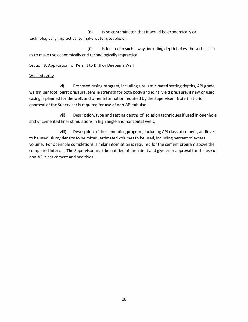
Section 8. Application for Permit to Drill or Deepen a Well
Well Integrity
(vi) Proposed casing program, including size, anticipated setting depths, API grade, weight per foot, burst pressure, tensile strength for both body and joint, yield pressure, if new or used casing is planned for the well, and other information required by the Supervisor. Note that prior approval of the Supervisor is required for use of non-API tubular.
(vii) Description, type and setting depths of isolation techniques if used in openhole and uncemented liner stimulations in high angle and horizontal wells,
(viii) Description of the cementing program, including API class of cement, additives to be used, slurry density to be mixed, estimated volumes to be used, including percent of excess volume. For openhole completions, similar information is required for the cement program above the completed interval. The Supervisor must be notified of the intent and give prior approval for the use of non-API class cement and additives.
11
Wyoming Oil and GasConservation Commission
Thomas E. DollState Oil and GasSupervisor
Property Taxes, $524,500,000 for
33.65% of the Assessed Property
Value Statewide
Severance Tax, $484,800,000 Federal Royalties,
$569,300,000
Federal Lease Royalties,
$52,400,000
State Royalties, $204,100,000
Sales and Use Taxes,
$103,900,000
Conservation Mill Levy, $4,400,000
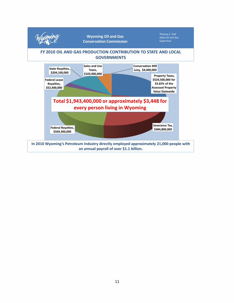
Total $1,943,400,000 or approximately $3,448 for every person living in Wyoming
FY 2010 OIL AND GAS PRODUCTION CONTRIBUTION TO STATE AND LOCAL GOVERNMENTS
In 2010 Wyoming’s Petroleum Industry directly employed approximately 21,000 people with an annual payroll of over $1.1 billion.

12
Attachment 3
Wind River Formation Cross-section Cartoon
Wyoming Oil and GasConservation Commission
Thomas E. DollState Oil and GasSupervisor
WY State Geological Survey Pavillion Presentation
Natural Gas Source: Cody Shale & possibly Meeteetse Shale
In general, precipitation recharges the Wind River Aquifer 1 to 5 inches per year; recharge occurs in the
Pavillion area also from irrigation at 0.25 to 0.75 inches per year including canals and ditches, and from losing streams, all potential sources of shallow groundwater
contamination
Concern: path for
methane from gas well
to water supply well;
38 of 169 Pavillion area
wells identified as not having
primary cement from circulated to
surface or into surface
casing; bradenhead
pressure data collection
identified 4 wells for possible
remediation
Concern: oil field sites contributed to shallow groundwater contamination; 11 sites soil sampled of 32 sites identified as landowner concern; results to be reported and possible remediation to be determined
Not all lenticular sands are charged with natural gas, some are wet, some are connected, some are not

13