the burial cairns and the landscape in the …jultika.oulu.fi/files/isbn9514268024.pdfthe burial...
TRANSCRIPT
THE BURIAL CAIRNS AND THE LANDSCAPE IN THE ARCHIPELAGO OF ÅBOLAND, SW FINLAND, IN THE BRONZE AGE AND THE IRON AGE
TAPANITUOVINEN
Department of Art Studies andAnthropology,
University of Oulu
OULU 2002

TAPANI TUOVINEN
THE BURIAL CAIRNS AND THE LANDSCAPE IN THE ARCHIPELAGO OF ÅBOLAND, SW FINLAND, IN THE BRONZE AGE AND THE IRON AGE
Academic Dissertation to be presented with the assent ofthe Faculty of Humanities, University of Oulu, for publicdiscussion in Auditorium GO 101, Linnanmaa, onSeptember 24th, 2002, at 12 noon.
OULUN YLIOPISTO, OULU 2002
Copyright © 2002University of Oulu, 2002
Supervised byProfessor Milton Nuñez
Reviewed byProfessor Andre CostopoulosProfessor Lars Forsberg
ISBN 951-42-6802-4 (URL: http://herkules.oulu.fi/isbn9514268024/)
ALSO AVAILABLE IN PRINTED FORMATActa Univ. Oul. B 46, 2002ISBN 951-42-6801-6ISSN 0355-3205 (URL: http://herkules.oulu.fi/issn03553205/)
OULU UNIVERSITY PRESSOULU 2002

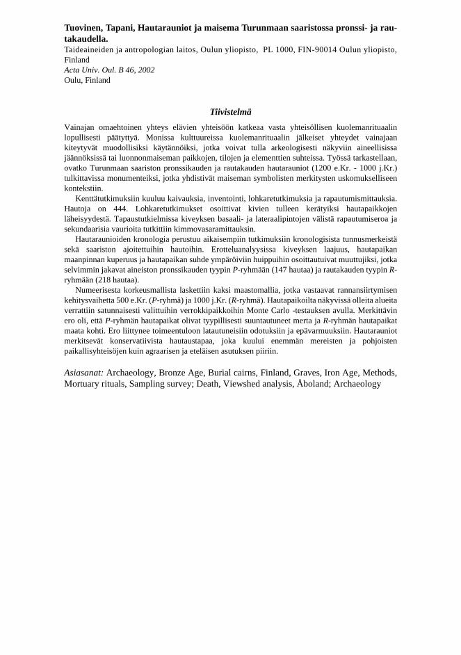
Tuovinen, Tapani, The Burial Cairns and the Landscape in the Archipelago ofÅboland, SW Finland, in the Bronze Age and the Iron Age Department of Art Studies and Anthropology, University of Oulu, P.O.Box 1000, FIN-90014University of Oulu, Finland Oulu, Finland2002
Abstract
Mortuary rituals express and cope with disorder brought about by a member's death in thecommunity. The autonomous connection of the deceased with the community is disrupted throughmortuary rituals. In many cultures the subsequent contacts with the realm of the dead are maintainedin formalized practices, sometimes including or referring to objects or patterns that can be traced inthe archaeological record. In this study it is asked, if the Bronze Age and Iron Age burial cairns (1200BC - AD 1000) in the SW archipelago of Finland might be interpreted as monuments establishing alink between the landscape and the religious context of symbolic meanings, thus making itmeaningful to examine the spatial references of grave sites.
The field studies include excavations, surveys, boulder analyses, and weathering studies. Thenumber of cairns in the area is 444. Examination of samples of boulders suggested that the stoneswere usually collected from the adjacent terrain. The Schmidt hammer technique was applied tomeasure the weathering differences between basal and lateral surfaces, and possible secondaryinterference.
The chronology of the archipelago cairns is based on previous studies related to generalchronological characteristics and datings of archipelago graves. Using discriminant analysis, the sizeof the cairn, the convexity of the surface at the grave site, and the topography of the terrain wereidentified as the variables most related to the differences between Group P, having a Bronze Agecharacter (147 cairns), from Group R of Iron Age character (218 cairns).
Two models representing the shorelines of 500 BC and AD 1000 were reconstructed using adigital elevation model (DEM). Monte Carlo-testing was applied when the visible areas around gravesites were compared to reference sets in four subareas. The grave sites in Group P were often directedtowards the land, whereas the grave sites in Group R were typically directed towards the sea. Thedifference might be related to differences in subsistence strategies. The cairns represented aconservative burial custom that belonged to local communities in maritime and northern areas, asopposed to the southern agricultural environments.
Keywords: Archaeology, Bronze Age, Burial cairns, Finland, Graves, Iron Age, Methods,Mortuary rituals, Sampling survey; Death, Viewshed analysis, Åboland; Archaeology

Tuovinen, Tapani, Hautarauniot ja maisema Turunmaan saaristossa pronssi- ja rau-takaudella. Taideaineiden ja antropologian laitos, Oulun yliopisto, PL 1000, FIN-90014 Oulun yliopisto,FinlandActa Univ. Oul. B 46, 2002Oulu, Finland
Tiivistelmä
Vainajan omaehtoinen yhteys elävien yhteisöön katkeaa vasta yhteisöllisen kuolemanrituaalinlopullisesti päätyttyä. Monissa kulttuureissa kuolemanrituaalin jälkeiset yhteydet vainajaankiteytyvät muodollisiksi käytännöiksi, jotka voivat tulla arkeologisesti näkyviin aineellisissajäännöksissä tai luonnonmaiseman paikkojen, tilojen ja elementtien suhteissa. Työssä tarkastellaan,ovatko Turunmaan saariston pronssikauden ja rautakauden hautarauniot (1200 e.Kr. - 1000 j.Kr.)tulkittavissa monumenteiksi, jotka yhdistivät maiseman symbolisten merkitysten uskomukselliseenkontekstiin.
Kenttätutkimuksiin kuuluu kaivauksia, inventointi, lohkaretutkimuksia ja rapautumismittauksia.Hautoja on 444. Lohkaretutkimukset osoittivat kivien tulleen kerätyiksi hautapaikkojenläheisyydestä. Tapaustutkielmissa kiveyksen basaali- ja lateraalipintojen välistä rapautumiseroa jasekundaarisia vaurioita tutkittiin kimmovasaramittauksin.
Hautaraunioiden kronologia perustuu aikaisempiin tutkimuksiin kronologisista tunnusmerkeistäsekä saariston ajoitettuihin hautoihin. Erotteluanalyysissa kiveyksen laajuus, hautapaikanmaanpinnan kuperuus ja hautapaikan suhde ympäröiviin huippuihin osoittautuivat muuttujiksi, jotkaselvimmin jakavat aineiston pronssikauden tyypin P-ryhmään (147 hautaa) ja rautakauden tyypin R-ryhmään (218 hautaa).
Numeerisesta korkeusmallista laskettiin kaksi maastomallia, jotka vastaavat rannansiirtymisenkehitysvaihetta 500 e.Kr. (P-ryhmä) ja 1000 j.Kr. (R-ryhmä). Hautapaikoilta näkyvissä olleita alueitaverrattiin satunnaisesti valittuihin verrokkipaikkoihin Monte Carlo -testauksen avulla. Merkittävinero oli, että P-ryhmän hautapaikat olivat tyypillisesti suuntautuneet merta ja R-ryhmän hautapaikatmaata kohti. Ero liittynee toimeentuloon latautuneisiin odotuksiin ja epävarmuuksiin. Hautarauniotmerkitsevät konservatiivista hautaustapaa, joka kuului enemmän mereisten ja pohjoistenpaikallisyhteisöjen kuin agraarisen ja eteläisen asutuksen piiriin.
Asiasanat: Archaeology, Bronze Age, Burial cairns, Finland, Graves, Iron Age, Methods,Mortuary rituals, Sampling survey; Death, Viewshed analysis, Åboland; Archaeology

AcknowledgementsTo begin with, my thanks are due to the great number of islanders with whom I have hadsome very interesting discussions. If I were to give here a complete register of theirnames, the list would become far too long. Therefore I don’t want to give precedence toany one of them; instead I would like to thank them all jointly for the information I havereceived and for their positive attitude towards my work.
In the Preface it becomes evident of what significance Professor Emeritus Unto Salo(University of Turku) has been for this work, and particularly its early phases. Hedeserves my special gratitude because without his support and positive attitude it wouldhave been hardly possible to accomplish this work. Professor Milton G. Núñez(University of Oulu) guided the accomplishment of my assertation and provided me withvaluable ideas. I am also grateful to the leader of the research group at Åbo AkademiUniversity, Professor Nils G. Holm for the support I have enjoyed. My coworkers at theDepartment of Comparative Religion and Folkloristics created a free and warm feeling oftogetherness. It was easy to work in such an atmosphere, and at the same time feel thatyour own field of research was appreciated and relevant even if it was very muchdifferent from the rest of the research conducted at the department. I want to thank themall!
Ph.D. Tarja Formisto has kindly made the osteological analyses whose results I havebeen able to exploit in this study. Leif Lindgren, the project planner at the Finnish Forestand Park Service, Nagu, initiated the field work in the area of combined activities of theSouthwestern Archipelago National Park, and assisted my work in the terrain; I wish tothank him and the rest of the staff of the National Park. I am also very grateful to all thearchaeologists, students of archaeology, and those interested in archaeology for the workthey have done during the excavations needed for this work – their names appear inchapter 4 where the excavations are discussed. Without their contribution essential partsof my material would be lacking.
I have had the opportunity to take lodgings at the field stations on Själö, Nagu, andLohm, Korpo, which are part of the Archipelago Research Institute, University of Turku.The staff at the Laboratory of Computer Cartography, University of Turku, has kindlyprovided me with access to computers and software which were indispensable for thestudy. Finally, I want to thank the Humanistic Faculty at the University of Oulu foraccepting this work into the publication series of the university, and Ella och Georg

Ehrnrooths stiftelse for awarding a scholarship for the finishing touches of this work. Thetranslation and revision work of this study has been financially supported by a grant fromthe Alfred Kordelin foundation, which is gratefully acknowledged. Chapters 4, 5, 6 and 7were translated into English by Heli Virtanen, M.A. and Maija Núñez, M.A. and the otherchapters by Erkki S. Makkonen, M.A. And, in conclusion, thank you Anja!
Lundströmska torpet, Houtskär, March, 2001
Tapani Tuovinen
AbbreviationsFFPS Finnish Forest and Park Service (Metsähallitus), Natural Heritage
Service of Southern Finland, NaguNBA The National Board of Antiquities (Museovirasto), HelsinkiNM The National Museum of Finland (Suomen Kansallismuseo), HelsinkiPMT The Provincial Museum of Turku (Turun maakuntamuseo), TurkuTYA The collections and archives of the Department of Archaeology,
University of Turku (Turun yliopisto), TurkuÅM The Museum Office (Museibyrån, Ålands landskapsstyrelse),
Mariehamn


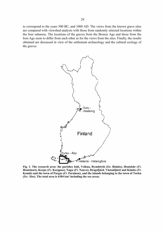
List of Figures Fig. 1. The research area: the parishes Iniö, Velkua, Rymättylä (Sw. Rimito), Houtskär
(Fi. Houtskari), Korpo (Fi. Korppoo), Nagu (Fi. Nauvo), Dragsfjärd, Västanfjärdand Kimito (Fi. Kemiö) and the town of Pargas (Fi. Parainen), and the islandsbelonging to the town of Turku (Sw. Åbo). The total area is 6384 km² includingthe sea areas. . . . . . . . . . . . . . . . . . . . . . . . . . . . . . . . . . . . . . . . . . . . . . . . . . . . 29
Fig. 2. The hypsographic curve of the archipelago of Åboland. . . . . . . . . . . . . . . . . . 32 Fig. 3. Trollberg, Houtskär. The NW part of the cairn has been removed to reveal the
inner circle. A combination level plan of the excavation in the year1979, drawnby Aarni Erä-Esko. The National Board of Antiquities. . . . . . . . . . . . . . . . . . . 47
Fig. 4. The Trollberg cairn can be distinguished in the distance when climbing up the SEslope to the top of the rock outcrop. Photograph by the author. . . . . . . . . . . . . 48
Fig. 5. The cairn of Trollberg is well known. In Houtskär it has been endowed a greatsignificance since it is said to symbolize the whole prehistory of the locality. Theguide board on the parking place of a boat restaurant tells the visitors the way upto the cairn which is on one of the highest rocks in the region. Photograph by theauthor. . . . . . . . . . . . . . . . . . . . . . . . . . . . . . . . . . . . . . . . . . . . . . . . . . . . . . . . . 48
Fig. 6. Furunabb, Houtskär. To the right the cairn 088. Photograph by the author. . . . 50 Fig. 7. The excavated burial cairns in the archipelago of Åboland. 1. Labbnäsåsen,
Dragsfjärd. 2. Jordbro, Dragsfjärd. 3. Långnäsudden, Dragsfjärd. 4. Rövik,Dragsfjärd. 5. Hammarsboda 108, Dragsfjärd. 6. Nämanön, Dragsfjärd. 7, 8.Tjuda, Kimito. 9. Jättekastberget, Kimito. 10. Söderviken, Västanfjärd. 11, 12.Lillskogen, Västanfjärd. 13. Söderby, Dragsfjärd. 14. Trollberg, Houtskär. 15–22.Furunabb, Houtskär. 23, 24. Sundbergen, Nagu. 25. Lilla Kuusis, Nagu. 26.Östergård 2, Dragsfjärd. 27. Ängesnäs bergen, Nagu. . . . . . . . . . . . . . . . . . . . 51
Fig. 8. The dwellings from the Bronze Age and the pre-Roman period (encircled), andthe cairns of the Bronze-Age type (Group P, see chapter 7) on the island ofKimito. The shoreline corresponds to the height of -17.5 m, i.e. approximately1200 BC. Several long straits divided the island of Kimito into parts, and the firth-like inlets added to the diversity of the topography. As early as 1948 Nils Cleveobserved that a considerable part of the graves follows an ancient firth through theisland of Kimito (Cleve 1948: 492–493). © The National Board of Surveying,License n:o MAR/103/98. . . . . . . . . . . . . . . . . . . . . . . . . . . . . . . . . . . . . . . . . . 54
Fig. 9. The known burial cairns in the southern archipelago of Nagu, in the area of Nötö,Boskär, Ådön, Sandholm, Trunsö, and Lökholm. © The National Board of Survey(MAR/103/98). . . . . . . . . . . . . . . . . . . . . . . . . . . . . . . . . . . . . . . . . . . . . . . . . . 87
Fig. 10. The cairns in Sundbergen, Nagu. Surveyed by the author (TYA). . . . . . . . . . . 89 Fig. 11. Sundbergen, Nagu, cairn 1, profile W–E. Measured and drawn by Timo
Kuokkanen (TYA). . . . . . . . . . . . . . . . . . . . . . . . . . . . . . . . . . . . . . . . . . . . . . . 89 Fig. 12. Part of a peg plate of an antler comb (TYA 486: 23). Sundbergen, Nagu, cairn 1.
Size ca 8:1. Photographed by the author. . . . . . . . . . . . . . . . . . . . . . . . . . . . . . 90 Fig. 13. The burial cairn Sundbergen 2, Nagu, seen from the west. Photographed by the
author. . . . . . . . . . . . . . . . . . . . . . . . . . . . . . . . . . . . . . . . . . . . . . . . . . . . . . . . . 90 Fig. 14. Sundbergen, Nagu. Particle size curves of soil samples. . . . . . . . . . . . . . . . . . 94 Fig. 15. The cairn on Lilla Kuusis, Nagu. Measured and drawn by the author (TYA). . 98 Fig. 16. Plan of the cairn Lilla Kuusis, Nagu. Contours at 5 cm intervals. Measured
pantographically by the author, Tommi Vuorinen and Timo Vuorisalo (TYA).99 Fig. 17. The cemetery of Östergård 2, Dragsfjärd. Surveyed and drawn by the author
(TYA). . . . . . . . . . . . . . . . . . . . . . . . . . . . . . . . . . . . . . . . . . . . . . . . . . . . . . . . 101 Fig. 18. The topography of the top of Ängesnäs bergen, Nagu. Surveyed and drawn by the
excavation team and the author (TYA). . . . . . . . . . . . . . . . . . . . . . . . . . . . . . 102 Fig. 19. The cairn on Ängesnäs bergen, Nagu. Photograph by the author. . . . . . . . . . 102 Fig. 20. Ängesnäs bergen, Nagu. Plan of burial cairn, measured and drawn by the
excavation team and the author (TYA). . . . . . . . . . . . . . . . . . . . . . . . . . . . . . 103 Fig. 21. Areas investigated by August 1999. . . . . . . . . . . . . . . . . . . . . . . . . . . . . . . . . 106 Fig. 22. Known burial cairns in the area investigated by December 1998. . . . . . . . . . 107 Fig. 23. Cairn on Kalholm, Holma, former parish of Hitis (present Dragsfjärd). From the
burial place there is an open view to Lammörs fjärden, although the altitude of thesite is only 17 meters. Photographed by the author 1997. . . . . . . . . . . . . . . . . 111
Fig. 24. The target area, the known burial cairns (filled dots) and the reference set (cross-hatched dots). © The National Board of Survey (MAR/103/98). . . . . . . . . . . 115
Fig. 25. The relative proportion (%) of the sea area of the window for the burial sites(upper) and the reference set (lower). . . . . . . . . . . . . . . . . . . . . . . . . . . . . . . . 121
Fig. 26. The tape measures and the total mass of the cairn for stones and bouldersweighing at least 0.5 kg. The regression line m = 331.7 + 410.1v, in which m isthe mass (kg) and v (volume) is the product of the length, breadth and height(m3). . . . . . . . . . . . . . . . . . . . . . . . . . . . . . . . . . . . . . . . . . . . . . . . . . . . . . . . . 123
Fig. 27. Boxplot of the masses of stones and boulders of five burial cairns. (1. Sundbergen1, 2. Sundbergen 2, 3. Lilla Kuusis, 4. Östergård 2, 5. Ängesnäs bergen). . . . 123
Fig. 28. The rocks of the Sundbergen 1 and 2 burial cairns and the sample from a boulderfield. . . . . . . . . . . . . . . . . . . . . . . . . . . . . . . . . . . . . . . . . . . . . . . . . . . . . . . . . . 125
Fig. 29. The relative cumulative frequencies of the roundness scores in the excavatedburial cairns. . . . . . . . . . . . . . . . . . . . . . . . . . . . . . . . . . . . . . . . . . . . . . . . . . . 128
Fig. 30. The sites for the determination of weathering curves. 1. Sundbergen, Nagu. 2.Hagaudd, Korpo. 3. Säbbholmen, Dragsfjärd. 4. Ramsö, Houtskär. 5. Kyrkudden,Nagu. 6. Immaskär, Houtskär. . . . . . . . . . . . . . . . . . . . . . . . . . . . . . . . . . . . . . 138

13
Fig. 31. Weathering curves (previous page): the mean values of the rebound values(vertical axis) and the altitudes of the measuring spots (horizontal axis). The errorbars are the standard errors of the mean value. The estimated changeover point Lhas been marked for the curve for Sundbergen, Nagu. . . . . . . . . . . . . . . . . . . 139
Fig. 32. Summary of the weathering curves. . . . . . . . . . . . . . . . . . . . . . . . . . . . . . . . . 143 Fig. 33. Ängesnäs bergen, Nagu. Contour plot of the rebound values of the basal and the
lateral surface and the approximate outer edge of the stone setting (thick screenedborder, cf. fig. 20). . . . . . . . . . . . . . . . . . . . . . . . . . . . . . . . . . . . . . . . . . . . . . . 147
Fig. 34. Sundbergen 1, Nagu. The plan of the cairn. The differences of the mean values ofthe upper and lower surface rebound values dR (cf. Appendix 1). Drawn by TimoKuokkanen and the author, 1988 (TYA). . . . . . . . . . . . . . . . . . . . . . . . . . . . . 149
Fig. 35. The distribution of the area of the stone settings of the burial cairns. n = 358. 157 Fig. 36. The length-width-height-hexahedron of the burial cairns. n = 338. . . . . . . . . 158 Fig. 37. The 38 largest burial cairns in Åboland (length more than 15 meters or area larger
than 175 m²). The size of the symbol on the map is directly proportional to therelative length of the stone setting. . . . . . . . . . . . . . . . . . . . . . . . . . . . . . . . . . 159
Fig. 38. Burial cairns with a relative length of at least 2 (n = 49). The direction of the mapsymbol indicates the direction of the longitudinal axis of the stone setting. . . 160
Fig. 39. A large cairn at Norrskogsbergen, Nagu (240). Photographed by TimoKuokkanen (TYA). . . . . . . . . . . . . . . . . . . . . . . . . . . . . . . . . . . . . . . . . . . . . . 162
Fig. 40. A small cairn on the island of Mjoö, Nagu (254). Photographed by the author.. . . . . . . . . . . . . . . . . . . . . . . . . . . . . . . . . . . . . . . . . . . . . . . . . . . . . . . 162
Fig. 41. A burial cairn at Storhomman, Kimito (125). Photographed by the author. . . 164 Fig. 42. A detail of the chain of the SW periphery of the cairn at Storhomman: stones
wedging the boulders in a horizontal position have been pushed between theflatwise laid rounded boulders of the dry-stone. Photographed by the author. 164
Fig. 43. A burial cairn with an upright dry-stone wall at Genböle, Dragsfjärd (001). Theboulders have been apparently collected in the adjacent terrain, in which schistosegneiss is cracking up into edged pieces. Photographed by the author. . . . . . . 165
Fig. 44. A burial cairn on the island of Långfuruholm, Dragsfjärd (060). Photographed byTimo Kuokkanen (TYA). . . . . . . . . . . . . . . . . . . . . . . . . . . . . . . . . . . . . . . . . 165
Fig. 45. A burial cairn at Furunabb, Houtskär (088). Photographed by Timo Kuokkanen(TYA). . . . . . . . . . . . . . . . . . . . . . . . . . . . . . . . . . . . . . . . . . . . . . . . . . . . . . . . 166
Fig. 46. A cairn at Trotby, Kimito. Photographed by the author. . . . . . . . . . . . . . . . . . 167 Fig. 47. A stone road on the esker between two burial cairns in Koupo, Pargas. Drawing
by Ragnar Nyberg (Nyberg 1985: 35). . . . . . . . . . . . . . . . . . . . . . . . . . . . . . . 170 Fig. 48. The distribution of the roundness proportion of the boulders (n = 345). Codes: 1
– edged; 2 - almost exclusively edged; 3 - mostly edged; 4 - edged and rounded;5 - mostly rounded; 6 - almost exclusively rounded; 7 – rounded. . . . . . . . . . 172
Fig. 49. The local density coefficient Cii(r) as a function of the radius r (m). The values ofthe coefficients were computed using the LDEN module (Kintigh 1987; Kintigh1992). . . . . . . . . . . . . . . . . . . . . . . . . . . . . . . . . . . . . . . . . . . . . . . . . . . . . . . . . 177
Fig. 50. The dagger from Långnäsudden, Dragsfjärd, according to Alfred Hackman(1897). . . . . . . . . . . . . . . . . . . . . . . . . . . . . . . . . . . . . . . . . . . . . . . . . . . . . . . . 183
Fig. 51. The grind stone from Stora Ängeskär, Dragsfjärd. Photographed by the author. . . . . . . . . . . . . . . . . . . . . . . . . . . . . . . . . . . . . . . . . . . . . . . . . . . . . . . . 183

Fig. 52. Boxplot of the distances (m) to the five nearest neighbours. The scale islogarithmic. . . . . . . . . . . . . . . . . . . . . . . . . . . . . . . . . . . . . . . . . . . . . . . . . . . . 187
Fig. 53. The distribution of the sum of distances to nearest neighbours (n = 380)(logarithmic scale). . . . . . . . . . . . . . . . . . . . . . . . . . . . . . . . . . . . . . . . . . . . . . 187
Fig. 54. The greatest difference of altitudes inside the window as a function of the radiusof the window (r = 50, 100, 200, 500, 1000, 2000 and 5000 meters). Center pointsin the window are Spånåmalm, Kimito (135), Käldinge, Nagu (378), Keistiö, Iniö(103) and Bussö, Korpo (349). . . . . . . . . . . . . . . . . . . . . . . . . . . . . . . . . . . . . 189
Fig. 55. The altitudes (m) and the shore zone ages (n = 147) of the P-group cairns. Theerror bar indicates whether the altitude was determined using the basic map, analtimeter or a levelling instrument. . . . . . . . . . . . . . . . . . . . . . . . . . . . . . . . . . 196
Fig. 56. The altitudes (m) and the shore zone ages (n = 218) of the R-group cairns. Theerror bar indicates whether the altitude was determined using the basic map, analtimeter or a levelling instrument. . . . . . . . . . . . . . . . . . . . . . . . . . . . . . . . . . 197
Fig. 57. The altitudes (m) and the shore zone datings of the R-group cairns with a shorezone dating of 500 BC or younger (n = 58). The error bar indicates whether thealtitude was determined using the basic map, an altimeter or a levellinginstrument. . . . . . . . . . . . . . . . . . . . . . . . . . . . . . . . . . . . . . . . . . . . . . . . . . . . . 198
Fig. 58. The cairn at Djupklevsudden, Korpo, is situated in the village of Kälö in theSouthwestern Archipelago National Park. The pasture habitat is kept up by cattlegrazing (see Lindgren 2000). Photographed by the author. . . . . . . . . . . . . . . 199
Fig. 59. The graves at Österudden, Pargas, and Falkön, Dragsfjärd (encircled) were visiblefrom the sea when sailing north from the archipelago towards the Paimionlahtiand the coast – at least if the boat was close enough, and one knew where to look.The map image corresponds the landscape in the year 500 BC. © National Boardof Survey, lic. No. MAR/103/98. . . . . . . . . . . . . . . . . . . . . . . . . . . . . . . . . . . 203
Fig. 60. The effect of shore displacement on the view from the grave at Båtkullaberget,Kimito (139). The upper image presents the view in about 500 BC, the lower thepresent view (cf. Zilliacus 1994: 14–15). The blackened area describes the landarea outside the visual contact, the light grey sections denote the sea area outsidethe visual contact, the whitened area denotes the visible sea area, and the dark greysignifies the visible land area. © National Board of Survey, lic. No. MAR/103/98. . . . . . . . . . . . . . . . . . . . . . . . . . . . . . . . . . . . . . . . . . . . . . . . . . . 205
Fig. 61. The archipelago of Åboland in about 500 BC, and the cairns in Group P (n = 147).© National Board of Survey, lic. No. MAR/103/98 . . . . . . . . . . . . . . . . . . . . 207
Fig. 62. The archipelago of Åboland in about 1000 AD, and the cairns in Group R (n =218). © National Board of Survey, lic. No. MAR/103/98 . . . . . . . . . . . . . . . 208
Fig. 63. The relative proportion of land in a window with a side length of 2025 m in about500 BC for the grave sites in Group P, and in about 1000 AD for the grave sitesin Group R. n = 364. . . . . . . . . . . . . . . . . . . . . . . . . . . . . . . . . . . . . . . . . . . . . 209
Fig. 64. The visibility to the sea (white) and to the land (dark grey) within a radius of 5000metres round the grave site at Långfuruholm, Dragsfjärd (060) in about 1000 AD.At that time the height of the grave site was 4.5 m above sea level. © NationalBoard of Survey, lic.no. MAR/103/98. . . . . . . . . . . . . . . . . . . . . . . . . . . . . . . 213
Fig. 65. Typical grave islands against the horizon – milieu dominants – north of Nötö,Nagu, seen from WSW, from the stretch of open sea called Berghamns fjärden.The peaks on the left were the highest points of the grave island of Boskär, thepeak to the right from the middle belonged to the grave island of Ådön. Thereconstruction describes the silhouette in about 1000 AD, and was made with thehelp of a DEM. © The National Board of Survey, lic. No. MAR/103/98. . . . 216
Fig. 66. The regions to be analyzed for their fields of vision. 1. Björkö – Kittuis – Hyppeis;2. Brunskär – Nötö – Lökholm; 3. Hertsböle – Hammarsboda – Högsåra; 4.Lillandet. © The National Board of Survey, lic. No. MAR/103/98. . . . . . . . . 218
Fig. 67. The viewing angles from the grave site at Rövik (042), Dragsfjärd in about 500BC. The fan-shaped figure looking NE from the grave site indicates the strongestdepth effect. The sharpest oblique viewing angle downward from the grave sitetowards the strait which linked the sheltered waters of the inner archipelago witha long inlet (nowadays a lake called Dragsfjärden), was 10 degrees. The light greycolour demonstrates the invisible or horizontally visible areas, the darker greyshades the downwards visible areas; the white colour indicates the land areaswhich are higher up than the grave site. © The National Board of Survey, lic. No.MAR/103/98. . . . . . . . . . . . . . . . . . . . . . . . . . . . . . . . . . . . . . . . . . . . . . . . . . . 219
Fig. 68. Region 1, Björkö – Kittuis – Hyppeis. The cumulative map of the visible areasfrom the grave sites in Group P (n = 3, the greatest number of overlapping visibleareas cmax = 3). © The National Board of Survey, lic. No. MAR/103/98. . . 222
Fig. 69. Region 1, Björkö – Kittuis – Hyppeis. The cumulative area of the visible areasfrom the graves in Group R (n = 21, cmax = 14). © The National Board of Survey,lic. no. MAR/103/98. . . . . . . . . . . . . . . . . . . . . . . . . . . . . . . . . . . . . . . . . . . . . 225
Fig. 70. Region 2, Brunskär – Nötö – Lökholm. The cumulative map of viewsheds fromthe graves in Group R (n = 16, cmax = 10). © The National Board of Survey, lic.no. MAR/103/98. . . . . . . . . . . . . . . . . . . . . . . . . . . . . . . . . . . . . . . . . . . . . . . . 228
Fig. 71. Region 3, Hertsböle – Hammarsboda – Högsåra. The cumulative map of theviewsheds from the graves in Group P (n = 24, cmax = 10). © The National Boardof Survey, lic. no. MAR/103/98. . . . . . . . . . . . . . . . . . . . . . . . . . . . . . . . . . . . 232
Fig. 72. Region 3, Hertsböle – Hammarsboda – Högsåra. The cumulative map of theviewsheds from the graves in Group R (n = 23, cmax = 12). © The National Boardof Survey, lic.no. MAR/103/98. . . . . . . . . . . . . . . . . . . . . . . . . . . . . . . . . . . . 235
Fig. 73. Region 4, Lillandet. The cumulative map of the viewsheds from the grave sites inGroup P (n = 17, cmax = 16). © The National Board of Survey, lic. no. MAR/103/98. . . . . . . . . . . . . . . . . . . . . . . . . . . . . . . . . . . . . . . . . . . . . . . . . . . . . . . . . . . 238
Fig. 74. Region 4, Lillandet. The cumulative map of the viewsheds from the grave sites inGroup R (n = 15, cmax = 13). © The National Board of Survey, lic. no. MAR/103/98. . . . . . . . . . . . . . . . . . . . . . . . . . . . . . . . . . . . . . . . . . . . . . . . . . . . . . . . . . . 240
Fig. 75. The Iron-Age graves and cemeteries of classical types in Finland Proper (SWFinland) (n = 623). . . . . . . . . . . . . . . . . . . . . . . . . . . . . . . . . . . . . . . . . . . . . . 272
Fig. 76. The cairns in Finland Proper (SW Finland) (n = 1627). . . . . . . . . . . . . . . . . . 273

List of Tables Table 1. The shore displacement of the Baltic Sea in Hitis (the SE part of the archipel-
ago of Åboland), in Lohm, Korpo (the central part of the archipelago), and inIniö (the NW part of the archipelago). The Litorina shore level zones are givenin conventional radiocarbon years according to Glückert (1976, Appendix I)and the estimated mean sea levels with the standard errors in AD 800 and AD1400 according to Ekman (1993) and Kakkuri (1997). . . . . . . . . . . . . . . . . 84
Table 2. Sundbergen 1, Nagu. An osteological analysis of the bone samples from thecairn. . . . . . . . . . . . . . . . . . . . . . . . . . . . . . . . . . . . . . . . . . . . . . . . . . . . . . . . 92
Table 3. Sundbergen 2, Nagu. An osteological analysis of the bone samples from thecairn. . . . . . . . . . . . . . . . . . . . . . . . . . . . . . . . . . . . . . . . . . . . . . . . . . . . . . . . 93
Table 4. A soil analysis of the cairns at Sundbergen, Nagu. . . . . . . . . . . . . . . . . . . . 96 Table 5. Ängesnäs bergen, Nagu. Rounded mineral particles in water sieved sample,
particle size 1–2 mm. . . . . . . . . . . . . . . . . . . . . . . . . . . . . . . . . . . . . . . . . . 104 Table 6. The archaeological remains in the survey of the area of combined activities of
the Southwestern Archipelago National Park in 1994–1997. . . . . . . . . . . . 111 Table 7. Sampling area of Houtskär, Korpo and Nagu. Differences between on-site
measurements of altitudes of burial sites and altitudes derived from corre-sponding cells in the DEM. . . . . . . . . . . . . . . . . . . . . . . . . . . . . . . . . . . . . . 117
Table 8. Comparison of the burial sites and the reference set (the means, the standarddeviations, the greatest values, and the smallest value for all variables). . . 119
Table 9. The significance levels a of the differences between the terrain variables of theburial cairns and the reference set. The two-tailed Mann-Whitney’s U statisticand the two-tailed Kolmogorov-Smirnov’s D statistic. . . . . . . . . . . . . . . . 120
Table 10. The masses of stones and boulders of five burial cairns. . . . . . . . . . . . . . . 124 Table 11. The frequencies of the roundness scores 1...5 of stones and boulders weighing
at least 0.5 kg in the excavated burial cairns. . . . . . . . . . . . . . . . . . . . . . . . 128 Table 12. Observations on the soil under the burial cairn and its vicinity. . . . . . . . . . 129 Table 13. The distribution of the roundness proportion of boulders in cairns built on a
rock and on soil. . . . . . . . . . . . . . . . . . . . . . . . . . . . . . . . . . . . . . . . . . . . . . 129 Table 14. The volume of the burial cairns in cubic meters, and the roundness proportion
of the boulders. . . . . . . . . . . . . . . . . . . . . . . . . . . . . . . . . . . . . . . . . . . . . . . 130

Table 15. The altitudes and numbers of the measuring points, the numbers of reboundvalues n, the means and the standard deviations of rebound values, the lowestand highest rebound values and the standard errors of the mean values (SEM)in the measuring point on an average. . . . . . . . . . . . . . . . . . . . . . . . . . . . . 137
Table 16. Schmidt-hammer measurements of rock surfaces (sites, types of rock, altitudesh, numbers of measuring points, numbers of rebound values, means, standarddeviations Sd, and means of standard errors of mean). . . . . . . . . . . . . . . . 146
Table 17. Comparison of the mean rebound values of the basal and the lateral surfaces (t-testing). . . . . . . . . . . . . . . . . . . . . . . . . . . . . . . . . . . . . . . . . . . . . . . . . . . . . 146
Table 18. The comparison between the frequencies of stone settings with indeterminableoutline, and those with a regular shape, on rocks and mineral grounds (c² =0.306, df = 1, a = 0.580). . . . . . . . . . . . . . . . . . . . . . . . . . . . . . . . . . . . . . . 154
Table 19. The shape (the columns) and the profile (the rows) of the burial cairns. Somecategories were combined to avoid low frequencies so that cairns of rectangu-lar and polygonal or triangular forms were amalgamated into one class of an-gular cairns. The rarest profile classes were omitted. . . . . . . . . . . . . . . . . . 155
Table 20. The shape (the columns) and the profile (the rows). The standardized deviatesbetween observed and expected frequencies for each cell. . . . . . . . . . . . . 155
Table 21. The length, width, height, area (product of length and width) and volume(product of length, breadth and height) of the stone settings of the burial cairns. . . . . . . . . . . . . . . . . . . . . . . . . . . . . . . . . . . . . . . . . . . . . . . . . . . . . . 157
Table 22. The directions of the longitudinal axes of the cairns. . . . . . . . . . . . . . . . . . 161 Table 23. Comparison between burial cairns with and without architectural construc-
tions: the ln-volume, roundness proportion, altitude and ln-sum of distances tonearest neighbours. The degrees of freedom for the altitude were determinedusing the Welch method (Widjeskog 1987). . . . . . . . . . . . . . . . . . . . . . . . 170
Table 24. The osteological finds of the burial cairns in Åboland: the sample size (g), thepart defined as human bone (g), the calvarium parts (g), the estimated age, thenumber of individuals MNI, animal bones and the occurrence of burnt/unburntbones. The samples were analysed by Tarja Formisto in 1987 and 1998. . 173
Table 25. The frequencies of the local densities within the radii of 60 and 200meters. . . . . . . . . . . . . . . . . . . . . . . . . . . . . . . . . . . . . . . . . . . . . . . . . . . . . . 177
Table 26. The dated burial cairns in Åboland. n = 31.. . . . . . . . . . . . . . . . . . . . . . . . 182 Table 27. The distances to the five nearest neighbours (m) and the sum of distances to the
nearest neighbours. . . . . . . . . . . . . . . . . . . . . . . . . . . . . . . . . . . . . . . . . . . 186 Table 28. Potential variables measuring the location of the burial place in relation to
neighbouring burial places and the topography. . . . . . . . . . . . . . . . . . . . . . 192 Table 29. Comparison of differences between the groups P and R. To achieve an approx-
imate normal distribution, natural logarithms were computed of the area of thestone cover, the sum of distances, the altitude relative to the mean, and thesquare root of the relative proportion of sea. . . . . . . . . . . . . . . . . . . . . . . . 192
Table 30. Classification matrix of the discriminant analysis of the area of the cairn, theconvexity of the burial place and the height difference to the highest top. . 194
Table 31. Region 1, Björkö – Kittuis – Hyppeis. Comparison of the visible areas. GroupP, n = 3, m = 19. . . . . . . . . . . . . . . . . . . . . . . . . . . . . . . . . . . . . . . . . . . . . . 221

Table 32. Region 1. Comparison of viewing angles and distances. Group P, n = 3, m =19. . . . . . . . . . . . . . . . . . . . . . . . . . . . . . . . . . . . . . . . . . . . . . . . . . . . . . . . . 221
Table 33. Region 1, Björkö – Kittuis – Hyppeis. Comparisons of the areas visible fromburial sites and random sites. Group R, n = 21, m = 19. . . . . . . . . . . . . . . 223
Table 34. Region 1, Björkö – Kittuis – Hyppeis. Comparisons of viewing angles and dis-tances from burial sites and random sites. Group R, n = 21, m = 19. . . . . . 224
Table 35. Region 2, Brunskär – Nötö – Lökholm. Comparisons of visible areas. Group R,n = 16, m = 24. . . . . . . . . . . . . . . . . . . . . . . . . . . . . . . . . . . . . . . . . . . . . . . 227
Table 36. Region 2. Comparisons of viewing angles and distancess. Group R, n = 16, m= 24. . . . . . . . . . . . . . . . . . . . . . . . . . . . . . . . . . . . . . . . . . . . . . . . . . . . . . . 227
Table 37. Region 3. Comparisons of the visible areas. Group P, n = 24, m = 19. Owing toties, no reliable values were obtained for some minima (marked with dots) . . . . . . . . . . . . . . . . . . . . . . . . . . . . . . . . . . . . . . . . . . . . . . . . . . . . . . . 230
Table 38. Region 3. Comparisons of the angles and distances. Group P, n = 24, m = 19. . . . . . . . . . . . . . . . . . . . . . . . . . . . . . . . . . . . . . . . . . . . . . . . . . . . . 230
Table 39. Region 3. Comparisons of the visible areas. Group R, n = 23, m = 19. . . . 234 Table 40. Region 3. Comparisons of the viewing angles and the distances. Group R, n =
23, m = 19. . . . . . . . . . . . . . . . . . . . . . . . . . . . . . . . . . . . . . . . . . . . . . . . . . 234 Table 41. Region 4, Lillandet. Comparisons of visible areas. Group P, n = 17,
m = 19. . . . . . . . . . . . . . . . . . . . . . . . . . . . . . . . . . . . . . . . . . . . . . . . . . . . . . 237 Table 42. Region 4, Lillandet. Comparisons of viewing angles and distances. Group P, n
= 17, m = 19. . . . . . . . . . . . . . . . . . . . . . . . . . . . . . . . . . . . . . . . . . . . . . . . . 237 Table 43. Region 4, Lillandet. Comparisons of visible areas. Group R, n = 15,
m = 19. . . . . . . . . . . . . . . . . . . . . . . . . . . . . . . . . . . . . . . . . . . . . . . . . . . . . 241 Table 44. Region 4, Lillandet. Comparisons of viewing angles and distances. Group R, n
= 15, m = 19. . . . . . . . . . . . . . . . . . . . . . . . . . . . . . . . . . . . . . . . . . . . . . . . . 241

Contents
Abstract Tiivistelmä Acknowledgements Abbreviations List of FiguresList of TablesPreface 1 Introduction . . . . . . . . . . . . . . . . . . . . . . . . . . . . . . . . . . . . . . . . . . . . . . . . . . . . . . . . 272 Earlier Field Archaeology in the Archipelago of Åboland . . . . . . . . . . . . . . . . . . . . 30
2.1 A Mosaic of Small Islands And Brackish Water . . . . . . . . . . . . . . . . . . . . . . . 302.1.1 The Archipelago Zones . . . . . . . . . . . . . . . . . . . . . . . . . . . . . . . . . . . . . . 302.1.2 Shore Displacement . . . . . . . . . . . . . . . . . . . . . . . . . . . . . . . . . . . . . . . . . 312.1.3 Climatology . . . . . . . . . . . . . . . . . . . . . . . . . . . . . . . . . . . . . . . . . . . . . . . 33
2.2 Field Archaeological Research into Burial Cairns since the 1880s . . . . . . . . . 342.2.1 Early Field Investigations in Åboland . . . . . . . . . . . . . . . . . . . . . . . . . . . 342.2.2 The Augmentation of the Museum Collections . . . . . . . . . . . . . . . . . . . . 402.2.3 The origin of the hypothesis concerning the peripheral nature of the
archipelago . . . . . . . . . . . . . . . . . . . . . . . . . . . . . . . . . . . . . . . . . . . . . . . . 422.3 Field work projects 1943–1973 . . . . . . . . . . . . . . . . . . . . . . . . . . . . . . . . . . . . . 45
2.3.1 The Investigations of the National Board of Antiquities in Houtskär 1978–1986 . . . . . . . . . . . . . . . . . . . . . . . . . . . . . . . . . . . . . . . . . . . . . . . . . . . . . 46
2.3.2 New finds . . . . . . . . . . . . . . . . . . . . . . . . . . . . . . . . . . . . . . . . . . . . . . . . . 522.3.2.1 Early Metal Age . . . . . . . . . . . . . . . . . . . . . . . . . . . . . . . . . . . . . 522.3.2.2 The Iron Age . . . . . . . . . . . . . . . . . . . . . . . . . . . . . . . . . . . . . . . . 54
2.4 Interpretations of Coastal Cairns . . . . . . . . . . . . . . . . . . . . . . . . . . . . . . . . . . . . 572.4.1 Immigration or Cultural Contacts . . . . . . . . . . . . . . . . . . . . . . . . . . . . . . 572.4.2 Adopting a Landscape Approach . . . . . . . . . . . . . . . . . . . . . . . . . . . . . . . 582.4.3 Coastal Cairns in Sweden . . . . . . . . . . . . . . . . . . . . . . . . . . . . . . . . . . . . . 59
3 Land, Sea, and Burial Sites . . . . . . . . . . . . . . . . . . . . . . . . . . . . . . . . . . . . . . . . . . . . 613.1 Death: a Crisis within the Community . . . . . . . . . . . . . . . . . . . . . . . . . . . . . . . 613.2 Graves as Markers of What Is Beyond . . . . . . . . . . . . . . . . . . . . . . . . . . . . . . . 63
3.2.1 Stone . . . . . . . . . . . . . . . . . . . . . . . . . . . . . . . . . . . . . . . . . . . . . . . . . . . . . 643.2.2 Monumentality . . . . . . . . . . . . . . . . . . . . . . . . . . . . . . . . . . . . . . . . . . . . . 64

3.2.3 Morphological Variation . . . . . . . . . . . . . . . . . . . . . . . . . . . . . . . . . . . . . 653.3 The Landscape As a Cultural Construction . . . . . . . . . . . . . . . . . . . . . . . . . . . 67
3.3.1 Dimensions of the Human Body And the Human Landscape . . . . . . . . . 673.3.2 Approaches to Meanings Embedded in the Landscape . . . . . . . . . . . . . . 693.3.3 The Landscape of the Prehistoric Archipelago . . . . . . . . . . . . . . . . . . . . 72
4 The Field Studies . . . . . . . . . . . . . . . . . . . . . . . . . . . . . . . . . . . . . . . . . . . . . . . . . . . . 754.1 What is a burial cairn? . . . . . . . . . . . . . . . . . . . . . . . . . . . . . . . . . . . . . . . . . . . . 75
4.1.1 The grave as an empirical category . . . . . . . . . . . . . . . . . . . . . . . . . . . . . 754.1.2 The field archaeological criteria . . . . . . . . . . . . . . . . . . . . . . . . . . . . . . . . 77
4.2 Levellings and the shore displacement of the Baltic Sea . . . . . . . . . . . . . . . . . 814.2.1 Measuring methods . . . . . . . . . . . . . . . . . . . . . . . . . . . . . . . . . . . . . . . . . 814.2.2 Dating shore level zones of the Litorina Sea . . . . . . . . . . . . . . . . . . . . . . 82
4.3 The excavations . . . . . . . . . . . . . . . . . . . . . . . . . . . . . . . . . . . . . . . . . . . . . . . . . 844.3.1 Sundbergen, Nagu . . . . . . . . . . . . . . . . . . . . . . . . . . . . . . . . . . . . . . . . . . 85
4.3.1.1 Sundbergen 1 . . . . . . . . . . . . . . . . . . . . . . . . . . . . . . . . . . . . . . . 874.3.1.2 Sundbergen 2 . . . . . . . . . . . . . . . . . . . . . . . . . . . . . . . . . . . . . . . 884.3.1.3 Osteological analysis . . . . . . . . . . . . . . . . . . . . . . . . . . . . . . . . . 914.3.1.4 Soil analysis . . . . . . . . . . . . . . . . . . . . . . . . . . . . . . . . . . . . . . . . 94
4.3.2 Lilla Kuusis, Nagu . . . . . . . . . . . . . . . . . . . . . . . . . . . . . . . . . . . . . . . . . . 984.3.3 Östergård 2, Dragsfjärd . . . . . . . . . . . . . . . . . . . . . . . . . . . . . . . . . . . . . 1004.3.4 Ängesnäs bergen, Nagu . . . . . . . . . . . . . . . . . . . . . . . . . . . . . . . . . . . . . 101
4.4 The surveys . . . . . . . . . . . . . . . . . . . . . . . . . . . . . . . . . . . . . . . . . . . . . . . . . . . 1044.4.1 Fieldwork 1983–1998 . . . . . . . . . . . . . . . . . . . . . . . . . . . . . . . . . . . . . . 1044.4.2 Research scheme . . . . . . . . . . . . . . . . . . . . . . . . . . . . . . . . . . . . . . . . . . 1054.4.3 The survey of the area of combined activities of the Southwestern
Archipelago National Park 1104.4.4 The practical routine: finding cairns and making field notes . . . . . . . . . 112
4.5 The topography of burial cairns in Houtskär, Korpo and Nagu . . . . . . . . . . . 1134.5.1 Introduction . . . . . . . . . . . . . . . . . . . . . . . . . . . . . . . . . . . . . . . . . . . . . . 113
4.5.1.1 The field work . . . . . . . . . . . . . . . . . . . . . . . . . . . . . . . . . . . . . 1144.5.2 The digital elevation model . . . . . . . . . . . . . . . . . . . . . . . . . . . . . . . . . . 1164.5.3 The distributions of the terrain variables . . . . . . . . . . . . . . . . . . . . . . . . 117
4.5.3.1 The variables . . . . . . . . . . . . . . . . . . . . . . . . . . . . . . . . . . . . . . 1174.5.3.2 The differences of the distributions . . . . . . . . . . . . . . . . . . . . . 119
4.6 The boulder studies . . . . . . . . . . . . . . . . . . . . . . . . . . . . . . . . . . . . . . . . . . . . . 1224.6.1 The mass of stones and boulders . . . . . . . . . . . . . . . . . . . . . . . . . . . . . . 1224.6.2 The rocks . . . . . . . . . . . . . . . . . . . . . . . . . . . . . . . . . . . . . . . . . . . . . . . . 1244.6.3 The roundness of the stones and boulders . . . . . . . . . . . . . . . . . . . . . . . 127
4.6.3.1 Roundness score . . . . . . . . . . . . . . . . . . . . . . . . . . . . . . . . . . . . 1274.6.3.2 Roundness proportion . . . . . . . . . . . . . . . . . . . . . . . . . . . . . . . . 128
4.7 Weathering studies . . . . . . . . . . . . . . . . . . . . . . . . . . . . . . . . . . . . . . . . . . . . . 1314.7.1 The principles . . . . . . . . . . . . . . . . . . . . . . . . . . . . . . . . . . . . . . . . . . . . . 1314.7.2 The weathering of the shore rock and the shore displacement . . . . . . . 1324.7.3 The rocks . . . . . . . . . . . . . . . . . . . . . . . . . . . . . . . . . . . . . . . . . . . . . . . . 1344.7.4 The Schmidt hammer measurements . . . . . . . . . . . . . . . . . . . . . . . . . . . 1344.7.5 The estimation of weathering curves . . . . . . . . . . . . . . . . . . . . . . . . . . . 135

4.7.5.1 The regression models . . . . . . . . . . . . . . . . . . . . . . . . . . . . . . . 1354.7.5.2 Case studies . . . . . . . . . . . . . . . . . . . . . . . . . . . . . . . . . . . . . . . 1374.7.5.3 Discussion . . . . . . . . . . . . . . . . . . . . . . . . . . . . . . . . . . . . . . . . . 142
4.7.6 The weathering of the basal surfaces of burial cairns . . . . . . . . . . . . . . 1444.7.7 The weathering of boulders . . . . . . . . . . . . . . . . . . . . . . . . . . . . . . . . . . 1474.7.8 Are the craters secondary? . . . . . . . . . . . . . . . . . . . . . . . . . . . . . . . . . . . 1504.7.9 Discussion . . . . . . . . . . . . . . . . . . . . . . . . . . . . . . . . . . . . . . . . . . . . . . . 151
5 The Morphology of the Burial Cairns . . . . . . . . . . . . . . . . . . . . . . . . . . . . . . . . . . . 1535.1 The Outlines and Surface Topographies . . . . . . . . . . . . . . . . . . . . . . . . . . . . . 1535.2 The Dimensions and Relative Lengths . . . . . . . . . . . . . . . . . . . . . . . . . . . . . . 1565.3 The Direction of the Longitudinal Axis . . . . . . . . . . . . . . . . . . . . . . . . . . . . . 1615.4 The Architectural Constructions . . . . . . . . . . . . . . . . . . . . . . . . . . . . . . . . . . . 163
5.4.1 The chains . . . . . . . . . . . . . . . . . . . . . . . . . . . . . . . . . . . . . . . . . . . . . . . 1635.4.2 The stone cists . . . . . . . . . . . . . . . . . . . . . . . . . . . . . . . . . . . . . . . . . . . . 1685.4.3 Other constructions . . . . . . . . . . . . . . . . . . . . . . . . . . . . . . . . . . . . . . . . 1695.4.4 Burial cairns with and without architectural constructions . . . . . . . . . . 170
5.5 The constructing material . . . . . . . . . . . . . . . . . . . . . . . . . . . . . . . . . . . . . . . . 1715.6 The interments . . . . . . . . . . . . . . . . . . . . . . . . . . . . . . . . . . . . . . . . . . . . . . . . . 172
6 The Cemeteries and the Single Graves . . . . . . . . . . . . . . . . . . . . . . . . . . . . . . . . . . 1757 The Bronze Age – the Iron Age . . . . . . . . . . . . . . . . . . . . . . . . . . . . . . . . . . . . . . . . 178
7.1 Earlier studies on the chronology of cairns in SW Finland . . . . . . . . . . . . . . 1787.2 The dated cairns in Åboland . . . . . . . . . . . . . . . . . . . . . . . . . . . . . . . . . . . . . . 180
7.2.1 The dating criteria . . . . . . . . . . . . . . . . . . . . . . . . . . . . . . . . . . . . . . . . . 1807.2.2 The stratigraphical and the cemetery chorological datings . . . . . . . . . . 1817.2.3 The group analogical datings . . . . . . . . . . . . . . . . . . . . . . . . . . . . . . . . . 184
7.3 The empirical determination of chronological characteristics . . . . . . . . . . . . 1857.3.1 The stone cover of the burial cairn . . . . . . . . . . . . . . . . . . . . . . . . . . . . . 1857.3.2 The relative location of the burial cairns . . . . . . . . . . . . . . . . . . . . . . . . 1857.3.3 The topography of the burial place . . . . . . . . . . . . . . . . . . . . . . . . . . . . 187
7.4 Discriminant analysis . . . . . . . . . . . . . . . . . . . . . . . . . . . . . . . . . . . . . . . . . . . 1907.4.1 The groups P and R . . . . . . . . . . . . . . . . . . . . . . . . . . . . . . . . . . . . . . . . 1907.4.2 The potential variables . . . . . . . . . . . . . . . . . . . . . . . . . . . . . . . . . . . . . . 1917.4.3 The estimation . . . . . . . . . . . . . . . . . . . . . . . . . . . . . . . . . . . . . . . . . . . . 1937.4.4 The shore zone datings . . . . . . . . . . . . . . . . . . . . . . . . . . . . . . . . . . . . . . 1957.4.5 The classification functions . . . . . . . . . . . . . . . . . . . . . . . . . . . . . . . . . . 2007.4.6 Discussion . . . . . . . . . . . . . . . . . . . . . . . . . . . . . . . . . . . . . . . . . . . . . . . 200
8 Visual Dimensions of the Burial Sites . . . . . . . . . . . . . . . . . . . . . . . . . . . . . . . . . . . 2028.1 To See And To Be Seen . . . . . . . . . . . . . . . . . . . . . . . . . . . . . . . . . . . . . . . . . 2028.2 The Development of the Landscape in the Archipelago of Åboland . . . . . . . 206
8.2.1 Shore displacement . . . . . . . . . . . . . . . . . . . . . . . . . . . . . . . . . . . . . . . . 2068.2.2 Forests and pastures . . . . . . . . . . . . . . . . . . . . . . . . . . . . . . . . . . . . . . . . 209
8.3 Views from the Grave Sites . . . . . . . . . . . . . . . . . . . . . . . . . . . . . . . . . . . . . . 2118.3.1 Altitudes of the Grave Sites . . . . . . . . . . . . . . . . . . . . . . . . . . . . . . . . . . 2118.3.2 Terrain Observations And Digital Elevation Model . . . . . . . . . . . . . . . 2138.3.3 Map Scale . . . . . . . . . . . . . . . . . . . . . . . . . . . . . . . . . . . . . . . . . . . . . . . . 215
8.3.4 The Statistical Significance of the Differences in the Distribution of the Fields of Vision . . . . . . . . . . . . . . . . . . . . . . . . . . . . . . . . . . . . . . . . . . . 216
8.3.5 The Ranges of Vision towards the Sea and the Land in Four Different Regions . . . . . . . . . . . . . . . . . . . . . . . . . . . . . . . . . . . . . . . . . . . . . . . . . . 2178.3.5.1 Region 1: Björkö – Kittuis – Hyppeis . . . . . . . . . . . . . . . . . . . 2208.3.5.2 Region 2: Brunskär – Nötö – Lökholm . . . . . . . . . . . . . . . . . . 2268.3.5.3 Region 3, Hertsböle –Hammarsboda – Högsåra . . . . . . . . . . . 2298.3.5.4 Region 4, Lillandet . . . . . . . . . . . . . . . . . . . . . . . . . . . . . . . . . . 236
8.3.6 Grave Sites And the Symbolic Implications of the Landscape . . . . . . . 2428.3.6.1 Comparison of the Viewsheds . . . . . . . . . . . . . . . . . . . . . . . . . 2428.3.6.2 Burial Sites in the Taskscape . . . . . . . . . . . . . . . . . . . . . . . . . . 2438.3.6.3 The Symbolic Landscape of the Burial Sites . . . . . . . . . . . . . . 245
8.3.7 Discussion . . . . . . . . . . . . . . . . . . . . . . . . . . . . . . . . . . . . . . . . . . . . . . . 2478.3.7.1 Graves, Communities, and Territoriality . . . . . . . . . . . . . . . . . 2478.3.7.2 Problems of Territorial Interpretations . . . . . . . . . . . . . . . . . . . 2488.3.7.3 Land And the Human Being . . . . . . . . . . . . . . . . . . . . . . . . . . . 252
9 On Continuity, Settlement, and Subsistence . . . . . . . . . . . . . . . . . . . . . . . . . . . . . . 2539.1 A Summary of Empirical Results . . . . . . . . . . . . . . . . . . . . . . . . . . . . . . . . . . 2539.2 The Iron-Age Settlement of Åboland Reconsidered . . . . . . . . . . . . . . . . . . . . 255
9.2.1 Graves As Indicators of Settlement . . . . . . . . . . . . . . . . . . . . . . . . . . . . 2559.2.1.1 The Direction of the Null Hypothesis . . . . . . . . . . . . . . . . . . . 2569.2.1.2 Settlement And Cemeteries . . . . . . . . . . . . . . . . . . . . . . . . . . . 258
9.2.2 Images of Wilderness And Isolation in the Construction of National Prehistory . . . . . . . . . . . . . . . . . . . . . . . . . . . . . . . . . . . . . . . . . . . . . . . . 260
9.2.3 Critical Comments on the Periphery Hypothesis . . . . . . . . . . . . . . . . . . 2619.2.4 Archaeological Evidence of Iron-Age Settlement . . . . . . . . . . . . . . . . . 2639.2.5 Pollen Analyses . . . . . . . . . . . . . . . . . . . . . . . . . . . . . . . . . . . . . . . . . . . 2669.2.6 Onomastic studies . . . . . . . . . . . . . . . . . . . . . . . . . . . . . . . . . . . . . . . . . 2679.2.7 Summary . . . . . . . . . . . . . . . . . . . . . . . . . . . . . . . . . . . . . . . . . . . . . . . . 269
9.3 Cairns: a Coastal Archaeology View . . . . . . . . . . . . . . . . . . . . . . . . . . . . . . . 2699.4 Cairns in Historical Sources? . . . . . . . . . . . . . . . . . . . . . . . . . . . . . . . . . . . . . 276
9.4.1 Långholm . . . . . . . . . . . . . . . . . . . . . . . . . . . . . . . . . . . . . . . . . . . . . . . . 2769.4.2 Långfuruholm . . . . . . . . . . . . . . . . . . . . . . . . . . . . . . . . . . . . . . . . . . . . . 277
Bibliography . . . . . . . . . . . . . . . . . . . . . . . . . . . . . . . . . . . . . . . . . . . . . . . . . . . . . . . . . .279Appendices . . . . . . . . . . . . . . . . . . . . . . . . . . . . . . . . . . . . . . . . . . . . . . . . . . . . . . . . . . .305

PrefaceAt the age of twelve in secondary school I was assigned to draw a geographical map of aplace of my own choice. I chose the small island of Vuorkattila, Velkua with its rocks,bird nests, and skerries. At that time I did not know yet that observing birds and plants,catching jellyfish, and counting pinetree stems would one day turn into archaeologicalfield work which in fact included largely similar elements. Fifteen years later ProfessorUnto Salo, Department of Archaeology, and the station foreman Aatos Petäjä, theArchipelago Research Institute, University of Turku, gave me the opportunity to startwith looking for cairns in the archipelago. This also involved an opportunity to develop amore adult version of the boyish spark to search, map, and organize, which once startedin Velkua such a long time ago.
Archaeological surveying in the archipelago is largely practical. It includes servicingand repairing the boat and its equipment, docking, boating and overnighting in varyingcircumstances. But above all, the field work in the archipelago means slow travellingfrom one island to another and hiking in forests, occasionally day out day in without anytraces of new cairns. And when you eventually find one, it often appears to be verysimilar to those known previously. Redundancy, scanty variation in structure andappearance, and faithful observing of traditional burying rituals are typical features ofcairns. The significances of the graves and their associations with to the surroundingnature have been expressed so delicately that understanding seems to increase onlygradually as you can see them in forests and on rocks. The grave constructors were thefirst people to leave of themselves sustaining traces in nature, and, after all, it is notamazing that those traces are materially very minute.
The minimalistic message of the cairns might be one reason for the fact that cairns inthe archaeology of the Finnish coastal areas have been taken so little notice of despitetheir great number and typical character; besides, they seem to offer remarkableopportunities to learn to understand the economic activity, ’society’, and ’religion’ of thecoastal population. I was thus very lucky to be invited by Professor Unto Salo to join hisexcavation programme in the late 1970s; he also made me understand the relevance of theresearch of burial rituals, and see the challenges involved in the practical gathering andprocessing of the material. After the excavation projects of the first years Professor Salobegan to collect a consistent material concerning the whole of the coast of southwesternFinland. On one hand, this required a lot of work to develop an appropriate computerized

database, and, on the other hand, it was necessary to organize the field work. I was luckyenough to have the opportunity to participate in both projects, and my research area wasto be the archipelago of Åboland (Fi. Turunmaa).
Since the cairns in the southwestern archipelago had been rather scantily investigated,my first task was to clarify the morphology, context, and locations of the graves. On thebasis of the first field working periods it seemed to be evident that among thearchipelagian graves there were several which had to date back to the Iron Age althoughthey had previously been considered to be from the Bronze Age. Therefore it becameactual in the next phase to conduct excavations in order to find practical means to datecairns of different types. The possibility offered to me by the Finnish Forest and ParkService to search for cairns in the outer archipelago 1994–1997 proved an importantopening for this study because it was the survey work that gave evidence of the outerarchipelago being a central area of cairns of Iron Age character.
With the gradual shaping of the morphology, context, and chronology of the cairns inthe archipelago it became possible to examine questions of more theoretical character. In1996 I was working at the Environmental Centre of Southwestern Finland in order topromote multidisciplinary research of the mutual relationship of man and nature in theBiosphere Reserve Area of the Archipelago Sea. When working with the archipelagoresearchers of other scientific fields I also came to the idea of concentrating anddeveloping some more crystallized archaeological approaches of man’s relationship with’nature’ on a symbolic level. At the end of the year 1997 I was able to start the framing ofthis dissertation in a group of investigators working with a research project of theAcademy of Finland called Socio-cultural plurality and biodiversity: compatibility orclash? A multidisciplinary study on the Archipelago Sea Biosphere Reserve Area, SouthWestern Finland, which is a part of the Finnish Biodiversity Programme FIBRE (1997–2002). The research team was led by Professor Nils G. Holm (Åbo Akademi University),and it consisted of Kjell Andersson, Lic.Soc., Ole Rud Nielsen, Lic. Phil., and AnjaTuomisto, Lic. Phil., and me.

1 IntroductionIn the research area of this study, the archipelago of Åboland1(see fig. 1), the smallislands build up a diversified landscape rich in delicate details in which the open stretchesof sea separate the larger islands and groups of islets from each other. Ever since the timewhen the archipelago began to shape itself on account of the glacio-isostatic land upliftmany details of the landscape have changed, and new groups of islands have emerged.New islands and skerries have risen out of the sea in the outermost archipelago at theedge of the open sea while the islands close to the coast have grown fast into themainland or remained separated by narrow straits. Land uplift has not, however, resultedin the disappearance of the archipelago which has only slided gradually further outtowards the Baltic Sea. At the same time the difference remains between the outerarchipelago dominated by stretches of open sea and the inner archipelago characterizedby large coalescent islands. The mutual relationship between land and water is, on theother hand, reflected in local physical conditions such as the climate. As the thermaleconomy of the Baltic Sea is the essential regulator of the coastal climate, the closenessof the sea and the mutual relationship between land and water are apt to affect the localclimatic conditions on the coast (Solantie 1990). It is probable that the relative climaticdifference between the archipelago and the coast has consequently prevailed in thepostglacial period. The phenomenon of land uplift allows us to observe the changes in thelandscape, and to establish what things in the archaeological remains are constant and’conservative’, and what things are variable, and in what relationship the regionaldifferences in archaeological remains and the time gradient stand to each other. Thespecific character of the natural geography of the archipelago constitutes one of the basesof this study, and will be discussed at the beginning of chapter 2.
1. The oldest name of the Åboland archipelago is Finska skären ’the Finnish skerries’ from the year 1386. Thename dates back to the time when the name Finland denoted merely the region in southwestern Finland whichsubsequently was called Varsinais-Suomi (Sw. Egentliga Finland), Finland Proper. See Zilliacus 1991 b, andWolf-Knuts 1999. The use of Turunmaa, the Finnish equivalent of Åboland is not equally stabilized.Previously it was used to denote the vicinity of the town of Turku (e.g. Ailio 1927), but today the nameTurunmaa is used mainly as a synonym of the name Åboland (e.g. Pitkänen 1985 a). Saaristomeri (Sw.Skärgårdshavet) ’the Archipelago Sea’ is an established name in natural sciences, denoting the archipelagosof Åland and Åboland. Several new names have been suggested, the most recent in The Atlas of Finland,published by The Geographical Society of Finland (1999).
28
The field archaeological research history of the archipelago is different from that of themainland in South-West Finland and Åland. It is an illustrative example of theconstruction of national prehistory in the 20th century, and therefore it has been devotedquite an extensive section in the second chapter. The earliest archaeological excavationsand surveys were implemented in the 1880s, and their results are still partly relevant evenif the technique used at that time does not meet today's demands. After the firstinvestigators there was a tranquil period in the field archaeology of the archipelago. Theecological hypothesis of A.M. Tallgren developed in the 1930s into a notion according towhich the archipelago was a culturally peripheral area and a fierce wilderness for man.This was not apt to revive the interest in field research. It was not until the postwar periodthat the field investigations gradually got started again.
Land, sea, and sky built the huge natural elements around the islanders. To some extentwe are able to reconstruct the topography and the essential features of the naturallandscape in the various periods, but, as such, they do not yet convey to us a very goodidea of what the landscape of the islanders was like on a symbolic level, and whatsignificance it possessed in the tradition of prehistoric communities. We will get closer bystudying what symbolic levels we can establish in the archaeological remains and theirrelation to the surrounding nature. One of the most obvious targets of investigation isnaturally the cairns. They were constructed of stone, the most sustaining material innature. They were enduring monuments whose location in the archipelago made themeasily accessible from generation to generation and they were easily discovered.Interpretations in archaeological and anthropological literature concerning graves andcairn sites, the sustainability of the material, monumentalism, and landscape as a culturalconstruction will be discussed in chapter 3 on the basis of the facts mentioned above.
Studies of the morphological variation of the graves, the locations of the cairns, andthe relation between the grave sites and the landscape requires a sufficiently consistentand representative material. The previously available field archaeological material did notentirely meet these requirements, and thus it was necessary to do some fieldwork for thisstudy. The hypotheses which emerged during the survey were examined by implementingexcavations and sampling surveys. The surveys, the excavations, and the topography ofthe grave sites in their present environment affected by land uplift will be discussed inchapter 4. Investigations of boulders, comprising the weight of the stones in the cairns,various minerals, roundness, and the weathering of boulders and rock surfaces will alsobe discussed in chapter 4. The shape of the cairns, their surface topography, size,architectural construction, and burials will be discussed in chapter 5. In chapter 6 therelative location of the grave sites will be studied.
Land uplift resulted at places in conspicuous changes in certain details of the landscapeduring the period of cairn construction. We should thus attempt to locate the grave sites inthe landscape in the phases of land uplift roughly corresponding to their ages. An analysisof the external features characterizing the cairns from the Bronze Age or from the IronAge is given in chapter 7. On the basis of these features it is possible to divide the gravesin the research area into two main type categories, those of Bronze Age character, andthose of Iron Age character. The classification is principally chronological, and is inaccord with the chronology of the shore displacement.
In chapter 8 the known graves from the four subareas are set in a digital elevationmodel (DEM) with which the topographies surrounding the grave sites are reconstructed
29
to correspond to the years 500 BC, and 1000 AD. The views from the known grave sitesare compared with viewshed analysis with those from randomly selected locations withinthe four subareas. The locations of the graves from the Bronze Age and those from theIron Age seem to differ from each other as for the views from the sites. Finally, the resultsobtained are discussed in view of the settlement archaeology and the cultural ecology ofthe graves.
Fig. 1. The research area: the parishes Iniö, Velkua, Rymättylä (Sw. Rimito), Houtskär (Fi.Houtskari), Korpo (Fi. Korppoo), Nagu (Fi. Nauvo), Dragsfjärd, Västanfjärd and Kimito (Fi.Kemiö) and the town of Pargas (Fi. Parainen), and the islands belonging to the town of Turku(Sw. Åbo). The total area is 6384 km² including the sea areas.
2 Earlier Field Archaeology in the Archipelago of Åboland
2.1 A Mosaic of Small Islands And Brackish Water
2.1.1 The Archipelago Zones
The Baltic Sea is a shallow basin, a closed tideless system characterized by stratifiedbrackish water, strong seasonal alternation, and shallow fragmented coastal topography.In southwestern Finland the coastal topography of the Baltic Sea is particularlyfragmented. The archipelagian area of southwestern Finland is divided into the morewesterly archipelago of Åland and the more easterly archipelago of Åboland. They arepart of the top surface of the deep-worn basement in southern Finland, the subcambricpeneplain descending in gentle undulation towards the Baltic Sea and forming anarchipelago off the coast. The basement consists mainly of granite, migmatites, andschists (Salonen 1994). Nils Edelman (1986) compares the visible surface structure of thearchipelago to a worn wooden floor on whose old structure lengthy fraying has leftfurrows and grooves. The relief reflects the zones of the minerals, the old foldingtectonic, the lengthy weathering and erosion, the shear zones of the bedrock, the fracturevalleys, the displacements and depressions, and the wearing and accumulating effect ofthe continental glacier (Fogelberg 1986; Fogelberg & Seppälä 1986). These factors areapt to shape the fragmented and small-scale landscape in which the general directions ofthe movements affecting the bedrock can still be seen – straits, coves, stretches of the sea,oblong islands, and various fissure systems.
The extent of the archipelago off the Finnish coast depends on the depth of the relief ofthe peneplain, and its angle of inclination. In southwestern Finland this angle is fairlygentle, 2–3 minutes, and, consequently, the archipelagos of Åboland and Åland formjointly an extensive zone which is more than 150 km in width. On the coast of the Gulf ofBothnia the width of the archipelagic zone is less than 10 km. The SW archipelagocomprises more than 22000 islands, and more than 14000 km of shoreline. Most islands(15800) are smaller than one hectar in area. The archipelago of Åboland and the islandsof Åland constitute jointly – when it comes to the multitude of the islands – the mostextensive archipelago area in the world. The fragmentation of the landscape gives rise to
31
a high geodiversity, a mosaic of land and water offering a multitude of habitats forvarious organisms (Granö et al. 1999: 11–15; Kirkkala 1999: 5).
When sailing from the Baltic Sea through the archipelago towards the mainland wecan see how small skerries and rocks gradually give way to larger islands, and how thewide stretches of the sea separating the islands reduce into narrow straits between theislands. The differences in the relation of land and water areas build up a toposequencewhich can be divided into four sections (Granö et al. 1999: 27–38):1. Skerry zone. Small skerries and underwater reefs.2. Outer archipelago zone. Rocky islets. Land area less than 10 per cent of the water
area.3. Inner archipelago zone. Large islands. The proportions of land and sea approximately
equal.4. Mainland zone. Large islands and peninsulas. Small water areas. Till, silt, and clay
deposits.Sometimes the classification includes a fifth zone, the middle zone. The toposequence isin accord with the phytogeographical zones which were described by Ernst Häyrén acentury ago (Häyrén 1900). The utmost skerries of the skerry zone are treeless, theislands of the outer archipelago zone are dominated by deciduous trees while the trees inthe inner archipelago zone and the mainland zone are mainly coniferous. Since Häyrén’sdays the zonal succession of landscapes within the archipelago has been developed andused in geographically oriented research (Granö 1955; Varjo 1959; Granö 1981; Granö1994), but in cultural research it has been seldom used as an analytical concept (e.g.Huldén 1996).
The amount of soil deposits is the smaller the more out in the archipelago and thenearer the open sea you are. The small islands and the highest tops of the large islands arecliffs polished by the continental ice sheet either bare or covered by a thin layer of soil.When approaching the coast the proportion of rocky moraine shores becomes more andmore predominant; in the inner archipelago there are also clayey reed shores besidesthose with moraine soil (Granö et al. 1986). The number of glacifluvial formations isrelatively small. The most important glacial formation is the ice-marginal formationSalpausselkä III (Sw. Stängselåsen III) which traverses the research area from the east tothe west, either on the surface of the earth or on the bottom of the sea (Fogelberg 1964).
2.1.2 Shore Displacement
After the construction of the oldest cairns the surface of the earth has risen 20 m in regardto the surface of the sea. Even after the construction of the youngest cairns the amount ofthe land uplift has been about five metres. The land uplift is principally of glacio-isostaticorigin, and is caused by the fact that the crust of the earth which due to the weight of theIce-Age glacier had been compressed downwards tends to return to its previouscondition. The total effect of the land uplift at the seashore is also influenced by thetectonic component caused by the lithospheric stress which is responsible for 10–20 percent of the uplift rate, and the eustatic component, the elevation fluctuation of the surfaceof the Baltic Sea (Eronen 1987; Eronen 1994; Kakkuri 1987; Kakkuri 1997). In addition,

32
particularly in the inner archipelago the fine-grained material is deposited on the bottomof the sea accelerating the effect of the land uplift (Granö et al. 1986). The joint influenceof the various factors results in shore displacement due to which the islands grow in size,join together, and the water area is reduced. Simultaneously the archipelago zones willshift gradually towards the southwest as the underwater reefs of the skerry zone emergeout of the sea and turn into small islands. Since the primary factor for the formation of anarchipelago coast is the surface structure of the submerged peneplain, not the shoredisplacement as such, we may conclude that the topographic structure of the prehistoricarchipelago was much the same as it is today.
Fig. 2. The hypsographic curve of the archipelago of Åboland.
Land uplift also brings forth the nutrient load characteristic of the Baltic Sea, theresuspension of the old bottom sediments. With the gradual rise of the sea bottom whichthus is subjected to the underwater turbulence caused by the waves, the sedimentsstratified on the bottom will emit some of their material, and consequently releasenitrogenous and phosphoric nutrients. The biological primary production is enlivened bythe ensuing nutrition circulation. Although the number of the species is not very great,they have no shortage of nutrition, and may appear in huge and productive masses as forinstance the Baltic herring (Clupea harengus). Consequently, the river mouths and themuddy-bottomed shallow areas of the Baltic Sea can boast a high primary production(Håkanson 1991).
The hypsographic curve of the archipelago of Åboland (figure 2) indicates that thehighest points of the skerries which were the first to emerge out of the sea are today at theheight of 60–70 m. They are the highest peaks of the peneplain which were surrounded bydeep waters at the time of their emersion. The land area increased slowly with the landuplift but in the Neolithic Stone Age when the peaks had reached the height of about -30m the growth of the land area began to accelerate. The accelerated increase of the land
33
area began in Åboland later than on Åland (cf. Jaatinen et al. 1989: 25–29; Núñez et al.1997).
2.1.3 Climatology
In the postglacial period the Baltic Sea has experienced also other changes apart fromshore displacement. The salinity of the surface water in the Baltic Sea has decreased afterthe maximal value, approximately 10 per mille in the sea area of southwestern Finland,(Eronen et al. 1979), during the optimal postglacial climatic conditions down to thepresent value of approximately 6 per mille (Kullberg 1981). The assortment of fishspecies consists of originally marine species and those characteristic of fresh waterconditions, and both the groups have undergone physiological and morphologicalchanges. During the optimal climatic conditions the fish fauna was, more than today, verysimilar to the fish fauna in the ocean. For instance the Baltic herring which spawns inautumn got distributed in the Baltic Sea probably at that very time (Ojaveer et al. 1981).In the present phase of the development the salinity of the brackish water is too low forseveral ocean fish species, and too high for many fresh water fish species. The salinitydisplays a distinct S–N gradient from the Danish straits northwards to the farthest cornersof the Gulf of Bothnia and the Gulf of Finland so that the salinity is the lowest in thenorth. The same gradient appears in several hydrological, chemical, and biologicalvariables (e.g. Kautsky 1991). The Baltic Sea is not a uniform marine area despite itsbasin-like nature.
Åland, Åboland, and the southwestern mainland coast are nowadays the only regionsin Finland belonging to the hemiboreal climatic zone. The archipelago is characterized bymild winters, springs with scanty precipitation, and early summers. The snow melts, andthe earth warms up in early spring. The average sum of effective temperature in thesouthwestern archipelago is 1300 ºCd, and the mean duration of the vegetational period isat least 180 days; these parameters are the highest in the country (Solantie 1990). Hardfrosts, i.e. ground temperatures below -3.0 ºC, are practically absent during thevegetational period. In spring, the hard frosts are over earlier than on the mainland, andthe capability of the sea water to level up the variations in temperature results in a veryinsignificant annual fluctuation of frosts. For instance, in the archipelago the meanduration of the period without hard frosts is 179 days whereas in the inland in regionswith few lakes the corresponding duration is only 109 days (Solantie 1987). Thevegetation period of the archipelago is thus characterized by early commencement dates,long periods without frosts, and the almost non-existent possibility of incidental frostrisks – all these are significant climatic factors favourable to prehistoric agriculture whichhad to accommodate to extreme northern conditions (Zvelebil & Rowley-Conwy 1986).
The climatic factors measured in our day cannot be directly extrapolated to correspondto numerical values in the subboreal and the subatlantic period. But, as suggested by EljasOrrman, the climatic difference between the archipelago and the mainland wasnevertheless very much the same as today (Orrman 1991 a: 201), the marine climate andthe capability of the sea water to store warmth are in fact linked up with each other. Nor isit possible to deduce any numerical values as for the extent or the duration of the coat of

34
ice on the Baltic Sea (Makkonen et al. 1984) but we can assume that they too were inaccord with the gradient from the open sea to the mainland coast.
To sum up the facts mentioned above we can establish that the archipelago of Åbolandoffered a rich, versatile, and naturally favourable environment to prehistoric people. Thediversified mosaic-like archipelago which was rich in details, the marine climate, theecology of the brackish water, and the conspicuous alternation of seasons were thespecific features contributing to the welfare of man in those days. The significance of thecoastal natural resources has been emphasized in the investigations concerning thesubsistence strategies in the Stone Age, but when it comes to the economy of the MetalAge the marine natural resources have attained little attention (e.g. Siiriäinen 1981;Siiriäinen 1982; Núñez 1986; Núñez 1991; cf, however, Salo 1995: 1–2). Some reasonsfor this situation can be found in the history of research.
2.2 Field Archaeological Research into Burial Cairns since the 1880s
2.2.1 Early Field Investigations in Åboland
The earliest fairly reliable reference to a heap of stones as a possible grave site derivesfrom the year 1735. A clergyman called Johan G. Salonius mentioned in his description ofthe parish of Nagu that on the island of Sandö there were sailors’ graves constructed ofstones2. Salonius called these cairns by the common popular name of jättekast, jätukast ’agiant’s cast’. In Finnish the equivalent popular name is hiidenkiuas ’stove of beasts’. Thispopular name was adopted into professional usage to denote big cairns of Bronze-Agecharacter, and was used in Finnish literature for most of the 20th century.
The first field archaeological investigations were conducted in the late 19th century. In1878 Lars Wilhelm Fagerlund, the physician and museologist, published his workAnteckningar om Korpo och Houtskärs socknar. It was a description of the life ofcommon people, and a reference to ancient remains was mentioned only on the very lastpages. Fagerlund was aware of remains from the historic period only, and among these hementioned the cairns at Furunabb, Houtskär. He assumed that they were remains of hidingplaces from the Great Northern War (1714–1721) (Fagerlund 1878: 293). Even anotherconclusion might have been possible as J.R. Aspelin had in 1871 taken notice of thesimilarity between the cairns on the coasts of Finland and the Swedish prehistoric cairns(Nordman 1968: 21; Aspelin 1875: 58; Aspelin 1885: 37). Maybe the archipelago seemedto Fagerlund to be a region where no prehistoric remains could possibly be found. A fewyears earlier the philologist Axel Olof Freudenthal (interestingly, one of the founders ofthe national movement of the Swedish-speaking population in Finland) had published areview of the archaeological remains in the eastern archipelago of Uusimaa (Sw. Nyland)(Freudenthal 1874) in which he described labyrinths and stone ovens – they were remainsfrom the historical period which conspicuously differred from the then known prehistoricremains on the mainland.
2. The manuscript by Salonius 1735, NBA, p. 27.
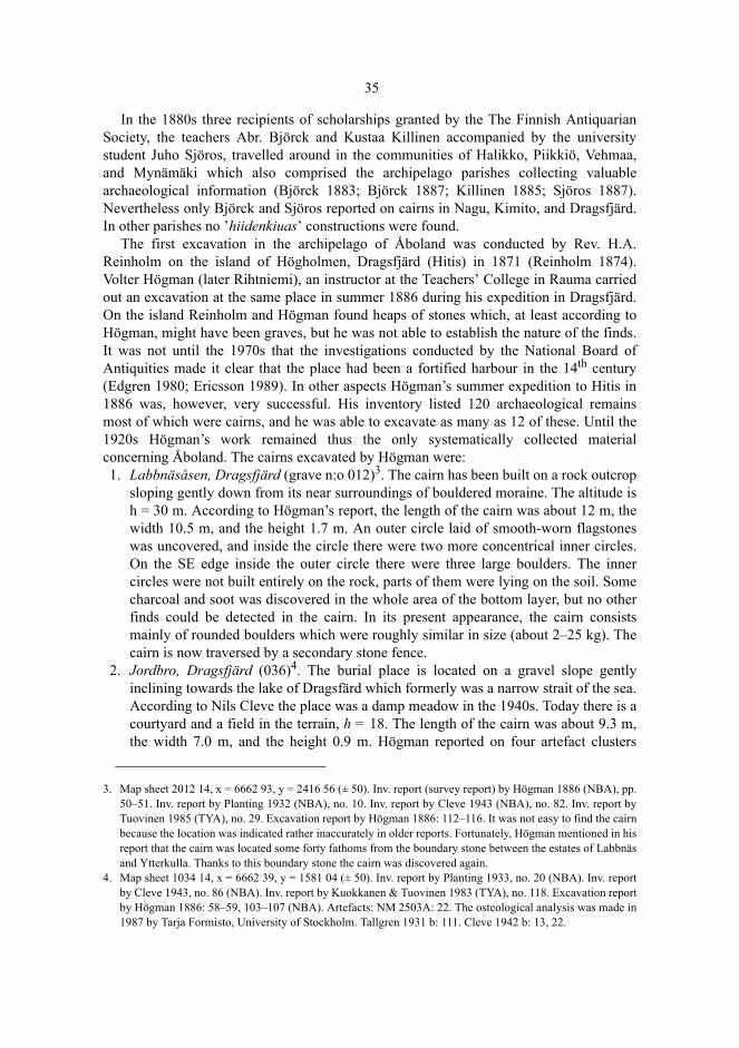
35
In the 1880s three recipients of scholarships granted by the The Finnish AntiquarianSociety, the teachers Abr. Björck and Kustaa Killinen accompanied by the universitystudent Juho Sjöros, travelled around in the communities of Halikko, Piikkiö, Vehmaa,and Mynämäki which also comprised the archipelago parishes collecting valuablearchaeological information (Björck 1883; Björck 1887; Killinen 1885; Sjöros 1887).Nevertheless only Björck and Sjöros reported on cairns in Nagu, Kimito, and Dragsfjärd.In other parishes no ’hiidenkiuas’ constructions were found.
The first excavation in the archipelago of Åboland was conducted by Rev. H.A.Reinholm on the island of Högholmen, Dragsfjärd (Hitis) in 1871 (Reinholm 1874).Volter Högman (later Rihtniemi), an instructor at the Teachers’ College in Rauma carriedout an excavation at the same place in summer 1886 during his expedition in Dragsfjärd.On the island Reinholm and Högman found heaps of stones which, at least according toHögman, might have been graves, but he was not able to establish the nature of the finds.It was not until the 1970s that the investigations conducted by the National Board ofAntiquities made it clear that the place had been a fortified harbour in the 14th century(Edgren 1980; Ericsson 1989). In other aspects Högman’s summer expedition to Hitis in1886 was, however, very successful. His inventory listed 120 archaeological remainsmost of which were cairns, and he was able to excavate as many as 12 of these. Until the1920s Högman’s work remained thus the only systematically collected materialconcerning Åboland. The cairns excavated by Högman were: 1. Labbnäsåsen, Dragsfjärd (grave n:o 012)3. The cairn has been built on a rock outcrop
sloping gently down from its near surroundings of bouldered moraine. The altitude ish = 30 m. According to Högman’s report, the length of the cairn was about 12 m, thewidth 10.5 m, and the height 1.7 m. An outer circle laid of smooth-worn flagstoneswas uncovered, and inside the circle there were two more concentrical inner circles.On the SE edge inside the outer circle there were three large boulders. The innercircles were not built entirely on the rock, parts of them were lying on the soil. Somecharcoal and soot was discovered in the whole area of the bottom layer, but no otherfinds could be detected in the cairn. In its present appearance, the cairn consistsmainly of rounded boulders which were roughly similar in size (about 2–25 kg). Thecairn is now traversed by a secondary stone fence.
2. Jordbro, Dragsfjärd (036)4. The burial place is located on a gravel slope gentlyinclining towards the lake of Dragsfärd which formerly was a narrow strait of the sea.According to Nils Cleve the place was a damp meadow in the 1940s. Today there is acourtyard and a field in the terrain, h = 18. The length of the cairn was about 9.3 m,the width 7.0 m, and the height 0.9 m. Högman reported on four artefact clusters
3. Map sheet 2012 14, x = 6662 93, y = 2416 56 (± 50). Inv. report (survey report) by Högman 1886 (NBA), pp.50–51. Inv. report by Planting 1932 (NBA), no. 10. Inv. report by Cleve 1943 (NBA), no. 82. Inv. report byTuovinen 1985 (TYA), no. 29. Excavation report by Högman 1886: 112–116. It was not easy to find the cairnbecause the location was indicated rather inaccurately in older reports. Fortunately, Högman mentioned in hisreport that the cairn was located some forty fathoms from the boundary stone between the estates of Labbnäsand Ytterkulla. Thanks to this boundary stone the cairn was discovered again.
4. Map sheet 1034 14, x = 6662 39, y = 1581 04 (± 50). Inv. report by Planting 1933, no. 20 (NBA). Inv. reportby Cleve 1943, no. 86 (NBA). Inv. report by Kuokkanen & Tuovinen 1983 (TYA), no. 118. Excavation reportby Högman 1886: 58–59, 103–107 (NBA). Artefacts: NM 2503A: 22. The osteological analysis was made in1987 by Tarja Formisto, University of Stockholm. Tallgren 1931 b: 111. Cleve 1942 b: 13, 22.
36
which in his view were linked with interments: (1) fragments of burnt bone andpottery in a sooty layer of humus, (2) a clay vessel under which some bone andcharcoal was found, (3) a clay vessel and unburnt bones, and (4) fragments of burntbone. According to C.F. Meinander (1954b: 60), at least part of the pottery mightoriginate from a Late Neolithic cultural layer under the cairn. An osteological studycarried out by Tarja Formisto in 1987 revealed that the bone sample consisted of 3.7 gof burnt and 10.9 g of unburnt seal bone. The occurrence of seal bone in the findssupports Meinander’s view that part of the finds originate from an older settlementlayer5. The cairn itself may thus have been without any finds.
3. Långnäsudden, Dragsfjärd (041)6. The burial site is located on a small sheer cliff atthe tip of a cape pushing northwards into the lake of Dragsfjärd, close to anothercairn. From the place, which in the Bronze Age was a small rocky islet there is a goodvisibility in all directions except S. The altitude h = 25 m. The length of the cairn wasabout 13.3 m, the width 12.7 m, and the height 1.5 m. In the middle of the cairn therewas a pit. When Högman and his research group were excavating the cairn, theystarted from the edges, and soon found a circle laid of large boulders. The outermeasures of the uncovered circle were 13.3 and 11.5 m. On the rock surface there wasa humus layer containing some charcoal. In an oval stone setting in the bottom layer abronze dagger from the II period was detected (Meinander 1954 b: 15, 107, 211;Edgren 1999b: 1–3). The cairn was carefully restored, and today it is slightly largerthan before the excavation. The boulders are mostly rounded, and of much the samesize (about 2–50 kg).
4. Rövik, Dragsfjärd7. A shallow, oval, structureless cairn was detected in rocky terrain.It consisted of fairly small stones in one or two layers. Some charcoal was found inthe bottom layer. The precise location of the cairn is unknown.
5. Hammarsboda, Dragsfjärd 108 (045)8. The site is located on an ice-margin formationbelonging to the ice-marginal formation of Salpausselkä III. The W–E top of the hillis surrounded by fields and pastures. The grave belongs to a group four cairns. Thealtitude h = 21.3 (levelled). The length and the width of the cairn were about 9.5 m,and the height 0.8 m. During the excavation some unburnt bone, and an indistinctinner circle were discovered, and in the middle of the cairn possibly a stone cist. The
5. Seal bones were detected in excavations of Bronze-Age cairns at Kaunismäki, Harjavalta, and at Uotinmäki,Kiukainen. In these cases the seal bones seem to be originated from stratigraphically older cultural layersunder the cairns (see Salo 1970: 12–15, 22–24; Lahtiperä 1970: 202–205; Salo 1981: 42–50; cf. Väkeväinen1979).
6. Map sheet 1034 14, x = 6661 78, y = 1581 96 (± 50). Inv. report by Appelgren 1927 (NBA): 9. Inv. report byPlanting 1932, no. 32 (NBA). Inv. report by Cleve 1943, no. 101 (NBA). Inv. report by Kuokkanen &Tuovinen 1983, no. 123 (TYA). Excavation report by Högman 1886: 60–61, 96–103 (NBA). Artefacts: NM2503A: 1, 21. Heikel 1890: 179–182. Hackman 1897: 375. Tallgren 1931 b: 111. Cleve 1942 b: 12–13, 23.Cleve 1948: 490, 493. Meinander 1954 b: 15, 107, 211.
7. Map sheet 1034 13, x = 6656 32, y = 1581 60 (± 200). Inv. report by Planting 1932, no. 26 (NBA). Inv. reportby Cleve 1943, no. 103 (NBA). Inv. report by Kuokkanen & Tuovinen 1983, no. 128 (TYA). Excavationreport by Högman 1886, pp. 52–53, 111–112 (NBA). Tallgren 1931 b: 111. Cleve 1942 b: 23.
8. Map sheet 1034 11, x = 6661 21, y = 1578 69 (± 50). Inv. report by Planting 1932, no. 15–18 (NBA). Inv.report by Cleve 1943, no. 108 (NBA). Inv. report by Kuokkanen & Tuovinen 1983, no. 138 (TYA).Excavation report by Högman 1886, pp. 54–56, 107–111 (NBA). Report by Tuovinen 1990 (TYA), no. 14.Artefacts: NM 2503A: 23. Tallgren 1931 b: 111. Cleve 1942 b: 23.
37
age of the cairn could not be determined. In the year 1878, a clergyman called LudvigWennerström had, however, found a narrow-bladed palstave in the cairnHammarsboda 106, which is only 20 m away. The artefact dates back to the II or IIIperiod of the Bronze Age (Meinander 1954 b: 211–212).
6. Nämanön, Dragsfjärd (061)9. On the NE slope of the highest point of the island ofNämanön there is a raised shore feature. The stones of the shore were probably usedas building material for two cairns, one on the top, at the altitude of some 28 m, theother a few metres lower, partly on the raised shore. In 1886 Högman excavated theupper cairn. According to his report, the length of the cairn was 7.4 m, the width 7.0m, and the height 0.8 m. Högman could not discover any internal structures or otherfinds except some charcoal in the bottom layer. His reconstruction of the grave is around symmetrical cairn with an even upper surface.
7. Tjuda, Kimito (129)10. The site is located in moraine terrain in the vicinity ofcultivated fields on a small flat rock outcrop. The cairn is the northern one of twocairns. The altitude h = 28 m. The length and the width were about 8.0 m, and theheight 0.8 m. Högman discovered two concentric circle constructions the outer one ofwhich had been demolished. The length of the outer circle was 6.0 m, and the width5.0 m. In the inner circle the boulders were packed tightly against each other; thiscircle was 2.6 m long and 2.3 m wide. Even in this grave the bottom layer containedsome charcoal. Inside the inner circle there was an area of 1.7 m x 0.7 m with someburnt bone. An osteological analysis was made of a joint sample of the two excavatedcairns at Tjuda (129 and 130). Of the total amount of 34.6 g, 22.5 g was determined tobe from a calvarium: Infans II/Juvenilis, minimum number of positively identifiedindividuals (MNI): 1. In addition the sample contained 3.7 g of unburnt horse bone. Inits present appearance the cairn consists of rounded and edged stones and boulders ofabout 1–150 kg.
8. Tjuda, Kimito (130)11. This grave is the southern one of two cairns, located only 20 maway from cairn 129. The altitude h = 28 m. According to the excavation report, thelength and the width of the cairn were about 8.0 m, and the height 1.2 m. In thebottom layer there was an outer circle with a diameter of 7 m, constructed of largerounded boulders. A possible flagstone cist was detected inside the circle, the lengthof which was 1.8 m, and the width 1.0–1.3 m. The bottom humus contained somecharcoal and unburnt bone, and a distinct area of 1.3 m x 0.8 m with burnt bone.
9. Map sheet 1034 10, x = 6652 06, y = 1575 55 (± 50). Inv. report by Planting 1933: 3 (NBA). Inv. report byKuokkanen & Tuovinen 1983, no. 116 (TYA). Excavation report by Högman 1886: 80-82, 131–133 (NBA).
10. Map sheet 2012 03, x = 6677 55, y = 2428 89 (± 50). Inv. report by Appelgren 1927, no. 24/25 (NBA). Inv.report by Tuovinen 1985, no. 96 (TYA). Excavation report by Högman 1886: 22, 95–96 (NBA). Artefacts:NM 2503A: 20. Osteological analysis by Tarja Formisto, University of Stockholm, 1987. Cleve 1942 b: 20.
11. Mapsheet 2012 03, x = 6677 54, y = 2428 89 (± 50). Inv. report by Appelgren 1927, no. 24/25 (NBA). Inv.report by Tuovinen 1985, no. 95 (TYA). Excavation report by Högman 1886: 22, 93–95 (NBA). Artefacts:NM 2503A: 19. Cleve 1942 b: 20.
38
9. Jättekastberget, Kimito (149)12. The cairn is located on the top of a rock outcrop, on aslope inclining towards NNW. It was built on a flat surface, almost on the highestpoint of the rock, h = 58 m. From the burial site the visibility is good towards NE, N,and NW. The length and the width of the cairn were about 12.5 m, and the height 2.0m. A vertical dry-stone wall of flagstones, about one metre in height, had beenerected on the bottom layer of stones. The construction had a trestlework of wedgestones in the crevices between the stones. The cairn was encircled by a structure oflong boulders with the flat side outwards. The diameter of the circle was 9 m, and ithad suffered some damage on the southern side. Inside the circle there was a semi-circle of stones, the other stones in the bottom layer were randomly set. Under thebottom stones some unburnt bone was detected. In the W part of the bottom layerthere was some charcoal in two separate areas. In its present appearance the cairnconsists of edged and rounded boulders of 1–100 kg; in the middle there is a deepcavity.
10. Söderviken, Västanfjärd (326)13. The cairn is located on a slope inclining towards thesea-shore in W and SW, on a plane terrace sloping slightly towards NW, h = 15 m. Itis the northern of two cairns on the same rock outcrop. Originally the visibility fromthe site had been good towards S and SW. The material used in building the cairnconsists of the same granite as the lower slope of the rock outcrop, with a high rate ofweathering. The length and the width of the cairn were about 4.0 m, and the height 0.3m. A rectangular outer frame was found around the cairn with randomly set stonesinside. In the bottom layer some charcoal was found; no other finds could be detected.In the present appearance the cairn consists of mostly fairly small (about 0–25 kg)edged stones. According to a later report by Hildur Planting (1933), the cairn hassuffered some damage after the excavation.
11. Lillskogen, Västanfjärd (328)14. This burial site is located on the rocky SW slope of ahigh rock outcrop, on a flat surface sloping slightly towards SW, h = 15 m. Thevisibility from the cairn is good towards the sea in SE, S, and SW. The cairn is thenorthern one of the two graves on the rock outcrop. The cairn is oblong andrectangular, lined by large boulders. The length was 7.5 m, the width 3.0 m, and theheight 0.6 m. The longitudinal axis runs SE–NW. The bottom layer had possibly beendivided between two stone frames, filled with small stones; no other internalstructures could be detected in the cairn. Some charcoal and bnurnt bone were foundin the bottom layer. Högman seems to have left the stone structure as it was; itconsists of rounded and edged boulders of about 50–200 kg.
12. Map sheet 2012 03, x = 6671 94, y = 2427 87 (± 50). Inv. report by Appelgren 1927, no. 45 (NBA). Inv.report Tuovinen 1985, no. 87 (TYA). Excavation report by Högman 1886: 31–32, 90–92 (NBA). Artefacts:NM 2503A: 18. Cleve 1942 b: no. 36.
13. Map sheet 2012 01, x = 6658 31, y = 2422 65 (± 50). Inv. report by Planting 1933:1 (NBA). Inv. report byTuovinen 1985, no. 31 (TYA). Excavation report by Högman 1886: 62–63, 119–120 (NBA). Cleve 1942 b,no. 113.
14. Map sheet 2012 02, x = 6660 04, y = 2426 54 (± 50). Inv. report by Planting 1933: 1 (NBA). Inv. report byTuovinen 1985, no. 41 (TYA). Excavation report by Högman 1886: 65, 118–119 (NBA). Artefacts: NM2503A: 25. Cleve 1942 b: no. 115.
39
12. Lillskogen, Västanfjärd (329)15. This grave is situated on the same rock outcrop ascairn 328, slightly further SE on the slope at the altitude, h = 15 m. The length and thewidth of the cairn were about 8.0 m, and the height 0.9 m. In the middle of the cairnthere was a cavity.Högman’s excavation team discovered two inner circles; the outerone was 6 m in diameter, packed tightly with boulders, the inner one was of a smallersize measuring 3.6 m and 3.2 m, respectively. Some unburnt bone was found in thebottom layer. In its present appearance the cairn consists of rounded and edged stonesand boulders (of about 1–100 kg). The boulders at the edges of the cairn, apparentlyleft as they were found by Högman, weigh at their most several hundred kilograms.
Högman’s excavation report of the grave at Långnäsudden discloses well his techniques.The excavation was begun at the edges of the setting to find out whether there were anystone circles under or around the cairn. When a circle was discovered, the excavationwork at the edges was interrupted, and the work was continued in the upper part of thegrave, ”jämnt öfver hela lagret”, (evenly all over the layer). The problem with hisexcavation techniques was that he was not able to see the entire bottom layer of stonesand to investigate whether the borders actually formed patterns which were not of randomsequence at the time of the erection of the structure. When the bottom layer of stones wasuncovered, the excavators had already displaced some boulders at the edges of the grave.When starting the excavation work at the edges one always runs the risk of removing theboulders so that the displacement results in constructing unintentional circles. Högman –as well as some of his coevals – possibly came to regard some stone patterns asconstructed circles on account of his/their general interest in architectural constructionsalthough present-day field archaeologists would certainly hesitate in making suchconclusions. I have not been able to confirm all the circles mentioned by Högman in hisinventory report (e.g. Östermark, Kimito (161))16.
The results established by Högman during his summer expedition influenced forseveral decades the conceptions concerning the age and the cultural context of the burialcairns in the SW archipelago. He found and excavated mainly large-sized cairns, and theartefacts detected by him were thus representative of large cairns only. In this respect it isnot surprising that the Iron-Age mortuary ritual was not discussed in his records. Högmanwas possibly unlucky also in the fact that no finds could be made in the burial cairn atSöderviken, Västanfjärd since any possible finds there would probably have been fromthe Iron Age. He chose his excavation sites in various parts of the island of Kimitoönwhich suggests that his aim was to make a representative regional cross section of thecairns on Kimitoön and the archipelago of Hitis. The emphasis he laid on large cairns
15. Map sheet 2012 02, x = 6660 03, y = 2426 57 (± 50). Inv. report by Planting 1933: 1 (NBA). Inv. report byTuovinen 1985, no. 42 (TYA). Excavation report by Högman 1886: 65, 116–118 (NBA). Artefacts: NM2503A: 24. Cleve 1942 b: no. 116.
16. Högman detected also a few rectangular stone settings on the island of Örö, Dragsfjärd, and excavated one ofthem. No artefacts were found, and the construction remained undated. In his report he described the locationrather inaccurately, which makes the identification of the site somewhat uncertain. In the southern part of theisland there are five rectangular stone settings, probably the same as those reported by Högman. In spite oftheir small areal size their heights are 0.6–1.3 m, and they do not conform to the general type of burial cairnsin other respects, either. E.g., the altitude of the lowest is only 4.2 m, which indicates that they are not likelyto be prehistoric remains. See inv. report by Högman 1886 (NBA). Inv. report by Tuovinen 1996, no. 46(FFPS).

40
may be accounted for by the fact that he obtained information of most archaeological sitesby interviewing people whom he met in the villages. Consequently it was apparently thelarge and obtrusive cairns (Schiffer et al. 1978) that were the first graves to be found.Högman’s aim at compiling a representative account expresses itself in his later fieldstudies in the rural community of Rauma, and in the parish of Lappi (Salo 1981 b) wherehe was more successful than on Kimitoön. These studies, conducted in 1891, includedboth small and large burial cairns in the vicinity of villages as well as in forests, morethan a kilometre away from the nearest road.
Högman’s investigations were followed by a more tranquil period. In the 1920s and inthe 1930s Olof Appelgren and Hildur Planting did some field work in Kimito andDragsfjärd at the same time as Svante Dahlström and John Gardberg made excursions inthe archipelago and gathered observations of archaeological remains, among other things.Dahlström collected the results of the excursions in his book Gullkrona which waspublished in 1945. In 1935, Ella Kivikoski conducted a rescue excavation in Söderby,Dragsfjärd prior to an imminent road building project. 13. Söderby, Dragsfjärd (037)17. The grave was located on a slope inclining slightly E,
towards the lake of Dragsfjärden, h = 24 m. According to Kivikoski’s excavationreport the diameter of the cairn was about 4 m. Almost half of the circle constructionwas uncovered. In the middle of the circle there was a one-layer stone setting ofcobbles. Some burnt bone and 16.9 g of charcoal were collected from this layer. 7.7 gof the bone fragments could be identified (3.6 g of a calvarium): Adult MNI = 1.
The archives of the National Board of Antiquities also include some correspondence fromthe 1930s and other information of the cairns in the archipelago but until the SecondWorld War the field archaeological evidence of the cairns in the archipelago was, on thewhole, rather sparse in comparison with the rest of southwestern Finland. What wasknown about the locations, sizes, and ages of the graves was almost exclusively based onthe results published by the field researchers in the 1880s. In 1918 A.M. Tallgrenpublished a map concerning the distribution of cairns; the points were concentrated on theisland of Kimitoön and in Pargas and Nagu with scattered points in Rymättylä and Korpo(Tallgren 1918: 117). The maps published by Tallgren in 1931 propose the samedistribution (Tallgren 1931 a: 81; Tallgren 1931 b: 56). According to the evidenceavailable at that time the cairns in Åboland seemed to date from the Bronze Age.
2.2.2 The Augmentation of the Museum Collections
The first reliably documented Metal-Age artefact in Åboland was brought to light in187818. Inspired by an article he had read in his calendar, Rev. Ludvig Wennerströmexcavated a cairn at Hammarsboda, Dragsfjärd, and found a narrow-bladed palstave from
17. Map sheet 1034 14, x = 6662 29, y = 1581 02 (± 50). Inv. report by Cleve 1943, no. 93 (NBA). Inv. report byKuokkanen & Tuovinen 1983, no. 130 (TYA). Excavation report by Kivikoski 1935 (NBA). Artefacts: NM10108: 1–4. Osteological analysis by Tarja Formisto, University of Stockholm 1987. Cleve 1942 b: 23. In thevery vicinity of the grave investigated by Kivikoski, a rescue excavation was conducted in 1979 and 1988 butno prehistoric remains were detected. The site is today under a road. See reports by Matti Bergström 1979(NBA), and Juhani Kostet et al. 1988 (PMT).
41
the II or III period of the Bronze Age with some bone splinters pertaining to a burialritual.19 The bronze dagger from the II period of the Bronze Age, found by VolterHögman during his excavation at Långnäsudden, Dragsfjärd (Edgren 1999b: 1–3) is alsoone of the early finds. These early finds were published in the 19th century (Björck 1883;Heikel 1890; Hackman 1897), and they indicated that the cairns in Åboland could well bequite old. On the other hand, the Viking-Age C-type axe20 detected by Högman at Kyrk-sundet, Dragsfjärd (Hitis) was never published.
A treasure consisting of fifteen Arabian or Anglo-Saxon coins from the 11th centuryhad been found in Pargas prior to 1834. The accurate site of the find is unknown. Thecoins were kept in a private collection until they were sold to St Petersburg in 1869(Lagus 1900: no.49; Nordman 1921: 12). At the turn of the century three silver artefacts,which were part of a larger silver treasure21, were delivered to Alfred Hackman at theFinnish National Museum. The artefacts had been found in the 1870s ”i någonskärgårdssocken i närheten af Åbo” (in an archipelagean parish in the vicinity of the townof Turku, Sw. Åbo); there is no more accurate information of the site of the find (Hack-man 1900). The rest of the artefacts of the find had found their way into the smelting ovenof a silversmith in Turku. The three artefacts were: a Viking-Age silver pin belonging to aring brooch (Cleve 1942 a: 16–19; cf. Kivikoski 1973: fig 723), a massive neck-ringfrom the late Merovingian period or the Viking Age (cf. Kivikoski 1973: figs 449, 728),and a penannular brooch. The end of the penannular brooch, which has a rectangular dec-orative field in the middle of a sphere, is faceted. It differs, however, from the facetedtype described by Salmo (Salmo 1956: 30–36) on account of its broad pin head. Conse-quently, the brooch seems to be closer to the 11th-century brooches with thick intermedi-ate parts (Salmo 1956: 65–71; Kivikoski 1973: fig 704).
In 1924 when two villagers of Holma, Dragsfjärd were digging up a cairn on the isle ofStora Ängeskär, they found a whetstone of schist, which had been worn as a pendant,dating from the Viking Age (Dahlström 1945: 52–57). This find was of great significancesince it was the first to connect the cairns in the archipelago with the Iron Age. The rest ofthe Metal-Age artefacts found prior to the Second World War were generally regarded assporadic finds. Such artefacts included Bronze-Age tubular axes found in Kimito22 andVästanfjärd23, the blade of a Bronze-Age tubular axe in Kimito24, a rhomb-shaped stoneaxe at Tappo, Västanfjärd25, an oval striking-stone from the Iron Age at Nygård,
18. Stone Age artefacts are not included here. See Cleve 1942 b, Meinander 1954 b, Myhrman 1990, Asplund1997 a, Asplund 2000.
19. NM 1910. See Björck 1883: 68-69; Tallgren 1931 b: 111.20. NM 2503A: 3. Cf. Wuolijoki 1972: 6–7.21. NM 4464: 1–3.22. NM 800. Aspelin 1875: 59. Meinander 1954 a: 26. The artefact belonged to the collections of Adolf Lindman
(Suistoranta 1982: 41), and the site of the discovery is today unknown.23. NM 11588. Meinander 1954 a: 26.24. NM 10816. The artefact was bought by the museum of Sagalund in the 1860s, the site of the discovery being
either Makila or Tjuda in Kimito.25. NM 9749: 1. Asplund 1997 a: 241.
42
Pargas26, an X-type sword from the Viking Age at Kila, Kimito27, and a two-bladedsword with a spherical knob from the 12th century at Björkholm, Nagu28.
During the six first decades the augmentation of museum collections was thusconcentrated on finds from the older Bronze Age and the Late Iron Age in the sameregions as the acknowledged cairns, i.e. the island of Kimitoön, Pargas, and Nagu. Thefinds were, however, rather sparse, and most of the Iron Age was not represented at all.No archaeological excavations had been conducted in Åboland with the exception of theisland of Kimitoön. Over the same decades the number of the finds discovered on themainland of South-West Finland had manifolded, and the material was more completeparticularly when it comes to the Iron Age; on the other hand, the number of fieldinvestigations on the mainland was manifold in comparison with that in the archipelago29.The mainland of South-West Finland, particularly the regions in the vicinity of the townof Turku, Uskela, and Laitila, had become one of the archaeologically best-known areasin Finland as manifested by the monographs published on the subject (Kivikoski 1939;Salmo 1938: 2–24; Tallgren 1914; Tallgren 1931 a; Tallgren 1931 b). With time it becameobvious that Åboland had been overlooked in the field research. In 1941 Cleve wrote thatthe archipelago of Åboland should be investigated systematically to allow the establish-ment of the possible continuity of settlement from the Bronze Age to the Iron Age.
2.2.3 The origin of the hypothesis concerning the peripheral nature of the archipelago
In the two monographies published by A.M. Tallgren in 1931 he studied the relationshipbetween the Late Neolithic Culture of Kiukainen and the Bronze Age on the coast ofsouthern Finland. The artefacts of bronze and the forms of burial rituals signified in hisopinion an essential difference in comparison with the earlier Stone Age culture. Tallgrenalso observed that land uplift had transformed the environment of the ”stove of beasts”(hiidenkiuas) which now was much more mainland-like than it had been at the time of theconstruction of the cairns. Originally the graves had been constructed in the archipelago,i.e. at the seaside. The finds from the Neolithic Stone Age, on the other hand, weredistributed on the coastal zone reaching some distance inland in comparison with thecairns. The archipelago was, according to Tallgren, alien to the mainland population ofthe Stone Age. ”How could we possibly think that the population of the mainland wouldhave moved to settle down in the barren archipelago where the living conditions were
26. NM 10958: 2. Asplund 2000: 54–55. The type of the artefact conforms to that described by Salo 1968: 169.The oval striking-stones date back to the Roman Iron Age and the Migration period.
27. NM 7011. The site of the discovery is uncertain. Asplund 1997 a: 261. Cf. Kivikoski 1973: fig. 837. 28. NM 5215. Tallgren 1931 b: 158; Meinander 1983; Fagerlund 1992. Cf. Kivikoski 1973: fig. 1167.
Furthermore, there is a blade of a broadaxe, found in Lökholm, Nagu in the 1930s; in the catalogue of theProvincial Museum of Turku this artefact was described as medieval (PMT 12959). It was probablydestroyed in the bombardment of Turku Castle in June, 1941. Another possibly historical artefact is thespearhead from Jänessaari, Turku (PMT 20954).
29. See the inventory prepared by A.M. Tallgren of the excavations in Southwest Finland by the year 1931(Tallgren 1931 b: 6–8).

43
entirely different from those they were used to? How could those people have made theirliving?” (Tallgren 1931 a: 93). And in another connection: ”…it seems very doubtful thatthe population should have settled down on islands and skerries which certainly were notvery favourable for living, neither for fishermen or hunters nor for farmers” (Tallgren1931 b: 58).
The finds from the Bronze Age conveyed a cultural otherness which had to beinterpreted, and here Tallgren ended up with suggesting alien elements. The constructorsof the cairns were immigrants from Sweden who were engaged in seafare and trade withremote regions, and who imposed taxes on the inland inhabitants or dealt with them infurs and victuals. They lived in the archipelago, secure from the possible hostile attacks ofthe mainland population, and were capable of keeping contact from there with theirmother country. Despite the aversions the mainland population gradually adopted the newburial construction (Tallgren 1931 a: 91–94; Tallgren 1931 b: 58; Cleve 1942 b: 7–8).According to Tallgren many crucial problems concerning the Bronze Age were stilldisputable but for centuries his immigration theory remained, however, as the vigorousone.
It is generally known that the scantiness of the finds from the pre-Roman Age wasinterpreted as a sign of the annihilation of settlement both on the Finnish mainland and onÅland caused by the deterioration of the climate (e.g. Meinander 1954 a: 208). Accordingto Tallgren South-West Finland became desolate during the centuries preceding theChristian Age. When the area – according to Alfred Hackman’s immigration theory(1905) – was resettled at the beginning of the new millennium, the agrarian populationfrom the other side of the Gulf of Finland colonized the mainland regions but not thearchipelago. According to Tallgren’s idea the archipelago remained a desolate wildernessuntil the end of the Iron Age (Tallgren 1931 a: 107, 160–161; Tallgren 1931 b: 60–61; 80;101; Jutikkala 1933: 78–). What had been suitable for the seaworthy and self-sufficient’Swedish’ immigrants proved too barren and severe living conditions for the agrarianFinnic peasants of the Iron Age.
This is how what I call the concept ”hypothesis of the peripheral nature of thearchipelago” emerged. According to this idea the archipelago was an outlying and barrenwilderness when it comes to the agrarian settlement which was the focal point ofarchaeological research. Its natural resources were scant, and it was exploited mainly forlong-distance utilization (Fi. kaukonautinta) only30. This idea was not shared withoutreserve by C.A. Nordman and Svante Dahlström, both specialists on the past of the archi-pelago (Nordman 1936: 30; Dahlström 1945: 19, 31), but the hypothesis remained, how-ever, the prevailing interpretation of the prehistory of the settlement of southwestern Fin-land. It also deserves mention that the hypothesis was introduced in texts which weremainly intended to be used as textbooks or popular readers.
In the postwar period the hypothesis of the peripheral nature of the archipelagoreceived a new touch as it was connected with the Vikings. Several scholars still regardedthe scantiness of the Iron-Age finds in Åboland as evidence of the desolation of thearchipelago (e.g. Kerkkonen 1945: 246–247, 251–254; Meinander 1954 a: 116; Gardberg
30. The use of the word kaukonautinta (long-distance utilization) in this connection suggests that the author seesan analogy between the prehistoric archipelago and the system of alloted wilderness (Fi. erämaalaitos) in thehistorical age (see Jutikkala 1958: 17–49; Luukko 1967) even if Tallgren does not mention it explicitly.
44
1955: 28–31; Jutikkala 1958: 15; Meinander 1961: 87; Ericsson 1973: 11; Meinander1980: 11; Meinander 1983; Suistoranta 1985: 5–6; Hirviluoto 1991: 162; Fagerlund 1992;Luoto & Seppä-Heikka 1992: 24; Orrman 1994 b: 526–527; Orrman 1999: 379–380;Asplund 2000: 67)31. The summery fishing and hunting trips of the coastal inhabitants,and the transito traffic of the Vikings on the southern Archipelago Sea seemed to havebeen the only human activity in Åboland in the Iron Age. Gabriel Nikander searched forexplanations to the scantiness of the finds in factors which might have dispelled the settle-ment. According to his idea the Vikings were so dangerous to Finnish peasants that theisland of Kimitoön could not be populated due to this risk. Referring to the farmland areasat the end of the Middle Ages he came to the conclusion that the arable land on Kimitoönwas insufficient for the peasants in the Iron Age (Nikander 1942: 30–31).
The scantiness of finds is always relative. Nils Cleve, for instance, compared the thenabsence of Iron-Age finds in the southern archipelago of Åboland with the multitude ofBronze-Age cairns. In his view it seemed impossible that a few obviously Iron-Agegraves on the island of Kimitoön could have filled the settlement vacuum of centuries inthe Iron Age; instead he wanted to give these graves another context, the Vikings andtheir voyages to Russia. This was evidenced by the Viking-Age cairn on Stora Ängeskär,and the apparently late grave of the same type on Långfuruholm found by Högman (Cleve1948: 502). Iron-Age cairns, if there were any, had been constructed by sailors from thewest, not by local islanders. Aino Naert, the philologist, discussed the number of Iron-Age finds in the archipelago of Åboland compared with that on the mainland coast ofSouth-West Finland and the mainland of Åland (Naert 1995: 92)32. These simplified com-parative studies did not display any attempt to take into account the regional differencesin field research situations.
Ella Kivikoski emphasized the significance of the eastern trade route introduced byVikings for the mutual contacts of goods exchange between Finland and Birka. The traderoute, which, according to her view, followed with great certainty the waterwaymentioned in the medieval so-called Danish itinerary, invigorated the activity of thetrading places on the coast of the Gulf of Finland. Nevertheless, the coasts of Uusimaaremained uninhabited and desolate apart from the supposed fishing or hunting seasonsand market days. Kivikoski assumed that the archipelago of Åboland was during theViking Age and the Crusades inhabited by a Swedish Christian population, which, onaccount of its burial rituals without any material objects, had remained archaeologicallyinvisible (Kivikoski 1964: 193–220; 295). Kivikoski did not give any statement of whatkind of relationships she thought had prevailed between the Vikings and the Swedishinhabitants of the archipelago but in all likelihood we may assume that she consideredthem peaceful. C.F. Meinander (1983: 231–237) for his part thought that the reason forthe scantiness of archipelagian finds was the absence of sedentary population caused bythe threat caused by the Vikings, and the necessity of the mainland population pursuingslash-and-burn cultivation to rule over huge uninhabited wildernesses33.
31. See also the settlement maps, for instance Jutikkala 1949: 10; Kivikoski 1964: 294; Luukko 1967: 185;Orrman 1991 b: 5).
32. Naert refers to Cleve and Kivikoski when discussing this matter but the comparison with mainland finds isher own.
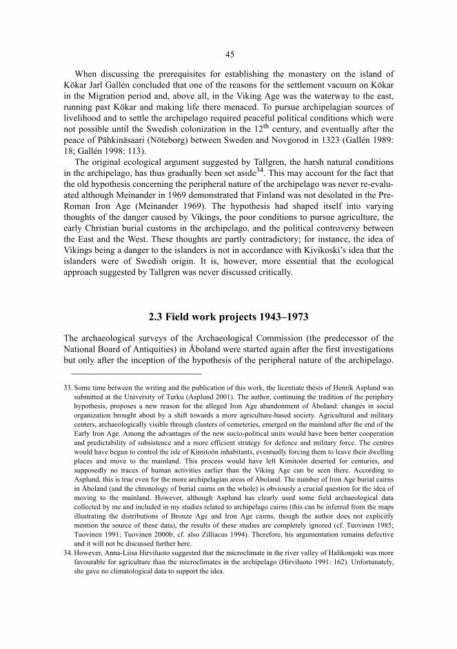
45
When discussing the prerequisites for establishing the monastery on the island ofKökar Jarl Gallén concluded that one of the reasons for the settlement vacuum on Kökarin the Migration period and, above all, in the Viking Age was the waterway to the east,running past Kökar and making life there menaced. To pursue archipelagian sources oflivelihood and to settle the archipelago required peaceful political conditions which werenot possible until the Swedish colonization in the 12th century, and eventually after thepeace of Pähkinäsaari (Nöteborg) between Sweden and Novgorod in 1323 (Gallén 1989:18; Gallén 1998: 113).
The original ecological argument suggested by Tallgren, the harsh natural conditionsin the archipelago, has thus gradually been set aside34. This may account for the fact thatthe old hypothesis concerning the peripheral nature of the archipelago was never re-evalu-ated although Meinander in 1969 demonstrated that Finland was not desolated in the Pre-Roman Iron Age (Meinander 1969). The hypothesis had shaped itself into varyingthoughts of the danger caused by Vikings, the poor conditions to pursue agriculture, theearly Christian burial customs in the archipelago, and the political controversy betweenthe East and the West. These thoughts are partly contradictory; for instance, the idea ofVikings being a danger to the islanders is not in accordance with Kivikoski’s idea that theislanders were of Swedish origin. It is, however, more essential that the ecologicalapproach suggested by Tallgren was never discussed critically.
2.3 Field work projects 1943–1973
The archaeological surveys of the Archaeological Commission (the predecessor of theNational Board of Antiquities) in Åboland were started again after the first investigationsbut only after the inception of the hypothesis of the peripheral nature of the archipelago.
33. Some time between the writing and the publication of this work, the licentiate thesis of Henrik Asplund wassubmitted at the University of Turku (Asplund 2001). The author, continuing the tradition of the peripheryhypothesis, proposes a new reason for the alleged Iron Age abandonment of Åboland: changes in socialorganization brought about by a shift towards a more agriculture-based society. Agricultural and militarycenters, archaeologically visible through clusters of cemeteries, emerged on the mainland after the end of theEarly Iron Age. Among the advantages of the new socio-political units would have been better cooperationand predictability of subsistence and a more efficient strategy for defence and military force. The centreswould have begun to control the isle of Kimitoön inhabitants, eventually forcing them to leave their dwellingplaces and move to the mainland. This process would have left Kimitoön deserted for centuries, andsupposedly no traces of human activities earlier than the Viking Age can be seen there. According toAsplund, this is true even for the more archipelagian areas of Åboland. The number of Iron Age burial cairnsin Åboland (and the chronology of burial cairns on the whole) is obviously a crucial question for the idea ofmoving to the mainland. However, although Asplund has clearly used some field archaeological datacollected by me and included in my studies related to archipelago cairns (this can be inferred from the mapsillustrating the distributions of Bronze Age and Iron Age cairns, though the author does not explicitlymention the source of these data), the results of these studies are completely ignored (cf. Tuovinen 1985;Tuovinen 1991; Tuovinen 2000b; cf. also Zilliacus 1994). Therefore, his argumentation remains defectiveand it will not be discussed further here.
34. However, Anna-Liisa Hirviluoto suggested that the microclimate in the river valley of Halikonjoki was morefavourable for agriculture than the microclimates in the archipelago (Hirviluoto 1991: 162). Unfortunately,she gave no climatological data to support the idea.
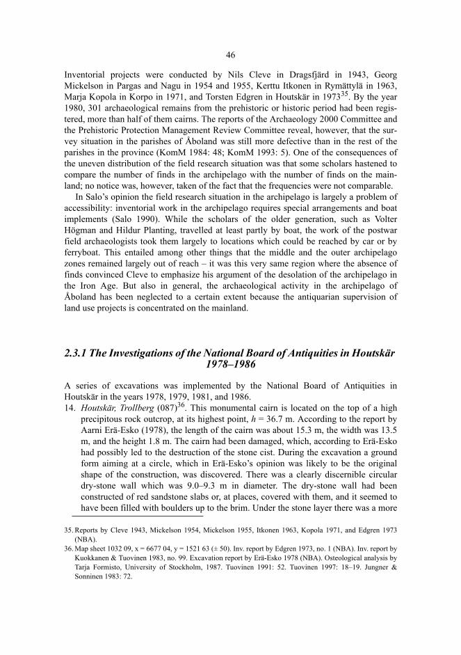
46
Inventorial projects were conducted by Nils Cleve in Dragsfjärd in 1943, GeorgMickelson in Pargas and Nagu in 1954 and 1955, Kerttu Itkonen in Rymättylä in 1963,Marja Kopola in Korpo in 1971, and Torsten Edgren in Houtskär in 197335. By the year1980, 301 archaeological remains from the prehistoric or historic period had been regis-tered, more than half of them cairns. The reports of the Archaeology 2000 Committee andthe Prehistoric Protection Management Review Committee reveal, however, that the sur-vey situation in the parishes of Åboland was still more defective than in the rest of theparishes in the province (KomM 1984: 48; KomM 1993: 5). One of the consequences ofthe uneven distribution of the field research situation was that some scholars hastened tocompare the number of finds in the archipelago with the number of finds on the main-land; no notice was, however, taken of the fact that the frequencies were not comparable.
In Salo’s opinion the field research situation in the archipelago is largely a problem ofaccessibility: inventorial work in the archipelago requires special arrangements and boatimplements (Salo 1990). While the scholars of the older generation, such as VolterHögman and Hildur Planting, travelled at least partly by boat, the work of the postwarfield archaeologists took them largely to locations which could be reached by car or byferryboat. This entailed among other things that the middle and the outer archipelagozones remained largely out of reach – it was this very same region where the absence offinds convinced Cleve to emphasize his argument of the desolation of the archipelago inthe Iron Age. But also in general, the archaeological activity in the archipelago ofÅboland has been neglected to a certain extent because the antiquarian supervision ofland use projects is concentrated on the mainland.
2.3.1 The Investigations of the National Board of Antiquities in Houtskär 1978–1986
A series of excavations was implemented by the National Board of Antiquities inHoutskär in the years 1978, 1979, 1981, and 1986.14. Houtskär, Trollberg (087)36. This monumental cairn is located on the top of a high
precipitous rock outcrop, at its highest point, h = 36.7 m. According to the report byAarni Erä-Esko (1978), the length of the cairn was about 15.3 m, the width was 13.5m, and the height 1.8 m. The cairn had been damaged, which, according to Erä-Eskohad possibly led to the destruction of the stone cist. During the excavation a groundform aiming at a circle, which in Erä-Esko’s opinion was likely to be the originalshape of the construction, was discovered. There was a clearly discernible circulardry-stone wall which was 9.0–9.3 m in diameter. The dry-stone wall had beenconstructed of red sandstone slabs or, at places, covered with them, and it seemed tohave been filled with boulders up to the brim. Under the stone layer there was a more
35. Reports by Cleve 1943, Mickelson 1954, Mickelson 1955, Itkonen 1963, Kopola 1971, and Edgren 1973(NBA).
36. Map sheet 1032 09, x = 6677 04, y = 1521 63 (± 50). Inv. report by Edgren 1973, no. 1 (NBA). Inv. report byKuokkanen & Tuovinen 1983, no. 99. Excavation report by Erä-Esko 1978 (NBA). Osteological analysis byTarja Formisto, University of Stockholm, 1987. Tuovinen 1991: 52. Tuovinen 1997: 18–19. Jungner &Sonninen 1983: 72.

47
indistinct construction, possibly an inner concentric circle, which did not differ fromthe rest of the construction as to the colour or the type of the material stones. The rocksurface was encountered after the removal of the stones. It was covered by a thin layerof soil which contained some charcoal, burnt bone, eight quartz flakes, and a quartzscraper. The bone sample consisted of 330.1 g of burnt bone, 231.8 g of which wasidentified (32.1 g of calvarium): Juvenilis/Adultus, MNI = 1. After the investigationthe excavation team reconstructed the cairn in the shape which, according to theirassumption, must have been the original. The cairn shaped itself into a regularmound, 12 m in diameter, lined by a circle of heavy boulders.
Fig. 3. Trollberg, Houtskär. The NW part of the cairn has been removed to reveal the innercircle. A combination level plan of the excavation in the year1979, drawn by Aarni Erä-Esko.The National Board of Antiquities.
48
Fig. 4. The Trollberg cairn can be distinguished in the distance when climbing up the SE slope to the topof the rock outcrop. Photograph by the author.
Fig. 5. The cairn of Trollberg is well known. In Houtskär it has been endowed a great significance since itis said to symbolize the whole prehistory of the locality. The guide board on the parking place of a boatrestaurant tells the visitors the way up to the cairn which is on one of the highest rocks in the region.Photograph by the author.
49
15. Houtskär (Houtskari), Furunabb (088)37. This cairn belongs to the cemetery ofFurunabb (Tuovinen 1991: 57–59; Zilliacus 1994: 36), located on a plane rockoutcrop near the shore, h = 15.0 m. The cairn 088 is a rectangular construction, builtmostly of rounded stones and boulders (about 1–100 kg), the side lengths of whichare 8.3 m (W–E) and 7.7 m (N–S), and the height 0.7 m. The sides are fairlyaccurately oriented towards the cardinal points of the compass. The outer frame of thecairn is built of large boulders. In the middle there is an edged vertical stone slab, acentre stone, orientated N–S on its long side. The height of the centre stone from thesurface of the cairn is 1.7 m, the width at the base 1.4 m, and the thickness 0.2–0.3 m.Seen from aside, the centre stone resembles an asymmetrical polygon. In anexcavation conducted by Tapio Seger in 1986, it was discovered that the proportion ofsmall stones mixed with large boulders was greater in the filling layer than in thesurface layer. Many of the small stones had become brittle by action of fire. In thefilling layer, a well-preserved skeleton was found; according to Seger, the skeletonwas one of a small dog, and of recent age. It is noteworthy that in course of theexcavation the amount of small stones decreased in the deeper-lying layers. On therock surface there was a layer of humus, 2–3 cm thick, without any finds. The totalheight of the centre stone was measured to be 2.25 cm. According to L.W. Fagerlund,the centre stone whose height was seven feet (2.08 m), had been erected only 30 yearsearlier, i.e. in the middle of the 19th century (Fagerlund: 1878: 293).
16. Houtskär, Furunabb (091). A shallow stone setting, consisting of two layers of stones,excavated by a team led by Päivi Pykälä-aho in 1981. The altitude was h = 14.8 m.According to the excavation report, the length of the construction was 4.1 m, thewidth 3.9 m, and the height 0.5 m. 280 g of burnt bone fragments were found under afive-centimeter-thick humus layer on the rock surface.
17. Houtskär, Furunabb (092). A shallow triangular stone setting, consisting of stones intwo layers, excavated by a team led by Pirkko Höysniemi in1979. The altitude was h= 12.5 m. The length of the stone setting was 2.8 m, and the width 2.5 m. A ferrule ofiron was found in the thin humus layer on the bottom of the stone setting.
37. Furunabb in Hyppeis, Houtskär is a cemetery of 12 stone settings. Inv. report by Kuokkanen & Tuovinen1983, no. 76–88 (TYA). Eight of the cairns were excavated by the National Board of Antiquities in the years1979, 1981, and 1986. Map sheet 1032 06, x = 6678 55….6678 60, y = 1514 73…1514 75 (± 50). Cairn 088.Excavation report by Seger 1986 (NBA). Cairn 091. Artefacts: NM 21157: 2. Excavation report by Pykälä-aho 1981 (NBA), no. 5. Cairn 092. Artefacts: NM 20576: 1-7. The particles of bone reported by PirkkoHöysniemi (1979, no. 6, NBA) were identified as charcoal and stone (Tarja Formisto, University ofStockholm, 1987). Cairn 094. Artefacts: NM 21157: 3. Excavation report by Pykälä-aho 1981 (NBA). Cairn096. Excavation report by Pykälä-aho, no. 10. Cairn 097. Artefacts NM 21157: 1. Excavation report byPykälä-aho 1981, no. 11 (NBA). Cairn 098. Excavation report by Pykälä-aho 1981, no. 12 (NBA). Cairn 099.Excavation report by Pykälä-aho 1981, no. 13 (NBA). Other sources: Fagerlund 1878: 293; Tuovinen 1991:57–59; Tuovinen 1997: 19–20; inv. report by Edgren 1973, no. 2 (NBA).
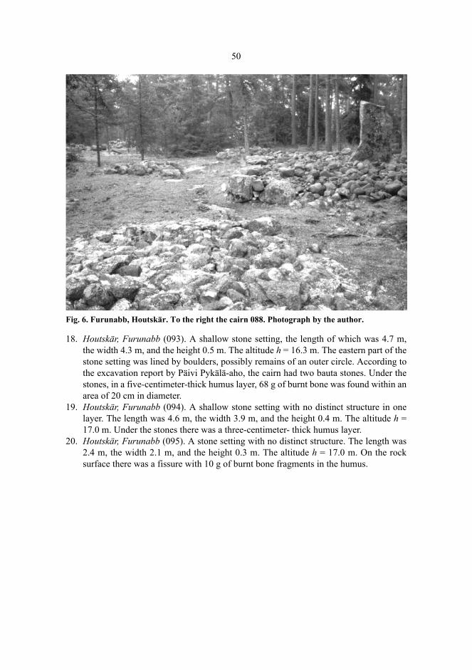
50
Fig. 6. Furunabb, Houtskär. To the right the cairn 088. Photograph by the author.
18. Houtskär, Furunabb (093). A shallow stone setting, the length of which was 4.7 m,the width 4.3 m, and the height 0.5 m. The altitude h = 16.3 m. The eastern part of thestone setting was lined by boulders, possibly remains of an outer circle. According tothe excavation report by Päivi Pykälä-aho, the cairn had two bauta stones. Under thestones, in a five-centimeter-thick humus layer, 68 g of burnt bone was found within anarea of 20 cm in diameter.
19. Houtskär, Furunabb (094). A shallow stone setting with no distinct structure in onelayer. The length was 4.6 m, the width 3.9 m, and the height 0.4 m. The altitude h =17.0 m. Under the stones there was a three-centimeter- thick humus layer.
20. Houtskär, Furunabb (095). A stone setting with no distinct structure. The length was2.4 m, the width 2.1 m, and the height 0.3 m. The altitude h = 17.0 m. On the rocksurface there was a fissure with 10 g of burnt bone fragments in the humus.

51
Fig. 7. The excavated burial cairns in the archipelago of Åboland. 1. Labbnäsåsen, Dragsfjärd.2. Jordbro, Dragsfjärd. 3. Långnäsudden, Dragsfjärd. 4. Rövik, Dragsfjärd. 5. Hammarsboda108, Dragsfjärd. 6. Nämanön, Dragsfjärd. 7, 8. Tjuda, Kimito. 9. Jättekastberget, Kimito. 10.Söderviken, Västanfjärd. 11, 12. Lillskogen, Västanfjärd. 13. Söderby, Dragsfjärd. 14.Trollberg, Houtskär. 15–22. Furunabb, Houtskär. 23, 24. Sundbergen, Nagu. 25. Lilla Kuusis,Nagu. 26. Östergård 2, Dragsfjärd. 27. Ängesnäs bergen, Nagu.
21. Houtskär, Furunabb (096). A stone setting of one stone layer, the length of which was1.8 m, the width 1.6 m, and the height 0.3 m. The altitude h = 15.3 m.
22. Houtskär, Furunabb (097). A stone setting of one stone layer, the length of which was3.7 m, the width 2.6 m, and the height 0.5 m. The altitude h = 14.8 m.
The excavation at Trollberg, Houtskär, in 1978, and particularly the excavations atFurunabb in 1979, 1981, and 1986 produced substantial new evidence of the chronologyof the cairns. The layer containing charcoal in the grave at Trollberg was radiocarbondated to the Bronze Age (2990 ± 140 uncal BP, Hel-114338). The characteristics of thesecairns emphasize the differences between the graves from the Bronze Age and those fromthe Iron Age because the Trollberg and Furunabb cairns represent both morphologicallyand topographically almost opposite features.
38. The date is 2990 ± 140 BP, which gives, according to the A-method of Stuiver & Reimer (1993), thecalibrated date 1 σ : cal BC 1425 (1212, 1199, 1192, 1138, 1132) 974 (Hel-1143; Jungner & Sonninen 1983:72).
23,24 Sundbergen
25 Lilla Kuusis
26 Östergård 2
27 Ängesnäs bergen
123
4
5
6
7,8
9
1011,12
13
14
15-22Furunabb

52
2.3.2 New finds
2.3.2.1 Early Metal Age
In the last few decades the number of the Metal-Age finds in the archipelago of Åbolandand Kimitoön has increased rapidly thanks to research projects and amateur activity39.Three Bronze-Age or pre-Roman dwellings have been found on the island of Kimitoön:Hammarsboda 3, Dragsfjärd; Tappo, Västanfjärd; and Makila, Kimito. Maybe even Jord-bro, Dragsfjärd, found by Nils Cleve in 1943, could be included in the list.
At Hammarsboda, Dragsfjärd, the ice-marginal formation of Salpausselkä III traversesa valley between two rocky areas of elevated land. Here the ice-marginal formationformed in the second pre-Christian millennium a dry gravel isthmus which on both sideswas lined with arms of the sea towards the south and towards the north (figure 8). Thereare Subneolithic dwellings in this area down from the height of 30 m, possible trappingpits, and six cairns, four of which date back to the Bronze Age with relatively greatcertainty. To judge from the height, the youngest dwelling is Hammarsboda 3, which waslocated on the isthmus, and was thus particularly well sheltered against heavy seas but, onthe other hand, in immediate contact with the outer archipelago and the open sea. In thenorth, there was a long (4.5 km) arm of the sea, opening in the west into the outerarchipelago; in the south there was another arm of the sea (1.2 km), also opening into theouter archipelago. The location of the dwelling reminds of the Bronze-Age seal huntingsite in Otterböte, Kökar (Gustavsson 1997). The excavation in 1991 revealed stoneartefacts and pottery typical of the Kiukainen-culture40. During the excavation some sur-face artefacts were collected, and their elevations were measured tacheometrically. Theelevations obtained indicated that the site had been inhabited when the surface of theearth was as much as 18 m lower than today, i.e. in about 1300 BC. The Kiukainen-ceramics does not exclude the dating of the dwelling to the early Bronze Age as it seemsto have been in use until about 1000 BC (Carpelan 1979).
The dwelling at Tappo was located, in the period of its usage, at the farthest corner of along and shallow cove, not far from arable fine-grained sediments and at some distancefrom the shore (figure 8). The excavation in 1989 led by Henrik Asplund brought todaylight a relatively big amount of burnt clay in regard to the investigated area; the claydisplayed grooves made by twigs or branches, possibly remains from a wall built ofintertwined branches. The ceramics is Epineolithic, and the dwelling can thus be datedback to the younger Bronze Age or the Pre-Roman Iron Age. In the bone material onlyone seal bone was recognizable (Asplund 1997 a: 255–258). There are three medium-sized cairns in the vicinity of the dwelling, one of these with a high centre stone (331,332, 333).
39. Part of the finds have been published with general regional surveys. See Koivunen 1982; Tuovinen 1984;Nyberg 1985; Suistoranta 1985; Myhrman 1990; Tuovinen 1991; Fagerlund 1992; Laukkanen 1995;Tuovinen 1997; Asplund 1997 a; Tuovinen 1999; Tuovinen 2000 b; Fortelius 1999: 1–3; Asplund 2000;Myhrman 2000.
40. Excavation report by Tuovinen 1991 (TYA).
53
The dwelling site at Makila, Kimito was located, in its period of usage, at the farthestcorner of a cove opening towards the east, not far from fine-grained sediments (figure 8).Test pits were dug and a phosphorus mapping was performed on the stony hill of morainelimited by cultivated fields and hilly moraine terrain in 199041. The finds include piecesof Morby ceramics, burnt clay, and burnt bone. There is also a cairn on the hill (154). Thelower limit of high phosphorus contents in the terrain is about 18.0 m. The dwelling datesback to the Bronze Age or the Pre-Roman Iron Age. A cairn was investigated in 1997 onthe cliff rising north of the dwelling. It was discovered to be surrounded by a structurelaid of stones intended to even the ground around the cairn (Asplund 1997 a: 258–259).
Jordbromalmen is a dwelling site from the period of the Kiukainen-culture; itsshoreline lay, according to C.F. Meinander (1954 b: 64), at the height of 19.5 m. Thus it isslightly older than the Litorina V- shoreline, and the dwelling might have been in use aslate as the Bronze Age. The site is located on a gently inclining S and SE gravel slopewith a view towards Dragsfjärd, an open stretch of the sea opening below the slope, todaycontracted into a lake. During the excavations made by Nils Cleve and C.F. Meinander in1946 and 1947 a 25–40 cm thick culture layer with scattered soot stains and fire-crackedstones, at least partly remains of fireplaces,was uncovered in the sandy terrain. Threefoundations of dwellings, oblong low stone structures laid on the ground, and traces ofwooden upright props were discovered on the site. Ninety per cent of the pottery showedno decoration, but the decorated sherds refer to the Kiukainen-ceramics (Meinander 1954b: 61–65). The rest of the dwellings belonging to the Kiukainen-culture (Östermark,Kimito; Branten, Kimito; Knipäng, Dragsfjärd; Hammarsboda 2 and 4, Dragsfjärd;Alistalo, Rymättylä; and Sydmo malmarna, Pargas) are of older origin, according to theevidence available today42. In Satava, Turku, a quartzitic artefact having the shape of abear-head was found, but it seems to be a stray find43. According to Christian Carpelan itoriginates from the Neolithic or the Early Bronze Age (Carpelan 1974).
41. Excavation report by Asplund 1990 (TYA).42. Asplund 1997 a: 240–241; Meinander 1954 b: 64–66; Koivunen 1982.43. NM 13439. See field report by Tuovinen 1979, no. 4.10 (PMT).
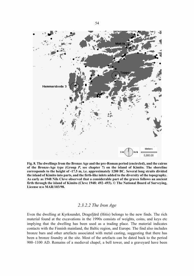
54
Fig. 8. The dwellings from the Bronze Age and the pre-Roman period (encircled), and the cairnsof the Bronze-Age type (Group P, see chapter 7) on the island of Kimito. The shorelinecorresponds to the height of -17.5 m, i.e. approximately 1200 BC. Several long straits dividedthe island of Kimito into parts, and the firth-like inlets added to the diversity of the topography.As early as 1948 Nils Cleve observed that a considerable part of the graves follows an ancientfirth through the island of Kimito (Cleve 1948: 492–493). © The National Board of Surveying,License n:o MAR/103/98.
2.3.2.2 The Iron Age
Even the dwelling at Kyrksundet, Dragsfjärd (Hitis) belongs to the new finds. The richmaterial found at the excavations in the 1990s consists of weights, coins, and keys etcimplying that the dwelling has been used as a trading place. The material indicatescontacts with the Finnish mainland, the Baltic region, and Europe. The find also includesbronze bars and other artefacts associated with metal casting, suggesting that there hasbeen a bronze foundry at the site. Most of the artefacts can be dated back to the period900–1100 AD. Remains of a medieval chapel, a bell tower, and a graveyard have been
55
found in the vicinity of the dwelling (Nordman 1940; Edgren 1995 a; Edgren 1995 b;Edgren 1996; Edgren 1997 a; Edgren 1999b: 7–18).
At Jungfrusund, Dragsfjärd, there is natural harbour, which was used from the MiddleAges to the 18th century. Four vessels of Slavic ceramics (also known as Vend or Balticceramics) were found on the bottom of the sea outside the harbour in 1987. In allprobability they had been used in the 11th–13th centuries (Dahlström 1945; Ericsson 1979;Kallberg 1990; Edgren 1997 b). The site is located 14 km north-northwest of Kyrksundet.A piece of an East Scandinavian runic stone, probably dating back to the late 11th century,was found at Stora Ängesön, 7 km north of Kyrksundet, on the bottom of a reedy fladcove (Åhlén et al. 1998 a; Åhlén et al. 1998 b)44. The rest of the newer Iron-Age strayfinds consist of a barbed spear head, found at Malmen, Pargas and dating back to theMigration Period or the Merovingian period45, a Viking-Age iron axe found on Jermo,Pargas46, an oval striking-stone found at Helgeboda, Kimito47, and a wedge axe from theViking Age, found in Hirvensalo, Turku48. Furthermore, two cup-marked stones areknown to have been found in Åboland, one at Galtby, Korpo, and the other at Berga,Kimito. Both of those have become demolished (Tuovinen 1991: 70–71; Asplund 1997 a:261).
Also the rocky fortified island of Borgholm, Iniö can be included in the Iron-Agefinds. It is a wooded islet of 15 hectares, its top reaching the height of 28 m. The gentlyinclining southern slope is encircled by a 450-metre-long stone wall whose lowest point isat the height of 8.1 m. On account of the height it can be established that the fortified islethas not been in use before the Viking Age (Tuovinen et al. 1992). Another knownfortified islet in Åboland, Bårnholm, Nagu is a granite dome with sharp and steep featuresrising to the height of 30 m; the area of this island in the inner archipelago of Nagu is lessthan two hectares. The shore cliffs all around the island are steep or vertical, and can beascended only with great difficulty. A double wall constructed of heavy granite bouldershas been built on the southwestern slope which is gentler than the others. Noinvestigations have been carried out on the island, and the age of the wall is unknown(Nordman 1936; Dahlström 1945: 63–67; Tuovinen 1991: 71–73). The numerous placenames with an initial borg-, lin- or linna- may refer to fortified islands. The rocks or cliffswith names with an initial borg- in Houtskär have been assumed to be Iron-Age refugesbut no walls have been found on them. The names with an initial borg- occasionally referalso to islands with sheer shores (Pitkänen 1985 a: 271–273; Orrman 1991 a: 222;Zilliacus 1989: 56; Zilliacus 1994: 38; Zilliacus 1997: 43; Valtavuo-Pfeifer 1998: 46–47;cf. also Montin-Tallgren 1910; Tallgren 1931 a: 171).
44. A flad (Sw. flada) is a shallow bay formed by the land uplift, often partly isolated from the sea. See, e.g.Numminen 1999.
45. NM 13619. Cf. Salmo 1938: 215–216; Cleve 1943: 133–134; Kivikoski 1973: fig.551; Lehtosalo-Hilander1982: 21–22; Pihlman’s type R1 (Pihlman 1990: 122–126). Asplund 2000: 56–57.
46. Asplund 2000: 58–59.47. NM 30444. Asplund 1997 a: 261–262.48. PMT 15740. Cf. Wuolijoki 1972: 26; Kivikoski 1973: fig. 882. Inv. report by Tuovinen 1979, no. 4.15
(PMT). With reference to an axe of the same cuneiform type in Estonia, Henrik Asplund suggests that theartefact originates from the Early Iron Age (Asplund 2000: 62). Whichever is the true date, the axe hasoriginally fallen to the clayey bottom of an inlet, since the altitude of the shore where is was found is only 3–4 meters.

56
In the field investigations of recent years, constructions laid of boulders confining around or rectangular floor space have been discovered. A vertical rocky wall sometimesforms one or two of the walls of the dwelling. The area of the floor space isapproximately 4–30 square metres, frequently cleared and levelled. The wall may befairly low, almost on the level of the ground, or a dry-stone wall of the height of a fewboulder tiers. The remains have not been investigated but their structure and location aresuggestive of a tomtning, i.e. remains of a temporary shelter for fishermen and sealhunters overnighting near the fishing grounds. More than twenty tomtning-remains havebeen found in Houtskär, Korpo, Nagu, and Dragsfjärd (Tuovinen 1991: 78–80).
Tomtning-remains have been discovered also in the archipelago of Åland (Karlsson1990). By 1993 as many as 1259 tomtning-remains had been recorded solely on the eastcoast of Sweden (Norman 1993: 30). The coasts of Norrbotten and Västerbotten areparticularly rich in tomtning-remains used by ancient seal hunters; these remains aremainly from the Viking Age or the Middle Ages, the oldest from the Migration Period asevidenced by radiocarbon dating. According to Peter Norman, the northern tomtning-remains display two age layers which are different from each other in terms of locationand construction. Medieval tomtning-remains are located on the utmost skerries at theedge of the zone of solid ice, and often in clusters of dozens of shelters. Those from theIron Age have been built closer to the inner archipelago at the height of 10–30 m abovesea level (Norman 1993: 39–40, 47–48; Broadbent 1987; Nilsson 1988; Olofsson &Lindström 1990).
In the archipelago of Åboland there are a few tomtning-remains located in shelteredterrain at the height of 10–26 m, and their distinctive features are very much the same asthose of the Iron-Age tomtning-remains on the Swedish east coast. These remains may befairly old. Most of them are, however, located on rather low sites in the outer archipelago,and date probably from the historical period (Tuovinen 2000 b). Memorized knowledgeof overnightings on the outer fishing skerries in simple constructions of stone has beenrecorded particularly in the archipelago of Åland in the 20th century (Andersson 1938:119; Törnroos 1980: 97–98; Högnäs 1984; 1989; Karlsson 1990; Slotte 1990: 165). Thenumber of Metal-Age archaeological finds in Åboland has increased rapidly but the fieldresearch situation is still defective in certain respects in comparison with that on themainland coast. For instance the investigations of dwellings have been fewer resulting ina fairly small number of registered Metal-Age dwellings. It may be, however, moresignificant that the ecological fundamental assumption in Tallgren’s hypothesisconcerning the peripheral nature of the archipelago, i.e. the unfavourable naturalconditions in the archipelago, still remains unfounded. The evidence acquired throughfield archaeology has been far too little to be of any help in discussing the hypothesis. Thenature of the archipelago is, however, rather diversified rather than scanty, as alleged atthe beginning of this chapter. For this reason I will discuss the hypothesis of theperipheral nature of the archipelago again in chapter 9.
57
2.4 Interpretations of Coastal Cairns
2.4.1 Immigration or Cultural Contacts
In his work Die Bronzezeit in Finnland (1954) C.F. Meinander was inclined to supportthe idea that the construction of cairns and the bronze artefacts should be understood interms of cultural contacts rather than as evidence of an immigration of Scandinaviansettlers. Meinander demonstrated among other things that the finds from two dwellingsites, which had been known in Tallgren’s days, included artefacts from the Bronze Age.These sites were Toispuolojannummi, Paimio and Isokylä, Uskela. The finds from theformer site were previously considered to date from the period of comb-ceramics(Europaeus 1930); pottery from the latter site were known since the beginning of thecentury but they were regarded as grave finds from the Roman Iron Age (Europaeus1914). It was thus evident that there was Bronze-Age settlement on the coast of themainland. As new dwelling sites belonging to the Neolithic Kiukainen-culture werediscovered on the islands and on the coast, the populations of the Kiukainen-culture, andthe later cairn builders could not be regarded as entirely separate communities any longer.Nevertheless, in his Bronzezeit, Meinander does not entirely oppose to the old idea thatpeople from Sweden settled down on the Finnish coast in the early Bronze Age. Thecairns were, according to Meinander, of religious significance. The graves constructed onlow-lying land were located in the vicinity of settlement and cultivated fields, suggestingthat beliefs concerning harvest were an essential part of the burial ritual. The cairnsconstructed on high rocks reflected the desire of the communities to have a contact withnature, the sea, the sun, and the subterranean powers in the rocks (Meinander 1954 a: 93–94; 196–201).
Unto Salo has presented a further development of the interpretation of new settlers.The accurate homology between the pattern of cairns on the Finnish coast and that inScandinavia – both in terms of morphology and location – speaks for the immigranttheory. The cairns are utterly different from the traditions of the population of theNeolithic Kiukainen-culture. The new burial ritual signified such a deep-going social andreligious phenomenon that it must have been adopted from immigrants, and through long-term and intensive contacts. The immigrants settled down in the infertile rocky coastalregions in Åland and South-West Finland, which were suitable for fishing, seal hunting,fowling, and, occasionally, for clearing woodland for new cultivation. The number ofimmigrants was, however, small, and there was no organized immigration. Thedevelopment of the relationships between the immigrants and the old populationrepresenting the Kiukainen-culture was fairly favourable which is demonstrated by thefact that the new burial ritual was adopted among the population of the Kiukainen-culture.The Scandinavian immigrants gradually became incorporated in the original population,and, in course of time, the archaeological differences vanished (Salo 1981a: 16–21; Salo1981b: 424–437; Salo 1984 a; Salo 1984 c: 85–94; Salo 1988: 89–92; Salo 1995).
In Southern Scandinavia an advanced bronze technology evolved in the beginning ofthe second millennium BC. It was based on imported raw material, and therefore it wascrucial to establish an exchange network in the northern and eastern Fennoscandia.According to Christian Carpelan some of the Scandinavian traders settled in the Finnish

58
coastal areas to form a kind of superstratum, an upper class living among the populationof the Kiukainen-culture and at its expense. The immigrants lived at the same sites as thepopulation of the Kiukainen-culture, and therefore there are no visible archaeologicaldifferences. The upper class traded in natural products which were conveyed toScandinavia where there was a need for commodities to be bartered for metals from thesouth. It took some time before the immigrants had settled in the country for good, andthe new burial ritual was adopted among the population of the Kiukainen-culture onlyafter this development (Carpelan 1982; Carpelan 1999: 271). Tapio Seger’s version of theupper class in the Bronze Age is based on the idea of chiefdom communities suggested byService and Sahlins characterized by ranked social structure, organized redistribution ofproduction, increased population size, territoriality, and centre-periphery relations. In hisopinion the construction work of the cairns was so toilsome that it required extensive co-operation and redistribution of production to feed the labourers. The social structure wasstrictly ranked. The crucial factor in the development of the social structure was theincreased stock of seals (Seger 1982 a).
2.4.2 Adopting a Landscape Approach
Since the very first days of research it has been well-known that cairns have beenpreferably constructed on elevated hills with good visibility over the surroundings. Thereason for this was – as put by Aarne Äyräpää – ”to allow the deceased to see even fromhis last place of rest his dearest field of work, the sea” (Europaeus 1922: 186).
Of the Finnish scholars Unto Salo is the one who has the most thoroughly studied theconnections between the cairns and the landscape. According to his idea, the visibilityfrom elevated grave sites was of two-way nature. On one hand, the view from the gravesite represented the great unity of nature, eternal and infinite. On the other hand, the gravepreserved the memory of the deceased, ”and it was best preserved if the cairn could beseen, at a visible site, particularly from the sea” (Salo 1981: 125). The graves which wereconstructed on rocks with good open view over the surroundings were family monumentsheralding its position and status. The graves gave a visual proof of the power of thefamily as a land-owner: the range of vision opening around the grave drew the borderlinesof the territory ruled by the family, which was not to be trespassed upon by strangers. Thepower was necessary to protect the cultivations, cattle, and natural resources of the familyagainst rivals and competitors (Salo 1981: 122–130). The grave monuments wereindicators of the homesteads and cultivations of the deceased ones and on the other sidethey were signs in the landscape telling outsiders that the land had been taken insomebody’s possession. Consequently, the graves consolidated the internal socialpractices of the community, and were, at the same time, signals directed at any rivalscoming from the outside world49.
In his general reviews of the Metal Age, Unto Salo has outlined a theory concerningthe tradition of cairns; the ingredients of this theory are the sign language of the graves,
49. The idea of territoriality and the control of the landscape has been adopted by many Finnish scholars (e.g.Seger 1982; Asplund 1997 b: 42–43; Pihlman 1999: 65, 73).
59
the family, the land possessions, and the peasant house. According to him, the Bronze-Age cairns had a symbolic function in preserving and protecting the family. The size ofthe grave was the crucial factor. The greater the number of the deceased family membersburied in the same cairn, the bigger the size of the cairn. A large cairn indicatedsimultaneously the strong aspiration of the family and the house to demonstrate their rightto the land as well as the authority, freedom of will, and competitiveness induced by suchland proprietorship. The right to land meant a state of unshared possession effected by thework done in the originally non-possessed piece of ground; its permanence required acontinuous use of the possession, and, on the other hand, protection against any possiblerivals. Changes in the aspirations to demonstrate the proprietary right to land resulted inchanges in the size of the graves. For this reason the size of the cairns became smaller inthe V period of the Bronze Age, if not earlier, and reburials and grave enlargements weresubstituted by individual cairns in the graveyards or cairn clusters. By the Roman IronAge the proprietary rights to land had stabilized, and, as a result, the proprietary right didnot involve any longer very strong social tensions or conflicts of interests; consequentlythe monumental nature of the cairns was no more necessary. This fact, on the other hand,led to constructing smaller and smaller cairns (Salo 1981 b: 125–, 201–204; 1984 a: 133–139; 1984 b: 89–90; Salo 1997: 87–93).
The tendency towards a change concerning the other aspect of monumentality, thechoice of the natural location as a grave site, is concretized in Satakunta on the shores ofthe ancient coves at Panelia and Nakkila. The results of the excavations, particularly atRieskaronmäki in Nakkila, are a good example of the fact that, towards the end of theBronze Age, the grave was not located any more on a high, frequently rocky site of view;instead, it was constructed on a lower ground in the moraine terrain and in the vicinity ofthe homestead. Also the choice of grave sites in itself indicates the development fromindividual graves towards cairn clusters, or groups of several cairns. The development is,according to Unto Salo, closely associated with the beginning of sedentary agriculturalsettlement in the Bronze Age (Salo 1981 b: 127–150; Salo 1984 c: 89; Salo 1987; Salo1997: 14; cf. Carlsson 1983).
The stabilization of power and competitiveness which, according to Salo, ismanifested in the development of the cairn tradition, can also be interpreted as a changein the concept of power from acquired power to inherited power (cf. Thomas 1995). In theearly phase of sedentary agricultural settlement the cairns represented an expression ofpower acquired through competition, in the later stages of development they legitimizedthe inherited power by demonstrating the symbolic relationship between the social orderand the ancestors. In his literary production Unto Salo has made it clear that the landscapeas a cultural construction is an inevitable aspect in understanding the burial ritual of theBronze Age and the Early Iron Age. This approach to landscape and monumentality is thepoint which the present work wishes to augment with additional point of views.
2.4.3 Coastal Cairns in Sweden
In some respects the Swedish research of coastal cairns follows the same lines as theFinnish. Evert Baudou demonstrated in his work Forntida bebyggelse i Ångermanlands

60
kustland (1968) that the cairns were located in certain altitudinal zones not far from theancient coastline. The sedentary Bronze-Age settlement on the coast of Ångermanlandconsisted of clustered settlement units which, according to Baudou, were apparentlyinhabited by extended families. The graves were located at sites which offered anunobstructed view towards the sea: on the shores of straits between islands or betweenislands and the mainland looking out towards the open sea. The best explanation of thegreat number of small scattered single graves is the function of the cairns as signs ofpropriety and as landmarks. In the Bronze Age of Ångermanland, Baudou does not seeany traces of class society since the finds of artefacts were rather few, and most gravesare so small in size that they cannot possibly be interpreted as indications of chiefdom.Any of the graves in Ångermanland may have been built by extended families (Baudou1968: 89–90; 124–152).
Baudou’s observations of the graves looking out towards the open sea have beenconfirmed by Örjan Hermodsson’s (1987) and Lars Forsberg’s investigations on the eastcoast of Sweden. Forsberg established that late Neolithic and early Bronze-Age graveshad been located at the upper ends of coves. Later in the Bronze Age there was atendency to construct graves closer to the open sea, not exclusively, however, since cairnswere still erected also on the shores of straits. At the same time the expansion of cairnconstruction to many different areas was obvious (Forsberg 1999).
The idea of the function of cairns as signs of land proprietorship has emerged inSweden at least on the same scale as in Finland. According to Dan Carlsson, for example,the cairns on Gotland were constructed to be signs of land proprietorship with thedevelopment of agriculture from slash-and-burn cultivation into sedentary fieldcultivation. Such signs had to be permanent monuments which were visible from faraway. The bigger the monument, the smaller the risk of its becoming annihilated. Thelegitimation of acquired land proprietorship was materialized in the cairns of ancestors.The locations of the graves in the unobstructed landscape of Gotland indicates that theywere meant to be visible; the external signs of proprietorship were erected to function aslandmarks and information to outsiders (Carlsson 1983).
The recently published monograph by Dag Widholm deals with the Bronze-Age gravemonuments in Småland, in southern Sweden. He differentiates between the regionscharacterized by ritual reproduction of ideology and religion and those subjected toagricultural production. The most significant graveyards can be interpreted as centralritual sites; in these, according to Widholm, there were graves of people from a larger areathan the very neighbourhood and individuals belonging to various social categories. Suchcentral sites consisted of areas with several graves, typically quadrangular cairns, and shiptumuluses. Individual graves, on the other hand, are to be found in more marginal regions.One of the most significant observations made by Widholm is that the grave sites arelocations used for lengthy periods for repeated rites (Widholm 1998: 39).

3 Land, Sea, and Burial Sites
3.1 Death: a Crisis within the Community
Death causes a crisis in those members of the community who had had close emotionallinks with the deceased. Death also affects those who were socially, economically, orpsychically dependent on the deceased, those who took care of his/her children, fishedwith him/her, and those who could share the knowledge, skills, or other cultural capitalhe/she had acquired. The familiar routine of the day is shattered, and the community iscompelled to solve problems concerning the present and the future. The cultural practicesconcerning the transition from life to death or the period of transition between life anddeath, are called mortuary rituals. In various cultures, the mortuary rituals act asindispensable means of the community to cope with and try to overcome the absence ofbalance and psycho-social crisis caused by the death of a member in the community. Thebeliefs concerning death suppress fear, and contribute to returning safety and order in thecommunity (Malinowski 1960: 53–56, 64–68).
Death rituals express, cope with, and suppress disorder in the community when amember of the community dies. They tend to take care of the deceased, supply his needs,satisfy the wants of those left behind, protecting them simultaneously against supernaturalforces. Taking care of the fate of the deceased as well as of the settling of the mutualrelationships of those left behind, is, as observed by Aili Nenola, ”a symbolic way ofexpressing the process through which the living, those left behind, gradually get rid of thesocial, psychic, and emotional ties to the deceased”. On the other hand, there is empiricknowledge of the fact that all the essential features of the mortuary ritual are reserved, ingeneral, only for the authoritarian members of the community whose death really jerkssociety out of its balance, and who have died in a habitual or permitted way (Nenola1985: 185, 202).
The religious notions associated with death offer an explanation to what happens atdeath, and give a myth-based pattern to be followed when facing death. Everywherepeople have made an effort to adapt to the crisis caused by death by creating culturallyuniform, analytical answers to the challenge of death (Pentikäinen 1990). The formalityrecognized by both anthropologists and archaeologists which prevails in the methods ofhandling the deceased, is thus made very understandable (Pader 1982: 36–40). The corpse
62
and the ways of handling it contain a strong symbolic means expressing the transitionfrom life to death (Barrett 1996).
Mortuary rituals may involve one’s ancestors who participate in rites concerned withthe living, i.e. ancestor rituals or they are funerary rituals that are specifically concernedwith human burial (Barrett 1996: 397). Mortuary rituals are rites of passage meant tolocate the deceased conclusively and permanently in the other world, the realm of death.They are not merely ceremonies which put an end to life, possibly visualized by a graveconstruction to be discovered by archaeologists, but they also represent a formal turningpoint which makes a new existence possible after death (Kaliff 1997: 20).
Mortuary rituals often include an ambivalence which is based on fear of death on onehand, and on emotional attachment to the deceased on the other. Estrangement from thedeceased is achieved by confronting and handling the corpse in various ways, washing oradorning it or with a wake. At the same time the contact between the deceased and thoseleft behind is maintained through pictures, statues, grave constructions or other images,and symbols. Mortuary rituals help those left behind to create the feeling that thedeceased has been bidden a conclusive farewell, that the estrangement is sufficientlyeffective, and that the deceased is no more among those alive and thus not capable ofaffecting them (Holm 1997: 67–68).
The final farewell is concretely expressed in the beliefs of Siberian and Saami tribesaccording to which in the Totenreich (the Realm of the Dead) cultural categories liketime, directions, body parts, earth and sky, are inverted in relation to the world of theliving (Harva 1938: 347–350; Storå 1971: 206–209). According to Uno Harva(Holmberg), this comprehension probably originates from the very experience of lookingat one’s image on the mirroring water surface (Holmberg 1925). Among the 19th-centurySiberian Nenets, objects buried with the deceased were broken to signify that in the otherworld they were used in a different way from that found on earth. The sledge that wasused to transport the deceased to the cemetery, was left there and turned upside down orinjured in a special manner that was symbolically linked to the realm of the dead. Thosewho moved away from the grave, stepped backwards and returned back to the homechoom by a different route, in order to reproduce the principle of inversion and misleadthe deceased, preventing him or her to find the way home (Ovsyannikov & Terebikhin1994: 48–57). Any archaeologist who found these artefacts afterwards would probablybecome aware of the intentional damage caused to them, but not necessarily of the ritualsignificance of these characteristics.
Facing death requires of the nearest friends and relatives of the deceased renewednegotiations concerning the feelings of mutual obligations and solidarity also with regardto ancestors and the supernatural. The process of death actualizes, on the other hand, eventhe demands concerning social relationships, conflicts, and, for example, theauthorization of taking possession of the property of the deceased. The process of deathemphasizes the ritual as an expression of exertion of power, and as a means oflegitimation of this power. The version of social relationships shown in the ritual isfrequently idealized and legitimized through references to the past and the ancestors; itprovides a forum on which to disperse and conceal social conflicts (Pader 1982: 36–44;Hedeager 1990: 97–98; Pihlman 1990: 49–50; Kristiansen 1991: 21, 31–35; Bender 1992;Härke 1993). On the other hand, as a social transition the ritual also reveals and expressesfundamental categories, rules, and beliefs. According to Victor Turner, those who
63
participate in rites of passage move from a social state and status to another, proceedingfrom the separation phase to the liminal phase and the incorporation phase. The liminalphase is characterized by an egalitarian relationship between persons and an absence ofconventional status, rule and property (communitas, Turner 1969). The ritual includes theopportunity of renewed discussions or repudiations concerning categories and rules thusmaking transitions between sociocultural categories possible. Consequently, categoriesare thus defined, overstepped, and redefined (Barrett 1996: 396–397; Anttonen 1996: 34).
When discussing the cherishing of ancestors’ memories at secondary interments KojiMizoguchi emphasizes the actualisation of the cultural power field in the mortuary ritual.Memories and recognition of one’s ancestors may serve as exclusive means of powerwhich were, to a limited extent, at the disposal of a certain group – according toMizoguchi these were likely to be men – to naturalize and justify the power of the group.Interpretations and disputes concerning the ancestors and their authority had a chance ofemerging in the specific situation caused by death. Discussions in the power field weresubject to cultural norms which were thus submitted to pressures of change. In thisrespect, the mortuary ritual was a site of continuity as well as of change and discontinuity.People were able to feel that they observed loyally the tradition of mortuary ritualalthough the surging cultural power field had in fact resulted in changes in the mortuaryritual. Archaeological evidence provides a special opportunity of studying this processover a longer period (Mizoguchi 1996: 231; Pader 1982: 37–39).
3.2 Graves as Markers of What Is Beyond
The autonomous connection of the deceased with the community of the living isdisrupted only after the final conclusion of the burial ritual. After that the grave remainsas a reminder of the deceased and the incidents connected with his/her death, of the rites,and of the dialogue between the earthly and the supernatural. Contacts with the deceasedare frequently controlled ritually, for instance by channelling them to calendar memorialdays (Nenola 1985: 184; Holm 1997: 69). Contacts with the deceased may also bemaintained with ceremonies formalized by returning to the grave and including a spatialritualization of the grave site. The grave site obtains significances containing beliefswhich make it a sacred site and create a link between the ancestors, the world of the dead,and the world of the living (Cooney 1994), or make the grave site a part of the cycliccirculation of birth, life, and death. The features of the grave accentuating thepermanence from the past to the future, the authority of the past generations, and thepower of the knowledge adopted from them, can be best understood as symbols oftemporal continuity incorporated in the grave. Such features are apt to increase thearchaeological obtrusiveness (to use Schiffer’s term, Schiffer et al. 1978) of a graveconstruction.
64
3.2.1 Stone
Stone is a lasting material which endures from the past to the future, and refers thus tosomething beyond the immediate and temporal world of man’s experience. Of all naturalmaterials, stone provides a substance which may involve implications concerning theworld view and the cosmological order. Unto Salo puts the idea like this:
”The Bronze-Age cairns are (…) in all their stony essence deeply human, and notonly human but also things of cultural history: More serenely than any othermaterial, they reflect the growth of temporal dimension which is likely to be themost essential feature in the cultural history of the Bronze Age” (Salo 1981 b: 114).
The permanence of a grave constructed of stone preserves the cultural importance of thegrave site to those to whom the maintenance of such importance brings security, power,and identity. On the other hand, it also reminds us of the position of the grave site in thepower field of the use of natural resources, and prevents it from being forgotten by thoseto whom the grave site signifies something else.
Some interesting relationships between stone and fire can be pointed out. When astone is struck against metal or another stone, a spark appears: stone gives birth to fire. Aspetrified fire or as a creator of fire, stone thus possesses a sacred existence. It is a part ofthe symbols in the rites of passage of cremation interments, and during the prehistorictime it may ”have been regarded as an abode for the souls of the deceased, and at thesame time a centre of power for the living” (Kaliff 1997: 126). Fire and lithic artefactswere, according to Unto Salo, symbols associated with beliefs concerning thesupernatural power of the thunder, which appeared in Finland along with early agriculture(Salo 1990 a; Salo 1990 b).
3.2.2 Monumentality
The cairns in the southwestern archipelago are located in the barren rocky terrain at siteswhich make them easily discernible. Many graves are very large and protrude from theenvironment in a way which makes one naturally conceive them as very specific stonymarks. When something concrete of a sufficient size and of permanent timeless visibilitywas produced intentionally in the prehistoric period we are apt to speak about monuments(Criado 1995).
In recent years the megalithic monuments in Europe have been given interpretationsbased on social constructivism deriving from the significances of the past of thecommunity, and their presentation in artefacts and narratives. The past of the communitywas materialized and eternalized by preparing durable symbolic artificial artefacts andconstructions, particularly megalithic graves. Material culture ”can introduce absentpersons or classes of person into social discourse by means of metaphors and mnemonics,thereby influencing the interaction” (Thomas 1993). Monuments were timemarks in thelandscape (Holtorf 1997), and carriers of material memory (Neustupny 1998) which weremeant to endure to the coming generations. Neolithic monuments marked significant

65
sites, and the memories associated with these sites were expressed, interpreted, idealized,and renewed in oral narratives.
The construction of monuments has required remarkable efforts and concentration ofthe available labour of the Neolithic community. It is generally thought that themonuments were erected in a period of social inequality, and thus they have expressedpower, communicating in a visual signal language. For example, in the chiefdoms ofNeolithic Wessex the ceremonial architecture (long barrows, enclosures, and cursusmonuments) involved an impressive amount of work, which may be interpreted as ameans to establish a social ideology in the material reality possessed and controlled by thechiefs: the economic base provided the stability for the control of labour as the ideologygave it legitimacy (Earle 1991: 98). However, we have to ask if chiefdom was aprerequisite for monument building. Monumentality was not absolute. As a representationof prestige, visibility, and durability, it was inevitably in any community related to its owncultural traditions and prevailing socioeconomic and natural circumstances. Monumentsdo not need to have been materially similar in different cultural traditions although theypossessed basically similar symbolic significances.
The interpretations suggested as purposes of the significance of the monuments are notparallel. According to Cornelius Holtorf (1997), the monuments were constructed for thepurpose of ”prospective memory”, substantially for a distant future enabled by thedurability of the monuments whereas Paul K. Wason sees the monuments as sacred siteswhich were in active use in the period of their construction, and as means ofcommunicating with ancestors (Wason 1998; see also Parker Pearson & Ramilisonina1998). Another question concerns the communication itself: are the monuments messagesfrom the constructors or those deceased? Julian Thomas emphasizes the significance ofancestors and ancestry in Neolithic communities, which, as accentuated by Wason (1998),implies that the power was inherited rather than acquired. Without absorbing more deeplyin this discussion we can establish that the ideas presented have one thing in common: thegrave monument as a physical object exists in temporal reality; it has its past, present, andfuture. The deceased persons, on the other hand, represent timelessness, independence ofthe time of those living, and they are materialized, as suggested by Thomas and others, inconcrete symbols. At rituals the concealed modality of the timelessness of existenceemerges out of concrete symbols. Material culture ”takes on the characteristics of theritual mode by tangibly making present (in the sense of present tense and concretely here)that which is not physically here, is in another ’time’ (non-durational), and at anotherlevel of reality” (Pader 1982: 41). An object, a grave monument, a site, or a landscape are– to use the term suggested by Mircea Eliade (1961) – hierophanies, manifestations of adifferent reality beyond our world in objects that constitute an integral part of ’this’world.
3.2.3 Morphological Variation
For the archaeological method of cultural research it is significant that religion is inclinedto preserve, transmit, and reproduce tradition over long time periods. A religious ritualinvolves a great amount of repetition to guarantee the form and significance of the ritual
66
to be memorized and thus maintained to the coming generations (Renfrew 1994: 50).Conservatism and long age concerns also the mortuary ritual, and its material remainders,the graves in which the repetition of morphology and the similarity of graves is anexpected rule, and variation is often an exception.
Cornelius Holtorf has made an important point concerning sustained life strategies,typical of prehistoric farmers. ”Considerations of the future were certainly not unusual ina Neolithic farming society: both animal husbandry and crop growing have in commonthat they yield results only through continuing work over a long time period. If farmersthus have to plan their subsistence strategies for one or more years ahead, they may aswell have thought about a future which is further away, and perhaps well beyond theirown life expectancy” (Holtorf 1997: 48; see also Sarmela 1984: 216–). The idea ofthoughts about the future being present in the burial ritual might help us to understandinherent morphological continuums in grave design not only in Middle-EuropeanNeolithic contexts, but also further north, among Bronze-Age and Iron-Age fisher-farmers along the coasts of the Baltic Sea, as well. Marek Zvelebil has pointed out that innorthern areas, a real neolithization of economy did not occur before the last millenniumBC due to the subsistence risks that the northern climate caused for early agriculture(Zvelebil 1985).
Of course, the cairns on the Finnish coasts and in the archipelago do not belong to thesame cultural context and time period as the megalithic monuments. Cairns display,however, as mentioned previously, features which equalize them as a cultural category tothe Neolithic monuments in Central Europe. Cairns were visual and permanentmonuments. They could be visited from generation to generation, and a considerablenumber of them, at least 10 000 on the whole Finnish coast, have been preserved till ourday (Salo et al. 1992).
The size of the cairns varies from low stone settings with a diameter of a few metres toreally large cairns which were over two metres in height, and more than ten metres(occasionally more than twenty metres) in length. The whole scale of the cairns does notmeet entirely the criteria of classical monuments. This does not, however, imply that thecairns would be concealed or difficult to detect in the terrain. A small-sized grave may belocated in the terrain so that the topographic conditions will reveal its site. Natural objectswhich are easily distinguishable in the landscape by their unusual nature, shape, size, orlocation, and which are linked with narrative tradition, are called milieu dominants byAlbert Eskeröd (Eskeröd 1947: 82–83). In the archipelago a milieu dominant may havebeen, for instance, the peak of a rock or the tip of a cape which revealed the site of a graveto fishers far out on the sea. On the other hand a grave which was erected high up on arock outcrop was far from spectators and the shore zone, i.e. the zone where people cameby boat, from where they departed, and whose details were best visible from the sea.Cairns were thus to a variable extent ambiguous monuments in the sense suggested byFelipe Criado: ”human constructions which are endowed with monumentality through theproximity of an older natural feature which contributes to their spatial visibility andtemporal duration but which may be difficult to detect without prior knowledge of thesocial rationality at work in each specific context” (Criado 1995: 199). Possibly the cairnswere inseparable extensions of milieu dominants or, as Katherine Hauptman Wahlgrensuggests, artificial rocks, ”created by people to enclose the dead and make them part ofthe spirit world in the natural rock” (Hauptman Wahlgren 1998: 92).
67
3.3 The Landscape As a Cultural Construction
3.3.1 Dimensions of the Human Body And the Human Landscape
A recent study by Veikko Anttonen helps us to understand how the meanings of thevernacular terms for ’sacred’ in different cultures are associated with the human body,landscape, community, and their internal and external boundary zones (Anttonen 1996).The sacred was in many languages originally a border category for symbolic limitsbetween the oppositions inside/outside the body and inside/outside the territory. Inrelation to the human body, human territoriality, and the community ”different times andplaces, things, and phenomena, people and animals etc.” were regarded as ’sacred’, andlinked to ”values of central significance to the order and continuity of the life of thecommunity and their ritual representations”. Using etymologies of the words for ’sacred’as well as selected ethnographies from Finland, Ob-Ugrian peoples, and Morocco,Anttonen shows that the terms for ’sacred’ are ”linguistic indices, the semantic scope ofwhich has varied in time, by which a given language group draws distinctions betweenpersons, animals, things, objects, phenomena, topographical landmarks, events,experiences, etc., and sets them up as symbols of its boundaries, values and ideals”. InFinnish place names, the word ’pyhä’ (’sacred’), originally denoted the outer border of aninhabited region, and marked where the wilderness began. Later, with the advent ofChristianity, the meaning of the term changed, and obtained the Christianizedsignifications of Lat. ’sanctus’. The word ’pyhä’ appears in more than one hundred namesof lakes, rivers, rapids, hills, headlands, bays, and fells in Finland – as well as in Estonia– in many cases as an appellative of topographically prominent milieu dominants(Anttonen 1996: 209–218; Anttonen 1993 b; Anttonen 1993 a).
The character of ’pyhä’ as a symbolic marker for borders is somewhat different fromthe liminal zone between this world and the other world, which, according to EdmundLeach (1976) is the core area of the sacred and of ritual activity. As noted by IlkkaPyysiäinen, this is though the case in literary religions and abstract theological beliefsystems. In non-literate (or preliterate) ethnic traditions, however, like the one reflected inold Finnish place names, religious symbols were understood rather concretely in terms ofvarious objects and phenomena in nature, unlike the ”theologies” that locate the sacredborder zone between this world and an ontologically different other world (Pyysiäinen1996: 24; see also Salo 1990 a).
The Finnish word ’pyhä’ and its conceptual counterparts among Ob-Ugrians andMoroccoans lead us to cross-cultural abstractions of space and orientation, such as theinterrelationship between the body and the landscape. There is a fundamental continuumbetween the human body, the consciousness, and the landscape. The experience of thelandscape, the earth, is established in the body itself, the scale that the human sensoryfaculty and the physical capabilities of the body provide (Tilley’s ’somatic space’, cf.Tilley 1994: 14–16). For instance, in many Indo-European languages, the names of thecardinal points of the compass are defined according to the body orientation in relation tosunrise, thus giving the directions ’in front’ for the East, ’behind’ for the West, ’left’ forthe North, and ’right’ for the South. The Earth is something that provides man with life,

68
subsistence, and identity, but, on the other hand, it is also the place where man goes afterdeath (Pyysiäinen 1996: 27–30; see also Bowie 2000: 39–44).
Elements, objects, and natural phenomena thus provide a basis for significant culturalsymbols and categorizations of the world. This idea is relevant for interpretations ofarchaeological remains in contexts where they can be understood as being related to theritual, or, ultimately, the sacred. For example, Colin Richards has demonstrated parallelsbetween the architectural forms of late Neolithic stone henges in various parts of theBritish Isles and the topographies surrounding the monuments. These homologies oflandscapes indicated the dominant natural elements of the landscape, the water and thehills, and constituted a symbolic representation of the perceived world. The symbolicsignificance of water probably reflected its very physical qualities. Water createdtopographical zones and divisions of the landscape; water also flowed forward in the formof rivers and streams, signifying movement and transition. The purifying quality of waterwas probably associated with cultural notions of ’clean’ and ’unclean’ (Richards 1996 a).The basic link between natural elements and their cultural representations is that theessence of natural elements, in that it is independent of human beings, significantlyinfluences the symbolic meanings attached to nature. For instance, stone is durable, hard,and weighty in comparison with wood. Thus, the temporal level of stone is different fromthat of wood, which decays in the end as well as other vanishing organisms, includinghuman beings (Parker Pearson & Ramilisonina 1998).
Knut Helskog follows the same lines of thought when discussing the Stone-Agecarvings along the coast of Norway, the Gulf of Bothnia, and the Karelian lakes. They arelocated in shore zones where water, land, and sky merge. According to him, the carvingsites were locations where the cosmological worlds had counterparts in the elements ofnature, and where these realms met in spatial and symbolic oppositions. The imagery ofthe carving panels suggests that the sites were liminal places where people participated inrites of passage, moving from an existing state to one of reappearance, endowed withcertain changes in status, position, or cultural knowledge. (Helskog 1999.)
A further issue which the semantics of the Finnish word ’pyhä’ provides us with is theidea of a set of parallel linguistic terms denoting symbolic territorial division of thelandscape and attaching social values and ideals to the landscape. In other words, acultural category established a link between the landscape and the religious context ofsymbolic meanings. Given that such (pre)historic links can be traced using onomastic andethnographic evidence, it is meaningful to examine if the archaeological record, in acomparable way, indicates patterns which can be understood as sets of spaces and placesthat once possessed cultural significance. However, in the case of graves in the FinnishSW archipelago this hypothesis refers to the burial sites and the landscape rather than toany border zones between inhabited areas and the wilds. Since the distribution of burialcairns in SW Finland indicates a concentration of settlement along the coast and in thearchipelago (Salo et al. 1992), there is no specific reason to assume that we are dealingwith something we may regard as wilderness in the sense of cultural history.
69
3.3.2 Approaches to Meanings Embedded in the Landscape
In the tradition of Nordic geography, landscape has been defined as an entity createdthrough the interaction of nature and culture where nature is ever present in some way orother but adapted to human activity (e.g. Hustich 1982; Sporrong 1994: 297). In theliterature of the last years of the 20th century landscape has been seen more and morefrequently as a sociocultural construction which has been examined from varying angleswith an emphasis on the meaning of the landscape, the textuality of the landscape, or thelandscape as a memory. New cultural geography has adopted a view emphasizingdescription and representation, which is often interested in the individual experience of aplace, and its social context. For instance, the changes in the significances of theOrthodox Church in the landscape have been discussed in a Finnish study (Raivo 1996).Landscape has actually become a way to see and to analyze one’s cultural environment.Thus landscape always contains subjects which produce and renew the significances anddiscourses of landscape (Raivo 1997). Simultaneously, archaeological landscape researchhas widened, and the concept of landscape has received more multiform significances.For instance, the question of subjectivity and individuality has been posed (Boaz &Uleberg 1995: 251–252; Llobera 1996). The three main angles of research may be called:landscape as ecology (dynamic ecology at local level), landscape as a palimpsest(sequential cultural modifications of an inscribed surface (Küchler 1995; Barford 2000),and landscape as a meaning (Stoddart & Zubrow 1999). The conceptual contents of thelandscape have obtained an ever increasing number of significances. When discussing acertain or several certain significances one should – as suggested by Henrik Bruun – use amore accurate terminology (Bruun 1998). The ancient landscape studied in this papermight be labelled as ’symbolic landscape’.
The work done during the past generations and the social co-existence involved tend toreshape the landscape. Technical practices are intertwined with socialness. Tim Ingolduses the term ’taskscape’ to describe the integrated whole made up of work andsocialness: ”just as the landscape is an array of related features, so – by analogy – thetaskscape is an array of related activities”. According to him, the landscape equals to thetaskscape in its embodied form. The forms of the taskscape are a result of labour, arisingalongside with those of the landscape; on the other hand, neither of them is ever completesince they are in a constant process of change and mutual incorporation (Ingold 1993:158-162). This aspect is very much the same as what Fisher and Thurston call therecursive link between humans and their landscapes (Fisher & Thurston 1999).
Stories are another contributor to the landscape. Finnish narrative research hasdemonstrated that oral narratives were organized in nature as tradition territories that werefrequently connected with patterns of livelihood, and pertinent values and roles. Specificplaces in nature – often milieu dominants – were centres of the localization of traditionwhere a ”translation of tradition into perceived nature” took place (Honko 1981 a; Honko1993: 52). The idea of narratives incorporated in natural features was introduced inarchaeology during the 1990’s. In his A Phenomenology of Landscape (1994),Christopher Tilley connects moving in the landscape and narratives. When strolling alonga path through the landscape one faces impressions which disappear and are replaced bynew ones. The significances of the places are interpreted in relation to each other and assequences continuing along the paths or routes connecting those places. In terms of
70
understanding the significances of the place, the act of moving may be as important asarriving at the place or staying there. The sequence of experiences is a narrative metaphorin itself but what Tilley suggests is rather the fact that a real understanding of thelandscapes requires close interpretation, going from one place to another, transformingthe experience, and sharing it in the form of a narrative. Legends bind ties between placesand persons, and ”become sedimented into the landscape”, producing thus a dialecticalrelationship of construction and reproduction between places and narratives (Tilley 1994:27–33; see also Chapman 1997; Huuskonen 1995). Narratives constitute oral historycombining place, movement, and landscape into an amount of knowledge which endowsman’s environment with a sensible array, safety, and a synthesis of his living milieu.
The significances of places compile the landscape into a sort of memory, a culturallyinterpreted material record which consolidates the ties between the past and the present,the earthly and the supernatural. Tradition, experience, and description structure thelandscape while the landscape imparts a structure to tradition, experience, anddescription. In Western tradition, there is a predominant conception of landscape as amemory which is historically connected with mapping and landscape painting whereas inmany non-Western cultures the landscape is a part of the process of remembering(Küchler 1995; Thomas 1995). According to Tilley’s view of archaeology, the landscapeis composed of a continuum of historical events which constitutes both the medium forand the outcome of action, movement, and memory, and previous histories of action,movement, and memory. The landscape is nothing less that ”a means of conceptualordering that stresses relations” (Tilley 1996: 162; Tilley 1994: 23, 34).
When places receive historical significances and their strata in the narrative tradition,collective memories are simultaneously assorted, selected, and possible idealized.Permanent significances receive symbolic shapes, and are – at least partly – solidified,materialized, and guaranteed against new interpretations. Incidents which have beenmaterialized and become symbolic are thus more real than those which have not beenmaterialized because an incident may exist without time and place when it has received asymbolic shape. Landscape may thus include realities surpassing the process whichcreated the landscape (Smith 1994; Morphy 1995: 188–189). Such realities may belong topersons of a specific status: the control over the knowledge of the landscape may becomea means of acquiring power, or reproduction (Tilley’s double bind, Tilley 1996; see alsoTilley 1995; Thomas 1995; Morphy 1995: 190). The significances of landscape must belearned in socialization through which social realities are expressed in the landscape. Onthe other hand, although landscape is produced and renewed socially, it may besimultaneously described to be a natural formation, exterior, and independent of man.This endows landscape with an aspect of power legitimation because social order can bepresented as a normative and undeniable natural order. The specific way of monuments tocreate order in space and time is accounted for by the fact that they represented man’sdesire to change landscape, and to materialize the authority of ancestors both inarchitecture and in topography.
In Neolithic Britain, megalithic architecture displays forms which imitate the adjacenttopography or its prominent features (Richards 1996 a; Richards 1996 b; Bender 1992;Tilley 1995; Nash 1997). In Cornwall the long axes of some barrows point towards hillswhose tops are crowned by tor formations, i.e. weathered stone towers (Tilley 1996). Attimes, astronomical alignments in the layout of some monumental constructions also
71
seem to have emphasized social order by making it appear to be part of the natural order(Bradley 1991: 53–54). Monuments created connections and reciprocities with the milieudominants. I use the term ’spatial reference’ for signs indicating directions, distances,shapes, heights, or other spatial quantities in landscape.
Presumably spatial references have been originally articulated and addressed verbally,and the places with which they were linked have been named. We cannot, however, knowwhat places were named and how, millenniums ago. Consequently, names cannot be usedas archaeological indications of landscape despite Tilley’s argumentation. Hecharacterizes the landscape as an interrelated set of named places (Tilley 1996)50. Itseems rather probable that prehistoric people named places in their environment in thesame way as people did in the historical period (Kiviniemi 1990; Pitkänen 1990; Zilliacus1990), but as far as archaeologists are concerned, they have to seek for the understandingof the sense of place in material and spatial hints which can be interpreted as part of giv-ing significance to places. In doing this one should examine how systematic and finelydivided the spatial references indicated by the monuments are. When discussing thisaspect Ezra Zubrow has emphasized the linguistic relativity hypothesis, i.e. the notionthat diverse languages influence the thoughts of those who speak them (Lucy 1996). Thisimplies, for instance, that ”the more relevant a spatial category was to a culture, the morefinely divided and more marked the terminology was” (Zubrow 1995: 42). Detailedvocabulary can be found, for example, in ethnographic records of the traditional ice ter-minology used by the inhabitants of the Finnish archipelagoes. Their vocabulary encom-passed virtually all qualities and characteristics of the ice, the development of the icecover during the winter months, and terms related to moving on the ice, fishing, seal hunt-ing, passages and routes, all crucially important knowledge for maritime subsistence(Storå 1985: 194–196; Storå 1992).
Approaches emphasizing the cultural meanings of landscape have sometimes beenconsidered to be subjectivistic, and they may tempt one to make rather far-reachinginterpretations of the configurations of features in landscape, or of objects, elements, andphenomena in nature. In a discussion concerning criticisms of psychological approachesto religion, E.E. Evans-Pritchard wrote: ”Primitive peoples show remarkably little interestin what we may regard as the most impressive phenomenon of nature – sun, moon, sky,mountains, sea, and so forth – whose monotonous regularities they take very much forgranted” (Evans-Pritchard 1965: 54). Simon Stoddart and Ezra Zubrow suggest that adirect access to the interaction between landscape and man is possible only throughhistorical sources or ethnographic analogies. Demonstrating features or shapes inlandscape, which are then imitated in cultural monuments is, according to them, only apartial solution when searching for significances (Stoddart & Zubrow 1999: 687–688). It
50. There is another problem in Tilley’s argumentation. He criticizes the New Archaeology concept introduced inthe 1970s concerning space as an abstract dimension where objects are determined by using geometricquantities such as Cartesian coordinates (Tilley 1994: 9–10). This is not how non-Western small-scalesocieties understand the surrounding spatial reality. On the other hand, some early achievements in geodeticsand astronomy, or traditional navigation on the Pacific Ocean, which was independent of western technology,challenge all attempts of explanation if the geometry of space is denied (Kirch 1986; Kirch 1988; Keegan &Diamond 1987). Consequently, one should adopt the idea that a culturally defined topology of space may bebased on geometry or comprise some of its ingredients, but formal geometry is, however, only one possiblelanguage in which to express locations, relations, and other quantities.
72
should be added, however, that partiality in solutions is nonetheless linked with thequality of the evidence as in general in empirical research. If it is possible to demonstratein the landscape patterns or configurations of monuments, which cannot be explained aspure coincidences or as consequences of formation processes or the distribution of fieldarchaeological efforts, it makes sense to try to find their interpretation in what we havelearned, in different contexts, about the way of traditional small-scale communities tostructure cultural categories attaching to environment, landscape, and natural resources.This kind of cross-cultural interpretation is particularly relevant for the most intrinsic partof ”native” belief systems, the realm of ancestral beings (Parker Pearson & Ramilisonina1998). In this respect, the interpretation of the evidence does not differ from otherinterpretations of archaeological material. Our understanding is attached to our ownsociocultural reality which we are not able to legitimate by referring to the original andthe ”real” hidden in the past. The freedom of movement of understanding is substantiatedin the pluralism of possible and defensible interpretations (Olsen 1991).
3.3.3 The Landscape of the Prehistoric Archipelago
The prehistoric landscape of the southwestern Finnish archipelago was composed of amosaic of land and water with a small-scale variation of biotopes (see e.g. fig. 22). Thehigh geodiversity together with short distances implied numerous fishing, hunting, andforaging places, land for cultivation and grazing, harbour and landing sites withinrelatively small areas which were accessible by boat. On account of its mosaic nature thelandscape was also a unique composition of land and sea with an abundance of differentsmall-scale forms of reefs, skerries, islands, peninsulas, rocks, shores, forests, straits,inlets, and stretches of open sea; many of these were appropriate landmarks, and some ofthem were milieu dominants. We can assume that the cultural importance of naturalobjects and elements as symbols charged with religious significance was particularlyconspicuous in this environment. The land, the rocks, and the sea were the dominantmaterial elements of the physical world which provided the inhabitants of this region withsubsistence and dwelling, and especially favourable natural habitats due to the diversifiedsmall-scale topography. In addition, the land and the sea were the basic substances of theculturally constituted nature, a representation of a symbolic order of the world. Thereforethe visual imagery of land and sea provide a key factor in understanding culturalconstructions of the early archipelago landscape.
The starting point in building a visual imagery of the landscape and its elements, is thephysical pattern of the mosaic of land and sea. To accomplish en empiric analysis of thelandscape it is necessary to construct a well-argumented model of the outward appearanceof the landscape in the prehistoric period. Any observations and interpretations ofarchaeological remains can be attached to this model. The landscape thus comprises theaspects and phenomena in nature, which are independent of man: animals, plants, land,sea, sky, celestial bodies, natural phenomena, and antagonisms (light – dark, calm –stormy, warm – cold etc.); briefly, the biosphere. But the material nature also includes thehuman body, its kinetics, and activities, the focal point in nature, which serves also as ametaphorical object of comparison, how man’s awareness is linked with nature.

73
Simultaneously materiality produces the scale of landscape: it is the scale of sensoryperceptions. In the boat, on the field, or on a rock man hears and sees, feels thetemperature of the wind, the humidity of the air, and the fragrances it carries along. Inserene weather one can see as far as the horizon, during optical mirages even beyond it; ina fog one’s range of vision may be less than a few hundred metres, but one can hear thesounds from a distance, or smell the damp forest from far; the smell of decaying seaweedmakes one perceive the proximity of the shore.
In the text below the prehistoric landscape in the archipelago will be discussed as amaterial space confined by sensory perceptions. This space consisted of places and theirmutual relationships, it was constructed by the biosphere, and the cultural knowledge,structures and objects made by man. The cultural knowledge associated the significantplaces with the incidents of the past and their narrative interpretations, i.e. the tradition. Itmade the presence of monuments and the past generations understandable, and providedpeople with skills and knowledge of the places which were part of the use of naturalresources, subsistence, boating, techniques, and rituals. As a cultural construction thelandscape was related to the community while individuals may have differing experiencesand interpretations concerning various places. The concept of landscape aims thus atmaking sense in empiric research and material rather than at seeking for prehistoric man’sinternal models of the landscape. In the world of prehistoric man, culture and nature havefrequently been assumed to be one integrated unity (cf. Ingold 1993: 162; Bender 1992).Anthropological case studies indicate, however, that indigenous and traditional societiesembrace a wide range of relationships to nature, varying from oneness with nature as partof the experience of the world, to societies where people see themselves as separatedfrom nature (Milton 1998; cf Núñez et al. 1997: 33–36).
The excavations, surveys, sampling projects, boulder investigations, and weatheringstudies conducted for this work will be discussed in the next few chapters. The purpose ofthe excavations was to determine the ages of the graves, to analyze the consistency andorigin of the construction material, and, eventually, to penetrate what possible changeshave occurred in the stone settings after the date of construction. In other fieldarchaeological investigations I aimed at completing the material of observations collectedmainly in the 1880s, the 1930s, and the 1950s, at enlarging the distribution area of cairns,at acquiring knowledge of the nature of the sites in the terrain where grave constructionshave been erected, at determining the quality, origin, and possible selection of thematerial in the stone settings of the graves, and at studying anomalies in the weatheringenvironment of the cairns. These discussions are followed by a review of themorphological variation of the cairns, and the reciprocal positions of the graves. Theinformation obtained during the field investigations is used as initial data in thediscriminant analysis which aims at establishing the typical morphological andchorological characteristics of the cairns from the Bronze Age and the Iron Age. In thismanner we will be able to classify the graves into two main groups which, as closely aspossible, are in accordance with the graves which on the basis of available dating resultsare known to be either Bronze-Age or Iron-age constructions.
Questions of the location of the graves in prehistoric archipelago landscape will berediscussed after the empiric analyses. This will be done by studying the land and seaareas visible from the cairn sites, the perspectives and depths of the views, and he extentsof the visible areas. I hope that these reviews will contribute to illustrating the character,

74
changes, and continuity of the Metal-Age burial ritual in the southwestern archipelago,the solid connection between the graves and the landscape as it is expressed particularlyin spatial references, and to approach in this way the symbolic significances incorporatedin the mortuary ritual.
4 The Field Studies
4.1 What is a burial cairn?
4.1.1 The grave as an empirical category
The question of what stone formations are prehistoric burial cairns and which must beregarded as some other remains has been frequently discussed at archaeological seminars.The National Board of Antiquities organized a seminar to deal with this and otherquestions at the National Museum of Finland in 1991 (Purhonen 1993). Assessments ofthe possibilities to define or identify a pre- or early historical burial cairn by means ofouter characteristics – without excavation – have ranged from cautious pragmaticoptimism to critical pessimism. The variation of the assessments is natural because thequestion whether a burial cairn has any external characteristics to distinguish it fromother stone and boulder formations in the ground has not been studied systematically.
The identification of a burial cairn by means of external characteristics should bebased on a sufficient amount of representative and well-documented cases in which thecairn has been indicated to be the concealment of the remains of one or more deceasedhuman being. The identification as a grave is not nearly always possible because theexcavation techniques in use today are not always able to detect the remains of thedeceased or his/her equipment. A ”findless” cairn can be findless because nobody hasever been buried there or the remains of the cairn have disappeared to the extent that theycannot be discovered by the conventional excavation techniques for each particular age.Thus, a sufficient number of cases for determining the characteristics of a cairn is alwayssmaller and, for practical reasons, even considerably smaller than the total number ofpossible cairns in the area investigated. However, more crucial than the amount is thequestion of representativeness of the supposed cairns chosen to be excavated, theirgeneralizability: how well they cover the variation of the preserved formations in size,structure, manner of interment, location and other morphologic-typological and spatialattributes.
The archaeological field records accumulated during the past decades do not facilitatethe question of identifying burial cairns. The stone cairns, -heaps, -piles, -mounds and
76
other stone settings presented in field reports cover quite a range of graves, but theirstandard of documentation varies a great deal and comparing them is not always possible.The same diversity applies to records in other countries, too (e.g. Kaliff 1997: 27). Theinadequate knowledge of the formation processes of the burial cairns continues to blur theoverall pattern of their morphological variation. The structure of the cairn 2 inSundbergen, Nagu, to be discussed further in this study, resembles greatly the mounds onÅland, which cover a shallow stone cairn. The observation made by Helena Edgren(1983) that burial cairns and grave mounds appear on Åland side by side in the Late IronAge, gives reason to doubt whether there really are any non-continuous boundaries in themorphological variation of the cairns. The diversity of the formation processes isprobably yet a contributory factor in the variation of the present-day appearance of thecairns.
Little attention has been paid to the influence of antiquarian assessment and decision-making on archaeological field practises and terminological conventions. The officialdecision whether a recovered human construction has to be regarded as such anarchaeological site as is referred to in the Finnish Antiquities Act, includes judicialimplications. For this reason, the arguments supporting the decisions go partly beyondscientific questions of classification, because they have to support the generaltrustworthiness of decision-making in questions of archaeological heritage managementwhich concern essentially the interests of landowners. Decision-making includes thepossibility of mistake, which is often regarded as a risk especially in a case where anerroneous decision would result in the protection of a non-archaeological site as anarchaeological one (e.g. Jussila 1993: 85). The influence of the landowner’s interestcauses pressure comparable to the presentation of proof into decision-making (Tuovinen2000 a). Since research and heritage management are regarded as parallel and supportingprofessional areas of know-how (e.g. KomM 1993:5), antiquarian administration,regardless of its execution as an organization, cannot help influencing the practices offield archaeology.
In a way the ”objective” identification of a burial cairn is an absurd task. Ourknowledge of mortuary rituals thousands of years ago is rather insufficient, and it hasbeen acquired basically through material remains. We cannot trust that all mortuary ritualswill have resulted in building and preserving of the very formations we regard as burialcairns or that these formations will always contain or signify material remains of themortuary ritual which we can expect. The word ’grave’ itself contains an archaeologicalinterpretation. It carries a connotation confined to our own language(s) and culture(s)which is not necessarily anything close to ’graves’ and beliefs concerning the realm of thedead in non-western cultures and early epochs (Kaliff 1997: 68–70). For us, the culturesof the Bronze and Iron Ages are foreign cultures. So we have to see our understanding ofthe ’grave’ as the material remains of mortuary rituals and associated cultural traditions inthe context of a moderately far cultural distance. The question of the nature of a heap ofstones is not merely a biological or geological task of finding out how molecules on thesurface of the Earth were reorganised by people in the past, and it is not ultimately orcomprehensively unfolded by means of osteological, geochemical or other naturalscientific accuracy.
77
4.1.2 The field archaeological criteria
When using the term burial cairn I refer to stone settings which have been provedreliably – through excavations or otherwise – to contain remains of a deceased humanbeing, or stone- and boulder formations resembling them externally. The externalcharacteristics of a burial cairn are bound to vary regionally according to size, location,soil, type of forest and the method of field studies. In a thickly moss-covered spruceforest or in a brushwood area cleared of timber, it is difficult or practically impossible todetect or identify a shallow stone setting, whereas on a glacially smooth-worn rockoutcrop of the archipelago, even a pile of a few boulders can easily be detected. On theother hand, the cultural context of similar remains in different surroundings can bedifferent. For instance, part of the stone heaps on the Same sacrificial sites in NorthernNorway (Vorren & Eriksen 1993) bear an outward, and, as to the topography, a strikingresemblance to the burial cairns in the south-western archipelago of Finland.
Juha-Matti Vuorinen has published observations based on a large recorded material,how empirical perception affects the decision making of a field archaeologist (Vuorinen2000 c). According to him, small stone settings, possibly soil-mixed, situated on amoraine slope, have caused specific hesitation in the central question of defining whetherthey are burial cairns or not. In the southwestern archipelago, it is in general relativelyeasy to detect and identify burial cairns because the rocky terrain and the plain vegetationdo not hide the heaps as the moist habitats on the mainland zone do. Also in thearchipelago, there are, of course, moist habitats with rich vegetation (e.g. Lindgren &Stjernberg 1986 or Lindgren 2000), but the known cairns are rarely situated in suchplaces. On the rocks, hundreds of different stone heaps can be seen containing two, three,twenty – or so many boulders that one feels tempted to talk about a burial cairn unlesssome other fact than the amount of boulders testifies against this interpretation.
In the prevailing research situation, I chose elimination and subsequent evaluation asthe working method in the identification of burial cairns in the field. If a stone cairn hasbeen discovered in the terrain, the first task is to ascertain if the possibility of aprehistorical burial cairn can be eliminated. After this an assessment is made as towhether the outer appearance, structure, and location of a formation in the terrain and inrelation to other comparable constructions correspond sufficiently to the general idea thathas been formed by field archaeological evidence in the South-West of Finland of burialcairns or other similar remains not determined as something else than cairns. Thus, we aredealing with a subjective impression gathered in the terrain of the nature ofarchaeological remains.
In the elimination, investigation should be focused mainly on (1) possible traces ofnatural processes, like earlier Litorina phases of the Baltic Sea, and (2) possible recenttraces of human activity in the terrain. Other criteria can also be involved, for instancemoraine heaps which are formed through a storm striking down a heavy tree.
(1.) The origin of the formation cannot be explained through the washing oraccumulating shore processes of an earlier Litorina phase. Boulder fields and ancientshores have been washed out of the till in the process of glacio-isostatic land uplift.Usually they can be morphologically separated from burial cairns despite the fact thatshore displacement has long ago changed the shores into dry slopes. In order to ascertain
78
the identification in some cases, observations must be made on the local factorsinfluencing the formation of ancient shores, such as loose materials on the slopes, thedistribution of open sea effects in different directions and the inclination of the slopes(Pyökäri 1976). Boulder fields identified as ancient shores are often – but not always –situated on southern and south-eastern slopes (cf. Miettinen 1991: 89). This direction isconnected with the prevailing direction of glacial boulder transport in the South-West ofFinland (NW-SE or NNW-SSE), and to the exposition constituting a precondition for theformation of a raised shore formation (Salonen 1986; Glückert 1976: 13–16). Most of thetips from the public that have proved to be something other than burial cairns, haveconcerned raised shore formations. Some burial cairns have also been constructed onraised shore formations by gathering together rounded boulders (e.g. Nämanön inDragsfjärd (006)).
The pressure of waves and especially of ice pushes and heaps accumulation boulderrims (boulder ramparts) onto shores. The strength of the pushing force depends on thefetch and the effect, respectively, on the size of the blocks and the morphology and thefriction of the shore (King & Hirst 1964: 30–31; Mansikkaniemi 1970; Mansikkaniemi1976; Glückert 1976: 13–16; Pyökäri 1978). The boulder ramparts, lifted high up on theground by land uplift, can sometimes resemble burial cairns if regular rims along theshore have been developed51. On rock outcrops, boulder ramparts seem to be formedmainly in places where a steep rock stair or bank or a boulder field higher up on the shoresupports the stones against waves and ice. The friction of a smooth-polished rock surfaceis so low that the pressure of ice is able to move the boulders until they are stopped bysome barrier in the shore zone. In the formation of the morphology of the elevated shores,the influence of the open sea has been greater than on the present shores of the archipel-ago (Pyökäri 1976: 12–24). If there are no barriers on the rocks, the possibility of anaccumulation boulder rim can often be eliminated.
The stone and boulder deposits worked up and sorted out by shore processes, arecharacterized by the homogeneity of the material compared with human constructions.For this reason, I regard the presence of both rounded and edged boulders – possiblyclearly varying in size – in the same construction as a sign of the participation of thehuman hand in the formation process. In principle, orientation measurements (Pyökäri1976: 7–11) should be able to verify such a determination, but so far there is no practicalevidence of this.
The tops of the rock outcrops have been most exposed to wave and ice action, since atthe time when they emerged from the Litorina sea, there was a strong effect of the opensea. On the tops, the soil and the stones have been washed away while boulders and nakedrocks remain in place (Pyökäri 1976; Granö et al. 1999: 15). Thus, burial cairns locatedon hill tops can often be easily identified. However, this is not always the case withgraves located in tills and eskers.
(2.) The origin of the formation does apparently not relate to other human activitiesthan burying. Features to be considered here include structures discernable in the stoneformation (e.g. in stone ovens), the location in the terrain in relation to places suitable forcultivation or building, the mutual position of stone constructions, and information from
51. For instance, on the island of Furuskär, at Elvsö, Korpo (Finnish Basic Map 1032 09, x = 6671 60, y = 152530).
79
some source about the possible origin of the construction in question. There are manypossibilities: clearance cairns, fireplaces, border marks, landmarks, foundations and otherstone constructions pertaining to buildings, stone fences, boulders gathered together fortransportation in the winter by sledge, different stone abutments for surveying, navigationand military purposes52, quarrying waste and heaps of stones formed through excavatingpits in boulder fields53. Especially in the outer archipelago, there are a great number ofsmall stone piles which cannot be or in all probability are not burial cairns, and whose ori-gins are unknown. In the so-called area of combined activities of the Southwestern Archi-pelago National Park, they can be found practically on every island and skerry.
The border heaps are generally easily distinguisable from the burial cairns. They arelocated in places where the borders of villages or farms meet, they are frequently markedby vertically posed stone slabs, and they are high in relation to the diameter of theconstruction. A border stone heap can, however, be simultaneously a burial cairn: forinstance, in the villages of Bendby, Böle and Syvälax in Korpo, a burial cairn (202) hasbeen chosen to serve as a boundary stone.
Clearance cairns are found everywhere in the inner, outer, and skerry zones. Theirmaterial is often heterogeneous, typically consisting of both edged and rounded smallstones, sometimes mixed with sand, clay or silt, lifted from a field near by. Agriculturaland clearance cairns are sometimes located on slopes (cf. Selinge 1978: 80–82), which israre for a burial cairn. – Other constructions to be mentioned here are stone ovens,landmarks out of use and various stone settings related to fishing and hunting, liketomtning dwellings used by fishermen as temporary shelters, landing places forboats,54and stone walls used in sea bird hunting55 (Tuovinen 2000 b).
The stone ovens are fireplaces constructed of stones and boulders, used for makingfood, possibly also for drying. The walls of the ovens are assembled of large flagstones,the cover is arched or composed of horizontal stone slabs, and on one side there is anopening. No mortar has been used. Most ovens have collapsed, and surface damagescaused by heat expansion can often be discerned. Sometimes the ovens have been builtalongside a vertical rock surface the rock serving as a sidewall for the interior cavity.
The stone ovens are often located in groups detached from the villages, but nearwaterways and natural harbours in the inner and middle archipelago zones. They can befound on small rocky isles but most of them are, however, located on large woodedislands. Svante Dahlström was the first to connect these remains with the militaryoperations of the Russian galley navy during the Great Northern War 1714–1721, and theWar of the Hats 1741–1743 (Dahlström 1937); hence the older name ”Russian oven”.Recently ovens have been found in the outer and skerry zones, for which a local origin ismore likely. The outer archipelago ovens are sometimes situated aside from sea routes on
52. Concerning military stone-built remains from World War II, see e.g. Auvinen 1995 (Korpo), Silvast 1985: 71(Hangö) or Maaranen 2000: 191 (Ekenäs).
53. Such pits may result from digging temporary storage for food, from ore-searching, or from fetching stone forthe purpose of building (Jarva & Okkonen 1993; Gestrin 1994); according to Meinander (1977: 22), pits weredug during fox hunting, too. See also Maaranen 2000: 188–189.
54. In Åboland they are called uppdräkta, in Sweden båtlänning (Norman 1995: 29–31), the Finnish name beingvalkama (Mäkivuoti 1994).
55. Sw. vettaskåra, Fin. paahus, koija or koju. See Sirelius 1919: 80; Vilkuna 1935: 19–20; Norman 1995: 66.
80
islands around which it is practically impossible to anchor any large vessels. (Tuovinen2000 b; see also Broadbent 1987: 39–41; Olofsson & Lindström 1990: 19–26.)
There is some evidence of burial cairns built after the prehistoric times in Uusimaa, onthe southern coast, and in Ostrobothnia, on the western coast (Europaeus 1922; Siiriäinen1978). However, none of the stone settings in Åboland that I regard as burial cairns, islocated on a level whose shore zone age is later than AD 1000. The isle of Birsskär, in thevillage of Kälö in Korpo, may serve as an example of stone heaps which are definitely notprehistoric graves. On this isle, whose area is 29 hectares, there are at least 13 heaps ofstones with a diameter of 2 to 5 meters, and in addition a group of smaller ones. Some ofthem are low in height, only distinguishable from a short distance, while others areprominent conical stone heaps. Some of them can be discerned in the profile of the islefrom the sea. The lowest altitudes are 2.4 and 2.6 meters56. These stone heaps are proba-bly remains of fire places or some marks associated with navigation. North of Birsskärthere is a sea route which Hans Hansson registered on his sea chart in the 1650s (Ehrens-värd & Zilliacus 1997: 36). The route can be regarded as possible evidence connectingthe stone heaps with navigation.
The size of the stone setting does not provide a satisfactory criterion either. Manycairns are smaller than typical natural or man made constructions. According to UntoSalo, the diameters of the Bronze Age cairns in Satakunta range from 1.5 to 35 meters. InUotinperä II, Nakkila, for instance, there are several small stone settings which have withcertainty been identified as graves (Salo 1970; Salo 1981 b). When the cemetery ofFurunabb, Houtskär, was excavated, the smallest stone setting identified as a burial cairn,was constructed of only 50 stones. In the archipelago, one can come across several cairn-like stone settings, consisting of even less material.
Although burial cairns are usually easily identifiable in the archipelago because of therocky terrain, there are, of course, questionable cases. The most awkward task is todistinguish small stone settings in moraine terrain from occasional stone formations onraised shores dating from early Litorina phases. Sometimes it is difficult to distinguishthese from various man-made settings of indeterminable age. Therefore, I have includedin my material a number of stone settings which could be characterized as cairn-likesettings (Sw. röseliknande stensättning). It seems that low, not easily discernible burialcairns are underrepresented in the material (Tuovinen 2000 a). It is probable thatstructures resembling the ground-level graves excavated in the archipelago of Stockholmin Sweden (Äijä 1991) will occur in Finland, too.
On the rocky islands of the archipelago one can clearly observe a continuum of stone-built structures from those consisting of some boulders laid on a granitic surface to burialcairns of the height of the human body or more, containing thousands of stones. All theseare man-made anomalies in the terrain representing a long period from prehistoric timesto our days with various functions and cultural contexts. Notions of at which point of thecontinuum it is relevant to draw the line between burial cairns and other stone settingsvary from one field archaeologist to another, at least to some extent.
56. Report by Tuovinen 1995 b, nr 3 (FFPS).

81
4.2 Levellings and the shore displacement of the Baltic Sea
4.2.1 Measuring methods
Altitude is a central topographic quantity in determining the changes in the landscape andthe surroundings of a cairn and the maximal age of the cairn. In determining altitudes andtheir variations, the estimates can mainly be based on Finnish national basic maps(1:20000) and digital elevation models (DEM) derived from them. Their accuracy is,however, not always sufficient. Especially the altitudes of cairns located on low levelsshould be determined more accurately because their maximal ages have particularsignificance in the chronology of the graves of the archipelago. Therefore, I have levelledthe most important altitudes, which were measured from the ground level at the lowestedge of the stone setting.
The levellings for excavations were made using a spirit level or a theodolite equippedwith an EDM (Santala 1987). The levelling runs were started from a benchmark or the sealevel, closed to the same benchmark and adjusted. In the survey, only the lowest altitudeswere measured by levelling or barometrically, while most of the altitudes weredetermined roughly using topographic maps. The barometric levellings were made usingan aneroid (altimeter), closed and adjusted in the way given by Pekka Lehmuskoski(1979). The closing errors suggest that if the observations aim at the same or betteraccuracy in comparison with the elevation contours of the topographic maps – not morethan ± 2 meters – the interpolation time should not exceed two hours (cf. Honkasalo1955; Gray 1983: 117–118).
The elevations measured from the sea level were computed to the theoretical meanwater level in the Finnish N60 system by a linear interpolation connecting the readings ofthe nearest exact hour of two or three tide gauges. The tide gauges used here were themareograph stations of the Finnish Institute of Marine Research in Hangö (Hanko),Degerby, Ruissalo (Runsala), and Rauma (Vermeer et al. 1989). The interpolation wasbased on the assumption that the sea surface is a plane that can be fitted within two orthree points. This is, however, only an approximation. The mareograph in Ruissalo issituated in the inner zone where the large archipelago forms a buffer towards the BalticSea delaying the variation of the sea level. Most of the measurements have, however,been made from the water surface in stable weather conditions when the variation of thesea level is slow. Waves and breakers at the shoreline make another source of error. Thelevellings were made from the leeward sides of isles, from inside the reed vegetation onthe shore or from other places unaffected by the waves. If the standard error indetermining the sea level at the shoreline is assumed to be ± 2 cm, the standard errorcaused by the variation delay of the water masses in the inner zone ± 3 cm and otherrandom errors (surface tension on the levelling rod, instrumental error etc.) on average ±2 cm, the standard error of the levelling run is sm = = ± 4.1 cm in the innerzone and somewhat less in the outer zone. Since the edges of the burial cairns areirregular, the uncertainty concerning the level of the lower edge of the cairn is more than± 4.1 cm. Altitudes levelled from the shore line can thus be regarded as accurate enough.
222 232
82
4.2.2 Dating shore level zones of the Litorina Sea
If the age of a shore level zone is not too high – not more than a few thousand years – itcan be calculated by extrapolating retrogressively using the rate of apparent land upliftmeasured by Finnish tide gauges. The apparent land uplift or shore displacement is theamount of uplift in relation to the theoretical mean sea level. According to Martin Ekman,it is possible to go backwards in the dating to about AD 800 with reasonable accuracy. Hegives the height H(t) in relation to the geoid
H(t) = H(1960) + (1960-t)(Ha+ 1.0) × 10-3,
in which H(1960) is the local height difference between the geoid and the theoreticalmean sea level, caused by the topography of the Baltic Sea. This constant has to be addedto the mean sea level N60, because it does not coincide with the geoid. The heightdifference is H(1960) ≅ 0.15 in SW Finland (Ekman 1993: 16; later GPS measurementshave given slightly lower figures (Kakkuri & Poutanen 1997), but here the abovementioned value is being used). The sum H a + 1.0 is the estimated average land uplift(mm/yr) in relation to the mean sea level, in which 1.0 is a constant due to the decrease inthe land uplift.
By resolving the year t in Ekman’s formula, we can determine the age of a shore levelat a known height. In this way, I have calculated the maximal ages of cairns situated onrelatively low levels. The rates of apparent land uplift have been estimated from theisobase map of the Fennoscandian shield by Juhani Kakkuri (1997). Of course, thisprovides a general figure and does not consider isostatic anomalies (Kakkuri & Vermeer1985), or local variations due to sedimentation. Sedimentation increases the rate of shoredisplacement in the inner zone, particularly at the farthest corners of inlets and inestuaries (Granö et al. 1999).
According to Ekman, the influence of the eustatic effect need not be considered in atime span of a little more than 1000 years. The eustatic variation beginning from AD 550has varied from -1 to +2 mm/yr; however, on the average it has been close to zero (Ekman1986; Punning 1985; Eronen 1983; Eronen 1987; Kakkuri 1994 a).
Ekman’s formula is based on the mareograph records of Stockholm and Amsterdambeginning from the years 1774 and 1700. The standard error is approximately
s = 0.1 + (1700-t) × 0.4 × 10⁻³
from the year 1700 backwards. The standard error of the two standard deviations is 0.2 min 1700, 0.5 m in the Middle Ages and 0.8 m in the Viking Age. The inaccuracy inestimating the average rate of land uplift during the last millennium is a possible sourceof error57.
According to the estimates by Erkki Kääriäinen (1953) and Marjatta Okko (1967), therate of land uplift has decreased a little more than one per cent per one hundred years.This gives a possibility to make estimates further back from AD 800. On the basis ofKääriäinen’s and Okko’s results, the land uplift can be regarded as a backwards
57. A possible source of error is also caused by the cold period of the 15th and 16th centuries AD during whichlow sea water levels prevailed, possibly due to northern winds (Wahlberg 1994). However, it does not affectearlier dates deduced from shore displacement.
83
accelerating movement with a constant acceleration rate. Thus heights can be calculatedfrom a geometrical series starting from today, the decrease of land uplift being regardedas acceleration. Such an extrapolation does not, however, make it possible to acquirereliable results concerning ages over 2000–2500 years. In the region of Turku, the landuplift seems to have retarded more linearly than elsewhere on the SW coast (Hatakka &Glückert 2000; Glückert 1994: 72).
Combining altitudes on raised shores with the stratigraphy of a number of peat bogsyields shore level zones that can be radiocarbon dated using samples from organicsediments (cf. Everard 1980). Where burial places are located at high altitudes in theterrain, I have applied the shore level zones of the Litorina Sea as dated by GunnarGlückert (1976). However, conventional radiocarbon dates do not follow the same timescale as dates based on extrapolation of land uplift. The calibration of radiocarbon datesfor ages under 2500 years BP has little effect, but older ages, from the Bronze Agebackwards in archaeological chronology, are deferred from 50 to 200 years backwards oncalibration (Eronen et al. 1993: 18). For example, on the basis of radiocarbon calibrationthe grave of Trollberg in Houtskär (087) can be reckoned among the oldest cremationburials of the Finnish Bronze Age known so far. Lassi Hatakka and Gunnar Glückert haverecently published a calibrated shore displacement curve, the accuracy of which is ± 1 m,corresponding to ± 200 years. The altitude of a shoreline of a given age can thus beestimated at a precision of 1–2 meters (Hatakka & Glückert 2000).
Archaeological dating based on the shore displacement of the Baltic Sea is alwaysrelated to how the archaeological feature to be dated was located in comparison with themean shore level of the time of its building and use. The relation of burial places to shorelevels and the topography of the coastline has recently been examined by Jari Okkonen ina study concerning the cairns of the Central and Northern Ostrobothnia, Finland. Hecompared the altitudes of burial places with the altitudes of shore level zones (Okkonen1998). Earlier scholars, too, have discussed the relation of the burial places to the shorelevels (e.g., Meinander 1977: 23; Siiriäinen 1978; Salo 1981; Hermodsson 1987).
There is an unpublished paper by Anders Bergvall and Jesper Salander pertinent to thisquestion. It has been reviewed by Lars Forsberg (1999: 256–258). Using levelling,Bergvall and Salander showed that in Vebomark, Swedish Västerbotten, 21 out of thetotal 25 Late Neolithic or Early Bronze Age burial cairns located along several kilometersof raised shorelines, lie within an altitude range of only 1.8 meters. This is an obviousindication that they were built roughly contemporaneously not many meters above the sealevel. However, the fact remains that, as yet, we cannot say very much in general abouthow far from the shore zone and how high up in the terrain the burial cairns were built.The datings of the graves are not accurate enough to make it possible.
In the archipelago of Åboland, determining the distance and altitude differencebetween the burial place and the contemporary shore is possible in rare cases only, as wewill see later on. These cases indicate that the burial place varied in relation to the shore.Some graves were built near the shore, while others were placed on the tops of rockoutcrops. It is justified to assume that the cairns were placed high enough from the shoreso that the peaks of high sea level did not cover the stones and to prevent the ice pushingfrom the sea colliding against them. Given this assumption, the minimum height from theshore, by time of the construction of a cairn, can be approximately determined on thebasis of the present-day records of the annual and seasonal sea level variations of the
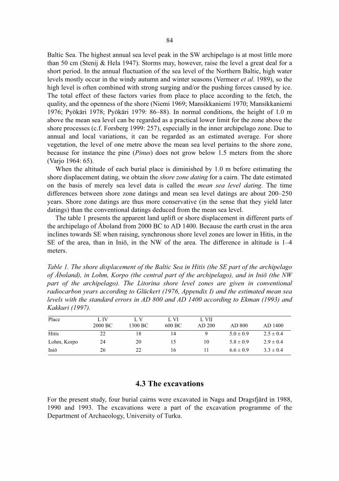
84
Baltic Sea. The highest annual sea level peak in the SW archipelago is at most little morethan 50 cm (Stenij & Hela 1947). Storms may, however, raise the level a great deal for ashort period. In the annual fluctuation of the sea level of the Northern Baltic, high waterlevels mostly occur in the windy autumn and winter seasons (Vermeer et al. 1989), so thehigh level is often combined with strong surging and/or the pushing forces caused by ice.The total effect of these factors varies from place to place according to the fetch, thequality, and the openness of the shore (Niemi 1969; Mansikkaniemi 1970; Mansikkaniemi1976; Pyökäri 1978; Pyökäri 1979: 86–88). In normal conditions, the height of 1.0 mabove the mean sea level can be regarded as a practical lower limit for the zone above theshore processes (c.f. Forsberg 1999: 257), especially in the inner archipelago zone. Due toannual and local variations, it can be regarded as an estimated average. For shorevegetation, the level of one metre above the mean sea level pertains to the shore zone,because for instance the pine (Pinus) does not grow below 1.5 meters from the shore(Varjo 1964: 65).
When the altitude of each burial place is diminished by 1.0 m before estimating theshore displacement dating, we obtain the shore zone dating for a cairn. The date estimatedon the basis of merely sea level data is called the mean sea level dating. The timedifferences between shore zone datings and mean sea level datings are about 200–250years. Shore zone datings are thus more conservative (in the sense that they yield laterdatings) than the conventional datings deduced from the mean sea level.
The table 1 presents the apparent land uplift or shore displacement in different parts ofthe archipelago of Åboland from 2000 BC to AD 1400. Because the earth crust in the areainclines towards SE when raising, synchronous shore level zones are lower in Hitis, in theSE of the area, than in Iniö, in the NW of the area. The difference in altitude is 1–4meters.
Table 1. The shore displacement of the Baltic Sea in Hitis (the SE part of the archipelagoof Åboland), in Lohm, Korpo (the central part of the archipelago), and in Iniö (the NWpart of the archipelago). The Litorina shore level zones are given in conventionalradiocarbon years according to Glückert (1976, Appendix I) and the estimated mean sealevels with the standard errors in AD 800 and AD 1400 according to Ekman (1993) andKakkuri (1997).
4.3 The excavations
For the present study, four burial cairns were excavated in Nagu and Dragsfjärd in 1988,1990 and 1993. The excavations were a part of the excavation programme of theDepartment of Archaeology, University of Turku.
Place L IV 2000 BC
L V 1300 BC
L VI 600 BC
L VII AD 200 AD 800 AD 1400
Hitis 22 18 14 9 5.0 ± 0.9 2.5 ± 0.4Lohm, Korpo 24 20 15 10 5.8 ± 0.9 2.9 ± 0.4Iniö 26 22 16 11 6.6 ± 0.9 3.3 ± 0.4
85
4.3.1 Sundbergen, Nagu
There are nine known cairns on Nötö and its neighbouring islands Mjoö and Granholm.Nils Cleve received some possible clues about cairns on Nötö (Cleve 1948: 493), but itwas not until 1987 that they were verified to be archaeological remains (see fig. 9). Agroup of five cairns were located on the top of a rock outcrop of Sundbergen, at thenorthern end of the isle of Nötö in Nagu. The cairns and their location resemble the threecairns in Piiloinen, Vehmaa (70 km to the north), excavated by Unto Salo in 1959, anddated to the Early Roman Iron Age (Salo 1968: 67–69), but the Sundbergen cairnsseemed to match into the hiidenkiuas category, typical of the Bronze Age, as well. Two ofthe cairns in Sundbergen were excavated in 198858. The aim was to date the graves andpossible secondary interferences, to determine the construction material and its relation tostones in the surrounding boulder fields, and to acquire osteological samples.
Sundbergen 1 (258). On the SE edge of a rock outcrop there is a roundish burial cairnwith a pit in the middle. The length of the cairn is 9.2 m (N–S, originally probably a littlesmaller), width 6.0 and height 0.5 m. The altitude h = 27.6 m and the area of the cairn is33 m². The surface consists of rounded, relatively even-sized stones.
Sundbergen 2 (259). A little more to the NW there is a low cairn with somewhatindefinite edges at the altitude of 29.9 m. The length is 4.5 m, width 4.3 m and height 0.4m. The surface consists mostly of rounded, relatively even-sized stones.
Sundbergen 3 (250). This round cairn is situated on a terrace in the upper part of theNW slope of the top, on a plane and convex rock surface. The altitude h = 24 m. In themiddle of the cairn there is a pit. The length is 7.7 m (SW−NE), width 6.1 m, and height0.7 m. The stones are rounded and fairly even-sized (circa 1−60 kg). In the middle there isa large pit where the stones are entirely covered by lichen.
Sundbergen 4 (251). The cairn 4 is situated on the SE lower slope of the rock outcrop,in a boulder field. The altitude h = 15 m. The stone setting is of an indeterminable shape.In the middle there is a pit. The length is 7.2 m (N−S), width 6.5 m, and height 0.4 m. Thestones are small (0−20 kg), almost exclusively rounded and probably picked up from thesurrounding boulder field.
Sundbergen 5 (252). The cairn 5 is also situated in a boulder field, more to the W, onthe southern lower slope of Sundbergen. The altitude h = 20 m. The stone setting isindeterminable by shape. In the middle there is a pit. The length is 7.7 m, width 6.4 m andheight 0.8 m. The stones are small (0−40 kg), almost exclusively rounded, and probablypicked up from the surrounding boulder field.
Mjoö 1 (253). The cairn Mjoö 1 is situated in the northern part of a rock outcrop, onthe western upper slope of a plane rock. From the site (h = 25 m) there is an unobstructedview in the directions between SW and NW. On an even surface sloping to SW, there is aflat stone setting, a little indeterminable at the edges, the length of which is 4.7 m, width4.4 m, and height 0.4 m. The stones are rounded and edged (about 1–50 kg). At the Wedge there is an edged granite boulder, larger than the others.
58. Inv. report by Tuovinen 1987, no. 37 and 38 (TYA), excavation report by Tuovinen 1988 (TYA), inv. reportby Tuovinen 1996, no. 25−33 (FFPS). Excavation team: Lassi Hatakka, Timo Kuokkanen, and the author.Tuovinen 1991: 53−57. Artefacts: TYA 486:1–30.

86
Mjoö 2 (254). The site is on the top of a rock outcrop, on a plane and flat surface,slightly sloping to the W, at the altitude of h = 28 m. The cairn has been placed beside adistal precipitous bank. There is an unobstructed view in all directions except for thesouth. The stone setting can be characterized as indeterminable in shape with an unevensurface and crater-like profile. The measurements are 4.1 m and 4.0 m. The stones arerounded and edged (about 0–30 kg).
Mjoö 3 (369). The cairn is situated in the S part of Mjoö, on a granite terrace, on analmost horizontal, plane surface (h = 11.5 m). There is some visibility to S and W towardsthe strait, Mjoö sund. On the terrace, there is a flat stone setting, with indeterminableedges and an uneven surface. The length is 5.3 m (N−S), width 3.9 m and height 0.4 m.The stones are rounded and edged, fairly even-sized (mainly about 0–40 kg). Thestructure is disperse and some stones have rolled down over the edge of the terrace.
Granholm (368). From the top of Granholm (h = 28 m), situated to the NW of Nötö,there is an unobstructed view in all directions. Here, on a convex smooth granite surface,there is a cairn, with indeterminable edges, with a length of 7.2 m (SE−NW), width 4.7 mand height 0.6 m. Nearly all stones are rounded, size about 0–40 kg, and mixed withsmaller pebbles. In the middle there is a conical pile of large boulders.
The two cairns that were excavated, Sundbergen 1 and 2, are situated at the northerntip of Nötö, on the top of a rock outcrop (fig 10). Sundbergen, Mjoö, and Granholm areamong the highest tops in a large area. The landscape around these tops can, in spite ofthe shore displacement after the Iron Age, still be characterized as an outer archipelagozone with a low relief. The unobstructed view over a large area, mainly to the north, fromthe top of Sundbergen is only limited by a dry pine forest. On the slopes of Sundbergen,especially on the E, SE and S sides, there are washed boulder fields surrounding the rockoutcrop in a large area reaching down to the shore on the NE side. To the SW of the rockarea and on Mjoö, there is sand and gravel.
The bedrock consists mainly of granite, migmatite, and granodiorite (Edelman 1956;Edelman 1985). Granodiorite is the prevailing rock type on the NW shore of Sundbergen.The rock changes into granite to SE from Sundbergen, towards the strait Mjoö sund. Themicrocline granite contains granate as porfyroblasts (Edelman 1985: 21), and magnetite.

87
Fig. 9. The known burial cairns in the southern archipelago of Nagu, in the area of Nötö,Boskär, Ådön, Sandholm, Trunsö, and Lökholm. © The National Board of Survey (MAR/103/98).
4.3.1.1 Sundbergen 1
The cairn Sundbergen 1 (258) has been erected on a convex, fairly flat top, only a littlelarger than the cairn itself. The surface is partly of coarse granite, partly of granodiorite,with biotite-plagioclase schist in small inclusions. The area covered by the stone settingconsists mostly of granodiorite. The rock surfaces surrounding the grave are fairly even,so the shore processes have evidently swept away soil, stones and boulders from the topsome 4500 years ago. Thus, all of the construction material of the cairn must have beentransported to the site. The area, measured along the edges of the stone setting, was 33m². There were 768 boulders weighing at least 0.5 kg, and their total weight was 11.30tons.
Most stones were rounded and, especially those of the surface layer, rather even-sized.There was a clearly discernible pit in the middle part of the cairn (fig. 11). Below thesurface stones, there were a lot of small stones and pebbles, about the size of a fist, whichhad been loosely wedged in between the larger boulders so that they often fell deeperwhen the large boulders were being moved. Thus, the average size of the stones andboulders could not be determined on the basis of the surface stones only. Possibly thepebbles were used to fill up the holes between the larger boulders on the surface of the

88
cairn, but due to gravity, a lot of pebbles slid down downwards between the boulders.This gravity effect, the abundance of small stones in the filling layer beneath the surfacewas also observed by Tapio Seger in the investigation of the cairn 088 at Furunabb,Houtskär, two years earlier.
The soil layer on the ground was covered by litter spilt down from between the boul-ders. Under the litter, there was a 1–3 cm thick layer of dark humus containing plenty oforganic material and angular gravel particles, which were residual originating from weath-ering. The most gravel was to be found under boulders lying on the granodiorite surface,and in the holes and crevices of the surface. The excavation of the humus layer revealedunburnt bone. On the bottom surface of the pit, burnt human bone fragments were found inan area of 3.2 m² (161 g).
Among the fragments of burnt bone, there were two pieces of burnt antler (0.6 g). Oneof the pieces had been carved into a rectangular and flat artefact. On the smooth-cut 16mm long face there are two engraved cross-like figures which form part of a longer deco-rated surface (fig. 12). The rivet hole, too, is visible. The artefact is probably the peg plateof a one-sided comb made up of three parts. This type of comb is rare on the mainland ofFinland (e.g. Lehtosalo-Hilander 1982: 65); they are, however, more frequent in in themound cemeteries of Åland from the Viking Age, such as in Långängsbacken (Kivikoski1980: 35–38) and, for instance, in Birka, Sweden (Ambrosiani 1981). A comb decoratedwith a lattice-like figure was found in a Viking Age cairn in Tammenpää, Halikko, on theSW coast of Finland; it is, however, made of bone and two-sided (Hirviluoto 1992: 68).
4.3.1.2 Sundbergen 2
The cairn Sundbergen 2 has been erected on a plane horizontal rock surface incliningslightly downwards from the edges of the stone setting (fig. 13). The rock surface is ofsmooth-worn granodiorite with criss-crossing granite veins. On the distal side SE, thecairn is bordered by a fracture bank over whose edge boulders have fallen from the stonesetting. The area of the cairn, measured along the edges of the stone setting, was 15.8 m².There were 458 boulders weighing at least 0.5 kg, and their total weight was 4.34 tons.

89
Fig. 10. The cairns in Sundbergen, Nagu. Surveyed by the author (TYA)59.
Fig. 11. Sundbergen, Nagu, cairn 1, profile W–E. Measured and drawn by Timo Kuokkanen(TYA).
59. For details, see the excavation report.
27
28
29.9
25.728.1
26
24
3
19.5
17.0
28.77
28.9 K221
K1 26.54
25.5
26.6
1
2
10 m
N
29 m
28
27494 496 498 500
W E

90
Fig. 12. Part of a peg plate of an antler comb (TYA 486: 23). Sundbergen, Nagu, cairn 1. Sizeca 8:1. Photographed by the author.
Fig. 13. The burial cairn Sundbergen 2, Nagu, seen from the west. Photographed by the author.
The stone cover consisted of fairly even-sized stones among which there were moreangular pieces than in the cairn 1. After the removal of the surface vegetation and thesurface layer of stones, a soil-mixed stone layer was visible. In this layer, the largeboulders were mainly rounded. The boulders were in one or two layers above the bottomlayer, which was composed of humus soil, with scattered edged and rounded pebbles,organic material, roots, fragments of charcoal and weathering residue. The humus layer
91
covered the rock so that most of the stones were not directly lying on the granodioritesurface, but on an intermediate 3–4 cm thick soil layer. In the soil layer, seven iron rivetswere found. In two of them, a rhomb-like piece has been preserved, typical of the rivetsused in clinker boat-building. The weight of the rivets was 4.4–14.0 g and length 29–42mm. Further, two artefacts, best characterized as nails, as well as unidentified fragmentsof iron, 189 g of unburnt and 1.3 g of burnt bone, a fish scale and pieces of shells werefound.
The iron rivets indicate that the cairn 2 was probably built in the Merovingian or theViking period (Anderson 1963; Raike 1996). As indicated by the boat finds, the Nordictradition of using iron rivets in clinker boat-building was continued even longer. Forinstance, the clinker-built boat from the castle of Turku has been radiocarbon dated to theMiddle Ages (640 ± 80 uncal BP) (Forssell 1982). In other Nordic countries, there arerivet finds from as late as the 16th century (Westerdahl 1989: 39–42; c.f. Weski 1999).
As far as I know, these are the first finds of iron rivets in the burial cairns of thearchipelago. In Sweden, rivets are known in medieval burial cairns in Misterhult (Norman1993: 112–113); in Klinta, Öland, iron rivets have been found in a cairn dating back to theViking Age (Schulze 1987: 58–60).
Observations made during the excavations indicate that a layer of soil has at first beenbrought on the rock, with edged and rounded pebbles combined with some finer mineralmaterial and some organic material. The rivets and burnt bones were buried in this layer.On the top of the bottom layer, there was a heap of rounded and edged stones andboulders of different sizes, and possibly some soil, too. If the cairn had been built on amineral soil, in a more fertile, humid and grazed place than the top of rocky Sundbergen,the earth layer on the ground would probably have favoured the vegetation to spread outon the cairn so that the stones would gradually have become covered. The result wouldhave reminded greatly of the mounds on Åland with a flat stone setting inside (Kivikoski1963; Museibyrån 1984). According to Helena Edgren (1983), there is no unambiguouslimit between burial cairns and earth mounds on Åland. In many places, they occur sideby side in the younger Iron Age. I regard it as probable that, as to the cairns and mounds,it is partly a question of the same type of construction, on which in different ecologicalhabitats different humus and vegetation covers have been deposited during the pastmillennium.
4.3.1.3 Osteological analysis
The osteological analysis of the bone samples was made by Tarja Formisto, University of Stockholm. The results show that a young person had been buried in cairn 1 (table 2). The human bones were found in the humus soil layer on the bottom, mixed with bird and fish bones, and bones of a small mammal. Nothing indicated that the animal bones would be secondary finds, but in a burial cairn, the possibility of contamination cannot be entirely eliminated (c.f. Okkonen 1993: 6). The animal bones in the filling layer, however, are not necessarily connected with the interment.

92
Table 2. Sundbergen 1, Nagu. An osteological analysis of the bone samples from the cairn.
In cairn Sundbergen 2 an adult person had been inhumed (table 3). The weight of thebone material was 44 g, mostly originating from a broken humerus. It had been placed onthe ground of the construction, into the humus soil layer, near the surface of the rock, andthe S edge of the cairn. The rivets and nails had also been placed mainly in the bottomlayer, next to the rock surface, but they formed a scattered group about 1.5 m to the NWfrom the human bones.
In addition to artefacts evidently set in the humus soil layer, bones were discovered incairn 2 under and between the stones the cairn was filled with. Among them there werefive unburnt teeth which have belonged to a person of 30–40 years of age (Juha Varrela,pers.comm.60), 1.7 g of other human bones and 201 g of unburnt bones which havebelonged to cattle, pig, sheep/goat, cat, bird, fish, and a small rodent. This leads to thequestion, whether the animal bones were a part of the interment. The human and animalbones could not be stratigraphically separated in situ from each other. Large animal boneslying under and between the boulders indicated that they were stratigraphically no moresecondary than the human bones. Thus the animal bones are probably part of the inter-ment and of the same age.
Find (TYA) Determination Stratification486:24 143 g burnt bone, fragments of Ossa longa
incompletely burnt. All human bones. Burnt human bones: 88 g. Os parietale, 4 pieces, Calvarium 33 pieces, Costae 1 piece, 105 pieces of long bones. Age: Juvenilis/Adultus, thin calvarium; skull sutures not grown together. Sex: –. MNI: 1.
The lowermost humus soil layer, mainly under the pit.
486:25 6.2 g of unburnt animal bones; among others, bones of a bird, small rodents and fish.
The lowermost humus soil layer.
486:26 7 g of unburnt animal bone. Humus soil in filling layer. 486:27 10 g of unburnt animal bone. A piece of the
humerus of a bird, and probably a talus of a roe deer/deer, young individual.
Humus soil in filling layer.
486:28 10.2 g of burnt bone fragments. Human bone, among others two thin fragments of the calvarium.
The lowermost humus soil layer, collected from water sieved samples using a stereomicroscope.
486:29 2 g of unburnt animal bones, among others bones of small rodents, birds and fishes.
The lowermost humus soil layer, collected from water sieved samples.
486:23 Burnt antler 2 pieces, 0.62 g. The lowermost humus soil layer, under the pit.
60. The teeth (TYA 486:13) are not included in the samples determined by Tarja Formisto.
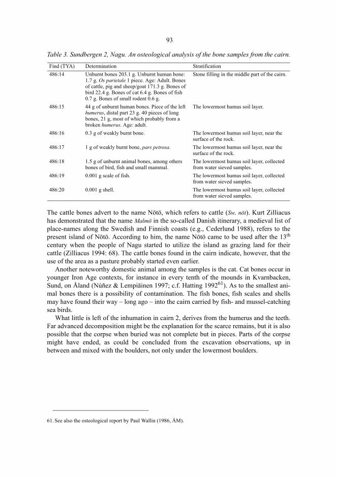
93
Table 3. Sundbergen 2, Nagu. An osteological analysis of the bone samples from the cairn.
The cattle bones advert to the name Nötö, which refers to cattle (Sw. nöt). Kurt Zilliacushas demonstrated that the name Malmö in the so-called Danish itinerary, a medieval list ofplace-names along the Swedish and Finnish coasts (e.g., Cederlund 1988), refers to thepresent island of Nötö. According to him, the name Nötö came to be used after the 13th
century when the people of Nagu started to utilize the island as grazing land for theircattle (Zilliacus 1994: 68). The cattle bones found in the cairn indicate, however, that theuse of the area as a pasture probably started even earlier.
Another noteworthy domestic animal among the samples is the cat. Cat bones occur inyounger Iron Age contexts, for instance in every tenth of the mounds in Kvarnbacken,Sund, on Åland (Núñez & Lempiäinen 1997; c.f. Hatting 199261). As to the smallest ani-mal bones there is a possibility of contamination. The fish bones, fish scales and shellsmay have found their way – long ago – into the cairn carried by fish- and mussel-catchingsea birds.
What little is left of the inhumation in cairn 2, derives from the humerus and the teeth.Far advanced decomposition might be the explanation for the scarce remains, but it is alsopossible that the corpse when buried was not complete but in pieces. Parts of the corpsemight have ended, as could be concluded from the excavation observations, up inbetween and mixed with the boulders, not only under the lowermost boulders.
Find (TYA) Determination Stratification486:14 Unburnt bones 203.1 g. Unburnt human bone:
1.7 g. Os parietale 1 piece. Age: Adult. Bones of cattle, pig and sheep/goat 171.3 g. Bones of bird 22.4 g. Bones of cat 6.4 g. Bones of fish 0.7 g. Bones of small rodent 0.6 g.
Stone filling in the middle part of the cairn.
486:15 44 g of unburnt human bones. Piece of the left humerus, distal part 23 g. 40 pieces of long bones, 21 g, most of which probably from a broken humerus. Age: adult.
The lowermost humus soil layer.
486:16 0.3 g of weakly burnt bone. The lowermost humus soil layer, near the surface of the rock.
486:17 1 g of weakly burnt bone, pars petrosa. The lowermost humus soil layer, near the surface of the rock.
486:18 1.5 g of unburnt animal bones, among others bones of bird, fish and small mammal.
The lowermost humus soil layer, collected from water sieved samples.
486:19 0.001 g scale of fish. The lowermost humus soil layer, collected from water sieved samples.
486:20 0.001 g shell. The lowermost humus soil layer, collected from water sieved samples.
61. See also the osteological report by Paul Wallin (1986, ÅM).
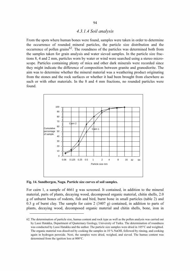
94
4.3.1.4 Soil analysis
From the spots where human bones were found, samples were taken in order to determinethe occurrence of rounded mineral particles, the particle size distribution and theoccurrence of pollen grains62. The roundness of the particles was determined both fromthe samples taken for grain analysis and water sieved samples. In the particle size frac-tions 8, 4 and 2 mm, particles worn by water or wind were searched using a stereo micro-scope. Particles containing plenty of mica and other dark minerals were recorded sincethey might indicate the difference of composition between granite and granodiorite. Theaim was to determine whether the mineral material was a weathering product originatingfrom the stones and the rock surfaces or whether it had been brought from elsewhere assuch or with other materials. In the 8 and 4 mm fractions, no rounded particles werefound.
Fig. 14. Sundbergen, Nagu. Particle size curves of soil samples.
For cairn 1, a sample of 4661 g was screened. It contained, in addition to the mineralmaterial, parts of plants, decaying wood, decomposed organic material, chitin shells, 2.0g of unburnt bones of rodents, fish and bird, burnt bone in small particles (table 2) and0.3 g of burnt clay. The sample for cairn 2 (3407 g) contained, in addition to parts ofplants, decaying wood, decomposed organic material and chitin shells, bone, iron in
62. The determination of particle size, humus content and rock type as well as the pollen analysis was carried outby Lassi Hatakka, Department of Quaternary Geology, University of Turku. The determination of roundnesswas conducted by Lassi Hatakka and the author. The particle size samples were dried in 105°C and weighted.The organic material was dissolved by cooking the samples in 10 % NaOH, followed by rinsing, and cookingagain in hydrogen peroxide. Next, the samples were dried, weighed, and sieved. The humus content wasdetermined from the ignition loss at 800°C.
0
10
20
30
40
50
60
70
80
90
100
Cumulativepercentageof sample
0.06 0.125 0.25 0.5 1 2 4 8 16 32 64
Particle size mm
Cairn 1
Cairn 2
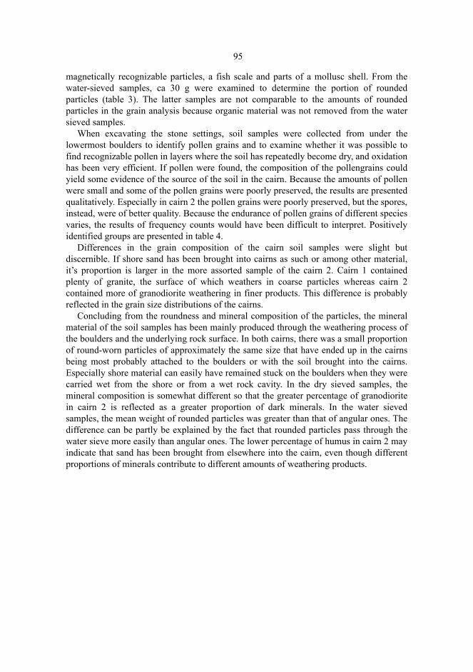
95
magnetically recognizable particles, a fish scale and parts of a mollusc shell. From thewater-sieved samples, ca 30 g were examined to determine the portion of roundedparticles (table 3). The latter samples are not comparable to the amounts of roundedparticles in the grain analysis because organic material was not removed from the watersieved samples.
When excavating the stone settings, soil samples were collected from under thelowermost boulders to identify pollen grains and to examine whether it was possible tofind recognizable pollen in layers where the soil has repeatedly become dry, and oxidationhas been very efficient. If pollen were found, the composition of the pollengrains couldyield some evidence of the source of the soil in the cairn. Because the amounts of pollenwere small and some of the pollen grains were poorly preserved, the results are presentedqualitatively. Especially in cairn 2 the pollen grains were poorly preserved, but the spores,instead, were of better quality. Because the endurance of pollen grains of different speciesvaries, the results of frequency counts would have been difficult to interpret. Positivelyidentified groups are presented in table 4.
Differences in the grain composition of the cairn soil samples were slight butdiscernible. If shore sand has been brought into cairns as such or among other material,it’s proportion is larger in the more assorted sample of the cairn 2. Cairn 1 containedplenty of granite, the surface of which weathers in coarse particles whereas cairn 2contained more of granodiorite weathering in finer products. This difference is probablyreflected in the grain size distributions of the cairns.
Concluding from the roundness and mineral composition of the particles, the mineralmaterial of the soil samples has been mainly produced through the weathering process ofthe boulders and the underlying rock surface. In both cairns, there was a small proportionof round-worn particles of approximately the same size that have ended up in the cairnsbeing most probably attached to the boulders or with the soil brought into the cairns.Especially shore material can easily have remained stuck on the boulders when they werecarried wet from the shore or from a wet rock cavity. In the dry sieved samples, themineral composition is somewhat different so that the greater percentage of granodioritein cairn 2 is reflected as a greater proportion of dark minerals. In the water sievedsamples, the mean weight of rounded particles was greater than that of angular ones. Thedifference can be partly be explained by the fact that rounded particles pass through thewater sieve more easily than angular ones. The lower percentage of humus in cairn 2 mayindicate that sand has been brought from elsewhere into the cairn, even though differentproportions of minerals contribute to different amounts of weathering products.
96
Table 4. A soil analysis of the cairns at Sundbergen, Nagu.
We can assume that the preconditions of deposition and preservation of the pollens ofvarious species are approximately the same in both cairns. However, there are certaindifferences in the samples. Pollen of pine (Pinus) did not occur in the sample of cairn 2,even if the graves are located in the middle of a pine forest. Even if the pollen grains ofcairn 2 were in a weaker condition than those of cairn 1, it is difficult to believe that thepine pollen grains would have been destroyed entirely. The stratification of cairn 2indicates that the rock surface was at first covered with soil, probably containing pollengrains, and subsequently the soil layer was covered with stones. The soil can have beenbrought from an adjacent rock dell, the deposits of which would represent an earlierphase of land uplift when the island of Nötö was still a rocky skerry in the outer zonewith no pine forest. This is further confirmed by the lack of spruce (Picea) and juniper(Juniperus) as well as the presence of fragments of shellfish. Probably the soil sealed thelayer from external pollen precipitation. The studies by Irmeli Vuorela and TerttuLempiäinen on the Late Neolithic site of Kotirinne, Turku, also suggest that the pollenstratigraphy may not be strongly affected by contamination in soil profiles (Vuorela &Lempiäinen 1988: 36–39). The preservation of the soil layer from contaminationssupports the preceding idea that the unburnt human bones, nails, rivets and animal bonesbelong to the same interment.
Cairn Sundbergen 1 Sundbergen 2Percentage of humus 17.4 11.72 mm dry sieving fraction:
Weight of mineral material g 400.2 539.4Percentage of weight of rounded particles 3.4 4.4Percentage of weight of particles of dark minerals 1.7 13.1
1 mm water sieving fraction:Weight of sample g 32.79 32.47Frequency of mineral particles 5983 4493Total weight of rounded particles g 0.29 0.23Per mille (‰) of total weight of particles 8.8 7.1Frequency of rounded particles 20 19Per mille (‰) of total frequency of particles 3.3 4.2Mean weight of rounded particles mg 14.5 12.1Mean weight, other particles mg 5.5 7.2Pollen and spore grains Alnus Alnus
Betula BetulaCyperaceae CyperaceaeEricaceae PolypodiaceaeJuniperus SphagnumPiceaPinus (abundant)PolypodiaceaeSphagnum

97
The soil layer of the cairn 1 seems to have gone through a different formation process.No man-made soil layer was observed, and the present soil is probably the result ofnatural humus formation and weathering products.
The preceding analyses support the observations made during the excavation. Theresults suggest that a young person was buried in cairn 2 during the Late Iron Age,endowed with rivets, nails and domestic animals or parts of them. The cairn 2 has beenbetter preserved from later external impacts than cairn 1. In the cairn 1, an adult personwas buried in the Late Iron Age, equipped – at least – with a comb.
More evidence of the formation processes of burial cairns would be achieved by afurther investigation into the composition of the building material and the traces ofnatural processes, for instance pollen stratigraphy. As to problems concerning mortuaryrituals, it is essential to learn more about when and to what extent artefacts and ecofactscan be regarded as primary constituents of interments and not related to subsequentexternal impacts, of human or other origin. The classic problem in studies on burial cairnsis the openness of the stone setting. Although this has not been investigated in Finland, Ithink it is safe to state that under the first centuries after the burial, oxygen, water, water-soluble compounds, and solar radiation were able to alter and destroy the remains of theburial. After the composition of humus soil on the ground or the rock surface, the remainswere probably better protected.
It is conceivable that artefacts and ecofacts fallen down between the boulders mayhave been mixed with the remains of the interment. Animal bones found in cairns haveoften, indeed, been regarded as secondary (c.f. Salo 1981 b: 178). However, if possible, itshould be investigated separately in each case whether bone remains are secondary or not,which requires a pedantic excavation technique. The excavation of a burial cairn involvesa risk of contamination. Therefore, care should be taken that turf, litter, roots, and recentsoil layers are carefully removed at the very moment of picking up each stone.
Layers of sand and gravel under and between the stones have been documented inother areas of Finland, too. Soil has been used to fill in the cavities between stones and toheap up a layer where the deceased was buried. The soil filling has been considered to bea characteristic that goes back to the Bronze Age (Edgren 1999: 330), and it seems toappear in Bronze Age and Early Iron Age contexts. For example, the Bronze Age cairnsin Råckers, Karis, and the Roman Iron Age cairns in Ekeberga, Sjundeå, and Ketohaka 1,Salo, contained layers of sand and gravel (af Hällström 1948; Keskitalo 1979: 14, 36;Schauman-Lönnqvist 1989: 47–50). According to Oiva Keskitalo, the soil filling was aprevailing feature in the Late Roman Iron Age in Ostrobothnia (Keskitalo 1979: 129).The cairns in Piiloinen, Vehmaa (Early Roman Iron Age), contained soil layers, too (Salo1968: 67–69). Thus, the soil filling in Sundbergen seems to represent a conservativecharacteristic in the burial tradition.
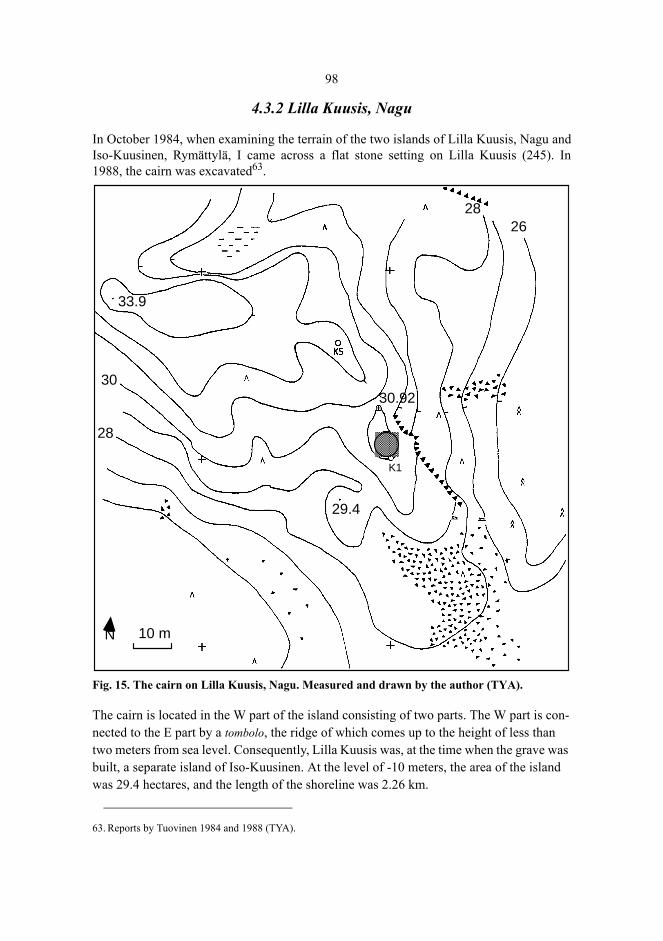
98
4.3.2 Lilla Kuusis, Nagu
In October 1984, when examining the terrain of the two islands of Lilla Kuusis, Nagu andIso-Kuusinen, Rymättylä, I came across a flat stone setting on Lilla Kuusis (245). In1988, the cairn was excavated63.
Fig. 15. The cairn on Lilla Kuusis, Nagu. Measured and drawn by the author (TYA).
The cairn is located in the W part of the island consisting of two parts. The W part is con-nected to the E part by a tombolo, the ridge of which comes up to the height of less than two meters from sea level. Consequently, Lilla Kuusis was, at the time when the grave was built, a separate island of Iso-Kuusinen. At the level of -10 meters, the area of the island was 29.4 hectares, and the length of the shoreline was 2.26 km.
63. Reports by Tuovinen 1984 and 1988 (TYA).
33.9
2628
K1
29.4
30.9230
28
10 mN
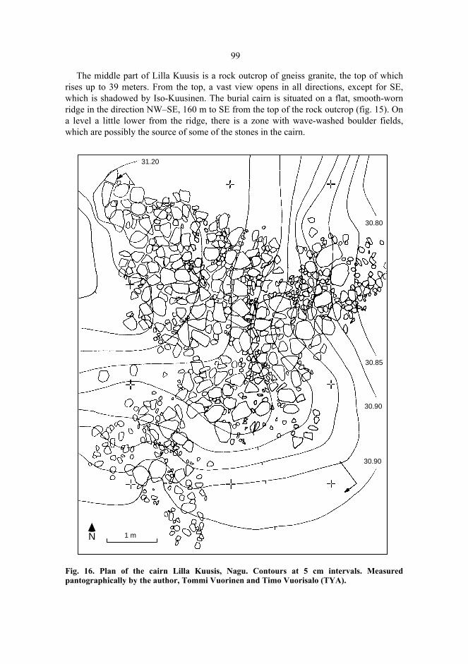
99
The middle part of Lilla Kuusis is a rock outcrop of gneiss granite, the top of whichrises up to 39 meters. From the top, a vast view opens in all directions, except for SE,which is shadowed by Iso-Kuusinen. The burial cairn is situated on a flat, smooth-wornridge in the direction NW–SE, 160 m to SE from the top of the rock outcrop (fig. 15). Ona level a little lower from the ridge, there is a zone with wave-washed boulder fields,which are possibly the source of some of the stones in the cairn.
Fig. 16. Plan of the cairn Lilla Kuusis, Nagu. Contours at 5 cm intervals. Measuredpantographically by the author, Tommi Vuorinen and Timo Vuorisalo (TYA).
31.20
30.80
30.85
30.90
30.90
1 mN

100
The cairn which can be characterized as a flat stone setting, is situated on a rock surfaceslightly inclined to SE. Some stones along the E and SW edges of the stone setting haveprobably slid down along the surface because they lie where the rock surface is slightlygrooved (figure 16). The length of the stone setting was 7.8 m (NNW–SSE) and width7.0 m. The area, measured along the edges of the stone setting, was about 22 m². Therewere 774 boulders weighing at least 0.5 kg, and their total weight was 2.78 tons. Thestones, mainly edged and relatively small, had been arranged on the rock surface in oneor two layers. Under the stones, there was a 1–3 cm thick layer of dark soil containingdecomposed organic matter, fine grained mineral material, and weathering products.Although no artefacts were found, it is obvious that the stone setting could not be a resultof natural processes because the stones were placed on a smooth-polished rock ridgeheavily exposed to shore processes at the earlier stages of shore displacement, andtherefore, glacially transported stones would have been swept away from the spot (c.f.Pyökäri 1976: 12–24).
4.3.3 Östergård 2, Dragsfjärd
The cemetery of Östergård 2, Dragsfjärd, with seven burial cairns, was discovered byHelena Edgren in 1985. In 1990, one of the cairns (054), was excavated64. The cemeteryis located on the cape of Purunpää, pointing towards the south off the mainland of Drags-fjärd, in a rocky terrain. The graves are located in a wave-washed till slope inclining tothe east, at the altitude of 14.7–16.8 m. Below the slope there is a field which continuingto the south as a bog at the level of 11–12 m. This lowland was once traversed by a longsound in the direction S–N. The water formed a shallow but well-protected bay whichopened to the west to a stretch of open sea, the present-day Gullkrona fjärd. Due to theland uplift, the sound became shallow, and finally drained by the end of the last millenni-um BC.
The length of the cairns varies from 1.6 to 3.2 meters, and width from 1.3 m to 2.0meters. They are round and constructed of fairly even-sized stones up to ca 40 kg. Thestones are mainly rounded and, consequently, probably collected from the shore.
The burial cairn selected for excavation was number 9. The surface was covered bymoss and litter. After the vegetation had been removed it turned out that the cairn hadclearly discernible edges. The stones and boulders were mostly rounded, and their weightvaried between 0.5 and 72 kg. There were 210 boulders weighing at least 0.5 kg, and theirtotal weight was 1.38 tons. Especially the surface stones were rounded and even-sized,and deeper among the boulders there were more pebbles and edged stones. This isevidently due to the gravity effect, earlier noted in Sundbergen, Nagu.
No artefacts were found, which makes the dating of the cairn cemetery uncertain. Thealtitudes of the cairns, however, indicate that they must be later than the Bronze Age. The
64. Inv. report by Helena Edgren 1985 (NBA), no. 11. Inv. report by Tuovinen 1987 (TYA), no 9. Excavationreport by Tuovinen 1990 (TYA). Excavation team: Timo Kuokkanen, Henry Malmberg, SolveigMannerström, Hans Myhrman, Henrik Salomonsson, Christina Sundberg, Bruno Södergård, Sven-ErikSöderholm, Henning Westberg, and the author.

101
lowest points of the cairns reach the altitude of 14.7 m, which is about the same level asthe local shore level zone Litorina VI, 600 BC uncal 14C (Glückert 1976).
Fig. 17. The cemetery of Östergård 2, Dragsfjärd. Surveyed and drawn by the author (TYA).
4.3.4 Ängesnäs bergen, Nagu
During a survey in 1983, a cairn was discovered on the top of a rock, named Ängesnäsbergen, on the island of Själö (Fi. Seili), Nagu (217). The initial hint of the grave wasgiven by Mr. Birger Wikström, laboratory foreman in the Archipelago Sea ResearchInstitute of the University of Turku. The research station of this institute is located onSjälö. The excavation of the cairn in 1993 was part of a course in excavation techniques,University of Turku65.
65. Reports by Kuokkanen & Tuovinen 1983 (TYA), no. 17, and Tuovinen 1993 (TYA). Ann-Christin Antell,Marja Anttila, Markus Kivistö, Terhi Mäkirinta, Virva Paavola and Jouni Taivainen participated in theexcavation team.
13
17.19
10
14
12
Åker
Stig
119
7 8
12
18
5 mN

102
Fig. 18. The topography of the top of Ängesnäs bergen, Nagu. Surveyed and drawn by theexcavation team and the author (TYA).
Fig. 19. The cairn on Ängesnäs bergen, Nagu. Photograph by the author.
32
2224
2628
3029.9
30.11
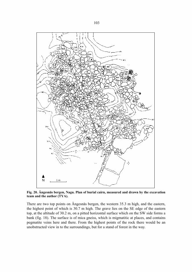
103
Fig. 20. Ängesnäs bergen, Nagu. Plan of burial cairn, measured and drawn by the excavationteam and the author (TYA).
There are two top points on Ängesnäs bergen, the western 35.3 m high, and the eastern,the highest point of which is 30.7 m high. The grave lies on the SE edge of the easterntop, at the altitude of 30.2 m, on a pitted horizontal surface which on the SW side forms abank (fig. 18). The surface is of mica gneiss, which is migmatitic at places, and containspegmatite veins here and there. From the highest points of the rock there would be anunobstructed view in to the surroundings, but for a stand of forest in the way.
A
1 mN
B

104
The stone setting covered an area the length of which was 7.8 m (SE–NW) and width5.3 m. The area, measured along the edges of the stone setting, was 21.7 m². There were1497 boulders weighing at least 0.5 kg, and their total weight was 8.20 tons.
The cairn was covered with rounded and angular stones and boulders of varying sizes.Under the stones there was a layer of soil consisting of pebbles, gravel, weatheringproducts, charcoal, and organic material. In between the boulders lying on the rock andthe rock surface there was only a very thin layer of soil, if any. The holes in the rock hadbeen filled with stones. It seemed that the stones had been set on the bare rock surface.
Samples of the soil layer were water-sieved and examined using a stereo microscope.The mineral particles were almost entirely angular, ungrinded, and many of them werefragile. The abundance of angular particles suggests (table 5) that the mineral materialoriginates almost entirely from weathering but yet there are some rounded quartz andfeldspar particles which have apparently come into the cairn attached to the boulders.Another possibility is that they originate from soil brought into the cairn, but,nevertheless, the amount of soil seems to be rather small compared with the Sundbergencairns.
Table 5. Ängesnäs bergen, Nagu. Rounded mineral particles in water sieved sample,particle size 1–2 mm.
No artefacts were found. However, weathering measurements of the basal and distalsurfaces of the cairn, to be discussed later, suggest that the cairn has a considerable age,although the age could not be accurately determined due to the high rate of weathering ofthe rock surface.
4.4 The surveys
4.4.1 Fieldwork 1983–1998
The area of this study consists of the parishes Iniö, Velkua, Rymättylä (Sw. Rimito),Houtskär (Fi. Houtskari), Korpo (Fi. Korppoo), Nagu (Fi. Nauvo), Dragsfjärd,Västanfjärd and Kimito (Fi. Kemiö) and the town of Pargas (Fi. Parainen), and theislands belonging to the town of Turku (Sw. Åbo). The total area is 6384 km² includingthe sea areas (fig. 21). The main part of the material was acquired in 1983–1988 and
Weight of sample g 34.70Frequency of mineral particles 7420Weight of rounded mineral particles g 0.12Per mille (‰) of rounded particles of total weight of particles 3.5Frequency of rounded particles 18Per mille (‰) of rounded particles of total frequency of particles 2.4Mean weight of rounded particles mg 6.7Mean weight, other particles mg 4.7
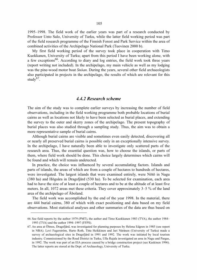
105
1995–1998. The field work of the earlier years was part of a research conducted byProfessor Unto Salo, University of Turku, while the latter field working period was partof the field research programme of the Finnish Forest and Park Service within the area ofcombined activities of the Archipelago National Park (Tuovinen 2000 b).
My first field working period of the survey took place in cooperation with TimoKuokkanen, University of Turku; apart from this period I have been working alone, witha few exceptions66. According to diary and log entries, the field work took three years(report writing not included). In the archipelago, my main vehicle as well as my lodgingwas the pine-wood motor boat Snöan. During the years, several other field archaeologistsalso participated in projects in the archipelago, the results of which are relevant for thisstudy67.
4.4.2 Research scheme
The aim of the study was to complete earlier surveys by increasing the number of fieldobservations, including in the field working programme both probable locations of burialcairns as well as locations not likely to have been selected as burial places, and extendingthe survey to the outer and skerry zones of the archipelago. The present topography ofburial places was also studied through a sampling study. Thus, the aim was to obtain amore representative sample of burial cairns.
Although burial cairns are visible and sometimes even easily detected, discovering allor nearly all preserved burial cairns is possible only in an exceptionally intensive survey.In the archipelago, I have naturally been able to investigate only scattered parts of theresearch area. Thus, the essential question was, how to choose the islands, or parts ofthem, where field work should be done. This choice largely determines which cairns willbe found and which will remain undetected.
In practice, the choice was influenced by several accumulating factors. Islands andparts of islands, the areas of which are from a couple of hectares to hundreds of hectares,were investigated. The largest islands that were examined entirely, were Nötö in Nagu(380 ha) and Högsåra in Dragsfjärd (530 ha). To be selected for examination, each areahad to have the size of at least a couple of hectares and to be at the altitude of at least fivemeters. In all, 1072 areas met these criteria. They cover approximately 3–5 % of the landarea of the archipelago of Åboland.
The field work was accomplished by the end of the year 1998. In the material, thereare 444 burial cairns, 380 of which with exact positioning and data based on my fieldobservations. Most statistical analyses and other summaries of the data are thus based on
66. See field reports by the author 1979 (PMT), the author and Timo Kuokkanen 1983 (TYA), the author 1984–1993 (TYA) and the author 1994–1997 (FFPS).
67. An area at Ölmos, Dragsfjärd, was investigated for planning purposes by Helena Edgren in 1985 (see reportin NBA). Levi Fagerström, Harto Roth, Titta Heikkinen and Jari Näränen (University of Turku) made asurvey of archaeological sites in Dragsfjärd in 1991 and 1992. The work was initiated by local tourismindustry. Commissioned by the Road District in Turku, Ulla Rajala investigated an area in Nagu and Pargas,in 1992. The work was part of an EIA process caused by a bridge construction project (see Kaskinen 1996).The latter reports are stored at the Dept. of Archaeology, University of Turku.
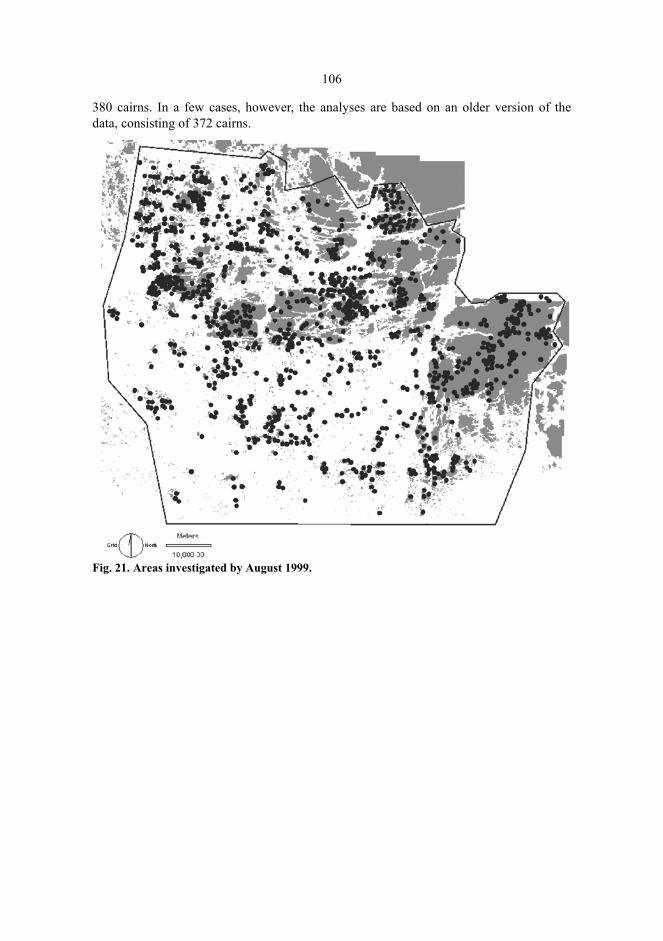
106
380 cairns. In a few cases, however, the analyses are based on an older version of thedata, consisting of 372 cairns.
Fig. 21. Areas investigated by August 1999.
107
Fig. 22. Known burial cairns in the area investigated by December 1998.
I investigated the chosen areas by walking criss-cross in the terrain, paying special atten-tion to rocky areas and moraines and less to swamps, sea shores, cultivations, courtyards and the densest bush vegetations. In plane terrain, the simplest thing to do was to walk along parallel compass lines in the forest.
The criteria of choice can in broad outline be divided into six categories.(1). Burial cairns previously known from earlier records and literature constitute the
starting point for the choice of the areas investigated68. Cairns with accurate locationaldata in the original records were, for the most part, easy to find. Some cairns, however,were found only after the second or third attempt. Volter Högman’s positioning data aremainly adequate and accurate but for some cairns mentioned by him, it was necessary tosearch for a day or two. Some of them remained undetected. For instance, the cairn atLabbnäsåsen, Dragsfjärd, discussed above, can still be identified thanks to the fact that
68. See Björck 1883; Cleve 1942b; Cleve 1948; Dahlström 1940; Dahlström 1945; Fagerlund 1878; FinskaHushållningssällskapet 1979; Gardberg 1955; Hackman 1897; Heikel 1890; Killinen 1885; Koivunen 1982;Sjöros 1887; Tallgren 1902; Tallgren 1906 and Tallgren 1931b. For reviews of cairns in the parishes of theresearch area, see Grönros 1983; Tuovinen 1984; Nyberg 1985; Suistoranta 1985; Tuovinen 1985; Fagerlund1992; Asplund 1997a; Tuovinen 1997; Edgren 1999b; Fortelius 1999; Tuovinen 1999; Asplund 2000.

108
Högman gave the distance from the cairn to a border slab that can still be located in theforest.
(2). Other items of the previous knowledge, influencing the choice of the areas to beexamined, originate from various sources: place names, older literature and notes, lettersand other material in museums and archives.
(3). Contacts to key persons. Many inhabitants of the archipelago and experts on localhistory and tradition contacted me during the field work and gave valuable information onpossible archaeological sites. Professionals of science, nature conservation and thearchipelago branch in general provided many tips, too. I also sought actively for contactswith people with local knowledge.
(4). The topographic data of the basic map may give clues to possible burial places.Matti Huurre addresses this fact when referring to places which, by terrain or soil seemappropriate (Huurre 1973: 35). So does Christian Keller in formulating the fact inNorwegian as follows: ”Jeg har intervjuet flere arkeologer som sier at de kjenner det påseg hvor i landskapet de forskjellige ting skal ligge” (Keller 1993: 60, my emphasis).Intuitive choice of location is not easy to report accurately because it not only refers toeducation and tradition of field archaeology but is also based on experience and – notleast – anticipation. The locations I chose intuitively are rocky highlands, hill tops andtopographically varying terrains. While searching the sites ’suitable’ in this respect,examination of the chosen areas actually gave some results. Sometimes I happened tocatch sight of a cairn on my way to a selected area.
The search of burial cairns by intuition naturally involves the risk that burial placescorresponding to expectations are the most likely to be found. To counterbalance this self-supporting strategy, I also chose areas which did not seem to be probable burial places onthe basis of the basic map.
(5). Random selection. Two sampling studies have been conducted in which the choiceof areas to be examined was randomized. The aim was, first (1983–1984), to estimate thenumber of burial cairns in the archipelago of Velkua, Iniö and the northern part ofHoutskär and, in 1995, to determine the distribution of topographic variables in an areacomprising parts of the parishes of Houtskär, Korpo and Nagu.
The number of burial cairns was estimated by means of systematic transect samplingin an area whose length was 31.00 km and width 20.65 km. In this area, there are 711islands formed before the Late Iron Age. The confidence interval of 80 % of the numberof graves was (21,86). The estimate of the mean density of burial cairns was found to beabout one cairn per a square kilometer of land area at the altitude of at least 10 meters(Tuovinen 1985: 34–47). The large relative proportion of sea and lowlands in thearchipelago of Velkua, Iniö, and northern Houtskär (cf. the hypsographic curve in fig. 2)suggests that the occurrence of burial cairns in the archipelago is not at least less frequentthan in the mainland zone.
A practical problem was how to reach an adequate sample size. For sampling, burialcairns are rare phenomena, and they are often located near each other. Thus, their numberin each sampling unit theoretically follows the negative binomial distribution, which inturn requires a rather large sample in order to reach a reasonably small standard error(Nance 1983). A total survey would, however, have given little advantage in regard to the

109
amount of work compared with sampling (cf. Kamermans 1995). With a relatively smallamount of work, an estimate was achieved for the entire area.
During the years after the sampling, I have found several cairns in the area, mainlythanks to persons living in Iniö. The number of known burial cairns, including someuncertain ones, is 21. The lower limit for the confidence interval has thus been reachedand probably at least a fourth of the preserved cairns of the study area have been found.Consequently, it would be a possible and realistic task to find all or nearly all preservedburial cairns in any limited area of the archipelago. – We shall later discuss the lattersampling study concerning the distribution of topographic variables.
(6) The size of the island was the main criterion in an archaeological survey that Iexecuted in the area of combined activities of the Southwestern Archipelago NationalPark in 1994–1997. Islands with an area of at least 15 hectares were investigated,occasionally even smaller islands and skerries (Tuovinen 2000 b).
In 1983, 244 areas were investigated during the first field work period. At thebeginning of the field work, a press communication was distributed to the regional bureauof the Finnish Broadcasting Company YLE and to provincial newspapers. This produced11 contacts resulting in seven previously unknown cairns. Local contacts and interviewsled to the discovery of 27 cairns, checking other pre-fieldwork information produced 14cairns, a selection of probable burial places based on information gathered from basicmaps gave another six positive cases, and the sample study resulted in six previouslyunknown cairns. Thus, a rise from 83 to 143 known cairns in the study area equalled to anincrease of 72 per cent. During the following field work periods, the figure was roughlythe same. Contacts to key persons led to the highest numbers of new finds, although thefrequencies and percentages were varying.
The field studies clearly indicated the significance of the interest of the islanders inarchaeology or local history when searching for archaeological sites. Personal contactsbetween and among professional archaeologists and non-professionals are important69.This is especially true of traditional extensive survey strategies in which only a minor partof the area can be examined. The popularity of publishing field archaeology and otherhumanistic research on the past (e.g., in the quarterly magazine Skärgård, published bythe Åbo Akademi University) obviously supports the functioning of informal contactnets.
Whatever the criteria of selection, the number and the size of areas are, a totalcoverage is hardly possible. This is illustrated by the fact that the cairn 3 in Sundbergen,Nagu, was only found after the excavation was begun, although it is a cairn of almosteight meters in diameter and quite near the cairns under excavation, behind some pinesgrowing lower on the slope. The fact that a total coverage is practically impossible toreach is well known within field archaeology (e.g., Plog et al. 1978). In this study, myaim has been to acquire a representative sample of islands in different land areas. Thereare two possible exceptions, the isle of Kimitoön, which is somewhat underrepresented,and the area of combined activities of the Southwestern Archipelago National Park,which is somewhat overrepresented. The former is, however, a target of active early fieldresearch (see chapter 2), while almost no previous field archaeology has been done in the
69. For a discussion, see Maaranen & Kirkinen 2000.

110
latter area, the southern outer archipelago zone. Thus the resulting effect is likely to be acounterbalancing one.
4.4.3 The survey of the area of combined activities of the Southwestern Archipelago National Park
In the Southwestern Archipelago National Park, nature conservation and cultural heritagemanagement cooperate in a natural way, since in the Archipelago Sea – contrary to mostother national parks in Finland – man has conciderably changed the nature through theexploitation of natural resources. Dry land as a result of land uplift has in many placesbeen used as pastures, meadows, and cultivated fields from the beginning. One of theaims of the activities of the National Park, in addition to the protection of natural values,is to protect and attend to cultural heritage and monuments and to safeguard traditionalways of nature exploitation (KomM 1987:25: 18). In the development of the NationalPark, basic knowledge of the cultural remains of the past of the archipelago, theiroccurrence, context, character, and age is necessary. For this purpose, I wascommissioned by the Finnish Forest and Park Service to conduct an archaeologicalsurvey in the area of combined activities of the National Park in 1994–199770.
There are more than 41000 islands and skerries in the Archipelago Sea. About 8400 ofthem belong to the area of combined activities containing, in addition to land owned bythe Forest and Park Service, also private land and land in military use. The area of theNational Park itself is 46000 hectares 2900 hectares of which is land (1.1.1999). Most ofthe landscape can be characterized as skerry zone or outer archipelago zone: 95 per centof the area is sea. For practical reasons, it was not possible to examine all islands andskerries. Consequently, I chose islands with an area of at least 12–15 hectares and islandswhere the advance information, place names, or archival sources suggested thatsomething of archaeological interest might be expected.
I investigated 235 selected islands and skerries, and explored them systematicallylooking for remains discernible on the surface. In regard to the altitude, almost any of theislands could, in principle, be sites of burial cairns from at least the Late Iron Age. I wasespecially keeping an eye on shore zones, places beneath rock cliffs and precipices, rockyterrain and boulder fields. Swamps, the thickest and the most difficult bush and junipershrubs and areas of planted trees remained, however, at least partly univestigated (e.g., onVänö, Högsåra and Norstö). In addition to archaeological remains, also recent man-madestone constructions, boulder fields and accumulation boulder rims were marked on themap. Altogether, 138 archaeological remains were recorded, most of them sites assumedto date from the medieval and post-medieval period. However, 37 burial cairns of the IronAge character were also found (table 6).
70. See field reports by Tuovinen 1994–1997 (FFPS); Tuovinen 2000 b.
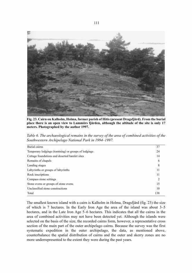
111
Fig. 23. Cairn on Kalholm, Holma, former parish of Hitis (present Dragsfjärd). From the burialplace there is an open view to Lammörs fjärden, although the altitude of the site is only 17meters. Photographed by the author 1997.
Table 6. The archaeological remains in the survey of the area of combined activities of theSouthwestern Archipelago National Park in 1994–1997.
The smallest known island with a cairn is Kalholm in Holma, Dragsfjärd (fig. 23) the sizeof which is 7 hectares. In the Early Iron Age the area of the island was about 3–5hectares, and in the Late Iron Age 5–6 hectares. This indicates that all the cairns in thearea of combined activities may not have been detected yet. Although the islands wereselected on the basis of the size, the recorded cairns form, however, a representative crosssection of the main part of the outer archipelago cairns. Because the survey was the firstsystematic expedition in the outer archipelago, the data, as mentioned above,counterbalance the spatial distribution of cairns and the outer and skerry zones are nomore underrepresented to the extent they were during the past years.
Burial cairns 37Temporary lodgings (tomtning) or groups of lodgings 24Cottage foundations and deserted hamlet sites 14Remains of chapels 6Landing stages 8Labyrinths or groups of labyrinths 11Rock inscriptions 11Compass stone settings 2Stone ovens or groups of stone ovens 15Unclassified stone constructions 10Total 138

112
A special characteristic of the outer archipelago seems to be the great number ofgraves in regard to the restricted land areas. 20 of the 37 burial cairns are situated inplaces that lay below the sea level of the Bronze Age. Consequently, only a few – if any –of the graves in the National Park date back to the Bronze Age.
4.4.4 The practical routine: finding cairns and making field notes
When trying to come across graves recorded in old field reports, one is often forced toface the fact that the past decades have inevitably won the race. At least 18 cairnsdocumented by Volter Högman and other researchers of the older generation, havevanished. Four of them have been destroyed by road building. In the rest of the cases, thecause of demolition is not known.
Sometimes it turns out to be difficult to find again sites mentioned in old records.Usually the location of the grave was indicated inaccurately, controversially, or based ontopographic fixed points previously relevant but later obsolete. In certain cases a grave inthe terrain cannot be connected with sites in old reports with certainty. However, there isusually no reason to doubt the quality of old data except for positioning. There were thirtycairns which I was not able to locate again, most of them on Kimitoön.
In the first place it is an economic question to resolve indistinct locational information.In general, I gave up trying to relocate the cairn if I couldn’t find it during one workingday. With help from people with local knowledge the location of some graves wasclarified, e.g., the cairn in Sellmo, Nagu (236), originally found by Juho Sjöros (Sjöros1887). Several field periods of working made it possible to clarify indistinct informationand to make certain corrections.
The following on-site notes were made of each cairn:1. Position, given in the national grid coordinate system (kkj).2. Accuracy of positioning in meters (as suggested by Rainio 1988). 3. A verbal description of the burial place.4. Altitude.5. Soil type(s).6. A verbal description of soil and topography.7. Vegetation.8. Map sketch, if necessary.9. Shape of the cairn.10. Profile of the cairn.11. Possible soil occurrence in the cairn.12. Main measures of the cairn.13. Main measures of the cairn given in older records. 14. Direction of the length axis of the cairn.15. Structures and stone material 16. Damages of the cairn.17. Possible uncertainty as a burial cairn.18. History of discovery.19. Possible earlier records, investigations, artefacts etc.
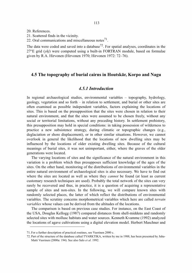
113
20. References.21. Scattered finds in the vicinity.22. Oral communications and miscellaneous notes71. The data were coded and saved into a database72. For spatial analyses, coordinates in the27°E grid (ykj) were computed using a built-in FORTRAN module, based on formulaegiven by R.A. Hirvonen (Hirvonen 1970; Hirvonen 1972: 72–76).
4.5 The topography of burial cairns in Houtskär, Korpo and Nagu
4.5.1 Introduction
In regional archaeological studies, environmental variables – topography, hydrology,geology, vegetation and so forth – in relation to settlement, and burial or other sites areoften examined as possible independent variables, factors explaining the locations ofsites. This is based on the presupposition that the sites were chosen in relation to theirnatural environment, and that the sites were assumed to be chosen freely, without anysocial or territorial limitations, without any preceding history. In settlement prehistory,this presupposition may hold in special conditions: in taking possession of wilderness topractice a new subsistence strategy, during climatic or topographic changes (e.g.,deglaciation or shore displacement), or in other similar situations. However, we cannotoverlook in general the likelihood that the locations of new dwelling sites may beinfluenced by the locations of older existing dwelling sites. Because of the culturalmeanings of burial sites, it was not unimportant, either, where the graves of the oldergenerations were located.
The varying locations of sites and the significance of the natural environment in thisvariation is a problem which thus presupposes sufficient knowledge of the ages of thesites. On the other hand, monitoring of the distributions of environmental variables in theentire natural environment of archaeological sites is also necessary. We have to find outwhere the sites are located as well as where they cannot be found (at least as currentcustomary research techniques are used). Probably the total network of the sites can veryrarely be recovered and thus, in practice, it is a question of acquiring a representativesample of sites and non-sites. In the following, we will compare known sites withrandomly selected places, the latter of which reflect the distributions of environmentalvariables. The scrutiny concerns morphometrical variables which here are called terrainvariables whose values can be derived from the altitudes of the locations.
The comparison is based on previous case studies. For instance, on the East Coast ofthe USA, Douglas Kellogg (1987) compared distances from shell-middens and randomlyselected sites with mollusc habitats and water sources. Kenneth Kvamme (1992) analyzedthe locations of agave cultivations using a digital elevation model. Herbert Maschner and
71. For a further description of practical routines, see Vuorinen 2000 c.72. Part of the structure of the database called TYARKTIKA, written by me in 1988, has been presented by Juha-
Matti Vuorinen (2000a: 194). See also Salo et al. 1992.
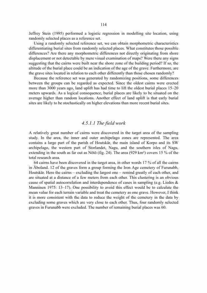
114
Jeffrey Stein (1995) performed a logistic regression in modelling site location, usingrandomly selected places as a reference set.
Using a randomly selected reference set, we can obtain morphometric characteristicsdifferentiating burial sites from randomly selected places. What constitutes those possibledifferences? Are there any morphometric differences not directly originating from shoredisplacement or not detectable by mere visual examination of maps? Were there any signssuggesting that the cairns were built near the shore zone of the building period? If so, thealtitude of the burial place could be an indication of the age of the grave. Furthermore, arethe grave sites located in relation to each other differently than those chosen randomly?
Because the reference set was generated by randomizing positions, some differencesbetween the groups can be regarded as expected. Since the oldest cairns were erectedmore than 3000 years ago, land uplift has had time to lift the oldest burial places 15–20meters upwards. As a logical consequence, burial places are likely to be situated on theaverage higher than random locations. Another effect of land uplift is that early burialsites are likely to be stochastically on higher elevations than more recent burial sites.
4.5.1.1 The field work
A relatively great number of cairns were discovered in the target area of the samplingstudy. In the area, the inner and outer archipelago zones are represented. The areacontains a large part of the parish of Houtskär, the main island of Korpo and its SWarchipelago, the western part of Storlandet, Nagu, and the southern isles of Nagu,extending in the south as far out as Nötö (fig. 24). The area (929 km²) covers 15 % of thetotal research area.
64 cairns have been discovered in the target area, in other words 17 % of all the cairnsin Åboland. 12 of the graves form a group forming the Iron Age cemetery of Furunabb,Houtskär. Here the cairns – excluding the largest one – remind greatly of each other, andare situated at a distance of a few meters from each other. This clustering is an obviouscause of spatial autocorrelation and interdependence of cases in sampling (e.g. Liedes &Manninen 1975: 13–17). One possibility to avoid this effect would be to calculate themean value for each terrain variable and treat the cemetery as one grave. However, I thinkit is more consistent with the data to reduce the weight of the cemetery in the data byexcluding some graves which are very close to each other. Thus, four randomly selectedgraves in Furunabb were excluded. The number of remaining burial places was 60.
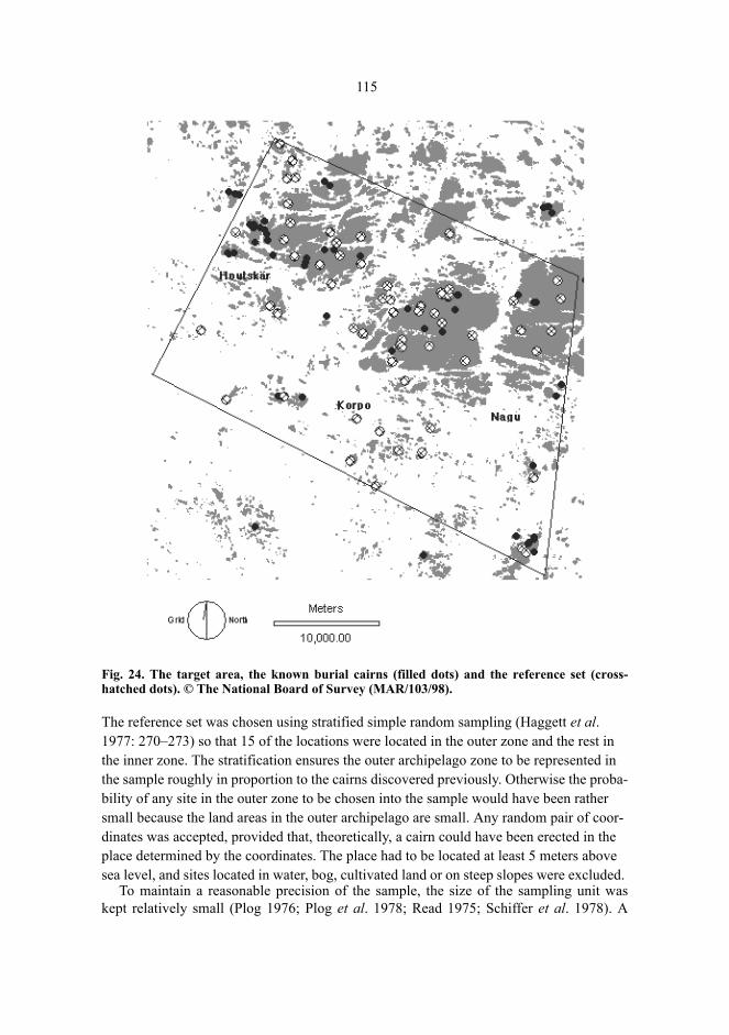
115
Fig. 24. The target area, the known burial cairns (filled dots) and the reference set (cross-hatched dots). © The National Board of Survey (MAR/103/98).
The reference set was chosen using stratified simple random sampling (Haggett et al. 1977: 270–273) so that 15 of the locations were located in the outer zone and the rest in the inner zone. The stratification ensures the outer archipelago zone to be represented in the sample roughly in proportion to the cairns discovered previously. Otherwise the proba-bility of any site in the outer zone to be chosen into the sample would have been rather small because the land areas in the outer archipelago are small. Any random pair of coor-dinates was accepted, provided that, theoretically, a cairn could have been erected in the place determined by the coordinates. The place had to be located at least 5 meters above sea level, and sites located in water, bog, cultivated land or on steep slopes were excluded.
To maintain a reasonable precision of the sample, the size of the sampling unit waskept relatively small (Plog 1976; Plog et al. 1978; Read 1975; Schiffer et al. 1978). A

116
radius of 400 m was drawn around each point. The areas falling within the radius wereexamined for the possible occurrence of burial cairns. No previously unknown graveswere found, but one previously known cairn, on Bussö in Korpo (349) happened to fallinside one of the areas of the reference set.
4.5.2 The digital elevation model
The comparison of the burial places with the reference set is based on terrain variablesderived from a digital elevation model (DEM) developed by the Finnish National Boardof Survey. The DEM is a file of altitude points, interpolated from the height contours andshore lines of the Finnish basic map and recalculated to a network of rectangular cellsrepresenting altitudes. The resolution of the model is 25 meters. Altitudes are given at anumerical precision of one decimeter.
On average, the standard error of the altitudes of the DEM is 1.76 m. Of the 90 mapsheets acquired for this study, 30 sheets are reported to give a better accuracy than theaverage value of the country. While examining the material, it is indeed evident that inmany cases the altitudes given by the DEM differ from those locally measured. Thesedifferences cannot, however, be explained merely by the standard errors of the DEM.Firstly, the altitudes of the DEM do not necessarily denote the same pieces of land surfaceas the known altitudes. The DEM altitudes represent the average values of the cells whilethe known altitudes of burial places represent points, either levelled on-site or estimatedfrom the basic map. Secondly, the location of each burial place was determined on themap. Thus, an inaccuracy of graphical origin is involved in the location of each burialplace, roughly amounting to the 25 meter side of the cells of the DEM. The correct cell ofthe DEM does not always coincide with the known location of the burial place. Especiallyon precipitous slopes the inaccuracy may cause distortion in the relation between theburial place and the cell. However, a detailed look at the data gives the overall picture thatthe inaccuracies are of minor practical significance. To eliminate the inaccuraciesdiscussed above it is evidently recommendable to use GPS positioning in the future(Ollikainen 1997; Poutanen 1998: 202–204). This applies particularly to emphasizing thesensitive changes in visibility when walking in the terrain (see Tilley 1994).
It is in any case worth while to state a few words about the possible systematicdifferences between corresponding altitudes obtained from different sources. Table 7gives statistics on the differences between on-site measured altitudes and correspondingaltitudes derived from the DEM, using different measuring methods. Individual heightlevels may differ distinctly from each other, but the differences are distributed both aboveand below zero. The differences between altitudes derived from the basic map and fromthe DEM are relative small on average. The altitudes measured using levellinginstruments or aneroids indicate more systematic differences. This may be due to the factthat a saddle point was often chosen when a cairn was erected.

117
Table 7. Sampling area of Houtskär, Korpo and Nagu. Differences between on-sitemeasurements of altitudes of burial sites and altitudes derived from corresponding cells inthe DEM.
In practice, the deviations of altitudes affect most conspicuously the cairns located at lowheights above sea level. For instance, the altitude given by the DEM for the burial placeon Hummelskär, Korpo, is only 4.9 m, whereas the value obtained by using a spirit levelwas 8.4 meters. The grave of Kistkär, Österskär, Korpo, one of the outermost burial sitesin the archipelago, is according to the DEM situated in a cell with a given altitude of 5.7meters, whereas the altitude obtained from the on-site measurement was 7.5 meters.When shore zone datings are determined for low-altitude Iron Age graves, an error of thismagnitude is significant. For this reason, the altitudes of burial places near the shore weredetermined using a spirit level or an aneroid. In higher terrain, some distance away fromthe shore, the DEM errors do not have the same significance for shore zone datings, sincethere the cairns were obviously not built near the shore. Furthermore, the point errors aresmoothed when large areas are covered by the model. In the following discussion, I willuse DEM altitudes in analyses based on GIS techniques, and on-site measurements in thedeterminations of shore zone datings.
4.5.3 The distributions of the terrain variables
4.5.3.1 The variables
In the comparison between burial places and random locations, ten morphometricvariables are used. Variables such as altitude, height difference in relation to summits,relative altitude, slope, and sum of distances to the nearest neighbours are calculated bycomparing the burial site with its topographic surroundings. Other variables are derivedfrom the area around the burial place. The area is defined by a circular window opened inthe DEM, with a radius of 500 meters, and with the burial place as the centre (1245 cells).The latter variables are mean altitude, median altitude, standard deviation of altitude,quartile range of altitude and relative proportion of sea area.
To determine the values of the terrain variables, the DEM has to be overlaid with thepoints representing burial cairns and random locations, the distances between the pointshave to be calculated and each cell has to be compared with its surroundings usingdifferent neighbour functions. These tasks were performed mainly using the Idrisi and
Determination of altitude n Smallest
differenceGreatest
differenceMean of
differencesStandard deviation
of differencesExamined from basic map 43 -3.8 6.5 0.40 2.24
Spirit levelling 15 -2.5 5.1 1.63 2.22Barometric levelling 2 0.3 3.2 1.75 2.05
Total 60 -3.8 6.5 0.75 2.27
118
BMDP softwares (Eastman 1997; Dixon 1992). The distances were computed using theNEIG module by Keith W. Kintigh (Kintigh 1987; Kintigh 1992: 41–46). The values were determined as follows:1. The altitude is the value of the cell in the DEM.2. The height difference in relation to summits equals to the highest altitude within 500
meters subtracted by the altitude of the cell.3. The relative altitude is obtained by extracting, using the cumulative frequency
distribution, the relative proportion of the cells with an altitude lower than or equal tothe cell in the middle of the circular window.
4. The slope can be determined from the DEM by comparing the altitude of each cellwith the altitudes in the nearest adjacent cells on the north, south, west, and east sides.The slope indicates the most precipitous slope near the observation point. The slopemay obtain a high numerical value, if there is a precipice in the neighbourhood, evenif the cell in the center of the circle is on an even ground. The slope cannot directly beinterpreted as a slope of the basal surface under the cairn, although that is sometimesthe case. The accuracy of the slope depends on the resolution of the DEM and thelocal topography (Chang & Tsai 1991). Usually the calculated slope is smaller than orequal to the actual slope (Guzzetti & Reichenbach 1994: 59).
5. The sum of distances to the nearest neighbours indicates how close the five closestneighbouring burial sites or, respectively, the random places are located. It is definedas the sum of the distances, each of them weighted with the inverse of the square rootof the distance
where dj denotes the distances to the j:th closest neighbour. Due to the graphicalinaccuracy involved in estimating the coordinates of the burial site from the map,apparent zero distances may occur. They are eliminated by adding one meter to eachdistance.
For the five nearest neighbours, 0 < nd ≤ 5. The closer to each other the neighbours arelocated, the greater is the value of the sum of distances. The further away the j:thneighbour is from the observation point, in relation to which the distance is measured, theless the neighbour affects the value of the sum. The square roots of the divisors are taken,since otherwise neighbours situated a little further away would not have any significanteffect on the value of the variable. 6. 6. The mean altitude is given by the mean of the non-zero altitudes of the cells inside
the window. The sea surface is thus excluded, since the result of including the sealevel in the calculation would reflect rather the amount of sea around the burial placethan the actual mean altitude of the terrain.
7. The median altitude is given by the median of the non-zero altitudes of the cellsinside the window.
8. The standard deviation of altitude is given by the standard deviation of the non-zeroaltitudes of the cells inside the window.
9. The quartile range of altitude is given by the quartile range of the non-zero altitudesof the cells inside the window.
Σ= +
=5
1 11
j jd d
n

119
10. The relative proportion of sea area indicates the percentage of cells inside the windowwith altitudes equalling zero.
4.5.3.2 The differences of the distributions
The statistics for the distributions of the terrain variables are listed in tables 8 and 9. Thelocations of the distributions are compared using the Mann-Whitney U-test, completedwith Kolmogorov-Smirnov tests for the equality of the location, variation, and shape ofdistributions. In the latter, the test statistic D is equal to the greatest difference betweenthe two cumulative functions to be compared (Conover 1980).
The altitude. The burial sites are located on average 7 meters higher than the places ofthe reference set. The altitudes of the burial sites show a greater variation, too. The differ-ences are statistically significant. At least partly the difference is a logical consequence ofthe age of the earliest graves: when they were built, the land surface was at least 15 metershigher at present. Contrary to Iron Age burial sites or randomly selected places, the earli-est graves cannot be located at low altitudes. However, even a preliminary look at thetopography indicates that the differences of altitudes are also partly due to the choice oflocation of the burial places, the gravebuilder’s inclination to choose high places in the ter-rain. The cairns were, thus, often built on land which had risen from the sea long beforethe building work. If we applied the shore displacement chronology in an uncritical way inorder to date the burial places according to their altitude, we would, of course, end up withtoo high age estimates. This is evident especially for the classical hiidenkiuas graves thatwere often erected on tops of rocks. Reversely: on an average, the cairns are later than theage suggested by a superficial look at the topography.
Table 8. Comparison of the burial sites and the reference set (the means, the standarddeviations, the greatest values, and the smallest value for all variables).Variable Burial places, n = 60 Reference set, n = 60
Mean Sd Max value Min value Mean Sd Max value Min valueAltitude (m) 20.335 8.298 38.8 4.9 13.657 6.326 32.3 6.1Height difference in relation to summits (m) 7.837 6.508 22.1 0.0 11.388 6.242 27.0 0.5
Relative altitude (%) 77.497 24.051 100.0 27.5 70.737 20.166 99.1 16.9Mean altitude (m) 13.030 4.379 24.869 3.935 10.617 4.551 21.190 3.794Median altitude (m) 12.680 4.838 25.0 3.7 9.908 4.752 21.3 3.0Sd of altitude (m) 6.081 1.384 8.8790 2.321 5.312 1.817 10.882 2.404Quartile range of altitude (m) 4.485 1.350 8.050 1.900 3.903 1.638 8.975 1.700Relative proportion of sea area (%) 24.173 21.468 93.3 0.0 32.070 32.460 95.8 0.0
Slope (º) 3.754 2.621 12.311 0.115 5.241 3.523 18.783 0.115Sum of distances to nearest neighbours 0.3004 0.3023 1.1409 0.0471 0.1001 0.0275 0.1724 0.0548
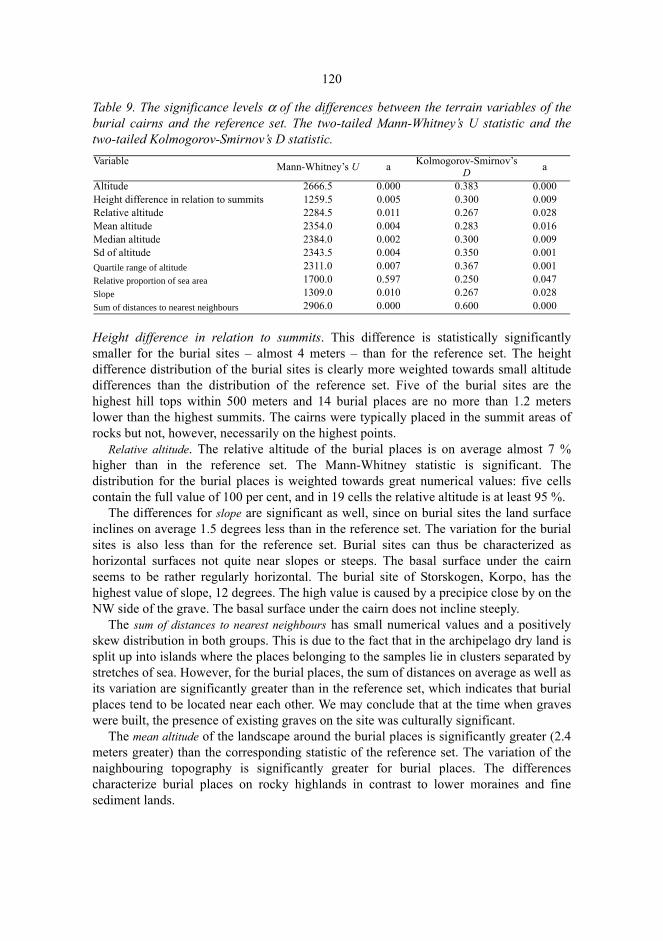
120
Table 9. The significance levels α of the differences between the terrain variables of theburial cairns and the reference set. The two-tailed Mann-Whitney’s U statistic and thetwo-tailed Kolmogorov-Smirnov’s D statistic.
Height difference in relation to summits. This difference is statistically significantlysmaller for the burial sites – almost 4 meters – than for the reference set. The heightdifference distribution of the burial sites is clearly more weighted towards small altitudedifferences than the distribution of the reference set. Five of the burial sites are thehighest hill tops within 500 meters and 14 burial places are no more than 1.2 meterslower than the highest summits. The cairns were typically placed in the summit areas ofrocks but not, however, necessarily on the highest points.
Relative altitude. The relative altitude of the burial places is on average almost 7 %higher than in the reference set. The Mann-Whitney statistic is significant. Thedistribution for the burial places is weighted towards great numerical values: five cellscontain the full value of 100 per cent, and in 19 cells the relative altitude is at least 95 %.
The differences for slope are significant as well, since on burial sites the land surfaceinclines on average 1.5 degrees less than in the reference set. The variation for the burialsites is also less than for the reference set. Burial sites can thus be characterized ashorizontal surfaces not quite near slopes or steeps. The basal surface under the cairnseems to be rather regularly horizontal. The burial site of Storskogen, Korpo, has thehighest value of slope, 12 degrees. The high value is caused by a precipice close by on theNW side of the grave. The basal surface under the cairn does not incline steeply.
The sum of distances to nearest neighbours has small numerical values and a positivelyskew distribution in both groups. This is due to the fact that in the archipelago dry land issplit up into islands where the places belonging to the samples lie in clusters separated bystretches of sea. However, for the burial places, the sum of distances on average as well asits variation are significantly greater than in the reference set, which indicates that burialplaces tend to be located near each other. We may conclude that at the time when graveswere built, the presence of existing graves on the site was culturally significant.
The mean altitude of the landscape around the burial places is significantly greater (2.4meters greater) than the corresponding statistic of the reference set. The variation of thenaighbouring topography is significantly greater for burial places. The differencescharacterize burial places on rocky highlands in contrast to lower moraines and finesediment lands.
Variable Mann-Whitney’s U a Kolmogorov-Smirnov’s D a
Altitude 2666.5 0.000 0.383 0.000Height difference in relation to summits 1259.5 0.005 0.300 0.009Relative altitude 2284.5 0.011 0.267 0.028Mean altitude 2354.0 0.004 0.283 0.016Median altitude 2384.0 0.002 0.300 0.009Sd of altitude 2343.5 0.004 0.350 0.001Quartile range of altitude 2311.0 0.007 0.367 0.001Relative proportion of sea area 1700.0 0.597 0.250 0.047Slope 1309.0 0.010 0.267 0.028Sum of distances to nearest neighbours 2906.0 0.000 0.600 0.000
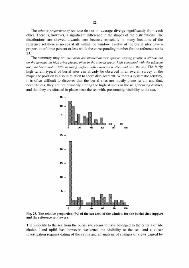
121
The relative proportions of sea area do not on average diverge significantly from eachother. There is, however, a significant difference in the shapes of the distributions. Thedistributions are skewed towards zero because especially in many locations of thereference set there is no sea at all within the window. Twelve of the burial sites have aproportion of three percent or less while the corresponding number for the reference set is23.
The summary may be: the cairns are situated on rock uplands varying greatly in altitude buton the average on high lying places, often in the summit areas, high compared with the adjacentarea, on horizontal or little inclining surfaces, often near each other, and near the sea. The fairlyhigh terrain typical of burial sites can already be observed in an overall survey of themaps; the position is also in relation to shore displacement. Without a systematic scrutiny,it is often difficult to discover that the burial sites are mostly plane terrain and that,nevertheless, they are not primarily among the highest spots in the neighbouring district,and that they are situated in places near the sea with, presumably, visibility to the sea.
Fig. 25. The relative proportion (%) of the sea area of the window for the burial sites (upper)and the reference set (lower).
The visibility to the sea from the burial site seems to have belonged to the criteria of sitechoice. Land uplift has, however, weakened the visibility to the sea, and a closerinvestigation requires dating of the cairns and an analysis of changes of views caused by

122
shore displacement. Visibility to the sea does not imply any certain topographic relationbetween the burial site and the shore zone at the time when the graves were built; actuallythere is a certain variety to be found concerning this relation. Some cairns situated on alow level suggest, however, that, at their time, they must have been constructed near theshore zone. The most distinct example of this is the cairn at Djupklevudden (364), Korpo,on a rock rising from the shore to the height of 6.4 m from sea level.
4.6 The boulder studies
4.6.1 The mass of stones and boulders
In the excavations included in this study, the constructing material of the burial cairnswas investigated. Observations were made of the mass distribution of stones and bouldersweighing at least about 0.5 kg, of the quality and roundness of the stones as well as of thesoil filling of the cairn (Sundbergen, Ängesnäs bergen).
The calculation of the total mass of the stone setting gives a possibility to estimate howexactly the actual size of the stone setting can be given by measuring its length, width andheight with a measuring tape. When examining the scatter plot (figure 26), it becomesapparent that the tape measurements predict the total mass of the stone setting withreasonable reliability excluding the Lilla Kuusis burial cairn in Nagu, whose mass issmaller than that predicted on the basis of the measures. The cairn, indeed, is a shallowstone setting following the rock surface with stones smaller than on average. In any case,the comparison creates confidence in simple tape measuring as a sensible way ofdetermining the size of the cairn if the borders of the stone setting can be reliablydetermined.
The mass of stones and boulders has a positively skew distribution. More than half ofthe stones and boulders weigh less than 10 kg (figure 26, table 10). The largest bouldersin the cairns were approximately ten times larger than the average. If all the stones under0.5 kg had been weighed, the distributions would have been even skewer. This signifiesthat most of the total mass of the burial cairns was composed of small stones – and not oflarge boulders dominating the outer appearance of the stone setting and giving the visualimpression of the average size of the boulders. The boulders and large stones haveprobably also in a way concentrated on the surface of the stone setting because smallstones are prone to run inside the stone setting through gaps between the boulders. In thisway, small stones have disappeared, even if some of them had originally lain on thesurface layer of the stone covering.
The dislocation of small stones was verified in the excavations of the Sundbergencairn, Nagu. In the stone filling under the surface layer, there were small stones which hadbeen wedged in between boulders and larger stones. When the boulders were stirred byexcavators, the small stones fell or ran deeper. An observation close to this was reportedby Tapio Seger from Furunabb, Houtskär, during his excavation in the year 1986. As anexplanation we could assume that stones of different sizes have been thrown on the cairnin random sequences, with some small stones remaining on the surface and, later on,
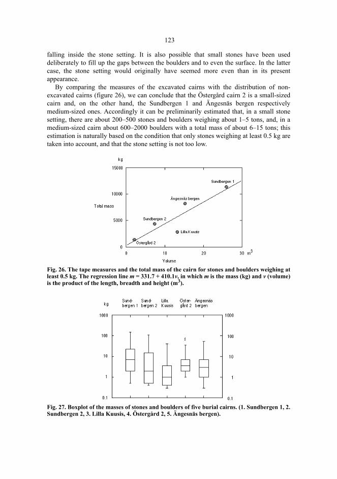
123
falling inside the stone setting. It is also possible that small stones have been useddeliberately to fill up the gaps between the boulders and to even the surface. In the lattercase, the stone setting would originally have seemed more even than in its presentappearance.
By comparing the measures of the excavated cairns with the distribution of non-excavated cairns (figure 26), we can conclude that the Östergård cairn 2 is a small-sizedcairn and, on the other hand, the Sundbergen 1 and Ängesnäs bergen respectivelymedium-sized ones. Accordingly it can be preliminarily estimated that, in a small stonesetting, there are about 200–500 stones and boulders weighing about 1–5 tons, and, in amedium-sized cairn about 600–2000 boulders with a total mass of about 6–15 tons; thisestimation is naturally based on the condition that only stones weighing at least 0.5 kg aretaken into account, and that the stone setting is not too low.
Fig. 26. The tape measures and the total mass of the cairn for stones and boulders weighing atleast 0.5 kg. The regression line m = 331.7 + 410.1v, in which m is the mass (kg) and v (volume)is the product of the length, breadth and height (m3).
Fig. 27. Boxplot of the masses of stones and boulders of five burial cairns. (1. Sundbergen 1, 2.Sundbergen 2, 3. Lilla Kuusis, 4. Östergård 2, 5. Ängesnäs bergen).
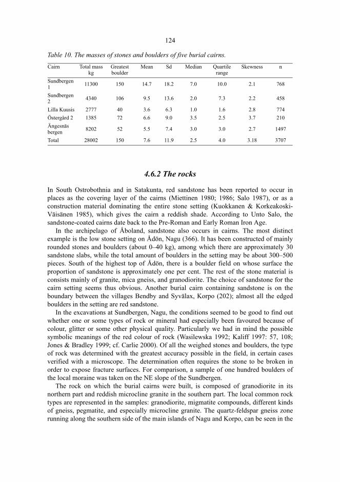
124
Table 10. The masses of stones and boulders of five burial cairns.
4.6.2 The rocks
In South Ostrobothnia and in Satakunta, red sandstone has been reported to occur inplaces as the covering layer of the cairns (Miettinen 1980; 1986; Salo 1987), or as aconstruction material dominating the entire stone setting (Kuokkanen & Korkeakoski-Väisänen 1985), which gives the cairn a reddish shade. According to Unto Salo, thesandstone-coated cairns date back to the Pre-Roman and Early Roman Iron Age.
In the archipelago of Åboland, sandstone also occurs in cairns. The most distinctexample is the low stone setting on Ådön, Nagu (366). It has been constructed of mainlyrounded stones and boulders (about 0–40 kg), among which there are approximately 30sandstone slabs, while the total amount of boulders in the setting may be about 300–500pieces. South of the highest top of Ådön, there is a boulder field on whose surface theproportion of sandstone is approximately one per cent. The rest of the stone material isconsists mainly of granite, mica gneiss, and granodiorite. The choice of sandstone for thecairn setting seems thus obvious. Another burial cairn containing sandstone is on theboundary between the villages Bendby and Syvälax, Korpo (202); almost all the edgedboulders in the setting are red sandstone.
In the excavations at Sundbergen, Nagu, the conditions seemed to be good to find outwhether one or some types of rock or mineral had especially been favoured because ofcolour, glitter or some other physical quality. Particularly we had in mind the possiblesymbolic meanings of the red colour of rock (Wasilewska 1992; Kaliff 1997: 57, 108;Jones & Bradley 1999; cf. Carlie 2000). Of all the weighed stones and boulders, the typeof rock was determined with the greatest accuracy possible in the field, in certain casesverified with a microscope. The determination often requires the stone to be broken inorder to expose fracture surfaces. For comparison, a sample of one hundred boulders ofthe local moraine was taken on the NE slope of the Sundbergen.
The rock on which the burial cairns were built, is composed of granodiorite in itsnorthern part and reddish microcline granite in the southern part. The local common rocktypes are represented in the samples: granodiorite, migmatite compounds, different kindsof gneiss, pegmatite, and especially microcline granite. The quartz-feldspar gneiss zonerunning along the southern side of the main islands of Nagu and Korpo, can be seen in the
Cairn Total mass kg
Greatest boulder
Mean Sd Median Quartile range
Skewness n
Sundbergen 1 11300 150 14.7 18.2 7.0 10.0 2.1 768
Sundbergen 2 4340 106 9.5 13.6 2.0 7.3 2.2 458
Lilla Kuusis 2777 40 3.6 6.3 1.0 1.6 2.8 774Östergård 2 1385 72 6.6 9.0 3.5 2.5 3.7 210Ängesnäs bergen 8202 52 5.5 7.4 3.0 3.0 2.7 1497
Total 28002 150 7.6 11.9 2.5 4.0 3.18 3707
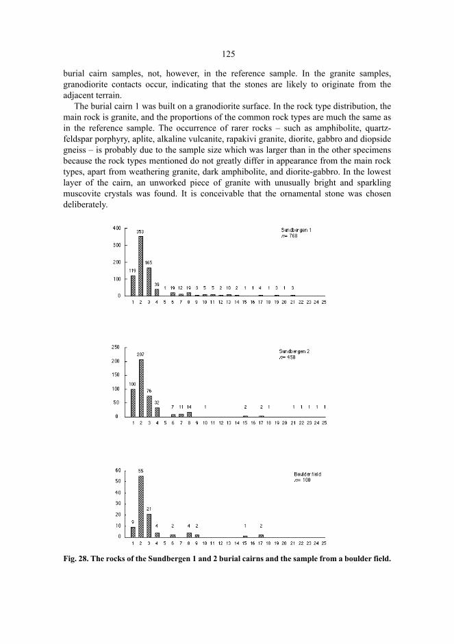
125
burial cairn samples, not, however, in the reference sample. In the granite samples,granodiorite contacts occur, indicating that the stones are likely to originate from theadjacent terrain.
The burial cairn 1 was built on a granodiorite surface. In the rock type distribution, themain rock is granite, and the proportions of the common rock types are much the same asin the reference sample. The occurrence of rarer rocks – such as amphibolite, quartz-feldspar porphyry, aplite, alkaline vulcanite, rapakivi granite, diorite, gabbro and diopsidegneiss – is probably due to the sample size which was larger than in the other specimensbecause the rock types mentioned do not greatly differ in appearance from the main rocktypes, apart from weathering granite, dark amphibolite, and diorite-gabbro. In the lowestlayer of the cairn, an unworked piece of granite with unusually bright and sparklingmuscovite crystals was found. It is conceivable that the ornamental stone was chosendeliberately.
Fig. 28. The rocks of the Sundbergen 1 and 2 burial cairns and the sample from a boulder field.

126
The frequencies of the rocks were plotted in figure 28. The rocks were classified asfollows: 1. Granodiorite, quartzdiorite, trondhjemite2. Granite3. Migmatite4. Mica gneiss5. Uralite porphyrite6. Pegmatite7. Quartz-feldspar gneiss (leptite)8. Sandstone 9. Diabase10. Amphibolite11. Quartz12. Quartz-feldspar porphyry13. Aplite14. Alkaline vulcanite15. Quartzite16. Rapakivi granite17. Biotite-plagioclase schist18. Porphyry granite19. Diorite and gabbro20. Diopside gneiss21. Hornblende gneiss22. Hornblende pegmatite23. Porphyry granodiorite24. K-feldspar25. LimestoneThe basal surface under the burial cairn 2 consists of granodiorite, with granite veins.Among the stones, granodiorite is also relatively common, even though granite is themain type. Many of the rare rock types in the cairn 1 are not present, instead hornblendepegmatite, porphyry granodiorite, k-feldspar, and limestone were found. In hornblendepegmatite, hornblende is seen as large scattered granules together with feldspar; inporphyry granodiorite, large k-feldspar granules were found respectively. Pure k-feldsparoccurs in large crystals, which may have been split off from pegmatite. Hornblendepegmatite, porphyry granodiorite, and k-feldspar thus occur sometimes in separate pieceswith a special appearance, and it is possible that they have been chosen in the burial cairnfor their very appearance.
The reference sample, however, did not present unambiguous reference as to thechoice of rock type. Jotun sandstone occurred both in the burial cairn and in thecomparison sample in a fairly ample amount but it was not overrepresented in the burialcairns. However, a deliberate choice is suggested by the fact that dark and sparklingstones have been brought into the burial cairns to the extent that there are clearly more ofthem in the cairns than in the boulder field.
The rock type distributions suggest that the stones and boulders of the cairns have beenpicked from a bare-washed stone field in the adjacent terrain, possibly on the shore,
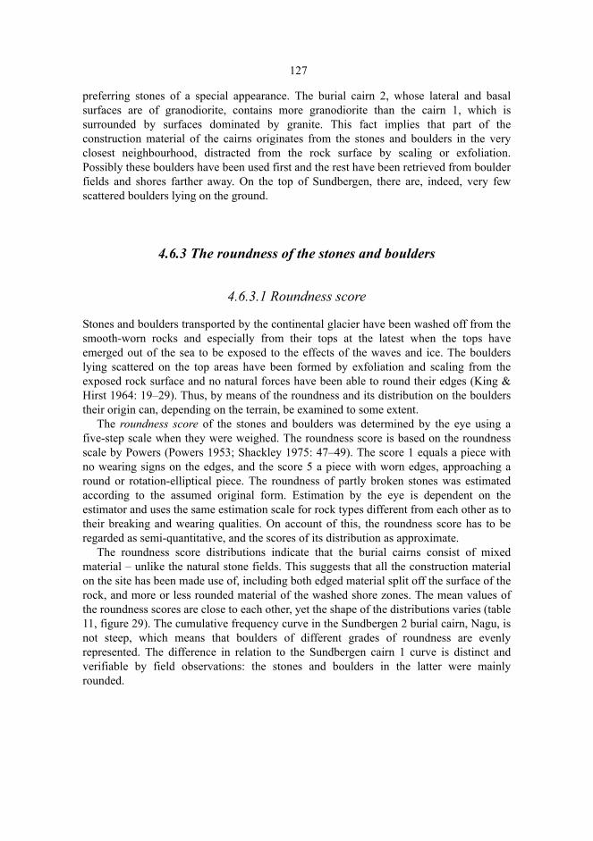
127
preferring stones of a special appearance. The burial cairn 2, whose lateral and basalsurfaces are of granodiorite, contains more granodiorite than the cairn 1, which issurrounded by surfaces dominated by granite. This fact implies that part of theconstruction material of the cairns originates from the stones and boulders in the veryclosest neighbourhood, distracted from the rock surface by scaling or exfoliation.Possibly these boulders have been used first and the rest have been retrieved from boulderfields and shores farther away. On the top of Sundbergen, there are, indeed, very fewscattered boulders lying on the ground.
4.6.3 The roundness of the stones and boulders
4.6.3.1 Roundness score
Stones and boulders transported by the continental glacier have been washed off from thesmooth-worn rocks and especially from their tops at the latest when the tops haveemerged out of the sea to be exposed to the effects of the waves and ice. The boulderslying scattered on the top areas have been formed by exfoliation and scaling from theexposed rock surface and no natural forces have been able to round their edges (King &Hirst 1964: 19–29). Thus, by means of the roundness and its distribution on the boulderstheir origin can, depending on the terrain, be examined to some extent.
The roundness score of the stones and boulders was determined by the eye using afive-step scale when they were weighed. The roundness score is based on the roundnessscale by Powers (Powers 1953; Shackley 1975: 47–49). The score 1 equals a piece withno wearing signs on the edges, and the score 5 a piece with worn edges, approaching around or rotation-elliptical piece. The roundness of partly broken stones was estimatedaccording to the assumed original form. Estimation by the eye is dependent on theestimator and uses the same estimation scale for rock types different from each other as totheir breaking and wearing qualities. On account of this, the roundness score has to beregarded as semi-quantitative, and the scores of its distribution as approximate.
The roundness score distributions indicate that the burial cairns consist of mixedmaterial – unlike the natural stone fields. This suggests that all the construction materialon the site has been made use of, including both edged material split off the surface of therock, and more or less rounded material of the washed shore zones. The mean values ofthe roundness scores are close to each other, yet the shape of the distributions varies (table11, figure 29). The cumulative frequency curve in the Sundbergen 2 burial cairn, Nagu, isnot steep, which means that boulders of different grades of roundness are evenlyrepresented. The difference in relation to the Sundbergen cairn 1 curve is distinct andverifiable by field observations: the stones and boulders in the latter were mainlyrounded.
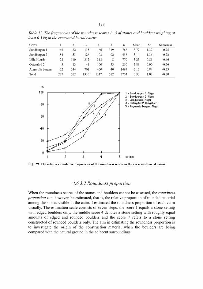
128
Table 11. The frequencies of the roundness scores 1...5 of stones and boulders weighing atleast 0.5 kg in the excavated burial cairns.
Fig. 29. The relative cumulative frequencies of the roundness scores in the excavated burial cairns.
4.6.3.2 Roundness proportion
When the roundness scores of the stones and boulders cannot be assessed, the roundnessproportion can, however, be estimated, that is, the relative proportion of rounded materialamong the stones visible in the cairn. I estimated the roundness proportion of each cairnvisually. The estimation scale consists of seven steps: the score 1 equals a stone settingwith edged boulders only, the middle score 4 denotes a stone setting with roughly equalamounts of edged and rounded boulders and the score 7 refers to a stone settingconstructed of rounded boulders only. The aim in estimating the roundness proportion isto investigate the origin of the construction material when the boulders are beingcompared with the natural ground in the adjacent surroundings.
Grave 1 2 3 4 5 n Mean Sd SkewnessSundbergen 1 66 82 135 166 319 768 3.77 1.32 -0.75Sundbergen 2 84 53 126 103 92 458 3.14 1.36 -0.22Lilla Kuusis 22 110 312 318 8 770 3.23 0.81 -0.66Östergård 2 3 13 41 100 53 210 3.89 0.90 -0.76Ängesnäs bergen 52 244 701 460 40 1497 3.13 0.84 -0.33Total 227 502 1315 1147 512 3703 3.33 1.07 -0.30
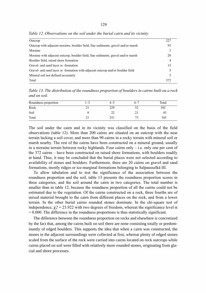
129
Table 12. Observations on the soil under the burial cairn and its vicinity.
Table 13. The distribution of the roundness proportion of boulders in cairns built on a rockand on soil.
The soil under the cairn and in its vicinity was classified on the basis of the fieldobservations (table 12). More than 200 cairns are situated on an outcrop with the nearterrain lacking a soil cover, and more than 90 cairns in a rocky terrain with mineral soil ormarsh nearby. The rest of the cairns have been constructed on a mineral ground, usuallyin a moraine terrain between rocky highlands. Four cairns only – i.e. only one per cent ofthe 372 cairns – have been constructed on raised shore formations, with boulders readilyat hand. Thus, it may be concluded that the burial places were not selected according toavailability of stones and boulders. Furthermore, there are 20 cairns on gravel and sandformations, mostly ridges or ice-marginal formations belonging to Salpausselkä III.
To allow tabulation and to test the significance of the association between theroundness proportion and the soil, table 13 presents the roundness proportion scores inthree categories, and the soil around the cairn in two categories. The total number issmaller than in table 12, because the roundness proportion of all the cairns could not beestimated due to the vegetation. Of the cairns constructed on a rock, three fourths are ofmixed material brought to the cairn from different places on the rock, and from a lowerterrain. In the other burial cairns rounded stones dominate. In the chi-square test ofindependence, χ2 = 23.922 with two degrees of freedom, whereat the significance level α= 0.000. The difference in the roundness proportions is thus statistically significant.
The difference between the roundness proportion on rocks and elsewhere is concretizedby the fact that, among the cairns built on soil there are none consisting totally or predom-inantly of edged boulders. This supports the idea that when a cairn was constructed, thestones in the adjacent surroundings were collected at first, whereat plenty of edged stonesscaled from the surface of the rock were carried into cairns located on rock outcrops whilecairns placed on soil were filled with relatively more rounded stones, originating from gla-cial and shore processes.
Outcrop 227Outcrop with adjacent moraine, boulder field, fine sediments, gravel and/or marsh 93Moraine 3Moraine with adjacent outcrop, boulder field, fine sediments, gravel and/or marsh 20Boulder field, raised shore formation 4Gravel- and sand layer or -formation 15Gravel- and sand layer or -formation with adjacent outcrop and/or boulder field 5Mineral soil not defined accurately 5Total 372
Roundness proportion 1–3 4–5 6–7 TotalRock 21 229 52 302Soil 0 22 21 43Total 21 251 73 345
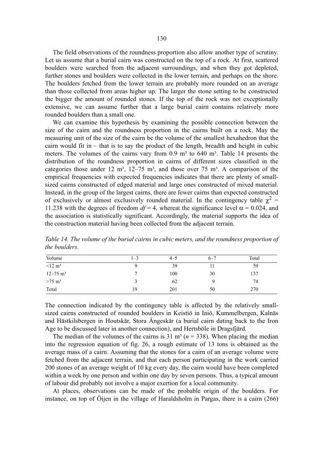
130
The field observations of the roundness proportion also allow another type of scrutiny.Let us assume that a burial cairn was constructed on the top of a rock. At first, scatteredboulders were searched from the adjacent surroundings, and when they got depleted,further stones and boulders were collected in the lower terrain, and perhaps on the shore.The boulders fetched from the lower terrain are probably more rounded on an averagethan those collected from areas higher up. The larger the stone setting to be constructedthe bigger the amount of rounded stones. If the top of the rock was not exceptionallyextensive, we can assume further that a large burial cairn contains relatively morerounded boulders than a small one.
We can examine this hypothesis by examining the possible connection between thesize of the cairn and the roundness proportion in the cairns built on a rock. May themeasuring unit of the size of the cairn be the volume of the smallest hexahedron that thecairn would fit in – that is to say the product of the length, breadth and height in cubicmeters. The volumes of the cairns vary from 0.9 m³ to 640 m³. Table 14 presents thedistribution of the roundness proportion in cairns of different sizes classified in thecategories those under 12 m³, 12–75 m³, and those over 75 m³. A comparison of theempirical frequencies with expected frequencies indicates that there are plenty of small-sized cairns constructed of edged material and large ones constructed of mixed material.Instead, in the group of the largest cairns, there are fewer cairns than expected constructedof exclusively or almost exclusively rounded material. In the contingency table χ2 =11.238 with the degrees of freedom df = 4, whereat the significance level α = 0.024, andthe association is statistically significant. Accordingly, the material supports the idea ofthe construction material having been collected from the adjacent terrain.
Table 14. The volume of the burial cairns in cubic meters, and the roundness proportion ofthe boulders.
The connection indicated by the contingency table is affected by the relatively small-sized cairns constructed of rounded boulders in Keistiö in Iniö, Kummelbergen, Kalnäsand Hästkilsbergen in Houtskär, Stora Ängeskär (a burial cairn dating back to the IronAge to be discussed later in another connection), and Hertsböle in Dragsfjärd.
The median of the volumes of the cairns is 31 m³ (n = 338). When placing the medianinto the regression equation of fig. 26, a rough estimate of 13 tons is obtained as theaverage mass of a cairn. Assuming that the stones for a cairn of an average volume werefetched from the adjacent terrain, and that each person participating in the work carried200 stones of an average weight of 10 kg every day, the cairn would have been completedwithin a week by one person and within one day by seven persons. Thus, a typical amountof labour did probably not involve a major exertion for a local community.
At places, observations can be made of the probable origin of the boulders. Forinstance, on top of Öijen in the village of Haraldsholm in Pargas, there is a cairn (266)
Volume 1–3 4–5 6–7 Total<12 m³ 9 39 11 5912–75 m³ 7 100 30 137>75 m³ 3 62 9 74Total 19 201 50 270

131
situated beside a granite projection with a nearly vertical tip. The granite is crackingstrongly, and stones can be detached from it with bare hands. The burial cairn containsstones of the same red granite, placed in the southern and south-eastern parts of the cairnin a semi-arch, with the even surfaces pointing outwards. In Norrby, Iniö, there is a well-developed horizontal cracking in the granite with a whole lot of loose stone flags on therock. These flags can be found in burial cairns in Norrby. Near the Lilla Kuusis burialcairn in Nagu, to the west of it, the bankung-cracking has loosened boulders from thebedding, and the edged boulders of the cairn seem to originate from this slope.
The Ängeskär island in Dragsfjärd is surrounded by a stretch of open sea, calledGullkrona fjärden. The 14 meter high top of the island is covered with a boulder fieldwith a visibility in all directions. On the boulders, there is a round cairn (346), with aprecipitous cavity in the middle. In the boulder field, a ditch-like depression can be seensurrounding the edge of the stone setting; the boulders have thus been lifted from theboulder field adjoining the stone setting. The boulders are, indeed, almost exclusivelyrounded, weighing 1–60 kg, and they do not differ in any way from those in thesurrounding boulder field. Although the stone setting is only 6 meters in diameter, itsheight is 0.9 meters. The height may be due to the excavation of the crater, whereasboulders have been lifted on the stone setting to serve as a rampart.
4.7 Weathering studies
4.7.1 The principles
Inside the rock, the stone material is in a stable state. When the surface of the stone isuncovered in connection with geological processes, it reacts with the organic compoundsof atmosphere and hydrosphere, it becomes an object of various physical processes andchanges into soluble compounds, and gravel, sand, or clay. Weathering has started. Inweathering, there are simultaneous physical factors disintegrating the stone material;chemical reactions change the mineral composition and the surrounding community ofliving organisms, and this, in its turn, affects the physical and chemical weatheringenvironment. We talk about mechanical, chemical and biological weathering (e.g., Small& Clark 1982: 14–26). The factors regulating weathering can be divided into climaticfactors – above all acquisition of water, and thermal conditions –, hydrologicalconditions, topography, different weathering qualities of stones, and the effect of theorganic environment (Uusinoka 1983).
The stone surface on the bottom of the sea is protected from conditions favouringweathering, and it weathers only chemically and very slowly (Uusinoka 1983: 20). Whenthe stone surface comes into contact with the atmosphere because of land uplift, a processbegins in which the stone surface experiences various conditions favouring weathering.The conditions change when the land uplift progresses. If the factors regulating thisprocess are recognizable and the changes taking place on the stone surface and theirultimate results in different phases can be observed, the temporal course of the processcan be defined in each weathering environment. We can, for instance, measure the surface

132
weathering in the shore zone and above it and compare the observed weatheringdifferences with time differences calculated from the shore displacement.
The shore displacement is only one of the possible factors exposing the surface of thestone to weathering processes and starting the weathering from a definable original state.The stone can experience a similar change also at the cracking of the rock, melting of aglacier, or when a sudden thermal distension breaks the stone when fire is made on thestone surface or when a lightning strikes the stone. The human being can also split andwork stone or fetch boulders from the water boundary or below it in order to clear theshore, or, for instance, to build a stone foundation, a pier, or a burial cairn.
If the elapsed time between the moment of measuring the weathering and the timerepresenting the original state of the surface can be determined, and if the localweathering-regulating factors and the course of the weathering process are sufficientlyknown, the local progression of weathering can be, at least roughly, delineated. When ahuman being removes boulders, wears weathering surfaces or in other ways interfereswith the natural order of stones, he is responsible for anomalies in the weatheringenvironment. If the anomalies can be related to the undisturbed weathering process ofnature, their age can be roughly determined. For instance, the weathering rate of a boulderwhich has been carried to the height of 10 meters from the shore zone, differs from therest of the local weathering environment.
The application of this simple principle has only recently been introduced in theprocess of dating archaeological remains on a larger scale. An early predecessor was,however, the study based on stereo photograph pairs by Nils Edelman of the age of therock carvings in Jan Karlsgården, Sund, Åland (Edelman 1968). In 1985, at theUniversity of Umeå in Sweden, Wibjörn Karlén and Rabbe Sjöberg came across the ideaof using the Schmidt hammer, originally designed for industrial hardness measuring, indetermining the age of boulder surfaces in a shore displacement environment on the coastof Västerbotten, Sweden (Sjöberg). This soon led to other dating results, often inconnection with lichen studies (among others Broadbent 1990; Sjöberg 1990; Sjöberg1991 a). The aim of the studies was to present the age of the weathering surface as afunction of the weathering rate measured by the Schmidt hammer in the specificlithologic environment with a standard error of the least possible magnitude. Objects ofdating have been hut foundations, burial and clearance cairns, net-drying racks, tomtning-remains, labyrinths, and recent disturbances in the boulder fields on the east coast ofSweden, and the rune carvings at Båtholmen, Vörå, Finland (Sjöberg 1991 b).
4.7.2 The weathering of the shore rock and the shore displacement
The sea shore is a zone washed by the sea water, where the surface of the stones risingfrom the sea stays for hundreds of years. Due to the shore displacement, the stone surfaceis gradually more and more affected by the air. The weathering process starts, but for along time the surface will still be in contact with the sea water. Ultimately, washing bythe sea water ends only after the surface of the stone has risen above the highest limit ofthe splash. Before that, the lasting and the frequency of the washing has, however,diminished considerably. It is probable that the sea water does not greatly affect the
133
chemical weathering above the mean of the annual maximum peaks (mean high water)any more, particularly because the rain water every now and then washes off the saltsbrought by the sea water. Instead, the washing effect is important in the mechanicweathering as it transports away the weathering products, and constitutes the prerequisitefor frost weathering.
According to the time series of Stenij and Hela (1947) the maximum high water ratemeasured by the mareograph in Ruissalo, Turku, has been 95 cm, the mean high waterrate being 72 cm, and the rate corresponding to the durability of 1 % is 53 cm. These ratesillustrate the effective zone of the sea water above the mean sea level. The effect of thesea water may reach higher up in the case of mechanical weathering as compared tochemical weathering. As for mechanical weathering, a significant fact is that the highlevel peaks occur most frequently during the strong winds of the autumn and winterseasons (Vermeer et al. 1989). The high water effect is then combined with the freezing ofthe wet rock surface, which causes scaling. The splash reaches considerably higher.During a storm it can – depending on the exposition and the quality of the shore – swell tothe height of 2 meters from the theoretical mean sea level (Niemi 1969) in the innerarchipelago, in the outer archipelago even higher.
Below the mean sea level there is a zone where weathering starts. Extremely low sealevels may not have any noticeable effect on weathering because they are of shortduration. Ritva Karhunen (1985: 22) estimated that the weathering starts in a zone 50–60cm below the mean sea level. When the shore displacement is 3–5 mm/year in theArchipelago Sea (Kakkuri 1997), the weathering forces begin their effect on the stonesurface approximately 100–200 years before it rises on to the theoretical mean sea level.In the region of Turku, the ground surface rising from the sea remains a shore zoneexposed to the effect of the shore processes for a period of about 400 years (Granö &Roto 1989).
Because of the level fluctuation of the water surface, it is reasonable to presume thatthe weathering conditions in the shore zone are different from those above it. In the shorezone, the surface conditions frequently vary between wet and dry, causing variation evenin the temperature of the surface. The waves wash weathering products off the surfaceand bring salts on it. When the temperature drops, the water first freezes in the shore zonebeginning from the upper limit of the splash and causing frost weathering. The conditionsof the shore zone should, thus, generate relatively fast weathering. Above the shore zone,the effect of the vegetation joins the weathering factors: the penetration of roots into thecracks, and the effect of micro-organisms, lichen and humus substances (chelation). Atleast roots have been observed to accelerate mechanical weathering; instead, thesignificance of lichen cover in the weathering process is disputable and of minorimportance (Berner 1992; Walderhaug & Walderhaug 1998).
The total effect of the different factors on the temporal course of the weatheringprocess can hardly be defined in any exact way other than empirically for eachweathering environment. Due to the relation of the shore zone and the dry shore rockabove it, we cannot assume the rate of weathering to be a linear function of time in allconditions.
The weathering crust forming on the surface of the stone retards the access of waterand carbon dioxide dissolved in it into the inner parts of the stone, and prevents thechemical transportation of the weathering products (Colman 1981). Thus the developing
134
of a weathering crust retards the weathering, and makes the weathering process non-linear. The weathering does not, however, stop altogether because the weatheringproducts usually get transported away from a bare surface. The weathering products arewashed off the more effectively the more precipitously the surface inclines (Uusinoka1983:20). Gradually a state of equilibrium is achieved, in which the weathering productsare being washed off the surface at the same rate as further weathering proceeds in theweathering crust and under it. Such observations can be made on high shore cliffs(Karhunen 1985). The thickness or mechanic tenacity of the weathering crust can no morebe used to define the age of a weathering surface when the surface is in a state ofequilibrium, and the accuracy of age defining weakens considerably before the state ofequilibrium.
To measure weathering, physical and chemical techniques have been developed(Aires-Barros & Mouraz-Miranda 1989; McCarroll 1985). The non-linear progress of theweathering process has most often been modelled using a logarithmic time function, inwhich the quantity measured is the thickness of the weathering crust, the mass loss of thesample, or a chemical indicator, among others (Colman 1981). Rabbe Sjöberg (1987;1991) has, however, used a linear regression to model weathering measured by theSchmidt hammer.
4.7.3 The rocks
The most important factors regulating weathering in stone are the composition of therock, the microstructure (cleavage, porosity, fabric, crystal structure), and the massqualities (absorption of water, capacity of conducting heat, heat distension, pullingtenacity) (Uusinoka 1983). Even if it has so far proved to be difficult to define theabsolute weathering of each rock type, attempts have been made to determine the mutualorder of weathering (Aires-Barros & Mouraz-Miranda 1989). Raimo Uusinoka (1983: 25)gives the following series of rocks from the most to the least tenacious: quartzite >amphibolite, gabbro, peridotite, and diabase > granite, granodiorite, and quartz diorite >granite and mica gneisses > arcose sandstone, silt stone, and their metamorphic products> dolomite > limestone. Ritva Karhunen (1985) presents by comparison the series granite> mica gneiss > postorogenic rapakivi granite, in which mica gneiss weathers about 1.5times, and rapakivi two times faster than granite.
Rocks measured in this study appear roughly in the middle of the series, and theirdifferences in weathering are not very significant. The differences are, however, largeenough to prevent a direct comparison between the measure values of different rocks.
4.7.4 The Schmidt hammer measurements
The weathering measurements for this study were made using the N-type Schmidthammer (see e.g. Day & Goudie 1977). By using the Schmidt hammer, the hardness of arock, boulder or concrete surface can be measured on a per cent scale. In the instrument,

135
there is a weight strained by a spring. The mass of the weight is released through a barand an impact plunger with kinetic energy of more than 2 Nm against the surface to betested. Part of the impulse caused by the stroke is absorbed in the breaking of the crystalstructure of the surface, part of it is reflected back to the instrument. The scale measuresthe amount of kinetic energy reflected back on a per cent scale (the rebound value). Thereading accuracy is 0.5 per cent. The higher the rebound value, the greater the mechanictenacity of the surface against the impulse. The rebound values are distributed mainlybetween 30 and 75 per cent.
By using the Schmidt hammer, it is possible to collect quickly numerous observationsof the hardness of the stone surface, to be measured for weathering, and, thus, for the ageof the exposed surface. The changes of rebound values in stone have been provedempirically to be in close connection with weathering in limestone (Day 1980), gabbro(McCarroll 1991), graywacke, sediment gneiss, and gneiss granite (Sjöberg 1987). Therebound values are, however, not only a function of weathering, but they are also affectedby the calibration of the measuring instrument, the measuring arrangements, and the localweathering environment, which all have to be carefully considered in the planning of themeasurement in order to gain interpretable results (McCarroll 1994).
M.J. Day and A.S. Goudie (1977) measured the instrument accuracy of the Schmidthammer and the repeatability of the results. They observed that the operator variance andthe effect of temperature were of little significance, but poor calibration was a statisticallysignificant source of error. It was even obvious that the same surfaces gave significantlylower rebound values when the surface was wet compared with the values given by a drysurface. On account of this, I have measured the rebound values on dry surfaces orsurfaces dried after the washing of the rock. Spots where the running water could beobserved to channel were not measured at all, nor were any smooth facet surfaces.
The rebound values were measured in areas of the size of a palm with no lichen on it,and if necessary cleared with a brush. In each area, 5–30 rebound values R weremeasured, after corrections as to their inclination (Rc) according to the tables supplied bythe manufacturer and, if needed, also calibrated to compensate for the mechanicalcrawling of the hammer (Rcal). Of the rebound values thus obtained, mean values andstandard errors of the mean value were calculated and used as standard figures.
4.7.5 The estimation of weathering curves
4.7.5.1 The regression models
The possibilities of using weathering measurements as an absolute dating technique arenot quite indisputable because other factors, too, besides the course of time affect themeasuring results. Numerical models may give, at least in geomorphologic studies, arather optimistic idea of the accuracy of the weathering techniques, as pointed out byDanny McCarroll (1994). Studies by Rabbe Sjöberg and Noel Broadbent in the shoredisplacement environment of the Baltic Sea, have, however, established a closeconnection between the rebound values and the weathering surfaces on different levels,

136
and illustrated this finding with curves (Sjöberg & Broadbent 1991). Since Sjöberg’s firstreport (1987) on the shore displacement environment on the east coast of Sweden, it hasseemed that, on the coast of Finland, too, it is possible to determine the connectionbetween the rebound values and the ages of the surfaces using weathering curves. If suchcurves can be established, they can produce age gradients, which can be made use of inthe interpretation of the measuring results of the weathering surfaces in the burial cairns.
Weathering environments vary and one of the sources of variation is the differentweathering qualities of different rocks. To control variation not related to the progress ofweathering, the simplest practice may be measuring by types of rock. It must also beassumed that the coefficients of the estimated weathering curves can only be applied inareas with essentially similar climatic and microclimatic factors.
Above it was suggested that the regression model presenting weathering shouldtheoretically be exponential rather than linear. In an exponential regression model, theretardation of the weathering process from the initial situation as a function of time can beexpressed in the same way as, e.g. in land uplift (c.f. Okko 1967; Ten Brink 1974). Maythe mean values of the rebound values used as measure figures be marked and theheight from the sea level hi. The exponential model is of the form
in which the intercept gives the value which the function approaches asymptoticallyas the height hi increases. The parameters and of the inner function determine theshape of the curve.
The rebound values of the shore displacement sequence may, however, decreaselinearly as the height from the sea level grows. In this case, the exponential regressionmodel does not offer any special advantage compared with the linear one, but onlyassumes more number crunching. Accordingly, the function to be used has to be chosen inconformity to the type of dependence between the values observed.
Weathering curves estimated from the shore displacement environment are bound upwith the place because the rate of shore displacement in the SW archipelago acceleratesfrom SE to NW. If there is a desire to generalize weathering curves to some extent or tomake comparisons between various localities, the rebound values must be replaced withthe shore displacement ages of the rock surface. This procedure involves an obviousdisadvantage: the altitudes of the observation points can be measured with the accuracy ofone centimeter, but when converted into shore displacement ages they become estimatedages involving certain sources of error instead of measured values.
Because the measured weathering surfaces reach the height of 15 meters and moreabove sea level corresponding to the shore displacement of more than 2000 years, thepresent land uplift in relation to the mean sea level cannot reliably be applied to the wholetime scale. The shore displacement ages can, instead, be estimated by comparing thealtitudes with the (uncalibrated) radiocarbon dates of the shore level zones as given byGunnar Glückert (1976). Some uncertainty is caused by the fact that Glückert’s shorelevel data was mainly collected on the coast. However, in Glückert’s data, there is a closelinear relationship between the age of the shore level zone and the altitude. In linear least-squares fit for regression of the rebound values upon the ages, the squared multiple
Rcali
Rcaliβ0ˆ e
β1ˆ β2hi
ˆ–+=
β0ˆ
β 1ˆ β 2
ˆ
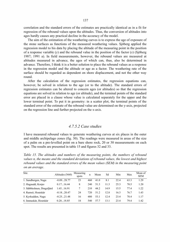
137
correlation and the standard errors of the estimates are practically identical as in a fit forregression of the rebound values upon the altitudes. Thus, the conversion of altitudes intoages hardly causes any practical decline in the accuracy of the model.
The aim of the estimation of the weathering curves is to express the age of exposure ofthe stone surfaces as functions of the measured weathering values. Sjöberg applied theregression model to his data by placing the altitude of the measuring point in the positionof a response variable (y) and the rebound value in the position of the factor (x) (Sjöberg1987; 1991 a). In field measurements, however, the rebound values are measured ataltitudes measured in advance, the ages of which can, thus, also be determined inadvance. Therefore, I think it is a better solution to place the rebound values as a responsein the regression model and the altitude or age as a factor. The weathering rate of thesurface should be regarded as dependent on shore displacement, and not the other wayround.
After the calculation of the regression estimates, the regression equations can,however, be solved in relation to the age (or to the altitude). The standard errors ofregression estimates can be altered to concern ages (or altitudes) so that the regressionequations are solved in relation to age (or altitude), and the terminal points of the standarderror are placed in a clause whose value is calculated separately for the upper and thelower terminal point. To put it in geometry: in a scatter plot, the terminal points of thestandard error of the estimate of the rebound value are determined on the y-axis, projectedon the regression line and further projected on the x-axis.
4.7.5.2 Case studies
I have measured rebound values to generate weathering curves at six places in the outerand middle archipelago zones (fig. 30). The readings were measured in areas of the sizeof a palm on a pre-levelled point on a bare shore rock, 20 or 30 measurements on eachspot. The results are presented in table 15 and figures 32 and 33.
Table 15. The altitudes and numbers of the measuring points, the numbers of reboundvalues n, the means and the standard deviations of rebound values, the lowest and highestrebound values and the standard errors of the mean values (SEM) in the measuring pointon an average.
Site Altitudes (N60) Measuring spots n Mean Sd Min Max Mean of
SEM1. Sundbergen, Nagu -0.09...28.77 23 460 41.0 8.1 22.4 63.3 1.292. Hagaudd, Korpo 0.17...16.44 8 240 51.3 11.3 25.3 70.5 1.203. Säbbholmen, Dragsfjärd 1.65...16.91 7 210 44.2 14.9 15.5 77.4 1.224. Ramsö, Houtskär -0.18...20.47 24 720 51.2 12.8 16.3 76.7 1.435. Kyrkudden, Nagu -0.25...21.48 16 480 53.1 12.4 23.4 78.4 1.176. Immaskär, Houtskär 0.20...18.85 18 540 57.7 13.1 23.4 79.4 1.42

138
1. Sundbergen, Nagu. The location is a shore rock at Sundbergen, Nötö, to the north ofthe excavated burial cairns73. The granodioritic shore is open to the north to thestretch of open sea of Berghamns fjärden. On higher shore levels, the shores have alsobeen open in other directions because the outer archipelago surrounding Nötö hasrisen from the sea later than the top of Sundbergen which is 30 meters high.
Fig. 30. The sites for the determination of weathering curves. 1. Sundbergen, Nagu. 2. Hagaudd,Korpo. 3. Säbbholmen, Dragsfjärd. 4. Ramsö, Houtskär. 5. Kyrkudden, Nagu. 6. Immaskär,Houtskär.
At Sundbergen the regression equation is (with the standard errors of the estimates inparentheses)
with the squared multiple correlation (the amount of the total variance accounted for bythe fit) R² = 0.876 and the standard error se = 2.14. The standard errors of the reboundvalues (figure 31) indicate that the prediction of low rebound values is the mostinaccurate. On high levels, along the progress of weathering, the variation of reboundvalues increases.
The form of the dependence is clearly exponential (figure 31). The rebound valuesdescend consistently to the level of about five meters, but above that the standard errorsof the rebound values increase, and they vary randomly without any noticeabledependence on the altitude. In this case, it is probably a question of a state of equilibriumof the rock surface in which the weathering products of granodiorite are transported away
73. Basic map 1034 01, x = 6651 30, y = 1543 35 (± 50).
)053.0)(087.0)(63.0(
80.37 294.0952.2eR hicali
−+=
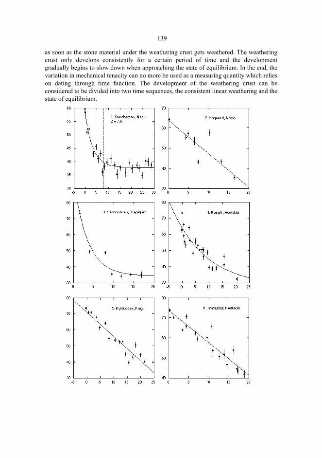
139
as soon as the stone material under the weathering crust gets weathered. The weatheringcrust only develops consistently for a certain period of time and the developmentgradually begins to slow down when approaching the state of equilibrium. In the end, thevariation in mechanical tenacity can no more be used as a measuring quantity which relieson dating through time function. The development of the weathering crust can beconsidered to be divided into two time sequences, the consistent linear weathering and thestate of equilibrium.
140
Fig. 31. Weathering curves (previous page): the mean values of the rebound values (verticalaxis) and the altitudes of the measuring spots (horizontal axis). The error bars are the standarderrors of the mean value. The estimated changeover point L has been marked for the curve forSundbergen, Nagu.
As to the weathering curve of Sundbergen, the point at which the state of equilibriumdevelops can be approximately determined, that is to say, until which phase ofdevelopment the mechanical tenacity of the weathering crust can be used as a datingquantity. A two-phase linear regression is used (Hinkley 1971). We write
,
where di = 1 if hi > L and di = 0 if hi = L.
The regression line consists of two rectilinear parts and the changeover point L. In lowerh values than the changeover point di = 0, and accordingly . In thechangeover point of the function, the regression line changes its direction because, due tothe indicator variable di, if the values of h are higher than thechangeover point. The changeover point can be estimated with the SYSTAT statisticalpackage (Wilkinson 1987). Using the NONLIN module, we obtain L = 7.6 m. The resultsuggests that at the height of 7.6 m at the latest the rebound values cannot be used anymore to help in the determination of age. The initial weathering until this height can bedescribed with the equation
The squared multiple correlation R² = 0.866, and the standard error se = 2.82. For the age corresponding to the altitude we obtained until the year 500 AD
in which TG is the date estimated in the Litorina shoreline zone or between two suchzones using the ratio diagram given by Glückert (1976, appendix I). The squared multiplecorrelation R² = 0.867, and the standard error se = 2.81.
2. Hagaudd, Korpo. The place is situated on a shore rock inclining to the north-west in asheltered bay74. It was measured in connection with the levelling of an adjacent burialcairn (203). The rock consists of mica gneiss, with some quartz veins. The surface isheavily covered with lichen, and on the lower slope with moss.
The number of observations is fairly limited but the rebound values tend to decreaselinearly with increasing altitude. We get
74. Basic map 1032 08, x = 6668 20, y = 1528 80 (± 50).
β̂2 h1 L–( )d1 0=
β̂2 h1 L–( )d1 0>
).328.0)(69.1(
206.268.54 hR icali−=
),0017.0)(28.2(
0117.025.31 TR Gcali+=
)00239.0)(37.2(
00914.030.46 T GcaliR +=
dhhR iiical Li
)(ˆˆˆ210
−++= βββ
)408.0)(78.3(
561.157.63 hR icali−=
141
with R² = 0.709, and se = 5.62.3. Säbbholmen, Dragsfjärd. The place is a shore cliff sloping to the west, with a fairly
heavy lichen and moss cover75. On the highest shore levels the place has been moreopen than today to the west and the north-west. The coarse surface consists mainly ofgabbro. On the shore, some granite, pegmatite, gneiss, and migmatitic mixed rock canbe found. We obtain
.The squared multiple correlation R² = 0.921, and the standard error se = 4.90. It seemsthat in Säbbholmen, too, the slowing down of the weathering, and the approaching of thestate of equilibrium are apparent.
The age corresponding to the altitude equals
In this case, has been defined that to obtain a realistic value range for theexponent function. The squared multiple correlation R² = 0.921, and the standard error se= 4.90.
4. Ramsö, Houtskär. At the western end of the island of Ramsö, there is a cape with auniform shore rock, in which both the southern and the northern slopes incline to thesea76. On the smooth-worn granite surface, there are stripes in the west-east direction.The stripes contain more K-feldspar, granate, and biotite-plagioclase than the mainstone. On the SW slope, the rock is particularly smooth, and the facet surfaces arewell preserved. The northern side is somewhat coarser, here and there pegmatitic. Thesurfaces are exposed on both sides of the cape to stretches of open sea, Skiftet (SW)and Äpplö fjärden (N). On higher levels, the shore has been considerably more expo-sed than in the present.
On Ramsö, the weathering curve is nonlinear. We obtain
with R² = 0.812, and se = 4.64.
5. Kyrkudden, Nagu. The northern side of Kyrkudden consists of bare rocks77. Thesurface consists of mica gneiss, with frequent stripes of migmate. On the westernshore there is some amphibolite. The shores are open in the north and north-east in thedirection of the Erstan, on higher levels also in other directions.
75. Basic map 1033 11, x = 6639 65, y = 1579 25 (± 50).76. Basic map 1041 04, x = 6684 48, y = 1513 05 (± 50).77. Basic map 1043 04, x = 6681 68, y = 1553 72 (± 50).
)138.0)(242.0)(18.4(
14.34 285.0096.4eR hicali
−+=
).742.0)(747.2)(18.4(
14.34 *529.1957.1eR T Gcali
+−+=
)045.0)(323.0)(37.12(
59.27 076.0589.3eR hicali
−+=
)291.0)(442.1)(50.12(
59.27 *491.0686.1e TGcaliR ++=
21000
* TT GG

142
On Kyrkudden, the dependence of the rebound values on height is linear:
with R² = 0.897, and se = 3.81.6. Immaskär, Houtskär. On the cape of the western part of the island there are bare
rocks, over which rebound values can be measured from shore to shore78. The rock ismade up of light-coloured granite with gneiss, and pegmatite veins in places. Thehorizontal top area is plane and very smooth-worn in places. In the south and thenorth the shores are exposed to shore processes from the stretch of open sea of Skiftet.On Immaskär
with R² = 0.888, and se = 3.64. The standard errors of the rebound values increase withincreasing altitude.
The declivity is a significant factor in the weathering process (Uusinoka 1983: 20–21).The radiation of the sun is distributed in a different way on the southern and northernslopes, which has been shown to affect weathering (Ohlson 1964: 83–84). This effect wasstudied on Ramsö, Kyrkudden and Immaskär. The different distribution of radiation onthe northern and southern slopes was expressed as the cosine of the opposite of thedirection of the slope. In regression analysis, however, neither the coefficients of thesteepness nor the direction of the slope proved to be statistically significant.
4.7.5.3 Discussion
The weathering curves show local variation. Actually, retarded weathering is seen in thecurve of Sundbergen only. In it, the initial rebound value Rcal = 58.2 % is lower, and themeasurements reach higher than in the other curves. When it comes to the other curves,little can be said of the retarding or reaching the state of equilibrium. The curve ofSäbbholmen is, due to the small number of samples, primarily indicative, but in it, too,retardation can be seen around the percentage of a little less than 40. The main reason forthe differences is probably the variation of qualities in different stones. While retardationcan be observed in the granodiorite of Sundbergen and the gabbro of Säbbholmen, therebound values develop linearly in the mica gneiss of Hagaudd and Kyrkudden, and in
78. Basic map 1041 01, x = 6687 55, y = 1507 18 (± 50).
)138.0)(74.1(
523.128.71 hR icali−=
)143.0)(60.1(
608.153.73 hR icali−=
)0009.0)(94.0(
0104.001.54 T GcaliR +=
)00085.0)(961.0(
00939.078.53 T GcaliR +=
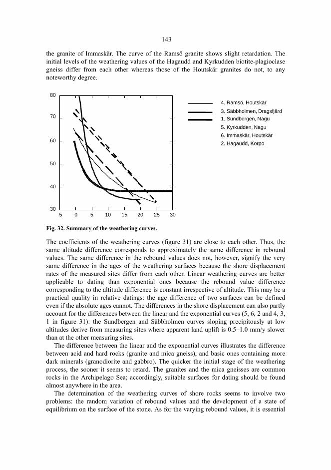
143
the granite of Immaskär. The curve of the Ramsö granite shows slight retardation. Theinitial levels of the weathering values of the Hagaudd and Kyrkudden biotite-plagioclasegneiss differ from each other whereas those of the Houtskär granites do not, to anynoteworthy degree.
Fig. 32. Summary of the weathering curves.
The coefficients of the weathering curves (figure 31) are close to each other. Thus, thesame altitude difference corresponds to approximately the same difference in reboundvalues. The same difference in the rebound values does not, however, signify the verysame difference in the ages of the weathering surfaces because the shore displacementrates of the measured sites differ from each other. Linear weathering curves are betterapplicable to dating than exponential ones because the rebound value differencecorresponding to the altitude difference is constant irrespective of altitude. This may be apractical quality in relative datings: the age difference of two surfaces can be definedeven if the absolute ages cannot. The differences in the shore displacement can also partlyaccount for the differences between the linear and the exponential curves (5, 6, 2 and 4, 3,1 in figure 31): the Sundbergen and Säbbholmen curves sloping precipitously at lowaltitudes derive from measuring sites where apparent land uplift is 0.5–1.0 mm/y slowerthan at the other measuring sites.
The difference between the linear and the exponential curves illustrates the differencebetween acid and hard rocks (granite and mica gneiss), and basic ones containing moredark minerals (granodiorite and gabbro). The quicker the initial stage of the weatheringprocess, the sooner it seems to retard. The granites and the mica gneisses are commonrocks in the Archipelago Sea; accordingly, suitable surfaces for dating should be foundalmost anywhere in the area.
The determination of the weathering curves of shore rocks seems to involve twoproblems: the random variation of rebound values and the development of a state ofequilibrium on the surface of the stone. As for the varying rebound values, it is essential
-5 0 5 10 15 20 25 3030
40
50
60
70
804. Ramsö, Houtskär
3. Säbbholmen, Dragsfjärd1. Sundbergen, Nagu
5. Kyrkudden, Nagu
6. Immaskär, Houtskär
2. Hagaudd, Korpo
144
to optimize the measurement procedure and screen one type of rock only in eachmeasurement series. When aiming at accuracy, it is theoretically well-argumented toobtain a sufficiently great number of measuring points even if it, for practical reasons,resulted in decreased rebound values per measuring point: increasing the amount ofmeasuring points yields smaller standard errors of estimates, and produces less biasedestimates (Barry 1993: 385). In the data at hand, 20 or 30 rebound values have beendetermined at each measuring point. The amount is probably sufficient when in comes toweathering environments and local rocks. Danny McCarroll, for instance, did fourmeasurements per boulder in his geomorphologic investigations in Norway (McCarroll1994: 36). In the field work practice, a fairly low number of rebound values permeasuring point may be acceptable, and thus a greater proportion of the time availablecan be spent on levelling the measuring points. On the other hand, especially whenworking alone, the very levelling takes most of the time.
The random variation of the rebound values at each measuring point is inclined toincrease with increasing altitude and decreasing rebound values. The variation is inconnection with the roughness of the surface (McCarroll 1991; McCarroll 1994), and, atleast in the case of the Sundbergen granodiorite, the development of a state of equilibriumin the stone material. On the surfaces of Sundbergen, the changeover point estimated was7.6 meters which corresponds to the age of about 1600 years. At other measuring sites,the reaching of the state of equilibrium seems to take longer. In the light of these casestudies, the Schmidt hammer technique seems to offer a possibility to date numericalweathering gradients for a period of at least 1600 years. Anomalies in the weatheringenvironment caused by the human being can then be compared with these gradients.
4.7.6 The weathering of the basal surfaces of burial cairns
When the surface of a rock is covered by constructing a burial cairn on it, the strengthand duration of the weathering forces affecting the surface change. The boulders protectthe surface from solar radiation. The soil layer gradually forming on the surface of therock smooths the variation of the temperature, decreases the oxygen supply to the surface,and retards the transportation of weathering products. It can be assumed that these factorsprotect the surface from the weathering forces. On the other hand, the rock surface underthe soil layer is moister than the bare surface, and thus the conditions for weathering maybe better under the soil layer (Walderhaug & Walderhaug 1998). If it can be empiricallyverified that there is a difference between the weathering process under a burial cairnbuilt on a rock and that of the surrounding rock surfaces, the difference may be of use indating, at least in relative dating. It may help, for instance, to determine whether a stoneheap is a prehistoric cairn or a recent stone pile.
In the following, we will compare series of rebound values which have been measuredof the rock surface covered by a cairn (the basal surface) and of the bare rock surfaceoutside the cairn (the lateral surface). The measurements have been carried out atSundbergen, Lilla Kuusis, and Ängesnäs bergen (table 17), at the altitude of about 30meters. At this altitude, weathering has advanced far, and the rebound values fluctuateconsiderably.

145
The distribution of the samples is fairly normal, and, consequently, the t-test can beused in comparing the surfaces. The differences in the mean rebound values of the basaland lateral surfaces are, indeed, statistically significant (table 17). The comparisonindicates, however, that in the Sundbergen granodiorite, weathering has progressedfurther on the basal than on the lateral surface, whereas in the gneiss granite of LillaKuusis, and in the mica gneiss of Ängesnäs bergen the case is quite the opposite:weathering has advanced further on the lateral than on the basal surface.
The most detailed rebound series is derived from Ängesnäs bergen. There, 651rebound values (mean values of five readings) were read in a rectangular measuring set ofsquares, the length of the square side being 25 cm. The contour plot (figure 33) shows thedistribution of rebound values on the surface of the rock. The rebound values of the basalsurface are, on the average, 7 % higher than on the lateral surface, and the highest valuesof the basal surface are close to 70 %. At the western edge, a distinct margin of anomalyfollowing the outer edge of the stone setting is apparent. In the southern and eastern partsthe margin of the anomaly and the edge of the stone setting are less distinct. In thesouthern and eastern parts of the stone setting it seems, both on the basis of fieldobservations and rebound values, that the stones and boulders have been secondarilyspread out from the stone setting. The bare rock outcrop in the eastern part of the burialcairn (cf. fig. 20) is not reflected in the rebound values even if some exfoliation, probablycaused by thermal expansion due to a forest fire was observed.
At Sundbergen, too, the weathering difference between the basal and lateral surfaces isclearly discernible but in the opposite direction. At the burial cairn 1 at Sundbergen, therebound values of the lateral surface are, on average, a little less than 2 % higher thanthose of the basal surface. The corresponding difference at the burial cairn 2 is more than6 %. At the cairn 2, the difference in weathering can be seen by the naked eye: the basalsurface is rougher than the lateral one.
The probable explanation is that granodiorite has weathered at the height of 30 metersto the extent that the rebound values do not change any more contrary to the process onthe lower slope where the change is continued as a function of shore displacement withhigher weathering age. The phenomenon seems to be linked with the rapid weathering ofdark minerals on the basal surface, and the forming of a rough surface. Dark magmaticrocks, enriched in mafic silicate minerals (e.g., pyroxene, amphibole, biotite mica), tendto have a faster chemical weathering rate than felsic magmas with higher concentrationsof lighter minerals (e.g., quartz and orthoclase feldspar) (Mälkki 1998: 11). The roughsurface easily yields under the impact plunger of the Schmidt hammer and produces lowreadings (McCarroll 1994: 37–38). For this reason, the weathering differences atSundbergen cannot, be used in dating. This is unfortunate because the age could havebeen controlled on the basis of the Late Iron Age artefacts of the burials. – The averageweathering difference observed at Lilla Kuusis was a little less than 6 %, but here nocomparison curve is available.
In Ängesnäs bergen the mean of the rebound values of the basal surface are 7.1 %higher than those of the lateral surface. Large variations in the rebound values of bothsurfaces make, however, the conversion of the weathering difference into a difference inage somewhat arbitrary. In addition, the comparison curve measured at Kyrkudden, thenorthern part of the church cape of the same island of Själö, only reaches to the height of21.5 meters because the top of the church cape is lower than the burial site. Ängesnäs
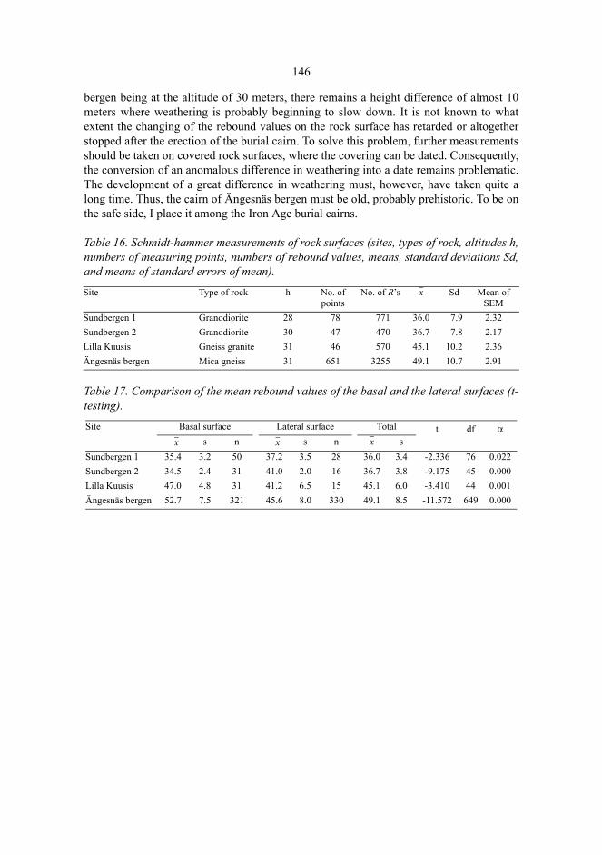
146
bergen being at the altitude of 30 meters, there remains a height difference of almost 10meters where weathering is probably beginning to slow down. It is not known to whatextent the changing of the rebound values on the rock surface has retarded or altogetherstopped after the erection of the burial cairn. To solve this problem, further measurementsshould be taken on covered rock surfaces, where the covering can be dated. Consequently,the conversion of an anomalous difference in weathering into a date remains problematic.The development of a great difference in weathering must, however, have taken quite along time. Thus, the cairn of Ängesnäs bergen must be old, probably prehistoric. To be onthe safe side, I place it among the Iron Age burial cairns.
Table 16. Schmidt-hammer measurements of rock surfaces (sites, types of rock, altitudes h,numbers of measuring points, numbers of rebound values, means, standard deviations Sd,and means of standard errors of mean).
Table 17. Comparison of the mean rebound values of the basal and the lateral surfaces (t-testing).
Site Type of rock h No. of points
No. of R’s x Sd Mean of SEM
Sundbergen 1 Granodiorite 28 78 771 36.0 7.9 2.32Sundbergen 2 Granodiorite 30 47 470 36.7 7.8 2.17Lilla Kuusis Gneiss granite 31 46 570 45.1 10.2 2.36Ängesnäs bergen Mica gneiss 31 651 3255 49.1 10.7 2.91
Site Basal surface Lateral surface Total t df αx s n x s n x s
Sundbergen 1 35.4 3.2 50 37.2 3.5 28 36.0 3.4 -2.336 76 0.022Sundbergen 2 34.5 2.4 31 41.0 2.0 16 36.7 3.8 -9.175 45 0.000Lilla Kuusis 47.0 4.8 31 41.2 6.5 15 45.1 6.0 -3.410 44 0.001Ängesnäs bergen 52.7 7.5 321 45.6 8.0 330 49.1 8.5 -11.572 649 0.000
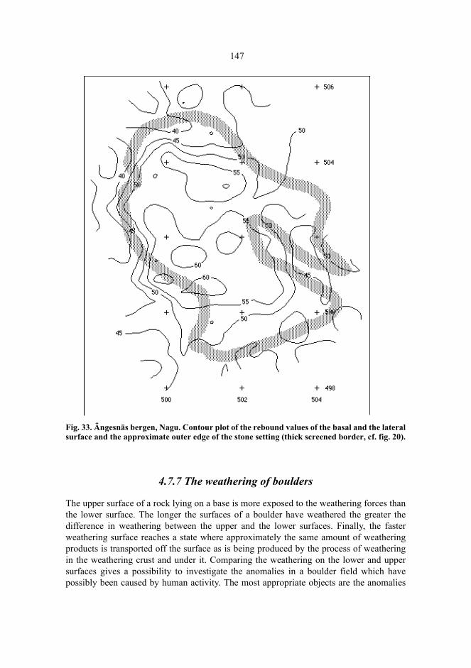
147
Fig. 33. Ängesnäs bergen, Nagu. Contour plot of the rebound values of the basal and the lateralsurface and the approximate outer edge of the stone setting (thick screened border, cf. fig. 20).
4.7.7 The weathering of boulders
The upper surface of a rock lying on a base is more exposed to the weathering forces thanthe lower surface. The longer the surfaces of a boulder have weathered the greater thedifference in weathering between the upper and the lower surfaces. Finally, the fasterweathering surface reaches a state where approximately the same amount of weatheringproducts is transported off the surface as is being produced by the process of weatheringin the weathering crust and under it. Comparing the weathering on the lower and uppersurfaces gives a possibility to investigate the anomalies in a boulder field which havepossibly been caused by human activity. The most appropriate objects are the anomalies

148
in the shore boulder fields washed by the waves (Sjöberg 1987: 22–32), but the surface ofa burial cairn, too, can be regarded as a suitable weathering environment. In the case ofburial cairns, it is, however, difficult to determine precisely the initial situation. Even ifthe initial phase is not known it is still possible to examine whether the boulders on thesurface of the cairn have maintained their original positions, or whether they have beenremoved or turned around secondarily fairly recently. The Schmidt-hammer techniquehas earlier been applied to the investigation of anomalies caused by the turning over ofboulders in tomtnings and labyrinths in Norrbotten, Sweden (Sjöberg 1987).
The rebound values of the upper and lower surfaces of the covering boulders wereobserved at Sundbergen, Lilla Kuusis and Ängesnäs bergen. Steadily lying heavyboulders (≥ 15 kg) were chosen for hammering. Mean values were calculated of therebound values separately for the lower and upper surfaces. The significance of thedifferences of means was determined by using the Welch t-test because the distributionscan be assumed to be approximately similar but with different variances (the Behrens-Fisher problem, see Widjeskog 1987 or Mardia et al. 1979: 142−144). Here, the purposeof calculating the Student’s t statistic is to describe the magnitude of the differences basedon the sample size and the variation of the values, not to test the significance of thedifferences because some differences are expected to develop.
At the burial cairn 1 at Sundbergen, Nagu, the boulders to be measured were chosen onthe border of the stone setting and around the crater in the middle (figure 34; cf. Appendix1). In the granite boulders, the difference varied from a few per cent up to 30 per cent. Inaddition, four boulders were found with significantly higher upper surface values thanlower surface values, and several boulders with a parallel yet statistically insignificantdifference. These boulders must have been turned over.
The boulders which had been turned over were situated around the crater. The mostprobable explanation for the observations is that the crater has been excavatedsecondarily, whereat some of the boulders removed from the crater have ended up in areverse position in relation to the weathering surfaces. Not a very long time has elapsedsince the disturbance, compared to the age of the burial cairn – yet long enough to allowthe occurrence of rather large Rhizocarpon lichens occur on the boulders (cf. Innes 1983).
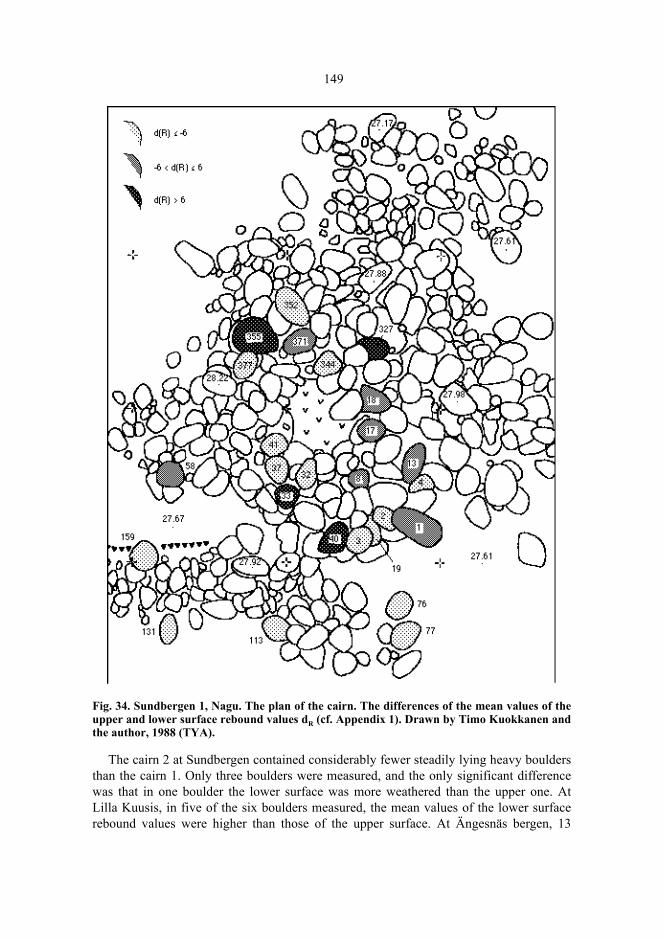
149
Fig. 34. Sundbergen 1, Nagu. The plan of the cairn. The differences of the mean values of theupper and lower surface rebound values dR (cf. Appendix 1). Drawn by Timo Kuokkanen andthe author, 1988 (TYA).
The cairn 2 at Sundbergen contained considerably fewer steadily lying heavy bouldersthan the cairn 1. Only three boulders were measured, and the only significant differencewas that in one boulder the lower surface was more weathered than the upper one. AtLilla Kuusis, in five of the six boulders measured, the mean values of the lower surfacerebound values were higher than those of the upper surface. At Ängesnäs bergen, 13
150
boulders were measured, and in twelve of them, major differences in rebound values wereestablished, the lower surface values being on an average, higher than the upper surfacevalues. The exceptional boulder (n:o 253, cf. figure 34) was situated in the southern partof the burial cairn. This is in accordance with the field observations and the rock surfaceweathering values, which have led to the assumption that the southern part has extendedsecondarily. Thus, the results from the investigations of the burial cairns seem to suggestthat, normally, there are differences between the mean rebound values obtained from theupper and lower surfaces of the covering boulders, and that the differences in mostboulders are fairly similar. Deviations from the normal situation can, then, be caused bysecondary disturbances, as the crater in the burial cairn 1 at Sundbergen or theheterogeneous origin of the boulders: the boulders have been carried to the site fromdifferent weathering environments, for instance from the shore or from high rocks.
In the comparison of mean values, the Student’s t-statistic indicates the relation of thedifference of the means to the standard deviation of the difference. The t statistics withtheir signs indicate how great the deviations are in either direction, considering thedeviation and the number of the rebound values. The mean, the standard deviation and theskewness indices of the sample distribution of the t-statistics are, thus, applicable asempirical figures in assessing to what extent the positions of the boulders correspond tothe normal situation, and to what extent they differ from it. In the cairn 1 at Sundbergen,the mean value is -2.06, the standard deviation 5.00, the variation coefficient 2.43 and theskewness 0.53. At Ängesnäs bergen, the corresponding figures are -8.05, 7.70, 0.96 and -0.62. It may thus be concluded that, at Sundbergen, there was a relatively greater numberof turned-over boulders than at Ängesnäs bergen, that the relative variation of thedifferences was greater at Sundbergen, and that, at Sundbergen, the great positivedifferences of the turned-over boulders appeared as a positive skewness of thedistribution. In other words: the burial cairn at Ängesnäs bergen has remained moreuntouched than the cairn at Sundbergen, where later disturbances have affected thestructure.
4.7.8 Are the craters secondary?
Different ideas have been presented of the origin of the craters, which are often coniccavities in the middle of the cairn. According to C.F. Meinander, the craters were formedwhen the cairn collapsed after the wooden coffin inside it had mouldered, or secondarilywhile the cairn was excavated for some reason (Meinander 1954 a: 101–103). Unto Saloregards the cavities mainly as actions of grave robbers, but some of the cavities of thelarge cairns in Satakunta may, according to him, be regarded as remains of collapsedsepulchral chambers, and as evidence of Scandinavian mortuary tradition (Salo 1981 b:156–164). The vertical dry-stone wall of the eastern side of the burial cairn at Öijen,Pargas (266), suggests such a chamber.
Stone constructions with a middle cavity may also be remains of ground cellars datingfrom the Historical Age (Jarva & Okkonen 1993: 102–103). In the archipelago ofÅboland, there are unmistakable remains of ground cellars, especially in the inner
151
archipelago but also further out, for instance at Höglandet, Dragsfjärd, where they are partof the ruined remains of a tenant farm inhabited in the 19th century.
The material collected in the surveys allows us to scrutinize the nature of the craters.Let us assume that the craters were excavated rather than a result of collapsing due to thedecomposition of a wooden coffin. During the digging work, the removed boulders had tobe placed somewhere, and, without a good reason, they have hardly been carried furtheraway than to the edge of the pit. Thus, the height of the cairn grew gradually. If the meanheight of crater-like burial cairns turns out to be significantly greater than that of burialcairns of other types, the observation supports the hypothesis of the secondary nature ofthe origin of the craters. When this may have occured is, of course, another matter.
We exclude the lowest cairns, those under 0.4 meters in height because there are only afew low cairns with unambiguous crater-like cavities. There remain 89 cairns classified ascrater-like and 135 graves classified as convex or indeterminable by profile. Because thesample distributions of the heights are skew, we had better examine the medians of theheights. The total median for all the cairns (n = 224) is 0.8 meters, the minimum heightbeing 0.4 m and the maximum height 2.2 m. The median for the crater-like cairns is 1.1 mwith a quartile range of 0.25 m while the median for convex or indeterminable cairns is0.7 m with a quartile range of 0.20 m. The Mann-Whitney U = 3043 and α = 0.000; thedifference of medians is statistically significant. The comparison of the medians supportsthe idea that the craters have been excavated secondarily. The dry wall in the stone settingof the above mentioned cairn at Öijen, Pargas (266) indicates, however, that all craters arenot secondary.
In occasional cairns, it is possible to discover recently excavated craters because theboulders have not yet had time to become covered by Rhizocarpon lichen. In the lichencover of the cairn on the island of Norra Mågsholmen, Västanfjärd (334), there are visibletraces of boulders having been lifted on the stone setting during the excavation, whereatits height has grown. There are traces in the Rhizocarpon lichen cover also in the cairns atSurnon (Houtskär, 083) and Kaldoholmen 2 (Dragsfjärd, 033). – Another possiblecharacteristic of secondary damage is the presence of small stones on the covering layerof the cairn, especially if they occur where there are cavities, craters and other signs ofexcavation – for instance in the cairn at Kalvholms fladan, Dragsfjärd (338). Small stonestend to run in between larger boulders in the course of time, so, if there are many of themon the surface of the stone setting, they can be regarded as a sign of a secondaryinterference in the stone setting.
4.7.9 Discussion
Observations support the idea that anomalies caused by human activity on the weatheringenvironment can be quantified by means of the Schmidt hammer because the variation ofrebound values is connected to the shore displacement age of the weathering surface. Onthe other hand, the interpretation of anomalies and the dating are more difficult if wecannot establish the initial situation with which the weathering gradients should becompared. Therefore, more observations are needed to construct comparative curves forthe weathering environments in order to obtain a quantitative basis to allow the
152
comparison of the weathering gradients. One possibility is to combine lichenmeasurements with weathering measurements (Sjöberg 1990).
Granite is a suitable base for many reasons: it weathers slowly, it is homogeneous,common, and easily recognized, even with a lichen cover. The schistose and, in thearchipelago of Åboland, striped and streaked character of gneiss weakens the possibilityof measuring the rate of weathering using the Schmidt-hammer. In the data fromHagaudd, Korpo, the influence of heterogeneity appears as a large variation of reboundvalues. On the other hand, at Kyrkudden, a consistent gradient with smaller standarddeviations was acquired of gneiss.
The measuring of weathering differences on rock surfaces seems to be well suitedwhen investigating whether a stone cairn can be dated back to prehistoric times withcertainty. In a suitable weathering environment, even absolute datings may be possible.This method would be of particular significance because artefacts are rare in burial cairns.Weathering measurements can even throw light on what characteristics distinguish aprehistoric stone pile from a more recent one. In an expedient weathering environment itis possible to attempt to determine the original size and possible later changes in the stonesetting. Further information is, however, needed of the magnitude of weatheringdifferences on surfaces covered by a burial cairn, soil layer, or boulder field in referenceto bare surfaces of different altitudes. The burial cairns selected for investigation shouldpreferably be located in slightly inclining, extensive granite areas, in which theuninterrupted development of rebound values can be observed from the shore to the top.
By combining weathering, boulder, and soil studies, information independent ofartefact finds can be acquired concerning the age, construction, and material of cairns, theinterment of the deceased, recent disturbances, and, possibly, the age of the cairn. Thisrequires careful excavation techniques. The contamination of the stone layers should alsobe prevented by taking care of the removal of the refuse and the soil as the stone setting isbeing disassembled during the excavation.
The possibility of combined techniques allows the retrieval of a significant amount ofpotential archaeological information from the cairns, not only from burials with theirendowments. All physical contact with the boulders impairs the possibilities ofinvestigation. To prevent the boulders from moving from their original positions, oneshould observe special caution when moving on the stones. Restoration or”improvement” even with good intentions should not be undertaken without investigatingthe grave carefully at the same time. The same applies to the use of burial cairns as touristattractions.
5 The Morphology of the Burial Cairns
5.1 The Outlines and Surface Topographies
The shape of the cairn was classified on-site. Indeterminable are stone settings withscattered edges, those which possibly extend down along the rock slope as differentprojections and scattered stone settings, and those which cannot be said to have anyparticular regular form. The total number of such cairns was 133 (30.5 %). 244 cairns(56.0 %) are round or oval, 15 (3.4 %) are rectangular, 7 (1.8 %) are of a polygon ortriangle form and 37 (8.5%) remain undefined (n = 436).
When surveying the cairns, it is often apparent that the outlines and the surface don’tseem to have preserved the form of the original construction. This is suggested by therelationship of the edges to the form of the rock surface under it. At the edges of the cairn,compact and outward-directed boulder projections can often be detected, the outlines ofwhich follow the cavities of the rock surface. They have probably been formed by themovement of the mass which is brought forth when the melting and freezing of water on asloping rock surface makes the boulders crawl, in the course of thousands of years, littleby little downwards until the movement of the boulder is stopped by an obstacle (King &Hirst 1964). On horizontal, even rocks, distinct signs of crawling are more rarelydetected. On the slope below the cairn, it is also quite common to find scattered boulders,which seem to have rolled down the descent due to the movement of the mass orintervention by human being or cattle. Clues are, though, rarely available of the age ofsuch slides or their effect on the structure of the cairn. Sometimes, it can be observed thatthere is compressed moss under the scattered boulders lying on the slope, or that theyhave not yet had time to become covered by lichen. In such cases, the slide must haveoccured quite recently, at most 10–20 years ago. Sometimes, on the upper slope of therock, immediately below the top, tons of boulders lying on the ground can be observed,while the top is quite bare. In a case like this, it can be a question of a totally destroyedburial cairn.
Most of the stone settings are lying on a horizontal ground, on which the movement ofthe mass is minor. Of the thirteen cairns on a clearly inclining slope, nine are situated onthe island of Kimitoön. In Påvalsby, Kimito, there are two adjacent cairns (166, 167) onthe slope; the larger one, 17.8 m in length and 2.4 m in heigth, is situated on a rocky

154
moraine slope under a precipice. Under the cairn of Österängsberget, Kimito (118), theground descends steeply towards the east and only the western edge is on a horizontalground.
The field studies brought only little light on whether the edges of the stone settingswere originally designed as a clearly limited, regular outline. The question primarilyconcerns a rounding outline because a regular angular form is indisputably visible only ina couple of cairns; the cairn 088 at Furunabb in Houtskär can be mentioned as anexample. The vertical dry-stone wall constructions which are usually, at least partly,covered under the boulders, suggest distinct edge constructions, but, in the absence ofboulder studies, it is impossible to establish whether the dry-stone wall has originallyformed the border of the stone setting, or whether it has been covered under the bouldersat the time of the construction.
We can, however, approach this question by means of the graves classified asindefinite by form instead of investigating regular stone settings. If we assume that aregular form has been the aim, and that the friction of the basal surface under the cairnhas later affected the magnitude of forces (physical or caused by a human being or ananimal) needed to remove the boulders from their positions, the cairns should be morefrequently indeterminable in shape where the friction of the ground is the lowest – on therocks. If we compare the frequencies of the indeterminable stone settings with thefrequencies of all the other stone settings on rocks and mineral soils, we cannot, however,present a statistically significant association between the frequency distributions (table18).
Table 18. The comparison between the frequencies of stone settings with indeterminableoutline, and those with a regular shape, on rocks and mineral grounds (χ² = 0.306, df = 1,α = 0.580).
Burial cairns built on boulder fields suggest, however, that a regular form has been theaim when building the stone setting. On such a ground, the edges of the cairn can beassumed to have been preserved well because the boulders have been firmly placed intheir positions in the cavities on the ground (a boulder field provides, it is true, a dryvegetation ground, and it is not covered with stone-preserving moss to the same extent asmoraine).
There are four known burial cairns built in a boulder field. The cairn on Nämanön,Dragsfjärd (006) is over 20 meters long, it has a rounded edge, and a regular convexsurface. Out from Nämanön, towards the stretch of open sea called Gullkrona fjärden, thereis the isle of Ängeskär, where a cairn (346) has been built in the boulder field covering thetop of the island. The stone setting is 6.3 m in length, 5.9 m in width, with a crater-likecavity in the middle, and a regularly round outline. There is a ditch around the stone setting,which indicates where the boulders have been lifted from for the cairn, and that the edge ofthe stone setting has not spread essentially outwards, otherwise the ditch would have been
Indefinite shape Regular shape TotalRock ground 104 211 315Mineral soil ground 13 32 45Total 117 243 360
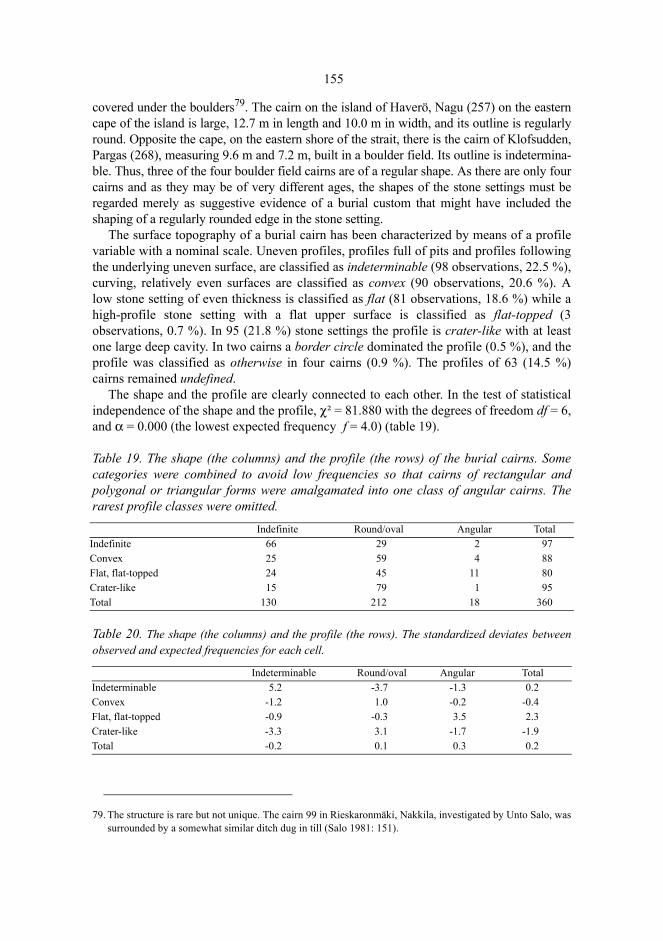
155
covered under the boulders79. The cairn on the island of Haverö, Nagu (257) on the easterncape of the island is large, 12.7 m in length and 10.0 m in width, and its outline is regularlyround. Opposite the cape, on the eastern shore of the strait, there is the cairn of Klofsudden,Pargas (268), measuring 9.6 m and 7.2 m, built in a boulder field. Its outline is indetermina-ble. Thus, three of the four boulder field cairns are of a regular shape. As there are only fourcairns and as they may be of very different ages, the shapes of the stone settings must beregarded merely as suggestive evidence of a burial custom that might have included theshaping of a regularly rounded edge in the stone setting.
The surface topography of a burial cairn has been characterized by means of a profilevariable with a nominal scale. Uneven profiles, profiles full of pits and profiles followingthe underlying uneven surface, are classified as indeterminable (98 observations, 22.5 %),curving, relatively even surfaces are classified as convex (90 observations, 20.6 %). Alow stone setting of even thickness is classified as flat (81 observations, 18.6 %) while ahigh-profile stone setting with a flat upper surface is classified as flat-topped (3observations, 0.7 %). In 95 (21.8 %) stone settings the profile is crater-like with at leastone large deep cavity. In two cairns a border circle dominated the profile (0.5 %), and theprofile was classified as otherwise in four cairns (0.9 %). The profiles of 63 (14.5 %)cairns remained undefined.
The shape and the profile are clearly connected to each other. In the test of statisticalindependence of the shape and the profile, χ² = 81.880 with the degrees of freedom df = 6,and α = 0.000 (the lowest expected frequency f = 4.0) (table 19).
Table 19. The shape (the columns) and the profile (the rows) of the burial cairns. Somecategories were combined to avoid low frequencies so that cairns of rectangular andpolygonal or triangular forms were amalgamated into one class of angular cairns. Therarest profile classes were omitted.
Table 20. The shape (the columns) and the profile (the rows). The standardized deviates betweenobserved and expected frequencies for each cell.
79. The structure is rare but not unique. The cairn 99 in Rieskaronmäki, Nakkila, investigated by Unto Salo, wassurrounded by a somewhat similar ditch dug in till (Salo 1981: 151).
Indefinite Round/oval Angular TotalIndefinite 66 29 2 97Convex 25 59 4 88Flat, flat-topped 24 45 11 80Crater-like 15 79 1 95Total 130 212 18 360
Indeterminable Round/oval Angular TotalIndeterminable 5.2 -3.7 -1.3 0.2Convex -1.2 1.0 -0.2 -0.4Flat, flat-topped -0.9 -0.3 3.5 2.3Crater-like -3.3 3.1 -1.7 -1.9Total -0.2 0.1 0.3 0.2

156
The comparison between the observed and the expected frequencies with the help of thestandardized deviates (table 20) indicates that the categories of shape and profileclassified as indeterminable are most closely connected with each other. This is well inaccordance with the often presented interpretation that the scattered condition of the stonesetting is due to its having been secondarily rummaged. The displacing of boulders isbound to cause irregularities and spread out the edges of the stone setting which certainlydoes not give more regularity to the setting than before. Consequently, the moresubstantial the secondary manipulation of the cairn, the more uneven and scattered thestone setting should be. Yet, secondary interference is only an interpretation because, sofar, there is no means – at least without excavations – to establish what the ”original”stone setting was like, whether its surface was flat, and what changes the stone setting hasbeen exposed to after its construction. The cairn might have been rebuilt or modified –and thus reactivated in rituals during a very long time as Hans Bolin suggests (Bolin1999) – so one may ask whether there was any ”original”, permanent, and completedshape.
On the other hand, it seems that crater-like profiles, which have been regarded asevidence of secondary manipulation, are not, as one could expect, typically connectedwith the indeterminable, scattered stone settings, but rather with rounded cairns. If westick to the idea that the craters have mainly been caused by people looking for buriedthings in the historical times or, in any case, a long time after the burial, we can assumethat mainly round and oval cairns have become objects of ransacking because they aremost easily recognized as constructed by man, and they are more common than, forexample, the rectangular ones.
The contingency table (table 19) indicates that there is an association between theangular shape, and the flat profile. Angular, flat burial cairns, often characterized as stonesettings, thus form a morphological group of their own. Low stone settings can often bedistinguished as a group of their own characterized by the feature that the boulders havebeen set on a flat, often level, rock surface (at least 7 cases). However, it should benoticed that a flat and horizontal basal surface may have been a precondition for thepreservation of a flat stone cairn. In such a cairn, the weight of the stones may not besufficient to keep them in their positions to the same degree as in large cairns. Thus thestones of a small stone setting are easily displaced from their positions by the feet ofpeople or cattle. They may also get caught in the movement of mass caused by thefreezing and melting of the water. It may be assumed that there have been low cairns evenon other kinds of surfaces than flat ones, but they have been destroyed in the course oftime.
5.2 The Dimensions and Relative Lengths
Most of the cairns in the southwestern archipelago are small. Measured by the product oflength and width, the area of half of the cairns is less than 50 m². If the length and thewidth were the same, the measures would thus be less than √50 = 7.1 m (table 21). Cairnswith dimensions of more than ten meters represent less than one fourth of the material.The few large graves are, however, so big compared with the small ones that the

157
distribution of the area of the cairns becomes lognormal (figure 35). Among the largestburial cairns are Hammarsboda 106 (043, 291 m²) and Hammarsboda 107 (044, 204 m²)in Dragsfjärd, Smisskullen (122, 277 m²), Verkholm (126, 227m²), Tjuda (132, 242 m²,Påvalsby (167, 233 m² and 168, 355 m²), Kåddböle (176, 337 m²), and Kummelberget(178, 205 m²) in Kimito, Kummelberget (285, 303 m²) in Pargas, Öijen (232, 283 m²),Sandö (233, 203 m²), and Öbergen (358, 400 m²) in Nagu, Hanka in Rymättylä (310, 245m²), and Trollberg (087, 207 m²) in Houtskär.
Fig. 35. The distribution of the area of the stone settings of the burial cairns. n = 358.
Table 21. The length, width, height, area (product of length and width) and volume(product of length, breadth and height) of the stone settings of the burial cairns.
Large burial cairns mainly occur on large islands such as the island of Kimitoön and themain islands of Pargas and Nagu (figure 37). Typically there are other, often large cairnsin the immediate vicinity. The Trollberg grave in Houtskär, located in the west, far fromthe other large cairns is, however, an exception in this respect.
Variable x Median Min Max s Quartile range
Skewness n
Length 9.2 8.0 1.6 48.8 5.3 2.8 2.6 363Width 6.6 6.0 1.3 20.0 3.2 2.1 1.0 358Height 0.8 0.7 0.2 2.4 0.4 0.3 1.2 338Area 69.9 49.8 2.1 400.0 62.5 35.5 1.9 358Volume 75.3 31.5 0.8 639.3 107.4 39.7 2.7 331
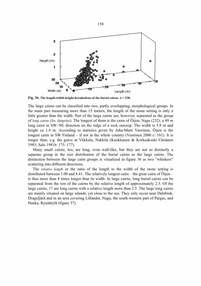
158
Fig. 36. The length-width-height-hexahedron of the burial cairns. n = 338.
The large cairns can be classified into two, partly overlapping, morphological groups. Inthe main part measuring more than 15 meters, the length of the stone setting is only alittle greater than the width. Part of the large cairns are, however, separated as the groupof long cairns (Sw. långröse). The longest of them is the cairn of Öijen, Nagu (232), a 49 mlong cairn in SW–NE direction on the ridge of a rock outcrop. The width is 5.8 m andheight ca 1.4 m. According to statistics given by Juha-Matti Vuorinen, Öijen is thelongest cairn in SW Finland – if not in the whole country (Vuorinen 2000 c: 181). It islonger than, e.g. the grave at Viikkala, Nakkila (Kuokkanen & Korkeakoski-Väisänen1985; Salo 1981b: 175–177).
Many small cairns, too, are long, even wall-like, but they are not as distinctly aseparate group in the size distribution of the burial cairns as the large cairns. Thedistinction between the large cairn groups is visualized in figure 36 as two ”whiskers”scattering into different directions.
The relative length or the ratio of the length to the width of the stone setting isdistributed between 1.00 and 8.41. The relatively longest cairn – the great cairn of Öijen –is thus more than 8 times longer than its width. In large cairns, long burial cairns can beseparated from the rest of the cairns by the relative length of approximately 2.5. Of thelarge cairns, 17 are long cairns with a relative length more than 2.5. The large long cairnsare mainly situated on large islands, yet close to the sea. They only occur near Dalsbruk,Dragsfjärd and in an area covering Lillandet, Nagu, the south-western part of Pargas, andHanka, Rymättylä (figure 37).
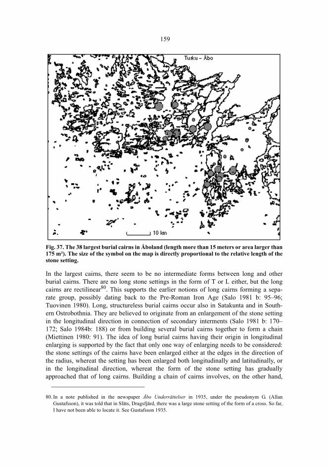
159
Fig. 37. The 38 largest burial cairns in Åboland (length more than 15 meters or area larger than175 m²). The size of the symbol on the map is directly proportional to the relative length of thestone setting.
In the largest cairns, there seem to be no intermediate forms between long and otherburial cairns. There are no long stone settings in the form of T or L either, but the longcairns are rectilinear80. This supports the earlier notions of long cairns forming a sepa-rate group, possibly dating back to the Pre-Roman Iron Age (Salo 1981 b: 95–96;Tuovinen 1980). Long, structureless burial cairns occur also in Satakunta and in South-ern Ostrobothnia. They are believed to originate from an enlargement of the stone settingin the longitudinal direction in connection of secondary interments (Salo 1981 b: 170–172; Salo 1984b: 188) or from building several burial cairns together to form a chain(Miettinen 1980: 91). The idea of long burial cairns having their origin in longitudinalenlarging is supported by the fact that only one way of enlarging needs to be considered:the stone settings of the cairns have been enlarged either at the edges in the direction ofthe radius, whereat the setting has been enlarged both longitudinally and latitudinally, orin the longitudinal direction, whereat the form of the stone setting has graduallyapproached that of long cairns. Building a chain of cairns involves, on the other hand,
80. In a note published in the newspaper Åbo Underrättelser in 1935, under the pseudonym G. (AllanGustafsson), it was told that in Släts, Dragsfjärd, there was a large stone setting of the form of a cross. So far,I have not been able to locate it. See Gustafsson 1935.
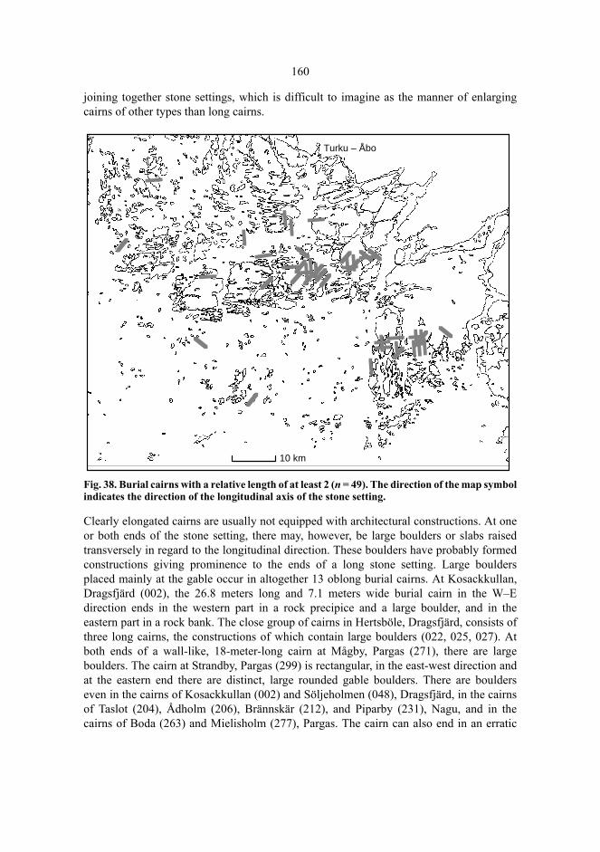
160
joining together stone settings, which is difficult to imagine as the manner of enlargingcairns of other types than long cairns.
Fig. 38. Burial cairns with a relative length of at least 2 (n = 49). The direction of the map symbolindicates the direction of the longitudinal axis of the stone setting.
Clearly elongated cairns are usually not equipped with architectural constructions. At oneor both ends of the stone setting, there may, however, be large boulders or slabs raisedtransversely in regard to the longitudinal direction. These boulders have probably formedconstructions giving prominence to the ends of a long stone setting. Large bouldersplaced mainly at the gable occur in altogether 13 oblong burial cairns. At Kosackkullan,Dragsfjärd (002), the 26.8 meters long and 7.1 meters wide burial cairn in the W–Edirection ends in the western part in a rock precipice and a large boulder, and in theeastern part in a rock bank. The close group of cairns in Hertsböle, Dragsfjärd, consists ofthree long cairns, the constructions of which contain large boulders (022, 025, 027). Atboth ends of a wall-like, 18-meter-long cairn at Mågby, Pargas (271), there are largeboulders. The cairn at Strandby, Pargas (299) is rectangular, in the east-west direction andat the eastern end there are distinct, large rounded gable boulders. There are boulderseven in the cairns of Kosackkullan (002) and Söljeholmen (048), Dragsfjärd, in the cairnsof Taslot (204), Ådholm (206), Brännskär (212), and Piparby (231), Nagu, and in thecairns of Boda (263) and Mielisholm (277), Pargas. The cairn can also end in an erratic
10 km
Turku – Åbo
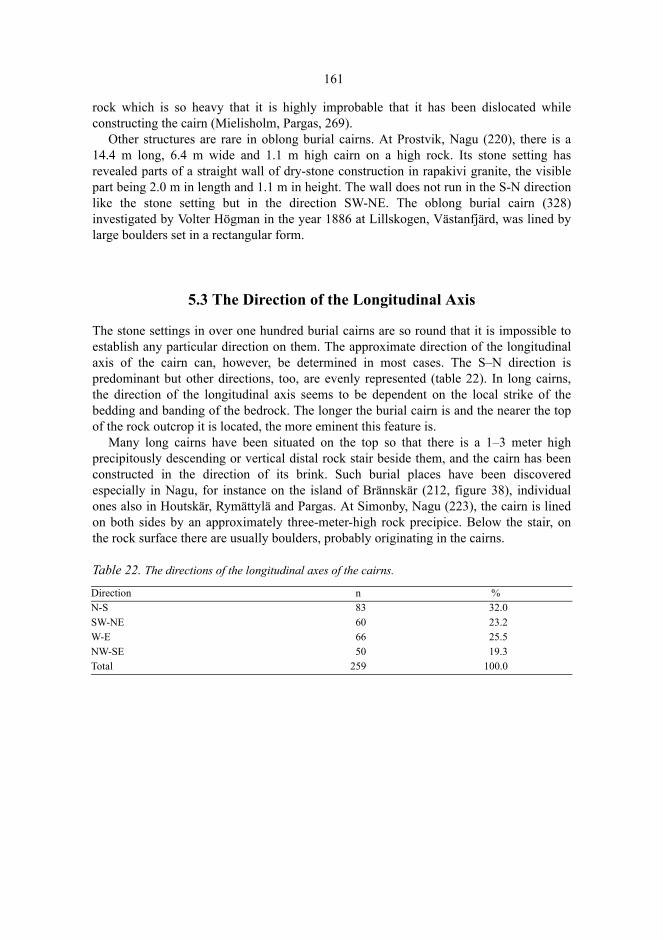
161
rock which is so heavy that it is highly improbable that it has been dislocated whileconstructing the cairn (Mielisholm, Pargas, 269).
Other structures are rare in oblong burial cairns. At Prostvik, Nagu (220), there is a14.4 m long, 6.4 m wide and 1.1 m high cairn on a high rock. Its stone setting hasrevealed parts of a straight wall of dry-stone construction in rapakivi granite, the visiblepart being 2.0 m in length and 1.1 m in height. The wall does not run in the S-N directionlike the stone setting but in the direction SW-NE. The oblong burial cairn (328)investigated by Volter Högman in the year 1886 at Lillskogen, Västanfjärd, was lined bylarge boulders set in a rectangular form.
5.3 The Direction of the Longitudinal Axis
The stone settings in over one hundred burial cairns are so round that it is impossible toestablish any particular direction on them. The approximate direction of the longitudinalaxis of the cairn can, however, be determined in most cases. The S–N direction ispredominant but other directions, too, are evenly represented (table 22). In long cairns,the direction of the longitudinal axis seems to be dependent on the local strike of thebedding and banding of the bedrock. The longer the burial cairn is and the nearer the topof the rock outcrop it is located, the more eminent this feature is.
Many long cairns have been situated on the top so that there is a 1–3 meter highprecipitously descending or vertical distal rock stair beside them, and the cairn has beenconstructed in the direction of its brink. Such burial places have been discoveredespecially in Nagu, for instance on the island of Brännskär (212, figure 38), individualones also in Houtskär, Rymättylä and Pargas. At Simonby, Nagu (223), the cairn is linedon both sides by an approximately three-meter-high rock precipice. Below the stair, onthe rock surface there are usually boulders, probably originating in the cairns.
Table 22. The directions of the longitudinal axes of the cairns.
Direction n %N-S 83 32.0SW-NE 60 23.2W-E 66 25.5NW-SE 50 19.3Total 259 100.0
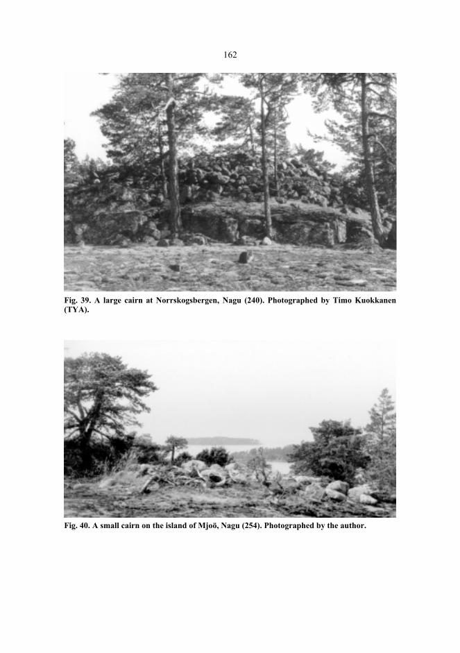
162
Fig. 39. A large cairn at Norrskogsbergen, Nagu (240). Photographed by Timo Kuokkanen(TYA).
Fig. 40. A small cairn on the island of Mjoö, Nagu (254). Photographed by the author.

163
5.4 The Architectural Constructions
5.4.1 The chains
The structural details of the cairns consist of different stone chains or parts of them, wallsset of boulders, caskets arranged of slabs and prominent upright boulders on the stonesettings. The stone chains are usually hidden inside the cairns and they can only beobserved if the surface has been damaged to the extent that part of the chain has becomevisible. Chains have been reported in 30 burial cairns; 11 of them have been discoveredduring the excavations and 19 registrations have been made during the survey work. Thefigures indicate distinctly that parts of the stone setting must be taken up in order todetect chains. It ensues from this, moreover, that unexcavated and excavated burial cairnsmust be kept apart when investigating the occurrence of chains. The same applies also toother inner structures of a stone setting. If we assume that the excavated burial cairnsrepresent sufficiently all preserved cairns, 39 % of all cairns would have at least onechain.
Stone chains appear most usually as a sequence of boulders surrounding the peripheryof the cairn either along the edge or embedded between and under the stones. The chainmay consist of one layer of boulders or several boulder layers as a dry-stone wall (figures42 and 43). The heights of the constructions range between 0.3 and 1.0 meters. In case ofseveral chains, they are concentric. One chain has been registered in 23 cairns (5.3 % ofall), two chains in six (1.4 %), and three chains in one (0.2 %) cairn. I have also seengroups of boulders in a row as well as edge-like stone settings which might be parts of achain or just incidental structures from the time of the building process.
A peripheral chain was reported by Ella Kivikoski in 1935 when she was investigatingthe burial cairn at Söderby, Dragsfjärd, and also by Volter Högman during hisinvestigations at Långnäsudden, Dragsfjärd, at Hammarsboda (108), and at Tjuda, and atJättekastberget, Kimito. Of the burial cairns investigated at Furunabb, Houtskär, three hada peripheral chain. There are peripheral chains recorded in surveys at Stornäset inDragsfjärd, at Storhomman, Kummelberget, Tjuda, Mörkdalsberget, and Östermark inKimito; further, at Kummelbergen, Houtskär, at Norrby, Iniö, at Prostvik, and Simonby,Nagu, and on the island of Öijen, Pargas.
The cairn at Storhomman (125) is on the top of a rock outcrop at the altitude of 45meters (figure 41). It has been constructed of rounded and edged, mainly granite boulders(about 1–150 kg). The NW, W, SW, and E edges reveal a dry-stone construction, a 0.4–0.5 m high wall set of two or more slabs laid flatwise. At the SW edge, the top slab hasbeen propped in a horizontal position by means of stone wedges (figure 42). There arealso loose slabs in the stone setting, probably deriving from a damaged chain.
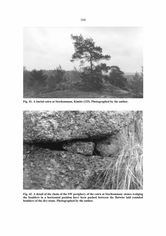
164
Fig. 41. A burial cairn at Storhomman, Kimito (125). Photographed by the author.
Fig. 42. A detail of the chain of the SW periphery of the cairn at Storhomman: stones wedgingthe boulders in a horizontal position have been pushed between the flatwise laid roundedboulders of the dry-stone. Photographed by the author.

165
Fig. 43. A burial cairn with an upright dry-stone wall at Genböle, Dragsfjärd (001). Theboulders have been apparently collected in the adjacent terrain, in which schistose gneiss iscracking up into edged pieces. Photographed by the author.
Fig. 44. A burial cairn on the island of Långfuruholm, Dragsfjärd (060). Photographed by TimoKuokkanen (TYA).
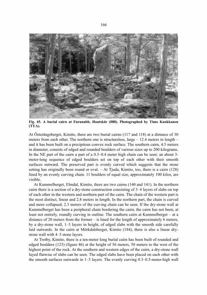
166
Fig. 45. A burial cairn at Furunabb, Houtskär (088). Photographed by Timo Kuokkanen(TYA).
At Österängsberget, Kimito, there are two burial cairns (117 and 118) at a distance of 30meters from each other. The northern one is structureless, large – 12.4 meters in length –and it has been built on a precipitous convex rock surface. The southern cairn, 4.5 metersin diameter, consists of edged and rounded boulders of various sizes up to 200 kilograms.In the NE part of the cairn a part of a 0.3–0.4 meter high chain can be seen: an about 3-meter-long sequence of edged boulders set on top of each other with their smoothsurfaces outward. The preserved part is evenly curved which suggests that the stonesetting has originally been round or oval. – At Tjuda, Kimito, too, there is a cairn (128)lined by an evenly curving chain. 11 boulders of equal size, approximately 100 kilos, arevisible.
At Kummelberget, Elmdal, Kimito, there are two cairns (140 and 141). In the northerncairn there is a section of a dry-stone construction consisting of 3–4 layers of slabs on topof each other in the western and northern part of the cairn. The chain of the western part isthe most distinct, linear and 2.8 meters in length. In the northern part, the chain is curvedand more collapsed; 2.3 meters of the curving chain can be seen. If the dry-stone wall atKummelberget has been a peripheral chain bordering the cairn, the cairn has not been, atleast not entirely, roundly curving in outline. The southern cairn at Kummelberget – at adistance of 20 meters from the former – is lined for the length of approximately 6 meters,by a dry-stone wall, 1–3 layers in height, of edged slabs with the smooth side carefullylaid outwards. In the cairn at Mörkdalsberget, Kimito (184), there is also a linear dry-stone wall with 4–5 stone layers.
At Trotby, Kimito, there is a ten-meter long burial cairn has been built of rounded andedged boulders (123) (figure 46) at the height of 56 meters, 50 meters to the west of thehighest point of the rock. At the southern and western edges of the cairn, a dry-stone walllayed flatwise of slabs can be seen. The edged slabs have been placed on each other withthe smooth surfaces outwards in 1–3 layers. The evenly curving 0.3–0.5-meter-high wall
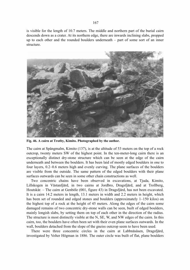
167
is visible for the length of 10.7 meters. The middle and northern part of the burial cairndescends down as a crater. At its northern edge, there are inwards inclining slabs, proppedup to each other and the rounded boulders underneath – part of some sort of an innerstructure.
Fig. 46. A cairn at Trotby, Kimito. Photographed by the author.
The cairn at Spångmalm, Kimito (137), is at the altitude of 53 meters on the top of a rockoutcrop, twenty meters SW of the highest point. In the ten-meter-long cairn there is anexceptionally distinct dry-stone structure which can be seen at the edge of the cairnunderneath and between the boulders. It has been laid of mostly edged boulders in one tofour layers, 0.2–0.6 meters high and evenly curving. The plane surfaces of the bouldersare visible from the outside. The same pattern of the edged boulders with their planesurfaces outwards can be seen in some other chain constructions as well.
Two concentric chains have been observed in excavations, at Tjuda, Kimito,Lillskogen in Västanfjärd, in two cairns at Jordbro, Dragsfjärd, and at Trollberg,Houtskär. – The cairn at Genböle (001, figure 43) in Dragsfjärd, has not been excavated.It is a cairn 14.2 meters in length, 13.1 meters in width and 2.2 meters in height, whichhas been set of rounded and edged stones and boulders (approximately 1–150 kilos) onthe highest top of a rock at the height of 45 meters. Along the edges of the cairn somedamaged remains of two concentric dry-stone walls can be seen, built of edged boulders,mainly longish slabs, by setting them on top of each other in the direction of the radius.The structure is most distinctly visible at the N, SE, W, and NW edges of the cairn. In thiscairn, too, the boulders have often been set with their even plane surfaces outwards. In thewall, boulders detached from the slope of the gneiss outcrop seem to have been used.
There were three concentric circles in the cairn at Labbnäsåsen, Dragsfjärd,investigated by Volter Högman in 1886. The outer circle was built of flat, plane boulders

168
and inside there were two further concentric chains. The inner chain was not entirely onthe rock but partly on a soil ground.
5.4.2 The stone cists
Stone cists have been discovered in only three cairns in Åboland. In his investigations atTjuda, Kimito (130), Högman observed, besides chains, within the outer circle anindistinct stone cist, 1.8 m in length and 1.0–1.3 m in width. Inside the stone cist, therewas some charcoal and unburnt and burnt (human?) bone in an area of 1.3 x 0.8 meters. –At Sunsveden, Houtskär, there is an exceptional cairn constructed on a horizontal shelf-like surface (081), with an area of about 5 square meters of bare rock surface in themiddle. In the SW part of the cairn, there is in the SE–NW direction a stone cist set ofvertical slabs, filled with stones. The length of the construction is 3.6 m, breadth 2.0 mand height 0.6 m. It is unusually large for a stone cist; indeed of the same size as the cistin the massive cairn of Viikkala, Nakkila (Satakunta) (Kuokkanen & Korkeakoski-Väisänen 1985). The Sunsveden coffin consists of maybe two slab cists.
The cairn on the little island of Långfuruholm, Dragsfjärd (060), is known sinceHögman’s expedition. The cairn is situated on the top of a rocky islet of the size of 8.8hectares, on a convex rock surface, at the altitude of 11.2 meters. Although the cairn is notat the highest point of the skerry, it is visible to the sea for some distance, which is notusual. The cairn has been collected of rounded boulders of the size of about 1–30 kilos.On both sides of the middle crater, there are two flat vertical stone slabs (figure 44).When Svante Dahlström visited Långfuruholm in 1929, he noted two or three bouldersturned into an upright position in the cairn. On the boulders, some horizontal slabs hadbeen lifted, forming the cover of something like a stone cist. When peeking under thecover, he could see human bones, among others unburnt parts of a human skull(Dahlström 1940). Hildur Planting visited the island four years later. She described theconstruction as a pit covered by two large slabs and bordered by two cubic and onerounded boulder. Between the boulders there opened a cavity the bottom of which wascovered by a thin layer of humus. On the bottom of the cavity, she saw human cranialbones, a femur and some vertebrae. According to oral tradition the stone setting had beenrummaged on several occasions. The cairn had been stirred up in order to ”att åtskelettdelarna bereda en värdigare plats” (prepare a worthier place for the skeleton parts).Planting collected a bone sample of 8.2 grams, which has later been determined asunburnt parts of the calvarium of a human adult (Adult, MIND = 1)81.
When revisiting Långfuruholm in 1940, Dahlström observed that the coffin had beendestroyed meanwhile. The slabs had been removed far from each other and erected(Dahlström 1940). The stone setting is still in approximately this state. On both sides ofthe middle crater, there are two flat vertical boulders in the direction W–E.
81. See survey report by Planting 1933: 1–2 (NBA). Artefacts: NM 9749:2. The osteological analysis was carriedout by Tarja Formisto, Stockholms universitet 1987.

169
5.4.3 Other constructions
There are six cairns with centrally placed boulders, vertical slabs or various kinds ofboulders rising from the stone setting: in the Hammarsboda cairn 10 in Dragsfjärd, in twocairns in Furunabb, Houtskär, in one of the cairns in Lofsdal in Pargas, and in the cairnsat Södergårdskvarn and Nivelax in Västanfjärd. In Hammarsboda 10, there is a largerounded central boulder. The Södergårdskvarn, Nivelax, and Lofsdal burial cairns seem tohave been built around an erratic boulder of the height of more than a meter. – InEngelsby, Kimito, there is a cairn, which seems to have been built between large erraticboulders weighing many hundred kilos in a way that the boulders have formed arectangle surrounding the cairn. The cairn is, however, scattered to the extent that theconstruction is no longer distinct.
The vertical stone slab in the rectangular cairn 088 in Furunabb is an edged slab of theheight of 1.7 meters (figure 45), the long side of which is fairly exactly in the directionN–S and the side profile of the form of an irregular polygon. Further, the burial cairn 093had, according to the excavation report, two gravestones.
On the highest point of Ängeskär, Dragsfjärd, there is a burial cairn (346) built ofrounded stones, surrounded by a ditch and a boulder field. The boulders of the cairn haveobviously been lifted from the ditch. Although boulder fields and shore formationswashed out of moraine occur frequently in different parts of Åboland, not many cairnsseem to have been built in them; besides Ängeskär, among these cairns belong Nämanönin Dragsfjärd (006), Jälankort in Innamo, Nagu (208), and Långholm in Iniö (102).Ängeskär is probably the only cairn where it can be morphologically discerned where thestones and boulders have been taken from. Building a burial cairn in a boulder field is notas such rare and the grave type has also been reported in Sweden and Norway (e.g.Lundborg 1966; Tysdal 1985).
From Malmudden, the shore of Pargas situated on the side of Erstan (Fi. Airisto), therereaches an esker about four kilometers to the SSE. In Koupo, at the southern end of theesker, there are side by side two burial cairns set mainly of rounded boulders (297 and298). The greatest dimensions of the cairns are 5.7 and 12.9 meters. They are joinedtogether by a stone setting about 48 meters long and about 2 meters broad, with a convexprofile, running in the direction SE–NW, and consisting of rounded boulders. To the westof it there are some small stone settings at the level of the ground (fig. 47). Although thelong cairn is on the top of the esker, the surface of which has become washed andpossibly deformed by the waves82, the impression, however, remains that the constructionis not a natural formation but a stone road built between two burial cairns. It can also be aquestion of a variant of a long cairn, with an extended stone setting at both ends. Therewould not seem to be many equivalents for the construction. Unto Salo has described astone road starting from a burial cairn in Soukainen, Rauma, limited by two parallel linesof stones, the context of which dates back to the Bronze Age (Salo 1981 b: 171–172).From Tyrväntö, a 50 meter long road, starting out from a burial cairn, is known (Kiviko-ski 1966: 96). A kind of parallel construction is included in the Rösaring complex in Cen-tral Sweden. There, a cairn cemetery, some mounds and a labyrinth appear in connection
82. For a description of the deformation mechanism, see Granö 1977.

170
with a 540 meter long stone road, which has been dated back to the Viking Age (Damell& Östmark 1986).
Fig. 47. A stone road on the esker between two burial cairns in Koupo, Pargas. Drawing byRagnar Nyberg (Nyberg 1985: 35).
Here and there, projections diverging from the edge of the cairn occur. The most distinctof them is in a crater-like cairn in Sandvik, Pargas (301). From the southern edge of thecairn, an about 3.5–4.0 meter long projection, set of fairly large boulders, diverges to theSE.
5.4.4 Burial cairns with and without architectural constructions
There are chains, dry-stone walls, stone cists or other constructions in 40 of the burialcairns. The small number may partly be explained by the fact that they are often onlyobserved if the cairn is excavated or damaged. Especially in large cairns, the stone settingcan conceal constructions, which only become visible when the stone setting is beingtaken up.
Table 23. Comparison between burial cairns with and without architectural constructions:the ln-volume, roundness proportion, altitude and ln-sum of distances to nearestneighbours. The degrees of freedom for the altitude were determined using the Welchmethod (Widjeskog 1987).
The comparison of structureless burial cairns with cairns with additional constructionsindicates the most distinct difference in the size of the stone cover. If the length, width,
No constructions
Constructions t-testx s n x s n t df α
Ln-volume 3.416 1.396 293 4.017 1.132 38 -2.55 329 0.011Roundness proportion 4.8 1.1 310 4.4 1.2 35 1.87 343 0.062
Altitude 25.20 10.98 332 29.26 13.68 40 -1.81 45.3 0.077Ln-sum of distances -1.496 0.791 332 -1.264 0.880 40 -1.73 370 0.084
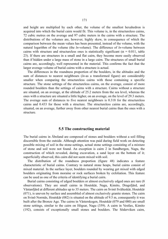
171
and height are multiplied by each other, the volume of the smallest hexahedron isacquired into which the burial cairn would fit. This volume is, in the structureless cairns,72 cubic metres on the average and 97 cubic meters in the cairns with a structure. Thedistributions of the volumes are, however, highly skew, in consequence of which thecomparison between the mean values has been presented, instead of the volume, with thenatural logarithm of the volume (the ln-volume). The difference of ln-volume betweencairns with structure and structureless ones is statistically significant (α = 0.011, table23). If there are structures in a small and flat cairn, they become more easily observedthan if hidden under a large mass of stone in a large cairn. The structures of small burialcairns are, accordingly, well represented in the material. This confirms the fact that thelarger average volume of burial cairns with a structure is actual.
The differences in the roundness proportion of the boulders, in the altitudes and thesum of distances to nearest neighbours (ln-as a transformed figure) are considerablysmaller when comparing the structureless cairns with those containing a specificstructure. The stone settings of the structureless cairns, on the average, consist of morerounded boulders than the settings of cairns with a structure. Cairns without a structureare situated, on an average, at the altitude of 25.2 meters from the sea level, whereas theones with a structure are situated a little higher, on an average, on the level of 29.3 meters.The average sum of distances to five nearest neighbours is 0.318 for the structurelesscairns and 0.433 for those with a structure. The structureless cairns are, accordingly,situated, on an average, further away from other nearest burial cairns than the ones with astructure.
5.5 The constructing material
The burial cairns in Åboland are composed of stones and boulders without a soil fillingdiscernible from the outside. Although attention was paid during field work on detectingpossible mixing of soil in the stone-settings, actual stone settings consisting of a mixtureof stone and soil were not found. An exception is cairn 2 in Sundbergen, Nagu, theconstruction of which revealed, during excavation, a sand layer on the bottom of it;superficially observed, this cairn did not seem mixed with soil.
The distribution of the roundness proportion (figure 48) indicates a featurecharacteristic of burial cairns. Contrary to natural stone heaps, burial cairns consist ofmixed material. In the surface layer, boulders rounded by wearing get mixed with edgedboulders originating from moraine or rock surfaces broken by exfoliation. This featurecan be used as one of the criteria of identifying a burial cairn.
Burial cairns consisting of edged boulders or almost exclusively edged ones are rare (8observations). They are small cairns in Houtskär, Nagu, Kimito, Dragsfjärd, andVästanfjärd at different altitudes up to 35 meters. The cairn on Svinö Svälteskär, Houtskär(071), is uneven by surface and assembled of almost exclusively granite stones. The cairnon Svinö Norrnäs, Houtskär (082) is situated on the altitude of 9.5 m, consequently it wasbuilt after the Bronze Age. The cairns in Västerskogen, Houtskär (079 and 080) are smallstone settings, similar to the cairn on Högsar, Nagu (359). A cairn in Vestlax, Kimito(192), consists of exceptionally small stones and boulders. The Söderviken cairn,
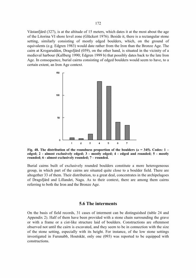
172
Västanfjärd (327), is at the altitude of 15 meters, which dates it at the most about the ageof the Litorina VI shore level zone (Glückert 1976). Beside it, there is a rectangular stonesetting, similarly consisting of mostly edged boulders, which, on the ground ofequivalents (e.g. Edgren 1983) would date rather from the Iron than the Bronze Age. Thecairn at Krogarudden, Dragsfjärd (059), on the other hand, is situated in the vicinity of amedieval harbour (Kallberg 1990; Edgren 1999 b) that possibly dates back to the late IronAge. In consequence, burial cairns consisting of edged boulders would seem to have, to acertain extent, an Iron Age context.
Fig. 48. The distribution of the roundness proportion of the boulders (n = 345). Codes: 1 –edged; 2 - almost exclusively edged; 3 - mostly edged; 4 - edged and rounded; 5 - mostlyrounded; 6 - almost exclusively rounded; 7 – rounded.
Burial cairns built of exclusively rounded boulders constitute a more heterogeneousgroup, in which part of the cairns are situated quite close to a boulder field. There arealtogether 33 of them. Their distribution, to a great deal, concentrates in the archipelagoesof Dragsfjärd and Lillandet, Nagu. As to their context, there are among them cairnsreferring to both the Iron and the Bronze Age.
5.6 The interments
On the basis of field records, 31 cases of interment can be distinguished (table 24 andAppendix 2). Half of them have been provided with a stone chain surrounding the graveor with a frame or a cist-like structure laid of boulders. Constructions are oftenmostobserved not until the cairn is excavated, and they seem to be in connection with the sizeof the stone setting, especially with its height. For instance, of the low stone settingsinvestigated in Furunabb, Houtskär, only one (093) was reported to be equipped withconstructions.
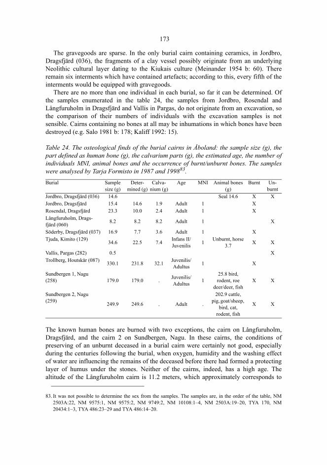
173
The gravegoods are sparse. In the only burial cairn containing ceramics, in Jordbro,Dragsfjärd (036), the fragments of a clay vessel possibly originate from an underlyingNeolithic cultural layer dating to the Kiukais culture (Meinander 1954 b: 60). Thereremain six interments which have contained artefacts; according to this, every fifth of theinterments would be equipped with gravegoods.
There are no more than one individual in each burial, so far it can be determined. Ofthe samples enumerated in the table 24, the samples from Jordbro, Rosendal andLångfuruholm in Dragsfjärd and Vallis in Pargas, do not originate from an excavation, sothe comparison of their numbers of individuals with the excavation samples is notsensible. Cairns containing no bones at all may be inhumations in which bones have beendestroyed (e.g. Salo 1981 b: 178; Kaliff 1992: 15).
Table 24. The osteological finds of the burial cairns in Åboland: the sample size (g), thepart defined as human bone (g), the calvarium parts (g), the estimated age, the number ofindividuals MNI, animal bones and the occurrence of burnt/unburnt bones. The sampleswere analysed by Tarja Formisto in 1987 and 199883.
The known human bones are burned with two exceptions, the cairn on Långfuruholm,Dragsfjärd, and the cairn 2 on Sundbergen, Nagu. In these cairns, the conditions ofpreserving of an unburnt deceased in a burial cairn were certainly not good, especiallyduring the centuries following the burial, when oxygen, humidity and the washing effectof water are influencing the remains of the deceased before there had formed a protectinglayer of humus under the stones. Neither of the cairns, indeed, has a high age. Thealtitude of the Långfuruholm cairn is 11.2 meters, which approximately corresponds to
Burial Sample size (g)
Deter-mined (g)
Calva-nium (g)
Age MNI Animal bones (g)
Burnt Un-burnt
Jordbro, Dragsfjärd (036) 14.6 Seal 14.6 X XJordbro, Dragsfjärd 15.4 14.6 1.9 Adult 1 XRosendal, Dragsfjärd 23.3 10.0 2.4 Adult 1 XLångfuruholm, Drags-fjärd (060) 8.2 8.2 8.2 Adult 1 X
Söderby, Dragsfjärd (037) 16.9 7.7 3.6 Adult 1 XTjuda, Kimito (129) 34.6 22.5 7.4 Infans II/
Juvenilis 1 Unburnt, horse 3.7 X X
Vallis, Pargas (282) 0.5 XTrollberg, Houtskär (087) 330.1 231.8 32.1 Juvenilis/
Adultus 1 X
Sundbergen 1, Nagu (258) 179.0 179.0 . Juvenilis/
Adultus 125.8 bird, rodent, roe
deer/deer, fishX X
Sundbergen 2, Nagu (259) 249.9 249.6 . Adult .
202.9 cattle, pig, goat/sheep,
bird, cat, rodent, fish
X X
83. It was not possible to determine the sex from the samples. The samples are, in the order of the table, NM2503A:22, NM 9575:1, NM 9575:2, NM 9749:2, NM 10108:1–4, NM 2503A:19–20, TYA 170, NM20434:1–3, TYA 486:23–29 and TYA 486:14–20.
174
the Litorina VII shore level (200 AD) (Glückert 1976). The cairn is, however, probablyyounger than the Roman Iron Age. The Sundbergen cairn 2 dates back to the Late IronAge, according to the excavation results examined earlier84.
Let us assume that both of the cairns were built in the Late Iron Age, approximately inthe ninth century. The land surface, at that time, was 5.3 ± 0.9 meters lower than today. Ofthe present area of Långfuruholm, which is 8.8 hectares, about 4.6 hectares was above thesea level at that time. The island must have consisted, at that time, of almost exclusivelybare granite bedrock. Sundbergen, which is the northern point of Nötö, was 5.6 ± 0.9meters lower than today. The point formed a 20 meter high rocky cape diverging from themain island of Nötö, connected with the larger island by a neck of land only a few metershigh. The area of the cape separated by the isthmus was 22 hectares. On the S and Eshores and in the slopes, there were boulder fields, and in the SW slope mineral soil, butfor the rest, the island was nothing but bedrock.
The local topographies of Långfuruholm and Sundbergen suggest thus that the woodsupply was short. This can, as Milton Núñez has suggested in a seminar contribution,explain the fact that the deceased were buried unburnt: the amount of wood required for apyre was simply not available. Mogens Bo Henriksen has demonstrated experimentallythat the burning of a carcass of a swine in a pile would take one cubic meter of hardwood,when the burning takes place in a well arranged wood construction (Henriksen 1993).Besides the structure of the burning pile, the amount of energy needed certainly dependson wind, the moisture of the wood and other conditions where the burning takes place. Incircumstances typical of the archipelago, more than one cubic meter of wood wouldprobably have been required to burn a human body.
84. In addition, there are two unverified notes concerning possible Iron Age or later inhumations in stone cairns:a note by John Gardberg in 1929 from Norrkumlet, Korpo (348) (Tuovinen 2000 b: 50), and a note fromArkesholmen, Pargas (Finska Hushållningssällskapet 1979: 265; Nyberg 1985: 51). The latter site is at thealtitude of less than 10 meters, on the top of an island 1.8 hectares large.
6 The Cemeteries and the Single GravesThe burial cairns have been built on islands and rocky islets, separated from each otherby straits, in places even by wide stretches of open sea. Due to the mosaic pattern of landand sea as such, cairns on same islands are located relatively close to each other, whilegraves on different islands are situated far from each other. So far, burial cairns are notknown in swamps or cultivated land – they would, indeed, have become cleared awayfrom cultivations – so, the pattern of the soil also affects the relation of the cairns to theterrain and to each other.
The cairn constructors, however, often placed the graves in a distinctly more compactgroup than the pattern of the surrounding areas of water, cultivations and swamps as suchwould have required. In Houtskär, Korpo and Nagu, the spatial clustering of the burialplaces is, as we have seen above, statistically significantly greater than that of randomlyselected places. The relative locations of burial places are, thus, not explained only by thepattern of the soil or the pattern between land and sea.
In the groups of cairns placed on top of a rock outcrop, one can often observe that oneor two cairns have been located in the middle of the group, often on the highest point ofthe top, in the saddle point, as, for instance, on Sundbergen. The fact that even singlegraves are frequently placed in the saddle point or nearby suggests that the centrallylocated grave or graves within a group of cairns are the oldest ones. When the first andoldest cairn had been built, the chosen place had become marked with a monument. Insemiotic terms, the cairn had become the index of a natural place. It made the placesignificant for the people who shared a common tradition and knowledge about the place.The groups of cairns that we see, have been constructed in sequences, in which thebuilding of each cairn took a position dependent on older cairns. The relative location ofthe cairns is connected to their order of age, the duration of time represented by the cairngroup and the cultural significances of the burial place.
In principle, it makes sense to determine the location of a cairn in relation to thesurrounding cairns only provided that the location of a particular cairn is only comparedwith the locations of cairns older than the said cairn. The cairns situated nearby must beassumed to have existed when that particular cairn was built in order to justify the thoughtthat the nearby cairns had the significance of an index of a natural place and, likewise,that the choice of the burial place was dependent on the existence of older graves. Ananalysis of the relative locations of the graves would require knowledge of the relative

176
ages of the cairns in the study area (or at least of the cairns situated fairly close to eachother within an area) as well as of the possible secondary interments in these cairns. Inpractice, this makes the task impossible, unless its conditions are extenuated.
To adopt an alleviation, we can assume that cairns situated close to each other, fromthe earliest to the latest one, can be regarded as expressions of the significance of thesame burial site. Then, it can be meaningful to determine their relative locationssymmetrically, disregarding the order of age. Illogical spatial relations, for instance thedistance from an early grave to a later one, naturally cause noise in the data. Minimizingthe noise presupposes that the relative locations are taken into consideration only ormainly in the close vicinity of each cairn. The greater the distance between each pair ofburial sites is, the less likely is even an approximate simultaneusness of the graves and theless likely is the association of the locations with each other.
To describe the relative locations of burial cairns, a suitable quantity has to be defined.We will examine, to what extent the location of each cairn is influenced by other cairnsand how many other neighbouring cairns the location of each cairn is associated with.
A cairn included in a group is surrounded by one or more cairns. The subject to bedetermined is a zone surrounding the cairn, which characterizes the typical maximumarea of groups formed by cairns. The cairns which fit inside this zone, can be regarded torepresent a group of interrelated burials, a cairn cemetery. The singe graves not fittinginside the zone are situated in various degrees detached and separate from each other.
To start with, the mutual distances between burial places have to be computed. Thestarting values of the coordinates in Finnish national grid are in most cases correct withan accuracy of 30 meters (cf. Rainio 1988: B10–12). Since the inaccuracy of the mapcoordinates is of graphical origin, the inaccuracy of the distances between burial places isindependent of the positioning of the places. The inaccuracy has no practical significancewhen cemeteries are discussed in contrast to single graves, since the characteristic featureof single graves is their solitary location some distance from other graves.
The desired zone can be determined using local density analysis (LDA) (Johnson1984; Kintigh 1990). In general, local density analysis involves the calculation of atriangle matrix of local density coefficients Cii(r), which expresses the degree of spatialclustering between the artefact types i and j. The diagonal of the triangle matrix expressesthe coefficient of a type with itself Cii(r), which is a measure of the degree of clustering ofthat type. From the diagonal of the matrix we may compute the local density for eachcairn, which gives the number of cairns located within the fixed distance r from the cairnbeing examined. According to the definition, there is always at least one cairn, theparticular one being examined.
The local density coefficient Cii(r) which is the ratio of the mean local density to themean density of the whole of the area investigated, has been calculated for each radius r =10, 20, 30, 40, 50,..., 300 meters. The mean density of the area investigated (6384 km²) issomewhat theoretical because the area includes plenty of water and lowlands, where wecannot expect to meet with cairns.
The radius r expresses the resolution involved in the local density coefficient. Thecoefficient can be expressed as a function of the radius r. Figure 49 indicates that thecoefficient diminishes rapidly as the radius increases up to the distance of a little less than100 meters. When increasing the radius further, the value of the local density coefficient
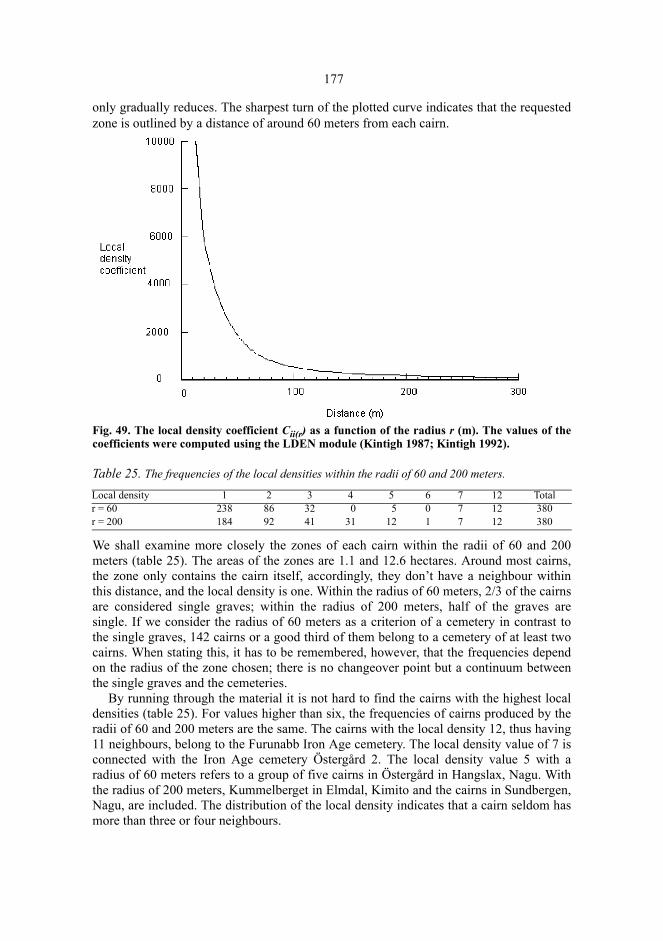
177
only gradually reduces. The sharpest turn of the plotted curve indicates that the requestedzone is outlined by a distance of around 60 meters from each cairn.
Fig. 49. The local density coefficient Cii(r) as a function of the radius r (m). The values of thecoefficients were computed using the LDEN module (Kintigh 1987; Kintigh 1992).
Table 25. The frequencies of the local densities within the radii of 60 and 200 meters.
We shall examine more closely the zones of each cairn within the radii of 60 and 200meters (table 25). The areas of the zones are 1.1 and 12.6 hectares. Around most cairns,the zone only contains the cairn itself, accordingly, they don’t have a neighbour withinthis distance, and the local density is one. Within the radius of 60 meters, 2/3 of the cairnsare considered single graves; within the radius of 200 meters, half of the graves aresingle. If we consider the radius of 60 meters as a criterion of a cemetery in contrast tothe single graves, 142 cairns or a good third of them belong to a cemetery of at least twocairns. When stating this, it has to be remembered, however, that the frequencies dependon the radius of the zone chosen; there is no changeover point but a continuum betweenthe single graves and the cemeteries.
By running through the material it is not hard to find the cairns with the highest localdensities (table 25). For values higher than six, the frequencies of cairns produced by theradii of 60 and 200 meters are the same. The cairns with the local density 12, thus having11 neighbours, belong to the Furunabb Iron Age cemetery. The local density value of 7 isconnected with the Iron Age cemetery Östergård 2. The local density value 5 with aradius of 60 meters refers to a group of five cairns in Östergård in Hangslax, Nagu. Withthe radius of 200 meters, Kummelberget in Elmdal, Kimito and the cairns in Sundbergen,Nagu, are included. The distribution of the local density indicates that a cairn seldom hasmore than three or four neighbours.
Local density 1 2 3 4 5 6 7 12 Totalr = 60 238 86 32 0 5 0 7 12 380r = 200 184 92 41 31 12 1 7 12 380
7 The Bronze Age – the Iron Age
7.1 Earlier studies on the chronology of cairns in SW Finland
Before we examine what kind of characteristics there are that might differentiate cairns ofdifferent ages in Åboland, we take earlier studies on the mainland of SW Finland andÅland as a starting point. The monumentality of cairns is probably the most important ofthe attributes that have been regarded to characterize burial cairns of different ages. Inliterature, monumentality has not quite been defined in an explicit manner. Depending onthe context, monumentality has been primarily used to denote the total volume of thecairn, its scale, and the visibility of the cairn itself. It sometimes refers to thecharacteristics of the burial place, especially its altitude. A large and high burial cairn,built on a picturesque hill with a wide view is monumental, if any. Architecturalconstructions, such as chains and frames, stone cists, dry-stone walls and centrally placedboulders have also been included in monumentality.
Of Finnish scholars, especially Unto Salo has discussed burial cairns as monumentsand suggested symbolic interpretations of monumentality. In his reviews into the EarlyMetal Age, he sketches a theory of the cairn tradition, the constituents of which are thesign language of the graves, kinship, agricultural landownership, property, and sedentarydwelling. According to him, the Bronze Age cairns had a symbolic function in protectingand preserving the family. The volume of the cairn was of great importance especiallyduring the Early Bronze Age, when the graves used to be built large. The more intermentswere made in a cairn, the greater it grew. And the mightier the grave was enlarged themore powerful was the endeavour of the family and the peasant farm (Fi. talo) to expressits right to land property, its dominance, its freedom of will, territorial control, andcompetence of rivalry. Settlers competed for lands suited for cultivating and cattlebreeding, and cairns indicated outsiders the family’s proprietory rights to the landacquired with hard work, a transformation from something originally owned by no one toprivate property. Due to the origin of the property, the continuous ownership could onlybe guaranteed by continuous utilization of land and natural resources and protectionagainst competitors. Changes in expressions of ownership led to changes in themonumentality of the graves. At the latest during the V period the cairns were graduallybuilt smaller than before. Instead of making secondary interments and enlarging the stone
179
cover, individual small cairns, that constituted cemeteries, were built. At the latest duringthe Roman Iron Age, the landownership had become established, and the right to controlland and resources was no more associated with social tensions and opposing interests.Thus there was no need to build monumental graves (Salo 1981 b: 125–, 201–204; 1984a: 133–139; 1984 b: 89–90; Salo 1997: 87–93; see also Pihlman 1999: 65, 73).
During the Bronze Age, the nature of burial places also changed so that, towards theend of the Bronze Age, the burial places were no longer chosen on the tops of high hillsbut lower in the terrain on moraine and near dwelling sites. Excavations by Salo on theshores of the ancient bay of Nakkila and Panelia in Satakunta yielded evidence of this. InRieskaronmäki, Nakkila, the Late Bronze Age graves were located lower than before, onmoraines, near buildings and they were grouped into a cemetery instead of solitarylocated single graves.
The progress outlined by Salo is based on excavations and discoveries made mainly inthe province of Satakunta. Towards the South, on the mainland coast of Finland Proper,there is less evidence on the alteration of the cairns along with the time. The cairn inKotokallio, Lieto, from the period II (Edgren 1969; Kaskinen 1980) is a single grave onthe top of a rock outcrop. In Lehmihaka, Perniö, there is a cairn cemetery located by adwelling place, dating from the end of the Bronze Age and the Pre-Roman Iron Age. Thecairns are situated one beside the other on a moraine-covered slope (Lähdesmäki 1983;Lähdesmäki 1987). The differences between these cairns dating from different ages arewell in conformity with the progress described by Unto Salo.
From the Early Iron Age, there are examples of burial cairns built into a cemetery. Inthe valley of the river Aura, the Iron Age cairns and cemeteries are situated in low-lyingterrain on mineral soil (Salo 1995: 15–18; Laukkanen & Vuorinen 1987). The statisticspresented by Vuorinen indicate, that in the former administrative district of Turku andPori, SW Finland, small cairns are common on lowlands, suggesting that they are, inaverage, later than large cairns. Those cairns that have been dated to the Iron Age, are inaverage smaller than the Bronze Age ones (Vuorinen 2000: 181–182). Observations fromUusimaa match into this pattern (Laurén 1991), and in the size, grouping and location inthe terrain, a similar tendency can be observed in Southern Ostrobothnia, too (Miettinen1989).
On an outer island of the Gulf of Finland, in Suursuonmäki, Lavansaari, there is acairn cemetery, radiocarbon dated to the Pre-Roman and the Early Roman Iron Age.There are at least 29 cairns in a chain of the length of 110 meters. However, they are notsituated in a low terrain but on the top of a ridge (Miettinen 1996). The cairn cemetery inPiiloinen, Vehmaa, to the NW from Turku (Salo 1968: 67–69), is also on the top of a rockoutcrop. It greatly resembles the burial cairn grounds in the archipelago of Åboland.
Helena Edgren has dealt with cairns and cairn cemeteries dating from the Early IronAge on Åland. There are 1200 cairns and they are grouped into 123 cemeteries.According to her, the Bronze Age cairns were built on tops, whereas during the Early IronAge the graves were placed lower on mineral soils, near present cultivated lands. Many ofthe cairns are three- or four-sided. The location and altitude distinguish them from theBronze Age ones: while cairns from the Bronze Age are situated by the sea, the ones fromthe Iron Age are grouped near lakes and protected gulfs of sea, on islands and in theinland of Åland. This form of burial was, however, quite unknown for the Swedishpopulation of the Late Iron Age (Edgren 1983: 88–89, 96). To the Iron Age cemeteries
180
belong, among others, Västra Nabbergen in Eckerö, with three- and four-sided stonesettings (Dreijer 1979: 45) and the Pre-Roman cemeteries Jomala 37.4 Överby andLemland 4.1 Flaka with tens of burial cairns (excavation reports Storå 1991 and 1990,ÅM).
There is not much evidence on the change in the constructing material of the cairns.Earlier, we have observed that the boulder material suggests that the stones were mainlycarried from the near surroundings. The composition of the stone material is thus ratherlocal and dependent on the choice of the place. The choice of the place, on the other hand,seems to change along with the time. As stated above, cairns consisting of edged bouldersseem to have an Iron Age context. The composition of the boulder material would seemto be an interesting chronological characteristic.
To summarize, the small size is clearly characteristic of Iron Age burials. The cairnsare sometimes three- or four-sided and often located on relatively low altitudes, onmineral soils. They are surrounded by a mainland or inland topography and often groupedinto cairn cemeteries. The grouping tendency – a great relative proportion of solitaryMetal Age cairns outside cemeteries indicates a high age of the cairns – is also known inSweden (Selinge 1986: 24–25).
7.2 The dated cairns in Åboland
7.2.1 The dating criteria
In Åboland, there are about thirty cairns, the age of which can, at least approximately, beconsidered to be known. The most reliable dating of a cairn is achieved when the datingartefact or other chronological evidence is enclosed in the structure of the cairn in a waythat it stratigraphically dates the time of building. If the cemetery includes other cairnsbesides the stratigraphically dated one, they can, depending on local topography, beregarded approximately contemporary on the basis of a cemetery chorological dating – touse Bo Gräslund’s terms (1974: 38–39). This is based on the presumption that there existsa spatial autocorrelation between the cairns in regard to age; many observations indeedsupport this notion. Here, it is enough to state that the cairn dates either from the Bronzeor the Iron Age. The frequency distribution of the local density gives the ground to definewhich of the cairns belong to the same cemetery, probably of roughly the same age.
The structure of a burial cairn can closely resemble a morphological cairn groupdatable somewhere else. In a case like this, we can talk about group analogical dating(Gräslund 1974: 35). The group analogical dating of burial cairns has been criticisedbecause many morphological features are of long duration (Furingsten 1986).
On the other hand, as Baudou showed, some consistent morphological changes didtake place during the Bronze Age and the Iron Age in Ångermanland, Sweden (Baudou1968: 97–103). Therefore, in the case of Åboland, they can be taken as an evidence of theage of the cairns although there is no reason to believe that the morphological changesthemselves were the same in the Finnish archipelago as in the Swedish Ångermanland.
181
The stratigraphical, cemetery chorological and group analogical datings have beengathered together in the table 26. In addition, the shore displacement makes the shorezone dating of many cairns possible. At first, we will, however, examine what can bemade of dating criteria independent of the displacement of the shore zone.
7.2.2 The stratigraphical and the cemetery chorological datings
The artefacts of the Långnäsudden and Hammarsboda burial cairns in Dragsfjärd havebeen published several times (Björck 1882; Heikel 1890; Hackman 1987; Cleve 1942 b;Meinander 1954 b; Edgren 1999b: 1–3). One of the two Långnäsudden cairns isstratigraphically dated by a bronze dagger85 of period II found by Volter Högman in hisexcavations in 1886. The unexcavated cairn quite next to it can be assumed to date fromsame age. In addition, a narrow-bladed palstave86 of approximately the same age origi-nates from the cairn 106 in Hammarsboda. Högman did not find any artefacts of a dat-ing nature while investigating the cairn 108, but the four Hammarsboda cairns preserved,situated close to each other, can be dated to the Bronze Age, using cemetery chorologicalcriteria.
A cremation area, with an underlying carbon layer and covered by a burial cairn wasexcavated in Trollberg, Houtskär in 1978. The carbon layer was radiocarbon dated 2990 ±140 BP (Hel-1143; Jungner & Sonninen 1983: 72), which, calibrated according to Stuiverand Reimer (1993), takes the cairn back to a good thousand years BC87, that is to the sec-ond or possibly third period of the Bronze Age. The burial of Trollberg is one of the old-est known cremations in Finland; it is of almost the same age as the burial of Kotokallio,Lieto (Edgren 1969; Kaskinen 1980). The cairn on Ängesnäs bergen, Nagu, can, with thereservations mentioned above, be dated to the Iron Age on the basis of weathering meas-urements of the rock surface.
In 1886, Volter Högman found a cairn on Långfuruholm, Dragsfjärd (see chapter5.42). It is situated on the top of a rocky skerry close to Gullkrona fjärden, at the altitudeof 11.2 meters. Svante Dahlström and Hildur Planting observed parts of a well preservedunburnt human skeleton under the cairn. The fact that an unburnt skeleton hardlypreserves under the stones, exposed to moisture and oxygen, for thousands of years,suggests that the cairn is from the Iron Age or even medieval. The altitude makes datingto the Bronze Age impossible.
On a cold day in the spring of the year 1924, some fowlers from Holma in Dragsfjärdwere ransacking a cairn on the island of Stora Ängeskär just to keep themselves warm.Then, they suddenly noticed a pendant grinder under the stones, dated later to the VikingAge by Nils Cleve in the Historical Museum of Turku (Dahlström 1945: 52–57). Thestick like grinder is four-sided, with a hole and it is of black slate and there are marks ofgrinding crosswise on it (figure 51)88. On Åland, this type of a grinder occurs at least in
85. NM 2503A:1. 86. NM 1910.87. The radiocarbon age of the sample is, calibrated according to the A-method by Stuiver and Reimer (1993) , 1
σ: cal BC 1425 (1212, 1199, 1192, 1138, 1132) 974.
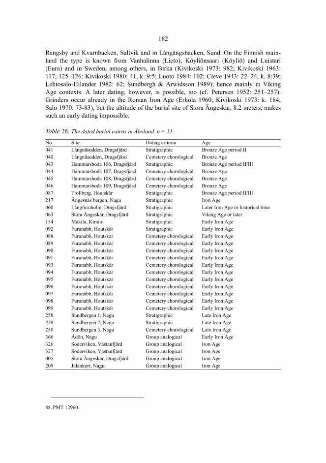
182
Rangsby and Kvarnbacken, Saltvik and in Långängsbacken, Sund. On the Finnish main-land the type is known from Vanhalinna (Lieto), Köyliönsaari (Köyliö) and Luistari(Eura) and in Sweden, among others, in Birka (Kivikoski 1973: 982; Kivikoski 1963:117, 125–126; Kivikoski 1980: 41, k. 9:5; Luoto 1984: 102; Cleve 1943: 22–24, k. 8:39;Lehtosalo-Hilander 1982: 62; Sundbergh & Arwidsson 1989); hence mainly in VikingAge contexts. A later dating, however, is possible, too (cf. Petersen 1952: 251–257).Grinders occur already in the Roman Iron Age (Erkola 1960; Kivikoski 1973: k. 184;Salo 1970: 73-83), but the altitude of the burial site of Stora Ängeskär, 8.2 meters, makessuch an early dating impossible.
Table 26. The dated burial cairns in Åboland. n = 31.
88. PMT 12960.
No Site Dating criteria Age041 Långnäsudden, Dragsfjärd Stratigraphic Bronze Age period II040 Långnäsudden, Dragsfjärd Cemetery chorological Bronze Age043 Hammarsboda 106, Dragsfjärd Stratigraphic Bronze Age period II/III044 Hammarsboda 107, Dragsfjärd Cemetery chorological Bronze Age045 Hammarsboda 108, Dragsfjärd Cemetery chorological Bronze Age046 Hammarsboda 109, Dragsfjärd Cemetery chorological Bronze Age087 Trollberg, Houtskär Stratigraphic Bronze Age period II/III217 Ängesnäs bergen, Nagu Stratigraphic Iron Age060 Långfuruholm, Dragsfjärd Stratigraphic Later Iron Age or historical time063 Stora Ängeskär, Dragsfjärd Stratigraphic Viking Age or later154 Makila, Kimito Stratigraphic Early Iron Age092 Furunabb, Houtskär Stratigraphic Early Iron Age088 Furunabb, Houtskär Cemetery chorological Early Iron Age089 Furunabb, Houtskär Cemetery chorological Early Iron Age090 Furunabb, Houtskär Cemetery chorological Early Iron Age091 Furunabb, Houtskär Cemetery chorological Early Iron Age093 Furunabb, Houtskär Cemetery chorological Early Iron Age094 Furunabb, Houtskär Cemetery chorological Early Iron Age095 Furunabb, Houtskär Cemetery chorological Early Iron Age096 Furunabb, Houtskär Cemetery chorological Early Iron Age097 Furunabb, Houtskär Cemetery chorological Early Iron Age098 Furunabb, Houtskär Cemetery chorological Early Iron Age099 Furunabb, Houtskär Cemetery chorological Early Iron Age258 Sundbergen 1, Nagu Stratigraphic Late Iron Age259 Sundbergen 2, Nagu Stratigraphic Late Iron Age250 Sundbergen 3, Nagu Cemetery chorological Late Iron Age366 Ådön, Nagu Group analogical Early Iron Age326 Söderviken, Västanfjärd Group analogical Iron Age327 Söderviken, Västanfjärd Group analogical Iron Age005 Stora Ängeskär, Dragsfjärd Group analogical Iron Age209 Jälankort, Nagu Group analogical Iron Age
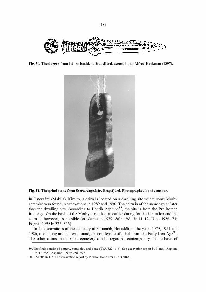
183
Fig. 50. The dagger from Långnäsudden, Dragsfjärd, according to Alfred Hackman (1897).
Fig. 51. The grind stone from Stora Ängeskär, Dragsfjärd. Photographed by the author.
In Östergård (Makila), Kimito, a cairn is located on a dwelling site where some Morbyceramics was found in excavations in 1989 and 1990. The cairn is of the same age or laterthan the dwelling site. According to Henrik Asplund89, the site is from the Pre-RomanIron Age. On the basis of the Morby ceramics, an earlier dating for the habitation and thecairn is, however, as possible (cf. Carpelan 1979; Salo 1981 b: 11–12; Uino 1986: 71;Edgren 1999 b: 325–326).
In the excavations of the cemetery at Furunabb, Houtskär, in the years 1979, 1981 and1986, one dating artefact was found, an iron ferrule of a belt from the Early Iron Age90.The other cairns in the same cemetery can be regarded, contemporary on the basis of
89. The finds consist of pottery, burnt clay and bone (TYA 522: 1–6). See excavation report by Henrik Asplund1990 (TYA). Asplund 1997a: 258–259.
90. NM 20576:1–5. See excavation report by Pirkko Höysniemi 1979 (NBA).
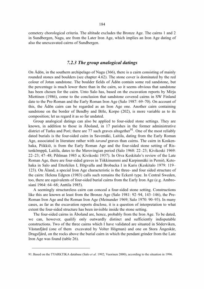
184
cemetery chorological criteria. The altitude excludes the Bronze Age. The cairns 1 and 2in Sundbergen, Nagu, are from the Later Iron Age, which implies an Iron Age dating ofalso the unexcavated cairns of Sundbergen.
7.2.3 The group analogical datings
On Ådön, in the southern archipelago of Nagu (366), there is a cairn consisting of mainlyrounded stones and boulders (see chapter 4.62). The stone cover is dominated by the redcolour of Jotun sandstone. The boulder fields of Ådön contain some red sandstone, butthe percentage is much lower there than in the cairn, so it seems obvious that sandstonehas been chosen for the cairn. Unto Salo has, based on the excavation reports by MirjaMiettinen (1986), come to the conclusion that sandstone covered cairns in SW Finlanddate to the Pre-Roman and the Early Roman Iron Age (Salo 1987: 69–70). On account ofthis, the Ådön cairn can be regarded as an Iron Age one. Another cairn containingsandstone on the border of Bendby and Böle, Korpo (202), is more variable as to itscomposition; let us regard it as so far undated.
Group analogical datings can also be applied to four-sided stone settings. They areknown, in addition to those in Åboland, in 17 parishes in the former administrativedistrict of Turku and Pori; there are 77 such graves altogether91. One of the most reliablydated burials is the four-sided cairn in Savemäki, Laitila, dating from the Early RomanAge, associated in literature rather with tarand graves than cairns. The cairn in Kosken-haka, Piikkiö, is from the Early Roman Age and the four-sided stone setting of Ris-tenkömppä, Laitila, dates to the Merovingian period (Salo 1968: 22–23; Kivikoski 1969:22–23; 47–48; Pihlman 1985 a; Kivikoski 1937). In Oiva Keskitalo’s review of the LateRoman Age, there are four-sided graves in Tiikkinummi and Karpinmäki in Perniö, Keto-haka in Salo and Etterkilen I, Högvalla and Brobacka I in Karis (Keskitalo 1979: 119–123). On Åland, a special Iron Age characteristic is the three- and four sided structure ofthe cairn: Helena Edgren (1983) calls such remains the Eckerö type. In Central Sweden,too, there are equivalents of four-sided burial cairns from the Early Iron Age (e.g. Ambro-siani 1964: 64–68; Anttila 1985).
A seemingly structureless cairn can conceal a four-sided stone setting. Constructionslike this are known at least from the Bronze Age (Salo 1981: 92–94, 143–146), the Pre-Roman Iron Age and the Roman Iron Age (Meinander 1969; Salo 1970: 90–93). In manycases, as far as the excavation reports disclose, it is a question of interpretation to whatextent the four-sided structure has been invisible inside the stone setting.
The four-sided cairns in Åboland are, hence, probably from the Iron Age. To be dated,we can, however, qualify only outwardly distinct and sufficiently indisputableconstructions. Two of the three cairns which I have validated are situated in Söderviken,Västanfjärd (one of them excavated by Volter Högman) and one on Stora Ängeskär,Dragsfjärd, on the rocks above the burial cairn in which the pendant grinder from the LateIron Age was found (table 26).
91. Based on the TYARKTIKA database (Salo et al. 1992; Vuorinen 2000), according to the situation in 1996.
185
7.3 The empirical determination of chronological characteristics
7.3.1 The stone cover of the burial cairn
The size of the burial cairn belongs to the basic observations documented in surveys. Thesize can be informed as the volume of the smallest hexahedron the cairn would fit in – theproduct of the length, width and height. The volume, however may be an inaccuratemeasure, because its numeric value greatly depends on the height of the stone setting, themeasuring of which is approximate – as far as it is even possible. The area of the stonesetting – the product of the length and the width (or the area of an ellipse correspondingthe length and the width) – is, thus, a more sensible standard. The product of the lengthand the width seems regularly to have a positively skew distribution, so, instead of it, inthe analyses, the logarithm of the numeric value can be used, having an approximatelynormal distribution. The field data of this study also included the information of the shapeand profile of the stone cover, the roundness of the boulders and the possible architecturalconstructions.
Architectural constructions, such as the stone chains in Bronze Age cairns(Långnäsudden, Hammarsboda 108 and Trollberg) are, yet, problematic as morphologic-chronological characteristics, because they often remain invisible under the stone cover,whereat the cairn would have to be excavated in order to observe the constructions.Negative information of the structures are, thus, in most cases missing observations. Yet,to define systematic typological characteristics, information perceivable withoutexcavations or other destructive techniques would be required.
7.3.2 The relative location of the burial cairns
The relative locations of the cairns can be used to determine to what extent a grave hasbeen connected to other graves, has become part of a cemetery, or if a grave is morelikely to belong to a single grave tradition. The spatial interrelationships between thecairns are constituted by two factors, the number of cairns in the close vicinity of anyindividual cairn and the distances between cairns.
The local density is a possible measure of spatial clustering. It is, however, tied to afixed radius and gets only few possible numeric values and most often small ones, whichdiminishes the usefulness of the variable in the analysis of the location. Anotherpossibility is offered by the distance of each burial place to its nearest neighbour orneighbours (attraction) (e.g. Hodder & Orton 1976: 38–52). The distances characterisethe relation of each burial with the neighbouring burial sites and the variation of therelations from one grave to another. Calculating clustering statistics from the distributionsof distances would, however, be partly trivial, because the cairns are clustered near eachother simply on account of the water areas separating the islands.
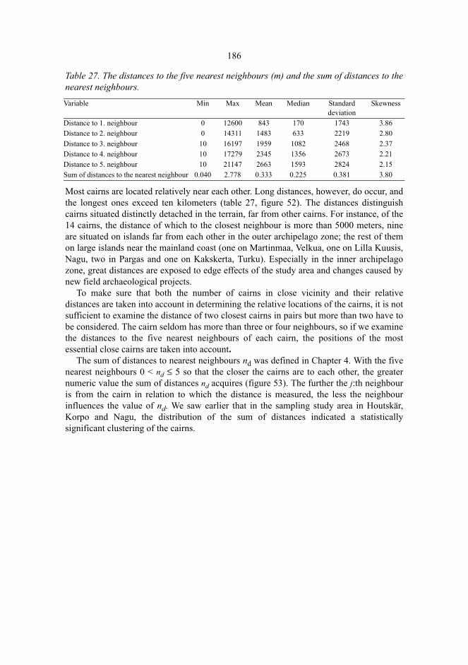
186
Table 27. The distances to the five nearest neighbours (m) and the sum of distances to thenearest neighbours.
Most cairns are located relatively near each other. Long distances, however, do occur, andthe longest ones exceed ten kilometers (table 27, figure 52). The distances distinguishcairns situated distinctly detached in the terrain, far from other cairns. For instance, of the14 cairns, the distance of which to the closest neighbour is more than 5000 meters, nineare situated on islands far from each other in the outer archipelago zone; the rest of themon large islands near the mainland coast (one on Martinmaa, Velkua, one on Lilla Kuusis,Nagu, two in Pargas and one on Kakskerta, Turku). Especially in the inner archipelagozone, great distances are exposed to edge effects of the study area and changes caused bynew field archaeological projects.
To make sure that both the number of cairns in close vicinity and their relativedistances are taken into account in determining the relative locations of the cairns, it is notsufficient to examine the distance of two closest cairns in pairs but more than two have tobe considered. The cairn seldom has more than three or four neighbours, so if we examinethe distances to the five nearest neighbours of each cairn, the positions of the mostessential close cairns are taken into account.
The sum of distances to nearest neighbours nd was defined in Chapter 4. With the fivenearest neighbours 0 < nd ≤ 5 so that the closer the cairns are to each other, the greaternumeric value the sum of distances nd acquires (figure 53). The further the j:th neighbouris from the cairn in relation to which the distance is measured, the less the neighbourinfluences the value of nd. We saw earlier that in the sampling study area in Houtskär,Korpo and Nagu, the distribution of the sum of distances indicated a statisticallysignificant clustering of the cairns.
Variable Min Max Mean Median Standarddeviation
Skewness
Distance to 1. neighbour 0 12600 843 170 1743 3.86Distance to 2. neighbour 0 14311 1483 633 2219 2.80Distance to 3. neighbour 10 16197 1959 1082 2468 2.37Distance to 4. neighbour 10 17279 2345 1356 2673 2.21Distance to 5. neighbour 10 21147 2663 1593 2824 2.15Sum of distances to the nearest neighbour 0.040 2.778 0.333 0.225 0.381 3.80
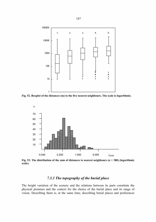
187
Fig. 52. Boxplot of the distances (m) to the five nearest neighbours. The scale is logarithmic.
Fig. 53. The distribution of the sum of distances to nearest neighbours (n = 380) (logarithmicscale).
7.3.3 The topography of the burial place
The height variation of the scenery and the relations between its parts constitute thephysical premises and the context for the choice of the burial place and its range ofvision. Describing them is, at the same time, describing burial places and preferences
10
20
30
40
50
60
70
0.040 0.200 1.000 5.000 1/vm
n
188
used in selecting them. The topography of the surrounding scenery and the patterns ofland and sea can be illustrated morphometrically by means of a digital elevation model.In the grid, a circular window is opened, the center point of which is the cell from whichthe topography is examined.
Finding an appropriate size of the window is a classical problem. Too small a windowdoes not cover sufficiently the height variation of the terrain, but only represents a part ofit. Then, the value of the variable primarily changes as a function of local slope. Too largea window generalizes the height variation so that a detailed enough illustration of therelief of the terrain cannot be obtained.
Fausto Guzzetti and Paola Reichenbach (1994) determined, while discussing a topo-graphic division for Italy, the properties of topographic variation typical of the ridges andthe valleys. The characteristic wavelength was obtained when variation was measuredwithin nested windows of increasing size until the full range of local elevation wasencountered (the grain). The method can also be applied in investigating Åboland. Thecrucial difference, however, is that the subject is not only the variation of altitudes butalso the location of the burial places in relation to the topography. The location of a cairnis not random, but related to the surrounding terrain and other burial places. The startingpoint of a measurement of the topography is the burial place, so the area of thetopography to be examined is determined according to the burial place. The size of thewindow should be sufficient to illustrate the essential characteristics of the topographysurrounding the burial place but it should not generalize too much the small-scale featuresof the peneplane. The larger the window the more it covers the landscape that a burialplace has in common with the other burial places.
The local density coefficient (figure 49) as a measure of the relative distances betweencairns gives an idea about the minimum size of the window. With short radius lengths, thecoefficient obtains high numeric values but they decline abruptly up to about 60–100meters and, while the radius continues to increase, the values decline only slowly. Thedistribution of distances to the nearest neighbour (table 27) yields that half of thedistances remain less than 170 meters. The clustering of cairns in the same burial placescomprises, thus, for the most part distances less than 170 meters. The radius of thewindow should be distinctly greater than this.
Using nested windows of increasing size, we can estimate the characteristicwavelength of the terrain and the upper limit of the size of the window. For two reasons,the result is an approximation. To begin with: the cairns are often situated on the tops, inthe saddle points. If one finds the saddle point and settles there to observe the landscape,one comes to choose a position which limits, on an average, a greater difference ofaltitudes into a window with a fixed radius than a randomly chosen observation pointwould do. The observer is, indeed, standing in a place which represents the upper end ofthe local height variation. Secondly, the burial places have risen, compared to the sealevel, 5–20 meters since the time of the construction of the cairns. The long duration ofthe burial cairn as a type of burials signifies that there is not one single ancient time levelwhose topographic study would be relevant, but there are, instead, as many levels as thereare cairns. If burial cairns are considered as memorials and monuments preserving intime, there are as many time sequences as there are cairns. In an examination of thepresent topography, it is not necessary to make presumptions of the topographies of the
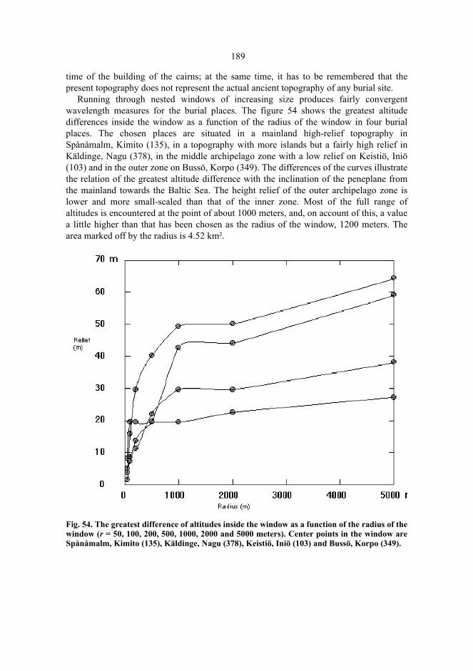
189
time of the building of the cairns; at the same time, it has to be remembered that thepresent topography does not represent the actual ancient topography of any burial site.
Running through nested windows of increasing size produces fairly convergentwavelength measures for the burial places. The figure 54 shows the greatest altitudedifferences inside the window as a function of the radius of the window in four burialplaces. The chosen places are situated in a mainland high-relief topography inSpånåmalm, Kimito (135), in a topography with more islands but a fairly high relief inKäldinge, Nagu (378), in the middle archipelago zone with a low relief on Keistiö, Iniö(103) and in the outer zone on Bussö, Korpo (349). The differences of the curves illustratethe relation of the greatest altitude difference with the inclination of the peneplane fromthe mainland towards the Baltic Sea. The height relief of the outer archipelago zone islower and more small-scaled than that of the inner zone. Most of the full range ofaltitudes is encountered at the point of about 1000 meters, and, on account of this, a valuea little higher than that has been chosen as the radius of the window, 1200 meters. Thearea marked off by the radius is 4.52 km².
Fig. 54. The greatest difference of altitudes inside the window as a function of the radius of thewindow (r = 50, 100, 200, 500, 1000, 2000 and 5000 meters). Center points in the window areSpånåmalm, Kimito (135), Käldinge, Nagu (378), Keistiö, Iniö (103) and Bussö, Korpo (349).
190
7.4 Discriminant analysis
7.4.1 The groups P and R
The ages of the dated cairns in Åboland are known with a varying accuracy. The mostapproximate ages determine the accuracy of the whole chronology to a great degree. Forexample, if we try to identify the characteristics of Early Bronze Age cairns, we have torely on not more than three cases that fairly reliably belong to that period. However, allthe dated cairns fit into rough chronological categories, such as the Bronze Age or theIron Age. Thus the known ages can be made use of in the most systematic manner so thatthe dated cairns are put in either of the two groups: the Bronze Age or the Iron Agegroup. In the following, I shall be calling the groups in the mentioned order groups P andR.. In this division into two groups, the ages of the cairns dated can be regarded asknown.
Cairns dated and grouped can be compared with undated cairns regarding variousattributes. Through comparison the division into two age groups can be expanded byexamining the characteristics of the dated graves and connecting each undated cairn intothe group that best corresponds to its features. The classification can finally be tested bychecking if group P includes cairns which due to their altitude cannot have been builtduring the Bronze Age because, in that case, they would have been built in the waterlineor under the water. In order to retain the possibility of testing, the altitude of the burialplace is not included among the variables by means of which the characteristics of thegroups are searched for. The classification also produces prognoses: the comparison withthe classification can resolve which group a previously unknown cairn resembles most.
The grouping, thus, includes a reverse one-way multivariate analysis of variance: thecontrast determined by values of a two-level factor variable is measured from a part of thesample, and the grouping induced by the contrast is extended to the rest of the sample.This was done using discriminant analysis, which is applicable in determining whichvariables or linear combinations of them distinguish two or more groups present in thesample from each other (e.g. Bahrenberg et al. 1992: 316–358; Mardia et al. 1979: 300–325)92. The variables are combined into a model and weighted with coefficients so thatdifferences between the groups are maximized. The discriminant analysis aims at solvingwhether it is possible to improve the grouping criteria, what the structure of the differencebetween the groups is like and how to find the most appropriate group for a new observa-tion or an ungrouped observation in the sample.
Discriminant analysis can be described geometrically so that each observation point isplotted into a space, where each variable represents one dimension. The points are
92. For two groups the alternative is logistic regression analysis. However, the maximum likelihood procedureinvolved in logistic regression analysis runs into indeterminance for some variables and does not give reliableresults regarding them, nor does it exact logistic regression using the LogXact software. See Hosmer &Lemeshov 1989; Kleinbaum 1994; Mehta & Patel 1995; Cytel Software 1997. In practical empirical research,discriminant analysis tends to end up with fairly similar conclusions as logistic regression analysis (Press &Wilson 1978). For archaeological case studies using discriminant analysis, see Akazawa 1988, Tomber 1988,and Charles 1992. Variables with nominal scales could not be included here, however, the shape of the cairndid not prove a good group indicator in logistic regression analysis.

191
projected on a level, which is rotated into the position where maximum differences areproduced between the groups. This position determines the coefficients of thediscriminant functions. In the case of two groups, the level is a line and one discriminantfunction is obtained.
7.4.2 The potential variables
The attributes must be found which distinguish distinctly enough the cairns into thegroups P and R and describe the characteristics of the groups. Earlier studies in themorphological and spatial attributes of the burial cairns and the change of them alongwith the time constitute a starting point for the selection of variables. Obviously, the mostimportant morphological variable is the area of the cairn, but the roundness proportion,too, was tentatively included in the analysis.
A group of variables was used to measure the location of the burial place related to thetopography and to neighbouring burial places. In order to compute them, a circularwindow was opened in the DEM with the radius of 1200 meters. Only the cells weretaken into account the altitude of which is higher than zero, to eliminate the influence ofthe sea level to the value of measures describing land elevation. These variables were thesum of distances to nearest neighbours, the distance to the nearest neighbour, the localdensity, the altitude relative to the cumulative frequency distribution, the altitude relativeto the mean, the height difference of the altitude and the mean in the window, the altituderelative to the highest top, the height difference to the highest top, the slope, theconvexity93and the center versus neighbours (CVN) (table 28).
The topography around the burial place was measured using mean altitude, medianaltitude, standard deviation of altitude and the quartile range of the altitude. The extent ofsea was given by the relative proportion of sea, while the elevation-relief ratio gave ameasure of the degree of dissection of the landscape (Guzzetti & Reichenbach 1994). Thelocation of the burial place in relation to the toposequence of the archipelago zones fromthe mainland coast to the skerry zone indicates in what degree the landscape can becharacterized as maritime. Here we are examining the surface of the peneplane in relationto the sea surface (Granö 1955), so a rather large window has to be opened in the DEM.Thus, a quadratic area of 5.1 x 5.1 km² was chosen as the window. The burial place issituated in the middle cell of each window. The area closely corresponds to the measuringunit of the coastal geographical analysis of Olavi Granö and Markku Roto (1986), aquarter of a sheet of the Finnish basic map. In the window, the mean of the altitudes of allthe cells was calculated, which I call the mean altitude of the archipelago zone.
93. The ridge-valley index by Kenneth Kvamme is another measure of the shape of the surface (Kvamme 1992).
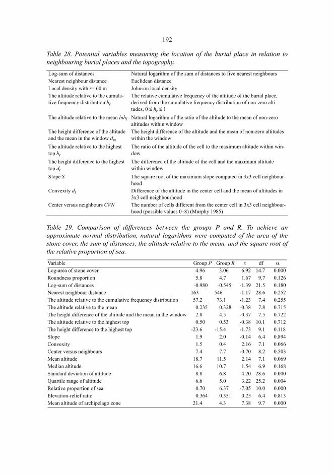
192
Table 28. Potential variables measuring the location of the burial place in relation toneighbouring burial places and the topography.
Table 29. Comparison of differences between the groups P and R. To achieve anapproximate normal distribution, natural logarithms were computed of the area of thestone cover, the sum of distances, the altitude relative to the mean, and the square root ofthe relative proportion of sea.
Log-sum of distances Natural logarithm of the sum of distances to five nearest neighboursNearest neighbour distance Euclidean distanceLocal density with r= 60 m Johnson local densityThe altitude relative to the cumula-tive frequency distribution hr
The relative cumulative frequency of the altitude of the burial place, derived from the cumulative frequency distribution of non-zero alti-tudes, 0 ≤ hr ≤ 1
The altitude relative to the mean lnhl Natural logarithm of the ratio of the altitude to the mean of non-zero altitudes within window
The height difference of the altitude and the mean in the window dm
The height difference of the altitude and the mean of non-zero altitudes within the window
The altitude relative to the highest top ht
The ratio of the altitude of the cell to the maximum altitude within win-dow
The height difference to the highest top dt
The difference of the altitude of the cell and the maximum altitude within window
Slope S The square root of the maximum slope computed in 3x3 cell neighbour-hood
Convexity dl Difference of the altitude in the center cell and the mean of altitudes in 3x3 cell neighbourhood
Center versus neighbours CVN The number of cells different from the center cell in 3x3 cell neighbour-hood (possible values 0–8) (Murphy 1985)
Variable Group P Group R t df αLog-area of stone cover 4.96 3.06 6.92 14.7 0.000Roundness proportion 5.8 4.7 1.67 9.7 0.126Log-sum of distances -0.980 -0.545 -1.39 21.5 0.180Nearest neighbour distance 163 546 -1.17 28.6 0.252The altitude relative to the cumulative frequency distribution 57.2 73.1 -1.23 7.4 0.255The altitude relative to the mean 0.235 0.328 -0.38 7.8 0.715The height difference of the altitude and the mean in the window 2.8 4.5 -0.37 7.5 0.722The altitude relative to the highest top 0.50 0.53 -0.38 10.1 0.712The height difference to the highest top -23.6 -15.4 -1.73 9.1 0.118Slope 1.9 2.0 -0.14 6.4 0.894Convexity 1.5 0.4 2.16 7.1 0.066Center versus neighbours 7.4 7.7 -0.70 8.2 0.503Mean altitude 18.7 11.5 2.14 7.1 0.069Median altitude 16.6 10.7 1.54 6.9 0.168Standard deviation of altitude 8.8 6.8 4.20 28.6 0.000Quartile range of altitude 6.6 5.0 3.22 25.2 0.004Relative proportion of sea 0.70 6.37 -7.05 10.0 0.000Elevation-relief ratio 0.364 0.351 0.25 6.4 0.813Mean altitude of archipelago zone 21.4 4.3 7.38 9.7 0.000

193
The most distinct difference between the groups P and R is in the difference of the meanvalues in the area of the stone cover of the cairn: the cairns in the group P are larger thanthose in the group R. The means of logarithmic values are 4.96 and 3.06; the means are162 m² and 28 m² calculated of values given in square meters. The differences betweenthe groups also appear in the height differences to the highest top, in the convexities ofthe burial place, in the mean altitudes, and in the variation of the altitude, in the relativeproportions of sea, and in the mean altitudes of the archipelago zone. The differences are:
The boulders in the cairns of the group P seem, on the basis of the mean values, morerounded than those in the group R, and so does the difference in medians indicate, whichis more meaningful for an ordinal scale variable. The differences between the groupsregarding the relative locations are not prominent, even if such differences have beendescribed in literature, as we stated in the above. Regarding Åboland, it is obviously aquestion of maritime landscape: the cairns of the outer archipelago are situated, for themere topography, far from each other, because the islands and groups of islands areseparated from each other by wide stretches of open sea. The differences between thegroups regarding the altitude relative to the topography are minor. The burial sites in bothP- and R-groups are approximately 1.5 times higher than the mean value of the elevationsof the window. The differences in the elevation-relief ratio are minor, too.
The proportion of sea and the mean altitude of archipelago zone are reasonably goodpredictors of group membership. However, since their values are connected to thetopographic character of the archipelago zones and indirectly to the communicationservices in the archipelago communities, the variables partly reflect a fact irrelevantregarding their dating, the choice of the excavated cairns, where the mainland island ofKimito is clearly overrepresented. Therefore, the determination of the group membershipshould so far still be primarily based on the stone cover, the place of the burial and thetopography surrounding the burial site.
7.4.3 The estimation
The variables that were apparently interesting on the basis of the comparison of groupmeans were selected for a stepwise discriminant analysis using the BMDP7M software(Dixon 1992: 363–385). Using the F-to-enter value as a criterion for a statisticallysignificant model with a minimum number of variables, the area of the cairn, theconvexity of the burial place and the height difference to the highest top were entered intothe discriminant function. The standardized discriminant function is
Group P Group R
Large stone cover Small stone cover
Burial site low in relation to the highest top Burial site high in relation to the highest top
Burial site convex or inclining Burial site plane
Burial site in high terrain Burial site in low terrain
Burial site in a topographically varying terrain Burial site in a plane terrain
Burial site in mainland landscape Burial site in maritime landscape
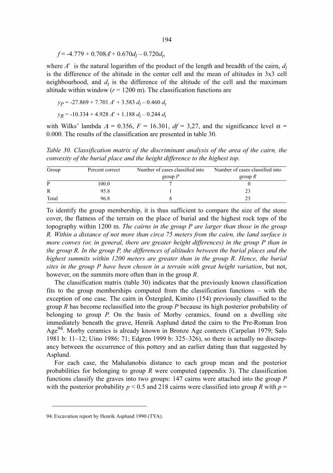
194
f = -4.779 + 0.708A’+ 0.670dl – 0.720dt,
where A’ is the natural logarithm of the product of the length and breadth of the cairn, dlis the difference of the altitude in the center cell and the mean of altitudes in 3x3 cellneighbourhood, and dt is the difference of the altitude of the cell and the maximumaltitude within window (r = 1200 m). The classification functions are
yP = -27.869 + 7.701 A’ + 3.583 dl – 0.460 dt
yR = -10.334 + 4.928 A’ + 1.188 dl – 0.244 dt
with Wilks’ lambda Λ = 0.356, F = 16.301, df = 3,27, and the significance level α =0.000. The results of the classification are presented in table 30.
Table 30. Classification matrix of the discriminant analysis of the area of the cairn, theconvexity of the burial place and the height difference to the highest top.
To identify the group membership, it is thus sufficient to compare the size of the stonecover, the flatness of the terrain on the place of burial and the highest rock tops of thetopography within 1200 m. The cairns in the group P are larger than those in the groupR. Within a distance of not more than circa 75 meters from the cairn, the land surface ismore convex (or, in general, there are greater height differences) in the group P than inthe group R. In the group P, the differences of altitudes between the burial places and thehighest summits within 1200 meters are greater than in the group R. Hence, the burialsites in the group P have been chosen in a terrain with great height variation, but not,however, on the summits more often than in the group R.
The classification matrix (table 30) indicates that the previously known classificationfits to the group memberships computed from the classification functions – with theexception of one case. The cairn in Östergård, Kimito (154) previously classified to thegroup R has become reclassified into the group P because its high posterior probability ofbelonging to group P. On the basis of Morby ceramics, found on a dwelling siteimmediately beneath the grave, Henrik Asplund dated the cairn to the Pre-Roman IronAge94. Morby ceramics is already known in Bronze Age contexts (Carpelan 1979; Salo1981 b: 11–12; Uino 1986: 71; Edgren 1999 b: 325–326), so there is actually no discrep-ancy between the occurrence of this pottery and an earlier dating than that suggested byAsplund.
For each case, the Mahalanobis distance to each group mean and the posteriorprobabilities for belonging to group R were computed (appendix 3). The classificationfunctions classify the graves into two groups: 147 cairns were attached into the group Pwith the posterior probability p < 0.5 and 218 cairns were classified into group R with p =
Group Percent correct Number of cases classified into group P
Number of cases classified into group R
P 100.0 7 0R 95.8 1 23Total 96.8 8 23
94. Excavation report by Henrik Asplund 1990 (TYA).
195
0.5 (figures 61 and 62). Thus, more than half of the burial cairns in Åboland are of IronAge character.
7.4.4 The shore zone datings
Transferring dates from dated finds to finds with unknown age involves a generalizationthe plausibility of which may not be easy to assess. Yet, in Åboland, the shoredisplacement offers an opportunity to test the group membership of cairns by examining,whether the shore zone datings are logically consistent – assuming the cairns were notbuilt in the waterline or under the water. Were cairns with group P characteristics erectedin places which in the end of the Bronze Age still were under the sea level or in the shorezone?
Regarding the oldest shore level zones until the Litorina IV-level, the ages wereestimated using the shore displacement curve in the district of Turku (figures 55 and 56)by Matti Eronen et al. (1993: 30). Regarding later Litorina shores, the shore zone ageswere estimated as the function of the location of the burial place and the altitude by fittinga trend surface into 14 points in the ratio diagram given by Glückert for the altitudes ofthe shore level zones LVIII, LVII, LVI and LV95(Glückert 1976, Appendix I). From theLate Iron Age circa 800 AD up to the present, the shore zone ages can be reckoned usingformulas given by Ekman and isobases given by Kakkuri (Ekman 1993; Kakkuri 1997).The accuracy of the procedure improves towards the present although the dates, as awhole, are approximate because of the graphical source data, the scarcity of Glückert’sdata in the outer and skerry zones and the errors of the DEM.
The scatter points of the altitudes in both groups mostly fall between 15 and 30 meters.However, in the group P, there are two cairns located on a rock surface uncovered not ear-lier than the Iron Age. In figure 55, they settle on the time axis to the right side of the ver-tical segment denoting the year 500 BC. The cairns are situated in Pargas and Västanfjärd.
Lofsdal, Pargas (288). The altitude is circa 15 meters. The cairn can have been builtat the earliest about 500 BC. A cairn with a radius of 8 m, indeterminable shape, col-lected of rounded and edged boulders (about 0–100 kg) in a rocky terrain, on a NWslope, on an uneven rock surface. The cairn is rather large, about 70 m², its differenceof height to the highest top is -25.5 m and the convexity of the burial place is 0.6m96
Norra Mågsholmen, Västanfjärd (334). The altimetrically measured altitude is 11 m.The cairn can have been built at the earliest about 100 BC. A cairn with an indetermi-nable shape. The E edge of the cairn might have been rectangular. In the middle of it,there is – concluding from the Rhizocarpon lichens on the stones – a very recent cra-ter. The place is on an island, separated from the mainland of the island of Kimito bya narrow strait, on a slightly inclining rock with an even top. The length of the cairn is7.6 m, width 4.9 m (37 m²) and height 0.9 m. The stone cover consists of mostly
95. The points 25, 38, 57, 66, 81, 129, 137, 177, 191, 248, 250, 255, 269 and 295 in Glückert’s data. For trendsurface analysis, see e.g. Haggett et al. 1977: 379–383.
96. See survey report by Mickelson 1954, no 10 (NBA) and Tuovinen 1985, no 195 (TYA). Nyberg 1985, no 10.
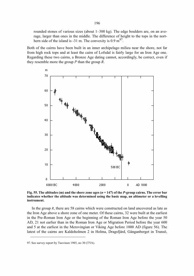
196
rounded stones of various sizes (about 1–300 kg). The edge boulders are, on an ave-rage, larger than ones in the middle. The difference of height to the tops in the nort-hern side of the island is -31 m. The convexity is 0.9 m97.
Both of the cairns have been built in an inner archipelago milieu near the shore, not farfrom high rock tops and at least the cairn of Lofsdal is fairly large for an Iron Age one.Regarding these two cairns, a Bronze Age dating cannot, accordingly, be correct, even ifthey resemble more the group P than the group R.
Fig. 55. The altitudes (m) and the shore zone ages (n = 147) of the P-group cairns. The error barindicates whether the altitude was determined using the basic map, an altimeter or a levellinginstrument.
In the group R, there are 58 cairns which were constructed on land uncovered as late asthe Iron Age above a shore zone of one meter. Of these cairns, 32 were built at the earliestin the Pre-Roman Iron Age or the beginning of the Roman Iron Age before the year 50AD, 21 not earlier than in the Roman Iron Age or Migration Period before the year 600and 5 at the earliest in the Merovingian or Viking Age before 1000 AD (figure 56). Thelatest of the cairns are Kaldoholmen 2 in Holma, Dragsfjärd, Gånganberget in Trunsö,
97. See survey report by Tuovinen 1985, no 30 (TYA).
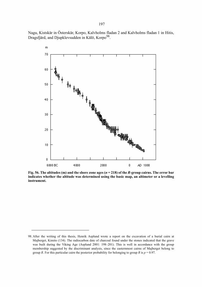
197
Nagu, Kistskär in Österskär, Korpo, Kalvholms fladan 2 and Kalvholms fladan 1 in Hitis,Dragsfjärd, and Djupklevsudden in Kälö, Korpo98.
Fig. 56. The altitudes (m) and the shore zone ages (n = 218) of the R-group cairns. The error barindicates whether the altitude was determined using the basic map, an altimeter or a levellinginstrument.
98. After the writing of this thesis, Henrik Asplund wrote a report on the excavation of a burial cairn atMajberget, Kimito (134). The radiocarbon date of charcoal found under the stones indicated that the gravewas built during the Viking Age (Asplund 2001: 198–201). This is well in accordance with the groupmembership suggested by the discriminant analysis, since the easternmost cairns of Majberget belong togroup R. For this particular cairn the posterior probability for belonging to group R is p = 0.97.
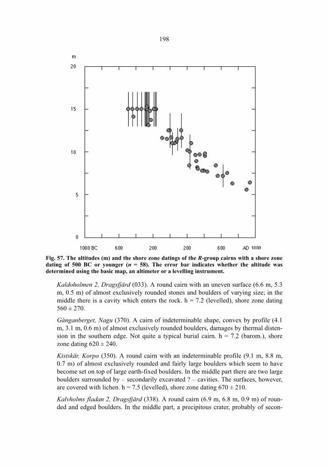
198
Fig. 57. The altitudes (m) and the shore zone datings of the R-group cairns with a shore zonedating of 500 BC or younger (n = 58). The error bar indicates whether the altitude wasdetermined using the basic map, an altimeter or a levelling instrument.
Kaldoholmen 2, Dragsfjärd (033). A round cairn with an uneven surface (6.6 m, 5.3m, 0.5 m) of almost exclusively rounded stones and boulders of varying size; in themiddle there is a cavity which enters the rock. h = 7.2 (levelled), shore zone dating560 ± 270.
Gånganberget, Nagu (370). A cairn of indeterminable shape, convex by profile (4.1m, 3.1 m, 0.6 m) of almost exclusively rounded boulders, damages by thermal disten-sion in the southern edge. Not quite a typical burial cairn. h = 7.2 (barom.), shorezone dating 620 ± 240.
Kistskär, Korpo (350). A round cairn with an indeterminable profile (9.1 m, 8.8 m,0.7 m) of almost exclusively rounded and fairly large boulders which seem to havebecome set on top of large earth-fixed boulders. In the middle part there are two largeboulders surrounded by – secondarily excavated ? – cavities. The surfaces, however,are covered with lichen. h = 7.5 (levelled), shore zone dating 670 ± 210.
Kalvholms fladan 2, Dragsfjärd (338). A round cairn (6.9 m, 6.8 m, 0.9 m) of roun-ded and edged boulders. In the middle part, a precipitous crater, probably of secon-
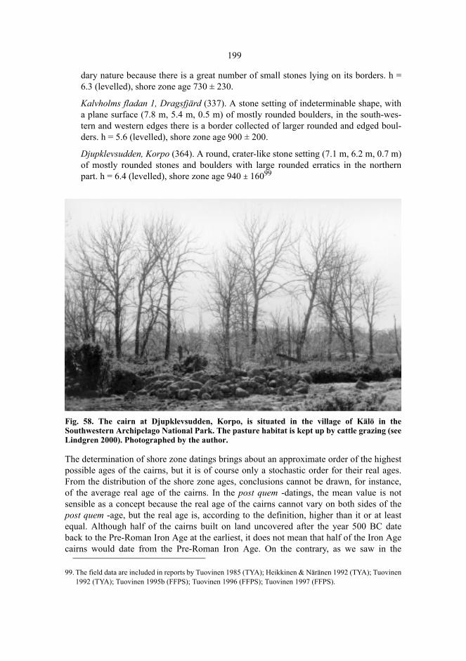
199
dary nature because there is a great number of small stones lying on its borders. h =6.3 (levelled), shore zone age 730 ± 230.
Kalvholms fladan 1, Dragsfjärd (337). A stone setting of indeterminable shape, witha plane surface (7.8 m, 5.4 m, 0.5 m) of mostly rounded boulders, in the south-wes-tern and western edges there is a border collected of larger rounded and edged boul-ders. h = 5.6 (levelled), shore zone age 900 ± 200.
Djupklevsudden, Korpo (364). A round, crater-like stone setting (7.1 m, 6.2 m, 0.7 m)of mostly rounded stones and boulders with large rounded erratics in the northernpart. h = 6.4 (levelled), shore zone age 940 ± 16099
Fig. 58. The cairn at Djupklevsudden, Korpo, is situated in the village of Kälö in theSouthwestern Archipelago National Park. The pasture habitat is kept up by cattle grazing (seeLindgren 2000). Photographed by the author.
The determination of shore zone datings brings about an approximate order of the highestpossible ages of the cairns, but it is of course only a stochastic order for their real ages.From the distribution of the shore zone ages, conclusions cannot be drawn, for instance,of the average real age of the cairns. In the post quem -datings, the mean value is notsensible as a concept because the real age of the cairns cannot vary on both sides of thepost quem -age, but the real age is, according to the definition, higher than it or at leastequal. Although half of the cairns built on land uncovered after the year 500 BC dateback to the Pre-Roman Iron Age at the earliest, it does not mean that half of the Iron Agecairns would date from the Pre-Roman Iron Age. On the contrary, as we saw in the
99. The field data are included in reports by Tuovinen 1985 (TYA); Heikkinen & Näränen 1992 (TYA); Tuovinen1992 (TYA); Tuovinen 1995b (FFPS); Tuovinen 1996 (FFPS); Tuovinen 1997 (FFPS).
200
sample study (chapter 4.5), the cairns are, on an average, later than an overall survey oftopography would suggest.
Testing the group membership against shore zones indicates that the classification intogroups P and R is not perfectly identical with a division into Bronze Age and Iron Agecairns. P and R represent two groups, the former of which is typically Bronze Age and thelatter occurs primarily in the Iron Age. Group membership must be interpreted as asuggestive and stochastic, not an absolute feature.
7.4.5 The classification functions
The classification functions can be used to determine which group an earlier unknownburial cairn is closer to. The observed values of variables are put into classificationfunctions and the cairn is entered into the group the classification function of whichacquires a higher value. Let us assume that a cairn has been found the length of which is9.2 m and the width 6.9 m, the convexity on the burial place 1.1 m and the difference ofheight to the highest top 17.0 m. By putting into classification functions, we get yP = 0.22and yR = 7.28. The burial cairn, thus, belongs most closely into the group R.
7.4.6 Discussion
The chronological characteristics of burial cairns in Åboland partly seem to agree withthe ones dealt with in earlier studies on the Finnish SW mainland area and on Åland. Thesmall size of the cairn and the location in a low-lying terrain indicate an Iron Age dating.However, the clustering of the cairns, the tendency to group into cemeteries, is not typicalof the group R in the same way as in the Iron Age cairns of the mainland – as acharacteristic distinctive for Iron Age graves.
Another difference is in the range of sea in the landscape surrounding cairns ofdifferent ages. According to Helena Edgren (1983), the Bronze Age cairns of Åland aretypically situated by the sea and they have been built by seal hunters and fishers. Becausethe environment of the cairns is still in our days maritime, it must have been significantlymore so during the Bronze Age when the land surface of Åland was 15–20 m lower thanat the present. In Åboland, the maritime landscape of the cairns of the P-group has,instead, in the process of shore displacement, shifted to an inner archipelago andmainland (figure 61).
While the landscape of Iron Age burial cairns on Åland can be characterized asmainland or inner archipelago (Edgren 1983), the cairns of group R in Åboland have beenbuilt on a broad zone ranging from the largest islands, such as the mainland of Kimito, tothe outer archipelago zone in Hitis, Nagu and Korpo (figure 62), yet a more maritimeenvironment than on Åland. It seems that the tradition of the selection of the place ofburial cairns changed more towards a land-based landscape in the course of time from theBronze to the Iron Age on Åland, while the tradition remained its maritime character inÅboland.

201
Due to shore displacement, the maritime character of the present day landscape is adifferent thing than the same characteristic at the times the burial cairns were built. In thelarge-scale topography of the peneplane inclining towards the Baltic Sea, thetoposequence has moved over from NE towards SW as land has risen up from the sea.According to the hypsographic curve of Åboland (fig. 2), the earliest skerries that rose upfrom the sea were the highest summits of the peneplane, having steep slopes, while thelater exposed land was plainer. The high relief, characteristic of the burial places of groupP and the terrain surrounding them, can partly be explained by the exposure of thepeneplane: when the Bronze Age cairns were erected, the sea was deeper and the islandswere smaller and further away from each other than during the Iron Age. The present dayBronze Age cairns are typically not located in a maritime landscape any more, they arerather surrounded by forests and agricultural land. The spatial distribution of the R-cairnsindicates that there was a direction for the building of new cairns: as land rose from thesea further out in the archipelago, cairns were built on the newly formed and enlargeningislands. The result is a stochastic time gradient from the present day mainland zonethrough the inner zone to the present day outer archipelago zone. Along this gradient, themorphology of the cairns and the topographic characteristics of the burial places can beinterpreted as a part of the mortuary ritual while the present day topographic setting in alarger sense, and the presence of the sea, can be rather than, or in addition to culturalpreferences, associated with the prehistoric stage of the development of the shoredisplacement.
8 Visual Dimensions of the Burial Sites
8.1 To See And To Be Seen
The sample from Houtskär, Korpo, and Nagu demonstrated that the grave sites weretypically located on elevated (but of very varying heights) rock outcrops. The graveswere frequently constructed on the tops – or near the tops – of the rocks, at elevated sitesin comparison with their vicinity, on horizontal or slightly sloping surfaces, often close toeach other, and near the sea. This means that the visibility from the grave sites was widerin scope than from its neighbourhood. The grave sites also provided visual contacts witheach other. The distribution of the grave sites in the sample indicates that the basis of thecultural significances of the grave sites lay in the visual ingredients of the landscape, inthe relief, in the perspective, in the mosaic of land and sea, in the horizon.Thesignificances seem to have been connected with the network of visual contacts betweenthe grave sites and the surrounding land and sea in the ancient landscape.
What is said above, concerns the grave sites only, not the graves themselves: extremelyfew cairns are visible from the sea or from the adjacent terrain. The grave at Bussö,Korpo (349), for example, can be discerned from the sea in the south and in the southwestbut not from very far although the rocks of the southern section of Bussö are treeless, andthere is a wide stretch of open sea in the south. The same applies to the grave at Kalholm,Dragsfjärd (362) from where there is an unobstructed view to the sea (fig. 23). The cairnwas barely discernible in the profile of the island if the boat was suitably close to theshore. It is impossible to see the grave when walking along the shores of Kalholm. Alsothe graves at Österudden, Pargas (265) and Falkön, Dragsfjärd (007) can be seen with thenaked eye from the sea; they are located at the distance of four kilometres from each otherat two heads of capes, on opposite sides of the waterway from the open stretch of the seacalled Gullkrona fjärden into the inner archipelago towards the Peimari, and thePaimionlahti. They are not visible from a distance without optical aids, either, and neversimultaneously, but the rocks of the graves can be recognized even from afar. The site ofthe grave at Ernholmsberget, Nagu is an even terrace at the height of 35 metres, 60 m SEof the highest point of the rock. The constructors have desired to find a site which isslightly lower than the highest point of the rock, and yet with an unobstructed viewtowards the waters in the surroundings in all directions apart from NW. Also the stone
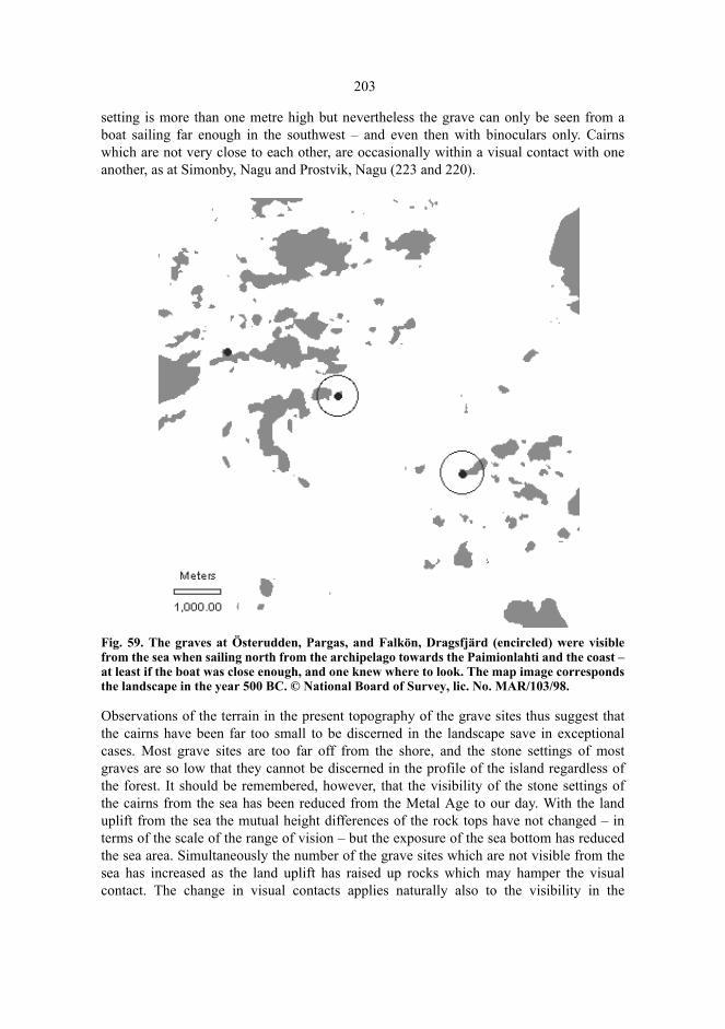
203
setting is more than one metre high but nevertheless the grave can only be seen from aboat sailing far enough in the southwest – and even then with binoculars only. Cairnswhich are not very close to each other, are occasionally within a visual contact with oneanother, as at Simonby, Nagu and Prostvik, Nagu (223 and 220).
Fig. 59. The graves at Österudden, Pargas, and Falkön, Dragsfjärd (encircled) were visiblefrom the sea when sailing north from the archipelago towards the Paimionlahti and the coast –at least if the boat was close enough, and one knew where to look. The map image correspondsthe landscape in the year 500 BC. © National Board of Survey, lic. No. MAR/103/98.
Observations of the terrain in the present topography of the grave sites thus suggest thatthe cairns have been far too small to be discerned in the landscape save in exceptionalcases. Most grave sites are too far off from the shore, and the stone settings of mostgraves are so low that they cannot be discerned in the profile of the island regardless ofthe forest. It should be remembered, however, that the visibility of the stone settings ofthe cairns from the sea has been reduced from the Metal Age to our day. With the landuplift from the sea the mutual height differences of the rock tops have not changed – interms of the scale of the range of vision – but the exposure of the sea bottom has reducedthe sea area. Simultaneously the number of the grave sites which are not visible from thesea has increased as the land uplift has raised up rocks which may hamper the visualcontact. The change in visual contacts applies naturally also to the visibility in the
204
opposite direction: the sea area visible from the grave sites has decreased during themillenniums.
As an example we might use the grave at Båtkullaberget, Kimito; this cairn in theeastern part of Kimitoön is almost 12 m long and 1.3 m high (139). The grave site islocated at the height of 36 m, on a rock outcrop rising 30 m above the surroundingcultivations, NW of the highest point of the rock. At the end of the Bronze Age the sitewas located on a cape above a steep slope inclining down to the shore, at the height ofabout 23 m above the sea. The present cultivated fields were covered by a 4–9 m deepwater. From the site there was a wide scope of view (radius 5000 m) of 13.6 km², 53 percent of which was water. The present scope of view of 11.4 km² consists of only three percent of water. The changes in the visual contacts from Båtkullaberget illustrate both theeffect of the silting sea bottom on the view to the sea, and the effect of the land uplift onincreasingly hampered visibility (fig. 60).
Land uplift does not necessarily influence the recognizability of the distinctivetopographic forms of the grave site – rock peaks, terraces, capes, or mouths of straits. Thediscernability of the cairn from far is not any prerequisite of the signification of the site; itis sufficient that the grave site is linked with a characteristic form of the landscape, amilieu dominant, which distinguishes it from the rest of the sites. Such a grave site agreeswith Felipe Criado’s concept of an ambiguous monument (Criado 1995: 199). While thevisual properties of natural places belong to the usual material of Swedish and old Finnishplace names in Åboland (Pitkänen 1985 a: 162–188; Zilliacus 1989: 56–64 etc; Fortelius1999: 269–329), it might be analogically presumed that features in landscape, such astrees, bird colonies, soil, boulders, the colour or shape of rocks, the location ortopography of an island in reference to other islands, could have made a prehistoric gravesite extraordinary and recognizable. The grave at Bussö, Korpo mentioned above, is apossible example: it is located on a cape pushing south, with red, at places pegmatiticgranite. The cairn and the reddish colour of the rock are distinctly discernable from thesea and from the same distance, but when walking on land the colour easily remainsunnoticed. Consequently, the grave must be watched from the south or from thesouthwest, and from the sea. The reddish stone seems to appear only on the southernshore of Bussö.
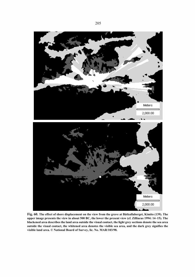
205
Fig. 60. The effect of shore displacement on the view from the grave at Båtkullaberget, Kimito (139). Theupper image presents the view in about 500 BC, the lower the present view (cf. Zilliacus 1994: 14–15). Theblackened area describes the land area outside the visual contact, the light grey sections denote the sea areaoutside the visual contact, the whitened area denotes the visible sea area, and the dark grey signifies thevisible land area. © National Board of Survey, lic. No. MAR/103/98.
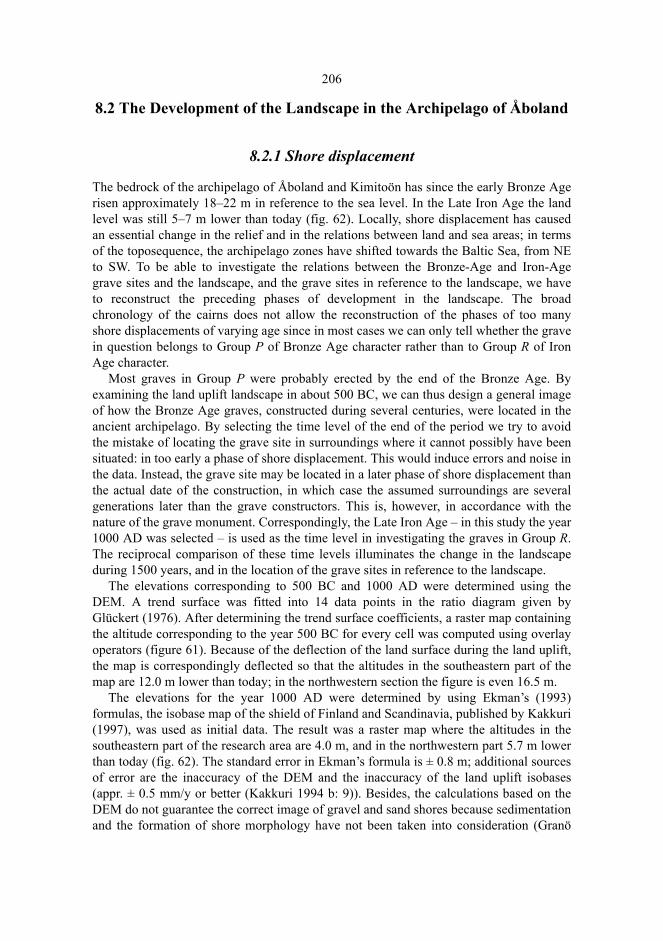
206
8.2 The Development of the Landscape in the Archipelago of Åboland
8.2.1 Shore displacement
The bedrock of the archipelago of Åboland and Kimitoön has since the early Bronze Agerisen approximately 18–22 m in reference to the sea level. In the Late Iron Age the landlevel was still 5–7 m lower than today (fig. 62). Locally, shore displacement has causedan essential change in the relief and in the relations between land and sea areas; in termsof the toposequence, the archipelago zones have shifted towards the Baltic Sea, from NEto SW. To be able to investigate the relations between the Bronze-Age and Iron-Agegrave sites and the landscape, and the grave sites in reference to the landscape, we haveto reconstruct the preceding phases of development in the landscape. The broadchronology of the cairns does not allow the reconstruction of the phases of too manyshore displacements of varying age since in most cases we can only tell whether the gravein question belongs to Group P of Bronze Age character rather than to Group R of IronAge character.
Most graves in Group P were probably erected by the end of the Bronze Age. Byexamining the land uplift landscape in about 500 BC, we can thus design a general imageof how the Bronze Age graves, constructed during several centuries, were located in theancient archipelago. By selecting the time level of the end of the period we try to avoidthe mistake of locating the grave site in surroundings where it cannot possibly have beensituated: in too early a phase of shore displacement. This would induce errors and noise inthe data. Instead, the grave site may be located in a later phase of shore displacement thanthe actual date of the construction, in which case the assumed surroundings are severalgenerations later than the grave constructors. This is, however, in accordance with thenature of the grave monument. Correspondingly, the Late Iron Age – in this study the year1000 AD was selected – is used as the time level in investigating the graves in Group R.The reciprocal comparison of these time levels illuminates the change in the landscapeduring 1500 years, and in the location of the grave sites in reference to the landscape.
The elevations corresponding to 500 BC and 1000 AD were determined using theDEM. A trend surface was fitted into 14 data points in the ratio diagram given byGlückert (1976). After determining the trend surface coefficients, a raster map containingthe altitude corresponding to the year 500 BC for every cell was computed using overlayoperators (figure 61). Because of the deflection of the land surface during the land uplift,the map is correspondingly deflected so that the altitudes in the southeastern part of themap are 12.0 m lower than today; in the northwestern section the figure is even 16.5 m.
The elevations for the year 1000 AD were determined by using Ekman’s (1993)formulas, the isobase map of the shield of Finland and Scandinavia, published by Kakkuri(1997), was used as initial data. The result was a raster map where the altitudes in thesoutheastern part of the research area are 4.0 m, and in the northwestern part 5.7 m lowerthan today (fig. 62). The standard error in Ekman’s formula is ± 0.8 m; additional sourcesof error are the inaccuracy of the DEM and the inaccuracy of the land uplift isobases(appr. ± 0.5 mm/y or better (Kakkuri 1994 b: 9)). Besides, the calculations based on theDEM do not guarantee the correct image of gravel and sand shores because sedimentationand the formation of shore morphology have not been taken into consideration (Granö
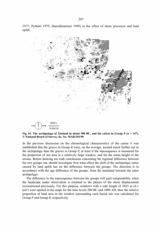
207
1977; Pyökäri 1979; Mansikkaniemi 1989) in the effect of shore processes and landuplift.
Fig. 61. The archipelago of Åboland in about 500 BC, and the cairns in Group P (n = 147).© National Board of Survey, lic. No. MAR/103/98
In the previous discussion on the chronological characteristics of the cairns it wasestablished that the graves in Group R were, on the average, located much further out inthe archipelago than the graves in Group P, at least if the toposequence is measured forthe proportion of sea area in a relatively large window, and for the mean height of theterrain. Before drawing too rash conclusions concerning the regional difference betweenthe two groups one should investigate first what effect the shift of the archipelago zonescaused by land uplift has on the difference between the groups. The direction is inaccordance with the age difference of the groups: from the mainland towards the outerarchipelago.
The difference in the toposequence between the groups will gain comparability whenthe landscape under observation is returned to the phases of the shore displacementreconstructed previously. For this purpose, windows with a side length of 2025 m (4.1km²) were opened in the maps for the time levels 500 BC and 1000 AD; then the relativeproportion of land area in the window surrounding each burial site was calculated forGroup P and Group R, respectively.
208
Fig. 62. The archipelago of Åboland in about 1000 AD, and the cairns in Group R (n = 218).© National Board of Survey, lic. No. MAR/103/98
The distributions of land area were largely in accordance. The most distinct differencewas seen in the greater proportion of Group R in grave sites for which the proportion ofland area in the window was almost or precisely 100 per cent (fig. 63). These were gravesites on large islands. For the grave sites in Group P, the proportion of land area in thewindow was, on the average, 0.509 (51 per cent) (standard deviation 0.289). In group Rthe average proportion of land area was 0.549 (55 per cent) (standard deviation 0.288). Incomparison, Student’s t = -1.259, with degrees of freedom df = 362, and significance levelα = 0.202. Even if the present map image suggests that the surroundings of the grave sitesin Group R are more maritime than those of the grave sites in Group P, the difference isnot, however, statistically significant when the age differences of the graves and thechanges of landscape caused by shore displacement during 1500 years are taken intoconsideration. At the time of their construction, the sites of the graves in Group P were, infact, as maritime as those of the graves in Group R but by the Iron Age, shoredisplacement had changed the surroundings of the oldest grave sites so that they weremore like mainland terrain (cf. fig. 62).

209
Fig. 63. The relative proportion of land in a window with a side length of 2025 m in about 500BC for the grave sites in Group P, and in about 1000 AD for the grave sites in Group R. n = 364.
The minute difference between the grave sites in Group P and in Group R concerning themaritime landscape at the time of the construction implies that graves were erectedfurther out in the archipelago and in a more extensive area than before when new islandsemerged out of the sea as a result of land uplift, and the islands became larger in size. Inthe Iron Age cairns appeared, above all, in the present outer archipelago zone and in themiddle zone in Iniö, Houtskär, and Hitis while the construction of graves continued onthe large islands in Rymättylä, Nagu Lillandet, Pargas and Dragsfjärd, and the mainland-like areas of Kimitoön. In today’s archipelago this means that the gradient from the innerzone to the outer archipelago zone – from an older shore displacement environment to ayounger one – is, at the same time, a stochastic age gradient of the cairns. It is impossible thatthe oldest graves should have been constructed in the outmost archipelago and on thelowest sites. An occasional old grave further out in the archipelago or an Iron-Age gravein a mainland-like environment does not influence the general trend of the age gradient.
8.2.2 Forests and pastures
The outward aspect of the landscape in the southwestern archipelago in the Metal Agewas probably largely determined by the topography. The appearance of the landscape andthe visual contacts within the landscape were, however, also influenced by forests.Forests have passed through a long development due to the land uplift succession,climatic changes, and human activity. The skerries which emerged out of the sea receivedtheir first pioneering trees in the most sheltered places, and developed gradually into themore or less wooded islands that they are today. The last phase of development of theforests in the archipelago began in the 19th century after the obstacles imposed bylegislation concerning parcelling of the land to crofters and fishing outside the villageshad been abolished. The population of the archipelago of Åboland rose by the year 1910up to the highest figure known so far (Jaatinen 1960; Jaatinen 1961; Vainio 1981; Moring1994: 62–70). Sheep and cattle were grazing wherever they could find anything to eat.Grazing and collecting fodder for winter led to a deterioration of the forest to the extent
210
that ”original” wild nature had disappeared a hundred years ago. In the 20th century themarket powers made traditional forms of small-scale fishing, agriculture, and cattle-raising impossible, which, in its turn, led to large-scale emigration and diminishingpopulation. After the cessation of grazing, the forests of the archipelago are todaygrowing again (Lindgren & von Numers 1999; Lindgren 2000).
The forests of the archipelago are divided into zones. The inner and the middlearchipelago zones are dominated by coniferous and mixed forests which are replaced bymaritime deciduous woodland when moving further out towards the outer archipelagozone. They are characterized by shoreline alder groves (Alnus), and patches of low-growing birch (Betula), occasionally even dry pine woods (e.g. Lindgren & Stjernberg1986: 11–14; Granö et al. 1999: 27–38). The outmost islands of the skerry zone aretotally or largely treeless.
The development of the forests of the southwestern archipelago in the subboreal andsubatlantic periods has been investigated mainly by using pollen analyses. According tothe research conducted by Gunnar Glückert, the forests of the subboreal period on themainland of Åland abounded in birch and alder, and the more southern deciduous specieswere more common than today (Glückert 1978: 79–87; see also Huntley & Birks 1983).The florescence of the oak-dominated mixed forests (QM) and deciduous forests came toan end in the late subboreal period, at the latest, when pine and spruce forests becamecommon on the mainland of Åland. The forests on the island of Kumlinge in the easternarchipelago of Åland were of more maritime type than those on the mainland of Åland.The development of the forests on Kumlinge can be investigated since about 1700 BPwhen the bog of Gunnarsmossen was isolated from the Baltic Sea, and the pollen analysesindicate that rocky Kumlinge remained almost treeless for about 1000 years. Deciduousmaritime trees were, however, not uncommon at low-lying and sheltered sites (Glückert1989).
The Bronze-Age dwelling place of Otterböte is located in the parish of Kökar, Åland,which borders on the western edge of the research area. The place was inhabited in thesubboreal period, about 1300–1000 BC. On the basis of pollen and macrofossil analysesthe type of the forest was at that time close to the present maritime deciduous forest typeon Kökar (Gustavssson 1997: 17–21; Núñez et al. 1997). The most significant species interms of visibility were probably birch, alder, aspen (Populus), hazel (Corylus), oak(Quercus), ash (Fraxinus), and elm (Ulmus). No coniferous trees seem to have grown onthe island apart from juniper (Juniperus).
Irmeli Vuorela has been investigating the bog basins on the mainland coast of south-western Finland and in the archipelago (Vuorela 1991 a; Vuorela 1999). In the swamp ofLalaxkärret, Nagu, one can distinguish a shore phase with an overrepresentation ofconiferous trees due to the pollen concentrations brought to the shore by the waves. Dueto land uplift, a bog developed at the site during the younger Bronze Age and the Pre-Roman Iron Age, and the tree pollen analyses indicate a typical shore forest dominated bydeciduous trees. After this the pollen of coniferous trees becomes predominant; thesamples lack, however, the surface section stratified during the past 2000 years because ofthe subsequent peat harvesting in the area. The oldest layer in the sample from the bog ofMossen, Korpo (Vuorela 1991 b: 126–130) is about 2000 years old. The shore phase,characterized by alder, birch and the more southern tree species such as hornbeam(Carpinus), and the subsequent development of marshland typified by the predominant
211
proportion of pine pollen, is seen also at Mossen. At Mossdalen, Kimito, pine, birch, alderand the more southern tree species abound in the Bronze Age (Asplund & Vuorela 1989).At the same time, spruce becomes more common but in about 2850 BP its proportionseems to diminish due to human activities, probably grazing. Also in the swamp ofIsokärret, Kimito, the forest vegetation consists of coniferous trees, birch, alder, and themore southern deciduous trees after the shore phase (Asplund & Vuorela 1989).
The natural geographic zones of the archipelago from the mainland coast to the opensea (Granö 1981; Jaatinen 1982: 45; Granö et al. 1999: 27–38) probably existed in thesubboreal and the subatlantic periods because the zonal differences were due todifferences in the distribution of land and sea, and the maritime climate. The pollenanalyses do not challenge such a concept. Judging from the samples, the stand of forest atKumlinge and Kökar was dominated by deciduous trees to a greater extent than at Korpo,Nagu and Kimito, and was thus close to the forest type in the outer archipelago. Severalislands which today grow with maritime birch forest were at the time of the graveconstruction probably treeless outer skerries.
The fact that such ancient Finnish loan names as Korpo (from Fi. *Korpi ’a dampforest’) and Mossala (from Fi. *Mustasalo ’a black island’) denote large forested islandsprovides interesting indirect evidence (Pitkänen 1985 a: 148–149; 179–180; Zilliacus1994: 26; Zilliacus 1997: 35; Fortelius 1999: 14–16). But due to the absence of moredetailed knowledge one must, however, keep in mind when studying the landscape thatthis is rather a reconstruction of potential visual contacts than anything else. The chancesof making the correct conclusions are greater in the outer than in the inner archipelago.
8.3 Views from the Grave Sites
8.3.1 Altitudes of the Grave Sites
The graves whose age can be determined with considerable certainty allow aninvestigation of the height difference between the grave site and the shoreline at the timeof the grave construction. The graves at Långnäsudden, Dragsfjärd (041, 042) which dateback to the II period of the Bronze Age are located at the height of about 25 m. We canassume that the graves were erected at the height of less than 10 metres above sea level,in the northern corner of a skerry with an area of less than a hectare. The graves atHammarsboda, Dragsfjärd (043–046) were constructed on a narrow headland belongingto the ice-marginal formation of Salpausselkä III at the heights of 20.9, 22.3, 21.3, and20.0 metres, respectively. By inference from the finds, the graves belong to the second orthe third period, and thus they must originally have been located only 3–5 metres abovethe shoreline. The inlet of the sea around the headland was so shallow that it silted up bythe end of the Bronze Age. The site of the grave at Trollberg, Houtskär (087, dating backto about 1200 BC) was rather different: the rock outcrop reaches today the height of 37metres. At the time of the construction of the grave, the rock was only 16–18 m high.
The grave at Stora Ängeskär, Dragsfjärd on the southern shore of the island at theheight of 8.2 m, dates back to the Viking Age. The rock outcrop at the grave site
212
overlooking the sea was, at that time, 3.9–5.0 m (± 0.8 m) lower than today in referenceto the mean water level. The grave was thus constructed at the height of approximately 3–4 m only a few steps from the shore but nevertheless on a horizontal terrace-like rockoutcrop. In the cemetery at Furunabb, Houtskär the graves are located in a terrain whoseheight ranges from 14 to 17 metres. The original height difference between the graves andsea level was less than 10 metres. The two cairns at Sundbergen, Nagu were erected in theyounger Iron Age at a site which was quite different, on the top of a rock; at the time oftheir construction the top was 21–26 m above sea level, today the cairns stand at theheights of 27.6 and 29.9 m, respectively.
On the presumption that cairns were no longer, at least generally, erected in the timesof recorded history, the graves at the lowest sites must have been constructed close to theshoreline. Some of these graves were, for instance, the grave at Kaldoholmen 2, Drags-fjärd (033, h = 7.2 m, shore zone dating AD 560 ± 270), the atypical grave at Gångan-berget, Nagu (370, h = 7.2, about 620 ± 240), the grave at Kistskär, Korpo (350, h = 7.5,670 ± 210), the grave at Kalvholms fladan 2, Dragsfjärd (338, h = 6.3, 730 ± 230), Kalv-holms fladan 1, Dragsfjärd (337, h = 5.6, 900 ± 200), and the grave at Djupklevsudden,Korpo (364, h = 6.4, 940 ± 160). These graves, like that at Stora Ängeskär, were probablyconstructed only a few metres above mean water level.
In the light of the examples above, the height difference between the grave sites andthe shoreline is highly varying. The distribution of the heights concerning the graves inGroup P (fig. 55) indicates, however, that most of the graves were constructed ten metres,at the most, above the Bronze-Age shore zone, and definitely not on the highest tops ofthe region although elevated sites were favoured when selecting sites of graves. The gravesites in Group R are located in roughly the same or slightly lower present height zones(fig.56), which implies that Iron-Age graves were not located any closer to the shorelinethan Bronze-Age graves. If the graves in Group R had been constructed closer to theshore, their sites should be on considerably lower levels. In terms of the view from thegrave site, the height above sea level was not, however, the only significant factor inselecting the grave site; other important determinatives were the height of the grave site inreference to the surrounding terrain, the presence of visual obstacles in the surroundings,the amount of sea and low-lying terrain in the landscape, and how uninterrupted theskyline is on the horizon. The landscape opening from a 10-metre-high cliff on a skerry inthe outer archipelago may be as extensive as one from a 50-metre-high rock in the innerarchipelago or on the mainland coast (figure 64). But also the view from a grave site inthe outer archipelago maybe rather limited if the grave site is located within a group ofislands or in a so-called miniature archipelago (Lindgren & Stjernberg 1986: 13). In theouter archipelago or on its edge, one can find grave sites belonging to Group R withlimited views at Kistskär, Korpo (350), at Härön, Dragsfjärd (347), at VästraGranholmen, Dragsfjärd (Hitis) (341), and at Bötesön, Dragsfjärd (Hitis) (363).

213
Fig. 64. The visibility to the sea (white) and to the land (dark grey) within a radius of 5000metres round the grave site at Långfuruholm, Dragsfjärd (060) in about 1000 AD. At that timethe height of the grave site was 4.5 m above sea level. © National Board of Survey, lic.no. MAR/103/98.
8.3.2 Terrain Observations And Digital Elevation Model
Landscape is mediated to us by sensory perception. If we want to understand andinterpret a landscape from the point of view of a prehistoric observer and perceiver, themost natural way is to set about studying the landscape in reference to the prehistoriclandscape, and to try to discover the remaining dimensions which may have existed andreceived significances in the prehistoric period. Christopher Tilley, for instance, madeterrain observations of the sites of the barrows and megalithic monuments in thelandscape of southern England. Among other things, he gathered the importance of thereciprocal visual contacts between the monuments, and the exactness in the choice of the
214
monument sites (Tilley 1994; Tilley 1996). The paths connecting significant places in thelandscape, emerge in his analysis as a narrative metaphor: during a walk in the landscapeone reads the significances of the different places in reference to each other. They formsequences of connotations which proceed along the connecting paths (Tilley 1994: 27-33). The idea of reading the landscape by means of close contact is also included in thesuccessions of observations made by Carl Olof Cederlund of the places on the Swedisheast coast, mentioned in the medieval so-called Danish itinerary (Cederlund 1988;Cederlund 1991). In Norway, Christian Keller mapped the landscape entities bordered byIron-Age barrows, and their mutual relationships (Keller 1993; see also Gansum et al.1997). An analysis of visibilities conducted as field research is well-adapted to observingthe reciprocal visual contacts between sites, to mapping visually obstructed areas, and toestablishing the visual sequences which a mobile observer is able to discern. At the sametime an observer today preserves the closeness to the position of a prehistoric observerand perceiver in the landscape because the representation of the same locality andlandscape can be perceived with one’s own senses.
As stated previously, shore displacement after the Metal Age has transformed thelandscape essentially, and deteriorated the visibility towards the sea from the grave sites.At many places, if not at most, one gets a biased image of the prehistoric landscape whenone walks to the grave site and stops to have a look around. – I am saying this in spite ofthe fact that I regard real authentic observations as almost indispensable for the under-standing of the nature of the grave site. Even they have, however, their limitations. In thisresearch it is thus necessary to approach the visual landscapes by reconstructing themwith the help of a map. At the same time the landscape must be modified into a two-dimensional cartographic plane, which in its turn involves a transition from a worldperceived with senses into a geometrically measured milieu, and, correspondingly, thesensory perceptions are lost (Raivo 1997: 205–206).
The digital elevation model (DEM) of the National Board of Survey in Finlandprovides a suitable material in mapping and analyzing the visual contacts. With thiselevation model it is possible to produce quantified and extensive descriptions of thevisual contacts at the site of observation. The conventional GIS line of sight (LOS)function between the cell of observation and any other cell will produce a binary-codedvalue (0 or 1) according to whether the latter cell is visible from the cell of observation ornot. The viewshed operation determines the cells which are visible from the observationsite. Visual contacts may be combined to involve mutual reciprocal visual contacts ofpoints, lines, and areas. In computations, the height of the observer’s eyes from land leveland the longest distance of visual contacts must be known or assumed. – The range ofvision is not a more exact GIS-function than any other raster operations of maps. TheDEM errors tend to enlarge the calculated range of vision (Fisher 1991), and differentimplementations produce differring ranges of vision (Fisher 1993). The accuracy of thevariables derived from a DEM is also affected by the spatial structure of DEM errors (Li& Jezek 1999).
215
8.3.3 Map Scale
The curvature of the earth confines the longest possible distance of visual contactbetween two places. A geographic range of vision across the surface of the sea can bedetermined if both the height of the site of observation from sea level and the height ofthe object from sea level on the horizon are known (Bowditch 1981: 132; Bowditch 1984:347–348; National Board of Navigation 1991: 14–15). For instance, seen from a 10-metre-high shore cliff, the surface of the sea joins the horizon at the distance of 12.4 kmfrom the observer (refraction and meteorological visibility are not taken intoconsideration). If the object to be observed is 5 metres high, it can be seen from the shorecliff from a distance of 21 km, at the most; five-metre-high objects further off cannot beseen on account of the curvature of the earth.
Since the islands in the archipelago of Åboland are low (Granö et al. 1986) – in theprehistoric period they were even lower – most of the silhouettes of the islands are not, onaccount of the curvature of the earth, visible to the observer at such long distances, andeven high islands shrink into streaks on the horizon. The study of the visual ranges ofgrave sites must therefore be confined to distances shorter than the longest theoreticalvisual sphere of observation. Long-distance visual observations may provide us with tooremote details which, in fact, have never been discernable with the naked eye. Theprolongation of the radius of the range of view to be observed will, besides,overemphasize the share of high places within the viewshed (van Leusen 1999).
Studying the visual range towards the sea from a grave site, requires, however,observing a sufficiently extensive area. If the visibility of fishing waters or seal ices fromthe grave site are assumed to have been of great significance, it must have been importantto have a sufficiently long unobstructed view towards the open sea from the land. In theinner archipelago the distance to the sea was longer – if there was any visual contact withit – than in the outer archipelago. Mapping the visual contacts must apparently beextended at least to the topographic specific wave length, 1200 m (see chapter 7.3.3).
When studying the scale of significant visual contacts it is also possible to direct one’slook in the opposite direction: from the sea towards the land. In the archipelago land isalmost always visible in some directions, if the visibility is not hampered by darkness,fog, or rain, sometimes right close, sometimes far off on the horizon. To determineposition, direction, and distance in the archipelago has thus been possible, unlike on theopen Baltic Sea, on the basis of terrestrial fixed points. The best fixed points wereprovided by islands whose silhouettes on the horizon were in some way or otherextraordinary (fig. 65). We know on what insight we have into fishing in the historicalperiod that the localization of the best fishing grounds was based on terrestrial fixedpoints at a distance of several, occasionally even more than ten kilometres (Ahlbäck1955; Gardberg 1966; Storå 1985: 193–194; cf. Hovda 1948: 51–66; Igarashi 1984). Ifand when these fixed points formed a significant array of natural places in orientation,their significances may have obtained even a sacral nature.
The scale effect appears also in the reciprocal relations of the visual ranges of variousgrave sites. A more generalized image of the views is obtained when the area underobservation is enlarged. As a result, the ranges of vision embrace areas which are moreand more varying in topography, and at the same time it will be more and more possiblethat the observed differences in visual contacts are caused by differences in local

216
topographies within the research area. When the area under observation is reduced, theproportion of the area of each field of vision will increase with regard to the area of thewhole research field, and the local small-scale topography will be accentuated in thedistribution of the ranges of vision. This situation will emerge when mapping ranges ofvision in a very small area on account of a high frequency of graves. The scale effect canbe influenced by choosing as homogeneous areas as possible, by using this method onemay, however, omit contrasts in studying the ranges of vision of graves of varying ages.
Fig. 65. Typical grave islands against the horizon – milieu dominants – north of Nötö, Nagu,seen from WSW, from the stretch of open sea called Berghamns fjärden. The peaks on the leftwere the highest points of the grave island of Boskär, the peak to the right from the middlebelonged to the grave island of Ådön. The reconstruction describes the silhouette in about 1000AD, and was made with the help of a DEM. © The National Board of Survey, lic. No. MAR/103/98.
The fields of vision in the archipelago can thus be studied using radiuses ranging from agood kilometre to more than ten kilometres. In the following analysis the fields of visionhave been mapped to the distance of 5000 m from each grave site.
8.3.4 The Statistical Significance of the Differences in the Distribution of the Fields of Vision
Almost any place selected at random provides a visual field of at least some extent intoits surroundings. In the archipelago one can see the sea shore or even further out to thesea from many places. The ranges of vision given by the DEM must therefore beinterpreted with the greatest caution if it is not known whether they are in some consistentway different from the rest of the fields of vision in the archipelago. We already know bythe sampling investigation studied in chapter 4 that the grave sites of the archipelagowere not chosen at random; it is, however, necessary to analyze specifically how thegrave sites differ from other places concerning their ranges of vision.
In the analysis of visible areas the individual finite populations consist of the values ofvariables derived from the DEM; the fields of vision from empirically determinedobservation points can then be compared with those values. The significance tests may beconducted by using, for instance, Kolmogorov-Smirnov’s test (Wheatley 1995; cf. Fisheret al. 1997: 584).
Also Monte Carlo-tests have been used in solving such problems (Fisher et al. 1997;Kvamme 1997). In this approach the empirical data are compared with a sequence ofsamples which have been generated from the finite population according to therandomization procedure determined by the null hypothesis. The estimator T of theparameter under observation is used in this comparison. The material consists of m + 1
217
samples representing the distribution of T, m generated by random selection (referenceset), and one by observation. Each sample comprises n observations. The test result isdetermined by the rank k of the value of T, derived from the observations, when the m + 1samples have been arranged into the mutual order of magnitude of T. In one-sided teststhe probability of the observed value of T being the kth lowest in ranking or lower whenthe null hypothesis is assumed to be true, is α = k/(m + 1); correspondingly, theprobability of the observed value of T being the kth highest in ranking or higher is α = 1 –k/(m + 1), depending on the direction of the alternative hypothesis (Ripley 1987: 171–174).
The Monte Carlo-tests involve a relatively simple procedure. No massive referencesets are necessary on the significance level α = 0.05, the normally employed magnitudeof the reference set is m = 19 if no rigid demands have been set on the power of the tests(Hope 1968; Jöckel 1986). This does not mean, however, that the computing will be atrivial task in all cases; on the contrary, the calculation time used up by the computer willbe rapidly prolonged as the size of the maps and the number of cells are growing.
8.3.5 The Ranges of Vision towards the Sea and the Land in Four Different Regions
In the following we will investigate, by using Monte Carlo-testing, four different sectionswithin the research area (fig. 66) to be able to achieve a detailed mapping of theviewsheds from the grave sites. These regions represent the best-investigated areas in thearchipelago and on the island of Kimitoön, and so it seems apparent that an essential partof the preserved graves have been discovered in these areas. In the choice of the sectionswe have also aimed at having a representative sample of inner, middle, and outerarchipelago in the Metal Age, varying spatial densities of graves, and areas where thegrave sites in Group P and Group R differ from each other in location.
To eliminate the edge effects, only the grave sites which are located at a distance of atleast 5000 m from the edge of the area, have been analyzed in each section. The selectionof the places in the reference set was chosen in the same frame by using a simple randomsampling without replacement. All the points in the random selection which were at theheight of 1.2 m or below from the determined sea level or the surface of a lake weredismissed. The specific viewsheds for the grave sites in Group P and Group R have beendetermined on the maps in 500 BC and 1000 AD.
The area and the perimeter of the visible area can be determined from the DEM byusing standard GIS-functions. The combination of the maps by using overlay operationsallows us to determine the magnitudes of the visible sea and land areas and their mutualrelations. The perimeter of the visible area indicates the unbrokenness of the visiblehorizon and the sinuousness of the outline of the visible area. The perimeter of the outlineincreases when the high places in the visible area overshadow the lower-lying placesbehind them. The perimeter and the extent of the field of vision are thus measures of howenclosed the landscape is.
The assessment of the sharpest angle from which a certain place in the surroundingterrain is seen obliquely both upwards and downwards will furnish the smallest and the

218
greatest viewing angle; the difference is the relief index. The relief index measures thedepth effect and the three-dimensionality created by the height differences. The index canbe calculated by using standard GIS-functions as suggested by Jonathan Baldwin andothers (Baldwin et al. 1996). The viewing angle is determined from the difference ofheights between the observer’s eyes and the object to be observed in the terrain, and thehorizontal distance to the object to be observed; these quantities will yield the tangent ofthe viewing angle (fig. 67). There is, however, one problem: how to determine theviewing angle in the very same cell in which the elevation model is used. In this cell thedistance is shortened into the distance of the cell midpoint from itself since the assumedobserver looks down at his feet. Therefore the index suggested by Baldwin and others issusceptible to distortion. It can be corrected by making use of the cells adjacent to theviewing point which give a more realistic image of the true appearance of the terrain inthe vicinity of the observer. The calculated inclination in the cell of the viewing point isreplaced by a median-filtered value which is determined from the cell of viewing andeight adjacent cells. Also the adaptive box-techniques can be used for this purpose(Eliason & McEwan 1990).
Fig. 66. The regions to be analyzed for their fields of vision. 1. Björkö – Kittuis – Hyppeis; 2.Brunskär – Nötö – Lökholm; 3. Hertsböle – Hammarsboda – Högsåra; 4. Lillandet. © TheNational Board of Survey, lic. No. MAR/103/98.
1
2
3
4

219
Fig. 67. The viewing angles from the grave site at Rövik (042), Dragsfjärd in about 500 BC. Thefan-shaped figure looking NE from the grave site indicates the strongest depth effect. Thesharpest oblique viewing angle downward from the grave site towards the strait which linkedthe sheltered waters of the inner archipelago with a long inlet (nowadays a lake calledDragsfjärden), was 10 degrees. The light grey colour demonstrates the invisible or horizontallyvisible areas, the darker grey shades the downwards visible areas; the white colour indicatesthe land areas which are higher up than the grave site. © The National Board of Survey, lic. No.MAR/103/98.
In this context, the concepts of composition and configuration of landscape ecology can beused in studying and interpreting the fields of vision in the ancient archipelago (Dunninget al. 1992; Li & Reynolds 1993). Composition refers to the part of the landscape which iscovered by the place, to what visual spaces the landscape involves, to their extent, and totheir variation. It refers to the presence, absence, or relative proportions of the landscapecomponents. Configuration denotes the spatial patterning of landscape or habitat.Configuration describes the position of the place in the landscape, the relative positionsof the various visual spaces of the landscape, how they are bounded, and what shape theyare. Composition variables consist of the extents of the field of vision, and the spaces itembraces; configuration variables include the shape of the field of vision, the three-dimensionality created by the height differences and the depth of the landscape, and therange of the visual contact.

220
8.3.5.1 Region 1: Björkö – Kittuis – Hyppeis
The Grave Sites in Group P
The area of the present parish of Houtskär was part of the outer archipelago in the BronzeAge. In about 500 BC, 4.8 per cent of the area consisted of land. The highest point of theland was 25 metres. In the area bounded by the villages of Björkö, Kittuis, and Hyppeisthere are three grave sites in Group P. From the grave site at Kummelbergen (077),Kittuis there was an unobstructed view into the sector between SW and SE and in a sharpoblique angle downward towards the sheltered strait and the inlet between the islands.From the grave site at Sunsveden (081) one could see the sheltered water area betweenthe islands and the adjacent inlet shore in two sectors: NW and E. At that time, Trollberg(087) was already a prominent place from where the view and the depth effect wererather evenly distributed in all directions. In the open landscape of the Bronze Age outerarchipelago, Trollberg was well discernible from the sea.
Comparison between the grave sites and the reference set (table 31) demonstrates thatthe extent of the sea view from the grave sites in Group P does not differ statisticallysignificantly from that of the rest of the places, but the land area visible from the gravesites was significantly larger than elsewhere. The average land area visible from the gravesites (3.53 km²) was 1.4 times larger than the greatest average of the areas in the referenceset. While the total of the visible area from the grave sites was only indicatively greaterthan that in the reference set, the perimeter of the visible area from the grave sites issignificantly greater. The outline of the visible area from the grave sites is more sinuoussince the visible area comprises islands which overshadow each other. The graves werethus constructed on large islands, which, in turn, were surrounded by several otherislands. The grave islands were embraced by sheltered waters which were separated fromthe open sea in all directions by land. The viewing angles from the grave sites differ fromthose of the reference set in the fact that the average viewing angle is smaller – theoblique downward angle is sharper than when viewing the landscape from elsewhere. Thegrave sites are thus prominent in terms of landscape but the visible areas from them aremore limited than one might expect.
The cumulative map of the visible areas (fig. 68) demonstrates the overlapping visibleareas from the grave sites, and the differences revealed by Monte Carlo- tests in the mapimage. The cumulative map of the visible areas is obtained by summing two or moremaps of visible areas so that – in this case – the number of the grave sites from which thecell is visible is recorded for every cell of the map (Wheatley 1995; Llobera 1996; Fisheret al. 1997; Lake et al. 1998; van Leusen 1999).

221
Table 31. Region 1, Björkö – Kittuis – Hyppeis. Comparison of the visible areas. Group P,n = 3, m = 19.
Table 32. Region 1. Comparison of viewing angles and distances. Group P, n = 3, m = 19.
Minimum for reference set
Maximum for reference set
Values for burial sites
Rank of burial sites
Significance
Area of the viewshed (km²)Mean 9.55 39.87 32.38 18 0.15Maximum 13.40 52.28 51.92 19 0.10Minimum 0.20 25.35 8.82 15 0.30
Area of visible sea (km²)Mean 7.75 38.05 28.85 18 0.15Maximum 10.72 49.31 48.28 18 0.15Minimum 0.07 24.09 6.95 15 0.30
Area of visible land (km²)Mean 0.50 2.56 3.53 20 0.05*Maximum 0.69 4.26 5.08 20 0.05*Minimum 0.13 1.99 1.87 19 0.10
Ratio of sea area to land areaMean 4.87 54.22 7.73 4 0.20Maximum 6.66 133.56 13.27 4 0.20Minimum 0.56 16.57 3.73 8 0.40
Perimeter of the viewshed (km)Mean 69.38 212.71 264.95 20 0.05*Maximum 87.30 323.23 392.51 20 0.05*Minimum 4.45 190.50 113.45 17 0.20
Ratio of the perimeter to the areaMean 5.43 14.75 9.74 12 0.45Maximum 6.33 27.35 12.87 7 0.35Minimum 2.08 12.12 5.56 14 0.35
Minimum for reference set
Maximum for reference set
Values for burial sites
Rank of burial sites
Significance
Smallest viewing angle (º)Mean -11.04 -5.03 -1.03 2 0.10Maximum -9.31 -3.89 -6.62 6 0.30Minimum -17.12 -5.71 -14.79 4 0.20Greatest viewing angle (º)Mean 0.99 5.60 0.84 1 0.05*Maximum 1.51 10.65 2.47 6 0.30Minimum 0.06 3.27 -0.03 1 0.05*Mean viewing angle (º)Mean -0.34 0.05 -0.44 1 0.05*Maximum -0.33 0.53 -0.26 2 0.20Minimum -0.45 -0.14 -0.53 1 0.05*Relief index (º)Mean 7.55 13.82 11.15 12 0.45Maximum 8.88 21.74 14.76 12 0.45Minimum 5.28 11.08 9.09 16 0.25Mean length of LOS (m)Mean 2184 3258 3032 13 0.40Maximum 3035 3417 3395 19 0.10Minimum 312 3146 2458 8 0.40

222
Fig. 68. Region 1, Björkö – Kittuis – Hyppeis. The cumulative map of the visible areas from thegrave sites in Group P (n = 3, the greatest number of overlapping visible areas cmax = 3). © TheNational Board of Survey, lic. No. MAR/103/98.
The Grave Sites in Group R
In about 1000 AD, 16.4 per cent of the area of Houtskär consisted of land, and the highestrocks reached the height of 35 metres. Group R consists of 32 grave sites. In Houtskär thegraves in Group R stand in the landscape either detached or at a distance of a few hundredmetres from the closest neighbour. The cemetery at Furunabb is, however, an exceptionwith its twelve graves constructed side by side. When studying the visible areas a strongspatial autocorrelation can be established between the graves at Furunabb, and thereforeonly one grave at Furunabb, a large quadrangular large setting (088), was included in theanalysis of the visible areas. The remaining 21 grave sites100 give, however, a moreextensive picture of the variation of the visible areas of the grave sites in Group R thanthe three grave sites in Group P.
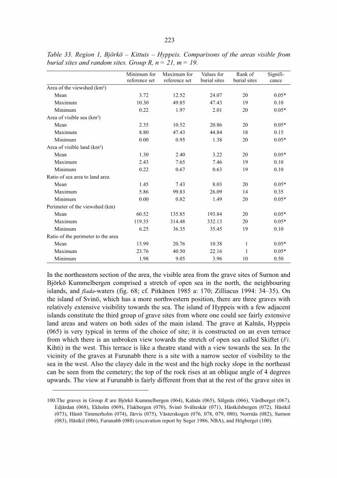
223
Table 33. Region 1, Björkö – Kittuis – Hyppeis. Comparisons of the areas visible fromburial sites and random sites. Group R, n = 21, m = 19.
In the northeastern section of the area, the visible area from the grave sites of Surnon andBjörkö Kummelbergen comprised a stretch of open sea in the north, the neighbouringislands, and flada-waters (fig. 68; cf. Pitkänen 1985 a: 170; Zilliacus 1994: 34–35). Onthe island of Svinö, which has a more northwestern position, there are three graves withrelatively extensive visibility towards the sea. The island of Hyppeis with a few adjacentislands constitute the third group of grave sites from where one could see fairly extensiveland areas and waters on both sides of the main island. The grave at Kalnäs, Hyppeis(065) is very typical in terms of the choice of site; it is constructed on an even terracefrom which there is an unbroken view towards the stretch of open sea called Skiftet (Fi.Kihti) in the west. This terrace is like a theatre stand with a view towards the sea. In thevicinity of the graves at Furunabb there is a site with a narrow sector of visibility to thesea in the west. Also the clayey dale in the west and the high rocky slope in the northeastcan be seen from the cemetery; the top of the rock rises at an oblique angle of 4 degreesupwards. The view at Furunabb is fairly different from that at the rest of the grave sites in
100.The graves in Group R are Björkö Kummelbergen (064), Kalnäs (065), Sälgnäs (066), Vårdberget (067),Edjärdan (068), Ekholm (069), Flakbergen (070), Svinö Svälteskär (071), Hästkilsbergen (072), Hästkil(073), Hästö Timmerholm (074), Järvis (075), Västerskogen (076, 078, 079, 080); Norrnäs (082), Surnon(083), Hästkil (086), Furunabb (088) (excavation report by Seger 1986, NBA), and Högberget (100).
Minimum for reference set
Maximum for reference set
Values forburial sites
Rank of burial sites
Signifi-cance
Area of the viewshed (km²)Mean 3.72 12.52 24.07 20 0.05*Maximum 10.30 49.85 47.43 19 0.10Minimum 0.22 1.97 2.01 20 0.05*
Area of visible sea (km²)Mean 2.35 10.52 20.86 20 0.05*Maximum 8.80 47.43 44.84 18 0.15Minimum 0.00 0.95 1.38 20 0.05*
Area of visible land (km²)Mean 1.30 2.40 3.22 20 0.05*Maximum 2.43 7.65 7.46 19 0.10Minimum 0.22 0.67 0.63 19 0.10
Ratio of sea area to land areaMean 1.45 7.43 8.03 20 0.05*Maximum 5.86 99.83 26.09 14 0.35Minimum 0.00 0.82 1.49 20 0.05*
Perimeter of the viewshed (km)Mean 60.52 135.85 193.84 20 0.05*Maximum 119.35 314.48 332.13 20 0.05*Minimum 6.25 36.35 35.45 19 0.10
Ratio of the perimeter to the areaMean 13.99 20.76 10.38 1 0.05*Maximum 23.76 40.50 22.16 1 0.05*Minimum 1.98 9.05 3.96 10 0.50
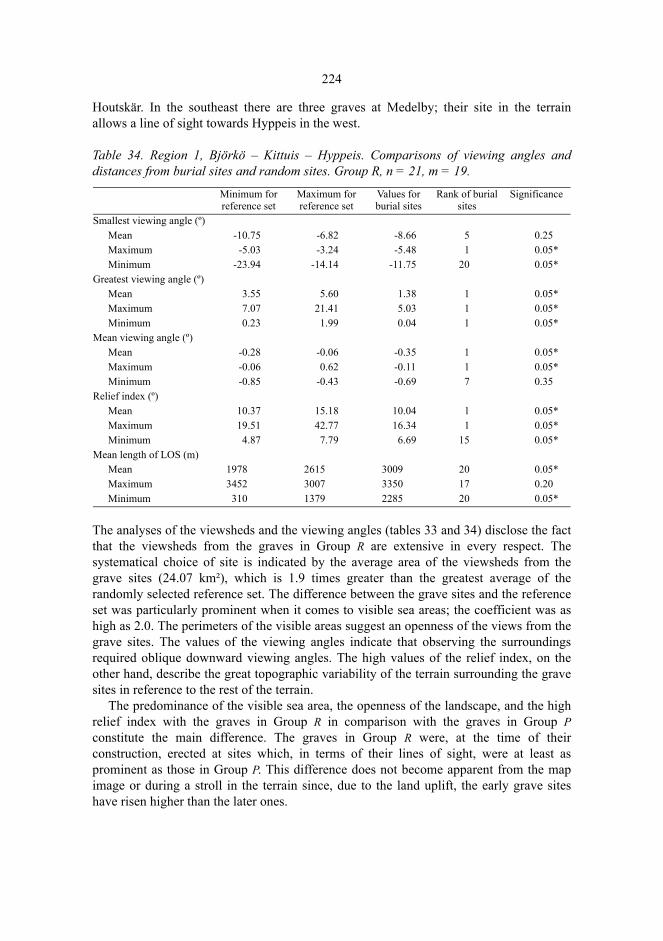
224
Houtskär. In the southeast there are three graves at Medelby; their site in the terrainallows a line of sight towards Hyppeis in the west.
Table 34. Region 1, Björkö – Kittuis – Hyppeis. Comparisons of viewing angles anddistances from burial sites and random sites. Group R, n = 21, m = 19.
The analyses of the viewsheds and the viewing angles (tables 33 and 34) disclose the factthat the viewsheds from the graves in Group R are extensive in every respect. Thesystematical choice of site is indicated by the average area of the viewsheds from thegrave sites (24.07 km²), which is 1.9 times greater than the greatest average of therandomly selected reference set. The difference between the grave sites and the referenceset was particularly prominent when it comes to visible sea areas; the coefficient was ashigh as 2.0. The perimeters of the visible areas suggest an openness of the views from thegrave sites. The values of the viewing angles indicate that observing the surroundingsrequired oblique downward viewing angles. The high values of the relief index, on theother hand, describe the great topographic variability of the terrain surrounding the gravesites in reference to the rest of the terrain.
The predominance of the visible sea area, the openness of the landscape, and the highrelief index with the graves in Group R in comparison with the graves in Group Pconstitute the main difference. The graves in Group R were, at the time of theirconstruction, erected at sites which, in terms of their lines of sight, were at least asprominent as those in Group P. This difference does not become apparent from the mapimage or during a stroll in the terrain since, due to the land uplift, the early grave siteshave risen higher than the later ones.
Minimum for reference set
Maximum for reference set
Values for burial sites
Rank of burial sites
Significance
Smallest viewing angle (º)Mean -10.75 -6.82 -8.66 5 0.25Maximum -5.03 -3.24 -5.48 1 0.05*Minimum -23.94 -14.14 -11.75 20 0.05*
Greatest viewing angle (º)Mean 3.55 5.60 1.38 1 0.05*Maximum 7.07 21.41 5.03 1 0.05*Minimum 0.23 1.99 0.04 1 0.05*
Mean viewing angle (º)Mean -0.28 -0.06 -0.35 1 0.05*Maximum -0.06 0.62 -0.11 1 0.05*Minimum -0.85 -0.43 -0.69 7 0.35
Relief index (º)Mean 10.37 15.18 10.04 1 0.05*Maximum 19.51 42.77 16.34 1 0.05*Minimum 4.87 7.79 6.69 15 0.05*
Mean length of LOS (m)Mean 1978 2615 3009 20 0.05*Maximum 3452 3007 3350 17 0.20Minimum 310 1379 2285 20 0.05*

225
Fig. 69. Region 1, Björkö – Kittuis – Hyppeis. The cumulative area of the visible areas from thegraves in Group R (n = 21, cmax = 14). © The National Board of Survey, lic. no. MAR/103/98.
The cumulative map of visible areas will again shed additional light on the structure andsignificance of the viewsheds (fig. 69). The most conspicuous overlap of the viewsheds isseen west of the island of Hyppeis on the stretch of open sea called Svinö fjärden, and onthe stretch of sea called Hästö fjärden which is a sheltered water area surrounded byislands off the island of Hyppeis. In view of the small area of the Hästö fjärden itdeserves attention that the grave sites have been selected so that the water area is visible,at least partly, from 10–14 various grave sites. The graves at Medelby in the east, forinstance, have been constructed on rock outcrops from which the Hästö fjärden is visiblein the west in a narrow sector at a distance of four kilometres. The visible sea areas westand east of Hyppeis are likely to indicate important fishing waters in the Iron Age.

226
8.3.5.2 Region 2: Brunskär – Nötö – Lökholm
The region bounded by Brunskär, Korpo in the northwest, and Nötö and Lökholm, Naguin the southeast belonged to the outer archipelago in the Iron Age. In 1000 AD 3.1 percent of the area of the region was land with a maximum altitude of 35 m. On account ofthe openness of the landscape, the reconstruction of the lines of sight is more reliable thanin the inner archipelago. The 16 graves of the region belong to Group R, and shore zonedating has established that many of them have been constructed in the Iron Age101. I haveexplored more than half of the land area of the region (Tuovinen 2000 b), which suggeststhat a considerable share of the preserved graves have been detected.
Nine of the graves in the region form a group at the northern end of the island of Nötö,and on the adjacent islands of Granholm and Mjoö, all of which boast a fairlyunobstructed visibility. The other seven graves have been constructed on middle-sizedislands in the surroundings of Nötö; even these boast an extensive visibility in regard tothe elevation of the grave sites, particularly in the southern part of the region where therange of vision reaches the horizon.
In the analyses of the viewsheds (tables 35 and 36), the total area of the viewshed, thearea of the visible sea, and the perimeter of the viewshed proved to be statisticallysignificant variables. At the grave sites the mean area of visible sea 36.69 km² is 1.2 timeshigher than the maximum mean in the reference set. In the maximum values of the area ofthe viewshed, there is, however, no systematic difference between the grave sites and thereference set, which indicates that the sites with the most extensive viewsheds have notbeen selected as grave sites. On the other hand, the ratio of the sea area to the land area issignificantly higher for the maximum values, and indicative for the mean values. Alsothis emphasizes the significance of an extensive and open visible sea area in the choice ofthe grave site. The coefficients of the difference between the viewsheds of the grave sitesand those of the reference set are not as high as in Houtskär. The reason for this is themore maritime environment where the influence of the choice of the site on the visibilityof the sea is not as strong as in Houtskär.
101.The graves are Bussö (349) and Aspö (351) in Korpo, and the following graves in Nagu: Boskär (365), Ådön(366), Granholm (368), Sundbergen 1 (258), Sundbergen 2 (259) (excavation report on these two graves atSundbergen by Tuovinen, 1988, TYA), Sundbergen 3 (250), Sundbergen 4 (251), Sundbergen 5 (252), Mjoö1 (253), Mjoö 2 (254), Mjoö 3 (369), Gånganberget (370), Sandholm (371), Revberget (372).
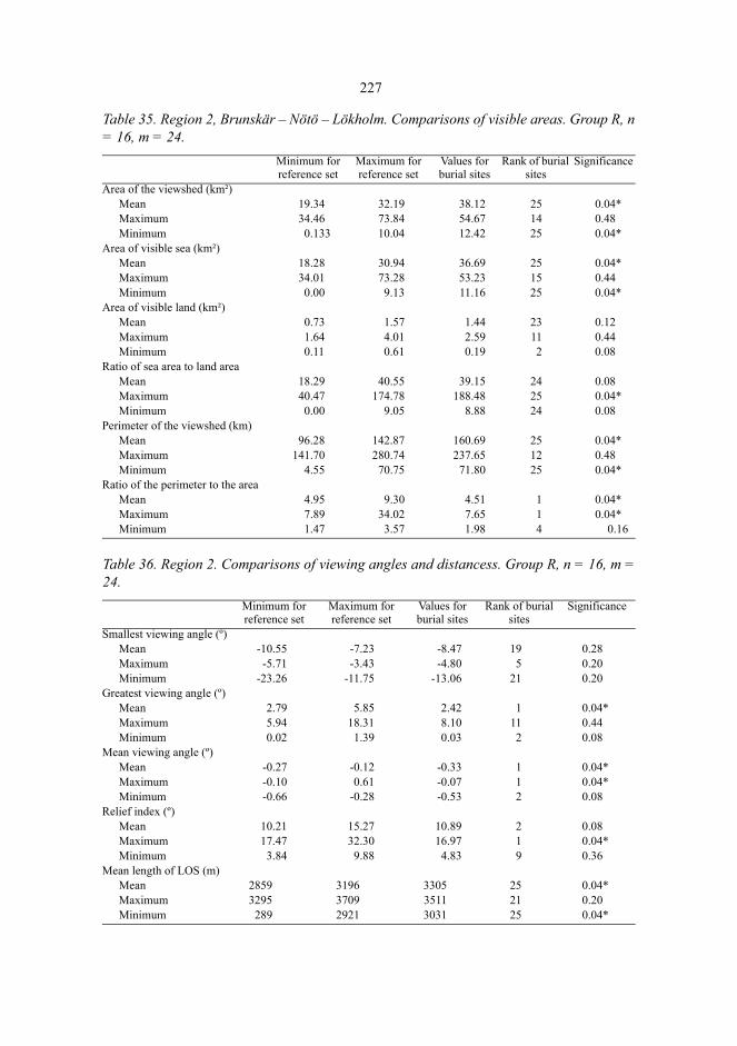
227
Table 35. Region 2, Brunskär – Nötö – Lökholm. Comparisons of visible areas. Group R, n= 16, m = 24.
Table 36. Region 2. Comparisons of viewing angles and distancess. Group R, n = 16, m =24.
Minimum for reference set
Maximum for reference set
Values for burial sites
Rank of burial sites
Significance
Area of the viewshed (km²)Mean 19.34 32.19 38.12 25 0.04*Maximum 34.46 73.84 54.67 14 0.48Minimum 0.133 10.04 12.42 25 0.04*
Area of visible sea (km²)Mean 18.28 30.94 36.69 25 0.04*Maximum 34.01 73.28 53.23 15 0.44Minimum 0.00 9.13 11.16 25 0.04*
Area of visible land (km²)Mean 0.73 1.57 1.44 23 0.12Maximum 1.64 4.01 2.59 11 0.44Minimum 0.11 0.61 0.19 2 0.08
Ratio of sea area to land areaMean 18.29 40.55 39.15 24 0.08Maximum 40.47 174.78 188.48 25 0.04*Minimum 0.00 9.05 8.88 24 0.08
Perimeter of the viewshed (km)Mean 96.28 142.87 160.69 25 0.04*Maximum 141.70 280.74 237.65 12 0.48Minimum 4.55 70.75 71.80 25 0.04*
Ratio of the perimeter to the areaMean 4.95 9.30 4.51 1 0.04*Maximum 7.89 34.02 7.65 1 0.04*Minimum 1.47 3.57 1.98 4 0.16
Minimum for reference set
Maximum for reference set
Values for burial sites
Rank of burial sites
Significance
Smallest viewing angle (º)Mean -10.55 -7.23 -8.47 19 0.28Maximum -5.71 -3.43 -4.80 5 0.20Minimum -23.26 -11.75 -13.06 21 0.20
Greatest viewing angle (º)Mean 2.79 5.85 2.42 1 0.04*Maximum 5.94 18.31 8.10 11 0.44Minimum 0.02 1.39 0.03 2 0.08
Mean viewing angle (º)Mean -0.27 -0.12 -0.33 1 0.04*Maximum -0.10 0.61 -0.07 1 0.04*Minimum -0.66 -0.28 -0.53 2 0.08
Relief index (º)Mean 10.21 15.27 10.89 2 0.08Maximum 17.47 32.30 16.97 1 0.04*Minimum 3.84 9.88 4.83 9 0.36
Mean length of LOS (m)Mean 2859 3196 3305 25 0.04*Maximum 3295 3709 3511 21 0.20Minimum 289 2921 3031 25 0.04*
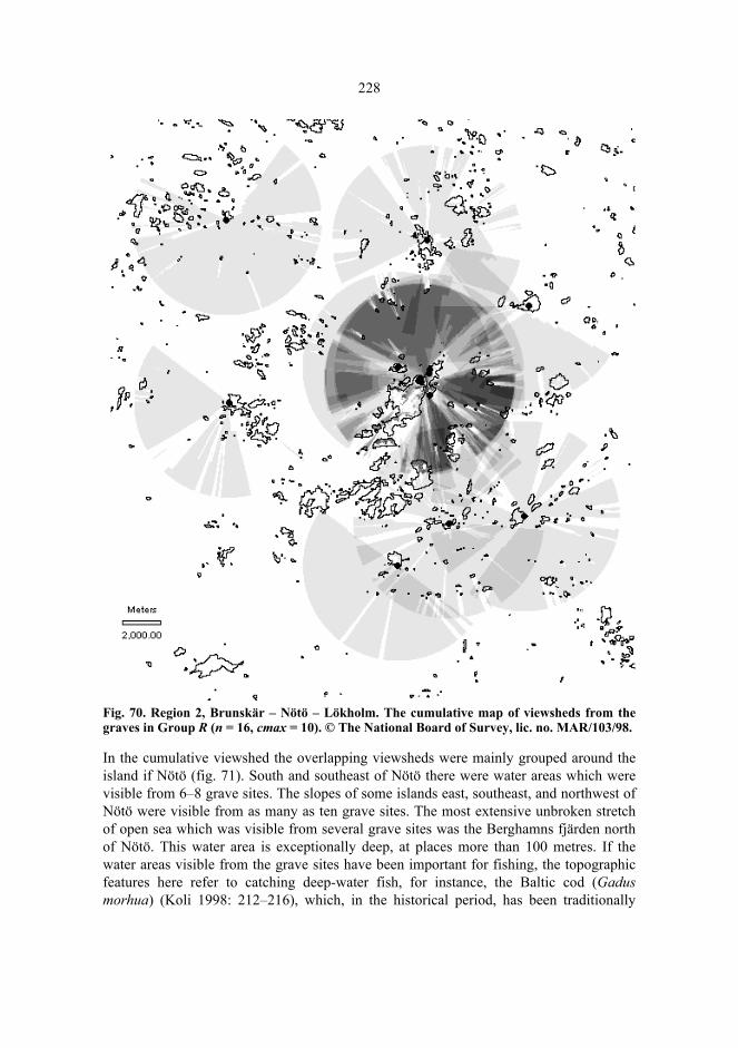
228
Fig. 70. Region 2, Brunskär – Nötö – Lökholm. The cumulative map of viewsheds from thegraves in Group R (n = 16, cmax = 10). © The National Board of Survey, lic. no. MAR/103/98.
In the cumulative viewshed the overlapping viewsheds were mainly grouped around theisland if Nötö (fig. 71). South and southeast of Nötö there were water areas which werevisible from 6–8 grave sites. The slopes of some islands east, southeast, and northwest ofNötö were visible from as many as ten grave sites. The most extensive unbroken stretchof open sea which was visible from several grave sites was the Berghamns fjärden northof Nötö. This water area is exceptionally deep, at places more than 100 metres. If thewater areas visible from the grave sites have been important for fishing, the topographicfeatures here refer to catching deep-water fish, for instance, the Baltic cod (Gadusmorhua) (Koli 1998: 212–216), which, in the historical period, has been traditionally

229
caught in the parts of the archipelago where the underground shoal abruptly slopesdownwards into a steep depression (e.g. Gardberg 1966).
The cumulative viewshed may, on the other hand, link the graves at Sundbergen alsowith an erratic boulder called Klockarstenen, in the northern part of Nötö. On the edges ofthe boulder there are 13 cup-like hewn depressions. The boulder sends forth a very loudmetallic sound when knocked with a stone, and the adjacent rocks echo the sound far outnorth precisely where the Berghamns fjärden is located. Previously I have presumed thatKlockarstenen might have been used to give out sound signals to boats lost in the fognorth of Nötö, or fishermen walking on the ice (Tuovinen 1988). It is, however, unknownwhen the stone could have been used for this purpose. The overlap and the resemblanceof the viewshed of the Iron-Age graves and the range of audibility of the sounds of theboulder, do not alone suffice to prove their simultaneousness, even if it is no doubt anindication of some weight.
The lines of sight into the adjacent landscape from the grave sites in the archipelagosurrounding Nötö were also largely unobstructed. The most southeastern grave site atRevberget, Lökholm (372) offered the most extensive viewshed. The sea was visible allaround the horizon, the open Baltic Sea could be seen in the south, and most of the islandof Lökholm was visible too. The most northwestern grave at Bussö (349) was constructedon a cape pushing out into the south, and although it was located at the height of less than10 m above the sea level at that time, the visibility towards the southern stretches of thesea and the distant island clusters of Nötö, Björkö, and Aspö was nearly unobstructed in asector of almost 300 degrees. In the north, the adjacent rocks hampered the visibility. Inthe northeast at Ådön (366) the viewshed was very much the same: sea and islands werevisible in an extensive southern sector while the viewshed was obstructed by rocks in thenortheast.
8.3.5.3 Region 3, Hertsböle –Hammarsboda – Högsåra
The Grave Sites in Group P
In the Metal Age the region bordered by the villages of Hertsböle, Genböle, Ölmos, andHögsåra (Dragsfjärd) consisted of two large land blocks and the surrounding archipelago.A structurally controlled N–W valley separated the mainland-like southwestern part ofthe island of Kimitoön from a ten-kilometre-long island, which today constitutes theregion of Ölmos – Söderlångvik. Later, this island grew together with the island ofKimitoön whereby the lake of Dragsfjärden was formed in the south, and the inlet ofNorrfjärden in the north.

230
Table 37. Region 3. Comparisons of the visible areas. Group P, n = 24, m = 19. Owing toties, no reliable values were obtained for some minima (marked with dots)
Table 38. Region 3. Comparisons of the angles and distances. Group P, n = 24, m = 19.
Minimum for reference set
Maximum for reference set
Values for burial sites
Rank of burial sites
Significance
Area of the viewshed (km²)Mean 5.63 14.35 13.84 19 0.10Maximum 18.20 65.81 38.60 10 0.50Minimum 0.15 1.04 0.46 12 0.45
Area of visible sea (km²)Mean 2.78 12.64 9.92 18 0.15Maximum 16.69 63.22 28.31 5 0.25Minimum . . . . .
Area of visible land (km²)Mean 1.68 3.31 3.92 20 0.05*Maximum 2.74 13.65 20.80 20 0.05*Minimum 0.15 0.59 0.45 15 0.30
Ratio of sea area to land areaMean 1.42 10.57 4.49 10 0.50Maximum 9.21 158.07 12.52 3 0.15Minimum . . . . .
Perimeter of the viewshed (km)Mean 69.65 109.52 114.17 20 0.05*Maximum 172.90 336.63 342.58 20 0.05*Minimum 4.30 26.60 15.65 12 0.45
Ratio of the perimeter to the areaMean 13.39 19.85 12.76 1 0.05*Maximum 26.44 43.67 34.07 14 0.35Minimum 1.44 7.19 3.91 17 0.20
Minimum for reference set
Maximum for reference set
Values for burial sites
Rank of burial sites
Significance
Smallest viewing angle (º)Mean -7.83 -5.61 -11.25 1 0.05*Maximum -3.24 -3.89 -5.03 1 0.05*Minimum -20.33 -9.00 -21.74 1 0.05*
Greatest viewing angle (º)Mean 2.80 4.48 3.63 16 0.25Maximum 6.57 14.57 7.00 4 0.20Minimum -0.15 1.24 0.20 4 0.20
Mean viewing angle (º)Mean -0.19 -0.05 -0.16 6 0.30Maximum 0.15 1.82 0.59 7 0.35Minimum -0.81 -0.40 -0.87 1 0.05
Relief index (º)Mean 8.57 11.93 14.88 20 0.05*Maximum 14.26 27.47 27.91 20 0.05*Minimum 4.15 5.90 8.49 20 0.05*
Mean length of LOS (m)Mean 2041 2673 2426 14 0.35Maximum 3102 3704 3191 2 0.10Minimum 284 1198 615 12 0.45
231
In 500 BC, the proportion of the land area of the region was 24.7 per cent, and the heightof the highest rocks was 56 m. In this region, there are 24 graves in Group P, amongothers the cairns at Hammarsboda and Långnäsudden which date back to the Bronze Age,as indicated by the artefact finds102. The ten graves which have been constructed on theshores of the Bronze-Age inlet and the islands off the shore in Hertsböle constitute themost distinct group in consideration of the viewsheds. The rest of the grave sites are to befound mainly in the structurally controlled valley of Dragsfjärden.
The land areas visible from the burial sites are significantly larger than those from thereference set (table 37). The mean value of the land area visible from the grave sites, 3.92km² is 1.2 times higher than the maximum mean in the reference set. The perimeters ofthe viewsheds are also significantly longer. The ratio of the perimeter to the area of theviewshed at the burial sites is significantly lower: the graves have been constructed atsites from which the lines of sight are, on the average, more unobstructed in all directionsthan from those in the reference set. The views from the grave sites were unobstructedeven if the graves were constructed in regions where land was visible in every direction,i.e. the viewshed resembled that in the inner archipelago. The significantly smallerminimum viewing angles, the significantly smaller minimums of mean viewing angles,and the significantly higher relief indexes for the grave sites (table 38) indicate also thatthe viewsheds from the grave sites were characterized by a sharp visual depth effect. Thesea was not of any essential significance in the choice of the burial sites in Group P,apparently it was much more important to have a large visible land area in everydirection, and that the feeling of exaltation was impressive. The burial sites were solitaryand prominent.
The cumulative map of viewsheds (fig. 72) demonstrates a considerable variation inthe viewsheds from the grave sites in Group P. Ten graves were constructed in thesoutheastern part of the region on the inlet of Hertsböle; from most of these the viewshedtowards the south, in the direction of the stretch of open sea now called the Bruksfjärden,was relatively unobstructed. Most of the rest of the graves were constructed on the rocksrising up from the seashore with views towards the sheltered inland waters and the othergraves. The graves were actully turned away from open stretches of sea.
Only the southernmost grave site at Rövik (042) offered a view towards the sea in thesouth but even there the sea opened in the far distance, in an almost horizontal viewingangle. The grave at Rövik had been constructed at the end of a rocky cape, and the mostattractive depth effect opened towards the east and the north (fig. 67). The grave site waslike a gate guard of the strait leading to the north into the structurally controlled valley ofthe Dragsfjärden and the Norrfjärden (stretches of open sea). A boat sailing northwardspassed beneath the grave rock at Rövik at a very close distance but the line of sightremained uninterrupted. Sailing further up the boat arrived on the Dragsfjärden, the largewater area separating the big island of Ölmos and the mainland of the island of Kimitoön;here the viewsheds from the grave sites overlapped each other the most after Hertsböle.
102.The graves in Group P are Rövik (042), Kosackkullan (002), Petersknallen 2 (050), the graves 106 (043),107 (044), 108 (045) (excavation report by Högman 1886, NBA), and 109 (046) at Hammarsboda, the graves100 (040) (excavation report by Högman 1886, NBA), 101 (041), and 101+ (009) at Långnäsudden,Labbnäsåsen (012), Björkboda (034), Genböle (001) (fig. 42), Malmsberget (011), Svartholmsskatan (025),and the graves 10 (031), 17 (024), 18 (023), 19 (020), 21 (028), 22 (027), 23 (026), 24 (022), and 26 (030) atHertsböle.

232
The water area of the Dragsfjärden was visible from 4–7 grave sites, and even the shoreslining this stretch of open sea could be seen from 2–7 burial sites. On the western shore,the dwelling sites at Jordbro and Knipäng which date back to the late-Neolithic culture ofKiukais, have been discovered (Meinander 1954 b: 61–66; Asplund 1997 a: 243–245).The rocky upland area rising behind the dwelling site at Ansvedja is visible from severalgrave sites on the eastern shore, but this is presumably of no significance since thedwelling site is older than the Bronze Age, it dates back to the comb-ceramic period(Cleve 1942 b; Myhrman 1990: 29).
Fig. 71. Region 3, Hertsböle – Hammarsboda – Högsåra. The cumulative map of the viewshedsfrom the graves in Group P (n = 24, cmax = 10). © The National Board of Survey, lic. no. MAR/103/98.
233
The viewshed from the most southwestern site of graves in Group P in this region, atPetersknallen (050), includes a narrow viewing sector towards the stretch of open sea inthe northwest, but the rest of the viewshed comprises only visible land area and thesheltered strait off the grave site. If the grave had been constructed just 300 metres moreto the west, the viewshed would have comprised a large sector in the west consisting ofouter archipelago, open stretches of sea, and horizon. Such a site was not, however,selected; the viewshed was turned away from the sea. The four cairns in the cemetery atHammarsboda (043, 044, 045, and 047) also turn their backs to the sea: they have beenconstructed in a valley, at the upper end of a firth-like inlet pushing from the north.
The Grave Sites in Group R
In 1000 AD, 32.9 per cent of the area of the region Hertsböle – Hammarsboda – Högsåraconsisted of land with the maximum height of 65 metres. Twenty-three graves in Group Rhave been discovered in this region103. The figure does not include all the graves discov-ered; at Jordbro and at Söderby several graves have been destroyed, and their precise sitescannot be determined any longer; for this reason they have not been incorporated in theanalysis of the viewsheds.
The Monte Carlo-tests demonstrated that the area of the viewshed from the grave siteswas significantly larger than that from the reference set (table 39). In studying separatelythe areas of visible land and that of visible sea, the difference is evident with regard to theextensive views from the grave sites towards the sea. The mean area of visible sea, 9.06km², was 1.4 times higher than the greatest mean of the samples forming the reference set.When it comes to land areas, the only statistically significant difference is seen in themaximum visible land area, which is significantly smaller from the grave sites than fromthe reference set. The burial site in question is Nämanön, Dragsfjärd (006), and the visibleland area is 6.24 km². As there are no significant differences between the viewing angles(table 40), the extensive viewsheds have not been achieved by constructing the graves onhigh places, as was the case with the graves in Group P, but by erecting them on smallislands in open landscape. Ties deriving from the inaccuracy of the digital elevationmodel are involved in the lowest values of the viewing angles.
103.The graves in Group R are Högsåra Hemlandet (019), Långfuruholm (060), Nämanön 1 (061, excavationreport by Högman 1886, pp.80–82, 131–133, NBA), Nämanön 2 (006), Söljeholmen (048), Krogarudden(059), the graves at Östergård 2: 7 (052), 8 (053), 9 (054, excavation report by Tuovinen 1990, TYA), 10(055), 11 (056), 12 (057), and 13 (058), Hamnholmssundet (051), Petersknallen 1 (049), Hammarsboda 10(335), Hammarsboda 11 (336), Västersjälsmalmen (008 and 017), Jordbro 86 (036), Söderby 93 (037,excavation report by Ella Kivikoski 1935, NBA), Hertsböle 16 (021), and Hertsböle 25 (029).
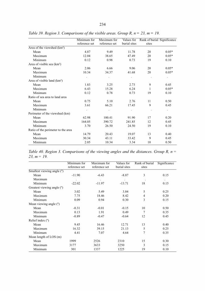
234
Table 39. Region 3. Comparisons of the visible areas. Group R, n = 23, m = 19.
Table 40. Region 3. Comparisons of the viewing angles and the distances. Group R, n =23, m = 19.
Minimum for reference set
Maximum for reference set
Values for burial sites
Rank of burial sites
Significance
Area of the viewshed (km²)Mean 4.87 9.49 11.78 20 0.05*Maximum 12.04 38.65 47.49 20 0.05*Minimum 0.12 0.98 0.73 19 0.10
Area of visible sea (km²)Mean 2.06 6.66 9.06 20 0.05*Maximum 10.34 34.37 41.68 20 0.05*Minimum . . . . .
Area of visible land (km²)Mean 1.83 3.25 2.73 9 0.45Maximum 6.43 15.28 6.24 1 0.05*Minimum 0.12 0.78 0.73 19 0.10
Ratio of sea area to land areaMean 0.75 5.10 2.76 11 0.50Maximum 3.61 66.21 17.45 9 0.45Minimum . . . . .
Perimeter of the viewshed (km)Mean 62.98 100.41 91.90 17 0.20Maximum 164.05 390.72 241.85 12 0.45Minimum 3.70 26.50 24.50 19 0.10
Ratio of the perimeter to the areaMean 14.79 20.43 19.07 13 0.40Maximum 30.34 43.11 33.42 9 0.45Minimum 2.05 10.34 3.34 10 0.50
Minimum for reference set
Maximum for reference set
Values for burial sites
Rank of burial sites
Significance
Smallest viewing angle (º)Mean -11.90 -6.43 -8.87 3 0.15Maximum . . . . .Minimum -22.02 -11.97 -13.71 18 0.15
Greatest viewing angle (º)Mean 3.02 5.49 3.84 5 0.25Maximum 7.75 18.46 8.42 4 0.20Minimum 0.09 0.94 0.30 3 0.15
Mean viewing angle (º)Mean -0.31 -0.01 -0.15 10 0.50Maximum 0.13 1.91 0.49 7 0.35Minimum -0.89 -0.47 -0.64 12 0.45
Relief index (º)Mean 9.45 16.46 12.71 13 0.40Maximum 16.32 39.15 21.13 5 0.25Minimum 4.41 7.07 4.64 7 0.35
Mean length of LOS (m)Mean 1999 2526 2310 15 0.30Maximum 3177 3633 3250 3 0.15Minimum 301 1337 1225 19 0.10

235
Fig. 72. Region 3, Hertsböle – Hammarsboda – Högsåra. The cumulative map of the viewshedsfrom the graves in Group R (n = 23, cmax = 12). © The National Board of Survey, lic.no. MAR/103/98.
The cumulative map of the viewsheds (fig. 73) gives a lucid idea of the fact that thegraves in Group R – like the graves dating back to the Bronze Age – were built on thehills rising from the shores of the island of Kimitoön, but also in the archipelago, whichwas not done in the Bronze Age. Several graves were constructed at sites with viewshedstowards the sea. Off the island of Högsåra there was a stretch of sea opening towards thewest, which was visible from as many as five grave sites, whereas the graves on the largeland block of Ölmos were surrounded by more closed landscapes, dominated by landviews.

236
The differences between the viewsheds from the graves of Group P and Group R in theregion Hertsböle – Hammarsboda – Högsåra do not derive solely from the effect of thecontinuous land uplift process in the Bronze Age and the Iron Age. The viewsheds fromthe grave sites in Group P were turned away from the sea whereas those from the gravesites in Group R were directed towards the sea. In spite of the mainland-like location theviewsheds from the grave sites in Group P were open because the graves wereconstructed at high places with a strong feeling of depth and exaltation. The openness ofthe grave sites in Group R was based on the unobstructed visibility towards the sea ratherthan on the elevated sites of the graves. A considerable variation prevails, however, in theviewshed variables in both groups; this variation is mainly due to the fact that thelandscape in the region is divided into two scenically different parts: archipelago in thesouth and the west, two mainland-like blocks (the island of Kimitoön and the present-daypeninsula of Ölmos) in the north and the east.
8.3.5.4 Region 4, Lillandet
The Grave Sites in Group P
In 500 BC the region of Lillandet, Nagu belonged to the middle archipelago, and 14.1 percent of its area consisted of land. The highest top reached 45 m in height. The relief ofLillandet and that of the archipelago of Själö north of Lillandet is very sharp but,simultanously, very fine-drawn. The tops of the rocks were relatively high and easilydiscernable even in the Bronze Age, the waters were, correspondingly, very deep.
Lillandet belongs to the regions in the archipelago of Åboland with the highest spatialdensity of burial cairns. On account of the high frequency of the graves, a relatively smalland limited area in the middle part of Lillandet with seventeen registered graves in GroupP was chosen to provide material for the discussion of the viewsheds104. The local topog-raphy is thus easily distinguishable in the distribution of the viewsheds. The seventeengraves include three large long cairns: the cairn at Öijen (232) which is the largest gravein the research region being 49 m in length, 6 m in width, and 1.4 m in height, further-more, the grave at Sandö (233, measuring 33, 6, and 1.2 m, respectively), and the grave42 at Käldinge (243, measuring 22, 5, and 0.4 m, respectively).
104.The graves in Group P are Sandö (233), Öijen (232, 215, and 216), Öbergen 51 (358), Käldinge 2 (374),Käldinge 4 (356), Käldinge 7 (377), Käldinge 42 (243), Käldinge 83:9 (211), Hangslax 83:2 (205), Hangslax11 (226), Simonby 9 (224), Simonby 46 (353), Simonby 45 (352), Simonby 47 (354), and Kiuasvuori (222).None of these has been excavated.
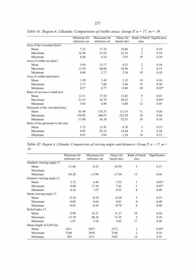
237
Table 41. Region 4, Lillandet. Comparisons of visible areas. Group P, n = 17, m = 19.
Table 42. Region 4, Lillandet. Comparisons of viewing angles and distances. Group P, n = 17, m =19.
Minimum for reference set
Maximum for reference set
Values for burial sites
Rank of burial sites
Significance
Area of the viewshed (km²)Mean 7.23 17.19 10.88 2 0.10Maximum 16.49 61.62 23.16 2 0.10Minimum 0.46 4.14 3.93 19 0.10
Area of visible sea (km²)Mean 5.64 15.17 8.53 2 0.10Maximum 13.29 60.88 20.96 3 0.15Minimum 0.00 2.77 2.58 19 0.10
Area of visible land (km²)Mean 1.59 2.45 2.35 19 0.10Maximum 2.77 7.60 5.48 15 0.30Minimum 0.27 0.77 0.80 20 0.05*
Ratio of sea area to land areaMean 12.11 17.34 13.82 9 0.45Maximum 21.67 43.76 20.33 1 0.05*Minimum 5.05 8.90 6.88 12 0.45
Perimeter of the viewshed (km)Mean 85.49 135.37 111.53 11 0.50Maximum 158.95 340.87 232.20 10 0.50Minimum 13.80 56.10 52.55 19 0.10
Ratio of the perimeter to the areaMean 3.75 12.41 4.70 3 0.15Maximum 8.95 83.22 14.44 4 0.20Minimum 0.01 2.64 1.24 18 0.15
Minimum for reference set
Maximum for reference set
Values for burial sites
Rank of burial sites
Significance
Smallest viewing angle (º)Mean -11.68 -8.32 -10.30 3 0.15Maximum . . . . .Minimum -30.28 -13.98 -17.58 13 0.40
Greatest viewing angle (º)Mean 3.72 6.44 3.52 1 0.05*Maximum 8.00 17.54 7.41 1 0.05*Minimum 0.14 1.97 0.55 8 0.40
Mean viewing angle (º)Mean -0.34 -0.18 -0.28 5 0.25Maximum -0.09 0.64 0.01 8 0.40Minimum -0.82 -0.43 -0.70 8 0.40
Relief index (º)Mean 8.99 14.31 11.37 10 0.50Maximum 12.79 40.10 15.35 2 0.10Minimum 1.87 5.28 4.82 17 0.20
Mean length of LOS (m)Mean 2411 2857 2372 1 0.05*Maximum 3104 3650 3166 2 0.10Minimum 582 2311 1562 14 0.35

238
Fig. 73. Region 4, Lillandet. The cumulative map of the viewsheds from the grave sites in GroupP (n = 17, cmax = 16). © The National Board of Survey, lic. no. MAR/103/98.
The Monte Carlo tests indicate a tendency to select the grave sites to allow only narrowviewsheds towards the sea while those towards the land are, as a rule, fairly extensive(table 41). In terms of the mean areas, the difference between the grave sites and randomsites is indicative, the level of significance being α = 0.10. On the level of significance α= 0.05, two significant differences are found: the smallest visible land area from the gravesites 0.80 km² is larger than that from any of the random sites, and the maximum ratiobetween the sea and the land area within the viewshed from the grave sites 20.33 is lowerthan that from any of the reference set. The greatest viewing angles from the grave sitesare significantly smaller than those from the reference set (table 42); this differenceindicates an evasive attitude towards constructing graves in low-lying dells. On the otherhand, the differences between the grave sites and the reference set do not suggest anysystematic tendency to choose high tops of rocks as grave sites. The average length of the

239
line of sight for the grave sites is significantly shorter than that for the reference set. Interms of linear units the difference is, however, only 40 m.
The image of the grave sites with relatively narrow viewsheds towards the seabecomes more accurate when examining the cumulative viewsheds (fig. 74). The graveswere, almost without an exception, constructed close to the shore. The grave sites in thevillages of Hangslax, Simonby, and partly Käldinge line a narrow strait which dividedLillandet into two parts, and formed a sheltered inland water between the islands (205,211, 224, 226, 243, 352, 353, 354, 222). Due to the land uplift this narrow strait hassubsequently contracted into a sea inlet called Sundvik. The viewsheds opened towardsthe strait, the opposite shores, and the highest rock tops of Lillandet. The water of thestrait was visible from 7–12 grave sites, and the northern shore of the strait from 3–16grave sites.
The viewsheds from the grave sites at Käldinge (356, 374, 377) were slightlynarrower. They comprised particularly the sandy valley which connects the inlet ofSundvik and the lake of Storträsket. This valley turned to dry land at the end of theBronze Age; if the graves in Group P at Käldinge date from the middle or the beginningof the Bronze Age, the valley towards which their viewsheds opened was covered byshallow sea water and formed an extension of the strait of Sundvik. The easternmostgraves, on the other hand, were constructed at places with principal viewsheds towardsthe south, the east, and the northeast.
The Grave Sites in Group R
In the year 1000 AD the region of Lillandet belonged to the middle archipelago where27.2 per cent of the area was land. The highest rock top in the northern part of Lillandetreached the height of 55 m. There are 15 graves in Group R in this region105. Theyinclude, for instance, the long cairn Hangslax 13 (228, measuring 15 m in length, 5 m inwidth, and 0.7 m in height), the long cairn Hangslax 14 (229, measuring 10m in length,and 4 m in width), the long cairn Käldinge 9 (378, measuring 17, 6, and 0.5 m, respec-tively), and the long cairn Käldinge 10 (379, measuring 12, 3, and 0.3 m, respectively).The graves in Groups P and R stand close to each other in the terrain.
The graves were located around the inlet of Sundvik but further off from the shore thanthe graves in Group P and the shoreline zone in 500 BC. The analysis of the viewshedsand the viewing angles (tables 43 and 44) indicates that the area of visible land within theviewshed from the grave sites was significantly larger than that from the reference set.The mean area of visible land from the grave sites was 1.5 times higher than themaximum mean for the reference set. The mean perimeter of the viewsheds from thegrave sites is significantly greater than that for the reference set. The ratio of theperimeter to the area of the viewshed, on the other hand, is significantly smaller than thatfor the reference set: the mean value is approximately 50 per cent of the minimum meanfor the reference set. The landscapes surrounding the grave sites were thus open. Thegreatest viewing angles and the mean viewing angles from the grave sites weresignificantly smaller than those for the reference set – the grave sites were at elevated
105.The graves in Group R are Käldinge 83:8 (210), Prostvik 1 (219), Prostvik 2 (220), Prostvik 4 (221),Prostvik 8 (223), Hangslax 10 (225), Hangslax 12 (227), Hangslax 13 (228), Hangslax 14 (229), Hangslax 48(355), Öbergen 50 (357), Käldinge 1 (373), Käldinge 3 (375), Käldinge 9(378), and Käldinge 10 (379).
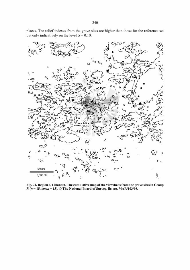
240
places. The relief indexes from the grave sites are higher than those for the reference setbut only indicatively on the level α = 0.10.
Fig. 74. Region 4, Lillandet. The cumulative map of the viewsheds from the grave sites in GroupR (n = 15, cmax = 13). © The National Board of Survey, lic. no. MAR/103/98.

241
Table 43. Region 4, Lillandet. Comparisons of visible areas. Group R, n = 15, m = 19.
Table 44. Region 4, Lillandet. Comparisons of viewing angles and distances. Group R, n =15, m = 19.
Minimum for reference set
Maximum for reference set
Values for burial sites
Rank of burial sites
Significance
Area of the viewshed (km²)Mean 4.81 10.13 7.28 10 0.50Maximum 11.87 59.04 18.82 7 0.35Minimum 0.46 1.84 0.93 14 0.35
Area of visible sea (km²)Mean 3.05 7.90 3.54 3 0.15Maximum 8.06 57.37 10.68 3 0.15Minimum . . . . .
Area of visible land (km²)Mean 1.50 2.54 3.74 20 0.05*Maximum 2.21 9.93 8.98 19 0.10Minimum 0.32 0.77 0.93 20 0.05*
Ratio of sea area to land areaMean 10.94 18.06 11.48 2 0.10Maximum 18.55 52.76 22.14 4 0.20Minimum 4.20 8.77 6.10 9 0.45
Perimeter of the viewshed (km)Mean 66.54 100.91 115.66 20 0.05*Maximum 113.25 343.63 264.04 19 0.10Minimum 10.15 28.55 22.25 14 0.35
Ratio of the perimeter to the areaMean 1.80 5.78 0.90 1 0.05*Maximum 6.63 34.25 4.20 1 0.05*Minimum . . . . .
Minimum for reference set
Maximum for reference set
Values for burial sites
Rank of burial sites
Significance
Smallest viewing angle (º)Mean -11.17 -6.69 -8.59 12 0.45Maximum . . . . .Minimum -31.30 -11.53 -19.39 8 0.40
Greatest viewing angle (º)Mean 3.96 7.00 2.89 1 0.05*Maximum 8.21 25.81 7.29 1 0.05*Minimum 0.15 2.71 0.39 2 0.10
Mean viewing angle (º)Mean -0.31 -0.10 -0.50 1 0.05*Maximum 0.03 0.94 -0.06 1 0.05*Minimum -1.16 -0.49 -0.92 2 0.10
Relief index (º)Mean 13.41 18.61 18.35 19 0.10Maximum 24.21 37.40 24.69 2 0.10Minimum 3.47 8.82 9.64 20 0.05*
Mean length of LOS (m)Mean 2022 2591 2067 2 0.10Maximum 2999 3409 3084 3 0.15Minimum 518 1710 928 15 0.30
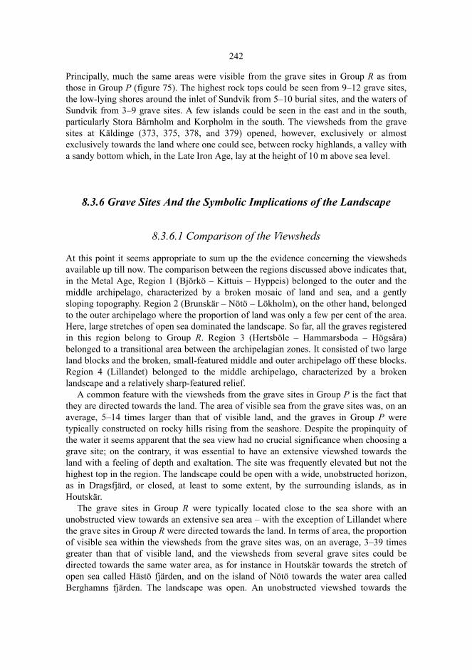
242
Principally, much the same areas were visible from the grave sites in Group R as fromthose in Group P (figure 75). The highest rock tops could be seen from 9–12 grave sites,the low-lying shores around the inlet of Sundvik from 5–10 burial sites, and the waters ofSundvik from 3–9 grave sites. A few islands could be seen in the east and in the south,particularly Stora Bårnholm and Korpholm in the south. The viewsheds from the gravesites at Käldinge (373, 375, 378, and 379) opened, however, exclusively or almostexclusively towards the land where one could see, between rocky highlands, a valley witha sandy bottom which, in the Late Iron Age, lay at the height of 10 m above sea level.
8.3.6 Grave Sites And the Symbolic Implications of the Landscape
8.3.6.1 Comparison of the Viewsheds
At this point it seems appropriate to sum up the the evidence concerning the viewshedsavailable up till now. The comparison between the regions discussed above indicates that,in the Metal Age, Region 1 (Björkö – Kittuis – Hyppeis) belonged to the outer and themiddle archipelago, characterized by a broken mosaic of land and sea, and a gentlysloping topography. Region 2 (Brunskär – Nötö – Lökholm), on the other hand, belongedto the outer archipelago where the proportion of land was only a few per cent of the area.Here, large stretches of open sea dominated the landscape. So far, all the graves registeredin this region belong to Group R. Region 3 (Hertsböle – Hammarsboda – Högsåra)belonged to a transitional area between the archipelagian zones. It consisted of two largeland blocks and the broken, small-featured middle and outer archipelago off these blocks.Region 4 (Lillandet) belonged to the middle archipelago, characterized by a brokenlandscape and a relatively sharp-featured relief.
A common feature with the viewsheds from the grave sites in Group P is the fact thatthey are directed towards the land. The area of visible sea from the grave sites was, on anaverage, 5–14 times larger than that of visible land, and the graves in Group P weretypically constructed on rocky hills rising from the seashore. Despite the propinquity ofthe water it seems apparent that the sea view had no crucial significance when choosing agrave site; on the contrary, it was essential to have an extensive viewshed towards theland with a feeling of depth and exaltation. The site was frequently elevated but not thehighest top in the region. The landscape could be open with a wide, unobstructed horizon,as in Dragsfjärd, or closed, at least to some extent, by the surrounding islands, as inHoutskär.
The grave sites in Group R were typically located close to the sea shore with anunobstructed view towards an extensive sea area – with the exception of Lillandet wherethe grave sites in Group R were directed towards the land. In terms of area, the proportionof visible sea within the viewsheds from the grave sites was, on an average, 3–39 timesgreater than that of visible land, and the viewsheds from several grave sites could bedirected towards the same water area, as for instance in Houtskär towards the stretch ofopen sea called Hästö fjärden, and on the island of Nötö towards the water area calledBerghamns fjärden. The landscape was open. An unobstructed viewshed towards the
243
horizon was of certain significance in choosing the grave site, and this was frequentlyachieved by constructing graves on minor islands where the terrain does not interrupt theline of sight towards the sea and the horizon in the same way as on large islands. Graveswere frequently constructed at elevated sites where the difference in height and the deptheffect were perceptible, but not on the highest tops in the region.
The most conspicuous difference between the grave sites in Group P and those inGroup R seems to be linked with the composition of the landscape: the grave sites inGroup P were directed towards the land whereas those in Group R were directed towardsthe sea. When it comes to the configuration of the landscape, the most essential differencebetween the two groups can be demonstrated in the openness of the landscape: in threeregions out of the four, the viewshed from the grave sites in Group R was open, whereasin Group P the viewshed from the grave sites was open in one region out of three. Theopenness of the landscapes within the viewsheds from the grave sites in Group R doesnot, however, appear to be as easily generalized as the difference between the two groupsin the extents of the visible land and sea areas. Besides, the openness of the landscape isconnected with the topography of the region: the viewshed towards the land may varybetween closed and open whereas the sea landscape is by nature open.
Irrespective of the differences between the two groups, the choice of the grave sites inthe terrain is characterized by continuity. The features which are common with the twogroups, are the choice of elevated sites, the perspective, and the effect of depth andheight. In terms of area, the viewsheds are extensive with local variations. The continuityand the variation of the viewsheds of the grave sites are compatible with themorphological continuity and variation of the graves. The burial ritual varied in time andspace, but, basically, its nature was conservative.
8.3.6.2 Burial Sites in the Taskscape
In the following, the author’s interpretation of the nature of the cairns in Åboland asmonuments will be presented. When the interpretation of the differences between thecompositions of the viewsheds from the grave sites in Group P and Group R is beingpursued, one tends, primarily, to consider the land and the sea as symbolic representationsof subsistence strategies. Is it possible that those who constructed a grave at a sitedirected towards the land, thought of the surrounding landscape as cultivated land,meadows, and pastures? Viewsheds from grave sites opening towards the open sea andcertain water areas between the islands might suggest that these graves were the lastresting places of fishermen or seal hunters. The archipelago landscapes were thus scenesof labour in a material form, or taskscapes (Ingold 1993). The graves may haverepresented the insight of bygone generations into arable land and its cultivation, intofishing waters and their exploitation, and into the best procedures on ice to be observedwhen hunting seals. This knowledge sheltered people against the risks of subsistence suchas crop failures or misfortunes on the spring ice during the seal- hunting season. Theburial sites were chosen to form one part of what Orvar Löfgren (1981) calls a productionlandscape, an open book containing the acquired knowledge and skills which helped ininterpreting, categorizing, and exploiting the available natural resources.

244
We need not, however, submit to the notion that the spatial reference of the grave sitesshould have referred to the landscape solely through their actual socioeconomicimplications because the mortuary ritual frequently presents an idealized version of socialrelationships. Idealization legitimizes the prevailing reality, and makes it a part of theorder which can be retraced back to the idealistic past, or presents an image of a desiredor aspired social order (Pader 1982: 36–44; Härke 1993). According to my understanding,the viewsheds from the grave sites in Group P represent idealized landscapes, theyexpress a request to gods of desired success rather than a reference to the factual yield ofcattle and land. Early farmers had long-term expectations concerning the yield of cattleand land. These expectations were expressed in the building of durable monuments. Asstated by Holtorf, agriculture and cattle raising brought results only after continuous andprotracted labour, and therefore the farmers were compelled to outline their subsistencestrategies for years ahead (Holtorf 1997). The Bronze-Age grave sites in the archipelagoof Åboland may be interpreted as sites of symbolic charges, linked with the insight ofancestors creating security in coping with life.
Then, how to understand the fact that the grave sites in Group R were directed towardsthe sea? According to Marek Zvelebil the Bronze Age in the eastern part of the Balticregion was characterized by a subsistence strategy emphasizing minimal risks and lowproductivity. As long as tools of iron were non-existent the yield of an agriculturalhousehold was, under the circumstances, very insecure: it was life close to the extremelimits of subsistence. The circumstances varied drastically according to the seasons of theyear but there was more to it: the risk of a total crop failure occurred once a generation oronce a century due to extremely cold years. The introduction of iron was the mostsignificant technical and economic feature of development in the Iron Age; thisdevelopment was of particular importance since it decreased the risks involved inagriculture by increasing the yield of cultivation (Zvelebil 1985; Zvelebil 1981: 26–27).Consequently, a change in the composition of the landscapes of the grave sites does notnecessarily imply increased importance of fishing or decreased significance of agriculturebut a change of life following from reduced risks within agriculture. The expectations andimplications linked with the mortuary ritual gained more and more foothold and involvedeventually fish, even seals. Although we do not yet possess any osteological evidence offishing or seal hunting in the archipelago of Åboland in the Iron Age (cf. Gustavsson1986; Gustavsson 1987; Núñez et al. 1997), these activities must have been fairlyimportant sources of livelihood. In Houtskär, for instance, fishing was the main source oflivelihood up to the Middle Ages (Kuvaja 1997).
The subsistence strategies provide a possible solution to the problem why graves werenot, as a rule, constructed at the highest sites in the region: their viewsheds were notapparently what was expected of a burial site. The highest tops were generally rockslocated far from the sea and low-lying arable land. On the other hand, several eventsfollowing the prehistoric erection of the graves have focused on the highest tops whichprovide the most extensive viewsheds of the surrounding area. Military beacon fires in theMiddle Ages (Sw. böte), and subsequently in the historical period (Sw. kas and vård) wereput up on the very highest tops (Orrman 1991 a: 213–219; Sjöstrand 1992). Triangulationstations were constructed from the end of the 19th century on the highest tops. Thesemanoeuvres have contributed to the devastation of cairns at the most elevated sites.
245
8.3.6.3 The Symbolic Landscape of the Burial Sites
The grave builders were obviously inclined to bury their deceased in the vicinity ofexisting graves; the morphology and locations of earlier graves influenced theconstruction and positioning of new graves. This principle is exemplified by thecemeteries of Furunabb in Houtskär, and Hammarsboda in Dragsfjärd, as well as by thecairns on the islands of Nötö, Mjoö, and Granholm in Nagu, and the cairns in the forestsof the villages of Hertsböle in Dragsfärd, and Söderby in Iniö. Cairns which have beenconstructed close to each other tend to be alike morphologically. This does not, however,imply that there were no changes in the burial tradition during the period in course ofwhich deceased members of the community were buried in the cairns which belonged toa cemetery or were, in any case, visible from each other. Gradual transformations doseem to have occurred, but adherence to the tradition was, nevertheless, the predominanttrait. According to my understanding, morphological and spatial continuity reflects aconsciousness of ancestors, a sense of ancestral existence in the sphere of specific sitesand spaces in the landscape. Bygone generations were in conjunction with present as wellas with future generations.
On the other hand, when ancestors were recalled during the mortuary ritual, anoccasion may have emerged at which the competition of predominant interpretations ofthe social order escalated, and the ancestral prestige was challenged. According toMizoguchi, the mortuary rituals might have included a basis of continuity as well astensions striving to change the internalized control maintaining the prevalent social order.Mortuary rituals were thus an occasion of both continuity and change. The members ofthe community felt that they observed faithfully the traditions of mortuary practicesalthough transformations were in reality taking place (Mizoguchi 1996: 231–233). Thedifference between the natures of Bronze-Age and Iron-Age cairns in the archipelago ofÅboland can thus be understood as a result of the accumulation of ’unintended’transformation processes during the cycles of generations.
The landscapes around the grave sites were open, and the sea was almost without anexception visible within the viewsheds, which frequently were associated with an effectof depth and exaltation. Elevated burial sites which were frequently discernable from thesea, were easily recognizable even from a distance, and could be found in the terrain withfacility; occasionally the grave sites were milieu dominants but had rarely been erected onthe highest tops in the region. Elevated sites could be easily interpreted as places to beascended, and to be visited in ceremony, observing specific traditions, in order to beholdthe grave and its surroundings. Grave sites were intended to be visited and revisited, overand over again, from generation to generation. From the grave sites the living members ofthe community watched the land and the sea; accomplishments, skills and knowledge,social relationships, and agreements were reviewed, effected, and negotiated at theseplaces. There the children adopted their parents’ knowledge of the significances of thelandscale and the different places, essential beliefs, and ethical commitments – but, aboveall, they were places which actualized the presence of the ’sacred’. At the grave sites onecould encounter the consciousness of the presence of one’s ancestors and superhumanpowers.
Elevated places are in religious symbols frequently associated with the fundamentalspatial dimension, the so-called forwards-upwards -motive. The path from the profane
246
world towards sacred sites runs longitudinally, and on the way, in passing graduallyhigher and higher up, the participants of the procession encounter symbolic expressionsand arrive, eventually, at a sacred site or space which is higher up than the profane worldwith its life, closer to heaven. This motive is well-known from ancient Egypt, and theChristian, Gnostic, and Islamic traditions (Holm 1997: 87–88). Even though the gravesites were not sacred places of worship in the same sense as churches or mosques106, vis-iting a cemetery gave, according to my interpretation, a somewhat similar experience of asymbolic space. The burial site on the rock was approached either by boat or by land, theslope was ascended, and a sequence of familiar places were passed. The whole sequenceof experiences was then transformed into a narrative expressed and shared orally (cf.Tilley 1994: 27–33).
The explanation to the larger mean size of the graves in Group P in reference to thosein Group R may be derived from the renewed visits to the grave site. A proposal might bethat during the longitudinal procession new stones were collected to be taken into thecairn. In this way more and more of the very material, which originally made the placeinto something specific (Kaliff 1997: 106) – or at least marked out a specific, differentplace –, was added to the structure of the grave. Revisiting the grave site may haveinvolved a secondary interment in the old grave construction (Salo 1981 b: 144–148) orsome other rebuilding and ritual reactivation of the cairn (cf. Bolin 1999: 55–68).Simultaneously, the cairn gradually accumulated and grew larger and larger. The older thegrave, the longer it has been able to grow in size.
Elements, objects, and phenomena in nature do not contain merely references tonatural resources and sources of subsistence; they also constitute a basis for culturalsymbols and categorizations of the world. We may imagine that in the archipelago, naturetalked to human beings in phenomena and transformations, such as rough seas,thunderstorms, the freezing over of the waters, or the movement of the celestial bodies.The sea separated the islands and skerries from each other, and created a mosaic of landand water where an abundance of identifiable landmarks made up a cognitive map ofplaces. On the other hand, within the viewsheds from the burial sites which were typicallymore or less elevated, the sea created also a continuum towards the horizon, a sense ofbeing at the starting point of a nearly infinite distance to the horizon, which – as asuggestion – may have constituted a liminal zone between this world and the other world.Another important natural element was the earth, its fertile soil, its stones, and itsbedrock. The grave was a continuation of the bedrock, a focusing point where thedeceased came close to the rocks and the sea – and here the fertile and productive powerof the earth and the sea flowed into the granitic stones and the deceased.
106.The close relationship between graves and altar places has, however, been emphasized by Anders Kaliff, seeKaliff 1997.
247
8.3.7 Discussion
8.3.7.1 Graves, Communities, and Territoriality
In chapter 3 we have discussed several theories concerning cairns which have beenpublished in recent decades. In the beginning the investigators were interested in theorigin of the Bronze-Age grave builders, in later days this interest has expanded to focus,among other things, on the connection between the monumentality, location, and numberof the cairns on one hand, and power, control over the earth and natural resources, andterritoriality, on the other.
According to Unto Salo, there was a two-way visibility at the grave sites located onhigh rock tops. On one hand, the viewshed opening from the grave site represented theunity of nature, a scale in time and space outdoing the human being. On the other hand,the stony grave preserved the memory of the deceased, ”and this was sustained best if thecairn was in sight, at a visible site, discernible from the sea, in particular ” (Salo 1981 b:125). The cairns constructed on panorama sites should be interpreted as monuments of thefamily heralding the position or status of the family. The use of power was necessary tosafeguard the fields, the cattle, and the natural resources belonging to the family againstrivals (Salo 1981 b: 122–130). Monuments were an expression directed both to themembers of the community and to the outsiders indicating that the land had been takeninto possession, that there was a permanent symbolic link between the spatial entities andthe values, norms, and proprietary relationships guiding social practices (Anttonen 1996:108). According to this interpretation, the graves were directed against exterior rivals, butconsolidated, at the same time, the internal social practices of the community.
Woodcutting, building, and cultivated fields were in themselves conspicuous signs ofpropriety and the legitimation of propriety, produced by such activities. But the perimeterof the territory was indicated by constructing graves, and the viewsheds opening fromthese restricted the territory in the propriety of the family. Trespassers and neighbourswere not to enter this territory without permission. The landscape of the graveconstructors was an inhabited region where each family and each house attempted tosafeguard themselves an adequate share of the limited natural resources (Salo 1981 b:130). When investigating the cairns in Södermanland, Sweden, Sonja Wigren came to theconclusion that the cairns could not possibly have marked the boundaries of the proprietybut they must have been located to cover the whole territory if they, in the first place,were any signs of the propriety of the territory (Wigren 1987: 109–120, 144; see alsoRamqvist 1982). The opinions of Salo and Wigren are, in this respect, different fromthose published in the classical general review of the prehistoric settlement ofÅngermanland, Sweden by Evert Baudou which presents the interpretation that the graveswere constructed to mark the boundaries of the territory (Baudou 1968).
According to Salo’s thoughts the appreciated burial under a huge mass of stones wasgranted to worthy members of the peasant community who had a close historical link withthe clearing of the terrain and the taming of nature into a culture. He sees even theScandinavian immigrants in an agrarian and fairly egalitarian light: they were seal huntersand farmers who brought the tradition of cairns and the use of metals with them to theireastern neighbours. Christian Carpelan, again, describes the Scandinavian immigrants as
248
an upper class who settled among the population representing the culture of Kiukais,inhabiting their homesteads and living at their cost. The population belonging to theculture of Kiukais adopted the new burial tradition only after the newcomers had settleddown permanently (Carpelan 1982). Tapio Seger suggested a third version of thecommunities on the Finnish coasts in the Bronze Age; he saw these communities asstrictly ranked and hierarchic economic units led by professional chiefs, who organizedworking teams to build grave constructions. These communities were well-organized andhad noticeable regional centres on the Finnish coast and on Åland (Seger 1982 a). TorstenEdgren goes along the same line of thought as Unto Salo when emphasizing the role ofthe kinship in the Bronze Age coastal society. However, on the other hand he considersbronze artefacts as signs of aristocratic landowner families, the internal cohesion andcontinued existence of which were maintained by chiefs and through ritual forms of culticperformances (Edgren 1999 b: 2–3).
8.3.7.2 Problems of Territorial Interpretations
The conception which accentuates territoriality and land propriety includes the idea that acairn, due to its appearance, size, and position, was apt to inform everybody where theline between permitted and prohibited land or activity was running and who held thepower in the region. The problem here is the apparent overestimation of the visibility ofthe graves. In the prehistoric period, as well as today, the cairns in the archipelago wereprobably better discernible than on the mainland on account of the fact that one could seethem also from the sea. Even in the archipelago the cairns were, however, very rarely, ifever, discernible from the sea without modern optic aids. The cairns were simply toosmall details in the landscape to be distinguished if the distance was even a little longer.In other words, the cairns could not possibly have meant anything to people who camefrom somewhere further away, and did not know the landscape before. The grave siteswhich had the nature of being milieu dominants were better visible than the graves but anoutsider could never know that there was a grave linked with the milieu dominantbecause the stone setting of the grave could not be seen until one had come very near thegrave site. As the graves were constructed on dry land, frequently at elevated sites and atsome distance from the shore, they belonged, in the view of outsiders, to the periphery,they were not within the viewshed: the archipelago could be reached by outsiders only byboat or across the ice. An outsider sees the landscape primarily from the sea whereas themembers of the community may approach it from the sea or from the inland.
Consequently, graves or grave sites cannot possibly have been signs of proprietydirected at an outsider. If the graves were signs of land propriety, they must have beendirected at somebody else, in some other sense. It is possible that they reminded the morepenurious members in the community, who did not themselves possess any land property,of the status of land proprietorship, they may have indicated to one’s neighbours who alsopossessed land what resources the land proprietor had at his disposal, or they may haveconsolidated the identity of the family as a group to confirm that they were entitled toexploiting natural resources or that they had claims concerning these. If the graves weresigns of land propriety, they represented the internal spatial categorizations within the
249
community, the sustaining values and rules concerning the control over the land;cognitive, normative, and valuational principles were written down in them. ”Knowledgeof the landscape became bound into them” (Tilley 1996: 175). The graves legitimated theprevailing established order by indicating the symbolic link between the spatial and thesocial categories: the proprietorship was achieved and guaranteed by labour whichoriginally was done on something non-possessed, as put by Salo (Salo 1997: 87–93).According to this conception the graves can be interpreted as part of a process where thecommunity was constructing its own identity with reference to the outside world: othercommunities, alien people encountered in goods exchange, otherness.
If we abandon the idea that the graves were directed at outsiders in the concurrence fornatural resources, it will not be necessary to assume that the grave monument should bevisible from a far distance to be able to give significance to the site. One should ratherargue that the visibility of the grave site maintained the memory of the deceased who hadbeen buried there. The summit of a rock, a cape, the mouth of a strait, or any other milieudominant could be seen from a distance of several kilometres; it reminded the spectator ofthe existence of the grave site and of what had been told about it – provided he knew thecoding of the landscape.
In the archipelago of Åboland the relative visibility of the grave sites does not actuallyadvocate the notion that the cairns should have served as landmarks of a territorybelonging to a family, an extended family, a tribe or some other local community. Thisnotion was presented by Baudou concerning the cairns on the eastern coast of Sweden,and argued his opinion by the fact that the occurrence of the graves on the coast is notevenly distributed; in fact, they are grouped in dense clusters separated by areas where thegraves are more sparse. Such clusters could be interpreted as centres of settlement units(Baudou 1968: 124–152). Lars Forsberg has remarked, and with good reason, that if thegraves were landmarks of territorial boundaries, they should be located peripherically atthe territorial boundaries, not centrally within the territories (Forsberg 1999: 254; cf.Wigren 1987: 109–120, 144).
A far-reaching concept of the peripheric location of the graves has been proposed byHenrik Asplund. According to his notion cairns were constructed outside the sedentarilysettled areas in the Bronze Age and the Pre-Roman Iron Age. In South-West Finland thedeceased of the valleys of the river Aura and the river Paimionjoki were transported to thearchipelago to be buried in the wilds for which reason the number of graves in the rivervalleys remained fairly small. The graves in the wilds were associated with thecompetition with those who were from outside the community: the graves were necessarylandmarks of proprietorship where there were no other means to control strangers and toprevent them from appropriating illegal economic advantages (Asplund 1997 b: 42–43).Indeed, the number of the graves in the river valleys mentioned above was previouslyregarded as utterly small; Tallgren enumerated several regions with sparse finds in 1931(Tallgren 1931 a: 91107). In the light of the available material today (Salo et al. 1992)
107.Few, if any, Bronze-Age cairns were known on the coastal zone between Laitila and Turku until the 1950s.According to Meinander (1954 a: 114) this may, at least partly, be due to the fact that no efforts were madeafter the 19th century to discover cairns. Nevertheless the absence of finds in this region was real in hisopinion. The situation has changed after the surveys conducted in the area, although the coastal zone fromMynämäki to Salo is still rather poor in finds (Salo et al. 1992; Vuorinen 2000 c).
250
concerning the distribution of cairns in the scope of the whole of Finland Proper (SW Fin-land), the river valleys do not appear as extensive vacuums in comparison with the rest ofthe mainland coast in this respect. Similar areas with sparse graves can be found also else-where, for instance in Perniö, which, generally speaking, is regarded as rich in graves.The sparse occurrence of graves in the river valleys is thus a question of scale and scope:if the region to be examined is limited to be sufficiently small, the frequency of the gravesremains often small, too. On the other hand, it is well known that, in the valley of theriver Aura, archaeological remains have been ravaged by the urban building activity inTurku (Kivikoski 1971; Salo 1982: 76–77). According to old records, the cairns or ”Lappgraves” (Sw. lappgrav) in the region of Turku in particular, have been ransacked with thepurpose of discovering hidden treasures (Holmberg 1858). The hypothesis of gravesbeing located in the wilds implies also that dwellings and cemeteries were not located inthe same areas. All information of the relative locations of cairns and dwellings has, how-ever, remained fairly deficient so far. It is easy to state that no cairns have been discov-ered in the surroundings of certain dwelling sites on the mainland coast but there are sev-eral examples of dwelling sites which are close to or even surrounded by cairns (e.g. Salo1981a: 15, 19; Salo 1981b: 42–96; Lähdesmäki 1987; Strandberg 1996; Strandberg 1998;Asplund 1997 a: 255–259). Thus, on the basis of all available material, the notion ofgraves being constructed as a rule in the wilderness is not plausible.
The hypothesis of cairns serving as beacons, marking out waterways in the archipelago(Krantz 1940; Jansson 1985; Wigren 1987: 121–125; Broadbent 1983) has not beensupported in Finland as much as in Sweden108. The morphology and the topography ofthe graves in the archipelago of Åboland do not favour this hypothesis, either. The cairnswere so small details in the landscape that they were discernible from the sea only inexceptional cases or circumstances, and could thus not serve as beacons: there are severalother fixed – and better visible in bad weather – marks in the archipelago than the cairns.A beacon in the present sense of the word denotes an aid in navigating a vessel. One ofthese aids is a heap of stones (Sw. kummel) erected on a shore cliff, which facilitates therecognition of a cape, island, strait, skerry, or some other natural place in the archipelagowhere sailing is often complicated and hampered by impediments. These stone heaps areof great help to the shipper or the pilot, who is able to compare his visual observationswith the sea chart or sailing instructions where the location of the stone heap has beenindicated. In the modern sense, marking out waterways in the archipelago of Åboland didnot begin, however, until the reign of Gustavus Vasa when the fairway Utö – Turku wasmarked out; marine surveying in detail was started in the 18th century (Öhman 1993;Öhman 1996; Ehrensvärd & Zilliacus 1997). In the prehistoric period a grave site may, ofcourse, have been a milieu dominant which could be recognized from afar, and be of greathelp in determining the position at sea provided that there was somebody on board withlocal knowledge – but that is an entirely different matter.
The theories concerning territoriality in Finland reflect the Nordic trend of the last fewdecades which regards Bronze-Age communities as chief-dominated and as based on the
108.Judging from the clerical reports included in the extensive inquiry concerning the ancient monuments in1666–1693, delivered to the Crown by priests in Sweden-Finland, the stone cairns seem to have beeninterpreted by peasants as ancient landmarks for seafarers, at least in Ostrobothnia. See Edgren 1995 c: 56–57.

251
relationship between centres and peripheries. Archaeological evidence has been soughtfor in petroglyphs, the morphology of the graves, their number and distribution, and thecentral areas of agricultural and metal production. In this, southern Scandinavia has beenused as a model. The aim of several approaches has been to separate the centres from theperiphery on the local, the regional, or the interregional level (Widholm 1998: 10–21;Broadbent 1983: 11–14). The concept of centres is closely related to the interpretation ofcairns as part of territorial private proprietorship. The interpretations whose central idea isto establish the territory in the landscape opening from the grave site seem, on the basis ofthe discussion above, to be best in accordance with the empiric observations. In a way, thegraves were inclined to cover the territory rather than limit it, their significance in thecommunity opened inwards rather than outwards. Economic, political, and ritualisticcentres might thus be found at places where there are several graves and dwelling sitestogether.
The location of the graves cannot, however, be determined by the relative positions ofthe centre and the periphery only. In the archipelago the graves have been constructedsufficiently high up in the terrain at sites which have not been subsequently taken up bycultivation or any other human activity. The location of the grave is thus determined bythe size of the islands, their relative positions, and on each island individually, by thepattern of moraine or rock terrain in reference to that of low-lying soil sediments. On themainland coast, the sea does not, apart from the shoreline, divide the natural landscapeinto separate sections in the same way as in the archipelago but the river valleys and thebogs, for instance, form their specific patterns which affect the location of the cairns, andeven where these have been able to endure. When searching for territories, central places,and peripheries on various levels one should thus be able to distinguish the characteristicwavelength of the topography of the landscape from a possible local structure connectedwith the territoriality, and much more should be known about the relative locations of thegraves and the dwelling sites than today.
Territories, central places, and expressions of power have connections with thestructure of Western communities, perhaps even with male-dominated research traditions.Therefore it is not surprising that our culture displays analogies to the significances whichorganized community, competition, power, their legitimization, and subordination ofnature are thought to have had in the prehistoric past. Archaeology is, in fact, present-daydiscourse of the past (Olsen 1991). For instance, our deliberation of the organizationalrequirements in constructing cairns is not free from 21th-century Western concepts ofphysical work, its values, status, gender aspects, and significances. As previously stated,the construction of a cairn which, on an average, weighed more than 10 tons, wasapparently not an exceedingly heavy effort for the local community in the archipelago.But even if we are able to estimate and express the required amount of work as physicalquantities, the problem of the relationship of the grave builders towards their task remainsunsolved. Did they think of the effort of carrying stones as a duty which was done at thecost of one’s livelihood or perhaps as forced labour; was it a token of emotionalitytowards the deceased or part of the rites of passage where conventional social categorieswere dissolved? Were all the stones brought at a time or during several generations whenthe grave was being revisited? Were the same significances involved in constructing largegraves as with small ones; most graves were in fact small? Was the work part of aritualistic demonstration of power, or did it symbolize the building and sharing of the

252
experienced world, did it involve expressions of beliefs and those of the need of socialcohesion, or was it part of the continuation of life?
8.3.7.3 Land And the Human Being
The purpose of the comments above is not to deny the significance of graves asexpressions, safeguards, and reproduction of power in the Metal-Age communities in thesouthwestern coastal regions of Finland. They do not question, either, the priority ofcertain regions as better candidates than others, on account of findings, when tracingeconomic centres or sites of political institutions, or, as suggested by Dag Widholm(1998), ritualistic scenes where people from far and near have gathered. Yet my firmbelief is that the conceptual constructions of territoriality and manifestations ofpatriarchal power do not sufficiently grasp the mortuary culture whose material remainsthe cairns in fact are. The Metal-Age communities should evidently be regarded as fairlylocal and egalitarian; the cairns should be approached as part of the religious sphere oflife and the symbolic constructing of reality. We may imagine that the ancient landscapeof the archipelago was filled up with places carrying cultural meanings pertaining toreligion, tradition, and social relations and their reproduction. Thus, ancestral beings,enculturation, social cohesion, and the continuity of life should be incorporated in ourunderstanding of the mortuary ritual.
As a possible illustration of this view, we may think of the landscape as ancestraltransformation, as the Australian aboriginals do. Where their ancestors hunted, gathered,sang, or moved through the world, their actions became timeless parts of the place forever. The ancestral beings transformed themselves into features of the landscape, and sowere the ancestral events transformed into the order of the world. The flow of ancestralaction was fixed all the time into the landscape; through such a transformation theancestral actions and experiences became ”a structure that exists outside the ancestralworld” (Morphy 1995: 189). This structure is a liminal zone between this world and theother world. Naturally, this does not suggest any close cultural parallels between theAustralian aboriginals and the prehistoric islanders of Finland. But I do suggest that thereare other ways to relate to the landscape than mere proprietorship. Perhaps the islandersdid not possess the land; maybe they were integral to and dedicated to the land – and tothe sea.
9 On Continuity, Settlement, and Subsistence
9.1 A Summary of Empirical Results
Five cairns were excavated for this study. Sundbergen 1 in Nagu is a medium-sized cairnwhere a young person was cremated in the Late Iron Age. The body was interred with acomb of antler. The grave had probably been constructed on a bare rock. Judging fromthe results of the weathering investigations the stone setting of the grave was damagedwhen a crater was dug in it essentially later than at the time of the interment. Sundbergen2 in Nagu is a small cairn where a grown-up person was interred in the Late Iron Age.Some iron rivets, probably from a clinker-built boat were buried with the body. Parts offaunal remains, cattle, pig, goat or sheep, and cat were also detected in the cairn. Theconstruction of the grave had been started by carrying a layer of earth on the bare rockoutcrop. The interment was then implemented in this earth layer which was covered upwith stones and boulders. The cemetery at Sundbergen is comparable with the cairns atPiiloinen in Vehmaa which, however, date from the Early Roman Iron Age (Salo 1968:67–69). The stone setting at Lilla Kuusis in Nagu, and the minor cairn at Östergård inDragsfjärd remained without finds. The same applies to the medium-sized cairn atÄngesnäs bergen in Nagu, but in this case the excavation observations and the weatheringinvestigations indicated that it was an ancient man-made construction, probably a grave.
The purpose of the study was to complete previous investigations by increasing thenumber of field observations. The field work programme included both probablelocations of burial cairns and locations which were not likely to have been selected asburial sites, and the area of the investigation was extended to embrace the outer andskerry zones of the archipelago because in this way a more representative sample ofburial cairns was acquired. The number of registered burial cairns increased from 240 to444; some of the graves were mentioned in old field reports but could not be relocated.The number of the graves in the outer archipelagian zone was considerable with regard toits limited land area. The nature of these graves refers to the Iron Age, which wasconfirmed by the excavations at Sundbergen in Nagu. In a sampling study of the recenttopography at the burial sites in Houtskär, Korpo, and Nagu, it was established that,typically, rocky and even places which were elevated in relation to the adjacenttopography, were selected as burial sites. They were preferably near each other, and close

254
to the sea. An examination of the locations of the burial sites reveals also that, due toshore displacement, the graves are generally later than the local topography implies.
A rough estimate of the total weights of burial cairns suggested that the majority ofcairns measured less than 20 to 30 tons in weight. Graves with more than 100 tons ofstones are obviously very rare. A comparison between the minerals and rocks in thegraves Sundbergen 1 and 2 and those excavated from the wave-washed tills in the vicinitysuggested furthermore that the stones used in grave constructions were fetched from theimmediate vicinity of the graves whereby no special attention was paid to the colour orother visual properties of the stones. There are, however, certain intimations of red orglimmering stones being the most popular. The stones close to the burial site were usedfirst, and, as no more stones were available on the adjacent bare rocks, the rest of thestones had to be transported from more and more distant places, often from low hillslopes.
The most common shape of the stone setting is round or oblong, and several stonesettings which now are indistinct and diffuse, have probably been round originally. Thearea of the stone setting as the product of length and width is seldom more than 150 m².The long cairns may, at will, be discussed as a separate group. A special case among theseis the 49 meter-long grave at Öijen, Nagu (232) which is the longest cairn in southwesternFinland. In large graves in particular, there are stone chains, stone cists, and prominentcentral boulders.
The graves were frequently fairly close to each other. The distribution of the relativedistances between the graves suggests, however, that more than half of the graves werelocated individually in the terrain. When there were several graves close to each other, thenumber of adjacent graves was seldom greater than four.
When comparing the distinctive features of the dated cairns on the coast of southernFinland and those of the non-dated (through excavations or by other means) cairns inÅboland, the most essential distinctive differences between the graves from the BronzeAge (Group P) and those from the Iron Age (Group R) are to be found in the area of thecairns, the differences in elevation in the vicinity of the grave sites, and in the differencesin elevation between the grave site and the highest rock summit within the radius of 1200metres. On the other hand, the graves display continuity from the Bronze Age to the IronAge: for instance, the typical location of graves close to each other does not changeessentially in course of time. More than half of the cairns belong to the Iron Age ratherthan to the Bronze Age. The shoreline datings of the graves indicate that 58 graves musthave been built in the Iron Age, part of them in the Late Iron Age.
The viewsheds opening from the grave site were of great importance for theconstructors when they were choosing the location for the last resting place of thedeceased. Shore displacement has certainly changed the landscapes around the grave sitesin an essential way as the previously visible sea became dry land. The graves in Group P(dating from the Bronze Age) as well as those in Group R (dating from the Iron Age)were in their day built at equally maritime sites. The present gradient from the innertowards the outer archipelago – from the earlier shore displacement milieu towards thelater – is the stochastic age gradient of the cairns.
A common feature to the viewsheds of the graves in Group P in all the four selectedregions was that they were turned towards the land. In general, the visible sea area fromthe grave sites was fairly extensive, and several graves had been built on the hills rising
255
up from the sea shore. Despite the proximity of the sea it is apparent that the sea view wasof no primary importance in the choice of the grave site; on the contrary, an extensiveview towards the land and the effect of depth and exaltation were of greater importance.The sites of the graves in Group R were typically close to the sea with an obstructed andextensive sea view – Lillandet in Nagu was, however, an exception; there the sites of thegraves in Group R resembled those of the graves in Group P. The viewsheds from severalgraves in Group R were directed towards the same water area. Also the viewshed to thehorizon seems to have been of importance in the choice of the grave site, and thereforethe grave was frequently constructed on a minor island where the terrain did not interruptthe line of sight towards the sea and the horizon to the same extent as on a large island.
In spite of the differences in viewsheds, the choice of the grave sites in the terrain ischaracterized by continuity from the Bronze Age to the Iron Age. The choice of elevatedsites and the pertaining perspective with the effect of depth and height were the commonfeatures for the locations. In terms of areas, the viewsheds were extensive with certainlocal variations. In the mortuary ritual, the viewsheds from the graves seem to beassociated with expressions of desired livelihood and success. They may be interpretedalso as exalted places which were ascended and visited ceremonially, and where the graveand its surroundings were beheld. The graves were meant to be revisited over and overagain, from generation to generation. These sites were places which were dedicated torecollecting, narrating, reiterating and negotiating, there the children adopted from adultstheir beliefs, ethical commitments, and the significances of the landscape and the sites –but, above all, at the grave sites everybody was conscious of the ’sacred’. There one couldencounter the awareness of the presence of one’s ancestors, and superhuman powers.
9.2 The Iron-Age Settlement of Åboland Reconsidered
9.2.1 Graves As Indicators of Settlement
The hypothesis concerning the peripheral nature of the archipelago which was introducedin the 1930s has a central position in the research history of the archaeology of thearchipelago of Åboland; according to this hypothesis the archipelago was, in view of theagrarian population which is the focal point of archaeology, a remote and barren wildregion whose settlement came to an end at the end of the Bronze Age with noresettlement in the Iron Age. The first new settlers came to the archipelago only in the12th century with the Swedish colonization (see chapter 2). On the mainland coast ofSouth-West Finland the course of events was different: according to the presentconception the settlement there was uninterrupted all through the Iron Age (e.g. Salo1995). Field archaeological investigations have, however, brought forth observationswhich are not in favour of the hypothesis mentioned above. In the following, theproblems associated with the hypothesis, the archaeological evidence of the settlement ofÅboland in the Iron Age, and the aspects of pollen analysis and place name studies inreference to the problem of settlement, will be discussed.
256
9.2.1.1 The Direction of the Null Hypothesis
The concept according to which the absence of finds in a certain region within a givenprehistoric period B implies the disappearance of settlement in that period (B) despite thereported presence of such finds from the preceding period A, occurs over and over againin the research tradition of Finnish settlement archaeology. This concept may be basedeven on a conspicuous scarcity of finds in that period (B), or on finds which might beassociated with the economic exploitation of uninhabited wilds. It has been thought thatthe principle of caution results in a conditional statement according to which there hasbeen no settlement, if its existence cannot be demonstrated specifically. This conditionmay, of course be completed with additional statements concerning the fieldarchaeological research situation. In the following, a remote example will be given: InJ.R. Aspelin’s days in the 1870s some ten Bronze-Age metal artefacts had been reportedfrom Finland, and by virtue of the scarcity of the finds, the possible settlement of Finlandwas, in his opinion, at any rate questionable.
The concept described above leads to certain problems if applied indiscriminately. Inthe first place one must assume generally speaking that the biological survival of manmust, for a long period of time, have been the principal rule at least in regions where thenatural conditions have allowed the subsistence of man. The population in Finland couldnot have multiplied in course of millenniums if this assumption did not prevail: accordingto calculations made by Eino Jutikkala the population of Finland in the Stone Age was2500–10000 people, and by the Famine Years 1695–1697 the population had risen up tohalf a million. The growth of the population was not monotonous but the trend of thedevelopment must have been ascendant in the long run (Jutikkala 1987). Consequently,also the long-term trend of the settlement must have been mainly ascendant andincreasing. Otherwise it is rather difficult to discuss the settlement processes in theprehistoric period and in the Middle Ages (e.g. Orrman 1991 b), or to vindicateconclusions which have built culture-historical bridges across dozens, even hundreds ofgenerations when discussing continuities in material culture or archaic cultural practices,categories, and phenomena, such as beliefs, rituals, and institutions pertinent to thecultural traditions of wildernesses (Sarmela 1984), the linguistic footprints of early ironindustries (Salo 1993), simple boat constructions (Itkonen 1941), the use of vessels (Salo1989), the history of agricultural tools (e.g., Vilkuna 1971), and old etymologies(Häkkinen 1984; Anttonen 1996; Häkkinen 1999).
The disappearance of settlement, its desolation is thus a specific process in prehistory,a phenomenon deviating from the general expansive trend, which should have one ormore locally and temporally limited explanations. Case studies from Europe, Africa, theMiddle East, and the two continents of America suggest that permanent abandonment ofdwelling sites took place only in exceptional economic, demographic, ecological, orregional sociocultural circumstances (Tomka & Stevenson 1993), to say nothing aboutwhole large areas being depopulated.
Differences in excavation or survey methods, or in the coverage of the field researchbetween various regions cannot be considered responsible for such depopulation. Also theintensity of the survey affects strongly what is observed and what remains unobserved;this, on the other hand, is drastically reflected in interpretations and conclusions (Plog etal. 1978). The same applies, naturally, to the effect of survey methods, the abundance,
257
clustering, obtrusiveness, visibility, and accessibility of the archaeological remains(Schiffer et al. 1978) on the result of the field work. Strict caution should be observed ininterpretations, if the field research is in its initial phase, or if the finds derive from otheroperations than field research. The artefacts registered by J.R. Aspelin were obtainedfrom such specific situations in field research. The continuity of settlement through theBronze Age has no more been questioned for a long time (Salo 1984 a). Generallyspeaking, the contemporary notion is that there is an obvious continuity of culture andsettlement on the coast of Finland from the Subneolithic Stone Age to the Iron Age (Salo1981a). Being wise afterwards does not, however, justify us to ignore the fact that we arestill facing the same problems as Aspelin because there are regions and periods where theregistrations of finds are very scarce.
Another problem of methodology in the interpretation of real or seeming shortcomingsin the find material concerns the regional scope. Its significance is illustrated by thedebate concerning the development of the settlement of southern Ostrobothnia in 800–1200 AD. For a long time the only prevailing concept was that the Iron-Age settlementwhich is represented by cemeteries and graves with abundant finds until the 7th and the8th centuries, began to vanish from this area in the 9th century, and Ostrobothnia wasdesolated (e.g. Meinander 1977). Sporadic finds have been reported from this area fromthe Late Iron Age but according to the traditional opinion they do not indicate acontinuity of settlement; instead, they have been interpreted as being left there by huntersand other travellers in the wilds who came from the more southern province of Satakunta.The present settlement of the region did not start until the beginning of the Middle Ageswith the colonization from Sweden. The research team of Evert Baudou joined togetherarchaeological excavations and pollen analyses during their field research in southernOstrobothnia in the years 1986–1991. Attention was paid not only to central settlementregions with abundant finds but also to regions exposed by rapid shore displacement withvery few, if any, registered finds from the Iron Age. According to the reports given by theresearch team (Baudou et.al. 1991; Baudou 1991), the results of the investigationsindicated that the discontinuity of settlement was only local, not regional. The conditionsof cultivation and cattle raising in the region changed in the Late Iron Age because shoredisplacement in the flat and even landscape of Ostrobothnia (e.g. Jones 1988) resulted ingrazing lands turning into marshy ground. For this reason the settlement moved closer tothe sea shore where shore meadows still provided pasture land for the cattle.
Critical views have been presented about the interpretation of the pollen analyses fromsouthern Ostrobothnia (see Orrman 1994 a; Orrman 1999) but, nevertheless, theinvestigations conducted by Baudou’s team demonstrate very clearly the significance ofindependent methods and of a sufficiently extensive local scale. If the area surveyed inquestions about the continuity, enlargement, and structure of the settlement is rather small– the banks of a river or the shore of a Finnish lake and the like – one easily ends up witha situation in which the conclusions have to be based on a very limited number of finds,occasionally even on one single find. In such a case the possibility of studying thesettlement as a regional process adapting to gradual changes like shore displacement etc.is wasted on one hand, and, on the other hand, every new find will change ostensibly theimage of the settlement of the region.
The presumption that a certain region is uninhabited, does not thus necessarily turn outto be the simplest and most cautious null hypothesis because it must be altered every now
258
and then with increasing find material. To assume that every region should be regarded aspotentially inhabited if such a notion is not challenged by obvious evidence, seems to bemore in accord with the nature of the field archaeological material. Such ”obviousevidence” might purport, for instance, natural conditions which make human settlementimpossible, natural catastrophes, or an absolute absence of evidence of any settlement, inspite of systematically and purposefully conducted field archaeological investigations109.The latter assumption – ”it is there, if only we can find it” – is, with increasing find mate-rial, more sustainable than the assumption of desolation or depopulation, but it deprives,naturally, the finds of the fascination which is inextricably linked with finding somethingnew and unexpected.
9.2.1.2 Settlement And Cemeteries
A dwelling site is a primary indication of settlement in an archaeological material. AsBronze-Age and Iron-Age dwelling sites are usually difficult to trace, the location and thedevelopment of settlement have been traditionally investigated by means of the locationand distribution of graves and cemeteries. Due to the obtrusiveness of cemeteries andgraves they are often more easily discovered than the remains of buildings and dwellingsites which have been covered by earth. Graves have, at least in some cases, been ravagedmore seldom than dwellings by construction work and haulage of gravel. As the gravesand the cemeteries are often located in the vicinity of known dwelling sites, the graves –particularly those from the Iron Age – are regarded as reliable indications of sedentarysettlement even where no dwelling sites have been registered. Indirectly deducedsettlement has been called cemeterial settlement (Fi. kalmistollinen asutus, Salo 1995;Salo 1999). The development of settled areas, cultural regions, and barter trade in FinlandProper and Häme (SW and S Finland) in the Late Iron Age, as described by Kivikoski, isan example of writing prehistory on the basis of cemeterial settlement (Kivikoski 1961:290–293).
It would, however, be unwise to conclude inversely that the absence of cemeteries orgraves is a direct indication of the absence or desolation of settlement. Matti Huurreexpresses this notion as follows:
109.I will not discuss here rare phenomena which are characterized by the fact that their very discovery anddetection require a fairly extensive number of samples, and thus a particularly strenuous archaeological work,especially when the phenomenon is concentrated in regional clusters (Nance 1983: 312–318), which is notunusual. These phenomena are represented by rarities which may occur, say, once in a century.
259
Focusing research exclusively on cemeteries involves certain risks. As a cemeterycan be regarded as a distinct implication of Iron-Age settlement, it may lead easilyto the concept that the absence of cemeteries is an indication of the absence ofsettlement. One may, however, pose the question why stable settlement could nothave been possible even without a certain type of cemetery. In fact, cemeteriesdemonstrate only a certain type of burial which, again, is associated with religionand beliefs. Thus the increasing prevalence of cemeteries reflects the distributionof new religious concepts which need not have anything to do with the spreadingof settlement. It has been frequently emphasized that one might believe thatFinland had turned into a totally desolate country by the advent of Christianity ifone relied on cemeterial finds only (Huurre 1979: 141).
The presence of graves and cemeteries is thus not a necessary but often a sufficientcondition for the conclusion that the finds indicate a sedentary settlement. The historical-geographical context has been of significance for various researchers in theinterpretations of cemeterial settlement. A 12th-century grave with a cremated femalebody was discovered in Suomussalmi in northeastern Finland. In the otherwise sparseIron-Age find milieu this grave was interpreted as an isolated interment in the wilds, andnot as an indication of sedentary settlement (Huurre 1973 b; cf. Huurre 1992). In westernFinland, in Satakunta, 14 cairn cemeteries have been regarded as indications of sedentarysettlement from the Late Roman Iron Age, and this has resulted in inferring changes inthe assumed central regions of settlement (Salo 1999: 8). The arguments of theseinterpretations are differentiated by the difference between the remote northern taiga andthe fertile south-western agrarian region on one hand, and by the frequencies of thegraves on the other. In both cases it is, however, a question of interments in river valleys.Where does the line run within archaeological finds between sedentary settlement, mobileresidential settlement, and desolate wilderness? On the mainland coast of Finland Properthere are more than 600 registered Iron-Age graves and cemeteries which haveundoubtedly been interpreted as indications of sedentary agrarian settlement. But whatabout the more than 200 Iron-Age cairns in Åboland at the distance of 10–70 km from themainland coast towards the archipelago; are they wilderness interments or graves withinsedentary settlement?
The basic assumption of cemeterial settlement, the location of Metal-Age graves anddwellings close to each other, seems to be valid in several contexts. With the help ofgraves we are able to outline the regions which undoubtedly have been inhabited butburial sites cannot throw much light on the location of dwelling sites or on desolateregions. Even a small number of registered graves may be an indication of sedentarysettlement but the less and fewer the archaeological indications are, the more cautious oneshould be. The graves contain, however, also other intimations of prehistoric communitiesthan of their location: they may provide knowledge of beliefs, rituals, the relationshipbetween man and nature, subsistence strategies, gender, and the biological qualities of thedeceased. When these traits contain local contexts, connections with the ecologicalsettings of the grave sites, it is not too audacious to regard the graves as culturallysignificant monuments of locally anchored people whose dwelling sites were somewherein the vicinity.
260
9.2.2 Images of Wilderness And Isolation in the Construction of National Prehistory
For decades it has been a common conception that the Iron Age archipelago of Åbolandwas a desolate wilderness, exploited mainly for long-distance utilization only and thusresembling the wilderness regions of the inland of Finland. However, in the imagery ofthe Finnish national prehistory writing the archipelago has never acquired the sameprominence as the wooded inland regions. Derek Fewster has characterized the early20th-century national construction of the Finnish Iron Age with its heroic spirit of theKalevala, the conquest of wild uninhabited forests, and the tribal organization into semi-state communities whose military power was based on hillforts. In this scenery the worstenemies of Finns were the Vikings (Fewster 1999). In the (pre)historical archtypes ofFinnishness the maritime archipelago seems to have been an alien region and thereforeleft outside of the mainstream of research. The archipelago was the pillaging nest of theVikings, there was no network of hillforts as there was in the interior and on the south-western coast of the country. And the starting point of the settlement in the archipelago,the Bronze Age with its predominantly Scandinavian tokens – Tallgren used the term the”Scandinavian” Bronze Age in Finland (Tallgren 1937) – was not a very important part ofprehistory in the construction of Finnishness because early prehistorical populations werenot regarded as predecessors of today’s Finns.
The urban bourgeoisie discovered the fashion of spending summer in the archipelagosof Sweden and Finland in the late 19th century. For them the archipelago was a morehomelike equivalent to an alpine or wilderness milieu, it was an aesthetically appreciateduntamed virgin territory. There was no contradiction between this milieu and itsinhabitants, the islanders who made their humble living by doing hard work (Eklund1985; Montin 1996). The literature concerning the archipelago, and the belles lettres withethnographic characteristics in particular (see e.g. Nygren 1989) has contributed todefining the islanders as diligent people who lived a modest life in harsh and isolatedcircumstances close to nature. The archipelago came to represent intact nature, an old-fashioned way of living, and freetime experiences, and the natural esthetics of thearchipelago was placed on a par with the fascination of Lappish nature (Huuhtanen 1983).
The image of the archipelago has supported the concept of the modesty of thearchipelagian culture and its submission to the harsh circumstances even in the learnedinterpretations concerning the past. This accounts, at least partly, for the idea of thearchipelago as a many-thousand-year-old wild and desolate region. Kenneth Gustavssonhas paid attention of the description of the medieval monastery of Kökar in thearchipelago of Åland by Reinhold Hausen, the State Antiquarian (1850–1942): it was
(…) a poor convent on a few out-of-the-way and almost forgotten islands wherethe main task of the brothers was to pacify the wild islanders” (Gustavsson 1994:494).
Contrary to Hausen’s image, the historical records of Åland indicate that the inhabitantsof Åland and the archipelago of Åboland maintained active trade contacts withStockholm as early as the 16th century; the fishermen took the main surplus of their catchto be sold there (Friberg 1983; see also Kerkkonen 1978 and Orrman 1991 a: 262–264).Nor can the peasants or fishermen of later days be described as isolated or wild

261
(Villstrand 1993). The socio-economic recession of the archipelago, the emigration of thepopulation, and the change from a central production area into the present-day economicand social periphery began only in the early 20th century, largely as a consequence of theeconomic crisis of coastal fishing. The adverse development has continued until recently(e.g. Vainio 1981; Eklund 1994; Andersson 1998).
9.2.3 Critical Comments on the Periphery Hypothesis
The empirical props of the periphery hypothesis – the image of the archipelago as aremote and desolate wilderness – were the comparison of frequencies of artefacts inÅboland with those of the mainland coast of South-Western Finland on one hand and theabsence of Iron-Age burials in the archipelago on the other hand. The severe naturalconditions in the archipelago, and the insecurity caused by the political contradictionbetween the east and the west were regarded as responsible for these phenomena; thepolitical contradiction led often to dangerous or unstable circumstances, particularly inthe Viking Age. Another alternative was provided by Kivikoski’s notion according towhich the absence of finds was only seeming: in the Viking Age and in the period ofCrusades, the archipelago was inhabited by a Christian Swedish population which, due toits burial customs without artefacts, was archaeologically invisible (see chapter 2).
The comparison between find frequencies involved certain questionable traits since thefield archaeological research situations in the regions to be compared were notcomparable. In the south-western part of the Finnish mainland, more than 600 Iron Agesites have been excavated during the past 100 years. In particular, the parishes of Laitila,Kalanti, and the region of Turku have been well represented when the sites for excavationhave been chosen. The focal point has been directed into investigations of graves andcemeteries, particularly into Iron Age cremations, inhumations and burial mounds. Thisobviously reflects the interests of many scholars of the first half of the 20th century,particularly those of Helmer Salmo, Alfred Hackman, A.M. Tallgren, and Ella Kivikoski(see Vuorinen 2000 b). Of course, the construction of houses and roads has directedwhere the rescue excavations were located, too.
In the early 20th century and long after the Second World War, Åboland wasdisregarded in the field archaeological activity. Despite certain commentary statements(Cleve 1941), no field archaeological investigations were launched which might havebrought any further elucidation on the periphery hypothesis. The results of thecomparisons between the find frequencies in the archipelago and on the mainland werethus as arbitrary as the choice of the regions to be compared.
What then was the reason for Åboland being disregarded in field archaeology? Salo isprobably quite right in accentuating the sparseness of antiquarian and research resourcesand the cumbersome accessibility of archaeological remains in the archipelago (Salo 1990c). Another factor must have been the unimportance of the archipelago for theconstruction of Finnish national prehistory as well as the socioeconomic peripheralizationof the archipelago in the 20th century: the archipelago was seen as a region ofprehistorically little significance which had, besides, been under the sea water for severalmillenniums. The rather late launch of construction projects might be a third factor.
262
Extensive road construction projects during which archaeological remains are oftenunearthed, started in the archipelago as late as 1945 with the first building phase of theSkärgårdsvägen (”the Archipelagian Road”); previously the traffic communications wereprovided by steamships and ferryboats (Vikström 1994; Westerlund 2000). Thousands ofsummer cottages have been built in the archipelago since the 1960s (e.g. Andersson 1999)but they are mostly located close to the shores, and therefore these building projects havenot affected archaeological remains to the same extent as on the mainland.
The second prop of the periphery hypothesis was the empirical generalization whichhad ensued as a consequence of the excavation projects on the coast: the cairns were anexplicitly Bronze-Age form of burial rituals, which vanished gradually in Finland Properto be substituted by other forms of graves or cemeteries in the Iron Age. The fact that thecairns are (so far) the only Metal-Age type of burial form found in the archipelago,would, according to this conception, demonstrate that no burials took place in thearchipelago during the Iron Age. While several cairns were obviously from the Iron Age(see e.g. Cleve 1948), the investigators resorted willingly to regarding them as indicationsof alien people, as sporadic sailors’ graves which had been left there by Vikings. This wasa forced conceptual construction presented for lack of anything better because nothingsuggests that the Iron-Age cairns should be alien or sporadic in this milieu; on thecontrary, their morphology and choice of site indicate a continuity of the cairn traditionand a knowledge of local circumstances. The threat induced by Vikings in Åboland –irrespective of its imminence – does not account for the desolation of the archipelago,unlike the coast of the mainland, more than 1000 years before the Vikings, and itsremaining desolate. On the other hand, there is no evidence of any Christian mortuaryritual without artefacts, if the excavated cairns with no artefact finds cannot be regardedas such.
In the light of the present-day evidence, it is not easy to find any ecological reasons forwhy the natural conditions in the archipelago should have been so harsh that – assuggested by Tallgren – Stone-Age and Bronze-Age fishermen, hunters or peasants couldnot have made their living in the archipelago (Tallgren 1931 a; Tallgren 1931 b). One ofthe main advantages of the archipelago is the geodiversity of the mosaic of land and sea.Olavi Granö and Markku Roto described in the 1980s the variation of the number ofislands and the length of the shoreline in squares of 25 km² (5 x 5 km²) on the coast ofFinland (Granö et al. 1986). According to their report the number of islands was morethan 100, and the shoreline was longer than 75 km for every 25 square kms in many partsof the southwestern archipelago. The total length of the shoreline in the archipelago ofÅboland is almost a third of the total length of the whole shoreline in Finland (Granö &Roto 1991). Due to land uplift the islands are no more the same as in the Bronze Age andthe Iron Age, but a study of earlier land uplift phases (figures 61 and 62) demonstratesthat the mosaic of land and sea in the archipelago was principally as kaleidoscopic in theprehistoric period as it is today. The great topographic diversity of the archipelago infers anumber of islands of varying shapes and sizes, inlets, capes, straits, and stretches of opensea with varying animal and plant habitats within a relatively small area. The mostspecific traits of the archipelago include small vegetational patterns, conspicuouscontrasts, and numerous ecotones:
263
The distance from the open shoreline to the dark interior of the woods is short, yet thewood is overshadowed in turn by a bare rock outcrop supporting windblown downybirch” (Lindgren 2000: 14).
Easily crossed waterways which, at least partly, were sheltered by the archipelagoconnected the land and the sea with each other. Consequently,the topographic diversity ofnature must have provided good possibilities for fishing, hunting, seal hunting, fowling,and foraging. The Neolithic settlement of the archipelago of Åland was obviously basedon maritime resources and their seasonal availability. The most essential natural resourcethat the Stone-Age population of the archipelago lacked, in comparison with the mainlandresidents, was the rapids abounding with salmon (Núñez 1986; Núñez 1991; Núñez 1994;Núñez 1996; Väkeväinen 1982).
The many small dales filled with fine-grained sediments and the meadows developingon gently sloping shores provided also potential soil for small-scale agriculture and cattle-breeding for the inhabitants of the archipelago. The clay in the archipelago belongs to thelight Litorina clay-type in southwestern Finland, and tilling this soil was possible alsowith light implements (Orrman 1991 a: 200–201; Orrman 1991 b). The investigationsconducted by Birgitta Roeck Hansen and Aino Nissinaho in Laitila, in South-WestFinland demonstrate the small size of Iron-Age cultivations (Roeck Hansen & Nissinaho1995). It is therefore difficult to vindicate the notion presented by Nikander suggestingthat the tillable land areas on the island of Kimitoön should have been insufficient to Iron-Age peasants (Nikander 1942: 30–31).
9.2.4 Archaeological Evidence of Iron-Age Settlement
The archaeological material discussed above contains two aspects which are not easilycompatible with the periphery hypothesis: on one hand the Iron-Age cemeteries andindividual graves in the archipelago, and on the other hand the conservatism and thecontinuity which are characteristic of the morphology of the cairns, as well as of thelocation and the spatial references of the grave sites.
The graves on the islands of Stora Ängeskär and Långfuruholm in Dragsfjärd (060,063) were, for a long time the only reported cairns in Åboland which had been assuredlyconstructed after the Bronze Age, the former in the Viking Age, and the latter in the LateIron Age (or the Middle Ages?). Subsequently, a number of cairns have been discoveredin their vicinity in the archipelago of Dragsfjärd; their small size and low-lying locationresemble those of the graves at Stora Ängeskär and Långfuruholm, with which they seemto be of roughly the same age. The cemetery at Furunabb, Houtskär, consisting of 12cairns, was dated back to the middle of the Iron Age in the investigations of the NationalBoard of Antiquities. The graves at Sundbergen, Nagu must have been constructed in theLate Iron Age although their location on a high rock with a wide viewshed is very similarto the description presented in textbooks traditionally to the exalted sites of Bronze-Age”stoves of beasts”. The distribution of the shore zone datings of grave sites (figure 57)indicates that 58 burial sites in Åboland are located so low that they were below sea levelor in the shore zone during the Bronze Age. Consequently, 15 per cent of the graves inÅboland must logically date back to the Iron Age, and the burial sites at Sundbergen

264
indicate that although some graves were constructed in a terrain which had emerged outof the sea in the Bronze Age, they are to be dated back to the Iron Age. The distributionof the shore zone datings did not reveal any such interruption or discontinuity whichmight be expected if the archipelago had remained for 15 centuries a desolate wildernesswhere only fishermen and hunters from the mainland coast moved very rarely during thehunting and fishing season.
Iron Age cairns are particularly abundant in the outer archipelago zone that stillconstituted a skerry zone for one or two millennia ago. It seems that all cairns in the so-called area of combined activities of the Southwestern Archipelago National Park dateback to that period. The total area of the area of combined activities is 3000 km², the landcovering 150 km² of the total area. The mean density of burial cairns is thus 0.25 cairnsper square kilometer (for even higher figures see Tuovinen 1985: 34–45). Judging fromthe statistics given by Juha-Matti Vuorinen the mean density of burial cairns in thenorthern part of Finland Proper – one of the best known areas in Finland due to manyfield archaeological projects during the 20th century – is 0.19/km². Because Vuorinen’sstatistics include both Bronze Age and Iron Age cairns, the difference of densities musthave been considerably greater than the difference implied by the statistics above. Thegreater density of Iron Age cairns in the outer archipelago zone is furthermoreemphasized by the fact that the land uplift has increased considerably the total land areaof the archipelago since the prehistoric period while the process has affected the mainlandcoast only in regions where there are seashores. The major original difference has beenpartly evened by the differential increase of land area. The gradient of burial cairns fromthe mainland coast to the outer archipelago is thus not only a stochastic time gradient, butit is probably also a gradient of density of cairns.
When tracing the characteristics of the graves in Group P and in Group R we paidattention to the morphological and spatial differences between the two groups but,simultaneously, it became evident that apart from the differences, there was an obviouscontinuity between them. The very appearance of the grave, a simple, externallystructureless heap of stones was similar in the two groups. Although cairns have beencategorized by archaeologists, and although their variation has been frequently described,the external substance of the cairn is, nevertheless, monotonously uniform, andaccentuates, in its own way, the reiteration of the mortuary ritual. On an average, thegraves in Group P are larger than those in Group R but it is not quite clear whether theywere larger even at the time of their construction, or whether they have grown in sizegradually due to later interments and subsequent addition of stones. Being older than thegraves in Group R, they have had time to grow in size, too.
There are differences between the graves belonging to Group P and to Group Rconcerning the differences of height in the surroundings of the grave sites; the grave sitesin Group P are located in a terrain with great differences of height. Great differences ofelevation may naturally be considered to be results of a cultural choice but, at the sametime, they are linked with land uplift. When the surface of the peneplane emerged out ofthe sea after the Ice Age, the highest tops of rocks turned into the first islands, and thedales and plains filled with fine-grained sediments were the last to dry up. The oldestareas of dry land are thus characterized by a sharp relief while the relief of the youngestareas is gently sloping. If graves of various ages are found in a landscape of land uplift,the oldest tend to be located in the areas with a sharp relief, and the youngest in those

265
with a gently sloping relief. Consequently, the most significant differences characterizingthe graves in Group P and in Group R have a context both to the prehistorical mortuaryritual and to the passing of time. The differences and the similarities are thus intertwined.
The similarity of the graves in Group P and in Group R is demonstrated by the factthat, on an average, there are no great differences in the ratio of the elevation of gravesites and the surrounding topography although local variation in one direction or the otheris perceptible. In the Iron Age, the graves were constructed at elevated sites in the sameway as in the Bronze Age. There are no conspicuous differences, either, in the location ofthe cairns in reference to the other cairns and cairn cemeteries in the vicinity. In the IronAge, new graves were still constructed preferably beside old ones, as before, or attraditional sites resembling those of old graves, as demonstrated by the graves on theisland of Nötö in Nagu and at Hyppeis in Houtskär. Frequently, for instance at Lillandet inNagu and on the island of Kimitoön, the graves of the two groups are located within sightfrom each other, even closer. The memory of Bronze-Age graves, their significance forthe constructors, seems to have been preserved until the Iron Age. Other traits, which thegraves of the two groups have in common, are: the slope of the terrain at the grave siteand the dissection of the landscape surrounding the grave site.
In the Iron Age, maritime sites were selected as grave sites, as it had been done in theBronze Age. The viewsheds from these were, however, even more maritime than in theBronze Age, contrary to what might be thought on account of land uplift. This isexplained by the fact that in course of the gradual emergence of the archipelago out of thesea, cairns were constructed step by step further and further out in the archipelago withthe rise of new islands and their growing size. The spatial references of the grave siteswere systematic: the same regions were included in the viewsheds from several gravesites, or the viewsheds contained similar elements of landscape. The spatial referencesshowed in certain cases great precision: the grave sites in the southwestern part ofHoutskär, for instance, were selected so that the same water areas, two stretches of opensea, called the Hästö fjärden and the Svinö fjärden, were visible from several individualgrave sites. According to my opinion, the systematism of spatial references derives fromlocal knowledge of nature and from the traditional system of significances concerningnatural places. Thus, the cairns and the grave sites in Åboland do not imply aninterruption of the tradition but indicate continuity from the Bronze Age to the Iron Ageand beyond.
Other investigations conducted in Åboland are in accord with this. The findsassociated with the dwelling site and the trading place at Kyrksundet, Dragsfjärd, datemainly back to the 10th and the 11th centuries, and according to Torsten Edgren the sitehas at that time been inhabited all year round (Edgren 1995 a; Edgren 1995 b; Edgren1996; Edgren 1997 b; Edgren 1999 b: 7–18). Other indicators of settlement are thedwelling sites on the island of Kimitoön from the Early Iron Age (Asplund 1997 a), andthe hillfort on the island of Borgholm in Iniö, which has been possibly used in the LateIron Age (Tuovinen et al. 1992).
266
9.2.5 Pollen Analyses
The vegetation period in the archipelago begins early in spring when the snow melts andthe earth warms up. Severe frosts are virtually non-existent during the vegetation period.The frostless period is the longest in the country: it lasts about six months (Solantie 1987;Solantie 1990). Even if the numerical values of the climatic parameters during the earlyphases of agriculture – during the subboreal and the subatlantic chronozones (Mangerudet al. 1974) – had not been the same as today, the more favourable climate in thearchipelago in comparison with that on the mainland, was probably a significant factor inprehistorical agriculture which had to accommodate to extreme northern circumstances(Zvelebil & Rowley-Conwy 1986). The pollen analyses conducted by Irmeli Vuorelarevealed in Åboland Cerealia occurrences which belong to the oldest in the country(Vuorela 1991 b; Vuorela & Hicks 1995; Vuorela 1999). Magnus Fries discoveredindications of Bronze-Age agriculture on Åland islands as early as the early 1960s (Fries1961) but, at that time, they were apparently without any cause considered questionable(Irmeli Vuorela, pers.comm.).
The earliest indication of primitive agriculture in the present-day archipelago has beendiscovered in a sample obtained from the bog of Lalaxkärret in Nagu. The radiocarbondate of the absolute Cerealia limit of the sample is 3600 ± 90 uncal BP, calibrated(Stuiver & Reimer 1993) 2110 – (1960) – 1880 BC. In archaeological chronology the daterefers to the Neolithic culture of Kiukais110; it is one of the oldest traces of agriculture inFinland. The pollen curve shows also possible indications of cultivation in about 2600 BP.Due to peat harvesting there is a gap of 2000 years in the history of the surface layer ofthe swamp, and therefore the pollen material could not be investigated continuously untilthe present day (Vuorela 1991 a; Vuorela 1991 b).
Vuorela has discovered almost equally old evidence of Stone-Age cultivation in theswamp of Isokärret in Kimito: the date of the absolute Cerealia limit is 3360 ± 100 uncalBP (cal 1770 – (1660) – 1540 BC). Agriculture stabilized in about 2400 BP (empiricCerealia limit), and to judge from its indications, it was probably slash-and-burn-cultivation. The cultivation of rye started in the Viking Age in about 900 AD, which isshown by the sharp increase in the Cerealia pollen frequencies (rational Cerealia limit).At the same time, permanent field cultivation was introduced, and the sample bears alsoevidence of a simultaneous change in the flora as a result of pasturage (Asplund &Vuorela 1989; Vuorela 1990; Vuorela 1991 a).
At Mossdalen, Kimito, the earliest indications of woodland clearings in the pollensamples from the Bronze Age, ca 3000 BP (Vuorela 1991 b), suggest slash-and-burn-cultivation. Also the absolute Cerealia limit (2530 ± 110 uncal BP) dates back to theBronze Age, approximately 780 BC (Asplund & Vuorela 1989).
The curves of pollen samples collected from the swamp of Mossen in Korpo revealindications of woodland clearing more than 2000 years ago. The age of the absoluteCerealia limit is 1990 ± 90 BP, calibrated 110 BC – (4) – 100 AD. The Iron-Agecultivation in the surroundings of the swamp has apparently not been continuous, even if
110.At the Late Neolithic dwelling site of Kotirinne (Niuskala), Turku, a cereal grain was found in the 1980s(Vuorela & Lempiäinen 1988). Today the site is located on the mainland (thus outside the research area of thepresent study), but during the Kiukais culture it was surrounded by an inner archipelago landscape.
267
the pollen material suggests two more intense periods of cultivation during the Iron Age.In about 600 BP, i.e. about 1400 AD, effective agricultural activity was started in thesurroundings of the bog, the deciduous trees were cut down, and the terrain was clearedfor cultivation (Vuorela 1991 a; Vuorela 1991 b).
Thus, the pollen stratigraphy demonstrates that the sporadic phase of agriculture whichis represented by slash-and-burn-cultivation from the Kiukais culture to the Pre-RomanIron Age, is followed by increased area of cultivation and more intensive human impacton the flora in the Early Iron Age. Eventually the cultivation of rye gains ground in theLate Iron Age and the Middle Ages. The final transition to field cultivation takes place atthe same time. The complete picture is, however, still rather inaccurate due to the smallnumber of investigations. The inaccuracy is caused, among other things, by the sparsepollen production of the oldest crops, barley and wheat (Vuorela 1991 b: 130–131).
9.2.6 Onomastic studies
The mother tongue of the majority of the present-day population of Åboland is Swedish.The population descends from Central Sweden, and they carried out the colonization ofthe archipelago which according to most researchers took place in the 12th century. Theplace name material of the region consists of many ingredients which represent contactsbetween Swedish and Finnish. The recent investigations concerning place names inÅboland include an extensive mapping work and interpretations of place names, theydetermine the various name strata and their reciprocal age relationships. This allows acomparison of onomastic and archaeological results with each other although thetemporally remote linguistic and material cultural ingredients are not entirely compatible.
The oldest stratum of the name material in Åboland is represented by the names ofFinnish origin which have then been borrowed into Swedish, and simultaneously adopteda phonetic structure to suit the Swedish language. Approximately 1000 place names of thetotal of 40000 in the region are originally Finnish. Ritva Liisa Pitkänen divides the namesinto three age strata (Pitkänen 1990):1. Half of the loan-names originate from the time of colonization and the preceding
centuries. These names include e.g. Kvivlax < *Kuivalahti, ’dry cove’.2. A number of names originate from the beginning of the first millennium (e.g. Lemlax
< *Lemmenlaksi ’Lempi’s cove’ (called after a person named Lempi).3. The oldest names were given during the last millennium BC (e.g. Rosklax <
*Ruskonlaksi).The Finnish names are often associated with islands, coves or sea inlets, capes, or othernatural places. When they were borrowed into Swedish, they often became names ofsettlement, for instance Hyppeis (< *Hypöinen) and Mossala (< *Musta-salo). TheFinnish name material includes, apart from names of natural places, also namesassociated with fishing, cattle-raising, agriculture, villages, houses, rear buildings,smithies, mills, harbours, borders, means of communication, persons, as well as pyhä-and hiisi-names (Pitkänen 1985). During the Iron Age, hiisi-names originally denotedplaces marked off within inhabited areas. They were associated with positive religious

268
meanings, but after the coming of Christianity they changed to designate beasts(Anttonen 1996: 116–123). Part of the names may descend from the Estonian language.The borrowing of names has, according to Pitkänen, required a permanent and organizedco-operation, common interests, and agreements between populations with differentmother tongues. An additional prerequisite must have been a bilinguality of a certaindegree. Hostile contacts could not have resulted in Finnish names being borrowed intoSwedish, the same applies to contacts between settlers from Sweden and Finnish seasonalfishermen (Pitkänen 1985 a: 352–353; Pitkänen 1985 b; Pitkänen 1992). On the otherhand, the use of the borrowed names must have been continuous, otherwise they wouldnot have been preserved to the present-day investigators of names (Pitkänen 1990;Zilliacus 1997). The Finnish material of loan-names is thus not in accordance with thenotion that the archipelago of Åboland would have been only a usufructuary of travellingfishermen and slash-and-burn cultivators of the Iron Age.
Kurt Zilliacus derives the parish name Houtskär from the Finnish name of an island*Hauta-salo in which the word hauta refers to old graves, maybe prehistoric cairns withsignificance to those who introduced the place name; the word salo refers to a large(wooded) island. According to him, the name reflects the respect shown toward thegraves by the bygone generations (Zilliacus 1997). This interpretation opens theopportunity to try to understand the relationship between those who had given the nameto the place and the graves, many of which could be very old when the name was given.It means that the graves still involved living significances and interpretations when theparish name Houtskär was introduced. Which graves, then, among those which have beenpreserved until our day, could have been objects of such respect? In the first placeprobably those which had been constructed at elevated and prominent sites with extensiveviewsheds. Such graves are characterized by an elevated site but also by their relativelyhigh position in reference to their adjacent surroundings. Kummelbergen at Björkö,Kummelbergen at Kittuis, Trollberg and Västerskogen at Medelby, Ekholm and SvinöSvälteskär at Hyppeis, and Resberg at Nåtö belong to these graves. The both registeredgrave sites called Kummelbergen in Houtskär belong thus to this group. Even this aspect,for its part, suggests that ancient graves were noted when giving names to various places.
The Swedish place names do not include name types deriving from the PrimitiveGermanic language spoken in Scandinavia in the prehistoric period. Therefore the oldtheory of onomastics, according to which a population speaking a Primitive Germaniclanguage would have lived on the coast of Finland before the Christian era, has beenabandoned (Naert 1995: 15–18; Häkkinen 1996: 169–170; Zilliacus 1997). According tothe prevailing opinion, the Swedish place names date back to the 12th century, at theearliest.
Also the Swedish material includes place names of various ages. The oldest villagenames are of the type -by, -böle, and -boda in Kimito, and -by in Korpo (Zilliacus 1994:13–24; 41–46). In his recently published research work, Bertel Fortelius has, however,come to the conclusion that the village names Aspö, Björkö, Kälö, and Brånskär(Brunskär) in the outer archipelago of Korpo, which originally were natural names, arelikely to date back to the Iron Age (Fortelius 1999: 437–455).
269
9.2.7 Summary
The notion that Åboland had been an uninhabited desolate wilderness for 1500 yearscompelled its advocates to assume specific circumstances and events, which have notbeen verified empirically. The periphery hypothesis has relied on implicit conceptions,which may have been formulated on somebody’s writing desk, of the isolated and harshnatural conditions in the archipelago. This has resulted in indiscriminate interpretations,and the notion retained its vitality because no field investigations which would havethrown light on the hypothesis were started for decades. The problem has remained: wasthere a gap in the settlement or is there a gap in the field archaeological studies andevidence of the settlement? The morphological conservativity of the cairns, the relativelocations of the graves, the local knowledge revealed by the spatial references of thegrave sites, and the datings of the graves indicate, however, a continuity from the BronzeAge to the Iron Age and beyond. The results of other field archaeological investigations,of pollen analyses, and of the onomastic studies are in accordance with this. Of course,these arguments are not adequate to create a consistent and complete image of the Iron-Age settlement in Åboland, its character and sources of livelihood, but they do givesufficient evidence to justify the abandonment of the hypothesis concerning theperipheral nature of the archipelago.
9.3 Cairns: a Coastal Archaeology View
There are presumably approximately 10000 cairns on the coast of Finland (Salo et al.1992: 6)111. Quite a few of those date from the Bronze Age, but in a large part of thecoast the cairn remained the most common type of burial far in the Iron Age. Accordingto C.F. Meinander, there are cairns in all coastal elevation zones in southern Ostrobothnia,which provides firm evidence of the continuity of settlement from the Bronze Age to thePre-Roman Iron Age. In the Nordic countries cairns have been in the Early Iron Agemore predominant in Ostrobothnia than anywhere else, which, according to Meinander,indicates an independent tradition in the region (Meinander 1977: 23).
The distributions of the grave site elevations in Middle Ostrobothnia, collected by AriSiiriäinen, demonstrate that the Bronze-Age burial cairns are located higher up in theterrain than those from the Iron Age, and that there are graves which have beenconstructed after the Iron Age (Siiriäinen 1978).
Also on the coast of Satakunta the tradition of cairns continued until the Iron Age, atleast until the Late Roman Iron Age but after that the finds are sparse (Salo 1970). So far,it has been possible to date only four graves in the Viking Age (Räty 1992).
In the coastal regions of South-West Finland, more than 1000 cairns have beenreported, and less than 100 of these have been excavated (Salo et al. 1992). In the valleyof the River Aura which has been scrutinized in the most minute detail, the cairns indicate
111.This figure does not include the cairns in Åland nor the cairns in the Finnish inland, the so-called Lappishcairns. According to Jussi-Pekka Taavitsainen such cairns indicate the settlement of inland regions in theBronze Age and the Iron Age (Taavitsainen 1994).
270
a continuity of settlement from the Bronze Age until the Pre-Roman Iron Age, and thereare some registered cairns from the Migration Period. Reliable datings are, however,rather sparse. Juha-Matti Vuorinen has observed that there is a size gradient for the cairnsfrom the inland towards the coast so that the inland graves in Laitila, for instance, are, onan average, larger than those in Kalanti which is closer to the coast; correspondingly thegraves in Mynämäki are, on an average, larger than those in Mietoinen (Vuorinen 2000 c:181). This is a distinct suggestion of the fact that the construction of graves has kept alongthe receding shoreline (due to land uplift), and that the inland graves are thus, on anaverage, older than those on the coast. The direction of the age gradient is thus logical,and in accordance with that in the archipelago.
During the Iron Age new grave and cemetery types were established in South-WestFinland, such as the cemetery types of Kärsämäki and Untamala, tarand graves,cremation cemeteries under level ground, and inhumation cemeteries (eg. Salo 1995).During the Iron Age the great frequency of graves and cemeteries becomes a prominentfeature of the agrarian regions on the mainland coast of South-West Finland in referenceto the other provinces of the Finnish mainland; other characteristic features include thediversity of grave types, and the long-term usage of the cemeteries (Seger 1982 b; Seger1984). According to Kaisa Lehtonen, there is a tendency in the river Aurajoki valleytowards a more uniform burial practice in the Late Iron Age, but otherwise her resultssupport the general notion concerning the frequency and period of use of the cemeteries(Lehtonen 2000).
The many cairns on the mainland of Åland date back to the Bronze Age and the EarlyIron Age. There is, however, no clear-cut line between a burial cairn and a burial moundfrom the Late Iron Age on Åland (e.g. Kivikoski 1963); at frequent sites the two gravetypes seem, at least partly, to have coexisted in the Late Iron Age. It is not very probable,either, that the difference between the grave types should imply a discontinuity ofsettlement (Edgren 1983; Edgren 1984).
In the archipelago of Åland cairns are relatively sparse (Karlsson 1990). Thoroughstudies by Kenneth Gustavsson have demonstrated that the settlement at Otterböte inKökar dates back to the Bronze Age (approximately 1000 BC), and served as a winterdwelling site where seal hunters from the southern coast of the Baltic, today’s Poland,spent some months waiting for the beginning of the hunting season. It is worth noting thatso far only one cairn has been discovered in Kökar although the investigations in theregion have been fairly thorough. The grave dates back to the Late Iron Age (Gustavsson1997).
On the western coast of Finland the tradition of the Bronze-Age grave type seems tohave continued with unabated strength even in the Iron Age. In South-West Finland thetradition receded in an early phase, the ancient grave type was substituted by variousdiversified and partly successive grave and cemetery types. In the archipelago of Åbolandthe tradition of cairns continued with little change in the Iron Age. On the mainland ofÅland the burial ritual changed from the old cairn structure into a mound, often withvarious internal structures. Further north on the coasts of Satakunta and SouthernOstrobothnia the cairns became rare in the Iron Age, and apparently they were notsubstituted by other grave types to the same extent as in South-West Finland. Thus thetradition of cairns changed or was substituted principally in South-West Finland and onthe mainland of Åland; the expansion of agrarian economy in the Iron-Age is another

271
common feature with the two regions. This again raises the question whether thecontinuity of the cairn tradition from the Bronze age to the Iron Age was associated withthe subsistence strategies of the coastal population. Is it possible to associate cairns withmaritime settlement?
In Finland, shore displacement was the most rapid on the western coast. The gravesites have risen high above the present-day sea level but along the coast the occurrence ofcairns follows mainly, however, the elevation zones of the shores in the Early Metal Age(Okkonen 1998; Siiriäinen 1978; Meinander 1977; Meinander 1954 a; Salo 1981 b; Saloet al. 1992). In Ostrobothnia and Satakunta where the peneplane is flat, and where thereare few islands off the coast, the occurrence of the cairns follows the coast like a string ofpearls. In the regions with an archipelago, as in Åboland, the occurrence of cairnsdissolves into a zone covering the width of the archipelago. The inland location of severalcairns is only seeming: the cairns in Perniö in South-West Finland seem to have been builtin the inland but in the Bronze Age the sea reached the valleys of the River Perniönjokiand the River Asteljoki as deep fjords, and most of the cairns were located on their banks(Kallberg 1991: map 2).
With the land uplift new islands emerged out of the sea outer and outer in thearchipelago. The islands grew in size, and new graves were built on them. This is how thestochastic age gradient of the graves developed into what it is in the present-daylandscape from the mainland coast to the outer archipelago: the Bronze-Age graves(Group P) are located in the inner and the middle zone, while the Iron-Age graves (GroupR) are in the middle and the outer zone, occasionally close to the skerry zone. Figure 76displays on a map all the ”classical” Iron-Age graves and cemeteries in South-WestFinland112: mounds and mound cemeteries (89), intermediate forms between cairns andmounds (273), inhumations and inhumation cemeteries (41), cremation cemeteries (142),stone constructions above the ground other than cairns (tarand graves, graves indicatedwith an upright stone (29), miscellaneous, indeterminable graves (49), totalling 623 cem-eteries and individual graves. A comparison with the distribution of cairns in South-WestFinland (figure 77) seems to reveal a two-way process in burial rituals: (1) in the BronzeAge the graves were constructed mostly on the mainland coast or the large mainland-likeislands close to the coast, and (2) in the Iron Age the cairns were built in different parts ofthe archipelago, but most typically in the middle and the outer zones, and at the same timethe classical grave and cemetery types of the Iron Age began to be established on themainland and in mainland-like regions at some distance from the shore.
112.This information is based on the data base TYARKTIKA (Salo et al. 1992; Vuorinen 2000 a).
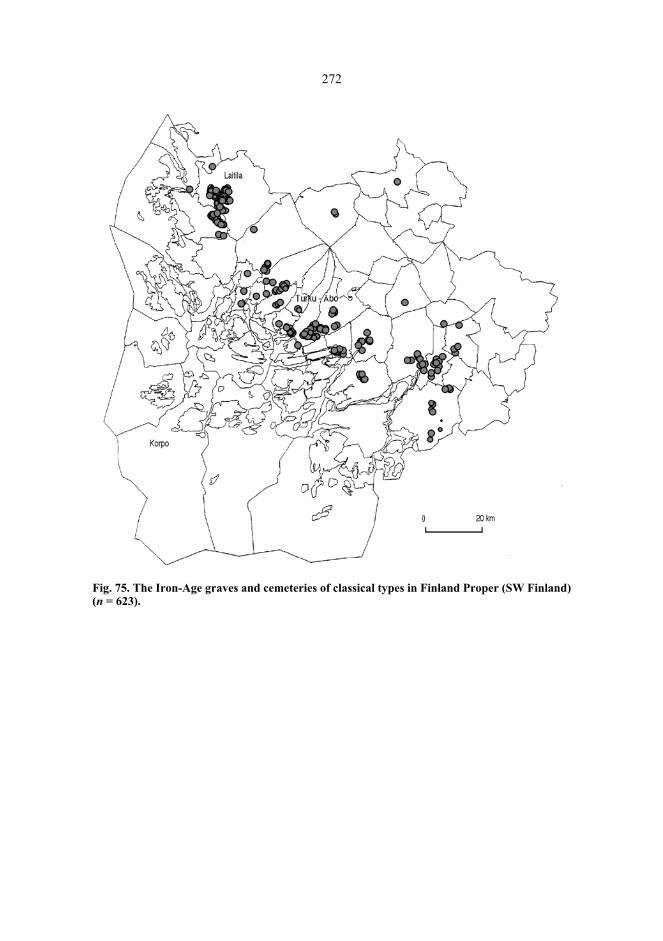
272
Fig. 75. The Iron-Age graves and cemeteries of classical types in Finland Proper (SW Finland)(n = 623).

273
Fig. 76. The cairns in Finland Proper (SW Finland) (n = 1627).
Naturally, the procedure of shaping the spreading process involves also a source of error:the cognizance of the chronology of the cairns on the mainland coast, and, as aconsequence, also of their location in reference to the ancient phases of the sea shore isdefective. In this phase of research, the interpretation which seems the mostrecommendable to me, is the following: the burial cairns represent the Bronze-Agepopulation who based their subsistence mainly on the versatile natural resources of thearchipelago (including arable land), and the Iron-Age population who pursued theBronze-Age strategies of subsistence. The classical grave and cemetery types of the IronAge represent a population whose way of living was associated with the mainland ratherthan the archipelago, and whose subsistence was based on the options provided byspecialized cattle-raising and agriculture.
The Bronze-Age graves were, in my opinion, built by a population who pursued theslash-and-burn type of agriculture adopted during the culture of Kiukais, and for whomfishing, seal hunting, fowling, and other maritime sources of livelihood were of greatsignificance. The islanders of the Bronze Age exploited the opportunities provided by

274
their topographically versatile and small-featured environment in their subsistencestrategies. In their religious thinking the earth possessed significances which made themconstruct the graves at maritime sites from where one could see extensive areas of land.This might have something to do with a symbolically presented and desired yield of landand cattle rather than with an actual success within a source of livelihood which hadbarely been initiated in the circumstances of the northern Baltic and involved great risksof failure of crops. The stone and wooden tools of the Bronze Age made small-scaleagriculture, presumably slash-and-burn-cultivation, feasible, but it was impossible toresort to agriculture alone. The sea was of great importance, firstly, since it offeredseveral sources of livelihood giving thus security, and secondly, because of the maritimeclimate which provided the best possible prerequisites for agriculture. The Bronze-Ageislanders of the south-western archipelago of Finland observed thus, in their own way, thesame strategy of low productivity and minimized risks as the Bronze-Age populations inmany other parts of northeastern Europe (Zvelebil 1985).
The Iron-Age islanders of the archipelago pursued the burial ritual initiated in theBronze Age; the graves were, however, not as large as before – or there were fewerreinterments than previously –, and the grave sites were selected in the landscape so thatthe viewsheds from them were turned towards the sea. During the Iron Age theconstructors of the graves found their way also to the outer isles and skerries, whichnaturally evokes an image of the great significance of fishing, seal hunting, and fowling.The pollen analyses refer, however, to the stabilization of agriculture towards the end ofthe Iron Age, at least in the inner and the middle archipelago zones. The multifacetedeconomy of the Bronze Age seems thus to have continued in the archipelago whichoffered good natural conditions to that activity. The continuity of the burial ritual wasassociated with the continuity of subsistence strategies. There was no need to changeeither of those. The Metal-Age subsistence strategy in the archipelago may thus haveresembled, to some extent, the annual rotational cycle of the islanders which is well-known from ethnographies; this cycle comprised a seasonal exploitation of naturalresources, the rotational interlock of agriculture, cattle raising, fishing of different fishspecies, seal hunting, fowling, egg collecting, and the use of other natural products. If oneof these resources failed, the loss could be compensated for by strengthening the use ofother resources (see Storå 1982; Storå 1985).
Further light on the development of the settlement and the economy on the mainlandcoast in South-West Finland can be thrown if one makes an effort to see these aspectsfrom a coastal archaeology view. The response of the Bronze-Age economy to the risks ofagriculture at the extreme climatic limits of the possibilities of cultivation was themultifaceted economy and the avoidance of risks; new and better prerequisites of moreextensive cultivation and of getting the best possible profit from it, were opened when theiron tools were introduced in tilling the soil. The use of iron scythes facilitated thegathering of forage on the meadows. The development of mainland settlement and theexpansion of agriculture (e.g. Meinander 1980) was a socio-economic change whichapparently led also to changes and diversity in burials.
According to Marek Zvelebil the real Neolithic form of economy did not develop innortheastern Europe until the Iron Age on account of the risks involved in agriculture.The agrarian economy was compelled to aim, if possible, at safeguarding productivity incase of possible collapses, and this adaptation included orientations towards cattle raising,
275
slash-and-burn-cultivation, and versatile mixed economy. The trend was, however,distinct: from the earlier unspecialized, local cultivation which aimed at providingindispensable products towards specialized agricultural production and social complexity.The realization of these two things required overproduction and a regional network ofgoods exchange (Zvelebil 1985). It is quite possible that South-West Finland developed abarter system between the archipelago and the coast to reduce the risks involved inagriculture: the natural products of the archipelago and what was produced by theislanders themselves could be exchanged for the products of the mainland regions whichwere specialized in agriculture. In this way the agrarian economy of the mainland mighthave proceeded towards a further specialization in agricultural products and a moreeffective production of food. The latter aspects can be considered to be the basis of thestabilized settlement (Salo 1995) and the great frequency of cemeteries (Seger 1982 b;Lehtonen 2000) in South-West Finland. This idea might be illustrated by a historicalexample, the extensive network of contacts between the peasants of the parishes in thearchipelago of Åboland and those of the mainland. The islanders transported fish, meat,butter, eggs and firewood to Stockholm, the towns in the region of the lake Mälaren, thecoastal parishes of southern Finland, Tallinn, and St Petersburg to be exchanged for grain,salt, hemp, and iron. The fishermen-peasants of the archipelago were dependent on thetrade in the centres of population on account of their own petty grain production; on theother hand, the centres of population were equally dependent on the products of thearchipelago (Villstrand 1993; Orrman 1991: 262–264; Kerkkonen 1978; Papp 1986; cf.Modéer 1945).
Actually we might have some evidence of a system of exchanging goods between thearchipelago and the coast: the dwelling site of Kyrksundet in Dragsfjärd. The finds fromthis community which was used chiefly from the 9th to the 11th century, consist ofartefacts which suggest contacts with the Finnish mainland. There is, for instance, a key-formed pendant with an equivalent at Rapola, Valkeakoski in Häme (a province inFinland). Most of the artefacts, some of which are Oriental or European coins, indicate,however, contacts with Sweden, Åland or Estonia. Some twenty weights among the findsare obvious indications of trading activity at the site. Torsten Edgren suggests that thetrading site at Kyrksundet was established by peasants from Halikko and Perniö who firststayed at the site only seasonally but from the 10th century all the year round. Theycarried on trade with the Vikings who sailed past the coast (Edgren 1995 a; Edgren 1995b). There is, however, no need to imagine that participation in the Baltic goods exchangeshould have excluded the bartering contacts with the mainland, actually the result was justthe opposite. If the settlers of Kyrksundet came from Halikko and Perniö, the barter tradewith their original home region would seem as natural as the cooperation with theVikings.
The archipelagean zone of the Finnish coast is the widest in Åboland and Åland. Itcomprises extensive sheltered areas where the fishing boats need not be as big and heavyas on the open coasts. On the other hand, it was relatively difficult to move in thearchipelago due to the numerous underwater shallows, which hampered the exploitationof and the competition for the natural resources by outsiders. Due to land uplift newshoals continued to emerge out of the deep water – naturally at a fairly slow pace. Whenthe commission of goods and products for foreign exchange of goods was beingorganized in the region around Turku (Pihlman 1985 b), the transportation of the

276
merchandise required the establishment of a local knowledge of navigationalcircumstances. Although pilots on the Finnish waters were first mentioned in the MiddleAges (Lähteenoja 1947; Öhman 1996), it is quite evident, e.g. according to HenrikCederlöf; that pilotage had been organized earlier than what is related in written sources(Cederlöf 1989: 15). There is a possible early juncture in the 8th century when newchanges developed in the Baltic market. Prior to the 8th century the imported goodsconsisted of luxury articles and other products, and their price was determined by supplyand demand, but also by the mutual social relationships between those who participated inthe exchange of goods. From the 8th century onwards, trading became a market-basedlong-distance commercial activity, and it was no more necessary for the participants in theexchange to have any specific social relationships with each other (Pihlman 1985 b;Näsman 1984: 121–128; Näsman 1991). This century was also a period when the scopeof the exchange enlargened to the area of Volga and Kama in Russia (Salo 1982: 11–18).The local knowledge of the islanders has surely been the nearest available solution whensolving the problems of pilotage in the archipelago.
9.4 Cairns in Historical Sources?
9.4.1 Långholm
In Finland, cairns dating back to the historical period have been reported fromOstrobothnia and the archipelago of Uusimaa (Siiriäinen 1978; Europaeus 1922). Cairnsform the historical period have been registered also on the eastern coast of Sweden,occasionally associated with tomtning-remains (Larsson 1984; Hermodsson 1987;Norman 1991; Norman 1993: 93, 158). In the archipelago of Åboland, the shore zonedatings for some cairns in the outer archipelago suggest that the grave might date back tothe Middle Ages. This is the case concerning, for example the grave at Djupklevudden,Kälö, Korpo (364). It has been constructed on a shore cliff, which today is at the height of6.4 m above sea level, which corresponds to the shore zone dating 940 ± 160 AD butthere is no certainty of medieval origin for any of the graves.
There are, however, two historical sources which may be relevant. One is the greatinquiry into the ancient monuments in 1666–1693 which was launched in Sweden-Finland with a royal statute (Baudou & Moen 1995; Cleve 1967; Laakso 1987; Edgren1995 c). In 1674, the Vicar of the parish of Taivassalo, Petrus A. Bergius dispatched to theKing a report on the information he had acquired concerning the ancient remains in hisparish. In order to collect that information he convened the peasants of his parish, whichat that time comprised also the subordinate parish of Iniö. The letter written by Bergiuswas published in 1859 by Karl August Bomansson in the following form:
277
Men fans intet, som wärdigt är skrifwas; Vthan bönderna wid wårt capell, ochJuimo byy, berättade, at på en högh backawägh som Callas borgh holmen, hafwerfordom warit en skanss temligh stoor och wijdh, hwilcken Konungens Krigzfolck iden giordt hafwer, och sedan aff Landzens inbyggiare i siälskap och på en annanholme haart när, i twå jord och sand här begrafne *) Petrus A. BergiusPast. et Præp. toefsalensis*) Meningen häraf är svår att fatta. Utg. anm.
As stated by Bomansson in his footnote, the contents of the text are rather obscure. In thefollowing a suggestion for an English interpretation113:
But there was nothing worth writing about; apart from what the peasants from thevillage of Jumo in our chapel parish [of Iniö] told: on a high hill, calledBorgholmen, there was in ancient times a fairly large and wide earthwork built bythe King’s warriors, and furthermore, two of the islanders were buried here and onanother island nearby, together in earth and sand.
The borgh holmen mentioned by Bergius can be recognized as the island of Borgholm inthe village of Jumo in Iniö. The shores of the island are walled in by a rampart in nineseparate sections. The total length of the sections, which in all probability are the remainsof the earthwork mentioned by Bergius, is approximately 450 metres. The lowest point ofthe rampart is at the height of 8.1 m indicating that the fortified island was not in usebefore the Viking Age (Tuovinen et al. 1992). The rampart which had been constructed inancient times, as mentioned in the letter written by Bergius, was a dry-stone wall likethose of the Iron-Age hillforts, which suggests a dating to the Late Iron Age; building thewall too far from the shore would not have been prudent since that would have given theinvaders the opportunity to perform a landing on the shore zone. What is actually moreinteresting than the age of the hillfort, is the statement that two islanders had been buriedtogether on a nearby island in earth and sand. This description suits best the island ofLångholm which is separated from Borgholm by a narrow strait. This island is moresandy and more gravelly than most of the adjacent islands. In the middle of Långholmthere is a cairn (102), which has been constructed, very exceptionally, in a terrain ofgravel and pebbles.
9.4.2 Långfuruholm
In the cairn of Långfuruholm at Högsåra, Dragsfjärd one could still see in the early 20th
century well-preserved parts of a human skeleton between the boulders. This grave,discovered by Volter Högman in 1886, and the apparently late remains of a humanskeleton inspired Svante Dahlström to write an animated essay in 1940 (Dahlström 1940).In this essay he deals with a statute in the provincial code of Uppland in Sweden from the
113.My thanks are due to Ulrika Wolf-Knuts and Kurt Zilliacus for the help in interpreting the text. Any possiblemistakes are mine.

278
year 1296. It decreed the procedure to be observed if a member of the crew on a vesselbelonging to the Swedish marine military organization, called ledung, should be taken ill.If the disease lasted long and was serious, the vessel had to be sailed to a harbour, and thecrew should be forbearing, watch and observe the state of the patient. The suspense wenton until all the members of the crew agreed about the death of the patient. The deceasedhad to be taken then to an uninhabited island and buried between stones and turf –mællum stens ok torfwo. Only after this did the vessel sail off. The passage of the statuteconcludes with the statement that if the sailor after all survived, was rescued, and wasable to name the vessel and its crew, he was entitled to receive a remuneration of 140marks as a compensation for being buried. The final clause should be interpreted as adetermination of the liability for remuneration, which made the crew consider verycarefully the resolution concerning the death of the patient.
But mællum stens ok torfwo; Dahlström interpreted this expression as a cairn. Theassociation between the old law text and the cairns is naturally liable to discussion: itmight be arbitrary to build a bridge between a medieval provincial code and the grave atLångfuruholm. On the other hand it might be thinkable that the simply andunsophisticatedly described procedure in which the decision concerning death is made inthe community around the patient, derives from a prehistorical common tradition in thecountry. The possibility of the survival of the patient brings forth the unsoughtreminiscence of the tradition described by cultural anthropologists of treating the patientas deceased and of initiating the mortuary ritual before the biological moment of death; Irefer here, for example, to Lauri Honko’s description of the burial tradition in Melanesiawith the patient as a participant (Honko 1960: 49–50; see also Honko 1981 b: 161–162;Nenola 1985: 185–187). If the death of a sick Skolt was delayed and turned into adifficult process, the death was sometimes hastened by setting a copper pot beside thepatient the wrong side up; this upside-down position reflected the principle of inversion inthe realm of Death (Storå 1971: 207). It is thus a matter of cultures where the biologicalmoment of death is not regarded as the decisive point of transition from the living to therealm of Death. Bringing the dying member of the community into the category of thedeceased is rather a cultural procedure attended to by the community, and the biologicaldeath is only one momentary phase in this procedure, though of great importance, to besure. Maybe this example will remind us of the fact that archaeology provides only alimited means of comprehending the mortuary ritual behind the cairns.

BibliographyLiterature
Ahlbäck, Ragna (1955). Kökar. Näringslivet och dess organisation i en utskärssocken. Skrifterutgivna av Svenska Litteratursällskapet i Finland 351. Helsingfors: Svenska Litteratursällskapet iFinland.
Ailio, Julius (1927). Turunmaan varhaisin asutus ja kulttuuri. Suomen museoliiton julkaisuja 2: 57–69.
Aires-Barros, L. & Mouraz-Miranda, A. (1989). Weathering and weatherability of rocks and itssignificance in geotechnics. Balasubramaniam, K.S. & Evangelou, V.P. & Faure, G. & Goni, J. &Grubb, P.L.C. & Hill, P.A. & Lahodney-arc, O. & Melfi, A.J. & Mendelovici, E. & Nikitina, A.P.& Pickering, W.F. & Augustithis, S.S. (eds) (1989). Weathering: its products and deposits,Volume II: 605–645. Athens: Theophrastus Publications, S.A.
Akazawa, Takeru (1988). Variability in the types of fishing adaptation of the later Jomon hunter-gatherers, c. 2500 to 300 bc. Bailey, Geoff & Parkington, John (eds) (1988). The archaeology ofprehistoric coastlines: 78–92. Cambridge: Cambridge University Press.
Ambrosiani, Björn (1964). Fornlämningar och bebyggelse. Stockholm: Kungliga Vitterhets Historieoch Antikvitets Akademien.
Ambrosiani, Kristina (1981). Viking age combs, comb making and comb makers in the light of findsfrom Birka and Ribe. Stockholms Studies in Archaeology 2. Stockholm: Stockholms universitet.
Anderson, Gunlög (1963). Boatgraves in Finland. Suomen Museo LXX: 5–23. Andersson, Kjell (1998). Näringsutvecklingen i sydvästra Finlands skärgård 1985–1995: tolv
kommuner i ljuset av offentlig statistik. Rapporter och diskussionsinlägg från Forskningsinstitutet(FISS) 4/98. Helsingfors: Svenska social- och kommunalhögskolan vid Helsingfors universitet.
Andersson, Kjell (1999). Saaristostatus kehityksen valttikorttina? Tuomisto, Anja (ed.) (1999). Pitkäsoutu – matkalla muistettuun ympäristöhistoriaan: 51–59. Religionsvetenskapliga skrifter nr 46.Åbo: Åbo Akademi.
Andersson, Sven (1938). Åboländska fiskare i den öståboländska skärgården. Budkavlen 27: 113–124.
Anttila, Kaisu (1985). En kvadratisk stensättning vid Bleckenstad, Ekeby sn, Östergötland. Fjölnir,Häfte 3: 37–42.
Anttonen, Veikko (1993 a). Erä- ja metsäluonnon pyhyys. Kalevalaseuran vuosikirja 73: 24–35. Anttonen, Veikko (1993 b). Interpreting ethnic categories denoting ’sacred’ in a Finnish and an Ob-
Ugrian context. Temenos 28: 55–80. Anttonen, Veikko (1996). Ihmisen ja maan rajat. ’Pyhä’ kulttuurisena kategoriana. Suomalaisen
Kirjallisuuden Seuran Toimituksia 646. Helsinki: Suomalaisen Kirjallisuuden Seura. Aspelin, J.R. (1875). Suomalaisen muinaistutkinnon alkeita. Suomalaisen Kirjallisuuden Seuran
Toimituksia 51. Helsinki: Suomalaisen Kirjallisuuden Seura. Aspelin, J.R. (1885). Suomen asukkaat pakanuuden aikana. Helsinki: K.E. Holm.

280
Asplund, Henrik (1997a). Kemiön suurpitäjän esihistoria. Suistoranta, Kari & Asplund, Henrik(1997). Kemiön suurpitäjän historia 1: 213–288. Kemiö: Sagalundin museon kuntayhtymä.
Asplund, Henrik (1997b). Niuskalan Polttolaitoksenkadun keramiikka. Turun maakuntamuseo,Monisteita 9: 23–50.
Asplund, Henrik (2000). Tid, människor och landskap. En bok om arkeologi i Pargas. Pargas hem-bygdsförenings publikation nr 15. Pargas: Pargas hembygdsförening.
Asplund, Henrik (2001). Landscapes, power and coerced decisions. A study on Iron Age archipelagoand mainland from the perspective of the Kemiönsaari area in SW Finland. Licentiate thesis,Dept. of Archaeology, University of Turku.
Asplund, Henrik & Vuorela, Irmeli (1989). Settlement studies in Kemiö – archaeological problemsand palynological evidence. Fennoscandia archaeologica 6: 67–79.
Auvinen, Eero (1995). Lützowin ”allas” Merikarhujen Stora Hummelskärin tukikohdassa. Merikarhu– Sjöbjörnen 3/1995: 145–155.
Bahrenberg, Gerhard & Giese, Ernst & Nipper, Josef (1992). Statistische Methoden in derGeographie, Band 2. Stuttgart: B.G. Teubner.
Baldwin, J. & P. Fisher, P. & Wood, J. & Langford, M. (1996). Modelling environmental cognitionof the view with GIS. Third International Conference Integrating GIS and EnvironmentalModelling, Santa Fe, NM, January 1996. [Available from http://ncgia.ucsb.edu/conf/SANTAFE_CD-ROM/sf_papers/ fisher_peer/baldwin.html].
Barford, P.M. (2000). Seen and unseen: sites in a landscape. Nissinaho, Aino (ed.) (2000). Sites andsettlement: 85–99. Turku: University of Turku.
Barrett, John C. (1996). The living, the dead and the ancestors: Neolithic and Early Bronze Agemortuary practices. Preucel, Robert & Hodder, Ian (eds) (1996). Contemporary archaeology intheory: 394–412. Oxford: Blackwell.
Baudou, Evert (1968). Forntida bebyggelse i Ångermanlands kustland. Arkeologiska undersökningarav ångermanländska kuströsen. Arkiv för norrländsk hembygdsforskning XVII. Härnösand:Kulturhistoriska föreningen Murberget.
Baudou, Evert (1991). Om tomrum och tvärvetenskap. Thule 4: 97–108. Baudou, Evert & Engelmark, Roger & Liedgren, Lars & Segerström, Ulf & Wallin, Jan-Erik (eds.)
(1991). Järnåldersbygd i Österbotten: en ekologisk-arkeologisk studie av bosättningskontinuitetoch resursutnyttjande. Acta antiqua Ostrobotniensia nr 2. Vasa: Scriptum.
Baudou, Evert & Moen, Jon (eds.) (1995). Rannsakningar efter antikviteter – ett symposium om1600-talets Sverige. Kungl. Vitterhets Historie och Antikvitets Akademien, Konferenser 30.Stockholm: Kungl. Vitterhets Historie och Antikvitets Akademien.
Bender, Barbara (1992). Theorizing landscape and the prehistoric landscapes of Stonehenge. Man27(4): 735–755.
Berner, Robert A. (1992). Weathering, plants, and the long-term carbon cycle. Geochimica et Cosmo-chimica Acta 56(8): 3225–3231.
Berry, William D. (1993). Understanding regression assumptions. Lewis-Beck, Michael S. (ed.)(1993). Regression analysis: 335–424. London: SAGE Publications.
Björck, A. (1883). Kiinteitä Muinaisjäännöksiä Halikon Kihlakunnassa. Suomen Muinaismuisto-Yhdistyksen Aikakauskirja 6: 35–80.
Björck, A. (1887). Muinaismuistoja Piikkiön kihlakunnasta. Suomen Muinaismuisto-YhdistyksenAikakauskirja 8: 1–66. Helsinki: Suomen Muinaismuisto-Yhdistys.
Bolin, Hans (1999). Kulturlandskapets korsvägar: mellersta Norrland under de två sista årtusendenaf.Kr. Stockholm studies in archaeology 19. Stockholm: Stockholms universitet.
Bomansson, Karl August (1859). Bidrag till Finlands historia. 1, Finska Presterskapets berättelser omMonumenter och Antiqviteter i Finland, 1667–1674. Suomi 1858: 117–172.
Bowditch, Nathaniel (1981). American Practical Navigator, Volume II. Washington, D.C.: DefenseMapping Agency Hydrographic/Topographic Center.
Bowditch, Nathaniel (1984). American Practical Navigator, Volume I. Washington, D.C.: DefenseMapping Agency Hydrographic/Topographic Center.
Bowie, Fiona (2000). The anthropology of religion: an introduction. Oxford: Blackwell.Bradley, Richard (1991). The pattern of change in British prehistory. Earle, Timothy (ed) (1991).
Chiefdoms: power, economy and ideology: 44–70. Cambridge: Cambridge University Press.
281
Breide, Henrik (1999). A few thoughts about ”The Baltic Itinerary”. Lindström, Marcus (ed.) (1999).The marine archaeology of the Baltic Sea area: conditions of the present; possibilities andproblems in the future: 44–55. Huddinge: Södertörns högskola.
Broadbent, Noel (1983). Too many chiefs and not enough indians. A peripheral view of NordicBronze Age society. Stjernquist, Berta (ed.) (1983). Struktur och förändring i bronsåldernssamhälle: 7–22. University of Lund, Institute of Archaeology, Report Series No 17. Lund: Lundsuniversitets historiska museum.
Broadbent, Noel (1987). Iron Age and medieval seal hunting sites. Archaeological investigations atBjuröklubb, Västerbotten, Northern Sweden, Part 1. Center for Arctic Cultural Research, UmeåUniversity, Research Reports Nr. 5. Umeå: Umeå universitet.
Broadbent, Noel (1990). Use of lichenometric and weathering rates for dating. NorwegianArchaeological Review 23: 3–8.
Bruun, Henrik (1998). Landskapets begreppsliga landskap – en humanekologs reflexioner ochlandskapsbegreppets möjligheter. Nordenskiöld-samfundets tidskrift 57: 77–95.
Carlie, Anne (2000). ”Sacred white stones”: on traditions of building white stones into graves. LundArchaeological Review 5: 41–58.
Carlsson, Dan (1983). Bronsålder – tiden för kulturlandskapets territoriella framväxt och etableringpå Gotland. Stjernquist, Berta (ed.) (1983). Struktur och förändring i bronsålderns samhälle: 23–36. University of Lund, Institute of Archaeology, Report Series No 17. Lund: Lunds universitetshistoriska museum.
Carpelan, Christian (1974). Hirven- ja karhunpääesineitä Skandinaviasta Uralille. Suomen Museo 81:29–88.
Carpelan, Christian (1979). Om asbestkeramikens historia i Fennoskandien. Finskt Museum 85: 5–25.
Carpelan, Christian (1982). Om bronsålderns jordbrukssamhälle i Finland. Sjøvold, Thorleif (ed)(1982). Introduksjonen av jordbruk i Norden: 265–278. Oslo: Universitetsforlaget.
Carpelan, Christian (1999). Käännekohtia Suomen esihistoriassa aikavälillä 5100...1000 e.Kr.Fogelberg, Paul (ed.) (1999). Pohjan poluilla. Suomalaisten juuret nykytutkimuksen mukaan:249–280. Bidrag till kännedom av Finlands natur och folk 153. Helsinki: Finska Vetenskaps-Societen.
Cederlund, Carl Olof (1988). A medieval description of searoutes along the Swedish and Finnishcoasts, ending in Reval (Tallinn), Estonia. Marine archaeology – development of research andconservation, Publication number 13 in the Series of Provincial Museum of Kymenlaakso: 3–25.
Cederlund, Carl Olof (1991). Forskningsprojektet Medeltida sjöfart och segelleder längs svenskaÖstersjökusten, dess bakgrund och genomförande t.o.m. 1989 – en interrimrapport. Fornvännen86: 17–20.
Cederlöf, Henrik (1989). Farleder och lotsplatser i Ekenäs skärgård. 2. uppl. Ekenäs: EkenäsTryckeri Aktiebolags Förlag.
Chang, Kang-tsung & Tsai, Bor-wen (1991). The effect of DEM resolution on slope and aspectmapping. Cartography and geographic information systems 18(1): 69–77.
Chapman, John (1997). Places as timemarks – the social construction of prehistoric landscapes inEastern Hungary. Nash, George (ed.) (1997). Semiotics of landscape: archaeology of mind: 31–45. BAR International Series S-661. Oxford: Archaeopress.
Charles, Douglas K. (1992). Woodland demographic and social dynamics in the American Midwest:analysis of a burial mound survey. World Archaeology Vol. 24, No. 2: 175–197.
Cleve, Nils (1941). Arkeologiska undersökningar i skärgården. Nordenskiöld-Samfundets Tidskrift1941:1: 69–70.
Cleve, Nils (1942 a). Ett i Finland funnet tistelspänne. Finskt Museum XLVIII: 12–22. Cleve, Nils (1942 b). Kimitobygdens forntid. Nikander, Gabriel (ed.) (1942). Kimitobygdens historia
II:1, Bondekulturen: 1–26. Åbo: Förlaget Bro. Cleve, Nils (1943). Skelettgravfälten på Kjuloholm i Kjulo. Suomen Muinaismuistoyhdistyksen
Aikakauskirja XLIV. Helsinki: Suomen Muinaismuistoyhdistys.Cleve, Nils (1948). Våra skärgårdars äldsta bebyggelse. Skärgårdsboken, utgiven av Nordenskiöld-
Samfundet i Finland: 482–509. Helsingfors: Nordenskiöld-Samfundet i Finland.
282
Cleve, Nils (1967). Om ”gamble monumenter och antiqviteter”. Historiska och litteraturhistoriskastudier 42. Skrifter utgivna av Svenska litteratursällskapet i Finland 420: 25–44.
Colman, Steven M. (1981). Rock-weathering rates as functions of time. Quaternary Research 15:250–264.
Conover, W.J. (1980). Statistics of the Kolmogorov-Smirnov type. Conover, W.J. (ed) (1980).Practical nonparametric statistics: 344–385. 2nd ed. New York: John Wiley & Sons.
Cooney, Gabriel (1994). Sacred and secular neolithic landscapes in Ireland. Carmichael, David L. &Hubert, Jane & Reeves, Brian & Schance, Audhild (eds) (1994). Sacred sites, sacred places: 32–43. London: Routledge.
Criado, Felipe (1995). The visibility of the archaeological record and the interpretation of socialreality. Hodder, Ian & Shanks, Michael & Alexandri, Alexandra & Buchli, Victor & Carman, John& Last, Jonathan & Lucas, Gavin (eds) (1995). Interpreting archaeology: finding meaning in thepast: 194–204. London: Routledge.
Cytel Software (1997). LogXact for Windows. Cambridge, Mass.: Cytel Software Corporation. Dahlström, Svante (1937). Ryssugnarna och den ryska skärgårdsflottan. Finskt Museum XLIV: 14–
70. Dahlström, Svante (1940). En sjömans grav på obebodd ö. Budkavlen 1940: 1–23. Dahlström, Svante (1945). Gullkrona. Åbo: Förlaget Bro. Damell, David & Östmark, Kerstin (1986). Rösaringkomplexet. Arkeologi i Sverige 1984: 179–212.
Riksantikvarieämbetet och Statens historiska museer, Rapport 1986:2. Stockholm:Riksantikvarieämbetet.
Day, M.J. & Goudie, A.S. (1977). Field assessment of rock hardness using the Schmidt test hammer.British Geomorphological Research Group Technical Bulletin 18: 19–29.
Day, Michael J. (1980). Rock hardness: field assessment and geomorphic importance. ProfessionalGeographer 32(1): 72–81.
Dixon, Wilfrid Joseph (ed) (1992). BMDP statistical software manual: to accompany the 7.0software release, Volumes 1, 2 & 3. Berkeley – Los Angeles – Oxford: University of CaliforniaPress.
Dreijer, Matts (1979). Det åländska folkets historia. I:1, Från stenåldern till Gustav Vasa.Mariehamn: Ålands Kulturstiftelse.
Dunning, John B. & Danielson, Brent J. & Pulliam, H. Ronald (1992). Ecological processes thataffect populations in complex landscapes. Oikos 65(1): 169–175.
Earle, Timothy (1991). Property rights and the evolution of chiefdoms. Earle, Timothy (ed) (1991).Chiefdoms: power, economy and ideology: 71–99. Cambridge: Cambridge University Press.
Eastman, J. Ronald (1997). Idrisi for Windows. User’s guide. Version 2.0. Worcester, MA: ClarkUniversity.
Edelman, Nils (1956). Kallioperäkartan selitys, lehti 1033 Nötö. Suomen geologinen kartta 1:100000. Helsinki: Geologinen Tutkimuslaitos.
Edelman, Nils (1968). Geological dating of a rock carving. Finskt Museum 75: 40–43. Edelman, Nils (1985). Nauvon karttalehden kallioperä. Suomen geologinen kartta 1:100 000,
Kallioperäkarttojen selitykset, 1034 Nauvo. Helsinki: Geologian tutkimuskeskus. Edelman, Nils (1986). Skärgårdens ytformer – ett slitet trägolv. Skärgård 9(3): 22–31. Edgren, Helena (1983). Ålands bebyggelsehistoria under äldre järnålder. Åländsk Odling 42: 88–97. Edgren, Helena (1984). On the continuity of settlement in the Early Iron Age on the Åland Islands.
Iskos 4: 121–125. Edgren, Torsten (1969). Kotokallio in Lieto. Ein Grabfund aus der älteren Bronzezeit im Dorf
Vanhalinna. Suomen Museo 76: 74–84. Edgren, Torsten (1980). Medieval archaeological investigations on the southwest coast of Finland.
Helsingin yliopiston arkeologian laitos, Moniste n:o 22: 102–110. Edgren, Torsten (1995a). “…De Aspø usque Ørsund.vi. Inde usque Hangethe.iij …“. An
archaeological project concerning one of the harbours in Finland’s south-western archipelagoreferred to in “the Danish itinerary“. Olsen, Olaf & Skamby Madsen, Jan & Rieck, Flemming(eds.) (1995). Shipshape: essays for Ole Crumlin-Pedersen: 203–212. Roskilde:Vikingeskibshallen.
Edgren, Torsten (1995b). Kyrksundet i Hitis. Budkavlen 74: 49–66.
283
Edgren, Torsten (1995c). Några synpunkter på rannsakningarnas Finlandsdel. Baudou, Evert &Moen, Jon (eds.) (1995). Rannsakningar efter antikviteter – ett symposium om 1600-taletsSverige: 51–61. Kungl. Vitterhets Historie och Antikvitets Akademien, Konferenser 30.Stockholm: Kungl. Vitterhets Historie och Antikvitets Akademien.
Edgren, Torsten (1996). Arkeologi i Hitis utskär. Skärgård 19(3): 15–21. Edgren, Torsten (1997a). Bakom lås och bom. Kring en vikingatida nyckeltyp. Blomqvist, Marianne
(ed.) (1997). Ord och några visor tillägnade Kurt Zilliacus 21.7.1997. Meddelanden frånInstitutionen för nordiska språk och nordisk litteratur vid Helsingfors universitet B18: 43–49.
Edgren, Torsten (1997b). Early pottery found off Purunpää in Dragsfjärd. Nautica Fennica 1997: 35–39.
Edgren, Torsten (1999a). Alkavan rautakauden kulttuurikuva Länsi-Suomessa. Fogelberg, Paul (ed.)(1999). Pohjan poluilla. Suomalaisten juuret nykytutkimuksen mukaan: 311–333. Bidrag tillkännedom av Finlands natur och folk 153. Helsinki: Finska Vetenskaps-Societen.
Edgren, Torsten (1999b). Fornlämningar och fornfynd i Hitis utskär. Kimito: Sagalundsgillet.Ehrensvärd, Ulla & Zilliacus, Kurt (1997). Farlederna berättar. Föreningen Konstsamfundets
publikationsserie XVII. Helsingfors: Konstsamfundet – Söderströms.Eklund, Erland (1985). Sommargästernas skärgård hundra år. Finsk Tidskrift 1985, h. 9: 503–512. Eklund, Erland (1994). Kustfiskare och kustfiske i Finland under den industriella epoken. Svenska
social- och kommunalhögskolan vid Helsingfors universitet, SSKH Skrifter 5. Helsingfors:Universitetstryckeriet.
Ekman, Martin (1986). A reinvestigation of the world’s second longest series of sea levelobservations: Stockholm 1774–1984. Kakkuri, Juhani (ed.) (1986). Proceedings of the 10thgeneral meeting of the Nordic Geodetic Commission, Helsinki 29. Sept.–3. Oct. 1986: 111–121.Helsinki: Suomen geodeettinen laitos.
Ekman, Martin (1993). Postglacial rebound and sea level phenomena, with special reference toFennoscandia and the Baltic Sea. Lecture notes, NGK Autumn School in Helsinki, Sept. 7–13,1992, Suomen geodeettisen laitoksen julkaisuja 115: 7–70.
Eliade, Mircea (1961). The sacred and the profane: the nature of religion. New York: Harper & Row. Eliason, Eric M. & McEwan, Alfred S. (1990). Adaptive box filters for removal of random noise from
digital images. Photogrammetric Engineering and Remote Sensing 56(4): 453–458. Ericsson, Christoffer H. (1973). Maritimhistoriskt fältarbete i Museiverkets regi. Maritimhistorisk
konferens i Umeå den 8-9 december 1972, Rapport: 8–13. Statens sjöhistoriska museum och rådetför maritim forskning.
Ericsson, Christoffer H. (1979). Jungfrusund och Hangö udde. Hamnar och ankarplatser i sydväst,Sex föredrag hållna under Nordisk maritimhistorisk exkursion III i augusti 1977: 61–83.Helsingfors: Museiverket.
Ericsson, Christoffer H. (1989). Timrade bryggkonstruktioner vid Högholmen i Hitis. Maritimamedeltidsstudier, Jungfrusund 2: 73–94.
Erkola, Toini (1960). Suitian Ekebergan kalmisto Siuntiossa. Suomen Museo LXVII: 5–21. Eronen, Matti (1983). Late Weichselian and Holocene shore displacement in Finland. Smith, D.E. &
Dawson, A.G. (eds) (1983). Shorelines and isostacy: 183–207. New York: Academic Press. Eronen, Matti (1987). Global sea-level changes, crustal movements and quaternary shorelines in
Fennoscandia. Geological Survey of Finland, Special Paper 2: Fennoscandian land uplift: 31–36. Eronen, Matti (1994). Muinaisrannat ja jääkauden jälkeinen maankuoren deformaatio Fennoskan-
diassa. Turun yliopiston maaperägeologian osaston julkaisuja 78: 53–61. Eronen, Matti & Glückert, Gunnar & van de Plassche, Orson & van der Plicht, Johannes & Rajala,
Päivi & Rantala, Pasi (1993). The postglacial radiocarbon-dated shoreline data of the Baltic inFinland compiled for the Nordic Data Base of Land Uplift and Shorelines. Swedish NuclearPower Inspectorate, Project NKS/KAN3, subproject 3.2.4.2., 1992–93, Final report 30.8.1993.Turku: University of Turku.
Eronen, Matti & Jungner, Högne & Uusinoka, Raimo (1979). 14C-ajoitettu sinisimpukkalöytöSeinäjoelta ja tietoa muista kuoriesiintymistä Itämeren piirissä. Terra 91: 209–218.
Eskeröd, Albert (1947). Årets äring: etnologiska studier i skördens och julens tro och sed. NordiskaMuseets Handlingar 26. Stockholm: Nordiska Museet.
Europaeus, Aarne (1914). Gravfynd i Uskela. Finskt Museum 21: 23–38.
284
Europaeus, Aarne (1922). Fornfynd från Kyrkslätt och Esbo socknar. Finska FornminnesföreningensTidskrift 32:1. Helsingfors: Finska Fornminnesföreningen.
Europaeus, Aarne (1930). Uusia kivikauden taidelöytöjä. Suomen Museo 36: 82–88. Evans-Pritchard, Edward Evan (1965). Theories of primitive religion. Oxford: Claredon. Everard, C.E. (1980). On sea-level changes. Thompson, F.H. (ed) (1980). Archaeology and coastal
change: 1–23. London: The Society of Antiquaries of London.Fagerlund, L.W. (1878). Anteckningar om Korpo och Houtskärs socknar. Bidrag till kännedom af
Finlands natur och folk, utgifna af Finska Vetenskaps-Societen. Tjugondeåttonde Häftet.Helsingfors: Finska Litteratur-sällskapets Tryckeri.
Fagerlund, Rainer (1992). Förhistorisk tid och medeltid. Bång, Christine & Fagerlund, Rainer (eds.)(1992). Nagu sockens historia I: 9–27. Nagu: Nagu kommun.
Fewster, Derek (1999). The invention of the Finnish Stone Age: politics, ethnicity and archaeology.Huurre, Matti (ed) (1999). Dig it all: papers dedicated to Ari Siiriäinen: 13–20. Helsinki: TheFinnish Antiquarian Society – The Archaeological Society of Finland.
Finska Hushållningssällskapet (1979). Pargas naturinventering. Åbo: Finska Hushållnings-sällskapet.
Fisher, Christopher T. & Thurston, Tina L. (1999). Special section. Dynamic landscapes and socio-political process: the topography of anthropogenic environments in global perspective. Antiquity73(281): 630–631.
Fisher, Peter F. (1991). First experiments in viewshed uncertainty: the accuracy of the viewshed area.Photogrammetric Engineering & Remote Sensing 57(10): 1321–1327.
Fisher, Peter F. (1993). Algorithm and implementation uncertainty in viewshed analysis.International Journal of Geographical Information Systems 7(4): 331–347.
Fisher, Peter F. & Farrelly, Chris & Maddocks, Adrian & Ruggles, Clive (1997). Spatial analysis ofvisible areas from the Bronze Age cairns of Mull. Journal of Archaeological Science 24: 581–592.
Fogelberg, Paul (1964). Om Salpausselkä III i Skärgårdshavet. Nordenskiöld-samfundets tidsskrift24: 36–53.
Fogelberg, Paul (1986). Berggrundens relief i Fennoskandien – gamla och nya åsikter omutvecklingen. Sphinx LXI–LXII (1983-1984): 57–69.
Fogelberg, Paul & Seppälä, Matti (1986). Geomorfologia. Suomen Kartasto 122. Helsinki: maan-mittaushallitus.
Forsberg, Lars (1999). The Bronze Age site at Mårtenfäboda in Nysätra and the settlement context ofthe cairns on the coast of Northern Sweden. Huurre, Matti (ed) (1999). Dig it all: papers dedicatedto Ari Siiriäinen: 251–285. Helsinki: The Finnish Antiquarian Society – The ArchaeologicalSociety of Finland.
Forssell, Henry (1982). Ett medeltida båtfynd vid Åbo slott. Finskt Museum 87: 11–21. Fortelius, Bertel (1999). Ortnamnen i Korpo. Åbo: Åbo Akademis förlag. Freudenthal, Axel Olof (1874). Öfversigt af östra Nylands fasta fornlemningar. Suomen Muinais-
muisto-Yhtiön Aikakauskirja I: 65–70. Friberg, Nils (1983). Stockholm i bottniska farvatten. Stockholms bottniska handelsfält under
senmedeltiden och Gustav Vasa, en historisk-geografisk studie i samarbete med Inga Friberg.Stockholm: LiberFörlag.
Fries, Magnus (1961). Pollenanalytiskt bidrag till vegetations- och odlingshistoria på Åland. FinsktMuseum 68: 5–20.
Furingsten, Agne (1986). Två rösen i Dalstorp. Riksantikvarieämbetet och Statens historiska museer,Rapport UV 1986:6. Stockholm: Riksantikvarieämbetet.
Gallén, Jarl (1989). Kökar, klosterbröderna och havet. Maritima medeltidsstudier, Jungfrusund 2:15–57. Åbo: Åbo Akademi.
Gallén, Jarl (1998). Finland i medeltidens Europa. Skrifter utgivna av Svenska litteratursällskapet iFinland 613. Helsingfors: Svenska litteratursällskapet i Finland.
Gansum, Terje & Jerpåsen, Gro B. & Keller, Christian (1997). Arkeologisk landskapsanalyse. AmS-Varia 28. Stavanger: Arkeologisk museum i Stavanger.
Gardberg, C.J. (1955). Forntid och medeltid i Åbolands skärgård. Sjöbjörnarna, Årsbok 1955: 25–42. Gardberg, John (1966). Torskmärken kring Mörskär och Kökarsören. Budkavlen 43–44: 159–192. Gestrin, Trygve (1994). Gropar i klapper. Museoviraston arkeologian osaston julkaisu n:o 4: 17–21.
285
Glückert, Gunnar (1976). Post-glacial shore-level displacement of the Baltic in SW Finland. AnnalesAcademiae Scientiarum Fennicae, Series AIII, 118.
Glückert, Gunnar (1978). Östersjöns postglaciala strandförskjutning och skogens historia på Åland.Turun yliopiston maaperägeologian osaston julkaisuja 34. Turku: Turun yliopisto.
Glückert, Gunnar (1989). Itämeren rannansiirtyminen, metsien, asutuksen ja viljelyn historiaAhvenanmaan Kumlingen saarella. Turun yliopiston maaperägeologian osaston julkaisuja 61.Turku: Turun yliopisto.
Glückert, Gunnar (1994). Maankohoamisen arvioiminen Itämeren jääkauden jälkeisen rannansiirty-misen avulla Suomessa. Publications of the Department of Quaternary Geology, University ofTurku 78: 62–76.
Granö, Olavi (1955). Natur und Wirtschaft an der Schärenküste vor Porvoo in Südfinnland.Geographische Untersuchnungen über räumlichen Wandel in dem Übergangsgebiet zwischenoffenem Meer und Festland. Fennia 78:5. Helsinki: Societas geographica Fenniae.
Granö, Olavi (1977). The effect of the sea on the eskers of an emerging coast in Southern Finland.Baltica 6: 11–15.
Granö, Olavi (1981). The zone concept applied to the Finnish coast in the light of scientific traditions.Fennia 159(1): 63–68.
Granö, Olavi (1994). The tradition of research into the archipelago coast of Finland. Nissinaho, Aino(ed) (1994). Cultural ecology: one theory?: 3–10. Turku: Turun yliopisto – Åbo Akademi.
Granö, Olavi & Roto, Markku & Seppälä, Matti & Winterhalter, Boris (1986). Korkeus- jasyvyyssuhteet. Suomen Kartasto 121. Helsinki: maanmittaushallitus.
Granö, Olavi & Roto, Markku (1989). The duration of shore exposure along the emerging Finnishcoast. Journal of Coastal Research 5(1): 49–55.
Granö, Olavi & Roto, Markku (1991). Merenranta Varsinais-Suomessa: kartta ja kartan selitys.Turku: Turun yliopisto.
Granö, Olavi & Roto, Markku & Laurila, Leena (1999). Environment and land use in the shore zoneof the coast of Finland. Publicationes Instituti Geographici Universitatis Turkuensis N:o 160.Turku: Turun yliopisto.
Gray, J.M. (1983). The measurement of shoreline altitudes in areas affected by glacio-isostacy, withparticular reference to Scotland. Smith, D.E. & Dawson, A.G. (eds) (1983). Shorelines andisostacy: 97–127. Institute of British Geographers, Special Publication No. 16. New York:Academic Press.
Gräslund, Bo (1974). Relativ datering. Om kronologisk metod i nordisk arkeologi. Tor XVI. Uppsala:Uppsala universitet.
Grönros, Jarmo (1983). Lounais-Suomen röykkiöhaudat Aurajoesta Rauman maalaiskuntaan.Unpublished M.A. thesis, Univ. Of Turku, Dept. of Archaeology.
G[ustafsson, Allan] (1935). Dragsfjärd en etappstation på urgammal färdeväg i österled. Åbo Under-rättelser 22.6.1935.
Gustavsson, Kenneth (1986). Skärvstensrösen på Kökar, Åland. Larsson, Thomas B. (red.) (1986).Skärvstenshög och skärvstensvall. Pågående arkeologisk forskning: 57–64. Södermanlandsmuseum, Rapport 8. Nyköping: Södermanlands museum.
Gustavsson, Kenneth (1987). Charred-stone cairns on Kökar. Burenhult, Göran & Carlsson, Anders& Hyenstrand, Åke & Sjøvold, Torstein (eds) (1987). Theoretical approaches to artefacts,settlement and society, Part ii: 364–377. BAR International Series 366(ii).
Gustavsson, Kenneth (1994). Franciskanerklostret på Kökar – nytt ljus över medeltiden iSkärgårdshavet. Historisk Tidskrift för Finland 79(3): 494–518.
Gustavsson, Kenneth (1997). Otterböte: new light on a Bronze Age site in the Baltic. Theses andpapers in archaeology B4. Stockholm: Stockholms universitet.
Guzzetti, Fausto & Reichenbach, Paola (1994). Towards a definition of topographic divisions forItaly. Geomorphology 11(1): 57–74.
Hackman, Alfred (1897). Die Bronzezeit Finnlands. Suomen MuinaismuistoyhdistyksenAikakauskirja 17: 349–408.
Hackman, Alfred (1900). Ur våra privatsamlingar. Finskt Museum 2: 17–25. Hackman, Alfred (1905). Die ältere Eisenzeit in Finnland. I. Die Funde aus den fünf ersten Jahr-
hunderten n. Chr. Helsingfors: A. Hackman.
286
Haggett, Peter & Cliff, Andrew D. & Frey, Allan (1977). Locational analysis in human geography.Vol. II: Locational methods. Second edition. London: Edward Arnold.
Harva, Uno (1938). Die religiösen Vorstellungen der Altaischen Völker. Folklore Fellow’sCommunications 125. Helsinki: Suomalainen Tiedeakatemia.
Hatakka, Lassi & Glückert, Gunnar (2000). Calibration curves representing shore displacement of theBaltic based on radiocarbon ages in the Karjaa, Perniö, Turku, Mynämäki, and Laitila areas, SWFinland. Nissinaho, Aino (ed.) (2000). Sites and settlement: 3–14. Turku: University of Turku.
Hatting, Tove (1992). Cats from Viking Age Odense [Fyn]. Journal of Danish Archaeology 9: 179–193.
Hauptman Wahlgren, Katherine (1998). Encultured rocks. Encounter with a ritual world of theBronze Age. Current Swedish Archaeology 6: 85–97.
Hedeager, Lotte (1990). Danmarks jernalder. Mellem stamme og stat. Aarhus: Aarhus Universitets-forlag.
Heikel, A.O. (1890). Pronssiajan löytöjä Suomesta. Suomen Muinaismuisto-Yhdistyksen Aikakaus-kirja 11: 179–184.
Helskog, Knut (1999). The shore connection. Cognitive landscape and communication with rockcarvings in northernmost Europe. Norwegian Archaeological Review 32(2): 73–94.
Henriksen, Mogens Bo (1993). Et ligbrændingsforsøg på Hollufgård – hvad kan det fortælle omjernalderens brandgrave? Fynske Minder 1993: 99–116.
Hermodsson, Örjan (1987). Hälsinglands kuströsen. En jämförande analys. Tor 21: 103–129. Hinkley, David V. (1971). Inference in two-phase regression. Journal of the American Statistical
Association, December 1971: 736–743. Hirviluoto, Anna-Liisa (1991). Salon esihistoria. Salo: Salon kaupunki. Hirviluoto, Anna-Liisa (1992). Esihistoriallisen ajan Halikko. Hirviluoto, Anna-Liisa & Pitkänen,
Kari (1992). Halikon historia I: 13–150. Halikko: Halikon kunta. Hirvonen, R.A. (1970). The use of subroutines in geodetic computations. Maanmittaus 45(1–2): 45–
61. Hirvonen, R.A. (1972). Matemaattinen geodesia. Teknillisen Korkeakoulun Ylioppilaskunta,
Julkaisu n:o 305. Espoo: Otakustantamo. Hodder, Ian & Orton, Clive (1976). Spatial analysis in archaeology. Cambridge: Cambridge
University Press. Holm, Nils G. (1997). Människans symboliska verklighetsbygge. En psykofenomenologisk studie.
Religionsvetenskapliga skrifter 40. Åbo: Åbo Akademi.Holmberg, Axel Emmanuel (1858). Forntida stensättningar och rösen i trakten af Åbo. Åbo Under-
rättelser nr 64, 17.8.1858. Holmberg, Uno (1925). Vänster hand och motsols. Rig 8: 23–36. Holtorf, Cornelius (1997). Megaliths, monumentality and memory. Archaeological Review from
Cambridge 14(2): 45–66. Honkasalo, Tauno (1955). On barometric levelling. Suomen geodeettisen laitoksen julkaisuja N:o 46:
69–76. Honko, Lauri (1960). Varhaiskantaiset taudinselitykset ja parantamisnäytelmä. Hautala, Jouko (ed.)
(1960). Jumin keko. Tutkielmia kansanrunoustieteen alalta: 43–111. Tietolipas 17. Helsinki:Suomalaisen Kirjallisuuden Seura.
Honko, Lauri (1981a). Four forms of adaptation of tradition. Honko, Lauri & Voigt, Vilmos (eds)(1981). Adaptation, change, and decline in oral literature: 19–33. Studia Fennica 26. Helsinki:Suomalaisen Kirjallisuuden Seura.
Honko, Lauri (1981b). Uskontotieteen näkökulmia. Toinen painos. Helsinki: WSOY. Honko, Lauri (1993). Oral poetry: the comparative approach. Honko, Lauri & Timonen, Senni &
Branch, Michael (eds) (1993). The Great Bear: a thematic anthology of oral poetry in the Finno-Ugrian languages: 43–61. Suomalaisen Kirjallisuuden Seuran toimituksia 533. Helsinki:Suomalaisen Kirjallisuuden Seura.
Hope, Adery C.A. (1968). A simplified Monte Carlo significance test procedure. Journal of the RoyalStatistical Society B 30(3): 582–598.
Hosmer, David W. & Lemeshow, Stanley (1989). Applied logistic regression. New York, Chichester,Brisbane, Toronto, Singapore: John Wiley & Sons.
287
Hovda, Per (1948). Stadnamn og sjøfiske. Namn och Bygd 36: 51–66. Hubert, Jane (1994). Sacred beliefs and beliefs of sacredness. Carmichael, David L. & Hubert, Jane
& Reeves, Brian & Schance, Audhild (eds.) (1994). Sacred sites, sacred places: 9–19. London:Routledge.
Huldén, Niklas (1996). Båtar i bouppteckningar. Skärgård 19(4): 11–14. Huntley, B. & Birks, H.J.B. (1983). An atlas of past and present pollen maps for Europe: 0–13000
years ago. Cambridge: Cambridge University Press. Hustich, Ilmari (1982). Muuttuva suomalainen maisema. Terra 94(1): 64–68. Huuhtanen, Päivi (1983). Erämaa kulttuurimaisemana. Synteesi 2(1): 26–30. Huurre, Matti (1973a). Esihistoriallisten muinaisjäännösten inventointi. Purhonen, Paula & Söyrinki,
Leena (toim.) (1973). Arkeologin kenttätyöt: 27–56. Helsinki: Gaudeamus. Huurre, Matti (1973b). Ristiretkiajan polttohauta Suomussalmella. Suomen Muinaismuistoyhdis-
tyksen Aikakauskirja 75: 82–88. Huurre, Matti (1979). 9000 vuotta Suomen esihistoriaa. Helsinki: Otava. Huurre, Matti (1992). Esihistoriallinen aika. Winqvist, Stefan & Ursin, Heli (eds.) (1992). Asutus.
Bosättning och bebyggelse. Suomen Kartasto 153: 2–5. Helsinki: Maanmittaushallitus – SuomenMaantieteellinen Seura.
Huuskonen, Marjut (1995). Maisema myytin ja historian kohtauspaikkana. Tuomisto, Anja &Uusikylä, Heli (eds.) (1995). Kuva, teksti ja kulttuurinen näkeminen: 177–191. Tietolipas 141.Helsinki: Suomalaisen Kirjallisuuden Seura.
Håkanson, Lars (1991). Physical geography of the Baltic. The Baltic Sea environment, Session 1.Uppsala: Uppsala Universitet.
Häkkinen, Kaisa (1984). Suomen kielen vanhimmasta sanastosta ja sen tutkimisesta. Suomalais-ugrilaisten kielten etymologisen tutkimuksen perusteita ja metodiikkaa. Publications of theDepartment of Finnish and General Linguistics of the University of Turku 17. Turku: Turunyliopisto.
Häkkinen, Kaisa (1996). Suomalaisten esihistoria kielitieteen valossa. Tietolipas 147. Helsinki:Suomalaisen Kirjallisuuden Seura.
Häkkinen, Kaisa (1999). Esisuomalainen pyyntikulttuuri ja maanviljely sanastohistorian kannalta.Fogelberg, Paul (ed.) (1999). Pohjan poluilla. Suomalaisten juuret nykytutkimuksen mukaan:159–173. Bidrag till kännedom av Finlands natur och folk 153. Helsinki: Finska Vetenskaps-Societen.
af Hällström, Olof (1948). Några bronsåldersgravar i Karis. Finskt Museum LIV–LV: 27–43. Härke, Heinrich (1993). Intentionale und funktionale Daten. Ein Beitrag zur Theorie und Methodik
der Gräberarchäologie. Archäologisches Korrespondenzblatt 23(1): 141–146. Häyrén, Ernst (1900). Längs-zonerna i Ekenäs skärgård. Geografiska Föreningens Tidskrift 12: 222–
234. Högnäs, Per-Ove (1984). Sältingskär – ett fiskeläge i södra Föglö. Åländsk Odling 44: 52–60. Högnäs, Per-Ove (1989). Åländska fiskelägesmiljöer. Bottnisk kontakt 4: 63–67. Igarashi, Tadataka (1984). Locality-finding in relation to fishing activity at sea. Gunda, Béla (ed)
(1984). The fishing culture of the world, Vol. I: 545–567. Budapest: Akadémiai Kiadó. Ingold, Tim (1993). The temporality of the landscape. World Archaeology 25(2): 152–174. Innes, John L. (1983). Use of an aggregated Rhizocarpon ’species’ in lichenometry: an evaluation.
Boreas 12: 183–190. Itkonen, T.I. (1941). Suomen ruuhet. 1-, 2-, 3- ja monipuiset sekä lautaruuhet kivikaudesta vuoteen
1940. Kansatieteellinen Arkisto 5:1. Helsinki: Suomen Muinaismuistoyhdistys.Jaatinen, Stig (1960). Expansion and retreat of settlement in the southwestern archipelago of Finland.
Fennia 84:1: 39–66. Jaatinen, Stig (1961). Saaristo-Suomen väestö ja sen elinkeinot. Publications of the Helsinki School
of Economics, Geographical Studies 22: 1–21. Jaatinen, Stig (1982). Maamme saaristomaisemien luonne ja muuttuminen. Terra 94(1): 41–51.Jaatinen, Stig & Peltonen, Arvo & Westerholm, John (1989). Ålands kulturlandskap – 1700-talet.
Bidrag till kännedom av Finlands natur och folk 137. Helsingfors: Finska Vetenskaps-Societen. Jansson, Seth (1985). Rösegravar och farleder. Västerbottens Norra Fornminnesförening / Skellefteå
Museum, Meddelande XLVII: 142–154.
288
Jarva, Eero & Okkonen, Jari (1993). Röykkiöiden inventointikokemuksia Pohjois-Suomesta. Lapin-raunioita ja hiidenkiukaita. Museoviraston arkeologian osaston julkaisu n:o 3: 93–108.
Johnson, Ian (1984). Cell frequency recording and analysis of artifact distributions. Hietala, HaroldJ. (ed) (1984). Intrasite spatial analysis in archaeology: 75–96. Cambridge: CambridgeUniversity Press.
Jones, Andrew & Bradley, Richard (1999). The significance of colour in European archaeology.Cambridge Archaeological Journal 9(1): 112–114.
Jones, Michael (1988). Landskapsförändring genom landhöjning. Holstein, Lars (red) (1988). Detmaritima kulturlandskapet kring Bottenviken: 180–202. Umeå: Umeå Universitet.
Jungner, Högne & Sonninen, Eloni (1983). Radiocarbon dates II. Radiocarbon Dating Laboratory,University of Helsinki, Report No. 2.
Jussila, Timo (1993). Kaksi röykkiötä Espoosta. Lapinraunioita ja hiidenkiukaita. Museovirastonarkeologian osaston julkaisu n:o 3: 81–87.
Jutikkala, Eino (1933). Asutuksen leviäminen 1600-luvun alkuun mennessä. Suomen kulttuurihis-toria I: 51–103. Porvoo – Helsinki: WSOY.
Jutikkala, Eino (1949). Suomen historian kartasto. Atlas of Finnish History. Porvoo–Helsinki:WSOY.
Jutikkala, Eino (1958). Suomen talonpojan historia. Suomalaisen Kirjallisuuden Seuran Toimituksia257. Toinen laitos. Helsinki: Suomalaisen Kirjallisuuden Seura.
Jutikkala, Eino (1987). Finlands befolkning och befolkande. Historisk tidskrift för Finland 72(3):351–373.
Jöckel, Karl-Heinz (1986). Finite sample properties and asymptotic effiency of Monte Carlo tests.The Annals of Statistics 14(1): 336–347.
Kakkuri, Juhani (1987). Character of the Fennoscandian land uplift in the 20th century. GeologicalSurvey of Finland, Special Paper 2, Fennoscandian land uplift: 15–20.
Kakkuri, Juhani (1994 a). On unification of the vertical datums of the countries on the Baltic Sea.Kakkuri, Juhani (ed.) (1994). Final results of the Baltic Sea Level 1990 GPS Campaign, Suomengeodeettisen laitoksen tiedonantoja 94:2: 11–15.
Kakkuri, Juhani (1994 b). Suomen maannousu geodeettisten tutkimusten valossa; tuloksia erilaisistageodeettisista mittauksista. Publications of the Department of Quaternary Geology, University ofTurku 78: 1–14.
Kakkuri, Juhani (1997). Postglacial deformation of the Fennoscandian crust. Geophysica 33(1): 99–109.
Kakkuri, Juhani & Poutanen, Markku (1997). Geodetic determination of the surface topography ofthe Baltic Sea. Marine Geodesy 20: 307–316.
Kakkuri, Juhani & Vermeer, Martin (1985). The study of land uplift using the Third Precise Levellingof Finland. Suomen Geodeettisen Laitoksen Tiedonantoja 85:1: 5–11.
Kaliff, Anders (1992). Brandgravskick och föreställningsvärld. En religionsarkeologisk diskussion.Occasional Papers in Archaeology 4. Uppsala: Societas Archaeologica Upsaliensis.
Kaliff, Anders (1997). Grav och kultplats: eskatologiska föreställningar under yngre bronsålder ochäldre järnålder i Östergötland. Aun 24. Uppsala: Uppsala University.
Kallberg, Ulla (1990). Var Purunpää en hamn under medeltiden? Bottnisk kontakt 5: 67–71. Kallberg, Ulla (1991). Varsinais-Suomen kaakkoisosan pronssikauden tyyppiset hautarauniot.
Unpublished M.A. thesis, Univ. Of Turku, Dept. of Archaeology.Kamermans, H. (1995). Survey sampling, right or wrong? Huggett, Jeremy & Ryan, Nick (ed) (1995).
Computer applications and quantitative methods in archaeology 1994: 123–126. B.A.R.International series 600. Oxford: TEMPVS REPARATVM.
Karhunen, Ritva (1985). Kallion pinnan postglasiaalinen rapautuminen ja sen nopeus Lounais-Suomen rannikkoalueella. Unpublished M.Sc. thesis, Univ. Of Turku, Dept. of Geography.
Karlsson, Marita (1990). Fornlämningar i skärgårdsmiljö på Åland. Åländsk Odling 49: 91–98. Kaskinen, Ilkka (1980). Vanhemman pronssikauden hautaraunio Liedon Kotokalliolla. Karhun-
hammas 4: 43–55. Kaskinen, Juha (1996). Definition of environmental information in road planning. A case of the
planning of a fixed road connection in Turku Archipelago. Annales Universitatis Turkuensis Ser.B 215: 94–105. Turku: Turun yliopisto.
289
Kautsky, Lena (1991). Life in the Baltic Sea. The Baltic Sea environment, Session 2. Uppsala:Uppsala Universitet.
Keegan, William F. & Diamond, Jared M. (1987). Colonization of islands by humans: abiogeographical perspective. Advances in archaeological method and theory 10: 49–92.
Keller, Christian (1993). Visuelle landskapsanalyser i arkeologien. Universitetets OldsaksamlingsÅrsbok 1991/1992: 59–68.
Kellogg, Douglas C. (1987). Statistical relevance and site locational data. American Antiquity 52(1):143–150.
Kerkkonen, Gunvor (1945). Västnyländsk kustbebyggelse under medeltiden. Skrifter utgivna avSvenska Litteratursällskapet i Finland CCCI. Helsingfors: Svenska Litteratursällskapet i Finland.
Kerkkonen, Gunvor (1978). Borgare och bondeseglare. Handelssjöfart på Reval genom och i SV-Finlands skärgård under tidigt 1500-tal. Historiallisia tutkimuksia 106. Helsingfors: Suomenhistoriallinen seura.
Keskitalo, Oiva (1979). Suomen nuoremman roomalaisen rautakauden löydöt. Helsingin yliopistonArkeologian laitos, Moniste n:o 20.
Killinen, Kust. (1885). Muinaisjäännöksiä Vehmaan kihlakunnassa. Suomen Muinaismuisto-Yhdistyksen Aikakauskirja 7: 111–214. Helsinki: Suomen Muinaismuisto-Yhdistys.
King, Cuchlaine A. & Hirst, Rachel A. (1964). The boulder-fields of the Åland islands. Fennia 89:2.Helsinki: Societas Geographica Fenniae.
Kintigh, Keith W. (1987). The Archaeologist’s Analytical Toolkit. Archaeological ComputingNewsletter 10: 4–6.
Kintigh, Keith W. (1990). Intrasite spatial analysis: a commentary on major methods. Voorrips,Albertus (ed.) (1990). Mathematics and information science in archaeology: a flexible approach:165–200. Bonn: HOLOS-Verlag.
Kintigh, Keith W. (1992). Tools for quantitative archaeology. Tempe, AZ: Keith W. Kintigh. Kirch, Patrick V. (1986). Exchange systems and inter-island contact in the transformation of an island
society: the Tikopia case. Kirch, Patrick V. (ed) (1986). Island societes. Archaeologicalapproaches to evolution and transformation: 33–41. Cambridge: Cambridge University Press.
Kirch, Patrick V. (1988). Long-distance exchange and island colonization: the Lapita case.Norwegian Archaeological Review 21(2): 103–117.
Kirkkala, Teija (1999). Hur mår Skärgårdshavet? Miljöns tillstånd i Sydvästra Finland 1. Åbo:Sydvästra Finlands miljöcentral.
Kivikoski, Ella (1937). Suomen vanhinta rautakautta. Suomen Museo XLIV: 23–46. Kivikoski, Ella (1939). Die Eisenzeit im Auraflussgebiet. Suomen Muinaismuistoyhdistyksen Aika-
kauskirja 43. Helsinki: Suomen Muinaismuistoyhdistys. Kivikoski, Ella (1961). Suomen esihistoria. Porvoo: WSOY. Kivikoski, Ella (1963). Kvarnbacken. Ein Gräberfeld der jüngeren Eisenzeit auf Åland. Helsinki:
Suomen Muinaismuistoyhdistys. Kivikoski, Ella (1964). Finlands förhistoria. Helsingfors: Schildt. Kivikoski, Ella (1966). Suomen kiinteät muinaisjäännökset. Tietolipas 43. Helsinki: Suomalaisen
Kirjallisuuden Seura. Kivikoski, Ella (1969). Esihistoriallinen aika. Laitilan historia 1: 3–69. Laitila: Laitilan kunta ja
seurakunta. Kivikoski, Ella (1971). Turun kaupungin historia kivikaudesta vuoteen 1366. Turku: Turun kau-
punki. Kivikoski, Ella (1973). Die Eisenzeit Finnlands. Bildwerk und Text. Helsinki: Finnische Altertums-
gesellschaft. Kivikoski, Ella (1980). Långängsbacken. Ett gravfält från yngre järnåldern på Åland. Suomen
Muinaismuistoyhdistyksen Aikakauskirja 80. Kiviniemi, Eero (1990). Die lexikalischen Grundzüge der finnischen Ortsnamen. Leskinen, Heikki &
Kiviniemi, Eero (eds.) (1990). Finnish onomastics: 26–46. Studia Fennica 34. Helsinki:Suomalaisen Kirjallisuuden Seura.
Kleinbaum, David G. (1994). Logistic regression. New York: Springer-Verlag. Koivunen, Pentti (1982). Esihistoria ja kiinteät muinaisjäännökset. Koivunen, Pentti & Matinolli,
Eeva (1982). Rymättylän historia I: 11–21. Rymättylä: Rymättylän kunta ja seurakunta.
290
Koli, Lauri (1998). Suomen kalat. 2. p. Helsinki: WSOY. Komiteanmietintö 1984:48 (1984). Arkeologia 2000 -toimikunnan mietintö. Helsinki: Valtion paina-
tuskeskus. Komiteanmietintö 1987: 25 (1987). Saaristomeren kansallispuiston suunnittelutyöryhmän mietintö.
Helsinki: Valtion painatuskeskus – ympäristöministeriö. Komiteanmietintö 1993:5 (1993). Alueellisen muinaismuistohallinnon kehittämistoimikunnan mie-
tintö. Helsinki: VAPK-kustannus. Krantz, Claes (1940). Bronsåldersrösen som sjömärken. Ett stycke nautisk arkeologi. Göteborgs och
Bohusläns Fornminnesförenings Tidskrift 1940: 1–29. Kristiansen, Kristian (1991). Chiefdoms, states, and systems of social evolution. Earle, Timothy (ed)
(1991). Chiefdoms: power, economy and ideology: 16–43. Cambridge: Cambridge UniversityPress.
Kullberg, Gunnar (1981). Physical oceanography. Voipio, Aarno (ed.) (1981). The Baltic Sea: 133–181. Elsevier Oceanography Series 30. Amsterdam: Elsevier.
Kuokkanen, Timo & Korkeakoski-Väisänen, Kristiina (1985). Nakkila, Viikkala, Selkäkangas,pronssikautisen hautaröykkiön tutkimus 1978–81. Karhunhammas 9: 10–17.
Kuvaja, Christer (1997). Medeltiden. Mårtensson, Bernt (red.) (1997). En bok om Houtskär. Del I,Bygdens öden till slutet av 1800-talet: 53–66. Houtskär: Houtskärs kommun.
Kvamme, Kenneth L. (1992). Terrain form analysis of archaeological location through geographicinformation systems. Lock, Gary & Moffett, Jonathan (eds) (1992). Computer applications andquantitative methods in archaeology 1991: 127–136. BAR International Series S-577. Oxford:TEMPVS REPARATVM.
Kvamme, Kenneth L. (1997). GIS and statistical inference in Arizona: Monte Carlo significance tests.Johnson, Ian & North, MacLaren (eds) (1997). Archaeological Applications of GIS: Proceedingsof Colloquium II, UISPP XIIIth Congress, Forli, Italy, September 1996. Sydney UniversityArchaeological Methods Series 5. [CD-ROM]
Küchler, Susanne (1995). Landscape as memory: the mapping of process and its representation in aMelanesian society. Bender, Barbara (ed.) (1995). Landscape: politics and prespectives: 85–106.Providence: Berg.
Kääriäinen, Erkki (1953). On the recent uplift of the earth’s crust in Finland. Fennia 77:2. Helsinki:Societas geographica Fenniae.
Laakso, Veikko (1987). Vuoden 1666 “Placati ja käsky wanhoist monumendeist eli erinomaisistasioist ja jälken muistettawist menoist“. Karppinen, Eira & Kostet, Juhani & Laakso, Veikko &Ringbom, Åsa & Salo, Unto (eds.) (1987). Tutkimustyö ja museotoimi, Juhlakirja Knut Drakentäyttäessä 60 vuotta 6.3.1987: 117–129. Turku: Knut Draken juhlakirjatoimikunta.
Lagus, Wilh. (1900). Numismatiska anteckningar II. Om mynt funna i finsk jord. Helsingfors: FinskaLitteratursällskapets Tryckeri.
Lahtiperä, Pirjo (1970). Metallikautinen asutus Kokemäenjoen suussa II. Luuaineiston analyysi. Pori:Satakunnan Museon Kannatusyhdistys.
Lake, M.W. & Woodman, P.E. & Mithen, S.J. (1998). Tailoring GIS software for archaeologicalapplications: an example concerning viewshed analysis. Journal of Archaeological Science 25:27–38.
Larsson, Lars Z. (1984). Kustfornlämningar i Västerbotten. Arkeologi i Sverige 1981: 143–153. Riks-antikvarieämbetet och Statens historiska museer, Rapport 1984:3. Stockholm: Riksantikvarie-ämbetet.
Laukkanen, Esa & Vuorinen, Juha-Matti (1987). Varhaisrautakauden jäljillä Turun Hannunniitussa.Aboa 49: 25–31.
Laukkanen, Esa (1995). Kakskerta historian takaisena aikana. Lappalainen, Jussi T. (ed) (1995).Kakskerta 2: saaret, ihmiset, vaiheet: 233–246. Turku: Turun Maakuntamuseo.
Laurén, Juha (1991). Kenttähavaintoja Pohjanpitäjänlahden röykkiöistä. Lapinraunioita ja hiidenkiu-kaita, Museoviraston arkeologian osaston julkaisuja 3: 31–36.
Leach, Edmund (1976). Culture & communication: the logic by which symbols are connected..Cambridge: Cambridge University Press.
Lehmuskoski, Pekka (1979). Barometrisen korkeudenmittauksen virhelähteistä ja tarkkuudesta.Maanmittaus 1979(1-2): 31–54.

291
Lehtonen, Kaisa (2000). Iron Age settlement in the river Aurajoki valley: its pattern and relation tothe settlement of historic times. Nissinaho, Aino (ed.) (2000). Sites and settlement: 45–83. Turku:University of Turku.
Lehtosalo-Hilander, Pirkko-Liisa (1982). Luistari II. The artefacts. Suomen Muinaismuistoyhdis-tyksen Aikakauskirja 82:2. Helsinki: Suomen Muinaismuistoyhdistys.
van Leusen, Martijn (1999). Viewshed and cost surface analysis using GIS. Barcelo, J.A. & Briz, I.& Vila, A. (eds) (1999). Computer Applications and Quantitative Methods in Archaeology 1998.British Archaeological Reports, International Series 757: 215–223.
Li, Habin & Reynolds, James F. (1993). A new contagion index to quantify spatial patterns oflandscapes. Landscape Ecology 8(3): 155–162.
Li, Hongxing & Jezek, Kenneth C. (1999). Investigating DEM error patterns by directionalvariograms and Fourier analysis. Geographical Analysis 31(3): 249–266.
Liedes, Matti & Manninen, Pentti (1975). Otantamenetelmät. Toinen painos. Helsinki: Gaudeamus. Lindgren, Leif & Stjernberg, Torsten (1986). Skärgårdshavets nationalpark. Helsingfors: Norden-
skiöld-samfundet. Lindgren, Leif & von Numers, Mikael (1999). Hur förändras skärgårdens växtlighet och djurvärld då
boskapsskötseln upphört? Skärgård 22(3): 6–10. Lindgren, Leif (2000). Island pastures. Helsinki: Metsähallitus – Edita.Llobera, Marcos (1996). Exploring the topography of mind: GIS, social space and archaeology.
Antiquity 70(269): 612–624. Lucy, John A. (1996). Language diversity and thought: a reformulation of the linguistic relativity
hypothesis. Cambridge: Cambridge University Press. Lundborg, Lennart (1966). Klapperstensgravfältet vid Påarp, Trönninge socken. Halland 49: 5–13. Luoto, Jukka (1984). Liedon Vanhanlinnan mäkilinna. Suomen Muinaismuistoyhdistyksen
Aikakauskirja 87. Luoto, Jukka & Seppä-Heikka, Merja (1992). Sikoangervo (Filipendula vulgaris) ja ihminen – arkeo-
loginen kommentti. Suomen Museo 99: 21–40. Luukko, Armas (1967). Suomen asuttaminen. Vuorela, Toivo (ed.) (1967). Perinnetietoa: 178–207.
Tietolipas 52. Helsinki: Suomalaisen Kirjallisuuden Seura. Lähdesmäki, Ulla (1983). Perniön Lemun kylän Lehmihaan varhaismetallikautista keramiikkaa. Kar-
hunhammas 7: 96–104. Lähdesmäki, Ulla (1987). Perniö, Lemu, Lehmihaka. Varhaismetallikautisen hautaraunioryhmän ja
asuinpaikan tutkimukset vuosina 1979–1982. Karhunhammas 11: 1–52. Lähteenoja, Aina (1947). Suomen luotsi- ja majakkalaitoksen historia vuoteen 1808. Helsinki:
Merenkulkuhallitus. Löfgren, Orvar (1981). Människan i landskapet – landskapet i människan. Honko, Lauri & Löfgren,
Orvar (eds.) (1981). Tradition och miljö: ett kulturekologiskt perspektiv: 235–260. Lund:LiberLäromedel.
Maaranen, Päivi (2000). Röykkiöitä Etelä-Saimaalta ja Uudeltamaalta – hautoja ja viljelyskivikasoja.Maaranen, Päivi & Kirkinen, Tuija (eds.) (2000). Arkeologinen inventointi – opas inventoinninsuunnitteluun ja toteuttamiseen: 185–191. Helsinki: Museovirasto.
Maaranen, Päivi & Kirkinen, Tuija (2000). Arkeologin ja arkeologian harrastajan yhteistyö-mahdollisuudet. Maaranen, Päivi & Kirkinen, Tuija (eds.) (2000). Arkeologinen inventointi – opasinventoinnin suunnitteluun ja toteuttamiseen: 225–229. Helsinki: Museovirasto.
Makkonen, Lasse & Launiainen, Jouko & Kahma, Kimmo & Alenius, Pekka (1984). Long-termvariations in some physical parameters of the Baltic Sea. Mörner, Nils-Axel & Karlén, Wibjörn(eds.) (1984). Climatic changes on a yearly to millenial basis: 391–399. Dordrecht: D. ReidelPublishing Company.
Malinowski, Bronislaw (1960). Magia, tiede ja uskonto sekä muita esseitä. Porvoo – Helsinki:WSOY.
Mangerud, J. & Andersen, S.T. & Berglund, B.E. & Donner, J.J. (1974). Quaternary stratigraphy ofNorden, a proposal for terminology and classification. Boreas 3: 109–128.
Mansikkaniemi, Hannu (1970). Ice-push action on sea shores, south-eastern Finland. Turunyliopiston maantieteen laitoksen julkaisuja n:o 50.
292
Mansikkaniemi, Hannu (1976). Ice action on seashores, southern Finland: observations andexperiments. Fennia 148: 1–17. Helsinki: Societas geographica Fenniae.
Mansikkaniemi, Hannu (1989). Do terraces on land uplift shores necessarily indicate a pause inregression? Zeitschrift für Geomorphologie N.F. 73: 49–57.
Mardia, K.V. & Kent, J.T. & Bibby, J.M. (1979). Multivariate analysis. London: Academic Press. Maschner, Herbert D.G. & Stein, Jeffrey W. (1995). Multivariate approaches to site location on the
northwest coast of North America. Antiquity 69(262): 61–73. McCarroll, Danny (1985). Weathering-based dating techniques: a critical review. Swansea
Geographer 22: 27–45. McCarroll, Danny (1991). The Schmidt hammer, weathering and rock surface roughness. Earth
Surface Processes and Landforms 16: 477–480. McCarroll, Danny (1994). The Schmidt hammer as a measure of degree of rock surface weathering
and terrain age. Beck, Charlotte (ed) (1994). Dating in exposed and surface contexts: 29–45.Albuquerque: University of New Mexico Press.
Mehta, Cyrus R. & Patel, Nitin R. (1995). Exact logistic regression: theory and examples. Statisticsin Medicine 14: 2143–2160.
Meinander, C.F. (1954 a). Die Bronzezeit in Finnland. Suomen Muinaismuistoyhdistyksen Aika-kauskirja 54. Helsinki: Suomen Muinaismuistoyhdistys.
Meinander, C.F. (1954 b). Die Kiukaiskultur. Suomen Muinaismuistoyhdistyksen Aikakauskirja 53.Helsinki: Suomen Muinaismuistoyhdistys.
Meinander, C.F. (1961). Arkeologin. Text till Atlas över Skärgårds-Finland: 84–87. Helsingfors:Nordenskiöld-Samfundet i Finland.
Meinander, C.F. (1969). Dåvits. En essä om förromersk järnålder. Finskt Museum 76: 27–69. Meinander, C.F. (1977). Forntiden i svenska Österbotten. Svenska Österbottens historia I. Vasa:
Svenska Österbottens Landskapsförbund. Meinander, C.F. (1980). The Finnish society during the 8th – 12th centuries. Helsingin yliopiston
arkeologian laitos, Moniste n:o 22: 7–13. Meinander, C.F. (1983). Om svenskarnes inflyttningar till Finland. Historisk Tidskrift för Finland 68:
229–251. Miettinen, Mirja (1980). Forntid i Pörtom. Vasa: Pörtom Hembygdsförening. Miettinen, Mirja (1986). An Early Iron Age cairn from Frönäsudden, Southern Ostrobothnia.
Fennoscandia archaeologica 3: 59–66. Miettinen, Mirja (1989). Den österbottniska kustbosättningen under tidig metallålder ca 1000 BC–
200 AD. Sammanfattning av undersökningar på 1970- och 1980-talen. Bottniskt kontakt 4: 99–107. Skellefteå: Skellefteå museum.
Miettinen, Timo (1991). Kiviröykkiöiden tunnistus- ja tutkimusongelmista. Lapinraunioita ja hiiden-kiukaita, Museoviraston arkeologian osaston julkaisuja 3: 88–92.
Miettinen, Timo (1996). Suomenlahden ulkosaarten esihistoriaa. Hamari, Risto & Korhonen, Martti& Miettinen, Timo & Talve, Ilmar (1996). Suomenlahden ulkosaaret. Lavansaari, Seiskari,Suursaari, Tytärsaari: 49–67. Suomalaisen Kirjallisuuden Seuran Toimituksia 630. Helsinki:Suomalaisen Kirjallisuuden Seura.
Milton, Kay (1998). Nature and the environment in indigenous and traditional cultures. Cooper,David E. & Palmer, Joy A. (eds) (1998). Spirit of the environment: religion, value andenvironmental concern: 86–99. London: Routledge.
Mizoguchi, Koji (1996). Time in the reproduction of mortuary practices. World Archaeology 25(2):223–235.
Modéer, Ivar (1945). Svenska ortnamn som vittna om sjöfartsförbindelser med utlandet. Saga ochSed 1944: 29–40.
Montin, Kim (1996). Stadsbor i skärgårdsnaturen: en återblick. Skärgård 19(4): 29–33. Montin-Tallgren, Jenny-Maria [J.M.M.T.] (1910). Muinaislinna Rymättylässä. Kotiseutu 1: 88–89. Moring, Beatrice (1994). Skärgårdsbor: hushåll, familj och demografi i finländsk kustbygd på 1600-
, 1700- och 1800-talen. Bidrag till kännedom av Finlands natur och folk 145. Helsingfors: Finskavetenskaps-societeten.
293
Morphy, Howard (1995). Landscape and the reproduction of the ancestral past. Hirsch, Eric &O’Hanlon, Michael (eds.) (1995). The anthropology of landscape: perspectives on place andspace: 184–209. Oxford: Clarendon Press.
Murphy, D.L. (1985). Estimating neighborhood variability with a binary comparison matrix. Photo-grammetric Engineering and Remote Sensing 51(6): 667–674.
Museibyrån (1984). Under Godbyvägen. Rapport från en arkeologisk undersökning av ett hög-gravfält/boplatsområde. Museibyrån 1984:1. Mariehamn: Ålands landskapsstyrelse.
Myhrman, Hans (1990). Från säljägare till rösbyggare. Stenåldern i Dragsfjärd ur en amatör-arkeologs synvinkel. Dragsfjärd: Hans Myhrman.
Myhrman, Hans (2000). Om järnåldern i Nagu och Korpo. Skärgård 23(3): 26–29.Mäkivuoti, Markku (1994). Perämeren kansallispuiston kiinteät muinaisjäännökset. Metsähallituk-
sen luonnonsuojelujulkaisuja A 23. Vantaa: Metsähallitus. Mälkki, Matti (1998). Geologia, geokemia ja mineralogia: yleiset perusteet ja merigeologiset sovel-
lutukset (erityisesti Itämeren alueella) – kirjallisuusselvitys. Meri – Report Series of the FinnishInstitute of Marine Research No. 34. Helsinki: Finnish Institute of Marine Research.
Naert, Aino (1995). Ortnamn i språkkontakt. Metoddiskussion med utgångspunkt i ortnamnsskicket iett finsk-svenskt kontaktområde. Nomina Germanica 20. Uppsala: Uppsala universitet.
Nance, Jack D. (1983). Regional sampling in archaeological survey: the statistical perspective.Advances in Archaeological Method and Theory 6: 289–356.
Nash, George (1997). Monumentality and the landscape: the possible symbolic and politicaldistribution of long chambered tombs around the Black Mountains, Central Wales. Nash, George(ed.) (1997). Semiotics of landscape: archaeology of mind: 17–30. BAR International Series S-661. Oxford: Archaeopress.
National Board of Navigation (1991). List of lights of Finland 1991. Helsinki: National Board ofNavigation.
Nenola, Aili (1985). Kuolema, yksilö ja yhteisö. Kuolemanrituaalien alustavaa tarkastelua. Etiäinen1: 178–206. Turku: Turun yliopisto.
Neustupny, Evzen (1998). Otherness in prehistoric times. The world-view of prehistoric man.Kungliga Vitterhets Historie och Antikvitets Akademien, Konferenser 40: 65–71. Stockholm:Kungliga Vitterhets Historie och Antikvitets Akademien.
Niemelä, Osmo (ed.) (1984). Suomen kartoitus (Mapping of Finland). Suomen Kartasto 112.Helsinki: Maanmittaushallitus – Suomen maantieteellinen seura.
Niemi, Osmo (1969). Rannan aikaansaama todellinen vedenpinta Saaristomeren alueella.Unpublished M.Sc. thesis, Univ. Of Turku, Dept. of Geography.
Nikander, Gabriel (1942). Bebyggelsens förutsättningar. Nikander, Gabriel (ed.) (1942). Kimito-bygdens historia II:1: 27–50. Åbo: Förlaget Bro.
Nilsson, Ann-Christin (1988). Tomtningar från yngre järnåldern utmed övre Norrlands kust. Centerfor Arctic Cultural Research, Umeå University, Research Papers Nr. 13. Umeå: Umeå Universitet.
Nordman, C.A. (1921). Anglo-Saxon coins found in Finland. Helsingfors: Holger Schildt. Nordman, C.A. (1936). Bornholm i Nagu. Finskt Museum XLIII: 23–31. Nordman, C.A. (1968). Archaeology in Finland before 1920. Helsinki: Societas Scientiarum Fennica. Nordman, C.O. (1940). Medeltidskyrkogården i Hitis. Finskt Museum XLVI: 12–27. Norman, Peter (1991). Maritime monuments from the Viking period and early Middle Ages in the
Kalmarsund area. Crumlin-Pedersen, Ole (ed.) (1991). Aspects of maritime Scandinavia AD 200-1200: 121–130. Roskilde: Vikingeskibshallen.
Norman, Peter (1993). Medeltida utskärsfiske. En studie av fornlämningar i kustmiljö. Nordiskamuseets Handlingar 116. Stockholm: Nordiska museets förlag.
Norman, Peter (1995). Sjöfart och fiske. De kustbundna näringarnas lämningar. Fornlämningar iSverige 3. Stockholm: Riksantikvarieämbetet.
Numminen, Samu (1999). Fladat ja kluuvijärvet Saaristomerellä. Suomen ympäristö 339. Turku:Lounais-Suomen ympäristökeskus.
Núñez, Milton (1986). Om bosättningen på Ålandsöarna under stenåldern. Åländsk Odling 46: 13–28. Núñez, Milton (1990). A flint/quartz substitute in the Åland Archipelago. Universitetets Oldsak-
samling Årbok 1989/1990: 93–101.
294
Núñez, Milton (1991). On the food resources available to man in the Stone Age Finland. FinsktMuseum 97: 24–54.
Núñez, Milton (1994). Discovery and occupation of the Finnish Stone Age Archipelago in the 4thmillenium BC. Kontaktstencil 37: 109–124.
Núñez, Milton (1996). When the water turned salty. Muinaistutkija 3/1996: 23–33. Núñez, Milton & Lempiäinen, Terttu (1997). A late Iron Age farming complex from Kastelholms
Kungsgård, Sund, Åland Islands. PACT 36(13): 125–142. Núñez, Milton & Okkonen, Jari & Frachetti, Michael & Daly, Patrick (1997). GIS where altitude is
a function of time. Johnson, Ian & North, MacLaren (eds) (1997). Archaeological Applications ofGIS: Proceedings of Colloquium II, UISPP XIIIth Congress, Forli, Italy, September 1996. SydneyUniversity Archaeological Methods Series 5. [CD-ROM]
Núñez, Milton & Okkonen, Jari & Gustavsson, Kenneth (1997). On the environmental impact of trainoil production on Kökar 3500–1500 cal BP. Muinaistutkija 4/1997: 29–36.
Nyberg, Ragnar (1985). Våra rösgravar. Pargas Hembygdsförenings Publikationer nr 8. Pargas:Pargas Hembygdsförening.
Nygren, Anja (1989). Stormskärs-serien av Anni Blomqvist ur traditionsforskningens synvinkel.Budkavlen 67: 68–81.
Näsman, Ulf (1984). Glas och handel i senromersk tid och folkvandringstid. En studie kring glas frånEketorp-II, Öland, Sverige. Aun 5. Uppsala: Uppsala universitet.
Näsman, Ulf (1991). Sea trade during the Scandinavian Iron Age: its character, commodities, androutes. Crumlin-Pedersen, Ole (ed) (1991). Aspects of maritime Scandinavia AD 200-1200: 23–40. Roskilde: Vikingeskibshallen.
Ohlson, Birger (1964). Frostaktivität, Verwitterung und Bodenbildung in den Fjeldgegenden vonEnontekiö, Finnisch-Lappland. Fennia 89:3. Helsinki: Societas geographica Fenniae.
Ojaveer, Evald & Lindroth, Arne & Bagge, Ole & Lehtonen, Hannu & Toivonen, Jorma (1981).Fishes and fisheries. Voipio, Aarno (ed.) (1981). The Baltic Sea: 275–350. Elsevier OceanographySeries 30. Amsterdam: Elsevier Scientific Publishing Company.
Okko, Marjatta (1967). The relation between raised shores and present land uplift in Finland duringthe past 8000 years. Annales Academiae scientiarum Fennicae A3, 93.
Okkonen, Jari (1993). Keminmaan Kiimamaan röykkiö- ja asuinpaikkakohteen arkeologiset tutki-mukset 1992. Meteli 8. Oulu: Oulun yliopisto.
Okkonen, Jari (1998). Pohdintoja rannikon pronssikulttuurin pohjoisrajasta. Muinaistutkija 4/1998:56–61.
Ollikainen, Matti (1997). Determination of orthometric heights using GPS levelling. Publications ofthe Finnish Geodetic Institute 123. Kirkkonummi: Suomen geodeettinen laitos.
Olofsson, Lena & Lindström, Inge (1990). Fiskelägen och tomtningar i västra Bottenvikens skärgård.Uppsats för C 1 i arkeologi, särskilt nordeuropeisk. Umeå Universitet, Institutionen för arkeologi.
Olsen, Bjørnar (1991). Roland Barthes: from sign to text. Tilley, Christopher (ed) (1991). Readingmaterial culture: 163–205. Oxford: Basil Blackwell Ltd.
Orrman, Eljas (1991a). Den svenska bebyggelsens historia. Zilliacus, Kurt (red.) (1991). “Finskaskären“: 197–278. Helsingfors: Konstsamfundet, 2. uppl.
Orrman, Eljas (1991b). Geographical factors in the spread of permanent settlement in parts of Finlandand Sweden from the end of the Iron Age to the beginning of modern times. Fennoscandiaarchaeologica 8: 3–21.
Orrman, Eljas (1994a). Bebyggelsekontinuitet eller diskontinuitet. Historisk Tidskrift för Finland79(3): 385–390.
Orrman, Eljas (1994b). Om territoriella organisationsprinciper i Sveariket vid övergången frånförhistorisk tid till medeltid. Historisk Tidskrift för Finland 79(3): 519–529.
Orrman, Eljas (1999). Suomen väestön ja asutuksen kehitys keskiajalla. Fogelberg, Paul (ed.) (1999).Pohjan poluilla. Suomalaisten juuret nykytutkimuksen mukaan: 375–384. Bidrag till kännedom avFinlands natur och folk 153. Helsinki: Finska Vetenskaps-Societen.
Ovsyannikov, O.V. & Terebikhin, N.M. (1994). Sacred space in the culture of the Arctic regions.Carmichael, David L. & Hubert, Jane & Reeves, Brian & Schance, Audhild (eds) (1994). Sacredsites, sacred places: 44–81. London: Routledge.

295
Pader, Ellen-Jane (1982). Symbolism, social relations and the interpretation of mortuary remains.British Archaeological Reports International series 130. Oxford: B.A.R.
Papp, David (1986). Åländsk husbehovsseglation. Historia bland öar och skär, Historicus Skriftserie,vol. 6: 39–46.
Parker Pearson, M. & Ramilisonina (1998). Stonehenge for the ancestors: the stones pass on themessage. Antiquity 72(276): 308–326.
Pentikäinen, Juha (1990). Suomalaisen lähtö. Kirjoituksia pohjoisesta kuolemankulttuurista.Suomalaisen Kirjallisuuden Seuran Toimituksia 530. Helsinki: Suomalaisen KirjallisuudenSeura.
Petersen, Jan (1952). Vikingetidens redskaper. Oslo: Jacob Dybwad. Pihlman, Sirkku (1985a). Laitila Soukainen Savemäki. Rautakautisen kalmiston tutkimus 1978.
Karhunhammas 9: 58–71. Pihlman, Sirkku (1985b). Turun seudun erityispiirteitä rautakaudella. Aboa 49: 25–38. Pihlman, Sirkku (1990). Kansainvaellus- ja varhaismerovinkiajan aseet Suomessa. Typologia,
kronologia ja aseet ryhmästrategioissa. Iskos 10. Helsinki: Suomen Muinaismuistoyhdistys. Pihlman, Sirkku (1999). Kuolema arkeologisena ilmiönä – yleistyksiä esihistoriasta. Döden som
arkeologiskt fenomen – generaliseringar i förhistorisk tid. Aboa 59–60: 62–77.Pitkänen, Ritva Liisa (1985a). Turunmaan saariston suomalainen lainanimistö. Suomalaisen
Kirjallisuuden Seuran Toimituksia 418. Helsinki: Suomalaisen Kirjallisuuden Seura. Pitkänen, Ritva Liisa (1985b). Lånenamnen i Åboland. Studier i nordisk filologi 67: 53–71. Pitkänen, Ritva Liisa (1990). Uplift as a method of dating the names of natural places. Leskinen,
Heikki & Kiviniemi, Eero (eds.) (1990). Finnish onomastics: 47–60. Studia Fennica 34. Helsinki:Suomalaisen Kirjallisuuden Seura.
Pitkänen, Ritva Liisa (1992). Turunmaan saariston suomalais-virolainen asutus. Julku, Kyösti (ed.)(1992). Suomen varhaishistoria: 397–403. Studia Historica Septentrionalia 21. Rovaniemi:Pohjois-Suomen Historiallinen Yhdistys.
Plog, Stephen & Plog, Fred & Wait, Walter (1978). Decision making in modern surveys. Advancesin archaeological method and theory 1: 383–421.
Plog, Stephen (1976). Relative efficiences of sampling techniques of archaeological surveys.Flannery, Kent V. (ed) (1976). The early Mesoamerican village: 136–158. New York: AcademicPress.
Poutanen, Markku (1998). GPS-paikanmääritys. Ursan julkaisuja 64. Helsinki: Tähtitieteellinenyhdistys Ursa.
Powers, M.C. (1953). A new roundness scale for sedimentary particles. Journal of SedimentaryPetrology 23(2): 117–119.
Press, S.J. & Wilson, S. (1978). Choosing between logistic regression and discriminant analysis.Journal of the American Statistical Association 73(364): 699–705.
Punning, J.-M. (1985). Eustatic fluctuations of the Baltic Sea in the Holocene. Iskos 5: 119–126. Purhonen, Paula (toim.) (1993). Lapinraunioita ja hiidenkiukaita. Kansallismuseossa 17.10.1991
pidetyn “Epämääräisiä kiviröykkiöitä“ koskevan seminaarin alustukset. Museoviraston arkeo-logian osasto, Julkaisu N:o 3. Helsinki: Museovirasto.
Pyysiäinen, Ilkka (1996). Belief and beyond: religious categorization of reality. Religions-vetenskapliga skrifter nr 33. Åbo: Åbo Akademi.
Pyökäri, Mauri (1976). Rannansiirtymisestä ja rannikon kehityksestä Piikkiössä morfologianperusteella. Turun yliopiston maantieteen laitoksen julkaisuja N:o 73.
Pyökäri, Mauri (1978). Jään aiheuttama rantakivien kulkeutuminen talvella 1975/76 Airistonalueella. Turun yliopiston maantieteen laitoksen julkaisuja N:o 84.
Pyökäri, Mauri (1979). Mixed sand and gravel shores in the Southwestern Finnish Archipelago.Annales Academiae Scientiarum Fennicae AIII 128. Helsinki: Suomalainen Tiedeakatemia.
Raike, Eeva (1996). Venepolttohautaus Suomen rautakaudessa. Muinaistutkija 2/1996: 19–24. Rainio, Antti (toim.) (1988). Paikkatietojen yhteiskäyttö Suomessa. LIS-projekti. Maanmittaushalli-
tuksen julkaisu nro 60. Helsinki: maanmittaushallitus. Raivo, Petri J. (1996). Maiseman kulttuurinen transformaatio: ortodoksinen kirkko suomalaisessa
kulttuurimaisemassa. Nordia Geographical Publications 25:1. Oulu: Oulun yliopisto.
296
Raivo, Petri J. (1997). Kulttuurimaisema. Alue, näkymä vai tapa nähdä. Haarni, Tuukka & Karvinen,Marko & Koskela, Hille & Tani, Sirpa (eds) (1997). Tila, paikka ja maisema. Tutkimusretkiäuuteen maantieteeseen: 193–209. Tampere: Vastapaino.
Ramqvist, Per H. (1982). Gene – boplatsen ur maritimt perspektiv. Bottnisk kontakt I: 2–11. Read, Dwight W. (1975). Regional sampling. Mueller, James W. (ed) (1975). Sampling in
archaeology: 45–60. Tucson: The University of Arizona Press. Reinholm, H.A. (1874). Tutkimuksia Hiittisissä. Historiallinen Arkisto 4: 133–134. Renfrew, Colin (1994). The archaeology of religion. Renfrew, Colin & Zubrow, Ezra (eds) (1994).
The ancient mind: elements of cognitive archaeology: 47–54. Cambridge: Cambridge UniversityPress.
Richards, Colin (1996 a). Henges and water. Journal of Material Culture 1(3): 313–336. Richards, Colin (1996 b). Monuments as landscape: creating the centre of the world in late Neolithic
Orkney. World Archaeology 28(2): 190–208. Ripley, Brian D. (1987). Stochastic simulation. New York: John Wiley & Sons. Roeck Hansen, Birgitta & Nissinaho, Aino (1995). A fossil landscape in Salo, Laitila, SW Finland.
Karhunhammas 16: 25–39. Räty, Jouko (1992). Porin Leppäkorven röykkiöt. Julku, Kyösti (ed.) (1992). Suomen varhaishistoria:
448–467. Studia Historica Septentrionalia 21. Rovaniemi: Pohjois-Suomen HistoriallinenYhdistys.
Räsänen, Matti & Salonen, Veli-Pekka (1983). Turun Kakskerranjärven ravinnetila ja sen kehitys.Publications of the Department of Quaternary Geology, University of Turku No. 50.
Salmo, Helmer (1938). Die Waffen der Merowingerzeit in Finnland. Suomen Muinaismuisto-yhdistyksen Aikakauskirja XLII:1. Helsinki: Suomen Muinaismuistoyhdistys.
Salmo, Helmer (1956). Finnische Hufeisenfibeln. Suomen Muinaismuistoyhdistyksen Aikakauskirja56. Helsinki: Suomen Muinaismuistoyhdistys.
Salo, Unto (1968). Die frührömische Zeit in Finnland. Suomen Muinaismuistoyhdistyksen Aikakaus-kirja 67. Helsinki: Suomen Muinaismuistoyhdistys.
Salo, Unto (1970). Metallikautinen asutus Kokemäenjoen suussa I. Muinaisjäännökset ja muinais-löydöt. Pori: Satakunnan Museon Kannatusyhdistys.
Salo, Unto (1981a). Esihistoriallisen asutuksen jatkuvuudesta Suomen rannikolla. Sananjalka 23: 9–24.
Salo, Unto (1981b). Satakunnan pronssikausi. Satakunnan historia I,2. Rauma: Satakunnan Maa-kuntaliitto.
Salo, Unto (1982). Suomen kaupunkilaitoksen syntyjuuria ja varhaisvaiheita. Historiallinen arkisto78: 7–98.
Salo, Unto (1984a). Esihistoriallisen asutuksen jatkuvuudesta Suomen rannikolla. Åström, Sven-Erik(ed.) (1984). Suomen väestön esihistorialliset juuret: 175–190. Bidrag till kännedom av Finlandsnatur och folk H 131. Helsingfors: Finska Vetenskaps-societen.
Salo, Unto (1984b). Pronssikausi ja rautakauden alku. Suomen historia 1: 98–249. Espoo: Weilin +Göös.
Salo, Unto (1984c). Pyyntikulttuurista maan viljelyyn. Kirkinen, Heikki & Hakamäki, Toivo &Linkola, Martti (eds.) (1984). Sukupolvien perintö 1 – Talonpoikaiskulttuurin juuret: 61–100.Helsinki: Kirjayhtymä.
Salo, Unto (1987). Noormarkku Söörmarkku: Karimaa ja Rainiola. Varhaismetallikautisten raunioi-den tutkimus 1981–2. Karhunhammas 11: 53–88.
Salo, Unto (1988). Kontakter tvärs över Bottenviken under förhistoriskt tid – en kort översikt. Iskos7: 87–99.
Salo, Unto (1989). Astian kulttuurihistoriasta Suomessa ja sen naapurialueilla. Suomen Museo 96: 5–48.
Salo, Unto (1990 a). Agricola’s Ukko in the light of archaeology. A chronological and interpretativestudy of ancient Finnish religion. Ahlbäck, Tore (ed) (1990). Old Norse and Finnish religions andcultic place-names: 92–190. Scripta Instituti Donneriani Aboensis 13. Åbo: Åbo Akademi.
Salo, Unto (1990 b). Fire-striking implements of iron and Finnish myths relating to the birth of fire.Iskos 9: 49–61.
Salo, Unto (1990c). Åbolands skärgård och Finlands förhistoria. Skärgård 13(3): 20–23.
297
Salo, Unto (1993). Raudan synty: rautatekniikan varhaisvaiheista Suomessa. Sananjalka 34: 103–122.
Salo, Unto (1995). Aurajokilaakson pronssikautinen ja rautakautinen asutus. Tietoja, tulkintoja, ky-symyksiä. Nissinaho, Aino (ed.) (1995). Ihmisen maisema, Kirjoituksia yhteisön ja ympäristönmuutoksesta Lounais-Suomen rannikolla: 1–45. Turku: Turun yliopisto – Åbo Akademi.
Salo, Unto (1997). Ihmisen jäljet Satakunnan maisemassa. Kulttuurimaiseman vuosituhannet. Suo-malaisen Kirjallisuuden Seuran Toimituksia 677. Helsinki: Suomalaisen Kirjallisuuden Seura.
Salo, Unto (1999). Kotimaakuntamme Satakunta: katsaus Satakunnan asuttamisen, organisoitumi-sen, talouden ja kulttuurin vaiheisiin. Satakuntaliitto, Sarja A:245. Pori: Satakuntaliitto.
Salo, Unto & Tuovinen, Tapani & Vuorinen, Juha-Matti (1992). Luettelo Suomen rannikon hauta-raunioista. Karhunhammas 14. Turku: Turun yliopisto.
Salonen, Veli-Pekka (1986). Glacial transport distance distributions of surface boulders in Finland.Geological Survey of Finland, Bulletin 338. Espoo: Geologian tutkimuskeskus.
Salonen, Veli-Pekka (1994). Maankamara. Nurmela, Leena (ed.) (1994). Ympäristön tila Varsinais-Suomessa: 24–28. Alueelliset tilaraportit 4. Helsinki: Vesi- ja ympäristöhallitus.
Santala, Jaakko (1987). Voidaanko EDM-korkeusjonomittauksella korvata vaaitusta? Maanmittaus62(2): 1–12.
Sarmela, Matti (1984). Eräkauden henkinen perintö. Kirkinen, Heikki & Hakamäki, Toivo &Linkola, Martti (eds.) (1984). Sukupolvien perintö 1 – Talonpoikaiskulttuurin juuret: 155–262.Helsinki: Kirjayhtymä.
Schauman-Lönnqvist, Marianne (1989). Iron Age Studies in Salo III. The Development of Iron AgeSettlement in the Isokylä Area in Salo. Suomen Muinaismuistoyhdistyksen Aikakauskirja 89:2.Helsinki: Suomen Muinaismuistoyhdistys.
Schiffer, Michael B. & Sullivan, Alan P. & Klinger, Timothy C. (1978). The design of archaeologicalsurveys. World Archaeology 10: 1–28.
Schulze, Hella (1987). Köpings sn. Beskow Sjöberg, Margareta (red) (1987). Ölands järn-åldersgravfält, Volym I: 21–138. Stockholm: Riksantikvarieämbetet och Statens historiskamuseer.
Seger, Tapio (1982a). On the structure and emergence of Bronze Age society in Coastal Finland: asystems approach. Suomen Museo 88: 31–44.
Seger, Tapio (1982b). The plague of Justinian and other scourges. An analysis of the anomalies in thedevelopment of the Iron Age population in Finland. Fornvännen 77: 184–197.
Seger, Tapio (1984). Rasselenie v epohu ûeleznogo veka (statisticeskij analiz). Rybakov, B.A. (ed.)(1984). Novoe v arheologii SSSR i Finlandii: 100–112. Leningrad: Nauka.
Selinge, Klas-Göran (1978). Fornlämningsregistret som forskningsunderlag. Fornvännen 73: 75–90. Selinge, Klas-Göran (1986). Stensättningar med variationer. Om en fornlämningsterm – med
västgötska exempel. Arkeologi i Sverige 1984: 7–50. Stockholm: Riksantikvarieämbetet. Shackley, Myra L. (1975). Archaeological sediments. London: Butterworths. Siiriäinen, Ari (1978). The Bronze Age site at Anttila in Lestijärvi and the dating of the coastal cairns
in Middle Ostrobothnia, Finland. Suomen Museo 84: 13–25. Siiriäinen, Ari (1981). On the cultural ecology of the Finnish Stone Age. Suomen Museo 87: 5–40. Siiriäinen, Ari (1982). Recent studies on the Stone Age economy in Finland. Fennoscandia Antiqua
I: 17–26. Silvast, Pekka (1985). Hangöudd som sovjetisk örlogsbas 22.3.1940–2.12.1941. Hangö museums
publikationer 2. Ekenäs: Ekenäs Tryckeri. Sirelius, U.T. (1919). Suomen kansanomaista kulttuuria I. Helsinki: Otava. Sjöberg, Rabbe & Broadbent, Noel (1991). Measurement and calibration of weathering, using the
Schmidt hammer, on wave washed moraines on the upper Norrland coast, Sweden. Earth SurfaceProcesses and Landforms 16(1): 57–64.
Sjöberg, Rabbe (1987). Vittringsstudier med Schmidt test-hammer. Center for Arctic CulturalResearch, Umeå University, Research Reports Nr. 1. Umeå: Umeå universitet.
Sjöberg, Rabbe (1990). Measurement and calibration of weathering processes and lichenometricinvestigations on a wave washed moraine, on the Upper Norrland coast, Sweden. GeografiskaAnnaler 72A(3-4): 319–327.
298
Sjöberg, Rabbe (1991 a). Relative datings with the Schmidt test-hammer of terraced house-foundations in Forsa parish, Hälsingland, Sweden. Laborativ Arkeologi 5: 93–99.
Sjöberg, Rabbe (1991b). Undersökningar med Schmidt Test-hammer av runinskrift vid Båtholmen iVörå, Österbotten. Studia Archaeologica Ostrobotniensia 1989/1990: 39–42.
Sjöros, Juho (1887). Muinaismuistoja Mynämäen kihlakunnasta. Suomen Muinaismuisto-Yhdistyksen Aikakauskirja 8: 67–172. Helsinki: Suomen Muinaismuisto-Yhdistys.
Sjöstrand, Olle (1992). Böten, vårdar och kasar – eldsignalering vid våra kuster. Skärgård 15(2): 14–22.
Slotte, Håkan (1990). Lågskär i Ålands hav. Meddelanden från Ålands kulturstiftelse nr 5.Mariehamn: Ålands kulturstiftelse.
Small, R. John & Clark, Michael J. (1982). Slopes and weathering. Cambridge: CambridgeUniversity Press.
Smith, Jonathan (1994). The lie that blinds. Destabilizing the text of landscape. Duncan, James &Ley, David (eds) (1994). Place/culture/representation: 78–92. London – New York: Routledge.
Solantie, Reijo (1987). Hallojen loppuminen keväällä ja alkaminen syksyllä. Meteorologisiajulkaisuja 6. Helsinki: Ilmatieteen laitos.
Solantie, Reijo (1990). The climate of Finland in relation to its hydrology, ecology and culture.Finnish Meteorological Institute Contributions No. 2. Helsinki: Finnish Meteorological Institute.
Sporrong, Ulf (1994). Om begreppet landskap. Jensen, Ronnie (ed.) (1994). Odlingslandskap ochfångstmark, en vänbok till Klas-Göran Selinge: 295–301. Stockholm: Riksantikvarieämbetet.
Stenij, S.E. & Hela, Ilmo (1947). Suomen merenrannikoiden vedenkorkeuksien lukuisuudet. Meren-tutkimuslaitoksen julkaisu 138.
Stoddart, Simon & Zubrow, Ezra (1999). Changing places. Antiquity 73(281): 686–688. Storå, Nils (1971). Burial customs of the Skolt Lapps. Folklore Fellow’s Communications 210.
Helsinki: Suomalainen Tiedeakatemia. Storå, Nils (1982). Mångsyssleriet i skärgården förr. Skärgård 5(3): 12–25. Storå, Nils (1985). Adaptive dynamics and island life. Resource use in the Åland Islands. Studia
Fennica 30: 113–144. Storå, Nils (1992). Vinterns tjänliga isar. Om isen som resurs. Svenska landsmål och svenskt folkliv
1991: 115–133. Strandberg, Nina (1996). Kaarina Hulkkio – varhaismetallikauden ja vanhemman rautakauden
kohtauspaikka. Museviraston arkeologian osaston julkaisuja 6: 37–45. Strandberg, Nina (1998). Rakennukset Kaarinan Hulkkion varhaismetallikautisella ja rautakautisella
asuinpaikalla. Muinaistutkija 1/1998: 2–12. Stuiver, Minze & Reimer, Paula J. (1993). Extended 14C database and revised CALIB radiocarbon
calibration program. Radiocarbon 35: 215–230. Suistoranta, Kari (1982). Muinaistutkija Adolf Lindman. Fornforskaren Adolf Lindman. Turun
maakuntamuseo, Raportteja 5. Turku: Turun maakuntamuseo.Suistoranta, Kari (1985). Paraisten historia. Parainen: Paraisten kaupunki. Sundbergh, Karin & Arwidsson, Greta (1989). Schleif- und Wetzsteine. Arwidsson, Greta (Ed.)
(1989). Birka II:3, Systematische Analysen der Gräberfunde: 102–110. Stockholm: Kungl.Vitterhets Historie och Antikvitets Akademien.
Taavitsainen, Jussi-Pekka (1994). Kaskeaminen ja metsästys erämailla. Kalevalaseuran vuosikirja73: 187–207.
Tallgren, A.M. (1906). Tre nya bronsåldersfynd från Finland. Suomen Museo – Finskt Museum 13:42–48.
Tallgren, A.M. (1914). Untamalan kalmisto. Suomalais-Ugrilaisen Seuran Toimituksia 35(15): 1–9. Tallgren, A.M. (1918). Varsinais-Suomen pitkin ja poikki. Hämeenlinna: Arvi A. Karisto.Tallgren, A.M. (1931 a). Suomen muinaisuus. Suomen historia I. Porvoo – Helsinki: WSOY. Tallgren, A.M. (1931 b). Varsinais-Suomen esihistoria. Varsinais-Suomen historia I. Turku:
Varsinais-Suomen historiantutkimusyhdistys. Tallgren, A.M. (1937). Suomen skandinaavisesta pronssikaudesta: esitelmä Suomen tiedeseuran
kokouksessa tammikuun 25. p:nä 1937. Societas Scientiarum Fennica, Vuosikirja XV, B5. Tallgren, J.M. (1902). Sägner och fornminnen från Kakskerta och Satava. Finskt Museum 1902: 4.

299
Thomas, Julian (1993). The hermeneutics of megalithic space. Tilley, Christopher (ed) (1993).Interpretative archaeology: 73–97. Providence – Oxford: Berg.
Thomas, Julian (1995). The politics of vision and the archaeologies of landscape. Bender, Barbara(ed.) (1995). Landscape: politics and perspectives: 19–48. Providence: Berg.
Tilley, Christopher (1994). A phenomenology of landscape: places, paths and monuments. Oxford:Berg Publishers.
Tilley, Christopher (1995). Art, architecture, landscape [Neolithic Sweden]. Bender, Barbara (ed.)(1995). Landscape: politics and perspectives: 49–84. Providence: Berg.
Tilley, Christopher (1996). The powers of rocks: topography and monument construction on BodminMoor. World Archaeology 28(2): 161–176.
Tomber, Roberta (1988). Multivariate statistics and assemblage comparison. Ruggles, C.L.N. &Rahtz, S.P.Q. (eds) (1988). Computer and quantitative methods in archaeology 1987: 29–38.British Archaeological Reports S-393. Oxford: B.A.R.
Tomka, Steven A. & Stevenson, Marc G. (1993). Understanding abandonment processes: summaryand remaining concerns. Cameron, Catherine M. & Tomka, Steve A. (1993) (eds.) Abandonmentof settlements and regions: ethnoarchaeological and archaeological approaches: 191–195.Cambridge: Cambridge University Press.
Tuovinen, Tapani (1980). Mäkelä ja Peltomäki: kaksi hautarauniota Ulvilassa. Karhunhammas 4:181–193.
Tuovinen, Tapani (1984). De första tecknen på mänsklig aktivitet. Iniö skärgårdskommuns historia,Del I: 43–48. Iniö: Föreningen Iniö Hembygdsbok.
Tuovinen, Tapani (1985). Saaristomeren varhaismetallikautiset hautarauniot. Karhunhammas 10:31–75.
Tuovinen, Tapani (1988). Klingande sten, uppradad sten – två maritima fornlämningar i Nagu ochKorpo skärgård. Korkeakoski-Väisänen, Kristiina & Lähdesmäki, Ulla & Nissinaho, Aino &Pihlman, Sirkku & Tuovinen, Tapani (toim.) (1988). Baskerilinja, Unto Salo 60 vuotta: 111–119.Turku: Turun yliopisto.
Tuovinen, Tapani (1991). Fornfynden och deras uttolkning. Zilliacus, Kurt (red.) (1991). “Finskaskären“: 15–113. Föreningen Konstsamfundets publikationsserie VII. Helsingfors: Konst-samfundet, 2. upplagan.
Tuovinen, Tapani (1997). De arkeologiska fynden. Mårtensson, Bernt (red.) (1997). En bok omHoutskär. Del I, Bygdens öden till slutet av 1800-talet: 13–32. Houtskär: Houtskärs kommun.
Tuovinen, Tapani (1999). Muinainen Velkua. Tuomisto, Anja (ed.) (1999). Pitkä soutu – matkallamuistettuun ympäristöhistoriaan: 19–28. Religionsvetenskapliga skrifter nr 46. Åbo: ÅboAkademi.
Tuovinen, Tapani (2000 a). Löytö toteuttaa etsijän tahtoa. Maaranen, Päivi & Kirkinen, Tuija (toim.)(2000). Arkeologinen inventointi – opas inventoinnin suunnitteluun ja toteuttamiseen: 33–41.Helsinki: Museovirasto.
Tuovinen, Tapani (2000 b). Ulkosaariston arkeologiaa. Saaristomeren kansallispuiston yhteis-toiminta-alueen inventointi 1994–1997. Metsähallituksen luonnonsuojelujulkaisuja Sarja A, No122. Vantaa: Metsähallitus.
Tuovinen, Tapani & Ek, Paul & Huldén, Stig-Göran & Kroneld, Rolf (1992). Geokemi och arkeologipå Borgholm, en fornborg i Iniö. Finskt Museum 98: 29–40.
Turner, Victor W. (1969). The ritual process: structure and antistructure. London: Routledge &Kegan Paul.
Tysdal, Olav (1985). Strandgravfelta på Jaeren. AmS-Småtrykk 14: 3–18. Törnroos, Birger (1980). Stenbådan – ett åländskt fiskeläge i Bottenhavet. Ålands Folkminnes-
förbund, Bygdeserie 4. Mariehamn: Ålands Folkminnesförbund. Uino, Pirjo (1986). An Iron Age community at Ketohaka in Salo and other remains of Metal Period
buildings in Finland. Iron Age Studies in Salo II. Suomen Muinaismuistoyhdistyksen Aikakaus-kirja 89:1: 25–201.
Uusinoka, Raimo (1983). Rapautumisilmiöt kallioperässä. Tampereen teknillinen korkeakoulu,Rakennustekniikan osasto, Raportti 12. Tampere: Tampereen teknillinen korkeakoulu.
300
Vainio, Juhani (1981). Flyttningsrörelse och avfolkning i sydvästra Finlands skärgård (Korpo,Rimito och Merimasku 1950–1974). Turun yliopiston maantieteen laitoksen julkaisuja n:o 92.Turku: Turun yliopisto.
Valtavuo-Pfeifer, Ritva (1998). Terrängnamn in Svenskfinland. Skrifter utgivna av Svenskalitteratursällskapet i Finland nr 615. Helsingfors: Svenska litteratursällskapet i Finland.
Varjo, Uuno (1959). Zonengliederung in südwestfinnischer Landschaft und Landwirtschaft. Fennia82:4. Helsinki: Societas Geographica Fenniae.
Varjo, Uuno (1964). Über finnische Küsten und ihre Entstehung unter besonderer Berücksichtigungder Bildungen ihrer trockenen Zone. Fennia 91:2. Helsinki: Societas geographica Fenniae.
Vermeer, Martin & Kakkuri, Juhani & Mälkki, Pentti & Boman, Hanna & Kahma, Kimmo K. &Leppäranta, Matti (1989). Land uplift and sea level variability spectrum using fully measuredmonthly means of tide gauge readings. Finnish Marine Research 256: 3–75.
Vikström, Matts (1994). Skärgårdsvägen i Åboland. Tiemuseon julkaisuja 10. Åbo: Vägverket, Åbovägdistrikt.
Vilkuna, Kustaa (1935). Varsinaissuomalaisten kansanomaisesta taloudesta. Porvoo: WSOY. Vilkuna, Kustaa (1971). Miten pellonpinta kääntyi ennen kääntösiivellistä auraa. Turun Historial-
linen Arkisto 26: 105–126. Turku: Turun Historiallinen Yhdistys.Villstrand, Nils Erik (1993). De ”rätta skärkarlarnas” mälarhandel. Skärgård 16(1): 28–38. Vorren, Ørnulv & Eriksen, Hans Kr. (1993). Samiske offerplasser i Varanger. Tromsø Museums
skrifter XXIV. Tromsø: Nordkalott-Forlaget. Vuorela, Irmeli (1990). Från svedjebruk till åkerbruk i Åbo skärgård. Skärgård 13(3): 33–37. Vuorela, Irmeli (1991a). Lounais-Suomen varhaismetallikautinen asutus ja viljely siitepölyanalyysin
valossa. Karhunhammas 13: 2–23. Vuorela, Irmeli (1991b). Pollenanalytiska studier. Zilliacus, Kurt (red.) (1991). “Finska skären“:
115–132. Helsingfors: Konstsamfundet, 2. uppl. Vuorela, Irmeli (1999). Viljelytoiminnan alku Suomessa paleoekologisen tutkimuksen kohteena.
Fogelberg, Paul (ed.) (1999). Pohjan poluilla. Suomalaisten juuret nykytutkimuksen mukaan:143–151. Bidrag till kännedom av Finlands natur och folk 153. Helsinki: Finska Vetenskaps-Societen.
Vuorela, Irmeli & Lempiäinen, Terttu (1988). Archaeobotany of the site of the oldest cereal grain findin Finland. Annales botanici Fennici 25(1): 33–45.
Vuorela, Irmeli & Hicks, Sheila (1995). Human impact on the natural landscape in Finland. A reviewof the pollen evidence. Robertsson, Ann-Marie [et al.] (eds) (1995). Landscapes and life: studiesin honour of Urve Miller: 245–257. PACT 50. Rixensart: Conseil de l'Europe.
Vuorinen, Juha-Matti (2000a). Frequency of Early Metal Period and Iron Age archaeological remainsin the northern parts of SW-Finland. Nissinaho, Aino (ed.) (2000). Sites and settlements: 193–197.Turku: University of Turku.
Vuorinen, Juha-Matti (2000b). Iron Age research in Finland Proper. Chronological and spatial reviewof the Iron Age sites investigated by archaeological excavations in Finland Proper. Nissinaho,Aino (ed.) (2000). Sites and settlements: 225–276. Turku: University of Turku.
Vuorinen, Juha-Matti (2000c). Röykkiöiden inventointia lounaisessa Suomessa. Maaranen, Päivi &Kirkinen, Tuija (eds.) (2000). Arkeologinen inventointi – opas inventoinnin suunnitteluun jatoteuttamiseen: 180–184. Helsinki: Museovirasto – Helsingin yliopisto.
Väkeväinen, Lea (1979). Mysterious stone settings at the dwelling site of Pyheensilta in Mynämäki.Suomen Museo 85: 81–86.
Väkeväinen, Lea (1982). Om sten- och bronsåldersboplatsernas ekologi på Åland. Helsinginyliopiston arkeologian laitos, moniste 29: 44–51.
Wahlberg, Jan-Erik (1994). Kuusiston linnasaaren kehitys keskiajalla. Suna, Antti (ed.) (1994).Kuusiston linna – tutkimuksia 1985–1993: 66–78. Museoviraston rakennushistorian osastonraportteja 8. Helsinki: Museovirasto.
Walderhaug, Olav & Walderhaug, Eva M. (1998). Weathering of Norwegian rock art – a criticalreview. Norwegian Archaeological Review 31(2): 119–139.
Wasilewska, Ewa (1992). Archaeology of religion: colors as symbolic markers dividing sacred fromprofane. Journal of Prehistoric Religion 5: 36–41.
301
Wason, Paul K. (1998). Monuments, religion, status and communication in the Neolithic. PrehistoricCommunication Symposium SAA Seattle, WA, March 27, 1998. [Available from http://www.bates.edu/~pwason/Monumental.html].
Weski, Timm (1999). Sail, oar and clinker technique in the Baltic Sea before 1200 AD – foreigninfluences, local developments and regional groups. Lindström, Marcus (ed.) (1999). The marinearchaeology of the Baltic Sea area: conditions of the present; possibilities and problems in thefuture: 93–99. Huddinge: Södertörns högskola.
Westerdahl, Christer (1989). Norrlandsleden I. Källor till det maritima kulturlandskapet. Arkiv förnorrländsk hembygdsforskning XXIV 1988–89. Härnösund: Länsmuseet – Murberget.
Westerlund, Lars (2000). Egentliga Finland som förbindelseregion. Skärgård 23(1–2): 3–66. Wheatley, David (1995). Cumulative viewshed analysis. A GIS-based method for investigating
intervisibility, and its archaeological application. Lock, Gary & Stanèiè, Zoran (eds) (1995).Archaeology and geographical information systems: a European perspective: 171–186. London:Taylor & Francis.
Widholm, Dag (1998). Rösen, ristningar och riter. Acta Archaeologica Lundensia, Series Prima in4º, nr 23. Lund: Lunds universitet.
Widjeskog, Östen (1987). Behrens-Fishers problem och Mann-Whitneys U-test. Åbo: Åbo Akademi. Wigren, Sonja (1987). Sörmländsk bronsåldersbygd. En studie av tidiga centrumbildningar daterade
med termoluminescens. Theses and papers in North-European archaeology 16. Stockholm:Stockholms universitet.
Wilkinson, Leland (1987). SYSTAT: the system for statistics. Evanston: SYSTAT, Inc. Wolf-Knuts, Ulrika (1999). Åboland. Bergström, Anne & Sjöström, Anne (eds.) (1999). Åboland i
sikte: 9–12. Åbo: Upptäck museer i Åboland. Wuolijoki, Helena (1972). Suomen rautakauden silmäkirveet. Helsingin yliopiston arkeologian
laitos, Moniste n:o 4. Helsinki: Helsingin yliopisto. Zilliacus, Kurt (1989). Skärgårdsnamn. Skrifter utgivna av Svenska litteratursällskapet i Finland nr
558. Helsingfors: Svenska litteratursällskapet i Finland. Zilliacus, Kurt (1990). The place-names in ”The Skerries”. Leskinen, Heikki & Kiviniemi, Eero
(eds.) (1990). Finnish onomastics: 122–129. Studia Fennica 34. Helsinki: SuomalaisenKirjallisuuden Seura.
Zilliacus, Kurt (ed.) (1991a). ”Finska skären”. Helsingfors: Konstsamfundet. 2nd edition. Zilliacus, Kurt (1991 b). Inledning. Zilliacus, Kurt (ed.) (1991). “Finska skären“: 11–13. Helsingfors:
Konstsamfundet. 2nd edition.Zilliacus, Kurt (1994). Orter och namn i ”Finska skären”. Helsingfors: Konstsamfundet. Zilliacus, Kurt (1997). Vad ortnamnen berättar. Mårtensson, Bernt (red.) (1997). En bok om
Houtskär. Del I, Bygdens öden till slutet av 1800-talet: 35–52. Houtskär: Houtskärs kommun. Zubrow, Ezra B.W. (1995). Reconstructing spatial archaeological reality: cognition and pragmatism.
Nordic TAG: The archaeologist and his/her reality. Helsinki Papers in Archaeology No. 7: 37–44. Helsinki: University of Helsinki.
Zvelebil, Marek & Rowley-Conwy, Peter (1986). Foragers and farmers in Atlantic Europe. Zvelebil,Marek (ed.) (1986). Hunters in transition: Mesolithic societes of temperate Eurasia and theirtransition to farming: 67–93. Cambridge: Cambridge University Press.
Zvelebil, Marek (1981). From forager to farmer in the Boreal zone: reconstructing economicpatterns trough catchment analysis in prehistoric Finland. Part I–II. British ArchaeologicalReports S-115. Oxford: B.A.R.
Zvelebil, Marek (1985). Iron Age transformations in northern Russia and the northeast Baltic. Barker,Graeme & Gamble, Clive (eds) (1985). Beyond domestication in prehistoric Europe: 147–180.New York: Academic Press.
Åhlén, Marit & Tuovinen, Tapani & Myhrman, Hans (1998a). Ett nyfunnet runstensfragment frånHitis i Åboland, Finland. Nytt om runer 13: 14–15.
Åhlén, Marit & Tuovinen, Tapani & Myhrman, Hans (1998b). Ett runstensfragment från Hitis.Muinaistutkija 1/1998: 18–20.
Äijä, Karin (1991). Skärgårdsstad – gravar i en välavgränsad bronsåldersmiljö. Arkeologi i Sverige,Ny följd 1: 169–180. Stockholm: Riksantikvarieämbetet.
Öhman, Martin (1993). Utö, samhället längst ute. Helsingfors: Miljöministeriet.

302
Öhman, Martin (1996). Männen på lejdaren: lotsningsverksamheten i Skärgårdshavet 1696–1996.Åbo: Skärgårdshavets sjöfartsdistrikt.
Archives
The Archipelago Research Institute, University of Turku, Nagu, Själö (Seili)
Maps.
The Department of Archaeology, University of Turku, TurkuAsplund, Henrik (1990). Kimito, Makila, Östergård. Preliminära undersökningar av en förromersk
boplats 1989–1990. Fagerström, Levi & Roth, Harto (1991). Inventointikertomus. Dragsfjärdin saariston inventointi
1991. Heikkinen, Titta & Näränen, Jari (1992). Hiittisten saariston inventointi 1992. Rajala, Ulla (1992). Nauvon ja Paraisten välisen kiinteän yhteyden yleissuunnitelman linjaus-
vaihtoehtojen arkeologinen inventointi 3.–18.6.1992. Tuovinen, Tapani (1983–1993). Iniö, Houtskari, Korppoo, Velkua, Rymättylä, Nauvo, Dragsfjärd,
Kemiö, Västanfjärd, Parainen sekä Turun kaupunkiin kuuluvat saaret. TutkimusprojektiinLounais-Suomen rannikon varhaismetallikautiset hautarauniot kuuluvaa inventointiaineistoa,1748 s.
Tuovinen, Tapani (1988). Nauvo, Sundbergen. Kahden metallikautisen hautaraunion tutkimukset4.5.–8.6.1988.
Tuovinen, Tapani (1988). Nauvo, Vähä-Kuusinen (Lilla Kuusis). Metallikautisen hautarauniontutkimus 10.7.–19.7.1988.
Tuovinen, Tapani (1990). Dragsfjärd Hammarsboda. Maastokäynti 19.12.1990. Tuovinen, Tapani (1990). Dragsfjärd Östergård 2. Arkeologisk undersökning av ett gravröse den 6.–
9. september 1990. Tuovinen, Tapani (1991). Dragsfjärd, Hammarsboda 3. Opetuskaivaus 13.–24.5.1991. Tuovinen, Tapani (1993). Nauvo Ängesnäs bergen. Arkeologian opetuskaivaus 3.–14.5.1993.
Finnish Forest and Park Service (Metsähallitus), Natural Heritage Service of SouthernFinland, NaguTuovinen, Tapani (1995 a). Saaristomeren kansallispuiston yhteistoiminta-alueen arkeologiset
kohteet. Tuovinen, Tapani (1995 b). Saaristomeren kansallispuiston yhteistoiminta-alueen arkeologinen
inventointi II. Tuovinen, Tapani (1996). Saaristomeren kansallispuiston yhteistoiminta-alueen arkeologinen
inventointi III, 1996. Tuovinen, Tapani (1997). Saaristomeren kansallispuiston yhteistoiminta-alueen arkeologinen
inventointi IV, 1997.
The Museum Office (Museibyrån, Ålands landskapsstyrelse), MariehamnStorå, Jan (1990). Dokumentering av skadegörelse på rösegravfält Lemland 4.1 Flaka. Rapport över
restaureringsarbetena och de arkeologiska nödundersökningarna. Storå, Jan (1991). Rösegravfält Jomala, 37.4 Överby. Dokumentering av skadegörelse. Arkeologiska
nödundersökningar och restaureringsarbeten. Wallin, Paul (1986). Kvarnbacken. Osteologisk analys. Rapport över brända ben från Larsas
Kvarnbacken, Bertby 2.4, Saltvik sn, Åland.
The National Board of Antiquities, Archaeological Department, HelsinkiAppelgren, Olof (1927). Kimito-ön under förhistorisk tid. Bergström, Matti (1979). Dragsfjärd Söderlångvik (Söderby). Röykkiön osan kaivaus.
303
Cleve, Nils (1943). Redogörelse för en fornminnesrekognosering i Dragsfjärd sommaren 1943,utförd med understöd av Nordenskiöld-Samfundet i Finland.
Cleve, Nils (1946). Redogörelse för arkeologiska undersökningar på Jordbromalmen i Dragsfjärd,utförda med understöd av Nordenskiöld-Samfundet i Finland.
Edgren, Helena (1985). Dragsfjärd. Arkeologisk inventering 1985. Konstsamfundets Insula Nova -område.
Edgren, Torsten (1973). Seutukaavaliiton kustannuksella tehty inv. museoviraston aloitteesta[Houtskär].
Erä-Esko, Aarni (1978). Houtskarin Trollberg. Tutkimukset 17.7.–9.8.1978. Fredriksson, Margit (1931). [Korpo, notes]. Högman, Volter (1886). Fornminnen upptecknade och undersökta i Kimito och Hitis skär sommaren
1886. Höysniemi, Pirkko (1979). Houtskari Hyppeis Västergärdan. Houtskari Hyppeis Furunabb. Itkonen, Kerttu (1963). Rymättylän kiinteät muinaisjäännökset. Kivikoski, Ella (1935). Kertomus kaivauksesta Dragsfjärdin pit. Söderbyn kl. maalla heinäkuun 20
päivänä 1935.Kopola, Marja (1971). Korppoon kunnan kiinteät muinaisjäännökset. Inventointikertomus ja luettelo
kiinteistä muinaisjäännöksistä. Mickelson, Georg (1954. [Pargas, survey report].Mickelson, Georg (1955). Inventarieförteckning över de fasta fornlämningarna i Nagu socken. Planting, Hildur (1932). Dragsfjärd. Förteckning över gravkummel i Dragsfjärd. Planting, Hildur (1933). Fasta fornlämningar i Hiitis socken. Planting, Hildur (1933). Fasta fornlämningar i Västanfjärds socken. Pykälä-aho, Päivi (1981). Houtskari Hyppeis Furunabb. Salonius, Johan G. (1735). Nagu Sockens Beskrifning författat af Johan G:vi Salonius Anno 1735.
[Manuscript, rewritten in 1893]. Seger, Tapio (1986). Houtskari Hyppeis Furunabb. Bautakivilatomuksen kaivaus 2.–12.6.1986. Vilkuna, Janne (1986). [Lökholm, Nagu. Report].
The Provincial Museum of Turku, TurkuKostet, Juhani & Itkonen, Pertti & Mikkonen-Hirvonen, Satu (1988). Dragsfjärd Söderlångvik
Söderby 1988. Kertomus kiviröykkiön kaivauksesta 6.– 10.10.1988. Tuovinen, Tapani (1979). Turku Hirvensalo – Satava – Kakskerta. Arkeologinen osa-alueinventointi.
Svenska litteratursällskapet, HelsingforsCollection by John Gardberg 1929. SLS 514:71.

Appendices

306
Appendix 1
Sundbergen 1, Nagu. An example of the rebound measurements of boulders lying on thesurface of a cairn. The number of the sample (cf. fig.34 ), the type of rock, the weight ofthe boulder (m), the statistics for the values of the upper and lower surfaces, the differ-ences dR of the mean values and the t statistics, the degrees of freedom and the signifi-cance levels. The boulders with the greatest rebound value difference where the uppersurface values are smaller than the lower surface ones come first, and the boulders withthe greatest opposite difference come last. Twenty-nine boulders were measured, the totalnumber of readings, n = 465.N:o Rock m Upper surface dR Lower surface t df α
x s n x s n159 Granite 61.5 39.5 11.8 12 -29.6 69.1 2.6 9 -8.41 12.4 0.00077 Granite 69.0 33.5 6.7 10 -26.6 60.1 7.4 11 -8.61 19.0 0.000344 Granite 48.0 47.4 5.0 6 -26.1 73.4 4.0 5 -9.68 9.0 0.00019 Granite 37.5 30.5 4.8 8 -25.8 56.3 5.8 7 -9.38 11.7 0.000762 Granite 15.0 49.2 5.2 8 -18.2 67.4 4.5 9 -7.73 14.0 0.0003 Uralite
porphyrite38.0 45.7 6.2 8 -18.1 63.8 3.8 6 -6.74 11.6 0.000
352 Granite 61.0 39.7 4.7 6 -16.9 56.6 9.7 6 -3.84 10 0.00376 Granite 48.5 46.9 4.7 8 -16.7 63.6 9.6 11 -5.00 15.2 0.0002 Migmatite 30.5 37.3 5.2 10 -11.2 48.5 10.1 7 -2.68 8.2 0.02837 Granodiorite 49.5 39.5 5.7 7 -10.0 49.5 14.0 10 -2.03 12.7 0.065113 Migmatite 45.0 52.6 1.5 7 -9.7 62.3 2.8 6 -7.69 7.4 0.000131 Granite 58.0 36.2 6.0 8 -8.0 44.2 10.4 9 -1.96 13.0 0.0724 Granodiorite 21.5 34.1 2.4 6 -7.7 41.8 4.1 6 -4.00 10 0.00332 Granodiorite 25.0 40.6 6.7 9 -7.3 47.9 3.8 10 -2.89 12.3 0.013377 Granite 45.0 57.0 8.7 12 -6.5 63.5 5.8 11 -2.13 19.3 0.04741 Migmatite 20.0 33.8 5.7 8 -6.0 39.8 4.0 9 -2.49 12.4 0.02918 Migmatite 53.0 37.0 4.5 7 -4.6 41.6 4.9 9 -1.96 13.5 0.0717 Migmatite 14.5 36.7 3.1 6 -4.1 40.8 0.9 4 -3.08 6.3 0.022918 Granite 27.0 65.6 5.6 9 -3.8 69.4 4.9 10 -1.58 16.0 0.13413 Mica gneiss 68.5 48.1 3.3 7 -1.3 49.4 3.0 7 -0.76 12 0.46217 Migmatite 31.0 58.3 9.9 9 1.0 57.3 8.8 8 0.22 15.0 0.8311 Granodiorite 64.0 46.4 7.7 8 1.6 44.8 5.5 6 0.45 12.0 0.659371 Granodiorite 55.5 37.8 5.4 6 3.4 34.4 4.5 6 1.19 10 0.2618 Granite 27.0 70.7 7.3 6 4.2 66.5 2.4 6 1.35 10 0.20858 Mica gneiss 36.0 51.0 2.2 8 5.6 45.4 4.7 8 3.04 14 0.009355 Amphibolite 93.0 49.1 7.6 10 6.2 42.9 6.6 8 1.85 15.8 0.08540 Mica gneiss 63.5 55.1 4.1 10 15.8 39.3 4.7 12 8.33 19.9 0.000327 Granite 41.5 68.9 1.4 6 18.6 50.3 7.9 10 7.22 9.9 0.00033 Granodiorite 29.0 61.4 3.3 7 21.4 40.0 5.0 7 9.37 12 0.000
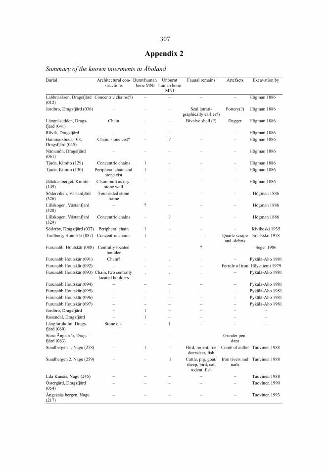
307
Appendix 2
Summary of the known interments in ÅbolandBurial Architectural con-
structionsBurnt human
bone MNIUnburnt
human bone MNI
Faunal remains Artefacts Excavation by
Labbnäsåsen, Dragsfjärd (012)
Concentric chains(?) – – – – Högman 1886
Jordbro, Dragsfjärd (036) – – – Seal (strati-graphically earlier?)
Pottery(?) Högman 1886
Långnäsudden, Drags-fjärd (041)
Chain – – Bivalve shell (?) Dagger Högman 1886
Rövik, Dragsfjärd – – – – – Högman 1886Hammarsboda 108, Dragsfjärd (045)
Chain, stone cist? – ? – – Högman 1886
Nämanön, Dragsfjärd (061)
– – – – – Högman 1886
Tjuda, Kimito (129) Concentric chains 1 – – – Högman 1886Tjuda, Kimito (130) Peripheral chain and
stone cist1 – – – Högman 1886
Jättekastberget, Kimito (149)
Chain built as dry-stone wall
– – – – Högman 1886
Söderviken, Västanfjärd (326)
Four-sided stone frame
– – – – Högman 1886
Lillskogen, Västanfjärd (328)
– ? – – – Högman 1886
Lillskogen, Västanfjärd (329)
Concentric chains – ? – – Högman 1886
Söderby, Dragsfjärd (037) Peripheral chain 1 – – – Kivikoski 1935Trollberg, Houtskär (087) Concentric chains 1 – – Quartz scrape
and -debrisErä-Esko 1978
Furunabb, Houtskär (088) Centrally located boulder
– – ? – Seger 1986
Furunabb Houtskär (091) Chain? . . . – Pykälä-Aho 1981Furunabb Houtskär (092) – – – – Ferrule of iron Höysniemi 1979Furunabb Houtskär (093) Chain, two centrally
located boulders. . . – Pykälä-Aho 1981
Furunabb Houtskär (094) – – – – – Pykälä-Aho 1981Furunabb Houtskär (095) – . . . – Pykälä-Aho 1981Furunabb Houtskär (096) – – – – – Pykälä-Aho 1981Furunabb Houtskär (097) – – – – – Pykälä-Aho 1981Jordbro, Dragsfjärd – 1 – – – –Rosendal, Dragsfjärd – 1 – – – –Långfuruholm, Drags-fjärd (060)
Stone cist – 1 – – –
Stora Ängeskär, Drags-fjärd (063)
– – – – Grinder pen-dant
–
Sundbergen 1, Nagu (258) – 1 – Bird, rodent, roe deer/deer, fish
Comb of antler Tuovinen 1988
Sundbergen 2, Nagu (259) – – 1 Cattle, pig, goat/sheep, bird, cat,
rodent, fish
Iron rivets and nails
Tuovinen 1988
Lila Kuusis, Nagu (245) – – – – – Tuovinen 1988Östergård, Dragsfjärd (054)
– – – – – Tuovinen 1990
Ängesnäs bergen, Nagu (217)
– – – – – Tuovinen 1993
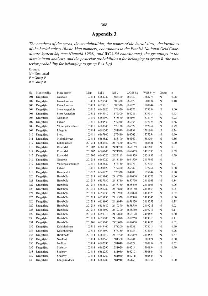
308
Appendix 3
The numbers of the carns, the municipalities, the names of the burial sites, the locationsof the burial cairns (Basic Map numbers, coordinates in the Finnish National Grid Coor-dinate System kkj (see Niemelä 1984), and WGS-84 coordinates), the groupings in thediscriminant analysis, and the posterior probabilities p for belonging to group R (the pos-terior probability for belonging to group P is 1-p). Groups:N = Non-datedP = Group PR = Group R
No. Municipality Place-name Map kkj x kkj y WGS84 x WGS84 y Group p001 Dragsfjärd Genböle 103414 6664740 1583460 6664591 1583274 N 0.08002 Dragsfjärd Kosackkullan 103413 6658940 1580320 6658791 1580134 N 0.10003 Dragsfjärd Kosackkullan 103413 6658910 1580330 6658761 1580144 N .004 Dragsfjärd Stora Ängeskär 103312 6642920 1579520 6642771 1579334 N 1.00005 Dragsfjärd Stora Ängeskär 103312 6643010 1579500 6642861 1579314 R 0.73006 Dragsfjärd Nämanön 103410 6652090 1575560 6651941 1575374 N 0.92007 Dragsfjärd Falkön 103411 6669530 1577210 6669381 1577024 N 0.36008 Dragsfjärd Västersjälsmalmen 103411 6663940 1578150 6663791 1577964 N 0.99009 Dragsfjärd Långnäs 103414 6661540 1581990 6661391 1581804 N 0.34010 Dragsfjärd Storö 103411 6667800 1577440 6667651 1577254 N 0.90011 Dragsfjärd Malmisberget 103414 6663820 1583190 6663671 1583004 N 0.36012 Dragsfjärd Labbnäsåsen 201214 6662930 2416560 6662785 1583421 N 0.00013 Dragsfjärd Rosendal 201202 6668300 2421780 6668159 2421603 N 0.01014 Dragsfjärd Rosendal 201202 6668600 2421970 6668459 2421793 N 0.69015 Dragsfjärd Rosendal 201202 6668720 2422110 6668579 2421933 N 0.59016 Dragsfjärd Genböle 201214 6664720 2418140 6664579 2417963 N .017 Dragsfjärd Västersjälsmalmen 103411 6663880 1578150 6663731 1577964 N 0.94018 Dragsfjärd Falkön 103411 6669620 1577450 6669471 1577264 N 0.88019 Dragsfjärd Hemlandet 103312 6648220 1575330 6648071 1575144 N 0.90020 Dragsfjärd Hertsböle 201213 6658140 2418750 6658000 2418573 N 0.06021 Dragsfjärd Hertsböle 201213 6657930 2418740 6657790 2418563 N 0.84022 Dragsfjärd Hertsböle 201213 6658580 2418780 6658440 2418603 N 0.06023 Dragsfjärd Hertsböle 201213 6658280 2418830 6658140 2418653 N 0.05024 Dragsfjärd Hertsböle 201213 6658230 2418900 6658090 2418723 N 0.02025 Dragsfjärd Hertsböle 201213 6658130 2419520 6657990 2419343 N 0.00026 Dragsfjärd Hertsböle 201213 6658960 2418930 6658820 2418753 N 0.38027 Dragsfjärd Hertsböle 201213 6658680 2419390 6658540 2419213 N 0.03028 Dragsfjärd Hertsböle 201213 6658690 2419390 6658550 2419213 N 0.11029 Dragsfjärd Hertsböle 201213 6659310 2419800 6659170 2419623 N 0.80030 Dragsfjärd Hertsböle 201213 6658900 2419890 6658760 2419713 N 0.11031 Dragsfjärd Hertsböle 201201 6659200 2420050 6659060 2419873 N 0.02032 Dragsfjärd Kaldoholmen 103312 6643460 1578200 6643311 1578014 N 0.99033 Dragsfjärd Kaldoholmen 103312 6643690 1578350 6643541 1578164 N 0.96034 Dragsfjärd Björkboda 201214 6665010 2418700 6664869 2418523 N 0.37035 Dragsfjärd Nordanå 103414 6667560 1581360 6667411 1581174 N 0.00036 Dragsfjärd Jordbro 103414 6662390 1581040 6662241 1580854 N 0.52037 Dragsfjärd Söderby 103414 6662290 1581020 6662141 1580834 N 0.99038 Dragsfjärd Söderby 103414 6662250 1581030 6662101 1580844 N .039 Dragsfjärd Söderby 103414 6662260 1581030 6662111 1580844 N .040 Dragsfjärd Långnäsudden 103414 6661780 1581940 6661631 1581754 P 0.00
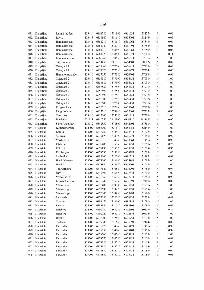
309
041 Dragsfjärd Långnäsudden 103414 6661780 1581960 6661631 1581774 P 0.00042 Dragsfjärd Rövik 103413 6656140 1581650 6655991 1581464 N 0.05043 Dragsfjärd Hammarsboda 103411 6661210 1578670 6661061 1578484 P 0.00044 Dragsfjärd Hammarsboda 103411 6661240 1578710 6661091 1578524 P 0.01045 Dragsfjärd Hammarsboda 103411 6661210 1578690 6661061 1578504 P 0.08046 Dragsfjärd Hammarsboda 103411 6661220 1578600 6661071 1578414 P 0.11047 Dragsfjärd Kammarbergen 103411 6666760 1578550 6666611 1578364 N 1.00048 Dragsfjärd Söljeholmen 103413 6654450 1581010 6654301 1580824 N 0.82049 Dragsfjärd Östergård 1 103410 6657060 1577560 6656911 1577374 N 0.62050 Dragsfjärd Östergård 1 103410 6657020 1577530 6656871 1577344 N 0.06051 Dragsfjärd Hamnholmssundet 103410 6657050 1577150 6656901 1576964 N 0.96052 Dragsfjärd Östergård 2 103410 6656580 1577500 6656431 1577314 N 1.00053 Dragsfjärd Östergård 2 103410 6656580 1577500 6656431 1577314 N 1.00054 Dragsfjärd Östergård 2 103410 6656580 1577500 6656431 1577314 N 1.00055 Dragsfjärd Östergård 2 103410 6656590 1577500 6656441 1577314 N 1.00056 Dragsfjärd Östergård 2 103410 6656590 1577510 6656441 1577324 N 1.00057 Dragsfjärd Östergård 2 103410 6656580 1577510 6656431 1577324 N 1.00058 Dragsfjärd Östergård 2 103410 6656600 1577500 6656451 1577314 N 1.00059 Dragsfjärd Krogarudden 103410 6655510 1577860 6655361 1577674 N 1.00060 Dragsfjärd Långfuruholm 103410 6652210 1573840 6652061 1573654 R 0.96061 Dragsfjärd Nämanön 103410 6652060 1575550 6651911 1575364 N 1.00062 Dragsfjärd Bötskäret 201115 6640250 2418300 6640110 2418123 N 0.97063 Dragsfjärd Stora Ängeskär 103312 6642850 1578800 6642701 1578614 R 1.00064 Houtskär Kummelbergen 104107 6683200 1521610 6683051 1521424 N 1.00065 Houtskär Kalnäs 103206 6678760 1514410 6678611 1514224 N 1.00066 Houtskär Sälgnäs 103206 6677120 1514990 6676971 1514804 N 0.92067 Houtskär Vårdberget 103206 6678810 1514740 6678661 1514554 N 0.99068 Houtskär Edjärdan 103206 6678400 1515760 6678251 1515574 N 0.75069 Houtskär Ekholm 103206 6679180 1515770 6679031 1515584 N 0.95070 Houtskär Flakbergen 103206 6678530 1515380 6678381 1515194 N 1.00071 Houtskär Svälteskär 104104 6681660 1512060 6681511 1511874 N 0.99072 Houtskär Hästkilsbergen 103206 6675990 1513160 6675841 1512974 N 1.00073 Houtskär Hästkil 103206 6675850 1512660 6675701 1512474 N 1.00074 Houtskär Timmerholm 103206 6676140 1516820 6675991 1516634 N 0.93075 Houtskär Järvis 103206 6677490 1516190 6677341 1516004 N 1.00076 Houtskär Västerskogen 103206 6678060 1516050 6677911 1515864 N 0.99077 Houtskär Kummelbergen 103209 6676740 1525060 6676591 1524874 N 0.07078 Houtskär Västerskogen 103206 6675400 1519900 6675251 1519714 N 1.00079 Houtskär Västerskogen 103206 6675680 1519970 6675531 1519784 N 1.00080 Houtskär Västerskogen 103206 6676040 1519990 6675891 1519804 N 1.00081 Houtskär Sunsveden 103209 6677080 1522580 6676931 1522394 N 0.41082 Houtskär Norrnäs 104104 6681470 1513100 6681321 1512914 N 1.00083 Houtskär Surnon 104107 6683540 1521080 6683391 1520894 N 0.65084 Houtskär Reisberg 104102 6692750 1508320 6692601 1508134 N 0.84085 Houtskär Reisberg 104102 6692720 1508330 6692571 1508144 N 1.00086 Houtskär Hästkil 103206 6675900 1512520 6675751 1512334 N 1.00087 Houtskär Trollberg 103209 6677040 1521630 6676891 1521444 P 0.03088 Houtskär Furunabb 103206 6678570 1514740 6678421 1514554 R 0.93089 Houtskär Furunabb 103206 6678550 1514740 6678401 1514554 R 0.99090 Houtskär Furunabb 103206 6678560 1514740 6678411 1514554 R 1.00091 Houtskär Furunabb 103206 6678570 1514750 6678421 1514564 R 0.99092 Houtskär Furunabb 103206 6678580 1514740 6678431 1514554 R 1.00093 Houtskär Furunabb 103206 6678580 1514730 6678431 1514544 R 1.00094 Houtskär Furunabb 103206 6678580 1514750 6678431 1514564 R 0.99095 Houtskär Furunabb 103206 6678580 1514750 6678431 1514564 R 0.98

310
096 Houtskär Furunabb 103206 6678590 1514750 6678441 1514564 R 1.00097 Houtskär Furunabb 103206 6678590 1514750 6678441 1514564 R 1.00098 Houtskär Furunabb 103206 6678600 1514750 6678451 1514564 R 1.00099 Houtskär Furunabb 103206 6678600 1514740 6678451 1514554 R 1.00100 Houtskär Svinö Högberget 104104 6681500 1512700 6681351 1512514 N 0.99101 Iniö Äspholm 104109 6702730 1520540 6702581 1520354 N 0.45102 Iniö Långholm 104109 6703630 1520790 6703481 1520604 N 1.00103 Iniö Keistiö 104105 6696050 1518260 6695901 1518074 N 0.98104 Iniö Keistiö 104105 6696080 1518260 6695931 1518074 N 1.00105 Iniö Märrarygg 104108 6696660 1520920 6696511 1520734 N .106 Iniö Dalen 104108 6697260 1520990 6697111 1520804 N 0.96107 Iniö Norrby 104108 6697580 1521320 6697431 1521134 N 1.00108 Iniö Norrby 104108 6698300 1520650 6698151 1520464 N 0.99109 Iniö Norrby 104108 6698050 1520320 6697901 1520134 N 0.91110 Iniö Söderby 104108 6696920 1521970 6696771 1521784 N 1.00111 Iniö Norrby 104108 6698120 1520480 6697971 1520294 N 0.99112 Iniö Norrby 104108 6698120 1520490 6697971 1520304 N 1.00113 Kimito Smisskullen 201206 6678340 2433510 6678200 2433333 N 0.97114 Kimito Smisskullen 201206 6678340 2433460 6678200 2433283 N 0.82115 Kimito Viksgård 202104 6681170 2430670 6681029 2430493 N 0.02116 Kimito Viksgård 202104 6681200 2430610 6681059 2430433 N 0.01117 Kimito Österängsberget 201206 6678420 2430760 6678280 2430583 N 0.09118 Kimito Österängsberget 201206 6678450 2430760 6678310 2430583 N 0.17119 Kimito Skrinnanberget 201203 6677740 2429260 6677599 2429083 N 0.02120 Kimito Skrinnanberget 201203 6677740 2429250 6677599 2429073 N 0.06121 Kimito Gästerby 201203 6677380 2428820 6677239 2428643 N 0.95122 Kimito Smisskullen 201203 6678700 2429680 6678559 2429503 N 0.00123 Kimito Trotby 201206 6677660 2431260 6677520 2431083 N .124 Kimito Telegrafberget 202104 6681030 2430240 6680889 2430063 N 0.11125 Kimito Storhomman 103415 6673960 1583170 6673811 1582984 N 0.99126 Kimito Verkholm 201215 6673300 2418170 6673159 2417993 N 0.00127 Kimito Verkholm 201215 6673290 2418150 6673149 2417973 N 0.00128 Kimito Tjuda 201203 6677480 2428950 6677339 2428773 N 0.45129 Kimito Tjuda 201203 6677550 2428890 6677409 2428713 N 0.08130 Kimito Tjuda 201203 6677540 2428870 6677399 2428693 N 0.29131 Kimito Klobben 201203 6676440 2429070 6676300 2428893 N 0.15132 Kimito Tjuda 201203 6676690 2428010 6676549 2427833 N 0.01133 Kimito Tjuda 201203 6676680 2428010 6676539 2427833 N 0.50134 Kimito Spångmalm 201203 6675210 2428390 6675070 2428213 N 0.97135 Kimito Spångmalm 201203 6675230 2428340 6675090 2428163 N 0.99136 Kimito Spångmalm 201203 6675200 2428350 6675060 2428173 N .137 Kimito Spångmalm 201203 6675180 2427930 6675039 2427753 N 0.03138 Kimito Makila 201203 6674290 2427220 6674149 2427043 N 0.09139 Kimito Båtkullaberget 201206 6672830 2433490 6672690 2433313 N 0.00140 Kimito Kummelberget 201206 6671790 2436660 6671650 2436483 N 0.01141 Kimito Kummelberget 201206 6671770 2436660 6671630 2436483 N 0.37142 Kimito Sjölax 201206 6671450 2436910 6671310 2436733 N 0.03143 Kimito Sjölax 201206 6671450 2436900 6671310 2436723 N 0.02144 Kimito Sjölax 201206 6671460 2436880 6671320 2436703 N 0.00145 Kimito Björnholmen 201206 6671380 2437480 6671240 2437303 N 0.38146 Kimito Länsmansberget 201206 6672770 2431050 6672630 2430873 N 0.00147 Kimito Länsmansberget 201206 6672780 2431040 6672640 2430863 N 0.00148 Kimito Jättekastberget 201203 6671970 2427850 6671830 2427673 N 0.82149 Kimito Jättekastberget 201203 6671940 2427860 6671800 2427683 N 0.89150 Kimito Jättekastberget 201203 6671920 2427870 6671780 2427693 N 0.99
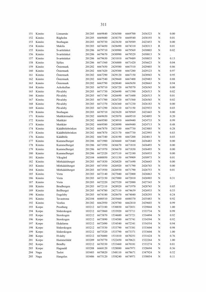
311
151 Kimito Linnarnäs 201205 6669840 2436500 6669700 2436323 N 0.00152 Kimito Rågholm 201205 6669680 2438370 6669540 2438193 N 0.01153 Kimito Storhagan 201203 6670730 2423630 6670589 2423453 N 0.00154 Kimito Makila 201203 6674450 2428490 6674310 2428313 R 0.01155 Kimito Svartträsket 201206 6679710 2430980 6679569 2430803 N 0.02156 Kimito Svartträsket 201206 6679670 2430990 6679529 2430813 N .157 Kimito Svartträsket 201206 6679630 2431010 6679489 2430833 N 0.13158 Kimito Sjölax 201206 6671560 2436800 6671420 2436623 N 0.04159 Kimito Östermark 201202 6667650 2429580 6667510 2429403 N 0.86160 Kimito Östermark 201202 6667420 2429300 6667280 2429123 N 0.97161 Kimito Östermark 201202 6667290 2429120 6667150 2428943 N 0.95162 Kimito Östermark 201202 6667540 2429660 6667400 2429483 N 0.88163 Kimito Östermark 201202 6665790 2428840 6665650 2428663 N 0.94164 Kimito Ackokullan 201203 6670710 2426720 6670570 2426543 N 0.00165 Kimito Påvalsby 201203 6671730 2426690 6671590 2426513 N 0.02166 Kimito Påvalsby 201203 6671740 2426690 6671600 2426513 N 0.01167 Kimito Påvalsby 201203 6671700 2426720 6671560 2426543 N 0.02168 Kimito Påvalsby 201203 6671370 2426360 6671230 2426183 N 0.00169 Kimito Påvalsby 201203 6671290 2426110 6671150 2425933 N 0.03170 Kimito Storhagan 201203 6670710 2423620 6670569 2423443 N 0.00171 Kimito Mattkärrmalm 201202 6669650 2425070 6669510 2424893 N 0.20172 Kimito Mattkärr 201202 6669580 2424910 6669440 2424733 N 0.99173 Kimito Mattkärr 201202 6669580 2424890 6669440 2424713 N 0.48174 Kimito Kåddbölebrinken 201202 6667870 2423180 6667730 2423003 N 0.28175 Kimito Kåddbölebrinken 201202 6667870 2423170 6667730 2422993 N 0.83176 Kimito Kåddböle 201202 6667340 2424190 6667200 2424013 N 0.03177 Kimito Kummelberget 201206 6671980 2436660 6671840 2436483 N 0.00178 Kimito Kummelberget 201206 6671950 2436670 6671810 2436493 N 0.00179 Kimito Kummelberget 201206 6671970 2436670 6671830 2436493 N 0.00180 Kimito Kummelberget 201206 6672320 2437110 6672180 2436933 N 0.00181 Kimito Viksgård 202104 6680050 2431150 6679909 2430973 N 0.01182 Kimito Mörkdalsberget 201203 6671830 2426820 6671690 2426643 N 0.00183 Kimito Mörkdalsberget 201203 6671930 2426920 6671790 2426743 N 0.00184 Kimito Mörkdalsberget 201203 6671930 2426930 6671790 2426753 N 0.01185 Kimito Vreta 201203 6672140 2427040 6672000 2426863 N .186 Kimito Vreta 201203 6672150 2427080 6672010 2426903 N 0.31187 Kimito Vreta 201203 6672220 2427520 6672080 2427343 N .188 Kimito Brudbergen 201203 6672110 2428920 6671970 2428743 N 0.85189 Kimito Bollberget 201203 6674780 2427110 6674639 2426933 N 0.53190 Kimito Engelsby 201203 6674180 2428470 6674040 2428293 N 0.24191 Kimito Tavastrona 202104 6680510 2435660 6680370 2435483 N 0.92192 Kimito Vestlax 201202 6662950 2429780 6662810 2429603 N 0.99193 Korpo Prostberg 103212 6672180 1530030 6672031 1529844 N 1.00194 Korpo Söderskogen 103212 6673860 1533920 6673711 1533734 N 0.99195 Korpo Storskogen 103212 6673870 1534680 6673721 1534494 N 0.92196 Korpo Storskogen 103212 6673890 1534580 6673741 1534394 N 0.92197 Korpo Ekdalarna 103212 6672490 1534540 6672341 1534354 N 0.94198 Korpo Söderskogen 103212 6673530 1533790 6673381 1533604 N 0.98199 Korpo Söderskogen 103212 6673520 1533790 6673371 1533604 N 1.00200 Korpo Hväsby 103212 6670400 1531810 6670251 1531624 N 0.76201 Korpo Hummelskär 103209 6670770 1522450 6670621 1522264 N 1.00202 Korpo Bendby 103212 6670330 1533460 6670181 1533274 N 0.81203 Korpo Hagaudd 103208 6668120 1528880 6667971 1528694 N 0.36204 Nagu Taslot 103403 6678820 1548110 6678671 1547924 N 0.52205 Nagu Hangslax 103406 6675120 1558240 6674971 1558054 N 0.11
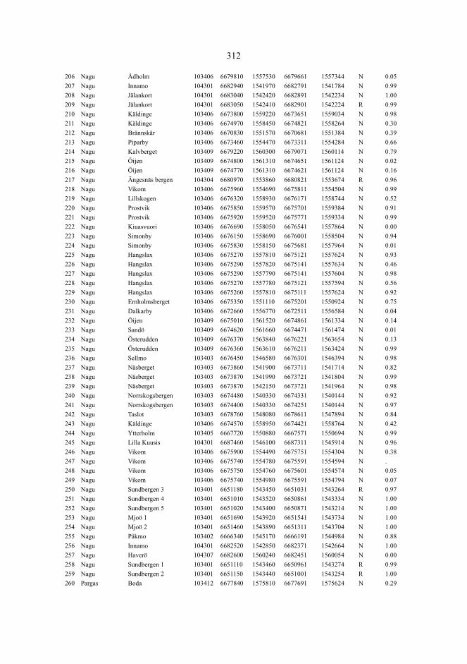
312
206 Nagu Ådholm 103406 6679810 1557530 6679661 1557344 N 0.05207 Nagu Innamo 104301 6682940 1541970 6682791 1541784 N 0.99208 Nagu Jälankort 104301 6683040 1542420 6682891 1542234 N 1.00209 Nagu Jälankort 104301 6683050 1542410 6682901 1542224 R 0.99210 Nagu Käldinge 103406 6673800 1559220 6673651 1559034 N 0.98211 Nagu Käldinge 103406 6674970 1558450 6674821 1558264 N 0.30212 Nagu Brännskär 103406 6670830 1551570 6670681 1551384 N 0.39213 Nagu Piparby 103406 6673460 1554470 6673311 1554284 N 0.66214 Nagu Kalvberget 103409 6679220 1560300 6679071 1560114 N 0.79215 Nagu Öijen 103409 6674800 1561310 6674651 1561124 N 0.02216 Nagu Öijen 103409 6674770 1561310 6674621 1561124 N 0.16217 Nagu Ängesnäs bergen 104304 6680970 1553860 6680821 1553674 R 0.96218 Nagu Vikom 103406 6675960 1554690 6675811 1554504 N 0.99219 Nagu Lillskogen 103406 6676320 1558930 6676171 1558744 N 0.52220 Nagu Prostvik 103406 6675850 1559570 6675701 1559384 N 0.91221 Nagu Prostvik 103406 6675920 1559520 6675771 1559334 N 0.99222 Nagu Kiuasvuori 103406 6676690 1558050 6676541 1557864 N 0.00223 Nagu Simonby 103406 6676150 1558690 6676001 1558504 N 0.94224 Nagu Simonby 103406 6675830 1558150 6675681 1557964 N 0.01225 Nagu Hangslax 103406 6675270 1557810 6675121 1557624 N 0.93226 Nagu Hangslax 103406 6675290 1557820 6675141 1557634 N 0.46227 Nagu Hangslax 103406 6675290 1557790 6675141 1557604 N 0.98228 Nagu Hangslax 103406 6675270 1557780 6675121 1557594 N 0.56229 Nagu Hangslax 103406 6675260 1557810 6675111 1557624 N 0.92230 Nagu Ernholmsberget 103406 6675350 1551110 6675201 1550924 N 0.75231 Nagu Dalkarby 103406 6672660 1556770 6672511 1556584 N 0.04232 Nagu Öijen 103409 6675010 1561520 6674861 1561334 N 0.14233 Nagu Sandö 103409 6674620 1561660 6674471 1561474 N 0.01234 Nagu Österudden 103409 6676370 1563840 6676221 1563654 N 0.13235 Nagu Österudden 103409 6676360 1563610 6676211 1563424 N 0.99236 Nagu Sellmo 103403 6676450 1546580 6676301 1546394 N 0.98237 Nagu Näsberget 103403 6673860 1541900 6673711 1541714 N 0.82238 Nagu Näsberget 103403 6673870 1541990 6673721 1541804 N 0.99239 Nagu Näsberget 103403 6673870 1542150 6673721 1541964 N 0.98240 Nagu Norrskogsbergen 103403 6674480 1540330 6674331 1540144 N 0.92241 Nagu Norrskogsbergen 103403 6674400 1540330 6674251 1540144 N 0.97242 Nagu Taslot 103403 6678760 1548080 6678611 1547894 N 0.84243 Nagu Käldinge 103406 6674570 1558950 6674421 1558764 N 0.42244 Nagu Ytterholm 103405 6667720 1550880 6667571 1550694 N 0.99245 Nagu Lilla Kuusis 104301 6687460 1546100 6687311 1545914 N 0.96246 Nagu Vikom 103406 6675900 1554490 6675751 1554304 N 0.38247 Nagu Vikom 103406 6675740 1554780 6675591 1554594 N .248 Nagu Vikom 103406 6675750 1554760 6675601 1554574 N 0.05249 Nagu Vikom 103406 6675740 1554980 6675591 1554794 N 0.07250 Nagu Sundbergen 3 103401 6651180 1543450 6651031 1543264 R 0.97251 Nagu Sundbergen 4 103401 6651010 1543520 6650861 1543334 N 1.00252 Nagu Sundbergen 5 103401 6651020 1543400 6650871 1543214 N 1.00253 Nagu Mjoö 1 103401 6651690 1543920 6651541 1543734 N 1.00254 Nagu Mjoö 2 103401 6651460 1543890 6651311 1543704 N 1.00255 Nagu Påkmo 103402 6666340 1545170 6666191 1544984 N 0.88256 Nagu Innamo 104301 6682520 1542850 6682371 1542664 N 1.00257 Nagu Haverö 104307 6682600 1560240 6682451 1560054 N 0.00258 Nagu Sundbergen 1 103401 6651110 1543460 6650961 1543274 R 0.99259 Nagu Sundbergen 2 103401 6651150 1543440 6651001 1543254 R 1.00260 Pargas Boda 103412 6677840 1575810 6677691 1575624 N 0.29

313
261 Pargas Boda 103412 6677760 1575640 6677611 1575454 N 0.37262 Pargas Boda 103412 6677760 1575650 6677611 1575464 N 0.75263 Pargas Boda 103412 6677760 1575660 6677611 1575474 N 0.05264 Pargas Björkholm 103409 6675460 1569550 6675311 1569364 N 0.16265 Pargas Österudden 103412 6670950 1574410 6670801 1574224 N 0.21266 Pargas Ön 103409 6677890 1565250 6677741 1565064 N 0.87267 Pargas Labbholmen 103412 6672660 1575830 6672511 1575644 N 0.82268 Pargas Klofsudden 104307 6682940 1561360 6682791 1561174 N 0.54269 Pargas Mielisholm 103412 6678810 1573240 6678661 1573054 N 0.94270 Pargas Mågby 103409 6678210 1568550 6678061 1568364 N 0.99271 Pargas Mågby 103409 6676690 1569040 6676541 1568854 N 0.39272 Pargas Mågby 103409 6676650 1569140 6676501 1568954 N 0.74273 Pargas Mågby 103409 6676950 1569910 6676801 1569724 N 1.00274 Pargas Mågby 104307 6685660 1561680 6685511 1561494 N 0.97275 Pargas Klofsan 104307 6683090 1561570 6682941 1561384 N 0.92276 Pargas Skärmola 104307 6685190 1564600 6685041 1564414 N 0.81277 Pargas Mielisholm 103412 6678820 1573230 6678671 1573044 N 0.24278 Pargas Portnäset 103412 6671680 1571960 6671531 1571774 N 0.29279 Pargas Sandholm 103409 6679900 1562450 6679751 1562264 N 0.06280 Pargas Jättekasten 104307 6689560 1568650 6689411 1568464 N 0.32281 Pargas Jättekasten 104307 6689560 1568590 6689411 1568404 N 0.02282 Pargas Vallis 104307 6688020 1568340 6687871 1568154 N 0.06283 Pargas Lofsdal 104307 6682460 1568530 6682311 1568344 N 0.33284 Pargas Lofsdal 104307 6681700 1568190 6681551 1568004 N 0.11285 Pargas Kummelberget 104307 6680930 1569400 6680781 1569214 N 0.15286 Pargas Kummelberget 104307 6680930 1569430 6680781 1569244 N 0.90287 Pargas Sildala 103409 6679970 1568950 6679821 1568764 N 0.72288 Pargas Sattmark 104307 6682700 1568720 6682551 1568534 N 0.24289 Pargas Lilltervo 103409 6679700 1565280 6679551 1565094 N 0.08290 Pargas Lilltervo 103409 6679870 1565490 6679721 1565304 N 0.65291 Pargas Mågby 103409 6676590 1568640 6676441 1568454 N .292 Pargas Mågby 103409 6676770 1568540 6676621 1568354 N 0.01293 Pargas Mågbyklobben 103409 6676040 1567640 6675891 1567454 N 0.59294 Pargas Långstrandsberget 103409 6677030 1567460 6676881 1567274 N 0.95295 Pargas Lofsdal 104307 6682780 1569040 6682631 1568854 N 0.46296 Pargas Bredviksbacken 104311 6694340 1574660 6694191 1574474 N 0.14297 Pargas Koupo 104307 6687080 1562180 6686931 1561994 N 0.43298 Pargas Koupo 104307 6687040 1562200 6686891 1562014 N 0.92299 Pargas Strandby 104307 6687580 1561230 6687431 1561044 N 0.86300 Pargas Mågby 103409 6676580 1568640 6676431 1568454 N 0.21301 Pargas Sandvik 103409 6676600 1568840 6676451 1568654 N 0.11302 Pargas Sandvik 103409 6676640 1568900 6676491 1568714 N 0.81303 Pargas Sandvik 103409 6676800 1569000 6676651 1568814 N 0.97304 Pargas Lilltervo 103409 6679850 1565420 6679701 1565234 N 0.08305 Rymättylä Nuikonvuori 104305 6698400 1551060 6698251 1550874 N 0.89306 Rymättylä Miinamäki 104305 6694840 1555590 6694691 1555404 N 0.64307 Rymättylä Äijälä 104305 6694330 1555520 6694181 1555334 N 0.66308 Rymättylä Isoluoto 104304 6687990 1553200 6687841 1553014 N 0.45309 Rymättylä Isoluoto 104304 6688000 1553010 6687851 1552824 N .310 Rymättylä Hanka 104304 6686860 1553720 6686711 1553534 N 0.00311 Rymättylä Hanka 104304 6686990 1553800 6686841 1553614 N 0.00312 Rymättylä Hanka 104304 6686960 1553790 6686811 1553604 N 0.01313 Rymättylä Ojainen 104304 6689880 1554590 6689731 1554404 N .314 Rymättylä Härmistönniemi 104304 6689020 1554200 6688871 1554014 N 0.02315 Rymättylä Härmistönniemi 104304 6689020 1554210 6688871 1554024 N 0.05
314
316 Rymättylä Ojainen 104304 6689840 1554720 6689691 1554534 N 0.87317 Rymättylä Ojainen 104304 6689880 1554690 6689731 1554504 N 0.92318 Rymättylä Prustinvuori 104302 6698050 1547700 6697901 1547514 N 0.19319 Rymättylä Kramppi 104304 6686490 1554520 6686341 1554334 N 0.95320 Rymättylä Kramppi 104304 6686500 1554520 6686351 1554334 N 0.96321 Rymättylä Hanka 104304 6686820 1553700 6686671 1553514 N 0.02322 Turku Nunnavuori 104308 6696520 1569620 6696371 1569434 N 0.00323 Turku Kettukallio 104308 6693080 1564940 6692931 1564754 N 0.98324 Velkua Martinmaa 104112 6700220 1533810 6700071 1533624 N 0.95325 Västanfjärd Lyckeberget 201202 6663970 2425240 6663830 2425063 N 0.90326 Västanfjärd Söderviken 201201 6658310 2422650 6658170 2422473 R 0.98327 Västanfjärd Söderviken 201201 6658300 2422670 6658160 2422493 R 0.82328 Västanfjärd Lillskogen 201202 6660040 2426540 6659900 2426363 N 0.88329 Västanfjärd Lillskogen 201202 6660030 2426570 6659890 2426393 N 0.57330 Västanfjärd Södergårdskvarn 201202 6663260 2424160 6663120 2423983 N 0.10331 Västanfjärd Nivelax 201202 6665220 2424290 6665080 2424113 N 0.48332 Västanfjärd Nivelax 201202 6665230 2424280 6665090 2424103 N 0.95333 Västanfjärd Nivelax 201202 6665230 2424300 6665090 2424123 N 0.58334 Västanfjärd Norra Mågsholmen 201201 6656450 2423470 6656310 2423293 N 0.20335 Dragsfjärd Hammarsboda 10 103411 6660700 1578500 6660551 1578314 N 0.82336 Dragsfjärd Hammarsboda 11 103411 6660830 1578820 6660681 1578634 N 0.73337 Dragsfjärd Kalvholms fladan 1 103315 6642240 1583370 6642091 1583184 N 0.96338 Dragsfjärd Kalvholms fladan 2 103315 6642450 1583240 6642301 1583054 N 0.89339 Dragsfjärd Kalvholms fladan 3 103315 6642450 1583260 6642301 1583074 N 1.00340 Dragsfjärd Kyrkön 103315 6641740 1583620 6641591 1583434 N 0.97341 Dragsfjärd Västra Granholmen 103314 6638460 1582350 6638311 1582164 N 1.00342 Dragsfjärd Snåldö 103311 6639370 1574570 6639221 1574384 N 1.00343 Dragsfjärd Norrglo 103311 6639300 1577960 6639151 1577774 N 0.99344 Dragsfjärd Rosala Hamnholmen 103312 6641450 1577710 6641301 1577524 N 0.97345 Dragsfjärd Holma Hamnholmen 103312 6641760 1577580 6641611 1577394 N 0.77346 Dragsfjärd Ängeskär 103407 6655040 1567340 6654891 1567154 N 1.00347 Dragsfjärd Härön 103308 6637900 1563050 6637751 1562864 N 1.00348 Korpo Norrkumlet 103205 6662780 1518500 6662631 1518314 N 0.99349 Korpo Bussö 103210 6658520 1532600 6658371 1532414 N 0.99350 Korpo Kistskär 103204 6650240 1517460 6650091 1517275 N 0.76351 Korpo Västerö 103112 6649000 1533590 6648851 1533404 N 1.00352 Nagu Simonby 45 103406 6675910 1558540 6675761 1558354 N 0.03353 Nagu Simonby 46 103406 6675900 1558540 6675751 1558354 N 0.35354 Nagu Simonby 47 103406 6675880 1558680 6675731 1558494 N 0.28355 Nagu Hangslax 48 103406 6675120 1557580 6674971 1557394 N 1.00356 Nagu Käldinge 49 103406 6674310 1558240 6674161 1558054 N 0.35357 Nagu Öbergen 50 103409 6674600 1560740 6674451 1560554 N 0.99358 Nagu Öbergen 51 103409 6674570 1560740 6674421 1560554 N 0.00359 Nagu Högsar 103403 6670850 1547710 6670701 1547524 N 1.00360 Nagu Hummelholm 103402 6665230 1544830 6665081 1544644 N 0.69361 Nagu Hummelholm 103402 6665230 1544790 6665081 1544604 N 0.99362 Dragsfjärd Kalholm 103312 6643850 1576050 6643701 1575864 N 0.86363 Dragsfjärd Bötsön 103311 6635280 1577350 6635131 1577164 N 0.97364 Korpo Djupklevudden 103208 6662930 1520780 6662781 1520594 N 0.90365 Nagu Boskär 103401 6658410 1543180 6658261 1542994 N 0.99366 Nagu Ådön 103401 6655480 1548810 6655331 1548624 R 0.95367 Nagu Ön 103405 6661620 1558900 6661471 1558714 N 0.99368 Nagu Granholm 103401 6651640 1542220 6651491 1542034 N 0.98369 Nagu Mjoö 3 103401 6650310 1544050 6650161 1543864 N 0.90370 Nagu Gånganberget 103303 6641290 1543190 6641141 1543004 N 1.00

315
371 Nagu Sandholm 103303 6643730 1545640 6643581 1545454 N 1.00372 Nagu Revberget 103303 6644470 1549570 6644321 1549384 N 0.97373 Nagu Käldinge 1 103406 6674040 1558320 6673891 1558134 N 0.99374 Nagu Käldinge 2 103406 6674060 1558250 6673911 1558064 N 0.46375 Nagu Käldinge 3 103406 6674110 1558340 6673961 1558154 N 0.86376 Nagu Käldinge 5 103406 6674420 1558330 6674271 1558144 N .377 Nagu Käldinge 7 103406 6674500 1558400 6674351 1558214 N 0.15378 Nagu Käldinge 9 103406 6674120 1558010 6673971 1557824 N 0.80379 Nagu Käldinge 10 103406 6674100 1558030 6673951 1557844 N 0.76380 Korpo Västerretais 103212 6673530 1533750 6673381 1533564 N 0.99