surface water management plan - haringey … · surface water management plan drain london london...
TRANSCRIPT
SURFACE WATER MANAGEMENT PLAN
DRAIN LONDON
LONDON
BOROUGH OF
HARINGEY
FINAL DRAFT
V2.0
Quality Management
i
Quality Management
DOCUMENT INFORMATION
Title: Surface Water Management Plan for London Borough of Haringey
Owner: Mahmood Ramjan
Version: v2.0
Status: Working draft
Project Number: CS/046913
File Name: L:\Environment\ZWET\CS046913_DrainLondon_Tier2\Reports\Group4_Outputs\SWMPs\Haringey SWMP\DLT2_GP4_Haringey_SWMP_Draft_V2.0.doc
REVISION HISTORY
Summary of Changes Completed By Date of Issue
Version
Initial draft SI 1.0
Final draft following Council feedback SI 24/08/2011 2.0
AUTHOR
Name Organisation and Role
Stephanie Ip Senior Consultant, Capita Symonds
Ruth Farrar Consultant, Capita Symonds
APPROVALS
Name Title Signature Date
Ruth Goodall Director, Capita Symonds
Michael Arthur Principal Consultant, Capita Symonds
Kevin Reid Programme Manager
DISTRIBUTION
Name Organisation and Role
Mahmood Ramjan Network Manager, LB Haringey
Kevin Reid Programme Manager, GLA
RELATED DOCUMENTS
Doc Ref Document Title Author Date of Issue
Version

Acknowledgements
ii
Acknowledgements
A number of people and organisations outside Haringey Council have contributed to this Surface
Water Management Plan. Their assistance is greatly appreciated, and in particularly inputs and
information provided by:
The British Geological Survey
British Waterways
Drain London Group 4 boroughs:
o London Borough of Enfield
o London Borough of Hackney
o London Borough of Waltham Forest
o London Borough of Newham
o London Borough of Tower Hamlets
The Environment Agency
The Greater London Authority
London Councils
The London Fire Brigade
Network Rail
Thames Water
Transport for London and London Underground

Executive Summary
iii
Executive Summary
This document forms the Surface Water Management Plan (SWMP) for the London Borough (LB) of Haringey. The report outlines the preferred surface water management strategy for the borough. In this context surface water flooding describes flooding from sewers, drains, groundwater, and runoff from land, small watercourses and ditches that occurs as a result of heavy rainfall. The SWMP has been delivered as part of the Tier 2 package of works of the Drain London Project and builds upon previous work undertaken as part of the Tier 1 package of works. A four phase approach has been undertaken in line with Defra‟s SWMP technical guidance documentation (2010). These are:
Phase 1 – Preparation;
Phase 2 – Risk Assessment;
Phase 3 – Options; and
Phase 4 – Implementation and Review.
Phase 1: Preparation
Phase 1 builds upon work undertaken during Tier 1 of the Drain London Project. The Tier 1 work involved the collection and review of surface water data from key stakeholders and the building of partnerships between key stakeholders responsible for local flood risk management. It was also decided that London would be delineated into 8 working groups. The LB of Haringey forms part of Group 4 along with the LB‟s of Haringey, Hackney, Tower Hamlets, Newham, and Waltham Forest. These six boroughs also form the North London Strategic Flood Group. The Group has been established in order for these local authorities to determine best practice and resources to enable each authority to discharge their responsibilities as Lead Local Flood Authority (LLFA) under the Flood and Water Management Act (FWMA) 2010. Phase 2: Risk Assessment
As part of the Phase 2 Risk Assessment, direct rainfall modelling has been undertaken across the entire borough for five specified return periods. The results of this modelling have been used to identify Local Flood Risk Zones (LFRZs) where flooding affects houses, businesses and/or infrastructure. Those areas identified to be at more significant risk have been delineated into Critical Drainage Areas (CDAs) representing one or several LFRZs as well as the contributing catchment area and features that influence the predicted flood extent.
Within the LB of Haringey, 8 CDAs have been identified and are presented in the figure below. The chief mechanisms for flooding in the LB of Haringey can be broadly divided into the following categories:
Topographical Low Lying Areas - areas such as underpasses, subways and lowered roads beneath railway lines are more susceptible to surface water flooding;
Railway Cuttings: stretches of railway track in cuttings are susceptible to surface water flooding and, if flooded, will impact on services;
Railway Embankments - discrete surface water flooding locations along the upstream side of the raised rail embankment;
Topographical Low Points – areas which are at topographical low points throughout the borough which result in small, discrete areas of deep surface water ponding;
Sewer Flood Risk – areas where extensive and deep surface water flooding is likely to be the influence of sewer flooding mechanisms alongside pluvial and groundwater sources; and

Executive Summary
iv
Fluvial Flood Risk - areas where extensive and deep surface water flooding is likely to be the influence of fluvial flooding mechanisms (alongside pluvial, groundwater and sewer flooding sources).
Figure i Critical Drainage Areas within the London Borough of Haringey
Analysis of the number of properties at risk of flooding has been undertaken for the rainfall event with a 1 in 100 probability of occurrence in any given year. A review of the results demonstrate that 32,100 residential properties and 4,400 non-residential properties in the LB of Haringey could be at risk of surface water flooding of a depth greater than 0.03m during a 100 year rainfall event (above an assumed 0.1m building threshold). A review of these statistics coupled with local knowledge of the study area identifies that the following CDAs are at greatest risk of flooding in terms of the number of receptors at risk:

Executive Summary
v
CDA ID
Infrastructure
Households Commercial / Industrial
Total Non-Deprived Deprived
All > 0.5m Deep
All > 0.5m Deep
All > 0.5m Deep
All > 0.5m Deep
Group4_055 42 4 4807 21 339 164 270 18 5458
Group4_057 45 8 1521 12 3084 178 215 3 4865
Group4_073 11 1 2099 7 5 0 38 0 2153
Group4_063 4 1 13 0 1528 21 26 0 1571
Group4_010 13 0 834 4 573 0 79 0 1499
Table i Top Priority Critical Drainage Areas within the London Borough of Haringey
One of the CDAs within the LB of Haringey, CDA Group4_010 has cross-boundary issues. The northern portion of this CDA extends into the LB of Enfield. This CDAs will require joint management to implement the potential options and manage surface water flood risk.
Phase 3 Options Assessment There are a number of opportunities for measures to be implemented across the borough to reduce the impact of surface water flooding. Ongoing maintenance of the drainage network and small scale improvements are already undertaken as part of the operations of the borough. In addition, opportunities to raise community awareness of the risks and responsibilities for residents should be sought, and the LB of Haringey may wish to consider the implementation of a Communication Plan to assist with this. It is important to recognise that flooding within the borough is not confined to just the CDAs, and therefore, throughout the borough there are opportunities for generic measures to be implemented through the establishment of a policy position on issues including the widespread use of water conservation measures such as water butts and rainwater harvesting technology, use of soakaways, permeable paving, Bioretention carpark pods and green roofs. In addition, there are borough-wide opportunities to raise community awareness. For each of the CDAs identified within the borough, site-specific measures have been identified that could be considered to help alleviate surface water flooding. These measures were subsequently short listed to identify a potential preferred option for each CDA. Pluvial modelling undertaken as part of the SWMP has identified that flooding within the LB of Haringey is heavily influenced by existing and historic river valleys, and impacts a number of regionally important infrastructure assets. Chapter 4 identifies the preferred surface water flood risk management options and measures to address the flood risk within the borough. Borough-wide, it is recommended that in the short-to-medium term the LB of Haringey:
Engage with residents regarding the flood risk in the borough, to make them aware of their responsibilities for property drainage (especially in the CDAs) and steps that can be taken to improve flood resilience;
Provide an „Information Portal‟ via the LB of Haringey website, for local flood risk information and measures that can be taken by residents to mitigate surface water flooding to/around their property;
Prepare a Communication Plan to effectively communicate and raise awareness of surface water flood risk to different audiences using a clearly defined process for internal and external communication with stakeholders and the public; and
Improve maintenance regimes, and target those areas identified to regular flood or known to have blocked gullies.

Executive Summary
vi
Phase 4 Implementation & Review Phase 4 establishes a long-term Action Plan for the LB of Haringey to assist in their role under the FWMA 2010 to lead in the management of surface water flood risk across the borough. The purpose of the Action Plan is to:
Outline the actions required to implement the preferred options identified in Phase 3;
Identify the partners or stakeholders responsible for implementing the action;
Provide an indication of the priority of the actions and a timescale for delivery; and
Outline actions required to meet the requirements for the LB of Haringey as LLFA under the FWMA 2010.
The SWMP Action Plan is a „living‟ document, and as such, should be reviewed and updated regularly, particularly following the occurrence of a surface water flood event, when additional data or modelling becomes available, following the outcome of investment decisions by partners and following any additional major development or changes in the catchment which may influence the surface water flood risk within the borough.

Glossary
vii
Glossary
Term Definition
Aquifer A source of groundwater comprising water bearing rock, sand or gravel capable of yielding significant quantities of water.
AMP Asset Management Plan, see below
Asset Management Plan
A plan for managing water and sewerage company (WaSC) infrastructure and other assets in order to deliver an agreed standard of service.
AStSWF Areas Susceptible to Surface Water Flooding. A national data set held by the Environment Agency and based on high level modelling which shows areas potentially at risk of surface water flooding.
Catchment Flood Management Plan (CFMP)
A high-level planning strategy through which the Environment Agency works with their key decision makers within a river catchment to identify and agree policies to secure the long-term sustainable management of flood risk.
CDA Critical Drainage Area, see below.
Critical Drainage Area
A discrete geographic area (usually a hydrological catchment) where multiple and interlinked sources of flood risk (surface water, groundwater, sewer, main river and/or tidal) cause flooding in one or more Local Flood Risk Zones during severe weather thereby affecting people, property or local infrastructure.
CFMP Catchment Flood Management Plan, see entry above
CIRIA Construction Industry Research and Information Association
Civil Contingencies Act
This UK Parliamentary Act delivers a single framework for civil protection in the UK. As part of the Act, Local Resilience Forums have a duty to put into place emergency plans for a range of circumstances including flooding.
CLG Government Department for Communities and Local Government
Climate Change Long term variations in global temperature and weather patterns caused by natural and human actions.
Culvert A channel or pipe that carries water below the level of the ground.
Defra Government Department for Environment, Food and Rural Affairs
DEM Digital Elevation Model: a topographic model consisting of terrain elevations for ground positions at regularly spaced horizontal intervals. DEM is often used as a global term to describe DSMs (Digital Surface Model) and DTMs (Digital Terrain Models).
DG5 Register A water-company held register of properties which have experienced sewer flooding due to hydraulic overload, or properties which are 'at risk' of sewer flooding more frequently than once in 20 years.
DSM Digital Surface Model: a topographic model of the bare earth/underlying terrain of the earth‟s surface including objects such as vegetation and buildings.
DTM Digital Terrain Model: a topographic model of the bare earth/underlying terrain of the earth‟s surface excluding objects such as vegetation and buildings. DTMs are usually derived from DSMs.
EA Environment Agency: Government Agency reporting to Defra charged with protecting the Environment and managing flood risk in England.
Indicative Flood Risk Areas
Areas determined by the Environment Agency as potentially having a significant flood risk, based on guidance published by Defra and WAG and the use of certain national datasets. These indicative areas are intended to provide a starting point for the determination of Flood Risk Areas by LLFAs.

Glossary
viii
Term Definition
FCERM Flood and Coastal Erosion Risk Management Strategy. Prepared by the Environment Agency in partnership with Defra. The strategy is required under the Flood and Water Management Act 2010 and will describe what needs to be done by all involved in flood and coastal risk management to reduce the risk of flooding and coastal erosion, and to manage its consequences.
FMfSW Flood Map for Surface Water. A national data set held by the Environment Agency showing areas where surface water would be expected to flow or pond, as a result of two different chances of rainfall event, the 1 in 30yr and 1 in 200yr events.
Flood defence Infrastructure used to protect an area against floods such as floodwalls and embankments; they are designed to a specific standard of protection (design standard).
Flood Risk Area See entry under Indicative Flood Risk Areas.
Flood Risk Regulations
Transposition of the EU Floods Directive into UK law. The EU Floods Directive is a piece of European Community (EC) legislation to specifically address flood risk by prescribing a common framework for its measurement and management.
Floods and Water Management Act
An Act of Parliament which forms part of the UK Government's response to Sir Michael Pitt's Report on the Summer 2007 floods, the aim of which is to clarify the legislative framework for managing surface water flood risk in England. The Act was passed in 2010 and is currently being enacted.
Fluvial Flooding Flooding resulting from water levels exceeding the bank level of a watercourse (river or stream). In this report the term Fluvial Flooding generally refers to flooding from Main Rivers (see later definition).
FRR Flood Risk Regulations, see above.
IDB Internal Drainage Board. An independent body with powers and duties for land drainage and flood control within a specific geographical area, usually an area reliant on active pumping of water for its drainage.
iPEG Increased Potential Elevated Groundwater (iPEG) maps. The iPEG mapping shows those areas within the borough where there is an increased potential for groundwater to rise sufficiently to interact with the ground surface or be within 2 m of the ground surface. The mapping was carried out on a London-wide scale by Jacobs/JBA in March 2011.
IUD Integrated Urban Drainage, a concept which aims to integrate different methods and techniques, including sustainable drainage, to effectively manage surface water within the urban environment.
LB London Borough, e.g. LB Haringey, London Borough of Haringey
LDF Local Development Framework. The spatial planning strategy introduced in England and Wales by the Planning and Compulsory Purchase Act 2004 and given detail in Planning Policy Statements 12. These documents typically set out a framework for future development and redevelopment within a local planning authority.
LFRZ Local Flood Risk Zone, see below.
Local Flood Risk Zone
Local Flood Risk Zones are defined as discrete areas of flooding that do not exceed the national criteria for a „Flood Risk Area‟ but still affect houses, businesses or infrastructure. A LFRZ is defined as the actual spatial extent of predicted flooding in a single location
Lead Local Flood Authority
Local Authority responsible for taking the lead on local flood risk management. The duties of LLFAs are set out in the Floods and Water Management Act.
LiDAR Light Detection and Ranging, a technique to measure ground and building levels remotely from the air, LiDAR data is used to develop DTMs and DEMs (see definitions above).
LLFA Lead Local Flood Authority, see above.

Glossary
ix
Term Definition
Local Resilience Forum
A multi-agency forum, bringing together all the organisations that have a duty to cooperate under the Civil Contingencies Act, and those involved in responding to emergencies. They prepare emergency plans in a co-ordinated manner and respond in an emergency. Roles and Responsibilities are defined under the Civil Contingencies Act.
LPA Local Planning Authority. The local authority or Council that is empowered by law to exercise planning functions for a particular area. This is typically the local borough or district Council.
LRF Local Resilience Forum, see above.
Main River Main rivers are a statutory type of watercourse in England and Wales and are usually larger streams and rivers, but may also include some smaller watercourses. A main river is defined as a watercourse marked as such on a main river map, and can include any structure or appliance for controlling or regulating the flow of water in, into or out of a main river. The Environment Agency's powers to carry out flood defence works apply to main rivers only.
NRD National Receptor Dataset – a collection of risk receptors produced by the Environment Agency. A receptor could include essential infrastructure such as power infrastructure and vulnerable property such as schools and health clinics.
Ordinary Watercourse
All watercourses that are not designated Main River, and which are the responsibility of Local Authorities or, where they exist, IDBs are termed Ordinary Watercourses.
PA Policy Area, see below.
Partner A person or organisation with responsibility for the decision or actions that need to be taken.
PFRA Preliminary Flood Risk Assessment, see below.
Pitt Review Comprehensive independent review of the 2007 summer floods by Sir Michael Pitt, which provided recommendations to improve flood risk management in England.
Pluvial Flooding Flooding from water flowing over the surface of the ground; often occurs when the soil is saturated and natural drainage channels or artificial drainage systems have insufficient capacity to cope with additional flow.
Policy Area One or more Critical Drainage Areas linked together to provide a planning policy tool for the end users. Primarily defined on a hydrological basis, but can also accommodate geological concerns where these significantly influence the implementation of SuDS
PPS25 Planning and Policy Statement 25: Development and Flood Risk
Preliminary Flood Risk Assessment
Assessment required by the EU Floods Directive which summarises flood risk in a geographical area. Led by Local Authorities.
Resilience Measures
Measures designed to reduce the impact of water that enters property and businesses; could include measures such as raising electrical appliances.
Resistance Measures
Measures designed to keep flood water out of properties and businesses; could include flood guards for example.
Risk In flood risk management, risk is defined as a product of the probability or likelihood of a flood occurring, combined with the consequence of the flood.
Risk Management Authority
Defined by the Floods and Water Management Act as “the Environment Agency, a lead local flood authority, a district council for an area for which there is no unitary authority, an internal drainage board, a water company, and a highway authority”.
RMA Risk Management Authority, see above
Sewer flooding Flooding caused by a blockage or overflowing in a sewer or urban drainage system.
SFRA Strategic Flood Risk Assessment, see below

Glossary
x
Term Definition
Stakeholder A person or organisation affected by the problem or solution, or interested in the problem or solution. They can be individuals or organisations, includes the public and communities.
Strategic Flood Risk Assessment
A strategic framework for the consideration of flood risk when making planning decisions at Local Level.
SuDS Sustainable Drainage Systems, see below.
Sustainable Drainage Systems
Methods of management practices and control structures that are designed to drain surface water in a more sustainable manner than some conventional techniques. Includes swales, wetland sand ponds.
Surface water Rainwater (including snow and other precipitation) which is on the surface of the ground (whether or not it is moving), and has not entered a watercourse, drainage system or public sewer.
SWMP Surface Water Management Plan
TE2100 The Thames Estuary 2100 Project. Led by the Environment Agency, the project was established in 2002 with the aim of developing a long-term tidal flood risk management plan for London and the Thames estuary.
TfL Transport for London
TWUL Thames Water Utilities Ltd
UKCIP The UK Climate Impacts Programme. Established in 1997 to assist in the co-ordination of research into the impacts of climate change. UKCIP publishes climate change information on behalf of the UK Government and is largely funded by Defra.
WaSC Water and Sewerage Company

Table of Contents
xi
Table of Contents
QUALITY MANAGEMENT ...................................................................................................................... 1
ACKNOWLEDGEMENTS ....................................................................................................................... 2
EXECUTIVE SUMMARY ......................................................................................................................... 3
GLOSSARY ............................................................................................................................................ 7
TABLE OF CONTENTS ........................................................................................................................ 11
1 INTRODUCTION ....................................................................................................................... 1
1.1 WHAT IS A SURFACE WATER MANAGEMENT PLAN? ....................................................................... 1 1.2 BACKGROUND ............................................................................................................................. 1 1.3 SWMP PROCESS ........................................................................................................................ 3 1.4 OBJECTIVES ................................................................................................................................ 4 1.5 STUDY AREA ............................................................................................................................... 5 1.6 FLOODING INTERACTIONS ............................................................................................................ 8 1.7 LINKAGES WITH OTHER PLANS ..................................................................................................... 9 1.8 EXISTING LEGISLATION .............................................................................................................. 11 1.9 PEER REVIEW ........................................................................................................................... 12 1.10 LLFA RESPONSIBILITIES ............................................................................................................ 13
2 PHASE 1: PREPARATION .................................................................................................... 14
2.1 PARTNERSHIP ........................................................................................................................... 14 2.2 DATA COLLECTION .................................................................................................................... 14 2.3 DATA REVIEW ........................................................................................................................... 17 2.4 SECURITY, LICENSING AND USE RESTRICTIONS .......................................................................... 18 2.5 LLFA ASSET REGISTER REQUIREMENTS .................................................................................... 19 2.6 REVIEW OF ASSET MANAGEMENT SYSTEMS ............................................................................... 20
3 PHASE 2: RISK ASSESSMENT ............................................................................................ 21
3.1 INTERMEDIATE ASSESSMENT ..................................................................................................... 21 3.2 RISK OVERVIEW ........................................................................................................................ 22 3.3 SURFACE WATER FLOODING ...................................................................................................... 23 3.4 ORDINARY WATERCOURSE FLOODING ........................................................................................ 26 3.5 GROUNDWATER FLOODING ........................................................................................................ 29 3.6 SEWERS ................................................................................................................................... 32 3.7 OTHER INFLUENCES OF FLOODING ............................................................................................. 34 3.8 CRITICAL DRAINAGE AREAS ....................................................................................................... 35 3.9 SUMMARY OF RISK .................................................................................................................... 44
4 PHASE 3: OPTIONS .............................................................................................................. 45
4.1 OBJECTIVES .............................................................................................................................. 45 4.2 MEASURES ............................................................................................................................... 45 4.3 PROPOSED SURFACE WATER DRAINAGE POLICY ........................................................................ 49 4.4 PREFERRED CDA OPTIONS ....................................................................................................... 50 4.5 PREFERRED OPTIONS SUMMARY ............................................................................................... 57 4.6 SHORT – MEDIUM TERM RECOMMENDATIONS ............................................................................. 58 4.7 OPTION PRIORITISATION ............................................................................................................ 59
5 PHASE 4: IMPLEMENTATION AND REVIEW ...................................................................... 63
5.1 ACTION PLAN ............................................................................................................................ 63 5.2 SUMMARY OF KEY ACTIONS ....................................................................................................... 64 5.3 REVIEW TIMEFRAME AND RESPONSIBILITIES ............................................................................... 70

Table of Contents
xii
5.4 ONGOING MONITORING.............................................................................................................. 70 5.5 INCORPORATING NEW DATASETS ................................................................................................ 71 5.6 UPDATING SWMP REPORTS AND FIGURES ................................................................................ 71
6 REFERENCES ........................................................................................................................ 72
Appendix A Data Review ................................................................................................................ A-1 Appendix B Asset Register Recommendation................................................................................ B-2 Appendix C Risk Assessment: Technical Details ...........................................................................C-3 Appendix C1 Surface Water Modelling ............................................................................................C-4 Appendix C2 Groundwater...............................................................................................................C-5 Appendix D Maps ............................................................................................................................D-6 Appendix E Option Assessment Details ......................................................................................... E-7 Appendix F Peer Review ................................................................................................................ F-8 Appendix G Spatial Planner Information Pack ............................................................................... G-9 Appendix H Resilience Forum and Emergency Planner Information Pack ................................. H-10
TABLES
Table i Top Priority Critical Drainage Areas within the London Borough of Haringey..............................v Table 1-1 Summary of Drain London Project „Tier‟ Structure ................................................................. 2 Table 2-1 Data Sources and Use .......................................................................................................... 15 Table 2-2 Asset Register (source: Defra, 2011 Lead Local Flood Authority Duty to Maintain a Register)
........................................................................................................................................................ 19 Table 3-1: SWMP Study Levels of Assessment [Defra 2010] ............................................................... 21 Table 3-2: Records of Surface Water Flooding ..................................................................................... 24 Table 3-3: Watercourses in the London Borough of Haringey .............................................................. 27 Table 3-4: Records of Groundwater Flooding ....................................................................................... 30 Table 3-5: Number of Thames Water sewer flood records within the London Borough of Haringey .... 33 Table 3-6 Legend for Hazard Rating Figures ........................................................................................ 37 Table 3-7: Summary of Surface Water Flood Risk in CDAs in the London Borough of Haringey ........ 44 Table 4-1 Typical Surface Water Flood Risk Management Measures .................................................. 48 Table 4-2 Benefits and Costs of CDA Measures .................................................................................. 61 Table 5-1 Type of Actions within the Action Plan .................................................................................. 63 Table 5-2 Action Plan Summary ............................................................................................................ 65
FIGURES
Figure i Critical Drainage Areas within the London Borough of Haringey ............................................... iv Figure 1-1 Drain London Project „Tier‟ Structure ..................................................................................... 2 Figure 1-2 Drain London Sub-regional Partnerships ............................................................................... 3 Figure 1-3 Recommended Defra SWMP Process (Source Defra 2010) ................................................ 4 Figure 1-4 LiDAR Representation of the Topography within Haringey ................................................... 7 Figure 1-5 Illustration of Flood Sources (source: WSP, 2010). ............................................................... 9 Figure 1-6 Linkages of LFRM Strategy Reports .................................................................................... 11 Figure 1-7 Where the SWMP is located within the delivery of local flood and coastal risk management
........................................................................................................................................................ 12 Figure 3-1: Model coverage for the London Borough of Haringey ........................................................ 25 Figure 3-2 Example Critical Drainage Area (CDA) and Local Flood Risk Zone (LFRZ) ....................... 36 Figure 3-3 Combinations of flood depth and velocity that cause danger to people (Source:
Defra/Environment Agency research on Flood Risks to People - FD2320/TR2) ........................... 37 Figure 4-1 Illustration of Sources, Pathways & Receptors (extracted from SWMP Technical Guidance,
Defra 2010) .................................................................................................................................... 46 Figure 4-2 Source, Pathway and Receptor Model (adapted from Defra SWMP Technical Guidance,
2010) .............................................................................................................................................. 47

1 Introduction
DLT2_GP4_Haringey_SWMP_Draft_V2.0.doc
24/08/2011
Page 1 of 71
1 Introduction
1.1 What is a Surface Water Management Plan?
1.1.1 A Surface Water Management Plan (SWMP) is a plan produced by the Lead Local Flood
Authority (in this case London Borough of Haringey) which outlines the preferred surface
water management strategy in a given location. In this context surface water flooding
describes flooding from sewers, drains, groundwater, and runoff from land, small water
courses and ditches that occurs as a result of heavy rainfall.
1.1.2 This SWMP study has been undertaken as part of the Drain London Project in consultation
with key local partners who are responsible for surface water management and drainage in
the London area – including Thames Water, the Environment Agency and Transport for
London. The Partners have worked together to understand the causes and effects of surface
water flooding and agree the most cost effective way of managing surface water flood risk for
the long term.
1.1.3 This document also establishes a long-term action plan to manage surface water and will
influence future capital investment, maintenance, public engagement and understanding, land-
use planning, emergency planning and future developments.
1.2 Background
1.2.1 In May 2007 the Mayor of London consulted on a draft Regional Flood Risk Appraisal (RFRA).
One of the key conclusions was that the threat of surface water flooding in London was poorly
understood. This was primarily because there were relatively few records of surface water
flooding and those that did exist were neither comprehensive nor consistent. Furthermore the
responsibility for managing flood risk in London is split between boroughs and other
organisations such as Transport for London, London Underground, Network Rail and
relationships with the Environment Agency and Thames Water and the responsibility for
managing sources of flood risk were unclear. To give the issue even greater urgency it is
widely expected that heavy storms with the potential to cause flooding will increase in
frequency with climate change.
1.2.2 The Greater London Authority, London Councils, Environment Agency and Thames Water
commissioned a scoping study to test these findings and found that this was an accurate
reflection of the situation. The conclusions were brought into sharp focus later in the summer
of 2007 when heavy rainfall resulted in extensive surface water flooding in parts of the UK
such as Gloucestershire, Sheffield and Hull causing considerable damage and disruption. It
was clear that a similar rainfall event in London would have resulted in major disruption. The
Pitt Review examined the flooding of 2007 and made a range of recommendations for future
flood management, most of these have been enacted through the Flood and Water
Management Act 2010 (FWMA).
1.2.3 The Department for Environment, Food and Rural Affairs (Defra) recognised the importance of
addressing surface water flooding in London and fully funded the Drain London project. The
Drain London project is being delivered through 3 „Tiers‟ as shown in Figure 1-1.

1 Introduction
DLT2_GP4_Haringey_SWMP_Draft_V2.0.doc
24/08/2011
Page 2 of 71
Figure 1-1 Drain London Project ‘Tier’ Structure
1.2.4 A description of the works within each Tier is described in Table 1-1. This SWMP forms part of
Tier 2 package of works.
Table 1-1 Summary of Drain London Project ‘Tier’ Structure
Phase Summary of works
Tie
r 1
a) A high level strategic investigation to group the 33 separate boroughs into a smaller number of more manageable units for further study under Tiers 2 and 3 in order to develop and refine an SWMP for each.
b) Development of a web based „Portal‟ to provide data management, data storage and access to the various data sets and information across the „Drain London Forum‟ participants and to Tier 2 & 3 consultants.
c) c) Provide programme management support for the duration of the Drain London project, including Tiers 2 and 3.
Tie
r 2
a) Delivery of 33 borough-level Surface Water Management Plans to identify Local Flood Risk Zones and Critical Drainage Areas.
b) Creation of 33 borough-level Action Plans including capital and maintenance actions and programmes of work for each partner/stakeholder as well as actions required to meet the responsibilities as Lead Local Flood Authority required by the FWMA 2010.
c) Preparation of 33 borough-level Preliminary Flood Risk Assessments to meet the requirements of the Flood Risk Regulations 2009 on Lead Local Flood Authorities.
d) d) List of prioritised Critical Drainage Areas for potential further study or capital works in Tier 3 using the Drain London Tier 1 Prioritisation Matrix.
Tie
r 3
a) Detailed investigations into high priority Critical Drainage Areas to further develop and prioritise mitigation options.
b) b) Development of cross-organisational action plans that include a costed list of identified flood risk management mitigation measures and community level flood plans.

1 Introduction
DLT2_GP4_Haringey_SWMP_Draft_V2.0.doc
24/08/2011
Page 3 of 71
1.2.5 As described in Table 1-1, Tier 2 of the Drain London project involves the preparation of
SWMPs for each London Borough. Through the subsequent enactment of the FWMA
boroughs are also required to produce Preliminary Flood Risk Assessments (PFRA). The
Drain London project has been extended to deliver both a PFRA and a SWMP for each
London Borough. This will be a major step in meeting borough requirements as set out in the
F&WM Act. Another key aspect of the Act is to ensure that boroughs work in partnership with
other Local Risk Authorities. Drain London assists this by creating sub-regional partnerships
as set out in Figure 1-2 below.
Figure 1-2 Drain London Sub-regional Partnerships
1.3 SWMP Process
1.3.1 The Defra SWMP Technical Guidance (2010) provides the framework for preparing SWMPs.
This report has been prepared to reflect the four principal stages identified by the guidance
(refer Figure 1-3):
Preparation; Identify the need for a SWMP, establish a partnership with the relevant stakeholders and scope SWMP (refer to Chapter 2);
Risk Assessment; Identify which level of detail is required for the SWMP – a Level 2 Intermediate assessment was selected for this study (refer to Chapter 3);
Options: Identify options/measures (with stakeholder engagement) which seek to alleviate the surface water flood risk within the study area (refer to Chapter 4); and
Implementation and Review: Prepare Action Plan and implement the monitoring and review process for these actions (refer to Chapter 5).
1
2
3
4
5
6 7
8

1 Introduction
DLT2_GP4_Haringey_SWMP_Draft_V2.0.doc
24/08/2011
Page 4 of 71
Figure 1-3 Recommended Defra SWMP Process (Source Defra 2010)
1.3.2 The scope of the Tier 2 work (refer to Table 1-1) falls within Phase 2 (Risk Assessment) and
Phase 3 (Options) and partially within Phase 4 (Implementation and Review).
1.4 Objectives
1.4.1 The objectives of the SWMP are to:
Develop a robust understanding of surface water flood risk in and around the study area, taking into account the challenges of climate change, population and demographic change and increasing urbanisation in London;
Identify, define and prioritise Critical Drainage Areas, including further definition of existing local flood risk zones and mapping new areas of potential flood risk;

1 Introduction
DLT2_GP4_Haringey_SWMP_Draft_V2.0.doc
24/08/2011
Page 5 of 71
Make holistic and multifunctional recommendations for surface water management which improve emergency and land use planning, and enable better flood risk and drainage infrastructure investments;
Establish and consolidate partnerships between key drainage stakeholders to facilitate a collaborative culture of data, skills, resource and learning sharing and exchange, and closer coordination to utilise cross boundary working opportunities;
Undertake engagement with stakeholders to raise awareness of surface water flooding, identify flood risks and assets, and agree mitigation measures and actions;
Deliver outputs to enable a real change on the ground whereby partners and stakeholders take ownership of their flood risk and commit to delivery and maintenance of the recommended measures and actions;
Meet borough specific objectives as recorded at the outset of the development of the SWMP (further details below);
Facilitate discussions and report implications relating to wider issues falling outside the remit of this Tier 2 work, but deemed important by partners and stakeholders for effectively fulfilling their responsibilities and delivering future aspects of flood risk management.
1.4.2 Borough specific aims and objectives were discussed at the various meetings held throughout
the development of the SWMP. These are summarised below:
Identify surface water flood risk areas to assist with spatial planning and future development;
Identify surface water flood risk areas to assist with emergency planning within the borough;
Provision of mapping which is suitable for public distribution;
Determine (if possible) options to alleviate flood risk within the identified Critical Drainage
Areas;
Provide a clear Action Plan which the Council can implement (and/or areas to investigate) to
assist in the further understanding of pluvial and groundwater flooding within the borough.
1.5 Study Area
Location and Characteristics
1.5.1 The LB of Haringey is located in north London bordering the London boroughs of Waltham
Forest to the east, Camden, Islington and Hackney to the south, Barnet to the west, and
Enfield to the north.
1.5.2 The borough boundary encompasses an area of 3,000ha and contains a mixture of urban and
open space landuses. Open spaces are scattered around the borough and located towards
the east adjacent to the River Lee. Figure 3 within Appendix D provides an overview of the
landuses within the LB of Haringey.
1.5.3 The borough contains the following significant infrastructure:
An electricity station on Leeside Road;
A drainage pumping station on Marsh Lane;
Kilometres of Network Rail and London underground rail line along with tube/rail stations and rail maintenance assets and infrastructure;

1 Introduction
DLT2_GP4_Haringey_SWMP_Draft_V2.0.doc
24/08/2011
Page 6 of 71
Ambulance station on Trinity Road;
Two fire Station (St Loy‟s Road and Priory Road);
Three Hospitals – St Luke‟s Woodside, Highgate Private Hospital, St Ann‟s Hospital; and
Eleven (11) A roads.
Major Rivers and Waterways within the Borough
1.5.4 The River Lee is located along the eastern extent of the borough and flows in a southerly
direction, forming the boundary between Haringey and Waltham Forest boroughs. The
watercourse drains a large rural catchment to the north of London, extending as far as Luton
and encompassing parts of Hertfordshire and Essex. The River Lee flows through the London
Boroughs of Enfield, Waltham Forest, Hackney, Tower Hamlets, and Newham, where the
watercourse outfalls to the River Thames.
1.5.5 The Pymmes Brook flows through the LB of Enfield in an easterly direction, before entering
the LB of Haringey near the Tottenham Marshes. The watercourse flows in a southerly
direction before outfalling into the River Lee Navigation near Tottenham Hale.
1.5.6 A number of underground watercourses are present within the LB of Haringey. The most
notable of these is the Moselle Brook. This watercourse is a natural tributary of the River Lee
however now artificially outfalls to the Pymmes Brook. The culverted watercourse runs in an
easterly direction with only a small stretch above ground in Tottenham Cemetery.
1.5.7 The New River flows southwards through the centre of the borough. It was constructed in
1613 to supply drinking water to London. It is owned and operated by Thames Water and is
currently used to transport water from the surrounding reservoirs and treatment plants.
1.5.8 Figure 7 in Appendix D shows the locations of these watercourses within the borough.
Topography and Geology
1.5.9 Figure 1-4 shows that the topography of the LB of Haringey generally slopes in an easterly
direction towards the River Lee. The highest parts of the borough are in the west along the
boundaries with the LBs of Barnet, Camden and Islington. The lowest parts of the borough are
towards the River Lee along the boundary with Waltham. The topography of the borough
suggests that surface water runoff is likely to flow in an easterly direction and pond in the low-
lying areas. There are a number of railway embankments within the borough that may impede
or alter these flow routes.
1.5.10 The LB of Haringey lies within the London Basin, which has been shaped by a chalk syncline
several hundred metres thick. The basin has been infilled over time by a series of clays and
sands, the most notable deposit being the fossil rich and impermeable London Clay. The clay
layer can be up to 150m thick beneath London. More recently in geological terms, the London
Clay has been overlain by drift deposits from river terraces. As the River Lee has altered its
path and scoured channels deeper through time, they have left deposits of sand and gravel in
terrace formations upon the underlying geology. Rainfall in clay areas runs off quickly into the
rivers as water is unable to penetrate into the ground. The interaction between groundwater
and surface water is generally prevented due to the presence of London Clay.

1 Introduction
DLT2_GP4_Haringey_SWMP_Draft_V2.0.doc
24/08/2011
Page 7 of 71
Figure 1-4 LiDAR Representation of the Topography within Haringey
Significant future development plans
1.5.11 The Local Development Framework (LDF) for the London Borough of Haringey identifies
growth areas in:
Wood Green; and
Tottenham Hale.
1.5.12 In each instance an Area Action Plan will be produced to provide further guidance on how
development should be brought forward.
1.5.13 Plans for urbanisation and redevelopment within the LB of Haringey may present a challenge
to the existing drainage systems. However, it is also affords a crucial opportunity to address
long-standing issues and problems relating to surface water flooding through strategic
improvements and upgrades to the drainage system. The SWMP for the LB of Haringey
should afford a particular focus on these areas allocated for further development and
urbanisation and identify any potential locations for strategic improvements and upgrades to
the existing drainage systems.
1.5.14 n the case of the Wood Green identified growth area, development offers the opportunity to
reduce flood risk in „critical drainage areas‟ identified in section 3.8 of this report.
Interactions with neighbouring Boroughs / County Councils
1.5.15 The need for an integrated approach between neighbouring boroughs has become apparent
due to cross boundary flooding and drainage issues in recent years. This has become evident

1 Introduction
DLT2_GP4_Haringey_SWMP_Draft_V2.0.doc
24/08/2011
Page 8 of 71
in the Drain London programme where a number of „critical drainage areas‟ identified in
section 3.8 of this report span across more than one borough.
1.5.16 The LB of Haringey forms part of the „Group 4‟ group of boroughs, established as part of the
Drain London programme, formed to assist delivery of Drain London, but also to establish an
ongoing working partnership for managing local flood risk in the area. The aims of this
partnership are to understand flood risk to the group boroughs and to share best practice
management procedures. Drain London Group 4 includes the London Boroughs of:
Enfield Newham
Hackney Tower Hamlets
Haringey Waltham Forest
1.6 Flooding Interactions
1.6.1 The SWMP technical guidance (Defra 2010) identifies four primary sources of surface water
flooding that should be considered within a SWMP as described below:
Pluvial flooding: High intensity storms (often with a short duration) are sometimes unable to infiltrate into the ground or be drained by formal drainage systems since the capacity of the collection systems is not large enough to convey runoff to the underground pipe systems (which in turn might already be surcharging). The pathway for surface water flooding can include blockage, restriction of flows (elevated grounds), overflows of the drainage system and failure of sluice outfalls and pump systems.
Sewer flooding: Flooding which occurs when the capacity of the underground drainage network is exceeded, resulting the surcharging of water into the nearby environment (or within internal and external building drainage networks). The discharge of the drainage network into waterways and rivers can also be affected if high water levels in receiving waters obstruct the drainage network outfalls.
Ordinary Watercourses: Flooding from small open channels and culverted urban watercourses (which receive most of their flow from the urban areas) can either exceed their capacity and cause localised flooding of an area or can be obstructed (through debris or illegal obstruction) and cause localised out of bank flooding of nearby low lying areas.
Groundwater flooding: Flooding occurs when the water level within the groundwater aquifer rises to the surface. In very wet winters these rising water levels may lead to flooding of areas that are normally dry. This can also lead to streams that only flow for part of the year being reactivated. These intermittent streams are typically known as bournes. Water levels below the ground can rise during winter (dependant on rainfall) and fall during drier summer months as water discharges from the saturated ground into nearby watercourses.
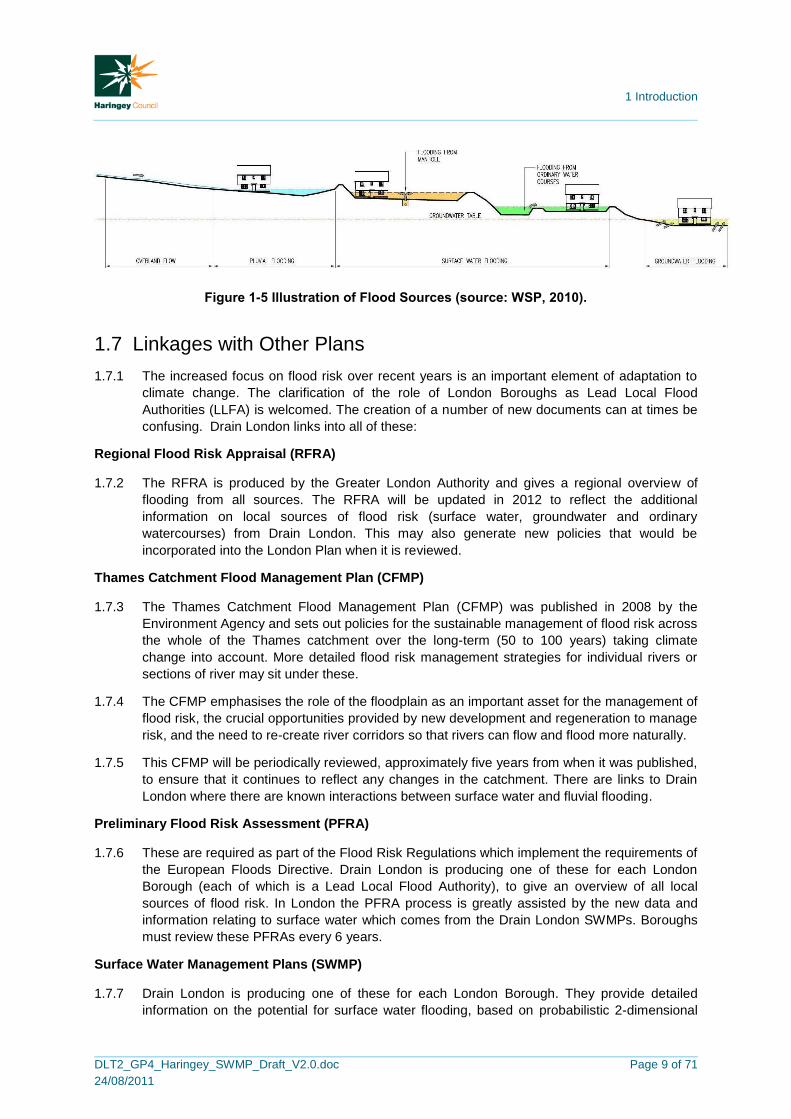
1.6.2 Figure 1-5 provides an illustration of these flood sources. Each of these sources of flood risk a
futher explained within Chapter 3 of this report.
1 Introduction
DLT2_GP4_Haringey_SWMP_Draft_V2.0.doc
24/08/2011
Page 9 of 71
Figure 1-5 Illustration of Flood Sources (source: WSP, 2010).
1.7 Linkages with Other Plans
1.7.1 The increased focus on flood risk over recent years is an important element of adaptation to
climate change. The clarification of the role of London Boroughs as Lead Local Flood
Authorities (LLFA) is welcomed. The creation of a number of new documents can at times be
confusing. Drain London links into all of these:
Regional Flood Risk Appraisal (RFRA)
1.7.2 The RFRA is produced by the Greater London Authority and gives a regional overview of
flooding from all sources. The RFRA will be updated in 2012 to reflect the additional
information on local sources of flood risk (surface water, groundwater and ordinary
watercourses) from Drain London. This may also generate new policies that would be
incorporated into the London Plan when it is reviewed.
Thames Catchment Flood Management Plan (CFMP)
1.7.3 The Thames Catchment Flood Management Plan (CFMP) was published in 2008 by the
Environment Agency and sets out policies for the sustainable management of flood risk across
the whole of the Thames catchment over the long-term (50 to 100 years) taking climate
change into account. More detailed flood risk management strategies for individual rivers or
sections of river may sit under these.
1.7.4 The CFMP emphasises the role of the floodplain as an important asset for the management of
flood risk, the crucial opportunities provided by new development and regeneration to manage
risk, and the need to re-create river corridors so that rivers can flow and flood more naturally.
1.7.5 This CFMP will be periodically reviewed, approximately five years from when it was published,
to ensure that it continues to reflect any changes in the catchment. There are links to Drain
London where there are known interactions between surface water and fluvial flooding.
Preliminary Flood Risk Assessment (PFRA)
1.7.6 These are required as part of the Flood Risk Regulations which implement the requirements of
the European Floods Directive. Drain London is producing one of these for each London
Borough (each of which is a Lead Local Flood Authority), to give an overview of all local
sources of flood risk. In London the PFRA process is greatly assisted by the new data and
information relating to surface water which comes from the Drain London SWMPs. Boroughs
must review these PFRAs every 6 years.
Surface Water Management Plans (SWMP)
1.7.7 Drain London is producing one of these for each London Borough. They provide detailed
information on the potential for surface water flooding, based on probabilistic 2-dimensional

1 Introduction
DLT2_GP4_Haringey_SWMP_Draft_V2.0.doc
24/08/2011
Page 10 of 71
modelling. This information improves greatly on data which has previously been provided at a
national scale by the Environment Agency. In addition each SWMP contains an Action Plan
that has been developed in conjunction with both the borough and relevant other Risk
Management Authorities. This data and actions and associated policy interventions will feed
directly into the operational level of the borough across many departments, in particular into
spatial and emergency planning policies and designations and into the management of local
authority controlled land.
Strategic Flood Risk Assessments (SFRA)
1.7.8 Each local planning authority is required to produce a SFRA under Planning Policy Statement
25 (PPS25). This provides an important tool to guide planning policies and land use decisions.
Current SFRAs have a strong emphasis on flooding from main rivers and the sea and are
relatively weak (due to past priorities and a lack of data) in evaluating flooding from other local
sources including surface water, groundwater and ordinary watercourses. The information
from Drain London will improve this understanding.
1.7.9 The LB of Haringey is included within the North London SFRA, drafted in August 2008. This
report covers the London Boroughs of Barnet, Camden, Enfield, Hackney, Haringey, Islington
and Waltham Forest. The North London SFRA was commissioned based on the existing
collaboration between the seven boroughs on the North London Waste Plan. This document
forms the basis of the LB of Haringey‟s SFRA.
Local Development Documents (LDD)
1.7.10 LDDs including the Core Strategy and relevant Area Action Plans (AAPs) will need to reflect
the results from Drain London. This may include policies for the whole borough or for specific
parts of boroughs, for example Critical Drainage Areas. There may also be a need to review
Area Action Plans where surface water flood risk is a particular issue. The updated SFRA will
assist with this as will the reviewed RFRA and any updated London Plan policies. In producing
Opportunity Area Planning Frameworks, the GLA and boroughs will also examine surface
water flood risk more closely.
Local Flood Risk Management Strategies
1.7.11 The Flood and Water Management Act 2010 (FWMA) requires each LLFA to produce a Local
Flood Risk Management Strategy by December 2012. Whilst Drain London will not directly
deliver a LFRMP, the SWMPs, PFRAs and their associated risk maps will provide the
necessary evidence base to support the development of LFRMS and it is anticipated that no,
or limited new modelling will be necessary to produce these strategies.
1.7.12 The schematic diagram (Figure 1-6 below) illustrates how the CFMP, PFRA, SWMP and
SFRA link to and underpin the development of a Local Flood Risk Management Strategy.

1 Introduction
DLT2_GP4_Haringey_SWMP_Draft_V2.0.doc
24/08/2011
Page 11 of 71
Figure 1-6 Linkages of LFRM Strategy Reports
1.8 Existing Legislation
1.8.1 The Flood and Water Management Act 2010 (FWMA) presents a number of challenges for
policy makers and the flood and coastal risk management authorities identified to co-ordinate
and deliver local flood risk management (surface water, groundwater and flooding from
ordinary water courses). „Upper Tier‟ local authorities have been empowered to manage local
flood risk through new responsibilities for flooding from surface and groundwater.
1.8.2 The FWMA reinforces the need to manage flooding holistically and in a sustainable manner.
This has grown from the key principles within Making Space for Water (Defra, 2005) and was
further reinforced by the summer 2007 floods and the Pitt Review (Cabinet Office, 2008). It
implements several key recommendations of Sir Michael Pitt‟s Review of the Summer 2007
floods, whilst also protecting water supplies to consumers and protecting community groups
from excessive charges for surface water drainage.
1.8.3 The FWMA must also be considered in the context of the EU Floods Directive, which was
transposed into law by the Flood Risk Regulations 2009 (the Regulations) on 10 December
2009. The Regulations requires three main types of assessment / plan to be produced:
a) Preliminary Flood Risk Assessments (maps and reports for Sea, Main River and
Reservoirs flooding) to be completed by Lead Local Flood Authorities and the
Environment Agency by the 22 December 2011. Flood Risk Areas, at potentially
significant risk of flooding, will also be identified. Maps and management plans will be
developed on the basis of these flood risk areas.
b) Flood Hazard Maps and Flood Risk Maps. The Environment Agency and Lead Local
Flood Authorities are required to produce Hazard and Risk maps for Sea, Main River and
Reservoir flooding as well as „other‟ relevant sources by 22 December 2013.
c) Flood Risk Management Plans. The Environment Agency and Lead Local Flood
Authorities are required to produce Flood Risk Management Plans for Sea, Main River
and Reservoir flooding as well as „other‟ relevant sources by 22 December 2015.
1.8.4 Figure 1-7, below, illustrates how this SWMP fits into the delivery of local flood and coastal
risk management, and where the responsibilities for this lie.
LFRM Strategies
CFMP PFRA SWMP SFRA
Documents Delivered by Drain London

1 Introduction
DLT2_GP4_Haringey_SWMP_Draft_V2.0.doc
24/08/2011
Page 12 of 71
Figure 1-7 Where the SWMP is located within the delivery of local flood and coastal risk
management
1.9 Peer Review
1.9.1 It is essential for the Drain London Project that SWMPs are consistent and comparable across
Greater London. This is to facilitate:
Fair, transparent and rapid allocation of funds to identified high priority flood risk areas within London;
Collaborative working practices between stakeholders; and
Environment Agency (National Strategy)
Produce a National Strategy for FCERM as part of full strategic overview role for all FCERM (Main river, ordinary watercourse,
sea water, surface run-off, groundwater, coastal erosion and flood risk from reservoirs). Support lead local authorities and others
in FCERM by providing information and guidance on fulfilling their roles.
Defra Flood and Coastal Erosion Risk Policy
Lead Local Flood Authorities – Local Strategies surface water, groundwater, ordinary
watercourses
Overview
Planning PFRAs SWMPs CFMPs SMPs
Delivery LLFAs - surface water
and groundwater
EA – Main River and
the Sea
Water companies, reservoir owners, highways authorities
Third Party assets

1 Introduction
DLT2_GP4_Haringey_SWMP_Draft_V2.0.doc
24/08/2011
Page 13 of 71
Building of local capability (Council officers and consultants doing work in the future will be able to make use of outputs regardless of who produced them for each borough).
1.9.2 To ensure consistency and comparability between London Borough SWMPs produced, a Peer
Review process has been used. The process involved the four consultant teams who are
working on the Drain London SWMPs independently reviewing each other‟s work. This has
ensured that all outputs result from a consistent technical approach, are of a high technical
quality and are communicated in the specified formats. The peer review report for this SWMP
is included in Appendix F.
1.10 LLFA Responsibilities
1.10.1 Aside from forging partnerships and coordinating and leading on local flood management,
there are a number of other key responsibilities that have arisen for Local Lead Flood
Authorities from the Flood & Water Management Act 2010, and the Flood Risk Regulations
2009. These responsibilities include:
Investigating flood incidents – LLFAs have a duty to investigate and record
details of significant flood events within their area. This duty includes identifying
which authorities have flood risk management functions and what they have done
or intend to do with respect to the incident, notifying risk management authorities
where necessary and publishing the results of any investigations carried out. .
Asset Register – LLFAs also have a duty to maintain a register of structures or
features which are considered to have an effect on flood risk, including details on
ownership and condition as a minimum. The register must be available for
inspection and the Secretary of State will be able to make regulations about the
content of the register and records.
SuDS Approving Body – LLFAs are designated the SuDS Approving Body (SAB)
for any new drainage system, and therefore must approve, adopt and maintain any
new sustainable drainage systems (SuDS) within their area. This responsibility is
anticipated to commence from April 2012.
Flood risk management strategies – LLFAs are required to develop, maintain,
apply and monitor a strategy for local flood risk management in its area. The local
strategy will build upon information such as national risk assessments and will use
consistent risk based approaches across different local authority areas and
catchments.
Works powers – LLFAs have powers to undertake works to manage flood risk
from surface runoff and groundwater, consistent with the local flood risk
management strategy for the area.
Designation powers – LLFAs, as well as district councils and the Environment
Agency have powers to designate structures and features that affect flooding in
order to safeguard assets that are relied upon for flood risk management.
1.10.2 These LLFA requirements have been considered in the production of this document. The
SWMP will assist the LLFA in providing evidence for points 1, 2 and 3.

2 Phase 1: Preparation
DLT2_GP4_Haringey_SWMP_Draft_V2.0.doc
24/08/2011
Page 14 of 71
2 Phase 1: Preparation
2.1 Partnership
2.1.1 The Flood and Water Management Act 2010 defines the Lead Local Flood Authority (LLFA)
for an area as the unitary authority for the area, in this case LB of Haringey. As such, the LB
of Haringey is responsible for leading local flood risk management including establishing
effective partnerships with stakeholders such as the Environment Agency, Thames Water
Utilities Ltd, Transport for London, Network Rail and London Underground as well as others.
Ideally these working arrangements should be formalised to ensure clear lines of
communication, mutual co-operation and management through the provision of Level of
Service Agreements (LoSA) or Memorandums of Understanding (MoU). It is recommended
that the partnerships created as part of the Drain London Tier 1 work are maintained into
perpetuity.
2.1.2 As mentioned in section 1.5.16 of this report, the LB of Haringey forms part of the Drain
London „Group 4‟ group of boroughs, established as part of the Drain London programme.
Group 4 are currently represented on the Thames Regional Flood and Coastal Committee
(RFCC) by Councillor Chris Bond, Cabinet Member for Environment from the LB of Enfield.
2.1.3 At a borough level, representatives from a number of departments and sectors have been
engaged in the SWMP process including Emergency Planning, Strategic Planning, Highways
and Sustainable Transport, in recognition of the cross-department input required on managing
local flood risk.
2.1.4 Members of the public may also have valuable information to contribute to the SWMP and to
an improved understanding and management of local flood risk within the borough. Public
engagement can afford significant benefits to local flood risk management including building
trust, gaining access to additional local knowledge and increasing the chances of stakeholder
acceptance of options and decisions proposed in future flood risk management plans.
2.2 Data Collection
2.2.1 The collection and collation of strategic level data was undertaken as part of the Drain London
Tier 1 work and disseminated to Tier 2 consultants by the GLA. Data was collected from each
of the following organisations:
LB of Haringey
British Airports Authority
British Geological Survey
British Waterways
Environment Agency
Greater London Authority
Highways Agency
London Underground
Network Rail
Thames Water
Transport for London
2.2.2 A comprehensive data set was provided to the Tier 2 consultants.

2 Phase 1: Preparation
DLT2_GP4_Haringey_SWMP_Draft_V2.0.doc
24/08/2011
Page 15 of 71
2.2.3 Table 2-1 provides a summary of the data sources held by partner organisations and provides
a description of each dataset, and how the data was used in preparing the SWMP. This data
was collated centrally by the Greater London Authority through the Drain London project,
including centralising relevant data sharing agreements and licensing. This data was then
disseminated to consultants Capita Symonds with Scott Wilson for the preparation of the LB of
Haringey SWMP.
Table 2-1 Data Sources and Use
Dataset Description Use in this SWMP
En
vir
on
men
t A
ge
nc
y
Main River centre line GIS dataset identifying the location of Main Rivers across London
To define waterway locations within the borough.
Environment Agency Flood Map (Flood Zones)
Shows extent of flooding from rivers during a 1 in 100yr flood and 1 in 1000yr return period flood. Shows extent of flooding from the sea during 1 in 200yr and 1 in 1000yr flood events. Ignores the presence of defences.
To identify the fluvial and tidal flood risk within the borough and areas benefiting from fluvial and tidal defences.
Areas Susceptible to Surface Water Flooding
A national outline of surface water flooding held by the EA and developed in response to Pitt Review recommendations.
To assist with the verification of the pluvial modelling
Flood Map for Surface Water
A second generation of surface water flood mapping which was released at the end of 2010.
To assist with the verification of the pluvial modelling
Groundwater Flooding Incidents
Records of historic incidents of groundwater flooding as recorded by the Environment Agency.
To identify recorded groundwater flood risk – assist with verifying groundwater flood risk
National Receptors Dataset
A nationally consistent dataset of social, economic, environmental and cultural receptors including residential properties, schools, hospitals, transport infrastructure and electricity substations.
Utilised for property/infrastructure flood counts and to determine CDA‟s.
Indicative Flood Risk Areas
National mapping highlighting key flood risk areas, based on the definition of „significant‟ flood risk agreed with Defra and WAG.
Initial review to determine national view on flood risk areas within the borough.
Historic Flood Outline Attributed spatial flood extent data for flooding from all sources.
Used to assist with the verification of modelling results and CDA locations (where available)
Rainfall Data 15 minute and daily rainfall gauge records from approximately 1990 – 2010 for gauge sites across London.
Used in the initial stages of rainfall modelling to determine appropriate model durations and hyetographs.
Source protection zones
Show zones around important groundwater sources which may be impacted by contamination that might cause pollution in the area. The maps show three main zones (inner, outer and total catchment).
Within the assessment of groundwater flooding to determine permeable geology
Asset data Details on the location and extent of flood defences across Group 4 as well as a system asset management plans.
To determine asset locations within the pluvial modelling process.

2 Phase 1: Preparation
DLT2_GP4_Haringey_SWMP_Draft_V2.0.doc
24/08/2011
Page 16 of 71
Dataset Description Use in this SWMP
Lo
nd
on
Bo
rou
gh
of
Ha
rin
gey
Strategic Flood Risk Assessments (SFRA)
SFRAs may contain useful information on historic flooding, including local sources of flooding from surface water, groundwater and flooding from canals.
Provide a background to the flood risk in the borough.
Historical flooding records
Historical records of flooding from surface water, groundwater and ordinary watercourses.
Where available used to assist with the verification of modelling results and CDA locations.
Anecdotal information relating to local flood history and flood risk areas
Anecdotal information from authority members regarding areas known to be susceptible to flooding from excessive surface water, groundwater or flooding from ordinary watercourses.
Assist with CDA confirmation but not necessarily used as verification evidence.
Highways Flooding Reports
Highways Flooding Reports, including analysis of the flood risk at each location.
Verification of pluvial model results.
Core Strategy Development Plans
Local Development Scheme, details on Area Action Plans and Place Shaping Priority Areas.
Understanding of areas of future development.
Th
am
es
Wa
ter
DG5 Register for Thames Water Utilities areas
DG5 Register logs and records of sewer flooding incidents in each area.
Mapping sewer flooding incidents.
Sewer pipe network
GIS dataset providing the geo-referenced location of surface water, foul and combined sewers across Group 1. Includes pipe size and some information on invert levels.
Verifying CDA locations and Phase 3:Options Assessment
Basements GIS dataset showing Thames Water Utilities recording of basement locations.
Defining CDAs and utilised within the property count information
Bri
tis
h
Wa
terw
ay
s
British Waterway‟s canal network
Detailed GIS information on the British Waterway‟s canal network, including the location of canal centrelines, sluices, locks, culverts, etc.
Centrelines have been incorporated within modelling to define canal locations
Bri
tis
h
Ge
olo
gic
al
So
cie
ty
Geological datasets
Licensed GIS datasets including: Geological indicators of flooding; Susceptibility to groundwater flooding; Permeability; Bedrock and superficial geology.
Understanding the geology of the borough
GL
A
Deprived Areas Index of Multiple Deprivation, ranking all London Ward‟s.
Used within the prioritisation matrix and for property counts
Administrative boundaries
Greater London Borough boundaries Providing study boundaries
Ordnance Survey Mapping, MasterMap
Vector mapping of the London area
Utilised within the pluvial modelling to determine “roughness” within the borough

2 Phase 1: Preparation
DLT2_GP4_Haringey_SWMP_Draft_V2.0.doc
24/08/2011
Page 17 of 71
Dataset Description Use in this SWMP
Lo
nd
on
Fir
e B
rig
ad
e
Historic flooding records
London Fire Brigade call outs to incidents of flooding between January 2000 and December 2009. Does not specify the source of flooding.
Understanding of possible flood locations within the borough – records do not indicate what type of flooding occurred at each location.
Lo
nd
on
Un
de
rgro
un
d a
nd
Ne
two
rk R
ail
Historic flooding records
Recorded incidents of flooding to London Underground and National Rail infrastructure
Verification of pluvial modelling results and CDA designations
Tra
ns
po
rt f
or
Lo
nd
on
Pump Station Locations Pdf mapping identifying the location of road underpass pump station owned and maintained by TfL.
Understanding which assets include pumping stations and to assist in the verification of pluvial outputs and the optioneering exercise
Info
terr
a
LiDAR topographical data
High resolution elevation data derived from airborne sources – at a 1m grid. A laser is used to measure the distance between the aircraft and ground and between the aircraft and the vegetation canopy or building tops. Typical (unfiltered) accuracy ranges are +/- 0.15m.
Filtered LiDAR was utilised within the creation of the pluvial models to define the ground surface of the catchment and to understand the general topography of the catchment and wider borough.
2.3 Data Review
2.3.1 The most significant data gap across the LB of Haringey relates to records of past „local‟
flooding incidents. This is a common issue across the UK as record keeping of past floods has
historically focussed on flooding from rivers or the sea. Records of past incidents of surface
water, sewer, groundwater or ordinary watercourse flooding have been sporadic.
2.3.2 Thames Water have provided postcode linked data on records of sewer flooding, (known as
the DG5 register) however more detailed data on the location and cause of sewer flooding is
not currently available.
2.3.3 Some incidents have been digitised into GIS from hard copy maps by LB of Haringey,
however there is very little information on the probability, hazard or consequence of flooding.
2.3.4 Similarly, the London Fire Brigade have recorded incidents of call outs relates to flooding,
however there is no information on the source of flooding (e.g. pipe bursts or rainfall), or
probability, hazard or consequence of the flooding.
Future Groundwater Flooding
2.3.5 Groundwater flooding is dependent on local variations in topography, geology and soils. The
causes of groundwater flooding are generally understood however it is difficult to predict the
actual location, timing and extent of groundwater flooding without comprehensive datasets.

2 Phase 1: Preparation
DLT2_GP4_Haringey_SWMP_Draft_V2.0.doc
24/08/2011
Page 18 of 71
2.3.6 There is a lack of reliable measured datasets to undertake flood frequency analysis and even
with datasets this analysis is complicated due to the non-independence of groundwater level
data. Surface water flooding incidents are sometimes mistaken for groundwater flooding
incidents, e.g. where runoff via infiltration seeps from an embankment, rather than locally high
groundwater levels.
2.3.7 Drain London have commissioned specific groundwater emergence maps, known as
increased Potential for Elevated Groundwater (iPEG) maps, to assist in determining the areas
within Greater London that are possibly at risk of groundwater flooding.
Future Surface Water Flooding
2.3.8 The Environment Agency data sets „Areas Susceptible to Surface Water Flooding‟ and second
generation „Flood Map for Surface Water‟ are national scale assessments suitable for broadly
identifying surface water flood risk. The datasets are of a resolution suitable for assessments
such as the PFRA, however are limited in their use in addressing the next stages of the Flood
Risk Regulations (2009), e.g. Hazard Maps and in producing SWMPs and useful Action Plans
The outputs from Drain London will assist in addressing this data limitation. These EA data
sets were utilised in the model validation phase.
Flooding Consequences
2.3.9 The National Receptors Database (NRD), version 1.0 data set, was provided for all London
Boroughs in December 2010. This data set was provided to allow property counts to be
undertaken for all SWMPs. Version 1.1 of the NRD has subsequently been issued and
contains modifications and corrections since version 1.0. However, in order to avoid repetition
of work, and ensure consistency between the SWMP, PFRA and the EA Pluvial flooding
(Areas Susceptible to Surface Water Flooding and Flood Map for Surface Water), it was
decided to complete the SWMP using NRD version 1.0.
2.4 Security, Licensing and Use Restrictions
2.4.1 A number of datasets used in the preparation of this SWMP are subject to licensing
agreements and use restrictions.
2.4.2 The following national datasets provided by the Environment Agency are available to lead
local flood authorities for local decision making:
EA Flood Zone Map;
Areas Susceptible to Surface Water Flooding;
Flood Map for Surface Water; and
National Receptor Database.
2.4.3 A number of the data sources used are publicly available documents, such as:
Strategic Flood Risk Assessment;
Catchment Flood Management Plan;
Preliminary Flood Risk Assessment; and

2 Phase 1: Preparation
DLT2_GP4_Haringey_SWMP_Draft_V2.0.doc
24/08/2011
Page 19 of 71
Index of Multiple Deprivation.
2.4.4 The use of some of the datasets made available for this SWMP has been restricted. These
include:
Records of property flooding held by the Council and by Thames Water Utilities Ltd;
British Geological Society geology datasets; and
London Fire Brigade call outs for flooding.
2.4.5 Necessary precautions must be taken to ensure that all restricted information given to third
parties is treated as confidential. The information must not be used for anything other than the
purpose stated in the terms and conditions of use accompanying the data. No information may
be copied, reproduced or reduced to writing, other than what is necessary for the purpose
stated in the agreement.
2.5 LLFA Asset Register Requirements
2.5.1 As indicated in Section 2.5, the FWMA requires that the LLFA maintains an asset register
which records information about structures and features that are likely to have a significant
impact on flood risk within the LLFAs jurisdictional boundary.
2.5.2 As of the 6th April 2011, all LLFAs will need to maintain a register. Defra have determined the
legal characteristics of the register and records, this is provided in Table 2-2:
Table 2-2 Asset Register (source: Defra, 2011 Lead Local Flood Authority Duty to Maintain a
Register)
Register Record
a. Must be made available for inspection at all
reasonable times.
Up to the LLFA to decide if they wish to make
it available for inspection
b. Must contain a list of structures or features
which in the opinion of the authority, are likely
to have a significant effect on a local flood
risk.
For each structure or feature listed on the
register, the record must contain information
about its ownership and state of repair.
c. s.21 (2) of the Act allows for further regulations to be made about the content of the register
and record. There is currently no plan to provide such regulations therefore their content
should be decided on by the LLFA depending on what information will be useful to them.
d. There is no legal requirement to have a separate register and record although as indicated
above, only the register needs to be made available for public inspection.
2.5.3 A template and guidance documentation was provided to the LLFAs in March 2011. Although
these templates were not designed to be a working tool, they do demonstrate what information
could be contained within the register and how it could be structured.
2.5.4 The creation of the asset register was not within the scope of the Drain London project and is
the responsibility of the LLFA. It is recommended that the LLFAs utilise a risk-based approach
when creating the asset register, and begin recording structures or features which are
considered the have the greatest influence on flooding first.
2.5.5 It is important to note that the register will be a “live” document, and is expected to be updated
over time as more structures and features are identified and added.

1
DLT2_GP4_Haringey_SWMP_Draft_V2.0.doc
24/08/2011
Page 20 of 71
2.6 Review of Asset Management Systems
2.6.1 Criteria to assess the existing asset management system of all London Boroughs was
developed as part of the Drain London Tier 2 exercise to ensure consistency over the Greater
London study area. This criteria is listed below:
Level 1 – The borough knows where their assets are, what they look like and what condition they are in. Register system may take the form of a spreadsheet or hard copy records.
Level 2 – The borough is aware of the „Local Authority Flood Risk Asset Tool‟ currently being produced by the EA / Defra. Their register is GIS based (basic proprietary system only) or uses a highways based asset management system database. Their register captures information generally aligned with guidance provide by the Tool and the EA NFCDD system where practical. They know where their assets are and carry out reactive maintenance of significant structures as required.
Level 3 – The borough has a detailed understanding of Asset Registers as required by the Flood and Water Management Act. Their register system accurately replicates the „Local Authority Flood Risk Asset Tool‟ data standards and related NFCDD structures to an attribute level. Their register is GIS based (advanced proprietary or bespoke system) or is completely integrated with an existing asset management system. They know where their assets are and carry out periodic maintenance on the structures using a risk based priority system.
2.6.2 LB Haringey provided some asset information as part of the Drain London Tier 1 „data
collection‟ exercise and based on the current review of the asset register appears to be Level
1. Appendix B provides a summary of the actions required to meet the full level 3 status as
defined above.

3 Phase 2: Risk Assessment
DLT2_GP4_Haringey_SWMP_Draft_V2.0.doc
24/08/2011
Page 21 of 71
3 Phase 2: Risk Assessment
3.1 Intermediate Assessment
Aims
3.1.1 The aim of the Phase 2 Intermediate Risk Assessment is to identify the sources and
mechanisms of surface water flooding across the study area which will be achieved through
an intermediate assessment of pluvial flooding, sewer flooding, groundwater flooding and
flooding from ordinary watercourses along with the interactions with main rivers and the sea.
The modelling outputs will then be mapped using GIS software.
3.1.2 SWMPs can function at different geographical scales and therefore necessarily at differing
scales of detail. Table 3-1 defines the potential levels of assessment within a SWMP. This
SWMP has been prepared at the „borough‟ scale and fulfils the objectives of a second level
„Intermediate Assessment‟.
Table 3-1: SWMP Study Levels of Assessment [Defra 2010]
Level of Assessment Appropriate Scale Outputs
1. Strategic Assessment Greater London
Broad understanding of locations that are more vulnerable to surface water flooding. Prioritised list for further assessment. Outline maps to inform spatial and emergency planning.
2. Intermediate Assessment
Borough wide
Identify flood hotspots which might require further analysis through detailed assessment. Identify immediate mitigation measures which can be implemented. Inform spatial and emergency planning.
3. Detailed Assessment Known flooding
hotspots
Detailed assessment of cause and consequences of flooding. Use to understand the mechanisms and test mitigation measures, through modelling of surface and sub-surface drainage systems.
3.1.3 As shown in Table 3-1 above, the intermediate assessment is applicable across a large town,
city or borough. In the light of extensive and severe historical flooding and the results from the
over-arching national pluvial modelling suggesting that there are 38,800 properties at risk
across the borough during a 1 in 200 year return period rainfall event, it is appropriate to adopt
this level of assessment to further quantify the risks.
3.1.4 The purpose of this intermediate assessment will be to further identify those parts of the
borough that are likely to be at greater risk of surface water flooding and require more detailed
assessment. The methodology used for this SWMP is summarised below. Further detail of the
methodology is provided in Appendix C.
A Direct Rainfall modelling approach using TuFLOW software has been selected whereby rainfall events of known probability are applied directly to the ground surface and water is routed by the model over a representation of the ground surface to provide an indication of potential flow path directions and velocities and areas where surface water may pond.

3 Phase 2: Risk Assessment
DLT2_GP4_Haringey_SWMP_Draft_V2.0.doc
24/08/2011
Page 22 of 71
The direct rainfall modelling has been supported by hydraulic field visits and has been undertaken in conjunction with the LB of Haringey staff and/or EA staff.
The outputs from the pluvial modelling have been verified (where possible) against historic surface water flood records.
3.2 Risk Overview
3.2.1 The following sources of flooding have been assessed and are discussed in detail in the
following sections of this report:
Pluvial flooding: runoff as a result of high intensity rainfall when water is ponding or
flowing over the ground surface before it enters the underground drainage network or a
watercourse. Figures 13 to 22 in Appendix D present mapped results of the surface water
modelling;
Sewer flooding; flooding which occurs when the capacity of the underground drainage
system is exceeded, resulting in flooding inside and outside of buildings. Normal
discharge of sewers and drains through outfalls may be impeded by high water levels in
receiving waters as a result of wet weather or tidal conditions;
Flooding from ordinary watercourses: flooding which occurs as a result of the capacity of
the watercourse being exceeded resulting in out of bank flow (water coming back out of
rivers and streams); and
Flooding from groundwater sources: occurs when the water level within the groundwater
aquifer rises to the surface.
3.2.2 The identification of areas at risk of flooding has been dominated by the assessment of
surface water and ordinary watercourse flooding as these sources are expected to result in
the greater consequence (risk to life and damage to property), as well as the quality of the
information available for informing the assessment.
Mapping Limitations
3.2.3 The mapping shown within this report is suitable to identify broad areas which are more likely
to be vulnerable to surface water flooding. This allows the LB of Haringey and its partners to
undertake more detailed analysis in areas which are most vulnerable to surface water
flooding.
3.2.4 In addition, the maps can also be used as an evidence base to support spatial planning. This
will ensure that surface water flooding is appropriately considered when allocating land for
future development. The maps can be used to assist emergency planners in preparing their
Multi-Agency response plans.
3.2.5 Please note that these maps only show the predicted likelihood of surface water flooding (this
includes flooding from sewers, drains, small watercourses and ditches that occurs in heavy
rainfall in urban areas) for defined areas, and due to the coarse nature of the source data
used, are not detailed enough to account for precise addresses. Individual properties therefore
may not always face the same chance of flooding as the areas that surround them.
3.2.6 There may also be particular occasions when flooding occurs and the observed pattern of
flooding does not in reality match the predicted patterns shown on these maps. We have done
all we can to ensure that the maps reflect all the data available to us and have applied our
expert knowledge to create conclusions that are as reliable as possible. It is essential that

3 Phase 2: Risk Assessment
DLT2_GP4_Haringey_SWMP_Draft_V2.0.doc
24/08/2011
Page 23 of 71
anyone using these maps fully understands the complexity of the data utilised in production of
the maps, is aware of the limitations and does not use the maps in isolation.
3.2.7 We will not be liable if the maps by their nature are not as accurate as might be desired or are
misused or misunderstood despite our warnings. For this reason we are not able to promise
that the maps will always be completely accurate or up to date. We are also not liable for any
future flooding that is not highlighted in this report.
3.3 Surface Water Flooding
Description
3.3.1 Surface water flooding is the term used to describe flooding which occurs when intense, often
short duration rainfall is unable to soak into the ground or to enter drainage systems and
therefore runs over the land surface causing flooding. It is most likely to occur when soils are
saturated so that they cannot infiltrate any additional water or in urban areas where buildings
tarmac and concrete prevent water soaking into the ground. The excess water can pond
(collect) in low points and result in the development of flow pathways often along roads but
also through built up areas and open spaces. This type of flooding is usually short lived and
associated with heavy downpours of rain.
3.3.2 The potential volume of surface runoff in catchments is directly related to the size and shape
of the catchment to that point. The amount of runoff is also a function of geology, slope,
climate, rainfall, saturation, soil type, urbanisation and vegetation.
Causes and classifications
3.3.3 Surface water flooding can occur in rural and urban areas, but usually causes more damage
and disruption in the latter. Flood pathways include the land and water features over which
floodwater flows. These pathways can include drainage channels, rail and road cuttings.
Developments that include significant impermeable surfaces, such as roads and car parks
may increase the volume and rate of surface water runoff.
3.3.4 Urban areas which are close to artificial drainage systems, or located at the bottom of hill
slopes, in valley bottoms and hollows, may be more prone to surface water flooding. This may
especially be the case in areas that are down slope of land that has a high runoff potential
including impermeable areas and compacted ground.
Impacts of surface water flooding
3.3.5 Surface water flooding can affect all forms of the built environment, including:
Residential, commercial and industrial properties;
Infrastructure, such as roads and railways, telecommunication systems and sewer systems;
It can also impact on:
Agriculture; and
Amenity and recreation facilities.
3.3.6 Flooding from land is usually short-lived and may only last as long as the rainfall event.
However occasionally flooding may persist in low-lying areas where ponding occurs. Due to

3 Phase 2: Risk Assessment
DLT2_GP4_Haringey_SWMP_Draft_V2.0.doc
24/08/2011
Page 24 of 71
the typically short duration, flooding from land tends not to have as serious consequences as
other forms of flooding, such as flooding from rivers or the sea however it can still cause
significant damage and disruption on a local scale.
Historic Records – Surface Water Flooding
3.3.7 Past records of surface water flooding within Haringey have been gathered from sources such
as the Environment Agency, London Underground as well as the LB of Haringey. These
incidents have been mapped as part of the SWMP and are presented in figure 5 in Appendix
D. A number of combined pluvial/fluvial events have been recorded at locations spread in and
around Tottenham. These are listed in Table 3-2 below. No information is known on the dates
of these flood incidents or their impacts.
Table 3-2: Records of Surface Water Flooding
Street Location
White Hart Lane (corner Perth Road) Wood Green
Rivulet Road (corner Gospatrick Road) Wood Green
Rivulet Road (corner Stockton Road) Wood Green
Duckletts Common, Haringey Tottenham
Lordship Lane, Haringey (corner Walpole Road) Tottenham
Phillip Lane (corner Wilmot Road) Tottenham
Town Hall Approach Road Tottenham
Antill Road (corner Montague Road) Tottenham Hale
Foutayne Road Tottenham Hale
Watermead Way Near Tottenham Marshes
Garman Road (corner Sedge Road) Tottenham Hale
Methodology for Surface Water Flooding
3.3.8 As part of the SWMP process hydraulic modelling has been undertaken. Several 2-
dimensional direct rainfall models were created, using the TUFLOW software, to determine
the causes and consequences of surface water flooding within the LB of Haringey. The results
of the models provide an indication of key flowpaths, velocities and areas where water is likely
to pond.
3.3.9 As the extents of the models have been based upon catchment boundaries, and not borough
boundaries, several models were required to cover the area occupied by the LB of Haringey.
This was carried out to appropriately represent cross-boundary interaction and allow for Drain
London Tier 2 consultants to undertake a collaborative modelling approach. Figure 3-1 below
indicates the extent of the models utilised within the assessment of the LB of Haringey.

3 Phase 2: Risk Assessment
DLT2_GP4_Haringey_SWMP_Draft_V2.0.doc
24/08/2011
Page 25 of 71
Figure 3-1: Model coverage for the London Borough of Haringey
3.3.10 The hydraulic models were run for the following return periods:
1 in 30 year event;
1 in 75 year event;
1 in 100 year event;
1 in 100 year event with allowance for climate change (30% increase in rainfall); and
1 in 200 year event
3.3.11 As part of this study, maps of maximum water depth and hazard for each of the return periods
above have been prepared and are presented in Appendix D of this report. When viewing the
maps, it is important that the limitations of the modelling are considered. The key assumptions
include the use of a continuous loss (6.5mm/hr) to represent the presence of the underground
drainage network. The model does not take into account any capacity issues associated with
the drainage network such as surcharging of manholes leading to backing up of surface water,
blocked outfalls etc. Refer to Appendix C for a more detailed discussion on the hydraulic
modelling methodology.
3.3.12 Figures 13 to 17 in Appendix D indicates that water is predicted to pond over a number of
roads and residential properties. These generally occur at low points in the topography or
where water is constricted behind an obstruction or embankment. An example of this flooding
mechanism within the borough is area around Chadwell Lane and Great Amwell Lane in
Hornsey, where water is observed to back up behind the railway line between Alexandra
Palace and Hornsey railway stations. Overland flowpaths have been observed to follow

3 Phase 2: Risk Assessment
DLT2_GP4_Haringey_SWMP_Draft_V2.0.doc
24/08/2011
Page 26 of 71
natural valleys within the borough such as in the south of Tottenham along the original course
of the Stonebridge Brook before it was culverted. The flowpath begins on Green Lanes and
flows east roughly parallel to St Ann‟s Road resulting in ponding in the vicinity of Culvert Road.
3.3.13 Some of the records of surface water flooding in the LB of Haringey have been used to verify
the modelling results. Discussions with Council staff at Haringey have also provided anecdotal
support for several of the locations identified as being susceptible.
3.3.14 The results of the assessment have been used to identify „Local Flood Risk Zones‟ (LFRZs)
and „Critical Drainage Areas‟ (CDAs) across the LB of Haringey. These critical CDAs are
identified in Figure 23 of Appendix D. Section 3.8 provides a short summary of the risk of
flooding within each CDA.
Uncertainty in flood risk assessment – Surface Water Modelling
3.3.15 The surface water modelling provides the most detailed information to date on the
mechanisms, extent and hazard which may result from high intensity rainfall across the LB of
Haringey. However, due to the strategic nature of this study and the limitations of some data
sets, there are limitations and uncertainties in the assessment approach that the reader
should be aware of.
3.3.16 There is a lack of reliable measured datasets and the estimation of the return period
(probability) for flood events is therefore difficult to verify. The broad scale mapping provides
an initial guide to areas that may be at risk, however there are a number of limitations to using
the information:
The mapping does not include underground sewerage and drainage systems;
The mapping should not be used in a scale to identify individual properties at risk of surface water flooding. It can be used as a general indication of areas potentially at risk.
Whilst modelled rainfall inputs has been modified to reflect the possible impacts of climate change it should be acknowledged that this type of flooding scenario is uncertain and likely to be very site specific. More intense short duration rainfall and higher more prolonged winter rainfall are likely to exacerbate flooding in the future.
3.4 Ordinary Watercourse Flooding
Description
3.4.1 All watercourses in England and Wales are classified as either „Main Rivers‟ or „Ordinary
Watercourses‟. The difference between the two classifications is based largely on the
perceived importance of a watercourse, ad in particular it‟s potential to cause significant and
widespread flooding. However this is not to say watercourses classified as Ordinary
Watercourses cannot cause localised flooding. The Water Resources Act (1991) defines a
„Main River‟ as “a watercourse shown as such on a Main River Map”. The Environment
Agency keep and maintain information on the spatial extent of the Main River designations.
The Floods and Water Management Act (2010) defines any watercourse that is not a Main
River an Ordinary Watercourse – including ditches, dykes, rivers, streams and drains (but not
public sewers).
3.4.2 The Environment Agency have duties and powers in relation to Main Rivers. Local Authorities,
or in some cases Internal Drainage Boards, have powers and duties in relation to Ordinary
Watercourses.

3 Phase 2: Risk Assessment
DLT2_GP4_Haringey_SWMP_Draft_V2.0.doc
24/08/2011
Page 27 of 71
3.4.3 Flooding from Ordinary Watercourses occurs when water levels in the stream or river channel
rise beyond the capacity of the channel, causing floodwater to spill over the banks of the
watercourse and into the adjacent land. The main reasons for water levels rising in ordinary
watercourses are:
Intense or prolonged rainfall causing flow to increase in watercourses, exceeding the capacity of the channel. This can be exacerbated by wet antecedent (the preceding time period) conditions and where there are significant contributions of groundwater;
Constrictions/obstructions within the channel causing flood water to backup;
Blockage/obstructions of structures causing flood water to backup and overtop the banks; and
High water levels preventing discharge at the outlet of the ordinary watercourse (often into a Main River).
3.4.4 Table 3-3 summaries the watercourses present in the borough and the classification.
Table 3-3: Watercourses in the London Borough of Haringey
Watercourse Classification Responsibility under
the FWMA
Moselle Brook Main River
EA Stonebridge Brook Main River
Pymmes Brook Main River
River Lee/River Lee Navigation Main River
Numerous unnamed ditches Ordinary Watercourse LB of Haringey
New River Artificial Watercourse Thames Water
Impacts of Flooding from Ordinary Watercourse
3.4.5 The consequence of ordinary watercourse flooding is dependent upon the degree of hazard
generated by the flood water (as specified within the Defra/Environment Agency research on
Flood Risks to People - FD2321/TR2) and what the receptor is (e.g. the consequence of a
hospital flooding is greater than that of a commercial retailer). The hazard posed by flood
water is related to the depth and velocity of water, which, in Ordinary Watercourses, depends
on:
Constrictions in the channel causing flood water to backup;
The magnitude of flood flows;
The size, shape and slope of the channel;
The width and roughness of the adjacent floodplain; and
The types of structures that span the channel.
3.4.6 The hazard posed by floodwater is proportional to the depth of water, the velocity of flow and
the speed of onset of flooding. Hazardous flows can pose a significant risk to exposed people,
property and infrastructure.

3 Phase 2: Risk Assessment
DLT2_GP4_Haringey_SWMP_Draft_V2.0.doc
24/08/2011
Page 28 of 71
3.4.7 Whilst low hazard flows are less of a risk to life (shallow, slow moving/still water), they can
disrupt communities, require significant post-flood clean-up and can cause costly and possibly
permanent structural damage to property.
Historic Records – Ordinary Watercourse Flooding
3.4.8 There were no historical records of flooding from ordinary watercourses available from the LB
of Haringey. This is not to say that no such incidents have occurred or that there is no future
flood risk to the Borough from ordinary watercourses.
Methodology for Assessing Ordinary Watercourses
3.4.9 Ordinary watercourses have been included in the surface water flood modelling.
Watercourses have been defined by digitising breaklines along the centre line of each
watercourse. Elevations of watercourses have been determined from LiDAR to represent a
“bank full” scenario.
3.4.10 Structures along the watercourse have been modelled as either 1D or 2D elements,
depending on the length and location of the structure. The dimensions of structures have been
determined from asset information obtained in the data collection stage where available or
inferred from site visits or LiDAR data.
3.4.11 The assessment of flood risk from ordinary watercourses in Haringey has been based on
outputs from the Drain London surface water modelling described in Appendix C and
presented in Figures 13 to 17 in Appendix D. The figures indicate that the LB of Haringey is at
a moderate risk of flooding from ordinary watercourses with areas of standing water located in
some residential areas or in open spaces. The most significant of these areas, is in the vicinity
of Tottenham Cemetery. The model results show that a number of residential properties and a
part of the A10 is potentially at risk in a 100 year event.
3.4.12 Please note that the risk of flooding from fluvial (including Main River) and tidal sources are
covered within the North London SFRA (August, 2008).
Uncertainties and Limitations – Ordinary Watercourse Modelling
3.4.13 As with any hydraulic model, these models have been based on a number of assumptions
which may introduce uncertainties into the assessment of risk. The assumptions within the
models should be noted and understood such that informed decisions can be made when
using model results.
3.4.14 In relation to ordinary watercourses, the limits of the modelling include (but are not limited to):
Modelling of structures has not been based on detailed survey data;
The watercourses are assumed to be bank full at the start of the rainfall event, hence river flows and channel capacities have not been taken into account; and
Only one storm duration was considered for this study.
3.4.15 Taking these uncertainties and constraints into consideration, the estimation of risk of flooding
from rivers presented in this report is considered robust for the level of assessment required in
the SWMP.

3 Phase 2: Risk Assessment
DLT2_GP4_Haringey_SWMP_Draft_V2.0.doc
24/08/2011
Page 29 of 71
3.5 Groundwater Flooding
Description
3.5.1 Groundwater flooding is caused by the emergence of water originating from sub-surface
permeable strata. In short groundwater flooding is water which emerges from the ground from
either a specific point (such as a spring) or over a wide diffuse location. A groundwater flood
event results from a rise in groundwater level sufficient for the water table to intersect the
ground surface and inundate low lying land. Groundwater floods tend to be long in duration
developing over weeks or months and prevailing for days or weeks.
3.5.2 There are many mechanisms associated with groundwater flooding, which are linked to high
groundwater levels, and can be broadly classified as:
Direct contribution to channel flow.
Springs erupting at the surface.
Inundation of drainage infrastructure.
Inundation of low-lying property (basements).
Impacts of Groundwater Flooding
3.5.3 The main impacts of groundwater flooding are:
Flooding of basements of buildings below ground level – in the mildest case this may involve seepage of small volumes of water through walls, temporary loss of services etc. In more extreme cases larger volumes may lead to the catastrophic loss of stored items and failure of structural integrity;
Overflowing of sewers and drains – surcharging of drainage networks can lead to overland flows causing significant but localised damage to property. Sewer surcharging can lead to inundation of property by polluted water. Note: it is complex to separate this flooding from other sources, notably surface water or sewer flooding;
Flooding of buried services or other assets below ground level – prolonged inundation of buried services can lead to interruption and disruption of supply;
Inundation of roads, commercial, residential and amenity areas – inundation of grassed areas can be inconvenient, however the inundation of hard-standing areas can lead to structural damage and the disruption of commercial activity. Inundation of agricultural land for long durations can have financial consequences; and
Flooding of ground floors of buildings above ground level – can be disruptive, and may result in structural damage. The long duration of flooding can outweigh the lead time which would otherwise reduce the overall level of damages.
3.5.4 In general terms groundwater flooding rarely poses a risk to life.
Historical Records
3.5.5 Table 3-4 provides a summary of the previous records of flooding attributed to groundwater in
the LB of Haringey. Figure 10 in Appendix D shows the geographical locations on these
incidents within the borough.

3 Phase 2: Risk Assessment
DLT2_GP4_Haringey_SWMP_Draft_V2.0.doc
24/08/2011
Page 30 of 71
Table 3-4: Records of Groundwater Flooding
Date Location Recorded Impacts
14/08/2002 Ferme Park Road, Stroud Green Standing Water
03/10/2002 Southwood Lane, Highgate Damp
09/12/2002 Shelbourne Road, Tottenham Standing Water
19/12/2002 Farrer Mews, Muswell Hill Standing Water
14/11/2003 The Avenue, Tottenham Seepage
18/02/2004 Rookfield Avenue, Muswell Hill Seepage
27/02/2004 Mount Pleasant Crescent, Stroud Green
Standing Water
13/04/2004 Muswell Hill Golf Course Standing Water
20/04/2004 Terront Road, West Green Standing Water
05/07/2004 Harcourt Road, Wood Green Standing Water
04/04/2005 Lansdowne Road, Tottenham Wet
21/06/2005 Coniston Road, Muswell Hill Standing Water
17/11/2005 Mount Pleasant Villas, Stroud Standing Water
25/06/2007 The Avenue, Tottenham Standing Water
26/09/2007 Park Avenue, Wood Green Standing Water
22/11/2007 Coniston Road, Muswell Hill Standing Water
18/07/2008 Alexandra Avenue, Wood Green
Standing Water
17/03/2009 Hampstead Lane, Highgate Standing Water Methodology used for Groundwater Mapping
3.5.6 As part of the Drain London project Drain London Tier 1 consultants commissioned a dataset
referred to as the Increased Potential Elevated Groundwater (iPEG) maps. The iPEG mapping
assists in identifying areas which have an increased potential to experience groundwater
flooding. The iPEG map shows those areas within the borough where there is an increased
potential for groundwater to rise sufficiently to interact with the ground surface or be within 2 m
of the ground surface. The assessment was carried out at a Greater London scale.
3.5.7 The four data sources listed below have been utilised to produce the „increased Potential for
Elevated Groundwater‟ (iPEG) map:
British Geological Survey (BGS) Groundwater Flood Susceptibility Map;
Jacobs Groundwater Emergence Maps (GEMs);
Jeremy Benn Associates (JBA) Groundwater Flood Map; and
Environment Agency/Jacobs Thames Estuary 2100 (TE2100) groundwater hazard maps.
3.5.8 More information on the production of the iPEG map is discussed in Appendix C.
3.5.9 The iPEG mapping is presented in Figure 10 of Appendix D together with historic records of
flooding which have been identified as related to groundwater. The mapping shows an
increased potential for ground water to rise most noticeably in the north-east of the borough.
Two key areas have been identified - the area where the Moselle Brook is culverted and
within the floodplain of the River Lee Navigation channel. Comparing Figure 10 with Figure 12
in Appendix D which shows the underlying geology within the borough, it can be seen that
these two areas coincide with deposits of gravel, silt and alluvium.

3 Phase 2: Risk Assessment
DLT2_GP4_Haringey_SWMP_Draft_V2.0.doc
24/08/2011
Page 31 of 71
3.5.10 The areas identified as having an increased potential for ground water to rise, is in contrast to
the historic records of groundwater incidents which are scattered throughout the borough. The
discrepancy between recorded historic incidents and potential areas of future incidents may
be attributed to the following:
Past incidents may be a result of localised flooding mechanisms (or other flooding mechanisms) which have not been assessed as part of the production of the iPEG mapping.
The iPEG mapping does not represent local geological features and artificial influences (e.g. structures or conduits) which have the potential to heavily influence the local rise of groundwater.
The iPEG map only shows areas that have the greatest potential for elevated groundwater and does not necessarily include all areas that are underlain with permeable geology.
The flood source attributed to some past incidents may not be accurate.
Uncertainties and Limitations – Groundwater Flooding
3.5.11 Not all areas underlain by permeable geology are shown on the iPEG maps. Only where there
is the highest degree of confidence in the assessment are the areas delineated as areas
where groundwater may be an issue. This ensures resources are focused on the most
susceptible areas. In all areas underlain by permeable substrate, groundwater should still be
considered in planning developments.
3.5.12 Within the areas delineated, the local rise of groundwater will be heavily controlled by local
geological features and artificial influences (e.g. structures or conduits) which cannot currently
be represented. This localised nature of groundwater flooding compared with, say, fluvial
flooding suggests that interpretation of the map should similarly be different. The map shows
the area within which groundwater has the potential to emerge but it is unlikely to emerge
uniformly or in sufficient volume to fill the topography to the implied level. Instead,
groundwater emerging at the surface may simply runoff to pond in lower areas.
3.5.13 For this reason within iPEG areas, locations shown to be at risk of surface water flooding are
also likely to be most at risk of runoff/ponding caused by groundwater flooding. Therefore the
iPEG map should not be used as a “flood outline” within which properties at risk can be
counted. Rather it is provided, in conjunction with the surface water mapping, to identify those
areas where groundwater may emerge and if so what would be the major flow pathways that
water would take.
3.5.14 It should be noted that this assessment is broad scale and does not provided a detailed
analysis of groundwater, it only aims to provide an indication of where more detailed
consideration of the risks may be required.
3.5.15 The causes of groundwater flooding are generally understood. However groundwater flooding
is dependent on local variations in topography, geology and soils. It is difficult to predict the
actual location, timing and extent of groundwater flooding without comprehensive datasets.
3.5.16 There is a lack of reliable measured datasets to undertake flood frequency analysis on
groundwater flooding and even with datasets this analysis is complicated due to the non-
independence of groundwater level data. Studies therefore tend to analyse historic flooding
which means that it is difficult to assign a level of certainty.

3 Phase 2: Risk Assessment
DLT2_GP4_Haringey_SWMP_Draft_V2.0.doc
24/08/2011
Page 32 of 71
3.5.17 The impact of climate change on groundwater levels is highly uncertain. More winter rainfall
may increase the frequency of groundwater flooding incidents, but drier summers and lower
recharge of aquifers may counteract this effect.
3.6 Sewers
Description
3.6.1 Flooding from foul and combined sewers occurs when rainfall exceeds the capacity of
networks or when there is an infrastructure failure. In the LB of Haringey the sewer network is
a largely separated foul and surface water system. Only a small area near to Finsbury Park is
observed to be using combined system. Figure 8 in Appendix D shows the Thames Water
sewer network within the borough.
Causes of sewer flooding
3.6.2 The main causes of sewer flooding are:
Lack of capacity in the sewer drainage networks due to original under-design;
Lack of capacity in sewer drainage networks due to an increase in flow (such as climate change and/or new developments connecting to the network);
Exceeded capacity in sewer drainage networks due to events larger than the system designed event;
Loss of capacity in sewer drainage networks when a watercourse has been fully culverted and diverted or incorporated into the formal drainage network (lost watercourses);
Lack of maintenance or failure of sewer networks which leads to a reduction in capacity and can sometimes lead to total sewer blockage;
Failure of sewerage infrastructure such as pump stations or flap valves leading to surface water or combined foul/surface water flooding;
Groundwater infiltration into poorly maintained or damaged pipe networks; and
Restricted outflow from the sewer systems due to high water or tide levels in receiving watercourses („tide locking‟).
Impacts of Sewer Flooding
3.6.3 The impact of sewer flooding is usually confined to relatively small localised areas but flooding
is associated with blockage or failure of the sewer network, flooding can be rapid and
unpredictable. Flood waters from this source are also often contaminated with raw sewage
and pose a health risk. The spreading of illness and disease can be a concern to the local
population if this form of flooding occurs on a regular basis.
3.6.4 Drainage systems often rely on gravity assisted dendritic systems, which convey water in
trunk sewers located at the lower end of the catchment. Failure of these trunk sewers can
have serious consequences, which are often exacerbated by topography, as water from
surcharged manholes will flow into low-lying urban areas.
3.6.5 The diversion of “natural” watercourses into culverted or piped structures is a historic feature
of the London drainage network. Where it has occurred, deliberately or accidentally it can

3 Phase 2: Risk Assessment
DLT2_GP4_Haringey_SWMP_Draft_V2.0.doc
24/08/2011
Page 33 of 71
result in a reduced available capacity in the network during rainfall events when the sewers
drain the watercourses catchment as well as the formal network. Excess water from these
watercourses may flow along unexpected routes at the surface (usually dry and often
developed) as its original channel is no longer present and the formal drainage system cannot
absorb it.
Historic Records – Sewer Flooding
3.6.6 There were no historical records of flooding attributed to the sewerage network in the LB of
Haringey. This is not to say that no such incidents have occurred or that there is no future
flood risk to the borough from ordinary watercourses.
3.6.7 The risk of flooding from sewers is increasing due to the increasing urbanisation of areas and
rising rainfall intensities. Several recent flood events across the country have been attributed
to the inability of the drainage network to contain runoff during severe storm events and the
occurrence of events which exceed the design capacity of the drainage network may be
increasing.
3.6.8 The data provided by Thames Water for use in this SWMP shows postcodes where properties
are known to have experienced sewer flooding prior to June 2010. Figure 9 in Appendix D
displays this data along with other known records of sewer flooding. The data provides a
broad overview of flood incidents in the borough as it is not property specific, instead providing
information in postcode sectors (a four digit postcode). As some of these sectors extend into
other London Boroughs, it is not possible to determine the exact number of properties that
have experienced a sewer flooding incident. The Thames Water dataset is summarised for the
LB of Haringey in Table 3-5.
3.6.9 The majority of the incidents of sewer flooding are clustered in the south of the borough
around southeast Tottenham, and Crouch End extending through to Highgate and Muswell
Hill– post codes N15 4 and N8 8. Southeast Tottenham is located at the low point of
catchments which drain into the River Lee. The high number of sewer incidents could be a
result of “locking” of surface water sewer outfalls to the watercourse.
3.6.10 The high number of recorded incidents at Crouch End extend across a large area extending to
the northwest in Muswell Hill and to the South in Highgate. The high number of incidents may
be a result of overloading of the surface water drainage system.
Table 3-5: Number of Thames Water sewer flood records within the London Borough of
Haringey
Post
Code Sector
2 in 10 external
2 in 10 internal
1 in 10 external
1 in 10 internal
1 in 20 external
1 in 20 internal
Severe Total
Properties
N10 1 0 0 0 0 0 2 0 2
N10 2 0 0 0 0 5 1 0 6
N10 3 0 1 0 3 0 3 1 8
N11 2 0 0 1 0 0 3 0 4
N15 3 0 0 0 0 0 1 0 1
N15 4 0 6 7 8 0 6 2 29
N15 5 0 0 0 0 0 1 2 3
N17 0 0 0 0 1 0 0 0 1
N17 7 0 0 1 0 1 0 0 2
N17 9 0 0 1 0 0 0 1 2
N2 0 0 0 2 1 0 11 0 14
N2 9 0 0 0 1 0 10 0 11
N22 5 0 0 1 0 0 3 0 4
N22 6 0 0 0 0 0 1 2 3

3 Phase 2: Risk Assessment
DLT2_GP4_Haringey_SWMP_Draft_V2.0.doc
24/08/2011
Page 34 of 71
Post
Code Sector
2 in 10 external
2 in 10 internal
1 in 10 external
1 in 10 internal
1 in 20 external
1 in 20 internal
Severe Total
Properties
N22 7 0 0 0 0 1 0 0 1
N22 8 0 0 1 0 0 7 0 8
N4 1 0 0 0 0 0 5 0 5
N4 4 0 0 2 1 0 4 0 7
N6 4 0 0 0 0 1 1 0 2
N6 5 0 0 1 2 1 4 0 8
N8 0 0 0 0 0 1 0 0 1
N8 7 0 0 0 0 0 1 0 1
N8 8 0 3 1 1 0 17 0 22
N8 9 0 0 1 3 0 0 0 4
Total 14 3 51 7 81 98 6 251
Methodology for Drainage Network Modelling
3.6.11 Consultation with Thames Water determined that the sewer system across London could be
assumed to have an approximate capacity of 6.5mm/hr. This was represented in the surface
water modelling by removing 6.5mm/hr from the rainfall totals for the duration of the model.
3.6.12 The sewer system was not modelled explicitly hence interaction between the sewer system
and surface water modelling is not investigated. This was beyond the scope of the borough
wide study but in specific areas where the sewer network has been identified to be of
particular relevance to flood risk more detailed integrated modelling may be required at a later
date.
Uncertainties in Flood Risk Assessment – Sewer Flooding
3.6.13 Assessing the risk of sewer flooding over a wide area is limited by the lack of data and the
quality of data that is available. Furthermore, flood events may be a combination of surface
water, groundwater and sewer flooding.
3.6.14 An integrated modelling approach is required to assess and identify the potential for sewer
flooding but these models are complex and require detailed information. Obtaining this
information can be problematic as datasets held by stakeholders are often confidential,
contain varying levels of detail and may not be complete. Sewer flood models require a
greater number of parameters to be input and this increases the uncertainty of the model
predictions.
3.6.15 Existing sewer models are generally not capable of predicting flood routing (flood pathways
and receptors) in the above ground network of flow routes - streams, dry valleys, highways
etc.
3.6.16 Use of historic data to estimate the probability of sewer flooding is the most practical
approach, however does not take account of possible future changes due to climate change or
future development. Nor does it account for improvements to the network, including clearance
of blockages, which may have occurred.
3.7 Other Influences of Flooding
Main River Fluvial Flooding
3.7.1 Interactions between surface water and tidal/fluvial flooding are generally a result of
watercourses unable to store excess surface water runoff. Where the watercourse in question
is defended, surface water can pond behind defences. This may be exacerbated in situations

3 Phase 2: Risk Assessment
DLT2_GP4_Haringey_SWMP_Draft_V2.0.doc
24/08/2011
Page 35 of 71
where high water levels in the watercourse prevent discharge via flap valves through defence
walls.
3.7.2 Main rivers have been considered in the surface water modelling by assuming a „bank full‟
condition, in the same way that ordinary watercourses have been modelled. Structures such
as weirs, locks and gates along watercourses have not been explicitly modelled.
3.7.3 Figure 7 in Appendix D shows the Environment Agency‟s Flood Risk Zones mapped alongside
historical records of flood events. The outlines show that the risk of fluvial flooding in the
Borough is largely concentrated in the Lee Valley as well as around sections of the Moselle
Brook and the New River. Much of the River Lee and its tributaries are defended, however this
does not eliminate the risk of flooding entirely as there is the possibility of the defences
overtopping or failing.
3.7.4 Some of the lower reaches of the River Lee are tidally influenced near the confluence with the
River Thames. The LB of Haringey is located far enough inland such that there is a low risk
from this source of flooding. In addition, the Thames Barrier also currently provides protection
to the borough in excess of the 0.1% annual probability event.
3.7.5 Further information on fluvial (Main River) flooding can be found in the North London SFRA
(August 2008).
Artificial Drainage Bodies
3.7.6 There are two canals located within the LB of Haringey, the River Lee Navigation channel
(part of the main river network) and the New River (owned and managed by Thames Water).
The New River is a water supply aqueduct originally constructed in 1613. Over time, the
course of the aqueduct has been altered and capacity increased in line with demand. The
water level is regulated by a number of sluice gates. Stretches of the New River channel have
been raised above the surrounding ground levels. Failure of the defences along these raised
stretches could have significant consequences to properties in the vicinity.
3.7.7 There are a few small, covered reservoirs located within the LB of Haringey, however the risk
to the borough from dam failure comes from outside of the borough boundary. A number of
large reservoirs are located adjacent to the River Lee within the LB of Waltham Forest. The
sudden failure of these dams could potentially have catastrophic consequences for the LB of
Haringey, due to a surge in water being released into the downstream catchment. The
enforcement of the Reservoirs Act is the responsibility of the Environment Agency, however
the maintenance and regular inspection of the reservoirs is the responsibility of the owners.
Through the enforcement of regular inspection and maintenance, the risk of flooding as a
result of reservoir failure is considered low.
3.7.8 The production of reservoir flood maps was commissioned by the Environment Agency in
2009 for all large raised reservoirs in England and in Wales. These maps show the likely
consequences should a reservoir failure occur. The maps may be viewed on the Environment
Agency‟s website.
3.8 Critical Drainage Areas
3.8.1 A critical drainage area (CDA) is defined by the Drain London Tier 2 Technical Specification
as “a discrete geographic area (usually a hydrological catchment) where multiple and
interlinked sources of flood risk (surface water, groundwater, sewer and/or river) often cause
flooding in a Flood Risk Area during severe weather thereby affecting people, property or local
infrastructure.”

3 Phase 2: Risk Assessment
DLT2_GP4_Haringey_SWMP_Draft_V2.0.doc
24/08/2011
Page 36 of 71
3.8.2 Within these CDAs, Local Flood Risk Zones have been identified. These are defined as “the
actual spatial extent of predicted flooding in a single location. LFRZs are discrete areas of
flooding that do not exceed the national criteria for a ‘Flood Risk Area’ but still affect houses,
businesses or infrastructure.” Local Flood Risk Zones (LFRZs) across the LB of Haringey
have been identified based on both the probability and consequence of flooding from the
above „local‟ sources. The approach taken has therefore considered the local circumstances
in defining and agreeing with each borough its LFRZs, whilst seeking to maintain consistency
in the overall level of risk to people and property.
3.8.3 Figure 3-3 below shows an example of a CDA and LFRZ. Note that the LFRZ has not been
delineated with a boundary to prevent implying properties not shown at risk to be within a flood
risk “zone”. This approach has been adopted across the whole of the Drain London study
area.
Figure 3-2 Example Critical Drainage Area (CDA) and Local Flood Risk Zone (LFRZ)
3.8.4 75 critical drainage areas have been identified across Group 4, including 9 within the LB of
Haringey. Figure 1 in Appendix D shows the location of these 9 CDAs within the borough.
Figures 23 to 24 indicate the flood depth and flood hazard in each CDA for the 1 in 100 year
rainfall event. The naming of the CDAs has been carried out across the entire Group this are
not necessarily sequential across individual boroughs.
3.8.5 Guidance on the depths and velocities (hazard) of floodwater that can be a risk to people is
shown within Figure 3-3.

3 Phase 2: Risk Assessment
DLT2_GP4_Haringey_SWMP_Draft_V2.0.doc
24/08/2011
Page 37 of 71
Figure 3-3 Combinations of flood depth and velocity that cause danger to people (Source:
Defra/Environment Agency research on Flood Risks to People - FD2320/TR2)
3.8.6 This information has been converted into a hazard rating (defined within Table 3-6) which can
be seen within all hazard related figures within Appendix D, figures 18 to 22.
Table 3-6 Legend for Hazard Rating Figures
Degree of
Flood Hazard Hazard Rating (HR) Description
Low <0.75 Caution Flood zone with shallow flowing water or
deep standing water
Moderate 0.75b –
1.25 Dangerous for
some (i.e.
Danger: Flood zone with deep or fast
flowing water

3 Phase 2: Risk Assessment
DLT2_GP4_Haringey_SWMP_Draft_V2.0.doc
24/08/2011
Page 38 of 71
3.8.7 The following sections of the report provide a summary of the location, probability,
consequences and mechanisms of flooding in each CDA within the borough. Each
accompanying figure shows the extent of the CDA displayed with the 1 in 100 year maximum
depth results.
children)
Significant 1.25 -2.5 Dangerous for
most people
Danger: Flood zone with deep fast flowing
water
Extreme >2.5 Dangerous for all Extreme danger: Flood zone with deep fast
flowing water

3 Phase 2: Risk Assessment
DLT2_GP4_Haringey_SWMP_Draft_V2.0.doc
24/08/2011
Page 39 of 71
CDA: Group4_010
Location: Green Lanes (A105) and
neighbouring roads, Wood Green
Description: Surface water is
observed to flow down Green Lanes
and adjacent roads, cutting through
properties towards Pymmes Brook,
with the water ponding in low points.
There are two identified LFRZs -
within the new housing estate
located off Truro Road, and the
flowpath running parallel to Green
Lanes from Princes Avenue through
to Berkshire Gardens. This CDA is
located within the LBs of Enfield and
Haringey and falls within the North
Circular Area Action Plan as well as
the Wood Green growth area.
Validation: There is strong
correlation between the modelling
results and the LB of Enfield‟s
historic flooding records in Tottenhall Road. In addition, 9 flooding incidents have been recorded in the
two areas of concern by the London Fire Brigade. The model results also correlate well with the EA
Surface Water Maps.
CDA: Group4_055
Location: North of Hornsey High Street
and west of the mainline railway.
Description: Overland flow follows the
path of the Moselle Brook catchment
where the natural outfall has been
culverted beneath the railway line and the
New River. This embankment poses as an
obstacle to overland flow. This area is a
'pinch point' for a large upstream surface
water catchment. A significant hazard
rating is observed within the LFRZ around
Cross Lane
Validation: There is generally good
correlation between the modelled results
and the EA Surface Water Maps. There
are numerous London Fire Brigade
records of flooding incidents spread
throughout the CDA with nine incidents

3 Phase 2: Risk Assessment
DLT2_GP4_Haringey_SWMP_Draft_V2.0.doc
24/08/2011
Page 40 of 71
located within the LFRZ around Cross Lane.
CDA: Group4_056
Location: Rathcoole Gardens, Hornsey Vale
Description: The natural outfall in this CDA has been
integrated into the drainage network beneath the
railway and the New River, which both form man-
made obstacles to overland flow. Predominantly
residential properties are at risk in this area a number
of which are observed to contain basements.
Validation: There is a good correlation between the
modelling results and the EA Surface Water Maps for
both 30 year and 200 year event. There are no
supporting flood records in this area.
CDA: Group4_057 Location: Seven Sisters Road, South Tottenham Description: Surface water follows the natural valley in this CDA. There is no clear outfall in this location due to the presence of railway embankments. Surface water is observed to pond in low-lying areas such as those around Culvert Road and Seven Sisters Road. Validation: Anecdotal evidence from consultation with Haringey Borough Council confirms that flooding has occurred at the lowest area on Culvert Road as represented by the modelling results.

3 Phase 2: Risk Assessment
DLT2_GP4_Haringey_SWMP_Draft_V2.0.doc
24/08/2011
Page 41 of 71
CDA: Group4_061
Location: Tottenham High Road
and area surrounding Halefield
Road, Tottenham.
Description: Surface water is
observed to pond around
Halefield Road as a result of
overland flow from the west.
Ponding water is also observed at
the low point along Tottenham
High Road. The largest depths of
water occur along the roads with
some residential properties and
their back gardens flooded.
Validation: There is good
correlation between the modelling
results and the EA Surface Water
Maps for both 30 year and 200
year event. There are no other
supporting flood records in the
area.
CDA: Group4_062
Location: Milton Park, Crouch End
Description: Surface water is
observed to pond behind the
Parkland Walk embankment
resulting in flooding of Milton Park
road and surrounding properties. A
number of these properties contain
basements. There is a significant
health and safety risk to these
residents.
Validation: There is a good
correlation between the modelled
results and the EA Surface Water Map for the 200 year event. The Drain London modelled results
show a larger flood extent for the 30 year event. There are no other supporting flood records in the
area.

3 Phase 2: Risk Assessment
DLT2_GP4_Haringey_SWMP_Draft_V2.0.doc
24/08/2011
Page 42 of 71
CDA: Group4_063
Location: The Roundway (A10)
and Warkworth Road, Tottenham
Description: Surface water
observed to flow along Rivolet
Road and Jellicoe Road before
entering the Moselle Brook. This
location is at the head waters of
the Moselle Brook, and this is one
of the few locations where the
watercourse is not culverted.
Flooding has the potential to
combine fluvial and surface water.
Residential properties around
Warkworth Road and the A10 are
shown to be at risk.
Validation: There is good correlation with the modelling results and the EA Surface Water Maps. There
are three London Fire Brigade records of flooding within the CDA. Previous flooding of the sheltered
housing in Larksburg Close affected in the region of 30-50 properties.
CDA: Group4_073 Location: Alexandra Palace Railway Station and mainline railway track, Wood Green Description: The railway line is in a cutting at this location, with the track sloping continuously from north to south. Overland flow from the catchment to the west as well as the sewer network are likely to contribute to flooding in the railway corridor. Validation: There is good correlation between the modelled results and the EA Surface Water Maps. One record of a previous incident was provided by Network Rail of flooding on the mainline railway near Alexandra Palace Station.

3 Phase 2: Risk Assessment
DLT2_GP4_Haringey_SWMP_Draft_V2.0.doc
24/08/2011
Page 43 of 71
CDA: Group4_075 Location: Lordship Lane and Ellenborough Road, Noel Park Description: The flooding occurs at the localised low point in topography. Lordship Lane and Granville Road to the south and north respectively are 0.25-0.3m higher than Ellenborough Road. The culverted Moselle Brook runs beneath Lordship Lane on the southern edge of the CDA. Validation: There is good correlation between the model results and the EA Surface Water Maps. There are no supporting flood records in this area.

3 Phase 2: Risk Assessment
DLT2_GP4_Haringey_SWMP_Draft_V2.0.doc
24/08/2011
Page 44 of 71
3.9 Summary of Risk
3.9.1 Table 3-7 (below) identifies the surface water flood risk to infrastructure, households and commercial/industrial receptions. The table is a summary of the information submitted to the Drain London Board of Prioritisation
Matrices for each CDA.
Table 3-7: Summary of Surface Water Flood Risk in CDAs in the London Borough of Haringey
CDA ID Scheme Location
Moderation Infrastructure Households Commercial / Industrial
Validation Primary Secondary
Essential Highly
Vulnerable More
Vulnerable Non-Deprived
(All) Non-Deprived (Basements)
Deprived (All) Deprived
(Basements) All
Basements Only
All >
0.5m Deep
All >
0.5m Deep
All >
0.5m Deep
All >
0.5m Deep
All >
0.5m Deep
All >
0.5m Deep
All >
0.5m Deep
All >
0.5m Deep
All >
0.5m Deep
Group4_010 Green Lanes, Wood Green Synergy
Combination of two or more of the above
3 0 4 0 6 0 834 4 0 0 573 0 0 0 79 0 0 0 Validated
Group4_055 Area North of Hornsey High Street, Hornsey
Health and Safety Combination of two or more of the above
10 3 11 0 21 1 4807 21 12 0 339 164 0 0 270 18 0 0 Validated
Group4_056 Rathcoole Gardens, Hornsey Vale Health and Safety Environmental 1 0 2 0 5 1 1026 64 20 0 0 0 0 0 20 0 0 0 Validated
Group4_057 Culvert Road, South Tottenham Synergy Health and Safety 6 6 18 1 21 1 1521 12 2 0 3084 178 1 0 215 3 0 0 Validated
Group4_061 Tottenham High Road and Suburbs, Tottenham Hale
Synergy Combination of two or more of the above
5 2 3 0 3 0 11 0 0 0 1258 3 0 0 60 0 0 0 Validated
Group4_062 Milton Park and Causton Road, Crouch End
Health and Safety None 1 1 2 0 7 0 912 33 2 0 0 0 0 0 76 0 0 0 Validated
Group4_063 The Roundway (A10) and Warkworth Road, Tottenham
Regionally Important Infrastructure
Combination of two or more of the above
3 1 0 0 1 0 13 0 0 0 1528 21 0 0 26 0 0 0 Validated
Group4_073 Alexandra Palace Railway Station and mainline railway, Wood Green
Nationally / strategically important infrastructure
Synergy 1 1 6 0 4 0 2099 7 1 0 5 0 0 0 38 0 0 0 Validated
Group4_075 Ellenborough Road, Noel Park Health and Safety None 0 0 2 0 1 0 0 0 0 0 246 0 0 0 12 0 0 0 Validated

4 Phase 3: Options
DLT2_GP4_Haringey_SWMP_Draft_V2.0.doc
24/08/2011
Page 45 of 71
4 Phase 3: Options
4.1 Objectives
4.1.1 The purpose of Phase 3 is to identify a range of structural and non-structural measures
(options) with the potential to alleviate flood risk and to then assess each option in order to
eliminate those that are not feasible or do not make economic sense. The remaining options
are then developed and tested against their relative effectiveness, benefits and costs. The
target level of flood protection from surface water flooding has been set at 1 in 75 years. This
aligns with the likely level of flood protection necessary to enable commercial insurance cover
to be provided to the general public.
4.1.2 The option identification has taken place on an area-by-area (site-by-site) basis following the
process established in Phase 2. The options assessment assesses and short-lists the
measures for each CDA in turn..
4.1.3 Phase 3 delivers a high level option assessment for each of the Critical Drainage Areas
(CDAs) identified in Phase 2. No monetised damages have been calculated and flood
mitigation costs have been determined using engineering judgement rather than through
detailed analysis. Costs should therefore be treated at an order of magnitude level of
accuracy. The options assessment presented here follows the process described in the Defra
SWMP Guidance but is focussed on highlighting areas for further detailed analysis and
immediate „quick win‟ actions. Further detailed analysis may occur for high priority CDAs, as
defined by the Prioritisation Matrix, within the next Tier (Tier 3) of the Drain London project.
4.2 Measures
4.2.1 Surface water flooding is often highly localised and complex. Its management is therefore
highly dependent upon the characteristics of the critical drainage area and there are few
solutions which will provide benefits in all locations. This section outlines potential measures
which have been considered for mitigating the surface water flood risk within LB of Haringey.
4.2.2 The SWMP Plan Technical Guidance (Defra 2010) identifies the concept of Source, Pathway
and Receptor as an appropriate basis for understanding and managing flood risk. Figure 4-1
identifies the relationship between these different components, and how some components
could be considered within more than one category.

4 Phase 3: Options
DLT2_GP4_Haringey_SWMP_Draft_V2.0.doc
24/08/2011
Page 46 of 71
Figure 4-1 Illustration of Sources, Pathways & Receptors (extracted from SWMP Technical
Guidance, Defra 2010)
4.2.3 When identifying potential measures it is useful to consider the source, pathway, receptor
approach (refer to Figure 4-1 and Figure 4-2). Both structural and non-structural measures
were considered in the optioneering exercise undertaken for the identified CDAs. Structural
measures can be considered as those which require fixed or permanent assets to mitigate
flood risk (such as a detention basin, increased capacity pipe networks). Non-structural
measures may not involve fixed or permanent facilities, and the benefits to of flood risk
reduction is likely to occur through influencing behaviour (education of flood risk and possible
flood resilience measures, understanding the benefits of incorporating rainwater reuse within a
property, planning policies etc).

4 Phase 3: Options
DLT2_GP4_Haringey_SWMP_Draft_V2.0.doc
24/08/2011
Page 47 of 71
Figure 4-2 Source, Pathway and Receptor Model (adapted from Defra SWMP Technical
Guidance, 2010)
4.2.4 Methods for managing surface water flooding can be divided into methods which influence
either the Source, Pathway or Receptor, as described below, (refer to Table 4-1.):
Source Control: Source control measures aim to reduce the rate and volume of surface water runoff through increasing infiltration or storage, and hence reduce the impact on receiving drainage systems. Examples include retrofitting SuDS (e.g. Bioretention basins, wetlands, green roofs etc) and other methods for reducing flow rates and volume.
Pathway Management: These measures seek to manage the overland and underground flow pathways of water in the urban environment, and include: increasing capacity in drainage systems; separation of foul and surface water sewers etc.
Receptor Management: This is considered to be changes to communities, property and the environment that are affected by flooding. Mitigation measures to reduce the impact of flood risk on receptors may include improved warning and education or flood resilience measures.
Source Reduce Flows entering
the drainage network
Pathway Manage Overland Flow Paths. Ensure Existing
Capacity is Utilised
Receptor Improve Flood
Resilience and Awareness

4 Phase 3: Options
DLT2_GP4_Haringey_SWMP_Draft_V2.0.doc
24/08/2011
Page 48 of 71
Table 4-1 Typical Surface Water Flood Risk Management Measures
Generic measures Site specific measures
Do Nothing (do not continue maintenance)
Do Minimum (continue current maintenance)
So
urc
e c
on
tro
l Bioretention carpark pods
Soakaways, water butts and rainwater harvesting
Green roofs
Permeable paving
Underground storage;
Other 'source' measures
Swales
Detention basins
Bioretention basins;
Bioretention carpark pods;
Bioretention street planting;
Ponds and wetlands
Path
way
Man
ag
em
en
t
Improved maintenance regimes
Increase gulley assets
Increase capacity in drainage system
Separation of foul & surface water sewers
Managing overland flows
Land Management practices
Other 'pathway' measures
Recep
tor
Man
ag
em
en
t Improved weather warning
Planning policies to influence development
Social change, education and awareness
Improved resilience and resistance measures
Raising Doorway/Access Thresholds‟
Other 'receptor' measures
Temporary or demountable flood defences - collective measure
Excluded Measures
4.2.5 Section 4.4 discusses the preferred options for each of the CDAs in turn (The CDAs are as
described in Section 3). Two specific options were considered but generally excluded for all
CDAs during the optioneering exercise, there were;
Do Nothing: no longer undertaking maintenance (e.g. no longer maintaining gulley pits)
Do Minimum: continuing the current maintenance regime (e.g. maintaining the current level of maintenance on a gulley pit).
4.2.6 The Do Nothing approach was excluded as a preferred option as it will provide no benefit to
reducing the flood risk within a Local Flood Risk Zone (LFRZ) and wider CDA. Utilising this
approach would in fact be likely to lead to an increase the probability and consequence of
flooding in the borough
4.2.7 The Do Minimum approach was excluded as a preferred option due to the predicted effects of
climate change increasing the intensity and volume of rainfall. Maintaining the proposed
maintenance regime will only be beneficial to the CDAs and LFRZs whilst rainfall intensities
and volumes remain at a level similar to that of current conditions. If intensities and volumes
increase as a result of climate change (as is anticipated) then the standard of protection
afforded by assets (e.g. gulley pits) will diminish over time.

4 Phase 3: Options
DLT2_GP4_Haringey_SWMP_Draft_V2.0.doc
24/08/2011
Page 49 of 71
4.3 Proposed Surface Water Drainage Policy
4.3.1 It should be acknowledged that the CDAs only account for a small portion of the areas that
could be affected by surface water flooding. The CDAs are the areas where the impact of
surface water flooding is expected to be greatest but it is recommended that the Council
implement policies which will reduce the flood risk from surface water flooding throughout the
borough and promote Best Management Practises to the implementations of SuDS and the
reduction of runoff volumes.
4.3.2 The SWMP Action Plan (discussed in Section 5) which is a major output of this project
recommends that the following policies are implemented within the boundaries of the LLFA to
reduce the flood risk within the borough:
Policy 1: All developments across the borough (excluding minor house extensions less than
250m2) which relate to a net increase in impermeable area are to include at least one 'at
source' SuDS measure (e.g. waterbutt, rainwater harvesting tank, bioretention planter box
etc). This is to assist in reducing the peak volume of runoff discharging from the site.
Policy 2: Proposed „brownfield‟ redevelopments greater than 0.1 hectare are required to
reduce post development runoff rates for events up to and including the 1 in 100 year return
period event with an allowance for climate change (in line with PPS25 and UKCIP guidance)
to 50% of the existing site conditions. If this results in a discharge rate lower than the
Greenfield conditions it is recommended that the Greenfield rate (calculated in accordance
with IoH1241) are used.
Policy 3: Developments located in Critical Drainage Areas (CDAs) and greater than 0.5
hectare are required to reduce runoff to that of a predevelopment Greenfield runoff rate
(calculated in accordance with IoH124). It is recommended that a SuDS treatment train is
utilised to assist in this reduction.
4.3.3 The borough may also wish to consider the inclusion of the following policy to manage the
pollutant loads generated from proposed development applications:
Policy 4: Best Management Practices (BMP) are required to be demonstrated for all
development applications within the LB of Haringey. The following load-reduction targets must
be achieved when assessing the post-developed sites SuDS treatment train (comparison of
unmitigated developed scenario versus developed mitigated scenario):
- 80% reduction in Total Suspended Sediment (TSS);
- 45% reduction in Total Nitrogen (TN);
- 60% reduction in Total Phosphorus (TP); and
- 90% reduction in litter (sized 5mm or greater).
1 Defra/Environment Agency, September 2005, Flood and Coastal Defence R&D Programme:
Preliminary Rainfall Runoff Management for Developments (R&D Technical Report W5-074/A/TR/1 Revision D)

4 Phase 3: Options
DLT2_GP4_Haringey_SWMP_Draft_V2.0.doc
24/08/2011
Page 50 of 71
4.4 Preferred CDA Options
4.4.1 This section discusses the preferred option identified for each CDA based on the measures
discussed in Table 4-1. A figure showing the preferred option has been provided where this is
thought to enhance the description. The locations of the capital works shown in the figures are
indicative only. It is strongly recommended that a feasibility assessment is carried out at each
CDA prior to the commencement of any capital works.
4.4.2 Detailed option appraisal assessments were undertaken on a range of options for each CDA
before the preferred option was chosen. This process was fully documented and details can
be found within Appendix E.

4 Phase 3: Options
DLT2_GP4_Haringey_SWMP_Draft_V2.0.doc
24/08/2011
Page 51 of 71
Group4_010 – Green Lanes and neighbouring roads, Wood Green
The LB of Enfield has advised flood
alleviation schemes (FAS) have already
been constructed beneath Green Lanes
and Woodside Park in the form of
underground storage. These have not
been taken into account in the current
modelling. It is recommended more
detailed modelling is carried out to
ascertain the impact on modelled results.
The preferred option for this CDA is to
install underground storage units
beneath Tottenhall Road, Green Lanes,
Berkshire Gardens and Grenoble
Gardens and increase the storage
capacity in Woodside Park, either as
additional underground storage or
changing the FAS to a pond/wetland. It is
also proposed to improve the entry
capacity along Green Lanes. In the short
term property level flood protection for
residents and businesses in Green Lanes area is recommended. Altering the FAS in Woodside Park
could provide a wetland or pond amenity, whilst retaining surface water upstream. This CDA spans
across the LBs of Enfield and Haringey and will require corporation between the two boroughs.
Other measures that were considered include increasing the capacity of the drainage network. The
option of increasing the capacity of the drainage network was rejected as it would cause greater
disruption to the local road network and the North Circular (A406), than the proposed option.
Group 4_055 – Hornsey
The preferred option for this CDA is to increase the trunk sewer size near Chadwell Lane as well as
increasing the gully sizes here to increase the volume of water entering the pipes. It is also proposed
to provide storage in the upper catchment within Queens Wood and to use the cricket grounds as
overflow storage. Speed bumps are also proposed for Palace Road to divert water along the road,
away from properties.
Other measures that were considered include the installation of a surface water pump station at the
low point of the new housing development with the outfall connected into the New River. This measure
was disregarded as the provision of a surface water pump is likely to be costly and the pumping of
surface water is generally not sustainable. This also has the potential to increase fluvial flood risk
however this is likely to be minimal.

4 Phase 3: Options
DLT2_GP4_Haringey_SWMP_Draft_V2.0.doc
24/08/2011
Page 52 of 71
Group4_056 – Rathcoole Gardens / Weston Park, Hornsey Vale
The preferred option involves
the installation of underground
storage beneath Weston Park
Road and the creation of a pond
or wetland in Stationers Park.
The implementation of green
roofs and permeable paving at
Hornsey School for Girls is also
recommended to reduce local
runoff. Improving the entry
capacity along Rathcoole
Gardens and Weston Park Road
will assist in conveying surface
water into the drainage system.
Resilience and resistance
measures for the highest risk
properties are also
recommended.
Other measures that were
considered include the
installation of a surface water
pump station to pump the water
into the New River. This
measure was disregarded as
the provision of a surface water pump is likely to be costly and the pumping of surface water is
generally not sustainable. This also has the potential to increase fluvial flood risk however this is likely
to be minimal.

4 Phase 3: Options
DLT2_GP4_Haringey_SWMP_Draft_V2.0.doc
24/08/2011
Page 53 of 71
Group4_057 – South Tottenham
The preferred option for this CDA is to apply local improvements to conveyance, if necessary,
compensated for by providing additional storage in the railway 'triangle' and in Chestnuts Recreation
Ground as either a detention basin or underground storage. It is also recommended to implement
flood resilience and resistance measures to properties at high flood risk and the development a flood
plan for the community, including St Ann‟s Hospital. This CDA falls within the Seven Sisters Corridor
'Area of Change' hence the identified measures could be incorporated as part of development
proposals. The incorporation of SuDS is also recommended for future developments.
Other measures that were considered include increased maintenance regimes along with retrofitting of
resistance/resilience measures to the highest risk properties. In the long-term, the incorporation of
SuDS at proposed developments within the Seven Sisters Corridor may help to reduce runoff „at
source'. Although this measure has the benefit of deliverability, it was disregarded as in the short to
medium term, the probability of flooding is not reduced (only the consequences).
Group4_061 – Tottenham High Road and suburbs
The preferred option for this CDA is to de-culvert the Moselle Brook in Carbuncle Passage and
Scotland Green, connecting to a pond or wetland in Hartington Park. The surface water drainage
network in this area can be increased and linked to also discharge into the storage area. The option
also involves additional gullies to be installed in the A1010 High Street to convey more water into the
Moselle Brook (off set by the downstream storage). It is also recommended that the resilience of the
High Road is improved through regional emergency planning. Mid- to long-term strategic development
should be used to reduce the load on the sewerage system.
The proposed Tottenham High Road/Bruce Grove development corridor and Northumberland Park
'Area of Change' offer the opportunity to reduce existing surface water loads on the drainage system
and create additional capacity in areas such as Halefield Road and Glendish Road. The London
Green Grid Project is also proposing opening up of the culverted Moselle Brook through Scotland

4 Phase 3: Options
DLT2_GP4_Haringey_SWMP_Draft_V2.0.doc
24/08/2011
Page 54 of 71
Green and Carbuncle Passage close to the Local Flood Risk Zone. The preferred option can be
implemented in conjunction with these planning proposals.
Other measures that were considered include installing underground storage beneath Poynton Road
and Glendish Road. This option was discounted as it is unlikely to be cost-beneficial when compared
to the preferred option.
Group4_062 –Milton Park, Crouch End
The preferred option for
this CDA includes
underground storage
beneath the junction of
Milton Park and Milton
Avenue, as well as
increasing the diameter
of the drainage pipe in
the area and improving
the local entry capacity
of the system. The
retrofitting of flood
resilience measures for
basement properties is
also recommended.
Other measures that were considered include developing a preferential flow route to divert water away
from Milton Park. This measure was determined to not be a viable option as the relative ground levels
mean it is not possible to construct a flow route onto Northwood Road and under the Parkland Walk.

4 Phase 3: Options
DLT2_GP4_Haringey_SWMP_Draft_V2.0.doc
24/08/2011
Page 55 of 71
Group4_063 – The Roundway (A10) and Warkworth Road, Tottenham
The preferred option for
this CDA includes
constructing a swale
within the verge adjacent
to the A10, enlarging the
cemetery pond to create
additional storage
capacity and opening up
the culvert on the Moselle
Brook. Flood resilience
and resistance measures
for properties at the
highest flood risk and
improved entry capacity
in Cavell Road, Fryatt
Road and Larkspur Close
is also recommended.
Lastly, the
implementation of a
transport flood
management plan for the
A10 to help reduce the
consequences should a
flood event occur.
Other measures that
were considered include
construction of storage upstream in Tower Gardens. The measure was disregarded as it was
observed that the size of the existing pipe network in this location was small. This implies that the
contributing sub-catchment is also small and hence, increasing capacity here is unlikely to impact
significantly on flooding downstream.
Group4_073 – Alexandra Palace Railway Station and mainline railway, Wood Green
The preferred option for this CDA includes the construction of a stub wall to divert surface water away
from properties and a swale parallel to railway line. It is also recommended that a regional flood
emergency plan for the railway line is implemented. This option is estimated to cost approximately
£13,000. The residential stub walls could potentially move the floodwater onto the railway line but may
require works through private resident‟s land which is unlikely to be popular if they have not
experienced flooding previously. The swale parallel to the railway line could potentially increase flood
risk from the New River. A feasibility investigation should be carried out to assess this and the issue
with water quality in the New River.
Other measures that were considered include the „do nothing‟ scenario and providing storage adjacent
to or beneath the railway tracks. If no measures are implemented the existing flood risk will remain,
flooding this railway line of national importance. Providing storage adjacent to the railway corridor
presents potential structural issues with constructing in close proximity to the railway line.

4 Phase 3: Options
DLT2_GP4_Haringey_SWMP_Draft_V2.0.doc
24/08/2011
Page 56 of 71
Group4_075 – Clapton Station, Upper Clapton
The preferred option
for this CDA is to
provide flood
resistance measures
for properties along
Ellenborough Road
and Lordship Lane
Junior School, as
well as providing
storage beneath
Ellenborough Road
along with increasing
the size and/or
number of gullies.
Other measures that
were considered
include increasing
the capacity of the
existing drainage system. This measure was discarded as there is the potential to increase the flood
risk downstream.

4 Phase 3: Options
DLT2_GP4_Haringey_SWMP_Draft_V2.0.doc
24/08/2011
Page 57 of 71
4.5 Preferred Options Summary
4.5.1 It is recognised that numerous CDAs have been identified throughout the borough, and it may
not be possible, with available resources and funds, to address identified surface water flood
risk within all of these in the short to medium term. It is therefore important to prioritise those
schemes that are deemed to be most beneficial and address those areas known to experience
surface water flooding within the borough. Discussions with the LB of Haringey through the
Options Workshop and throughout the study have confirmed that priority should be assigned
to addressing surface water flooding risk in those areas that:
Experience regular or significant surface water / groundwater / sewer flooding;
Contain basement properties;
Contain critical infrastructure; and / or
Through the pluvial modelling undertaken, are predicted to face significant surface water flooding depths (>0.5m) and hazard (high flow velocities and depth) for the 1 in 100 year rainfall event.
4.5.2 Table 4-2 provides an estimate of the percentage of surface water flood risk eliminated or
mitigated as a result of implementing the preferred option. A capital cost band is also provided
to give an indication as to the investment required. A band as opposed to a definitive figure
has been provided to reflect the strategic nature of the SWMP study and options identification.
All costs are indicative and should only be used for preliminary estimates due to the
generalised nature of the information used to compile it. An estimated cost for the preferred
flood mitigation option for each identified CDA has been calculated based on standard unit
costs provided as part of Tier 1 of the Drain London Project to mitigate the 1 in 75 year event.
No monetised damages have been calculated, and flood mitigation costs have been
determined using engineering judgement, but have not undergone detailed analysis. The
following standard assumptions have been applied, as determined in the Drain London
Prioritisation Matrix Guidance:
The costs are the capital costs for implementation of the scheme only.
Costs do not include provisions for consultancy, design, supervision, planning process, permits, environmental assessment or optimum bias.
No provision is made for weather (e.g. winter working).
No provision is made for access constraints.
Where required, it will be stated if costs include approximate land acquisition components.
No operational or maintenance costs are included.
No provision is made for disposal of materials (e.g. for flood storage or soakaway clearance).

4 Phase 3: Options
DLT2_GP4_Haringey_SWMP_Draft_V2.0.doc
24/08/2011
Page 58 of 71
4.6 Short – Medium Term Recommendations
4.6.1 Accounting for the nature of the surface water flooding in the LB of Haringey, the options
identified through the Phase 3 – Options Assessment, and requirements under the FWMA
2010 and Flood Risk Regulations 2009, it is considered that the following actions should be
prioritised in the short to medium-term:
Undertake a Surface Water Catchment Drainage Study for CDA‟s shown to be at highest risk in terms of number of receptors affected: Group4_055, Group4_057, and Group4_73. This assessment should be undertaken with the LB of Haringey, Thames Water and TfL, to greater information on the flood risk within the CDAs along with obtaining a greater understanding of the drainage capacity within each area. It is recommended that the study continues the work undertaken as part of this SWMP and consider the following:
o Determining the capacity in the existing sewer network, and likely spill volumes during the modelled return periods utilised in this study (refer to Section 3.3);
o Update rainfall hyetographs utilised in the model so as to reflect the CDA area more accurately (only recommended for models which are trimmed to the CDA catchment);
o Undertaking detailed pluvial modelling of the area, incorporating updated drainage capacity assumptions including sewer capacity information from Thames Water, where available;
o Undertaking detailed pluvial modelling of the area, incorporating updated permeable area infiltration assumptions – ideally based on area/site specific permeability/percolation testing;
o Identifying and recording surface water assets including their asset type, location and condition (required as part of the Asset Register);
o Topographical survey of assets and structures which may influence flooding and overland flow paths – to be included in the 1D or 2D model element (as required) to provide a greater understanding of their influence;
o Determining the current condition of gullies and carrier pipes;
o Determining the capacity of gullies and carrier pipes;
o Determining the connections to Thames Water surface water sewers and assets;
o Undertaking CCTV surveys for those areas where there are known blockages in the local pipes and/or surface water sewers;
o Clearing those gullies or pipes identified as blocked during investigations (as part of annual maintenance routine);
o Determining upgrade requirements and costs for the local drainage infrastructure and seek funding opportunities to implement these; and
o Providing updates to the Drain London pluvial models, to update the Flood Depth and Hazard maps for these areas with local drainage capacity information;

4 Phase 3: Options
DLT2_GP4_Haringey_SWMP_Draft_V2.0.doc
24/08/2011
Page 59 of 71
o Once updated modelling has been undertaken it is recommended that the preferred options for flood alleviation in the catchment (including the consideration of upgrades to the local and/or sewer drainage network, flood storage and/or source control SuDS) are reassessed through the detailed model, and that cost of implementing these are undertaken to identify the most cost-beneficial option(s) for mitigating surface water flood risk in the catchment.
Undertake a feasibility study for providing source control and flow path management measures in all open space areas within the borough;
Confirm the flood risk to all Network Rail, Transport for London and Highways Agency assets and agree a timeframe for the detailed assessment of areas of concern;
Undertake a borough wide feasibility study to determine which roads may be retrofitted to include bioretention carpark pods;
Improve maintenance regimes, and target those areas identified as having blocked gullies;
Identify and record surface water assets as part of the Asset Register, prioritising those areas that are known to regularly flood and are therefore likely to require maintenance / upgrading in the short-term;
Collate and review information on Ordinary Watercourses in the borough to gain an improved understanding of surface water flooding in the vicinity of these watercourses;
Provide an „Information Portal‟ via the LB of Haringey website, for local flood risk information and measures that can be taken by residents to mitigate surface water flooding to / around their property. This could be developed in conjunction with the North London Strategic Flood Group and include:
o A list of appropriate property-level flood risk resilience measures that could be installed in a property;
o A list of „approved‟ suppliers for providing local services, such as repaving of driveways, installation of rainwater tanks and water butts etc;
o link to websites/information sources providing further information;
o An update on work being undertaken in the borough by the Council and/or the Stakeholders to address surface water flood risk; and,
o A calendar showing when gullies are to be cleaned in given areas, to encourage residents to ensure that cars are not parked over gullies / access is not blocked during these times.
Production of a Communication Plan to effectively communicate and raise awareness of surface water flood risk to different audiences using a clearly defined process for internal and external communication with stakeholders and the public.
4.7 Option Prioritisation
4.7.1 The Prioritisation Matrix was developed out of the need for a robust, simple and transparent
methodology to prioritise the allocation of funding for surface water management schemes
across all the 33 London Boroughs by the Drain London Programme Board. As such, the
prioritisation should be understood in the high-level decision-making context it was designed

4 Phase 3: Options
DLT2_GP4_Haringey_SWMP_Draft_V2.0.doc
24/08/2011
Page 60 of 71
for. It is not intended to constitute a detailed cost-benefit analysis of individual surface water
flood alleviation schemes nor to restrict the work that each LLFA may wish to seek funding for
or commence.
4.7.2 The prioritisation methodology is primarily based upon existing Environment Agency and
Defra guidance but has been tailored to the high-level prioritisation task at hand and is specific
to the pan-London context.
4.7.3 The information within Table 4-2 was submitted for input into the Prioritisation Matrix by the
Drain London Programme Board. The Board will then compare all Critical Drainage Area
options across London and prioritise them for funding as part of Tier 3 works. Feedback will
then be provided to all consultants at a London Borough level to influence the Action Plan
prepared as part of Phase 4. CDA detailed investigations or „quick win‟ measures receiving
funding from Tier 3 will be identified as immediate actions, but others may require longer term
planning and actions for implementation across relevant organisations.

4 Phase 3: Options
DLT2_GP4_Haringey_SWMP_Draft_V2.0.doc
24/08/2011
Page 61 of 71
Table 4-2 Benefits and Costs of CDA Measures
CDA ID Scheme Location
Scheme Category
Infrastructure Households Commercial /
Industrial Capital Cost Band
Essential Highly Vulnerable More Vulnerable Non-Deprived (All) Deprived (All) All
Eliminated (%)
Mitigated (%)
Eliminated (%)
Mitigated (%)
Eliminated (%)
Mitigated (%)
Eliminated (%)
Mitigated (%)
Eliminated (%)
Mitigated (%)
Eliminated (%)
Mitigated (%)
Group4_010 Green Lanes, Wood Green
Other or combination of above 60 40 0 20 0 20 5 20 0 5 0 10 1m - 10m
Group4_055 Area North of Hornsey High Street, Hornsey
Other or combination of above 0 40 0 0 0 5 0 5 0 0 0 5 1m - 10m
Group4_056 Rathcoole Gardens, Hornsey Vale
Other or combination of above 0 0 0 0 0 0 0 5 0 0 0 30 1m - 10m
Group4_057 Culvert Road, South Tottenham
Other or combination of above 0 50 0 0 0 0 0 5 0 0 0 5 1m - 10m
Group4_061 Tottenham High Road and Suburbs, Tottenham Hsle
Other or combination of above 0 40 0 0 0 70 0 0 0 20 0 20 1m - 10m
Group4_062 Milton Park and Causton Road, Crouch End
Other or combination of above 0 0 0 0 0 0 0 5 0 0 0 5 1m - 10m
Group4_063 The Roundway (A10) and Warkworth Road, Tottenham
Other or combination of above 0 35 0 0 0 0 0 0 10 30 0 0 1m - 10m
Group4_073 Alexandra Palace Railway Station and mainline railway, Wood Green
Other or combination of above 0 100 0 0 0 0 0 5 0 0 0 10 26k – 50k
Group4_075 Ellenborough Road, Noel Park
Other or combination of above 0 0 0 50 0 0 0 0 10 40 10 30 501k - 1m
Note: The Drain London Prioritisation Matrix requires an estimation of the percentage of total number of units that have the potential to benefit from the proposed scheme. This has been determined by calculating the number of units within the LFRZ that the
scheme has been designed to mitigate, as a percentage of the number of units within the CDA as a whole. The input is restricted to multiples of five percent (5%). It should be noted that the information within this table is purely for input into the Drain
London Prioritisation Matrix and should be treated as such.


5 Phase 4: Implementation and Review
DLT2_GP4_Haringey_SWMP_Draft_V2.0.doc
24/08/2011
Page 63 of 71
2
5 Phase 4: Implementation and Review
5.1 Action Plan
5.1.1 An Action Plan has been created for each LLFA within the Drain London area. The Action
Plan is a simple summary spreadsheet that has been formulated by reviewing the previous
phases of the SWMP in order to create a useful set of actions relating to the management and
investigation of surface water flooding going forward. It is the intention that the Action Plan is
a live document, maintained and regularly updated by the borough, as actions are progressed
and investigated. It should be understood that following further detailed investigation the
preferred option in each CDA, and even in some cases the need for any action other than
basic investigation in a particular CDA may be discounted. Likewise new actions may be
identified by the borough, or may be required by changing legislation and guidance overtime.
5.1.2 The Action Plan identifies (Table 5-1 outlines the Action Types used to categorise actions in
the Action Plan):
Actions required to satisfy the FWMA and FRR requirements, (these are common to all LLFAs);
Future studies and consultations for investigation and confirming the level of flood risk within the borough;
Who is responsible for delivery of each action, along with who might provide support;
When actions should be undertaken, reviewed and updated.
Linkages between actions;
An estimation of costs for investigations and optioneering works – including possible sources of funding – for the CDAs within the borough;
Table 5-1 Type of Actions within the Action Plan
Action Type Abbreviation Description
Flood and Water
Management Act / Flood
Risk Regulations
FWMA / FRR
Duties and actions as required by the FRR and FWMA -
Refer to Appendix A of the LGG 'Preliminary Framework
to assist the development of the Local Strategy for Flood
Risk Management' (February 2011) for minimum
requirements
Policy Action Policy Spatial planning or development control actions
Communication /
Partnerships C + M
Actions to communicate risk internally or externally to LLFA or create / improve flood risk related partnerships
Financial / Resourcing F + R Actions to secure funding internally / externally to support works or additional resources to deliver actions

5 Phase 4: Implementation and Review
DLT2_GP4_Haringey_SWMP_Draft_V2.0.doc
24/08/2011
Page 64 of 71
2
Action Type Abbreviation Description
Investigation /
Feasibility / Design I / F / D
Further investigation / feasibility study / Design of mitigation
Flooding Mitigation
Action FMA
Maintenance or capital works undertaken to mitigate flood risk
5.2 Summary of Key Actions
5.2.1 The LB of Haringey Action Plan has been delineated into the following themes:
Actions for the Council to review with regard to the FWMA and FRR;
General Actions and investigations that apply to the wider borough and can include the identified CDA‟s and consultation with the community; and
CDA specific actions and investigations.
5.2.2 Table 5-2 provides a summary of the Action Plan. The complete version of the Action Plan is
held and maintained by the LB of Haringey.

5 Phase 4: Implementation and Review
DLT2_GP4_Haringey_SWMP_Draft_V2.0.doc
24/08/2011
Page 65 of 71
5
Table 5-2 Action Plan Summary
ID
Action
Benefit Potential Funding Source
Timing Responsibility Other
Stakeholders What? How? Where? Timeframe Approx. Duration
Lead Organisation
LLFA Dept. Primary Support
1 Take forward existing and future local actions in the SWMP
Continue to run a Flood Working Groups within the Council
Borough-wide
Co-ordinated delivery of local flood risk management within the borough
LB only Short Short LB Haringey Unknown Other members of working Group
2
Take forward strategic existing and future actions in the SWMP that involve multiple boroughs or other flood risk management authorities
Continue to attend a working group similar to 'Drain London Group 4'
Sub-regional
Co-ordinated delivery of local flood risk management across the region
LB only Short Short LB Haringey Unknown Other Group 4 Boroughs
Environment Agency, Thames Water, TfL, Network Rail
3
Develop, maintain, apply and monitor a Strategy for local flood risk management of the area.
Use the outcomes of the SWMP as the first stage of preparing a strategy. Refer to Preliminary Framework to assist the development of the Local Strategy for Flood Risk Management „A Living Document‟, February 2011, Local Government Association.
Borough-wide
Meeting obligations under the Floods and Water Management Act
LB only Medium Short LB Haringey Unknown Environment Agency
4 Prepare a PFRA in relation to flooding in the LLFA‟s area.
Use the PFRA developed for Drain London as the basis for the next round of PFRAs in 2017
Borough-wide Meeting obligations under the Flood Risk Regulations
LB only Long Short LB Haringey Unknown Environment Agency
5 Prepare flood hazard maps and flood risk maps
In relation to each identified area of significant risk, a flood hazard map and a flood risk map need to be produced. The DL model results may be used as a starting point. Refer to Preliminary Framework to assist the development of the Local Strategy for Flood Risk Management „A Living Document‟, February 2011, Local Government Association.
Borough-wide Meeting obligations under the Flood Risk Regulations
LB only Medium Short LB Haringey Unknown Environment Agency
6 Prepare flood risk management plans
A LLFA must prepare a flood risk management plan for each area of significant risk.
Borough-wide Meeting obligations under the Flood Risk Regulations
LB only Medium Short LB Haringey Unknown Environment Agency
7
Co-operation - Authorities must co-operate with each other in exercising functions under both the Act and the Regulations.
Regular sharing of data and expertise in addressing local flooding issues
Borough-wide
Meeting obligations under the Floods and Water Management Act
LB only Short Long LB Haringey N/A Environment Agency, Thames Water
TfL, Network Rail
8 Duty to Maintain a Register
Establish and maintain a register of structures, including ownership which are believed to have a significant effect on a local flood risk.
Borough-wide
Meeting obligations under the Floods and Water Management Act. Improved understanding of local flood risk mechanisms and asset importance
LB only Short Long LB Haringey Unknown Environment Agency

5 Phase 4: Implementation and Review
DLT2_GP4_Haringey_SWMP_Draft_V2.0.doc
24/08/2011
Page 66 of 71
5
ID
Action
Benefit Potential Funding Source
Timing Responsibility Other
Stakeholders What? How? Where? Timeframe Approx. Duration
Lead Organisation
LLFA Dept. Primary Support
9 Flood Incident Investigations
Investigate flooding incidents (where other risk management authorities do not respond and to the extent that it considers necessary or appropriate) to identify which authorities have relevant functions to deal with the flood and whether each of them intends to respond.
Borough-wide
Meeting obligations under the Floods and Water Management Act. Improved understanding of local flood risk issues.
LB only Short Long LB Haringey Unknown
10
Sustainable Development - contribute towards achievement of sustainable development.
Look for opportunities to integrate fluvial and surface water flood risk reduction measures
Borough-wide
Meeting obligations under the Floods and Water Management Act. Long term implementation of sustainable flood risk management.
LB only Short Long LB Haringey Development Control
All other LLFA Departments
11 Sustainable Drainage - LLFAs must establish a SuDS Approval Body (SAB)
SAB to potentially include representatives from Spatial Planning, Parks and Open Spaces, Highway Services, etc. Refer to Preliminary Framework to assist the development of the Local Strategy for Flood Risk Management „A Living Document‟, February 2011, Local Government Association.
Borough-wide
Meeting obligations under the Floods and Water Management Act. Long term implementation of sustainable flood risk management.
LB only Short Long LB Haringey Unknown
12 Investigate whether flooding incidents have occurred in Local Flood Risk Zones
Survey of local residents (e.g. mail drop, door knocking)
All Local Flood Risk Zones across the borough
Validate model outputs, resident 'buy in'
LB only Short 1 year LB Haringey Unknown Local Residents
13 Record flooding incidents in a consistent manner
Use the standard data capture form developed as part of Drain London
Borough-wide Consistency of data records across Greater London
LB only Short Long LB Haringey Unknown
14
Assess the accuracy of the standard Drain London drainage capacity assumptions to enable further local prioritisation of flood management options
Data sharing and meetings with Thames Water to discuss specific drainage capacity in CDAs using existing TWUL models (where available)
All CDAs across the borough
Refine understanding in CDAs
LB only Short 1 year LB Haringey Unknown Thames Water
15
Ensure drainage systems are operating at capacity in Local Flood Risk Zones - maintenance of gullies
Review existing gully clearance/ maintenance schedules and if necessary revise/prioritise Local Flood Risk Zones
All Local Flood Risk Zones across the borough
Flooding isn't exacerbated
LB only Short 1 year LB Haringey Unknown TfL Thames Water
16
Ensure drainage systems are operating at capacity in Local Flood Risk Zones - maintenance of SW sewers
May require mapping of existing drainage infrastructure; Review existing maintenance schedules and if necessary revise/prioritise Local Flood Risk Zones
All Local Flood Risk Zones across the borough
Flooding isn't exacerbated
LB only Short 1 year LB Haringey Unknown Thames Water
17
Determine whether current emergency response to borough-wide surface water flooding are appropriate
Review the Multi-Agency Flood Plan in the context of the Drain London outputs, involving key transport providers such as TfL and Network Rail, as appropriate.
Borough-wide Emergency response based no best available information
LB only Short 1 year LB Haringey
Emergency Planning / Civil Contingencies
Local Resilience Forum
TfL, Network Rail

5 Phase 4: Implementation and Review
DLT2_GP4_Haringey_SWMP_Draft_V2.0.doc
24/08/2011
Page 67 of 71
5
ID
Action
Benefit Potential Funding Source
Timing Responsibility Other
Stakeholders What? How? Where? Timeframe Approx. Duration
Lead Organisation
LLFA Dept. Primary Support
18
Review of the recorded incidents of basement flooding in the borough as well as groundwater borehole and geological conditions and develop a strategy to manage the problem.
Collate and investigate existing records of groundwater flooding reported by residents in basements. Use Drain London Potential Elevated Groundwater Map as an initial guide to target areas for improvement. Consider flood resilience/resistance measures that could be retrofitted to properties.
Borough-wide
Refine understanding of this borough wide problem and identify solutions and funding
LB only Medium 1 year LB Haringey Drainage Engineering
Local Residents
19
Consider retrofitting flood resilience and resistance measures to basement properties where there is a history (and likely future risk) of groundwater ingress.
Impermeable membranes, additional drainage.
Borough-wide Reduction in the probability of flooding
Property Level Flood Protection (Defra)
Long 10 years LB Haringey Drainage Engineering
Local Residents
20
In Local Flood Risk Zones use SWMP mapped outputs to require developers to demonstrate compliance with PPS 25 by ensuring development will remain safe and will not increase risk to others, where necessary supported by more detailed integrated hydraulic modelling.
Development Control Policy
All Local Flood Risk Zones across the borough
Mid-long term reduction in the consequences of flooding
Private developer
Short LDF Plan Period
LB Haringey Development Control
Environment Agency
21
Developments in critical drainage areas to contribute to measures to reduce surface water flood risk in the CDA.
Section 106, Community Infrastructure Levy, Development Control Policy
All CDAs across the borough
Mid-long term reduction in the probability of flooding
Private developer
Short LDF Plan Period
LB Haringey Spatial Planning
Environment Agency
22
Developments across the subcatchment to include at least one 'at source' SUDS measure, resulting in a net improvement in water quantity or quality discharging to sewer
Development Control Review and Monitoring of policy implementation
Borough-wide
Mid-long term reduce in flood risk and improvement in water quality
Private developer
Short LDF Plan Period
LB Haringey Spatial Planning
Environment Agency
23
Developments across the borough greater than 0.5 hectares to reduce runoff from site by at least 50%
Development Control Review and Monitoring of policy implementation
Borough-wide Mid-long term reduction in the probability of flooding
Private developer
Short LDF Plan Period
LB Haringey Spatial Planning
Environment Agency
24
Developments greater than 0.5 hectare in Critical Drainage Areas to reduce runoff to predevelopment greenfield runoff rates
Development Control Review and Monitoring of policy implementation
All CDAs across the borough
Mid-long term reduction in the probability of flooding
Private developer
Short LDF Plan Period
LB Haringey Spatial Planning
Environment Agency
25
Determine capacity of existing drain system serving railway lines and the accuracy of the Drain London drainage capacity assumptions.
Detailed review of existing drainage information, survey and modelling if necessary
In relevant CDAs across the borough
Refine understanding of risk to critical infrastructure. Prioritise localised drainage improvements
Network Rail/TfL
Medium 1-2 years Network Rail/TfL
N/A Thames Water

5 Phase 4: Implementation and Review
DLT2_GP4_Haringey_SWMP_Draft_V2.0.doc
24/08/2011
Page 68 of 71
5
ID
Action
Benefit Potential Funding Source
Timing Responsibility Other
Stakeholders What? How? Where? Timeframe Approx. Duration
Lead Organisation
LLFA Dept. Primary Support
26
Look for opportunities to reduce flood risk to critical transport infrastructure whilst upgrading the existing drainage network
Review the London Underground drainage catchments proposed for improvement against the Drain London outputs.
Borough-wide
Refine understanding of risk to critical infrastructure. Prioritise localised drainage improvements
TfL Medium 1-2 years TfL N/A LB Haringey Thames Water
27
Determine whether services (e.g. power, telecommunications) are resilient to surface water flooding
Provide outputs of Drain London to critical services providers and meet to discuss the overall resilience of service across the borough
Borough-wide Community resilience to flooding
Service providers
Short 1 year Service Providers
N/A LB Haringey
28
Installation of additional road gullies or alternative drainage systems to reduce standing water depth and duration in local flood risk zones
As part of highways improvement programme include additional construction task of installing additional gullies or alternative drainage systems where feasible. Consultation with Thames Water may be required.
In relevant CDAs across the borough
Reduction in the probability of flooding
LB only Short Ongoing LB Haringey Transport / Highways
TfL Thames Water
29
Consider undertaking more detailed modelling particularly around critical underpasses and tunnels or where FAS exist
CDAs of national importance
Refine understanding in CDAs
Short LB Haringey Drainage Engineering
30
Seek opportunities within all Masterplans and Area Action Plans to integrate fluvial and surface water flood risk reduction measures
Development Control Review and Monitoring of policy implementation
All Masterplans and Area Action Plans
Mid-long term reduce in flood risk and improvement in water quality
Private developer
Short LDF Plan Period
LB Haringey Spatial Planning
31
Ensure any development in a CDA falling within a Strategic Growth area/Area Action Plan to reduce runoff to predevelopment Greenfield runoff rates.
Area Action Plan
All Strategic Growth Areas and Area Action Plans
Long term reduction in flood risk in the CDA
Private developer
Short LDF Plan Period
LB Haringey Spatial Planning
Environment Agency
32
Carry out a feasibility study including further investigation of the technical issues and consultation with local stakeholders
Feasibility investigation, including either use of Thames Water models or refined Drain London model.
All CDAs across the borough
Refine understanding in CDAs
LB only Short 5 years LB Haringey Unknown Thames Water Environment Agency
33
Seek to include SUDS retrofitting policies to enhance or replace conventional drainage systems in LFRZs, or elsewhere as opportunities arise
Development Control Review and Monitoring of policy implementation
Borough-wide
Mid-long term reduce in flood risk and improvement in water quality
Private developer
Short LDF Plan Period
LB Haringey Spatial Planning
34
Investigate relationship between existing Foul Water pumping stations on the Surface Water system.
Map locations of existing FW pumping stations; assess standard of protection/vulnerability to storm flows
Borough-wide
Refine understanding of the relationship between both systems.
Thames Water
Medium 1-2 years LB Haringey Transport / Highways
Thames Water

5 Phase 4: Implementation and Review
DLT2_GP4_Haringey_SWMP_Draft_V2.0.doc
24/08/2011
Page 69 of 71
5
ID
Action
Benefit Potential Funding Source
Timing Responsibility Other
Stakeholders What? How? Where? Timeframe Approx. Duration
Lead Organisation
LLFA Dept. Primary Support
35
Determine areas within the Borough which are appropriate for retrofitting bioretention basins and carparking pods
Desktop study to determine feasibility of incorporating these SUDs within the Borough
Borough-wide
Findings will indicate areas appropriate within the Borough. Will assist in reducing runoff volumes and improving the water quality discharging to watercourses
LB only Medium 1-2 years LB Haringey Development Control
Thames Water Environment Agency and TfL

5 Phase 4: Implementation and Review
DLT2_GP4_Haringey_SWMP_Draft_V2.0.doc
24/08/2011
Page 70 of 72
2
5.3 Review Timeframe and Responsibilities
5.3.1 Proposed actions have been classified into the following categories:
Short term; Actions to be undertaken within the next six months
Medium term: Actions to be undertaken within the next year.
Long term. Actions to be undertaken beyond the first year of implementation.
5.3.2 The Action Plan identifies the relevant internal departments and external partnerships that
should be consulted and asked to participate when addressing an action. After an action has
been addressed, it is recommended that the responsible department (responsible for
completing the action) review the Action Plan and update it to reflect any issues
(communication or stakeholder participation) which arose during the completion of an action
and whether or not additional actions are required.
5.3.3 It is recommended that the Action Plan is reviewed and updated on a quarterly basis to reflect
any necessary amendments. In order to capture the works undertaken by the Council and
other stakeholders, it is recommended that the Action Plan review should not be greater than
an annual basis. For clarity, it is noted that the FWMA places immediate or in some cases
imminent new responsibilities on Lead Local Flood Authorities, of which LB Haringey is one.
The main actions required are contained in the Action Plan (Action ID Numbers 3 - 13) but are
also summarised below:
Develop, maintain, apply and monitor a Strategy for local flood risk
management of the area.
Duty to maintain a local flood risk asset register.
Investigate flood incidents and record in a consistent manner.
Establish a SuDS Approval Body (SAB).
Contribute towards achievement of sustainable development.
On-going responsibility to co-operate with other authorities through sharing
of data and expertise.
Preparation of flood risk management plans
5.4 Ongoing Monitoring
5.4.1 The partnership arrangements established as part of the SWMP process (e.g. LB of Haringey,
neighbouring boroughs, EA and TWUL, etc, working in collaboration) should continue beyond
the completion of the SWMP in order to discuss the implementation of the proposed actions,
review opportunities for operational efficiency and to review any legislative changes.

5 Phase 4: Implementation and Review
DLT2_GP4_Haringey_SWMP_Draft_V2.0.doc
24/08/2011
Page 71 of 72
2
5.4.2 In addition, maintaining the working partnership between the „Group 4‟ group of boroughs is
recommended in order to gain an understanding of flood risk across the boroughs and to
share best practice management procedures.
5.4.3 The SWMP Action Plan should be reviewed and updated annually as a minimum, but there
may be circumstances which might trigger a review and/or an update of the Action Plan in the
interim. In fact, Action Plan updates may be as frequent as every few months. Examples of
something which would be likely to trigger an Action Plan review include:
Occurrence of a surface water flood event;
Additional data or modelling becoming available, which may alter the understanding of risk within the study area;
Outcome of investment decisions by partners is different to the preferred option, which may require a revision to the action plan, and;
Additional (major) development or other changes in the catchment which may affect the surface water flood risk.
5.4.4 It is in the interest of LB of Haringey that the SWMP Action Plan remains current and up-to-
date. To help facilitate this, it would be useful for the LB of Haringey to liaise with other flood
risk management authorities and monitor progress.
5.5 Incorporating new datasets
5.5.1 The following tasks should be undertaken when including new datasets in the LB of Haringey
SWMP:
Identify new dataset.
Save new dataset/information.
Record new information in log so that next update can review this information.
5.6 Updating SWMP Reports and Figures
5.6.1 In recognition that the SWMP will be updated in the future, the report has been structured in
chapters according to the SWMP guidance provided by Defra. By structuring the report in this
way, it is possible to undertake further analyses on a particular source of flooding and only
have to supersede the relevant chapter, whilst keeping the remaining chapters unaffected.
5.6.2 In keeping with this principle, the following tasks should be undertaken when updating SWMP
reports and figures:
Undertake further analyses as required after SWMP review
Document all new technical analyses by rewriting and replacing relevant chapter(s) and appendices.
Amend and replace relevant SWMP Maps.
Reissue to departments within the LB of Haringey and other stakeholders.

6 References
DLT2_GP4_Haringey_SWMP_Draft_V2.0.doc
24/08/2011
Page 72 of 72
1
6 References
Cabinet Office, June 2008, The Pitt Review - Learning Lessons from the 2007 Floods
Capita Symonds Ltd, 2011, Preliminary Flood Risk Assessment for London Borough of Haringey
Defra, March 2005, Making Space for Water - Taking forward a new Government strategy for Flood
and Coastal Erosion Risk Management in England
Defra/Environment Agency, September 2005, Flood and Coastal Defence R&D Programme:
Preliminary Rainfall Runoff Management for Developments (R&D Technical Report W5-074/A/TR/1
Revision D)
Defra, 2006, Flood and Coastal Defence Appraisal Guidance, FCDPAG3 Economic Appraisal,
Supplementary Note to Operating Authorities – Climate Change Impacts October 2006.
http://www.defra.gov.uk/environment/flooding/documents/policy/guidance/fcdpag/fcd3climate.pdf
Defra, 2008, The Government‟s Response to Sir Michael Pitt‟s Review of the Summer 2007 Floods
http://www.defra.gov.uk/environment/flooding/documents/risk/govtresptopitt.pdf
Defra, March 2010, Surface Water Management Plan Technical Guidance
Defra, March 2010, Surface Water Management Plan Technical Appendices
Environment Agency, December 2010, Preliminary Flood Risk Assessment (PFRA) Final Guidance,
Report GEHO1210BTGH-E-E
Environment Agency, December 2010, Preliminary Flood Risk Assessment (PFRA) Annexes to the
Final Guidance, Report GEHO1210BTHF-E-E
Greater London Authority, 2010, Drain London: Data and Modelling Framework Greater London Authority, 2010, Drain London: Data and Modelling Framework Appendices Local Government Group, February 2011, Preliminary Framework to assist the development of the Local Strategy for Flood Risk Management „A Living Document‟ http://www.lga.gov.uk/lga/aio/17064046 Mouchel, August 2008, North London Strategic Flood Risk Assessment
WSP, February 2010, Thatcham Surface Water Management Plan Volume One

Appendix A Data Review
DLT2_GP4_Haringey_SWMP_Draft_V2.0.doc
24/08/2011
Page A-1
Appendix A Data Review

Appendix B Asset Register Recommendation
DLT2_GP4_Haringey_SWMP_Draft_V2.0.doc
24/08/2011
Page B-2
Appendix B Asset Register Recommendation

Appendix C Risk Assessment: Technical Details
DLT2_GP4_Haringey_SWMP_Draft_V2.0.doc
24/08/2011
Page C-3
Appendix C Risk Assessment: Technical Details Appendix C consists of the following subsections: C1 – Surface Water Modelling C2 – Groundwater

Appendix C Risk Assessment: Technical Details
DLT2_GP4_Haringey_SWMP_Draft_V2.0.doc
24/08/2011
Page C-4
Appendix C1 Surface Water Modelling Refer to separate report “Haringey SWMP Appendix C1: Surface Water Modelling Technical Report”

Appendix C Risk Assessment: Technical Details
DLT2_GP4_Haringey_SWMP_Draft_V2.0.doc
24/08/2011
Page C-5
Appendix C2 Groundwater Refer to separate report “Haringey SWMP Appendix C2: Groundwater Assessment Report”

Appendix D Maps
DLT2_GP4_Haringey_SWMP_Draft_V2.0.doc
24/08/2011
Page D-6
Appendix D Maps The following maps are referenced as figures in the text of this SWMP report:
Figure Number Description
Figure 1 Critical Drainage Area Index Map
Figure 2 LiDAR Topographic Survey
Figure 3 Landuse Areas
Figure 4 Environment Agency Flood Map for Surface Water
Figure 5 1 in 100 year rainfall event depth grid with Recorded Surface Water Flood Incidents
Figure 6 Environment Agency Flood Map
Figure 7 Environment Agency Flood Map and Fluvial Flooding Incidents
Figure 8 Thames Water Sewer Network
Figure 9 Recorded Incidents of Sewer Flooding
Figure 10 Potential Elevated Groundwater Map
Figure 11 Infiltration SuDS Suitability Map
Figure 12 Geological Map
Figure 13 1 in 30 year rainfall event Flood Depth
Figure 14 1 in 75 year rainfall event Flood Depth
Figure 15 1 in 100 year rainfall event Flood Depth
Figure 16 1 in 100 year rainfall event Flood Depth with Climate Change
Figure 17 1 in 200 year rainfall event Flood Depth
Figure 18 1 in 30 year rainfall event Flood Hazard
Figure 19 1 in 75 year rainfall event Flood Hazard
Figure 20 1 in 100 year rainfall event Flood Hazard
Figure 21 1 in 100 year rainfall event Flood Hazard with Climate Change
Figure 22 1 in 200 year rainfall event Flood Hazard
Figure 23: CDA_010 CDA_010 – 1 in 100 year rainfall event Flood Depth
Figure 23: CDA_055 CDA_055 – 1 in 100 year rainfall event Flood Depth
Figure 23: CDA_056 CDA_056– 1 in 100 year rainfall event Flood Depth
Figure 23: CDA_057 CDA_057 – 1 in 100 year rainfall event Flood Depth
Figure 23: CDA_061 CDA_061 – 1 in 100 year rainfall event Flood Depth
Figure 23: CDA_062 CDA_062 – 1 in 100 year rainfall event Flood Depth
Figure 23: CDA_063 CDA_063 – 1 in 100 year rainfall event Flood Depth
Figure 23: CDA_073 CDA_073 – 1 in 100 year rainfall event Flood Depth
Figure 23: CDA_075 CDA_075 – 1 in 100 year rainfall event Flood Depth
Figure 24: CDA_010 CDA_010 – 1 in 100 year rainfall event Flood Hazard
Figure 24: CDA_055 CDA_055 – 1 in 100 year rainfall event Flood Hazard
Figure 24: CDA_056 CDA_056 – 1 in 100 year rainfall event Flood Hazard
Figure 24: CDA_057 CDA_057 – 1 in 100 year rainfall event Flood Hazard
Figure 24: CDA_061 CDA_061 – 1 in 100 year rainfall event Flood Hazard
Figure 24: CDA_062 CDA_062 – 1 in 100 year rainfall event Flood Hazard
Figure 24: CDA_063 CDA_063 – 1 in 100 year rainfall event Flood Hazard
Figure 24: CDA_073 CDA_073 – 1 in 100 year rainfall event Flood Hazard
Figure 24: CDA_075 CDA_075 – 1 in 100 year rainfall event Flood Hazard

Appendix E Option Assessment Details
DLT2_GP4_Haringey_SWMP_Draft_V2.0.doc
24/08/2011
Page E-7
Appendix E Option Assessment Details

Appendix F Peer Review
DLT2_GP4_Haringey_SWMP_Draft_V2.0.doc
24/08/2011
Page F-8
Appendix F Peer Review

Appendix G Spatial Planner Information Pack
DLT2_GP4_Haringey_SWMP_Draft_V2.0.doc
24/08/2011
Page G-9
Appendix G Spatial Planner Information Pack

Appendix H Resilience Forum and Emergency Planner Information Pack
DLT2_GP4_Haringey_SWMP_Draft_V2.0.doc
24/08/2011
Page H-10
Appendix H Resilience Forum and Emergency Planner Information Pack