london borough of haringey
TRANSCRIPT

London Borough of Haringey Contaminated Land Strategy
RH Environmental August 2004

LB Haringey Contaminated Land Strategy August 2004
RH Environmental Cwmbychan Rhydlewis Llandysul Ceredigion SA44 5SB T: 01559 363836 E: [email protected] The LB Haringey Contaminated Land Strategy was revised and rewritten between November 2003 and August 2004 by RH Environmental, Environmental Health Consultants. Copyright: London Borough of Haringey 2004
2

LB Haringey Contaminated Land Strategy August 2004
Contents Contents Executive Summary Terms of Reference Management System Structure Contaminated Land Strategy and Management System Manual The Haringey Environment Management System Procedures Appendices
3

LB Haringey Contaminated Land Strategy August 2004
1.0 Executive Summary
This Contaminated Land Strategy has been prepared for the Environmental Control Services of the London Borough of Haringey, in accordance with the Environmental Protection Act 1990, (as amended by the Environment Act 1995). Under this legislation the Council is obliged to adopt and implement a contaminated land strategy. The Council is under a statutory duty to secure the remediation of contaminated land where significant harm is being, or could be caused to the environment, human health or to structures. The strategy relates to land contaminated by past activities only. The Council is the primary authority for the implementation of the strategy. It will consult with and take advice from other agencies, for example the Environment Agency, English Nature, English Heritage and the Greater London Authority.
The strategy outlines the Councils’ approach to dealing with contaminated land within the borough. Procedures have been developed to identify responsibilities within the Council and to ensure the Council deals with land which is contaminated, in a consistent and diligent manner. These procedures will be reviewed annually to ensure the assumptions and methods of assessment built into the strategy are appropriate and reflect current scientific and Government advice.
The borough has been characterised and the strategy points to where problems of land contamination are most likely to occur. It also details how land in the borough will be reviewed and inspected according to a clear risk based approach to ensure those sites most likely to threaten vulnerable pollution receptors are dealt with first. Procedures detail how the Council will identify and inspect land thought to be contaminated. They also detail how sites found to be significantly contaminated such that they place people, the environment or structures at risk, will be dealt with. The apportionment of liability for remediating contaminated sites is a complex matter and the Council is tasked with identifying who is responsible under a prescribed process of attributing liability between various groups or individuals who have an interest in the land. Where the land in question is in the ownership of the Council, it will be responsible for remediation.
The process of investigating land will generate large quantities of environmental information which will, except in specified circumstances, become public information. The strategy details how this information will be handled to ensure those parties who need to know will have access to the information under the Environmental Information Regulations.
4

LB Haringey Contaminated Land Strategy August 2004
Sustainable Development
The main driver behind this new regime for dealing with contaminated land is sustainable development and to address our legacy of contaminated land from past economic activity.
tt
“The last hundred years have seen a massive increase in the wealth of this country and the well being of the people. But focussing solely on economic growth and ignoring its’ impact on people and the environment, means we might have reduced or avoided the cost of con aminated land.” Tony Blair: “A Better Quality of Life”, A S rategy for Sustainable Development in the UK, 1999.
Sustainable development is at the heart of the Councils’ Corporate objectives and the Contaminated Land Strategy will support this aim. The strategy identifies how the Council has addressed these issues within its’ existing policy framework.
The Council is committed to implementing the strategy and enforcing statutory powers to deal with contaminated land. It has adopted the principles of ISO 14001 Environmental Management Systems to manage and verify that it is performing its’ duties efficiently and in accordance with its’ stated aims and statutory duties.
5

LB Haringey Contaminated Land Strategy August 2004
2.0 Terms of Reference 2.1 The Terms of Reference for this strategy are drawn from the DETR Circular 02/2000,
section B15. This section sets out the areas that local authorities should include in their strategy document. The London Borough of Haringey strategy will therefore contain the following elements:
2.2 A description of the particular characteristics of the borough of Haringey. How this
area characterisation influences the strategy will be set out.
2.3 The aims objectives and priorities of the authority. 2.4 The time scales for the inspection of the various areas within the authority. 2.5 The strategy will set out arrangements and procedures for the consideration of the following:
a) Consideration of land for which the authority itself has responsibility for. This will include current or former ownership or occupation.
b) Obtaining and evaluating information on actual harm or pollution of controlled waters.
c) The identification of receptors and assessing the possibility or likelihood that they are being, or could be, exposed to or affected by a contaminant.
d) Obtaining and evaluating existing information on the possible presence of contaminants and their effect.
e) Liaison with statutory bodies. f) Liaison with, and responding to information from, the owners and occupiers
of land, and other relevant interested parties. g) Responding to information or complaints from members of the public,
businesses and voluntary organisations. h) Planning and reviewing a programme for inspecting particular areas of land. i) Carrying out the detailed inspection of particular areas of land. j) Reviewing and updating assumptions and information previously used to
assess the need for detailed inspection of different areas and managing new information.
k) Managing information obtained and held in the course of carrying out its inspection duties.
6

LB Haringey Contaminated Land Strategy August 2004
3.0 Management System Structure
3.1 The strategy is a top-tier management system document, designed to integrate with the requirements of BS EN ISO 14001 and the Eco Management and Audit Scheme (EMAS).
3.2 The strategy will guide the formation of procedures for dealing with contaminated land. Management System Structure - Procedures
3.3 A prime requirement of the provisions of Part IIA of the Environmental Protection Act 1990 is the development of a strategy to manage and address the contaminated land issues within the borough of Haringey. The procedures attached to this strategy will set out how the system will work.
3.4 The procedures (section 6.0 of this report) detail how the Council’s management system will operate and will not be part of the public consultation documents. The procedures are set out in Table 1 together with a summary below. Table 1
Enforcement Services: Contaminated Land Procedures P1 Local Authority Ownership of Land P2 Controlled Waters P3 Receptors in Haringey P4 Identifying Potentially Contaminated Land P5 Site Investigations P6 Formal Identification of Contaminated Land P7 Remediation of Contaminated Land P8 Serving Statutory Notices P9 Owners & Occupiers of Land P10 Complaints P11 Updating Assumptions P12 Managing Information
Summary of Procedures
P1 Local Authority Ownership of Land The Council will in the course of implementing the strategy, identify and investigate potentially contaminated land in its ownership.
P2 Controlled Waters
All controlled waters in the borough will be identified and the information will be used to assess the significance of specific point sources of contamination.
P3 Receptors in the Borough
All potential receptors will be identified, this will include for example; areas of nature conservation interest.
P4 Identifying Potentially Contaminated Land
A systematic review of all land in the borough will be undertaken; this will use historical land use data to identify potentially contaminated land.
P5 Site Investigations
Land thought to be potentially contaminated will be subjected to an incremental process of investigation to determine whether it poses a risk of serious harm to specified receptors.
7

LB Haringey Contaminated Land Strategy August 2004
P6 Formal Identification of Contaminated Land Where land is identified as causing significant harm to specified receptors the Council will formally notify the land owner(s). Sites that are severely contaminated may be referred to the Environment Agency as ‘Special Sites’ for enforcement action post-notification.
P7 Remediation of Contaminated Land
The Council will seek remediation of contaminated land through voluntary means through planned development or failing that through service of formal notices under relevant legislation.
P8 Serving Statutory Notices
The Council will follow statutory procedure and Defra guidance in the service of notices.
P9 Owners and Occupiers of Contaminated Land
Owners of land that might be contaminated will be consulted concerning the findings of the site investigation process.
P10 Complaints The Council will deal with all complaints in accordance with published procedures.
P11 Updating Assumptions The Council will periodically review the assumptions that it has made and update the strategy in the light of any changes that may have occurred.
P12 Managing Information
The Council will implement a system for the management of contaminated land information. This will be held on a database and include the formal contaminated land register.
8

LB Haringey Contaminated Land Strategy August 2004
4.0 Contaminated Land Strategy
4.1 Introduction
4.1.1 The strategy is structured as follows,
4.2 Regulatory Context and Duties 4.3 Corporate Policy Context 4.4 Cross Departmental Working 4.5 Key features of Haringey 4.6 Development of the Strategy 4.7 Management Team and Responsibilities 4.8 Review Mechanisms Implementing the Strategy Implementation Programme
4.1.2 Under the Local Government Act 2000, the Council has the responsibility to safeguard
the economic, social and environmental wellbeing of the borough. The Council is committed to providing a sustainable future for the area under its responsibility. In this context the contaminated land strategy is an essential part of implementing this commitment and responsibility of the Council, as the remediation and re use of contaminated land is a key step in moving forward into a sustainable future for the borough.
9

LB Haringey Contaminated Land Strategy August 2004
4.2 Regulatory Context and Duties
4.2.1 The responsibilities for dealing with Contaminated Land are prescribed in the
Environmental Protection Act 1990 (Part IIA) as amended by the Environment Act 1995.
4.2.2 The contaminated land regime has been under development since the early 1990’s. Following consultation on a 1993 White Paper entitled “Paying for our Past”, the Environment Act 1995 amended section 78 of the Environment Protection Act 1990.
4.2.3 The Contaminated Land Regulations 2000 and DETR statutory guidance (Circular 02/2000), came into force in April 2000. It is the introduction of this new regulatory regime, generally referred to as the Part IIA regime, that has placed the Council under an obligation to produce this strategy document.
The Council’s Duties
4.2.4 The Council has the primary regulatory role under the Part IIA regime. This is
because it has historically had responsibility for dealing with any statutory nuisance caused by land contamination. Further, the local authority is the primary authority for land use planning. It must however make reference to the Environment Agency for specific site guidance. The Environment Agency is the enforcing authority with regard to special sites only.
4.2.5 The Councils’ duties are prescribed in Part IIA of the Environmental Protection Act 1990,
To cause the borough to be inspected for contaminated land To determine whether conditions at any particular site meets the statutory definition
of contaminated land To ensure all ‘statutory’ contaminated land is remediated To act as the enforcing authority for all contaminated land, unless
a site meets the definition of a “special site” (in which case the Environment Agency will act as the enforcing authority)
Environment Agency Duties
4.2.6 The Environment Agency has a secondary regulatory role in assisting local
authorities, which includes, Provision of baseline information for the borough Providing site-specific local guidance Taking the lead and enforcing role when dealing with special sites Monitoring the enforcement activity of Local Authorities Monitoring the rate of clean up of contaminated sites Publishing periodic reports on the state of land contamination nationally
Defining Contaminated Land
4.2.7 A legal definition of contaminated land is given in Section 78A(2) of Part
IIA of the Environmental Protection Act 1990: Contaminated land is any land which appears to the local authority in whose area it is situated to be in such a condition, by reason of substances in, on or under the land, that,
10

LB Haringey Contaminated Land Strategy August 2004
(a) significant harm is being caused or there is a significant possibility of such harm being caused; or (b) pollution of controlled waters is being, or is likely to be caused Section 78A(5) requires the regulatory authority to act in accordance with guidance issued by the Secretary of State in determining significance and likelihood.
Pollutant Linkages
4.2.8 For a site to meet the definition of contaminated land, a pollutant linkage
must be established. A pollutant linkage consists of three parts: a) A source of contamination in, on or under the ground b) A pathway by which the contaminant is causing significant harm (or
which presents a significant possibility of such harm being caused) c) A specified type of receptor
4.2.9 The receptors recognised as being potentially affected by contaminated land in the borough include:
1. Human beings 2. Ecological systems or living organisms forming part of a system within certain
protected locations, including: Sites of Special Scientific Interest (SSSI's) National Nature Reserves Nature Reserves Special Areas of Conservation (SACs) Special Protection Areas (SPAs) Candidate SACs RAMSAR sites Areas of special protection for birds
3. Property in the form of structures, including
Ancient Monuments Designated historic sites
4. Property in other forms
Crops Livestock Home-grown produce Owned or domesticated animals Wild animals subject to shooting or fishing rights
5. Controlled waters
Surface waters ( e.g. rivers, lakes, streams) Potable water supply Source protection zones Groundwater – private abstractions Groundwater – major and minor aquifers
Risk Assessment
4.2.10 If the three components of the pollutant linkage are found to exist, a desktop risk
assessment will be undertaken to determine the likelihood of harm being caused and the likely nature and extent of the harm caused if the predicted event actually
11
LB Haringey Contaminated Land Strategy August 2004
occurred. An area of land can only be designated contaminated land if a significant risk has been proven.
Dealing with Contaminated Land
4.2.11 If an area of contaminated land has been identified, the prescribed approach for
dealing with it will be the same regardless of whether the Council or the Environment Agency is the regulator. There are four main stages to this approach: a) To establish who is the appropriate person to bear responsibility for
the remediation of the land.
To decide what remediation is required and to ensure that this occurs, through:
Reaching a voluntary agreement Serving a remediation notice, if agreement cannot be reached Carrying out work themselves, in certain circumstances
c) To determine who should bear what proportion of the liability for the costs of the work.
d) To record certain information about regulatory action on a public register.
Environmental Information Regulations 1992 (as amended)
4.2.12 The process of identifying and investigating land for potential contamination will
generate a considerable quantity of environmental information. The Council has therefore identified its’ duties with regard to the proper storage and dissemination of the information on public request.
4.2.13 The Regulations require the Council to make any environmental information it holds
available upon request, subject to certain exemptions. Information includes records, registers, reports, returns, and information on computers. The Council will respond to requests for information on land it has identified during the borough desktop review, as well as detailed information following site investigations.
4.2.14 Below are the exemptions to the right of environmental information. In all
circumstances where there is doubt, Legal Services will be consulted.
Where held for judicial purposes Where disclosure would affect legal proceedings Where disclosure would affect international relations, national defence or
public security Where disclosure would affect the confidentiality of deliberations by a
relevant person, or the confidentiality of commercially sensitive matters.
Where it would involve the supply of a document or record which is still in the course of completion
Where the information is not accessible
Data and Access to Information
4.2.15 The Council must maintain a register of formal action taken under Part IIA, which must be made available for public inspection at all reasonable times.
12

LB Haringey Contaminated Land Strategy August 2004
Contaminated Land Register
4.2.16 The information recorded relates to formal action and subsequent actions e.g.
remediation. The register contents are specified at length in schedule 3 of the Contaminated Land (England) Regulations 2000. The contaminated land register will be maintained by Environmental Control Services at 639 High Road, Tottenham, London N17 8BD. The register may be accessed free of charge during normal office hours.
Performance Indicators
4.2.17 The Government have stated DEFRA will be developing performance indicators to
assess overall progress in the task of identifying and remediating our inherited legacy of contaminated land. No such performance indicators have been developed to date, but it is suggested they will include: a) Measures of the scale of regulatory activities; and b) Indicators of the overall progress in the task of identifying and remediating contaminated land.
Complaints and Information
4.2.18 Procedures are in place to: Record that information or a complaint has been received Demonstrate an appropriate officer has been designated to deal with the request Record the request and response Ensure appropriate records are maintained
13

LB Haringey Contaminated Land Strategy August 2004
4.3 Corporate Policy Context
Corporate Objectives of the Council
4.3.1 Dealing with contaminated land in the borough falls within the scope of the Community Strategy objective to “create a cleaner, greener environment...” This objective is identified as one of the Council’s priorities in the Best Value Performance Plan 2003 – 2004. The Council’s plan for implementing this objective is highlighted in the Environment Control Services Strategic Plan.
Local Agenda 21
4.3.2 The Council has adopted sustainable development as one of its principal objectives and it is working towards a Strategic Sustainability and Environmental Policy. Public consultation and involvement with the LA21 process is well established in Haringey, with an Action Plan produced in 2000, which was monitored in 2001 to provide a means of informing the Council on its progress on reaching its objectives.
4.3.3 In relation to contaminated land, there are three objectives of the LA21 action plan
that will be influenced by the statutory contaminated land functions in Environmental Control Services;
a) Living
Improve the quality of our built and natural environment Reduce pollution in our streets, open spaces, air and rivers
b) Working
Ensure regeneration is sustainable
4.3.4 To meet the objectives, a series of actions were proposed in the Action Plan (2000) which were monitored in 2001. Action relates to contaminated land;
Initiative Who is responsible When Performance indicators
L2. Review the stock of previously used "brownfield land" -and its suitability for housing and review the Council's density and parking standards
LBH Environmental Services
2000 onwards
Proportion of development on greenfield sites
4.3.5 2001 LA21 monitoring report
L2: Of the major residential schemes which were built in 2000, none were built
on green field sites i.e. 0%.
Redevelopment of Brownfield Land
4.3.6 The contaminated land strategy sits within the context of Government targets for at least 60% of all new housing developments on ‘brownfield sites’, that is sites previously used (ref. Planning For Communities For the Future, Defra). As there is pressure to redevelop brownfield sites, the contaminated land strategy will have increasing importance in providing a framework from which potentially contaminated land will be dealt with.
14

LB Haringey Contaminated Land Strategy August 2004
A number of brownfield sites in the borough have been identified in the Unitary Development Plan (UDP) as opportunity development areas. Some are situated on land known to be contaminated; sites which are expected to be developed in the next three years are detailed below.
Table 2 Sites Identified for Development 2004 - 2006 Arena Estate, Green Lanes, N4 Bounds Green Campus, Middlesex University, Bounds Green Road, N11 Tottenham Campus, Middlesex University, White Hart Lane, N17 Former Friern Barnet Sewage Works, Pinkham Way, N10 Former Hornsey Central Hospital, Park Road, N8 Goulding Court, Clarendon Road, N8 Part of Lymington Avenue, N22 725-731 Lordship Lane, N22 White Hart Lane Stadium, High Road, N17 12-14 Truro Road, N22 Tottenham Green Baths/Clyde Road. Town Hall Approach Road, N15 Tottenham International including Tottenham Hale Station, the retail park, Hale Wharf and Tottenham Marshes Wards Corner and Council Offices at Apex House, N15 Lordship Lane Health Centre, Lordship Lane, N17 Central Schools Foundation Playing Field adjacent to Tetherdown School, Woodside Avenue, N10 Lynx Express Depot, Coppetts Road, N10 Texaco Garage, Tottenham Lane, N8 158 Tottenham Lane, N8 Data source: LB Haringey Development Contract May 2004
4.3.8 These and other sites will require careful consideration to ensure contamination is
dealt effectively so as not to delay development opportunities. It is inevitable that the pressure to redevelop these sites will place a heavy demand on Enforcement Services to ensure appropriate remediation action is undertaken.
Unitary Development Plan: Contaminated Sites
4.3.9 The adopted UDP (1998) states existing policy for contaminated land and reads as
follows;
RIM 3.4: Contaminated Sites “When considering applications for development on or near sites which may be contaminated, the Council will need to be satisfied that the development can safely be constructed and used and potential problems adequately monitored. When developments are proposed on or near any land which may have been
contaminated, either by previous uses or as a result of movement of contaminants, or which has been used as a landfill site, careful consideration will be given to the suitability of the proposed uses. On such sites developers will be required to carry out detailed site investigations in order to identify pollutants present. They will need to carry out any necessary treatment of the land and provide full technical evidence at the time of any planning application to show that the development can safely proceed. The Council will take account of Government advice contained in PPG23. The Council will also consult the Waste Regulation Authority and the Environment Agency, Thames Region, on all such applications.
15
LB Haringey Contaminated Land Strategy August 2004
9.51 Section 153 of the Environmental Protection Act empowers the Secretary of State to make regulations requiring local authorities to prepare registers of land which have been subject to past contaminative use. At such time as the regulations are made, and adequate resources can be found, the Council will produce such a register. Consideration will be given to the drafting of more specific policies containing detailed criteria to be applied in determining planning applications once the register of contaminated land has been drawn up.”
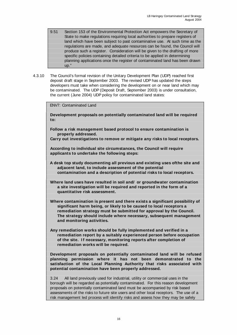
4.3.10 The Council’s formal revision of the Unitary Development Plan (UDP) reached first
deposit draft stage in September 2003. The revised UDP has updated the steps developers must take when considering the development on or near land which may be contaminated. The UDP (Deposit Draft, September 2003) is under consultation, the current (June 2004) UDP policy for contaminated land states:
ENV7: Contaminated Land Development proposals on potentially contaminated land will be required to: Follow a risk management based protocol to ensure contamination is
properly addressed. Carry out investigations to remove or mitigate any risks to local receptors. According to individual site circumstances, the Council will require applicants to undertake the following steps: A desk top study documenting all previous and existing uses ofthe site and
adjacent land, to include assessment of the potential contamination and a description of potential risks to local receptors.
Where land uses have resulted in soil and/ or groundwater contamination
a site investigation will be required and reported in the form of a quantitative risk assessment.
Where contamination is present and there exists a significant possibility of
significant harm being, or likely to be caused to local receptors a remediation strategy must be submitted for approval by the Council. The strategy should include where necessary, subsequent management and monitoring activities.
Any remediation works should be fully implemented and verified in a
remediation report by a suitably experienced person before occupation of the site. If necessary, monitoring reports after completion of remediation works will be required.
Development proposals on potentially contaminated land will be refused planning permission where it has not been demonstrated to the satisfaction of the Local Planning Authority that risks associated with potential contamination have been properly addressed. 3.24 All land previously used for industrial, utility or commercial uses in the borough will be regarded as potentially contaminated. For this reason development proposals on potentially contaminated land must be accompanied by risk based assessments of the risks to future site users and other local receptors. The use of a risk management led process will identify risks and assess how they may be safely
16

LB Haringey Contaminated Land Strategy August 2004
managed both during and after development. The risk management led approach will guide applicants towards the most appropriate measures for each site, highlighting those where risks are not sufficient to warrant remedial action and those where remedial intervention measures are necessary. Planning conditions will be imposed where it appears to the Council that land is
potentially contaminated to ensure appropriate actions are implemented prior to development and/ or occupation of land so that it is suitable for use and does not pose risks to local receptors. Local receptors include;
Humans Living organisms or ecological systems Property (including crops) produce grown domestically or on allotments for
consumption, livestock etc. Controlled waters (surface and ground waters) 3.26 In response to the Environmental Protection Act 1990 (as amended), the Councils Contaminated Land strategy (2004) sets out how it will deal with potentially contaminated sites and summarises where in the borough past land uses may have led to land contamination. Information on potentially contaminated land in the borough is available from Enforcement Services although this information is not necessarily exhaustive. 3.27 Supplementary planning guidance (SPG 8f) provides additional guidance on how the Council expects applicants to deal with potentially contaminated land in the borough. Note: Supplementary planning guidance 8f (SPG8F), can be found in Appendix E of this document.
SPG8F is currently in draft and is subject to public consultation and is likely to be adopted in the winter of 2004.
17

LB Haringey Contaminated Land Strategy August 2004
Cross Departmental Working
Planning: Development Control
4.4.1 Integration between Development Control and the contaminated land function is important because the majority of contaminated sites will be remediated by planned development under the jurisdiction of Development Control. It is essential therefore that a close working relationship exists between Planning and Enforcement Services to ensure correct remediation options are adopted during the redevelopment of contaminated sites. The contaminated land function in Enforcement Services will interface with Development Control through identifying sites that may be contaminated and recommending planning conditions to address contamination.
4.4.2 The Planning Department Development Control team previously dealt with he
remediation of contaminated sites as and when they were redeveloped. Remediation strategies had been the responsibility of the Development Control Teams, who consult with the Environment Agency and Enforcement Services on an ad hoc basis. Apart from the general provisions in the UDP, there were no procedures for dealing with remediation; this however has been addressed during the development of this strategy and all potentially contaminated land subject of a planning application will be referred to Enforcement Services for consideration.
4.4.3 Sites that have been remediated through planned redevelopment will be identified by virtue of their previous (potentially contaminating) land use(s) and reviewed to ensure they have been satisfactorily remediated with regard to current guidance on site remediation.
4.4.4 Follow up arrangements for monitoring site remediation and compliance with conditions is addressed through the adoption of standard planning conditions for potentially contaminated land which incorporate verification procedures to ensure developments meet approved standards of remediation for the permitted site uses. Information Technology
4.4.5 GeoEnviron environmental software was commissioned as a stand-alone system for
the compilation of contaminated land information and the desktop risk assessment of potentially contaminated sites. This software is being assimilated into GGP (a G15) used by Planning, to facilitate the transfer and sharing of site data between Development Control and Enforcement Services. Once integrated, the respective systems will screen planning and building control applications and access historical site data.
4.4.6 At present Development Control utilise GGP GIS mapping systems for handling map-
based planning data; relevant to the contaminated land function are constraints data fields which will incorporate contaminated land data to flag development proposals on potentially contaminated sites. Mapping data held by Development Control includes;
County maps from 1860 (upper part of the borough) LCC maps 1870, 1896, 1915 Aerial photographs from 1940’s Derived data from planning use classes Derived data from building types
Building Control
18

LB Haringey Contaminated Land Strategy August 2004
4.4.7 Has the duty to enforce protection measures in new build projects to mitigate the impact of contamination on property. The Building Control Division will be notified when contaminated ground conditions require preventive measures to safeguard building elements from adverse ground conditions. This will occur through Planning Applications and Building Regulations Applications being screened to flag potentially contaminated land.
Engineers and Highways
4.4.8 Land under highways, pavements, verges and common areas may be contaminated
and present a potential risk to receptors. Highways Authorities must maintain registers under Part III of the New Roads and Street Works Act 1991 for inter alia, streets with special engineering difficulties, which includes risks from contamination. Potentially contaminated land will be flagged by cross-referencing with GGP G15 data held by Planning.
Property Services: Asset Management
4.4.9 The Council has substantial land holdings in Haringey managed through the Asset
Management Plan, which includes all housing, education, social services, leisure property and amenity land. When reviewing the borough for potentially contaminated sites, the Business Support Unit in Property Services will be responsible for confirming Council ownership and for arranging more detailed site investigations if and when necessary. The Property Services TERRIER system carries data on ownership, occupancy and in some cases previous land uses which will be of value to the prioritisation and investigation of potentially contaminated land.
4.4.10 In the event of Council owned land being identified as contaminated, the Asset Working Group will be consulted. Contaminated land in Council ownership would be remediated in accordance with a publicly available remediation strategy approved by Enforcement Services designated Contaminated Land Officer.
Legal Services
4.4.11 Part IIA of the Environmental Protection Act 1990 is complex. Legal advice may be
required on many aspects including those relating to enforcement, liability, powers of entry, data protection, access to information etc.
4.4.12 Land charges deal with searches on land within the borough and are required to
divulge environmental information including that relating to land contamination or land uses that may have given rise to contamination. To respond to contaminated land enquiries (CON29), Land Charges will be provided with direct access to GGP map overlays to enable them to respond to enquiries within 2 days.
19

LB Haringey Contaminated Land Strategy August 2004
4.5 Development of the Strategy
4.5.1 The Council is required to take a strategic approach to inspecting land in its area for
contamination. Statutory guidance requires that the approach adopted should:
Be rational, ordered and efficient Be proportionate to the seriousness of any actual or potential risk Seek to ensure the most pressing and serious problems are identified first Ensure that resources are concentrated on investigating areas where the Council is
most likely to identify contaminated land Ensure that the Council efficiently identifies requirements for the
detailed inspection of particular areas of land
4.5.2 This strategy has been developed in consultation with the Council’s statutory consultees to meet these requirements. Particular reference has been made to “Contaminated Land Inspection Strategies - Technical Advice for Local Authorities” DETR.
External Consultation
4.5.3 The designated Contaminated Land Officer will be responsible for the external liaison and communication with the Environment Agency and other statutory consultees. Existing mechanisms for public consultation within the Community Strategy and LA21 and the UDP will provide a vehicle within which public comments will influence the strategy.
4.5.4 The Councils contaminated land strategy will have an impact on a number of its
services and in respect of land it owns. The following factors will guide the strategy.
Partnerships
4.5.5 By having a clear strategy for dealing with contaminated land, the Council will be able to communicate more effectively with the local community and with strategic partners: The Environment Agency, Greater London Authority, Government Office for London, English Nature and English Heritage.
The Local Economy
4.5.6 Through the principle of ‘suitable for use’ it is the intention of the Council to provide a climate of certainty and support for landowners and developers in securing the remediation of brownfield sites in the borough. The strategy will provide a clear picture for landowners and developers, of how it will investigate and assess sites thought to be contaminated. It is in the interest of all stakeholders in the local economy that contaminated land is remediated and otherwise neglected sites are brought back into use.
Social
4.5.7 Contaminated land also carries a social cost to the borough. The social cost is visible in sites that are not re used and prevent the natural development of the community. This impact is presently mitigated by the strength of the local economy but it will not facilitate the remediation of all sites.
20

LB Haringey Contaminated Land Strategy August 2004
Natural Environment
4.5.8 The cost to the natural environment will occur through many pathways as contaminants enter into receptors such as water and vegetation. The Council is committed to protecting sites of importance and enhancing the biodiversity of the borough.
21

LB Haringey Contaminated Land Strategy August 2004
4.6 Management Team and Responsibilities
4.6.1 The management team for the implementation of the strategy is;
Assistant Director, Enforcement Services Business Support Manager, Enforcement Services Group Manager, Commercial Group, Enforcement Services
4.6.2 The management team for the review of the strategy is;
Commercial Group Manager, Enforcement Services Information Technology Team Leader Planning and Environmental Policy and
Performance and Enforcement Services Business Support Manager, Enforcement Services Designated Contaminated Land Officer, Enforcement Services
4.6.3 The designated Contaminated Land Officer, will be responsible for the strategy review in consultation with the following Departments and statutory bodies; Planning Property Services Central Information Services (IT) Environment Agency English Heritage English Nature Food Standards Agency
22

LB Haringey Contaminated Land Strategy August 2004
4.7 Review
4.7.1 The Enforcement Services Management Team will review the strategy on a regular
basis. To meet its statutory responsibilities two aspects of review will be undertaken:
Triggers for reviewing inspection decisions, and Review of the inspection strategy
4.7.2 The strategy as a whole will be reviewed every three years (next review 2007) and
changes reported to the Policy and Strategy Committee. Particular matters that will be kept under review include:
The content of the strategy generally Priorities for further investigation of potentially contaminated sites The potential for the introduction of new receptors The potential for new contamination Progress on voluntary remediation The enforcement process Identification of special sites Progress with the implementation
Triggers for Non-Routine Site Investigations or Inspections
These will be;
Unplanned events e.g. pollution incidents Introduction of new receptors e.g. new developments Supporting voluntary remediation e.g. land owners who wish to remediate their land
in advance of any action by the Council Identification of localised health effects which appear to relate to the use of a
particular area of land Responding to information from other agencies, e.g. the Environment Agency As a result of planning applications or regeneration initiatives
Enforcement and Interpretation
4.7.4 Decisions made with regard to land which may be contaminated, will be reviewed in
the following circumstances; Significant changes in legislation Establishment of significant case law or other precedent Revision of the guideline values for exposure assessment Previous remediation schemes considered inadequate
23

LB Haringey Contaminated Land Strategy August 2004
4.8 Implementing the Strategy
4.8.1 The programme to identify and seek remediation of contaminated sites will directed
by a clear order of local priorities based upon the potential risk to receptors and local redevelopment pressures.
Table 3
Priority areas Vulnerable receptors Source protection zones and water abstraction
points eg boreholes, TWUL North London recharge scheme points (see Appendix A)
Surface waters eg River Lea and tributaries, Lea navigation
Schools and children’s facilities Residential areas Amenity and allotment land (see Appendix B) Nature reserves (see Appendix C)
Areas of development pressure See Table 2
Identifying Potentially Contaminated Sites
4.8.2 The Council will carry out an ordered and rational inspection of the borough to
identify all potentially contaminated land. This process will by way of a desktop review of available records containing historical information on land use. This process will be carried out in accordance with DETR guidance CLR 3; “Documentary Research on Industrial Sites” and will be accomplished using GeoEnviron GIS to utilise map based historical data held by Planning on GGP or data specifically acquired for this purpose. Additional written sources of data e.g. Kelly’s trade directories and borough profiles will supplement map data.
4.8.3 To ensure consistent data management access will be restricted. It will however be
made available for the dissemination of information for the purposes of the public register and public requests for environmental information.
4.8.4 The Council has already some contaminated land information from historic maps and
site remediation data from redevelopments and where as the site owner, the Council may have commissioned site investigations or remediation work. This information will be added to the database to ensure consistent data management.
Prioritising Potentially Contaminated Sites
4.8.5 Sites identified as being potentially contaminated, will be prioritised and subjected to
further investigation by way of the desktop risk assessment and site prioritisation tool in GeoEnviron. Where appropriate, a walk over survey of the site will be undertaken. This will entail prioritising sites thought to be posing a risk to receptors for further investigation.
4.8.6 Existing guidance includes DETR guidance CLR 6; ‘Prioritisation and categorisation procedure for sites which may be contaminated’.
24

LB Haringey Contaminated Land Strategy August 2004
Table 4 CLR 6 Priority Categories Priority Category 1 Site likely not to be suitable for present use and environmental setting.
Contaminants probably or certainly present and very likely to have an unacceptable impact on key targets. Urgent assessment action needed in the short term.
Priority Category 2 Site may not be suitable for present use and environmental setting. Contaminants probably or certainly present and very likely to have an unacceptable impact on key targets. Urgent assessment action needed in the short term.
Priority Category 3 Site considered suitable for present use and environmental setting. Contaminants may be present but unlikely to have an unacceptable impact on key targets. Assessment action unlikely to be needed whilst the site remains in present use or otherwise remains undisturbed.
Priority Category 4 Site considered suitable for present use and environmental setting. Contaminants may be present but very unlikely to have an unacceptable impact on key targets. No assessment action needed while the site remains in present use or undisturbed.
4.8.7 GeoEnviron will score sites using a similar methodology to complete a contaminant –
pathway – receptor (CRP) assessment to prioritise each site. Site information will reveal potential contaminants and/or sensitive receptors, but the CRP assessment will only take place where both contaminant and receptor are present.
4.8.8 At this stage the Council may contact current landowners concerning specific sites
with regard to obtaining access and to ascertain whether further information is available concerning the condition of the site prior to site investigations.
4.8.9 Information and guidance that will be referred to either in conjunction with CLR 6 in
the evaluation of sites or during more detailed site investigations are;
Table 5 Defra Guidance and Publications DETR Industry Profiles Detailing potential soil contaminants associated with
industrial activities Defra; CLR 8 Priority Contaminants for the Assessment of Land
Identifies priority contaminants or families of contaminants related to past industrial activities
Defra; CLR 9 Contaminants in Soils
Toxicological data and acceptable intake data for humans
Defra; “Tox” series Collation of toxicological data and intake values for humans Defra: Soil Guideline Values (SGV)
Values for soil contaminated with contaminants for which toxicological data has been determined
Defra; CLR 10 Contaminated Land Exposure Assessment Model (CLEA)
Software tool for exposure assessment
Site Investigations
4.8.10 The purpose of a site investigation is to satisfy the Council in the execution of its
statutory duties as to whether a site “statutorily contaminated,” that is to say, it poses a significant risk to a receptor. This may include a request by the Council for the Environment Agency to undertake site investigations to gather sufficient information on significant source – pathway – receptor linkages to enable the Council to determine the site “contaminated”. The Agency would only consider undertaking investigations on behalf of the Council if the site in question would become a special site if the Council designated the land as contaminated land.
4.8.11 Site investigations will take place in priority order except where factors such as site disturbance or redevelopment come into effect. Intrusive site investigations will only
25

LB Haringey Contaminated Land Strategy August 2004
be made as a last resort; for example when information is not available and it is considered very likely that a significant risk of harm to specified receptors is present. Any site investigation would be conducted to ensure the minimum disturbance of the site and strictly limited to confirm whether or not the site is contaminated.
This process will be carried out in accordance with Defra CLR 2; guidance on preliminary site
inspection of contaminated land. Where necessary the Council will refer to the CLEA 2002 Exposure Assessment Tool, the Health Protection Agency, Primary Care Trust or expert consultants on the toxicological aspects of site contamination.
Where appropriate, the Council will consult with the Food Standards Agency (FSA) in
respect of safety for consumers of any food that might be affected by contamination of land. This includes food produced in domestic gardens and allotments and food collected from the wild, including game, as well as commercially produced foods.
The FSA is available to advise on any potential food safety aspects of any specific cases of
contaminated land that might be identified as a result of the development and implementation of the strategy. In addition, it can provide guidelines for the sampling of food. The FSA is able to use the results from crop samples analysed to estimate consumer exposure and, through comparison with safety guidelines and consultation with its’ toxicologists, it can advise on any health concerns for consumers of food produced on potentially contaminated land.
Site Remediation
4.8.15 Where it is established that a site is ‘statutorily contaminated’ remediation action must be undertaken. This may first be through informal agreement with the land owner(s) or by way of service of remediation notices. In either case a remediation strategy must be agreed with the Council.
4.8.16 Site remediation will occur, either formally through the strategy or through the
redevelopment of land under the Town and Country Planning Acts. In either case, remediation of the land will be dictated by a risk-based approach in accordance with current scientific knowledge and guidance from Defra and the Environment Agency.
The designated Contaminated Land Officer will specify remediation measures which will be
both appropriate and cost effective. The aim will be to ensure that the land is no longer contaminated, taking the shortest and lowest cost route. This means, in most cases, attention will be focused on the pathway, rather than the contaminant or receptor.
Archaeologically Sensitive Sites 4.8.18 Some former industrial activities are of archaeological significance and at these
locations any contaminates present may constitute an important element of the archaeological interest. This aspect will be considered when drawing up a remedial strategy. When significant contamination is identified on or in an unscheduled archaeological site, and remediation is necessary, full discussion with English Heritage’s Greater London Archaeology Advisory Service (GLAAS) will take place at an early stage to agree an appropriate mitigation strategy.
Local Authority Remediation
26

LB Haringey Contaminated Land Strategy August 2004
4.8.19 Before the Council can serve a remediation notice it will first determine whether it has the power to carry out any of the remediation actions itself. There are five specified circumstances where this may be the case:
Where urgent action is required (see below) Where no appropriate person can be found Where one or more appropriate persons are excluded (on grounds of hardship) Where the local authority has made an agreement with the appropriate person(s) that it should carry out the remediation In default of a remediation notice
Urgent Cases 4.8.20 Urgent action will follow where the Council is satisfied that there is imminent danger
of serious harm or serious pollution of controlled waters being caused as a result of contaminated land. The Council will undertake remediation in urgent cases if it is the enforcing authority and if it is of the opinion that the risk could only be mitigated by formal action. In the case of a special site the Council will declare land contaminated and notify the Environment Agency who will be responsible for remediation.
4.8.21 Wherever possible the Council will seek to recover costs of remediation works it has
completed.
Apportioning Liability
4.8.22 When land has been declared contaminated within the meaning of Section 57 of the Environmental Protection Act 1990 and all pollutant(s) linkages have been established, the procedure for the apportionment of liability can begin.
4.8.23 There are 5 stages to follow before liability can be apportioned,
a) Identify potential appropriate persons and liability groups Characterise remediation actions Attribute responsibility to liability groups Exclude members of liability groups Apportion liability between members of a liability group
These procedures are complex and once identified may be classified as either a Class A or B
person;
Class A The polluter or persons who knowingly permit pollution Class B Where no Class A person can be found liability reverts to the
owner or occupier
27

LB Haringey Contaminated Land Strategy August 2004
4.9 Implementation
4.9.1 The implementation programme provides a general outline of key milestones. It will
however, be realigned by the management review mechanism in the light of new information and practical experience.
4.9.2 The programme is as follows,
Table 6 Implementation Timetable Function Date 1. Publication of the strategy Autumn 2004 2. Implementing GeoEnviron to process land based information and to provide the public register
September 2004
3. Dealing with urgent sites Winter 2004/05 4. Site identification October 2004 onwards 5. Desktop risk assessment Early Summer 2005 6. Site inspections Late Summer 2005 7. Detailed site inspection and risk assessment
Ongoing as sites are either; Revealed through stages 2 – 5 above, or As they enter the planning process for development
8. Service of Remediation Notices Ongoing as a follow on from 6 above, where sites are found to be a significant risk to receptors
28

LB Haringey Contaminated Land Strategy August 2004
5.0 The Haringey Environment
5.1 Introduction
5.1.1 This section provides a description of the particular environmental and land use characteristics of the Haringey area. This is important in terms of identifying
potential contamination source – pathway – target linkages and to enable contaminated land risk assessments to be made. This section is structured as follows;
5.2 The local environment 5.3 Current land use
Historic land use Features in relation to contaminated land Sources of Contamination
It is necessary to have an appreciation of current and past land use and industrial history of
the borough. It is these activities that will account for most of the sources of contamination in the area.
5.1.3 Contamination sources include: former industrial sites in the Lee Valley, former land
uses that are known to contaminate land and the pollutants associated with them.
Pathways
5.1.4 Pathways that contaminants might move along include: groundwater migration, methane gas migration, wind blown deposition, uptake from soils, into plants and then to humans, leaching into watercourses and disturbance from excavations. Targets
5.1.5 Examples of targets include nature conservation areas, rivers, groundwater source protection zones, human beings, and flora and fauna.
Receptors
5.1.6 Land can only be considered contaminated if it can be shown that there is a reasonable risk of the contaminants present can via a pollutant linkage, cause significant harm to a specified receptor. The Environmental Protection Act 1990 identifies these:
a) Human
The present population of the Haringey is approximately 221,600 (2003) distributed fairly evenly across its area of 29.6km2, although the east of the borough is more densely populated. The potential for persons either living on or having access to a contaminated site will be considered in every case, but priority will be given to sites with children, e.g. schools, play areas and houses.
b) Property – buildings
All buildings and underground services are potential receptors and will be considered in every case where contamination and buildings exist.
c) Property – home grown produce
Allotments sites in the borough are listed in Appendix B, these will be identified and their potential for being contaminated will be considered on the
29

LB Haringey Contaminated Land Strategy August 2004
basis of their previous use(s). Similarly, domestic gardens likely to be contaminated will be identified and assessed.
d) Ecological receptors
There are several sites in the borough (see Section 5.2) that may constitute a receptor. Significant impact from contamination is unlikely but all areas will be identified, examined and any risks carefully quantified with English Nature and the Environment Agency.
e) Water
Water may be regarded as both a receptor and therefore potentially harmed by pollution and also as a pathway through which contaminants may spread. All water resources such as surface water, ground water, reservoirs etc. are treated as both for the purposes of this strategy.
At present the Environmental Protection Act 1990 requires that contaminated land should ‘not cause pollution’ to controlled waters, however there are proposals to amend this provision to ‘not causing significant harm’ to controlled waters. This will impact upon the Councils activities under this strategy, in that it may reduce the extent to which land may be perceived as having a detrimental effect on water resources in the borough.
30

LB Haringey Contaminated Land Strategy August 2004
5.2 The Local Environment
5.2.1 The Borough of Haringey is located in the centre of North London and is defined as
an Outer London borough. In the west is Alexandra Palace and to the east Tottenham Hotspur football ground. In the centre is Wood Green, one of the largest shopping and service centres in London. Eastern Haringey is built on the river Lea flood plain, while the western part of the borough is hilly. Although the borough is populated throughout its area, the eastern part is more densely populated.
5.2.2 The eastern part of Haringey bordering on the Lea valley was formerly a significant
part of London’s light industry but has suffered from economic decline since the 1970’s and is now the focus of regeneration programmes.
5.2.3 The west of the borough in contrast, is characterised by affluent residential areas of
tree-lined avenues and retail areas developed during the Edwardian period. Water Resources
The Environment Agency is charged by the Water Resources Act 1991 to prevent and monitor
water pollution to controlled waters, this activity is centred on the regulation of list I and II chemicals specified under EC Directive 80/68/EEC. The Agency has provided comprehensive map based information to the Council which will form the basis of its approach in terms of prioritising and assessing potentially contaminated land in relation to water resources. This information has been loaded onto GeoEnviron although it has yet to be validated to confirm the data is complete.
The presence and distribution of source protection zones and vulnerable major aquifers are
clearly targets for prioritising action under the contaminated land strategy. They are potential receptors but may also act as pathways for the further distribution of soil contamination.
Surface Water – Controlled Waters
5.2.6 With the exception of Highgate, surface water in Haringey drains eastwards into the
River Lea, in Highgate surface water runs westwards into the River Brent or into combined sewers in LB Islington. Surface water in the borough flows generally eastward in the Muswell, the Moselle, the Stonebridge, their tributaries and storm drains (separate to foul water drains). The Stonebridge is almost entirely covered except for the short stretch in the Markfield area close to the River Lea. The Moselle and it’s upper tributaries rise in Queen’s Wood and Crouch End playing fields, and run through Priory park, Lordship recreation ground and Markfield playground. A lower tributary the Lesser Moselle, flows through Tottenham cemetery. Pymmes Brook also flows eastward into the Lea along the northern boundary of the borough.
5.2.7 Thames Water Utilities owns and operates the New River which flows north to south via Bowes Park, Wood Green, Hornsey, Finsbury Park and Green Lanes to Stoke Newington Reservoir and Coppermills Water Treatment Works immediately to the east of the borough boundary. This watercourse is used to supply north and central London with drinking water. The company also owns and operates the water storage reservoirs on the eastern boundary of the borough. A map showing the location of these water assets is shown in Appendix A.
31

LB Haringey Contaminated Land Strategy August 2004
Table 7 Details of Boreholes and Water Treatment Works Within and in Proximity of Haringey Borough Borehole Site Locations National Grid Reference Abstraction From Myddleton Road, Bowes Park TQ 3056 9173 Chalk Station Road, Wood Green TQ 3048 9041 Chalk Hornsey Filter Beds, Hornsey TQ 3059 8975 Chalk Lothair Road South, Haringey TQ 3163 8802 Chalk Hornsey Sluice, Hornsey TQ 3070 8955 Chalk Hornsey Gatehouse TQ 3078 8939 Chalk Park Well, Tottenham TQ 3502 9090 Chalk Bowes Road TQ 3070 9220 Chalk Campsbourne TQ 3050 8950 Chalk Coppermills TQ 3500 8840 Chalk Green Lanes TQ 3230 8700 Chalk Lea Bridge TQ 3600 8650 Chalk Lordship Road TQ 3250 8750 Chalk Park TQ 3500 9080 Chalk Water Treatment Works Location Coppermills Water Treatment Works TQ 3550 8800 N/a Source: Thames Water Utilities Ltd. January 2004
Surface Water Quality
The River Lea (including the Lea Navigation) on the boroughs eastern boundary is the principal watercourse in the area. Upstream of its confluence with Pymmes brook the Lea has been assigned River Quality Objective (RQO) class 2, whilst downstream of this point it is RQO 5. The Lea Navigation is RQO 3.
Table 8 Tributaries of the River Lea Tributary RQO Classification Pymmes Brook (which forms part of the northern boundary of the borough)
RQO class 4 and 5
Muswell Brook (a tributary of Pymmes Brook) RQO classification 4 and 5 Stonebridge Brook RQO classification not assigned Moselle Brook RQO classification not assigned Source: Environment Agency March 2004
5.2.9 RQOs relate to the level of water quality that a watercourse should achieve in order
to be suitable for its agreed uses; class 1 being suitable for all uses and class 5 is suitable for very restricted uses.
5.2.10 The Environment Agency have advised that in addition to Thames Water, there is one
other licensed groundwater abstraction point; Canon Rubber 881 High Road, Tottenham which is licenced for cooling water.
Groundwater
5.2.11 Major aquifers are very sensitive to potential pollution where hydraulic continuity exists between the ground and surface waters. This is unlikely to be the
case in Haringey and the Environment Agency has confirmed that there is a low risk of the chalk aquifer being contaminated by surface water or groundwater as it is overlain by the impermeable London Clay.
5.2.12 However, groundwater vulnerability maps supplied by the Environment Agency show
source protection zones to protect some drinking water supplies in Haringey. There are source protection zones centred on the TWUL North London Artificial Recharge wells in Wood Green, Tottenham and Hornsey, where surface water is periodically
32

LB Haringey Contaminated Land Strategy August 2004
pumped into the chalk aquifer to balance deep ground water abstraction. Land use activities within the source protection zones are closely monitored by the Environment Agency.
5.2.13 The Environment Agency have commented that because of the thick layer of London
Clay underlying the borough there are no groundwater issues of concern. Caution should however be taken with development requiring deep piles for potential risk of puncturing the London Clay. The London Clay does have a ‘window’ south east of the borough in Stratford where the clay is missing exposing the chalk aquifer via the Kempton Park and Reading and Woolwich sand and gravel beds. This area is highly sensitive to pollution and a general awareness should prevail for the potential for pollution pathways (continuity) with contaminated land in Haringey.
5.2.14 Hampstead Heath ponds, just outside the borough boundary (LB Camden), are spring
fed from minor aquifers and are therefore sensitive to groundwater pollution; the ponds may be regarded as receptors rather than pollutant pathways. The ponds are however situated within a greenfield location which is unlikely to be disturbed or developed.
5.2.15 Thames Water advise that in addition to the North London Artificial Recharge scheme,
drinking water is also abstracted from the New River and the Lea Valley Reservoirs for treatment just outside the borough at the Coppermills Water Treatment Works.
Private Water Supplies
5.2.16 Enforcement Services are not aware of any private water supplies within the borough. These are properties served from their own borehole or well supply; if present the Council has a duty to check the safety of such supplies.
5.2.17 Drinking water abstraction points are both potential receptors and pathways for land
contamination. All such abstraction points and non potable groundwater abstractions licensed by the Environment Agency, will be reviewed with regard to their proximity to any land that is identified as potentially contaminated.
Geology
Solid Geology
5.2.18 The general geology for the borough is shown on the British Geological Survey 1:50,000 sheet 256. The dominant formation is chalk overlain by London Clays which provides some degree of protection to groundwater in the chalk.
5.2.19 London Clay is not considered vulnerable to land pollution because of its
characteristic, impermeability to water penetration and inert nature in respect of volatile organic and inorganic soil contaminants. This characteristic protects the underlying Cretaceous Chalk, which is the major drinking water aquifer for the region.
Drift Geology
5.2.20 The most common drift deposits found in Haringey are sands and gravel’s, known as
aggregates. River gravel’s are found in low lying river valleys are recent deposits. Glacial gravel’s are much older and found on higher ground. Drift cover can provide suitable protection to shallow ground water.
5.2.21 In the borough there are formations of unconsolidated drift material. There are two
areas of younger drift material; the Claygate and Bagshot beds. These run in a ridge
33

LB Haringey Contaminated Land Strategy August 2004
from; Harringay West station to Ealing (West London), it is broken in a number of places and marks the northern edge of the Thames Valley.
5.2.22 The Hornsey Ridge to the south west of the borough consists of Claygate beds.
Hampstead and Highgate (partly within the borough) are topped with Bagshot sand. Northumberland Park in the east of the borough is on brick earth, a drift deposit.
5.2.23 In the lower lying Lea valley in the east of the borough are alluvial deposits including
Kempton Park Gravels, Enfield Silts and more recent Alluvial Silts. Nature Conservation
5.2.24 The First Deposit Draft of the Unitary Development Plan, September 2003, lists several sites of local significance (schedules 8, 9, 10 and 11). Sites of local significance are listed in Appendix C;
Conservation Areas
5.2.25 The Borough has 27 declared conservation areas covering a total area of approximately 800 hectares (see UDP).
Historic Parks, Gardens and Landscapes
5.2.26 There are two parks which are nationally registered, Alexandra Park and Finsbury Park. There are a further 34 registered public parks, gardens, squares, cemeteries and churchyards of local historic interest.
Statutory Nature Conservation Sites
5.2.27 English Nature was consulted concerning nature conservation within the borough,
there are some nature conservation interests as summarised in table 9. Table 9 Statutory Nature Conservation Sites
Site Designation Features Walthamstow Reservoirs (just outside borough boundary in LB Waltham Forest)
SSSI One of the UK’s major heronries and large concentration of breeding water fowl including; Great crested grebe Pochard Tufted duck Coot Yellow wagtail Sedge and reed warblers Shoveler Common tern Fenland flora uncommon to London including; Marsh marigold (Caltha palustris) Graceful sedge (Carex x subgracilis) Common club rush (Schoenoplectis lacustris) Lesser bullrush (Typha angustifolia) Over 300 species of plant in wooded areas, grass banks, fen and open water.
Hampstead Heath Woods (just outside borough boundary in LB Camden)
SSSI Long established high forest woodlands with exceptional structure and old and over mature trees Tree species including Sessile oak (Quercus petraea) Beech (Fagus sylvatica) Pedunculate oak (Quercus robur) Wild service tree (Sorbus torminalis)
34

LB Haringey Contaminated Land Strategy August 2004
Downy birch (Betula pubescens) Understorey and plant species including; Holly (Ilex aquifolium) Rowan (Sorbus aucuparia) Hazel (Corylus avellana) Rhododendron (Rhododendron ponticum) Cherry laurel (Prunus laurocerasus) Bramble (Rubus fruticosus) Bracken (Pteridium aquilinum) Bluebell (Hyacinthoides non-scripta) Wood anemone (Anemone nemorosa) Pignut (Compodium majus) Acidic flush flora including; Soft rush (Jancus effusus) Bog-moss (Sphagum spp.) Water horsetail (Equisetum fluviatile) Common bent (Agrostis capillaris) Creeping soft grass (Holcus mollis) Tufted hair grass (Deschampsia cespitosa) Silver birch (Betula pendula) Alder (Alnus glutinosa) The nationally rare invertebrate; Jewel beetle (Agrilus pannonicus) – listed as vulnerable in the British Red Data Book
Parkland Walk Local Nature Reserve
Queen’s Wood Local Nature Reserve
Railway Fields Local Nature Reserve
Source: English Nature 2004
Key property types 5.2.28 Consultation with English Heritage has confirmed that within the categories of
significant harm the DETR Circular 2/200 identifies Scheduled Ancient Monuments (SAMs) as one of receptors that could be subject to harm. In the case of SAMs, substantial damage (i.e. harm) is regarded as any damage that significantly impairs the historic, architectural, traditional, artistic or archaeological interest by reason of which the monument was scheduled. Although there are currently no SAMs in Haringey, SAMs should be noted within the Strategy as designation may occur during the life of the Strategy.
The sites of some former industrial activities are of archaeological significance, and at these locations any contaminants present may constitute an important element of the archaeological interest. This aspect would need to be considered when drawing up a remedial strategy for such a site.
SAMs constitute a relatively small proportion of the total archaeological resource and English
Heritage would expect that when significant contamination is identified on an unscheduled archaeological site and remediation is necessary, full discussion with English Heritage’s Greater London Archaeology Advisory Service (GLAAS) would take place at an early stage to agree an appropriate mitigation strategy.
Other Potential Property Types Although not included in the DETR guidance, listed buildings, world heritage sites, historic
parks and gardens, historic battlefields and conservation areas will on occasions also be sensitive receptors. All these are designations, some of them statutory, that local authorities are required to take into account when considering planning applications
35

LB Haringey Contaminated Land Strategy August 2004
and related matters. For example a significant number of industrial buildings are listed and some conservation areas may include, or may even have been designated principally because of their industrial heritage.
Allotments
5.2.32 Allotment sites are listed in Appendix B; these will constitute vulnerable receptors by virtue of the practice of consuming produce grown on site. Priority will be given to sites were allotments coincide with former industrial land uses.
36

LB Haringey Contaminated Land Strategy August 2004
5.3 Current Land Use
5.3.1 Haringey has a diverse industrial base with companies operating in a wide range of
sectors. In comparison with London as a whole, there is a relatively high concentration of manufacturing, in particular, metal goods, food, clothing and textiles, distribution, hotels and catering.
5.3.2 The local economy is dominated by micro and small businesses (91.5% employing
less than 24 people), there are eight businesses employing 200 people or more. Table 10 Employment by Sectors Employment Number of
Employees % in Employment
Farming, fishing, extraction - - Manufacturing 5,570 9.3% Utilities, construction and communications
7,260 12.1%
Distribution and leisure 21,720 36.3% Finance and business services 10,420 17.4% Education, health and public administration
14,890 24.9%
Source: Haringey City Growth Strategy October 2003
5.3.3 In the manufacturing sector, 80% of all manufacturing employment is accounted for
in the following sectors; metal goods, processing of rubber and plastics, timber and wooden furniture. The total employed is however less than that employed in retailing.
5.3.4 There is a significant floor space given to distribution and warehousing as the
borough is part of the Lea Valley and East London Corridors and is conveniently placed for distributing goods in London and the South East.
5.3.5 The present industrial areas of the borough are potential sources of contamination
and these will be inspected in accordance with statutory guidance to establish whether there is a potential for contamination to exist. Industrial activities controlled by other statutory mechanisms (e.g. IPPC) will be excluded in accordance with statutory guidance.
5.3.6 Within Haringey there are few present day activities that might lead to potential
ground contamination, although petroleum retailing presents a risk. The Institute of Petroleum estimates that some 30% of petrol stations contaminate groundwater (ENDS Report 311 December 2000).
Waste Management
5.3.7 Active and formerly licensed waste transfer and landfill sites are regulated by the
Environment Agency under Part II of the Environmental Protection Act 1990. Sites currently operating under licence are the responsibility of the Environment Agency and will not be investigated under the contaminated land strategy. These sites are listed in Appendix D - Licensed & Exempt Sites.
5.3.8 However, former sites operating prior to the introduction of licensing in 1976 (Control
of Pollution Act 1974), and have since closed will be of significant interest as potentially contaminated land.
37

LB Haringey Contaminated Land Strategy August 2004
5.3.9 Former civic amenity sites may act as potential sources of contamination and will be investigated. Current sites subject to licensing and control by the Environment Agency will not be considered.
Waste or Derelict Land
5.3.10 Sites owned by the utilities, National Rail, the Council or the private sector, and left
abandoned can accumulate unwanted materials and may be used to dispose of wastes and effluents illegally. These therefore may constitute potentially contaminated sites, however it will be difficult to attribute specific hazards to these sites without either; evidence of what has been dumped, or site investigation to assess whether contaminants are present.
Previously Developed Contaminated Sites
5.3.11 The review of the borough will highlight sites according to their historic use, some will have since been remediated and redeveloped. In such cases the site will be assessed to ascertain whether the methods and extent of remediation are sufficient to deal with the contamination present. In some cases the methods used to clean up the site may be unknown, in others it is possible that remediation was inadequate.
Prescribed Processes
Air Pollution
5.3.12 The Council currently authorises over 20 industrial/commercial processes under Part I of the Act. These include vehicle sprayers, printers, mobile crushers and petrol stations. Many of these processes have the potential to pollute the land and where appropriate will be screened during a review of the borough for potentially contaminated sites.
Integrated Pollution Prevention and Control
5.3.13 The IPPC regime controls discharges into the environment, including those to land and is administered by the Environment Agency under Part I of the Act; there are presently no IPPC processes in the borough.
Hazardous Installations 5.3.14 Consultation with the Health and Safety Executive (HSE) Hazardous Installations
Directorate (HID) has indicated a low incidence of industrial or commercial sites storing hazardous materials.
5.3.15 Sites are registered with the HSE Hazardous Installations Directorate under the
Notification of Installations Handling Hazardous Substances Regulations 1982 and the Control of Major Accident Hazards Regulations 1999. There are 3 sites within (or in close proximity) to the borough.
COMAH sites
5.3.16 The Control of Major Accident Hazards Regulations 1999 (SI 743) is enforced by the Environment Agency and Health & Safety Executive (joint competent authority) to control both on and off site risks from industries with a high potential for disaster from dangerous substances (flammable, toxic or explosive). There are currently no sites within the borough.
38

LB Haringey Contaminated Land Strategy August 2004
Table 11
NIHHS and COMAH sites
NIHHS sites
Site Name Address Hornsey Holder Station Tottenham Holder Station Leeside Trading Estate
Clarendon Road Willoughby Lane Part of Willoughby Lane complex, Leeside (consultation distance falls within LB Haringey)
COMAH sites
None Source: HSE Hazardous Installations Directorate 2003/ LB Haringey Emergency Planning Officer 2003
5.3.17 The Council is a Hazardous Substances Authority for the purposes of the Planning
(Hazardous Substances) Act 1990 and the Planning (Hazardous Substances) Regulations 1992. This legislation requires consent to allow the presence on land of hazardous substances above a specified quantity. These regulations were recently amended by the Planning (Control of Major Accident Hazards) Regulations 1999 (SI 981) to take account of the new COMAH Regulations (below). The planning department is responsible for maintaining a register of authorised sites; there are presently no authorised sites in the borough.
Explosives
5.3.18 Explosives are not directly covered by the hazardous substances regulations but are controlled by the Health & Safety Executive under licences issued under the Explosives Act 1875. Any licenced sites will be identified in consultation with the HSE.
39

LB Haringey Contaminated Land Strategy August 2004
5.4 Historic Land Use
Early Land Use
5.4.1 Historically the development of Haringey has been influenced by the radial pattern of
communications from the City of London. Originally the natural vegetation was dense forest which discouraged settlement except along natural lines of communication. By the time of the Norman Conquest there were settlements in Tottenham and the Hornsey High Street area. In Tudor times when London grew in population and size, villages in the surrounding countryside were favoured by the rich as country resorts, among these were Tottenham (accessible to the city) and Highgate (“high and healthy”). However the present suburban and light industrial development patterns date from the nineteenth century population explosion and the suburban railways developed during that period.
Tottenham 5.4.2 On the west bank of the Lea the Anglo-Saxon settlement of (Totte-ham) Tottenham
grew up, it is likely that Ermine street, a Roman Road from London to Lincoln, followed the line of the present Tottenham High Road. Until the early 19th century the area was predominantly a self-supporting rural community, the principal focus was the feudal manor at Bruce Castle and Tottenham Mills. Industrial activity is not recorded other than brick and tile manufacture from the brick earth deposits in Tottenham, which began from as early as 1435 until the last brick works closed in 1961.
5.4.3 By the 17th century Tottenham had grown westwards from the Lea and all that remained of the forest was the remoter parish of Wood Green and Alexandra Park then known as Tottenham Wood. By 1880 Tottenham was still predominantly rural but now served as a market garden area supplying the city with agricultural produce via the river Lea and Great Eastern Railway which reached Tottenham by 1840. In 1872 the Liverpool Street – Enfield railway line was opened which was obliged to offer cheap workman’s tickets which triggered a housing boom and Tottenham became a dormitory town for those working in the city. The population grew from 9,000 in 1851 to 71,000 in 1891 and 158,000 by 1931 when development was virtually complete.
5.4.4 Taking advantage of the cheap and plentiful labour industrial development took place
from 1890 on the cheap flat land along the River Lea and large companies such Harris Lebus (furniture) transferred from Finsbury Park to Ferry Lane in 1899. Other large industrial sites include Gestetner in Broad Lane and JAP Engineering in Northumberland Park. There are records of silk manufacture, rubber and lace factories and the local corn mill turned over to seed oil and later gunpowder manufacture. Industrial activity in the late 19th and first part of the 20th century can be discerned from Kelly’s directories and Tottenham Official guide (undated c. 1960).
Wood Green 5.4.5 Historically Wood Green is a parish of Tottenham, in 1800 it had a population of 100
but with the development of north – south turnpike roads (Green Lanes and High Road) and the Great Northern Railway in 1809 its accessibility improved and by 1888 it was a separate administrative area. The development of Alexandra Palace in 1873 brought more people and was served by 2 branch railway lines; one from Seven Sisters Junction opened in 1878 was known as the Palace Gates line.
40
LB Haringey Contaminated Land Strategy August 2004
5.4.6 Housing developments took place through the 19th and early 20th century concurrent with Tottenham, as the area was more hilly, the developments was less dense and there was no industry of note. Large areas remained open including Alexandra Park and Muswell Hill Golf Course (the oldest in London).
Hornsey
5.4.7 There was probably an Anglo-Saxon settlement in Hornsey in the vicinity of the
present High Street and the tenure of the Manors of Hornsey by the Bishops of London is thought to date from the Norman Conquest. These parts were densely forested and used for hunting, the Green Man and Woodman refer to forest wardens. Hornsey was a consequence slow to develop with various settlements around the parish church in High Street Highgate, and in the hamlets of Muswell Hill and Crouch End.
5.4.8 The traditional main route of communication in this part of the borough was the
Great North Road to Barnet to Whetstone across to Finchley Common to Highgate and down into Holloway. This route despite difficult gradients had by 1400, supplanted an earlier route via Colney Hatch – Muswell Hill – Crouch End, which was abandoned on account of impassability in wet weather.
5.4.9 As with Tottenham, development was stimulated by the railways and by 1860,
Hornsey was served by the Great Northern Railway. The area to the west including Crouch End, Muswell Hill and Highgate remained isolated until 1867 when a line was opened from Finsbury Park to Crouch End and Highgate. In 1875 a branch line connected Alexandra Palace to Highgate, cheap fares and a good service encouraged suburban development; by 1881 Stroud Green station was opened. The population in Hornsey increased from 19,387 in 1871 to 61,697 in 1891; this growth was concentrated along the railway lines.
5.4.10 The hilly western area of the borough is different in character with no industrial
development of note. From the 18th century the area was developed for villas of the wealthy and later in the 19th century for fashionable middle and upper class housing, e.g. the Rookfield Estate on the eastern slopes of Muswell Hill.
5.4.11 Highgate is unique in Haringey, never a large medieval settlement it was patronised
by the wealthy from Tudor times because it was high and healthy. It retains a high proportion of medieval buildings and has no industrial history.
Despite its 19th century growth, the borough had little industry before the 1890’s with most
people engaged in agriculture, crafts and trading. Wood Green and Hornsey developed as a preponderantly residential suburb. Industry first began to concentrate in three areas before the first world war: Tottenham Hale Northumberland Park towards Edmonton Along the old boundary with Stoke Newington
The past industrial history of Haringey is principally characterised by accessible, cheap flat land
along the eastern banks of the River Lea. By some it is credited as being the seat of Britain’s post-industrial revolution (from c.1850) until its decline in the 1960’s. A number of these activities may have left a contaminated land legacy. A search in Bruce Castle Museum Local History Archive revealed the following activities;
Table 12
41

LB Haringey Contaminated Land Strategy August 2004
Historic Industries in Haringey Name/Activity Address Notes Anon. Brick, tile and clay pot manufacture.
High Road and surrounding areas. White Hart Lane Beans Green (later the Haringey Stadium and Arena and now Sainsbury’s superstore)2
Bounds Green
Brick making established from the 15th century exploiting London Clay deposits. 2, 3
285,000 breeks (bricks & tiles) manufactured in 1435-6. Brick earth deposits exploited from area around parish church and east of High Road. Clay (brick earth) digging licensed in High Road area from 1704. This industry flourished during the house building boom of the 19th century. When local brick makers also used clinker from domestic fires, c.1845 3 manufacturers in the area. In 1818 there was a brick field in Rectory Field close to the Edmonton border. 3
2 potteries on north side of White Hart Lane in area formerly Clay Hill now Devonshire Hill. Activity from 1619 when known as ‘Apeland’. This land split into 2 plots leased from Tent Farm: Cole Pottery from c.1850 to 1950 later
to become Williams Brothers Direct Supply Stores Depot and;
Pottery from c.1850 becoming White Hart Lane Potteries in 1886 one of largest horticultural potteries in UK producing 100,000 hand-made pots/ week, employed 150 men. Up to 100 horses were employed and an important subsidiary business sprung up of haulage and refuse collection. Business ceased 1960. Site subsequently developed by soft drinks manufacturer Idris and later occupied by Beechams. 2
In 1843 Nathaniel Lee owned tile works with 3 cottages, the tile kilns survived until the 1860’s.with a brick field immediately to the east of Tottenham Cemetery and a brick works between the railway tunnel and Bounds Green Road. Manufactured glazed bricks and tiles. 3
From 1862 pottery established by Charles Paul Millard until 1926 when site turned over for use as Scouts Playing Field, use continues to date. 2
Tottenham Mills Various activities
Circa early 19th century, short-lived industries including tannery at White Hall and papermaking. 3
Silk Winding Factory Lane 1815 factory built for silk winding and later used for manufacture of rubber solution, giant stack built in 1839, later demolished in 1903. Site part sold to Licensed Victuallers who built Dowsett
42

LB Haringey Contaminated Land Strategy August 2004
Road, but remainder continued until company moved to Barking in c.1919.
Lace Making Love Lane, Tottenham 1810 factory built and run by successive owners until burnt down in 1860.
Allsopp & Co. Piano Manufacture
Site bounded by Mayes Road/ Western Road and Coburg Road
1872 to 1880 Manufacturer of pianos, site sold to Barratt & Co. in 1880.2
Barratt & Co. Confectioners
Site bounded by Mayes Road/ Western Road and Coburg Road
1880 to 1980 Manufacturers of chocolates and confectionery. Employed c.1,000 people at its peak. Currently site of LB Haringey Social Services office. 2
Tobacco Manufactory Western Road (now Hornsey Gasholder site)
1861 to 1894Tobacco snuff and cigar factory2
Nurseries Various sites Numerous nurseries are listed in Kelly’s Directories; Wood Green Nursery, Commerce Road (1864) Bowes Nursery 1871 The Vineries, Nightingale Road 1882 – 1884 Alexandra Nurseries, Woodside Road 1903 In addition there were at least six jobbing nurserymen, probably servicing the larger houses, in the latter half of the 19th century. By the 1920’s the Alexandra Nurseries site had become the Wood Green UDC Nursery accessed from Wolves Lane and is now Haringey Council’s nursery known as Palm House. Bounds Green Nurseries stood on the north side of Bounds Green Road, from c.1910 to 1960, after which flats were built on the site.2
Tottenham Brewery & Bell Brewery
1862 – c.1890 Bought by Whitbread & Co in 1896 and turned into a bottling depot in the same year, although some of the older brewery buildings, on the east side of High Road south of Park Lane, were still used in 1924.3
Floor-Cloth factory Bathurst (later Laurence) Road
c.1860 3
Tobacco works Wood Green Common c.1860 3
Millington & Sons Stationers
Fountayne & Fawley Roads
c.1903 Manufacturing stationers3
Eagle Pencil Co. Ferry Lane & Ashley Road 1920 Kolok Tariff Road 1904 – c.1913
Manufacturing carbons and ribbons3
English Abrasives London Emery – moved from Clerkenwell
1902 – c.19043
Edward Barber & Co Foundry
Paxton Road 1908 – 1973 Water fittings manufacturers. Non-ferrous sand foundry and finishing shop.3
Maynard’s Confectioners
Vale – Eade Road. Moved from Stamford Hill in 1906
Confectioners3
L. Lazarus & Son Furniture manufacture/ chemicals
Queen Street 1935 Large furniture factory. In 1950 site acquired by Sparklets, a subsidiary of the British Oxygen Co. Building
43

LB Haringey Contaminated Land Strategy August 2004
continued in the extreme north-east, where by 1951 Brantwood Road and its factories had been extended eastward to Willoughby Lane, and started in the north-west along Cline Road, Bounds Green.3
Wingate Trading Estate Various
784 – 792 High Road 1959 Site occupied by 40 firms who replaced a plate-glass manufacturer’s .3
Charrington & Co Brewery
Brantwood Road 1973 Employed 500 at their bottling and keg store. 3
Cannon Rubber Ashley Road and High Road
1973
Wood Green & Hornsey Steam Laundry Ltd.
Albert Road, alongside Muswell Brook
c.1890 Buildings present, used for alternative purposes. 2
Mirror Laundry Brabant Road 1910 to c.1939 Presently used as a children’s play centre2
MAP (Myddleton & Alexandra Park) Laundry
The Campsbourne, Hornsey
c.1906 to ? Once employed several hundred people2
RW Munro Engineering
Cornwall Road, Tottenham
1905 to 1938 Manufacturer of precision instruments1
RW Munro Engineering
Cline Road, Bounds Green
1938 to 1960(?) Manufacturer of precision instruments1
JA Prestwich 1 Landsdown Crescent (and adjoining property)
1898 to 1911 Manufacturer of motorcycle engines1
JA Prestwich Northumberland Park, Tottenham
1911 to 1963 Manufacturer of motorcycle engines, munitions, aircraft parts, pump engines, portable engines. Employed c.10,000 at its peak. 1
Gestetner Engineering/ink
Broad Lane, Tottenham 1906 to 1982 Manufacturer of duplicating equipment. Employed c. 10,000 at its peak. 1
Harris-Lebus Furniture manufacture
Ferry Lane (and surrounding areas), Tottenham
1904 to 1969 Manufacturer of furniture employing c.8,000 people at its peak, reputedly the largest furniture manufacturer in world. Site redeveloped by GLC for housing in early 1970’s. 1
In 1900 acquired 13½ a. for their Finsbury works on former nursery-land south of Ferry Lane. Although other firms were to follow at Tottenham Hale, Lebus remained exceptional until the 1930’s in have a site east of the railway line there, presumably chosen for the carriage of timber by water.2
Standard Bottle Co. Ltd.
Site north of Cline Road, Bounds Green
1910 – 1971 Glassworks on site of former Bounds Green Farm, becoming the Standard Bottle Company Limited in 1926, destroyed by fire in 1970’s, now part of Middlesex University campus. 2
Wonder Baking Company Ltd.
North of White Hart Lane next to South’s Potteries
1937 to ? Bakers producing mass produced bread including the ‘Wonderloaf’2
Data sources: London’s Lea Valley; J Lewis, Phillimore & Co. Ltd. 1999 Wood Green Past; Albert Pinching, Historical Publications, 2000
44

LB Haringey Contaminated Land Strategy August 2004
Victoria County History, Middlesex; Volume 5, pp. 337-339, University of London Institute of Historical Research, 1976
5.4.14 By 1967 industrial activity in the borough occupied 4% of the land area. In the 1960’s the principal industries in the area were; timber and furniture, textiles, clothing, bricks, pottery, cement and public utilities; during that period industrial activity in the borough was undergoing a marked decline. Most industrial activity was characterised by small companies employing less than 10 people, in 1967 there were 619 manufacturing businesses. In 1970 clearance areas for new housing displaced 250,000 square feet of garages, workshops and storage, for example around Gourley Place and Ashley Road.
5.4.15 The largest employer in the borough was the Harris Lebus furniture works, however
by 1966 had reduced its workforce to 1,200, it had substantial sites north and south of Ferry Lane which were redeveloped by Greater London Council for residential and recreational purposes in the 1960’s and 1970’s.
Table 13 Land Used for Public Utilities c.1970
Site Size Notes Marksfield Sewage works
6 acres Redundant since 1960’s
Friern Barnet Sewage works
24 acres North of Muswell Hill Golf club; site partly landfilled with refuse
Electricity 20 acres: Includes Tottenham Main Grid sub-station (8 acres) and the Hornsey grid station, Tottenham Lane Primary sub-stations situated Tottenham & Wood Green Systems: Penshurst Road Central Tottenham, Greenfield Road Markfield West Green (Green Lanes) Watsons Road Hornsey Systems: Crouch End Cranley Gardens
Gas 11 acres (see separate table below)
Refuse 7 acres
Includes land use for the production and distribution of supplies only, i.e. excludes land owned but occupied for other purposes Includes land formerly used for refuse disposal now known as Coppetts Playing fields Includes land use for the production and distribution of supplies only, i.e. excludes land owned but occupied for other purposes Includes land formerly used for refuse disposal now known as Coppetts Playing fields
Water supply Hornsey works 32 acres Crouch Hill 7 acres Fortis Green 14 acres Bishops Wood 32 acres Hornsey Lane 4 Finsbury Park 3 Lea Valley reservoirs 107 acres
Post Office 5 acres Does not include post offices Council Depots 27 sites* covering 26 acres
including:
45

LB Haringey Contaminated Land Strategy August 2004
Refuse transfer at Park View Road Western Road Hornsey High Street (redundant on opening of GLC incinerator at Edmonton) Disinfection depot and stores, Wightman Road Mortuary Myddleton Road Highways Depot Coombes Croft (0.4a) Parks Depot & Nurseries Lordship Lane (5.0a) Coppetts Road (2.5a) Cleansing Depot Minster Road *This list is not exclusive
Data source: Haringey Structure Plan 1970
Gas Works 5.4.16 The utilities sites listed above may include areas potentially contaminated
land, of these former town gas works represent one of the greatest sources of potential ground contamination in Haringey and all sites will require careful
examination. In the time of Town Gas production, Tottenham and Wood Green received gas from the Eastern Gas Board who manufactured gas at Willoughby Lane gasworks on the northern boundary of the borough; gas
production had ceased in by the mid 1970’s. Hornsey received Town Gas from the North Thames Gas Board, a high-pressure gas main entered the borough through Finsbury Park to gas holders at Hornsey Park Road, Wood Green from whence it was distributed.
Table 14 Land Owned by North Thames and Eastern Gas Boards in Haringey 1968
Board Location Acres Existing Use Zoning in IDP Eastern Willoughby Lane 9 Gas Board Sports club Private Open Space Willoughby Lane 2 Derelict Allotments Private Allotments Willoughby Lane 11 Leased to Industry For Gas Board Willoughby Lane 16 Operational Land For Gas Board Lordship Lane 10 Stores (operational
land) Business and Private Grounds
639 High Road, N17 1 Offices, stores, workshop, depot
Housing
3/5 Bounds Green Road, N11
0.3 Showroom and depot Housing
North Thames
Hornsey Park Road 4 Holder station For Gas Board
Hornsey Park Road 1 Leased for builders yard
For Gas Road
Hornsey Park Road 4 Vacant Yard For Gas Board Data source: Haringey Structure Plan 1970
Railway Land Table 15 Railway Lines Traversing Haringey
46

LB Haringey Contaminated Land Strategy August 2004
Great Northern Line St Pancras – Tilbury Line Liverpool Street – Cambridge Line Liverpool Street – Enfield Line LRT Northern Line LRT Piccadilly Line
Each line will include several areas of derelict and potentially contaminated land
Hazards Related to Former Industrial Uses
5.4.17 The information summarised above indicates the probable distribution of contaminated land in the borough. It confirms the assumptions that the eastern part of the Borough is more likely to be exposed to risks from contamination.
5.4.18 A comprehensive list of potentially contaminative uses compiled by Defra,
Contaminated Land Division details contaminants associated with industrial land uses. This list will be used as a principal reference source when identifying potentially contaminating land uses and the contaminants likely to be present.
5.4.19 As an indication of the potential contaminants present on former industrial land, the following key contaminants have been identified. This list is indicative only and other contaminants may be present.
Table 16 Key Contaminants Associated with Industrial Uses of Land in Haringey
Key Contaminants Industry Metals and
Semi-Metals Inorganic Chemicals
Organic Chemicals
Chemical Works: Coatings printing inks manufacturing works
Barium, Cadmium, Chromium, Copper, Lead, Nickel, Zinc
Sulphates, Asbestos, Acids & Alkalis
Phenol, Aromatic Hydrocarbons, Polyaromatic Hydrocarbons, Chlorinated Aliphatic Hydrocarbons, Organotin Compounds
Chemical Works: Explosives, propellants and pyrotechnics manufacturing works
Arsenic, Barium, Chromium, Copper, Lead, Mercury, Nickel, Zinc,
Nitrates, Sulphates, Asbestos, Acids/Alkalis
Phenol, Propanone, Oil/fuel hydrocarbons, Aromatic hydrocarbons, Chlorinated aliphatic hydrocarbons, Poly-chlorinated bi-phenyls
Chemical Works: rubber processing works (including works manufacturing tyres and other rubber products)
Zinc Sulphur Phenol, Aromatic hydrocarbons, Chlorinated aliphatic hydrocarbons, Poly-chlorinated bi-phenyls
Dockyards and dockland
Arsenic, Cadmium, Chromium, Copper, Lead, Mercury, Nickel, Zinc
Sulphates, Sulphur, Asbestos,
Phenol, Poly aromatic hydrocarbons Chlorinated aliphatic hydrocarbons , Hexachlorocyclohexane species, Chlorinated aromatic hydrocarbons, Poly chlorinated bi-phenyls
Dry Cleaners Arsenic, Cadmium, Chromium, Copper, Lead, Mercury, Selenium, Zinc
Cyanide-free, Nitrates, Sulphates, Asbestos, Acids/Alkalis
Aromatic hydrocarbons, Chlorinated aliphatic hydrocarbons, Poly
47

LB Haringey Contaminated Land Strategy August 2004
chlorinated bi-phenyls Engineering works: aircraft manufacturing works
Cadmium, Chromium, Copper, Lead, Nickel, Zinc
Cyanide-free, Nitrates, Sulphates, Asbestos, Acids/Alkalis
Aromatic hydrocarbons, Chlorinated aliphatic hydrocarbons, Poly chlorinated bi-phenyls
Engineering works: Electrical and electronic equipment manufacturing works (including works manufacturing equipment containing PCBs)
Arsenic, Cadmium, Chromium, Copper, Lead, Mercury, Nickel, Zinc
Nitrates, Sulphates, Sulphur, Asbestos, Acids/Alkalis
Aromatic hydrocarbons, Chlorinated aliphatic hydrocarbons, Poly chlorinated bi-phenyls
Engineering works: mechanical engineering and ordnance works
Arsenic, Beryllium, Cadmium, Chromium, Copper, Lead, Mercury, Nickel, Vanadium, Zinc
Cyanide-free, Nitrates, Sulphates, Asbestos, Acids/Alkalis
Phenol, Propanone, Aromatic hydrocarbons, Poly aromatic hydrocarbons, Chlorinated aliphatic hydrocarbons, Poly chlorinated bi-phenyls
Engineering works: vehicle manufacturing works
Cadmium, Chromium, Copper, Lead, Nickel, Selenium, Zinc
Cyanide-free, Nitrates, Sulphates, Sulphur, Asbestos, Acids/Alkalis
Phenol, Propanone, Oil/fuel hydrocarbons, Aromatic hydrocarbons, Poly aromatic hydrocarbons, Chlorinated aliphatic hydrocarbons, Poly chlorinated bi-phenyls
Gasworks, coke works and other coal carbonisation plants
Arsenic, Cadmium, Chromium, Copper, Lead, Mercury, Nickel, Vanadium, Zinc
Cyanide-free, Cyanide-complex, Sulphates, Sulphur, Asbestos, Acids/Alkalis
Phenol, Aromatic hydrocarbons, Poly aromatic hydrocarbons
Metal manufacturing, refining and finishing works; electroplating and other metal finishing work
Cadmium, Chromium, Copper, Lead, Nickel, Zinc
Cyanide-free, Nitrates, Sulphates, Sulphur, Asbestos, Acids/Alkalis
Phenol, Aromatic hydrocarbons, Chlorinated aliphatic hydrocarbons
Metal manufacturing, refining and finishing works; non-ferrous metals (including lead works)
Cadmium, Chromium, Copper, Lead, Mercury, Nickel, Vanadium
Sulphur, Asbestos Oil/fuel hydrocarbons, Aromatic hydrocarbons, Poly aromatic hydrocarbons, Poly chlorinated bi-phenyls
Printing and bookbinding works
Arsenic, Cadmium, Chromium, Copper, Lead, Mercury, Selenium, Zinc
Cyanide-free, Nitrates, Asbestos, Acids/Alkalis
Propanone, Aromatic hydrocarbons, Chlorinated aliphatic hydrocarbons, Poly chlorinated bi-phenyls
Pulp and paper manufacturing works
Arsenic, Cadmium, Chromium
Sulphates, Asbestos, Acids/Alkalis
Oil/fuel hydrocarbons, Chlorinated aliphatic hydrocarbons, Hexachloro-cyclohexane, Chlorinated aromatic
48

LB Haringey Contaminated Land Strategy August 2004
hydrocarbons, Poly chlorinated bi-phenyls, Dioxins and furans
Railway land Arsenic, Cadmium, Chromium, Copper, Lead, Nickel, Vanadium
Sulphates, Asbestos Poly aromatic hydrocarbons, Chlorinated aliphatic hydrocarbons, Poly chlorinated bi-phenyls
Road vehicle servicing and repair garages and filling stations
Arsenic, Chromium, Copper, Lead, Zinc
Asbestos, Acids/Alkalis Oil/fuel hydrocarbons, Aromatic hydrocarbons, Poly aromatic hydrocarbons, Chlorinated aliphatic hydrocarbons, Poly chlorinated bi-phenyls, Organolead compound
Road vehicle servicing and repair; transport and haulage centres
Arsenic, Chromium, Copper, Lead, Vanadium, Zinc
Asbestos, Acids/Alkalis Propanone, Aromatic hydrocarbons, Poly aromatic hydrocarbons, Poly chlorinated bi-phenyls, Organolead compounds
Sewage works and sewage farms
Arsenic, Cadmium, Chromium, Copper, Lead, Mercury, Nickel, Zinc
Cyanide-free, Nitrates, Sulphates, Sulphur, Asbestos, Acids/Alkalis
Oil/fuel hydrocarbons, Chlorinated aliphatic hydrocarbons, Chlorinated aromatic hydrocarbons, Poly chlorinated bi-phenyls
Waste recycling, treatment and disposal sites; drum and tank cleaning and recycling plants
Sulphates, Asbestos Propanone, Aromatic hydrocarbons, Poly chlorinated bi-phenyls
Waste recycling, treatment and disposal sites; landfills and other waste treatment or waste disposal sites
Arsenic, Cadmium, Chromium, Copper, Lead, Nickel, Zinc
Sulphur, Asbestos, Acids/Alkalis
Oil/fuel hydrocarbons, Poly aromatic hydrocarbons, Chlorinated alphatic hydrocarbons, Chlorinated aliphatic hydrocarbons, Chlorinated aromatic hydrocarbons, Poly chlorinated bi-phenyls
Waste recycling, treatment and disposal sites, metal recycling sites
Arsenic, Barium, Cadmium, Chromium, Copper, Lead, Mercury, Nickel, Zinc
Cyanide-free, Sulphates, Sulphur, Asbestos, Acids/Alkalis
Oil/fuel hydrocarbons, Chlorinated aliphatic hydrocarbons, Poly chlorinated bi-phenyls
5.4.20 The contaminants highlighted in table 16 indicate potential hazards in the borough
which may present a risk to local receptors; the local population, the environment and structures. Specific risks will be assessed on a case by case basis.
5.5 Features in Relation to Contaminated Land Sources of Contamination
49

LB Haringey Contaminated Land Strategy August 2004
5.5.1 From local land use history a number of observations can be made.
The industrial history of the borough indicates potential areas of ground
contamination in the river Lea valley, in particular on sites where either 19th or early 20th century industrial activity has taken place or where utility companies operated. For example, uncontrolled refuse disposal which frequently accompanied brick and tile manufacture will have left a legacy of uncontrolled deposits in many areas of Tottenham, which have subsequently been built over with residential houses. Large engineering and munitions factories such J.A. Prestwich in Northumberland Park will have undoubtedly contaminated the soil with mobile contaminants such oils and solvents as well as metals etc.
Other sites which may be problematic include former landfill sites now used for
allotments and playing fields; former gasworks proposed for housing and other developments; former industrial sites developed for public housing in the 1970’s before contamination was remediated within a risk management based protocol.
More recent and modern day land uses are also likely to have introduced
contamination. These include the following types of land uses which have been identified in the borough;
Petrol filling stations Railways Utility land, e.g. Gas works, Electricity sub-stations and sewage treatment works Landfill and Council operated Civic Amenity sites closed prior to 1976 when the
Control of Pollution Act 1974 came into force Light and medium engineering facilities Uncontrolled waste deposits, e.g. on open ground adjacent to railways etc.
The Council will therefore identify and prioritise high-risk sites such as gasworks,
former landfill sites, depots, engineering sites etc. Of particular interest to the Council will be potentially contaminated sites now used as allotments and recreational areas, and sites it owns that may be contaminated.
Receptors
The house building boom of the 19th and early 20th century and the predominantly residential
nature of the borough will have resulted in houses built on former industrial and thus contaminated land. This does not mean that the public is necessarily at serious risk as it is not known whether contamination was addressed in the course of house building. It is suspected however that little attention was given to remediation, which highlights the statutory duty of the Council to investigate where past land uses indicate potential risks to receptors.
Another important feature of the local environment is the use of allotments and amenity land
which may be situated on former industrial sites and potentially contaminated. With domestic and amenity/ recreation land uses there is a potential for direct contact and ingestion of soil contaminants.
While the borough is predominantly urban it does contain the following types of
environmental feature;
Nature reserves Water resources
Source protection zones
50

LB Haringey Contaminated Land Strategy August 2004
Controlled waters Nature Reserves
5.5.5 Nature reserves host diverse eco-habitats which will by their nature be more sensitive
to soil contamination and will therefore be considered as priority receptors. Water Resources 5.5.6 The Environment Agency under the Water Resources Act and Water Industry Act
1991, is responsible for the protection of the water environment. Contaminated land will have an impact on this environment. This will in turn place particular priorities for action to mitigate pollution from contaminated land in respect of vulnerable water resources.
5.5.7 The Council will place high priority on those sites, which are situated in areas of
source protection zones centred on the TWUL North London Recharge bore holes in Wood Green, Tottenham and Hornsey.
5.5.8 The groundwater regime is less of a risk with regard to contaminating drinking water aquifers. Shallow groundwater closer to the surface may however, be a pathway in the movement of contaminants in soil.
5.5.9 The Council will liase with the Environment Agency to ensure its’ approach to the assessment of the borough is proportionate to the potential risks to the water environment.
51

LB Haringey Contaminated Land Strategy August 2004
6.0 Contaminated Land Procedures This section of the contaminated land strategy sets out the detailed procedures that the
Council will use when dealing with land which may be contaminated. As this section of the strategy addresses internal procedures of Enforcement Services it will not
be circulated for consultation.
Procedure 1 Local Authority Ownership of Land
Objective: To identify land for which the authority has responsibility, including current or former ownership or occupation.
Property Services
When potentially contaminated sites are identified by the designated CLO they will contact the Business Support Unit Manager, Property Services, for local knowledge and confirmation as to whether a site is owned by the Council. Property Services will deal with all Council owned sites including education, social services, housing, leisure and amenity land.
The more detailed investigation of site conditions for land owned by the Council will be led by Property Services in consultation with the designated CLO, In the event of Council owned land being identified as contaminated, the Assets Working Group and any client Department, e.g. Housing, Leisure etc will converse to establish a management team to lead on dealing with the appropriate remediation procedures. Council Owned Housing For general enquiries relating to site ownership and history, these should be addressed to Property Services. Where it is necessary to conduct detailed site investigations, the Housing Strategy and Programmes Team is the first point of contact for confirming and arranging intrusive site investigations.
Enforcement Services (ES) Sites with a history of potentially contaminative uses will be recorded on GeoEnviron and the hard copy information securely archived within ES for future reference.
Where potentially contaminative uses may be undertaken at the present time it will be recommended that a review of letting conditions will be undertaken to ensure that responsibility for the consequences of contamination is clear.
Procedure 2 Controlled Waters Objective: Identifying and recording information on controlled waters.
ES The location of all controlled waters and their grade will be obtained from the Environment Agency (EA), CD-ROM loaded onto GeoEnviron GIS.
The information recorded on GeoEnviron will include: surface waters,
52
LB Haringey Contaminated Land Strategy August 2004
groundwater, rivers, lakes, streams and canals. The location of all abstraction points from both surface and ground waters including a note of consent numbers. Areas of low water quality will be noted.
All points of discharge to surface and ground waters will be identified, including a note of consent numbers. ES will notify the EA and water undertakers serving the borough if pollution of controlled waters or water supplies is found to be occurring as a result of land contamination.
Procedure 3
Receptors within the Borough Objective: The identification of receptors which may be potentially exposed to significant harm from contaminated land.
ES Key receptors will be identified from procedures 3.0 above and the characterisation of the borough in the contaminated land strategy, this may be supplemented by local knowledge supplied by Council officers. Receptors and areas in which they are situated in the borough will be recorded on GeoEnviron and include: Controlled waters Human beings Living organisms or ecological systems Property including buildings, crops, produce grown domestically or on allotments for
consumption, livestock, other owned animals, wild animals subject to shooting or fishing rights
Procedure 4 Identifying Potentially Contaminated Land Objective: Identifying potentially con aminated land within the borough. t
ES A desktop study of all land within the borough will be undertaken to identify land that is potentially contaminated. Land identified as being potentially contaminated will be identified from sources shown in appendix I. Potentially contaminated land will be entered onto GeoEnviron.
Procedure 5 Site Investigations Objective: Planning and undertaking a programme for inspecting potentially contaminated land.
ES GeoEnviron will prioritise land in accordance with CLR 6 priority categories 1 – 4, in order of risk to potential receptors in the borough and CLR 8 Priority Contaminants
53

LB Haringey Contaminated Land Strategy August 2004
for the Assessment of Land. Sites will therefore be prioritised and then investigated further in order of potential risk. The order of site investigation may be amended at the discretion of the designated Contaminated Land Officer (CLO), for example perceived risk from the public, complaints, proposed development or other circumstances that may arise which in the opinion of the designated CLO justify earlier investigation. Sites identified as potentially contaminated land will be investigated on a priority basis with site specific risk assessments and if required detailed site investigations (SI).
Site Specific Risk Assessments
Site specific risk assessments (SSRAs) will conducted in accordance with current guidance and best practice, e.g. CLR 2; Guidance on Preliminary Site Inspection of Contaminated Land and CIRIA report C552 – 2001 Contaminated Land Risk Assessment. Land which may be designated as Special Sites will be investigated by the EA and no further active involvement will undertaken by the Council, other than archiving relevant information for future reference.
Visual inspections and walk over surveys will be undertaken once permission to enter the site has been granted by the land owner(s) (see Powers of Entry below). All correspondence with the land owner(s) regarding access will be undertaken by ES administration. Each SSRA will be recorded in an assessment based upon the checklists in CLR 2. Each assessment will record the opinion of the person undertaking the SSRA as to the potential level and any significant risk of contamination affecting receptors. The opinion will state whether further more detailed investigations are required (e.g. detailed site investigations) and the urgency of such work. SSRA assessments will be supplemented by information already held by ES so that the assessment findings will provide a complete picture based on the available information. For example the summary assessment may be supplemented by documentary or historical evidence to confirm the potential for land to be contaminated and the significance of the risk to receptors. Each SI will be recorded on GeoEnviron with a back up in hard copy or secure electronic form for future reference.
Detailed Site Investigations
Intrusive site investigations should be undertaken by external consultants acting for the Council or land owner(s), in accordance with current guidance and best practice, for example, see appendix E. Where a detailed site investigation is required, for example where insufficient or no detailed investigation has been carried out in the past, ES administration will correspond with the appropriate person(s) requesting the provision of detailed site information. Each request will be based upon the summary assessments from the SSRA.
54

LB Haringey Contaminated Land Strategy August 2004
In the event of queries or disputes over the necessity for or the extent or detail of a site investigation ES administration will refer the matter to the designated CLO to deal with the appropriate person(s). Once a detailed SI has been undertaken, the SI report and its findings will be reviewed to ensure the SI was properly conducted and the findings are in accordance with current knowledge on the risks posed to receptors by soil contaminants. The SI review will have regard to current guidance and best practice, e.g. CLR 7, CLR 9, the TOX and SGV series. Where the potential for groundwater contamination has been identified, the EA will be consulted and their views will be sought and taken into consideration when reviewing the SI report.
The SI review will provide an expert opinion for the designated CLO who will confirm whether the land contamination presents a significant risk of harm to receptors and determine whether or not formal action by the Council under Part IIA is necessary.
Procedure 6 Formal Identification of Land as Contaminated Land
Objective: To identify land as ‘contaminated land’ under Part IIA of the Environmen al Protection Act 1990 and to record all such decisions on the publicregister.
t
Where land has been identified and investigated and the opinion formed that contamination is posing a significant risk of harm to receptors, it will be formally identified as contaminated land under Part IIA of the EPA 1990. Following identification of land as potentially contaminated, ES administration will under S78B formally notify the EA and owner(s) and occupier(s) of the land and any other appropriate persons. In accordance with ES enforcement policy all communications must be clear and without ambiguity.
Special Sites
Consultation with the EA will be carried out with regard to land which in the opinion of the designated CLO warrants designation as a special site. All relevant information will be disclosed to the EA on request.
ES administration will notify all relevant persons including the EA, that the Council considers the land should be designated as a special site. The decision to designate a site as a special site will take effect 21 days after notification of the relevant persons or the day after the EA agrees with the designation (which ever is the sooner). All relevant persons will then be advised by ES administration the decision has taken effect and the designation recorded on the public register.
The EA may notify the Council that it considers certain land should be designated as a special site(s), in which case the designated CLO will confirm this decision, which will be recorded by ES administration on GeoEnviron and the public register and notify all relevant persons.
Contaminated land will come to the attention of the Council through other statutory procedures, e.g. planned development under the TCPAs, IPPC, water pollution dealt with by the EA under the WRA 1991, Waste Management Licensing regulated by the
55

LB Haringey Contaminated Land Strategy August 2004
EA. Where this occurs, Part IIA procedures will continue to apply except where other statutes or processes take precedence; e.g. IPPC, planned re-development and remediation of contaminated under the TCPAs. In all cases however the same standards of remediation and the recording of site information on GeoEnviron will apply. To reflect the trend of voluntary remediation of contaminated land as part of planned development under the TCPAs and PPG 23 guidance, contaminated land remediated in the course of planned development under the TCPAs will not be subject to formal proceedings under Part IIA. Except where land falls within the definition of contaminated land, it will be entered as such onto the Contaminated Land Register.
Once identified, the contaminated land in question will be recorded in the public register by ES administration who will responsible for its maintenance. ES will be responsible for all requests for information held on the public register and will process them in accordance with the Department’s procedures for dealing with public requests for environmental information. Where commercially confidential information has been provided, the designated CLO will advise on whether it may be released to the parties requesting the information.
Procedure 7 Remediation of Contaminated Land Objective: To secure the remediation of contaminated land in the borough. Wherever possible the Council will seek the voluntary remediation of land. To achieve this, once land has been designated as contaminated land ES will write to the land owner(s) requesting a remediation statement from the land owner(s).
Remediation Notices
Once identified as contaminated land, ES will serve a remediation notice (S78G) on the appropriate person(s) specifying what needs to be done and the period within which the various pieces of work should be done. ES will explain the reason why it considers the notice recipient to be the appropriate person, detail the location and extent of the contaminated land, the substances by which it is contaminated and particulars of the significant harm or pollution of controlled waters resulting in the designation. Note: All formal proceedings must comply with the general requirements of the service enforcement policy. Prior to serving a remediation notice ES will consult with the appropriate persons about the remediation to be done and if necessary consult with other persons who might be required to give consents or grant rights before works can progress (e.g. right of access). A remediation notice cannot be served until three months have elapsed since service of the S78B notification. An exception will be made however for land where the condition of the land warrants urgent action or there is imminent danger of serious harm, or of serious pollution of controlled waters.
56

LB Haringey Contaminated Land Strategy August 2004
Exceptions
Remediation notices will not be served in the following circumstances;
Where it appears there is nothing in the way of remediation that could be specified in the notice taking into account such matters as cost, seriousness of harm, standard of remediation or what is reasonable to do. In this case ES will make a remediation declaration saying what it would have specified in a remediation notice (if could have done so) and its reasons for not doing so.
The appropriate person is already carrying out the necessary remediation
work, or it has been done or is planned. In which case they must publish a remediation statement, if one is not published by the time a remediation notice could have been served, ES may publish a remediation statement and if necessary then serve a remediation notice recovering its costs from the appropriate persons.
The appropriate person is the Council. In which case the responsible
department will publish a statement of what is likely to be done (or has been done), the time scale, the names and addresses of those involved in the remediation work.
The Council is to carry out the remediation work itself owing to the absence of responsible persons or in the event of enforcement action under Part IIA. To be accepted by the Council, any remediation statement must be compiled by suitably competent persons on behalf of the owner(s) and satisfy the Council that the potential and actual risks to receptors from contaminants have been fully addressed. Remediation works must be undertaken in strict accordance with the remediation statement. Where appropriate the designated CLO may require that the works are monitored to satisfy the Council that the land is properly remediated and the known risks addressed. The primary mechanism for remediating contaminated land is expected to be planned development under the control of the TCPAs. In all cases where this is the case, the remediation will proceed under conditions imposed with the planning permission for the development. Remediation work under the TCPAs will be to the same standard as remediation under Part IIA. On completion of the remediation works the land owner(s) will provide written evidence that the remediation has been properly undertaken, and where appropriate with guarantees from the site contractors responsible for the remediation that the works conform with the remediation statement and strategy.
Procedure 8 Service of Statutory Notices Under Part IIA
Objective: To correc ly identify persons responsible for contaminated land and to secure its remediation through use of statutory powers where voluntary procedures have failed
t
. Where it is not possible to agree upon a remediation strategy for contaminated land the Council will serve Remediation Notice(s) upon the responsible parties requiring the remediation of the land in question. The notices must be accurate and
57

LB Haringey Contaminated Land Strategy August 2004
sufficiently detailed to direct the responsible parties towards the appropriate steps for remediation and reduction of the risks to receptors from the contaminants. The designated CLO is responsible for; ensuring the service of notices complies with ES enforcement policy, identifying upon whom the notices should be served and the service of all notices and subsequent correspondence. The designated CLO will refer all complex land ownership issues to Corporate Legal Services to properly identify the appropriate persons for land under investigation, and advise on the appointment of legal liabilities in respect of land under Part IIA. Powers of Entry Where access to land has not been given by the land owner(s) the Council will exercise its powers of entry under section 108 of the Environment Act 1995. At least seven days notice will be given of proposed entry onto any premises, unless there is an immediate risk to human health or the environment.
Procedure 9 Owners and Occupiers of Land Objective: Liaison and responding to information from the owners and occupiers of land and other relevant interested parties.
ES
Where contaminated land has been identified an advisory letter will be sent by ES to the owner and/or occupier of the site. The letter will also request information that may be in the owner(s) possession regarding current or historical uses of the land.
All responses and subsequent enquiries from the owner(s) of land will be dealt with by the designated CLO who will be responsible for ensuring all communications are properly dealt with.
Procedure 10 Complaints Objective: Responding to information or complaints from members of the public, the business community and voluntary organisations.
ES All requests for information and complaints relating to contaminated land will be recorded on the ES complaints database and recorded under a specific code for contaminated land.
All complaints will be referred to the designated CLO who will decide who will deal
with it and oversee all responses and actions taken when dealing with the complaint. All complaints must be dealt with in accordance with ES complaints procedure.
58

LB Haringey Contaminated Land Strategy August 2004
Procedure 11 Updating Assumptions Objective: Reviewing and updating assumptions and information previously used to assess the need for detailed inspection of different areas and managing new information.
ES
The assumptions made for the assessment of contaminated land will be reviewed as and when new information or guidance from central government or other reputable sources becomes available (e.g. Defra, EA, CIEH). The review should where appropriate include the formal consultation of the EA for its views and guidance.
The strategy will be reviewed every three years. However the review interval may be shortened as a consequence of:
Changes in Government policy New information on the extent of contaminated land risks and liabilities within the
borough Changes that are taking place in contaminated land technology and assessment
Procedure 12 Managing Environmental Information Objective: Managing environmental information in accordance with statutory requirements and commercial confidentiality
ES
The Business Support Manager will hold overall responsibility for managing environmental information obtained and held by the Council in the course of carrying out its duties under Part IIA. The day to day management of the information will be the responsibility of ES administration and will take account of the: Data Protection Act Environmental Information Regulations 1992 Disclosure of information for local land searches – including CON29 enquiries, dealing
with commercially confidential information and information relating to national security
The Memorandum of Understanding between the Environment Agency/Local Government Association and Defra to share information relating to contaminated land
Freedom of Information Act Most information will be held on GeoEnviron, which will summarise the available information relating to land contamination. Additional information will be archived in hard copy format. It is expected that the majority of public requests for information will be dealt with through the data held on GeoEnviron.
Requests for information will be dealt with promptly and a response provided no later than 10 working days from receipt of an enquiry.
59

LB Haringey Contaminated Land Strategy August 2004
Environment Agency
The designated CLO will be responsible for ensuring the EA are notified of: Land that has been designated contaminated land under Part IIA of the Environment
Act 1995 Voluntary action has been agreed or a remediation notice has been served on land
designated as contaminated land Public Register The Council is required to set up and maintain a public register of environmental information pertaining to contaminated land in the borough. The register will be maintained by ES administration who will deal with all requests for information in accordance with the public requests for environmental information procedures. The public register will be developed from GeoEnviron read only screens and will be available to the public by appointment during normal office hours.
60

LB Haringey Contaminated Land Strategy August 2004
Appendix A Assets Map 1: Thames Water Utilities Water Assets Maps 2 and 3: English Nature – Statutory Nature Conservation Interests: Reservoirs Hampstead Heath Woods
61

LB Haringey Contaminated Land Strategy August 2004
Appendix B Allotments Site Location Notes Alexandra Park/Nursery/Grove Lodge Meadow (No 2 locks)
Bottom & top of Palace, Approach Road, N10
Courtman Road 17-19 Courtman Road N17 Creighton Avenue 16-18 Creighton Avenue & 24-26
Coppetts Road N10
Creighton Road 61-63 Creighton Road N17 Backs onto a cemetery Elmar Road Entrance in Elmar Road &
Seaford Road N15 Elmar Road is a former railway line (1896 map data)
Golf Course 47-49 Winton Avenue N11 & End of Bidwell Gardens N11
Gospatrick Road Gospatrick Road, N17 Higham Road Entrance in Higham Road N17 &
by Lordship Recreation Ground
Highgate End of Yeatman Road & End of Gaskell Road N6
Ranelagh Road Adjacent to 9 Ranelagh Road N22
Rectory Farm Devonshire Hill Lane (East side of Great Cambridge Road & Weir Hall Road N17)
Rivulet Road End of Rivulet Road, N17 Shepherds Hill Bottom of Montenotte Road, 83-
85 Wood Vale & east end of Queens Wood N8
Shepherds Hill Railway Gardens Between Eton Court & Goldsmiths Court, Shepherds Hill, N6
This site is adjacent to a disused railway line
Stockton Road Adjacent to 23 Stockton Road N17
The Grove & Railway Bank End of The Grove, off Mount Pleasant Villas N4
White Hart Lane Corner of White Hart Lane & Rivulet Road N17
Wolves Lane Adjacent to St Cuthberts Church, Wolves Lane & 60-62 Norfolk Avenue N22
Aylmer Road Between Whittington Court & Aylmer Road N2
De Quincey Road Entrance off The Roundway N17
Franklin Street Franklin Street N15 A building used to stand on this site (1896 map data)
Mannock Road Off Westbury Avenue N22
Marsh Lane Corner of Marsh Lane & Garman Road N17
This site is adjacent to a haulage site
Quernmore Road
Quernmore Road N4
South Grove Opposite Wilfred Court, South Grove N15
62

LB Haringey Contaminated Land Strategy August 2004
Appendix C Green Belt and Open Land Green Belt
Lea Valley Regional Park
Metropolitan Open Land Coldfall Wood & Coppetts Road Sports Ground Highgate Golf Course Parkland Walk (Highgate UG station to Finsbury Park Parkland Walk (Muswell Hill Road to Muswell Hill) Highgate Wood, Queens Wood, Shepherds Hill Allotments,
and Crouch End Playing Fields Alexandra Park Muswell Hill Golf course Finsbury Park New River Sports Ground, White Hart Lane Recreation
Ground Lordship Lane Recreation Ground and Downhills Park Tottenham Cemetery and Bruce Castle Park Highgate School Playing Fields Highgate Station Cutting Coldfall Road and Fortismere School Playing Fields and 79
Creighton Avenue Former track bed – adjacent Highgate Wood Former Railway land adjacent to Finsbury Park Highgate School Sports Ground
Significant Local Open Land
St Aloysius/Channing Playing Fields N8 Scott Park, Woodfield Way Crouch Hill covered reservoir N8 Cheshnuts Recreation Ground N15 Willoughby Lane Sports Ground N17 Fortis Green Reservoir & Playing Field Woodside Park N22 Down Lane Recreation Ground N17 Priory Park N8 Ducketts Common/Greengate Common N8 Avenue Gardens Chapmans Green
Civic Centre Gardens Kings Road POS Noel Park Recreation Ground Paignton Park Railway Fields St Mary’s Churchyard Stanley/Culross POS Tottenham Green Tower Gardens Wood Green Common
63

LB Haringey Contaminated Land Strategy August 2004
Ecologically Valuable Sites Sites of Metropolitan Importance Lea Valley nr Walthamstow
The New River Parkland walk Highgate Wood (includes Alexandra Palace track
bed) Queens Wood
Sites of Borough Importance (Grade 1) Coldfall Wood Railway Fields Nature Reserve Alexandra Park (inc. Nature Conservation Area) Former Friern Barnet Sewage Works includes
Alexandra Road Depot Bluebell Wood and Muswell Hill Golf Course Crouch End Playing Fields Complex Scott Park Wood Green Reservoirs Tottenham Marshes
Sites of Borough importance (Grade 2) Fortis Green covered Reservoir and playing field Tottenham Cemetery and Bruce Castle Park Palace Gates Grove Lodge, Muswell Hill Tunnel Gardens Highgate Golf Course Finsbury Park (excluding New River and Parkland
Walk) Tottenham Railsides Markfield Recreation Ground Tottenham Hale to Northumberland Park Railsides Harringay Stadium Slopes Stroud Green Railway Bank Holickwood Park
Sites of Local Importance
Rhodes Avenue Spinney & Albert Road Recreation Ground
64

LB Haringey Contaminated Land Strategy August 2004
Appendix D Licensed Waste Management Sites
Site description Operator Address Facility
VHE construction Plc
Leaside Road, Tottenham, London N17
Household, Commercial & Industrial Waste Transfer Stn
Hales Waste Control Ltd
81 Garman Road, Tottenham, London, N17
Household Waste Amenity Site
Haringey London Borough Council
Civic Amenity Site, Park View Road, Tottenham, London, N17 9AY
Household, Commercial & Industrial Waste Transfer Stn
London Restoration (Civil Engineering) Ltd
Leeside Road, Tottenham, London, N17
Metal Recycling Site (mixed MRS's)
Mayer Parry Recycling Ltd
Bridge Works, Markfield Road, Tottenham, London, N15 4QF
Metal Recycling Site (vehicle dismantler)
Kengrade Ltd Rear of Block D, Bounds Green Ind. Estate, Bounds Green Road, London, N11 2UD
Household, Commercial & Industrial Waste Transfer Stn
O'Donovan (Waste Disposal) Limited
82 Markfield Road, Tottenham, London, N15 4QF
Metal Recycling Site (vehicle dismantler)
Howe Ronald George
Breakers Yard, Durnford Street, Tottenham, London, N15
Metal Recycling Site (vehicle dismantler)
Redcorn Limited British Rail Sidings, 44 White Hart Lane, Tottenham, London, N17 8DP
Household, Commercial & Industrial Waste Transfer Stn
Field & Palmer Ltd 143 Station Road, Wood Green, London, N22 4ST
Household, Commercial & Industrial Waste Transfer Stn
Hadnall Ltd Unit 4 Ashley Road, Tottenham Hale, London, N17 9LJ
A16 - Physical Treatment Facility
O'Donovan (Waste Disposal) Limited
100a Markfield Road, Tottenham, London, N15 4QF
Source: Environment Agency 2003 Exempt Waste Management Sites
Operator Address Description of Exempt Activity ATM & CW Hill Veterinary Surgeons
178 Park Rd, Hornsey, London, N8 8JT
39(2) - Storage of waste at medical/nurse/vet practice
Premier V W Limited 98 Vale Road, Haringey, London, N4 1PZ
45(1) - Recovery of waste from scrap metal/motor vehicles
T E Beach Contractors Ltd Beach House, 165-73 Hawley Rd, Dartford, Kent, DA1 1PB
40(1) - Storage of non-liquid waste away from production site
Boots the Chemists Ltd 1, Thane Rd West, Nottingham, NG2 3AA
11 - Recovery for reuse of recyclables
Boots the Chemists Ltd 1, Thane Rd West, Nottingham, NG2 3AA
11 - Recovery for reuse of recyclables
Boots the Chemists Ltd 1, Thane Rd West, Nottingham, NG2 3AA
11 - Recovery for reuse of recyclables
Boots the Chemists Ltd 1, Thane Rd West, Nottingham, NG2 3AA
11 - Recovery for reuse of recyclables
British Rail - Intercity East Coast
Bounds Green Intercity Depot, Bridge Rd, Wood Green, London, N22 7SE
17 - Storage of recyclables for reuse
British Rail - Intercity East Coast
Bounds Green Intercity Depot, Bridge Rd, Wood Green, London, N22 7SE
18 - Storage of recyclables in secure containers
British Rail - Intercity East Coast
Bounds Green Intercity Depot, Bridge Rd, Wood Green, London, N22
45(2) - Storage of waste where scrap metal recovery takes place
65

LB Haringey Contaminated Land Strategy August 2004
7SE British Rail Intercity East Coast
Bounds Green Depot, Bridge Rd, Wood Green, London, N22 7SE
27(1) - Processing waste on site where produced
Dana Holdings Ltd Units 8 & 10, West Rd, Hotspur Ind Est, London, N17
17 - Storage of recyclables for reuse
Europaints Unit 5 Royal London Estate, 31-5 West Rd, Tottenham, London, N17 0XL
17 - Storage of recyclables for reuse
Field & Palmer Ltd 143 Station Rd, Wood Green, London, N22 7SU
17 - Storage of recyclables for reuse
Field & Palmer Ltd 143 Station Rd, Wood Green, London, N22 7SU
40(1) - Storage of non-liquid waste away from production site
Haringey LB Council Contract & Construction Services, Park View Rd, Tottenham, London, N17 9AY
12(1) - Composting of biodegradable waste
Haringey Council Waste Management Services, Contract House, Park View Road, London, N17 9AY
17 - Storage of recyclables for reuse
Haringey Council Waste Management Services, Contract House, Park View Road, London, N17 9AY
40(1) - Storage of non-liquid waste away from production site
Haringey Council Waste Management Services, Contract House, Park View Road, London, N17 9AY
40(2) - Temporary storage of scrap rails
Tasher Hassan & Hilbert Thomas
Unit 16, Willoughby Lane Ind Estate, Willoughby Lane, Tottenham, London, N17 OYL
45(1) - Recovery of waste from scrap metal/motor vehicles
Mr John Hendy t/a Brantwood Car Breakers
Brantwood Road, Tottenham, London, N17 0DT
45(1) - Recovery of waste from scrap metal/motor vehicles
J Mccartney Ltd 168 Park View Road, Tottenham, London, N17 9DP
45(1) - Recovery of waste from scrap metal/motor vehicles
L M P Motors 1b Bromley Road, Tottenham, London, N17 0AR
45(1) - Recovery of waste from scrap metal/motor vehicles
Marks & Spencer plc Michael House, Baker Street, London, W1A 1DN
11 - Recovery for reuse of recyclables
Marks & Spencer plc Michael House, Baker Street, London, W1A 1DN
11 - Recovery for reuse of recyclables
Marks & Spencer plc Michael House, Baker St, London, W1A 1DN
17 - Storage of recyclables for reuse
Marks & Spencer plc Michael House, Baker St, London, W1A 1DN
17 - Storage of recyclables for reuse
R Mellis 19A Wakefield Road, Tottenham, London, N15 4NJ
45(1) - Recovery of waste from scrap metal/motor vehicles
Murphy Ltd Ashley House, Ashley Rd, Tottenham Hale, London, N17 9LZ
40(1) - Storage of non-liquid waste away from production site
66

LB Haringey Contaminated Land Strategy August 2004
Prism Autobody Repairs Ltd Unit 2, Elmslea Trading Estate, Leeside Road, Tottenham, London, N17 0XR
45(1) - Recovery of waste from scrap metal/motor vehicles
Railtrack plc - East Coast Main Line
Zone HQ - Main Offices, Station Rise, York, YO1 1HT
41 - Temporary storage of waste on site where produced
Redcorn Ltd 44 White Hart Lane, Tottenham, London, N17 8DP
45(1) - Recovery of waste from scrap metal/motor vehicles
Rover Spares Unit 4, 6-8 Northumberland Park, Tottenham, London, N17 0TX
45(1) - Recovery of waste from scrap metal/motor vehicles
Tasher Hassan & Hilbert Thomas
Northumberland Park Industrial Estate, Unit 16 Willoughby Lane, Tottenham, London, N17 0YL
-
Natta Building Co Ltd Natco Welding Equipment Ltd, Ferry Lane Wharf, Ferry Lane, London, N17 9NF
19(1) - Demolition/construction/excavation waste storage
Source: Environment Agency 2003
67

LB Haringey Contaminated Land Strategy August 2004 Appendix E
APPENDIX E Supplementary Planning Guidance
Haringey Unitary Development Plan Consultation Supplementary Planning Guidance (SPG) Sustainable Urban Design Standards: Greener Resources SPG 8f Land Contamination CONTENTS Introduction
Background UDP Policy Table 1: Process Summary for Dealing with Contaminated Land Phase 1 Hazard Identification and Assessment
2.0 Step 1 Establish Former Uses of Brownfield Land 3.0 Step 2 Identifying Contaminants of Concern 4.0 Step 3 Develop a Conceptual Model Components of the Conceptual Model 5.0 Step 4 Undertake a Hazard Assessment Exploratory Investigations
Phase 2 Risk Estimation and Evaluation 6.0 Step 5 Design and Implement Ground Investigation Investigation Techniques Uncertainty 7.0 Step 6 Undertake Risk Estimation 8.0 Step 7 Undertake Risk Evaluation
Development of Provisional Risk Management Objectives Evaluation and Selection of Remedial measures Step 8 Identify and Evaluate Options for Remedial Treatment Risk Management Objectives
68

LB Haringey Contaminated Land Strategy August 2004 Appendix E
10.0 Step 9 Identification and Analysis of Remedial Options Documentation and Approvals Implementation of Risk management Options 11.0 Step 10 Design and Implement Remedial Works
Develop an Implementation Plan Implementation Verification
12.0 Step 11 Implement Monitoring and Maintenance Programmes and Project Completion Long Term Monitoring and Maintenance Requirements Development of a Monitoring and Maintenance Plan Project Completion Appendix I Model Document Package Appendix 2 Standard Planning Conditions for Land Which May be
Contaminated References
69

LB Haringey Contaminated Land Strategy August 2004 Appendix E
INTRODUCTION 1.1 In considering planning applications where land is potentially
contaminated and remediation may be required the Council will have particular regard to the following: adopted Haringey Unitary Development Plan (1998) Policy RIM 3.4, Haringey UDP First Deposit Consultation (2003) Policy ENV 7, SPG9 and this supplementary guidance. The purpose of this supplementary guidance is to provide guidelines for applicants seeking Council approval to develop land, which may be contaminated.
Background
Government guidance states that contaminated land is a material planning consideration and that the development phase is the most cost effective time in which to deal with problems associated with past soil contamination. For this reason the Council’s Unitary Development Policy states:
UDP 1st Deposit draft (September 2003) ENV7: Contaminated Land “Development proposals on potentially contaminated land will be required to:
Follow a risk management based protocol to ensure contamination is properly addressed.
Carry out investigations to remove or mitigate any risks to local receptors.
According to individual site circumstances the Council will require applicants to undertake the following steps:
A desk top study documenting all previous and existing uses of the site and adjacent land, to include assessment of the potential contamination and a description of potential risks to local receptors.
Where land uses have resulted in soil and/ or groundwater contamination a site investigation will be required and reported in the form of a quantitative risk assessment.
Where contamination is present and there exists a significant possibility of significant harm being, or likely to be caused to local receptors a remediation strategy must be submitted for approval by the Council. The strategy should include where necessary, subsequent management and monitoring activities.
Any remediation works should be fully implemented and verified in a remediation report by a suitably experienced person before occupation of the site. If necessary, monitoring reports after completion of remediation works will be required.
Development proposals on potentially contaminated land will be refused planning permission where it has not been demonstrated to the satisfaction of the Local Planning Authority that risks associated with potential contamination have been properly addressed.”
70
LB Haringey Contaminated Land Strategy August 2004 Appendix E
Important note
1.3 On land where there is likely to be significant contamination it is important that prior to seeking planning approval or to comply with a planning condition that a step-by-step procedure is followed to ensure all contamination issues are properly addressed. The Council recommends:
“Guidance for the Safe Development of Housing on Land Affected by Contamination”; National House Building Council (NHBC) and Environment Agency (EA) R and D Publication 66, available from the Stationery Office (tel. 0870 600 5522).
Other relevant publications (see references below).
1.4 The primary objective in dealing with contamination on land should be to demonstrate that it can be safely managed to render the land “fit for purpose” and that it does not present risk of significant harm to people, the environment or structures (local receptors).
The Council published its Contaminated Land Strategy (2004) in response to
statutory duties placed on it by the Environmental Protection Act 1990. The strategy outlines the Council’s approach to dealing with contaminated land and summarises the potential risks present in the borough. Copies of the strategy can be obtained from Enforcement Services.
1.6 When dealing with a site that may be contaminated, a sequential
process should be followed. This is to ensure developers or applicants are not forced to undertake unnecessary expense when investigating potentially contaminated land. The basic steps are:
71

LB Haringey Contaminated Land Strategy August 2004 Appendix E
Table 1: Process Summary for Dealing with Potentially Contaminated Land
Step
Actions
Submissions to the Council
Step 1 Establish former uses of the site. Collect physical data and undertake walk-over survey. Consult regulatory authorities.
Step 2 Identify contaminants of concern; List industries identified in Step 1, identify industry-specific contaminants and geologically-based contaminants.
Step 3 Develop conceptual model of the site.
Phase 1 Hazard identification and assessment
Step 4 Undertake Hazard Assessment. Review data and conduct exploratory investigations if further information is required.
Desk Top Study
Step 5 Seek specialist advice
Design and implement ground investigation. Update Step 3.
Step 6 Seek specialist advice
Undertake risk estimation. Obtain generic assessment criteria or calculate site-specific criteria.
Phase 2 Risk estimation and evaluation
Step 7
Undertake risk evaluation. Identify unacceptable risks from comparison of measured concentrations with appropriate criteria.
Site Investigation Report and Quantitative Risk Assessment Report
Step 8 Identify and evaluate options for remedial treatment based on risk management objectives.
Evaluation and selection of remedial measures Step 9 Select preferred remedial
strategy and submit for approval.
Remediation Strategy
Step 10 Seek specialist advice
Design and implement remedial works. Undertake verification of remedial action.
Implementation of risk management
Step 11 Implement monitoring and maintenance programmes. Complete project.
Remediation Report Monitoring Report
72

LB Haringey Contaminated Land Strategy August 2004 Appendix E
Phase 1 – Risk Assessment
When making a planning application, the applicant is required to provide the Local Planning Authority (LPA) with details of existing and previous land uses of the site, potential contamination and likely risks associated with the site. A desk top study (Steps 1 – 4) is recommended before making an application which should be submitted with the application.
HAZARD IDENTIFICATION AND ASSESSMENT
Step 1
Establish Former Uses of Brownfield Land
2.0 Any brownfield land should be regarded as being potentially contaminated as previous activities carried out there may have caused contamination of the ground by toxic or other noxious materials.
2.1 In Haringey there are a number of areas particularly in the east
of the borough which may be contaminated eg; former gas board land, land associated with engineering, brick and tile manufacture, refuse disposal sites, former utilities and sewage works, oil storage, in-filled pits and industrial land adjacent to the River Lea; these usually require investigation.
2.2 Enforcement Services hold some historical data and an
“Environmental Information” search may be requested. Property deeds and the Land Registry are also useful for relevant information. Other documents which indicate potential contamination due to past contaminative land uses should be consulted. Any such information should be copied and included with a planning application.
3.0 Step 2
Identifying Contaminants of Concern 3.1 This involves compiling a site-specific list of all contaminants of concern by;
each known current or former industrial use of the land; the key contaminants corresponding to each industrial use (see R&D 66 or
Defra publications – references are given at the end); other contaminants known to be associated with the relevant industrial uses,
where these are suspected; other contaminants known or suspected to be present from the walkover
survey; potentially harmful substances which may occur naturally in the locality; substances or soil characteristics, which may affect the behaviour and
therefore the risk estimates for, listed contaminants.
73
LB Haringey Contaminated Land Strategy August 2004 Appendix E
4.0 Step 3
Develop a Conceptual Model 4.1 In this step, information obtained during steps 1 and 2 is used to develop a
conceptual model of the site. The conceptual model is based on the potential pollutant linkages identified for the site. It is a representation in summary form of the nature of the contamination problem for which a solution is being sought. It can be expressed in a tabular, matrix or pictorial format.
Components of the Conceptual Model
4.2 The conceptual model should identify:
each of the receptors (for example occupants of the development, neighbours, controlled waters), breaking these down into separate categories where appropriate (for example separate identification of adults and children, groundwater and surface water);
the pathways by which they could be exposed (for example inhalation or ingestion of contaminated soils or dust, consumption of home-grown vegetables affected by contamination, leaching of contaminants into groundwater);
the contaminants associated with former uses of the site or thought likely to be present;
a preliminary assessment of the likelihood of a pollutant linkage for each combination of contaminant, pathway and receptor.
4.3 The conceptual model summarises the nature of the problem for which a
solution is being sought. The conceptual model determines the way in which subsequent stages are followed, and ensures that each relevant pollutant linkage is investigated fully.
Step 4
Undertake Hazard Assessment 5.1 The main objective of this step is to evaluate the initial conceptual model
developed in Step 3. This is done in order to:
establish the likelihood of each of the potential pollution linkages; address the nature, likely location and behaviour of contaminants; identify potential for chronic and short-term health risks.
5.2 The first task in this step is to critically evaluate all data collected so far and
assess any further data collection needs. In order to obtain additional information it may be necessary, for example, to undertake some exploratory investigations prior to the more comprehensive ground investigations undertaken as part of the risk estimation in phase 2.
74

LB Haringey Contaminated Land Strategy August 2004 Appendix E
Exploratory Investigations Such investigations are not required at this stage unless the applicant or the Council
consider that it is necessary to confirm the existence of hazards suspected from the earlier desk study and site walkover. The investigation should give an indication of the likely quantities of contaminants present and their probable locations.
Phase 2 This phase will only be undertaken where it is necessary to address land contamination as part of the development project; these subsequent steps will require expert assistance and would normally take place as the development proceeds.
RISK ESTIMATION AND EVALUATION Step 5
Design and Implement Ground Investigation 6.1 The purpose of detailed investigations is to produce sufficient information
about the locations, concentrations and behaviour of contaminants to undertake risk estimation and evaluation.
6.2 Developers may wish to take specialist advice on the design and
implementation of investigations. When planning an investigation, in nearly all cases it will be necessary to commission analytical services from a suitably qualified and experienced laboratory. In many cases, the ground investigation itself will be undertaken by a specialist contractor, whose services can be procured directly or indirectly through a consultant. Guidance on the selection of service providers is given in Defra document CLR 12.
6.3 Typically, detailed investigations would produce the following information:
the locations of contaminated zones within the site; types and concentrations of contaminants in soil and groundwater; concentrations and flows of gases such as carbon dioxide and methane other physical and chemical characteristics of soil and groundwater that can
influence the behaviour of the contaminants, such as pH, organic matter, soil porosity and water levels.
It can often be cost-effective to combine geotechnical and contamination
investigations, but in so doing the needs and objectives of both must be taken into account. Historically, the objectives of a contamination assessment have often been subordinated to those of the geotechnical investigation and the data obtained on contamination have therefore been of very limited value. One example of the way in which this can happen is when sampling soils from boreholes. A geotechnical engineer may be interested in taking a sample of clay at a depth of, say, five metres in order to establish its load-bearing capacity for piles. However, clay is a very effective barrier against the movement of many contaminants and is therefore unlikely to be
75

LB Haringey Contaminated Land Strategy August 2004 Appendix E
contaminated. Testing of the clay for contamination is unlikely to produce much useful information. On many industrial sites contamination is found near the surface, sometimes in made ground. Testing of such material could produce a wealth of information about contamination but very little about the loading bearing capacity of the site for piles.
6.5 The ground investigation should be designed to provide sufficient information
about levels of contaminants to give confidence that the data is representative of the real conditions. The more samples that are taken, the less chance there is that very high concentrations of contaminants or very large areas of contaminated soil would go unnoticed.
6.6 Ground investigations for the purposes of assessing contamination will
normally be undertaken using a staged approach. The exploratory investigation described in Step 4 may be adequate as the first stage of a more detailed approach, if designed with that in mind.
Investigation Techniques
6.7 Various techniques which may be used are described in the British Standard
Code of Practice; BS10175 (2001), Investigation of Potentially Contaminated Sites.
6.8 There are two main types of investigation technique; non-intrusive
investigations, such as geophysical investigations, and intrusive investigations, which involve trial pits, boreholes or probeholes.
6.9 Non-intrusive techniques include the following:
conductivity and resistivity surveys, which can locate disturbed ground and buried objectives and identify variations in groundwater quality;
magnetic and electromagnetic surveys, which work in a similar way to metal detectors;
ground penetrating radar, which can identify buried tanks, pipes and voids as well as hydrocarbons; seismic techniques, which can identify boundaries between different layers of soil and measure the depth of groundwater’
surface emissions monitoring using portable gas detection equipment; and infra-red thermography, which can detect sources of heat (for example active
landfills), and infra-red photography, which can detect stressed vegetation from aerial photographs.
6.10 Non-intrusive techniques can be usefully deployed in the first stage of a
phased investigation because they can highlight areas for more detailed sampling in the subsequent phase.
6.11 Intrusive techniques include the following:
probing, which typically involves a stainless steel probe with a pointed end which can be pushed or driven just below the surface and can be used to sample for gases or volatile substances in the ground;
trial pits, excavated using a mechanical digger with a backactor, typically to a depth of about 4m;
76
LB Haringey Contaminated Land Strategy August 2004 Appendix E
boreholes, which may be constructed to much greater depths than trial pits. 6.12 Probing does not allow sampling at significant depth and is therefore often
used only for screening. Trial pits are very commonly used because they allow sampling from a range of depths, typically at 0.5m or 1.0m vertical intervals starting at the surface. In the case of housing developments where potential contamination of gardens is an issue, additional samples may be taken from the near surface layers (for example at 0.1m). Trial pits have the advantage that the layers from which the samples are being taken are visible to the site operative, who can take additional samples of any visually suspect material.
6.13 Analysis of samples should be carried out by a laboratory accredited for the
appropriate testing methods. Laboratories with UKAS accreditation meet certain quality assurance and quality control requirements for analytical work. However, the UKAS accreditation is obtained for individual analytical methods, and the applicant should check that the certificates relate to the tests required.
Uncertainty
6.14 No amount of sampling can guarantee to detect all contamination present.
Developers must therefore be aware that even if they commission the most comprehensive ground investigation there is a risk that during development further contamination may be uncovered. If this happens, the conceptual model will need to be amended. This in turn may indicate the need for further investigation, revised risk estimates and a review of the remediation strategy.
Step 6 7.0 Undertake Risk Estimation 7.1 This should include consideration of risks during both the construction phase
and post-development. In many cases it may also be necessary to consider risks to the surface water and groundwater environment. Developers would also want to be satisfied that any contaminants in the ground are not likely to damage building materials, services or underground structures. Phytotoxicity (toxicity to plants) is of concern in areas of the development where plants are to be grown, such as gardens and landscaped areas, and some sites may have sensitive ecosystems, such as ponds or woodland, which need to be protected.
7.2 Risk estimation can be carried out either by using generic assessment criteria
(such as the Guideline Values developed from the CLEA model; (ref. Environment Agency) for assessing the long-term risks to human health) or relevant environmental standards or by deriving site-specific assessment criteria which are tailored to the particular circumstances of the site. This step then involves estimating and evaluating all risks which could arise from the contaminants identified.
7.3 The details that should be covered in this step are:
77

LB Haringey Contaminated Land Strategy August 2004 Appendix E
the use of guideline values for human health as criteria for risk estimation; where guideline values are not available, the use of generic criteria or
calculated site-specific criteria for human health; the use of non-human health criteria; and the estimation of risk from short-term exposure.
7.4 Where guideline values are not yet available or a contaminant has been
identified for which a guideline value is not to be developed, it will be necessary either to use other generic criteria or to estimate site specific assessment criteria, based on toxicity data and calculated exposure. A specialist advisor will almost certainly be needed to undertake the work, which should be based upon comprehensive risk assessment guidance provided in R&D 66 or other relevant publications.
7.5 The Council will need to be satisfied with the site-specific criteria proposed
and the approach used in its derivation. The specialist advisor should therefore produce a documented assessment which can be evaluated by the Council, who will be looking for transparency in deriving values, evidence of sound science and clarity.
Step 7
8.0 Undertake Risk Evaluation 8.1 The purpose of risk evaluation is to establish whether there is a need for risk
management action. This involves the collation and review of all information relating to the site in order to:
address areas of uncertainty and their possible effect on risk estimates; identify risks that are considered unacceptable; set provisional risk management objectives for addressing the unacceptable
risks. 8.2 This step should include:
a commentary on the components of a typical housing development, showing how different components have different sensitivities to contamination and that risks must be considered separately for each;
Procedures for establishing whether risks are considered unacceptable.
Development of Provisional Risk Management Objectives 8.3 When all unacceptable risks have been identified the process of establishing
risk management objectives can begin. In general, the risk management objectives will reflect the need to manage the risks associated with each pollutant linkage identified in the conceptual model and subsequently found to be unacceptable.
EVALUATION AND SELECTION OF REMEDIAL MEASURES
Step 8
78

LB Haringey Contaminated Land Strategy August 2004 Appendix E
Identify and Evaluate Options for Remedial Treatment
9.1 The starting point for the development of a remedial strategy is the
establishment of risk management objectives. In many cases the results of risk evaluation will already have permitted the development of provisional objectives. This step should cover:
confirmation of risk management objectives; identification and analysis of remedial options
9.2 Guidance on the process of selecting remedial measures is given in R&D 66
and CIRIA reports on remedial treatment for contaminated land and in particular Volume IV; Classification and Selection of Remedial Methods.
9.3 The risk estimation and evaluation process will have identified any
unacceptable risks from contamination. It is then necessary to decide whether remedial work is required to manage these risks, and, if so, to devise an appropriate remedial strategy.
Risk management objectives
9.4 Before agreeing a remedial strategy it is important to establish clearly what
needs to be achieved for any remediation. This includes not only the preliminary risk-based objectives but also a wider consideration of the circumstances of the land and its management context. This statement of what needs to be achieved is termed the remedial objective.
9.5 Conceptually, risk management action will involve breaking the pollutant
linkage by use of one or more of the following methods to satisfy the remedial objectives:
source control: technical action either to remove or in some way modify the
source(s) of the contamination. Examples might include excavation and removal, bioremediation or soil venting;
pathway control: technical action to reduce the ability of the contaminant source to pose a threat to receptors by inhibiting or controlling the pathway. Examples would include the use of engineered cover systems over contaminants left in situ or the use of membranes to prevent gas ingress into buildings;
receptor control: non-technical actions or controls that alter the likelihood of receptors coming into contact with the contaminants, for example altering the site layout.
9.6 In determining what needs to be achieved by any remedial strategy you must
also consider how it will be accomplished. The statement of any remedial objective should take account of any changes resulting from the selected approach and technique(s), such as:
how will the remedial objective be measured? For example, for a cover
system, the properties of the liner in terms of its thickness and
79
LB Haringey Contaminated Land Strategy August 2004 Appendix E
engineered properties are more appropriate than measuring contaminant concentration beneath it.
Where is the remedial objective to be measured? This would take into account, for example, the media type, location of samples, and extent of area/volume to be covered.
9.7 The remedial objectives must take this into account to an increasing level of
detail, as the most appropriate remedial strategy becomes clearer. The remedial objectives should therefore, be kept under review and revised accordingly throughout the evaluation, selection, and implementation process outlined in steps 9 and 10.
9.8 When the remedial objectives have been defined it will be necessary to
confirm that all the appropriate information is available, particularly in relation to pollutant linkages and the associated risks, to proceed with the selection of remedial measures.
Step 9 10.0 Identification and Analysis of Remedial Options 10.1 Having identified the preliminary remedial objectives, the developer should
devise a shortlist of potentially suitable remedial options. This may involve applying a single technique or a combination of methods to deal with different contaminants, risks, and site circumstances.
Documentation and Approvals
10.2 Documentation to be submitted to the Council at this point should in general
include a report of the ground investigation, risk assessment and remedial strategy, consisting of:
purpose and aims of the report; summary of available site information; ground investigation methodology; works completed; results/findings of work relating to geology, hydrogeology and soil
contamination;
assessment of hazards:
estimation and evaluation of risks; evaluation of remedial options; the preferred remedial strategy.
10.3 Reports should be clear, transparent and based on sound science. A checklist
of typical reports produced for a housing development is provided in Appendix 1.
10.4 At this stage it may also be appropriate to seek community acceptance of the
proposals, especially where remedial works are likely to be highly visible and result in a certain amount of disruption.
80

LB Haringey Contaminated Land Strategy August 2004 Appendix E
IMPLEMENTATION OF RISK MANAGEMENT OPTIONS
Step 10 11.0 Design and Implement Remedial Works 11.1 By the end of step 9 a remedial strategy will have been determined. In this
step, the design and procurement of the remedial works are carried out. Since this step often represents the first stage of development work on site it is important to ensure approval has been obtained from the Council in respect of discharging the planning conditions.
11.2 This step includes details of the following activities:
development of an implementation plan; implementation of remedial works; verification of remedial works.
Development of an Implementation Plan
11.3 The principal tasks are to design and specify the remedial works required and
to formulate an implementation plan. In developing the implementation of risk management action the key steps are as follows:
confirm that the objectives remain relevant for detailed design; determine what constitutes completion of the remedial treatment (see below) identify the detailed design factors and ensure adequate data are available; design and specify the remedial treatment prepare an implementation plan; procure the remedial treatment.
Implementation
11.4 A suitably experienced person should supervise the implementation of
remedial measures. Clear records of site works should be maintained to allow “as built” records to be produced on completion. The Council and other regulatory authorities should be kept informed of progress and in particular any variations from the proposed remedial strategy. This is best achieved by the preparation of progress reports.
11.5 During and after completion of this step it is important to document
departures from the original remedial strategy as a result of new findings on contamination of the land. Documentation of work undertaken should be developed from site notes, diaries and progress reporting.
Verification
11.5 The completed works should be verified against the original risk management
objectives of the remedial strategy. Verification may also be required where there is a requirement for:
81

LB Haringey Contaminated Land Strategy August 2004 Appendix E
monitoring to meet licence/permit conditions; monitoring of risks caused by activities on-site during the works; ongoing validation testing during the works to provide that the remedial
objectives are being met. STEP 11
12.0 Implement Monitoring and Maintenance Programmes and Project
Completion 12.1 This step commences at about the time that the development is complete.
The purpose of long-term monitoring is to ensure that remedial treatment continues to be effective during the post-completion phase. A long-term maintenance plan may also be developed to ensure that remedial works remain in good repair.
Long Term Monitoring and Maintenance Requirements
12.2 If all significant contaminants are removed or destroyed at the end of step 10 and verification shows that the remedial objectives have been met, no further action is needed apart from ensuring that comprehensive, appropriate documentation is prepared and maintained.
12.3 If, however, contaminants remain or the end-point of remedial treatment is uncertain, post-treatment management, comprising monitoring and/or maintenance will be required. Sometimes, long term monitoring may be made a condition of a planning permission or waste management licence.
Development of a Monitoring and Maintenance Plan
12.4 Where the need for ongoing monitoring and maintenance has not been set
out in an implementation plan, a separate plan for undertaking the monitoring and maintenance is required. This should set out the scope and content of monitoring and maintenance, and arrangements for reporting on and responding to the findings of the programme.
Project Completion
Project “completion” needs to be established on a case-by-case basis, and in
particular will reflect risk management strategy being implemented and the circumstances in which the work is being carried out.
82

LB Haringey Contaminated Land Strategy August 2004 Appendix E
APPENDIX 1: Model Document Package (ref. R&D 66 NHBC, EA) The following sub-sections provide a checklist of the documents and reports likely to be produced at each step in the guidance. Outputs are indicated in bold type. Phase 1 - Risk Assessment State risk assessment objectives (risk assessment objectives) Identify hazards (desk study and site reconnaissance) Assess hazards (site investigation) Undertake hazard assessment (site conceptual model). Phase 2 - Risk Management State the effects of the nature and extent of hazardous conditions (risk estimation and evaluation). State risk management objectives (risk management objectives) Review available data from risk assessment above Identify potential remedial options Carry out a detailed analysis of each remedial option. Select preferred strategy (risk management strategy). Design and procure the remediation process (remediation method statement) Validation State verification objectives (verification objectives) Record the implementation and verification of the remediation process (remediation report). Record ongoing monitoring and maintenance (monitoring report)
83

LB Haringey Contaminated Land Strategy August 2004 Appendix E
APPENDIX 2: Standard Planning Conditions for Land Which May Be Contaminated Condition: Contaminated Land No works pursuant to this permission shall commence until there has been submitted to and approved in writing by the Local Planning Authority the following: Desk top study In accordance with current guidance; a desk top study documenting all previous and existing land uses of the site and adjacent land, an assessment of the potential contamination and a description of potential risks to local receptors. Risk estimation and evaluation Where the desk top study indicates land uses which may have resulted in soil and/ or groundwater contamination a site investigation will be required. The site investigation shall be undertaken in accordance with current guidance to determine the nature and extent of contamination and the presence of pollutant pathways to local receptors. The results of the investigation shall be reported in the form of a quantitative risk assessment. The site investigation should take into account historical land use information and include intrusive site investigations as necessary and where appropriate make reference to adjoining land. Remediation Where the site investigation reveals that contamination is present and there exists a significant possibility of significant harm being, or likely to be caused to:
Humans Living organisms or ecological systems Property (including crops) produce grown domestically or on allotments for
consumption, livestock etc. or; The pollution of controlled waters,
The applicant shall submit a remediation strategy for approval in writing by the
local planning authority. The remediation strategy shall detail how risks identified during the risk estimation and evaluation process will be dealt with in respect of the permitted use of the site, local receptors and other local factors. The strategy shall include where necessary, subsequent management and monitoring activities. Verification and monitoring
Any approved remediation works shall be fully implemented, completed, and verified by a suitably experienced person before the development hereby approved is occupied. Verification of the completed remediation works shall be by way of a remediation report submitted for approval by the Local Planning Authority. Unless otherwise agreed in writing by the LPA, such verification shall include:
(i) ‘As built’ drawings of the implemented works
84

LB Haringey Contaminated Land Strategy August 2004 Appendix E
Photographs of remediation works in progress Site progress reports and other site documentation completed during the course
of remediation Details of variations in the remediation works due to site conditions etc. (iv) Certificates signed by a suitably experienced person verifying that
specific remedial measures were undertaken and that imported material is free of contamination
(v) On-going monitoring records Thereafter the approved remediation works shall, if required as part of the remediation strategy, be monitored and maintained to the satisfaction of the LPA.
Variations to this condition shall only be permitted with the written approval of the LPA.
Reason: In order for the local planning authority to be satisfied that the proposed development hereby approved is accordance with the Council’s planning policy concerning contaminated land. Reason for Refusal: Contaminated Land This application is hereby refused because it has not been demonstrated to the satisfaction of the Local Planning Authority that risks associated with potential contamination on this site have been properly addressed and contrary to Policy RIM 3.4 of the adopted UDP and Policy ENV7 of the Second Deposit Consultation UDP. Informative The application cannot be determined until such time as the applicant has carried out a desk top study and if necessary, intrusive site investigations, to assess the potential nature and extent of contamination on the land and the desk top study has been submitted for approval by the Local Planning Authority. The desk top study and any site investigations should be carried out in accordance with current guidance. Where the desk top study indicates potential risks to local receptors from contamination, the applicant shall provide sufficient information to the Local Planning Authority to indicate how risks identified from the desk top study and/ or the site investigation will be addressed having regard to the proposed use(s) of the site and other local factors.
85

LB Haringey Contaminated Land Strategy August 2004 Appendix E
References
DETR Industry Profiles Detailing potential soil contaminants associated with industrial activities
Guidance for the Safe Development of Housing on Land Affected by Contamination (National House Building Council and Environment Agency) R&D publication 66
Model procedures for developing contaminated land
Defra, CLR 1 A framework for assessing the impact of contaminated land on groundwater and surface water.
Volumes 1 & 2. DoE, 1994.
Defra, CLR 2 Guidance on preliminary site inspection of contaminated land.
Volume 1, DoE1994. Volume 2. DoE, 1994.
Defra, CLR 3 Documentary research on industrial sites.
Report by RPS Group plc. DoE, 1994.
Defra, CLR 4 Sampling strategies for contaminated land.
DoE, 1994.
Defra, CLR 5 Information systems for land contamination.
DoE, 1994.
Defra, CLR 6 Prioritisation & categorisation procedure for sites which may be contaminated.
DoE, 1995.
Defra; CLR 8 Priority Contaminants for the Assessment of Land
Identifies priority contaminants or families of contaminants related to past industrial activities
Defra; CLR 9 Contaminants in Soils Toxicological data and acceptable intake data for humans
Defra; CLR 10 Contaminated Land Exposure Assessment Model (CLEA)
Software tool for exposure assessment
CLR 12 A quality approach for contaminated land consultancy.
.DoE, 1999
Defra; “Tox” series Collation of toxicological data and intake values for humans
Defra: Soil Guideline Values (SGV) Values for soil contaminated with contaminants for which toxicological data has been determined
Communicating Understanding of Contaminated Land Risks (SEPA, SNIFFER, Environment Agency)
Guidance on communicating risk to the public
These documents can be obtained from Defra or the Environment Agency; www.defra.gov.uk/environment/landliabilitywww.environment-agency.gov.uk/subjects/landquality Other documents referred to: BS 10175: Investigation of potentially contaminated sites, code of practice, 2001
Available from British Standards Institute (tel. 0208 996 9001).
CIRIA Remedial Treatment for Contaminated Lands, Volume IV: Classification and Selection of Remedial methods (SP104)
This volume is one of an extensive series on contaminated land remediation. (Construction Industry Research and Information Association; 0207 549 3300; www.ciria.org/bookshop)
86

LB Haringey Contaminated Land Strategy August 2004
APPENDIX F Glossary of Terms TERM/ ABBREVIATION
MEANING
Brownfield site A site that has been generally abandoned or underused where redevelopment is complicated by actual or perceived environmental contamination. Only a small proportion of brownfield sites will meet the definition of contaminated land
CLEA Contaminated Land Exposure Assessment, a methodology for carrying out a risk assessment
Contaminated land Any land which appears to the local authority in whose area it is situated to be in such a condition, by reason of substances, in, on or under the land that: a) significant harm is being caused or there is a significant possibility of such harm being caused; or b) pollution of controlled waters is being, or is likely to be caused
Controlled waters These include a) inland waters (river, streams, underground streams, canals, lakes and reservoirs) b) groundwater’s (any water contained in underground strata, wells or boreholes)) c) territorial waters (the sea within three miles of a baseline) d) coastal waters (the sea within the baseline up to the line of highest tide, and tidal waters up to the fresh water limit
Defra Department of environment, food and rural affairs
Drinking water abstraction
The taking of water from a source (in this case, primarily an underground source) for drinking water
EA The Environment Agency
Eco-system A biological system of interacting organisms and their physical Environment
GIS Geographical Information System
Groundwater Any water contained in underground strata, wells or boreholes
ICRCL Interdepartmental Committee on Remediation of Contaminated Land
NNR National Nature Reserve
Pathway One or more routes by which a receptor can be exposed to a contaminant
Pollutant linkage The relationship between a contaminant, a pathway and a receptor
Ramsar site A site protected under an international convention on protection of wetlands of international importance, especially as habitats for waterfowl, named after the city in Iran where the convention was signed
Receptor Sometimes referred to as “a target “– the health of a person,

LB Haringey Contaminated Land Strategy August 2004
waters, ecosystem or property type that could be affected by contamination
Remediation Generally accepted as being the carrying out of works to prevent or minimise effects of contamination. In the case of this legislation the term also encompasses assessment of the condition of land, and subsequent monitoring of the land
Risk assessment The study of a) the probability, or frequency, of a hazard occurring; and b) the magnitude of the consequences
SAC Special area of conservation
Source A substance in, on or under the ground with the ability to cause Harm
Source protection zone
Protection zones around certain sources of groundwater used for public water supply. Within these zones, certain activities and processes are prohibited or restricted.
SPA Special Protection Area for birds
Special site Any contaminated land designated due to the presence of: Waste acid tar lagoons Oil refining Explosives Integrated pollution control sites Nuclear sites
SSSI Site of Special Scientific Interest
88

LB Haringey Contaminated Land Strategy August 2004
APPENDIX G Consultees Environment Agency Tricia Lloyd Planning Liaison Officer Apollo Court, Hatfield Herts AL10 9EX English Heritage Alan Byrne Regional Planner Greater London Archaeology Advisory Service (GLAAS) 23 Saville Row London W1S 2ET English Nature Paul Losse Devon House, 12 – 15 Dartmouth Street, Queen Anne’s Gate London SW1H 9BL Health & Safety Executive Mrs Christine Marshall Principal Inspector Hazardous Installations Directorate, Belgrave Road, Greyfriars Northampton NN1 2BS Food Standards Agency Dr Mat Barber, Chemical Contaminants & Animal Feed Division Room 707c, Aviation House, 125 Kingsway, London WC2B 6NH
89

LB Haringey Contaminated Land Strategy August 2004
APPENDIX H Reference documents Defra CLR 1 A framework for assessing the impact of contaminated land on groundwater
and surface water. Volumes 1 & 2. DoE, 1994 CLR 2 Guidance on preliminary site inspection of contaminated land DoE, 1994 CLR 3 Documentary research on industrial sites DoE, 1994 CLR 4 Sampling strategies for contaminated land DoE, 1994 CLR 5 Information systems for land contamination DoE, 1994 CLR 6 Prioritisation & categorisation procedure for sites which may be contaminated
DoE, 1995 LB Haringey Unitary Development Plan, First Deposit Draft, September 2003 Haringey Structure Plan, 1970 Haringey City Growth Strategy, October 2003 Haringey Community Strategy, 2003 – 2007 Haringey Local Agenda Action Plan 2000, (published 2001) Environmental Services Directorate, Environmental Control Enforcement Policy, June 2002 Haringey Asset Management Plan 2003 – 2006 A System For the Prioritisation of Point Source; A summary of site prioritisation methodology used in the GeoEnviron Contaminated Land module, undated Environment Agency CD Containing water resource data Legislation and guidance The Environment Act 1995, HMSO (1995) SI 2000/227, Environmental Protection, England, The Contaminated Land (England) Regulations 2000, HMSO (2000) DETR Circular 02/2000, Environmental Protection Act 1990:Part IIA Contaminated Land, HMSO (2000) Contaminated Land Inspection Strategies, Technical Advice for Local Authorities, DETR (Draft for comment April 2000).
90
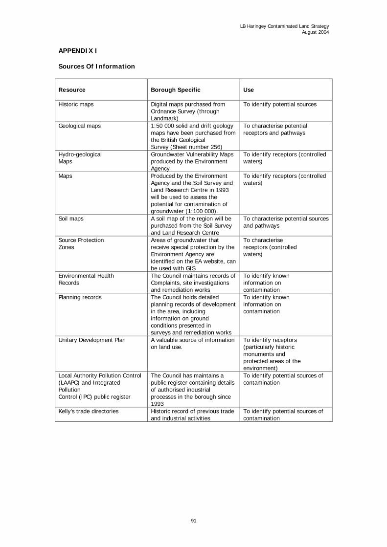
LB Haringey Contaminated Land Strategy August 2004
APPENDIX I Sources Of Information Resource
Borough Specific
Use
Historic maps Digital maps purchased from Ordnance Survey (through Landmark)
To identify potential sources
Geological maps
1:50 000 solid and drift geology maps have been purchased from the British Geological Survey (Sheet number 256)
To characterise potential receptors and pathways
Hydro-geological Maps
Groundwater Vulnerability Maps produced by the Environment Agency
To identify receptors (controlled waters)
Maps Produced by the Environment Agency and the Soil Survey and Land Research Centre in 1993 will be used to assess the potential for contamination of groundwater (1:100 000).
To identify receptors (controlled waters)
Soil maps A soil map of the region will be purchased from the Soil Survey and Land Research Centre
To characterise potential sources and pathways
Source Protection Zones
Areas of groundwater that receive special protection by the Environment Agency are identified on the EA website, can be used with GIS
To characterise receptors (controlled waters)
Environmental Health Records
The Council maintains records of Complaints, site investigations and remediation works
To identify known information on contamination
Planning records The Council holds detailed planning records of development in the area, including information on ground conditions presented in surveys and remediation works
To identify known information on contamination
Unitary Development Plan A valuable source of information on land use.
To identify receptors (particularly historic monuments and protected areas of the environment)
Local Authority Pollution Control (LAAPC) and Integrated Pollution Control (IPC) public register
The Council has maintains a public register containing details of authorised industrial processes in the borough since 1993
To identify potential sources of contamination
Kelly’s trade directories Historic record of previous trade and industrial activities
To identify potential sources of contamination
91

LB Haringey Contaminated Land Strategy August 2004
Resource
Borough Specific
Use
Waste Management Licences
The Environment Agency maintain a public register of sites licensed for waste management activities and have provided relevant information relating to sites in the borough. This will include civic amenity sites, waste transfer sites and former landfill sites
To identify sources of Contamination
Register of closed landfill sites
The Environment Agency will provide a register of closed landfill sites
To identify sources of Contamination
Local History Museum Bruce Castle local archive has detailed records of local industrial activity including maps
To identify sources of contamination
Greater London Sites and Monuments Record (GLSMR)
English Heritage Amateur London Archaeological Advisory Service hold a record of all known archaeological sites, including Scheduled Ancient Monuments (SAMs)
To identify receptors
92