supporting science - ixblue · 2019-01-24 · integration, installation, configuration management,...
TRANSCRIPT

EARTH MONITORING

2 EARTH MONITORING EARTH MONITORING 3
EARTH MONITORING

4 EARTH MONITORING EARTH MONITORING 5
SUPPORTING SCIENCE

6 EARTH MONITORING EARTH MONITORING 7
With 30 years of experience in the fields of Fiber- Optic Gyroscope-based inertial navigation, acoustic positioning and communication, seabed mapping systems, design and manufacturing of vessels and drones, iXblue stands today as a major player for scientific instrumentation.
iXblue develops new, in-house technologies to conduct new missions or to implement new ways of carrying out traditional ones.
It never loses sight of the reality in the field thanks to the constant assistance of its experienced Survey Division and the feedback from its valued customers.
The Survey Division helps to develop, test and eventually implement the resulting products on the market and guarantee their relevancy.
Its products are also the result of research for the smartest innovation and a mastering of core technologies.
These technologies are continually further developed by a team of passionate and dedicated scientists, engineers and technicians.
All of its systems are produced internally, from design to manufacturing. In addition, intellectual curiosity inspires the company’s researchers to always go further and find new ways to address customer problems.
These are the key components of iXblue’s DNA.
« Working on our technologies was and still is one of the most
satisfactory endeavors of my career. I am still amazed with what we
have achieved with what was just, only a few decades ago, theories.
I am thrilled by the potential of what is yet to be unveiled. »
Hervé Lefèvre, Physics PhD., iXblue’s Chief Scientific Officer
and one of the inventors of the Fiber-Optic Gyroscope
8 EARTH MONITORING EARTH MONITORING 9
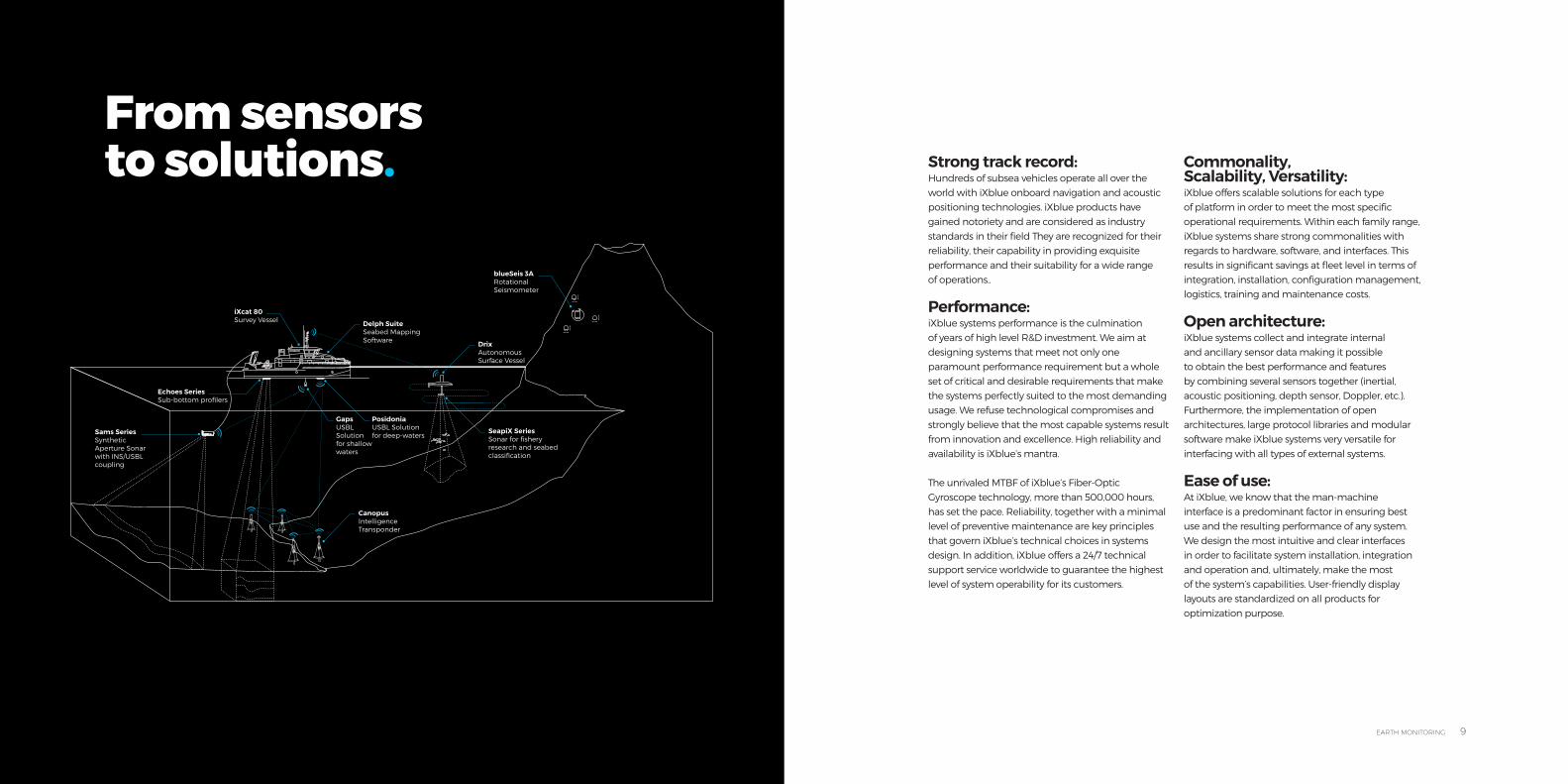
From sensors to solutions.
blueSeis 3ARotational Seismometer
DrixAutonomous Surface Vessel
SeapiX SeriesSonar for fishery research and seabed classification
iXcat 80Survey Vessel
Sams SeriesSynthetic Aperture Sonar with INS/USBL coupling
Delph SuiteSeabed Mapping Software
Echoes SeriesSub-bottom profilers
CanopusIntelligence Transponder
PosidoniaUSBL Solution for deep-waters
GapsUSBL Solution for shallow waters
Strong track record:Hundreds of subsea vehicles operate all over the world with iXblue onboard navigation and acousticpositioning technologies. iXblue products have gained notoriety and are considered as industry standards in their field They are recognized for their reliability, their capability in providing exquisite performance and their suitability for a wide range of operations..
Performance: iXblue systems performance is the culmination of years of high level R&D investment. We aim at designing systems that meet not only oneparamount performance requirement but a whole set of critical and desirable requirements that make the systems perfectly suited to the most demanding usage. We refuse technological compromises andstrongly believe that the most capable systems result from innovation and excellence. High reliability and availability is iXblue’s mantra.
The unrivaled MTBF of iXblue’s Fiber-Optic Gyroscope technology, more than 500,000 hours, has set the pace. Reliability, together with a minimal level of preventive maintenance are key principles that govern iXblue’s technical choices in systems design. In addition, iXblue offers a 24/7 technical support service worldwide to guarantee the highest level of system operability for its customers.
Commonality, Scalability, Versatility: iXblue offers scalable solutions for each type of platform in order to meet the most specific operational requirements. Within each family range, iXblue systems share strong commonalities with regards to hardware, software, and interfaces. This results in significant savings at fleet level in terms ofintegration, installation, configuration management, logistics, training and maintenance costs.
Open architecture: iXblue systems collect and integrate internal and ancillary sensor data making it possibleto obtain the best performance and features by combining several sensors together (inertial, acoustic positioning, depth sensor, Doppler, etc.). Furthermore, the implementation of openarchitectures, large protocol libraries and modular software make iXblue systems very versatile for interfacing with all types of external systems.
Ease of use: At iXblue, we know that the man-machine interface is a predominant factor in ensuring best use and the resulting performance of any system. We design the most intuitive and clear interfaces in order to facilitate system installation, integration and operation and, ultimately, make the most of the system’s capabilities. User-friendly display layouts are standardized on all products for optimization purpose.
10 EARTH MONITORING EARTH MONITORING 11
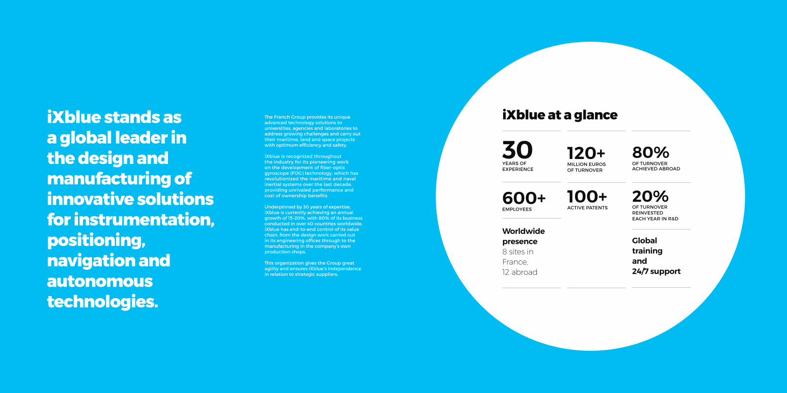
iXblue stands as a global leader in the design and manufacturing of innovative solutions for instrumentation, positioning, navigation and autonomous technologies.
The French Group provides its unique advanced technology solutions to universities, agencies and laboratories to address growing challenges and carry out their maritime, land and space projects with optimum efficiency and safety.
iXblue is recognized throughout the industry for its pioneering work on the development of fiber-opticgyroscope (FOG) technology, which has revolutionized the maritime and naval inertial systems over the last decade, providing unrivaled performance and cost of ownership benefits.
Underpinned by 30 years of expertise, iXblue is currently achieving an annual growth of 15–20%, with 80% of its business conducted in over 40 countries worldwide. iXblue has end-to-end control of its value chain, from the design work carried outin its engineering offices through to the manufacturing in the company’s own production shops.
This organization gives the Group great agility and ensures iXblue’s independence in relation to strategic suppliers.
iXblue at a glance
YEARS OF EXPERIENCE
600+ EMPLOYEES
Worldwide presence 8 sites in France, 12 abroad
120+ MILLION EUROSOF TURNOVER
100+ ACTIVE PATENTS
80% OF TURNOVER ACHIEVED ABROAD
Global training and 24/7 support
20% OF TURNOVER REINVESTED EACH YEAR IN R&D
30

12 EARTH MONITORING EARTH MONITORING 13
GROUND WAVESDETECTION
GR
OU
ND
WA
VE
S
DE
TEC
TIO
N
blueSeis 3ARotational Seismometer
DrixAutonomous Surface Vessel
SeapiX SeriesSonar for fishery research and seabed classification
iXcat 80Survey Vessel
Sams SeriesSynthetic Aperture Sonar with INS/USBL coupling
Delph SuiteSeabed Mapping Software
Echoes SeriesSub-bottom profilers
CanopusIntelligence Transponder
PosidoniaUSBL Solution for deep-waters
GapsUSBL Solution for shallow waters
14 EARTH MONITORING EARTH MONITORING 15
Z
ωZ
ωY
ωX
Y
X
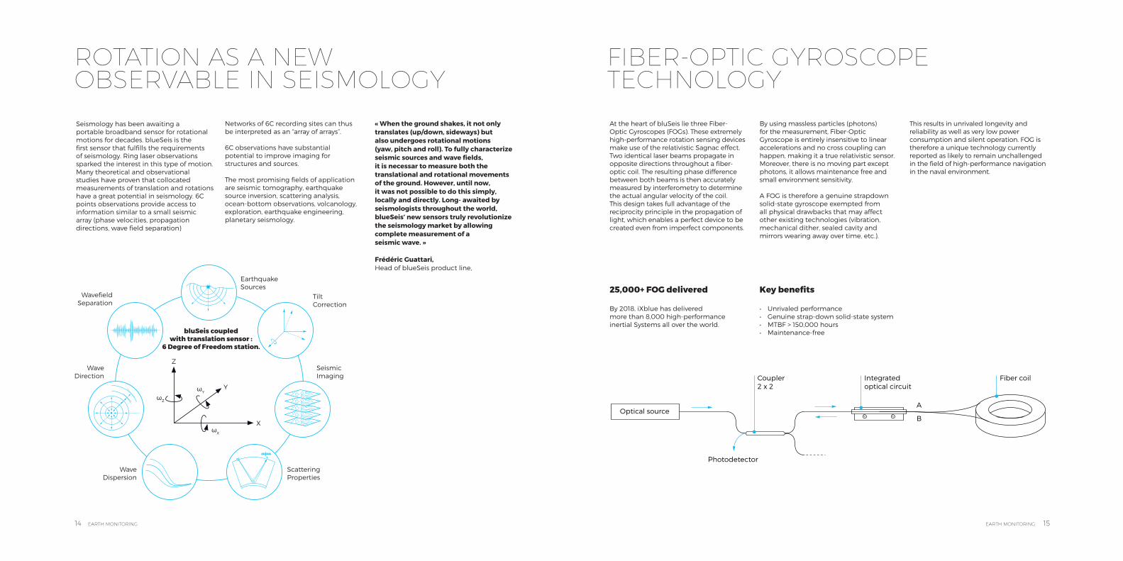
ROTATION AS A NEW OBSERVABLE IN SEISMOLOGY
FIBER-OPTIC GYROSCOPE TECHNOLOGY
Seismology has been awaiting a portable broadband sensor for rotational motions for decades. blueSeis is the first sensor that fulfills the requirements of seismology. Ring laser observations sparked the interest in this type of motion. Many theoretical and observational studies have proven that collocated measurements of translation and rotations have a great potential in seismology. 6C points observations provide access to information similar to a small seismic array (phase velocities, propagation directions, wave field separation)
Networks of 6C recording sites can thus be interpreted as an “array of arrays”.
6C observations have substantial potential to improve imaging for structures and sources.
The most promising fields of application are seismic tomography, earthquake source inversion, scattering analysis, ocean-bottom observations, volcanology, exploration, earthquake engineering, planetary seismology.
EarthquakeSources
TiltCorrection
SeismicImaging
ScatteringProperties
Wave Dispersion
Wave Direction
Wavefield Separation
bluSeis coupled with translation sensor :
6 Degree of Freedom station.
« When the ground shakes, it not only translates (up/down, sideways) but also undergoes rotational motions (yaw, pitch and roll). To fully characterize seismic sources and wave fields, it is necessar to measure both the translational and rotational movements of the ground. However, until now, it was not possible to do this simply, locally and directly. Long- awaited by seismologists throughout the world, blueSeis’ new sensors truly revolutionize the seismology market by allowing complete measurement of a seismic wave. »
Frédéric Guattari, Head of blueSeis product line,
At the heart of bluSeis lie three Fiber-Optic Gyroscopes (FOGs). These extremely high-performance rotation sensing devices make use of the relativistic Sagnac effect. Two identical laser beams propagate in opposite directions throughout a fiber-optic coil. The resulting phase difference between both beams is then accurately measured by interferometry to determine the actual angular velocity of the coil. This design takes full advantage of the reciprocity principle in the propagation of light, which enables a perfect device to be created even from imperfect components.
By using massless particles (photons) for the measurement, Fiber-Optic Gyroscope is entirely insensitive to linear accelerations and no cross coupling can happen, making it a true relativistic sensor. Moreover, there is no moving part except photons, it allows maintenance free and small environment sensitivity.
A FOG is therefore a genuine strapdown solid-state gyroscope exempted from all physical drawbacks that may affect other existing technologies (vibration, mechanical dither, sealed cavity and mirrors wearing away over time, etc.).
This results in unrivaled longevity and reliability as well as very low power consumption and silent operation. FOG is therefore a unique technology currently reported as likely to remain unchallenged in the field of high-performance navigation in the naval environment.
25,000+ FOG delivered
By 2018, iXblue has deliveredmore than 8,000 high-performance inertial Systems all over the world.
Key benefits
• Unrivaled performance• Genuine strap-down solid-state system• MTBF > 150,000 hours• Maintenance-free
Optical source
Photodetector
Coupler 2 x 2
Integratedoptical circuit
A
B
Fiber coil
16 EARTH MONITORING EARTH MONITORING 17
QUADRANS SEISMOMETER TRUE NORTH ALIGNMENT SOLUTIONS
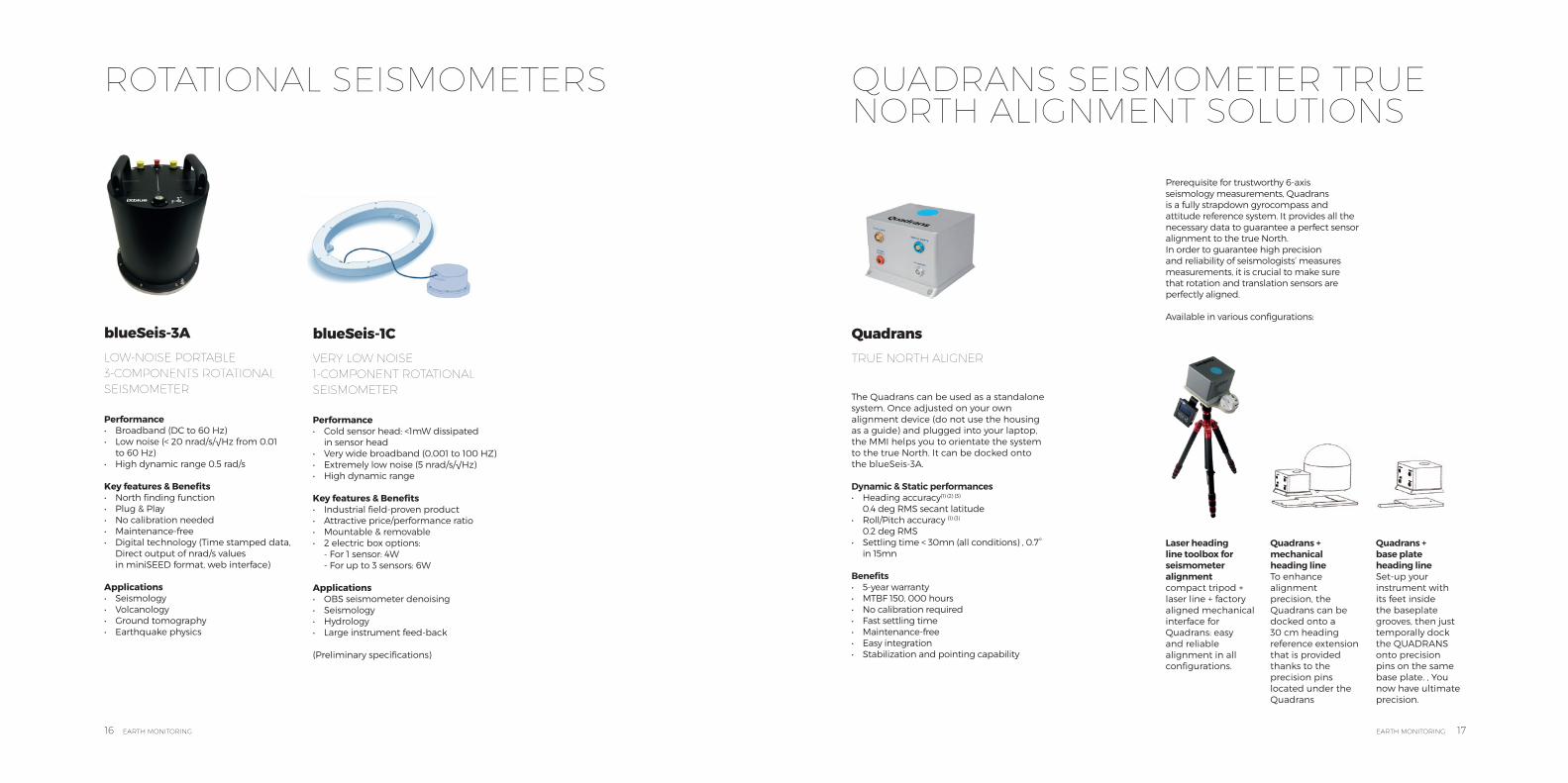
The Quadrans can be used as a standalone system. Once adjusted on your own alignment device (do not use the housing as a guide) and plugged into your laptop, the MMI helps you to orientate the system to the true North. It can be docked onto the blueSeis-3A.
Dynamic & Static performances• Heading accuracy(1) (2) (3)
0.4 deg RMS secant latitude• Roll/Pitch accuracy (1) (3)
0.2 deg RMS• Settling time < 30mn (all conditions) , 0.7°
in 15mn
Benefits• 5-year warranty• MTBF 150, 000 hours• No calibration required• Fast settling time• Maintenance-free• Easy integration• Stabilization and pointing capability
Prerequisite for trustworthy 6-axis seismology measurements, Quadrans is a fully strapdown gyrocompass and attitude reference system. It provides all the necessary data to guarantee a perfect sensor alignment to the true North.In order to guarantee high precision and reliability of seismologists’ measures measurements, it is crucial to make sure that rotation and translation sensors are perfectly aligned.
Available in various configurations:
Laser heading line toolbox for seismometer alignment compact tripod + laser line + factory aligned mechanical interface for Quadrans: easy and reliable alignment in all configurations.
Quadrans + mechanical heading line To enhance alignment precision, the Quadrans can be docked onto a 30 cm heading reference extension that is provided thanks to the precision pins located under the Quadrans
Quadrans + base plate heading line Set-up your instrument with its feet inside the baseplate grooves, then just temporally dock the QUADRANS onto precision pins on the same base plate. , You now have ultimate precision.
Performance• Broadband (DC to 60 Hz)• Low noise (< 20 nrad/s/√Hz from 0.01
to 60 Hz)• High dynamic range 0.5 rad/s Key features & Benefits• North finding function• Plug & Play• No calibration needed• Maintenance-free• Digital technology (Time stamped data,
Direct output of nrad/s values in miniSEED format, web interface)
Applications• Seismology• Volcanology• Ground tomography• Earthquake physics
Performance• Cold sensor head: <1mW dissipated
in sensor head• Very wide broadband (0,001 to 100 HZ)• Extremely low noise (5 nrad/s/√Hz)• High dynamic range Key features & Benefits• Industrial field-proven product• Attractive price/performance ratio• Mountable & removable• 2 electric box options:
- For 1 sensor: 4W - For up to 3 sensors: 6W
Applications• OBS seismometer denoising• Seismology• Hydrology• Large instrument feed-back
(Preliminary specifications)
blueSeis-3A LOW-NOISE PORTABLE 3-COMPONENTS ROTATIONAL SEISMOMETER
blueSeis-1C VERY LOW NOISE 1-COMPONENT ROTATIONAL SEISMOMETER
Quadrans TRUE NORTH ALIGNER
ROTATIONAL SEISMOMETERS
QuadransIMO grade gyrocompass & attitude reference system
Quadrans, is a fully strapdown gyrocompass and attitude
reference system. IMO and IMO-HSC certified, it provides all
the necessary data for demanding navigation and control
applications. High customizability and Ethernet/Serial
connectivity provides a very easy integration on any platform.
Based on a state-of-the-art interferometric fiber-optic
gyroscope technology (iFOG*), Quadrans does not require any
maintenance during its unlimited service life. Quadrans is
the ideal replacement for any mechanical gyro for whom is
focused on total cost of ownership and maximizing availability
and safety of their ships.
[email protected] | www.ixblue.comEMEA +33 1 30 08 88 88 | Americas +1 781 937 8800 | APAC +65 6747 491220
17-0
3-D
S-Q
uad
ran
s
FEATURES
• Compact and plug & play system
• AHRS: All in one Gyrocompass & MRU
• Unique strap-down technology, interferometric FOG (iFOG*)
• Embedded Man Machine Interface (no proprietary CDU)
• IMO Certification
BENEFITS
• Fast settling time
• Maintenance-free
• Easy integration
• Stabilization and pointing capability
• Automatic speed and latitude correction
• Works in high sea state
• Allows restart at sea
Sea proven technologyQuadrans is based on a unique iFOG design* which has been in
use in the harshest environment for 15 years.
From land application to space environment through all main
European navies first ranks platforms.
Quadrans has been in use for 5 years in many navies (French,
Chile, UK, Portugal,...) and multiple DP operators.
In addition, Quadrans has also been the obvious choice for most
competitors in the America’s cup and the Vendée Globe, proving
its performances in any sea state and its reliability.
Reliability and through life costThe return of experience on iXblue iFOG technology shows a
MTBF of more than 150.000h, without any kind of maintenance
(neither on board nor with factory return), and a life expectation
that have already proven to be superior to 15 years. All this
combined makes Quadrans a true install and forget equipment
with an unbeaten low cost through the life of your ship. As a token
of our confidence, Quadrans comes with a 5 years warranty.
An opened architectureThe Quadrans solution, as every iXblue product, is an opened
architecture, ready to interface with any other component.
It includes, in addition to standard NMEA, a large library of
open source protocols, to give autonomy to the user in
the integration of the Quadrans in the life of the ship.*discover more on iXblue iFOG on our website
18 EARTH MONITORING EARTH MONITORING 19
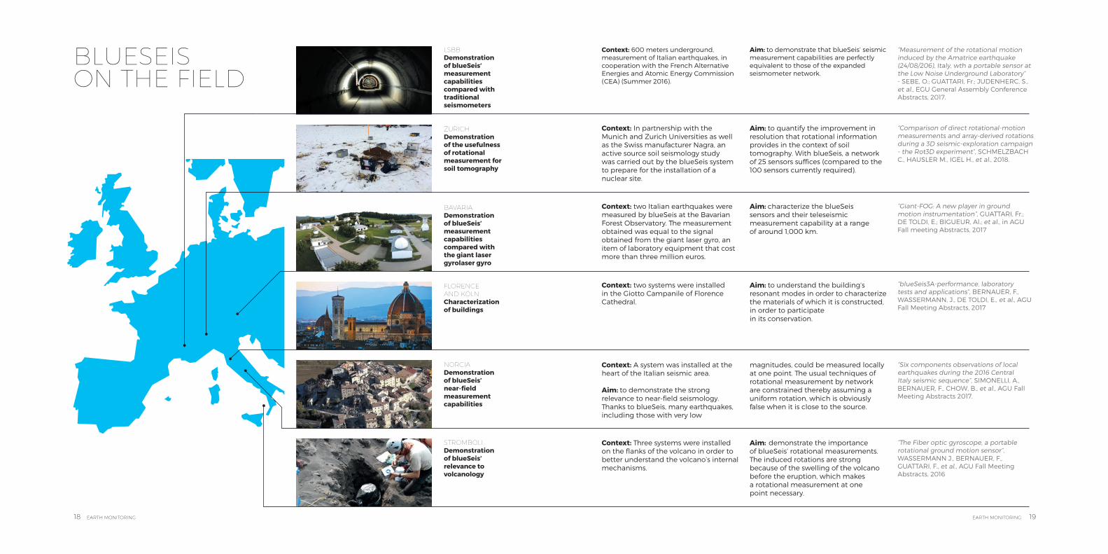
Context: 600 meters underground, measurement of Italian earthquakes, in cooperation with the French Alternative Energies and Atomic Energy Commission (CEA) (Summer 2016).
Context: In partnership with the Munich and Zurich Universities as well as the Swiss manufacturer Nagra, an active source soil seismology study was carried out by the blueSeis system to prepare for the installation of a nuclear site.
Context: two Italian earthquakes were measured by blueSeis at the Bavarian Forest Observatory. The measurement obtained was equal to the signal obtained from the giant laser gyro, an item of laboratory equipment that cost more than three million euros.
Context: Three systems were installed on the flanks of the volcano in order to better understand the volcano’s internal mechanisms.
Context: A system was installed at the heart of the Italian seismic area. Aim: to demonstrate the strong relevance to near-field seismology. Thanks to blueSeis, many earthquakes, including those with very low
Context: two systems were installed in the Giotto Campanile of Florence Cathedral.
LSBBDemonstration of blueSeis’ measurement capabilities compared with traditional seismometers
ZURICHDemonstration of the usefulness of rotational measurement for soil tomography
BAVARIADemonstration of blueSeis’ measurement capabilities compared with the giant laser gyrolaser gyro
STROMBOLIDemonstration of blueSeis’ relevance to volcanology
NORCIADemonstration of blueSeis’ near-field measurement capabilities
FLORENCE AND KÖLNCharacterization of buildings
Aim: to demonstrate that blueSeis’ seismic measurement capabilities are perfectly equivalent to those of the expanded seismometer network.
“Measurement of the rotational motion induced by the Amatrice earthquake (24/08/206), Italy, wth a portable sensor at the Low Noise Underground Laboratory” - SEBE, O.; GUATTARI, Fr.; JUDENHERC, S., et al., EGU General Assembly Conference Abstracts, 2017.
“Comparison of direct rotational-motion measurements and array-derived rotations during a 3D seismic-exploration campaign- the Rot3D experiment”, SCHMELZBACH C., HAUSLER M., IGEL H., et al., 2018.
“Giant-FOG: A new player in ground motion instrumentation”, GUATTARI, Fr.; DE TOLDI, E.; BIGUEUR, Al.; et al., in AGU Fall meeting Abstracts, 2017
“blueSeis3A-performance, laboratory tests and applications”, BERNAUER, F., WASSERMANN, J., DE TOLDI, E., et al., AGU Fall Meeting Abstracts, 2017
“Six components observations of local earthquakes during the 2016 Central Italy seismic sequence”, SIMONELLI, A., BERNAUER, F., CHOW, B., et al., AGU Fall Meeting Abstracts 2017.
“The Fiber optic gyroscope, a portable rotational ground motion sensor”, WASSERMANN J., BERNAUER, F., GUATTARI, F., et al., AGU Fall Meeting Abstracts, 2016
Aim: to quantify the improvement in resolution that rotational information provides in the context of soil tomography. With blueSeis, a network of 25 sensors suffices (compared to the 100 sensors currently required).
Aim: characterize the blueSeis sensors and their teleseismic measurement capability at a range of around 1,000 km.
Aim: demonstrate the importanceof blueSeis’ rotational measurements. The induced rotations are strong because of the swelling of the volcano before the eruption, which makes a rotational measurement at one point necessary.
magnitudes, could be measured locally at one point. The usual techniques of rotational measurement by network are constrained thereby assuming a uniform rotation, which is obviously false when it is close to the source.
Aim: to understand the building’s resonant modes in order to characterize the materials of which it is constructed, in order to participatein its conservation.
BLUESEIS ON THE FIELD
20 EARTH MONITORING EARTH MONITORING 21
SUBSEA IMAGERY
SU
BS
EA
IMA
GE
RY
blueSeis 3ARotational Seismometer
DrixAutonomous Surface Vessel
SeapiX SeriesSonar for fishery research and seabed classification
iXcat 80Survey Vessel
Sams SeriesSynthetic Aperture Sonar with INS/USBL coupling
Delph SuiteSeabed Mapping Software
Echoes SeriesSub-bottom profilers
CanopusIntelligence Transponder
PosidoniaUSBL Solution for deep-waters
GapsUSBL Solution for shallow waters

22 EARTH MONITORING EARTH MONITORING 23
“The Ogooue Fan (Gabon): a modern example of deep-sea system on a complex sea-floor topography. Solid Earth Discussion.”, MIGNARD et al., EGU Abstracts, 2018
The Ogooue deep-sea Fan located in the northeastern part of the Gulf of Guinea expands over more than 550km westwards of the Gabonese shelf and passes through the Cameroun volcanic line. Here are presented the first study of acoustic data (multibeam echosounder and 3.5kHz seismic data) and piston cores covering the deep-sea part of this West African system.
A complete solution: More than just a sub-bottom profiler, the Echoesseries provides a complete solution for acquiring, processing and interpreting high quality geological data thanks to its integration with the Delph Seismic software provided.
Having developed Echoes in collaboration with the French Marine Institute, Ifremer, over the course of 20 years ensures an excellent and rigorous classification of all key elements by scientific users.
A one product range for shallow water and deep water applications, our sub-bottomprofilers can be used for the vertical imaging of sediment layers by the means of low- frequency acoustic sound-waves. reflections. Similar to reflection seismic methods, a fully mastered low-frequency acoustic waveform is emitted, and the many reflections that occur when theacoustic impedance changes (air-water,water-sediment, sediment-to-sedimentinterfaces), are received. This acquisition sequence is repeated over time when the acquisition system is moving and results in successive scans that build acoustic profile images depicting the water-column andsubsurface sediment layers.
The full power of Echoes is available as soon as the emitting starts so it is available from very shallow water to greater depths. When using CHIRPS with Echoes, maintaining a very high vertical resolutionregardless of the power level, is made possible thanks to the modulated signal that is mastered over time.
While this aperture remains wider than that of a parametric, it provides superior quality imaging of the sediment layers, especially when the arrangement of acoustic layers becomes complex. It isalso naturally more robust to motion. The horizontal resolution remains excellent, in particular in shallow water applications or when surveying closer to the seabed using a tow-fish or subsea vehicle such as an AUV.
SUB-BOTTOM PROFILERS
The full spectrum of SBP dedicated to sedimentology studies.
Key benefits
• In-house manufacturing and design of our transducers (Tonpilz technology), electronics and software
• Compact antenna: transducers remain small and lightweight (easily operated by a single man for Echoes 10000)
• Possibility of using other acoustic sensors such as a multi-beam echosounder with no acoustic interference and without requiring an external synchronization.
• Clear interfaces, contrasted images, texture of layers
100
150
50
50
75
20
10
15
7,5
Echoes 1 5000.5 - 2.5 kHz
Echoes 3 000 T3/T71.7 - 6 kHz
Echoes 5 O00 T12 - 6 kHz
Echoes 10 0005 - 15 kHz
Mean Penetration (ms)
Equivalent depth in clays (m)
Resolution (cm)
Chirp Resolution = Sound Velocity / 2xBandwidth
IFREMER - TOTAL
24 EARTH MONITORING EARTH MONITORING 25
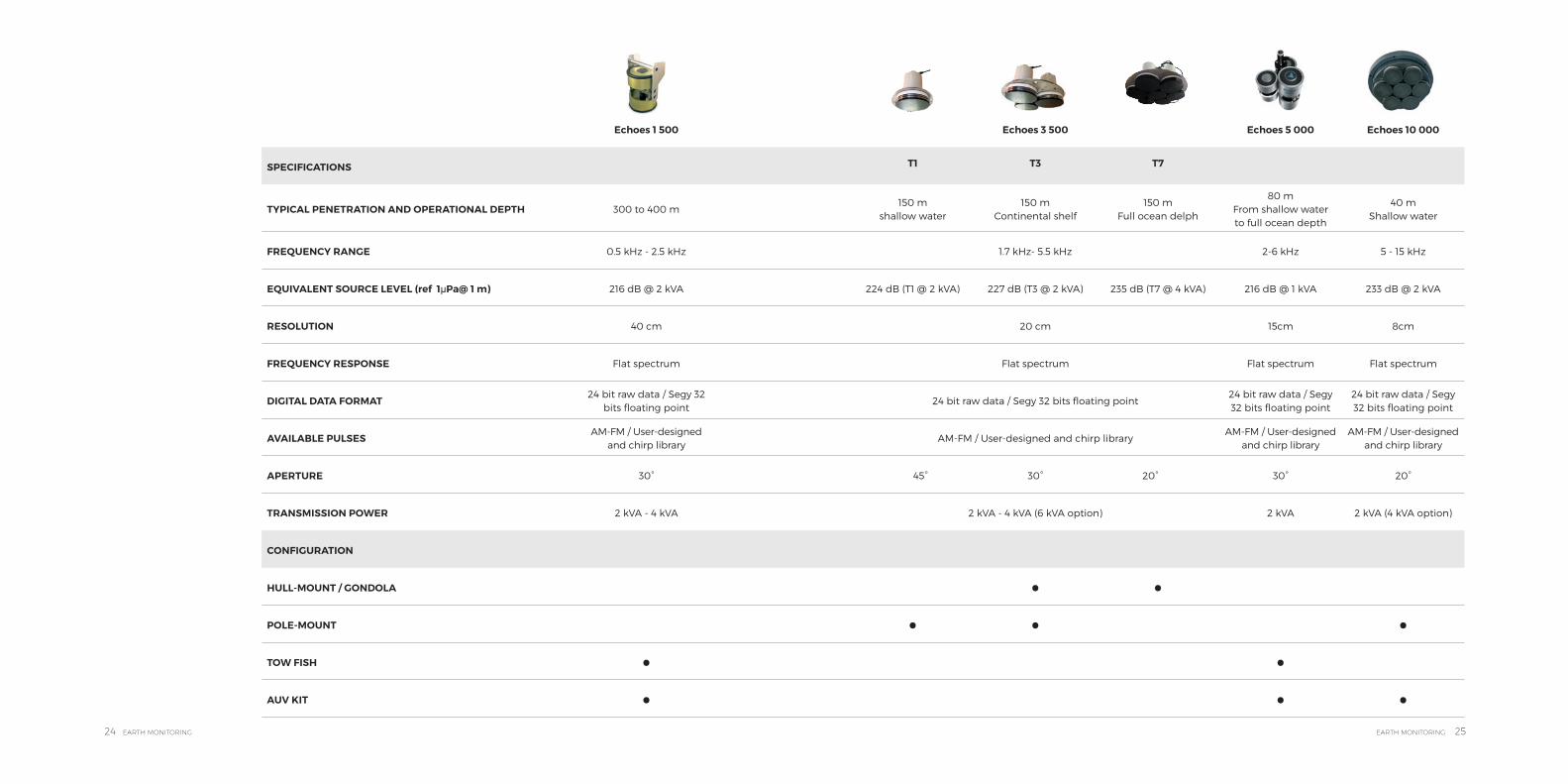
Echoes 1 500 Echoes 3 500 Echoes 5 000 Echoes 10 000
SPECIFICATIONS T1 T3 T7
TYPICAL PENETRATION AND OPERATIONAL DEPTH 300 to 400 m150 m
shallow water150 m
Continental shelf150 m
Full ocean delph
80 m From shallow water to full ocean depth
40 m Shallow water
FREQUENCY RANGE 0.5 kHz - 2.5 kHz 1.7 kHz- 5.5 kHz 2-6 kHz 5 - 15 kHz
EQUIVALENT SOURCE LEVEL (ref 1μPa@ 1 m) 216 dB @ 2 kVA 224 dB (T1 @ 2 kVA) 227 dB (T3 @ 2 kVA) 235 dB (T7 @ 4 kVA) 216 dB @ 1 kVA 233 dB @ 2 kVA
RESOLUTION 40 cm 20 cm 15cm 8cm
FREQUENCY RESPONSE Flat spectrum Flat spectrum Flat spectrum Flat spectrum
DIGITAL DATA FORMAT24 bit raw data / Segy 32
bits floating point24 bit raw data / Segy 32 bits floating point
24 bit raw data / Segy 32 bits floating point
24 bit raw data / Segy 32 bits floating point
AVAILABLE PULSESAM-FM / User-designed
and chirp libraryAM-FM / User-designed and chirp library
AM-FM / User-designed and chirp library
AM-FM / User-designed and chirp library
APERTURE 30° 45° 30° 20° 30° 20°
TRANSMISSION POWER 2 kVA - 4 kVA 2 kVA - 4 kVA (6 kVA option) 2 kVA 2 kVA (4 kVA option)
CONFIGURATION
HULL-MOUNT / GONDOLA • •POLE-MOUNT • • •TOW FISH • •AUV KIT • • •

26 EARTH MONITORING EARTH MONITORING 27
Sams MT-3000 Sams DT-6000
RATIONALEHigh resolution modular
survey platformHigh productivity deep-tow modular
survey platform
COVERAGE RATE 7.2 km2/h 6.12 km2/h
FREQUENCY 100 kHz 55 kHz
BANDWIDTH 30 kHz 15 kHz
FULL SWATH 800 m 1 800 m
MAXIMUM DEPTH 3 000 m 6 000 m
THEORETICAL ACROSS-TRACK RESOLUTION
>= 15 cm >= 50 cm
SPEED ˜4-5 knots ˜2-3 knots
AUV KIT • •
“iXblue’s SAS are the result of a user-oriented approach forsubsea imagery by automatically collecting and positioning very high resolution data, which significantly reduces post- processing works”
Lionel Fauré, Business Unit Principal
Frédéric Mosca, PhD and author of « Temporal approach of the synthetic aperture imaging using Hadamard matrix”
By integrating positioning and navigational capabilities and performing real-time coherent and non-coherent SAS integration, iXblue makes SAS technology available to all scientific communities. The combination of all these technologies gives the SAMS system optimal imaging performance with respect to environmental conditions in terms of swath, resolution, image quality, coverage rate and absolute pixel positioning accuracy.
SYNTHETIC APERTURE MAPPING SONAR
The Sams series widens the capabilities of conventional imaging SSS
Key benefits
• Georeferenced high precision data• Real-time generation of high-quality,
high-resolution maps • Sea proven• Real-time multi-sensor data fusion /
full swath seabed mapping• Sonar and navigation• Post-processing capabilities from
raw data
• Industry-standard workflow integrated in iXblue
• Delph software• Full survey package inside: sonar
imaging, interferometric system, gap-filling MBES, bathymetry, SBP, magnetometer,
• Pinger locator• Available in Kit for AUVs
Resolution(meters)
Standard SSS
0,010
0,100
800 1800
1,000
10,000
SAMS MT-3000
SAMS DT-6000
Maximum Swath(meters)
28 EARTH MONITORING EARTH MONITORING 29
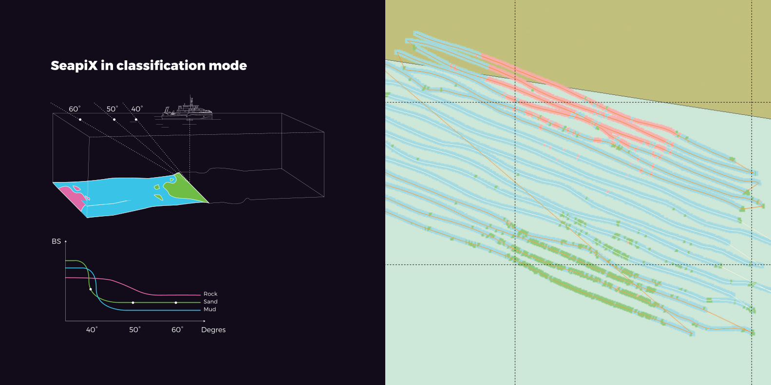
SeapiX generates one or more scan swathes along or across a vessel’s axis, providing totalthree-dimensional coverage of the water column (to provide metrological target strength and volume backscattering strength), a bathymetric profile of the seabed and sediment identification analysis.
Each detection is referenced in 3D in the water column and is automatically reported on amap built in real time including local bathymetry. Accordingto IHO standards, SeapiX bathymetry is special order when coupled with external high-quality motion reference units.
Its accuracy reaches an unparalleled level, thanks to its narrowest beams (1.6° x 1.6°) and advanced acoustic modulation principles (resolution +-7.5 cm only), and its embedded motion sensor (each array has stabilizingbeams with a MEMS sensor included in the sonar head).
Its transducer generates several multibeam transmissions and acoustic processes to yield quantitative and qualitative measurements of the marine environment. Its multiple advanced modulation modes, including CHIRP, combined with pulse compression, guarantee the highest possible detection performance, even in harsh environments.
A new proven technology, which will provide new features each year.An innovative and robust method used to classify the seabed benefits from the longitudinal steered beam that provides a full BS profile measurement (+/-60° aperture) on each insonified pixel at Nadir. The measured BS profile is compared to classified BS profile values in order to discriminate bottom type in real-time. Two SeapiX versions are available for our customers: A SeapiX for fishery and a SeapiX Research which hasan additional software package
with scientific functionalities.SeapiX can be calibrated in our laboratories or in situ (in particular for research applications).
SeapiX was designed for harsh environments and areas that are very difficult to operate in. It was developed for the hull of fishery vessels which navigate in rough seas for months at a time. In order to have a new cost-efficient product that could be used in other applications such as scientific ones, we are developing a portable version that can be mounted on a pole.
As a military technology covered by a number of patents, SeapiX is the first compact civilian system comprising a dual Mills Cross multibeam sonar transducer.
3D MULTI-BEAMECHO-SOUNDER
Complete environment monitoring from Water column analysis to bathymetry and seabed classification
120°
Downward lookingSide lookingOn a buoy Forward looking
30 EARTH MONITORING EARTH MONITORING 31
60° 50° 40°
40°
BS
Degres
RockSandMud
50° 60°
60° 50° 40°
40°
BS
Degres
RockSandMud
50° 60°
SeapiX in classification mode
32 EARTH MONITORING EARTH MONITORING 33
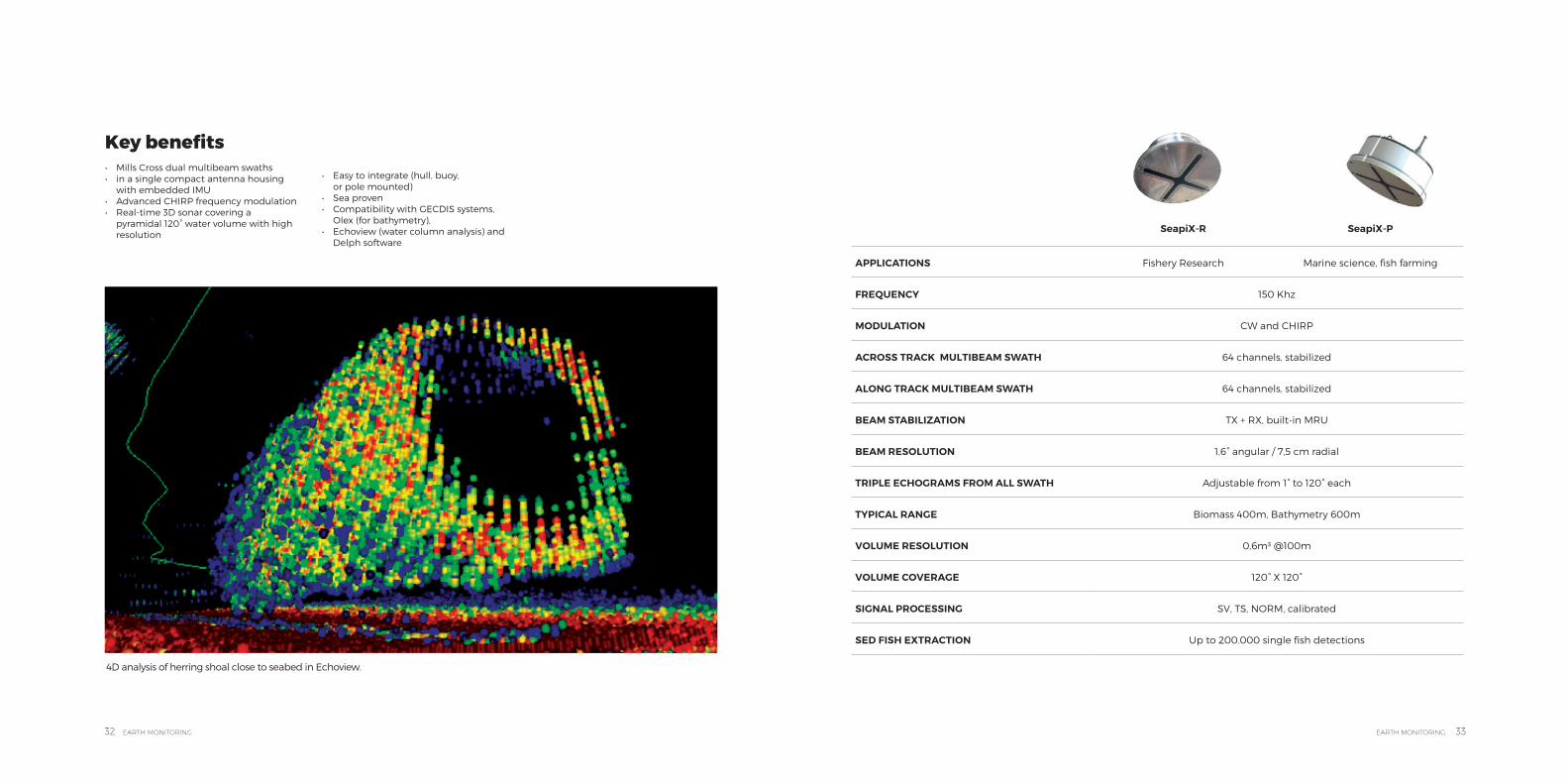
4D analysis of herring shoal close to seabed in Echoview.
SeapiX-R SeapiX-P
APPLICATIONS Fishery Research Marine science, fish farming
FREQUENCY 150 Khz
MODULATION CW and CHIRP
ACROSS TRACK MULTIBEAM SWATH 64 channels, stabilized
ALONG TRACK MULTIBEAM SWATH 64 channels, stabilized
BEAM STABILIZATION TX + RX, built-in MRU
BEAM RESOLUTION 1,6° angular / 7,5 cm radial
TRIPLE ECHOGRAMS FROM ALL SWATH Adjustable from 1° to 120° each
TYPICAL RANGE Biomass 400m, Bathymetry 600m
VOLUME RESOLUTION 0,6m3 @100m
VOLUME COVERAGE 120° X 120°
SIGNAL PROCESSING SV, TS, NORM, calibrated
SED FISH EXTRACTION Up to 200.000 single fish detections
Key benefits • Mills Cross dual multibeam swaths• in a single compact antenna housing
with embedded IMU• Advanced CHIRP frequency modulation• Real-time 3D sonar covering a
pyramidal 120° water volume with high resolution
• Easy to integrate (hull, buoy, or pole mounted)
• Sea proven• Compatibility with GECDIS systems,
Olex (for bathymetry),• Echoview (water column analysis) and
Delph software

34 EARTH MONITORING EARTH MONITORING 35
Based on 30 years’ solid experience, the Delph suite solves industry bottlenecks by reducing the time and cost of geophysical dataprocessing and mapping with a focus on the quality of the final result. This new software generation optimizes workflows allowing real-time data interpretation during the acquisition process.
Designed in a collaborative approach with key users, they fit market specifications and increase productivity.The improved/smarter tools for geophysicists, the multi-sensor data integration and QC at all levels, improve the level of the final report deliverable for any type of survey.
iXblue provides different software for your unique need.
Delph acquisition software is a unified data logging solution that safely monitors and records side-scan-sonar, seismic, and sub-bottom profiler data in a simplified user-interface. It focuses on reliabile, online Q.C.
Delph interpretation software efficiently turns geophysical data into geographic information layers that seamlessly integrate into Delph 3D’s geographic visualizationor any other geographical information system. The common user interface and global viewer approach to handle sonar and sub- bottom data provides users with a dedicated tool to process and analyze data with a major gain in productivity.
Delph seismic is the most complete acquisition, processing and interpretation software package designed to provide geologists and geophysicists with easy access to all data collected from high resolution seismic systems and sub-bottom profilers. It’s the ideal solution for use in all types of surveys.
Delph sonar is a complete acquisition, processing, and interpretation software designed to easily performaccurate and productive side- scan-sonar surveys. Providing an optimal Q.C. at any stage and relying on powerful workflow and ease-of-use, side- scan-sonar mapping has never been so fast.
Delph mag locator offers a unique operational solution for the mapping of buried objects. In a few comprehensive steps, it filters and maps magnetic anomalies. Although requiring no prior expertise, it provides an accurate magnetic anomaly map to locate magnetic sources.
Delph software suite focuses on the acquisition and processing of geophysical data. From the tight integration of sensors to cartographic deliverables, Delph handles the transformation from raw side-scan sonar, sub-bottom profilers, seismic and magnetometer data to mapping products in a very logical and ultra-efficient workflow.
SEAFLOOR MAPPING SOFTWARE
Geophysical software for efficient processing of multi-sensor data sets
36 EARTH MONITORING EARTH MONITORING 37
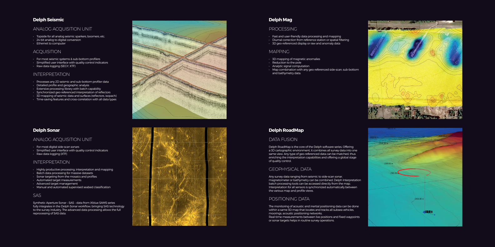
Delph Seismic Delph Mag
Delph Sonar Delph RoadMap
ANALOG ACQUISITION UNIT
• Topside for all analog seismic sparkers, boomers, etc.• 24-bit analog to digital conversion• Ethernet to computer
ACQUISITION
• For most seismic systems & sub-bottom profilers• Simplified user interface with quality control indicators• Raw data logging (SEGY, XTF)
INTERPRETATION
• Processes any 2D seismic and sub-bottom profiler data• Detailed profile and geographic analysis• Extensive processing library with batch capability• Synchronized geo-referenced interpretation of reflectors• 3D mapping of seismic data and surfaces (reflectors, isopach)• Time-saving features and cross-correlation with all data types
PROCESSING
• Fast and user-friendly data processing and mapping• Diurnal correction from reference station or spatial filtering• 3D geo-referenced display or raw and anomaly data
MAPPING
• 3D mapping of magnetic anomalies• Reduction to the pole• Analytic signal computation• Map combination with any geo-referenced side-scan, sub-bottom
and bathymetry data.
ANALOG ACQUISITION UNIT
• For most digital side-scan sonars• Simplified user interface with quality control indicators• Raw data logging (XTF)
INTERPRETATION
• Highly productive processing, interpretation and mapping• Batch data processing for massive datasets• Sonar targeting from the mosaics and profiles• Automated target measurements• Advanced target management• Manual and automated supervised seabed classification
SAS
Synthetic Aperture Sonar – SAS – data from iXblue SAMS series fully integrates in the Delph Sonar workflow, bringing SAS technology to the survey industry. The advanced data processing allows the full reprocessing of SAS data.
DATA FUSION
Delph RoadMap is the core of the Delph software series. Offering a 3D cartographic environment, it combines all survey data into one same view. Any type of geo-referenced data can be matched, thus enriching the interpretation capabilities and offering a global stage of quality control.
GEOPHYSICAL DATA
Any survey data ranging from seismic to side-scan sonar, magnetometer or bathymetry can be combined. Delph Interpretation batch processing tools can be accessed directly from the map. Interpretation for all sensors is synchronized automatically between the various map and profile views.
POSITIONING DATA
The monitoring of acoustic and inertial positioning data can be done within a same 3D map that locates and tracks all subsea vehicles, moorings, acoustic positioning networks.Real-time measurements between live positions and fixed waypoints or sonar targets helps in routine survey operations.

38 EARTH MONITORING EARTH MONITORING 39
Our commitments• 100% compatible systems• Full end-to-end integrated
solution• Performance & integrity• Open architecture with
any other third party manufacturer
• Hydro-acoustic responsibility over multi-sensor integration
• Georeferenced raw data over open format
• De-multiplied payloads and simultaneous acquisition
• High productivity and securely connected mapping
• Multisensory acquisition & processing data systems: SBP, Mag, SAS, MBES
• Unrivaled reliability and accuracy enabled by independent bottom samples with no interpolation or beam overlap
• Productivity increase and cost savings delivered by the ability to operate several frequencies in one pass
• Simple installation and easy to use, resulting in limited training required
• Responsive, knowledgeable and friendly technical support
• Ocean environmental care & innovating method
The quality of a field study heavily depends on the quality of the systems used during the survey, which include navigation and positioning, subsea imagery and backscatter products as well as motion sensorsor software needed for data collection analysis. Driven by a strong and common focus on addressing customers’ needs, iXblue and major players are combining efforts to offerfull end-to-end integrated solutions that include best-in-class custom-made systems.
HYDROSUITE
Custom integrated solution capabilitieDeep WaterOffer
Medium Water Offer
Shallow WaterOffer
Multibeam Echosounder
SeaBeam 3012 SeaBeam 3030 R2S 2024
SeaBeam 3020 SeaBeam 3050 R2S 2026
Synthetic Apperture Sonar
SAMS-DT6000 SAMS-MT3000 SAMS-ST1000
AUV Kit AUV Kit AUV Kit
Sub-Bottom Profiler
Echoes T7 3,5k 6KVA Echoes T3 3,5k 4KVA Echoes 10k 2/4KVE
ROV/AUV kit 5k ROV/AUV kit 5k Echoes T1 3,5k 2KVA
3D Multibeam Echosounder
SeapiX SeapiX
Geophysical Software Delph Delph Delph
Additional Option Any third-party sensor or software architecture

40 EARTH MONITORING EARTH MONITORING 41
SUBSEA POSITIONING
SU
BS
EA
PO
SIT
ION
ING
blueSeis 3ARotational Seismometer
DrixAutonomous Surface Vessel
SeapiX SeriesSonar for fishery research and seabed classification
iXcat 80Survey Vessel
Sams SeriesSynthetic Aperture Sonar with INS/USBL coupling
Delph SuiteSeabed Mapping Software
Echoes SeriesSub-bottom profilers
CanopusIntelligence Transponder
PosidoniaUSBL Solution for deep-waters
GapsUSBL Solution for shallow waters

42 EARTH MONITORING EARTH MONITORING 43
AUV tracking in Snaefellsnes Peninsula
« For the un-aided shallow water dives, navigation errors can easily reach 20m. While using the [Gaps] USBL aiding, the AUV navigation accuracy is down to 1-2 m. This shows the benefits of using USBL aiding. »
Johannsson Hordur,Teledyne Senior Software Engineer.
ACOUSTIC POSITIONING SOLUTIONS
A fact that is sometimes not fully considered is that data is only as good as the linked metadata. When an entireinstrument array is misplaced, or a sonar is not accurately navigating, it may replicate errors and jeopardize a whole project.
Inertial and acoustic positioning (LBL and USBL) are the only adequate solutions available today for subsea operations. They allow for sub centimetric positioning of instrumentation during deployment or data collection.
iXblue has always practices a different approach to subsea navigation and positioning, combining innovative concepts, proprietary technologies and solutions that aim at making its products easier to implement and use, and to perform even better and allow substantial savings for budget-constrained projects.
Acoustic positioning is best used for the deployment of complex instrument arrays, AUV and tow fish tracking and communication with deployedinstruments. To provide a global answer to these challenging applications, iXblue has developed a complete range of LBL/USBL products.
Gaps, a USBL system embedding an INS that is thus self-positioned and allows for quick and agile deployment along withunrivaled performance for shallow and deep- water operations.
Posidonia is a long range/high accuracy USBL system designed to track subsea vehicles down to 6,000 m deep and at ranges of more than 10,000 m.Ramses is a flexible acoustic transceiver with self-contained computing, designed to perform full LBL or sparse LBL navigational capabilities on any type of underwater vehicle.
Canopus is a full featured intelligent seabed transponder complemented by a unified integrated software approach.Together with iXblue’s range of INS, the next generation of Ramses and added features for Gaps, and Canopus provides solutions to control and improve positioning and navigation for all subsea operations. Used alone or in combination with each other, iXblue’s technologies provide solutions to every challenge. All integrated in a unified software architecture, iXblue solutions are easy to use and can be combined easily with third party equipment.
iXblue systems are open systems, meaning that full interfacing documents and protocol libraries are available to all our customers. We actively encourage third party integration and strive to add interoperability to our systems.
Whether for AUVs, tow fishes, metrology, one or multiple vehicles at a time, iXblue’s global solutions allow you to save time, avoid errors and improve accuracy throughout your entire project.

44 EARTH MONITORING EARTH MONITORING 45
Gaps
RANGE NOMINAL 4,000
ACCURACY 0,06% x range
OPERATING FREQUENCY 20~30 kHz
ANTENNA APERTURE 200 deg
DATA TELEMETRY 500 bits/s
CONSTRUCTION Carbon fiber
SIZE (MM) Ø 295 x 638
TRANSPONDERSiXblue MF transponder
Canopus Third party transponder
Correct positioning is a major factor of success in a data collection campaign. Gaps takes advantage of the unique expertisein both acoustic positioning and inertial navigation that iXblue has built up over the years. Gaps merges the unique acoustic elements with cutting-edge inertialnavigation resulting in an extremely flexible system for any sea applications operating in the medium frequency band.
A wide range of transponders are available for Gaps for all kinds of operations, including compatibility with someother manufacturers’ beacons. Its latest firmware release includes data a telemetry functionality which enables Gaps to communicate via wireless communication with other iXblue products, including Canopus transponders.
Gaps is an all-in-one, calibration-free and portable system with a light weight and reduced size which does not require any complicated installation and allows it to be operated in harsh and noisy conditions. Itperformance is very high thanks todata merger of acoustic, inertial and GPS technologies and finally, has no limits in terms of operational area, from shallow and deep water, horizontal and vertical channels, short or long ranges.
Gaps is an all-in-one system which provides absolute geo-referenced positioning of any
subsea vehicles or objects. Our USBL offers a very accurate heading and attitude for the surface vessel along with the highest accuracy and unrivaled performance in shallow or extreme shallow water depths with omnidirectional beams.
Control/Command your AUVGaps enables simultaneous tracking and acoustic communications without the need to install a dedicated modem transducer on the AUV or on the surface vessel.You can now track, send commands and receive AUV status with the same equipment.
Position telemetryFor AUV tracking or AUV based INS DVL calibration and ROV applications, Gaps enables a position to be sent acoustically to a subsea INS:• Gaps estimates the position • of the beacon (USBL) • Gaps sends its position to the beacon • The beacon broadcasts the position to
the subsea INS
Collect data from any subsea sensor Any sensor can be interfaced to a subsea beacon. The beacon broadcasts the measurements to the Gaps throughan acoustic channel. Gaps outputs the information on a serial or Ethernet communication port.
Gaps MF USBL
Up to 200°
Applications
• Tracking of tow fish operations and AUVs
• Accurate installation of instrumentation on the seabed
• OBS line positioning and data collection
• Real-time positioning and data collection of towed array sonar
46 EARTH MONITORING EARTH MONITORING 47
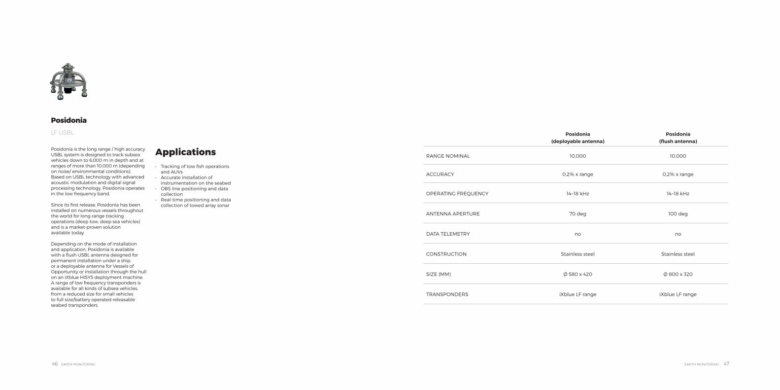
Posidonia (deployable antenna)
Posidonia (flush antenna)
RANGE NOMINAL 10,000 10,000
ACCURACY 0,2% x range 0,2% x range
OPERATING FREQUENCY 14~18 kHz 14~18 kHz
ANTENNA APERTURE 70 deg 100 deg
DATA TELEMETRY no no
CONSTRUCTION Stainless steel Stainless steel
SIZE (MM) Ø 580 x 420 Ø 800 x 320
TRANSPONDERS iXblue LF range iXblue LF range
Posidonia is the long range / high accuracy USBL system is designed to track subsea vehicles down to 6,000 m in depth and at ranges of more than 10,000 m (depending on noise/ environmental conditions). Based on USBL technology with advanced acoustic modulation and digital signal processing technology, Posidonia operates in the low frequency band.
Since its first release, Posidonia has been installed on numerous vessels throughout the world for long-range tracking operations (deep tow, deep sea vehicles) and is a market-proven solution available today.
Depending on the mode of installation and application, Posidonia is available with a flush USBL antenna designed for permanent installation under a ship,or a deployable antenna for Vessels of Opportunity or installation through the hull on an iXblue HISYS deployment machine. A range of low frequency transponders is available for all kinds of subsea vehicles, from a reduced size for small vehicles to full size/battery operated releasable seabed transponders.
Posidonia LF USBL
Applications
• Tracking of tow fish operations and AUVs
• Accurate installation of instrumentation on the seabed
• OBS line positioning and data collection
• Real-time positioning and data collection of towed array sonar

48 EARTH MONITORING EARTH MONITORING 49
Monitoring the North-South Alfeo Fault with the European Institute for Marine Studies (IUEM).
« The fact that the IUEM, a long-standing partner of iXblue, trusts our new Canopus transponders for this challenging project is a big vote of confidence. Because the Canopus transponders precisely meet the exacting requirements of such a subsea project, iXblue was chosen over other bidders to provide autonomous and continuous monitoring of the movements of the tectonic plates along a 2 kilometers segment of the North-South Alfeo faults. »
Hubert Pelletier, Business unit principal
LBL AND SPARSE LBL FOR GEODESY
iXblue strives to provide universities, laboratories and agencies with smarter and more reliable ways to operateand conducts long-term deployment projects. That is why today iXblue USBL and LBL products are perfectly suited for applications such as geodesy where robustness, autonomy, accurate positioning and quality of results are paramount.
Today, several iXblue systems and products are in the field, monitoring crustal deformation or tectonic drifting.Thanks to its hundreds of acoustic codes for interrogation and reply, Canopuscan be used in the most complex environments without any acoustic interferences for depths of up to 6,000m. It features underwater acoustic communication between transponders, transceivers and surface equipment and
embeds environmental temperature, pressure and inclinometer sensors. With its extremely low power consumption (up to 4 years of battery life in listening mode) and intelligent ping management feature, Canopus is perfectly suited for long-term projects such as seafloor geodesy.
Provided by iXblue, the positioning system, either a ROV/AUV-embedded Ramses or a Gaps embedded on an Ppportunity Vessel will ensure that the transponders are more than accurately positioned on the seabed during deployment thanks to the close coupling with INS or GNSS systems that iXblue has developed over the years.
During a project, iXblue Gaps and Ramses can be used to communicate with the transponders to recover vital information: battery life andevent log, data from the environmental sensors.
Robust and smart instrumentsfor long-term geodetic deployment.
50 EARTH MONITORING EARTH MONITORING 51
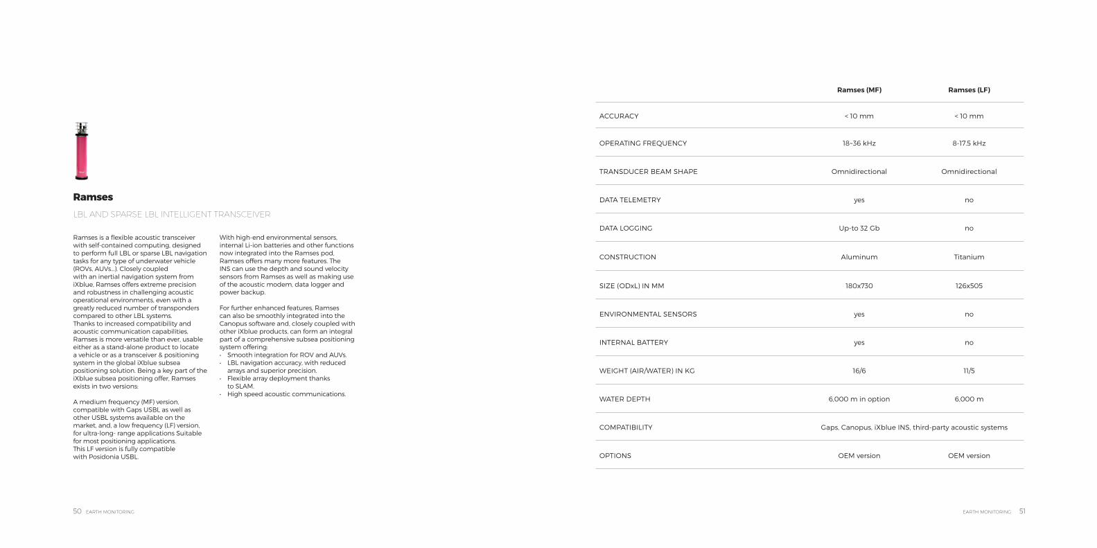
Ramses is a flexible acoustic transceiver with self-contained computing, designed to perform full LBL or sparse LBL navigation tasks for any type of underwater vehicle (ROVs, AUVs...). Closely coupledwith an inertial navigation system from iXblue, Ramses offers extreme precision and robustness in challenging acoustic operational environments, even with a greatly reduced number of transponders compared to other LBL systems.Thanks to increased compatibility and acoustic communication capabilities, Ramses is more versatile than ever, usable either as a stand-alone product to locate a vehicle or as a transceiver & positioning system in the global iXblue subsea positioning solution. Being a key part of the iXblue subsea positioning offer, Ramses exists in two versions:
A medium frequency (MF) version, compatible with Gaps USBL as well as other USBL systems available on the market, and, a low frequency (LF) version, for ultra-long- range applications Suitable for most positioning applications. This LF version is fully compatible with Posidonia USBL.
With high-end environmental sensors, internal Li-ion batteries and other functions now integrated into the Ramses pod, Ramses offers many more features. The INS can use the depth and sound velocity sensors from Ramses as well as making useof the acoustic modem, data logger and power backup.
For further enhanced features, Ramses can also be smoothly integrated into the Canopus software and, closely coupled with other iXblue products, can form an integral part of a comprehensive subsea positioning system offering:• Smooth integration for ROV and AUVs.• LBL navigation accuracy, with reduced
arrays and superior precision.• Flexible array deployment thanks
to SLAM. • High speed acoustic communications.
Ramses LBL AND SPARSE LBL INTELLIGENT TRANSCEIVER
Ramses (MF) Ramses (LF)
ACCURACY < 10 mm < 10 mm
OPERATING FREQUENCY 18~36 kHz 8-17.5 kHz
TRANSDUCER BEAM SHAPE Omnidirectional Omnidirectional
DATA TELEMETRY yes no
DATA LOGGING Up-to 32 Gb no
CONSTRUCTION Aluminum Titanium
SIZE (ODxL) IN MM 180x730 126x505
ENVIRONMENTAL SENSORS yes no
INTERNAL BATTERY yes no
WEIGHT (AIR/WATER) IN KG 16/6 11/5
WATER DEPTH 6,000 m in option 6,000 m
COMPATIBILITY Gaps, Canopus, iXblue INS, third-party acoustic systems
OPTIONS OEM version OEM version
52 EARTH MONITORING EARTH MONITORING 53
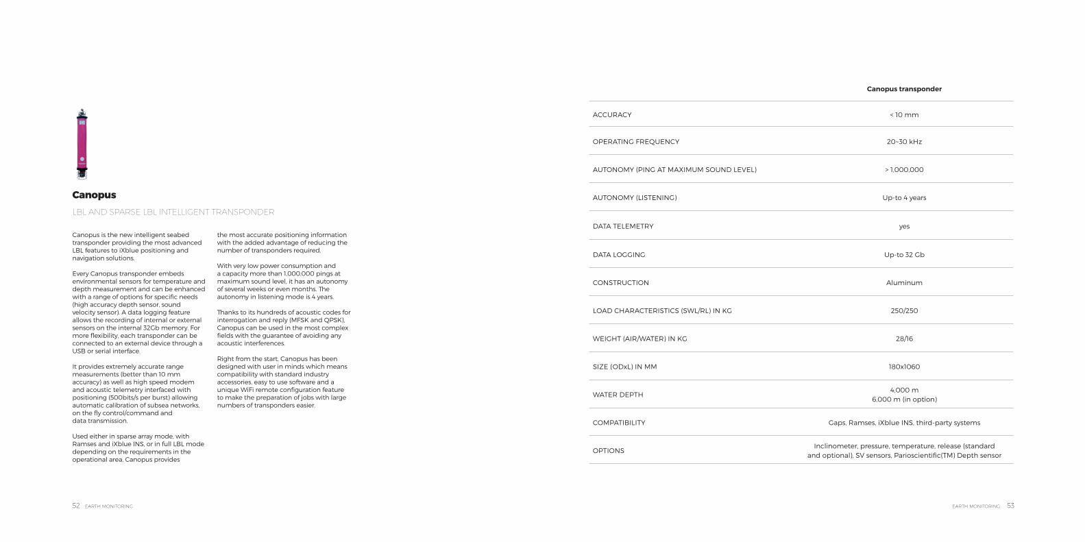
Canopus is the new intelligent seabed transponder providing the most advanced LBL features to iXblue positioning and navigation solutions.
Every Canopus transponder embeds environmental sensors for temperature and depth measurement and can be enhanced with a range of options for specific needs (high accuracy depth sensor, soundvelocity sensor). A data logging feature allows the recording of internal or external sensors on the internal 32Gb memory. For more flexibility, each transponder can be connected to an external device through a USB or serial interface.
It provides extremely accurate range measurements (better than 10 mm accuracy) as well as high speed modem and acoustic telemetry interfaced with positioning (500bits/s per burst) allowing automatic calibration of subsea networks, on the fly control/command and data transmission.
Used either in sparse array mode, with Ramses and iXblue INS, or in full LBL mode depending on the requirements in the operational area, Canopus provides
the most accurate positioning information with the added advantage of reducing the number of transponders required.
With very low power consumption and a capacity more than 1,000,000 pings at maximum sound level, it has an autonomy of several weeks or even months. The autonomy in listening mode is 4 years.
Thanks to its hundreds of acoustic codes for interrogation and reply (MFSK and QPSK), Canopus can be used in the most complex fields with the guarantee of avoiding any acoustic interferences.
Right from the start, Canopus has been designed with user in minds which means compatibility with standard industry accessories, easy to use software and a unique WiFi remote configuration feature to make the preparation of jobs with large numbers of transponders easier.
Canopus LBL AND SPARSE LBL INTELLIGENT TRANSPONDER
Canopus transponder
ACCURACY < 10 mm
OPERATING FREQUENCY 20~30 kHz
AUTONOMY (PING AT MAXIMUM SOUND LEVEL) > 1,000,000
AUTONOMY (LISTENING) Up-to 4 years
DATA TELEMETRY yes
DATA LOGGING Up-to 32 Gb
CONSTRUCTION Aluminum
LOAD CHARACTERISTICS (SWL/RL) IN KG 250/250
WEIGHT (AIR/WATER) IN KG 28/16
SIZE (ODxL) IN MM 180x1060
WATER DEPTH4,000 m
6,000 m (in option)
COMPATIBILITY Gaps, Ramses, iXblue INS, third-party systems
OPTIONSInclinometer, pressure, temperature, release (standard
and optional), SV sensors, Parioscientific(TM) Depth sensor
54 EARTH MONITORING EARTH MONITORING 55
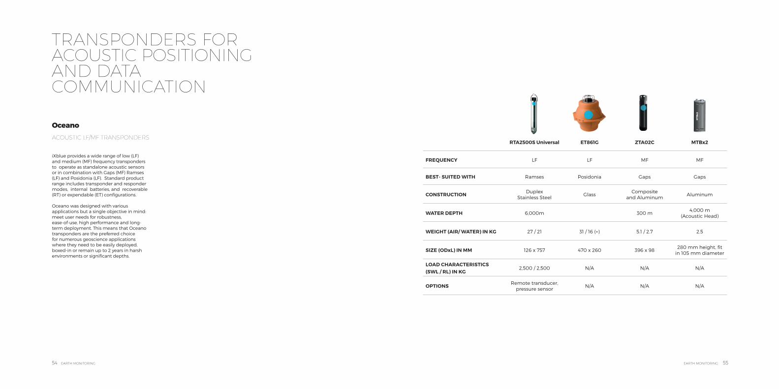
RTA2500S Universal ET861G ZTA02C MTBx2
FREQUENCY LF LF MF MF
BEST- SUITED WITH Ramses Posidonia Gaps Gaps
CONSTRUCTION Duplex Stainless Steel
GlassComposite
and AluminumAluminum
WATER DEPTH 6,000m 300 m4,000 m
(Acoustic Head)
WEIGHT (AIR/ WATER) IN KG 27 / 21 31 / 16 (+) 5.1 / 2.7 2.5
SIZE (ODxL) IN MM 126 x 757 470 x 260 396 x 98280 mm height, fit
in 105 mm diameter
LOAD CHARACTERISTICS (SWL / RL) IN KG
2,500 / 2,500 N/A N/A N/A
OPTIONS Remote transducer, pressure sensor
N/A N/A N/A
TRANSPONDERS FOR ACOUSTIC POSITIONING AND DATA COMMUNICATION
iXblue provides a wide range of low (LF) and medium (MF) frequency transponders to operate as standalone acoustic sensors or in combination with Gaps (MF) Ramses (LF) and Posidonia (LF). Standard product range includes transponder and responder modes, internal batteries, and recoverable (RT) or expendable (ET) configurations.
Oceano was designed with various applications but a single objective in mind: meet user needs for robustness,ease-of-use, high performance and long- term deployment. This means that Oceano transponders are the preferred choice for numerous geoscience applications where they need to be easily deployed, boxed-in or remain up to 2 years in harsh environments or significant depths.
Oceano ACOUSTIC LF/MF TRANSPONDERS
56 EARTH MONITORING EARTH MONITORING 57
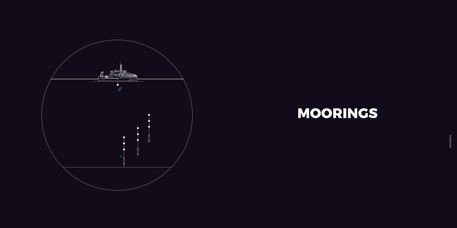
MOORINGS
MO
OR
ING
S
blueSeis 3ARotational Seismometer
DrixAutonomous Surface Vessel
SeapiX SeriesSonar for fishery research and seabed classification
iXcat 80Survey Vessel
Sams SeriesSynthetic Aperture Sonar with INS/USBL coupling
Delph SuiteSeabed Mapping Software
Echoes SeriesSub-bottom profilers
CanopusIntelligence Transponder
PosidoniaUSBL Solution for deep-waters
GapsUSBL Solution for shallow waters
58 EARTH MONITORING EARTH MONITORING 59
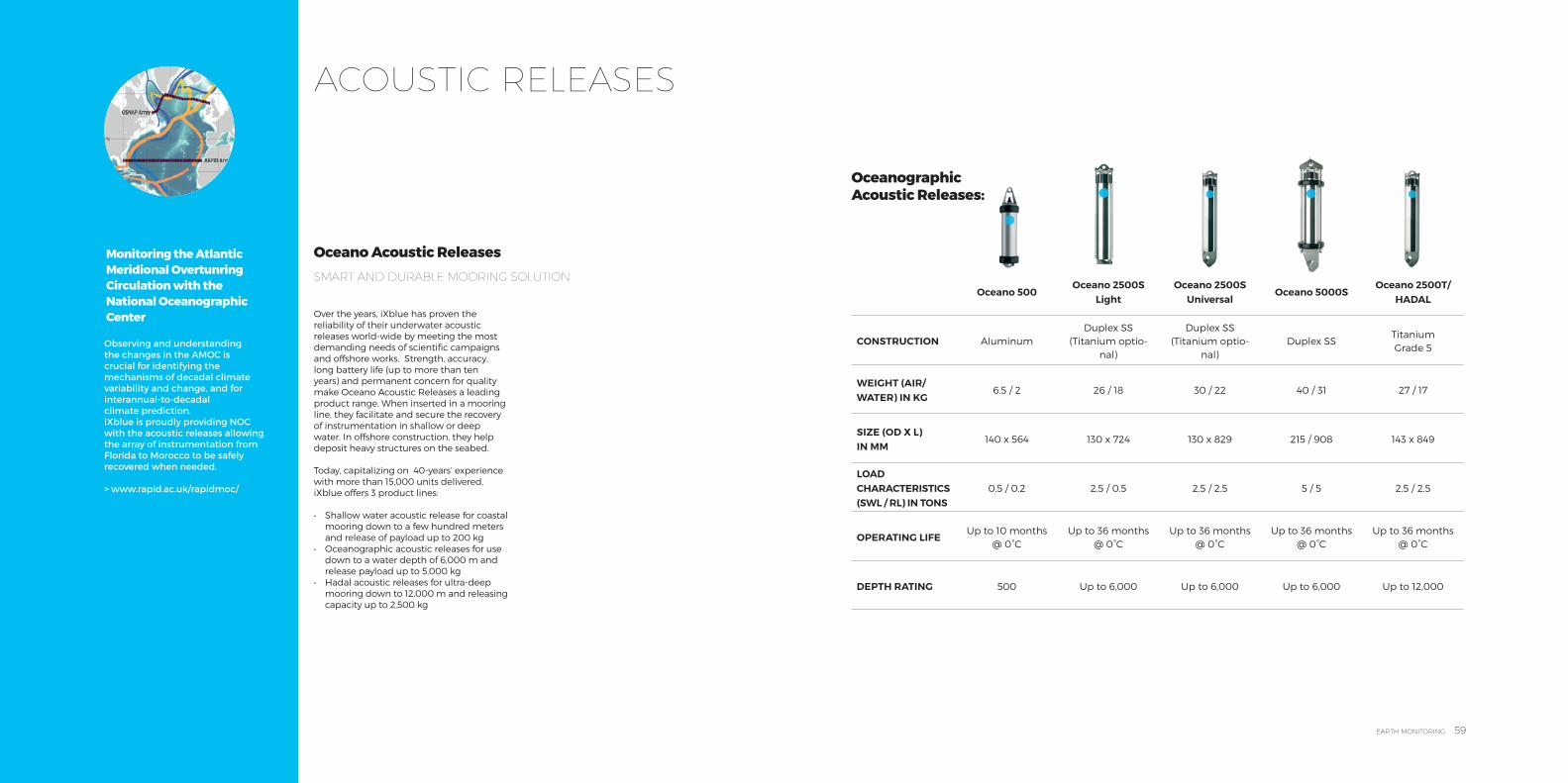
ACOUSTIC RELEASES
Monitoring the Atlantic Meridional Overtunring Circulation with the National Oceanographic Center
Observing and understanding the changes in the AMOC is crucial for identifying the mechanisms of decadal climate variability and change, and for interannual-to-decadal climate prediction.iXblue is proudly providing NOC with the acoustic releases allowing the array of instrumentation from Florida to Morocco to be safely recovered when needed.
> www.rapid.ac.uk/rapidmoc/
Over the years, iXblue has proven the reliability of their underwater acoustic releases world-wide by meeting the most demanding needs of scientific campaigns and offshore works. Strength, accuracy, long battery life (up to more than ten years) and permanent concern for quality make Oceano Acoustic Releases a leading product range. When inserted in a mooring line, they facilitate and secure the recovery of instrumentation in shallow or deep water. In offshore construction, they help deposit heavy structures on the seabed.
Today, capitalizing on 40-years’ experience with more than 15,000 units delivered, iXblue offers 3 product lines:
• Shallow water acoustic release for coastal mooring down to a few hundred meters and release of payload up to 200 kg
• Oceanographic acoustic releases for use down to a water depth of 6,000 m and release payload up to 5,000 kg
• Hadal acoustic releases for ultra-deep mooring down to 12,000 m and releasing capacity up to 2,500 kg
Oceano Acoustic Releases SMART AND DURABLE MOORING SOLUTION
Oceanographic Acoustic Releases:
Oceano 500Oceano 2500S
LightOceano 2500S
UniversalOceano 5000S
Oceano 2500T/HADAL
CONSTRUCTION AluminumDuplex SS
(Titanium optio-nal)
Duplex SS (Titanium optio-
nal)Duplex SS
Titanium Grade 5
WEIGHT (AIR/ WATER) IN KG
6.5 / 2 26 / 18 30 / 22 40 / 31 27 / 17
SIZE (OD X L) IN MM
140 x 564 130 x 724 130 x 829 215 / 908 143 x 849
LOAD CHARACTERISTICS (SWL / RL) IN TONS
0.5 / 0.2 2.5 / 0.5 2.5 / 2.5 5 / 5 2.5 / 2.5
OPERATING LIFEUp to 10 months
@ 0°CUp to 36 months
@ 0°CUp to 36 months
@ 0°CUp to 36 months
@ 0°CUp to 36 months
@ 0°C
DEPTH RATING 500 Up to 6,000 Up to 6,000 Up to 6,000 Up to 12,000

60 EARTH MONITORING EARTH MONITORING 61
DRONES
DR
ON
ES
blueSeis 3ARotational Seismometer
DrixAutonomous Surface Vessel
SeapiX SeriesSonar for fishery research and seabed classification
iXcat 80Survey Vessel
Sams SeriesSynthetic Aperture Sonar with INS/USBL coupling
Delph SuiteSeabed Mapping Software
Echoes SeriesSub-bottom profilers
CanopusIntelligence Transponder
PosidoniaUSBL Solution for deep-waters
GapsUSBL Solution for shallow waters
62 EARTH MONITORING EARTH MONITORING 63
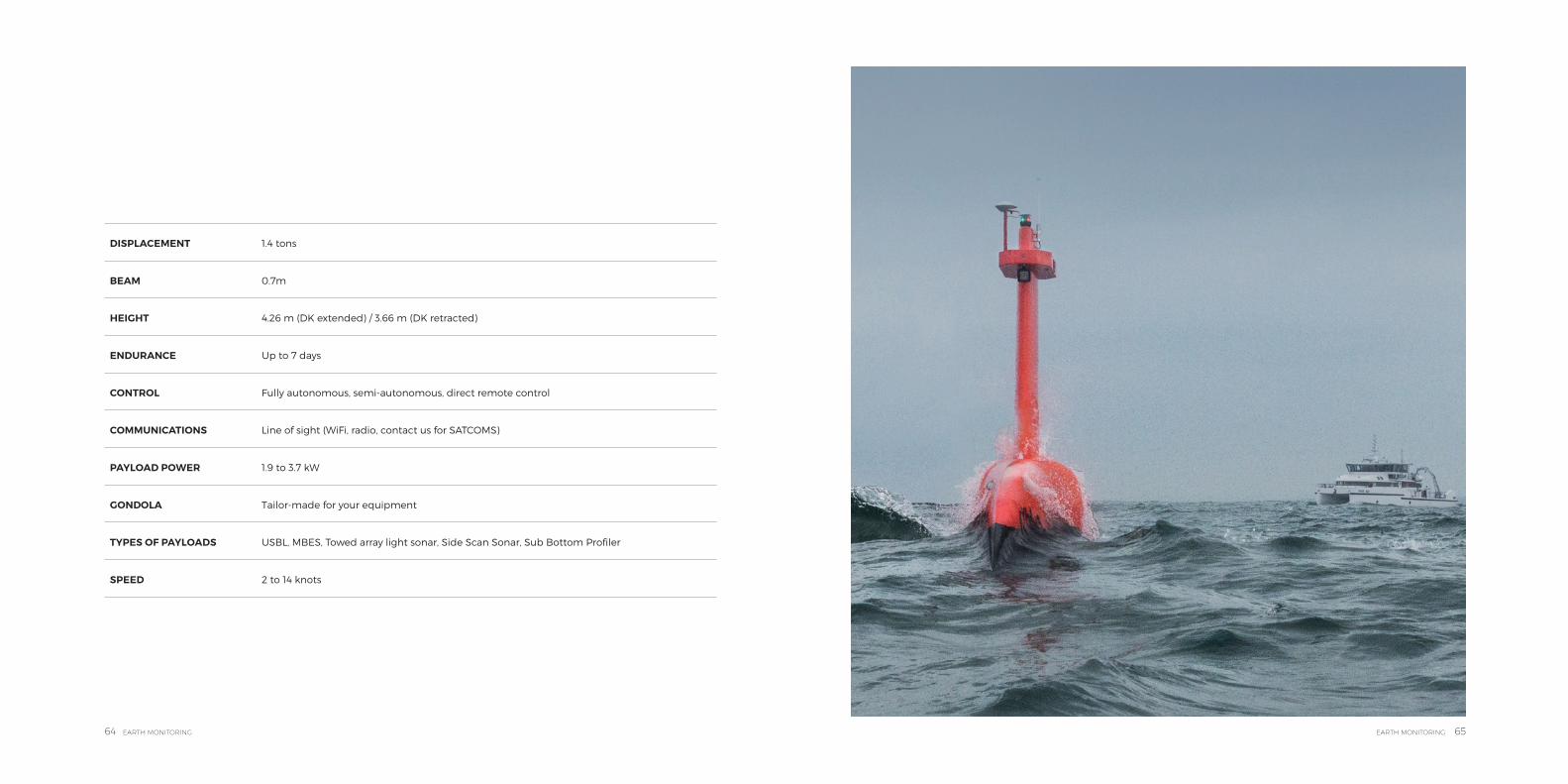
DriX operates from the surfaceto the depth. Thus, for DriXpositioning is of the utmostimportance, as is stabilityof its communications with the world at the surface. In order to be able to deliver thosemost demanding qualities DriX offers:
DriX is a true Swiss armyknife. For subsea positioningand tracking tasks, DriX can be fitted with a standard iXblue gondola integrating our seabed mapping solutionsor any third party systemsdepending on the needs, providing the following
DriX’s seaworthiness providesall the suitable featuresto perform an excellentsubsea positioning missionover an extended periodof time in environmentalconditions exceeding thoseof a traditional support vessel.DriX is a safe asset. Beingunmanned, it ensures that people remain safe Theyoperate it from a distance andgather the benefits withouttaking risks. As an autonomous
In addition to its excellentstability, DriX offers anothermajor improvement to thearena: a gondola.This already-known feature inthe survey field, transcendsthe concept by providing:
• The best possible location for the payload. Bolted onto a two-metre deep drop keel, always extended when DriX is in operation, it positions the sensors under the bubbling effect zone generated by any type of vessel. It is also as far
• Long operating life (ranging from 5 to 10 days depending on the speed and the maritime environment,
• Excellent platform thanks to its energy-saving hydrodynamic design);
• Excellent maneuvering features and a wide range of speeds (from 2 to 14 knots)
• Hydrographic survey• Coastal and harbour
monitoring• Hydro acoustic survey• Seabed mapping• Seabed automatic
classification• AUV tracking with USBL
systems integrated in the gondola
platform, it is designed to beas safe as possible. A numberof software and physical layershave been superposed toprovide the means to overrideit at any time.
away aspossible from DriX’s own engine noise (already much dampened by the use of composite materials). Thanks to the drop-keel structure and materials, it is as vibration-free as one can get.
• Very good modularity. The type and size of the gondola varies according to the nature of the payload. A single DriX can operate a number of different gondolas. It offers the market a truly multirole
• Specific kinematics for missions which require “hovering” capabilities
• An excellent platform stability up to sea state 4 and higher (in order to reduce the impact of the difference between the roughness of the surface and the calm deep down under the surface and expand the working domain)
tool. All it takes (from a payload angle) to change DriX’s mission is to hoist it onto the work deck and bolt a new gondola where the previous one was fitted.
• Real cost effectiveness. The gondola is tailor-crafted by The iXblue Shipyard either to new or already customer-owned payloads. If the payload size is of essence when the gondola is designed, other payloads of equivalent dimensions can
• A number of applications and payloads Thanks to its removable and replaceable gondola, DriX will enable any customer to useits own sensors and to adapt them to the mission in hand.
be adapted within the same gondola afterwards. All that is required is to unbolt a hatch located under the gondola to remove the previous payload and put a new one in its place. Cabling is preinstalled.
Thanks to its removable and replaceable gondola, DriX enables any customer to use their own survey devices and to adapt them to the mission in hand. DriX is a true Swiss knife.
An unrivalled seaworthiness A number of applications and payloads
A safe asset for your survey missionsA second-to-none tool for data gathering
UNMANNED SURFACE VEHICLE
64 EARTH MONITORING EARTH MONITORING 65
DISPLACEMENT 1.4 tons
BEAM 0.7m
HEIGHT 4.26 m (DK extended) / 3.66 m (DK retracted)
ENDURANCE Up to 7 days
CONTROL Fully autonomous, semi-autonomous, direct remote control
COMMUNICATIONS Line of sight (WiFi, radio, contact us for SATCOMS)
PAYLOAD POWER 1.9 to 3.7 kW
GONDOLA Tailor-made for your equipment
TYPES OF PAYLOADS USBL, MBES, Towed array light sonar, Side Scan Sonar, Sub Bottom Profiler
SPEED 2 to 14 knots

66 EARTH MONITORING EARTH MONITORING 67
SERVICES & EQUIPMENT SUPPLY
SE
RV
ICE
S &
E
QU
IPM
EN
T S
UP
PLY
68 EARTH MONITORING EARTH MONITORING 69
iXblue believes that a successful operation relies on upstream preparation, efficient and available support and training in how to best use our products.
This is why we grasped the opportunity tooffer our users a dedicated training & services facility in Aberdeen. In addition, a team of scientists, sailors and surveyors as well as equipment and vesselsare ready to help our users in designing and implementing their projects.
Training Assistance in implementing iXblue technology in your project is delivered by a dedicated team of experienced personnel who combine training duties with time spent offshore at your operations ensuring that the training they deliver and the support they provide are always up to date.
With a regular and developing program of training courses available throughout the year, we are able to offer:
• Inertial Theory and Operation
• Gaps and Posidonia Theory and Operation
• Acoustic release maintenance
• Delph INS• Echoes series Theory and
Operation• SAMS series Theory and
Operation• SeapiX Theory and
Operation• Delph for Geophysicists• DriX maintenance• DriX Pilot• Vessel maintenance
Services With a team of experienced offshore operators, we can assist at every stage of your project.
Based at our La Ciotat facility (South of France), our team of scientist offers our users the opportunity to increase their existing knowledge with the experience of our in-house survey and product specialists.They are able to provide an analysis of your survey requirements and adviseon how the iXblue range of products and vessels may be utilized to allow you to meet your project specifications in the most cost-effective way.
• Project Consulting - Scientific requirements analysis and equipment selection.
• Project execution – On-board assistance mobilizing, setting to work, and operating iXblue systems and products. Survey data acquisition with DriX
• On board training of staff.• Data Processing - Specialist
data processing using Delph software.
Our team includes sailors, divers (IIA class), hydrographers and oceanographers.
24/7 SupportAt iXblue we care about your peace of mind and we stand behind our products and system. Our highly trained support teams offer 24/7 assistance and provide you with top quality service,helping you to meet your day-to-day objectives.
SHARING KNOWLEDGE THROUGH TRAINING AND SERVICES
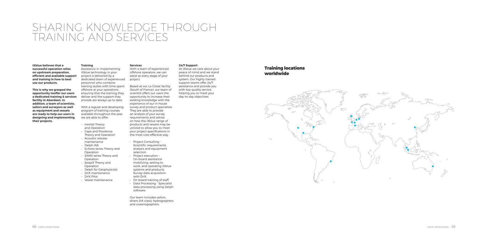
Training locations worldwide
70 EARTH MONITORING EARTH MONITORING 71
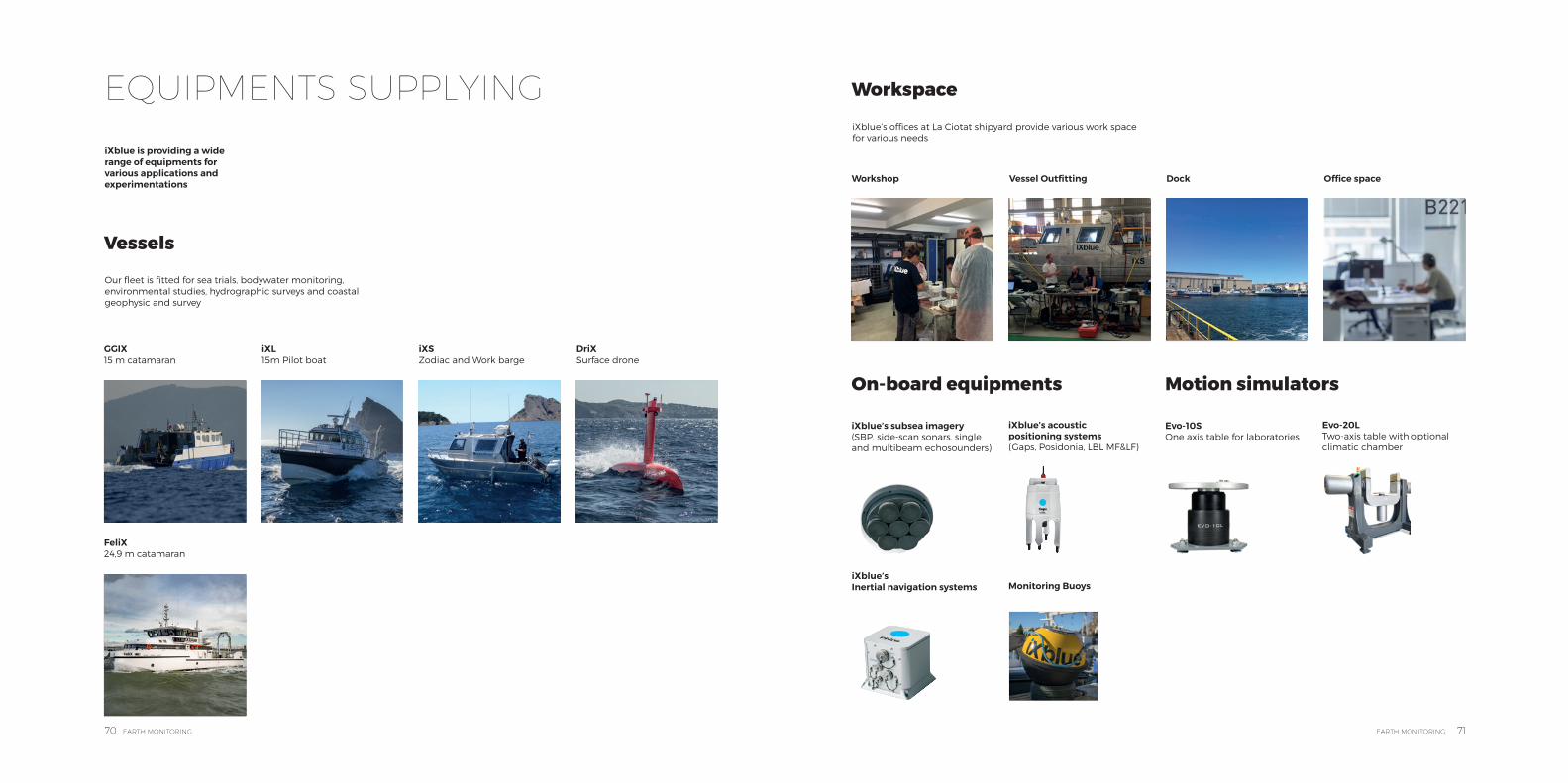
EQUIPMENTS SUPPLYING
iXblue is providing a wide range of equipments for various applications and experimentations
GGIX 15 m catamaran
FeliX24,9 m catamaran
Workshop
iXblue’s Inertial navigation systems
iXS Zodiac and Work barge
Dock
iXblue’s acoustic positioning systems(Gaps, Posidonia, LBL MF&LF)
Evo-20LTwo-axis table with optional climatic chamber
iXL 15m Pilot boat
Vessel Outfitting
iXblue’s subsea imagery (SBP, side-scan sonars, single and multibeam echosounders)
Evo-10SOne axis table for laboratories
DriX Surface drone
Office space
Monitoring Buoys
Our fleet is fitted for sea trials, bodywater monitoring, environmental studies, hydrographic surveys and coastal geophysic and survey
iXblue’s offices at La Ciotat shipyard provide various work space for various needs
Vessels
Workspace
On-board equipments Motion simulators
72 EARTH MONITORING EARTH MONITORING 73
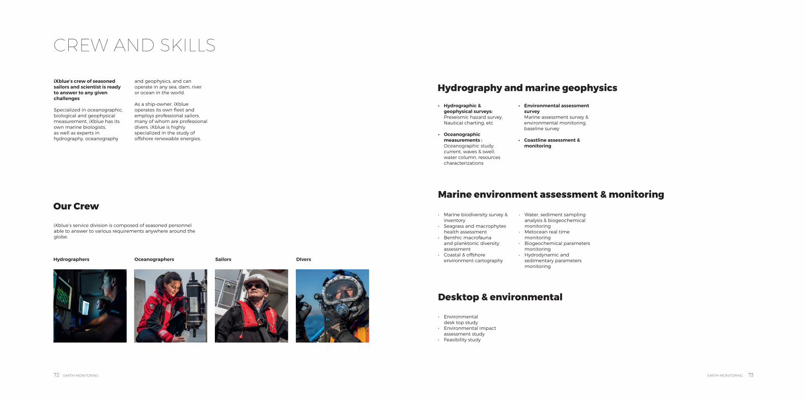
CREW AND SKILLS
iXblue’s crew of seasoned sailors and scientist is ready to answer to any given challenges
Specialized in oceanographic, biological and geophysical measurement, iXblue has its own marine biologists,as well as experts in hydrography, oceanography
and geophysics, and can operate in any sea, dam, river or ocean in the world.
As a ship-owner, iXblue operates its own fleet and employs professional sailors, many of whom are professional divers. iXblue is highly specialized in the study of offshore renewable energies.
Hydrographers SailorsOceanographers DIvers
iXblue’s service division is composed of seasoned personnel able to answer to various requirements anywhere around the globe.
Our Crew
• Hydrographic & geophysical surveys: Preseismic hazard survey, Nautical charting, etc
• Oceanographic measurements : Oceanographic study: current, waves & swell, water column, resources characterizations
• Environmental assessment survey Marine assessment survey & environmental monitoring, baseline survey
• Coastline assessment & monitoring
• Marine biodiversity survey & inventory
• Seagrass and macrophytes health assessment
• Benthic macrofauna and planktonic diversity assessment
• Coastal & offshore environment cartography
• Water, sediment sampling analysis & biogeochemical monitoring
• Metocean real time monitoring
• Biogeochemical parameters monitoring
• Hydrodynamic and sedimentary parameters monitoring
• Environmental desk top study
• Environmental impact assessment study
• Feasibility study
Hydrography and marine geophysics
Marine environment assessment & monitoring
Desktop & environmental

74 EARTH MONITORING
Join us on:
@ixblue
iXblue