sundarbans oil spill assessment
TRANSCRIPT

SUNDARBANS OIL SPILL ASSESSMENT Joint United Nations/Government of Bangladesh Mission
December 2014
Union Civil Protection Mechanism

2
Published in Switzerland, 2015 by the Joint UNEP/OCHA Environment Unit, Emergency Preparedness and Environment Section, Emergency Services Branch, OCHA Copyright © 2015 Joint UNEP/OCHA Environment Unit
This publication may be reproduced in whole or in part and in any form for educational or not-for-profit purposes without special permission from the copyright holder, provided acknowledgement is made of the source. Information has been compiled by the experts on mission based upon best available knowledge when drafted.
Joint UNEP/OCHA Environment Unit Emergency Preparedness and Environment Section Emergency Services Branch, Office for the Coordination of Humanitarian Affairs (OCHA) Palais des Nations CH-1211 Geneva 10 Switzerland [email protected]
Report Editor: Joint UNEP/OCHA Environment Unit Cover photo: Oiled vegetation with fishing boat © Zia Islam

3
Table of Contents
Executive Summary ............................................................................................................................5 List of acronyms and glossary of terms ..............................................................................................6 1. Mission background and scope ..................................................................................................7
1.1 Context................................................................................................................................7 1.2 Mission objective .................................................................................................................8 1.3 Terminology ........................................................................................................................9
2. Key Findings and Activities ...................................................................................................... 10 2.1 Setting ............................................................................................................................... 10 2.1.1 Environment .................................................................................................................. 10 2.1.2 Socioeconomic setting ................................................................................................... 10 2.2 Oil spill extent.................................................................................................................... 12 2.2.1 Characteristics ............................................................................................................... 12 2.2.2 Extent of Spill ................................................................................................................. 12 2.3 Response operations ......................................................................................................... 16 2.3.1 Initial response .............................................................................................................. 16 2.4 Environmental impacts ...................................................................................................... 19 2.4.1 Aquatic environment ..................................................................................................... 19 2.4.2 Mangroves..................................................................................................................... 23 2.4.3 Wildlife .......................................................................................................................... 27 2.5 Human and socioeconomic impacts ................................................................................... 30 2.5.1 Health impacts ............................................................................................................... 31 2.5.2 Impact on Livelihoods .................................................................................................... 32
3. Summary.................................................................................................................................. 34 3.1 Conclusions ....................................................................................................................... 34 3.2 Recommendations ............................................................................................................. 36
4. References ............................................................................................................................... 41 Annexes ........................................................................................................................................... 42

4
The Joint UNEP/OCHA Environment Unit (JEU) assists Member States in preparing for and responding to environmental emergencies by coordinating international efforts and mobilizing partners to aid affected countries requesting assistance. By pairing the environmental expertise of the United Nations Environment Programme (UNEP) and the humanitarian response network coordinated by the United Nations Office for the Coordination of Humanitarian Affairs (OCHA), the JEU ensures an integrated approach in responding to environmental emergencies. The Environmental Emergencies Centre (EEC) (www.eecentre.org) is an online tool designed to build the capacity of national responders to environmental emergencies developed by the JEU.
The United Nations Disaster Assessment and Coordination (UNDAC) is part of the international emergency response system for sudden-onset emergencies. UNDAC is designed to help the United Nations and governments of disaster-affected countries during the first phase of a sudden-onset emergency.
The United Nations Development Programme partners with people at all levels of society to help build nations that can withstand crisis, and drive and sustain the kind of growth that improves the quality of life for everyone. On the ground in more than 170 countries and territories, we offer global perspective and local insight to help empower lives and build resilient nations.
The United States Agency for International Development (USAID) was founded in 1961 and is the lead U.S. Government agency for foreign assistance. USAID works to end extreme global poverty and enable resilient, democratic societies to realize their potential. USAID works in over 100 countries to: Strengthen democracy and good governance, protect human rights, improve global health, advance food security and agriculture, improve environmental sustainability, further education, help societies prevent and recover from conflicts; and provide humanitarian assistance in the wake of natural and man-made disasters. For more information, please visit www.usaid.gov.
CEDRE, based in France, is a non-profit-making association created on 25 January 1979 to improve spill response preparedness and strengthen the national response organisation. It is responsible, on a national level, for documentation, research and experimentation on pollutants, their effects and the response means and tools that can be used to combat them. It is charged with providing advice and expertise to the authorities responsible for responding to accidental pollution. It is competent both for marine waters and inland surface waters.
The Union Civil Protection Mechanism (UCPM) facilitates co-operation in disaster response, preparedness, and prevention among 31 European states (EU-28 and the Former Yugoslav Republic of Macedonia, Iceland, and Norway). With the support of the European Commission, Participating States pool resources and experts that can be made available to disaster-stricken countries all over the world as well as for prevention and preparedness operations. When activated, the Mechanism coordinates the provision of assistance from its Participating states. The European Commission manages the Mechanism through the Emergency Response Coordination Centre (ERCC). Operating 24/7, the ERCC monitors risks and emergencies around the world and serves as an information and coordination hub during emergencies. Among other tasks, the ERCC also ensures that Participating States are fully aware of the situation on-site and can make informed decisions for providing financial and in-kind assistance. For more information, please refer to the ECHO website and/or ERCC Portal. The Union Civil Protection mechanism closely cooperates with the United Nations and it participated in several joint missions.

5
Executive Summary
On 9 December 2014, an oil tanker accident in the Sundarbans of Bangladesh led to the release of approximately 358,000 litres of heavy fuel oil into the river and mangrove ecosystem. The response to the accident was led by the Ministry of Environment and Forests along with its attached departments, Department of Forest and Department of Environment, with the help of local communities. Concern about the potential impacts of the oil to the ecosystem and the communities that depend on it for their livelihoods, led the Government of Bangladesh on 15 December 2014 to request the United Nations Development Programme (UNDP) provide technical assistance in assessing the impacts and supporting the response.
A Joint United Nations / Government of Bangladesh Sundarbans Oil Spill Response mission was subsequently formed, under the coordination of the United Nations Development Programme. The mission consisted of 25 experts and officials from Bangladesh Government agencies and universities, the United Nations Disaster Assessment and Coordination (UNDAC) team, UNDP, USAID, the European Union Civil Protection Mechanism, France and the Wildlife Conservation Society. The objective of the mission was to strengthen the Government’s efforts in containing and cleaning up the oil spillage, as well as to provide support to assessing the situation and developing an action plan for a phased response and recovery. The team spent six days in the affected area where site observations, interviews, aerial photography, sampling and other assessment techniques were used to evaluate the situation and develop recommendations.
A number of factors, including timely tidal variations and the decision to ban tanker traffic in the river, minimized the penetration of oil into the mangrove ecosystem. Nonetheless, the oil spill accident must be considered serious, as it occurred in a wildlife sanctuary, and World Heritage Site and Ramsar site treasured for its unique biodiversity. The lack of a formal oil spill contingency plan; which among other things, designates an appropriate competent authority to oversee the response as well as the limited experience and response infrastructure, made response and recovery efforts challenging. Despite these limitations, the concerted efforts of the nearby communities and the Department of Forest, reduced the impacts and led to a reported 68,200 litres of oil being collected. The lack of training, appropriate equipment and experience resulted in unintended negative impacts to the local community – with immediate health impacts such as difficulties in breathing, headaches and vomiting reported among the community responders. While on water and shoreline clean-up operations are over, the removal of oiled debris, the management of response generated waste, and the assessment of a final disposal option needs to continue. The mission urgently recommends the removal of all oiled debris in a safe and environmentally appropriate manner.
When it comes to impact, the rapid assessment recommends further monitoring to more definitely determine the effect of the residual oil in the aquatic environment and its impacts on fisheries and livelihoods. No visible impact on the mangrove forest floor due to the accident has been observed, and the initial acute impacts to wildlife from this spill appear to be limited in scope.
With respect to human and socioeconomic impacts, the assessment revealed that the impact on livelihoods was intensive during the first two weeks – with some community members losing income and others benefiting economically from the oil recovery scheme. The long-term effects on livelihoods, food security and health cannot be assessed in the allocated timeline of this rapid assessment.
The oil spill accident represents a serious wake-up call. At the same time the incident provides an excellent knowledge-sharing opportunity to strengthen national oil spill preparedness and response capacity moving forward. While a number of factors limited the impact of the spill, the shipping of oil through a valued and biodiverse ecosystem presents a serious risk to both the environment and the communities that depend on it for their livelihoods. Appropriate safeguards and mitigation measures need to be put in place for all significant marine routes with immediate attention required to safeguard the Shela channel from the risk of another vessel collision and potential oil spill if it is reopened to vessel traffic. The mission recommends improvements in national oil spill preparedness and response and improved vessel traffic management. Additionally the lessons of the oil spill should be integrated into the existing integrated resources management plans of the Sundarbans, with due attention to aquatic, mangrove and wildlife monitoring.

6
List of abbreviations, acronyms and glossary of terms
BDT Bangladeshi Taka (currency) BPC Bangladesh Petroleum Corporation CEDRE Centre of Documentation, Research and Experimentation on Accidental Water Pollution
(France) DoE Department of Environment, Ministry of Environment and Forests (GoB) ECHO European Commission’s Humanitarian Aid and Civil Protection Directorate General ERD Economic Relations Division (GoB) DF Department of Forest (MoEF, GoB) FGD Focus Group Discussion GoB Government of Bangladesh IFO 380 Intermediate fuel oil with a maximum viscosity of 380 Centistokes (<3.5% sulphur) IMO International Maritime Organization IOPCF International Oil Pollution Compensation Funds ITOPF International Tanker Owners Pollution Federation IUCN International Union for Conservation of Nature JEU Joint UNEP/OCHA Environment Unit MoEF Ministry of Environment and Forests (GoB) NGO Non-Governmental Organization NOAA National Oceanic and Atmospheric Administration (United States) OCHA (UN) Office for the Coordination of Humanitarian Affairs OPRC International Convention on Oil Pollution Preparedness, Response and Co-operation PAH Polycyclic Aromatic Hydrocarbon PPE Personal Protective Equipment Ramsar The Convention on Wetlands of International Importance SRF Sundarbans Reserve Forests SSI Semi-Structured Interviews UAV Unmanned Aerial Vehicle UCPM Union Civil Protection Mechanism (ECHO) UN United Nations UNDAC United Nations Disaster Assessment and Coordination UNDP United Nations Development Programme UNESCO United Nations Educational, Scientific and Cultural Organization UNEP United Nations Environment Programme UNOSAT United Nations Institute for Training and Research (UNITAR) Operational Satellite
Applications Programme USAID United States Agency for International Development VOC Volatile Organic Compound WCS Wildlife Conservation Society
An environmental emergency is defined as a sudden onset disaster or accident resulting from natural, technological or human-induced factors, or a combination of these, that cause or threaten to cause severe environmental damage as well as harm to human health and/or livelihoods. UNEP/GC.22/INF/5, 13 November 2002

7
1. Mission background and scope
1.1 Context
A tanker (OT Southern Star) carrying a reported 357,664 litres of heavy fuel oil collided on 9 December, 2014, at around 5:00 am local time, with another vessel and partly sank in the Shela River situated within the Sundarbans mangrove region in Bangladesh. A major breach was made in the hull causing oil to spill into the river and adjacent side channels and creeks. By the afternoon of the next day the oil had spread at least 20 km upstream to Mongla and at least 20 km downstream to Horintana. The accident caused widespread concern for the Sundarbans ecosystem, which is the world’s largest mangrove forest and has been a Ramsar site since 1992 and part of which is a UNESCO World Heritage site since 1997. Due to its richness of biological diversity the entire Sundarbans (6,017 square kilometres) is under some form of state protection. Furthermore, millions of Bangladeshis depend upon the Sundarbans for food, livelihoods and shelter. The oil spill took place within the Chandpai Wildlife Sanctuary which was recently estabished to protect important dolphin habitat. The location of the spill is shown in Figure 1.
Figure 1. Oil spill accident site, Sundarbans, Bangladesh. Map by Sayedur R. Chowdhury.
The Department of Forest of the Ministry of Environment and Forests (MoEF) of the Government of Bangladesh (GoB) provided oversight and guidance to a community-based response effort. Fishermen and community members were engaged to collect the oil. Additionally, fine mesh nets were placed across the mouths of tributary/distributary creeks and channels to prevent the oil from entering them during rising tides. Fishing nets were locally deployed along the river banks for recovering the drifting oil. The response operations were carried out over approximately 12 days (from 12 to 22 December) during which a reported 68,200 litres of oil was collected by communities and purchased by the Bangladesh Petroleum Corporation (BPC).
8
On 15 December, the Economic Relations Division (ERD) of the Ministry of Finance submitted a request to the United Nations Development Programme (UNDP) (Annex 1) to provide technical assistance to: 1) assess the oil spill containment and clean-up needs, and 2) conduct an assessment and draft an action plan for recommended mitigation measures. On 17 December, a United Nations Disaster Assessment and Coordination (UNDAC) team was deployed to support UNDP in the assessment and coordination, under the leadership of the United Nations Environment Programme (UNEP) / UN Office for the Coordination of Humanitarian Affairs (OCHA) Joint Environment Unit (JEU). The team was subsequently strengthened with specialists supported by USAID, the French Ministry of Ecology, Suistainable Development and Energy (France) and the European Commission through the Union Civil Protection Mechanism, as well as with representatives of Government, academia, UNDP, other agencies and non-goverrnmental organizations (NGOs). The timeline of events is provided in Table 1.
Table 1. Key events and dates related to the oil spill accident
Date Event
09 December at 5:00 am Oil tanker accident in the Chandpai Wildlife Sanctuary of the Bangladesh Sundarbans results in release of approximately 358,000 litres of heavy fuel oil. UNDP submits proposal to respond to oil spill to MoEF
10 December MoEF, Department of Forest and Department of Environment begin response MoEF forms an expert committee which includes relevant Government stakeholders and academia to assess the environmental damage due to the oil spill and to put forward suggestions for reducing such damage in the future
11 December Bangladesh Petroleum Corporation starts buying collected oil from community Vessel salvaged and towed to Joymoni Department of Environment of MoEF begins collection and analysis of water samples from the oil-affected area, continuing until 26 December
12-13 December MoEF 13-person assessment team visits accident site 15 December GoB convenes and creates interministerial body headed by the Ministry of
Shipping to address the spill 16 December UNDP proposal to respond to the spill approved by Ministry of Finance, Economic
Relations Division 18-20 December UN-led team of experts arrives in Dhaka from France, Japan, Switzerland, USA and
from across Bangladesh 20 December Vessel towed to Mongla 21 December Oil collection stops; BPC reported purchasing a total of 68,200 litres of oil
MoEF assessment team submits its report 22 – 27 December Assessment team conducts field work in and around spill site 31 December Assessment team presents preliminary conclusions and recommendations to GoB. 1 – 15 January Assessment team incorporates feedback from key stakeholders and submits final
report to GoB
1.2 Mission objective
The objective of the Joint UN / GoB Sundarbans Oil Spill Response mission was to:
1. Strengthen GoB’s effort in containing oil spillage and clean-up 2. Provide support to GoB in assessing the situation and developing an action plan for a phased
response and recovery.
Since most of the containment and clean-up work - with the exception of oil waste management - had been completed by the time of the field assessment, the majority of the team was involved in the second objective namely the assessment of the situation and the development of appropriate recommendations. The mission consisted of 25 core team members, of which 14 were nationals of Bangladesh and 11 were international staff. The team was additionally supported by a number of

9
experts and representatives of Government, NGOs, academia and international organizations. The full list of team members is provided in Annex 2. The team was divided into six Sub-Teams, shown in the organizational chart below.
The overall misison approach was guided carefully by the principles of neutrality and impartiality, as well as by the ‘do no harm’ principle to ensure that response and assessment efforts do no additional damage to the sensitive ecosystem of the Sundarban. The assessment built on local expertise and capacity, with international experts working in conjunction with national and local experts and MoEF Department of Environment (DOE) and Department of Forest (DF) officials. This collaboration greatly contributed to the success of the assessment and is expected to facilitate the implementation of Team’s recommendations. This joint Bangladesh-international effort contributed to information-exchange between experts and developed local capacities on oil spill response and assessments.
The mission used a combination of literature review, on-site land- and vessel-based direct observations, interviews, sampling and surveys to develop findings and develop recommendations. Methodologies used are described in the “Key findings and Activities” chapter and in detail in the annexes. The mission agenda is provided in Annex 3, with field observation locations provided in Annex 4. The mission worked in close coordination with representatives of national authorities, academia, NGOs and UN agencies, as well as communities. A full list of consulted stakeholders is included in Annex 5. Reviewed background documents and additional resources are listed in Section 4.
The report and assessment were prepared on the basis of information and observations possible within the mission timeframe. The mission focuses on the situation at the scene of the accident, as observed between 22 and 28 December 2014. The assessment did not look into the reasons of the accident. Rather, the mission focused its findings on immediate, mid-term and long-term recommendations to address the oil spill, reduce the potential impacts to humans and the environment, and prevent future spills.
1.3 Terminology
Affected area The area of ecosystem exposed to oil (trace amount to full exposure)
Affected population The population using, in any form, the affected area for livelihoods or recreation

10
2. Key Findings and Activities
The mission findings focus on the following areas:
- Oil spill extent
- Response operations
- Environmental impacts
o Aquatic environment
o Mangroves
o Wildlife
- Human and socioeconomic impacts
o Health impacts
o Livelihoods
The chapter begins with a general overview of the Sundarbans area. It then moves into an assessment of the oil spill extent, after which the findings and activities related to the response operations are described. Finally, an assessment of the potential impacts on the environment and human beings is given.
2.1 Setting
2.1.1 Environment
At about 10,000 square kilometres and forming at the delta of the Ganges, Brahmaputra and Meghna rivers on the Bay of Bengal, the Sundarbans is the largest contiguous mangrove forest of the world. In Bangladesh alone, the Sundarbans encompasses 6017 km2 of the coastal zone. It is a Ramsar Convention site since 1992, has three wildlife sanctuaries and was designated a World Heritage site by UNESCO in 1997. The forest is nationally and internationally considered to be of critical conservation significance for its environmental services and biodiversity. The Sundarbans consists of a complex network of tidal waterways, mud flats and small islands of salt tolerant mangrove forest. During high tides the area is partly flooded with brackish water mixing with river freshwater. Forest areas contain over 334 species of plants, but are dominated by a few species - mostly Sundri (Heritiera fomes) and Gewa (Excoecaria agallocha) mangroves as well as Golpatta (Nypa fruticans) palm. The fauna is very diverse with approximately 425 species of wildlife; including 40 species of mammals, 300 species of birds and 35 species of reptiles. These include the famous Royal Bengal Tiger and many other important mammal species such as spotted deer, rhesus monkey, jackel and civet, estuarine crocodile and monitor lizard. Aquatic resources in the rivers and streams include 177 species of fish, 24 species of shrimp, 7 species of crabs as well as ceteaceans such as dolphins and porpoises. The Sundarbans plays a vital role in a variety of ecosystem functions including 1) trapping of sediment and land formation, 2) protection of human lives and habitats from cyclones, 3) acting as a nursery for fish, 4) oxygen production, 5) natural recycling, 6) timber production, 7) supply of food and building materials, and 8) climate change mitigation and adaptation through carbon sequestration and storage.
2.1.2 Socioeconomic setting
A large part of the Sundarbans is protected as part of the Sundarbans Reserve Forests (SRF). There, human settlements are restricted – meaning there are neither villages nor cultivated fields inside. However, the reserve is used by a large number of rural communities located within a 20-km wide

11
zone outside the forest boundary. The total population living in the identified landscape around the reserve is estimated to be as high as 855,000.
It is estimated that approximately 30% of the nearby population, or 300,000 persons, are dependent of the SRF for their livelihoods – with around 200,000 regularly collecting resources from the Sundarbans. More than one million people depend on the Sundarbans for their livelihoods with a large part involved in various resource collection including working seasonally as fishermen, nipa palm and other non-timber resource collectors, fishermen and honey hunters. The SRF is an important source of revenue to the Government. A significant part of the value comes from the extensive shrimp breeding and nursery grounds supporting this important export industry.
Approximately 8,300 people reside close to the accident site (Table 2 and Figure 2).
Table 2. Population of affected communities (Source: Union Parisad E-service centre)
Union: Chila, Upazila: Mongla, District: Bagerhat
Ward No. Ward- 4 Ward- 5 Ward- 7 Ward- 8 Ward- 9 Total
Name of Village (14 villages) Gabgunia Paschim Chila
Dakhin Joymony
Moddhya Joymony
Uttar Joymoni
Total number of families 352 544 429 265 452 2042
Total population 1442 2196 1570 1586 1579 8373
· Total male 739 1102 801 789 813 4244
· Total female 703 1094 769 797 766 4129
Figure 2. Location of affected communities. Map by Sayedur R. Chowdhury.

12
The village community of Joymoni is located where the Pashur and Shela rivers meet, on the northern edge of the SRF and less than 3 km upriver of the collision site. The livelihoods of the village residents centers around an intricate connection with the rivers. Many of their houses are built on stilts at the river edges. People get their drinking water from rainwater storages, the river, or by purchasing it. They employ various techniques to harvest different finfish and shellfish species, they farm, and they keep small livestock at the river's edge.
In addition to livelihood support, the Sundarbans is an important and valued tourist destination for both Bangladeshi and international tourists. Tourist revenues from the Sundarbans is provided in Table 3.
Table 3. Revenue from tourism in the Sundarbans (Data from MoEF Sundarbans West and East)
Period Number of tourists Revenue in Bangladeshi Taka - BDT (USD)
July 2009 to June 2010 116,990 BDT 6,420,778 (USD 82,320)
July 2010 to June 2011 207,930 BDT 8,622,020 (USD 110,540)
July 2011 to June 2012 227,038 BDT 11,066,315 (USD 141,880)
July 2012 to June 2013 140,037 BDT 19,873,725 (USD 254,790)
July 2013 to June 2014 100,540 BDT 11,121,830 (USD 142,590)
2.2 Oil spill extent
2.2.1 Characteristics
As a result of the accident, a reported 357 664 litres of furnace oil was released into the Shela river. Furnace oil is a dark, viscous residual fuel oil with high viscosity similar to that of a heavy fuel oil1. When released, its physical and chemical properties will change due to evaporation, emulsification, dissolution, photo-oxidation and biodegradation processes. Additional information on the fate of oil in the environment is provided in the section “Aquatic environment”. In terms of toxicity, heavy fuel oil can be considered as less acutely toxic to the environment and people than lighter oils, as it has lower proportions of single ring aromatics (such as benzene) and smaller polycyclic aromatic hydrocarbons (PAHs). One oil sample was analyzed at the Bangladesh Petroleum Exploration & Production Commpany Limited in order to determine the percentage of the aromatic fraction which is the fraction usually used to predict the potential ecotoxicity of oil. The full results of the analysis were not available at the time of the reporting. However, preliminary results of an oil sample analysed in the United States show the oil to be consistent with a heavy fuel oil composed of a distillate and fuel residue – having a broad spectrum of saurates and aromatics and being rich in sulphur-compounds. The full results of conducted analysis together with a guidance note on different analytical methods and approaches will be provided to the Government of Bangladesh as soon as they are available.
2.2.2 Extent of Spill
Satellite imagery, aerial surveys using an unmanned aerial vehicle (UAV), videos taken immediately after the accident and site observations were used to assess the extent of the spill.
1 Furnace oil is a type of heavy fuel oil. While the exact composition of the oil needs to be chemically analysed it is assumed to be close to that of intermediate fuel oil, IFO 380, which has a maximum viscosity of 380 Centistokes (<3.5% sulphur)

13
Initially, a map showing the spread of the pollution from 9-13 December was developed by UNOSAT using satellite imagery. The imagery produced corresponded well with the field observations of the distribution of oil, but it will not necessarily account for any future oil movement. It should be noted that the produced image only illustrates ‘probable’ oil and may include ‘false positive’ readings due to natural factors that can immitate oil e.g. calm waters and some natural floating substances. EMSA also provided satellite imagery on 25 December 2014, which shows a darker area, likely an oil spill, but unlikely the Shela river accident oil, in the Bay of Bengal. Annex 6 provides imagery and analysis of the satellite data. The experience gained during the Sundarbans oil spill underscores the potential interest of the use of satellite imagery in an oil spill context. It also showed the use limitations - and thus reliability and relevance - of satellite data in such a riverine/estuarine context.
The distribution of oil along the Shela and Pashur rivers and tributary shorelines was assessed through visual observations performed from a speedboat between 23 and 27 December 2014 (Figure 3). Shoreline oiling was nominally classified on the basis of observed oil as No/Trace, Low, Medium and High, according to the scale presented in Table 4.
Figure 3. Visual survey of the shoreline by speedboat

14
Table 4. Scale used to assess shoreline oil pollution
No/Trace: no oil observed along the shore but limited trace oiling cannot be fully excluded.
Low: low level of oil pollution observed; from sporadic traces on the shore to a continuous thin layer of oil on the vegetation (< 30 cm).
Medium: Medium level of contamination observed; no visible oil on the shoreline sediments but a visible line (< 30 cm) on the vegetation or/and on human constructions.
High: High level of contamination observed; oil on the shoreline and on the vegetation (> 30 cm coverage).
In total, approximately 80 km of shoreline was assessed, of which approximately 8 km (or 10%) was classified as having a high degree of oiling at the time of the assessment. The results of the shoreline assessment are summarized in Figure 4.

15
Figure 4. Results of shoreline assessment – oiling degree as observed and reported by assessment teams. Map
by Sayedur R. Chowdhury.
The field assessment noted that the two sides of the Shela River were polluted in different ways which is assumed to be due to the river’s current patterns which have strongly influenced the distribution of the oil on the shoreline. The river’s tributaries were also observed to be less oiled than
Points of interest Places
Oil Spill EYent Site
Spot of specific observation (oile<! area, animals ... )
EXTENT OF OILiN THE SUNDARBANS UN-GoB Joint Sundarbans Oil Spilllmpon~ Mission
Spi ll Evel1t date: 09 De<embef l014 Rap«jAssessment perK>d: B -17 [)e(ember 2014
"
Base image: land~l 8 false (OIOf Compos~e image acquired on 25 November 2014 (2 weeks before the spill event)
Degree of oiled shoreline HighOiling Medium Oi ling Low Oiling
--- No/Traceoiling Unclassified
-- MoEF)

16
the main river. Response efforts to prevent the oil spreading into the river’s tributaries and side canals appear to have been effective, although some oil appears to have entered streams prior to the deployment of protective nets. In areas where the grass had been cut as part of response operations, little oil was observed beneath the cleared vegetation on the mudflat. The spilled oil was observed to be stuck to vegetation and especially to the leaves and trunks of the palm Nypa fruticans. The team observed sheen – a thin glistening layer of oil on the surface of water – coming from oiled trees, especially in the afternoons when the air temperature rose and the oil became less viscous. This phenomenon is expected to continue in the short- to medium-term and it is possible that more sheen will be observed during the hotter summer months. Significant remobilization of the fuel oil was not observed.
An aerial survey was conducted to compare the oiling observed 27-29 December with that observed immediately after the accident (12 December). To this end, aerial photographic images at two sites were extracted from the videos obtained from flights conducted by an unmanned aerial vehicle (UAV). Photos were subsequently digitally enhanced for greater detectability of features. The photos show that there is a general decrease in the oiling of shorelines two weeks after the accident. However, the detailed comparison of images is constrained by variations in the UAV's positioning and altitude, camera look angles, sun's altitude and zenith, and other factors. The full details of the UAV survey – methodology, findings and applicability – is provided in Annex 7.
2.3 Response operations
2.3.1 Initial response
Following the collision, some residents of Joymoni reported that they had immediately begun to collect oil, as they considered the spilled oil represented both a threat to their community as well as a potentially valuable resource. Fishermen used all means available to collect the-floating oil. Nets were installed across the mouths of creeks and channels and, in one case, it was noted a channel control structure was closed to prevent oil from entering the community canal network. Fishing nets were used to scoop up oil, in a similar fashion as that used in the traditional way of catching shrimp larvae with the tide. The fine-meshed mosquito nets proved effective for capturing the heavy fuel oil. Pits were dug in the shore, in some cases with plastic lining, for use as temporary storage for the recovered oil product. Along the shore and on the water, villagers also collected oiled vegetation (water hyacinth and grasses) and boiled these to release a liquid oil product. After boiling, vegetative material was gathered at DF assembly points, left on the shore, or buried and piled in unlined pits at various locations throughout the community. Reports and photographs indicate that during the collection and boiling of oiled vegetation no personal protective equipment (PPE) nor respiratory protection was used.
On 10 December, the DF responded and managed the spill response effort that lasted until 22 December. The DF coordinated the deployment of nets across the mouths of creeks to minimize the risk of oil from entering these waterways, and with assistance from the Navy, tried to use an oil boom to limit the spread of oil from the the sunken vessel. The effectiveness of the boom is reported to have been limited. Pressure washing of trees was attempted but discontinued after showing no effect. No dispersants were reported to have been used due to the concern of their potential toxicity on the mangrove ecosystem. Additionally, video footage showing response efforts sees people walking along the shore trampling oil into the sediment with their feet.
17
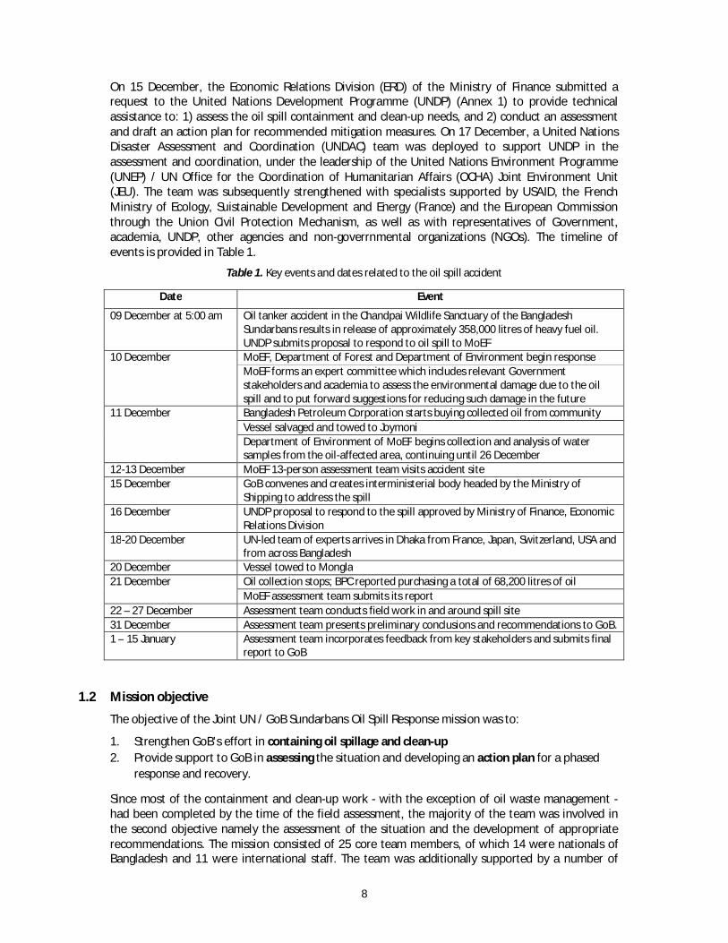
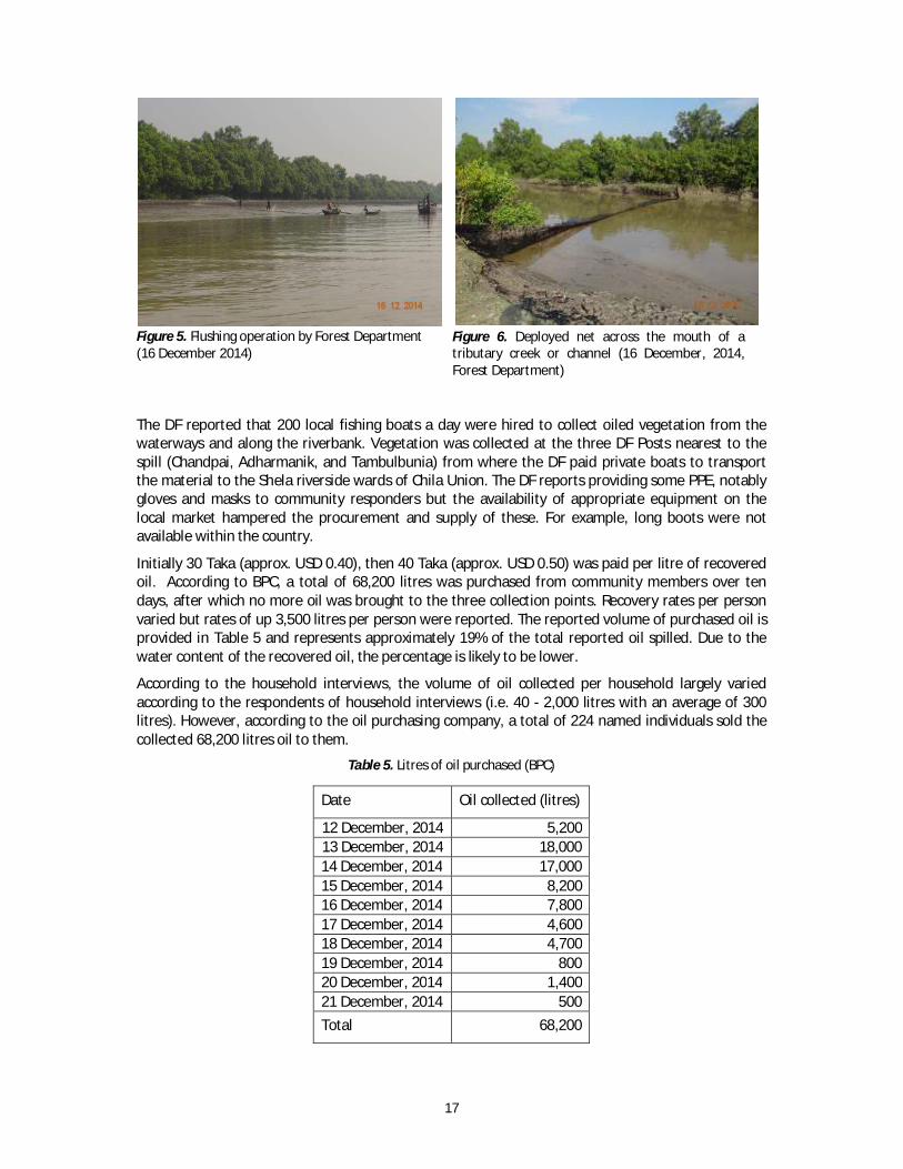
The DF reported that 200 local fishing boats a day were hired to collect oiled vegetation from the waterways and along the riverbank. Vegetation was collected at the three DF Posts nearest to the spill (Chandpai, Adharmanik, and Tambulbunia) from where the DF paid private boats to transport the material to the Shela riverside wards of Chila Union. The DF reports providing some PPE, notably gloves and masks to community responders but the availability of appropriate equipment on the local market hampered the procurement and supply of these. For example, long boots were not available within the country.
Initially 30 Taka (approx. USD 0.40), then 40 Taka (approx. USD 0.50) was paid per litre of recovered oil. According to BPC, a total of 68,200 litres was purchased from community members over ten days, after which no more oil was brought to the three collection points. Recovery rates per person varied but rates of up 3,500 litres per person were reported. The reported volume of purchased oil is provided in Table 5 and represents approximately 19% of the total reported oil spilled. Due to the water content of the recovered oil, the percentage is likely to be lower.
According to the household interviews, the volume of oil collected per household largely varied according to the respondents of household interviews (i.e. 40 - 2,000 litres with an average of 300 litres). However, according to the oil purchasing company, a total of 224 named individuals sold the collected 68,200 litres oil to them.
Table 5. Litres of oil purchased (BPC)
Date Oil collected (litres)
12 December, 2014 5,200 13 December, 2014 18,000 14 December, 2014 17,000 15 December, 2014 8,200 16 December, 2014 7,800 17 December, 2014 4,600 18 December, 2014 4,700 19 December, 2014 800 20 December, 2014 1,400 21 December, 2014 500 Total 68,200
Figure 5. Flushing operation by Forest Department (16 December 2014)
Figure 6. Deployed net across the mouth of a tributary creek or channel (16 December, 2014, Forest Department)

18
The Clean-up Sub-Team used a series of land and water reconnaissance-based activities of the Shela and Pashur river system to assess the past and current response and clean-up operations. Representatives of the community were engaged, in coordination with the DF, to identify areas within the community where waste had been buried or stockpiled. Oiled debris and vegetation collected was deposited at various points throughout the community of Joymoni, located in Chila Union, particularly in Ward 7.
The survey undertaken by the Human & Livelihood Sub-Team showed that, of the villagers who reported disposing of oiled debris (including oil collectors and villagers cleaning up debris in their own community; N= 115), 41 reported taking it to the DF jetty, 22 piling it directly on the shore, 13 burying the debris, 9 piling it directly on the ground but the pile washed away in the high tide, and 14 burning the debris and then burying the remains. The remaining interviewees turned the debris over to others for disposal.
A community-based effort initiated and organized by a small group of dedicated enthusiasts to centrally locate and dewater oiled vegetation was observed at two locations. A third, larger, location for dewatering the vegetation was under construction led by the Department of Forest at the time of reconnaissance activities. Prior to the mission's presentation of preliminary conclusions and recommendations to the GoB on 31 December, four temporary storage containers made of bamboo were constructed while options for final disposal of the oiled solid waste were being evaluated.
The mission worked with the DF to identify a location where the oil impacted vegetation and debris could be managed long-term. Unfortunately, few options for long term disposal for hazardous and non-hazardous wastes exist in the region. Annex 8 provides a discussion on the current state of waste management, a suitability assessment of proposed disposal sites and elements of an oil waste management plan.
Interviews and photos from the time of response show that little to no PPE was utilized through the oil removal operation. Reports of the use of kerosene to remove oil staining from skin followed by a soap wash was a reported common practice amongst villagers that participated in oil removal operations. Annex 9 provides a discussion on the appropriate use of PPE and the management of its use.
Figure 7. Efforts to centralize oiled waste and dewater vegetation (23 December, Kawser Mohammad, UNDP)

19
2.4 Environmental impacts
2.4.1 Aquatic environment
The Aquatic Sub-Team focused on surface water, sediments and aquatic biota, evaluating the potential impact of the oil spill on the quality of water in the affected areas (including the level of oil residue in water, sediment and aquatic organisms) and the populations of aquatic organisms (including fish, shrimp, crab, molluscs and mudskippers).
The Sub-Team used existing monitoring and sampling data and visual observations to conduct its assessment. The aquatic team surveyed 40-45 km along the Shela River of the Sundarbans, from the Chandpai to the Harintana area. The team measured water depth and hydrological parameters of selected sites using portable field instrumentation. Data on dissolved oxygen and pH were collected from the Department of Environment (DoE). Data and a map of locations visited are provided in Annex 10. Findings are presented in two sections: 1) the fate of the oil in the environment and 2) the potential impact on aquatic organisms.
Fate of oil in the environment
Oil consists of hydrocarbons ranging from volatile organic compounds (e.g. benzene, toluene, ethylbenzene and xylene - BTEX) to complex non-biodegradable ones (e.g. asphaltenes). Spilled oil in the coastal waters is acted upon by a number of chemical and physical processes, collectively known as weathering (Figure 8). The way in which spilled oil behaves depends largely on how persistent the oil is and its persistence in the environment depends on a series of factors including the amount and type of oil spilled together with local meteorological and oceanic conditions (currents, tides, wave action, temperature and winds).
Figure 8. Behaviour of oil in the aquatic environment (Cedre, 2007)
Following a spill, oil is found in the environment in both visible and non-visible forms. The visible forms of oil are presented in Figure 9.

20
Figure 9. Visible oils in the environment (HWM – high water-mark, LWM – low water-mark)
In the case of the Sundarbans spill, the oil observed along the river banks at the time of the field assessment work, was visible mainly in the form of oiled vegetation. There was some oiled debris noted that is likely to be remobilized at each spring tides will then drift downstream, potentially leading to sheen on the water. It is likely that such a sheen will continue to be observed in the weeks to months to come as oil is washed out from vegetation and other oiled surfaces. No free-floating oil or free-stranded oil accumulations were observed. In some locations, an oil layer was detected on the surface of intertidal mudflat, but no residue was detected in the sub-surface sediment (±5 cm) surveyed by the Aquatic Sub-Team at four sites. Table 6 summarizes the results of the mission for the various forms of oil, and recommendations on further activities to be undertaken to conclusively determine the presence of oil.
Table 6. Results of oil surveys for various visible fractions
Forms Aspects Control /result mission Recommendations
Visible
Floating oil Survey / No evidence
Update and extent the survey Stranded oil Survey / No evidence
Oil coated vegetation Survey / High evidence
Oiled debris High evidence None
Figure 10 shows the possible deposits of non-visible oils in the environment.

21
Figure 10. Non-visible oils in the environment (HWM – high water-mark)
As seen in Figure 10, non-visible oil can take the form of stranded, dispersed, dissolved, flocculated or ingested oil. Aiming at checking the potential presence of non-visible oil in the different compartments of the riverine environment, three actions have been carried out:
Samples of water, sediment and fish tissues were collected for visual assessment for the presence of oil and for further lab analysis by the Aquatic Sub-Team, (see section “Impact of oil on aquatic environment” for further information).
Buried oil (oil within shoreline sediment) has been reported by the Response Sub-Team at a single site where a thin sediment layer partly covering stranded oil deposits was observed at the upper level of a shallow slope beach. This buried oil may have resulted from the clean-up and waste storage operations (Figure 10), which took place at this site, followed by natural sedimentation. Video evidence from early in the response has indicated that oil had been pushed into the sediment during clean-up operations. The extent of buried trampled oil is likely to be limited in extent as these clean-up operations occurred only in a few sites nearest to the accident site. Sampling has been carried out along the river banks in four representative sites by the Aquatic Sub-Team: no evidence of buried oil has been observed. Representative crab holes in the most heavily oiled shores were dug out to determine presence of oil, but no oil was found.
A dedicated survey for sunken oil has been carried out adjacent to the more polluted banks (as well as in the middle of the river) by using a proven technique consisting in dragging a weighted sorbent line on the sea/river bottom (see Annex 11). No evidence of sunken oil was observed during each of the 10 transects. This partly raises doubts about the likely existence of slicks or patches of sunken oil, at least in those sections of the river. While the results do not fully exclude the possibility of oil having sunk to the bottom of the river bed (particularly through the clay-oil flocculation process), there is a low probability of the widespread occurrence of sunken oil slicks.

22
Table 7 summarizes the results of the mission for the various forms of non-visible oil, and recommendations on further activities to be undertaken to conclusively determine no presence of oil.
Table 7. Results of oil surveys for various non-visible fractions
Forms Aspects Control /mission result Recommendations
Non visible
Buried stranded oil Observation (1)
4 controls (no evid.)
Local checking (eventual survey, if positive)
Sunken oil Survey / No evidence Update and extend the survey
Dispersed oil
Dissolved oil
Ingested oil
Sampling
Control (no evidence) Monitoring on a regular basis
Impact of oil on aquatic environment
Water sampling and analysis can be undertaken to determine presence of hydrocarbons within the water column. Due to the limited hydrocarbon analysis capacity in-country, and the short timeframe of the assessment, it was decided not to conduct any separate sampling or analysis. Sampling in a fast-flowing river environment presents challenges due to the high variability of chemical, physical and biological properties in various areas whereby individual samples would be less representative than a long-term monitoring program, which can be used to assess trends. This is particularly relevant as parameters such as organic matter, dissolved oxygen and hydrocarbons vary according to temperature, water turbulence, depth and salinity. It should also be noted that phytoplankton populations are not recommended in scientific literature2 as a relevant monitoring parameter for oil spill effects in the environment - even though they are highly sensitive to light soluble oil fractions the effects are not easily measurable in-situ, as phytoplankton have a fast turnover, effective recruitment from adjacent waters and a very high natural fluctuation both in space and time. A draft sampling program aimed at improving baseline data of the riverine system is outlined in Annex 12.
Interviews with local fishermen and the collection of fish specimens were used to assess the impact of the oil spill on fisheries. A total of 16 interviews with a mix of 11 fishermen groups, 5 shrimp collectors and 26 crab catchers were conducted to evaluate the availability of key aquatic organisms. Respondents in Chandpai, Joymoni Ghol and Andermanik river areas reported an absence of fish and crab, at least for the first few days following the oil spill, but the respondents in Tambul Bunia, Alkir Char and Harintana reported little reduction in their catch. Full details of the assessment are provided in Annex 10. These findings were supported by the assessment of the Human & Livelihood Sub-Team, in which almost 60% of the interviewees reported that fish catches had declined in the immediate days after the spill.
The team members collected specimens of 20 different fish, 2 crab, 1 shrimp and 1 prawn species on 25-26 December 2014 from the Kalamula Varani, near Tanbul Bunia Forest Camp of the Shela River. Morphological and internal examination of Lates calcarifer (sea bass), Glossogobius aureus (flat head goby), Polynemeus paradiseus (paradise threadfin), Plotosus canius (venomous catfish), Scylla olivacea (mud crab), Penaeus monodon (tiger shrimp) and Macrobrachium rosenbergii (giant prawn) were conducted. These were visually evaluated for oil film, and then dissected and assessed in order
2 National Academy of Sciences. 1985. Oil in the sea: inputs, fates and effects. National Academy Press, Washington, DC, USA. 601pp. ISBN 0-309-03479-5.

23
to establish the presence of oily odour. No oil trace on the surface, or smell inside the fish, shrimp and crab was observed by the team members as well as fisherfolk.
2.4.2 Mangroves
Mangrove systems are generally considered to be among the most productive ecosystems in the world. The environmental services provided by mangrove systems include (but are not limited to) shoreline protection and stabilization, soil formation, carbon sequestration, animal habitat and food source, and water quality improvement. In Bangladesh, the riverine ecotype mangrove forests of the Sundarbans not only provide these services, but they provide an important supply of food and fibre. They are also a source of great national pride and protectiveness.
The Mangrove Sub-Team was formed with representation from the U.S. National Oceanic and Atmospheric Administration (NOAA), the Bangladesh Department of Forest, the Bangladesh Forest Research Institute, and the Bangladesh MoEF. The team integrated expertise in mangrove biology and silviculture, Sundarbans mangrove forest management, Sundarbans mangrove forest policy, and mangrove oil spill assessment and response.
Between 23 and 27 December, 2014, the Sub-Team surveyed mangrove habitat along the main channel of the Shela River and its side creeks. Because the creeks had not been accessed in many of the initial oiling assessments, and because the Extent Sub-Team determined conditions along the main river, the Mangrove Sub-Team prioritized surveys of the creeks and their vegetation.
Nine creeks and four forest floor sites were assessed for oiling condition, mangrove health, and potential clean-up actions. In addition, oil found on vegetation was tested for mobility, and potential routes for vertical penetration into the mud and clay shoreline substrate (e.g., crab burrows) were assessed.
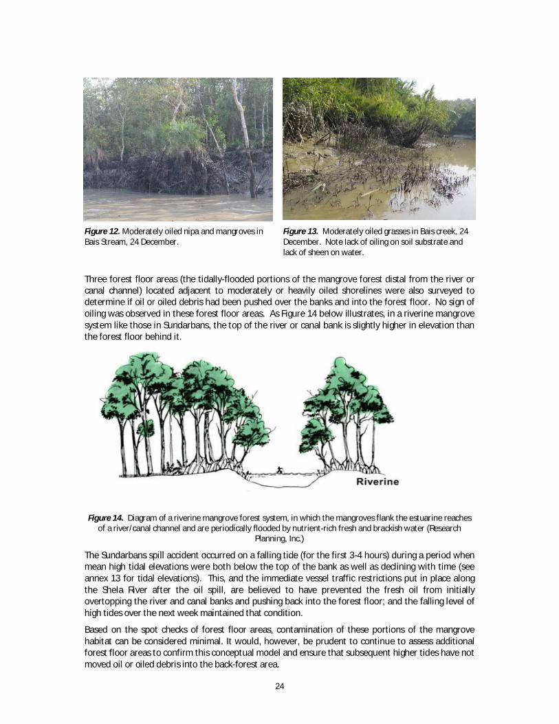
Eight of the nine creeks surveyed were classified as having either trace or low amounts of surface oiling on mangroves (i.e., leaves, trunks, prop roots, pneumatophores) and soil substrates. The vegetation in the ninth, Bais creek, was categorized as moderately oiled (see Figures 12 and 13 below). No substantive oiling was noted on the shoreline soil substrate of any of the creek.
Figure 11. Morphological and internal examination of Lates calcarifer (sea bass) from the Shela River on 26 December 26, 2014
24
Figure 12. Moderately oiled nipa and mangroves in Bais Stream, 24 December.
Figure 13. Moderately oiled grasses in Bais creek, 24 December. Note lack of oiling on soil substrate and lack of sheen on water.
Three forest floor areas (the tidally-flooded portions of the mangrove forest distal from the river or canal channel) located adjacent to moderately or heavily oiled shorelines were also surveyed to determine if oil or oiled debris had been pushed over the banks and into the forest floor. No sign of oiling was observed in these forest floor areas. As Figure 14 below illustrates, in a riverine mangrove system like those in Sundarbans, the top of the river or canal bank is slightly higher in elevation than the forest floor behind it.
Figure 14. Diagram of a riverine mangrove forest system, in which the mangroves flank the estuarine reaches of a river/canal channel and are periodically flooded by nutrient-rich fresh and brackish water (Research
Planning, Inc.)
The Sundarbans spill accident occurred on a falling tide (for the first 3-4 hours) during a period when mean high tidal elevations were both below the top of the bank as well as declining with time (see annex 13 for tidal elevations). This, and the immediate vessel traffic restrictions put in place along the Shela River after the oil spill, are believed to have prevented the fresh oil from initially overtopping the river and canal banks and pushing back into the forest floor; and the falling level of high tides over the next week maintained that condition.
Based on the spot checks of forest floor areas, contamination of these portions of the mangrove habitat can be considered minimal. It would, however, be prudent to continue to assess additional forest floor areas to confirm this conceptual model and ensure that subsequent higher tides have not moved oil or oiled debris into the back-forest area.

25
Assessment of the tendency of oil to mobilize from vegetation was tested with a sample of oiled intertidal grass collected at the Nundawalla Forest Camp on 23 December (Figure 15) and oiled nipa leaf collected in the Bais Canal on 24 December (Figure 16). In both cases, submergence of the oiled vegetation in river or canal water resulted in sheening, but not a release of heavier (i.e., dark) oil. In the case of the oil on the leaf of Nypa fruticans, commonly known as the nipa palm, slight heating (on a finger and exposed to direct sun) caused the oil to become noticeably more liquid.
Figure 15. Sheen released from oiled grass from Nundawalla Forest Camp upon immersion in river water, 23
December. Photo by G. Shigenaka.
Figure 16. Testing for release of oil from the leaf of Nypa fruticans in Bais Canal, 24 December. Photo by Zia
Islam.
The range of oil residues observed on the vegetation was not sufficient to require any directed removal action; the action itself and the disturbance associated with bringing personnel into the forest were determined to likely cause more adverse impact than the potential impacts of the oil itself. The extent and degree of heavy oiling has declined dramatically since the first days of the spill, and is expected to continue to diminish with time (although likely at a reduced rate). The spilled oil type, heavy fuel oil, is believed to be less acutely toxic to mangroves, but may be more persistent in the environment over the long-term than a lighter oil.
While some apparent acute effects of oil exposure (i.e., loss of leaves from some young mangrove trees at the low tide margin) were observed along two creeks, resource experts from the Bangladesh Forest Research Institute and the Department of Forest also noted that new growth had already

26
begun to appear on the plants. The below-ground root structure of the affected seedlings was also examined and judged to be normal (Figures 17 and 18).
Figure 17. Defoliated mangrove seedlings in Tangrar Canal, 26 December. Note new leaf growth on some of
the plants. Photo by G. Shigenaka.
Figure 18. Shallow roots of defoliated mangrove seedlings excavated near Harbaria, showing normal structure.
Photo by G. Shigenaka.
Nypa fruticans, commonly known as the nipa palm and locally, as golpata, is a species of palm native to the coastlines and estuarine habitats of the Indian and Pacific Oceans. It is the only palm considered adapted to the mangrove biome. The leaves of the nipa are used by local populations as roof material for thatched houses or dwellings, as well as covered areas on fishing boats. The leaves are also used in many types of basketry and thatching. In the Sundarbans, nipa is one of the non-timber resources permitted for harvesting by the Department of Forest.

27
Figure 19. Oiled nipa along the the Shela River system, 26 December. Photo by G. Shigenaka.
As shown in Figure 19, lightly to moderately oiled nipa was encountered in several locations surveyed by the mangrove team. From a solely environmental perspective, the degree of oiling would not justify any clean-up activities. However, because this is a utilized and valued Sundarbans resource, potential actions for removing oiled vegetation without impeding on the pending harvest or damaging the resource itself were evaluated.
The preferred approach was identified as cutting of the oiled vegetation simultaneously with the normal harvest. However, the oiled leaves would be handled differently from unoiled leaves. Collectors of oiled nipa would be compensated by the Department of Forest, and contaminated material would be separated and disposed by approved methods (likely incineration). The capacity of burning facilities should be considered to avoid backlog and stockpiling of oiled leaves. As is the current practice during harvest, two leaves (one central new shoot and one side leaf) will be left intact on the plant to promote new growth.
There are relatively long sections of shoreline (e.g., near Andermanic) where nipa is consistently oiled. It is recommended to leave a few designated sections of this oiled nipa uncleaned and uncut, to compare future growth and viability with unoiled, unoiled and cut, and oiled and cut plants. This will help to provide guidance for future remedial actions if another oil spill affecting the nipa resource would occur.
2.4.3 Wildlife
The Wildlife Sub-Team was formed with representation from UC Davis, the Bangladesh Department of Forest – Wildlife Division, and the Wildlife Conservation Society (WCS). The team therefore effectively included and utilized expertise in oiled wildlife response, local species biology and behavior (especially those of high conservation value, such as Irrawaddi and Ganges River Dolphin and Royal Bengal Tiger), and advanced knowledge in the ecosystem that those animals inhabit.
The overall objective of the wildlife assessment was to:
Evaluate the short term acute impacts of the oil spill on wildlife in the affected area, and
Develop a long-term monitoring plan to evaluate the chronic effects of oil spill on key wildlife species.
The oiled regions were evaluated through site assessments to determine apparent signs (e.g., external oil on wildlife) and potential impacts of oiling (e.g., mortalities, behavioural abnormalities) of wildlife. A standardized methodology for categorizing observations by all personnel was established and tactics implemented using specific Search Effort and Observation documentation

28
(See Annex 14). Targeted open water, shoreline, and terrestrial (where possible) surveys were conducted in key areas of high wildlife concentrations using dedicated wildlife personnel and assets. Wildlife experts were additionally embedded into other assessment teams in order to expand overall coverage of surveyed areas. Data were compiled to acquire estimates of proportions of observed wildlife affected by oil (by species, and by area).
Between 23 Dec and 27 December, 27 discrete searches were undertaken by personnel equipped with standardized data collection forms, binoculars, a global positioning system (GPS) device, and an identification guide prepared for key wildlife species. Within these searches, a total of 82 wildlife sightings were recorded, totalling 108 animals. Of these, three birds (one greater egret, one intermediate egret and one crested serpent eagle) were determined to have light oiling (2-25% coverage of the body) and two (one intermediate egret and one bubul sp.) were suspected of having trace oiling. Numerically, egret species appeared to be the most commonly oiled species, with 15% of the total birds having some oiling noted on the feathers. The results are summarized in Figure 20.
Figure 20. Distribution of wildlife species and observed oiling status
A compilation of reports and with confirmatory photodocumentation from on-scene personnel prior to 23 Dec have resulted in confirmed oiling in one smooth-coated otter (found dead), one additional intermediate egret, one estuarine crocodile, and one water monitor (all photographed alive but having unknown fates). Full post-mortem examination of the otter found visible oil in the oral cavity and lesions suggestive of oil intoxication (e.g., lung consolidation, liver pathology). Careful examination of an available photograph of an Irrawaddy Dolphin found dead by the media on 14 Dec

29
did not find evidence of external oiling. The DF and WCS had attempted to find the body of the dolphin in order to conduct a full post-mortem examination, but the body was not located.
According to data provided by Dr. Abdullah Harun Chowdhury of Khulna University, who performed a visual evaluation of the spill region from 11 to 25 December 2014 in 15 different locations near the spill site, 27 oiled animals (five frogs, two monitor lizards, two crocodiles, 17 egrets, and one otter), were observed in the approximately two weeks following the spill, with species distributions similar in nature to this rapid assessment. Data and photodocumentation from this study, however, was not available during the UN rapid assessment, therefore cases cannot be confirmed or reconciled for the present report.
Figure 21. Heavily oiled Water Monitor (13 Dec, Photo by Rubaiyat Mansur, 22.35195 N, 89.63906 E)
Figure 22. Trace oiled (behind right rear leg) Estuarine Crocodile (Photo by Jahidul Kabir, 25 Dec near
Andharmanik)

30
Figure 23. Lightly oiled Intermediate Egret (Photo by Jahidul Kabir, 25 Dec near Andharmanik)
Figure 24. Lightly oiled Intermediate Egret (Photo by Michael Ziccardi, 26 Dec, 22.27839 N, 89.61401 E)
2.5 Human and socioeconomic impacts
The objective of the Human and Livelihoods Sub-Team assessment was to understand the impact of this incident on peoples’ health and livelihoods. The assessment focused specifically on Sundarbans resource dependent groups as the most impacted groups. Interviewees were chosen so as to ensure an appropriate gender and age balance.
Field observation of the oil spill spread areas near to homesteads, low lying crop fields, ponds, shrimp culture ghers3/enclosures were undertaken. These observations were followed by a first round of discussions with local government representatives, who confirmed that the most impacted communities live adjacent to the Pashur and Shela river banks in Wards 4, 5, 7, 8 and 9 of Chila Union. Figure 25 shows the location of the affected communities that covers the villages of Joymoni Dakshin, Joymoni Moddhya, Joymoni Uttar, Gabgunia and Paschim Chila. The population of the affected area is 8,373 (of which 4,244 are male and 4,129 female within 2,042 households).
3 Piece of land surrounded by a raised dike, used for shrimp farming.

31
Figure 25. Villages where interviews were conducted to assess perceived health and livelihood impact.
The effects of the oil spill among the approximately 8,373 people in the most affected communities were assessed through:
Field observation of the oil spill and spread areas (on the Shela and Pashur river banks, homestead, low line crop fields, ponds, shrimp culture ghers/enclosures);
A systematic interview survey of 159 persons representing 159 households, located within the lowlying riverbank area, based on standardized questionnaire;
Semi-structured interviews; and Focused group discussions.
Overall three focus group discussions (FGDs), thirteen semi-structured interviews (SSIs), and 159 household interviews were conducted as part of the rapid assessment. Respondents were selected randomly; capturing the main occupational groups of the affected areas. Of the total household interviews, 106 were male and 53 were female. More men than women were interviewed, as men had been more involved in the recovery operations. The average age was 40.3 years with a range between 17 and 80 years. The interview survey focused on livelihoods and health perceptions, and did not in detail go through the mode of exposure or provide health advice (see Questions and metholodogy in Annex 15). FGDs and SSIs were conducted to assess the perceived health and livelihood impacts over a wider area and also to triangulate the interview survey results. The respondents of the assessment are heterogeneous with regards to livelihood, with the oil collectors and non-collectors having the professions of shrimp post larvae collectors, housewives, fish businessmen, shet (those who purchasing the shrimp post larvae in bulk quantity), forest resource collectors (crab, fuel, fodder, leaves). An interview with the doctor deployed by the district administration to conduct a health assessment between 13-15 December was also carried out.
2.5.1 Health impacts
Oil can enter people’s bodies when they breathe air, bathe, eat fish, drink water or accidentally eat or touch oiled debris, soil or sediment that is contaminated with oil. Oil contains many compounds that can be harmful to humans, primarily volatile organic compounds (VOCs), including PAHs, as well as sulphur- and nitrogen-containing compounds and metals. When oil is burned, additional PAHs can be formed as combustion by-products along with small dust particles. The dose and duration of oil exposure will directly influence the potential health effects. Typical effects from direct exposure to oil or burning oil in sufficiently high concentrations include short-term respiratory problems, skin, eye

32
and throat irritation and headache. Ingestion of hydrocarbons can lead to nausea and diarrhoea. When it comes to fish, finfish (unlike shellfish) efficiently metabolize hydrocarbons – meaning that fish is unlikely to be a source of significant contamination. Environmental contamination associated with oil spills and the fear of effects to potential livelihoods can also cause stress among affected communities.
Of the 159 respondents, 115 or 72% reported being involved in oil / oiled debris or vegetation collection. Of these, a slight majority of the survey interviewees reported no direct health impacts of the oil spill (87). Respondents perceiving health impacts reported these to have occurred during the collection and disposal of oiled debris, not duing the actual oil collection. Of those interviewees reporting adverse health effects, 55 reported difficulty in breathing, 27 reported eyes burning, 20 reported headaches, eight (8) reported vomiting, and four (4) reported itching. About half of the interviewees with symptoms reported them as mild and the remaining half as strong. Generally respondents reported symptoms being temporary and having ceased after oil collection was stopped – with itching reported as ongoing for a week or slightly more.
According to information received from interviews and the local clinic, no one was admitted either at the village community clinic at Katakhali or at distance health service structures. The doctor who had carried out a health impact assessment among around approximately 40 community representatives between 13-15 December reported limited health impacts and complaints. No laboratory tests were undertaken at that time. The workers were reportedly advised by the DF to use minimal safety precautions including wearing masks. It should be noted that simple masks would not provide adequate protection to the chemical compounds. Suitable masks were not available on the local markets and could therefore not be provided. Healthcare workers were also informed to direct suspect cases to the district doctor.
There were no signs of visible oil at the two ponds adjacent to the river. The crop fields, ponds and shrimp culture ghers were also not visibly contaminated by oil. This may have been due to the precaution by the farmers who did not release water into their crops and ponds for the first two weeks after the spill in order to avoid contamination. The Human and Livelihood Sub-Team observed oiled fishing gears at the homestead areas of the affected community, also confirmed by the Clean-up Sub-Team. The community reported not having collected drinking water from both the rivers in the two weeks following the spill due to visible oil on the water. During this time people fetched water from a long distance or purchased water at a high cost.
The mission did not include medical expertise and was therefore not in a position to in detail assess the health impacts to communities or responders. Reports from the local clinic, doctors and community members involved in the response indicate that the experienced health impacts were temporary. In order to establish the long-term or possible chronic effects of the oil spill to the oil collectors and affected communities, additional health surveys may be undertaken.
2.5.2 Impact on Livelihoods
Most of the respondents from Joymoni area reported adverse health (when asked, they classified the health impact as “strong” on a scale from no, mild to strong impact) and livelihood impacts from the oil spill for the first two weeks after the spill, while people close to Chandpai Bazaar generally reported no adverse health and livelihood impacts from the oil spill. A large majority of the interviewees reported damage to their fishing gear (81.8%) and clothes (81.1%), while 18.2% reported the loss of domestic ducks and 5.7% reported that their drinking water supply was affected.
Most of the participants explained that due to low tide, the post larval shrimp collection was not massively impacted at the immediate time of the oil spill. Two weeks after the oil spill, respondents reported continuing the collection of shrimp post larvae during the new moon tides. Respondents did not observe or obtain data of collected shrimp dying due to the impact of oil spill. The households survey data revealed that a majority (58.5%) of the respondents reported that fish catches declined

33
versus 39% reporting no change; and 2.5% reported an increase of fish production (Figure 26). At the oil spill spot villagers reported observing a few dead fishes and crabs. As seen in the section on aquatic impacts, studies to ascertain any possible chronic effects on aquatic resources should be conducted as part of baseline environmental monitoring programs.
Figure 26: Collection of fish after spill
In the targeted interviews, the need to replace damaged set bag nets, current nets, mosquito nets, line nets and drift nets came up. Among those, the mosquito and current nets are illegal for fishing. The only way for purchasing a new net is to take loans from local money lenders at a high interest rate. Some fishermen also work as wage labour in paddy fields or earth moving work.
Other forest resource (crabs, honey, fuel, fodder, wood, leaves collectors) collectors did not go inside the forest for the first two weeks since the oil spill. Respondents were not able to describe any impact of the oil spill on forest resources. However, communities have expressed fear that they may lose the opportunity to go inside the forest for collecting resources.
Most of local dwellers interviewed noted that due to the oil spill, boats were not allowed to anchor at the river banks near their village. This led to a reduction in their income, as the inhabitants could not sell goods and food to traders during that time. The impact on tourism of the accident appears to be minimal, based on interviews with DF officials. During the time of the assessment a large number of tourist groups could be seen in the area, with no drop in numbers being reported by DF.

34
3. Summary
3.1 Conclusions
The incident in the Shela River represents a serious oil spill accident in a wildlife sanctuary and World Heritage and Ramsar site treasured for its unique biodiversity. Approximately 358,000 litres of heavy fuel oil were spilled from the damaged tanker. The mission focus lay in strengthening GoB’s efforts in containing the spillage and clean-up, and to provide support in assessing the situation and developing an action plan through the provision of appropriate recommendations.
When it comes to spillage containment and clean-up, the operations are completed with the exception of the management of oiled waste. The BPC reported that 68,200 litres had been purchased, based on payment records to local communities – representing approximately 19% of the oil spilled. Remaining oil on shoreline and vegetation, apart from nipa leaves, does not warrant further clean-up action after consideration of net environmental benefits. The removal of oiled debris, the management of response generated waste, and the assessment of a final disposal option is ongoing and should continue until complete. Efforts are underway to identify and relocate oil impacted debris and vegetation to centralized dewatering cribs. The MoEF is evaluating potential disposal options and is working with partner Ministries, affected communities and local authority representatives to determine a suitable location.
With respect to the response, the lack of a formal oil spill contingency plan; which among other things designates an appropriate competent authority to oversee the response as well as the limited experience and response infrastructure, made response and recovery efforts challenging. Despite these limitations, the concerted efforts of the DF, such as the provision of nets to limit the spread of oil into tributaries, and the coordination of oiled vegetation collection, reduced the impacts.
For a few community members, the incentive scheme helped to compensate for the loss of income from a loss of fishing days, destroyed fishing gear and unsalable contaminated catch. Notwithstanding the rapid community efforts to remove oil from the river system the lack of training, appropriate equipment and experience resulted in unintended negative impacts to the environment and the local community. The delay in supply of personal protective equipment caused, at least temporarily, immediate health impacts among the community responders, who reported short-term difficulties in breathing, headaches and vomiting.
On-site observations, satellite and aerial imagery as well as bottom surveys imply that most of the oil released has either been washed out along the Shela and Pashur rivers or contained by shoreline vegetation. Timely tidal variations and the decision to ban tanker traffic in the Shela River immediately after the accident occurred, minimized the penetration of oil into the mangrove ecosystem from the waterways. Even so, the main shorelines 40 km up- and downstream of the incident site, excluding creeks, show varying degrees of oil residue contained in the vegetation.
With respect to the effects of the oil on the mangrove environment, no visible impact on the mangrove forest floor due to the accident has been observed. No oil or oiled debris was found to have moved beyond the shoreline adjacent to the rivers and canals in the broader forest habitat. Had the oil and oiled debris spread, they would have presented immense logistical challenges for both detection and remedial action and significantly increased the severity of spill effects. Minor mangrove seedling impacts were noted, but new growth was already observed on affected plants. Because of this, immediate and short-term impacts of the oil spill to mangroves may be limited.
Initial acute impacts to wildlife from this spill, based on observable mortality and visible oiling on and/or behavioural changes to live animals, appear to be limited in scope. Geographically these effects are focused no farther south than Andharmanik. This finding should not be interpreted as “no effect”, as there may be subclinical or sub-apparent impacts present that were not observable during this rapid assessment. Additionally, there may have been significant non-observable acute impacts to
35
wildlife populations, as it was difficult to fully assess the region (especially terrestrial environments) and because the rapid assessment activities occurred almost two weeks following the oil release.
When it comes to the fate of the residual oil in the environment, it is too early to make any comprehensive judgments vis-a-vis potential impacts. Data recorded immediately after the spill shows no decline in fish and invertebrate species but about half of interviewees in local communities reported a decline in catch.
When it comes to human and socio-economic impacts, the assessment revealed that the impact on livelihoods was intense during the first two weeks due to refraining from fishing and collecting forest resources by local community members. While many fisherfolk lost their nets and tools for income-generation, other community members suffered the loss of domestic livestock (i.e. ducks due to oiling). A very small percentage of community members received a short-term economic benefit from the oil recovery scheme. The long-term effects on livelihoods, food security and health cannot be assessed in the allocated timeline of this rapid assessment. The oiling of nipa palm could temporarily be disruptive to communities engaging in palm leaf harvesting, and additionally cause health concerns and waste disposal issues.
While the analysis of the rapid assessment is encouraging in terms of immediate impact, it does not reduce or eliminate the need for monitoring of mangrove ecosystem conditions and health in the future. Mangrove systems offer unique and important opportunities for assessment of longer-term or chronic effects from the oil spill. The work conducted by the Joint Mission in terms of oil extent assessment, mangrove, wildlife and fisheries monitoring, provides a solid platform on which to construct a more robust surveillance and monitoring program.
In conclusion, the oil spill accident within a wildlife sanctuary represents a serious wake-up call. While a number of factors limited the impact of the spill, the shipping of oil through a valued and biodiverse environment presents a substantial risk to both the environment and the communities that depend on it for their livelihoods. Appropriate safeguards and mitigation measures need to be put in place to prevent and prepare for oil spills in the Sundarbans and throughout Bangladesh for all significant marine routes. Caution and prudence dictate that the situation be carefully monitored for change to discern any longer-term or chronic effects to this critical habitat and that appropriate mitigation be developed as needed. Long-term monitoring should be initiated as part of the integrated resources management plans already in place for the Sundarbans.
36
3.2 Recommendations
The Mission recommends the MoEF develop an action plan to include and implement the below recommendations. This action plan should be developed in consultation with all affected stakeholders – including all relevant Ministries – and must specify responsible parties, timelines and necessary resources to monitor the impacts of the oil spill and if necessary, carry out restoration activities. Support from the international community, UN agencies and civil society can be requested for the development and implementation of the plan.
The Mission recommends the action plan be independently evaluated at six months and two years to assess the follow up of the action plan. This periodic evaluation could be performed by national experts, including key government stakeholders, relevant academia and civil society - with possible participation of the UN or other international organizations as deemed necessary. This will support accountability and sustainability in addition to providing recognition to stakeholders for what has been accomplished after the report, and for assessing if modifications are needed or possibly new recommendations added.
Below are the mission’s recommendations to: 1) address the impact of the spill on the environment and affected communities, and 2) reduce the risk of additional oil spills going forward. Recommendations are listed in order of priority, with timeframes specified where possible.

37
ADDRESSING THE IMPACT OF THE SPILL
Issue Recommendation Additional information 1. An estimated 30-50MT of oiled vegetation
and other debris remains in temporary storage structures close to the communities. This will begin to decompose, pose a health hazard to local communities and remain a source of potential re-oiling of the area if the storage fails.
Accelerate efforts to quickly and safely dispose of all solid oiled waste and develop and implement a comprehensive management plan to ensure the waste does not re-contaminate the environment.
The MoEF, in coordination with other appropriate agencies, authorities and stakeholders, should develop a comprehensive management plan for the solid oiled wastes generated from the spill and the community based response effort. This plan should include collected waste and all oiled materials and debris currently residing within the community.
2. The mission had only limited time to assess the scale and extent of oil spread through the area.
Continue oil spill surveillance with the support of Department of Forest, and tourism personnel.
An oil spill reporting system should be set up as a mechanism for all relevant parties withn the Sundarbans to report observations of oil and other marine pollution.
3. The mission found little evidence of immediate acute impacts of the oil spill on the environment. However, impacts on mangrove trees and other flora and fauna may be delayed.
Continue oil spill, mangrove and wildlife surveillance with the support of Department of Forest, and tourism personnel, and through planned and existing programs.
A re-survey of affected mangrove areas should be conducted at different times over the next year, and particularly pre- and post-monsoon season. In the event of discernible impacts, restoration measures should be considered if relevant and practical. Mortalities of key wildlife species in the area of heavy/ moderate oiling are to be reported and assessed for presence/ absence of oil.
4. Oiled nipa palm leaves still remain along the banks of the rivers in some areas.
Safely remove moderately to heavily oiled nipa leaves and dispose of appropriately.
An existing harvest program for nipa can be used as a vehicle for the removal of oiled nipa in the spill-affected area. However, the oiled vegetation should be handled differently and will have a separate waste stream dependent on the availability and capacity of safe disposal facilities. Established practices for nipa harvest (i.e., the requirement to leave two leaves intact) should be followed. Also, reference areas in which oiled nipa plants will be left untreated should be designated in order to provide insights for management of nipa in future spill events.
5. The local villagers collecting and extracting the spilled oil did so without protective equipment and have reported health problems.
Support community responders with health check-ups and initiate a community health monitoring program.
An intensive health study is required to be conducted as early as possible for oil collectors and affected communities to idenitfy any health effects attributable to the oil spill. Based on the findings, a long-term health monitoring program can be initiated.

38
REDUCE RISK GOING FORWARD
Issue Recommendation Additional information 6. The communities affected by the oil
spill suffered financial loss due to fishing interruption.
Explore avenues for compensation. The affected communities may availed the opportunity to claim compensation for lost income due to oil spill through the death of their poultry and refraining from fishing. Particular attention is required to ensure that the compensation makes it directly to the oil affected commnuties members.
7. The local communities within Sundarbans rely heavily on the exploitation of natural resources within an area of worldwide environmental importance.
Promote suitable alternative livelihoods for Sundarbans resource-dependent communities
The GoB should promote concrete livelihood options for the affected fisherfolk who lost their nets and/or whose catch has been significantly reduced. Such alternative livelihoods might include, among others, employment in local industry with the goal of reducing dependence of local communities on resource extraction from the Sundarbans ecosystem.
8. A major obstacle to assessing the impacts of the current oil spill incident has been a lack of useful reference data.
Lay the foundation of a long-term environmental monitoring plan that will provide useful data for the impact assessment and monitoring efforts in the event of future pollution incidents.
Exisiting and planned environmental monitoring programmes within the Sundarbans should be evaluated for suitability for modification to ensure relevant data on water quality, pollutants within the environment and flora and fauna are collected. Monitoring of edible resources for potential health issues should be included. A dedicated environmental monitoring and survey station for the Pashur rivers could be set up under the MoEF.
9. The management of vessel traffic through the Sundarbans and measures taken to prevent pollution incidents are currently weak and need to be addressed to help mitigate the risk of future pollution.
Strengthen the inland vessel management regime; implement and enforce measures to manage marine traffic in the approved navigation channels of the Sundarbans In the Shela River: There is an immediate need to stagger the large number of vessels waiting to pass; ban passage during night hours and fog; and prohibit all anchoring in the channel except in an emergency. Throughout the Sundarbans: Implement and enforce internationally-accepted safeguards
Initiate a study of the environmental, economic and social implications of various shipping routes, with the objective to find an alternative route to the Shela river that minimizes environmental risk to the Sundarbans. The regime should include a program to improve and maintain a system of aids to navigation for both international and domestic marine traffic.
The regime should legislate on marine insurance requirements for vessels to ensure that they provide adequate provsion to cover the likely costs of pollution incidents.
The regime should ensure that vessels operating in Bangladesh

39
and measures such as vessel spacing, navigational operational restrictions (eg, vessel speed limits), regional anchoring prohibitions and hazardous cargo specifications and restrictions.
waters comply with standards of vessel construction and operations as designated under the international classification societies.
10. The current level of contingency planning and preparedness for oil spills and similar pollution incidents is very low in Bangladesh.
Adopt oil pollution response regulations in accordance with international best practices. Adopt and enact the draft national oil contingency plan. The GoB should speed up the enactment of the Marine Environment Conservation Act, 2004, creating a regulatory environment that would have the goal of controlling vessel-source marine pollution in Bangladesh’s marine environment. The Bangladesh Government should implement its obligations under the International Convention on Oil Pollution Preparedness, Response and Co-operation (OPRC) Convention it has ratified and consider ratification of further international conventions related to oil pollution.
Enactment of the Marine Environment Conservation Act, 2004 would clarify the role and mandate of those agencies tasked with its enforcement and strengthen oil spill preparedness and response measures as well as allow for the adoption of a liability and compensation regime. The legislative instrument should include the requirement to establish the following response components; development or adoption of an incident management regime and the development and implementation of a damage claims and compensation program. The OPRC Convention provides a framework for developing an effective response capability and contingency plan for oil spill response. Support to revise the oil spill contingency plan and implement the convention is availabe through the International Maritime Organisation (IMO). The national oil spill contingency plan can be further developed using a review/planning committee to integrate lessons learned, identify gaps and continuously improve through drills, exercises, workshops and training courses. Further Conventions that should be considered for ratification include the International Convention on Civil Liability for Oil Pollution Damage (CLC92), the International Oil Pollution Compensation Funds (IOPCF) and the International Convention on Civil Liability for Bunker Oil Pollution Damage (Bunkers01)4.
4 The International Convention on Oil Pollution Preparedness, Response and Co-operation convention aims at providing a global framework for international co-operation in combating major incidents or threats of marine pollution http://www.imo.org/About/Conventions/ListOfConventions/Pages/International-Convention-on-Oil-Pollution-Preparedness,-Response-and-Co-operation-(OPRC).aspx. The International Oil Pollution Compensation Funds are three intergovernmental organisations which provide compensation for oil pollution damage resulting from spills of

40
Regional cooperation in response to an oil spill incident can be strengthened through engagement in relevant regional initiatives. Oil spill contingency planning elements should also be included in the Sundarbans Reserve Forest management plan. On all of above issues, capacity development capacity of staff should be an integral element.
persistent oil from tankers. The Bunkers Convention was adopted to ensure that adequate, prompt, and effective compensation is available to persons who suffer damage caused by spills of oil, when carried as fuel in ships' bunkers. http://www.iopcfunds.org/ http://www.imo.org/About/Conventions/ListOfConventions/Pages/International-Convention-on-Civil-Liability-for-Bunker-Oil-Pollution-Damage-%28BUNKER%29.aspx

41
4. References
Asian Development Bank. 2004. Institutional Strengthening of Chittagong Port Authority in Environmental Management. ADB. 177 pp.
Asian Development Bank. 1998. Summary Initial Environmental Examination for Sundarbans Biodiversity Conservation Project in Bangladesh. ADB. 29 pp.
Cedre. 2007. Black Tides. In Learning Guide collection. Cedre Editor, Brest, ISBN 978-2-87893-086-3, 118p.
Chowdhury, A. Impact of Oil Spillage on the Environment of Sundarbans (World Largest Mangrove Forest) in Bangladesh – Draft Report. Khulna University. 16 pp.
IUCN. 1997. World Heritage Nomination – IUCN Technical Evaluation, Sundarban Wildlife Sanctuaries, Bangladesh. IUCN. 25 pages.
Department of Forest. 2010. Integrated Resources Management Plans for the Sundarbans (2010 – 2020), Volume 1. Dhaka: Department of Forest, Ministry of Environment and Forests. 323 pp.
Hoff, R. (ed.). 2012. Oil Spill in Mangroves – Planning & Response Considerations. Seattle: NOAA Ocean Service, National Oceanic and Atmospheric Administration 72 pp.
Le Floch S., Guyomarch J., Merlin F., Stoffyn-Egli P., Dixon J., Lee K. 2002. The influence of salinity on oil-mineral aggregate formation. Spill Science & Technology Bulletin, 8, 65-71
National Academy of Sciences. 1985. Oil in the sea: inputs, fates and effects. National Academy Press, Washington, DC, USA. 601pp. ISBN 0-309-03479-5.
United Nations Environment Programme. 2011. Environmental Assessment of Ogoniland. Nairobi: United Nations Environment Programme. 262 pp.
Yender, R., J. Michel, and C. Lord. 2002. Managing Seafood Safety after an Oil Spill. Seattle: Hazardous Materials Response Division, Office of Response and Restoration, National Oceanic and Atmospheric Administration. 72 pp.
Sundarbans Delta Vision 2050 (IUCN and WWF, 2013).
International Tanker Owner Pollution Federation (ITOPF) Bangladesh Country File.
Farooque, M., Hasan, R.S. 1996. Laws Regulating Environment in Bangladesh. 761 pp.
Karim, S. 2009 Implementation of the MARPOL Convention in Bangladesh, Macquarie Journal of International and Comparative Environmental Law 51. Page 51 - 82.
Useful links
Centre of Documentation, Research and Experimentation on Accidental Water Pollution (CEDRE), www.cedre.fr/en/publication/index.php
Environmental Emergencies Centre, www.eecentre.org
International Tanker Owners Pollution Federation (ITOPF) www.itopf.com
Global oil and gas industry association for environmental and social issues (IPIECA), www.ipieca.org
International Maritime Organization (IMO), www.imo.org
IOPC Funds, http://www.iopcfunds.org/
NOAA Office of Response and Restoration, www.response.restoration.noaa.gov OPRC, http://www.imo.org/About/Conventions/ListOfConventions/Pages/International-Convention-on-Oil-Pollution-Preparedness,-Response-and-Co-operation-(OPRC).aspx

42
Annexes
Annex 1. Request for assistance
Annex 2. Team composition
Annex 3. Mission agenda
Annex 4. Field Observation Locations
Annex 5. List of consulted stakeholders
Annex 6. Satellite imagery
Annex 7. Unmanned Aerial Vehicle survey
Annex 8. Waste Management and Disposal Considerations
Annex 9. Personal Protective Equipment Considerations
Annex 10. Aquatic Environment Assessment Report
Annex 11. Sunken Oil Survey
Annex 12. Proposal for Elements of an Aquatic Monitoring Programme
Annex 13. Mangrove Assessment Report
Annex 14. Wildlife Assessment Report
Annex 15. Assessment of Human and Socioeconomic Impacts
Annex 16. Chemical characteristics

43
ANNEX 1. Request for Assistance
G<>v<mme", of ,"" 1'<opIt., RtpobIic "'~ Mi, ;".,.of ~""'"
!"«>nomic kd ., .... U;,-u;.,. (EHD) U.O.-...)
_·0"11""-. DhaIuo·1205 u· ... m! ro, btl
("U I L01H1C.OO. 16 .WU_lh
S'~i<"<" 1.""0<1 .. ". ,0"."""",. "' ...,~ .. "'" «;"i, <......0 by f...-, 0;1 ...,.,J< in s...Ioob.uo, " ... ,I",,,,h
The ~."... ;" ~it«I'" '" r<qIIO~ UNDf' '" """ . .., 00«""", .,.iolan« '" tool.lo '" ,,;,,, .... ... boon , .......... '" <apoi;;< or -. od <OtT)'iol5hip 'SooII><m St.·)' ill Slltl. ri ...... ". ..
S~ "" 0'iI_12_20 " . Imm<disle ""'........, io Ii>< """"' ''' ''''' .'co • .,.. l«I0 i.w:
'- Suppootioi ()(oI", dlQ.! '" «w><>i ..... "';110&< and -.u. .. ""'es5O/)' ' _'up or Ill< .n«IN..-n>;
2. Pro'>O< --""' GoB on .... _ of u.. _ "'" ond "'''Ior '' .,,, ... plan fu<
militillioo ~. plio .... _b.
y "" .... !l><r<to.-e ~irld ly ........... '" mobi ll>< lJNDf' ;"" ",., ,,,,,,1 ,""~ teom and """ . ..,
...,....,. .... ,..,.,. .. """'''''''" """'" "" OIl _'" 1>0"'-
~""... UN E)f'", <lo<bQn~ .... ..---,. EkU;" ..., ,,," i'l Ii>< Min • ..". "'I",~ ond ro"" " (M6EF) 10 tal. ~ """'" en .... fulluoo· ... i<wd roo , .. ~ UN 1' .....
,. a._of ... oni,..' .... """"UN_...-.... 2, ~"""" __ ,_""',.,".4 ., .. ........ ....,_ .. " __ i" .. _ ~.",., UN_. 1 """ .......... "' ... . __ .. __ ....... .......-0KWiQ''''',.,_.
c_.,' Oi.<t-!oo UN[}f'o(H"II~ 100 Sk>I>on. f;lA lI<iO'" kol.<,. Sharo, i ~~fl.OIIl" N ...... llh>l.. Il07
IT; fo r KI.d I,fo rm"". (10' !ISSlI!l!! .. w".!orlN
~ .V \'1
,C;" 1.-Mi,... Ali H". s.";,,.- ... .......... !k<,.,"Y
UN O_ll--OI ,,<.OJ 17~~; I."""
01, 50."" S«"""Y. The _ MiIIi .... ', O!ft«. T.jpoo. DI»IoI, 01 So .... """"'Y. "';,i>try ofl!<om< Affaia, ~I"",," S«"""""-~ .. IOOO OJ "",....,.. Mi,,,,,,. orF"",,,,, Aff ..... So"" ~ic~io, !JhH;. - IOOO 1)4, s«.-....y. ).I io;,.". ofSO i"", .. D_I,.;",t, "" ........... l>h>b _IOOO O~, !k<f<Ia<)'. ).I ioi>l.,. of E., i"",,,, ... _ f'",,",,~ _11><1<>11 s..;.-.. \, DIuoI:.·IOOO
06. Clu.i ........ NIIR. $0"", ~"II~"" [}Iu." - IOOJ

44
ANNEX 2. Team Composition
Joint UN / GoB Sundarbans Oil Spill Response Team
Country Organization Name Focus
Finland UNDAC / UNEP/OCHA Emilia Wahlstrom Team Leader
Bangladesh UNDP Khurshid Alam Deputy Team Leader
Sweden UNDAC Per-Anders Berthlin Assessment Coordinator
Japan UNDAC Haruka Ezaki Reporting and Logistics
Bangladesh UNDP Alamgir Hossain Field Operations Coordinator
France CEDRE Loic Kerambrun Oil spill intervention expert
Bangladesh Government Syed Mehedi Hasan Deputy Secretary MOEF
Bangladesh Department of Forest Zahir Uddin Ahmed DFO, Sundarbans West Division
Bangladesh Department of Forest Md. Jahidul Kabir DFO (CC), Wildlife & Nature Conservation Division
Bangladesh Bangladesh Forestry Research Institute
Dr. Masudur Rahman Divisional Officer, Mangrove Silviculture
Bangladesh Department of Environment Md. Mustafizur Rahman Akhand Deputy Director
Bangladesh Department of Environment Solaiman Haider Deputy Director
France CEDRE, supported by the European Union Emergency Response Coordination Centre through the Civil Protection Mechanism
Stephane le Floch Oil spill intervention expert, Extent Sub-Team Leader
USA National Oceanic and Atmospheric Administration
Gary Shigenaka Biologist/ chemical expert, Mangrove Sub-Team Leader
USA UC Davis Prof. Michael Ziccardi Oil spill intervention/ wildlife expert, Wildlife Sub-Team Leader
USA US Coast Guard CDR Keith Donohue Oil spill response expert
USA USAID/Bangladesh Colin Holmes Environmental Assessment, Information Management

45
Canada UNDP consultant Ryan Wheeler Oil spill intervention expert, Clean-up and Response Sub-Team Leader
Bangladesh Chittagong University Prof. Shahadat Hossain Marine ecosystems, Aquatic Sub-Team Leader
Bangladesh Chittagong University Prof. Sayedur Rahman Chowdhury Geo-spatial expert (extent)
Bangladesh Khulna University Dr. Khandaker Anisul Huq Aquatic Biodiversity
Bangladesh Dhaka University Prof. Badrul Imam Petro- geologist
USA Wildlife Conservation Society Brian Smith Wildlife expert
Bangladesh UNDP Sifayet Ullah Logistics/ Disaster Management
Bangladesh UNDP Kawser Ahmed Shaikh Mohammad Communications
Bangladesh UNDP Ikbal Faruk Livelihoods, Livelihood Sub-Team Leader
Bangladesh UNDP Man Thapa Livelihoods, disaster risk reduction
Bangladesh UNDP Farida Shahnaz Livelihood and gender
Bangladesh UNDP Sharif Ahmed Bhuiyan Security
Assessment Support Staff
United Kingdom The International Tanker Owners Pollution Federation Limited (ITOPF)
Mark Whittington
Oil spill intervention expert
Bangladesh Wildlife Conservation Society Rubaiyat Mansur Extent, wildlife, UAV
Bangladesh Wildlife Conservation Society Mahmudur Rahman Extent, wildlife, UAV
Bangladesh Wildlife Conservation Society Elisabeth Mansur Wildlife, livelihoods
Bangladesh Wildlife Conservation Society Manish Datta Livelihoods
Bangladesh Wildlife Conservation Society Farhana Akhtar Livelihoods, Livelihood Sub-Team Co-Leader

46
ANNEX 3. Mission Agenda
Date Time Agenda Present Remark
Thursday 18 December
11:00 Arrival of UNDAC in Dhaka
12.00-19.00 Meeting with UNDP UNDAC, Country Director (CD), CD ai, assistant CDs, UNDP
Friday 19 December
9:00-10:00 UNDP brief to MOEF UNDP, MOEF
10:30-13:30 UNDP Meeting UNDAC, Assistant CD,UNDP
16:00-21:00 Assessment planning UNDAC
Saturday 20 December
11:00-12:00 TL Brief with MOEF UNDAC TL, UNDP, MOEF
16:00-18:00 TL Brief with Minister of Environment and Forest
UNDAC TL, UNDP, Canadian expert, USAID, and EU expert
Sunday 21 December
11:00-12:00 Meeting with UNDP UNDAC, UNDP, Canada, France, EU, national experts
12:45-13:30 DSS Briefing UNDAC, UNDP, Canada, France, EU, national experts (Joint team)
13:30-14:00 Join team completed; introduction Joint team: UNDAC, UNDP, Deputy CD, USAID, Canada, France, EU, US, national experts
14:30-18:00 Planning Meeting for Joint UN Mission Sundarban Oil Spill
Joint team: UNDAC, UNDP, USAID, Canada, France, EU, US, national experts
Monday 22 December
08:00-16:30 Travel to Mongla Joint team: UNDAC, MOEF, UNDP, USAID, Canada, France, EU, US, national experts, WCS
Arrival of WCS and MOEF officers

47
17:00 Team got on Boat
19::00-21:00 Team Briefing
Tuesday 23 December
7:00 River boat moved to incident site Joint team: UNDAC, MOEF, UNDP, USAID, Canada, France, EU, US, national experts, WCS, assessment support
Arrival of additional MOEF officers and ECS support members
8:00-8:30 Morning briefing
9:00-13:00 Field assessment
13:30-14:00 Lunch briefing
14:00-17:00 Field assessment
18:00-19:00 Briefing
21:30-22:30 Planning meeting
Wednesday 24 December
7:00 River boat moved to down stream Joint team: UNDAC, MOEF, UNDP, USAID, Canada, France, EU, US, national experts, WCS, assessment support
Response team and Human team relocated to Mongla
7:30-8:00 Briefing
8:00-14:00 Field assessment
16:00 Relocation to another boat
17:00-18:30 Visit of Secretary of MOEF
19:00-20:00 Sub-team leaders briefing
Thursday 25 December
7:30-8:00 Briefing Joint team: UNDAC, MOEF, UNDP, USAID, Canada, France, EU, US, national experts, WCS, assessment support
8:00 Assessment start (downstream of incident site)

48
10:30 Visit of CCF to the boat
17:30 Assessment end
18:30-19:30 Briefing - sharing finding - planning of following day
Friday 26 December
7:00-7:30 Briefing Joint team: UNDAC, MOEF, UNDP, USAID, Canada, France, EU, US, national experts, WCS, assessment support
8:00 Assessment start (close to the incident site)
15:00 Clean-up meeting at Chandpai (TL, Clean-up team, UNDP)
17:00 Assessment ends
19:00 Briefing - Sharing of findings and recommendations
Joint team: UNDAC, MOEF, UNDP, USAID, Canada, France, EU, US, national experts, WCS
Saturday 27 December
5:30-11:00 Assessment (Extent) Joint team: UNDAC, MOEF, UNDP, USAID, Canada, France, EU, US, national experts, WCS, assessment support
7:30-8:00 Briefing
8:00-12:00 Assessment(Mangrove, Response, Wildlife)
12:00-12:30 Team invited to the tea on the boat by DFO
12:30- 17:00 Travel to Khulna
19:00 Briefing
Saturday 28 December
8:30-17:30 Team relocated to Dhaka Joint team: UNDAC, MOEF, UNDP, USAID, Canada, France, EU, US, national experts,

49
Saturday 29 December
9:00-17:30 Team Workshop in Dhaka Joint team: UNDAC, MOEF, UNDP, USAID, Canada, France, EU, US, national experts, WCS
15:00-16:30 Meeting with Swedish embassy at Lake Castle
TL, PA, EU expert, Swedish embassy: Ambassador, first secretary
16:45-17:15 Meeting with EU delegation TL, PA, EU expert, and Head of EU delegation
Sunday 30 December
9:00-13:00 Team workshop at UN building Joint team: UNDAC, MOEF, UNDP, USAID, Canada, France, EU, US, national experts, WCS
13:30-14:30 UNCT meeting TL, GT, LK, UNDP, RC ai
15:30-17:30 Technical meeting with MOEF Joint team: UNDAC, MOEF, UNDP, USAID, Canada, France, EU, US, national experts, WCS, assessment support,
MOEF :Additional Secretary, Chief Conservator of Forests, and Assistant Conservator of Forests
19:00-21:00 UNDP reception
Monday 31 December
9:00-11:00 Team Workshop Joint team: UNDAC, MOEF, UNDP, USAID, Canada, France, EU, US, national experts
12:00-13:00 Presentation to Minister of Environment and Forest
TL, UNRC ai, UNDP, Minister of Environment and Forest
16:00-17:00 Press Conference at Pan Pacific Shonargaon
TL, RC and MOEF
31 December – 4 January
International experts’ exist from Bangladesh
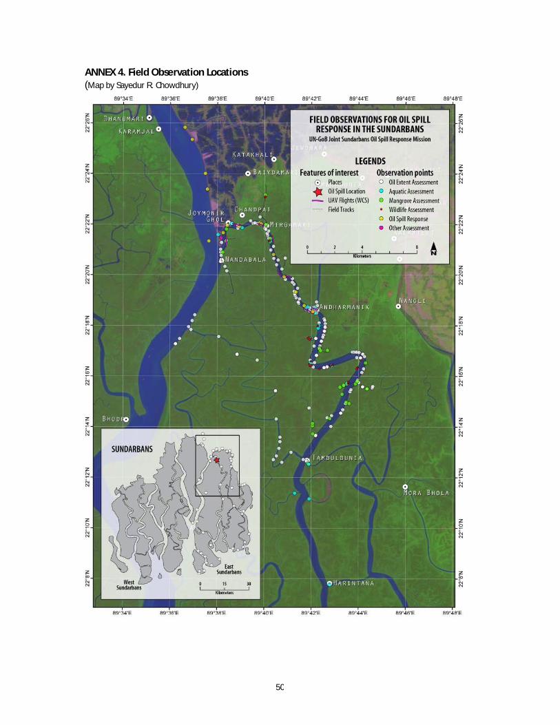
50
ANNEX 4. Field Observation Locations (Map by Sayedur R. Chowdhury)
FIELD OBSERVATIONS FOR OIL SPILL RESPONSE IN THE SUNDARBANS
lIN·GoB Joint Sundarblns Oil Spill Response Mission
LEGENDS Features of interest
o Plms
... Oil Spill location UAV Flights (W(S) Field Tracks
Observation points o Oi l ExtentAmssment a Aquatic A:»e5sment a Mangrove Asse5,menl
Wildlife Assessment o Oi l Spill Response • Other A:;sessment

51
ANNEX 5. List of consulted stakeholders
Department of Forest, Ministry of Environment and Forest Department of Environment, Ministry of Environment and Forest Mongla Port Authority, Ministry of Shipping Bangladesh Coast Guard, Ministry of Home Affaires Bangladesh Inland Water Transport Authority, Ministry of Shipping Wildlife Conservation Society (WCS) World Health Organization
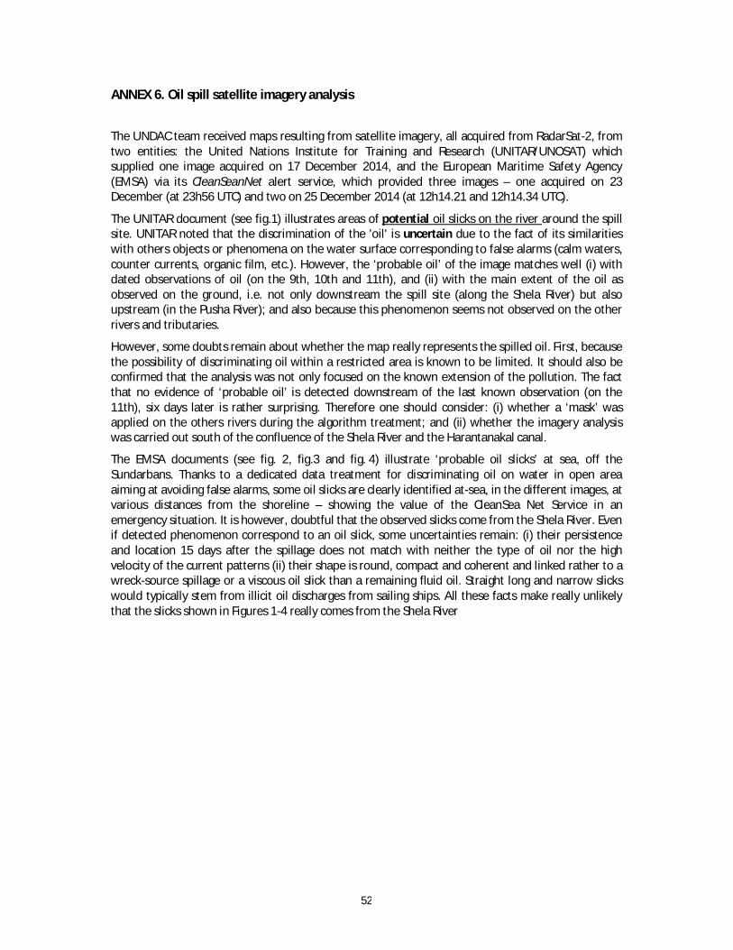
52
ANNEX 6. Oil spill satellite imagery analysis
The UNDAC team received maps resulting from satellite imagery, all acquired from RadarSat-2, from two entities: the United Nations Institute for Training and Research (UNITAR/UNOSAT) which supplied one image acquired on 17 December 2014, and the European Maritime Safety Agency (EMSA) via its CleanSeanNet alert service, which provided three images – one acquired on 23 December (at 23h56 UTC) and two on 25 December 2014 (at 12h14.21 and 12h14.34 UTC).
The UNITAR document (see fig.1) illustrates areas of potential oil slicks on the river around the spill site. UNITAR noted that the discrimination of the 'oil' is uncertain due to the fact of its similarities with others objects or phenomena on the water surface corresponding to false alarms (calm waters, counter currents, organic film, etc.). However, the ‘probable oil’ of the image matches well (i) with dated observations of oil (on the 9th, 10th and 11th), and (ii) with the main extent of the oil as observed on the ground, i.e. not only downstream the spill site (along the Shela River) but also upstream (in the Pusha River); and also because this phenomenon seems not observed on the other rivers and tributaries.
However, some doubts remain about whether the map really represents the spilled oil. First, because the possibility of discriminating oil within a restricted area is known to be limited. It should also be confirmed that the analysis was not only focused on the known extension of the pollution. The fact that no evidence of ‘probable oil’ is detected downstream of the last known observation (on the 11th), six days later is rather surprising. Therefore one should consider: (i) whether a ‘mask’ was applied on the others rivers during the algorithm treatment; and (ii) whether the imagery analysis was carried out south of the confluence of the Shela River and the Harantanakal canal.
The EMSA documents (see fig. 2, fig.3 and fig. 4) illustrate ‘probable oil slicks’ at sea, off the Sundarbans. Thanks to a dedicated data treatment for discriminating oil on water in open area aiming at avoiding false alarms, some oil slicks are clearly identified at-sea, in the different images, at various distances from the shoreline – showing the value of the CleanSea Net Service in an emergency situation. It is however, doubtful that the observed slicks come from the Shela River. Even if detected phenomenon correspond to an oil slick, some uncertainties remain: (i) their persistence and location 15 days after the spillage does not match with neither the type of oil nor the high velocity of the current patterns (ii) their shape is round, compact and coherent and linked rather to a wreck-source spillage or a viscous oil slick than a remaining fluid oil. Straight long and narrow slicks would typically stem from illicit oil discharges from sailing ships. All these facts make really unlikely that the slicks shown in Figures 1-4 really comes from the Shela River

53
Figure 1. UNOSAT – RadarSat 2 acquired on 17 December 2014
@ [J [l, ffJ !P [J [l, [l, [J fl:!} ffJ (Jj} fl:!} Iff) jjJ !l1 !iJ jjJ fl:!} ffJ IiJiJ jjJ fl:!} @ !l1 @ W g ffJ fl
~~(Jj}[l,fl:!}jjJfl!iJjjJfl:!}@[l,jjJlff)gffJ~
Oi/Spill Production Date: !IH)ec-14
Glide Number: AC2Q141217BGD
no. mop"""" '" • __ .......... ..... 01
proMbIe oil>pilf" Su_MIInfT'N"',~, Bangl«ksh, as extnct<d rrom R",*"",,_2 SAR
""1III"'Y«<luire<llTDeceml>er2014. """a.oI probMJed<tected ~.,., _doom_..." oIl1>e
_erjoco_ %"" rhe&l8~ Thoex/tCl _. 01 doteded oiIore....cfflaind<H: '0_ ~ in r.odar imagery '0 c.lm wa",~. wrlace "'om "'!Ionic and "'9"'3_ 5ims, and _,
1e_",S. 11'1 _too, hV>IY _ "'ted -'a< con 0/
C<>Ur>ema3/(oiI~ .""'. inrador"'-""IJ'1hi.
anatt= 110. not I"" beetl ._ ;" the field
PIo .... ""nd~ __ "'UfYITAR,uNOSAT
II
a ltIaP .scalefOfA3:1:'O,OOO
"D P •. S , ,-
SateIile Doo .. ('): R ____ 2
.moperyDat .. : 17I121?014 R<:«>IuIion:l . ~m
C<>r>Yrig/It:~,DeIlwiIer_A.ssodo",.IM.
So<.n;o: KSAT
SateUev..ta (2):landsa/ ! 01.1 R<:«>I<JIion: !~ml'!>n"'",p.,,>ed .mo,;.eryO_:2¥11J2014 CopyrigftNASA So<.n:<t: USGS
Roado- : G<:<VeM<op"'_' OSMI ESRJ Other 1)0 .. : USGS, UNCS, NASA, IIGA, WCS ~:UNITARIUNOSAT
Production: UN/TAR I UNOSA T ~ooncIuct«I_AR;GISvl0. 2
Coon/i'Io", S .... em: WGS 1984 UTMZ""" 4Y; f"roi«b:>n: T,.,,=MercMor Ooltrn: WGS 1984
1I>e6epidiofl_~""oI_ .. geographic nome.and"'W edd __ """' ....,"'"
_"'beOfflK~""'dorl>eymply_
efldon,emertlot"accept"""" ""Ihe Unite<i1¥3tioM. LWUM' ... progntmot""'Unite<iN.""" ......... ""TraiIling_Re~(UNITAR).~
.a_e itMgefyond""_~inObtmaIion.
,...,"""ard anolysi.",UNh<JrT>IJf>torlanand de~_""",,, __ ~
1IOs_byUNITARlUNOSATis~_ .
0eIIINeC<:>mmMs~
s,ow,,_e J. OI.IfIpJn«I~_
8 -b~~~. __ _ UNOSAT
cont·ign~":t7t~~~ ~~r~~·mt:;~~.[. O[g ......... lIn;t.f.Ofg funo •• t

54
Figure 2. EMSA – RadarSat 2 acquired on 23/12/2014 (@ 23h56 UTC)
CleanSeaNet Alert Report
Scene 10: U4085
,-~.
Comments
., Centre Position Area spin #
5pilildent if1er onmap latitude I Longitude (Kml)
1 0 5_334085_ ' 021 0 01' 36.85" N I 089° 01' 53.67 E 2.74282
EMSAI.4aIIIrneSi.QXlrls.-~ . Till .35'21 1208.15 · Fu: .:r;, 211209480
BANGLADESH MANGROVES EMERGENCY
RAOARSAT - 2 - SGF
length Width
(Km) (Km)
Acqulslllon:
Oil Spill Alert Warning
Issued N01
4.373 1.343 applicable
NO
2014·12·23 23:56:37 UTe
Possible Source
Detected I Identified
No I No
Page l ot2
CleanSeaNet Alert Report BANGLADESH MANGROVES Acquisition: 2014·12·2323:56:37 UTe EMERGENCY
Scene 10: 314085 RADARSAT - 2 - SGF
Details of possib le Spill n 1· as 334085 1
Centre Position SAR Wind at Center Am l ength Width Class Alert Number of
Oilspill
I Direction (From) I Speed (m/s) level Slich Warning
Latitude longitude (Km') (Km) (Km) (A/S) Issued
021° 01 ' 36 .8S" N j 089°01 '53.62" E 17 I 5.' 2.74282 4.373 1.343 N01 N01
1 No applicable applicable
M8IeOrOlogicallnll Ocun Data
Sea Stale w~ Wave HeIgl" N' 0IrectI0n I'rom " ..... wn1
Speed (1M N'
""'-Direction (Irom W
Speed (m/f; " ~: Grey ft&kls are para meter. HI .. "IrMaIlIe" In Ina PrInr: I ramatenr matrix or nO! IIV_
Possible source Information
N. I Detected I Dist. (Km) I Identified I Type l iMO I Name MMSI Cl5 Latitude I Longitude Time (UTe) Track
EMSA Markne S<Jppon ServIces 2417 · Trol , ..J:I1 21 1 2O!I.1~ · Far: .,.J:j1 21 1209 4IlO Page 2 of2

55
CleanSeaNel Alert Report BANGLADESH MANGROVES
EMERGENCY
Acquisition: 2014-12-2512:14:21 UTe
Scene 10: 334082 RADARSAT - 2 - SGF ( GIS "'!ewe( )
Commtnl.
'~ ... ~'.-\ -- -"""*~ ~-
' -~ ~- .-
j-- 7
~ - I • ' , - BIr"'_ "''''''OI''~
Centre Position Area Length Widt h Oil Spill Possible Source Spill II Spilildentifier Alert Warning on map Latitude Longitude (Km') (Km) (Km) Issued Detected Identified
1 0 5_334082_ 1 021 0 44' 00.09" N 089 0 40' 09_38" E 1.17192 2.092 0 .133 N01
NO No No app licable
2 0 5_334082_ 2 021 0 38' 42 .71" N 089° SO' 01.27" E 1.90971 4.373 1.343 N01
NO No No app licable
EMSA u.tme St.Ippor1 SeMcel2411 - Tel. : .3:11 21 1209 .". fall , .~1 21 1209 480 Page l of 3
CleanSeaNet Alert Report BANGLADESH MANGROVES
EMERGENCY
Acquisition: 2014-12-2512:14:21 UTe
( US! 01 SpillS) ( GIS Viewef ) Scene 10: 334082 RADARSAT - 2 - SGF
Deta ils of possible Sp ill n° 1- as 334085 1 Centre Position SAR Wind at Center Am Length Width Class Oilspill
Alert Number of Latitude
I Longitude Direction (From) I Speed (m/s) level Slich
Warning (Km') (Km) (Km) (A/B) Issued
021 0 44' 00 .09" N I 0890 40' 09_38" E 324 I
5.504 1.17192 2.092 0 .133 N01 N01
1 No applicable applicable
Meteoo-ologieal and Ocfln Oata
Sea State W, Wawt HeIg W
"'""""'- W Mel-WInd
Sp&ed (ltV. .. C~~
Dlrecllon (/Tom .. Sp&ed (ltV. ..
'~te: Grey I\eIda are parameter. 181 .. "ItMsiDIe" In me Pr1nI arameten matrtx Of not available
[ ] Possible source Information
I N. Deteded Dist. (Km) I Identified I Type l iMO I Name MMSI CIS Latitude I Longitude Time (UTC) Track
EloISA u.ane S<4'I'Of"I SerW:el2417 · Till : -03:11 2t 12O!141:1 · Fax: .,.J:It 21 1209 4IlO Page 2 of 3

56
Figure 3. EMSA – RadarSat 2 acquired on 25/12/2014 (@12h14 UTC)
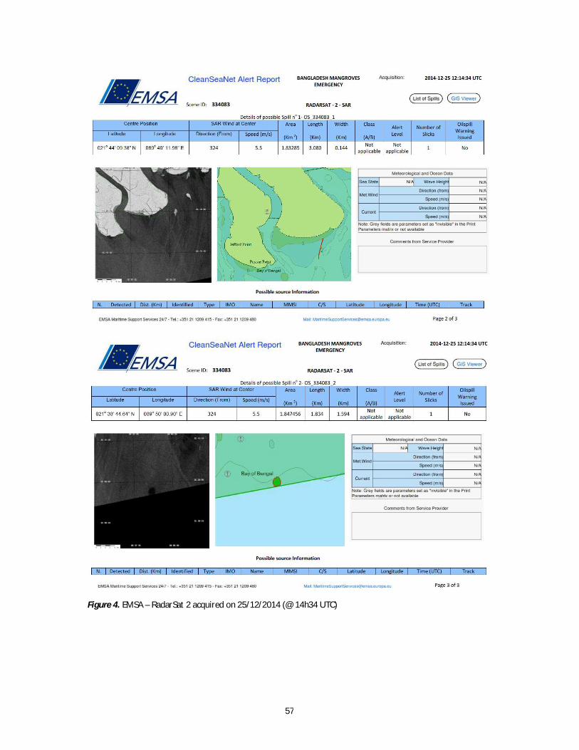
57
Figure 4. EMSA – RadarSat 2 acquired on 25/12/2014 (@ 14h34 UTC)

58
ANNEX 7. Unmanned Aerial Vehicle Survey
Introduction
Remote Sensing plays an important role in detecting the extent of spilled oil in the environment. However, depending on the passage/revisit schedules of suitable satellites and prevailing atmospheric conditions (e.g. cloud, fog, smog, etc.) its application can remain quite limited at times. While airborne aerial surveys can provide more flexible and useful alternatives to satellite remote sensing, flying a manned aircraft is expensive and the logistics (i.e., aircraft, sensor systems, processing equipment, etc.) may not be available. In such situations other means of visual surveillance of oiled environment may be carried out by relatively inexpensive platforms like unmanned aerial vehicles or UAVs (e.g., drones, quadcopters, etc.), tethered balloons, blimps or kites equipped with suitable sensor systems, most often with color photographic cameras. Pictures or videos taken by these cameras can provide extremely useful visuals to be used offsite in detecting and interpreting oiling condition of the environment, in this case oiled shorelines, vegetation, and waterways.
In the case of Sundarbans oil spill response, visuals (video and photography) can be useful for offsite assessment of oiled shorelines and other oil spill related changes along the bank of rivers and creeks. The visuals could be collected by at least two ways, namely (a) by flying a UAV equipped with necessary cameras (aerial and/or oblique aerial views), and (b) by running a similar camera equipment from a boat traversing along the bank (horizontal view/scanning). Both views have their advantages and limitations. When combining both methods useful information on oiled shore/bank can be extracted. Images collected at time intervals can also be used for change detection (e.g., improvement of oiled condition, change in vegetation health, etc.).
High resolution (up to 12 megapixels) color digital photographs would be preferable over High Definition (HD) movies (which can only provide 1920x1080 pixels=2MP still capture images) for subsequent analysis, interpretation and image classification. Moreover, still captures from HD movies would have image artifacts like blurring, Gaussian effects and interlacing, which are not good for feature identification and information extraction.
Visuals obtained by UAV or other means are generally interfered by various agents e.g., weeds, dark organic matters, dark shadows and shades, sun glitter, biogenic slicks, trash, fog/mist, industrial/municipal outflows, etc., and therefore require careful interpretation. In many cases, depending on the requirement, imageries may also require geometric rectification for correcting optical distortions caused by lenses, and registration to ground control points for geographic reference.
Use of UAV in Sundarbans Oil Spill response
Three days after the spill on December 12, 2014, prior to GoB-UN mission's arrival and field activities in the Sundarbans, Wildlife Conservation Society (WCS) conducted an aerial video surveillance on the banks of the Sela River (figure 7.1). The surveillance consisted of ten short transects at various locations along the banks of the river both upstream and downstream to the spill event site. High Definition (HD, 1920x1080 pixels) videos of relatively high frame rate (up to 50 fps) were captured during these short flights of the UAV.

59
Figure 7.1. Paths (transects) of UAV flights on December 12, 2014. Map by Sayedur R Chowdhury, based on
data provided by WCS.

60
On December 26-29, 2014 the GoB-UN Joint Mission planned to revisit four of the previously surveyed transects and conduct six new transects in relatively inaccessible creeks near the most oil impacted area.
UAV being assembled for flight. Photo by Sayedur R Chowdhury.
UAV ready to fly. Photo by Sayedur R Chowdhury.
UAV on flight and video acquisition. Photo by Sayedur R Chowdhury.
Figure 7.2. Unmanned Aerial Vehicle
Post processing and interpretation of UAV images
Aerial photographic images at two sites were extracted from the HD videos of December 12 and December 26, 2014 from the UAV flights along transect # 1 (see map). These were digitally enhanced for greater detectability of features. A general sense of change in oiled condition two weeks after the first acquisition of images can be observed from the sets of images (figure 7.3). However, it is complicated to make a direct comparison due to the different todal states when the images were obtained. Further examination and digital analysis can provide a better analysis of changes in oiling over time. It should also be noted that use and comparison of images is constrained by variations in UAV's positioning and altitude, camera look angles, sun's elevation and azimuth, and other factors.

61
Site
A
December 12, 2014 (High Tide) December 26, 2014 (Low Tide)
Site
B
December 12, 2014 (High Tide) December 26, 2014 (Low Tide)
Figure 7.3. Comparison of still aerial images at two sites extracted from HD videos of Flight transect # 1.
What can be done next
The technique of aerial surveillance can be improved with proper and detailed flight planning (e.g. flying transects at similar tidal states and during the same time of day), greater equipment control, and additional post processing of the acquired images to accurately identify oiled areas and quantify their extent. Nevertheless the technique proved useful and it is recommended particularly for obtaining baseline data and identifying areas of large oiling in the immediate aftermath of an incident. UAV and horizontal photographic scanning can also be considered for use in later phases of oil spill assessment, for example for assessing vegetation health through leaf yellowing or potential remobilization of redidual oils. Key challenges for long-term comparative assessments include variations in the UAV’s positioning, tidal state and the sun’s elevation and azimuth.

62
ANNEX 8. Waste Management and Disposal Considerations
Introduction
In the event of an emergency event or natural disaster, it is not uncommon for the development of significant volumes of wastes or wastes uncommon to the traditional waste stream and in particular those that can be considered hazardous. Waste management during emergencies is often an overlooked issue yet it must be considered to avoid creating a secondary long-term problem for the community in which the emergency or disaster has already occurred.
In an effort to ensure that generated wastes are minimized and those that are generated are managed appropriately a number of options should be considered at the onset and throughout a response to an emergency or disaster. The following diagram (source: Environment Canada) denotes options for the management of wastes during an emergency.
To manage disaster or environmental emergency wastes, it is critical that a waste management strategy or plan be developed and implemented. A waste management plan should include the following key components:
Purpose and Scope of the Waste Management and Disposal Plan Waste Designation Interim Storage, Segregation, Transportation and Tracking Waste Disposition / Final Disposal
A Waste Management Plan template ideal for oily waste management can be found at the following internet location.
http://ocean.floridamarine.org/acp/SJACP/Documents/ACP/PR_USVI_Reference_Documents/Waste%20Management%20Disposal%20Plan.pdf

63
Site Observations
During the period of 23 – 27 December 2014, the UN-GoB Joint Oil Spill Assessment Response Sub-Team visited the Chila Union region particularly the community of Joymoni to search for interim waste disposal locations, buried waste and accumulations of oil impacted debris. The following is a summary of those observations.
Interim Oil Impacted Waste Disposal and Buried Oil Impacted Waste
The sub team upon arriving at the Joymoni jetty immediately observed piles of oil impacted vegetation located in the lagoon area of the community. Approximately 6 larges piles of waste were observed. Each pile measuring greater than 2 metres in diameter of varying heights up to 2 metres. The piles had been covered with excavated river sediments.
Additional locations of buried oil impacted waste were noted in at least three locations in the community of Joymoni. These are noted in Figure 1.
Figure 1. Joymoni Lagoon Oil Impacted Waste Piles N 22 22.061', E 089 38.584'
Figure 2. Joymoni lagoon - oil impacted debris piles photodocumented on 25 Dec by Keith Donohue UNDP

64
Joymoni Road Buried Oil Impacted Waste (Being Excavated)
N 22 21.368', E 089 38.147'
'
Figure 3. Joymoni Road - buried oily debris photodocumented on 27 Dec by Keith Donohue UNDP
Joymoni Point Buried Oil Impacted Waste (Being Excavated)
N 22 21.167', E 089 38.143'
Figure 4. Joymoni Point - buried oily debris photodocumented on 27 Dec by Keith Donohue UNDP

65
Joymoni Interim Oil Impacted Waste Storage and Dewatering Crib
N 22 22.084', E 089 38.584'
Figure 5. Joymoni -Interim Oil Impacted Debris Storage and dewatering photodocumented on 23 Dec by
Kawser Mohammad, UNDP
Joymoni Residence Interim Oil Impacted Waste Storage and Dewatering Crib
N 22 21.469', E 089 38.162'
Figure 6. Joymoni Residence - Interim Oil Impacted Debris Storage and Dewatering Crib photodocumented on 27 Dec by Keith Donohue UNDP

66
Final Waste Disposal Site Assessment
In addition to surveying the community for interim disposal sites or buried waste sites the Response Sub-team along with elected community leaders, community member and Department of Forest representatives visited three sites to determine their feasibility to receive oil impacted debris and potentially support some incineration to reduce the volumes of oil impacted organic materials (vegetation).
The suitability of the sites were inspected and evaluated against the following parameters:
Site ownership; Land use planning; Proximity to human habitation; Access to the public; Proximity to sensitive environments and agricultural lands; Downwind proximity of human habitation (in the event incineration is conducted); Proximity to critical infrastructure; and Proximity to transportation infrastructure.
The following are the advantages and disadvantages of the community proposed disposal sites.
Pashur River Private Site - Chila Union (N 22 22.520', E089 37.782')
Figure 7. Pashur River Private Site looking North and East respectively photodocumented on 25 Dec by Keith Donohue
Advantages:
Plot of land inspected for the waste is privately owned and it was anticipated that the site would be available to accept oil impacted debris for disposal.
The site's planned use is for industrial activities, further it requires additional fill making it ideal to accept a small amount of waste or to conduct a waste burn.
Site was readily available by water and oiled debris could be transported vessel.
Disadvantages:
The site while very large is surrounded by public; both legitimate and illegitimate homesteads. If incineration takes place the smoke from the fire may be visible and depending on the wind
conditions may route smoke over the Joymoni community. The site while privately owned is accessible to any person. The site while bermed is in very close proximity to community agricultural lands. The logistics to move the material from the community to the site are not simple and will
require some significant coordination.
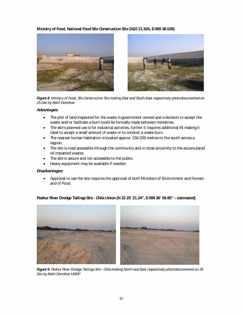
67
Ministry of Food, National Food Silo Construction Site (N22 21.924, E 089 38.028)
Figure 8. Ministry of Food, Silo Construction Site looking East and South-East respectively photodocumented on 25 Dec by Keith Donohue
Advantages:
The plot of land inspected for the waste is government owned and a decision to accept the waste and/or facilitate a burn could be formally made between ministries.
The site's planned use is for industrial activities, further it requires additional fill making it ideal to accept a small amount of waste or to conduct a waste burn.
The nearest human habitation is located approx. 150-200 metres to the south across a lagoon.
The site is road accessible through the community and in close proximity to the accumulated oil impacted wastes.
The site is secure and not accessible to the public. Heavy equipment may be available if needed.
Disadvantages:
Approval to use the site requires the approval of both Ministers of Environment and Forests and of Food.
Pashur River Dredge Tailings Site - Chila Union (N 22 25' 21.24", E 089 36' 59.85" – estimated)
Figure 9. Pashur River Dredge Tailings Site - Chila looking North and East respectively photodocumented on 25 Dec by Keith Donohue UNDP

68
Advantages:
The plot of land inspected for the waste is government owned (Local) and a decision to accept the waste and/or facilitate a burn could be formally made.
The site's planned use is yet unknown but is currently undergoing land reclamation; receiving pumped dredge tailings.
Disadvantages:
Smoke generated from a burn could potentially impact parts of the community that are adjacent to the site.
The site overall is quite large and is used as a cricket grounds for many children. The repurposing of the site for waste disposal could be detrimental to their community’s recreational uses.
The logistics to move the material from the community to the site are not simple and will require some significant coordination.
The site, while very large, is surrounded by public, both legitimate and illegitimate, shelters. If incineration takes place the smoke from the fire may be visible and depending on the wind
conditions may impact homesteads in close proximity. The site is accessible to any person.
Additional Waste Disposal Options
Many options to waste disposal exist, however, the region of Chila Union is limited in those options. Much of oil impacted debris is located in Joymoni a moderately remote community on the Shela and Pashur Rivers in the north-east of the Sundarban. Heavy vehicle access is very difficult and expensive. Small loads of cargo are carried by local motorized three wheel flatbed carts. Any land based disposal site will need to consider transportation logistics. Two of the potential disposal sites are located adjacent to the Pashur River. These sites or others identified by one of the major rivers or connecting channels may allow for the transportation of response generated wastes by marine vessel.
Disposal may be supplemented by incineration at temporary or at the permanent disposal site to reduce the volume of organic wastes (oiled vegetation). Any incineration method should be conducted in a manner acceptable to local and regional authorities and in compliance with any environmental legislation governing discharges to air. The following elements should also be considered prior to the use of an incineration method.
Open burning should be considered a last resort; Any treated wood materials if present should be removed from the waste stream; Limit open burning to oil impacted vegetation; and Any burning should be conducted in accordance with best available practice to protect
human health;
Further consideration may be given to incineration of organic materials if a kiln used for brick firing (manufacturing) is available and regionally located to the generated wastes. Again, any effort to incinerate must be done in compliance with the applicable legislation or under the permission of a certificate of approval by the appropriate government agency.
At the termination of the field component of the mission a fourth site was identified as being considered by Department of Forest representatives. This site located on the south bank of the Mongla River in the vicinity of the Community of Mongla is currently being utilized for the disposal of dredge tailings. The site was not inspected by the mission team. Based on observation from a marine vessel it appears that the proposed site may have similar advantages and disadvantages as the Pashur River Dredge Tailings Site - Chila.

69
Conclusion
The spill of heavy fuel oil has been had a significant impact on the Shela and Pashur River system and in particular on the people that utilize the river for every aspect of their livelihood. The survey and reconnaissance conducted by the UN-GoB Joint Oil Spill Assessment Response Sub-Team has observed significant accumulations of oil impacted debris made up of both vegetation and material used to recovery oil from the environment. Management of these materials in the early phases of the response was not monitored and resulted in their deposit at various locations throughout the community, putting at risk the health of community members.
During the assessment many of these deposits were identified and immediate recommendations to manage them appropriately were provided. Further, the Response Sub-Team worked with local officials and of the Department of Forest to help identify and assess the suitability of potential long term disposal sites which may also be suitable to allow for some incineration of impacted organic materials. Based on the observations and the information gathered through interviews with community and Forest Dept. representatives The Ministry of Food, Silo Construction Site offers a suitable location for long term disposal of the oil impacted materials. The options to safely conduct limited incineration process here in order to reduce the volume of organic wastes should be further explored.
At the termination of the field assessment efforts were underway to excavate the buried materials and safely transport them to additional dewatering / drying cribs built in central locations. Once a decision has been made regarding final disposition these materials will be ideally located to be transported to that location.

70
ANNEX 9. Personal Protective Equipment Considerations
In the event of an emergency event or natural disaster in which hazardous wastes are generated the individuals tasked with efforts to response or clean-up should be outfitted with appropriate protective equipment.
Throughout the world many guidelines and standards exist to ensure the safety of workers / volunteers when they are handling wastes and hazardous materials. The following United States Occupational Safety and Health Administration (OSHA) standards provide a comprehensive background on worker /volunteer safety with respect to the handling of wastes and responding to the release of hazardous materials. The standard lays out a 4 level regime of protection. Level D; basic level of protection against nuisance contamination versus Level A; highest degree of personal protection in environments that are immediately dangerous to life and health.
US OSHA CFR 1920.120 Appendix B General description and discussion of the levels of protection and protective gear. https://www.osha.gov/pls/oshaweb/owadisp.show_document?p_table=STANDARDS&p_id=9767
The following is a summary of personal protective equipment recommended for ongoing community clean-up efforts. Level D A work uniform affording minimal protection: used for nuisance contamination only. The following constitutes Level D equipment; it may be used as appropriate: 1. Coveralls. 2. Gloves. 3. Boots/shoes, chemical-resistant steel toe and shank. 4. Boots, outer, chemical-resistant (disposable). 5. Safety glasses or chemical splash goggles. 6. Hard hat. 7. Escape mask. 8. Face shield.
Decontamination and Disposal of Soiled Personal Protective Equipment
The purpose of the use of personal protective equipment is twofold: the first being to protect the health and safety of workers / volunteers from potentially hazardous exposures; the second purpose of the personal protective equipment is to minimize the potential for secondary contamination. Secondary contamination occurs when a worker whether protected or not leaves the work site without properly decontaminated or removing one's personal protective equipment or soiled clothing. During any incident in which there may be contamination of one's personal goods or where personal protection equipment is utilized it is imperative that a procedure to remove and dispose of or decontaminate one's personal protective equipment is implemented. Additional discussion regarding decontamination and appropriate discarding of soiled personal protective equipment can be found in the following reference standard. US OSHA CFR 1920.120 (k) Decontamination General description and discussion of the levels of protection and protective gear. https://www.osha.gov/pls/oshaweb/owadisp.show_document?p_table=STANDARDS&p_id=9765

71
ANNEX 10. Aquatic Environment Assessment
The Aquatic Sub-Team visited 40-45 km from the Chandpai to the Harintana area along the Shela River of the Sundarbans. The mentionable places we visited are Chadpai, Joymoni Ghol (oil spill site), Andharmanik River, Nandabala-Anderia Varani, Tanbul Bunia, Kalamula Varani, Alkir Char and Harintana forest camp (Figure 1).
Figure 1. Observation of Shela River ecosystem (yellow line) during 23-26 December 2014
The Aquatic Sub-Team measured water depth and hydrological parameters of selected sites using portable field equipment (Table 1). Data on dissolved oxygen and pH were collected from the department of Environment (DoE). While the majority of these parameters are linked to baseline marine monitoring, the amount of dissolved oxygen could be impacted in case of a large oil spill.
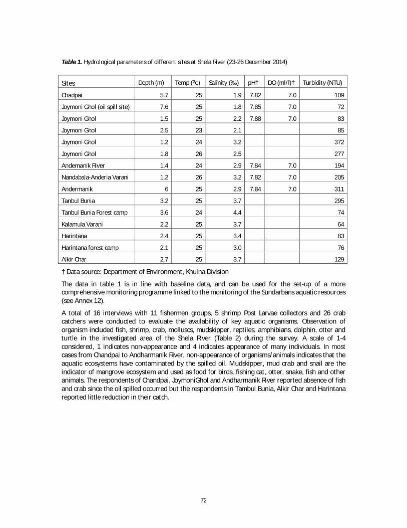
72
Table 1. Hydrological parameters of different sites at Shela River (23-26 December 2014)
Sites Depth (m) Temp (⁰C) Salinity (‰) pH† DO (ml/l)† Turbidity (NTU)
Chadpai 5.7 25 1.9 7.82 7.0 109
Joymoni Ghol (oil spill site) 7.6 25 1.8 7.85 7.0 72
Joymoni Ghol 1.5 25 2.2 7.88 7.0 83
Joymoni Ghol 2.5 23 2.1 85
Joymoni Ghol 1.2 24 3.2 372
Joymoni Ghol 1.8 26 2.5 277
Andemanik River 1.4 24 2.9 7.84 7.0 194
Nandabala-Anderia Varani 1.2 26 3.2 7.82 7.0 205
Andermanik 6 25 2.9 7.84 7.0 311
Tanbul Bunia 3.2 25 3.7 295
Tanbul Bunia Forest camp 3.6 24 4.4 74
Kalamula Varani 2.2 25 3.7 64
Harintana 2.4 25 3.4 83
Harintana forest camp 2.1 25 3.0 76
Alkir Char 2.7 25 3.7 129
† Data source: Department of Environment, Khulna Division
The data in table 1 is in line with baseline data, and can be used for the set-up of a more comprehensive monitoring programme linked to the monitoring of the Sundarbans aquatic resources (see Annex 12).
A total of 16 interviews with 11 fishermen groups, 5 shrimp Post Larvae collectors and 26 crab catchers were conducted to evaluate the availability of key aquatic organisms. Observation of organism included fish, shrimp, crab, molluscs, mudskipper, reptiles, amphibians, dolphin, otter and turtle in the investigated area of the Shela River (Table 2) during the survey. A scale of 1-4 considered, 1 indicates non-appearance and 4 indicates appearance of many individuals. In most cases from Chandpai to Andharmanik River, non-appearance of organisms/animals indicates that the aquatic ecosystems have contaminated by the spilled oil. Mudskipper, mud crab and snail are the indicator of mangrove ecosystem and used as food for birds, fishing cat, otter, snake, fish and other animals. The respondents of Chandpai, JoymoniGhol and Andharmanik River reported absence of fish and crab since the oil spilled occurred but the respondents in Tambul Bunia, Alkir Char and Harintana reported little reduction in their catch.
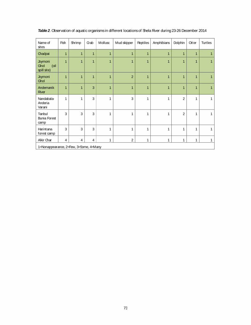
73
Table 2. Observation of aquatic organisms in different locations of Shela River during 23-26 December 2014
Name of sites
Fish Shrimp Crab Mollusc Mud skipper Reptiles Amphibians Dolphin Otter Turtles
Chadpai 1 1 1 1 1 1 1 1 1 1
Joymoni Ghol (oil spill site)
1 1 1 1 1 1 1 1
1 1
Joymoni Ghol
1 1 1 1 2 1 1 1 1 1
Andemanik River
1 1 3 1 1 1 1 1 1 1
Nandabala-Anderia Varani
1 1 3 1 3 1 1 2 1 1
Tanbul Bunia Forest camp
3 3 3 1 1 1 1 2 1 1
Harintana forest camp
3 3 3 1 1 1 1 1 1 1
Alkir Char 4 4 4 1 2 1 1 1 1 1
1=Nonappearance, 2=Few, 3=Some, 4=Many

74
ANNEX 11. Sunken Oil Survey
Summary
A dedicated survey for sunken oil has been carried out along the more polluted banks (as well as in the middle of the river) by using a proven technic implemented during certain oil spills in the USA consisting in dragging a weighted dragging sorbent line on the sea/river bottom. At this end, a prototype of tool has to be built and implemented in 10 sites facing heavily polluted banks and corresponding in different types of riverine sites prone to oil sedimentation. No evidence of sunken oil have been observed during each of the 10 transects. This assessment enables to partly raise doubts about the likely existence of slicks or patches of sunken oil. These results do not mean that no oil has sunken on the river (particularly oil particles through the clay-oil flocculation process) but the occurrence of sunken oil slicks –even of patches - along the river seems of low probability. The survey however needs to be updated in the coming weeks and recommendations to this end are proposed.
A methodology for searching sunken oil has been assessed based on a proved technic implemented during certain oil spills in the USA consisting in dragging a weighted dragging sorbent line on the sea/river bottom. The survey has been focused around and downstream the spill site: on 24 December around the station of Department of Forest in of Chandpai, then on 26 December, further north in the immediate vicinity of the spill site.
Tools & Methodology
Due to a lack of “Oil Snare” sorbent dragging line, as usually used, a prototype has to be built (see above photos). It consists of a 20m long rope (diam. 0.5 cm), weighted with 2 weights (<1 kg) – one at the extremity and 7 metres before- and equipped with some stripes of oleophilic fabrics (i.e. on which the oil is prone to adhere) - each 50 cm - that were available on the mission boats (PPE, and big bag).
The rope is dragged along a 100m long transect parallel to the shore. Transects were carried out in particular sites according the initial oiling severity.
Transects were geo-referenced and depth recorded.
Site choice
In total, 10 transects have been carried out during the joint mission (see map1), in sites heavily polluted and corresponding to 4 environments - a priori prone to oil deposit - as follows: Five in the front of the river bank:
o Suspected scenario: oil transfer after oil stranding on a sloppy waterlogged mud. Two in a small shallow creeks:
o Suspected scenario: submersion of oil after oil deposit in a restricted shallow sector. One in a small embayment of sediment accretion with counter-current and eddies:
o Suspected scenario: sedimentation in sheltered shallow waters. Two on the middle of the river bed, downstream a confluence:

75
o Suspected scenario: sinking of oil after oil mixing with mud in a turbulent water environment (eddies, counter-current);
o At the location of the wreck (downstream and upstream) o Suspected scenario: sinking of oil after during the spillage.
Locations, parameters and observations are mentioned in table1.
Area Time Geo-Coordinate Depth
(ft)
Concentration of oil on Bank
Dragging Length
(m)
Result
Point A 09:57 N22.30003 E89.70523 3.4 High 125 Nil
Point B 10:14 N22.29153 E89.70022 8.6 High 86 Nil
Point C 11:11 N22.27561 E89.69926 13.4 High 156 Nil
Point D 12:18 N22.30837 E89.70264 11.5 High 205 Nil
Point F 12:33 N22.31139 E89.69592 35.6 Low 101 Nil
Point G 13:16 N22.35556 E89.66998 3 High 120 Nil
Point H 13:25 N22.35596 E89.67167 11 High 1031 Nil
Point I 13:51 N22.34723 E89.67152 4 High 179 Nil
Point J 14:05 N22.32252 E89.68790 8 High 136 Nil
Point K 17:05 N22.38730 E89.66512 2.5 Low 89 Nil
Figure 1. Sunken oil survey locations. Map by Sayedur R Chowdhury.

76
Figure 2. Sunken oil survey locations
Results
No evidence of sunken oil have been observed during each of the 10 transects.
Comments This assessment enables to partly raise doubts about the likely existence of slicks or patches of
sunken oil. These results do not mean that no oil has sunken on the river. It is highly probable that oil particles had adsorbed on silt grains to form mineral/oil aggregates
according the clay-oil flocculation process. Those aggregates probably end to sink far from the spill site thanks to the highly dynamical environment (currents, counter-currents and eddies, tides). At the end, these processes leaded to a wide dissemination of micro-droplets of oil, embedded in clay, more or less prone to degrade at moderate or long-term.
The occurrence of sunken oil slicks – even of patches - along the river seems of low probability. The oil, according to its initial characteristics and the highly dynamic environment, never formed
coherent patches / slicks of viscous oil – that is prone to sink in fresh muddy water - but presented during the first days a fluid aspect forming shape-moving strips of black oil surrounded by a great amount of sheens.
Recommendations The survey needs to be updated in the coming weeks. The survey has been carried out in the more polluted part of the river, but through a relatively restricted number (only 10 transects) have been done. The extent of the survey downstream to Dudhmukhi that was initially planned (at least inn highly sensitive areas) has been estimated useless due to the very low and decreasing level – see the absence - of contamination observed along the river and its tributaries.
77
Aiming at complementing the present survey (and raising a greater part of doubts about sunken oil that could persist), it would be interesting to update the survey by some regular surveys to be carried out in the near future. This will be easily done by trained national persons due to the fact that the present surveys have been carried out and recorded by one WCS employee (Mahmudur Rahman) with the collaboration of representatives of Universities of Bangladesh (Prof. M Shahadat Hossain and Prof. Anisul Haque), as well as from the Department of Forest (M. Zahir).
Moreover, because the present survey did not use the sorbent “oil Snare” rope usually used for such surveys (but an improvised prototype) it is also suggested to supply the Bangladesh authorities with dedicated equipment for searching sunken oil.
Reported on 24/12/2014 then updated on the 26/12/14 (LK)

78
ANNEX 12. Proposal for Elements of an Aquatic Monitoring Programme
In case of an oil spill, the monitoring should be set up to reflect the extent and scale of observed oil – in this case in the immediate vicinity of the oil spill accident site. At the same time, the accident offers an opportunity to improve the aquatic monitoring as part of integrated resources management in the Sundarbans. This annex provides the details for a research design for possible chronic impacts from environmental pollution on the aquatic environment, fisheries and coastal livelihoods of Sundarbans.
It is recommended to conduct monitoring the aquatic environment of Shela River addressing key physico-chemical and biological parameters. Table 1 provides a recommendation of parameters to be
RESEARCH DESIGN
SAMPLING DESIGN
Gear selection
Gill/seine net Hook/trap
DATA COLLECTION
DATA ANALYSIS
Lunar periodicity
Full Moon Low tide
Sampling Schedule
(January-December)
Patchiness consideration
Spatial (20sites) Temporal (24 months)
Oil Spill Impact on Aquatic Environment, Fisheries and Coastal Livelihoods of Sundarbans
Primary Data
Environmental Data
Water quality Soil quality
Secondary Data
Water quality Soil quality Fisheries abundance Income Food & health
Fisheries Data Catch & effort Habitat
detection
Socioeconomic Data Livelihood options Income Food & health
In-situ measurement Laboratory analysis Species identification and quantification
Evaluation of water and soil quality Fisheries habitat suitability modeling Fishers livelihoods analysis
OUTPUTS

79
monitored, with locations provided in Table 2. Parameters linked directly to oil spill impact are indicated in bold, while the others are of importance for overall water quality monitoring.
Table 1. Aquatic monitoring parameters
Parameters for water sample Parameters for sediment sample Valuable and important
fisheries species Dissolved oxygen (DO) Temperature Salinity pH Turbidity Hardness Alkalinity Oil concentration Heavy metal concentration Micro-nutrients Nitrogenous elements
Benthic community Annelids Molluscs Crustaceans Pnidaria Coelenterates Ichthyo fauna Microorganisms (i.e. bacteria) Oil residue Grain size Heavy metal concentration Micro-nutrients Nitrogenous elements
Abundance and distribution of fishes, shrimps and crabs
Oil residue in fishes, shrimps and crabs
Heavy metal concentration in fishes, shrimps and crabs
*Key parameters are highlighted as bold.
Table 2. Sampling locations in the Shela River for monitoring aquatic environment Sampling location Latitude Longitude Remarks 1 22⁰21'50.14"N 89⁰38'33.08"E 2 22⁰21'54.07"N 89⁰38'44.61"E 3 22⁰21'50.21"N 89⁰39'5.60"E 4 22⁰21'51.21"N 89⁰39'15.04"E 5 22⁰21'1.01"N 89⁰39'33.90"E 6 22⁰22'2.98"N 89⁰39'44.39"E 7 22⁰21'57.17"N 89⁰40'5.38"E 8 22⁰21'51.33"N 89⁰40'11.69"E 9 22⁰21'35.73"N 89⁰40'20.12"E 10 22⁰21'25.01"N 89⁰40'24.34"E 11 22⁰21'14.28"N 89⁰40'22.27"E Oil spill site 12 22⁰21'14.52"N 89⁰40'28.59"E 13 22⁰20'55.74"N 89⁰40'29.66"E 14 22⁰20'44.04"N 89⁰40'33.88"E 15 22⁰20'34.30"N 89⁰40'39.15"E 16 22⁰20'25.52"N 89⁰40'33.36"E 17 22⁰20'8.95"N 89⁰40'48.64"E 18 22⁰19'57.25"N 89⁰40'53.92"E 19 22⁰19'50.43"N 89⁰41'3.37"E 20 22⁰19'47.53"N 89⁰41'14.92"E 21-25 --- --- Reference sites
Illustration of the locations of proposed 20 sampling points in the Shela River to monitor water, sediment and fisheries aspects

80
Additional information on oil concentration monitoring is provided below.
Oil characterisation a. The chemical composition of the original oil must be characterised to predict its persistence and its toxicity: percentage of saturated compounds (alkanes and branched ones), polycyclic aromatics hydrocarbons (PAH) and polar ones (Resins, Asphaltenes and Waxes). b. More emphasis must be put on the PAH fraction which is the most hazardous fraction for life (human and organisms). c. Need to determine the soluble fraction of the oil by following the Water Accommodated Fraction protocol. Oil persistence in the environmental matrix (water and sediment) a. To follow the physical and chemical behaviour of the oil on the shoreline to determine the remaining percentage of the main hazardous compounds: oil samples must be collected and analysed at interval of 6 months during 2 years. These samples can be collected on trees and/or on the house stilts at Chandpai village. b. To follow the oil concentration in the sediment (Total Oil Concentration or Total Petroleum Hydrocarbon concentration) and to estimate its biodegradation rate through biomarker measurements such as C17/Pristane and C18/Phytane ratios and nor-hopane quantification: a sediment sampling must be performed at interval close to vicinity of the incident occurred (High fragments on the extend map). c. To monitor the oil concentration in drinking water and, more globally where the river water is used for human purposes, and also in interstitial water taken from the bank. Oil toxicity and Bioaccumulation a. Taking into account the oil composition, look for Log KOW of the major oil compounds. b. For fish, to measure PAH metabolites in bile and to link to the PAH fraction in the original oil. c. For bivalves, to measure the oil concentration in tissues.

81
ANNEX 13. Mangrove Assessment
Between 23 and 27 December, 2014, the Mangrove Assessment Team surveyed mangrove habitat along the main channel of the Shela River and its side streams (Table 1). Tidal elevations at the time of the spill reduced the penetration of oil into the mangrove floor (Table 2).
Table 1. Location Information For Side Canals And Forest Floor Sites Surveyed 23-27 December 2014 During The Un-Gob Joint Mission.
Side Canals Surveyed
Mrigamari Camp/Canal 23 December 22.36650° 89.66757°
Surjamukhi Canal 23 December 22.35613° 89.63982°
Kakramari Canal 25 December 22.22884° 89.70101°
Canal (name not known) 25 December 22.24968° 89.72457°
Canal (name not known) 25 December 22.26343° 89.73244°
Canal (name not known) 25 December 22.26164° 89.72485°
Tangrar Canal 26 December 22.31330° 89.70448°
Murti Canal 26 December 22.34978° 89.71345°
Forest Floor Sites Surveyed
Nundawalla Forest Camp 23 December 22.34832° 89.63717°
Andermanic Forest Camp 23 December 22.35528° 89.67061°
Bais Canal 24 December 22.28357° 89.70644°
Harbaria Ecotourism Center 27 December 22.29770° 89.61458°
Table 2. Tidal elevations for Mongla over the period before and after the oil spill.
82
List of plant species observed in the oil-affected areas of the Sundarban
Recorded during the visit with the Joint Mission Team from 23-27 December, 2014
Tree Species
Scientific Name Family Name Local Name Type of Plant 1. Amoora cuculata Meliaceae Amur Small tree 2. Avicennia marina Avicenniaceae Moricha baen Small tree 3. Avicennia officinalis Avicenniaceae Baen Large tree 4. Bruguiera gymnorhiza Rhizophoraceae Kankra Tree 5. Ceriops decandra Rhizophoraceae Goran Small tree 6. Cynometra ramiflora Leguminaceae Shingra Small tree 7. Excoecaria agallocha Euphorbiaceae Gewa Small tree 8. Heritiera fomes Sterculiaceae Sundri Tree 9. Lumnitzera racemosa Combretaceae Kirpa Small tree 10. Sonneratia apetala Sonneratiaceae Keora Large spreading tree 11. Sonneratia caseolaris Sonneratiaceae Ora/Soyla Small tree 12. Xylocarpus mekongensis Meliaceae Passur Tree Shrub Species 13. Pandanus foetidus Pandanaceae Kewa katta Prickly shrub Shrub-Climber Species 14. Derris trifoliata Leguminaceae Gila lota Climber 15. Sarcolobus globosus Asclepiadaceae Bowali lata Climber Palm Species 16. Nypa fruticans Palmae Golpata Palm with underground
stem 17. Phoenix paludosa Palmae Hanthal Thorny palm gregarious Herb Species 18. Acanthus illicifolius Acanthaceae Hargoja Woody, thorny herb Grass Species 19. Enochloa procera Gramineae Nolgash Grass 20. Myriostachya wightiana Gramineae Dhanshi Grass on new accretion 21. Phragmites karka Gramineae Nol khagra Grass- a tall reed 22. Typha spp. Gramineae Helipata Grass Fern Species 23. Acrostichum aureum Pteridiaceae Hodo/tiger
fern Gregarious fern
24. Stenochlaena palustris Blechnaceae Deki lota Climbing fern

83
Recommendations
Immediate Actions (0-3 months)
Initiate planning for, and implement mangrove monitoring within the three temporal periods (immediate, mid-term, and long-term)
Health of the mangrove forest should be monitored for signs of oil toxicity. Yellowing and loss of leaves are common occurrences when mangroves are exposed to toxic levels of oil, but this can occur over a range of time dependent on oil type and oiling conditions, and therefore likely candidate areas where this might occur (i.e., areas of observed moderate or more persistent oiling) should be re-visited at regular intervals by BFRI and/or Department of Forest personnel. The first re-visit should occur in February, or 2 months post-spill.
Integrate oil spill monitoring into existing mangrove monitoring studies
A comprehensive long-term mangrove study already exists as a collaborative effort by BFRI, and universities in Bangladesh. This provides a pre-spill baseline and represents the rare opportunity to compare post-spill conditions with those existing pre-spill.
Establish the framework for removal of oiled nipa along the river and canal banks
An existing harvest program for nipa can be used as a vehicle for the removal of oiled nipa in the spill-affected area. However, the oiled vegetation would be handled differently and will have a separate waste stream dependent on the availability and capacity of proper incineration facilities. Established practices for nipa harvest, i.e., the requirement to leave two leaves intact, will be followed. Also, reference areas in which oiled nipa plants will be left untreated will be designated in order to provide insights for management of nip in future spill events.
Investigate remote sensing methods for synoptic assessment of mangrove health at regular intervals
Because mangroves reflect toxic exposure to oil in highly visible ways (i.e., leaf yellowing or loss, outright mortality), they are good candidates for remote impact assessment by such means as aerial photography or satellite imagery. These broad “snapshots” of the resource can show areas of effect that are either not visible from the ground, or can confirm observations from the other monitoring surveys. While visible spectra photographs are useful, infrared or chlorophyll-enhancing capabilities would be well-suited for consideration as an assessment approach.
Mid-Term Actions (3-6 months)
Re-survey impacted mangrove areas
(Refer to mangrove monitoring plans above under Immediate Actions). A single re-visit/monitoring of oiled mangrove forests was originally conceived to occur 6 months post-spill; however, this falls in monsoon season and accommodation of this timing will likely be necessary. In fact, monsoon season offers the opportunity to evaluate whether/how the rains will aid in flushing remaining oil from the mangrove system. To that end, we recommend one survey visit just before monsoon season (April), and one just after (August-September), providing important information about the role of natural processes in accelerating spill recovery in the Sundarbans system.

84
Long-Term Actions (6-18 months)
Re-survey impacted mangrove areas
(Refer to mangrove monitoring plans above under Immediate Actions and Mid-Term Actions). The fourth monitoring survey should occur at one-year post-spill, allowing assessment of recovery status after exposure to a full cycle of seasonal changes.
Mangrove restoration workshop
After one year and multiple monitoring surveys into the affected mangrove forest, a workshop should be held in Dhaka to discuss results to date and the potential need for restoration actions to facilitate recovery of mangroves showing signs of oil spill impairment during the field surveys. Potential restoration approaches could include direct actions like replanting of seeds, propagules, and seedlings; or management actions to reduce other sources of stress to the mangrove forest. BFRI and the Ministry of Environment and Forest will play key roles; others, including international experts, may be invited to participate.
In conclusion, the Mangrove Assessment Team spot-surveyed canal and forest floor locations in the most heavily impacted portion of the Sundarbans. Observed impacts were minimal; however, the team recommends continued monitoring over the next year. Following the one-year monitoring period, structured restoration efforts may be considered and recommended.
Oiled nipa plants were observed throughout the survey area and a plan for removal of contaminated vegetation was proposed for consideration by Department of Forest authorities.
Although, of course, the oil spill had the great potential for environmental calamity, we believe that the combination of tide height and cycle, along with the characteristics of the oil, may have limited short-term effects. Caution and prudence dictate that the situation be carefully monitored for change to discern any longer-term or chronic effects to this critical habitat.

85
ANNEX 14. Wildlife Assessment Report
Summary
In order to determine the extent and degree of impact of the Sundarbans oil spill on resident wildlife populations, a systematic survey was done in the regions where oiled animals were most likely to be found. Teams of trained personnel were deployed with data forms, binoculars, GPS devices, and identification charts. In all, a total of 82 wildlife sightings were recorded, totalling 108 animals. Of these, three birds (one greater egret, one intermediate egret and one crested serpent eagle) were determined to have light oiling (2-25% coverage of the body) and two (one intermediate egret and one bubul) were suspected of having trace oiling. Additional animals (one smooth-coated otter, one additional intermediate egret, two estuarine crocodiles, and one water monitor) were confirmed as being observed oiled from reports and accompanying photodocumentation.
Introduction
Bangladesh is home to over 125 globally threatened species (IUCN Red List) – including 21 Critically Endangered, 34 Endangered and 69 Vulnerable species. The Sundarbans Reserved Forests (SRF), one of the two Ramsar sites in the country, supports an estimated 49 species of mammals, 59 species of reptiles, eight species of amphibians, 400 species of fishes and 315 species of birds, with as many as 20 being recognized as globally threatened. Key flagship species within the Sundarbans includes the Royal Bengal tiger (Panthera tigris; with a population estimated at less than 500 individuals), Ganges River Dolphin (Platanista gangetica), Irrawaddy Dolphin (Orcaella brevirostris), and River terrapin (Batagur baska).
Based on the high level of terrestrial and aquatic biodiversity in the SRF, in 1977, the Government of Bangladesh established three Wildlife Sanctuaries in the far southern portion of the Sundarbans [Sundarbans West (715 km2), South (370 km2), and East (310 km2)] under the Bangladesh Wildlife (Preservation) Order, and in 2012, UNESCO declared these collective Sanctuaries as a ‘World Heritage Site’. Further, in 2012, because the waterways of the Sundarbans are the only place where both the Endangered Ganges River and the Vulnerable Irrawaddy dolphins occur together in populations large enough for early conservation interventions to be effective, Bangladesh established defined ‘dolphin hotspots’ as three additional Wildlife Sanctuaries (Chandpai, Dhangmari and Dudhmukhi).
Because of the sensitivity and value of this ecosystem, there were great concerns regarding the potential short- and long-term impacts to wildlife species within this region from the oil spill that occurred on 9 December. Therefore, the UN-led mission included a full wildlife survey as a key element to the overall assessment.
Methodology
Surveys: Dedicated wildlife teams (as well as key individuals imbedded within the other functional teams) were dispatched throughout the area from 23 to 27 December 2014 to conduct standardized surveys. Assessments were conducted as far as 40-50 km south of the spill site on the Shela River, upwards to the Pashur River, and extending into the multiple streams off of these larger waterways. Efforts were focused on those streams that were most likely to contain oiled wildlife, as well as those waterways that had not yet been covered by other surveys (e.g., WCS, Department of Forest).
Species: A species identification document (complete with photographs) was developed and distributed to all wildlife personnel to ensure correct speciation of observed animals. In order to better clarify those species of greatest concern, species were categorized according to value and risk as either High or Low (e.g., High Value/High Risk, etc.) (See Table 1). Value was assigned as both a measure of conservation importance (i.e., IUCN Red List status) as well as socioeconomic worth. Risk was assigned based on the potential for acute effects from oil contamination from prior knowledge and experience.

86
Search Effort: All surveys that included a wildlife observer recorded key data on standardized forms for each discrete search effort (e.g., date, team name, search number, recorder name, observer(s) name(s), GPS unit used, start/end time, start/end GPS coordinates) as well as the GPS unit recording track lines to ensure documentation and extent of coverage. Data forms and associated code descriptors were provided to each observer to standardize approach.
Wildlife Observations: Within each search effort, wildlife observers were directed to record pertinent data on each individual animal observed. Careful observation of oiling status and species (if possible) were emphasized, and conducted by lengthy visual assessment via high-power binoculars. Specific data elements collected included date, team name, search number, observation number, time, GPS coordinate/waypoint, species, group size, new-born numbers, channel type, habitat type, oiling status, and health status using standardized data forms. Code descriptors for the categorical variables are presented in Table 2.
Anecdotal reports: In addition to dedicated and directed wildlife surveys, efforts were made to locate and interview individuals who were on scene between 9 and 23 December, observed oiled animals, and photodocumented their exposure. If these reports were confirmed by photos as being oiled, they were considered “confirmed reports”. If data were acquired but no photographic evidence accompanied the information, the results were considered “unconfirmed reports”.
Results
Search effort: Pertinent search effort data is presented in Table 3. In brief, 27 individual searches were done by 11 separate teams between 23 and 27 December 2014.
Wildlife sightings: Pertinent results from all wildlife surveys are presented in Tables 4 (locations) and 5 (observational data). In short, a total of 82 wildlife sightings were recorded, totalling 108 animals. Of these, three birds (one greater egret, one intermediate egret and one crested serpent eagle) were determined to have light oiling (2-25% coverage of the body) and two (one intermediate egret and one bubul) were suspected of having trace oiling.
Confirmed reports: Pertinent reports are described in Table 6. In short, one smooth-coated otter, one additional intermediate egret, one estuarine crocodile, and one water monitor were confirmed as being observed oiled from reports and accompanying photodocumentation. One Irrawaddy Dolphin, photographed by the media on 12 December, could not be confirmed as oiled by the available photograph.
Unconfirmed reports: A variety of ancillary reports were received from a number of different sources throughout the Sundarbans region. In particular, a published report of Dr. Abdullah Harun Chowdhury (KU), who performed a visual evaluation of the spill region from 11 to 25 December 2014 in 15 different locations near the spill site, documented 27 oiled animals (five frogs, two monitor lizards, two crocodiles, 17 egrets, and one otter). Data and photodocumentation from this study, however, was not available during the UN rapid assessment, therefore cases cannot be confirmed or reconciled for the present report.
Conclusions
Through a standardized and systematic approach to evaluating all regions where oiled wildlife were most likely to occur, a more thorough understanding of potential acute impacts to animals in the region was gained.
Overall, initial acute impacts to wildlife from this spill, based on observable mortality and visible oiling on and/or behavioural changes to live animals, appear to be limited in scope. Geographically these effects appear to be focused no farther south than Andharmanik (e.g., within a 40 km radius from the oil spill site).
It is important to note, however, that this finding should not be interpreted as “no effect”, as there may be subclinical or sub-apparent impacts present that were not observable during this rapid

87
assessment. Moreover, chronic impacts to wildlife due to ongoing exposure to low-level petroleum hydrocarbons in the environment (e.g., on animals, on eggs) and bioconcentrated in food items are of significant concern and necessitate long-term follow up.
There may also have been significant non-observable acute impacts to wildlife populations during this rapid assessment, as it was difficult to fully assess the region (especially within terrestrial environments). Also, based on prior knowledge of deaths to seabirds from oil exposure, a majority of the acute mortalities happen within the first 7-10 days of a release. As this rapid assessment began 14 days post-release, it is possible that animals may have been exposed and died without being observed, either through being washed away on the tides, moving to the undergrowth before succumbing, or being predated upon after death. However, no reports of large-scale mortalities were noted by any responders within the area at the time of the spill, nor was increased predator presence noted.
In summary, it appears that large-scale acute impacts on wildlife species were avoided in this instance due to weather, tidal, seasonal, and location factors beyond the control of the responders involved. However, it is strongly suggested that significant prevention efforts are undertaken to attempt to reduce the likelihood of accidents that could result in oil spills and, should they occur, implement tactics to limit any oil release and spread in the future. The most effective means to limit wildlife impacts from oil is to prevent the oiling of the animals in the first place. Lastly, due to the sensitivity and value of the species in the region, discussions regarding limited secondary (e.g., deterrence) and tertiary (e.g., recovery and rehabilitation) efforts towards live animals should be discussed, taking into account the significant logistical and infrastructure challenges in the region.
Recommendations for wildlife surveillance and monitoring
More information on the recommendations in the main report are provided below. These should link into, and build upon, the surveillance and monitoring mechanisms already in place. An active surveillance effort for wildlife mortalities should be established in the region of heavy/moderate oiling (i.e., north of Andharnmanik), with a tiered response intensity based on value and risk and utilizing existing resources and systems whenever possible. The surveillance should concentrate on the following:
Higher Value/Higher Risk species (e.g., dolphin, otters, masked finfoot.): Initial environmental assessment/documentation (e.g., oiling status, photographs, any apparent cause of mortality) by party discovering the carcass, rapid notification to Wildlife Division personnel, and full investigation (including post-mortem examination if feasible) by the Department of Forest’s Wildlife Division if at all possible
Higher Value/Lower Risk (e.g., wildboar, spotted deer, monkey) or Lower Value/Higher Risk (e.g., egrets, kingfisher, monitor lizard): Initial environmental assessment/documentation by party discovering the carcass and rapid notification to the Wildlife Division.
Lower Value/Lower Risk (e.g., passerine birds): Documentation by party discovering the carcass.
A targeted monitoring and assessment program should be developed, focusing on key species and regions/habitats, spanning at least the next five years, to determine chronic impacts to wildlife populations. The monitoring and assessment program should focus on addressing the following questions with the suggested methods:
What are the impacts on the oil spill on the food items of Higher Value/Higher Risk Species as investigated with a prey sampling program?
Is there any evidence of the oil spill (direct or indirect) causing or contributing to documented mortalities of Higher Value/Higher Risk Species as investigated according to post-mortem examinations and tissue evaluation conducted by trained Wildlife Division staff?

88
Has the oil spill resulted in any long-term changes in occupancy patterns and reproduction of Higher Value/Higher Risk Species, as documented through dedicated surveys and existing monitoring systems of the Department of Forest and a dolphin sighting network among tourist vessel captains.
Has the oil spill resulted in any detectable changes in the long-term health of wildlife populations, as measured by key indicators of health status (e.g., observable debilitation or wasting, targeted health assessments in captured animals or those experiencing acute mortality, such as trauma.
Table 1. Wildlife species of concern for the Sundarbans oil spill
Category Species IUCN Status High Value/ High Risk
Ganges River dolphin (Platanista gangetica) EN Irrawaddy dolphin (Orcaella brevirostris) VU Finless porpoise (Neophocaena phocaenoides) VU Small-clawed otter (Aonyx cinerea) VU Smooth coated otter (Lutrogale perspicillata) VU Estuarine crocodile (Crocodylus porosus) LC/LR Masked finfoot (Heliopais personatus) EN Fishing Cat (Prionailurus viverrinus) EN Pallas’s fish eagle (Haliaeetus leucoryphus) VU River terrapin (Batagur baska) CR White-rumped Vulture (Gyps bengalensis) CR
High Value/ Low Risk
Bengal tiger (Panthera tigris)* EN King cobra (Ophiophagus Hannah) VU Lesser adjutant (Leptoptilos javanicus) VU Spotted deer (Axis axis); Barking deer (Muntiacus muntjak) LC Rhesus monkey (Macaca mulatta) LC Wild boar (Sus scrofa) LC Oriental magpie robin (Copsychus saularis) LC
Low Value/ High Risk
Water Monitor (Varanus salvator) LC Dog-faced water snake (Cerberus rynchops) LC White-breasted waterhen (Amaurornis phoenicurus) LC Ruddy-breasted crake (Zapornia fusca) LC Slaty-breasted rail (Lewinia striata) LC Kingfishers, Egrets and Herons LC
Low Value/ Low Risk
Leopard Cat (Prionailurus bengalensis) LC Indian crested porcupine (Hystrix indica) LC Common Vine Snake (Ahaetulla nasuta) NA Spot-tailed pit viper (Trimeresurus erythrurus) LC Indian flapshell turtle (Lissemys punctata) LC/LR White-bellied sea eagle (Haliaeetus leucogaster) LC Brahmini Kite (Haliastur indus) LC Osprey (Pandion haliaetus) LC

89
Dusky Eagle-owl (Bubo coromandus) LC Buffy Fish-owl (Ketupa ketupu); Brown Fish-owl (K. zeylonensis) LC Common toad (Bufo melanostictus); Marbled toad (B. stomaticus) LC Indian green frog (Euphlyctis hexadactylus) LC Indian bullfrog (Hoplobatrachus tigerinus) LC Crab-eating frog, Mangrove Frog (Fejervarya cancrivora ) LC Waders other than listed here

90
Table 2. Codes used for wildlife surveys for the Sundarbans oil spill
Category Codes
Channel Type W = Wide: > 200m across
N = Narrow: <200m across
C = Confluence
Habitat Type A = Aquatic, mid-channel
N = Nearshore
S = Shoreline (at mud level)
T = In high trees
Oiling Status H = Heavy; 75% or more visible externally oiled
M = Moderate; 25 - 74% oiled
L = Light; 2-24% oiled
T = Trace (tips of wings, on legs)
N = Not visibly oiled
U = Unable to determine oiling
Health Status H = Abnormal - High (e.g., animal in poor condition, bird unable to fly, dolphin resting on surface not swimming away, deer staggering or unable to rise
L = Abnormal - Low (e.g., bird labored flight or excessive preening, dolphin slightly lethargic, deer moving slowly away)
N = Normal behaviour and good visible health
U = Unable to assess
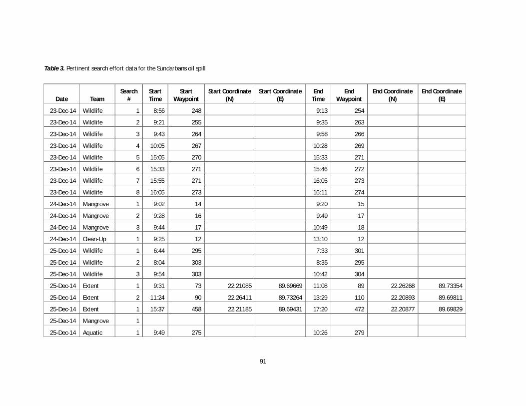
91
Table 3. Pertinent search effort data for the Sundarbans oil spill
Date Team Search
# Start Time
Start Waypoint
Start Coordinate (N)
Start Coordinate (E)
End Time
End Waypoint
End Coordinate (N)
End Coordinate (E)
23-Dec-14 Wildlife 1 8:56 248 9:13 254
23-Dec-14 Wildlife 2 9:21 255 9:35 263
23-Dec-14 Wildlife 3 9:43 264 9:58 266
23-Dec-14 Wildlife 4 10:05 267 10:28 269
23-Dec-14 Wildlife 5 15:05 270 15:33 271
23-Dec-14 Wildlife 6 15:33 271 15:46 272
23-Dec-14 Wildlife 7 15:55 271 16:05 273
23-Dec-14 Wildlife 8 16:05 273 16:11 274
24-Dec-14 Mangrove 1 9:02 14 9:20 15
24-Dec-14 Mangrove 2 9:28 16 9:49 17
24-Dec-14 Mangrove 3 9:44 17 10:49 18
24-Dec-14 Clean-Up 1 9:25 12 13:10 12
25-Dec-14 Wildlife 1 6:44 295 7:33 301
25-Dec-14 Wildlife 2 8:04 303 8:35 295
25-Dec-14 Wildlife 3 9:54 303 10:42 304
25-Dec-14 Extent 1 9:31 73 22.21085 89.69669 11:08 89 22.26268 89.73354
25-Dec-14 Extent 2 11:24 90 22.26411 89.73264 13:29 110 22.20893 89.69811
25-Dec-14 Extent 1 15:37 458 22.21185 89.69431 17:20 472 22.20877 89.69829
25-Dec-14 Mangrove 1
25-Dec-14 Aquatic 1 9:49 275 10:26 279

92
25-Dec-14 Aquatic 2 10:27 280 11:09 284
25-Dec-14 Aquatic 3 11:19 286 11:37 289
25-Dec-14 Aquatic 4 11:40 290 11:50 293
26-Dec-14 Wildlife 1 8:33 24 9:38 35
26-Dec-14 Wildlife 2 9:38 35 10:06 39
26-Dec-14 Wildlife 3 15:59 40 16:53 44
27-Dec-14 Wildlife 1 8:30 45 9:45 55

93
Table 4. Pertinent wildlife location data for the Sundarbans oil spill
Sighting # Team Date
Search # Time Waypoint
GPS Coordinate (N)
GPS Coordinate (E) Species ID/Activity
1 Wildlife 23-Dec-14 1 Unknown 249 Magpie, Robin 2 Wildlife 23-Dec-14 1 Unknown 250 Magpie, Robin 3 Wildlife 23-Dec-14 1 9:02 251 Unknown (Drongo?) 4 Wildlife 23-Dec-14 1 9:02 252 Kingfisher, Common 5 Wildlife 23-Dec-14 1 9:07 252 Kingfisher, Common 6 Wildlife 23-Dec-14 1 9:13 254 Eagle, Crested Serpent 7 Wildlife 23-Dec-14 2 9:21 258 Red Vented Bulbul 8 Wildlife 23-Dec-14 2 9:30 259 Kingfisher, Brown-Winged 9 Wildlife 23-Dec-14 2 9:32 260 Kingfisher, Brown-Winged
10 Wildlife 23-Dec-14 2 9:34 261 Bulbul, Red-Vented 11 Wildlife 23-Dec-14 2 9:34 262 Magpie, Robin
1 Clean-Up 24-Dec-14 1 9:47 14 Egret, Greater 9 Clean-Up 24-Dec-14 1 11:10 24 Widgeon
10 Clean-Up 24-Dec-14 1 11:20 25 Duck, Domestic 11 Clean-Up 24-Dec-14 1 11:30 26 Dolphin, Ganges River 12 Clean-Up 24-Dec-14 1 12:35 27 Adjutant, Lesser
1 Aquatic 25-Dec-14 1 9:59 276 22.29988 89.70506 Dove 3 Aquatic 25-Dec-14 1 10:18 278 22.29154 89.70023 Tailorbird, Common 6 Aquatic 25-Dec-14 2 10:30 281 22.29164 89.69807 Bulbul, Red-Vented 7 Aquatic 25-Dec-14 2 10:40 282 22.27594 89.69943 Egret, Greater 9 Aquatic 25-Dec-14 2 11:09 284 22.27471 89.69953 Macaque
10 Aquatic 25-Dec-14 2 11:14 285 22.27427 89.69987 Kite Sp. 14 Aquatic 25-Dec-14 3 11:37 289 22.27733 89.73528 Kite, Brahmini 15 Aquatic 25-Dec-14 4 11:40 290 22.27246 89.73275 Bulbul, Red-Vented 16 Aquatic 25-Dec-14 4 11:41 291 22.27208 89.73234 Macaque 17 Aquatic 25-Dec-14 4 11:43 292 22.27210 89.73236 Magpie, Robin

94
1 Extent 25-Dec-14 1 10:56 86 22.25912 89.74306 Drongo 2 Extent 25-Dec-14 2 11:43 98 22.27606 89.73469 Egret 3 Extent 25-Dec-14 2 12:13 102 22.24096 89.71341 Egret 4 Extent 25-Dec-14 2 12:19 104 22.24092 89.71265 Kingfisher Sp. 5 Extent 25-Dec-14 2 12:19 105 22.24096 89.71320 Kingfisher Sp. 6 Extent 25-Dec-14 2 11:39 96 22.27936 89.73343 Monkey 7 Extent 25-Dec-14 2 11:49 99 22.27307 89.73300 Monkey 8 Extent 25-Dec-14 2 11:34 94 22.27898 89.73173 Eagle, White-Bellied Sea 9 Extent 25-Dec-14 3 15:58 459 22.21667 89.68456 Egret Sp.
10 Extent 25-Dec-14 3 16:17 462 22.21753 89.67671 Egret Sp. 11 Extent 25-Dec-14 3 16:19 464 22.22362 89.67785 Kingfisher Sp. 12 Extent 25-Dec-14 3 16:54 467 22.21564 89.67505 Kingfisher Sp. 13 Extent 25-Dec-14 3 16:08 460 22.20764 89.67482 Monkey 14 Extent 25-Dec-14 3 17:02 469 22.20933 89.67840 Wabbler
1 Mangrove 25-Dec-14 1 9:27 22.22885 89.70100 Heron Sp. 2 Mangrove 25-Dec-14 1 9:33 22.23413 89.70087 Magpie, Robin 3 Mangrove 25-Dec-14 1 9:34 22.23563 89.70092 Egret Sp. 4 Mangrove 25-Dec-14 1 9:57 22.23925 89.71308 Macaque 5 Mangrove 25-Dec-14 1 10:41 22.26172 89.73118 Heron Sp. 1 Wildlife 25-Dec-14 3 16:40 20 22.20842 89.70002 Deer, Barking 1 Wildlife 25-Dec-14 1 7:02 296 Kingfisher, Brown-Winged 2 Wildlife 25-Dec-14 3 16:41 21 22.20802 89.70094 Egret, Greater 2 Wildlife 25-Dec-14 1 7:02 296 Egret, Small 3 Wildlife 25-Dec-14 1 7:19 297 Duck Sp. 3 Wildlife 25-Dec-14 3 17:07 22 22.21980 89.72194 Kingfisher, Common 4 Wildlife 25-Dec-14 1 7:20 298 Heron, Green 5 Wildlife 25-Dec-14 1 7:26 299 Egret, Small 6 Wildlife 25-Dec-14 1 7:28 300 Egret, Intermediate 7 Wildlife 25-Dec-14 1 7:35 301 Shank, Red

95
8 Wildlife 25-Dec-14 2 8:04 303 Hawk Eagle, Changeable 1 Wildlife 26-Dec-14 1 8:40 25 22.32042 89.70519 Egret, Intermediate 2 Wildlife 26-Dec-14 1 8:53 26 22.33608 89.70524 Heron, Indian Pond 3 Wildlife 26-Dec-14 1 9:02 27 22.34456 89.70795 Macaque 4 Wildlife 26-Dec-14 1 9:02 27 22.34456 89.70795 Magpie, Robin 6 Wildlife 26-Dec-14 1 9:12 29 22.35364 89.70837 Kingfisher, Brown-Winged 7 Wildlife 26-Dec-14 1 9:15 30 22.35641 89.70929 Magpie, Robin 8 Wildlife 26-Dec-14 1 9:24 31 22.36651 89.70979 Dolphin, Ganges River 9 Wildlife 26-Dec-14 1 9:29 32 22.36513 89.70674 Kingfisher, Brown-Winged
10 Wildlife 26-Dec-14 1 9:31 33 22.36421 89.70511 Kingfisher, Brown-Winged 11 Wildlife 26-Dec-14 1 9:34 34 22.36297 89.70251 Kingfisher, White Throat 12 Wildlife 26-Dec-14 2 9:45 36 22.36724 89.70901 Fish Eagle, Pallas' 13 Wildlife 26-Dec-14 2 9:50 37 22.36250 89.71023 Kingfisher, White Throat 14 Wildlife 26-Dec-14 2 9:56 38 22.35661 89.70917 Dolphin, Ganges River 15 Wildlife 26-Dec-14 3 16:29 41 22.37735 89.66562 Osprey 16 Wildlife 26-Dec-14 3 16:29 41 22.37735 89.66562 Malkoha 17 Wildlife 26-Dec-14 3 16:33 42 22.29509 89.61966 Kingfisher, Brown-Winged 18 Wildlife 26-Dec-14 3 16:35 43 22.29108 89.62258 Kingfisher, White Throat
1 Wildlife 27-Dec-14 1 8:39 46 22.27839 89.61401 Egret, Intermediate 2 Wildlife 27-Dec-14 1 8:40 46 22.27839 89.61401 Sandpiper, Common 3 Wildlife 27-Dec-14 1 8:46 47 22.27759 89.61653 Macaque 4 Wildlife 27-Dec-14 1 8:46 47 22.27759 89.61653 Deer, Spotted 5 Wildlife 27-Dec-14 1 8:54 49 22.26963 89.61980 Kingfisher, Black-Capped 6 Wildlife 27-Dec-14 1 8:57 50 22.26968 89.61198 Eagle, Crested Serpent 7 Wildlife 27-Dec-14 1 9:07 51 22.26761 89.60836 Macaque 8 Wildlife 27-Dec-14 1 9:20 53 Egret, Small 9 Wildlife 27-Dec-14 1 9:24 54 Egret, Small

96
Table 5. Pertinent wildlife observation data for the Sundarbans oil spill
Sighting # Team Date Search
# Species ID Group
Size Newborns Channel
Type Habitat
Type Oiling Status Health
1 Wildlife 23-Dec-14 1 Magpie, Robin 1 0 N/A M N N 2 Wildlife 23-Dec-14 1 Magpie, Robin 1 0 N/A M N N 3 Wildlife 23-Dec-14 1 Unknown (Drongo?) 1 0 N/A M T? N 4 Wildlife 23-Dec-14 1 Kingfisher, Common 1 0 N/A S N N 5 Wildlife 23-Dec-14 1 Kingfisher, Common 1 0 N/A S N N 6 Wildlife 23-Dec-14 1 Eagle, Crested Serpent 1 0 N/A T L N 7 Wildlife 23-Dec-14 2 Red Vented Bulbul 1 0 N/A M N N 8 Wildlife 23-Dec-14 2 Kingfisher, Brown-Winged 1 0 N/A M N N 9 Wildlife 23-Dec-14 2 Kingfisher, Brown-Winged 1 0 N/A M N N
10 Wildlife 23-Dec-14 2 Bulbul, Red-Vented 1 0 N/A M T N 11 Wildlife 23-Dec-14 2 Magpie, Robin 1 0 N/A S N N
1 Clean-Up 24-Dec-14 1 Egret, Greater 1 0 W S L N 9 Clean-Up 24-Dec-14 1 Widgeon 2 0 W S N N
10 Clean-Up 24-Dec-14 1 Duck, Domestic 6 0 W S N N 11 Clean-Up 24-Dec-14 1 Dolphin, Ganges River 6 0 C A N N 12 Clean-Up 24-Dec-14 1 Adjutant, Lesser 1 0 W S N N
1 Aquatic 25-Dec-14 1 Dove 1 0 W N N N 3 Aquatic 25-Dec-14 1 Tailorbird, Common 3 0 N N N N 6 Aquatic 25-Dec-14 2 Bulbul, Red-Vented 1 0 N N N N 7 Aquatic 25-Dec-14 2 Egret, Greater 2 0 W S N N 9 Aquatic 25-Dec-14 2 Macaque 1 0 W S N N
10 Aquatic 25-Dec-14 2 Kite Sp. 1 0 W T N N 14 Aquatic 25-Dec-14 3 Kite, Brahmini 1 0 W S N N 15 Aquatic 25-Dec-14 4 Bulbul, Red-Vented 1 0 W N N N 16 Aquatic 25-Dec-14 4 Macaque 1 0 W N N N 17 Aquatic 25-Dec-14 4 Magpie, Robin 1 0 W N N N

97
1 Extent 25-Dec-14 1 Drongo 1 0 N T N N 2 Extent 25-Dec-14 2 Egret 1 0 W A N N 3 Extent 25-Dec-14 2 Egret 1 0 N T N N 4 Extent 25-Dec-14 2 Kingfisher Sp. 1 0 N T N N 5 Extent 25-Dec-14 2 Kingfisher Sp. 1 0 N T N N 6 Extent 25-Dec-14 2 Monkey 1 0 W T N N 7 Extent 25-Dec-14 2 Monkey 1 0 W T N N 8 Extent 25-Dec-14 2 Eagle, White-Bellied Sea 1 0 W T N N 9 Extent 25-Dec-14 3 Egret Sp. 1 0 W T N N
10 Extent 25-Dec-14 3 Egret Sp. 1 0 W T N N 11 Extent 25-Dec-14 3 Kingfisher Sp. 1 0 W T N N 12 Extent 25-Dec-14 3 Kingfisher Sp. 1 0 W T N N 13 Extent 25-Dec-14 3 Monkey 3 0 W T N N 14 Extent 25-Dec-14 3 Wabbler 1 0 W T N N
1 Mangrove 25-Dec-14 1 Heron Sp. 1 0 N S N N 2 Mangrove 25-Dec-14 1 Magpie, Robin 1 0 N S N N 3 Mangrove 25-Dec-14 1 Egret Sp. 1 0 N S N N 4 Mangrove 25-Dec-14 1 Macaque 1 0 W T N N 5 Mangrove 25-Dec-14 1 Heron Sp. 1 0 W S N N 1 Wildlife 25-Dec-14 1 Kingfisher, Brown-Winged 1 0 N N N N 2 Wildlife 25-Dec-14 1 Egret, Small 1 0 N S N N 3 Wildlife 25-Dec-14 1 Duck Sp. 2 0 N N N N 4 Wildlife 25-Dec-14 1 Heron, Green 1 0 N S N N 5 Wildlife 25-Dec-14 1 Egret, Small 5 0 N S N N 6 Wildlife 25-Dec-14 1 Egret, Intermediate 1 0 N S N N 7 Wildlife 25-Dec-14 1 Shank, Red 1 0 N S N N 8 Wildlife 25-Dec-14 2 Hawk Eagle, Changeable 1 0 W T N N 1 Wildlife 25-Dec-14 3 Deer, Barking 1 0 W S N N 2 Wildlife 25-Dec-14 3 Egret, Greater 1 0 W S N N

98
3 Wildlife 25-Dec-14 3 Kingfisher, Common 1 0 W S N N 1 Wildlife 26-Dec-14 1 Egret, Intermediate 1 0 W S L N 2 Wildlife 26-Dec-14 1 Heron, Indian Pond 1 0 W S U N 3 Wildlife 26-Dec-14 1 Macaque 2 0 W T N N 4 Wildlife 26-Dec-14 1 Magpie, Robin 1 0 W S N N 6 Wildlife 26-Dec-14 1 Kingfisher, Brown-Winged 1 0 W S N N 7 Wildlife 26-Dec-14 1 Magpie, Robin 1 0 W S N N 8 Wildlife 26-Dec-14 1 Dolphin, Ganges River 1 0 W A U N 9 Wildlife 26-Dec-14 1 Kingfisher, Brown-Winged 1 0 W S N N
10 Wildlife 26-Dec-14 1 Kingfisher, Brown-Winged 1 0 W S N N 11 Wildlife 26-Dec-14 1 Kingfisher, White Throat 1 0 W S N N 12 Wildlife 26-Dec-14 2 Fish Eagle, Pallas' 1 0 W T N N 13 Wildlife 26-Dec-14 2 Kingfisher, White Throat 1 0 W S N N 14 Wildlife 26-Dec-14 2 Dolphin, Ganges River 1 0 W A N N 15 Wildlife 26-Dec-14 3 Osprey 1 0 N T N N 16 Wildlife 26-Dec-14 3 Malkoha 1 0 N T N N 17 Wildlife 26-Dec-14 3 Kingfisher, Brown-Winged 1 0 N S N N 18 Wildlife 26-Dec-14 3 Kingfisher, White Throat 1 0 N S N N
1 Wildlife 27-Dec-14 1 Egret, Intermediate 1 0 N S T N 2 Wildlife 27-Dec-14 1 Sandpiper, Common 1 0 N S N N 3 Wildlife 27-Dec-14 1 Macaque 2 0 N T N N 4 Wildlife 27-Dec-14 1 Deer, Spotted 3 0 N S N N 5 Wildlife 27-Dec-14 1 Kingfisher, Black-Capped 1 0 N S N N 6 Wildlife 27-Dec-14 1 Eagle, Crested Serpent 1 0 N T N N 7 Wildlife 27-Dec-14 1 Macaque 2 0 N T N N 8 Wildlife 27-Dec-14 1 Egret, Small 1 0 N S N N 9 Wildlife 27-Dec-14 1 Egret, Small 1 0 N S N N
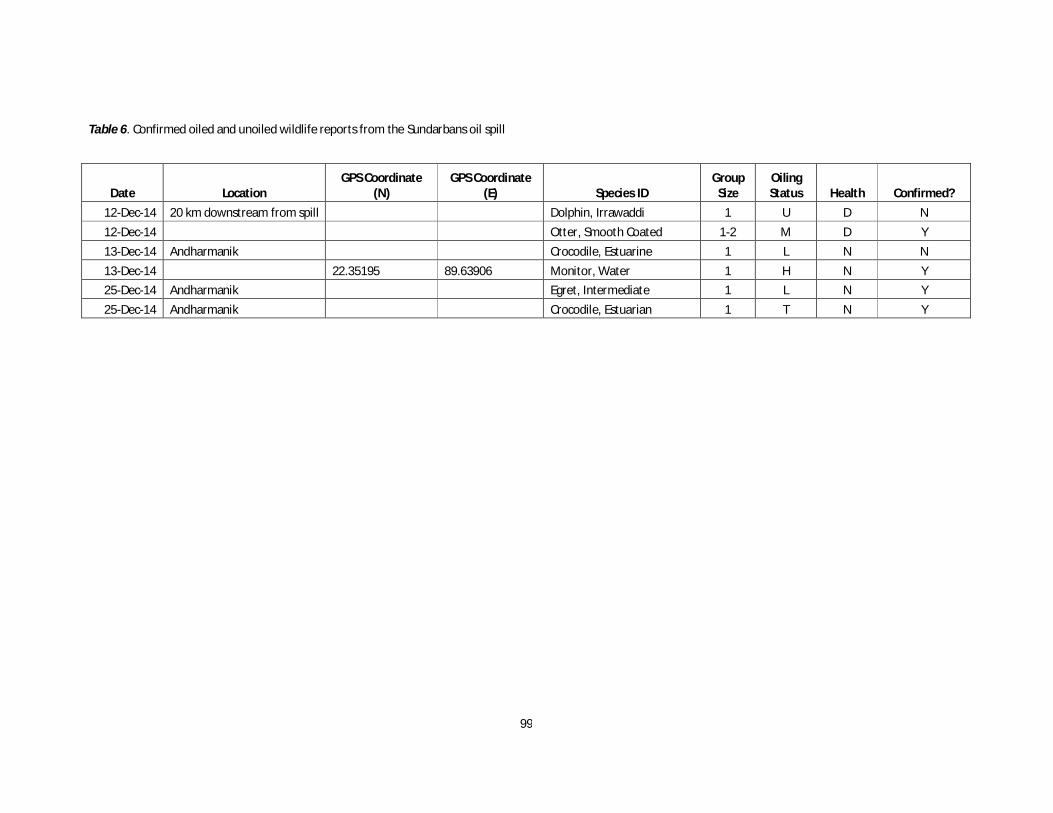
99
Table 6. Confirmed oiled and unoiled wildlife reports from the Sundarbans oil spill
Date Location GPS Coordinate
(N) GPS Coordinate
(E) Species ID Group
Size Oiling Status Health Confirmed?
12-Dec-14 20 km downstream from spill Dolphin, Irrawaddi 1 U D N 12-Dec-14 Otter, Smooth Coated 1-2 M D Y 13-Dec-14 Andharmanik Crocodile, Estuarine 1 L N N 13-Dec-14 22.35195 89.63906 Monitor, Water 1 H N Y 25-Dec-14 Andharmanik Egret, Intermediate 1 L N Y 25-Dec-14 Andharmanik Crocodile, Estuarian 1 T N Y

100
ANNEX 14. Human Health and Livelihoods Assessment
Socioeconomic Impact Assessment of the Oil Spill on the Sundarbans Resource Collectors at Mongla, Bagerhat
A. Overall Objective
To understand the impact of this incident on peoples’ livelihoods, especially Sundarbans resource dependent groups, most impacted groups and identify actions for short, medium and long term.
B. Methodology
The team conducted the assessment through adapting process based on the daily basis findings during the data collection at the affected area. The duration of assessment is three days from December, 24-26, 2014.
1. Geographic Location
At the first step, the team held a discussion meeting with the local elected government representatives and affected community people. They participants of the meeting informed that the oil spill affected community people living adjacent to the river banks of Pashur and Shela at Chila Union in wards of 4, 5, 7, 8 and 9 covering the villages of Joymoni Dakshin, Joymoni Moddhya, Joymoni Uttar, Gabgunia and Paschim Chila. The population of the affected area is 8,373 (Male-4,244 and female-4129) out of 2,042 households (Source: E-service center, Chila Union Parisad). The below map showed the location of the villages.

101
2. Assessment
The assessment conducted by the following tools and collected similar data from various settings and triangulation for confirmation of information. The facilitated tools are:
Field observation of the oil spill and spread areas (on the Shela and Pashur river banks, homestead, low line crop fields, ponds, shrimp culture ghers/enclosures) A quick survey of households based on set a questionnaire (see Table 1) Semi-structured interviews Focused group discussions Table 1. Questionnaire questions
1. How many people involved in the oil collection from your village? 2. Have you been involved in oil/oil affected debris collection? Yes / No 3. What did you do with the collected debris? 4. What effects has burning of oiled debris had your health? a. None b. difficulty in breathing
c. Headache d. others 5. While collecting the oil/oil affected debris did you have any health problems? a. Vomiting b.
Itching c. Rash d. Headache e. others 6. What was the intensity of the heath problem? a. No impact b. Mild impact c. Strong impact 7. What sort of other damages did you face the oil spill? a. Damage of the gear b. Damage of
the clothing c. Damage of the poultry d)others… 8. Have you see any wildlife/dead animal after oil spill? (Sighting, species, type) 9. Has fish catch changed since oil spill? a. Decreased b. Increased c. Same 10. What can be done to cope with the problems you have faced due to oil spill? (short / long-
term)
C. Findings
Overall 03 focused group discussions (FGDs), 13 Semi-structure interviews (SSIs), and 159 households interviews were conducted. Of the total respondents of households’ interviews, 66.7% were male and 33.3% were female. The average age was 40.3 years with a range between 17 and 80 years. The respondents of the assessment are heterogeneous i.e. the oil collectors and non-collectors with the professions of shrimp post larvae collectors, housewives, fish businessmen, set (those who purchasing the shrimp post larvae in bulk quantity), forest resource collectors (crab, fuel, fodder, leaves). The households survey respondents are 64% fishers and 34% shrimp post larvae collectors.
1. Oil Collectors
The number of oil collectors largely varied according to the respondents of household interviews i.e. 4-2000 with an average of 300. However, according to the oil purchasing company5, a total number of 224 individuals name were recorded who sold the collected 68,200 litres oil to them. Likewise, following the decision from Deputy Commissioner (DC) of Bagerhat District, a list of around 700 people (who collected the oil) prepared by the elected local government representative, the Chairman, Chila Union Parisad. He subsequently sent that households list upwards through Mongla Upazila (Sub-district) administration.
5 Bangladesh Padma Oil Company (BPC)

102
2. Oil Contaminated Waste Disposal
Survey data revealed that 115 respondent (out of 159) physically involved in cleaning the oiled debris. Of these, 35.7% reported taking it to the Department of Forest Jetty, 19.1% piling it directly on the shore, 11.3% burying the debris, 7.8% piling it directly on the ground but the pile washed away in the high tide, and 12.2% % burning the debris and then burying the remains. The remaining respondent turned the debris over to others for disposal. According to the findings of FGDs and SSIs, this effort made the people to response to the incident but that resulted hazards to their health as people involve in this activity without any minimum safety measures. Despite that effort, till the last day of assessment (December 26, 2014), the sign of oil observed visible at the piles adjacent to the rivers, and these are getting washed by water flow day by day. Some oil collected gears, crafts, debris, still kept aside at the homestead areas, river bank areas of the affected community.
3. Impact on Health
There is a mixed reaction about the impact on health of those people who were engaged in collecting the oil from the Shela and Pashur Rivers. The survey data revealed that 72.3%
respondents (115 out of 159) were involved in oil and oiled debris collection. A slight majority of the respondent reported no direct health impacts of the oil spill (54.7%). The rest of the respondents reported no health impacts during oil collection but noticing health impacts during oiled debris
Figure 2: Oil Collection by Hands.
Figure 1. Reported health impacts.
Figure 2. Oil Collection by Hands.

103
collection and disposal. Of those respondents reported adverse health effects, 34.6% reported difficulty in breathing, 17.0% reported eyes burning, 12.6% reported headaches, 5% reported vomiting, and 2.5% reported itching for a week or more. Same respondents faced difficulties like headache and vomiting, or itching and eyes burning, etc. About half of the respondents with symptoms reported them as mild and the remaining half as strong. In reply of the question of FGDs and SSIs, they have also informed that nobody got admitted into the hospital near to their village (the community clinic at Katakhali) or at distance health service structures.
4. Fish Production
Most of the participants explained that due to low tide, the shrimp post larvae collection was not massively continued during the moment of oil spill. While, after two weeks of oil spill, the high tide took place in full shape and they are now continuing the collection of shrimp post larvae. Also, the collected post larvae have been released in various ghers and they didn’t observe or get any news that these shrimp post larvae are dying due to the impact of oil spill. The households survey data revealed that the fish catches declined as reported by majority (58.5%) of the respondents, 39% reported no change and 2.5% reported in decrease of fish production. Now is the shrimp post larvae collection season, therefore about other fish catches, they can’t give any opinion that the production increased or decreased due to oil spill. While, at the oil spill spot they have observed few dead fishes and crabs.
5. Other Forest Resources
The other forest resource collectors (crabs, honey, fuel, fodder, wood, leaves collectors) were not go inside the forest during the first two weeks due to the raised tension of oil spill. Therefore, they were not able to inform about any status of impact of oil spill on forest resources. They have expressed fear that they may lose the opportunity to go inside the forest for collecting the resources. Very few participants reported of oiled or dead wildlife, although we did receive isolated reports of oiled and dead kingfishers, sandpipers, fish, one wild boar and one monitor lizard.
6. Households’ Income
Most of the forest dwellers described that due to oil spill, the ships are not allowed to anchor at their river banks which resulted reduction of their income. If the ships anchored at their location, the people get down and purchase various goods and meals from the village and they get good income.
Due to oil spill, first two weeks they were not able to continue the shrimp post larvae collection from the rivers which impacted on their income on the other hand they earn money by selling collected
Figure 3. Collected Shrimp Post Larvae
Figure 4. Reported impact on fish catch

104
oil. Also, those who went for post larvae collection their nets got damaged due to oil contamination and not possible to use the same nets again for shrimp post larvae collection, reported by the large numbers of participants of assessment (81.8%). Similarly, 81.1% reported that their clothes damaged during oil collection. The numbers of damaged nets may be above five hundred, they claimed. The damaged nets are: set bag nets, current nets, mosquito nets, line nets, and drift nets. Among those,
the mosquito and current nets are illegal for fishing. The only way for purchasing the net again is to take loans from the local money lenders with high rate of interest. Some fishermen go for other kinds of livelihoods activities like working as wage labour in paddy field or earth work.
The crop fields, ponds and shrimp culture ghers are not observed contaminated by the oil. This was due to the precaution by the farmers and they didn’t enter water into their areas for the first two weeks to avoid contamination. On the other hand, 18.2% households’ survey respondents informed about loss of domestic ducks.
7. WaSH
The participants informed that for first two weeks, they were not able to collect drinking water from both the rivers due to visible oil on top of the water. Now days, they are continue to collect and drink water from rivers. But during that refrained period they fetched water from long distance or purchased water with high cost. These two rivers are the only source of drinking water during winter, whereas during summer they usually drink rainwater instead of drinking water from the rivers.
D. Conclusion
The assessment data revealed that the impact on income from livelihood options were intensive during the first two weeks due to refraining from fishing at both the rivers and from the forest resources as well. The fish/shrimp catches may decrease due to oil spill as majority of the respondents informed. The other livelihoods activities like agriculture, pond fish culture, poultry and livestock activities at the field and homestead areas not that much impacted. The people who directly involved in oil collection have faced temporary health hazards. However, there were no in patient cases identified due to the health hazards caused by oil collection. The massive collection of oil by the joint efforts of community and Department of Forest from the second day of spill till December 22, 2014 reduces the intensive impact on their livelihood activities. While, they are coping with that disaster by taking loans from money lenders and purchased fishing nets and continue fishing. Some of them goes to work for other options like wage labour for agricultures, earth workers, etc.
E. Recommendations
The oil collectors may availed the opportunity to claim for compensation as they have lost their income due to oil spill resulting in death of their poultry birds, lost income due to refraining from fishing, etc. Compensation for free treatment and medicine for any disease resulted health hazards caused due to oil spill.

105
The long-term action could be facilitation of alternative livelihoods activities to keep them refraining from collection and depletion of forest resources. The oil contaminated nets, containers, debris need to collect as early as possible from the households and dispose those at the distance with caution to avoid further contamination. Intensive periodical study is required to start as early as possible to conduct health check-up by the physician to the oil collectors. Based on the findings the long-term health monitoring program can be carried out.

106
ANNEX 15. Chemical Characterization (Tasks 1, 2, 3, and 5)
Chemical characterization of all samples was carried out using gas chromatography/mass spectrometry (GC/MS) operated in selected ion monitoring (SIM). The GC/MS methodology has been developed specifically for detection and quantification of compounds unique to oil spills. The target GC/MS-SIM analytes are given in Table 1 and are widely used to identify petrogenic, biogenic, and pyrogenic hydrocarbons in a variety of sample matrices. Note that the list includes commonly-found aromatic hydrocarbons and their alkyl homologs, saturate compounds from C10 to C35, isoprenoids pristane and phytane, and four groups of oil “biomarkers”. The oil biomarkers include the tri- and pentacyclic hopanes, diasteranes and regular steranes, 14β(H)-steranes, and the triaromatic steroids. Chemical characterization of samples was performed using an Agilent 7890 GC equipped with an Agilent 5975 inert XL MSD or an Agilent 6890 GC equipped with an Agilent 5973 MSD. Both instrument systems were fitted a 5% diphenyl/95% dimethyl polysiloxane high-resolution capillary column (30 m x 0.25 mm x 0.25µm). Instrumental acquisition was identical for both instruments and QA/QC assured that data was comparable between both systems.
Table 1. Targeted Petroleum Hydrocarbon Analytes
Anthracene Fluoranthene C-1 Phenanthrenes Benzo (a) Anthracene Fluorene C-2 Phenanthrenes Benzo (a) Pyrene C-1 Fluorenes C-3 Phenanthrenes Benzo (b) Fluorene C-2 Fluorene s C-4 Phenanthrenes Benzo (e) Pyrene C-3 Fluorenes Pyrene Benzo (g,h,i) Perylene Indeno (1,2,3-cd) Pyrene C-1 Pyrenes Benzo (k) Fluorene Naphthalene C-2 Pyrenes Chrysene C-1 Naphthalenes C-3 Pyrenes C-1 Chrysenes C-2 Naphthalenes C-4 Pyrenes C-2 Chrysenes C-3 Naphthalenes Saturate Hydrocarbons: C-3 Chrysenes C-4 Naphthalenes nC10-nC35 C-4 Chrysenes Naphthobenzothiophene Oil Biomarkers: Dibenzo (a,h) Anthracene C-1 Naphthobenzothiophenes Hopanes (m/z 191)
Dibenzothiophene C-2 Naphthobenzothiophenes Diasteranes & Regular Steranes (m/z 217)
C-1 Dibenzothiophenes C-3 Naphthobenzothiophenes 14β(H) Steranes (m/z 218) C-2 Dibenzothiophenes Perylene Triaromatic Steroids (m/z 231) C-3 Dibenzothiophenes Phenanthrene
GC/MS data were also used to calculate the Fossil Fuel Pollution Index (FFPI) to determine if the PAH signatures in in-situ burn residues changed from a petrogenic signature to a more pyrogenic signature. The FFPI was first conceived by Boehm and Farrington (1984) and was later modified by LSU-RCAT to incorporate an expanded list of target aromatic compounds. The modified FFPI was calculated as follows:
Modified FFPI = (((C-1 Naphs + C-2 Naphs + C-3 Naphs + C-4 Naphs + C-1 Fluors + C-2 Fluors + C-3 Fluors + DBT + C-1 DBTs + C-2 DBTs + C-3 DBTs + C-2 Phens + C-3 Phens + C-4 Phens + C-2 Pyrs + C-2 Chrys) + (0.5 x (Naph + Fluro + Phen + C-1 Pyrs + C-1 Chrys))))/(Total Aromatics – Perylene)
A modified FFPI value closer to one (1.0) represents petrogenic/oil-derived PAHs while a value less than 0.6 represents pyrogenic/combustion-derived PAHs.