summary of the glmris report - great lakes and …€¦ · nuisance species (ans) ... then used in...
TRANSCRIPT

Great Lakes andMississippi River Interbasin Study
Summary of the GLMRIS Report

water quality; transport diseases; and result in economic, political, and social impacts. For these reasons, ANS are of national and global concern.
Because ANS populations span watershed and government jurisdictional boundaries, efforts to manage them must be coordinated across these boundaries.
Prevention is recognized as the best defense against ANS. For GLMRIS, USACE has interpreted the term “prevent” to mean the reduction of risk to the maximum extent possible, because it may not be technologically feasible to achieve an absolute solution.
GEOGRAPHIC FOCUS
GLMRIS Study Area
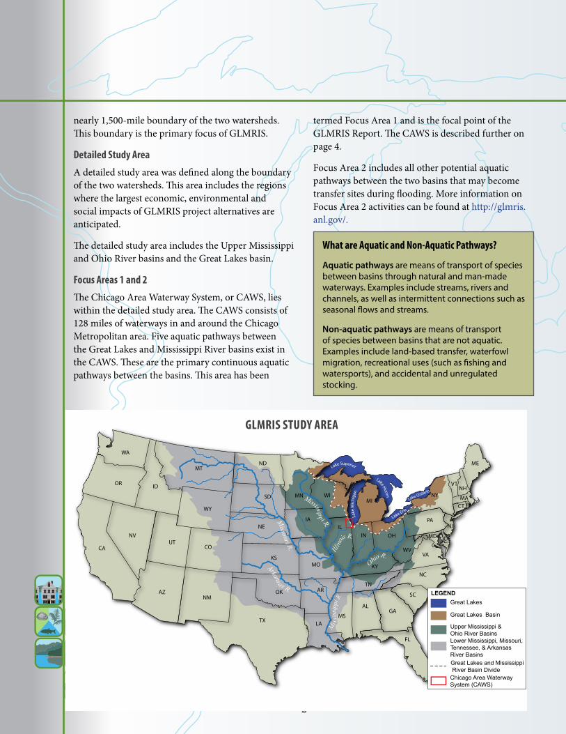
The GLMRIS study area includes the Great Lakes and Mississippi River basins of the United States. Potential aquatic pathways between the basins exist along the
This document summarizes the information set forth in the GLMRIS Report. The entire GLMRIS Report, including Technical Appendices, can be downloaded on the GLMRIS web site at http://glmris.anl.gov.
WHAT IS GLMRIS?GLMRIS is the Great Lakes and Mississippi River Interbasin Study conducted by the United States Army Corps of Engineers (USACE) as authorized by the United States Congress. USACE is conducting the study in consultation with other federal agencies, Native American tribes, state agencies, local governments, and nongovernmental organizations.
The goal of GLMRIS is to present a range of options and technologies to prevent the transfer of aquatic nuisance species (ANS) between the Great Lakes and Mississippi River basins through aquatic pathways.
These options are presented in the GLMRIS Report as eight alternative plans. Impacts to uses and users of the waterways affected by the plans were evaluated, and methods to address significant impacts are included in the alternatives. The report outlines potential plans for decision makers; a recommended plan was not selected for the project.
WHY THE NEED FOR GLMRIS?The Great Lakes and Mississippi River basins are ecosystems of great importance in the United States. In recent years, invasions of ANS have severely impacted the economic and environmental resources of these ecosystems.
GLMRIS addresses the need for a comprehensive effort to reduce the risk of future ANS transfers between the two basins.
AQUATIC NUISANCE SPECIES: POTENTIAL IMPACTS AND PREVENTIONAquatic nuisance species can threaten native plants and animals; reduce abundance and variety of native species; harm important terrestrial and aquatic ecosystems; degrade
- 1 -
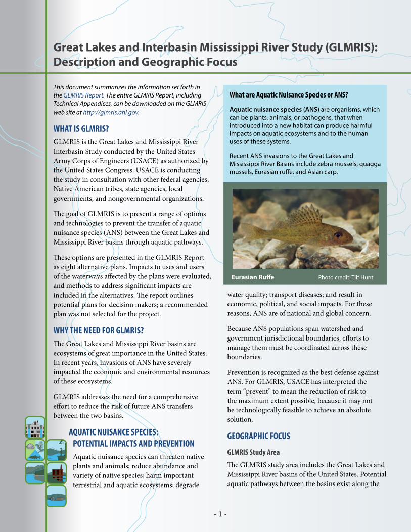
What are Aquatic Nuisance Species or ANS?
Aquatic nuisance species (ANS) are organisms, which can be plants, animals, or pathogens, that when introduced into a new habitat can produce harmful impacts on aquatic ecosystems and to the human uses of these systems.
Recent ANS invasions to the Great Lakes and Mississippi River Basins include zebra mussels, quagga mussels, Eurasian ruffe, and Asian carp.
Eurasian Ruffe Photo credit: Tiit Hunt
Great Lakes and Interbasin Mississippi River Study (GLMRIS): Description and Geographic Focus
- 2 -
nearly 1,500-mile boundary of the two watersheds. This boundary is the primary focus of GLMRIS.
Detailed Study Area
A detailed study area was defined along the boundary of the two watersheds. This area includes the regions where the largest economic, environmental and social impacts of GLMRIS project alternatives are anticipated.
The detailed study area includes the Upper Mississippi and Ohio River basins and the Great Lakes basin.
Focus Areas 1 and 2
The Chicago Area Waterway System, or CAWS, lies within the detailed study area. The CAWS consists of 128 miles of waterways in and around the Chicago Metropolitan area. Five aquatic pathways between the Great Lakes and Mississippi River basins exist in the CAWS. These are the primary continuous aquatic pathways between the basins. This area has been
termed Focus Area 1 and is the focal point of the GLMRIS Report. The CAWS is described further on page 4.
Focus Area 2 includes all other potential aquatic pathways between the two basins that may become transfer sites during flooding. More information on Focus Area 2 activities can be found at http://glmris.anl.gov/.
WA
OR
CA
NVUT
CO
AZNM
OK
TX
KS
NE
SD
ND
MN
IA
WIMI
IL
MO
AR
MS
ALGA
FL
LA
SC
NC
TN
IN OH
KY
WVVA
MD
PA
DE
CT
NJ
RIMANYNH
VT
ME
WY
MT
ID
Lake Erie
Lake
Mic
higa
n
Lake Superior
Lake Huron
Lake Ontario
M
issi
ssip
pi R
.
Arkans a s R.
Il
linois R.
Ohio
R.
Mississipp i R.
Missouri R.
LEGENDGreat Lakes
Great Lakes Basin
Upper Mississippi & Ohio River BasinsLower Mississippi, Missouri, Tennessee, & Arkansas River Basins
Chicago Area Waterway System (CAWS)
Great Lakes and Mississippi River Basin Divide
GLMRIS STUDY AREA
What are Aquatic and Non-Aquatic Pathways?
Aquatic pathways are means of transport of species between basins through natural and man-made waterways. Examples include streams, rivers and channels, as well as intermittent connections such as seasonal flows and streams.
Non-aquatic pathways are means of transport of species between basins that are not aquatic. Examples include land-based transfer, waterfowl migration, recreational uses (such as fishing and watersports), and accidental and unregulated stocking.

- 3 -
AUTHORIZING LEGISLATIONGLMRIS was authorized by Congress in 2007 in Section 3061(d) of the Water Resources Development Act of 2007, Public Law 110-114 (WRDA 2007).
To provide a thorough and comprehensive analysis, GLMRIS includes an analysis of the impacts to uses and users of the CAWS that might occur if any alternative were implemented.
In 2012, Congress modified the direction of GLMRIS in Section 1538 of the Moving Ahead for Progress in the 21st Century Act, Public Law 112-141, to focus on the five direct aquatic pathways of the CAWS between the Great Lakes and the Mississippi River basins.
STUDY GOALThe goal of GLMRIS is to present a range of options and technologies to prevent the transfer of aquatic nuisance species (ANS) between the Great Lakes and Mississippi River basins through aquatic pathways. The GLMRIS Report addresses this goal by presenting eight alternative plans. These GLMRIS Alternatives were developed with two objectives:
• Preventing ANS transfer• Mitigating impacts to resources (uses) and users
of any plan implementation
STAKEHOLDER ENGAGEMENTThe alternative plans were developed by USACE with input from federal, state, and local agencies, Native American tribes, nongovernmental organizations, and the public at key milestones in the study.
At the study outset, USACE held 12 meetings in the Great Lakes and Mississippi River basins to gather input used to help define the study problem, opportunities, and constraints.
A collaborative stakeholder participation process is employed to engage interested parties, including establishing a multi-agency advisory committee, sharing study products as they became available, and having a strong presence on the Internet and social media.
GLMRIS REPORTThe GLMRIS Report presents eight alternative plans designed to prevent the transfer of ANS between the Great Lakes and Mississippi River basins. Impacts to uses and users of the CAWS were evaluated for each alternative, and methods to address these impacts were included in the alternatives.
The GLMRIS Report does not recommend a specific plan. However, evaluation criteria are included in the report that could be used by decision makers to further evaluate and compare the alternative plans.
This document summarizes the information set forth in the GLMRIS Report. The entire GLMRIS Report, including Technical Appendices, can be downloaded on the GLMRIS web site at http://glmris.anl.gov.
INTRODUCTION & BACKGROUND
GLMRIS Authorization and Project Approach
Fishing on the Mississippi River

- 4 -
CAWS LOCATION AND DESCRIPTIONThe Chicago Area Waterway System (CAWS) is the primary focus of GLMRIS. There are five continuous aquatic pathways between the Great Lakes and Mississippi River basin located within the system. The CAWS is a network of canals and channelized rivers in northeastern Illinois and northwestern Indiana. It is a complex, multipurpose waterway with many uses and users that developed as the City of Chicago expanded. The CAWS is operated by the Metropolitan Water Reclamation District of Greater Chicago (MWRDGC), primarily to transport stormwater and wastewater treatment plant discharges. USACE maintains the CAWS for commercial and recreational navigation.Nearly half of the CAWS is excavated, man-made channels. The rest is made up of formerly natural streams that have been highly altered and no longer resemble their original condition. Flow of water through the CAWS in Illinois is generally from north to south and from east to west. The system slowly drains away from Chicago and Lake Michigan into the Mississippi basin and down toward Lockport.Much of the water in the CAWS comes indirectly from Lake Michigan. Water intakes located offshore in Lake Michigan supply water that is treated and then used in homes, offices, and industries. That water eventually makes its way to wastewater treatment plants. There are five wastewater treatment plants, called “water reclamation plants,” in the CAWS. These WRPs are O’Brien, Stickney, Calumet, and Lemont in Illinois, and Gary in Indiana.About 70 percent of the total annual flow out of the CAWS at Lockport is treated wastewater discharged from the WRPs in Illinois.
Chicago Area Waterway System (CAWS)
Aquatic Pathways between Lake Michigan and the Mississippi River Basin in the CAWS
1. Wilmette Pumping Station, IL
2. Chicago River Controlling Works, IL
3. Calumet Harbor, IL
4. Indiana Harbor, IN
5. Burns Small Boat Harbor, IN
Waterways in the CAWS

- 5 -
WATER REGULATING STRUCTURESWater moving into and out of the CAWS is mostly regulated by a series of structures that include:
• Wilmette Pumping Station, IL at the north end of the system.
• Chicago River Controlling Works, IL on the Chicago River and the O’Brien Lock and Dam, IL on the Calumet River provide passage for ships and boats to and from Lake Michigan and regulate flow of water to the CAWS from Lake Michigan.
• Dams at Lockport, IL and Brandon Road, IL control the southward discharge into the Des Plaines River and the Illinois River system.
CHICAGO AREA WATERWAY SYSTEM
INTRODUCTION & BACKGROUND
OTHER IMPORTANT LOCATIONSThe GLMRIS Alternatives include controls or other measures affecting several of the WRPs and regulating structures listed above. In addition to these locations, controls and structures were also sited at:
• Alsip, IL • Oak Lawn, IL• Calumet City, IL • Thornton, IL• Chicago, IL • Stateline, IL/IN• McCook, IL • Hammond, IN
Bubbly
Creek
Chicago
R
South
Br
Little Calumet River
Cal
umet
Riv
er
Des
Pla
ines
Riv
er
Chicago
River
Chicago Sanitary
and Ship Canal
Salt Creek
Calumet-Sag Channel
Des P
laines River
IndianaHarbor & Canal
Burns DitchGrand Calumet River
N. Br. Chicago R
iver
North S
hore Channel
Hammond
O’BrienWRP
Electric Dispersal Barriers
Lemont WRPIndiana Harbor
GaryWWTP
Burns Small Boat Harbor
Lockport Controlling Works
Lockport Lock & Dam
Calumet WRP
CalumetHarbor
StickneyWRP
JOLIET
CHICAGO
GARY
IINDIANA
ILLINOIS
Stickney
Alsip
Thornton
CalumetCity
OakLawn
Chicago RiverControlling Works
LakeMichigan
McCook
Wilmette
StateLine
T.J. O’BrienLock & Dam
Brandon Road Lock & Dam
GLMRIS MeasureLocation
Other CAWSFeature
WaterReclamation Plant
IUses and Users of the CAWS include:• Management of stormwater and
combined sewer overflows to pre-vent floods and basement backups
• Receiving discharges from municipal and industrial treatment plants
• Water supply for industries• Emergency response vessels• Commercial navigation• Recreational boating• Sport fishing• Power generation• Cooling water for power
generators, commercial buildings, and other industries

- 6 -
TARGET ANS SPECIES FOR GLMRISA list of ANS was compiled to provide focus for the set of options or control alternatives developed in GLMRIS to prevent ANS from transferring between the Great Lakes and Mississippi River basins.
ANS SCREENING PROCESSA total of 254 ANS were determined by the GLMRIS Team to be present in either the Great Lakes or Mississippi River basins or both. Once this overall list of ANS in the study area was developed, several steps were completed to shorten the list. Species were removed from the list if they were:
• Already in both the Great Lakes and Mississippi River basins
• Not likely to move from one basin to the other through the CAWS
• Not likely to become a nuisance or invasive• Not likely to cause moderate to severe harm
These steps shortened the list from 254 to 35 species. An assessment was completed to identify the level of risk or likelihood of each of the 35 species to cause harm if they were to enter a new basin. This process is called a “risk assessment.”
As a result of the risk assessment, each species was given a rating of high, medium, or low, based on two factors:
• Whether the species were likely to enter and become established in the other basin; and
• The likelihood of causing harmful impacts if the species were to become established in the other basin.
After the ratings were assigned, species identified as having a low likelihood of impacts were removed
from the list. The list of 35 species was reduced to a final list of 13 ANS target species identified as having either a medium or high risk of transfer between basins.
ANS RISK REDUCTIONSPotential reductions in the risk of transfer were evaluated for each of the 13 species for each alternative plan. For descriptions of the ANS risk ratings and the ANS risk reduction expected for each alternative plan, please see the GLMRIS Report.
Aquatic Nuisance Species (ANS) Considered in GLMRIS
Threespine Stickleback Photo credit: Carin Gondar
Silver Carp Photo credit: Desidor
ANS Species Considered in GLMRIS Alternative PlansSpecies Posing Risk to the Great Lakes Basin:
1. Scud2. Bighead carp3. Silver carp
Species Posing Risk to the Mississippi River Basin:4. Bloody red shrimp5. a Diatom6. Fishhook waterflea7. Grass kelp 8. Red algae9. Reed sweetgrass 10. Ruffe11. Threespine stickleback12. Tubenose goby13. Viral Hemorrhagic Septicemia virus (VHSv)

- 7 -
SELECTION OF ANS CONTROL TECHNOLOGIESTechnologies that can be used to control the transfer of the 13 target ANS for GLMRIS were identified through a series of studies. From the original list of 96 technologies that were identified, several were selected as appropriate for consideration in the CAWS to minimize and/or prevent the transfer of ANS between the Great Lakes and Mississippi River basins.
ANS controls are either nonstructural or structural methods. Structural methods include the building and operation of structures to control the transfer of ANS.
NONSTRUCTURAL CONTROLSNonstructural controls can be installed or applied quickly and have relatively few potential safety risks associated with their use. They include methods like:
• Using nets to remove fish from a water body;• Using registered chemicals to control plants or
animals in a water body;• Controlling boat access to a waterway and
making cleaning stations available to boats going between different water bodies; and
• Education programs to help the general public understand the issues associated with ANS and how their everyday actions can influence the spread of ANS.
STRUCTURAL CONTROLS Structural control methods for the CAWS include GLMRIS Locks, electric barriers, ANS Treatment Plants, screened sluice gates, and physical barriers.
The GLMRIS Lock is a gate system that allows boat traffic to pass between water bodies and uses a system of structures and special equipment to control the transfer of ANS.
The lock is closed after a boat enters. ANS-treated water is then pumped into the lock, replacing the water that came in with the boat. The lock is then opened and the boat continues on its way. Electric barriers and ANS Treatment Plants are used in combination with the GLMRIS Lock system.
ANS & CONTROL TECHNOLOGIES
ANS Control Technologies Considered in GLMRIS Alternatives
Boat Passing through a GLMRIS Lock
GLMRIS LockPrevents the transfer of ANS that move by Passive Draft along the current of water.
2 - ANS-treated water is pumped into one endof the GLMRIS Lock.
Untreated Water
Untreated Water
Untreated Water
Lock gatesare closed on this end.
Lock gatesare closed on this end.
Lock gatesare closed on this end.
4 - ANS-treated water replaces untreated water.
3 - Untreated water is pumped from the opposite end of the lock.
1 - Vessel is entering theCAWS ANS Buffer Zone.
Lock gatesare closed on this end.
CAWS ANSBuffer Zone
CAWS ANSBuffer Zone
CAWS ANSBuffer Zone
5 - Vessel is locked through ANS-treated water and enters the CAWS ANS Buffer Zone.
*General operating conditions are shown. Operations would vary based on direction of travel and site specific conditions.
GLMRIS Lock System Layout
Electric Barrier Control House
GLMRIS Lock
ANS Treatment Plant
Electrodes

- 8 -
Electric barriers are included as part of the GLMRIS Lock to reduce the possibility of fish getting through the lock. The barrier uses electrodes in the bottom of the channel, powered by a control house, to create an electric field in the waterway. Fish are repelled or stunned by the electric field, which restricts their movement into the GLMRIS Lock.
The ANS Treatment Plant (ANSTP) is a system to remove ANS from water used for operation of the GLMRIS Lock. The process of treating the water includes screening, filtration, and exposure to ultraviolet light (UV).
Screened sluice gates are used to control ANS transfer during flood conditions. They allow water to pass during significant flood conditions, but the screen controls fish passage through the structure.
Physical barriers are structural control measures used to separate one water body from another. Separation of water bodies provides a relatively high level of confidence that the transfer of ANS will be
controlled. Barriers are built using concrete and sheet pile and could also be used as park space or pedestrian bridges.
GLMRIS Electric Barrier Layout
Control House
Electric CablesConnect to Electrodes
Electric Cables
EngineeredChannel
Electrodes are Placed Along the Bottom of Engineered Channel
GLMRIS ANS Treatment Plant Process
SCREENS UV LIGHT
SCREENS UV LIGHTSAND FILTER
ANSTPS AT WILMETTE, CHICAGO, TJ O'BRIEN AND CALUMET CITY
ANSTPS AT STICKNEY AND ALSIP
Screened Sluice Gates Operation
BACKFLOW

- 9 -
Among a larger array of uses and users of the CAWS, the primary elements considered in the study include:
Uses • Flood risk management • CAWS ecosystem• CAWS water quality• Lake Michigan water quality
Users• Commercial navigation• Noncommercial navigation• Hydropower
MITIGATIONIf significant impacts could not be minimized in an alternative, methods were developed to address the impacts as possible for each use or user. The planned methods for addressing impacts are termed “mitigation.”
A set of four measures for mitigation of impacts were used in the GLMRIS Alternatives:
• ANS Treatment Plant- used in some alternatives for water quality mitigation in addition to ANS control.
• Conveyance tunnel- collects stormwater or wastewater and transports it to a storage reservoir; or reroutes WRP effluent to mitigate water quality impacts.
• Reservoirs- provides storage for excess stormwater and wastewater during rain events.
• Sediment remediation- cleanup of contaminants in sediments that may impact Lake Michigan in some alternatives.
PLANNING HORIZONThe effectiveness and impacts of each alternative were evaluated over a 50-year period. Conditions under the alternatives were compared to the baseline condition (Alternative Plan 1) at 0 years and at 10, 25, and 50 years.
COST OF THE ALTERNATIVEFor each alternative, the GLMRIS Report includes a rough estimate of the costs of implementing the alternative. This estimate includes the costs for both the ANS controls and any required mitigation to implement the alternative, though some of these costs may be borne by entities other than USACE.
GLMRIS ALTERNATIVE PLANSEight alternative plans, including a “No New Federal Action-Sustained Activities” baseline alternative, were developed in the study with the goal of preventing ANS transfer between the Great Lakes and Mississippi River basins. The focus of these alternatives is control of the 13 target ANS species. Overviews of each alternative plan are presented in the following pages.
STRATEGIES USED IN ALTERNATIVE PLANSThere are several strategies for ANS control used in the GLMRIS Alternatives:
• Nonstructural controls- examples include education and outreach, pesticide use, and mechanical removal.
• Structural ANS control technologies- GLMRIS Locks, electric barriers, ANS treatment plants, screened sluice gates, and physical barriers.
• Buffer zone- an ANS-treated area of waterway created between upstream and downstream control technologies.
• Hydrologic separation- use of physical barriers placed in waterways to block aquatic connections between basins.
• Hybrids- combinations of the individual strategies.
USES AND USERSIn developing each GLMRIS Alternative, impacts to uses and users of the CAWS and Lake Michigan were evaluated, and the alternatives were formulated with the goal of minimizing impacts to them.
GLMRIS Alternatives: OverviewGLMRIS ALTERNATIVES
STRATEGIES USED IN EACH GLMRIS ALTERNATIVEAlternative
PlanNo New Actions
Non- structural Controls
Structural Control
Technologies
Buffer Zone
Hydrologic Separation
1 X*
2 X
3 X X
4 X X X
5 X X X
6 X X X
7 X X X X
8 X X X X*Current and previously planned activities sustained

- 10 -
ALTERNATIVE DESCRIPTIONAlternative Plan 1 assumes that the current and previously planned future actions for ANS control will continue without any additional GLMRIS controls. Therefore, the alternative serves as a reference point or “baseline condition” to compare with Alternative Plans 2 through 8. For this baseline condition, the following local, state, and federal actions are assumed to occur:
• Commercial harvesting of Asian carp (bighead and silver carp).
• Electrofishing and response actions for Asian carp.
• Electric Dispersal Barriers Project for Asian carp (includes current and planned barriers).
• Research and development on ANS monitoring and control methods.
The alternative also assumes that all other ANS education, outreach, monitoring, and prevention activities currently supported will continue.
ESTIMATED TIME UNTIL ALTERNATIVE IS COMPLETED = Not applicable. This is the baseline condition
KEY STRUCTURAL ELEMENTSThere are no new structural ANS controls or mitigation structures for Alternative Plan 1.
Alternative Plan 1: No New Federal Action - Sustained Activities
ANS RISK REDUCTIONThere is no reduced risk of ANS establishment with implementing Alternative Plan 1, as it is the baseline condition.
ESTIMATED COSTSThere are no estimated costs for Alternative Plan 1, as this is the baseline condition.
IMPACTS TO USES AND USERSThere are no additional impacts to uses and users for Alternative Plan 1, as this is the baseline condition.
- 11 -
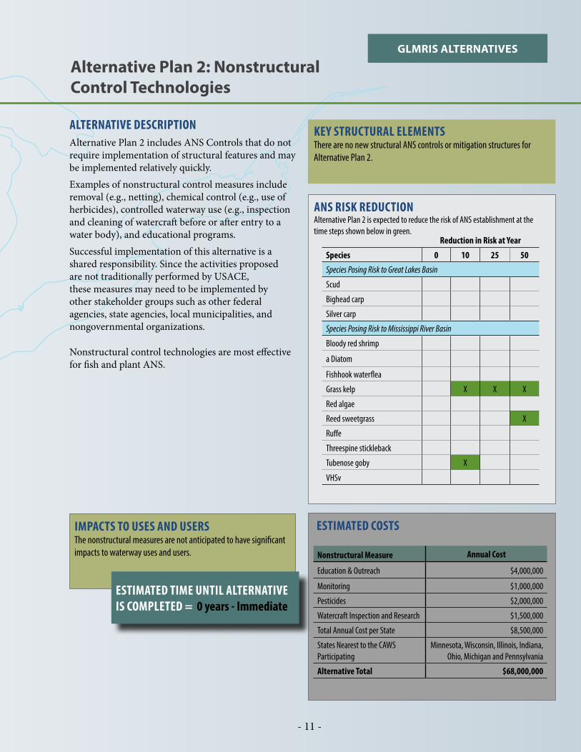
ALTERNATIVE DESCRIPTIONAlternative Plan 2 includes ANS Controls that do not require implementation of structural features and may be implemented relatively quickly. Examples of nonstructural control measures include removal (e.g., netting), chemical control (e.g., use of herbicides), controlled waterway use (e.g., inspection and cleaning of watercraft before or after entry to a water body), and educational programs.Successful implementation of this alternative is a shared responsibility. Since the activities proposed are not traditionally performed by USACE, these measures may need to be implemented by other stakeholder groups such as other federal agencies, state agencies, local municipalities, and nongovernmental organizations.
Nonstructural control technologies are most effective for fish and plant ANS.
ESTIMATED COSTS
Nonstructural Measure Annual Cost
Education & Outreach $4,000,000
Monitoring $1,000,000
Pesticides $2,000,000
Watercraft Inspection and Research $1,500,000
Total Annual Cost per State $8,500,000
States Nearest to the CAWS Participating
Minnesota, Wisconsin, Illinois, Indiana, Ohio, Michigan and Pennsylvania
Alternative Total $68,000,000
ANS RISK REDUCTIONAlternative Plan 2 is expected to reduce the risk of ANS establishment at the time steps shown below in green.
Reduction in Risk at Year
Species 0 10 25 50
Species Posing Risk to Great Lakes Basin
Scud
Bighead carp
Silver carp
Species Posing Risk to Mississippi River Basin
Bloody red shrimp
a Diatom
Fishhook waterflea
Grass kelp X X X
Red algae
Reed sweetgrass X
Ruffe
Threespine stickleback
Tubenose goby X
VHSv
Alternative Plan 2: Nonstructural Control Technologies
IMPACTS TO USES AND USERSThe nonstructural measures are not anticipated to have significant impacts to waterway uses and users.
GLMRIS ALTERNATIVES
KEY STRUCTURAL ELEMENTSThere are no new structural ANS controls or mitigation structures for Alternative Plan 2.
ESTIMATED TIME UNTIL ALTERNATIVE IS COMPLETED = 0 years - Immediate

- 12 -
ALTERNATIVE DESCRIPTIONAlternative Plan 3 focuses on maintaining the current operations of the CAWS with a minimal number of control points. It includes nonstructural measures and two single-point ANS Control technologies located at Stickney and Alsip. These technologies reduce the risk of transfer of ANS between basins in both directions. The nonstructural measures described in Alternative 2 would also be implemented.At both Stickney and Alsip, a new GLMRIS Lock would be constructed on the Chicago Sanitary and Ship Canal (CSSC) and the Cal-Sag Channel.Approach channels would be built on either side of the lock and would include electric barriers to control fish from entering the lock chamber during use. An ANS Treatment Plant would provide the water for lockages to flush the locks of ANS not affected by the electric barriers. The new locks would remain closed at all times unless a vessel needed to cross to the other side. The locks would remain closed to prevent passage of ANS during maintenance or power failures of the electric barriers.The normal flow of the CAWS would be diverted from the channel on the lake side of the new locks, through ANS Treatment Plants at each location, and then discharged back to the river side of the new locks.Significant flooding would result from this alternative without mitigation. Therefore, this alternative includes construction of three new GLMRIS reservoirs and conveyance tunnels to mitigate additional flooding risks.
ESTIMATED TIME UNTIL ALTERNATIVE IS COMPLETED = 25 years
Alternative Plan 3: Mid-System Control Technologies without a Buffer Zone
KEY STRUCTURAL ELEMENTS
ANS Control Technologies
LocationGLMRIS
LockElectric Barrier
ANS Treatment
Plant
Screened Sluice Gates
Physical Barrier
Stickney X X XAlsip X X X
Flood Risk Management Mitigation MeasuresGLMRIS Reservoirs:
McCook (Second reservoir) - 11.4 billion gallons Thornton (Second reservoir) - 15.8 billion gallons Oak Lawn (New reservoir) - 0.2 billion gallons
Conveyance Tunnels:Along the CSSC to McCook - 5 miles long, 14 feet in diameterAlsip to Thornton - 5 miles long, 16 feet in diameter
ANS RISK REDUCTION Alternative Plan 3 is expected to reduce the risk of ANS establishment at the time steps shown below in green.
Reduction in Risk at Year
Species 0 10 25 50
Species Posing Risk to Great Lakes Basin
Scud
Bighead carp X X
Silver carp X X
Species Posing Risk to Mississippi River Basin
Bloody red shrimp X* X*
a Diatom
Fishhook waterflea
Grass kelp X X X
Red algae
Reed sweetgrass X
Ruffe X
Threespine stickleback X* X*
Tubenose goby X X X
VHSv*Probability of establishment is high or medium at earlier time steps. Risk of ANS establishment is reduced provided no establishment occurs before plan implementation.

- 13 -
LOCATIONS OF ANS PREVENTION AND MITIGATION MEASURES
ESTIMATED COSTSElement Costs (2014 dollars)
ANS Control Measures $4,032,000,000
CAWS Ecosystem Mitigation Measures $44,000,000
Water Quality Mitigation Measures NA
Flood Risk Management Mitigation Measures $9,140,000,000
Design/Construction Management $2,257,000,000
Lands, Easements, Rights of Way Relocations, and Disposal Areas
$70,000,000
Operation, Maintenance, Repair, Replacement, & Rehabilitation (annual)
$145,500,000
Nonstructural Controls (annual) $68,000,000
Alternative Total (does not include annual costs) $15,543,000,000
IMPACTS TO USES AND USERS
Uses ImpactedFlood Risk Management
CAWS Ecosystem
CAWS Water Quality
Lake Michigan Water Quality
Commercial Navigation
Noncommercial Navigation
Hydropower
Users Impacted
XX
XX
GLMRIS ALTERNATIVES
Stickney
GLMRIS LockElectric Barrier
ANS Treatment Plant
Alsip
LakeMichigan
I
JOLIET
CHICAGO
GARY
Little Calumet River
Bubbly
Creek
Chicago
R
South
Br
Cal
umet
Riv
er
Des
Pla
ines
Riv
er
Chicago
River
Chicago Sanitary
and Ship Canal
Salt Creek
Calumet-Sag ChannelD
es Plaines River
IndianaHarbor & Canal
Burns DitchGrand Calumet River
N. Br. Chicago R
iver
North S
hore Channel
New GLMRISReservoir
New GLMRISReservoir
New GLMRISReservoir
IINDIANA
ILLINOIS
Thornton
Oak Lawn
McCookGLMRIS LockElectric BarrierANS Treatment Plant
MID-SYSTEM CONTROLTECHNOLOGIESWITHOUT BUFFERAlternative Features
Project
Mitigation
Project & Mitigation
Conveyance Tunnel
Not to scale

- 14 -
ALTERNATIVE DESCRIPTIONAlternative Plan 4 focuses on maintaining the current operations of the CAWS and creates an ANS-treated buffer zone within the CAWS. The buffer zone is the segment of the CAWS between the lakefront and the CAWS at Brandon Road.
The buffer zone is created by installing ANS control measures along the five aquatic pathways between the CAWS and Lake Michigan and by installing ANS con-trol measures at the single downstream point of the CAWS at Brandon Road. The nonstructural measures described in Alternative 2 would also be implement-ed. The Buffer Zone allows for backup control points in the system and would serve as a zone where ANS response actions could occur, if necessary.
GLMRIS Locks with flushing chambers, engineered channels, and electric barriers would be installed at Chicago, T.J. O’Brien, and Brandon Road. AN-STPs and screened sluice gates would be included at Wilmette, T.J. O’Brien, and Chicago. Physical barriers would be constructed in the waterway at Stateline and Hammond.
Conveyance tunnels and reservoirs are included to mitigate for increased flood risks caused by the ANS control structures.
ESTIMATED TIME UNTIL ALTERNATIVE IS COMPLETED = 10 years
Alternative Plan 4: Control Technology Alternative with a Buffer Zone
KEY STRUCTURAL ELEMENTS
ANS Control Technologies
LocationGLMRIS
LockElectric Barrier
ANS Treatment
Plant
Screened Sluice Gates
Physical Barrier
Wilmette X XChicago X X X XT.J. O’Brien X X X XStateline XHammond XBrandon Road X X
Flood Risk Management Mitigation Measures
GLMRIS Reservoirs:Stateline (New reservoir) - 0.3 billion gallonsThornton (Second reservoir) - 4.4 billion gallons
Conveyance Tunnels:Hammond to Thornton - 7 miles long, 14 feet in diameter
Reduction in Risk at Year
Species 0 10 25 50
Species Posing Risk to Great Lakes Basin
Scud
Bighead carp X X
Silver carp X X
Species Posing Risk to Mississippi River Basin
Bloody red shrimp X* X* X*
a Diatom
Fishhook waterflea
Grass kelp X X X
Red algae
Reed sweetgrass X
Ruffe X
Threespine stickleback X* X* X*
Tubenose goby X X X
VHSv
ANS RISK REDUCTION Alternative Plan 4 is expected to reduce the risk of ANS establishment at the time steps shown below in green.
*Probability of establishment is high or medium at earlier time steps. Risk of ANS establishment is reduced provided no establishment occurs before plan implementation.

- 15 -
LOCATIONS OF ANS PREVENTION AND MITIGATION MEASURES
ESTIMATED COSTSElement Costs (2014 dollars)
ANS Control Measures $3,175,000,000
CAWS Ecosystem Mitigation Measures $25,000,000
Water Quality Mitigation Measures $1,559,000,000
Flood Risk Management Mitigation Measures $1,980,000,000
Design/Construction Management $1,037,000,000
Lands, Easements, Rights of Way Relocations, and Disposal Areas
$30,000,000
Operation, Maintenance, Repair, Replacement, & Rehabilitation (annual)
$150,500,000
Nonstructural Controls (annual) $68,000,000
Alternative Total (does not include annual costs) $7,806,000,000
IMPACTS TO USES AND USERS
Uses ImpactedFlood Risk Management
CAWS Ecosystem
CAWS Water Quality
Lake Michigan Water Quality
Commercial Navigation
Noncommercial Navigation
Hydropower
Users Impacted
XXX
XX
GLMRIS ALTERNATIVES
Thornton
GLMRIS LockElectric BarrierANS Treatment PlantScreened Sluice Gates
Wilmette
New GLMRISReservoir
GLMRIS LockElectric BarrierANS Treatment PlantScreened Sluice Gates
ANS Treatment PlantScreened Sluice Gates
GLMRIS LockElectric Barrier
Physical BarrierNew GLMRIS Reservoir
T.J. O’BrienLock & Dam
LakeMichigan
IINDIANA
ILLINOIS
Physical Barrier
Hammond
Chicago
Brandon Road
StateLine
CONTROL TECHNOLOGYWITH BUFFER ZONEAlternative Features
Project
Mitigation
Project & Mitigation
Conveyance TunnelBuffer / Response Zone
Not to scale
JOLIET
GARY
CHICAGO
I
Bubbly
Creek
Chicago
R
South
Br
Little Calumet River
Cal
umet
Riv
er
Des
Pla
ines
Riv
er
Chicago
River
Chicago Sanitary
and Ship Canal
Salt Creek
Calumet-Sag ChannelD
es Plaines River
IndianaHarbor & Canal
Burns DitchGrand Calumet River
N. Br. Chicago R
iver
North S
hore Channel

- 16 -
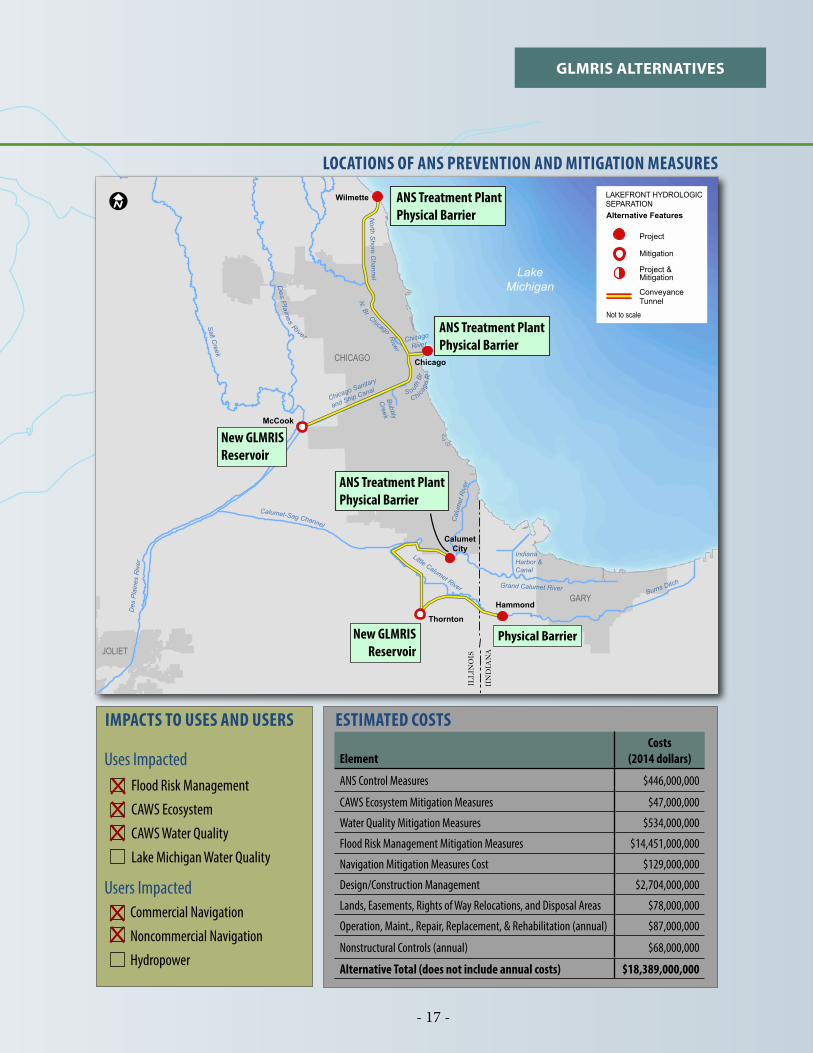
ALTERNATIVE DESCRIPTIONAlternative Plan 5 is focused on separating the hydrologic connection between the Great Lakes and Mississippi River basins at the Lake Michigan lakefront. This will be achieved through physical barriers located at Wilmette, Chicago, Calumet City, and Hammond. The nonstructural measures described in Alternative 2 would also be implemented.
Stagnant conditions and other water quality impacts are expected near the dead-end reaches of the CAWS where physical barriers would be placed. Therefore, this alternative includes ANS Treatment Plants located at Wilmette, Chicago, and Calumet City that would take flow from Lake Michigan, treat it, and discharge it into the CAWS to improve water movement and water quality.
Water quality in Lake Michigan would improve under this alternative because combined sewer and stormwater flows from the CAWS would not flow into Lake Michigan.
Significant flooding would result from this alternative without mitigation. Therefore, this alternative includes construction of two new GLMRIS reservoirs and conveyance tunnels to mitigate additional flooding risks.
ESTIMATED TIME UNTIL ALTERNATIVE IS COMPLETED = 25 years
Alternative Plan 5: Lakefront Hydrologic Separation
KEY STRUCTURAL ELEMENTS
ANS Control Technologies
LocationGLMRIS
LockElectric Barrier
ANS Treatment
Plant
Screened Sluice Gates
Physical Barrier
Wilmette X* XChicago X* XCalumet City X* XHammond X
*For water quality mitigation in the CAWS
Flood Risk Management Mitigation MeasuresGLMRIS Reservoirs:
McCook (Second reservoir) - 6.5 billion gallonsThornton (Second reservoir) - 13.5 billion gallons
Conveyance Tunnels:Wilmette to Chicago - 13 miles long, 22 feet in diameterChicago to McCook - 13 miles long, 42 feet in diameterCalumet City to Thornton - 6 miles long, 30 feet in diameterHammond to Thornton - 7 miles long, 14 feet in diameter
Reduction in Risk at Year
Species 0 10 25 50
Species Posing Risk to Great Lakes Basin
Scud X* X*
Bighead carp X X
Silver carp X X
Species Posing Risk to Mississippi River Basin
Bloody red shrimp X* X*
a Diatom X* X*
Fishhook waterflea X X
Grass kelp X X X
Red algae X* X*
Reed sweetgrass X
Ruffe X
Threespine stickleback X* X*
Tubenose goby X X X
VHSv X* X*
ANS RISK REDUCTION Alternative Plan 5 is expected to reduce the risk of ANS establishment at the time steps shown below in green.
*Probability of establishment is high or medium at earlier time steps. Risk of ANS establishment is reduced provided no establishment occurs before plan implementation.
- 17 -
GLMRIS ALTERNATIVES
ESTIMATED COSTS
ElementCosts
(2014 dollars)
ANS Control Measures $446,000,000
CAWS Ecosystem Mitigation Measures $47,000,000
Water Quality Mitigation Measures $534,000,000
Flood Risk Management Mitigation Measures $14,451,000,000
Navigation Mitigation Measures Cost $129,000,000
Design/Construction Management $2,704,000,000
Lands, Easements, Rights of Way Relocations, and Disposal Areas $78,000,000
Operation, Maint., Repair, Replacement, & Rehabilitation (annual) $87,000,000
Nonstructural Controls (annual) $68,000,000
Alternative Total (does not include annual costs) $18,389,000,000
LOCATIONS OF ANS PREVENTION AND MITIGATION MEASURES
IMPACTS TO USES AND USERS
Uses ImpactedFlood Risk Management
CAWS Ecosystem
CAWS Water Quality
Lake Michigan Water Quality
Commercial Navigation
Noncommercial Navigation
Hydropower
Users Impacted
XXX
XX
Wilmette
LakeMichigan
Hammond
Thornton
Chicago
LAKEFRONT HYDROLOGICSEPARATIONAlternative Features
Project
Mitigation
Project & Mitigation
Conveyance Tunnel
Not to scale
IINDIANA
ILLINOIS
CalumetCity
Physical Barrier
McCook
New GLMRISReservoir
New GLMRISReservoir
ANS Treatment PlantPhysical Barrier
ANS Treatment PlantPhysical Barrier
ANS Treatment PlantPhysical Barrier
JOLIET
GARY
CHICAGO
I
Bubbly
Creek
Chicago
R
South
Br
Little Calumet River
Cal
umet
Riv
er
Des
Pla
ines
Riv
er
Chicago
River
Chicago Sanitary
and Ship Canal
Salt Creek
Calumet-Sag ChannelD
es Plaines River
IndianaHarbor & Canal
Burns DitchGrand Calumet River
N. Br. Chicago R
iver
North S
hore Channel
- 18 -
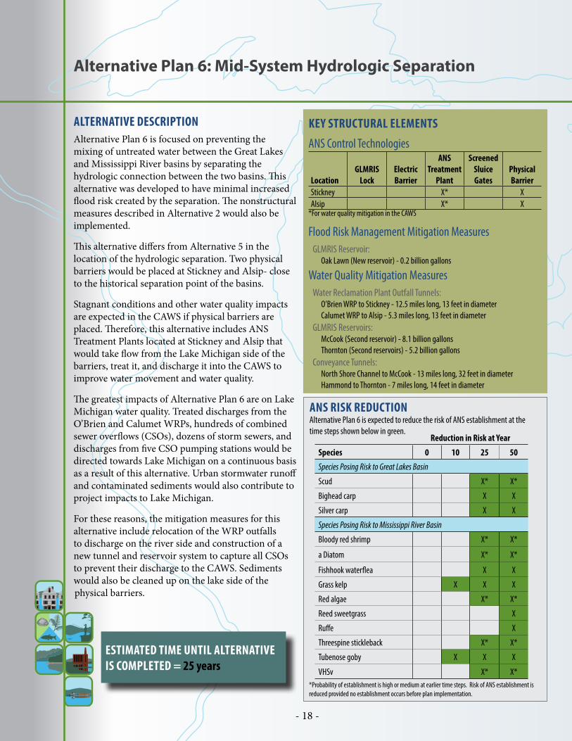
Alternative Plan 6: Mid-System Hydrologic Separation
ALTERNATIVE DESCRIPTIONAlternative Plan 6 is focused on preventing the mixing of untreated water between the Great Lakes and Mississippi River basins by separating the hydrologic connection between the two basins. This alternative was developed to have minimal increased flood risk created by the separation. The nonstructural measures described in Alternative 2 would also be implemented.
This alternative differs from Alternative 5 in the location of the hydrologic separation. Two physical barriers would be placed at Stickney and Alsip- close to the historical separation point of the basins.
Stagnant conditions and other water quality impacts are expected in the CAWS if physical barriers are placed. Therefore, this alternative includes ANS Treatment Plants located at Stickney and Alsip that would take flow from the Lake Michigan side of the barriers, treat it, and discharge it into the CAWS to improve water movement and water quality.
The greatest impacts of Alternative Plan 6 are on Lake Michigan water quality. Treated discharges from the O’Brien and Calumet WRPs, hundreds of combined sewer overflows (CSOs), dozens of storm sewers, and discharges from five CSO pumping stations would be directed towards Lake Michigan on a continuous basis as a result of this alternative. Urban stormwater runoff and contaminated sediments would also contribute to project impacts to Lake Michigan.
For these reasons, the mitigation measures for this alternative include relocation of the WRP outfalls to discharge on the river side and construction of a new tunnel and reservoir system to capture all CSOs to prevent their discharge to the CAWS. Sediments would also be cleaned up on the lake side of the physical barriers.
ESTIMATED TIME UNTIL ALTERNATIVE IS COMPLETED = 25 years
KEY STRUCTURAL ELEMENTS
ANS Control Technologies
LocationGLMRIS
LockElectric Barrier
ANS Treatment
Plant
Screened Sluice Gates
Physical Barrier
Stickney X* XAlsip X* X
*For water quality mitigation in the CAWS
Flood Risk Management Mitigation MeasuresGLMRIS Reservoir:
Oak Lawn (New reservoir) - 0.2 billion gallons
Water Quality Mitigation MeasuresWater Reclamation Plant Outfall Tunnels:
O’Brien WRP to Stickney - 12.5 miles long, 13 feet in diameterCalumet WRP to Alsip - 5.3 miles long, 13 feet in diameter
GLMRIS Reservoirs:McCook (Second reservoir) - 8.1 billion gallonsThornton (Second reservoirs) - 5.2 billion gallons
Conveyance Tunnels:North Shore Channel to McCook - 13 miles long, 32 feet in diameterHammond to Thornton - 7 miles long, 14 feet in diameter
ANS RISK REDUCTION Alternative Plan 6 is expected to reduce the risk of ANS establishment at the time steps shown below in green.
*Probability of establishment is high or medium at earlier time steps. Risk of ANS establishment is reduced provided no establishment occurs before plan implementation.
Reduction in Risk at Year
Species 0 10 25 50
Species Posing Risk to Great Lakes Basin
Scud X* X*
Bighead carp X X
Silver carp X X
Species Posing Risk to Mississippi River Basin
Bloody red shrimp X* X*
a Diatom X* X*
Fishhook waterflea X X
Grass kelp X X X
Red algae X* X*
Reed sweetgrass X
Ruffe X
Threespine stickleback X* X*
Tubenose goby X X X
VHSv X* X*
- 19 -
GLMRIS ALTERNATIVES
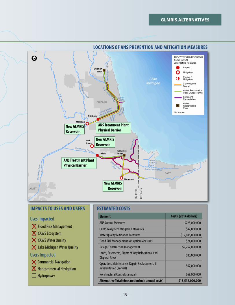
LOCATIONS OF ANS PREVENTION AND MITIGATION MEASURES
ESTIMATED COSTSElement Costs (2014 dollars)
ANS Control Measures $223,000,000
CAWS Ecosystem Mitigation Measures $42,000,000
Water Quality Mitigation Measures $12,886,000,000
Flood Risk Management Mitigation Measures $24,000,000
Design/Construction Management $2,257,000,000
Lands, Easements, Rights of Way Relocations, and Disposal Areas
$80,000,000
Operation, Maintenance, Repair, Replacement, & Rehabilitation (annual)
$67,000,000
Nonstructural Controls (annual) $68,000,000
Alternative Total (does not include annual costs) $15,512,000,000
IMPACTS TO USES AND USERS
Uses ImpactedFlood Risk Management
CAWS Ecosystem
CAWS Water Quality
Lake Michigan Water Quality
Commercial Navigation
Noncommercial Navigation
Hydropower
Users Impacted
XXX
XX
X
O’BrienWRP
CalumetWRP
Stickney
Alsip
LakeMichigan
IINDIANA
ILLINOIS
Thornton
McCookANS Treatment PlantPhysical Barrier
ANS Treatment PlantPhysical Barrier
JOLIET
CHICAGO
GARY
ANS Treatment PlantPhysical Barrier
New GLMRISReservoir
Oak Lawn
New GLMRISReservoir
New GLMRISReservoir
MID-SYSTEM HYDROLOGICSEPARATIONAlternative Features
Not to scale
Project
Mitigation
Project & Mitigation
Conveyance Tunnel
Water ReclamationPlant Outfall Tunnel
SedimentRemediation
Water ReclamationPlant
Bubbly
Creek
Chicago
R
South
Br
Little Calumet River
Cal
umet
Riv
er
Des
Pla
ines
Riv
er
Chicago
River
Chicago Sanitary
and Ship Canal
Salt Creek
Calumet-Sag ChannelD
es Plaines River
IndianaHarbor & Canal
Burns DitchGrand Calumet River
N. Br. Chicago R
iver
North S
hore Channel
I

- 20 -
Alternative Plan 7: Mid-System Separation Cal-Sag Open Control Technologies with a Buffer Zone
ALTERNATIVE DESCRIPTIONAlternative Plan 7 combines technologies and hydrologic separation to minimize impacts to existing CAWS uses and users. It includes three physical barriers located at Stickney, Stateline, and Hammond that will hydrologically separate four of the five aquatic pathways between the CAWS and Lake Michigan. The nonstructural measures described in Alternative 2 would also be implemented.
ANS control technologies would be located at T.J. O’Brien and Brandon Road to create a Buffer Zone on the remaining aquatic pathway. GLMRIS Locks with flushing chambers, engineered channels, and electric barriers would be included between T.J. O’Brien and Brandon Road. ANSTPs would be included at Stickney, Chicago, and T.J. O’Brien. Screened sluice gates would be included at T.J. O’Brien.
The Stickney barrier is expected to cause significant impacts to water quality in the South Branch Chicago River and the CSSC. An ANS Treatment Plant would be constructed at Stickney to mitigate these impacts. The T.J. O’Brien ANS Treatment Plant would also serve to mitigate impacts in the Cal-Sag Channel.
The greatest impacts of Alternative Plan 7 are on Lake Michigan water quality. Treated discharges from the O’Brien WRP, CSOs, storm sewers, and discharges from CSO pumping stations would be directed towards Lake Michigan on a continuous basis as a result of this alternative. Urban stormwater runoff and contaminated sediments will also contribute to project impacts to Lake Michigan.
For these reasons, the mitigation measures for this alternative include relocation of the O’Brien WRP outfall to discharge on the river side of the Stickney barrier and construction of a new tunnel and reservoir system to capture all CSOs on the Chicago
River system and prevent their discharge to the Lake Michigan basin. Sediments would also be cleaned up on the lake side of the Stickney barrier.
ESTIMATED TIME UNTIL ALTERNATIVE IS COMPLETED = 25 years
KEY STRUCTURAL ELEMENTSANS Control Technologies
LocationGLMRIS
LockElectric Barrier
ANS Treatment
Plant
Screened Sluice Gates
Physical Barrier
Stickney X* XT.J. O’Brien X X X XStateline XHammond XBrandon Road X X
*For water quality mitigation in the CAWS
Flood Risk Management Mitigation MeasuresGLMRIS Reservoirs:
Stateline (New reservoir) - 0.3 billion gallonsThornton (Second reservoir) - 4.4 billion gallons
Conveyance Tunnels:Hammond to Thornton - 7 miles long, 14 feet in diameter
Water Quality Mitigation MeasuresWater Reclamation Plant Outfall Tunnels:
O’Brien WRP to Stickney - 12.5 miles long, 13 feet in diameterGLMRIS Reservoirs:
McCook (Second reservoir) - 8.1 billion gallonsConveyance Tunnels:
North Shore Channel to McCook - 13 miles long, 32 feet in diameter
ANS RISK REDUCTIONAlternative Plan 7 is expected to reduce the risk of ANS establishment at the time steps shown below in green. Reduction in Risk at Year
Species 0 10 25 50
Species Posing Risk to Great Lakes Basin
Scud
Bighead carp X X
Silver carp X X
Species Posing Risk to Mississippi River Basin
Bloody red shrimp X* X*
a Diatom
Fishhook waterflea
Grass kelp X X X
Red algae
Reed sweetgrass X
Ruffe X
Threespine stickleback X* X*
Tubenose goby X X X
VHSv*Probability of establishment is high or medium at earlier time steps. Risk of ANS establishment is reduced provided no establishment occurs before plan implementation.

- 21 -
GLMRIS ALTERNATIVES
LOCATIONS OF ANS PREVENTION AND MITIGATION MEASURES
ESTIMATED COSTSElement Costs (2014 dollars)
ANS Control Measures $2,716,000,000
CAWS Ecosystem Mitigation Measures $44,000,000
Water Quality Mitigation Measures $8,280,000,000
Flood Risk Management Mitigation Measures $1,863,000,000
Design/Construction Management $2,152,000,000
Lands, Easements, Rights of Way Relocations, and Disposal Areas
$42,000,000
Operation, Maintenance, Repair, Replacement, & Rehabilitation (annual)
$110,200,000
Nonstructural Controls (annual) $68,000,000
Alternative Total (does not include annual costs) $15,097,000,000
IMPACTS TO USES AND USERS
Uses ImpactedFlood Risk Management
CAWS Ecosystem
CAWS Water Quality
Lake Michigan Water Quality
Commercial Navigation
Noncommercial Navigation
Hydropower
Users Impacted
XXX
XX
X
StateLine
Stickney
LakeMichigan
O’BrienWRP
MID-SYSTEM SEPARATIONCAL SAG OPENCONTROL TECHNOLOGIESWITH BUFFER ZONEAlternative Features
Not to scale
Project
Mitigation
Project & Mitigation
Conveyance TunnelWater ReclamationPlant Outfall TunnelSedimentRemediationBuffer/ResponseZoneWater ReclamationPlant
IINDIANA
ILLINOIS
Thornton
McCook
ANS Treatment PlantPhysical Barrier
GLMRIS LockElectric BarrierANS Treatment PlantScreened Sluice Gates
T.J. O’BrienLock & Dam
Hammond
New GLMRISReservoir
New GLMRISReservoir
JOLIET
GARY
CHICAGO
Bubbly
Creek
Chicago
R
South
Br
Little Calumet River
Cal
umet
Riv
er
Des
Pla
ines
Riv
er
Chicago
River
Chicago Sanitary
and Ship Canal
Salt Creek
Calumet-Sag ChannelD
es Plaines River
IndianaHarbor & Canal
Burns DitchGrand Calumet River
N. Br. Chicago River
North S
hore Channel
Physical BarrierNew GLMRIS Reservoir
Physical BarrierGLMRIS LockElectric Barrier
Brandon Road
I

- 22 -
Alternative Plan 8: Mid-System Separation CSSC Open Control Technologies with a Buffer Zone
ALTERNATIVE DESCRIPTIONAlternative Plan 8 combines technologies and hydrologic separation to minimize impacts to existing CAWS uses and users. It includes a physical barrier at Alsip that will hydrologically separate three of the five aquatic pathways between the CAWS and Lake Michigan. The nonstructural measures described in Alternative 2 would also be implemented.
ANS control technologies would be located at Wilmette, Chicago, and Brandon Road to create Buffer Zones on the remaining aquatic pathways. GLMRIS Locks with flushing chambers, engineered channels, and electric barriers would be included at Chicago and Brandon Road. ANS Treatment Plants would be included at Wilmette, Chicago, and Alsip. Screened sluice gates would be included at Wilmette and Chicago.
The Alsip barrier is expected to cause significant impacts to water quality in the Cal-Sag Channel. The ANS Treatment Plant at Alsip would help mitigate these impacts.
The greatest impacts of Alternative Plan 8 are on Lake Michigan water quality. Treated discharges from the Calumet WRP, CSOs, storm sewers, and discharges from CSO pumping stations would be directed towards Lake Michigan on a continuous basis as a result of this alternative. Urban stormwater runoff and contaminated sediments will also contribute to project impacts to Lake Michigan.
For these reasons, the mitigation measures for this alternative include relocation of the Calumet WRP outfall to discharge on the river side of the Alsip barrier and construction of a new tunnel and reservoir system to capture all CSOs on the Calumet River system to prevent their discharge to the Lake Michigan basin. Sediments would also be cleaned up
on the lake side of the Alsip barrier.
ESTIMATED TIME UNTIL ALTERNATIVE IS COMPLETED = 25 years
KEY STRUCTURAL ELEMENTS
ANS Control Technologies
LocationGLMRIS
LockElectric Barrier
ANS Treatment
Plant
Screened Sluice Gates
Physical Barrier
Wilmette X* XChicago X X X* XAlsip X* XBrandon Rd X X
*For water quality mitigation in the CAWS
Flood Risk Management Mitigation MeasuresGLMRIS Reservoir:
Oak Lawn (New reservoir) - 0.2 billion gallons
Water Quality Mitigation MeasuresWater Reclamation Plant Outfall Tunnels:
Calumet WRP to Alsip - 5.3 miles long, 13 feet in diameterGLMRIS Reservoir:
Thornton (Second reservoir) - 5.2 billion gallonsConveyance Tunnels:
Hammond to Thornton - 7 miles long, 14 feet in diameter
ANS RISK REDUCTION Alternative Plan 8 is expected to reduce the risk of ANS establishment at the time steps shown below in green.
Reduction in Risk at Year
Species 0 10 25 50
Species Posing Risk to Great Lakes Basin
Scud
Bighead carp X X
Silver carp X X
Species Posing Risk to Mississippi River Basin
Bloody red shrimp X* X*
a Diatom
Fishhook waterflea
Grass kelp X X X
Red algae
Reed sweetgrass X
Ruffe X
Threespine stickleback X* X*
Tubenose goby X X X
VHSv*Probability of establishment is high or medium at earlier time steps. Risk of ANS establishment is reduced provided no establishment occurs before plan implementation.

- 23 -
GLMRIS ALTERNATIVES
LOCATIONS OF ANS PREVENTION AND MITIGATION MEASURES
ESTIMATED COSTSElement Costs (2014 dollars)
ANS Control Measures $2,643,000,000
CAWS Ecosystem Mitigation Measures $26,000,000
Water Quality Mitigation Measures $4,337,000,000
Flood Risk Management Mitigation Measures $145,000,000
Design/Construction Management $1,146,000,000
Lands, Easements, Rights of Way Relocations, and Disposal Areas
$36,000,000
Operation, Maintenance, Repair, Replacement, & Rehabilitation (annual)
$96,500,000
Nonstructural Controls (annual) $68,000,000
Alternative Total (does not include annual costs) $8,333,000,000
IMPACTS TO USES AND USERS
Uses ImpactedFlood Risk Management
CAWS Ecosystem
CAWS Water Quality
Lake Michigan Water Quality
Commercial Navigation
Noncommercial Navigation
Hydropower
Users Impacted
XXX
XX
X
GLMRIS LockElectric BarrierANS Treatment PlantScreened Sluice Gates
Chicago
AlsipCalumetWRP
Oak Lawn
Wilmette
LakeMichigan
ANS Treatment PlantScreened Sluice Gates
MID-SYSTEM SEPARATIONCSSC OPENCONTROL TECHNOLOGIESWITH BUFFER ZONEAlternative Features
Not to scale
Project
Mitigation
Project & Mitigation
Conveyance Tunnel
Water ReclamationPlant Outfall Tunnel
SedimentRemediation
Buffer/ResponseZone
Water ReclamationPlant
IINDIANA
ILLINOIS
Thornton
ANS Treatment PlantPhysical Barrier
JOLIET
CHICAGO
GARY
New GLMRISReservoir
New GLMRISReservoir
GLMRIS LockElectric Barrier
Brandon Road
Bubbly
Creek
Chicago
R
South
Br
Little Calumet River
Cal
umet
Riv
er
Des
Pla
ines
Riv
er
Chicago
River
Chicago Sanitary
and Ship Canal
Salt Creek
Calumet-Sag Channel
Des P
laines River
IndianaHarbor & Canal
Burns DitchGrand Calumet River
N. Br. Chicago R
iver
North S
hore Channel
I

- 24 -
As described by this Summary document, the GLMRIS Report provides valuable information for both the public and decision-makers, including ideas regarding available options to control ANS, as well as the identification of potential impacts that alternatives may have on existing uses and users of the waterways. The Report also outlines mitigation measures that could be implemented for each identified alternative to minimize any adverse impacts on existing uses such as water quality, flood risk management, and commerce.
As ANS control is a shared responsibility among federal, state, and local agencies, as well as the public, continued participation by stakeholders is essential to reach a decision and authorization for a collaborative path forward. In order to promote this dialog, the engagement of regional stakeholders will continue to be a focus of the study team after the release of the GLMRIS Report.
Immediately after the release of the GLMRIS Report, an open public comment period will allow interested parties to provide statements for the record using the study web site, via traditional mail, or at a series of public meetings held throughout the Great Lakes and Upper Mississippi River basins.
As the conversation continues, collaborative groups such as the Asian Carp Regional Coordinating Committee, which is comprised of federal, state, and local governments and associated regulatory agencies – will continue to play a significant leadership role. Continued partnerships among these agencies will facilitate coordinated efforts toward the protection of aquatic and environmental resources and shape future decisions regarding long-term ANS strategies.
Conclusions and Next Steps
Mississippi River
Lockport Locks
Lake Superior near Brimley, MI

- 25 -
Ecosystem – a complex system of interdependent relationships between a community of plants and animals with its environment.
Electric dispersal barrier – a technology used to control the movement of fish within the study area. The barrier is created by a system that creates an electric field in the water that discourages fish from crossing.
Flood risk management - reducing flood risk through mitigation planning, preparation, response, and recovery. The CAWS is used to convey floodwater away from the Chicago area to minimize the risk of flood damages.
Hydrologic separation – a method to separate connected waterways by placing physical structures at key points in the waterway system to control the movement of aquatic nuisance species between the basins.
Jurisdictional – the boundaries defined by a government or other authority, e.g., a city or a county.
Lockage – the passage of a boat or ship through a lock like those found on the CAWS.
Watershed – the land area drained by a river and its tributaries. For example, the Great Lakes basin includes the land area from which streams and rivers ultimately flow to one of the Great Lakes.
Algae – a simple, nonflowering plant that contains no stems, roots, or leaves and can range in size from single-celled plants (such as red algae) to large seaweed (such as grass kelp).
Aquatic nuisance species (ANS) - plants, animals, or pathogens that, when introduced into a new habitat, can produce harmful impacts on aquatic ecosystems and on human uses of these systems.
Aquatic pathway – a means of transport of species between basins through natural and man-made waterways. Examples include streams, rivers and channels, as well as seasonal and intermittent connections.
Non-aquatic pathway - a means of transport of species between basins that is not aquatic. Examples include land-based transfer, waterfowl migration, recreational uses (such as fishing and water sports) and accidental and unregulated stocking.
Basin – the land area drained by a river and its tributaries. For example, the Great Lakes basin includes the land area from which streams and rivers ultimately flow to one of the Great Lakes.
Biodiversity (also referred to as biological diversity) - the abundance and variety of plant and animal species in a particular area or region. The presence of aquatic nuisance species can impact biodiversity by competing with native species for food, resulting in the decline of native species abundance.
Buffer zone – a segment of waterway between the lakefront and downstream control points that serves as a zone where an aquatic nuisance species response action could occur, if necessary.
Crustaceans – an aquatic animal, such as a crab or lobster, that has several pairs of legs and a body made of sections that are covered in a hard outer shell. Several crustaceans, including the fishhook waterflea, scud, and bloody red shrimp, have been identified as aquatic nuisance species in the study area.
Glossary

To find out more about GLMRIS, visit the following locations:
Web: http://glmris.anl.gov/
Twitter: https://twitter.com/glmris
Facebook: https://www.facebook.com/glmris
Contact the GLMRIS Project Team via email at:
G L M R I SGreat Lakes and Mississippi River Interbasin Study
Ecosystems Navigation Recreation Water useaquatic Nuisance Species