stazione totale leica flexline ts03/ts07 · 2019-04-05 · leica flexline ts03/ts07 manual total...
TRANSCRIPT

Leica FlexLine TS03/TS07 Manual Total Stations
leica-geosystems.com
LEICA FLEXLINE TS03/TS07 MANUAL TOTAL STATIONS n Work faster: measure more points per day due to faster measurement and stakeout procedures (endless drives, trigger key, drives on both sides, pinpoint EDM and more), supported by our comprehensive and user-friendly Leica FlexField software.
n Use it trouble-free: increase productivity and minimise downtime by relying on instruments that simply work and come with a global service and support network.
n Choose products that are built to last: FlexLine operates with the same high level of quality even after years of use under harsh conditions (like mud, dust, blowing rain, extreme heat and cold).
n Control your investment: reliability, speed and accuracy ensure a lower investment over the product lifetime and a higher resell value.
n Save time with AutoHeight: measure, read and set the instrument height automatically with this revolutionary feature in the FlexLine TS07 (optional). Errors are minimised and the setup process onsite is faster.
FlexLine
The Leica FlexLine TS03 and TS07 high-quality, manual total stations are based on a proven product conceptthat has been revolutionising the world of measurement and survey for nearly 200 years. The instruments are equipped with a comprehensive application-based software package - Leica FlexField software - that enables most survey and stakeout tasks to be carried out easily and efficiently. The new FlexLine manual total stations work reliably and deliver accurate results even in harsh environments.
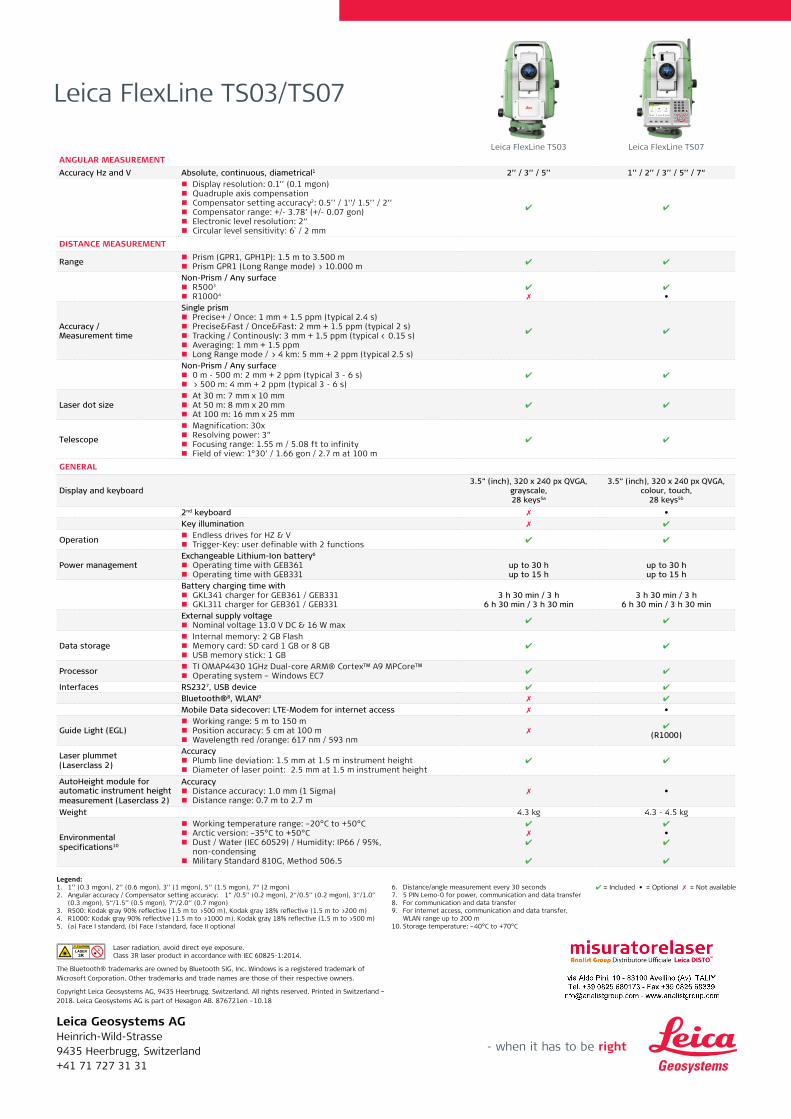
Leica FlexLine TS03 Leica FlexLine TS07ANGULAR MEASUREMENTAccuracy Hz and V Absolute, continuous, diametrical1 2’’ / 3’’ / 5’’ 1’’ / 2’’ / 3’’ / 5’’ / 7“
n Display resolution: 0.1’’ (0.1 mgon) n Quadruple axis compensation n Compensator setting accuracy2: 0.5’’ / 1’’/ 1.5’’ / 2’’ n Compensator range: +/- 3.78’ (+/- 0.07 gon) n Electronic level resolution: 2“ n Circular level sensitivity: 6` / 2 mm
✔ ✔
DISTANCE MEASUREMENT
Range n Prism (GPR1, GPH1P): 1.5 m to 3.500 m n Prism GPR1 (Long Range mode) > 10.000 m ✔ ✔
Non-Prism / Any surface n R5003
n R10004✔✗
✔•
Accuracy / Measurement time
Single prism n Precise+ / Once: 1 mm + 1.5 ppm (typical 2.4 s) n Precise&Fast / Once&Fast: 2 mm + 1.5 ppm (typical 2 s) n Tracking / Continously: 3 mm + 1.5 ppm (typical < 0.15 s) n Averaging: 1 mm + 1.5 ppm n Long Range mode / > 4 km: 5 mm + 2 ppm (typical 2.5 s)
✔ ✔
Non-Prism / Any surface n 0 m - 500 m: 2 mm + 2 ppm (typical 3 - 6 s) n > 500 m: 4 mm + 2 ppm (typical 3 - 6 s)
✔ ✔
Laser dot size n At 30 m: 7 mm x 10 mm n At 50 m: 8 mm x 20 mm n At 100 m: 16 mm x 25 mm
✔ ✔
Telescope
n Magnification: 30x n Resolving power: 3” n Focusing range: 1.55 m / 5.08 ft to infinity n Field of view: 1°30’ / 1.66 gon / 2.7 m at 100 m
✔ ✔
GENERAL
Display and keyboard3.5“ (inch), 320 x 240 px QVGA,
grayscale, 28 keys5a
3.5“ (inch), 320 x 240 px QVGA, colour, touch,
28 keys5b
2nd keyboard ✗ •Key illumination ✗ ✔
Operation n Endless drives for HZ & V n Trigger-Key: user definable with 2 functions ✔ ✔
Power managementExchangeable Lithium-Ion battery6
n Operating time with GEB361 n Operating time with GEB331
up to 30 hup to 15 h
up to 30 hup to 15 h
Battery charging time with n GKL341 charger for GEB361 / GEB331 n GKL311 charger for GEB361 / GEB331
3 h 30 min / 3 h6 h 30 min / 3 h 30 min
3 h 30 min / 3 h6 h 30 min / 3 h 30 min
External supply voltage n Nominal voltage 13.0 V DC & 16 W max ✔ ✔
Data storage n Internal memory: 2 GB Flash n Memory card: SD card 1 GB or 8 GB n USB memory stick: 1 GB
✔ ✔
Processor n TI OMAP4430 1GHz Dual-core ARM® Cortex™ A9 MPCore™ n Operating system – Windows EC7 ✔ ✔
Interfaces RS2327, USB device ✔ ✔
Bluetooth®8, WLAN9 ✗ ✔
Mobile Data sidecover: LTE-Modem for internet access ✗ •
Guide Light (EGL) n Working range: 5 m to 150 m n Position accuracy: 5 cm at 100 m n Wavelength red /orange: 617 nm / 593 nm
✗✔
(R1000)
Laser plummet(Laserclass 2)
Accuracy n Plumb line deviation: 1.5 mm at 1.5 m instrument height n Diameter of laser point: 2.5 mm at 1.5 m instrument height
✔ ✔
AutoHeight module for automatic instrument height measurement (Laserclass 2)
Accuracy n Distance accuracy: 1.0 mm (1 Sigma) n Distance range: 0.7 m to 2.7 m
✗ •
Weight 4.3 kg 4.3 - 4.5 kg
Environmental specifications10
n Working temperature range: –20°C to +50°C n Arctic version: –35°C to +50°C n Dust / Water (IEC 60529) / Humidity: IP66 / 95%,
non-condensing n Military Standard 810G, Method 506.5
✔✗✔
✔
✔•✔
✔
Leica Geosystems AGHeinrich-Wild-Strasse9435 Heerbrugg, Switzerland+41 71 727 31 31
Leica FlexLine TS03/TS07
Legend:1. 1’’ (0.3 mgon), 2’’ (0.6 mgon), 3’’ (1 mgon), 5’’ (1.5 mgon), 7“ (2 mgon)2. Angular accuracy / Compensator setting accuracy: 1“ /0.5’’ (0.2 mgon), 2“/0.5’’ (0.2 mgon), 3“/1.0’’
(0.3 mgon), 5“/1.5’’ (0.5 mgon), 7“/2.0’’ (0.7 mgon)3. R500: Kodak gray 90% reflective (1.5 m to >500 m), Kodak gray 18% reflective (1.5 m to >200 m)4. R1000: Kodak gray 90% reflective (1.5 m to >1000 m), Kodak gray 18% reflective (1.5 m to >500 m)5. (a) Face I standard, (b) Face I standard, face II optional
6. Distance/angle measurement every 30 seconds7. 5 PIN Lemo-0 for power, communication and data transfer8. For communication and data transfer9. For internet access, communication and data transfer,
WLAN range up to 200 m10. Storage temperature: –40°C to +70°C
✔ = Included • = Optional ✗ = Not available
Laser radiation, avoid direct eye exposure.Class 3R laser product in accordance with IEC 60825-1:2014.
The Bluetooth® trademarks are owned by Bluetooth SIG, Inc. Windows is a registered trademark of Microsoft Corporation. Other trademarks and trade names are those of their respective owners.
Copyright Leica Geosystems AG, 9435 Heerbrugg, Switzerland. All rights reserved. Printed in Switzerland – 2018. Leica Geosystems AG is part of Hexagon AB. 876721en –10.18
Leica FlexField plusUn'applicazione per ogni operazione

Leica FlexField plus
DATI GENERALI DESCRIZIONE TS02 PLUS
TS06 PLUS
TS09 PLUS
Gestione file
Gestione di lavori, punti fissi, misurazioni, codici e formati nella memoria interna o sulla chiavetta USB.
Importazione datiGSI, DXF, LandXML, ASCII, CSV
Esportazione datiGSI, DXF, LandXML, ASCII definiti dall'utente, CSV
Barra icona di stato
Visualizza lo stato completo dello strumento in qualsiasi momento.
Protezione strumento con PIN
Protegge lo strumento inserendo un PIN (Personal Identification Number).
Beep Picchettamento
Per aumentare l'efficienza del picchettamento, il segnale acustico diventa più veloce in prossimità del punto da picchettare.
Selezione mappa Per selezionare punti fissi, misurazioni o stazioni da una mappa. - -
PROGRAMMI DESCRIZIONE
Setup TPS
Vari metodi di setup stazione - Set orientamento, Punto indietro noto, Più punti indietro, Intersezione, Intersezione di Helmert, Intersezione locale, Trasferimento di quota.
Rilievo
Misura di un numero illimitato di punti inclusa Codifica e Codifica Rapida con un massimo di 8 attributi. I codici possono essere selezionati da un elenco predefinito o inseriti manualmente.
Vista Mappa Per visualizzare dati in Rilievo Rapido e Rilievo in una mappa grafica. -
Offset
Calcolo delle coordinate del caposaldo nei casi in cui non è possibile puntare direttamente il caposaldo o posizionarvi il riflettore.
Picchettamento Picchettamento di punti con navigazione grafica dalla stazione.
Distanza di raccordo
Calcolo della distanza inclinata, distanza orizzontale, differenza di quota, pendenza e direzione tra due punti noti.
Area & VolumeMisura e calcolo di aree piane, aree di superficie, divisione area e volumi DTM con vista grafica.
Quota RemotaCalcolo della posizione di un punto inaccessibile misurando a un punto base e mirando al punto remoto.
PROGRAMMI DESCRIZIONE TS02 PLUS
TS06 PLUS
TS09 PLUS
Punto nascostoMisura di punti che non sono direttamente visibili utilizzando una speciale asta per punti nascosti.
Controllo della distanza
Calcolo della distanza inclinata, distanza orizzontale, differenza di quota, pendenza, direzione e differenze di coordinate tra gli ultimi due punti misurati.
Controllo punto di orientamen-to
Controllare se la posizione della stazione è ancora corretta rimisurando i punti di controllo con navigazione grafica dalla stazione.
Linea di riferimento
Definizione di linee e verifica di punti rispetto alla linea con vista grafica. Punti di picchettamento, segmentazioni linea e griglie con navigazione grafica dalla stazione.
Arco di riferimento
Definizione di archi e verifica di punti rispetto all'arco con vista grafica. Punti di picchettamento, archi, corde e angoli con navigazione grafica.
Piano di riferimento
Definizione di piani e misura di punti rispetto al piano. Picchettamento del punto di intersezione calcolato con navigazione grafica dalla stazione.
COGO
Vari metodi di calcolo geometrici delle coordinate con vista grafica dei risultati calcolati – Inversa, Poligonale (distanza & direzione), Intersezioni, Set Point, Piano di offset, Estensione linea.
Road 2D
Definizione di rettilinei, curve, spirali e punti di controllo rispetto all'elemento definito con vista grafica. Picchettamento di punti con navigazione grafica dalla stazione.
Road 3D
Caricamento o creazione manuale di allineamenti orizzontali e verticali. Controllo e picchettamento di punti e pendenze rispetto all'allineamento.
-
PoligonaleMisurare, calcolare e compensare poligonali incluse le osservazioni di rilievo.
-
Tunnel
Caricamento o creazione manuale di allineamenti orizzontali, verticali e sezione tunnel. Controllo e picchettamento di punti tunnel e post-elaborazione in ufficio.
-
Mining
Completamento di un rilievo di picchettamento, Picchettamento Linee di Picchetti, Picchettamento Linee di Pendenza ed esecuzione di rilievi del sottosuolo mediante metodo Offset.
InclusoOpzionale–Non disponibile

Leica FlexField plusUn'applicazione per ogni operazione
Setup & Rilievo
1
10
Trasferimento di quota
2
11
Controllo punto di orientamento
Quota remota
5
14
Offset
Picchetta-mento
6
15
Punto nascosto
Road 3D
7
16
Distanza di raccordo
Road 2D
8
17
Griglia di riferimento
Piano di riferimento
Rilievo
9
18
Calcolo di aree e volumi
Poligonale
3
12
COGOArco di riferimento
4
13
Linea di riferimento
1
2
6
78
9 10
1112
13
14
15
17 16
18
3
4
5

AccessorioriginaliBrochure
Viva TS11Brochure
FlexLineTS09plusBrochure
FlexLineTS06plusBrochure
FlexLineTS02plusBrochure
Il marchio Windows CE è di proprietà di Microsoft Corporation.
Altri marchi e nomi commerciali appartengono ai rispettivi proprietari.
Cover Picture: Shanghai Pudong skyline
Original Accessories
Leica Geosystems Original ZubehörMaterial matters
Leica FlexLine TS06plusTop precision meets high efficiency
The Second Plus: Real Features, True Benefits
USB Stick �� For fast and easy
transfer of data
Wireless Bluetooth �� For cable-free
connection to data logger
Electronic Guide Light�� For faster
stake-out
FlexField plus�� Modern and
intuitive on-board software for higher productivity
PinPoint EDM�� The most precise in its class
(1.5 mm + 2 ppm)�� Extremely fast (1 second)�� > 1.000 meters without prism�� Coaxial laser pointer and
measurement beam
Alpha-numerical keyboard�� Fast and error-
free input
Large high-resolution display�� At-a-glance viewing
on the largest high-resolution display in its class
Useful tools�� A range of
tools, such as a trigger key and laser plummet, speed up your work
mySecurity�� Unique cloud-
based protection against theft
Arctic version�� For use at –35°C (–31°F)
Original Accessories
Leica Geosystems Original ZubehörMaterial matters
Leica FlexField plusAn application for every task
Leica FlexLine TS09plusFull Precision at High Performance
Leica FlexLine TS02plusBest-In-Class Precision
Original AccessoriesBrochure
Viva TS11Brochure
FlexField plus & FlexOfficeBrochure
FlexLine TS09plusBrochure
FlexLine TS02plusBrochure
Distance meter: (PinPoint R500 / R1000):Laser class 3R in accordance with IEC 60825-1 resp. EN 60825-1
Laser plummet:Laser class 2 in accordance with IEC 60825-1 resp. EN 60825-1
Distance meter: (Prism Mode)Laser class 1 in accordance with IEC 60825-1 resp. EN 60825-1
Guide light (EGL):LED class 1 in accordance with IEC 60825-1 resp. EN 60825-1
The Bluetooth® word mark and logos are owned by Bluetooth SIG, Inc. and any use of such marks by Leica Geosystems AG is under license.
Other trademark and trade names are those of their respective owners.
Cover picture: Dubai City Skyline
Illustrations, descriptions and technical data are not binding. All rights reserved. Printed in Switzerland.Copyright Leica Geosystems AG, Heerbrugg, Switzerland, 2016. 789488en – 04.16
Leica Geosystems – when it has to be right
Revolutionising the world of measurement and survey for nearly 200 years, Leica Geosystems creates complete solutions for professionals across the planet. Known for premium products and innovative solution development, professionals in a diverse mix of industries, such as aerospace and defence, safety and security, construction, and manufacturing, trust Leica Geosystems for all their geospatial needs. With precise and accurate instruments, sophisticated software, and dependable services, Leica Geosystems delivers value every day to those shaping the future of our world.
Leica Geosystems is part of Hexagon (Nasdaq Stockholm: HEXA B; hexagon.com), a leading global provider of information technologies that drive quality and productivity improvements across geospatial and industrial enterprise applications.
Leica Geosystems AGwww.leica-geosystems.com
Leica FlexLine TS02plusData sheet
Leica FlexLine TS09plusFull precision at high performance
The Second Plus: Real Features, True Benefits
OriginalAccessoriesBrochure
Viva TS11Brochure
FlexField plus &FlexOfficeBrochure
FlexLineTS06plusBrochure
FlexLineTS02plusBrochure
Distance meter: (PinPoint R500 / R1000):Laser class 3R in accordance with IEC 60825-1 resp. EN 60825-1
Laser plummet:Laser class 2 in accordance with IEC 60825-1 resp. EN 60825-1
Distance meter: (Prism Mode)Laser class 1 in accordance with IEC 60825-1 resp. EN 60825-1
Guide light (EGL):LED class 1 in accordance with IEC 60825-1 resp. EN 60825-1
The Bluetooth® word mark and logos are owned by Bluetooth SIG, Inc. and any use of such marks by Leica Geosystems AG is under license.
Other trademark and trade names are those of their respective owners.
Cover picture: Shanghai Pudong Skyline
Illustrations, descriptions and technical data are not binding. All rights reserved. Printed in Switzerland. Copyright Leica Geosystems AG, Heerbrugg, Switzerland, 2016. 789508en-us – 04.16
Original Accessories
Leica Geosystems Original ZubehörMaterial matters
Leica FlexLine TS06plusTop Precision meets High Efficiency
Leica FlexLine TS02plusBest-In-Class Precision
Leica FlexField plusAn application for every task
USB Stick �� For fast and easy
transfer of data
Wireless Bluetooth® �� For cable-free
connection to data logger
Electronic Guide Light�� For faster
stake-out
FlexField plus�� Modern and
intuitive on-board software for higher productivity
PinPoint EDM�� The most precise in its class
(1.5 mm + 2 ppm)�� Extremely fast (1 second)�� > 1.000 meters without prism�� Coaxial laser pointer and
measurement beam
Color & Touch Display �� Highest user-
friendliness
Useful tools�� A range of tools,
such as a trigger key and laser plummet, speed up your work
Arctic version�� For use at
–35°C (–31°F)
mySecurity�� Unique cloud-
based protection against theft
Leica Geosystems – when it has to be right
Revolutionising the world of measurement and survey for nearly 200 years, Leica Geosystems creates complete solutions for professionals across the planet. Known for premium products and innovative solution development, professionals in a diverse mix of industries, such as aerospace and defence, safety and security, construction, and manufacturing, trust Leica Geosystems for all their geospatial needs. With precise and accurate instruments, sophisticated software, and dependable services, Leica Geosystems delivers value every day to those shaping the future of our world.
Leica Geosystems is part of Hexagon (Nasdaq Stockholm: HEXA B; hexagon.com), a leading global provider of information technologies that drive quality and productivity improvements across geospatial and industrial enterprise applications.
Leica Geosystems AGwww.leica-geosystems.com
Illustrazioni, descrizioni e specifiche tecniche non sono vincolanti. Tutti i diritti sono riservati. Stampato in Svizzera – Copyright Leica Geosystems AG, Heerbrugg, Switzerland, 2016. 789528it – 06.16
Rivoluzionando il mondo della misurazione e del rilievo per quasi 200 anni, Leica Geosystems crea soluzioni complete per tutti i professionisti del pianeta. Nota per la qualità dei prodotti e per lo sviluppo di soluzioni innovative, i professionisti di tutti i settori, da aerospaziale e difesa, alla sicurezza, costruzioni e produzione, ripongono la propria fiducia in Leica Geosystems per tutte le loro esigenze. Con strumenti precisi e accurati, un sofisticato software e servizi affidabili, Leica Geosystems fornisce i valori necessari a definire il futuro.
Leica Geosystems è parte di Hexagon (Nasdaq Stoccolma: HEXA B; hexagon.com), leader mondiale nella fornitura di tecnologie informatiche che guidano il miglioramento della qualità e produttività tra applicazioni aziendali geo-spaziali e industriali.
Leica Geosystems AGleica-geosystems.com