state route 1 (pacific coast highway) at old newport ... · state route 1 (pacific coast highway)...
TRANSCRIPT

State Route 1 (Pacific Coast Highway) at Old Newport Boulevard Intersection Improvement
Orange County, California District 12 - ORA - 1; PM 19.6-19.8
EA 0N480/EFIS 1214000049
INITIAL STUDY WITH PROPOSED NEGATIVE DECLARATION
Prepared by the State of California Department of Transportation
April 2017
For individuals with sensory disabilities, this document is available in Braille, in large print, on audiocassette, or on computer disk. To obtain a copy in one of these alternate formats, please call or write to Caltrans, Attn: Mr. Charles Baker, Environmental Analysis, Specialists Branch; 1750 East 4th Street, Santa Ana, CA 92705; (657) 328-6139; or use California Relay Service 1 (800) 735-2929 (TTY), 1 (800) 735-2929 (Voice), or 711.

This page intentionally left blank
State Route 1 at Old Newport Boulevard Intersection Project i
General Information About This Document
What’s in this document? The California Department of Transportation (Caltrans) has prepared this Initial Study, which examines the potential environmental impacts of the Build Alternative and its Design Variation being considered for the proposed State Route 1 (Pacific Coast Highway) at Old Newport Boulevard Intersection Improvement Project (hereinafter referred to as “Project”) in the City of Newport Beach in Orange County, California. The document describes the Project; the existing environment that could be affected by the Project; potential impacts from the Project; and proposed avoidance, minimization, and/or mitigation measures.
What should you do?
Please read this Initial Study. Additional copies of this document as well as the technical studies are available for review at the Caltrans District Office 12 at:
o 1750 East 4th Street, Santa Ana, California 92705
The document can also be viewed at the City of Newport Beach in their Community Development Department located at:
o City of Newport Beach at 100 Civic Center Drive, Newport Beach, California 92660
o Newport Beach Public Library at 1000 Avocado Avenue, Newport Beach, California 92660
The document can also be accessed electronically at the following website: http://www.dot.ca.gov/d12/DEA/1/0N480Newport
We welcome your comments. If you have any concerns about the Project, please send your written comments to Caltrans by the deadline. Submit comments via U.S. mail to Caltrans at the following address:
Mr. Charles Baker, Senior Environmental Planner Environmental Analysis, Specialists Branch California Department of Transportation 1750 East 4th Street Santa Ana, California 92705
Submit comments via email to: [email protected].
Submit comments by the deadline: June 5, 2017.
What happens next? After comments are received from the public and reviewing agencies, Caltrans may (1) give environmental approval to the proposed Project; (2) do additional environmental studies; or (3) abandon the Project. If the Project is given environmental approval and

State Route 1 at Old Newport Boulevard Intersection Project ii
funding is appropriated, the City, in coordination with Caltrans, could design and build all or part of the Project.
For individuals with sensory disabilities, this document can be made available in Braille, in large print, on audiocassette, or on computer disk. To obtain a copy in one of these alternate formats, please call or write to Department of Transportation, Attn: Charles Baker, Caltrans Environmental Analysis – Specialist Branch, Caltrans District 12, 1750 East 4th Street, Santa Ana, California 92705; (657) 328-6139 Voice; or use the California Relay Service 1 (800) 735-2929 (TTY), 1 (800) 735-2922 (Voice) or 711.

State Route 1 at Old Newport Boulevard Intersection Project iv
This page intentionally left blank

State Route 1 at Old Newport Boulevard Intersection Project v
Proposed Negative Declaration Pursuant to: Division 13, Public Resources Code
Project Description The California Department of Transportation (Caltrans), the lead agency pursuant to the California Environmental Quality Act (CEQA) on this Project, in cooperation with the City of Newport Beach, proposes improvements to State Route (SR) 1 (known locally as Pacific Coast Highway [PCH] or West Coast Highway) and Old Newport Boulevard. The Project would provide a dedicated right-turn lane on SR-1 onto Old Newport Boulevard, a third through lane from approximately 430 feet east of the Old Newport Boulevard intersection to 100 feet west of the intersection, as well as a pedestrian crosswalk and bicycle lane within the Project limits. The purpose of the Project is to improve traffic operations; to improve circulation and pedestrian movement; to alleviate vehicle queuing; and to reduce congestion.
Determination This proposed Negative Declaration is included to give notice to interested agencies and the public that it is Caltrans’ intent to adopt a Negative Declaration for this Project. This does not mean that Caltrans’ decision on the Project is final. This Negative Declaration is subject to change based on comments received by interested agencies and the public.
Caltrans has prepared an Initial Study for this Project and, pending public review, expects to determine from this study that the proposed Project would not have a significant effect on the environment for the following reasons.
• The Project would have no effect on agriculture, greenhouse gases, mineral resources, recreation, population and housing, tribal cultural resources, or public services.
• The Project would have less than significant effect on aesthetics, air quality, biological resources, cultural resources, geology and soils, hydrology and water quality, hazards and hazardous materials, land use and planning, noise, recreation, transportation and traffic, and utilities and service systems.
______________________________ _______________ Chris Flynn Date Deputy District Director District 12 California Department of Transportation

State Route 1 at Old Newport Boulevard Intersection Project vi
This page intentionally left blank

State Route 1 at Old Newport Boulevard Intersection Project vii
Table of Contents
Proposed Negative Declaration ......................................................................................v Table of Contents ........................................................................................................ vii List of Tables ............................................................................................................. viii List of Figures ............................................................................................................ viii Chapter 1 Introduction ......................................................................................... 1
1.1 Introduction ................................................................................................. 1 1.2 Purpose and Need ....................................................................................... 2
1.2.1 Purpose .................................................................................................. 2 1.2.2 Need ...................................................................................................... 2
1.3 Build Alternative ......................................................................................... 9 1.3.1 The Build Alternative ........................................................................... 9 1.3.2 The Build Alternative with Design Variation ..................................... 15
1.4 Permits and Approvals Needed ............................................................. 2121 Chapter 2 CEQA Environmental Checklist ....................................................... 23 Chapter 3 Climate Change Discussion ............................................................ 145
3.1 Regulatory Setting .................................................................................. 145 3.1.1 State................................................................................................... 145 3.1.2 Federal............................................................................................. 1466
3.2 Project Analysis ...................................................................................... 148 3.2.1 Construction Emissions .................................................................... 150 3.2.2 CEQA Conclusion ............................................................................ 151
3.2.2.1 Greenhouse Gas Reduction Strategies ......................................... 151 3.2.2.2 Adaptation Strategies ................................................................... 154
Chapter 4 Consultation and Coordination........................................................ 159 4.1 Stakeholders ............................................................................................ 159 4.2 Early Agency Consultation and Coordination ........................................ 159 4.3 Public Outreach ....................................................................................... 160 4.4 Public Review Process ............................................................................ 160
4.4.1 Public Notice ..................................................................................... 160 Chapter 5 List of Preparers .............................................................................. 161 Chapter 6 Distribution List .............................................................................. 163 Appendix A Figures, Maps, Database Results .................................................... 167 Appendix B Title VI Policy Statement ................................................................ 169 Appendix C Environmental Commitment Record .............................................. 171

State Route 1 at Old Newport Boulevard Intersection Project viii
List of Tables
Table 1.1 Exisiting and Future Level of Service Summary .......................................... 7 Table 1.2 Existing (Year 2013) Peak Hour Intersection Traffic Volume ..................... 8 Table 1.3 Traffic Accident Surveillance and Analysis System Accident
Summary ..................................................................................................... 8 Table 1.4 Project Schedule ......................................................................................... 21 Table 1.5 Permits and Approvals for the Build Alternative and Design
Variation ................................................................................................... 22 Table 2.1 State and Federal Criteria Air Pollutant Standards, Effects,
Sources, and Attainment Status ................................................................ 35 Table 2.2 South Coast Air Quality Management District Criteria Pollutant
Significant Mass Emissions Significance Thresholds (lbs/day) ............... 40 Table 2.3 Estimated Maximum Daily Construction Emissions for the Build
Alternative (lbs/day) ................................................................................. 42 Table 2.4 Estimated Total Construction Emissions for the Build
Alternative (tons) ..................................................................................... 42 Table 2.5 Maximum Localized Construction Pollutant Emissions (lbs/day) ............. 43 Table 2.6 Estimated Total Construction Emissions for the Build Alternative
Design Variation (tons) ............................................................................. 44 Table 2.7 Comparison of Worldwide Greenhouse Gas Emissions ............................. 80 Table 2.8 Estimated GreenHouse Gas Emissions from Construction ........................ 81 Table 2.9 Estimated GHG Emissions from Construction ........................................... 82 Table 2.10 Vibration Damage Threshold Criteria .................................................... 113 Table 2.11 Vibration Annoyance Criteria ................................................................. 113 Table 2.12 Existing Level of Service at the State Route 1/Old Newport
Boulevard Intersection ............................................................................ 126 Table 2.13 Level of Service Summary ..................................................................... 128 Table 2.14 Cumulative Projects in the Project Vicinity ........................................... 141 Table 3.1 Climate Change/CO2 Reduction Strategies ............................................ 1533
List of Figures
Figure 1 Project Vicinity Map ................................................................................... 3 Figure 2 Project Location Map .................................................................................. 5 Figure 3a The Build Alternative Layout ................................................................... 13 Figure 3b The Build Alternative Design Variation Layout ....................................... 19 Figure 4 California Greenhouse Gas Forecast ...................................................... 149 Figure 5 Mobility Pyramid .................................................................................... 152

State Route 1 at Old Newport Boulevard Intersection Project 1
Chapter 1 Introduction
1.1 Introduction
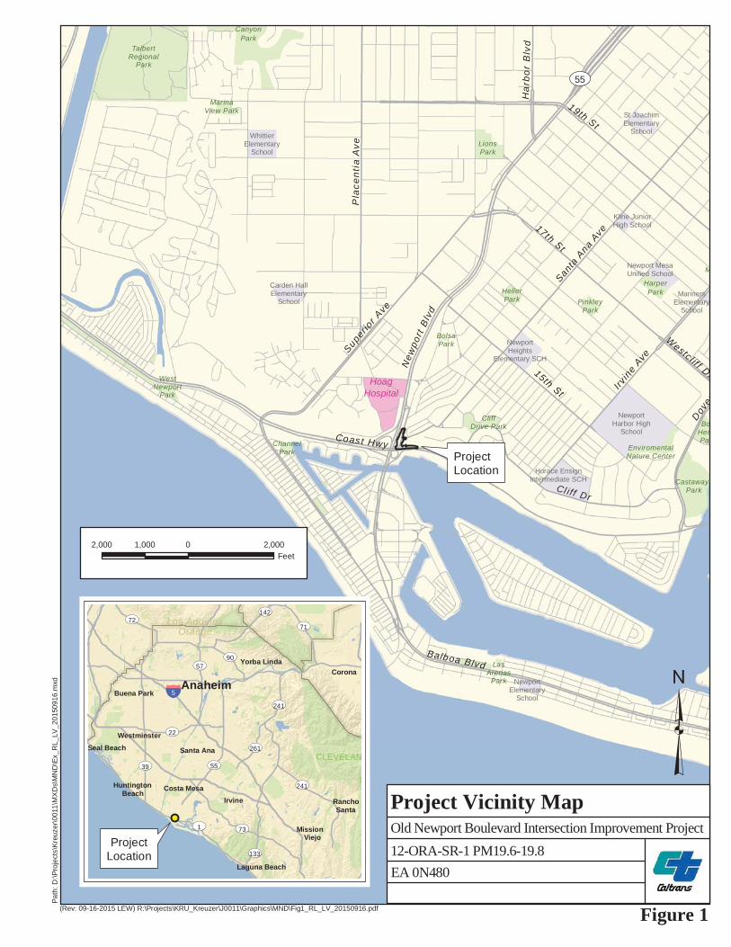
The California Department of Transportation (Caltrans), the California Environmental Quality Act (CEQA) lead agency on this Project, in cooperation with the City of Newport Beach, proposes improvements to State Route (SR) 1 (known locally as Pacific Coast Highway [PCH] or West Coast Highway) and Old Newport Boulevard. The Project is located in the city of Newport Beach in Orange County, California. Figures 1 and 2 depict the Regional Location and Local Vicinity, respectively. The City of Newport Beach would provide funding for this Project. No federal funding for this Project is anticipated.
In the Project vicinity, SR-1 is the primary east‐west route along the coast. It is classified as a Major Arterial Highway on the Orange County Transportation Authority’s (OCTA’s) Master Plan of Arterial Highways (MPAH) and is a Major Arterial under the Newport Beach General Plan’s Master Plan of Streets and Highways. Old Newport Boulevard is a north-south roadway. Old Newport Boulevard is not designated on either the City’s General Plan or the OCTA’s MPAH.
On SR-1, the Project site begins approximately 1,000 feet east of Old Newport Boulevard and ends at the Old Newport Boulevard and SR-1 intersection. Within the Project limits, SR-1 has three westbound and two eastbound lanes; it also has a raised median, which prohibits left turns from the eastbound SR-1 to Old Newport Boulevard. The SR-1’s third westbound through lane terminates as a right turn-lane onto Old Newport Boulevard.
Old Newport Boulevard is a local street that runs north-south and serves as the northbound on- and off-ramp to SR-55. Old Newport Boulevard has one lane in each direction with on-street parking on the east side. The Project extends from SR-1 to approximately 250 feet north of Santa Ana Avenue, for a total distance of about 450 feet. There is currently no sidewalk on the northern side of SR-1 along the frontage of the property at the intersection’s northeastern quadrant (A Market and A Restaurant).

Chapter 1 Introduction
State Route 1 at Old Newport Boulevard Intersection Project 2
1.2 Purpose and Need
1.2.1 Purpose The purpose of the Project is to improve overall traffic operations; to improve circulation and pedestrian movement; to alleviate vehicle queuing; and to reduce congestion. Specifically, the Project would provide a pedestrian crosswalk at Old Newport Boulevard; would provide a designated bike lane; and would improve the intersection’s operation by alleviating vehicle queuing and reducing congestion.
1.2.2 Need SR-1 was built circa 1938. Though there have been subsequent improvements, the Project proposes improvements that would enhance the roadway design to be more in line with current standards. The existing intersection currently operates with two westbound lanes with a drop right lane at Old Newport Boulevard, which serves as a trap lane for vehicle movement. Additionally, the Project would provide other improvements that serve to facilitate efficient operation of the roadway. This includes the elimination of uncontrolled access and parking that is easily accessible to and from SR-1. The Project would contribute to the California Transportation Plan’s (CTP’s) performance-based goals of providing an integrated, multimodal transportation system by enhancing pedestrians’ and bicyclists’ experience and safety by improving lighting conditions, providing pedestrian facilities at the intersection, and providing a dedicated bicycle lane.
Existing Roadway Deficiencies and Projected Demand Under existing conditions (2013) the SR-1/Old Newport Boulevard intersection operates at level of service (LOS) B during the AM peak hour and LOS D during the PM peak hour. The two other study area intersections: SR-1/SB SR-55 Ramps and NB SR-55 Ramps/Old Newport Blvd evaluated for this Project operate at LOS B during the AM and PM peak hours. The existing and future LOS are shown in Table 1.1.
New
port
Blv
d
ProjectLocation
Irvin
e Ave
Santa
Ana
Ave
Ha
rbo
r B
lvd
15th St
Dov
er
Balboa Blvd
Coast Hwy
19th St
17th St
Cl iff Dr
Westcl if f Dr
Superior Ave
Pla
cent
ia A
ve
M
HarperParkHeller
Park
LionsPark
CanyonPark
TalbertRegional
Park
MarinaView Park
CastawaysPark
EnviromentalNature Center
BoHenPar
WestNewport
Park
CliffDrive Park
BolsaPark
ChannelPark
LasArenas
Park
PinkleyPark
HoagHospital
NewportElementary
School
WhittierElementary
School
NewportHarbor High
School
Carden HallElementary
School
St JoachimElementary
School
MarinersElementary
School
Newport MesaUnified School
Horace EnsignIntermediate SCH
NewportHeights
Elementary SCH
Kline JuniorHigh School
UV55
(Rev: 09-16-2015 LEW) R:\Projects\KRU_Kreuzer\J0011\Graphics\MND\Fig1_RL_LV_20150916.pdf
Path
: D:\P
roje
cts\
Kreu
zer\0
011\
MX
Ds\
MN
D\E
x_R
L_LV
_201
5091
6.m
xd
³Figure 1
Old Newport Boulevard Intersection Improvement Project
Project Vicinity Map
2,000 0 2,0001,000Feet
12-ORA-SR-1 PM19.6-19.8
CLEVELAN
N
ProjectLocation
§̈5
ST1 ST73
ST22
ST241
ST90
ST261
ST142
ST39
ST72ST71
ST55
ST133
ST57
ST241
Los AngelesOrange
Anaheim
Viejo
Beach
SantaRancho
Corona
Irvine
Mission
Santa Ana
Huntington Costa Mesa
Buena Park
Seal BeachWestminster
Yorba Linda
Laguna Beach EA 0N480

Chapter 1 Introduction
State Route 1 at Old Newport Boulevard Intersection Project 4
This page intentionally left blank

Pacific CoastHighway
Santa Ana Ave
New
port
Blv
d
Hoa
g D
r
La Jolla Dr
Old
New
port
Blvd
(Rev: 9-16-2015 CJS) R:\Projects\KRU_Kreuzer\J0011\Graphics\MND\Fig2_Location_20150916.pdf
Path
: D:\P
roje
cts\
Kreu
zer\0
011\
MX
Ds\
MN
D\E
x_Lo
catio
n_20
1509
16.m
xd
³Figure 2
Old Newport Boulevard Intersection Improvement Project
Project Location Map100 0 10050
Feet
Aerial Source: Aerials Express 2009
Project Boundary
12-ORA-SR-1 PM19.6-19.8EA 0N480

Chapter 1 Introduction
State Route 1 at Old Newport Boulevard Intersection Project 6
This page intentionally left blank

Chapter 1 Introduction
State Route 1 at Old Newport Boulevard Intersection Project 7
Table 1.1 Exisiting and Future Level of Service Summary
Level of Service
Intersections
Existing (Year 2013) Opening Day (Year 2017) Horizon Year (Year 2040)
No-Build Alternative With Project No-Build
Alternative With Project No-Build Alternative With Project
AM PM SAT AM PM SAT AM PM SAT AM PM SAT AM PM SAT AM PM SAT SR-1/SB SR-55 Ramps B B A B B A B B A B B A E C C E C C
SR-1/Old Newport Blvd B D C B B B B D C B B B B D C B C B
NB SR-55 Ramps /Old Newport Blvd
B B B B B B B B C B B C B C C B C C
SAT: Saturday; SR: State Route; SB: southbound; NB: northbound
Source: Traffic Impact Analysis 2015
As shown in the table, the Project LOS at the SR-1/Old Newport Boulevard intersection would improve from LOS D under existing conditions to LOS B in 2017 (the opening year) during the PM peak hour and would improve from LOS C under existing conditions to LOS B on Saturday. The Project would improve the LOS at this same intersection from LOS D under existing conditions to LOS C in 2040 (the horizon year) in the PM hours and from LOS C under existing conditions to LOS B in 2040 (the horizon year) on Saturdays.
The Average Daily Traffic (ADT) volumes through the study area intersections are shown in Table 1.2 below. In addition to vehicle traffic, pedestrian and bicycle traffic occurs at the intersection. Existing pedestrian counts reported two, eight, and ten pedestrians crossing Old Newport Boulevard in the weekday AM, weekday PM, and Saturday peak hours, respectively. Existing bicycle counts reported 0, 3, and 173 bicycles crossing Old Newport Boulevard in the weekday AM, weekday PM, and Saturday peak hours, respectively.

Chapter 1 Introduction
State Route 1 at Old Newport Boulevard Intersection Project 8
Table 1.2 Existing (Year 2013) Peak Hour Intersection Traffic Volume
2013
Travel Direction
SR-55/SR-1 SR-1/Old Newport Blvd SR-55/Old Newport Blvd
AM PM SAT AM PM SAT AM PM SAT
NBT – – – – – – 1,623 1,435 1,482 NBR – – – – – – 92 148 124 SBL 388 395 368 – – – – – – SBT – – – – – – 1,313 1,973 2,199 SBR 202 428 367 104 251 210 – – – EBT 2,161 1,314 1,245 2,038 1,386 1,307 – – – WBT 789 1,981 1,178 954 2,450 1,652 – – – WBR 309 683 629 344 443 469 199 343 381
SR: State Route; SAT: Saturday; NBT: northbound through lane; NBR: northbound right-turn lane; SBL: southbound left-turn lane; SBT; southbound through lane; SBR: southbound right-turn lane; EBT: eastbound through lane; WBT: westbound through lane; WBR: westbound right-turn lane
Note “–“ Not applicable
Source: Traffic Impact Analysis 2015
Based on the Caltrans Traffic Accident Surveillance and Analysis System (TASAS) data, which is provided in Table 1.3 below, the intersection is deficient due to vehicle queuing, which causes congestion; this, in turn, is the primary cause for collisions. The TASAS data shows a total of ten collisions on SR-1. Of these, five were rear-end type collisions; two were broadside collisions; and there was one each of sideswipe, head-on, and “other”. The actual accident rate for the intersection totals 0.16, whereas the average accident rate for similar intersections totals 0.06.
Table 1.3 Traffic Accident Surveillance and
Analysis System Accident Summary
Intersection Location
Actual Accident Rates Average Accident Rates
FAT F+I Total FAT F+I Total
SR-1/Old Newport Blvd 0.00 0.05 0.16 0.00 0.02 0.06
FAT: Fatal; F+I: Fatal + Injury; SR: State Route
The proposed third westbound through lane and dedicated right-turn lane would alleviate vehicle queuing and therefore reduce congestion. Eliminating unrestricted parking along SR-1 and adding stop control for Old Newport Boulevard onto
Chapter 1 Introduction
State Route 1 at Old Newport Boulevard Intersection Project 9
westbound SR-1 would reduce vehicle, pedestrian, and bicycle conflicts and would enhance the overall pedestrian and traffic movement at the intersection.
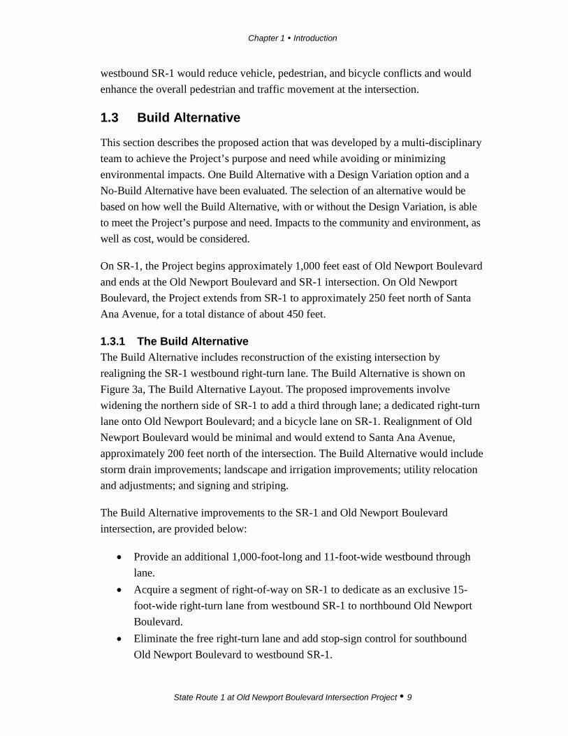
1.3 Build Alternative
This section describes the proposed action that was developed by a multi-disciplinary team to achieve the Project’s purpose and need while avoiding or minimizing environmental impacts. One Build Alternative with a Design Variation option and a No-Build Alternative have been evaluated. The selection of an alternative would be based on how well the Build Alternative, with or without the Design Variation, is able to meet the Project’s purpose and need. Impacts to the community and environment, as well as cost, would be considered.
On SR-1, the Project begins approximately 1,000 feet east of Old Newport Boulevard and ends at the Old Newport Boulevard and SR-1 intersection. On Old Newport Boulevard, the Project extends from SR-1 to approximately 250 feet north of Santa Ana Avenue, for a total distance of about 450 feet.
1.3.1 The Build Alternative The Build Alternative includes reconstruction of the existing intersection by realigning the SR-1 westbound right-turn lane. The Build Alternative is shown on Figure 3a, The Build Alternative Layout. The proposed improvements involve widening the northern side of SR-1 to add a third through lane; a dedicated right-turn lane onto Old Newport Boulevard; and a bicycle lane on SR-1. Realignment of Old Newport Boulevard would be minimal and would extend to Santa Ana Avenue, approximately 200 feet north of the intersection. The Build Alternative would include storm drain improvements; landscape and irrigation improvements; utility relocation and adjustments; and signing and striping.
The Build Alternative improvements to the SR-1 and Old Newport Boulevard intersection, are provided below:
• Provide an additional 1,000-foot-long and 11-foot-wide westbound through lane.
• Acquire a segment of right-of-way on SR-1 to dedicate as an exclusive 15-foot-wide right-turn lane from westbound SR-1 to northbound Old Newport Boulevard.
• Eliminate the free right-turn lane and add stop-sign control for southbound Old Newport Boulevard to westbound SR-1.

Chapter 1 Introduction
State Route 1 at Old Newport Boulevard Intersection Project 10
• Remove the “short weaving” distance between the SR-1 and Old Newport Boulevard intersection and the westbound SR-1 to the southbound SR-55 loop ramp.
• Provide a striped 5-foot-wide lane adjacent to the westbound right-turn lane to improve the bike-vehicle interface.
• Enhance the pedestrian experience safety by providing a sidewalk with improved lighting at the intersection’s northeastern corner and a crosswalk across Old Newport Boulevard.
• Eliminate uncontrolled vehicular access and parking to and from SR-1 at the A Market and Restaurant site on the northeast corner of the intersection.
• Eliminate the westbound right/through “trap” lane on SR-1.
Project Phasing Demolition and construction associated with the Project are expected to occur in two phases over a six-month period. Old Newport Boulevard and SR-1 would remain open through all phases of construction. The Build Alternative would export 800 cubic yards.
Temporary Project Construction Components Temporary Construction Easements (TCEs) would need to be obtained from A Market and A Restaurant (Assessor’s Parcel Number [APN] 049-110-01) and from the medical office building site (APN No. 049-110-29) to facilitate reconstruction of the parking lots and associated landscape improvements.
Construction Vehicle Access and Staging Construction vehicle access and staging would occur in previously disturbed and developed areas within the existing public street right-of-way. Staging will not occur within State Right of Way.
Right-of-Way and Parking As a result of the Build Alternative a total of 21 parking spaces would be removed. Right‐of‐way would need to be acquired from two adjacent parcels (APNs 049-110-01 and 049-110-29). Approximately 4,257 square feet would be required from A Market and A Restaurant (APN 049-110-01) located at 3334 Pacific Coast Highway. This would require the removal of an estimated 17 of the 21 parking spaces. An estimated 1,400 square feet of property would be acquired from the medical office building located at 3300 Pacific Coast Highway (APN 049-110-29), which includes
Chapter 1 Introduction
State Route 1 at Old Newport Boulevard Intersection Project 11
the removal and replacement of street landscaping and acquisition of two parking spaces. In addition two on-street parking spaces would be removed from SR-1. No building acquisitions or relocations would occur as a result of implementation of the Build Alternative. Temporary construction easements (TCE’s) on both properties will be required to facilitate construction of the parking lots and associated landscape improvements. The City of Newport Beach will be the implementing agency for all work, including right of way acquisition.
Drainage Improvements The Project area is currently served by existing storm drain facilities (pipes and box structures) that drain from north to south and outlet into the bay. The majority of the storm flows come from the residential area north of SR-1 and east of Old Newport Boulevard. The Build Alternative would require construction of two new catch basins along with connector pipes to existing drainage pipes/reinforced concrete boxes (RCBs) in Old Newport Boulevard. The Build Alternative improvements would improve water quality conditions by increasing the pervious area within the Project footprint.

Chapter 1 Introduction
State Route 1 at Old Newport Boulevard Intersection Project 12
This page intentionally left blank

ProposedPavementStriping
A Market A Restaurant
Medical Office Building
Pacific Coast Highway
Santa Ana Ave
Newp
ort B
lvd
La Jolla Dr
³Figure 3a
Old Newport Boulevard Project
Build Alternative
100 0 10050Feet
Aerial Source: Aerials Express 2009
Proposed Striping
Proposed Curb
Proposed Gutter
Pedestrian Crossing
Proposed Sidewalk
Proposed Landscape Area
Right-of-Way Acquisition
Proposed TCEEA 0N48012-ORA-SR-1 PM19.6-19.8

Chapter 1 Introduction
State Route 1 at Old Newport Boulevard Intersection Project 14
This page intentionally left blank
Chapter 1 Introduction
State Route 1 at Old Newport Boulevard Intersection Project 15
1.3.2 The Build Alternative with Design Variation The Build Alternative Design Variation would reconstruct the existing intersection west of its existing location and implement a third westbound through lane and a westbound right-turn lane on SR-1. The Build Alternative Design Variation is shown on Figure 3b, The Build Alternative Design Variation Layout. Instead of maintaining existing configuration as under the Build Alternative, the Design Variation proposes that Old Newport Boulevard would be reconstructed from SR-1 to approximately 450 feet north of SR-1. Old Newport Boulevard would also be realigned approximately 60 feet to the west to maximize right-turn storage and to eliminate the street centerline skew angle. The limits of the reconstructed Old Newport Boulevard would extend from SR-1 to approximately 450 feet north of SR-1.
The Build Alternative Design Variation would include storm drain improvements, landscape and irrigation improvements, utility relocation and adjustments, and signing and striping.
• Realignment of Old Newport Boulevard approximately 60 feet west of its current location would be required to maximize right-turn storage.
• Parking and circulation modifications would be required on private property in the northeast quadrant of the intersection.
• Removal and replacement of landscaped areas would be required along Old Newport Boulevard.
• Eliminate uncontrolled vehicular access and parking to and from SR-1 from A Market and A Restaurant.
• Relocation of the existing light post and of other local on-street signage.
• Adjustment and/or relocation of various aboveground utility features (e.g., manholes, valves, vaults).
Project Phasing Demolition and construction associated with the Project are expected to occur in two phases over a six-month period. Old Newport Boulevard and SR-1 would remain open through all phases of construction. The Build Alternative Design Variation would export 1,800 cubic yards of soils and materials to a local landfill.
Temporary Project Construction Components Temporary Construction Easements (TCEs) would need to be obtained from A Market and A Restaurant (Assessor’s Parcel Number [APN] 049-110-01) and from

Chapter 1 Introduction
State Route 1 at Old Newport Boulevard Intersection Project 16
the medical office building site (APN No. 049-110-29) to facilitate reconstruction of the parking lots and associated landscape improvements.
Construction Vehicle Access and Staging Construction vehicle access and staging would occur in previously disturbed and developed areas within the existing public street right-of-way. Staging will not occur within State Right of Way.
Right-of-Way and Parking As a result of the Build Alternative Design Variation, a total of six parking spaces would be removed. Right‐of‐way would need to be acquired from two adjacent parcels (APNs 049-110-01 and 049-110-29). Approximately 4,007 square feet would be required from A Market and A Restaurant (APN 049-110-01) located at 3334 Pacific Coast Highway. This would require the removal of an estimated two parking spaces. An estimated 885 square feet of property would be acquired from the medical office building located at 3300 Pacific Coast Highway (APN 049-110-29), requiring the removal and replacement of street landscaping and acquisition of an additional 2 parking spaces. In addition, two on-street parking spaces would be removed from SR-1. No building acquisitions or relocations would occur as a result of implementation of the Build Alternative. Temporary construction easements (TCE’s) on both properties will be required to facilitate construction of the parking lots and associated landscape improvements. The Build Alternative Design Variation would also require the permanent acquisition of a Caltrans-owned parcel on Old Newport Boulevard. The City would request that Caltrans be the implementing agency for right of way and the viability of this variation would depend on the decision of the California Transportation Commission (CTC) to approve the parcel as excess land. If the CTC does not approve the parcel as an excess land sale, the City would grant a conditional use permit so this design variation could be implemented. City must enter a cooperative agreement with Caltrans for reimbursement of work performed under Caltrans’ role as implementing agency.
Chapter 1 Introduction
State Route 1 at Old Newport Boulevard Intersection Project 17
Drainage Improvements The Build Alternative Design Variation would require construction of six catch basins along with connector pipes to the existing drainage pipes/reinforced concrete boxes (RCBs) in Old Newport Boulevard. The Build Alternative Design Variation proposes to construct a pre-treatment storm water quality vault to capture sediment and pollutants. This storm water vault would be installed along SR-1’s northern curb and gutter to capture heavy sediment, bacteria, oil and grease, nutrients, and heavy metals. Storm flows would then be conveyed to an infiltration basin that would be located just east of Old Newport Boulevard, which would allow for natural percolation into the underlying soils within 72 hours. An overflow mechanism would be designed and constructed to handle severe storm events. Implementation of the water quality features would improve the Project site’s perviousness.

Chapter 1 Introduction
State Route 1 at Old Newport Boulevard Intersection Project 18
This page intentionally left blank

Storm WaterQuality Basin
ProposedPavement Striping
A MarketA Restaurant
Medical Office Building
Pacific CoastHighway
Santa Ana Ave
Newp
ort Bl
vdLa Jolla Dr
Old N
ewpo
rt Blvd
³Figure 3b
Old Newport Boulevard ProjectBuild Alternative Design Variation
100 0 10050Feet
Aerial Source: Aerials Express 2009
Proposed Striping/ArrowsPedestrian CrossingWater Quality BMPProposed SidewalkProposed Landscape AreaRight-of-Way AcquisitionPermanent EasementProposed TCE EA 0N480
12-ORA-SR-1 PM19.6-19.8

Chapter 1 Introduction
State Route 1 at Old Newport Boulevard Intersection Project 20
This page intentionally left blank

Chapter 1 Introduction
State Route 1 at Old Newport Boulevard Intersection Project 21
No-Build Alternative With the No-Build Alternative, no improvements would be implemented.
1.4 Permits and Approvals Needed
This Initial Study/Negative Declaration (IS/ND) is intended to serve as the primary CEQA environmental document for all actions associated with the Build Alternative and its Design Variation for the proposed SR-1 at Old Newport Boulevard Intersection Improvement Project, including all discretionary approvals requested or required to implement the Project.
The anticipated schedule for the Project is shown in the Table 1.4 below.
Table 1.4 Project Schedule
Project Phase Anticipated Timeline
Approval of the IS/ND Spring 2017
Plans, Specifications and Estimates Fall 2017
Right-of-Way Acquisitions Winter 2017–2018
Construction Fall 2019
In addition, this is the primary reference document for the formulation and implementation of an Environmental Commitment Record for the proposed Project.
The permits, reviews, and approvals required for Project construction are described in Table 1.5 below.

Chapter 1 Introduction
State Route 1 at Old Newport Boulevard Intersection Project 22
Table 1.5 Permits and Approvals for the Build Alternative and Design Variation
Agency Permit/Approval Status
Caltrans
Encroachment Permit Prior to the initiation of construction, an Encroachment Permit issued by Caltrans would be required for all construction activities within the SR-1 and Old Newport Blvd right-of-way.
Caltrans and City of Newport Beach
Cooperative Agreement A Cooperative Agreement between the City of Newport Beach and Caltrans outlining their respective responsibilities for Project implementation would be required.
City of Newport Beach Approval of construction A Coastal Development Permit would be required from the City of Newport Beach.
City of Newport Beach
Certification of right-of-way A right-of-way certification demonstrating that all Project-required right-of-way has been acquired would be necessary prior to the initiation of construction. The City would also need to ensure that funding for right-of-way acquisition has been authorized.
Conditional Use Permit A CUP would be required for the reduction of the on-site parking for A Market and A Restaurant
State Water Resources Control Board
NPDES Construction General Permit (Order No. 2009-0009-DWQ, NPDES No. CAS00002)
For construction that causes more than 1.0 acre (the Build Alternative Design Variation) of soil disturbance, the Project must file a Notice of Intent (NOI) with the SWRCB prior to construction.
Caltrans Statewide NPDES Permit (Order No.2012-0011-DWQ, NPDES No, CAS000005)
This permit was issued to Caltrans to regulate discharges from Caltrans properties facilities and activities.
Santa Ana Regional Water Quality Control Board
MS4 Permit for the Santa Ana Region of Orange County (Order R8-2009-0030)/ Draft Order No. R8-2015-0001
This permit was issued to all cities in the County, including City of Newport Beach.
Caltrans: California Department of Transportation; SR: State Route; CUP: Conditional Use Permit; SWRCB: State Water Resources Control Board; NPDES: National Pollutant Discharge Elimination System; NOI: Notice of Intent; MS4: Municipal Separate Storm Sewer System

State Route 1 at Old Newport Boulevard Intersection Project 23
Chapter 2 CEQA Environmental Checklist
ENVIRONMENTAL FACTORS POTENTIALLY AFFECTED: The environmental factors checked below will be potentially affected by this project. Please see the checklist beginning on page 9 for additional information. Any boxes not checked represent issues that were considered as part of the scoping and environmental analysis for the project, but for which no impacts were identified.
Aesthetics Agriculture and Forestry Air Quality Biological Resources Cultural Resources Geology/Soils
Greenhouse Gas Emissions Hazards and Hazardous
Materials Hydrology/Water Quality
Land Use/Planning Mineral Resources Noise Paleontology Population/Housing Public Services Recreation Transportation/Traffic Tribal Cultural Resources Utilities/Service Systems Mandatory Findings of Significance
DETERMINATION: On the basis of this initial evaluation:
I find that the proposed project COULD NOT have a significant effect on the environment, and a NEGATIVE DECLARATION will be prepared.
I find that although the proposed project could have a significant effect on the environment, there will not be a significant effect in this case because revisions in the project have been made by or agreed to by the project proponent. A MITIGATED NEGATIVE DECLARATION will be prepared.
I find that the proposed project MAY have a significant effect on the environment, and an ENVIRONMENTAL IMPACT REPORT is required.
I find that the proposed project MAY have a "potentially significant impact" or "potentially significant unless mitigated" impact on the environment, but at least one effect 1) has been adequately analyzed in an earlier document pursuant to applicable legal standards, and 2) has been addressed by mitigation measures based on the earlier analysis as described on attached sheets. An ENVIRONMENTAL IMPACT REPORT is required, but it must analyze only the effects that remain to be addressed.
I find that although the proposed project could have a significant effect on the environment, because all potentially significant effects (a) have been analyzed adequately in an earlier EIR or NEGATIVE DECLARATION pursuant to applicable standards, and (b) have been avoided or mitigated pursuant to that earlier EIR or NEGATIVE DECLARATION, including revisions or mitigation measures that are imposed upon the proposed Project.
Signature: Date: Printed Name: For:
Chapter 2 CEQA Environmental Checklist
State Route 1 at Old Newport Boulevard Intersection Project 24
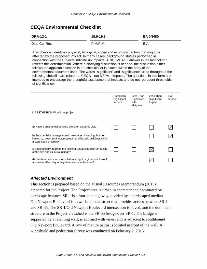
CEQA Environmental Checklist ORA-12-1 19.6-19.8 EA 0N480
Dist.-Co.-Rte. P.M/P.M. E.A. This checklist identifies physical, biological, social and economic factors that might be affected by the proposed Project. In many cases, background studies performed in connection with the Projects indicate no impacts. A NO IMPACT answer in the last column reflects this determination. Where a clarifying discussion is needed, the discussion either follows the applicable section in the checklist or is placed within the body of the environmental document itself. The words "significant" and "significance" used throughout the following checklist are related to CEQA—not NEPA—impacts. The questions in this form are intended to encourage the thoughtful assessment of impacts and do not represent thresholds of significance.
Potentially
Significant Impact
Less Than Significant with Mitigation
Less Than Significant Impact
No Impact
I. AESTHETICS: Would the project:
a) Have a substantial adverse effect on a scenic vista
b) Substantially damage scenic resources, including, but not limited to, trees, rock outcroppings, and historic buildings within a state scenic highway
c) Substantially degrade the existing visual character or quality of the site and its surroundings?
d) Create a new source of substantial light or glare which would adversely affect day or nighttime views in the area?
Affected Environment This section is prepared based on the Visual Resources Memorandum (2015) prepared for the Project. The Project area is urban in character and dominated by hardscape features. SR-1 is a four-lane highway, divided by a hardscaped median. Old Newport Boulevard is a two-lane local street that provides access between SR-1 and SR-55. The SR-1/Old Newport Boulevard intersection is paved, and the dominant structure in the Project viewshed is the SR-55 bridge over SR-1. The bridge is supported by a retaining wall; is adorned with vines; and is adjacent to southbound Old Newport Boulevard. A row of mature palms is located in front of the wall. A windshield and pedestrian survey was conducted on February 2, 2015.
Chapter 2 CEQA Environmental Checklist
State Route 1 at Old Newport Boulevard Intersection Project 25
The City of Newport Beach General Plan’s Natural Resources Element (2006) discusses visual resources and scenic highways in the City. Based on review of the General Plan’s Coastal Views Map (Figure NR3), SR-1 is designated as a Coastal View Road. However, this portion of SR-1 (i.e., the intersection) is not designated on the Caltrans Officially Designated State Scenic Highways list.
The City of Newport Beach prepared a Coastal Land Use Plan (CLUP) in 2009, consistent with the guidelines from the Coastal Commission. The CLUP’s Coastal Views Map provides information on coastal highways in the City.
The SR-1 and SR-55 Bridge is identified as “Newport Boulevard Bridge” in the City’s 2006 General Plan, and the SR-1/SR-55 interchange is called out under the General Plan’s Natural Resources Element in Policy NR 20.3, which states “Protect and enhance public view corridors”. Old Newport Boulevard does not have a General Plan designation.
A Market and A Restaurant, located adjacent to the intersection, are described in the City of Newport Beach’s Historic Resource Inventory and are old enough to require evaluation as potential historic resources. A Restaurant has been in operation since 1926. The buildings are currently being evaluated as part of the Cultural Resources Study conducted for the Project.
According to the City General Plan, there are no other scenic resources in or near the Project area. The Project site is also not located on or near mountains, hillside areas, or ridgelines; areas with historical and distinctive architecture; the downtown area; residential enclaves; or scenic drives.
The sensitive viewer groups consist of employees and clientele of the adjacent A Market and A Restaurant and the medical office building; pedestrians and bicyclists; residents of the apartment complexes and residential neighborhood north of the intersection; westbound travelers on SR-1; and northbound and southbound travelers on Old Newport Boulevard. The view of the intersection is obscured from SR-55 northbound and southbound due to a difference in elevation.
Environmental Consequences Checklist Question a The Build Alternative Based on review of the General Plan, SR-1 is designated as a Coastal View Road on the City of Newport Beach General Plan’s Coastal Views Map (Figure NR3). The

Chapter 2 CEQA Environmental Checklist
State Route 1 at Old Newport Boulevard Intersection Project 26
General Plan does not provide specific guidelines for Coastal View Roads. However, according to General Plan Goal NR 20, Preservation of significant visual resources, public views should be protected and enhanced from any public view corridors such as SR-1. Based on this, the Build Alternative would not introduce any elements that would obscure coastal views and public views from SR-1 or that would jeopardize the “Coastal View Road” designation. The Build Alternative would not conflict with any Coastal View policies. No scenic vistas have been identified on the General Plan map for the Project. Because there are no scenic vistas and no impacts to public coastal views from the Project, the Build Alternative would not have a substantial adverse effect on a scenic vista.
The Build Alternative Design Variation Based on the review of the General Plan, SR-1 is designated as a Coastal View Road on the City of Newport Beach General Plan’s Coastal Views Map (Figure NR3). Similar to the Build Alternative, the Build Alternative Design Variation would not introduce any elements that would obscure coastal views and public views from the SR-1 or that would jeopardize the “Coastal View Road” designation. No scenic vistas have been identified on the General Plan map for the Project. Because there are no scenic vistas, the Build Alternative Design Variation would not have a substantial adverse effect on a scenic vista.
No-Build Alternative Under the No-Build Alternative, no physical changes would occur, and the proposed Project would not result in adverse impacts to the aesthetic environment.
Checklist Question b The Build Alternative The Build Alternative would not impact scenic resources, rock outcroppings, or historic buildings within a State scenic highway. It would not require substantial amounts of grading that would modify the surrounding topography or introduce major design elements that would change views of mountains, hillside areas, or ridgelines.
The Build Alternative would result in a loss of 211 square feet of planted landscaping in front of the medical building. This would not result in a substantial visual change to the area and is consistent with the development pattern on the parcels containing A Market and A Restaurant, which contain a parking lot immediately adjacent to the roadway.

Chapter 2 CEQA Environmental Checklist
State Route 1 at Old Newport Boulevard Intersection Project 27
The surrounding area does not have historical or distinctive architecture; a downtown area; residential enclaves; or scenic drives. A Market and A Restaurant are on the City of Newport Beach’s Historic Resource Inventory. The Project would not impact the viewshed or architectural features of these properties (this is discussed further below under “Cultural Resources”). As described above, SR-1 is not a Caltrans Officially Designated State Scenic Highway, and Caltrans has not given Old Newport Boulevard a scenic roadway designation. Because the Build Alternative would not impact scenic resources, rock outcroppings, or historic buildings within a State scenic highway, it would not have a substantial adverse effect on scenic resources.
As described above, SR-1 is a Newport Beach Coastal View Road, but not a Caltrans Officially Designated State Scenic Highway, and Old Newport Boulevard does not have any scenic designations. The Build Alternative would not impact mountains, hillside areas, or ridgelines; areas with historical or distinctive architecture; a downtown area; residential enclaves; or scenic drives. Because the Build Alternative would not impact scenic resources, rock outcroppings, or historic buildings within a State scenic highway, it would not have a substantial adverse effect on scenic resources.
The Build Alternative Design Variation As described above, SR-1 is a Newport Beach Coastal View Road, but not a Caltrans Officially Designated State Scenic Highway, and Old Newport Boulevard does not have any scenic designations. The Build Alternative Design Variation would result in a loss of 172 square feet of street landscaping in front of the medical building. This would include a small strip of sod, scrub vegetation, and a palm tree.
The Build Alternative Design Variation would not impact mountains, hillside areas, or ridgelines; areas with historical or distinctive architecture; a downtown area; residential enclaves; or scenic drives. Because the Build Alternative Design Variation would not impact scenic resources, rock outcroppings, or historic buildings within a State scenic highway, it would not have a substantial adverse effect on scenic resources.
No-Build Alternative Under the No-Build Alternative, no physical changes would occur, and the proposed Project would not result in adverse impacts to the aesthetic environment.

Chapter 2 CEQA Environmental Checklist
State Route 1 at Old Newport Boulevard Intersection Project 28
Checklist Question c The Build Alternative The Caltrans Visual Assessment Guide was used to determine the extent of visual impacts of the Build Alternative. Out of 30 possible points, the overall score for the Build Alternative was 13 points, indicating a low level of change to the visual environment. No structures are proposed as part of the Project, and all proposed improvements for the Build Alternative would be at-grade.
Minor parking modifications would occur at the front of A Market and the medical office building lot as a result of the Build Alternative. Parking spots fronting Old Newport Boulevard would be removed, and a continuous sidewalk would be provided that connects Old Newport Boulevard to SR-1. However, this would not increase the appearance of hardscape features. In addition, two parking spaces would be removed at the medical office building (APN049-110-29) and after implementation of the Build Alternative, this area would be landscaped. No other visual changes would occur.
After Project completion, the views onto the site and off the site would remain relatively unchanged. The visual quality and character of the site would remain unchanged, and the duration of views for all sensitive viewer groups would remain unchanged. Therefore, the relatively small visual changes under the Build Alternative would result in low response in all sensitive viewer groups. After Project implementation, the visual quality and character of the site would remain the same; thus, the Build Alternative would not degrade the existing visual quality of the site and its surroundings, and it would not have a substantial adverse effect on visual quality or character of the site.
The Build Alternative Design Variation The Caltrans Visual Assessment Guide was used to determine the extent of visual impacts of the Build Alternative Design Variation. Out of 30 possible points, the overall score for the Build Alternative Design Variation was 13 points, indicating a low level of change to the visual environment. Similar to the Build Alternative, improvements for the Build Alternative Design Variation would be at-grade and would not involve the addition of new visual elements that would change the quality of existing views.
The Build Alternative Design Variation would not involve the addition of new visual elements that would change the quality of existing views. The slope of the

Chapter 2 CEQA Environmental Checklist
State Route 1 at Old Newport Boulevard Intersection Project 29
intersection would remain the same and landscape beautification elements would be provided after construction is completed. Parking modification and/or realignment would occur at the A Market and A Restaurant parking lot and at the parking lot of the medical office building. The Build Alternative Design Variation would not dramatically increase the appearance of hardscape features. The main visual changes under the Build Alternative Design Variation would be to remove the existing street parking along westbound SR-1 and to replace it with a right-turn lane; to add a parking lot on the west side of A Market; and to remove the existing concrete-paved parking lot on the east side of Old Newport Boulevard. In addition, two parking spaces would be removed at the medical office building (APN049-110-29) and after implementation of the Build Alternative Design Variation, this area would be landscaped. These changes would not alter the visual quality or character of the site because the intersection is paved and already dominated by hardscape features. After Project completion, the visual quality and character of the site would remain unchanged and sensitive viewer groups’ response to these changes would be low.
Additional Project features in the viewshed include construction of a landscaped water quality basin (i.e., a Best Management Practice [BMP]) along Old Newport Boulevard. The landscaped basin would serve as a beautification element and would soften the existing view dominated by the hardscape features and the paved intersection. After Project implementation, the visual quality and character of the site would remain the same; thus, the Build Alternative Design Variation would not degrade the existing visual quality of the site and its surroundings, and it would not have a substantial adverse effect on the site’s visual quality or character.
No-Build Alternative Under the No-Build Alternative, no physical changes would occur, and the proposed Project would not result in adverse impacts to aesthetic environment.
Checklist Question d The Build Alternative The Build Alternative would provide additional street lighting in the road right-of-way for vehicles, pedestrians, and bicycles. The addition of new lighting at the intersection would not incorporate sources of new light and glare because the intersection is located in an urban area. The westbound SR-1 east and west of the intersection is well lit by adjacent development. Provision of additional lighting near the SR-55 bridge would enhance the experience of westbound travelers. The Build Alternative would not create new sources of substantial light or glare that would

Chapter 2 CEQA Environmental Checklist
State Route 1 at Old Newport Boulevard Intersection Project 30
adversely affect day or nighttime views in the area. Because the Project is located in an urban area and because lighting already exists on the site, the Build Alternative would not result in substantial effects related to light and glare.
The Build Alternative Design Variation The Build Alternative Design Variation would provide additional street lighting in the road right-of-way for vehicles, pedestrians, and bicycles. The addition of new lighting at the intersection would not result in substantial new sources of light and glare because the intersection is located in an urban area. The westbound SR-1 east and west of the intersection is well lit by adjacent development. The Build Alternative Design Variation would not create new sources of substantial light or glare that would adversely affect day or nighttime views in the area. Because the Project is located in an urban area and because lighting already exists on the site, the Build Alternative Design Variation would not result in substantial effects related to light and glare.
No-Build Alternative Under the No-Build Alternative, no physical changes would occur, and the proposed Project would not result in adverse impacts to the aesthetic environment.
Avoidance, Minimization, and/or Mitigation Measures No avoidance, minimization, and mitigation measures would apply.
Chapter 2 CEQA Environmental Checklist
State Route 1 at Old Newport Boulevard Intersection Project 31
Potentially Significant Impact
Less Than Significant with Mitigation
Less Than Significant Impact
No Impact
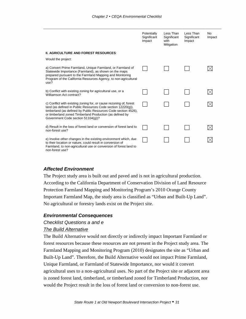
II. AGRICULTURE AND FOREST RESOURCES:
Would the project:
a) Convert Prime Farmland, Unique Farmland, or Farmland of Statewide Importance (Farmland), as shown on the maps prepared pursuant to the Farmland Mapping and Monitoring Program of the California Resources Agency, to non-agricultural use?
b) Conflict with existing zoning for agricultural use, or a Williamson Act contract?
c) Conflict with existing zoning for, or cause rezoning of, forest land (as defined in Public Resources Code section 12220(g)), timberland (as defined by Public Resources Code section 4526), or timberland zoned Timberland Production (as defined by Government Code section 51104(g))?
d) Result in the loss of forest land or conversion of forest land to non-forest use?
e) Involve other changes in the existing environment which, due to their location or nature, could result in conversion of Farmland, to non-agricultural use or conversion of forest land to non-forest use?
Affected Environment The Project study area is built out and paved and is not in agricultural production. According to the California Department of Conservation Division of Land Resource Protection Farmland Mapping and Monitoring Program’s 2010 Orange County Important Farmland Map, the study area is classified as “Urban and Built-Up Land”. No agricultural or forestry lands exist on the Project site.
Environmental Consequences Checklist Questions a and e The Build Alternative The Build Alternative would not directly or indirectly impact Important Farmland or forest resources because these resources are not present in the Project study area. The Farmland Mapping and Monitoring Program (2010) designates the site as “Urban and Built-Up Land”. Therefore, the Build Alternative would not impact Prime Farmland, Unique Farmland, or Farmland of Statewide Importance, nor would it convert agricultural uses to a non-agricultural uses. No part of the Project site or adjacent area is zoned forest land, timberland, or timberland zoned for Timberland Production, nor would the Project result in the loss of forest land or conversion to non-forest use.

Chapter 2 CEQA Environmental Checklist
State Route 1 at Old Newport Boulevard Intersection Project 32
Because there is no farmland on the Project site, the Build Alternative would not result in substantial adverse effects to farmland.
The Build Alternative Design Variation The Build Alternative Design Variation would not directly or indirectly impact Important Farmland or forest resources because these resources are not present in the Project study area. The Farmland Mapping and Monitoring Program (2010) designates the site as Urban and Built-Up Land. Therefore, the Build Alternative Design Variation would not impact Prime Farmland, Unique Farmland, or Farmland of Statewide Importance, nor would it convert any agricultural uses to non-agricultural uses. No part of the Project site or adjacent areas is zoned forest land, timberland, or timberland zoned for Timberland Production, nor would the Project result in the loss of forest land or convert forest land to a non-forest use. Because there is no farmland on the Project site, the Build Alternative Design Variation would not result in substantial effects to farmland.
No-Build Alternative Under the No-Build Alternative, no physical changes would occur, and the proposed Project would not conflict with any designated farmland or timberland.
Checklist Question b The Build Alternative As stated above, the Project area lacks any agricultural uses. The City of Newport Beach General Plan Land Use Map (2006) designates the areas at the intersection as “General Commercial”, and the General Plan states that there are no lands in the Project area under a Williamson Act contract. Therefore, implementation of the Build Alternative would not conflict with or have an adverse effect on existing zoning for agricultural use or on a Williamson Act Contract.
The Build Alternative Design Variation As stated above, the Project study area lacks any agricultural uses. The City of Newport Beach General Plan designates the areas at the intersection as “General Commercial”, and the General Plan states that there are no lands in the Project area under a Williamson Act contract. Therefore, implementation of the Build Alternative Design Variation would not conflict with or have an adverse effect on existing zoning for agricultural use or a Williamson Act Contract.

Chapter 2 CEQA Environmental Checklist
State Route 1 at Old Newport Boulevard Intersection Project 33
No-Build Alternative Under the No-Build Alternative, no physical changes would occur and the proposed Project would not conflict with any designated farmland or timberland.
Checklist Questions c and d The Build Alternative No agricultural, forestland, or timberland zoning applies to the Project site. Therefore, the Build Alternative would not conflict with existing zoning for, or cause rezoning of, forest land, timberland, or timberland zoned for Timberland Production. Because the Project is not located on forest lands or timber lands, the Build Alternative would not result in a substantial adverse effect to forest lands or timber lands.
The Build Alternative Design Variation No agricultural, forestland, or timberland zoning applies to the Project site. Therefore, the Build Alternative Design Variation would not conflict with existing zoning for, or cause rezoning of, forest land, timberland, or timberland zoned for Timberland Production. Because the Project is not located on forestland or timberland, the Build Alternative Design Variation would not result in a substantial adverse effect to forestland or timberland.
No-Build Alternative Under the No-Build Alternative, no physical changes would occur, and the Project would not conflict with any designated farmlands or timberlands.
Avoidance, Minimization, and/or Mitigation Measures No avoidance, minimization, or mitigation measures are necessary.

Chapter 2 CEQA Environmental Checklist
State Route 1 at Old Newport Boulevard Intersection Project 34
Potentially Significant Impact
Less Than Significant with Mitigation
Less Than Significant Impact
No Impact
III. AIR QUALITY: Where available, the significance criteria established by the applicable air quality management or air pollution control district may be relied upon to make the following determinations. Would the project:
a) Conflict with or obstruct implementation of the applicable air quality plan?
b) Violate any air quality standard or contribute substantially to an existing or projected air quality violation?
c) Result in a cumulatively considerable net increase of any criteria pollutant for which the project region is non- attainment under an applicable federal or state ambient air quality standard (including releasing emissions which exceed quantitative thresholds for ozone precursors)?
d) Expose sensitive receptors to substantial pollutant concentrations?
e) Create objectionable odors affecting a substantial number of people?
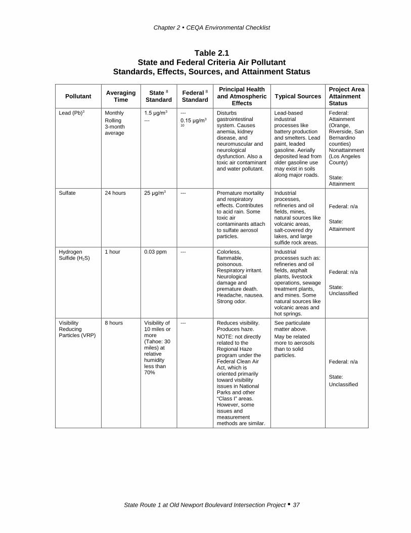
Affected Environment The Federal Clean Air Act (FCAA), as amended in 1990, is the federal law that governs air quality while the California Clean Air Act of 1988 is its companion state law. These laws, and related regulations by the U.S. Environmental Protection Agency (USEPA) and California Air Resources Board (CARB), set standards for the quantity of pollutants that can be in the air. National Ambient Air Quality Standards (NAAQS) and California Ambient Air Quality Standards (CAAQS) are presented in Table 2.1 below for six transportation-related criteria pollutants that have been linked to potential health concerns. For regions that do not attain the CAAQS, CARB requires the air districts to prepare plans for attaining the standards. These plans are then integrated into the State Implementation Plan (SIP).
The South Coast Air Quality Management District (SCAQMD) is the agency principally responsible for comprehensive air pollution control in the South Coast Air Basin (SoCAB), which includes all of Orange County and the urbanized portions of Los Angeles, Riverside, and San Bernardino Counties.

Chapter 2 CEQA Environmental Checklist
State Route 1 at Old Newport Boulevard Intersection Project 35
On December 7, 2012, the SCAQMD adopted the 2012 Air Quality Management Plan (AQMP), which is a regional and multi-agency effort (among the SCAQMD, CARB, the Southern California Association of Governments [SCAG], and the USEPA). The 2012 AQMP incorporates the latest scientific and technical information and planning assumptions, including the 2012 Regional Transportation Plan/Sustainable Communities Strategy (RTP SCS); updated emission inventory methods for various source categories; and SCAG’s latest growth forecasts. On December 20, 2012, the 2012 AQMP was submitted to CARB and the USEPA for concurrent review and approval for inclusion in the SIP. CARB approved the 2012 AQMP on January 25, 2013. The main purpose of an AQMP is to bring an area into compliance with the requirements of federal and State air quality standards.
Table 2.1 State and Federal Criteria Air Pollutant
Standards, Effects, Sources, and Attainment Status
Pollutant Averaging Time
State 8 Standard
Federal 8
Standard Principal Health
and Atmospheric Effects
Typical Sources Project Area Attainment Status
Ozone (O3) 1 hour 8 hours
0.09 ppm 0.070 ppm
--- 4 0.070 ppm (4th highest in 3 years)
High concentrations irritate lungs. Long-term exposure may cause lung tissue damage and cancer. Long-term exposure damages plant materials and reduces crop productivity. Precursor organic compounds include many known toxic air contaminants. Biogenic VOC may also contribute.
Low-altitude ozone is almost entirely formed from reactive organic gases/volatile organic compounds (ROG or VOC) and nitrogen oxides (NOx) in the presence of sunlight and heat. Common precursor emitters include motor vehicles and other internal combustion engines, solvent evaporation, boilers, furnaces, and industrial processes.
Federal: Extreme Nonattainment State: Nonattainment
Carbon Monoxide (CO)
1 hour 8 hours 8 hours (Lake Tahoe)
20 ppm 9.0 ppm 1 6 ppm
35 ppm 9 ppm ---
CO interferes with the transfer of oxygen to the blood and deprives sensitive tissues of oxygen. CO also is a minor precursor for photochemical ozone. Colorless, odorless.
Combustion sources, especially gasoline-powered engines and motor vehicles. CO is the traditional signature pollutant for on-road mobile sources at the local and neighborhood scale.
Federal: Attainment/ Maintenance State: Attainment

Chapter 2 CEQA Environmental Checklist
State Route 1 at Old Newport Boulevard Intersection Project 36
Table 2.1 State and Federal Criteria Air Pollutant
Standards, Effects, Sources, and Attainment Status
Pollutant Averaging Time
State 8 Standard
Federal 8
Standard Principal Health
and Atmospheric Effects
Typical Sources Project Area Attainment Status
Respirable Particulate Matter (PM10) 2
24 hours Annual
50 μg/m3
20 μg/m3
150 μg/m3 --- 2 (expected number of days above standard < or equal to 1)
Irritates eyes and respiratory tract. Decreases lung capacity. Associated with increased cancer and mortality. Contributes to haze and reduced visibility. Includes some toxic air contaminants. Many toxic & other aerosol and solid compounds are part of PM10.
Dust- and fume-producing industrial and agricultural operations; combustion smoke & vehicle exhaust; atmospheric chemical reactions; construction and other dust-producing activities; unpaved road dust and re-entrained paved road dust; natural sources.
Federal: Attainment/ Maintenance State: Nonattainment
Fine Particulate Matter (PM2.5) 2
24 hours Annual 24 hours (conformity process 5) Secondary Standard (annual; also for conformity process 5)
--- 12 μg/m3 --- ---
35 μg/m3 12.0 μg/m3 65 μg/m3 12 μg/m3 (98th percentile over 3 years)
Increases respiratory disease, lung damage, cancer, and premature death. Reduces visibility and produces surface soiling. Most diesel exhaust particulate matter – a toxic air contaminant – is in the PM2.5 size range. Many toxic & other aerosol and solid compounds are part of PM2.5.
Combustion including motor vehicles, other mobile sources, and industrial activities; residential and agricultural burning; also formed through atmospheric chemical and photochemical reactions involving other pollutants including NOx, sulfur oxides (SOx), ammonia, and ROG.
Federal: Nonattainment State: Nonattainment
Nitrogen Dioxide (NO2)
1 hour Annual
0.18 ppm 0.030 ppm
0.100 ppm 6 (98th percentile over 3 years) 0.053 ppm
Irritating to eyes and respiratory tract. Colors atmosphere reddish-brown. Contributes to acid rain & nitrate contamination of stormwater. Part of the “NOx” group of ozone precursors.
Motor vehicles and other mobile or portable engines, especially diesel; refineries; industrial operations.
Federal: Attainment/ Maintenance State: Attainment
Sulfur Dioxide (SO2)
1 hour 3 hours 24 hours
0.25 ppm --- 0.04 ppm
0.075 ppm 7
(99th percentile over 3 years) 0.5 ppm 9
Irritates respiratory tract; injures lung tissue. Can yellow plant leaves. Destructive to marble, iron, steel. Contributes to acid rain. Limits visibility.
Fuel combustion (especially coal and high-sulfur oil), chemical plants, sulfur recovery plants, metal processing; some natural sources like active volcanoes. Limited contribution possible from heavy-duty diesel vehicles if ultra-low sulfur fuel not used.
Federal: State:
Chapter 2 CEQA Environmental Checklist
State Route 1 at Old Newport Boulevard Intersection Project 37
Table 2.1 State and Federal Criteria Air Pollutant
Standards, Effects, Sources, and Attainment Status
Pollutant Averaging Time
State 8 Standard
Federal 8
Standard Principal Health
and Atmospheric Effects
Typical Sources Project Area Attainment Status
Lead (Pb)3 Monthly Rolling 3-month average
1.5 μg/m3
--- --- 0.15 μg/m3 10
Disturbs gastrointestinal system. Causes anemia, kidney disease, and neuromuscular and neurological dysfunction. Also a toxic air contaminant and water pollutant.
Lead-based industrial processes like battery production and smelters. Lead paint, leaded gasoline. Aerially deposited lead from older gasoline use may exist in soils along major roads.
Federal: Attainment (Orange, Riverside, San Bernardino counties) Nonattainment (Los Angeles County) State: Attainment
Sulfate 24 hours 25 μg/m3 --- Premature mortality and respiratory effects. Contributes to acid rain. Some toxic air contaminants attach to sulfate aerosol particles.
Industrial processes, refineries and oil fields, mines, natural sources like volcanic areas, salt-covered dry lakes, and large sulfide rock areas.
Federal: n/a State: Attainment
Hydrogen Sulfide (H2S)
1 hour 0.03 ppm --- Colorless, flammable, poisonous. Respiratory irritant. Neurological damage and premature death. Headache, nausea. Strong odor.
Industrial processes such as: refineries and oil fields, asphalt plants, livestock operations, sewage treatment plants, and mines. Some natural sources like volcanic areas and hot springs.
Federal: n/a State: Unclassified
Visibility Reducing Particles (VRP)
8 hours Visibility of 10 miles or more (Tahoe: 30 miles) at relative humidity less than 70%
--- Reduces visibility. Produces haze. NOTE: not directly related to the Regional Haze program under the Federal Clean Air Act, which is oriented primarily toward visibility issues in National Parks and other “Class I” areas. However, some issues and measurement methods are similar.
See particulate matter above. May be related more to aerosols than to solid particles.
Federal: n/a State: Unclassified

Chapter 2 CEQA Environmental Checklist
State Route 1 at Old Newport Boulevard Intersection Project 38
Table 2.1 State and Federal Criteria Air Pollutant
Standards, Effects, Sources, and Attainment Status
Pollutant Averaging Time
State 8 Standard
Federal 8
Standard Principal Health
and Atmospheric Effects
Typical Sources Project Area Attainment Status
Vinyl Chloride3 24 hours 0.01 ppm --- Neurological effects, liver damage, cancer. Also considered a toxic air contaminant.
Industrial processes Federal: n/a
State:
Notes: ppm = parts per million; μg/m3 = micrograms per cubic meter; ppb=parts per billion (thousand million) 1 Rounding to an integer value is not allowed for the State 8-hour CO standard. A violation occurs at or above 9.05
ppm. 2 Annual PM10 NAAQS revoked October 2006; was 50 μg/m3. 24-hr. PM2.5 NAAQS tightened October 2006; was 65
μg/m3. Annual PM2.5 NAAQS tightened from 15 μg/m3 to 12 μg/m3 December 2012 and secondary annual standard set at 15 μg/m3.
3 The ARB has identified vinyl chloride and the particulate matter fraction of diesel exhaust as toxic air contaminants. Diesel exhaust particulate matter is part of PM10 and, in larger proportion, PM2.5. Both the ARB and U.S. EPA have identified lead and various organic compounds that are precursors to ozone and PM2.5 as toxic air contaminants. There are no exposure criteria for adverse health effect due to toxic air contaminants, and control requirements may apply at ambient concentrations below any criteria levels specified above for these pollutants or the general categories of pollutants to which they belong.
4 Prior to 6/2005, the 1-hour ozone NAAQS was 0.12 ppm. Emission budgets for 1-hour ozone are still be in use in some areas where 8-hour ozone emission budgets have not been developed, such as the S.F. Bay Area.
5 The 65 μg/m3 PM2.5 (24-hr) NAAQS was not revoked when the 35 μg/m3 NAAQS was promulgated in 2006. The 15 μg/m3 annual PM2.5 standard was not revoked when the 12 μg/m3 standard was promulgated in 2012. The 0.08 ppm 1997 ozone standard is revoked FOR CONFORMITY PURPOSES ONLY when area designations for the 2008 0.75 ppm standard become effective for conformity use (7/20/2013). Conformity requirements apply for all NAAQS, including revoked NAAQS, until emission budgets for newer NAAQS are found adequate, SIP amendments for the newer NAAQS are approved with a emission budget, EPA specifically revokes conformity requirements for an older standard, or the area becomes attainment/unclassified. SIP-approved emission budgets remain in force indefinitely unless explicitly replaced or eliminated by a subsequent approved SIP amendment. During the “Interim” period prior to availability of emission budgets, conformity tests may include some combination of build vs. no build, build vs. baseline, or compliance with prior emission budgets for the same pollutant.
6 Final 1-hour NO2 NAAQS published in the Federal Register on 2/9/2010, effective 3/9/2010. Initial area designation for California (2012) was attainment/unclassifiable throughout. Project-level hot spot analysis requirements do not currently exist. Near-road monitoring starting in 2013 may cause redesignation to nonattainment in some areas after 2016.
7 EPA finalized a 1-hour SO2 standard of 75 ppb in June 2010. Nonattainment areas have not yet been designated as of 9/2012.
8 State standards are “not to exceed” or “not to be equaled or exceeded” unless stated otherwise. Federal standards are “not to exceed more than once a year” or as described above.
9 Secondary standard, set to protect public welfare rather than health. Conformity and environmental analysis address both primary and secondary NAAQS.
10 Lead NAAQS are not considered in Transportation Conformity analysis. Greenhouse Gases and Climate Change:
Greenhouse gases do not have concentration standards for that purpose. Conformity requirements do not apply to greenhouse gases. Source: CARB 2015.
The SCAQMD maintains a network of ambient air monitoring stations throughout the SoCAB to determine whether areas are meeting the standards. Newport Beach is located in SCAQMD-designated Source Receptor Area (SRA) 18 – North Coastal Orange County. Air quality for SRA 18 is monitored at the Costa Mesa Monitoring
Chapter 2 CEQA Environmental Checklist
State Route 1 at Old Newport Boulevard Intersection Project 39
Station, located approximately 3.6 miles north of the Project site. The Costa Mesa Monitoring Station monitors ozone (O3), nitrogen dioxide (NO2), carbon monoxide (CO), and sulfur dioxide (SO2). The maximum pollutant concentrations measured at the Costa Mesa Monitoring Station between 2011 and 2013 show exceedances of the State one-hour O3 standard in 2013 and the federal and State eight-hour O3 standards from 2011 to 2013. No other standards were exceeded.
The Project site is located in an urban area with commercial land use development and residential uses adjacent to the roadways in all directions. The major sources of existing emissions are the vehicles using the roads and intersection.
Some members of the general population are especially sensitive to air pollutant emissions and should be given special consideration when evaluating air quality impacts from projects. These people include children, the elderly, persons with preexisting respiratory or cardiovascular illness, and athletes and others who engage in frequent exercise. Structures that house these persons or places where they gather (e.g., residences, schools, playgrounds, child-care centers, convalescent centers, retirement homes, and athletic fields) are defined as sensitive receptors by the SCAQMD. The nearest sensitive receptors to the Project site are residences (i.e., condominiums) located adjacent to the northern portion of the Project site at 207, 209, 211, 213, and 215 La Jolla Avenue; excavation would occur on Old Newport Boulevard and SR-1 approximately 15 feet from the residential uses. There is a medical facility located at 3300 West Coast Highway, Suite C, which is located approximately 75 feet to the north of the Project site boundary and the planned excavation area on SR-1. A surgical center, Newport Bay Surgery Center, is located 332 feet southeast of the Project site at 3333 West Coast Highway. Hoag Hospital is located 630 feet northwest of the Project site across Newport Boulevard and (SR-55).
The SCAQMD establishes significance thresholds to assess the regional impact of Project-related air pollutant emissions in the SoCAB. Table 2.2 lists the SCAQMD’s mass emissions thresholds, which are presented for both short-term construction and long-term operational emissions. A project with emissions rates below these thresholds is not considered to have an adverse effect on air quality.

Chapter 2 CEQA Environmental Checklist
State Route 1 at Old Newport Boulevard Intersection Project 40
Table 2.2 South Coast Air Quality Management District Criteria Pollutant Significant Mass Emissions Significance Thresholds (lbs/day)
Criteria Pollutant Construction Operation
Volatile Organic Compounds (VOC) 75 55 Oxides of Nitrogen (NOx) 100 55 Carbon Monoxide (CO) 550 550 Oxides of Sulfur (SOx) 150 150 Particulate Matter (PM10) 150 150 Particulate Matter (PM2.5) 55 55 lbs/day: pounds per day
Environmental Consequences Information presented in this section is based on the State Route 1 and Old Newport Boulevard Intersection Improvement Project Air Quality Technical Report (Air Quality Technical Report) (2015).
Checklist Question a The Build Alternative For a project to be consistent with the AQMP, the pollutants emitted from that project should not (1) exceed the SCAQMD CEQA air quality significance thresholds or (2) conflict with or exceed the assumptions in the AQMP.
Implementation of the Build Alternative would contribute emissions of respirable particulate matter with a diameter of 10 microns or less (PM10), fine particulate matter with a diameter of 2.5 microns or less (PM2.5), and the ozone (O3) precursors volatile organic compounds (VOC) and nitrogen oxides (NOx) to the area during short-term construction. As discussed under question “b” below, the estimated pollutant emissions during construction would be less than the SCAQMD criteria. Upon completion of construction, there would be no change in vehicle volume, mix, or speeds and therefore no change in vehicle-related emissions. The Build Alternative does not involve a change in General Plan designation or zoning and therefore would not exceed the assumptions in the AQMP. As such, no conflict with the 2012 AQMP would occur with the Build Alternative. Because the Build Alternative’s construction emissions would not exceed the SCAQMD CEQA air quality significance thresholds and would not conflict with the AQMP, the Build Alternative would not result in substantial adverse effects related to air quality.
Chapter 2 CEQA Environmental Checklist
State Route 1 at Old Newport Boulevard Intersection Project 41
The Build Alternative Design Variation The Build Alternative Design Variation would result in the same impacts to air quality as the Build Alternative. Because the Build Alternative Design Variation’s construction emissions would not exceed the SCAQMD CEQA air quality significance thresholds and would not conflict with the 2012 AQMP, the Build Alternative Design Variation would not result in substantial adverse effects related to air quality. Refer to the Build Alternative checklist question “a”, above.
No-Build Alternative Under the No-Build Alternative, no physical changes would occur and the proposed Project would not generate any air quality pollutants.
Checklist Question b The Build Alternative Construction Impacts – Regional Air Quality Criteria pollutant emissions would occur from operation of construction equipment; generation of fugitive dust from grading and earth-moving activities; import of construction materials; and operation of vehicles driven to and from the site by construction workers. Construction emissions for the Build Alternative were calculated with the Road Construction Emissions Model (version 7.1.5.1). The Road Construction Emissions Model was developed by the Sacramento Metropolitan Air Quality Management District (SMAQMD) for calculating emissions from linear construction projects and is accepted by the SCAQMD.
The Build Alternative would include demolition, shallow grading, utility relocation, curb and gutter reconstruction, repaving, and restriping. For purposes of estimating construction emissions, it was assumed that construction of the Build Alternative and/or its Design Variation would last approximately six months. The Build Alternative would likely last approximately five months, but the estimates in the table were prepared for the most conservative scenario. Table 2.3 shows the estimated maximum daily construction emissions for the Build Alternative and its Design Variation. As shown, all criteria pollutant emissions would be less than their respective thresholds. Thus, the Build Alternative would not result in violation of any air quality standards.

Chapter 2 CEQA Environmental Checklist
State Route 1 at Old Newport Boulevard Intersection Project 42
Table 2.3 Estimated Maximum Daily Construction Emissions for the Build
Alternative (lbs/day)
VOC NOx CO PM10 PM2.5
Construction emissions 7 68 32 6 4 SCAQMD Daily Thresholds 75 100 550 150 55
Exceeds SCAQMD Thresholds? No No No No No lbs/day: pounds per day; VOC: volatile organic compound(s); NOx: nitrogen oxides; CO: carbon monoxide; PM10: respirable particulate matter with a diameter of 10 microns or less; PM2.5: fine particulate matter with a diameter of 2.5 microns or less; SCAQMD: South Coast Air Quality Management District. Source: Air Quality Technical Report 2015
Table 2.4 shows Regional Total Construction Emissions for the Build Alternative. There are no significance criteria for total Project emissions.
Table 2.4 Estimated Total Construction Emissions
for the Build Alternative (tons)
VOC NOx CO PM10 PM2.5
The Build Alternative 0.2 1.3 2.3 0.2 0.1 VOC: volatile organic compound(s); NOx: nitrogen oxides; CO: carbon monoxide; PM10: inhalable particulate matter with a diameter of 10 microns or less; PM2.5: fine particulate matter with a diameter of 2.5 microns or less.
Source: Air Quality Technical Report 2015
Construction Impacts – Localized Air Quality The localized effects from daily construction emissions were evaluated at sensitive receptor locations according to the SCAQMD’s localized significance threshold (LST) method, which utilizes on-site mass emissions rate look up tables and Project-specific modeling, where appropriate. LSTs are applicable to the following criteria pollutants: nitrogen dioxide (NO2),1 carbon monoxide (CO), PM10, and PM2.5. LSTs represent the maximum emissions from a project that are not expected to cause or contribute to an exceedance of the most stringent applicable federal or State ambient air quality standard, and are developed based on the ambient concentrations of that pollutant for each SRA and distance to the nearest sensitive receptor. For PM10 and PM2.5, LSTs were derived based on requirements in SCAQMD Rule 403, Fugitive Dust (see Standard Condition AQ-2). The mass rate look-up tables were developed for each SRA and can be used to determine whether or not a project may generate
1 NO2 impacts are addressed by evaluating nitrogen oxide (NOx) emissions.

Chapter 2 CEQA Environmental Checklist
State Route 1 at Old Newport Boulevard Intersection Project 43
significant adverse localized air quality impacts. The SCAQMD provides LST mass rate look-up tables for projects that are less than or equal to five acres. To minimize construction emissions, Standard Conditions AQ-1 and AQ-2 would be applicable.
Consistent with the SCAQMD’s LST guidelines, only emissions that occur on site are considered. As shown in Table 2.5, localized emissions for all criteria pollutants would be less than their respective thresholds. Impacts would be less than significant at the nearest sensitive receptors (i.e., residences at 207–215 La Jolla Avenue) and all other sensitive receptors located farther from the Project site.
Table 2.5 Maximum Localized Construction Pollutant Emissions (lbs/day)
NOx CO PM10 PM2.5
Local emissions 35 16 3.8 2.0 SCAQMD LSTsa 92 647 4 3
Exceeds SCAQMD Thresholds? No No No No lbs/day: pounds per day; NOx: nitrogen oxides; CO: carbon monoxide; PM10: respirable particulate matter with a diameter of 10 microns or less; PM2.5: fine particulate matter with a diameter of 2.5 microns or less; SCAQMD: South Coast Air Quality Management District; LST: Localized Significance Threshold. a Thresholds for Source Receptor Area 18, North Coastal Orange County, 1-acre site, 25-meter receptor distance for NOx and
CO, and 25-meter receptor distance for PM10 and PM2.5.
Source: Air Quality Technical Report 2015
Long-Term Operational Impacts As discussed in Section XVI, Traffic and Transportation, the Build Alternative would not generate traffic or cause a change in traffic volumes. The Project’s Traffic Impact Analysis reports that the overall change in traffic operations, namely volumes and speed, between the No Build and the Build Alternative would be negligible. Therefore, it is concluded that changes in vehicle pollutant emissions between the Build Alternative and No-Build Alternative conditions would be negligible. No operational air quality impact would occur from the Build Alternative. Because the Build Alternative would not result in substantial construction or operational emissions, the Build Alternative would not violate air quality standards or contribute to existing or projected air quality violations. Based on this, the Build Alternative would not result in substantial adverse effects related to air quality standards.
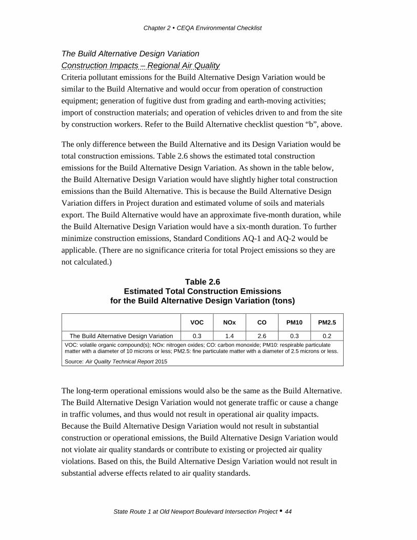
Chapter 2 CEQA Environmental Checklist
State Route 1 at Old Newport Boulevard Intersection Project 44
The Build Alternative Design Variation Construction Impacts – Regional Air Quality Criteria pollutant emissions for the Build Alternative Design Variation would be similar to the Build Alternative and would occur from operation of construction equipment; generation of fugitive dust from grading and earth-moving activities; import of construction materials; and operation of vehicles driven to and from the site by construction workers. Refer to the Build Alternative checklist question “b”, above.
The only difference between the Build Alternative and its Design Variation would be total construction emissions. Table 2.6 shows the estimated total construction emissions for the Build Alternative Design Variation. As shown in the table below, the Build Alternative Design Variation would have slightly higher total construction emissions than the Build Alternative. This is because the Build Alternative Design Variation differs in Project duration and estimated volume of soils and materials export. The Build Alternative would have an approximate five-month duration, while the Build Alternative Design Variation would have a six-month duration. To further minimize construction emissions, Standard Conditions AQ-1 and AQ-2 would be applicable. (There are no significance criteria for total Project emissions so they are not calculated.)
Table 2.6 Estimated Total Construction Emissions
for the Build Alternative Design Variation (tons)
VOC NOx CO PM10 PM2.5
The Build Alternative Design Variation 0.3 1.4 2.6 0.3 0.2 VOC: volatile organic compound(s); NOx: nitrogen oxides; CO: carbon monoxide; PM10: respirable particulate matter with a diameter of 10 microns or less; PM2.5: fine particulate matter with a diameter of 2.5 microns or less.
Source: Air Quality Technical Report 2015
The long-term operational emissions would also be the same as the Build Alternative. The Build Alternative Design Variation would not generate traffic or cause a change in traffic volumes, and thus would not result in operational air quality impacts. Because the Build Alternative Design Variation would not result in substantial construction or operational emissions, the Build Alternative Design Variation would not violate air quality standards or contribute to existing or projected air quality violations. Based on this, the Build Alternative Design Variation would not result in substantial adverse effects related to air quality standards.
Chapter 2 CEQA Environmental Checklist
State Route 1 at Old Newport Boulevard Intersection Project 45
No-Build Alternative Under the No-Build Alternative, no physical changes would occur and the proposed Project would not generate any air quality pollutants.
Checklist Question c The Build Alternative The region is a federal and/or State nonattainment area for PM10, PM2.5, and ozone (O3). The Build Alternative would contribute particulates and VOC and NOx (both O3 precursors) to the area during construction. As discussed in question “b” above, regional construction emissions would not violate any air quality standards, nor would it contribute substantially to an existing or projected air quality violation. Construction emissions would be less than the SCAQMD CEQA significance thresholds, as shown in Table 2.3. Therefore, regional construction emissions of nonattainment pollutants would not contribute to a cumulatively considerable increase of criteria pollutants.
With respect to local impacts, cumulative construction particulate impacts are considered when projects may be within a few hundred yards of each other. Although a minor Newport Boulevard traffic signal project is located south of the Project site, there are no known large projects within 1,500 feet of the Project site where major construction would occur concurrently. Therefore there would be no cumulative construction particulate impacts.
As described above, the Build Alternative would not have direct operational air quality impacts; therefore there would be no contribution to a cumulative operational impact. No substantial adverse effects are expected as a result of the Build Alternative.
The Build Alternative Design Variation The Build Alternative Design Variation would contribute particulates and VOC and NOx (both O3 precursors) to the area during construction but, similar to the Build Alternative Design Variation, would not lead to violations of any air quality standards (refer to checklist question “b” for the Build Alternative Design Variation). Construction emissions would be less than the SCAQMD thresholds; therefore, regional construction emissions of nonattainment pollutants would not contribute to cumulatively considerable levels.
As described above in checklist question “b”, there would be no direct operational air quality impacts; therefore, there would be no contribution to a cumulative operational

Chapter 2 CEQA Environmental Checklist
State Route 1 at Old Newport Boulevard Intersection Project 46
impact. No substantial adverse effects are expected as a result of the Build Alternative Design Variation.
No-Build Alternative Under the No-Build Alternative, no physical changes would occur and the proposed Project would not generate any air quality pollutants.
Checklist Question d The Build Alternative Criteria Pollutants from On-Site Construction As discussed in question “b” above, construction of the Build Alternative would not expose sensitive receptors to localized emissions that would exceed ambient air quality standards. Therefore, Project construction would not expose any nearby sensitive receptors to substantial pollutant concentrations. Toxic hotspots are locations where air pollution may expose local populations to elevated health risks, such as cancer. The Build Alternative was analyzed in context of carbon monoxide (CO) hotspots and toxic air contaminants to determine whether additional exposure of population would occur.
Carbon Monoxide Hotspots A CO hotspot is an area of localized CO pollution caused by severe vehicle congestion on major roadways, typically near intersections. Although the Project is not subject to Transportation Conformity requirements, the guidance of the University of California, Davis’ 1997 Transportation Project-Level Carbon Monoxide Protocol (CO Protocol) is appropriate for evaluating the potential for a CO hotspot. As stated in the CO Protocol, “Projects may be deemed satisfactory if it can be determined that the Project does not lead to an increase in emissions”. The Project would not generate traffic, nor would it increase the percentage of vehicles in cold start mode. If a project increases average delay at signalized intersections operating at a level of service (LOS) E or F or causes an intersection that would operate at LOS D or better without a project to operate at LOS E or F with a project, a quantitative screening is required. The Project’s traffic analysis for the 2040 scenario shows that the SR-1/southbound SR-55 ramps intersection would operate at LOS E in the AM peak hour.
Various air quality agencies in California, but not the SCAQMD, have developed conservative screening methods based on intersection peak hour volumes. The SMAQMD’s screening method is used in this analysis. The method is applicable in
Chapter 2 CEQA Environmental Checklist
State Route 1 at Old Newport Boulevard Intersection Project 47
the SCAQMD/Orange County because background CO levels in Orange County and the Project area are similar or less than the background CO levels in Sacramento. The SMAQMD method states that a Project would result in a less than significant impact to air quality for local CO if
• It would result in an affected intersection experiencing less than 31,600 vehicles per hour;
• It would not contribute traffic to a tunnel, parking garage, bridge underpass, urban street canyon, below-grade roadway, or other location where horizontal or vertical mixing of air would be substantially limited; and
• The intersection, which includes a mix of vehicle types, is not anticipated to be substantially different from the County average.
The Project traffic analysis for the 2040 scenario forecasts a volume of 4,133 vehicles at the southbound SR-1/SR-55 intersection ramps in the AM peak hour. The intersection is not located in a tunnel, urban canyon, or similar area where mixing of air would be limited, nor is the vehicle mix anticipated to be substantially different than the County average. There would be no potential for a CO hotspot or exceedance of State or federal CO ambient air quality standard because the maximum traffic volume would be substantially less than the 31,600 vehicles per hour screening level. Therefore, based upon this threshold, the impact would not be adverse.
Toxic Air Contaminants Pollutants Generated On Site Construction activities from the Build Alternative would result in short-term, Project-generated emissions of diesel particulate matter (PM) from the exhaust of off-road, heavy-duty diesel equipment used for site preparation (e.g., demolition and grading), paving, and other miscellaneous activities. CARB identified diesel PM as a toxic air contaminant (TAC) in 1998. The dose to which receptors are exposed is the primary factor used to determine health risk. Dose is a function of the concentration of a substance or substances in the environment and the duration of exposure to the substance. Thus, the risks estimated for a maximally exposed individual (MEI) are higher if a fixed exposure occurs over a longer time period. According to the Office of Environmental Health Hazard Assessment, health risk assessments, which determine the exposure of sensitive receptors to TAC emissions, should be based on a 30- to 70-year exposure period; however, these assessments should be limited to the period/duration of activities that would occur with the Build Alternative.

Chapter 2 CEQA Environmental Checklist
State Route 1 at Old Newport Boulevard Intersection Project 48
There would be few pieces of off-road, heavy-duty, diesel equipment in use, and the approximate five-month construction period for the Build Alternative would be short when compared to 70 years. Construction-related emissions would not expose sensitive receptors to substantial emissions of TACs.
Because there would be no increase in traffic volumes under the Build Alternative, long-term operation of the Project would not generate additional TACs. Therefore, the Build Alternative would not expose sensitive receptors to substantial pollution concentrations. No substantial adverse effects to nearby receptors would occur from the Build Alternative.
The Build Alternative Design Variation The Build Alternative Design Variation would result in the same impacts as the Build Alternative (refer to the checklist question “d” discussion above). The Build Alternative Design Variation would not expose sensitive receptors to substantial pollutant concentrations. No substantial adverse effects to nearby receptors would occur from the Build Alternative Design Variation.
No-Build Alternative Under the No-Build Alternative, no physical changes would occur and the proposed Project would not generate any air quality pollutants.
Checklist Question e The Build Alternative The Build Alternative would not develop or place sensitive receptors near major odor sources such as landfills, wastewater treatment plants, and dairies. There would be no change in long-term odor exposure.
Project construction equipment and the Build Alternative would generate odors during the construction phase. Potential odors include diesel exhaust emissions and paving operations. There may be situations where construction activity odors would be noticeable by persons nearby, but these odors would not be unfamiliar or necessarily objectionable. Any odors would be temporary; would dissipate rapidly from the source with an increase in distance; and would not be expected to be objectionable to a substantial number of people. After completion of the road improvements, there would be no potential for increased odors attributable to the Project. Therefore, the Build Alternative would not result in substantial adverse effects related to odor during construction and operation.

Chapter 2 CEQA Environmental Checklist
State Route 1 at Old Newport Boulevard Intersection Project 49
The Build Alternative Design Variation The Build Alternative Design Variation would result in same impacts as the Build Alternative (refer to the checklist question “e” discussion). Therefore, the Build Alternative would not result in substantial adverse effects related to odor during construction and operation.
No-Build Alternative Under the No-Build Alternative, no physical changes would occur and the proposed Project would not generate any air quality pollutants.
Avoidance, Minimization, and/or Mitigation Measures Construction Standard Conditions The proposed Project would be subject to the following standard conditions for dust control during demolition, excavation, grading, hauling, and various other activities, resulting in minimization of dust emissions:
AQ-1 The construction contractor shall comply with Caltrans’ Standard Specifications in Section 14 (2010).
• Section 14-9.02 specifically requires compliance by the contractor with all applicable laws and regulations related to air quality, including air pollution control district and air quality management district regulations and local ordinances.
• Section 14-9.03 is directed at controlling dust. If dust-palliative materials other than water are to be used, material specifications are contained in Section 18.
AQ-2 The construction contractor shall comply with South Coast Air Quality Management District (SCAQMD) Rule 403.
• SCAQMD Rule 403 prohibits emissions of fugitive dust from any active operation, open storage pile, or disturbed surface area that remains visible beyond the emission source property line.
• A person conducting active operations shall utilize one or more of the applicable best available control measures to minimize fugitive dust emissions from each fugitive dust source type.

Chapter 2 CEQA Environmental Checklist
State Route 1 at Old Newport Boulevard Intersection Project 50
Operations No avoidance, minimization or mitigation measures are required.
Potentially Significant Impact
Less Than Significant with Mitigation
Less Than Significant Impact
No Impact
IV. BIOLOGICAL RESOURCES: Would the project:
a) Have a substantial adverse effect, either directly or through habitat modifications, on any species identified as a candidate, sensitive, or special status species in local or regional plans, policies, or regulations, or by the California Department of Fish and Wildlife or U.S. Fish and Wildlife Service?
b) Have a substantial adverse effect on any riparian habitat or other sensitive natural community identified in local or regional plans, policies, regulations or by the California Department of Fish and Wildlife or US Fish and Wildlife Service?
c) Have a substantial adverse effect on federally protected wetlands as defined by Section 404 of the Clean Water Act (including, but not limited to, marsh, vernal pool, coastal, etc.) through direct removal, filling, hydrological interruption, or other means?
d) Interfere substantially with the movement of any native resident or migratory fish or wildlife species or with established native resident or migratory wildlife corridors, or impede the use of native wildlife nursery sites?
e) Conflict with any local policies or ordinances protecting biological resources, such as a tree preservation policy or ordinance?
f) Conflict with the provisions of an adopted Habitat Conservation Plan, Natural Community Conservation Plan, or other approved local, regional, or state habitat conservation plan?
Affected Environment This section is prepared based on the Natural Environment Study – Minimal Impacts (NES-MI) report (2015). A literature review was conducted prior to the initiation of the reconnaissance level survey in order to determine the potential for special status species reported from the Project region. The following sources were used: the California Native Plant Society’s (CNPS’) Locational Inventory of Rare and Endangered Vascular Plants of California and the California Department of Fish and Wildlife’s (CDFW’s) California Natural Diversity Database (CNDDB). An official species list was obtained from the U.S. Fish and Wildlife Service (USFWS) on July 29, 2014, and an updated list was obtained on September 16, 2016, and then on January 24, 2017.
Chapter 2 CEQA Environmental Checklist
State Route 1 at Old Newport Boulevard Intersection Project 51
The Biological Study Area (BSA) is located on a segment of Old Newport Boulevard and SR-1 (known locally as Pacific Coast Highway or West Coast Highway). The BSA is provided in Appendix A and includes all areas of potential direct effects. The BSA includes the permanent and temporary impacts of combined Alternatives 1 and 2 and extends 50 feet around the right-of-way of each alternative. Topography in the BSA is gently sloped with an elevation of approximately 14 to 16 feet above mean sea level. The BSA is fully developed with few patches of ornamental landscaping.
The reconnaissance-level survey was conducted on February 2, 2015, to describe vegetation types and to evaluate the potential of habitats to support special status plant and wildlife species in the BSA. The majority of the BSA is entirely developed; the only vegetation type that occurs in the BSA is ornamental landscaping with ruderal (weedy) species in the understory. The dominant trees, shrubs, and herb species used for landscaping include California palm (Washingtonia sp.), small fruit fig (Ficus microcarpa), bougainvillea (Bougainvillea sp.), yeddo hawthorn (Raphiolepis umbellate), fescue (Festuca sp.), red slender iceplant (Malephora crocea), and English ivy (Hedera helix). The dominant non-native weedy plants include a few types of spurge (Euphorbia sp.). No riparian vegetation is present in the BSA. The BSA is not located in the National Wetland Inventory, and no drainage features were observed.
Common wildlife species that may occur in the BSA or in the Project vicinity include western side-blotched lizard (Uta stansburiana), red-tailed hawk (Buteo jamaicensis), rock pigeon (Columba livia), mourning dove (Zenaida macroura), American crow (Corvus brachyrhynchos), northern mockingbird (Mimus polyglottos), European starling (Sturnus vulgaris), house finch (Carpodacus mexicanus), house sparrow (Passer domesticus), California ground squirrel (Otospermophilus beecheyi), Virginia opossum (Didelphis virginiana), and common raccoon (Procyon lotor). During the site visit, the following wildlife species and/or their sign were observed: house sparrow (Passer domesticus), black phoebe (Sayornis nigricans), brown pelican (Pelecanus occidentalis), gull (Larus sp.), and cottontail rabbit (Sylvilagus bachmani). No fish, amphibians, reptiles, or other types of mammals were observed.
During the reconnaissance-level survey for the Project, the adjacent SR-55 bridge structure over SR-1 was examined for structural characteristics suitable for use by roosting bats. A bridge joint crevice that runs parallel along the length of the bridge was observed along the bridge structure that could provide potential habitat for bats.

Chapter 2 CEQA Environmental Checklist
State Route 1 at Old Newport Boulevard Intersection Project 52
However, no past or present evidence of bat use of the bridge was identified due to the lack of bat sign (i.e., odor, guano, urine staining).
Special Status Plant Species Four federally and/or State-listed Threatened or Endangered plant species have been reported from the vicinity of the Project site. These species include salt marsh bird’s-beak (Chloropyron maritimum ssp. maritimum), Laguna Beach dudleya (Dudleya stolonifera), Gambel’s water cress (Nasturtium gambelii), and big-leaved crownbeard (Verbesina dissita).
Special Status Wildlife Species Ten federally and/or State-listed Threatened or Endangered wildlife species have been reported from the vicinity of the Project site. These species include San Diego fairy shrimp (Branchinecta sandiegonensis), tidewater goby (Eucyclogobius newberryi), western snowy plover (Charadrius alexandrinus nivosus), California black rail (Laterallus jamaicensis coturniculus), Belding’s savannah sparrow (Passerculus sandwichensis beldingi), coastal California gnatcatcher (Polioptila californica californica), light-footed clapper rail (Rallus longirostris levipes), bank swallow (Riparia riparia), least Bell’s vireo (Vireo bellii pusillus), and Pacific pocket mouse (Perognathus longimembris pacificus). In addition, the USFWS Trust Resources List identifies the following 13 migratory birds of concern that may occur in the region: black oystercatcher (Haematopus bachmani), black skimmer (Rynchops niger), Brewer’s sparrow (Spizella breweri), cactus wren (Campylorhynchus brunneicapillus), Costa’s hummingbird (Calypte costae), Lawrence’s goldfinch (Carduelis lawrencei), least bittern (Ixobrychus exilis), lesser yellowlegs (Tringa flavipes), marbled godwit (Limosa fedoa), mountain plover (Charadrius montanus), olive-sided flycatcher (Contopus cooperi), short-billed dowitcher (Limnodromus griseus), and yellow warbler (Dendroica petechial ssp. brewsteri). Special status species have been given recognition by federal and/or State agencies, as well as private conservation organizations because of perceived or documented decline in the population size or geographic range of the species.
Migratory Birds and Nesting Raptors The Migratory Bird Treaty Act (MBTA) protects active bird nests. The MBTA makes it illegal for anyone to take, possess, import, export, transport, sell, purchase, barter, or offer for sale, purchase, or barter, any migratory bird, or the parts, nests, or eggs of such a bird except under the terms of a valid permit issued pursuant to federal regulations. Sections 3503, 3503.5, and 3513 of the California Fish and Game Code
Chapter 2 CEQA Environmental Checklist
State Route 1 at Old Newport Boulevard Intersection Project 53
prohibit activities that “take, possess or destroy” any raptor nest or egg. Ornamental vegetation adjacent to SR-1 or SR-55 and Old Newport Boulevard may provide some marginally suitable habitat for nesting birds.
Executive Order 13112 Federal requirements prohibit the planting of exotic species (Executive Order 13112) that have been identified as invasive, as seeds from invasive species could escape to natural areas and degrade native vegetation. Plantings within any landscaped areas must be consistent with this Executive Order. Some ornamental trees and plants in the BSA such as English ivy, Mexican fan palm (Washingtonia robusta), panic veldt grass (Ehrharta erecta), and Canary Island date palm (Phoenix canariensis) are listed on California Invasive Plant Council (Cal-IPC) list of exotic species.
Orange County Natural Community Conservation Plan and Habitat Conservation Plan According to the Central-Coastal Orange County Natural Community Conservation Plan and Habitat Conservation Plan (NCCP/HCP) Planning Areas in Southern California Map, the BSA is located within the Central-Coastal NCCP/HCP. The NCCP/HCP is a comprehensive, multi-jurisdictional habitat conservation plan focusing on conservation of species and their associated habitats in Orange County, primarily protecting coastal sage scrub habitat and the species that utilize this habitat. In addition, the NCCP/HCP provides regulatory coverage for a total of 39 individual species; however, none of the species occur on site. The Central-Coastal NCCP/HCP covers 13 cities, including Newport Beach.
Environmental Consequences Checklist Question a The Build Alternative The Build Alternative would impact areas that are urbanized and generally considered of low biological value. The only vegetation type impacted by the Build Alternative would be ornamental. No federally and/or State-listed Threatened, Endangered, or sensitive plant or wildlife species were observed during the survey. Due to the paved nature of the BSA, none of the federally and/or State-listed Threatened or Endangered plant and wildlife species are expected to be impacted by the Build Alternative. The Build Alternative would not result in a substantial adverse effect, either directly or through habitat modification, on any federally and/or State-listed Threatened, Endangered, or sensitive plant or wildlife species because none were observed.
Chapter 2 CEQA Environmental Checklist
State Route 1 at Old Newport Boulevard Intersection Project 54
The Build Alternative Design Variation Similar to the Build Alternative, the Build Alternative Design Variation would impact areas that are urbanized and generally considered of low biological value. The only vegetation impacted by the Build Alternative Design Variation would be ornamental. Due to the paved nature of the BSA, none of the federally and/or State-listed Threatened or Endangered plant and wildlife species are expected to be impacted by the Build Alternative Design Variation. The Build Alternative Design Variation would not result in a substantial adverse effect either directly or through habitat modification on any federally and/or State-listed Threatened, Endangered, or sensitive plant or wildlife species because none of them were observed.
No-Build Alternative Under the No-Build Alternative, no physical changes would occur and the proposed Project would not result in impacts to biological resources.
Checklist Questions b and c The Build Alternative During the reconnaissance-level field survey, no drainages or isolated wetland features were observed in the BSA that would be considered jurisdictional by the U.S. Army Corps of Engineers (USACE), the Regional Water Quality Control Board (RWQCB), or the CDFW. No riparian vegetation occurs on the site. Therefore, no impacts would occur to USACE, RWQCB, or CDFW jurisdictional areas under the Build Alternative. Since none of these areas are present on site, the Build Alternative would not have a substantial adverse effect on a riparian habitat; on a sensitive community; or on a federally protected wetland.
The Build Alternative Design Variation Because no jurisdictional resources subject to USACE, RWQCB, or the CDFW jurisdiction occur on the Project site, the Build Alternative Design Variation would not have an adverse effect on wetlands or riparian vegetation.
No-Build Alternative Under the No-Build Alternative, no physical changes would occur that would result in impacts to biological resources.
Checklist Question d The Build Alternative Developed areas present barriers to wildlife movement, and the BSA is entirely surrounded by urban development. No wildlife movement is expected to occur in the
Chapter 2 CEQA Environmental Checklist
State Route 1 at Old Newport Boulevard Intersection Project 55
BSA because the site is developed and does not provide a linkage to other undeveloped areas. Only urban-tolerant wildlife (e.g., raccoon [Procyon lotor], opossum [Didelphis virginiana]) and some urban-adapted bird species would be expected to use the BSA for wildlife movement. The Build Alternative would not interfere substantially with the movement of native resident or migratory fish or other wildlife species or established wildlife corridor because none of them are present on site. No substantial adverse effects are expected as a result of the Build Alternative.
The Build Alternative Design Variation The Build Alternative Design Variation would not interfere substantially with the movement of native resident or migratory fish or other wildlife species or established wildlife corridor because none are present on site.
No-Build Alternative Under the No-Build Alternative, no physical changes would occur and the proposed Project would not result in impacts to biological resources.
Checklist Questions e and f The Build Alternative The BSA has been developed and does not support native habitats, sensitive plant or wildlife species, or sensitive plant communities subject to the provisions of the Central-Coastal NCCP/HCP. Therefore, the Build Alternative would not conflict with the provisions of the NCCP/HCP.
Federal requirements prohibit the planting of exotic species (Executive Order 13112) that have been identified as invasive, as seeds from invasive species could escape to natural areas and degrade native vegetation. Few plant species that are listed on the Cal-IPC list of exotic species occur in the BSA. Due to developed nature of the BSA, the removal of the exotic trees and plants is not expected to cause the spread of these species into native habitats. Implementation of Avoidance and Minimization Measure BIO-1 would ensure that exotic trees and other landscaping to be removed from the site would be handled, transported, and disposed of at a green waste facility according to the applicable laws and regulations. As a result, the Build Alternative is not expected to disperse exotic plant species seeds and/or otherwise contribute to the invasion of exotic species into natural habitats. Plantings in any landscaped areas must be consistent with this Executive Order. Implementation of Minimization and Avoidance Measure BIO-2, which prohibits planting invasive species, would ensure compliance with Executive Order 13112.

Chapter 2 CEQA Environmental Checklist
State Route 1 at Old Newport Boulevard Intersection Project 56
The BSA provides marginally suitable nesting habitat for migratory birds protected under the Migratory Bird Treaty Act. If tree removal occurs under the Build Alternative, it shall be scheduled during the non-nesting bird season (September 2 to February 14). If vegetation removal activities are planned to occur during the nesting season, a pre-construction nesting bird survey would be required within seven days prior to clearing of any vegetation. If any active nests are detected, the area and a buffer area (ranging from 25 feet to 500 feet depending on the species) must be avoided until the chicks have fledged or until the Monitoring Biologist has determined that the nest has failed. Implementation of Avoidance and Minimization Measure BIO-3 would ensure that impacts to nesting birds are minimized.
If vegetation removal activities would occur during the raptor nesting season (February 1 to June 30), a pre-construction survey for nesting raptors would be required within seven days prior to clearing of any vegetation. If any active nests are detected, the area and a buffer (likely ranging between 300 and 500 feet) must be avoided until the chicks have fledged or until the Monitoring Biologist has determined that the nest has failed. Implementation of Avoidance and Minimization Measure BIO-3 would ensure that impacts to nesting raptors are minimized. Due to the developed nature of the BSA and with implementation of the Avoidance and Minimization Measure BIO-3, the Build Alternative would not result in impacts to wildlife movement.
Because there are no biological resources, no sensitive habitats, and no adopted HCPs relevant to the Project site, the Build Alternative would not conflict with local plans or policies protecting biological resources and provisions of the HCP. No substantial adverse effects are expected.
The Build Alternative Design Variation Because the BSA does not support native habitats, sensitive plant or wildlife species, or sensitive plant communities, the Build Alternative Design Variation would not conflict with the provisions of the Central-Coastal NCCP/HCP.
If the Build Alternative Design Variation would result in removal of landscaping, implementation of Avoidance and Minimization Measure BIO-1 would ensure that exotic trees and other landscaping would be handled, transported, and disposed of at a green waste facility according to the applicable laws and regulations. As a result, the Build Alternative Design Variation is not expected to disperse exotic plant species seeds and/or otherwise contribute to the invasion of exotic species into natural

Chapter 2 CEQA Environmental Checklist
State Route 1 at Old Newport Boulevard Intersection Project 57
habitats. Implementation of Avoidance and Minimization Measure BIO-2, which prohibits planning of invasive species, would ensure compliance with Executive Order 13112 (which prohibits spread of invasive species).
If tree removal occurs under the Build Alternative Design Variation, it should be scheduled during the non-nesting bird season (September 2 to February 14) similar to the Build Alternative. If vegetation removal activities are planned to occur during the nesting season, a pre-construction nesting bird survey would be required within seven days prior to clearing of any vegetation. Implementation of Avoidance and Minimization Measure BIO-3 would ensure that impacts to nesting birds are minimized.
If vegetation removal activities would occur during the raptor nesting season (February 1 to June 30), a pre-construction survey for nesting raptors would be required within seven days prior to clearing of any vegetation. Implementation of Avoidance and Minimization Measure BIO-3 would ensure that impacts to nesting birds are minimized. Due to the developed nature of the BSA and implementation of Avoidance and Minimization Measure BIO-3, implementation of the Build Alternative Design Variation would not result in impacts to wildlife movement. Because there are no biological resources, no sensitive habitats, and no adopted HCPs on the Project site, the Build Alternative Design Variation would not conflict with local plans and policies protecting biological resources and provisions of the HCP. No substantial adverse effects are expected.
No-Build Alternative Under the No-Build Alternative, no physical changes would occur, and the proposed Project would not result in impacts to biological resources.
Avoidance, Minimization, and/or Mitigation Measures Avoidance and Minimization Measures BIO-1 During Project construction, all invasive plant species, if found on site,
shall be handled, transported, and disposed of off site by a qualified contractor to minimize the potential of spreading invasive species and/or their seeds off site. All plants and their seed pods shall be secured in such a manner that no contamination of native soils and natural areas occurs.
BIO-2 Prior to construction, landscape designs shall be submitted to Caltrans for review and approval by a qualified Biologist. The review shall

Chapter 2 CEQA Environmental Checklist
State Route 1 at Old Newport Boulevard Intersection Project 58
determine that no invasive exotic plant species are to be used in any proposed landscaping. Suitable substitutes shall be recommended by the Reviewing Biologist. All mulch, topsoil, and seed mixes used during landscaping activities and erosion-control Best Management Practices (BMPs) implemented shall be free of invasive plant species propagules.
BIO-3 Pre-construction surveys for nesting birds, nesting raptors, and roosting bats are required immediately prior to construction (e.g., within seven days) during the nesting bird season (February 15 to September 1).
Potentially Significant Impact
Less Than Significant with Mitigation
Less Than Significant Impact
No Impact
V. CULTURAL RESOURCES: Would the project:
a) Cause a substantial adverse change in the significance of a historical resource as defined in §15064.5?
b) Cause a substantial adverse change in the significance of an archaeological resource pursuant to §15064.5?
c) Directly or indirectly destroy a unique paleontological resource or site or unique geologic feature?
d) Disturb any human remains, including those interred outside of dedicated cemeteries?
This study, because it was completed under CEQA and there is no federal component, used a Historic Resources Compliance Report as the umbrella cultural resources document. Methods included (1) establishing a Project Area Limit (PAL); (2) consulting with seven tribal groups identified by the Native American Heritage Commission under Section 106 of the National Historic Preservation Act and eight tribal groups under Assembly Bill (AB) 52; (3) completing an archaeological records review at the South Central Coastal Information Center at California State University, Fullerton; (4) performing a review of the historic built environment (by Architectural Historian Pamela Daly); and (5) completing a pedestrian survey of the PAL. Pursuant to Section 15064.5(a) of the California Code of Regulations, Caltrans determined that the resources in the PAL do not meet National Register criteria, but are historical resources under CEQA since they are listed on a local register of historical resources; however, pursuant to PRC Section 15064.5(b) of the California Code of Regulations,

Chapter 2 CEQA Environmental Checklist
State Route 1 at Old Newport Boulevard Intersection Project 59
there will be no impact or disturbance to them in either of the two alternatives to the Project.
Affected Environment This section is prepared based on the Historical Resources Compliance Report (HRCR), the Archaeological Survey Report (ASR), and the Historic Resources Evaluation Report (HRER), which together comprise Phase I Cultural Resources Study. The PAL surrounding the intersection of Old Newport Boulevard and SR-1 consists of a completely built environment of streets, sidewalks, and parking lots. The PAL is an equivalent of the Area of Potential Effect (APE) for federal projects and was established in those areas where ground-disturbing activities as a result of Project implementation could potentially affect historic and archeological properties.
Field Survey A field survey of the PAL was conducted on March 9, 2015, by BonTerra Psomas Director of Cultural Resources, Patrick O. Maxon, M.A., RPA and on March 9 and June 13, 2015, by Pamela Daly, M.S.H.P., a qualified Architectural Historian.
Native American Consultation The resource identification effort included consultation with the Native American Heritage Commission (NAHC) in Sacramento regarding the possible presence of traditional cultural properties or other Native American resources in the Project vicinity. On March 23, 2015, the NAHC reviewed the Sacred Lands file and prepared a list of local representatives who could be contacted in regard to the Project. The sacred lands file check failed to indicate the presence of any Native American cultural resources in the immediate vicinity of the PAL. The NAHC included a list of seven Native American individuals/organizations that may have knowledge of cultural resources in the Project vicinity. The individuals/organizations were contacted via letter on March 24, 2015, and were invited to share any cultural resource information that they may have regarding the PAL.
In addition, following the initial mail out, all tribes were contacted by telephone on May 14, 2015, to ensure a good faith effort in making contact. A telephone response was received from Joyce Perry of the Juaneño Band of Mission Indians, Acjachemen Nation requesting Native American monitoring if excavations exceed 30 inches below the ground surface. Voicemails and/or follow up emails were sent to the remaining contacts.

Chapter 2 CEQA Environmental Checklist
State Route 1 at Old Newport Boulevard Intersection Project 60
The Project is subject to the requirements of AB 52, the CEQA Tribal Consultation law that went into effect July 1, 2015. As such, in addition to the initial Native American coordination, consultation under AB 52 was subsequently conducted. Caltrans requested a draft letter to be prepared on Caltrans letterhead, inviting the tribes listed on the NAHC Sacred Lands File search to consult with Caltrans. Caltrans sent the letters to the tribes on September 15, 2015. To date, two tribes have responded to the AB 52 Tribal Consultation letters: Andrew Salas of Gabrieleño Band of Mission Indians, Kizh Nation, who requested monitoring of construction activities, and Rebecca Robles from the United Coalition to Protect Panhe (UCPP), who stated that that the area is highly sensitive for the presence of buried resources and would like to be notified in case of discoveries. The Phase I Cultural Resources study (HRCR) shows that there are no known cultural resources recorded in the PAL; there was no indication of any cultural resources during the pedestrian survey; and the shallow grading planned for the Project will only affect previously disturbed sediments. Therefore, archaeological and/or Native American monitoring of grading is not warranted.
Cultural Resources Records Search An archaeological records search was conducted by BonTerra Psomas staff archaeologist Coral Eginton, on September 19, 2013, at the South Central Coastal Information Center (SCCIC) at California State University, Fullerton. The Office of Historic Preservation Historic Property Data File (HPDF) for Orange County was also consulted on that date. The HPDF identified ten properties in the City of Newport Beach, but none were located within a ¼ mile radius of the PAL.
Archaeological Inventory The records search indicated that four cultural resources sites have been previously recorded within ½ mile of the PAL. None of these are within the current Project site. Twenty cultural resources studies have been completed within a ½-mile radius of the PAL. Four of these studies included at least a portion of the current PAL; however, none were intensive studies of the Project site.
Other Historic Resources Sources Structures located on APN 049-110-01 (A Restaurant and A Market, a storage building, and a valet/staff building) appear to be more than 45 years old. Therefore, a historic resources inventory research was conducted and included, among other sources, the Historic Resource Inventory (1991), the City of Newport Beach’s
Chapter 2 CEQA Environmental Checklist
State Route 1 at Old Newport Boulevard Intersection Project 61
Register of Historical Resources (2014), and the Historic Resources chapter of the Newport Beach General Plan (2006).
These structures are located on private property and are not State-owned. Therefore, pursuant to Section 15064.5(b)(5) of the State CEQA Guidelines, no review or concurrence is necessary from the State Historic Preservation Office (SHPO).
The HRER includes the results of the survey of the PAL for built environment and historic landscape resources and determined that A Restaurant and A Market at 3334–3400 West Coast Highway (SR-1) appear not to be eligible for listing in the California Register of Historical Resources (CRHR).
An archaeological and historic resources records search for the Project indicated that 20 studies have been completed within ½ mile of the PAL. The PAL is roughly equivalent to the Area of Potential Effects (APE), as defined for a project with federal involvement. At least four of the studies include at least a portion of the current PAL. Four cultural resources sites have been recorded within ½ mile of the PAL. None are within the PAL. The cultural resources study has shown that, aside from A Restaurant and A Market, there are no known cultural resources recorded in the PAL; there was no indication of any during the pedestrian survey; and the shallow grading planned for the Project will only affect previously disturbed sediments. Therefore, archaeological and/or Native American monitoring of grading is not warranted.
According to the Historic Resource Inventory, the property (the A Restaurant building in APN 049-110-01) was determined to be a local resource for its association with the history and evolution of roadside architecture in Newport Beach, having been the historic site of the Arches Service Station and Arches Café that had been built on the parcel in the 1920s. However, the Historic Resource Inventory was never officially adopted by the City (i.e., General Plan and Newport Beach’s Register of Historical Resources); therefore, the restaurant and associated buildings are not listed in the City of Newport Beach’s Register of Historical Resources.
Environmental Consequences Checklist Question a The Build Alternative A historic review and evaluation of the built environment within and in the vicinity of the PAL was completed by Architectural Historian Pam Daly, M.S.H.P. Ms. Daly found that A Restaurant (which is not a State-owned resource), which is within APN
Chapter 2 CEQA Environmental Checklist
State Route 1 at Old Newport Boulevard Intersection Project 62
049-110-01, is not eligible for listing in the CRHR; however, the buildings appear eligible for local listing.
The Build Alternative would reconfigure existing parking to cause cars to pass more closely in the front of the building than in its original configuration. After implementation of the Build Alternative, a total of 21 parking spaces would be lost and some of the parking will be replaced with landscaping. However, these changes would not impact historic resources because the A Market and A Restaurant property is not eligible for the CRHR. The results of the survey of the Project PAL for built environment and historic landscape resources determined that the property will not be directly impacted by proposed Project activities. Therefore, the Build Alternative would not result in adverse change in the significance of a historic resource, as defined in Section 15064.5 of the State CEQA Guidelines.
The Build Alternative Design Variation The Build Alternative Design Variation would reconfigure the parking lot of A Restaurant and A Market and implement additional landscaping. The existing parking that would be modified by the Build Alternative Design Variation was already repurposed in the past into a use that causes cars to pass more closely in the front of the building than in its original configuration. The Build Alternative Design Variation would enlarge the parking in that location to provide additional space between passing cars and the property. No other physical changes would occur on the A Market and A Restaurant property. Because the A Market and A Restaurant are not State-owned resources and because, under this alternative, no impacts would occur to the buildings, the Build Alternative Design Variation would not result in adverse change in the significance of a historic resource, as defined in Section 15064.5 of the State CEQA Guidelines.
No-Build Alternative Under the No-Build Alternative, no physical changes would occur and no excavation would be required; therefore, the No Build Alternative would not affect cultural resources.
Checklist Question b The Build Alternative The records search revealed that two prehistoric sites (CA-ORA-59 and CA-ORA-60) and two historic resources (P-30-177134 and P-30-177444) have been recorded within ½ mile of the PAL. The two prehistoric sites have been previously destroyed.

Chapter 2 CEQA Environmental Checklist
State Route 1 at Old Newport Boulevard Intersection Project 63
A pedestrian survey of the PAL failed to indicate the presence of any archaeological resources.
The NAHC did not identify the presence of any Native American cultural resources in the immediate vicinity of the PAL. Additionally, none of the Native Americans contacted in regards to this Project had any specific knowledge of any cultural sites in the Project PAL; however, one respondent—Joyce Perry of the Juaneño Band of Mission Indians, Acjachemen Nation—requested Native American monitoring if excavations exceed 30 inches below the ground surface.
The Phase I Cultural Resources study (HRCR) has shown that, aside from A Restaurant and A Market, there are no known cultural resources recorded in the PAL and there was no indication of any cultural resources during the pedestrian survey.
In addition, excavations for the Build Alternative are not expected to exceed 1.5 feet in depth. Given the degree to which the entire PAL has been impacted by historic development (including roads, sidewalks, sewer and water systems, buildings and parking lots, or the placement of artificial fill), it is not anticipated that cultural resources would be encountered at that depth. It is Caltrans’ policy to avoid cultural resources whenever possible. Further investigations may be needed if the site(s) cannot be avoided by the Project (Refer to CUL-1). If buried cultural materials are encountered during construction, it is Caltrans’ policy that work stop in that area until a qualified archaeologist can evaluate the nature and significance of the find. Additional surveys will be required if the Project changes to include areas not previously surveyed. With implementation of CUL-1, the Build Alternative will not cause a substantial adverse change in the significance of an archeological resources.
The Build Alternative Design Variation It does not appear that the Build Alternative Design Variation would have the potential to disturb archaeological resources. The excavation for the Project would be minimal, up to approximately 1.5 feet below ground surface (bgs), and thus, the potential to discover unknown resources is low. However, it is Caltrans’ policy to avoid cultural resources whenever possible. Further investigations may be needed if the site(s) cannot be avoided by the Project (Refer to CUL-1). With implementation of CUL-1, the Build Alternative Design Variation would not have a potential to cause a substantial adverse change in the significance of an archeological resources.

Chapter 2 CEQA Environmental Checklist
State Route 1 at Old Newport Boulevard Intersection Project 64
No-Build Alternative Under the No-Build Alternative, no physical changes would occur and no excavation would be required; therefore, the No-Build Alternative would not affect cultural resources.
Checklist Question c The Build Alternative Paleontological resources are typically located at least 3 or 5 feet below an alluvial ground surface, and the excavations for the Build Alternative would occur at approximately 1.5 feet bgs. Therefore, the Build Alternative will not have an impact on paleontological resources because the planned excavations will not extend deep enough to impact paleontologically sensitive sediments.
The Build Alternative Design Variation Paleontological resources are typically located at least 3 or 5 feet below ground surface, and the excavations for the Build Alternative Design Variation would occur at approximately 1.5 feet bgs. Therefore, the Build Alternative Design Variation would not have an impact on paleontological resources because the planned excavations will not extend deep enough to impact paleontologically sensitive sediments.
No-Build Alternative Under the No-Build Alternative, no physical changes would occur and no excavation would be required; therefore, the No-Build Alternative would not affect cultural resources.
Checklist Question d The Build Alternative No human remains are known to exist on the Project site, and the site is not identified as a formal cemetery. The Project site and its surrounding area are highly disturbed, and the possibility of discovering human remains is unlikely. However, the lack of past evidence of a Native American burial ground or human remains at the Project site does not guarantee the absence of subsurface remains. Therefore, if there is an unexpected discovery of human remains, guidelines summarized in CUL-1 below should be followed.
In accordance with State law, if remains are discovered (to be determined by the County Coroner and a qualified archaeologist), no work will be permitted until the remains are removed from the site. Once the remains are removed, construction
Chapter 2 CEQA Environmental Checklist
State Route 1 at Old Newport Boulevard Intersection Project 65
activities may resume. If the remains are non-Native American and of no forensic significance, the City will make the proper arrangements with a qualified archaeologist to remove the remains and have them reburied in accordance with current guidelines in the California Health and Safety Code. If the remains are recent, the Coroner will handle all necessary removal and reburial activities. Standard Condition CUL-1 would ensure that impacts to any buried resources on site are minimized.
The Build Alternative Design Variation Similar to the Build Alternative, no human remains are known to exist on the Project site, and the site is not identified as a formal cemetery. The Project site and its surrounding area are highly disturbed, and the possibility of discovering human remains during construction of the Build Alternative Design Variation is unlikely. However, the lack of past evidence of a Native American burial ground or human remains at the Project site does not guarantee the absence of subsurface remains. Therefore, if there is an unexpected discovery of human remains, guidelines summarized in CUL-1 below shall be followed.
No-Build Alternative Under the No-Build Alternative, no physical changes would occur and no excavation would be required; therefore, the No-Build Alternative would not affect cultural resources.
Avoidance, Minimization, and/or Mitigation Measures Standard Conditions CUL – 1 Standard Caltrans Protocol: 14-2.01 GENERAL Section 14-2 includes specifications relating to cultural resources. 14-2.02 ARCHAEOLOGICAL RESOURCES 14-2.02A General Section 14-2.02 applies if archaeological resources are discovered at the job site. Do not disturb the resources and immediately:
1. Stop all work within a 60-foot radius of the discovery
2. Protect the discovery area

Chapter 2 CEQA Environmental Checklist
State Route 1 at Old Newport Boulevard Intersection Project 66
3. Notify the Engineer. The Department investigates. Do not move archaeological resources or take them from the job site. Do not resume work within the discovery area until authorized. If ordered, furnish resources to assist in the investigation or recovery of archaeological resources.
Potentially Significant Impact
Less Than Significant with Mitigation
Less Than Significant Impact
No Impact
VI. GEOLOGY AND SOILS: Would the project:
a) Expose people or structures to potential substantial adverse effects, including the risk of loss, injury, or death involving:
i) Rupture of a known earthquake fault, as delineated on the most recent Alquist-Priolo Earthquake Fault Zoning Map issued by the State Geologist for the area or based on other substantial evidence of a known fault? Refer to Division of Mines and Geology Special Publication 42?
ii) Strong seismic ground shaking?
iii) Seismic-related ground failure, including liquefaction?
iv) Landslides?
b) Result in substantial soil erosion or the loss of topsoil?
c) Be located on a geologic unit or soil that is unstable, or that would become unstable as a result of the project, and potentially result in on- or off-site landslide, lateral spreading, subsidence, liquefaction or collapse?
d) Be located on expansive soil, as defined in Table 18-1-B of the Uniform Building Code (1994), creating substantial risks to life or property?
e) Have soils incapable of adequately supporting the use of septic tanks or alternative waste water disposal systems where sewers are not available for the disposal of waste water?
Affected Environment The information in this section has been compiled from the Draft Geologic Hazards Assessment Summary (2013) and the Phase I Environmental Site Assessment (2015).
The site is located in the north-central portion of the Peninsular Ranges physiographic province. The intersection is located in the southwestern portion of the Orange County Coastal Plain on Newport Mesa, which is underlain by sedimentary rocks of marine and continental origin. The site vicinity is mapped with sand, clayey sand, sandy clay, and clay. Earth materials encountered during the field borings consisted

Chapter 2 CEQA Environmental Checklist
State Route 1 at Old Newport Boulevard Intersection Project 67
primarily of mixtures of sandy silt, clayey sand, and silty sand that were moist to very moist. The underlying soils are sandy loams and sandy clays. Finer-grained sandy clay soils were also encountered in borings from 2.5 feet to 5.0 feet below the pavement’s surface.
The SR-1/Old Newport Boulevard intersection is not located on the published Newport Beach Quadrangle Alquist-Priolo Earthquake Fault Zone dated July 1, 1986, and no known active faults are shown on current geologic maps for the site. The nearest known active fault is the offshore segment of the Newport-Inglewood Fault, which is located approximately 0.5 mile southwest of the Project site and is capable of generating a maximum earthquake magnitude (Mw) of 7.5. The intersection is also located over the surface projection of the San Joaquin Hills Blind Thrust and approximately 5 miles from its rupture surface, which is capable of generating a maximum earthquake magnitude of 7.1 Mw. Given the proximity of the intersection to these and numerous other active and potentially active faults, the area would likely be subjected to earthquake ground motions in the future. In addition, earthquake shaking can generate a variety of geological effects on the soil substrate such as liquefaction.
Liquefaction occurs when the affected soil layer loses its primary characteristics and behaves as liquid. Susceptibility to liquefaction is based on geologic and geotechnical data. River channels and floodplains are considered most susceptible to liquefaction, while alluvial fans have a lower susceptibility. Depth to groundwater is an additional factor in liquefaction susceptibility. Groundwater shallower than 30 feet results in high to very high susceptibility to liquefaction, while deeper water results in low and very low susceptibility. According to the City of Newport Beach General Plan’s Seismic Hazards Map (Figure S-2), the intersection is located in the area with liquefaction potential, but outside the area with landslide potential or seismic slope instability. In addition, the City Natural Hazards Mitigation Plan’s Seismic Hazards Map (Plate H-4, 2014) identifies that the Project site is located in areas where historic occurrence of liquefaction or where local geological, geotechnical, and groundwater conditions indicate a potential for permanent ground displacements such that mitigation, as defined in Section 2693(c) of the California Public Resources Code (PRC) would be required. This section defines “Mitigation” as “those measures that are consistent with established practice and that would reduce seismic risk to acceptable levels”.
Chapter 2 CEQA Environmental Checklist
State Route 1 at Old Newport Boulevard Intersection Project 68
Environmental Consequences Checklist Question a The Build Alternative i) The Project is located in California, which is subject to seismic events as a result
of numerous seismic faults in Orange County and Southern California. In addition, the Project site is located in close proximity to the Newport-Inglewood Fault and the San Joaquin Hills Blind Thrust. The Build Alternative includes intersection improvements and does not propose any habitable structures that would expose people or structures to seismic events, including the risk of loss, injury, or death, more than occurs under existing conditions. In addition, the Build Alternative would adhere to Caltrans’ standard seismic practices. Implementation of Avoidance and Minimization Measures GEO-1 and GEO-2 would ensure compliance with geotechnical specifications. With implementation of Avoidance and Minimization Measures, the Build Alternative would not expose people or structures to potential substantial adverse effects including the risk of loss, injury, death due to rupture of a known fault. No substantial adverse effects are expected.
ii) The General Plan’s Safety Element indicates that the City is subject to seismic shaking from faults located nearby (i.e., Newport-Inglewood Fault). The intensity of seismic ground shaking would depend on the distance to the earthquake’s epicenter; the depth of the earthquake; the earthquake magnitude; and the soils on site. The Project is an improvement to an existing intersection and does not propose any elevated structures. The Project would not elevate the hazards related to seismic shaking and would be built according to Caltrans and City standards. Therefore, the Build Alternative would not expose people or structures to potential substantial adverse effects, including the risk of loss, injury, or death involving strong seismic shaking.
iii) According to the General Plan Safety Element map, the SR-1/Old Newport Boulevard intersection is located in a liquefaction-prone zone. The historic groundwater depth at the site is at 33.8 feet bgs, and construction activities are not expected to excavate to this depth. Therefore, construction of the Build Alternative would not encounter groundwater. Based on the State of California Special Publication 117A, hazards from liquefaction should be mitigated to the extent required to reduce seismic risk to “acceptable levels”. According to the California Code of Regulations (specifically, Title 14, Section 3721(a)), an acceptable level of risk is “that level that provides reasonable protection of the public safety”. The original roadway design incorporated design measures to
Chapter 2 CEQA Environmental Checklist
State Route 1 at Old Newport Boulevard Intersection Project 69
reduce the potential impacts associated with the land subject to liquefaction, and the Build Alternative roadway design would also incorporate design measures to reduce liquefaction. Therefore, the Build Alternative would not result in impacts related to seismic events including liquefaction. Because the improvements for the Build Alternative would be minor, they would not expose people or structures to potential substantial adverse effects, including liquefaction. No substantial adverse effects are expected as a result of the Build Alternative.
iv) According to the General Plan Safety Element map, the intersection is located outside the earthquake-induced landslide zone. The topography of the Project area is relatively flat and lacks any features capable of producing a landslide. The Build Alternative would not introduce any new topographical features or elements that would increase the risk of landslide in the vicinity of the Project site. No substantial adverse effects related to landslides are expected to occur as a result of the Build Alternative.
The Build Alternative Design Variation i) Similar to the Build Alternative, the Build Alternative Design Variation includes
intersection improvements and does not propose any habitable structures that would expose people or structures to seismic events, including the risk of loss, injury, or death. In addition, the Build Alternative Design Variation would adhere to the Caltrans and City standard seismic practices. Implementation of Avoidance and Minimization Measures GEO-1 and GEO-2 would ensure compliance with geotechnical specifications. With implementation of Avoidance and Minimization Measures, the Build Alternative Design Variation would not expose people or structures to potential substantial adverse effects including the risk of loss, injury, death due to rupture of known fault. No substantial adverse effects are expected.
ii) Similar to the Build Alternative, the Build Alternative Design Variation is an improvement to an existing intersection and does not propose any bridge structures. The Project would be constructed to meet existing Caltrans and City standards to minimize hazards related to seismic shaking. Therefore, the Build Alternative Design Variation would not expose people or structures to potential substantial adverse effects, including the risk of loss, injury, or death involving strong seismic shaking.
iii) The intersection is located in a zone subject to liquefaction. The historic groundwater depth at the site is at 33.8 feet bgs, and construction activities are not
Chapter 2 CEQA Environmental Checklist
State Route 1 at Old Newport Boulevard Intersection Project 70
expected to excavate to this depth. Therefore, groundwater is not expected to be encountered while constructing the Build Alternative Design Variation. The original roadway design incorporated design measures to reduce the potential impacts associated with the land subject to liquefaction, and the roadway design would also incorporate design measures to reduce liquefaction. Therefore, the Build Alternative Design Variation would not result in impacts related to seismic events, including liquefaction. As discussed above, the Project does not propose habitable structures and thus would not expose people or structures to potential substantial adverse effects, including the risk of loss, injury, or death involving seismic-related ground failure, including liquefaction. No substantial adverse effects are expected as a result of the Build Alternative Design Variation.
iv) As discussed above, the SR-1/Old Newport Boulevard intersection is located outside the earthquake-induced landslide zone. The Build Alternative Design Variation would not introduce any new topographical features or elements that would increase the risk of landslides in the vicinity of the Project site. No substantial adverse effects related to landslides are expected to occur as a result of the Build Alternative Design Variation.
No-Build Alternative Under the No-Build Alternative, no physical changes would occur and no excavation would be required. Therefore, the No-Build Alternative would not affect the existing geological setting.
Checklist Question b The Build Alternative The site is paved, and no exposed soils exist on the site other than landscaped areas. Implementation of the Build Alternative would result in disruption of 0.73 acre of soils underlying the existing paved intersection during construction, but the Project’s operation phase would not result in any impacts to top soils. Because the soils disturbed are less than one acre, a Water Pollution Control Plan (WCPC) would be required to be prepared for the Build Alternative. The Build Alternative would also need to comply with the Orange County DAMP and MS4 Permit for the Santa Ana Region of Orange County (Order R8-2009-0030)/Draft Order No. R8-2015-0001)(see the discussion in Section IX, Hydrology and Water Quality). Because the Project site is paved and because construction work would be minimal, the Build Alternative would not result in substantial adverse effects related to erosion or loss of topsoil.
Chapter 2 CEQA Environmental Checklist
State Route 1 at Old Newport Boulevard Intersection Project 71
The Build Alternative Design Variation Implementation of the Build Alternative Design Variation would result in disruption of 1.63 acres of soils underlying the existing paved intersection during construction, but the Project’s operational phase would not result in any impacts to top soils. Construction activities for the Build Alternative Design Variation would be required to comply with the Statewide National Pollutant Discharge Elimination System (NPDES) Permit (Order No. 2012-0011-DWQ, NPDES No. CAS000005) and NPDES Construction General Permit (Order No. 2009-0009-DWQ, NPDES No. CAS000002). The NPDES program regulates storm water and non-storm water discharges associated with construction or demolition activities (including, but not limited to, clearing, grading, grubbing, or excavation) or any other activity that results in a land disturbance that is equal to or greater than one acre. The NPDES program requires the development and implementation of a Storm Water Pollution Prevention Program (SWPPP) for projects that disturb more than one acre. The Build Alternative Design Variation would also need to comply with the Orange County Drainage Area Management Plan (DAMP) and MS4 Permit for the Santa Ana Region of Orange County (Order R8-2009-0030/Draft Order No. R8-2015-0001). In addition, implementation of BMPs would minimize impacts related to soil erosion (see the discussion in Section IX, Hydrology and Water Quality). Because the Project site is paved, the Build Alternative Design Variation would not result in substantial adverse effects related to erosion or loss of topsoil.
No-Build Alternative Under the No-Build Alternative, no physical changes would occur and no excavation would be required. Therefore, the No-Build Alternative would not affect the existing geological setting.
Checklist Question c The Build Alternative Implementation of the Build Alternative would not change the existing geologic setting of the Project study area since the intersection already exists. As discussed above, the Project is not located in an area subject to slope failure or landslides. The Project is not located on any geologic units or soils that are unstable and that could potentially result in landslides, on or off the site, nor are the soils on site prone to landslides, lateral spreading, subsidence, or collapse. However, the Project area is subject to liquefaction, but the Build Alternative would not increase the liquefaction potential on the site. Because the Project site is not located on unstable geologic units, the Build Alternative would not result in substantial adverse effects to a geologic unit

Chapter 2 CEQA Environmental Checklist
State Route 1 at Old Newport Boulevard Intersection Project 72
or soil that is unstable or one that would become unstable as a result of the Project and potentially result in an on- or off-site landslide, in lateral spreading, in subsidence, in liquefaction, or in collapse.
The Build Alternative Design Variation Similar to the Build Alternative, the Build Alternative Design Variation would not change the existing geologic setting of the Project site. As discussed above, the Project is not located in an area subject slope failure or landslides or on any geologic unit that is unstable. The Project site is subject to liquefaction, but the Build Alternative Design Variation would not increase the liquefaction potential on the site. Because the Project is not located on unstable geologic units, the Build Alternative Design Variation would not result in substantial adverse effects to a geologic unit or soil that is unstable, or that would become unstable as a result of the Project and potentially result in an on- or off-site landslide, in lateral spreading, in subsidence, in liquefaction, or in collapse.
No-Build Alternative Under the No-Build Alternative, no physical changes would occur and no excavation would be required. Therefore, the No-Build Alternative would not affect the existing geological setting.
Checklist Question d The Build Alternative Soils underlying the Project site have a medium expansion potential. Implementation of the Build Alternative would not incorporate new land use types and would not change the expansion potential of the soils. Caltrans and City standard seismic practices would be implemented to ensure than liquefaction potential is minimized. Therefore, the Build Alternative would not result in a substantial adverse effect related to expansive soils and would not create a substantial risk to life or property.
The Build Alternative Design Variation Implementation of the Build Alternative Design Variation would not incorporate new land use types and would not change the expansion potential of soils. Therefore, the Build Alternative Design Variation would not result in a substantial adverse effect related to expansive soils and would not create a substantial risk to life or property.
Chapter 2 CEQA Environmental Checklist
State Route 1 at Old Newport Boulevard Intersection Project 73
No-Build Alternative Under the No-Build Alternative, no physical changes would occur and no excavation would be required. Therefore, the No-Build Alternative would not affect the existing geological setting.
Checklist Question e The Build Alternative As discussed above, the Build Alternative is an improvement to the existing intersection; as such, it does not involve the installation or use of any septic tanks. No substantial adverse effects are expected because the Build Alternative does not support the use of septic tanks.
The Build Alternative Design Variation As discussed above, the Build Alternative Design Variation is an improvement to the existing intersection; as such, it does not involve the installation or use of any septic tanks. No substantial adverse effects are expected because the Build Alternative Design Variation does not support the use of septic tanks.
No-Build Alternative Under the No-Build Alternative, no physical changes would occur and no excavation would be required. Therefore, the No-Build Alternative would not affect the existing geological setting.
Avoidance, Minimization, and/or Mitigation Measures Standard Conditions GEO-1 Prior to construction, a geotechnical consultant shall be retained to
review the final street improvement plans and ensure design plans are in compliance with Caltrans and City standard seismic practices and geotechnical specifications.
GEO-2 During construction, a geotechnical consultant shall be retained to provide soil engineering services to observe compliance with the design, specifications and recommendations, and to allow design changes in the event that subsurface conditions differ from those anticipated prior to the start of construction.

Chapter 2 CEQA Environmental Checklist
State Route 1 at Old Newport Boulevard Intersection Project 74
Potentially Significant Impact
Less Than Significant with Mitigation
Less Than Significant Impact
No Impact
VII. GREENHOUSE GAS EMISSIONS: Would the project:
a) Generate greenhouse gas emissions, either directly or indirectly, that may have a significant impact on the environment?
An assessment of the greenhouse gas emissions and climate change is included in Volume II of the environmental document. While Caltrans has included this good faith effort in order to provide the public and decision-makers as much information as possible about the project, it is Caltrans determination that in the absence of further regulatory or scientific information related to greenhouse gas emissions and CEQA significance, it is too speculative to make a significance determination regarding the project’s direct and indirect impact with respect to climate change. Caltrans does remain firmly committed to implementing measures to help reduce the potential effects of the project. Additional information is located in Technical Studies Bound Separately (Volume II) of this document.
b) Conflict with an applicable plan, policy or regulation adopted for the purpose of reducing the emissions of greenhouse gases?
Regulatory Setting Federal Although climate change and greenhouse gas (GHG) reduction are a concern at the federal level, currently no regulations or legislation have been enacted specifically addressing GHG emissions reductions and climate change at the project level. Neither the United States Environmental Protection Agency (USEPA) nor the Federal Highway Administration (FHWA) has issued explicit guidance or methods to conduct project-level GHG analysis. 2 The FHWA supports the approach that climate change considerations should be integrated throughout the transportation decision-making process—from planning through project development and delivery. Addressing climate change mitigation and adaptation up front in the planning process will assist in decision-making; will improve efficiency at the program level; and will inform the analysis and stewardship needs of project-level decision-making. Climate change considerations can be integrated into many planning factors, such as supporting economic vitality and global efficiency, increasing safety and mobility, enhancing the environment, promoting energy conservation, and improving the quality of life. The four strategies outlined by FHWA to lessen climate change impacts correlate with efforts that the State is undertaking to deal with transportation and climate change;
2 To date, no national standards have been established regarding mobile source GHGs, nor has the
USEPA established any ambient standards, criteria, or thresholds for GHGs resulting from mobile sources.
Chapter 2 CEQA Environmental Checklist
State Route 1 at Old Newport Boulevard Intersection Project 75
these strategies include improved transportation system efficiency, cleaner fuels, cleaner vehicles, and a reduction in travel activity.
Climate change and its associated effects are also being addressed through various efforts at the federal level to improve fuel economy and energy efficiency, such as the “National Clean Car Program” and Executive Order 13514 – Federal Leadership in Environmental, Energy and Economic Performance.
Executive Order 13514 (October 5, 2009): This order is focused on reducing greenhouse gases internally in federal agency missions, programs and operations, but also directs federal agencies to participate in the Interagency Climate Change Adaptation Task Force, which is engaged in developing a national strategy for adaptation to climate change.
The USEPA’s authority to regulate GHG emissions stems from the U.S. Supreme Court decision in Massachusetts v. EPA (2007). The Supreme Court ruled that GHGs meet the definition of air pollutants under the existing Clean Air Act and must be regulated if these gases could be reasonably anticipated to endanger public health or welfare. Responding to the Court’s ruling, the USEPA finalized an endangerment finding in December 2009. Based on scientific evidence, it found that six greenhouse gases constitute a threat to public health and welfare. Thus, it is the Supreme Court’s interpretation of the existing Act and USEPA’s assessment of the scientific evidence that form the basis for its regulatory actions. The USEPA, in conjunction with the National Highway Transportation Safety Administration (NHTSA), issued the first of a series of GHG emission standards for new cars and light-duty vehicles in April 2010.3
The USEPA and the NHTSA are taking coordinated steps to enable the production of a new generation of clean vehicles with reduced GHG emissions and improved fuel efficiency from on-road vehicles and engines. These next steps include developing the first-ever GHG regulations for heavy-duty engines and vehicles, as well as additional light-duty vehicle GHG regulations.
The final combined standards that made up the first phase of this national program apply to passenger cars, light-duty trucks, and medium-duty passenger vehicles, covering model years 2012 through 2016. The standards implemented by this program are expected to reduce GHG emissions by an estimated 960 million metric
3 http://www.c2es.org/federal/executive/epa/greenhouse-gas-regulation-faq
Chapter 2 CEQA Environmental Checklist
State Route 1 at Old Newport Boulevard Intersection Project 76
tons and 1.8 billion barrels of oil over the lifetime of the vehicles sold under the program (model years 2012–2016).
On August 28, 2012, the USEPA and the NHTSA issued a joint Final Rulemaking to extend the National Program for fuel economy standards to model year 2017 through 2025 passenger vehicles. Over the lifetime of the model year 2017–2025 standards, this program is projected to save approximately four billion barrels of oil and two billion metric tons of GHG emissions.
The complementary USEPA and NHTSA standards that make up the Heavy-Duty National Program apply to combination tractors (semi-trucks), heavy-duty pickup trucks and vans, and vocational vehicles (including buses and refuse or utility trucks). Together, these standards will cut greenhouse gas emissions and domestic oil use significantly. This program responds to President Barack Obama’s 2010 request to jointly establish greenhouse gas emissions and fuel efficiency standards for the medium- and heavy-duty highway vehicle sector. The agencies estimate that the combined standards will reduce carbon dioxide (CO2) emissions by about 270 million metric tons and save about 530 million barrels of oil over the life of model year 2014–2018 heavy duty vehicles.
On December 18, 2014, the White House Council on Environmental Quality (CEQ) released the Revised Draft Guidance on the Consideration of Greenhouse Gas Emissions and the Effects of Climate Change in NEPA Reviews (2014 Draft Guidance). The 2014 Draft Guidance is not a rule or regulation and is not legally enforceable; the non-mandatory language is intended to describe CEQ policies and recommendations. The 2014 Draft Guidance provides a “reference point” of 25,000 metric tons of carbon dioxide equivalent emissions on an annual basis (MTCO2e/year); if an Action would generate less than this amount, a quantitative analysis of greenhouse gas is not “warranted”.
State With the passage of several pieces of legislation, including State Senate and Assembly bills and Executive Orders, California launched an innovative and proactive approach to dealing with GHG emissions and climate change.
Assembly Bill 1493 (AB 1493), Pavley, Vehicular Emissions: Greenhouse Gases, 2002: This bill requires the California Air Resources Board (CARB) to develop and implement regulations to reduce automobile and light truck GHG emissions. These
Chapter 2 CEQA Environmental Checklist
State Route 1 at Old Newport Boulevard Intersection Project 77
stricter emissions standards were designed to apply to automobiles and light trucks beginning with the 2009 model year.
Executive Order (EO) S-3-05 (June 1, 2005): The goal of this EO is to reduce California’s GHG emissions to 1) year 2000 levels by 2010, 2) year 1990 levels by 2020, and 3) 80 percent below the year 1990 levels by 2050. In 2006, this goal was further reinforced with the passage of Assembly Bill 32.
Assembly Bill 32 (AB 32), Núñez and Pavley, The Global Warming Solutions Act of 2006: AB 32 sets the same overall GHG emissions reduction goals as outlined in EO S-3-05, while further mandating that CARB create a scoping plan and implement rules to achieve “real, quantifiable, cost-effective reductions of greenhouse gases.”
Executive Order S-20-06 (October 18, 2006): This order establishes the responsibilities and roles of the Secretary of the California Environmental Protection Agency (Cal/EPA) and State agencies with regard to climate change.
Executive Order S-01-07 (January 18, 2007): This order set forth the low carbon fuel standard for California. Under this EO, the carbon intensity of California’s transportation fuels is to be reduced by at least 10 percent by 2020.
Executive Order B-30-15 (April 29, 2015): This order establishes a new interim statewide GHG emissions reduction target of 40 percent below 1990 levels by 2030.
Senate Bill 97 (SB 97) Chapter 185, Greenhouse Gas Emissions (2007): This bill required the Governor’s Office of Planning and Research (OPR) to develop recommended amendments to the California Environmental Quality Act (CEQA) Guidelines for addressing GHG emissions. The amendments became effective on March 18, 2010.
Senate Bill 375 (SB 375), Chapter 728, Sustainable Communities and Climate Protection (2008): This bill requires CARB to set regional emissions reduction targets from passenger vehicles. The Metropolitan Planning Organization (MPO) for each region must then develop a “Sustainable Communities Strategy” (SCS) that integrates transportation, land-use, and housing policies to plan for the achievement of the emissions target for their region.
Senate Bill 350 (SB 350), Chapter 547, Clean Energy and Pollution Reduction Act of 2015: SB 350 implements some of the goals of EO B-30-15. The text of SB

Chapter 2 CEQA Environmental Checklist
State Route 1 at Old Newport Boulevard Intersection Project 78
350 sets a December 31, 2030, target for 50 percent of electricity to be generated from renewable sources.
Regional South Coast Air Quality Management District (SCAQMD): The mission of the SCAQMD is to undertake all necessary steps to protect public health from air pollution, with sensitivity to the impacts of its actions on the community and businesses through a comprehensive program of planning, regulation, compliance assistance, enforcement, monitoring, technology advancement, and public education. Beginning in April 2008, the SCAQMD convened a Working Group to provide guidance to local lead agencies on determining significance for GHG emissions in their CEQA documents. On December 5, 2008, the SCAQMD Governing Board adopted its staff proposal for an interim CEQA GHG significance threshold of 10,000 metric tons of carbon dioxide equivalent per year (MTCO2e/yr) for industrial projects where the SCAQMD is the lead agency. The policy objective for establishing this significance threshold is to capture projects that represent approximately 90 percent of GHG emissions from new sources and to avoid EIR-level analysis for relatively small impacts.
In September 2010, the Working Group proposed extending the 10,000 MTCO2e/yr screening threshold currently applicable to industrial projects where the SCAQMD is the lead agency, described above, to other lead agency industrial projects. A project with emissions less than the applicable screening value would be considered to have less than significant GHG emissions. Projects with emissions greater than the screening values would be further analyzed. The Working Group has not convened since the fall of 2010. As of the date of this Initial Study, the proposal has not been considered or approved for use by the SCAQMD Board. In the meantime, no GHG significance thresholds are approved for use in the South Coast Air Basin.
Local City of Newport Beach Energy Action Plan: On July 2013, the City of Newport Beach prepared the Energy Action Plan (EAP), created in partnership with Southern California Edison (SCE) and Southern California Gas Company (SoCalGas). The main goal of the EAP is to provide a roadmap for the City of Newport Beach to reduce greenhouse gas emissions through energy reductions in facility buildings and operations. The primary objectives of the City’s EAP are to reduce the City’s carbon footprint and its adverse effect on

Chapter 2 CEQA Environmental Checklist
State Route 1 at Old Newport Boulevard Intersection Project 79
the environment; conserve energy at the local government facilities; and raise energy conservation awareness in local community and improve the quality of life.
Orange County Cities Energy Leadership Partnership Program: In 2011, the City of Newport Beach entered into a joint partnership with SCE via the Orange County Cities Energy Leadership Partnership Program (OCCELP). Existing Partnership participants include the Cities of Newport Beach, Huntington Beach, Fountain Valley, Westminster, and Costa Mesa. OCCELP allows the City of Newport Beach to be incentivized for electricity and natural gas saved for municipal retrofit projects and community outreach efforts. The Partnership provides a performance‐based opportunity for the City of Newport Beach to demonstrate energy efficiency leadership in its community through energy saving actions, including retrofitting its municipal facilities and providing opportunities for the City’s constituents to take action within their homes and businesses.
Affected Environment Climate change refers to long-term changes in temperature, precipitation, wind patterns, and other elements of the Earth’s climate system. An ever-increasing body of scientific research attributes these climatological changes to greenhouse gas (GHG) emissions, particularly those generated from the production and use of fossil fuels.
While climate change has been a concern for several decades, the establishment of the Intergovernmental Panel on Climate Change (IPCC) by the United Nations and World Meteorological Organization in 1988 has led to increased efforts devoted to GHG emissions reduction and climate change research and policy. These efforts are primarily concerned with the emissions of GHGs generated by human activity including carbon dioxide (CO2), methane (CH4), nitrous oxide (N2O), tetrafluoromethane, hexafluoroethane, sulfur hexafluoride (SF6), fluoroform (HFC-23), s, s, s, 2-tetrafluoroethane (HFC-134a), and difluoroethane (HFC-152a).
In the U.S., the main source of GHG emissions is electricity generation, followed by transportation. In California, however, transportation sources (including passenger cars, light-duty trucks, other trucks, buses, and motorcycles) make up the largest sources of GHG-emitting sources. The dominant GHG emitted is CO2, mostly from fossil fuel combustion. Table 2.7 shows the magnitude of GHG emissions on the global, national, State, and regional scales.
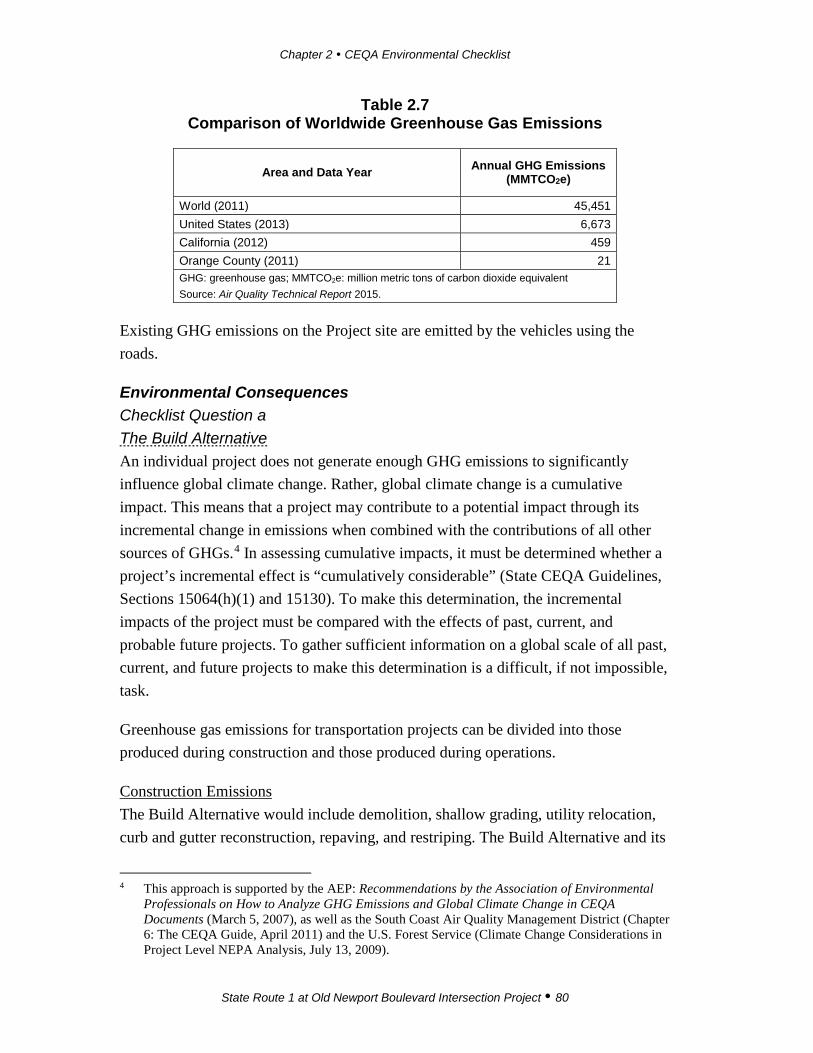
Chapter 2 CEQA Environmental Checklist
State Route 1 at Old Newport Boulevard Intersection Project 80
Table 2.7 Comparison of Worldwide Greenhouse Gas Emissions
Area and Data Year Annual GHG Emissions (MMTCO2e)
World (2011) 45,451 United States (2013) 6,673
California (2012) 459 Orange County (2011) 21 GHG: greenhouse gas; MMTCO2e: million metric tons of carbon dioxide equivalent Source: Air Quality Technical Report 2015.
Existing GHG emissions on the Project site are emitted by the vehicles using the roads.
Environmental Consequences Checklist Question a The Build Alternative An individual project does not generate enough GHG emissions to significantly influence global climate change. Rather, global climate change is a cumulative impact. This means that a project may contribute to a potential impact through its incremental change in emissions when combined with the contributions of all other sources of GHGs.4 In assessing cumulative impacts, it must be determined whether a project’s incremental effect is “cumulatively considerable” (State CEQA Guidelines, Sections 15064(h)(1) and 15130). To make this determination, the incremental impacts of the project must be compared with the effects of past, current, and probable future projects. To gather sufficient information on a global scale of all past, current, and future projects to make this determination is a difficult, if not impossible, task.
Greenhouse gas emissions for transportation projects can be divided into those produced during construction and those produced during operations.
Construction Emissions The Build Alternative would include demolition, shallow grading, utility relocation, curb and gutter reconstruction, repaving, and restriping. The Build Alternative and its
4 This approach is supported by the AEP: Recommendations by the Association of Environmental
Professionals on How to Analyze GHG Emissions and Global Climate Change in CEQA Documents (March 5, 2007), as well as the South Coast Air Quality Management District (Chapter 6: The CEQA Guide, April 2011) and the U.S. Forest Service (Climate Change Considerations in Project Level NEPA Analysis, July 13, 2009).

Chapter 2 CEQA Environmental Checklist
State Route 1 at Old Newport Boulevard Intersection Project 81
Design Variation differs in Project duration and estimated volume of material export. For purposes of estimating construction emissions, they would be similar in equipment used and intensity of activities.
Construction GHG emissions are generated by vehicle engine exhaust from construction equipment, on-road hauling trucks, vendor trips, and worker commuting trips. GHG emissions for the Build Alternative and its Design Variation were calculated with the Road Construction Emissions Model (version 7.1.5.1). The Road Construction Emissions Model was developed by SMAQMD for calculating emissions from linear construction projects and is accepted by the SCAQMD.
Because impacts from construction activities occur over a relatively short-term period of time, they contribute a relatively small portion of the overall lifetime Project GHG emissions. In addition, GHG emission reduction measures for construction equipment are relatively limited. Therefore, SCAQMD staff recommends that construction emissions be amortized over a 30-year Project lifetime, so that GHG-reduction measures will address construction GHG emissions as part of the operational GHG reduction strategies.
The primary difference between the Build Alternative and its Design Variation would be that the Build Alternative would have an approximate five-month duration for construction activities and the Build Alternative Design Variation would have an approximate six-month duration for construction activities. As shown in Table 2.8, the 30-year amortized construction emissions for the Build Alternative would be 82 MTCO2e/yr.
Table 2.8 Estimated GreenHouse Gas Emissions from Construction
Alternative Emissions MTCO2ea Amortized Emissions MTCO2eb
The Build Alternative 247 82 GHG: greenhouse gases; CO2: carbon dioxide; MTCO2e: metric tons of carbon dioxide equivalent. a The Road Construction Emissions Model does not calculate methane or GHGs other than CO2; however, the
difference between MTCO2 and MTCO2e is negligible in this context. b Total amortized over 30 years
Source: Air Quality Technical Report 2015
Operational Emissions The Build Alternative would not generate traffic or cause a change in traffic volumes. As discussed in Section XVI, Transportation/Traffic, there would be no change in the level of service (LOS) at the two intersections. For all three scenarios, there would be
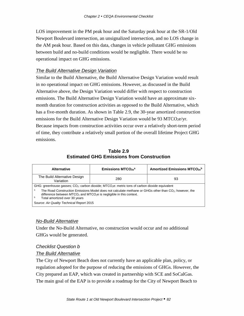
Chapter 2 CEQA Environmental Checklist
State Route 1 at Old Newport Boulevard Intersection Project 82
LOS improvement in the PM peak hour and the Saturday peak hour at the SR-1/Old Newport Boulevard intersection, an unsignalized intersection, and no LOS change in the AM peak hour. Based on this data, changes in vehicle pollutant GHG emissions between build and no-build conditions would be negligible. There would be no operational impact on GHG emissions.
The Build Alternative Design Variation Similar to the Build Alternative, the Build Alternative Design Variation would result in no operational impact on GHG emissions. However, as discussed in the Build Alternative above, the Design Variation would differ with respect to construction emissions. The Build Alternative Design Variation would have an approximate six-month duration for construction activities as opposed to the Build Alternative, which has a five-month duration. As shown in Table 2.9, the 30-year amortized construction emissions for the Build Alternative Design Variation would be 93 MTCO2e/yr. Because impacts from construction activities occur over a relatively short-term period of time, they contribute a relatively small portion of the overall lifetime Project GHG emissions.
Table 2.9 Estimated GHG Emissions from Construction
Alternative Emissions MTCO2ea Amortized Emissions MTCO2eb
The Build Alternative Design Variation 280 93
GHG: greenhouse gasses; CO2: carbon dioxide; MTCO2e: metric tons of carbon dioxide equivalent a The Road Construction Emissions Model does not calculate methane or GHGs other than CO2; however, the
difference between MTCO2 and MTCO2e is negligible in this context. b Total amortized over 30 years Source: Air Quality Technical Report 2015
No-Build Alternative Under the No-Build Alternative, no construction would occur and no additional GHGs would be generated.
Checklist Question b The Build Alternative The City of Newport Beach does not currently have an applicable plan, policy, or regulation adopted for the purpose of reducing the emissions of GHGs. However, the City prepared an EAP, which was created in partnership with SCE and SoCalGas. The main goal of the EAP is to provide a roadmap for the City of Newport Beach to
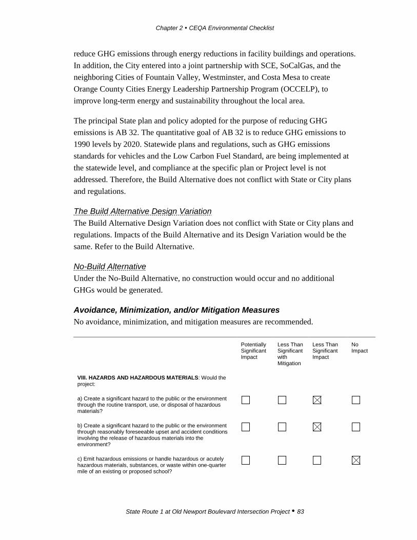
Chapter 2 CEQA Environmental Checklist
State Route 1 at Old Newport Boulevard Intersection Project 83
reduce GHG emissions through energy reductions in facility buildings and operations. In addition, the City entered into a joint partnership with SCE, SoCalGas, and the neighboring Cities of Fountain Valley, Westminster, and Costa Mesa to create Orange County Cities Energy Leadership Partnership Program (OCCELP), to improve long-term energy and sustainability throughout the local area.
The principal State plan and policy adopted for the purpose of reducing GHG emissions is AB 32. The quantitative goal of AB 32 is to reduce GHG emissions to 1990 levels by 2020. Statewide plans and regulations, such as GHG emissions standards for vehicles and the Low Carbon Fuel Standard, are being implemented at the statewide level, and compliance at the specific plan or Project level is not addressed. Therefore, the Build Alternative does not conflict with State or City plans and regulations.
The Build Alternative Design Variation The Build Alternative Design Variation does not conflict with State or City plans and regulations. Impacts of the Build Alternative and its Design Variation would be the same. Refer to the Build Alternative.
No-Build Alternative Under the No-Build Alternative, no construction would occur and no additional GHGs would be generated.
Avoidance, Minimization, and/or Mitigation Measures No avoidance, minimization, and mitigation measures are recommended.
Potentially Significant Impact
Less Than Significant with Mitigation
Less Than Significant Impact
No Impact
VIII. HAZARDS AND HAZARDOUS MATERIALS: Would the project:
a) Create a significant hazard to the public or the environment through the routine transport, use, or disposal of hazardous materials?
b) Create a significant hazard to the public or the environment through reasonably foreseeable upset and accident conditions involving the release of hazardous materials into the environment?
c) Emit hazardous emissions or handle hazardous or acutely hazardous materials, substances, or waste within one-quarter mile of an existing or proposed school?
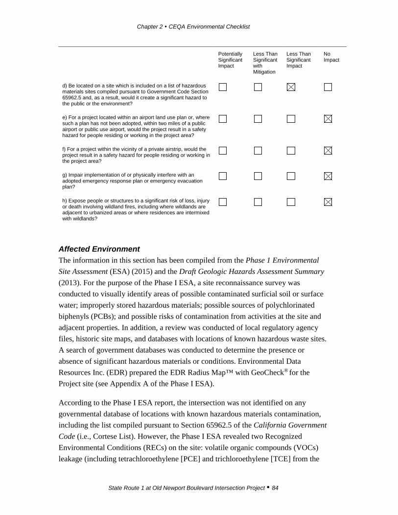
Chapter 2 CEQA Environmental Checklist
State Route 1 at Old Newport Boulevard Intersection Project 84
Potentially Significant Impact
Less Than Significant with Mitigation
Less Than Significant Impact
No Impact
d) Be located on a site which is included on a list of hazardous materials sites compiled pursuant to Government Code Section 65962.5 and, as a result, would it create a significant hazard to the public or the environment?
e) For a project located within an airport land use plan or, where such a plan has not been adopted, within two miles of a public airport or public use airport, would the project result in a safety hazard for people residing or working in the project area?
f) For a project within the vicinity of a private airstrip, would the project result in a safety hazard for people residing or working in the project area?
g) Impair implementation of or physically interfere with an adopted emergency response plan or emergency evacuation plan?
h) Expose people or structures to a significant risk of loss, injury or death involving wildland fires, including where wildlands are adjacent to urbanized areas or where residences are intermixed with wildlands?
Affected Environment The information in this section has been compiled from the Phase 1 Environmental Site Assessment (ESA) (2015) and the Draft Geologic Hazards Assessment Summary (2013). For the purpose of the Phase I ESA, a site reconnaissance survey was conducted to visually identify areas of possible contaminated surficial soil or surface water; improperly stored hazardous materials; possible sources of polychlorinated biphenyls (PCBs); and possible risks of contamination from activities at the site and adjacent properties. In addition, a review was conducted of local regulatory agency files, historic site maps, and databases with locations of known hazardous waste sites. A search of government databases was conducted to determine the presence or absence of significant hazardous materials or conditions. Environmental Data Resources Inc. (EDR) prepared the EDR Radius Map™ with GeoCheck® for the Project site (see Appendix A of the Phase I ESA).
According to the Phase I ESA report, the intersection was not identified on any governmental database of locations with known hazardous materials contamination, including the list compiled pursuant to Section 65962.5 of the California Government Code (i.e., Cortese List). However, the Phase I ESA revealed two Recognized Environmental Conditions (RECs) on the site: volatile organic compounds (VOCs) leakage (including tetrachloroethylene [PCE] and trichloroethylene [TCE] from the
Chapter 2 CEQA Environmental Checklist
State Route 1 at Old Newport Boulevard Intersection Project 85
former Raytheon Company’s [Raytheon/Hughes] Newport Beach Facility) and potential for methane and hydrogen sulfide gas leakage. Furthermore, one historical Recognized Environmental Condition (HREC) was identified—a past gas station located at the northwestern corner of Old Newport Boulevard. Two environmental issues were identified: aerially deposited lead (ADL) and presence of lead-based and chromium-based paints.
Recognized Environmental Conditions Regional groundwater can be impacted by leakage of the PCE and TCE from the former Raytheon Company’s (Raytheon/Hughes) Newport Beach Facility (located at 500–540 Superior Avenue). The facility is located hydrologically up-gradient and approximately 0.6 mile north of the intersection. The Santa Ana RWQCB oversees the investigation and cleanup at the facility. As part of the cleanup, 91 monitoring wells were installed to monitor groundwater in the site vicinity. Two of these wells (well HM-52 and well PW-16) are located near the SR-1/Old Newport Boulevard intersection. According to the Phase I ESA, VOC concentrations over time indicate a stable or declining trend. Groundwater beneath the site flows in a south-southeasterly direction, roughly following Newport Boulevard toward Newport Bay. Elevated concentrations of PCE and TCE from Raytheon have been detected in groundwater and extend several hundred feet down-gradient (south-southeast) of their facility. Breakdown components of PCE and TCE (including 1,2-dichloroethylene) have been detected in a down-gradient well (PW-16) located at the south side of SR-1. The RWQCB stated that the detected PCE and TCE concentrations are low and below regulatory guidelines for human health and aquatic life, indicating that a substantial impact to Newport Bay is unlikely. Raytheon is in the process of performing regularly scheduled soil vapor and groundwater monitoring for the facility and bioremediation of the groundwater on and off the facility.
A review of the City of Newport Beach Council Ordinance (89-42 – Methane Gas Mitigation District and 15.55 Methane Overlay Zone) revealed that the intersection is not located within a Methane Gas Mitigation District/Boundary. Although the intersection is not located within a mapped methane zone, it is located several hundred feet west of the nearest Methane Zone (west of Newport Boulevard [SR-55]) and may be affected by methane and hydrogen sulfide leaking upward from the subsurface. Methane gas is found in high concentrations in or near ground surface in certain areas of Newport Beach.

Chapter 2 CEQA Environmental Checklist
State Route 1 at Old Newport Boulevard Intersection Project 86
Historical Recognized Environmental Conditions A gas station was located at the northwest corner of Old Newport Boulevard and Newport Boulevard during the 1940s and 1950s. Potential environmental concerns with the former gas station were likely removed when the highway was widened and the Newport Boulevard on- and off-ramps were reconfigured in the late 1990s; thus, these concerns would not affect the current Project.
Environmental Issues Since the roadways on the Project site have been in use since the 1920s, there is a potential for soils that are contaminated with ADL beneath the paved roadway surfaces. In California, soil within Caltrans right-of-way that contains hazardous waste concentrations of ADL can be reused under the authority of a variance issued by the Department of Toxic Substances Control (DTSC), which applies to all 12 Caltrans districts.
Due to the commercial roadway nature, lead-based paint and chromium based paint (yellow thermal striping and marking) are also likely to be present.
Two former gas stations and an auto repair facility were located adjacent to the SR-1/Old Newport Boulevard intersection in the eastern and southwestern quadrants of the intersection. Neither of them were reported for violations and thus have low potential to have a REC to the subject intersection. One leaking underground storage tank (LUST) was reported down-gradient from the intersection at 3333 Pacific Coast Highway (Jerry’s Marine Fuel Service Harbor Marina Club). The reported LUST was a gasoline release affecting the soil and groundwater beneath the site. The case was closed in 1997, and thus no longer represents a REC.
No PCBs, Asbestos Containing Materials (ACMs), or vapor intrusion concerns were identified on site during the site visit conducted for the Phase I ESA.
Environmental Consequences Checklist Questions a and b The Build Alternative Due to the nature of the Project, implementation of the Build Alternative would not involve the routine storage or use of hazardous materials. Both roadways can be used as means of transporting certain goods, including hazardous materials. However, the Build Alternative would improve the operation of the intersection and thus is expected to decrease the likelihood of accidents. The construction phase would require the use of common chemicals (e.g., fuels, lubricants, paints, and solvents) for
Chapter 2 CEQA Environmental Checklist
State Route 1 at Old Newport Boulevard Intersection Project 87
the operation of vehicles and construction equipment. Adherence to existing regulations would ensure compliance with safety standards related to the use and storage of hazardous materials as well as the safety procedures mandated by applicable federal, State, and local laws and regulations. The Build Alternative is proposed to better accommodate existing and projected traffic volumes and to improve level of service (LOS) during the PM peak hour; it is, therefore, not anticipated to create a substantial hazard to the people or environment through use or transport of hazardous materials. The Build Alternative is not designed to increase the frequency of hazardous materials transport, nor would it directly result in the release of hazardous materials. Therefore, no impacts are expected associated with hazards to the public or the environment through the routine transport, use, or disposal of hazardous materials or reasonably foreseeable upset and accident conditions involving release of hazardous materials. No substantial adverse effects are expected as a result of the Build Alternative.
The Build Alternative Design Variation Due to the nature of the Project, implementation would not involve the routine storage or use of hazardous materials. The Build Alternative Design Variation would improve the operation of the intersection and, therefore, is expected to decrease the likelihood of accidents. Similar to the Build Alternative Design Variation, the Project’s construction phase would require the use of common chemicals (e.g., fuels, lubricants, paints, and solvents) for the operation of vehicles and construction equipment. Adherence to existing regulations would ensure compliance with safety standards related to the use and storage of hazardous materials and with the safety procedures mandated by applicable federal, State, and local laws and regulations. The Build Alternative Design Variation is proposed to better accommodate existing and projected traffic volumes and to improve LOS during the PM peak hour over existing conditions; it is, therefore, not anticipated to create a substantial hazard to the people or environment through use or transport of hazardous materials. The Build Alternative Design Variation is not designed to increase the frequency of hazardous materials transport, nor would it directly result in the release of hazardous materials. Therefore, no substantial adverse effects are expected associated with hazards to the public or the environment through the routine transport, use, or disposal of hazardous materials or through a reasonably foreseeable upset and accident conditions involving release of hazardous materials.

Chapter 2 CEQA Environmental Checklist
State Route 1 at Old Newport Boulevard Intersection Project 88
No-Build Alternative Under the No-Build Alternative, no physical changes and no excavation would occur; therefore, the No-Build Alternative would not expose people to or result in any hazards.
Checklist Question c The Build Alternative No schools are located within ¼ mile of the Project site. Therefore, the Build Alternative would not result in hazardous emissions or require the handling of hazardous materials, and it would not impact schools. Because no schools are in vicinity of the Build Alternative and because no hazardous materials would be used during construction, no substantial adverse effects are expected.
The Build Alternative Design Variation No schools are located within ¼ mile of the Project site. Therefore, the Build Alternative Design Variation would not result in hazardous emissions or require the handling of hazardous materials. Because no schools are in vicinity of the Build Alternative Design Variation and because no hazardous materials would be used during construction, no substantial adverse effects are expected.
No-Build Alternative Under the No-Build Alternative, no physical changes and no excavation would occur and thus the No-Build Alternative would not expose people to or result in any hazards.
Checklist Question d The Build Alternative The review of the hazardous materials databases did not reveal that the site is included on a list of hazardous materials sites. The RECs include regional groundwater contamination with VOC and potential for methane gas leakage from adjacent areas.
The Phase I ESA determined that, based on the depth to groundwater, it is unlikely that the known VOC groundwater contamination associated with the former Raytheon/Hughes Facility would impact the Project site. In addition, Raytheon currently monitors the groundwater quality on and off the site. Because of this, no additional Avoidance and Minimization Measures were recommended.
Chapter 2 CEQA Environmental Checklist
State Route 1 at Old Newport Boulevard Intersection Project 89
Due to the presence of methane zones near the Project site, the Phase I ESA determined that methane and hydrogen sulfide gases must be monitored and that a gas survey must occur during Project construction (Avoidance and Minimization Measures HAZ-1 and HAZ-2).
Based on results of the Phase I ESA, lead-based paint is likely present in the traffic striping within Project limits; therefore, prior to demolition and construction activities, a lead-based paint survey of the striping would need to be conducted by a qualified professional. Soil sampling would be required to be conducted to determine the presence of ADL (refer to Avoidance and Minimization Measure HAZ-3), and surveys would be required to determine the presence of LBP and chromium-based paint (refer to Avoidance and Minimization Measure HAZ-4). Implementation of HAZ-4 would ensure that handling and removal of LBP and chromium-based paint would be conducted according to local and federal laws and regulations. If lead-contaminated soils are encountered, they would need to be handled, transported, and disposed of at an appropriate landfill according to Avoidance and Minimization Measure HAZ-4. With incorporation of Avoidance and Minimization Measures HAZ-1, HAZ-2, HAZ-3, and HAZ-4, the Build Alternative would not create a significant hazard to the public or the environment and would not result in substantial adverse effects.
The Build Alternative Design Variation Impacts for the Build Alternative Design Variation would be similar to impacts for the Build Alternative. Based on the findings of the Phase I ESA, the Project site was not listed in the EDR report. Due to the presence of the methane zones in proximity of the Project site, the Phase I ESA determined the need for monitoring methane and hydrogen sulfide gases and for a gas survey during Project construction (Avoidance and Minimization Measures HAZ-1 and HAZ-2). In addition, the Phase I ESA determined the need for a limited subsurface investigation for ADL and LBP. Soil sampling would be required to be conducted to determine the presence of ADL (refer to Avoidance and Minimization Measure HAZ-3), and surveys would be required to determine the presence of LBP and chromium-based paint (refer to Avoidance and Minimization Measure HAZ-4). The Phase I ESA determined that, based on the depth to groundwater, it is unlikely that the known groundwater contamination associated with the former Raytheon/Hughes facility would impact the Project site.

Chapter 2 CEQA Environmental Checklist
State Route 1 at Old Newport Boulevard Intersection Project 90
No-Build Alternative Under the No-Build Alternative, no physical changes and no excavation would occur and thus, the No-Build Alternative would not expose people to or result in any hazards.
Checklist Questions e and f The Build Alternative The nearest public airport (John Wayne Airport) is located approximately four miles northeast of the Project area. According to the City’s General Plan Safety Element (Figure J-4, Clear and Accident Potential Zones), the Project site is not located within John Wayne Airport’s Safety Compatibility Zones or Airport Impact Zones. Thus, the Build Alternative would not result in substantial adverse effects with respect to airport land use plans.
The Build Alternative Design Variation The nearest public airport (John Wayne Airport) is located approximately four miles northeast of the Project area. According to the City’s General Plan Safety Element (Figure J-4, Clear and Accident Potential Zones), the Project site is not located within John Wayne Airport’s Safety Compatibility Zones or Airport Impact Zones. Thus, the Build Alternative Design Variation would not result in substantial adverse effects with respect to airport land use plans.
No-Build Alternative Under the No-Build Alternative, no physical changes and no excavation would occur; thus, the No-Build Alternative would not expose people to or result in any airport land use plans.
Checklist Question g The Build Alternative The only adopted emergency response plan for this area is a Tsunami Inundation Emergency Plan (Tsunami Inundation Map for Emergency Planning). However, neither Old Newport Boulevard nor SR-1 are designated as evacuation routes on the City of Newport Beach Tsunami Emergency Information map. Therefore, implementation of the Build Alternative would not impair implementation of the adopted emergency response plan.
The Build Alternative Design Variation Refer to checklist question g for the Build Alternative.

Chapter 2 CEQA Environmental Checklist
State Route 1 at Old Newport Boulevard Intersection Project 91
No-Build Alternative Under the No-Build Alternative, no physical changes and no excavation would occur; thus, the No-Build Alternative would not conflict with an adopted emergency response plan.
Checklist Question h The Build Alternative The site is fully developed and located in an area that is not subject to wildland fires. According to the City’s General Plan Wildfire Hazards Map (Figure S4), the Project site is not located in an area subject to wildfires. Therefore, the Build Alternative is not expected to expose people or structures to a significant risk of loss, injury, or death involving wildland fires.
The Build Alternative Design Variation The site is fully developed and located in an area that is not subject to wildland fires. In addition, according to the City’s General Plan Wildfire Hazards Map (Figure S4), the Project site is not located in an area subject to wildfires. Therefore, the Build Alternative Design Variation is not expected to expose people or structures to a significant risk of loss, injury, or death involving wildland fires.
No-Build Alternative Under the No-Build Alternative, no physical changes and no excavation would occur; therefore, the No-Build Alternative would not expose people or structures to a significant risk of loss, injury, or death involving wildland fires.
Avoidance, Minimization, and/or Mitigation Measures Avoidance and Minimization Measures HAZ-1 During Project construction, monitoring for the presence of methane
and hydrogen sulfide gases shall be conducted by an appropriate certified consultant.
HAZ -2 The City of Newport Beach shall conduct a Soil Gas Survey prior to construction activities to identify the potential for methane and hydrogen sulfide gases that may be encountered during Project activities in order to evaluate appropriate precautions. The Work Plan for Soil Gas Survey shall be prepared by the City of Newport Beach prior to the survey and forwarded to Caltrans for review and approval.

Chapter 2 CEQA Environmental Checklist
State Route 1 at Old Newport Boulevard Intersection Project 92
HAZ-3 The Aerially Deposited Lead (ADL) Work Plan shall be prepared by the City of Newport Beach and forwarded to Caltrans for review and approval. During final design, a certified consultant shall conduct soil sampling for the purpose of determining the presence of lead-contaminated soils. If concentrations of lead detected in soil samples collected from areas within the right-of-way exceed the State requirements, the soils shall be classified as California hazardous waste. The handling, treatment, or disposal of soils impacted with ADL that would be generated during construction activities shall be consistent with federal, State, and local laws.
HAZ-4 A Lead-Based and Chromium-Based Paint Work Plan shall be prepared by the City of Newport Beach and forwarded to Caltrans for review and approval. During final design, a certified consultant shall conduct a lead-based and chromium-based paint investigation. A certified consultant shall also investigate any pavement materials that would be renovated or demolished as part of the Project.
Potentially Significant Impact
Less Than Significant with Mitigation
Less Than Significant Impact
No Impact
IX. HYDROLOGY AND WATER QUALITY: Would the project:
a) Violate any water quality standards or waste discharge requirements?
b) Substantially deplete groundwater supplies or interfere substantially with groundwater recharge such that there would be a net deficit in aquifer volume or a lowering of the local groundwater table level (e.g., the production rate of pre-existing nearby wells would drop to a level which would not support existing land uses or planned uses for which permits have been granted)?
c) Substantially alter the existing drainage pattern of the site or area, including through the alteration of the course of a stream or river, in a manner which would result in substantial erosion or siltation on- or off-site?
d) Substantially alter the existing drainage pattern of the site or area, including through the alteration of the course of a stream or river, or substantially increase the rate or amount of surface runoff in a manner which would result in flooding on- or off-site?
e) Create or contribute runoff water which would exceed the capacity of existing or planned storm water drainage systems or provide substantial additional sources of polluted runoff?
f) Otherwise substantially degrade water quality?

Chapter 2 CEQA Environmental Checklist
State Route 1 at Old Newport Boulevard Intersection Project 93
Potentially Significant Impact
Less Than Significant with Mitigation
Less Than Significant Impact
No Impact
g) Place housing within a 100-year flood hazard area as mapped on a federal Flood Hazard Boundary or Flood Insurance Rate Map or other flood hazard delineation map?
h) Place within a 100-year flood hazard area structures which would impede or redirect flood flows?
i) Expose people or structures to a significant risk of loss, injury or death involving flooding, including flooding as a result of the failure of a levee or dam?
j) Inundation by seiche, tsunami, or mudflow
Affected Environment The intersection is located in the Newport Bay Watershed, which drains directly to the Pacific Ocean. The intersection is located in proximity to the Newport Beach Harbor. A Drainage and Water Quality Technical Memorandum (DWQTM, August 2015) was prepared for the Project to comply with the National Pollutant Discharge Elimination System (NPDES) permit requirements.
The City of Newport Beach is part of the Central Orange County Water Management Area (COC WMA), which was developed as part of a multi-agency task force to develop a countywide Water Quality Strategic Plan. The COC WMA encompasses the entire Newport Bay Watershed and the northern portion of the adjacent Newport Coast Watershed that lies within the jurisdiction of the Santa Ana RWQCB. The COC WMA covers an approximate 154-square-mile area with overland flows draining toward the Pacific Coast into Newport Bay. Major cities and contributors of pollutants in the watershed include Irvine, Newport Beach, Tustin, and portions of Costa Mesa, Laguna Hills, Laguna Woods, Lake Forest, Orange, and Santa Ana. The principal watercourse of the Newport Bay Watershed is San Diego Creek, with a drainage area that covers approximately 122 square miles of the watershed. The main tributary to San Diego Creek is Peters Canyon Wash; smaller tributaries include Serrano Creek, Borrego Canyon Wash, Agua Chinon Wash, Bee Canyon Wash, Sand Canyon Wash, and Bonita Canyon Creek. The entire area within the COC WMA drains to the Critical Coastal Areas (CCAs) and Areas of Special Biological Significance (ASBS), which means conditions in the COC WMA substantially impact the coastal ecosystem.

Chapter 2 CEQA Environmental Checklist
State Route 1 at Old Newport Boulevard Intersection Project 94
As part of Section 402 of the Clean Water Act, the USEPA has established regulations under the NPDES program to control direct storm water discharges. In California, the State Water Resources Control Board (SWRCB), through the nine RWQCBs, administers the NPDES permitting program and is responsible for developing NPDES permitting requirements. The NPDES program regulates industrial pollutant discharges, which include construction activities. The SWRCB works in coordination with RWQCBs to preserve, protect, enhance, and restore water quality. The City of Newport Beach is within the jurisdiction of the Santa Ana RWQCB and thus is subject to its standards, goals, and permitting requirements. The Project would be required to adhere to the requirements of the SWRCB’s NPDES Construction General Permit (Order No. 2009-0009-DWQ, NPDES No. CAS000002) and Caltrans Statewide NPDES Permit (Order No. 2012-0011-DWQ, NPDES No. CAS000005). Orange County and City of Newport Beach implement the Municipal Separate Storm Sewer System NPDES Permit, often referred to as the “MS4 Permit”. The most recent MS4 NPDES Permit was adopted in 2009 (Order R8-2009-0030), a draft permit 2015 is currently being prepared.
According to the DWQTM (August 2015), the Newport Bay Watershed is on the 303(d) list of waterbodies and is impaired for pesticides, nutrients, sediment and siltation, copper and other metals, fecal coliform, pathogens, PCBs, sediment toxicity, and selenium. The applicable Total Maximum Daily Loads (TMDLs) were established for the watershed and include sediments, nutrients, toxic pollutants, selenium, and fecal coliform.
The Project area is currently served by existing storm drain facilities (pipes and box structures) that drain from north to south and outlet into the Newport Bay. The majority of the storm flows sheet-flow from the residential area north of SR-1 and east of Old Newport Boulevard. In total, the Project has a drainage tributary area of 50.4 acres.
According to Flood Insurance Rate Map published by the Federal Emergency Management Agency (specifically, Map 06059C0381J, dated December 3, 2009), the intersection appears to be located in Zone X, an area located outside the 100-year and 500-year flood plains. The City’s General Plan Coastal Hazards Map (Figure S1) states that the site is in an area subject to tsunami inundation (specifically, the extreme high tide 100-year zone), where inundation elevation is set at 13.64 feet. The Project Study Area is located outside other flood hazard areas, as depicted on the City’s General Plan Flood Hazards map (Figure S3).
Chapter 2 CEQA Environmental Checklist
State Route 1 at Old Newport Boulevard Intersection Project 95
In 2009, the California Emergency Management Agency, California Geological Survey, and University of Southern California prepared the tsunami inundation maps for California. A Tsunami Inundation Map for Emergency Planning was published for the Newport Beach Quadrangle. The intersection is located within the Tsunami inundation area; therefore, it is considered to have a high potential for being affected by tsunamis.
According to the DWQTM (August 2015) depth to groundwater is 6.6 feet and no groundwater was encountered during geotechnical borings up to 5.0 feet deep. According to the Phase I ESA, the depth of the groundwater, as measured in 2013, in the vicinity of the intersection was inferred at a depth of 33 feet bgs. The direction of the groundwater flow in the vicinity of the intersection is from north to south.
Environmental Consequences Checklist Questions a, e, and f The Build Alternative The Build Alternative would improve the existing intersection and would not incorporate any new land uses. New land uses are typically associated with incorporation of new water quality pollutants. Pollutants typical of urban areas and transportation land uses consist of sediments, nutrients; heavy metals; pathogens; pesticides and herbicides; oil and grease; trash and debris; and toxic organic compounds. Implementation of the Build Alternative may generate similar pollutants during construction. Additional pollutants that would be generated temporarily include paints and solvents related to proposed striping. However, with implementation of the temporary BMPs (adherence to the existing NPDES, Caltrans, and City requirements), short-term construction water quality impacts would not be substantial. Refer to Avoidance and Minimization Measure WQ-1.
The Build Alternative may generate some pollutants during construction that would be minimized by implementing construction-related BMPs (e.g., temporary inlet protection, perimeter sediment control, use of concrete washouts, dust control measures) listed in Avoidance and Minimization Measure WQ-1.
The existing footprint for the Build Alternative totals 0.73 acre, of which 5.5 percent is pervious and 94.5 percent is impervious. After construction of the Build Alternative is completed, the Project’s impervious area would decrease from 0.69 acre to 0.65 acre (a decrease of 5.5 percent). The Project’s pervious area would increase from 0.04 acre to 0.08 acre, an increase of 5.5 percent over existing conditions. The proposed

Chapter 2 CEQA Environmental Checklist
State Route 1 at Old Newport Boulevard Intersection Project 96
pervious areas are limited to landscape features, which would enable site percolation. The increase in the pervious area would provide additional infiltration capability over existing conditions, which would provide a water quality improvement and thus no additional water quality BMP is recommended.
The Build Alternative would also construct two catch basins and a connector pipe to convey flows and handle storm events.
1. Catch Basin 1 would be constructed on the southeast corner of Old Newport Boulevard and Santa Ana Avenue.
2. Catch Basin 2 would be constructed on the northeast corner of SR-1 and Old Newport Boulevard.
The Build Alternative would be required to implement the requirements of the SWRCB NPDES Construction General Permit (Order No. 2009-0009-DWQ, NPDES No. CAS000002), Caltrans Statewide NPDES Permit (Order No. 2012-0011-DWQ, NPDES No. CAS000005), and the Santa Ana RWQCB MS4 Permit.
The Build Alternative would result in disturbance of 0.73 acre, which would require preparation of a Water Pollution Control Program (WPCP) under the Caltrans NPDES permit. As a result of these improvements, the Build Alternative would not contribute to the degradation of the Newport Bay Watershed water quality standards and would not contribute to a violation of discharge requirements. After completion of the Project, the storm water quality on the site would slightly improve. The Project would not incorporate new land uses or new pollutants to the site that would diminish water quality. The Build Alternative would not create sources of untreated runoff, and would not otherwise substantially degrade water quality. No substantial adverse water quality effects are expected as a result of the Build Alternative.
The Build Alternative Design Variation The Build Alternative Design Variation would improve the existing intersection and would not incorporate new land uses that would add new water quality pollutants. The Build Alternative Design Variation would generate the same type of pollutants as the Build Alternative: sediments; nutrients; heavy metals; pathogens; pesticides and herbicides; oil and grease; trash and debris; toxic organic compounds; and paints and solvents.
The Build Alternative Design Variation would be required to implement the requirements of the SWRCB’s NPDES Construction General Permit (Order No.
Chapter 2 CEQA Environmental Checklist
State Route 1 at Old Newport Boulevard Intersection Project 97
2009-0009-DWQ, NPDES No. CAS000002), Caltrans Statewide NPDES Permit (Order No. 2012-0011-DWQ, NPDES No. CAS000005), and the Santa Ana RWQCB MS4 Permit.
The Build Alternative Design Variation would result in disturbance of 1.63 acres during construction. Because the disturbed soil area for the Build Alternative Design Variation would exceed one acre, it would be subject to the NPDES Construction General Permit. Therefore, preparation of a Storm Water Pollution Prevention Program (SWPPP) and notification to the SWRCB via the SMARTS database would be required.
The Build Alternative Design Variation would not result in new pollutants of concern in the long term because all pollutants generated by the Project would be addressed with incorporation of post-construction BMPs; for example, a storm water quality basin is proposed at the SR-1/Old Newport Boulevard intersection as part of the Build Alternative Design Variation to convey flows; capture and treat pollutants; and handle storm events. The proposed storm water quality basin would be located at the northeast corner of Old Newport Boulevard and Santa Ana Street. Refer to Avoidance and Minimization Measure WQ-2.
The Build Alternative Design Variation would construct five catch basins that would connect to the existing drainage pipes and reinforced concrete boxes (RCBs) in Old Newport Boulevard. It would also reconstruct one existing catch basin in order to capture flows from the realigned intersection (i.e., there would be a total of six catch basins). All these catch basins would be designed to handle severe storm events. The locations of these six catch basins is as follows:
1. Catch Basin 1 would be constructed north of Catch Basin 2 on the east side of Old Newport Boulevard north of Santa Ana Avenue.
2. The existing Catch Basin 2 is located on the west side of Old Newport Boulevard, north of Santa Ana Avenue. It would be reconstructed due to the revised curb alignment at this location. This catch basin would pick up the flows from the northwest corner of the SR-1/Old Newport Boulevard intersection.
3. Catch Basin 3 would be constructed at the northeast corner of Old Newport Boulevard and Santa Ana Avenue.

Chapter 2 CEQA Environmental Checklist
State Route 1 at Old Newport Boulevard Intersection Project 98
4. Catch Basin 4 is a sump that would be constructed at the southeast corner of the Old Newport Boulevard and Santa Ana Avenue intersection.
5. Catch Basin 5 would be constructed at the northeast corner of the SR-1 and Old Newport Boulevard intersection.
6. Catch Basin 6 would be constructed on the northwest corner of the intersection along SR-1
As a result of the Build Alternative Design Variation, the impervious area would be reduced due to implementation of the BMPs, specifically a landscaped water quality basin just north of the intersection. Under existing conditions, 97.5 percent of the Build Alternative Design Variation footprint, which totals 1.63 acres, is paved and impervious. Following the Build Alternative Design Variation completion, the Project’s impervious area would decrease from 1.59 acres to 1.46 acres (a decrease of 7.9 percent). The Project’s pervious area would increase from 0.04 acre to 0.17 acre, an increase of 7.9 percent. The increase in pervious area is attributed to implementation of the storm water quality basin. This BMP would treat first flush storm water flows and naturally percolate into the ground. This would improve water quality as potential pollution would be removed by plant materials and media such as mulch, top soil, sand, and gravel. An overflow mechanism would be provided in this basin area to accommodate severe storm events. As a result of these improvements, the Build Alternative Design Variation would not contribute to the degradation of the Newport Bay Watershed water quality standards and would not contribute to a violation of discharge requirements. After completion of the Project, the storm water quality on the site would improve. The Project would not incorporate new land uses and new pollutants to the site that would diminish water quality. The Build Alternative Design Variation would not create sources of untreated runoff and would not otherwise substantially degrade water quality. Because the Build Alternative Design Variation would comply with the Statewide Construction General Permit requirements it would not violate any water quality standards or waste discharge requirements, nor would it otherwise contribute to degradation of water quality. No substantial adverse water quality effects are expected as a result of the Build Alternative Design Variation.
No-Build Alternative Under the No-Build Alternative, no physical changes would occur and no water pollutants would be generated other than those that are already being generated by the existing facility. The No-Build Alternative would not negatively affect water quality.

Chapter 2 CEQA Environmental Checklist
State Route 1 at Old Newport Boulevard Intersection Project 99
Checklist Question b The Build Alternative Implementation of the Build Alternative would not deplete groundwater supplies or substantially interfere with groundwater recharge. The Project site does not act as a groundwater recharge basin because the entire site is paved. The Build Alternative would not directly impact groundwater levels in the site vicinity since grading and construction activities associated with the Project would be minor, and it is not anticipated that groundwater would be disturbed during construction. The Project would implement improvements to an existing paved roadway intersection, and would decrease impervious area compared to existing conditions. Therefore, the Build Alternative would not substantially interfere with groundwater recharge, nor would it include any uses that would require water consumption. As such, the Build Alternative would not substantially deplete groundwater supplies or interfere substantially with groundwater recharge such that there would be a net deficit in aquifer volume or a lowering of the local groundwater table level.
The Build Alternative Design Variation Implementation of the Build Alternative Design Variation would not deplete groundwater supplies or substantially interfere with groundwater recharge. The Project site does not act as a groundwater recharge basin because the entire site is paved. The Build Alternative Design Variation would realign the existing paved intersection and would incorporate a storm water quality basin that would act as an infiltration basin. As a result of the Build Alternative Design Variation, the ratio of pervious area compared to existing conditions would increase by approximately eight percent and the groundwater recharge rate may increase. Therefore, the Build Alternative Design Variation would have a beneficial impact to groundwater recharge, rather than interfere with existing recharge. The Build Alternative Design Variation would not include any uses that would require water consumption. As such, the Build Alternative Design Variation would not deplete groundwater supplies or interfere substantially with groundwater recharge such that there would be a net deficit in aquifer volume or a lowering of the local groundwater table level. No substantial adverse effects to the water aquifer are expected as a result of implementation of the Build Alternative Design Variation.
No-Build Alternative Under the No-Build Alternative, no physical changes would occur and no water pollutants would be generated other than those that are already being generated by the

Chapter 2 CEQA Environmental Checklist
State Route 1 at Old Newport Boulevard Intersection Project 100
existing facility. The No-Build Alternative would not substantially deplete groundwater supplies or interfere substantially with groundwater recharge.
Checklist Questions c and d The Build Alternative As discussed under checklist question “a”, the improvement of the SR-1/Old Newport Boulevard intersection would not change the site drainage pattern and would not change the elevation of the site. Because the improvements would be relatively minor, the drainage on the Project site would be relatively the same as under existing conditions. The Build Alternative would slightly improve the water quality runoff conditions by increasing pervious area of the site by 5.5 percent. As a result, the percolation of the site may slightly improve over existing conditions. No increase in storm flow is anticipated. Storms would be handled by the two proposed catch basins, which would preclude off-site runoff. Thus, implementation of the Build Alternative would not result in alteration of a drainage pattern that would result in substantial erosion or siltation on or off the site, and it would not create sources of polluted runoff.
The Build Alternative Design Variation As discussed under checklist question “a”, a storm water quality basin is proposed as part of the Build Alternative Design Variation. The intersection improvements would not change the drainage pattern because elevation of the site would not change and because the proposed catch basins, water quality treatment basin, and storm water vault would be constructed to handle severe storm flows. As a result, percolation of the site would also improve. The storm water quality basin would be sized adequately to handle storms and to treat pollutants. Therefore, implementation of the Build Alternative Design Variation would not result in substantial adverse effects to drainage patterns that would result in substantial erosion or siltation on or off the site, and it would not create sources of polluted runoff.
No-Build Alternative Under the No-Build Alternative, no physical changes would occur and no water pollutants would be generated other than those that are already being generated by the existing facility. The No-Build Alternative would not result in alternation of a drainage pattern that would result in substantial erosion or siltation on or off the site, and it would not create sources of polluted runoff.

Chapter 2 CEQA Environmental Checklist
State Route 1 at Old Newport Boulevard Intersection Project 101
Checklist Question g The Build Alternative The Project is located in a FEMA-designated Zone X flood area, which is defined as an area of moderate flood hazards, usually between the limits of the 100-year and 500-year floods. The nature of the Project is to improve the existing intersection and thus, the Project does not propose housing within a 100-year flood hazard area, as mapped on a federal Flood Hazard Boundary, Flood Insurance Rate Map, or other flood hazard delineation map. Because of this, the Build Alternative would not result in substantial adverse effects related to flood hazards.
The Build Alternative Design Variation The Build Alternative Design Variation is located in a FEMA-designated Zone X, which is defined as an area of moderate flood hazard usually between the limits of the 100-year and 500-year floods. The nature of the Project is to improve the existing intersection and thus, the Project does not propose housing within a 100-year flood hazard area as mapped on a federal Flood Hazard Boundary, Flood Insurance Rate Map, or other flood hazard delineation map. Because of this, the Build Alternative Design Variation would not result in substantial adverse effects related to flood hazards.
No-Build Alternative Under the No-Build Alternative, no physical changes would occur and no housing would be placed in the FEMA designated Zone X. The No-Build Alternative would not elevate the exposure to flood related water hazards.
Checklist Questions h and i The Build Alternative The Build Alternative would not expose people or structures to a significant risk of loss, injury, or death involving flooding, including flooding as a result of the failure of a levee or dam, because it does not include the development of housing and would not redirect drainage patterns. The intersection improvements would not expose people or structures to a significant risk of loss, injury, or death involving flooding, including flooding as a result of the failure of a levee or dam because the Build Alternative does not propose structures. No substantial adverse effects related to flooding would occur.

Chapter 2 CEQA Environmental Checklist
State Route 1 at Old Newport Boulevard Intersection Project 102
The Build Alternative Design Variation The Build Alternative Design Variation would not expose people or structures to a significant risk of loss, injury, or death involving flooding, including flooding as a result of the failure of a levee or dam, because it does not include the development of housing and does not redirect drainage patterns. No substantial adverse effects would occur.
No-Build Alternative Under the No-Build Alternative, no physical changes would occur and thus the No-Build Alternative would not expose people or structures to flooding.
Checklist Question j The Build Alternative The intersection is located in the Coastal Zone and tsunami zone. However, implementation of the Build Alternative would not increase exposure to tsunami or mudflow because the intersection is an existing facility. In addition, the Build Alternative would not change the elevation of the intersection and thus would not increase tsunami risk. No hazard from seiche is present on site. Therefore, the Build Alternative would not result in substantial adverse effects related to tsunami, mudflow, or seiche.
The Build Alternative Design Variation The intersection is located in the Coastal Zone and tsunami zone; however implementation of the Build Alternative Design Variation would not increase exposure to tsunami or mudflow because the intersection is an existing facility. In addition, the Build Alternative Design Variation would not change the elevation of the intersection and thus would not increase tsunami risk. No hazard from seiche is present on site. Therefore, the Build Alternative Design Variation would not result in substantial adverse effects related to tsunami, mudflow, or seiche.
No-Build Alternative Under the No-Build Alternative, no physical changes would occur and the potential for tsunami would be as it is under existing conditions. The No-Build Alternative would not elevate the exposure to water hazards such as tsunami, liquefaction, or storms.
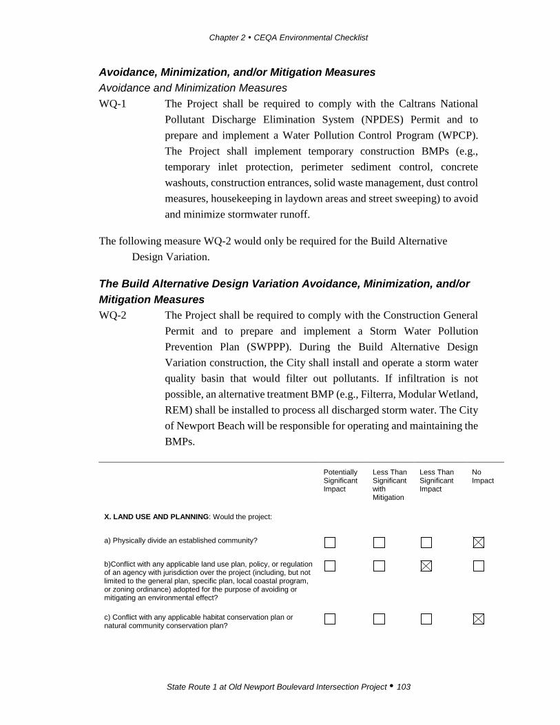
Chapter 2 CEQA Environmental Checklist
State Route 1 at Old Newport Boulevard Intersection Project 103
Avoidance, Minimization, and/or Mitigation Measures Avoidance and Minimization Measures WQ-1 The Project shall be required to comply with the Caltrans National
Pollutant Discharge Elimination System (NPDES) Permit and to prepare and implement a Water Pollution Control Program (WPCP). The Project shall implement temporary construction BMPs (e.g., temporary inlet protection, perimeter sediment control, concrete washouts, construction entrances, solid waste management, dust control measures, housekeeping in laydown areas and street sweeping) to avoid and minimize stormwater runoff.
The following measure WQ-2 would only be required for the Build Alternative Design Variation.
The Build Alternative Design Variation Avoidance, Minimization, and/or Mitigation Measures WQ-2 The Project shall be required to comply with the Construction General
Permit and to prepare and implement a Storm Water Pollution Prevention Plan (SWPPP). During the Build Alternative Design Variation construction, the City shall install and operate a storm water quality basin that would filter out pollutants. If infiltration is not possible, an alternative treatment BMP (e.g., Filterra, Modular Wetland, REM) shall be installed to process all discharged storm water. The City of Newport Beach will be responsible for operating and maintaining the BMPs.
Potentially Significant Impact
Less Than Significant with Mitigation
Less Than Significant Impact
No Impact
X. LAND USE AND PLANNING: Would the project:
a) Physically divide an established community?
b)Conflict with any applicable land use plan, policy, or regulation of an agency with jurisdiction over the project (including, but not limited to the general plan, specific plan, local coastal program, or zoning ordinance) adopted for the purpose of avoiding or mitigating an environmental effect?
c) Conflict with any applicable habitat conservation plan or natural community conservation plan?

Chapter 2 CEQA Environmental Checklist
State Route 1 at Old Newport Boulevard Intersection Project 104
Affected Environment The intersection is located in the Coastal Zone as defined by the City of Newport Beach and California Coastal Commission. The California Coastal Act (the Coastal Act) was adopted in 1976 by the California Coastal Commission. The Coastal Commission’s mission is to protect, conserve, restore, and enhance the environmental and human-based resources of the California coast and ocean for environmentally sustainable and prudent use by current and future generations. The Coastal Commission, in partnership with coastal cities such as the City of Newport Beach, plans and regulates the use of land and water resources in the coastal zone. The Coastal Act includes specific policies that address issues such as shoreline public access and recreation; environmentally sensitive areas; terrestrial and marine habitat protection; visual resources; landform alteration; commercial fisheries; water quality; offshore oil and gas development; transportation; and public works. Implementation of Coastal Act policies is accomplished primarily through the preparation of local coastal programs (LCPs) that are required to be completed by Counties and Cities with a Coastal Zone. The City of Newport Beach prepared a Coastal Land Use Plan (CLUP) in 2009, consistent with the guidelines from the Coastal Commission. On November 10, 2015 the City Council approved the Implementation Plan for the CLUP and authorized submittal to the California Coastal Commission for certification. Following this, in 2016, a series of meetings and hearings occurred, and the CLUP Implementation Plan became effective starting January 30, 2017. This gave the City the authority to issue a Coastal Development Permit (CDP) for projects within the City, subject to appeal by the Coastal Commission. The Permit Application Filling and Processing procedures are described in Chapter 21.50 of the CLUP Implementation Plan.
The City of Newport Beach CLUP policies in Section 2.9.2 describe the requirements of coastal access and recreational opportunities such as use of bikeways. Policies 2.9.2-1 through 2.9.2-4 encourage use of bikeways and cooperation among agencies regarding bikeways, trails, and connections to bikeway systems.
The Newport Beach General Plan Land Use Map designates land uses at the northeast corner of the intersection as “General Commercial”. The other quadrants of the intersection are designated as transportation. The existing land uses at the intersection include transportation land uses (Old Newport Boulevard and SR-1) and A Market and A Restaurant. Adjacent existing land uses to the north consist of apartment complexes and a residential neighborhood, which are both located north of Santa Ana Avenue. The SR-55 bridge is located to the east; the medical office building is to the
Chapter 2 CEQA Environmental Checklist
State Route 1 at Old Newport Boulevard Intersection Project 105
west; and the parking lot for the Newport Beach marina is to the south, across the street from SR-1. No established neighborhoods exist at the intersection.
According to the City’s General Plan (Figure S-5), the intersection is located outside the John Wayne Airport Clear Zone/runway Protection Zones and Accident potential Zone. Based on the General Plan Wildlife Hazards map (Figure S-4), the intersection is located in an area that is classified as having low to no potential for fire susceptibility.
Environmental Consequences Checklist Question a The Build Alternative Since the Project would improve an existing roadway, the Build Alternative would not physically divide an established community, nor would it result in any barriers that would preclude travel throughout the Project area. The Build Alternative would actually enhance the public experience by removing existing line of sight issues and by improving operation of the intersection.
Though the Build Alternative would not divide an established community it would require the acquisition of a portion of private property to accommodate the roadway improvements. As reflected in LU-1, discussed later in this section, affected property owners would be compensated with the fair market value of the property as well as damages, if any. No substantial adverse effects to an established community are expected.
The Build Alternative Design Variation Similar to the Build Alternative Design Variation, since the Project would improve an existing roadway, the Build Alternative Design Variation would not physically divide an established community, nor would it result in any barriers that would preclude travel throughout the Project area. No impacts to an established community would occur.
As with the Build Alternative, acquisition of a portion of private property to accommodate the roadway improvements would be required with the Build Alternative Design Variation. As reflected in LU-1 affected property owners would be compensated with the fair market value of the property as well as damages, if any.

Chapter 2 CEQA Environmental Checklist
State Route 1 at Old Newport Boulevard Intersection Project 106
No-Build Alternative The No-Build Alternative would not result in changes to existing land use patterns and would not divide an established community.
Checklist Question b The Build Alternative The Project accommodates alternative modes of transportation and, therefore, enhances the pedestrian and bicyclist experience in the nearby coastal areas (as discussed in the CLUP Policies 2.9.3-14, 3.1.1-9, 3.2.1-14, 3.2-19). Pursuant to the provisions of the CLUP Implementation Plan, the Project would be required to secure a CDP from the City of Newport Beach. Implementation of the Build Alternative would result in sliver acquisitions from two adjacent parcels (APN 049-110-01 and APN 049-110-29) and would also result in the need of CDP from the City of Newport Beach.
Therefore, Avoidance and Minimization Measure LU-2 would also apply to the Build Alternative. The acquisition of a portion of the A Market and A Restaurant parking lot would result in the loss of approximately 17 parking spaces out of 55 existing spaces. In addition, the medical office building would lose two parking spaces. The City would work with the parcel owners to find the best solution for parking acquisitions either in terms of a conditional use permit (CUP) or compensation. If replacement parking cannot be implemented, the City would be required to issue a CUP for fewer on-site parking spaces to allow the business to function with the decreased number of parking spaces. Two on-street parking spaces on SR-1 would be permanently removed and coordination with the City of Newport Beach and Caltrans would be necessary to identify replacement locations.
After implementation of the Build Alternative, reconfiguration of the existing parking lot and restriping of 42 parking spaces would be provided on site to allow for restaurant parking. Two on-street parking spaces on SR-1 would be permanently removed for the purpose of providing a dedicated right-turn lane onto Old Newport Boulevard. These are metered spaces located in front of the medical office building and within the coastal zone. It should be noted, these two spaces were temporarily removed from public use in 2014 and 2015 for the purpose of the gas line replacement project along SR-1. Minimization Measure LU-3 requires that the City of Newport Beach, in coordination with Caltrans, identify the location to replace the loss of these two on-street parking spaces prior to construction. With implementation of LU-1 and Avoidance and Minimization Measures LU-2 through LU-4, the Build
Chapter 2 CEQA Environmental Checklist
State Route 1 at Old Newport Boulevard Intersection Project 107
Alternative would not conflict with an applicable land use plan such as the CLUP or General Plan. The City of Newport Beach will be the implementing agency for all work, including right of way acquisition.
The Build Alternative Design Variation Similar to the Build Alternative, the Build Alternative Design Variation accommodates alternative modes of transportation and enhances the pedestrian and bicyclist experience in nearby coastal areas (as discussed in the CLUP Policy 2.9.3-14, 3.1.1-9, 3.2.1-1). No land use incompatibilities would occur as a result of implementing the Build Alternative Design Variation because the Project proposes improvements to an existing intersection.
The acquisition of a portion of the A Market parking lot (APN 049-110-01) would result in a loss of approximately 2 parking spaces out of an existing 55 spaces. The A Market parking lot is planned to be redesigned to provide opportunities for parking on the west side of the building. No building acquisitions or relocations would occur. The planned redesigned parking on the west side of the building would require the permanent acquisition of a Caltrans-owned parcel on Old Newport Boulevard. The City would request that Caltrans be the implementing agency for right of way and the viability of this variation would depend on the decision of the California Transportation Commission (CTC) to approve the parcel as excess land. If the CTC does not approve the parcel as an excess land sale, the City would grant a conditional use permit so this design variation could be implemented. City must enter a cooperative agreement with Caltrans for reimbursement of work performed under Caltrans’ role as implementing agency.
Parking (two spaces) would also be displaced at the medical office building (APN 049-110-29), and there are no replacement opportunities for these spaces. The parking rearrangement and the loss of two parking spaces would not conflict with the existing zoning requirements or Coastal Act provisions because the private parking was serving the restaurant and medical office (i.e., not coastal access parking). The City of Newport Beach would apply for the CDP and thus Avoidance and Minimization Measure LU-1 is proposed. No land use incompatibility would occur as a result of implementation of the Build Alternative Design Variation because the intersection already exists, and the Project proposes improvements to the intersection.
In addition to the private parking spaces on private property, there are two on-street parking spaces on SR-1 that would be permanently removed. Minimization Measure
Chapter 2 CEQA Environmental Checklist
State Route 1 at Old Newport Boulevard Intersection Project 108
LU-3 requires that the City of Newport Beach, in coordination with Caltrans, identify the location to replace the loss of these two on-street parking spaces prior to construction. With implementation of Land Use Avoidance and Minimization Measures provide below, the Build Alternative Design Variation would not conflict with an applicable land use plan such as the CLUP or General Plan.
No-Build Alternative The No-Build Alternative would not conflict with an applicable plan such as the CLUP or General Plan.
Checklist Question c The Build Alternative Refer to checklist question “f” in Section IV, Biological Resources.
The Build Alternative Design Variation Refer to checklist question “f” in Section IV, Biological Resources.
No-Build Alternative The No-Build Alternative would not conflict with an existing natural community conservation plan or habitat conservation plan.
Avoidance, Minimization, and/or Mitigation Measures LU-1 Prior to construction, the City of Newport Beach would obtain all
required right-of-way for the roadway improvements. Owners of property to be acquired shall be compensated for the fair market value of the property as well as damages, if any, to the remaining portions of their properties in accordance with the Uniform Relocation Assistance and Real Property Acquisition Policies Act of 1970, as Amended.
LU-2 Prior to commencement of construction activities, the City of Newport Beach shall apply and obtain a Coastal Development Permit.
LU-3 Prior to construction, the City of Newport Beach, in coordination with Caltrans, shall replace two impacted on-street metered parking spaces located on SR-1.
LU-4 Prior to construction, opportunities for replacement of the private parking shall be evaluated with the land owners. If suitable replacement parking cannot be obtained, the City shall proceed with
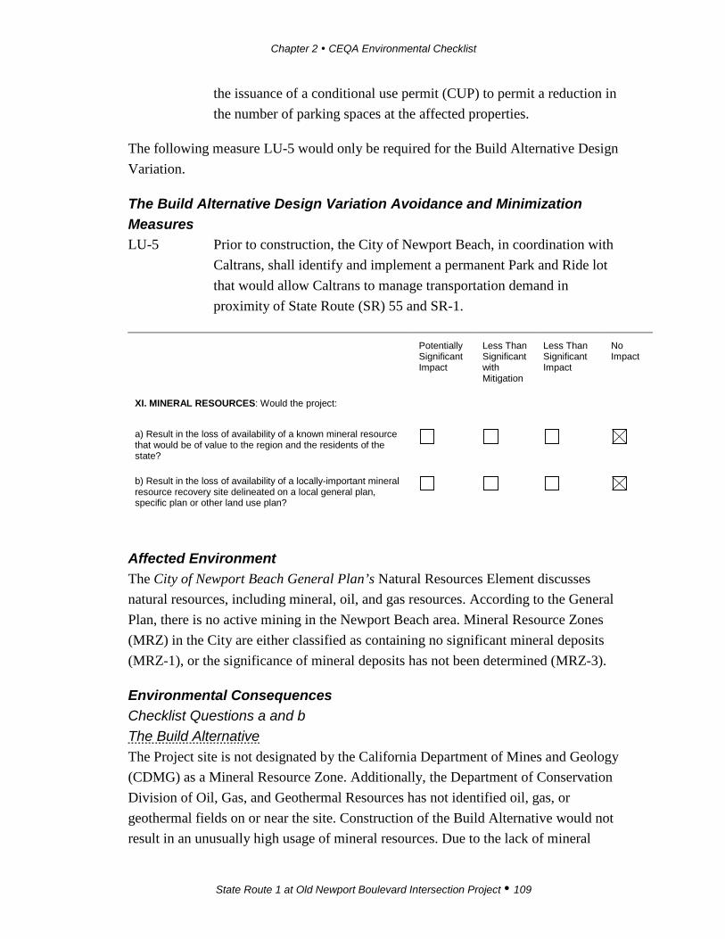
Chapter 2 CEQA Environmental Checklist
State Route 1 at Old Newport Boulevard Intersection Project 109
the issuance of a conditional use permit (CUP) to permit a reduction in the number of parking spaces at the affected properties.
The following measure LU-5 would only be required for the Build Alternative Design Variation.
The Build Alternative Design Variation Avoidance and Minimization Measures LU-5 Prior to construction, the City of Newport Beach, in coordination with
Caltrans, shall identify and implement a permanent Park and Ride lot that would allow Caltrans to manage transportation demand in proximity of State Route (SR) 55 and SR-1.
Potentially Significant Impact
Less Than Significant with Mitigation
Less Than Significant Impact
No Impact
XI. MINERAL RESOURCES: Would the project:
a) Result in the loss of availability of a known mineral resource that would be of value to the region and the residents of the state?
b) Result in the loss of availability of a locally-important mineral resource recovery site delineated on a local general plan, specific plan or other land use plan?
Affected Environment The City of Newport Beach General Plan’s Natural Resources Element discusses natural resources, including mineral, oil, and gas resources. According to the General Plan, there is no active mining in the Newport Beach area. Mineral Resource Zones (MRZ) in the City are either classified as containing no significant mineral deposits (MRZ-1), or the significance of mineral deposits has not been determined (MRZ-3).
Environmental Consequences Checklist Questions a and b The Build Alternative The Project site is not designated by the California Department of Mines and Geology (CDMG) as a Mineral Resource Zone. Additionally, the Department of Conservation Division of Oil, Gas, and Geothermal Resources has not identified oil, gas, or geothermal fields on or near the site. Construction of the Build Alternative would not result in an unusually high usage of mineral resources. Due to the lack of mineral

Chapter 2 CEQA Environmental Checklist
State Route 1 at Old Newport Boulevard Intersection Project 110
resources in the City of Newport Beach, no substantial adverse effects to mineral resources are expected.
The Build Alternative Design Variation As discussed above, due to the lack of mineral resources in the City of Newport Beach, no substantial adverse effects to mineral resources are expected.
No-Build Alternative The No-Build Alternative would not result in physical changes to mineral resources, nor would it result in an unusually high use of mineral resources.
Avoidance, Minimization, and/or Mitigation Measures No Avoidance, Minimization, and/or Mitigation Measures are required.
Potentially Significant Impact
Less Than Significant with Mitigation
Less Than Significant Impact
No Impact
XII. NOISE: Would the project result in:
a) Exposure of persons to or generation of noise levels in excess of standards established in the local general plan or noise ordinance, or applicable standards of other agencies?
b) Exposure of persons to or generation of excessive groundborne vibration or groundborne noise levels?
c) A substantial permanent increase in ambient noise levels in the project vicinity above levels existing without the project?
d) A substantial temporary or periodic increase in ambient noise levels in the project vicinity above levels existing without the project?
e) For a project located within an airport land use plan or, where such a plan has not been adopted, within two miles of a public airport or public use airport, would the project expose people residing or working in the project area to excessive noise levels?
f) For a project within the vicinity of a private airstrip, would the project expose people residing or working in the project area to excessive noise levels?
Affected Environment Noise Noise is most often defined as unwanted sound. Although sound can be easily measured, the perception of noise and the physical response to sound complicate the analysis of its impact on people. Sound pressure levels are described in units called

Chapter 2 CEQA Environmental Checklist
State Route 1 at Old Newport Boulevard Intersection Project 111
the decibel (dB). Decibels are measured on a logarithmic scale that quantifies sound intensity in a manner similar to the Richter scale used for earthquake magnitudes. A doubling of the energy of a noise source, such as doubling of traffic volume, would increase the noise level by 3 dB. The human ear is not equally sensitive to all frequencies on the sound spectrum. To accommodate this phenomenon, the A-scale was devised; the A-weighted decibel scale (dBA or dB[A]) approximates the frequency response of the average healthy ear when listening to most ordinary everyday sounds.
The dominant noise in the Project area is traffic on SR-55, SR-1, and Old Newport Boulevard. Secondary noise sources include aircraft and helicopter overflights, including occasional helicopters to and from the heliport at Hoag Hospital.
Vibration In contrast to airborne noise, groundborne vibration is not a common environmental problem. It is unusual for vibration from sources such as buses and trucks to be perceptible. Some common sources of groundborne vibration are construction activities such as blasting, pile driving, and operating heavy earth-moving equipment.
In quantifying vibration, the peak particle velocity (ppv) is most frequently used to describe vibration impacts and is typically measured in inches per second (in/sec). Vibration levels that may cause annoyance to humans are often described using the vibration decibel (VdB). Typically, groundborne vibration generated by man-made activities attenuates rapidly with distance from the source.
Sensitive Receptors Noise- and vibration-sensitive land uses include residential land uses, schools, hospitals, libraries, and open space/recreational areas where quiet environments are necessary for enjoyment, public health, and safety. Sensitivity to noise/vibration increases during the evening and at night. Noise and vibration can interfere with sleep, speech, and television/radio and can cause annoyance. The City of Newport Beach has a number of public and private educational facilities, hospitals, convalescent homes, day care centers, and other facilities that are considered noise sensitive. However, the primary noise-sensitive use in the City is residential use.
The nearest sensitive receptors to the Project site are residences (i.e., condominiums) located adjacent to the northern portion of the Project site at 207, 209, 211, 213, and 215 La Jolla Drive. There is a medical facility located on 3300 Pacific Coast Highway, Suite C, which is located approximately 75 feet to the north of the Project

Chapter 2 CEQA Environmental Checklist
State Route 1 at Old Newport Boulevard Intersection Project 112
site boundary and the planned excavation area on SR-1. A surgical center, Newport Bay Surgery Center, is located southeast of the Project site on 3333 West Coast Highway. Hoag Hospital is located 630 feet northwest of the Project site across Newport Boulevard and SR-55.
Environmental Consequences Checklist Question a The Build Alternative Chapter 10.26, Community Noise Control, of the City of Newport Beach Municipal Code is the applicable noise standard. Section 10.26.035.E exempts “Noise sources associated with construction, repair, remodeling, demolition or grading of public rights-of-way or during authorized seismic surveys” from the quantitative exterior and interior noise level limits and other requirements prescribed in Chapter 10.26 (refer to Avoidance and Minimization Measure NO-1). Therefore, the Build Alternative would not expose persons to or generate noise in excess of standards established in a local general plan or noise ordinance or applicable standards of other agencies. The Build Alternative would not result in generation of substantial adverse noise effects.
The Build Alternative Design Variation The Build Alternative Design Variation would result in the same noise impacts as the Build Alternative. Implementation of the Build Alternative Design Variation would not expose persons to or generate noise in excess of standards established in a local general plan or noise ordinance or applicable standards of other agencies (refer to the Build Alternative checklist question “a”, above). There would not be a substantial adverse permanent noise increase in ambient noise levels as a result of the Build Alternative Design Variation, and thus no people would be exposed to excessive noise levels (refer to Avoidance and Minimization Measure NO-1).
No-Build Alternative There would be no temporary increase in construction vibration or noise for the No-Build Alternative because construction work would occur. No impacts are expected.
Checklist Question b The Build Alternative Groundborne noise is the vibration of floors and walls that may cause items (e.g., windows or dishes on shelves) to rattle or cause a rumbling noise. The rumbling is created by the motion of the room surfaces, which act like a giant loudspeaker.

Chapter 2 CEQA Environmental Checklist
State Route 1 at Old Newport Boulevard Intersection Project 113
There are no applicable CEQA significance thresholds or standards for vibration. Caltrans, in its Transportation and Construction Vibration Guidance Manual (2013), has published guideline criteria for structural damage and human annoyance, as shown in Tables 2.10 and 2.11. Based on the guidelines in Tables 2.10 and 2.11, vibration levels exceeding 0.24 peak particle velocity (ppv) inch per second (in/sec) would be considered potentially adverse.
Table 2.10 Vibration Damage Threshold Criteria
Structure and Condition Maximum ppv (in/sec)
Transient Sources Continuous/Frequent Intermittent Sources
Extremely fragile historic buildings, ruins, ancient monuments 0.12 0.08 Fragile buildings 0.2 0.1 Historic and some old buildings 0.5 0.25 Older residential structures 0.5 0.3 New residential structures 1.0 0.5 Modern industrial/commercial buildings 2.0 0.5 ppv: peak particle velocity; in/sec: inch(es) per second
Note: Transient sources create a single isolated vibration event, such as blasting or drop balls. Continuous/frequent intermittent sources include impact pile drivers, pogo-stick compactors, crack-and-seat equipment, vibratory pile drivers, and vibratory compaction equipment.
Source: Caltrans, Transportation and Construction Vibration Guidance Manual (2013)
Table 2.11 Vibration Annoyance Criteria
Average Human Response ppv (in/sec)
Severe 2.0 Strongly perceptible 0.9 Distinctly perceptible 0.24 Barely perceptible 0.035 ppv: peak particle velocity; in/sec: inch(es) per second Source: Caltrans, Transportation and Construction Vibration Guidance Manual (2013)
The highest levels of groundborne vibration from construction activities are associated with pile driving and blasting, but neither activity would occur with the proposed Project. Large bulldozers and large trucks are anticipated to have vibration levels of 0.089 ppv in/sec at a distance of 25 feet.
Chapter 2 CEQA Environmental Checklist
State Route 1 at Old Newport Boulevard Intersection Project 114
The closest construction to a sensitive receptor would occur for sidewalk construction on Old Newport Boulevard, approximately 85 feet south of the condominiums on La Jolla Drive, as shown on Figure 3a. Although it is not likely that large equipment would be used for construction in this area, at a distance of 85 feet, the vibration levels from large bulldozers and large trucks would be approximately 0.02 ppv in/sec. This vibration level is less than the 0.24 ppv in/sec threshold described above and less than the 0.17 ppv in/sec theoretical worst-case vibration for the Build Alternative Design Variation. There would be no potential for structural damage.
Vibration may occasionally be perceptible when heavy equipment would be closest to a residence; however, there would be no excessive groundborne vibration exposure to persons.
Once operational, the Build Alternative would not generate any additional traffic. Therefore, there would be no Project-related increase in groundborne vibration or noise.
Because the Build Alternative would not increase groundborne noise or vibration, it would not result in substantial adverse exposure of persons to or generation of excessive groundborne vibration or groundborne noise levels.
The Build Alternative Design Variation Vibration sources and impact thresholds would be the same as described for the Build Alternative Design Variation.
The closest construction to a sensitive receptor would occur for sidewalk construction on Old Newport Boulevard, approximately 15 feet from the rear of the condominiums on La Jolla Drive. (Refer to Figure 3b.) At a distance of 15 feet, the vibration levels from large bulldozers and large trucks—although it is not likely that large equipment would be used for construction in this area—would be approximately 0.17 ppv in/sec. This vibration level is less than the 0.24 ppv in/sec threshold described above. There would be no potential for structural damage.
Vibration may be perceptible occasionally when heavy equipment would be closest to a residence; however, there would be no excessive groundborne vibration exposure to persons.
Chapter 2 CEQA Environmental Checklist
State Route 1 at Old Newport Boulevard Intersection Project 115
Once operational, the Build Alternative Design Variation would not generate any additional traffic. Therefore, there would be no Project-related increase in groundborne vibration or noise.
Because the Build Alternative Design Variation would not increase groundborne noise and vibration, it would not result in substantial adverse exposure of persons to or generation of excessive groundborne vibration or groundborne noise levels.
No-Build Alternative There would be no temporary increase in construction vibration and noise for the No-Build Alternative because construction work would occur. No impacts are expected.
Checklist Question c The Build Alternative The dominant noise in the Project area is traffic on SR-55, SR-1, and Old Newport Boulevard. The proposed improvements for the Build Alternative involve widening the north side of SR-1 to add a third lane across Old Newport Boulevard, a right-turn pocket, and a bicycle lane. The Build Alternative would not generate any additional traffic. The primary purpose of the Build Alternative is to improve traffic operation, circulation, and pedestrian and bicycle movement. As a result, traffic volumes and speeds are anticipated to be virtually the same with both the Build Alternative and the No-Build Alternative.
The widening of SR-1 would result in some westbound traffic being approximately 11 feet closer to receptors north of SR-1 than under existing conditions. The increase in traffic noise to those receptors would be less than 0.5 dBA and would not be perceptible. Because of this, there would not be a substantial adverse permanent noise increase in ambient noise levels as a result of the Build Alternative.
The Build Alternative Design Variation The Build Alternative Design Variation would result in the same noise impacts as the Build Alternative (refer to the Build Alternative discussion for checklist question “c”). There would not be a substantial adverse permanent noise increase in ambient noise levels as a result of the Build Alternative Design Variation.
No-Build Alternative There would be no temporary increase in construction vibration and noise for the No-Build Alternative because construction work would occur. No impacts are expected.

Chapter 2 CEQA Environmental Checklist
State Route 1 at Old Newport Boulevard Intersection Project 116
Checklist Question d The Build Alternative Construction activities associated with the Build Alternative are planned to begin in 2019 and are expected to occur over approximately five months. During construction activities, the residential and commercial receptors in the immediate vicinity would experience short-term increases in noise levels from the operation of heavy construction equipment (e.g., excavators, loaders, trucks, and backhoes). Noise levels would fluctuate depending on equipment type; duration of use; and distance between the noise source and listener.
The Build Alternative demolition and construction activities would have a construction duration of approximately five months, which would be approximately one month shorter than the Build Alternative Design Variation. The construction activities of the Build Alternative Design Variation would occur 85 feet from the La Jolla Drive residencies.
The Build Alternative construction noise would periodically be heard at residences and other receptors above the existing traffic noise levels. Based on the existence of existing traffic noise and the limited duration of proposed construction work near the La Jolla Drive residences, it is concluded that the temporary increase in ambient noise levels in the Project vicinity would not be substantial.
The Build Alternative Design Variation Demolition and construction activities would be similar to the Build Alternative, with the following differences: (1) the Build Alternative Design Variation would have a construction duration of approximately six months, which would be approximately one month longer than the Build Alternative and (2) the closest construction of the Build Alternative Design Variation to the La Jolla Drive homes would be approximately 15 feet.
The operation of equipment would occur as close as 15 feet to the La Jolla Drive homes with rear exposure to Old Newport Boulevard during the installation of the new sidewalk. These residences are exposed to existing traffic noise levels from the adjacent Old Newport Boulevard and from SR-55, approximately 100 feet to the east. However, as shown on Figure 3b, the Build Alternative Design Variation Layout, most of the Build Alternative Design Variation construction would occur at much greater distances from these residences. Construction noise would periodically be heard at residences and other receptors above the existing traffic noise levels.
Chapter 2 CEQA Environmental Checklist
State Route 1 at Old Newport Boulevard Intersection Project 117
However, based on the existence of existing traffic noise and the limited duration of proposed construction work near the La Jolla Drive residences, the temporary increase in ambient noise levels in the Project vicinity would not be substantial.
However, because of the differences between the Build Alternative and its Design Variation described above, temporary noise impacts for the Build Alternative Design Variation would exceed those of the Build Alternative.
No-Build Alternative There would be no temporary increase in construction vibration and noise for the No-Build Alternative because construction work would occur. No impacts are expected.
Checklist Question e The Build Alternative The Project site is not located in an airport land use plan or within two miles of a public or private airport. Therefore, the Build Alternative would not expose people working in the Project area to substantial adverse aircraft noise levels.
The Build Alternative Design Variation The Build Alternative Design Variation would not expose people working in the Project area to substantial adverse aircraft noise levels, the same as the Build Alternative. Therefore, the Build Alternative Design Variation would not expose people working in the Project area to substantial adverse aircraft noise levels.
No-Build Alternative The No-Build Alternative would not expose people to substantial adverse aircraft noise levels because the intersection is located outside a public airport zone. No impacts are expected.
Checklist Question f The Build Alternative The Project site is near the Hoag Hospital heliport. The Build Alternative would not change the number of people living or working in the Project area, nor would it increase helicopter operations. Therefore, the Build Alternative would not expose people residing or working in the area to substantial adverse noise levels from a nearby private airport or airstrip.
Chapter 2 CEQA Environmental Checklist
State Route 1 at Old Newport Boulevard Intersection Project 118
The Build Alternative Design Variation The Build Alternative Design Variation would have no impact, the same as the Build Alternative. Therefore, the Build Alternative Design Variation would not expose people residing or working in the area to substantial adverse noise levels from a nearby private airport or airstrip.
No-Build Alternative The No-Build Alternative would not expose people to excessive aircraft noise levels because the intersection is located outside a private airport zone. No impacts are expected.
Avoidance, Minimization, and/or Mitigation Measures Avoidance and Minimization Measures NO-1 The Project shall be required to comply with the City of Newport
Beach Noise Ordinance and the Caltrans Standard Specification Section 14-8.02 and Standard Special Provision S5-310.
Potentially Significant Impact
Less Than Significant with Mitigation
Less Than Significant Impact
No Impact
XIII. POPULATION AND HOUSING: Would the project:
a) Induce substantial population growth in an area, either directly (for example, by proposing new homes and businesses) or indirectly (for example, through extension of roads or other infrastructure)?
b) Displace substantial numbers of existing housing, necessitating the construction of replacement housing elsewhere?
c) Displace substantial numbers of people, necessitating the construction of replacement housing elsewhere?
Affected Environment In 2014, the City of Newport Beach reported 86,874 inhabitants, of which 46,399 were in labor force. The City growth pattern from 2010 to 2014 showed a very low population increase. The US Census (2010) reported that the City is comprised of 38,751 total households, with an average household size of 2.19. The total number of housing units in the City is 44,193, of which 87 percent (38,751 units) were occupied. Orange County Projections (2014) indicate that the City’s population would increase to 92,284 by 2015, and the number of housing units in the City would increase to
Chapter 2 CEQA Environmental Checklist
State Route 1 at Old Newport Boulevard Intersection Project 119
46,668 by 2035. The area where the intersection is located is commercial in nature, and no housing units exist within the Project limits. A small neighborhood consisting of apartment complexes mixed with single-family residential housing is located north of the Project limits.
Environmental Consequences Checklist Question a The Build Alternative Implementation of the Build Alternative would not result in impacts to growth and would not be a catalyst to growth. The Project would improve the existing intersection and would maintain existing Level of Service (LOS) volumes; the Project would not convert the existing land uses into different land use types such as new residential or nonresidential uses. Therefore, the Build Alternative would not directly or indirectly induce substantial population growth in the area. No substantial adverse growth-related effects would occur as a result of the Build Alternative.
The Build Alternative Design Variation Implementation of the Build Alternative Design Variation would not result in impacts to growth and would not be the catalyst to growth. The Project would improve the intersection and would not convert existing land uses into different land use types. The Build Alternative Design Variation would not directly or indirectly induce substantial population growth in the area. No substantial adverse growth related effects would occur as a result of the Build Alternative Design Variation.
No-Build Alternative The No-Build Alternative would not result in any construction and, as a result, would not create any substantial adverse effects to population and housing.
Checklist Questions b and c The Build Alternative Implementation of the Build Alternative would result in sliver acquisitions from two adjacent parcels. These sliver acquisitions would total 4,257 square feet from the A Market and A Restaurant parcel, and 1,400 square feet from the medical office building; however, these acquisitions would not necessitate the displacement of these buildings or their employees. The Build Alternative would not displace existing housing or buildings, nor would it result in relocations of people or result in the construction of replacement housing/employment elsewhere. No substantial adverse effects would occur as a result of the Build Alternative.
Chapter 2 CEQA Environmental Checklist
State Route 1 at Old Newport Boulevard Intersection Project 120
The Build Alternative Design Variation Implementation of the Build Alternative Design Variation would result in sliver acquisitions from two adjacent parcels (APN 049-110-01 and APN 049-110-29). These sliver acquisitions would total 4,007 square feet from the A Market and A Restaurant parcel and 885 square feet from the medical office building; however, these acquisitions would not necessitate the displacement of these buildings or their employees. The Build Alternative Design Variation would not displace existing housing or buildings, nor would it result in relocations of people or result in the construction of replacement housing/employment elsewhere. No substantial adverse effects would occur as a result of the Build Alternative Design Variation.
No-Build Alternative The No-Build Alternative would not result in any construction and, as a result, would not create any substantial adverse effects to population and housing.
Avoidance, Minimization, and/or Mitigation Measures No Avoidance, Minimization, and/or Mitigation Measures are required.
Potentially Significant Impact
Less Than Significant with Mitigation
Less Than Significant Impact
No Impact
XIV. PUBLIC SERVICES:
a) Would the project result in substantial adverse physical impacts associated with the provision of new or physically altered governmental facilities, need for new or physically altered governmental facilities, the construction of which could cause significant environmental impacts, in order to maintain acceptable service ratios, response times or other performance objectives for any of the public services:
Fire protection?
Police protection?
Schools?
Parks?
Other public facilities?

Chapter 2 CEQA Environmental Checklist
State Route 1 at Old Newport Boulevard Intersection Project 121
Affected Environment Fire Protection The City Emergency Response Plan, Essential Facilities Map (Plate H-1) maps all public and emergency services providers in the City of Newport Beach. The Newport Beach Fire Department (NBFD) provides fire protection services to the City. The NBFD is comprised of three divisions: Fire Operations, Life Safety Services, and Marine Operations Divisions. The closest Fire Station is located approximately one mile south of the intersection on Lido Island.
Police Services The Newport Beach Police Department (NBPD) is responsible for providing law enforcement services to the City. The NBPD is located at 870 Santa Barbara Drive, which is approximately 4.5 miles east of the Project site.
Schools The Newport-Mesa Unified School District (NMUSD) provides education services to a majority of the City, including the Project area. The Project site is located within the attendance boundaries of Newport Elementary School, Ensign Intermediate School, and Newport Harbor High School. No public schools are located in the vicinity of the intersection.
Recreational Facilities The Newport Beach General Plan Recreation Element (Figure R1, Existing Recreational Facilities) identifies parks, public beaches, and marine-protected areas in the City. According to the General Plan’s Existing Recreational Facilities Map (Figure R-1) and the Proposed Park and Recreational Facilities Map (Figure R-2), there are no existing or proposed recreational resources on the Project site. The Project Study Area is not designated “Parks and Recreation”, and there are no parks or recreational facilities located immediately adjacent to the Project site. No recreational facilities are located on the Project site. Weekend-related bicycle traffic occurs along SR-1, although no bike lane is provided.
Other Service Providers The SR-1/Old Newport Boulevard intersection is not located in the vicinity of any other public service providers.
Chapter 2 CEQA Environmental Checklist
State Route 1 at Old Newport Boulevard Intersection Project 122
Environmental Consequences Checklist Question a The Build Alternative The Build Alternative would improve an existing intersection and would not result in any new land uses that would require additional fire or police protection services, nor would it result in the need for other public services. It would not generate any students for school enrollment. The Build Alternative would provide a dedicated continuous bicycle lane through the intersection, thus enhancing the experience for recreational bicyclists. During construction, some delays in emergency response time at the intersection may occur. However, the Traffic Management Plan (TMP) would address all temporary impacts related to construction and would identify alternative routes (refer to Avoidance and Minimization Measure TRA-1 under Section XVI, Transportation/Traffic).
The Build Alternative Design Variation The Build Alternative Design Variation would improve an existing intersection and would not result in any new land uses that would require additional fire or police protection or the need for other public services. It would not generate any students for school enrollment. The Build Alternative Design Variation would provide a dedicated bicycle lane through the intersection, thus enhancing the experience for recreational bicyclists. During construction, some delays in emergency response time at the intersection may occur. However, the Traffic Management Plan (TMP) would address all temporary impacts related to construction and would identify alternative routes (refer to Avoidance and Minimization Measure TRA-1 from Section XVI, Transportation/Traffic).
No-Build Alternative The No-Build Alternative would not result in any construction and would not conflict with service providers.
Avoidance, Minimization, and/or Mitigation Measures Avoidance and Minimization Measure TRA-1 from Section XVI, Transportation/Traffic, would also reduce Public Services impacts.

Chapter 2 CEQA Environmental Checklist
State Route 1 at Old Newport Boulevard Intersection Project 123
Potentially Significant Impact
Less Than Significant with Mitigation
Less Than Significant Impact
No Impact
XV. RECREATION:
a) Would the project increase the use of existing neighborhood and regional parks or other recreational facilities such that substantial physical deterioration of the facility would occur or be accelerated?
b) Does the project include recreational facilities or require the construction or expansion of recreational facilities which might have an adverse physical effect on the environment?
Affected Environment There are approximately 620 acres of parkland, including trails, and approximately 90 acres of active recreational beach area in the City. The intersection is located in Newport Beach Service Area 1 – West Newport. According to the General Plan, most of West Newport’s recreation land is provided in the form of beaches. According to the General Plan’s Existing Recreational Facilities Map (Figure R-1) and the Proposed Park and Recreational Facilities Map (Figure R-2), there are no existing or proposed recreational resources on the Project site. The Project site consists of transportation land uses and commercial land uses. No parkland exists on the Project site or adjacent to the Project site.
Environmental Consequences Checklist Questions a and b The Build Alternative The Build Alternative would not increase the use of existing parks or recreational facilities, nor would it require expansion of any park or recreational facilities because the Project does not propose housing development and would not, therefore, generate recreational users. As such, no substantial physical deterioration of the recreational facilities would occur. No substantial adverse effects related to recreational facilities would occur from the Build Alternative. Refer to Section XVI, Transportation/Traffic, for effects related to bike lanes.
The Build Alternative Design Variation No substantial adverse effects related to recreational facilities would occur from the Build Alternative Design Variation (refer to the Build Alternative checklist questions “a” and “b” above).
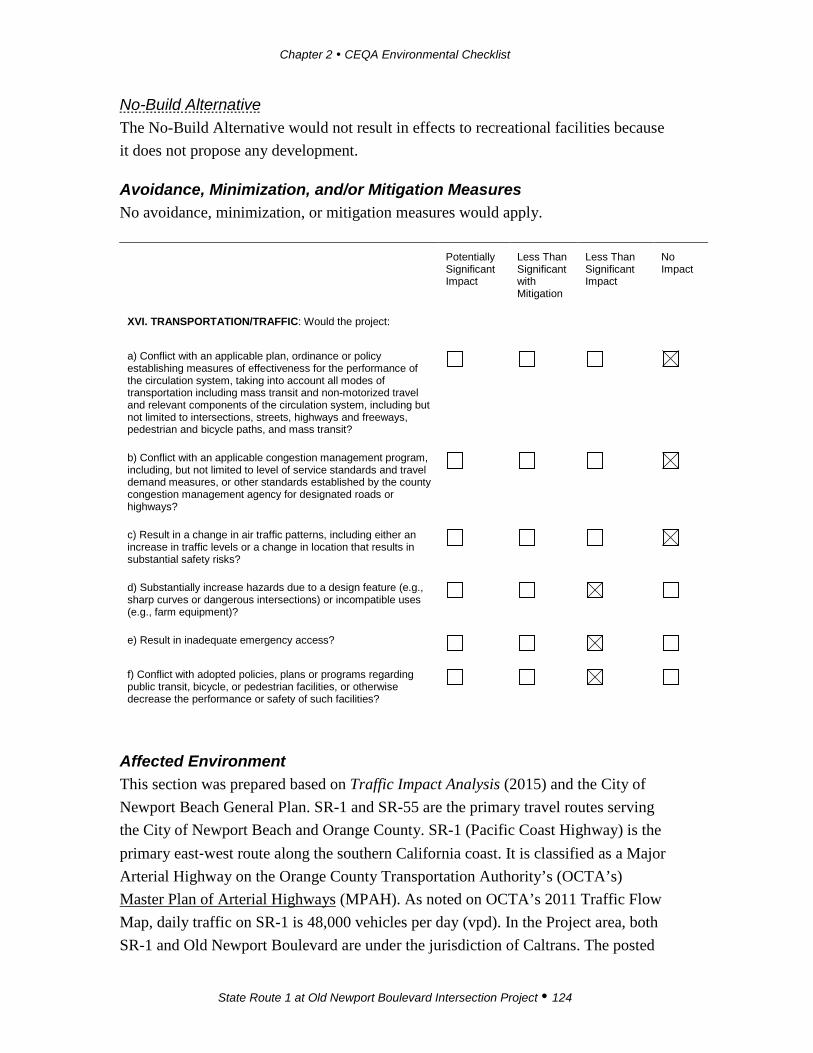
Chapter 2 CEQA Environmental Checklist
State Route 1 at Old Newport Boulevard Intersection Project 124
No-Build Alternative The No-Build Alternative would not result in effects to recreational facilities because it does not propose any development.
Avoidance, Minimization, and/or Mitigation Measures No avoidance, minimization, or mitigation measures would apply.
Potentially Significant Impact
Less Than Significant with Mitigation
Less Than Significant Impact
No Impact
XVI. TRANSPORTATION/TRAFFIC: Would the project:
a) Conflict with an applicable plan, ordinance or policy establishing measures of effectiveness for the performance of the circulation system, taking into account all modes of transportation including mass transit and non-motorized travel and relevant components of the circulation system, including but not limited to intersections, streets, highways and freeways, pedestrian and bicycle paths, and mass transit?
b) Conflict with an applicable congestion management program, including, but not limited to level of service standards and travel demand measures, or other standards established by the county congestion management agency for designated roads or highways?
c) Result in a change in air traffic patterns, including either an increase in traffic levels or a change in location that results in substantial safety risks?
d) Substantially increase hazards due to a design feature (e.g., sharp curves or dangerous intersections) or incompatible uses (e.g., farm equipment)?
e) Result in inadequate emergency access?
f) Conflict with adopted policies, plans or programs regarding public transit, bicycle, or pedestrian facilities, or otherwise decrease the performance or safety of such facilities?
Affected Environment This section was prepared based on Traffic Impact Analysis (2015) and the City of Newport Beach General Plan. SR-1 and SR-55 are the primary travel routes serving the City of Newport Beach and Orange County. SR-1 (Pacific Coast Highway) is the primary east‐west route along the southern California coast. It is classified as a Major Arterial Highway on the Orange County Transportation Authority’s (OCTA’s) Master Plan of Arterial Highways (MPAH). As noted on OCTA’s 2011 Traffic Flow Map, daily traffic on SR-1 is 48,000 vehicles per day (vpd). In the Project area, both SR-1 and Old Newport Boulevard are under the jurisdiction of Caltrans. The posted
Chapter 2 CEQA Environmental Checklist
State Route 1 at Old Newport Boulevard Intersection Project 125
speed limit on SR-1 is 40 miles per hour (mph). SR-1 currently has three westbound and two eastbound lanes in the Project limits. The number three westbound through lane terminates as a right-turn lane at Old Newport Boulevard. There is currently no sidewalk on the north side of SR-1 along the frontage of the property in the intersection’s northeastern quadrant (i.e., in front of A Market and A Restaurant). On‐site parking is currently allowed at the A Market and A Restaurant parking lot, which has direct, uncontrolled access from SR-1. SR-1 is designated as a Class III (on road, signed) Bike Route on OCTA’s Bikeway Map. Heavy bicycle traffic occurs in the westbound direction during the Saturday peak hour.
Old Newport Boulevard is a two-lane local street that serves as the northbound on- and off-ramp to SR-55. The OCTA does not have a designation for Old Newport Boulevard. The posted speed limit on Old Newport Boulevard is 35 mph. Old Newport Boulevard provides on-street (parallel) parking for A Market and A Restaurant along the west side of the property. Based on the pedestrian counts prepared for the Traffic Impact Analysis (2015), pedestrian movement on Old Newport Boulevard is considered low.
The Traffic Impact Analysis evaluated SR-1 along the westbound movement approaching Old Newport Boulevard, including pedestrians and bicyclists. Three intersections were studied: (1) SR-1/SR-55 off-ramp (signalized); (2) SR-1/Old Newport Boulevard (free); and (3) SR-55/Old Newport Boulevard (stop controlled).
When analyzing traffic impacts on highways and intersections, a Level of Service (LOS) concept is used to relate the quality of traffic service. LOS is used to analyze highways by categorizing traffic flow and assigning quality levels of traffic based on performance measure like speed, density, and other factors. LOS A translates to the best traffic quality and no delays at the intersection, while LOS F is the worst quality of traffic throughput and longest vehicle delays through the intersection.
As shown in Table 2.12 the existing LOS (2013) in the AM peak hour at all three study area intersections is LOS B. During the PM peak hour, the SR-1/Old Newport Boulevard intersection operates at LOS D and the SR-1/SR-55 off-ramp intersection and the SR-55/Old Newport Boulevard intersection both operate at LOS B.
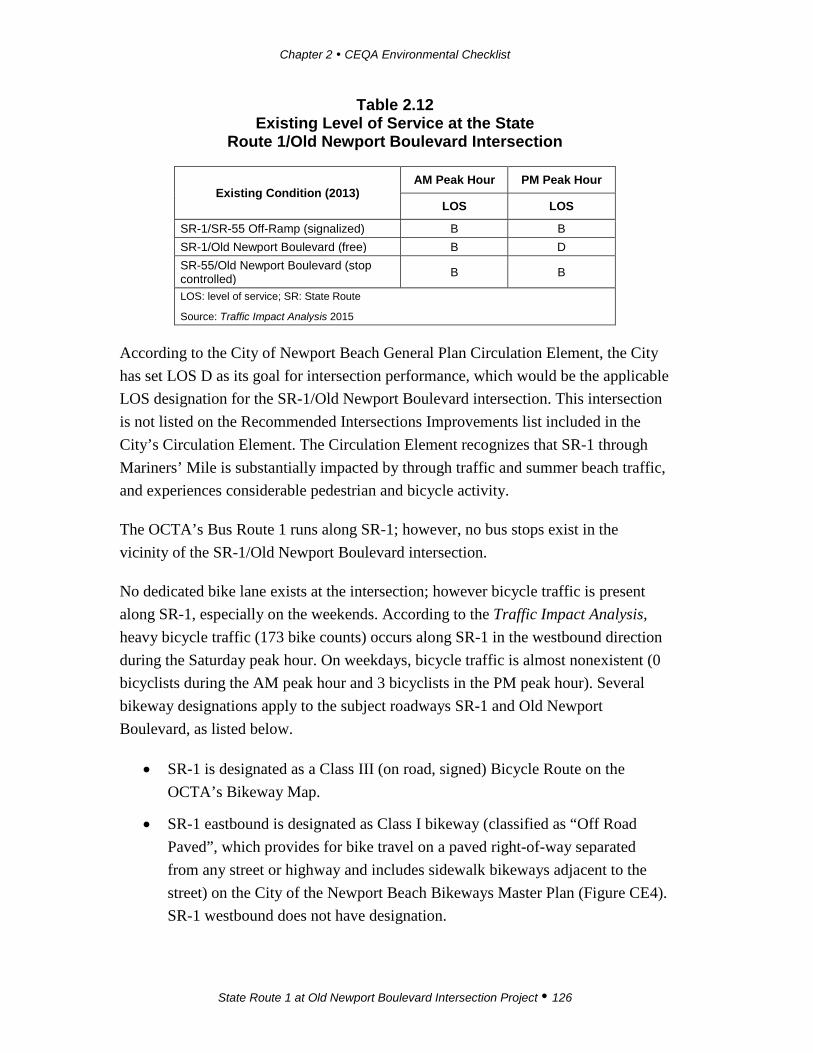
Chapter 2 CEQA Environmental Checklist
State Route 1 at Old Newport Boulevard Intersection Project 126
Table 2.12 Existing Level of Service at the State
Route 1/Old Newport Boulevard Intersection
Existing Condition (2013) AM Peak Hour PM Peak Hour
LOS LOS
SR-1/SR-55 Off-Ramp (signalized) B B SR-1/Old Newport Boulevard (free) B D SR-55/Old Newport Boulevard (stop controlled) B B
LOS: level of service; SR: State Route
Source: Traffic Impact Analysis 2015
According to the City of Newport Beach General Plan Circulation Element, the City has set LOS D as its goal for intersection performance, which would be the applicable LOS designation for the SR-1/Old Newport Boulevard intersection. This intersection is not listed on the Recommended Intersections Improvements list included in the City’s Circulation Element. The Circulation Element recognizes that SR-1 through Mariners’ Mile is substantially impacted by through traffic and summer beach traffic, and experiences considerable pedestrian and bicycle activity.
The OCTA’s Bus Route 1 runs along SR-1; however, no bus stops exist in the vicinity of the SR-1/Old Newport Boulevard intersection.
No dedicated bike lane exists at the intersection; however bicycle traffic is present along SR-1, especially on the weekends. According to the Traffic Impact Analysis, heavy bicycle traffic (173 bike counts) occurs along SR-1 in the westbound direction during the Saturday peak hour. On weekdays, bicycle traffic is almost nonexistent (0 bicyclists during the AM peak hour and 3 bicyclists in the PM peak hour). Several bikeway designations apply to the subject roadways SR-1 and Old Newport Boulevard, as listed below.
• SR-1 is designated as a Class III (on road, signed) Bicycle Route on the OCTA’s Bikeway Map.
• SR-1 eastbound is designated as Class I bikeway (classified as “Off Road Paved”, which provides for bike travel on a paved right-of-way separated from any street or highway and includes sidewalk bikeways adjacent to the street) on the City of the Newport Beach Bikeways Master Plan (Figure CE4). SR-1 westbound does not have designation.

Chapter 2 CEQA Environmental Checklist
State Route 1 at Old Newport Boulevard Intersection Project 127
• The CLUP designates northbound SR-1 west of the intersection as Class II bike trail. A Class II bike lane is defined as “A lane in the street, normally the parking lane, or a separate lane, striped and signed for the exclusive or semi-exclusive use of bicycles”.
• The CLUP designates SR-1 eastbound east of the intersection as Class I bike trail. A Class I bike trail is defined as “Off-street or sidewalk facility designated for bicycle and pedestrian use”. SR-1 westbound does not have designation.
Environmental Consequences Checklist Question a The Build Alternative The Build Alternative proposes to widen the north side of SR-1 by adding a third westbound lane, a dedicated right-turn pocket, and a bicycle lane. No geometry changes to the intersection are proposed. These improvements would result in overall improvement of the LOS at the intersection, as shown in Table 2.13.
Without the Build Alternative improvements, in 2017, the SR-1/SR-55 off-ramp and the SR-55/Old Newport Boulevard intersection would continue to operate at LOS B during AM and PM peak hours. The intersection of SR-1/Old Newport Boulevard would operate at LOS B during the AM peak hour and LOS D during the PM peak hour. In opening year 2017, under the Build Alternative, the LOS at the SR-1/Old Newport Boulevard intersection would improve from LOS D to LOS B during the PM peak hour, while maintaining the LOS B during the AM peak hour.

Chapter 2 CEQA Environmental Checklist
State Route 1 at Old Newport Boulevard Intersection Project 128
Table 2.13 Level of Service Summary
Level of Service
Intersections
Existing (Year 2013) Opening Day (Year 2017) Horizon Year (Year 2040)
No-Build Alternative
The Build Alternative/ The Build
Alternative DV
No-Build Alternative
The Build Alternative/ The Build
Alternative DV
No-Build Alternative
The Build Alternative/ The Build
Alternative DV
AM PM SAT AM PM SAT AM PM SAT AM PM SAT AM PM SAT AM PM SAT SR-1/SB SR-55 Ramps B B A B B A B B A B B A E C C E C C
SR-1/Old Newport Blvd B D C B B B B D C B B B B D C B C B
NB SR-55 Ramps /Old Newport Blvd
B B B B B B B B C B B C B C C B C C
SAT: Saturday; SR: State Route; SB: southbound; NB: northbound
Source: Traffic Impact Analysis 2015
In 2017, the SR-1/SR-55 off-ramp and the SR-55/Old Newport Boulevard intersection would continue to operate at LOS B during the AM and PM peak hours. Without the Build Alternative improvements, in horizon year 2040, the LOS at all three intersections would deteriorate. The SR-1/SR-55 off-ramp intersection would operate at LOS E during AM peak hour and LOS C during PM peak hour; the SR-55/Old Newport Boulevard intersection would operate at LOS B during the AM peak hour and LOS C in the PM peak hour; and the SR-1/Old Newport Boulevard intersection would operate at LOS B during the AM peak hour and LOS D during PM peak hour.
In horizon year 2040, with implementation of the Build Alternative, the SR-1/Old Newport Boulevard intersection LOS would improve from LOS D to LOS C during the PM peak hour while maintaining LOS B during the AM peak hour. The two other study area intersections’ LOS would not be impacted by the Build Alternative. Implementation of the Build Alternative would enhance bicyclists’ safety by providing a dedicated bicycle lane adjacent to the westbound right-turn lane and by enhancing pedestrians’ safety by providing a sidewalk with lighting in the northeast corner and a crosswalk across Old Newport Boulevard. The Build Alternative would improve the intersection to conform to Caltrans designated standards and would not conflict with the City of Newport Beach designated LOS D goal. Based on the above, the Build Alternative would not conflict with an applicable plan, ordinance, or policy

Chapter 2 CEQA Environmental Checklist
State Route 1 at Old Newport Boulevard Intersection Project 129
establishing measures of effectiveness for the performance of the circulation system, including intersections, streets, highways and freeways, pedestrian and bicycle paths, and mass transit. The Build Alternative would not result in substantial adverse effects related to operation of the streets and bicycle lanes.
The Build Alternative Design Variation The Build Alternative Design Variation proposes to widen the north side of SR-1 by adding a third westbound lane, a dedicated right-turn pocket, and a bicycle lane. Old Newport Boulevard would be realigned approximately 60 feet to the west to maximize the right-turn dedicated lane length and to eliminate the street centerline skew angle. These improvements would result in overall improvement of the LOS at the intersection, as shown in Table 2.13.
Improvement of the Build Alternative Design Variation would result in the same LOS improvements as under the Build Alternative. In horizon year 2040, with implementation of the Build Alternative Design Variation, the SR-1/Old Newport Boulevard LOS would improve from LOS D to LOS C during the PM peak hour while maintaining LOS B during the AM peak hour. The two other study area intersections’ LOS would remain as they are under existing conditions. Implementation of the Build Alternative Design Variation would enhance bicyclists’ experience by providing a dedicated bike lane adjacent to the westbound right-turn lane and to enhance pedestrians’ safety; a sidewalk with lighting in the intersection’s northeast corner; and a crosswalk across Old Newport Boulevard. The Build Alternative Design Variation would improve the intersection to conform to Caltrans-designated standards and would not conflict with the City of Newport Beach designated LOS D goal. Based on the above, the Build Alternative Design Variation would not conflict with an applicable plan, ordinance, or policy establishing measures of effectiveness for the performance of the circulation system, including intersections, streets, highways and freeways, pedestrian and bicycle paths, and mass transit. The Build Alternative Design Variation would not result in substantial adverse effects related to operation of the streets and bicycle lanes.
No-Build Alternative The No-Build Alternative would not result in construction and would not improve sight distance, enhance the bike lane, or alleviate the queuing conditions at the intersection.
Chapter 2 CEQA Environmental Checklist
State Route 1 at Old Newport Boulevard Intersection Project 130
Checklist Question b The Build Alternative The intersection of SR-1/Old Newport Boulevard is listed in the OCTA’s 2012 Congestion Management Plan (CMP) with a LOS C during the AM peak hours and LOS B during PM peak hours. In horizon year 2040, with implementation of the Build Alternative, the SR-1/Old Newport Boulevard LOS would improve from existing LOS D to LOS C during the PM peak hour, while maintaining LOS B during the AM peak hour. Therefore, the Build Alternative would not conflict with the Orange County CMP. In addition, the LOS designated by the City for all intersections is LOS D. The Build Alternative would improve to LOS B in the AM peak hour and to LOS C in the PM peak hour and thus is consistent with standards identified by the City. Because the Build Alternative would improve LOS, it would not conflict with an applicable congestion management programs, LOS standards and travel demand measures, or other standards established by the OCTA. The Build Alternative would not result in substantial adverse effects related to traffic and LOS.
The Build Alternative Design Variation The Build Alternative Design Variation would not conflict with an Orange County CMP or the City designation of LOS D. The Build Alternative Design Variation would not result in substantial adverse effects related to traffic and LOS. Refer to the checklist question “b” discussion under the Build Alternative above.
No-Build Alternative The No-Build Alternative would not result in construction and would not improve sight distance, enhance the bike lane, or alleviate the queuing conditions at the intersection.
Checklist Question c The Build Alternative The nearest airport (John Wayne Airport) is located approximately four miles northeast of the intersection. Construction and operation of the Build Alternative would not increase the frequency of air traffic or alter air traffic patterns. The Build Alternative would not result in substantial adverse effects related to change in air traffic patterns because the Project is an improvement of an intersection located four miles away from John Wayne Airport.
Chapter 2 CEQA Environmental Checklist
State Route 1 at Old Newport Boulevard Intersection Project 131
The Build Alternative Design Variation The Build Alternative Design Variation would not result in substantial adverse effects related to change in air traffic patterns because the Project is an improvement of an intersection that is located four miles away from John Wayne Airport, the nearest airport. Construction and operation of the Build Alternative Design Variation would not increase the frequency of air traffic or alter air traffic patterns.
No-Build Alternative The No-Build Alternative would not result in construction and would not increase the frequency of air traffic or alter air traffic patterns.
Checklist Question d The Build Alternative The Project would improve traffic operations, circulation, and pedestrian movement and, as such, the Build Alternative would not implement any design features that would result in safety concerns. The day-to-day operation of the intersection would be enhanced by providing a bike lane for bicyclists; a sidewalk with lighting; and a crosswalk for pedestrians.
The Build Alternative would provide a bike lane for bicyclists; a sidewalk with lighting; and a crosswalk for pedestrians. Construction of these would improve the bicyclist and pedestrian interface. The Build Alternative is consistent with Caltrans and City standards, and does not implement any design features that would result in safety concerns. The Build Alternative would maintain the existing geometry of the intersection and would add a dedicated right-turn pocket and a third westbound through lane. This modification would eliminate the existing westbound right trap movement and would eliminate the short westbound weaving distance between Old Newport Boulevard and the southbound SR-55 loop on-ramp. The vehicular and bicycle interface would also be improved, and upgraded lighting would be provided. Therefore, the Build Alternative would not increase hazards due to a design feature and would not result in incompatible land uses.
The Build Alternative Design Variation The Build Alternative Design Variation would provide a bike lane for bicyclists; a sidewalk with lighting; and a crosswalk for pedestrians. Construction of these would improve the bicyclist and pedestrian interface. The proposed dedicated turn lane length (1,000 feet) is consistent with Caltrans and City standards. The Build Alternative Design Variation would shift the alignment of Old Newport Boulevard 60

Chapter 2 CEQA Environmental Checklist
State Route 1 at Old Newport Boulevard Intersection Project 132
feet west of its existing location to allow for improved geometry of the intersection and to provide space for additional parking adjacent to A Market and A Restaurant. This modification would eliminate the existing westbound right trap movement and allow for the extension of a dedicated right-turn pocket and a third westbound through lane; this would, in turn, improve existing line-of sight issues. Improvement of the intersection would eliminate the short westbound weaving distance between Old Newport Boulevard and the southbound SR-55 loop on-ramp. Vehicular and bicycle interface would be improved, and upgraded lighting would be provided. Therefore, the Build Alternative Design Variation would not increase hazards due to a design feature and would not result in incompatible land uses. No hazardous design features that would result in substantial adverse effects are expected from the Build Alternative Design Variation.
No-Build Alternative The No-Build Alternative would not result in construction and would not improve sight distance, enhance the bike lane, or alleviate the queuing conditions at the intersection.
Checklist Question e The Build Alternative The Build Alternative would improve the operation of the intersection by providing an extended (approximately 1,000-foot-long) right-turn lane. This, in turn, would provide better emergency access for various modes of transportation and emergency providers. During construction, the Build Alternative would result in short-term impacts (such as delays), which could temporarily affect traffic movement. Implementation of the Traffic Management Plan (TMP) (refer to Avoidance and Minimization Measure TRA-1) would ensure that construction-related traffic impacts are alleviated. Because of this, the Build Alternative would not result in substantial adverse effects related to inadequate emergency access.
The Build Alternative Design Variation The Build Alternative Design Variation would improve the operation of the intersection by providing an extended (approximately 1,000-foot-long) dedicated right-turn lane, similar to the Build Alternative Design Variation. This, in turn, would result in better emergency access for various modes of transportation and emergency providers. Implementation of the TMP during construction of the Build Alternative Design Variation would ensure that construction-related traffic impacts are alleviated.
Chapter 2 CEQA Environmental Checklist
State Route 1 at Old Newport Boulevard Intersection Project 133
Because of this, the Build Alternative Design Variation would not result in substantial adverse effects related to inadequate emergency access.
No-Build Alternative The No-Build Alternative would not result in construction and would not improve sight distance, enhance the bike lane, or alleviate the queuing conditions at the intersection.
Checklist Question f The Build Alternative The Build Alternative would enhance the experience of pedestrians and bicyclists by providing a continuous designated bicycle lane, sidewalks, and an upgraded pedestrian crosswalk. During construction, short-term impacts to sidewalks may occur. However, these impacts would be temporary and would be addressed with implementation of the TMP (see Avoidance and Minimization Measure TRA-1).
With the proposed improvements under the Build Alternative, the day-to-day operation of the SR-1/Old Newport Boulevard intersection would be enhanced. Under existing conditions, bicyclists heavily utilize SR-1 during the weekends even though no continuous bicycle lane exists through the intersection. Implementation of the Build Alternative would enhance bicyclists’ safety by providing an on-street, designated bike lane adjacent to the westbound right-turn lane that is consistent with the OCTA Class III bikeway designation on the OCTA Bikeway Map. Operation of the intersection would also improve the line of sight and lighting at the intersection which, in turn, would benefit traveling bicyclists.
Additional improvements under the Build Alternative include upgrades to sidewalks and pedestrian crossings. New sidewalks would be constructed along SR-1, and a new pedestrian crosswalk would be provided on Old Newport Boulevard. The Build Alternative would increase the performance of the intersection. Therefore, the Build Alternative does not conflict with the applicable policies, plans, and programs regarding public transit or bicycle and pedestrian facilities; it also would not decrease the performance of these facilities. No substantial adverse effects are expected.
The Build Alternative Design Variation The Build Alternative Design Variation would not conflict with policies, plans, or programs regarding public transit, bicycle, or pedestrian facilities, nor would it decrease the performance of these facilities. The Build Alternative Design Variation would incorporate similar features as the Build Alternative (e.g., enhanced experience

Chapter 2 CEQA Environmental Checklist
State Route 1 at Old Newport Boulevard Intersection Project 134
and safety for pedestrians and bicyclists) by providing a continuous designated bike lane, pedestrian sidewalks, and an upgraded pedestrian crosswalk. Impacts under the Build Alternative Design Variation would be the same as impacts under the Build Alternative Design Variation. Similar to the Build Alternative, the Build Alternative Design Variation proposes a designated, striped bicycle lane adjacent to the westbound SR-1 that would be consistent with the OCTA Bikeway Map Master Plan. Therefore, the Build Alternative Design Variation does not conflict with the applicable policies, plans, and programs regarding public transit, bicycle, or pedestrian facilities, nor would it decrease the performance of these facilities. No substantial adverse effects are expected.
No-Build Alternative The No-Build Alternative would not result in construction and would not improve sight distance, enhance the bike lane, or alleviate the queuing conditions at the intersection.
Avoidance, Minimization, and/or Mitigation Measures Avoidance and Minimization Measures TRA-1 A Traffic Management Plan (TMP) shall be developed during final
design to ensure safe and efficient traffic flow throughout the Project study area during all phases of construction. The TMP shall optimize roadway capacity, signal phasing, and timing during construction. The TMP shall identify temporary measures such as lane closure signage; bicycle lane/pedestrian detours; and the potential need for a construction flagperson during peak traffic hours.
Caltrans, in coordination with the City of Newport Beach, shall ensure that emergency service providers are aware of each stage of construction and of any potential service delays.

Chapter 2 CEQA Environmental Checklist
State Route 1 at Old Newport Boulevard Intersection Project 135
Potentially Significant Impact
Less Than Significant with Mitigation
Less Than Significant Impact
No Impact
XVII. TRIBAL CULTURAL RESOURCES: Would the project cause a substantial adverse change in the significance of a tribal cultural resource, defined in Public Resources Code section 21074 as either a site, feature, place, cultural landscape that is geographically defined in terms of the size and scope of the landscape, sacred place, or object with cultural value to a California Native American tribe, and that is:
a) Listed or eligible for listing in the California Register of Historical Resources, or in a local register of historical resources as defined in Public Resources Code section 5020.1(k), or
b) A resource determined by the lead agency, in its discretion and supported by substantial evidence, to be significant pursuant to criteria set forth in subdivision (c) of Public Resources Code Section 5024.1. In applying the criteria set forth in subdivision (c) of Public Resource Code Section 5024.1, the lead agency shall consider the significance of the resource to a California Native American tribe.
Affected Environment Assembly Bill (AB) 52, which went into effect on July 1, 2015, proposed to include tribal cultural resources in the CEQA analysis, and introduced a new class of resources: Tribal Cultural Resources. The California Office of Administrative Law approved the changes to the CEQA checklist to incorporate the Tribal Cultural Resources questions on September 27, 2016. The Project is subject to the requirements of AB 52, the CEQA Tribal Consultation law. As such, in addition to the initial Native American coordination, consultation under AB 52 was subsequently conducted. Caltrans requested a draft letter be prepared on Caltrans letterhead, inviting the tribes listed on the NAHC Sacred Lands File search to consult with Caltrans. Caltrans sent the letters to the tribes on September 15, 2015. To date, two tribes have responded to the AB 52 Tribal Consultation letters: Andrew Salas of the Gabrieleño Band of Mission Indians, Kizh Nation, who requested monitoring of construction activities, and Rebecca Robles from the United Coalition to Protect Panhe (UCPP), who stated that the area is highly sensitive for the presence of buried resources and would like to be notified in case of discoveries.
Environmental Consequences Checklist Questions a, b The Build Alternative The Phase I Cultural Resources study (HRCR) shows that there are no known cultural resources recorded in the PAL; there was no indication of any cultural resources
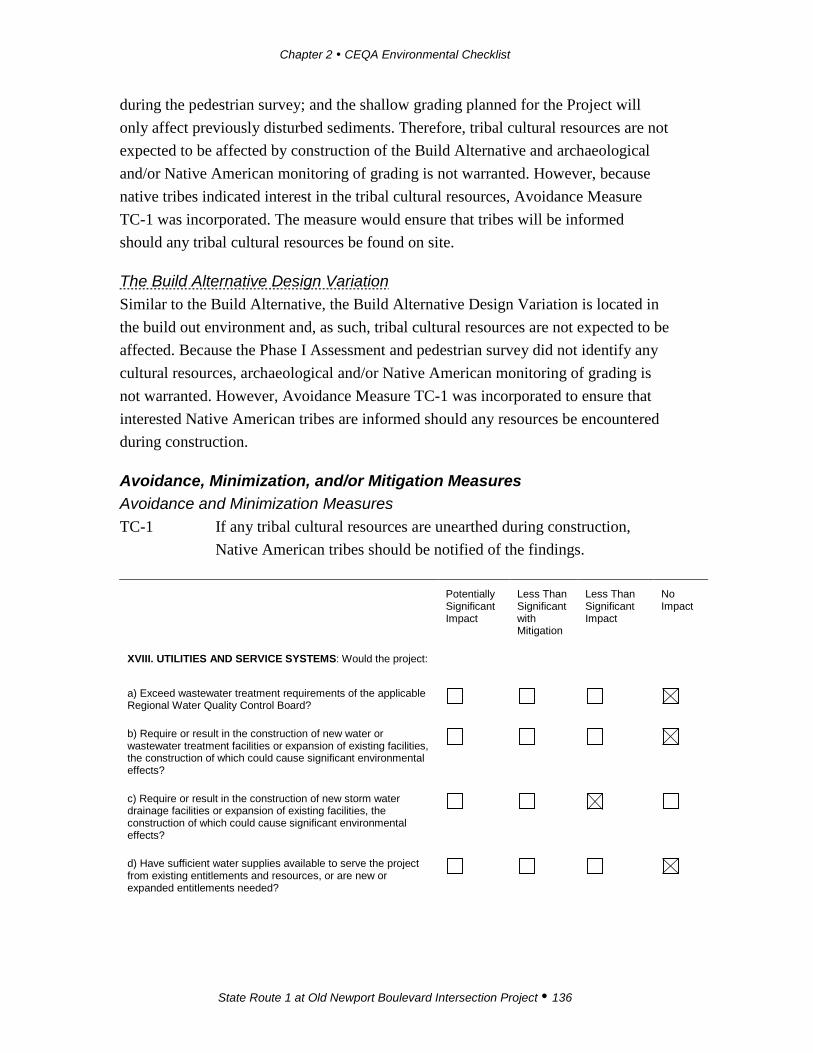
Chapter 2 CEQA Environmental Checklist
State Route 1 at Old Newport Boulevard Intersection Project 136
during the pedestrian survey; and the shallow grading planned for the Project will only affect previously disturbed sediments. Therefore, tribal cultural resources are not expected to be affected by construction of the Build Alternative and archaeological and/or Native American monitoring of grading is not warranted. However, because native tribes indicated interest in the tribal cultural resources, Avoidance Measure TC-1 was incorporated. The measure would ensure that tribes will be informed should any tribal cultural resources be found on site.
The Build Alternative Design Variation Similar to the Build Alternative, the Build Alternative Design Variation is located in the build out environment and, as such, tribal cultural resources are not expected to be affected. Because the Phase I Assessment and pedestrian survey did not identify any cultural resources, archaeological and/or Native American monitoring of grading is not warranted. However, Avoidance Measure TC-1 was incorporated to ensure that interested Native American tribes are informed should any resources be encountered during construction.
Avoidance, Minimization, and/or Mitigation Measures Avoidance and Minimization Measures TC-1 If any tribal cultural resources are unearthed during construction,
Native American tribes should be notified of the findings.
Potentially Significant Impact
Less Than Significant with Mitigation
Less Than Significant Impact
No Impact
XVIII. UTILITIES AND SERVICE SYSTEMS: Would the project:
a) Exceed wastewater treatment requirements of the applicable Regional Water Quality Control Board?
b) Require or result in the construction of new water or wastewater treatment facilities or expansion of existing facilities, the construction of which could cause significant environmental effects?
c) Require or result in the construction of new storm water drainage facilities or expansion of existing facilities, the construction of which could cause significant environmental effects?
d) Have sufficient water supplies available to serve the project from existing entitlements and resources, or are new or expanded entitlements needed?

Chapter 2 CEQA Environmental Checklist
State Route 1 at Old Newport Boulevard Intersection Project 137
Potentially Significant Impact
Less Than Significant with Mitigation
Less Than Significant Impact
No Impact
e) Result in a determination by the wastewater treatment provider which serves or may serve the project that it has adequate capacity to serve the project’s projected demand in addition to the provider’s existing commitments?
f) Be served by a landfill with sufficient permitted capacity to accommodate the project’s solid waste disposal needs?
g) Comply with federal, state, and local statutes and regulations related to solid waste?
Affected Environment The Orange County Sanitation District (OCSD) provides wastewater treatment services to the 479 square miles of northern and central Orange County, including the City of Newport Beach. In 2012, the OCSD completed two new treatment plant projects that were designed to treat the wastewater to secondary standards. Both plants are currently working and treating wastewater to levels that exceed preliminary design expectations.
The Metropolitan Water District of Southern California (MWDSC) supplies imported treated surface water to the City of Newport Beach. In addition, groundwater is imported from a 350-square-mile underground aquifer that is replenished with water from Santa Ana River, local rainfall, and imported water. During the past three years Southern California has experienced drought conditions and, as water has become more scarce, new water conservation bills and water conservation best management practices have been recommended.
The City contracts with Waste Management of Orange County to collect and dispose of the City’s solid waste. The solid waste is disposed of at the Frank R. Bowerman Landfill in Irvine. The Bowerman Landfill, which is operated by OC Waste & Recycling, is a 725-acre facility that is operating at a maximum daily permitting capacity of 8,500 tons per day. The landfill has a remaining capacity of 44.6 million tons and is expected to remain open until 2022. The California Integrated Waste Management Act of 1989 (AB 939) required that local jurisdictions divert at least 50 percent of all solid waste generated by January 1, 2000. The City consistently complies with AB 939 by diverting 50 percent or more of its solid waste.

Chapter 2 CEQA Environmental Checklist
State Route 1 at Old Newport Boulevard Intersection Project 138
Environmental Consequences Checklist Questions a, b, d, and e The Build Alternative The Build Alternative would result in improvements to an existing roadway intersection, and would not result in any new land uses that would consume water or generate wastewater. Therefore, it would not result in a need to treat water and would not result in an exceedance of wastewater treatment requirements or require the expansion of any existing facilities. Similarly, since the Project would not result in increased demand for potable water or modify water supply chains, there would be no impact on City water supplies.
The Build Alternative Design Variation The Build Alternative Design Variation would result in improvements to an existing roadway intersection, and would not result in any new land uses that would consume water or generate wastewater. Therefore, it would not result in a need to treat water.
No-Build Alternative The No-Build Alternative would not result in construction and would not require provision of additional utilities.
Checklist Question c The Build Alternative As discussed under checklist question “a” in Section IX, Hydrology and Water Quality, the Project area is currently served by existing storm drain facilities (pipes and box structures) that drain from north to south and outlet into Newport Bay. The majority of the storm flows sheet-flow from the residential area north of SR-1 and east of Old Newport Boulevard.
The Build Alternative would construct two new catch basins to convey flows and connector pipes to existing drainage pipes in Old Newport Boulevard. Catch Basin 1 would be constructed on the southeast corner of Old Newport Boulevard and Santa Ana Avenue, and Catch Basin 2 would be constructed on the northeast corner of SR-1 and Old Newport Boulevard. These basins would be adequately sized to capture pollutants and handle storm water flows; therefore, their construction would not result in an adverse environmental effect.
The Build Alternative Design Variation As discussed under checklist question “a” in Section IX, Hydrology and Water Quality, several water quality treatment and capture features are proposed as part of
Chapter 2 CEQA Environmental Checklist
State Route 1 at Old Newport Boulevard Intersection Project 139
the Build Alternative. The Build Alternative Design Variation would construct five catch basins and connector pipes to existing drainage pipes/RCBs in Old Newport Boulevard. In addition, one existing catch basin would be reconstructed in order to capture flows from the realigned intersection. Catch Basin 1 would be constructed north of the existing catch basin on the east side of Old Newport Boulevard north of Santa Ana Avenue. The existing Catch Basin 2, on the west side of Old Newport Boulevard north of Santa Ana Avenue, would be reconstructed due to the revised curb alignment at this location. This catch basin would pick up the flows from the northwest corner of SR-1/Old Newport Boulevard. Catch Basin 3 would be constructed on the northeast corner of Old Newport Boulevard and Santa Ana Avenue. Catch Basin 4 is a sump that would be constructed on the southeast corner of Old Newport Boulevard and Santa Ana Avenue. Catch Basin 5 would be constructed on the northeast corner of SR-1 and Old Newport Boulevard. These catch basins would be designed to handle severe storm events. The construction of a new storm water system would improve the water quality on site and would improve the ground percolation of the site; thus, the Build Alternative Design Variation would have a beneficial effect to the site.
No-Build Alternative The No-Build Alternative would not result in construction and would not require provision of additional utilities.
Checklist Questions f and g The Build Alternative As stated above, the City diverts 50 percent or more of solid waste from the landfill. The Build Alternative would result in generation of 800 cubic yards of construction waste during the construction phase. The City remains committed to continuing to reduce and minimize solid waste. Because the Frank R. Bowerman Landfill has a substantial remaining capacity available to accept waste, the Project would be served by a landfill with sufficient permitted capacity to accommodate the Project’s solid waste disposal need. Therefore, the Build Alternative would not conflict with federal, State, or local statutes or regulations regarding solid waste.
The Build Alternative Design Variation The Build Alternative Design Variation would result in generation of 1,800 cubic yards of construction waste during the construction phase. All waste, soils, and demolished materials would be hauled off to the Frank R. Bowerman Landfill, which has sufficient permitted capacity to accommodate this Project’s solid waste disposal
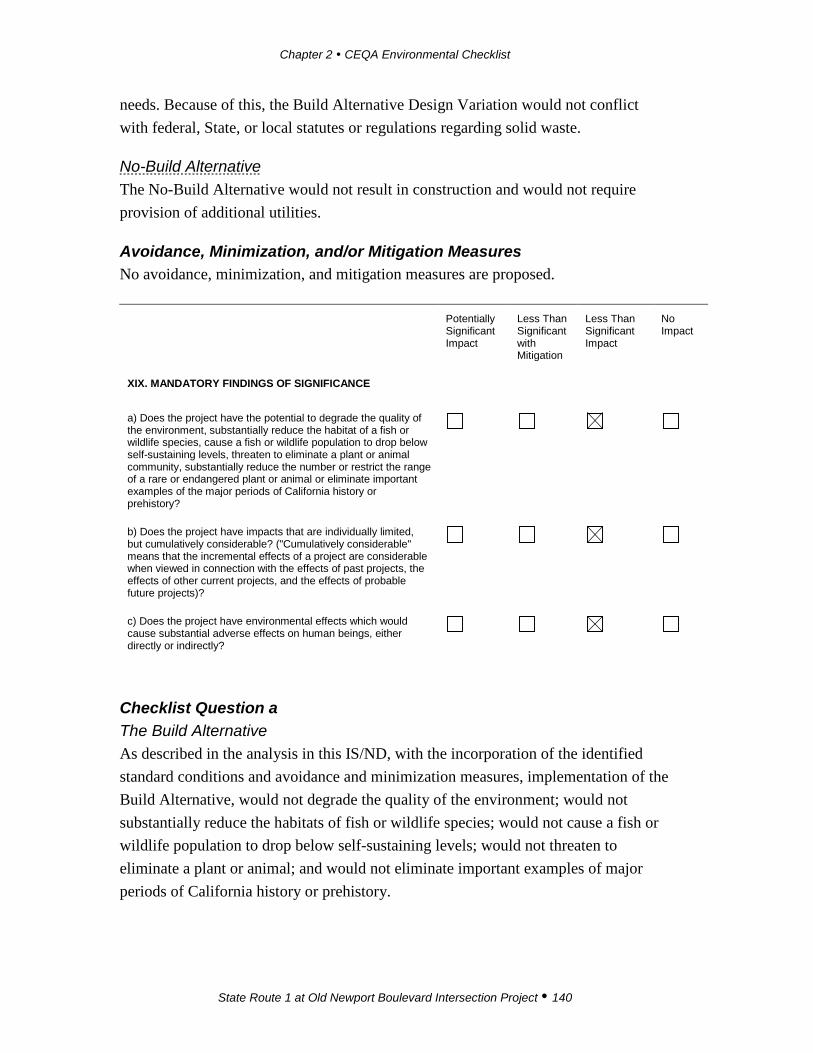
Chapter 2 CEQA Environmental Checklist
State Route 1 at Old Newport Boulevard Intersection Project 140
needs. Because of this, the Build Alternative Design Variation would not conflict with federal, State, or local statutes or regulations regarding solid waste.
No-Build Alternative The No-Build Alternative would not result in construction and would not require provision of additional utilities.
Avoidance, Minimization, and/or Mitigation Measures No avoidance, minimization, and mitigation measures are proposed.
Potentially Significant Impact
Less Than Significant with Mitigation
Less Than Significant Impact
No Impact
XIX. MANDATORY FINDINGS OF SIGNIFICANCE
a) Does the project have the potential to degrade the quality of the environment, substantially reduce the habitat of a fish or wildlife species, cause a fish or wildlife population to drop below self-sustaining levels, threaten to eliminate a plant or animal community, substantially reduce the number or restrict the range of a rare or endangered plant or animal or eliminate important examples of the major periods of California history or prehistory?
b) Does the project have impacts that are individually limited, but cumulatively considerable? ("Cumulatively considerable" means that the incremental effects of a project are considerable when viewed in connection with the effects of past projects, the effects of other current projects, and the effects of probable future projects)?
c) Does the project have environmental effects which would cause substantial adverse effects on human beings, either directly or indirectly?
Checklist Question a The Build Alternative As described in the analysis in this IS/ND, with the incorporation of the identified standard conditions and avoidance and minimization measures, implementation of the Build Alternative, would not degrade the quality of the environment; would not substantially reduce the habitats of fish or wildlife species; would not cause a fish or wildlife population to drop below self-sustaining levels; would not threaten to eliminate a plant or animal; and would not eliminate important examples of major periods of California history or prehistory.

Chapter 2 CEQA Environmental Checklist
State Route 1 at Old Newport Boulevard Intersection Project 141
The Build Alternative Design Variation As described in the analysis in this IS/ND, with the incorporation of the identified standard conditions and avoidance and minimization measures, implementation of the Build Alternative Design Variation, would not degrade the quality of the environment; would not substantially reduce the habitats of fish or wildlife species; would not cause a fish or wildlife population to drop below self-sustaining levels; would not threaten to eliminate a plant or animal; and would not eliminate important examples of major periods of California history or prehistory.
Checklist Question b As discussed in Chapter 2, the Project would have limited direct impacts. The cumulative analysis focuses on the resources that the Project may affect. If the Project would not result in impacts to a resource, it could not contribute to a cumulative impact. The evaluation addresses projects likely to have impacts of a similar nature as Project where, combined, the effects may be significant. Additionally, the cumulative analysis focuses on projects in the Project vicinity where there is potential for the impacts to overlap, thereby potentially increasing the overall magnitude of the impacts. Table 2.14 provides a listing of projects identified as potentially contributing to cumulative impacts.
Table 2.14 Cumulative Projects in the Project Vicinity
Name Jurisdiction Proposed Uses Status
Traffic and Pedestrian Signal Replacement
City of Newport Beach
Replace weathered traffic and pedestrian signal heads and mounting brackets at 10 locations.
Approved
Park Ave Bridge Replacement Project
City of Newport Beach
Demolish the existing Park Ave Bridge and construct an improved, seismically reinforced bridge over the Grand Canal. The new bridge would include 11-foot vehicle lanes, 6-foot raised sidewalks, and switchback ramps that are compliant with the Americans with Disability Act (ADA). During construction, a temporary bridge will be installed at Balboa Ave.
Approved

Chapter 2 CEQA Environmental Checklist
State Route 1 at Old Newport Boulevard Intersection Project 142
Table 2.14 Cumulative Projects in the Project Vicinity
Name Jurisdiction Proposed Uses Status
Newport Boulevard and 32nd St Modification Project
City of Newport Beach
Add an additional northbound through lane along Newport Blvd from 30th St to 32nd St and an additional southbound through lane along Newport Blvd from Via Lido to 32nd St. This project also includes a raised, landscaped median and 6-foot-wide bike lanes.
Approved
15th St/Balboa Reconstruction
City of Newport Beach
Reconstruct the median and landscape 15th St between West Bay Ave and West Oceanfront, and on West Balboa Blvd from 12th St to 19th St
Design phase
Bayside Dr Modification
City of Newport Beach
Modify existing pavement striping and construct new raised landscaped medians on Bayside Dr. Reconstruct the pavement on Bayside Dr and Jamboree Rd.
Planning phase
Bristol St Traffic Signal Sync
City of Newport Beach
Complete upgrades to the traffic signal control hardware and closed circuit television (CCTV) cameras at 8 intersections.
Planning phase
MacArthur Blvd Pavement Rehabilitation
City of Newport Beach
Replace project grinds and overlays on MacArthur Blvd with rubberized asphalt concrete.
Design phase
Newport Blvd Traffic Signal Sync
City of Newport Beach
Update traffic signal controls at 8 intersections and complete gaps. Construction phase
Banning Ranch City of Newport Beach
Allows for 1,375 residential dwelling units; 75,000 square feet of commercial uses; a 75-room resort inn with ancillary resort uses; approximately 51.4 gross acres of parks; and approximately 252.3 gross acres of permanent open space.
NOD posted
Sunset Ridge Park City of Newport Beach
Constructs a 13.67-acre park on 18.9 acres at the northwest corner of West Coast Hwy and Superior Avenue in the West Newport community.
Construction phase
Chapter 2 CEQA Environmental Checklist
State Route 1 at Old Newport Boulevard Intersection Project 143
The Build Alternative As shown in the Table 2.14 above, there are eight transportation projects in various phases of development in proximity of the Project site. Construction of these projects could overlap construction of the SR-1/Old Newport Boulevard Project. However, since all these projects are relatively small, no cumulative significant impacts are expected. Appropriate standard conditions and avoidance and minimization measures, similar to those that have been identified for the Project, would also be applicable to the cumulative projects, thereby minimizing the potential for cumulative impacts. Implementation of the Build Alternative would result in improvements to an existing roadway intersection. Project construction would result in improved geometry of the existing intersection and would alleviate future congestion that would occur if Project improvements are not implemented. Temporary and permanent impacts from the SR-1/Old Newport Boulevard Project would not be cumulatively considerable in conjunction with other projects.
The Build Alternative Design Variation The majority of projects listed in Table 2.14 are small transportation projects, and construction of these projects could overlap with construction of the SR-1/Old Newport Boulevard Project. As discussed under the Build Alternative, the appropriate standard conditions and avoidance and minimization measures, similar to those that have been identified for the Project, would also be applicable to the cumulative projects, thereby minimizing the potential for cumulative impacts. Implementation of the Build Alternative Design Variation would result in improvements to an existing roadway intersection. Project construction would result in improved geometry of the existing intersection and would alleviate future congestion that would occur if Project improvements are not implemented. Temporary and permanent impacts from SR-1/Old Newport Boulevard Project would not be cumulatively considerable in conjunction with other projects.
Checklist Question c The Build Alternative Implementation of the Build Alternative would improve the function of the intersection and would enhance biking opportunities; therefore, the Build Alternative is designed to provide benefits to local populations. None of the elements of the design would incorporate features that would result in environmental effects that would cause a substantially adverse effect on human beings either directly or indirectly.

Chapter 2 CEQA Environmental Checklist
State Route 1 at Old Newport Boulevard Intersection Project 144
The Build Alternative Design Variation Implementation of the Build Alternative Design Variation would improve the function of the intersection and enhance biking opportunities; therefore, the Build Alternative Design Variation is designed to provide benefits to local populations. None of the elements of the design would incorporate features that would result in environmental effects that would cause a substantially adverse effect on human beings either directly or indirectly.
State Route 1 at Old Newport Boulevard Intersection Project 145
Chapter 3 Climate Change Discussion
3.1 Regulatory Setting
3.1.1 State With the passage of several pieces of legislation, including State Senate and Assembly Bills and Executive Orders, California launched an innovative and proactive approach to dealing with GHG emissions and climate change.
Assembly Bill 1493 (AB 1493), Pavley, Vehicular Emissions: Greenhouse Gases, 2002: This bill requires the California Air Resources Board (CARB) to develop and implement regulations to reduce automobile and light truck GHG emissions. These stricter emissions standards were designed to apply to automobiles and light trucks beginning with the 2009 model year.
Executive Order (EO) S-3-05 (June 1, 2005): The goal of this EO is to reduce California’s GHG emissions to 1) year 2000 levels by 2010, 2) year 1990 levels by 2020, and 3) 80 percent below the year 1990 levels by 2050. In 2006, this goal was further reinforced with the passage of Assembly Bill 32.
Assembly Bill 32 (AB 32), Núñez and Pavley, The Global Warming Solutions Act of 2006: AB 32 sets the same overall GHG emissions reduction goals as outlined in EO S-3-05, while further mandating that CARB create a scoping plan and implement rules to achieve “real, quantifiable, cost-effective reductions of greenhouse gases.”
Executive Order S-20-06 (October 18, 2006): This order establishes the responsibilities and roles of the Secretary of the California Environmental Protection Agency (Cal/EPA) and State agencies with regard to climate change.
Executive Order S-01-07 (January 18, 2007): This order set forth the low carbon fuel standard for California. Under this EO, the carbon intensity of California’s transportation fuels is to be reduced by at least 10 percent by 2020.
Executive Order B-30-15 (April 29, 2015): This order establishes a new interim statewide GHG emissions reduction target of 40 percent below 1990 levels by 2030.
Senate Bill 97 (SB 97) Chapter 185, Greenhouse Gas Emissions (2007): This bill required the Governor’s Office of Planning and Research (OPR) to develop recommended amendments to the California Environmental Quality Act (CEQA)
Chapter 3 Climate Change Discussion
State Route 1 at Old Newport Boulevard Intersection Project 146
Guidelines for addressing GHG emissions. The amendments became effective on March 18, 2010.
Senate Bill 375 (SB 375), Chapter 728, Sustainable Communities and Climate Protection (2008): This bill requires CARB to set regional emissions reduction targets from passenger vehicles. The Metropolitan Planning Organization (MPO) for each region must then develop a “Sustainable Communities Strategy” (SCS) that integrates transportation, land-use, and housing policies to plan for the achievement of the emissions target for their region.
Senate Bill 391 (SB 391) Chapter 585, 2009 California Transportation Plan (2009): This bill requires the State’s long-range transportation plan to meet California’s climate change goals under AB 32.
Senate Bill 350 (SB 350), Chapter 547, Clean Energy and Pollution Reduction Act of 2015: SB 350 implements some of the goals of EO B-30-15. The text of SB 350 sets a December 31, 2030, target for 50 percent of electricity to be generated from renewable sources.
3.1.2 Federal Although climate change and GHG reduction are a concern at the federal level, currently no regulations or legislation have been enacted specifically addressing GHG emissions reductions and climate change at the project level. Neither the United States Environmental Protection Agency (USEPA) nor the Federal Highway Administration (FHWA) has issued explicit guidance or methods to conduct project-level GHG analysis.5 The FHWA supports the approach that climate change considerations should be integrated throughout the transportation decision-making process—from planning through project development and delivery. Addressing climate change mitigation and adaptation up front in the planning process will assist in decision-making; will improve efficiency at the program level; and will inform the analysis and stewardship needs of project-level decision-making. Climate change considerations can be integrated into many planning factors, such as supporting economic vitality and global efficiency, increasing safety and mobility, enhancing the environment, promoting energy conservation, and improving quality of life.
5 To date, no national standards have been established regarding mobile source GHGs, nor has the
USEPA established any ambient standards, criteria, or thresholds for GHGs resulting from mobile sources.

Chapter 3 Climate Change Discussion
State Route 1 at Old Newport Boulevard Intersection Project 147
The four strategies outlined by FHWA to lessen climate change impacts correlate with efforts that the State is undertaking to deal with transportation and climate change; these strategies include improved transportation system efficiency, cleaner fuels, cleaner vehicles, and a reduction in travel activity.
Climate change and its associated effects are also being addressed through various efforts at the federal level to improve fuel economy and energy efficiency, such as the “National Clean Car Program” and Executive Order 13514 – Federal Leadership in Environmental, Energy and Economic Performance.
Executive Order 13514 (October 5, 2009): This order is focused on reducing greenhouse gases internally in federal agency missions, programs and operations, but also directs federal agencies to participate in the Interagency Climate Change Adaptation Task Force, which is engaged in developing a national strategy for adaptation to climate change.
The USEPA’s authority to regulate GHG emissions stems from the U.S. Supreme Court decision in Massachusetts v. EPA (2007). The Supreme Court ruled that GHGs meet the definition of air pollutants under the existing Clean Air Act and must be regulated if these gases could be reasonably anticipated to endanger public health or welfare. Responding to the Court’s ruling, the USEPA finalized an endangerment finding in December 2009. Based on scientific evidence, it found that six greenhouse gases constitute a threat to public health and welfare. Thus, it is the Supreme Court’s interpretation of the existing Act and USEPA’s assessment of the scientific evidence that form the basis for its regulatory actions. The USEPA, in conjunction with the National Highway Transportation Safety Administration (NHTSA), issued the first of a series of GHG emission standards for new cars and light-duty vehicles in April 2010.6
The USEPA and the NHTSA are taking coordinated steps to enable the production of a new generation of clean vehicles with reduced GHG emissions and improved fuel efficiency from on-road vehicles and engines. These next steps include developing the first-ever GHG regulations for heavy-duty engines and vehicles, as well as additional light-duty vehicle GHG regulations.
The final combined standards that made up the first phase of this national program apply to passenger cars, light-duty trucks, and medium-duty passenger vehicles,
6 http://www.c2es.org/federal/executive/epa/greenhouse-gas-regulation-faq

Chapter 3 Climate Change Discussion
State Route 1 at Old Newport Boulevard Intersection Project 148
covering model years 2012 through 2016. The standards implemented by this program are expected to reduce GHG emissions by an estimated 960 million metric tons and 1.8 billion barrels of oil over the lifetime of the vehicles sold under the program (model years 2012–2016).
On August 28, 2012, the USEPA and the NHTSA issued a joint Final Rulemaking to extend the National Program for fuel economy standards to model year 2017 through 2025 passenger vehicles. Over the lifetime of the model year 2017–2025 standards, this program is projected to save approximately four billion barrels of oil and two billion metric tons of GHG emissions.
The complementary USEPA and NHTSA standards that make up the Heavy-Duty National Program apply to combination tractors (semi-trucks), heavy-duty pickup trucks and vans, and vocational vehicles (including buses and refuse or utility trucks). Together, these standards will cut greenhouse gas emissions and domestic oil use significantly. This program responds to President Barack Obama’s 2010 request to jointly establish greenhouse gas emissions and fuel efficiency standards for the medium- and heavy-duty highway vehicle sector. The agencies estimate that the combined standards will reduce carbon dioxide (CO2) emissions by about 270 million metric tons and save about 530 million barrels of oil over the life of model year 2014–2018 heavy duty vehicles.
On December 18, 2014, the White House Council on Environmental Quality (CEQ) released the Revised Draft Guidance on the Consideration of Greenhouse Gas Emissions and the Effects of Climate Change in NEPA Reviews (2014 Draft Guidance). The 2014 Draft Guidance is not a rule or regulation and is not legally enforceable; the non-mandatory language is intended to describe CEQ policies and recommendations. The 2014 Draft Guidance provides a “reference point” of 25,000 metric tons of carbon dioxide equivalent emissions on an annual basis (MTCO2e/year); if an Action would generate less than this amount, a quantitative analysis of greenhouse gas is not “warranted”.
3.2 Project Analysis
An individual project does not generate enough GHG emissions to significantly influence global climate change. Rather, global climate change is a cumulative impact. This means that a project may contribute to a potential impact through its incremental change in emissions when combined with the contributions of all other

Chapter 3 Climate Change Discussion
State Route 1 at Old Newport Boulevard Intersection Project 149
sources of GHG.7 In assessing cumulative impacts, it must be determined if a project’s incremental effect is “cumulatively considerable” (CEQA Guidelines Sections 15064(h)(1) and 15130). To make this determination, the incremental impacts of the project must be compared with the effects of past, current, and probable future projects. To gather sufficient information on a global scale of all past, current, and future projects to make this determination is a difficult, if not impossible, task.
The AB 32 Scoping Plan mandated by AB 32 includes the main strategies California will use to reduce GHG emissions. As part of its supporting documentation for the Draft Scoping Plan, the CARB released the GHG inventory for California (forecast last updated: October 28, 2010). The forecast, refer to Figure 4, is an estimate of the emissions expected to occur in 2020 if none of the foreseeable measures included in the Scoping Plan were implemented. The base year used for forecasting emissions is the average of statewide emissions in the GHG inventory for 2006, 2007, and 2008.
Figure 4: California Greenhouse Gas Forecast
Source: http://www.arb.ca.gov/cc/inventory/data/forecast.htm
7 This approach is supported by the AEP: Recommendations by the Association of Environmental
Professionals on How to Analyze GHG Emissions and Global Climate Change in CEQA Documents (March 5, 2007), as well as the South Coast Air Quality Management District (Chapter 6: The CEQA Guide, April 2011) and the U.S. Forest Service (Climate Change Considerations in Project Level NEPA Analysis, July 13, 2009).
Chapter 3 Climate Change Discussion
State Route 1 at Old Newport Boulevard Intersection Project 150
Caltrans and its parent agency, the Transportation Agency, have taken an active role in addressing GHG emission reduction and climate change. Recognizing that 98 percent of California’s GHG emissions are from the burning of fossil fuels and 40 percent of all human made GHG emissions are from transportation, Caltrans has created and is implementing the Climate Action Program at Caltrans that was published in December 2006.8
Neither the Build Alternative nor the Build Alternative Design Variation would generate traffic or cause a change in traffic volumes. As discussed in Section XVI, Transportation/Traffic, of Chapter 2, Impact Checklist, there will be no change in the level of service (LOS) at the two Project intersections. For all scenarios analyzed, the Project would improve LOS in the PM peak hour and the Saturday peak hour at the SR-1/Old Newport Boulevard intersection (an unsignalized intersection), and the Project would create no LOS change in the AM peak hour. Based on this data, it is concluded that changes in vehicle pollutant GHG emissions between build and no-build conditions would be negligible. There would be no operational impact on GHG emissions from the Build Alternative or the Build Alternative Design Variation.
3.2.1 Construction Emissions Greenhouse gas emissions for transportation projects can be divided into those produced during construction and those produced during operations. Construction GHG emissions include emissions produced as a result of material processing; emissions produced by on-site construction equipment; and emissions arising from traffic delays due to construction. These emissions would be produced at different levels throughout the construction phase; their frequency and occurrence can be reduced through innovations in plans and specifications and by implementing better traffic management during construction phases.
In addition, with innovations such as long-life concrete pavements, improved traffic management plans, and changes in materials, the GHG emissions produced during construction can be mitigated to some degree by longer intervals between maintenance and rehabilitation events.
8 Caltrans Climate Action Program is located at the following web address:
http://www.dot.ca.gov/hq/tpp/offices/ogm/key_reports_files/State_Wide_Strategy/Caltrans_Climate_Action_Program.pdf
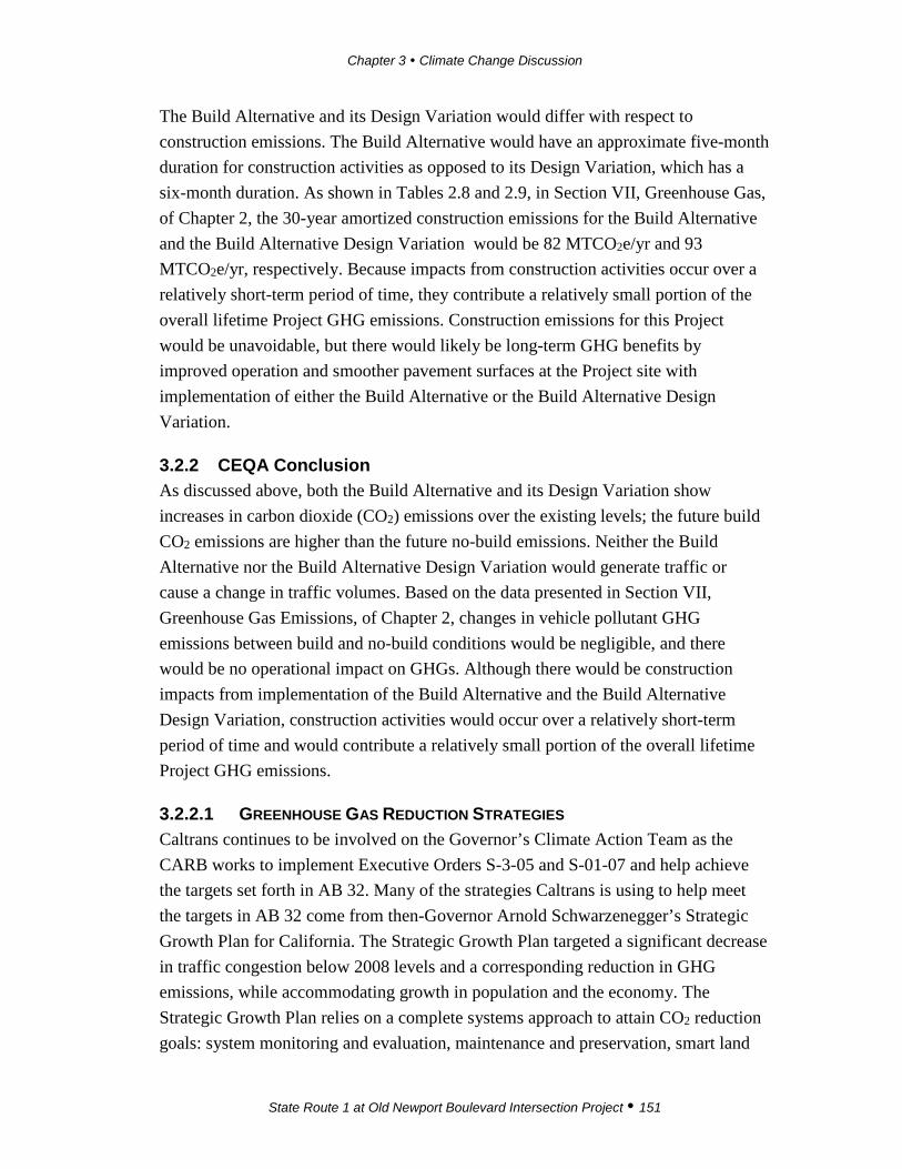
Chapter 3 Climate Change Discussion
State Route 1 at Old Newport Boulevard Intersection Project 151
The Build Alternative and its Design Variation would differ with respect to construction emissions. The Build Alternative would have an approximate five-month duration for construction activities as opposed to its Design Variation, which has a six-month duration. As shown in Tables 2.8 and 2.9, in Section VII, Greenhouse Gas, of Chapter 2, the 30-year amortized construction emissions for the Build Alternative and the Build Alternative Design Variation would be 82 MTCO2e/yr and 93 MTCO2e/yr, respectively. Because impacts from construction activities occur over a relatively short-term period of time, they contribute a relatively small portion of the overall lifetime Project GHG emissions. Construction emissions for this Project would be unavoidable, but there would likely be long-term GHG benefits by improved operation and smoother pavement surfaces at the Project site with implementation of either the Build Alternative or the Build Alternative Design Variation.
3.2.2 CEQA Conclusion As discussed above, both the Build Alternative and its Design Variation show increases in carbon dioxide (CO2) emissions over the existing levels; the future build CO2 emissions are higher than the future no-build emissions. Neither the Build Alternative nor the Build Alternative Design Variation would generate traffic or cause a change in traffic volumes. Based on the data presented in Section VII, Greenhouse Gas Emissions, of Chapter 2, changes in vehicle pollutant GHG emissions between build and no-build conditions would be negligible, and there would be no operational impact on GHGs. Although there would be construction impacts from implementation of the Build Alternative and the Build Alternative Design Variation, construction activities would occur over a relatively short-term period of time and would contribute a relatively small portion of the overall lifetime Project GHG emissions.
3.2.2.1 GREENHOUSE GAS REDUCTION STRATEGIES Caltrans continues to be involved on the Governor’s Climate Action Team as the CARB works to implement Executive Orders S-3-05 and S-01-07 and help achieve the targets set forth in AB 32. Many of the strategies Caltrans is using to help meet the targets in AB 32 come from then-Governor Arnold Schwarzenegger’s Strategic Growth Plan for California. The Strategic Growth Plan targeted a significant decrease in traffic congestion below 2008 levels and a corresponding reduction in GHG emissions, while accommodating growth in population and the economy. The Strategic Growth Plan relies on a complete systems approach to attain CO2 reduction goals: system monitoring and evaluation, maintenance and preservation, smart land
Chapter 3 Climate Change Discussion
State Route 1 at Old Newport Boulevard Intersection Project 152
use and demand management, and operational improvements, as shown in Figure 5 The Mobility Pyramid.
Figure 5: Mobility Pyramid
Caltrans is supporting efforts to reduce vehicle miles traveled by planning and implementing smart land use strategies: job/housing proximity, developing transit-oriented communities, and high-density housing along transit corridors. Caltrans works closely with local jurisdictions on planning activities, but does not have local land use planning authority. Caltrans assists efforts to improve the energy efficiency of the transportation sector by increasing vehicle fuel economy in new cars and in light and heavy-duty trucks; Caltrans is doing this by supporting ongoing research efforts at universities, by supporting legislative efforts to increase fuel economy, and by participating on the Climate Action Team. It is important to note, however, that control of fuel economy standards is held by the USEPA and CARB.
Caltrans is also working towards enhancing the State’s transportation planning process to respond to future challenges. Similar to requirements for regional transportation plans under Senate Bill (SB) 375 (Steinberg 2008), SB 391 (Liu 2009) requires the State’s long-range transportation plan to meet California’s climate change goals under Assembly Bill (AB) 32.
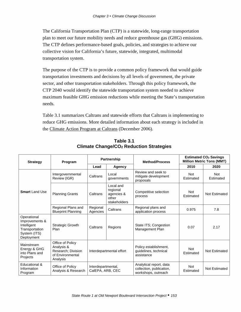
Chapter 3 Climate Change Discussion
State Route 1 at Old Newport Boulevard Intersection Project 153
The California Transportation Plan (CTP) is a statewide, long-range transportation plan to meet our future mobility needs and reduce greenhouse gas (GHG) emissions. The CTP defines performance-based goals, policies, and strategies to achieve our collective vision for California’s future, statewide, integrated, multimodal transportation system.
The purpose of the CTP is to provide a common policy framework that would guide transportation investments and decisions by all levels of government, the private sector, and other transportation stakeholders. Through this policy framework, the CTP 2040 would identify the statewide transportation system needed to achieve maximum feasible GHG emission reductions while meeting the State’s transportation needs.
Table 3.1 summarizes Caltrans and statewide efforts that Caltrans is implementing to reduce GHG emissions. More detailed information about each strategy is included in the Climate Action Program at Caltrans (December 2006).
Table 3.1 Climate Change/CO2 Reduction Strategies
Strategy Program Partnership
Method/Process Estimated CO2 Savings
Million Metric Tons (MMT) Lead Agency 2010 2020
Smart Land Use
Intergovernmental Review (IGR) Caltrans Local
governments
Review and seek to mitigate development proposals
Not Estimated
Not Estimated
Planning Grants Caltrans
Local and regional agencies & other stakeholders
Competitive selection process
Not Estimated Not Estimated
Regional Plans and Blueprint Planning
Regional Agencies Caltrans Regional plans and
application process 0.975 7.8
Operational Improvements & Intelligent Transportation System (ITS) Deployment
Strategic Growth Plan Caltrans Regions State ITS; Congestion
Management Plan 0.07 2.17
Mainstream Energy & GHG into Plans and Projects
Office of Policy Analysis & Research; Division of Environmental Analysis
Interdepartmental effort Policy establishment, guidelines, technical assistance
Not Estimated Not Estimated
Educational & Information Program
Office of Policy Analysis & Research
Interdepartmental, CalEPA, ARB, CEC
Analytical report, data collection, publication, workshops, outreach
Not Estimated Not Estimated

Chapter 3 Climate Change Discussion
State Route 1 at Old Newport Boulevard Intersection Project 154
Table 3.1 Climate Change/CO2 Reduction Strategies
Strategy Program Partnership
Method/Process Estimated CO2 Savings
Million Metric Tons (MMT) Lead Agency 2010 2020
Fleet Greening & Fuel Diversification
Division of Equipment
Department of General Services
Fleet Replacement B20 B100
0.0045 0.0065 0.045 0.0225
Non-vehicular Conservation Measures
Energy Conservation Program Green Action Team Energy Conservation
Opportunities 0.117 0.34
Portland Cement Office of Rigid Pavement
Cement and Construction Industries
2.5 % limestone cement mix 25% fly ash cement mix > 50% fly ash/slag mix
1.2
0.36
4.2
3.6
Goods Movement Office of Goods Movement
Cal EPA, ARB, BT&H, MPOs
Goods Movement Action Plan
Not Estimated Not Estimated
Total 2.72 18.18
Climate Change (June 22, 2012): is intended to establish a Caltrans policy that will ensure coordinated efforts to incorporate climate change into Caltrans decisions and activities.
Caltrans Activities to Address Climate Change (April 2013)9 provides a comprehensive overview of activities undertaken by Caltrans statewide to reduce greenhouse gas emissions resulting from agency operations.
The following measures would also be included in the Project to reduce the GHG emissions and potential climate change impacts from the Project:
• Landscaping reduces surface warming and, through photosynthesis, decreases CO2. The Project proposes planting in the intersection slopes and drainage basin. The landscaping would help offset potential CO2 emissions increase.
• Placing idling restrictions for trucks and equipment at construction sites would reduce fuel usage.
3.2.2.2 ADAPTATION STRATEGIES “Adaptation strategies” refer to how Caltrans and others can plan for the effects of climate change on the state’s transportation infrastructure and strengthen or protect the facilities from damage. Climate change is expected to produce increased
9 http://www.dot.ca.gov/hq/tpp/offices/orip/climate_change/projects_and_studies.shtml
Chapter 3 Climate Change Discussion
State Route 1 at Old Newport Boulevard Intersection Project 155
variability in precipitation, rising temperatures, rising sea levels, variability in storm surges and intensity, and the frequency and intensity of wildfires. These changes may affect the transportation infrastructure in various ways, such as damage to roadbeds from longer periods of intense heat; increasing storm damage from flooding and erosion; and inundation from rising sea levels. These effects would vary by location and may, in the most extreme cases, require that a facility be relocated or redesigned. There may also be economic and strategic ramifications as a result of these types of impacts to the transportation infrastructure.
At the federal level, the Climate Change Adaptation Task Force, co-chaired by the White House Council on Environmental Quality (CEQ), the Office of Science and Technology Policy (OSTP), and the National Oceanic and Atmospheric Administration (NOAA), released its interagency task force progress report on October 28, 2011,10 outlining the federal government’s progress in expanding and strengthening the Nation’s capacity to better understand, prepare for, and respond to extreme events and other climate change impacts. The report provides an update on actions in key areas of federal adaptation, including building resilience in local communities, safeguarding critical natural resources such as freshwater, and providing accessible climate information and tools to help decision-makers manage climate risks.
Climate change adaptation must also involve the natural environment. Efforts are underway on a statewide-level to develop strategies to cope with impacts to habitat and biodiversity through planning and conservation. The results of these efforts will help California agencies plan and implement mitigation strategies for programs and projects.
On November 14, 2008, then-Governor Arnold Schwarzenegger signed EO S-13-08, which directed a number of State agencies to address California’s vulnerability to sea level rise caused by climate change. This EO set in motion several agencies and actions to address the concern of sea level rise.
In addition to addressing projected sea level rise, the California Natural Resources Agency (Resources Agency) was directed to coordinate with local, regional, State, and federal public and private entities to develop The California Climate Adaptation
10 http://www.whitehouse.gov/administration/eop/ceq/initiatives/adaptation
Chapter 3 Climate Change Discussion
State Route 1 at Old Newport Boulevard Intersection Project 156
Strategy (December 2009),11 which summarizes the best-known science on climate change impacts to California, assesses California’s vulnerability to the identified impacts, and then outlines solutions that can be implemented within and across State agencies to promote resiliency.
The strategy outline is in direct response to EO S-13-08 that specifically asked the Resources Agency to identify how state agencies can respond to rising temperatures, changing precipitation patterns, sea level rise, and extreme natural events. Numerous other State agencies were involved in the creation of the Adaptation Strategy document, including the California Environmental Protection Agency; Business, Transportation and Housing; Health and Human Services; and Department of Agriculture. The document is broken down into strategies for different sectors that include Public Health; Biodiversity and Habitat; Ocean and Coastal Resources; Water Management; Agriculture; Forestry; and Transportation and Energy Infrastructure. As data continues to be developed and collected, the State’s adaptation strategy will be updated to reflect current findings.
The National Academy of Science was directed to prepare a Sea Level Rise Assessment Report12 to recommend how California should plan for future sea level rise. The report was released in June 2012 and included:
• Relative sea level rise projections for California, Oregon and Washington taking into account coastal erosion rates, tidal impacts, El Niño and La Niña events, storm surge and land subsidence rates.
• The range of uncertainty in selected sea level rise projections.
• A synthesis of existing information on projected sea level rise impacts to state infrastructure (such as roads, public facilities and beaches), natural areas, and coastal and marine ecosystems.
• A discussion of future research needs regarding sea level rise.
In 2010, interim guidance was released by The Coastal Ocean Climate Action Team (CO-CAT) and Caltrans as a method to initiate action and discussion of potential risks to the state’s infrastructure due to projected sea level rise. Subsequently, CO-
11 http://www.energy.ca.gov/2009publications/CNRA-1000-2009-027/CNRA-1000-2009-027-
F.PDF 12 Sea Level Rise for the Coasts of California, Oregon, and Washington: Past, Present, and Future
(2012) is available at http://www.nap.edu/catalog.php?record_id=13389.

Chapter 3 Climate Change Discussion
State Route 1 at Old Newport Boulevard Intersection Project 157
CAT updated the Sea Level Rise guidance to include information presented in the National Academies Study.
All State agencies that are planning to construct projects in areas vulnerable to future sea level rise are directed to consider a range of sea level rise scenarios for the years 2050 and 2100 to assess project vulnerability and, to the extent feasible, reduce expected risks and increase resiliency to sea level rise. Sea level rise estimates should also be used in conjunction with information on local uplift and subsidence, coastal erosion rates, predicted higher high water levels, storm surge, and storm wave data.
All projects that have filed a Notice of Preparation as of the date of EO S-13-08, and/or are programmed for construction funding from 2008 through 2013, or are routine maintenance projects may, but are not required to, consider these planning guidelines. An NOP for this Project was not filed before the date of EO S-13-08 and was not programmed for construction prior to 2013. The Project is located within the City of Newport Beach Coastal Land Use Plan. However, according to Table 2 of Caltrans’s Guidance on Incorporating Sea Level Rise, the Project is not within the highest range of potential sea-level rise projections. The highest range for the farthest projection is 43–69 inches in 2100. The Project area is drained by a double 9 feet by 4 feet box culvert which drains southerly under Old Newport Road and across SR-1 to its downstream outfall to Newport Bay. The Project does not result in impacts to this culvert. The existing culvert is hydraulically sufficient to handle the 25 year storm event runoff in the Project area, including accommodations for potential future sea level rise within the Project design horizon in Newport Bay at the downstream outfall of the box culvert. In addition, the Project site is 11 to 15 feet above mean sea level, and therefore, would not be within the range of the potential sea-level rise projection.
Executive Order S-13-08 also directed the Business, Transportation, and Housing Agency to prepare a report to assess vulnerability of transportation systems to sea level rise affecting safety, maintenance, and operational improvements of the system, and the economy of the state. Caltrans continues to work on assessing the transportation system vulnerability to climate change, including the effect of sea level rise.
Currently, Caltrans is working to assess which transportation facilities are at greatest risk from climate change effects. However, without statewide planning scenarios for relative sea level rise and other climate change effects, Caltrans has not been able to determine what change, if any, may be made to its design standards for its
Chapter 3 Climate Change Discussion
State Route 1 at Old Newport Boulevard Intersection Project 158
transportation facilities. Once statewide planning scenarios become available, Caltrans will be able review its current design standards to determine what changes, if any, may be needed to protect the transportation system from sea level rise.
Climate change adaptation for transportation infrastructure involves long-term planning and risk management to address vulnerabilities in the transportation system from increased precipitation and flooding; the increased frequency and intensity of storms and wildfires; rising temperatures; and rising sea levels. Caltrans is an active participant in the efforts being conducted in response to EO S-13-08 and is mobilizing to be able to respond to the National Academy of Science Sea Level Rise Assessment Report.

State Route 1 at Old Newport Boulevard Intersection Project 159
Chapter 4 Consultation and Coordination
Early and continuing coordination with the general public and appropriate public agencies is an essential part of the environmental process to determine the scope of environmental documentation; the level of analysis; potential impacts and avoidance, minimization, and/or mitigation measures; and related environmental requirements. Agency consultation and public participation for this Project have been accomplished through a variety of formal and informal methods, including interagency coordination meetings, public meetings, public review of the CEQA document, and contact with property owners in the study area. This chapter summarizes the results of the City of Newport Beach’s and Caltrans’ efforts to fully identify, address, and resolve Project-related issues through early and continuing coordination.
4.1 Stakeholders
Stakeholders include those whose influence can significantly affect the efforts of the Project. Stakeholders include individuals, community-based organizations, and governmental agencies.
Federal, State, and local agencies involved with the Project include the City of Newport Beach and Caltrans. Additional agencies, such as OCTA and FHWA, have been consulted on specific issues associated with their area of jurisdiction.
4.2 Early Agency Consultation and Coordination
The U.S. Fish and Wildlife Service (USFWS) was consulted on July 29, 2014, for the list of the federally and State-listed species potentially occurring on the Project area, and an updated list was obtained on September 16, 2016, and on January 24, 2017.
Consultation pursuant to AB 52 AB 52, which went into effect on July 1, 2015, proposes to include tribal cultural resources in the CEQA analysis and introduces a new class of resources: Tribal Cultural Resources. The Project was subject to the requirements of AB 52. As such, in addition to the initial Native American coordination, consultation under AB 52 was subsequently conducted. Caltrans sent the letters to the tribes on September 15, 2015. Two tribes have responded to the AB 52 Tribal Consultation letters: Andrew Salas of the Gabrieleño Band of Mission Indians, Kizh Nation, who requested monitoring of construction activities, and Rebecca Robles from the United Coalition to Protect
Chapter 4 Consultation and Coordination
State Route 1 at Old Newport Boulevard Intersection Project 160
Panhe (UCPP), who stated that the area is highly sensitive for the presence of buried resources and would like to be notified in case of discoveries.
4.3 Public Outreach
The CEQA process includes public participation in the form of public review of the environmental document. Upon completion of the public review period, written responses to all significant environmental issues raised will be prepared and made part of the final environmental document for consideration by decision-makers for the Project.
4.4 Public Review Process
4.4.1 Public Notice Caltrans would circulate the IS for the proposed SR-1/Old Newport Boulevard Improvement Project for a 30-day public review on [TBP]. The public comment period is between [TBP].
Notice of Intent (NOI) would be sent to elected officials, service providers, utility companies and adjacent property owners within the surrounding area, including within a ¼-mile buffer of the Project limits. The NOI would provide information on the location of the document or how to download the document from the Caltrans website.
The NOI would be published in [TBP].
State Route 1 at Old Newport Boulevard Intersection Project 161
Chapter 5 List of Preparers
The following BonTerra Psomas staff members contributed to the preparation of this IS/ND:
Kathleen Brady, AICP, Principal of Technical Services; Bachelor of Science, Sociology, University of California, Riverside; 39 years of environmental planning experience. Contribution: As Principal-in-Charge, managed the preparation of the IS/ND.
Agnieszka Napiatek, Project Manager; Master of Science, Environmental Studies, California State University, Fullerton; 11 years of experience in environmental planning. Contribution: prepared the IS/ND.
Julia R. Black, Technical Writer/Editor; Bachelor of Arts, English, California State University, Fullerton; 17 years writing and editing experience. Contribution: Edited the IS/ND.
Sheryl A. Kristal, Senior Word Processor, Microsoft Office Specialist. General Studies, Golden West College; 11 years of word processing experience. Contribution: Formatted the IS/ND.
James Kurtz, B.S., Director, Air Quality and Acoustical Programs. Bachelor of Science, Engineering, University of California, Los Angeles; 33 years of air quality analysis experience and 24 years of noise analysis experience. Contribution: Prepared the Air Quality Analysis and reviewed the Noise Analysis. No longer with Psomas.
Laura Wrenn, GIS Specialist; Bachelor of Science, Geography, University of Georgia; 5 years of professional GIS experience. Contribution: Created graphics for the IS/ND. No longer with Psomas.
Jonathan A. Zimmer, Senior GIS Analyst; Masters of Advanced Studies in Geographical Information Systems, Arizona State University; 7 years of professional GIS experience and 5 years of professional Remote Sensing experience. Contribution: Created graphics for the IS/ND.

Chapter 5 List of Preparers
State Route 1 at Old Newport Boulevard Intersection Project 162
This page intentionally left blank
State Route 1 at Old Newport Boulevard Intersection Project 163
Chapter 6 Distribution List
FEDERAL AGENCIES U.S. Army Corps of Engineers Project Planning Branch 915 Wilshire Boulevard Los Angeles, CA 90017-3401 U.S. Fish and Wildlife Service 6010 Hidden Valley Road, Suite 101 Carlsbad, CA 92008 Attn: Jim Bartel, Field Supervisor
Environmental Protection Agency, Region IX Southern California Field Office 600 Wilshire Boulevard, Ste. 1460 Los Angeles, CA 90017
STATE AGENCIES State Clearinghouse Office of Planning and Research 1400 10th Street Sacramento, CA 95814-5502 State Clearinghouse, Executive Officer 1400 10th Street, Room 156 P.O. Box 3044 Sacramento, CA 95812 California Department of Fish and Wildlife 3883 Ruffin Road San Diego, CA 92123 California Department of Parks and Recreation Office of Historic Preservation 1416 9th Street, Room 1442 Sacramento, CA 95814 California Highway Patrol 2031 E Santa Clara Avenue Santa Ana, CA 92705
Santa Ana Regional Water Quality Control Board 3737 Main Street, Suite 500 Riverside, CA 92501-3348
Native American Heritage Commission 915 Capitol Mall, Room 364 Sacramento, CA 95814
Native American Heritage Commission Executive Secretary 1550 Harbor Boulevard, Ste. 100 West Sacramento, CA 95691
Karl Schwing California Coastal Commission 200 Oceangate Long Beach, CA 90802
California Public Utilities Commission Interim Executive Director Tim Sullivan 505 Van Ness Avenue San Francisco, CA 94102
LOCAL/REGIONAL AGENCIES South Coast Air Quality Management District 21865 Copley Drive Diamond Bar, CA 91765 County of Orange Planning Department 300 North Flower Street Santa Ana, CA 92703-5000
Orange County Transportation Authority 550 S. Main St. P.O. Box 14184 Orange, CA 92863-1584

Chapter 6 Distribution List
State Route 1 at Old Newport Boulevard Intersection Project 164
City of Newport Beach Community Development Director 100 Civic Center Drive Newport Beach, CA 92660 City of Newport Beach Planning Director 100 Civic Center Drive Newport Beach, CA 92660 Fire Chief –City of Newport Beach 100 Civic Center Drive, Bay 2B Newport Beach, CA 92660
Fire Chief Jeff Bowman Orange County Fire Authority 1 Fire Authority Road Irvine, CA 92602-0125
LIBRARIES Central Library 1000 Avocado Avenue Newport Beach, CA 92660
Mariners Branch Library 1300 Irvine Avenue Newport Beach, CA 92660
Notice of Intent will be sent to elected officials, service providers, utility companies and adjacent property owners within the surrounding area. The Notice of Availability provided information on the location of the document or how to download the document from the Caltrans website.
ELECTED OFFICIALS Representative Mimi Walters 45th District 3333 Michelson Drive, Ste. 230 Irvine, CA 92612 Representative Dana Rohrabacher 48nd District 101 Main Street, Ste. 380 Huntington Beach, CA. 92648 Senator Dianne Feinstein 11111 Santa Monica Boulevard, Ste. 915 Los Angeles, CA 90025 Junior Senator Kamala Harris 312 N. Spring St., Ste. 1748 Los Angeles, CA 90012 State Senator John Moorlach 37th District 950 S. Coast Drive, Ste. 240 Costa Mesa, CA 92629
Assembly Member Matt Harper 74th District 1503 South Coast Drive, Ste. 205 Costa Mesa, CA 92626
County of Orange Board of Supervisors Michelle Steel – District 2 10 Civic Center Plaza Santa Ana, CA 92701 County of Orange Board of Supervisors Lisa Bartlett – District 5 333 W. Santa Ana Blvd Santa Ana, CA 92701
Mayor, City of Newport Beach Kevin Muldoon 100 Civic Center Drive Newport Beach, CA 92660
Councilmember, City of Newport Beach Diane Dixon 100 Civic Center Drive Newport Beach, CA 92660
Chapter 6 Distribution List
State Route 1 at Old Newport Boulevard Intersection Project 165
Councilmember, City of Newport Beach Duffy Duffield 100 Civic Center Drive Newport Beach, CA 92660
Councilmember, City of Newport Beach Scott Peotter 100 Civic Center Drive Newport Beach, CA 92660
Councilmember, City of Newport Beach Jeff Herdman 100 Civic Center Drive Newport Beach, CA 92660
Councilmember, City of Newport Beach Will O'Neill 100 Civic Center Drive Newport Beach, CA 92660
Councilmember, City of Newport Beach Brad Avery 100 Civic Center Drive Newport Beach, CA 92660
UTILITIES City of Newport Beach Public Works Department 100 Civic Center Drive Newport Beach, CA 92660
ORGANIZATIONS Newport Beach Historical Society PO Box 8814 Newport Beach, CA 92658
NATIVE AMERICAN REPRESENTATIVES Ms. Anita Espinoza Juaneño Band of Mission Indians 639 Holten Road Talent, OR 97540
Ms. Sonia Johnston, Tribal Chairperson Juaneño Band of Mission Indians P.O. Box 25628 San Ana, CA 92799
Ms. Joyce Perry Representing Tribal Chairperson Juaneño Band of Mission Indians Acjachemen Nation 4955 Paseo Segovia Irvine, CA 92612
Ms. Rebecca Robles United Coalition to Protect Panhe 119 Avenida San Fernando San Clemente, CA 92672
Ms. Teresa Romero, Chairwoman Juaneño Band of Mission Indians Acjachemen Nation 31411-A La Matanza Street San Juan Capistrano, CA 92675
Mr. Bud Sepulveda, Vice Chairperson Juaneño Band of Mission Indians P.O. Box 25828 Santa Ana, CA 92799

Chapter 6 Distribution List
State Route 1 at Old Newport Boulevard Intersection Project 166
This page intentionally left blank

State Route 1 at Old Newport Boulevard Intersection Project 167
Appendix A Figures, Maps, Database Results

Attachment A Figures, Maps, Database Results
State Route 1 at Old Newport Boulevard Intersection Project 168
This page intentionally left blank

United States Department of the Interior
FISH AND WILDLIFE SERVICECarlsbad Fish and Wildlife Office
2177 SALK AVENUE - SUITE 250CARLSBAD, CA 92008
PHONE: (760)431-9440 FAX: (760)431-5901URL: www.fws.gov/carlsbad/
Consultation Code: 08ECAR00-2017-SLI-0341 January 24, 2017Event Code: 08ECAR00-2017-E-00622Project Name: SR-1/ Newport Boulevard
Subject: List of threatened and endangered species that may occur in your proposed projectlocation, and/or may be affected by your proposed project
To Whom It May Concern:
The enclosed species list identifies threatened, endangered, and proposed species, designatedcritical habitat, and candidate species that may occur within the boundary of your proposedproject and/or may be affected by your proposed project. The species list fulfills therequirements of the U.S. Fish and Wildlife Service (Service) under section 7(c) of theEndangered Species Act (Act) of 1973, as amended (16 U.S.C. 1531 ).et seq.
New information based on updated surveys, changes in the abundance and distribution ofspecies, changed habitat conditions, or other factors could change this list. Please feel free tocontact us if you need more current information or assistance regarding the potential impacts tofederally proposed, listed, and candidate species and federally designated and proposed criticalhabitat. Please note that under 50 CFR 402.12(e) of the regulations implementing section 7 ofthe Act, the accuracy of this species list should be verified after 90 days. This verification canbe completed formally or informally as desired. The Service recommends that verification becompleted by visiting the ECOS-IPaC website at regular intervals during project planning andimplementation for updates to species lists and information. An updated list may be requestedthrough the ECOS-IPaC system by completing the same process used to receive the enclosedlist.
The purpose of the Act is to provide a means whereby threatened and endangered species andthe ecosystems upon which they depend may be conserved. Under sections 7(a)(1) and 7(a)(2)of the Act and its implementing regulations (50 CFR 402 ), Federal agencies are requiredet seq.to utilize their authorities to carry out programs for the conservation of threatened andendangered species and to determine whether projects may affect threatened and endangeredspecies and/or designated critical habitat.

A Biological Assessment is required for construction projects (or other undertakings havingsimilar physical impacts) that are major Federal actions significantly affecting the quality of thehuman environment as defined in the National Environmental Policy Act (42 U.S.C. 4332(2)(c)). For projects other than major construction activities, the Service suggests that a biologicalevaluation similar to a Biological Assessment be prepared to determine whether the project mayaffect listed or proposed species and/or designated or proposed critical habitat. Recommendedcontents of a Biological Assessment are described at 50 CFR 402.12.
If a Federal agency determines, based on the Biological Assessment or biological evaluation,that listed species and/or designated critical habitat may be affected by the proposed project, theagency is required to consult with the Service pursuant to 50 CFR 402. In addition, the Servicerecommends that candidate species, proposed species and proposed critical habitat be addressedwithin the consultation. More information on the regulations and procedures for section 7consultation, including the role of permit or license applicants, can be found in the "EndangeredSpecies Consultation Handbook" at:
http://www.fws.gov/endangered/esa-library/pdf/TOC-GLOS.PDF
Please be aware that bald and golden eagles are protected under the Bald and Golden EagleProtection Act (16 U.S.C. 668 ), and projects affecting these species may requireet seq.development of an eagle conservation plan(http://www.fws.gov/windenergy/eagle_guidance.html). Additionally, wind energy projectsshould follow the wind energy guidelines (http://www.fws.gov/windenergy/) for minimizingimpacts to migratory birds and bats.
Guidance for minimizing impacts to migratory birds for projects including communicationstowers (e.g., cellular, digital television, radio, and emergency broadcast) can be found at:http://www.fws.gov/migratorybirds/CurrentBirdIssues/Hazards/towers/towers.htm;http://www.towerkill.com; andhttp://www.fws.gov/migratorybirds/CurrentBirdIssues/Hazards/towers/comtow.html.
We appreciate your concern for threatened and endangered species. The Service encouragesFederal agencies to include conservation of threatened and endangered species into their projectplanning to further the purposes of the Act. Please include the Consultation Tracking Number inthe header of this letter with any request for consultation or correspondence about your projectthat you submit to our office.
Attachment
2
http://ecos.fws.gov/ipac, 01/24/2017 07:11 PM 1
Official Species List
Provided by: Carlsbad Fish and Wildlife Office
2177 SALK AVENUE - SUITE 250
CARLSBAD, CA 92008
(760) 431-9440
http://www.fws.gov/carlsbad/
Consultation Code: 08ECAR00-2017-SLI-0341Event Code: 08ECAR00-2017-E-00622 Project Type: TRANSPORTATION Project Name: SR-1/ Newport BoulevardProject Description: The project entails reconstruction of the old Newport Boulevard at the (SR-1)Pacific Coast Highway interchange. Please Note: The FWS office may have modified the Project Name and/or Project Description, so itmay be different from what was submitted in your previous request. If the Consultation Codematches, the FWS considers this to be the same project. Contact the office in the 'Provided by'section of your previous Official Species list if you have any questions or concerns.
United States Department of InteriorFish and Wildlife Service
Project name: SR-1/ Newport Boulevard
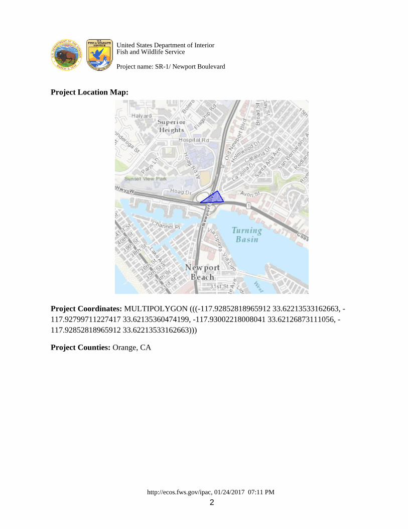
http://ecos.fws.gov/ipac, 01/24/2017 07:11 PM 2
Project Location Map:
Project Coordinates: MULTIPOLYGON (((-117.92852818965912 33.62213533162663, -117.92799711227417 33.62135360474199, -117.93002218008041 33.62126873111056, -117.92852818965912 33.62213533162663))) Project Counties: Orange, CA
United States Department of InteriorFish and Wildlife Service
Project name: SR-1/ Newport Boulevard

http://ecos.fws.gov/ipac, 01/24/2017 07:11 PM 3
Endangered Species Act Species List
There are a total of 5 threatened or endangered species on your species list. Species on this list should be considered in
an effects analysis for your project and could include species that exist in another geographic area. For example, certain
fish may appear on the species list because a project could affect downstream species. Critical habitats listed under the
Has Critical Habitat column may or may not lie within your project area. See the Critical habitats within your
project area section further below for critical habitat that lies within your project. Please contact the designated FWS
office if you have questions.
Birds Status Has Critical Habitat Condition(s)
Coastal California gnatcatcher
(Polioptila californica californica)
Population: Wherever found
Threatened Final designated
Light-Footed Clapper rail (Rallus
longirostris levipes)
Population: Wherever found
Endangered
western snowy plover (Charadrius
nivosus ssp. nivosus)
Population: Pacific Coast population DPS-
U.S.A. (CA, OR, WA), Mexico (within 50 miles
of Pacific coast)
Threatened Final designated
Flowering Plants
Salt Marsh bird's-beak (Cordylanthus
maritimus ssp. maritimus)
Population: Wherever found
Endangered
Mammals
Pacific Pocket mouse (Perognathus
longimembris pacificus)
Population: Wherever found
Endangered
United States Department of InteriorFish and Wildlife Service
Project name: SR-1/ Newport Boulevard

http://ecos.fws.gov/ipac, 01/24/2017 07:11 PM 4
Critical habitats that lie within your project areaThere are no critical habitats within your project area.
United States Department of InteriorFish and Wildlife Service
Project name: SR-1/ Newport Boulevard
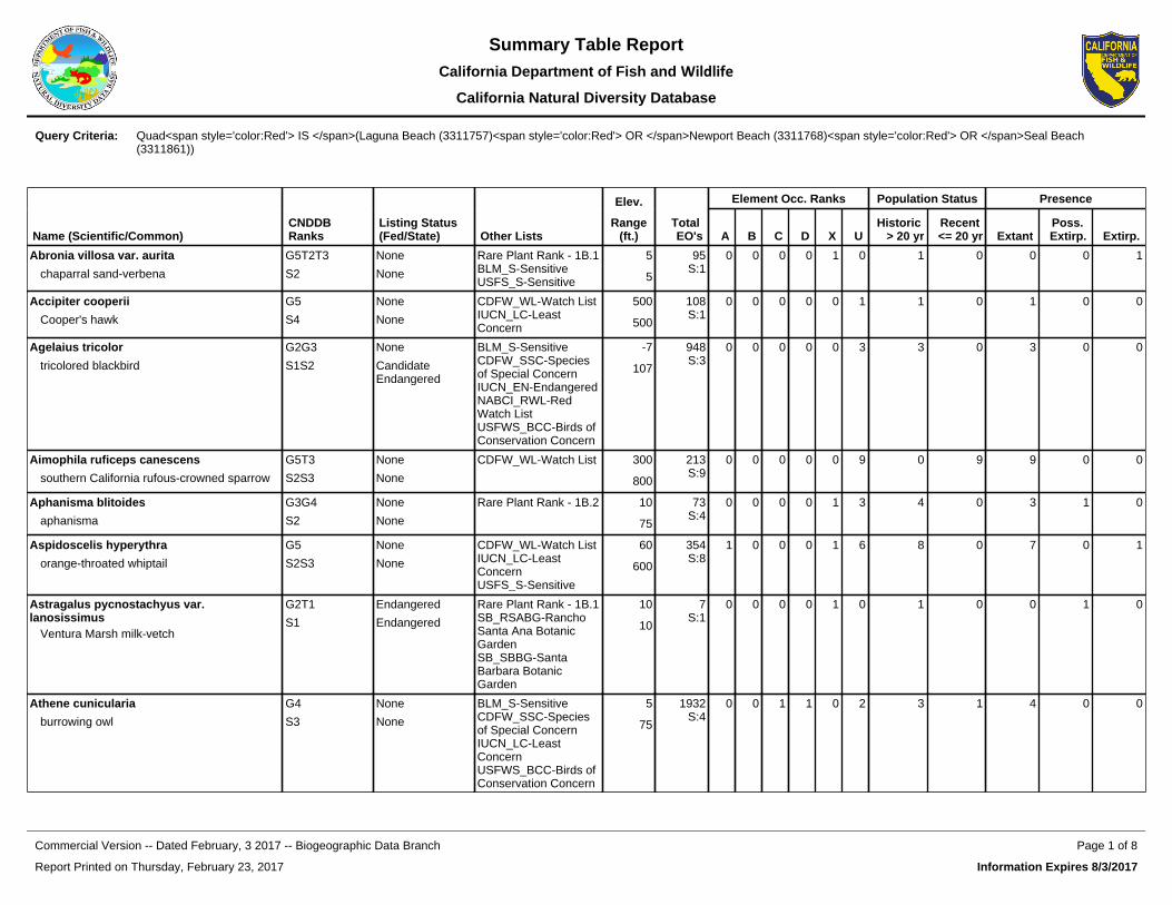
Elev. Element Occ. Ranks Population Status Presence
Name (Scientific/Common)CNDDB Ranks
Listing Status (Fed/State) Other Lists
Range(ft.)
Total EO's A B C D X U
Historic > 20 yr
Recent <= 20 yr Extant
Poss. Extirp. Extirp.
Abronia villosa var. aurita
chaparral sand-verbena
G5T2T3
S2
None
None
Rare Plant Rank - 1B.1BLM_S-SensitiveUSFS_S-Sensitive
5
5
95S:1
0 0 0 0 1 0 1 0 0 0 1
Accipiter cooperii
Cooper's hawk
G5
S4
None
None
CDFW_WL-Watch ListIUCN_LC-Least Concern
500
500
108S:1
0 0 0 0 0 1 1 0 1 0 0
Agelaius tricolor
tricolored blackbird
G2G3
S1S2
None
Candidate Endangered
BLM_S-SensitiveCDFW_SSC-Species of Special ConcernIUCN_EN-EndangeredNABCI_RWL-Red Watch ListUSFWS_BCC-Birds of Conservation Concern
-7
107
948S:3
0 0 0 0 0 3 3 0 3 0 0
Aimophila ruficeps canescens
southern California rufous-crowned sparrow
G5T3
S2S3
None
None
CDFW_WL-Watch List 300
800
213S:9
0 0 0 0 0 9 0 9 9 0 0
Aphanisma blitoides
aphanisma
G3G4
S2
None
None
Rare Plant Rank - 1B.2 10
75
73S:4
0 0 0 0 1 3 4 0 3 1 0
Aspidoscelis hyperythra
orange-throated whiptail
G5
S2S3
None
None
CDFW_WL-Watch ListIUCN_LC-Least ConcernUSFS_S-Sensitive
60
600
354S:8
1 0 0 0 1 6 8 0 7 0 1
Astragalus pycnostachyus var. lanosissimus
Ventura Marsh milk-vetch
G2T1
S1
Endangered
Endangered
Rare Plant Rank - 1B.1SB_RSABG-Rancho Santa Ana Botanic GardenSB_SBBG-Santa Barbara Botanic Garden
10
10
7S:1
0 0 0 0 1 0 1 0 0 1 0
Athene cunicularia
burrowing owl
G4
S3
None
None
BLM_S-SensitiveCDFW_SSC-Species of Special ConcernIUCN_LC-Least ConcernUSFWS_BCC-Birds of Conservation Concern
5
75
1932S:4
0 0 1 1 0 2 3 1 4 0 0
Query Criteria: Quad<span style='color:Red'> IS </span>(Laguna Beach (3311757)<span style='color:Red'> OR </span>Newport Beach (3311768)<span style='color:Red'> OR </span>Seal Beach (3311861))
Report Printed on Thursday, February 23, 2017
Page 1 of 8Commercial Version -- Dated February, 3 2017 -- Biogeographic Data Branch
Information Expires 8/3/2017
Summary Table ReportCalifornia Department of Fish and Wildlife
California Natural Diversity Database
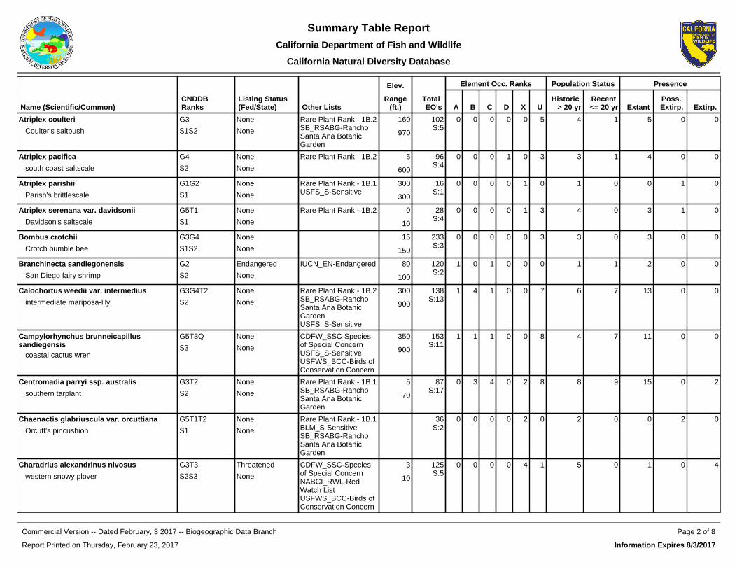
Elev. Element Occ. Ranks Population Status Presence
Name (Scientific/Common)CNDDB Ranks
Listing Status (Fed/State) Other Lists
Range(ft.)
Total EO's A B C D X U
Historic > 20 yr
Recent <= 20 yr Extant
Poss. Extirp. Extirp.
Atriplex coulteri
Coulter's saltbush
G3
S1S2
None
None
Rare Plant Rank - 1B.2SB_RSABG-Rancho Santa Ana Botanic Garden
160
970
102S:5
0 0 0 0 0 5 4 1 5 0 0
Atriplex pacifica
south coast saltscale
G4
S2
None
None
Rare Plant Rank - 1B.2 5
600
96S:4
0 0 0 1 0 3 3 1 4 0 0
Atriplex parishii
Parish's brittlescale
G1G2
S1
None
None
Rare Plant Rank - 1B.1USFS_S-Sensitive
300
300
16S:1
0 0 0 0 1 0 1 0 0 1 0
Atriplex serenana var. davidsonii
Davidson's saltscale
G5T1
S1
None
None
Rare Plant Rank - 1B.2 0
10
28S:4
0 0 0 0 1 3 4 0 3 1 0
Bombus crotchii
Crotch bumble bee
G3G4
S1S2
None
None
15
150
233S:3
0 0 0 0 0 3 3 0 3 0 0
Branchinecta sandiegonensis
San Diego fairy shrimp
G2
S2
Endangered
None
IUCN_EN-Endangered 80
100
120S:2
1 0 1 0 0 0 1 1 2 0 0
Calochortus weedii var. intermedius
intermediate mariposa-lily
G3G4T2
S2
None
None
Rare Plant Rank - 1B.2SB_RSABG-Rancho Santa Ana Botanic GardenUSFS_S-Sensitive
300
900
138S:13
1 4 1 0 0 7 6 7 13 0 0
Campylorhynchus brunneicapillus sandiegensis
coastal cactus wren
G5T3Q
S3
None
None
CDFW_SSC-Species of Special ConcernUSFS_S-SensitiveUSFWS_BCC-Birds of Conservation Concern
350
900
153S:11
1 1 1 0 0 8 4 7 11 0 0
Centromadia parryi ssp. australis
southern tarplant
G3T2
S2
None
None
Rare Plant Rank - 1B.1SB_RSABG-Rancho Santa Ana Botanic Garden
5
70
87S:17
0 3 4 0 2 8 8 9 15 0 2
Chaenactis glabriuscula var. orcuttiana
Orcutt's pincushion
G5T1T2
S1
None
None
Rare Plant Rank - 1B.1BLM_S-SensitiveSB_RSABG-Rancho Santa Ana Botanic Garden
36S:2
0 0 0 0 2 0 2 0 0 2 0
Charadrius alexandrinus nivosus
western snowy plover
G3T3
S2S3
Threatened
None
CDFW_SSC-Species of Special ConcernNABCI_RWL-Red Watch ListUSFWS_BCC-Birds of Conservation Concern
3
10
125S:5
0 0 0 0 4 1 5 0 1 0 4
Report Printed on Thursday, February 23, 2017
Page 2 of 8Commercial Version -- Dated February, 3 2017 -- Biogeographic Data Branch
Information Expires 8/3/2017
Summary Table ReportCalifornia Department of Fish and Wildlife
California Natural Diversity Database
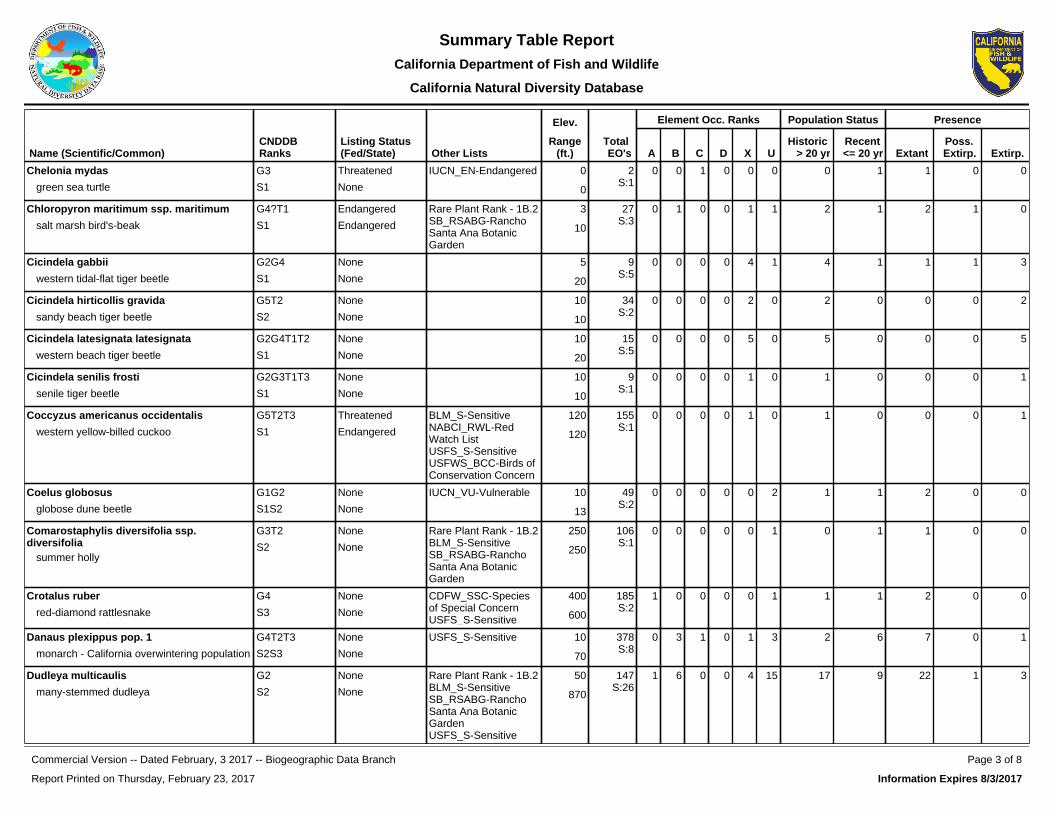
Elev. Element Occ. Ranks Population Status Presence
Name (Scientific/Common)CNDDB Ranks
Listing Status (Fed/State) Other Lists
Range(ft.)
Total EO's A B C D X U
Historic > 20 yr
Recent <= 20 yr Extant
Poss. Extirp. Extirp.
Chelonia mydas
green sea turtle
G3
S1
Threatened
None
IUCN_EN-Endangered 0
0
2S:1
0 0 1 0 0 0 0 1 1 0 0
Chloropyron maritimum ssp. maritimum
salt marsh bird's-beak
G4?T1
S1
Endangered
Endangered
Rare Plant Rank - 1B.2SB_RSABG-Rancho Santa Ana Botanic Garden
3
10
27S:3
0 1 0 0 1 1 2 1 2 1 0
Cicindela gabbii
western tidal-flat tiger beetle
G2G4
S1
None
None
5
20
9S:5
0 0 0 0 4 1 4 1 1 1 3
Cicindela hirticollis gravida
sandy beach tiger beetle
G5T2
S2
None
None
10
10
34S:2
0 0 0 0 2 0 2 0 0 0 2
Cicindela latesignata latesignata
western beach tiger beetle
G2G4T1T2
S1
None
None
10
20
15S:5
0 0 0 0 5 0 5 0 0 0 5
Cicindela senilis frosti
senile tiger beetle
G2G3T1T3
S1
None
None
10
10
9S:1
0 0 0 0 1 0 1 0 0 0 1
Coccyzus americanus occidentalis
western yellow-billed cuckoo
G5T2T3
S1
Threatened
Endangered
BLM_S-SensitiveNABCI_RWL-Red Watch ListUSFS_S-SensitiveUSFWS_BCC-Birds of Conservation Concern
120
120
155S:1
0 0 0 0 1 0 1 0 0 0 1
Coelus globosus
globose dune beetle
G1G2
S1S2
None
None
IUCN_VU-Vulnerable 10
13
49S:2
0 0 0 0 0 2 1 1 2 0 0
Comarostaphylis diversifolia ssp. diversifolia
summer holly
G3T2
S2
None
None
Rare Plant Rank - 1B.2BLM_S-SensitiveSB_RSABG-Rancho Santa Ana Botanic Garden
250
250
106S:1
0 0 0 0 0 1 0 1 1 0 0
Crotalus ruber
red-diamond rattlesnake
G4
S3
None
None
CDFW_SSC-Species of Special ConcernUSFS_S-Sensitive
400
600
185S:2
1 0 0 0 0 1 1 1 2 0 0
Danaus plexippus pop. 1
monarch - California overwintering population
G4T2T3
S2S3
None
None
USFS_S-Sensitive 10
70
378S:8
0 3 1 0 1 3 2 6 7 0 1
Dudleya multicaulis
many-stemmed dudleya
G2
S2
None
None
Rare Plant Rank - 1B.2BLM_S-SensitiveSB_RSABG-Rancho Santa Ana Botanic GardenUSFS_S-Sensitive
50
870
147S:26
1 6 0 0 4 15 17 9 22 1 3
Report Printed on Thursday, February 23, 2017
Page 3 of 8Commercial Version -- Dated February, 3 2017 -- Biogeographic Data Branch
Information Expires 8/3/2017
Summary Table ReportCalifornia Department of Fish and Wildlife
California Natural Diversity Database
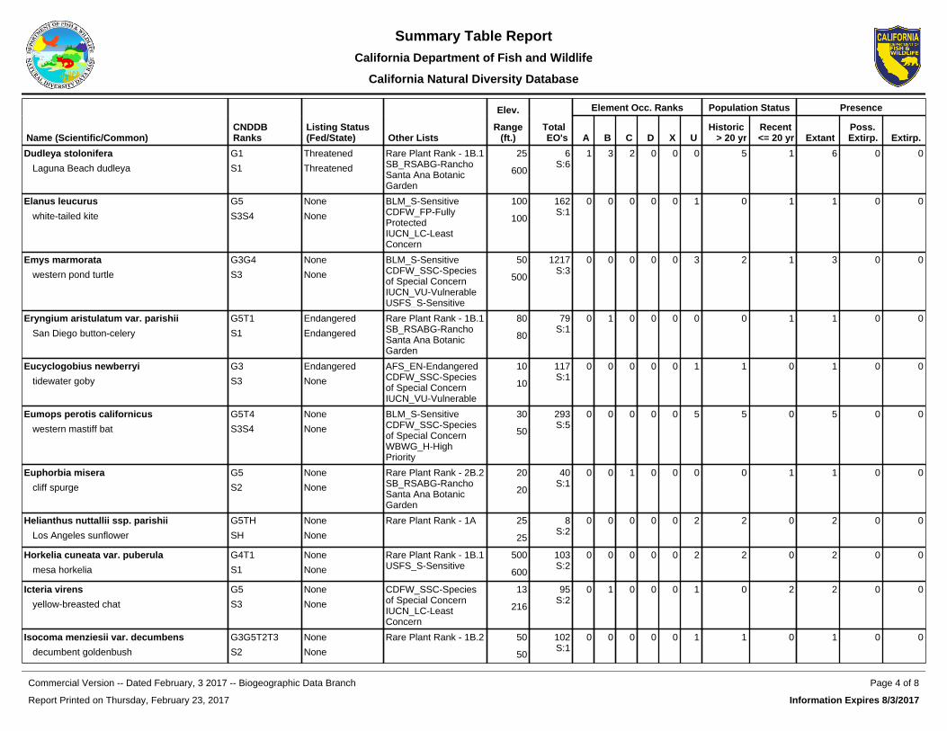
Elev. Element Occ. Ranks Population Status Presence
Name (Scientific/Common)CNDDB Ranks
Listing Status (Fed/State) Other Lists
Range(ft.)
Total EO's A B C D X U
Historic > 20 yr
Recent <= 20 yr Extant
Poss. Extirp. Extirp.
Dudleya stolonifera
Laguna Beach dudleya
G1
S1
Threatened
Threatened
Rare Plant Rank - 1B.1SB_RSABG-Rancho Santa Ana Botanic Garden
25
600
6S:6
1 3 2 0 0 0 5 1 6 0 0
Elanus leucurus
white-tailed kite
G5
S3S4
None
None
BLM_S-SensitiveCDFW_FP-Fully ProtectedIUCN_LC-Least Concern
100
100
162S:1
0 0 0 0 0 1 0 1 1 0 0
Emys marmorata
western pond turtle
G3G4
S3
None
None
BLM_S-SensitiveCDFW_SSC-Species of Special ConcernIUCN_VU-VulnerableUSFS_S-Sensitive
50
500
1217S:3
0 0 0 0 0 3 2 1 3 0 0
Eryngium aristulatum var. parishii
San Diego button-celery
G5T1
S1
Endangered
Endangered
Rare Plant Rank - 1B.1SB_RSABG-Rancho Santa Ana Botanic Garden
80
80
79S:1
0 1 0 0 0 0 0 1 1 0 0
Eucyclogobius newberryi
tidewater goby
G3
S3
Endangered
None
AFS_EN-EndangeredCDFW_SSC-Species of Special ConcernIUCN_VU-Vulnerable
10
10
117S:1
0 0 0 0 0 1 1 0 1 0 0
Eumops perotis californicus
western mastiff bat
G5T4
S3S4
None
None
BLM_S-SensitiveCDFW_SSC-Species of Special ConcernWBWG_H-High Priority
30
50
293S:5
0 0 0 0 0 5 5 0 5 0 0
Euphorbia misera
cliff spurge
G5
S2
None
None
Rare Plant Rank - 2B.2SB_RSABG-Rancho Santa Ana Botanic Garden
20
20
40S:1
0 0 1 0 0 0 0 1 1 0 0
Helianthus nuttallii ssp. parishii
Los Angeles sunflower
G5TH
SH
None
None
Rare Plant Rank - 1A 25
25
8S:2
0 0 0 0 0 2 2 0 2 0 0
Horkelia cuneata var. puberula
mesa horkelia
G4T1
S1
None
None
Rare Plant Rank - 1B.1USFS_S-Sensitive
500
600
103S:2
0 0 0 0 0 2 2 0 2 0 0
Icteria virens
yellow-breasted chat
G5
S3
None
None
CDFW_SSC-Species of Special ConcernIUCN_LC-Least Concern
13
216
95S:2
0 1 0 0 0 1 0 2 2 0 0
Isocoma menziesii var. decumbens
decumbent goldenbush
G3G5T2T3
S2
None
None
Rare Plant Rank - 1B.2 50
50
102S:1
0 0 0 0 0 1 1 0 1 0 0
Report Printed on Thursday, February 23, 2017
Page 4 of 8Commercial Version -- Dated February, 3 2017 -- Biogeographic Data Branch
Information Expires 8/3/2017
Summary Table ReportCalifornia Department of Fish and Wildlife
California Natural Diversity Database

Elev. Element Occ. Ranks Population Status Presence
Name (Scientific/Common)CNDDB Ranks
Listing Status (Fed/State) Other Lists
Range(ft.)
Total EO's A B C D X U
Historic > 20 yr
Recent <= 20 yr Extant
Poss. Extirp. Extirp.
Lasiurus cinereus
hoary bat
G5
S4
None
None
IUCN_LC-Least ConcernWBWG_M-Medium Priority
10
10
235S:1
0 0 0 0 0 1 1 0 1 0 0
Lasthenia glabrata ssp. coulteri
Coulter's goldfields
G4T2
S2
None
None
Rare Plant Rank - 1B.1BLM_S-SensitiveSB_RSABG-Rancho Santa Ana Botanic Garden
5
300
97S:6
0 0 1 0 2 3 4 2 4 2 0
Laterallus jamaicensis coturniculus
California black rail
G3G4T1
S1
None
Threatened
BLM_S-SensitiveCDFW_FP-Fully ProtectedIUCN_NT-Near ThreatenedNABCI_RWL-Red Watch ListUSFWS_BCC-Birds of Conservation Concern
0
0
244S:1
0 0 0 0 0 1 1 0 1 0 0
Microtus californicus stephensi
south coast marsh vole
G5T1T2
S1S2
None
None
CDFW_SSC-Species of Special Concern
5
15
7S:2
0 0 0 0 0 2 2 0 2 0 0
Nama stenocarpa
mud nama
G4G5
S1S2
None
None
Rare Plant Rank - 2B.2 390
400
22S:4
0 1 1 0 0 2 1 3 4 0 0
Nasturtium gambelii
Gambel's water cress
G1
S1
Endangered
Threatened
Rare Plant Rank - 1B.1SB_RSABG-Rancho Santa Ana Botanic GardenSB_SBBG-Santa Barbara Botanic Garden
12S:1
0 0 0 0 1 0 1 0 0 0 1
Navarretia prostrata
prostrate vernal pool navarretia
G2
S2
None
None
Rare Plant Rank - 1B.1 80
80
60S:2
0 0 0 0 0 2 1 1 2 0 0
Nemacaulis denudata var. denudata
coast woolly-heads
G3G4T2
S2
None
None
Rare Plant Rank - 1B.2SB_RSABG-Rancho Santa Ana Botanic Garden
10
10
37S:5
0 0 1 0 0 4 3 2 5 0 0
Nyctinomops macrotis
big free-tailed bat
G5
S3
None
None
CDFW_SSC-Species of Special ConcernIUCN_LC-Least ConcernWBWG_MH-Medium-High Priority
50
50
32S:1
0 0 0 0 0 1 1 0 1 0 0
Report Printed on Thursday, February 23, 2017
Page 5 of 8Commercial Version -- Dated February, 3 2017 -- Biogeographic Data Branch
Information Expires 8/3/2017
Summary Table ReportCalifornia Department of Fish and Wildlife
California Natural Diversity Database
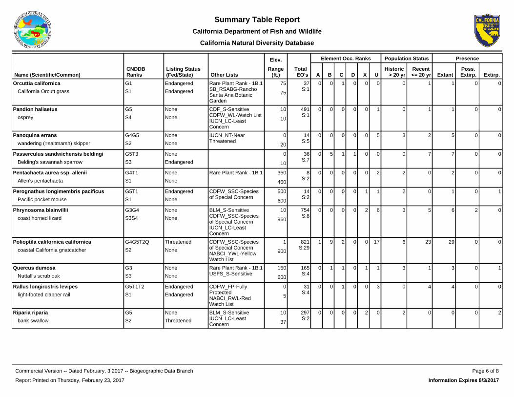
Elev. Element Occ. Ranks Population Status Presence
Name (Scientific/Common)CNDDB Ranks
Listing Status (Fed/State) Other Lists
Range(ft.)
Total EO's A B C D X U
Historic > 20 yr
Recent <= 20 yr Extant
Poss. Extirp. Extirp.
Orcuttia californica
California Orcutt grass
G1
S1
Endangered
Endangered
Rare Plant Rank - 1B.1SB_RSABG-Rancho Santa Ana Botanic Garden
75
75
37S:1
0 0 1 0 0 0 0 1 1 0 0
Pandion haliaetus
osprey
G5
S4
None
None
CDF_S-SensitiveCDFW_WL-Watch ListIUCN_LC-Least Concern
10
10
491S:1
0 0 0 0 0 1 0 1 1 0 0
Panoquina errans
wandering (=saltmarsh) skipper
G4G5
S2
None
None
IUCN_NT-Near Threatened
0
20
14S:5
0 0 0 0 0 5 3 2 5 0 0
Passerculus sandwichensis beldingi
Belding's savannah sparrow
G5T3
S3
None
Endangered
0
10
36S:7
0 5 1 1 0 0 0 7 7 0 0
Pentachaeta aurea ssp. allenii
Allen's pentachaeta
G4T1
S1
None
None
Rare Plant Rank - 1B.1 350
460
8S:2
0 0 0 0 0 2 2 0 2 0 0
Perognathus longimembris pacificus
Pacific pocket mouse
G5T1
S1
Endangered
None
CDFW_SSC-Species of Special Concern
500
600
14S:2
0 0 0 0 1 1 2 0 1 0 1
Phrynosoma blainvillii
coast horned lizard
G3G4
S3S4
None
None
BLM_S-SensitiveCDFW_SSC-Species of Special ConcernIUCN_LC-Least Concern
10
960
754S:8
0 0 0 0 2 6 3 5 6 2 0
Polioptila californica californica
coastal California gnatcatcher
G4G5T2Q
S2
Threatened
None
CDFW_SSC-Species of Special ConcernNABCI_YWL-Yellow Watch List
1
900
821S:29
1 9 2 0 0 17 6 23 29 0 0
Quercus dumosa
Nuttall's scrub oak
G3
S3
None
None
Rare Plant Rank - 1B.1USFS_S-Sensitive
150
600
165S:4
0 1 1 0 1 1 3 1 3 0 1
Rallus longirostris levipes
light-footed clapper rail
G5T1T2
S1
Endangered
Endangered
CDFW_FP-Fully ProtectedNABCI_RWL-Red Watch List
0
5
31S:4
0 0 1 0 0 3 0 4 4 0 0
Riparia riparia
bank swallow
G5
S2
None
Threatened
BLM_S-SensitiveIUCN_LC-Least Concern
10
37
297S:2
0 0 0 0 2 0 2 0 0 0 2
Report Printed on Thursday, February 23, 2017
Page 6 of 8Commercial Version -- Dated February, 3 2017 -- Biogeographic Data Branch
Information Expires 8/3/2017
Summary Table ReportCalifornia Department of Fish and Wildlife
California Natural Diversity Database
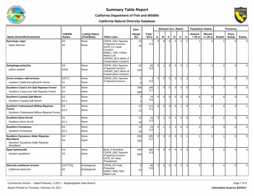
Elev. Element Occ. Ranks Population Status Presence
Name (Scientific/Common)CNDDB Ranks
Listing Status (Fed/State) Other Lists
Range(ft.)
Total EO's A B C D X U
Historic > 20 yr
Recent <= 20 yr Extant
Poss. Extirp. Extirp.
Rynchops niger
black skimmer
G5
S2
None
None
CDFW_SSC-Species of Special ConcernIUCN_LC-Least ConcernNABCI_YWL-Yellow Watch ListUSFWS_BCC-Birds of Conservation Concern
10
10
7S:1
0 0 0 0 0 1 1 0 1 0 0
Setophaga petechia
yellow warbler
G5
S3S4
None
None
CDFW_SSC-Species of Special ConcernUSFWS_BCC-Birds of Conservation Concern
12
223
66S:2
0 1 0 0 0 1 0 2 2 0 0
Sorex ornatus salicornicus
southern California saltmarsh shrew
G5T1?
S1
None
None
CDFW_SSC-Species of Special Concern
5
5
4S:2
0 0 0 0 0 2 2 0 2 0 0
Southern Coast Live Oak Riparian Forest
Southern Coast Live Oak Riparian Forest
G4
S4
None
None
180
580
246S:7
1 0 0 0 0 6 7 0 7 0 0
Southern Coastal Salt Marsh
Southern Coastal Salt Marsh
G2
S2.1
None
None
0
5
24S:6
0 0 0 0 0 6 6 0 6 0 0
Southern Cottonwood Willow Riparian Forest
Southern Cottonwood Willow Riparian Forest
G3
S3.2
None
None
12
12
111S:1
0 0 0 0 1 0 1 0 0 0 1
Southern Dune Scrub
Southern Dune Scrub
G1
S1.1
None
None
13
40
10S:2
0 1 0 1 0 0 2 0 2 0 0
Southern Foredunes
Southern Foredunes
G2
S2.1
None
None
13
20
23S:3
0 1 1 1 0 0 3 0 3 0 0
Southern Sycamore Alder Riparian Woodland
Southern Sycamore Alder Riparian Woodland
G4
S4
None
None
250
250
230S:1
0 0 0 0 0 1 1 0 1 0 0
Spea hammondii
western spadefoot
G3
S3
None
None
BLM_S-SensitiveCDFW_SSC-Species of Special ConcernIUCN_NT-Near Threatened
440
940
450S:3
0 0 0 0 0 3 0 3 3 0 0
Sternula antillarum browni
California least tern
G4T2T3Q
S2
Endangered
Endangered
CDFW_FP-Fully ProtectedNABCI_RWL-Red Watch List
6
10
68S:6
0 0 0 0 2 4 5 1 4 0 2
Report Printed on Thursday, February 23, 2017
Page 7 of 8Commercial Version -- Dated February, 3 2017 -- Biogeographic Data Branch
Information Expires 8/3/2017
Summary Table ReportCalifornia Department of Fish and Wildlife
California Natural Diversity Database

Elev. Element Occ. Ranks Population Status Presence
Name (Scientific/Common)CNDDB Ranks
Listing Status (Fed/State) Other Lists
Range(ft.)
Total EO's A B C D X U
Historic > 20 yr
Recent <= 20 yr Extant
Poss. Extirp. Extirp.
Suaeda esteroa
estuary seablite
G3
S2
None
None
Rare Plant Rank - 1B.2 0
5
39S:13
0 1 0 0 0 12 4 9 13 0 0
Symphyotrichum defoliatum
San Bernardino aster
G2
S2
None
None
Rare Plant Rank - 1B.2BLM_S-SensitiveUSFS_S-Sensitive
76S:3
0 0 0 0 2 1 3 0 1 1 1
Taxidea taxus
American badger
G5
S3
None
None
CDFW_SSC-Species of Special ConcernIUCN_LC-Least Concern
75
75
533S:1
0 0 0 1 0 0 0 1 1 0 0
Trigonoscuta dorothea dorothea
Dorothy's El Segundo Dune weevil
G1T1
S1
None
None
0
5
4S:2
0 0 0 0 0 2 2 0 2 0 0
Tryonia imitator
mimic tryonia (=California brackishwater snail)
G2
S2
None
None
IUCN_DD-Data Deficient
0
0
39S:2
0 0 0 0 0 2 2 0 2 0 0
Valley Needlegrass Grassland
Valley Needlegrass Grassland
G3
S3.1
None
None
500
500
45S:1
0 0 0 0 0 1 1 0 1 0 0
Verbesina dissita
big-leaved crownbeard
G1G2
S1
Threatened
Threatened
Rare Plant Rank - 1B.1SB_RSABG-Rancho Santa Ana Botanic Garden
500
500
2S:1
0 1 0 0 0 0 0 1 1 0 0
Vireo bellii pusillus
least Bell's vireo
G5T2
S2
Endangered
Endangered
IUCN_NT-Near ThreatenedNABCI_YWL-Yellow Watch List
10
365
474S:3
0 0 2 1 0 0 0 3 3 0 0
Report Printed on Thursday, February 23, 2017
Page 8 of 8Commercial Version -- Dated February, 3 2017 -- Biogeographic Data Branch
Information Expires 8/3/2017
Summary Table ReportCalifornia Department of Fish and Wildlife
California Natural Diversity Database

Plant List
25 matches found. Click on scientific name for details
Search Criteria
Found in Quad 33117F8
Scientific Name Common Name Family LifeformRare Plant Rank
State Rank
Global Rank
Abronia maritima red sand-verbena Nyctaginaceae perennial herb 4.2 S3? G4?
Abronia villosa var. auritachaparral sand-verbena
Nyctaginaceae annual herb 1B.1 S2 G5T3T4
Aphanisma blitoides aphanisma Chenopodiaceae annual herb 1B.2 S3 G3G4
Atriplex coulteri Coulter's saltbush Chenopodiaceae perennial herb 1B.2 S2 G2
Atriplex pacificaSouth Coast saltscale
Chenopodiaceae annual herb 1B.2 S2 G3G4
Atriplex parishii Parish's brittlescale Chenopodiaceae annual herb 1B.1 S1 G1G2
Atriplex serenana var. davidsonii
Davidson's saltscale Chenopodiaceae annual herb 1B.2 S1 G5T1
Camissoniopsis lewisiiLewis' evening-primrose
Onagraceae annual herb 3 S1S3 G2G3
Centromadia parryi ssp. australis
southern tarplant Asteraceae annual herb 1B.1 S2 G3T2
Chloropyron maritimum ssp. maritimum
salt marsh bird's-beak
Orobanchaceaeannual herb (hemiparasitic)
1B.2 S1 G4?T1
Dudleya multicaulismany-stemmed dudleya
Crassulaceae perennial herb 1B.2 S2 G2
Dudleya stoloniferaLaguna Beach dudleya
Crassulaceaeperennial stoloniferous herb
1B.1 S1 G1
Eryngium aristulatum var. parishii
San Diego button-celery
Apiaceaeannual / perennial herb
1B.1 S1 G5T1
Helianthus nuttallii ssp. parishii
Los Angeles sunflower
Asteraceaeperennial rhizomatous herb
1A SH G5TH
Juncus acutus ssp. leopoldii
southwestern spiny rush
Juncaceaeperennial rhizomatous herb
4.2 S3.2 G5T5
Lasthenia glabrata ssp. coulteri
Coulter's goldfields Asteraceae annual herb 1B.1 S2.1 G4T3
Nama stenocarpum mud nama Boraginaceaeannual / perennial herb
2B.2 S1S2 G4G5
Nasturtium gambelii Gambel's water cress Brassicaceaeperennial rhizomatous herb
1B.1 S1 G1
Navarretia prostrataprostrate vernal pool navarretia
Polemoniaceae annual herb 1B.1 S2 G2
coast woolly-heads Polygonaceae annual herb 1B.2 S2.2 G3G4T3?
Page 1 of 2CNPS Inventory Results
7/29/2014http://www.rareplants.cnps.org/result.html?adv=t&quad=33117F8:1
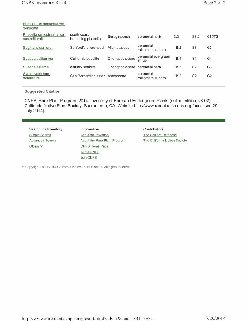
Search the Inventory
Simple Search
Advanced Search
Glossary
Information
About the Inventory
About the Rare Plant Program
CNPS Home Page
About CNPS
Join CNPS
Contributors
The Calflora Database
The California Lichen Society
Nemacaulis denudata var. denudata
Phacelia ramosissima var. austrolitoralis
south coast branching phacelia
Boraginaceae perennial herb 3.2 S3.2 G5?T3
Sagittaria sanfordii Sanford's arrowhead Alismataceaeperennial rhizomatous herb
1B.2 S3 G3
Suaeda californica California seablite Chenopodiaceaeperennial evergreen shrub
1B.1 S1 G1
Suaeda esteroa estuary seablite Chenopodiaceae perennial herb 1B.2 S2 G3
Symphyotrichum defoliatum
San Bernardino aster Asteraceaeperennial rhizomatous herb
1B.2 S2 G2
Suggested Citation
CNPS, Rare Plant Program. 2014. Inventory of Rare and Endangered Plants (online edition, v8-02).
California Native Plant Society, Sacramento, CA. Website http://www.rareplants.cnps.org [accessed 29 July 2014].
© Copyright 2010-2014 California Native Plant Society. All rights reserved.
Page 2 of 2CNPS Inventory Results
7/29/2014http://www.rareplants.cnps.org/result.html?adv=t&quad=33117F8:1

Plant List
54 matches found. Click on scientific name for details
Search Criteria
Found in 9 Quads around 33117E7
Scientific Name Common Name Family LifeformRare Plant Rank
State Rank
Global Rank
Abronia maritima red sand-verbena Nyctaginaceae perennial herb 4.2 S3? G4?
Abronia villosa var. auritachaparral sand-verbena
Nyctaginaceae annual herb 1B.1 S2 G5T3T4
Aphanisma blitoides aphanisma Chenopodiaceae annual herb 1B.2 S3 G3G4
Atriplex coulteri Coulter's saltbush Chenopodiaceae perennial herb 1B.2 S2 G2
Atriplex pacificaSouth Coast saltscale
Chenopodiaceae annual herb 1B.2 S2 G3G4
Atriplex parishii Parish's brittlescale Chenopodiaceae annual herb 1B.1 S1 G1G2
Atriplex serenana var. davidsonii
Davidson's saltscale Chenopodiaceae annual herb 1B.2 S1 G5T1
Brodiaea filifoliathread-leaved brodiaea
Themidaceaeperennial bulbiferous herb
1B.1 S1 G1
Calochortus catalinaeCatalina mariposa lily
Liliaceaeperennial bulbiferous herb
4.2 S3.2 G3
Calochortus weedii var. intermedius
intermediate mariposa lily
Liliaceaeperennial bulbiferous herb
1B.2 S2 G3G4T2
Camissoniopsis lewisiiLewis' evening-primrose
Onagraceae annual herb 3 S1S3 G2G3
Centromadia parryi ssp. australis
southern tarplant Asteraceae annual herb 1B.1 S2 G3T2
Chaenactis glabriuscula var. orcuttiana
Orcutt's pincushion Asteraceae annual herb 1B.1 S1 G5T1
Chloropyron maritimum ssp. maritimum
salt marsh bird's-beak
Orobanchaceaeannual herb (hemiparasitic)
1B.2 S1 G4?T1
Cistanthe maritima seaside cistanthe Montiaceae annual herb 4.2 S3.2 G3G4
Comarostaphylis diversifolia ssp. diversifolia
summer holly Ericaceaeperennial evergreen shrub
1B.2 S2 G3T2
Convolvulus simulanssmall-flowered morning-glory
Convolvulaceae annual herb 4.2 S3.2 G3
Deinandra paniculata paniculate tarplant Asteraceae annual herb 4.2 S3.2 G3G4
Dichondra occidentalis western dichondra Convolvulaceaeperennial rhizomatous herb
4.2 S3.2 G4?
Dodecahema leptocerasslender-horned spineflower
Polygonaceae annual herb 1B.1 S1 G1
Page 1 of 3CNPS Inventory Results
7/29/2014http://www.rareplants.cnps.org/result.html?adv=t&quad=33117E7:9
Dudleya blochmaniae ssp. blochmaniae
Blochman's dudleya Crassulaceae perennial herb 1B.1 S2 G2T2
Dudleya multicaulismany-stemmed dudleya
Crassulaceae perennial herb 1B.2 S2 G2
Dudleya stoloniferaLaguna Beach dudleya
Crassulaceaeperennial stoloniferous herb
1B.1 S1 G1
Eryngium aristulatum var. parishii
San Diego button-celery
Apiaceaeannual / perennial herb
1B.1 S1 G5T1
Euphorbia misera cliff spurge Euphorbiaceae perennial shrub 2B.2 S2 G5
Harpagonella palmeriPalmer's grapplinghook
Boraginaceae annual herb 4.2 S3.2 G4
Helianthus nuttallii ssp. parishii
Los Angeles sunflower
Asteraceaeperennial rhizomatous herb
1A SH G5TH
Hesperocyparis forbesii Tecate cypress Cupressaceaeperennial evergreen tree
1B.1 S2 G2
Horkelia cuneata var. puberula
mesa horkelia Rosaceae perennial herb 1B.1 S1 G4T1
Isocoma menziesii var. decumbens
decumbent goldenbush
Asteraceae perennial shrub 1B.2 S2 G3G5T2T3
Juncus acutus ssp. leopoldiisouthwestern spiny rush
Juncaceaeperennial rhizomatous herb
4.2 S3.2 G5T5
Lasthenia glabrata ssp. coulteri
Coulter's goldfields Asteraceae annual herb 1B.1 S2.1 G4T3
Lepidium virginicum var. robinsonii
Robinson's pepper-grass
Brassicaceae annual herb 4.3 S3 G5T3
Lycium californicum California box-thorn Solanaceae perennial shrub 4.2 S3.2 G4
Malacothrix saxatilis var. saxatilis
cliff malacothrix Asteraceaeperennial rhizomatous herb
4.2 S3.2 G5T3
Monardella hypoleuca ssp. intermedia
intermediate monardella
Lamiaceaeperennial rhizomatous herb
1B.3 S2S3 G4T2T3
Nama stenocarpum mud nama Boraginaceaeannual / perennial herb
2B.2 S1S2 G4G5
Nasturtium gambeliiGambel's water cress
Brassicaceaeperennial rhizomatous herb
1B.1 S1 G1
Navarretia prostrataprostrate vernal pool navarretia
Polemoniaceae annual herb 1B.1 S2 G2
Nemacaulis denudata var. denudata
coast woolly-heads Polygonaceae annual herb 1B.2 S2.2 G3G4T3?
Nolina cismontana chaparral nolina Ruscaceaeperennial evergreen shrub
1B.2 S2 G2
Pentachaeta aurea ssp. allenii
Allen's pentachaeta Asteraceae annual herb 1B.1 S2 G4T2
Phacelia ramosissima var. austrolitoralis
south coast branching phacelia
Boraginaceae perennial herb 3.2 S3.2 G5?T3
Pseudognaphalium leucocephalum
white rabbit-tobacco Asteraceae perennial herb 2B.2 S2S3.2 G4
Quercus dumosa Nuttall's scrub oak Fagaceaeperennial evergreen shrub
1B.1 S2 G2
Sagittaria sanfordii Sanford's arrowhead Alismataceaeperennial rhizomatous herb
1B.2 S3 G3
Senecio aphanactis chaparral ragwort Asteraceae annual herb 2B.2 S2 G3?
Page 2 of 3CNPS Inventory Results
7/29/2014http://www.rareplants.cnps.org/result.html?adv=t&quad=33117E7:9
Search the Inventory
Simple Search
Advanced Search
Glossary
Information
About the Inventory
About the Rare Plant Program
CNPS Home Page
About CNPS
Join CNPS
Contributors
The Calflora Database
The California Lichen Society
Sidalcea neomexicanasalt spring checkerbloom
Malvaceae perennial herb 2B.2 S2S3 G4?
Suaeda californica California seablite Chenopodiaceaeperennial evergreen shrub
1B.1 S1 G1
Suaeda esteroa estuary seablite Chenopodiaceae perennial herb 1B.2 S2 G3
Suaeda taxifolia woolly seablite Chenopodiaceaeperennial evergreen shrub
4.2 S2S3 G3?
Symphyotrichum defoliatumSan Bernardino aster
Asteraceaeperennial rhizomatous herb
1B.2 S2 G2
Tetracoccus dioicus Parry's tetracoccus Picrodendraceaeperennial deciduous shrub
1B.2 S2.2 G3
Verbesina dissitabig-leaved crownbeard
Asteraceae perennial herb 1B.1 S1 G2G3
Suggested Citation
CNPS, Rare Plant Program. 2014. Inventory of Rare and Endangered Plants (online edition, v8-02). California Native Plant Society, Sacramento, CA. Website http://www.rareplants.cnps.org [accessed 29 July 2014].
© Copyright 2010-2014 California Native Plant Society. All rights reserved.
Page 3 of 3CNPS Inventory Results
7/29/2014http://www.rareplants.cnps.org/result.html?adv=t&quad=33117E7:9

Search the Inventory
Simple Search
Advanced Search
Glossary
Information
About the Inventory
About the Rare Plant Program
CNPS Home Page
About CNPS
Join CNPS
Contributors
The Calflora Database
The California Lichen Society
Plant List
10 matches found. Click on scientific name for details
Search Criteria
Found in Quad 33118F1
Scientific Name Common Name Family LifeformRare Plant Rank
State Rank
Global Rank
Astragalus pycnostachyus var. lanosissimus
Ventura marsh milk-vetch
Fabaceae perennial herb 1B.1 S1 G2T1
Atriplex parishiiParish's brittlescale
Chenopodiaceae annual herb 1B.1 S1 G1G2
Atriplex serenana var. davidsonii
Davidson's saltscale
Chenopodiaceae annual herb 1B.2 S1 G5T1
Centromadia parryi ssp. australis
southern tarplant Asteraceae annual herb 1B.1 S2 G3T2
Chloropyron maritimum ssp. maritimum
salt marsh bird's-beak
Orobanchaceaeannual herb (hemiparasitic)
1B.2 S1 G4?T1
Lasthenia glabrata ssp. coulteri
Coulter's goldfields
Asteraceae annual herb 1B.1 S2.1 G4T3
Nama stenocarpum mud nama Boraginaceaeannual / perennial herb
2B.2 S1S2 G4G5
Nemacaulis denudata var. denudata
coast woolly-heads
Polygonaceae annual herb 1B.2 S2.2 G3G4T3?
Suaeda esteroa estuary seablite Chenopodiaceae perennial herb 1B.2 S2 G3
Symphyotrichum defoliatumSan Bernardino aster
Asteraceaeperennial rhizomatous herb
1B.2 S2 G2
Suggested Citation
CNPS, Rare Plant Program. 2014. Inventory of Rare and Endangered Plants (online edition, v8-02). California Native Plant Society, Sacramento, CA. Website http://www.rareplants.cnps.org [accessed 29 July 2014].
© Copyright 2010-2014 California Native Plant Society. All rights reserved.
Page 1 of 1CNPS Inventory Results
7/29/2014http://www.rareplants.cnps.org/result.html?adv=t&quad=33118F1:1

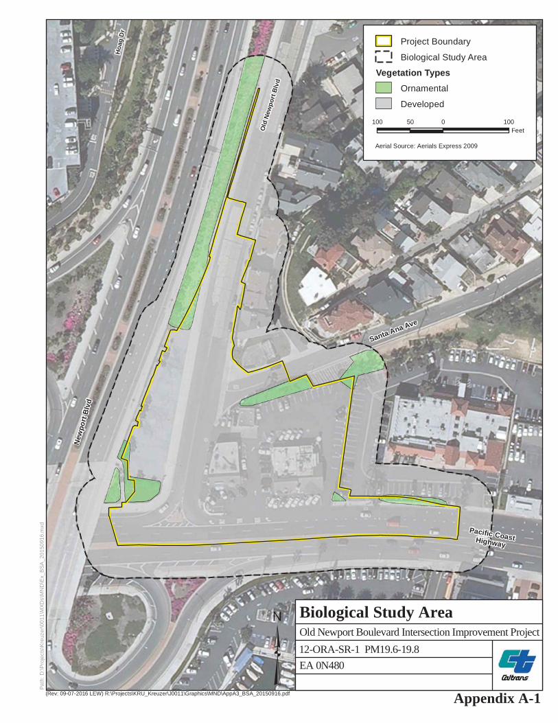
Pacific CoastHighway
Santa Ana Ave
New
port
Blv
d
Hoa
g D
r
La Jolla Dr
Old
New
port
Blv
d
(Rev: 09-07-2016 LEW) R:\Projects\KRU_Kreuzer\J0011\Graphics\MND\AppA3_BSA_20150916.pdf
Path
: D:\P
roje
cts\
Kre
uzer
\001
1\M
XDs\
MN
D\E
x_B
SA_2
0150
916.
mxd
³Appendix A-1
Old Newport Boulevard Intersection Improvement Project
Biological Study Area
100 0 10050Feet
Aerial Source: Aerials Express 2009
Project Boundary
Biological Study Area
Vegetation TypesOrnamental
Developed
EA 0N48012-ORA-SR-1 PM19.6-19.8

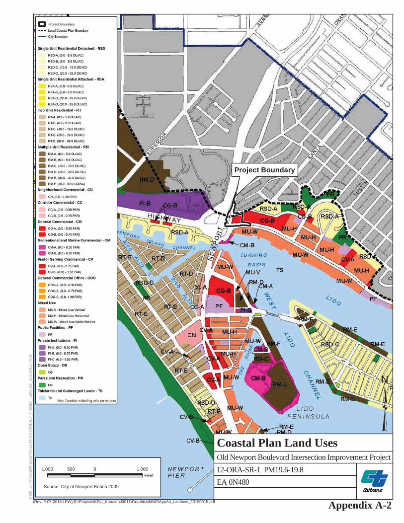
Project Boundary
(Rev: 9-07-2016 LEW) R:\Projects\KRU_Kreuzer\J0011\Graphics\MND\AppA4_Landuse_20150915.pdf
Path
: D:\P
roje
cts\
Kre
uzer
\001
1\M
XDs\
MN
D\E
x_C
oast
al_L
andu
se_2
0150
915.
mxd
³Appendix A-2
Old Newport Boulevard Intersection Improvement Project
Coastal Plan Land Uses
1,000 0 1,000500Feet
Source: City of Newport Beach 2009
Project Boundary
EA 0N48012-ORA-SR-1 PM19.6-19.8


Project Boundary
11
(Rev: 9-07-2016 LEW) R:\Projects\KRU_Kreuzer\J0011\Graphics\MND\AppA5_GPLU_20150915.pdf
Path
: D:\P
roje
cts\
Kre
uzer
\001
1\M
XDs\
MN
D\E
x_G
PLU
_201
5091
5.m
xd
³Appendix A-3
Old Newport Boulevard Intersection Improvement Project
General Plan Land Uses
2,000 0 2,0001,000Feet
Source: City of Newport Beach 2009
Project Boundary
EA 0N48012-ORA-SR-1 PM19.6-19.8


State Route 1 at Old Newport Boulevard Intersection Project 169
Appendix B Title VI Policy Statement

Attachment B Title VI Policy Statement
State Route 1 at Old Newport Boulevard Intersection Project 170
This page intentionally left blank

State Route 1 at Old Newport Boulevard Intersection Project 171
Appendix C Environmental Commitment Record

Attachment C Environmental Commitment Record
State Route 1 at Old Newport Boulevard Intersection Project 172
This page intentionally left blank

Appendix C Environmental Commitment Record
State Route 1 at Old Newport Boulevard Intersection Project 173
Task and Brief Description Responsible Party Timing/Phase NNSP Req Action Taken to Comply with
Task Task Completed
Remarks Environmental Compliance
Initials Date Initials Date Air Quality AQ-1 The construction contractor shall comply with Caltrans’s Standard Specifications in Section 14 (2010). • Section 14-9.02 specifically requires compliance by
the contractor with all applicable laws and regulations related to air quality, including air pollution control district and air quality management district regulations and local ordinances.
• Section 14-9.03 is directed at controlling dust. If dust palliative materials other than water are to be used, material specifications are contained in Section 18.
Construction Contractor Construction (CC)
AQ-2 The construction contractor shall comply with South Coast Air Quality Management District (SCAQMD) Rule 403. • SCAQMD Rule 403 prohibits emissions of fugitive
dust from any active operation, open storage pile, or disturbed surface area that remains visible beyond the emission source property line.
• A person conducting active operations shall utilize one or more of the applicable best available control measures to minimize fugitive dust emissions from each fugitive dust source type.
Construction Contractor Construction (CC)
Biological Resources BIO-1 During Project construction, all invasive plant species, if found on site, shall be handled, transported, and disposed of off site by a qualified contractor to minimize the potential of spreading invasive species and/or their seeds off site. All plants and their seed pods shall be secured in such a manner that no contamination of native soils and natural areas occurs.
Project Engineer/Construction Contractor
Construction (CC)
BIO-2 Prior to construction, landscape designs shall be submitted to Caltrans for review and approval by a qualified Biologist. The review shall determine that no invasive exotic plant species are to be used in any proposed landscaping. Suitable substitutes shall be recommended by the Reviewing Biologist. All mulch, topsoil, and seed mixes used during landscaping activities and erosion-control Best Management Practices (BMPs) implemented shall be free of invasive plant species propagules.
City and Caltrans biologist / Landscape Architect
Construction (CC)
BIO-3 Pre-construction surveys for nesting birds, nesting raptors, and roosting bats are required immediately prior to construction (e.g., within seven days) during the nesting bird season (February 15 to September 1).
City biologist Construction (CC)
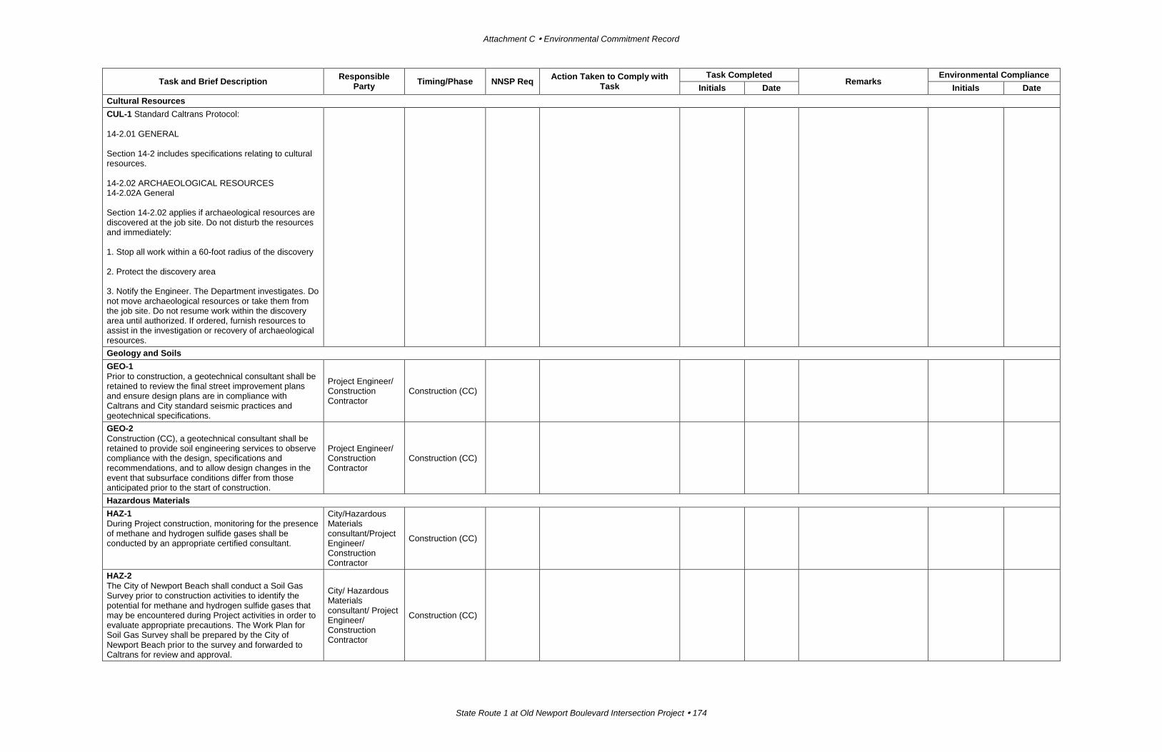
Attachment C Environmental Commitment Record
State Route 1 at Old Newport Boulevard Intersection Project 174
Task and Brief Description Responsible Party Timing/Phase NNSP Req Action Taken to Comply with
Task Task Completed
Remarks Environmental Compliance
Initials Date Initials Date Cultural Resources CUL-1 Standard Caltrans Protocol: 14-2.01 GENERAL Section 14-2 includes specifications relating to cultural resources. 14-2.02 ARCHAEOLOGICAL RESOURCES 14-2.02A General Section 14-2.02 applies if archaeological resources are discovered at the job site. Do not disturb the resources and immediately: 1. Stop all work within a 60-foot radius of the discovery 2. Protect the discovery area 3. Notify the Engineer. The Department investigates. Do not move archaeological resources or take them from the job site. Do not resume work within the discovery area until authorized. If ordered, furnish resources to assist in the investigation or recovery of archaeological resources.
Geology and Soils GEO-1 Prior to construction, a geotechnical consultant shall be retained to review the final street improvement plans and ensure design plans are in compliance with Caltrans and City standard seismic practices and geotechnical specifications.
Project Engineer/ Construction Contractor
Construction (CC)
GEO-2 Construction (CC), a geotechnical consultant shall be retained to provide soil engineering services to observe compliance with the design, specifications and recommendations, and to allow design changes in the event that subsurface conditions differ from those anticipated prior to the start of construction.
Project Engineer/ Construction Contractor
Construction (CC)
Hazardous Materials HAZ-1 During Project construction, monitoring for the presence of methane and hydrogen sulfide gases shall be conducted by an appropriate certified consultant.
City/Hazardous Materials consultant/Project Engineer/ Construction Contractor
Construction (CC)
HAZ-2 The City of Newport Beach shall conduct a Soil Gas Survey prior to construction activities to identify the potential for methane and hydrogen sulfide gases that may be encountered during Project activities in order to evaluate appropriate precautions. The Work Plan for Soil Gas Survey shall be prepared by the City of Newport Beach prior to the survey and forwarded to Caltrans for review and approval.
City/ Hazardous Materials consultant/ Project Engineer/ Construction Contractor
Construction (CC)

Appendix C Environmental Commitment Record
State Route 1 at Old Newport Boulevard Intersection Project 175
Task and Brief Description Responsible Party Timing/Phase NNSP Req Action Taken to Comply with
Task Task Completed
Remarks Environmental Compliance
Initials Date Initials Date HAZ-3 The Aerially Deposited Lead (ADL) Work Plan shall be prepared by the City of Newport Beach and forwarded to Caltrans for review and approval. During final design, a certified consultant shall conduct soil sampling for the purpose of determining the presence of lead-contaminated soils. If concentrations of lead detected in soil samples collected from areas within the right-of-way exceed the State requirements, the soils shall be classified as California hazardous waste. The handling, treatment, or disposal of soils impacted with ADL that would be generated during construction activities shall be consistent with federal, State, and local laws.
City/ Hazardous Materials consultant/ Project Engineer/ Construction Contractor
During final design
HAZ-4 A Lead-Based and Chromium-Based Paint Work Plan shall be prepared by the City of Newport Beach and forwarded to Caltrans for review and approval. During final design, a certified consultant shall conduct a lead-based and chromium-based paint investigation. A certified consultant shall also investigate any pavement materials that would be renovated or demolished as part of the Project.
City/ Hazardous Materials consultant/ Project Engineer/ Construction Contractor
During final design
Water Quality WQ-1 The Project shall be required to comply with the Caltrans National Pollutant Discharge Elimination System (NPDES) Permit and to prepare and implement a Water Pollution Control Program (WPCP). The Project shall implement temporary construction BMPs (e.g., temporary inlet protection, perimeter sediment control, concrete washouts, construction entrances, solid waste management, dust control measures, housekeeping in laydown areas and street sweeping) to avoid and minimize stormwater runoff.
City of Newport Beach/Project Engineer/ Construction Contractor
Construction (CC)
WQ-2 The Project shall be required to comply with the Construction General Permit and to prepare and implement a Storm Water Pollution Prevention Plan (SWPPP). During the Build Alternative Design Variation construction, the City shall install and operate a storm water quality basin that would filter out pollutants. If infiltration is not possible, an alternative treatment BMP (e.g., Filterra, Modular Wetland, REM) shall be installed to process all discharged storm water. The City of Newport Beach will be responsible for operating and maintaining the BMPs.
City of Newport Beach/ Project Engineer/ Construction Contractor
Construction (CC)
Land Use and Planning LU-1 Prior to construction, the City would obtain all required right-of-way for the roadway improvements. Owners of property to be acquired shall be compensated for the fair market value of the property as well as damages, if any, to the remaining portions of their properties in accordance with the Uniform Relocation Assistance and Real Property Acquisition Policies Act of 1970, as
City of Newport Beach/ Project Engineer
Final Design
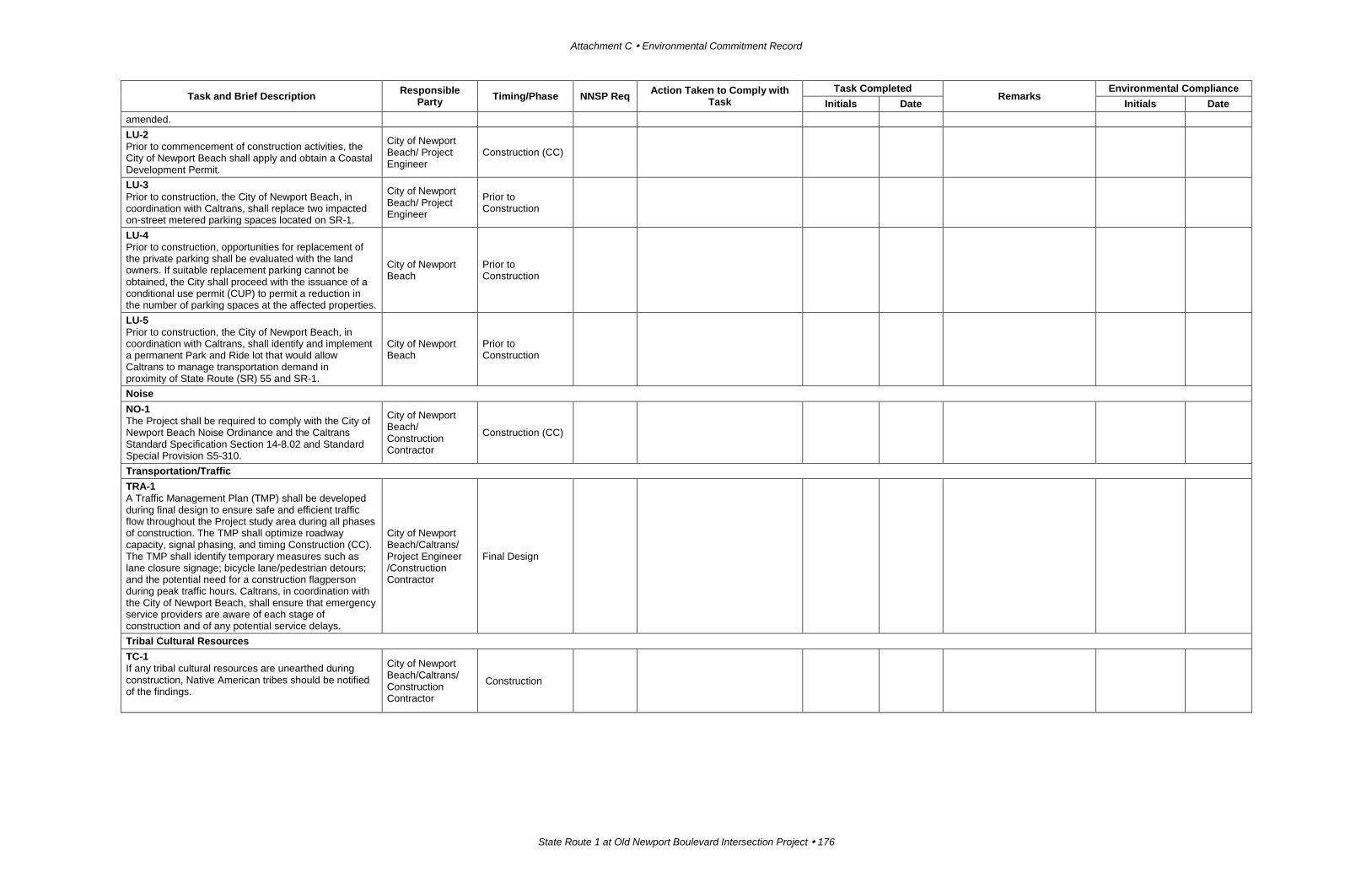
Attachment C Environmental Commitment Record
State Route 1 at Old Newport Boulevard Intersection Project 176
Task and Brief Description Responsible Party Timing/Phase NNSP Req Action Taken to Comply with
Task Task Completed
Remarks Environmental Compliance
Initials Date Initials Date amended. LU-2 Prior to commencement of construction activities, the City of Newport Beach shall apply and obtain a Coastal Development Permit.
City of Newport Beach/ Project Engineer
Construction (CC)
LU-3 Prior to construction, the City of Newport Beach, in coordination with Caltrans, shall replace two impacted on-street metered parking spaces located on SR-1.
City of Newport Beach/ Project Engineer
Prior to Construction
LU-4 Prior to construction, opportunities for replacement of the private parking shall be evaluated with the land owners. If suitable replacement parking cannot be obtained, the City shall proceed with the issuance of a conditional use permit (CUP) to permit a reduction in the number of parking spaces at the affected properties.
City of Newport Beach
Prior to Construction
LU-5 Prior to construction, the City of Newport Beach, in coordination with Caltrans, shall identify and implement a permanent Park and Ride lot that would allow Caltrans to manage transportation demand in proximity of State Route (SR) 55 and SR-1.
City of Newport Beach
Prior to Construction
Noise NO-1 The Project shall be required to comply with the City of Newport Beach Noise Ordinance and the Caltrans Standard Specification Section 14-8.02 and Standard Special Provision S5-310.
City of Newport Beach/ Construction Contractor
Construction (CC)
Transportation/Traffic TRA-1 A Traffic Management Plan (TMP) shall be developed during final design to ensure safe and efficient traffic flow throughout the Project study area during all phases of construction. The TMP shall optimize roadway capacity, signal phasing, and timing Construction (CC). The TMP shall identify temporary measures such as lane closure signage; bicycle lane/pedestrian detours; and the potential need for a construction flagperson during peak traffic hours. Caltrans, in coordination with the City of Newport Beach, shall ensure that emergency service providers are aware of each stage of construction and of any potential service delays.
City of Newport Beach/Caltrans/ Project Engineer /Construction Contractor
Final Design
Tribal Cultural Resources TC-1 If any tribal cultural resources are unearthed during construction, Native American tribes should be notified of the findings.
City of Newport Beach/Caltrans/ Construction Contractor
Construction