state of the coast report 2009
DESCRIPTION
North Carolina's beaches are caught in a tightening vise grip between the sea and development. The 2009 State of the Coast Report examines what needs to be done to ensure that our beaches are protected into the future.TRANSCRIPT

N o r t h C a r o l i N a C o a s t a l F e d e r a t i o N
State of the Coast Report2009
The FuTure oF our Beaches

the State of the Coast report 20092
state of the CoastNCCF is a non-profit tax-exempt organization dedicated to involving citizens in decisions about managing coastal resources. Its aim is to share technical information and resources to better represent current and long-term economic, social and environmental interests of the North Carolina Coast.
3609 Highway 24 (Ocean), Newport, NC 28570Phone: 252-393-8185 • Fax: 252-393-7508E-Mail: [email protected] • www.nccoast.org
The North Carolina Coastal Federation is located on Highway 24 in Ocean, NC, between Swansboro and Morehead City. Our offices, nature library and
shop are open Monday through Friday, 8:30 am to 5 pm.
layout/desigN by 8 Dot Graphics
NCCF’s 14th Annual State of the Coast ReportThe intent of the State of the Coast Report is to provide citizens who care about our coast with a tool to better understand the issues, challenges and solu-tions that are key to our coast’s health. We hope this publication will move you to participate in the restoration and protection of our coast. To learn more, call the NC Coastal Federation at 252-393-8185. The opinions expressed in the State of the Coast Report represent the views of the N.C Coastal Federation.
Acknowledgements: This publication required a major effort that combined the expertise of many people. Jan DeBlieu, the federation’s Cape Hatteras Coastkeeper, was the report’s lead author. Frank Tursi, the federation’s Cape Lookout Coastkeeper, was its editor and also contributed articles. Christine Miller, our planning and communications director, copyedited the publication and oversaw design, printing and distribution, and Sara Birkemeir and George Scott at 8 Dot Graphics designed the publication.
North Carolina has some of the most valuable and beautiful beaches in the world. In this State of the Coast Report, we examine what needs to be done to protect them.
In writing this report, we looked beyond current arguments over whether to maintain the state’s ban on seawalls, jetties and groins. Let’s be very clear–the federation is on the forefront of efforts to keep this ban in place. But we also recognize that the fight to keep the state’s ban on hard structures to control erosion is only a symptom of a much larger and more complex problem.
Forward-looking officials decided in the early 1980s that our public beaches should not be degraded to protect private or public oceanfront development. This priority has remained the cornerstone of our oceanfront policy ever since.
When our current policies were adopted, the amount and value of private oceanfront development was low compared to today. Policymakers knew that comprehensive strategies to protect our public beaches were required and elected to get out in front of oceanfront development trends in order for current and future policies to remain effective. Progressive polices included: banning hard erosion control structures; encouraging beach re-nourishment to protect existing development from erosion; permitting sand bags to provide time to either remove structures imminently threatened by erosion or to protect them while the beach was being re-nourished; enacting building setback regulations on the oceanfront; and providing money to buy undevelopable lots for beach access.
Many other proposed ideas were either compromised to limit their effectiveness or never adopted by either the N.C. Coastal Resources Commis-sion or the N.C. General Assembly. Sufficient money to buy open space along the ocean was never provided, building setbacks were set at the expected life of the mortgages and not the buildings and tighter limitations on public infrastructure that serves high-density development in ocean hazard areas never materialized.
Meanwhile, a number of federal and state government programs such as the National Flood Insurance Program, the N.C. Beach Plan and the Federal Emergency Management Agency disaster relief aid have policies that conflict with the goal of protecting the public beach. This results in increasing conflict between policies that promote protection of the public beach and policies that encourage intense oceanfront development.
The net effect of these mixed policy choices is that they worked to forestall, but not eliminate, serious threats to maintaining public beaches. Building setbacks, for example, provided a temporary cushion for oceanfront development and public accesses–but that cushion is disappearing in many
places. As the buffer is eaten away by erosion and a general shortage and sometimes mismanagement of sand in the system, public and private oceanfront property owners have become increasingly concerned about their investments.
Rising sea level will make oceanfront management decisions even more challenging in the future. Previous predictions of the range of sea level rise were based on limited scientific knowledge and focused on the oceans ability to absorb heat. These measurements are now being refined by new federal research that indicates that a three-foot rise in sea level over the next 90 years that can be expected along our coast.
In response to an accelerating rise in sea-level and destructive storm events, barrier islands will increasingly move toward the mainland while inlets will shift over time. This means private and public oceanfront development, which is currently increasing in density and value, will be at even greater risk. These trends, combined with current limitations on funding for beach re-nourishment, difficulty in finding suitable sand for beach pumping and dramatic increases in the costs of insurance will challenge the state’s resolve to protect its public beaches unless we become much more proactive and aggressive in designing and implementing policies to save this precious resource.
That’s why the federation decided to invite a diverse set of people to a “summit” in March to help chart another course for the future of our beaches. At this meeting, we purposely avoided discussing disagreements and conflicts and focused instead on areas of agreement among participants. We had hoped to rekindle a more constructive dialogue about our beaches similar to what occurred 30 years ago when our current policies and rules were put in place.
Out of this meeting, the majority agreed on many constructive findings and recommendations on how to improve the protection of our beaches. These recommendations can be found in this report. They won’t solve all the serious threats to beaches. They demonstrate instead that there’s a lot of consensus about many things that need to be done to get us moving forward in a positive direction to protect our beaches.
The harder part of the job still remains. It will take inspired and dedicated leadership to translate these recommendations into meaningful actions. Protection of the public trust beach must remain the clear purpose and outcome of all management decisions along North Carolina’s oceanfront. This can only occur by getting out in front of issues and threats, and not waiting until our beaches are in crisis. They are simply too valuable to leave their fate to a reactionary management approach that results in decisions that satisfy no one.
Todd Miller, Executive Director
NCCF BoaRD oF D IRECtoRs
President Melvin Shepard, Jr. – Sneads Ferry Vice President Dick Bierly – Morehead City Treasurer Olivia Holding – Raleigh Secretary Ginger Webster – Kitty Hawk
Gerry Barrett, Atlantic; Sam Bland, Emerald Isle; Liz Brinker, Currituck; Veronica Carter, Le-land; Matthew Converse, Moyock; Wanda Coston, Wilmington; Bill Ducker, Sunset Beach; Ernie Foster, Hatteras; James Barrie Gaskill, Ocracoke; Bill Hunneke, Greenville; Joseph Kilpatrick, Winston-Salem; Jackie Mardan, Wilmington; Mary Hunter Martin, Raleigh; Randy Mason, Emerald Isle; Midge Ogletree, Columbia; David M. Paynter, Wilmington; Lewis Piner, Wendell; Richard Powers, Greenville; Joseph Ramus, Beaufort; Duane Reynolds, Havelock; John Runkle, Chapel Hill; Bland Simpson, Chapel Hill; Donna Snead, Emerald Isle; Doug Wakeman, Pittsboro; Keith Walker, Beaufort
staFF
h e a d q u a r T e r s eXeCutiVe direCtor Todd Miller: [email protected] direCtor oF oPeratioNs Rachael Carlyle: [email protected] dePuty direCtor Lauren Kolodij: [email protected] BusiNess MaNager Jo Ann Marsh: [email protected] PlaNNiNg & CoMMuNiCatioNs Christine Miller: [email protected] direCtor oFFiCe assistaNt Rose Rundell: [email protected] Emily Farmer: [email protected] deVeloPMeNt direCtor Sally Steele: [email protected] PoliCy direCtor Jim Stephenson: [email protected]
N o r T h e a s T CaPe hatteras CoastKeePer Jan DeBlieu: [email protected] Coastal sCieNtist Erin Fleckenstein: [email protected] Coastal outreaCh sPeCialist Sara Hallas: [email protected]
c e N T r a l CaPe looKout CoastKeePer Frank Tursi: [email protected] Coastal sCieNtist Lexia Weaver: [email protected] Coastal outreaCh sPeCialist Sarah Phillips: [email protected]
s o u T h e a s T CaPe Fear CoastKeePer Mike Giles: [email protected] seNior Coastal sCieNtist Tracy Skrabal: [email protected] Coastal outreaCh sPeCialist Ted Wilgis: [email protected]

3the State of the Coast report 2009
ThiS REPoRT iS FoR JiM
This State of the Coast Report is dedicated to Jim Stephenson, the federation’s policy director and legisla-tive lobbyist who died recently of an apparent heart attack. We here at the federation lost a friend and a valuable teammate. All who cherish the North Carolina coast lost a forceful advocate.
Jim loved our coast and worked diligently to protect it. Every coastal environmental bill that passed the N.C. General Assembly in the last five or six years had Jim’s fingerprints on it, as did most of the coastal regulations of state agencies. He worked quietly behind the scenes to ensure that the bills and rules were as protective of our coastal environ-ment as they could be.
No issue fired Jim’s passions more than protecting our beaches. At the time of his death, he was working to stop a bill that would allow small jetties to be built at inlets to lessen erosion. He feared that bill would be the first step in dismantling the state’s long-standing ban on seawalls, jetties and other types of hard structures in our beaches. Allowing such structures, he knew, was a shortsighted step that would threaten the public’s use of their beach.
This State of the Coast Report lays out what’s at stake and presents a thoughtful plan that protects the future of our public beaches. Jim would approve.
Imagine you’re sitting on a sandy beach at the ocean’s edge, playing in a tide pool. You take some sand and mix it with water until it drips from your fingers. You dribble this sandy mixture in an arc along the waterline so it forms a low ridge.
Over the next few hours the tide will come and go, washing over your little ridge, drowning it at times, leaving it high and dry at others. As the water moves in and out, it pushes sand grains around. The shape of your ridge will be altered, radically in places.
You have just created a working model of barrier islands, in all their changeable beauty.
The thin strands that edge the North Carolina coast—and that comprise some of the most expensive real estate in the state—have never been firm ground. They migrate a grain at a time, and they shift noticeably when they’re assaulted by storms.
Every day, sand is carried by wind and tide from offshore bars to the beach and back in a never-ending dance. Its movement depends on the season and the frequency of major storms like hurricanes and nor’easters and even minor ones.
But what happens when the islands are buried beneath homes and businesses worth billions of dollars? As they drift and move, private property and public infrastructure are threatened by erosion. Pressure mounts to try to hold them in place.
It’s an impossible task.
“A huge sand spit can form on an inlet point over eight to nine months—then you get a couple of weeks of storms and it’s gone.” –Sam Bland, retired ranger and Superintendent, Hammocks Beach State Park
Setting public policy for North Carolina’s migrating beaches should be simple: As much as possible, let nature take its course. Build in flexibility. This is true even though there are
vast differences between the thin Outer Banks and the wider but hurricane-threatened strands south of Cape Lookout.
Along the northern coast, 20 feet of sand sit atop the muck of an ancient river channel or old inlets. The islands that formed atop these unstable sediments lie close to the continental shelf and face northeast to east and into the prevailing winds of powerful wintertime nor’easters. As a result, heavy surf from the open ocean slams into the barrier islands, intensifying erosion.
The islands south of Cape Lookout lie atop more stable ancient rock and are made up of thinner layers of marine sands and clays. Facing southeast to south, they are protected from winter storms, though they’re more vulnerable to the less-frequent hurricanes. The geologic disparity between north and south shapes very different kinds of islands. Along the Outer Banks, the strands are long and narrow, with only four inlets between the Virginia state line and Cape Lookout. To the west are the wide Albemarle and Pamlico sounds.
South of Cape Lookout, the steeper rising sediments have given birth to fatter, stubbier islands, lots of inlets and much narrower bays and sounds. The surf here packs less punch, too, because waves lose much of their energy traveling across the wide continental shelf.
“On the southernmost portion of Onslow Beach, there were tidal creeks on the estuary side in ’91 that are gone now. If they were still there, they’d be in the ocean. North of there, the beach has been building seaward. There’s more sediment offshore.” –John Fussell, biologist, central coast
Think of sand as geologic currency. Every island has a sand budget, and where it’s managed wisely, the beaches are wider, flatter and less plagued by erosion. When humans try to control erosion, they often upset the sand budget and create unseen problems.
In the mid-20th century, workers paid by the federal government built tall dunes on beaches from the Virginia state line to the southern tip of Ocracoke Island. Scientists didn’t understand barrier island migration then, and the dunes were intended to protect the beaches from erosion. They had the opposite effect.
When angry surf rolls up a beach, it pushes sand to the west—its natural drift. But if the breakers hit a line of tall dunes, they undercut them and carry the sand into the ocean, where’s it’s lost from the barrier island system. The same thing happens when storm surf hits a sea wall. Since the ocean can’t wash sediment onto the island over a sea wall or tall dunes, the sand budget is pushed into a l deficit.
Once the dunes were built on Cape Hatteras, they were perpetually maintained to protect buildings and N.C. 12, the main highway along the Outer Banks 12. As a result, the islands of Cape Hatteras are starving. But the islands of Cape Lookout, where no artificial dunes were built, just to the south, are still wide and healthy.
“Mason’s Creek has been lost. It used to be very natural, with bends and sandbars. But they’ve channelized it with overdredging. And they’ve done it because they wanted the sand for renourishment.” –Bob Pharr, long time Howe’s Creek resident
Then there are the geologic underpinnings of the beaches, which help determine where erosion occurs.
Between 20,000 and 8,000 years ago, during the peak of the last ice age, so much of the Earth’s water was tied up in ice that sea level was 400 feet lower than today. The state’s coastline lay somewhere near the continental shelf.
Back then rivers ran through what are now the coastal sounds of the northern coast, forming gravel-filled channels. Ancient river gravels erode more quickly than other coastal sediments. Geologists believe the segments of coast with underlying gravel are more prone to inlet formation. Their theory held be true in 2003, when Hurricane Isabel cut an inlet just north of Hatteras Village—right where they had that predicted an inlet would form.
While recent geologic studies have sharpened our knowledge of coastal erosion, none of this is new. In 1978, in a book entitled From Currituck to Calabash: Living with North Carolina’s Barrier Islands, four respected geologists surveyed the beaches and pinpointed areas of high erosion. The book was meant to warn potential property owners against purchas-ing land that was bound to wash away. It might have also served as a tool for seaside communities to plan for wise growth. But its advice was largely ignored.
erosioN: a Natural ForCe that reMaKes our BeaChesTable of ContentsPage 3
Erosion: A Natural Force That Remakes Our Beaches
Pages 4Seawalls, Jetties and Groins
Why hard structures are bad for the beach and how they came to be banned in North Carolina.
Page 5Regulatory History
Regulations to control development along the state’s beaches were visionary for their time, but never evolved to meet
current or future threats.
Page 6A Rising Sea
The Atlantic Ocean is expected to rise at almost three times the rate it has in the past because of global warming. Such a dramatic
increase will worsen erosion and storm damage.
Pages 7-8Beach Summit Recommendations
Experts and scientists in the various fields of oceanfront development meet for two days and recommend sweeping changes to state and
federal laws to better protect our public beaches.
Pages 9-11The 2008 Pelican Awards
Recognizing the good work of people, groups and organizations to protect our coast
Pages 12-15Annual Report
The N.C. Coastal Federation’s accomplishments and financial report for 2008.
Cover by George Mitchell • www.carolina-photo.com

the State of the Coast report 20094
On a steep stretch of beach in Kill Devil Hills is a five-story hotel that’s famous among North Carolina policymakers.
With its sand-color cladding and open breezeways, the Sea Ranch doesn’t look much different from other older oceanfront inns. But in the early 1980s the surf began lapping at its foundation—and the state’s Coastal Resources Commission (CRC) faced the first challenge to its new erosion control policies.
Development was booming along the coast, fueled by decades of light storm activity and state and federal subsidies that lessened the financial risk of building on the beaches. State policymakers were looking north with alarm to New Jersey and other urban coasts, where seawalls and jetties had accelerated erosion.
The federal government had passed the Coastal Zone Management Act in 1972, spurring North Carolina to enact its own Coastal Area Management Act (CAMA) two years later. The purpose of the new law was to protect the coast’s natural environment and promote sustainable development in the state’s 20 coastal counties.
CAMA mandated the creation of the CRC, a 15-member regulatory commission made up of coastal residents from a range of interest groups. The law charged the CRC with setting policies to safeguard the state’s beaches, inlets, marshes and estuaries.
The commission and the staff of the new state Division of Coastal Management (DCM) set up a permitting system and wrote land-use planning guidelines for growing coastal communities. It was a heady time. “The people we worked with were very committed to looking at the science of coastal systems and carefully and thoughtfully setting policy,” says David Owens, the director of DCM from 1978 to 1989. “We also wanted to involve the public through education.”
It soon became clear that new kinds of rules were needed for building on the changeable ocean beaches. Between 1979 and 1984, the CRC enacted a number of ground-breaking regulations. New development was required to be set back from the ocean, based on a formula pegged to local erosion rates. It was the first time in the nation that variable erosion
setback requirements had been applied to ocean beaches.Most notably, regulations were passed to discourage the
use of hard structures—seawalls, jetties and groins. Instead, communities were encouraged to protect themselves from erosion through beach re-nourishment or the relocation of threatened buildings.
Successful re-nourishment projects had been completed at Wrightsville Beach and Carolina Beach. These were far less damaging to natural systems than hard structures, which disrupt the natural flow of sand and cause massive erosion over time. Hard structures could still be installed under the CRC rules, but not to protect newly- constructed beachfront houses or businesses.
The CRC regulations allowed installation of sand bags for erosion control, but only as a temporary measure to give property owners time to move their houses—and communities a chance to plan nourishment projects.
It all sounded good. But a higher-than-expected erosion rate at the Sea Ranch quickly showed how difficult it would be to sustain the CRC’s new policies. In desperation the hotel’s owners tried to halt the ocean’s advance with spot re-nourishment, sand bags and repairs to an old bulkhead. Nothing worked.
holding ThE linEIn early 1984 the CRC appointed a task force to examine
erosion problems at the Sea Ranch and other threatened properties in Dare County. Its report to the full CRC that summer was extensive. Key among them was the conclusion that the state’s beaches should remain open for use by the public. Large commercial structures should be discouraged from building on erosion-prone shores. Seawalls should be banned, along with other erosion control measures that threatened public use of the beaches.
The task force suggested that sand-trapping structures like groins and breakwaters might be allowed if carefully designed to protect public use of the beaches. But Paul Denison, a retired Army Corps District engineer and a member of the CRC’s citizens’ advisory council, objected that the provision could easily be misused. Denison cautioned that the use of stationary materials like wood or concrete would lead to a
permanent hardening of the shoreline. The CRC heeded his warning. In December 1984 the commission adopted a full ban against placing hard structures on the state’s beaches—one of the first of its kind in the nation.
ThE inlET QuESTionChallenges to the ban were mounted almost immediately.
For awhile they were rebuffed. But in 1989 the state Division of Transportation was granted a permit to build a small jetty along the south shore of Oregon Inlet to protect the approach to the Herbert C. Bonner Bridge, which spanned the inlet.
On the state’s southern coast, ocean surf began seriously threatening the Civil War-era earthen works at Fort Fisher. Because the fort was historically significant and could not be moved, the CRC granted a variance in 1992 that allowed construction of a seawall around the site.
Owners of private property were also seeking variances to the ban. In 1995 the developers of Bald Head Island south of Wilmington won a variance that allowed the installation of 16 sand-filled fabric tubes. The tubes stretched from dunes to ocean.
Next, owners of the newly-constructed Shell Island Resort on the north end of Wrightsville Beach pressured the CRC to let them build a steel sheet piling as protection from Mason Inlet, which was migrating south at a rate of 450 feet a year. The CRC stood firm, even in the face of a lawsuit by the Wrightsville property owners. (The suit ultimately failed.) But the commission allowed the resort to install a wall of sandbags 410 feet long and 16 feet high, with the stipulation that the bags would be removed in two years.
180,000 cubic yards of sand each year to the beaches of Assateague.
Then there’s the example of the Herbert C. Bonner Bridge that spans Oregon Inlet on the Outer Banks. In 1989 the N.C. Coastal Resources Commission changed its rules on shoreline harden-ing to allow the N.C. Department of Transporta-tion to build a small jetty, called a groin, on Pea Island to protect the south end of the bridge.
The groin keeps the north tip of the island from eroding away. But on the north side of the inlet, the tip of Bodie Island is still catching sand
and migrating south. As a result, Oregon Inlet has grown narrower. But the amount of water flowing through it hasn’t decreased.
Protecting Our Beaches: Eddies and Shoals
continued on page 6...
It’s an old saying, but a wise one: If it’s not broken, don’t fix it. And as coastal engineers have discovered, trying to fix a perceived erosion problem often leads to other, potentially bigger problems.
Take the jetties on each side of the inlet just south of Ocean City, MD. Built in the 1930s to stabilize Ocean City Inlet, the jetties disrupted the normal north-south flow of sand along the coast. In a short time the erosion rate on publicly-owned Assateague Island National Seashore, just to the south, had increased from about three feet a year to an astounding 40 feet a year.
In 2001 and 2002 sand was pumped back onto Assateague, at a cost of $13.2 million. An elaborate system now attempts to move
JEttIEs: ExpEnsivE FixEs With UnForEsEEn ConsEqUEnCEs A decade after construction of the groin, currents flowing through the
ever-narrower inlet began undermining the bridge pilings. The bridge has since undergone extensive repairs. Also, to widen the inlet the Army Corps of Engineers has cut 400 feet off the tip of Bodie Island and transferred the sand to the Pea Island Wildlife Refuge.
Proponents of beach hardening point out that rocking up the south end of Bodie Island would keep Oregon Inlet open. But that move would cause problems similar to those at Ocean City Inlet—runaway erosion on Pea Island, a slender portion of the Outer Banks with no extra sand to spare unless the state is willing to constantly dredge the inlet and move the sand to Pea Island.
As the examples in Maryland and Oregon Inlet show, groins and jetties don’t negate the need for constant dredging and re-nourishment. The cost of building such structures and the long-term costs of maintaining them could be exorbitant.
Galveston, TX seawall, Hurricane Rita 2005. Photo courtesy U.S. Army Corps of Engineers.
Mud balls litter Atlantic Beach after a bad beach renourishment project.
5the State of the Coast report 2009
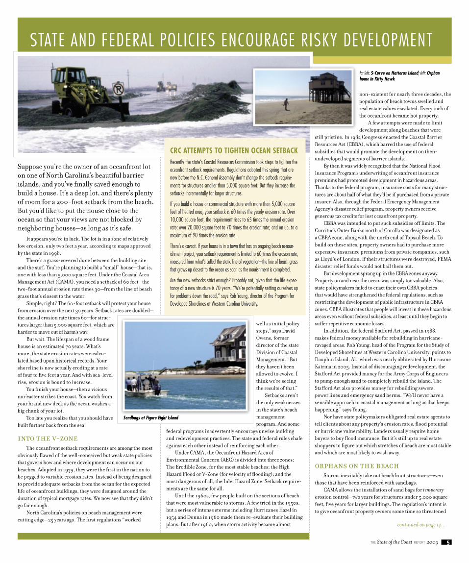
Suppose you’re the owner of an oceanfront lot on one of North Carolina’s beautiful barrier islands, and you’ve finally saved enough to build a house. It’s a deep lot, and there’s plenty of room for a 200-foot setback from the beach. But you’d like to put the house close to the ocean so that your views are not blocked by neighboring houses—as long as it’s safe.
It appears you’re in luck. The lot is in a zone of relatively low erosion, only two feet a year, according to maps approved by the state in 1998.
There’s a grass-covered dune between the building site and the surf. You’re planning to build a “small” house—that is, one with less than 5,000 square feet. Under the Coastal Area Management Act (CAMA), you need a setback of 60 feet—the two-foot annual erosion rate times 30—from the line of beach grass that’s closest to the water.
Simple, right? The 60-foot setback will protect your house from erosion over the next 30 years. Setback rates are doubled—the annual erosion rate times 60—for struc-tures larger than 5,000 square feet, which are harder to move out of harm’s way.
But wait. The lifespan of a wood frame house is an estimated 70 years. What’s more, the state erosion rates were calcu-lated based upon historical records. Your shoreline is now actually eroding at a rate of four to five feet a year. And with sea-level rise, erosion is bound to increase.
You finish your house—then a vicious nor’easter strikes the coast. You watch from your brand new deck as the ocean washes a big chunk of your lot.
Too late you realize that you should have built further back from the sea.
Into the V-Zone The oceanfront setback requirements are among the most
obviously flawed of the well-conceived but weak state policies that govern how and where development can occur on our beaches. Adopted in 1979, they were the first in the nation to be pegged to variable erosion rates. Instead of being designed to provide adequate setbacks from the ocean for the expected life of oceanfront buildings, they were designed around the duration of typical mortgage rates. We now see that they didn’t go far enough.
North Carolina’s policies on beach management were cutting edge—25 years ago. The first regulations “worked
well as initial policy steps,” says David Owens, former director of the state Division of Coastal Management. “But they haven’t been allowed to evolve. I think we’re seeing the results of that.”
Setbacks aren’t the only weaknesses in the state’s beach management program. And some
federal programs inadvertently encourage unwise building and redevelopment practices. The state and federal rules chafe against each other instead of reinforcing each other.
Under CAMA, the Oceanfront Hazard Area of Environmental Concern (AEC) is divided into three zones: The Erodible Zone, for the most stable beaches; the High Hazard Flood or V-Zone (for velocity of flooding); and the most dangerous of all, the Inlet Hazard Zone. Setback require-ments are the same for all.
Until the 1960s, few people built on the sections of beach that were most vulnerable to storms. A few tried in the 1950s, but a series of intense storms including Hurricanes Hazel in 1954 and Donna in 1960 made them re-evaluate their building plans. But after 1960, when storm activity became almost
non-existent for nearly three decades, the population of beach towns swelled and real estate values escalated. Every inch of the oceanfront became hot property.
A few attempts were made to limit development along beaches that were
still pristine. In 1982 Congress enacted the Coastal Barrier Resources Act (CBRA), which barred the use of federal subsidies that would promote the development on then- undeveloped segments of barrier islands.
By then it was widely recognized that the National Flood Insurance Program’s underwriting of oceanfront insurance premiums had promoted development in hazardous areas. Thanks to the federal program, insurance costs for many struc-tures are about half of what they’d be if purchased from a private insurer. Also, through the Federal Emergency Management Agency’s disaster relief program, property owners receive generous tax credits for lost oceanfront property.
CBRA was intended to put such subsidies off limits. The Currituck Outer Banks north of Corolla was designated as a CBRA zone, along with the north end of Topsail Beach. To build on these sites, property owners had to purchase more expensive insurance premiums from private companies, such as Lloyd’s of London. If their structures were destroyed, FEMA disaster relief funds would not bail them out.
But development sprang up in the CBRA zones anyway. Property on and near the ocean was simply too valuable. Also, state policymakers failed to enact their own CBRA policies that would have strengthened the federal regulations, such as restricting the development of public infrastructure in CBRA zones. CBRA illustrates that people will invest in these hazardous areas even without federal subsidies, at least until they begin to suffer repetitive economic losses.
In addition, the federal Stafford Act, passed in 1988, makes federal money available for rebuilding in hurricane-ravaged areas. Rob Young, head of the Program for the Study of Developed Shorelines at Western Carolina University, points to Dauphin Island, Al., which was nearly obliterated by Hurricane Katrina in 2005. Instead of discouraging redevelopment, the Stafford Act provided money for the Army Corps of Engineers to pump enough sand to completely rebuild the island. The Stafford Act also provides money for rebuilding sewers, power lines and emergency sand berms. “We’ll never have a sensible approach to coastal management as long as that keeps happening,” says Young.
Nor have state policymakers obligated real estate agents to tell clients about any property’s erosion rates, flood potential or hurricane vulnerability. Lenders usually require home buyers to buy flood insurance. But it’s still up to real estate shoppers to figure out which stretches of beach are most stable and which are most likely to wash away.
Orphans on the BeachStorms inevitably take out beachfront structures—even
those that have been reinforced with sandbags.CAMA allows the installation of sand bags for temporary
erosion control—two years for structures under 5,000 square feet, five years for larger buildings. The regulation’s intent is to give oceanfront property owners some time so threatened
CRC ATTEMPTS To TighTEn oCEAn SETbACkRecently the state’s Coastal Resources Commission took steps to tighten the oceanfront setback requirements. Regulations adopted this spring that are now before the N.C. General Assembly don’t change the setback require-ments for structures smaller than 5,000 square feet. But they increase the setbacks incrementally for larger structures.
If you build a house or commercial structure with more than 5,000 square feet of heated area, your setback is 60 times the yearly erosion rate. Over 10,000 square feet, the requirement rises to 65 times the annual erosion rate; over 20,000 square feet to 70 times the erosion rate; and on up, to a maximum of 90 times the erosion rate.
There’s a caveat. If your house is in a town that has an ongoing beach re-nour-ishment project, your setback requirement is limited to 60 times the erosion rate, measured from what’s called the static line of vegetation–the line of beach grass that grows up closest to the ocean as soon as the nourishment is completed.
Are the new setbacks strict enough? Probably not, given that the life expec-tancy of a new structure is 70 years. “We’re potentially setting ourselves up for problems down the road,” says Rob Young, director of the Program for Developed Shorelines at Western Carolina University.
continued on page 14...
STATE AND FEDERAL POLICIES ENCOURAGE RISKY DEVELOPMENT
far left: S-Curve on Hatteras Island; left: Orphan home in Kitty Hawk
Sandbags at Figure Eight Island

the State of the Coast report 20096
All are expensive responses to a rising Atlantic Ocean. And it’s only beginning.
Consider: The Atlantic has risen on average about 18 inches a century in all the time we’ve been putting buildings and roads along its edge. But the natural order is changing because of global warming. The best scientific forecasts now predict that the ocean will rise at almost double its historic rate during this century. And even that dramatic increase may be too conservative. No one, for instance, predicted what happened in the Antarctic in 2008.
In February of that year, a large piece of the Wilkins Ice Shelf on the southwest Antarctic Peninsula broke free and fell into the ocean, stunning climate scientists. The slice that collapsed measured a mile and a half in width and more than 25 miles in length. Its cleaving triggered what one journal called “the runaway disintegra-tion” of 250 square miles of the interior of the ice flow.
The ice cap was melting. Quickly.Without question, things are warming up. On the north
side of the globe, the polar ice cap has shrunk faster than predicted by any of the computer models used to make forecasts about climate change. At the end of last summer, the polar cap was nearly a third smaller than its average autumnal size from 1979 to 2000. In a couple of years, ships should be able to steam through ice-free polar waters, at least during the summer. The illusionary Northwest Passage will become a reality.
That means trouble is brewing for us in North Carolina, half of a globe away.
Melting icebergs in the North Atlantic have no effect on the N.C. coast. Like ice cubes melting in a tumbler of water, the icebergs add no additional volume to the ocean. Glaciers are another matter entirely. Huge amounts of water will be released into the oceans if they melt. The last time the Earth was ice free, the coastline of what would become North Carolina was somewhere close to where I-95 is now. Add to that, the expansion of the ocean that will occur as the Atlantic warms. Every careless cook learns about thermal expansion when failing to keep a close eye on the pot of bubbling spaghetti water.
No one is yet selling beachfront property in Rocky Mount, but the best available forecasts aren’t encouraging. The United Nation’s International Panel on Climate Change predicted in 2007 that the oceans of the world will rise an average seven to 23 inches by 2100. The forecast, though,
excluded a rapid disintegration of the world’s ice sheets. With melting glaciers, panel members gauged that a three-foot rise in sea level was possible.
But the panel’s report was based on data that were already several years old. A review of more current literature in the Journal of Bioscience in 2008 came up with a worst-case scenario of a five-foot rise in sea level during the next century.
In April 2009, the respected journal Nature published a study showing that about 121,000 years ago the world’s seas rose six-and-a-half to 10 feet within 50 to 100 years.
Though the predictions may not yet be precise, the bottom line is clear: Trouble is coming.
The vulnerability of any coastal area to the brimming sea depends on its slope and elevation. A three-foot rise
of the Atlantic would have little effect in Maine, say, where granite cliffs rise vertically from the sea. Here, we mostly have sand, flat sand. North of Cape Lookout, elevations are especially low, and the land climbs gradually. Along the Albemarle Sound, the land gains only a few inches in elevation for every mile traveled inland. South of the cape, the land rises more quickly, climbing nearly three feet west of Wilmington for every mile traveled from the coast.
Models have been developed to predict coastal inunda-tion with various amounts of sea level rise. On the Outer Banks, thought to be the most at risk, a study by the Nature Conservancy and the Albemarle Pamlico National Estuary Program shows most of south Nags Head and Roanoke Island under water with a one-foot rise. That’s the so-called bathtub model, in which waters rise slowly and evenly.
But barrier islands are shaped most by many natural forces, including storms, and it’s likely that higher sea level will mean increased storm surges—especially if warmer seas and temperatures give birth to more powerful hurricanes.
Maps by Stanley Riggs and Dorothea Ames of East Carolina University show Cape Hatteras breaking into small islands surrounded by open water if the ocean continues to rise at its current rate or if the Outer Banks are hit by Category Four or Five hurricanes—storms the size of Katrina and Rita. The central coast barrier islands would still be intact with a 13.7-inch rise in sea level, according to predictive maps by Ben Poulter, a former Duke University researcher. But they would be much thinner. Mainland and islands together, Poulter predicts about 770 square miles of dry ground would be gone with eastern Carteret County and the peninsula between Albemarle and Pamlico sounds being most vulnerable.
Rising Seas Mean Brewing TroublesProtecting Our Beaches: Eddies and Shoals ...continued from page 4
That action bought property owners enough time to convince local and state officials that the inlet channel should be relocated so it would no longer threaten the north end of Wrightsville Beach. In 2002 the channel was moved 3,000 feet to the north. Other seaside communities took note. In 2005 Bogue Inlet channel was moved to the west to lessen erosion on Emerald Isle. Relocation has also been proposed for Rich Inlet to give relief to threatened properties on Figure Eight Island.
Despite the variances that allowed hard structures to be built at Oregon Inlet, Fort Fisher and Bald Head Island, many state officials continued to support the ban. In 2003 the N.C. General Assembly passed House Bill 1028, which prohibited construction of any permanent erosion control structure on the oceanfront. Its passage took what had been a state policy and gave it the weight of law.
ThE “ExPERiMEnTAl gRoin” FAllACyAlthough beach re-nourishment is the least damaging
way to forestall erosion, it’s very expensive. Between 1936 and 2006, more than $197 million was spent re-nourishing North Carolina beaches. Many of the early projects were compara-tively easy, carried out on shores with low-energy waves and a good sand supply close to land. In 2000 the Corps estimated it would need between $10 million and $11.5 million a year to meet re-nourishment demands along 60 miles of state beaches. In 2006 cost estimates for a 14-mile project in Dare County came in at close to $1 billion over 50 years.
But with the federal deficit swelling, Army Corps of Engineer funds for beach re-nourishment—once considered easily accessible—have been cut to the bone. Coastal residents are reluctant to shoulder the full cost of such projects.
Oceanfront property owners are nervously looking for other answers.
A bill in the state Senate in 2006 proposed allowing “experimental structures to be used along inlets to help protect private property.” It died. But in 2007 and 2008 other legisla-tion was proposed that would allow construction of a small jetty around the north end of Figure Eight Island. Both bills failed. Nonetheless, political pressure continues to build.
This year a bill that would allow small jetties to be built on eroding beaches passed the state Senate quickly. Fortunately, many legislators know they have only to look to beaches in other states to see the damage such structures can cause.
bEATing ThE oddSThrough all the high tides, storms and political maneuver-
ings, the Sea Ranch has remained standing. Its viability got a much-needed boost after Hurricane Isabel in 2003, when the Federal Emergency Management Agency financed the building of an emergency berm along much of the Dare County Outer Banks. Sand was trucked in from a mine in Currituck County and placed in a long ridge along the beach.
Much of the berm remains. But the beach in front of the Sea Ranch is steeper than a natural beach, and the tops of sand bags are visible—a potent reminder that erosion, like rust, never stops.
Every beach town in North Carolina is clamoring for sand to pump onto its eroding beaches. Property owners in some of those towns are paying higher taxes to finance beach projects that exceed a million dollars per mile of restored beach. Inlets are being moved to protect threatened beachfront houses. Jetties are being considered to keep islands from moving.
Shell Island, before the inlet relocation

7the State of the Coast report 2009
The idea was simple. Bring together the top experts in the various fields of managing growth along the state’s beaches. Put them all in one room for a couple of days to brainstorm. And, in the end, have them come up with a better plan to address rapid coastal development and accelerated sea-level rise while protecting our public beaches.
We think they did.The N.C. Coastal Federation and the Center
for the Study of Natural Hazards and Disasters at UNC-Chapel Hill, with some funding help from the N.C. Beach, Inlet & Waterway Association, convened a Beach Management Summit in Beaufort in March 2009.
We asked the 41 diverse participants to discuss emerging threats to the public beach and to evaluate existing ocean-front policies, programs and regulations. We challenged them to suggest actions to ensure North Carolina is prepared to address development, coastal storms and sea-level rise along our oceanfront. The goal of the meeting was to identify a coherent set of policy recommendations that are supported by science and will further the basic policy of North Carolina to protect its oceanfront recreational beaches.
The only requirement was that those recommenda-tions had to promote the fundamental state policy that our public beaches are among our most important environ-mental, social and economic assets, and that nothing they recommend would endanger their continued existence and health. In short, everyone agreed to attend this meeting understanding we would not make recommendations that placed a higher priority on protecting private and public oceanfront developed land over the priority of protecting our public trust recreational beaches.
Beyond this one ground rule, the summit provided an open forum to challenge existing ideas, rules and programs. We encouraged participants to think creatively, but at the same time remember that if we have learned anything from the past two decades, it is the difficulty inherent when adopting, implementing and enforcing regulatory policies and programs. We pushed participants to be specific and focus their recommendations so that they can be acted upon and enacted as policy.
Summit FindingsExisting state policies and rules that manage growth on
North Carolina’s beaches were originally designed with one clear purpose: Protect the North Carolina’s beaches for the public. Unfortunately, other state or federal policies often conflict with that goal, and the state has failed to put effective programs in place to protect the public beach.
Those are among the key findings of the Beach Summit after participants considered a range of topics, such as the history of beach policy in North Carolina, the influence of federal and state programs on beach management and community development and economic trends that affect beach protection.
The key findings, which form the basis for recommendations, are:
Current policies were formulated with the priority of protecting the public recreational beach. Existing policies and regulations that manage the beachfront of North Carolina were designed with the intent that the public beach should be protected even at the expense of other oceanfront land uses. State policy makers viewed the need to protect the beach for the public trust as paramount.
Many state and federal policies are not coordinated and work at cross purposes with the state’s existing priority to protect the public beach. Some existing federal and state governmental programs do not reinforce the state’s goal of protecting the public beach. North Carolina has not been sufficiently aggres-sive in its efforts to bring consistency to these programs so
that they align with state policies.Advancements in the scientific understanding of
climate, sea-level rise and the effects of coastal storms send a clear warning that we are ill-prepared to adapt. These major drivers seriously challenge North Carolina’s resolve to protect its beaches.
Our ability to predict changes in beaches as a result of these drivers is improving dramatically, but this infor-mation has not been adequately used to devise long-term management programs. The failure to put effective programs in place before they are needed has and will result in short-sighted management decisions that degrade the public beach.
Current development trends illustrate a disconnect between short-term and long-term beach manage-
ment needs. The density and size of oceanfront development is increasing even in light of warnings about storm activity and increasing rates of sea-level rise. Building setback distances are inadequate to provide for the long-term protection of our public beaches. The N.C. Coastal Resources Commission has modified setback requirements and is waiting for legislative approval of its revised rules.
Protecting the public beaches is compatible with the Coastal Habitat Protection Plan. The plan recognizes beach re-nourish-ment as an accepted tool for beach protection as long as proper grain size and necessary dredging moratoriums continue to be used to minimize ecological harm to living organisms.
Findings and Recommendations Issued by Summit Participants (Please note: Participants issued these recommendations as individuals. Organizational affiliations are for identification purposes only and do not imply any endorse-ment by these agencies.)
Dick Bierly, vice president, N.C. Coastal Federation• Ray Burby, professor emeritus, Department of City and Regional Planning, •
UNC-Chapel HillChris Canfield, executive director, Audubon North Carolina• Derb Carter, executive director, Southern Environmental Law Center• Matthew Converse, Bank of Currituck• Chris Dumas, associate professor, Department of Economics and Finance, •
UNC-WilmingtonBob Emory, chairman, N.C. Coastal Resources Commission• Dave Godschalk, Stephen Baxter professor emeritus, Department of City •
and Regional Planning, UNC-Chapel Hill
Joe Ramus, Research Professor, Duke University Marine Lab• Dara Royal, chair, Coastal Resources Advisory Council• Greg Rudolph, manager, Carteret County Shore Protection Office• Harry Simmons, executive director, N.C. Beach and Inlet Waterway Association• Gavin Smith, executive director, Center for the Study of Natural Hazards •
and Disasters, UNC-Chapel HillJim Stephenson, policy director, N.C. Coastal Federation• Doug Wakeman, economics professor, Meredith College• J.P. Walsh, assistant professor, Department of Geology, East Carolina University• Joan Weld, vice chairwoman, N.C. Coastal Resources Commission• Berry Williams, Berry A. Williams & Associates• Rob Young, director, Program for the Study of Developing Shorelines, •
Western Carolina University
Jimmy Johnson, eastern regional field officer, N.C. Department of • Environment and Natural Resources
Charles Jones, retired director, N.C. Division of Coastal Management• Rick Luettich, director and professor, Institute of Marine Sciences, •
UNC-Chapel HillDavid Marlett, director, Brantley Risk and Insurance Center; Chair, •
Department of Finance, Banking & Insurance, Appalachian State University Todd Miller, executive director, N.C. Coastal Federation• Charlotte Mitchell, K&L Gates• Pres Pate, retired director, N.C. Division of Marine Fisheries; retired •
associate director, N.C. Division of Coastal Management Mack Paul, K&L Gates• Len Pietrafesa, director, Office of External Affairs, College of Physical & •
Mathematical Sciences, N.C. State University
Beach Summit: Experts Convene, Come Up with Better Plan
Beach Summit participants
Isabel Inlet at Hatteras

the State of the Coast report 20098
Limits on high-rise buildings on the oceanfront, changes in the federal flood insurance program, money to relocate buildings threatened by erosion and limits on the amount of money spent to rebuild storm-damaged public infrastructure are just a few of the sweeping recommendations made by summit participants.
The purpose of the recommendations is to refocus state and federal policies of managing growth on the oceanfront so that they consistently reinforce the goal of protecting public recreational beaches.
To do that, participants came up with two sets of recom-mendations. The first is aimed at buying time for coastal communities by allowing them to effectively protect their beaches and existing oceanfront development without compromising the public beach in the process. The other recommendations would help those communities better adapt to sea-level rise and storms that will inevitably lead to removing or relocating buildings and infrastructure and, over time, will trigger significant adjustments to land use patterns along the oceanfront in order to protect public beaches.
Buying TimeTo allow coastal communities to more effectively protect
beaches and existing oceanfront development, summit participants decided to:
Ask the N.C. General Assembly to allow the revised setback • rules recently adopted by the Coastal Resources Commission to go into effect.
Ask the N.C. General Assembly to enact a Family Beach Act • that places limits on high-rise buildings and other forms of high-density development on the oceanfront, patterned after the height limits adopted by most beach communi-ties. This would prevent beach nourishment projects from encouraging increased building densities along the oceanfront, and give longer term adaptation and relocation strategies more chance to succeed.
Ask the N.C. Coastal Resources Commission (CRC) to • amend and seek federal approval of the N.C. Coastal Area Management Program to include a specific policy statement that prevents the loss of sand to the beach system as a result of navigational dredging projects.
Ask the CRC and the N.C. Division of Coastal Management • (DCM) to take the lead in coordinating state and federal programs that protect our public recreational beaches.
Ask the CRC to strengthen the existing post-disaster • reconstruction component found in North Carolina CAMA
plans to include an actionable strategy describ-ing how the public recreational beach will be protected through adaptive management strate-gies that make them less vulnerable to future coastal hazards.
Ask Congress to direct the National Flood Insurance • Program to pay for the relocation of threatened structures before they are claimed by the ocean.
Ask the N.C. General Assembly to enact a program that • funds and assigns responsibility for removing buildings from the publicly owned beach.
Ask the N.C. General Assembly to allocate adequate money • to ensure that DCM has the capacity to enforce sand compat-ibility standards for all beach nourishment projects.
Ask Congress to change funding formulas for beach • nourishment so that they place an equal or greater value on environmental, recreational and public access benefits versus the current emphasis concerning storm damage reduction for structures, which favors higher building densities.
Ask the N.C. General Assembly to work with local • governments to identify additional funding and innovative financing strategies for beach nourishment projects that are consistent with the state’s strategy for allocating sand resources under the Beach and Inlet Management Plan.
Ask the Coastal Resources Commission to ensure the • forthcoming Beach and Inlet Management Plan provides a strategy for allocating sand resources and alternative reloca-tion strategies for those beach communities that don’t have adequate sand resources to do beach nourishment.
Sea-Level RiseTo allow beach landowners and local, state and federal
agencies to better adapt to accelerated sea-level rise, summit participants decided to:
Ask the N.C. General Assembly to mandate and fund opera-• tional programs that remove or relocate buildings and infra-
structure. These programs need to be designed so that they do not sacrifice public recreational beaches to protect private oceanfront property.
Ask Congress to direct National Flood • Insurance Program to develop “erosion” insurance that would help landowners self-
finance to protect themselves against financial losses associated with coastal erosion.
Ask Congress to fund a joint • state and federal adaptation study covering Virginia, North Carolina and South Carolina that helps develop relocation and removal strategies using existing authori-
ties of the US Army Corps of Engineers.
Request that the N.C. Division of Emergency • Management work with DCM to plan the $5 million federally funded study on sea-level rise to ensure that it establishes sound adaptation strategies for how beachfront communities can adapt to long-term sea-level rise without degrading their public beaches.
Ask the CRC to identify counterproductive federal • or state programs that encourage intense develop-ment along the oceanfront. These programs should be eliminated or modified to be consistent with the state’s Coastal Management Program, and counterproductive programs should be made ineligible under the Coastal Zone Management Act for federal permits, grants or loans.
Ask the CRC and the N.C. Division of Emergency • Management to integrate post-disaster planning require-ments with hazard mitigation planning requirements in one plan that includes the latest scientific understanding of sea-level rise, erosion and other coastal hazards.
Ask the legislature to make the CRC the lead entity responsi-• ble for coordinating adaptation programs that are designed to relocate and remove land uses that are no longer sustainable.
Ask Congress and the legislature to modify existing • programs and develop long-term funding mechanisms to assist communities in adapting to changing coastal conditions.
Ask the N.C. General Assembly to establish public policy • that limits the use of public funds to rebuild or improve substantially damaged public infrastructure and critical facili-ties located in the oceanfront flood zones following disasters.
Ask the N.C. General Assembly to direct the CRC to • develop recommendations for responding to erosion hazards and planning for sea-level rise so that the public recreational beach is always protected.
Sweeping Recommendations Would Protect State’s Beaches
It is essential the recommendations made by participants of the Beach Summit be acted upon quickly and concurrently to provide comprehensive oceanfront management programs that protect the public recreational beach.
Summit participants warn that piecemeal application of these recom-mendations will increase the likelihood that management efforts will work at cross-purposes and undermine the goal of protecting the beach.
reCoMMeNdatioNs are Call to aCtioNThe group envisions that management programs resulting from these
recommendations must work in concert to address changing beach conditions responding to sea level rise, storms and the daily ebb and flow of the ocean. All summit participants stress that protection of the public recreational beach must remain the clear purpose and outcome of all management decisions along North Carolina’s oceanfront.
Summit participants believe the effective protection of the public rec-reational beach can only occur by getting out in front of issues and threats and not waiting until the beaches are in crisis. North Carolina’s beaches are simply too valuable to leave their fate to a reactionary management approach that results in decisions that satisfy no one. Adopting a business as usual approach is not an option if future generations are to continue to benefit from North Carolina’s wonderful beaches.
above: Sandbags at Pea Island; right: Hatteras, before and after. Photo courtesy of NOAA

9the State of the Coast report 2009
NoRthEast
BusinessBank of Currituck
Last year, in the heat of the debate over the new state stormwater rules, the Bank of Currituck went out on a limb by hosting a workshop that helped to bring the federa-tion’s message of low-impact development (LID) to area builders. As president of the bank and a member of the federation’s Board of Directors, Matt Converse cultivated a discussion with northeast coast developers and builders by hosting the workshop at the bank’s Grandy branch. Area developers, builders and citizens learned about LID from Larry Coffman, a nationally recognized LID pioneer and expert. Matt has offered to use Bank of Currituck branches in Grandy and Moyock as demonstration sites for green development and LID practices as a way of showing the public their commitment to sustainable development. He continues to present an environmentally friendly message to audiences within his sphere.
Citizen ActionC.O.A.S.T? (Can Our Actions Save Tomorrow?)
A group of residents north of Corolla on the Currituck Outer Banks found the answer to that question to be a resounding yes. The group, known as C.O.A.S.T, fought hard against a county zoning change that would have allowed commercial development in their part of the islands, which doesn’t even have a road. The only way to reach the small settlements of Swan Beach and Carova is to drive the beach. It’s not a suitable place for shops and hotels, as C.O.A.S.T. members effectively argued to the
Currituck Board of Commissioners in November. The activists pulled together information about the effects of development on stormwater and the water table, traffic on the beach, emergency service and evacua-tion problems, disturbance of wildlife and more. Their arguments were so carefully drawn that the commis-sioners voted unanimously to deny the zoning change.
Environmental EducationMary Doll (Cape Hatteras National Seashore)
Each year the National Park Service offers high-quality environmental education outings that reach thousands of visitors to the Cape Hatteras National Seashore. Mary Doll, the seashore’s chief of interpretation, works hard
to make sure the programs impart a great deal of information about the fragile coastal system of the Cape Hatteras region. Judging from the high popularity of the programs, they’re also lots of fun. In 2008, Sara Hallas, the federation’s NE outreach specialist, partnered with Doll to offer a sound-side seining
2008 Pelican AwardsstatEwIDE
Lifetime Achievement Sam Bland (pictured right)
By the time the federation gets around to recognizing someone with our lifetime achievement award, the winner has normally contributed about as much as is humanly possible toward the protection and well-being of our coast. This year’s award goes to Sam Bland, and while he deserves this award for his past accomplishments, we give it to him with the expectation that he has the potential to win this award a second time given his ongoing dedication to the protection and restoration of our beautiful coast.
At age 50, after 30 years in the Department of Environment and Natural Resources, 22 of them as a ranger and superintendent of Hammock Beach State Park, Sam retired in February from his official responsibilities to protect and manage one of our coast’s most special places. Sam took care of the park in a way that protected its natural resources while at the same time allowed the public to enjoy and understand its spectacular natural heritage. That’s a tough balancing act when you’re responsible for protecting one of the crown jewels of our state—there’s the tendency to love such treasures to death. He has devoted himself to being one of our state’s best and most responsi-ble coastal stewards by consistently carrying out his duties with the N.C. Division of Parks and Recreation with passion and dedication.
For the past several years, Sam has served as a board member of the federation. Since his retirement, he has become our most active volunteer, putting in long hours working to advance our mission. Sam seeks no recognition or glory for his good works—he is motivated only by what’s good for the coast. His approach to environmental steward-ship represents our best hope for maintaining a healthy and productive coast for future generations. He inspires everyone he works with to put aside unproductive rhetoric, roll up their sleeves and get to work. He is an inspiration to us all.
LegislativeGeorge Givens (pictured right)
Enacting laws has often been compared to sausage making, and for the past 23 years, George Givens has served up some of the finest fare in the N.C. General Assembly. As chief counsel to the legislative committees handling environmental issues, Givens had a principal role in writing the laws that define how development and natural resources are managed in North Carolina.
In 2008, Givens presided over a series of contentious stakeholder meetings on the Coastal Stormwater rules. The law that emerged from these negotiations resulted in science-based protections for sensitive shellfish waters in all 20 coastal counties – a long sought-after objective of
the federation. The bill passed unanimously in the Senate and 105-4 in the House.
Often, Givens found it necessary to convene stakeholder meetings to craft a compromise between competing interests. When the Lower Neuse River experi-enced fish kills during the mid-1990s, Givens crafted the Clean Water Responsibility and Environmentally Sound Policy Act of 1997. When trash speculators concocted projects for skyscraper mounds of trash near wildlife refuges and public gamelands, Givens penned the Solid
Waste Management Act of 2007, and he continued to work through a myriad of other sensitive legislation as environ-mental issues arose.
State Government Official Mike Randall (pictured left)
While low-impact development (LID) is gaining popularity nation-wide, the dedication of one state government official is helping lead the way for use of LID in coastal North Carolina. Mike Randall with the N.C. Division of Water Quality has demon-strated a real commitment to using LID as an option for developers in
meeting state stormwater requirements. LID is a relatively new development approach that reduces and often prevents pollution from stormwater runoff.
Mike has made great strides toward changing our business-as-usual approach to stormwater management, recognizing the limitations of conventional pipe and pond systems in protecting water quality. He partnered with New Hanover County; Brunswick County; Wilmington; Withers & Ravenel, an engineering firm; and the federation to develop a LID manual and other supporting tools. Mike is a true champion of LID and actively promotes its use in North Carolina.
Special RecognitionOlivia Holding (pictured right)
Olivia Holding is well-known throughout North Carolina as an energetic environmental advocate and is actively engaged in a number of statewide boards, including that of the federation. Olivia has guided the growth of the federation as a board member since 1996. In 2006 she took on the leadership role in the federation’s historic campaign to raise $3 million. For three years, Olivia directed her enthusiasm and love for the coast to raise visibility and donations. She traveled to
meet with donors and convincingly told her story about the critical role that the federation plays in protecting and restoring the coast. Through her leadership, the Campaign Steering Committee successfully ended the campaign with more than $3 million raised, hundreds of new friends and coast-wide expansion of the federation, putting Coastkeepers®, restoration and education staff to work in three regional offices.

the State of the Coast report 200910
program at Oregon Inlet. She got a first-hand look at how well Doll’s programs work.
“Mary oversees programs not only on Cape Hatteras, but also at Fort Raleigh Historic Site and at Wright Brothers Memorial,” Sara says. “She manages to create such a wide variety of interpretive programming, there’s something for everyone. “
VolunteerCliff Ritt
If you need something done to help protect water quality, rally the kayakers. That’s been the philosophy of Cliff Ritt, the former president of the Outer Banks Paddling Club. In 2008 Cliff convinced club members to show up in force at numerous important public meetings, including a June rally in Raleigh asking legislators to support strengthened coastal stormwater regulations, the public meeting on the state’s new Beach and Inlet Management Plan and a Manteo Board of Adjustments hearing on the permit for the federation’s new office building. Thanks to his efforts, many voices have spoken loudly about the importance of protecting coastal waters. Cliff has also enthusiastically recruited new federa-tion members, and he was recently named to the federation’s Northeast Region Advisory Board.
Conservation/Restoration Katherine Mitchell (pictured below right)
The Northeast regional award goes to a person rather than a specific project. Katherine Mitchell has dedicated herself to helping restore the natural hydrology of the coast through the use of native plants and rain gardens. As the horticulturist for the N.C. Aquarium on Roanoke Island, she has spearheaded the installation of several low-impact development features on the aquarium property. Through her efforts, the aquarium has installed cisterns to collect run-off from the building’s roof and a showcase rain garden, which she designed and maintains.
Kathy has done more than anyone else to bring about the cumulative success of rain gardens in the Northeast region. She has served as a trusted advisor and partner to the federation in the design and installation of rain gardens throughout Manteo, including the gardens at the federation’s new office and elsewhere in the region. She speaks frequently to public groups on the value of using native plants and installing rain gardens.
CENtRal
BusinessWal-Mart (pictured right)
The federation’s introduction to Wal-Mart came when the retail giant purchased land for its newest store in Carteret County. Federation staff contacted the new store engineers and suggested a number of low-impact development (LID) strategies that they might incorporate into the construction. Wal-Mart agreed to vary their design in order to help protect the nearby waters of the White Oak River. A call from a Wal-Mart staff person later led to a project that introduced the federation to Diana Gardner, and a great community partnership began. Through Diana’s encouragement, the federation began a school rain garden program that helps students along the coast learn about the coastal environ-ment and help plan, build and plant rain gardens at schools. In addition to funding four rain gardens, Wal-Mart has provided dozens of volunteers from their stores to assist with plantings and other volunteer activities.
Citizen ActionDick Bierly (pictured right)
Some people retire to relax but not Dick Bierly of Morehead City. Since moving to Carteret County in 1992, Dick has been
actively working to protect our natural resources. Recognizing the link between a healthy coastal environment and a healthy coastal economy, Dick has been a major player in bringing both economic and conservation interests to the table to discuss complicated coastal issues. He is a strong advocate of effective planning and promotes the connection between land uses and water quality. Dick played a major role in the debate and adoption of the state’s coastal stormwater rules, participat-ing in several key agency meetings and public hearings. Dick also leads the Coastal Caucus, a collaboration of environmental groups that meets to strategize on key coastal issues. He also developed the concept of a Coastal Growth Strategies Course for local elected officials that the federation has worked with partners to organize and hold.
Environmental EducationJeannie Kraus
Jeannie Wilson Kraus, recently retired as education curator from the N.C. Maritime Museum, has been educating students and adults along the N.C. coast for many years. Though retired, she still leads programs to Cape Lookout National Seashore and into the Croatan National Forest. She has been an integral part in the federation’s annual native plant festival as a “plant expert,” teaching others about native plants and their uses in landscaping. Jeannie, author
of A Guide to Ocean Dune Plants Common to North Carolina and A Guide to Salt Marsh Plants Common to North Carolina, has been a frequent guest on the federation’s cable show and has volunteered her time in the past to help lead trips with federation educators.
VolunteerDonna Snead (pictured left)
Donna Snead has been volunteering for the federation for over five years and plans to volunteer for many more.
Donna, who splits her time between Virginia and North Carolina, lives in Emerald Isle. She volunteers for many organizations in Carteret County, but logs the most hours for the federation. Donna has worked diligently in every federation habitat restoration event, festival and headquarters event and she also serves on the federation’s Board of Directors. Donna often takes her show on the road, setting up and manning booths for different events in and around Greensboro. In 2008, Donna volunteered over 100 hours for the federation and she hasn’t slowed down in 2009. Her constant energy and sincere interest in volunteering have endeared her to federation staff and
other volunteers.
Conservation/RestorationCape Lookout National Seashore and the Core Sound Waterfowl Museum and heritage center
The goal of this successful demonstration project was to reduce bacteria concentrations entering into Core Sound by identifying, designing and installing several low-impact developments (LID) treatments. Two cisterns, three rain gardens and a stormwater wetland were installed at the museum and the seashore’s visitor center and are helping to capture, absorb and filter polluted stormwater runoff that would have flowed into the adjacent shellfish waters of Core Sound. N.C. State University’s Department of Biological & Agricultural Engineering designed the project and the Duke University Marine Lab near Beaufort is monitoring it. The N.C. Clean Water Management Trust Fund, North Carolina Sea Grant and by the N.C. Division of Soil and Water Conservation’s Community Conservation Assistance
2008 Pelican Awards

11the State of the Coast report 2009
Program provided money for the project. Other project partners included the Master Gardener volunteers of N.C. State University’s Cooperative Extension and Harkers Island Elementary School.
southEast
Local Government Phil Prete (City of Wilmington), Shawn Ralston (New Hanover County)
Recognizing that conventional approaches to develop-ment are not adequately protecting water quality, in 2008, New Hanover County, the City of Wilmington and Brunswick County unanimously adopted Low Impact Development (LID) technical manuals to allow for voluntary use of LID to manage stormwater. LID is a relatively new approach to site design, development and land use planning that reduces and often prevents impacts from stormwater runoff.
Phil Prete, City of Wilmington Environmental Planner and Shawn Ralston, New Hanover County Environmental Planner dedicated tireless hours toward developing the easy to read, user-friendly LID manuals that received wide-spread support and buy-in from a both development and environmental interests. The final documents are already serving as models for implementing LID in other coastal communities. The North Carolina Coastal Federation partnered with the local governments and state Division of Water Quality to fund and support the project.
BusinessNew River Nets and Cofish International
The Shepard family, owners of the New River Nets and Cofish International in Sneads Ferry, are long-time friends and supporters of the federation. Over the years, New River Nets has donated boating supplies, foul weather field gear and restoration supplies to help keep the federation staff well-equipped and ready to work in the field. Most recently, they donated box loads of warm vests and rain gear to the federation for distribution to area school children who participated in one of the federation’s many field trips. They have also offered the federation at-cost barrels that are used to create rain barrels for sale at our annual native plant festival. Through the generosity of New River Nets, the federation’s boats and staff are better equipped to do our jobs in even the worst field conditions, and its dedication to our mission is an excellent example of how businesses can partner with the federation to help protect our coast.
Citizen Action Kelly Stryker and The Friends of the Lower Cape Fear (pictured below right)
Kelly Stryker and the Friends of the Lower Cape Fear demon-strate what committed people can achieve. In their efforts to stop a heavily polluting cement industry from locating along a pristine section of the Cape Fear River, Kelly and the other members of the group have collectively spent
thousands of hours to educate area residents about the potential adverse environmental effects and health hazards associated with the proposed Titan Cement Co. plant. Over the last year, they have taken their message from a door-to-door campaign, to the offices of EPA and to the offices of many of their state legislators. Kelly, one of the founders of the growing citizen effort, has been a guiding light in this fight. A prodigious researcher and tireless advocate, she has somehow managed to balance her fulltime effort to fight Titan with her other fulltime job as a mother of three small children.
Environmental EducationValerie Southgate and Jamie McGirt
During her second year of teaching in 1998 at John T. Hoggard High School in Wilmington, Valerie Southgate began bringing her classes out to the salt marsh in the hopes of sharing her love for the coast with her students. For 12 years, she has stressed the importance of the marsh and other estuarine habitats as critical components of our coastal ecology. Through her partnership with the federation, over 300 students have become engaged in the Student Habitat Education Program. Valerie’s’ hope is for her students to become young environmental stewards and educate others.
One of her students, Jaimie McGirt, has displayed passion and dedication toward protecting and restoring our coast. Jaimie cites growing up next to the ocean and having the beach and marshes as her tutors as the reasons behind her drive to become a vocal and active coastal steward. Through Jaimie’s student teaching, mentoring, volunteering and work with Hoggard’s National Honor Society, she has involved many of her fellow students in caring for the coast.
Volunteer Lockwood Folly Army (pictured above right)
In 2007, 16 people joined the federation on a project to determine what is ailing the Lockwood Folly River in Brunswick County. Jason Doll, an engineer for the project, dubbed them the “Lockwood Army.” Both Jason and the federation were amazed by the dedication of these volunteers who consistently sampled in even the most harsh weather condi-tions. The group took over 300 water samples to help determine what is causing the
continued closure of critical shellfish beds in the river. The members of the army are: Lynn Bohlen, Shelia
Drennen, Hans Forster, Bob Graham, Phyllis Evans, Ben & Eva Haddon, Tom Hetherington, Melody Knowles, Fred Loepp, John Michaux, Dave Pelizzari, Rich Peruggi, Kevin Talon, Joe Taylor and Hans Wagner.
Conservation/Restoration city of wilmington stormwater services and new hanover county planning department (james E.L. Wade Stormwater Wetland and Community Park) (pictured below)
New Hanover County and Wilmington joined forces to get funding from the N.C. Clean Water Management Trust Fund to acquire 17 acres and build an 11-acre stormwater wetland in the Hewlett’s Creek watershed. This project diverts two major stormwater outfalls away from the shellfish waters of the creeks and into a series of created stormwater wetlands. The stormwater wetlands help to capture and treat polluted runoff from about 10 percent of the watershed. The wetland also serves as critical habitat for native and migratory birds, animals and plants and is the largest constructed stormwater wetland in the area. After the wetland construction, the city installed a passive park on the same site. The park is named for James E. L. Wade, a former mayor and community activist. The project is part of an overall effort to restore Hewlett’s Creek and its shellfish waters.

the State of the Coast report 200912
2008 highlighTS
Promoted adoption of the state’s coastal stormwater • rules by organizing community meetings and recruiting volunteers to lobby legislators to support the new rules
Worked to protect North Carolina’s beautiful oceanfront • beaches by helping defend the state’s ban on new seawalls, groins and jetties
Laid the groundwork for restoring polluted tidal creeks • by conducting restoration studies supported by the U.S. EPA and N.C. Division of Water Quality
Opened the Northeast Regional Office in Manteo•
Expanded the federation’s reach to offer Coastkeeper®, • Restoration, Education and Outreach programs equally in all three coastal regions
Promoted low-impact development practices through • diversified public-private partnerships
Completed restoration of 1,991 acres at North • River Farms
Worked to complete a statewide action plan for oyster • habitat and secure $6.3 million in funding for the plan
Acquired 200 acres of land on the White Oak River •
Completed nine wetland and shoreline restoration • projects and built 15 rain gardens
Engaged 4,907 student volunteers and 979 adult • volunteers in our work
Built the federation’s membership from 8,500 to 9,000 •
Successfully completed its $3 million Capital Campaign•
North Carolina Coastal Federation
“In 2008 almost every aspect of our work has been dramatically influenced by seismic corrections in our economy, political leadership and the financial capacity of citizens, businesses, and governmental agencies to rise to the challenges our coast faces. Never in the 27-year history of the federation has our work been needed more. We satisfied these demands by stretching our creativity, efficiency and sweat equity.”
– Todd Miller, Executive Director, N. C. Coastal Federation
2 0 0 8 A N N U A L R E P O R TPhoto © Butch Bales

13the State of the Coast report 2009
noRThEAST REgionWith assistance from hundreds of volunteers, renova-•
tions were completed and the Northeast Regional Office in Manteo was opened. Coastkeeper®, Restoration, Education and Outreach Programs were fully staffed and Jan, Erin and Sara hit the ground running.
Worked with the Town of Manteo to conduct an inventory • of possible sites for installation of Best Management Practices (BMP) to improve water quality;
Created three rain gardens and planned three more to • reduce and filter stormwater;
Established partnerships and developed summer • educational programs, including a seining program at Bodie Island and wetlands walks at Roanoke Island Festival Park;
Initiated a student environmental education program in • the region and engaged more than 300 students in various programs;
Conducted two public education events – a low-impact • development (LID) workshop in March and a presentation in April by Dr. Stan Riggs of East Carolina University on sea level rise and predicted effects on the Outer Banks;
Challenged a stormwater permit for a development on • Hatteras Island to demonstrate inadequacies in old state standards;
Designed and secured funding for a living shoreline at • Jockey’s Ridge State Park to create fisheries habitat and improve water quality; and
Developed plans and secured initial funding for a restora-• tion project in Hyde County that will reduce stormwater runoff on 10,000 acres of agricultural land, paving the way for oyster reefs to be built just offshore in Pamlico Sound. This is the beginning of a multi-year project.
CEnTRAl REgionEnvironmental education •
programs were expanded, new programs were initiated and resto-ration milestones were reached. All the while, groundwork was laid for a major restoration/education initiative on Jones Island in the White Oak River.
Conducted shoreline plantings at • Jones Island, Carteret Community College, Lenoxville Point and Harkers Point;
Bagged and transported 1,677 • bags of oyster shell and 1,080 bags of marl in preparation for 2009 oyster restoration work at Jones Island;
Worked with students to • construct a rain garden at Chocowinity Middle School;
Completed restoration of the 1,991 acre Tract 1 at North • River Farms with 17,600 wetland plants and 33,500 trees;
Worked with the Core Sound Waterfowl Museum and the • Cape Lookout National Seashore Visitor Center on Harkers Island to install four additional LID stormwater treatments including a 1,500-gallon cistern, two rain gardens and a
stormwater wetland;
Installed a 1,500-• gallon cistern and created a rain garden at the federation headquarters;
Completed student • wetland nursery and oyster restoration projects with nine
middle and high schools in Carteret, Craven, and Onslow counties;
Expanded student education program to six additional • schools in Craven, Jones and Pamlico counties, reaching 2,000 students;
Completed the monitoring and modeling phase of a three-• year, EPA-funded study that looked at bacteria contamina-tion that is closing shellfish beds in the White Oak River. A plan for controlling runoff that is carrying bacteria to the river will be complete in 2009;
Conducted 54 public summer programs at Cape Lookout • National Seashore, engaging over 400 participants; and
Conducted the first Coastal Academy for local • elected officials educating 50 participants from coastal governments.
Major Accomplishments Jan. 1, 2008 to December 31, 2008
Photo © Butch Bales

the State of the Coast report 200914
SouThEAST REgionNCCF responded to threats from industry and other devel-•
opment, by encouraging citizens to become engaged and help protect water quality in their communities. Education programs were expanded to engage individuals of all ages in environmental stewardship.
Reported on two wetland violations to state agencies on • two developments, which resulted in Notices of Violation and significant fines;
Objected to development in coastal wetlands in Topsail • Beach with EPA input, which resulted in denial of the Corps of Engineer-required 404 permit;
Led efforts to develop LID manuals for New Hanover • County, the City of Wilmington and Brunswick County. The participating local governments unanimously adopted the manuals in 2008, opening the door for the use of LID by developers in these coastal communities;
Worked with 100-plus partners to • complete the Oyster Plan for 2008-2012, establishing a statewide action plan for oyster habitat. Helped gain a $2 million appropriation to expand the Division of Marine Fisheries oyster sanctuary program and $4.3 million to build an oyster research hatchery;
Led the effort by multiple citizen • groups to oppose a proposal to locate a large cement plant on the Northeast Cape Fear River;
Expanded education program, • engaging 160 middle school students in the Student Wetland Nursery program, and 141 high school students in the Oysters in the Classroom program;
Hosted two Neighborhood Creek meetings focused on • local creek issues, water quality and stewardship opportu-nities, which were attended by over 220 people;
Conducted summer field trips on Bird Island; •
Designed and/or created six rain gardens along the • southeastern coast;
Completed restoration of a “living shoreline” project and a • 100-foot-long oyster shell loading pier at Morris Landing to enable oyster habitat creation projects in Stump Sound;
As part of the Lockwood Folly Watershed TMDL project, • NCCF and volunteers collected 340 water quality and flow data samples during 17 sampling events throughout the
watershed; and
Assisted in develop-• ment of resolutions by Kure, Wrightsville and Carolina beaches for support of Marine No-Discharge zone in New Hanover County.
structures can be relocated, and to buy communities time to complete nourishment projects. But too often owners have treated sand bags as a permanent solution.
Sand bags are hard as rock. Stacked together, they function as a seawall. Their only advantage is that they can be removed more easily. They limit sand flow, causing beaches to narrow. And they deflect wave energy in a way that increases erosion on adjacent properties.
Until last year, sand bags were allowed to stay in place indefinitely in communities that had pending re-nourishment plans. But many projects have been delayed indefinitely because of cutbacks in federal funds and the unwillingness of local taxpayers to pay for projects. A CRC rule change required properties to remove sand bags by May 1, 2008, if
their permits had expired. Dozens of owners have refused to comply. A bill introduced to the state legislature seeks a two-year moratorium on the sand bag removal, ostensibly to give the state a chance to study the issue.
What happens if a structure can’t be saved from collapse into the sea? Here’s where things get really dicey.
The National Flood Insurance Program provides compen-sation to property owners who lose structures to flooding in storms. Homeowners can be reimbursed up to $250,000, and owners of commercial structures can get up to $500,000. But the program stopped paying owners to move buildings threatened by erosion, so many owners leave derelict buildings on the beach, waiting for storms to knock them down. What’s more, the program doesn’t consider erosion risks. A house on a stretch of stable beach is charged the same rate as one in a highly unstable inlet hazard zone.
David Owens is among the growing number of policymakers
and advisors who believe the cost of flood insurance should rise as beaches erode and structures stand more in harm’s way. “The idea is to use the rates to encourage relocation, not collapse,” he says. “But that wouldn’t compensate owners for the loss of land. So it’s not a popular idea.”
Congress has directed the agency to determine the feasibility of providing insurance for erosion of real estate. This type of coverage would compensate financial losses resulting from land disappearing into the sea. “Right now many oceanfront property owners, with properties that have average values between $1 and $2 million, are substantially exposed to huge financial losses given the $250,000 cap on flood insurance coverage,” says Todd Miller, executive director of the federation. “Wind insurance will not cover losses if a property is destroyed by flooding, and flood insurance does not cover the loss of earth.”
State and Federal Policies Encourage Risky Development...continued from page 5

15the State of the Coast report 2009
The generosity of our many Friends of the Coast enables the NCCF to reach up and down the coast with Coastkeeper®, Advocacy, Restoration, and Education programs. We appreciate gifts of all sizes, as well as the thousands of hours that our volunteers donate.
the following friends made donations at recognition levels.
Jeff & Roz Abrams, The Abrams Charitable Trust., The Albatross Fleet, Anheuser-Busch, Albemarle Pamlico National Estuarine Program, Diann Barbacci, The Harold H. Bate Foundation, Richard Bierly, Charles F. Blanchard, Blumenthal Foundation, Boeckman Family Foundation, Cannon Foundation, Carlson Family Foundation, Mary Flagler Cary Charitable Trust, The Conservation Fund, Hugh & Nan Cullman, Thomas Darden, The Dickson Foundation, Adam Dillon , Lee H. & Tharon Dunn, The Educational Foundation of America, Laura B. Edwards, Susan Edwards & David Staub, Kyle Elliott, Emerald Isle Realty, Ernie & Lynne Foster, Ella Ann L & Frank B. Holding Foundation, Charlie & Jenny Godwin, Golden Corral Charitable Fund, Grace Jones Richardson Trust, Matt Hapgood, Olivia Britton Holding, Kathryn B. Howd, J & B AquaFood, Sarah J. Jolly, Julian Price Family Foundation, Joseph & Penelope Kilpatrick, Steve Lazin, Susan Lupton &.
Bob Schall, Jackie & Omar Mardan, Percy W. & Elizabeth G. Meekins Foundation, John & Karen Middleton , Todd Miller & Julie Shambaugh, Dr. & Mrs. James L. Mohler, Moore Charitable Foundation, N.C. Clean Water Management Trust Fund, N.C. Department of Environment and Natural Resources, N.C. Department of Justice-Environmental Division, N.C. Department of Transportation, N. C. Division of Marine Fisheries, N.C. Division of Soil and Water Community Conservation Assistance Program, N.C. Sea Grant, North Carolina GlaxoSmithKline Foundation, Mr. & Mrs. Billy Olive, Adele F. Paynter , C. Sprague Paynter, David & Cary Paynter, Stuart M. Paynter , Mary Dudley P. Price, Mary Norris Preyer Fund, Joseph Ramus, Restoration Systems, Restore America’s Esturaries, Ann Page
Richardson, Rossbach Family Foundation, John Runkle & Nancy Dole, Melvin & Tillie Shepard, Shield-Ayres Foundation, Ann & Bland Simpson, Lisa Jones & Keith Smith, Southern Alliance for Clean Energy, St. James Properties, Fred & Alice Stanback, Sally Steele & Lee Taylor,Craig & Cathy Steffee, Sunset Beach Taxpayers Association, Melanie Taylor, Town of Manteo, US Fish and Wildlife Service, Mason & Jill Venable, Doug Wakeman, Wal-Mart Foundation, Ralph & Ginger Webster , Grady White Boats, Dr. L. Polk Williams, and Z. Smith Reynolds Foundation.
2008 ANNUAL REPORTstateMeNt oF aCt iV it ies For the year eNded deCeMBer 31 , 2008
Grants and RevenuesDonations ........................................................................212,068Campaign donations/cash ..................................................650,254*Membership .....................................................................128,482Grants .............................................................................743,473Special projects .................................................................891,324Grants – land acquisition ....................................................2,045,809**Investment income (loss) ...................................................(98,616)Miscellaneous ...................................................................8,782
total reVeNues ..............................................................4,581,576
ExpensesAdministration ..................................................................97,802Development ....................................................................86,208Headquarters/program ......................................................591,281 Northeast/program ...........................................................176,591Central/program ...............................................................210,475Southeast/program ...........................................................253,514Coastwide restoration & protection projects ...........................867,874
eXPeNses ........................................................................2,283,745Land transferred ................................................................539,513
total eXPeNses ..............................................................2,823,258
Net assetsChange............................................................................1,758,318Beginning ........................................................................33,524,899Ending.............................................................................35,283,217
How your donations were put to work
*Funds are restricted to the designated Campaign Fund.**Land purchase on the White Oak River. This property will be transferred to the N.C. Wildlife Resources Commission.
The federation’s audit is conducted by Thompson, Price, Scott, Adams & Co., P.A. Please contact the federation for a copy of the full audit.
G I V I N G T O T H E C O A S T
38%
11% 9%8%
26%
4%4%
Photo
© Ch
eryl B
urke
Photo © Shawn Baiers

Join The North Carolina Coastal Federation Today
Your membership donation will be used to:
• Restore degraded coastal shorelines, wetlands and habitats• Educate students about marine ecosystems and what they can do to keep them healthy• Protect valuable shellfish waters• Encourage good environmental rules and laws and their enforcement• Educate decision makers about better ways to protect natural resources• Purchase and protect land that is critical to water quality• Engage the public in projects and activities that restore and protect the coast• Help Keep the North Carolina Coast a spectacular place for future generations
While your contribution is hard at work for the Coast, you can enjoy these member benefits:
• Annual State of the Coast Report• Discounts on events and workshops• Members’ Preview of annual native plant sale • Quarterly newsletters• Discounts in the Nature Shop• Checkout privileges in the NCCF library• Action Alerts
Membership ApplicationYes, I want to help protect and restore our coast. Please enter my membership in the North Carolina Coastal Federation today.
Name
Address
City State Zip
Phone Email
Individuals or Families $35 $50 $100 $250 $500 $1,000
Businesses, Groups & Organizations $50 $100 $250 $500 $1,000
Additional benefits: $100 level – NCCF hat; $250 level – NCCF shirt and hat; $500 level - NCCF hat and shirt and listing in NCCF’s Annual Report; $1,000 level – NCCF hat and shirt, listing in Annual Report and invitation to a private NCCF event.
Please make your check payable to NCCF and mail with this form to 3609 Highway 24 (Ocean) Newport, NC 28570 or complete the credit card information:
Name Card: Visa MC Am Exp. Discover
Credit Card Number Expir. Date
Signature
Membership fees minus the value of benefits received are tax-deductible. Fair market value of benefits are: $35-$50 level: 0; $100 level - $10; $250 level - $20; $500 level - $25; $1,000 level - $50.
Check here if you wish to waive benefits and receive the maximum deduction.
North Carolina Coastal Federation3609 Highway 24 (Ocean)
Newport, North Carolina 28570
252.393.8185
www.nccoast.org
E Please recycle.
help keep north Carolina’s Coast healthy and beautiful!Apply for NCCF’s specialty license plate TODAY!
Proceeds will be put to work protecting and restoring coastal North Carolina.
to oRDER: www.ncdot.org/dmv or your local license renewal office.