sport newsletter july-september 2016 · july – september 2016 r. the sport. eport. short-term...
TRANSCRIPT

National Aeronautics and Space Administration
SPoRT QuarterlyJuly – September 2016
The SPoRTREPORTShort-term Prediction Research and Transition (SPoRT) CenterNASA Marshall Space Flight Center (MSFC), Huntsville, ALhttp://weather.msfc.nasa.gov/sport/
Join SPoRT on: NWSChat @ nasa_sport or blog
with us @ http://nasasport.wordpress.com/
The SPoRT Center is a NASA- and NOAA-funded project to transition unique observations and research capabilities to the operational community to improve short-term weather forecasts on a regional scale. While the direct beneficiaries of these activities are selected NOAA Weather Forecast Offices (WFOs) and National Centers, the research leading to the transitional activities benefits the broader scientific community.
Quarterly Highlights
SAC Meeting
Every 18-24 months, SPoRT undergoes a formal review to assist in focusing the efforts of ongoing and planned research and transition to operations activities. This group is the Science Advisory Committee (SAC), which consists of a rotating group of external scientists and administrators from SPoRT stakeholder organizations. From July 26-28, the 6th SAC convened in Huntsville, AL where SPoRT personnel presented a compre-hensive project review to the committee. NASA Program Manager Dr. Tsengdar Lee and seven formal SAC Members attended (see inset table at the right) and participated in nine sessions focusing on the key topics of: Training and Assessment, Remote Sensing, Total Lightning, Modeling & Data Assimilation, NASA Applied Science Synergy, and Data Display and Visualization. Overall feedback from the SAC was positive regarding SPoRT’s team structure, recent accomplishments, and future plans. Preliminary guidance from the SAC indicated project focus should
pivot to new project areas more relevant to upcoming NASA missions, including water- and land-observing missions related to land surface and hydrologic modeling, atmospheric composition, and synthetic aperture radar along
with new engagement with NASA’s Applied Science Program to become more engaged with mission-level appli-cations. More details are available at: http://weather.msfc.nasa.gov/sport/sac_reports/.
2016 SPoRT SAC and Affiliations
Kim Runk (chair) NOAA National Weather Service Operations Proving Ground
Joe Santanello NASA Goddard Space Flight Center
Andy Edman NOAA National Weather Service Western Region
Walt Petersen NASA Marshall Space Flight Center
John Haynes NASA Headquarters
Dave Radell NOAA National Weather Service Eastern Region
Will McCarty NASA Goddard Space Flight Center

2 The SPoRT Quarterly Report July – September 2016
Recent Accomplishments
Kenya Modeling TripAs part of a collaborative effort with NASA/SERVIR, Jonathan Case trav-eled to Nairobi, Kenya to conduct a regional modeling and verification workshop with participants from both the Intergovernmental Authority on Development (IGAD) Climate Prediction and Applications Centre (ICPAC), and Regional Centre for Mapping of Resources for Development (RCMRD). In support of this workshop, Mr. Case enhanced a python-based version of the SPoRT-Model Evaluation Tools (SPoRT-MET) scripting package by developing and testing new capabilities such as verifying Weather Research and Forecasting (WRF) model forecasts against the satellite-based precipitation dataset. Real-time, short-term WRF forecasts have been generated over an East Africa domain and provided to workshop participants via an internal web page, incorporating unique land surface input datasets into experimental simulations including Land Information System (LIS) run over East Africa and global real-time Visible Infrared Imaging Radiometer Suite (VIIRS) green vege-tation fraction datasets. SPoRT-MET model verification output statistics were produced for testing the python-based SPoRT-MET package and for producing results for the August work-shop in Nairobi. Additionally, numerous presentations were given at the August workshop along with a seminar at RCMRD, providing background
information on SPoRT’s modeling and data assimilation activities and relevant components for the workshop. The workshop was well-received by both organizations and NASA/SERVIR, paving the way for transitioning these regional modeling and verification appli-cations to both ICPAC and RCMRD.
Visit to AlaskaKevin McGrath and Lori Schultz trav-eled to Alaska during September to work with our collaborative partners at both the Geographic Information Network of Alaska (GINA), located at the University of Alaska in Fairbanks, and the NWS Alaska Region Headquarters in Anchorage. Outcomes of the trip included sharing of code to facilitate implementation of limb and bias corrections for Suomi-NPP and Terra/Aqua Moderate-resolution Imaging Spectroradiometer (MODIS) infrared brightness temperatures to improve the overall quality and ease of interpretation for multispectral imagery (i.e., RGBs). In addition, the team worked with Alaska Region personnel to incorporate and test AWIPS capabilities for client-side construction and display of 24-bit
RGB composites using the parameters required by the EUMETSAT recipes for the Daytime Microphysics, Nighttime Microphysics, Dust, and Volcanic Ash RGBs in operations. These changes will produce products within the AWIPS framework that match the previously provided 8-bit imagery used in opera-tions at Alaska WFOs, greatly reducing latency (~60 minutes) while also taking advantage of the available 24-bit image resolution. While at NWS Alaska Region Headquarters, the opportunity to expand the configuration changes to include the current Himawari-8 Advanced Himawari Imager (AHI) data feed occurred when testing showed that the single bands were already correctly configured. All modifications are being tested at the Alaska Region to ensure there are no conflicts with other data. Plans are to deploy the configu-ration changes to the NWS field offices once testing is complete.
Meeting with EUMETSATKevin Fuell and Geoffrey Stano attended a meeting at EUMETSAT Headquarters in Darmstadt Germany with personnel from the EUMETSAT Atmospheric and Imagery Applications Division and the User Services and Climate group. Within the former, a meeting occurred with the Division director and the lead Lightning Imager (LI) Scientist to share SPoRT’s experiences developing and transitioning total lightning products into operations. In addition, plans were discussed regarding potential areas of collaboration where SPoRT’s experi-ences with the GOES-R Geostationary Lightning Mapper (GLM) in the U.S. could be combined with EUMETSAT efforts for the preparations of the MeteoSat Third Generation (MTG) LI instrument as well as possible post launch research topics. The director and associated training staff from the User Services and Climate group met with SPoRT staff as well. Trainers discussed their needs for user preparations of MTG, and SPoRT provided background on its transition and training efforts in
Collaborative partners share code in Alaska.

3The SPoRT Quarterly Report July – September 2016
the area of total lightning and multi-spectral imagery as well as its interests in partnering with the international community.
TEMPO Applications WorkshopDr. Mike Newchurch and SPoRT Co-PI Brad Zavodsky co-hosted the First Tropospheric Emissions: Monitoring of Pollution (TEMPO) Applications Workshop at the Shelby Center for Science and Technology located at the University of Alabama in Huntsville on July 11-12. TEMPO will provide high temporal, spectral, and spatial resolu-tion daylight observations from space allowing for unprecedented measure-ment of atmospheric constituents for effectively monitoring the rapidly varying emissions and chemistry that govern air quality. TEMPO is currently planned to launch in 2020 or 2021 aboard a commercial geostationary communications satellite in order to maintain a constant view of North America. This will allow for a complete East to West scan over the field of regard every hour during the day. The purpose of the workshop was to identify the myriad of capabilities and appli-cations of TEMPO, to recognize the needs of the end-user community, and to discuss the necessary next steps for preparation of the TEMPO launch. Fulfilling these specific objectives four to five years prior to the expected launch date of the instrument demon-strates the commitment of the TEMPO Science Team in paving the pathway for a mission that is committed to the highest return on investment for NASA and the scientific community.
Louisiana Flood ResponseMembers of the SPoRT team supported the NASA Earth Science Disaster Response Plan and Applied Sciences Disasters program during their support to FEMA and other partners during the August 2016 flooding in central and southern Louisiana. The team collabo-rated with partners at Goddard Space
Flight Center to obtain flood imagery from the Earth Observing-1 (EO-1) platform, producing multispectral water index and cloud mask products to assist partners with the visual interpretation of water and flood extent. The team also partnered with USGS and the Hazards Data Distribution System to obtain higher spatial resolution products from commercial platforms, generating new and innovative multispectral composites to highlight flooded areas beyond their standard depiction in true color imagery. They also explored image enhancements
that will improve the clarity of true color photography obtained from the International Space Station and analyzed likely persistent flood areas using soil moisture predictions from SPoRT’s local LIS simulations. Future work will explore the feasibility of predicting flood extent from the National Water Model, improved flood detection across multiple platforms, and partnership with the Applied Sciences: Capacity Building DEVELOP program in order to have a new student team exploring these areas in collaboration with the SPoRT team.
EUMETSAT Satellite Park.
Completion of the Evaluation and Transition of total lightning data to MSFC’s Emergency Operations Center. Through a MSFC Chief Technologists-funded effort titled “Investment in Lightning Safety at Marshall Space Flight Center,” SPoRT team members and other MSFC Earth Science Office personnel have developed a capability to allow MSFC Emergency Operations Center (EOC) personnel to view near real-time Lightning Flash Extent Density data from the North Alabama Lightning Mapping Array (NALMA), which includes total lightning (i.e., both in-cloud and cloud-to-ground (CG) flashes). Lightning ground strike data traditionally used by the MSFC EOC does not measure all of the in-cloud flashes or provide
any spatial extent of the lightning as it flashes across the sky. A comparison with the CG-only dataset currently used by MSFC shows that the NALMA data provides an average of 8 additional minutes lead time on the first ground strike using the total lightning that the MSFC EOC can utilize to get personnel and property to safety. Along with other meteorological variables, the NALMA data are provided in a web-based viewer which contains range rings that allow the MSFC safety office to deter-mine when lightning is entering the area in order to appropriately warn personnel to cease outdoor activities.

2 The SPoRT Quarterly Report July – September 20164 The SPoRT Quarterly Report
Transitions and AssessmentsVIIRS Daytime Microphysics AssessmentThe Daytime Microphysics (DtMicro) RGB is a standard EUMETSAT RGB that complement both Nighttime and 24-hour Microphysics RGBs for use in operational aviation forecasting. The lack of a 3.9 um reflectance product had prevented the transition of the DtMicro RGB. SPoRT staff imple-mented an algorithm to derive the 3.9 um reflectance for S-NPP/VIIRS (and later MODIS) and began to transition the DtMicro RGB to Alaska NWS users in summer of 2016. Forecasters from the three NWS Alaska forecast offices as well as the NWS Alaska Aviation Weather Unit provided feedback for 18 events from late June to early August. In addition to applying the DtMicro RGB to analyze areas of low clouds versus fog for aviation ceiling and visibility hazards, forecasters used the imagery to more efficiently interpret the synoptic-scale cloud scene and to identify convective cloud structures outside of radar coverage that are likely producing precipitation.
During a short time period of the DtMicro RGB assessment, the Juneau
radar was not functioning due to scheduled hardware maintenance and forecasters provided feedback on the use of the DtMicro RGB to analyze convection. For example, on July 17 a forecaster stated, “[The DtMicro RGB] helped analyze the strength of the convection developing east and north of the panhandle (position 1 in figure below). Convective cells east of Hyder were not as strong as those farther north (positions 2 & 3). Also, it provided more details (compared to single-channel imagery) on relative cloud heights for various areas (posi-tion 4).” The forecaster indicated that the training to prepare them for the assessment was sufficient and that continued use of the DtMicro RGB over time became easier as their inter-pretation skill developed. However, even after the assessment period fore-casters requested further development of training cases and examples for their staff. Given the limited number of opportunities to apply the VIIRS (and MODIS) DtMicro RGB and its asso-ciated latency, forecaster feedback indicated that an increased number of
satellite passes and a latency of less than one hour would greatly improve satellite imagery use of this product. The Advanced Very High Resolution Radiometer (AVHRR) instrument is also able to create the DtMicro RGB as demonstrated by EUMETSAT colleagues and this may provide some solutions to user feedback. The latency of the DtMicro RGB is likely to improve with the addition of SPoRT processing code at the UAF/GINA Direct Broadcast site which occurred in September 2016.
GPM Rain Rate Products AssessmentForecasters at some of our partner NWS offices are currently contributing feedback on NASA Global Precipitation Measurement (GPM) Mission passive microwave rain rate products, tran-sitioned through collaboration with NASA Goddard Space Flight Center (GSFC) to experimental operations by SPoRT. The Albuquerque WFO is evaluating the utility of the product suite during the North American Monsoon, and Juneau, Anchorage, Fairbanks, and the Alaska-Pacific River Forecast Center are evaluating the products at high latitudes for precipitation estimates in radar-void regions. SPoRT is transitioning rain rates from the intercalibrated suite of passive microwave radiometers (the Level 2 swath product), the Level 3 Integrated Multi-satellitE Retrievals for GPM (IMERG) product, which utilizes morphing techniques to create a 60oN-60oS contiguous rain rate product, and accumulations from the IMERG product. SPoRT will conduct site visits with our Alaska NWS partners in October and follow up on this activity. Feedback from these assessments will be provided to the GPM science team and NOAA managers to help represent forecasters’ experiences with these new datasets in operations and guide further transitions.
DtMicro RGB image on July 17, 2016 showing user-identified case to identify convective cloud structures.

3The SPoRT Quarterly Report July – September 2016 The SPoRT Quarterly Report 5
Satellite Proving Ground ActivitiesSTAT MeetingSPoRT has been a participant in the NWS Satellite Training and Advisory Team (STAT) for the past year through its expertise in product training related to RGB imagery and total lightning. The purpose of the STAT has been to outline and guide the production of 42 separate training modules for the Satellite Foundational Course for GOES-R. These modules, ranging from 10-45 minutes each, will serve as the core training material for the NWS in preparation for the launch and eventual use of GOES-R. The STAT meeting that took place in Boulder, Colorado on September 6-9 had four objec-tives. These were to 1) ensure that the modules for the foundational course were complete, 2) finalize the objec-tives and agenda for the NWS Science Operations Officers/Development and Operations Hydrologist (SOO/DOH) GOES-R Prep Course (starting in November), 3) establish similar founda-tional training for JPSS, and 4) begin to outline the “Level 2” GOES-R training showcasing operational examples. In
all aspects, SPoRT is playing an active role having produced one of the 42 modules and serving as subject matter experts for several more, providing the GLM component to the SOO/DOH prep course, and will lead numerous modules for both JPSS foundation and GOES-R applications.
SPoRT Involvement in the Training for GOES-RBased on SPoRT’s long history with using total lightning data in operations and supporting this with training, the program played a significant role in the two GLM modules that are a part of the NWS Satellite Foundational Course for GOES-R. These two modules for GLM, along with the rest of the foundational course, are designed to cover the basics of what the GLM is and what type of data to expect from this instrument once GOES-R is operational. These modules will be viewed as a requirement for all 1,200+ forecasters in the NWS and will set the stage for the “Level 2” applications
training that will be produced in 2017 once GLM is active.
Dr. Geoffrey Stano, SPoRT’s Satellite Liaison to the NOAA Satellite Proving Grounds, served as the subject matter expert for the module, “Introduction to the Geostationary Lightning Mapper,” that was produced by COMET. This is a revision of an earlier module by COMET on which SPoRT also served as a subject matter expert. The module covers the basics of GLM and the basic output the GLM will provide. In addition, Dr. Stano was the creator of the second GLM module, “Visualizing the Geostationary Lightning Mapper in AWIPS.” This utilized the GLM proxy product developed by the NASA/MSFC that transformed ground-based lightning mapping array data into GLM output. This module is significant as it is a first of its kind training that gives fore-casters a sneak peak of what GLM will likely look like in the operational AWIPS decision support system and provide additional background on the GLM events, groups, and flashes.
Proposals
ICE-POPSPoRT has received funding from NASA HQ to collaborate with GSFC on devel-opment of a high-resolution modeling capability to support the upcoming 2018 Winter Olympics in Korea. This project, called the International Collaborative Experiments for PyeongChang Olympic and Paralympic Games 2018 (ICE-POP 2018), will feature an opportunity to demonstrate SPoRT’s high end computing resources for potential real-time forecasts. SPoRT’s sea surface temperature and land surface products will be integrated into a version of the NASA Unified WRF model along with Goddard-developed cloud microphysics schemes in an
attempt to better represent the physical processes associated with air-sea inter-actions and dynamic cloud processes that occur during winter over the Korean peninsula.
DAT ExtensionOver the past few years, the SPoRT team has been improving access to and use of Earth remote sensing prod-ucts within the NOAA/NWS Damage Assessment Toolkit (DAT), a suite of web and smartphone or tablet based applications that facilitate geospatial mapping and greater detail in the severe weather damage survey process. The majority of that work has focused on facilitating access to NASA, NOAA, and
commercial remote sensing products targeting the identification of damage associated with tornadoes of varying intensity, along with exploring new tech-niques that will improve detection of both tornado and hail damage streaks. Recently, the team was provided with an augmentation of their original award that will extend the project into FY17 and facilitate the inclusion of flood detection products developed by the team and in collaboration with NASA partners within the Applied Sciences Disasters Program. The team will add these additional products and neces-sary training to help NWS forecasters improve their capability to map flood extent and provide decision support services to their local partners.
2 The SPoRT Quarterly Report July – September 20166 The SPoRT Quarterly Report
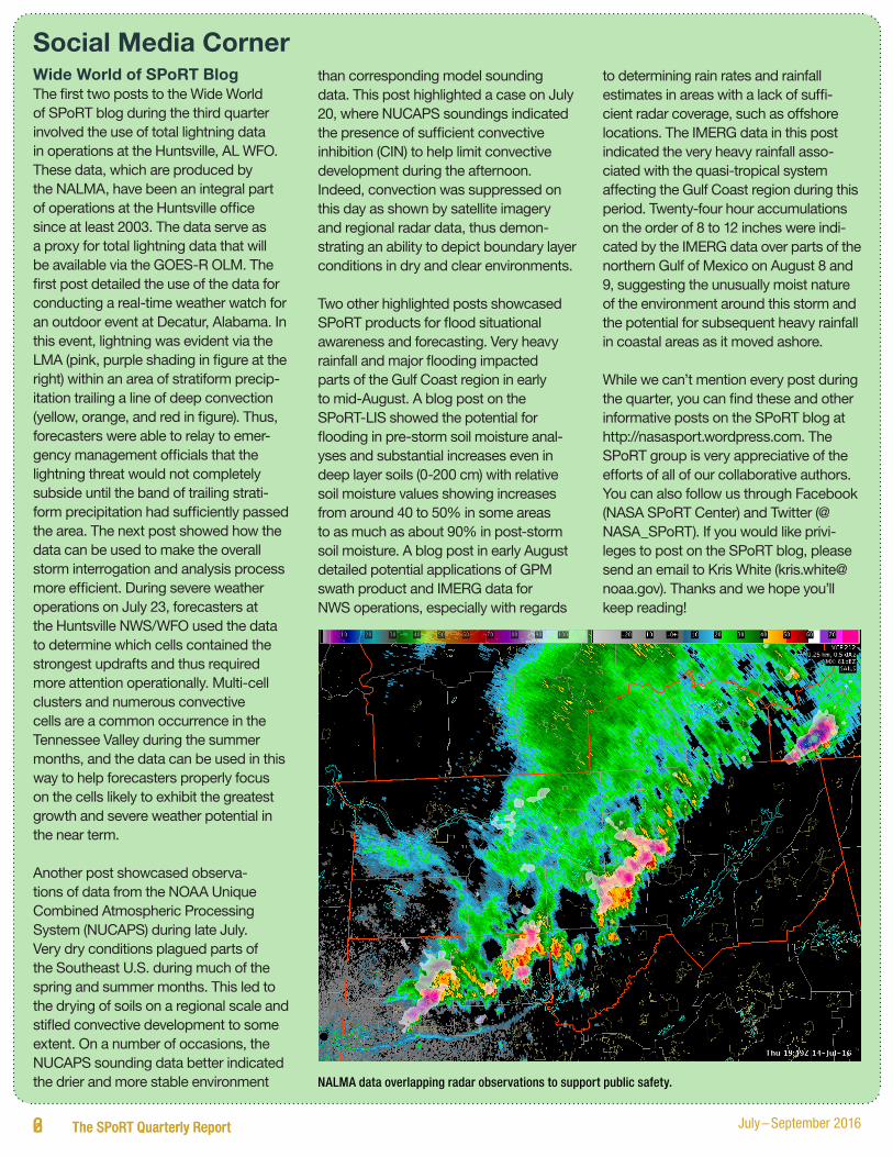
Social Media CornerWide World of SPoRT BlogThe first two posts to the Wide World of SPoRT blog during the third quarter involved the use of total lightning data in operations at the Huntsville, AL WFO. These data, which are produced by the NALMA, have been an integral part of operations at the Huntsville office since at least 2003. The data serve as a proxy for total lightning data that will be available via the GOES-R OLM. The first post detailed the use of the data for conducting a real-time weather watch for an outdoor event at Decatur, Alabama. In this event, lightning was evident via the LMA (pink, purple shading in figure at the right) within an area of stratiform precip-itation trailing a line of deep convection (yellow, orange, and red in figure). Thus, forecasters were able to relay to emer-gency management officials that the lightning threat would not completely subside until the band of trailing strati-form precipitation had sufficiently passed the area. The next post showed how the data can be used to make the overall storm interrogation and analysis process more efficient. During severe weather operations on July 23, forecasters at the Huntsville NWS/WFO used the data to determine which cells contained the strongest updrafts and thus required more attention operationally. Multi-cell clusters and numerous convective cells are a common occurrence in the Tennessee Valley during the summer months, and the data can be used in this way to help forecasters properly focus on the cells likely to exhibit the greatest growth and severe weather potential in the near term.
Another post showcased observa-tions of data from the NOAA Unique Combined Atmospheric Processing System (NUCAPS) during late July. Very dry conditions plagued parts of the Southeast U.S. during much of the spring and summer months. This led to the drying of soils on a regional scale and stifled convective development to some extent. On a number of occasions, the NUCAPS sounding data better indicated the drier and more stable environment
than corresponding model sounding data. This post highlighted a case on July 20, where NUCAPS soundings indicated the presence of sufficient convective inhibition (CIN) to help limit convective development during the afternoon. Indeed, convection was suppressed on this day as shown by satellite imagery and regional radar data, thus demon-strating an ability to depict boundary layer conditions in dry and clear environments.
Two other highlighted posts showcased SPoRT products for flood situational awareness and forecasting. Very heavy rainfall and major flooding impacted parts of the Gulf Coast region in early to mid-August. A blog post on the SPoRT-LIS showed the potential for flooding in pre-storm soil moisture anal-yses and substantial increases even in deep layer soils (0-200 cm) with relative soil moisture values showing increases from around 40 to 50% in some areas to as much as about 90% in post-storm soil moisture. A blog post in early August detailed potential applications of GPM swath product and IMERG data for NWS operations, especially with regards
to determining rain rates and rainfall estimates in areas with a lack of suffi-cient radar coverage, such as offshore locations. The IMERG data in this post indicated the very heavy rainfall asso-ciated with the quasi-tropical system affecting the Gulf Coast region during this period. Twenty-four hour accumulations on the order of 8 to 12 inches were indi-cated by the IMERG data over parts of the northern Gulf of Mexico on August 8 and 9, suggesting the unusually moist nature of the environment around this storm and the potential for subsequent heavy rainfall in coastal areas as it moved ashore.
While we can’t mention every post during the quarter, you can find these and other informative posts on the SPoRT blog at http://nasasport.wordpress.com. The SPoRT group is very appreciative of the efforts of all of our collaborative authors. You can also follow us through Facebook (NASA SPoRT Center) and Twitter (@NASA_SPoRT). If you would like privi-leges to post on the SPoRT blog, please send an email to Kris White ([email protected]). Thanks and we hope you’ll keep reading!
NALMA data overlapping radar observations to support public safety.

7The SPoRT Quarterly Report July – September 2016
CongratulationsMSFC Honor Awards and MSFC Science and Technology Office AwardsOn July 13, Marshall Space Flight Center hosted their annual Honor Awards ceremony, highlighting accom-plishments by MSFC personnel that had received either Agency-wide or Center-level awards for their outstanding accomplishments in the previous year. Several honors were provided to members of the SPoRT team, including:
• Andrew Molthan, Presidential Early Career Award for Scientists and Engineers, and Marshall Center Director’s Commendation Award for outstanding technical leadership to NASA through service to multiple scientific and technical organizations, with resulting significant benefits to MSFC STEM and technical programs.
• Jason Burks (now with Colorado State University/CIRA), Marshall Research and Technology Award, in recognition of notable achieve-ments in research and technology, in particular his leadership in AWIPS development in support of SPoRT, along with new web mapping service technologies for the distribution of Earth Science Office data sets.
• Lori Schultz, Jordan Bell, Kevin McGrath, Jason Burks (now with CSU/CIRA), Andrew Molthan, Brad Zavodsky, and Tony Cole (now with Oak Ridge National Lab) were SPoRT-affiliated team members who received a MSFC Group Achievement Award for their support of response efforts following the Nepal Earthquakes of May 2015. This included the generation of products
from the VIIRS day-night band, assisting with targeting of NASA’s EO-1 and Advanced Spaceborne Thermal Emission and Reflection Radiometer (ASTER) sensors, gener-ation of supplemental products from those sensors, and collaboration with other NASA team members supporting response activities.
On August 17, Marshall’s Science and Technology Office hosted their annual Peer Awards ceremony, highlighting accomplishments by team members who were nominated by their peers in a variety of categories. Brad Zavodsky received the “Paddleball” award, a new category this year highlighting a team member for their ability to quickly react and be responsive to rapidly changing conditions and workload requirements.
Welcome
New Civil ServantDr. Emily Berndt has been hired by NASA Marshall Space Flight Center as a Remote Sensing Scientist. Her initial efforts will support SPoRT. She previously supported the SPoRT project as a Post-Doc and more recently as a University of Alabama in Huntsville (UAH) Research Scientist. Dr. Berndt has more than 5 years of experience working with remotely sensed observations from NASA and NOAA satellites, including multispec-tral imagery from MODIS and VIIRS and temperature, moisture, and ozone soundings from the Atmospheric Infrared Sounder (AIRS) and Cross-track Infrared Sounder (CrIS). These observations support both weather analysis and numerical weather prediction focused on better under-standing atmospheric dynamics. Dr. Berndt will help to lead NOAA-funded proving ground activities and develop-ment of new products to support NWS forecaster decision making.
New Undergraduate StaffSPoRT would also like to welcome two undergraduate students from UAH. Angela Burke, a sophomore ATS student, and Charles Mirus, a senior ATS student, have joined the team to support development of case studies of NASA data based on forecaster feedback obtained during assessments to fill in the new SPoRT Applications Library.
PublicationsBell, J.R., and A.L. Molthan, 2016:
Evaluation of approaches to identi-fying hail damage to crop vegetation using satellite imagery. J. Operational Meteor., 4 (11), 142–159. http://dx.doi.org/10.15191/nwajom.2016.0411
Berndt, E., A. Molthan, and W. Vaughan, 2016: Transitioning NASA and NOAA Multispectral Composites to Operations. AGU Earth & Space Science News (EOS), accepted.
Blankenship, C.B., J.L. Case, B.T. Zavodsky, and W.L. Crosson, 2016: Assimilation of SMOS Retrievals in the Land Information System. IEEE Trans. Geosci. Remote Sens, in press.
SPoRT Seminars• August 4: “The Spatially Generalized
Hurricane Outage Prediction Model” — Dr. Brent McRoberts (Department of Geography, Texas A&M University)
2 The SPoRT Quarterly Report July – September 20168 The SPoRT Quarterly Report
PresentationsBerndt, E., B. Zavodsky, and M. Folmer,
2016: Development and Application of Hyperspectral Infrared Ozone retrieval Products for Operational Meteorology. NASA Sounder Science Team Meeting, Greenbelt, MD, 13-16 September.
Blankenship, C.B., J.L. Case, and B.T. Zavodsky, 2016: SMAP data assim-ilation at NASA SPoRT. Poster, 3rd Satellite Soil Moisture Validation and Application Workshop, New York, NY, 21-22 September.
Blankenship, C.B., J.L. Case, and B.T. Zavodsky, and G. Stano, 2016: Assimilation of SMOS retrieved soil moisture in the Land Information System. EUMETSAT Satellite Meteorological Annual Meeting, Darmstadt, Germany, 26-30 September.
Elmer, N, G., Jedlovec, E. Berndt, 2016: Limb Correction of SEVIRI and AVHRR Infrared Channels in Clear and Cloudy Regions for the Improved Interpretation of RGB Composites, EUMETSAT Satellite Meteorological Annual Meeting, Darmstadt Germany, 26-30 September.
Fuell, K., C. Gravelle, J. Burks, E. Berndt, L. Schultz, A. Molthan, and A. Leroy, 2016: Client-side Data Processing and Training for Multispectral Imagery Applications in the GOES-R Era. Joint 21st Satellite Meteorology, Oceanography and Climatology Conference and 20th Conference on Air-Sea Interaction, AMS, Madison, WI, 15-19 August.
Fuell, K., E. Berndt, A. Molthan, and F. LaFontaine, 2016: Integration and Evaluation of Multispectral Imagery and Associated Quantitative Products to Complement Operational Analysis of Aviation Hazards.National Weather Association Annual Meeting, 10-15 September.
Fuell, K., E. Berndt, J. Burks, A. LeRoy, L. Schultz, and A. Molthan, 2016: User Preparations for Multispectral Imagery in the GOES-R and JPSS Era via Technical Improvements to
Product Production and Training. EUMETSAT Satellite Meteorological Annual Meeting, Darmstadt Germany, September 26-30.
LeRoy, A. 2016: Perspective on the GPM Rain Rate Products Transitioned to Selected SPoRT Partner NOAA Offices, NASA/NOAA Meeting on Status of NASA-GPM, Greenbelt, MD, 24 August.
Molthan, A., B. Zavodsky, and M. Folmer, 2016: Use of Satellite Data within Weather Decision Support Systems. Workshop to Develop a Portfolio of Low Latency Datasets for Time-Sensitive Applications, Hampton, VA, 27-29 September.
Schultz, L, A. Molthan, J. Burks, J. Bell, K. McGrath, and T. Cole, 2016: Applications of Earth Remote Sensing for Identifying Tornado and Severe Weather Damage. EUMETSAT Satellite Meteorological Annual Meeting, Darmstadt Germany, 26-30 September.
Stano, G.T., J.E. Burks, and K.M. Mcgrath, 2016: Preparing the end user community for the GOES-R Geostationary Lightning Mapper. 21st Satellite, Meteorology, Oceanography, and Climatology Conf., AMS, Madison, WI, 15-19 August.
Stano, G.T., K.K. Fuell, and A.L. Molthan, 2016: Preparations for Integrating Space-Based Total Lightning Observations into Forecast Operations. EUMETSAT Satellite Meteorological Annual Meeting, Darmstadt Germany, 26-30 September.
Zavodsky, B., A. Molthan, C. Schultz, P. Meyer, P. Gatlin, G. Stano, J. Srikishen, K. McGrath, and J. Case, 2016: SPoRT Activities Relevant to Launch/Range. Day of Launch Working Group Fall Meeting, Cape Canaveral, FL, 24-25 August.
Upcoming Calendar of Events• October 12-14: Synthetic Aperture Radar (SAR) Workshop (Huntsville, AL)
• November 1-5: GOES-R Launch Week (Cape Canaveral, FL)
• November 7-11: AMS Severe Local Storms (Portland, OR)
• November 8-10: Disasters Regional Response Team (Addison, TX)
• November 14-17: McIDAS Users’ Group Meeting (Madison, WI)
• November 15-16: ICESat-2 Applications Focus Workshop (Huntsville, AL)
• November 15-17: NWS SOO/DOH GOES-R Prep Course (Kansas City, MO)
• November 18: Invited Presentation at University of Alabama/National Water Center Water Research Group (Tuscaloosa, AL)
• December 5-9: Experimental Products Development Team Introduction Course (Fort Collins, CO)
• December 8: Site Visit to NWS Forecast Office (Nashville, TN)
• December 12-16: American Geophysical Union Fall Meeting (San Francisco, CA)
• December 15-16: Site Visit to NWS Forecast Office, Regional Operations Center, and Southern Region Headquarters (Fort Worth, TX)

VisitorsPam SullivanSPoRT briefed Pam Sullivan, GOES-R Flight Project Manager, during her visit to MSFC on July 6 on our interactions with the GOES-R Proving Ground and transition of proxy GOES-R products to operational forecasters to accelerate use of these observations within the NWS AWIPS decision support system shortly after launch.
Dr. Steve VolzSPoRT briefed Dr. Steve Volz, Director of the NOAA Satellite and Information Service (NESDIS), during his visit to MSFC on August 3 on our interactions with the NOAA Satellite Proving Grounds as well as collaborative projects with research scientists at NESDIS. As part of this presentation, work done to high-light use of multispectral imagery, total lightning observations, and soil moisture observations for the National Water Model were discussed.
Dr. Brent McRobertsDr. Brent McRoberts, a Post-Doc at Texas A&M University, visited SPoRT on August 4. He gave a seminar on his work related to using soil moisture observations during landfalling tropical storms to predict power outages. Dr. McRoberts is part of a group at Texas A&M who manages the North American Soil Moisture Database, which SPoRT has used to validate output from SPoRT real-time, high-resolution LIS model and impact of assimilating satel-lite-based soil moisture observations.
Intern ProjectsSPoRT hosted three NASA intern students this summer to assist in research and training projects. Berenice Alvarado (Mentor: Brad Zavodsky) completed a project entitled “Soil Moisture Validation of the SPoRT-LIS over CONUS”, where she found that the SPoRT-LIS exhibited less bias than the North American Land Data
Analysis System (NLDAS-2) for the year 2014 when compared to a set of 300+ high quality observations. Andrea Pulido (Mentors: Andrew Molthan and Emily Berndt) completed a project entitled “Development of L3 GPM-IMERG Product Training Utilizing the ADDIE Model”, which resulted in a responsive learner-centered and self-paced GPM-IMERG operational training module designed to increase engagement and retention and indicate measureable outcomes. James Coy (Mentor: Chris Schultz) completed a project entitled “An Assessment of Land Surface and Lightning Characteristics Associated with Lightning-Initiated Wildfires”, where he found that lightning characteristics (i.e., positive or nega-tively charged CG strike) do not have a major role in starting a wildfire but rather the characteristic of the land surface where dry soil moisture and heavy vegetation conditions were present.
Tweets of the Quarter
National Aeronautics and Space Administration
George C. Marshall Space Flight CenterHuntsville, AL 35812www.nasa.gov/marshall
www.nasa.gov
NP-2016-10-124-MSFCG-250198