sindh irrigation and drainage authority sindh water sector improvement...
TRANSCRIPT

SINDH IRRIGATION AND DRAINAGE AUTHORITY Sindh Water Sector Improvement Project Phase-I (WSIP-I)
PREPARATION OF REGIONAL PLAN FOR THE LEFT BANK OF
INDUS, DELTA AND COASTAL ZONE
Phase - I Final Report
Preparation of Inventory, Assessment of Existing Conditions, Identification of Issues, and Methodology and Plan
for Consultations and Stakeholder Participation
MAIN REPORT
Volume – I
The Louis Berger Group Inc. In Association with
Indus Associated Consultants (Pvt.) Ltd.
JUNE 2011
Disposal of Sewage Water in Phuleli Canal Consultation with Women
LBOD Spinal Bifurcation Point

Phase-I Final Report
The Sindh Irrigation and Drainage Authority on behalf of the Government of Sindh on the 5th of
March 2010 signed a contract with The Louis Berger Group Inc., in alliance with Indus Associated
Consultants (Pvt) to prepare the Regional Master Plan for the Left Bank of Indus, Delta and
Coastal Zone under the Sindh Water Sector Improvement Project Phase-I (WSIP-I).
On 23rd
December 2011, the Consultants submitted the draft report of Phase-I. The same was
made available on the SIDA Web Page and sent out to the Panel of Experts for comments. On 03rd
March 2011 the Panel of Experts met for the first time to review and comment on the Consultants
draft report Phase-I.
On 30th April, 2011 the Consultants submitted a revised Final Report of Phase-I. On 18
th May the
Panel of Experts met to analyze and assess the revised report. After the Consultants presentations
and the comments of the different members of the Panel, the Final Report Phase-I was formally
accepted by the Panel of Experts.
The Final Report Phase-I May 2011 version was distributed among the stakeholders invited to
attend the National Workshop in Karachi. The comments of the workshop participants have been
incorporated in the present version.
June, 2011

TABLE OF CONTENTS
ACKNOWLEDGEMENTS................................................................................................................................ I
ACRONYMS, MEASURES AND UNITS .......................................................................................................... II
LIST OF TABLES ........................................................................................................................................ VII
EXECUTIVE SUMMARY .............................................................................................................................. X
1. INTRODUCTION TO THE STUDY .......................................................................................................... 1
1.1. INTRODUCTION TO THE PROJECT AND THIS REPORT ................................................................................. 1 1.2. BACKGROUND TO THE PROJECT ........................................................................................................... 4 1.3. OBJECTIVES AND SCOPE OF WORK ....................................................................................................... 8 1.4. SUMMARY OF THE PROJECT ................................................................................................................ 9 1.5. SCOPE OF THE PHASE-I STUDY .......................................................................................................... 11
2. METHODOLOGY AND APPROACH TO PHASE I OF THE REGIONAL PLANNING PROGRAM ................. 15
2.1. METHODOLOGIES AND APPROACHES USED TO ADDRESS EIGHT THEMATIC AREAS ...................................... 15 2.2. GENERAL APPROACH TO THE STUDIES ................................................................................................ 15 2.3. METHODOLOGY FOR PLANNING STUDIES ............................................................................................ 16 2.4. PRIMARY DATA COLLECTION, REVISION AND CRITICAL ANALYSIS ............................................................. 17 2.5. FLOODING ALONG THE LBOD AND INDUS RIVER AND INTRUSION OF SEAWATER IN THE COASTAL ZONE .......... 19
3. CONSOLIDATED DRAINAGE AND FLOOD SUBSECTOR ISSUES AND PROBLEMS: VOICES OF THE STAKEHOLDERS ................................................................................................................................ 21
3.1 INTRODUCTION .............................................................................................................................. 21 3.2 GENERAL APPROACH ...................................................................................................................... 21 3.3 SUMMARY FINDINGS ...................................................................................................................... 22
4. THEMATIC AREA STUDIES ................................................................................................................ 32
4.1 OVERVIEW AND DEVELOPMENT OF PLANNING FOR DRAINAGE AND FLOODING ..................... 32 4.1.1 Background to the planning thematic area study ..................................................................... 32 4.1.2 Key Findings of the Thematic Assessment ................................................................................. 39 4.1.3 Issues and Problems Identified for the Thematic Area .............................................................. 49 4.2 WATER RESOURCES AND WATER USAGE FOR DRAINAGE AND FLOODING ............................... 56 4.2.1 Background ................................................................................................................................ 56 4.2.2 Key Findings ............................................................................................................................... 64 4.2.3 Issues and Problems .................................................................................................................. 68 4.3 IMPACT OF DRAINAGE AND FLOOD ON ENVIRONMENT AND WETLANDS ................................ 69 4.3.1 Background of Thematic Area ................................................................................................... 69 4.3.2 Methodology adopted to address the thematic areas .............................................................. 69 4.3.3 Key Findings ............................................................................................................................... 70 4.3.4 Riverine and Irrigated Forests- Causes of Deforestation and Proposed Strategy for
Reforestation ............................................................................................................................. 73 4.3.5 Physical Resources of the Left Bank and Coastal Zone .............................................................. 74 4.3.6 Surface and Groundwater Quality…its impact on Ecosystem and Environment ....................... 78 4.3.7 Flow downstream Kotri and Sustainability of Indus Ecosystem ................................................ 81 4.3.8 Indus Delta and Mangroves ....................................................................................................... 86 4.3.9 Wetlands ................................................................................................................................... 89 4.3.10. Sources of Water Pollution ........................................................................................................ 90 4.3.11 Pollution of Surface and Groundwater by Industrial Effluents .................................................. 91 4.3.12 Issues and Problems – Environment and Biodiversity................................................................ 92 4.4 FLOODING, DISASTER MANAGEMENT AND MITIGATION.......................................................... 99 4.4.1. Background to the flooding disaster thematic area study ........................................................ 99

4.4.2. Key Findings of the Thematic Assessment ............................................................................... 110 4.4.3. Issues and problems ................................................................................................................ 116 4.5 STRUCTURES FOR IRRIGATION DRAINAGE AND FLOOD PROTECTION ..................................... 117 4.5.1 Background .............................................................................................................................. 117 4.5.2 Key Findings ............................................................................................................................. 145 4.5.3 Issues and Problems ................................................................................................................ 148 4.6 OVERVIEW OF CURRENT AGRICULTURE, LIVELIHOOD, AND ECONOMIC ASPECT OF DRAINAGE &
FLOODS ................................................................................................................................... 151 4.6.1 Background to the Economics Thematic Area Study ............................................................... 151 4.6.2 Methodology Adopted To Address the Thematic Area ............................................................ 151 4.6.3 Key Findings of Thematic Issues .............................................................................................. 152 4.6.4 Issues and Problems ................................................................................................................ 169 4.6.5 Livelihood Development Framework ....................................................................................... 172 4.6.6 Socioeconomic Goals of Flood Management .......................................................................... 182 4.7 SOCIAL ISSUES OF DRAINAGE OPERATIONS AND FLOODING .................................................. 184 4.7.1 Background to the Thematic Area Study ................................................................................. 184 4.7.2 Approach and Methodology .................................................................................................... 185 4.7.3 Communication Strategy used for the Study ........................................................................... 188 4.7.4 Stakeholder consultations ....................................................................................................... 191 4.7.5 Key Findings of the Thematic Assessment ............................................................................... 193 4.8 REVIEW CAPACITIES OF PROVINCIAL AGENCIES INVOLVED IN EXECUTION OF THE IRRIGATION
AND DRAINAGE PROJECT AND ITS MANAGEMENT ................................................................. 200 4.8.1 Background to the Institutional Reform, Thematic Area Study ............................................... 200 4.8.2 Approach to address the thematic area .................................................................................. 200 4.8.3 Key Findings of the Thematic Assessment ............................................................................... 201 4.8.4 Provincial Actions for Reform .................................................................................................. 210 4.8.5 Agencies for Supply of Water and Drainage and Flood Control Management in Sindh .......... 210 4.8.6 IPD and SIDA, Only Two Operating Agencies for Water, Drainage and Flood Management .. 212 4.8.7 Major Issues and Problems Identified for Guidance of Phase II .............................................. 216
REFERENCES ........................................................................................................................................... 224

SINDH WATER SECTOR IMPROVEMENT PROJECT PHASE-I
Preparation of Regional Plan for the Left Bank of Indus, Delta and Coastal Zone
i
ACKNOWLEDGEMENTS
Contract agreement was signed on March 5, 2010 between Sindh Irrigation and Drainage
Authority (SIDA) and The Louis Berger Group Inc. in Association with Indus Associated
Consultants (Pvt.) Ltd. for preparation of Regional Plan for the Left Bank of Indus, Delta and
Coastal Zone, addressing the flooding issues and providing proper drainage through appropriate
structural and non structural measures.
The studies are planned to be carried out in consultation with the stakeholders starting from
beginning to end covering identification of issues, analysis and design of solutions in four phases.
The phase-I study cover inventory and assessment of existing conditions and identification of
issues and problems. The Final Phase-I report has been prepared as per terms of the agreement
We feel great pleasure in extending our cordial thanks to SIDA management, Project Coordination
& Monitoring Unit Staff and Panel of Experts (POE) who reviewed draft Phase-I report for their
valuable guidance and support in preparing this report.
We are greatly indebted to Mr. Muhammad Ehsan Leghari Managing Director SIDA and Dr.Ylli
Dedja FAO Project Management Consultant/ Agent (PMC/A) Team Leader for kind assistance and
guidance extended during various interactive meetings for monitoring progress of the study.

SINDH WATER SECTOR IMPROVEMENT PROJECT PHASE-I
Preparation of Regional Plan for the Left Bank of Indus, Delta and Coastal Zone
ii
Acronyms, Measures and Units
Acronyms and Abbreviations
ACE Associated Consulting Engineers
ADB Asian Development Bank
ADF Assistant Director Fisheries
ADP Annual Development Program
ALI Adult Literacy Index
APHA American Public Health Association
AWB Area Water Board
AWWA American Water Works Association
BDG Beneficiary Drainage Group
BDN Badin
BHU Basic Health Unit
BOD Biochemical Oxygen Demand
CBO Community Based Organization
CCA Cultivable Command Area
CCB Citizen Community Board
CHW Community Health Worker
COD Chemical Oxygen Demand
CS Case Study
CWR Crop Water Requirement
DCO District Coordination Officer
DDMA District Disaster Management Authority
DERA Drought Emergency Relief Assistance
DO Dissolved Oxygen
DOF Department of Fisheries
DPOD Dhoro Puran Outfall Drain
DRIP Drainage Reclamation Institute of Pakistan
DSEA Drainage Sector Environment Assessment
E. Coli Escherica Coli Forms
EI Educational Index
EIA Environmental Impact Assessment
EPA Environmental Protection Agency
EPD Environmental Protection Department
ERC Emergency Relief Cell
ETo Evapotranspiration
FAO Food and Agriculture Organization of the United Nations
FD Finance Department
FFC Federal Flood Commission
FGD Focus Group Discussion
FGW Fresh Ground Water
FO Farmers organization
FP Family Planning
GCA Gross Command Area
GD Government Dispensary
GDP Gross Domestic Product
GEI Gross Enrollment Index

SINDH WATER SECTOR IMPROVEMENT PROJECT PHASE-I
Preparation of Regional Plan for the Left Bank of Indus, Delta and Coastal Zone
iii
GER Gross Enrollment Ratio
GFCS Ghotki Feeder Canal System
GIS Geographic Information System
GoP Government of Pakistan
GoS Government of Sindh
Govt Government
HDA Hyderabad Development Authority
HDI Human Development Index
HH House Hold
HYD Hyderabad
IAC Indus Associated Consultants
IBRD International Bank for Reconstruction and Development
ICID International Commission on Irrigation and Drainage
IMR Infant Mortality Rate
IPD Irrigation and Power Department
IPOE International Panel of Experts
IUCN International Union For Conservation Of Nature
IWASRI International Water- Logging, and Salinity Research
Institute
IWMI International Water Management Institute
KPOD Kadhan Pateji Outfall Drain
KVA Kilo Volt Ampere
LANDSAT Land Observation Satellite
LBG The Louis Berger Group Inc.
LBOD Left Bank Outfall Drain
LGO Local Government Ordinance
LIG Lahmeyer International Germany
LIP Lower Indus Project
M&E Monitoring and Evaluation
MA Million Areas
MAF Million Acre Feet
MDG Millennium Development Goal
MGD Million Gallons per Day
Milch Milking Producing Animals
MINFAL Ministry of Food Agriculture And Livestock
MMR Maternal Mortality Rate
MMP Mott McDonald Pakistan, Consultants
MPK Mirpurkhas
NA Northern Areas
NCMC National Crisis Management Cell
NCS National Conservation Strategy
NDMA National Disaster Management Authority
NDMF National Disaster Management Framework
NDMO National Disaster Management Ordinance of 2007
NDP National Drainage Project
NEAP National Environmental Action Plan
NEC National Economic Council
NEQS National Environmental Quality Standards
SINDH WATER SECTOR IMPROVEMENT PROJECT PHASE-I
Preparation of Regional Plan for the Left Bank of Indus, Delta and Coastal Zone
iv
NESPAK National Engineering Services Pakistan
NFFB National Flood Forecasting Bureau
NGO Non-Governmental Organization
NRM Natural Resources Management
NWFP North Western Frontier Province
O&M Operation and Maintenance
OFWM On Farm Water Management
OM&M Operation, Maintenance and Management
P&D Planning & Development
PARC Pakistan Agriculture Research Council
PCBs Polychlorinated Biphenyles
PCMC Provincial Crisis Management Cell
PCRWR Pakistan Council of Research in Water Resources
PDMA Provincial Disaster Management Authority
PHC Primary Health Care
PID Project Information Document
PoE Panel of Experts who reviewed the first draft of the Phase I
report
PPA Participatory Poverty Assessment
PPAF Pakistan Poverty Alleviation Fund
PPM Parts per Million
PPT Parts per Thousand
PSDP Public Sector Development Program
PSQCA Pakistan Standards Quality Control Authority
RBOD Right Bank Outfall Drain
RD Reduced Distance
SAR Sodium Adsorption Ratio
SCARP Salinity Control and Reclamation Project
SFD Sindh Forest Department
SGW Saline Ground Water
SIDA Sindh Irrigation & Drainage Authority
SITE Sindh Industrial Trading Estate
SMO SCARP Monitoring Organization
SOFWMP Sindh On-Farm Water Management Project
SS Suspended Solids
SUPARCO Space and Upper Atmosphere Research Commission
SWMO Sindh Water Management Ordinance, 2002
TAY Tando Allahayar
TB Tuberculosis
TBA Traditional Birth Attendants
TDS Total Dissolved Solids
THT Thatta
TMA Tehsil Municipal Administration
TMK Tando Mohammad Khan
TOR Terms of Reference
TPK Tharparkar
TSS Total Suspended Solids
UAF University of Agriculture, Faisalabad

SINDH WATER SECTOR IMPROVEMENT PROJECT PHASE-I
Preparation of Regional Plan for the Left Bank of Indus, Delta and Coastal Zone
v
Units/Measures
UC Union council
UCDO United Community Development Organization
UMK Umerkot
UNDP United Nations Development Programme
UNO United Nation Organization
UWP Urban Works Program
VC Village Council
VDO Village Development Organization
WAPDA Water and Power Department Authority
WASA Water and Sanitation Authority
WB World Bank
WCA Water Course Association
WHO World Health Organization
WMO World Meteorological Organization
WPCF Water Pollution Control Federation
WSIP Water Sector Improvement Project
WWF World Wide Fund For Nature
WWF-P World Wide Fund for Nature- Pakistan
ZTBL Zarai Tariqiati Bank Ltd
BCM Billion Cubic Meters
BTU British Thermal Unit
Cu.m Cubic Meter
Cumecs Cubic Meters per Second
Cusec Cubic Foot Per Second
EC Electrical Conductivity
Ha Hectare
MAUND 40 Kg Weight
Kc Crop Coefficient
Kg Kilogram
MHA Million Hectares
mm Millimeters
Mt Metric Ton
PAISA 100 Paisa = 1 Rupee
ft-3
sec-1
Cubic feet per second
ft Feet
Sec Second
m Meter

SINDH WATER SECTOR IMPROVEMENT PROJECT PHASE-I
Preparation of Regional Plan for the Left Bank of Indus, Delta and Coastal Zone
vi
Glossary and Definitions of Terms
Abadgar Farmer
Abiana Tax for using Irrigation Water
Abkalani Flood season
Arhtis Commission Agents
Bt Bacillus thuringiensis is a bacterium, commonly used in cotton varieties
Bachao bund Flood protection bund
Baraaj Barrage
Beldar Lower level employee of the Irrigation Department
Dal Local food
Devi A shrub commonly found in grounds
Dhands Lakes / reservoir
Dhoro Puran Dhoro means Depression & Puran is the name of place
Jhopra A hut made of straw
Katcha A house made up of mud and straw
Kino pani Black water / Sewage water / Dirty water
Kharif Summer Crop Season
Khatedars Registered cultivators
Laar Lower part of Sindh Province
Madressah Religious Seminary
Masjid Mosque
Milch Milk Producing Animals
Moghas Outlet
Pacca Made of bricks
Taluka Sub District
Rabi season Winter crop season
Roti Locally homemade bread
Rali Handmade bed cover
Ramsar site Site protected under Ramsar Convention on Wetlands
Sim nala Drain
Siro Upper part of Sindh province
Wah Watercourse/canal
Wadera Head of the village
Wattan card Government ID card for flood victims
Warabandi System for rotation in irrigation right
Wicholo Central part of Sindh Province
Zamindar Landowner

SINDH WATER SECTOR IMPROVEMENT PROJECT PHASE-I
Preparation of Regional Plan for the Left Bank of Indus, Delta and Coastal Zone
vii
LIST OF TABLES
Table 1.1: Components of the World Bank Funded WSIP-I Project ................................................. 1
Table 1.2: Summary of Water Sector Improvement Project Phase-1 (WSIP-I) for the Lower Indus
River Basin ...................................................................................................................... 2
Table 1.3: Major Barrages on the Indus River in Sind Province ....................................................... 4
Table 1.4: Summary of Study Requirements ................................................................................... 10
Table 1.5: Detailed Description of Questions Considered in Phase-I Study ................................... 11
Table 1.6: Topic Outline for Summary of the Task-I Study ............................................................ 13
Table 3.1: Summary of Issues and Problems ................................................................................... 22
Table 4.1.1: Topic Outline for Summary of the Thematic Area 1 Study ........................................ 33
Table 4.1.2: Chronology of Major Irrigation Infrastructure in Sindh .............................................. 34
Table 4.1.3: Chronology of Drainage Problems in Sindh ................................................................ 34
Table 4.1.4: Chronology of the LBOD in Sindh .............................................................................. 36
Table 4.1.5: Chronology of the Tidal Link and Cholri Weir ........................................................... 38
Table 4.1.6: Current State and Circumstances of Drainage in Sindh Province ............................... 40
Table 4.1.7: Feasibility Report for Redesign of LBOD Stage-I - Badin Area Drainage System -
June 2009 .................................................................................................................... 42
Table 4.1.8: Data collection related to drainage and flooding is done by various Government
organizations............................................................................................................... 50
Table 4.2.1: Topic Outline for Summary of the Thematic Area 2 Study ........................................ 56
Table 4.2.2: Barrages & Main Canals in the Study Area................................................................. 57
Table 4.2.3: Entitlement and Canal Withdrawals in Guddu, Sukkur, and Kotri Barrage Sub-
Regions in Study Area ................................................................................................ 58
Table 4.2.4: Annual Maxim (24-hour duration) Rainfall Record (mm) at Various Meteorological
Stations of Project Area .............................................................................................. 60
Table 4.2.5: 24 Hour Maximum Rainfall ........................................................................................ 61
Table 4.2.6: Annual Rainfall Potential and Available Water for Storage ........................................ 61
Table 4.2.7: Location of Naturally Occurring Dhoras and Dhands ................................................. 63
Table 4.2.8: List of Dhands in Badin Area ...................................................................................... 63
Table 4.3.1: Topic Outline for Summary of the Thematic Area 3 Study ........................................ 69
Table 4.3.2: Water Distribution as per Water Apportionment Accord 1991 ................................... 75
Table 4.3.3: Recommendations of the Study-I Consultants ............................................................ 85
Table 4.3.4: Minimum Water Requirements for various Interventions proposed by the Study-II .. 85
Table 4.3.5: Suggested outflow downstream Kotri on 10 daily basis.............................................. 85

SINDH WATER SECTOR IMPROVEMENT PROJECT PHASE-I
Preparation of Regional Plan for the Left Bank of Indus, Delta and Coastal Zone
viii
Table 4.3.6: Historical discharge volumes and silt load from 1880 to 1992 onwards ..................... 87
Table 4.4.1: Topic Outline for Summary of the Thematic Area 4 Study ........................................ 99
Table 4.4.2: Major Flood Events in Pakistan Compared to the Year 2010 Super-flood ............... 102
Table 4.4.3: Historical and 2010 Flood Peaks and Return Period for Barrages on Indus (PARC1)
.................................................................................................................................. 104
Table 4.4.4: Peak Ground Acceleration at Various Coastal Cities of Pakistan ............................. 106
Table 4.4.5: Principal Legal Instruments Concerned With Disaster Management and Disaster Risk
Reduction in Pakistan ............................................................................................... 107
Table 4.4.6: Assessment of Failure Mechanism of the MS Flood Protection Bund in Sindh ....... 112
Table 4.5.1: Topic Outline for Summary of the Thematic Area 5 Study ...................................... 117
Table 4.5.2: Irrigation Network in Study Area Barrages & Main Canals ..................................... 118
Table 4.5.3: Entitlement and Canal Withdrawals in Guddu, Sukkur and Kotri barrage Sub-regions
in Study Area ............................................................................................................ 119
Table 4.5.4: Major Structures in Ghotki, (Guddu Barrage), Khairpur East, Khairpur West (Sukkur
Barrage), Pinyari, Fuleli and Akram Wah (Kotri Barrage) Canals .......................... 125
Table 4.5.5: Major Structures in Rohri and Nara Canals (Sukkur Barrage) .................................. 126
Table 4.5.6: Drainage facilities of the LBOD Stage-1 Project. ..................................................... 131
Table 4.5.7-A: Major Structures Flood Protection Main Bunds and Loop Bunds along Left Bank
River Indus ............................................................................................................... 136
Table 4.5.8: (B) Major Structures Flood Protection Vulnerable Points of Bunds ......................... 140
Table 4.5.9: List of different Health Institutions on Small/ Large Scale in Left Bank Study area 141
Table 4.5.10: District Wise Number of Schools in Left Bank Study Area .................................... 142
Table 4.8. 1: Summary – Staffing And Budget of IPD Left Bank 2010-2011 .............................. 203
Table 4.8.2: Summary – Staffing and Budget of IPD Earmarked For SIDA and AWBS 2010 –
2011 (Except Land Reclamation) ............................................................................... 205
Table: 4.8.3: SIDA Allocated Budgets 2010-2011, Drainage Divisions, For Land Reclamation . 206
Table 4.8. 4: Budget Allocated for Upkeep of Equipment, Machinery & M & R of Embankment &
Headworks Budget 2010-2011 ................................................................................... 218
Table 4.8. 5: Budget Allocated for Maintenance & Rehabilitation of Main and Feeder Canals and
Lift Irrigation & Silt Clearance .................................................................................. 219
Table 4.8. 6: Number of Staff BPS: 1 to 14 ................................................................................... 220
Table 4.8. 7: Income and Expenditure Account For the Year Ended June 30, 2009 Rupees in '000‟
.................................................................................................................................... 221

SINDH WATER SECTOR IMPROVEMENT PROJECT PHASE-I
Preparation of Regional Plan for the Left Bank of Indus, Delta and Coastal Zone
ix
LIST OF MAPS
Map 3.1: Coverage of Stakeholder Consultation Villages ............................................................... 31

SINDH WATER SECTOR IMPROVEMENT PROJECT PHASE-I
Preparation of Regional Plan for the Left Bank of Indus, Delta and Coastal Zone
x
EXECUTIVE SUMMARY
Introduction
Various drainage projects have been executed on left bank of Indus and deltaic area of Sindh
during five decades to combat the adverse impacts of drainage, water disasters, and the twin
problem of water logging and salinity. This has degraded the productivity of agricultural lands and
resulted in environmental, social and economic problems. Construction of Left Bank Outfall Drain
Stage–I (LBOD-I) was under taken in 1985. The ultimate disposal of drainage water was to the
Arabian Sea through KPOD, DPOD and Tidal Link. The stakeholders at Benazirabad, Sanghar and
Mirpurkhas have positive perceptions about the LBOD because their waterlogged lands have been
reclaimed, more fresh water is made available from underground through scavenger wells, crop
production has increased, lands have become more fertile and stormwater disposal became quick.
The people of Badin and Thatta have negative perceptions on the grounds that the failure of the
outfall system has brought miseries for them. Their lands have been degraded, and turned into
saline; wetland ecosystem is completely damaged and degraded and livelihood opportunities have
shrunk. They always remain under fear that heavy rains, storms and cyclones may hit any time.
The government as usual always relies on adhoc arrangements for relief and rescue operations and
the conditions may go out of control. They always feel vulnerable, because they don‟t see any
organized plan to face such disasters. The project benefitted the areas in Benazirabad
(Nawabshah), Sanghar, Mirpurkhas districts but created problems especially in the coastal area of
Badin and Thatta districts.
The Louis Berger Group/Indus Associated Consultants has been assigned the preparation of a
Regional Plan for the Left bank of the Indus River from Guddu Barrage to the Delta and Coastal
Zone. Phase I of this four phase project is dedicated to identification of issues and problems
associated with the impacts of spreading water logging and salinity; institutional breakdown for
management of water delivery, drainage, floods and disasters; environmental problems and
resultant spread of poverty and deteriorating livelihoods among the growing population.
Diversion of river flows and consequent exacerbation of drainage problems was introduced by
improvement of inundation canals and subsequent construction of barrages at Sukkur in the 1930s,
at Kotri in the 1950s and at Guddu in the 1960s. SCARP developments were planned by the Lower
Indus Project (LIP) team during the 1960s and successively financed and constructed since the
1970s. The SCARP wells are a combination of those to pump freshwater directly to distributaries
and minors, those that pump saline groundwater and skimming wells that pump relatively fresh
water from shallow aquifers and more saline water from deeper strata to prevent up coning.
The report is structured in three parts, this executive summary, the main body of the report, and
annexes and drawings. Chapters of the report summarize the Background to the Project, the
Approach and Methodology followed; the Findings, Problems and Associated Issues; and eight
Thematic Sections. Thematic groupings summarize detail of the work and findings that address the
requirements of 34 Tasks of the contract. Annexes contain details of interviews that engaged more
than 5,000 stakeholders plus a large body of secondary information.
The methodical approach, as described in Chapter 3 of this report, was followed and a
considerable body of findings, problems and issues, as is presented in Chapter 2 of this report were
identified.

SINDH WATER SECTOR IMPROVEMENT PROJECT PHASE-I
Preparation of Regional Plan for the Left Bank of Indus, Delta and Coastal Zone
xi
A Plan with a Consultative Approach
Deterioration of Infrastructure and Operations
The canals, drains and river structures are deteriorating. This infrastructure deterioration is
contributing to increasing severity of the disasters that accompany floods, water logging and
salinity and worsened poverty and
decline of livelihoods in the country
side.
Thus, most of the excellent
developments of the 40 year period,
1950 to 1990, have been allowed to
deteriorate to the point that they now
are a burden rather than an asset to
national solvency. The hope of the
Revised Action Program (RAP) of the
1980s and the introduction of Reform
in 1995 are as yet unrealized. And
now in the first decade of the new millennium reform is languishing and there is need to provide a
jump start.
Deficient Collections of Water Charges
Through a combination of administrative decisions, some outside the control of IPD, water charges
still are derived from Abiana based on rates that are set arbitrarily, are imperfectly collected, and in
IPD administered areas are passed
directly to the Department of
Revenue. In those areas where
Farmer‟s Organizations (FOs) have
been established, revenue is collected
by the FOs and is shared with the
AWBs: total collections for AWBs are
shown in the bar chat for the period
2001 to 2011.
Still, after a decade of Reform effort,
Abiana collected by the FOs is inadequate to the needs for operation, maintenance and
management (OM&M) of the canal systems. For both organizations, IPD and the AWBs/FOs,
collections are far short of the costs of production. The budget of IPD is adopted annually from
general revenue and grants and published in the Provincial Budget report.
Natural disasters, people’s perceptions and WSIP
A succession of catastrophic events including the 1999 cyclone and its effects in the Coastal Zone
of Badin and Thatta, rainfall floods of 2003 and 2006 in the interior of the Province, and the mega
Indus River flood of 2010 that breached bunds and flooded overbank, have generated vocal
reactions from the populace and in turn a strong desire on the part of government to provide
solutions to redress grievances of the entire populace.
The primary engine of restarting the stalled program of reform is embodied in the WSIP,
programmatically and financially. This Regional Planning Program is intended to directly address

SINDH WATER SECTOR IMPROVEMENT PROJECT PHASE-I
Preparation of Regional Plan for the Left Bank of Indus, Delta and Coastal Zone
xii
issues that have arisen especially with respect to structural deterioration, water logging and
salinity, floods, disasters, and the spread of poverty and deterioration of livelihoods.
Approach to the Study and Report Presentation
Format of the Regional Master Plan Report
The report is structured in three volumes, this executive summary, the main body of the report in
volume I, annexes in volume II and the Atlas in volume III. Chapters of the report summarize the
background to the Project, the approach and methodology followed; the findings, problems and
associated issues; and eight Thematic Sections. Thematic groupings summarize detail of the work
and findings that address the requirements of 32Tasks of the contract. Annexes contain details of
interviews that engaged more than 5,000 stakeholders plus a large body of secondary information.
The Atlas summarizes the work and findings of 2 Tasks.
There is value to the deliberative approach of the Sindh Government. This project is conceived in
four phases with this first phase being a thorough vetting of issues and problems at all stratas of
society.
The methodical approach, as described in Chapter-3 of this report, was followed and a
considerable body of findings, problems and issues, as is presented in Chapter 2 of this report were
identified.
A Participatory Approach
A central point in the preparation of the WSIP Regional Plan is preparation of the Plan in
consultations with communities and other major stakeholders. One of the key „lessons learnt‟ (see
PAD, WB, 2007) has been to make participatory approaches to development crucial to project
design based on social considerations. Genuine participation and involvement from the community
and other relevant stakeholders, thus, is viewed as essential throughout the planning and design
process not only for this phase of the work but throughout all four phases.
General Approach to the Studies
To address the diverse requirements and outcomes required in the 34 tasks of Phase I of the
Project, the Consultant grouped tasks under eight themes and carried out the work of each thematic
area in four steps:
Planning process
Secondary data collection, review, critical evaluation and analyses
Primary data collection, review and critical analyses
Collation of findings and identification of resultant problems and issues for presentation to
stakeholders.
Each sub-team planned the activities and approaches according to the particular task groups
assigned. Sources of required data were identified, followed by informational meetings with
concerned departments, reconnaissance surveys, and specially developed interaction with
communities and other major stakeholders.
Methodology for Addressing Issues of Eight Thematic Areas
Five structural and non-structural requirements are to be addressed in the course of preparation of
this four phase Regional Plan: 1) flooding along the LBOD and Indus River and intrusion of
seawater in the Coastal Zone, 2) potential measures for rehabilitation of the LBOD system, Dhands

SINDH WATER SECTOR IMPROVEMENT PROJECT PHASE-I
Preparation of Regional Plan for the Left Bank of Indus, Delta and Coastal Zone
xiii
and Tidal Link, 3) ongoing structural and non-structural programs and identification of additional
project needs, 4) determination of institutional arrangements for effective management of water
delivery, maintenance of drainage, flood operations and disaster response, and 5) identification and
systematic documentation of conditions in the countryside with respect to water delivery, water
quality, agriculture, fisheries, poverty, livelihoods, health and general welfare.
Problems and Issues associated with each objective requirement were initially explored through
review of secondary information of reports and available data followed by a designed primary data
collection program. Collection of primary data occurred during repeated consultations with
stakeholders at all levels of society through surveys, interviews, workshops, and field
reconnaissance. Thus during Phase I of the project, surveys and interviews were carried out across
the region after careful design and confirmation by SIDA. Additionally, field surveys were carried
out for observation of conditions and for collection of basic data to provide perspective to the
positions of stakeholders while recognizing that some are well informed and the opinions of others
are fanciful.
Review and Use of Secondary Data
In accordance with the outlined planning criteria, the Consultant collected, reviewed and analysed
extensive secondary data and reports. Publications, documents and reports consulted are listed in
the bibliography. Stake holders associated with each topic were identified and consulted during the
process of data collection. Stakeholders
included beneficiaries, affected
communities, NGOs, influential local
people and staff of government line
departments.
Literature review and collected data
provided a firm base for an understanding
of the project area, its infrastructure and
prevailing social conditions. The secondary
sources also were important for
identification of strengths and gaps of past
and ongoing projects, structural and non-
structural, and for identification of the core
issues. Early recognition of issues was
important for setting an appropriate
communication strategy and the selection
of methodological tools for interaction with
communities and stakeholders.
Primary Data Collection, Review and
Critical Analysis
The LBG/Indus sub-teams planned and
conducted approximately 200 field trips
during Phase I of the Project. Primary data
was collected largely with communities and other major stakeholders. To approach communities
and stakeholders efficiently and to limit data collected to that required for analyses; LBG/Indus
prepared a comprehensive communications strategy. The strategy is briefly outlined in the report
section of Thematic Area 7.
Coverage of Stakeholder Consultation
Villages

SINDH WATER SECTOR IMPROVEMENT PROJECT PHASE-I
Preparation of Regional Plan for the Left Bank of Indus, Delta and Coastal Zone
xiv
Approach to Community Consultations
Community consultations were the venue for collection of most of the raw data and information
for all themes and issues of phase I of the study. An important objective of this phase of the project
was to identify, together with communities and other stakeholders, relevant issues and problems.
And in accordance with this objective, data collection and analysis required a primarily qualitative
approach. The large geographical area is diverse and complex with a multiplicity of issues. Thus a
multi-dimensional methodological approach, that employed a variety of investigative tools, was
adopted for the consultations and assessments regarding the environmental, poverty,
socioeconomic and other task-related requirements.
The combination of methodological tools (triangulation) enabled reasonable insight into
communities‟ perceptions about contemporary problems, causes of the persisting poverty and
problems and community concerns and suggestions about the effects of Project related issues on
their livelihoods. The discussions were attended by beneficiaries in villages served by existing
drainage projects and intended beneficiaries in the villages that are expected to be served by
planned projects. The discussion centered on a structured checklist, and some open ended
questions to solicit their perceptions about the performance of the completed projects.
Although the overview of the Consultant‟s TOR directs the focus of the study be with respect to
drainage and flood issues, the Consultant has included issues and problems not explicitly related to
the drainage and flood as required by a number of the 34 Tasks. Further such a narrow focus could
not be maintained since stakeholders lack faith that anyone considers their opinions or that their
pleas and opinions will be passed to the relevant authorities. This consideration was fully
confirmed in areas where some consultations with the stakeholders were conducted in the past and
the stakeholders repeatedly stated that no value was given to their opinions and suggestions were
not considered at all in past projects and programs.
Regional Coverage of Community Consultations
There are 3,259 villages/settlements in the Project area (UNOCHA 2010 and PCO). The
Consultant accessed 148 villages, which represent around 4.5% of the sample universe. Each of
the fifteen Project area districts and each of the three Area Water Boards were represented in the
consultations on the Project issues and problems.
To ensure full and equal involvement of men and women of all ages, backgrounds and social status
during the consultations, especially with respect to activities which directly affect individual lives
and lives of their communities, a multi-dimensional approach was used for planning and
conducting of consultations. The consultations were conducted at five levels:
1. Grassroots level – 148 villages
2. District level – 15 districts
3. Area Water Board level – 3 Area Water Boards
4. Regional level – Left Bank, Indus Delta and Coastal Zone of Sindh
5. National level

SINDH WATER SECTOR IMPROVEMENT PROJECT PHASE-I
Preparation of Regional Plan for the Left Bank of Indus, Delta and Coastal Zone
xv
"According to facts/ field conditions/ surveys
conducted time to time , in almost 13 Years only two
disasters have been reported on Tidal Link, First was
a Cyclone on 21st May 1999, Other was in Monsoon
rains 2003 overtopping of Spinal Drain near Kadhan
& Tando Bago during heavy rains, First One was
natural Disaster it would have created same
destruction any how, Second One was mismanagement
on part of Operation & Management agencies: In
2003 during Heavy Monsoon Rains Irrigation
Channels like Nara Canal were not Closed from Head
in time, but when conditions (Overtopping expected
Breaches of Irrigation Canals) were getting out of
Control that Irrigation Channels were given escape
into LBOD that was already flowing at its full design
discharge capacity of 4000 cusecs, that rain flood
water of about 12000 to 14000 cusecs when flowed
towards sea and coupled with a High Tide (High Tide
Timing was ignored while opening escape) resulted in
overtopping of LBOD, but after one week LBOD was
the only water way that drained out overtopped flood
water back into Sea. After that incident the then
President of Pakistan ordered immediate action by
Army Engineering Core and NDP authorities to take
remedial measures, in result LBOD Spinal Drain size
was increased and its embankments were covered with
Stone pitching, after that till today LBOD has passed
2006 heavy Rains/ Flood effluent and 2010 Rain/
Flood effluent from Left Bank of River Indus also
feeding Fresh Rain Water to Dhand Complex of Badin
Area & no any incident is reported.”
Mr. Noor Memon, PCMU May 2011
Community consultations were
conducted for a full range of topics
with an area focus depending on the
dominate concern in the area.
Consultations focused on
LBOD/drainage issues and problems at
36 sample villages, while 40 villages
in the Lower Sindh were consulted on
poverty issues, 60 on economic and
livelihood issues and 12 on
environmental issues, Table 7.2, Main
Report. Moreover, the Consultant
made almost 200 reconnaissance trips
across the Project area. More than 300
different organizations, NGOs, CBOs
and others were represented at
consultations and over 5,000
stakeholders were directly consulted in
the first phase of the Project. The area
directly accessed during consultations
represents over 300,000 residents.
The consultations with stakeholders and
affected communities included the
following methodological tools:
workshops, open community consultations,
focus group discussions, key informant
interviews, informal interviews, and establishment of channels for feedbacks and continuity of
stakeholder involvement.
Approach to Assessment of Flooding along the LBOD and Indus River and Intrusion of Seawater
in the Coastal Zone
Among important studies reviewed was the 2009 feasibility report of NESPAK, ACE and DMC
which presented alternatives for rehabilitation and rationalization of flood capacities of LBOD,
DPOD, KPOD, and the Tidal Link. Simultaneously each alternative presents program components
for protecting large areas of the coastal
area through a program for construction of
bunds and structures.
This review was followed up by
reconnaissance level surveys by engineers,
agriculturalists, economists,
environmentalists, fisheries, forestry and
other specialists of the team who visited
the Indus River downstream of Kotri, the
Coastal Zone, the Tidal link, the Dhands
and the LBOD/DPOD/KPOD channels.
Separate surveys were made by engineers
and GIS specialists to establish high water
marks and to measure depths of inundation
“The project is a good example of non-transparent
mechanism used by (International Financial
Institutions) IFIs. No single piece of information was
shared with communities. No public consultations
were arranged. Resultantly, the project has a big
technical flaws and causing serious social, livelihood
and environmental problems in coastal areas of Badin.
During recent rains of 2003 and overflowing of drain
constructed under the LBOD led to flooding of vast
area, 30 people died, thousands were dislocated,
thousands acres of standing crop was damaged. We
believe that if the communities had been consulted in
the project planning phase and all the related
information were shared with them; the damage would
have been averted.”
(Mustafa Talpur 2003)

SINDH WATER SECTOR IMPROVEMENT PROJECT PHASE-I
Preparation of Regional Plan for the Left Bank of Indus, Delta and Coastal Zone
xvi
Disaster Risk Management Cycle
of the several types of flooding including that caused by rainfall, high wind-driven tides, and
breaches and over bank flooding along the Indus River and the LBOD.
Observations of these engineers and scientists were used to quantify and confirm validity of local
stakeholder and community perceptions as presented during interviews, workshops and other local
consultations.
Approach to Review of On-going and Indicated New Projects and Programs, Structural and Non-
structural
Initially reports of feasibility, design and construction of facilities were accessed through
WAPDA, DGAEWM and IPD for assessing the direction of on-going construction programs and
the features of completed programs and projects. Current status of facilities including structures,
channels and tubewells were assessed through visits to and the securing of data from subdivisions
of IPD and from SIDA. Issues, problems and deficiencies identified will guide the preparation of
prefeasibility studies during phase II.
Approach to Assessment of Water Quality and Availability and Agriculture, Fisheries, Poverty,
Livelihoods, Health and General Welfare
The approach and methodology to determine problems and issues associated with general welfare
in the countryside through consultation is detailed at length above due to its systematic approach
with scientific overtones. Details are provided in report Section 4.7 that deals with primary data
collection and consultations. Additionally during the reconnaissance surveys, some water samples
were collected and analyzed for discharges by industry.
Approach to the Assessment of Institutional Capacities for Effective Maintenance and
Management of Water Delivery, Drainage Disposal and Flood Protection Works and Disaster
Response
Initially identified were the two agencies that will: 1)
determine the success or failure of the Reform Program
begun in 1995 with enactment of the SIDA Act, and 2) that
are involved in management, operation and maintenance of
canal and drain systems and flood works in the left bank
area of the Indus River. The two responsible agencies are
IPD and SIDA and its two operating units, AWBs and FOs.
Public records including the Provincial Budgets for IPD, SIDA, and Land Reclamation, 2009-2010
and 2010-2011, were analyzed to assess personnel and mechanized capacities for maintenance,
operation of canals and drains and for flood protection and remediation.
Strengths of these two organizations and their capacities to carry out routine maintenance and
operation of the canal and drain systems were inferred from their tables of organization.
NGOs involved in the largely non-structural activities associated with programs that address
social, economic, and cultural conditions that prevail in irrigated areas and the Delta and Coastal
Zone. These entities were initially identified through registries and were assessed through the
internet. Follow up was accomplished by visits, telephone and email contact. Personnel, equipment
and transport capacities and legal and financial standing of NGOs were secured for short listing
during implementation.

SINDH WATER SECTOR IMPROVEMENT PROJECT PHASE-I
Preparation of Regional Plan for the Left Bank of Indus, Delta and Coastal Zone
xvii
Key Findings, Issues and Problems
Issues and problems bought up by the consulted
stakeholders are typologically summarized in
table 3.1 of the main report. A number of the
issues and problems reported therein are at
times overlapping and repetitive, which is
unavoidable because the causes can be diverse
but converge into the same problem.
The major issues identified are summarized
below:
Drainage Network and Flood Protection
Infrastructure
a. The opinions of the stakeholders
and communities about the LBOD
were divided. Those who expressed
positive opinion said that it has
reduced the drain out time for flood
and storm water, and has improved
the productivity. Those who strongly feel that it had affected them negatively feel
that it has degraded their lands, decreased farm and fish productivity, and degraded
underground aquifers. The degradation is mainly due to drainage, industrial waste
discharges and sea encroachment.
b. Communities in Badin and Thatta districts, and delta and coastal area expressed
serious reservation against any future drainage projects saying that new projects
will bring more devastation, including additional contaminated and poisonous
urban and industrial effluent. In the absence of mitigation measures to arrest
seawater intrusion through eroded tidal link and KPOD is destroying agriculture
lands, salinizing aquifer and destroying the ecosystem of lakes and wetlands.
c. Stakeholders of the Ghotki district in two consultative workshops held at Ghotki
and Sukkur complained of the Government of Sindh not taking any initiative in
stopping the Drainage effluent of SCARP-VI mixed with industrial effluent. The
effluent is disposed unattended in district Ghotki severely degrading the lands.
Water logging and salinity is on the rise resulting in crop failure and depletion of
the resource base with an adverse impact on livelihoods.
Disposal of Flood and Storm Water
a. Farmers feel that there is no widely known mechanism to deal with disposal of
storm water and have to resort to ad hoc and unplanned measures thereby
damaging drainage and other infrastructure. They desire development of options
for safe and timely disposal of storm water

SINDH WATER SECTOR IMPROVEMENT PROJECT PHASE-I
Preparation of Regional Plan for the Left Bank of Indus, Delta and Coastal Zone
xviii
b. People complained that the
government flood response was
too late, particularly, rescue and
relief was unplanned, and support
for rehabilitation was inadequate.
They were apprehensive of
unexpected breaches during floods
and felt concerned by the threat to
the human lives, livestock, assets
and livelihoods.
c. They suggested development of
possible flood retardation basins,
and escapes routes, etc. to protect
barrages and irrigation and
drainage network, physical
infrastructure, vital installations,
and properties. They complained
of inadequate early warning
mechanism or crisis management
in case of super floods.
d. The perception is that national and provincial disaster management institutions are
ineffective in combating flood and storm water disaster.
e. They desired development of options for safe and timely disposal of storm water.
Stakeholders suggested options to harvest rainwater through conservation in the
desert area for storage and recharge of the groundwater.
Operation & Maintenance of Irrigation and Drainage Infrastructure
a. The drainage network is clogged with silt and weeds. This restricts free flow of the
drainage effluent and causes breaching.
b. Farmers reported that organized gangs are involved in the stealing of high tension
wires, motors and pumps, electrical fittings, and in some places even the doors.
Where tubewells were functioning, they were a source of power theft for non-
agricultural uses. This has reduced the effectiveness of the SCARP tubewells, and
reduction of water table is constrained.
Tubewells – Tubewells are still being operated by staff of IPD even though policy is to
transfer them to the private sector. Tubewells have not been maintained and 20 to 60
percent are not functioning. This situation has prevailed for decades.
The situation in three divisions of IPD that operate tubewells for drainage of saline water
show similarly variable results to those depicted for fresh water tubewells.
c. Issue Related to a Program of Preventative Maintenance -- IPD is not carrying out routine
maintenance and has only a limited program of reconstruction and rehabilitation that is
constrained by inadequate budgetary allocations. Review of the budgets presented in the

SINDH WATER SECTOR IMPROVEMENT PROJECT PHASE-I
Preparation of Regional Plan for the Left Bank of Indus, Delta and Coastal Zone
xix
Main Report, illustrates the severe lack of funds in the budget for other than personnel,
allowances, and office expenses.
Environment and Wetlands
a. Reported negative impacts included
i) deterioration in freshwater quality
ii) increase in water-logging and
salinity iii) shift of productive
agricultural lands to un-productive
wastelands v) change in agriculture
farming system vi) expansion of
swampy area and vii) sinking of
productive mudflats in the delta.
The ultimate impact of seawater
intrusion was loss of biodiversity
and degradation of deltaic
ecosystem.
b. Forests have vital social, economic
and environmental importance.
Deforestation was caused due to
variety of social, economic and
environmental issues. The pre-
dominant issues were i) Low
discharges of Indus River resulting in extended droughts ii) Inadequate irrigation
supplies/allocated water and actual receipt and iii) Adverse social pressures. Above
factors have negatively impacted the forests and caused deforestation.
c. Issues responsible for degradation of mangroves resulting in resource base
reduction are i) reduced flow of sweet water ii) reduced silt from Indus iii) inflow
of pollutants from industries and intermix of industrial effluents iv) browsing by
camels and grazing by livestock and v) illicit wood and fodder harvesting. This has
resulted in degradation of mangrove ecosystem and loss of biodiversity and
valuable habitats.
d. Pollutants entering the water sources fall in three categories viz. municipal,
industrial and agricultural wastes. The main issues contaminating surface and
ground waters include i) disposal of untreated industrial effluents and sewage and
city garbage into canals and other fresh water bodies iii) seepage of fertilizers and
pesticides from agriculture fields and soil iv) disposal of highly toxic and high
BOD laden sugar mill effluents into surface drains of the main drainage system v)
seawater intrusion in river carrying hyper saline water that percolates from river
bed into the deep aquifers rendering the groundwater saline and unsuitable for
domestic use and vi) effluents of Kotri industrial area into river and canals
e. The high pollution level of surface and groundwater led to different environmental
consequences such as reduction of biodiversity, ecosystem dysfunction

SINDH WATER SECTOR IMPROVEMENT PROJECT PHASE-I
Preparation of Regional Plan for the Left Bank of Indus, Delta and Coastal Zone
xx
The IPD organization is out of date, with
respect to staffing, office locations, and
lack of mechanized maintenance crews. Yet
IPD is the only institution that has a basic
budget and potential capacity to manage,
maintain and operate the systems for
delivery of irrigation, industrial and M&I
water; disposal of agricultural and storm
water drainage; routing of water and
floods at barrages and along the Indus
River; and to maintain flood protection
infrastructure before, during and after
floods
SIDA needs to be freed of restraints
imposed by IPD - Serious constraints to
transfer of the AWB systems to SIDA are
hampering reorganization. The
transformation of SIDA, AWBS and FOs
into utilities began well but has been
stalled due to the reluctance and active
opposition to formation of utilities by IPD.
eutrophication, alteration of aquatic habitats and contamination of downstream
and marine ecosystems, increase in water related diseases and decrease in
agricultural productivity.
f. The coastal wetlands are degraded due to seawater intrusion. The seawater has
changed the wetlands ecosystem by adversely affecting the fauna, flora, wild life
and biodiversity, habitats, fish and livelihood opportunities. The inland freshwater
wetlands have been degraded due to reduced flows in the river and consistent
drought conditions. These wetlands habitats are either dried up or turned brackish
for the want of freshwater.
g. Fisheries, waterfowl and wildlife
habitats have been seriously degraded
and the livelihood opportunities have
dwindled. There is need for a
management plan for managing this
valuable resource on scientific lines.
h. Over mining of underground water has led to saline water encroachment in the
fresh groundwater areas. Indiscriminate conjunctive use of marginally saline
underground is degrading soil quality which adversely affects productivity in the
long run.
Institutional Issues
a. National and provincial disaster management institutions are ineffective in
combating flood and storm water disaster and the plans to cope with likely
Tsunami disaster.
b. Most farmers expressed their dissatisfaction, and expressed the need for improved
monitoring and accountability.
c. It is a general impression of the
consulted communities that Farmers‟
Organizations (FOs) are dysfunctional.
Almost all the farmers are aware of the
Farmer Organization (FO), but only few
are aware of their mandate,
responsibilities, and functions. The
majority of the consulted stakeholders
and communities believe that the
Irrigation Department sells water to the
rich and the powerful”.
d. FOs do not have enough power to ensure a proper share of water for their
communities. Local powerful individuals and waderas control the work of the FOs
to the detriment of the local people

SINDH WATER SECTOR IMPROVEMENT PROJECT PHASE-I
Preparation of Regional Plan for the Left Bank of Indus, Delta and Coastal Zone
xxi
e. The Irrigation Department does not maintain the irrigation system regularly and
properly; and mismanages funds.
f. Serious constraints to transfer of the AWB systems from IPD to SIDA are
hampering reorganization of SIDA. IPD, itself, needs reorganization to routinely
and equitably distribute water, to manage the Indus River and main canals and to
maintain flood protection infrastructure before, during and after floods. The
stakeholders reported that there is widespread institutional mismanagement and
mismanagement of funds for operation and maintenance
Quality of Life, Socioeconomic Wellbeing and Livelihoods
a. Safe and clean drinking water is not available particularly in the saline
underground water areas and in delta and coastal area.
b. In the delta and coastal area due to the swampy conditions the incidence of various
water borne and contagious diseases is quite high. Similarly un-drained and
stagnant rain water in the entire left bank also serves as a breeding place for
mosquitoes, flies, and other insects.
c. The access to education services is inadequate, particularly for girls. The situation
is marred with absenteeism of staff, shortage of trained teachers, absenteeism of
students, increasing dropout rates, etc. Similarly, health services in rural areas are
inadequate, particularly for women. Absenteeism of medical and paramedical staff-
medical supplies is issues. The poor health services are evident from frequent and
chronic illness, malnutrition, and high infant mortality rates.
d. Due to collapse of tidal link and the associated structures, the freshwater bodies in
the delta and coastal areas have turned saline. Due to saline water, fish cannot get
enough food and fish reproduction is decreasing as a consequence. This has
destroyed the livelihood of the fisher folks and they have lost their livelihood.
e. Due to continued encroachment of seawater, and overtopping from KPOD, the
productive farmland has gone out of production, and further encroachment needs
to be arrested.
f. The skill level among villagers is low and there is need for skill development
programs to enable them to earn livelihoods, rather than working as low wage
unskilled labour. There is lack of alternate livelihood opportunities, low level of
skills, and access to finance is causing unemployment.
Gender Issues
a. General issues include lack of opportunity for women‟s employment, low literacy
rate, too many children per family, family debts due to high dowry expenses, lack
of education and other basic facilities in villages. As well there is lack of sanitation
facilities for women, absence of prenatal services, and absence of any consultations
with women.

SINDH WATER SECTOR IMPROVEMENT PROJECT PHASE-I
Preparation of Regional Plan for the Left Bank of Indus, Delta and Coastal Zone
xxii
Community Consultation
a. The majority of the consulted villages and stakeholders report the absence of
meaningful consultations with their communities prior to visits by the Project
team. There is disbelief that anyone will consult locals at all. When consulted
previously, no value was given to their opinions and suggestions and they doubted
if their suggestions will be considered. Women are generally ignored in the
consultative process.
b. Road, health, sanitation and absence of basic services were generally noted in
project area.
Agriculture and Irrigation Sector
a. Lack of availability and shortage of irrigation water is a serious concern expressed
by most of the consulted villages, particularly for farmers located in the tail
reaches of the system. Shortages and uncertainty in the irrigation supplies- and
absence of equity are the main constraints in efficient utilization of water
resources. However, people at upper reaches of canal commands and
distry/watercourse level utilized water at full potential and their yields and
production increased. This resulted in overall increase in crop production at district
level, although tail enders recorded their severe resentment against this unlawful
practice.
b. Availability of good quality agricultural inputs such as certified seed, fertilizers,
pesticides, need to be ensured. Agriculture support services such as agricultural
extension, animal husbandry and veterinary support services, soil testing, etc. are
generally inaccessible.
c. In the areas affected with soil salinity farmers are dependent on low value crops
and there is a need to introduce bio-saline agriculture.
SINDH WATER SECTOR IMPROVEMENT PROJECT PHASE-I
Preparation of Regional Plan for the Left Bank of Indus, Delta and Coastal Zone
xxiii

SINDH WATER SECTOR IMPROVEMENT PROJECT PHASE-I
Preparation of Regional Plan for the Left Bank of Indus, Delta and Coastal Zone
1
1. INTRODUCTION TO THE STUDY
1.1. Introduction to the Project and this Report
Government of Sindh started the reforms of the management of the entire irrigation system with
the approval of SIDA Act 1997, shifting the responsibilities for the management of irrigation and
drainage infrastructure from the governmental centralized provincial Irrigation and Power
Department (IPD) to autonomous bodies: the Sindh Irrigation and Drainage Authority (SIDA),
Area Water Board (AWBs) and Farmers organization (FOs). The Sindh Water Management
ordinance 2002 replaced SIDA Act 1997. The immediate goal of reforms in Sindh is restore
equitable and reliable water delivery to the farmers. The ultimate goal is, of course, the
improvement of agricultural production. At present Sindh Irrigation and Drainage Authority
(SIDA) is executing the World Bank funded Water Sector Improvement Project Phase – 1 (WSIP-
I) The overarching objective of WSIP is to improve the efficiency and effectiveness of distribution
of irrigation water in three Area Water Boards (Ghotki Canal AWB, NARA Canal AWB, Left
Bank Canals AWB), particularly with respect to measures of reliability, equity and user
satisfaction. This will be achieved by:
1. Strengthening and fast tracking the institutional reforms that are already underway in
Sindh1.
2. Improving the irrigation system in a systematic way covering key hydraulic
infrastructure, main and branch canals, and distributaries and minors;
3. Enhancing long-term sustainability of the irrigation system through participatory
irrigation management and developing institutions for improving operation and
maintenance (O&M) of the system and cost recovery
The project also has a component2 to support detailed studies and preparation of a Regional Plan
for the area on the Left Bank of the Indus River, for rehabilitation and improvement of collection
and safe disposal of drainage effluent, flood and storm water in the left bank of Indus, and
rehabilitation of wetlands and the coastal zone; considering the environmental importance of the
region and its economic potential drawing upon international experience. The various components
of the WSIP-I project are shown in Table 1.1. A summary of the characteristics of the WSIP-1
project and its Preparation of a Regional Plan for the Left Bank of the Indus, Delta and Coastal
Zone sub-project is given in Table 1.2.
Table 1.1: Components of the World Bank Funded WSIP-I Project
WSIP-I
Component
Description of Component
A Community Development and Capacity Building
B Improvement of Irrigation and Drainage System
C Management Plans for Major Irrigation and Drainage Infrastructure
Preparation of Regional Plan to Deal with Floods & Drainage
Issues on Left Bank of Indus River and Designing Measures for
Improvement of the Indus Delta and the Coastal Zone [This
Study]
1 Sindh Irrigation and Drainage Authority (SIDA) has established a total of 345 Farmer Organizations (FOs), in three Area Water Boards
(AWB) - as legal entities under the Sindh Water Management Ordinance of 2002 (SWMO 2002)
2 The sub-component C-2 of SWIP-I deals with the provision of these studies
SINDH WATER SECTOR IMPROVEMENT PROJECT PHASE-I
Preparation of Regional Plan for the Left Bank of Indus, Delta and Coastal Zone
2
WSIP-I
Component
Description of Component
D Project Monitoring, Evaluation and Supervision of Environmental
Management Plan
E Project Coordination, Monitoring, Technical Assistance and
Training
Table 1.2: Summary of Water Sector Improvement Project Phase-1 (WSIP-I) for the Lower
Indus River Basin
Period Sponsor Project and
component
name
Abbreviation Objective Methodology
Dec
2007
–
April
2013
World
Bank
Project:
Water Sector
Improvement
Project –
Phase I3
WSIP-I Improve the
efficiency and
effectiveness
of distribution
of irrigation
water in three
AWB4s
(Ghotki, Nara
and Left
Bank),
particularly
with respect to
measures of
reliability,
equity and
user
satisfaction.
(a) Deepening and
broadening the institutional
reforms that are already
underway in Sindh;
(b) Improving the irrigation
system in a systematic way
covering key hydraulic
infrastructure, main and
branch canals, and
distributaries and minors;
(c) Enhancing long-term
sustainability of irrigation
system through
participatory irrigation
management and
developing institutions for
improving operation and
maintenance (O&M) of the
system and cost recovery
April
2010
-
April
2013
Subproject:
Preparation
of a Regional
Plan for the
Left Bank of
the Indus,
Delta and
Coastal Zone
RMP-LBG Prepare for
the
Government
of Sindh
(GoSindh) a
regional
master plan
for addressing
the flooding
issues and
providing
proper
drainage to
the area on the
left bank of
the Indus
River through
Phase-I: Inventory and
assessment of existing
conditions and identification
of issues and problems,
preparation of a report that
can form the basis of
consultations with all
stakeholders to reach an
agreement on definition of
issues and problems.
Phase-II: Identification of
solutions covering structural
and non-structural options,
and institutional and
management measures and
their technical
environmental and social
3 Project Implementing Agency is the Sindh Irrigation and Drainage Authority (SIDA)
4 AWB are Area Water Boards – There are 345 Farmer‟s Organizations in three Area Water Boards in the
Lower Indus River Basin

SINDH WATER SECTOR IMPROVEMENT PROJECT PHASE-I
Preparation of Regional Plan for the Left Bank of Indus, Delta and Coastal Zone
3
Period Sponsor Project and
component
name
Abbreviation Objective Methodology
appropriate
structural and
non-structural
measures,
including
remedial
measures for
any
outstanding
deficiencies in
the Left Bank
Outfall
Drainage
system,
measures for
retention
and/or safe
disposal of
drainage,
storm and
flood water,
improvement
of wetlands in
the delta area
and in the
coastal zone
recognizing
their
environmental
importance
and
considerable
economic
potential for
the local
communities.
feasibility, approximate
cost, workability and
ranking based on pre-
feasibility level studies and
analysis.
Phase-III: Preparation of
detailed feasibility including
technical, economic,
environmental and social
viability and
implementation/institutional
arrangement for the
solutions identified under
Phase II as high priority.
Phase-IV: Preparation of
detailed designs and bidding
documents for the most
preferred solution for
implementation according
to the international
standards and
implementation manuals
and institutional
arrangements for non-
structural solutions.
The regional plan is to be prepared in four study phases. The main focus of the – Phase-I, study is
to prepare an inventory and assessment of existing conditions and the identification of issues and
problems. This will form the basis of consultations with all stakeholders to reach an agreement on
the definitions of issues and problems. This Phase-I study is also to cover issues related to the
supply of water and management of drainage & waste water effluent, expected to be generated by
the development of the Thar Coal mines and power complex in the future as planned by the
government.
The Phase-I Report is to be finalized through extensive consultations with the population, water
users and stakeholders in area on the Left Bank of the Indus River, Delta and Coastal Zones; and
was to help identify and prioritize issues for which the solutions have to be developed during the
following Phases of the study.

SINDH WATER SECTOR IMPROVEMENT PROJECT PHASE-I
Preparation of Regional Plan for the Left Bank of Indus, Delta and Coastal Zone
4
This document is the final Report for Phase-I Study and is the required first output of the project as
discussed above.
1.2. Background to the Project
Sindh Province has a vast irrigation and drainage network and it is one of the primary beneficiaries
of the Indus Basin Irrigation System of Pakistan (IBIS). The IBIS is considered as one of the
largest contiguous irrigation systems in the world. Of the total 14 barrages of the IBIS, Sindh has
three major barrages on the Indus River that divert approximately 48 million acre feet MAF (59.0
billion cubic meters- BCM) of water annually to the 14 main canal commands in Sindh Province.
These canal systems have an aggregate length of 13,325 miles (21,445 Km), which serve a gross
command area (GCA) of 14.391 million acres (5.8 million ha). There are also about 42,000
watercourses (tertiary channels), which have an aggregate length of about 75,000 miles (120,000
Km). The water diversion in the study area (Table 1.3) is approximately 11.6 MAF for eight canal
commands.
Table 1.3: Major Barrages on the Indus River in Sind Province
Barrage Name Nearest
city
Year
constructed
Diversion Quantity Left Bank
(MAF)
Guddu Ghotki 1962 3.484
Sukkur Sukkur 1932 5.532
Kotri Hyderabad 1955 2.577
A plan showing this extensive barrage, canal and drainage system is shown in Figure 1.1

SINDH WATER SECTOR IMPROVEMENT PROJECT PHASE-I
Preparation of Regional Plan for the Left Bank of Indus, Delta and Coastal Zone
5
Figure 1.1: Plan of the Barrage, Canal and Drainage system of Lower Indus Region
1.2.1 Salinity and waterlogging
Around 78% of the area in Sindh Province is underlain by saline groundwater which is unsuitable
for irrigation and other uses. Surface and sub-surface drainage systems are inadequate, resulting in
much of the drainage effluent being either retained in the basin or disposed of into rivers, canals,

SINDH WATER SECTOR IMPROVEMENT PROJECT PHASE-I
Preparation of Regional Plan for the Left Bank of Indus, Delta and Coastal Zone
6
and through a drainage network. There are 13 existing surface drainage systems in Sindh, which
serve a total area of over 6.2 million acres (2.5 million hectares) and have an aggregate length of
about 3.8 thousand miles (about 6.1 thousand Kms). In addition, there are two sub-surface
drainage systems, which serve an area of 0.10 million acres (0.04 million ha).
Due to an inadequate drainage network and the flat topography of the basin, nearly one-fifth of the
canal command area is affected by water logging and salinity – widely referred to as the twin
problems or twin menace. A map showing the surface areas of water logging and salinity is given
in Figure 1.2.
Figure 1.2: Waterlogging and Surface Salinity Status Left Bank of Lower Indus Region
To address the problems of water logging and salinity in the Left Bank of the Indus River, the Left
Bank Outfall Drain (LBOD) was constructed. The LBOD collects drainage water from the three
districts of Sukkur Barrage command area (Shaheed Benazirabad, Sanghar, and Mirpurkhas) and
drains to the sea through a Tidal Link drain constructed as part of the LBOD project. LBOD has
performed well and the upper part of the LBOD area has benefited from the drainage. However,
there are several issues unresolved in the outfall area and coastal zone.
A chronological history of the development of irrigation and drainage, and a genesis of the salinity
and drainage problems in the study area is given in Vol-II Thematic area 4.2, Table 4.1.2. These
twin problems, combined with increased development in the region, demand the preparation of a

SINDH WATER SECTOR IMPROVEMENT PROJECT PHASE-I
Preparation of Regional Plan for the Left Bank of Indus, Delta and Coastal Zone
7
comprehensive Regional Plan for the handling of flood and drainage problems of the area on the
left Bank of the Indus River, the River Delta and its Coastal Zone.
1.2.2 Project/Study Area
The project study area includes all areas in Sindh Province lying on the Left Bank of Indus River,
including the river delta, associated wet lands, and adjacent coastal zone. In particular, it covers
the irrigation areas served by the Indus River canals off-taking from the left bank of Guddu,
Sukkur and Kotri barrages; the area covered by the Left Bank Outfall Drain (LBOD), and its
catchment and backwash areas.
The delineation of the project areas for the study is shown in Figure 1.3.
Figure 1.3: Map Showing the Study Area: Left Bank of Indus, River Delta and Coastal Zone
Originally it was expected that it would be possible to consider the Indus River Delta and Coastal
Zone separately, and to develop different Phase-I issues and problems for the two areas. However
the complex nature of the morphology and the interaction of tides and river morphology in the two
areas shown in Figure 1.4a and 1.4b make it impossible to separate out drainage and flooding
effects in the Delta and Coastal Zone. For this reason, the two areas are taken as one morphologic
regime in the study.
Left Bank
Delta &
Coastal
Zone

SINDH WATER SECTOR IMPROVEMENT PROJECT PHASE-I
Preparation of Regional Plan for the Left Bank of Indus, Delta and Coastal Zone
8
Figure 1.4a: Extent of Indus River Delta and Coastal Zone in the Study Area
Figure 1.4b: Google Earth Photo of Indus River Delta and Coastal Zone in the Badin Study
Area
1.3. Objectives and Scope of Work
1.3.1 Objectives
The objective of consultancy services is to prepare for the Government of Sindh (GoSindh) a
Regional Plan for addressing the flooding issues and providing proper drainage to the area on the
Left Bank of the Indus River - including the River‟s Delta and Coastal Zone - through appropriate
structural and non-structural measures, including remedial measures for any outstanding

SINDH WATER SECTOR IMPROVEMENT PROJECT PHASE-I
Preparation of Regional Plan for the Left Bank of Indus, Delta and Coastal Zone
9
deficiencies in the Left Bank Outfall Drainage (LBOD) system; measures for retention and/or safe
disposal of drainage; storm and flood water; improvement of wetlands in the delta area and in the
coastal zone; recognizing their environmental importance and considerable economic potential for
local communities.
These studies have been carried out in consultation with the stakeholders starting from the
beginning to the end of the process covering the identification of the issues, and an analysis and
indicative design of solutions. The work has been performed in a phased manner. Each phase was
conducted through consultations and shared understanding with the stakeholders leading to key
decision necessary for carrying out further work under subsequent phases of the study.
1.3.2 Phased investigation
The assignment was designed to be performed in four phased studies as defined below:
Phase-I: Inventory and assessment of existing conditions and identification of issues and
problems, preparation of a report that will form the basis of consultations with all stakeholders to
reach an agreement on definitions of issues and problems. This will also cover issues related to
supply of water and management of drainage & waste water effluent expected to be generated by
development of the Thar Coal mines and power complex in the future as planned by the
government. The Phase-I report will be finalized through extensive consultations with the
population, water users and stakeholders in area on the Left Bank of the Indus River, delta and
coastal zones; and should help identify and prioritize issues for which the solutions have to be
developed during the Phase-II study.
Phase-II: Identification of solutions covering structural and non-structural options, and
institutional and management measures and their technical, environmental and social feasibility,
approximate cost, workability and ranking based on pre-feasibility level studies and analysis.
Development of a comprehensive Regional Plan to address the problems of flooding and drainage
composed of an optimal mix of improved structural, non-structural, institutional and management
measures selected to enhance developmental objectives in the study/project area. This phase will
also include consultations with stakeholders in order to identify solutions for which detailed
feasibility is to be carried out under Phase-III studies.
Phase-III: Preparation of detailed feasibility including technical, economic, environmental and
social viability and implementation/institutional arrangements for the solutions identified under
Phase II as high priority. This phase will also result in consultations based on the feasibility
studies, and identification and prioritization of structural and non-structural solutions and their
ranking for which detailed designs will be prepared.
Phase-IV: Preparation of detailed designs and bidding documents for the most preferred solution
for implementation according to international standards and implementation manuals, and
institutional arrangements for non-structural solutions.
1.4. Summary of the Project
The key components of the Regional Plan Study are given in Table 1.4. In addition, the following
requirements of the project Terms of Reference were followed in undertaking all aspects of the
study:
1.1. The Client for the Regional Plan is the Government of Sindh, and all of its administrative
components. However implementation of the Regional Plan is to be designed and to be
implemented by a wide range of actors and civil society.

SINDH WATER SECTOR IMPROVEMENT PROJECT PHASE-I
Preparation of Regional Plan for the Left Bank of Indus, Delta and Coastal Zone
10
1.2. The beneficiaries of the Regional Plan are the populations on the Left Bank of the Indus
River; and the population in the Delta and Coastal Zone. Other areas in Sindh, including the
Right Bank of the Indus River, were not part of the study area.
1.3. The development sectors that the Regional Plan was to focus on are drainage and flooding
only. Other development sectors such as irrigation and or social sectors are being considered
in other components of the WSIP-I and are not a part of the Master Plan study.
1.4. Particular interest is to be directed to the assessment of deficiencies in the Left Bank Outfall
Drain System (LBOD). This was further divided into assessment of drainage collection,
drainage conveyance and drainage disposal.
1.5. The study considered combined collection, transport and disposal of both drainage water and
excess flood water. This is similar to studies in urban areas where combined collection of
waste water and storm water require remediation before the combined polluted water flow
can be safely discharged to existing water courses.
1.6. Particular attention was directed to improvement of the wetland environment in the Indus
River Delta and Coastal Zone.
1.7. Any remedial measures selected to address issues and problems were to include both
structural and non-structural options
1.8. The study was based on an assessment of Issues and Problems; to be followed by proposed
Options and Solutions.
1.9. All work efforts were to be based on extensive consultations with stakeholders: i) to identify
issues and problems; ii) to analyse options and solutions; to design remedial measures;
Consultations and a shared understanding with stakeholders were required before work on a
primary phase of the study could be completed; and the successive phase of the study could be
started.
Table 1.4: Summary of Study Requirements
Study Characteristic: Study Requirement
Client: Government of Sindh Province
Beneficiaries: Sindh Province:
1. Population on Left Bank of Indus River
2. Population of Delta and Coastal Zone
Sectors to be
considered:
1. Drainage
2. Flooding
Executing
Agency:
Planning & Development Department,
Government of Sindh Province
Implementing
Agency:
Sindh Irrigation and Drainage Authority
Sponsor: The World Bank

SINDH WATER SECTOR IMPROVEMENT PROJECT PHASE-I
Preparation of Regional Plan for the Left Bank of Indus, Delta and Coastal Zone
11
1.5. Scope of the Phase-I Study
1.5.1 Expected Phase-I Output
As stated above, the scope of the Phase-I study was an inventory and assessment of existing
conditions and the identification of issues and problems, through preparation of the Phase-I report
to be finalized through extensive consultations with the population, water users and stakeholders in
area on the Left Bank of the Indus River, delta and Coastal Zone; and to help identify and
prioritize issues for which solutions have to be developed during the Phase-II study.
The Phase-I study was to also cover issues related to supply of water and management of drainage
& waste water effluent expected to be generated by development of the Thar Coal mines and
power complex in the future as planned by the government.
1.5.2 Terms of Reference for Phase-I study
The detailed Terms of Reference for work preformed for the Phase-I study are given in Table 1.5.
All studies were focused on the study area of the Left Bank of the Indus, the Delta and the Coastal
Zone making up a major part of the Lower Indus Basin in Sindh Province.
Table 1.5: Detailed Description of Questions Considered in Phase-I Study
Task No. Task Description
Task I-1 Document, review and examine all available reports on comprehensive planning
in the project area (Left Bank Indus, Delta and Coastal Zone)
Task I-2 Review and examine rain water harvesting and storage of storm water in Dhoras5
Task I-3 Document, review and analyze reports and research on seawater intrusion into
surface water and ground water
Task I-4 Document, review and evaluate systems of data collection, processing and
analysis for comprehensive water use planning and irrigation water deliveries,
drainage, flood management and planning
Task I-5 Document and review causes of deforestation and strategies for reforestation
Task I-6 Document and review climatic conditions, major hydrological events and
meteorological events that have impacted flooding and drainage
Task I-7 Document major water structures and review their role in water resources and
irrigation/drainage planning and flood management
Task I-8 Describe and analyze physical resources in the study area (soils, climate, surface
water, ground water, existing irrigation and drainage, land use, vegetation,
biology and other)
Task I-9 Analyze the potential impacts of climate change on a flood management master
plan
Task I-10 Document the location, extent and adequacy of existing infrastructure in the study
area (roads, utilities, market, water diversion facilities, schools, health facilities
and other
Task I-11 Study, document and analyze options for supply and disposal of water to and
from the Thar Coal area
Task I-12 Determination of human resources, farm size, etc. and socio-economic surveys
for the project area
5 Old natural depression lakes

SINDH WATER SECTOR IMPROVEMENT PROJECT PHASE-I
Preparation of Regional Plan for the Left Bank of Indus, Delta and Coastal Zone
12
Task No. Task Description
Task I-13 Review and analyze the performance of on-going and completed projects for
incorporation into the proposed master plan
Task I-14 Review the institutional, technical and physical capacity of provincial agencies
associated with irrigation and drainage [and flood management]
Task I-15 Evaluate the capacity of local institutions (NGOs) to implement components of
the master plan
Task I-16 Prepare maps showing key features in the study area (water systems, road
networks, drainage networks, water logging, salinity and others)
Task I-17 Map all settlements and collect key data in the coastal and delta areas
Task I-18 Document and review poverty and vulnerability assessments in lower Sindh;
including coastal and delta areas
Task I-19 Evaluate and recommend methodologies for alleviating poverty and improving
livelihood based on landlessness and decreasing land entitlements
Task I-20 Develop implementation arrangements and monitoring and evaluation (M&E)
methods for livelihood activities in coastal and delta areas
Task I-21 Document, review and evaluate methods for flood management and O&M for the
river basin
Task I-22 22: Review and evaluate current methodologies for disaster management and
develop procedures for managing disasters
Task I-23 23: Document and assess socio economic goals, objectives and principals for the
formulation of flood management options
Task I-24 24: Carry out an evaluation of how to manage the minimum required quantity of
Indus water to pass through the Kotri Barrage
Task I-25 25: Document, review and analyze research and studies on coastal mangroves
Task I-26 26: Review research studies and plans to understand the impact of development
of the ecosystem,
Task I-27 27: Review and analyze the water quality of ground and surface water on the Left
Bank of the Indus
Task I-28 28: Collect and analyze data on how the population of the left bank of the Indus is
influenced by industrial affluent and how water quality can be improved
Task I-29 29: Review and identify the sources of water pollution, and declining quantities
and quality of surface and ground water
Task I-30 30: Study potential impacts of the fault line and earthquakes on structural and non
Task I-31 31: Develop a methodology and plans for public participation with stake holders
Task I-32 32: Design the intervention to adequately share with all key stakeholders
Task I-33 33: Report on the analysis and its identification of major and high priority issues
Task I-34 Carry out consultations, with local and provincial/national workshops, to finalize
the Phase-I study report and to develop a shared understanding of issues that
should be addressed in subsequent stages of the study
1.5.3 Functional Grouping of Individual Phase-I Study Tasks
The results of the work performed for Phase-I are conveniently grouped into eight thematic areas
presented in chapter 4 of this summary report. Thirty two tasks were grouped into eight thematic

SINDH WATER SECTOR IMPROVEMENT PROJECT PHASE-I
Preparation of Regional Plan for the Left Bank of Indus, Delta and Coastal Zone
13
areas and two tasks were grouped into atlas. Each topic covers several subjects and includes
several tasks as presented in Table 1.6. Each of the nine topics discusses a separate area of concern
in the two target sectors of the study – drainage and flooding.
Table 1.6: Topic Outline for Summary of the Task-I Study
Topic of Concerns for Phase-I Task Studies
Subjects Covered Phase-I Tasks Included
I – Overview and Development of Planning for Drainage and Flooding
Planning studies
Background to the problems of
drainage and flood management
Data collection
Consultations and workshops
T-1: Document and review all available reports
T-4: Document and evaluate planning studies
T-33: Report on identification of issues and analysis (This
report)
II – Water Resources and Water Usage for Drainage and Flooding
Rain water harvesting
Delta and coastal zone problems
Storm water retention and reuse
after flooding
T-2: Review and examine rainwater harvesting and storage of
storm water usage
T-11: Study and analyze options for water supply to Tar Coal
Field
III – Impact of Drainage and Flood on Environment And Wetlands
Salt water intrusion
Deforestation
Soil, climate, surface water, and
ground water resources
Land use
Vegetation
Biological resources
Water quality
Mangroves
Lower Indus River Basin
ecosystem
Down stream conditions below
Kotri Barrage
Ground water quality
Surface water quality
Industrial effluents
Ground water pollution
Surface water pollution
T-3: Document, review and analyze research on sea water
intrusion
T-5: Document and review deforestation and strategies for
reforestation
T-8: Description and analysis of physical resources
T-9: Analyze potential impacts of climate change
T-24: Evaluate quality of Indus River water
T-25: Document research on mangroves
T-26: Review studies and plans for development of Indus
eco-system downstream of Kotri Barrage
T-27: Review and analyze information on groundwater and
surface water quality
T-28: Evaluate how population is affected by industrial
pollution
T-29: Identify sources of ground water and surface water
pollution
IV – Water Disaster Management and Mitigation
Disaster management
Water disaster and flood
management
Year 2010 super-flood lessons
learned
Climate, hydrology and
meteorology
Salt water intrusion
Deforestation
T-6: Document and review climatic conditions, hydrological
and meteorological conditions
T-21: Document, review and evaluated methods and planning
for flood management
T-22: Review and evaluate current methods for disaster
management.
T-30: Study the impact of faulting and earthquakes on the
study area

SINDH WATER SECTOR IMPROVEMENT PROJECT PHASE-I
Preparation of Regional Plan for the Left Bank of Indus, Delta and Coastal Zone
14
Topic of Concerns for Phase-I Task Studies
Subjects Covered Phase-I Tasks Included
Earthquakes and faulting
V – Structures for drainage and Flood Protection
Irrigation structures
Drainage structures
Flood protection structures
Operation and maintenance
(O&M)
T-7: Review water structures and drainage structures
planning and management
T-10: Document extent and adequacy of infrastructure
T-13: Review and evaluate the performance of existing and
on-going structures
VI – Overview of Current Agriculture, Livelihood, and Economic Aspect of
Drainage & Floods
Overview of Agriculture Sector
and description of socioeconomic
conditions
Framework for improvement of
livelihoods and its
implementation in the delta and
coastal area, and
Socioeconomic goals of flood
management
T-12: Determination of human resources, farm size, etc.
and socio-economic surveys for the project area
T-19: Landless and poverty nexus and methods for improving
livelihood opportunities in the delta and coastal area
T-20: Implementation arrangements for improving livelihood
activities in the delta and coastal areas.
T-23: Socio-economic goals of flood protection
VII - Social Issues from Drainage Operation and Flooding
Stakeholder consultations
Stakeholder interventions
Poverty
T-18: Document and review poverty assessments in lower
Sindh
T-31: Develop methodology and plan for consultations with
stakeholders
T-32: Design interventions with key stakeholders
T-34: Carry out consultations, with local and
provincial/national workshops, to finalize the Phase-I study
report and to develop a shared understanding of issues that
should be addressed in subsequent stages of the study
VIII – Review of Capacities of Provincial Agencies Involved in Execution of The Irrigation and
Drainage Project and its Management
Human resources
Physical capacity
T-14: Review institutions, technical and physical capacity of
provincial agencies
T-15: Evaluate the capacity of local institutions to implement
the Regional Master Plan
Atlas – GIS and Mapping for Drainage and Water Disasters
Physical resources
Physical location
Settlements
T-16: Prepare maps showing key features
T-17: Map all settlements in WSIP-I project area

SINDH WATER SECTOR IMPROVEMENT PROJECT PHASE-I
Preparation of Regional Plan for the Left Bank of Indus, Delta and Coastal Zone
15
2. METHODOLOGY AND APPROACH TO PHASE I OF THE REGIONAL PLANNING
PROGRAM
A central point in the preparation of the WSIP Regional Plan is preparation of the Plan in
consultations with communities and other major stakeholders. One of the key „lessons learnt‟ (see
PAD, WB, 2007) has been to make participatory approaches to development crucial to the Project
design and social consideration. Participatory approach is considered fundamental to the short and
long-term success of this Project. Genuine participation and involvement from the community and
other relevant stakeholders is essential throughout the planning and design process.
2.1. Methodologies and Approaches Used to Address Eight Thematic Areas
Five structural and non-structural requirements are to be addressed in the course of preparation of
a Regional Plan for the Left Bank of the Indus River, Coastal Zone and Delta. The Plan is to
address: 1) flooding along the LBOD and Indus River and intrusion of seawater in the Coastal
Zone, 2) potential measures for rehabilitation of the LBOD system, Dhands and Tidal Link, 3)
ongoing structural and non-structural programs and identify additional project needs, 4)
conditions, perceived and real, in the countryside with respect to government engagement in water
delivery, water quality, agriculture, fisheries, poverty, livelihoods, health and general welfare, and
5) determine institutional arrangements for effective management of water delivery, maintenance
of drainage, flood operations and disaster response.
Problems and Issues associated with each objective requirement were to be explored during
repeated consultations with stakeholders at all levels of society through surveys, interviews,
workshops, and field reconnaissance. Thus during Phase I of the project, consultation with the
communities and other major stakeholders, surveys and interviews were carried out across the
region after careful design and confirmation by the Client. Additionally field surveys were carried
out for observation of conditions and for collection of basic data to provide perspective to the
positions of stakeholders while recognizing that some are well informed and the opinions of some
are fanciful.
2.2. General Approach to the Studies
To address the diverse requirements and outcomes required in the 34 tasks of Phase-I of the
Project, the consultant grouped 32 tasks under eight themes and 2 tasks in atlas and carried out the
work of each thematic area according to the adopted general approach and methodology as adapted
to each specific theme. Application of the general approach was conducted as follows:
1. Planning process
2. Secondary data collection, revision and critical evaluation and analysis
3. Primary data collection, revision and critical analysis
4. Collation of findings and identification of resultant problems and issues for presentation to
stakeholders.
Each of Consultant‟s specialized sub-teams planned the activities and approaches according to the
particular tasks assigned to the sub-team. Sources of required data were identified, followed by
informational meetings with relevant departments; reconnaissance surveys and specially developed
interaction with communities and other major stakeholders. Planning was concentrated around the
major objective – documentation and analysis of current conditions and identification of issues and
problems related to the Project.

SINDH WATER SECTOR IMPROVEMENT PROJECT PHASE-I
Preparation of Regional Plan for the Left Bank of Indus, Delta and Coastal Zone
16
2.3. Methodology for Planning Studies
Each major study was planned according to the objectives of the particular study. Generally, all
studies and approaches followed the main criteria outlined as follows:
a) Identifying existing legal, budgetary and other official documents
b) Identifying existing relevant studies/reports/maps
c) Identifying different parameters/indicators, ideas and applications used in the
studies/reports
d) Identifying the main methods and techniques used in the analysis and design of the reports
e) Understanding and rationalizing the significance of the problems, solutions and structures
f) Synthesizing and developing our own professional judgement including through visits to
and inspections of areas that have been impacted by floods, seawater intrusion,
contaminated drain water and where water shortages prevail.
g) Developing appropriate approach, methodology and tools
2.3.1 Secondary Data Collection, Revision and Critical Analysis
In accordance with the outlined planning criteria, the Consultant collected, reviewed and analysed
extensive secondary data, publications consulted are listed in the bibliography. Each study/task
required review of selected literature, relevant reports and existing studies as well as contacts with
relevant agencies and organizations involved in the specific area.
The first step was identification of stakeholders for each area of interest and introductory meetings
with them during the process of data collection. These included beneficiaries, affected
communities, NGOs working in respective areas, and local influential people. Government line
department officers were contacted at the Meteorological Department, Forestry Department,
Coastal Development Authority, Agricultural Department, Cane/Production Managers of Sugar
Mills, civil society representatives, AWBs, CBOs, FOs, WUAs, Abadgar Water Board,
Environmental agencies, representatives and technocrats including personnel from PCMU, SIDA,
IPD, WAPDA and Water Experts, just to name a few.
Information about relevant organizations and NGOs were assessed through the local networks and
the internet. Follow up for information was accomplished by visits and telephone and email
contacts. Personnel, equipment and transport capacities and legal and financial standing of NGOs
were secured for use during implementation to facilitate short listing. The Consultant established a
database of relevant NGOs working in the Project area.
The next step was collection of data (reports, literature, maps, data on rainfall, water table depth,
relevant revenue, provincial budget, Barrages, head regulators, drains, canals, irrigation, available
statistics on population and economic indicators etc). Library resources of SIDA and local
universities were accessed. Information gained was complemented by the Web search on various
components of the set tasks such as environmental and wetland problems of the Project area,
pollution of surface and underground water, socioeconomic and poverty characteristics of the
Project area, flood etc. Each Consultants sub-team gained considerable information and
perspective through revision of these documents and reports.
Revision of literature and other relevant data were assessed and used for further planning by each
Consultant‟s sub-team. It formed a solid base for familiarization with and understanding of the

SINDH WATER SECTOR IMPROVEMENT PROJECT PHASE-I
Preparation of Regional Plan for the Left Bank of Indus, Delta and Coastal Zone
17
Project area and relevant components of the Regional Plan Phase I. In addition, it served as the
base for a variety of specific assessments, critical analysis and evaluations of existing situation,
identifications of strengths and gaps of relevant past and ongoing projects and other relevant
structural and non-structural interventions in the Project area. Furthermore, the secondary sources
were of the utmost importance for identification of the core issues as well as for setting the
appropriate communication strategy and methodological tools for interaction with communities
and stakeholders.
2.4. Primary Data Collection, Revision and Critical Analysis
The primary data collection encompassed a few
layers of actions which are not strictly
conducted in the presented order, but rather
simultaneously or overlapping. Primarily, each
Consultant‟s sub-team planned and conducted
reconnaissance field trips. There were almost
200 such trips during the Phase I of the Project.
Each reconnaissance trip conducted had a
specific aim corresponding to the sub-team‟s
assigned tasks.
One of the major steps in collection of primary
data was consultations with communities and other major stakeholders. In order to access
communities and stakeholders, the Consultant prepared a communications strategy. The brief
outline of the communication strategy is presented in the Thematic Area 7.
2.4.1 Community Consultations Approach
The main objective of this phase of the Project was to identify, together with communities and
relevant stakeholders, Project relevant issues/problems. In accordance with this objective data
collection and analysis required a primarily qualitative approach. In addressing the tasks and
objectives stated in the Terms of Reference, the Consultant formulated a methodology that would
realistically cover the issues relevant in the Project area. The large geographical area is diverse
and complex with a multiplicity of issues. Thus, a multi-dimensional methodological approach,
with a variety of methodological tools, was adopted for the consultations and assessments
regarding the environmental, poverty, socioeconomic and other task-related requirements.
2.4.2 Sampling Design and Sample Size
A feature of qualitative sampling is that a small
number of cases are sampled. The aim is to
collect data that provides in-depth view for
understanding Project related issues as seen
through the eyes of the affected people. The
corresponding sample methodology involved
non-probability sampling as it did not aim to
produce a statistically representative sample or
draw statistical inference. The targeted
phenomenon/issue needs only to appear once
in the sample.

SINDH WATER SECTOR IMPROVEMENT PROJECT PHASE-I
Preparation of Regional Plan for the Left Bank of Indus, Delta and Coastal Zone
18
In order to fairly cover the whole Project area, a purposive sampling within a multi-dimensional
approach was considered as one of the most applicable approaches to address the aims of the
defined tasks. The combination of methodological tools (triangulation) enabled reasonable insight
into communities‟ perceptions about contemporary problems, causes of the persisting poverty and
problems and community concerns and suggestions about the effects of Project related issues on
their livelihoods. In total, 36 out of 61 identified villages were chosen to comprise the sample for
the LBOD/Drainage issues/problems study. The selection of a sample village within identified
villages was determined according to issues prevailing in each area.
All eight districts in the Lower Sindh are included in the consultations on poverty. Based on
adopted criteria rural Union Councils in each district were identified with the help of stakeholders,
UC offices and local NGOs. One Union Council in each district and one Deh in the Union Council
were selected randomly to comprise sample. Representatives from each village in a sampled Deh
participated at consultations. Overall for assessment poverty, 40 villages from the area were
consulted.
The approach and methodology adopted for the socioeconomic study included: review of past and
ongoing project documents and studies, compilation and analysis of secondary data, and findings
from the focus group discussions in the randomly selected communities of the Study area, both,
where drainage works are in place and where they need to be extended. Relevant published data
was collected, collated and analyzed.
The field survey has been conducted to map
out the prevailing socioeconomic conditions in
the command area of the left bank of Indus
River. Two areas were delineated, namely, 1)
area served by completed drainage projects
implemented under various programs, such as
SCARPs, LBOD Stage-I, and NDP, referred in
this report as Zone A; and 2) areas that are
planned and or being considered for extension
in the future, referred hereafter as Zone B.
Distributaries or minor canals were randomly selected in each of the sub regions. Three
watercourses, one each in the three reaches, head, middle, and tail, also were randomly selected.
In addition, three villages were randomly selected in the delta/coastal zone. Out of the 60 selected
villages, 36 are in Zone A, while 24 are in Zone B, including three villages in the coastal zone.
Village profiles were prepared for each of the selected settlements based on focus group
discussions held at each village. The discussions were attended by beneficiaries in villages served
by existing drainage projects and intended beneficiaries in the villages that are expected to be
served by planned projects. The discussion centered on a structured checklist, and some open
ended questions to solicit their perceptions about the performance of the completed projects.
2.4.3 Stakeholder Consultations
There are 3,259 villages/settlements in the Project area (UNOCHA 2010 and PCO). The
Consultant accessed 148 villages, which represent around 4.5% of the sample universe. Each of
the fifteen Project area districts and each of the three Area Water Boards were represented in the
consultations on the Project issues and problems.
SINDH WATER SECTOR IMPROVEMENT PROJECT PHASE-I
Preparation of Regional Plan for the Left Bank of Indus, Delta and Coastal Zone
19
To ensure full and equal involvement of men and women of all ages, backgrounds and social status
during the consultations, especially with respect to activities which directly affect individual lives
and lives of their communities, multi-dimensional approaches were used for planning and conduct
of consultations. The consultations were conducted at five levels:
1. Grassroots level – 148 villages
2. District level – 15 districts
3. Area Water Board level – 3 Area Water Boards
4. Regional level – Left Bank, Indus Delta and Coastal Zone of Sindh
5. National level
Overall, the Consultant conducted community consultations on LBOD/drainage issues and
problems in 36 sample villages, 40 villages in the Lower Sindh were consulted on poverty issues,
60 on economic and livelihood issues and 12 on environmental issues. (Table 4.7.2) Moreover,
the Consultant made almost 200 reconnaissance trips across the Project area. More than 300
different organizations, NGOs, CBOs and others, were represented at consultations and over 5,000
stakeholders were directly consulted in the first phase of the Project. The area directly accessed by
consultations represents over 300,000 inhabitants.
The consultations with stakeholders and affected communities included the following
methodological tools: workshops with stakeholders, open community consultations with sample
village population, focus group discussions, key informant interviews, informal interviews,
observation and established system for feedbacks and continuity of the stakeholders‟ involvement.
2.5. Flooding along the LBOD and Indus River and Intrusion of Seawater in the Coastal
Zone
Among important studies reviewed was the 2009 feasibility report of NESPAK, ACE and DMC
which presented alternatives for rehabilitation and rationalization of flood capacities of LBOD
components for protecting large areas of the coastal area through a program for construction of
bunds and structures.
This review was followed up by visits of engineers and agriculturalists, economists,
environmentalists, and fisheries, forestry and other specialists of the team who visited the Indus
River downstream of Kotri, Coastal Zone, the Tidal link, the Dhands and the LBOD/DPOD/KPOD
channels. Separate visits and surveys were made by engineers and GIS specialists to establish high
water marks and to measure depths of inundation of the several types of flooding including that
caused by rainfall, high wind-driven tides, and breaches and over bank flooding along the Indus
River and the LBOD. Observations of these engineers and scientists will be used to quantify and
confirm validity of local stakeholder and community perceptions as presented during visits,
interviews, workshops and other local consultations.
2.5.1 Review of On-going and Indicated New Projects and Programs, Structural and Non-
structural
Initially reports of feasibility, design and construction of facilities were accessed through WAPDA
and IPD for assessing the direction of on-going construction programs and the features of
completed programs and projects. Current status of facilities including structures, channels and
tubewells were assessed through visits to and the securing of data from subdivisions of IPD and
from SIDA. Issues, problems and deficiencies identified will guide the preparation of prefeasibility
studies during phase II.

SINDH WATER SECTOR IMPROVEMENT PROJECT PHASE-I
Preparation of Regional Plan for the Left Bank of Indus, Delta and Coastal Zone
20
2.5.2 Water Quality and Availability and Agriculture, Fisheries, Poverty, Livelihoods,
Health and General Welfare
The approach and methodology to determine problems and issues associated with general welfare
in the countryside is detailed at length due to its systematic approach with scientific overtones.
Details are provided in the report sections above under the headings, “primary data collection” and
“consultations”.
2.5.3 Institutional Arrangements for Effective Maintenance and Management of Water
Delivery, Drainage, and Flood Protection Works and Disaster Response
Initially identified were the two agencies that: 1) will determine the success or failure of the
Reform Program begun in 1995 with enactment of the SIDA Act and 2) are involved in operation,
maintenance, and management (OM&M) of canal and drain systems and management of flood
works and floods affecting the left bank area of the Indus River. The two responsible agencies are
IPD and SIDA and its two operating units, AWBs and FOs.
Public records including the Provincial Budgets for IPD, SIDA, and Land Reclamation, 2009-2010
and 2010-2011, were analyzed to assess personnel and mechanized capacities for maintenance,
operation of canals and drains and for flood protection and remediation.
RSPs and NGOs are involved in the largely non-structural activities associated with programs that
address social, economic, and cultural conditions that prevail in irrigated areas and the Delta and
Coastal Zone. These entities were initially identified through registries and were assessed through
the internet. Follow up was accomplished by visits, telephone and email contact. Personnel,
equipment and transport capacities and legal and financial standing of NGOs were secured for use
during implementation to facilitate short listing.

SINDH WATER SECTOR IMPROVEMENT PROJECT PHASE-I
Preparation of Regional Plan for the Left Bank of Indus, Delta and Coastal Zone
21
3. CONSOLIDATED DRAINAGE AND FLOOD SUBSECTOR ISSUES AND
PROBLEMS: VOICES OF THE STAKEHOLDERS
3.1 Introduction
This chapter presents a summary of major issues and problems related to the collection, disposal
and management of drainage effluent, flood and storm water, its impact on the quality of life of
communities, their livelihood, environment, and need for preventive, mitigation, and corrective
measures to be considered in the future planning of structural and nonstructural interventions and
investment (including execution and implementation of any rehabilitation, extension, construction,
and management). Based on the ToR for the Study in hand, one of the main outputs of the Phase I
of the Study is the documentation of perceived issues and problems related to the subsector and
documented in various earlier studies, and most importantly, as perceived by the stakeholders at
large, representing their apprehensions, threats, and aspirations.
3.2 General Approach
To accomplish this, the Consultants made an extensive review of various documents and reports,
and conducted a series of extensive stakeholder consultations through interviews with
knowledgeable people, interacting with rural populace during field visits, conducting discussions
with focus groups, male and female, in the villages, undertaking case studies, and district and
subregional level workshops. The consultation covered about 148 villages and was attended by
more than five thousand participants. The location of these villages is depicted in the attached map
3.1.
Although the Consultant‟s ToR focus exclusively on
drainage and flood issues, the Consultant have included
issues and problems not explicitly related to drainage
and flooding. The consideration is based on the
stakeholder‟s disbelief that anyone would consider their
opinions at all and their pleas to pass their opinions to
the relevant authorities. In areas where some
consultations with stakeholders were conducted in the
past, the stakeholders stated that no value was given to
their opinions and suggestions. People do not believe
that any of their suggestions will be considered at all.
Considering that this document is to be shared by all the
stakeholders, particularly rural communities, it is felt
that it has to respect the participating stakeholders
desire, therefore the consultants have also included
stakeholder‟s concerns related to overall agriculture,
water management, and socioeconomic issues and problems.
The documented voices of the stakeholders, particularly marginalized stakeholders, are an
important feedback that needs to be considered in the planning cycle. Continued stakeholder
participation would dispel any misconception, ward off any negative misperceptions, create
confidence between target communities and planners, executing, implementing, and managing
institutions, and most importantly will create a sense of ownership. The target beneficiaries should
not be seen as passive beneficiaries, but as partners in the development process.
„There has never been any program
of consultation like this before
because you came for the first time
in our village. If some officers
come, they meet only a big person
of the village and go back. They
never consulted us on such
important issues‟ (Sahib Khan Lund
village, Ghotki)
„We don‟t have big hopes that you
will solve our problems but we are
happy that at least someone came to
us for consultation on important
issues related to our lives‟. (Tig
village, Ghotki)
(Unedited in their own words)

SINDH WATER SECTOR IMPROVEMENT PROJECT PHASE-I
Preparation of Regional Plan for the Left Bank of Indus, Delta and Coastal Zone
22
3.3 Summary Findings
Issues and problems brought up by the consulted stakeholders are typologically summarized in the
following table 3.1. The main issues include those related to: i) collection and disposal of drainage
effluent; ii) disposal of flood and storm water; iii) operation and management of the irrigation and
drainage infrastructure; iv) environment; vi) institutional performance; vii) socioeconomic
wellbeing and livelihoods, particularly in the lower delta, coastal zone, and the lower reaches of
the drainage system; viii) agriculture support services; and ix) access to social and physical
infrastructure. Many of the issues and problems reported are at times overlapping and repetitive,
hence unavoidable.
Table 3.1: Summary of Issues and Problems
No MAIN ISSUE DESCRIPTION
A. Drainage Network Related
The LBOD/KPOD
outfall infrastructure
was not designed
properly and has caused
miseries to the
communities in lower
reaches
The opinion of the stakeholders and communities about the
LBOD is divided. Those who expressed a positive opinion
stated that it has reduced the drain out time for stagnant flood
and storm water, and has improved the productivity.
Those who strongly feel that it has affected them negatively
feel that it has degraded their lands, decreased farm and fish
productivity, and degraded underground aquifer. The
degradation is mainly due to overtopping of drainage effluent,
transportation of industrial waste, sea encroachment, etc. The
damaged tidal link has widened considerably and turned into a
creek.
Stakeholder’s are
apprehensive of any
reconstruction or
extension of LBOD
and/or KPOD
Communities in Badin and Thatta districts, and in the delta
and coastal areas, expressed serious reservations against any
future drainage projects.
Total rejection stems from bad experience of villages along the
LBOD/KPOD. People suspect that new projects will bring
more devastation, including additional contaminated and
poisonous urban and industrial effluents.
The absence of mitigation measures to arrest seawater
intrusion through the collapsed tidal link and KPOD is
destroying agriculture lands, and bringing about salinization of
aquifers in the respective corridors as well as salinization of
lakes and wetlands.
A need is felt to extend
the drainage network in
the upper and middle
parts of the left bank
Farmers in areas without any drainage infrastructure/network
desire that drainage projects are constructed in their respective
areas to control water logging and salinity menace, to reclaim
culturable waste and to increase their farm productivity.
Drainage effluent
intrusion from Southern
Punjab in Ghotki Area
In the Sukkur region stakeholder workshop, participants
expressed their serious concern on drainage effluent intrusion
from Southern Punjab which is fast degrading productive land

SINDH WATER SECTOR IMPROVEMENT PROJECT PHASE-I
Preparation of Regional Plan for the Left Bank of Indus, Delta and Coastal Zone
23
No MAIN ISSUE DESCRIPTION
into marsh, forcing farmers to migrate and thereby lose their
livelihood.
B. Disposal of Flood and Storm Water Related
Communities along the
flood protection feel
vulnerable to flood
havoc
People complain that the government flood response is always
too little and too late, particularly rescue and relief is
unplanned and support for rehabilitation is inadequate.
Communities, particularly along the flood protection works
and beyond, are apprehensive of unexpected breaches during
floods. They feel vulnerable and fear threats to the human
lives, livestock, access to social services, movable and
immovable assets, food security and livelihoods.
They suggest the development of possible flood retardation
basins, escapes routes etc. that would protect barrages and
irrigation and drainage networks, physical infrastructure, vital
installations, and other private and public properties.
They also feel an absence of any standard operating
procedures or protocols to trigger timely flood protection and
preparedness measures in consultation with vulnerable
communities.
Also there is no early warning mechanism or crisis
management in case of super floods.
There is inadequate
infrastructure to safely
dispose off and conserve
storm water in case of
high rainfall
Farmers feel that there is no widely known mechanism to deal
with disposal of storm water and so have to resort to ad hoc
and unplanned measure thereby damaging the drainage and
other infrastructure. They desire that various options for safe
and timely disposal of storm water be planned.
Stakeholders suggest that IPD/SIDA should explore various
options to harvest rainwater in the desert area for storage and
recharge of groundwater, and in lakes/dhands to revitalize
fishing potential
C. Operation & Maintenance of Irrigation, Drainage, and Flood Protection Infrastructure
Related
Inadequate and poor
O&M of the drainage
system, including
subdrains and on-farm
drains
The drainage network, particularly main and secondary drains
are in dilapidated condition and clogged with silt and weeds.
This restricts free flow of the drainage effluent leading to
occasional breaching.
A significant proportion
of SCARP tubewells are
non operational
Farmers report that a significant proportion of drainage wells
are not operating due to want of major repairs and
replacement. It was observed during the field visits that most

SINDH WATER SECTOR IMPROVEMENT PROJECT PHASE-I
Preparation of Regional Plan for the Left Bank of Indus, Delta and Coastal Zone
24
No MAIN ISSUE DESCRIPTION
of the tubewells have been vandalized. It was reported that
organized gangs are involved in the stealing of high tension
wires, hook up connections, motors and pumps, electrical
fittings, and in some places even doors. Where these tubewell
are functioning, they are sources of power theft for non-
agricultural uses. As these are not functional, farmers have
abandoned the connecting farm ditches and in some cases the
subdrains. This has reduced the effectiveness of the SCARP
tubewells, and lowering of the water table is constrained.
D. Environment Related
The continued and
unabated environmental
degradation due to
seawater intrusion
For the last ten years downstream Kotri flows has been less
than allocated in the 1991 accord, hence adverse effects on the
ecology, biodiversity, habitat for birds, sediment deposit, area
under mangroves and riverine forest, growth of fish resources,
livelihoods etc. and all these need to be addressed.
Absence of a plan to check seawater intrusion reaching up to
about 150 km in the river, destroying the ecology and causing
land degradation.
Adverse impacts of seawater intrusion include degrading of
canal water quality for domestic use in the areas close to the
coast, increasing of arable land salinization rendering it
unproductive, and dwindling of fish catch due to increasing
salinity levels in the lakes/dhands.
Both structural and non structural options need to be explored
to find a sustainable solution to the problem of sea water
intrusion and ecosystem instability.
Seawater intrusion has destroyed the ecosystem of the coastal
area wetlands thereby affecting fisheries, wildlife, waterfowl
and livelihood in general. Mitigation of such damage would
require structural and non structural interventions.
The pollution level in the
river, irrigation canals,
and drains is increasing
significantly
Drinking water sources, both surface water and groundwater,
are increasingly polluted due to unchecked disposal of
untreated pollutants emanating from the increasing disposal of
urban sewerage and solid waste, leaching of agrochemicals,
untreated hazardous industrial waste, particularly from sugar
mills. This pollution is destroying aquatic life in the water
bodies and livelihood of the communities.
Despite cost effective available techniques, there is a lack of
compliance and ineffectiveness of EPA to control pollution
and contamination of water ways and of the drainage system.
Deforestation of riverine Deforestation of riverine forests is inducing over spilling of

SINDH WATER SECTOR IMPROVEMENT PROJECT PHASE-I
Preparation of Regional Plan for the Left Bank of Indus, Delta and Coastal Zone
25
No MAIN ISSUE DESCRIPTION
forest flood waters.
The authorised and unauthorised clearing of riverine forests is
destroying river and delta ecology and morphology.
The general law and order situation in the riverine belt is
encouraging indiscriminate denudation of mangroves and
riverine forests.
The speed of afforesting and replanting in riverine area is
slower than its decline.
Deforestation of
mangroves
As a coping strategy the inhabitants started denuding the
mangroves not only to meet their fuel wood requirement, but
also to fetch money. Hence the need to introduce social
forestry programs is felt.
Ineffective control for checking denuding of mangroves and
riverine forest for fuel and its sale, animal feed, and charcoal
making is further accentuating the loss of vegetation.
The speed of expansion and regeneration of mangroves is
slower than its decline.
Over mining of
underground water
Over mining of underground water is leading to saline water
encroachment in the fresh groundwater areas.
Indiscriminate conjunctive use of marginally saline ground
water is degrading soil quality which will adversely affect
productivity in the long run.
Degradation of
Wetlands The coastal wetlands are degraded due to seawater
intrusion. The seawater has changed the wetlands ecosystem by
adversely affecting the fauna, flora, wild life and biodiversity,
habitats, fish and livelihood opportunities.
The inland freshwater wetlands have been degraded due to
reduced flows in the river and consistent drought conditions.
These wetlands havitats either dried up or turned brackish for
the want of freshwater.
Fisheries, waterfowl and habitats have been seriously
degraded and the livelihood opportunities have dwindled. There
is need for a management plan for managing this valuable
resource on scientific lines at par with the developed nations.
E. Institutional Related
Disaster Management
and Preparedness
National and provincial disaster management institutions are
ineffective in combating flood and storm water disasters.
Absence of plans to cope with likely Tsunami or any seismic
disaster.

SINDH WATER SECTOR IMPROVEMENT PROJECT PHASE-I
Preparation of Regional Plan for the Left Bank of Indus, Delta and Coastal Zone
26
No MAIN ISSUE DESCRIPTION
Dissatisfaction with the
overall performance of
the drainage project
staff
Most farmers expressed their dissatisfaction and the need for
improved monitoring and accountability.
Poor awareness of SIDA,
AWBs, and FOs
mandates.
Most respondents (except for a few), are not aware of the
Sindh Irrigation and Drainage Authority (SIDA), and there is a
need to propagate the relationship between SIDA and AWBs.
Most participants are generally aware of the Area Water
Boards (AWB) and its role and responsibilities, however there
is a felt need to further disseminate their responsibilities.
It is a general impression of the consulted communities that
Farmers‟ Organizations (FOs) are dysfunctional. Almost all
the farmers are aware of the Farmer Organization (FO), but
only few are aware of their mandate, responsibilities, and
functions.
Other Institutional
Issues
The majority of the consulted stakeholders and communities
believe that most of the staff of the Irrigation Department are
not fair in maintaining equity in water distribution.
Abiana (collected by the FOs) is not adequate to operate and
maintain distributaries and minors, and funds are mismanaged.
IPD and SIDA and associated AWBs and FOs are not well
organized, located, staffed and equipped (mechanized) to carry
out even routine operations and maintenance functions.
There are just a few specifically allocated reserves for coping
with floods and other disasters.
There is no identified budget and adequate organizational
capacity for O&M of the Tidal Link and LBOD.
FOs do not have enough power to ensure a proper share of
water for their communities.
Local powerful individuals and waderas control the work of
the FOs to the detriment of the local people.
FOs‟ chairmen are selected rather than elected.
The Irrigation Department does not maintain the irrigation
system regularly and properly; and mismanages funds.
The capacity to collect irrigation statistics in terms of staffing,
funding, adequate software and hardware, and training is
limited
Consulted stakeholders form Badin and Thatta think that the
World Bank should compensate the population for lost lives,

SINDH WATER SECTOR IMPROVEMENT PROJECT PHASE-I
Preparation of Regional Plan for the Left Bank of Indus, Delta and Coastal Zone
27
No MAIN ISSUE DESCRIPTION
livelihoods and degraded environment caused by the LBOD.
Every change in the government brings to a closure started
development schemes; so many projects have never been
finished.
F Quality of Life, Socioeconomic Wellbeing and Livelihoods Related
Availability of safe fresh
drinking water
Safe and clean drinking water is not available particularly in
the saline underground water areas and in the delta and coastal
areas.
Seawater intrusion in the delta and coastal areas has salinized
underground water, restricting the availability of fresh
groundwater for domestic use
Untreated municipal sewage disposed off into freshwater
bodies is used for domestic purposes by thousands of people
living in areas with brackish underground water. Less than 8%
of total wastewater released daily is, only partially, treated
before it is released into the surface water bodies.
Breeding ground for
diseases
In the delta and coastal areas, due to the swampy conditions,
the incidence of various water borne and contagious diseases
is quite high.
Similarly un-drained and stagnant rain water in the entire left
bank also serves breeding places for mosquitoes, flies, and
other insects.
Access to education and
health services
The access to education services is inadequate, particularly for
girls. The situation is marred with absenteeism of staff,
shortage of trained teachers, absenteeism of students,
increasing dropout rates, etc
Similarly, health services in rural areas are inadequate,
particularly for women. Absenteeism of medical and
paramedical staff and shortage of medical supplies are the
main issues. The poor state of health services is evidenced by
frequent and chronic illnesses, malnutrition, and high infant
mortality rates.
Adverse impact on
livelihood
The encroachment of seawater into the grazing lands in the
delta and coastal areas has reduced the carrying capacity of
such areas. The situation is further exacerbated by
indiscriminate grazing of the limited available resources. This
has also significantly reduced the income of households who
depended solely on livestock income. There is a need to
designate areas where camel grazing is managed through

SINDH WATER SECTOR IMPROVEMENT PROJECT PHASE-I
Preparation of Regional Plan for the Left Bank of Indus, Delta and Coastal Zone
28
No MAIN ISSUE DESCRIPTION
controlled grazing and rotation.
Due to the collapse of the tidal link and associated structures,
the freshwater bodies in the delta and coastal areas have turned
saline. Due to saline water, fish cannot get enough food and
fish reproduction is decreasing as a consequence. This has
destroyed the livelihood of the fisher folks.
Due to continued sea encroachment, productive farmland has
gone out of production. Further encroachment needs to be
arrested.
The delta and coastal areas has been a back quarters in the
economic growth and lag behind in livelihood opportunities.
The skills level is low and needs skills development programs
to enable them to earn a living, rather than working as low
wage unskilled labour.
Lack of alternate livelihood opportunities, low level of skills,
and access to finance, is causing unemployment.
Increasing poverty in the
delta and coastal zones
Because of landlessness and lack of alternate livelihood
opportunities, poverty and food insecurity is increasing,
particularly in the delta and coastal areas.
Lack of enabling factors
for introduction of
ecotourism
The poor physical infrastructure has inhibited ecotourism
which could be a source of livelihood for delta and coastal
area communities.
G. Agriculture and Irrigation Sector Related
Irrigation shortage is
causing low productivity
Lack of availability and shortage of irrigation water are serious
concerns expressed by most of the consulted villages,
particularly for farmers located in the tail reaches of the
system. Shortages and uncertainty in the irrigation supplies,
and absence of equity are the main constraints in efficient
utilization of water resources.
Sukkur and Ghotki stakeholders stated that the drainage
water of SCARP-IV together with the effluents from industries
is diverted unattended to the Ghotki district. The toxic drainage
effluent enters the Bagoo Wah and spreads in the fertile and
productive lands damaging the crops and degrading their lands.
They demanded the government of Sindh for immediate
stoppage of the drainage effluent from Punjab that has degraded
their valued land resources.
Low agricultural
productivity due to
various constraints
Farmers felt that the improvement in irrigation management
and drainage system alone is not enough for improving
productivity and livelihood. They felt that timely availability
of good quality inputs, such as certified seed, fertilizers,

SINDH WATER SECTOR IMPROVEMENT PROJECT PHASE-I
Preparation of Regional Plan for the Left Bank of Indus, Delta and Coastal Zone
29
No MAIN ISSUE DESCRIPTION
pesticides and herbicides, need to be ensured.
Similarly, getting fair prices for output is an issue and the
marketing system needs improvement, as arhtis are not fair in
their dealings.
Agriculture support services, such as agricultural extension,
animal husbandry and veterinary support services, soil testing,
etc. are generally inaccessible.
Lack of research and
extension support for
adopting biosaline
agriculture
In the areas affected with soil salinity, farmers are dependent
on low value crops and there is a need to introduce salt
tolerant food and cash crops, and appropriate fodder crops, to
sustain the animal population.
H Gender Related
Major issues Lack of opportunity for women employment
Low literacy rate
Too many children per family
Family debts due to high dowry expenses
Lack of education and other basic facilities in villages
Lack of sanitation facilities for women
Absence of prenatal services
Absence of any consultations with women
J Community Consultation Related
General issues The majority of the consulted villages and stakeholders report
the absence of meaningful consultations with their
communities. There is disbelief that anyone will consult locals
at all.
In areas where some consultations with stakeholders were
conducted in the past, the stakeholders stated that no value was
given to their opinions and suggestions.
People are apprehensive about their suggestions being
considered and taken note of.
Women are generally ignored in the consultative process. An
absence of social inclusion of women in voicing their opinions
and participating in the decision making process in public
spheres of their lives is persistent.
L Other Related Issues
General issues
concerned with
Farm to market roads network and spur roads are in

SINDH WATER SECTOR IMPROVEMENT PROJECT PHASE-I
Preparation of Regional Plan for the Left Bank of Indus, Delta and Coastal Zone
30
No MAIN ISSUE DESCRIPTION
development dilapidated condition, and constraints access to basic services.
There is a lack of proper sanitation which breeds disease and
causes poor health.

SINDH WATER SECTOR IMPROVEMENT PROJECT PHASE-I
Preparation of Regional Plan for the Left Bank of Indus, Delta and Coastal Zone
31
Map 3.1: Coverage of Stakeholder Consultation Villages

SINDH WATER SECTOR IMPROVEMENT PROJECT PHASE-I
Preparation of Regional Plan for the Left Bank of Indus, Delta and Coastal Zone
32
4. THEMATIC AREA STUDIES
4.0 Background to the Thematic Task Studies
As discussed above, all of the 34 study tasks specified for Phase-I of the Regional Plan Study were
aggregated into the eight thematic task areas identified in Table 4.0.
Table 4.0: Thematic areas Identified and Studied in Phase-I of the Regional Plan
Preparation
No. Thematic Area
1 Overview and Development of Planning for Drainage and Flooding
2 Water Resources and Water Usage for Drainage and Flooding
3 Impacts of drainage and Flood on Environment and Wetlands
4 Flooding, Disaster Management and Mitigation
5 Structures for Irrigation Drainage and Flood Protection
6 Overview of Current Agriculture, Livelihood, and Economic Aspect of
Drainage & Floods
7 Social Issues of Drainage Operation and Flooding
8 Review of Capacities Of Provincial Agencies Involved in Execution of the Irrigation and
Drainage Projects and its Management
Each thematic summary of the task studies was prepared to give a broad overview of the
methodology used for collection of the required information, the assessment of the information,
and a statement of the issues and problems identified for the thematic area. Topics covered for
each theme, based on the terms of reference of the Regional Plan study include:
1. Background to the thematic area study
2. Methodology used to address the thematic area
3. Selection of data sources and references for the thematic area study – primary and
secondary sources
4. Key findings of the thematic assessment
5. Consultation methods used and stakeholder inputs to the thematic assessment
6. Issues and problems identified for the thematic area
7. Important references and data resources for the thematic area
The methodology and issues and problems have been summarized in separate chapters to avoid
repetition. The objective of this summary report is a document that presents a shared
understanding of issues and problems of drainage and flooding for identification of options and
solutions to serve as an agreed stakeholder basis upon to build the Regional Plan for the Left Bank
Indus, Delta and Coastal Zone to mitigate impacts of drainage and flooding for all classes of
stakeholders.
4.1 OVERVIEW AND DEVELOPMENT OF PLANNING FOR DRAINAGE AND
FLOODING
4.1.1 Background to the planning thematic area study
In order to meet the scope of the Phase-I study, being mainly an inventory and assessment of
existing conditions and the identification of issues and problems related to drainage and flooding,
the topics related to the planning for drainage and flooding in the area on intervention were studied
using the tasks listed in Table 4.1.1.

SINDH WATER SECTOR IMPROVEMENT PROJECT PHASE-I
Preparation of Regional Plan for the Left Bank of Indus, Delta and Coastal Zone
33
Table 4.1.1: Topic Outline for Summary of the Thematic Area 1 Study
Topic of Concerns for Phase-I Task Studies
Subjects Covered Phase-I Tasks Included
I – Overview and Development of Planning for Drainage and Flooding
Planning studies
Background to the problems of drainage and
flood management
Data collection
T-1: Document and review all available
reports
T-4: Document and evaluate planning studies
T-33: Report on identification of issues and
analysis (This report)
Irrigation schemes –and their direct link to drainage- have often failed in the past because they
have focussed mainly on the engineering, production and productivity and economic concepts of
the scheme, failing to recognize the social and environmental aspects of the scheme; and Sindh is
not an exception. Large schemes have – until a couple of decades ago- been considered the most
effective means to enhance agricultural productivity and as is reported in the literature, major
donors have focussed their fight against poverty investing generous financial support in such
projects, where the major concern focused on technological aspects ignoring the socio-economic,
institutional/ administrative and socio-political aspects.
There was little concern about the fact that large irrigation systems require the establishment of
effective, efficient and dependable administrative institutions to properly manage the systems by
implementing actions that guarantee proper maintenance of the infrastructure and appropriate
operation of the system to ensure fair water distribution among the water users. At present a
chronic problem observed is that the tail enders- at the end of the irrigation scheme do not get
enough water. Lack of maintenance and improper operation of irrigation canals and drainage
systems are in large, responsible for waterlogging and salinization of the agricultural lands. Poor
irrigation practices at on-farm level also contribute to waterlogging and salinity of the lands.
Irrigation system beneficiaries seem to believe that since the construction of irrigation and
drainage infrastructure is conducted by the Government, their operation and maintenance also rests
with Government agencies. After the failure of a number of schemes in the past, international
donors insist on beneficiaries‟ involvement in the conceptualization, construction, operation and
maintenance of irrigation and drainage projects.
Pakistan‟s Indus River Basin Irrigation System is the world‟s largest and probably more
complicated integrated irrigation system, and highly complex drainage system. The need to protect
crops from unpredictable rainfall variations and to provide with irrigation water during the dry
season promoted the construction of infrastructure to control the water flow in the rivers. The need
to communicate and transport from both sides of rivers encouraged the construction of bridges to
cross them. Even though considerable progress in river management has been achieved during the
last century, our human knowledge of river behaviour is still highly empirical. There are vast
areas of river behaviour and its interactions through human intervention in the form of dams,
barrages, bridges, and other structures are still not properly understood.
In the specific case of the Indus River in Sindh, the barrages stop the sediment flow, significantly
affecting the ecology of the downstream Indus River Delta area. Bridges constrain water flow,
SINDH WATER SECTOR IMPROVEMENT PROJECT PHASE-I
Preparation of Regional Plan for the Left Bank of Indus, Delta and Coastal Zone
34
raising water levels and encouraging silt deposition upstream and increasing water velocity
downstream of them. During the 2010 floods, the predictions about water velocities and time lags
were inaccurate because the effects of human intervention affect the river behaviour. People‟s
encroachment into riverside areas reduced the cross section forcing the river to overflow
embankments with the devastating effect on people life‟s, belongings and infrastructure.
4.1.1.1 Chronology of irrigation and drainage development in Sindh
The following is a brief chronological history of the development of irrigation and drainage in
Sindh. Included is a chronological history of the implementation of major irrigation projects; a
history of drainage problems; planning and development of the Left Bank Outfall Drain (LBOD)
system; a summary of the implementation of the Tidal Link and the Cholri Weir; and a summary
of how Sindh Province irrigation and drainage reached its current condition and state.
A chronological history of the implementation of the major irrigation and drainage infrastructure
in the Lower Indus Basin in Sindh Province is given in the tables below:
Table 4.1.2: Chronology of Major Irrigation Infrastructure in Sindh
Year or period Activity Discussion
Several thousand
years
Development of irrigation in the
Indus River Basin in what is now
the Sindh Province of Pakistan
The Indus River Basin is one of
the oldest irrigated river basins in
the world
Mid 1800‟s Irrigation canal systems were
extended and improved during the
time of British rule
Water resource planning and
comprehensive irrigation was
developed at the Roorkee
hydraulic research station
Late 1800‟s A major program for improvement
and construction of new inundation
canals was undertaken
1924 The construction of barrages was
started
1932 Barrage commanded irrigation was
introduced with the construction of
Sukkur Barrage system
Barrage commands a gross area
of some eight million acres on
the left bank of the Indus River
1955 Kotri Barrage completed
1962 Guddu Barrage completed
1985-1997 Under LBOD Stage-1 Project
remodelling of Nara Canal and
Chotiari Resorvior were undertaken.
1998-2004 Under NDP balance works of
LBOD Stage-1 were undertaken.
Table 4.1.3: Chronology of Drainage Problems in Sindh
Year or period Activity Discussion
1932 The need of drainage was realized but
water table at that time was so deep that it

SINDH WATER SECTOR IMPROVEMENT PROJECT PHASE-I
Preparation of Regional Plan for the Left Bank of Indus, Delta and Coastal Zone
35
Year or period Activity Discussion
was not considered an urgent priority to
provide drainage
1930 – 1950 Development of large scale agriculture
coupled with primitive irrigation practices
resulting in over irrigation through unlined
canals constrained by topographical relief
of the natural drainage caused the water
table to rise
1950‟s High water table brought the twin problem
of water logging and salinity, destroying
vast tracts of fertile lands
1950‟s Cyclic monsoon storms flooded large areas
and brought the water able at the surface in
areas where it was already high
1959 Studies were initiated initially in the
Khairpur area and later in the entire Sindh
under Lower Indus Project (LIP)
Water logging and
salinity problem became
aggravated
1966 Log-term development plan for the areas
irrigated by the Guddu, Sukkur and Kotri
barrages was prepared under LIP Report.
In May 1961 WAPDA published a report
entitled "Programme for water logging and
salinity control in irrigated areas of West
Pakistan" comprising of 10 year
Programme for water logging and salinity
control measures through development of
groundwater resources. 16 salinity control
and Reclamation projects (SCARPs) were
identified for Lower Indus Region. SCARP
Projects completed on Left Bank of River
Indus in study area were.
Ghotki (Fresh Ground water)
completed during 1976-90
SCARP Khairpur completed in
1963-70
SCARP North Rohri (Fresh ground
water) completed in 1969-1979
East Khairpur Tile drainage Project
completed in 1985
SCARP south Rohri (Fresh ground
water) completed in 1976-1090
Left Bank outfall drain stage-1 Project
started in 1985 and completed in 2003

SINDH WATER SECTOR IMPROVEMENT PROJECT PHASE-I
Preparation of Regional Plan for the Left Bank of Indus, Delta and Coastal Zone
36
Year or period Activity Discussion
Seven main surface drainage systems in
Left Bank Kotri Barrage command have
been rehabilitated under National Drainage
Program.
1970 - 1980 The waterlogged area reached its maximum
extent (up to 20 to 30 percent of the
irrigated lands in the Indus Basin) causing
serious threat Water logging and Salinity.
Present In Sindh Province, 54% of the land area is
affected by salinity and 24 percent of land
is severely waterlogged.
Table 4.1.4: Chronology of the LBOD in Sindh
Year or Period Activity Discussion
1959 One of the major projects proposed
under LIP was the construction of
the Left Bank Outfall Drain
(LBOD) and its component projects
Left Bank Outfall Drain (LBOD)
Project relates to the Sukkur Left
Bank Command area
All of this command area is
supplied with perennial
irrigation, supporting the
extensive and intensive
cultivation activities in
developed in the province
1966 & 1969 Speedy construction of LBOD was
recommended in the LIP proposal
and in LBOD Planning Reports
produced by WAPDA
In the first phase the main storm
drain was to be built for an
estimated effluent of drainage
from some six million acres of
land from the outlet into the sea
to the junction with the South
Rohri Main Drain
This programme was based on
the condition that development
of individual projects in the
catchment was to take place
independently
Due to financial constraints and
in absence of internal drainage,
the construction of the proposed
main and out fall drain did not
take place
1972 A revised plan for a Phase-I was
prepared by WAPDA Project
In the catchments chosen for first
phase of LBOD a part of only

SINDH WATER SECTOR IMPROVEMENT PROJECT PHASE-I
Preparation of Regional Plan for the Left Bank of Indus, Delta and Coastal Zone
37
Year or Period Activity Discussion
Planning Directorate with
catchments areas covering a vast
area between Jamrao and Mithrao
canal with provision of storm
drainage of five day duration and of
five year return period i.e. 8" inches
of rain, and its construction in
various phases
one main drain East Nara Main
Drain with its junction with the
outfall drain was proposed
1974 The construction of LBOD Phase-I
was initiated comprising the LBOD
Spinal Drain from RD 159 to 450,
the Dhoro Link from RD 0 to 17,
the Dhoro Puran Outfall Drain from
RD 0 to 110, LBOD Branch Drain
from RD 0 to 132 and its internal
drainage system, covering an area of
0.226 million acres
Beginning 1979 The completed works begun in 1974
proved very beneficial during heavy
rain storms by saving standing
crops, livestock and Infrastructure
which could have been otherwise
damaged by flooding
1980 The mandate and nature of LBOD
Project was revised by UK based
Overseas Development Association
(ODA) Consultants, proposing the
construction of a Spinal Drain of
about 285 miles in length and 10
component drainage projects to
provide storm and sub-surface
drainage for a gross area of 4.9
million acres
The revised LBDO had an
estimated cost of Rs 26.00
billion excluding price escalation
and interest during construction
Due to financial constraints, a
bankable LBOD Project was
prepared and offered to the
World Bank and other agencies
for appraisal and financing.
However the revised proposal
did not meet the standards for
financing by external agencies
1982 World Bank financed studies to
review and update the LBOD
Project undertaken by M/S M.
MacDonald under UNDP financing
The revised project was much
smaller in scope with only a few
priority projects
April 1983 Based on World Bank Studies and
GoP‟s financial constraints, CDWP
proposed WAPDA to prepare a core
programme for the completion of
LBOD Spinal Drain.
This core programme was
approved by the ECNEC at a
total cost of Rs. 1196.849 million

SINDH WATER SECTOR IMPROVEMENT PROJECT PHASE-I
Preparation of Regional Plan for the Left Bank of Indus, Delta and Coastal Zone
38
Year or Period Activity Discussion
November 1983 Consultants Sir M. MacDonald Ltd
reviewed the project in light of the
World Bank advice and a reduced
and less expensive project known as
LBOD Stage-1 was prepared
This plan was jointly reviewed
and appraised by the Bank and
co-financiers including ADB, the
Saudi Fund for Development
(SFD), British Overseas
Development Association
(ODA), Islamic Dev. Bank
(IDA), Swiss Fund, Canadian
Development Association and
Government of Pakistan (who
later approved the revised plan)
1983 - 1985 The work for construction of LBOD
Spinal Drain from RD 450 to RD
816 under a Core Programme was
started in 1983 and completed in
1985
Construction included the spinal
drain, three main drains and
three component projects
covering above 1.3 million acres.
The outfall capacity of the Spinal
Drain was 4600 cusecs,
discharging partly through the
Dhoro Puran Drain (DPOD) into
Shakoor Dhand and partly
through the Kadhan Pateji
Outfall Drain (KPOD) and a
Tidal Link into the sea through
Shah Samando Creek
February to
August 1984
PC-I for LBOD Stage I project was
submitted to Government of
Pakistan and was approved by
ECNEC
1985 -1986 Construction work on the project
started
Table 4.1.5: Chronology of the Tidal Link and Cholri Weir
Year or Period Activity Discussion
1980s The Tidal Link Was recognized as
needed to dispose of the saline
effluent in a manner that it does not
damage other agricultural areas or
bodies of fresh water in the lower
basin
1980s Pre-design studies for Tidal Link
were carried out to demonstrate that
drainage of low laying agricultural
areas connected to the LBOD
System will not be adversely

SINDH WATER SECTOR IMPROVEMENT PROJECT PHASE-I
Preparation of Regional Plan for the Left Bank of Indus, Delta and Coastal Zone
39
Year or Period Activity Discussion
affected by high spring tides and on-
shore winds, particularly in
monsoon season
September 1987 Sir M. MacDonald & Partners
Principal Consultants of LBOD
Stage-I project commissioned Delft
Hydraulics to perform a pre-design
study for the alignment of the tidal
link and outfall
The Link, 26 mile long, had a
constant bed width of 92 feet and
side slope of 1 in 3. The bed
slope was 1 in 14,000 that
resulted in a bed level of-17 ft. at
outfall in Shah Samando Creek
October 1989 The construction of the Tidal Link
and outfall was scheduled to begin
Financed with assistance from
the Saudi Fund
September 1991 The construction contract for the
Tidal Link was awarded to China
Harbor Engineering Company
The construction cost was RS.
787million and the contract
period was 41.5 months
Late 1994 Construction of the Tidal Link was
completed on schedule
1995 In the first year of operation, the
Tidal Link had disposed of an
estimated 30 billion cft of water
containing 3 million tons of salt
from the irrigated area of lower
Sindh
This volume of water
corresponds to an average of 7
inches depth of water over the
entire 1.27 million acres of the
project area
1990s Cholri Weir was constructed to
preserve the environment and
prevent outflows from the Dhands;
but to permit some inflow at high
tide and attenuation of peak water
level. For this purpose an overflow
weir was provided in the Tidal Link
northern embankment at Cholri
Dhand
Dhands are natural lakes existing
in the tidal range of the delta
The level of this weir was chosen
to limit water levels to their
seasonal maximum in the
Dhands. The weir was designed
for flow in either direction
according to the tidal cycle with
the crest level of 4.5 ft and a
length of 1800 ft with 94 bays.
Under the worst storm flow /
tidal conditions, the water level
in the Dhands was not to exceed
6 feet
4.1.2 Key Findings of the Thematic Assessment
4.1.2.1 Current state and circumstances of drainage in Sindh
A summary of how Sindh Province irrigation and drainage reached its current condition and state
is given in Table 4.1.6.

SINDH WATER SECTOR IMPROVEMENT PROJECT PHASE-I
Preparation of Regional Plan for the Left Bank of Indus, Delta and Coastal Zone
40
Table 4.1.6: Current State and Circumstances of Drainage in Sindh Province
Year or Period Activity Discussion
June, 24 1998 Due to various technical reasons,
the Tidal Link was damaged and the
Cholri Weir structure collapsed
WAPDA named consultants
responsible for the faulty design
of Cholri Weir
May 21 1999 In disastrous tropical cyclone-2A hit
tidal areas of Thatta and Badin
Districts. As a result, sea water
over-ran Tidal Link and destroyed
its structures
A total of 54 breaches occurred
at different locations along Link.
Both the embankments were
caved-in. The channel is,
however, operational functioning
as a natural water way and
effluent of all the three
components Nawabshah,
Sanghar and Mirpurkhas of
LBOD including Spinal Drain is
being delivered through the
channel into the sea
March, 2000 World Bank fielded a Fact Finding
Mission to understand the technical
details and process of the failure and
the damage to the Tidal Link, the
environmental and social
consequences, and to suggest to the
Government of Sindh further steps
to be taken
July 2003 There were heavy rains, sea storm
and flooding in Badin District,
Sindh Pakistan
Water also entered to the area by
the canals in the left bank below
Kotri
2004-05 Emergency works were executed in
order to restore functioning of the
outfall drains (KPOD and DPOD)
Work was performed in
association with V Corps
Engineers of the Pakistan Army
September 10,
2004
Communities belonging to Badin
District, Sindh submitted a Request
for Inspection to the World Bank‟s
Inspection Panel, in which issues
related to the LBOD Stage 1 Project
were raised.
April 2006 There was another flood event in the
LBOD project area in due to
intensive rains in the Lower Sindh
No water reached to the area by
the canals in the left bank below
Kotri during the 2006 Event
After this flood event the banks
of MMD were repaired and
strengthened both by Nara Canal
AWB and Left Bank Canals
AWB in the reaches located in

SINDH WATER SECTOR IMPROVEMENT PROJECT PHASE-I
Preparation of Regional Plan for the Left Bank of Indus, Delta and Coastal Zone
41
Year or Period Activity Discussion
their respective jurisdictions
July 2006 The Panel issued its report outlining
the findings of the investigation
July 2006 The World Bank Management
issued its Response
In the light of Panel‟s
recommendations the Board of
Executive Directors of the Bank
approved a Short Term Action
Plan
2005 - 2007 Left Bank Canals AWB prepared 18
Nos. PSDP schemes for execution
during the period 2005-07 in order
to strengthen both banks of LBOD
from RD 204 to RD 159, and KPOD
in various reaches
The work is still on-going and
incomplete
Prior to year 2007
monsoon season
IPD undertook repair works of
LBOD system
4.1.2.2 Inventory of Available Reports
The latest and more important study for WSIP-I Component C Regional Plan is the Feasibility
Report; Re design of LBOD Stage-1 Badin Area Drainage System conducted by NESPAK for
WAPDA from 2007 to 2010. The summary of the key components is presented in below. The
review of the available reports identified by the WSIP-I Component C consultants is presented in
Vol-II Thematic Area 4.1.
Summary of Project: Re design of LBOD Stage-I Badin Area Drainage System
The feasibility Study for Re-design of LBOD Stage-I Badin Area Drainage System was conducted
by WAPDA through consultants M/S NESPAK-ACE-DMC (JV) under the directive of the
President of Pakistan: “WAPDA in consultation with Government of Sindh should carryout
feasibility Studies for re-designing of the system for the benefit of people of Badin district and
adjacent low lying area, which were badly affected during unexpected extraordinary rainfall in
1994 and 2003 monsoon with intensity between 200 mm to 304 mm”
The reports submitted by the Consultants, NESPAK were reviewed by the SIDA and the
Stakeholders and extensive interaction was maintained among the WAPDA, SIDA, Stakeholders,
and NGOs. A committee comprising representatives of Irrigation Power Department, WAPDA,
NGOs, and Stakeholders was constituted with the Managing Director SIDA as Chairman.
WAPDA/NESPAK analyzed two alternatives and three options for the second alternative. The
particulars of each alternative and the options along with the stakeholders‟ alternative are
summarized in Table 4.1.7 below.

SINDH WATER SECTOR IMPROVEMENT PROJECT PHASE-I
Preparation of Regional Plan for the Left Bank of Indus, Delta and Coastal Zone
42
Table 4.1.7: Feasibility Report for Redesign of LBOD Stage-I - Badin Area Drainage System - June 20096
Component of
Alternative Alternative-1
Alternative-2A
(Recommended by
NESPAK-ACE-DMC
Design JV)
Alternative-2B Alternative-2C
Alternative-3
(Recommended by
Stakeholders)
Improvement of
drainage system
Rehabilitation/remodelling
of Spinal Drain (SD) to
carry 7,300 cusec
Rehabilitation of Dhoro
Puran Outfall Drain
(DPOD) to carry 2,200
cusec
Remodelling of Kadhan
Pateji Outfall Drain
(KPOD) to flow 5,100
cusec at RD 159; and to
discharge 7,200 cusec at
outfall point in Tidal Link
Maximum storm water
flow in project = 9,400
cusec
Remodelling of Spinal
Drain to carry 7,300 cusec
Minor remodelling of
DPOD to discharge 3,000
cusec
Remodelling of KPOD to
flow 4,300 cusec at RD
159; and to discharge
6,400 cusec at outfall
point in Tidal Link
Maximum storm water
flow in project = 9,400
cusec
Remodelling of Spinal
Drain to carry 7,300 cusec
Minor remodelling of
DPOD to discharge 3,000
cusec
Remodelling of KPOD to
flow 4,300 cusec at RD
159; and to discharge
6,400 cusec at outfall
point in Tidal Link
Maximum storm water
flow in project = 9,400
cusec
Remodelling of Spinal
Drain to carry 7,300 cusec
Minor remodelling of
DPOD to discharge 3,000
cusec
Remodelling of KPOD to
flow 4,300 cusec at RD
159; and to discharge
6,400 cusec at outfall
point in Tidal Link
Maximum storm water
flow in project = 9,400
cusec
Rehabilitation of the Spiral
Drain; no remodelling
Remodelling of the DPOD to
carry 4,000 cusec
Increasing capacity of DPOD
weir located at RD 126 to
convey 4,000 cusec
Rehabilitation of the KPOD;
no remodelling
Construction of a new
drainage disposal outlet for
the KPOD at RD 52
Water level of SD and
KPOD equal to the last
design water level
Increase flow capacity in
SD & KPOD achieved by
widening the drains
Widening the cross-
section; and raising the
surface water level of the
remodelled SD, DPOD
and KPOD by 2 feet
above the last design
water level
Widening the cross-
section; and raising the
surface water level of the
remodelled SD, DPOD
and KPOD by 2 feet
above the last design
water level
Widening the cross-
section; and raising the
surface water level of the
remodelled SD, DPOD
and KPOD by 2 feet
above the last design
water level
Strengthening and stone
pitching of selected reaches
of Spiral Drains and outfall
drains
Rehabilitation of surface
drains in Badin, Mirpurkhas,
Sanghar and Nawabshah
Control of tidal
effect and sea
water intrusion
Plugging of creeks and
reconstruction of
embankment along the
southern side (Indian
Plugging of creeks and
reconstruction of
embankment along the
southern side (Indian
Plugging of creeks and
reconstruction of
embankment along the
northern side of Tidal
Plugging of creeks and
reconstruction of
embankment along the
southern side (Indian
Plugging of creeks and
reconstruction of
embankment along the
southern side (Indian border
6 WAPDA (2009), Feasibility Report for Redesign of LBOD Stage-I, Badin Area Drainage System, Volume 1, Main Report and Appendices, NESPAK-ACE-DMC Joint
Venture, Pakistan Water and Power Development Authority (WAPDA), Hyderabad, Pakistan, June 2009

SINDH WATER SECTOR IMPROVEMENT PROJECT PHASE-I
Preparation of Regional Plan for the Left Bank of Indus, Delta and Coastal Zone
43
Component of
Alternative Alternative-1
Alternative-2A
(Recommended by
NESPAK-ACE-DMC
Design JV)
Alternative-2B Alternative-2C
Alternative-3
(Recommended by
Stakeholders)
in dhands &
drainage system
border side) of Tidal Link border side) of Tidal Link Link border side) of Tidal Link side) of Tidal Link from RD -
80 to -155
Plugging of Tidal Link
near RD -145
Top plug top elevation =
0.0 feet amsl
Plugging of Tidal Link
near RD -145
Plugging of Tidal Link at
-110 as a back up to plug
at RD -145
Plug top elevation = 0.0 ft
amsl
Plugging of Tidal Link
near RD -110; two plugs
1000 ft apart for safety
reasons
Plug top elevation = 0.0 ft
amsl
Plugging of Tidal link
near RD -110 and RD -
145
Plug top elevation = 3.5 ft
amsl
Plugging of Tidal Link near
RD -145 to check sea water
intrusion
Provision of a structure
with flap gates near RD -13
of KPOD
Provision of a structure
with flap gates near RD -
13 of KPOD
Provision of a structure
with flap gates near RD -
13 of KPOD
No structure on KPOD
near RD -13
Provision of a structure with
flap gates near RD -5 of
KPOD to check sea water
intrusion
Protection of
cropped area
and villages
Flood protection bund for
villages and cropped areas
in the north of Achh,
Sainhri and Addah dhands
Flood protection bund for
villages and cropped areas
in the north of Achh,
Sainhri & Addah dhands
Flood protection bund for
villages and cropped areas
in the north of Achh,
Sainhri & Addah dhands
Flood protection bund for
villages and cropped areas
in the north of Achh,
Sainhri & Addah dhands
Flood protection bund for
villages and cropped areas in
the north of Achh, Sainhri &
Addah dhands
Flood protection bund for
village Khan Bahadur Lund
located near RD 28 of
KPOD
Flood protection bund for
village Khan Bahadur
Lund located near RD 28
of KPOD
Flood protection bund for
village Khan Bahadur
Lund located near RD 28
of KPOD
Flood protection bund for
village Khan Bahadur
Lund located near RD 28
of KPOD
Flood protection bund for
village Khan Bahadur Lund
located near RD 28 of KPOD
Flood protection bund
between RD -15 of KPOD
and the tail of Mirwah
Minor
Flood protection bund
between RD -15 of KPOD
and the tail of Mirwah
Minor
Flood protection bund
between RD -15 of KPOD
and the tail of Mirwah
Minor
Flood protection bund
between RD -15 of KPOD
and the tail of Mirwah
Minor
Flood protection bund
between RD -15 of KPOD
and the tail of Mirwah Minor
Flood protection bund
between the tail of Mirwah
Minor and the outfall of
Fuleli Guni drain
Flood protection bund
between the tail of
Mirwah Minor and the
outfall of Fuleli Guni
drain
Flood protection bund
between the tail of
Mirwah Minor and the
outfall of Fuleli Guni
drain
Flood protection bund
between the tail of
Mirwah Minor and the
outfall of Fuleli Guni
drain
Flood protection bund
between the tail of Mirwah
Minor and the outfall of
Fuleli Guni drain

SINDH WATER SECTOR IMPROVEMENT PROJECT PHASE-I
Preparation of Regional Plan for the Left Bank of Indus, Delta and Coastal Zone
44
Component of
Alternative Alternative-1
Alternative-2A
(Recommended by
NESPAK-ACE-DMC
Design JV)
Alternative-2B Alternative-2C
Alternative-3
(Recommended by
Stakeholders)
Other works
Access road cum bund in
between dhand system and
the sea
Access road cum bund in
between dhand system
and the sea
Access road cum bund in
between dhand system
and the sea
Access road cum bund in
between dhand system
and sea
Access road up to RD -145 of
Tidal Link
No new drain No new drain Construction of new drain
parallel to KPOD to
recharge Pateji Dhand
with storm water
No new drain
No new weir No new weir Construction of a new
structure in place of
Cholri weir but at a
different location
No new weir
Provision of 2 new
community centres, facilities
for fishing boats, and mobile
pump
SINDH WATER SECTOR IMPROVEMENT PROJECT PHASE-I
Preparation of Regional Plan for the Left Bank of Indus, Delta and Coastal Zone
45
WSIP-I Component C Regional Plan Consultants Critical Assessment
The report compiles general data about LBOD Badin area and provides useful information for the
Regional Planning Consultants Phases II & III.
Among the more important contributions are the consultation and stakeholders‟ workshops reports.
The document proposes increasing the design flowrate from 5 years return period to 10 years. It
analyzes two alternatives; the first one widening the canal bed and raising the embankments but
keeping the same water level inside LBOD and the second, one raising the embankments and
raising the water level inside the drain.
The first option was discarded due to the high remodeling cost. The second option was further
divided into three options. There seems to be a contradiction among the options, because options
2A and 2C recommend a bund on the Southern side (Indian border) to protect the Tidal Link and
nothing on the Northern side, which means that there is no need of protection on the Northern side.
Option 2B recommends a bund on the Northern side and nothing on the Southern side, which
implies that there is no need of protection on the Southern side.
The Tidal link L-section was observed by the NIO under the WAPDA/NESPAK study and is
presented among the results. The maximum scouring reported is about 60 to 70 feet.
Despite this important data, no other geotechnical investigation was found (it is unknown if there
were any subsurface explorations or not).
WAPDA recommends a plug at RD (-) 145 of Tidal Link which in view of the scouring reported
(60 to 70 feet deep) is highly questionable without detail geotechnical investigations. Any
structural solution to Tidal Link must be supported by soil mechanics explorations at least 100 feet
below.
The recommendation of including a flap gate Structure near RD (-) 5 of KPOD needs to be
supported by proper geotechnical investigation.
The original LBOD design was for 5 years return period flow, which implies a probability of 50%
of having at least one similar or greater storm to occur in a period of 3 years. The chances that the
maximum capacity will be reached or exceeded every three years are the same as tossing a coin
into the air every three years and hoping for it to fall head up.
The 2003 storm experienced has a return period of 6.6 years. This implies a probability of 56% of
having at least one similar or greater storm to occur in a period of 5 years. The flowrate proposed
by WAPDA/NESPAK corresponding to 10 years return period implies a probability of 52% of
having at least one similar or greater storm to occur in a period of 7 years and 80% in a period of
15 years. Increasing the capacity of LBOD has significant implications and is rigorously opposed
by some of the stakeholders. If this is the case, some measures will be needed for the people to be
prepared to react during flood events, because flooding will be part of their lives.
Data Collection and Preliminary Analysis
The data collection related to drainage and flooding is done by various Government organizations.
The data collection responsibility of some Ministries, Agencies and Departments with potential
direct involvement with WSIP-I and a summary of the findings regarding the data collection,

SINDH WATER SECTOR IMPROVEMENT PROJECT PHASE-I
Preparation of Regional Plan for the Left Bank of Indus, Delta and Coastal Zone
46
detailing the agency in charge, the systems of data collected and its suitability for planning and
decision making is given in Table 4.1.8. Due to insufficient budget, equipment, trained man power
and data processing facilities concerned departments need improvements to enhance their
capabilities.
In water resources projects the data collection is vital for the proper administration of the systems,
where MEASUREMENT is synonym of MANAGEMENT. If you can measure it, then you can
manage it. In general terms it can be stated that the data collected by some Government agencies
is insufficient, not easily available, unsystematic and inaccurate for proper decision making.
In 2005, FAO conducted a rapid appraisal survey of Ghotki, Nara and Left Bank Canal AWB,
where they concluded that the cross regulators and head gate structures of the Nara Canal System
are not used as control structures. Instead, the canals are operated using staff gauges downstream
of the cross regulators as an alternative for flow rate control, thus the data collected and/or the
decisions made/reported using these readings are highly inaccurate. FAO concluded that local
staff does not have either the technical training or the equipment needed to properly calibrate rated
control sections.FAO further highlighted that more emphasis should be placed during the
modernization planning and training on proven flow measurement devices and technologies.
Barrages Data and Analysis
Guddu Barrage
Data for the upstream and downstream peak
discharges at Guddu Barrage from 1963 to
2010 were made available to the Consultants.
The plot of discharges upstream versus
downstream of Guddu Barrage show a perfect
linear correlation, as can be seen in the figure.
Despite the sediment deposition/scouring, wear
and tear of the gates and other parameters that
might be affecting the flowrate, this correlation
remains the same and leads us to believe that
the stage discharge relationship upstream and
downstream might have not been updated most
likely since 1963. The flowrate through the
barrage gates under normal conditions behave
as non modular flow and non modular flows are
highly susceptible to any variations on the
physical conditions of the control points. This
somehow implies that the reported discharges
are approximate. How approximate? This data needs further investigation before any conclusion
can be adopted. The data is presented in Vol-II Thematic Area 4.1.
Data for Head-Discharge Relationship at Guddu Barrage
As per the request of the panel of experts the head-discharge relationship of Guddu Barrage was
analysed. The discharges upstream of the Barrage were ploted against the corresponding upstream
gauge readings. No correlation was found. The same exercise was conducted for the downstream
head discharge relationship. In this case the trend is clear, however the coefficient of correlation is
in the lower range.
y = 0.9825x + 38992
R² = 0.9984
0
200,000
400,000
600,000
800,000
1,000,000
1,200,000
1,400,000
0 500,000 1,000,000 1,500,000
U/S
cfs
D/S cfs
Guddu Barrage U/S vs D/S
-
200,000
400,000
600,000
800,000
1,000,000
1,200,000
1,400,000
254 256 258 260 262
Dis
cha
rg
e c
fs
Gauge Reading ft
Guddu Barrage. U/S H-Q

SINDH WATER SECTOR IMPROVEMENT PROJECT PHASE-I
Preparation of Regional Plan for the Left Bank of Indus, Delta and Coastal Zone
47
The available head (upstream gauge readings
minus the downstream gauges readings) were
plotted against the discharges reported
upstream and also downstream. A general
trend in both cases is observed, however, the
correlation is low. From the chart it can be
observed that as the available head increases,
the discharge decreases, which mean that few
gates are open, letting smaller discharges pass
and storing water in the lake formed by the
Barrage.
Sukkur Barrage Data
Withdrawals Capacities as per Design and Presently Sanctioned Data
According to the Sindh Irrigation and Power
Department, Sukkur Barrage feeds three canals
on the right bank: (i) Dadu, (ii) Rice and, (iii)
North Western and four on the left bank: (i)
Khaipur West, (ii) Rohri, (iii) Nara and, (iv)
Khaipur East. The total withdrawals capacities
during the design phase from the right bank
were 18,960 against 29,315 cusecs sanctioned at
present. The withdrawals capacities from the
left bank were 28,570 and 35,413 cusecs as per
design and presently sanctioned and the
combined withdrawals from right and left during design and present are 47,530 and 64,728
respectively.
The plot of discharges upstream versus downstream of Sukkur Barrage as per the data published
by the IPD from 1973 to 2010 (presented in Vol-II Thematic Area 4.1) show a perfect linear
correlation as can be seen in the figure below. This correlation indicates that the withdrawals from
right and left have not been altered since 1973, which somehow contradicts the statement about the
original and presently sanctioned withdrawals. This data needs further investigation before any
conclusion can be adopted.
Data for Head-Discharge Relationship at Sukkur Barrage
Being aware that the discharges through the
gates of Sukkur Barrage hydraulically behave
as submerged orifices, and therefore for proper
analysis the available head is required, in an
attempt to find the head-discharge relationship
of Sukkur Barrage, the discharges upstream of
the Barrage were plotted against the gauge
readings on the right bank abutment. No
correlation was found.
Since the data does not indicate the number of
y = 1.0203x - 60549
R² = 0.9991
0
200,000
400,000
600,000
800,000
1,000,000
1,200,000
1,400,000
0 500,000 1,000,000 1,500,000
U/S
cfs
D/S cfs
Sukkur Barrage U/S vs D/S
-
200,000
400,000
600,000
800,000
1,000,000
1,200,000
1,400,000
196 198 200 202 204
cfs
ft
Sukkur Barrage U/S Flow vs R/B
-200,000 400,000 600,000 800,000
1,000,000 1,200,000 1,400,000
0 2 4 6 8 10U/S
Dis
cha
rge,
cfs
Head, ft
Guddu Head vs u/s Q

SINDH WATER SECTOR IMPROVEMENT PROJECT PHASE-I
Preparation of Regional Plan for the Left Bank of Indus, Delta and Coastal Zone
48
gates open, neither the openings of each of them during the time the readings were recorded, no
conclusions can be withdrawn at this stage, but a word of caution regarding these data is
suggested, as well as further investigation.
The data provided by the IPD provides upstream and downstream gauge readings at Pier 23, which
allows us to estimate the available head for submerged flow. The discharges upstream of the
Barrage were plotted against the head at Pier 23 and once again no correlation was found. Since
there is a linear relationship between upstream and downstream discharges, it is concluded that a
plot of downstream flowrates and the available head at Pier 23 will present no correlation either.
Once again, since the data does not indicate the number of gates open, neither the openings of each
of them during the time the readings were recorded, no conclusions can be drawn at this stage, but
a word of caution regarding these data is suggested, as well as further investigation.
Kotri Barrage Data
The plot of discharges upstream versus
downstream of Kotri Barrage as per the data
made available by the IPD from 1955 to 2010
(presented in Vol-II Thematic Area 4.1) show a
perfect linear correlation. This correlation, as
the correlation of the other two barrages,
indicates that the withdrawals from right and
left have not been altered since 1955, despite
the silt deposition/scouring and normal wear
and tear of the gates. Moreover, such a perfect
fit leads to believe that the relationship is linked
more to an analytical study rather than a field
discharge calibration of gates. These data needs
further investigation before any conclusions can
be adopted.
Data for Head-Discharge Relationship at Kotri
Barrage
As in the case of Sukkur Barrage, the discharges
through the gates of Kotri Barrage hydraulically
behave as submerged orifices, and therefore for
proper analysis the available head is required.
However, in an attempt to find the head-
discharge relationship of Kotri Barrage, the
discharges upstream of the Barrage were plotted
against the gauge readings on Kotri Gauge. The
correlation found is encouraging. The
correlation shows a power function type of
relationship between the upstream discharges
and the gauge readings. The exponent of the
equation calculated is the slope of a log-log plot
of the same parameters.
Since the data does not indicate the number of gates open, neither the openings of each of them
during the time the readings were recorded, no conclusions can be drawn at this stage.
y = 933.39x2.1013
R² = 0.9345
0
200,000
400,000
600,000
800,000
1,000,000
1,200,000
0 10 20 30
cfs
ft
Kotri Barrage U/S
0
200,000
400,000
600,000
800,000
1,000,000
1,200,000
1,400,000
0 5 10 15 20 25
D/S
cfs
Days
Lag Time Sukkur to Kotri
110
115
120
125
130
135
0 5 10 15 20 25
Ga
ug
e B
rid
ge f
t
Days
Lag Time Dadu Moro Bridge to Kotri

SINDH WATER SECTOR IMPROVEMENT PROJECT PHASE-I
Preparation of Regional Plan for the Left Bank of Indus, Delta and Coastal Zone
49
Lag Time
The lag-time reported for the time the water took to travel from Sukkur Barrage to Kotri Barrage
was plotted against the discharge reported downstream of Sukkur. No relationship was found. It
may be observed that the discharge received at Kotri, differs from the discharge released from
Sukkur. Sometimes it increases and some
others it diminishes, which may explain the
reasons the two sets of data do not correlate
with each other.
Dadu Moro Bridge
The data provided by the IPD includes gauge
readings at Dadu Moro Bridge. This data was
plotted against the lag-time reported for the
time the water took to travel from Sukkur
Barrage to Kotri Barrage. No relationship was
found. Once again it may be observed that the discharge received at Kotri, differs from the
discharge released from Sukkur. Sometimes it increases and some others it diminishes, which may
explain the reasons why the two sets of data do not correlate with each other. Perhaps there is no
relation between the time it takes for the water to travel and the gauge readings at Dadu More
Bridge and other parameters might have to be identified to be able to predict the water travel time.
Lag time Guddu to Sukkur
The lag time reported for the water to travel from Guddu to Sukkur Barrage was ploted against the
discharge of Guddu Barrage and also in a separate chart against the discharge of Sukkur Barrage.
The lag time varies from one to four days. Within this very short range the data does not provide a
good correlation. Perhaps the lag time should be measured in hours rather than in days.
4.1.3 Issues and Problems Identified for the Thematic Area
A number of studies related to agriculture, irrigation, drainage, flooding, poverty and development
have been conducted in Sindh. On one hand some of the studies and reports are obsolete and need
to be updated because the cropping patterns change, the demand changes (population doubles
every 25 to 30 years) and the price/cost changes. On the other hand, the stakeholders complain
that the feasibility studies have already been conducted and question the investment in studies that
have already been conducted before.
Specific comments about the issues and problems regarding data collection by different agencies
are presented in Table 4.1.8. In general terms, the following can be said in relation to the adequacy
and timing in systematic/ systemic manner for use/ decision making:
Insufficient budget for data collection
Insufficient equipment for data collection
Insufficient trained personnel for data collection
Insufficient will for data collection
-
200,000
400,000
600,000
800,000
1,000,000
1,200,000
1,400,000
0 2 4 6
U/S
Dis
cha
rg
e c
fs
Lag Time, days
Guddu to Sukkur Lag Time t-Q

SINDH WATER SECTOR IMPROVEMENT PROJECT PHASE-I
Preparation of Regional Plan for the Left Bank of Indus, Delta and Coastal Zone
50
Table 4.1.8: Data collection related to drainage and flooding is done by various Government organizations
No. Agency Systems of data
collection Comments on data collection
1
WAPDA
1. Monitor and manage the dams
and reservoirs for irrigation
releases from the point of view
of specific hazard peculiar to
that area;
2. Provide telemetric data from rain
gauge stations and flood data
from Indus River Basin to the
Flood Forecasting Division of
the Pakistan Meteorological
Department;
Water & Power Development Authority (WAPDA)
Background
Water and Power Development Authority (WAPDA) was created by Govt: of Pakistan in 1958 and it was
divided into two major divisions namely Water & Power. Water Sector (WAPDA) was held responsible
for:
- Planning evaluation and preparation of feasibility reports of mega and small projects like Dams.
Reservoirs, Flood Management and SCARP (Tubewell) Projects.
- For all above projects WAPDA was and is responsible for:
Clear Statement of objectives
Collection of required data and its analysis.
Project investigations.
Preparation of preliminary design and cost estimate.
Analysis of Plans for economic viability
Selection of most attractive sometimes called the definite plan.
Preparation of monitoring plan with a view to receive feedback for the planning of future projects.
Functions
Responsible for Monitoring and O&M of projects working under WAPDA, like Dams, Reservoirs,
Drainage & Irrigation Projects, Discharges at Rim stations of all rivers, Snow melting discharges at
Barrages, upper & Lower Indus Basins of Country.
Over View/Comments
WAPDA is one the main Organization of the country which has played major and positive role in
Agriculture as well as in Power sectors. It has the credibility to construct mega projects like, Dams,
Reservoirs and also provided the network of Drainage & Irrigation System within the country.
These projects are running well, however there are some handicaps in running the projects due to the
following factors.
Major Dam sites are filled before time, especially in Kharif Season, when there is high demand for
supplying the irrigation water at Lower Indus Barrages for cultivation of cash crops like cotton and Rice.
- Rim Stations are not properly monitored.
Major issues regarding LBOD due to failure of Tidal system has created panic in Badin area.

SINDH WATER SECTOR IMPROVEMENT PROJECT PHASE-I
Preparation of Regional Plan for the Left Bank of Indus, Delta and Coastal Zone
51
Table 4.1.8: Data collection related to drainage and flooding is done by various Government organizations
No. Agency Systems of data
collection Comments on data collection
2
Provincial
Irrigation
Department
IPD
1. Along with WAPDA,
monitor and manage the
dams and reservoirs for
irrigation releases from the
point of view of specific
hazard peculiar to Sindh;
2. Data regarding repairs of
flood protection works in
the pre-flood season;
3. Inspect breaching of
sections and carry out repair
and improvement works of
flood protection
embankments.
Irrigation and Power Department (IPD)
Background
The Irrigation System of Country is the largest integrated irrigation network in world, serving 34.5 million
acres of contiguous Cultivated Land. The System is fed by the waters of Indus and its tributaries. The
salient features of the system are three major storage reservoirs, namely, Tarbela and Chashma on River
Indus and Mangla on River Jehlum, 19 barrages: 12 inter-river Link canal and 43 independent irrigation
canal commands.
- Diversion of river Water
Diversion of river Water into canal is made through Barrages which are gated diversion weirs. The main
Canals in turn deliver water to branch canals, distributaries and minors. The Diversion in Lower Indus
region is regulated through three Barrages i-e Guddu, Sukkur and Kotri Barrages. The Barrage and
Canal System of the region is under control of Sindh Irrigation Department (IPD).
- Role and Adequacy of Sindh Irrigation and Power Department:
Overall work of irrigation system of province is controlled through IPD Govt: of Sindh. This department
was established since British regime, the first Sukkur Barrage was commissioned during 1932, second
Kotri Barrages in 1954 and last one Guddu in 1962. The Whole system is under the major supervision of
Irrigation Department. In addition to that IPD (GoS) is responsible to look into day to day requirements
of discharges being supplied through IRSA. Also its main responsibility is to monitor the telemetry
system, weather the flow through this system is perfect or something is made wrong to supply less
amount of water to the lower Indus region. Not only this, but its responsibility is to get due share of
water during the sowing period of Kharif and Rabi season.
Overview/ Comments
In recent past this department in local terms of people was called as a “Royal” department from the
points of view of good governance point of view, best subordination, good performance, better O&M,
water equity distribution, this was the best institution Technical hands, good administration and good
coordination with stake holders and other allied departments.
Now, under present conditions, when it has been divided into two sectors i-e SIDA (a sister
organization) created during 1997 for taking over the canal system in three area water Boards its

SINDH WATER SECTOR IMPROVEMENT PROJECT PHASE-I
Preparation of Regional Plan for the Left Bank of Indus, Delta and Coastal Zone
52
Table 4.1.8: Data collection related to drainage and flooding is done by various Government organizations
No. Agency Systems of data
collection Comments on data collection
performance in different sections has been affected, like proper maintenance of three Barrages, seasonal
O&M of Canals (during closure) for desilting and maintenance of IP and NIP, control on cutting of trees
on canal paths. Negligible co-ordination between sisters (SIDA) department. Poor performance for
distribution of Irrigation under political pressure had damaged the image of department which was one
of the leading and prominent institutions of province.
Further, the management or authorities of this department have not been able to get their due share of
water according to the water treaty, and even are not able to get the due share for lower Indus region
during the sowing period of Kharif and Rabi crops. Also during last year flood (2010), they were not
fully able to manage for passing the flood water through their systems and all previous records were
broken by two main breaches at “Thori” and MS Bund, which have not only dislocated the people, but
created panic on left and right bank of Indus.
In perspective of above facts, it is important to re-strengthen and revive of a good intuition, which has
been spoiled due to some non acceptable policies made by the Technocrats and Policy makers by the
concerned authorities.
3
Sindh
Irrigation
and Drainage
Authority
Sindh Irrigation and Drainage Authority
Background
Sindh Irrigation Drainage Authority is an autonomous organization established in 1997 main task of SIDA
are:
Supply Water from Barrages to Canals. These canals will be operated by three water
Boards.
Receive water charges from the Area Water Boards and from other water users.
Construct, operate and maintain Irrigation, drainage and flood protection infrastructures.
Help in formations of farmers organizations (FOs) within the three area Water Boards.
Monitoring the water equity distribution among the water users.
Responsible to share the problems with stakeholders.
Create the awareness among the communities of the area Water Boards for achieving
their basic rights.
To create best co-ordination among allied departments like IPD (GoS) and WAPDA

SINDH WATER SECTOR IMPROVEMENT PROJECT PHASE-I
Preparation of Regional Plan for the Left Bank of Indus, Delta and Coastal Zone
53
Table 4.1.8: Data collection related to drainage and flooding is done by various Government organizations
No. Agency Systems of data
collection Comments on data collection
Water Wing
Overview/ Comments
Although SIDA was created during National Drainage Program in 1997, but still it is not
fully established, because of lacking good governance, poor performance of farmers organizations (FOs)
and their non co-operation with the SIDA management. Poor performance of Revenue collection by the
FOs and its remittance to the concerned authority.
- Poor O&M of the irrigation system for example there is no proper maintenance of canal paths of
both sides, nominal repair of infra structures under their jurisdiction.
- Lack of co-ordination between allied departments.
- Insufficient staff to handle the technical matters.
- Budget provision is not up to mark for repair and rehabilitation work of system.
4
Space and
Upper
Atmosphere
Research
Commission
(SUPARCO)
1. Provide services in disaster
forecasting, monitoring and
damage assessment using
satellite and remote sensing
technologies for floods,
cyclones, oil spills, dust storms,
droughts, earthquakes, tsunami
and glacier depletion;
2. Establish appropriate facilities to
acquire and process satellite data
for study of storms, monsoons,
cloud movements, dust storms,
cloud top, land and sea surface
temperatures, and other
meteorological atmospheric
processes;
SUPARCO
Background
In 1961, on the advice of Professor Abdus Salam the then scientific Advisor to the President of Pakistan, it
was decided to setup a committee dealing with space sciences. Consequently, space sciences Research wing
of the Pakistan Atomic Energy commission (PAEC) was established through an Executive order of Pakistan
dated 16th
September 1961.
Later on, Karachi become headquarters where as other offices were opened at Lahore, Islamabad, Multan
and Peshawar covering different functions of SUPARCO.
Functions
Undertake research and conduct pilot studies based on the applications of Satellite Remote
Sensing (SRS) data and Geographic Information System (GIS) technology to natural resources
surveying, mapping and environmental monitoring
Undertake research studies in space and atmospheric sciences including satellite meteorology,
satellite radiance, troposphere/stratosphere studies, atmospheric pollution, satellite geodesy and
astronomy
Undertake research studies relating to the ionosphere and associated radio wave propagation and
geomagnetism
Development, design, fabrication, assembly, and launching of:
- Acquisition of SRS data for earth resources surveying, mapping and environmental

SINDH WATER SECTOR IMPROVEMENT PROJECT PHASE-I
Preparation of Regional Plan for the Left Bank of Indus, Delta and Coastal Zone
54
Table 4.1.8: Data collection related to drainage and flooding is done by various Government organizations
No. Agency Systems of data
collection Comments on data collection
3. Provide remote sensing and
satellite maps after disasters in
order to show their impact;
monitoring studies
- Acquisition of data for atmospheric/meteorological studies
- Transmitting and receiving signals from communication satellites
- Reception of signals from ships, boats and vehicles in distress under the satellite-aided search
and rescue COSPAS-SARSAT programme
Establishment and operation of facilities for tracking satellites/rockets to determine their orbital
parameters, trajectories, etc
Development of instrumentation for various scientific and technological experiments
Development of software for different functions
5
Pakistan
Meteorological
Department
1. A network of observing stations
to generate meteorological,
geophysical and phonological
data.
2. A telecommunication system for
speedy dissemination of data
3. Meteorological offices to
analyze data for issuing forecasts
and warnings for aviation,
agriculture, shipping, sports,
irrigation etc.
4. Climatologically and data
processing units for scrutinizing,
comparing and publishing data
for appraisal of long term
weather trends and earthquakes.
Pakistan Metrological Department
Background
The Climatological Data Processing Centre (CDPC) based on personal computers (PCs) was established,
within Pakistan Meteorological Department in September, 1988. CDPC is located at Meteorological
Complex, Karachi. This center has been established for storage, processing, retrieval printing and supply of
climatological & meteorological data to end users. Two Computerized Data Processing Centers, known as
Regional Data Processing Centers have been established at Karachi and Lahore. Both these Regional
Computer Centers and main center have been equipped with IBM Compatible PCs, which are being
operated and utilized by trained meteorological personnel to meet the need of local & foreign end users
Functions 1. Supply of meteorological data stored on computer media to end users according to their individual
requirements.
2. To make efforts for establishment of computerized meteorological database in the country in
accordance with WMO requirements.
3. Issuance of a monthly climate surface/ & TEMP message of 25 & 6 stations of Pakistan
respectively through GTS to WMO designated regional hub for onward transmission on regular
basis.
4. Scrutiny and quality control of all meteorological data available in the data bank.
5. Training and keeping adequate staff capable of both the computer operation and the processing of
meteorological / climate data.
6. Development of various Meteorological, astronomical, statistical and climatological products, in the

SINDH WATER SECTOR IMPROVEMENT PROJECT PHASE-I
Preparation of Regional Plan for the Left Bank of Indus, Delta and Coastal Zone
55
Table 4.1.8: Data collection related to drainage and flooding is done by various Government organizations
No. Agency Systems of data
collection Comments on data collection
form of tables, maps, graphs, wind roses etc...
7. Deals with sunrise/sunset, moonrise/moonset, coordinates of new moon on 29th of each lunar month
for new moon lighting, solar and lunar eclipses, seasonal forecasts for summer and winter rains.
Overview/Comments
Up till now it is not fully able to provide meteorological expertise and professional services in support of
national economic development, and for the safety and benefit of the community; to provide information on
meteorological and geophysical matters with the objective of traffic safety in air , on land and sea ,
mitigation of disasters due to weather and geophysical phenomena, agriculture development based on
climatic potential of the country, prediction and modification of weather forecast in timely manner
In parallel to the national interest and consistent with its assigned role from World Meteorological
Organization (WMO), Pakistan Meteorological Service is supposed to aim to deliver quality forecast,
warning and advisory services to the communities of coastal zone area and fisherman fishing in the
territories of Arabian sea falling within the boundary limits of the country

SINDH WATER SECTOR IMPROVEMENT PROJECT PHASE-I
Preparation of Regional Plan for the Left Bank of Indus, Delta and Coastal Zone
56
4.2 WATER RESOURCES AND WATER USAGE FOR DRAINAGE AND FLOODING
4.2.1 Background
Water resources in the study area comprise of three components surface water, ground water and storm
water. Surface water is supplied through Guddu Sukkur and Kotri barrages. Groundwater comprising of
fresh ground water strip on left bank adjacent to River Indus and some pockets scattered in other areas.
The remaining area is underlain by saline ground water of marginal and brackish quality. Storm water is
generated from rainfall which can be harvested and collected in the existing naturally occurring
depressions or artificial ponds.
In order to meet the scope of the Phase-I study, being mainly an inventory and assessment of existing
conditions and the identification of issues and problems related to drainage and flooding, the topics related
to rain harvesting and options for Thar Coal were studied using the tasks listed in Table 4.2.1.
Table 4.2.1: Topic Outline for Summary of the Thematic Area 2 Study
Topic of Concerns for Phase-I Task Studies
Subjects Covered Phase-I Tasks Included
II – Water Resources And Water Usage for Drainage and Flooding
Rain water harvesting
Storm water retention and reuse
after flooding
T-2: Review and examine rainwater harvesting and storage of
storm water usage
T-11: Study and analyze options for water supply to Tar Coal
Field
4.2.1.1 Surface Water Resources
The main source of the surface water is River Indus. Irrigation water in the study area is diverted from
Indus River through eight main canals. Ghotki Feeder Canal takes off from Guddu Barrage. Khairpur East
Canal; Khairpur West Canal; Rohri Canal and; Nara Canal off take from Sukkur Barrage. Akram Wah;
Fuleli Canal and; Pinyari Canal off take from Kotri Barrage. Salient features of the irrigation network
which supply water in study area is presented in Table 4.2.2. Annual entitlements and withdrawals of eight
canals are presented in Table 4.2.3.
Annual Water entitlement of Ghotki Feeder Canal is 3.484 MAF (Million acre feet) Khairpur West is
1.148 MAF, Khairpur East 1.319 MAF, Nara Canal 7.803 MAF, Rohri Canal 8.297MAF, Fuleli Canal
3.280 MAF, Pinyari Canal 2.593 MAF and Akram Wah 1.786 MAF with total annual entitlement of all 8
Canals is 29.562 MAF. Annual withdrawals of 8 Canals for years 2004-05, 2005-06, 2006-07, 2007-08,
2008-09 and 2009-10 were 26.7, 29.0, 24.8, 25.199, 22.02 and 23.696 MAF.

SINDH WATER SECTOR IMPROVEMENT PROJECT PHASE-I
Preparation of Regional Plan for the Left Bank of Indus, Delta and Coastal Zone
57
Table 4.2.2: Barrages & Main Canals in the Study Area
Source: History and Irrigation Practices IPD April 1993
Barrage Canal Canal
Classification
Water
Allowance
(DES) Per
1000 acres
(Cusecs)
Maximum
Authorized
Discharge
(Cusecs)
GCA
(Million
Acres)
CCA
(Million
Acres)
Guddu Ghotki
Feeder Non-Perennial 6.0 11670 1.017 0.855
Sukkur
Khairpur
East Perennial 3.2 2550 0.570 0.369
Khairpur
West Perennial 3.2 2150 0.424 0.322
Rohri Perennial 2.7 16936 2.667 2.601
Nara Perennial 2.8 13861 2.502 2.240
Kotri
Akram
Wah(Lined
Channel)
Perennial 6.1 3770 0.518 0.487
Fuleli Non- Perennial 14.0 14330 1.111 0.929
Pinyari Non- Perennial 4.44 10490 0.948 0.786

SINDH WATER SECTOR IMPROVEMENT PROJECT PHASE-I
Preparation of Regional Plan for the Left Bank of Indus, Delta and Coastal Zone
58
Table 4.2.3: Entitlement and Canal Withdrawals in Guddu, Sukkur, and Kotri Barrage Sub-Regions in Study Area
Sub-Regions/Canal
GCA
(MA)
CCA
(MA)
Entitlement
(MAF) 2004/05
(MAF)
2005/06
(MAF)
2006/07
(MAF)
2007/08
(MAF)
2008/09
(MAF)
2009/10
(MAF)
Ghotki Canal 1.017 0.855 3.484 2.6 3.1 3.3 3.32 2.92 2.68
Guddu Sub-Region 1.017 0.855 3.484 2.6 3.1 3.3 3.32 2.92 2.68
Khairpur Feeder (West) 0.424 0.322 1.148 0.9 0.8 0.8 0.832 0.844 0.856
Khairpur Feeder (East) 0.570 0.369 1.319 1.0 1.1 1.1 1.18 1.21 1.24
Nara Canal 2.502 2.240 7.803 7.0 8.0 7.2 7.25 8.58 7.43
Rohri Canal 2.667 2.601 8.297 6.1 7.2 5.9 6.5 6.26 6.39
Sukkur Sub-Region 6.163 5.532 17.419 15.0 17.1 15.0 15.762 16.849 15.916
Fuleli Canal 1.111 0.929 3.280 4.7 4.6 3.3 3.08 3.67 3.43
Pinyari Canal 0.948 0.786 2.593 3.3 2.7 2.2 2.06 2.3 1.87
Akram Wah 0.518 0.487 1.786 1.1 1.5 1.0 0.977 1.29 1.04
Kotri Sub-Region 2.577 2.202 7.659 9.1 8.8 6.5 6.117 7.26 6.34
Total Left Bank 9.757 8.589 28.562 26.7 29.0 24.8 25.199 27.074 24.936
Source: Development Statistics of Sindh 2008 for years (2004-05, 2005-06, 2006-07)
IPD for years (2007-08, 2008-09, 2009-10)

SINDH WATER SECTOR IMPROVEMENT PROJECT PHASE-I
Preparation of Regional Plan for the Left Bank of Indus, Delta and Coastal Zone
59
4.2.1.2 Groundwater Resources
Estimated ground water resources for the Sindh province varies between 13 to 16.2 MAF with an
estimated safe yield between 4.4 to 8.1 MAF. More than 78% of the irrigated land in Sindh is
underlain with saline or brackish water, which is unfit for agriculture. The shortage of irrigation water
coupled with drought conditions in Sindh and the unreliability of canal water, have increased the
importance of exploitation of groundwater wherever fresh water or even saline water of marginal
quality is available. Fresh groundwater is found mostly in a strip parallel to the left bank of Indus
River and some pockets in other areas. Reliable data on extent of groundwater use in the Province is
not available. There are about 53,862 tubewells in Sindh. Of these 12,038 are public tubewells and
41,824 are in the private sector, though other unofficial estimates put the number of private tubewells
much higher. The present number of tubewells is likely to be more than 70,000. Considering an
operation factor of 8-10%, the groundwater pumping is estimated to be about 4.9 MAF on annual
basis.
4.2.1.3 Rainfall
Annual maximum 24 hour rainfall as recorded for the period 1968 to 2008 in the study area at Badin,
Chhor, Karachi (airport), Hyderabad, Nawabshah, Padidan and Rohri is presented in Table 4.2.4.
Frequency analysis of the rainfall data collected at recording stations indicate that the predicted
maximum rainfall occurrence in 24 hours is in the range of 68 to 113 mm from Rohri to Badin with 5
year return period, however the expected rainfall for return periods 10, 25, 50, 100 and 200 years is
quite high as presented in the Table 4.2.5.
4.2.1.4 Rainwater Harvesting
Rainwater harvesting is process of accumulating and storing of rainwater for reuses before it reaches
the aquifer. Water collected from the areas which are specially prepared for this purpose is called
storm water harvesting.
The quantum of storm water in the study area generated from rainfall is 6.73 MAF as presented in
Table 4.2.6. Out of which 5.46MA is generated in the eight canal command areas and 1.27 MAF in
Thar area which is outside canal command area. Storm water is presently disposed of through
drainage systems and accumulates in the depressions or create ponding situation in the fields.
Depressions (Dhoras) in left Bank study area
Lower Indus Valley has remained the play ground for mighty Indus River and has often shifted its
course from East to West touching the Khirthar ranges and again West to East hitting and dissecting
the Thar Desert. In this way it has shifted its course for many times and now has been confined by
weir control.
During its shifting (meandering) period, the River has left its prominent features like depressions
(Dhoras) on the surface of soil in the shape of oxbows, scars and channel remnants. These prominent
features are still intact and are quite visible on ground.

SINDH WATER SECTOR IMPROVEMENT PROJECT PHASE-I
Preparation of Regional Plan for the Left Bank of Indus, Delta and Coastal Zone
60
Table 4.2.4: Annual Maxim (24-hour duration) Rainfall Record (mm) at Various Meteorological
Stations of Project Area
Year Badin Chhor
Karachi
(airport) Hyderabad Nawabshah Padidan Rohri
1968 4.6 17.5 7.6 7.4 3.6 13 0.5
1969 0 4.1 29.2 3 13.2 19.6 1
1970 117.6 61 97 67.6 59.7 36.8 0.5
1971 42.2 51.3 23.1 18 8.6 50.3 0.9
1972 29.7 21.8 20.8 12.7 256.5 9.1 0.5
1973 35.6 32.8 104.6 21.8 17.3 27.4 0.3
1974 13.6 5 5.6 12.7 0.5 1.8 43.2
1975 61 40 31.6 29.1 52 54.9 64.6
1976 64.7 58.4 122.4 57.6 32.8 43.9 44.4
1977 60.8 88.6 207 47.4 22 32.5 24.6
1978 41.5 87.2 133.6 106.6 73 45.2 184.5
1979 241 29 166 41.6 64 16.2 35.6
1980 27 11 43.8 41 40.9 26.5 15.2
1981 138 42.2 47.6 17.7 51.2 32.9 28
1982 75.6 35.3 74 26.3 42.6 23.6 25
1983 67.4 119.9 38.9 101.7 48.2 43 46
1984 111.1 83.6 113.7 110.3 48 16 14
1985 55.7 97.6 37 30.7 35.9 48.6 23.1
1986 61.1 48.3 25.4 69.9 99 10 71
1987 0 23.7 0 14.2 0 20 18
1988 124.7 88.6 5.1 60.4 13.3 28.4 98.8
1989 95.4 86.6 58.8 79.2 27.5 20.3 63
1990 159.3 214.6 57.2 58 87.5 57.4 25.1
1991 36 20 19.5 6.5 26 42.8 5.8
1992 80 117 91.7 104.3 97 143 173.7
1993 119 123.4 9.8 27 29.2 70 49.5
1994 176.5 81.3 46.5 76.7 143 126 111.2
1995 88 60 81.3 31.2 72.2 95.5 64.2
1996 12 69.5 33.2 6.3 1.2 26.8 5.5
1997 31 36.3 24 12 30 20.5 40
1998 45.2 52.3 19.4 22
1999 113.5 107.2 38.1 8
2000 48.8 32.9 25.8 22
2001 26.1 70.4 40.5 16
2002 26 2.3 4 2
2003 150 137.2 71 61
2004 73 57.8 85.6 11.8
2005 23 32.1 15.4 26.3
2006 80 141.2 48 39.3
2007 57.6 37.2 124.2 55 67.2 34.8 30
2008 48.4 34 54 81.4 37 32 30.9
2009 74 62.6 142 85.5 29 7 31.2
Average 69.9 62.45 62.92 44.49 43.75 38.66 41.51
(Source: Metrological Department)
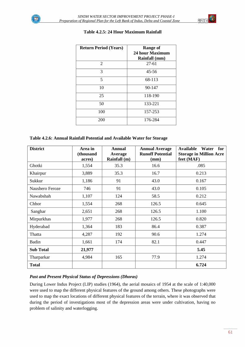
SINDH WATER SECTOR IMPROVEMENT PROJECT PHASE-I
Preparation of Regional Plan for the Left Bank of Indus, Delta and Coastal Zone
61
Table 4.2.5: 24 Hour Maximum Rainfall
Return Period (Years) Range of
24 hour Maximum
Rainfall (mm)
2 27-61
3 45-56
5 68-113
10 90-147
25 118-190
50 133-221
100 157-253
200 176-284
Table 4.2.6: Annual Rainfall Potential and Available Water for Storage
District Area in
(thousand
acres)
Annual
Average
Rainfall (m)
Annual Average
Runoff Potential
(mm)
Available Water for
Storage in Million Acre
feet (MAF)
Ghotki 1,554 35.3 16.6 .085
Khairpur 3,889 35.3 16.7 0.213
Sukkur 1,186 91 43.0 0.167
Naushero Feroze 746 91 43.0 0.105
Nawabshah 1,107 124 58.5 0.212
Chhor 1,554 268 126.5 0.645
Sanghar 2,651 268 126.5 1.100
Mirpurkhas 1,977 268 126.5 0.820
Hyderabad 1,364 183 86.4 0.387
Thatta 4,287 192 90.6 1.274
Badin 1,661 174 82.1 0.447
Sub Total 21,977 5.45
Tharparkar 4,984 165 77.9 1.274
Total 6.724
Past and Present Physical Status of Depressions (Dhoras)
During Lower Indus Project (LIP) studies (1964), the aerial mosaics of 1954 at the scale of 1:40,000
were used to map the different physical features of the ground among others. These photographs were
used to map the exact locations of different physical features of the terrain, where it was observed that
during the period of investigations most of the depression areas were under cultivation, having no
problem of salinity and waterlogging.

SINDH WATER SECTOR IMPROVEMENT PROJECT PHASE-I
Preparation of Regional Plan for the Left Bank of Indus, Delta and Coastal Zone
62
With the passage of time, overall cropping intensities increased within the left Bank Canal commands
of three Barrages. Later on this situation was changed by cultivating high delta crops, mismanagement
of irrigation system and seepage losses from the network of canals, branches, distributaries and
minors. Such conditions in the study area created waterlogging problem. This menace was confirmed
during the soil salinity and waterlogging survey conducted in 1976-79 for irrigated areas of Indus
basin by survey and Research organization Planning Division Lahore and report published in 1981.
From the result it was obvious that major parts of the existing depressions (Dhoras) areas were
waterlogged and mapped under the category of “Water Bodies”.
In converting the depressions areas into water bodies, two major factors played the main role;
1- Increase in ground water table depth in adjacent cultivated Lands;
When the water table rises above the surface level of depressions, the horizontal underground
flow from cultivated fields started flowing towards the depressions (Dhoras) areas and these
served as natural drainage to the nearest cropped lands. The seepage from all around the
agriculture lands, slowly nearly filled up the depressions (Dhoras) with water
2- Irrigation and Storm water.
The next factor is the irrigation and storm runoff. These have played a main role in
inundating the depressions areas. The waste water of irrigation system when it is not required
by crops is allowed to go into the nearest depressions. During monsoon season the storm
water standing in the agriculture lands is also being drained out into these Dhoras. However,
some of the wise land owners have converted them into fish ponds and are making sustainable
profit.
In recent past (2000-2005), the irrigated areas of Indus basin were resurveyed under S&R,
project by SCARP Monitoring organization WAPDA, using the SPOT Satellite imagery for
mapping the Physical features of the ground. It was observed that condition of depressions
(Dhoras) was more or less the same as compared to the previous survey conducted by
WAPDA during 1981. There was little difference due to drought conditions prevailed during
the survey period of (2000-2005). Overall water table was lowered down that also resulted in
lowering the levels of standing water into depressions. Again during the last year‟s (2010) due
to heavy rain fall, the water levels have been raised in depression areas. The names of main
depressions (Dhoras) located at various locations of study area are mentioned in Table 4.2.7
Satellite imagery of these depressions are presented in Volume –II Thematic Area 4.2.

SINDH WATER SECTOR IMPROVEMENT PROJECT PHASE-I
Preparation of Regional Plan for the Left Bank of Indus, Delta and Coastal Zone
63
Table 4.2.7: Location of Naturally Occurring Dhoras and Dhands
Guddu and Sukkur Commands in Study Area
Figure Location of Dhoras Latitude Longitude Area in acres
1. Reti N 28o05'39 E 69
o48'18" 1210
2. Ghotki area N 27o57'54" E 69
o21'54" 717
3. Ghambat, Jiskani, Talpur Vada N 27o18'36" E 68
o37' 1798
4. Behlani N 27o06'54" E 68
o20'42" 582
5. Phul Town Area N 26o42'36" E 68
o10'12" 2176
6. Bandhi Area N 26o37'48" E 68
o18' 1664
7. Dour area N 26o29'24" E 68
o16'12" 3162
8. Bucheri area N 26o21' E 68
o16'12" 2362
9. Bachal Raho and Din
Muhammad Zardari
N 26o15' E 68
o15'18" 1856
10. Sakrand N 26o10'30" E 68
o18'18" 608
11. Tando Adam Shahdadpur, and
Mansoora
N 25o51' E 68
o43' 1754
12. Dhoro Naro
13. Dhoro Puran
Depth & Quality of Water in Depressions (Dhoras):
It has been observed during the different surveys conducted mostly by Water Wing WAPDA that an
average depth of water in depressions (Dhoras) ranges in between 3' - 6' ft. In those used as fish
ponds, the average depth ranges from 4-7 ft.
As per the quality of water is concerned, mostly are classified as marginal water (EC ranges in
between 2500 – 3000𝜇s/cm). During shortages of irrigation water in the canal system, some of this
water is pumped out for irrigating the adjacent cropped area. However, the water quality of Dhoras
trapped in between highly saline lands, are considered hazardous, with EC readings of more than 3000
𝜇s/cm, which are harmful for all types of water use.
A feasibility study is required to quantify the extent and storage capacity of each depression and
availability of runoff water for storage. It is essential to conduct surveys of all potential sites. A list of
natural Dhoras/depressions is presented in table 4.2.7 and Dhands in Badin area in table 4.2.8.
Table 4.2.8: List of Dhands in Badin Area
Sr. No Dhand Average
Depth
Average
water Level
Average Bed
level (AMSL)
Average
Salinity (PPM)
1. Sanhro 2.93 2.02 -0.90 7654
2. Sanhro-Mehro 3.08 1.79 -1.29 6638
3. Mehro 2.69 1.93 -0.76 3681
4. Cholri 1.82 3.20 1.38 13640
5. Pataje 1.62 3.08 1.46 49,610

SINDH WATER SECTOR IMPROVEMENT PROJECT PHASE-I
Preparation of Regional Plan for the Left Bank of Indus, Delta and Coastal Zone
64
4.2.1.5 Thar Coal, Water Supply and Disposal
Thar coal field is spread over an area of 9100 sq.kms in a strip of 140 km (N-S) and 65 km (E-W) in
Mithi, Islamkot, Nangarparkar, and Chachro Tehsils of District Tharparkar. Coal deposits have been
estimated to the tune of 175 billion tons of lignite coal with an average heating value of 5774 BTU/lb.
The coal power plants require pure water supply for their operations. A discharge of at least 280
cusecs are required for generation of 4000 MW electricity. The effluent being highly saline needs to
be disposed off at safe places without causing any environment problems. In the key findings of this
Thematic Area, options of water supply route and disposal of wastewater are discussed, analyzed and
critically evaluated.
4.2.2 Key Findings
4.2.2.1 Rainwater Harvesting
The quantum of storm water in the study area generated from rainfall is 6.73 MAF, out of which
5.46MA is generated in the eight canal command areas and 1.27 MAF in Thar area which is outside
canal command area. Storm water is presently disposed off through drainage systems in the area
where drainage networks have been implemented and, accumulates in the depressions or create
ponding situation in the fields where there are no surface drains.
There are 13 prominent depressions (Dhoras) existing in the different parts of Left Bank area. Out of
these, few are being used and converted into fish ponds by the Land owners. Many others are under
water having no significant use except to serve as drainage ponds for collecting the seepage from the
adjacent Lands. Few depressions (Dhoras) are deep and large enough in length and could be used for
rain harvesting. For this, detailed investigations are required to determine depth, length and width, so
that quantum of water could be determined for storm water harvesting purpose.
Feasibility is required to quantify the extent and storage capacity of each depression keeping in view
the need for storm water harvesting and availability of runoff water for storage. It is essential to
conduct survey of all potential sites. Very high evaporation rates present a problem for water storage.
4.2.2.2 Water Supply to Thar Coal
As mentioned before, coal power plants require pure water supply for their operations. A yardstick for
the discharge demand is 70 cusecs to generate 1,000 MW. The effluent being highly saline needs to be
disposed off safely, without causing environment problems. In this part of the thematic area, options
of water supply route and disposal of wastewater are discussed, analyzed and critically evaluated.
i. LBOD drainage effluent
ii. Groundwater
iii. Mined water generated from coal power plants
iv. Canal water
LBOD Drainage Effluent
Left Bank outfall Drain provides evacuation of storm water during rainfall and the ground water
drainage effluent generated from the three project components Nawabshah, Sanghar and Mirpurkhas
in non rainy periods. The underground brackish water pumped through Drainage Tubewells is around
1,640 cusecs. The difference of levels between LBOD RD (203) and Islamkot is 226 ft therefore
water can only be supplied to Islamkot through pumping. Furthermore, due to very high salt content
in the water combined with the pumping cost, makes this option not feasible.

SINDH WATER SECTOR IMPROVEMENT PROJECT PHASE-I
Preparation of Regional Plan for the Left Bank of Indus, Delta and Coastal Zone
65
Ground Water
Ground water investigations in Thar Coal area were carried out in 1992 by BGR (consulting firm) and
WAPDA. The study concluded that in an area of about 600 sq km fresh ground water down to 40 m
depth is found in Tharparkar area. The aquifer layers below 40m to 200m from ground surface
comprise of deeper sedimentary laminations with resistivity up to 60 ohm-m and it contains highly
saline water. For utilizing ground water for power plants, further detailed investigations may be
conducted to assess the present situation.
Water Generated From Mining
Sufficient quantity of water will be generated during mining process. The quality of water will be
saline as per initial investigations conducted by BGR. Further Investigations are needed for assessing
the present situation of quantity and quality of mining water for use in the power plant.
Surface Water
Indus Water for Thar Coal can be considered from Guddu or Sukkur Barrages. Rainee Canal is under
construction and takes-off from the left bank side upstream of Guddu Barrage. Nara Canal off-take is
situated on the left bank of Sukkur Barrage. Rainee Canal will be a flood (non-perennial) canal
without assured supply throughout the year. However Nara Canal is a perennial Canal with assured
supply throughout the whole year. The options of Water Supply from Rainee Canal and Lower Nara
Canal systems are discussed in the following paragraphs.
Rainee Canal is located on upstream of Guddu Barrage with design discharge of 5,155 cusecs. The
Canal will provide water during flood period (August - Sept) for irrigation purposes to an area 0.412
MA. Water from the tail of Rainee canal RL 218.5 ft can be supplied to Islamkot RL 236 through a
water carrier running along the Eastern boundary of Lower Nara Canal. The length of the lift cum
gravity canal will be around 370 km. The Canal will pass through Thar Desert comprising of
windblown sand dunes running from Southwest to North East. The dunes have height-up to 370 ft
which would require huge excavations for construction of water carrier. Construction will not be
possible due to the instability of slopes and drifting of sand that will result in the choking of the water
carrier. This option will be very expensive in addition to heavy capital investment on construction of
the water carrier; in addition assured water supply will not be available throughout year as Rainee
Canal is a non-perennial as mentioned above.
Chotiari Reservoir.
Chotiari Reservoir is an off stream storage reservoir constructed under LBOD Stage - 1 project.
Chotiari Reservoir is filled through Ranto escape off taking from Nara Canal. The design Capacity of
the Ranto Canal is 6,500 cusecs. The water management plan of Chotiari Reservoir is based on the
assumption that Nara Canal will be remodeled/ improved by construction of five fall Structures and
re-sectioning of the canal to accommodate discharge to the order of 20,000 cusecs. This quantum of
water will be available during the flooding period. Chotiari reservoir has been designed to
accommodate 0.71 MAF at full supply level RL 87.5 ft. The live storage capacity of Chotiari
reservoir is 0.67 MAF. The dead storage level is 64.75ft below which water will not be drawn from
the reservoir. The carrying capacity of Ranto Canal has been reduced to 1,500 cusecs due to silting
and also Nara Canal's carrying capacity has not been enhanced as the per-requisite works have not
been completed.
There are two options available for supplying water from Nara canal system, either from Chotiari
reservoir or from Farash weir situated at the tail of Lower Nara canal (Makhi-Farash Link). Nara
canal off-takes on Left Bank of Sukkur Barrage with design discharge of 13,650 cusecs. The Nara

SINDH WATER SECTOR IMPROVEMENT PROJECT PHASE-I
Preparation of Regional Plan for the Left Bank of Indus, Delta and Coastal Zone
66
Canal System comprises sub systems of Jamrao, Mithrao, Khipro and Lower Nara Canal (Makhi
Farash Link). Farash weir is at the tail end of the Lower Nara Canal.
Water supply from Chotiari reservoir is not feasible due to construction costs. However water supply
from Farash regulator to Islamkot is feasible.
4.2.2.3 Disposal of Wastewater from Thar Coal
There are several sources of waste water generation within the coal power plant systems. The
wastewater generated from these sources is of different quantities and qualities. The sources are: -
1. Effluents generated during regeneration of ion exchangers.
2. Alkalies effluent are generated during rinsing of anion exchangers and mixed bed
exchangers.
3. Blow down from plant consists of cooling water blow down and boiler blow down.
4. Domestic waste water.
In order to establish a general layout of the proposed drain to carry out effluent from Block-2 to
various saline water containing depressions (Dhands) scattered to several miles along border in the
South and East-West direction, a perusal of surface spot elevations given on the toposheet is
considered necessary. For this, top sheet no. NG42-15 of the area was used. This topo sheet was last
modified in 1955. The spot elevations (ft) given in the toposheet were read out and based on these
data, 20 feet interval contours were drawn on the map.
Examinations of the contour map of surface elevations reveal that there are two options for alignment
of the drain. These options have been emerged out in consideration of general slope of land and flow
direction through various valleys and natural drains within the sand dunes.
Option 1: In this option, the drain can be laid out from Block 2 to Sorungwari Dhand towards
the South from the source site. This drain can later be connected with block 8 to cater for the
needs of waste water disposal.
Option 2: In this option the drain can be laid out from Block 2 running South West between
Block 1 and Block 4 up to Libo village from where the drain could be laid out towards the
South, right up to Phatar Dhand. With this option, the disposal of effluent from Blocks 1 and
4 also become possible. The layout plan for the proposed drain under these two options is
shown in Vol-II Thematic Area 4.2.
This report has been based on Google Earth information of topographic elevations. In the actual
situation, field conditions could be quite different. Therefore to arrive at a final decision, detailed
topographic survey of the area should be carried out for delineation of layout of the drain pipe line.
The surface elevation contour maps show that the elevation contours run almost parallel in East –West
direction in the southern area. The slope is well below the minimum requirement (for drains) for
attaining a minimum velocity of 3 feet/sec. Below this minimum velocity, heavily loaded suspended
ash particles will be settled and accumulated inside the pipe. No self clean arrangements can be
designed other than velocity.
For the above reason, the plan for layout of drain to dispose of effluent into the LBOD seems to be not
feasible. Furthermore, detailed chemical and physical analysis is required to check for the pollution.
The length of the drain along the layout plan Option 1 is much shorter than the length of drain under
Option 2. Furthermore, the slope of the drain meets the requirement of maintaining a minimum
velocity of 3 feet per second. As such, the proposed layout under Option 1 is recommended.

SINDH WATER SECTOR IMPROVEMENT PROJECT PHASE-I
Preparation of Regional Plan for the Left Bank of Indus, Delta and Coastal Zone
67
The field was visited by experts who had detailed interview with the local residents and stakeholders.
There is no other objection except regarding some seasonal shallow lakes which dry up during the
summer season, leaving behind the salt on the surface. These salts are mostly used by the inhabitants
of the area for domestic as well as for commercial purpose. These lakes need to be excluded from the
inflow of the drainage effluent from the coal fields.
The Thar Coal Field and location of its block(s) to be developed initially are presented in figure 4.2.1.
Figure 4.2.1. Layout Plan for proposed Wastewater Drain under Options 1 and 2

SINDH WATER SECTOR IMPROVEMENT PROJECT PHASE-I
Preparation of Regional Plan for the Left Bank of Indus, Delta and Coastal Zone
68
0.0 1.0 2.0 3.0
Sanhro
Sanhro-Mehro
Mehro
Cholri
Pataje
Dhands' Average Depth (ft)4.2.3 Issues and Problems
Rainwater Harvesting
Very high water evaporation rates are observed
in the area, which substantially limits the use of
the small dhands as the water evaporates within
few months. Few depressions (Dhoras) are deep
and large enough in length and could be used for
rain harvesting. For this detailed investigations
are required to determine depth, length and
width, so that quantum of water could be determined for storm water harvesting purpose.
Supply water to Thar Coal
Each option for assured water supply to the Thar coal field, require lifting of water from low level to
high level will cause considerable difficulties in the operation and maintenance of pumps.
Selection of suitable route for water supply is based on Google Earth information. Sometimes there is
a lot of discrepancy between the observed and picked up ground levels from Google Earth. As such,
actual topographic survey is required to delineate the true layout of the pipeline.
Disposal of Waste Water from Thar Coal
As proposed, the effluent of Thar Coal Blocks-II will be disposed off into a series of Dhands about
36.5 km from the site (option-1). The estimated quantity of the effluent water is about 36500 acre feet
per annum. One lake (Dhand) as originally planned by SIDA is insufficient to store this amount of
water. However, if, all the lakes (Dhands) are interconnected, (except those used by local
communities for salt harvesting, see section 4.2.2.3) then the drainage effluent can be easily be
disposed of without causing any flooding of the nearby villages and land.
Total surface area of all these lakes (Dhands) has been found to be 23722 acres. Taking a conservative
side, if annual net evaporation (evaporation-rainfall) is assumed to be 3ft (36 inches), then annual
evaporation from these ponds will be equal to 70000 acre feet that is far above the inflow of drainage
water. As such there are no chances of over spillage and there would be no adverse impact on the
communities living in the vicinity of the disposal site.

SINDH WATER SECTOR IMPROVEMENT PROJECT PHASE-I
Preparation of Regional Plan for the Left Bank of Indus, Delta and Coastal Zone
69
4.3 IMPACT OF DRAINAGE AND FLOOD ON ENVIRONMENT AND WETLANDS
4.3.1 Background of Thematic Area
The titles covered in this thematic area include: Seawater intrusion, Riverine and Inland forests
located in the left bank of Indus and deltaic area Deforestation, Physical resources, Surface and
Groundwater quality, Flow downstream Kotri and impact on Ecosystem, Mangroves in the coastal
area, Sources of Water pollution and Pollution through Industrial effluents.
Table 4.3.1: Topic Outline for Summary of the Thematic Area 3 Study
Topic of Concerns for Phase-I Task Studies
Subjects Covered Phase-I Tasks Included
III –Impacts of Drainage and Flood on Environment and Wetlands
Salt water intrusion
Deforestation
Soil, climate, surface water, and
ground water resources
Land use
Vegetation
Biological resources
Water quality
Mangroves
Lower Indus River Basin ecosystem
Down stream conditions below
Kotri Barrage
Ground water quality
Surface water quality
Industrial effluents
Ground water pollution
Surface water pollution
T-3: Document, review and analyze research on sea water
intrusion
T-5: Document and review deforestation and strategies for
reforestation
T-9: Analyze potential impacts of climate change
T-24: Evaluate quality of Indus River water
T-25: Document research on mangroves
T-26: Review studies and plans for development of Indus
eco-system downstream of Kotri Barrage
T-27: Review and analyze information on groundwater and
surface water quality
T-28: Evaluate how population is affected by industrial
pollution
T-29: Identify sources of ground water and surface water
pollution
4.3.2 Methodology adopted to address the thematic areas
Information collection through Web search, primary and secondary sources
Web search was conducted on environmental and biodiversity problems of the project area with
special reference to pollution of surface and underground waters. Literature on Water disasters and
measures taken to mitigate the effects of flood and drainage challenges was reviewed. The consultants
reviewed reports of the national and international renowned organizations working on the issues of
the communities locally and globally. Copies were collected of up-dated progress reports, completed
and on-going development projects, issues and problems to manage them, lessons learnt, activities
undertaken to develop and monitor the resources.
i. Introductory meetings
Conducted introductory meetings with stakeholders, visited various sites especially those with
high risk and vulnerability. Meetings were also arranged with the related NGOs and CEOs of
SINDH WATER SECTOR IMPROVEMENT PROJECT PHASE-I
Preparation of Regional Plan for the Left Bank of Indus, Delta and Coastal Zone
70
government related organizations responsible for the relief and rehabilitation tasks. Also meetings
were arranged with the Irrigation Department, Environmental Protection Authority, Cane
Commissioner‟s office and responsible officers at various barrages.
ii. Identification of stakeholders
Stakeholders for each area of interest were identified and contacted during the process of data
collection. These included beneficiaries, affectees, NGOs working in respective areas, Local
influential people, government line department‟s officers, civil society representatives, CBOs,
FOs, WUAs, Abadgar Water Board representatives and Technocrats including personnel from
PCMU, SIDA and Water Experts.
iii. Embark on Participatory approach
Steps were taken to listen to the stakeholders and incorporated all stakeholder views in the report.
Following activities were undertaken to complete the assignment through the participatory
approach:
Arranged fact-finding and consultative meetings at local and regional levels
Prepared draft report incorporating feedback/views arrived at meetings and literature review
Deliberated for seeking their feedback
Incorporated inputs of stakeholders
iv. Stakeholders Consultative Workshops
A number of consultative workshops were held at different locations of the project area. The aim
of holding such workshops was to share their expertise and experiences in identifying their
problems and seeking their suggestions on workable and viable solutions. These workshops
provided us the information that would help in formulating the feasibility studies for various
interventions.
v. Detailed field visits
The consultants visited in person most of the areas that are reported being seriously affected
through floods and drainage outfall issues. The damages to the lands, properties, ecosystem,
wetlands, and infrastructure were observed on site through local visits and personal interviews
with groups of affectees and sometimes through village headman. All such contacts were made as
per the communication strategy developed by the Social team of the project.
4.3.3 Key Findings
Seawater Intrusion
In Sindh, the sea water intrusion is mainly caused by tidal effects in Indus River, tidal link and coastal
creeks. History depicts that land of Indus Delta was quite fertile as the agriculture fields existed quite
close to the sea (about 5 to 7 km) mainly depended upon surface freshwater. The good quality
groundwater was also available in the deltaic region just 4 to 5 km from the open sea. The freshwater
based riverine forests existed along the Indus river course. The entire deltaic area was rich in
biological resources.

SINDH WATER SECTOR IMPROVEMENT PROJECT PHASE-I
Preparation of Regional Plan for the Left Bank of Indus, Delta and Coastal Zone
71
Exhibit 6.14 -- Salinity Profiles for Various Discharges
100
1,000
10,000
100,000
0 20 40 60 80 100 120 140 160 180
Distance Along River from River Mouth (km)
Sa
lin
ity
(p
pm
)
Q0=0 cfs
Q3=3,000 cfs
Q5=5,000 cfs
Q10=10,000 cfs
Q15=15,000 cfs
Q20=20,000 cfs
Q30=30,000 cfs
Q50=50,000 cfs
Q60=60,000 cfs
Thatta-Sujawal BridgeDandho(Sherazi
BanderKarshah
Q0
Q3Q5
Q30
Q20
Q10
Q15
Q50
Q60
Seawater intrusion is mainly taking place due to continuous decrease in the freshwater flows in Indus
delta as a result of the development of the upcountry irrigation system and decrease in silt load. This
has multi-dimensional negative impacts in the coastal area such as i) depletion of freshwater (ground
and surface) in the deltaic region; ii) deterioration in freshwater quality; iii) increase in salinity; iv)
degradation of
productive agricultural
lands into wastelands
and swamps; v) Shift in
cropping pattern to low
value crops vi) and
sinking of productive
mudflats in the delta.
The ultimate impact of
seawater intrusion is
loss of biodiversity and
degradation of deltaic
ecosystem.
Seawater intrusion in the River Indus
Seawater intrusion in the river is variable and depends upon quantum of outflow in the river. MHW,
ACE(Pvt.) Ltd, NESPAK jointly carried out a model study to see likely extent of seawater intrusion
in the Indus River under various outflow conditions as shown in the (Figure 4.3.1). According to this
study, in case of no flow in the river seawater intrusion may be experienced in the river up to about
160 km from the river mouth. With the improvement in river outflow the seawater intrusion retreats.
An outflow at the rate of 30,000 cusecs limits the seawater at just 10 km away from Sherazi Bandar. It
is estimated that the sea has moved inland degrading more than 485 thousand ha (1.2 million acres) of
land in the districts of Thatta and Badin (World Bank 2005).
Seawater intrusion at Tidal Link
Figure 4.3.1 Shows salinity profile and seawater intrusion (source: FFCP 2005)
Figure 4.3.2 Discharge Volume Downstream Kotri (1937-2010 on Annual basis
(Source: IPD Sindh)
SINDH WATER SECTOR IMPROVEMENT PROJECT PHASE-I
Preparation of Regional Plan for the Left Bank of Indus, Delta and Coastal Zone
72
The recently built drainage system became sources of seawater intrusion for inland particularly after
the collapse of the Tidal Link. It has detrimental effects on the environment and has badly disrupted
the ecosystem of the area. It has also badly damaged the agriculture due to backflow of hyper saline
water in the drains and in the adjoining agriculture land.
Causes of Seawater Intrusion
a) Low and variable input of freshwater and sediments
b) Rising sea level globally due to climate change
Historic record shows that during the pre Kotri Barrage era the downstream flow at Kotri used to be
round the year. After the construction of Kotri Barrage, Guddu Barrage and Tarbela Dam, the
downstream flow at Kotri Barrage is observed only in the flood season spread over one to two months
(Figure-4.3.2 and Vol-II Thematic Area 4.3 Table -4.3.2).
Recommendations of the IPOE
The International Panel of Experts (IPOE November 2005) in their report recommended a minimum
outflow of 5,000 cusecs at downstream of Kotri should be maintained, and a total volume of 25 MAF
in any 5 years period (an annual equivalent amount of 5 MAF) be released downstream Kotri. During
last five years the downstream Kotri flows remained significantly lower than 5 MAF as recommended
by the IPOE. An another study by Joint venture of LIG (Germany), IAC (Lahore), and BCE
(Peshawar), recommend that at least 4.7 MAF water needs to be released annually downstream of
Kotri, only to preserve the mangrove ecosystem.
Now with the rising sea level due to global warming and the decreasing input of freshwater and
sediments from the Indus River, the Indus Delta faces serious threats in the following areas:
Ecosystem and stability of the delta
Loss of prime agriculture land
Seawater intrusion, rise in salinity of neighboring lands and aquifers
Loss of mangrove forest, flora and fauna
Loss of livelihoods of the coastal population
The viable options to significantly check the seawater intrusion and mitigate its impacts are i) to
attempt to grow mangroves in all potential mud flats all along the coastal belt ii) Allow 21 MAF flow
of fresh water downstream Kotri every year, all the year round to deposit silt along the coast to create
new mud flats and push the seawater back to the sea. These options will increase the area of mud
flats; provide nourishment for mangroves and other natural resources especially fisheries.
Sea Water Intrusion in KPOD and Tidal Link
As soon as the the tidal link began operating in 1995, it experienced erosion and scouring problems.
This resulted in collapse of 250 ft section of weir in June 1998. The catastrophic cyclone 2A of 21st
May 1999 have caused complete collapse of the Cholri weir and some 56 breaches occurred in tidal
link on both sides..Contrary to the design, the tidal effect reached far ahead in the tidal link and
KPOD. This caused the seawater to travel to dhands under the tidal influence and
backwashing/receding when the tide is low. This to and fro movement of seawater in dhand complex
SINDH WATER SECTOR IMPROVEMENT PROJECT PHASE-I
Preparation of Regional Plan for the Left Bank of Indus, Delta and Coastal Zone
73
has changed the water quality in dhands from brackish to highly saline. Consequently, freshwater fish
and reed grass have disappeared, water fowl population has decreased, and salinity of the adjoining
agricultural areas has increased, thereby degrading the fertile lands. In order to revive the ecosystem,
the stakeholders proposed to block out the dhands from seawater inflows by constructing bund
between the KPOD/Tidal link and the dhands along the right bank of KPOD/ Tidal link. The storm
water which is of good quality could be diverted to dhand complex to replenish the dhands, and to
reduce the salinity level of dhand water.
4.3.4 Riverine and Irrigated Forests- Causes of Deforestation and Proposed Strategy for
Reforestation
After agriculture, forestry is the second largest land use in Sindh. Forests are a natural endowment and
valuable resource for the province with a distinctive feature of being renewable. Sindh is blessed with
variety of forest types such as riverine forests located along both sides of Indus, irrigated plantations
located in the command area of irrigation systems of Sukkur, Guddu and Kotri barrages and Coastal
forests located in deltaic region of Indus. Forests have vital social, economic and environmental
importance for the economy of Sindh province. They provide productive and protective functions and
diversified types of services such as maintenance of environment, absorption of solar energy and
sequestration of Carbon dioxide, protection of the river banks from erosion, conservation of
biodiversity and wildlife, and prevention of desertification.
Area
Out of Sindh‟s total land area of 14.1 million ha, an area of about 1.13 million ha (8%) is under the
management of Sindh Forest Department (SFD) but only an area of 2.3% is covered by productive
forests, namely 241 thousand ha of riverine forest and about 82 thousand ha under irrigated plantation.
Riverine forests located in left bank of Indus river covers 157 thousand ha of which about 43.2
thousand ha is in the Sukkur district, followed by 34.5 thousand ha in Hyderabad district, about 23
thousand each in Shaheed Benazirabad and Thatta districts, about 15 thousand ha is in Naushero
Feroze district, about 12 thousand in Khairpur district, and about the 6.2 thousand ha in Ghotki
district. . The area under irrigated plantation is about 82 thousand ha, out of which about 35 thousand
ha is in the Sukkur barrage command, followed by 29 thousand in the Kotri barrage command, and
about 18 thousand ha in the Guddu barrage command. Of the total area under irrigated forest about 65
thousand is in the left bank of Indus, while about 17 thousand is in the right bank (Sindh Forest
Management Plans, 2001).
Forest Management Objectives
The main objectives include: i) to increase the vegetative cover over forest lands through conversation
and improvement in the existing forests for maximizing sustained production and preservation of
ecosystem; ii) to meet the fuel wood and timber requirements on sustained basis; iii) to promote the
environmental stability and to preserve bio-diversity and natural heritage; and iv) to intensify
management and adopt post care and arrest deforestation so as to achieve the forest productivity
potential.
Issues and problems causing deforestation and degradation of forests
Deforestation in the forests of Sindh is caused mainly due to social, economic and environmental
reasons. Riverine Forests are complex ecosystem, ecologically suited to their natural environment and
rely on annual or periodic river flooding for their survival. The predominant factors include: i) low

SINDH WATER SECTOR IMPROVEMENT PROJECT PHASE-I
Preparation of Regional Plan for the Left Bank of Indus, Delta and Coastal Zone
74
inundation flows in the Indus resulting in extended droughts; ii) lower than allocated irrigation
supplies (Annexure 4.3.1) iii) deteriorating law and order situation in the riverine areas; iv)
conversion of forest lands to agriculture use; and v) poor governance by the FD. The abovementioned
factors has taken its toll on the forest cover, and resulted in deforestation in the province.
Furthermore, the Forest Management Plans which are the guiding documents for development and
management of forests have either expired their duration or are incompatible with the ground realities.
Proposed Strategies/methods for reforestation of the Riverine Forests and Irrigated Plantations
i. Artificial regeneration of riverine forests: Regeneration shall be carried out in three stages-
pre-abkalani sowings, mid-abkalani sowings, and post-abkalani. During pre-abkalani the soil
is compacted, and seeds are planted, while in the mid- abkalani season seeds of Babul and
Kandi in 3:1 ratio is broadcasted. In the post abkalani xerophytic species is planted in case of
poor germination.
ii. Afforestation program in the riverine forests through development schemes: With the
initiation of drought periods especially from 1997 onwards the SFD initiated development
schemes in the riverine forests funded out of Annual Development Programme (ADP)
through lift water irrigation, either directly from the river or installation of tube wells. This
system still followed at modest and small scale, which needs to be accelerated. The approach
adopted so far by the department has been without a participatory approach involving local
communities/stakeholders in the planning, execution and management processes. It is
proposed that strategy of “participatory forestry” be adopted for sustainability in the
development of forestry.
iii. Afforestation through agroforestry leases in the riverine and inland forests: Sindh Forest
Department prepared policy in 2005 to develop forests (riverine and inland) through leasing
of forest lands to private entrepreneurs for growing agricultural crops in 75% and 25% tree
woodlots in the leased area. The lease was for an initial period of five years extendable up to
ten years on the basis of performance and adherence to the terms and conditions of the lease.
This program needs to be continued, with necessary amendments to ensure sustainability.
4.3.5 Physical Resources of the Left Bank and Coastal Zone
The importance of natural resources in sustaining productivity and environmental protection is at
present more realized than in the past. Its linkage to poverty alleviation by making the farmers
partners in the development process with empowerment is relatively a new concept. Natural resources
like land, water and rangelands are important for both crop and livestock farming which now has
become a limiting factor.
Soils and Land Use
The soils of the Left Bank area are mainly formed by alluvial sediments deposited by Indus River.
The dominant textures within the study area include medium textured soils (37.0% Buchiana Series),
moderately fine textured soils (32.0% chuarkana), where as minor part of area is comprised of
moderately coarse textured soils (18% Farida), and coarse textured soils (5.0% Jhang). The land use
classification is given as under:
Perennial Canal Irrigated……………………. 34%
Non Perinnial Canal Irrigated………………. 16.4%

SINDH WATER SECTOR IMPROVEMENT PROJECT PHASE-I
Preparation of Regional Plan for the Left Bank of Indus, Delta and Coastal Zone
75
Canal + Tube well Irrigated………………… 19.3%
Area under Forest Cover……………………. 0.42%
Sand Desert, Waterlogged and Saline……… 22.88%
Urban Areas, Grave Yards, Roads, Canals etc...7.00% (Annexures-4.3.3, 4.3.4, 4.3.5)
Climate and Rainfall
Sindh province is part of the subtropical region; hot in the summers and cold in the winters.
Temperatures frequently rise above 46 °C (115 °F) during May and August, and the minimum
average temperature of 2 °C (36 °F) occurs during December and January. The average rainfall in
Sindh is only 15 to 18 cm per year. There is significant difference in various parameters of climate
between the upper Sindh and the lower Sindh, and coastal areas. Temperature is higher in the upper
Sindh, while humidity is relatively higher in the lower parts of Sindh. Rainfall is relatively higher in
the lower Sindh compared to the upper Sindh. The wind velocity is higher in lower Sindh when
compared with upper Sindh. This phenomenon explains the diversity of climate in the upper and
lower Sindh.
Sindh Water Resources
Indus River is the main source of water for the province, with limited available fresh groundwater, the
yearly average availability of water in the province, computed from the data from year 1970 to 1997,
is 45 MAF. According to the Water Accord of 1991 Sindh is awarded 48.76 MAF for both Kharif and
Rabi seasons. The worst ever drought conditions in Sindh, experienced from 1998 to 2002, showed
that the province received much less water than allocated in the Water Accord.
Table 4.3.2: Water Distribution as per Water Apportionment Accord 1991
Province Kharif (MAF) Rabi(MAF) Total(MAF) Balance Flood
Supplies %
Punjab 37.07 18.87 55.94 37
Sindh 33.94 14.82 48.76 37
Khyber Pukhtoonkhwah 3.48 2.30 5.78 14
Balochistan 1.80 1.20 3.00 12
Civil Canals 2.85 1.02 3.87 -
Total 79.14 38.21 117.35
Source: Government of Pakistan
Groundwater Resources:
Estimated ground water resources for the Sindh province vary between 13 to 16.2 MAF with an
estimated safe yield between 4.4 to 8.1 MAF. More than 78% of the irrigated land in Sindh is
underlain with saline or brackish water, which is unfit for agriculture. There are about 13241
tubewells in Sindh. Of these about 12.859 thousand are private tubewells and about 382 are in the
public sector, though other unofficial estimates put the number of private tubewells much higher. The
present number of tube wells is likely to be more than 70 thousand, considering an operation factor of
8-10%, the groundwater pumping is estimated to be about 4.9 MAF on an annual basis (Azad 2003).
Groundwater Potential in Sindh:
Useable groundwater in the Province is mainly found in the Indus Plain, which is recharged from the
meandering river and from the irrigation network that has been developed in the area. The other
source of recharge is rainfall which is quite scanty and its contribution to the resource is limited.
Rainfall recharge was 1.96 MAF (2% of 265 mm per year) as worked out by ACE and Halcrow

SINDH WATER SECTOR IMPROVEMENT PROJECT PHASE-I
Preparation of Regional Plan for the Left Bank of Indus, Delta and Coastal Zone
76
(2001). The recharge from return flows (22.5% of 38.2 MAF), irrigation returns (22.5% of 3.5 MAF)
was assessed 8.58 MAF and 0.79 MAF respectively. In the Sindh, canal water losses have been taken
as 15 % of the total average canal supply of 45 MAF for the period 1988-2000. The recharges from
these canals was estimated 6.76 MAF. The recharge from the river was assessed 0.3 MAF. The total
available resource of the Sindh Province was assessed to be 18 MAF. (Muhammad Amin).
In Sindh about 28% of the area has fresh ground water suitable for irrigation. Close to the edges for
irrigated lands fresh ground water can be found at 20-25 m depth. Large areas in the province are
underlain with non potable highly brackish water including Thar, Nara and Kohistan. In Tharparkar
including Umerkot, the situation is further complicated by the occurrence of high fluoride in some
groundwater (PCRWR, 2004).
Irrigation in Sindh
The total reported area for the left bank is about 10.3 million hectares (ha), out of which, about 5.8
million ha is arable. Of the available arable land, 4.3 million ha is under cultivation, while 0.6 million
ha is under forest, and the remaining 0.9 million ha is culturable waste. The remaining 4.5 million ha
is not available for cultivation, and mainly comprise of settlements, waterways, physical, social and
physical infrastructure, mountains and rock outcrops, lakes, desert, etc. The actual irrigated area varies
from year to year depending on the availability of canal water with an average of 1.8 million ha
(Statistics of Sindh 2008). The irrigation system below the barrages (Guddu, Sukkur and Kotri
barrages) comprises 14 feeders and main canals, and 1,462 branch canals, distributaries and minors.
Generation of Additional Water Resources
There is a need for generation of additional water resources both through conventional and non-
conventional means including: i) water Conservation; ii) rainwater harvesting; iii) use of saline water
for agriculture; iv) recycling of drainage effluent after treatment; v) desalination for urban use; vi)
balanced conjunctive use of groundwater; vii) and crop substitution through introduction of biosaline
agriculture (Azad, FAO 2003).
Water conservation measures through watercourse improvement, lining of distributaries and minors in
saline groundwater areas, precision land leveling, and adoption of drip and sprinkler irrigation, where
feasible can improve efficiency, the total losses will be reduced by about 5% making about 1.7 BCM
of extra water available for crop use. By adopting these measures the cropped area can be increased
by about 12% of the present area or by about 400 thousand ha.
Water table Depth in the project Area and extent of Waterlogging and salinity
Water table depth of the areas irrigated by three barrages for the last 30 years show that major part
within different canal commands remained under 0-150cm depth during post monsoon season. This is
because of the rainfall, flooding condition & simultaneously canals are running in full supply level in
the kharif season, and water table rises at the peak before the start of the Rabi season. As the water
table starts increasing soon after Rabi, the area covered by water logging is higher at the end of
monsoon period. During the recent past drought conditions prevailed throughout the region during
1999 through 2009. This has lowered the water table depths remarkably to a larger extent, leaving a
small area within 0-150 cm depth zone in the pre monsoon season, where as a decreasing trend has
also been observed during post monsoon period.
Indus Ecosystem
Identified amongst the 40 biologically richest eco-regions in the world, the Indus Eco-region covers
approximately 65% of the province of Sindh and occupies 18 districts of Sindh. Indus eco-region is
characterized by diverse habitat consisting of coastal, freshwater and brackish wetlands, riverine

SINDH WATER SECTOR IMPROVEMENT PROJECT PHASE-I
Preparation of Regional Plan for the Left Bank of Indus, Delta and Coastal Zone
77
forests, a vast desert and irrigated plains. The area is rich in biodiversity of significant ecological and
economic importance to the country in general and to the local communities in particular. The Indus
Delta has one of the largest arid climate mangrove cover in the world. It includes 17 major creeks
besides a large number of minor creeks and mud flats. In addition to eight species of mangroves, the
main delta area harbors at least 34 animal species, 138 bird species, 24 reptile species and about 200
fish species (WWF Pakistan 2007 foreverindus). The coastal waters and associated wetlands attract a
number of migratory birds. Some 56 bird species belonging to six orders and fourteen families have
been reported in the Sindh coastal waters. The main river course is habitat of the blind Indus Dolphin.
Moreover, a variety of fish species including Indus baril, Indus garua and the Golden mahasheer are
found in the river. The riverine forests along the banks of the Indus support a variety of flora
comprising of Acacia, Tamarix and Prosopis and fauna including Hog deer, Wild boar, Jackals and
Foxes.
Freshwater Lakes
Sindh is home to the large freshwater lakes namely Keenjhar, Haleji, and Manchar which are also
internationally recognized as important for a wide variety of breeding, staging, passage and wintering
water birds. Some of the wintering birds that have been seen around these lakes include ducks and
geese, shorebirds, flamingos, cormorants, herons and egrets, ibises, coots, gulls, terns etc. However,
decrease inflow of water from River Indus is causing significant damage to these wetlands.
Brackish and Salt Lakes
The Indus eco-region is home to a number of brackish and salt lakes such as Drigh Lake, Jhubo and
Nureri lagoons and a large number of seasonal or permanent lakes in Deh Akro-II wetlands complex.
Desert
The desert region in Sindh covers an area of approximately 68,000 km and comprises of Thar, Nara
and Kohistan. The Thar region is mainly in the Tharparkar district and extends southwards along the
Runn of Kutch. It extends over an area of 23 thousand square km and has a population of about one
million people. The Nara region spans 22 thousand, square km and its upper portion lies in four
districts: Sukkur, Nawabshah, Khairpur and Sanghar. Finally, Kohistan, with coverage of 23 thousand
square km comprises of parts of Dadu, Larkana and Thatta (WWF Pakistan 2007 foreverindus).
Desert ecosystem:
The desert region in Sindh covers an area of approximately 68,000 km2 and comprises of Thar, Nara
and Kohistan. The Thar region is mainly in the Tharparkar district and extends southwards along the
Runn of Kutch. It extends over an area of 23,000 km2 and has a population of one million people. The
Nara region spans 22,000 km2 and its upper portion lies in four districts: Sukkar, Nawabshah,
Khairpur and Sanghar. Finally, Kohistan, with coverage of 23,000 km2 comprises of parts of Dadu,
Larkana and Thatta. These areas are characterized by large tracts of barren land that receive very little
rainfall leading to frequent drought-like conditions. The vegetation primarily comprises of stunted
scrubs.
The desert areas are among the poorest in Pakistan, with lack of infrastructure facilities health,
education etc. Majority of the people are involved in livestock production and cattle raising. However,
due to limited or no access to resources, and lack of education and training, the locals are not able to
maximize their economic potential. Traditional methods of livestock breeding are still being practiced
and animal mortality rate remains quite high due to malnourishment during drought periods. Since
rain is the main source of water and therefore agriculture and livestock activities are dependent on
rainfall, the failure of monsoon means no fodder for the cattle and livestock. Further, to compound the

SINDH WATER SECTOR IMPROVEMENT PROJECT PHASE-I
Preparation of Regional Plan for the Left Bank of Indus, Delta and Coastal Zone
78
problem poor transportation links make transit of fodder from other areas quite expensive and
therefore unaffordable for the locals.
Due to recurrent of drought conditions the settlements are forced to migrate to other areas of Sindh for
their survival. This migration has been creating overload on cities and towns amenities. Migration
itself is a big hindrance for indigenous peoples for their social development and livelihood.
Biological Resources of Sindh
Forests (mangroves, riverine and irrigated), wildlife, fisheries and livestock are the major biological
resources in the project area. Mangroves and riverine and inland forests have been discussed in detail
in paras 4.3.4 and 4.3.8 of this report. The coastal waters and associated wetlands attract a number of
migratory birds. Some 56 bird species have been reported in the Sindh coastal waters. The main river
course is habitat of the blind Indus Dolphin. The province holds a premier position in the fisheries
sector of Pakistan. It commands almost 100 percent of brackish, 65 percent of freshwater, and 71
percent of marine fish resources of the entire country. These resources constitute about 350 species of
marine, over 120 species of freshwater and 15 species of commercially important marine shrimp.
Sindh contains a sizeable proportion of Pakistan's livestock and poultry. For example, 27 percent
cattle, 28 percent buffalo and 40 percent of poultry are located in Sindh. The wetlands of Sindh serve
as spawning, rearing and nursery grounds for the production of shrimps, lobsters and fish. Eight of the
nineteen Ramsar wetland sites in Pakistan are located in Sindh. Wetlands are under stress for a variety
of reasons main being freshwater scarcity and sea intrusion. The project area is rich in livestock
especially buffaloes, cows, goats, sheep, camel, etc. and the main feeding/grazing grounds of
livestock are forestlands, rangelands and wastelands. Livestock is the main livelihood source of rural
populations but due to diminishing grazing grounds, high cost of feed and inadequate marketing
opportunities the livestock has not remained economic source in rural areas of project area. The
project area used to be rich in wildlife resources. There are several wildlife protected areas in the
project area both aquatic and terrestrial, containing variety of wild animals, birds, mammals, reptiles
etc. The types of protected areas include game reserves, wildlife sanctuaries and internationally
recognized national parks. The management of wildlife is entrusted to an independent department
namely Sindh Wildlife Department who is managing this resource through Sindh Wildlife Protection
Ordinance, 1972. Wildlife resource is under pressures due to variety of factors such as illegal hunting
and poaching, human population explosion, degradation of ecosystems, droughts, inadequate
governance, pollution, and decline in wildlife habitats. All above issues have resulted in degradation
of wildlife in the province and the project area.
4.3.6 Surface and Groundwater Quality…its impact on Ecosystem and Environment
The Pakistan Council of Research in Water Resources (PCRWR) launched “National Water Quality
Monitoring Program” in 2002 through 2006 that aimed at undertaking water quality monitoring of
major cities, rivers and storage reservoirs, canal, drains and natural lakes. Different organizations
including Pakistan Council of Research in Water Resources (PCRWR), Water and Power Development
Authority (WAPDA), Environmental Protection Authority (EPA) and some individual consultants
have conducted short-term studies on water quality. Results from various investigations and from the
studies carried by various organizations such as PCRWR, WAPDA, and EPA indicate that water
pollution has increased. The pollution levels are higher particularly in and around the big cities where
industrial estates are present. The water quality deterioration problems are caused by the discharge of
hazardous industrial wastes including persistent toxic synthetic organic chemicals, heavy metals,

SINDH WATER SECTOR IMPROVEMENT PROJECT PHASE-I
Preparation of Regional Plan for the Left Bank of Indus, Delta and Coastal Zone
79
Figure 4.3.3 Water Quality of Sindh Province
(Source: PCRWR 2002-2006)
pesticide products, municipal wastes and untreated sewage water to natural water bodies. These
substances mixed with water cause widespread water-borne and water related diseases.
The quality of water supplies in many cities is deteriorating at an alarming rate. The primary source of
these supplies is groundwater. As a result, diseases such as cholera, typhoid, dysentery, hepatitis,
giardiasis, cryptosporidiosis and guinea worm infections are about 80% of all diseases, including
diseases due to sanitation problem. All above mentioned diseases are responsible for 33% of deaths
(UNICEF, 2009.).
Over pumping of groundwater due to extended drought has adversely affected the water quality.
According to a recent study about 70% of the about 560 thousand tubewells in the Indus Basin are
pumping sodic water (PCRWR Water Quality Monitoring Program). Such water is highly injurious to
the soils resulting in reduced permeability and infiltration rates, particularly in the heavy textured
soils. Surface-water from most of our rivers is also polluted due to dumping of solid wastes and
industrial pollutants.
Due to industrial waste, heavy metals such as nickel, lead, zinc and cadmium have also been found in
Indus water. Many water sources and watersheds are already of poor quality and require remediation
and treatment. Both high-tech, energy-intensive technologies and low-tech, low-energy, ecologically
focused approaches exist to treat contaminated water. Concerted efforts to widely adapt these
technologies are needed; they need to be scaled up rapidly to deal with the tremendous amount of
untreated wastes administered by city governments entering into waterways every day; and water and
wastewater utilities need financial, administrative, and technical assistance to implement these
approaches.
The Status of Drinking Water Sources
Pakistan Council of Research in Water Resources (PCRWR) generated the first detailed water quality
profile of 23 major cities of the country. About 357 water samples from 364 selected water sources
were collected adopting the uniform sampling criteria and analyzed for 79 physico-chemical
parameters including, trace, ultra trace and bacterial indicators. The analytical findings were
compared to the World Health Organization (WHO) guidelines and Pakistan Standards Quality
Control Authority (PSQCA) standards for drinking water.
Analysis revealed the presence of four main water quality problems i.e. bacteriological (69%), arsenic
(24%), nitrate (14%) and cities had a considerable percentage of bacteriological contamination (40-
100%). A higher percentage of arsenic contamination was found in 9 cities, nitrate in 14 cities and
fluoride in 4 cities. In Sindh province, all the 14 sources monitored in Hyderabad were found unfit
mainly due to bacteriological
contamination (93%), excessive
levels of iron (47%), and
turbidity (93%). Karachi the
largest metropolitan city and
capital of Sindh province
revealed (93%) unsafe water
sources due to bacteriological
contamination, TDS and fluoride
(4%), sodium, chlorides and
sulphate (7%), nitrate (11%),
and iron (18%); only 2 out of 28
samples were safe. In Sukkur, 11
SINDH WATER SECTOR IMPROVEMENT PROJECT PHASE-I
Preparation of Regional Plan for the Left Bank of Indus, Delta and Coastal Zone
80
out of 12 sources were unfit because of bacteriological contamination, turbidity (50%), hardness,
sodium, chlorides, potassium, arsenic and fluoride (8%), nitrate (25%), sulphate and TDS (17%).
Twenty two water samples including 6 dams, 9 rivers, 2 canals, 4 lakes and 1 drain, LBOD and
RBOD; all were found microbiologically contaminated. Main cause of microbiological contamination
was due to the disposal of untreated sewage into water bodies.
Water Quality in Southern Sindh
About 300 water samples from water bodies of three southern districts Thatta, Badin and Tharparkar
were tested measuring physical, chemical, and biological (total coliform) quality parameters. All four
water bodies (dug wells, shallow pumps, canal water, and water supply schemes) exceeded World
Health Organization (WHO) MPL for turbidity (24%, 28%, 96%, 69%), coliform (96%, 77%, 92%,
81%), and electrical conductivity (100%, 99%, 44%, 63%), respectively. Iron was major problem in
all water bodies of district Badin ranging from 50% to 69%. Some common diseases found in the
study area were gastroenteritis, diarrhea and vomiting, kidney, and skin problems (Memon and
Soomro, 2010).
It is estimated that 20 million residents of Sindh depend on irrigation water for their domestic use,
especially in areas where the groundwater is brackish. The contamination of irrigation water by
coliform bacteria exceeds the limits set by WHO.
Water Quality of Surface Drains Outfalling in LBOD System
The data of the drainage effluent of the surface drains of the LBOD system from 2005-06 to 2007-08 (
Annexure-4.3.7) indicated that the Total Dissolved Solids (TDS) of the drains outfalling in spinal
drain from Shaheed Benazirabad onwards are in the range of 3,000 to 14,000 ppm. The SAR of the
effluent ranges from 10 to 23. The allowable ranges for TDS are 2,000 ppm and SAR up to 18. The
effluent shows higher values; therefore is not fit either for household use or for irrigation. However, if
mixed with canal water can be used on marginal lands. Kotri Barrage surface drains including Tando
Bago Drain, Lowari Drain, Serani Drain, Fuleli Guni Drain, Karo Gungro and other surface drains
which carry only the drainage water from adjacent fields, and storm water of the monsoon rains is
relatively better in terms of TDS and SAR within reasonable limits and therefore can be used for bio-
saline agriculture or for irrigation of crops under severe water scarcity conditions.
Salinity and Water logging
In 1975 the proportion of the IBIS area with groundwater less than 3 meters from the surface was
42% and the area with groundwater less than 2 meters from the surface was 22%. In Sindh the area
with a depth less than 3 meters was 57%. Although groundwater use has increased significantly, about
22% of the command area of IBIS has a water table of less than 1.5m (Asianics, 2000). In Sindh
Province presently, a small component of potential groundwater resources is being exploited by
public and private tube wells. Total groundwater extraction is about 3.5 MAF, which includes
pumping by 25,000 private tube wells and 4,100 SCARP tube wells.
Extent of Arsenic Contamination in groundwater
Preliminary analysis of the freshwater samples collected from nine districts of Sindh including
Jamshoro, Qambar-Shahdadkot, Matiari, Shaheed Benazirabad Naushero Feroze, Khairpur, Ghotki,
Sukkur and Dadu districts and analyzed for total dissolved solids (TDS) and arsenic contamination.
The results indicated that 10% of the samples had arsenic contamination of 100ppb or above. Use of
the arsenic polluted water may cause skin cancer if used continuously (Khuhawar 2006).

SINDH WATER SECTOR IMPROVEMENT PROJECT PHASE-I
Preparation of Regional Plan for the Left Bank of Indus, Delta and Coastal Zone
81
Impact of water pollution
The high pollution level of rivers and groundwater lead to different environmental consequences such
as reduction of biodiversity, increase in water related diseases and decrease in agricultural
productivity. The health of rivers, lakes, estuaries, coastal systems as well as marine resources is
threatened by water pollution issues, such as eutrophication, toxics pesticides, heavy metals,
acidification and siltation. Their main effects are ecosystem dysfunction, loss of biological diversity,
alteration of aquatic habitats and contamination of downstream and marine ecosystems. The cost of
water pollution is higher than the cost of its prevention, and neglecting water pollution control entails
high social and environmental costs. In
rural areas of Sindh, due to consumption
of polluted water for domestic use, 70%
patients suffer from waterborne diseases.
3-4 million people die each year of
waterborne diseases world-wide,
including more than 2 million children
who die from diarrhea (Bauder et al
2007). The degradation of water resources
reduces social security. The impairment
of water resources in regions where
poverty already affects a great part of the
population, can lead to greater social
inequity and poverty intensification.
Sources of Water pollution in Sindh
The main sources of water pollution include: i) disposal of untreated sewage and city garbage into
canals and river; ii) disposal of untreated industrial effluents into freshwater bodies; iii) seepage of
fertilizers and pesticides from agriculture fields and soil; iv) disposal of highly toxic and high BOD
laden sugar mill effluents into surface drains of the main drainage system; v) seawater intrusion from
the river mouth towards the land (upto Thatta-Sujawal Bridge) carrying hyper saline water that
percolates from river bed into the deep aquifers rendering the groundwater saline and unsuitable for
domestic use; and vi) effluents of Kotri industrial area into river and canals.
4.3.7 Flow downstream Kotri and Sustainability of Indus Ecosystem
Reduced river flows below Kotri barrage since last three decades have made the deltaic environment
fragile and has resulted in quite unsustainable ecosystem endangering the fauna flora, forests and
mangroves, fisheries directly affecting the livelihood of thousands of the populations residing in
coastal areas. The Indus Delta is listed under the Ramsar Convention on Wetlands, 1971, and is
classified as the fifth largest delta in the world (Pamela Stedman-Edwards).
The Indus Delta and surrounding habitats constitute diverse ecosystems including; riverine forests,
irrigated plains, fresh water lakes and brackish wetlands. The land along the main course of River
Indus is very fertile and supports a diversity of agricultural crops such as wheat, maize, cotton,
sugarcane, rice and a variety of fruit orchards such as bananas, mangoes, date palm jujube and
coconut palm. Significant fisheries resources include Indus Baril, Indus Garua, Golden Mahasheer
and the famous Palla fish. Riverine forests along the banks of river provide sanctuary to a variety of
birds, mammals, reptiles and amphibians. Keenjhar, Haleji and Hadero are three important fresh water
lakes lying at the apex of the coastal region. The Delta is also home to a significant number of lagoons
such as Jhubo and Nurari lagoons.

SINDH WATER SECTOR IMPROVEMENT PROJECT PHASE-I
Preparation of Regional Plan for the Left Bank of Indus, Delta and Coastal Zone
82
One of the paramount anthropogenic causes of ecological degradation in the Indus Delta is the
reduction in fresh water flows. The survival of the Indus Delta is dependent on the silt-laden
freshwater discharges from River Indus which has been curtailed due to diversion of water for
primarily agricultural use and power generation in the upper reaches. Freshwater flow has been
reduced from 150 million acre feet MAF) annually to 0.02 MAF in 2009-10. Release of freshwater
into the delta in recent years has been inconsistent and below the minimum annual requirements to
sustain the ecological health of the Delta.
The IPOE recommended a continuous flow of 5000 cusecs of water downstream Kotri throughout the
year or 5 MAF in a year distributed as per need. According to the provisions of the 1991 Water
Accord, 10 MAF is committed for downstream Kotri flows, however environmentalists believe this is
insufficient. The IUCN Pakistan has calculated essential release of 27 MAF for the continued
wellbeing of the Indus Delta. The reduction in water release has enhanced natural forces of
degradation in the coastal areas such as the increase in salinity which creates unfavorable conditions
for mangrove growth and associated biodiversity. Due to these stresses the catches of two
commercially important (migratory) finfish species, Palla (Tenualosa ilisha) and Dangri (Cates
alcrifer) have declined from 600 tons in 1986 to 200 tons in 1995. Palla used to dominate the fish
catch of Sindh with a record catch of eight thousand mt in 1959 (Pamela et al)
Irrigation Infrastructure and Inefficiency
The 25 year average (1975-2000) rim station inflow of the Indus River and its tributaries is estimated
to be approximately 154 MAF per year. However, the inflow of water varies drastically from year to
year. The Water Accord of 1991 assumes 114.35 MAF per year plus a 3 MAF for ungauged civil
canals, making a total of about 117 MAF. The provision for environmental flows for the downstream
and delta of the Indus is mentioned in the Water Accord at 10 MAF as a demanded by, but these flows
have not yet been finalized or included. In recent years, the annual supply of 114.35 MAF, as agreed
in Accord is not being complied with. Water losses between canal heads and watercourses, and losses
within water courses, are equal to one third of the total amount of water delivered. Another 25 percent
is lost within the farms. Pakistan's crop productivity per unit of water is very low at 0.13 kilograms
per cubic meter (Simi Kamal 2009 presentation at the University of Nebraska).
Environmental Repercussions of System Inefficiency
Due to water scarcity, the sixth biggest mangrove forest in the world has been reduced from 0.6
million to 0.25 million acres. Although the 1991 Water Accord recognizes a fixed quantum of
environmental flows (39.5 MAF per year), these are not released in a consistent way each year (1991
Water Accord, Pakkissan.com)
Recent satellite images indicate that mangroves in the delta cover about 160 thousand ha. On the one
hand these forests produce wood, provide habitat for wildlife, place for grazing animals and on the
other hand supports fisheries and shrimps production, and earns about Rs. 4 billion annually from
exports. About 100 thousand fishermen are engaged in fishing and shrimp industry. Factors
responsible for the degradation of Indus delta mangroves are: i) reduced flow of fresh water and silt
from river Indus, ii) inflow of pollutants from Industries, navigational activities and intermix of
industrial effluents, iii) browsing or grazing by livestock, iv) over harvesting of wood and fodder
causing meandering and erosion of creek banks, v) over fishing; and vi) gradual rise in the sea level
(Amjad et al). The recommendations of the International Panel of Experts with respect to a bare
minimum flow of 5 thousand cusecs are not being followed. For eight to ten months, the flows
downstream of Kotri are almost negligible, causing devastation of the ecosystem in the area.

SINDH WATER SECTOR IMPROVEMENT PROJECT PHASE-I
Preparation of Regional Plan for the Left Bank of Indus, Delta and Coastal Zone
83
The economic significance of the Indus Delta
The human population on the coast of Pakistan is estimated to total 1.2 million people; of them nearly
900 thousand reside in the Indus Delta. More than 135 thousand people depend on mangrove
resources for their livelihoods. An IUCN study (IUCN 2005) estimates the total value of losses at
US$125 million.
Environmental Impacts of Reduced Downstream flows include:
a) Ecological Impacts: The ecological impacts include disappearance of endangered fauna,
reduction in riverine and mangrove forests, loss of biodiversity, gradual inland movement of
the sea due to global warming, and increased marine and coastal pollution together with
seawater intrusion.
b) Economic Impacts: There is a tremendous economic loss and as a result, unemployment,
migration of people to other areas, and crime rate has grown exponentially in this region.
Fertile lands have been turned into barren lands due to seawater intrusion. Results of the
studies by the government of Sindh indicated that 480 thousand hectares (1.2 million acres) of
the land is lost to the sea.
c) Social and Public Health Impacts: Water borne diseases have registered an increase of 200%
in the last two decades. Due to the scarcity of water and resulting economic downturn, people
of Sindh find it very hard to make the ends meet. Unemployment, poverty, crime rate, and
other social problems are all on the rise. According to Asian Development Bank, 40 to 45%
people in Sindh are below poverty line (Altaf A Memon World Water and Environment
congress 2004). The rate of suicides in Sindh has sharply risen in the years after the water
shortage started.
d) Decline in Palla Fish (Tenualosa ilisha): The famous Palla fish (Tenualosa ilisha) has
migratory habits and for breeding it ascends upstream in River Indus from the Arabian Sea.
Due to very low discharge of Indus and lack of flooding, the fish has been unable to migrate
upstream for breeding and, hence, the stocks of Palla fish have depleted at an alarming pace
during the last 15 years Figure 4.3.5. In the past, it reportedly comprised of 70% of the total
catch. However, presently it hardly constitutes 15 % of the total catch. The decline in the
catch of this fish can be visualized from the chart below.

SINDH WATER SECTOR IMPROVEMENT PROJECT PHASE-I
Preparation of Regional Plan for the Left Bank of Indus, Delta and Coastal Zone
84
(Source: WWF Pakistan Indus for All Program)
Figure 4.3.5 Decline in Pala Fish catch
Quantity of water essentially needed for sustenance of ecosystem
It is estimated that the losses in conveyance and in the field are to tune of 60% (Pakistan Water Sector
Strategy 2002). Since the recommended deliveries do not account for these losses, therefore, if these
losses are taken into account, then the minimum quantity of water needed as per the IPOE
recommendations would be 12,500 cusecs (over 9.0 MAF per year) and as per study-II it will be
21MAF per year. Pamela Stedmans Edwards Pakistan Mangroves (WWF) Pakistan recommended
about 6.8 MAF for sustaining mangroves. Waheed Bhutto24
(2006) , Tahir Qureshi of IUCN,
Zulfiquar Halepoto and Rajab Memon (no dates) quoting the study conducted by the IUCN experts
have suggested that a discharge of 27 MAF of water is required to pass through Kotri barrage to
prevent further damage to Indus delta. Various recommendations range from as low as 3.6 MAF to 40
MAF /year. From these findings, it is believed that quantity less than 21 MAF/year may not sustain
the ecosystem which has been damaged to an extent that seems irreversible.
Studies undertaken by the Federal Flood Commission Pakistan in 2005 to ascertain the quantity of
water to flow downstream Kotri are:
Study-I -Water escapages below Kotri Barrage to check seawater intrusion
Study-II-Water escapages downstream of the Kotri Barrage to address environmental
Study-III-Environmental concerns of all the four provinces. (Federal Flood Commission 2005)
a) Study-I consultants recommended:
The consultants recommended a minimum flow of 10,000 cusecs to stop seawater
intrusion. Interface location with Option-2 (Q=10,000 cfs) is 35 km from the river
mouth near Dandho (Sherazi Bander). The consultants noted that this option would
eliminate seawater intrusion about 92% of the riverine area in the tidal reach. It is
very strange to mention that the recommendations of 10,000 cusecs were kept aside
and the openion of the IPOE were highlighted in the report.

SINDH WATER SECTOR IMPROVEMENT PROJECT PHASE-I
Preparation of Regional Plan for the Left Bank of Indus, Delta and Coastal Zone
85
Table 4.3.3: Recommendations of the Study-I Consultants
Season Volume in MAF
Dry Year Average Year Wet Year
Rabi 0.53 2.11 3.61
Kharif 2.56 3.35 3.63
Annual 3.09 5.46 7.24
b) Study –II consultants recommended
Table 4.3.4: Minimum Water Requirements for various Interventions proposed by the Study-II
Discipline Riverine
Forests
Delta
Mangroves
Agriculture Palla
fishery
Other fish
species
Domestic
use
Water
Requirement
Main
River
Channel
- 4.7 MAF 0.62 MAF 0.30
MAF
monthly
0.9 MAF
for 3
months
0.20 MAPF
Monthly
1.8 MAF
for 9
months
0.000696
MAF
Canals 0.40 MAF Total water demand
for fish: 2.7 MAF
0.000851
MAF
Season/Month April
September
April
September
Round the
Year
June -
August
September -
May
Year round
Proposed Total Flow Downstream Kotri: 8.42 MAF (equal to 21 MAF at 40% Efficiency)
Study-II consultants calculated the Kotri downstream flow requirements of riverine forests,
mangroves, agriculture, fisheries, and domestic use. The total requirements came as 8.42 MAF. The
water application efficiency as given by WAPDA (Water Sector Strategy Vol 5 2002) is 40%. As
such total required flow downstream Kotri would be 21 MAF. This requirement would be distributed
as per the water availability in the river. Following breakup of water flow is suggested round the year
on 10 daily basis to meet the requirement of all sub-sectors. Normally the flows in river are better
during four months (June-September) and less in the months (October-May). Table below gives the
flow on 10 daily basis round the year:
Downstream Flow below Kotri Barrage recommended by Study-II consultants is 8.42MAF per year.
On 40% Water Application Efficiency, the actual requirement is calculated as 21.0 MAF per year
(Flow in cusecs)
Table 4.3.5: Suggested outflow downstream Kotri on 10 daily basis
Cusecs Oct Nov Dec Jan Feb Mar Apr May Jun Jul Aug Sep I 20,000 20,000 20,000 20,000 20,000 20,000 20,000 20,000 100,000 280,000 280,000 100,000
II 20,000 20,000 20,000 20,000 20,000 20,000 20,000 20,000 100,000 280,000 280,000 100,000
III 20,000 20,000 20,000 20,000 20,000 20,000 20,000 20,000 100,000 280,000 280,000 100,000
Impact of the development interventions on the eco-system in the Indus downstream of Kotri
No development interventions took place with regard to the ecosystem development. Releases
downstream Kotri have practically stopped during 8-10 months of the year. The rate of degradation of
mangrove forests in the Indus Delta has been estimated at 6 percent between 1980 and 1995. At

SINDH WATER SECTOR IMPROVEMENT PROJECT PHASE-I
Preparation of Regional Plan for the Left Bank of Indus, Delta and Coastal Zone
86
present, only 15 percent of mangroves here are considered healthy. (Pamela Stedman-Edwards, WWF
Pakistan).
Impact of Flow Downstream Kotri in the Light of Imagery of the last 21 years
Satellite imageries were obtained from the internet for the years 1989-90, 200-01 and 2006-07. These
imageries were taken in the months of October-November (www.landcover.org). The flow in the river
was 17.22 MAF in 1989-90, 0.74 MAF in the year 2001-02 and 0.12 MAF during the year 2006-07.
Except in 2003-04, there existed drought conditions from 1999 till August 2010 where as in the
decade 1989-90 to 1998-99 the flow downstream Kotri was adequate. Therefore, the imagery of 1989-
90 showed dense vegetative growth and the covered area under vegetation was estimated 5800 sq.km.
In 2001-02 there was drought and the flow downstream Kotri was just 0.74 MAF, reducing the
vegetative area to about 3800 sq.km (65%). In 2006-07 vegetative cover increased to 5200 sq.km.
This was due to better flows in 2003-04. This suggested a direct correlation between flows and
vegetative cover.
4.3.8 Indus Delta and Mangroves
The Indus Delta is about 300 km long 50 km wide, a typical fan-shaped delta; build up by the
discharge of large quantities of silt washed down the Indus River. The delta covers an area of 600,000
ha and is characterized by 17 major and minor creeks covering an area of 160 thousand ha and a large
number of minor sandbars and mudflats spread over an area of 40 thousand ha (Forestry Sector
Master Plan, 1991). The Indus delta mangroves are unique, being the largest area of arid climate
mangroves and is 7th largest block in the world.
Area
Total area of Mangrove Forests was 345 thousand ha. Out of this, about 64.5 thousand ha area was
transferred to Port Qasim Authority in 1973. Sindh Forest Department at present manages about 281
thousand ha mangrove area. Recent satellite images indicate that about 160 thousand ha of delta is
covered by mangroves. The predominant species of Indus Delta is Avicennia marina locally known as
„Timer‟ which covers 97% of the area. Other species are; Rhizophora mucronata, Aegicerus
corniculatum and Ceriops tagal. The satellite imagery produced by SUPARCO shows that about 36
thousand ha is covered with dense mangrove growth, about 54.4 thousand ha of moderate canopy
mangroves, and bout 49.4 thousand ha have sparse vegetation. Another estimates estimated that the
area under dense mangroves is 73 thousand ha. Due to launching of local and foreign funded projects
in last 15 years by Sindh Forest Department indicate that the area under mangroves have increased
from 93 to 160 thousand hectares due to implementation of replanting projects (Sindh Forest
Department Estimates, 2009).
Importance of Mangroves
There are very few tree species globally which could adapted to hostile environment marred with
water logging, poor soils, soil salinity, saline water, tidal force, hurricanes, and high humidity- as is
found in delta and estuaries. The mangroves are a highly productive environment and ecosystem, both
economically and ecologically. Mangroves play an important role beneficial to man and nature, and at
the same time these forests are a rich storehouse of countless useful products. Mangroves also act as a
natural repository of varied and unique biological diversity. Mangroves reduce wave action and help
stabilize coastlines, assimilate sewage water, heavy metals from industrial plants, protect seaports
from siltation, reduce the intensity of cyclones, support livelihood to a population living along the
coastline, and is a source of wood for heating and cooking and fodder for livestock

SINDH WATER SECTOR IMPROVEMENT PROJECT PHASE-I
Preparation of Regional Plan for the Left Bank of Indus, Delta and Coastal Zone
87
Management Objectives
The general objectives of management of Indus delta mangroves are to i) conserve, protect and extend
the growing stock by proper silvicultural systems and treatments; ii) introduce commercially valuable
species in order to improve the economic viability of the present mangrove forests; iii) ensure
sustained quantities of forest products to meet the demands of the dependent population iv) protect
the coastline from erosion and the cultivated fields along the coastal belt from severe winds and
storms and sea intrusion; and vi) provide sustainable livelihood for local communities.
Major issues Causing Degradation and Deforestation of Indus Delta Mangroves
The major issues responsible for degradation of mangroves resulting in resource base reduction are as
under:
Reduced flow of fresh water: The mangrove forests thrived on when fresh water from river
Indus was adequate. In the recent years the mangroves of deltaic region have suffered greatly
due to extensive changes in the fresh water regime of Indus hydrological system.
Reduced silt from Indus: Reduced freshwater has resulted in reduced silt load necessary for
growth and establishment of mangroves and delta. IUCN-Pakistan has given a historical
discharge volumes and silt load from 1880 to 1992 onwards (Table 3.7.1), which suggests the
reduction in flows and silt load has not only degraded the development and health of
mangroves but has facilitated the sea intrusion in the Indus delta to the extent of 900 thousand
ha (Board of Revenue Estimates, 2006).
Table 4.3.6: Historical discharge volumes and silt load from 1880 to 1992 onwards
Period Discharge
Volume MAF
Percent
Reduction
Silt Load (mt)
1880-92 150 10 400
1940-54 84.7 12.9 225
1955-65 79.9 45.7 220
1966-76 46.0 58.4 133
1977-92 35.2 10 100
1992 onwards 10.0 12.9 30
Source: IUCN-Pakistan, 2000
Inflow of pollutants from industries and intermix of industrial effluents: Industries located
in the delta and major cities dump their polluted effluents to flow into the coastal area. The
industrial pollution, particularly from sugar mills through LBOD system and Kotri drainage
system has adversely affected the growth of mangroves.
Over browsing by camels, and grazing by large ruminants: In the coastal belt fodder from
mangroves support about 6,000 camels and 3,200 buffalo and cows (Socio-economic Survey
2001 by Sindh Forest Department). The fodder requirement is more than its carrying capacity
and over grazing and browsing is also adversely affected the growth of mangroves.
Illicit wood and fodder harvesting: The coastal populations have been over exploiting the
mangrove forests for their timber, fuel wood and fodder requirements. The encroachments by

SINDH WATER SECTOR IMPROVEMENT PROJECT PHASE-I
Preparation of Regional Plan for the Left Bank of Indus, Delta and Coastal Zone
88
unauthorized wood cutters, entering through small creeks, are damaging the growth of
mangroves. This is a serious issue and has resulted in the degradation of mangrove
ecosystem, coastal erosion, sea intrusion loss of biodiversity and valuable habitats, and
associated social, economic and environmental problems.
The Way Forward for Mangroves
Following activities are suggested for the mangroves:
to improve the understandings of the mangroves ecosystem in the context of achieving effective
management practices and improving the well being of dwellers of the coastal zone region.
to introduce “Participatory Approach” (Bottom-up approach) by involving local communities and
stakeholders in development, process conservation, protection and benefit sharing.
to provide alternative sources of wood, firewood and fodder to local communities so that their
dependence on mangroves should be reduced.
to provide alternative sources of livelihood to local communities to alleviate poverty which at
present in above 70% in the coastal areas-54% being the poorest (ADB estimates, 2006).
strengthen the capability of stakeholders especially government agencies and communities.
to organize and implement major multi and inter-disciplinary research, extension and training
programs on the mangrove ecosystem and its interaction with relevant coastal system.
to support applied research and demonstration site-specific pilot projects for rational management
of the mangroves along Indus delta and coast.
to rationalize the exploitation, management and conservation of mangroves and related coastal
systems for high level of production on sustained yield basis, including the conservation of
coastal areas and to other land and water uses, where and when advisable.
Strategies for Development
Protection: For self-generating and self-supporting ecosystem, protection is the main tool, if
development of forests is required. Priority needs to be given to potential sites with rich
regeneration. These areas needs to be protected against all human and animal entry for a
period of 10 years so that the tree growth attains a reasonable height to stand the pressures.
Similarly, replanted areas should also be protected to achieve the progress desired.
Restocking: Sizeable gaps in Avicennia growth over extended areas have developed on many
islands due to over-exploitation. Due to tidal currents seeding is not an option; hence
restocking is the potential option. This needs to be supported by establishing nurseries
multiplying seeds off economic species, such as Rhizophora mucronata.
New Planting: The Sindh Forest Department with the financial assistance from development
partners and funding from PSDP and ADP has launched several projects covering about 106
thousand ha, during the last seven years. Recently, Asian Development Bank (ADB) and
Government of Sindh have launched “Sindh Coastal Community Development Project” to
support promote mangrove plantation by communities on 5.5 thousand ha in the Keti Bunder
area. More recently, SFD in association with IUCN has also launched a project on mangroves
over an area of about 100 thousand ha during 2011-2017.

SINDH WATER SECTOR IMPROVEMENT PROJECT PHASE-I
Preparation of Regional Plan for the Left Bank of Indus, Delta and Coastal Zone
89
Re-introduction of mangroves in Tidal Link and Wetland areas: The mangroves along the
coast line of Badin were significantly damaged by the 1999 cyclone. It is proposed that
mangroves are reintroduced in the area, particularly along tidal link and wetland areas to
enrich biodiversity in wetlands, and to protect structures from wave wash, and to and to act as
a biological wall to check the sea intrusion.
Incentive mechanism to conserve mangroves
Participatory approach is an effective tool to develop and conserve Indus delta mangroves.
Under this approach the local communities are involved in planning, execution, protection
and benefit sharing processes. This approach will create a sense of ownership of mangrove
resource and the local communities will be provided incentives in cash and kind from this
resource and they will not harm it but protect it being the share holders in the benefits.
4.3.9 Wetlands
Wetlands are among the world's most productive environments and are essential part of our landscape.
They are the cradle of biodiversity and a vital component of the freshwater cycle. Wetlands provide
numerous benefits that include rich floral and faunal habitat, improved water quality, flood abatement,
water storage and groundwater recharge, support for fisheries, and opportunities for education and
recreation. Wetlands are dynamic ecosystems with complex interrelationships of hydrology, soils and
vegetation. In Pakistan, wetlands cover approximately 9.7% (78,000 sq.km.) of its total area (Kazmi
et al 2006). However like other green areas these wetlands are also under tremendous environmental
degradation. As a result, this important environmental source is depleting at an alarming rate.
Therefore, an internationally acceptable up to date scientific technology is required to monitor
wetlands effectively. It has established that the satellite remote sensing (SRS) and geographical
information systems (GIS) are the state-of-the-art technologies for mapping, monitoring, and
management of huge wetlands.
Wetlands are key natural resources providing livelihood opportunities for the local communities.
However, unsustainable methods of exploitation of these resources coupled with lack of sustainable
and participatory policies and planning to conserve such resources have resulted degradation of such
resources and threatened the very survival of the communities dependent on such resources
(Sangatsindh.org).
In Sindh there are more than 100 wetlands of which about 90% fall on the left bank of Indus and the
rest are located on right bank of Indus. They range from coast, river, lake, marsh, pond and channels
to lagoons. There are three wetland complexes namely Deh Akro II (32 dhandhs) located in district
Benazirabad, Chotiari (22 dhandhs located in Sanghar district and Indus delta/coastal wetlands (15
wetlands) located in Badin and Thatta districts. Rest of the wetlands are located in other districts of
Sindh. Wetlands of Sindh declared as Ramsar Sites are i) Haleji lake ii) Keenjhar lake iii) Drigh lake
iv) Indus dolphin Reserve v) Deh Akro II wetlands complex vi) Indus delta vii) Rann of Kutch viii)
Nureri lagoon ix) Jabbo lagoon x) Hub dam. All wetlands are storehouses of biodiversity and sources
of livelihood of majority of population. Biodiversity found in these wetlands are wetland vegetation,
plants fish, birds, wildlife and other aquatic life.
Major issues causing threats to wetlands are; droughts, eutrophication, bad agricultural practices and
agricultural run off, release of untreated industrial effluents, coastal and estuarine habitat loss due to
sea intrusion, shortage of freshwater in Indus and wetlands, species loss, habitat shrinkage, disposal of
saline drainage water of drainage systems, increase in salinity levels, extraction of groundwater and
development projects without EIA (Rahat Jabeen, 2004).
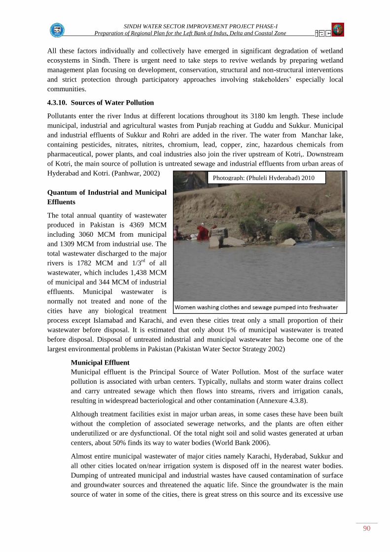
SINDH WATER SECTOR IMPROVEMENT PROJECT PHASE-I
Preparation of Regional Plan for the Left Bank of Indus, Delta and Coastal Zone
90
Photograph: (Phuleli Hyderabad) 2010
All these factors individually and collectively have emerged in significant degradation of wetland
ecosystems in Sindh. There is urgent need to take steps to revive wetlands by preparing wetland
management plan focusing on development, conservation, structural and non-structural interventions
and strict protection through participatory approaches involving stakeholders‟ especially local
communities.
4.3.10. Sources of Water Pollution
Pollutants enter the river Indus at different locations throughout its 3180 km length. These include
municipal, industrial and agricultural wastes from Punjab reaching at Guddu and Sukkur. Municipal
and industrial effluents of Sukkur and Rohri are added in the river. The water from Manchar lake,
containing pesticides, nitrates, nitrites, chromium, lead, copper, zinc, hazardous chemicals from
pharmaceutical, power plants, and coal industries also join the river upstream of Kotri,. Downstream
of Kotri, the main source of pollution is untreated sewage and industrial effluents from urban areas of
Hyderabad and Kotri. (Panhwar, 2002)
Quantum of Industrial and Municipal
Effluents
The total annual quantity of wastewater
produced in Pakistan is 4369 MCM
including 3060 MCM from municipal
and 1309 MCM from industrial use. The
total wastewater discharged to the major
rivers is 1782 MCM and 1/3rd
of all
wastewater, which includes 1,438 MCM
of municipal and 344 MCM of industrial
effluents. Municipal wastewater is
normally not treated and none of the
cities have any biological treatment
process except Islamabad and Karachi, and even these cities treat only a small proportion of their
wastewater before disposal. It is estimated that only about 1% of municipal wastewater is treated
before disposal. Disposal of untreated industrial and municipal wastewater has become one of the
largest environmental problems in Pakistan (Pakistan Water Sector Strategy 2002)
Municipal Effluent
Municipal effluent is the Principal Source of Water Pollution. Most of the surface water
pollution is associated with urban centers. Typically, nullahs and storm water drains collect
and carry untreated sewage which then flows into streams, rivers and irrigation canals,
resulting in widespread bacteriological and other contamination (Annexure 4.3.8).
Although treatment facilities exist in major urban areas, in some cases these have been built
without the completion of associated sewerage networks, and the plants are often either
underutilized or are dysfunctional. Of the total night soil and solid wastes generated at urban
centers, about 50% finds its way to water bodies (World Bank 2006).
Almost entire municipal wastewater of major cities namely Karachi, Hyderabad, Sukkur and
all other cities located on/near irrigation system is disposed off in the nearest water bodies.
Dumping of untreated municipal and industrial wastes have caused contamination of surface
and groundwater sources and threatened the aquatic life. Since the groundwater is the main
source of water in some of the cities, there is great stress on this source and its excessive use

SINDH WATER SECTOR IMPROVEMENT PROJECT PHASE-I
Preparation of Regional Plan for the Left Bank of Indus, Delta and Coastal Zone
91
has seriously affected its quality and incidences of water-borne diseases (ASSESS-HKH
2005).
The Hyderabad city disposes wastewater both in the fuleli canal and the river Indus. The
populations which depend on fuleli canal for drinking water get polluted water. Similarly,
Karachi city water is disposed through Liyari and Malir rivers, which pollute the sea
water with adverse effects on mangroves, fish, and other sea fauna.
Agricultural Runoff
The quantity or quality of agricultural runoff has not been measured or tested at the national
level but with an estimated 5.6 million tones of fertilizer and some 70 thousand mt of
pesticides used annually. In 107 samples of groundwater collected from various locations in
the country between 1988 and 2000, 31 samples were reported to have concentrations of
pesticides beyond FAO/WHO safety limits.
Concerns related to water pollution
Keeping in mind the continuous increase of the human population and the unprecedented
urbanization and industrialization of the province of Sindh, pollution of freshwater is bound
to accelerate. The main chemical, physical and microbial factors negatively affecting water
quality include: i) organic pollutants: ii) agrochemicals; iii) heavy metals: iv) microbial
contamination; v) toxic organic compounds: vi) traces of chemicals and pharmaceutical drugs
Suspended particles: vii) nuclear waste; and: secondary Stalinization and acidification.
Obviously, there is a diverse range of water pollutants, each of which is hazardous in different
concentrations. Nevertheless, water bodies, have their own self-purification capacity, which
depends on a variety of factors such as water volume, flow speed, and chemical composition.
4.3.11 Pollution of Surface and Groundwater by Industrial Effluents
Sindh is facing environmental problems of both green and brown nature. The green issues mainly
include environmental problems of irrigated agriculture, rain-fed agriculture, forests, and rangelands.
In irrigated agriculture, water logging and salinity dominate the environmental agenda. Brown
environmental problems are categorized in five main groups: industrial wastewater pollution,
domestic wastewater pollution, motor vehicle emissions, urban and industrial air pollution, and
marine and coastal zone pollution. Industrial pollution is increasing at a very rapid pace in left bank,
delta and coastal areas and the health and productivity impacts on population and natural resources are
significant.
a) Industrial Estates: Main industrial estates of Karachi, Kotri, Hyderabad and Sukkur are
recognized as key sources of increasing pollution in natural streams, rivers and sea. In
Karachi alone, more than 6,000 industrial enterprises, some 60% of the country‟s industry, are
located along the coastal belt. With the exception of only a few units, most of the industries
discharge their untreated effluent containing heavy metals and their compounds, detergents,
lubricating oils, chlorine and various organic and inorganic toxic compounds into the sewers
or directly into the Liyari River, the Malir River, and the sea. Only 1% of wastewater is
treated before being discharged directly into rivers and drains. In terms of the generating
environmentally damaging pollutants, textile processing industry is at the top of the list due to
its size, followed by leather tanning, cement, chemicals and paper and pulp industries
(http://www.environment.gov.pk Brief on Water Pollution).
b) Sugar Mills: Out of 33 sugar mills in Sindh, 30 are located on left bank of Indus. Three out
of 33 sugar mills use the molasses to produce industrial alcohol (ethyl alcohol) a significant

SINDH WATER SECTOR IMPROVEMENT PROJECT PHASE-I
Preparation of Regional Plan for the Left Bank of Indus, Delta and Coastal Zone
92
quantity of which is exported. Mills in Sindh have crushing capacity ranging from 4-9,000
metric tons per day. It is estimated that these mills discharge untreated effluents of about 25
million cubic meters per year in the irrigation and drainage systems (SDPI 2006). This
untreated effluent have high BOD, COD and TDS levels which pollute the water and are
hazardous for humans and other biotic life. The sugar mills in Sindh mostly dispose off their
effluents into the LBOD drainage system that kills the fish and induce toxic chemicals in the
drainage system
The Consultants have analyzed water samples from various sugar industries to estimate the
physico-chemical parameters to assess the quality of the effluent. Research has indicated that
the parameters such as pH, EC, TDS, DO, BOD, COD significantly exceeded the permissible
limits, indicating the need of proper treatment of waste water before discharge into water
bodies (Kumari et al 2006).
Impacts on population of left bank, delta and coastal areas
Impacts of industrial and municipal pollutants are directly affecting people, wildlife, flora, ecosystems
and natural resources in various forms such as polluted drinking water, reduced productivity of
productive lands, degraded ecosystems and reduced flora and fauna in the left bank, delta and coastal
areas. The foul-smell of septic conditions renders the water body a nuisance for local residents and
spoils any aesthetic value of the natural environment. High TSS levels further endanger aquatic life as
they limit light penetration causing clogging of fish gills. Under the Environmental Protection Act-
1997, it is mandatory upon every industry and city government to have a pre-treatment plant at their
premises. There are well defined procedures and techniques being practiced all over the world for
treating the industrial and municipal effluents before disposing off or using for agriculture /
lawn/parks irrigation etc. These include: i) physical treatment; ii) chemical treatment; and biological
treatment. (Wastewater Annexure-4.3.11)
4.3.12 Issues and Problems – Environment and Biodiversity
Sea water intrusion
1. Sea has intruded in the inland areas Issues concerned with sea intrusion, water logging and
salinity are brought up at each community consultation, particularly in coastal areas
2. The productive lands have been converted into un-productive lands in the coastal belt of
Sindh.
3. Arable land has become salty and unsuitable for cultivating any crops
4. Fresh water wetlands have been converted into brackish water areas.
5. Due to saline water, fish cannot get enough food and fish reproduction is decreasing as a
consequence
6. The livelihood of coastal communities especially fishermen have been decreased resulting in
increase in poverty.
7. Mangroves and riverine forests in the coastal belt and along Indus have been degraded due to
saline water.
8. Coastal ecosystems and their natural resources have been denuded.

SINDH WATER SECTOR IMPROVEMENT PROJECT PHASE-I
Preparation of Regional Plan for the Left Bank of Indus, Delta and Coastal Zone
93
9. Migration of local population have taken place due to limited livelihood sources,
unemployment and denuded natural resources.
10. The damages to Tidal link, KPOD and other drainage disposal systems have paved a way to
sea intrusion.
11. Sea intrusion has resulted in changing the quality of underground water and aquifer.
12. Salt water intrusion in freshwater irrigation and drainage systems has limited the only source
of domestic water for coastal communities.
13. No corrective measures have been initiated by the government to control the problem of sea
intrusion.
Mangroves
1. Overexploitation of mangrove forests is on-going due to over grazing, extraction of wood for
meeting the wood requirements of coastal villages, excessive fodder requirements for
livestock.
2. Decrease in freshwater flow to the delta results in a decrease in mangrove cover.
3. Decrease in sediment from the Indus River causes coastal erosion and accelerated loss of
mangrove cover
4. Loss of biodiversity and valuable habitats (such as feeding and breeding grounds) following
the reduction in mangrove cover is potentially a cause for the collapse of delta and coastal
fisheries
5. Mangrove forest development and management strategies are not participatory but are top
down approach with respect to protection, restocking, management and replanting mangroves
in the Indus Delta.
6. The discharge of untreated industrial effluent in the river and LBOD system has further
accentuated the situation.
7. The water quality of surface water is generally deteriorating resulting the biological and
bacteriological contamination is wide spread.
8. The salinity and bacterial contamination of the groundwater is increasing especially in delta
area.
9. The wastewater treatment before it is disposed off into the river, sea and irrigation systems is
not done.
Physical water resources affecting water quality in the study area
Sindh is a sub-tropical region having low rainfall from 15-18 cm per year and annual evaporation of
150-200 cm. Sindh solely depends on the waters of the Indus because its groundwater sources are
very limited and its rainfall is erratic. Following issues came out during the consultative process:
1. People argue that the LBOD was not constructed properly so the drainage effluent does not
flow into the sea
2. Fresh water from the Indus River was the main source/force for pushing back the sea tides
and flow in the Indus is not enough

SINDH WATER SECTOR IMPROVEMENT PROJECT PHASE-I
Preparation of Regional Plan for the Left Bank of Indus, Delta and Coastal Zone
94
3. For the last 10 years, Sindh has not received its allocated quantum of water as defined in the
1991 accord between the provinces
4. Low water flows in the Indus are resulting in extended periods of drought and low water
periods
5. Rainwater harvesting has not been given proper attention, although there is good potential for
water conservation through rainwater harvesting techniques
Ground water and surface water quality
1. Out of a population of 41,246,000 in Sindh province (2009 census projection), 92% of the
population is using polluted drinking water (PCRWR, 2008)
2. Disastrous levels of ground and surface water pollution and contamination exist everywhere
in the study area due to uncontrolled, improper and un-treated disposal of municipal,
industrial and drainage effluents in fresh water bodies. Severe levels of water pollution exist
in some areas due to unchecked release of industrial pollutants; such as from sugar mills
3. Weak mechanisms exist for monitoring and protecting the quality of surface and ground water
resources in the study area
4. Unchecked introduction of hazardous chemical effluents to ground water and surface water is
occurring through extensive use of fertilizer and pesticide agro-chemicals
5. Degraded groundwater quality exists due to un-controlled pumping of groundwater
6. Although the National Environmental Protection Act and its implementing agencies are in
place, actual control of water pollution is not yet effective
7. Unified national water quality standards have not yet been implemented in the study area
8. Many laws and regulations exist to address specific issues of water pollution; however, there
is lack of harmony and integration between the various legal instruments
9. Maintaining water quality is hampered by failure to enforce pollution control at the source
due to inadequacy of sanitation systems and water pollution disposal networks
10. Mechanisms for monitoring water quality are weak due to inadequate mechanisms for
collection and analysis of data and information
Sources of ground water and surface water pollution
1. Clean water is not provided to the majority of the population in Sindh Province
2. Sewage is commonly discharged directly into water bodies being used as the sole source of
water for domestic use
3. Industrial effluent carrying a heavy load of toxic pollutants is disposed off into water bodies
used for domestic purposes
4. Communities located adjacent to irrigation channels and drains dispose off their sewage
directly into the irrigation channels and drains causing severe levels of pollution
5. Monitoring of the water bodies both in cities and rural area is not performed regularly
resulting in countless water pollution point sources throughout the study area. Confusing
statement
SINDH WATER SECTOR IMPROVEMENT PROJECT PHASE-I
Preparation of Regional Plan for the Left Bank of Indus, Delta and Coastal Zone
95
Impact of industrial effluent and poor water quality on the population
1. Domestic sewage is not treated in the project area and is disposed of into drains and water
courses
2. Industries have severely contaminated surface and groundwater sources, and have badly
polluted the coastal and marine environment
3. Domestic sewage and industrial effluents in most places are jointly disposed of into fresh
water bodies causing severe microbiological contamination from sewage and heavy metal
loading from industrial activities
4. Sugar mill pollution of surface water is prevalent from the discharge of mill effluent directly
into the drainage system resulting in health problems of the population and damage to the
ecology of the delta and coastal zone
5. Well defined procedures and techniques are available for treating and safely disposing of
industrial and municipal effluents; but implementation of the methods is not practiced
Forests
Sindh has riverine forests along the Indus River and irrigated plantations in the command area of
Guddu, Sukkur and Kotri barrages. Analysis of these forests during the process of consultation and
literature review revealed that these forests have been degraded due to variety of social, economic and
environmental problems. The issues and problems identified during phase I study revealed as under:
1. Continuous reduction in annual inundation in Indus has emerged in severe droughts resulting
in degradation of riverine forests.
2. The productivity and composition of riverine forests has significantly declined.
3. Riverine ecosystem which used to be rich in biodiversity is now poor in biotic life thereby
significant imbalances in ecosystem functions and structures.
4. The regular features of regeneration of riverine forests through seed broadcasting during
inundation have been disturbed.
5. The tree resource and other associated natural resources have been reduced.
6. Due to droughts the trees have dried and have become vulnerable to illicit cutting causing
wide spread deforestation.
7. The virgin forest lands have been encroached by the land grabbers.
8. Irrigated plantations are not receiving their irrigation water allocations thereby resulting in
serious environmental problems due to reduced productivity, enhanced salinity, poor growth
of economic species and deforestation.
9. Deteriorating law and order in the forests have made the forests inaccessible and un-
manageable.
10. Inadequate governance and protection issues in the Forest department staff have emerged in
deforestation and environmental problems.
11. The policies of agro-forestry leases for raising trees on 25% of leased area are not being
implemented in most of the cases resulting in negative impacts.
12. There is lack of participatory approach in the department which keeps the communities away
in planning, management, development decision making and benefit sharing.

SINDH WATER SECTOR IMPROVEMENT PROJECT PHASE-I
Preparation of Regional Plan for the Left Bank of Indus, Delta and Coastal Zone
96
13. Monitoring and evaluation mechanisms are inadequate in the department.
14. Due devolution of social forestry to district governments the provincial forest department has
been kept away from seeding production, technical know how and extension services
resulting in reduction in tree resource on the farm lands.
Wetlands
1. LBOD/KPOD Tidal Link have paved a way to sea water intrusion in wetlands of Badin and
Thatta districts.
2. Freshwater wetlands/dhands have been converted to brackish water dhands in coastal area.
3. Untreated effluents of sugar mills are disposed off in irrigation and drainage channels which
ultimately reach to wetlands and enhance the NEQS levels.
4. Eutrophication in wetlands is a detrimental factor for fish and other biodiversity.
5. EIA is not conducted before launching of projects around the wetlands.
6. There is continuous increase in salinity due to saline water intrusion from sea and disposal
from drainage projects.
7. Inland freshwater wetlands have been degraded due to reduced flows in river and consistent
drought conditions. Steps need to be taken to ensure adequate river flows to rehabilitate these
wetlands.
Other – Environmental Issues and Problems
1. Stakeholders are very much aware of the condition of their environment.
2. People consider that nobody takes care of the environment and the Government‟s allocation of
funds for this purpose is meaningless
3. Several endangered species have vanished
4. Fish cannot survive in the contaminated water
5. Local lakes are dead
6. Migratory birds do not visit lakes anymore and the indigenous bird population has diminished
considerably
7. During the rainy season (July-August), water overflows from the LBOD and floods villages
with toxic water
8. Agro-chemical nutrients N and P released to water bodies cause eutrophication of wetlands
seriously affecting fish and other biodiversity
9. Agricultural land adjacent to sugar mills has been destroyed and the eco system is badly
affected
10. The natural drain of Dhoro Puran is clogged with mud and is connected with the LBOD that
transports contaminated water
11. Big sugar industries drain poisonous waste into the LBOD and pose a particular threat to the
environment, livelihoods and health of villagers
12. Communities allege that some sugar mills have established wine factories within the sugar mill
boundaries which release toxic waste water into the natural drainage of the Dhoro Puran

SINDH WATER SECTOR IMPROVEMENT PROJECT PHASE-I
Preparation of Regional Plan for the Left Bank of Indus, Delta and Coastal Zone
97
13. Encroachment of forest land by land grabbers is at its peak
14. Many affected communities demand that sugar mills immediately stop discharging poisonous
chemical water into the natural Dhoro Puran which was the only and last source of their
livelihood.
Way forward for Envirinment and Wetlands
1. Water requirements for delta and coastal zone as recommended by Study II Consultants that a
minimum of 21 MAF water need to be released for sustenance of the delta.
2. Due to flat topography of coastal areas, there exists a very mild slope of 2-3 inches a mile.
This favors the inland intrusion of sea at the rate of 2 km per century. The option of coastal
highway (now under execution) or use of injection wells may be considered to stop landward
movement of sea.
3. Keeping in view the water release position, both the structural and non-structural options may
be studied to find a sustainable solution of the problem of sea intrusion and ecosystem
stability.
4. Silt laden flow of river water for sustainability of mangroves and biodiversity may be
prioritized.
5. Sindh is the home of freshwater and brackish water wetlands. It is pity that these treasures are
not being managed properly. Some of these are Ramsar sites and internationally important. It
is proposed to establish a high powered Wetland Management Authority with technocrats
from all allied departments for proper management of the wetlands of Sindh.
6. Biodiversity and ecosystem thrives only when the required habitats are provided. Wherever,
the habitats are destroyed, it needs revival to attract the wild life and other biodiversity to
flourish under the required environment.
7. Preventive measures to keep the freshwater resources clean need to be taken at all levels as
the first line of defense. Providing safe drinking water to people is the domain of city
governments and regular monitoring of the water bodies through a third party organization
may improve the situation.
8. All offenders of Environmental Protection Act 1997 must be dealt with as per the provisions
of the EPA Act without discrimination and status.
9. All industrial units should change their effluent disposal system from End-of-Pipe to Cleaner
Production Technology.
10. All city governments and Industrialists must prepare their plan to go for the installation of the
treatment plants before disposing their effluent for use in agriculture after it meets the
required guidelines
11. Capacity building of the WASA staff needs to be carried out. All district governments may
have a standard laboratory for scheduled checking of water bodies and further reporting to the
provincial as well as the federal body.
12. Appropriate methodology should be designed for monitoring and surveillance of water
quality. All critical parameters should be monitored.
13. All personnel responsible for monitoring the quality of water should be professionals and
provided in-service training on a regular basis.

SINDH WATER SECTOR IMPROVEMENT PROJECT PHASE-I
Preparation of Regional Plan for the Left Bank of Indus, Delta and Coastal Zone
98
14. A critical and objective review of existing national research data on the quality of drinking
water should be conducted on a regular basis.
15. Extensive resources should be devoted to upgrade existing water distribution infrastructure.
16. The hygiene of water reservoirs/tanks of users must be mandatory.
17. Public awareness their responsibility towards establishment and maintenance of drinking
water quality standards. In this view low cost measures to be applied at a household level (use
of lemon juice, SODIS and chlorination etc.) should be applied.
18. In any disaster or epidemic outbreak, the decontamination of affected water resources to be
carried out at national level on war footing to check further spread of the contamination.
Awareness campaign through electronic media may reduce the panic
19. The aquatic ecosystems revival can be achieved not only through pollution control measures
but also through the ecological restoration of habitats and floodplains, which can significantly
contribute to boosting self-purification and improving water quality.

SINDH WATER SECTOR IMPROVEMENT PROJECT PHASE-I
Preparation of Regional Plan for the Left Bank of Indus, Delta and Coastal Zone
99
4.4 FLOODING, DISASTER MANAGEMENT AND MITIGATION
4.4.1. Background to the flooding disaster thematic area study
Management of flooding and water disasters, including encroachment of sea water, have been studied
nationally with emphasis of the impacts in Sindh Province along the left bank of the Indus River and
in the Coastal Zone and Delta. To identify the relevant issues and problems, the subjects and tasks
listed in Table 4.4.1 were studied in detail.
Table 4.4.1: Topic Outline for Summary of the Thematic Area 4 Study
Topic of Concerns for Phase-I Task Studies
Subjects Covered Phase-I Tasks Included
IV – Flooding, Disaster Management and Mitigation
Climate, hydrology and
meteorology
Water disaster and flood
management
Disaster management
Year 2010 super-flood
lessons learned
Earthquakes and faulting
T-6: Document and review climatic conditions, hydrological and
meteorological conditions
T-21: Document, review and evaluate methods and planning for
flood management
T-22: Review and evaluate current methods for disaster
management
T-30: Study the impact of faulting and earthquakes on the study
area
Climatic regions of Sindh
Sindh is divided into three climatic regions: Siro (the upper region, centered on Jacobabad), Wicholo
(the middle region, centered on Hyderabad), and Lar (the lower region, centered on Karachi). The
thermal equator passes through upper Sindh, where the air is generally very dry. Central Sindh's
temperatures are generally lower than those of upper Sindh but higher than those of lower Sindh. Dry
hot days and cool nights are typical during the summer. Central Sindh's maximum temperature
typically reaches 43–44 °C (109–111°F). Lower Sindh has a damper and humid maritime climate
affected by the southwestern winds in summer and northeastern winds in winter, with lower rainfall
than Central Sindh. Lower Sindh's maximum temperature reaches about 35–38 °C (95–100 F). In the
Khirthar range at 1,800 m (5,900 ft) and higher at Gorakh Hill and other peaks in Dadu District
temperatures near freezing have been recorded and brief snowfall is received in the winters.
Delta and Coastal Zone in Sindh
The Sindh coastal region is located in the south-eastern part of the country between the Indian border
along the Sir Creek on the east, and the Hub River along the Balochistan coast on the west. The Sindh
coast can be subdivided into the Indus Delta/creek system and the Karachi coast. The Indus Delta
(2,560 sq. km) is the most prominent ecological feature of the coast and covers 85 percent of the
coastal belt. The coastal morphology is characterized by a network of tidal creeks and several small
islands with scattered mangrove vegetation.
Situated between the Indus Delta on the southeast and Hub River on the west, the Karachi coastal belt
is about 100 km in length. Most of which, with the exception of scattered patches of mangroves, is
devoid of any kind of vegetation and consists of shallow lagoons, sea cliffs, stacks and terraces, wave
cut platforms, sea caves and notches.
The coastal waters have high salinity (Hein Van Gils, 2006) due to high evaporation rates, combined
with negligible rainfall. Oxygen-poor water layers sometimes rise to the surface along the coast,
leading to fish mortality. The wildlife along the Pakistani coast consists of both marine and terrestrial
species.

SINDH WATER SECTOR IMPROVEMENT PROJECT PHASE-I
Preparation of Regional Plan for the Left Bank of Indus, Delta and Coastal Zone
100
Figure 4.4.1 Peak Discharges at Sindh Barrages
Cyclones on the Sindh coast are not common but do occur periodically causing considerable damage
to coastal villages. After 1947 (post partition), major cyclones occurred in June 1948, November
1993, and in May 1999. The Indus is one of the few rivers in the world that exhibits a tidal bore which
has impact on the Lower Indus Basin in Sindh.
4.4.1.1 Climate Change and Potential Impacts on Water Disasters
Based on observations of the WWF in
Pakistan, global warming is causing damage
to Pakistan‟s environment (WWF 2004).
Among the impacts felt and seen are
biodiversity loss, shifts in weather patterns
and changes in fresh water supply. Each of
these impacts will change depending on
changes of the global climate and the
magnitude, intensity and return period of
water disasters and floods.
A study carried out by GTZ for WAPDA to
analyze trends in temperature and
precipitation in the Northern Areas for the
last century (Archer, et. al, 2001) found that
at Skardu, seasonal and annual temperatures
have risen over the last century. Mean annual
temperature has increased by 1.4 o C with the
mean annual daily maximum rising more
than 2.35 o
C. The winter temperatures, since
1961, have risen far more than those of
summer with an increase of winter maxima
up to 0.51 o
C per decade. Such temperature
increases could cause an upward shift of
almost 400 meters in the frost line. This
might impact the snow and rain patterns,
including the availability of snow for melt
during summer, which are major sources of
water in many rivers and sometimes are the
causes of severe super-floods.
Observations of the World Glacier
Monitoring Service based in Switzerland
indicate that mountain glaciers in the
Karakoram have been diminishing for the last
30 years. There are indications that the flow
of water in rivers increased during the decade
of 1990-2000 in comparison to 1975-1990,
which in the absence of increased precipitation, could mean melting of more ice (glacier retreat)
upstream. By way of confirmation, documented research indicates that some of the Glaciers in
Pakistan have retreated significantly in the recent past. Scientists believe this is an indicator of climate
change, resulting in earlier snow melt.

SINDH WATER SECTOR IMPROVEMENT PROJECT PHASE-I
Preparation of Regional Plan for the Left Bank of Indus, Delta and Coastal Zone
101
Changes in the climate suggest that the incidence of flash flooding and extreme flooding could
increase during the next few decades. Studies conducted also indicate that with a doubling of CO2 in
the atmosphere, average rainfall in South Asia could increase between 17 to 59 %. Such an increase of
CO₂, by some projections, could be associated with a doubling in the frequency of high rainfall
events. Variable monsoons, also anticipated, could mean more droughts. Observers also suggest that
further desiccation of arid areas due to warming could endanger food production in the plains unless
significant numbers of trees are planted.
In conclusion, climate change may increase the frequency and intensity of storms and could cause
changes of storm tracks. Although the frequency of cyclones along Pakistani coast is low, they cause
considerable damage when they occur, and it is important that a disaster management unit be tasked
with tracking of data and researches that provide indications of whether forecasted trends are being
confirmed. Another critical conclusion is the likely increase both in droughts and in frequency of high
rainfall events (triggering extreme floods).
Indus River
Sindh survives almost entirely on the water of the River Indus as there is very limited groundwater
available.
The situation worsens during periods of drought. The yearly average availability of water in the
province, computed from the data, 1970 to 1997, is 45 MAF. This information helps us to evaluate the
water security of Sindh. According to the Water Accord of 1991, Sindh is awarded 48.76 MAF for
both Kharif and Rabi seasons. The worst ever drought conditions in Sindh, experienced from 1998 to
2002, show that the province received less water than allocated in the Water Accord.
Before 1973, floods at Sukkur exceeding 900,000 cusecs occurred in the year 1914 and 1958. The
discharge recorded (preliminary estimate) at Sukkur exceeded 1,117,000 cusecs on 21st August 2010,
which broke all previous records on the score of peak and duration.
The history of the Indus River in the province of Sindh shows that up to year 1942, the damage and
devastation through breaches or erosion was almost a regular feature. The earliest record of a breach
is at Jamshoro front Bund near Hyderabad in the year 1903. From then on, the tale of destruction was
repeated almost every year at one or another point of the river course. This phenomenon did not
depend on the magnitude of high floods.
In the year 1941, even when the discharge was as low as 407,000 cusecs (ft3s
-1) floods occurred. It is
of interest to mention that, with this low flood, the river eroded away parts of the same Sukkur -
Larkana Bund, almost adjoining the reach where breaches occurred during the 1973 floods. Therefore,
even floods which are considered to be of low or medium magnitude by present day standards, can
lead to a serious situation in Sind, unless of course, a continuous line of reliable flood embankment
bunds is maintained in breach-proof condition.
Eighteen major floods that have affected Pakistan since 1947 have caused economic losses and
damage worth USD 6 billion (Table 4.4.2). This historical damage was overwhelmed by the super-
flood of year 2010 that is estimated to have caused economic losses and damage worth USD 10.05
billion.

SINDH WATER SECTOR IMPROVEMENT PROJECT PHASE-I
Preparation of Regional Plan for the Left Bank of Indus, Delta and Coastal Zone
102
Table 4.4.2: Major Flood Events in Pakistan Compared to the Year 2010 Super-flood
Year Lives Lost Villages
Affected
Estimated
damage
(USD)
1950 2,910 10,000
$6 billion
1955 679 6,945
1956 160 11,609
1973 474 9,719
1975 126 8,628
1976 425 9,150
1978 393 9,200
1988 508 1,000
1992 1008 13,208
1995 591 6,852
1998 47 161
2001 201 0.4 million1
2003 230 1.266 million1
2004 85 47
2005 59 1,931
2006 523 2,477
2007 586 6,498
20102 1980 62,000 sq miles
3 10.05 billion
1 Number of persons affected
2 World Bank & ADB Preliminary damage and Need assessment report November 2010
3 Area of Great Briton
In assessing the location, duration and impact of flooding in the Lower Indus Basin, it was found that
the SIDA Geographic Information System (GIS) and Remote Sensing (RS) Cell did not have a
comprehensive GIS data base or GIS based map of historical water disaster and flood events for the
Basin. The creation of such a data base is a fundamental first step to improve water disaster and flood
risk assessment and management in the project area.
4.4.1.2 Peak Flood Flow in the Indus Main Stem from July to September 2010
A flood peak flow analysis was conducted by the Pakistan Agricultural Research Council (PARC)
for the Indus River to assess river flows and hydrologic features of the Indus Main Stem at Rim
Stations and at various barrages (PARC, 2010). Flood flows on the main stem of the River were in the
range of 527,000 to 1,148,000 cusecs (ft3s
-1). The peak started at the Tarbela Rim Station on 30 July
2010 and reached Kotri Barrage on 27 August. It thus took 29 days for the flood peak to travel from
Tarbela to Kotri. This is longer than usual for many past floods because the peak flow continued to
change at different nodes due to inflow of floodwater from various tributaries into the Indus Main
stem river (Figure 4.4.2).

SINDH WATER SECTOR IMPROVEMENT PROJECT PHASE-I
Preparation of Regional Plan for the Left Bank of Indus, Delta and Coastal Zone
103
The extreme peak flood flows shown in Figure 4.4.2 represent discharge flowing below each barrage,
even after considering that large quantities of flood discharge were diverted before the barrage by
breaching or by overtopping of flood protection bunds. In reality, the flood flows would have been
much higher if flood water was fully allowed to reach and flow passed from barrages. For safety of
the barrages, large quantities of floodwater were diverted upstream of the barrage so that barrages
were not placed at risk of failure or excessive damage from large volumes of discharge passing
through the barrages.
Figure 4.4.2: Flood Peak Flows on Indus Main at Rim Stations and Barrages
during Year 2010 Super-Flood (PARC)
Flood Discharge and Frequency Analysis of the Super-flood
As discussed and illustrated above, the first high flood peak at Tarbela was 527,000 cubic feet per
second (ft3s
-1) on 30 July. This peak increased to 957,000 ft
3s
-1 at Chashma Barrage on 01 August due
to the inflows from the Kabul River.
At the Taunsa Barrage, the flood peak was observed as 794,000 ft3s
-1. This peak moved downstream
to the Guddu and Sukkur Barrages on 9 and 10 August and increased to around 1,128,000 ft3s
-1 as the
western hill torrents poured more water into the Indus River. The highest peak at Kotri – the most
downstream barrage on the Indus River, was 939,000 ft3s
-1.
The two highest flood peaks reached the Taunsa Barrage from Tarbela in 12 days time and remained
high for 3-4 days for each flood peak. The flood peaks at Guddu and Sukkur Barrages remained high
for more than 10 days. High flood peaks, multiple flood peaks and long peak values over time
combined together caused high damage to the irrigation and drainage infrastructure of Sindh.
Most of the barrages in Sindh experienced their near highest or highest historic flood peaks; which in
many cases was above their design discharge values. These high flood values were in spite of large
scale upstream flooding due to breaching of bunds (dikes) in the upper reaches of the Lower Indus
Basin in Sindh. Without this breaching of the bunds, the flood levels at the barrages in Sindh would

SINDH WATER SECTOR IMPROVEMENT PROJECT PHASE-I
Preparation of Regional Plan for the Left Bank of Indus, Delta and Coastal Zone
104
have been even higher and would have certainly severely damaged the already flood impacted
barrages.
Flood frequency analysis estimated by PARC showed that Tarbela Dam inflows were of very high
frequency (3,461 year return period) followed by Chashma (216 year return period), Taunsa (146 year
return period) and Kotri (102 year return period) (ADB-WB, 2010). The Tarbela flood peak (835,000
cusecs) was the highest value in its history (682,159 cusecs), but lower than its design flood
(1,500,000 cusecs). The flood peak at Chashma (1,036,673 cusecs) was also the highest on record
(1,028,723 cusecs) and higher than the design capacity of the barrage (950,000 cusecs; 9% higher).
The flood peak at Kotri was also very high (964,897 cusecs) and higher than its design capacity
(875,000 cusecs); but the year 2010 flood peak was lower than the historical flood peak (981,000
cusecs; 10% higher). The year 2010flood peaks at Kalabagh, Guddu and Sukkur were lower than their
historical peaks, as well as lower than their design capacity (Table 4.4.3).
Table 4.4.3: Historical and 2010 Flood Peaks and Return Period for Barrages on Indus (PARC1)
1 Also reported by the Federal
Flood Commission
Badin area has always been affected by floods
due to high precipitation and lack of drainage.
It has been reported that the major events in
recent history took place in 1959, 1961, 1962,
1964, 1970, 1976 and 1979 when the annual
precipitation events were reported to be within
203 mm to 609 mm. The July 2003
precipitation (303.9 mm) was estimated to have
a 66 years return period.
Locations Design
Discharge
(cusecs)
100 -yr
Flood
(cusecs)
2010 Flood Historic Peak
Peak Retur
n
Period
Cusecs Years Yea
r
Cusecs
Tarbela
Inflows
1,500,000 653,000 835,000 3,461 1929 682,159
Kalabagh 950,000 1,091,00
0
937,453 42 1929 1,200,00
0
Chashma 950,000 934,000 1,036,67
3
216 1929 1,028,72
3
Taunsa 1,100,000 911,000 959,999 146 1929 999,920
Guddu 1,200,000 1,332,00
0
1,148,73
8
34 1976 1,176,15
0
Sukkur (1.5 million as originally
designed; reduced to
900,000
1,290,00
0
1,130,99
5
39 1976 1,161,47
2
Kotri 875,000 962,000 964,897 102 1956 981,000

SINDH WATER SECTOR IMPROVEMENT PROJECT PHASE-I
Preparation of Regional Plan for the Left Bank of Indus, Delta and Coastal Zone
105
Cyclones are common in the coastal zone and according to the National Institute of Oceanography
their return interval is about ten years.
4.4.1.3 Historical Earthquakes Affecting Sindh Province
Three significant data bases are available for mapping of historical earthquakes in Pakistan and Sindh:
1. USGS NEIC (GPE) Database of earthquakes – 1973 to 2010
2. NGID Significant Earthquake Database – 2150 BC to present
3. India Database – 1063 to 1984
The Significant Earthquake Database contains information on destructive earthquakes from 2150 B.C.
to the present that meet at least one of the following criteria: Moderate damage (approximately $1
million or more), 10 or more deaths, Magnitude 7.5 or greater, Modified Mercalli Intensity X or
greater, or the earthquake generated a tsunami. The data base contains earthquakes with known
magnitude values between 0.1 and 9.9. Earthquakes that have no computed magnitude values are also
included in the data base. This data plotted as epicenters for earthquakes in all of Pakistan are shown
for in Sindh Province in Figure 4.4.3.
Seismic Hazard for Sindh
Estimation of the seismic hazard for the coastal area of Sindh was carried out using deterministic and
probabilistic approaches for the Pakistan Atomic Energy Commission for the sitting of nuclear power
plants on the southern coast of the country (Khan, Dhad and Qaisar, 2003). On the basis of seism
tectonics and geology, eleven faults were recognized in seismic districts as potential hazard sources.
Maximum magnitude potential for each of these sources was calculated. Peak ground acceleration
(PGA) values at the seven coastal cities due to the maximum credible earthquake on the relevant
causative fault source were also obtained and are given in Table 4.4.4.
Figure 4.4.3: Recent Earthquake Events (2150 BC to present) Recorded for Sindh (USGS)
http://earthquake.usgs.gov/earthquakes/eqarchives/epic/

SINDH WATER SECTOR IMPROVEMENT PROJECT PHASE-I
Preparation of Regional Plan for the Left Bank of Indus, Delta and Coastal Zone
106
Figure 4.4.4 Peak Ground Acceleration g 100 yrs
Return Period
Table 4.4.4: Peak Ground Acceleration at Various Coastal Cities of Pakistan
Coastal cities
Causative fault Credible
magnitude
Closest distance
(km)
Peak ground acceleration
(Ambraseys, 1991)
Jiwani West Makran fault 7.2 25 0.16g
Gwader Main Makran coast 8.0 30 0.21g
Pasni Main Makran coast 8.0 40 0.16g
Ormara Main Makran coast 8.0 25 0.25g
Turbat Hoshab fault 7.6 60 0.08g
Hub Sonmiani fault 7.1 20 0.19g
Karachi Sonmiani fault 7.1 45 0.08g
The cities of Gwadar and Ormara with acceleration values of 0.21g and 0.25g fall in the high seismic
risk area. The cities of Turbat and Karachi lie in low seismic risk area with acceleration values of less
than 0.1g. Probabilistic PGA maps with
contour interval of 0.05g for 100 years
return period with 90% probability of
non-exceedance were also compiled.
Ffigure 4.4.4 shows the expected peak
ground acceleration for a recurrence
period of 100 years, with the contour
interval of 0.05g for the southern coast
of Sindh and Balochistan. The results
shown indicate that the region
surrounding Makran coast can be
regarded as a high seismic risk region.
Also the region near Hub can be
regarded as a hazardous region.
On the other hand, Karachi lies at a
relatively stable location. Sukkur and Hyderabad are also in seismically stable locations. But some of
the project area along the Indus River Channel could be considered to be more prone to seismic risk.
Tsunami Disaster Potential for Sindh
The significant tsunami associated with the Makran earthquake of 1945 clearly shows the potential for
tsunami disasters on the Sindh coast in the project area. Tsunami safety in the form of public
awareness programmes and tsunami warning instrumentation and warning systems are well developed
in the region as a result of the Christmas 2004 tsunami that struck Sri Lanka, Bangladesh and India.
These tsunami disaster mitigation technologies are not well developed or implemented in Pakistan.
As discussed previously in this chapter, archival records of Pakistan Meteorological Department
(PMD) show that 4,000 people were killed by the combined effects of an earthquake and tsunami off
the Makran coast on Nov 28, 1945, with the tsunami responsible for most deaths. Further records
reveal that most tectonic activity takes place along the boundaries of the Indian tectonic plate and the
Iranian and Afghan micro-plates. At least 28 earthquakes with magnitudes close to 7.0 or above are
known to have occurred in this region since 1668, making the region extremely vulnerable to
tsunamis as well as tidal waves.

SINDH WATER SECTOR IMPROVEMENT PROJECT PHASE-I
Preparation of Regional Plan for the Left Bank of Indus, Delta and Coastal Zone
107
There is another tsunamigenic factor to take into account. It is the enormous pile of sediment that has
accumulated since the last glaciation at the top of the underwater canyon that materialize the former
course of the Indus River. It will one day collapse into a sudden and massive underwater landslide
(with or without an earthquake) that has the potential of generating a highly damaging tsunami.
After the destructive tsunami in December 2004, a network of different countries including Sri Lanka,
Pakistan, India, Oman, Iran and several other countries was formed to exchange the early warning.
The UN has established early warning tsunami centres in countries located in the North-east Atlantic
Ocean, Indian Ocean and Pacific Ocean. They are also training authorities and stakeholders to
improve the communication methods for timely delivery of warnings to all concerned.
A tsunami warning system also requires accurate bathymetrical and topographical surveys to know
water levels at different positions and to understand the ocean physics to know what is lying in the sea
bed to diminish or to amplify tsunami wave energy. The absence of topographical and bathymetric
data and tsunami preparedness and warning for the cities lying in the coastal belt of Sindh and the sea
can result in heavy losses.
It is understood that the Pakistan government has neither installed tide gauges on the coastal belt nor
conducted any topographical or bathymetrical surveys of the Arabian Sea.
4.4.1.4 Legal Framework for Water Hazard and Flood Management
An understanding of the legal framework for water disaster and flood management in Pakistan and
Sindh is an important point of departure for understanding how the flood management system works -
or does not work. A summary of the major forms of disaster legislation in Pakistan is given in Table
4.4.5.
Table 4.4.5: Principal Legal Instruments Concerned With Disaster Management and Disaster
Risk Reduction in Pakistan
Year Name of Legal Instrument Emphasis
Pre-1947 Indian Famine Codes Relief
1952
(Amended
1993)
The Civil Defence Act, 1952
As Amended in 1993
Response
1958 The West Pakistan National Calamities
(Prevention and Relief) Act, 1958
Response and relief
2001 Local Government Ordinance (LGO) Response and relief
2002 Emergency Services Ordinance (ESO) Response
2002 Sindh Water Management Ordinance, 2002
(SWMO)
Preparedness and
mitigation
2007 National Disaster Management Ordinance,
2007
Disaster Risk
Management
2010 National disaster management Act 2010 Disaster Risk
Management
Pre-Independence Era
The Indian Famine Codes, developed by the colonial British in the 1880s, were one of the
earliest forms of disaster management legislation. The Famine Codes defined three levels of
food insecurity: near-scarcity, scarcity and famine. Scarcity was defined as three successive

SINDH WATER SECTOR IMPROVEMENT PROJECT PHASE-I
Preparation of Regional Plan for the Left Bank of Indus, Delta and Coastal Zone
108
years of crop failure, crop yields of one-third or one-half normal and large populations in
distress. Famine further included a rise in food prices above 140% of normal, the movement
of people in search of food, and widespread mortality. This was possibly the earliest recorded
form of disaster risk assessment.
In order to address the issues of famine in India the British Government created an Indian
Famine commission to create ways to prevent and avoid future famine in India. In 1880 the
secretary of the commission wrote a draft of the Indian Famine Code. This famine code,
successively updated, became the basis of famine prevention until the 1970s. The Indian
famine codes were one of the first attempts to predict famine, and since they could predict it,
they could also prevent it or mitigate it.
Modern Era
Emergency response has remained a predominant approach in Pakistan to deal with disasters
until recently (Table 4.4.5).
The Civil Defence Act, 1952 -As Amended in 1993
The Civil Defense Act of 1952 established legislation to respond to disasters and emergencies
related to war and civil disturbance. In 1993, as a result of the fall of Communism, the law
was amended to include response to disasters and emergencies related to natural disasters.
The National Calamities (Prevention and Relief) Act, 1958
The Calamity Act of 1958, the major national policy for disaster management for almost 50
years prior to the passing of the National Disaster Management Ordinance of 2007, was
mainly concerned with emergency response and relief. Pakistan Civil Defence was the focal
agency for responding to disasters till 1970. In the aftermath of 1970 cyclone in the then East
Pakistan (now Bangladesh), the Emergency Relief Cell (ERC) was established, which became
the government‟s focal point for emergency flood relief in disaster hit areas. The reasons
behind this reactive approach by policy makers might have been related to the relatively lower
socio-economic impact of water disasters in the past; and the now discredited concept of
disaster relief versus the current concept of disaster risk reduction.
The Calamity Act, 1958 provided for the maintenance and restoration of order in areas
affected by certain calamities and for the prevention and control of and relief against such
calamities. Provincial Relief Commissioners (who also are Senior Members of the Provincial
Board of Revenue) were given the responsibility of relief. The calamities most concerned
with in the act were the water disasters of floods and drought.
Local Government Ordinance (LGO) 2001
The Local Government Ordinance (LGO), provided new avenues for effective and context-
specific disaster management, but there also existed a few legal and administrative
inconsistencies in relation to disaster response at provincial and district levels. Functions and
powers related to emergency response and disaster management at District, Tehsil and Union
level provided in the act included:
1. Zila Nazim: Being the head of the District, the Zila Nazim is responsible to “take
charge, organize and prepare for relief activities in disasters or natural calamities”.
2. Zila Council: The Zila (District) Council is to “make recommendations to the District
Government for enhancement of the care of disabled persons, paupers, aged, sick,
persons of unsound mind, abandoned minors, juvenile delinquents, drug dependents,
abused children, needy and disadvantaged person”.

SINDH WATER SECTOR IMPROVEMENT PROJECT PHASE-I
Preparation of Regional Plan for the Left Bank of Indus, Delta and Coastal Zone
109
3. Zila Council in a City District: In case of a City District, the Zila Council has the
responsibility and powers to (a) approve master plans, zoning, land use plans,
including classification and reclassification of land, environment control, urban
design, urban renewal and ecological balances; (b) review implementation of rules
and bye-laws governing land use, housing, markets, zoning, environment, roads,
traffic, tax, infrastructure and public utilities; and (c) review development of
integrated system of water reservoirs, water sources, treatment plants, drainage, liquid
and solid waster disposal, sanitation and other municipal services.
4. Tehsil Municipal Administration (TMA): Under the LGO, the TMA is to provide,
manage, operate, maintain and improve the municipal infrastructure and services,
including the water related activities of:
- Water supply and control and development of water sources, other than
systems maintained by the Union and Village Council
- Sewerage, sewage and sewage treatment and disposal
- Storm water drainage
5. Tehsil Council: The Tehsil Council was to approve land use, zoning and master
planning of the Tehsil development and maintenance programs or projects proposed
by the Tehsil Municipal Administration. The Town Council has also got similar
powers and responsibilities to be executed under the LGO.
6. Union Council Administration: The Union Council Administration was to assist the
relevant authorities in disasters and natural calamities and assist in relief activities,
including de-silting of canals
7. Union Council Nazim: The Union Council Nazim is to report to the concerned
authorities in respect of:
- Encroachment on State and local government property and violation of land
use and building laws, rules and bye-laws
- Environmental and health hazards
8. Union Council (UC): The Union Council is to promote plantation of trees,
landscaping and beautification of public places in the Union.
9. Village Council (VC): The Village Council is responsible to (a) develop and improve
water supply sources; (b) make arrangements for sanitation, cleanliness and disposal
of garbage and carcasses; and (c) take measures to prevent contamination of water
The LGO further states that the City District Government may set up district municipal offices for
integrated development and management of the following water resource related services:
1. Water source development and management, storage, treatment plants, and macro-
distribution
2. Sewage tertiary and secondary network, treatment plants, and disposal
3. Storm water drainage network and disposal
4. Flood control protection and rapid response contingency plans
5. Natural disaster and civil defence planning
6. Solid waste management, treatment and disposal, including land fill sites and
recycling plants
7. Industrial and hospital hazardous and toxic waste treatment and disposal

SINDH WATER SECTOR IMPROVEMENT PROJECT PHASE-I
Preparation of Regional Plan for the Left Bank of Indus, Delta and Coastal Zone
110
2
3
4
1
Figure 4.4.5 Flooded Area due to Bund Breaches
Several sections and clauses of the LGO have continued to create confusion that has resulted in the
clash between the District Nazims and District Coordination Officers (DCOs). For instance, in the
case of relief distribution Clause (k) of Section 18 of the LGO empowers the district Nazim to take
charge of relief activities while in Schedule 2 of the Ordinance, Clause 6 empowers the DCO to do the
same; but Clause 6 is further backed by the National Calamities (Prevention and Relief) Act, 1958,
and thus is considered to have precedence.
Emergency Services Ordinance (ESO), 2002
The Emergency Services Ordinance (ESO) established emergency service to deal with emergencies in
an effective manner and to combat threats to the public from modern warfare, terrorism and disasters;
and defines responsibilities at each level of government. A National Council was established to
regularly monitor the performance of this service and ensure continuity in the process of rule making
in the management of emergencies and disasters during peace time.
According to the ESO, provincial governments have the effective administrative power to implement
emergency service. Likewise, the District Emergency Officer was made responsible for the functional
management of the emergency service.
The Federal government was mainly responsible
for ensuring uniform standards for the emergency
service throughout the country; to provide advance
training to officers through a National Academy;
and to oversee the performance of provinces. The
ESO includes definitions of disaster related terms
such as natural versus man-made disasters,
emergency, preparedness, response and support
services and others. Under the ESO, the Federal,
Provincial and District Governments were
required to set-up Emergency Services, which
were to be responsible for preparedness and rapid response to emergencies and disasters of any scale.
The National and Provincial Crises Management Cells of the Ministry of Interior and Home
Departments respectively, were responsible to coordinate the activities of all emergency services at
the national and provincial levels.
Sindh Water Management Ordinance of 2002
(SWMO 2002)
The Sindh Water Management Ordinance of 2002
(SWMO, 2002) establishes The Sindh Irrigation and
Drainage Authority (SIDA) as an instrument of
change for the management and financing of the
irrigation and drainage infrastructure of the Lower
Indus Basin in Sindh.
The relevant sections of the Ordinance and identifies
the relevant disaster management responsibility
assigned to SIDA is presented in Vol–II Thematic
Area 4.4.
4.4.2. Key Findings of the Thematic Assessment
4.4.2.1 Finds Related to the 2010 Super Flood
Flowrates return period estimated for the 2010
flooding event
The Pakistan Agricultural Research Council (PARC)
estimated the 2010 flood recorded (964,897 cusecs) at
Kotri Barrage as having 102 years return period, as
-
200,000
400,000
600,000
800,000
1,000,000
1,200,000
1 10 100
Q (
cfs)
Tr (years)
Kotri Barrage Flood Frequency
Log Pearson Type III

SINDH WATER SECTOR IMPROVEMENT PROJECT PHASE-I
Preparation of Regional Plan for the Left Bank of Indus, Delta and Coastal Zone
111
indicated in the background section above. The 56 annual peak discharges‟ data reported at Kotri
Barrage (please refer to Vol–II Thematic Area 4.1) were analyzed in the present study to determine
the return period of the 2010 flowrate. The present study used the log- Pearson Type III prediction to
estimate the flood frequency for Kotri Barrage. It may be noted that the values obtained by different
methods will render different results. The present study concluded that the 2010 flood at Kotri
Barrage corresponds to a 42 years return period flow, in clear disagreement with the 102 years
estimated by PARC.
2010 River Bund Breaches in Sindh
Four breaches in flood protection embankments on the left Marginal Bund of the Guddu Barrage,
Tori, MS and PB bunds caused main damages. The first breach occurred in left Marginal bund of
Guddu Barrage, second breach occurred in the Tori Bund in the Guddu-Sukkur reach on the right
bank of the Indus River. The caused flood water overtopped the Beghari feeder canal and inundated
its corresponding irrigation systems under 3 to 4 m deep water on the Indus Right Bank in
downstream areas. It further inundated almost the entire NW canal command area and approximately
50% of the Beghari Feeder command area.
The third breach occurred in the MS Bund along the left bank of the Indus River downstream of Kotri
Barrage. This breach damaged the Pinyari canal system and inundated irrigation and drainage
facilities in about a 50 km long area. This breach was 250-300 m wide and passed a significant
volume of flood water.
The fourth breach occurred in the Indus right bank flood protection embankment also downstream of
the Kotri Barrage and inundated areas of Thatta District. Flooded area of the breaches is shown in
Figure 4.4.5.
Assessment of the Cause of Breach of MS Bund
An assessment of the cause of failure of the MS Bund was made based on an inspection field trip to
the site of the failure after the flood waters had receded but before repair of the bund. Since the failed
section of the bund had washed away and could not be inspected, the assessment of the cause of the
failure relied on an inspection of the remaining sections of bund upstream and downstream of the
breach. The assessment was also made based on observations of the Indus River morphology in the
area of the breach.
It was postulated that the following were potential causes of the failure of the bund:
1. Inadequate design of the bund
2. Improper alignment of the bund
3. Poor construction of the bund
4. Poor maintenance of the bund
5. Unique river morphology at the failed section
6. Poor performance of river training
7. Other factors
An assessment of the potential for each of these postulated failure mechanisms is presented in Table
4.4.6

SINDH WATER SECTOR IMPROVEMENT PROJECT PHASE-I
Preparation of Regional Plan for the Left Bank of Indus, Delta and Coastal Zone
112
Table 4.4.6: Assessment of Failure Mechanism of the MS Flood Protection Bund in Sindh
Assessed
contribution
to bund
failure
Postulated
bund
failure
mechanism
Observed condition Assessment
Low Inadequate
design
The section of failed bund
appeared to have the
standard section; and the
same as upstream and
downstream sections
It is assumed that the standard
Sindh bund section has a long
history and has been developed
over time to be a good compromise
between safety, construction
economy and O&M realities
Moderate Improper
alignment
The failed section has a dog-
leg alignment; upstream and
downstream sections are
straight
The failed section alignment may
have contributed to the breaching
Low Poor
construction
The failed section and its
upstream section appeared to
have the same level of
average construction; the
downstream section had new
better bank protection
pitching
The construction soils at the failure
section (and upstream and
downstream) was almost pure silt
that is likely to be erosive when
exposed to fast flowing water. The
pitching was placed directly
against the bank section without
geotextile separation fabric
Moderate Poor
maintenance
The failed section and its
upstream section did not
appear to be well maintained
Their appeared to be a general lack
of maintenance in the bund section
inspected
None Performance
of existing
river training
There is no river training
works at the failed section;
or upstream or downstream
of the failed section
The absence of river training may
have contributed to the failure
High River
morphology
The river channel in front of
the failed section was
aligned directly toward the
failed section. There is a
sharp river bend away from
the bund
It is assessed that the river
morphology was the main cause of
the bund failure. At high flood
flows the river channel was
directed directly at the location of
the failed section. Spurs are a
possible repair requirement.
Low to
none
Other cause None observed No other potential condition
making the failed bund section
unsafe was noted
Lessons Learned from the Year 2010 Super-flood
The major lesson learned from the year 2010 super-flood is that the institutions envisioned under the
National Disaster management Ordinance, 2007 and the modalities called for from the National Disaster
Management Plan are not functioning.
1. Natural flood retardation basins can be used instead of breaching of bunds to protect barrages
from damage or failure from extreme values of flood water flows.

SINDH WATER SECTOR IMPROVEMENT PROJECT PHASE-I
Preparation of Regional Plan for the Left Bank of Indus, Delta and Coastal Zone
113
2. It is considered by many knowledgeable flood management experts that it is politically and
socially impossible to intentionally breach bunds during the height of a flood if a
preparedness plan based on community consultations has not been prepared before the flood
event. Also as a minimum, the breaching plan must break bunds on both sides of the river to
show the local population that the breaching is not done to favour any one landowner or
community
There exists a competent plan. It is assessed that the National Disaster Management Strategy is clear,
compressive and right-thinking. However, there is a clear need for a new approach to water disaster
and flood management in the country, in the Lower Indus River Basin; and in Sindh. This perception
of need is present at all levels of government and within all classes of society.
It is not clear that there is sufficient, or any political will, to implement the National Disaster
Management Ordinance or establish the methodologies called for in the National Disaster
Management Framework. Even at the height of the recent national grief resulting from the year 2010
super-flooding not spokesperson was heard to say that the dis-functionality of the present disaster
management system will be fixed.
4.4.2.2 Water Disaster and Flood Management Scenario
Legal framework
The current legal framework for disaster management in Pakistan is the National Disaster Management
Ordinance (NDMO) of 2007. The Ordinance introduces the concept of Disaster Risk Reduction under
the Hyogo Framework of Action (HFA) 2005-2015 which is the modern internationally agreed to focus
of current disaster management practice.
Unfortunately the ordinance does not modify other water disaster management legislation going back to
the early days of the country to the time of its independence. The result is a confusing miss-match of old
and new legal institutions and modalities.
1. The NDMO may be too complex to implement and administer for a country like Pakistan with
limited financial and human resources
2. The current status of old, but not repealed, legislation is not known. But it is sensed that the old and
new legislation are in conflict with the lack of a clear political mandate as to what system of disaster
management is to be followed
3. It is not know if there is sufficient budget allocated to make the new Ordinance operational. But
experience with the introduction of other similar levels of legislation suggests that financial
resources are not available to implement the new Ordinance.
4. SIDA is not mentioned in the National Disaster Management Ordinance (NDMO, 2007) or the
National Disaster Management Framework (NDMF) – Even though the Sindh Water Management
Ordinance of 2002 (SWMO, 2002) legally gives the Sindh Irrigation and Drainage Authority
(SIDA) authority to practice flood management.
Institutional framework
The institutional framework clearly sets out the management structure for the new institutions legislated
by the National Disaster Ordinance of 2007; but fails to show any linkage to the historical appendages of
the older pre-existing legal framework. The result is lack of coordination and cooperation between
agencies and work often performed at cross-purposes.
SINDH WATER SECTOR IMPROVEMENT PROJECT PHASE-I
Preparation of Regional Plan for the Left Bank of Indus, Delta and Coastal Zone
114
In addition, while the development of new disaster risk management institutions has progressed at the
national level, there is lack of progress to develop these same institutions at the province and lower
levels of government. The result is a non-functional institutional system with vestiges of the old
programme vying with the new institutions established by the new programme fighting over insufficient
financial and human resources.
1. There is no historical culture of disaster risk management in Pakistan – Disaster Management is
not a career in Pakistan or in Sindh
2. The current status of old disaster management institutions, established under old, but not
repealed legislation is not known. But it is sensed that the old no longer needed institutions are
still in place using much needed financial and human resources.
Technical and social framework
The new legal framework and institutional framework for disaster risk management in Pakistan and in
the Lower Indus Basin is based on a new National Disaster Management Strategy (NDMS). It is
assessed that the strategy is well thought out and comprehensive. Detailed work plans and strategies
have been developed with comprehensive lists of action items and deliverables. Lacking however is an
understanding of the significant cost of the preparation of the plans and strategies; and an understanding
of the quantity and quality of the human resources needed for the work.
Also, the NDMS has no reference to participation of SIDA in the national or provincial water disaster
management Framework or Strategy.
4.4.2.3 Current Approach to Disasters and Flood Management
Up until 2005 it is possible to trace only fragmented and isolated efforts for developing a national
level interest in disaster risk management. But year 2005 proved to be a watershed in the context of
disaster management. Pakistan faced a devastating earthquake in October 2005 which exposed the
vulnerability of the existing emergency and disaster response system and capabilities. The 2005
earthquake changed Pakistan‟s perceptions about how to manage disasters. Besides this horrific event,
Pakistan also became a signatory of the international disaster risk reduction protocol – the Hyogo
Framework for Action 2005-15. Both these developments worked as a catalyst leading to the
promulgation of National Disaster Management Ordinance in and the adoption of the National
Disaster Management Strategy in 2007.
Increased Vulnerabilities to Water Hazards and Floods in Sind
The main causes of vulnerability to water hazards and floods in Sindh include: poor quality
construction of housing, buildings and infrastructure (particularly rural); fragile natural environment;
poor agriculture and irrigation management practices; weak early warning systems; lack of awareness;
poor education; and high levels of poverty. Lack of communications infrastructure and critical
facilities further aggravate vulnerabilities of communities in post-water disaster situations.
Much of the rural housing in Pakistan is adobe, which is extremely vulnerable to hazards like water
disasters and floods. The indigenous practice of light-weight, timber-laced construction has given way
to more massive masonry and reinforced concrete construction; this construction provides adequate
protection against weather but is often poorly constructed to withstand flooding. Also, urban housing
and infrastructure suffers from lack of implementation of building codes. The growth of slums and
urban poverty has further compounded unsafe construction practices in Karachi and possibly in
Hyderabad. Even a relatively prosperous city like Karachi does not follow safe construction practices.

SINDH WATER SECTOR IMPROVEMENT PROJECT PHASE-I
Preparation of Regional Plan for the Left Bank of Indus, Delta and Coastal Zone
115
Reasons lie in lack of political will, business interests, corruption, lack of information and lack of
trained man-power.
Fragility of natural environment in areas of the Indus River Basin has also exacerbated conditions of
vulnerability. Due to massive deforestation, the rate of soil erosion is very high in the Northern region
for the Indus River Basin. Pakistan has been left with only 4 % forest and vegetative cover, in contrast
to the required 25 % percent, thereby experiencing an intense and uninterrupted discharge of flood
water, especially during monsoon seasons. This coupled with increasing snowmelt in the Himalayan
glaciers has intensified flood risks.
Pressures upon forests and other natural resources need to be released in order to reduce water disaster
vulnerabilities. This is especially true in the delta and coastal zone of Sindh where the loss of
mangrove forests has opened large tracks of land to storm and cyclone damage and salt water
intrusion.
Overgrazing of marginal lands in Sindh and cultivation of water-intensive crops, such as rice and
sugar cane, has worsened drought conditions. A many-fold increase in livestock population in arid
zones has led to overexploitation of range-lands without providing them the time to recover.
Simultaneously, extensive installation of tube-wells in Sindh has accelerated extraction of ground
water, which is lowering the water table quickly. Solutions to drought and water shortage problems in
arid zones require modifications in agricultural and livestock management practices; including
reduction in the size of livestock population to make it compatible with carrying capacity of
rangelands and replacement of water-intensive crop varieties with drought resistant crops.
A little less than one-third of Pakistani people are living under the poverty-line, many of whom
inhabit water hazard prone areas. This social segment which struggles to cope with daily life risks
cannot be expected to make water disaster risk reduction a priority, and therefore suffers severely
from water disasters.
Seisms
The major issues that have been concluded from the major findings related to seisms are the
following:
1. The potential seismicity of Sindh is very high, and has not been properly considered in the
development and implementation of previous Master Plans
2. Sophisticated analysis of the seismicity of Sindh has been recently completed; but has not yet
been incorporated into the water resources management planning or implementation process
3. Tsunami disasters are a real threat to the people and infrastructure of the Delta and Coastal
Zone of Sindh; but little to preparedness or planning is currently in place to mitigate or
manage the risk of tsunamis striking the coast of Sindh
4. Modern concepts of seismic risk management are just now being introduced into Sindh; but
little practical experience currently exists
Sufficient knowledge is currently available to assess the seismic risk to all elements of a new Water
Resources Master Plan for the Left Bank Indus, Delta and Coastal Zone. It is however considered
necessary to introduce modern aspects of seismic risk management into the design, analysis and
implementation of the new Master Plan so that the people of Sindh can mitigate the seismic risk to all
new and existing water resource management and development in their region.

SINDH WATER SECTOR IMPROVEMENT PROJECT PHASE-I
Preparation of Regional Plan for the Left Bank of Indus, Delta and Coastal Zone
116
4.4.3. Issues and problems
Detail discussions about the issues and problems identified have been presented under Findings
above. These can be broadly resumed into the following:
Issues
Natural bund breaches occur due to poor performance of river training, which are caused by
inadequate design, poor construction and lack of maintenance. Lack of trained staff in the
government agencies is one of the causes of bund breaches.
Lack of natural flood retardation basins to be used to protect barrages from damage instead of
breaching of bunds.
The breaching plan to break bunds on only one side of the river (this is perceived by the local
population that the breaching is done to favour a specific landowner or community) without a
preparedness plan based on community consultations before the flood event.
The National Disaster Management Strategy (NDMS) is well thought out and comprehensive.
Detailed work plans and strategies have been developed with comprehensive lists of action
items and deliverables. However it is not implemented.
There is no historical culture of disaster risk management in Pakistan.
The main causes of vulnerability to water hazards and floods in Sindh include: poor quality
construction of housing, buildings and infrastructure (particularly rural); fragile natural
environment; weak early warning systems; lack of awareness; poor education; and high levels
of poverty.
Deforestation of the watershed is a major cause of flooding
The potential seismicity of Sindh is very high, and has not been properly considered in the
development and implementation of previous Master Plans
Tsunami disasters are a real threat to the people and infrastructure of the Delta and Coastal
Zone of Sindh; but little to preparedness or planning is currently in place to mitigate or
manage the risk of tsunamis striking the coast of Sindh.

SINDH WATER SECTOR IMPROVEMENT PROJECT PHASE-I
Preparation of Regional Plan for the Left Bank of Indus, Delta and Coastal Zone
117
4.5 STRUCTURES FOR IRRIGATION DRAINAGE AND FLOOD PROTECTION
4.5.1 Background
In order to meet the scope of the Phase-I study, being mainly an inventory and assessment of existing
conditions and the identification of issues and problems related to drainage and flooding, the topics
related to the structures for irrigation drainage and flood protection in the area on intervention were
studied using the tasks listed in Table 4.5.1.
Table 4.5.1: Topic Outline for Summary of the Thematic Area 5 Study
Topic of Concerns for Phase-I Task Studies
Subjects Covered Phase-I Tasks Included
V – Structures for Drainage and Flood Protection
Irrigation structures
Drainage structures
Flood protection structures
Operation and maintenance
(O&M)
T-7: Review water structures and drainage structures planning
and management
T-10: Document extent and adequacy of infrastructure
T-13: Review and evaluate the performance of existing and on-
going structures
Sindh has three major barrages on the Indus river that divert approximately 45 to 48 MAF (55.5 to 59
billion m3) of water annually to the 14 Canal Commands in Sindh. These systems have aggregate
length of Main, Branch Canals and Distributaries and Minors 19066 km.
There are about 42,000 water courses which have an aggregate length of 120,000 km. The irrigation
supplies are augmented with the pumping from fresh water tube wells installed in the fresh ground
water areas along River Indus.
Irrigation water in the study area is diverted from the Indus River through. Ghotki Feeder Canal off
taking from Guddu Barrage. Khairpur East Canal, Khairpur West Canal, Rohri Canal and Nara Canal
off taking from Sukkur Barrage. Akram Wah, Fuleli Canal and Pinyari Canal off take from Kotri
Barrage. Salient features of irrigation network Barrages and Canals which supply water in the study
area is presented in following Table 4.5.2. Total Gross Command Area of 8 Canals is 9.75 MA and
Cultivable Command Area 8.58 MA.
Annual Water entitlement of Ghotki Feeder Canal is 3.484 MAF Khairpur West is 1.148 MAF,
Khairpur East 1.319 MAF, Nara Canal 7.803 MAF, Rohri Canal 8.297MAF, Fuleli Canal 3.280
MAF, Pinyari Canal 2.593 MAF and Akram Wah 1.786 MAF with total annual entitlement of all 8
Canals is 29.562 MA. Annual withdrawals of 8 Canals for years 2004-05, 2005-06, 2006-07, 2007-08,
2008-09 and 2009-10 were 26.7, 29.0, 24.8, 25.199, 22.02 and 23.696 MAF. The withdrawals are
within entitlements as presented in Table 4.5.3 below.
The withdrawals in the canals were allowed by the authorities as per water availability at the barrages.
The data indicate that water has been released in the respective canal on the ratio of shortages in the
quantum of water available at barrages during shortage periods. Major Irrigation structures in the
Study area are Guddu, Sukkur and Kotri barrages, head regulators and cross-regulators in the
irrigation networks.

SINDH WATER SECTOR IMPROVEMENT PROJECT PHASE-I
Preparation of Regional Plan for the Left Bank of Indus, Delta and Coastal Zone
118
Table 4.5.2: Irrigation Network in Study Area Barrages & Main Canals
Source: History and Irrigation Practices IPD April 1993
Barrage Canal Year of
Commissioning
Canal
Classification
Water
Allowance
(DES) Per 1000
acres (Cusecs)
Intensity of
Cultivation Design
Discharge
(Cusecs)
Maximum
Authorized
Discharge
(Cusecs)
Length
(miles)
GCA
(Million
Acres)
CCA
(Million
Acres)
Kharif Rabi
Guddu Ghotki
Feeder 1962 Non-Perennial 6.0 60 - 8490 11670 79.6 1.017 0.855
Sukkur
Khairpur East 1932 Perennial 3.2 32 48 2094 2550 58.6 0.570 0.369
Khairpur
West 1932 Perennial 3.2 32 48 1940 2150 41.9 0.424 0.322
Rohri 1932 Perennial 2.7 27 54 10887 16936 208 2.667 2.601
Nara 1932 Perennial 2.8 28 53 13649 13861 226 2.502 2.240
Kotri
Akram
Wah(Lined
Channel)
1955 Perennial 6.1 44.5 35 4100 3770 76 0.518 0.487
Fuleli 1955 Non- Perennial 14.0 71 - 14859 14330 60 1.111 0.929
Pinyari 1955 Non- Perennial 4.44 71 - 13636 10490 56 0.948 0.786
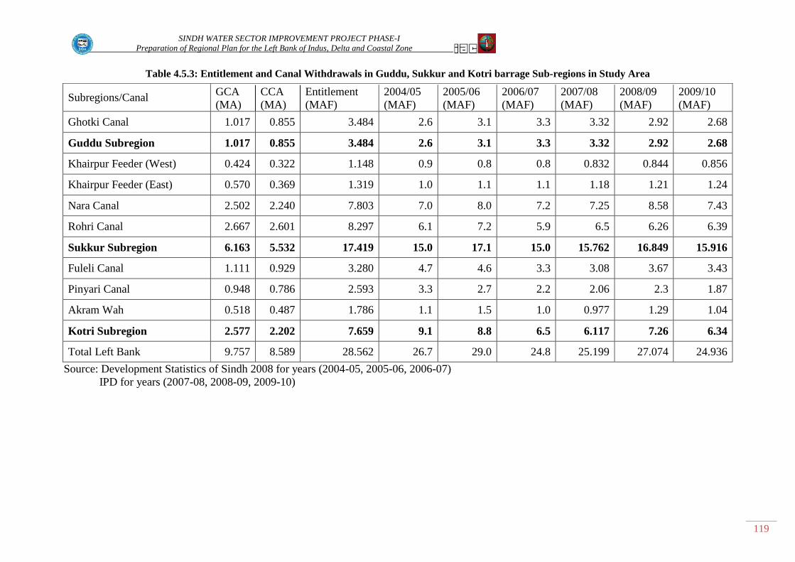
SINDH WATER SECTOR IMPROVEMENT PROJECT PHASE-I
Preparation of Regional Plan for the Left Bank of Indus, Delta and Coastal Zone
119
Table 4.5.3: Entitlement and Canal Withdrawals in Guddu, Sukkur and Kotri barrage Sub-regions in Study Area
Subregions/Canal
GCA
(MA)
CCA
(MA)
Entitlement
(MAF)
2004/05
(MAF)
2005/06
(MAF)
2006/07
(MAF)
2007/08
(MAF)
2008/09
(MAF)
2009/10
(MAF)
Ghotki Canal 1.017 0.855 3.484 2.6 3.1 3.3 3.32 2.92 2.68
Guddu Subregion 1.017 0.855 3.484 2.6 3.1 3.3 3.32 2.92 2.68
Khairpur Feeder (West) 0.424 0.322 1.148 0.9 0.8 0.8 0.832 0.844 0.856
Khairpur Feeder (East) 0.570 0.369 1.319 1.0 1.1 1.1 1.18 1.21 1.24
Nara Canal 2.502 2.240 7.803 7.0 8.0 7.2 7.25 8.58 7.43
Rohri Canal 2.667 2.601 8.297 6.1 7.2 5.9 6.5 6.26 6.39
Sukkur Subregion 6.163 5.532 17.419 15.0 17.1 15.0 15.762 16.849 15.916
Fuleli Canal 1.111 0.929 3.280 4.7 4.6 3.3 3.08 3.67 3.43
Pinyari Canal 0.948 0.786 2.593 3.3 2.7 2.2 2.06 2.3 1.87
Akram Wah 0.518 0.487 1.786 1.1 1.5 1.0 0.977 1.29 1.04
Kotri Subregion 2.577 2.202 7.659 9.1 8.8 6.5 6.117 7.26 6.34
Total Left Bank 9.757 8.589 28.562 26.7 29.0 24.8 25.199 27.074 24.936
Source: Development Statistics of Sindh 2008 for years (2004-05, 2005-06, 2006-07)
IPD for years (2007-08, 2008-09, 2009-10)

SINDH WATER SECTOR INPROVEMENT PHASE-1 PROJECT
Preparation of Regional Plan for the Left Bank of Indus, Delta and Coastal Zone
120
4.5.1.1 Barrages
Guddu Barrage
Guddu Barrage is located on the River Indus approximately 8 miles north east of Kashmore, in upper
Sindh having longitude coordinate at 69° 45‟ E and latitude coordinate at 28° 25‟ N. It is the first
Barrage on the River Indus in Sindh Province downstream of Taunsa Barrage, located in Punjab
Province.
The construction of the barrage started in 1955 and was completed in 1962. The total width of the
barrage between two abutments is 4,445 ft, comprising of 54 river sluices, 7 right pocket bays, and 4
left pocket bays, one of which is a navigation lock. All bays are 60 feet wide except the navigation
lock which is 50 feet wide. Gates are of the vertical lift type, suspended by chains mounted on an
overhead platform. The pockets are separated from the river bays by divide walls, each incorporating
a fish ladder. Both pocket bays are under sluices to serve the purpose of silt exclusion from the
pockets. A road bridge spans the river immediately downstream side of the gate line, supported on the
barrage piers. Regulator gates are counterbalanced and of the vertical lift type, each of 24 feet span 9
spans in Desert Pat Feeder, 10 in the B.S. Feeder, and 6 spans in the Ghotki Feeder, which offtakes on
the Left Bank side of Guddu Barrage and supply water to its command area. Detailed feasibility is
required in view of various problems faced in operation of the barrage side such as centralization of
main current and addition of Rainee Canal head regulator on upstream of barrage. Under WSIP
detailed feasibility studies will be conducted for improvement/ rehabilitation of the barrage.
Sukkur Barrage
Sukkur Barrage is located on the Indus River in Sindh at about 480 km (300 miles) north East of
Karachi having longitude coordinate of 68°33‟ E and latitude coordinate of 27°47‟ N. The Barrage is
situated 160km (100 miles) from Guddu Barrage and about 320 km (200 miles) from Kotri Barrage.
Sukkur Barrage is the first barrage constructed in Sindh province on River Indus. The Construction of
the Barrage started on 1st July 1923 and was completed by 31th December 1931. The Barrage was
commissioned on 13th January 1932 and water started flowing in 7 main Canals off taking on Right
and Left sides of Barrage.
Seven canal systems were constructed for supply of irrigation water out of which 3 canal systems are
on the right bank of the Barrage and 4 canal systems comprising of Khairpur West Canal, Rohri Canal
Khairpur East Canal and Nara Canal are on left bank of the Barrage, supplying irrigation water in the
study area under Sukkur Barrage command.
The total width of the barrage between two abutments is 4,725 ft. Comprising 66 bays each divided
into three sections: the right under sluices, the central weir portion and the left under sluices. The right
and left under sluices have 5 and 7 bays respectively and are separated from the main weir by right
and left divide walls. The central section is divided into 6 compartments each of 9 spans each. These
compartments are separated from one another and from the under sluices by 25 ft wide and 97 ft long
abutment piers and ordinary piers between the spans are 10 ft wide and 77 ft long.
Operational efficiency of the barrage was affected due to silt entry problem in the canals off taking on
the right bank side of the Barrage. Based on the result of the model studies 10 bays of the barrage, 9
adjacent to the right under sluices 6 to 14 and 23 were closed and river training works were carried
out for smooth operation of the barrage. However, the flood passing capacity of the barrage was
reduced from 1.5 million cusecs to 0.9 million cusecs. Several floods exceeding 0.9 million cusecs
and including a maximum 1.2 million cusecs passed in 1976 seriously threatening safety of the
SINDH WATER SECTOR INPROVEMENT PHASE-1 PROJECT
Preparation of Regional Plan for the Left Bank of Indus, Delta and Coastal Zone
121
barrage. During floods 2010 discharge 1.129 million cusecs passed through barrage threatening safety
of the Barrage. A comprehensive study is required for rehabilitation / improvement of the Barrage.
Kotri Barrage
Kotri Barrage was sanctioned by the Government of Sindh in September, 1954. Construction of the
Barrage was completed in 1955 and constructions of all main canals were completed in 1962. The
Barrage is the last barrage on River Indus located near Hyderabad and 72 miles (120 km) North East
of Karachi and 200 miles downstream of Sukkur Barrage. The Barrage length is 3,020 ft between
abutments; it incorporates a road bridge, a lock channel for river traffic, two fish ladders and 44 bays.
The Barrage was constructed primarily to irrigate 2.806 MA of lower Sindh. The Barrage also
provides facility for supply of water to Karachi through Kalri Lake fed by Kalri Beghari Feeder off
taking from the right side of the Barrage.
The main Canals Akram Wah, Fuleli and Pinyari supply water to left bank command of Kotri Barrage
which is part of the study area. Akram Wah is perennial and Fuleli and Pinyari Canals are non-
perennial.
Kotri Barrage is very important major structure in the study area for diversion of Indus water in the
study area which supports the cultivation of lands and also meeting requirements of drinking water to
the population, livestock and wild life in the area, as the ground water quality in the command of the
left bank area is ultra saline and not fit for drinking purposes.
4.5.1.2 Canals
Ghotki Feeder Canal System
Ghotki Feeder Canal system (GFCS) has a gross command area of 0.412 million ha (1.01 million
acres). The Canal off takes from the left bank of Guddu Barrage on the Indus River with a design
discharge of 8,400 cusec and a maximum authorized discharge of 11,670. The length of the main
canal is about 127 km. There are one head regulator and 8 cross – regulators on the Ghotki Feeder
Canal. There are no accurate flow measurement devices throughout Feeder Canal system.
Khairpur East Canal System
Khairpur East Canal System off takes from Left Bank of Sukkur Barrage, with design discharge 2094
cusec and maximum authorized discharge 2600 cusecs. Length of Canal is 58.6 miles (94.51 km).It
has Gross command Area (GCA) 0.57 MA. Khairpur East Canal System Comprises of 3 Branch
Canals GCA 84253 acres CCA 79274 acres and total Length of Branch Canals is 78.2 miles, 8
Distributaries GCA 21,062 acres CCA 117,536 acres and total Length 144.91 miles and 43 minors,
total Length 180.52 miles GCA 24,952 acres and CCA 155,277 acres and 203 direct outlets off taking
from main and branch Canals with GCA 40844 acres and CCA 34,179 acres. Major structure head
regulators and cross-regulators in East Khairpur Canal are presented in Table 4.5.4.
Khairpur West Canal System
Khairpur West Canal off takes from the left bank of River Indus at Sukkur Barrage with a design
discharge of 1,940 cusecs and a maximum authorized discharge of 2,200 cusecs. The length of the
Canal is 41.9 miles. Khairpur West Canal System comprise of 2 branch canals with total length of
47.48 miles; GCA 42,413 acres CCA 41,219 acres; 5 distributaries with total length 59.61 miles,
GCA 35,135 acres, CCA 35,007 acres and; 68 minors with total length 267.2 miles, GCA 206,893
acres and CCA 198,121 acres and 62 outlets directly takeoff from canals. Major structures in Khairpur
West Canal are presented in Appendix Table 4.5.4.

SINDH WATER SECTOR INPROVEMENT PHASE-1 PROJECT
Preparation of Regional Plan for the Left Bank of Indus, Delta and Coastal Zone
122
Rohri Canal System
Rohri Canal off takes on the left bank of Indus at Sukkur Barrage with design discharge 10,887 cusecs
and maximum authorized discharge of 16,963 cusecs. The length of the Canal is 208 miles (335.48
km). Rohri Canal System comprised of 16 branch canals with total length 294.07 miles; GCA 191,244
acres and CCA 186,337 acres; 60 distributaries with total length 794.64 miles, GCA 1,194,993 acres
CCA 1,143,401 acres and; 207 minors with total length 841.2 miles, GCA 1,202,975 acres and CCA
1,152,255 acres; 57 outlets directly off take from main Rohri Canal with GCA 38,359 acres and CCA
37,420 acres.
Rohri Canal has gross command area (GCA) 2.667 MA and cultivable command area (CCA) 2.601
MA. Canal operation is critical due to bank spillage and erosion of canal banks. There are over head
regulator 15 cross regulator and 3 fall structures on the Canal which play important role in supply and
distribution of water to the irrigation network in the Rohri Canal command. Some time conflict arises
between the farmers of downstream and upstream Cross regulators on the operation of gates of the
regulators, which directly affect the quantum of discharge division between upstream and downstream
channels. Major Structures on the Rohri Canal are presented in Table 4.5.5.
Nara Canal System
The Nara Canal system is one of the largest irrigation systems in the world covering command area of
1.01 MHA (2.502 million acres). The Nara Canal off takes on the left bank of River Indus from
Sukkur Barrage with a design discharge capacity of 13,649 cusecs. The maximum authorized
discharge is 13,750 cusecs however maximum inflow up to 17,000 cusecs has been conveyed from
the canal. The system was constructed in 1930s and it was designed to irrigate about 30% of
cultivable command Area (CCA). Water allowance for Nara Canal 2.8 cusec / 000 acres, however the
irrigated area has increased substantially. The Nara irrigation system is divided into two distinct
sections.
Upper Nara between Sukkur Barrage and Jamrao Weir (11% of total CCA).
Lower Nara below Jamrao Weir (89% of total CCA).
The first 155 km of the Nara Canal serves approximately 27,000 acres (109312 ha) which is 11% of
the total CCA of the Nara System. The Nara System below Jamrao weir constitutes 89% of the total
CCA of the Nara System. The area below Jamrao weir (RD 575 of Nara Canal) is served by 4 main
canal systems Jamrao, Mithrao Khipro and Lower Nara Canal.
The Jamrao system consist of the Jamrao Canal length 77 miles (129km) 3 Branch Canals
(west Branch, Dim Branch and Shahu Branch) 16 distributaries serving 290,000 acres
(117,060 ha) and 58 minors serving 368,000 acres (149,053 ha) and (total) 126,500 acres
(51,200 ha) are served by direct off takes.
The Mithrao System Consist of Mithrao Canal length 77 miles (129 km) 2 Branch Canals
Nabisar Branch and Naukot Branch, 15 distributaries serving 288,500 acres (116,776 ha) and
33 minors serving 206,375 acres (83,553 ha). A total of 92,500 acres (37,463 ha) area is
served by direct off takes.
The Khipro system consists of Khipro Canal length 47 miles (79 km). One Branch Canal
Samarjo Branch, 7 distributaries serving 132,000 acres (53,441 ha) and 15 minors serving
70,000 acres (28,374 ha) and 35,700 acres (14,446 ha) are served by direct off takes.
The Lower Nara Canal consists of Lower Nara Canal from Jamrao weir length 116 miles
(194 km) and Thar Canal length 13.8 miles (23 km) system consists of 14 distributaries

SINDH WATER SECTOR INPROVEMENT PHASE-1 PROJECT
Preparation of Regional Plan for the Left Bank of Indus, Delta and Coastal Zone
123
serving 209,160 acres (84,679 ha) and 9 minors serving 38,887 acres (19,832 ha) on the Thar
Canal 96,000 acres (38,886 ha), are served by direct off – takes.
Major structures in the Nara Canal System are presented in Table 4.5.5
Akram Wah System
The Akram Wah is a perennial canal. It off takes on left bank of Kotri Barrage constructed to
overcome this deficiency for supplying water in tail reaches. Gross command Area (GCA) of Akram
wah is 0.518 m acres (0.209 m ha) and cultivable command Are 0.487 million acres (0.197 m ha).
Length of the Canal is 76 miles (122 km). Canal supply water to Gaja Branch at RD 110 and in the
tail area situated in the south East of Tando Bago and Badin. The intermittent area along 200 RD is
irrigated by Fuleli Canal. Akram wah is Cement Concrete lined from the head to RD 110 and from
RD 130 to RD 190 and the section from RD 110 to RD 130 in brick lined. The design discharge of
Akram Wah is 4100 cusecs and maximum authorized Discharge is 3,770 cusecs. Designed water
allowance for Akram Wah is 6.1 cusecs / 000 acres. The Fuleli Gaja link (Capacity 300 cusecs) has
been constructed to feed Akram Wah. Akram Wah supply water to 5 Branch Canal systems.
Comprising of 4 distributaries and 37 minors. The major structures on this Canal are presented in
Table 4.5.4
Fuleli Canal System
The Fuleli Canal is non perennial off takes on left bank of River Indus from Kotri barrage. Gross
Command Area (GCA) 1.01 MA (0.449 MHA) and cultivable command Area (CCA) 1.01 MA (0.449
MHA), Design discharge of canal is 14,859 cusecs with water allowance 14.0 cusecs / 000 acres.
Length of canal is 60 miles. Maximum authorized discharge of canal is 14330 cusecs.
Fuleli Canal Supply Water to Branch Canal Systems comprising of Guni, Murad Wah, Matli Wah,
Sultani Wah and Nasir Wah on left bank side and Pandhi wah, Imam wah Jagir and Mir wah Talhar
on its right bank side. The length of branches is 419 miles. Branch Canals supply water to 53
distributaries and 10 minors. The total Length of distributaries is 164.8 miles and total length of
minors is 81 miles. Major Structures on Fuleli Canal are presented in Appendix Table 4.5.4.
Pinyari Canal System
Pinyari Feeder Canal (old Fuleli) is a non perennial Canal which off takes from Left Bank side of
Kotri barrage. Its design discharge is 13,636 cusecs and maximum authorized discharge 10,490
cusecs. Gross Command Area (GCA) of Pinyari Feeder Canal is 0.948 MA and cultivable command
Area 0.786 MA. Pinyari Canal System comprises 10 branches, 49 distributaries and 50 minors. Canal
System is designed on 71% cropping intensity with water allowance of 4.44 cusecs / 000 acres. Major
Structures on Pinyari Canal are presented in 4.5.4.
4.5.1.3 Irrigation Structures
Barrages
Irrigation Water in the study area is diverted through Guddu, Sukkur and Kotri barrages. Over all (as
mentioned above), the operational efficiency of the barrages need improvement due to various
problems in each barrage such as centralization of flow silt removal from upstream side near Canal
head regulators, Structural weaknesses and flood passing capacity. Feasibility is required for all three
barrages for improvement /Rehabilitation of barrages.

SINDH WATER SECTOR INPROVEMENT PHASE-1 PROJECT
Preparation of Regional Plan for the Left Bank of Indus, Delta and Coastal Zone
124
Head Regulator and Cross-Regulators
On all canal systems the water supply from barrages to a canal is regulated through head regulator and
water distribution is controlled through cross-regulators. The head regulators and cross regulators are
major irrigation structures are presented in the Table 4.5.4 and Table 4.5.5.
Water distribution in a canal system has been designed for manual upstream control. Cross- regulators
on main canals are either redial or sluice type gates. The operation of cross-regulators is based on the
target gauge reading on the downstream side of cross-regulator
The instruction to the gate operator is usually increase the water level by 1 decimal which means, for
example 10.5 to 10.6 feet reading on downstream gauge. The gate operator adjusts the cross-regulator
gates to set the target level of the downstream gauge. If the gates are already above the water level this
is accomplished by reducing the flow rate closing head gate at the adjacent off taking channel.
Operators record reading of the staff gauges located upstream and downstream of the cross-regulator
and intimate the in-charge officer. The operators are not supposed to make any adjustments without
permission.
The cross-regulators are not operated properly to provide a steady and reliable flow to the water users
at distributaries level and maintain upstream water levels, instead the operators are maintaining a
variable target water level downstream of the cross-regulators for proxy flow rate control. This causes
significant fluctuation in water level upstream, causing flow rate variability into the turnouts.
Condition survey of all cross-Regulators on main and branches canals in the study area is required for
smooth operation, efficient and reliable water distribution in the 8 canal systems.

SINDH WATER SECTOR INPROVEMENT PHASE-1 PROJECT
Preparation of Regional Plan for the Left Bank of Indus, Delta and Coastal Zone
125
Table 4.5.4: Major Structures in Ghotki, (Guddu Barrage), Khairpur East, Khairpur West
(Sukkur Barrage), Pinyari, Fuleli and Akram Wah (Kotri Barrage) Canals
Ghotki Feeder Canal Pinyari Canal Fuleli Canal Akram Wah Khairpur East
Canal
Khairpur West
Canal
Structure RD Structure RD Structure RD Structure RD Structure RD Structure RD
HEAD REGULATOR
ex: River
0 Head
Regulator 0
Head
Regulator 0
Head
Regulator 00
Head
Regulator 0
Head
Regulator 0
Cross Regulator
43 Fall Regulator
32 Old Gaja Regulator
116 X - Regulator
70th Mile
Patni X-Regulator
12.8
Beberloi
X-
Regulator
6.8
Cross
Regulator 63
Dino Shah X-
Regulator
114
Cross-
Regulator
on fulleli Canal
30th
Miles
Kazia Branch X-
Regulator
350 Mir Wah X-
Regulator
42.8 Rameja X-
Regulator 36
Cross
Regulator 177
Daro
Branch
Head Regulator
0
Imam Wah
Head Regulator
170
Akram
Wah
Escape head
Regulator
3381
Bhurgari
X-regulator
78.6
Jamsher
X-Regulator
62.1
Cross
Regulator 220
Balo X-
Regulator 5
Akram
Wah Sluices
230 Rajpari X-
Regulator 40.4
Bhatti Fall
X-Regulator
102.8
Cross
Regulator 269
Sujawal X-
Regulator 9
Sluice
No.1
Kot Diji
X-Regulator
158.2
Ahmed
Pur X-Regulator
113.8
Cross Regulator
322 Chhto X- Regulator
108 Sluice No.5
Thekratho
X-
Regulator
188.4 Ripri X-Regulator
141.8
Cross
Regulator 335
Munarki X-
Regulator
125 Akram Wah
Sluices
229 Jalalani X-
REgulator 216.7
Sial X-
Regulator 166.8
Cross
Regulator 345
Pinyari
Branch
Head
Regulator
0 Sluice
No.2
Shar X-
Regulator 247.5
Setherja X-
Regulator
214
Cross Regulator
352 Darro X-Regulator
6 Sluice No.3
Tri-
Junction X-
Regulator
293.6 Jadi X-Regulator
228
Cross Regulator
373 Darri X- Regulator
- Sluice No.4
Bhudhu X- Regulator
-
Ali Pur
Cross-
Regulator
241
Mirkhana X –
regulator
-
Begnah X -
Regulator -
Head
Regulator 1 1 1 1
1 1
X-Regulator 10 10 2 2
9 9
Other
Structures - 3 4 1
- -
Total 11 14 7 4
10 10

SINDH WATER SECTOR INPROVEMENT PHASE-1 PROJECT
Preparation of Regional Plan for the Left Bank of Indus, Delta and Coastal Zone
126
Table 4.5.5: Major Structures in Rohri and Nara Canals (Sukkur Barrage)
Rohri Canal
Nara Canal
Nara Canal Lower Nara
Canal Mithrao Canal Khipro Canal Jamrao Canal
Jamrao West
Branch
Structur
e RD
Structur
e
R
D
Structur
e
R
D
Structur
e RD
Structur
e RD
Structur
e RD
Structur
e RD
Head Regulator
Ex: River
0 Head Regulato
r
0 Makhi
Weir
15
0
Head Regulato
r
0 Head Regulato
r
0 Head Regulato
r
0 Jhano
Mari
8th Mil
e
Tan Do Masti Fall
118 Fall Structure
26 Farash Weir
530
Bakhoro
Cross
regulator
18.5
Cross
Regulato
r
3rd Mile
Cross
Regulato
r
17t
h Mil
e
Cross
Regulato
r
10t
h Mil
e
Naulakhi
x- regulator
205 Fall
Structure
13
5
Kanhar Cross
Regulato
r
65
Cross
Regulator
11th
Mile
Bhagi
Regulator
33rd
Mil
e
Cross
Regulator
22
Mile
Mehrabpur x-
regulator
264
Ranto
Head
Regulato
r
0.6
Valwari
Cross
Regulato
r
136.
5
Cross Regulato
r
14th
Mile
Dalore Regulato
r
49t
h
Mil
e
Cross Regulato
r
30t
h
Mil
e
Kandiaro
x- regulator
328
Dhararo Cross
Regulato
r
175
Cross
Regulator
18th
Mile
Mitho Machi
Regulato
r
59th
Mil
e
Cross
Regulato
r (Dhoro Regulato
r)
33
Mile
Naushero
x- regulator
425
Baraji Cross
Regulato
r
252
Cross
Regulator
28th
Mile-
Miro Mari
Regulato
r
69th
Mil
e
Dambalo
Regulator
45th
Mil
e
Phullfall
x-
regulator
442
Ram Jago
Cross
Regulator
315
Cross
Regulato
r
35th Mile
Cross
Regulato
r
77t
h Mil
e
Cross
Regulato
r
50t
h Mil
e
Yousaf dahri x -
regulator
469
Khani
Jogo Cross
Regulato
r
335 Cross Regulato
r
39th
Mile
Cross Regulato
r
82t
h
Mile
Cross Regulato
r
6th Mil
e
Durofall
regulator 522
Samaro
Jogo
Cross Regulato
r
353 Escape
Structure 195
Jhulari
Regulator
89th
Mil
e
Jamal shah x -
regulator
578
Sunthi
Jogo Cross
Regulato
r
382
Cross Regulato
r
101 Mil
e
Mirza baig fall
587 Escape Structure
332
Cross
Regulato
r
111
Mil
e
Chanesar x -
regulator
617 Cross Regulato
r
116 Mil
e
Sakrad x-
regulator 646
Cross Regulato
r
120 Mil
e
Kumblim
a x- regulator
705
Cross
Regulator
124
Mile
Zerpir Fall 764
Kumbdar
u x- regulator
807
Odero lal
x - regulator
890
Palejani
x- regulator
929

SINDH WATER SECTOR INPROVEMENT PHASE-1 PROJECT
Preparation of Regional Plan for the Left Bank of Indus, Delta and Coastal Zone
127
Khesanox
-
regulator
970
Almani
x-
regulator
1038
Head
Regulato
r
1 1 1 1 1 1 1
X-
Regulato
r
15 - - 9 7 13 7
Other
Structur
es
4 4 3 1 1 - -
Total 20 5 4 11 9 14 8

SINDH WATER SECTOR INPROVEMENT PHASE-1 PROJECT
Preparation of Regional Plan for the Left Bank of Indus, Delta and Coastal Zone
128
4.5.1.4 Drainage Structures
Lower Indus Project investigations were started in 1959 to provide a plan for the optimal development
of the water resources in Lower Indus Region. As a result of these investigations extending over a
period of six years, the Lower Indus Report was prepared in 1966 by Hunting Technical Services Ltd
and Sir M. MacDonald & Partners for WAPDA which provided benchmark data as well as
comprehensive plan of intensive development of the land and water resources of the province to
ensure that agricultural production meet the growing internal demands and export targets. The plan
envisaged interrelated projects for both additional water supplies and drainage to be carried out in a
program, phased over a period of 25 years. The Lower Indus Report covers the irrigated area of three
barrages of Sindh viz. Guddu, Sukkur and Kotri. The whole area is divided into four parts in
following categories:
I. Perennial fresh ground water.
II. Non-perennial fresh ground water.
III. Perennial saline ground water.
IV. Non-perennial saline ground water.
Priority was recommended for the projects in fresh ground water areas, where tube wells could be
easily installed to provide both increased irrigation water and providing drainage and can bring about
large and early increase in agriculture production.
Drainage facilities in Sindh have been provided over a gross command Area of 5.3 Mha. These
facilities include installation of 5,835 tube wells (3,697 FGW and 1,777 SGW) 365 Scavenger wells.
Construction of 8,200 km surface drains. 565 km interceptor drain 0.1 MA covered with tile drain.
Under Salinity Control and Reclamation Projects (SCARPS) the sub-surface drainage systems of tube
wells on the Left Bank of River Indus has been completed on Gross Command area 3.685 MA where
various drainage technologies have been adopted for water table and salinity control. The drainage
facility comprises of 3170 fresh Ground Water tube wells, 2168 saline ground water tube wells, 365
scavenger wells, tile drains over an area of 0.1 MA and 4,458 KM surface drains under other surface
drainage projects. The operational status of the tube wells in each SCARP Project is as under.
Ghotki Fresh Ground Water Project
The project is located in Ghotki district, the GCA of project is 0.178 million hectares (0.44 MA) and
CCA is 0.162 Mha (0.400 MA). A total of 1015 fresh ground water tube wells of total capacity of
2070 cusecs were installed. The capacity of individual tube wells vary from 1.5 cusecs to 2.5 cusecs
depending upon the aquifer conditions. This project has been framed to increase its cropping
intensities (Base year) from 95% to 150% at ultimate development. The tube well pumpage in
addition to irrigation supply through Ghotki canal (Non perennial) will result continuous assured
supply of water throughout year.
Additional tube wells were installed as such total number of tube wells in the project area is 1,092 out
of which 875 are operational and 217 are non-operational due to various reasons. As such the
pumping capacity has been reduced by 19.87 percent. Defects are due to 88 transformers burnt/theft,
31 11 KVA line defect, 18 bore failure, 47 due to defect in motor and 33 due to pump defects.
Khairpur SCARP Project
Project is located in District Khairpur the GCA of the project is 0.178 Mha (0.44 million acres) of
which 0.15 Mha (0.380 million acres) is cultivable under command of Khairpur Feeder East and

SINDH WATER SECTOR INPROVEMENT PHASE-1 PROJECT
Preparation of Regional Plan for the Left Bank of Indus, Delta and Coastal Zone
129
Khairpur Feeder West both canals are perennial. The project is essentially a drainage project. A total
of 540 tube wells of various capacities were installed to control the ground water table at 7ft below
the natural surface level. Out of total number 540 tube wells, 175 pump ground water of acceptable
(fresh water) quality which is directly utilized in the field channels for augmenting the existing
irrigation supplies on full development. Base year cropping intensities were 91 percent in1966-67,
will ultimately attain a level of 165 percent. For disposal of saline effluent 550 km of surface drains
were constructed and five pumping stations with an installed capacity of 855 cusecs to dispose off the
saline effluent into the Rohri Canal. Additional 105 tube wells were installed under Khairpur SCARP
extension program, accordingly the total number of tube wells in Khairpur SCARP has increased to
645.
The operational status of tube wells indicates that 289 tube wells are operational and 356 tube wells
are non operational due to various reasons. Tube wells are non-operational due to 182 transformers
theft/burnt, 39 11 KVA line defect, 61 Bore failure 41 Motor defects, 12 pump defect and 15 control
panel defects.
SCARP North Rohri Fresh Ground Water Project.
The project is located in Districts of Khairpur and Naushero Feroze. The GCA is 0.32 Mha (0.793
MAa) and CCA is 0.278 Mha (0.69 MAa). A total of 581 tube wells of various capacities between 1.5
cfs and 5.0 cfs have been installed. Annual pumpage of fresh ground water is about 1.08 MAF to
supplement the irrigation supplies. The cropping intensity during base year was 98% and with target
of 150 percent. The project was completed during 1969-1979.
Out of 581 tube wells of Naushero Division 259 are non-operational, 114 due to transformer
theft/burnt 1 11 KVA line fault, 110 bore failure, 27 motor defect, 5 pump defect and 2 control panel
defect.
SCARP South Rohri Fresh Ground Water Project.
The project is located in districts of Nawabshah and Hyderabad. GCA is 0.22 Mha (0.541 Ma) and
CCA is 0.152 Mha (0.375 Ma). The project receives perennial irrigation supplies from Rohri Canal
system supplemented by the additional of 1,214 fresh ground water tube wells with designed capacity
of 1 to 2 cusecs. The cropping intensities during base year were 88 percent which is planned to
increase upto 110 percent.
1,214 tube wells were constructed in the priority area providing a discharge capacity of 1 to 2 cusecs
of individual tube wells. Additional 8 tube wells were installed as such total number of tube wells is
1,222.
The operational status of the Tube wells indicate that 860 tube wells are operational and remaining
362 tube wells are non-operational as such the pumping capacity of Tube wells has been reduced
from 2,660 to 1,873 cusecs which have direct impact on the agricultural production due to reduction
in pumpage from tube wells. Non-operational Tube wells are 205 due to transformer theft/ Burnt, 44
Motor burnt, 69 pump defect, 34 bore failure 7 control panel and 3, 11 KVA line defect.
LBOD Stage – 1
LBOD Stage - 1 project was prepared is November 1983. PC-1 was submitted to Government of
Pakistan is Feb 1984, approved by ECNEC in August 1984 and construction of LBOD Stage-1 project
started in 1985-86 and completed in 1997 except Chotiari Reservoir, which was completed in 2002
and handed over to SIDA. Total area served by the three component projects Nawabshah, Sanghar

SINDH WATER SECTOR INPROVEMENT PHASE-1 PROJECT
Preparation of Regional Plan for the Left Bank of Indus, Delta and Coastal Zone
130
and Mirpurkhas is over Gross
Command Area (GCA) 1.426
MA and Cultural Command
Area (CCA) 1.276 MA.
The System comprising three
components Nawabshah,
Sanghar and Mirpurkhas
LBOD Branch Drain and
outfall System were handed
over to Irrigation Department/
Sindh Irrigation & Drainage
Authority upto 2002. The
management transfer process
was initiated in 1998 and
completed on January 2002.
WAPDA Operated System for
one year before management
transfer to IPD/ SIDA. The
Drainage facilities of LBOD
Stage 1 project are presented in
Table 4.5.6.
Nawabshah Component
Nawabshah component
provides drainage facility on
gross area of 0.626 MA with a
network of main branch and sub-drains totaling 323 km. Subsurface drainage comprises 274 Tube
wells and scavenger wells 191and 225 km of interceptor drains. The tube wells have been designed to
operate at 60% efficiency and maintain Water table at 7ft below ground Surface. Storm Drainage
disposal has been provided through network of Surface drains and inlets for evacuation of 50 percent
component of rainfall and 50 percent allowed for deep percolation. Surface drainage network will
provide evacuation of storm runoff within 2 days to 3 days through network of inlets. Tube wells are
non-operational due to various reasons, 100 due transformers theft/burnt, 133, 11 KVA line defect, 26
motor defect and 33 pump defect.
Sanghar component
Sanghar project provide drainage facility over a gross area of 0.424 MA with network of main, branch
and Sub – drains. 93.8%of this area has been provided with Sub-Surface drainage by 642 tube wells
and 175 scavenger wells, 122 km of interceptor drains are provided for seepage control along main
canals. The Tube wells have been designed to operate at 60% efficiency and maintain Water table at 7
ft below ground surface. The project has been designed to reduce flood damage by lowering high
Water table to provide more capacity for infiltration of excess irrigation applications and part of storm
water. Surface drainage network will provide evacuation of surface runoff within 2 and 3 days. 572
tube wells are operational and 224 tube wells are non-operational due to various reasons. Tube wells
are non-operational due to 75 transformers burnt/theft, 70 11 KVA line fault, 5 bore failure, 48 motor
burnt defect, 11 pump defects and 6 control panel defect.
LBOD Schematic Diagram
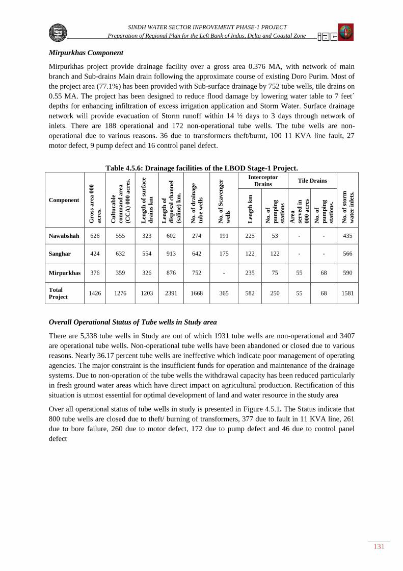
SINDH WATER SECTOR INPROVEMENT PHASE-1 PROJECT
Preparation of Regional Plan for the Left Bank of Indus, Delta and Coastal Zone
131
Mirpurkhas Component
Mirpurkhas project provide drainage facility over a gross area 0.376 MA, with network of main
branch and Sub-drains Main drain following the approximate course of existing Doro Purim. Most of
the project area (77.1%) has been provided with Sub-surface drainage by 752 tube wells, tile drains on
0.55 MA. The project has been designed to reduce flood damage by lowering water table to 7 feet´
depths for enhancing infiltration of excess irrigation application and Storm Water. Surface drainage
network will provide evacuation of Storm runoff within 14 ½ days to 3 days through network of
inlets. There are 188 operational and 172 non-operational tube wells. The tube wells are non-
operational due to various reasons. 36 due to transformers theft/burnt, 100 11 KVA line fault, 27
motor defect, 9 pump defect and 16 control panel defect.
Table 4.5.6: Drainage facilities of the LBOD Stage-1 Project.
Component
Gro
ss a
rea
000
acr
es.
Cu
ltu
rab
le
com
ma
nd
are
a
(CC
A)
00
0 a
cres
.
Len
gth
of
surf
ace
dra
ins
km
Len
gth
of
dis
po
sal
chan
nel
(sa
lin
e) k
m.
No
. o
f d
rain
ag
e
tub
e w
ells
No
. o
f S
cav
eng
er
wel
ls
Interceptor
Drains Tile Drains
No
. o
f st
orm
wa
ter
inle
ts.
Len
gth
km
No
. o
f
pu
mp
ing
sta
tio
ns
Are
a
serv
ed i
n
00
0 a
cres
No
. o
f
pu
mp
ing
sta
tio
ns.
Nawabshah 626 555 323 602 274 191 225 53 - - 435
Sanghar 424 632 554 913 642 175 122 122 - - 566
Mirpurkhas 376 359 326 876 752 - 235 75 55 68 590
Total
Project 1426 1276 1203 2391 1668 365 582 250 55 68 1581
Overall Operational Status of Tube wells in Study area
There are 5,338 tube wells in Study are out of which 1931 tube wells are non-operational and 3407
are operational tube wells. Non-operational tube wells have been abandoned or closed due to various
reasons. Nearly 36.17 percent tube wells are ineffective which indicate poor management of operating
agencies. The major constraint is the insufficient funds for operation and maintenance of the drainage
systems. Due to non-operation of the tube wells the withdrawal capacity has been reduced particularly
in fresh ground water areas which have direct impact on agricultural production. Rectification of this
situation is utmost essential for optimal development of land and water resource in the study area
Over all operational status of tube wells in study is presented in Figure 4.5.1. The Status indicate that
800 tube wells are closed due to theft/ burning of transformers, 377 due to fault in 11 KVA line, 261
due to bore failure, 260 due to motor defect, 172 due to pump defect and 46 due to control panel
defect

SINDH WATER SECTOR INPROVEMENT PHASE-1 PROJECT
Preparation of Regional Plan for the Left Bank of Indus, Delta and Coastal Zone
132
Figure 4.5.1: Overall Tubewells Operational Status of Projects in Study Area
Water logging Status in the Study area
Irrigated area on the Left Bank of Indus is served by eight major perennial & non perennial canals off
taking from three barrages of Indus on Left bank. Irrigation system of Sukkur barrage is in effect from
1932 to date. After the construction, it was advised by the British Engineers that the canals of barrage
should be lined in near future (LIP report) as operating levels of the canals are above the land surface,
and can create the water logging problem due to seepage from the canal. Prior to construction of
Sukkur barrage the water table depth in the Lower Indus region was below the range of 30 to 40ft
(LIP) even after the commissioning of two other barrages i.e. Kotri & Guddu respectively, the water
table depth range remained within safe limits. Later on with the passage of time, slowly & gradually
water table started rising due to the seepage effect, excess irrigation applications and mismanagement
of irrigation system, and ultimately twin menace of water logging & salinity emerged in the irrigated
areas.
Under the present situation, depth to water table has been raised to an alarming extent &is out of safe
limits. The data collected from SCARP Monitoring Organization WAPDA (Water Wing) south for
the period 1979 to 2009 has been processed and presented in Figure 4.5.2.
Water logging trend in the Study area
The Study area as already mentioned is irrigated by the left bank a canal of three barrages of lower
Indus region, surveyed area is in each canal command. Within this area the water table trend is based
on the available data of 30 years for two periods i.e. the Pre monsoon (April) & Post monsoon
(October) seasons of each year. However, somewhere the data is missing due to lack of funds, which
were not provided at proper time to the concerned organization (SMO south) & because of that survey
of the area could not be conducted within a scheduled time. The data collected so far has been
processed and interpreted and percent wise area falling within danger zone of 0-150 cm depth.
It is obvious from the two different categories of pre monsoon & post monsoon seasons for the period
of 30 years (1979-2009); the water table trend remained at highest level (0-150 cm) in both seasons.
In general, the high water table conditions have clearly been observed in the post-monsoon (October)
as compared to the pre-monsoon (April) period. The percent wise area covered on bi-annual survey
basis indicate that major part within different Canal Commands remained under 0-150cm water table
depth during post monsoon season. This is because of the rainfall, flooding condition &
simultaneously canals are running in full swing for supplying irrigation water during the Kharif

SINDH WATER SECTOR INPROVEMENT PHASE-1 PROJECT
Preparation of Regional Plan for the Left Bank of Indus, Delta and Coastal Zone
133
season, and water table rises at the peak before the start of the Rabi season. After that decreasing trend
of water table starts, that is why the area covered by water logging is more during the post monsoon
period.
Further it is pertinent to note that during the recent past drought conditions prevailed throughout the
region i.e. from 1999 till the end of 2009 because of this the water table depths were remarkably
lowered down to a larger extent, leaving a small area within 0-150 cm depth zone in pre monsoon
season, where as a decreasing trend has also been observed during post monsoon period. Water table
depth in pre-monsoon and post-monsoon from study area for period 1979 to 2010 is presented in Fig
4.5.2.
Figure 4.5.2: Pre monsoon (April) and Post monsoon (October) Water Logged Area in Study
area
Source: SMO South WAPDA
Flood Protection Structures
A "floodplain" is the lowland adjacent to a river, lake or sea. Floodplains are designated by the
frequency of the flood that is large enough to cover them. For example, the 10-year floodplain will be
covered by the 10-year flood and the 100-year floodplain by the 100-year flood. Flood frequencies,
such as the "100-year flood," are determined by plotting a graph of the size of all known floods for an
area and determining how often floods of a particular size occur. Another way of expressing the flood
frequency is the chance of occurrence in a given year, which is the percentage of the probability of
flood. For example, the 100-year flood has a 1% chance of occurring in any given year.
Dams, embankments, and other protective works are designed to provide protection against some
specific level of flooding. The "level of protection" is selected based on cost, desire of the community,
potential damage, environmental impact, and other factors. Engineers can design and construct
embankments, dams and other measures providing a very high level of protection. Communities tend
to choose lower levels of protection because of the initial financial cost rather than overall costs and
benefits.
Flood Protection Embankments may be either "engineered" or “non-engineered”. Engineered
embankments are those in which professional consideration has been given to the underlying soil
conditions, the kind of earth used in building the embankment, proper compaction of the embankment
materials, armoring of the embankment face if needed and other factors. Non-engineered
embankments are basically long piles of earth pushed up along a river. Engineered embankments have
a far lower rate of failure than non-engineered embankments.

SINDH WATER SECTOR INPROVEMENT PHASE-1 PROJECT
Preparation of Regional Plan for the Left Bank of Indus, Delta and Coastal Zone
134
Figure 4.5.3: Flood Discharges upstream and downstream of Guddu, Sukkur and Kotri
Barrages
Up Stream
Down Stream
YEAR
DISC
HARG
E (c
uft/
sec)
FLOOD LEVELS - Year 1955 to 2010
GUDDU BARRAGE
0
200000
400000
600000
800000
1000000
1200000
1400000
1955
1956
1957
1958
1959
1960
1961
1962
1963
1964
1965
1966
1967
1968
1969
1970
1971
1972
1973
1974
1975
1976
1977
1978
1979
1980
1981
1982
1983
1984
1985
1986
1987
1988
1989
1990
1991
1992
1992
1993
1994
1994
1995
1996
1997
1998
1999
2000
2001
2002
2003
2004
2005
2006
2007
2008
2009
2010
UP STREAM
DOWN STREAM
YEAR
SUKKUR BARRAGE
DIS
CHAR
GE
(cuf
t/se
c)
FLOOD LEVELS - Year 1955 to 2010
-
200,000
400,000
600,000
800,000
1,000,000
1,200,000
1,400,000
1955
1956
1957
1958
1959
1960
1961
1962
1963
1964
1965
1966
1967
1968
1969
1970
1971
1972
1973
1974
1975
1976
1977
1978
1979
1980
1981
1982
1983
1984
1985
1986
1987
1988
1989
1990
1991
1992
1992
1993
1994
1994
1995
1996
1997
1998
1999
2000
2001
2002
2003
2004
2005
2006
2007
2008
2009
2010
UP STREAM
DOWN STREAM
DIS
CHAR
GE
(cuf
t/se
c)
FLOODS LEVELS - Year 1955 to 2010
KOTRI BARRAGE
YEAR
-
200,000
400,000
600,000
800,000
1,000,000
1,200,000
1955
1956
1957
1958
1959
1960
1961
1962
1963
1964
1965
1966
1967
1968
1969
1970
1971
1972
1973
1974
1975
1976
1977
1978
1979
1980
1981
1982
1983
1984
1985
1986
1987
1988
1989
1990
1991
1992
1992
1993
1994
1994
1995
1996
1997
1998
1999
2000
2001
2002
2003
2004
2005
2006
2007
2008
2009
2010

SINDH WATER SECTOR INPROVEMENT PHASE-1 PROJECT
Preparation of Regional Plan for the Left Bank of Indus, Delta and Coastal Zone
135
There is a wide range of measures that can be used to protect against flooding. They may be grouped
in various ways, such as - "Structural" and "non-structural" measures whether they are most suitable
for protecting a) individual structures or b) areas containing multiple structures and communities
Whether their purpose is to: a) modify the flood; b) reduce susceptibility to flooding; and/or c) reduce
the impact of flooding. Multiple measures are usually needed to provide protection to an area. Flood
Protection embankments have been provided on the both sides Left Bank and Right Bank of River
Indus for safe passage of Flood water towards final outfall in Arabian Sea. The intensity of flood
discharges upstream and downstream of Guddu Barrage, Sukkur Barrage and Kotri Barrage (1955 to
2010) is presented in Figure 4.5.3.
Main Bunds and loop Bunds have been provided on the Left Bank of River Indus from Guddu to the
Arabian Sea for Safe disposal of flood water and protection of Left Bank Command areas under
Guddu, Sukkur and Kotri barrages.
These bunds are major structures in the study area for flood protection. Irrigation & Power
Department is responsible for construction and maintenance of Bunds as per Bund Manual. Main
Bunds and Loop Bunds along Left Bank side of River Indus are presented in Table 4.5.7 and
vulnerable points of bunds are presented in Table 4.5.8.
2010 Floods
During 2010 Floods three major breaches occurred in the River Flood protection embankments in
Sindh. The first breach occurred in Tori Bund on the right side River Indus in the reach between
Guddu and Sukkur Barrage. Second breach occurred in M.S Bund along Left Side downstream of
Kotri Barrage and inundated vast area which caused severe damages in the Study area. Third breach
occurred on the right flood protection embankment at downstream of Kotri Barrage and inundated
Thatta District area. The breach was timely closed.

SINDH WATER SECTOR INPROVEMENT PHASE-1 PROJECT
Preparation of Regional Plan for the Left Bank of Indus, Delta and Coastal Zone
136
Table 4.5.7-A: Major Structures Flood Protection Main Bunds and Loop Bunds along Left Bank River Indus
Ghotki AWB Khairpur Circle Rohri Circle
Main Bunds Loop Bunds Main Bunds Loop Bunds Main Bunds Loop Bunds
Name Length
M-F Name
Length
M-F Name
Length
M-F Name
Length
M-F Name
Length
M-F Name
Length
M-F
Machka Bund
Mile 0/0 to 3/0 3-00
Qadirpur Loop
Bund
Mile 0/0 to 8/4
8-4 Khairpur Feeder
West Bund 4-0
Loop Bund
Behind Garho
(LBBG)
0-5 Rohri Division MORO
Dilwaro Bund
Mile 0/0 to 7/0 7-00
Dilwaro Loop
Bund
Mile 7/0 to 8/0
1-00 Link Bund 0-4 New Narejo
Loop Bund 6-5
S.M Bund
Mile 0/0 to 3/2 3-2
Sagyoon Loop
Mile 0/0 to 1/2 1-2
Ranwati Bund
Mile 0/0 to
11/7
11-7
Garkino Loop
Bund
Mile 0/0 to
1/1+580ft
1-2 Ring Bund 1-4 Ulra Loop Bund 3-5 Front Bund
Mile 0/0 to 3/7 3-7
Kharal Loop
Mile 0/0 to 2/3 2-3
L.M Bund
(Old)
Mile 0/0 to 6/7
6-7 R.N Loop Bund
Mile 0/0 to 3/0 3-0 Main River Bund 1-0
New Mahesar
Loop Bund 0-6
S.M Bund
Mile 7/4 to 12/7 5-3
New Morio
Loop
Mile 0/0 to 4/1
4-1
Qadirpur Bund
Mile 0/0 to 1/2 1-2 Ulra Jagir Bund 2-2
Jamsher Loop
Bund 2-2
Bakhri Loop
Mile 0/0 to 2/5 2-5
Haji Shah Loop
Mile 0/0 to 2/3 2-3
Qadirpur Shank
Bund
Mile 0/0 to
2/4+2500
3-1 Ulra Jasir Bund 3-3
S.M Bund
Mile 16/0 to
19/1
3-1 Darbello Loop
Mile 0/0 to 2/4 2-4
Gemro Bund
Mile 10/6 to
14/4
3-6 Fareedabad Bund 0-4 Morio Loop
Mile 0/0 to 1/4 1-4
Abji Loop
Mile 0/0 to 7/4 7-4
R.N Bund
Mile 5/1 to
13/44-0
8-3 Bhatti Pir Bund 12-0 Pipri Loop
Mile 0/6 to 3/5 2-7
Jatoi X - Bund
Mile 0/0 to 7/4 7-4
Budhka Cross
Bund
Mile 22/4 to
26/4
4-0 Baro Bund 2-7 Bhagu Dero
Mile 0/0 to 1/6 1-6
Gadahero Loop
Mile 0/0 to 0/4 0-4
Baiji Bund
Mile 0/0 to
10/3
10-3 Razi Daro Bund 4-7
S.M Bund
Mile 28/4 to
33/4
5-0 S.M Bund
Mile 0/0 to 0/4 0-4

SINDH WATER SECTOR INPROVEMENT PHASE-1 PROJECT
Preparation of Regional Plan for the Left Bank of Indus, Delta and Coastal Zone
137
Table 4.5.7-A: Major Structures Flood Protection Main Bunds and Loop Bunds along Left Bank River Indus
Ghotki AWB Khairpur Circle Rohri Circle
Main Bunds Loop Bunds Main Bunds Loop Bunds Main Bunds Loop Bunds
Name Length
M-F Name
Length
M-F Name
Length
M-F Name
Length
M-F Name
Length
M-F Name
Length
M-F
R.N Bund
Mile 3/1 to
12/0
9-4 Agra Ring Bund 0-3 Manjath Bund
Mile 0/0 to 1/5 1-5
S.M Bund
Mile 0/0 to 7/4 4-2
R.N Mangli
Bund
Mile 0/0 to 1/1
1-1 Faiz Maher Bund 5-1
S.M Bund
Mile 35/4 to
75/1
39-5
Bakhri Trench
Loop Bund
Mile 0/0 to 3/7
3-7
R.N Link Bund
Mile 0/0 to 0/2 0-2 Gerkino Bund 4-7
Daualatpur
Loop
Mile 0/0 to 1/5
1-5 J - Spur
Mile 0/0 to 3/2 3-0
R.N Bund
Mile 0/0 to 1/1 0-7
S.M Bund
Mile 76/2 to
80/0
3-6
Front Bund
Mile 0/0 to 0/7 0-7
Kandiaro
Escapes
Mile 0/0 to 12/2
12-2
L.M Bund
(New)
Mile 2/4 to
13/6
DADU DIVISION Nawabshah
L.M Bund
(Old)
Mile 6/7 to
13/2
6-3
S.M Bund
Mile 80/0 to
99/0
19-0
Chattean Shah
Loop
Mile 0/0 to 4/4
1-2
Germo Bund
Mile 0/0 to 5/1 5-1
S.M Bund
Mile 104/6 to
123/0
18-2 Rahib Shah
Mile 0/0 to 2/7 2-3
R.N Bund
(Old)
Mile 12/5 to
22/4
9-7 Old Bund
Mile 0/0 to 2/2 2-2
Jiand Loop
Mile 0/0 to 1/0 4-1
R.N Bund
Mile 1/1 to 2/3 1-2
New Mud Loop
Mile 0/0 to 2/1 2-1

SINDH WATER SECTOR INPROVEMENT PHASE-1 PROJECT
Preparation of Regional Plan for the Left Bank of Indus, Delta and Coastal Zone
138
Table 4.5.7-A: Major Structures Flood Protection Main Bunds and Loop Bunds along Left Bank River Indus
Ghotki AWB Khairpur Circle Rohri Circle
Main Bunds Loop Bunds Main Bunds Loop Bunds Main Bunds Loop Bunds
Name Length
M-F Name
Length
M-F Name
Length
M-F Name
Length
M-F Name
Length
M-F Name
Length
M-F
HALA DIVISION
S.M Bund
Mile 123/0 to
137/6
14-6 Kurejo Loop
Mile 0/0 to 1/5 1-5
New Fatehpur
Mile 0/0 to 4/4 4-4
Hala Loop
Mile 0/0 to 4/1 4-1
Old Fatehpur
Mile 1/1 to 2/0 0-7
Old Fatehpur
Mile 2/0 to 4/2 2-2
Cross Bund
Mile 0/0 to 0/7 0-7
Matiari Loop
Mile 0/0 to 2/6 2-6
S.M Bund
Mile 142/0 to
172/0
29-6
Hala Cross
Bund
Mile 0/0 to 0/7
0-7
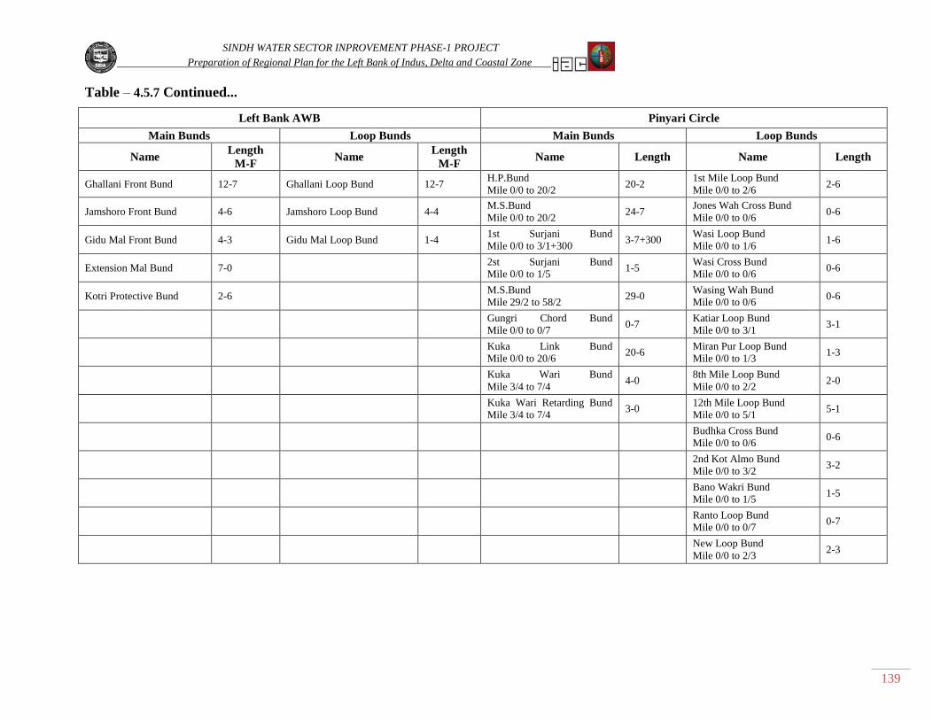
SINDH WATER SECTOR INPROVEMENT PHASE-1 PROJECT
Preparation of Regional Plan for the Left Bank of Indus, Delta and Coastal Zone
139
Table – 4.5.7 Continued...
Left Bank AWB Pinyari Circle
Main Bunds Loop Bunds Main Bunds Loop Bunds
Name Length
M-F Name
Length
M-F Name Length Name Length
Ghallani Front Bund 12-7 Ghallani Loop Bund 12-7 H.P.Bund
Mile 0/0 to 20/2 20-2
1st Mile Loop Bund
Mile 0/0 to 2/6 2-6
Jamshoro Front Bund 4-6 Jamshoro Loop Bund 4-4 M.S.Bund
Mile 0/0 to 20/2 24-7
Jones Wah Cross Bund
Mile 0/0 to 0/6 0-6
Gidu Mal Front Bund 4-3 Gidu Mal Loop Bund 1-4 1st Surjani Bund
Mile 0/0 to 3/1+300 3-7+300
Wasi Loop Bund
Mile 0/0 to 1/6 1-6
Extension Mal Bund 7-0 2st Surjani Bund
Mile 0/0 to 1/5 1-5
Wasi Cross Bund
Mile 0/0 to 0/6 0-6
Kotri Protective Bund 2-6 M.S.Bund
Mile 29/2 to 58/2 29-0
Wasing Wah Bund
Mile 0/0 to 0/6 0-6
Gungri Chord Bund
Mile 0/0 to 0/7 0-7
Katiar Loop Bund
Mile 0/0 to 3/1 3-1
Kuka Link Bund
Mile 0/0 to 20/6 20-6
Miran Pur Loop Bund
Mile 0/0 to 1/3 1-3
Kuka Wari Bund
Mile 3/4 to 7/4 4-0
8th Mile Loop Bund
Mile 0/0 to 2/2 2-0
Kuka Wari Retarding Bund
Mile 3/4 to 7/4 3-0
12th Mile Loop Bund
Mile 0/0 to 5/1 5-1
Budhka Cross Bund
Mile 0/0 to 0/6 0-6
2nd Kot Almo Bund
Mile 0/0 to 3/2 3-2
Bano Wakri Bund
Mile 0/0 to 1/5 1-5
Ranto Loop Bund
Mile 0/0 to 0/7 0-7
New Loop Bund
Mile 0/0 to 2/3 2-3

SINDH WATER SECTOR INPROVEMENT PHASE-1 PROJECT
Preparation of Regional Plan for the Left Bank of Indus, Delta and Coastal Zone
140
Table 4.5.8: (B) Major Structures Flood Protection Vulnerable Points of Bunds
Ghotki AWB Pinyari Circle Rohri Circle LBCAWB Khairpur
Main Bunds Main Bunds Main Bunds Main Bunds Main Bunds
Name Length
M-F Name
Length
M-F Name
Length
M-F Name
Length
M-F Name
Length
M-F
L.M
Bund
(Old)
Mile
0/0 to
3/1
Haji Pur
Bund
Mile 0/0
to 0/5 Rohri Division Moro
Ghallian Front
Bund
Distt: (Hyderabad)
Mile 3/0
to 5/2
Ulra Jagi Bund 2/ , 5/2
Qadirpur Loop
Bund
Mile 5/0 to
7/2
Haji Pur Bund
Mile 3/7 S.M Bund (Old)
Ghallian Front Bund
Distt: (Hyderabad
Gamero Bund
Mile 12/0 to
13/0
Haji Pur Bund
Mile 6/0 to 6/6
S.M Bund (Old)
Mile 3/2 Ghallian Front Bund
Distt: (Hyderabad)
Mile 7/0 to 9/0
Haji Pur Bund
Mile 8/0 to 8/4
L.M Bund (Bakhri)
Mile 12/4 Jamshoro Front Bund (Hyderabad)
Mile 10/0 to
12/7
Haji Pur Bund
Mile 12/4 to 13/5
Bakhri Loop Bund
Mile 0/0 to 2/5
Gidumal Front Bund
Distt: (T.M.Khan)
Mile 1/0 to 2/0
M.S Bund Mile 3/2 Manjuth Loop Bund
Mile 0/0 to 1/5
Mile 1/5 to 4/4
M.S Bund Mile 5/7 S.M Bund Mile 33/0
M.S Bund Mile 18/3 S.M Bund
(Bhorti Site)
Mile 37/4
1st
Surjani Bund
Mile 0/0
to 1/5
S.M Bund Mile 47/0 to
48/5
2st
Surjani Bund
Mile 0/0
to 1/5
S.M Bund Mile 54/0
M.S Bund Mile 42/5
to 44/3
Right
Guide Bank
Mile 0 to 3420
Ft
M.S Bund Mile 43/5 to
44/0+200
Left Guide Bank
Mile o to 3000 ft U/S & o to
800 ft U/S
Gungri Chord
Bund
Mile 0/0 to 0/7
J-Spur Dadu Moro
Bridge
Mile o to 3280 ft D/S
Kaka Link Bund
Mile 6/0 to 7/0
DAD Division Nawabshah
Kaka Link
Bund
Mile 9/4
to 20/6
New Mud
Loop Bund
Mile 1/3 to
2/1
Kaka
Wari
Retarded Bund
Mile 0/0
to 3/0
S.M Bund Mile 104/6 to
107/6
S.M Bund Mile 105/4 to
106+400
S.M Bund Mile 107/7
S.M Bund Mile 109/2
Hala Division
S.M Bund Mile 129/4
S.M Bund Mile 135/6 to 137/0
S.M Bund Mile 142/5
S.M Bund Mile 152/0
S.M Bund Mile 155/5
S.M Bund Mile 158/0
S.M Bund Mile 161/0
S.M Bund Mile 162/2
S.M Bund Mile 166/4

SINDH WATER SECTOR INPROVEMENT PHASE-1 PROJECT
Preparation of Regional Plan for the Left Bank of Indus, Delta and Coastal Zone
141
4.5.1.5 Adequacy of Infrastructures
Health
Health plays the main role in the lives of human beings; it is famous proverb that health is the wealth.
According to the 1948 universal declaration of Human Rights every one has the right to a standard of
living adequate to health and well-being of himself/ herself and his / her family. As it is correct to say
that human development is a basic right of an individual and health is its pre requisite for its
development. Poor health of any one can directly influence on his opportunities, earning capacity,
performance at school, ability to care for children, participation in community activities and so on.
Present Status
In the perspective of above facts it is observed that health indicators of Study area and over all Sindh
lag behind those of many low- income countries. According to analysis done in the late 1990s,
applicable to this province also suggested that priority should be given to the basic preventable and
readily treatable diseases. In recent past. Government of Sindh (GOS) has taken the lead in preparing
and announcing a comprehensive Health Policy covering both short & long term targets and
addressing all the impediments hampering progress. The Government is committed to continue all
efforts including the following.
- Implementation of the health policy.
- Re- Invigorating the Immunization and tuberculosis programmes.
- Improving health sector governance,
- Promoting public -private partnership by inviting NGOs.
Health Organization
The health Institutions are administratively governed by Director General Health services in the
province and maintains the records of Hospitals, Health Centers provided by subordinate office of the
District Health office. The Health is institutions functioning on district basis furnished by office of
DG Health Government of Sindh Hyderabad are listed in Table 4.5.9.
Table 4.5.9: List of different Health Institutions on Small/ Large Scale in Left Bank Study area
S. No Name of District Total Institution/ Health Center
1. Hyderabad 476
2. Matiari 166
3. Tando Muhammad Khan 91
4. Tando Allahyar 49
5. Thatta 610
6. Badin 717
7. Mirpurkhas 738
8. Umerkot 520
9. Tharparkar 829
10. Sanghar 888
11. Sukkur 393
12. Ghotki 341
13. Khairpur 1769
14. Naushero Feroze 952
15. Nawabshah 855

SINDH WATER SECTOR INPROVEMENT PHASE-1 PROJECT
Preparation of Regional Plan for the Left Bank of Indus, Delta and Coastal Zone
142
Adequacy
It is obvious from the available information that number of health institutions/ Hospitals and Health
centers in the different districts are more or less sufficient in different district of Study area. However
some parts of remote areas are lacking health facilities, therefore from adequacy point of view, the
concerned authorities have to consider the difficulties faced by the poor people of area. Especially the
people settled in coastal zone & adjacent to Thar Desert should be facilitated for providing Health
Units.
Schools
Parents play the main role in developing the mentality and behavior of their children, next to that is
role of a school teacher who grooms and polishes the child by providing a good education and better
atmosphere.
Therefore, after home the next nest of child is the school which plays the important role in
development of the human dignity, personality, vision, life stability with his strong economy by using
his knowledge for his earnings in applying his physical / mental role within the different sectors of life
Performance of Schools
Due to the poor governance, still the education sector is in state of crises. The factors responsible
include lack of access to education facilities & by poverty that prevents families from bearing the cost
of education. Moreover, unsatisfactory quality of education arising from absent or poorly trained
teachers, dearth of school supplies and inadequate infrastructure, (Shelter less school 1-2 room
schools, school without drinking waters & sanitation facilities); there is a lack of accountability of
school management to communities and service users, weak monitoring & evaluation of performance.
Status of School in Left Bank Study Area
For obtaining the status of the Left Bank (Study area), the available information is collected and based
on the Development Statistics of Sindh 2008, Bureau of Statistics P&D Department Government of
Sindh. According to this Primary, Middle and Secondary Schools in different district falling in left
bank of Indus River on district basis are presented in Table 4.5.10.
Table 4.5.10: District Wise Number of Schools in Left Bank Study Area
Province/ District
Primary Schools Middle Schools Higher Secondary Schools
2007 2007 2007
Male Female Male Female Male Female
Khairpur 2,873 564 145 63 93 23
Sukkur 978 207 56 34 44 15
Ghotki 1,064 233 71 26 32 4
Naushero Feroze 1,873 372 117 53 55 17
Nawabshah 2,111 417 79 27 47 11
Sanghar 2,678 378 120 47 62 19
Mirpurkhas 1,706 381 65 42 50 19
Tharparkar @ Mithi 3,175 585 275 18 28 4
Umerkot 1,779 444 74 27 30 8
Hyderabad 638 248 51 27 54 40
Tando Allahyar 624 121 37 10 20 5
Tando Muhammad Khan 870 124 18 8 18 5
Matiari 786 154 48 6 24 10
Badin 2,567 456 115 43 46 13
Thatta 2,688 407 60 35 55 17

SINDH WATER SECTOR INPROVEMENT PHASE-1 PROJECT
Preparation of Regional Plan for the Left Bank of Indus, Delta and Coastal Zone
143
Adequacy
Still the education at primary level requires changes to develop their status on national and
international level. Moreover, it is necessary to open the new schools in rural villages and all
prevailing schools within the area should be monitored with good governance & management.
Recently literacy rate was 58.6 percent for male and 36.3 for female during the period 2007-2008. It is
obvious that literacy rate and enrolment are very low to meet challenge of the province for poverty
alleviation and social Welfare.
Roads
Background
Road and railways are the main source of communication in the Study area. During past days long
before the partition of Indo-Pak the main source for transport and trade was the Indus which provided
the main communication and trade route between the hinterland and parts of the Arabian Sea. With
the passage of time and development of Karachi as a port and the buildup of Railway facilities, the
Indus river route declined in usefulness and as the Barrages were built, it ceased to be important.
Development & Extent of Roads
After Indo-Pak partition, National Highway was the only source of main transport within the province
which served as a trunk road connected with the small metalled / weathered roads of major cities on
Left bank like Hyderabad, Nawabshah, Mirpurkhas, Sanghar, Khairpur, Pano Akil and Ghotki etc.
Later on with the passage of time the network of roads (Farm to Market Roads) have been developed
and linked with the remaining cities, towns and major villages of the study area (Ref Atlas Fig road
map of the area). Now these roads have provided the major facilities for transporting agriculture
commodities to the nearest markets as well as to the Agro-Industrial areas like Sugar Mill Industries
etc.
Adequacy
Over all the network of Roads is still in need of development for connecting further with the remote
area villages and towns. Also the condition of the existing roads under present situation is poor and
requires the immediate attention of concerned authorities for minor/ major repairs for keeping light
and heavy transport road worthy.
Market
Role of Markets
Major role for establishment of markets depends upon the availability of raw material as well as the
production of agriculture commodities and the approach facilities for transporting those goods to the
markets. In addition to that the agriculture lands should be utilized in proper way for production of
food and fiber, which can be transported from small markets to big markets and further extra available
commodities for export to international markets (Mandies).
The marketing of the Study area mainly depends upon the trade with cities like Karachi, Hyderabad,
Sukkur, Nawabshah, Sanghar, Mirpurkhas, Khairpur, Pano Akil, Ghotki, and Mirpur Mathelo and
other local markets of the interior Small Towns/ Villages of the left Bank of Lower Indus Region
(Fig- Ref Atlas) showing the location of Markets (Mandies).
Monitoring of Markets
Over all at Tehsil (Taluka) Level Government of Sindh has established the Market committees, the
function of these committees is to establish and control the rates of agriculture commodities of the

SINDH WATER SECTOR INPROVEMENT PHASE-1 PROJECT
Preparation of Regional Plan for the Left Bank of Indus, Delta and Coastal Zone
144
area and also facilitate them by providing the Market places or Market Mandies (Infrastructures)
where a common man could be able to bring the agriculture produce for sale and also purchase the
agriculture inputs like fertilizer insecticides/ Pesticides, Seed for growing cash crops and vegetables.
Over all, market committees on Tehsil (Taluka) level are about 62 in the Study area and big cities are
having the mega markets where all types of goods are sold and purchased.
Adequacy
It has been observed that Markets are not located in a proper way and at proper places where a poor
farmer could be able to bring his agriculture commodities without facing any problem. Infrastructures
(Mandies) have got no capacious space to keep the raw material safely so that it may not be damaged,
for example fruits which are counted as perishable items are not preserved properly. However, it is
need of time that on large scale for big towns/cities and at small scales on Village basis Markets
(Mandies) are required to be developed so that a common man can approach easily and able to bring
his agriculture commodities without facing any problem.
Water Diversion
Irrigation Water in Study area is diverted from Indus River through Guddu barrage at Kashmore in the
north. Ghotki Feeder Canal off take from Guddu Barrage, Khairpur feeder East Canal, Khairpur
feeder west Canal, Rohri Canal and Nara Canal off take from Sukkur barrage and Akram Wah, Fuleli
Canal and Pinyari Canal off take from Kotri Barrage. Gross Command Area of 8 Canals is 9.75 MA
and Cultivable Command Area 8.58 MA.
The annual Water entitlement of Ghotki Feeder Canal is 3.484 MAF Khairpur West is 1.148 MAF
Khairpur East 0.369 MAF, Nara Canal 7.803 MAF, Rohri Canal 8.297 MAF, Fuleli Canal 3.280
MAF, Pinyari Canal 2.593 MAF and Akram Wah 1.786 MAF with total annual entitlement of all 8
Canals is 29.562 MAF.
Total Annual diversions in 8 Canals for years 2004-05, 2005-06, 2006-07, 2007-08, 2008-09 and
2009-10 were 26.7, 29.0, 24.8, 25.199, 22.02 and 23.696 MAF. Diversions are within entitlements.
The water diversions in the Canals are presented in Table 4.5.3.
Adequacy
It has been observed that diversions system on Left Bank area is in need of O&M, so that they can
carry the water according to their entitlements. The canals which have been silted up should be
rehabilitated and most important factor is the adding of the drainage effluent of Town/Cities into
irrigation system, which has not only polluted but also have, deposited its bad waste material into the
System. Therefore, for running the system in proper way, the concerned authorities should take
immediate action for rehabilitation of Canals, branches, distributaries and also to stop the drainage
effluent of cities and Industrial area into the irrigation system.
Utilities
Common person, either belonging to agriculture sector or business community or any other discipline,
are more or less dependent on utilities for their livelihood. Here specially with reference to
agriculture/ agro-Industrial people who are dependent on the important utilities like seed, fertilizer,
insecticides, electricity, tillage equipments are the basic needs for agriculture production as well as for
livelihood of people. The important basic utilities required from agriculture point of view are
discussed as under.

SINDH WATER SECTOR INPROVEMENT PHASE-1 PROJECT
Preparation of Regional Plan for the Left Bank of Indus, Delta and Coastal Zone
145
Tillage Equipments
The first and foremost requirement for cultivating the land is the availability of equipments required
for tilth & tillage.
Seed for Growing of Different Crops
After tillage the next requirement is to have a good variety of seed for obtaining best agriculture
production of crops.
Fertilizer & Insecticides
Fertility level in soils of study area is very low, therefore, different type of fertilizers are required by
crops and soils, which are necessary to apply for obtaining good yields. Moreover, during the crop
growth period there is attack of insets & pests, hence proper chemicals with proper doses are required
to save the crop from disease.
Electricity and Gas
Among all utilities the most important is the electric supply to the consumers, especially for
agriculture sector to run the tube wells for irrigation purpose as well as to lower down the
underground water to a certain depth, so that water logging and salinity may not affect the soil and
crops of the area. Also for running the agro-industries both electricity and Gas energies are required,
because many industries and some power plants are also running on gas. Hence, both are important
from life line point of view.
Adequacy
Overall in study area it has been observed that there is deficiency in supplying all the above required
utilities to a common man which plays the main role in livelihood of people of the area. This is
because of the mismanagement of the concerned organizations responsible for supplying the above
most important utilities, especially for running the agriculture sector.
4.5.2 Key Findings
4.5.2.1 Irrigation Sector
Barrages
Irrigation water in study area is diverted through Guddu, Sukkur and Kotri Barrages. Over all
operational efficiency of barrages need improvement due to various problems in each barrage.
Guddu Barrage
Soon after completion of construction in 1962-63, for ensuring proper distribution of flow passing
through barrage structure, T-head spur on the right side in 1965 and T-head spur on the left side of the
barrage in 1965 were constructed to improve flow pattern and also J-head spur on right side in 1994
and J-head spur on the left side in 2006 upstream of the barrage were constructed. Inspite of these
training works operational problems of the barrage are (i) flood and sediment management problems;
(ii) gates and gearing; (iii) a realm of safety of foundations and sub-surface flow conditions; (iv)
operational constraints; and (v) lack of monitoring systems and equipment.
The Guddu barrage was designed for maximum discharge of 1,100,000. Since its construction it has
passed 9 times the discharges in excess of 900,000 cfs. The Barrage is considered safe to pass
1200,000 cusecs. Bela (shoal) formation on the left side and Bela formation is also noticed at right
side. Consolidated sand banks colonized with grass, shrubs and small trees would reduce flood
passing capacity of barrage.

SINDH WATER SECTOR INPROVEMENT PHASE-1 PROJECT
Preparation of Regional Plan for the Left Bank of Indus, Delta and Coastal Zone
146
To address these issues and problems a detailed feasibility is in progress under WSIP for
improvement/rehabilitation of barrage.
Sukkur Barrage
Operational efficiency of barrage was affected due to silt entry problem in Canals off taking on the
Right Bank side of the Barrage. Based on the result of the model studies 10 bays of the barrage, 9
adjacent to the right under sluices 6 to 14 and 23 were closed and river training works were carried
out for smooth operation of the barrage, however the flood passing capacity of the barrage was
reduced from 1.5 million cusecs to 0.9 million cusecs. Several floods exceeding 0.9 million cusecs
and including a maximum 1.2 million cusecs passed in 1976 seriously threatening safety of the
barrage. During floods 2010 discharge 1.129 million cusecs passed through barrage threatening safety
of the barrage.
Major problems in the barrage were experienced in the years 1947, 1985 and year 2004. In 2004 a
large scour hole developed downstream of the first pile line in the first three spans of the right under
sluices resulting in collapse and damage of the first pile line and the concrete slab in its vicinity.
Cavities formed underneath the slab of the under sluices in front of the head regulator of Dadu Canal.
Urgent emergency repairs were carried out by the Army Engineers to save this prominent and
important structure from catastrophic failure.
Feasibility study was carried out in 2006 for rehabilitation works to the barrage. The feasibility study
recommended improvement works. Comprehensive study in required for design of safety, overall
performance improvements and modernization of operating and monitoring of barrage.
Kotri Barrage
Rehabilitation of Kotri Barrage constructed in 1955 has been completed recently and there seem to be
no major issues with barrage. There is provision in WSIP for inspection as well as assessment of the
Kotri Barrage and studies for designing any remedial measures/works that may be necessary.
Cross Regulator Operation
The cross- regulator are not properly operated to maintain upstream water levels, instead the operators
are maintaining a variable target water level downstream of the cross-regulators for proxy flow rate
control. This causes significant fluctuation in water level upstream, causing flow rate variability into
the turnouts.
Condition survey of all head-Regulators and Cross-Regulators on main and branch Canals in the
Study area is required for smooth operation, efficient and reliable water distribution in 8 Canal
Systems.
Drainage Sector
Non-Operational Tube wells
There are 5,338 tube wells in Study are out of which 1,931 tube wells are non-operational and 3,407
are operational tube wells. Non-operational tube wells have been abandoned or closed due to various
reasons. Nearly 36.17 percent tube wells are ineffective which indicate poor management of operating
agencies. The major constraint is the insufficient funds for operation and maintenance of the drainage
systems. Due to non-operation of the tube wells the withdrawal capacity has been reduced particularly
in fresh ground water areas which have direct impact on agricultural production. Rectification of this
situation is utmost essential for optimal development of land and water resource in the study area.

SINDH WATER SECTOR INPROVEMENT PHASE-1 PROJECT
Preparation of Regional Plan for the Left Bank of Indus, Delta and Coastal Zone
147
The Status indicate that 800 tube wells are closed due to theft/ burning of transformers, 377 due to
fault in 11 KVA line, 261 due to bore failure, 260 due to motor defect, 172 due to pump defect and 46
due to control panel defect.
LBOD – Stage-1
LBOD drainage system comprising of sub-drains, branch drains, main drains, spinal drain Badin area
drains need rehabilitation to restore original capacities.
LBOD outfall system also need major interventions for safe disposal of storm water to Shakoor
Dhand through Dhoro Puran outfall drain (DPOD) and Arabian sea through Kadhan Pateje outfall
drain (KPOD).
The problems faced in operation of LBOD during high rainfall events of 2003 and 2006 rains were
studied in detail and feasibility report prepared by NESPK is under review.
Water Logging Trend in the Study Area
Pre monsoon & post monsoon seasons for the period of 30 years (1979-2009), water table trend
remained at highest level (0-150 cm) in both seasons. In general, the high water table conditions have
clearly been observed in the post-monsoon (October) as compared to the pre-monsoon (April) period.
The percent wise area covered on bi-annual survey basis indicate that major part within different
Canal Commands remained under 0-150cm water table depth during post monsoon season. This is
because of the rainfall, flooding condition & simultaneously canals are running in full swing for
supplying irrigation water during the Kharif season, and water table rises at the peak before the start
of the Rabi season. After that decreasing trend of water table starts, area covered by water logging is
more during the post monsoon period.
Further it is pertinent to note that during the recent past drought conditions prevailed throughout
region i.e. from 1999 till the end of 2009 because of this the water table depths were remarkably
lowered down to a larger extent, leaving a small area within 0-150 cm depth zone in pre monsoon
season, where as a decreasing trend has also been observed during post monsoon period.
4.5.2.2 Flood Protection Bunds
All protective measures should be carried out in accordance with the provision of the Bund
Manual as adopted by the Irrigation and Power Department. The floods of the year 2010
necessitated fresh and exhaustive studies to adopt necessary measures in order to avoid
similar damages in future.
There are 49 vulnerable points in the main Bunds stretching from Guddu to Arabian Sea on
the left Bund side of River Indus which need immediate attention for strengthening by raising
top level of Bunds, providing stone pitching and apron for protection against wave wash. Top
level of Bunds should be raised up to 6 ft above recorded HFL during floods 2010.
The reaches adjacent to the cities should be given special consideration and the preventive
measures such as raising top levels, providing stone pitching and apron should be provided on
priority basis.
4.5.2.3 Infrastructures in Study Area
Key issues and problems identified are based on the findings. During the assessment and analysis it
has been observed that in each sector of task still we are lagging behind and there is either need of
improvement for promoting education of Schools, rehabilitation of health system and opening of new
health centers in remote areas. This improvement could be done by providing means of

SINDH WATER SECTOR INPROVEMENT PHASE-1 PROJECT
Preparation of Regional Plan for the Left Bank of Indus, Delta and Coastal Zone
148
communication, granting the budget for construction of new roads and repair of existing roads which
are in very bad condition. Not only this but for facilitating the Agriculture Sector, new markets
(Mandies) are to be established where a small farmer may be able to get good return from Agriculture
Commodities. Furthermore, if we look to the basic utilities required by the individuals of each Sector,
i-e a business man, Agriculturist or affiliated to any private or public sector are facing lot of
difficulties. It has been observed that there is lack of co-ordination between allied departments, there
is lack of good governance, lack of management and there is lack of monitoring and accountability
and insufficient budget releases to institutions.
4.5.3 Issues and Problems
A: Irrigation Sector Issues
Technical
Low operational efficiency of Cross-regulators on main and branch Canals.
Safety of Barrages in view of super Floods passing capacity and operational efficiency in
view of the sedimentation on up-stream side of the barrage, centralization of flow and other
problems.
Low water availability at tails.
Operation of the system with more discharge than design capacities.
In-equitable distribution of water.
Low water use efficiency.
Excessive use of water in upper command of channels as compared to lower command (tail
areas).
Direct outlets withdrawing water more than entitlement thereby increasing Water shortage
problems in the system.
Waste full on-farm water use.
Illegal withdrawal of irrigation water by influential people.
Low delivery efficiency.
Tampering of modules
Management
Institutional weakness, exclusive control of public sector in irrigation management.
Lack of corporate skills and lack of accountability system.
Indiscipline in administrative set up of agencies responsible for operation of the system.
Non-compliance of rules/ duties by operators of system as per O&M manual.
Less involvement of the farmers in the management and Operation of the water systems.
Less Budget release for operation maintains of the system.
Fiscal
Less recovery of water charges due to poorly managed recovery system.
Non-release of funds for development schemes
SINDH WATER SECTOR INPROVEMENT PHASE-1 PROJECT
Preparation of Regional Plan for the Left Bank of Indus, Delta and Coastal Zone
149
B: Drainage Sector Issues
Technical
Out of 5338 tube wells in Study area 1931 (36.17%) are non-operational.
Deferred Operation and Maintenance of Tubewells and other infrastructure.
Theft of transformers and 11 KVA line conductors.
Frequent brake down of electric power supply affecting operational efficiency of tube wells.
Intrusion of Saline ground water into fresh ground water aquifers due to over exploitation of
fresh water or less pumpage from adjoining saline ground water areas.
Intrusion of Saline drainage effluent from SCARP VI project into Ghotki area.
Poor O&M of Surface Drains.
Weed problem in surface Drains.
Out fall of canal escapes into LBOD system.
Issues/ problems in LBOD Outfall System.
Water logging and salinity problem in study area including the areas where drainage has not
been yet provided. (Planned project areas under LBOD Stage II).
Water logging problems in the vicinity of Chotiari Reservoir.
Management
Institutional weakness, lack of corporate skills and lack of accountability system.
In-discipline in administrative setup of agencies responsible for Operation and Maintenance
of Drainage Systems.
Less involvement of beneficiaries/ Stakeholders in planning, implementation and Operation
and Maintenance of Drainage Systems.
Lack of Coordination among various government agencies.
Fiscal
Insufficient budgetary provision by Government for Operation, Maintenance and replacement
of closed components of the projects.
Gap between O&M funds requirement and cost recovery
C: Infrastructure Issues
Schools
Lack of accesses to education facilities
High cost of education literature & Books
High cost of education fees by private Schools.
Unsatisfactory quality of education.
Inadequate infrastructure & poor condition of old school buildings.

SINDH WATER SECTOR INPROVEMENT PHASE-1 PROJECT
Preparation of Regional Plan for the Left Bank of Indus, Delta and Coastal Zone
150
Lack of accountability of school management.
Poor people are unable to bear the overall education cost for children.
Health Sector
Lack of the implementation of health policies in applying at different institutions/ Health
Centers of Study area.
Rural areas are still not fully covered by basic health centers.
At rural health centers staff is not available specially the Lady Doctors/ Lady Health visitors
(LHVS), which has created the problem for gender.
Mostly Government Hospitals/ Health centers are found in dirty and poor conditions.
There is no good governance in management.
Roads
Still there is no proper access of communication in remote areas of Left Bank.
The roads available are in very poor condition.
Canal & drainage paths for monitoring the system are in bad conditions.
There is lack of management by concerned department.
Market
Market facilities for Agriculture commodities have not been fully provided at Town / Taluka
level for sale of their products.
Where ever, there are markets, they are not fully established for example for transport
banking, for purchasing and selling of agriculture commodities, for producing raw products
from storm Water etc.
Markets are not located at safe and proper places near the approaches of main roads.
Water Diversion
Canal system off taking from three main barrages i.e. Guddu, Sukkur and Kotri have passed
their lives above half century and are now in need of rehabilitation for proper functioning
O&M of Water Diversion from barrages has not been attended properly.
There is no good governance from management point of view.
Utilities
From Agriculture point of view, the cost of Agriculture inputs like fertilizer, chemicals (for
pest & diseases) & cost of tillage operation have increased to an alarming extent.
Cost of electricity/ diesel has also increased and land owners are in trouble to run their tube
wells for Irrigation purpose.
Poor people or small Land owners are not in position to purchase costly varieties of seed for
different crops.
They also feel lot of difficulty to purchase seed & other utilities from long distances as the
small villages have got either no or negligible facilities available within the villages
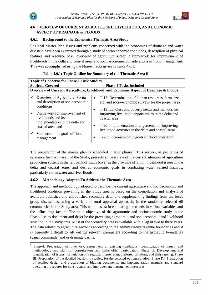
SINDH WATER SECTOR IMPROVEMENT PHASE-I PROJECT
Preparation of Regional Plan for the Left Bank of Indus, Delta and Coastal Zone
151
4.6 OVERVIEW OF CURRENT AGRICULTURE, LIVELIHOOD, AND ECONOMIC
ASPECT OF DRAINAGE & FLOODS
4.6.1 Background to the Economics Thematic Area Study
Regional Master Plan issues and problems concerned with the economics of drainage and water
disasters have been examined through a study of socioeconomic conditions, description of physical
features and resource base, overview of agriculture sector, a framework for improvement of
livelihoods in the delta and coastal area, and socio-economic considerations in flood management.
This was accomplished using the Phase-I tasks given in Table 4.6.1.
Table 4.6.1: Topic Outline for Summary of the Thematic Area 6
Topic of Concerns for Phase-I Task Studies
Subjects Covered Phase-I Tasks Included
Overview of Current Agriculture, Livelihood, and Economic Aspect of Drainage & Floods
Overview of Agriculture Sector
and description of socioeconomic
conditions
Framework for improvement of
livelihoods and its
implementation in the delta and
coastal area, and
Socioeconomic goals of flood
management
T-12: Determination of human resources, farm size,
etc. and socio-economic surveys for the project area
T-19: Landless and poverty nexus and methods for
improving livelihood opportunities in the delta and
coastal area
T-20: Implementation arrangements for improving
livelihood activities in the delta and coastal areas.
T-23: Socio-economic goals of flood protection
The preparation of the master plan is scheduled in four phases.7 This section, as per terms of
reference for the Phase I of the Study, presents an overview of the current situation of agriculture
production system in the left bank of Indus River in the province of Sindh, livelihood issues in the
delta and coastal zone, and desired economic goals in combating water related hazards,
particularly storm water and river floods.
4.6.2 Methodology Adopted To Address the Thematic Area
The approach and methodology adopted to describe the current agriculture and socioeconomic and
livelihood condition prevailing in the Study area is based on the compilation and analysis of
available published and unpublished secondary data; and supplementing findings from the focus
group discussions, using a variant of rural appraisal approach, in the randomly selected 60
communities in the Study area. This would assist in estimating the trends in various variables and
the influencing factors. The main objective of the agronomic and socioeconomic study in the
Phase-I, is to document and describe the prevailing agronomic and socioeconomic and livelihood
situation in the study area. Most of the secondary data is available with a lag of two to three years.
The data related to agriculture sector is according to the administrative/revenue boundaries and it
is generally difficult to sift out the relevant parameters according to the hydraulic boundaries
(canal commands) and or drainage basins.
7 Phase-I: Preparation of Inventory, assessment of existing conditions, identification of issues, and
methodology and plan for consultations and stakeholder participation. Phase II: Development and
identification of issues, formulation of a regional master plan, preferred solutions, and their ranking. Phase
III: Preparation of the detailed feasibility studies, for the selected options/solution. Phase IV: Preparation
of detailed design and preparation of bidding documents, and implementation manuals and standard
operating procedures for nonstructural and improvement management measures.

SINDH WATER SECTOR IMPROVEMENT PHASE-I PROJECT
Preparation of Regional Plan for the Left Bank of Indus, Delta and Coastal Zone
152
The left bank of Indus, for the purpose of this report is delineated into three subregions. These
include i) Guddu subregion in the north irrigated by Guddu barrage; ii) Sukkur subregion (middle)
mainly irrigated by Sukkur barrage, and iii) the Kotri subregion irrigated by Kotri barrage,
including delta and coastal areas, which is generally outside the canal command. The Ghotki
subregion includes districts of Ghotki and Sukkur. The Sukkur subregion include districts of
Khairpur, Naushero Feroze, Shaheed Benazirabad (formerly known as Nawabshah), Sanghar,
Matiari, Tando Allahyar, Hyderabad, Mirpurkhas, Umerkot, and parts of Tharparkar and Tando
Mohammed Khan districts. The Kotri subregion comprises parts of Tando Muhammad Khan and
Badin district, and eastern part of the Thatta district. The Delta and coastal subregion include
southern parts of the above two districts.
As most of the published data is based on revenue/administrative boundaries, to validate the
aggregate data and to observe the ground reality, group discussion were held in sixty villages,
spread over the left bank. Separate analysis is presented for areas where drainage projects are in
place, hereon referred as Zone A, and areas where the drainage projects are in the planning stage
or need to be considered, hereon referred as Zone B. (See Figure 1.1). The distribution of the
villages, by subregions and zones, where discussion groups were held is presented in Vol-II
Thematic Area 4.6 Table 4.6.1.
In Zone A, the average number of participants in the focus group is 18 persons, while in Zone B,
on an overall average about eleven people attended the discussion. In Zone A about 70 percent of
the participants are either land owners or sharecroppers, while in Zone B, they constituted 67
percent. The remaining represented private and public sector employees, self-employed and others.
Vol-II Thematic Area 4.6 Table 4.6.2 gives composition of the persons by vocation who attended
the discussion group.
Irrigation minors/canals were randomly selected in each of the sub regions. Three watercourses,
one each in the three reaches, head, middle, and tail were randomly selected In addition to this;
three villages were randomly selected in the delta/coastal zone. Out of the 60 selected villages, 36
are in Zone A, while 24 are in Zone B, including three villages in the coastal zone.
Following a rapid rural appraisal approach, village profiles were prepared for each of the selected
village settlement based on focus group discussion held at each village attended by beneficiaries in
the village served by drainage projects, and intended beneficiaries in the villages that are expected
to be served by planned projects. The discussion centered around a structured checklist, and some
open ended question to solicit their perceptions about the performance of the completed projects.
The findings are indicative and do not merit extrapolating at a higher order, nonetheless, are
adequate to describe the current prevailing situation, represent stakeholders perceptions for issues
and problems, and to compare and validate the available secondary data.
4.6.3 Key Findings of Thematic Issues
4.6.3.1 The setting and context
The Southern/lower part of the Indus Basin Irrigation System is the main source of water resources
for the Sindh province. In addition to this, underground fresh water, torrential flows, and water
bodies supplement water availability. The water resources support irrigated agriculture, livestock,
inland fisheries, forest plantation, municipal use, and industrial subsectors.
The Indus River in Sindh is managed with an elaborate system of irrigation, and drainage network
to dispose of off underground effluent, flood, and storm water. The irrigation system consists of
three barrages, Guddu, Sukkur, and Kotri, diverting water in to 14 main canal systems, of which
six are on the left bank and eight are on the right bank. The canal systems deliver water to

SINDH WATER SECTOR IMPROVEMENT PHASE-I PROJECT
Preparation of Regional Plan for the Left Bank of Indus, Delta and Coastal Zone
153
millions of farms through distributaries, minors, and watercourses. In addition to this, the system
provides drinking water supplies to the various urban settlements and industrial establishments.
The river supplies, downstream of Kotri, fall into the Arabian Sea, supporting riverine forests,
mangroves, and estuaries.
More than three fourth of Sindh is underlain with saline groundwater, and is generally not fit for
irrigation. The fresh groundwater, generally confined to the corridor along the Indus River, is of
better quality, and is suitable for irrigation and domestic use. To supplement the canal water
supplies, the private tubewells pump out the fresh groundwater. To combat the increasing water
table, causing water logging and salinity, declining farm productivity, and damage to physical
infrastructure, the deep turbines and tile drains/interceptors are employed to pump out and drain
out saline groundwater (the effluent). This effluent is disposed off into canals and or drainage
network. The same is transported to natural depressions in the delta and Arabian Sea. The drainage
network provides relief to the storm water. The floods in the Indus River is managed through a
string of flood embankments and spurs to contain the floodwaters within the river channel, and
from over-spilling and damaging the standing crops, livestock, physical infrastructure, and urban
settlements.
The irrigation, drainage, and flood subsector infrastructure is in disrepair due to deferred
maintenance, poor governance and operational management, and equity issues. The gap between
O&M expenditure and receipts (user charges – abiana and drainage cess) has been widening since
mid seventies. Despite occasional increase in the O&M yardstick and the user charge, the two does
not commensurate. In addition, the system needs investment to revamp and rehabilitate the
irrigation system and extension of the drainage system to other areas. Similarly, the flood
protection works also suffer from similar issues and need attention. Furthermore, investment is
needed to harvest and store storm and the floodwater surpluses, where feasible.
In the left bank, about one fifth of the canal command area suffers from water logging and salinity,
and hampered farm productivity. The system, therefore, needs to drain out the surplus saline water
effluent out of the basin. The Left Bank Outfall Drain (LBOD) collects drainage effluent from the
major part of left bank command areas of Sukkur, and Kotri barrages, and drains into the sea. The
tidal link and Cholri weir at the tail end of the LBOD botched due to various acts of nature and
technical reasons. The failure led to seawater intrusion and devastated the farmland, freshwater
bodies, inland fisheries in the delta, and mangroves in the coastal zone. This had an adverse impact
on the livelihood of people residing in the lower reaches of Kotri command, delta, and coastal
zones, compromising their food security in the deltaic region and coastal areas. This also severely
blighted the local ecology and environment. The communities in the affected area strongly feel
they were not consulted during the planning, designing, and implementation stages.
The situation requires preparation of a master plan to identify investments in improving the
existing drainage infrastructure and extending the same to the remaining areas of the canal
commands, and safe disposal of drainage effluent, flood and storm waters through the delta and
coastal zone into the sea, ensuring environmental sustainability. The planning process is to ensure
a participatory approach, involving consultation with the stakeholders.
The Government of Sindh (GoS), with the assistance from the World Bank, is implementing a
Water Sector Improvement Project, Phase I (WSIP-I)8. One of the subcomponents of the Project is
to support preparation, for the GoS, a regional master plan for addressing the flooding issues and
8 The WSIP-I approved in September 2007, and made effective in December 2007, terminates in April 2013.
The Project is being executed by the Planning and Development Department, GoS.
SINDH WATER SECTOR IMPROVEMENT PHASE-I PROJECT
Preparation of Regional Plan for the Left Bank of Indus, Delta and Coastal Zone
154
providing proper drainage to the area on the left bank of the Indus River through appropriate
structural and non-structural measures. This should include remedial measures for any outstanding
deficiencies in the LBOD, measures for retention and/or safe disposal of drainage, storm and
floodwater, improvement of wetlands in the delta area and in the coastal zone recognizing their
environmental importance and considerable economic potential for the local communities.
The preparation of the regional master plan was entrusted to Louis Berger Group (LBG). As per
terms of reference (TORs) and scope of work (SOW) of the study, the study area include areas
located in the left bank of Indus River, delta (and associated wetlands) and adjacent coastal zone.
The preparation of the study is to be conducted in consultation with the stakeholders at each stage
of the study, namely, identification of issues and solutions/options, and preparation of
prefeasibility and detailed feasibility, and ranking and sequencing of structural and nonstructural
interventions.
4.6.3.2 General description of the project area
Sindh is the southernmost province of Pakistan, bordering India towards eastern side, the Punjab
province in the north, Balochistan province in the west, and a coastline along the Arabian Sea in
the south. Sindh links to the rest of the country by a road and railroad network. Karachi city, the
provincial capital, serves as the main port city for the country, with two main seaports, Karachi
Port and Port Qasim. In addition to the international airport in Karachi, the province has eight
domestic airports located in various cities.9 The Study area is also linked to upcountry with inter
district and interprovincial road network, and a railroad.
The Indus River bisects the province into left and right bank. The right bank consists of irrigated
plain and dry land along the foothills of the Khirthar mountain of Sulaiman range. The left bank
consists of irrigated plains, and flanked in the eastern belt by arid Nara and Thar Desert, delta,
Halar range (Karonjhar), and the coastal zone.
4.6.3.3 Demography
According to the Population Census 1998,10
the population of the left bank of Indus in Sindh, in
the census year was 14.7 million, which is estimated as 20.4 million by the year 2010, and is
expected to reach 21 million by 2015. This accounts for about 48 percent of total population in
Sindh. Out of this population, about 76 percent population, directly or indirectly depend on
agriculture. About 72 percent of this population lives in the Sukkur barrage subregion, while 15
percent reside in the Kotri barrage subregion, followed by about 13 percent in the Guddu
subregion. Vol-II Thematic Area 4.6 Table 4.6.3 presents the past, current, and projected
population estimates in the three subregion of the Study area.
Based on the information provided in the discussion groups, the average number of HHs in the
selected villages in the study area is about 261. The average number of HHs in Zone A is 245, and
285 in Zone B. The total number of HHs in the selected villages are 15,670, of which 8,835 in
Zone A, and 6,835 in Zone B. Vol-II Thematic Area 4.6 Tables 4.6.4 presents distribution by
subregions in the two zones.
The average village population for the selected villages is estimated at 1,711 for Zone A, and 1686
in Zone B. The average family size of HHs in Zone A is 6.9, and 5.9 in Zone B. Vol-II Thematic
Area 4.6 Table 4.6.5 presents breakdown of average number of population of selected villages in
9 Hyderabad, Mirpurkhas, Dadu, Shaheed Benazirabad, Moenjodaro, Jacobabad, and Sukkur,
10 Development Statistics of Sindh. Bureau of Statistics. Planning and Development Department.
Government of Sindh

SINDH WATER SECTOR IMPROVEMENT PHASE-I PROJECT
Preparation of Regional Plan for the Left Bank of Indus, Delta and Coastal Zone
155
the three subregions in the two zones. The population data for females seem to be under reported,
and needs to be dealt with care, particularly, as the data indicates female population has been under
reported.
Access to education and health Services
The information on distances between village and the education and health related institutions
from the selected villages shows that the primary schools are generally within walking distance
from the villages, except in Ghotki primary school children have to walk about 2 Kms. While
middle and high schools are at distance of 4.7 km and 8.2 km. Similarly, college‟s students on an
average have to travel over 15 km. The Basic Health Units are generally with 7.5 km to and
hospitals are on an average at a distance of between 16 and 17 km. For accessing agricultural
extension and veterinary services, the farmers have to travel on an average 16 km. Vol-II Thematic
Area 4.6 Table 4.6.6 summarizes the information on accessibility of the abovementioned
institutions from the villages in the three subregions in the two zones.
Literacy
The literacy rate observed in the selected villages shows that in Zone A about 53% male
population above 15 years of age is literate, compared with 48% in Zone B. Vol-II Table 4.6.7
shows the present education level for different subregions in the two zones by gender. The table
shows that the literacy rate in women is abysmally low. In Zone-A it is estimated that only about
18% female are literate, while in Zone B the situation is relatively better 31% female population
has education. The data also shows that amongst the male adults, about 25% have continued their
education beyond primary schools, while in Zone B, about 21% got education beyond primary
school level.
Incidence of Diseases
The perception of the discussion group participants about prevalence of diseases and it intensity
suggests that Malaria is the main cause of illness in both the zones, followed by diarrhea. The
other causes of illness of low intensity include flue, typhoid, tuberculoses, and hepatitis. In women
prenatal is not considered a major issue. Vol-II Table 4.6.8 presents the incidence and intensity of
various diseases in different subregions of the two zones.
Access to utilities
The information from the discussion groups show that in Zone A about 85% of the
villages have power supply; while in B 100% of the households have power supply. The
situation regarding access to clean water is dismal. In Zone only about 52% have access to
clean water (hand pump, dugwells, tubewells, and piped water), while about 37% depend
on canal supplies, and about 11% get their water from ponds. In Zone B about 27% have
access to clean water, while about 43% draw their water from ponds, and 30% draw their
water from canals. In Zone A only 34% of the houses have latrines, and only about 14%
have access to sewerage facility. However, in Zone B relatively significant number of
houses (about 64%) have house latrine, and 12% houses are connected to sewerage
system. Vol-II Table 4.6.9 presents the extent of accessibility in the different
subregions/zones.
Employment and off farm Income
In Zone-A 4,669 persons reported income from sources other than crops and or livestock. In Zone
A about 71% of those employed earn their income from wage labor, while 6.5% are employed

SINDH WATER SECTOR IMPROVEMENT PHASE-I PROJECT
Preparation of Regional Plan for the Left Bank of Indus, Delta and Coastal Zone
156
within the area of residence, and 9.3% are employed in other towns and cities. Also about 5.8% are
self employed and others draw their income from pension, rent, and remittances, etc.
Similarly, in Zone B about 2,153 persons have off farm income. About 74% of those employed
earn their income from wage labor, while 8.9% are employed within the area of residence, and
6.9% are employed in other towns and cities. Also about 6.1% are self employed and the
remaining draw their income from pension, rent, and remittances, etc. Vol-II Table 4.6.10 presents
the average income by source of income and location.
Average monthly HH income and expenditure
The main source of income in the villages where discussion groups were held includes crop
income, income from sale of dairy products, and off farm income, etc. The latter two items were
recorded on a per month basis and monthly estimated crop income was computed by spreading this
for twelve months. In Zone A the estimated average total HH monthly estimated income is PKR
27,086, while for B, it is PKR 23,948, say PKR 24,000. In Zone A the share of crop income in
total HH income is about 60%, while in Zone B 66% income is sourced from crop income. Vol-II
Table 4.6.11 gives a breakdown of income for average HHs located in the three subregions of the
two Zones.
The information on average monthly HH expenditure presented in Vol-II Table 4.6.12 for the
three subregions in the two zones shows that in Zone A, the average monthly HH expenditure is
about PKR 31.5 thousands. Of this about 43% is spent on food, followed by 13% each on health
and transportation, while 10% is spent on education related costs, and surprisingly about 8% on
communication. The rest (13%) is spent on clothing, utilities, and social obligations. In Zone B,
the average monthly HH expenditure is about PKR 28.3 thousands. Out of this about 45% is spent
on food, followed by 14% and 11% on health and education respectively, while about 9% is spent
on communications, and about 8% on transportation. The rest (13%) is spent on clothing, utilities,
and social obligations. It may be cautioned here that the reported expenditure is higher than the
reported income. In such surveys it is a universal problem where respondents overstate the
expenditure and vice versa understate the income.
Perceived poverty profile
To assess the level of poverty in the selected villages, the focal group participants were asked to
classify the HHs in the village, as perceived by them, into four groups. The Zone A, they opined
that about 74% of the HHs are poor, while about 22% HHs are perceived as well off or rich. The
remaining about 4% HHs are considered as very poor and or destitute. In Zone B, the perceived
poverty is pervasive. The proportion of very poor and or destitute (6%) in Zone B is reported to be
higher than in Zone A. The HH considered poor are about 70%, while about 20% HHs are
considered well off and or rich. Figure 6.1 and Figure 6.2 and the associated tables depict the
distribution of the HHs, classified according the perceived poverty, in the three subregions in the
two zones.
Source of farm credit
Credit is considered as one of the binding factors in financing farm inputs and other farm related
investment. There are two main sources of rural finance: i) formal institutions, such as Commercial
banks, Zarai Tariqiati Bank Ltd (ZTBL) formerly known as Agricultural Development Bank of
Pakistan, Rural Support Programs, NGOs etc.; and ii) the informal sources include arhtis – the
commission agents (who combine the function of input suppliers, cash for consumption needs, and
sale of inputs and handle the farm produce in the market on behalf of their clients), moneylenders,

SINDH WATER SECTOR IMPROVEMENT PHASE-I PROJECT
Preparation of Regional Plan for the Left Bank of Indus, Delta and Coastal Zone
157
and friends and relatives, etc. The lending of the formal institutions is limited to seasonal, medium
term, and long term investment and do not cater for consumption needs. They also require
collateral and proper documentation and guarantees. The informal sources generally provide loans
for both inputs and consumption needs.
Various studies show that despite special allocation by the State Bank of Pakistan through
commercial banks, agriculture development bank, the preference is still the informal sector,
mainly, commission agents, money lenders, friends and relatives. It is estimated that despite the
informal sources charge exorbitant explicit and implicit interest rate/service charge, the informal
sources account for 70 to 80 percent of the credit market.
In Zone A, about 58% borrowers preferred informal sources for obtaining loans. Moneylenders
provided loans to about 37% of the borrowers, followed by arhtis and accounted for 14% of the
borrowers...Amongst the formal sources, ZTBL provided loans to about 28%, while 14%
borrowers accessed loan from commercial banks. The remaining borrowers about 7% borrowed
money from relatives and friends
Similarly, in Zone B about 54% borrowers accessed credit from informal sources. Mainly
moneylenders were the preferred source who provided loans to about 43% of the borrowers,
followed by 11% by arhtis. Amongst the formal sources, ZTBL provided loans to about 30%,
while only 6% borrowers accessed loan from commercial banks. The remaining borrowers about
9% borrowed money from relatives and friends. Vol-II Table 4.6.13 provides information about
sources of credit by type of agency in the different subregions and zones.
4.6.3.4 Description of physical features and resources base
Physiography
The left bank of Indus from North to South is about 550 km long, with varying breadth of between
50 km and 100 km (East to West). The topography is generally flat with deep alluvial and deltaic
deposits sloping towards Arabian Sea. Soils are mostly calcareous silt-loam. Soils in Badin and
Thatta districts are generally saline. Eastern part is predominantly desert; with inter dunal valleys
and alluvial flats. There are isolated limestone rock formations, found near Sukkur and Hyderabad.
In the southeastern corner, Karonjhar/Ravalli range is situated. Along the coast, rocks are oceanic
in nature. The coastal areas have about 17 major creeks/lagoons. Historically Indus delta region
has been continuously growing reclaiming lands during the historic times, but more recently
shrinking due to sea encroachment. The delta is spread over 41.4 thousand square kilometers and
consists of clayey and swampy terrain.
Climate
Sindh is part of the subtropical Asian region and is predominantly arid. The mean maximum
temperature in summers is around 45o Celsius. During April and August, the mercury touches as
high as 46oC to just above about 52°C. During December and January, the minimum average
temperature is about 8°C. In the winters, frost is common in the middle and upper Sindh. The
climate of lower Sindh (Lar) is milder and humid than middle Sindh (Wicholo), while the upper
Sindh (Siro), witnesses extremes.
The climate is arid, with an average annual precipitation is between 100 mm to 250 mm. Some
years are very wet, with up to 500 mm, while the province also experience prolonged drought. The
main rainy season is during the July and August, during which monsoon comes into from southeast
and deflects to the northwest. December and January receives occasional rains. The coastal belt

SINDH WATER SECTOR IMPROVEMENT PHASE-I PROJECT
Preparation of Regional Plan for the Left Bank of Indus, Delta and Coastal Zone
158
has mild climate and gets relatively severe towards the north.
Agroclimatic zones
The left bank can be delineated in to three agroclimatic areas. The wheat-cotton-sugarcane zone
encompasses Guddu and Sukkur barrage commands, and mainly grows dry crops, wheat, cotton,
sugarcane, oilseeds, millets, guar gum, etc.11
The main fruits grown in this zone include dates,
mangoes, banana, guava, etc. The Kotri barrage command, mostly with non-perennial canal
supplies, is marked out as wheat-paddy-sugarcane zone. This zone is best suited for sugarcane,
paddy, oilseeds, and pulses. As the canal supplies are not available during winter (Rabi), wheat is
grown with residual moisture. Banana is the main fruit grown in this zone. Towards the south,
vegetables, coconut, guava, and oil palms are grown. The third zone is the non barrage areas,
mainly Nara and Thar deserts. This area grows rain-fed crops such as millets, pulses, cluster been,
oilseeds, and some wheat.
Land resource base and utilization
The left bank accounts for about 73% of to the total reported area in Sindh. The total reported area
for the left bank is about 10.3 million hectares (ha), out of which, about 5.8 million ha is arable. Of
the available arable land, 4.3 million ha is under cultivation, while 0.6 million ha is under forest,
and the remaining 0.9 million ha is culturable waste. The remaining 4.5 million ha is not available
for cultivation, and mainly comprise of settlements, waterways, physical, social and productive
infrastructure, mountains and rock outcrops, lakes, desert, etc. The share of cultivated area in the
Sukkur subregion in the total cultivated area in the left bank is 72.3 percent, followed by 20
percent in Kotri subregion, and 7.7 percent in Guddu subregion. Similarly, the share of cropped
area in Sukkur subregion in total cropped area in the left bank is 68.4%, followed 18.5% in the
Kotri subregion, and 13.1% in the Guddu subregion. Out of 618 thousand ha forest cover, 58.3% is
in the Kotri Subregion, followed by 33% in the Sukkur subregion, and about 8.7% in the Guddu
subregion. The share of Sukkur subregion in total culturable wasteland in the left bank is 63.8%,
followed by 27.2% in Kotri subregion, and 9.0 percent in the Ghotki Subregion. The subregion
wise description of the land use is presented in Vol-II Table 4.6.14
The total arable area of the surveyed villages in Zone A is estimated as 11.7 thousand ha, of which
7.6 thousand ha (65.8%) is cultivated. The remaining area is either culturable waste (due to water
logging and salinity and water shortages) or under nonagricultural uses. In Zone B the area
available for cultivation is 5.2 thousand ha (72.2%) out of a total of 7.2 thousand ha. In Zone A the
average area per observed villages is 322.5 ha out of which about 218.3 ha is available for
cultivation, while in Zone B average area of the villages is 300.4 ha, and about 217.0 ha is
available for cultivation. The data presented in the abovementioned table shows that, in Zone A the
share of net area available for cultivation in the total arable area is higher in Ghotki and Sukkur
subregions (84.4% and 78.5% respectively) compared with Kotri subregion where only 29.9% is
cultivable; the rest being culturable waste. The percentage share of area available for cultivation
ranges between 74.8% and 74% in the three subregions in Zone B. Vol-II Table 4.6.15 presents
information on land base in the two Zones.
Farm structure and tenure
According to the last agricultural census of 200012
, the farm structure in the left bank, despite
dominance of small farms (in numbers), is in favor of large farms (in terms of total land area).
11
Paddy is also grown in parts of Tando Mohammed Khan area. 12
Agriculture Census 2000: Province of Sindh. Statistics Division, Government of Pakistan

SINDH WATER SECTOR IMPROVEMENT PHASE-I PROJECT
Preparation of Regional Plan for the Left Bank of Indus, Delta and Coastal Zone
159
Most farms are fragmented and are in joint ownership of extended family. This skewed structure is
a constraint to access and distribution of factors of production, particularly to smaller farms. This
also is a factor responsible for income disparity in the rural areas. Following is a description of
farm structure vis-à-vis farm ownership, and tenurial pattern.
Farm ownership pattern
There are about 600 thousand farm owners in the Study area, managing about 3.4 million ha. The
average farm size is about 5.7 ha. Three fourth of the total farm owners are subsistence farmers.
They own about one fourth of the total farm area. The number of farmer owners, in very small
farm size category13
, is about 21.4 percent (131 thousand), but they own only 2.4% of the farm
area, with an average farm size of 0.6 ha. Similarly, 52.1% (312 thousand) small farmers own
about 22.9% of the farm area, with an average farm size of 2.5 ha. The 77.4 thousand (12.9%)
owners are medium size farmers, owning about 15.9% of the farm, with an average farm size of
7.0 ha. This farm size is optimal farm size for sustenance of an average family. About 69.2
thousand farmers (11.5%) are in the large farm size category and they own about 34% of the farm
area, with an average farm size of 16.7 ha. The very large farmers are about 1.5% (9.1 thousand)
and they own one fourth of the farm area, with an average farm size of 92.8 ha. Vol-II Table
4.6.16 presents the farm ownership distribution for the three subregions and the districts in the
respective subregions.
Based on the past trends in the ownership pattern, as evident from previous census, the number of
farmers and the area owned in the higher farm size group is shrinking, consequently increasing
share of smaller farms over the years. The main reasons are: i) land mutation; ii) land transfers;
and iii) out migration by selling land and investment in urban areas.
Vol-II Table 4.6.17 presents the subregion wise information on number of farms in different farm
size categories, and the area owned by them in the two Zones. These estimates are relevant to the
selected villages and may not represent the overall picture of the area. This distribution pattern
should not be considered a substitute of the agriculture census type of survey, hence should be read
with care.
The pattern of farm size distribution, reported in the discussion groups, indicates a skewed
ownership pattern in the Study area. Large size farms dominate the area. In Zone A, the total
number of farms reported by the respondents in the surveyed villages is 1,898 farmers owning
about 11,809 ha. The very small farmers owning less than 2 ha account for 53.6% while they own
about 11.1% of the farm area. The small farmers (owning 2 to 5 ha) are about 24.2% and they own
about 13.9% of the farm area. Similarly 15.9% are medium size farmers (5 ha to 10 ha) and they
own 16.1% of the area, while large size (10 ha and above) farmers account for 6.4% and own
58.8% of the farm area.
Similarly in Zone B the total number of farms 892 farmers owning about 7,209 ha. The very small
farmers account for 39.2% while they own about 5.8% of the farm area. The small farmers are
about 27.6% and they own about 10.6% of the farm area. Similarly 21.6% are medium size
farmers and they own 18.1% of the area, while the large size farmers account for 11.5% and own
65.5% of the farm area.
The above mentioned table also shows that the overall average farm size in the Study area is about
6.1 ha, and 8.0 ha respectively for Zone A and Zone B. In Zone A, the average farm size of large
13
Very small farm size group = less than 1 ha; Small farm size =1ha to <5 ha; Medium size farm = 5 to 10
ha; Large size farm = 10 to 40 ha; and Very large size farm = above 40 ha.

SINDH WATER SECTOR IMPROVEMENT PHASE-I PROJECT
Preparation of Regional Plan for the Left Bank of Indus, Delta and Coastal Zone
160
farms is 56.5 ha, followed by 6.2 ha for medium size farms, 3.5 ha for small size farms and 1.3 ha
for very small farms. In Zone B, the average farm size of large farms is 45.8 ha, followed by 6.7 ha
for medium size farms, 3.1 ha for small size farms and 1.2 ha for very small farms.
Operational holdings and tenurial arrangement
Vol-II Table 4.6.18 shows that there are 727.5 thousand operational farms cultivating about 2.8
million ha. About 441.4 thousand farms (60.7%) are operated by owners farmers (self/direct
cultivation), managing 81.7% of the operated farm farms. The tenants or sharecroppers account for
35.2% and operate 21.2% of the area. The remaining farms are owner-cum-tenants14 accounting
for about 4.1% of the total operators, cultivating 9.2% of the area. The average farm area operated
is 3.9 ha. The average area operated by tenants is about 2.3 ha, while owner cultivators manage
about 5.2 ha, and the owner-cum-tenants operate on an average about 8.6 ha.
In Zone A the about 37% of the farms are cultivated by owner cultivators, 18% are cultivated by
owner-cum-tenants, while the remaining 45% farms are operated by tenants. In Zone B owner
cultivators are 17.5%, owner-cum-tenants are 10.4%, while 72.1% sharecroppers‟ farms is
cultivated by sharecroppers. Vol-II Table 4.6.19 details the subregion wise information on tenurial
pattern reported in the two Zones. There are about 976 and 387 landlords in Zone A and Zone B
respectively who engage sharecroppers.
4.6.3.5 Water resources and canal water availability
The irrigated agriculture is mainly concentrated in the alluvial plains along either side of the Indus;
while the rain fed cultivation is in the Thar and Nara desert, along the eastern provincial boundary,
and arid Khirthar range along the western boundary. The main source of irrigation is the Indus
River, diverted into irrigated areas through a network of three barrages, namely, Guddu, Sukkur,
and Kotri. The irrigation supplies to the left bank of Indus is through eight main canals. Between
62% and 65% of the total water diverted by the three barrages feed the command area of the left
bank. In the total cropped area, the share of irrigated area is over 90 percent, and within irrigated
areas canal irrigated area is about 95 percent, while about 5 percent is irrigated from shallow wells,
tubewells, lift irrigation, ponds, etc.
The Guddu subregion gets in canal supplies from Ghotki Feeder off taking from Guddu Barrage.
The main canals in the Sukkur subregion include Khairpur Feeder East, Khairpur Feeder West,
Nara, and Rohri canals, off taking from the Sukkur Barrage. The Kotri subregion include three
canals: Akram Wah (Lined Channel), Fuleli canal (New Fuleli), and Pinyari Feeder (Old Fuleli),
off taking from Kotri Barrage.
Surface water
Vol-II Table 4.6.20 presents Gross Command Area (GCA), Culturable Command Area (CCA),
and the canal withdrawals during 2004/05 to 2009/10. The Ghotki canal off takes from the Guddu
barrage and serves parts of Ghotki and Sukkur districts. The GCA of this canal is 411.7 thousand
ha, while the CCA is 347 thousand ha. During 2009/10 about 2.11 bum was diverted to the
commanded area.
The four canals that off take from Sukkur barrage includes: Khairpur Feeder (West), Khairpur
Feeder (East), Nara canal, and Rohri canal. They provide irrigation supplies to parts of Khairpur,
Naushero Feroze, Shaheed Benazirabad, Hyderabad, Matiari, Tando Allahyar, Tando Mohammed
14
Owner-cum-tenant includes those owner cultivators who self cultivate their own land and acquire land
from others as cash tenants or as share croppers.

SINDH WATER SECTOR IMPROVEMENT PHASE-I PROJECT
Preparation of Regional Plan for the Left Bank of Indus, Delta and Coastal Zone
161
Khan, Sanghar, Mirpurkhas, and Umerkot, districts. The GCA and CCA of the abovementioned
four canals is 2.49 million ha and 2,292 thousand ha, and about 12.9 bcm was diverted in to the
canal systems in 2009/10.
The three canals in the Kotri subregion are Lined Channel/Akram Wah, Fuleli canal, and Pinyari
canal irrigate Badin and eastern parts of Thatta districts. The GCA and CCA of these canals
together are 942.1 thousand ha and 888 thousand ha respectively, and about 5.14 bcm was diverted
to the canals.
A review of past canal diversions suggests that the water availability at canal heads declined over
time. This is largely due to shortfall in the river flows. It also reflects per CCA acre availability. As
the cropped area has not declined commensurate with water availability, it suggests under-
watering of crops, relative to the previous years.
Groundwater
Generally, the left bank is underlain with saline groundwater unsuitable for agriculture and
domestic and potable use. The fresh groundwater is mostly restricted to the narrow corridor along
the Indus river, and occasional lenses and perched water. In the freshwater zone, freshwater is
mostly pumped by the private tubwells to supplement the canal supplies. In the saline groundwater
zones the public sector tubewells drain out groundwater to dispose that into canals or in to the
drainage network.
As shown in Vol-II Table 4.6.21, in the three year period (2004/05 through 2006/07), 13,2
thousand tubewells were installed in the left bank of Indus. Out of these, 12.9 thousand tubewells
(98%) are fresh groundwater tubewells, while the balance 382 were installed by the public sector
in the saline groundwater zone. The table also shows that during the three-year period most of the
fresh groundwater tubewells (12.4 thousand) were in the Sukkur subregion, followed by 392
tubewells in the Kotri subregion. The balance 99 tubewells were installed in Guddu subregion. The
saline tubewells were installed in Tharparkar and Mirpurkhas districts.
The sudden surge in the increase in private sector tubewells may be explained as a coping strategy
to supplement shortages in the river/canal flows. In the absence of data on quality of underground
water and pumpage, it is difficult to predict the soil fertility and overall environmental
consequences. As most of these tubewells are shallow wells tapping perched water, they would
soon be run out, unless canal supplies are back to earlier flows, or recharged with heavy rains and
or canal seepage.
In the left bank, the total area sown in 2006/07 was 2.15 million ha. Out of this 0.36 million ha
(16.9%) was un-irrigated, while 1.48 million ha (68.5%) were canal irrigated, and balance 0.32
million ha was well/tubewell irrigated. Similarly out of total irrigated area the canal irrigated
shared 82.4% and 17.6% is well/tubewell irrigated. Vol-II Table 4.6.22 presents the area sown by
type of irrigation in the three subregions and respective districts. Table also shows that in Ghotki
and Matiari districts, well/tubewell is the predominant source of irrigation. In the two districts, the
share of well/tubewell irrigated area is 90 percent and 77 percent respectively, followed by
Tharparkar (38%), Tando Allahyar (32%), Sukkur (20%), and Khairpur (12%). In the remaining
districts, the share of well/tubewell irrigated area is less than 10 percent.
In Zone A, out of 36 villages where focus group discussion were held, sixteen villages have
SCARP tubewells, while equal number of villages supplement irrigation supplies from private
tubewells. Similarly, 22 villages reported access to drainage network. In Zone B, out of 24
villages, only seven villages reported location of private tubewells. Vol-II Table 4.6.23 gives the

SINDH WATER SECTOR IMPROVEMENT PHASE-I PROJECT
Preparation of Regional Plan for the Left Bank of Indus, Delta and Coastal Zone
162
subregion wise access to these facilities.
Lakes (Dhunds) and wetlands
Chotiari lake/reservoir is an off-stream reservoir on the Nara Canal Systems. Originally it was a
natural depression lake later upgraded to a reservoir with 55 km long earth embankment, with a
maximum height of 30 feet, and with a storage capacity of 0.6 bcm. The main source is its
watershed and floodwater from the Indus River, downstream of Sukkur barrage. It was upgraded in
to a reservoir to supply irrigation water to the hinterland and to supplement Nara canal system. It
was funded under LBOD Stage I Project investment.
The other freshwater lakes include Soonharo and Khipro lakes in Sanghar. Mahboob Lake in
Sujawal, Hadeiro15
and Jafri lakes in Thatta district. Lakes in Badin district include Tando Bago,
Khango (Khowaj), Phoosna Bakar, Mehro, Pateji, Sanhro, Cholri, and part of the Shakoor lake. A
detailed inventory and description of wetlands and lakes is given in the relevant chapter of the
report.
These lakes, fed from harvested storm water and flood supplies, were traditionally used for inland
fishing. The lakes, in the southern subregion, are generally been rendered saline due to sea
encroachment and failure of the LBOD to effectively transport the drainage effluent. Moreover,
the industries, particularly sugar mills, are disposing hazardous effluent into theses lakes.
4.6.3.6 Brief overview of agriculture sector in the study area
Agriculture sector is an important engine of growth in the study area. It directly and indirectly
provides livelihood to about three fourth of the Sindh population residing in the left bank. The left
bank receives almost 60% to 65% of the canal withdrawals, while its share in the total cropped
area is about three fourth. Apart from wheat, the main staple, most of the main cash crops and high
value crops, such as cotton, sugarcane, vegetables, condiments, and fruits (mango and banana) are
grown.
Cropping pattern
Sindh has two main cropping seasons, namely kharif – summer season (mid-April through mid-
October), and Rabi – winter season (mid-October through mid-April). The main Rabi crops are
wheat, rape and mustard, vegetables, and fodder. The main crops grown in kharif are cotton,
sugarcane, paddy,16
millets, and cluster-bean, kharif vegetables, pulses, nontraditional oilseeds,17
etc. In addition to this, the left bank produces different fruits such as mango, banana, dates,
papaya, guava, etc. The data on area under various crops for the last three years, shown in Vol-II
Table 4.6.24 through Vol-II Table 4.6.26 show that the total cropped area under crops decreased
from about 3 million ha in 2007/08 to about 2.8 million ha in 2009/10. This decline is attributed to
decline in the canal water availability. This has also changed the share of individual crops in the
total area.
The abovementioned tables show discernable increase in wheat area and its share in the cropped
area. The area under wheat reported as 764 thousand ha in 2007/08, accounting for 26% in the
cropped area, has increased to about 821 thousand ha in 2009/10, sharing about 30% in the
cropped area. It appears that wheat has replaced Rabi oilseeds whose area has reduced drastically.
Similarly, area under cotton has increased from about 579 thousand ha in 2007/08 to about 600
15
Hudero Lake is located 85 km from Karachi in the Thatta district Sindh Pakistan. It is a marshy area of salt
water where various types of water birds seek refuge. 16
Mostly in non-perennial areas of Guddu and Kotri barrages 17
Mainly sunflower and safflower,

SINDH WATER SECTOR IMPROVEMENT PHASE-I PROJECT
Preparation of Regional Plan for the Left Bank of Indus, Delta and Coastal Zone
163
thousand ha in 2009/10 accounting for about one fifth of the cropped area. The area under paddy
has also increased from about 181 thousand ha in 2007/08 to about 261 thousand ha in 2008/09,
and declined to about 238 thousand ha in 2009/10. The share of paddy in total cropped area
oscillated between 6% and about 9% in the same period. The share of Sugarcane area in the total
cropped area has declined from about 10.4% to 8.3% in the reported years. The area under
sugarcane declined from about 304 thousand ha in 2007/08 to about 230 thousand ha in 2009/10.
The area under fruit increased from about 142 thousand ha to about 145.5 thousand ha in the same
period, while area under vegetables has also increased from 54.6 thousand ha to about 64.7
thousand ha in the same period indicating a shift to high value crops. The details of area under
each crop and respective shares by subregion and by respective districts are given in the
abovementioned tables for the period 2007/08 to 2009/10.
The existing cropping pattern and intensities of canal commands in the left bank was also
estimated from the records of Sindh Irrigation Department, Sindh Irrigation Development
Authority (SIDA), and Agricultural Department and published data by the Bureau of Statistics of
Sindh and Pakistan. Where the availability of water is limited, the farmer prefers mixed cropping
pattern with low delta crops such as pulses, oil seeds, orchard and fodder. In the upper reaches of
the canal commands, the annual cropping intensity is higher than the lower reaches of the canal,
because availability of water at tail ends is low. In Sukkur Barrage and Kotri Barrages, the upper
reaches have higher cropping intensities compared to lower reaches.
The above cropping pattern is for the overall left bank and includes cropped area in the nonbarrage
areas. In the following section cropping pattern and cropping intensities has been revisited using
the command wise information on cropped area under various crops.
The cropping pattern and intensities has been estimated for the cropping year 2009/10 for all the
eight commands of the left bank, and are presented in Vol-II Table 4.6.27 through Table 4.6.34.
Data presented in the tables shows that In Kharif season, rice, cotton and sugarcane are dominant
crops on command of left bank canals of Indus. However, in perennial canals commands cotton
has edge over rice. In Rabi season wheat is the dominant crop, followed by fodder and Rabi
oilseeds.
Based on information gathered from the discussion groups, in Zone A the share of wheat is about
37.1% in the total cropped area, followed by cotton (21.2%), paddy (14.2%), sugarcane 11.3%,
Fruits 4.9%, and Rabi oilseeds 4.6%. Similarly in Zone B, the share of wheat is about 43.6% in the
total cropped area, followed by cotton (30.3%), paddy (14.2%), sugarcane 10.2%, and Rabi
oilseeds 5.1%. In both the zones vegetables, which is a high value crop share about 1.8% and 1.2%
in Zone A and Zone B respectively. Share of fruits in Zone B (1.6%) is relatively lower compared
with 4.9% in Zone A. The subregion wise crop shares in the two zones is presented in Vol-II Table
4.6.35.
Various reports18
indicate that about 32 thousand ha in Badin district and about 460 thousands in
Thatta district was lost to sea intrusion. Analysis of cropped area trends in the Thatta and Badin
area based on crop acreage data for 1991/92 through 2009/10 for all the crops, save sunflower,
shows that the total cropped area declined after the cyclone and sea intrusion. Nonetheless, the
cropped area in two districts has increased significantly in the post cyclone period, if the area
under sunflower is also taken into account in the total cropped area. As the two districts are served
18
Socioeconomic Study and Proposal for Livelihood Improvements: Badin and Thatta Districts, Sindh,
Pakistan. Agriculture and Rural Development Sector Unit. South Asia Region. The World Bank. April
25th
, 2005

SINDH WATER SECTOR IMPROVEMENT PHASE-I PROJECT
Preparation of Regional Plan for the Left Bank of Indus, Delta and Coastal Zone
164
by the eastern drain system i.e. LBOD and the western drain system for the Kotri barrage
command area, it is difficult to sift out or isolate the positive or negative impact of LBOD per se.
For further analysis would require disaggregated data at the taluka level. Unfortunately, despite
concerted efforts this data could not be obtained from the Agriculture Extension Department or the
Sindh Bureau of Statistics.
In Badin district the total cropped area (excluding sunflower) in 1991/92 was reported as about
230 thousands ha which declined to about 199 thousand ha by the year 1997/98, during which the
LBOD was being constructed. After the collapse of the tidal link and associated structures, the
cropped area continued to decline till 2004/05 (about 49 thousand ha), but increased thereafter to
about 207 thousand ha, which is about 10% lower than the base year. Similarly in Thatta district,
the total cropped area (excluding sunflower) in 1991/92 was reported as about 101 thousands ha
which increased to about 120 thousand ha by the year 1997/98. After the collapse of the tidal link
and associated structures, the cropped area initially declined, but recovered and has increased to
about 145 thousand ha by the year 2009/10; an increase of 43% over the base year. For details,
please see Vol-II Table 4.6.36 and 4.6.37. The trend in acreage changes is also depicted in Vol-II
Figures 4.6.3 and 4.6.4.
The abovementioned tables also show that with the acreage under sunflower included, the total
cropped area has increased significantly over the last 19 years. In the Badin district the area
registered an increase of more than 40% over the base year, while in the Thatta district the area has
almost doubled in the same period. It may be mentioned here that the decline in the cropped area
in the two districts may have been offset by the western drainage system.
The data on crop shares (excluding sunflower) shows that in Badin district, the share of Cotton
area has increased from 2% in 1991/92 to 9% by the year 2009/10. In the Thatta district the share
of paddy has declined from 58% to 50%, while wheat has increased from 6% to 11% in the same
period. With the area under sunflower included, the share of sunflower has increased from 1%, in
both the districts, to about 37% and 27% in Badin and Thatta districts. The year wise detail is
presented in Vol-II Table 4.6.38. The phenomenal increase in area under sunflower is that the
recently introduced hybrid varieties have lower delta and two crops can be grown in the Rabi
season.
Cropping intensity
Based on computations from the land utilization data,19
the overall cropping intensity in the Study
area is estimated as 65%. It is highest in the Guddu subregion (110%), followed by Kotri
subregion (63%), and 60% in the Sukkur region. One reason that explains high farming intensity in
Guddu subregion is rapid growth in private tubewells. Moreover, major portion of the culturable
waste and area uncommandable lies in the Sukkur subregion.
The cropping intensity mentioned above should not be seen same as command area specific
cropping intensities. The estimated cropping intensity reflects cropping intensity of the Study area
as a whole, which include barrage and non-barrage areas.
Based on further analysis of data20
mentioned earlier, in 2009/10, the annual cropping intensity of
Ghotki Feeder of Guddu sub-region is 35%. The annual cropping intensities of Khairpur West
Canal, Khairpur East Canal Nara Canal, and Rohri Canal falling in the Sukkur subregion is in the
order of 89.7%, 82.7%, 40.4% and 63.7% respectively. Likewise annual cropping intensity of
19
Volume-II Table 4.6.14 20
Volume-II Table 4.6.27 through 4.6.34
SINDH WATER SECTOR IMPROVEMENT PHASE-I PROJECT
Preparation of Regional Plan for the Left Bank of Indus, Delta and Coastal Zone
165
Akram Wah in Kotri subregion is 30.1%, while cropping intensities of only Kharif season for
Pinyari Canal and Fuleli Canal, both no perennial canals, is in the order of 19.3%, and 18.5%
respectively. It is evident from the figure of cropping intensities that in Nara Canal command the
annual cropping is very low which is the clear indicator that there is either acute shortage of water
or the available water potential is not used intelligently. Similarly, there are alarming figures of
cropping intensities in the command of canals falling in Kotri subregion, which explicitly
manifests that there is a huge shortage of water in this sub-region. This whole scenario needs a
special attention to address the problem in a productive manner in order the alleviate the poverty
prevailing in problematic sub-regions.
A recent survey conducted by WAPDA in 2006/07 shows that the cropping intensities has
decreased from 127.7% in 1982/83 to 114.9% in 2006/07 in the LBOD system.21
The results are
encouraging about increase in cropped area, reduction in current fallow, and production.
The zone wise analysis of cropping intensity for the surveyed villages, as reported by participants
in the focal discussion groups22
is 93.6% in Zone A, compared with 108.3% in Zone B. In Zone A
the cropping intensity ranges between 48.8% in Ghotki subregion to 97.8% in the Sukkur
subregion, and 105.8% in the Kotri subregion, while in Zone B it ranges from 64.4% in Ghotki
subregion to 107.9% in Kotri subregion, to 115.2% in the Sukkur subregion.
Production
In the left bank of Indus the production of wheat during 2007/08 through 2009/10 oscilated around
three million mt. The Sukkur subregion accounts for about two thirds of the total production,
followed by about 20 % produced in Guddu subregion, while Kotri subregion contributes 6% to
the total left bank production.
The total production of cotton (seed cotton) in the left bank during the same period was about 2.5
million mt in the first two years, which increased to about 4 mt in 2009/10. This phenomenal
increase is due to wide adoption of Bt varieties. About two third of the cotton is produced in
Sukkur subregion, followed by Guddu subregion which contributes about one fifth in total cotton
production, while about 5% is produced in the Kotri subregion. Recently it has been reported that
the performance of Bt cotton in Kotri subregion has demonstrated exceptionally high yields and
cotton may be an important crop in the coming years.
In the left bank paddy is also an important crop, and its production increased from half a million
mt in 2007/08 to about 700 thousand mt, of which about 70% to 80% is produced in the Kotri
subregion, while the balance is produced in the Guddu subregion and Sukkur subregions.
The total production of sugarcane in the three subregions was about 18.5 million mt, in 2007/08,
which significantly declined to about 13 mt in the last two years. The total production of
vegetables, a high value enterprise, in the left bank was 686 thousand mt in 2007/08, which
increased to about 800 thousand mt in 2008/09, while it shows a drastic decline in 2009/10
reducing to about 200 thousand mt. The Sukkur subregion which contributed about two third of the
total vegetable production in 2007/08, its share declined to about 45% by 2009/10. The share of
Kotri subregion in total vegetable production in 2007/08 was about 15%, which has increased to
about 50% by the year 2009/10. Sukkur subregion produces about 85% of the fruits, followed by
about 10% in the Kotri subregion. For details on production of main crops by subregion and
21
Final progress Report: Continuation of Monitoring of LBOD System. August 2006 to July 2008. SCARP
Monitoring Organization (SMO) WAPDA, Hyderabad. June 2009 22
Vol-II Table 4.6.35

SINDH WATER SECTOR IMPROVEMENT PHASE-I PROJECT
Preparation of Regional Plan for the Left Bank of Indus, Delta and Coastal Zone
166
districts, please refer to Vol-II Table 4.6.39 to 4.6.41.
Crop yields
The average yield of wheat during the last three years i.e. 2007/08 through 2009/10 is stagnant at
about 3.6 mt/ha, which is higher than the wheat average for Sindh, and higher than national
average. The yield of seed cotton has shown significant increase in the last three years. The yield
of cotton in 2007/08 was 4.2 mt/ha, which increased to 4.6 mt/ha in 2008/09, and in 2009/10 it
recorded a phenomenal increase of 6.8 mt/ha. The yield of sugarcane has been erratic. In 2007/08
the estimated average yield was observed as 61 mt/ha, which declined to about 50.5 mt/ha in
2008/09, and increased to about 58 mt/ha in 2009/10. For region wise details for the last three
years per ha yield of various crops in the three subregions/districts is presented in Vol-II Table
4.6.42 through 4.6.44.
As reported by farmers in the discussion group, in Zone A, the average yield of wheat is 3.1 mt/ha
compared with 3.5 mt/ha in Zone B. The reported yield of cotton is 2.2 mt/ha and 2.7 mt/ha in
Zone and Zone B respectively. Amongst the subregion the yield of cotton is between 3.2 mt/ha and
3.4 mt/ha and is discernibly higher than other subregions in both the zones where the maximum
reported yield is 2.5 mt/ha. This is due to recent proliferation of Bt cotton varieties in the Kotri
subregion. Similarly, the sugarcane yield in Zone A is about 80 mt/ha compared with 82.5 mt/ha
in Zone B. The sugarcane yields‟ in the Kotri subregion is relatively higher when compared with
other subregions. In the case of paddy, the average yield is about 4.3 mt/ha in Zone A, while it is
about 3.0 mt/ha in the Zone B. Similar to sugarcane, the yields of paddy in the Kotri subregion in
Zone A is significantly higher (5.4 mt/ha) than other subregions in the two zones. Like other crops
the yield of vegetables is also significantly higher in Zone A (20.9 mt/ha) compared with about 10
mt/ha in Zone B. The maximum yield reported is for Kotri subregion of Zone A. This is because of
relatively milder in the subregion which favors production of seasonal and offseason vegetables.
Vol-II Table 4.6.45 presents the subregion wise yield of the main crops in the two zones.
Farm inputs
There are six major inputs required for better production of crops i.e. water, seed, fertilizer, plant
protection materials, farm machinery and farm labor. Most farmers generally retain seed from the
previous crops. Nonetheless, with the introduction of private seed companies in Sindh, there is a
shift in replacing the traditional seed with higher quality seed. The Sindh Seed Corporation is
producing and marketing certified seed of wheat, paddy, and cotton on limited scale which does
not fulfill the total seed requirement of the area. Private sector is also producing and marketing
seeds. It is a matter of concern that seed from India is smuggled and used without screening for
seed borne diseases and viruses.
During the year 2007/08 the fertilizer off take in the left bank was recorded as 607 thousand mt.
Vol-II Table 4.6.46 presents off take by type of fertilizer in the districts of located in the left bank.
The table also shows that per ha use of fertilizer (N+P+K) in the Sukkur Subregion is about 233 kg
per ha, compared to 180 kg/ha in the Guddu subregion, and 124 kg/ha in the Kotri subregion. The
per ha use and NPK ratio is discernibly lower than the recommended levels. Particularly use of
potash fertilizers is abysmally low.
The sale of agrochemicals, insecticides, pesticides, weedicides, etc. is in private sector. These are
sold generally through fertilizer dealers, commission agents, and authorized dealers of the
pesticide companies. Sale of fake, adulterated, and out dated agrochemicals is a major issue and is
being addressed by the Agriculture Department. The farmers‟ complaint against the high prices of
insecticides and adulteration.

SINDH WATER SECTOR IMPROVEMENT PHASE-I PROJECT
Preparation of Regional Plan for the Left Bank of Indus, Delta and Coastal Zone
167
Farmers depend on both family and hired labor, which is an important input used at all stages of
crop production from preparatory tillage to harvesting. The hired labor is of two types, permanent
and causal. The permanent labor is hired on monthly or annual basis, whereas causal labor is hired
for short duration during the peak demand periods of planting and harvesting.
Crop enterprise budgets
Gross Margins or enterprise budgets expressed as difference between gross costs and cash costs,
reported in the discussion groups has been estimated for various crops grown in the Study area.
Vol-II Table 4.6.47 displays the summary of gross margins for different crops in the two zones.
In Zone A, vegetables realized a net income of about PKR 274 thousand per ha, followed by
sugarcane which earned about PKR 261 thousand per ha. The next most remunerative crop is
cotton (PKR 124 thousand) followed by wheat which fetched PKR 38 thousands per ha. The
returns from rapeseed and mustard seem to be reasonable which is valued at PKR 28 thousand per
hay.
In Zone B, sugarcane realized a net income of about PKR 291.3 thousands per ha, followed by
vegetables which earned about PKR 233 thousands per ha. The next most remunerative crop is
cotton (PKR 138 thousand) followed by paddy, about 48 thousands, and wheat fetches PKR 47
thousands on per ha basis. The gross margins for rapeseed and mustard crop seem to be reasonable
which is valued at PKR 42 thousand per ha.
The above estimates are based on the estimated gross margins for individual crops detailed in Vol-
II Table 4.6.48 through Vol-II Table 4.6.53. These tables give the estimated average gross
production costs, gross value of production, gross margins, and yields for abovementioned crops.
Volume –II Thematic Area 4.6 gives the summary of prices used in computations of crop
enterprise budgets.
The SMO, WAPDA monitoring report23
, mentioned above, estimates per ha gross value of
production, gross costs, and net income of various crops. Using 2006/07 prices it reports that the
per ha net income from sugarcane surpasses all crops. It is reported as PKR 145.8 thousand,
followed by PKR 53.2 thousand, and PKR 31.7 thousand from Rabi and Kharif vegetables
respectively, PKR 48.4 thousand from cotton, and PKR 24.9 thousand from wheat.
4.6.3.7 Brief overview of livestock subsector in the left bank
Nationally, it is estimated that the livestock sector accounts for about 50% in the total agriculture
Gross Domestic Product (GDP)24
. As the demand for the dairy products is significantly higher in
the province of Sindh, it is estimated that the share of livestock in total provincial GDP is higher
than national estimate. In the left bank there are about 8.5 million large ruminants, followed by
11.5 million small ruminants. Amongst the 936 thousand pack animals in the left bank, 73% are
horses, mules, and assess. Camel population is about 218 thousand, and is concentrated in the
Tharparkar district of the Sukkur subregion. Vol-II Table 4.6.54 presents the distribution of
livestock in the different districts in the study area.
The average population of animals per HH in Zone A is about 2.5, out of which 1.3 are large
ruminants/milch animals (buffalo and cow), followed by 0.62 goats. In Zone B, the average
number of animals per HH is 4.13, mainly about 1.3 milch animals, and 2.1 goats. Amongst the
three subregions, per HH animal population is relatively higher than other subregion Vol-II Table
23
ibid 24
Economic Survey of Pakistan 2009/10, Economic Advisers Wing, Ministry of Finance, Government of
Pakistan

SINDH WATER SECTOR IMPROVEMENT PHASE-I PROJECT
Preparation of Regional Plan for the Left Bank of Indus, Delta and Coastal Zone
168
4.6.55 illustrates the per HH average number of different types of animals in the three subregions
of the two Zones.
In the study area the milch animals are reared for home consumption and the surplus is sold as
milk or after processing into ghee (butter oil), etc. This supplements the household income of farm
and nonfarm HHs both. This income estimated here is limited to value of milk and dairy products,
and does not include value of milk consumed by the HHs, and hence should not be taken as cost of
production of milk which is conventionally estimated for a liter. In both the zones, the average
monthly net income from one buffalo, after adjusting for the cost of purchased feed, maintenance,
and medicines is a little over PKR 3,200. Similarly, the average monthly income from one cow is a
little over PKR 1,000 per HH in Zone A, while it is about PKR 2,760 in Zone B. Vol-II Table
4.6.56 and 4.6.57 presents the monthly expenditure, value of milk sold, of one buffalo and one cow
for different subregions and zones.
4.6.3.8 Brief overview of fisheries subsector in the left bank
During the past years the fish catch increased from 57 thousand mt in 2003/04 to 62.8 thousand mt
and declined to 60.3 thousand mt in the year 2006/07. Vol-II Table 4.6.58 shows that the during
the past few years the share of fish catch in Kotri subregion declined from 62.4 percent to 55
percent, while the share of the Sukkur subregion increased from 12.7 percent to 24.4 percent in the
same period. Similarly the catch increased from 29.7 percent to 31.5 percent in the Sukkur
subregion, while in the Ghotki subregion it increased from about 13 to 24 percent. This is mainly
due to the salinization of freshwater bodies in the Kotri subregion, particularly in the delta and
coastal zone.
In the Study area, the fisheries subsector provides livelihoods to about 32,000 household. Vol-II
Table 4.6.59 presents fisher folk population distribution in the Study area. It is reported that in
2006/07, the there were 23 thousand full time fisher folks, while there were about 8.8 thousand
part time fisher folks. The table also shows that there are 3,560 boats, out of which 1,810 are
sailboats and 1,750 are rowboats.
4.6.3.9 Agriculture support services
Both public and private sectors support agriculture, livestock, and fisheries subsectors through a
network of research, extension, and teaching institutions. The research institutes provide improved
production packages and improved seeds for dissemination through extension service. Private
sector companies that market agricultural inputs also provide extension services through their
dealers and some print media. Research being a public good, and have long gestation period,
private sector is still shy to invest in the research endeavors.
The agricultural research is the main source of basic and foundation seed. They provide these to
Sindh Seed Corporation, a public sector institution, and private seed companies for multiplication
and its provision to farmers.
Agricultural Engineering Department is responsible to provide services to farmers for improving
watercourses, land leveling, both heavy and precision land leveling, and development of tubewells.
The agriculture markets is reasonably liberalized, save for wheat, paddy, and sugarcane. These are
partially liberalized, as the federal government continues to announces the reference price to set
the prices. Farmers are free to sell their produce to any of the preferred buyer. In case of wheat, the
provincial food department procures wheat to meet their targets. To meet the procurement target,
the food department uses administrative leverage to claim the first charge. Once the target is
achieved met the farmers are free to sell their produce to any buyer. Farmers sell their rice and
SINDH WATER SECTOR IMPROVEMENT PHASE-I PROJECT
Preparation of Regional Plan for the Left Bank of Indus, Delta and Coastal Zone
169
sugarcane to buyer of their choice and at a negotiated price.
The provincial agriculture department, however, regulates the markets through quality control and
ensuring fair deal to the growers. The public sector grain, vegetable, and fruit markets are managed
by the Market Committees elected by the commission agents, representatives of the growers and
ex-officio officers from the department of agriculture. In the later report a description of marketing
channels will be detailed for each crop.
4.6.4 Issues and Problems
4.6.4.1 General observations of participants of discussion groups
At the end of the discussion group sessions, farmers were requested to give their awareness and
performance of the institutions dealing with the farmer managed irrigation system and drainage.
Following represent their opinions.
In Zone A, about 67% of farmers in the Guddu subregion acknowledged that the drainage projects
have improved water availability, while about 46% farmers in Sukkur subregion recognized water
availability. In Kotri subregion farmers opined that there was no increase in water availability.
About two third farmers in Ghotki and Sukkur regions expressed that the increase in water
availability increased their cropped area. Similarly, one third farmers in Ghotki subregion and two
thirds farmers in Sukkur region informed that this also increased the crop productivity. Only 11%
farmers in Kotri subregion conceded increase in yield.
Regarding satisfaction with the overall performance of the drainage project staff, only about two
third of the farmers reported their satisfaction, while all the farmers in the Sukkur and Kotri
subregions expressed their dissatisfaction. During the discussions they mentioned that most of the
tubewells are nonoperational due to vandalizing of the machinery, electrical panels, pole mounted
transformers, and hook up connections and high tension lines. The tubewells that survived theft
suffer from negligence and poor upkeep. Similarly, the farmers felt that most of the main and sub
drains are clogged with weeds and poor maintenance of embankments and rain cuts. Regarding
consultation with farmers by WAPDA/IPD at the design and implementation stage, one third of
the respondents in Ghotki acknowledged consultation, while farmers located in Sukkur and Kotri
subregions informed that they were not consulted.
Most respondents, are not aware of the Sindh Irrigation and Drainage Authority (SIDA), however
most of them are generally aware of the Area Water Boards (AWB) and its role and
responsibilities. Despite their concerns about O&M and physical condition of the system,
particularly minor canals and distributaries, they acknowledged that the distribution system has
improved relative to what it was when managed by the IPD. They also felt that there has been
some improvement in equitable distribution of irrigation supplies, still the tail enders are not
getting their due share.
Similarly, almost all farmers are aware of the Farmer Organization (FO), but only few are aware
of their mandate, responsibilities, and functions. However, they acknowledged that as the
chairperson of the FO is amongst the tail end farmers, there is a slight improvement in distribution
of irrigation water. They also informed that they are generally unaware of the rotation schedule
and that should be communicated to them at appropriate time in a transparent manner..
Regarding performance the SCARP tubewells, farmers complained that most of them are stolen
and vandalized. They also felt that those still in place are functioning less than their capacity. They
also desired that those still managed by WAPDA should be transferred to IPD/SIDA for repair and
rehabilitation. They felt that more tubewells should be installed to control the water logging

SINDH WATER SECTOR IMPROVEMENT PHASE-I PROJECT
Preparation of Regional Plan for the Left Bank of Indus, Delta and Coastal Zone
170
menace.
Farmers also expressed their dissatisfaction about the physical condition of the drains. Most of
them are damaged and need proper maintenance. They further informed that the tertiary drains
need particular attention, as most of them have been dismantled by farmers through whose land
they are passing. The farmers generally emphasized that a well maintained drainage system would
increase their farm productivity.
Farmers also felt that the improvement in irrigation management and drainage system alone is not
enough for improving productivity. They felt that timely availability of good quality inputs such
as, certified seed, fertilizers, pesticides, weedicides, need to be ensured. Similarly, getting fair
prices of output is an issue and marketing system need improvement, as arhtis are not fair in their
dealings.
4.6.4.2 Drainage related socioeconomic issues
During the Phase I of the Study frequent stakeholder consultations were held at a wider scale in
many rural communities. As identified by the communities, following are the main issues related
to socioeconomic wellbeing and livelihoods vis-à-vis impact of drainage network, its operation
and maintenance, its disposal, stunted growth/denudation of mangroves, seawater encroachment,
etc. The key issues and problems identified from the studies performed to assess the economics of
drainage and water disasters were grouped into thematic areas as presented below, while a later
section on Key Issues and Problems deals theses issues in detail.
4.6.4.3 Issues and problems - social and livelihood
Breeding ground for diseases: In the delta and coastal area due to the swampy conditions and low
quality of life, lack of social infrastructure, and health and hygiene related awareness the incidence
of various water borne and contagious diseases is quite high. The major illness in the area are
malaria, tuberculosis, diarrhea, cholera, anemia, etc.
Shortage of pastures for livestock and camels: The encroachment of seawater in to the grazing
lands in the delta and coastal areas has reduced the carrying capacity of such areas. The situation
has further worsened by indiscriminate grazing the limited availability. This has also significantly
reduced the income of household who depended solely on livestock income. The IPOE study
recommends that sequentially some area should be designated where camel grazing is managed
through controlled grazing and rotation.
Loss of fish potential of freshwater bodies: Due to collapse of tidal link, the freshwater bodies in
the delta and coastal areas have turned saline. This has destroyed the livelihood of the fisher folks
and they have lost their livelihood. Similarly, the once productive farmland has gone out of
production due to high salinity caused by sea encroachment, and overtopping of tidal link. Many
stakeholders suggested that the natural water bodies, depressions, and natural drains should only
be used or disposing off storm and flood water as a way to harvest surplus water and replenish the
freshwater bodies.
Lack of alternate livelihood opportunities: The affected areas has been back quarters and lagged
behind in livelihood opportunities. The main economic activity was fishing and limited agriculture.
The skill level is low and need skill development programs to enable them to earn livelihoods,
rather than working as low wage unskilled labor.
Stakeholders have suggested introduce and support community based ecological tourism in the
delta areas around fresh water bodies, with an integrated value chain approach connecting various

SINDH WATER SECTOR IMPROVEMENT PHASE-I PROJECT
Preparation of Regional Plan for the Left Bank of Indus, Delta and Coastal Zone
171
communities.
4.6.4.4 Issues and problems - farm productivity
Introduction of bio-saline agriculture: The main constraint in realizing better yields in the past
project area is poor disposal of drainage effluent causing land degradation. In the planned project
areas, the farmers reported marginal yields and low crop intensities. In areas that were devastated
by failure of LBOD and tidal link are the worst affected. The communities expressed the desire to
introduce and promote salt tolerant alternate crops. As the best productive land is allocated to cash
crops, marginal land is allocated to fodder; hence the availability of fodder and feed for livestock
is limited. There is a need to introduce salt tolerant fodder crops to sustain the animal population.
4.6.4.5 Issues and problems - operation and maintenance (O&M)
Lack of O&M of the tertiary and secondary drains: The drainage network, particularly main and
secondary drains are in dilapidated condition and clogged with silt and weeds. This restricts free
flow of the drainage effluent and its occasional breaching.
Abandoned onfarm drains: Farmers have, at most places dismantled the tertiary drains fearing the
drains will bring salinity to their land. The right of way of these tertiary drains is not well defined
and at most places the farmers complained that they did not receive the cost of land acquired for
the purpose.
Theft of SCARP Tubewell Accessories: A significant proportion of drainage wells are not
functioning due to all or some of the material is missing and not replaced. It was observed during
the field visits that most of the tubewells have been vandalized. It was reported that organized
gangs are involved in stealing high tension wires, hook up connections, motors and pumps,
electrical fittings, and in some places even the doors. Where these tubewell are functioning, they
are source of power theft for nonagricultural uses. As these are not functional, farmers have
abandoned the connecting farm ditches. This has reduced the effectiveness of the SCARP
tubewells, and reduction of water table is constrained.
4.6.4.5 Issues and problems - environment
Impact of constrained flows d/s of Kotri Barrage The constrained river flows downstream of Kotri
has lead to adverse impact on the quality of water, marine life, and river morphology. The
discharge of untreated industrial effluent in the river and LBOD system has further accentuated the
situation. The report by International panel of Experts Report25
(IPOE) indicates that the water
quality of surface water is generally of high standard; nonetheless, the biological and
bacteriological contamination is of wide spread. The report further observes that in the delta area
the salinity and bacterial contamination of the groundwater is increasing. The affected people felt
that there is an urgent need for wastewater treatment before it is disposed off in to the river/sea.
Denuding of mangroves for fuel wood: The reduction in the mangroves has seriously impaired the
aquatic life and inland fishing. This has significantly reduced the household incomes. This also
reduced their fuel wood supplies from the mangroves. As a coping strategy the inhabitants started
denuding the mangroves not only to meet their fuel wood requirement, but also to fetch money.
IPOE study recommends that the mangrove area need to be replanted to provide sustenance to the
local population, amongst other benefits. The affected communities desired that mangrove
cultivation should be introduced on the lines of social forestry programs to regulate excessive
25
Final Report of the Inspection Panel on Escapage (IPOE) below Kotri Barrage. Federal Flood
Commission (FFC), GoP. Islamabad. 20th of November, 2005

SINDH WATER SECTOR IMPROVEMENT PHASE-I PROJECT
Preparation of Regional Plan for the Left Bank of Indus, Delta and Coastal Zone
172
harvesting.
Continued sea encroachment: The communities in the Badin and Thatta districts, particularly in the
lower reaches of the barrage command area, delta, and coastal area are wary of the seawater
intrusion through the remains of tidal link. They apprehend that the sea intrusion will not only
engulf the fertile lands at the fringes, but will also render them permanently saline.
4.6.5 Livelihood Development Framework
4.6.5.1 Livelihood context
In line with the stated objectives of the WSIP and the poverty reduction strategy of Sindh, the
overall objective of the development is to reduce poverty in the left bank, particularly deltaic and
coastal zone, with focus on landless and vulnerable population. This could be achieved by
increased access to factors of production, especially land, improving access to social, economic,
and financial services, and supporting and creating enabling environment for income generating
and improving opportunities for livelihood activities. This require protecting those who are
vulnerable and marginalized by maximizing their growth and competitiveness and minimizing as
far as possible the negative effects that would occur on material, environmental and socio-
economic assets as a result of natural phenomenon and anthropogenic activities. This necessitates
policy support from the government to strengthen the capacity of the community to enhance
productivity of the resource base, engage in income generating activities, increase employment
opportunities, and peoples‟ income. Thus the purpose of this study is to assess and review the
poverty and livelihood opportunities in an environment that constraints the realization of
livelihood potential, due to landlessness, and poor access to social services.
The lesson learnt from the previous irrigation and drainage projects suggests that inclusion of
livelihood development activities should be an integral part of any investment plan/projects. The
purpose is to ward off any likely negative impact and externalities on the quality of life and
livelihood of any community or localities within the planned investment areas, particularly in the
delta and coastal zone areas.
In the left bank of Indus River, there is a strong correlation between prevailing poverty and
livelihood opportunities. The factors that influence livelihood opportunities are multidimensional
and interlinked. The main reasons include lack of access to factors of production, including
landlessness, access to social services and service institutions, particularly financial, poor
infrastructure, and poor knowledge base and skills. Although the livelihood opportunities are
relatively limited, as elsewhere in the country or province, the situation in delta and coastal area is
precarious. Providing livelihood development support to the entire Study area would need colossal
investment and thinly spread, and beyond the context of the drainage related investment.
Nonetheless, parts of Badin and Thatta districts, including delta and coastal zones, have been
historically back quarters harboring relatively higher poverty incidence need special attention and
focus. Particularly, these areas serve as disposal route for drainage effluent, storm water and flood
water, and are prone to cyclones and seawater intrusion, are highly vulnerable to occasional
threats. Moreover, due to general perception that in addition to the natural water related disasters,
the disposal of drainage system interspersed these areas, and collapse of the tidal link had
detrimental effect on the limited livelihood opportunities, the communities felt need for support for
sustained livelihood.
Prior to the natural and manmade havoc, the main source of livelihoods, were farming, fisheries,
livestock husbandry, and trading activities. Despite skewed land ownership, crop agriculture was
the main stay of economy. After the loss of fertile land and the grazing lands, and diminished
SINDH WATER SECTOR IMPROVEMENT PHASE-I PROJECT
Preparation of Regional Plan for the Left Bank of Indus, Delta and Coastal Zone
173
productivity of the crop and livestock sub-sectors, there was a shift to fisheries as a coping
strategy. Nonetheless, due to salinization of the freshwater bodies and stress on the marine fishery
potential, the dependence on this activity was also strained. Concurrently the damage and poor
allocation to social services reduced the quality of life, particularly access to education, health, and
drinking water and sanitation. This all retarded the economic growth and the livelihood activities.
The deterioration of the physical infrastructure further accentuated the quality of life in the area,
and population increasingly became food insecure.
This subsection analyses various factors that influence livelihood opportunities and recommends a
framework of interventions to alleviate pervasive poverty through improving access to existing
services, and improving livelihood opportunities.
The basic analytical frame of the assessment study included development of problem tree, as
perceived by communities, based on: focus group discussions, multidisciplinary in-house
consultation, and employing a Problem Tree. These assessments were made during the field visits
conducted by Consultants in the eight districts of the left bank. During the field studies separate
group discussion were held for male and female participants in the target rural communities.
Attempt was made to solicit their perceptions regarding the abovementioned issues and identified
needs. Based on findings from the field and observations made, problem tree was constructed by
the Consultant with a multidisciplinary approach involving all the relevant specialists. Based on
problem tree analysis, the main factors that have limited the livelihood opportunities and the
consequent poverty are described as follows.
Skewed land ownership
One of the main constraints in the delta and coastal areas is the highly skewed land ownership
pattern. Agricultural land is concentrated into hands of few, most of whom are absentee farmers.
The large landowners also have better access to factors of production such as agricultural inputs,
particularly irrigation supplies, and output markets. Most of the people in the rural areas do not
own land. They either work as tenants and or as casual labor on others land, or earn daily wages
from nonfarm activities. Most of the participants in the discussion stated that with the increasing
mechanization on large farms is leading also to displacement of sharecroppers creating
landlessness.
Landlessness
Notwithstanding the efforts by the past and present governments to mitigate the situation through
land reforms and distribution of government land to landless still the grave situation persists. The
situation continues because of the growing population and worsening land man ratio. Most of
landless are in poverty trap due to limited access to land and elk a living by either working as
sharecroppers or as wage labor in farm and nonfarm activities. In the absence of effective tenancy
Act, these landless people are insecure and under constant threat of ejection. Also with increasing
population, per person allocation of land to tenants is also shrinking. Landlessness, for housing,
also discourages them from improving the living conditions. Those living on landlords land and or
unauthorized settlements are under constant threat of ejection, hence are shy of engaging into an
income generating activities.
Inheritance traditions, decreasing land entitlements
The area owned by farmers, particularly small farmers is continuously getting smaller due to
inheritance and mutation. Because of the outmoded land record system, and petty tyranny of the
revenue staff, particularly tapedar (revenue clerk/accountant) at village level, the land stays in

SINDH WATER SECTOR IMPROVEMENT PHASE-I PROJECT
Preparation of Regional Plan for the Left Bank of Indus, Delta and Coastal Zone
174
joint ownership in revenue records. Even if a shareholder wants to dispose off the land, it is
difficult to do so under social pressure. As the land parcels become smaller and not enough to
sustain a family, the individual shareholders have to access land in the neighborhood on
sharecropping basis, or work as wage labor. This phenomenon is increasing the number of defacto
landlessness.
Ineffective land reforms and insecure land entitlements
The past land reforms were partially effective. Most of the people complain that land reforms were
ineffective in terms of implementation. The land was generally transferred to family members,
living or yet to born, and in fictitious names, and the land effectively remained in most cases in
fewer hands. The resumed land and other state land was also controlled and occupied by influential
landlords. Many attempts to distribute land to the landless have been thwarted by fictitious
allotments. As the land records system is still hand written and changes are not transparent, the
true ownership is clouded in mystery. They proved ineffective in ensuring the security of tenure
for the tenants.
The Tenancy Act requires that tapedar should enter the name of tenant in the land records when he
enters such arrangement. The law also provides that if a tenant has been cultivated a piece of land
for a period of three years he cannot be ejected and acquires permanent tenancy rights. As the
entitlements are not secure, the landlord can eject the tenant at any time. Despite there is a
Tenancy Act, the rights of the tenants are not protected due to its enforcement and compliance.
Shortage of irrigation supplies
In the lower parts of the Study area, the shortages in irrigation supplies have also reduced cropped
area significantly in the lower reaches. This has at places forced the small cultivators to abandon
their lands to either work as landless labor or migrate.
Seawater intrusion
In the southern districts, collapse of tidal link and consequent seawater intrusion has further
decreased availability of productive cultivable land. The decreasing cultivation and farm intensities
has further reducing the available land for cultivation and depressed productivity, even as tenants.
The direct and indirect causes of land degradation coupled with increasing population, has
increased the landlessness.
According to a report prepared by the World Bank (World Bank, 2005), the coastal villages used
to rely on multiple sources of income based on their domestic resources. While fishing formed a
large part of their livelihood agricultural and livestock activities were an important component as
every family had access to some areas on a subsistence basis. The decline of the fresh water flows
in the Indus Delta compelled the villagers to reduce their agriculture and livestock activities and
concentrate in the fisheries sector as the main means of subsistence.
Cutting wood enabled families to meet their needs of fuel, as well as to supplement the income of
the poorest households. The diminished availability of water accessibility combined with the
salinization of the fields substantially reduced the sources of income the villagers had. Fishing
became the most important source of income for many families, but it is unreliable as the number
of fish species, which were in abundance in the past, has now declined and with much lower
returns that it was possible for a decade or so ago. Having only one source of income made the
villagers highly vulnerable, as they rely in the diversification of income sources. As a result
migration took place. The World Bank indicates that the principal reason for out-migration is lack
of drinking water and health facilities.

SINDH WATER SECTOR IMPROVEMENT PHASE-I PROJECT
Preparation of Regional Plan for the Left Bank of Indus, Delta and Coastal Zone
175
Poor access to social services
The access to education institutions, health facilities, and drinking water facilities are thinly
spread. There is a need to increase their number which is in reasonable travel distance is required.
The existing institutions also need upgradation.
Poor physical infrastructure
Lack of farm-to-market roads, adequate transportation facilities is one of the main constraints. The
situation is further accentuated during floods. Animal carts, tractors and local transport are the only
means of transport to get into markets. It was reported that the farmers have to incur high cartage
charges to procure inputs and dispose of their produce in the local markets due to unavailability of
transport. The expansion in farm to market roads would also encourage shift to higher value crops,
particularly vegetables.
Absence of rural financial markets
The majority of farmers depend on informal sources for production loans. The development of
nonfarm enterprises is constrained due to access to or absence of financial markets.
Low level of skills
It was also observed that most of the farmers are illiterate and uneducated. They generally lack
skills for gainful employment within or outside the villages. Due to absence of skills, most of the
landless work as unskilled labor, which is low paid and frequency of engagement is low. With
acquiring of skills would enable the unemployed gainful employment and higher wages.
4.6.5.2 Impact on livelihood opportunities
The current economic situation of households is appalling and upsetting due to rising food
insecurity. Poor families and vulnerable households face high commodity prices, food prices,
health treatment prices and market prices. There is no proper functioning market system at grass
roots to cash agricultural output. This also has effects on low utilization of agriculture inputs.
Poverty is directly related to non-employment opportunities. There are few livelihood
opportunities. Farming and livestock income is the main income generating sources. The
uncontrolled market prices have created dreadful effects on daily household consumption.
Lack of economic growth coupled with the population growth, have raised the poverty level
among poor masses. It was found that tenants under sharecropping arrangements had fewer
incentives for investment in the protection of soil quality. A greater incidence of poverty was
found in the tenant categories. In the light of findings, it was suggested to direct greater efforts
towards the conservation of natural resources such as diversified crop rotations and incorporation
of legumes in the cropping pattern. Mainly, it is necessary to overcome water shortage by which
production can be raised. Due to water shortage, thousand acres of land is uncultivable and
cultivators unable to cultivate cash crops. This issue has resulted in landlessness and insufficient
livelihood opportunities. Basically, the highest number of rural and urban poor earns livelihoods
from small-scale agriculture income and different modes of informal income generating activities
based on short term and seasonal cycles. This has resulted in severe food insecurity and even
raised the levels of malnutrition among both, adults and children.
The main effects on the community and households of the abovementioned factors include: low
quality of life, food insecurity, poor health and malnutrition, work and school absenteeism,
involuntary migration, broken families and related social problems including increasing
lawlessness and crime rate, weakening of social protection system. Based on the data analysis, the

SINDH WATER SECTOR IMPROVEMENT PHASE-I PROJECT
Preparation of Regional Plan for the Left Bank of Indus, Delta and Coastal Zone
176
following recommendations given by communities need to be considered to prevent an increase in
poverty in an environment of landlessness, to decrease land entitlements, improve access to
existing services, and improve livelihood opportunities:
Delivery of essential services and basic necessities of life should be delivered in order to
reduce the burden of poverty in rural areas of lower Sindh.
There is a need to improve health and nutrition, preventive hygiene and provision of safe
drinking water especially in rural areas of lower Sindh.
Efforts should be taken to improve the water supply scheme for drinking and irrigation
water up to grass root level.
Provide food security for poor families facing drought situation at the time of food
insecurity due to less livelihood opportunities.
Strong social protection measures should be taken with strong coordination system from
District, taluka, union council and up to the Deh level.
Ensure social protection for the indigenous population and particularly for those who are
at extreme poverty in terms of basic needs of life, stability of jobs and food insecurity.
School feeding programs should be implemented due to extreme food insecurity among
poor families, so that children would at least have one nutritious meal. This will reduce
malnutrition ratio and increase school attendance.
The available state land should be distributed amongst landless, both for cultivation and
for housing.
Ensure rights of landless through effective implementation of Tenancy Act.
As the Study area mainly depends on agriculture, the development of the agriculture sector
should be at top priority. In response to this, sincere steps to improve the agriculture
production could have immediate and direct impact on poverty reduction in rural area.
Local markets should be empowered and well functioning in order to generate growth and
expand opportunities of livelihood for poor people.
Expand government job opportunities not only for skilled labour but also for non skilled.
Effective policies should be developed to encourage labour market engagement in terms of
fair prices, work opportunities, easy transport availability and investment from union
council to District level.
In order to ensure that the majority of the population do not fall into poverty, ensure the
minimum social guarantees and minimum wages for the rural community.
Establish the system of unemployment benefits at least for those, who are educated but
unemployed, up to the minimum subsistence level.
Provide professional trainings to the non-skilled labour force.
Indigenous resources should be exploited to raise the income generating livelihood
opportunities for the poor.
Interest free rural financing schemes should be introduced by providing huge loans to
reduce the poverty.

SINDH WATER SECTOR IMPROVEMENT PHASE-I PROJECT
Preparation of Regional Plan for the Left Bank of Indus, Delta and Coastal Zone
177
In order to expand the livelihood opportunities, factories and mills should be established
where local people could have opportunity to earn.
Markets should be linked with villages through roads and transportation facility, so that
people could have easy access to the markets.
Expand and improve physical infrastructure.
It should be ensured that farmers receive fair price for their farm production.
It was recommended by the respondents that Government should start implementing
effective poverty alleviation programs by involving local participation.
There is a need to encourage and facilitate rural women for generating home based income
activities.
Handicrafts training centers should be established especially for women in order to create
livelihood opportunities at Deh or at least at Union Council level.
Empower local communities in order to increase their control over indigenous resource
allocation process and accountability
Indigenous participation should be ensured in the planning and decision making phase for
the development programs that are supposed to be implemented at grass roots.
Ensure a fair distribution of benefits, public funds and indigenous resources at grass roots
level.
Implement transparent with effective monitoring mechanisms with the establishment of
real prices for food, medication, health and utility services.
Oil and Gas Resources in Sindh and Local employment
The natural resources production and exploration is administered by multinational companies with
agreement of the Federal Government. Majority of the oil and gas fields are situated in arid regions
of Sindh. These companies work on long term basis (25 to 30 years agreements), along with legal
and other compliances. They have corporate social responsibilities known as social license to
operate. Under this clause, companies are liable to employ 50% local inhabitants at all level as per
their job requirement through company policy procedures and execute community development
programs on sustainable basis in the communities where operated. Companies have to invest 2%
pre-tax budget in the operated area. The local government representatives and DCO‟s are
authorized to use that amount in local development at their discretion of the area.
A number of companies reflect a readiness to actively contribute towards the welfare of poor
communities around them by providing education, health services, and technology access.
However, it has been mentioned during consultations, that these efforts do not reflect the
communities‟ needs. The potential for leveraging the enormous potential of corporate sector to
alleviate poverty appears to be an area for government policy directions.
4.6.5.3 Ongoing livelihood development investments in the delta and coastal area
The socioeconomic study and proposals for livelihood improvement: Badin and Thatta Districts,
Sindh, Pakistan (World Bank, 2005), undertaken following continued disasters such as cyclone of
1999, drought in 2000, earthquake in 2001, drought and floods 2003. The main havoc, inter-alia,
was due to failure of the LBOD related drainage infrastructure, resulting backflow of drainage
effluents in the main drains, salinity of the productive farm land, salinization of the freshwater

SINDH WATER SECTOR IMPROVEMENT PHASE-I PROJECT
Preparation of Regional Plan for the Left Bank of Indus, Delta and Coastal Zone
178
bodies, and sea encroachment, destruction of physical infrastructure, etc. The report concludes that
more than 85 percent of the population perceives themselves as poor. The report proposed
following initiatives: i) better access to basic services and facilitating infrastructure; ii) higher
income generation through improved production and marketing of saline agriculture crops,
fisheries, and livestock; iii) secure access to, and better management of the coastal area natural
resources; iv) viable community organizations that can operate in partnership with the public and
private sector and NGOs; and v) improved access to high quality education, information, training
and netter nutrition and health.
The report recommended two components, i) community investment fund (CIF) to be
implemented through rural support programs and other partner NGOs; and ii) mangrove
rehabilitation and ecosystem management to be implemented through IUCN, WWF, provincial
forest department and other related agencies. The subcomponents proposed under the CIF
component to include: a) mobilization of Community Organizations (COs) where such
organizations do not exist and, strengthen existing ones in order to promote demand-based
development initiative and for getting active community participation and ownership; training and
orientation of the key office bearers and members of COs; b) advisory services in saline
agriculture, i.e., dissemination of plant and crop varieties that Pakistani researchers and researchers
from other countries have identified as suitable for saline water agriculture; c) social services:
construction of primary and secondary schools with adequate equipment and furniture, books and
teaching materials, etc., rural health centers and mobile clinics, reconstruction of residential houses
that were destroyed by flood and cyclone; d) water supply and sanitation: functioning water supply
schemes and promotion of hygiene and sanitation; e) community based fishery management:
includes assistance in training, management of fishing facilities, introduction of concept of
community-based coastal resources management, preparation and implementation of fishery
management plan, development of local fishing regulations and licensing and enforcement
mechanism; f) support for coastal aquaculture: assist the COs involved in fishery to explore the
potential for high value marine products such as shrimp, mussels, etc.; g) construction of
wharfs/jetties, provision of fishing boat and improvements in landing fish: rehabilitate and
construct wharfs and small jetties, on selected landing centers; provide essential infrastructure such
as water supply, offices and small storage facilities; to improve fish landing, each landing centre
equipped with a chilled store; ice maker with store and fish store; h) support for improvements in
marketing and processing: streamlining the marketing chain to create value for COs involved in
fish production and marketing; provision of marketing facilities; assist in establishing fish
processing plants or facilities; and i) rural road and rural electrification: upgrade existing road
networks and construct new roads; increase access to electricity to improve living conditions,
improve the delivery of basic social services such as health, education and water supply and, spur
economic development in the area.
The Sindh Coastal Areas Development (SCAD) Program was initiated by Pakistan Poverty
Alleviation Fund (PPAF) in 2006 with financial support of the World Bank as a vehicle to improve
livelihoods of coastal communities of Sindh in general and the communities affected by the Left
Bank Outfall Drainage (LBOD) in particular. Although an independent PPAF initiative, SCAD is
regarded as a targeted and urgent response to the Inspection Panel‟s investigation report which
strongly emphasized the need to address multifarious environment and water management
problems in the Sindh coastal areas, in particular, the LBOD Backwash Region (LBR) in the
districts of Badin and Thatta.

SINDH WATER SECTOR IMPROVEMENT PHASE-I PROJECT
Preparation of Regional Plan for the Left Bank of Indus, Delta and Coastal Zone
179
The SCAD program area encompasses 52 union councils and 12 sub-districts (tehsils) of four
coastal districts (Karachi, Badin, Thatta and Tharparker) of Sindh, covering approximately 3,350
settlements and a population of over 1.12 million. The aim of the program is to:
improve access to basic services
increase incomes through improved crop, fisheries, and livestock production
secure access to, and better management of natural resources of coastal area
form viable, inclusive and well governed community organizations
integrate coastal areas of Sindh with the national economy
promote technological innovations
reduce physical vulnerability
PPAF has a long term commitment under the SCAD program and plans to invest more than US$
35 million by year 2014, under its different phases. Currently (March 2011) the program is in its
3rd
phase and over USD 23 million have so far been invested under the various components of this
program. The program is mainly funded by the World Bank. However, the Program received
some bridge financing from other funding agencies including the United States Department of
Agriculture (USDA) and International Fund for Agriculture Development (IFAD) during a short
term gap between the two consecutive phases of the World Bank. The program continues to
prioritize the LBOD Backwash Region with allocation of over 65% of its total financial resources.
SCAD Program comprises of the following components:
a. Social Mobilization and Institutional Development; covering the formation of
community/village/ union council level organizations, and capacity building of the community
as well as the implementing partner organizations
b. Infrastructure Development; includes developing rural growth centers, constructing protective
infrastructure, constructing productive infrastructure, developing transport and mobility,
promoting technological innovations, and integrating workfare concepts in infrastructure
projects
c. Health and Education; involves adopting, upgrading and operating government facilities, and
developing new community managed facilities
d. Workfare; includes labour intensive nature of infrastructure, lower than normal community
contribution, and first right of refusal to participating community
e. Social Safety Nets: Targeting the Ultra Poor (TUP); covers selection and training of ultra poor
household, asset transfer, subsistence allowance, and special health care allowance to the
selected ultra poor household.
PPAF is implementing this program through matured Partner Organizations (POs). Linkages are
established with other projects in the area including Sindh Water Sector Improvement Project
(WSIP) and Sindh Coastal Community Development Project (SCCDP) as well as institutional
linkages with the Sindh Irrigation and Drainage Authority (SIDA) and the Sindh Coastal
Development Authority (SCDA).
The Sindh Coastal Areas Network (SCAN) was established in coordination with PPAF. SCAN is
working as a participatory platform for SCAD participating POs, as its regular members, to
promote exchange of views, experiences and building synergies to better implement the SCAD
Program. For close institutional linkages and coordination, SIDA and the World Wide Fund for
Nature in Pakistan (WWF-Pakistan) are also co-opted as its associate members.
In 2008, the Sindh Coastal Development Authority launched a $40 million Sindh Coastal
Community Development Project. The project duration is six years. The main objectives include:
i) to diversify household income generation options and access to service in ways sustainable to
the fragile ecosystem; ii) to improve coastal zone management by stabilizing environmental
degradation, protecting coastal areas from accelerated coastal erosion; and iii) to strengthen

SINDH WATER SECTOR IMPROVEMENT PHASE-I PROJECT
Preparation of Regional Plan for the Left Bank of Indus, Delta and Coastal Zone
180
institutional capabilities for coastal zone planning and development and management of fisheries
resource. The main components include: i) improve coastal area management including mangrove
planting, fish and raft pond development, and hatchery rehabilitation; ii) community development
including: community organization, demand-driven small-scale community-managed initiatives,
and demand-driven local government-managed medium scale initiatives; iii) institutional
strengthening, including survey of fisheries fresh/brackish water and water quality survey, capacity
building support for CDA management and district governments, developing geographic
information system (GIS), preparation of coastal development plan, and monitoring arrangements;
and iv) establishment of PMU and field offices. The small scale community managed initiatives is
being implemented through a contract to National Rural Support Program, while demand-driven
local government-managed medium scale initiatives is being implemented by the Badin and Thatta
district governments.
4.6.5.4 Indicative structure/design frame of the livelihood development support
The TORs for this Study require the Consultants to “develop implementation arrangements; give
structure for developing livelihood activities, to ensure the social aspects of the project are
adequately addressed during the assignment the Consultant will also develop detailed
implementation arrangements such as monitoring indicators, targets, baseline data collection and
analysis, and give the structure for developing an implementation manual for livelihood activities
in the coastal and delta areas.”
This has been accomplished by constructing an indicative design frame for the purpose. This is
based on a review of various documents and Consultant‟s findings from studies undertaken and
observations made in the field, and comments and suggestions gathered from the stakeholder
consultative workshop. The table below summarizes the likely design frame for the initiative. This
will be further developed in consultation with stakeholders, particularly CDA.
Table 4.6.2: The Indicative Design Frame
Design Summary Performance
Targets/Indicators
Data
Sources/Reporting
Mechanism
Assumption and Risks
Impact
Lives of the delta and
coastal communities
improved and vulnerable
protected from food
security risk
The targets will be
ascertained based
on consultation
with Sindh Coastal
Community
Development
Project, and after
ascertaining the
remaining gap and
additional
resources required
Periodic
performance and
impact assessment
surveys
Assumption: Adequate
funding support is made
timely available from
the GoSindh and
development partners
Drainage infrastructure
is in place
Risk
D/S water discharges
are not adequate and
mangroves area is may
not be rehabilitated
Outcome
Increased Household
Income;
Improvement in social
indicators
Increase in
household income;
Improvement in
social indicators
Assumption
Communities are
cohesive and benefit
from new opportunities
Adequate funds are
allocated for social
infrastructure and its
operation

SINDH WATER SECTOR IMPROVEMENT PHASE-I PROJECT
Preparation of Regional Plan for the Left Bank of Indus, Delta and Coastal Zone
181
Design Summary Performance
Targets/Indicators
Data
Sources/Reporting
Mechanism
Assumption and Risks
Risk
Inadequate funding for
social infrastructure
Poor support for
sustainable community
mobilization
Vagaries of nature.
Major macro economic
shocks
Outputs
1. Baseline and diagnostic
cum need assessment
studies
2. Introduction of biosaline
agriculture to produce
appropriate crops, fodder
and feed, and tree crops
3. Extension services for
improved agriculture and
animal husbandry
4. Community mobilization
5. establishing social
protection networks and
support
6. Construction of
community based
infrastructure including fish
markets, cold chain for
fish, transportation of fish
catch, spur roads
7. Improved link roads
8. Skill development
program in boat building
and repair, net making, and
other trades
9.. Enterprise development
and access to microfinance
10. Capacity building of
stakeholders and service
providers
11. Early warning system
12. training in preparedness
for natural calamities
13. Awareness programs
for judicious use of natural
resources such as
mangroves, grazing lands,
forests, preservation of
wildlife
14. Impact assessment
surveys.
1. Accomplished
within 6 months of
commencement
2. Number of ha
planted and output
3. Number of
communities
visited and
messages conveyed
4. Number of
CBOs established
and matured
5. Number of
beneficiaries
6. Number of
infrastructures
completed
7. Number, type,
and length of roads
improved
8. Number of
trainees
9. Number of
enterprise
supported and
amount of credit
made available
10. Number of
training provided
and persons trained
11. Early warning
system established
and its performance
12. Number of
training provided
and number of
trainees
13. Number of
orientation session,
outreach material,
and area preserved
14. Conducted each
Monitoring and
impact assessment
surveys
Assumption
Adequate funding is
available
Communities are
mobilized
Effective linkages are
established between
communities and nation
building departments
and service providers
Risks
Inadequate funding
from public sector
Communities are not
responsive and risk
averse

SINDH WATER SECTOR IMPROVEMENT PHASE-I PROJECT
Preparation of Regional Plan for the Left Bank of Indus, Delta and Coastal Zone
182
Design Summary Performance
Targets/Indicators
Data
Sources/Reporting
Mechanism
Assumption and Risks
year and benefits
quantified.
4.6.5.5 Implementation arrangements
In view of the two ongoing projects, with an investment outlay of $75 million, it would be
advisable not to undertake additional initiative to improve livelihood in the delta and coastal area.
This would be duplicating the efforts and resources. Both the institutions, PPAF and CDA are
implementing their respective projects through parceling out the components to partner Rural
Support Programs, NGOs, and district governments. If SIDA undertakes such initiative, given the
capacity at SIDA and lack of experience, will also have to act as conduit or clearing house, similar
to PPAF and CDA, for its implementation.
During a meeting with CDA it was learnt that they have commissioned a baseline study to map out
the current socioeconomic conditions, and are planning to undertake a study to prepare an
integrated development plan for the delta and coastal area. Once these studies are in hand,
assessment will be made, during the later phase of the Study to identify the gaps and areas of
intervention, scope of intervention, financing requirement, and mode of financing, etc. Pending
this, the detailed preparation of a livelihood development initiative by SIDA along with its
implementation arrangements and implementation manual, is recommended to be put on hold.
4.6.6 Socioeconomic Goals of Flood Management
The flooding events experienced by the Sindh population during the last decade, mainly the 2003
and 2006 events related to the LBOD overtopping and breaching the embankments and the 2010
Indus River super flood, have raised a number of questions as to the approach being followed by
the authorities and agencies in charge of disasters and flood protection. The modern approach is to
control the physical environment threats with modern technology and organized society, making it
possible to control the physical and climatic factors, aiming to minimize people‟s displacement
and suffering and economic losses by reducing the population‟s vulnerability.
The difficulty of properly reacting to catastrophic floods in a complex and fast-changing
socioeconomic environment became obvious during the LBOD floods in 2003 and Indus River
super flood in 2010. The floods are socioeconomic events that extend beyond the mere
hydrological and hydraulic phenomena, which comprise long lasting consequences on the
livelihoods and wellbeing of the local population and the Country as a whole.
The fast-changing socioeconomic environment, such as urbanization, industrial growth and
deforestation aggravate the magnitude, frequency and intensity of the flooding phenomena by
increasing the vulnerability to floods to an ever growing population.
Flood control structural measures, such as bunds have significant impact on the populations‟
socioeconomic aspects. Structural interventions have positive and negative effects on people‟s life.
Structural interventions benefit the local population during construction by providing them with
jobs and by providing them with protection to flooding, thus a safer place to live, to work and to
practice agriculture. However, structural interventions can also motivate the conversion of
agricultural land to residential and industrial use, thus making a significant impact on people‟s life,
by helping some increase their profit and displacing others or forcing them to change their
activities. Also, land acquisition activities tend to make people unhappy by dividing their land and

SINDH WATER SECTOR IMPROVEMENT PHASE-I PROJECT
Preparation of Regional Plan for the Left Bank of Indus, Delta and Coastal Zone
183
making it difficult to move from one place to the other and also because the cumbersome
paperwork required to get compensation.
The major floods in the Indus plain have time and again has devastated human lives, farmland, and
both public and private properties including housing, physical, productive, communication
infrastructure, livestock, and vital installations. The main impact is on the livelihoods of the
affectees, particularly poor and vulnerable population living in the rural areas. This also have a
slow down effect on overall national productivity, and adverse impact on the socioeconomic
growth of the poor and marginal, particularly living in the rural areas. The floods, if not managed
effectively, leads to increase in the poverty incidence, and decrease in social indicators, especially
related to education, health, malnutrition, sanitary conditions, and availability of clean drinking
water.
To mitigate and minimize the adverse impact of flood damages, the flood management programs
and strategy, in addition to technical/structural measures, also need to focus on the nonstructural
measures to ensure sustained socioeconomic levels, and minimum vulnerability to the livelihood
capacity of the flood prone communities. The strategy should also give emphasis on minimizing
the adverse impact on women and children who are the most affected.
The main elements of the nonstructural measures to minimize the adverse impact of floods
include:
Support to farmers and livestock herders through provision of essential factors of
production to jumpstart the economic activity;
Rehabilitation and extension of mangrove areas to serve as biological wall to retard sea
intrusion and erosion.
Relocation and redesigning of social infrastructure which acts both as temporary refuge
during floods and able to provide uninterrupted services;
Standard Action Plan for the rehabilitation and restoration of physical, productive, and
communication infrastructure that is essential for the restart of the livelihoods;
Capacity building of the flood prone communities to take part in the restoration and
rehabilitation of infrastructure to receive of food for work assistance rather than dole outs;
Support to nonfarm workers and entrepreneurs through rural credit and technical training.
Historically, the socioeconomic activities have been along the waterways. Floods, a natural
phenomenon has both its benefits and costs. They had been seen as a blessing for flood plains,
replenishing topsoil, recharging underground aquifer, natural storage into lakes, etc. However,
with the population pressure and consequent demand for farm land, close to water sources, has
made the human lives, farm land, dwellings, livestock, social, productive, and physical
infrastructures vulnerable in the event of extreme flooding. This increases the risk of negative
impact on the human lives and livelihood and socioeconomic wellbeing. Integrated flood
management can provides insurance against the flood disasters, and play a protective role to
maintain socioeconomic conditions.
Depending upon the intensity and frequency of water disasters, the extremes take its toll from what
it comes in its path, and leaves behind quantifiable and nonquantifiable economic damages. In
addition to the economic losses, environmental aspects are also important, if they have negative
externalities.

SINDH WATER SECTOR IMPROVEMENT PHASE-I PROJECT
Preparation of Regional Plan for the Left Bank of Indus, Delta and Coastal Zone
184
The economic losses due to vagaries of water disaster encompass loss of lives, adverse impact on
social wellbeing, loss of assets, and environmental degradation. Apart from irreversible human
losses, the mismanaged water hazards take its toll by slowing down the economy. Any integrated
flood management therefore needs to have well defined goals. The goals should include safeguards
against:
loss of life, which otherwise have social consequences including psychological;
damage to farmland, standing crops, and grains stored in houses;
damage to livestock which is source of dairy products, particularly for children, meat, draft
power for agriculture, and important assets for the poor and small farmers;
damage to houses, particularly rural houses;
restrained access to food, education and health facilities;
interrupted supply of fodder for livestock;
damage to productive infrastructure, such as irrigation and drainage networks, tubewells,
ponds, and lakes, particularly those which provide livelihood to fisherfolks;
damage to social infrastructure, such as buildings for education, health, domestic water
supplies, and sanitary and sewerage disposal system;
damage to physical infrastructure, such as public utility buildings, storages, particularly
grains, bridges, roads, railroads, airports, etc.;
damage to vital installations, such as communication towers, power houses, power lines,
etc.
damage to industrial and other nonfarm activities.
damage to water bodies; pastures, and grazing lands.
The above socioeconomic goals of flood management is to ensure that the national/regional pace
of growth, livelihood, food security, employment rate, and other socioeconomic indicators, is not
adversely affected or stalled, and that the vulnerability to the threat is minimized.
4.7 SOCIAL ISSUES OF DRAINAGE OPERATIONS AND FLOODING
4.7.1 Background to the Thematic Area Study
Regional Master Plan issues and problems concerned with related social issues were identified
through study and assessment of social activities and from stakeholder consultations. This was
accomplished as required by the four tasks given in Table A.
Table A – Topics Outline for Summary of the Thematic Area 7 Study
Topics of Concern for Phase-I Studies
Subjects Covered Phase-I Tasks Included
VII - Social Issues relevant to Drainage Operations and Flooding
Stakeholder
consultations
T-18: Document and review poverty assessments in lower Sindh
T-31: Develop methodology and plan for consultations with

SINDH WATER SECTOR IMPROVEMENT PHASE-I PROJECT
Preparation of Regional Plan for the Left Bank of Indus, Delta and Coastal Zone
185
Topics of Concern for Phase-I Studies
Subjects Covered Phase-I Tasks Included
Stakeholder
interventions
Poverty
stakeholders
T-32: Design interventions with key stakeholders
T-34: Carry out consultations, with local and provincial/national
workshops, to finalize the Phase-I study report and to develop a
shared understanding of issues that should be addressed in
subsequent stages of the study
4.7.2 Approach and Methodology
The main objective of this phase of community consultations is to assess poverty in the Lower
Sindh and identify Project relevant issues/problems and get communities’ views and
opinions. In accordance with the stakeholders consultations objectives, the data collection and
analysis required a primarily qualitative approach. The literature consulted in determination of the
methodological approach indicate qualitative approach as the most appropriate for the set
objectives:
Everet and Louis (1981) define qualitative approach as “inquiry from the inside” and quantitative
approach as “inquiry from the outside”.
“These approaches differ in the degree of the researcher‟s immersion in terms of
experiential engagement, direct contact with the subjects, and physical involvement in the
setting. In the “inside” or qualitative approach, the researcher aims for a holistic picture
from historically unique situations, where idiosyncrasies are important for meaning. The
researcher uses an inductive mode, letting the data speak. In contrast, traditional
“outside” or quantitative researchers aim to isolate the phenomenon, to reduce the level
of complexity in the analysis and to test hypotheses derived previously.” (Cited in Sonia
Ospina, 2004)
In addressing the tasks and objectives stated in the Terms of Reference, the Consultant formulated
the methodology which would realistically cover the Project area and issues relevant to the Project.
In order to cover a large geographical area and a number, diversity and complexity of issues, a
multi-dimensional methodological approach was adopted for the consultations with communities
and poverty assessment. The approach focused on: a) location, b) persisting issues, c) current
flooding issues and d) extreme poverty.
1) Location
The Project area is divided in three Area Water Boards. Each Area Water Board is represented in
the sample by the number of consultations with stakeholders at district level and number of
villages from different districts. The districts located outside the Area Water Board are also
represented in the sample.
2) Persisting issues
Population residing in different parts of the province faces different problems. To ensure
representation of villages facing different problems, a focus on persisting problems was applied.
3) Current flooding issues

SINDH WATER SECTOR IMPROVEMENT PHASE-I PROJECT
Preparation of Regional Plan for the Left Bank of Indus, Delta and Coastal Zone
186
The enormous current flooding affected a countless number of villages and settlements across the
Project area. A number of currently affected villages are included in the sample.
4) Extreme poverty
Poverty has remained one of the most serious problems of Pakistan- over one third of the
population is living under the poverty line. About forty-four percent of population is below the
poverty line on the human poverty index (UNDP, 2002). Although governmental bodies, local and
international NGOs, and international organizations operating in Pakistan have made eradication
of poverty a top priority and have operated many social development programs, poverty has been
on a rise when compared to the level of 26 percent in 1988 (GoP, 2003). A significant proportion
of Pakistan's population does not have adequate quantity and quality of food, access to basic
services and opportunities and hence are particularly vulnerable to economic, environmental and
political shocks. Sixty five percent of Pakistan's population lives in rural areas and majority of
them live below the poverty line (World Bank, 2002). Poverty is especially spread in the Lower
Sindh region.
4.7.2.1 Sampling Design and Sample Size
A feature of qualitative sampling is that a small number of cases are sampled. The data aim for
depth as well as breadth in understanding Project related issues as seen through the eyes of the
affected people. The corresponding sample methodology involved non-probability sampling as it
did not aim to produce a statistically representative sample or draw statistical inference. The
targeted phenomenon/issue needs only to appear once in the sample. Nevertheless, relevant
quantitative data on the village level were also collected and analyzed in this study. Literature
consulted on sampling methods and sampling size outlines the differences between qualitative and
quantitative approach in phenomena researched:
“Purposive sampling, one of the most common sampling strategies, groups participants according
to preselected criteria relevant to a particular research question… Sample sizes, which may or
may not be fixed prior to data collection, depend on the resources and time available, as well as
the study‟s objectives. Purposive sample sizes are often determined on the basis of theoretical
saturation (the point in data collection when new data no longer bring additional insights to the
research questions)… Even if it were possible, it is not necessary to collect data from everyone in
a community in order to get valid findings. In qualitative research, only a sample (that is, a subset)
of a population is selected for any given study… Purposive sampling is therefore most successful
when data review and analysis are done in conjunction with data collection.” (Family Health
International, Qualitative research method)
In order to fairly cover the whole Project area (including the districts outside the Area Water
Boards) and to ensure representation of rural and urban/semi-urban population which faces
different problems, a purposive sampling within a multi-dimensional approach was considered as
one of the most applicable approaches to address the aims of the defined tasks. The combination of
methodological tools enabled reasonable insight into communities‟ perceptions about
contemporary problems, causes of the persisting poverty and problems and their concerns and
suggestions about the effects of Project related issues on their livelihoods.
A broad range of issues and corresponding villages were identified across the Project area.
Identified issues were grouped into a few main categories which served as the selection criteria for
villages which could comprise the village sample. Overall, pre-identified issues were grouped into
seven major categories: water shortage, water logging, safe disposal of drainage water, salinity, sea

SINDH WATER SECTOR IMPROVEMENT PHASE-I PROJECT
Preparation of Regional Plan for the Left Bank of Indus, Delta and Coastal Zone
187
intrusion, LBOD/drainage effects and current flooding. Consequently, seven village sample
selection criteria were set.
Each of the seven major issues are represented by one or two villages (depending on severity of
issues in a particular area). The largest sample was assigned to the Left Bank Area Water Boards
mainly due to the most severe effects from the LBOD and the recent flooding in districts Badin
and Thatta. Districts outside the Area Water Boards are represented by one or two villages. In
total, 36 out of 61 identified villages were chosen to comprise the sample for the LBOD/Drainage
issues/problems study. The selection of a sample village within identified villages was determined
according to issues prevailing in each area.
All eight districts in the Lower Sindh are covered by consultations on poverty. Based on the
criteria for identification of rural areas, stakeholders, UC offices and local NGOs helped to identify
rural Union Councils in each district. One Union Council in each district and one Deh in the
sample Union Council were selected randomly. Representatives from each village in a sampled
deh participated at consultations. Overall, 40 villages from the area were consulted in the poverty
assessment.
4.7.2.2 Data Analysis
In accordance with the applied qualitative methodology and choice of sample size, the data
collection and analysis required a primarily qualitative approach which “…provides sufficient
description to allow the reader to understand the basis for an interpretation, and sufficient
interpretation to allow the reader to understand the description” (Patton, 2002, p.503-504)”.The
data aim for depth as well as breadth in understanding of the Project related issues as seen through
the eyes of the affected people.
The primary data collected during the community consultations were analyzed using qualitative
content analysis. Qualitative content analysis focuses on unique themes that illustrate the range of
the meanings of the phenomenon. It involves a process designed to condense raw data into
categories or themes based on valid conclusion and interpretation. This process uses inductive
reasoning, by which themes and categories emerge from the data through the researcher‟s careful
examination and constant comparison. The process of qualitative content analysis began during the
early stages of data collection. The early involvement in the analysis phase enabled the researcher
to move back and forth between concept development and data collection, and helps direct the
subsequent data collection toward sources that are more useful for addressing the research issues.
Information gathered through consultations with stakeholders, open consultations with
communities, key informants' interviews, focus group discussions, case studies, informal
interviews, open-ended questionnaires, filed notes analysis and observation, were complemented
by related information derived from government population censuses and relevant studies and
reports.
The basic unit of analysis was a community message which expresses the basic idea to be
classified under the content analysis. Messages were unitized into individual themes (issues) which
served as the unit for analysis.
4.7.2.3 Selection of Data Sources and References for the Thematic Area Study – Primary
and Secondary sources
In order to identify the main issues relevant to the Project area population, the Consultant pursued
multiple secondary sources of information. The sources include various reports and studies
relevant for the Project, census data on population, consultations with resourceful local individuals

SINDH WATER SECTOR IMPROVEMENT PHASE-I PROJECT
Preparation of Regional Plan for the Left Bank of Indus, Delta and Coastal Zone
188
and news and websites articles. The secondary sources were of the utmost importance for
identification of the core issues as well as for setting the appropriate communication strategy and
methodological tools for interaction with communities and stakeholders.
The major related issues within communities have been pre-identified and grouped. The identified
issues served as the platform for discussions with communities. To identify the most severe issues,
the Consultant pursued practical steps and gathered information from numerous secondary sources.
The following actions were undertaken and sources consulted:
Revision of various reports and studies about the Project area
Pre-flood visits to Kotri Barrage and surrounding area
Visits to flooded or flood critical points and barrages (Guddu, Ghotki, Sukkur, Kotri,
Bhanot and Khyber)
Visits to the Tidal Link
Information from numerous NGOs working in different parts of the Project area
The Consultant‟s local staff knowledge and experience and
SIDA‟s field staff knowledge and experience
4.7.2.4 Primary Data Collection
The primary data collection included workshop consultations with stakeholders, open community
consultations with males and females, focus groups discussions with males and females, case
study, open-ended questionnaires, key-informant interviews and observation in selected villages.
Before commencing the consultations at workshops with stakeholders and in villages with the
local population, the Consultant conducted one information session. The objective of the sessions
was to inform the participants about the scope and objectives of the Project, the objectives of the
community consultations, and to discuss issues and concerns relevant to the Project objectives. A
Power Point presentation or A1 flip charts were used at workshops. A verbal introduction to the
Project and the purpose of consultations were used in the sample villages. The team encouraged
the participants not only to list the problems and issues relevant to the Project but to express their
perception and to give their suggestions and recommendations about the implementation of the
Project.
4.7.3 Communication Strategy used for the Study
The community consultations were planned in close cooperation and shared with SIDA social
team and numerous NGOs working in the Project area. The first step was a preparation of the
communication strategy. The strategy draft was shared at a few workshops with stakeholders. The
particular input at the group discussions was related to access to village women and the best
approach and tools to be used at consultations with village communities. Their suggestions and
opinions were incorporated and applied during the following consultations with communities.
The foundation of the communication strategy suggested for this Project is primarily the grassroots
communication approach. The approach supports and strengthens peoples‟ ability to formulate
their problems, to suggest appropriate solutions and to shape possible resolutions of the identified
problems. Furthermore, the set communication strategy reaches other levels of stakeholders by
articles and press releases in the local newspapers and electronic media communication such as the
website post and email communication. Such a communication environment should make Project

SINDH WATER SECTOR IMPROVEMENT PHASE-I PROJECT
Preparation of Regional Plan for the Left Bank of Indus, Delta and Coastal Zone
189
interventions possible, more effective and ensure engagement of the stakeholders and wider
audience.
Planning communication activities as a support to the Project is the central point in our approach.
It aims to create a common understanding among all participants in the Project initiatives. The
communication activities emphasize:
identification of communities‟ needs and problems related to the Project
facilitation of exchanges of points of view among the various stakeholders involved
taking into account perceptions of the affected communities‟ in the planning of the
Project and
mobilizing communities and other major stakeholders in the development activities set
out in the Project
This kind of communication moves away from informing communities and to persuading them to
play a role in the Project activities planned by someone else. Instead, it facilitates exchange of
ideas, perceptions, opinions and solutions between different stakeholders.
4.7.3.1 Communication objectives
The central part of the proposed communication strategy is communication with communities at
village (distinctive groups) level. The main objectives of this approach are to:
inform communities about the Project
encourage active involvement of different community groups and foster partnership and
community ownership of the Project
engage communities in identifying the Project related problems and suggesting solutions
engage communities in identifying poverty causes and suggesting solutions
record as many dimensions and potential solutions as seen by the communities
decide on actions communities want to see implemented
identify communities‟ willingness and readiness to participate in all Project phases
engage communities in setting the communication systems which will serve as the
platform for interactive exchange of information between different stakeholders
enable affected communities to make relevant Project planning decisions and to ensure
community monitoring of different Project phases.
In order to achieve the set communication objectives, a variety of communication tools and
approaches have been planned and used at various stages of the consultations with local
communities and other major stakeholders. The following communication tools were planned:
Larger group discussions, focus group discussions, case studies, PowerPoint presentation or/and
posters/flipcharts and mass media tools.
Summary of communication methods used are given in the following table:

SINDH WATER SECTOR IMPROVEMENT PHASE-I PROJECT
Preparation of Regional Plan for the Left Bank of Indus, Delta and Coastal Zone
190
Table 4.7.1: Communication strategy
Type of
communication Purpose of communication Target groups
Number of
interventions
District
workshops
Genuine involvement of the local
stakeholders, identification of
issues/solutions
District/AWB/regional
stakeholders 17
Regional
workshops
Share Phase I findings
Targeted NGOs, line
departments and other
major stakeholders (1) Hyderabad,
Engage targeted major stakeholders
Secure support to the Project
Exchange of ideas/suggestions
National
workshop
Share Phase I findings
Engage targeted major stakeholders
Targeted NGOs, line
departments and other
major stakeholders (1) Karachi
Project pamphlet
Disseminate Project information District offices
10,000 in
Sindhi, 1,000
in English
language
Engage more stakeholders NGOs, FOs, CBOs
Foster transparency and accountability Line departments
Maintain visibility of executing
agencies Women‟s associations
Press release in
Jang, Kawish and
Dawn
Disseminate Project information Large Project area
audience
Minimum 3
articles Engage larger audience
Newspaper
supplement with
questionnaire
(Planned for
Phase II) Identification of solutions Large Project audience 1
Radio program
(Planned for
Phase II)
Disseminate Project information
Large Project area
audience
Minimum 3
airings
Engage non-consulted communities
Maintain visibility of executing
agencies
TV airing
(Planned for
Phase II)
Disseminate Project information
Large Project area
audience 2
Engage the non-consulted communities
Maintain visibility of executing
agencies
Hotline
Endorse meaningful communication -
feedback
General public interested
in the Project 1
Encourage Project ownership
Engage larger audience
Endorse meaningful communication
and exchange of ideas/suggestions, get
feedback
General public interested
in the Project (with
access to internet) 1 account
Project ownership
Engage Stakeholders/Community
members
Website (linked Disseminate Project information Major stakeholders 1

SINDH WATER SECTOR IMPROVEMENT PHASE-I PROJECT
Preparation of Regional Plan for the Left Bank of Indus, Delta and Coastal Zone
191
Type of
communication Purpose of communication Target groups
Number of
interventions to the SIDA‟s
website) (in
process)
Engage stakeholders/Community
members
Face to face
meetings
Feedback Stakeholders / affected
communities As needed Exchange of ideas/suggestions
4.7.4 Stakeholder consultations
The process refers to the full and equal involvement of men and women of all ages, backgrounds
and social status in the decision making processes, especially in activities which affect their lives
and lives of their communities. Women and other vulnerable groups are often excluded from the
decision making process particularly in the public spheres. The meaningful community
participation assumes systemic learning processes which will lead to action and change.
It was essential that all major stakeholders were identified and given the opportunity to be
involved and informed regarding the Project, the irrigation and drainage issues and potential
structural and non-structural solutions for the current issues/problems. Open public consultation
sessions, workshops and other systems for receiving comments are indispensable for
encouragement and opportunity for any interested parties to access information about the Project
and to express their opinions, suggestions and recommendations relevant to the Project.
As already underlined, a meaningful community and stakeholders‟ engagement goes beyond
formal dissemination of the Project information or people‟s pro-forma voicing their opinions. It
should build trust, rapport and understanding between the stakeholders and to ensure that the
perspectives and realities of the Project beneficiaries are integrated into longer-term strategies and
concrete actions.
The consultations with communities and other major stakeholders were conducted on five levels:
grassroots level, district level, Area Water Board level, regional level (to be conducted) and
national level (to be conducted).
There are 3,259 villages/settlements in the Project area (UNOCHA 2010 and PCO). The
Consultant accessed 148 villages, which represent about 4.5% of the sample universe. Each of
fifteen districts in the Project area , and each of the three Area Water Boards were represented in
the consultations on the Project issues and problems. The consultations involved the collection of
primarily qualitative data from primary sources. The consultations were conducted at five levels:
grassroots level, district level, Area Water Board level, and regional and national levels (to be
conducted).
Community consultations were conducted topically for specific issues. Consultations were
conducted for: 1) LBOD/drainage issues and problems in 36 villages, 2) poverty issues in 40
villages of Lower Sindh, 3) economic and livelihood issues in 60 villages and 4) environmental
issues in 12 villages (Table 4.7.1). Moreover, the Consultant made almost 200 reconnaissance
trips across the Project area. More than 300 different organizations, NGOs, CBOs etc. were
represented at consultations and over 5,000 stakeholders were directly consulted in the first phase
of the Project. The area directly accessed for consultations represents over 300,000 residents.
The consultations with stakeholders and affected communities include the following: workshops
with stakeholders, open community consultations with sample village population, focus group
discussions and key informant interviews.

SINDH WATER SECTOR IMPROVEMENT PHASE-I PROJECT
Preparation of Regional Plan for the Left Bank of Indus, Delta and Coastal Zone
192
1) Workshops with stakeholders
In order to cover a geographically large Project area, the Consultant organized and conducted
stakeholders‟ workshops in the following districts: Badin, Thatta, Umerkot, Tando Muhammad
Khan, Hyderabad, Mirpurkhas, Tando Allahyar, Matiari, Sanghar, Ghotki, Sukkur, Naushero
Feroze, Shaheed Benazirabad, and Khaipur. The stakeholders came from a variety of organizations
and groups such as farming communities, fishermen, villagers, urban populations, non-government
organizations (NGOs), water user groups, groups interested in environmental and social issues,
women‟s groups, civil society organizations, universities, local media and others. Over 300
organizations, NGOs and Civil societies were represented at the stakeholders‟ workshops.
To achieve transparency, continuity in the stakeholders‟ participation and to encourage ownership
of the Project, the Consultant shared the workshop records, notes and photographs with the
participants and asked them to review the records, fill in the gaps in the information and give
additional comments and opinions. (Appendix 7.3) These actions were taken for the sake of
thoroughness and partly in response to specific observations of those consulted. Selected specific
quotes are:
„We request that the suggestions of these discussions should not be thrown into the dust bin. At
least please forward these suggestions to the concerned quarters‟. (Stakeholders, Sanghar)
A participant from the Mirpurkhas workshop wrote:
„Trillions thanks for sharing proceeding of Mirpurkhas Workshop. It was very informative,
interactive and subject oriented workshop. It were abilities of facilitators who kept participants
around the topic. That is why in one day, we discussed lot on water sector improvement. As we all
were local participants, so we shared our views and suggestions in local languages…Our findings
are reflecting theoretical perspectives. We should find out what happened practically in normal
conditions and in flood conditions. We should share with participants historical background and
then require their opinion‟.
2) Open community consultations
Open community consultations were conducted in 36 sample villages in the fourteen districts of
the Project area. Villagers were informed about intended community consultations a minimum of
one day prior to consultations. Usually, an NGO working in the area was engaged to inform
villagers about the consultations and to help in organizing the meeting. The participants were
verbally informed about the Project and the objectives of the consultations with them. Overall, 70
open community consultations for 36 villages in fourteen districts were conducted.
3) Focus Group Discussions
Focus group discussions were planned to be conducted with village women. The objective of these
discussions was to ascertain women‟s perceptions of problems and issues related to the Project
benefits. Out of the 36 visited villages, only two focus group discussions on Project related issues
with women were conducted. In the rest of the sample villages, open community consultations
were conducted with women as great number of women requested to participate. Poverty
assessment was based on the focus group discussions with representatives from each village in a
sampled deh. In total, the poverty assessment included 8 focus group discussions with men and
eight with women.

SINDH WATER SECTOR IMPROVEMENT PHASE-I PROJECT
Preparation of Regional Plan for the Left Bank of Indus, Delta and Coastal Zone
193
4) Key Informant Interviews
Additional information on the village population, available basic services in the villages, distance
and access to services outside the villages, information on the village poor, landless, education,
health etc, was collected from the key informants. The Consultant conducted 36 such interviews;
one in each of the sampled villages. In addition, eight key informant interviews were conducted at
eight dehs for assessment of poverty. The matrix for village data collection was prepared in
advance. Usually, the key person was the village headman, a wadera, a local teacher or any other
educated and/or well informed person.
5) Case Studies
To complement findings obtained through the focus group discussions on poverty, the Consultant
conducted 16 case studies, 8 with women and 8 with men. The focus group participants chose the
poorest members among the participants for the case studies. The case studies thus are narrative
and document life in poverty as experienced by the poorest.
Table 4.7.2: Summary of the Consultant’s Field Activities
Study No
. o
f W
ork
sho
ps
No
. o
f K
ey
Info
rma
nts
No
. o
f
Co
mm
un
ity
Co
nsu
lta
tio
ns
No
. o
f C
ase
Stu
die
s
No
. o
f
Rec
on
na
issa
n
ce t
rip
s
No
. o
f
Vil
lag
es
No
. o
f
Pa
rtic
ipa
nts
Est
ima
ted
po
pu
lati
on
LBOD/
drainage 19 36 72 0 108 36 3,689 79,364
Poverty
assessment 0 8 16 16 30 40 296 98,500
Environme
ntal study 0 0 12 0 41 12 846 10,000
Socio-
economic
study 0 0 0 0 15 60 633 102,060
Total 19 44 100 16 194 148 5,464 289,924
(One regional and one national workshops will be conducted before the finalization of the report)
In addition, 10,000 Project pamphlets in Sindhi and 1,000 in English were distributed. (Appendix
7.3) A hotline number for public questions and comments and an email account for stakeholders‟
comments/ opinions were established. Individual feedbacks were incorporated into community
consultations records and in the final analysis of the stakeholders/community consultations. The
stakeholders request continuity in meaningful engagement and consequential actions to follow.
Preliminary findings from the first round of community consultations were shared with
stakeholders at the workshops organized by the Consultant in November 2010, March and April
2011. The workshops' outcomes were analyzed and used for fine tuning of consultations strategy,
refining of the methodology and tools used at the consultations, focusing on under-represented
community issues and problems in the Consultant‟s approach and sharing the findings on issues
identified.
4.7.5 Key Findings of the Thematic Assessment
The following are the main issues brought up at the community consultations.

SINDH WATER SECTOR IMPROVEMENT PHASE-I PROJECT
Preparation of Regional Plan for the Left Bank of Indus, Delta and Coastal Zone
194
4.7.5.1 LBOD/ Drainage System
The opinions of the stakeholders and communities about the LBOD are divided. Those who
benefited from the LBOD expressed a positive opinion, while those who experienced negative
effects, the communities from Badin and Thatta districts in particular, are angry and frustrated.
According to the communities experiencing negative effects, the LBOD water became poisonous,
it has deprived thousands of families of their source of livelihood, caused displacement of the
villagers and affected agricultural production. The intended purpose of LBOD was to drain out
saline and storm water and to alleviate water logging and salinity. However, the adversely affected
people strongly feel that the LBOD has failed to fulfill its objective. The communities claim that
LBOD always brings flood, it was not constructed appropriately, it does not drain rain water
properly, and it has caused substantial losses to the people, ecological system, fisheries and
agriculture in many areas.
Some stakeholders believe that The World Bank has its own interests in giving loans. „Keenjhar
and Haleeji lakes projects were financed by the IMF and the World Bank and both projects have
failed. We know consultations were also conducted before for LBOD but the suggestions of the
local community were not given any value‟. (Stakeholders, Thatta) In addition, there were some
opinions that that the World Bank should compensate the population for lost lives, livelihoods and
degraded environment caused by the LBOD.
Some communities expressed serious reservation against any future drainage/irrigation projects.
Their arguments range from the total rejection of any extension of the drainage system because of
the bad experience of some villages with LBOD, to contentions that no drains should be built
across the land of small growers because they cannot afford to lose any more land. In addition,
people apprehend that such a project would bring contaminated and poisonous water from the
factories. For these reasons, they prefer to be without vital drains rather than to suffer from
poisonous chemical effluent that would flow from the factories and sugar mills.
4.7.5.2 Access to Drinking Water
Drinking water is one of the main problems in most of the
consulted villages. In such villages drinking water is brackish and
contaminated. The villagers mostly draw water from wells by
hand pumps from irrigation canals and ponds. A number of
villages do not have enough water for their daily needs. In some
villages the village ponds are filled in once a month. In such
villages, people strictly ration water usage, fearing that the ponds
may run out of water before the new supply arrives. The
Consultants witnessed the people drawing muddy water for
drinking, cooking, washing and for animals. Villagers cannot
afford a basic purification system which costs around PRs 1000
per month. Usually, only wadera‟s homes have some system for water purification.
4.7.5.3 Shortage of Irrigation Water
In most of the sampled villages, the consulted people report that unavailability or shortage of
irrigation water is one of the major issues. The greatest impact of water shortage is reported in the
villages located at the tails reaches of the irrigation canals. Unavailability or shortage of irrigation
water has caused an increase in the salinity of the soil, turned pastures and arable land into barren
and unproductive land and devastated the livestock and fishery. In the opinion of the consulted
villagers, the shortage of irrigation water is mostly man-made, caused by unfair water distribution;

SINDH WATER SECTOR IMPROVEMENT PHASE-I PROJECT
Preparation of Regional Plan for the Left Bank of Indus, Delta and Coastal Zone
195
lack of equity. They stated that because the big landlords in the area have closed the canals to
villages the land became dry and impossible to cultivate. According to the villagers, other
powerful individuals in the area also divert water to their land and the villagers cannot get it back.
Stakeholders at Ghotki district pointed out that they were in dire need of irrigation water for their
rice fields while plenty of water was available in dams. No water was delivered to meet their
requirement. Their perception is that, if the requirement for water was fulfilled from dams, the
super flood water of 2010 could have been diverted to fill dams and the flood damage could be
avoided.
An issue was raised by the stakeholders in a consultative workshop at Sukkur that the drainage
water of SCARP-IV together with the effluents from industries is diverted unattended to the
Ghotki district. The toxic drainage effluent enters the Bagoo Wah and spreads in the fertile and
productive lands damaging the crops and degrading their lands. They demanded the government of
Sindh for immediate stoppage of the drainage effluent from Punjab that have degraded their valued
land resources.
4.7.5.4 Sea intrusion, water logging and salinity
The issues of sea intrusion, water logging and salinity were brought up at each community
consultation, particularly in the coastal area which is reported to be the most adversely affected.
The consulted people argue that the LBOD was not constructed properly so the drainage effluent
does not flow into the sea. Furthermore, the fresh water from the Indus River was the main
source/force for pushing back the sea tides. Due to saline water, fish cannot get enough food and
its reproduction is decreasing as a consequence. Arable land has become salinized and unsuitable
for cultivating any crops.
4.7.5.5 Agriculture /livelihoods
A great majority of villagers are farmers who depend on farming and livestock husbandry. In some
areas people claim that up to 80% of agricultural land has been degraded because of increase in the
water table (water logging and salinity). The saline land is not suitable for cultivation. When it
rains, the villagers cultivate as much as they can although usually they can only cultivate very
small plots of land because they cannot afford to buy seeds and fertilizer.
Livestock has decreased significantly, as there is a shortage of fodder. In most of the villages,
people reported having a goat or two, or one or two buffalos/cows - in some „better off‟
households. Some villagers try to preserve their livestock by giving their animals to farmers in the
districts in which fodder is available and then they share the benefit of livestock productivity.
In the delta and coastal area, more than 90% of the villagers make their living from fisheries. The
remaining 10% of the population depends on agriculture. Before the LBOD, the main crop was
rice. These communities claim that after the construction of the LBOD, they lost their main source
of income because sea intrusion and water salinity haves increased. The Mallah community, which
depended entirely on the fishery, became jobless and was forced to migrate. Communities stated
that before it was a sin to catch a small fish or a crab, but now they are ashamed that they have to
eat and sell anything they can catch.
4.7.5.6 Health
Health is one of the burning issues in the sampled villages. Due to brackish, saline, contaminated,
poisonous and non-potable water, the villagers suffer mostly from diarrhea, vomiting, stomach
pain, high fever, malaria, all types of hepatitis, tuberculosis, liver and skin diseases. They believe

SINDH WATER SECTOR IMPROVEMENT PHASE-I PROJECT
Preparation of Regional Plan for the Left Bank of Indus, Delta and Coastal Zone
196
that after the construction of the LBOD and the closure
of the old Dhoro Puran, the diseases became common
in the villages. There is a bad smell from the Doro
Puran Drain which makes local people dizzy. A lot of
the surveyed people report headaches and skin
diseases.
In addition, access to women‟s health care is almost
nonexistent. In the majority of the consulted villages
there is no Lady Health Worker (a local expression) or
a midwife who can help women during deliveries.
Many villagers reported high mortality of mothers and
babies due to the lack of medical help in the villages, or
difficult access to qualified medical assistance.
4.7.5.7 Insecurity and Shortage of Food
The consulted people reported that the extreme poverty in their villages is caused by the low
productivity of agricultural land, diminished livestock and fisheries, floods, inflation, landlessness,
shortage of irrigation water and lack of access to any other economical resources. Those who have
some land cannot cultivate it because of water shortage. The landless people are requesting that the
government distributes some land to the poor, so that they can work and feed their families. There
is chronic insecurity for the landless people. „We live on government land and when the
government needs the land, we have to go. We only need a home – a place to live‟. (A woman from
Major Bakar village, Hyderabad).
The participants of the discussion groups reported a widespread shortage of food and significant
increase of poverty in all sampled villages. Women reportedly sit all day in wait for husbands to
bring some food so that they can prepare meals for their families. Boiled chilies and bread (rotti) is
a common meal for many families. They can afford potatoes once or twice a month, while most
people get meat only on the occasion of Eid-e-Qurban, when they are offered meat by the well-off
people. A poor person in people‟s opinion is: „One who eats at night and starves in the morning is
poor‟. (Village Mureed Khoso, Thatta)
Food expenditures comprise on an average 90-95 % of the total income of the poor and the hike in
prices has severely hurt the people‟s purchasing power. As a result most of the people suffer from
malnutrition. This increased food expenditure means that poor get to spend less money on other
facilities like health or education.
Other devastating effects of poverty are loneliness and depression, continuous illness, increased
debt for health treatment, debts to overcome droughts and preparing dowry for daughters, which
creates a vicious poverty circle.
4.7.5.8 Crop Yield
The crop yields are low, mainly due to depletion in soil quality and erosion, water-logging and
salinity, and inadequate input levels. In addition, seeds, fertilizers, pesticides are costly, and
quality of seeds is questionable. The fertilizers and pesticides are mixed and very expensive.
4.7.5.9 Unemployment and Low Daily Wages
Employment opportunities in the public sector are very limited. There are few chances for
employment for the rural jobless in the private sector mainly due to the poor standard of education

SINDH WATER SECTOR IMPROVEMENT PHASE-I PROJECT
Preparation of Regional Plan for the Left Bank of Indus, Delta and Coastal Zone
197
and non-availability of technical training in the rural areas. The sources of livelihood and
employment opportunities for rural inhabitants are shrinking and there is no family planning. It is
common in rural areas that one family consists of 12 to 18 members, and they depend on only one
earner. Consequently, poverty and unemployment is increasing gradually, and more people are
sliding in to poverty. Those who are educated are also facing unemployment and this situation has
raised the non-importance of education among poor, peasants and small farmers and landless
especially. Those who have jobs receive low wages and are unable to meet the basic needs of their
families.
4.7.5.10 Lack of Education and Modern Technologies
Lack of education and knowledge is other main reason of poverty. The literacy rate of Pakistani
society is less than fifty percent; the female education rate is at miserable state. The farmers don‟t
know about the scientific ways of farming and the result is low production of yield from their
fields. However, in some villages, people do not see any benefits of women/girls education or
vocational training as those who have some education cannot get the job or due to cultural
constrains, family does not allowed a female member to work outside home.
The majority of the surveyed villages have segregated primary schools for boys and girls. Middle
and high schools are rarely located n the villages. The surveyed villagers report that education in
the available schools is of low quality. Girls have much lower school attendance than boys.
4.7.5.11 Inflation
Inflation is on the rise. Most of the people demand control on food prices. Families that used to
have three meals a day, now can afford food twice a day, while those who used to have two meals
a day, now have only one meal daily.
4.7.5.12 Women in the Local Context
The shortage of water, increasing water-
logging, land salinity, and adversely affected
farm productivity, and livestock decrease,
have changed women‟s lives. They used to
work in the fields with their husbands and
minded livestock. The loss of these major
sources of women‟s work has had a substantial
impact on local women. In many villages, they
must walk long distances to fetch drinking
water. In others, they sit all day at home
without work, caring for children and waiting
for their husbands to bring some food for the family. Some women go with husbands to cut wood
while others, in villages where some land is cultivated, pick cotton or do some other agricultural
work. In addition, population growth puts additional constrains on local women. As a cause of
poverty, women in one of the sample villages stated: ‟Too many babies, but we cannot do anything
as God gave them to us‟.
4.7.5.13 Environment
The community consultations, especially consultations with district stakeholders, revealed that the
people are very much aware of the condition of their environment. In their opinion, nobody takes
care of the environment and the Government‟s allocation of funds for this purpose is meaningless.
Several endangered species have vanished, fish cannot survive in the contaminated water and local

SINDH WATER SECTOR IMPROVEMENT PHASE-I PROJECT
Preparation of Regional Plan for the Left Bank of Indus, Delta and Coastal Zone
198
lakes are dead. Migratory birds do not visit lakes anymore and the indigenous birds population has
diminished considerably.
The sugar industries in the area drain poisonous waste into the LBOD and pose a serious threat to
the environment, livelihoods and health of the villagers. The natural drain of Dhoro Puran is
clogged with mud and is connected with the LBOD. During the rainy season (July-August), water
overflows LBOD and floods a number of villages with toxic water. Some of the communities
allege that some sugar mills have established wine factories within the sugar mill boundaries, and
the waste from the wine factory is reportedly released into the natural drainage of Dhoro Puran.
The adjacent agricultural land has been destroyed and the eco system is badly affected. The
affected communities demand that sugar mills immediately stop discharging poisonous chemical
water into the natural Dhoro Puran which was the only and last source of their livelihood.
4.7.5.14 Institutions and Government Departments
It is a general impression of the consulted communities that the Farmers‟ Organizations (FOs) are
dysfunctional. In the opinion of these communities, FOs do not have enough power even to ensure
a proper share of water for the communities as local powerful individuals and large farmers control
their operation.. Moreover, the FOs‟ chairmen are selected rather than elected. There are
widespread complaints about the malpractice of powerful landlords in the majority of the
consulted villages.
The majority of the consulted stakeholders and communities believe that most of the staff of the
Irrigation Department sell water to the rich and the powerful. The Department does not maintain
the irrigation system regularly and properly and some mismanagement of funds is present. In
addition, there were some opinions that that the World Bank (because of its own mistakes) should
compensate the affected population for lost lives, livelihood and degraded environment caused by
the LBOD.
The consulted stakeholders want to see the WSIP free from government and political interference.
In their opinion, this should be achieved by establishing development committees at district level,
which should include members from all parts of the society, such as landlords, social workers,
journalists etc. The committees would monitor the Project and make sure that bureaucracy and
corruption do not dominate the Project. People reported that there are a number of projects
initiated by the previous government that have not been completed. Every change in the
government brings to a closure started development schemes, so many projects have never been
finished.
4.7.5.15 Community Engagement
The majority of the consulted villages and stakeholders report the absence of meaningful
consultations with the communities. There is disbelief that anyone will consult locals at all, and a
deeply embedded distrust about the outcome of the consultations prevailing in the visited villages.
The information from the villages and the stakeholders consistently indicate that people want
genuine consultations, appropriate actions and feedback on any action taken.
In areas where some consultations with the stakeholders were conducted in the past, the
stakeholders stated that no value was given to their opinions and suggestions. People do not
believe that any of their suggestions will be considered at all: „At least, please forward these
suggestions to the concerned quarters‟. Stakeholders, Sanghar

SINDH WATER SECTOR IMPROVEMENT PHASE-I PROJECT
Preparation of Regional Plan for the Left Bank of Indus, Delta and Coastal Zone
199
The stakeholders requested transparency and accountability in any project in their area and, in
particular, that the projects‟ cost and expenditure are published in the newspapers, so, that the
population is properly informed.
The significance of consulting men and women equally about any of the issues related to their
lives is of ultimate importance. In each of the visited villages, women were genuinely surprised
that anyone asked for their opinion and recommendations. An absence of social inclusion of
women in voicing their opinions and participating in the decision making process in public spheres
of their lives is persistent.
4.7.5.16 Flood
The recent catastrophic flood of 2010 has adversely affected a number of the sampled villages. The
displaced communities lost their homes, crops, livestock and jobs. The Government provided food
but (according to the consulted people) the rations were insufficient. There was no provision of
fodder for the saved livestock. Also, the procedure for the issuing of Wattan cards is ineffective.
The villagers who suffered from the recent mega-flood think that the system for early warning is
nonexistent or ineffective. They stated that people were forced to leave because of the catastrophic
flood but the government could not inform them in time.. The community suggested that the
Government prepares a complete plan for the relief and rehabilitation of the affected villages and
the replenishment of the livestock in the post flood period.
The stakeholders demand an extensive awareness campaign about the preventive measures during
natural calamities. In addition, they suggest the strengthening of the river banks, tree planting
along river and canals, construction of rain and flood canals, clearing katcha areas around the river
and better management and coordination between the responsible departments and agencies.
4.7.5.17 Other issues
Innate desire to work at home or near home: Local men tend to seek employment in the village
or places closed to their villages. Women prefer an in-house or within-village work providing a
women-friendly working environment.
Difficult Access to Credit: Increasing cost of living and agricultural inputs reduce the purchasing
power of rural people. It is a general perception that in Sindh people are born in debt, live in debt
and die in debt. The availability of credit is a key prerequisite for the farmers, for their production
as well as their post harvesting requirements. The majority of growers depend on non- institutional
sources, such as friends, relatives, land lords, village merchants and money lenders at local level.
Road condition: The condition of local roads in the sampled villages is very poor. Because of bad
roads, access to basic services is difficult and expensive.
Sanitation: Proper sanitation is not available in most of the villages. People need help to construct
latrines in the villages.

SINDH WATER SECTOR IMPROVEMENT PHASE-I PROJECT
Preparation of Regional Plan for the Left Bank of Indus, Delta and Coastal Zone
200
4.8 REVIEW CAPACITIES OF PROVINCIAL AGENCIES INVOLVED IN EXECUTION
OF THE IRRIGATION AND DRAINAGE PROJECT AND ITS MANAGEMENT
(Review of Potentials of NGOs to Partner in Implementing Components of the Master Plan)
4.8.1 Background to the Institutional Reform, Thematic Area Study
Abstracts and separate reports were drafted, during fall of 2010, for two Tasks of the Regional
Master Plan Report, Phase I. Task 1-14 addressed institutional capacities of provincial agencies for
management of water and drainage operations of the left bank of the Indus River, Guddu to the
Delta and Coastal Zone. Task 1-15 addressed the capacities of NGOs to participate in
implementation of the Regional Master Plan.
Topics of Phase I Task Studies for Institutions
Subjects Covered Phase-I Tasks Included
Institutional Capacity of Provincial Agencies for Water, Drainage, and Flood Management
and for Implementation of the Regional Plan
Human Resources
Technical capacity
Physical Capacity
Financial Capacity
Organizational Relevance
T-14: “Review institutions, technical and physical
capacity (i.e. skills expertise, staffing and equipment) of
provincial agencies that are involved in the execution of
the irrigation and drainage development project and their
management”.
T-15: Evaluate the capacity of local institutions (NGOs
working in social, development and environmental sectors
of Sindh) as potential future partners to implement some
of the components of the Master Plan.
Following an extensive review by the stakeholders and a Panel of Experts (PoE), appointed by
SIDA, the separate reports for 34 tasks were grouped into thematic groups for consolidation into
one cohesive report. Section 8 has been drafted to address major issues and problems as identified
to date and to incorporate comments from various reviewers including the comments of the PoE.
4.8.2 Approach to address the thematic area
Initially identified were the two agencies that will: 1) determine the success or failure of the
Reform Program begun in 1995 with enactment of the SIDA Act and 2) that are involved in
operation, maintenance, and management (OM&M) of canal and drain systems and management
of flood works and floods affecting the left bank area of the Indus River. Further identified were
other agencies that perform project implementation and then hand over projects to Provincial
Agencies for operation and maintenance.
Two agencies are responsible for operation, maintainance and management (OM&M), IPD and
SIDA and its two operating units, AWBs and FOs. Two other agencies, WAPDA and DGAEWM,
implement programs and projects and then turn them over to the owners.
A third group NGOs and RSPs are involved in the largely non-structural activities associated with
social, economic, and cultural conditions that prevail in irrigated areas and the Delta and Coastal
Zone.

SINDH WATER SECTOR IMPROVEMENT PHASE-I PROJECT
Preparation of Regional Plan for the Left Bank of Indus, Delta and Coastal Zone
201
Revenue, staffs and operations of IPD, SIDA, AWBS and FOs were determined through
interviews with SIDA, FOs and IPD Circles and through discussions at workshops with
stakeholders. Specific information was gleaned from review of public and official documents, in
particular, the Provincial Budget for 2010-2011.
Considerable information and perspective was gained through review of documents and reports for
earlier and on-going programs including LBOD, SCARPS, NDP, SOFWM, and WSIP-1. Public
records including the Provincial Budgets for IPD and SIDA, 2009-2010 and 2010-2011, were
analyzed to assess personnel and mechanized capacities for maintenance and for flood protection
and remediation.
Library resources of SIDA were accessed, information for organizations and NGOs were assessed
through the internet and follow up was accomplished by visits, telephone and email contact.
Personnel, equipment and transport capacities and legal and financial standing of NGOs were
secured for use during implementation to facilitate short listing.
4.8.2.1 Consultation methods used and stakeholder inputs to the thematic assessment
Stake holders were contacted and consulted on institutional matters through workshops, during
interviews in the countryside and by interviews of FOs and staffs of the IPD at Division and Circle
levels. Individuals and NGO stakeholders generally were highly critical of the ineffectiveness of
IPD and the lack of willingness of IPD operational staff to provide support to the FOs even though
IPD retains control of Daroghas, Beldars and Abdars who are budgeted by the Province for
transfer to SIDA.SIDA is largely unrecognized by people of the villages.
4.8.3 Key Findings of the Thematic Assessment
Revenue and budget capacity of the two primary water, drainage and flood management agencies,
IPD and SIDA and associated AWBs and FOs, were assessed. It was determined that: 1) they are
not well organized, located, staffed and equipped (mechanized) to carry out even routine operation
and maintenance functions, and 2) have few specifically allocated reserves for coping with floods
and other disasters. There is no identified budget and organizational capacity of IPD is inadequate
for effective conduct of O&M of the Tidal Link and LBOD. This situation will be even more
critical to sustainability once rehabilitation works are accomplished under WSIP-1.
Beneficiary Drainage Groups have not been formed and consequently there is no ongoing
emphasis on drainage operations and management at the local level.
4.8.3.1 Recognition of the need for institutional reform to achieve self-sustaining water
delivery and drainage management
During the 1980s the Government of Pakistan recognized that the rapidly expanding systems for
delivery of irrigation water and for drainage of irrigated lands could not be maintained by
institutions that were organized to administer simple canal systems that originally delivered a low
duty of water. Problems of water logging and salinity and the need for costly drainage works
intensified after partition because water supply was greatly increased with the construction of river
reservoirs and installation of large numbers of tubewells.
The Ministry of Water and Power and the World Bank stimulated the central government to adopt,
in the mid 1990s, an institutional program of reform, based on participatory irrigation management
(PIM), that would lead to decentralization through participation and transfer of water management

SINDH WATER SECTOR IMPROVEMENT PHASE-I PROJECT
Preparation of Regional Plan for the Left Bank of Indus, Delta and Coastal Zone
202
from bureaucracies to self sustaining utility like entities. The National Drainage Program26
of 1995
was framed to promote institutional reform within each province with the intent of converting the
Provincial Irrigation and Power Departments (IPDs) into Provincial Irrigation and Drainage
Authorities (PIDAs) that would manage intra-provincial bulk water transfers at the heads of main
canals and manage main drains. Self-governing, self-financing Area Water Boards (AWBs) were
to transmit water along main and branch canals to distributaries and minors where the water would
be delivered to the Farmer Organizations (FOs) that would deliver water to watercourses and
recover costs of operation and maintenance through collection and retention of the Abiana (water
user charge).
4.8.3.2 Primary agencies concerned with water, drainage, and flood management in Sindh
Province, year 2010-2011
National and provincial responsibilities are inter-related -- National agencies including WAPDA,
are responsible for storage, transmission and distribution among provinces water of the Indus
River. Also they regulate river flows during periods of high and low river discharges and flooding.
Once water arrives at Guddu Barrage, IPD is responsible for: 1) diverting and delivering water into
the canal systems for agricultural and Municipal and Industrial (M&I) use; 2) management and
operation of tubewells and subsurface and surface drains that collect agricultural drainage effluent
and storm water for discharge through branch and spinal drains for outfalls to the sea; and 3)
management of the Indus River and its bunds and barrages. During floods the interaction among
national and provincial agencies responsible for operations of the river, canals and barrages, and
the populace of Sindh Province has been documented in tasks of this Phase I report that addresses
floods and disaster management.
Two operating agencies -- Two agencies, IPD and SIDA, are responsible for operation,
maintenance and management of the Indus River and its barrages and for the canal water delivery
and drainage systems. During this period of Transition SIDA is functioning administratively
within the Secretariat of Irrigation, Organization Chart, Figure 8.1, and the MD SIDA reports
directly to the Secretary of Irrigation as do five Chief Engineers.
However, the Water Sector Improvement Project (WSIP-I), executed by the Sindh Planning &
Development Department, and implemented by SIDA, (Figure 8.3), is designed to bring about
reform through transfer of operation and management functions to irrigators by beginning with
transitional funding of SIDA and the AWBs. SIDA and the AWBs are to become self-managing,
self-financing utility type organizations. By direction of provincial government, some 5,000
personnel of IPD and a budget approximating Rs.1.25 billion are to be transferred to SIDA and to
the three AWBs -- Ghotki Feeder, Nara Canal, and Kotri Left Bank. IPD has not, however,
transferred personnel and budgets to SIDA.
Personnel to be transferred have two functions, management of the canal divisions (4,200 staff,
Table 4.8.2) and those who manage TW and surface drainage systems including LBOD (870 staff,
Table 4.8.3). For 2010-2011 there are no construction or maintenance funds in the budgets for
canals and drains. However, the drainage divisions are budgeted Rs. 124 million for civil works
during 2009-2010. Offices expenses for the three drainage divisions are barely enough to pay for
electricity.
26
“Feasibility Study National Drainage Programme I, Vol. 1- Main Report”, NESPAK/Mott MacDonald International Ltd., May 1995,
Sponsored by Islamic Republic of Pakistan,/WAPDA, IBRD, and Japan Fund

SINDH WATER SECTOR IMPROVEMENT PHASE-I PROJECT
Preparation of Regional Plan for the Left Bank of Indus, Delta and Coastal Zone
203
Table 4.8. 1: Summary – Staffing And Budget of IPD Left Bank 2010-2011
Divisions / Circles Unit Officers Other Staff Allowances
(Rs)
Office
Expenses
(Rs)
Civil
Works
(Rs)
Total
(Rs)
Total
Staff
IPD Secretariat
Director Regulations
Sum - Budget
(Rs) 1,698,300 3,048,100 5,477,200 104,250,200
114,473,800
43 Sum - Staff
(No.)
E TH T C JT SK L
2 5 9 9 4 2 12
MD SIDA Hyderabad
Sum - Budget
(Rs) 2,451,100 4,424,400 10,274,500 4,815,000
21,965,000
47 Sum - Staff
(No.) 4 3 15 8 0 3 14
Chief Engr. Sukkur,
Left
Sum - Budget
(Rs) 4,087,400 8,685,300 9,777,200 2,351,100
24,901,000
110 Sum - Staff
(No.) 2 13 31 34 7 4 19
Ghotki Feeder Canal
& AWB
Sum - Budget
(Rs) 2,461,400 36,894,800 26,718,600 2,760,500 68,835,300
427 Sum - Staff
(No.) 2 8 17 27 49 49 275
NARA Canal & AWB
Mirpurkhas
(Grant-In-Aid)
Sum - Budget
(Rs) 9,030,200 173,544,100
160,967,900 176,876,600
520,418,800 2,485
Sum - Staff
(No.) 3 31 73 97 236 651 1394
Rohri Canal
Nusrat Benazirabad
XEN Hala Irrigation
Hala
Sakro Mirpur Sakro
Sum - Budget
(Rs) 8,400,900 108,779,100 108,177,900 19,695,300
245,053,200
1,559 Sum - Staff
(No.) 4 28 60 93 205 196 973
Chief Engr. Kotri Sum - Budget 5,991,700 36,247,200 31,164,600 59,183,700
132,587,200 400

SINDH WATER SECTOR IMPROVEMENT PHASE-I PROJECT
Preparation of Regional Plan for the Left Bank of Indus, Delta and Coastal Zone
204
Table 4.8. 1: Summary – Staffing And Budget of IPD Left Bank 2010-2011
Divisions / Circles Unit Officers Other Staff Allowances
(Rs)
Office
Expenses
(Rs)
Civil
Works
(Rs)
Total
(Rs)
Total
Staff
Hydraulics Lab
Hyderabad
(Rs)
Sum - Staff
(No.) 4 18 49 52 35 76 166
Upper Pinyari T. M.
Khan @ Hyd
Feeder Hyderabad
Lower Pinyari Sajawal
Pinyari Hyderabad
Sum - Budget
(Rs) 6,888,000 148,649,600 119,900,000 6,935,300
282,372,900
1,777 Sum - Staff
(No.) 4 22 48 160 207 360 976
Left Bank Badin
Akram Wah Badin
Guni Canal Badin
Fuleli Canal Badin
Sum - Budget
(Rs) 13,195,600 228,745,800 171,085,500 77,591,000
490,617,900
1,228 Sum - Staff
(No.) 4 22 50 83 193 222 654
Thatta Drainage
Lower Sindh Drainage
Drainage Tando Mohd
Khan
Sum - Budget
(Rs) 9,530,700 115,504,200 92,764,400 8,903,000
226,702,300
885 Sum - Staff
(No.) 3 17 60 49 50 121 585
Total (Rs) 57,743,600 828,275,400 705,143,200 404,178,000
1,995,340,200 8,961
Total Staff (No.) 32 167 412 612 986 1,684 5,068
Source: Budget 2010-2011, Finance Department Govt. of Sindh
Footnotes:
E/ BPS: 18-20 = MD, PD, GM, CE, SE, XEN; T/BPS: 10-14 = TECHNICIANS, DRAFTSMEN, PHOTOGRAPHER;
TH / BPS: 16-17 = TECHNICAL HEADS, AE, AXEN, C/BPS: 6-9 = CLERKS, PA, ASST;
SUPERINTEDENT, HEAD CLERK; JT/ BPS: 5 = JUNIOR TECHNICIANS;
SK /BPS: 2-4 = SKILLED CRAFTSMEN;L /BPS: 1 = LABOR;

SINDH WATER SECTOR IMPROVEMENT PHASE-I PROJECT
Preparation of Regional Plan for the Left Bank of Indus, Delta and Coastal Zone
205
Table 4.8.2: Summary – Staffing and Budget of IPD Earmarked For SIDA and AWBS 2010 – 2011 (Except Land Reclamation)
Summary Report, Regional Master Plan Phase – I
Div/Circles Staff / Budget Officers Other Staff Allowances
(Rs) Office
Expenses
(Rs)
Civil
Work
(Rs)
Total Total
Staff
MD SID
Hyderabad
(Grant-in-Aid)
Budget (Rs) 2,451,100 4,424,400
47 Category E TH T C JT SK L
Staff (No) 4 3 15 8 0 3 14 10, 274, 500 4,815,000 - 21,965,000
NARA Canal &
AWB
Mirpurkhas
(Grant-in-Aid)
Budget (Rs) 9,917,700 174,839,9000
2, 505 Staff (No) 4 33 76 103 237 651 1401 163,047,700 177,545,200 525,350,500
Ghotki Feeder
Canal & AWB
Sukkur
Budget (Rs) 2,461,400 36,894,800
421 Staff (No) 2 8 17 27 49 49 269 26,718,600 2,760,500 68,835,300
Left Bank Canal
& AWB, Badin
Budget (Rs) 6,202,900 106,9111,3000 1, 345
Staff (No) 4 22 93 157 193 222 654 93,267,000 40,054,200 246,435,400
Total (Rs) 21,033,100 323,070,400 293,037,800 225,174,900 862,586,200
Total Staff
(No) 14 66 201 295 479 925 2,338 4,318
Source: Budget 2010-2011, Finance Department Govt. of Sindh
Footnotes:
E/ BPS: 18-20 = MD, PD, GM, CE, SE, XEN; T / BPS: 10-14 = TECHNICIANS, DRAFTSMEN, PHOTOGRAPHER;
TH / BPS: 16-17 = TECHNICAL HEADS, AE, AXEN, C / BPS: 6-9 = CLERKS, PA, ASST;
SUPERINTEDENT, HEAD CLERK; JT/ BPS: 5 = JUNIOR TECHNICIANS;
SK / BPS: 2-4 = SKILLED CRAFTSMEN;
L / BPS: 1 = LABOR;

SINDH WATER SECTOR IMPROVEMENT PHASE-I PROJECT
Preparation of Regional Plan for the Left Bank of Indus, Delta and Coastal Zone
206
Table: 4.8.3: SIDA Allocated Budgets 2010-2011, Drainage Divisions, For Land Reclamation
Unit Name Officers
(Note 01)
Other Staff
(Note 02)
Allowances
(Rs)
Office
Expenses
(Rs)
Civil
Works
(Rs)
Total (Rs) Total
Staff
DIV Drainage Div (LBOD) Benazirabad
(SIDA)
E TH T C JT SK L
No Staffing 1 4 12 15 80 59 239 410
Rs Budget 2010-2011 2,009,900 28,197,900 23,716,800 87,127,900 141,052,500
DIV Drainage Div Sanghar (SIDA)
No Staffing 1 6 17 24 5 33 15 101
Rs Budget 2010-2011 1,730,100 7,761,500 6,941,800 185,167,500 201,600,900
DIV Drainage DIV. Mirpurkhas (SIDA) 359
No Staffing 1 5 22 21 13 61 236
Rs Budget 2010-2011 1,502,900 25,465,000 16,994,400 24,082,400 68,044,700
Rs Sum – Budget (Rs) 5,242,900 61,424,400 47,653,000 296,377,800 410,698,100
No Sum – Staff 3 15 51 60 98 153 490 870
Source: Budget 2010-2011, Finance Department Govt. of Sindh
Note 01: Note 02:
E = ENGINEER, CE, SE and XEN (BPS: 18-20); T = TECHNICIANS, DRAFTSMEN, PHOTOGRAPHER (BPS: 10-14);
TH = TECHNICAL HEADS, AE, AXEN, C = CLERKS, PA, ASST (BPS: 6-9);
SUPERINTEDENT, HEAD CLERK (BPS: 16-17); JT = JUNIOR TECHNICIANS (BPS: 5);
SK = SKILLED CRAFTSMEN (BPS: 2-4);
L = LABOR (BPS: 1);

SINDH WATER SECTOR IMPROVEMENT PHASE-I PROJECT
Preparation of Regional Plan for the Left Bank of Indus, Delta and Coastal Zone
207
SECRETARY
Chief Engineer
GUDDU
Chief Engineer
Sukkur Left
Chief Engineer
Sukkur Right
Chief Engineer
Kotri
Chief Engineer
DevelopmentMD, SIDA
1 circles
6 Divisions
(1/3 SIDA)
3 Circles
11 Divisions
(1/6 SIDA)
2 Circles
7 Divisions
3 circles
(1/3 SIDA)
4 Circles
13 Divisions
3 Area Water
Boards
12 Divisions
Additional Secretary
Power
3 Electrical
Inspector
Additional Secretary
Irrigation
Add Sect Admin
Deputy Section Admin
Officers
Director
Regulation
Deputy
Director
Project
Director
RBOD
Project
Director
Revamping
Project
Director
Lining
Project
Director
Small Dam
Summary Report, Regional Master Plan Phase-1
Source: After IPD, Official Website
Fig
ure
8.1
LBG / INDUS April 2011
Figure 8.1
ORGANIZATION CHART
IRRIGATION & POWER DEPARTMENT, SINDH

SINDH WATER SECTOR IMPROVEMENT PHASE-I PROJECT
Preparation of Regional Plan for the Left Bank of Indus, Delta and Coastal Zone
208
GOVERNMENT OF SINDH
Additional Chief Secretary
Planning & Development Departement
Project Coordination & Monitoring Unit
(PCMU)
Coordination & Monitoring of Project
Activities
Sindh Irrigation & Power Departement
Feasibility Studies for rehabilitation of
Barrages
Ghotki Feeder Canal Area Water
Board
Rehablitation of Main & Branch Canals, O&M
Coordination with FOs
NARA Canal Area Water Board
Rehablitation of Main & Branch Canals, O&M
Coordination with FOs
Farmer Organizations
Improvement of distributary / minor
Operation & Maintenance
Farmer Organizations
Improvement of distributary / minor
Operation & Maintenance
Left Bank Area Water Board
Rehablitation of Main & Branch Canals, O & M
Coordination with FOs
Farmer Organizations
Improvement of distributary / minor
Operation & Maintenance
Sindh Irrigation & Drainage
Authority
Project Implementation
Procurement Contract Management
Financial Management
Environmental Management
Project Steering Commette Headed by
ACS (Dev)
Provide policy guidance and monitor
overall project implementation and
outcome of project
Figure 8.2
Functional Relationships within Sindh Water Sector Improvement Project (WSIP)
Phase-I
Source: 12th Meeting, Project Steering Committee, 22 Oct 2010 LBG / Indus, 8th April 2011

SINDH WATER SECTOR IMPROVEMENT PHASE-I PROJECT
Preparation of Regional Plan for the Left Bank of Indus, Delta and Coastal Zone
209
Managing Director
Project Director
WSIP-1
General Manager
(Operation)
Deputy Director
Engineering
Asst. Director
Engineering (2)
Inspector Works
(02)
General Manager
(Transition)
Social Development
Specialist
Assistant Manager
Transiton
Manager (SM & G)
and SO/IS (8)
Asst. Engineers
FO (15)
General Manager
(R&D)
General Manager
(Finance)
Environmental
Specialist
Senior Accounts
Officer
Training CellHRD
(1)Manager & (1)AM
M&C
(1)CAdvisor
PA to PD WISP
Procurement
Specialist
Project Planning
Consultants
Deputy Director
Engineering
GIS
Specialist
Admin & Logistic
Officer
Office Manager
Asst. Director
Engineering (2)
Inspector Work (2)
IT Specialist Staff
Figure 8.3
SINDH WATER SECTOR IMPROVEMENT PROJECT
ORGANOGRAM, SIDA Headquarters
Source: SIDA LBG / INDUS April 2011
Figure 8.3

SINDH WATER SECTOR IMPROVEMENT PHASE-I PROJECT
Preparation of Regional Plan for the Left Bank of Indus, Delta and Coastal Zone
210
4.8.4 Provincial Actions for Reform
Much of the framework for change from the inefficient, bureaucratic operations of IPD to
utility/business style operations by SIDA, the AWBs, and the FOs has been legislated and
budgeted and now only needs to be further implemented through decisions to transfer personnel
and budgets from the control of IPD technical staff to SIDA and the AWBs. The positive steps
taken by the Government of Sindh up to spring 2011 include:
Passage of the SIDA Act of 1997 and the Sindh Water Management Ordinance (SWMO)
2002, which provide the legal basis for implementation of a program of Reform27
.
Processing of funds of the WSIP, including Grants-in-Aid to SIDA; which is vital if
reform is to be successfully financed through a period of Transition.
Finance Department earmarks in the Irrigation and Reclamation Budgets of the IPD for
transfer to SIDA including the Grants-in-Aid to MD SIDA and the Nara AWB.
Administration of WSIP through the Sindh Planning & Development Department rather
than through the Secretariat of Irrigation.
Enabling SIDA to form more than 350 Farmers Organizations (FOs) who will be
responsible to assess and collect Abiana, and deposit the proceeds to bank accounts of the
FOs and AWBs for maintenance and operations, whereas. Abiana collected in the areas
administered by the IPD still flows directly to the provincial exchequer.
4.8.5 Agencies for Supply of Water and Drainage and Flood Control Management in
Sindh
4.8.5.1 Operating agencies, IPD and SIDA
Although there are many agencies involved in approval and financing of projects, the Sindh
Irrigation and Power Department (IPD) and the Sindh Irrigation and Drainage Authority (SIDA)
are the two primary agencies most directly involved in operation, maintenance and management of
the distribution of irrigation water to the Moghas at the head of water courses for irrigated
agriculture. Additionally, these agencies oversee drainage and flood management as well as
delivery of bulk water to industries and municipalities.
4.8.5.2 Non-Operating Agencies with Responsibilities for Program Implementation,
DGAEWM, WAPDA and NGOs
Directorate of Agricultural Engineering and Water Management (DGAEWM)
Below the Moghas where IPD is not engaged, the Directorate General of Agricultural DGAEWM
is administering programs of watercourse upgrade and associated extension service. Currently
DGAEWM is managing an IDA credit of $50 million for extension of the Sindh on Farm Water
Management Project (SOFWMP)28
. Of the 42,000 water courses in Sindh some 17,000
watercourses had been improved between 2005 and 2009 under the National Program for
27
“The Sindh Water Management Ordinance, 2002”, Sindh Ordinance No. XL of 2002, The Sindh Government Gazette, Karachi,
October 26, 2002
28 Project information Document (PID), Appraisal Stage, Report No: AB4779, ”Additional Financing for Sindh On-Farm water Management”, PID, prepared May 7, 2009 Directorate General, Agriculture Engineering and water Management, Department of
Agriculture

SINDH WATER SECTOR IMPROVEMENT PHASE-I PROJECT
Preparation of Regional Plan for the Left Bank of Indus, Delta and Coastal Zone
211
Improvement of Watercourses (NPIW)29
. It is expected that 2,500 additional watercourses will be
improved as a component of the current credit extension. Additionally, there will be increased
emphasis for, “enhancing the long-term financial sustainability of the irrigation system by
fostering self-sustaining farmer organizations – Watercourse Associations (WCAs) – at the
watercourse levels”.
Watercourse Associations are active in areas administered by FOs and in areas that remain with
IPD. Thus the programs for watercourse improvements are vital both to success of the Reform
Program of SIDA and to upgrading of water use efficiency in areas administered by IPD.
Water and Power Development Authority WAPDA
WAPDA, a national organization, has been responsible for large provincial infrastructure
developments, including SCARPs and LBOD on the left bank of the Indus River, but it has no
operational role in water management and drainage of agricultural areas. Beyond water and
drainage operations and management, however, WAPDA is a key organization for the
management of floods of the Indus River and other disasters since it has operational authority at
dams and has active offices in Sindh and the other provinces.
NGOs for Implementation
Use of the term NGOs herein includes both NGOs and GONGOs (government organized NGOs).
They are well suited to partner for the conduct of economic, social and environmental elements of
the Regional Master Plan at district, Taluka, village and household levels. Generally, a number of
NGOs are promoting and executing programs that have an objective of sustainable community
development for achieving equitable economic, social, political, and cultural development. As
documented in Vol-II Table 4.8.1, twelve listed NGOs have submitted information and have
ongoing programs. They are staffed and equipped to carry out education, training and organization
of local persons and communities. The following quote, Annex 15A, p 4, provides insight to the
thrust of past and ongoing activities of NGOs, “…. purpose of poverty alleviation – enabling
people to break the poverty cycle, which begins with lack of opportunity, extends to the well-
known miseries of economic and nutritional poverty and leads new generations to endure the
same“;
Vol-II Table 4.8.1 lists only NGOs that currently are actively engaged in Sindh and who are
responsive to invitations to prequalify. The list was drawn from among more than 100 NGOs who
are registered. During preparation of Task I-15, Phase-I, NGOs were invited through newspaper
advertising to submit prequalification documents both for future implementation of planned works
and for conduct of current investigations. Additionally, available fact sheets for more than 30
NGOs were downloaded from web sites. While the fact sheets provide statements of vision and
professional engagements; LBG/Indus followed up with letters requesting information regarding
personnel strengths, equipment, and transport and office facilities.
NGOs listed in Annex 15-A may, during the remainder of the planning and subsequently during
implementation of the Regional Plan, be evaluated and invited to submit competitive proposals for
works and program completion. This list will be revised and updated during the remainder of
Phases II, III, and IV of the project as more information comes available. There are no important
issues and problems to be identified in Phase I and carried over to subsequent phases of the
Program with respect to NGOs.
29 Sindh On-Farm Water Management Project (SOFWMP) Project, Monitoring and Evaluation (M&E) Consultants, 2009

SINDH WATER SECTOR IMPROVEMENT PHASE-I PROJECT
Preparation of Regional Plan for the Left Bank of Indus, Delta and Coastal Zone
212
4.8.6 IPD and SIDA, Only Two Operating Agencies for Water, Drainage and Flood
Management
The Sindh Irrigation and Power Department (IPD) Is the only Authority in Sindh with a full range
of capacity for dealing with: 1) management, operation and maintenance of canals and drains, 2)
operation of the Indus River for water supply and during floods, 3) conduct and oversight of flood
works before, during and after events, and 4) control of water in major drains of the area on both
the left and right banks. The Sindh Irrigation and Drainage Authority (SIDA) is intended to be an
independent agency for eventual acquisition of all these functions and to operate them on a
business basis. The capacities of IPD and SIDA were reviewed and issues and problems associated
with reorganization for improved water distribution, drainage services, and river and drain
operations were identified successively through review of literature and official documents and
vetted with stakeholders through surveys, workshops and interviews. Field trips were made by
teams from Louis Berger Group and Indus Consulting Services for data collection and observation
of the condition of infrastructure. Also during and after the flood of 2010 the extent of flooding
and damage to bunds was observed and subsequently sites of bund reconstruction were visited.
4.8.6.1 The Sindh Irrigation and Power Department (IDP)
Sindh IPD, as depicted on figure 8.1, operates three barrages, Guddu, Sukkur, and Kotri, and Main
and Branch canal systems under the supervision of four Chief Engineers (CEs). Additionally, the
CE Development has responsibility for 4 Circles and 13 Divisions and his portfolio includes
administration of the Reclamation Budget as distinguished from the Circles that are dedicated to
operation and management of canals. Three of the 13 Divisions manage tubewells and horizontal
drainage systems; their budgets have been assigned to SIDA as tabulated in Table 4.8.3. Although,
Rs. 125 million was allocated to these divisions for civil works in the budget year 2009-201030
,
there is no budget for maintenance and upkeep allocated in 2010-2011, likely due to stringency
measures being imposed by the International Monetary Fund. This impacts tubewells more than
any immediate effects on canal systems that result from program cuts. Some 40% to 60% of
tubewells are “dead lined”, some due to theft and vandalization, and others for lack of spare parts.
Staff of the IPD that manage canals on the left bank of the Indus River and in the Secretariat at
Karachi total 8,961 Table 4.8.1. Additionally IPD, Left Bank includes three drainage divisions,
with staffs numbering 870 that deal with public sector tubewells and horizontal drainage including
LBOD, Table 4.8.3. Nearly 60% of the IPD staff for left bank canal and drainage systems are
budgeted as SIDA, yet after 10 years they still are controlled by IPD. At Distributaries within the
jurisdiction of the AWBs, FOs are struggling to manage delivery of water to watercourses. Local
water users, FO office bearers and staffs and NGOs report that IPD personnel often obstruct
operations of the FOs by not providing timely assistance during canal breaches and by arbitrary
restrictions on water deliveries.
The following observations and findings regarding IPD were identified during the review of the
organization and staffing of IPD and as collected during more than 4,000 interviews by the social,
environmental and economics teams of LBG/Indus.
30
Budget, 2010-2011, "Current Expenditure (Part-VII)" Finance Department, Government of Sindh, Vol. III.

SINDH WATER SECTOR IMPROVEMENT PHASE-I PROJECT
Preparation of Regional Plan for the Left Bank of Indus, Delta and Coastal Zone
213
Organizational Review of IPD
1. Table 4.8.4 lists units of IPD that that have dedicated budgets for maintenance of
machinery and to carry out bund upkeep, desilting and other maintenance operations at
barrages and along the bunds. The combined budget totals about Rs.310 million.
2. About Rs. 1.1 billion is provided for the maintenance, repair and desilting of the Main, and
Feeder Canals of the Left Bank, Table 4.8.5. These funds are assigned to specific canals in
amounts varying from Rs 4.3 million to Rs. 55.9 million, presumably for “force account”
or in-house work.
3. There is little to no budget for conduct of routine Preventative Maintenance in the budgets
of operating Divisions. Budgets for each Division and unit lack monies for POL, vehicle
and tool purchases and repairs, Tables 4.8-1, 2, and 3. Table 4.8.3 identifies that about Rs
296 million is available as Office Expenses. Most of these funds are for payment of
electricity charges for tubewells and pumps.
4. Repairs to bunds breached during the flood of 2010 have generally been delayed until
special budgets for consultants and construction companies could be authorized and
provided.
5. Although IPD is the only organization in Sindh that has personnel and apparent capacity to
manage delivery of water, budgets of canal divisions and circles lack resources other than
for personnel, allowances and routine office expenses. Thus, as noted in 3 above,
maintenance languishes and deferred maintenance grows progressively worse until there is
need for replacement and rehabilitation system wide.
6. Assigned resources and personnel are inadequate to maintain the LBOD system.
The following observations and findings regarding IPD were compiled during the above noted
review of the organization and staffing of IPD and primarily as collected during more than 4,000
interviews by the social, environmental and economics teams.
1. Stakeholders are divided, some recognize benefits of LBOD, i.e. shorter periods of
inundation after storms and as an outlet for discharge of saline groundwater and
agricultural drainage; while other stakeholders are negative, especially with respect to the
quality (often poisoned by industry and agricultural pesticides and fertilizers) of the drain
water which often is the only available water supply.
2. Villagers draw water from wells by hand pumps and from irrigation canals and ponds,
when these sources are available.
3. Irrigation water is in short supply.
4. Adequate water is not released downstream of Kotri to “push back the sea”.
5. Water logging and salinization of agricultural lands is spreading.
6. Health problems result from poor quality drain water.
7. Women are acutely affected by poor water quality and the resulting decline of livestock
which they attend. Numbers of livestock have declined across the region, and particularly
in flood prone areas, due to lack of fodder and other pressures.
8. Fish cannot survive the changed environment due to water pollution.

SINDH WATER SECTOR IMPROVEMENT PHASE-I PROJECT
Preparation of Regional Plan for the Left Bank of Indus, Delta and Coastal Zone
214
9. Sugar Mills are primarily responsible for the LBOD and other drain channels becoming
toxic during periods of low runoff; there were repeated demands that sugar mills be forced
to stop discharges of processing water to drains.
10. Communities consulted generally held the view that Farmer Organizations (FOs) are
dysfunctional. Observations were:
FOs do not have enough power to ensure a proper share of water for their
communities,
Powerful local individuals and “waderas” control the work of the FOs to the detriment
of the rest of local people.
A majority of the stakeholders and communities consulted believe that IPD staff is
corrupt and they sell water first to the rich and powerful.
There is malpractice by powerful landlords in the majority of the villages where
consultations were held.
The IPD does NOT maintain the irrigation system regularly and properly, funds that
are available are mismanaged.
Development Committees should be formed among local communities for monitoring
of projects to help assure that bureaucracy and corruption do not dominate.
11. Villagers surveyed with respect to recent catastrophic floods hold views that are relevant
to institutional reform:
Government response was too little, too late.
Displaced communities lost homes, crops livestock and jobs.
A system for early warning is non-existent or ineffective.
Government provided rations were insufficient.
No fodder was provided for surviving livestock.
Procedure for issuance of Watan Cards was ineffective and often a source of
harassment in that flood victims repeatedly traveled to issuing offices and were day-
after-day told to return tomorrow.
Communities ask that Government prepare a complete plan for relief and
rehabilitation of flood affected villages including replenishment of livestock.
Stakeholders want strengthening of river banks and bunds through tree planting,
construction of rain and flood channels, clearing of “katcha” areas and better
management and coordination among responsible government departments and
agencies.
4.8.6.2 The Sindh Irrigation and Drainage Authority (SIDA)
The Sindh Irrigation and Drainage Authority (SIDA), Figure 8.3, was initially established under
the SIDA Act of 1997 and the program of reform was further defined in the Sindh Water
Management Ordinance (SWMO) 2002, as amended in 2005. SIDA is authorized and planned to
be a semi-governmental utility. It also is an umbrella organization for formation and nurturing of
Area Water Boards (AWBs). AWBs are designed to be independent utilities for administration and

SINDH WATER SECTOR IMPROVEMENT PHASE-I PROJECT
Preparation of Regional Plan for the Left Bank of Indus, Delta and Coastal Zone
215
management of Main and Branch Canals that deliver and ultimately will sell water to Farmer
Organizations (FOs). FOs are small utilities that have been designed, chartered and formed for
operation, maintenance and management of distributaries and minor canals that deliver water to
watercourses and collect water charges (Abiana) from farmers.
SIDA is receiving considerable financial support, during an as yet undefined Transition Period,
through: 1) Grants-in-Aid 2) pass through financing of components of the Sindh Water Sector
Improvement Program, WSIP-1, and 3) allocations of the Provincial Budget. Both SIDA and the
AWBs currently receive budgetary support through Provincial allocations to IPD31
, as tabulated in
Table 4.8.2 entitled “Staffing and Budget of IPD Earmarked for SIDA 2010-2011” and Table 4.8.3
sub-titled, “Drainage Divisions for Land Reclamation”. The two tables show that SIDA and the
AWBs have allocated budgets that total about Rs.1.3 billion for staffs of 4,181 for canal divisions
and additional staff of 870 in three divisions of the Reclamation group of the CE Development.
Staff budgeted for headquarters in Hyderabad, total 47 including the Managing Director (MD),
Project Director (PD), and four General Managers (GMs). Directors of AWBs have been
appointed under WSIP. Upper level managers are directly supported by 41 specialists at
Headquarters and indirectly by the Directors of the AWBs who are former SE (Nara) and XENs
(Ghotki and LB Kotri). IPD personnel who operate canal systems in the name of the AWBs remain
under the administrative control of IPD and range from Directors (SE and XENs) to support staff
(Daroghas and Beldars) and Abiana collectors (Abdars). It is significant that the AWBs are tightly
under the control of the Directors at the top and that FOs have no control over Abdars who are key
for the collection of water charges and Daroghas and Beldars for the maintenance of the
Distributaries and Minor canals. Also FOs have little to no input to gate operations at the points of
diversion from the Branch Canals to Distributaries.
The distribution of the budget among Officers, Other Staff, Allowances, Office Expenses and Civil
Works (WSIP-1 funds) is summarized in Table 4.8.2. There is no budget allocation for Civil
Works in 2010-2011; there was a small allocation in 2009-2010 totaling about Rs. 58 million. This
amount illustrates the severe lack of funds in the budget for other than personnel, allowances, and
office expenses. Monies are not allocated or are miniscule in these line items of the Provincial
Budget for POL, transport, preventative maintenance or for rehabilitation of facilities considering
the backlog of deferred maintenance.
The Nara Canal AWB (NCAWB) was formed in 1999 and the Ghotki Feeder Canal AWB
(GFAWB) and Kotri left Bank Canals AWB (LBCAWB) were inaugurated in 2001. No additional
AWBs have been formed subsequently due to the slow pace of reform implementation. However
by 2010, 354 of 383 potential FOs had been registered.
It is significant that operating budgets for SIDA and AWBs are earmarked in the “Government of
Sindh Finance Department Budget of 2010-2011”. The budgets of the Managing Director and for
the Nara AWB and the XEN Nara Canal are detailed on pp 631 to 643 of the Provincial Budget as
Grants-in-Aid. Whereas budgets for the Ghotki Feeder Canal Circle and for the Left Bank Circle,
Badin and for three left bank divisions, Fuleli, Akram Wah, and Guni, are specified as normal IPD
budgets, not as grants-in-aid. MD SIDA also has a budget for Operation and Maintenance which
provides for minor works in the jurisdictions of each of the three AWBs. Former Superintending
Engineers or XENs of IPD have been re-designated as Directors of the AWBs and they manage,
through XENs and AXENs, the traditional divisions of IPD that now operate with budgets
31
Budget, 2010-2011, "Current Expenditure (Part-VII)" Finance Department, Government of Sindh, Vol. III.

SINDH WATER SECTOR IMPROVEMENT PHASE-I PROJECT
Preparation of Regional Plan for the Left Bank of Indus, Delta and Coastal Zone
216
earmarked by the Finance Department as agencies of SIDA. The management by traditional IPD
staffs and procedures still prevail down to the jurisdictions of the FOs. Thus there are tensions that
result from stakeholder complaints about the lack of cooperation or even obstruction by IPD staff
at distributaries and minors.
SIDA and AWB operations benefit from funding through the Water Sector Improvement
Programme, WSIP-I. Administration of that program under P&D and as guided by the Steering
Committee is as shown in Figure 8.2.
The audited income of SIDA in 200932
was grants that totaled Rs 14.7 million. This was the same
as was allocated in the Provincial Budget of 2009-2010.The audit report shows that Rs. 4.8 Million
was expended for projects and Rs. 9.9 Million was non-operational expenditure used to pay
salaries, office and travel expenses. This total dependence on grants needs to be reexamined after a
decade long period of Transition. Of even more dire concern is the situation with the AWBs who,
in theory, have budgets totaling more than one billion rupees but are totally controlled by IPD
personnel appointed to direct the AWBs and to administer all the circles and divisions of the three
systems.
Issues and Problems Related to Reform
Issues and problems associated with the reform program were identified within the context of
implementation of the Water Sector Improvement Project Phase-I. The government of Sindh has
identified an overarching objective to improve the efficiency and effectiveness of distribution of
irrigation water particularly with respect to measures of reliability, equity and user satisfaction.
This is expected to be achieved by deepening and broadening the institutional reforms that have
been underway in Sindh since the 1990s and enhancing long-term sustainability of irrigated
agriculture through participatory irrigation management and developing and modifying institutions
for improved operation and maintenance (O&M) of the system that, after a period of transition, are
to be financed from cost recovery.
Globally the issues relate to how can IPD and SIDA be energized to provide water more efficiently
to irrigation, municipalities and industry in a cost effective manner that does not depend on the
national and provincial treasuries to provide financing and operating funds. Findings indicate that
IPD still is organized essentially as it was 50 years ago and has lapsed into paralysis due to poor
administration and governance and political interference. and is not concerned with or does not
value the public good. SIDA was formed more than a decade ago and has yet to secure enduring
momentum that will permit it to achieve reform goals. Both agencies require rethinking and
prompt action to reverse the institutional deterioration. The decay has enormous potential for
irretrievably damaging the National economy.
Below is identification summary of major issues and problems that will guide the work of Phase II
to achieve institutional reform.
4.8.7 Major Issues and Problems Identified for Guidance of Phase II
A large number of findings, issues and problems were voiced by the stakeholders. They were
consolidated with respect to the institutional and organizational study and are presented by topic as
questions that will guide the work of Phase II:
32
“The Sindh Irrigation and Drainage Authority, Financial Statements for the Year Ended June 30, 2009”, A. F. Ferguson & Co.,
Chartered Accountants, Karachi, transmitted to SIDA January 31, 2010.

SINDH WATER SECTOR IMPROVEMENT PHASE-I PROJECT
Preparation of Regional Plan for the Left Bank of Indus, Delta and Coastal Zone
217
Problem: Abiana is the primary revenue collected by the FOs. It is not adequate to operate and
maintain distributaries and minors. By law sixty percent of the Abiana collected by FOs is
passed to AWBs. Sixty percent also is inadequate for O&M of the Main and Branch Canals.
Abiana is crop and acreage based and does not encourage efficient water use. This is a major
impediment to reform and achievement of water use efficiencies and consequent potential
increase of National income. Of equal importance to shortfalls of revenue collection is that the
Abiana system of crop acreage assessment and adjustments for yields lends itself to broad
interpretation and reduced payments. There is an urgent need to rationalise the collection of a
water fee.
Although SIDA is making a maximum effort to collect Abiana through expansion of the Abdar
staff and is conducting intensive programs of training, the collection of Abiana likely will
continue to fall far short of OM&M needs.
Issue: Revenue being derived from Abiana is inadequate for OM&M for canal systems of FOs
and AWBs.
Question: Can collection of water revenue be simplified and administered to fully cover
costs of operation, maintenance and rehabilitation of the irrigation and drainage systems
assigned to SIDA, AWBs, and FOs?
Problem: IPD is not carrying out routine maintenance and has only a limited program of
reconstruction and rehabilitation that is constrained by inadequate budgetary allocations. A
well organized program of Preventative (routine) Maintenance requires that a complete
inventory be made of each structure and its hardware, of each canal and drain reach, by
sections of road and for cross drainage structures, buildings and other infrastructure.
Frequency of each level of inspection for each structure is determined and work tasks are
issued daily to mobile teams whose vehicles are equipped with tools and stores for on-the spot
maintenance. Major problems are written up and repairs are made by “Force Account”
involving in-house staff or by subcontracting.
Review of the budgets of Table 4.8.1 illustrates the severe lack of funds in the budget for other
than personnel, allowances, and office expenses. Monies are not allocated or are miniscule in
these line items of the Provincial Budget for POL, transport, preventative maintenance or for
rehabilitation of facilities considering the backlog of deferred maintenance.

SINDH WATER SECTOR IMPROVEMENT PHASE-I PROJECT
Preparation of Regional Plan for the Left Bank of Indus, Delta and Coastal Zone
218
Table 4.8. 4: Budget Allocated for Upkeep of Equipment, Machinery & M & R of Embankment &
Headworks Budget 2010-2011
Ser No. NAME CIVIL WORKS
(Rs)
1. Repair & Maintenance of Machinery & Equipment 643,600
2. Bund Works 189,295,000
3. Embankments & Drainage Works 28,465,600
4. Machinery & Equipment, Sukkur Barrage 7,693,800
5. M & R (Head Works) 83,517,100
6. Sum - Budget (Rs) 309,615,100

SINDH WATER SECTOR IMPROVEMENT PHASE-I PROJECT
Preparation of Regional Plan for the Left Bank of Indus, Delta and Coastal Zone
219
Table 4.8. 5: Budget Allocated for Maintenance & Rehabilitation of Main and Feeder Canals and Lift Irrigation & Silt Clearance
NAME
CIVIL
WORKS
(Rs)
NAME
CIVIL
WORKS
(Rs)
NAME
CIVIL
WORKS
(Rs)
Main Canals (Left Bank) Feeder Canals (Left Bank) Silt Clearance 475,000,000
Nusrat Canal 40,280,000 Akram Wah (Feeder) 21,520,000 Lift Irrigation Schemes 47,555,800
Nasir Canal 17,050,000 K.B. Feeder 13,640,000 Drainage Schemes 86,315,700
Guni Branch 8,105,700 Khairpur Feeder East 38,970,700
Pinyari Branch 27,891,000 Khairpur Feeder West 30,545,000
West Division Khairpur 30,404,800 Ghotki Feeder 55,947,600
Rohri Division Moro 35,465,500 Fuleli Feeder 21,317,800
Dadu Division Nawabshah 40,112,400 Pinyari Feeder 40,577,500
Hala Division Hala 25,957,000
Nasir Division Hyderabad 19,160,500
Barrage Div. Sukkur 4,292,400
Sub Total 248,719,300 222,518,600
608,871,500
Total 1,080,109,400
Source: Budget 2010-2011, Finance Department Govt. of Sindh

SINDH WATER SECTOR IMPROVEMENT PHASE-I PROJECT
Preparation of Regional Plan for the Left Bank of Indus, Delta and Coastal Zone
220
Table 4.8. 6: Number of Staff BPS: 1 to 14
Summary Report, Regional Master Plan Phase-I
Group BPS (Range) No. of Posts
Draftsmen 13,10 58
Stenographer, Sub Engineer 12,11 288
Assistant 6 271
Clerks 14,9,7 499
Abdar, Storekeeper, Telephone Operator, Tracer 7,5 729
Craftsmen, Gauge Reader 2,3 161
Darogha, Sub Darogha 4,2 668
Driver 4 212
Daftari, Typist 2 37
Beldar, Attendant 1 3200
Gate man, Fero Printer 1 664
Cook, Sweeper 1 361
Mehtar, Helper 1 238
Khalasi, Naib Qasid, PW MAT, Mali 1 1102
Masson Mistry, Mechanic Grade-1, Telephone Attendant 1 78
Source: Budget 2010-2011, Finance Department Govt. of Sindh

SINDH WATER SECTOR IMPROVEMENT PHASE-I PROJECT
Preparation of Regional Plan for the Left Bank of Indus, Delta and Coastal Zone
221
Table 4.8. 7: Income and Expenditure Account For the Year Ended June 30, 2009 Rupees in '000‟
Income 2008 2009
Grants received from the Government of Sindh-non project 7,931 9,914
Deferred grant released 6,054 4,819
(Excess amount received) /amount short received from
Donor Agencies on account of reimbursement of expenditures 16,111 (45)
Total: 30,096 14,688
Expenditure
Project Expenditure 21,314 4,819
Non Project Expenditure:
Salaries & Allowances 5,817 6,905
Telephone and Postage 547 598
Travelling and Conveyance 605 520
Electricity 1,207 998
Fuel Expenses 481 635
Printing and Stationary 53 54
Repair and maintenance 3 47
Others 69 102
Sub Total 8,782 9,869
Total: 30,096 14,688
PROPERTY, PLANT AND EQUIPMENT
Office
Equipment
Furniture
Fixtures
Electric
Installations
Total
As at June 30, 2009
Cost 3,353 580 1,773 5,706
Accumulated Depreciation 2,547 148 263 2,958
Net Book Value 806 432 1,510 2,748
Depreciation Rate (%) 15% 10% 10%
Source: Budget 2010-2011, Finance Department Govt. of Sindh
Issue: IPD is not organized, equipped, and staffed to carry out a routine program of
maintenance
Question: How can IPD and the transferred Divisions be reorganized, equipped and re-
budgeted to implement and maintain a Preventative Maintenance Program (PMP)?
Problem: Neither SIDA nor IPD has organization, staff, or budget to manage rehabilitation,
operation and management of LBOD. It is urgent that an effective entity with financial muscle

SINDH WATER SECTOR IMPROVEMENT PHASE-I PROJECT
Preparation of Regional Plan for the Left Bank of Indus, Delta and Coastal Zone
222
be empowered, organized and dedicated to manage a rehabilitated LBOD/DPOD/KPOD/Tidal
Link/Dhand system. This can be accomplished with consolidation and restructuring of
divisions of IPD that are programmed to be passed to SIDA.
Issue: IPD and SIDA have no operational program or staff for maintaining the LBOD
Question: Can current units of IPD and SIDA be regrouped and reorganized to monitor and
manage a rehabilitated LBOD?
Problem: IPD is a bureaucratic organization that has lost much of its capacity to perform
because of inertia and reluctance to self examine and innovate. Perhaps the most serious of the
problems of the Department is that the Divisions are not staffed, Table 4.8.6, or equipped to
carry out routine every day maintenance, and compounds and offices are sited as they were
decades earlier when needs were different.
Also, the flood of 2010 revealed serious shortcomings in bund and barrage maintenance and
no enduring effort has been made to take charge of the OM&M of LBOD even though it long
has been a point of difficulty between WAPDA and IPD.
Issue: IPD needs reorganization to routinely and equitably distribute water, to manage the
Indus River and Main Canals and to maintain flood protection infrastructure before, during
and after floods.
Question: How can the Circles, Divisions, laboratories, M&R and other special units of IPD
be regrouped and staff altered to upgrade efficiency and effectiveness in providing water
equitably among water users and for addressing the issue of flood and river management?
Problem: The transformation of SIDA, AWBS and FOs into utilities began well but has been
halted/stalled due to the reluctance and active opposition to formation of utilities by IPD. The
legal authority, budgetary allocations, and formation of FOs and AWBs provide the basis for
early release of the administrative restraints that bind SIDA and that are preventing its
development into a series of utilities. It is important at this juncture that consideration of roles
appropriate to a self financing Utility and a government bureaucracy like IPD be sorted
through. A utility cannot become self financing if it has to manage floods, bunds, and barrages
on the Indus River. This is more appropriate to IPD which leads to a second point that needs
resolution before SIDA and AWBs can become successful utilities. What are the appropriate
roles for each of the two organizations, should IPD retain control and carry out maintenance of
larger components of the river and canal systems while SIDA has operational input and buys
and sells water, at some agreed point in the canal systems.
Issue: Serious constraints to transfer of the AWB systems to SIDA are hampering
reorganization
Question: What are the steps appropriate to securing the administrative decisions that will
secure transfer of budgets and personnel from IPD to SIDA for those units of IPD already
identified in the Provincial Budget?
Problem: Tubewells currently are mismanaged and not functioning as needed to supply
supplemental irrigation water and to provide the drainage necessary to reduce water logging.
The problem is complicated because tubewells are sited in fresh water zones, in zones where
skimming is taking place and in areas where saline groundwater is discharged directly to
drains.

SINDH WATER SECTOR IMPROVEMENT PHASE-I PROJECT
Preparation of Regional Plan for the Left Bank of Indus, Delta and Coastal Zone
223
Issue: Many public tubewells are not operational and consequently water logging and salinity
are spreading.
Question: Can water pricing be rationalized so that self financing entities can be formed to
provide supplemental irrigation water on demand and thus relieve government of a major
share of the tubewell burden.
Problem: There is no Financial Muscle for accomplishment of drainage and flood management
in the irrigated areas and along the LBOD. Sustainable entities likely can be made functional
only after IPD and SIDA functions are rationalized and fully implemented such that users pay
a fair share for drain and river works and operations. It is only with financial muscle that
organizations can become sustainable. Otherwise government bureaucrats who set budgets
have little sympathy for budgetary needs and resulting budgets are modified to suit political
rather than business goals. The management of floods is the business of the Nation and the
Province, therefore direct identified users of agriculture and industry should be required to pay
only a part of total costs.
Issue: Budgeting for drainage systems and operations is negligible while the need is large in
flat, waterlogged Sindh
Question: Can existing units of IPD be grouped and consolidated with user groups
(Drainage Beneficiary Groups, etc) to realize organizational and operational sustainability
along with rationalization of user inputs to budgetary needs?

SINDH WATER SECTOR IMPROVEMENT PHASE-I PROJECT
Preparation of Regional Plan for the Left Bank of Indus, Delta and Coastal Zone
224
REFERENCES
A. K. Snelgrove, 1967, „Geohydrology of the Indus River, West Pakistan‟, Sind University Press,
Hyderabad, Pakistan
Abdul Waheed Bhutto, „Seawater intrusion downstream Kotri‟,
http://‟.dawn.com/2006/01/30/ebr9.htm
ACE and Halcrow, Technical Report No.30, „Exploitation and regulations of fresh groundwater‟,
February 2001
ActionAid Pakistan International 2006, „Consultative Workshop on ADB Sindh Coastal & Inland
Community Development Project‟, Participatory Development Initiatives, PDI
ADB Asia-Pacific Water Forum, „Water for All‟, Country Paper Pakistan, 2007
ADB, „Project Completion Report‟. Left Bank Outfall Drain project (Stage-I), 2000
ADB, „Sindh Water Resources Development and Management Investment Programme‟, Appendix S,
Irrigation System Management, TA-7180 PAK, May 2009
ADB, December 2006, „Report and Recommendation of the President to the Board of Directors‟,
Project number 37188
ADB, February 2006, „Fact Sheet, Sindh Coastal and Inland Community Development Project –
Project Preparation‟
Aftab, A. 2009, „Macroeconomic indicators improve but poverty levels worsen‟, The News,
Islamabad, Pakistan
AG in Association with IDMCI Inc., „Sindh Water Resources Development and Management
Investment Programme‟, Final Report, AHT Group, June 2010
Agriculture Engineering and water Management, Directorate General, Department of Agriculture,
„Additional Financing for Sindh On-Farm water Management‟, Project information
Document (PID), Appraisal Stage, Report No: AB4779, prepared May 7, 2009
Ahmad, N., „Tubewsell: Theory and Practice‟, Lahore: Shahzad Nazir 61-B/2 Gulbeg- 3,1979
Ali Muhammad, „Our water Scenario. Are We Heading towards Disaster?‟ MPRA Paper No. 17151.
http://mpra.ub.uni-muenchen.de/17151/
Altaf A Memon, „A Physical Geography of Sindh‟, An Article, Pakistan
Altaf A. Memon, „An Overview of the History and Impacts of the Water Issue in Pakistan‟,
http://‟.sanalist.org/kalabagh/D-1.htm.
Altaf A. Memon, „Evaluation of Impacts on the Lower Indus River Basin Due to Upstream Water
Storage and Diversion‟, Proceedings, World Water & Resources Congress 2004, American
Society of Civil Engineers, Environmental and Water Resources Institute, Salt Lake City,
Utah, June 27 - July 1, 2004.
Amar Guriro, „Clean Drinking Water Still a Distant Dream‟, DailyTimes, http://.urckarachi.org/.
American Concrete Pipe Association, „Evaluation of HDPE Pipe Performance On Kentucky Dot
Construction Projects‟, 2005
Amjad, A. Shah., Kasawani, I., and Kamaruzaman, J., „Degradation of Indus Delta Mangroves in
Pakistan‟, International Journal of Geology, Issue 3, Vol. 1, 2007
Anonymous, „44 percent of the Pakistani population is without any access to safe drinking water‟,
http://‟.pakistaniscandals.com/post/730/44-percent-of-the-Pakistani-population-is-without-
any-access-to-safe-drinking-water.html

SINDH WATER SECTOR IMPROVEMENT PHASE-I PROJECT
Preparation of Regional Plan for the Left Bank of Indus, Delta and Coastal Zone
225
Anonymous, „Responding to Environmental Challenge‟, Pakistan‟s Sugar Industry,
Recommendations for Pakistan‟s Sugar Sector, .cpp.org.pk/etpibrchr/brochure-sugar.pdf
Asianics , „Tarbela Dam and related aspects of Indus Riven Basin Pakistan‟ , Prepared for World
Commission on Dams, 2000.
Asianics, „Tarbela Dam and Related Aspects of Indus River Basin‟, Final report, 2000
Aslam, M. and S.A. Prathapar, „Strategies to Mitigate Secondary Salinization in the Indus Basin of
Pakistan: A Selective Review‟, Research Report 97, IWMI, 2006
ASSESS-HKH, „River water quality policies, and pressures and impacts in the Hindu Kush-
Himalayan Region‟ Volume II: Country report, 2005
Azad A., „Sindh Water Resources Management –Issues and Options‟, FAO Paper Series No.15, 2003.
Azad A., M. Aslam Rasheed and Yameen Memon, FAO Investment Centre, Occasional Paper Series
No.15, 2003
Bauder,T.A; Waskom, R.M; and J. G. Davis, „Irrigation Water Quality Criteria‟ , Colorado State
University Extension Service, 2007
Bohuslav, P.E., „Hydraulic Design Manual Texas Department of Transportation‟, 2004
Bureau of Environmental Service, Chapter 8-„Hydraulic Design, Sewer and Drainage Facilities
Design‟ Manual
Chaudhry, M.H., „Open Channel low‟, Prentice-Hall, Upper Saddle River, NJ., 1993
Chen, J.C.P., „Cane Sugar Hand Book‟, 11th Edition. John Willey & Sons N.Y, 1985
CHOW, V.T., „Open Channel Hydraulics‟, McGraw-Hill, New York, N.Y., 1959
Commission on Irrigation and Drainage (ICID), New Delhi, „The Indus Basin, History of Irrigation,
Drainage and Flood Management‟, International, First Edition 2004
D. Slesigner and M. Stephonson, 1930, „The Encyclopedia of Social Sciences‟, Vol. IX, Mac Millan,
Kathmandu, Nepal
Daman Magazine, „Death of Delta due to Sugar mills Effluents‟, April-June 2010
Department, M. a. „PC-II: Development of Open-Cast Mining in Thar Coal Field‟, Sindh Coal
Authority, Government of Sindh
DOE/NETL, „Estimating freshwater needs to meet future thermoelectic generation requirements‟,
USA: National Energy Technology Laboratory, 2008
Dr C R Kothari – 2008, „Research Methodology: Methods & Techniques‟, Social Science
Dr C R Kothari, 2008, „Research Methodology: Methods & Techniques‟, Social Science
Evett, J.B. & L.Cheng, „2500 solved problems in Fluid Mechanics & hydraulics‟, McGraw-Hill, New
York, 1988
Family Health International, „Qualitative Research Methods: A Data Collector‟s Field Guide, Module
1‟,
http://www.fhi.org/nr/rdonlyres/etl7vogszehu5s4stpzb3tyqlpp7rojv4waq37elpbyei3tgmc4ty6
dunbccfzxtaj2rvbaubzmz4f/overview1.pdf
FAO, „Water Quality Evaluation‟, Water Quality for Agriculture
FAO, „Water Quality Management and Control of Water Pollution‟, Proceedings of a Regional
Workshop Bangkok, Thailand 26-30 October 1999
Federal Flood Commission Pakistan, „Study on Water Commission Pakistan, „ Study on Water
Escapages below Kotri Barrage to to Address Environmental Concerns‟, Study-II, 2005,
Escapages below Kotri Barrage to Check Seawater Intrusion‟ . Study-I, Federal Flood, 2005

SINDH WATER SECTOR IMPROVEMENT PHASE-I PROJECT
Preparation of Regional Plan for the Left Bank of Indus, Delta and Coastal Zone
226
Fernando J Gonzalez, Thinus Basson , Bart Schultz, „Studies on Water Escapages below Kotri
Barrage‟ , Final Report of IPOE for Review, Email Version, Netherlands, 2005
Finance Department, Government of Sindh, Current Expenditure (Part-VII) Vol. III., Budget 2010-
2011
Friends on Indus Forum, „Position Paper on Water in River Indus downstream Kotri‟ ,
G.Miller, B., „Coal Energy Systems. University of California‟, Davis,USA, 2005em
Geoff Bridges, „Asian Water Development Outlook‟, Asian Development Outlook, 2007
Gohar Ali Mahar and Nayyer Alam Zaigham, „Identification of Climate Changes in the Lower Indus
Basin, Sindh, Pakistan‟ , Journal of Basic and Applied Sciences Vol. 6, No. 2, 36-86, 2010
Government of Pakistan, „Forestry Sector Master Plan – Riverine and Mangrove Forests‟, 1991
Hamida Masood Shah, 2007, „Component C: Soci-economic Assessment of the Tidal Link-Dhands
System‟, Women Welfare Association
IBRD, „Pakistan, Public Expenditure Management‟, Accelerated Development of water Resources
and irrigated agriculture, Vol. II, Report No. 25665-PK, January 28, 2004
ICID, Pakistan, „Irrigation and Drainage‟, A Global Review
ICID, PANCID, Pakistan
Inam A., T. M. Ali Khan, A. R. Tabrez, S. Amjad, M. Danish, S. M. Tabrez, „Natural and man made
Stresses on the Stability of Indus Deltaic Eco-region‟, National Institute of Oceanography,
ST. 47 Clifton Block 1, Karachi, Pakistan
IPCC (Intergovernmental Panel for Climatic Changes) Report 6, Real Climate, Climate Science from
climate Scientists,www.realclimate.org/images/sealevel_1.jpg, 2007
IPDF, „Facts about Pakistan‟,http://ipdf.gov.pk/home/facts-about-pakistan/provinces/sindh
IPOE, „Final Report of, for Review of Studies, Water Escapages Below Kotri Barrage‟, November
2005
IRC, „SIDA Business Plan, 2002-2003‟, May 2002
Irrigation & Power Department Sindh, „Transition of SCARP Tube Wells to Private Sector‟, 2008
Israelsen, O., „Irrigation Principles and Practices‟, UTAH: John Wiley and Sons,Inc., 1962
IUCN (International Union for the Conservation of Nature) Coastal Echo System Issue # 4, „The
cost of upstream freshwater Loss of Indus Delta‟, April 2007
www.mangrovesforthefuture.org/Assets/.../Coastal_Ecosystems_4.pdf
IUCN 2007. Coastal Ecosystems, Issue #4, April 2007
IUCN, Indus Delta, „Pakistan: Economic Costs of Reduction in Freshwater Flows‟, Case Studies in
Wetland Valuation #5, 2003.
IUCN, Sindh State of Environment and Development, „The World Conservation Union‟, Pakistan,
2004
IUCNIndus Delta, „Pakistan: Economic costs of freshwater flow loss Values and Rewards: Counting
and Capturing Ecosystem Water Services for Sustainable Development‟, Edited by: Lucy
Emerton Water, Nature and Economics Technical Paper No. 1, 2005
IUCN-Pakistan: „Publication on Mangroves of Pakistan‟, 2000
IUCN-Pakistan: „Sindh State of Environment and Development‟, 2004
IUCN-Pakistan: „Sustainable Management of mangroves in the Indus Delta‟, 1992

SINDH WATER SECTOR IMPROVEMENT PHASE-I PROJECT
Preparation of Regional Plan for the Left Bank of Indus, Delta and Coastal Zone
227
J.T. Wells and J.M. Coleman, „Deltaic Morphology and Sedimentlogy‟, with special reference to the
Indus River Delta‟, Louisiana State University, Baton Rouge, Louisiana
Jafri, S.M.Y (1999), ‘Assessing Poverty in Pakistan‟ in „A Poverty Profile of Poverty in Pakistan‟,
Mahbub ul Haq Centre for Human Development, Islamabad.
Jhajjar Power Limited, Summary Environment Impact Assessment Project Number 42933, Jhajjar
Thermal Power Project, 2009
Kahlown, M.A., Azam , M., „Water Quality Issues and Status in Pakistan‟ , Paper submitted in the
Regional Integrated Workshop on Water Quality held in Kathmandu, Nepal from June 29-
July2, 2004.
Kazmi J.H; Qureshi, S; Siddiqui, M.U; and Hassan.M. 2006 Depleting wetlands of Lower Sindh. 1st
IEEE international conference on Advancement in Space technologies, Pakistan
Khuhawar M.Y., „Arsenic contamination in freshwaters in Sindh‟, Daily Dawn April 4, 2006
Kraemer, R. A, Choudhury, K E. Kampa, „Protecting Water Resources‟, International Con ference on
Freshwater Bonn, 2001
Kumar R. & Y. Sherif , „Economic Incentives for Pollution Prevention: A Case Study of Coal
Processing Industries, Dhanbad, Bihar, India‟, Environmental Economic Programme, 1995
Kumari S.B, A. Kavitha Kirubavathy and Rajammal Thirumalnesan, „Suitability and water quality
criteria of an open drainage municipal sewage water at Coimbatore, used for irrigation‟,
Journal of Environmental Biology, 2006, „.jeb.co.in
Lahmeyer International GmbH Germany, Indus Associated Consultants, Lahore, BAK Consulting
Engineers, „Study on water escapages downstream of Kotri Barrage to Address
Environmental Concerns (Study II)‟,Final Report study by Kotri Barrage Study –II
Consultants Group comprising, Peshawar.11
LIG (Germany) IAC (Lahore) and BCE (Peshawar), Final Main Report by „Study on Water
Escapages below Kotri Barrage‟, Study II, 20th of November 2005
Liviu Giosana, Stefan Constantinescub, Peter D. Cliftc, Ali R. Tabrezd, Muhammed Danishd, Asif
Inam, „Recent morphodynamics of the Indus delta shore and shelf‟, Joint effort by Science
Direct Continental Shelf Research 26 (2006) 1668–1684
Mantha Nagaraj, Dr Arvind Kumar, „Distillery Wastewater Treatment and Disposal‟,
http://www.environmental-expert.com/resulteacharticle.aspx?codi=6625
Memon,M; Soomro,.M.S; and K.Suleman, „Drinking Water quality Assessment in Southern Sindh‟,
Springer Science 2010.
MHW, ACE (Pvt) Ltd, NESPAK, by joint venture Ministry of water and power, federal flood
commission, „Study on water Escapage below Kotri barrage to check seawater intrusion‟ ,
Interim report
Mian Kaosar Hameed, „Overview of Sugar Manufacturing in Pakistan‟, COO - Sugar Operations
Michael Kugelman and Robert M. Hathaway, Woodrow Wilson International Center for Scholars,
Washington, D.C., 2009 .wilsoncenter.org
Miller, B.G, „Coal Energy System‟, Elsevier Academic Press, San Francisco, USA, 2005Ministry of
Environment National „Standards for Drinking Water Quality Pakistan‟, 2008
Mohammad Rafiq Khan, „Potential of Thermoelectric Power from Bagasse by Sugar Mills of
Pakistan‟, PEA-AIT International Conference on Energy and Sustainable Development:
Issues and Strategies (ESD 2010) The Empress Hotel, Chiang Mai, Thailand. 2-4 June 2010
Muhammad Amin, „Pakistan Groundwater Reservoir and its Sustainability‟, Member Water,
WAPDA, 705-WAPDA-House Lahore, Pakistan

SINDH WATER SECTOR IMPROVEMENT PHASE-I PROJECT
Preparation of Regional Plan for the Left Bank of Indus, Delta and Coastal Zone
228
Nadia M.A. and A.K.Mahmood, „Study on Effluents from Selected Sugar Mills in Pakistan: Potential
Environmental, Health, and Economic Consequences of an Excessive Pollution Load‟, SDPI
Islamabad, Pakistan, 2006
Najam Khurshed, Ali Husnain and Rahat Jabeen. An overview of the Wetlands and Waterfowl of
Sindh. Proceedings. Proceedings of the Conference on Impact of Environmental pollution of
Lakes of Sindh. MUET and EPA 1999.
National Disaster Management Authority, „Cyclone Contingency Plan for Karachi City‟, Government
of Pakistan, July 2008
NESPAAK-ACE-DMC-Joint Venture, „Feasibility Report for Re-Design of LBOD Stage-1 Badin
Area Drainage System Vol-1(Main Report)‟, 2010
NESPAC-ACE-DMC Joint Venture, 2009, „Feasibility Report for Re-Design of LBOD Stage- I,
Badin Area Drainage System‟, Volume I (Main Report)
NESPAK/Mott MacDonald International Ltd., Sponsored by Islamic Republic of Pakistan, /WAPDA,
IBRD, and Japan Fund, „Feasibility Study National Drainage Programme I‟, Vol. 1- Main
Report‟, May 1995
NIH, „Water pollution in Pakistan and its impact on public health - A review‟,
http://‟.ncbi.nlm.nih.gov/pubmed/21087795
Novak, P.A., I.B.Moffat, C.Nalluri and R.Narayanan, „Hydraulic Structures‟, Chapman & Hall,
London U.K., 1996
Novak,P.A., I.B.Moffat,C.Nalluri and R.Narayanan, ‘Hydraulic Structures‟, Chapman &Hall,London
U.K. 1996
Oosterbaan R.J @ waterlog.info: Reference: http://www.waterlog.info/pdf/enerart.pdf
Osmani, „Integrated Social & Environmental Assessment (ISEA)‟, For Water Sector Improvement
Project (Wsip-I), Summary Report, 2006
P&D Department GoS, Indus Delta,Indus Delta, Sindh Development Review, 2008
P. Novak, A.I.B. Moffat and C. Nalluri, Hydraulic Structures , Fourth Edition, School of Civil
Engineering and Geosciences, University of Newcastle upon Tyne, UK, R. Narayanan
Formerly Department of Civil and Structural Engineering, UMIST, University of Manchester,
UK
Pacific Institute, „World Water Day‟, World water quality facts and statistics
Pacific Institute, „World Water Quality Facts and Statistics World Water Day‟, 2010
Pakistan Agricultural Research Council, „Assessing the Livelihood of Fishermen in Coastal Areas of
Sindh‟, conducted by, Technology Transfer Institute, Tandojam
Pakistan Meteorological Department, Climatic Data Processing Centre, University Road, Karachi-
75270
Pamela Stedman-Edwards, „Pakistan Mangroves‟, WWF Pakistan
Panhwar M.H., „Water Requirement of Riverain Area of Sindh‟, 2002, http://‟ .Panhwar.com
Paper, T. C.-W., „Thar Coal Resources in Thar Desert‟, Sindh Pakistan
Patton, M.Q. (2002). „Qualitative Research and Evaluation Methods‟, Thousand Oaks,
PCRWR, „Water Quality‟, Report -3, 2003-2004,http: // .pcrwr.gov.pk/wq_phase3_report/intro.htm
PCRWR, Fifth Water Quality Monitoring Report. Ministry of Science & Technology, Islamabad,
2008
Planning & Development Department Government of Sindh, 2007, Sindh Vision 2030,

SINDH WATER SECTOR IMPROVEMENT PHASE-I PROJECT
Preparation of Regional Plan for the Left Bank of Indus, Delta and Coastal Zone
229
Planning and Development Government of Sindh, September 2003, „Between Hope and Despair‟
PositionPaper/Water Pollution, http://‟ .environment.gov.pk/PRO_PDF/PositionPaper/Water
Pollution.pdf
Prof. M. H. Panhwar, 1964, „Ground water in Hyderabad and Khairpur division‟, Pakistan
Prof. Manek Pithawalla, „A Physical and Economic Geography of Sindh‟, An Article, Pakistan
R. Andreas Kraemer, Keya Choudhury, Eleftheria Kampa, „Protecting Water Resources: Pollution
Prevention‟, International Conference on Fresh Water Bonn, 2001.
Rahat Jabeen 2004. Impact of Water Quality on Wetlands of Sindh. Proceedings of National Seminar
on Environmental, social and Cultural impacts of water Scarecity in Sindh. pp. 173-184.
Raja, A. a., „Power Plant Engineering‟, New Age International (P) Limited Publishers, 2006
Ralph A.W, P.J.Wesley, „Water Resources Engineering‟, Prentice Hall, New Jersey, 07458, U.S.A,
2002
World Bank 2006. Report No. 36946-PK Pakistan Strategic Country Environmental Assessment.
Republic of Philippines, Summary Environment Assess of the Masinloc Coal Fired Thermal Power
Plant Project, 1995
Review, S. D., „Development of Thar Coal‟, Planning and Development Department, Government of
Sindh, 2008-09
Riaz-Haq, „World Water Day: Water Scarce Pakistan?‟, 2009 http://‟ .riazhaq.com/2009/03/water-
scarce-pakistan.html
Richard John Huggett, „Fundamentals of Geomorphology‟, Second Edition
Robert M. Sorensen, Richard N. Weisman, and Gerard P. Lennon, „Control of Erosion, Inundation,
and Salinity Intrusion Caused by Sea level rise‟, 2009.
Ruth G. McRoy, „Qualitative research‟, http://www.uncp.edu/home/marson/qualitative_research.html
Sangatsindh http://sangatsindh.org/NRM&SU.htm.Natural Resources Management and Sustainable Use
(NRM&SU) Program.
Sarfaraz, „Industrial Estates in Pakista‟, Ministry of Industries & Production, Government of
Pakistan, Islamabad
SDPI Presentation. Zero Waste. Sustainable Development Policy Institute, „.Sdpi.org
„Seepage of water from the river Indus and occurrence of fresh ground water in sindh‟,
„.panhwar.com
Sial J.K; Bibi; S; and A.S.Qureshi, „Environmental Impacts of Sewage Water Irrigation on
Groundwater Quality‟, Pakistan Journal of Water Resources, Vol. 9(1) January-June 2005/ 49
SIDA, „Diagnostic Study Water Management of the Left Bank AWB‟, 2003
SIDA, „FAO Studies Rapid Appraisal Survey Report of Ghotki, Nara and Left Bank Canal AWB‟,
2005.
SIDA, „National Drainage Programme Sub-Project Appraisal Rehabilitation/Remodeling Of East
Kadhan Pateji Outfall Drainage System District Badin‟, 2001
SIDA, „Rehabilitation / Remodeling of West Kadhan Pateji Outfall Drainage System District Badin‟,
2001
SIDA, „Rehabilitation of LBOD Branch Surface Drainage System District Badin‟, 2001
SIDA, „Rehabilitation/Remodeling of Fuleli Guni Surface Drainage Project (Off-Farm Component)
Feasibility Report‟, 2001
SIDA, „Water Stress Quantification in Sindh Province Pakistan‟, 2005

SINDH WATER SECTOR IMPROVEMENT PHASE-I PROJECT
Preparation of Regional Plan for the Left Bank of Indus, Delta and Coastal Zone
230
SIDA, 2004, „Project information document (PID) Concept stage, Report No.: AB1145‟
SIDA, October 26, 2006, „Integrated social and Environmental Assessment (ISEA) for Water Sector
Improvement Project (WSIP-I) Summary Report‟
Simi Kamal, „Use of Water for Agriculture in Pakistan: Experiences and Challenges‟ , Conference on
The Future of Water for Food University of Nebraska Lincoln, Nebraska, 3rd–5th May 2009.
Sindh Forest Department, „Forest Management Plans of various districts of Sindh‟, 2001.
Sindh Forest Department, „Greener Sindh Publication‟, 1993.
Sindh Forest Department, „Official Records of Sindh Forest Department‟, 2009
Sindh Forest Department, „Progress Reports of Annual Development Programme‟, 2009.
Sindh Forest Department, „Sindh Forestry since Independence- A report‟, published by Sindh Forest
Department, 1999.
Sindh Government Gazette, Karachi, „The Sindh Water Management Ordinance‟, 2002
Sindh Irrigation and Drainage Authority (SIDA), „Financial Statements for the Year Ended June 30,
2009, The Sindh Irrigation and Drainage Authority‟, A. F. Ferguson & Co., Chartered
Accountants, Karachi, January 31, 2010
Sindh On-Farm Water management Project (SOFWMP) Project, Monitoring and Evaluation (M&E)
Consultants, 2009
Sindh Ordinance No. XL of 2002, October 26, 2002
Sonia Ospina, „Qualitative Research‟, Robert F. Wagner Graduate School of Public Service, New
York University, Edited by G. Goethals, G. Sorenson, J. MacGregor
SUPARCO, „National Report to 37th COSPAR Scientific Assembly Montreal Canada, 2008.
Syed Mazhar Hussain, „Indus delta in Retrospect‟, An Article, Pakistan
T. Postans M.R.A.S. Bt Captain, „Personal Observation on Sindh‟ by Bombay Army and Late
Assistant to the Political Agent in Sindh and Balochistan. Chart 41 of Indus Delta 1848-49).
2, 8, 10
Tahir Qureshi, IUCN, „Pakistan‟s coastal expert speaks at a Rotary Club function‟, 2010
The Encyclopedia of Social Sciences, 1930, Vol. IX, Mac Millan
Thomas Sheahan Well system, „Injection/Extraction Well System–A Unique Seawater Intrusion
Barrier‟, 2006, info.ngwa.org/gwol/pdf/770600551.PDF
U.S. Department of Transportation, „URBAN DRAINAGE DESIGN MANUAL‟, Hydraulic
Engineering Circular No. 22, Second Edition, 2001
Ul-Haque; Baig, M.A; Nabi,D; and W, Hayat, „Groundwater arsenic contamination - a multi-
directional emerging threat to water scarce areas of Pakistan‟ , Proc. 6th International
Groundwater Quality Conference held in Fremantle, Western Australia, pp:2-7.
Umar Farooq, Munir Ahmad and Abdul Wahid Jasra, „Natural Resources Conservation for Poverty
Alleviation by Making the Farmers Partner with Empowerment‟,
http://www.pide.org.pk/psde23/pdf/Umar%20Farooq.pdf
UNDP, „Four million threatened by contaminated water‟, Vol. XX UNDP News, 2009.
UNDP, 2006. „Annual Report of United Nations Development Programme‟, UNDP Secretariat, New
York, USA.
UNEP, „Cleaning the Waters‟, 2010, „.pacinst.org
UNIDO, „Industrial policy and the environment in Pakistan‟, 2000

SINDH WATER SECTOR IMPROVEMENT PHASE-I PROJECT
Preparation of Regional Plan for the Left Bank of Indus, Delta and Coastal Zone
231
Unraveling Bhakra, „Assessing the Temple of Resurgent India‟, Report of the Study of the Bhakra
Nangal Project Page 6 „.narmanda.org/misc/BhakraII.pdf
USDI, „Design of Small Dams: Third Edition‟, A water Resources Technical Publication. US Bureau
of Teclamation, 1987
WAPDA (World Bank), „Lower Indus Project‟, 1996
WAPDA, „Bed Level Survey of LBOD Tidal Link, KPOD, DPOD and Shah Samando Creek at Outfall
of Tidal Link by Echo-Sounding‟, 2002
WAPDA, „Drainage Master Plan of Pakistan‟, 2005
WAPDA, „Feasibility Report: Re design of LBOD Stage-1 Badin Area Drainage System‟, 2010
WAPDA, „Invitation by WAPDA for Short Listing/Pre-qualification for undertaking feasibility study
for water supply of canal water to Thar Coal Power Projects near Islamkot(Sindh)‟, 2010
WAPDA, „Lower Indus Region Right Bank Master Plan 1995 Feasibility study National Drainage
Program‟ ,1992
WAPDA, „PC-1 Form (second Revision) Left Bank Outfall Drain Stage-I‟, 1996
WAPDA, „Physical Monitoring Left Bank Outfall Drain Stage I Project Under National Drainage
Programme‟, 2004
WAPDA, „Pre- feasibility Study National Surface Drainage System‟, 2003
WAPDA, „Socio-economic Benchmark Survey1984 Ghotki Fresh Groundwater Project‟, 1986
WAPDA, MUET, IWASRI, IIMI, „Proceedings National Seminar on: Drainage in Pakistan‟, 2000
West Sea Barrage „.en.wikipedia.org/wiki/West_Sea_barrage
WHO, „Guidelines for Drinking Water Quality‟, Third Edition WHO Geneva, 2008
World Bank, „Final Report: International Panel of Experts (IPOE) on Left Bank out fall Drain
System‟, 2005
World Bank, „Review Report: International Panel of Experts (IPOE) on Drainage System‟, 2004
World Bank, 2001, „Attacking Poverty World Development Report‟, Oxford University Press for the
World Bank.
World Bank, Inspection Panel Report on NDP, July 6, 2006
World Bank, June 25, 2009, „Project Information Document (PID) Appraisal Stage‟
World Bank, March 2003, „Water Resources and Environment, Technical Note E2‟, Washington DC
WWF (2003) Coastal Areas, Foreverindus.org. Coastal Areas
WWF Pakistan, „Indus Delta- A Vanishing Ecosystem‟, Indus for All Programmes
WWF Pakistan, Quarterly Newsletter Indus for all Programmes, Volume 1 No. 2, April-June-2007
WWF, „Fact Sheet‟, http://wwfpak.org/factsheets_wps.php
WWF, „Pakistan Ecosystem Coastal Areas‟, http://www.fpak.org/foreverindus/ie_ecosystem.php
WWF, „Pakistan‟s waters at Risk, Water and Health Related Issues Pakistan‟, A Special report, 2007
WWF, Pakistan, „Biodiversity Significance of the Indus Eco-region‟, Indus for Ever Newsletter April-
June 2007
WWF-Pakistan, „Comparative Study on Forest Ecosystems upstream Sukkur and downstream Kotri
barrages‟, 2007
www.foreverindus.org/friendsofindus/Index.php

SINDH WATER SECTOR IMPROVEMENT PHASE-I PROJECT
Preparation of Regional Plan for the Left Bank of Indus, Delta and Coastal Zone
232
Zofeen Ebrahim, „Death of Indus delta in Pakistan‟, One World South Asia.Net, 2009
Zulfiqar Halepoto „Down Stream Kotri: constitutional position‟, http: //www.pakissan.com/.
Muhammad Amin, Pakistan‟s Groundwater Reservoir and Its Sustainability, WAPDA, 705-WAPDA-
House Lahore, Pakistan. Online available at http://www.watertech.cn/english/amin.pdf
NCPOE (1994) Nara Canal Panel of Experts, Sindh Irrigation and Power Department.
Chotiari Reservoir Project (1998) Independent Study.
Restoration of Dhoro Puran, Mirpurkhas (2007) PC-1 Mirpurkhas, Nara Canal Area Water Board