shields uas for water management a business case for uas associations/09-18... · training...
TRANSCRIPT

10/1/2018
1
• SC Association ofStormwater Managers2018 3rd Quarter Meeting
•Columbia, SC
•UAS for Innovative Water•Management:•A Business Case for Drones
•Garrett Shields, GISP, CFM•UAS National Program Manager•Wood Environment & Infrastructure Solutions
•woodplc.com
•What is a UAS?
Unmanned Aerial System
Commonly referred to as a “Drone"
Any aircraft operated without a human pilot onboard
Uses a remote control system
Contains GPS/GNSS technology
Some level of autonomy
2
•What is a UAS?
NOT a UAS
Lacks GPS
No autonomy
3A presentation by Wood.
The information provided here is for informational and educational purposes and current as of the date of publication. The information is not a substitute for legal advice and does not necessarily reflect the opinion or policy position of the Municipal Association of South Carolina. Consult your attorney for advice concerning specific situations.
10/1/2018
2
•What is a UAS?
IS a UAS
UsesGPS/GLONASS
Multipleautonomousfunctions
Return to home
Obstacleavoidance
Special flightmodes
4A presentation by Wood.
•What is a UAS?
•Disruptive Technology, A turning point for the geospatial industry
UAS offer fast and efficient methods of data•capture
Ultra-high resolution datasets
Precise measurements
Variety of detection methods•– R G B
•– Mult i-Spectral
•– Hyper-spectral
•– Thermal
•– L i D A R
•– Gas/Radiation Detection
•– Many more...
5A presentation by Wood.
•UAS Classifications
•Multi-Rotor Aircraft
Two or more rotors (often 4-8)
Vertical takeoff & landing (VTOL)
Shorter range, but more precise
control
Flown at all legal altitudes
•6A presentation by Wood.
•Fixed-Wing Aircraft
Often launched by hand or
catapult
Longer endurance & range
Flown at higher altitudes (300-
400ft AGL)
•Hybrid Aircraft
Combination of both fixed-
wing and multi-rotor
Vertical takeoff & landing (VTOL)
Flies as a fixed-wing
Ideal for large mission areas with
small landing zones

10/1/2018
3
•Regulatory Requirements
•7
•Overview of FAA Regulations on UAS
FAA Modernization and Reform Act of 2012 (FMRA) – Section 333
1st federal regulation aimed at opening the National Airspace (NAS) to civilianunmanned aircraft
Required a private or commercial pilot’s license to fly a UAS
Commercial operators had to file for an exemption to Section 333
•– Lengthy review process (>1yr)
Government operators had to obtain a Certificate of Authority (COA) tooperate UAS
•– COAs were sight-specific
Regulation is still active and applicable in some instances
8
•Overview of FAA Regulations on UAS
FAA Small UAS Rule - 14 CFR, Part 107
Often referred to as simply “Part 107”
Became effective on August 29, 2016
1st true regulation for civilian UAS operations
Relaxed or rolled back many of the provisions in the FMRA
UAS pilots classified as “operators”
– Pilot’s license not required, but must pass an exam
Established baseline guidance for safe integration into the NAS
9

10/1/2018
4
•Part 107 Operating Rules
UAS (and combined payload) must weigh less than 55lbs
Visual Line of Sight (VLOS) operations only
Must fly close enough to pilot so that he/she can see the UAS without aid
Daylight-only operations, or civil twilight 30 minutes before official sunrise to 30 minutes after official sunset, local time with appropriate
anti-collision lighting.
May use visual observer
Not required by FAA, but will be required by AmecFW
Cannot exceed 100 mph (87 knots)
Maximum altitude of 400ft above ground level (AGL)
Unless operating near a structure that is over 400ft tall, then remain within 400ft of that structure
10A presentation by Wood.
•Registering a UAS
Register your UAS
Commercial and Government UAS must be registered with the FAA and havethe registration number clearly marked on the exterior of the aircraft
Cost is $5
Also must have a printed copy of the UAS registration card at all times
11A presentation by Wood.
•Airspace Classifications
12A presentation by Wood.

10/1/2018
5
•Sectional Chart
•Operating in Controlled Airspace
It is possible to fly UAS in controlled airspace, requires special authorization•– Pilot must submit an authorization request to the FAA for the intended operation in controlled
•airspace
Must outline the following information:
•– Location and Date of proposed mission
•– Pilot in Command (with license info)
•– UAS registration number
•– Desired max. altitude (0-400ft AGL)
•– Description of the mission
•– Safety procedures
Request can take up to 90 days to review and process
New system now available in some locations to speed things up
14A presentation by Wood.
•LAANC
•Low Altitude Authorization and Notification Capability
Enables pilots access to controlled airspace near airports through near real-time processing
of airspace authorizations below approved altitudes in controlled airspace
• – Beginning April 30, 2018, the LAANC program moved from prototype stage to
•“National Beta Stage”
Phased roll-out of airspace operating under LAANC rules
•– South Central USA April 30, 2018•W e s t e r n N o r t h U S A M a y 2 4 ,
2 0 1 8 W e s t e r n S o u t h U S A
J u n e 2 1 , 2 0 1 8 E a s t e r n S o u t hU S A J u l y 1 9 , 2 0 1 8 E a s t e r n
N o r t h U S A A u g u s t 1 6 , 2 0 1 8
C e n t r a l N o r t h U S A S e p t e m b e r
1 3 , 2 0 1 8
300 ATC facilities covering 500 airports by end of 2018
15A presentation by Wood.

10/1/2018
6
•Becoming a UAS Operator (US Requirements)
Certification Requirements
UAS pilots now known as “Operators”
Required to pass an FAA administered aeronauticalknowledge exam
Must apply and take exam at a FAA testing center
60 multiple choice questions
Must pass with at least 70%
Once passed, pilots must register an account with theFAA, input their exam code and apply for a Remote PilotAirman Certificate
Requires a TSA background check & valid driver’s license no.
Certificates are valid for 24 months from the datereceived
Pilots must re-certify every 24 months
Cost to certify is $150
16
•Remote Pilot Exam – Things to Know
Without an aviation background, the test can be difficult
Heavy focus on the following:
FAA Sectional Charts (navigation charts)
UAS Regulation (Part 107)
Aircraft registration requirements
Weather Characteristics & standard forecasting
FAA standard Psychological behaviors
•17A presentation by Wood.
•Study Materials & Resources
The FAA has published several helpful guides to help prepare you for•the exam. All can be found at (www.faa.gov/UAS)
Part 107 Advisory Circular
Exam Study Guide
Pilot’s Handbook
Practice Exam
3rd Party Training
Training companies such as Dart Drones offer test prep and pilot training
UAS Manufacturer 3DR has a training website with materials and a very helpful
self graded practice exam
https://3dr.com/faa/study-guides/
18A presentation by Wood.

10/1/2018
7
•Existing Private or Commercial Pilots
•What if I’m already a licensed manned aircraft pilot?
You will still need to certify for UAS
14 CFR Part 61
Take an online knowledge test
Apply for a remote pilot certification to be added to your pilot license
19A presentation by Wood.
•Applications of UAS Technology
•Stormwater Management
•20
•Building/Infrastructure Inspections
UAS allow for detailedinspection of buildingsand infrastructure whileminimizing safety riskand time spent on site
Viewing somethingfrom the air can oftenreveal new details notreadily seen by humaninspectors on site
“3rd Perspective”
21A presentation by Wood.

10/1/2018
8
•Illicit DischargeDetection
•SepticLines
•22A presentation by Wood.
•Using aerial imagery, it ispossible to identify areasof concern withinproperties such as homes,landfills and airports.
•Dam Inspection
•Drone-based inspections of dams (wet & dry) can be done efficiently and with little
to no safety risk to the inspector.
23A presentation by Wood.
•Construction Inspection
•BEFORE
•AFTER
•24A presentation by Wood.
•UAS technology allows forsafe and efficient inspectionof large construction sites
•High-res imaging helps toidentify potential erosionissues and is often used totrack re-vegetation efforts

10/1/2018
9
•Environmental Sampling
•UAS can be used to collect water and air quality samples for environmental testing25
•
•Environmental Monitoring/Easement Inspections
•High resolution oblique (slanted) imagery/videos can be captured with ease using multi-
rotor UAS
•26
•Existing Conditions Surveys
• UAS are ideally suited for collecting imagery and footage of groundconditions before, during and after construction projects, especially inremote locations
27A presentation by Wood.

10/1/2018
10
•Ephemeral Water Source Monitoring
Leverage high-resolution imagery toassist in determininggeneral wetlandlocations
Vegetative speciescan also be identifiedand, in some cases,quantified
28A presentation by Wood.
•Additional Stormwater Applications
•Benefiting from UAS technology
Mapping stormwater infrastructure
•– High resolution imagery to map and locate infrastructure such as manholes, outfalls,
•BMPs, junction boxes and curbside inlets
•– Can be used to identify blocked inlets our inundated outfalls
Dry Screening of outfalls
•– Accessing stormwater outfalls in hazardous or hard-to-access areas
•– New safety systems on UAS reduce risk of collisions with trees or other obstructions
Precision Agriculture/Crop Monitoring
•– High resolution scans of large areas to monitor crop health and track potential
•pollutants
•– Often with multi-spectral or thermal sensors
29A presentation by Wood.
•
•Other Applications of UAS Technology
•30

10/1/2018
11
•Geo-Referenced Orthoimagery
•p•✓Pixel resolution: 1.98cm/pixel(0.7in)
•31A presentation by Wood.
•Light Detection and Ranging (LiDAR)
•32A presentation by Wood.
Ultra-high density laser scanning (>500 pts/m 2)
Can penetrate vegetation and some water conditions
Very high-precision results
•Photogrammetric Modeling (3D)
Three dimensional spatial positioning information derived from photographs Not ‘ground penetrating’ (i.e. LiDAR) and consequently is most effective on terrain with minimal or sparse vegetation
Photogrammetry can be extremely precise and is able to provide centimeter-level terrain data

10/1/2018
12
•Photogrammetric Modeling (3D)
•34
•Volumetric Measurements
Precise volumetric calculations can be derived with relative ease from UAS-based datasets
Requires a 3D surface, acquired from either a fixed-wing or multi-rotor UAS
Each pixel becomes a point of measure (up to 1,000 pts/m 2)
35A presentation by Wood.
•Photogrammetry Demo
•Landfill Model
•36

10/1/2018
13
•Public Safety/Emergency Response
•• Due to their ability to be rapidly deployed, UAS are ideally suited for public safety
•applications
37A presentation by Wood.
•Public Safety/Emergency Response
•Search and Rescue (SAR)
•• High resolution cameras and thermal imaging capabilities give public safety officials the
•ability to search remote areas quickly and cost effectively
38A presentation by Wood.
•Public Safety/Emergency Response
•Disaster Response
When roads and buildings are impacted by flooding or storm damage, the ability to seethe full situation can help mitigate further loss of life
UAS were heavily used following Hurricane Matthew in 2015 to documentinundated roads
•39A presentation by Wood.

10/1/2018
14
•Public Safety/Emergency Response
•Accident Reconstruction (Reality Capture)
Using UAS, police investigators can quickly map the scene of an accident for later useduring the investigation
Having a 3D map of the scene allows investigators to see evidence in its original contextlong after the scene has been cleared
•Image Credit: NCDOT Image Credit: NCDOT
40A presentation by Wood.
•
•Considerations for using Unmanned Technology
•41
•Proper Flight Planning
•Safety tips for a successful UAS mission
Prior to any UAS mission, have an established safety
procedure
Focus on the following:
•– Airspace requirements
•– Site conditions (people, obstacles, construction, etc.)
•– Pre-flight procedures
•– Weather conditions
•– Software/Firmware updates
•– Battery maintenance
•– Training
•– P P E
42

10/1/2018
15
•Mission Personnel
•Recommendations for a UAS Flight Crew
Always use a two person team
•– P i lot in Command
•– Sensor Operator/Observer
Observers are not required by
the FAA or NCDOT, but are highly
recommended for added safety
Make sure both are trained and
qualified to fly the aircraft in case of
emergency
43A presentation by Wood.
•DataProcessing
Cloud-based 3D modeling application High quality 3-dimensional models Can integrate survey and laser scanninginto photogrammetric model Prepares models for import into Civil3D or BIM
Premier 2D & 3D photogrammetricmodeling application Create high quality models, orthos &volumetrics Can integrate multi-spectral & thermal Full GIS support
•DataProcessing
2D & 3D photogrammetric dataprocessing Orthos, DEM/DSM, volumetrics, etc. Full integration with ArcGISDesktop & ArcGIS Online Leverages Pix4D modeling workflow
•Drone2Map
Desktop application Custom tuned to process data acquired bythe Trimble UX5 HP 2D & 3D outputs CAD & GIS compatibility
10/1/2018
16
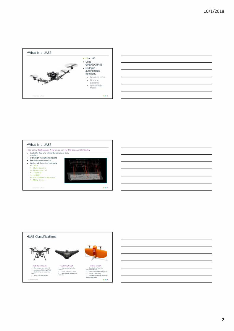
•Survey Seal Requirements
Find your surveyor and make friends
Most remotely sensed products (photogrammetry, LiDAR, orthophotos, etc.)
are considered to be “measured products” and thus require a seal from a licensed
Professional Land Surveyor
46A presentation by Wood.
•Return on Investment (ROI)
UAS technology offers a great cost savings over traditional data collection
methods
Efficiencies realized through many aspects:
•– Rapid deployment (in uncontrolled airspace)
•– Less time spent on site (hours vs. days)
•– Greater range of products for the cost (imagery & topo, etc.)
•– High degree of detail and precision
•– Versatility of the technology
•– Fewer people needed to conduct work
•– Reduction in safety risk to site personnel
Costs are typically 10-20% of comparable manned collection methods
•– Field survey, manned aviation, etc.
47A presentation by Wood.
•
•Brett Sexton•Environmental Scientist•Wood Environment & Infrastructure Solutions
Columbia, SC
•Garrett Shields, GISP, CFM•UAS National Program Manager•Wood Environment & Infrastructure SolutionsRaleigh, NC
•+1 919.381.9906•[email protected]
•+1 803.798.1200•[email protected]
•woodplc.com