session design – staff retreat · the soil conervaiton service loanded equipment to the swcd,...
TRANSCRIPT
1
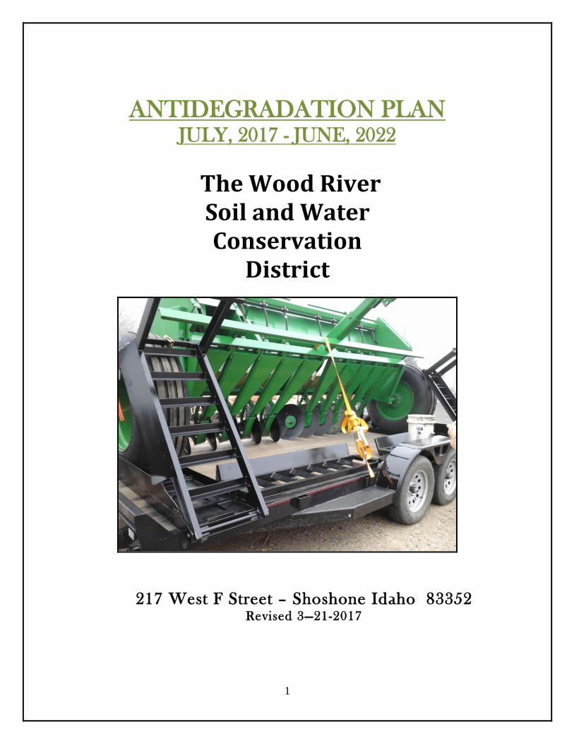
ANTIDEGRADATION PLAN JULY, 2017 - JUNE, 2022
The Wood River Soil and Water Conservation
District
217 West F Street – Shoshone Idaho 83352 Revised 3—21-2017
2
Conservation Districts Background
Idaho’s conservation districts were organized as part of a national soil conservation movement in
response to the Dust Bowl era of the 1930s. What has become the Wood River Soil & Water
Conservation District (Wood River SWCD) originally formed District on June 29, 1943.
Conservation districts are governmental subdivisions of the state of Idaho whose leadership comes
from locally elected volunteer supervisors. The 51 Soil Conservation Districts in Idaho, including
the Wood River Soil & Water Conservation District, are authorized by Idaho state law under
Title 22, Chapter 27. Under 22-2722 titled “Powers of Districts and Supervisors”, it states that, “A
soil conservation district organized under the provisions of this chapter shall constitute a
governmental subdivision of this state, and a public body corporate and politic, exercising public
powers…” Conservation districts are not state agencies, but rather locally governed bodies that
receive some technical and financial assistance from the state.
Support and guidance to Idaho’s conservation districts is provided by the Idaho Soil Conservation
Commission (ISCC). Among the contributions and responsibilities of conservation districts, Idaho
law states that “… conservation districts and the state soil conservation commission lead no
regulatory efforts to conserve, sustain, improve and enhance Idaho’s private and state lands and
provide assistance to private landowners and land users to plan, develop and implement
conservation plans addressing soil, water, air, plant and animal resources.”
Conservation district are catalysts for coordinating and implementing natural resource
conservation programs and channeling expertise and assistance from all levels of government into
action at the local level. Idaho conservation districts emphasize a non-regulatory, incentive based
approach to achieve local support and successful project implementation. The methods used for
implementation rely heavily on proven science-based solutions and typically integrate
informational and educational components.
In addition to the support provided by the ISCC at the state level, Idaho’s conservation districts
also have a unique agreement at the federal level with the USDA Natural Resources Conservation
Service (NRCS). As a partner to local conservation districts, USDA-NRCS provides technical
assistance to landowners and land users as needed or requested within conservation district
boundaries. Each district in Idaho has a signed Mutual Agreement with the Secretary of
Agriculture and the Governor of Idaho that establishes a framework for cooperation that ensures
appropriate project leadership at the local level, although support and assistance may originate at
the state or federal level.

3
Wood River SWCD History:
Farmers who obtained howmestead land in western Linocln and eastern Gooding counties sought to organize a soil
conservation district there in the spring of 1943. They were primarily interested in obtainng technical help to plan
irrigation system and determince which crops could best be grown on the newly developed land.
Petitions were circulated throughout the area in May and a public hearing was held June 29, 1943. All of the 86
landowners who voted in a July 31 referendum favored foring the district. The Wood River Soil and Water
Conservatin Distcit was officaill organized September 10, 1943.
The origianl WRSCD contained about 138,622 acres in a rectangurlar shpaed area in wester Lincoln and eastern
Gooidng coutnies. The district contained no towns, but the village of Shoshone was located south of the district.
Roscoe C. Geraard, Shoshone, charied the original board of supervisors. Serving with Gerard were Sam Danner,
W.B. Whittekeind, Charles Barlome, and Donald Sandy, all of Shoshone. The roigianla board met monthly at the
Lne Star School north of Shoshone.
Supervisors immediately compiled infromation needed to develop a conservation program. They cmpleted. A
rough draft of the SWCD’s first conservaiton program in Decemrber of 1943, the SWCD had received 30
applications for assistance on 3,443 acres.
Even before conservaiton work began farmenre in other parts of Lincoln county were asking how they could be
included in the district . In 1945, the Dietrich and Marley areas were added to the distri and in 1950 Richfield
joined thw SWCD, brign the distrit to its current 777,660.
Renting heavy equipment, particularly for land leveling, was one of the first services the SWCD offered to its
cooperators. The Soil Conervaiton Service loanded equipment to the SWCD, which rente it to farmers for a
nominal fee. Supervisors were responsible for specific implements and kept machinery at their hmes until the late
1970’s.
The Wood River SWCD was chosen as Idaho’s pilot distict in 1951 to determine if conservation district could help
imporve forage production on public land. Sam Danner charied the committee that led this effort.
The SWCD’s auxilary conducted conservation education projects including youth poster contests, exhitits at county
fairs, and essay contest.
From its beginning the WRSWCD has emphasized conservation education for farmers and city fold. Tours
showing new farming methods and ways to control erosion have always played an important role in the district’s
educational program.
The advancements in conservation made in the district would not have eend possiblloe without help from the many
groups and agencies which have which have worked with the SWCD. The NRCS, Agriculture stablization and
Cnseraiton Servie , Farmers Home Administration, Extension Service, Lincoln county Commission and local canal
companies have made conservation a community-wide efforts in the district.
The SWCD has been nvolved in several larger projects. A project to improve irrigation in the Dietrich area was
completed in 1978. The SWCD also particiatped in riprapping a section of accomplished through the Resource
conservaiton and Development program.
In 1983 the SWCd was asked by the Big Wood River Canal Board to develop a projects that would include gravity
sprinkler lines, hydropower electric plants, and irrigatin system improvements. The SWCD has completed the

4
preliminary study of the Richfield Tract and is working with the canal board to obtain funds to impelmtn the
proposed practices.
Conservation tillage is an exciting and increasngly popular new conservation practice in the Wood River District.
Farmers including Kenneth Koeppen, Gary Robbins, and roy Hubert were amon the first t adotp conservation
tillage practices in the district and have found it a great benefit n reducing erosion and lowering fuel costs.
5
TABLE OF CONTENTS
Executive Summary…………………….………………………………………………....7
Certificate of Adoption….………………………………..……………….……………..8
Mission of the Wood River Soil & Water Conservation District ….……..9
Organization of the Board…………………………………………………….…….....10
District Evaluation …………….……………………………………………………….....11
.
Section I:
Physical Characteristics of the District..…………………….....……12
Geographical Area………………..……………………………………………………...13
Land Cover Map…………..………………………………………………..….…….…..14
Land Status Map…………………………………………………………….……….……15
Lincoln County Workforce Trends..………………………………………….…..16
District Partners…………………………………………………………….……..………15 Section II:
Economic Conditions and Outlook………………..…..………….21
Population…………………………………………………………….……………………..22
Trends Impacting Conservation ………………………………………………….…22
Ag Census…………………………………………………………………………………...23 Section III:
Assessment of resource conditions, trends and needs……………
Soil ………………..………………………..………………………………………………….23
Water Resources………………………..………………………………...………..…..…28
Air Quality……………………………………..
Fish and Wildlife…………..

6
Section IV:
Identify and Prioritize Objectives:
District Priority #1 Water Quantity………………………………………………..
District Priority #2 Water Quality……………………………………………....….29
District Priority #3 Soil Erosion………..….………………………………......…...30
District Priority #4 Grazing Land Health ……………………………….………..31
District Priority #5 Species of Concern….………………………………………..32
District Priority #6 District Procedures / Information & Education …...33
Section V:
Water Quality component…………………………………..…....29
Stream Segments………..………………………………………………30
Description of water quality stream segments………………………......31
List of impacted waters in the district …………………..………………33
Budget…………………………………………………………………..34

7
EXECUTIVE SUMMARY: The Wood River Soil and Water Conservation District is one of 51 Conservation Districts in Idaho. Idaho Soil and Water Conservation Districts are political subdivisions of state government but are not state agencies. Conservation Districts are charged with carrying out a program for the conservation, use and development of soil, water, and other natural resources. Conservation Districts are the primary entities to provide assistance to private landowners and land users in the conservation, sustainment, improvement and enhancement of Idaho’s natural resources. They are catalysts for coordinating and implementing conservation programs, channeling expertise from all levels of government into action at the local level. Programs are nonregulatory; science-based technical assistance, incentive–based financial programs and informational and educational programs at the local level. It is the goal of the Wood River SWCD to provide technical assistance to landowners and land users through Conservation District efforts. Each Conservation District in Idaho has a signed Mutual Agreement with the Secretary of Agricultural and the Governor of Idaho that establishes a framework for cooperation. The Wood River SWCD provides an Annual Plan/Five-Year Resource Conservation Business Plan that is developed not only to guide the Conservation District, but also to encourage cooperation among landowners, government agencies, private organizations, and elected officials. Through knowledge and cooperation, all concerned can ensure a sustainable natural resource base for present and future generations in the Wood River Soil and Water Conservation District. This document identifies the resource needs in the Conservation District and presents a resource conservation action plan for meeting these needs.
8
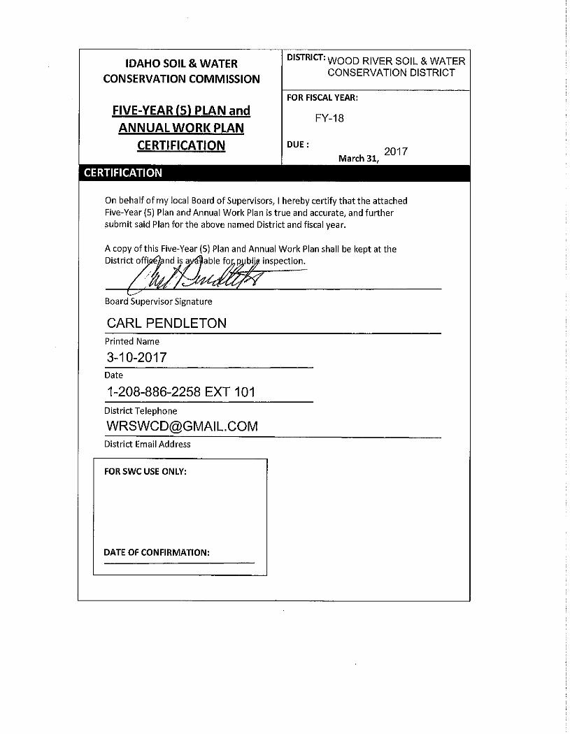
Certificate of Adoption:
The Board of elected supervisors of the Wood River Soil and Water Conservation District on this the 13th day of _March 10, 2017____, do hereby approve the following document known as the Resource Conservation Business Plan. This Plan will be in effect for a five-year period ending June 30, 2022 during which time it will be updated annually and/or amended, as necessary. As evidence of our adoption and final approval, we do hereby affix our signatures to this document. Carl Pendleton____________Chairman _______________________________________________ Dan Durand…………………..Vice-Chairman _______________________________________________ Kerry Thompson……………Secretary/Treasurer___________________________________________ Kay Billington………………..Member _______________________________________________ Dee Koonce……………………Member _______________________________________________ Supporting Idaho Conservation Partners Curtis Elke___________ Natural Resources Conservation Service Teri Murrison _______ Administrator (Soil Water Conservation Commission) Benjamin Kelley ____ Idaho Association of Soil Conservation Districts
9
Wood River Soil & Water Conservation District Antidegradation Plan
For More Information Contact: {Carl Pendleton}, {208-886-2258)
Organization of the Wood River Soil & Water Conservation District A political subdivision of the State of Idaho – authorities, powers and structure contained in Soil Conservation District Law, Title 22, Chapter 27, and Idaho Code. The District was organized in September 10, 1943 to provide voluntary land and water conservation technical and financial assistance to landowners and uses within the Wood River SWCD boundary.
Function of the Wood River Soil & Water Conservation District To make available technical, financial and educational resources, whatever their source, and focus or coordinate them so that they meet the needs of the local land manager with conservation of soil, water and related natural resources.
Who We Serve & Why The people who want to make informed decisions on Natural Resources within the Wood River SWCD’s District boundaries. To conserve the natural resources for beneficial and sustainable use and to inform everybody of
conservation opportunities that are available.
Mission of the Wood River Soil & Water Conservation District To Coordinate, Inform and Educate landowners of practices & opportunities that will enhance water quality, reduce soil erosion, protect riparian areas, and enhance wildlife habitat.
Vision of the Wood River Soil & Water Conservation District To assist landowners in solving conservation resource problems.
Values of the Wood River Soil & Water Conservation District
Sustainable use of natural resources.
Support for agricultural activity that uses sustainable, economical and feasible practices.
Value and respect for the Idaho Conservation Partnership.
Conservation education for adults and youth.
Coordination with agencies and land users in the conservation and sustainable natural resources.
10
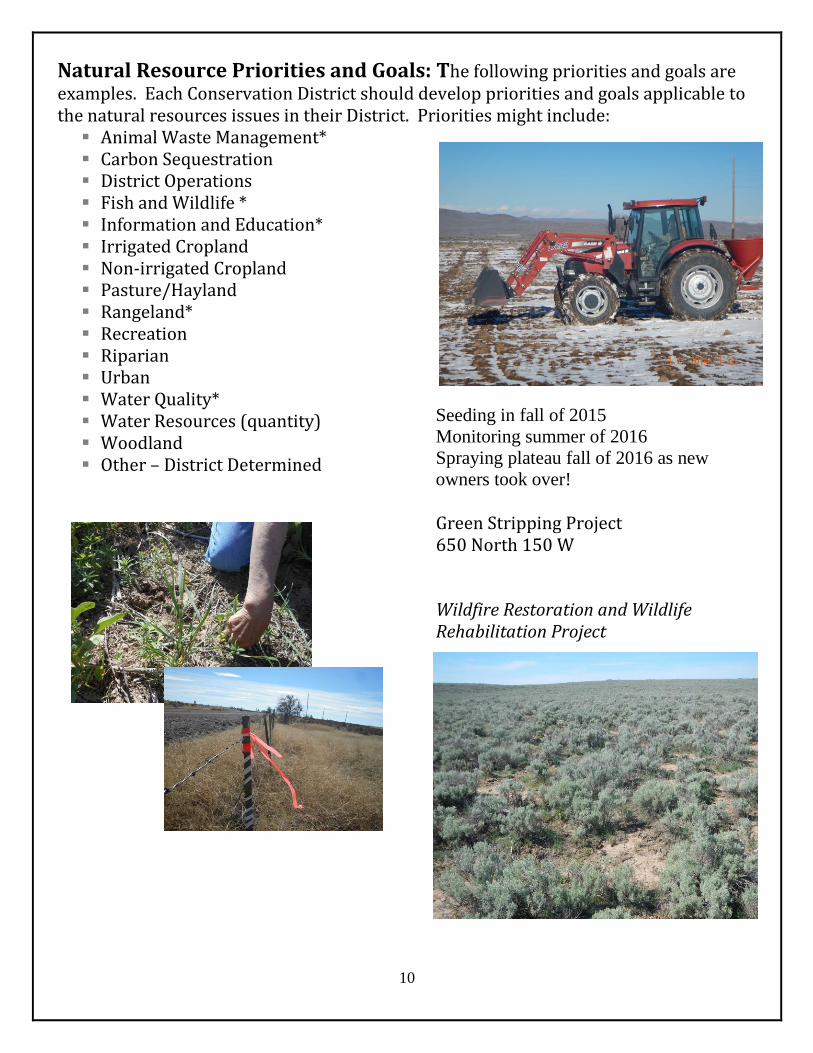
Natural Resource Priorities and Goals: The following priorities and goals are examples. Each Conservation District should develop priorities and goals applicable to the natural resources issues in their District. Priorities might include:
Animal Waste Management* Carbon Sequestration District Operations Fish and Wildlife * Information and Education* Irrigated Cropland Non-irrigated Cropland Pasture/Hayland Rangeland* Recreation Riparian Urban Water Quality* Water Resources (quantity) Woodland Other – District Determined
Seeding in fall of 2015
Monitoring summer of 2016
Spraying plateau fall of 2016 as new
owners took over!
Green Stripping Project 650 North 150 W Wildfire Restoration and Wildlife Rehabilitation Project
11
SOIL CONSERVATION DISTRICT EVALUATION:
Through a Memorandum of Understanding the Natural Resources Conservation Service (NRCS) and the Conservation District maintain an office to provide technical assistance to landowners in Lincoln Country. The office is located at 217 West F Street Shoshone, Idaho. The District has a 7 – Member locally elected Board of Supervisors and employees a part time Administrative Assistant. Supervisors include: Carl Pendleton, Dan Durand, Kay Billington, Kerry Thompson and Dee Koonce. Administrative Assistant: Barbara Messick. The District maintains a website and face book at: http//: www.wrswcd.weebly.com https://www.facebook.com/pages/Wood-River-Soil-and-Water-Conservation-District/457720200931782
Annual Budget Attached Annual Work Plan Attached List of District Partners Attached
USDA – Natural Resource Conservation Service The Natural Resources Conservation Service maintains the following staff in Shoshone or Lincoln County: District Conservationist- Patti Hurley, Soil Conservationist – Daniel Romano and Soil Conservation Technician – Katie Dennis.
SWC – Idaho State Soil Conservation Commission The Soil Conservation Commission has employed a new coordinator Rob Sharpnack who is housed in the Shoshone Field Office.
IDFG – STATE OF IDAHO FISH AND GAME The State of Idaho Fish and Game maintains the Clint Rasmussen- Mule Deer Program technician in Shoshone field office

12
Section I: Physical Characteristics
Lincoln County Wood River Soil and Water Conservation District
Wood River SWCD
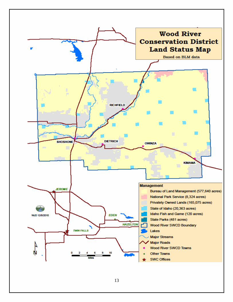
13
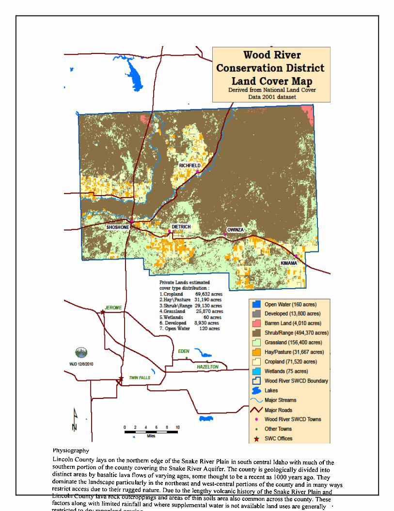
14

15
16
17
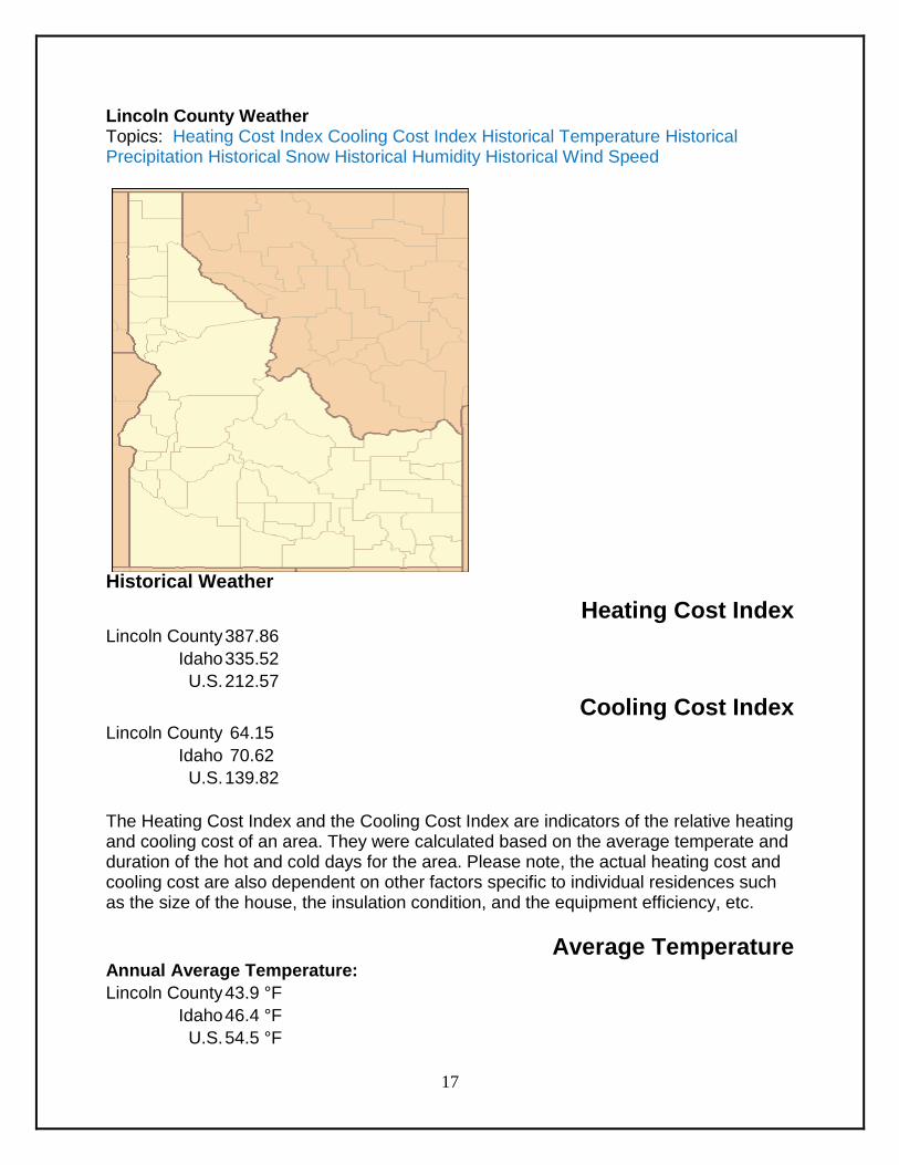
Lincoln County Weather Topics: Heating Cost Index Cooling Cost Index Historical Temperature Historical Precipitation Historical Snow Historical Humidity Historical Wind Speed
Historical Weather
Heating Cost Index Lincoln County 387.86
Idaho 335.52
U.S. 212.57
Cooling Cost Index Lincoln County 64.15
Idaho 70.62
U.S. 139.82
The Heating Cost Index and the Cooling Cost Index are indicators of the relative heating and cooling cost of an area. They were calculated based on the average temperate and duration of the hot and cold days for the area. Please note, the actual heating cost and cooling cost are also dependent on other factors specific to individual residences such as the size of the house, the insulation condition, and the equipment efficiency, etc.
Average Temperature Annual Average Temperature:
Lincoln County 43.9 °F
Idaho 46.4 °F
U.S. 54.5 °F
18
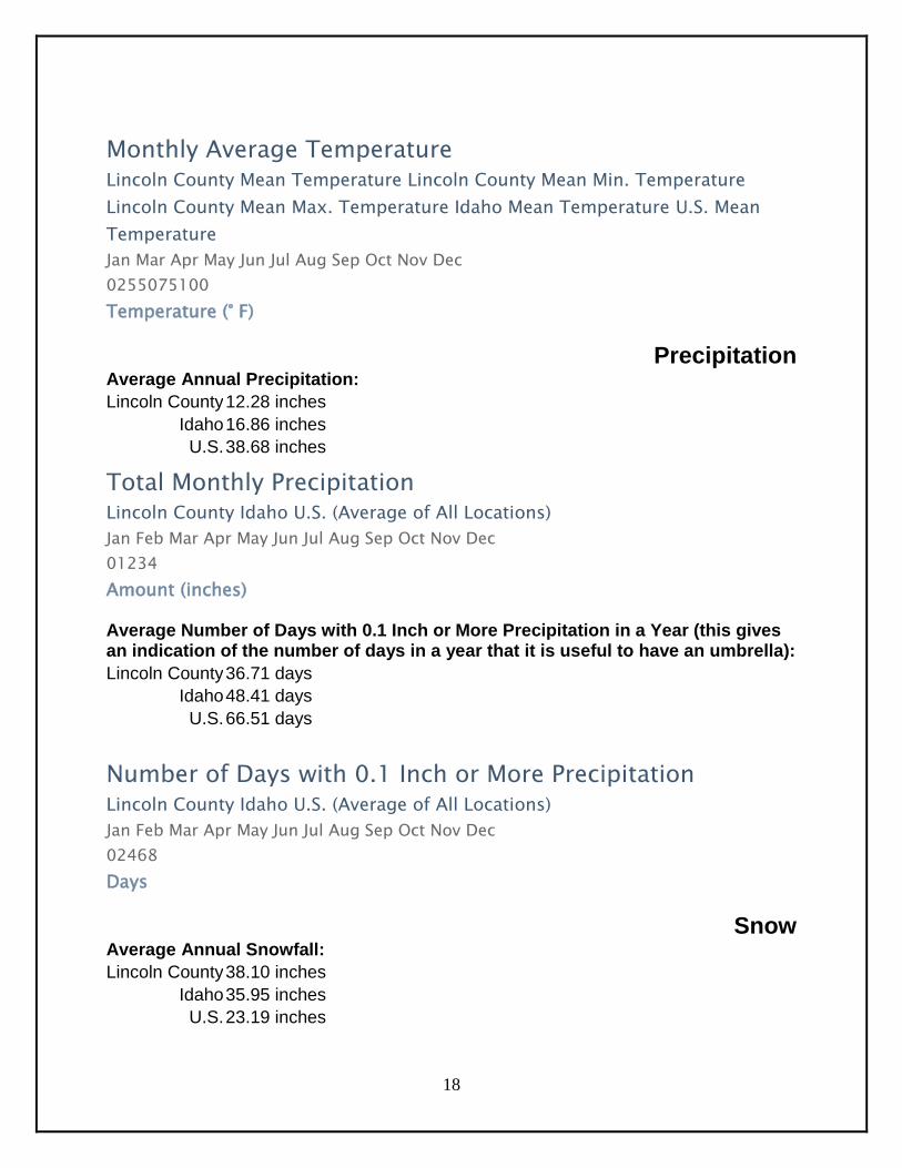
Monthly Average Temperature
Lincoln County Mean Temperature Lincoln County Mean Min. Temperature
Lincoln County Mean Max. Temperature Idaho Mean Temperature U.S. Mean
Temperature
Jan Mar Apr May Jun Jul Aug Sep Oct Nov Dec
0255075100
Temperature (° F)
Precipitation Average Annual Precipitation:
Lincoln County 12.28 inches
Idaho 16.86 inches
U.S. 38.68 inches
Total Monthly Precipitation
Lincoln County Idaho U.S. (Average of All Locations)
Jan Feb Mar Apr May Jun Jul Aug Sep Oct Nov Dec
01234
Amount (inches) Average Number of Days with 0.1 Inch or More Precipitation in a Year (this gives an indication of the number of days in a year that it is useful to have an umbrella):
Lincoln County 36.71 days
Idaho 48.41 days
U.S. 66.51 days
Number of Days with 0.1 Inch or More Precipitation
Lincoln County Idaho U.S. (Average of All Locations)
Jan Feb Mar Apr May Jun Jul Aug Sep Oct Nov Dec
02468
Days
Snow Average Annual Snowfall:
Lincoln County 38.10 inches
Idaho 35.95 inches
U.S. 23.19 inches
19
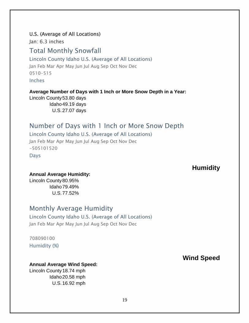
U.S. (Average of All Locations)
Jan: 6.3 inches
Total Monthly Snowfall Lincoln County Idaho U.S. (Average of All Locations)
Jan Feb Mar Apr May Jun Jul Aug Sep Oct Nov Dec
0510-515
Inches Average Number of Days with 1 Inch or More Snow Depth in a Year:
Lincoln County 53.80 days
Idaho 49.19 days
U.S. 27.07 days
Number of Days with 1 Inch or More Snow Depth
Lincoln County Idaho U.S. (Average of All Locations)
Jan Feb Mar Apr May Jun Jul Aug Sep Oct Nov Dec
-505101520
Days
Humidity Annual Average Humidity:
Lincoln County 80.95%
Idaho 79.49%
U.S. 77.52%
Monthly Average Humidity
Lincoln County Idaho U.S. (Average of All Locations)
Jan Feb Mar Apr May Jun Jul Aug Sep Oct Nov Dec
708090100
Humidity (%)
Wind Speed Annual Average Wind Speed:
Lincoln County 18.74 mph
Idaho 20.58 mph
U.S. 16.92 mph
20
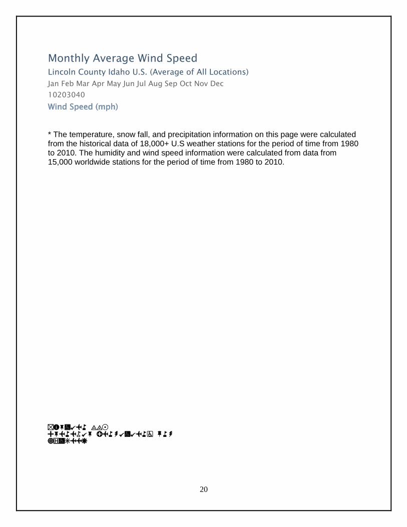
Monthly Average Wind Speed
Lincoln County Idaho U.S. (Average of All Locations)
Jan Feb Mar Apr May Jun Jul Aug Sep Oct Nov Dec
10203040
Wind Speed (mph)
* The temperature, snow fall, and precipitation information on this page were calculated from the historical data of 18,000+ U.S weather stations for the period of time from 1980 to 2010. The humidity and wind speed information were calculated from data from 15,000 worldwide stations for the period of time from 1980 to 2010.
Section II: Economic Conditions and Outlook

21
22
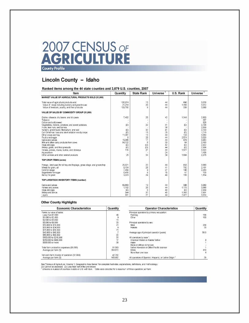
23
24
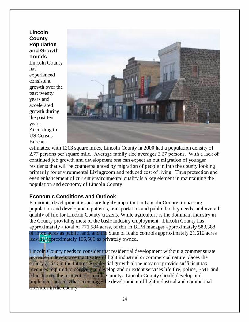
Lincoln County Population and Growth Trends Lincoln County
has
experienced
consistent
growth over the
past twenty
years and
accelerated
growth during
the past ten
years.
According to
US Census
Bureau
estimates, with 1203 square miles, Lincoln County in 2000 had a population density of
2.77 persons per square mile. Average family size averages 3.27 persons. With a lack of
continued job growth and development one can expect an out migration of younger
residents that will be counterbalanced by migration of people in into the county looking
primarily for environmental Livingroom and reduced cost of living Thus protection and
even enhancement of current environmental quality is a key element in maintaining the
population and economy of Lincoln County.
Economic Conditions and Outlook Economic development issues are highly important in Lincoln County, impacting
population and development patterns, transportation and public facility needs, and overall
quality of life for Lincoln County citizens. While agriculture is the dominant industry in
the County providing most of the basic industry employment. Lincoln County has
approximately a total of 771,584 acres, of this in BLM manages approximately 583,388
of those acres as public land, and the State of Idaho controls approximately 21,610 acres
leaving approximately 166,586 as privately owned.
Lincoln County needs to consider that residential development without a commensurate
increase in development activates of light industrial or commercial nature places the
county at risk in the future. Residential growth alone may not provide sufficient tax
revenues required to continue to develop and or extent services life fire, police, EMT and
education to the resident of Lincoln County. Lincoln County should develop and
implement policies that encourage the development of light industrial and commercial
activities in the county.
25
Wood River Soil & Water Conservation Partnerships:
How can we help is our motto: While we may not always be
able to participate, we do appreciate the opportunity to learn
other exciting efforts in Lincoln County.
Lincoln County Commissioners
Natural Resource Conservation Service
Office of Species Conservation
US Fish and Wildlife Service
Bureau of Land Management
Farm Service Agency
City of Shoshone
City of Richfield
City of Dietrich
Shoshone School District
Richfield School District
Dietrich School District
United States Environmental Protection
Agency
Department of Environmental Quality
Idaho Fish and Game
Pheasants forever
Idaho Ducks Unlimited
Idaho Department of Agriculture
Idaho Department of Water Resources
Idaho Soil and Water Conservation
Commission
Boy Scouts of America
FFA -
Natural Resources Camp
Big wood Canal Company
37 37 M Water master
BLM Bureau of Land Management
Mary and Grady Garrett
Idaho Forest Service
Big Wood Canal Company
37 /37 Water Master (Kevin Lakey)
Lincoln County Senior Center
Lincoln County Sherriff Dept.
Governor – Butch Otter
Senator – Michelle Stennett
Representative – Steve Miller
Representative – Sally Toone
Idaho State Water Board
Idaho Department of Environmental Quality
Cannon Envirothon
Idaho Department of Lands
Idaho Department of Parks and Recreation
North Side Canal Co.
University of Idaho Extension Lincoln County
Blaine Soil Conservation District
Nature Conservancy
Wood River Land Trust
26
Section III: Assessment of resource conditions, trends and conservation needs
of district.
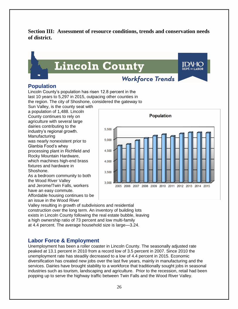
Population Lincoln County’s population has risen 12.8 percent in the last 10 years to 5,297 in 2015, outpacing other counties in the region. The city of Shoshone, considered the gateway to Sun Valley, is the county seat with a population of 1,488. Lincoln County continues to rely on agriculture with several large dairies contributing to the industry’s regional growth. Manufacturing was nearly nonexistent prior to Glanbia Food’s whey processing plant in Richfield and Rocky Mountain Hardware, which machines high-end brass fixtures and hardware in Shoshone. As a bedroom community to both the Wood River Valley and Jerome/Twin Falls, workers have an easy commute. Affordable housing continues to be an issue in the Wood River Valley resulting in growth of subdivisions and residential construction over the long term. An inventory of building lots exists in Lincoln County following the real estate bubble, leaving a high ownership ratio of 73 percent and low multi-family at 4.4 percent. The average household size is large—3.24.
Labor Force & Employment Unemployment has been a roller coaster in Lincoln County. The seasonally adjusted rate peaked at 13.1 percent in 2010 from a record low of 3.5 percent in 2007. Since 2010 the unemployment rate has steadily decreased to a low of 4.4 percent in 2015. Economic diversification has created new jobs over the last five years, mainly in manufacturing and the services. Dairies have brought stability to a workforce that traditionally sought jobs in seasonal industries such as tourism, landscaping and agriculture. Prior to the recession, retail had been popping up to serve the highway traffic between Twin Falls and the Wood River Valley.

27
Manufacturing jobs are stable and raising area wages. Hay, grains, corn and other crops that can be green chopped for dairy silage are the primary commodities. The U.S. Bureau of Land Management’s regional headquarters and the National Interagency Fire Center dispatch operation are seasonal employers. The Idaho Transportation Department has a sizeable presence in Shoshone. The surrounding small communities all saw interest in new housing prior to the downturn. The county is expected to continue steady growth. Non Farm Payroll Jobs for 2015
Wages & Income Per capita income in Lincoln County has spiked over the last decade increasing 44 percent, more than doubling the state and nation’s growth. In 2015, Lincoln County’ per capita ranked 6th regionally and 19th statewide. Per capita income decreased nearly one percent in 2015 to $36,100. Lincoln’s per capita income was ranked 35th in 2009 when milk prices were in the trough From 2014 to 2015, Lincoln’s average covered employment’s wage grew by 2.3 percent with a three percent drop in average employment. The outlook is for continued slow but steady growth even with the sustained higher population growth. Wages are expected to remain on the low end, due to the mix of service and ag jobs.
Prepared by Jan Roeser, Regional Economist, Idaho Department of Labor • 420 Falls Ave, Twin Falls, Idaho 83301 Phone: (208) 735-2500, ext. 3639 • email: [email protected] • Labor Market Information website: lmi.idaho.gov
28
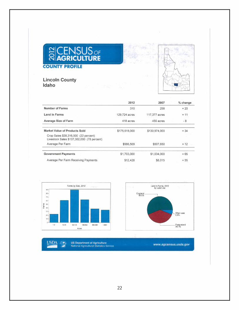
Soil Survey for CUSTER-LEMHI AREA is in north-central Idaho. It consists of areas in Custer and Lemhi Counties and a small area in the northern part of Blaine County. It includes parts of the Salmon, Challis, and Targhee National Forests. The total area is 1,959,720 acres, or about 3,062 square miles. The lowest point in the survey area, which is at an elevation of about 3,700 feet, is north of Salmon, along the Salmon River. The highest point, which is at an elevation of about 10,390 feet, is just south of Monument Peak, along the Idaho-Montana border. The general soil map in this area shows broad areas that have a distinctive pattern of soils, relief, and drainage. Each map unit on the general soil map is a unique natural landscape
Natural Resources The natural resources in the survey area include soil, water, timber, and minerals. Most of the jobs in the area are dependent on these resources. The farmland along the major rivers and their tributaries is used for pasture and for alfalfa and some grain crops. Because of the extremely mountainous topography, gravelly soils, and low precipitation, most of the land in the area is used as rangeland. Surface water is used primarily for irrigation, livestock, and recreation.

29
30
Section IV: Identify and Prioritize Objectives: (IDAPA 60-o5.02.025.04)
Priority 1: Water Quantity, Grazing Land Health & Species of Concern, Water Quality, Soil Health Conditions, District Procedure and Information and Education: Priority 1: Water Quantity
District projects related to Water Quantity include continued efforts to provide irrigation improvements on the
702 Pipeline, Glanbia Mitigation Project with riparian protection and willow planting and management. These
efforts are focused on the enhancement of variable rate irrigation as long term sustainability of the agricultural
community.
Priority 2:Grazing Land Health & species of Concern:
Priority 3: Water quality Maintain an economic stability of the ranching industry and multiple uses by assisting cooperators to improve forage quality and quantity of rangeland within the district. Promote the development of coordinated resource management plans under EQIP. Develop relationships with BLM, USFS, USFWS, NMFS, NRCS and IDFG to assist with public land grazing issues and enhancements. Assist Ranchers to address Sage Grouse and Wolf Management on public grazing lands. Priority 4: sol Health Conditions: Provide administrative assistance to NRCS on USDA/Farm Bill programs Promote and provide information to improve control of noxious weeds on both public and private lands in cooperation with county weed supervisor. Evaluate water conservation opportunities of sprinkler irrigation versus flood irrigation. Priority 5: District Procedures and Information and Education The district maintains an active presence in all area schools within the district.
Wood River SWCD maintains their accounting system on QuickBooks and completed a single audit of this
year’s financial activity providing accountability for funds administered through the district.
By October 30, all 5th and 6th grade students will have had the opportunity to participate in the conservation
poster contest and all 9th through 11th grade students will have had the opportunity to participate in the
conservation speech contest.
Information will be provided to the Envirothon Advisor for the State Envirothon.
Conservation District cooperator addresses and files will be updated.
The District will review and if needed update their policy and procedures manual and accountability policy.
By October 15, the District will have completed their annual audit and provided the audit to the Division of
Financial Management and others requiring this information.
Wood River SWCD will have provided new supervisors training.
31
Section V:
Water Quality (Lincoln)
The Idaho Department of Environmental Quality (DEQ) is the state agency designated to protect the state’s water
quality. DEQ's Surface Water Program is responsible for ensuring Idaho's streams, rivers, lakes, reservoirs, and wetlands
meet their beneficial uses and Idaho water quality standards. Section 303(d) of the Clean Water Act establishes
requirements for states and tribes to identify and prioritize water bodies that do not meet water quality standards. This
analysis is published and submitted to the EPA in Idaho's Integrated Report. Idaho must develop a water quality
improvement plan, called a total maximum daily load (TMDL), for those water bodies not meeting water quality
standards. In Idaho, TMDLs are assessed on a subbasin level, which means water bodies and pollutants within a
hydrologic subbasin are generally addressed in a single document.
The Wood River Soil Conservation District (WRSWCD) has parts of four subbasin within its boundaries; 37.3% of the
WRSCD is part of the Lake Walcott Subbasin; 36% of the conservation district is part of the Little Wood River
Subbasin, and 18.2 and 8.5% of the district is part of the Big Wood River and Upper Snake-Rock Subbasins respectively.
The Wood River SWCD works with the Upper Snake-Rock Watershed Advisory Group (WAG) and the Wood River
WAG (representing the Big Wood River and the Little Wood River Subbasins) to provide local public input and
guidance to DEQ when developing a TMDL and assist in implementing antidegradation projects to restore and maintain
Idaho’s waters to the appropriate condition.
Table of Subbasin Assessments, TMDLs, Implementation Plans, and Five-Year Reviews
Subbasin Name
Hydrologic
Unit Code
(HUC) TMDL Status
Implementation
Plan Status
Five Year Review
Status
Big Wood
River Subbasin
17040219
Approved by EPA
May 2002
Errata approved
by EPA
February 2012
Temperature
Addendum
Approved by EPA
December 2013
Agriculture
Completed
October 2006;
Revised
February 2014
Little Wood
River Subbasin
17040221 Approved by EPA
September 2005
Agriculture
Completed
March 2010
Snake River
(Upper Snake-17040212 Mid Snake TMDL
Phase I Approved by Completed June Completed April
32
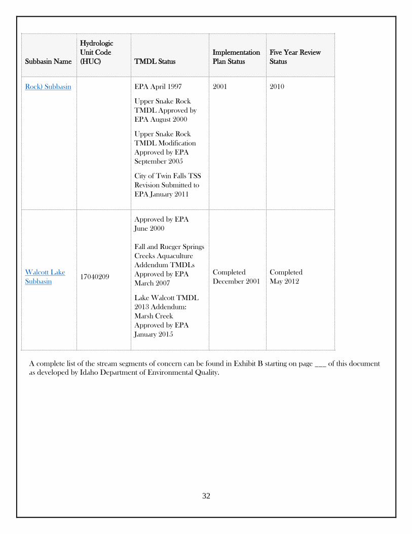
Subbasin Name
Hydrologic
Unit Code
(HUC) TMDL Status
Implementation
Plan Status
Five Year Review
Status
Rock) Subbasin EPA April 1997
Upper Snake Rock
TMDL Approved by
EPA August 2000
Upper Snake Rock
TMDL Modification
Approved by EPA
September 2005
City of Twin Falls TSS
Revision Submitted to
EPA January 2011
2001 2010
Walcott Lake
Subbasin
17040209
Approved by EPA
June 2000
Fall and Rueger Springs
Creeks Aquaculture
Addendum TMDLs
Approved by EPA
March 2007
Lake Walcott TMDL
2013 Addendum:
Marsh Creek
Approved by EPA
January 2015
Completed
December 2001
Completed
May 2012
A complete list of the stream segments of concern can be found in Exhibit B starting on page ___ of this document
as developed by Idaho Department of Environmental Quality.
33
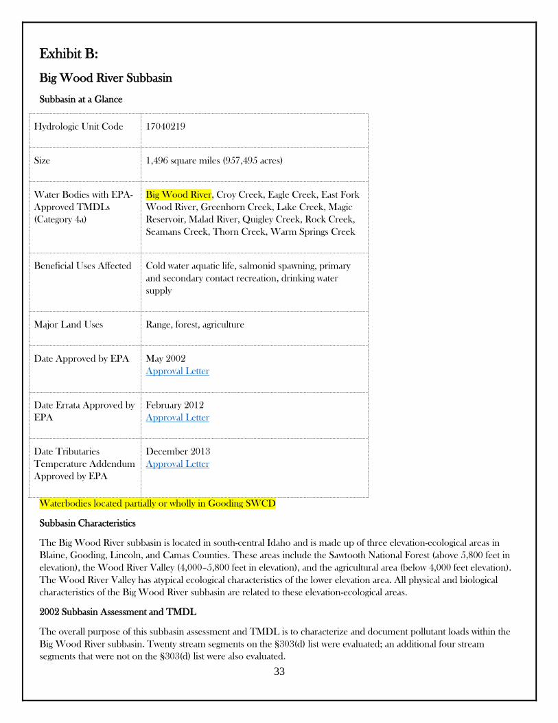
Exhibit B:
Big Wood River Subbasin
Subbasin at a Glance
Hydrologic Unit Code 17040219
Size 1,496 square miles (957,495 acres)
Water Bodies with EPA-
Approved TMDLs
(Category 4a)
Big Wood River, Croy Creek, Eagle Creek, East Fork
Wood River, Greenhorn Creek, Lake Creek, Magic
Reservoir, Malad River, Quigley Creek, Rock Creek,
Seamans Creek, Thorn Creek, Warm Springs Creek
Beneficial Uses Affected Cold water aquatic life, salmonid spawning, primary
and secondary contact recreation, drinking water
supply
Major Land Uses Range, forest, agriculture
Date Approved by EPA May 2002
Approval Letter
Date Errata Approved by
EPA
February 2012
Approval Letter
Date Tributaries
Temperature Addendum
Approved by EPA
December 2013
Approval Letter
Waterbodies located partially or wholly in Gooding SWCD
Subbasin Characteristics
The Big Wood River subbasin is located in south-central Idaho and is made up of three elevation-ecological areas in
Blaine, Gooding, Lincoln, and Camas Counties. These areas include the Sawtooth National Forest (above 5,800 feet in
elevation), the Wood River Valley (4,000–5,800 feet in elevation), and the agricultural area (below 4,000 feet elevation).
The Wood River Valley has atypical ecological characteristics of the lower elevation area. All physical and biological
characteristics of the Big Wood River subbasin are related to these elevation-ecological areas.
2002 Subbasin Assessment and TMDL
The overall purpose of this subbasin assessment and TMDL is to characterize and document pollutant loads within the
Big Wood River subbasin. Twenty stream segments on the §303(d) list were evaluated; an additional four stream
segments that were not on the §303(d) list were also evaluated.

34
The document recommends that four streams (Horse Creek, Owl Creek, Baker Creek, and East Fork Wood River) be
removed from the §303(d) list. These streams are meeting their beneficial uses and/or state water quality standards.
The document also recommends two additional stream segments be listed on the next §303(d) list. The first is in the Big
Wood River main stem from Base Line to Magic Reservoir. The second is in the Big Wood River main stem from
Interstate 84 to the Snake River (or the Malad River).
TMDLs were established for sediment, nutrients, and bacteria. Flow alteration will be evaluated further. A TMDL was
not being established at this time for streams polluted by nitrite + nitrate. Temperature and dissolved oxygen TMDLs will
be deferred until 2003 pending collection of more information. A TMDL was not established for turbidity at this time
since the sediment TMDLs will create reductions in turbidity. The TMDL recommends that ammonia be delisted as a
pollutant of concern.
2002 TMDL: Streams and Pollutants for Which TMDLs Were Developed
Big Wood River
Sediment, nutrients, bacteria
Eagle Creek
Sediment, nutrients
Lake Creek
Nutrients
Placer Creek
Nutrients
Cove Creek
Sediment, nutrients
Greenhorn Creek
Sediment, nutrients
Quigley Creek
Sediment, nutrients
Croy Creek
Sediment, nutrients
Seamans Creek
Sediment, nutrients
Rock Creek
Sediment, nutrients, bacteria
East Fork Rock Creek
Sediment, nutrients
Thorn Creek
35
Sediment, nutrients
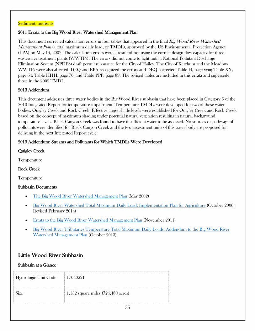
2011 Errata to the Big Wood River Watershed Management Plan
This document corrected calculation errors in four tables that appeared in the final Big Wood River Watershed
Management Plan (a total maximum daily load, or TMDL), approved by the US Environmental Protection Agency
(EPA) on May 15, 2002. The calculation errors were a result of not using the correct design flow capacity for three
wastewater treatment plants (WWTPs). The errors did not come to light until a National Pollutant Discharge
Elimination System (NPDES) draft permit reissuance for the City of Hailey. The City of Ketchum and the Meadows
WWTPs were also affected. DEQ and EPA recognized the errors and DEQ corrected Table H, page xviii; Table XX,
page 64; Table HHH, page 76; and Table PPP, page 89. The revised tables are included in this errata and supersede
those in the 2002 TMDL.
2013 Addendum
This document addresses three water bodies in the Big Wood River subbasin that have been placed in Category 5 of the
2010 Integrated Report for temperature impairment. Temperature TMDLs were developed for two of these water
bodies: Quigley Creek and Rock Creek. Effective target shade levels were established for Quigley Creek and Rock Creek
based on the concept of maximum shading under potential natural vegetation resulting in natural background
temperature levels. Black Canyon Creek was found to have insufficient water to be assessed. No sources or pathways of
pollutants were identified for Black Canyon Creek and the two assessment units of this water body are proposed for
delisting in the next Integrated Report cycle.
2013 Addendum: Streams and Pollutants for Which TMDLs Were Developed
Quigley Creek
Temperature
Rock Creek
Temperature
Subbasin Documents
The Big Wood River Watershed Management Plan (May 2002)
Big Wood River Watershed Total Maximum Daily Load: Implementation Plan for Agriculture (October 2006;
Revised February 2014)
Errata to the Big Wood River Watershed Management Plan (November 2011)
Big Wood River Tributaries Temperature Total Maximum Daily Loads: Addendum to the Big Wood River
Watershed Management Plan (October 2013)
Little Wood River Subbasin
Subbasin at a Glance
Hydrologic Unit Code 17040221
Size 1,132 square miles (724,480 acres)
36
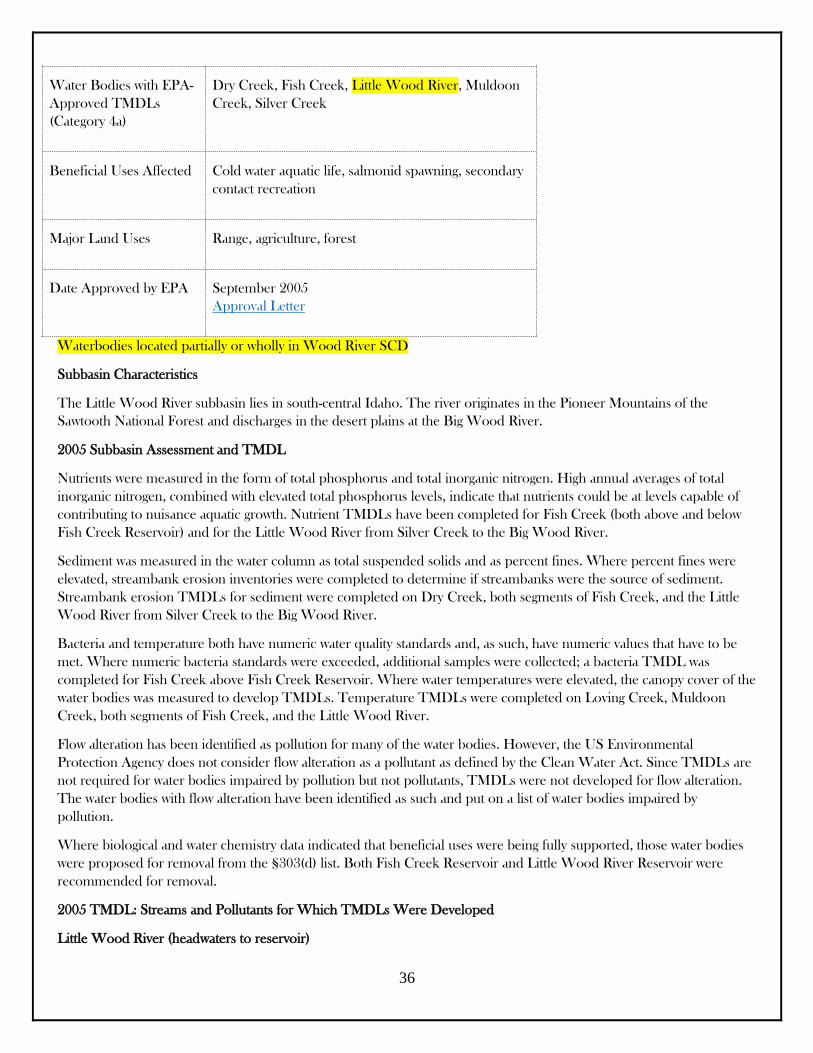
Water Bodies with EPA-
Approved TMDLs
(Category 4a)
Dry Creek, Fish Creek, Little Wood River, Muldoon
Creek, Silver Creek
Beneficial Uses Affected Cold water aquatic life, salmonid spawning, secondary
contact recreation
Major Land Uses Range, agriculture, forest
Date Approved by EPA September 2005
Approval Letter
Waterbodies located partially or wholly in Wood River SCD
Subbasin Characteristics
The Little Wood River subbasin lies in south-central Idaho. The river originates in the Pioneer Mountains of the
Sawtooth National Forest and discharges in the desert plains at the Big Wood River.
2005 Subbasin Assessment and TMDL
Nutrients were measured in the form of total phosphorus and total inorganic nitrogen. High annual averages of total
inorganic nitrogen, combined with elevated total phosphorus levels, indicate that nutrients could be at levels capable of
contributing to nuisance aquatic growth. Nutrient TMDLs have been completed for Fish Creek (both above and below
Fish Creek Reservoir) and for the Little Wood River from Silver Creek to the Big Wood River.
Sediment was measured in the water column as total suspended solids and as percent fines. Where percent fines were
elevated, streambank erosion inventories were completed to determine if streambanks were the source of sediment.
Streambank erosion TMDLs for sediment were completed on Dry Creek, both segments of Fish Creek, and the Little
Wood River from Silver Creek to the Big Wood River.
Bacteria and temperature both have numeric water quality standards and, as such, have numeric values that have to be
met. Where numeric bacteria standards were exceeded, additional samples were collected; a bacteria TMDL was
completed for Fish Creek above Fish Creek Reservoir. Where water temperatures were elevated, the canopy cover of the
water bodies was measured to develop TMDLs. Temperature TMDLs were completed on Loving Creek, Muldoon
Creek, both segments of Fish Creek, and the Little Wood River.
Flow alteration has been identified as pollution for many of the water bodies. However, the US Environmental
Protection Agency does not consider flow alteration as a pollutant as defined by the Clean Water Act. Since TMDLs are
not required for water bodies impaired by pollution but not pollutants, TMDLs were not developed for flow alteration.
The water bodies with flow alteration have been identified as such and put on a list of water bodies impaired by
pollution.
Where biological and water chemistry data indicated that beneficial uses were being fully supported, those water bodies
were proposed for removal from the §303(d) list. Both Fish Creek Reservoir and Little Wood River Reservoir were
recommended for removal.
2005 TMDL: Streams and Pollutants for Which TMDLs Were Developed
Little Wood River (headwaters to reservoir)
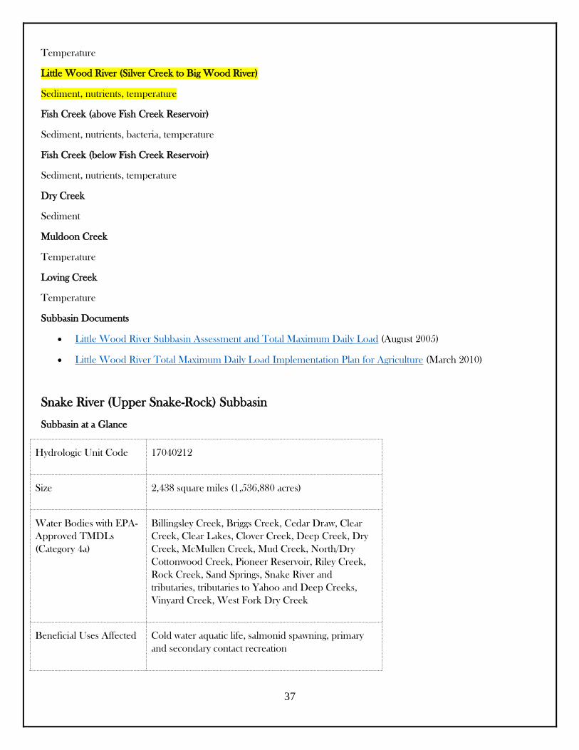
37
Temperature
Little Wood River (Silver Creek to Big Wood River)
Sediment, nutrients, temperature
Fish Creek (above Fish Creek Reservoir)
Sediment, nutrients, bacteria, temperature
Fish Creek (below Fish Creek Reservoir)
Sediment, nutrients, temperature
Dry Creek
Sediment
Muldoon Creek
Temperature
Loving Creek
Temperature
Subbasin Documents
Little Wood River Subbasin Assessment and Total Maximum Daily Load (August 2005)
Little Wood River Total Maximum Daily Load Implementation Plan for Agriculture (March 2010)
Snake River (Upper Snake-Rock) Subbasin
Subbasin at a Glance
Hydrologic Unit Code 17040212
Size 2,438 square miles (1,536,880 acres)
Water Bodies with EPA-
Approved TMDLs
(Category 4a)
Billingsley Creek, Briggs Creek, Cedar Draw, Clear
Creek, Clear Lakes, Clover Creek, Deep Creek, Dry
Creek, McMullen Creek, Mud Creek, North/Dry
Cottonwood Creek, Pioneer Reservoir, Riley Creek,
Rock Creek, Sand Springs, Snake River and
tributaries, tributaries to Yahoo and Deep Creeks,
Vinyard Creek, West Fork Dry Creek
Beneficial Uses Affected Cold water aquatic life, salmonid spawning, primary
and secondary contact recreation
38
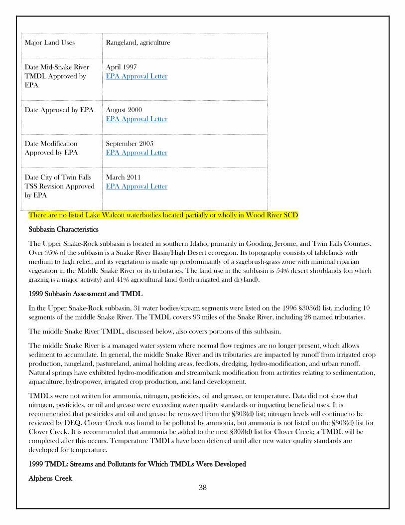
Major Land Uses Rangeland, agriculture
Date Mid-Snake River
TMDL Approved by
EPA
April 1997
EPA Approval Letter
Date Approved by EPA August 2000
EPA Approval Letter
Date Modification
Approved by EPA
September 2005
EPA Approval Letter
Date City of Twin Falls
TSS Revision Approved
by EPA
March 2011
EPA Approval Letter
There are no listed Lake Walcott waterbodies located partially or wholly in Wood River SCD
Subbasin Characteristics
The Upper Snake-Rock subbasin is located in southern Idaho, primarily in Gooding, Jerome, and Twin Falls Counties.
Over 95% of the subbasin is a Snake River Basin/High Desert ecoregion. Its topography consists of tablelands with
medium to high relief, and its vegetation is made up predominantly of a sagebrush-grass zone with minimal riparian
vegetation in the Middle Snake River or its tributaries. The land use in the subbasin is 54% desert shrublands (on which
grazing is a major activity) and 41% agricultural land (both irrigated and dryland).
1999 Subbasin Assessment and TMDL
In the Upper Snake-Rock subbasin, 31 water bodies/stream segments were listed on the 1996 §303(d) list, including 10
segments of the middle Snake River. The TMDL covers 93 miles of the Snake River, including 28 named tributaries.
The middle Snake River TMDL, discussed below, also covers portions of this subbasin.
The middle Snake River is a managed water system where normal flow regimes are no longer present, which allows
sediment to accumulate. In general, the middle Snake River and its tributaries are impacted by runoff from irrigated crop
production, rangeland, pastureland, animal holding areas, feedlots, dredging, hydro-modification, and urban runoff.
Natural springs have exhibited hydro-modification and streambank modification from activities relating to sedimentation,
aquaculture, hydropower, irrigated crop production, and land development.
TMDLs were not written for ammonia, nitrogen, pesticides, oil and grease, or temperature. Data did not show that
nitrogen, pesticides, or oil and grease were exceeding water quality standards or impacting beneficial uses. It is
recommended that pesticides and oil and grease be removed from the §303(d) list; nitrogen levels will continue to be
reviewed by DEQ. Clover Creek was found to be polluted by ammonia, but ammonia is not listed on the §303(d) list for
Clover Creek. It is recommended that ammonia be added to the next §303(d) list for Clover Creek; a TMDL will be
completed after this occurs. Temperature TMDLs have been deferred until after new water quality standards are
developed for temperature.
1999 TMDL: Streams and Pollutants for Which TMDLs Were Developed
Alpheus Creek

39
Sediment (total suspended solids), phosphorus
Billingsley Creek
Sediment (total suspended solids), pathogens (fecal coliform bacteria), phosphorus
Blind Canyon Creek
Sediment (total suspended solids), pathogens (fecal coliform bacteria), phosphorus
Cedar Draw
Sediment (total suspended solids), pathogens (fecal coliform bacteria), phosphorus
Clear Springs
Sediment (total suspended solids), phosphorus
Clover Creek
Sediment (total suspended solids), pathogens (fecal coliform bacteria), phosphorus
Cottonwood Creek
Sediment (total suspended solids), pathogens (fecal coliform bacteria), phosphorus
Crystal Springs
Sediment (total suspended solids), phosphorus
Deep Creek
Sediment (total suspended solids), pathogens (fecal coliform bacteria), phosphorus
Dry Creek (2 segments)
Sediment (total suspended solids), pathogens (fecal coliform bacteria), phosphorus
Dry Creek (West Fork)
Sediment (total suspended solids), pathogens (fecal coliform bacteria), phosphorus
Ellison Creek
Sediment (total suspended solids), phosphorus
McMullen Creek
Sediment (total suspended solids), pathogens (fecal coliform bacteria), phosphorus
Mud Creek
Sediment (total suspended solids), pathogens (fecal coliform bacteria), phosphorus
Riley Creek
Sediment (total suspended solids), pathogens (fecal coliform bacteria), phosphorus
Rock Creek
Sediment (total suspended solids), pathogens (fecal coliform bacteria), phosphorus

40
Thousand Springs Creek
Sediment (total suspended solids), phosphorus
Vineyard Creek
Sediment (total suspended solids), phosphorus
Bliss Reservoir
Sediment (total suspended solids), pathogens (fecal coliform bacteria), phosphorus
Lower Salmon Falls Reservoir
Sediment (total suspended solids), pathogens (fecal coliform bacteria), phosphorus
Pioneer Reservoir
Sediment (total suspended solids), pathogens (fecal coliform bacteria), phosphorus
Shoshone Falls Reservoir
Sediment (total suspended solids), pathogens (fecal coliform bacteria), phosphorus
Upper Salmon Falls Reservoir
Sediment (total suspended solids), pathogens (fecal coliform bacteria), phosphorus
Middle Snake River (10 segments)
Sediment (total suspended solids), pathogens (fecal coliform bacteria), phosphorus
1997 Middle Snake River Watershed Assessment and TMDL
Watershed at a Glance
Hydrologic Unit Code 17040212 (Upper Snake-Rock Subbasin)
17040213 (Salmon Falls Subbasin)
Size 94 square miles (60,160 acres)
Beneficial Uses Affected Aquatic life, primary and secondary contact recreation
Major Land Uses Irrigated agriculture, confined animal feeding
operations, food processing, aquaculture, urban,
hydroelectric development
A large portion of the economy and culture of south-central Idaho is dependent on water provided by the middle Snake
River and its tributaries. The middle Snake River has 14 segments listed as priority segments on the 1996 §303(d) list.
The middle Snake River's hydrologic system is shaped by precipitation, the river itself, tributaries, irrigation return flows,
ground water flow, and geothermal sites. With the exception of precipitation, all of these sources receive nutrient inputs
from human activities. Severely diminished instream flows have historically limited the middle Snake River's ability to
assimilate these nutrient-rich inputs.

41
This document is the first phase in a phased TMDL and focuses on reductions in total phosphorus. Proposed industry
total phosphorus reductions will be implemented within 5 years of the approval of this TMDL and will be maintained for
an additional 5 years to reach an instream target of 0.75 milligrams per liter total phosphorus at Gridley Bridge in
Hagerman, Idaho. Total phosphorus reductions will come from aquaculture, food processors, municipalities, confined
animal feeding operations, irrigated agriculture, and the hydroelectric industry.
Additional phases of the phased TMDL focus on sediment reduction (phase II), nitrogen reduction (phase III), flow
(phase IV), and other pollutants and stressors (phase V). These phases have been addressed simultaneously in the Upper
Snake Rock TMDL.
1997 TMDL: Streams and Pollutant for Which TMDLs Were Developed
14 sections of the middle Snake River, including Bliss, Shoshone Falls, Upper Salmon Falls, and Lower Salmon Falls
Reservoirs
Total phosphorus
Aquaculture Wasteload Allocations
Draft wasteload allocations for aquaculture facilities were developed in July 2004. These allocations are designed to meet
the total phosphorus reductions as specified in the Middle Snake River and Upper Snake Rock TMDLs. The allocations
affect 37 TMDLs for total phosphorus and total suspended solids and six associated segments of the Snake River.
Public comments were accepted on the document in August 2004. Based on the information and comments received,
DEQ modified the document and resubmitted it for public comment in the following three parts:
Upper Snake Rock TMDL Modification Part 1 (February 2004)
Upper Snake Rock TMDL Modification Part 2 (April 2005)
Upper Snake Rock TMDL Modification Part 3 (May 2005)
Subbasin Documents
Middle Snake River Watershed Management Plan: Phase 1 TMDL Total Phosphorus (January 1997)
The Upper Snake Rock Watershed Management Plan: The Upper Snake Rock Subbasin Assessment & the
Upper Snake Rock Total Maximum Daily Load (December 1999)
TMDL Executive Summary: Upper Snake/Rock Subbasin TMDL (July 2000)
The Upper Snake Rock TMDL Modification (July 2005)
The Upper Snake Rock Implementation Plan (June 2001)
Upper Snake Rock Subbasin TMDL (2000 & 2005) City of Twin Falls TSS Revision (January 2011)
Upper Snake Rock/Middle Snake TMDLs (HUC ID17040212): 5-Year TMDL Review (April 2010)
Walcott Lake Subbasin
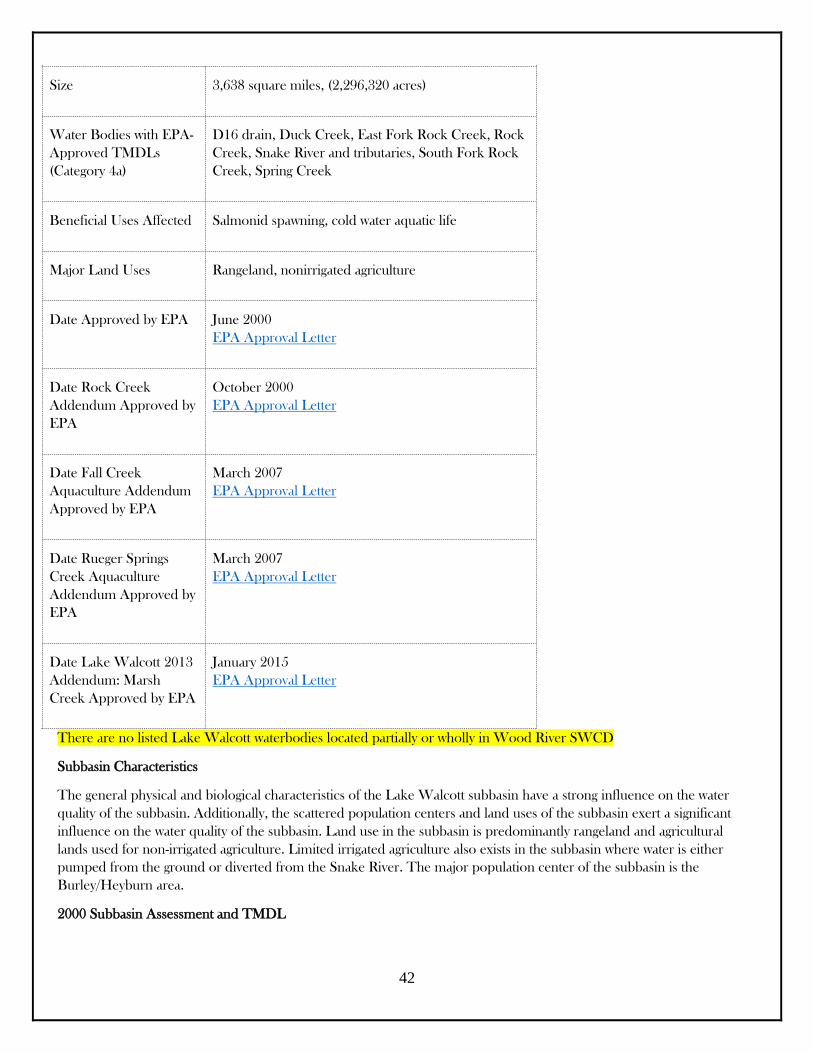
Subbasin at a Glance
Hydrologic Unit Code 17040209
42
Size 3,638 square miles, (2,296,320 acres)
Water Bodies with EPA-
Approved TMDLs
(Category 4a)
D16 drain, Duck Creek, East Fork Rock Creek, Rock
Creek, Snake River and tributaries, South Fork Rock
Creek, Spring Creek
Beneficial Uses Affected Salmonid spawning, cold water aquatic life
Major Land Uses Rangeland, nonirrigated agriculture
Date Approved by EPA June 2000
EPA Approval Letter
Date Rock Creek
Addendum Approved by
EPA
October 2000
EPA Approval Letter
Date Fall Creek
Aquaculture Addendum
Approved by EPA
March 2007
EPA Approval Letter
Date Rueger Springs
Creek Aquaculture
Addendum Approved by
EPA
March 2007
EPA Approval Letter
Date Lake Walcott 2013
Addendum: Marsh
Creek Approved by EPA
January 2015
EPA Approval Letter
There are no listed Lake Walcott waterbodies located partially or wholly in Wood River SWCD
Subbasin Characteristics
The general physical and biological characteristics of the Lake Walcott subbasin have a strong influence on the water
quality of the subbasin. Additionally, the scattered population centers and land uses of the subbasin exert a significant
influence on the water quality of the subbasin. Land use in the subbasin is predominantly rangeland and agricultural
lands used for non-irrigated agriculture. Limited irrigated agriculture also exists in the subbasin where water is either
pumped from the ground or diverted from the Snake River. The major population center of the subbasin is the
Burley/Heyburn area.
2000 Subbasin Assessment and TMDL
43
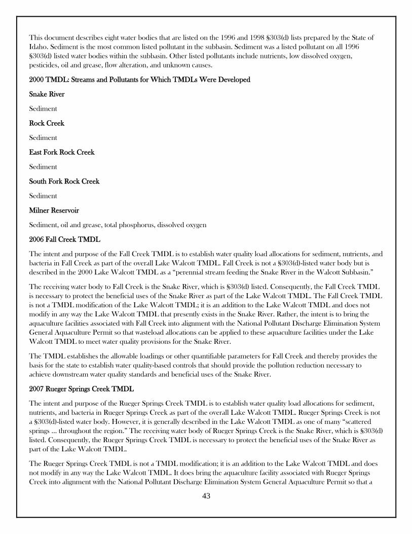
This document describes eight water bodies that are listed on the 1996 and 1998 §303(d) lists prepared by the State of
Idaho. Sediment is the most common listed pollutant in the subbasin. Sediment was a listed pollutant on all 1996
§303(d) listed water bodies within the subbasin. Other listed pollutants include nutrients, low dissolved oxygen,
pesticides, oil and grease, flow alteration, and unknown causes.
2000 TMDL: Streams and Pollutants for Which TMDLs Were Developed
Snake River
Sediment
Rock Creek
Sediment
East Fork Rock Creek
Sediment
South Fork Rock Creek
Sediment
Milner Reservoir
Sediment, oil and grease, total phosphorus, dissolved oxygen
2006 Fall Creek TMDL
The intent and purpose of the Fall Creek TMDL is to establish water quality load allocations for sediment, nutrients, and
bacteria in Fall Creek as part of the overall Lake Walcott TMDL. Fall Creek is not a §303(d)-listed water body but is
described in the 2000 Lake Walcott TMDL as a “perennial stream feeding the Snake River in the Walcott Subbasin.”
The receiving water body to Fall Creek is the Snake River, which is §303(d) listed. Consequently, the Fall Creek TMDL
is necessary to protect the beneficial uses of the Snake River as part of the Lake Walcott TMDL. The Fall Creek TMDL
is not a TMDL modification of the Lake Walcott TMDL; it is an addition to the Lake Walcott TMDL and does not
modify in any way the Lake Walcott TMDL that presently exists in the Snake River. Rather, the intent is to bring the
aquaculture facilities associated with Fall Creek into alignment with the National Pollutant Discharge Elimination System
General Aquaculture Permit so that wasteload allocations can be applied to these aquaculture facilities under the Lake
Walcott TMDL to meet water quality provisions for the Snake River.
The TMDL establishes the allowable loadings or other quantifiable parameters for Fall Creek and thereby provides the
basis for the state to establish water quality-based controls that should provide the pollution reduction necessary to
achieve downstream water quality standards and beneficial uses of the Snake River.
2007 Rueger Springs Creek TMDL
The intent and purpose of the Rueger Springs Creek TMDL is to establish water quality load allocations for sediment,
nutrients, and bacteria in Rueger Springs Creek as part of the overall Lake Walcott TMDL. Rueger Springs Creek is not
a §303(d)-listed water body. However, it is generally described in the Lake Walcott TMDL as one of many “scattered
springs … throughout the region.” The receiving water body of Rueger Springs Creek is the Snake River, which is §303(d)
listed. Consequently, the Rueger Springs Creek TMDL is necessary to protect the beneficial uses of the Snake River as
part of the Lake Walcott TMDL.
The Rueger Springs Creek TMDL is not a TMDL modification; it is an addition to the Lake Walcott TMDL and does
not modify in any way the Lake Walcott TMDL. It does bring the aquaculture facility associated with Rueger Springs
Creek into alignment with the National Pollutant Discharge Elimination System General Aquaculture Permit so that a
44
wasteload allocation can be applied to this facility under the Lake Walcott TMDL and meet water quality provisions for
the Snake River. The Rueger Springs Creek TMDL, therefore, is an iterative watershed management tool for
implementing state water quality standards and is based on the relationship between pollution sources and instream water
quality conditions.
The Rueger Springs Creek TMDL establishes the allowable loadings or other quantifiable parameters for Rueger Springs
Creek and thereby provides the basis for the state to establish water quality-based controls. These controls should
provide the pollution reduction necessary for Rueger Springs Creek to achieve downstream water quality standards and
beneficial uses of the Snake River.
Subbasin Documents
The Lake Walcott Subbasin Assessment, Total Maximum Daily Load, and Implementation Plan (2000)
The Fall Creek Total Maximum Daily Load (TMDL) of the Lake Walcott Watershed Management Plan (Lake
Walcott TMDL) (November 2006)
The Rueger Springs Total Maximum Daily Load (TMDL) of the Lake Walcott Watershed Management Plan
(Lake Walcott TMDL)
(January 2007)
Lake Walcott Total Maximum Daily Load (TMDL) Agricultural Implementation Plan (December 2001)
Lake Walcott Subbasin Assessment and Total Maximum Daily Loads: Five-Year Review (Includes Rueger
Springs and Fall Creek TMDLs) (May 2012)
Lake Walcott Total Maximum Daily Load 2013 Addendum: Marsh Creek Temperature and E. coli TMDLs
(December 2013)