senior project: the bieke plantation
DESCRIPTION
UGA senior capstone projectTRANSCRIPT
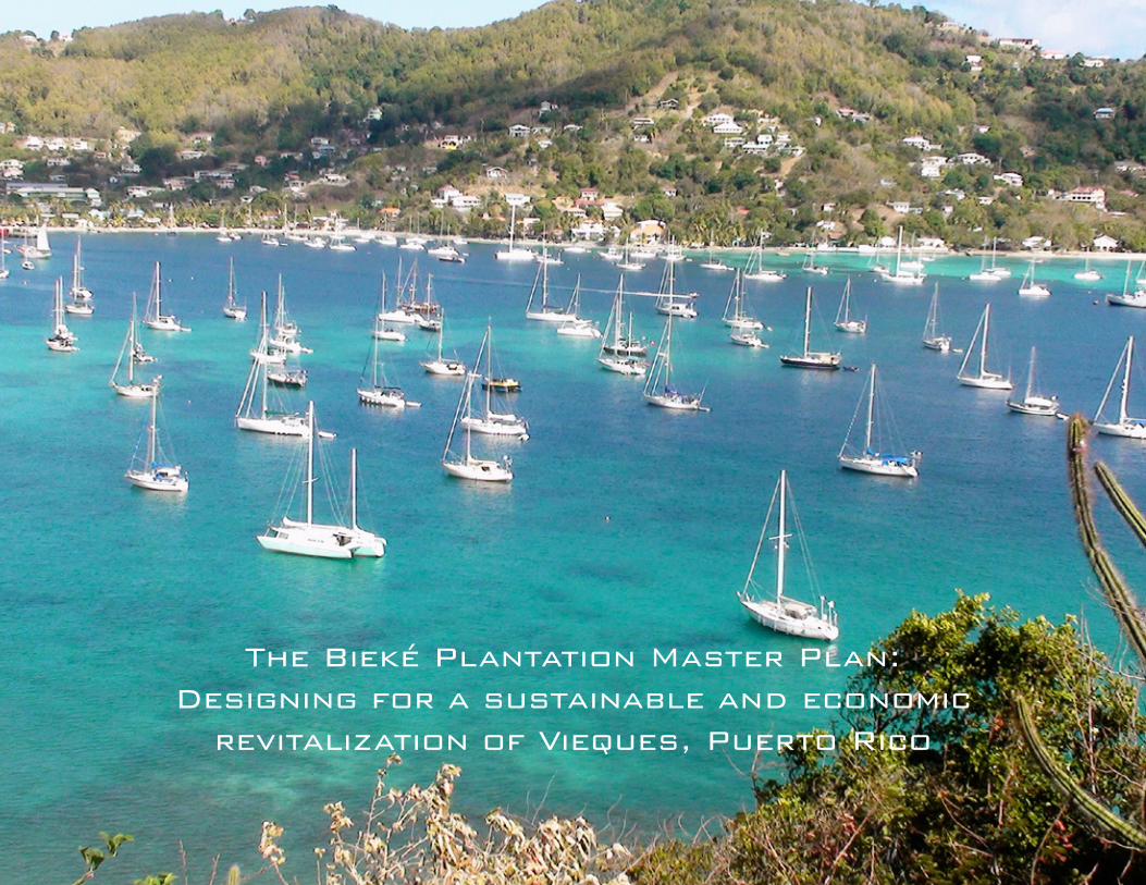
The Bieké Plantation Master Plan:Designing for a sustainable and economic
revitalization of Vieques, Puerto Rico


The Bieké Planta on Master Plan:Designing for a sustainable and economic revitaliza on of Vieques, Puerto Rico
by
Nathan Aarons
A Senior Design ProjectPresented to the College of Environment and Design
University of GeorgiaUnder the Direc on of:
Associate Professor José R. BuitragoIn par al fulfi llment of the requirements for the degree of
Bachelor of Landscape Architecture
Athens, GeorgiaSpring, 2013


Contents
Introduction
History 2 Situation 4
Site 5
Program Development
Design Concept & Objectives 8 Program Development 9 Inventory & Analysis 10
Constraints & Potentials 18
Conceptual Design
Concept Formulation 22 Master Planning & Alternative Designs 26
Design Development
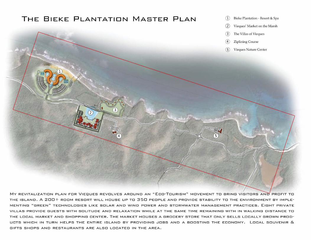
The Bieke Plantation Master Plan 32 The Resort & Spa at The Bieke Plantation 34 The Markets on the Marsh at The Bieke Plantation 36
The Villas at The Bieke Plantation 38
Technical Documentation Grading Plan 42 Lighting Plan 44
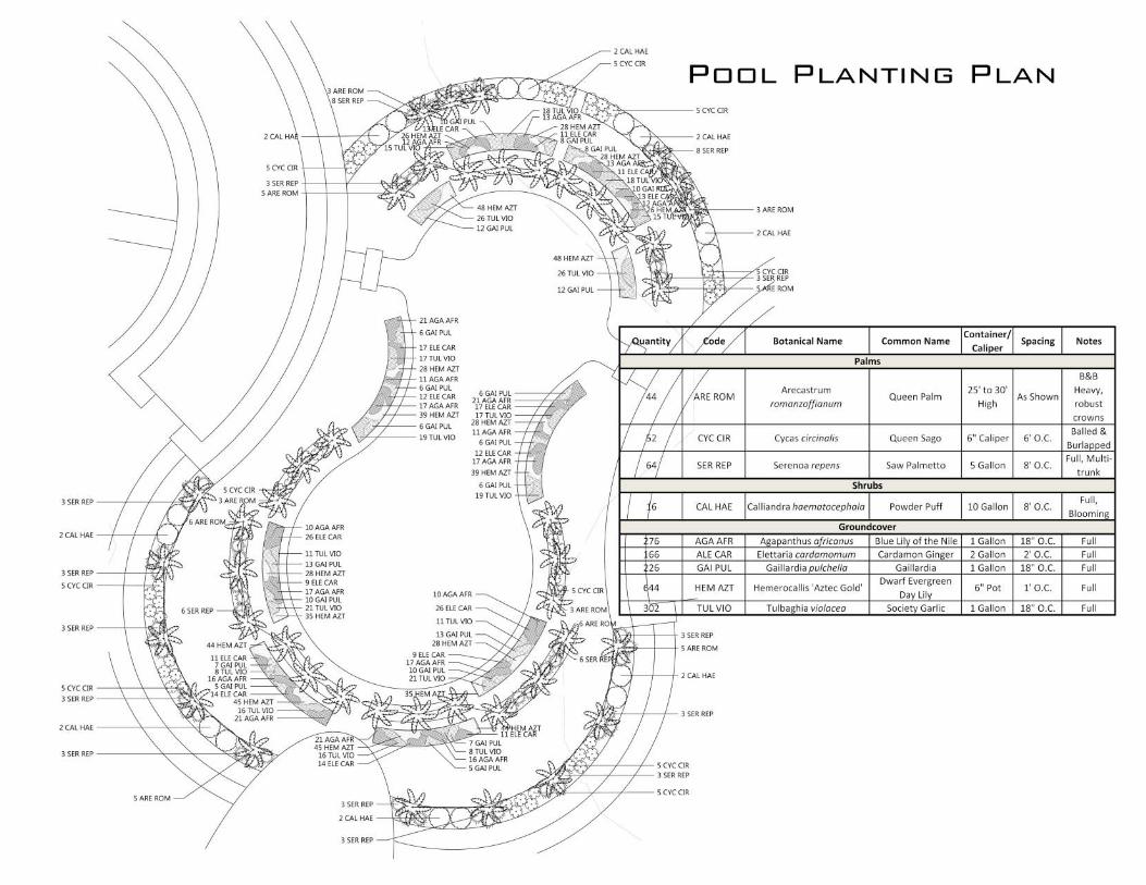
Planting Plan 46
Addendum
History 52 Economy 54
Tourism 56


Introduction


History
Vieques is an island–municipality of Puerto Rico in the Caribbean Sea. It is part of the United States Common-wealth of Puerto Rico, but, like the rest of Puerto Rico, retains strong influences from years of Spanish ownership.Vieques lies about 8 miles to the east of the Puerto Rican mainland, and measures about 21 miles long by 4 miles wide. Its two main towns are Isabel Segunda and Esperanza. At peak, the population of Vieques is around 10,000.
The island’s name is a Spanish spelling of the Taíno word “Bieké”, said to mean “small island”. It also has the nickname “Isla Nena”, usually translated from the Spanish as “Little Girl Island”, alluding to its perception as Puerto Rico’s little sister.
Vieques is best known as the site of a series of pro-tests against the United States Navy’s use of the is-land as a bombing range and testing ground, which led to the navy’s departure in 2003. Today the for-mer navy land is a national wildlife refuge, with nu-merous beaches that are commonly listed among the top beaches in the Caribbean for their azure-colored waters and white sands.

Situation
On April 19, 1999 two United States F-18 jets mistook an observation point for a designat-ed target and dropped 500 pound bombs on it killing a security guard named David Sanes and injuring three others. This event sparked huge protests all over the island and Puerto Rico leading to promises the Navy would be removed by May of 2003.
The Navy has since picked up everything and left the island under the administration of the United States Department of Interior’s Fish and Wildlife Service. A huge movement to clean up the island is under way. The Navy left behind a huge contamination problem that includes heavy metals, napalm, Agent Orange, depleted uranium, and other land, marine, and aerial contaminants. The citizens of Vieques are demanding that the Navy has the responsibility to return the island to its original state that they found it in 1941.
All of this has left the island in a poor state with disease and unemployment very high among the citizens. The mortality rate of the citi-zens is the highest among the 78 municipalities of Puerto Rico. Some have determined that the contaminants from the ordinance can be linked to the increasing cancer rates and the decrease of the economic value of the island due to de-creasing tourism and fish and wildlife popula-

Plat Description:
My site is located on the North side of Vieques. The site extends along the coast line from Pta. Goleta west to Puerto Diablo and includes Lagu-na Puerto Diablo in the South east corner. I chose this site to try and incorporate the Westerly Trade Winds that blow in to the North side of the island. The area is relatively flat but does have a little elevation change throughout. The are a few marsh-lands scattered along the coast but can be incorporated in to the design.
Site
Property Coordinates:
Northwest Corner: 18 degrees 09’19.88” N - 65 degrees 21’22.20” W
Southwest Corner:18 degrees 08’58.56” N - 65 degrees 21’29.68” W
Northeast Corner: 18 degrees 08’54.20” N - 65 degrees 19’45.99” W
Southeast Corner: 18 degrees 08’32.07” N - 65 degrees 19’52.69” W


Program Development

Design Concept:
To create an resort that helps revitalize the land through environmental and sustainable design ideas. To use additional tourism to provide economic prosperity to the island of Vieques without fur ther damaging the island or losing its’ “sense of place.”
Design Objectives:
Eco-Resort Ideas o Establish environmentally friendly activities that allow the users to enjoy their time on the island while also exploring different ways to minimize the negative effects that are placed on the environment. For sixty years, people were limited to only use a third of the island. I would like to open a part of this island to the people and allow for exploration and interaction of it. o Use renewable energy and environmentally sensitive water and waste disposal systems to create a resort that will meet the LEED Gold or Silver standards. I want to use the tools that the environment is presenting to us so that we don’t have to rely and live by the dwindling fossil fuels. o Offer many opportunities for interaction with local owners, managers, staff and guides. This will ease the idea of establishing another resort on the island if I could establish good relationships with the local people by using the businesses for attractions. o Offer a variety of excursions and educational materials to natural and cultural sites. This would allow the island to be used for more than a tourist destination and beaches. I want to incorporate activities that center on the history of the island and its’ people. Economic Prosperity o Use local, sustainably harvested and/or recycled building materials. This would help in achieving LEED standards as well as providing businesses with possible work. o Purchase food from local farmers, ranchers, or fishermen. o Employ and train local workers. This will create many jobs and boost the local economy of the island by boosting jobs and adding revenue to the island.
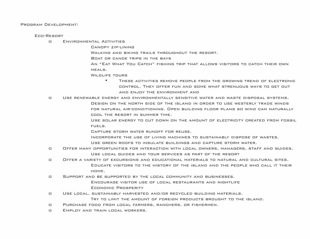
Program Development:
Eco-Resort o Environmental Activities � Canopy zip-lining � Walking and biking trails throughout the resort. � Boat or canoe trips in the bays � An “Eat What You Catch” fishing trip that allows visitors to catch their own meals. � Wildlife tours • These activities remove people from the growing trend of electronic control. They offer fun and some what strenuous ways to get out and enjoy the environment and o Use renewable energy and environmentally sensitive water and waste disposal systems. � Design on the north side of the island in order to use westerly trade winds for natural air-conditioning. Open building floor plans so wind can naturally cool the resort in summer time. � Use solar energy to cut down on the amount of electricity created from fossil fuels. � Capture storm water runoff for reuse. � Incorporate the use of living machines to sustainably dispose of wastes. � Use green roofs to insulate buildings and capture storm water. o Offer many opportunities for interaction with local owners, managers, staff and guides. � Use local guides and tour services as part of the resort o Offer a variety of excursions and educational materials to natural and cultural sites. � Educate visitors to the history of the island and the people who call it their home. o Support and be supported by the local community and businesses. � Encourage visitor use of local restaurants and nightlife � Economic Prosperity o Use local, sustainably harvested and/or recycled building materials. � Try to limit the amount of foreign products brought to the island. o Purchase food from local farmers, ranchers, or fishermen. o Employ and train local workers.


Conceptual Design


Design Development


Technical Documentation


Addendum

SOCIOECONOMIC CHARACTERISTICS CULTURAL HISTORY
The first permanent inhabitants of Vieques are considered to be the Archaic who lived there from 1680 to 1500 B.C. This culture was followed by others known as the Saladoid, Huecoid, Ostionoid, and Taino cultures (Figures 15 and 16). At the time of the arrival of Christopher Columbus in 1493, the Taino population of Puerto Rico was estimated to be about 60,000. Within a very short period, the Taino people were subjugated by the Spanish and their population was decimated by disease, emigration, in combat with Spanish troops, and assimilation into the population. Since the first Spanish settlers did not bring women, it was common practice to take Taino wives. In 1511, several of the Taino chiefdoms in Puerto Rico, allied with the Caribs, and tried to defeat the Spaniards. This uprising was defeated by troops under the control of Governor Juan Ponce de León.
In 1514, Cacimar, the Indian chief of Bieque, (Indian name for small land) actively participated in the attacks against the Spaniards. His brother, Yaureibo, led the last combat in Vieques in which the Spaniards brutally killed many Tainos and burned their huts and plantations.
Although the Spaniards considered Vieques an important part of their colonization project, they did not inhabit the island immediately. The English, Dutch, and French settled on the island at various times during the 17th and 18th centuries, but they were all eventually evicted.
In 1811, the Governor of Puerto Rico sent Juan Roselló to colonize the island. Although he was not fully successful, he was followed by Teófilo J.J. M. Le Guillou, of French descent. In 1828, Le Guillou asked the Governor of Puerto Rico to let him be in charge of Vieques’ lands, thus becoming the first Governor of Vieques. He led the Vieques’ colonization until his death in 1843. During his governing period, the first sugar plantations were established. The sugar industry and plantation system resulted in significant increases in the slave trade and the use of slaves in Vieques during the period up to the abolition of slavery in Puerto Rico. Slavery was officially abolished in Puerto Rico in 1873. During the late1800s, the sugar industry in Vieques was expanding with as many as five mills processing sugar in the early years of the Twentieth Century.
Between the early 1900s and the expropriations by the Navy, sugar production was a major but declining agricultural activity in Vieques. The sugar plantation economy that developed during the19th century brought about a concentration of lands under the control of relatively few owners. This was the case in Vieques, as well as other cane growing areas. Associated with the large land holdings was the practice of permitting workers to live, build homes, and tend gardens and livestock on parcels within the larger estates. These workers, or “agregados,” did not have title to the lands they lived on, but were generally permitted to remain and provided a labor force for the landowners on a seasonal basis. By the beginning of the Great Depression of the 1930s, the sugar plantations that were still operating faced an economic crisis and many families from Vieques left for the island of Saint Croix to pursue work opportunities. Between 1920 and 1940, the population in Vieques dropped from its peak of approximately 11,600 to 10,300. Ayala (2004) reported that between 1930 and 1940, 2,749 people emigrated from Vieques. After the expropriations of the 1940s, the population continued to decline until approximately 1960, and has shown slight increases

since then.
Between 1941 and 1947, the United States expropriated approximately 26,000 acres on the Island of Vieques for use by the Navy as a base and training facility. The expropriation of the lands on the eastern and western portions of the island left the civilian population with the zone in the center of the island. On August 25, 1941, the U.S. Congress approved Public Law 247, which authorized the Navy to assume immediate possession of the lands to be expropriated for the construction of the naval base in Vieques. Shortly after acquiring the lands, the Navy began construction activities on the military facilities in Vieques. For a few years, this construction activity provided employment opportunities for the local population. After the first several years of Navy presence, the construction job opportunities declined and since the potential for agricultural employment was greatly reduced, emigration from Vieques continued. The remaining population was restricted to a strip of land between the eastern and western military operations.
For many years, segments of the Vieques population opposed the Navy presence and lobbied to stop the military activities. In 1980, members of Congress recommended that the Navy leave Vieques. In 1983, the Government of Puerto Rico and the Navy entered into a Memorandum of Understanding regarding community assistance, land use, operation of the ranges, and environmental issues. That agreement established the conservation zones within the Navy-controlled areas. In 1999, a civilian security guard was killed by accident at the Observation Post adjacent to the Live Impact Area on eastern Vieques. That incident brought about an increase in the opposition to the Navy use of Vieques as a training area. In 2001, 4,000 acres of former Navy lands on western Vieques were transferred to the municipality, 800 acres to the Puerto Rico Conservation Trust, and 3,100 acres to the Department of the Interior. That same year, a non-binding referendum was held and 68 percent of the Vieques voters demanded that the Navy cease military practices, clean-up, and “return” the lands. On May 1, 2003, military operations and bombing in Vieques ceased and the eastern lands (14,543 acres) were transferred to the administrative jurisdiction of the Department of the Interior.
The Plan de Ordenamiento Territorial (land use plan), recently approved for Vieques, seeks to present guidelines for the island’s development. The documents include infrastructure projects and works consistent with the development vision established in the Sustainable Development Master Plan for the Municipality of Vieques. In 1999, by virtue of Executive Order 1999-21, the Vieques Special Commission and its Special Commissioner Office were created to evaluate the impacts of the Navy’s presence in Vieques. This office is an interagency means to facilitate the coordination between the Federal Government, the Government of Puerto Rico and its agencies, the Office of the Resident Commissioner, the municipality of Vieques, the private sector, and the community. Taken from the Vieques National Wildlife Refuge Comprehensive Conservation Plan and Environmental Impact Statement, pages 53 and
56.

EMPLOYMENT In Vieques, the total employment experienced a general increasing tendency from 1990 to 2002 (Table 4). In the early 1990s, employment was at a low with 1,153 people employed. Later it recovered and in 1998 began to decline again, arriving at 1,292 people employed in 2001. In 2002, recovery returned with 1,389 people employed. The increases although small have been less significant than in Puerto Rico as a whole. Reports produced by the Puerto Rico Department of Labor indicate that Vieques is among the municipalities with the lowest average annual employment growth in the eastern region. Table 4. Average annual employment growth, by municipality (1990-2002)
Municipality Annual Employment Juncos 4.3 Culebra 4.2 Patillas 3.5 Rio Grande 1.7 Fajardo 1.6 Yabocoa 1.2 Humacao 1.1 Las Piedras 1.0 Vieques 0.9 Naguabo 0.7 Maunabo 0.1 Luquillo -1.7 Ceiba -2.3 Eastern Region 1.2 Puerto Rico 1.6
Information from: Puerto Rico Department of Labor and Human Resources
The unemployment rate was 18.1 percent in 2002, and dropped to 16.0 percent in 2003. It is among the highest when compared to the surrounding municipalities in the region. The government is the principal employer in the municipality. In 2001, the government employed 41.1 percent of the workers. Based on this information, it can be seen that economic activity on the island is not very diverse. Other industries with reduced employment are manufacturing, insurance, and real estate. Employment has increased in construction and wholesale trade.
Income
The income level in Vieques is lower than in other areas of Puerto Rico with the average annual salary per worker reaching a maximum of $16,308 in 2002. Salaries vary from one industry to another but overall do not attain the levels of the other municipalities of Puerto Rico. Commercial Activity
Studies conducted in Vieques related to commercial activities have shown a reduction over time. In the case of sales at supermarkets and other food stores, construction materials, and eating and drinking establishments, there is an increase at the present time. The data shows that the number of establishments is decreasing by an average of 0.3 percent per year.
Construction
Based on the number of construction permits the Planning Board has granted, it appears that construction has increased during the last decade.
Tourism Projects
The Tourism Company of Puerto Rico reported that in January 2004, there were six tourism projects in Vieques. There are currently over 25 establishments providing lodging. These include small guest houses with only a few rooms to the Martineau Bay Resort with 138 rooms. There are more than 25 eating establishments.
Cost of Living The high cost of living has been one of the most frequent concerns expressed by the Viequenses. The necessity of transporting the major part of the products to the islands causes an increase in their costs. The existence of limited retail distribution channels also contributes to the price increases.
Taken from the Vieques National Wildlife Refuge Comprehensive Conservation Plan and Environmental Impact Statement, pages 56 - 58.

PUBLIC USE The refuge’s public use occurs year-round from 6 a.m. to sunset. Recreational activities include wildlife observation, wildlife photography, interpretation, environmental education, fishing access, and beach use. Beach-related recreation, such as sunbathing, is the most popular activity on the refuge. A more detailed look at current levels of use is found in Alternative A - Current Management (No Action).
Access to the Vieques National Wildlife Refuge occurs on both the western and eastern portions of the refuge. The western refuge consists of approximately 3,100 acres with recreational opportunities on areas known as Playa Grande, Punta Arenas (Green Beach), and Kiani Lagoon. The eastern refuge consists of approximately 14,573 acres with recreational opportunities at various beaches, but especially at Playa Caracas (Red Beach) and Playa La Chiva (Blue Beach). Currently, a major portion of the eastern refuge is closed due to the danger of unexploded ordnance and the cleanup process occurring in that area.
Wildlife Observation
The refuge has a wooden boardwalk located at Kiani Lagoon. The boardwalk extends around the lagoon. It provides an excellent view of Mt. Pirata, the highest elevation on the island and the original moist subtropical forest on Vieques. The number of people who visit the refuge to view wildlife is unknown, but many users who visit primarily for other reasons, such as beach use, also enjoy seeing wildlife. Currently, there are no designated wildlife observation trails but the public uses areas of open access to observe a myriad of butterflies and bird species.
Wildlife Photography
Although there are no photography blinds available for public use, visitors can photograph wildlife on the refuge in areas not restricted to access during refuge visiting hours. Interpretation
The refuge has an interpretive kiosk located at the head of the wooden board walk at Kiani Lagoon, describing elements of the mangrove swamp habitat and its ecological importance. The area is highly visited by local residents and tourists. Recently, an interpretive kiosk was located at the east entrance to the refuge describing the Service and Refuge Mission and informing the public of current recreational opportunities. The Service office hosts lecture programs occasionally during the year highlighting the island’s natural resources.
Environmental Education
The refuge has not developed a formal curriculum-based environmental education program. Although there is no formal program, the staff has taken college level students, local community groups, teacher workshop groups and school groups, both from Vieques and Puerto Rico, onto the refuge to teach them about the island’s ecosystems and management issues. Refuge staff has also brought environmental education activities to many local schools and local summer camp groups.
Boating/Canoeing
Naturally formed boat launching sites are located on both the eastern and western portions of the refuge. These sites are currently available for launching small water craft. All activities within the waters around the refuge are governed by state regulations. The boat ramps at the eastern refuge are at the east end of Playa La Chiva (Blue Beach), Conch Beach (in the Ensenada Honda area), and at Barracuda Bay also known as Puerto Ferro. The launch site at the western refuge is located by Kiani Lagoon.
Fishing/Hunting
Sport fishing access is allowed on the beachfront and in the lagoons, except for those areas that are posted closed. Fishing use is governed by state regulations. Hunting is not currently allowed on the refuge for a variety of reasons, including rare species and safety issues.
Beach Use
Beach recreation is the primary public use activity on the refuge. Primary recreational areas include Playa Grande and Punta Arena (Green Beach) at the western section of the refuge. Playa Caracas (Red Beach) and Playa La Chiva (Blue Beach) are the most visited at the eastern section of the refuge. However, there are other beaches used to a lesser extent. Punta Arena (Green Beach) and Playa La Chiva (Blue Beach) are also frequented on weekends and holidays by recreational boaters from Puerto Rico and other neighboring islands. Playa Caracas, Playa La Chiva, and Punta Arenas all have shelters and each has a picnic table. The shelters provide a shaded place for visitors to relax and enjoy their beach related activities.
Taken from the Vieques National Wildlife Refuge Comprehensive Conservation Plan and Environmental Impact Statement, pages 59 - 60.

Articles Bibliography
Backiel, Linda. “The People of Vieques, Puerto Rico vs. the United States Navy.” Monthly Review 1 Feb. 2003: 1-13. Print.
Barreto, Amí lcar Antonio. Vieques, the Navy, and Puerto Rican Politics. Gainesville: University of Flori da, 2002. Print.
Gold, Liv. “In Vieques, Puerto Rico, La Lucha Continua.” Dollars & Sense 268 (2006): 12-15. Business Source Complete. Web. 22 Jan. 2013.
Luxner, Larry. “Ebbs And Flows On VIEQUES.” Americas 58.1 (2006): 40-45. MasterFILE Elite. Web. 21 Jan. 2013.
Martinez, Marialba. “Vieques’ History Marked By Multiple Invasions.” Caribbean Business 32.17 (2004): 27. Business Source Complete. Web. 22 Jan. 2013.
Montane, Diana. “The Rebirth Of VIEQUES.” Hispanic 22.1 (2009): 20-22. MasterFILE Elite. Web. 21 Jan. 2013.
“Petitioned Public Health Assessment Soil Pathway Evaluation, Isla De Vieques Bombing Range, Vieques, Puerto Rico.” ATSDR-PHA-HC-Soil Characteristics, Isla De Vieques Bombing Range, Vieques, Puerto Rico. Agency for Toxic Substances and Disease Registry, 2 July 2009. Web. 21 Jan. 2013.
United States. Cong. U.S. Department of the Interior Fish and Wildlife Service Southeast Region. Vieques National Wildlife Refuge Comprehensive Conservation Plan and Environmental Impact Statement. Cong. Rept. Atlanta, GA: U.S. Dept. of the Interior, Fish and Wildlife Service, Southeast Region, 2007. Print.
Wilcox, Joyce. “Vieques, Puerto Rico: An Island Under Siege.” American Journal Of Public Health 91.5 (2001): 695-698. Business Source Complete. Web. 21 Jan. 2013.

Images Bibliography
History Pagehttp://www.islands.com/files/2012/day_2_san_juan_vieques_villa_casa_del_caribe_jay_pentax_raw_5550.jpg?1332989668
Situation Pagehttp://www.hispanicallyspeakingnews.com/uploads/images/article-images/041808_vieques2_story.JPGhttp://media.cmgdigital.com/shared/lt/lt_cache/thumbnail/960/img/photos/2013/05/01/2d/c4/547479a1855444658ac535d98069f72f-92dae5dcea894789b6d6197265ea3a1d-1.jpghttp://www.vieques-island.com/navy/images/vqsmapnavy.gifhttp://people.goshen.edu/~johnrb/vieques/May2000photos/USGSBombingRangeCloseup1.jpg
Master Plan Pagehttp://cache.marriott.com/propertyimages/h/hnljw/hnljw_home01.jpghttp://img.pr.com/release-file/1103/304012/runawaybay0451.jpghttp://www.visitpanamacitybeach.com/images/photos/sized/440/pier2.JPGhttp://farm1.static.flickr.com/231/473988886_c9bf9b654d.jpghttp://poipubeach.org/sites/default/files/PoipuShoppingCenters.jpg
Villas Pagehttp://www.palmcoveprivatevillaclub.com/cmsAdmin/uploads/private-villa-club-interior.jpghttp://www.serenevillas.com/maju/maju-mainpic2.jpghttp://blog.paradizo.com/wp-content/uploads/2010/08/athena-villas.jpg
Planting Pagehttp://www.esacademic.com/pictures/eswiki/83/Starr_020617-0019_Syagrus_romanzoffiana.jpghttp://users.telenet.be/cr28796/CycaCirc.jpghttp://www.chillypalmtree.com/alex_s_serenoa_repens_op_800x600.jpghttp://mgonline.com/media/Images/p/powderpuff01.jpghttp://www.missouribotanicalgarden.org/Portals/0/PlantFinder/low/A433-0906053tp.jpghttp://zvetki.ru/rgimage/189_413.jpghttp://www.mudia.com/green/_images/gaillardia_pulchella.jpghttps://www.gogardennow.com/media/catalog/product/cache/1/image/9df78eab33525d08d6e5fb8d27136e95/a/z/aztec-gold-001_2.jpghttp://www.mgonlinestore.com/SocietyG/Society_Garlic03.jpg
