sedimentary history of mangrove cays in turneffe … · depths of .1000 m occur immediately to the...
TRANSCRIPT
Sedimentary History of Mangrove Cays in Turneffe Islands,Belize: Evidence for Sudden Environmental Reversals
Terrence A. McCloskey and Kam-biu Liu
Department of Oceanography and CoastalSciences
School of the Coast and EnvironmentLouisiana State UniversityBaton Rouge, LA 70803, [email protected]
ABSTRACT
McCloskey, T.A. and Liu, K.-B., 2013. Sedimentary history of mangrove cays in Turneffe Islands, Belize: evidence forsudden environmental reversals. Journal of Coastal Research, 29(4), 971–983. Coconut Creek (Florida), ISSN 0749-0208.
The Holocene history of the continental margin of Belize has frequently been interpreted as being very straightforward,controlled almost entirely by postglacial sea level rise. Depending upon location, the dominant depositional environment,whether coral or mangrove, is either able to keep up with the rising sea level and thereby maintain its integrity throughthe present, or becomes drowned. Here we present sedimentary evidence from four mangrove cays situated on TurneffeIslands that shows an unusual pattern wherein early mangrove development is replaced by carbonate sedimentationbefore reverting back to mangroves in the relatively recent past. The bracketed carbonate layers, up to .2 m thick andresembling lagoon-floor material, display both a rough temporal coincidence across sites and a distinctive geographicsignature, thinning landward irrespective of relative elevation. The carbonate sections are often underlain by a mixedsediment layer characterized by a jumble of stratigraphically incoherent mangrove clumps intermingled withcarbonates. The replacement of mangrove peat with bottom-style carbonate deposition suggests a lowering of islandsurface elevation. Seismic activity is identified as the most likely cause, although hurricanes cannot be excluded. Ineither case the elevational reduction is probably amplified by peat collapse associated with mangrove mortality. Theoccurrence of such activity and the resulting catastrophic ecological/geomorphic change indicate a need for incorporatingthese geological perturbations in risk assessment for Turneffe Islands.
ADDITIONAL INDEX WORDS: Atlantic atolls, Turneffe Islands, Belize, mangroves, sea level rise, seismic activity,hurricanes, tsunamis.
INTRODUCTION
The paleoenvironmental history of the continental margin of
Belize is well known in the broad scale. Histories have been
developed from sediment cores extracted from numerous
mangrove cays both along and inside the barrier reef as well
as the coral rims and lagoon floors of all three offshore
carbonate platforms (Gischler, 1994, 2003; Gischler and
Hudson, 1998, 2004; Gischler and Lomando, 2000; Gischler et
al., 2008; Halley et al., 1977; Jones and Dill, 2002; Littler et al.,
1995; Macintyre, Littler, and Littler, 1995; Macintyre et al.,
2004; McKee and Faulkner, 2000; Monacci et al., 2009; Wooller
et al., 2004, 2007, 2009). The inferred regional environmental
history is straightforward, with both coral and mangrove cays
falling into one of two categories. Where vertical accretion rates
have kept up with sea level rise the cays have maintained their
respective compositional character, whereas when sea level
rise has surpassed accretion rates, islands have become
permanently submerged, with the mangrove peat or coral
formation being replaced by unconsolidated bottom deposition.
Here we present sedimentary evidence from six mangrove
cays covering a 30 km transect that suggests that the
environmental history has not been so uniformly simple for
Turneffe Islands, but that dramatic biological and geomorphic
perturbations have affected the atoll over the late Holocene,
and attempt to identify the causes of these unusual stratigra-
phies.
ENVIRONMENTAL SETTING ANDGEOLOGICAL HISTORY
The continental shelf of Belize consists of a shallow marine
lagoon extending from the mainland to the barrier reef. The
continental slope begins immediately east of the barrier reef,
marked by rapidly increasing water depths, interrupted by
three isolated carbonate platforms: Turneffe Islands, Light-
house Reef, and Glovers Reef (Figure 1). These platforms are
rare Atlantic atolls, accreted coral reefs that rise from deep
water to the surface, forming coral rims surrounding central
lagoons.
Turneffe Islands is located on a fault ridge, separated from
the barrier reef to the west by water depths of .400 m, while
DOI: 10.2112/JCOASTRES-D-12-00156.1 received 17 August 2012;accepted in revision 1 November 2012; corrected proofs received 24January 2013Published Pre-print online 27 February 2013.� Coastal Education & Research Foundation 2013
Journal of Coastal Research 29 4 971–983 Coconut Creek, Florida July 2013
depths of .1000 m occur immediately to the east. The atoll is
somewhat elliptical with the long axis running north–south.
Maximum distances are~50 km north to south and 16 km east
to west (Figure 1). The eastern face of the atoll is a vertical wall
hundreds of meters in height, topped by a wave-breaking rim of
coral, broken by a small number of openings, the most
important of which are, from north to south, Northern Bogue,
Long Bogue, and Grand Bogue. Lying behind the rim is a reef
flat generally ,400 m wide covered by a few tens of centimeters
of water. The center of the atoll is the Central Lagoon, dotted
with mangrove cays that rise steeply from the lagoon floor.
Circulation is restricted. Maximum lagoon depth is 8 m; the
floor is densely covered by sea grass (Thalassia), the calcareous
algae Halimeda, sponges (Spheciospongia species), and occa-
sional coral, mainly Porites species and Manicina areolata.
Seafloor sediments are dark, stained by the decaying organic
matter washed off the mangrove cays and are dominated by
Halimeda debris (Gischler, 2003; Gischler and Hudson, 1998).
Mangroves, which dominate atoll vegetation, typically display
zonation, with fringing red mangroves (Rhizophora mangle) at
the lowest levels, and bands of first black (Avicennia germi-
nans) and then white mangroves (Laguncularia racemosa)
forming inland, and dwarf Rhizophora forests developing in
areas of higher salinity (McKee, 1995; McKee and Faulkner,
2000; Murray et al., 2003). Sand is produced by the powdering
of coral on the reef face and flats. Subaerial sand is most
common on the eastern reef flat, either in piles as sandy cays
along the inside coral rim or as beaches on the eastern edges of
the facing mangrove islands. Beaches are commonly lacking on
the interior mangrove islands, which generally rise steeply
from the lagoon floor and consist of muddy peat right to the
island edge. Carbonate production, mainly by Halimeda,
dominates the lagoon-floor sediments (Gischler, 2003; Gischler
and Hudson, 1998).
During the last glaciation the Belize shelf (the current
shallow marine lagoon) and the three carbonate platforms were
all subaerial (Gischler and Hudson, 1998, 2004). The platforms
were dish-shaped limestone islands. The limestone shelf was
connected to the mainland, cut by river channels, the
topography controlled at depth by faults, and more superficial-
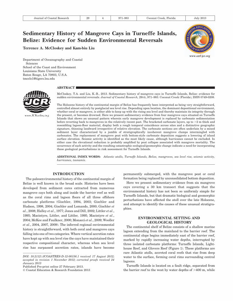
Figure 1. (c) Map of Turneffe Islands atoll, showing (a) geographical relation to the Caribbean, and (b) the Belize mainland. (d) The area around Long Bogue is
shown in greater detail, displaying the locations of sites 2, 3, and 4. (e) The three-core transect for site 3 is marked by a white box. The six coring sites are marked
by numbers: corresponding site designations are listed in the box on the left.
Journal of Coastal Research, Vol. 29, No. 4, 2013
972 McCloskey and Liu
ly by the antecedent topography imposed by a series of
Pleistocene reefs, themselves possibly sited on top of earlier
topographic highs based on siliclastic river deposits (Choi and
Ginsburg, 1982; Choi and Holmes, 1982; Dillon and Vedder,
1973; Ferro et al., 1999; Halley et al., 1977; Lara, 1993; Shinn et
al., 1979). Glacial melting and eustatic sea level rise drove a
rise in the water table leading to soil formation in most
locations. As sea level continued to rise, both the shelf and the
platforms flooded, leading to mangrove development in
intertidal areas and vertical accretion by coral along the rims
(Gischler, 2003; Gischler and Hudson, 1998, 2004). As the coral
rims built up, interior water depth increased, drowning the
mangroves in lower areas and where accretion was slow. These
flooded areas formed the floor of either the shelf or atoll
lagoons, depending on location. With the replacement of
mangrove peat deposition by the slower accretion rate
associated with carbonate production, the drowned areas fell
farther below sea level. On the carbonate platforms accommo-
dation space has increased since flooding, with lagoonal floor
sedimentation lagging far behind the vertical accretion of the
coral rim (Gischler, 2003; Gischler and Hudson, 1998, 2004).
On the other hand, ‘‘keep-up’’ mangroves, often starting on
antecedent highs (Halley et al., 1977), have kept pace with sea
level, building ever thicker peat sequences (up to 10 m thick,
Macintyre, Littler, and Littler, 1995; Wooller et al., 2009) that
support the steep-sided mangrove cays that presently dot the
shelf lagoon and atolls. This results from continuous near sea
level mangrove production as the cays accrete upward,
remaining within the upper tidal zone as the sea level rises
(Ellison, 1993; Macintyre, Littler, and Littler, 1995; McKee and
Faulkner, 2000; Woodroffe, 1981; Wooller et al., 2004, 2007,
2009). In most cases mangroves have dominated from their
establishment through the present, although small changes in
forest assemblage and canopy height have been recorded,
probably driven by changes in hydrology (Wooller et al., 2004,
2007, 2009).
This regional environmental progression has led to two
standard stratigraphic sequences:
Sequence 1. Limestone, brownish/greenish clay, mangrove
peat (‘‘keep-up’’ mangroves)
Sequence 2. Limestone, brownish/greenish clay, mangrove
peat, carbonates (‘‘drowned’’ mangroves)
Where mangroves have kept up with sea level (mangrove
islands), peat deposition continues to the present (sequence 1);
where they have not (subaqueous locations), an abbreviated
peat layer becomes overlaid by carbonate-dominated sand and
silt (sequence 2). These are the common sequences, well
documented in the literature (Gischler, 1994, 2003; Gischler
and Hudson, 1998, 2004; Gischler and Lomando, 2000; Gischler
et al., 2008; Halley et al., 1977; Jones and Dill, 2002; Littler et
al., 1995; Macintyre, Littler, and Littler, 1995; Macintyre et al.,
2004; McKee and Faulkner, 2000; Monacci et al., 2009; Wooller
et al., 2004, 2007, 2009).
Although two of the mangrove cays studied display the well-
known sequence 1 pattern, four other cays display a distinctly
different history in which mangrove peat occurs above the
submerged carbonate phase of sequence 2. The only similar
sequences recorded in the literature for Belize occur in cores
from Twin Cays, inside the barrier reef (Macintyre et al., 2004).
This peat–carbonate–peat sequence, suggesting rapid relative
sea level rise, followed by gradual recovery, probably occurs
twice in the Turneffe Islands cores. The candidate mechanisms
responsible for driving such dramatic environmental pertur-
bations are discussed in this paper, in order to assess the
possibility that the risk of similar future occurrences needs to
be considered in respect to the management and development
of Turneffe Islands.
METHODSIn total 23 cores were extracted from six mangrove cays: four
sites (GC, BB, MC, and DC) facing the reef flat along the
eastern edge of the atoll, one (HJ) in the Long Bogue channel,
and one (CC) in the Central Lagoon (Figure 1). With the
exception of sites CC and DC where only one core was taken,
multiple cores were retrieved from each site along a transect
generally landward from the coast in order to trace the spatial
variation of sediment layer thicknesses. The overall distance
between the northernmost (GC) and southernmost (DC) sites
(sites 1 and 5, respectively in Figure 1) is about 30 km.
Within each individual site the transect of cores extends up to
165 m inland (site BB). Apart from a 90-cm section of core GC1,
which was obtained by a modified Livingstone piston corer, all
sediment was extracted in 50-cm sections by a 2-inch diameter
Russian peat borer. With the exception of 11 short cores from
site BB, all cores were pushed until refusal, with a slight offset
and a minimum overlap of 5 cm between sections. Locations
were marked with a handheld GPS unit. Photos were taken
and sketches made capturing all relevant biological and
geomorphic features of the sites. Peat borer cores were
photographed and described in the field. Cores were sealed in
the field and transported to a cold room at Louisiana State
University. When opened all cores were photographed, de-
scribed, and subjected to loss on ignition (LOI) analysis at 1-cm
intervals continuously, following the methodology described by
Liu and Fearn (2000). A single core, HJ1, was selected for
focused study and radiocarbon dating. Plant macrofossils were
collected from HJ1 to provide materials for accelerator mass
spectrometry (AMS) radiocarbon dating.
Three bulk sediment and two plant detrital samples were
radiocarbon dated by the National Ocean Sciences AMS lab at
Woods Hole Oceanographic Institutions and Beta Analytic in
Miami. These dates were calibrated to calendar years using the
Calib 6.0 program (Stuiver, Reimer, and Reimer, 2010), based
on the datasets of Reimer et al. (2009). An age–depth model was
created using a single calendar date for each sample by
averaging the midpoints of all sigma date ranges, weighted
by probability (McCloskey and Liu, 2013).
RESULTSHere we present detailed data from HJ1, our main core,
which fully captures the important sedimentological features of
all the cores collected. Stratigraphic information from the other
cores and sites is also presented to illustrate regional variations
among different sites on the atoll.
Journal of Coastal Research, Vol. 29, No. 4, 2013
Sedimentary History of Turneffe Islands, Belize 973
HJ (Site 3 in Figure 1)
The HJ site is located on a small mangrove cay approxi-
mately 3 km west of the coral rim in Long Brogue (Figure 1).
This cay rises steeply from the lagoon floor, with water depth
reaching 4 m less than 10 m offshore zone. Cores HJ1 and HJ2
were located under thick, medium height (,5 m), monospecific
Rhizophora forest at 1 and 29 m inland, respectively. Core HJ3
was extracted from a flooded dwarf Rhizophora zone at 69 m
inland. The cores show a common pattern, with a thin basal
clay overlain by a peat layer, then a thick carbonate layer
(which may or may not be sandwiched between a chaotic
mixture of interbedded peat and inorganic layers), followed by
peat, which extends to the surface.
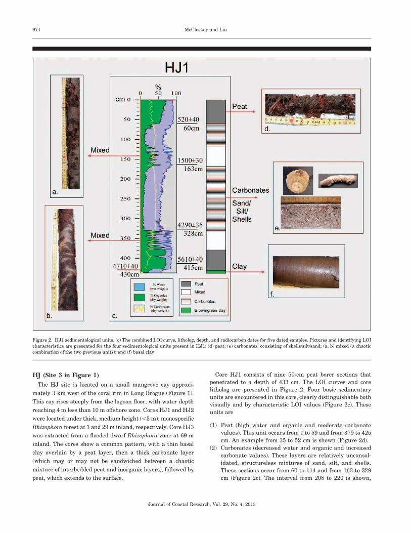
Core HJ1 consists of nine 50-cm peat borer sections that
penetrated to a depth of 433 cm. The LOI curves and core
litholog are presented in Figure 2. Four basic sedimentary
units are encountered in this core, clearly distinguishable both
visually and by characteristic LOI values (Figure 2c). These
units are
(1) Peat (high water and organic and moderate carbonate
values). This unit occurs from 1 to 59 and from 379 to 425
cm. An example from 35 to 52 cm is shown (Figure 2d).
(2) Carbonates (decreased water and organic and increased
carbonate values). These layers are relatively unconsol-
idated, structureless mixtures of sand, silt, and shells.
These sections occur from 60 to 114 and from 163 to 329
cm (Figure 2c). The interval from 208 to 220 is shown,
Figure 2. HJ1 sedimentological units. (c) The combined LOI curve, litholog, depth, and radiocarbon dates for five dated samples. Pictures and identifying LOI
characteristics are presented for the four sedimentological units present in HJ1: (d) peat; (e) carbonates, consisting of shells/silt/sand; (a, b) mixed (a chaotic
combination of the two previous units); and (f) basal clay.
Journal of Coastal Research, Vol. 29, No. 4, 2013
974 McCloskey and Liu
displaying characteristic shells and a coral fragment
(Figure 2e).
(3) Mixed. This unit is marked by repeated transitions
between the two previously described materials, marked
by abrupt dips/spikes in the LOI values, with water and
organic values rising/falling in parallel, inverse to the
carbonate values. The two sediment types are not
interbedded horizontally, and specific sediment types
rarely occur across the width of the cores (Figures 2a and
b). Rather, small, angular peat clasts are embedded in a
carbonate matrix. Generally the mixing appears more
extreme in the lower part of the intervals, with clast
frequency and volume occupied decreasing rapidly up-
core. Because this stratigraphy does not seem to
represent a succession of quickly changing depositional
environments but rather the simultaneous deposition of
two dramatically different sediment types, these mixed
layers are treated as a single zone, reflecting a particular
deposition style. This unit occurs from 115 to 162 and
from 330 to 378 cm (Figure 2c).
(4) Clay (low organic and carbonate percentages, intermedi-
ate water). A brown/green clay occurs below 425 cm. The
interval from 425 to 432 is shown (Figures 2c and f).
The AMS 14C dating results obtained from the three plant/
organic and two bulk sediment samples are listed in Table 1
and shown graphically in Figure 2.
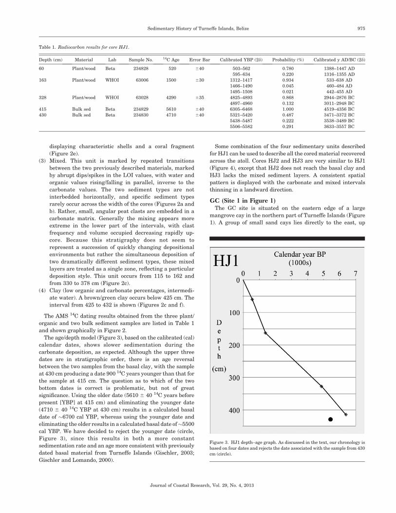
The age/depth model (Figure 3), based on the calibrated (cal)
calendar dates, shows slower sedimentation during the
carbonate deposition, as expected. Although the upper three
dates are in stratigraphic order, there is an age reversal
between the two samples from the basal clay, with the sample
at 430 cm producing a date 900 14C years younger than that for
the sample at 415 cm. The question as to which of the two
bottom dates is correct is problematic, but not of great
significance. Using the older date (5610 6 40 14C years before
present [YBP] at 415 cm) and eliminating the younger date
(4710 6 40 14C YBP at 430 cm) results in a calculated basal
date of ~6700 cal YBP, whereas using the younger date and
eliminating the older results in a calculated basal date of~5500
cal YBP. We have decided to reject the younger date (circle,
Figure 3), since this results in both a more constant
sedimentation rate and an age more consistent with previously
dated basal material from Turneffe Islands (Gischler, 2003;
Gischler and Lomando, 2000).
Some combination of the four sedimentary units described
for HJ1 can be used to describe all the cored material recovered
across the atoll. Cores HJ2 and HJ3 are very similar to HJ1
(Figure 4), except that HJ2 does not reach the basal clay and
HJ3 lacks the mixed sediment layers. A consistent spatial
pattern is displayed with the carbonate and mixed intervals
thinning in a landward direction.
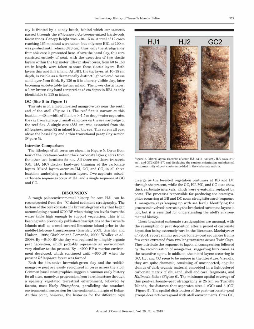
GC (Site 1 in Figure 1)The GC site is situated on the eastern edge of a large
mangrove cay in the northern part of Turneffe Islands (Figure
1). A group of small sand cays lies directly to the east, up
Table 1. Radiocarbon results for core HJ1.
Depth (cm) Material Lab Sample No. 14C Age Error Bar Calibrated YBP (2d) Probability (%) Calibrated y AD/BC (2d)
60 Plant/wood Beta 234828 520 640 503–562 0.780 1388–1447 AD
595–634 0.220 1316–1355 AD
163 Plant/wood WHOI 63006 1500 630 1312–1417 0.934 533–638 AD
1466–1490 0.045 460–484 AD
1495–1508 0.021 442–455 AD
328 Plant/wood WHOI 63028 4290 635 4825–4893 0.868 2944–2876 BC
4897–4960 0.132 3011–2948 BC
415 Bulk sed Beta 234829 5610 640 6305–6468 1.000 4519–4356 BC
430 Bulk sed Beta 234830 4710 640 5321–5420 0.487 3471–3372 BC
5438–5487 0.222 3538–3489 BC
5506–5582 0.291 3633–3557 BC
Figure 3. HJ1 depth–age graph. As discussed in the text, our chronology is
based on four dates and rejects the date associated with the sample from 430
cm (circle).
Journal of Coastal Research, Vol. 29, No. 4, 2013
Sedimentary History of Turneffe Islands, Belize 975
against the inside rim of the fringing coral, across the rather
wide reef flat (.750 m). Very tight fringing Rhizophora stands
extend into the water beyond the edge of the island; there is no
beach. Cores were extracted at 64, 89, and 125 m inland. GC1,
the most seaward core at 64 m inland, shows a stratigraphic
sequence (from bottom to top) of peat–carbonate–peat. Core
GC2 at 89 m inland reaches the basal clay, overlain by peat–
carbonate–mixed–carbonate–peat. GC3, cored at a slightly
higher elevation 125 m inland, is consistently peat throughout
(Figure 5).
MC (Site 4 in Figure 1)This site is located on a sandy cay on the western edge of the
reef flat, just south of the mouth of Long Bogue (Figure 1).
Three short cores (,150 cm) were taken within the Avicennia
zone along a cuspate transect paralleling the northern rim of
the cay. Cores MC1 (130 m) and MC2 (140 m) consist of a
bottom carbonate section, topped by peat, while the MC3 (150
m) shows a bottom upward sequence of carbonates–peat–
carbonates–peat (Figure 5).
CC (Site 6 in Figure 1)The CC site is located on a small mangrove cay in the
southern section of the Central Lagoon (Figure 1). A single core
463 cm in length was extracted from the Rhizophora zone, 42 m
inland. This core reaches the basal clay, followed by a mixed
section, then a thick carbonate section, capped by .1.5 m of
peat (Figure 5).
BB (Site 2 in Figure 1)The BB site is located on the eastern edge of a large mangrove
island just to the north of Long Brogue behind a wide reef flat
that forms an elbow in the islands’ eastern rim (Figure 1). The
Figure 4. HJ transect. Top box displays the lithologs for the three-core
transect, the bottom box displays the topography, hydrological conditions,
and dominant vegetation for each core.
Figure 5. Combined transects. (a) The lithologs from four study sites (GC,
HJ, CC, MC) display thick carbonate layers, (b) while lithologs from two sites
(BB, DC) do not. (a) A landward thinning of the carbonate layers is noticeable
across the GC, HJ, and MC transects, as is the separation of the layers into
upper and lower units. (c) Transects that do/do not contain these carbonate
layers do not fall into distinct geographic groupings.
Journal of Coastal Research, Vol. 29, No. 4, 2013
976 McCloskey and Liu
cay is fronted by a sandy beach, behind which our transect
passed through the Rhizophora–Avicennia–mixed hardwoods
forest zones. Canopy height was ~10–15 m. A total of 12 cores
reaching 165 m inland were taken, but only core BB1 at 100 m
was pushed until refusal (373 cm); thus, only the stratigraphy
from this core is presented here. Above the basal clay, this core
consisted entirely of peat, with the exception of two clastic
layers within the top meter. Eleven short cores, from 50 to 150
cm in length, were taken to trace these clastic layers. Both
layers thin and fine inland. At BB1, the top layer, at 10–15 cm
depth, is visible as a dramatically distinct light-colored coarse
sand layer 5 cm thick. By 130 m it is a barely visible clay, later
becoming undetectable farther inland. The lower clastic layer,
a 3-cm brown clay band centered at 48 cm depth in BB1, is only
identifiable to 115 m inland.
DC (Site 5 in Figure 1)This site is on a medium-sized mangrove cay near the south
end of the atoll (Figure 1). The reef flat is narrow at this
location:~40 m width of shallow (~1.5 m deep) water separates
the cay from a group of small sand cays on the seaward edge of
the reef flat. A single core (353 cm) was extracted from the
Rhizophora zone, 82 m inland from the sea. This core is all peat
above the basal clay and a thin transitional peaty clay section
(Figure 5).
Intersite ComparisonThe lithologs of all cores are shown in Figure 5. Cores from
four of the locations contain thick carbonate layers; cores from
the other two locations do not. All three multicore transects
(GC, HJ, MC) display landward thinning of the carbonate
layers. Mixed layers occur at HJ, GC, and CC, in all three
locations underlying carbonate layers. Two separate mixed-
carbonate sequences occur at HJ, and a single sequence at GC
and CC.
DISCUSSIONA rough paleoenvironmental history for core HJ1 can be
reconstructed from the 14C dated sediment stratigraphy. The
bottom of the core consists of a brownish-green clay that began
accumulating around 6700 BP when rising sea levels drove the
water table high enough to support vegetation. This is in
keeping with previously published descriptions of the Turneffe
Islands atoll as a mud-covered limestone island prior to the
middle-Holocene transgression (Gischler, 2003; Gischler and
Hudson, 1998; Gischler and Lomando, 2000; Wooller et al.,
2009). By ~6400 BP the clay was replaced by a highly organic
peat deposition, which probably represents an environment
very similar to the present. By ~4900 BP a marine environ-
ment developed, which continued until ~600 BP when the
present Rhizophora forest was formed.
Both the distinctive brownish-green clay and the reddish
mangrove peat are easily recognized in cores across the atoll.
Common basal stratigraphies suggest a common early history
for all sites, namely, a progression from bare limestone through
a sparsely vegetated terrestrial environment, followed by
forests, most likely Rhizophora, paralleling the standard
environmental succession for the continental margin of Belize.
At this point, however, the histories for the different cays
diverge as the forested vegetation continues at BB and DC
through the present, while the GC, HJ, MC, and CC sites show
thick carbonate intervals, which were eventually replaced by
peats. The processes responsible for producing the stratigra-
phies occurring at BB and DC seem straightforward (sequence
1: mangrove cays keeping up with sea level). Identifying the
processes involved in creating the bracketed carbonate layers is
not, but it is essential for understanding the atoll’s environ-
mental history.
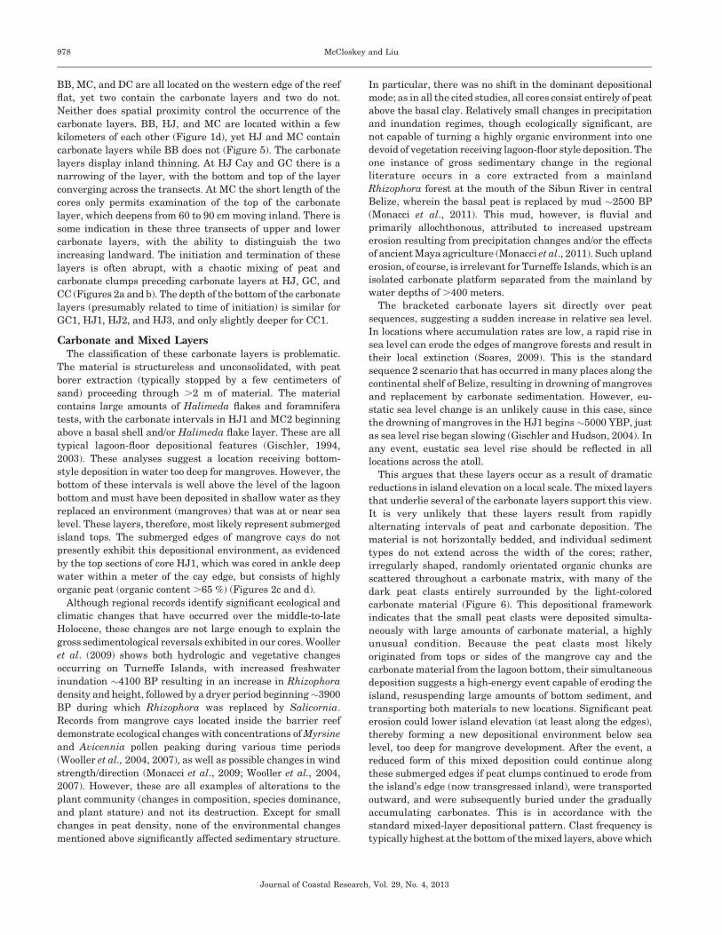
These bracketed carbonate stratigraphies are unusual, with
the resumption of peat deposition after a period of carbonate
deposition being extremely rare in the literature. Macintyre et
al. (2004) report similar peat–carbonate–peat sequences from a
few cores extracted from two long transects across Twin Cays.
They attribute the sequence to lagoonal transgression followed
by the recolonization of mangroves, suggesting hurricanes as
the causative agent. In addition, the mixed layers occurring in
GC, HJ, and CC seem to be unique in the literature. Visually,
they are quite dramatic, consisting of unconnected, angular
clumps of dark organic material embedded in a light-colored
carbonate matrix of silt, sand, shell and coral fragments, and
Halimeda flakes (Figure 6). The minimum spatial coverage of
this peat–carbonate–peat stratigraphy is 25 km on Turneffe
Islands, the distance that separates sites 1 (GC) and 6 (CC)
(Figure 5). The spatial distribution of the peat–carbonate–peat
groups does not correspond with atoll environments. Sites GC,
Figure 6. Mixed layers. Sections of cores HJ1 (315–330 cm), HJ2 (325–340
cm), and GC2 (255–270 cm) displaying the random orientation and physical
nonconnectivity of peat clasts embedded in the carbonate matrix.
Journal of Coastal Research, Vol. 29, No. 4, 2013
Sedimentary History of Turneffe Islands, Belize 977
BB, MC, and DC are all located on the western edge of the reef
flat, yet two contain the carbonate layers and two do not.
Neither does spatial proximity control the occurrence of the
carbonate layers. BB, HJ, and MC are located within a few
kilometers of each other (Figure 1d), yet HJ and MC contain
carbonate layers while BB does not (Figure 5). The carbonate
layers display inland thinning. At HJ Cay and GC there is a
narrowing of the layer, with the bottom and top of the layer
converging across the transects. At MC the short length of the
cores only permits examination of the top of the carbonate
layer, which deepens from 60 to 90 cm moving inland. There is
some indication in these three transects of upper and lower
carbonate layers, with the ability to distinguish the two
increasing landward. The initiation and termination of these
layers is often abrupt, with a chaotic mixing of peat and
carbonate clumps preceding carbonate layers at HJ, GC, and
CC (Figures 2a and b). The depth of the bottom of the carbonate
layers (presumably related to time of initiation) is similar for
GC1, HJ1, HJ2, and HJ3, and only slightly deeper for CC1.
Carbonate and Mixed LayersThe classification of these carbonate layers is problematic.
The material is structureless and unconsolidated, with peat
borer extraction (typically stopped by a few centimeters of
sand) proceeding through .2 m of material. The material
contains large amounts of Halimeda flakes and foramnifera
tests, with the carbonate intervals in HJ1 and MC2 beginning
above a basal shell and/or Halimeda flake layer. These are all
typical lagoon-floor depositional features (Gischler, 1994,
2003). These analyses suggest a location receiving bottom-
style deposition in water too deep for mangroves. However, the
bottom of these intervals is well above the level of the lagoon
bottom and must have been deposited in shallow water as they
replaced an environment (mangroves) that was at or near sea
level. These layers, therefore, most likely represent submerged
island tops. The submerged edges of mangrove cays do not
presently exhibit this depositional environment, as evidenced
by the top sections of core HJ1, which was cored in ankle deep
water within a meter of the cay edge, but consists of highly
organic peat (organic content .65 %) (Figures 2c and d).
Although regional records identify significant ecological and
climatic changes that have occurred over the middle-to-late
Holocene, these changes are not large enough to explain the
gross sedimentological reversals exhibited in our cores. Wooller
et al. (2009) shows both hydrologic and vegetative changes
occurring on Turneffe Islands, with increased freshwater
inundation ~4100 BP resulting in an increase in Rhizophora
density and height, followed by a dryer period beginning~3900
BP during which Rhizophora was replaced by Salicornia.
Records from mangrove cays located inside the barrier reef
demonstrate ecological changes with concentrations of Myrsine
and Avicennia pollen peaking during various time periods
(Wooller et al., 2004, 2007), as well as possible changes in wind
strength/direction (Monacci et al., 2009; Wooller et al., 2004,
2007). However, these are all examples of alterations to the
plant community (changes in composition, species dominance,
and plant stature) and not its destruction. Except for small
changes in peat density, none of the environmental changes
mentioned above significantly affected sedimentary structure.
In particular, there was no shift in the dominant depositional
mode; as in all the cited studies, all cores consist entirely of peat
above the basal clay. Relatively small changes in precipitation
and inundation regimes, though ecologically significant, are
not capable of turning a highly organic environment into one
devoid of vegetation receiving lagoon-floor style deposition. The
one instance of gross sedimentary change in the regional
literature occurs in a core extracted from a mainland
Rhizophora forest at the mouth of the Sibun River in central
Belize, wherein the basal peat is replaced by mud ~2500 BP
(Monacci et al., 2011). This mud, however, is fluvial and
primarily allochthonous, attributed to increased upstream
erosion resulting from precipitation changes and/or the effects
of ancient Maya agriculture (Monacci et al., 2011). Such upland
erosion, of course, is irrelevant for Turneffe Islands, which is an
isolated carbonate platform separated from the mainland by
water depths of .400 meters.
The bracketed carbonate layers sit directly over peat
sequences, suggesting a sudden increase in relative sea level.
In locations where accumulation rates are low, a rapid rise in
sea level can erode the edges of mangrove forests and result in
their local extinction (Soares, 2009). This is the standard
sequence 2 scenario that has occurred in many places along the
continental shelf of Belize, resulting in drowning of mangroves
and replacement by carbonate sedimentation. However, eu-
static sea level change is an unlikely cause in this case, since
the drowning of mangroves in the HJ1 begins ~5000 YBP, just
as sea level rise began slowing (Gischler and Hudson, 2004). In
any event, eustatic sea level rise should be reflected in all
locations across the atoll.
This argues that these layers occur as a result of dramatic
reductions in island elevation on a local scale. The mixed layers
that underlie several of the carbonate layers support this view.
It is very unlikely that these layers result from rapidly
alternating intervals of peat and carbonate deposition. The
material is not horizontally bedded, and individual sediment
types do not extend across the width of the cores; rather,
irregularly shaped, randomly orientated organic chunks are
scattered throughout a carbonate matrix, with many of the
dark peat clasts entirely surrounded by the light-colored
carbonate material (Figure 6). This depositional framework
indicates that the small peat clasts were deposited simulta-
neously with large amounts of carbonate material, a highly
unusual condition. Because the peat clasts most likely
originated from tops or sides of the mangrove cay and the
carbonate material from the lagoon bottom, their simultaneous
deposition suggests a high-energy event capable of eroding the
island, resuspending large amounts of bottom sediment, and
transporting both materials to new locations. Significant peat
erosion could lower island elevation (at least along the edges),
thereby forming a new depositional environment below sea
level, too deep for mangrove development. After the event, a
reduced form of this mixed deposition could continue along
these submerged edges if peat clumps continued to erode from
the island’s edge (now transgressed inland), were transported
outward, and were subsequently buried under the gradually
accumulating carbonates. This is in accordance with the
standard mixed-layer depositional pattern. Clast frequency is
typically highest at the bottom of the mixed layers, above which
Journal of Coastal Research, Vol. 29, No. 4, 2013
978 McCloskey and Liu
clast frequency decreases rapidly upcore above before tran-
sitioning into typical bottom-style carbonates, free of organic
clumps.
Slumping has been recorded for the floor of Turneffe Islands’
central lagoon (Stoddart, 1963) and inside the barrier reef near
the Tobacco Range fracture zone, ~40 km to the SW (Littler et
al., 1995; Macintyre, Littler and Littler, 1995). In both cases
the initiation of the slumping was attributed to wave action
associated with extreme events, with hurricanes or earth-
quakes being named as the most likely candidates. The
slumping near the Tobacco Range fracture zone is character-
ized by large blocks of fossil peat jumbled chaotically on the
lagoon bottom offshore from a mangrove cay. The investigators
believe that the slumping continued after the initiating event
because of undercutting and structural differences in the peat
(Littler et al., 1995).
Seismic ActivityAlthough several types of high-energy events are potentially
capable of reducing island elevation, seismic activity is the
most likely candidate in this case. Studies from the Patıa River
delta on the Pacific coast Colombia have shown that tectonic-
induced activity has led to subsidence, erosion, and the retreat
and death of mangroves (Restrepo and Cantera, 2011), while
‘‘most’’ of a large mangrove forest in the Dominican Republic
was destroyed as a result of an earthquake-generated waves in
1946 (Sherman, Fahey, and Martinez, 2001). Turneffe Islands
is a free-standing tower, .1000 m in height, situated only~150
km north of the North American/Caribbean plate boundary,
making it subject to tectonic disturbances, such as the 7.3
submarine earthquake that occurred 125 km NNE of La Ceiba,
Honduras, on 28 May 2009 (USGS Earthquake Hazards
Program 2009). Some evidence exists that significant seismic
settling has occurred in the past. The tops of the Pleistocene
reefs for the first three fault blocks offshore of Belize (Turneffe
Islands is on the second) all show a distinct southern dip,
possibly the result of tilting, although direct neotectonic
evidence is lacking, and differential weathering is an alterna-
tive explanation (Gischler and Hudson, 1998, 2004; Gischler
and Lomando, 2000). More direct evidence of movement is
provided by a speleothem gallery in the Great Blue Hole, a
submerged sinkhole in Lighthouse Reef, ~25 km east of
Turneffe Islands. Stalactites in this gallery display a northern
tilt of 5–108, some with bends and spiral structure, probably
indicating a tilt of the platform as they formed (Dill, 1977;
Jones and Dill, 2002). During recent times earthquakes ‘‘have
occurred and continue to be reported’’ for the area (Littler et al.,
1995).
The response of individual mangrove cays to gross platform
movement could be spatially inconsistent, with magnitude and
direction of movement varying by site. Idiosyncratic responses
would be particularly relevant in regard to slumping occurring
on cay edges, with the top of some cays dropping below the
mangrove depth threshold, while others are unaffected.
Platform structure could also be a factor, with a tilt to the
north resulting in lowering elevations in the north (thick
carbonate layer at GC) and higher elevations in the south (no
carbonate layer at DC). The exceptionally broad reef flat in
front of the BB transect, perhaps indicating greater structural
strength and less vertical mobility, may explain the lack of
carbonate layers in the BB transect.
Mangrove Die-offsMangrove mortality provides a possible amplifying mecha-
nism. Tree death can result in a lowering of cay surface
elevation, as demonstrated by the documentation by McKee
and Faulkner (2000) of several large stumps of Avicennia,
which typically occur at higher elevations, submerged in an
interior pond on a Belizean cay, indicating surface subsidence
following tree death. On Guanaja, off the coast of Honduras,
the die-off of mangroves associated with Hurricane Mitch
(1998) resulted in an elevation loss of .7 cm in the first 2 years,
with an additional predicted short-term loss of ~6 cm (Cahoon
et al., 2003). These studies suggest that the peat collapses
associated with die-offs are capable of significantly reducing
surface elevation and increasing water depth.
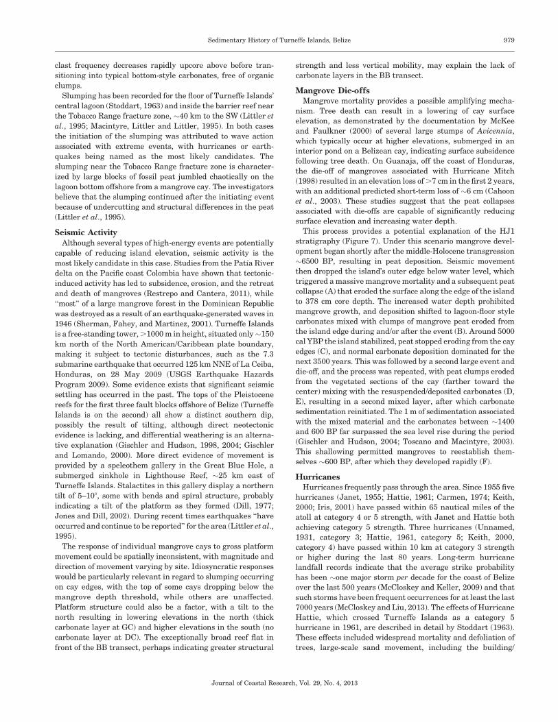
This process provides a potential explanation of the HJ1
stratigraphy (Figure 7). Under this scenario mangrove devel-
opment began shortly after the middle-Holocene transgression
~6500 BP, resulting in peat deposition. Seismic movement
then dropped the island’s outer edge below water level, which
triggered a massive mangrove mortality and a subsequent peat
collapse (A) that eroded the surface along the edge of the island
to 378 cm core depth. The increased water depth prohibited
mangrove growth, and deposition shifted to lagoon-floor style
carbonates mixed with clumps of mangrove peat eroded from
the island edge during and/or after the event (B). Around 5000
cal YBP the island stabilized, peat stopped eroding from the cay
edges (C), and normal carbonate deposition dominated for the
next 3500 years. This was followed by a second large event and
die-off, and the process was repeated, with peat clumps eroded
from the vegetated sections of the cay (farther toward the
center) mixing with the resuspended/deposited carbonates (D,
E), resulting in a second mixed layer, after which carbonate
sedimentation reinitiated. The 1 m of sedimentation associated
with the mixed material and the carbonates between ~1400
and 600 BP far surpassed the sea level rise during the period
(Gischler and Hudson, 2004; Toscano and Macintyre, 2003).
This shallowing permitted mangroves to reestablish them-
selves ~600 BP, after which they developed rapidly (F).
HurricanesHurricanes frequently pass through the area. Since 1955 five
hurricanes (Janet, 1955; Hattie, 1961; Carmen, 1974; Keith,
2000; Iris, 2001) have passed within 65 nautical miles of the
atoll at category 4 or 5 strength, with Janet and Hattie both
achieving category 5 strength. Three hurricanes (Unnamed,
1931, category 3; Hattie, 1961, category 5; Keith, 2000,
category 4) have passed within 10 km at category 3 strength
or higher during the last 80 years. Long-term hurricane
landfall records indicate that the average strike probability
has been ~one major storm per decade for the coast of Belize
over the last 500 years (McCloskey and Keller, 2009) and that
such storms have been frequent occurrences for at least the last
7000 years (McCloskey and Liu, 2013). The effects of Hurricane
Hattie, which crossed Turneffe Islands as a category 5
hurricane in 1961, are described in detail by Stoddart (1963).
These effects included widespread mortality and defoliation of
trees, large-scale sand movement, including the building/
Journal of Coastal Research, Vol. 29, No. 4, 2013
Sedimentary History of Turneffe Islands, Belize 979
removal of beach ridges, and extensive erosion, including beach
retreat, the creation of extensive scour pits, and the disappear-
ance/submergence of small sand cays. Despite the magnitude of
these effects, this storm is barely recognizable in our cores,
which were intentionally extracted in the areas cited as having
suffered the heaviest damage from Hattie (Stoddart, 1963). Of
our six sites, only BB displays a clear record of the event,
marked by a thin clastic layer at ~15 cm depth, which extends
only 130 m inland. A second clastic layer, occurring at 48 cm
depth in the same core, is attributed to the unnamed hurricane
of 1931 (McCloskey, 2009). Since both layers are markedly
different from the bracketed carbonate layers in size, structure,
solidarity, and composition, the possibility that the carbonate
layers were deposited as hurricane overwash layers is unlikely.
Nevertheless, hurricanes cannot be eliminated as a possible
causative agent, since hurricane-generated erosion and the
associated mangrove mortality provide a plausible mechanism
for lowering island elevation and thereby changing the normal
deposition from peat to carbonate sands, as suggested by
Macintyre et al. (2004). However, given the near total lack of
sedimentary signatures for historical storms, hurricanes seem
an unlikely candidate for producing the long-term changes
seen in our cores, particularly the multimillennial suppression
of mangroves observed at HJ1.
TsunamisIt is also unlikely that the carbonate layers are tsunami
deposits. A study conducted on a Maldivian atoll following the
2004 Sumatra tsunami demonstrates that steep atoll bathym-
etry and restricted atoll entrances tend to severely dampen the
geomorphic effects of tsunami waves (Kench et al., 2006, 2008).
Both of these inhibiting conditions apply to Turneffe Islands.
The sedimentary signatures of the Maldivian tsunami deposits
and Turneffe Islands’ carbonate layers exhibit distinct differ-
ences in composition, structure, grain size, layer thickness and
extent, and the presence of terminal drapes. Importantly, the
Maldivian tsunami did not lead to island instability, and the
event is not expected to be preserved in the sedimentary record
(Kench et al., 2006, 2008).
Regional CorrelationThe dramatic sedimentary changes that dominate this core
make chronological correlation of paleoenvironmental/cli-
matic events with regional records problematic. The record-
ing sensitivities for environmental proxies during the period
of carbonate deposition, which covers at least 4500 years in
HJ1, are very different from the sensitivities occurring
during peat deposition. During the carbonate period HJ1 is
basically insensitive to features such as changes in precip-
Figure 7. Conceptual model of HJ1 sedimentology based on peat collapse. In this model an event-driven peat collapse substantially reduces island elevation,
thereby switching sedimentation from mangrove peat to a mixed deposition followed by subaqueous carbonate material. This process occurs twice.
Journal of Coastal Research, Vol. 29, No. 4, 2013
980 McCloskey and Liu
itation and inundation regimes, ecosystem dynamics, and
plant assemblages that have been noted in peat-based proxy
records such as Wooller et al. (2004, 2007, 2009) and Monacci
et al. (2009, 2011), thereby severely limiting the utility of
HJ1’s contribution to regional correlations. Because the
shifts in depositional modes most likely result from instan-
taneous events and not climatic conditions, the timing of
these shifts also provides no climatic information and cannot
be matched with regional records. HJ1 does show a
correlation with local records in one regard, as it displays a
marked increase in sedimentation rate~1000 BP, as noted in
nearby locations (Monacci et al., 2009, 2011; Wooller et al.,
2004). However, in this case the higher sedimentation rate
probably merely reflects the change in deposition from slow
bottom-style carbonate deposition to the faster mangrove-
driven peat accumulation.
Carbonate Layers SummarySedimentologically, the carbonate layers do not appear to be
event layers, since they generally lack the chaotic nature, the
occasionally vertical deposition, and the overall structure
(upward fining) usually associated with instantaneous high-
energy deposition (Goff, McFadgen, and Chague-Goff, 2004;
Morton, Gelfenbaum, and Jaffe, 2007; Peters, Jaffe, and
Gelfenbaum, 2007; Williams, 2009, 2010). The thickness is
also beyond the usual event parameters, as is the unconsoli-
dated nature of the material. The most likely depositional
environment for the layers is a subtidal surface too deep to
permit mangrove development.
However, the layers do resemble event layers stratigraphi-
cally in regard to landward thinning, the rough atoll-wide
temporal correspondence, and the chaotic nature of the lower
contact between the peat and carbonate layers, especially the
mixed layers occurring in HJ1 and HJ2, GC2, and CC1. The
simultaneous deposition of two sediment types originating in
separate environments, their extreme vertical mixing, com-
plete lack of sorting, and general incoherency of these mixed
layers argues for some type of high-energy perturbation.
A likely resolution to this paradox is to view the carbonate
layers as event initiated, although the major portions of the
layers (the purely carbonate sections) predominately represent
normal deposition in a changed environment. The important
effect of the event was a rise of relative sea level for the sites,
with increased water depth shifting the depositional mode from
organic to carbonate. In some cases, this depositional shift was
preceded by a period of chaotic mixed deposition associated
with erosion and biogeological processes resulting from the
event. Since water depth can control mangrove viability, small
changes in relative sea level can result in an abrupt switch in
depositional environments. An event that causes water depth
to surpass the maximum mangrove depth threshold can switch
sedimentation from organic to carbonate, while gradual
shallowing will at some point lead to an abrupt switch back
to organic. The peat clasts found in the distinctive mixed layers
probably result from the disintegration of the edges of the peat
platform, an important amplifying mechanism contributing to
the reduction of island elevation.
The size and random orientation of the clasts indicate a
sudden and powerful precipitating event. Gradually changing
boundary conditions do not seem capable of producing either
such chaotic deposition or the required amplitude of water
depth changes. Nor do hurricanes. Although the hurricane-
driven amplification of surface elevation decreases through
peat collapse has been recorded in the region, this response has
not been observed for historical events on Turneffe Islands and
does not seem capable of operating at the necessary spatial
scale. Tsunamis also seem an unlikely candidate. Not only does
atoll geology limit their geomorphic effects, the lack of
corresponding events, both regionally and across the atoll,
argues against tsunamis as the proximate cause. Local seismic
activity, probably resulting from the shifting of all or part of the
platform, is the process that can most successfully explain both
the abrupt (probably repeated) relative sea level rise in a
widespread but spatially spotty manner and the distinctive
depositional mixing of carbonates and peat.
Dating of the initiation of the carbonate layers is uncertain.
The top of the bottom peat layer in HJ1 was not dated because
of the view that erosion associated with the precipitating event
removed an unknown amount of material directly below the
mixed layer. Although no other cores were dated, mangrove
accumulation and island elevation are so closely tied to sea
level that stratigraphic correlation across the atoll can be
expected to be fairly accurate for peat intervals. The elevations
of the bottoms of the carbonate layers do, in fact, display a
rough correlation. However, owing to erosion such correlations
are only useful if erosion is assumed to be similar across sites,
which, given the spatial variability seen in our cores, is
unlikely. Thus, the dating and chronological correlation of
events across Turneffe Islands is very uncertain. However, only
a large, platform-wide movement would have resulted in
simultaneous events across the atoll; smaller movements
resulting in slumping of individual mangrove cays could
display great temporal variability.
If these carbonate layers do indeed result from small-scale
subsidence, then the apparent repetition of the peat–carbon-
ate–peat sequence in the GC, HJ, and MC transects suggests
that such events may be a repeating phenomenon. If so, there
are fairly significant potential societal consequences, especially
given the increasing use of the atoll as a tourist destination
(Pat, 2001).
CONCLUSIONS(1) Sedimentary evidence indicates that the Turneffe Islands
mangrove cays share a common initial ecological history,
with basal clay, probably representing a species-poor
terrestrial environment being replaced by a mangrove
forest ~6500 BP. The rising water table associated with
postglacial sea level rise is the probable causative
mechanism.
(2) At two sites the peat deposition continues through the
present, having maintained a roughly static elevation
relative to sea level over the middle-to-late Holocene.
(3) At four sites the peat deposition is interrupted by thick
carbonate intervals, probably lasting several thousands
of years. This depositional environment resembles la-
goonal floor conditions, under a water depth surpassing
the maximum threshold for mangrove survival. However,
Journal of Coastal Research, Vol. 29, No. 4, 2013
Sedimentary History of Turneffe Islands, Belize 981
these conditions occur at elevations above the contempo-
rary lagoon floor.
(4) The most likely explanation for the stratigraphic change
from peat to carbonate-rich sand and silt is an event-
initiated drop in local surface elevation, resulting in an
increase in relative sea level. Candidate events include
hurricanes, tsunamis, and seismic activity. Hurricanes
probably lack the necessary geomorphic power. Not only
are appropriate tsunamis missing in the regional record,
but geologic factors, principally the atoll’s vertical
structure and intact rim, also reduce tsunami energy
below the requisite levels. Seismic activity that lowered
island surface level, amplified by the associated island
slumping resulting from peat collapse following massive
mangrove mortality, produced by a movement of all or
parts of the carbonate platform, is the most likely
explanation.
(5) If seismic activity is the responsible agent, there is a need
to incorporate this factor in risk assessment for coastal
Belize, since sedimentological evidence suggests at least
two such events over the last 5000 years.
ACKNOWLEDGMENTSThis research was supported by grants from the Inter-
American Institute for Global Change Research (IAI-
CRN2050), the U.S. National Science Foundation (BCS-
0213884), and a NSF Graduate Research Fellowship to
T.A.M. Assistance in the field was provided by Faustino
Chi, Adria Hussein, and Emily Byers.
LITERATURE CITEDCahoon, D.R.; Hensel, P.; Rybczyk, J.; McKee, K.L.; Proffitt, C.E., and
Perez, B.C., 2003. Mass tree mortality leads to mangrove peatcollapse at Bay Islands, Honduras after Hurricane Mitch. Journalof Ecology, 91, 1093–110.
Choi, D.R. and Ginsburg, R.N., 1982. Siliclastic foundations ofQuaternary reefs in southernmost Belize Lagoon, British Hondu-ras. GSA Bulletin, 93, 116–126.
Choi, D.R. and Holmes, C., 1982. Foundation of Quaternary reefs insouth-central Belize lagoon, British Honduras. American Associa-tion of Petroleum Geologists Bulletin, 66, 2663–2671.
Dill, R.F., 1977. The blue holes: geologically significant submergedsinkholes and caves off British Honduras and Andros, BahamasIsland. In: Taylor, D.L. (ed.), Proceedings of the Third InternationalCoral Reef Symposium, Vol. 2. Miami, Florida: Rosenstiel School ofMarine and Atmospheric Sciences, pp. 237–242.
Dillon, W.P. and Vedder, J.G., 1973. Structure and development ofthe continental margin of British Honduras. Geological Society ofAmerica Bulletin, 84, 2713–2732.
Ellison, J.C., 1993. Mangrove retreat with rising sea-level, Bermuda.Estuarine, Coastal and Shelf Science, 37, 75–87.
Ferro, C.E.; Droxler, A.W.; Anderson, J.B., and Mucciarone, D., 1999.Late Quaternary shift of mixed siliclastic-carbonate environmentsinduced by glacial eustatic sea-level fluctuations in Belize. In:Harris, P.M.; Saller, A.H., and Simo, J.A. (eds.), Advances inCarbonate Sequence Stratigraphy: Application to Reservoirs,Outcrops and Models, Vol. 63. Tulsa, Oklahoma: Special Publica-tions—Society of Economic Paleontology Mineralogists, pp. 385–411.
Gischler, E., 1994. Sedimentation on three Caribbean atolls: GloversReef, Lighthouse Reef and Turneffe Islands, Belize. Facies, 31,243–254.
Gischler, E., 2003. Holocene development in the isolated carbonateplatforms off Belize. Sedimentary Geology, 159, 113–132.
Gischler, E. and Hudson, J.H., 1998. Holocene development of threeisolated carbonate platforms, Belize, Central America. MarineGeology, 144, 333–347.
Gischler, E. and Hudson, J.H., 2004. Holocene development of theBelize Barrier Reef. Sedimentary Geology, 164, 223–236.
Gischler, E. and Lomando, A.J., 2000. Isolated carbonate platforms ofBelize, Central America: sedimentary facies, late Quaternaryhistory and controlling factors. In: Insalco, E.; Skelton, P.W., andPalmer, T.J. (eds.), Carbonate Platform Systems: Components andInteractions. London: The Geological Society of London, SpecialPublications 178, pp. 135–146.
Gischler, E.; Shinn, E.A.; Oschmann, W.; Fiebig, J., and Buster, N.,2008. A 1500-year Holocene Caribbean climate archive from theBlue Hole, Lighthouse Reef, Belize. Journal of Coastal Research,24, 1495–1505.
Goff, J.; McFadgen, B.G., and Chague-Goff, C., 2004. Sedimentarydifferences between the 2002 Easter storm and the 15th-centuryOkoropunga tsunami, southeastern North Island, New Zealand.Marine Geology, 204, 235–250.
Halley, R.B.; Shinn, E.A.; Hudson, J.H., and Lidz, B., 1977. Recentand relict topography of Boo Bee Patch reef, Belize. In: Taylor, D.L.(ed.), Proceedings of the Third International Coral Reef Sympo-sium, Vol. 2. Miami, Florida: Rosenstiel School of Marine andAtmospheric Sciences, pp. 29–35.
Jones, A.T. and Dill, R.F., 2002. Great Blue Hole of Lighthouse ReefAtoll, Belize, Central America: deep technical diving to collect sea-level records. In: Jackson, T.A. (ed.), Caribbean Geology: Into theThird Millennium. Fifteenth Caribbean Geological Conference.Kingston, Jamaica: University of the West Indies Press, pp. 181–193.
Kench, P.S.; McLean, R.F.; Brander, R.W.; Nichol, S.L.; Smithers,S.G.; Ford, M.R.; Parnell, K.E., and Aslam, M., 2006. Geologicaleffects of tsunami on mid-ocean atoll islands: the Maldives beforeand after the Sumatran tsunami. Geology, 34, 177–180.
Kench, P.S.; Nichol, S.L.; Smithers, S.G.; McLean, R.F., and Brander,R.W., 2008. Tsunami as agents of geomorphic change in mid-oceanreef islands. Geomorphology, 95, 361–383.
Lara, M.E., 1993. Divergent wrench faulting in the Belize southernlagoon: implications for Tertiary Caribbean plate movements andQuaternary reef distribution. American Association of PetroleumGeologists Bulletin, 77, 1041–1063.
Littler, M.M.; Littler, D.S.; Macintyre, I.G.; Brooks, B.L.; Taylor, P.R.,and Lapoint, B.E., 1995. The Tobacco range fracture zone: a uniquesystem of slumped mangrove peat. Atoll Research Bulletin, 29, 73–91.
Liu, K.-B. and Fearn, M.L., 2000. Reconstruction of prehistoriclandfall frequencies of catastrophic hurricanes in northwesternFlorida from lake sediment records. Quaternary Research, 54, 238–245.
Macintyre, I.G.; Littler, M.M., and Littler, D.S., 1995. Holocenehistory of Tobacco Range, Belize, Central America. Atoll ResearchBulletin, 430, 1–18.
Macintyre, I.G.; Toscano, M.A.; Lighty, R.G., and Bond, G.B., 2004.Holocene history of the mangrove islands of Twin Cays, Belize,Central America. Atoll Research Bulletin, 510, 1–16.
McCloskey, T.A., 2009. Proxy Records of Paleohurricane Activities forthe Western and Southern Caribbean. Baton Rouge, Louisiana:Louisiana State University, Ph.D. dissertation, 728p.
McCloskey, T.A. and Keller, G., 2009. 5000 year sedimentary record ofhurricane strikes on the central coast of Belize. QuaternaryInternational, 195, 53–68.
McCloskey, T.A. and Liu, K.-B, 2013. A 7000-year record ofpaleohurricane activity from a coastal wetlands in Belize. Holo-cene, 23, 276–289.
McKee, K.L., 1995. Mangrove species distribution patterns in aBelizean mangrove forest: an exception to the dominance-predationhypothesis. Biotropica, 27, 334–345.
McKee, K.L. and Faulkner, P.L., 2000. Mangrove peat analysis andreconstruction of vegetation history at the Pelican Cays, Belize.Atoll Research Bulletin, 468, 45–58.
Journal of Coastal Research, Vol. 29, No. 4, 2013
982 McCloskey and Liu
Monacci, N.M.; Meier-Grunhagen, U.; Finney, B.P.; Behling, H., andWooller, M.J., 2009. Mangrove ecosystem changes during theHolocene at Spanish Lookout Cay, Belize. Paleogeography, Palae-oclimataology, Palaeoecology, 280, 37–46.
Monacci, N.M.; Meier-Grunhagen, U.; Finney, B.P.; Behling, H., andWooller, M.J., 2011. Paleoecology of mangroves along the SibunRiver, Belize. Quaternary Research, 76, 220–228.
Morton, R.A.: Gelfenbaum, G., and Jaffe, B.E., 2007. Physical criteriafor distinguishing sandy tsunami and storm deposits using modernexamples. Sedimentary Geology, 200, 184–207.
Murray, M.R.; Zisman, S.A.; Furley, P.A.; Munro, D.M.; Gibson, J.;Ratter, J.; Bridgewater, S.; Minty, C.D., and Place, C.J., 2003. Themangroves of Belize: Part 1: distribution, composition andclassification. Forest Ecology and Management, 174, 265–279.
Pat, W., 2001. Case Study: Tourism and Biodiversity: Ecotourism—aSustainable Development Tool, a Case for Belize. Belmopan, Belize:Ministry of Tourism and Youth, Government Printers.
Peters, R.; Jaffe, B.E., and Gelfenbaum, G., 2007. Distribution andsedimentary characteristics of tsunami deposits along the Cascadiamargin of western North America. Sedimentary Geology, 200, 372–386.
Reimer, P.J.; Baillie, M.G.L.; Bard, E.; Bayliss, A.; Beck, J.W.;Blackwell, P.G.; Bronk Ramsey, C.; Buck, C.E.; Burr, G.; Edwards,R.L.; Friedrich, M.; Grootes, P.M.; Guilderson, T.P.; Hajdas, I.;Heaton, T.J.; Hogg, A.G.; Hughen, K.A.; Kaiser, K.F.; Kromer, B.;McCormac, F.G.; Manning, S.; Reimer, R.W.; Richards, D.A.;Southon, J.R.; Talamo, S.; Turney, C.S.M.; van der Plicht, J., andWeyhenmeyer, C.E., 2009. IntCal09 and Marine09 radiocarbon agecalibration curves, 0–50,000 years cal BP. Radiocarbon 51, 1111–1150.
Restrepo, J.D. and Cantera, J.R., 2011. Discharge diversion in thePatıa River delta, the Colombian Pacific: geomorphic and ecologicalconsequences for mangrove ecosystems. Journal of South AmericanEarth Sciences, doi: 10.1016/j.jsames.2011.04.006.
Sherman, R.E.; Fahey, T.J., and Martinez, P., 2001. Hurricaneimpacts on a mangrove forest in the Dominican Republic: damagepatterns and early recovery. Biotropica, 33, 393–408.
Shinn, E.A.; Halley, R.B.; Hudson, J.H.; Lidz, B., and Robbin, J.,1979. Three dimensional aspects of Belize patch reefs (abstract).
Bulletin of the American Association of Petroleum Geologists, 63,
528.
Soares, M.L.G., 2009. A conceptual model for the responses of
mangrove forests to sea level rise. In: Furmanczyk, K. (ed.),
Proceedings of the 11th International Coastal Symposium, Journal
of Coastal Research, Special Issue No. 64, pp. 267–271.
Stoddart, D.R., 1963. Effects of Hurricane Hattie on British Honduras
reefs and cays. Atoll Research Bulletin, 95, 1–120.
Stuiver, M.; Reimer, P.J., and Reimer, R. 2010. CALIB 14C
Radiocarbon Calibration. http://calib.qub.ac.uk/calib/.
Toscano, M.A. and Macintyre, I.G., 2003. Corrected western Atlantic
sea-level curve for the last 11,000 years based on calibrated C-14
dates from Acropora palmate framework and intertidal mangrove
peat. Coral Reefs, 22, 257–270.
USGS Earthquake Hazards Program. 2009. http://earthquake.usgs.
gov/earthquakes/eqinthenews/2009/us2009heak.
Williams, H.F.L., 2009. Stratigraphy, sedimentology, and microfossil
content of Hurricane Rita storm surge deposits in southwest
Louisiana. Journal of Coastal Research, 25, 1041–1051.
Williams, H.F.L., 2010. Storm surge deposition by Hurricane Ike on
the McFadden National Wildlife Refuge, Texas: implications for
paleotempestology studies. Journal of Foraminiferal Research 40,
510–519.
Woodroffe, C.D., 1981. Mangrove swamp stratigraphy and Holocene
transgression, Grand Cayman Island, West Indies. Marine Geolo-
gy, 41, 271–294.
Wooller, M.J.; Behlig, H.; Guerrero, J.L., Jantz, N., and Zweigart,
M.E., 2009. Late Holocene hydrologic and vegetation changes at
Turneffe Atoll, Belize, compared with records from mainland
Central America and Mexico. Palaios, 24, 650–656.
Wooller, M.J.; Behlig, H.; Smallwood, B.J., and Fogel, M., 2007. A
multiproxy peat record of Holocene mangrove palaeoecology from
Twin Cays, Belize. The Holocene, 17, 1129–1139.
Wooller, M.J.; Morgan, R.; Fowell, S.; Behlig, H., and Fogel, M., 2004.
Mangrove ecosystem dynamics and elemental cycling at Twin
Cays, Belize during the Holocene. Journal of Quaternary Science,
19, 703–711.
Journal of Coastal Research, Vol. 29, No. 4, 2013
Sedimentary History of Turneffe Islands, Belize 983