j. c. meerman - protect turneffe · · 2011-06-09j. c. meerman report to the belize forest...
TRANSCRIPT
March 2, 2006
J. C. Meerman
Report to the Belize Forest Department of the Ministry of Natural Resources
Table of contents
1. Introduction and Terms of Reference 1 2. Acknowledgements 2 3. Methodology 2 3.1. Baseline data search 2 3.2. Land Tenure Investigation 6 3.3. Fieldwork 9 4. Results 11 4.1. Mangrove and Littoral Forest Health 11 4.2. Crocodiles 16 4.3. Cockroach Bay Situation 21 4.4. Other wildlife 25 5. Conclusions and Recommendations 27 5.1. Northern Turneffe Recommendations 27 5.2. The previous zonation proposals 29 6 Literature 34
List of figures
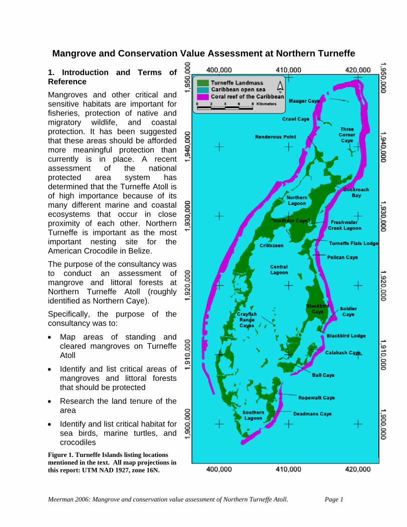
Figure 1. Turneffe Islands listing locations mentioned in the text. All map projections in this report: UTM NAD 1927, zone 16N. 1
Figure 2. Detail of project area with identified properties indicated in red (status December 2005) 7
Figure 3. Turneffe Atoll and October 23, 2005 flight path of overflight 9 Figure 4. Data collection points of fieldwork conducted in November 2005. Note: Vegetation
cover classification follows the standards set in the 2001 Central American Ecosystems Map (Meerman & Sabido). 10
Figure 5. Dead Red Mangrove stand on NW Turneffe Atoll. Notice the near total destuction and limited regeneration with very few live trees remaining. 11
Figure 6. Dead Black Mangrove Stand on NE Turneffe Atoll. Notice the heavy undergrowth of Batis maritima. 11
Figure 7. Area of Turneffe Atoll affected by Hurricane Keith in 2000 12 Figure 8. Wave action damage to shoreline Mangrove on E. Turneffe Atoll. The location is a
small cove behind a gap in the barrier reef 13 Figure 9. Map of Northern Turneffe noting features affecting natural vegetation 14 Figure 10. Recent Mangrove Clearing in Cockroach Bay 15 Figure 11. American Crocodile Sightings (Adults, juveniles 1996-7) and nests (2004); from
data provided by Steven Platt - WCS. 16 Figure 12. 2004 Landsat tm image of the eastern shores of Turneffe Islands. Insets show
enlarged sections of adjacent features. 18 Figure 13. Schematic overview of the crocodile activity at Cockroach Bay. 19 Figure 14. Forest Department Officer George Hanson on Cockroach Bay Beach showing
abundant crocodile tracks from lagoon to see (in background) 19
Figure 15. American Crocodile being fed at Blackbird Caye Resort, Turneffe Atoll (Picture Tamas B. Varga) 20
Figure 16. Gazetted description of Cockroach Bay Public/Crocodile Reserve 21 Figure 17. Property Map of Cockroach Bay and surroundings. Situation November 2005. 22 Figure 18. The Turneffe Parrotsnake Leptophis mexicanus hoeversi (juvenile). 25 Figure 19. Other species of interest noted during fieldwork in November 2005 (Manatee
data courtesy of CZMAI) 26 Figure 20. Proposed conservation zones in Northern Turneffe (not considering actual marine
components) 28 Figure 21. Prosposed Development Zoning based on the 1996 Turneffe Islands Development
Guidelines. 31 Figure 22. Proposed Biosphere Zonation developed by Oceanic Society 2004 32 Figure 23. MARXAN Analysis of conservation priorities based on the National Protected
Areas Policy and System Assessment: Meerman, 2005. 33
List of tables
Table 1. Survey entries found. Note: this focuses on Northern Turneffe but contains some data from other parts of Turneffe as well. 8
Table 2. List of some properties on Turneffe Atoll with real estate links indicated (December 2005) 23
Appendices
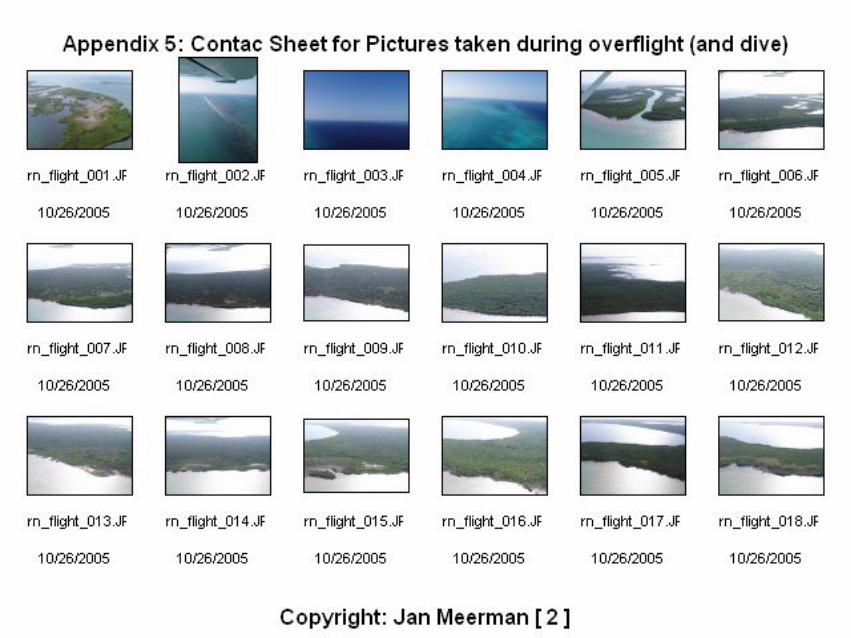
Appendix 1 2003 Cayes Development Policy Document Appendix 2 List and location of pictures taken during the October 23, 2005 overflight Appendix 3 Egan, S. 2005. Email detailing proposed Turneffe Biosphere design Appendix 4 Flora and Fauna encountered during fieldwork Appendix 5 Contac sheet of all pictures taken during overflight and fieldwork
Acronyms BERDS = Biodiversity and Environmental
Resource Data System for Belize BTFS = Belize Forest Studies CD = Compact Disk CZM = Coastal Zone Management CZMAI = Coastal Zone Management
Institute DoE = Department of the Environment ha = Hectare IUCN = International Conservation Union Km = Kilometer LIC = Land Information Center
N = North NAD = North American Datum NPAPSP = National Protected Areas
Policy and Systems Plan pp = pages Tm = Thematic Mapper TICAC = Turneffe Islands Coastal
Advisory Commitee TOR = Terms of Reference UTM = Universal Transverse Mercator WCS = Wildlife Conservation Society WWF = World Wildlife Fund for Nature
Mangrove and Conservation Value Assessment at Northern Turneffe
1. Introduction and Terms of Reference Mangroves and other critical and sensitive habitats are important for fisheries, protection of native and migratory wildlife, and coastal protection. It has been suggested that these areas should be afforded more meaningful protection than currently is in place. A recent assessment of the national protected area system has determined that the Turneffe Atoll is of high importance because of its many different marine and coastal ecosystems that occur in close proximity of each other. Northern Turneffe is important as the most important nesting site for the American Crocodile in Belize. The purpose of the consultancy was to conduct an assessment of mangrove and littoral forests at Northern Turneffe Atoll (roughly identified as Northern Caye). Specifically, the purpose of the consultancy was to:
• Map areas of standing and cleared mangroves on Turneffe Atoll
• Identify and list critical areas of mangroves and littoral forests that should be protected
• Research the land tenure of the area
• Identify and list critical habitat for sea birds, marine turtles, and crocodiles
Figure 1. Turneffe Islands listing locations mentioned in the text. All map projections ithis report: UTM NAD 1927, zone 16N.
n
Meerman 2006: Mangrove and conservation value assessment of Northern Turneffe Atoll. Page 1
2. Acknowledgements The study benefited from the kind help of George Hanson (Forest Department), Tineke Boomsma (Belize Tropical Forest Studies), Emil Cherrington (Coastal Zone Management Institute), Bruce Miller (Wildlife Conservation Society), Janet Gibson (Wildlife Conservation Society), Sergio Hoare (Wildlife Conservation Society), Melanie McField (World Wildlife Fund for Nature) Noreen Fairweather (Land Information Center), Martin Alegria (Department of the Environment) and the staff at the Lands and Survey Section of the Ministry of Natural Resources. 3. Methodology 3.1. Base line data search Some base line data exist on Turneffe Atoll and related issues. These include some gray literature:
CZMAI, 2003. Draft Cayes Development Policy. (See appendix 1. This document is available as digital copy - 23 pp.) This policy is an update from the 1995 draft. The greater part of the policy focuses on the less developed Cayes; the development issues of the ‘urban’ areas of San Pedro and Caye Caulker are more appropriately addressed through specific development planning guidelines. The Coastal Zone Management Strategy was endorsed by Cabinet in 2003. The Cayes Development Policy reflects and elaborates on the four pieces of legislation containing land use planning powers: provisions of this Strategy. The document lists the
• the 1998 Coastal Zone Management Act (establishing the Coastal Zone Advisory Council),
• the Disaster Preparedness and Response Act (the National Emergency Mobilisation Organisation),
• the 1981 Land Utilisation Act (establishing the Land Utilisation Authority), and
• the 1957 Housing and Town Planning Act (the Central Housing and Planning Authority). The first two of these Acts only have powers to draw up plans, which may include the zoning of particular land uses and land use densities, yet have no means to directly implement them. The last two also have development management powers, which means that they receive and assess applications for development. Another piece of legislation, the Environmental Protection Act (establishing the Department of the Environment), has the power to manage the development process, through environmental screening, yet has no planning powers. Moreover this last Act relies on the various other Government licensing agencies to refer applications to the Department of the Environment for appraisal.
Meerman 2006: Mangrove and conservation value assessment of Northern Turneffe Atoll. Page 2
The Land Utilisation Authority regulates the sub-division of property throughout the country and can declare (generally rural) areas to be Special Development Areas that are subject to land use development plans, drafted by the Physical Planning Section of the Lands and Surveys Department. The Central Housing and Planning Authority can declare a (generally urban) area as subject to its powers to control land use and building also through development plans. The National Emergency Mobilisation Organisation can declare areas that it considers vulnerable to disaster as subject to a Special Area Precautionary Plan, and the Coastal Zone Management Authority is responsible for the preparation of a CZM Plan; the Coastal Zone Management Advisory Council is required to review and approve the Coastal Zone Management Plan which may involve separate area-specific development guidelines. Other Government and semi Government development management agencies include the Fisheries Department (licensing aquaculture), the Belize Tourism Board (licensing hotels; the Geology and Petroleum Department (licensing dredging, petroleum and mineral extraction), the Forest Department (licensing logging and the cutting of mangroves), the Belize Trade and Investment Service (Beltraide) (issuing fiscal incentives). The Draft Cayes Development Policy has some very important policy statements regarding land tenure and ownership: C.1 Only applications from Belizeans are to be considered in leasing any Nationally owned caye or part of a caye. C.2 Lease holders on the cayes, particularly on the lesser developed ones, will be encouraged and assisted in obtaining titles. Long term Belizean occupants on National land that have no leases will be similarly encouraged to apply and obtain leases. C.4 A comprehensive development plan is to be attached to every lease of National land on cayes. C.5 The moratorium on the sale or grant of nationally owned cayes should be formalized or legislated. C.6 Assessment of all applications to sub-divide land on cayes must take the provisions of the CZM Plan into account. C.7 Development activities, as well as the development of leases and properties, are to be closely monitored to ensure compliance with the CZM Plan.
McGill, 1996 Draft Turneffe Islands Development Guidelines. (Available as hardcopy of the original only. Lodged at the CZMAI: label CZM/iczm-904. This historically important document is in need of digitization) This important document gives a general description, land tenure and occupation, land uses and provides a first recommendation on development
Meerman 2006: Mangrove and conservation value assessment of Northern Turneffe Atoll. Page 3
potential and development policy. These based on physical and social characteristics. Many of the data gathered for this development guidelines study were subsequently digitized and stored as ArcView Shapefiles at the CZMAI. Most of these files were analyzed for this study. Consultant create some new files based on these data. All data are available from the accompanying resource CD. Maps in the Turneffe Islands Development Guidelines include:
• Indicative map of existing land use
• Indicative map showing location of development sites
• Indicative vegetation map
• Indicative map showing areas identified as requiring particular conservation The principal objectives of the document were the protection of fishing resources and the protection of usuary fishing rights. Importance is given to the “custodianship” of the fishermen. Titling of established fishing camps (in spite of an existing moratorium on handing out leases on Cayes) features strongly. There is an extensive “database” of developments complete with description, ownership, development potential, development/zoning guidelines etc.
Turneffe Islands Coastal Advisory Committee, 2003 Turneffe Islands Development Guidelines (Draft). (Available as hardcopy from WCS marine. More hardcopies should be around but they are difficult to locate. This document is in need of digitization) This document essentially is an update on the 1996 McGill study. The document contains an extensive land tenure report including a list of lease approvals and expired/canceled leases. These data however have no spatial component, so the exact location of each of the leases remains vague. Of interest is also the anecdotal land tenure history. The document remains in a draft stage as it has not been officially accepted.
Egan, S. 2005. Rationale for location of Draft Core and Buffer Biosphere Reserve Zones on Turneffe Atoll. Email from Stefanie Egan, Graduate Student, San Francisco State University/Oceanic Society, San Francisco. This study, attempts to identify core protection areas on Turneffe Atoll. A GIS (ArcView shapefile) dataset exists.
Meerman 2006: Mangrove and conservation value assessment of Northern Turneffe Atoll. Page 4
Meerman, J. C. 2005. National Protected Area System Analysis. Series of reports to Ministry of Natural Resources. This extensive study analyses the existing protected areas system in Belize, carries out gap analyses and gives recommendations for the rationalization of the protected areas system. The analysis includes Turneffe Atoll.
Meerman, J. C. & W. Sabido. 2001. Central American Ecosystems Map: Belize. 2 reports. World Bank / Programme for Belize. This ArcView shapefiles accompanying this report were updated in 2005 using 2004 landsat images (Meerman, 2005). The new classification integrates the Murray et al (1999) vegetation description. The original shapefiles belonging to this dataset is troubled by inaccuracies resulting from original poor digitization of the Turneffe Landmass.
Murray, M. R., S. A. Zisman & C. D. Minty, 1999, Soil-plant relationships and a revised vegetation classification of Turneffe Atoll, Belize., Atoll Research Bulletin, 464, 32 pp. Report on the vegetation types existing on Turneffe Atoll. ArcView shapefiles of the classification exist and are located in the CZMAI database.
Platt, S. G., T. R. Rainwater & S. Nichols, 2004. A recent population assessment of the American Crocodile (Crocodylus acutus) in Turneffe Atoll, Belize. Herpetological Bulletin 89: 26-32. Establishes the known American Crocodile nesting sites. Field notes accompanying the report were digitized by Bruce Miller (WCS). The report established that Turneffe Atoll has the largest concentration of nesting activity of the American Crocodile in Belize. The most important nesting beaches and the threats to these are listed. The report concludes that failure to protect the most important nesting beach on Turneffe Atoll could have potentially devastating consequences for the species in Belize.
Meerman 2006: Mangrove and conservation value assessment of Northern Turneffe Atoll. Page 5
3.2. Land Tenure investigation Much land tenure information is incorporated in the 1996 and 2003 Turneffe Islands Development Guidelines. In many cases this information is very detailed providing ownership but lacks precise (spatial) boundary maps. Some ArcView shapefiles containing land tenure information was available in the CZMAI files. However, these files generally lack ownership information and are troubled by bad digitization and missing projection and datum information. Subsequently, an attempt was made to gather ownership / subdivision information from the Lands Department. Although the land registration is supposedly automated, it proved very difficult to locate registration plans using this automated system. Several plans were discovered by “accident” and not through the automated search feature. A total of 35 registrations were located. Because of the problems in locating all plans, the search was limited to the actual area of interest named in the Terms of Reference: Northern Turneffe. It is noteworthy to mention that most of the land given out on Turneffe appears to be located in South-eastern Turneffe: Blackbird Caye, Calabash Caye, Bull Caye, Ropewalk Caye, Deadman’s Caye. Hardcopies of all of the plans were acquired and all data were subsequently entered in a GIS layer. The data obtained are represented in table 1. These data are also available on the accompanying CD as the original GIS shapefile. Digitizing the registration entries revealed that the surveyors working on Turneffe are often very careless with the use of coordinates. Each of the entries obtained contained UTM coordinates for all corner points. It has to be assumed that these UTM coordinates refer to coordinates in North American Datum 1927, Zone 16N (Central America). Nevertheless, this was never stated and plotting the coordinates frequently revealed impossible locations for the properties described. Noted errors most likely, can not always be attributed to the use of a wrong map datum. While such inaccuracies provided by the surveyors are serious enough, they were clearly not discovered during the authentication process at the Lands and Survey Department. The consequences for all of this are very serious since they can lead to legal problems in the delineation of lands. The information thus obtained was combined in a number of ArcView shapefiles. The compilation of this for Northern Turneffe can be found in figure 2. Particular attention was paid to the Cockroach Bay area, reputably a key American Crocodile nesting area (figures 1, 16).
Meerman 2006: Mangrove and conservation value assessment of Northern Turneffe Atoll. Page 6
Figure 2. Detail of project area with identified properties indicated in red (status December 2005).
Meerman 2006: Mangrove and conservation value assessment of Northern Turneffe Atoll. Page 7
Table 1. Survey entries found. Note: this focuses on Northern Turneffe but contains some data from other parts of Turneffe as well. These are included here for completeness only. All data available as ArcView Gis
file on CD accompanying this document. ENTRY REG ISLAND REQUEST_BY SURVEYED_BY AUTHENTICATED 8039 22 Cockroach Bay Maria M. Guerra E.H. Arzu 18-05-2004 7032 16 Calabash Caye University of Belize K.A. Gillett 11-12-2002 7465 14 Blackbird Caye Austin E. Rodriguez M.E. Sanchez 22-07-2003 7465 14 Blackbird Caye Austin E. Rodriguez M.E. Sanchez 22-07-2003 1640 3 Blackbird Caye Ray Lightburn A.R. Marin 17-02-1993 6812 25 NE Reef Cayes Alfredo Aldana C.W. Arnold 11-09-2002 7643 4 Cockroach Bay Phillip R. ESpat G.E. Valdez 15-10-2003 8708 18 Blackbird Caye M.A. Aranda J.A. Keith 28-04-2005 8708 18 Blackbird Caye A.M. Enriquez J.A. Keith 28-04-2005 7784 18 SW tip of Northern
Caye H.M. Gabourel J.A. Keith 19-12-2003
7784 18 SW tip of Northern Caye
H.M. Gabourel J.A. Keith 19-12-2003
8035 25 Blackbird Caye Dalt Ltd C.W. Arnold 13-05-2004 4478 3 Calabash Caye Turneffe Island Resort A.R. Marin Sr. 01-06-1999 8431 18 Cockroach Bay Israel Marin J.A. Keith 16-11-2004 8431 18 Cockroach Bay Juan Willis Villanueva J.A. Keith 16-11-2004 8617 22 Blackbird Caye Ainslie Leslie E.H. Arzu 04-03-2005 8617 22 Blackbird Caye Miriam Neal E,H. Arzu 04-03-2005 8550 16 Blackbird Caye Roque Badillo K.A. Gillett 31-01-2005 8626 22 Blackbird Caye Kennylee Gonzalez E.H. Arzu 10-03-2005 8371 4 NE Reef Cayes Carlos Michael Barillas G.E. Valdez 22-10-2004 8371 4 NE Reef Cayes Carlos Michael Barillas G.E. Valdez 22-10-2004 7941 22 Cockroach Bay Josephine Sutherland E.H. Arzu 24-03-2004 7941 22 Cockroach Bay Ainslie Leslie E.H. Arzu 24-03-2004 8329 17 NE Reef Cayes Alfredo Aldana J.E. Depaz 28-09-2004 2059 157 Blackbird Caye Unknown G.A. Perez 00-00-0000 1293 3 Blackbird Caye Unknown A.R. Marin 04-10-1991 6639 3 Calabash Caye Marion Usher A.R. Marin 01-07-2002 6639 3 Calabash Caye Marion Usher A.R. Marin 01-07-2002 8530 18:3 Blackbird Caye E.A. Ariola J.A. Keithe 14-01-2005 8530 18:2 Blackbird Caye K. Drury J. A. Keith 14-01-2005 8530 18 Blackbird Caye R. Cocom J. A. Keith 14-01-2005 1293 3 Blackbird Caye J. A. Keith? 8100 20:2 Cockroach Bay B.B. Feinstein and
Constr. Depot D.W. McKay 17-06-2004
8100 20:1 Cockroach Bay B.B. Feinstein and Constr. Depot
D.W. McKay 17-06-2004
8923 22 Cockroach Bay Felipa Avilez E.H. Arzu 29-07-2005 ? ? Blackbird Caye Unknown-pegs found Unknown Pegs
found ?
Meerman 2006: Mangrove and conservation value assessment of Northern Turneffe Atoll. Page 8
3.3. Fieldwork
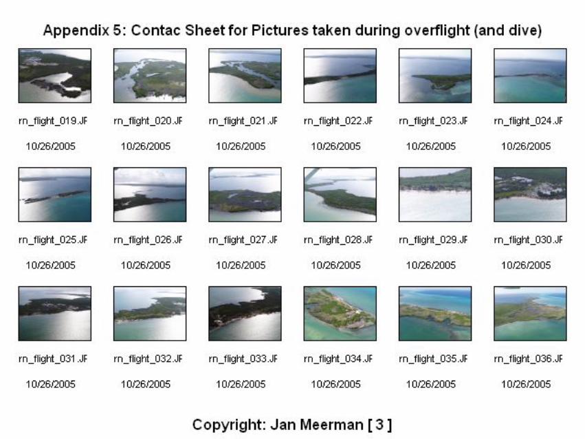
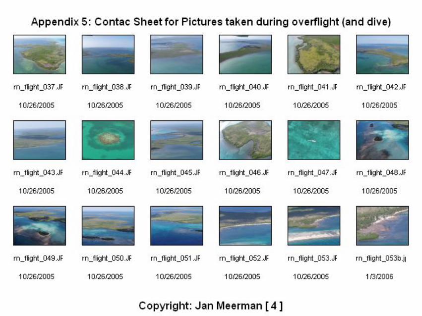
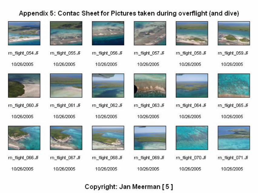
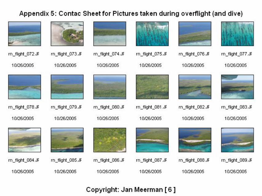
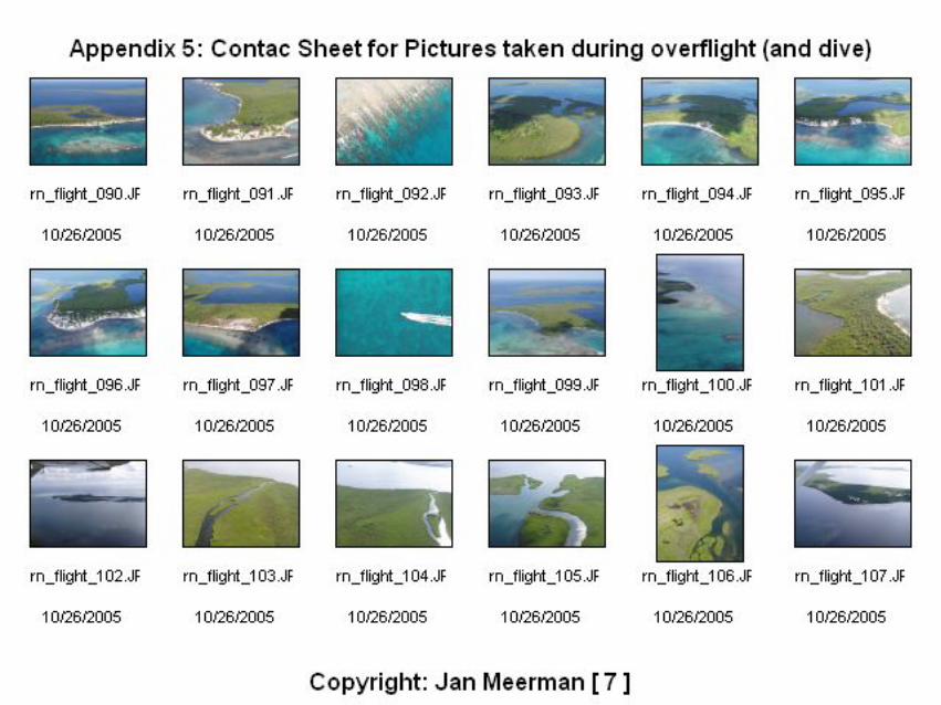
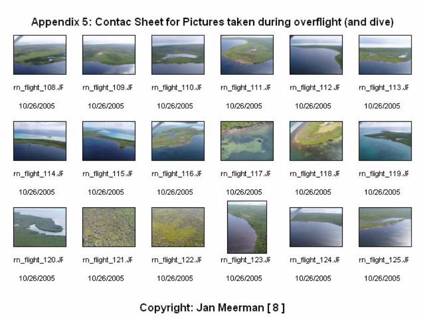
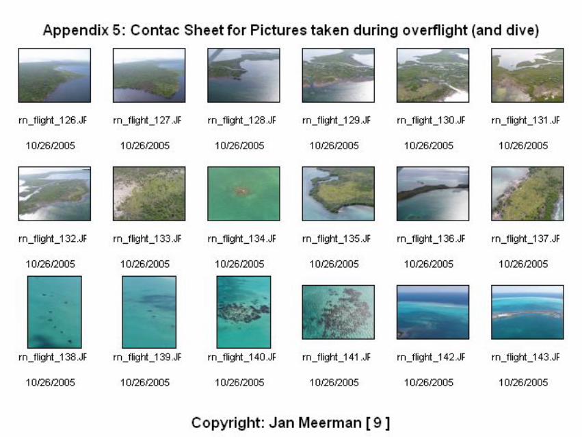
Following the baseline research, fieldwork was carried out. This field work consisted of an overflight of the area. This overflight was carried out on October 23, 2004 using a one engine plane from Javiers Flying Service in Belize City. Consultant was accompanied on this flight by George Hanson from the Forest Department. The flight path covered the northern ¾ of the Turneffe Atoll (see figure 3). On this flight a total of 220 digital pictures was taken. These pictures are provided on the accompanying resource CD. In Appendix 2, a map is presented with the location of each picture indicated. The numbers on this map correspond with the file number of the pictures. The pictures taken during this overflight proved very effective in assessing the state of the mangrove cover and in locating developments. Following this overflight, on the ground fieldwork was carried out on November 22 through November 24. Fieldwork had to be postponed twice due to proximity of Hurricane Wilma in the latter half of October and Tropical Storm Gamma on November the 21st. Both storms actually caused some damage to mangroves on Turneffe.
DaFiedeto NoBiSyap
Me
Figure 3. Turneffe Atoll and October 23, 2005 flight path of overflight
ta were collected throughout the coastal zone of Northern Turneffe (Figure 4). ldwork consisted mainly of assessing vegetation, investigating clearings and velopments. Several brief interviews with fishing camp guardians were held in order inquire for the presence of Crocodiles and Turtles. On the night of the 22-23rd of vember a night drive was held all over the Northern Lagoon in search of Crocodiles.
ological data collected are all entered in the Biological and Environmental Data stem of Belize (BERDS): http://www.biodiversity.bz . A complete listing is attached in pendix 4.
erman 2006: Mangrove and conservation value assessment of Northern Turneffe Atoll. Page 9
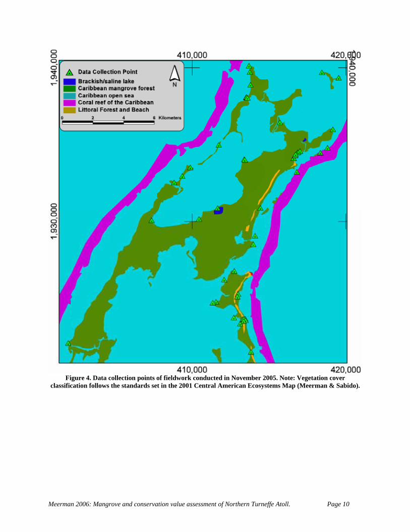
Figure 4. Data collection points of fieldwork conducted in November 2005. Note: Vegetation cover
classification follows the standards set in the 2001 Central American Ecosystems Map (Meerman & Sabido).
Meerman 2006: Mangrove and conservation value assessment of Northern Turneffe Atoll. Page 10
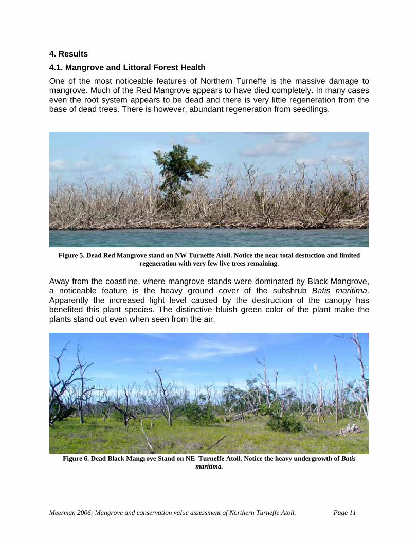
4. Results 4.1. Mangrove and Littoral Forest Health One of the most noticeable features of Northern Turneffe is the massive damage to mangrove. Much of the Red Mangrove appears to have died completely. In many cases even the root system appears to be dead and there is very little regeneration from the base of dead trees. There is however, abundant regeneration from seedlings.
Figure 5. Dead Red Mangrove stand on NW Turneffe Atoll. Notice the near total destuction and limited
regeneration with very few live trees remaining. Away from the coastline, where mangrove stands were dominated by Black Mangrove, a noticeable feature is the heavy ground cover of the subshrub Batis maritima. Apparently the increased light level caused by the destruction of the canopy has benefited this plant species. The distinctive bluish green color of the plant make the plants stand out even when seen from the air.
Figure 6. Dead Black Mangrove Stand on NE Turneffe Atoll. Notice the heavy undergrowth of Batis
maritima.
Meerman 2006: Mangrove and conservation value assessment of Northern Turneffe Atoll. Page 11
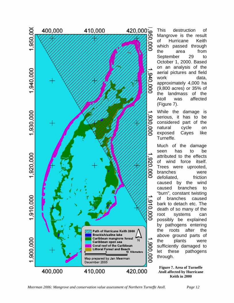
This destruction of Mangrove is the result of Hurricane Keith which passed through the area from September 29 to October 1, 2000. Based on an analysis of the aerial pictures and field work data, approximately 4,000 ha (9,800 acres) or 35% of the landmass of the Atoll was affected (Figure 7). While the damage is serious, it has to be considered part of the natural cycle on exposed Cayes like Turneffe. Much of the damage seen has to be attributed to the effects of wind force itself. Trees were uprooted, branches were defoliated, friction caused by the wind caused branches to “burn”, constant twisting of branches caused bark to detach etc. The death of so many of the root systems can possibly be explained by pathogens entering the roots after the above ground parts of the plants were sufficiently damaged to let these pathogens through.
Figure 7. Area of Turneffe Atoll affected by Hurricane
Keith in 2000
Meerman 2006: Mangrove and conservation value assessment of Northern Turneffe Atoll. Page 12
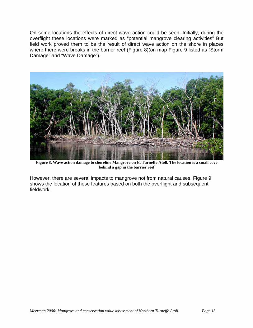
On some locations the effects of direct wave action could be seen. Initially, during the overflight these locations were marked as “potential mangrove clearing activities” But field work proved them to be the result of direct wave action on the shore in places where there were breaks in the barrier reef (Figure 8)(on map Figure 9 listed as “Storm Damage” and “Wave Damage”).
Figure 8. Wave action damage to shoreline Mangrove on E. Turneffe Atoll. The location is a small cove
behind a gap in the barrier reef However, there are several impacts to mangrove not from natural causes. Figure 9 shows the location of these features based on both the overflight and subsequent fieldwork.
Meerman 2006: Mangrove and conservation value assessment of Northern Turneffe Atoll. Page 13
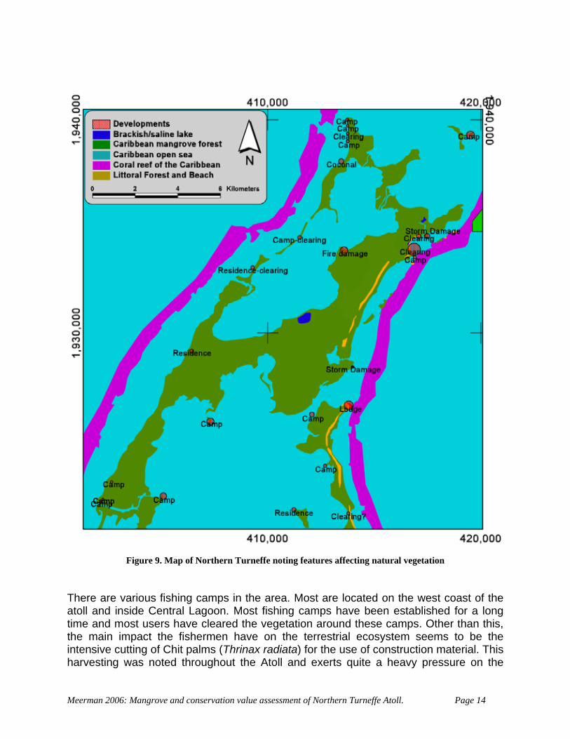
Figure 9. Map of Northern Turneffe noting features affecting natural vegetation There are various fishing camps in the area. Most are located on the west coast of the atoll and inside Central Lagoon. Most fishing camps have been established for a long time and most users have cleared the vegetation around these camps. Other than this, the main impact the fishermen have on the terrestrial ecosystem seems to be the intensive cutting of Chit palms (Thrinax radiata) for the use of construction material. This harvesting was noted throughout the Atoll and exerts quite a heavy pressure on the
Meerman 2006: Mangrove and conservation value assessment of Northern Turneffe Atoll. Page 14
population of this slow growing palm. Another main impact of the fishing camps could be the fact that most of them have dogs. These dogs (while occasionally becoming a prey of Crocodiles) must exert at least some pressure on crocodiles and turtles coming ashore for nesting purposes.
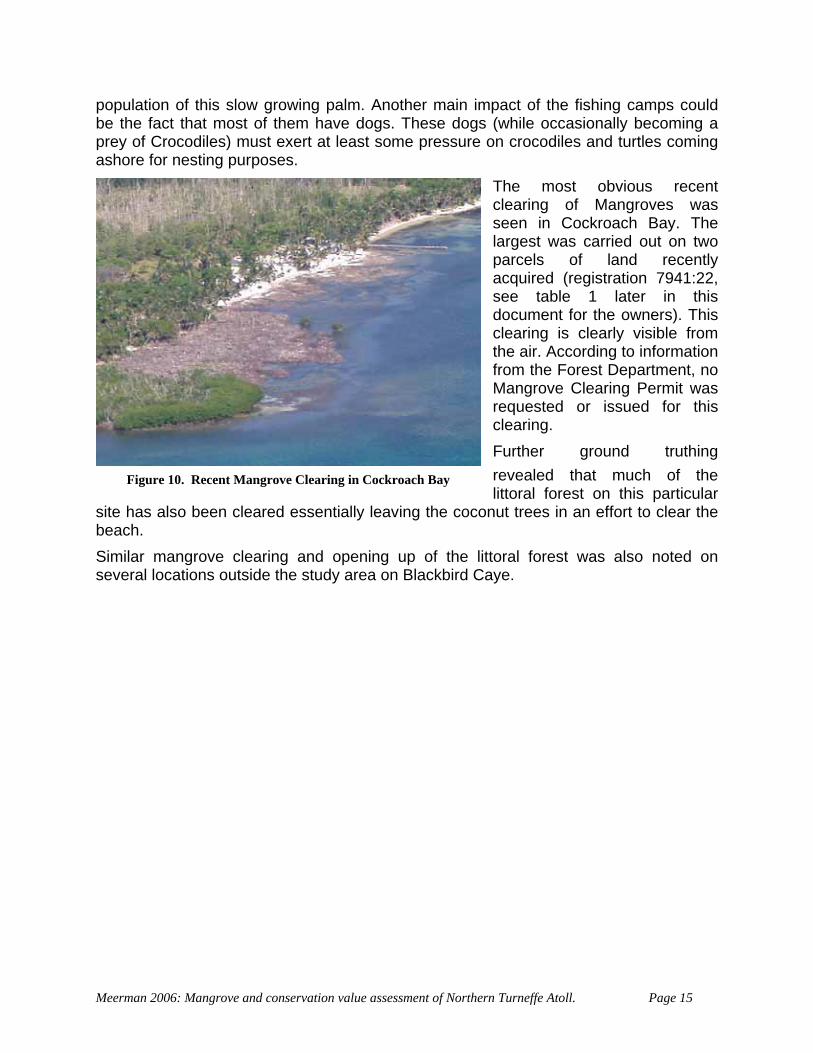
The most obvious recent clearing of Mangroves was seen in Cockroach Bay. The largest was carried out on two parcels of land recently acquired (registration 7941:22, see table 1 later in this document for the owners). This clearing is clearly visible from the air. According to information from the Forest Department, no Mangrove Clearing Permit was requested or issued for this clearing. Further ground truthing revealed that much of the
site hbeac
y
Simiseve
Meerm
Figure 10. Recent Mangrove Clearing in Cockroach Ba
littoral forest on this particularas also been cleared essentially leaving the coconut trees in an effort to clear the h. lar mangrove clearing and opening up of the littoral forest was also noted on ral locations outside the study area on Blackbird Caye.
an 2006: Mangrove and conservation value assessment of Northern Turneffe Atoll. Page 15
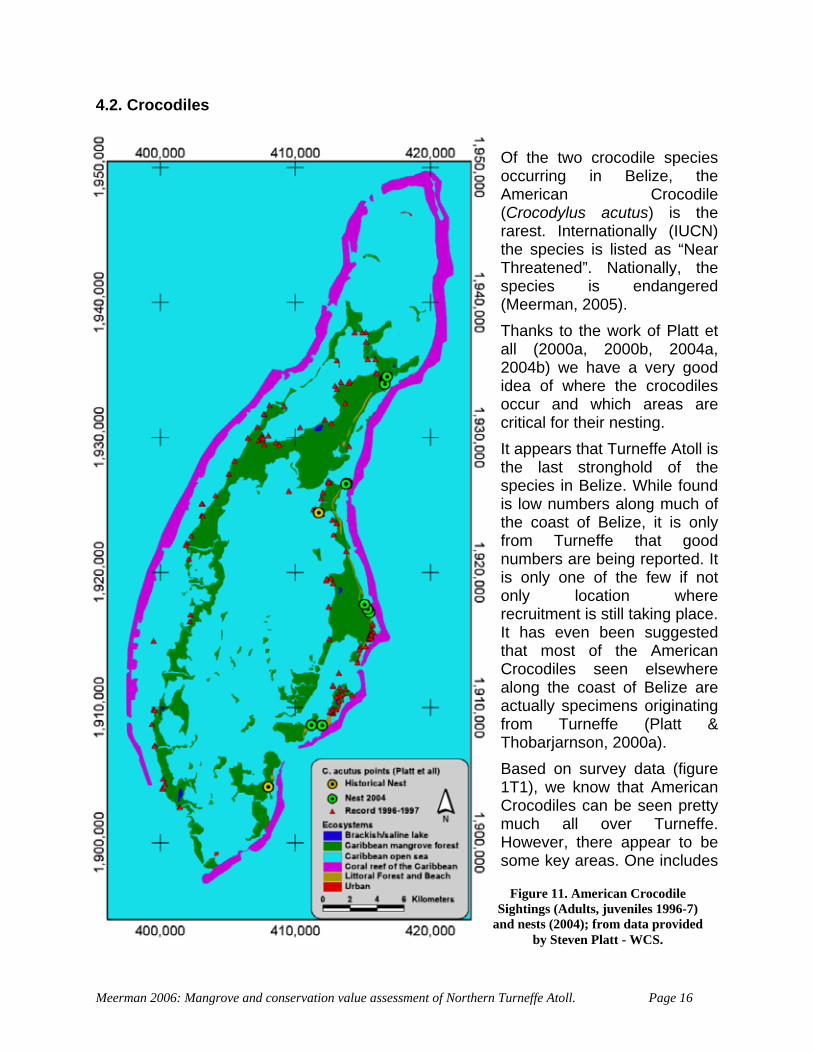
4.2. Crocodiles Of the two crocodile species occurring in Belize, the American Crocodile (Crocodylus acutus) is the rarest. Internationally (IUCN) the species is listed as “Near Threatened”. Nationally, the species is endangered (Meerman, 2005). Thanks to the work of Platt et all (2000a, 2000b, 2004a, 2004b) we have a very good idea of where the crocodiles occur and which areas are critical for their nesting. It appears that Turneffe Atoll is the last stronghold of the species in Belize. While found is low numbers along much of the coast of Belize, it is only from Turneffe that good numbers are being reported. It is only one of the few if not only location where recruitment is still taking place. It has even been suggested that most of the American Crocodiles seen elsewhere along the coast of Belize are actually specimens originating from Turneffe (Platt & Thobarjarnson, 2000a). Based on survey data (figure 1T1), we know that American Crocodiles can be seen pretty much all over Turneffe. However, there appear to be some key areas. One includes
Figure 11. American Crocodile Sightings (Adults, juveniles 1996-7)
and nests (2004); from data provided by Steven Platt - WCS.
Meerman 2006: Mangrove and conservation value assessment of Northern Turneffe Atoll. Page 16

Calabash Caye, another Southern and Northern Blackbird Caye, certain locations along Northern Lagoon, etc (but note that during our own, one evening survey on the Northern Lagoon of 22nd of November, we did not see a single Crocodile). Nesting has only been confirmed from the eastern shores of Turneffe. The key sites being Cockroach Bay, Northern Blackbird Caye, Southern Blackbird Caye and Bull Caye. Recent historical nesting records exist from Northern Blackbird (central lagoon shore) and Deadman’s Caye. By far the most important location is Cockroach Bay. On average 65% of all the reported nests on Turneffe were found here. What makes Cockroach Bay so attractive for the Crocodiles? While the American Crocodile is known to be salt water tolerant, it needs fresh water every now and then. Particularly the young crocodiles are incapable of surviving in pure salt water (Platt & Thobarjarnson, 2000a). For this reason the crocodiles need a more or less permanent source of fresh or at least brackish water. Secondly, for their reproduction, American Crocodiles depend on sandy ridges. They tend to dig nesting holes in the sand similar to those of Marine Turtles. This in contrast to the Morelets Crocodile (Crocodylus moreleti) who creates mound nests. Through a number of geological and geophysical oddities, high sandy beaches are rare on Turneffe. The close proximity of the reef prevents high wave action and allows a broad belt of mangrove to line the coast line. During unusual heavy seas this mangrove belt acts as a buffer, protecting the coast. With especially heavy seas such as during a hurricane, sand carried in by the waves gets filtered by the mangrove belt and deposited just behind this Red Mangrove belt. Occasionally, a breach in the reef is established and wave action, now unimpeded, starts eating away at the coast line. A some stage, the protecting mangrove belt can be destroyed and the littoral forest ridge is exposed and becomes beach. This process is happening on several locations along the Turneffe coast but is particularly well developed at Cockroach Bay (Figure 12). This process is still going on. Platt (2004) reports fresh sand deposits on the Cockroach Bay ridge following hurricane activity. Also, during our fieldwork, we could confirm fresh sand deposits probably resulting from tropical storm Gamma just days earlier. This constant sand build up creates a high enough ridge to prevent any crocodile nests from drowning during regular high tides and also it prevents the formation of a thick ground cover vegetation layer. In addition to this, there exists a small brackish water lagoon just behind the beach ridge of Cockroach Bay. This brackish lagoon, while insufficiently large to hold enough prey for a sizeable crocodile population, it creates and ideal resting place for crocodiles to recuperate after a day in the sea. And what’s more important, with its many shallow puddles and side lagoons, it provides a perfect nursery for the species. At Cockroach Bay, the American Crocodile finds everything it needs at a one stop location:
• Shelter during rough weather • Place to re-hydrate after prolonged presence in salt water • High sandy ridge suitable for nesting burrows • Nursery area
Meerman 2006: Mangrove and conservation value assessment of Northern Turneffe Atoll. Page 17
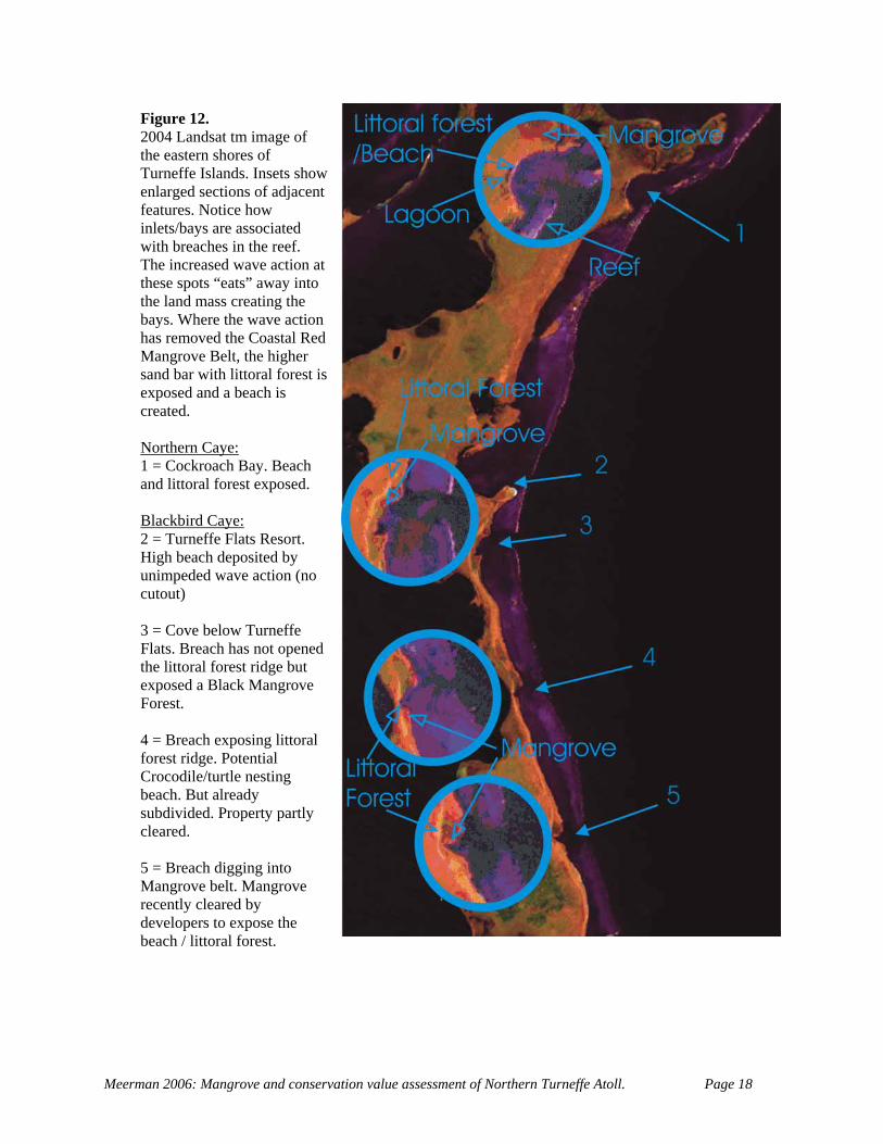
Figure 12. 2004 Landsat tm image of the eastern shores of Turneffe Islands. Insets show enlarged sections of adjacent features. Notice how inlets/bays are associated with breaches in the reef. The increased wave action at these spots “eats” away into the land mass creating the bays. Where the wave action has removed the Coastal Red Mangrove Belt, the higher sand bar with littoral forest is exposed and a beach is created. Northern Caye: 1 = Cockroach Bay. Beach and littoral forest exposed. Blackbird Caye: 2 = Turneffe Flats Resort. High beach deposited by unimpeded wave action (no cutout) 3 = Cove below Turneffe Flats. Breach has not opened the littoral forest ridge but exposed a Black Mangrove Forest. 4 = Breach exposing littoral forest ridge. Potential Crocodile/turtle nesting beach. But already subdivided. Property partly cleared. 5 = Breach digging into Mangrove belt. Mangrove recently cleared by developers to expose the beach / littoral forest.
Meerman 2006: Mangrove and conservation value assessment of Northern Turneffe Atoll. Page 18
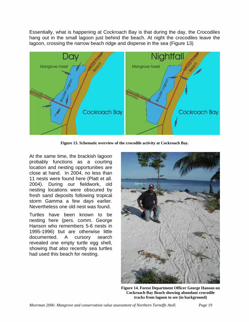
Essentially, what is happening at Cockroach Bay is that during the day, the Crocodiles hang out in the small lagoon just behind the beach. At night the crocodiles leave the lagoon, crossing the narrow beach ridge and disperse in the sea (Figure 13)
Figure 13. Schematic overview of the crocodile activity at Cockroach Bay. At the same time, the brackish lagoon probably functions as a courting location and nesting opportunities are close at hand. In 2004, no less than 11 nests were found here (Platt et all. 2004). During our fieldwork, old nesting locations were obscured by fresh sand deposits following tropical storm Gamma a few days earlier. Nevertheless one old nest was found. Turtles have been known to be nesting here (pers. comm. George Hanson who remembers 5-6 nests in 1995-1996) but are otherwise little documented. A cursory search revealed one empty turtle egg shell, showing that also recently sea turtles had used this beach for nesting.
F
Meerman 2006: Mangrove and conservation value asses
igure 14. Forest Department Officer George Hanson onCockroach Bay Beach showing abundant crocodile
tracks from lagoon to see (in background)
sment of Northern Turneffe Atoll. Page 19
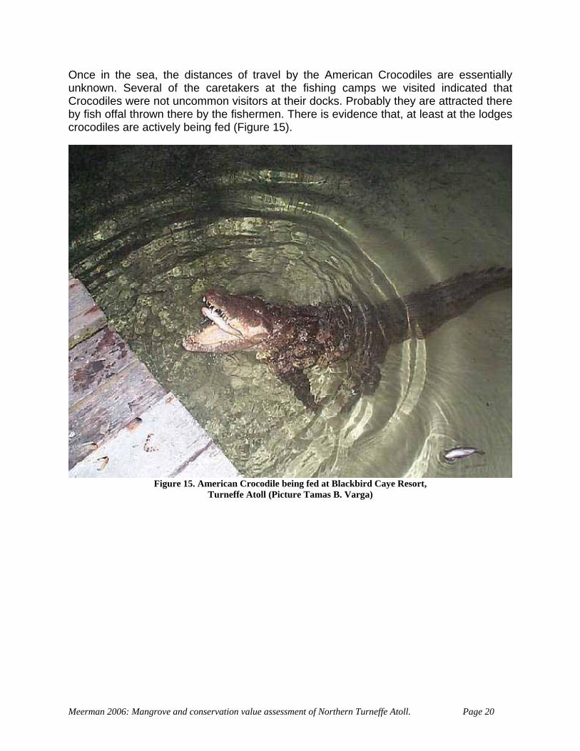
Once in the sea, the distances of travel by the American Crocodiles are essentially unknown. Several of the caretakers at the fishing camps we visited indicated that Crocodiles were not uncommon visitors at their docks. Probably they are attracted there by fish offal thrown there by the fishermen. There is evidence that, at least at the lodges crocodiles are actively being fed (Figure 15).
Meerman 2006: Mang
Figure 15. American Crocodile being fed at Blackbird Caye Resort,Turneffe Atoll (Picture Tamas B. Varga)
rove and conservation value assessment of Northern Turneffe Atoll. Page 20
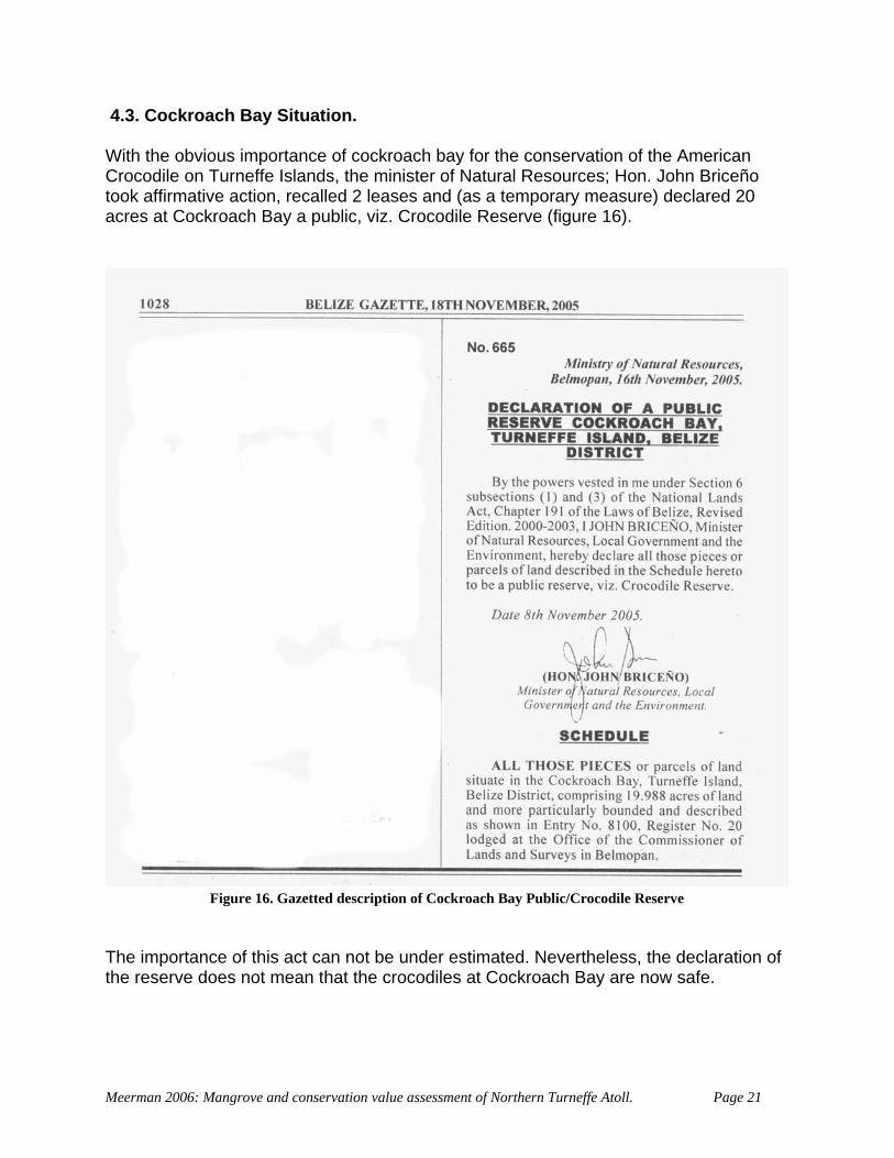
4.3. Cockroach Bay Situation. With the obvious importance of cockroach bay for the conservation of the American Crocodile on Turneffe Islands, the minister of Natural Resources; Hon. John Briceño took affirmative action, recalled 2 leases and (as a temporary measure) declared 20 acres at Cockroach Bay a public, viz. Crocodile Reserve (figure 16).
he importanc
F e
Tthe reserve do
Meerman 2006: M
igure 16. Gazetted description of Cockroach Bay Public/Crocodile Reserv
e of this act can not be under estimated. Nevertheless, the declaration of es not mean that the crocodiles at Cockroach Bay are now safe.
angrove and conservation value assessment of Northern Turneffe Atoll. Page 21
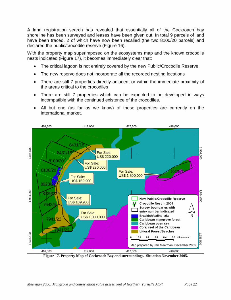
A land registration search has revealed that essentially all of the Cockroach bay
stems map and the known crocodile
lic/Crocodile Reserve
ximity of
• an be expected to be developed in ways
• re currently on the
shoreline has been surveyed and leases have been given out. In total 9 parcels of land have been traced, 2 of which have now been recalled (the two 8100/20 parcels) and declared the public/crocodile reserve (Figure 16). With the property map superimposed on the ecosynests indicated (Figure 17), it becomes immediately clear that:
• The critical lagoon is not entirely covered by the new Pub
• The new reserve does not incorporate all the recorded nesting locations
• There are still 7 properties directly adjacent or within the immediate prothe areas critical to the crocodiles
There are still 7 properties which cincompatible with the continued existence of the crocodiles.
All but one (as far as we know) of these properties ainternational market.
#Y#Y#Y#Y#Y#Y
#Y
#Y
#Y#Y#Y
8431/18
8100/20
8923/22
8039/22
7643/4
7941/22
7941/22
8431/18
8100/20 8329/17
416,500
416,500
417,000
417,000
417,500
417,500
418,000
418,000
1,93
3,50
0 1,933,5001,
934,
000 1,934,000
1,93
4,50
0 1,934,500
0 0.1 0.2 0.3 0.4 0.5 Kilometers
NBrackish/saline lakeCaribbean mangrove forestCaribbean open seaCoral reef of the CaribbeanLittoral Forest/Beaches
Survey boundaries withentry number indicated
#Y Crocodile Nest in 2004New Public/Crocodile Reserve
Map prepared by Jan Meerman, December 2005
For Sale:US$ 1,000,000
For Sale:US$ 159,900
For Sale:US$ 109,900
For Sale:US$ 220,000
For Sale:US$ 1,800,000
For Sale:US$ 220,000
Figure 17. Property Map of Cockroach Bay and surroundings. Situation November 2005.
Meerman 2006: Mangrove and conservation value assessment of Northern Turneffe Atoll. Page 22
The exact list of the persons requesting the registration of these particular parcels (the “owners”) are listed in table 1.
Table 2. List of some properties on Turneffe Atoll with real estate links indicated (December 2005) Location Entry-
Registration - Date
Size Survey Requested by:
Asking price
Real Estate hyperlink
Cockroach Bay
8431:18 16/11/04
10 + 10 Acres
Israel Marin + Juan W. Villanueva
US$ 220,000 each
http://www.privateislandsonline.com/cockroachcaye.htm
Cockroach Bay
7941:22 24/03/04
5.006 + 14.774 acres
Ainslie Leslie + Josephine Sutherland
US$ 1,000.000 together
http://belize-real-estate-sales.com/19_78_acres_on_turneffe_island
Cockroach Bay
8039:22 18/05/04
5.157 acres
Maria M. Guerra US$ 109,900
http://belize-real-estate-sales.com/5_157_acres_on_turneffe_island
Cockroach Bay
8923:22 29/07/05
8.832 acres
Felipa Avilez US$ 159,900
http://belize-real-estate-sales.com/8_832_acres_on_turneffe_island
Cockroach Bay
7643:4 15/10/03
7,985 acres
Phillip R. Espat
Cockroach caye
8329:17 28/09/04
9 acres Alfredo Aldana US$ 1,800,000
http://www.reefrealty.net/
Turneffe exact loc. unknown
? 7 Acres ? USD$285,000
http://belize-real-estate-sales.com/turneffe_island_7_acre_penisular_lot
Blackbird Caye
7465:14 5.01 Acre A.E. Rodriguez 449,900 US$
http://www.isolanaturale.com/?gclid=CNWi-ezX0YECFU4OOAodoA1kJQ
What is immediately clear is that the handing out these leases on Turneffe is in direct conflict with the following policy statements of the (2003) Caye Development Policy:
C.4 A comprehensive development plan is to be attached to every lease of National land on Cayes. C.5 The moratorium on the sale or grant of nationally owned Cayes should be formalized or legislated. C.6 Assessment of all applications to sub-divide land on Cayes must take the provisions of the CZM Plan into account. C.7 Development activities, as well as the development of leases and properties, are to be closely monitored to ensure compliance with the CZM Plan.
Also the 2003 Turneffe Islands Development Guidelines list:
• Reactivate the moratorium on the sale of small national cayes
• Institute a temporary moratorium on the sale of all national land on Turneffe until the Biosphere Management Plan is complete (or until December 2005)
Meerman 2006: Mangrove and conservation value assessment of Northern Turneffe Atoll. Page 23
• Due to the importance of mangroves as providers of ecological services for the Atoll and its main industries (fishing and tourism), the Mangrove Protection Act of 1989 should be strictly enforced.
ar a minimum and valuable littoral forest shou d and reserv
A kn ere w er a nt submi p rties w ld n ave b n out f the out land on Cayes. These developme any devel by CZM and are certainly not compliant with any plan. Furthermore, the two lots egistr :22 a am earlier when reporting illegal ma clea s nsiblylodge but the fact that it is already on the real est ket statement. Also a lodge at this location would be in need for an Environmental Impact Assessment. A check at the Department of he en revealed that there is no suo eW olicy very a t to a e r locat operties are being acquired for residential or e ym t purposes onc ion is confirm es became available on the international market as soon as they were surveyed. From a national development perspective there is no compelli son a the tiona
• Cle ing of vegetation should be kept told be identifie ed.
s far as rope
own, thhich shou
as nevever h
developmeeen givents ignore
plan ollowing plan
tted for each of these moratorium on giving
oped
with r ation 7941 re the s e as mentionedngrove ring. The site i oste
ate mar being developed for a , seems to refute this
t Environm t in November 2005ch an Environmental Impact Assessment has been carried
ut or appli d for. phile there
emoteexist a “ion does not imply that these pr
” that e Belizean has righ piece of the jewel. Th
ven enjo en . This c lus ed by the fact that the properti
to put these natng rea ionalssets on interna l market.
Meerman 2006: Mangrove and conservation value assessment of Northern Turneffe Atoll. Page 24
4.4 tThe AmDatabase records are presented in figure 11. But several observations were made dur 19. How erest as well.
umbers.
k is still to be conducted in this field.
of 4 active nests were counted which are depicted n figure 19.
Another bird that was mapped is the White-crowned Pigeon, a typical species for Caribbean Islands. This species was seen on Cockroach Caye but is to be expected on all islands including in the littoral forest of the main islands. Another species of great interest is the Turneffe Parrotsnake (Leptophis mexicanus hoeversi, figure 18). This taxon is endemic to Turneffe Atoll. The species is usually uniformly green but axanthic mutants which are uniform blue are relatively common. This is a striking and unique species. A total of 7 individuals (5 blue, 2 green) were observed on Both Northern Caye and Black Bird Caye (Fig. 19). The specimens were generally observed in littoral forest/coconal habitats. While apparently relatively common, the extremely limited distribution and its preference for a scarce habitat should mark it as extremely vulnerable.
. O her Wildlife erican Crocodile is certainly one of the flagship species for northern Turneffe.
ing the November 2005 fieldwork, the locations of which being indicated on figure ever, there are other species of int
One important species is the Manatee. No direct observations were made during the fieldwork but some data was obtained through CZMAI and these were plotted in Figure 19. Turneffe is not a location with a high density of Manatee sightings but nonetheless the species is present in reasonable nAs mentioned before, marine turtles are thought to be coming to shore and lay eggs all along the eastern shores of Turneffe Atoll. One hatched egg was found in Cockroach Bay. But otherwise, information on sea-turtles in Northern Turneffe is very sketchy. CZMAI has data on supposed nesting activities on several of the islands near Cockroach Caye, but these are without identification and numbers. Forest Officer George Hanson, reported a number of Turtle nests on Cockroach Bay in 1995-1996. Clearly a lot of worBird colonies could not be monitored during the fieldwork in October and November since no birds were breeding at that time. A critical habitats map produced by the CZMAI indicates several locations with Herons and Terns. But the map is to indistinct to be very specific. Only Ospreys were present at their nests during November, probably in preparation of the actual breeding season. A totalo
Figure 18. The Turneffe Parrotsnake Leptophis mexicanus hoeversi (juvenile). Picture by Jan
Meerman.
Meerman 2006: Mangrove and conservation value assessment of Northern Turneffe Atoll. Page 25
Turneffe Parrotsnake
Figure 19. Other species of interest noted during fieldw
courtesy of CZork in November 2005 (but Manatee data
MAI)
Meerman 2006: Mangrove and conservation value assessment of Northern Turneffe Atoll. Page 26
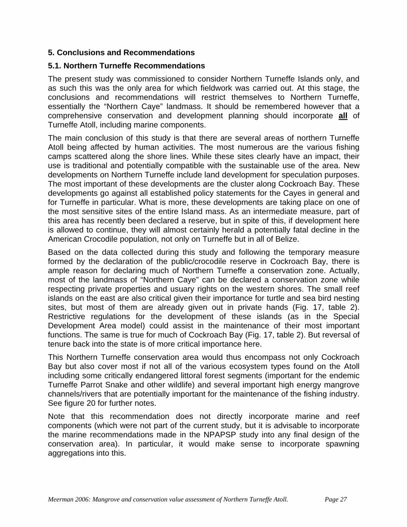
5. Conclusions and Recommendations 5.1. Northern Turneffe Recommendations The present study was commissioned to consider Northern Turneffe Islands only, and as such this was the only area for which fieldwork was carried out. At this stage, the conclusions and recommendations will restrict themselves to Northern Turneffe, essentially the “Northern Caye” landmass. It should be remembered however that a comprehensive conservation and development planning should incorporate all of Turneffe Atoll, including marine components. The main conclusion of this study is that there are several areas of northern Turneffe Atoll being affected by human activities. The most numerous are the various fishing camps scattered along the shore lines. While these sites clearly have an impact, their use is traditional and potentially compatible with the sustainable use of the area. New developments on Northern Turneffe include land development for speculation purposes. The most important of these developments are the cluster along Cockroach Bay. These developments go against all established policy statements for the Cayes in general and for Turneffe in particular. What is more, these developments are taking place on one of the most sensitive sites of the entire Island mass. As an intermediate measure, part of this area has recently been declared a reserve, but in spite of this, if development here is allowed to continue, they will almost certainly herald a potentially fatal decline in the American Crocodile population, not only on Turneffe but in all of Belize. Based on the data collected during this study and following the temporary measure formed by the declaration of the public/crocodile reserve in Cockroach Bay, there is ample reason for declaring much of Northern Turneffe a conservation zone. Actually, most of the landmass of “Northern Caye” can be declared a conservation zone while respecting private properties and usuary rights on the western shores. The small reef islands on the east are also critical given their importance for turtle and sea bird nesting sites, but most of them are already given out in private hands (Fig. 17, table 2). Restrictive regulations for the development of these islands (as in the Special Development Area model) could assist in the maintenance of their most important functions. The same is true for much of Cockroach Bay (Fig. 17, table 2). But reversal of tenure back into the state is of more critical importance here. This Northern Turneffe conservation area would thus encompass not only Cockroach Bay but also cover most if not all of the various ecosystem types found on the Atoll including some critically endangered littoral forest segments (important for the endemic Turneffe Parrot Snake and other wildlife) and several important high energy mangrove channels/rivers that are potentially important for the maintenance of the fishing industry. See figure 20 for further notes. Note that this recommendation does not directly incorporate marine and reef components (which were not part of the current study, but it is advisable to incorporate the marine recommendations made in the NPAPSP study into any final design of theonservation area). In particular, it would make sense to incorporate spawning
aggre
c
gations into this.
Meerman 2006: Mangrove and conservation value assessment of Northern Turneffe Atoll. Page 27
Figure 20. Proposed conservation zones in Northern Turneffe (schematic and not considering actual reef components) with conservation features indicated. 1 = High energy mangrove channels potentially
important for fishery resources 2 = High energy mangrove channels
9 = Broken Palmetto Thicket (viz. Murrey et al) 10 = Broken Palmetto-Buttonwood Thicket (viz.
3 = High energy mangrove lagoons and channels 4 = Spawning aggregation 5 = Crocodile - Turtle nesting site 6 & 7 = Littoral forest for Turneffe Parrot Snake
and other wildlife 8 = High energy mangrove lagoon and channel
11 = High crocodile density (nesting?) 12 = High energy mangrove channels 13 = Northern Lagoon (Crocodiles, Manatees) 14 = High energy mangrove channels 15 = Northern Lagoon 16 & 17 = Turtle nesting & birds
Murrey et al. 1999)
Meerman 2006: Mangrove and conservation value assessment of Northern Turneffe Atoll. Page 28
Any declaration of new protected areas should be carried out as part of the upcoming National Protected Areas Plan implementation. Any classification should follow the IUCN model as recommended within the NPAPSP. Depending on the areas included and the stakeholder input, conservation categories suitable for Northern Turneffe could be:
• CATEGORY Ib: Protected area managed mainly for wilderness protection.
• CATEGORY V: Protected area managed mainly for landscape/seascape conservation and recreation.
• CATEGORY VI: Protected area managed mainly for the sustainable use of natural ecosystems.
While the above recommendations were made based principally on the present study, these recommendations were not made in isolation. The various previous recommendations and analysis gave very similar results (see chapter 5.2). In addition, it is recommended that regular monitoring is established for:
• Crocodiles • Sea Turtles • Turneffe Parrot Snakes • Marine Birds • Manatees • Mangroves
This small list does not to intend to exclude other species (Dolphins and other marine organisms). Partly this monitoring is already in place (Manatees) but coordination of these efforts is advisable. A good system that allows such coordination is the Biodiversity and Environmental Resource Data System for Belize (BERDS): http://www.biodiversity.bz The principle of monitoring should be to gather data that can be used in management decisions. The monitoring of mangroves in this context is a bit problematic, since much of the mangroves on Northern Turneffe are regenerating following hurricane damage. Monitoring activities in this case should particularly satisfy scientific interest, since no particular activities to promote regeneration are proposed at this stage.
been e ree o
ent Gui uccessor elines se plans
s:
tential beyond what recommended as special development sites.
5.2. The previous zonation proposals In the recent past several attempts haveAtoll including zoning for conservation. Th
made to come to a zoning of Turnefff these are discussed here.
nes (McGill, 1996• Turneffe Islands Draft Developmevelopment Guid
deli ) and its sthe Turneffe D (TICAC, 2003)(Figure 21). Therecognizes two zone
o Conservation o Minimal development po
Meerman 2006: Mangrove and conservation value assessment of Northern Turneffe Atoll. Page 29
The plan considers only the terrestrial parts of Turneffe and primarily looks at the height of the land to decide on development potential. Low lying or semi-permanently inundated mangrove is rightfully classified as having low development potential. Areas earmarked for conservation includes:
s,
n.
tion developed by Oceanic Society (Egan, 2005)(Figure 22). This the coastal marine components of Turneffe. Criteria t all. 2000-2004 Crocodiles studies, the presence of
regations, coral diversity, vegetation diversity, manatee rd nesting and lobster abundance. Core areas recognized include:
Belize based on the attributes of 10 km² hexagons. This study took both terrestrial and marine
se of Turneffe, land tenure was not taken into vailable for this study). The MARXAN system
as being of
These thr consequently the outcomes differ. NevCalabash
o the entire Northern Lagoon and shores, o The bulk of Northern Caye including Cockroach Bay, Freshwater Creek
Lagoon and surroundingo Cayes east and southeast of Cockroach Bay. o Pelican Caye, o Soldier Caye, o the low-lying sections of Calabash Caye and the o Crayfish Range and associated Cayes in the Central Lagoo
• Biosphere zonaplan considers primarilyused include the Platt espawning aggoccurrence, bi
o The four spawning aggregations o Cockroach Bay o The Turneffe Flats property o Pelican Caye o Crocodile Beach on Blackbird Caye o Calabash Caye
• The MARXAN analysis carried out as part of the National Protected Areas System Plan (Meerman, 2005)(Figure 23). This study analyzed
attributes into account. In the caaccount (they were simply not afavors areas where several ecosystems and/or other conservation features occur in close proximity. This study recognized much of Turneffe high conservation importance recognizing particularly the northern and eastern portions of the Atoll.
ee studies all had a very different approach and ertheless, there are some common denominators such as the importance of Caye, parts of the Blackbird Caye Area, and Cockroach Bay.
Meerman 2006: Mangrove and conservation value assessment of Northern Turneffe Atoll. Page 30
Figure 21. Prosposed Development Zoning based on
the 2003 Turneffe Islands Development Guidelines.
Meerman 2006: Mangrove and conservation value assessment of Northern Turneffe Atoll. Page 31
Figure 22. Proposed Biosphere Zonation developed by Ocea
Society 2004 nic
Meerman 2006: Mangrove and conservation value assessment of Northern Turneffe Atoll. Page 32
Meerman 2006: Mangrove and conservation value assessment of Northern Turneffe Atoll. Page 33
Figure 23. MARXAN Analysis of conservation priorities based on
the National Protected Areas Policy and System Assessment:
Meerman, 2005.
Meerman 2006: Mangrove and conservation value assessment of Northern Turneffe Atoll. Page 34
6. Literature CZMAI, 2003. Draft CaEgan, S. 2005. Rationale for location of
Zones on TuFrancisco State Univ
McGill, 1996 Turneffe Islands Dev
Meerman, J. C. & W. Sreports. World Bank / Programme for 2004 landsat images
Meerman, J. C. 2005. EcosystMeerman, J. C. 2005a. National
Ministry of Natural Resources. Meerman, J. C. 2005b. National Li
Natural Resources. 8pp. Murray, M. R., S. A. Zisman
vegetation classification of Turneffe Atopp.
Platt, S. G. and J. B. Thorbjarcrocodile, Crocodylus
Platt, S. G. and J. B. Thorcrocodile in the coastal zone
Platt, S. G., T. R. RainwateAmerican Crocodile (CrocodylusBulletin 89: 26-32.
Platt, S.G. 2004b. The BelizDevelopment. Report to Wild
Turneffe Islands CoastaDevelopment Guidelines 58 pp + maps.
yes Development Policy. Available as digital copy 23 pp. Draft Core and Buffer Biosphere Reserve
rneffe Atoll. Email from Stefanie Egan, Graduate Student, San ersity/Oceanic Society, San Francisco.
elopment Guidelines. Available as hardcopy of the original only. Lodged at the CZMAI label CZM/iczm-904.
abido. 2001. Central American Ecosystems Map: Belize. 2 Belize. Since then updated in 2005 using
ems Map of Belize, 2004 update. Protected Area System Analysis. Series of reports to
st of Critical Species – 1st Draft. Report to Ministry of
& C. D. Minty, 1999, Soil-plant relationships and a revised ll, Belize., Atoll Research Bulletin, 464, 32
narson. 2000a. Status and conservation of the American acutus, in Belize. Biological Conservation 96:13-20.
bjarnarson. 2000b. Nesting ecology of the American of Belize. Copeia 2000:868-872.
r & S. Nichols, 2004a. A recent population assessment of the acutus) in Turneffe Atoll, Belize. Herpetological
American Crocodile (Crocodylus acutus) in the Turneffe Atoll, e. An Assessment of Current Conservation Status and Threats Posed by
life Society. 8 pp. l Advisory Committee (TICAC), 2003. Turneffe Islands
Coastal Zone Management Authority and Institute
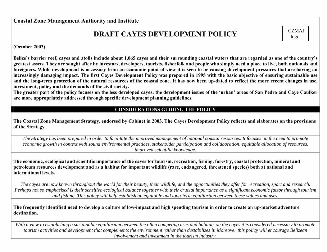
DRAFT CAYES DEVELOPMENT POLICY (October 2003) Belize’s barrier reef, cayes and atolls include about 1,065 cayes and their surrounding coastal waters that are regarded as one of the country’s greatest assets. They are sought after by investors, developers, tourists, fisherfolk and people who simply need a place to live, both nationals and foreigners. While development is necessary from an economic point of view it is seen to be causing development pressures that are having an increasingly damaging impact. The first Cayes Development Policy was prepared in 1995 with the basic objective of ensuring sustainable use and the long-term protection of the natural resources of the coastal zone. It has now been up-dated to reflect the more recent changes in use, investment, policy and the demands of the civil society. The greater part of the policy focuses on the less developed cayes; the development issues of the ‘urban’ areas of San Pedro and Caye Caulker are more appropriately addressed through specific development planning guidelines.
CONSIDERATIONS GUIDING THE POLICY The Coastal Zone Management Strategy, endorsed by Cabinet in 2003. The Cayes Development Policy reflects and elaborates on the provisions of the Strategy.
The Strategy has been prepared in order to facilitate the improved management of national coastal resources. It focuses on the need to promote economic growth in context with sound environmental practices, stakeholder participation and collaboration, equitable allocation of resources,
improved scientific knowledge. The economic, ecological and scientific importance of the cayes for tourism, recreation, fishing, forestry, coastal protection, mineral and petroleum resources development and as a habitat for important wildlife (rare, endangered, threatened species) both at national and international levels.
The cayes are now known throughout the world for their beauty, their wildlife, and the opportunities they offer for recreation, sport and research. Perhaps not so emphasised is their sensitive ecological balance together with their crucial importance as a significant economic factor through tourism
and fishing. This policy will help establish an equitable and long-term equilibrium between these values and uses. The frequently identified need to develop a culture of low-impact and high spending tourism in order to create an up-market adventure destination. With a view to establishing a sustainable equilibrium between the often competing uses and habitats on the cayes it is considered necessary to promote
tourism activities and development that complements the environment rather than destabilizes it. Moreover this policy will encourage Belizean involvement and investment in the tourism industry.
CZMAI logo
Recognition of the projected implications of climate change and consequent sea level rise. Comprehensive research has been undertaken, both nationally and internationally, into the anticipated implications of global climate change. This is of particular relevance to Belize with its extensive low lying lands (both cayes and mainland), and susceptibility to natural catastrophe such as hurricanes
and floods. Correlation with existing legislation, as well as existing and draft policies and guidelines, that directly or indirectly govern the use and development of the cayes. Over fifty pieces of primary legislation, and many more subsidiary pieces and guidelines, govern or advise a wide variety of coastal zone activities. This
policy reflects all current and draft legislation and policy, and makes recommendation on their uses, adaptation and implementation. Recognition of the different types of cayes and their individual characteristics that dictate the form of use or development that is appropriate and sustainable.
No two cayes are the same: basic factors of ownership, occupation, location, natural features, habitat and history influence their potential use. This policy reflects such considerations and recognises that no blanket approach would be suited to the many individual characteristics.
The awareness that the cayes represent one of the most valuable resources of Belize and that the use and exploitation of that resource should benefit all Belizeans in an open and transparent manner. The cayes are recognised both nationally and abroad as being one of the fundamental components of the qualities that are summed up as The Jewel. As
such they essentially belong to the nation, and the nation has the right to have a say on how they are used now and in the future.
POLICY OBJECTIVES To motivate and encourage both local and foreign investment in coastal resources.
Much of this translates into the acquisition or leasing of land on the cayes and the development of these lands and surrounding waters. Such developments should be encouraged and facilitated to contribute to and complement the cayes and their established occupants. They should not be a
source of conflict between foreign investors and local interests with, in some cases, the loss of customary rights and inappropriate development. To promote development without compromising national identity and time-honoured rights.
The cayes and waters have been used by Belizeans for hundreds of years. Traditional practices and styles have been developed over the years, which have resulted in forms of use that effectively based on the potentials and constraints of the natural environment and reflect a local culture peculiar to the
Belizean cayes.
To balance development with sound conservation management.
The cayes are particularly fragile and vulnerable on account of their (often) small size and characteristic ecology, and there is already evidence of damage at many locations.
To strengthen and support Government procedures for receiving and reviewing development proposals for the cayes, and the resources available to carry out those procedures.
There are several Government departments and statutory bodies responsible for implementing the legislation and guidelines mentioned above. This policy aims to strengthen interagency co-ordination and cooperation and facilitate the public’s access and use of the procedures for submitting
development proposals. To ensure that the existing and customary users and occupants of the cayes have a right to security of their interests. The cayes are a rapidly changing environment. As a reflection of their varied interests and competing uses the cayes are becoming increasingly exposed to international interests and valuation (monetary and otherwise). In the face of this it is important to guarantee that those that make their living from
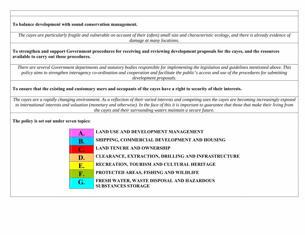
the cayes and their surrounding waters maintain a secure future. The policy is set out under seven topics: A. LAND USE AND DEVELOPMENT MANAGEMENT
B. SHIPPING, COMMERCIAL DEVELOPMENT AND HOUSING
C. LAND TENURE AND OWNERSHIP
D. CLEARANCE, EXTRACTION, DRILLING AND INFRASTRUCTURE
E. RECREATION, TOURISM AND CULTURAL HERITAGE
F. PROTECTED AREAS, FISHING AND WILDLIFE
G. FRESH WATER, WASTE DISPOSAL AND HAZARDOUS SUBSTANCES STORAGE
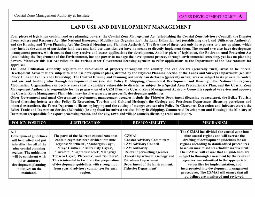
LAND USE AND DEVELOPMENT MANAGEMENT Four pieces of legislation contain land use planning powers: the Coastal Zone Management Act (establishing the Coastal Zone Advisory Council), the Disaster Preparedness and Response Act (the National Emergency Mobilisation Organisation), the Land Utilisation Act (establishing the Land Utilisation Authority), and the Housing and Town Planning Act (the Central Housing and Planning Authority). The first two of these Acts only have powers to draw up plans, which may include the zoning of particular land uses and land use densities, yet have no means to directly implement them. The second two also have development management powers, which means that they receive and assess applications for development. Another piece of legislation, the Environmental Protection Act (establishing the Department of the Environment), has the power to manage the development process, through environmental screening, yet has no planning powers. Moreover this last Act relies on the various other Government licensing agencies to refer applications to the Department of the Environment for appraisal. The Land Utilisation Authority regulates the sub-division of property throughout the country and can declare (generally rural) areas to be Special Development Areas that are subject to land use development plans, drafted by the Physical Planning Section of the Lands and Surveys Department (see also Policy C: Land Tenure and Ownership). The Central Housing and Planning Authority can declare a (generally urban) area as subject to its powers to control land use and building also through development plans (see also Policy B: Shipping, Commercial Development and Housing). The National Emergency Mobilisation Organisation can declare areas that it considers vulnerable to disaster as subject to a Special Area Precautionary Plan, and the Coastal Zone Management Authority is responsible for the preparation of a CZM Plan; the Coastal Zone Management Advisory Council is required to review and approve the Coastal Zone Management Plan which may involve separate area-specific development guidelines. Other Government and quasi Government development management agencies include the Fisheries Department (licensing aquaculture), the Belize Tourism Board (licensing hotels; see also Policy E: Recreation, Tourism and Cultural Heritage), the Geology and Petroleum Department (licensing petroleum and mineral extraction), the Forest Department (licensing logging and the cutting of mangroves; see also Policy D: Clearance, Extraction and Infrastructure), the Belize Trade and Investment Service (Beltraide) (issuing fiscal incentives; see also Policy B: Shipping, Commercial Development and Housing), the Ministry of Investment (responsible for export processing zones), and the city, town and village councils (licensing trade and liquor). POLICY POSITION JUSTIFICATION RESPONSIBILITY MECHANISM
CAYES DEVELOPMENT POLICY: A Coastal Zone Management Authority & Institute
A.1 Development guidelines will be drafted and put into effect for all of the nine coastal planning
regions. The guidelines will be consistent with
other statutory development planning
initiatives on the mainland.
The parts of the Belizean coastal zone that contain cayes has been divided into nine regions: ‘Northern’, ‘Ambergris Caye’,
‘Caye Caulker’, ‘Belize City Cayes’, ‘Turneffe’, ‘Lighthouse Reef’, ‘Dangriga
Tobacco Caye’, ‘Placencia’, and ‘Southern’. This is intended to facilitate the preparation of development guidelines with strong input from coastal advisory committees for each
region.
CZMAI Coastal Advisory Committees CZM Advisory Council CZM Authority Relevant permitting agencies (Forest Department, Geology and Petroleum Department, Department of the Environment, Fisheries Department)
The CZMAI has divided the coastal zone into nine coastal regions and will oversee the
drafting of development guidelines for all regions according to standardised procedures based on maximised stakeholder involvement. The CZMAI will ensure that all guidelines are subject to thorough assessment by the relevant
agencies, are submitted to the appropriate authorities for implementation, and
incorporated into development management procedures. The CZMAI will ensure that all
guidelines are monitored and reviewed.
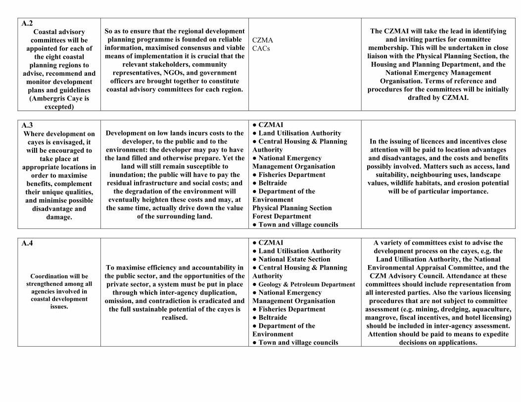
A.2 Coastal advisory
committees will be appointed for each of
the eight coastal planning regions to
advise, recommend and monitor development plans and guidelines (Ambergris Caye is
excepted)
So as to ensure that the regional development planning programme is founded on reliable
information, maximised consensus and viable means of implementation it is crucial that the
relevant stakeholders, community representatives, NGOs, and government
officers are brought together to constitute coastal advisory committees for each region.
CZMA CACs
The CZMAI will take the lead in identifying
and inviting parties for committee membership. This will be undertaken in close liaison with the Physical Planning Section, the Housing and Planning Department, and the
National Emergency Management Organisation. Terms of reference and
procedures for the committees will be initially drafted by CZMAI.
A.3 Where development on
cayes is envisaged, it will be encouraged to
take place at appropriate locations in
order to maximise benefits, complement their unique qualities, and minimise possible
disadvantage and damage.
Development on low lands incurs costs to the
developer, to the public and to the environment: the developer may pay to have the land filled and otherwise prepare. Yet the
land will still remain susceptible to inundation; the public will have to pay the
residual infrastructure and social costs; and the degradation of the environment will
eventually heighten these costs and may, at the same time, actually drive down the value
of the surrounding land.
● CZMAI ● Land Utilisation Authority ● Central Housing & Planning Authority ● National Emergency Management Organisation ● Fisheries Department ● Beltraide ● Department of the Environment Physical Planning Section Forest Department ● Town and village councils
In the issuing of licences and incentives close attention will be paid to location advantages
and disadvantages, and the costs and benefits possibly involved. Matters such as access, land
suitability, neighbouring uses, landscape values, wildlife habitats, and erosion potential
will be of particular importance.
A.4
Coordination will be strengthened among all
agencies involved in coastal development
issues.
To maximise efficiency and accountability in the public sector, and the opportunities of the private sector, a system must be put in place
through which inter-agency duplication, omission, and contradiction is eradicated and
the full sustainable potential of the cayes is realised.
● CZMAI ● Land Utilisation Authority ● National Estate Section ● Central Housing & Planning Authority ● Geology & Petroleum Department ● National Emergency Management Organisation ● Fisheries Department ● Beltraide ● Department of the Environment ● Town and village councils
A variety of committees exist to advise the development process on the cayes, e.g. the Land Utilisation Authority, the National
Environmental Appraisal Committee, and the CZM Advisory Council. Attendance at these
committees should include representation from all interested parties. Also the various licensing procedures that are not subject to committee
assessment (e.g. mining, dredging, aquaculture, mangrove, fiscal incentives, and hotel licensing) should be included in inter-agency assessment. Attention should be paid to means to expedite
decisions on applications.
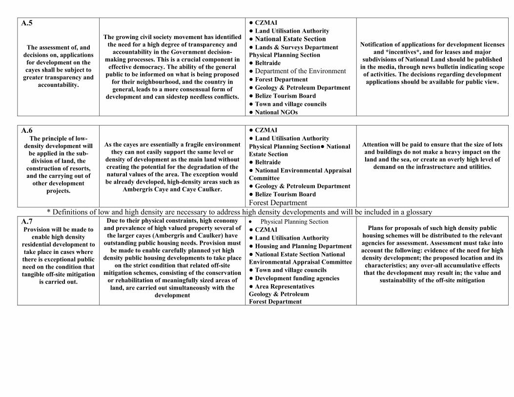
A.5
The assessment of, and decisions on, applications for development on the cayes shall be subject to
greater transparency and accountability.
The growing civil society movement has identified the need for a high degree of transparency and
accountability in the Government decision-making processes. This is a crucial component in
effective democracy. The ability of the general public to be informed on what is being proposed
for their neighbourhood, and the country in general, leads to a more consensual form of
development and can sidestep needless conflicts.
● CZMAI ● Land Utilisation Authority ● National Estate Section ● Lands & Surveys Department Physical Planning Section ● Beltraide ● Department of the Environment ● Forest Department ● Geology & Petroleum Department ● Belize Tourism Board ● Town and village councils ● National NGOs
Notification of applications for development licenses and *incentives*, and for leases and major
subdivisions of National Land should be published in the media, through news bulletin indicating scope of activities. The decisions regarding development applications should be available for public view.
A.6
The principle of low-density development will
be applied in the sub-division of land, the
construction of resorts, and the carrying out of
other development projects.
As the cayes are essentially a fragile environment they can not easily support the same level or
density of development as the main land without creating the potential for the degradation of the natural values of the area. The exception would be already developed, high-density areas such as
Ambergris Caye and Caye Caulker.
● CZMAI ● Land Utilisation Authority Physical Planning Section● National Estate Section ● Beltraide ● National Environmental Appraisal Committee ● Geology & Petroleum Department ● Belize Tourism Board Forest Department
Attention will be paid to ensure that the size of lots and buildings do not make a heavy impact on the land and the sea, or create an overly high level of
demand on the infrastructure and utilities.
* Definitions of low and high density are necessary to address high density developments and will be included in a glossary A.7 Provision will be made to
enable high density residential development to take place in cases where there is exceptional public need on the condition that tangible off-site mitigation
is carried out.
Due to their physical constraints, high economy and prevalence of high valued property several of
the larger cayes (Ambergris and Caulker) have outstanding public housing needs. Provision must
be made to enable carefully planned yet high density public housing developments to take place
on the strict condition that related off-site mitigation schemes, consisting of the conservation
or rehabilitation of meaningfully sized areas of land, are carried out simultaneously with the
development
• Physical Planning Section ● CZMAI ● Land Utilisation Authority ● Housing and Planning Department ● National Estate Section National Environmental Appraisal Committee ● Town and village councils ● Development funding agencies ● Area Representatives Geology & Petroleum Forest Department
Plans for proposals of such high density public
housing schemes will be distributed to the relevant agencies for assessment. Assessment must take into account the following: evidence of the need for high density development; the proposed location and its characteristics; any over-all accumulative effects that the development may result in; the value and
sustainability of the off-site mitigation
A.8
Aesthetic appearance and practicality of
construction material will be encouraged in all
developments of the cayes, particularly in regard to
beach aesthetics.
The prevalent materials, size and style of building on the cayes have evolved over many years as an appropriate response to the demands of use and
nature. This can be considered as generally suitable to demand yet also crucial to the aesthetic
and landscape value of the cayes: a vital consideration in the tourism industry. The Strata Act should be taken into account where small lots
with large public spaces exist or are allowed.
● CHPA ● CZMAI ● Land Utilisation Authority ● National Estate Section ● Beltraide ● National Environmental Appraisal Committee ● Central Housing & Planning Authority ● Belize Tourism Board ● Town and village councils ● Development funding agencies ● Insurance agencies ● Geology and Petroleum Department Forest Department
All applications for development licenses or incentives will be assessed to ensure that matters of aesthetic appearance and the localised suitability of
materials are taken this into account.
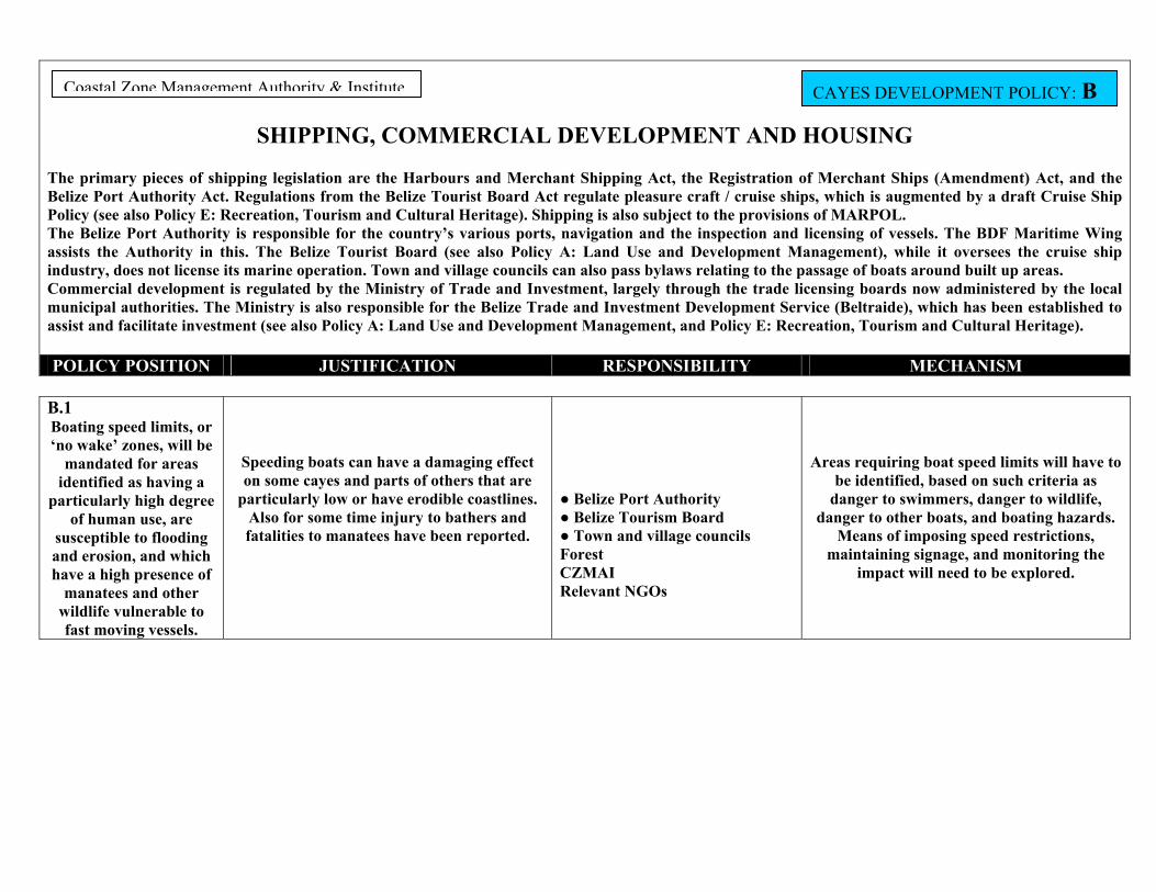
SHIPPING, COMMERCIAL DEVELOPMENT AND HOUSING
rimary pieces of shipping legislation are the Harbours and Merchant Shipping Act, the Registration of Merchant Ships (Amendment) Act, and the Port Authority Act. Regulations from the Belize Tourist Board Act regulate pleasure craft / cruise ships, which is augmented by a draft Cruise Ship (see also Policy E: Recreation, Tourism and Cultural Heritage). Shipping is also subject to the provisions of MARPOL. elize Port Authority is responsible for the country’s various ports, navigation and the inspection and licensing of vessels. The BDF Maritime Wing
s the Authority in this. The Belize Tourist Board (see also Policy A: Land Use and Development Management), while it oversees the cruise ship try, does not license its marine operation. Town and village councils can also pass bylaws relating to the passage of boats around built up areas.
ercial development is regulated by the Ministry of Trade and Investment, largely through the trade licensing boards now administered by the local ipal authorities. The Ministry is also responsible for the Belize Trade and Investment Development Service (Beltraide), which has been established to
and facilitate investment (see also Policy A: Land Use and Development Management, and Policy E: Recreation, Tourism and Cultural Heritage).
POLICY POSITION JUSTIFICATION RESPONSIBILITY MECHANISM
CAYES DEVELOPMENT POLICY: B astal Zone Management Authority & Institute
B.1 Boating speed limits, or ‘no wake’ zones, will be
mandated for areas identified as having a
particularly high degree of human use, are
susceptible to flooding and erosion, and which have a high presence of
manatees and other wildlife vulnerable to fast moving vessels.
Speeding boats can have a damaging effect on some cayes and parts of others that are
particularly low or have erodible coastlines. Also for some time injury to bathers and fatalities to manatees have been reported.
● Belize Port Authority ● Belize Tourism Board ● Town and village councils Forest CZMAI Relevant NGOs
Areas requiring boat speed limits will have to be identified, based on such criteria as
danger to swimmers, danger to wildlife, danger to other boats, and boating hazards.
Means of imposing speed restrictions, maintaining signage, and monitoring the
impact will need to be explored.
The pBelizePolicyThe BassistindusCommmunicassist
Co
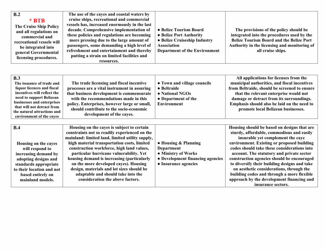
B.2 * BTB
The Cruise Ship Policy and all regulations on
commercial and recreational vessels will
be integrated into general Governmental licensing procedures.
The use of the cayes and coastal waters by cruise ships, recreational and commercial
vessels has, increased enormously in the last decade. Comprehensive implementation of these policies and regulations are becoming more pressing due to the large amount of
passengers, some demanding a high level of refreshment and entertainment and thereby
putting a strain on limited facilities and resources.
● Belize Tourism Board ● Belize Port Authority ● Belize Cruiseship Industry Association Department of the Environment
The provisions of the policy should be integrated into the procedures used by the Belize Tourism Board and the Belize Port
Authority in the licensing and monitoring of all cruise ships.
B.3 The issuance of trade and liquor licences and fiscal incentives will reflect the need to support Belizean
businesses and enterprises that will not detract from
the natural attractions and environment of the cayes
The trade licensing and fiscal incentive
processes are a vital instrument in assuring that business development is commensurate
with the recommendations made in this policy. Enterprises, however large or small,
should contribute to the socio-economic development of the cayes.
● Town and village councils ● Beltraide ● National NGOs ● Department of the Environment
All applications for licenses from the municipal authorities, and fiscal incentives
from Beltraide, should be screened to ensure that the relevant enterprise would not
damage or detract from its surroundings. Emphasis should also be laid on the need to
promote local Belizean businesses.
B.4
Housing on the cayes will respond to
increasing demand by adopting designs and
standards appropriate to their location and not
based entirely on mainland models.
Housing on the cayes is subject to certain constraints not so readily experienced on the mainland: limited land, limited utility supply,
high material transportation costs, limited construction workforce, high land values,
particular hurricane vulnerability. Yet housing demand is increasing (particularly
on the more developed cayes). Housing design, materials and lot sizes should be
adaptable and should take into the consideration the above factors.
● Housing & Planning Department ● Ministry of Works ● Development financing agencies● Insurance agencies
Housing should be based on designs that are sturdy, affordable, commodious and easily
insurable yet complement the caye environment. Existing or proposed building codes should take these considerations into account. The statutory and private sector
construction agencies should be encouraged to diversify their building designs and take
on aesthetic considerations, through the building codes and through a more flexible approach by the development financing and
insurance sectors.
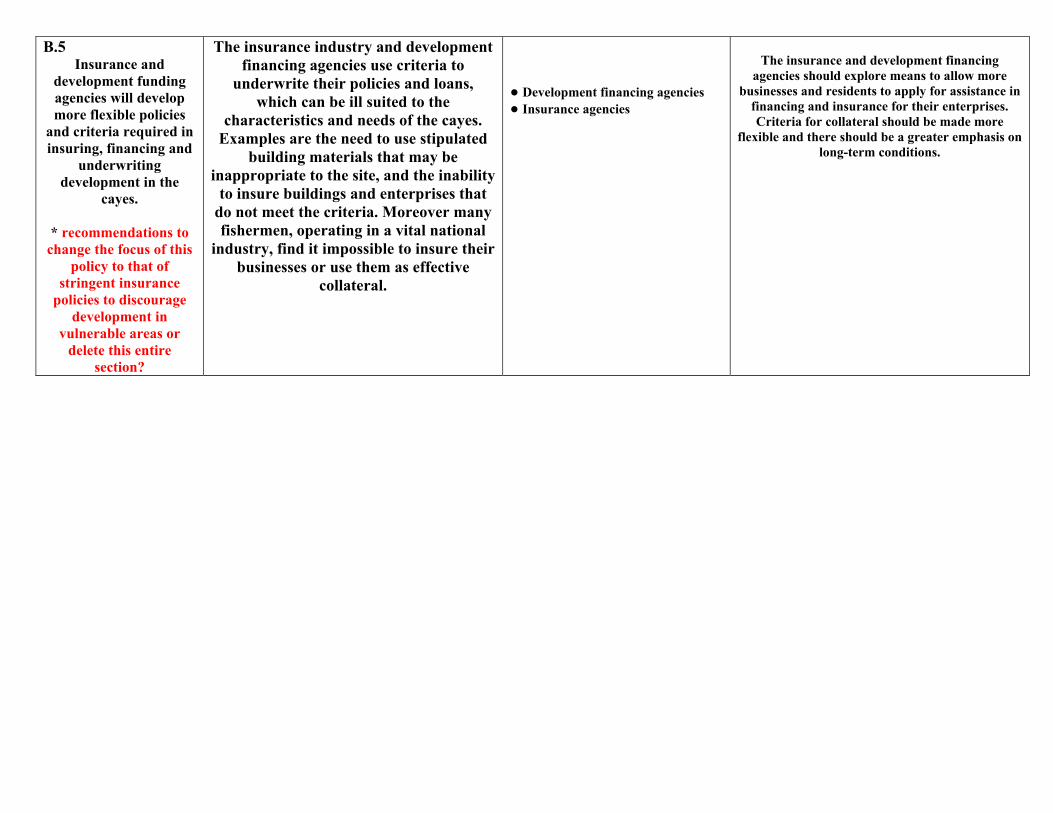
B.5 Insurance and
development funding agencies will develop more flexible policies
and criteria required in insuring, financing and
underwriting development in the
cayes.
* recommendations to change the focus of this
policy to that of stringent insurance
policies to discourage development in
vulnerable areas or delete this entire
section?
The insurance industry and development financing agencies use criteria to
underwrite their policies and loans, which can be ill suited to the
characteristics and needs of the cayes. Examples are the need to use stipulated
building materials that may be inappropriate to the site, and the inability
to insure buildings and enterprises that do not meet the criteria. Moreover many fishermen, operating in a vital national
industry, find it impossible to insure their businesses or use them as effective
collateral.
● Development financing agencies ● Insurance agencies
The insurance and development financing
agencies should explore means to allow more businesses and residents to apply for assistance in
financing and insurance for their enterprises. Criteria for collateral should be made more
flexible and there should be a greater emphasis on long-term conditions.
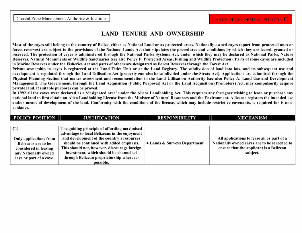
LAND TENURE AND OWNERSHIP
Most of the cayes still belong to the country of Belize, either as National Land or as protected areas. Nationally owned cayes (apart from protected ones or forest reserves) are subject to the provisions of the National Lands Act that stipulates the procedures and conditions by which they are leased, granted or reserved. The protection of cayes is administered through the National Parks Systems Act, under which they may be declared as National Parks, Nature Reserves, Natural Monuments or Wildlife Sanctuaries (see also Policy F: Protected Areas, Fishing and Wildlife Protection). Parts of some cayes are included in Marine Reserves under the Fisheries Act and parts of others are designated as Forest Reserves through the Forest Act. Private ownership in cayes is registered at the Land Titles Unit or at the Land Registry. The subdivision of land into lots, and its subsequent use and development is regulated through the Land Utilisation Act (property can also be subdivided under the Strata Act). Applications are submitted through the Physical Planning Section that makes assessment and recommendation to the Land Utilisation Authority (see also Policy A: Land Use and Development Management). The Government, through the Land Acquisition (Public Purposes) Act or the Land Acquisition (Promoters) Act, may compulsorily acquire private land, if suitable purposes can be proved. In 1992 all the cayes were declared as a ‘designated area’ under the Aliens Landholding Act. This requires any foreigner wishing to lease or purchase any national land to first obtain an Alien Landholding License from the Minister of Natural Resources and the Environment. A license registers the intended use and/or means of development of the land. Conformity with the conditions of the license, which may include restrictive covenants, is required for is non-voidance. POLICY POSITION JUSTIFICATION RESPONSIBILITY MECHANISM
CAYES DEVELOPMENT POLICY: C Coastal Zone Management Authority & Institute
C.1
Only applications from
Belizeans are to be considered in leasing any Nationally owned caye or part of a caye.
The guiding principle of affording maximised advantage to local Belizeans in the enjoyment and development of the country’s resources should be continued with added emphasis.
This should not, however, discourage foreign investment, which should be channelled
through Belizean proprietorship wherever possible.
● Lands & Surveys Department
All applications to lease all or part of a Nationally owned cayes are to be screened to
ensure that the applicant is a Belizean subject.
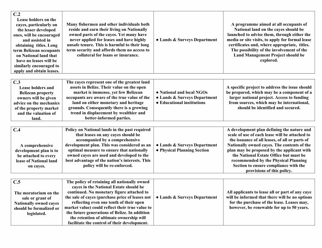
C.2 Lease holders on the cayes, particularly on the lesser developed
ones, will be encouraged and assisted in
obtaining titles. Long term Belizean occupants
on National land that have no leases will be
similarly encouraged to apply and obtain leases.
Many fishermen and other individuals both reside and earn their living on Nationally owned parts of the cayes. Yet many have never applied for leases and have highly
unsafe tenure. This is harmful to their long term security and affords them no access to
collateral for loans or insurance.
● Lands & Surveys Department
A programme aimed at all occupants of National land on the cayes should be
launched to advise them, through either the media or site visits, to apply for formal lease certificates and, where appropriate, titles. The possibility of the involvement of the
Land Management Project should be explored.
C.3
Lease holders and Belizean property
owners will be given advice on the mechanics of the property market
and the valuation of land.
The cayes represent one of the greatest land assets in Belize. Their value on the open
market is immense, yet few Belizean occupants are aware of the true value of the
land on either monetary and heritage grounds. Consequently there is a growing
trend in displacement by wealthier and better-informed parties.
● National and local NGOs ● Lands & Surveys Department ● Educational institutions
A specific project to address the issue should be prepared, which may be a component of a
larger national project. Access to funding from sources, which may be international,
should be identified and secured.
C.4
A comprehensive development plan is to
be attached to every lease of National land
on cayes.
Policy on National lands in the past required that leases on any cayes should be accompanied by a comprehensive
development plan. This was considered as an optimal measure to ensure that nationally owned cayes are used and developed to the
best advantage of the nation’s interests. This policy will be re-enforced.
● Lands & Surveys Department ● Physical Planning Section
A development plan defining the nature and scale of use of each lease will be attached to the issuance of all leases, of all or parts of
Nationally owned cayes. The contents of the plan may be proposed by the applicant with
the National Estate Office but must be recommended by the Physical Planning Section to ensure compliance with the
provisions of this policy.
C.5 The moratorium on the
sale or grant of Nationally owned cayes should be formalized or
legislated.
The policy of retaining all nationally owned cayes in the National Estate should be
continued. No monetary figure attached to the sale of cayes (purchase price of leases not
reflecting even one tenth of their open market value) could reflect their true value to the future generations of Belize. In addition
the retention of ultimate ownership will facilitate the control of their development.
● Lands & Surveys Department
All applicants to lease all or part of any caye will be informed that there will be no options
for the purchase of the lease. Leases may, however, be renewable for up to 50 years.
C.6
Assessment of all applications to sub-divide land on cayes
must take the provisions of the CZM Plan into
account.
The Land Utilisation Authority has the role of regulating the sub-division of private lands throughout the country. As such it performs
a vital function in determining the means whereby privately owned cayes may be
developed. Furthermore the use of binding covenants, attached as conditions to
approval, provide a means to ensure that the land is used according to its best potential.
● Land Utilisation Authority ● Physical Planning Section
All applications to the Land Utilisation
Authority to sub-divide property shall be assessed with regard to all the provisions of the CZM Plan. Conditions will be attached, as legally binding covenants, to approval as
deemed necessary.
C.7 Development activities, as well as the development of leases and properties, are to be closely monitored to ensure compliance with
the CZM Plan.
Several statutory and voluntary agencies make regular or occasional inspections on activities on cayes and in the coastal zone in general. However
resources are strained and inter-agency communication unsystematic. Most advantageous would be a systematic inspection schedule, yet in its absence a mechanism for standardised inter-agency reporting would be highly instrumental.
● Fisheries Department ● Lands & Surveys Department ● Physical Planning Section ● CZMAI ● Department of the Environment ● Belize Port Authority ● National and local NGOs Forestry Geology and Petroleum Department
The CZMAI will be responsible, through the Coastal Advisory Council, for drafting and
initiating a standardised reporting system. The system will include standardized report format or means of recording information, forwarding it to
all relevant agencies, and storing it.
C.8 A cayes database is to be
established to include information on use,
ownership, value and physical and ecological
characteristics
Collated data on the use, scale of use, leasing, ownership and marketing, and natural
characteristics of the cayes is lacking. Without this information it is extremely difficult to gauge
development trends, prospective opportunities, or the potential natural and monetary value of the
cayes.
● CZMAI
The CZMAI will establish a database through the coastal planning program in close collaboration
with the relevant agencies and stakeholders.
CLEARANCE, EXTRACTION, DRILLING AND INFRASTRUCTURE The clearance and/or use of vegetation are regulated by the Forest Department under the Forest Act and the Protection of Mangroves Regulations. The first applies, in the context of the cayes, to the extraction of timber from the littoral forest; the second to the cutting of mangroves (guided by the draft National Mangrove Management Plan). The National Lands Act plays a role through its requirement for a shore-side reserve along all the seafront and lagoon front of National lands, and also the Land Utilisation Act through the attachment of conditions to the approval of the sub-division of property (see also Policy A: Land Use and Development Management). The Geology and Petroleum Department has responsibility for mineral extraction (dredging) and drilling through the Mines and Minerals Act, the Petroleum Act, and subsidiary regulations (see also Policy A: Land Use and Development Management). A draft Marine Dredging Policy will provide guidelines for dredging. Any oil spills are the responsibility of the National Emergency Management Organization, the Belize Port Authority, the Department of the Environment, and other applicable permitting agencies. The Physical Planning Section of the Lands and Surveys Department through the National Lands Act and the Private Works Construction Act regulates the construction of piers, jetties, seawalls and other coastal structures. The Ministry of Works regulates public roads and bridges. POLICY POSITION JUSTIFICATION RESPONSIBILITY MECHANISM
Coastal Zone Management Authority & Institute CAYES DEVELOPMENT POLICY: D
D.1
In areas subject to development, the
clearance of natural vegetation should be kept to the minimum
necessary for meaningful occupation.
In all cases attention will be paid to maximising the
retention of areas identified as supporting wildlife and controlling
erosion.
The absolute removal of all vegetation on a caye leads to erosion, accelerated rain run-off, depleted freshwater reserves, the loss of
wildlife, and landscape deterioration.
● Forest Department ● Land Utilisation Authority ● Department of the Environment ● National and local NGOs Central Housing and Planning
A general guideline is the retention of an adequate % of the natural vegetation on a site
subject to development, while ensuring that the remaining vegetation, is properly managed.
D.2 Forested areas that are used by fishermen and
others for timber extraction and other
forest products will be managed on a
sustainable basis.
Certain parts of the cayes are habitually used by fishermen and others to cut poles or leaves for a variety of purposes. This policy seeks to
promote means by which this use can be continued on a sustainable basis to the
benefit of the users and the environment.
● Forest Department ● Fisheries Department ● CZMAI ● National and local NGOs
The responsible agencies should identify and map the areas of habitual timber extraction on
the cayes. Discussion should be undertaken with local fishermen and other interested,
legally established parties concerning the best means of management and agreements entered into with registered groups over management
responsibilities.
D.3 The restoration and
rehabilitation of damaged coastal areas shall be undertaken.
Development pressures and natural events have resulted in loss or damage to habitats over large areas of the coast. Rehabilitation of these areas, together with restoration is vital for coastal protection, wildlife habitat, and coastal aesthetic values and should be
encouraged.
● CZMAI ● Forest Department ● Fisheries Department ● National and local NGOs ● Town and village councils Geology and Petroleum
A programme to identify sites that have sustained damage and that require restoration
and rehabilitation shall be initiated and facilitated through the combined efforts of CZMAI and Forest Department. Relevant
government departments, local councils and interested NGOs should be encouraged to
collaborate.
D.4 Enforcement of the
Protection of Mangroves Regulations
should be enhanced.
The regulations provide a means to ensure that removal or retention of mangroves can be rationalised according to development or protective needs. Furthermore, significant
work has been completed for the classification of mangrove areas that have
been identified as nursery areas, active nesting sites, resting or breeding areas for
colonies or concentrations of birds.
● Forest Department �CZMAI ● National and local NGOs
The Forest Department has the legal
responsibility for managing mangroves, and is and is prepared to collaborate with other
relevant and interested agencies to assist in the monitoring of mangrove areas.
D.5 The requirement for a
beach reserve alongside all watercourses and bodies will be strictly
adhered to. The appropriate width of
reserves should be determined either by development plans or standards applied by
statutory licensing agencies. Furthermore, extended reserves will
be required in
The traditional 66 feet reserve, as required in
the National Lands Act and through the Land Utilisation Authority, is largely
impractical. Ideally a reserve offers an effective and easily accommodated means to
protect both waterside vegetation (and thereby the banks or beach and the quality of
water), and public access to water bodies.
CZMAI ● Land Utilisation Authority ● National Estate Section ● Physical Planning Section Forest Department CACs
The laws governing the traditional 66 feet reserve (primarily the National Lands Act, but
also the Land Utilisation Act) should be reviewed in order to better define the purposes, legal standing, and means of establishing and
maintaining the reserves.
mangrove habitats and areas of possible
erosion.
D.6 Construction setbacks will be required for all
buildings on the seafront. The setback
should consist of a minimum of 66 feet, where practicable.
The area where the sea meets the land is a transition zone characterized by complex
physical and biological processes, including varying long-term and short-term currents.
It is also the area most immediately susceptible to sea level rise. Construction in
this zone can have significant negative impacts on shoreline stability, and on the integrity and investments that have been
committed.
● Housing & Planning Department ● Town and village councils ● Land Utilization Authority ● Local planning committees
The Housing and Planning Department, and all agencies implementing its delegated powers
(town and village councils and local planning committees) should revise its planning
provisions to ensure the adequacy of all provisions for construction setbacks. The Land
Utilization Authority should ensure that appropriate reference is made to the need for
such setbacks in its approval process.
D.7
There will be no construction of groynes, seawalls, causeways or
other solid coastal structures without a full
investigation into the environmental
consequences and approval from the relevant authority.
Such structures cause major changes in the speed and direction of waves and offshore
currents, resulting in changes to the coastal morphology that are often damaging to both the natural environment and to development
projects.
● Physical Planning Section ● Town and village councils ● Ministry of Works / engineering consultants ● CZMAI Department of the Environment
All applications to the Physical Planning Section and the relevant municipal authorities should be assessed in light of the need to avoid any erosion or un-due deposition, or alteration
of currents. Local councils, along with the CZMAI, should be encouraged and authorized
to assist in monitoring. Guidance on appropriate construction should be sought
from the Professional Association of Engineers and/or coastal engineers.
D.8
Piers will be sited to
avoid deposition, erosion and obstruction,
and only with permission from the Physical Planning
Section.
On some larger cayes the un-planned proliferation of piers has already caused problems including alteration of beach profiles and channel depths, navigation
hazards, loss of aesthetic appeal and recreational values, and personal accident. Many of these problems could be avoided through limiting the number of piers to
approximately one per one thousand feet.
● Physical Planning Section ● Fisheries Department ● CZMAI ● Town and village councils
The current policy on piers should be reviewed to allow a more comprehensive approach. Piers should be sited at points with ready
public access or, where this is not possible, they should be required to allow public use. The relevant Government or municipal bodies
should be encouraged to establish and maintain community/public piers or marinas.
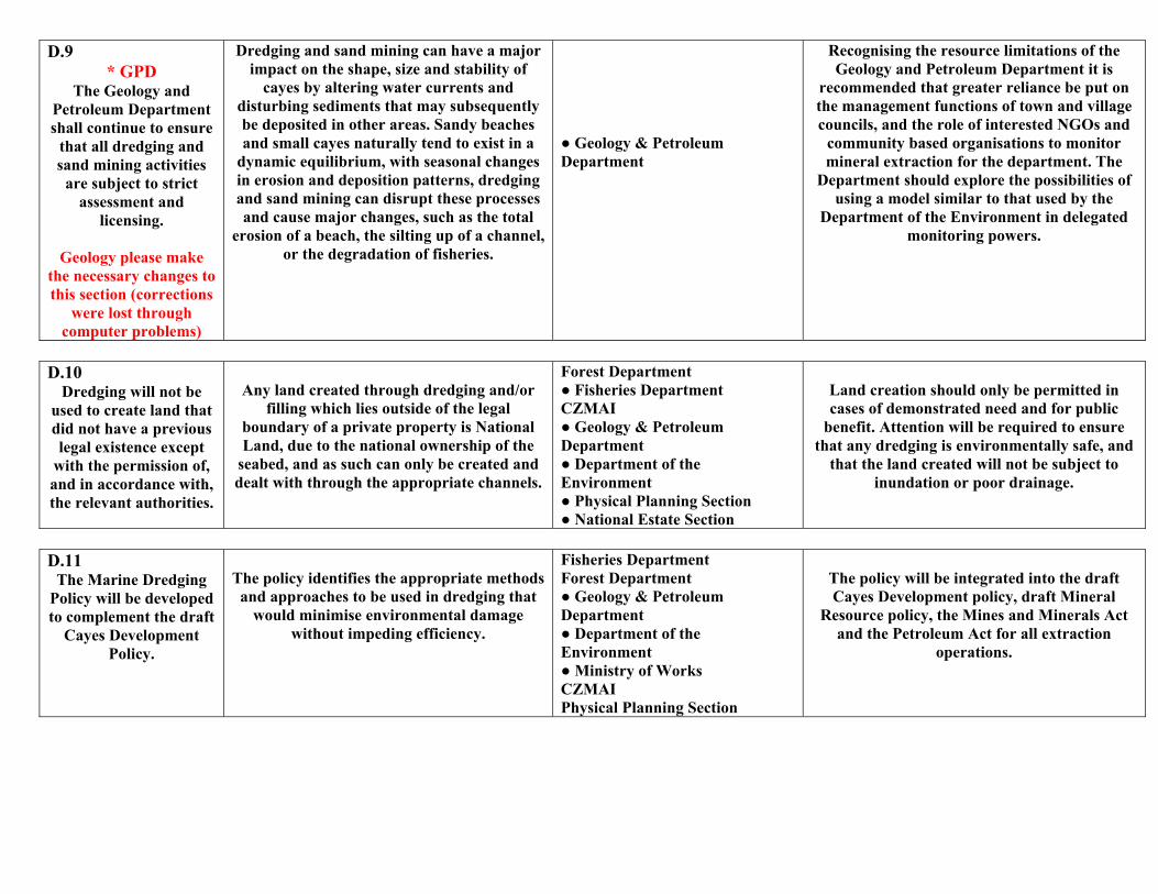
D.9 * GPD
The Geology and Petroleum Department shall continue to ensure
that all dredging and sand mining activities
are subject to strict assessment and
licensing.
Geology please make the necessary changes to this section (corrections
were lost through computer problems)
Dredging and sand mining can have a major impact on the shape, size and stability of
cayes by altering water currents and disturbing sediments that may subsequently be deposited in other areas. Sandy beaches and small cayes naturally tend to exist in a
dynamic equilibrium, with seasonal changes in erosion and deposition patterns, dredging and sand mining can disrupt these processes and cause major changes, such as the total
erosion of a beach, the silting up of a channel, or the degradation of fisheries.
● Geology & Petroleum Department
Recognising the resource limitations of the Geology and Petroleum Department it is
recommended that greater reliance be put on the management functions of town and village councils, and the role of interested NGOs and
community based organisations to monitor mineral extraction for the department. The
Department should explore the possibilities of using a model similar to that used by the
Department of the Environment in delegated monitoring powers.
D.10
Dredging will not be used to create land that did not have a previous legal existence except
with the permission of, and in accordance with, the relevant authorities.
Any land created through dredging and/or
filling which lies outside of the legal boundary of a private property is National Land, due to the national ownership of the
seabed, and as such can only be created and dealt with through the appropriate channels.
Forest Department ● Fisheries Department CZMAI ● Geology & Petroleum Department ● Department of the Environment ● Physical Planning Section ● National Estate Section
Land creation should only be permitted in cases of demonstrated need and for public
benefit. Attention will be required to ensure that any dredging is environmentally safe, and
that the land created will not be subject to inundation or poor drainage.
D.11
The Marine Dredging Policy will be developed to complement the draft
Cayes Development Policy.
The policy identifies the appropriate methods and approaches to be used in dredging that
would minimise environmental damage without impeding efficiency.
Fisheries Department Forest Department ● Geology & Petroleum Department ● Department of the Environment ● Ministry of Works CZMAI Physical Planning Section
The policy will be integrated into the draft Cayes Development policy, draft Mineral
Resource policy, the Mines and Minerals Act and the Petroleum Act for all extraction
operations.
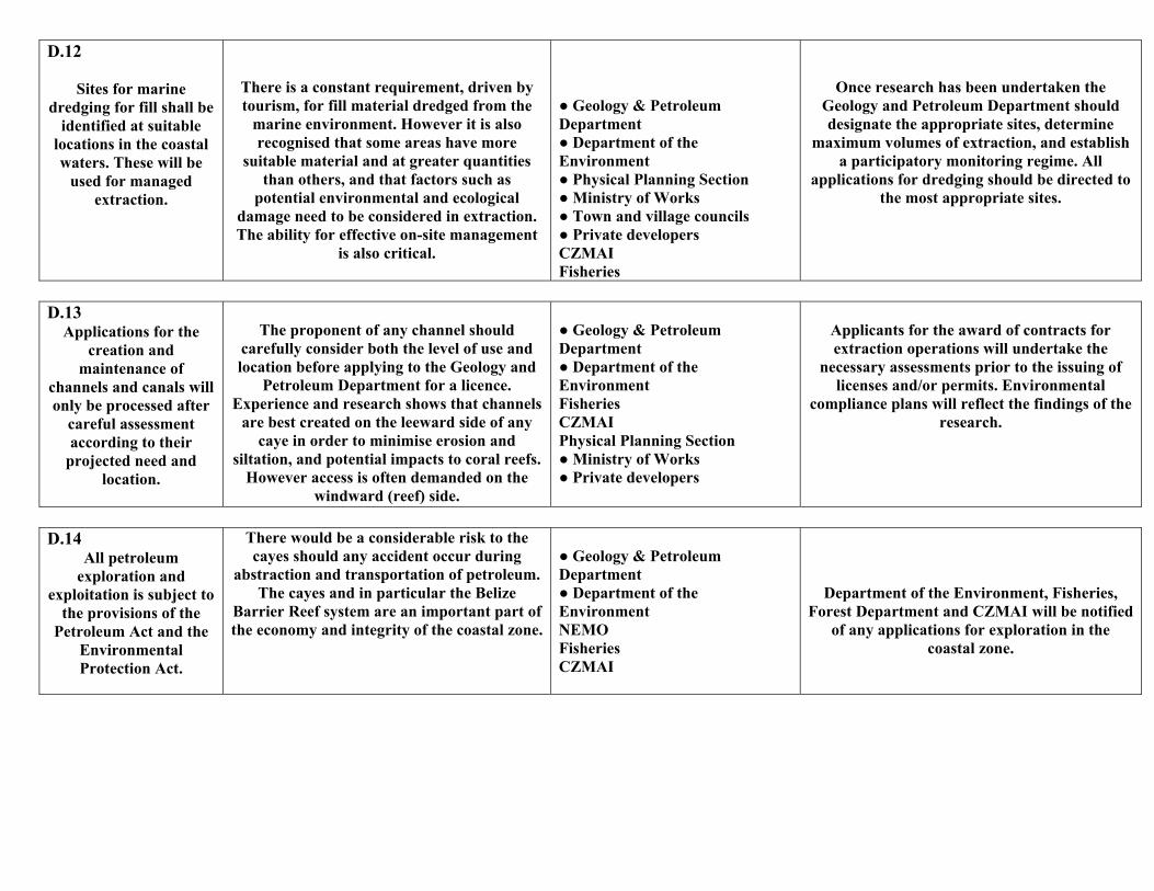
D.12
Sites for marine dredging for fill shall be
identified at suitable locations in the coastal waters. These will be
used for managed extraction.
There is a constant requirement, driven by tourism, for fill material dredged from the
marine environment. However it is also recognised that some areas have more
suitable material and at greater quantities than others, and that factors such as
potential environmental and ecological damage need to be considered in extraction. The ability for effective on-site management
is also critical.
● Geology & Petroleum Department ● Department of the Environment ● Physical Planning Section ● Ministry of Works ● Town and village councils ● Private developers CZMAI Fisheries
Once research has been undertaken the Geology and Petroleum Department should designate the appropriate sites, determine
maximum volumes of extraction, and establish a participatory monitoring regime. All
applications for dredging should be directed to the most appropriate sites.
D.13
Applications for the creation and
maintenance of channels and canals will only be processed after
careful assessment according to their
projected need and location.
The proponent of any channel should
carefully consider both the level of use and location before applying to the Geology and
Petroleum Department for a licence. Experience and research shows that channels
are best created on the leeward side of any caye in order to minimise erosion and
siltation, and potential impacts to coral reefs. However access is often demanded on the
windward (reef) side.
● Geology & Petroleum Department ● Department of the Environment Fisheries CZMAI Physical Planning Section ● Ministry of Works ● Private developers
Applicants for the award of contracts for extraction operations will undertake the
necessary assessments prior to the issuing of licenses and/or permits. Environmental
compliance plans will reflect the findings of the research.
D.14
All petroleum exploration and
exploitation is subject to the provisions of the
Petroleum Act and the Environmental Protection Act.
There would be a considerable risk to the cayes should any accident occur during
abstraction and transportation of petroleum. The cayes and in particular the Belize
Barrier Reef system are an important part of the economy and integrity of the coastal zone.
● Geology & Petroleum Department ● Department of the Environment NEMO Fisheries CZMAI
Department of the Environment, Fisheries, Forest Department and CZMAI will be notified
of any applications for exploration in the coastal zone.
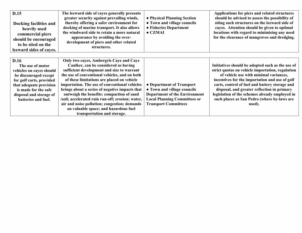
D.15
Docking facilities and heavily used
commercial piers should be encouraged
to be sited on the leeward sides of cayes.
The leeward side of cayes generally presents greater security against prevailing winds, thereby offering a safer environment for
docking of marine transport. It also allows the windward side to retain a more natural
appearance by avoiding the over-development of piers and other related
structures.
● Physical Planning Section ● Town and village councils ● Fisheries Department ● CZMAI
Applications for piers and related structures should be advised to assess the possibility of siting such structures on the leeward side of cayes. Attention should be given to optimal
locations with regard to minimising any need for the clearance of mangroves and dredging.
D.16
The use of motor vehicles on cayes should be discouraged except for golf carts, provided that adequate provision
is made for the safe disposal and storage of
batteries and fuel.
Only two cayes, Ambergris Caye and Caye Caulker, can be considered as having
sufficient development and size to warrant the use of conventional vehicles, and on both
of these limitations are placed on vehicle importation. The use of conventional vehicles brings about a series of negative impacts that
outweigh the benefits: compaction of sand /soil; accelerated rain run-off; erosion; water, air and noise pollution; congestion; demands
on valuable space; and hazardous fuel transportation and storage.
● Department of Transport ● Town and village councils Department of the Environment Local Planning Committees or Transport Committees
Initiatives should be adopted such as the use of strict quotas on vehicle importation, regulation
of vehicle use with minimal variances, incentives for the importation and use of golf carts, control of fuel and battery storage and disposal, and greater reflection in primary
legislation of the schemes already employed in such places as San Pedro (where by-laws are
used).
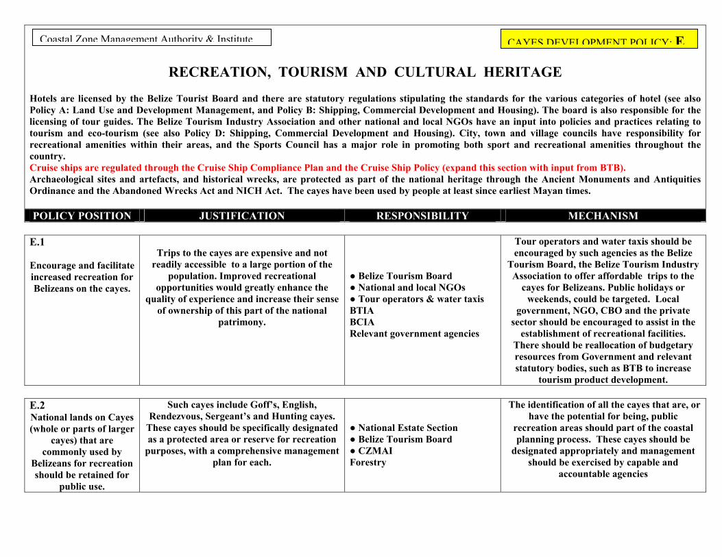
RECREATION, TOURISM AND CULTURAL HERITAGE
otels are licensed by the Belize Tourist Board and there are statutory regulations stipulating the standards for the various categories of hotel (see also licy A: Land Use and Development Management, and Policy B: Shipping, Commercial Development and Housing). The board is also responsible for the ensing of tour guides. The Belize Tourism Industry Association and other national and local NGOs have an input into policies and practices relating to urism and eco-tourism (see also Policy D: Shipping, Commercial Development and Housing). City, town and village councils have responsibility for creational amenities within their areas, and the Sports Council has a major role in promoting both sport and recreational amenities throughout the untry. ruise ships are regulated through the Cruise Ship Compliance Plan and the Cruise Ship Policy (expand this section with input from BTB). rchaeological sites and artefacts, and historical wrecks, are protected as part of the national heritage through the Ancient Monuments and Antiquities rdinance and the Abandoned Wrecks Act and NICH Act. The cayes have been used by people at least since earliest Mayan times.
OLICY POSITION JUSTIFICATION RESPONSIBILITY MECHANISM
Coastal Zone Management Authority & Institute CAYES DEVELOPMENT POLICY: E
E.1
Encourage and facilitate increased recreation for Belizeans on the cayes.
Trips to the cayes are expensive and not
readily accessible to a large portion of the population. Improved recreational
opportunities would greatly enhance the quality of experience and increase their sense
of ownership of this part of the national patrimony.
● Belize Tourism Board ● National and local NGOs ● Tour operators & water taxis BTIA BCIA Relevant government agencies
Tour operators and water taxis should be encouraged by such agencies as the Belize
Tourism Board, the Belize Tourism Industry Association to offer affordable trips to the
cayes for Belizeans. Public holidays or weekends, could be targeted. Local
government, NGO, CBO and the private sector should be encouraged to assist in the
establishment of recreational facilities. There should be reallocation of budgetary resources from Government and relevant statutory bodies, such as BTB to increase
tourism product development.
E.2 National lands on Cayes (whole or parts of larger
cayes) that are commonly used by
Belizeans for recreation hould be retained for
public use.
Such cayes include Goff’s, English, Rendezvous, Sergeant’s and Hunting cayes.
These cayes should be specifically designated as a protected area or reserve for recreation
purposes, with a comprehensive management plan for each.
● National Estate Section ● Belize Tourism Board ● CZMAI Forestry
The identification of all the cayes that are, or have the potential for being, public
recreation areas should part of the coastal planning process. These cayes should be
designated appropriately and management should be exercised by capable and
accountable agencies
s
HPolictorecoCAO P
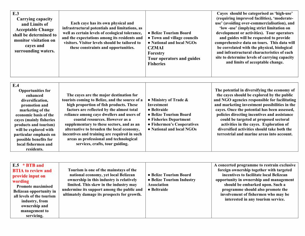
E.3 Carrying capacity
and Limits of Acceptable Change
shall be determined to monitor visitation on
cayes and surrounding waters.
Each caye has its own physical and infrastructural potentials and limitations, as well as certain levels of ecological tolerance, and the expectations among its residents and visitors. Visitor levels should be tailored to
these constraints and opportunities.
● Belize Tourism Board ● Town and village councils ● National and local NGOs CZMAI Forestry Tour operators and guides Fisheries
Cayes should be categorised as ‘high-use’ (requiring improved facilities), ‘moderate-
use’ (avoiding over-commercialisation), and ‘low -use’ (implying strict limitation on
development or activities). Tour operators and guides will be requested to provide
comprehensive data on tours. This data will be correlated with the physical, biological and infrastructural characteristics of each
site to determine levels of carrying capacity and limits of acceptable change.
E.4
Opportunities for enhanced
diversification, promotion and
marketing of the economic basis of the
cayes (mainly fisheries products and tourism) will be explored with
particular emphasis on possible benefits for local fishermen and
residents.
The cayes are the major destination for tourists coming to Belize, and the source of a
high proportion of fish products. These factors are reflected by the almost total
reliance among caye dwellers and users of coastal resources. However as a
supplementary to these sectors, and as an alternative to broaden the local economy,
incentives and training are required in such areas as professional and technological
services, crafts, tour guiding.
● Ministry of Trade & Investment ● Beltraide ● Belize Tourism Board ● Fisheries Department ● Fishermen’s Cooperatives ● National and local NGOs
The potential in diversifying the economy of the cayes should be explored by the public
and NGO agencies responsible for facilitating and marketing investment possibilities in the cayes. Once the potential has been assessed, policies directing incentives and assistance
could be targeted at proposed sectoral activities in the cayes. Exploration of
diversified activities should take both the terrestrial and marine areas into account.
E.5 * BTB and BTIA to review and provide input on wording
Promote maximised Belizean opportunity in all levels of the tourism
industry, from ownership and management to
servicing.
Tourism is one of the mainstays of the national economy, yet local Belizean
ownership in this industry is relatively limited. This skew in the industry may
undermine its support among the public and ultimately damage its prospects for growth.
● Belize Tourism Board ● Belize Tourism Industry Association ● Beltraide
A concerted programme to restrain exclusive foreign ownership together with targeted
incentives to facilitate local Belizean opportunity in ownership and management
should be embarked upon. Such a programme should also promote the
involvement of fishermen who may be interested in any tourism service.
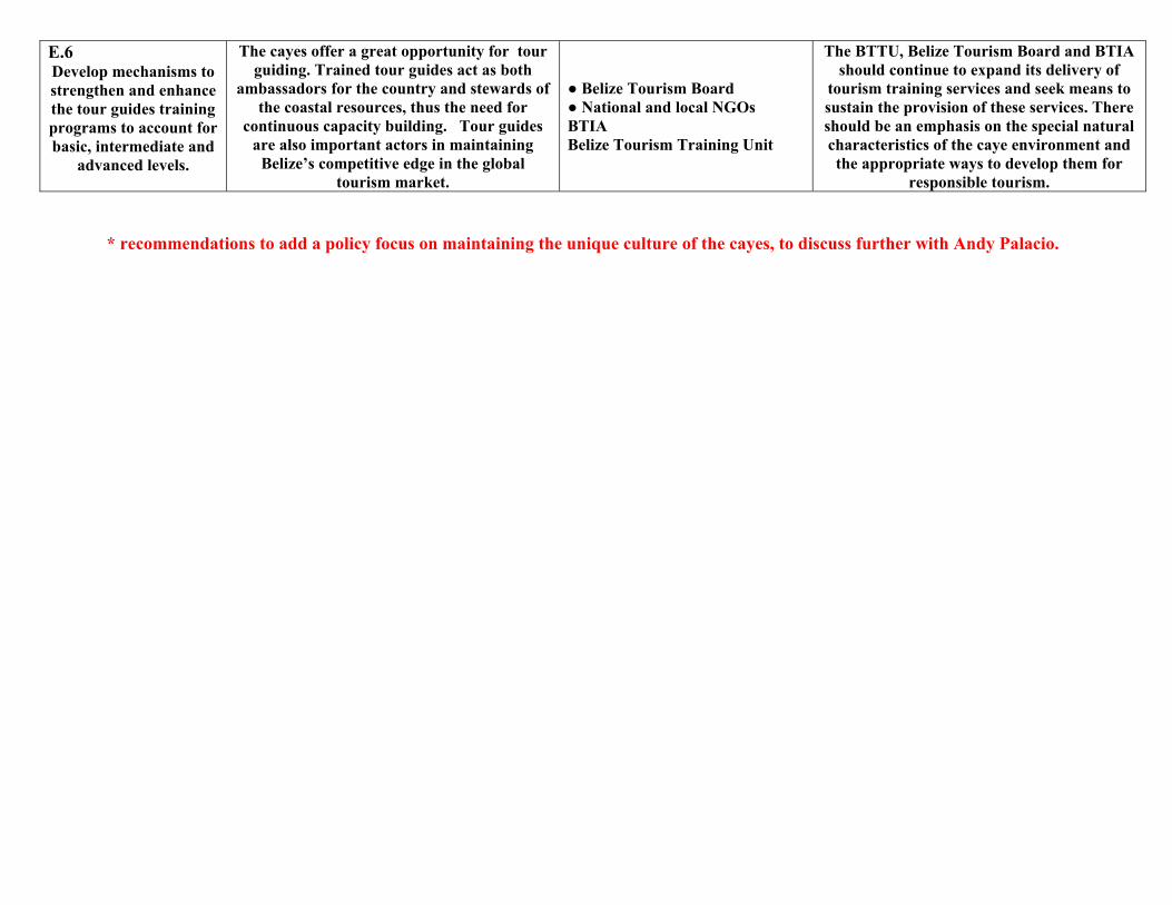
E.6 Develop mechanisms to strengthen and enhance the tour guides training programs to account for basic, intermediate and
advanced levels.
The cayes offer a great opportunity for tour guiding. Trained tour guides act as both
ambassadors for the country and stewards of the coastal resources, thus the need for
continuous capacity building. Tour guides are also important actors in maintaining
Belize’s competitive edge in the global tourism market.
● Belize Tourism Board ● National and local NGOs BTIA Belize Tourism Training Unit
The BTTU, Belize Tourism Board and BTIA should continue to expand its delivery of
tourism training services and seek means to sustain the provision of these services. There should be an emphasis on the special natural characteristics of the caye environment and the appropriate ways to develop them for
responsible tourism. * recommendations to add a policy focus on maintaining the unique culture of the cayes, to discuss further with Andy Palacio.
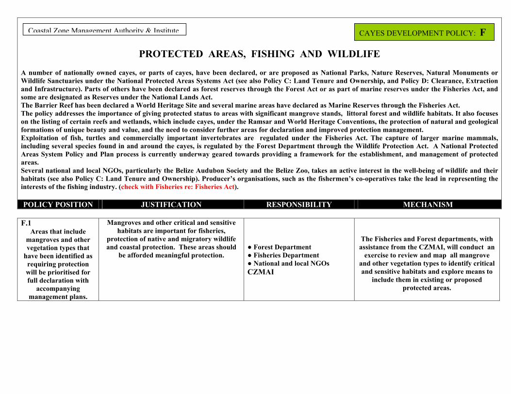
PROTECTED AREAS, FISHING AND WILDLIFE
number of nationally owned cayes, or parts of cayes, have been declared, or are proposed as National Parks, Nature Reserves, Natural Monuments or ldlife Sanctuaries under the National Protected Areas Systems Act (see also Policy C: Land Tenure and Ownership, and Policy D: Clearance, Extraction d Infrastructure). Parts of others have been declared as forest reserves through the Forest Act or as part of marine reserves under the Fisheries Act, and
e are designated as Reserves under the National Lands Act. e Barrier Reef has been declared a World Heritage Site and several marine areas have declared as Marine Reserves through the Fisheries Act. e policy addresses the importance of giving protected status to areas with significant mangrove stands, littoral forest and wildlife habitats. It also focuses the listing of certain reefs and wetlands, which include cayes, under the Ramsar and World Heritage Conventions, the protection of natural and geological mations of unique beauty and value, and the need to consider further areas for declaration and improved protection management. ploitation of fish, turtles and commercially important invertebrates are regulated under the Fisheries Act. The capture of larger marine mammals, luding several species found in and around the cayes, is regulated by the Forest Department through the Wildlife Protection Act. A National Protected
Areas System Policy and Plan process is currently underway geared towards providing a framework for the establishment, and management of protected areas. Several national and local NGOs, particularly the Belize Audubon Society and the Belize Zoo, takes an active interest in the well-being of wildlife and their habitats (see also Policy C: Land Tenure and Ownership). Producer’s organisations, such as the fishermen’s co-operatives take the lead in representing the interests of the fishing industry. (check with Fisheries re: Fisheries Act). POLICY POSITION JUSTIFICATION RESPONSIBILITY MECHANISM
oastal Zone Management Authority & Institute CAYES DEVELOPMENT POLICY: F
F.1
Areas that include mangroves and other vegetation types that
have been identified as requiring protection will be prioritised for full declaration with
accompanying management plans.
Mangroves and other critical and sensitive habitats are important for fisheries,
protection of native and migratory wildlife and coastal protection. These areas should
be afforded meaningful protection.
● Forest Department ● Fisheries Department ● National and local NGOs CZMAI
The Fisheries and Forest departments, with assistance from the CZMAI, will conduct an
exercise to review and map all mangrove and other vegetation types to identify critical and sensitive habitats and explore means to
include them in existing or proposed protected areas.
A WiansomThThonforExinc
C
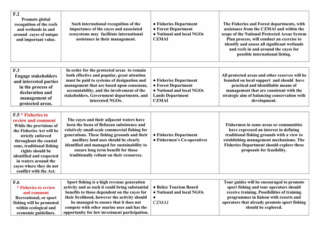
F.2 Promote global
recognition of the reefs and wetlands in and
around cayes of unique and important value.
Such international recognition of the importance of the cayes and associated ecosystems may facilitate international
assistance in their management.
● Fisheries Department ● Forest Department ● National and local NGOs CZMAI
The Fisheries and Forest departments, with assistance from the CZMAI and within the
scope of the National Protected Areas System Plan process, will conduct an exercise to
identify and assess all significant wetlands and reefs in and around the cayes for
possible international listing.
F.3 Engage stakeholders and interested parties
in the process of declaration and management of protected areas.
In order for the protected areas to remain both effective and popular, great attention must be paid to systems of designation and
management that are based upon consensus, accountability, and the involvement of the
stakeholders, Government departments, and interested NGOs.
● Fisheries Department ● Forest Department ● National and local NGOs Lands Department CZMAI
All protected areas and other reserves will be founded on local support and should have
practical and identifiable means of management that are consistent with the
strategic aim of balancing conservation with development.
F.5 * Fisheries to review and comment While the provisions of the Fisheries Act will be
strictly enforced throughout the coastal
zone, traditional fishing rights should be
identified and respected in waters around the
cayes where they do not conflict with the Act.
The cayes and their adjacent waters have been the focus of Belizean subsistence and
relatively small-scale commercial fishing for generations. These fishing grounds and their
ancillary land uses should be clearly identified and managed for sustainability to
ensure long term benefit for those traditionally reliant on their resources.
● Fisheries Department ● Fishermen’s Co-operatives
Fishermen in some areas or communities have expressed an interest in defining
traditional fishing grounds with a view to establishing management mechanisms. The Fisheries Department should explore these
proposals for feasibility.
F.6
* Fisheries to review and comment
Recreational, or sport fishing will be promoted
within ecological and economic guidelines.
Sport fishing is a high revenue generation activity and as such it could bring substantial benefits to those dependent on the cayes for their livelihood, however the activity should
be managed to ensure that it does not compete with other marine uses and has the
opportunity for low investment participation.
● Belize Tourism Board ● National and local NGOs ● CZMAI
Tour guides will be encouraged to promote sport fishing and tour operators should receive training. Possibilities of training programmes in liaison with resorts and
operators that already promote sport fishing should be explored.
F.7 The full range of
protection afforded by the Wildlife Protection Act will be provided to the native and migrant fauna and to flora that are unique to the cayes or surrounding waters.
Many of the native species of fauna and flora currently found on the cayes are becoming increasingly rare in the Caribbean region and in the rest of the world. As such the Belizean cayes offer the opportunity to become a treasured repository for these
threatened species.
● Forest Department ● National and local NGOs
Forest Department is responsible for enforcing the protection and management of
flora and fauna, and is prepared to collaborate with other relevant and
interested agencies.
F.8 check with Archaeology for their input All archaeological sites and abandoned wrecks
in the cayes and surrounding waters will
be identified and considered for
registration and protection as provided for through the NICH
Act and the Abandoned Wrecks Act.
The cayes and surroundings waters hold a wealth of archaeological sites and abandoned wrecks, the great majority un-registered that can contribute to both the cultural heritage of the country and, if suitably managed, to
tourism attraction. Exploration of possible archaeological sites and abandoned wrecks should be properly
managed to ensure high scientific standards and patrimony of any objects found.
● IRMAC ● National and local NGOs Belize Port Authority
Undertake an inventory and mapping of all sites of significance. Once a comprehensive assessment of sites is completed, options for
management can be explored.
F.9
Build knowledge through scientific research on the
coastal resources in and around the cayes.
Despite significant research there still exists
gaps in knowledge and guidance for research priorities and researchers. Underpinning the
effective implementation of the Cayes Development Policy is the need for reliable
and up to date information.
CZMAI Fisheries Forest University of Belize Department of the Environment Geology and Petroleum Other relevant research institutions
Identify research priorities and conduct
targeted research needs, strengthen clearinghouse mechanisms for marine and coastal information, establish and maintain
cayes database.
FRESH WATER, WASTE DISPOSAL AND HAZARDOUS SUBSTANCES STORAGE
e Public Utilities Commission, through the Water Industry Act, is the statutory regulator of water provision, and is responsible for ensuring that water ply licensees manage their own treatment and distribution systems. The only comprehensive water supply system that operates on the cayes is in San
dro, though one is scheduled for Caye Caulker. Elsewhere rainwater and ground water are the primary sources. The Public Health Bureau, in the nistry of Health, is responsible for monitoring the quality of drinking water, the disposal of liquid waste, and issues related to general public health. City d town councils are currently responsible for the collection and disposal of solid waste though the Solid Waste Management Authority is being established be responsible for a comprehensive waste disposal system. Management of water resources the remit of the Hydrology section of the National teorological Service.
imary responsibility for the control of all forms of pollution lies with the Department of the Environment, through the Environmental Protection Act and regulations (see also Policy A: Land Use and Development Management). The marketing, storage, use and disposal of pesticides and herbicides are ulated by the Pesticides Control Board of the Department of Agriculture. eral village councils and NGOs operating at both national and local levels, also take a particular interest in waste disposal issues.
POLICY POSITION JUSTIFICATION RESPONSIBILITY MECHANISM
Coastal Zone Management Authority & Institute CAYES DEVELOPMENT POLICY: G
G.1
Water supply systems for all coastal
developments, especially tourism and residential
developments will explore the use of environmentally
acceptable alternatives to groundwater
extraction.
The need for good potable water on the cayes is increasing and creating a demand for
reliable, clean systems. While it is essential that these systems meet growing demand, it is important that they are also non-polluting.
● Public Utilities Commission ● Belize Tourism Board ● Land Utilisation Authority MNREI (Department of Environment)
Conditions attached by the MNREI in licensing water abstractions, by the Belize
Tourism Board in licensing of hotels, by the Land Utilisation Authority in approval of
sub-division on the cayes (except those with central water supply systems) and
Department of the Environment through the EIA process should include requirements on non-polluting means of potable water supply (and waste disposal). Such conditions should generate more research on viable means of
non-polluting supply.
G.2 Rainfall catchment systems should be
installed for all coastal tourism or residential
velopments, whether large or small.
Rainfall catchment systems are probably the
most effective, cleanest, cheapest and non-polluting freshwater systems available. Vast quantities of potable water are wasted when not collected. Guttering also helps to avoid erosion and pot holing around structures.
● Public Utilities Commission ● Housing & Planning Department ● Town and village councils ● Development funding agencies ● Architectural businesses & construction industry ● Belize Tourism Board MNREI (DoE)
Conditions should be attached to the licensing, permitting and funding of resort and housing developments on the cayes and their water supply systems requiring the use
of rainfall catchment systems in order to reduce the demand for other, more costly
forms of potable water generation and supply.
de
ThsupPeMianto MePrits regSev
G.3 Where wells are to be dug to provide ground
water, thorough research and
monitoring should be undertaken.
Limited information is available on the size
and carrying capacity of the freshwater lenses of the cayes. However it is known from cases in other regions that such ground water supplies can rapidly become depleted, with
subsequent damage through salt-water intrusion.
● Public Utilities Commission ● Ministry of Rural Development ● Hydrology Department MNREI (DoE)
The Public Utilities Commission should take into account possible impacts on
groundwater in the licensing of all water supply/abstraction systems and the MNREI
in the licensing of water abstraction. Businesses or individuals should seek
professional advice before undertaking operations in order to determine the viability and usefulness of the work. A system should be devised to regulate the sinking of wells if
such a system is absent.
G.4 Desalination and / or
reverse osmosis plants will only be installed if other methods can not
provide sufficient water of the required quality
Such plants can produce polluting side effects and consequently there is the need to explore
other alternatives so that any effluent is safely disposed of and appropriate
monitoring methods are established.
● Public Utilities Commission ● Department of the Environment CZMAI
Approval by Department of the Environment for any installation of reverse osmosis plants should take the availability of other means of
potable water supply into account. The Department will conduct monitoring of
effluent from these systems with support from relevant and interested agencies.
G.5
The disposal of solid waste generated on the cayes should be guided by the provision of the
Solid Waste Management Plan and
the principles of reduce, recycle and re-use.
Maximum effort should be made to reduce the amount of waste generated on the cayes
as their generally small size and fragile environment limits the amount of land
available for disposal. Their comparative inaccessibility requires complex and
expensive waste transport arrangements with the mainland. Furthermore the cayes are particularly vulnerable to ground water
pollution and accumulations of waste detract significantly from their aesthetic appeal.
● Department of the Environment ● Town and village councils ● Public Health Department ● Solid Waste Management Authority
A concerted effort to fast track the
implementation of the Solid Waste Plan (coastal component) otherwise encourage
incineration, composting and transportation to officially approved collection points or disposal sites. The frequent use of coastal
waters as dumping grounds will be discouraged and penalties for non-
compliance explored.
G.6
Develop and implement beach management
programs
To enhance public health, aesthetics, and recreational use of our beaches and in
general the tourism product.
● Department of the Environment ● Town and village councils ● Public Health Department ● National and local NGOs BTB Ministry of Local Government CZMAI
CZMAI, BTB, PHB and the Department of the Environment should develop and jointly
implement beach management programs. Regular beach clean-ups should be
organised in coordination with the tourism industry and the voluntary sector.
G.7
Sewerage disposal
systems in the cayes, including septic tanks
and composting toilets, will be subject to a
comprehensive assessment before
installation.
Nutrients from sewage can pollute the freshwater lens and, should they leak
through the ground water system to the adjacent marine environment, can damage the coral reef by promoting algal growth.
Moreover sewage is extremely hazardous to human health and will undermine the
tourism value of the cayes.
● Department of the Environment ● Town and village councils ● Public Health Department
Sewage disposal for individual houses, small resorts and low density sub-divisions will be guided by the coastal planning guidelines and individual septic tanks will be utilized as long
as they are properly designed and built to ensure that there is no leakage into the water
table and the marine environment. Larger resorts and sub-divisions will use
one of the following: (a) any existing municipal or community sewerage system; (b) a simple but well-established type of package plant with extended aeration, activated sludge, biological contractors, etc. (c) stabilisation ponds. Check with Public Health for their input.
G.8 The use of composting
toilets will be encouraged in
appropriate locations on the cayes and only following thorough
assessment.
The compost generated from the toilets can be used to fertilise cultivated land or can be
thinly spread through other vegetation.
● Department of the Environment ● Town and village councils ● Public Health Department ● Belize Tourism Board
Those agencies that have licensing remits should consider requesting applicants to
explore the possibility of using composting toilets, especially those in sensitive locations.
G.9 The storage and
disposal of dangerous liquid wastes, including
chemicals and hazardous substances,
should be carefully assessed by the relevant authorities. In addition grey water treatment
systems will be installed wherever possible.
The limited size and the vulnerable ecology of the cayes and surrounding coastal waters
means that pollution problems on them tend to be far more acute than on the mainland, and that the effects can be spread rapidly to
the marine environment.
● Department of the Environment ● Pesticides Control Board ● Town and village councils ● Public Health Department ● Public Utilities Commission ● Belize Water Services Ltd
All places storing and / or disposing of dangerous chemicals, liquid waste and other hazardous substances should be registered
with the Department of the Environment. All places storing pesticides or herbicides should be licensed by the Pesticides Control Board. The Public Utilities Commission and/or the
licensed company responsible for sewage disposal systems for built up areas (Belize
Water Services Ltd), should be able to offer guidance on suitable liquid waste disposal systems for smaller enterprises. Town and
village councils have the duty to monitor the efficiency of these systems operating in their
respective areas.
G.10 The use of fertilisers, pesticides, herbicides
and fungicides on cayes should be discouraged.
If the use of pesticides is unavoidable it is
recommended that biodegradable agents are used and that the requirements of the Pesticides Control
Board will be strictly adhered to.
The sandy infertile soil of the cayes and the high insect population tend to encourage the
use of nutrients and chemicals that can grossly alter the natural cayes environment.
In many cases alternative approaches are available such as general cleanliness, sand raking, and the positioning of buildings to
catch maximum breeze. Clearance of mangroves to reduce insect
habitation should only be undertaken as a last resort and then only in moderation and in conformity with the requirements of the
Forest Department.
● Pesticides Control Board ● Department of the Environment ● Public Health Department ● CZMAI ● Town and village councils Forest Department
The Pesticides Control Board should be assisted in regulating and monitoring the use, storage and disposal of pesticides, herbicides
and fungicides on the cayes. The Board should explore the possibilities of engaging
the assistance of other relevant and interested agencies in monitoring.
Appendix 2 Each dot indicates the location shown in a picture taken during the overflight. The number of
the location corresponds with the picture file name.
Northern Turneffe Mangrove and Conservation Value Assessment, 2005
Appendix 2 Each dot indicates the location shown in a picture taken during the overflight. The number of
the location corresponds with the picture file name.
Northern Turneffe Mangrove and Conservation Value Assessment, 2005
Appendix 2 Each dot indicates the location shown in a picture taken during the overflight. The number of
the location corresponds with the picture file name.
Northern Turneffe Mangrove and Conservation Value Assessment, 2005
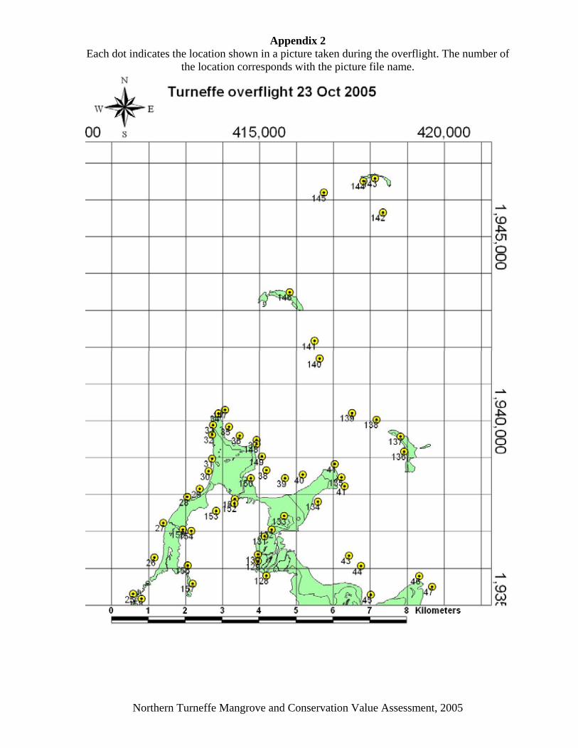
Appendix 2 Each dot indicates the location shown in a picture taken during the overflight. The number of
the location corresponds with the picture file name.
Northern Turneffe Mangrove and Conservation Value Assessment, 2005
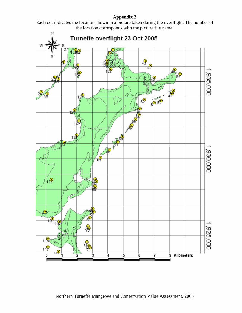
Appendix 2 Each dot indicates the location shown in a picture taken during the overflight. The number of
the location corresponds with the picture file name.
Northern Turneffe Mangrove and Conservation Value Assessment, 2005
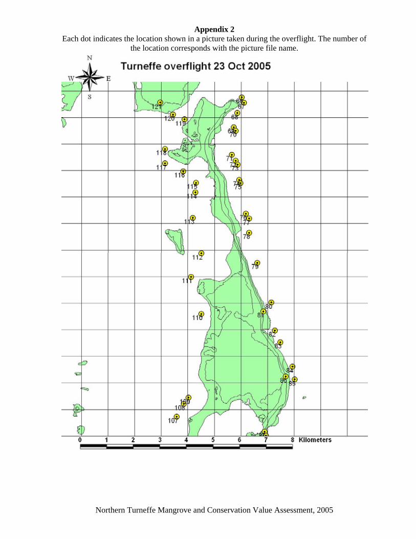
Appendix 2 Each dot indicates the location shown in a picture taken during the overflight. The number of
the location corresponds with the picture file name.
Northern Turneffe Mangrove and Conservation Value Assessment, 2005
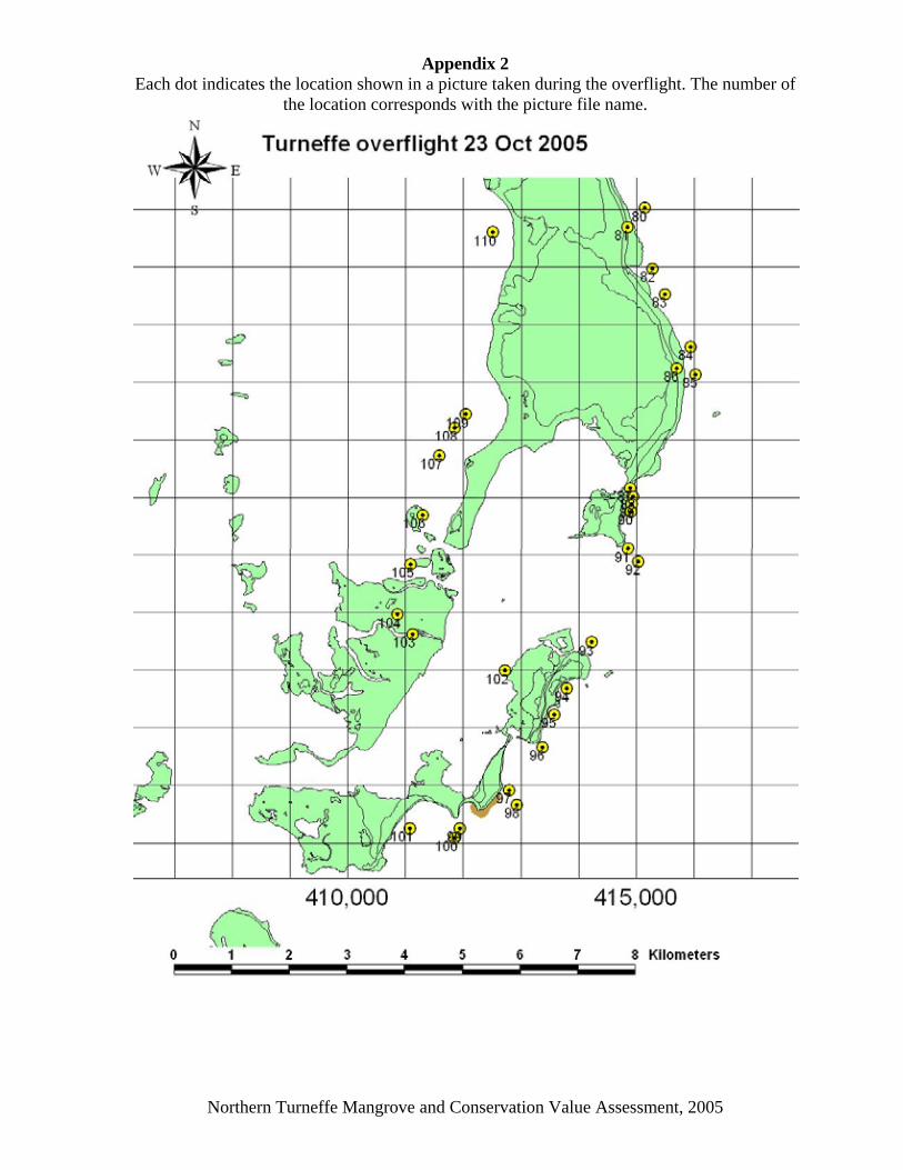
Appendix 2 Each dot indicates the location shown in a picture taken during the overflight. The number of
the location corresponds with the picture file name.
Northern Turneffe Mangrove and Conservation Value Assessment, 2005
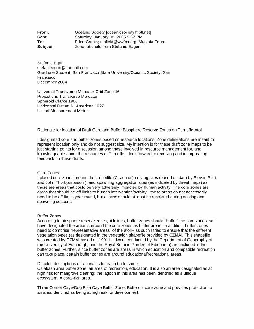
From: Oceanic Society [[email protected]] Sent: Saturday, January 08, 2005 5:37 PM To: Eden Garcia; [email protected]; Mustafa Toure Subject: Zone rationale from Stefanie Eagen Stefanie Egan [email protected] Graduate Student, San Francisco State University/Oceanic Society, San Francisco December 2004 Universal Transverse Mercator Grid Zone 16 Projections Transverse Mercator Spheroid Clarke 1866 Horizontal Datum N. American 1927 Unit of Measurement Meter Rationale for location of Draft Core and Buffer Biosphere Reserve Zones on Turneffe Atoll I designated core and buffer zones based on resource locations. Zone delineations are meant to represent location only and do not suggest size. My intention is for these draft zone maps to be just starting points for discussion among those involved in resource management for, and knowledgeable about the resources of Turneffe. I look forward to receiving and incorporating feedback on these drafts. Core Zones: I placed core zones around the crocodile (C. acutus) nesting sites (based on data by Steven Platt and John Thorbjarnarson ), and spawning aggregation sites (as indicated by threat maps) as these are areas that could be very adversely impacted by human activity. The core zones are areas that should be off limits to human intervention/activity-- these areas do not necessarily need to be off-limits year-round, but access should at least be restricted during nesting and spawning seasons. Buffer Zones: According to biosphere reserve zone guidelines, buffer zones should "buffer" the core zones, so I have designated the areas surround the core zones as buffer areas. In addition, buffer zones need to comprise "representative areas" of the atoll-- as such I tried to ensure that the different vegetation types (as designated in the vegetation shapefile provided by CZMAI. This shapefile was created by CZMAI based on 1991 fieldwork conducted by the Department of Geography of the University of Edinburgh, and the Royal Botanic Garden of Edinburgh) are included in the buffer zones. Further, since buffer zones are areas in which education and compatible recreation can take place, certain buffer zones are around educational/recreational areas. Detailed descriptions of rationales for each buffer zone: Calabash area buffer zone: an area of recreation, education. It is also an area designated as at high risk for mangrove clearing; the lagoon in this area has been identified as a unique ecosystem. A coral-rich area. Three Corner Caye/Dog Flea Caye Buffer Zone: Buffers a core zone and provides protection to an area identified as being at high risk for development.

Pigeon Caye Bogue area buffer zone: Buffers a C. acutus nesting site; provides protection for an area identified as at high risk for development and mangrove clearing. Represents an area of broken palmetto. Big Caye Bokel area buffer zone: Buffers a core zone; protects an area identified as at risk for development and mangrove clearing; a coral rich area. Blackbird Caye Buffer Zone: Buffers two core zones and a seperate C. acutus nesting site; a coral-rich area; education facility located in this area which is compatible with buffer zone definition; represents a forested area. Western buffer zone on Blackbird Caye: buffers western area of core zone Douglas Caye buffer zone: offers protection for an area identified as having a regular population of manatees (based on a recommendation by Suzanne Holguin- graduate student and manatee researcher for Oceanic Society) Northeast Blackbird area buffer zone: buffers a core offers protection for an area identified as having a regular population of manatees (as suggested by Suzanher for Oceanic Society) Western reef of Turneffe: offers protection for the fringing reef- a sensitive, coral-rich area - northern part buffers a core area. Northwestern area of Central Lagoon: offers protection for an area identified as having a regular population of manatees (based on a recommendation by Suzanne Holguin- graduate student and manatee researcher for Oceanic Society); represents an area of broken palmetto/wood thicket. Crickozeen Creek area buffer zone: offers protection for an area identified as having a regular population of manatees (based on a recommendation by Suzanne Holguin- graduate student and manatee researcher for Oceanic Society); represents an area of palmetto. Northern Bogue area buffer zone: identified as an area at risk of development, mangrove clearing and dredging; represents an area of savanna.
Pelican Caye buffer zone: Draft Turneffe Island Management Plan suggested this area receive protection as it is an important nesting and brooding area for birds. Shag Caye buffer zone: A lobster-rich area, (as identified by Anhil Marin; a long-time fisherman of Turneffe)- seeing significant declines in lobster numbers Oceanic Society Blackbird Caye Research Station Visit us at www.oceanic-society.org
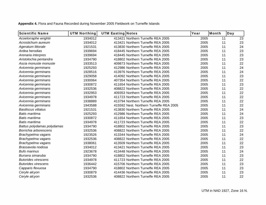
Appendix 4. Flora and Fauna Recorded during November 2005 Fieldwork on Turneffe Islands
Scientific Name UTM Northing UTM Easting Notes Year Month DayAcoelorraphe wrightii 1934012 413421 Northern Turneffe REA 2005 2005 11 23Acrostichum aureum 1934012 413421 Northern Turneffe REA 2005 2005 11 23Ageratum littorale 1921531 413830 Northern Turneffe REA 2005 2005 11 24Ardea herodias 1939694 418445 Northern Turneffe REA 2005 2005 11 23Arenaria interpres 1939694 418445 Northern Turneffe REA 2005 2005 11 23Aristolochia pentandra 1934790 418802 Northern Turneffe REA 2005 2005 11 23Ascia monuste monuste 1933513 409873 Northern Turneffe REA 2005 2005 11 22Avicennia germinans 1925293 412986 Northern Turneffe REA 2005 2005 11 24Avicennia germinans 1928516 413976 Northern Turneffe REA 2005 2005 11 24Avicennia germinans 1929058 414092 Northern Turneffe REA 2005 2005 11 23Avicennia germinans 1930064 407354 Northern Turneffe REA 2005 2005 11 22Avicennia germinans 1930872 411654 Northern Turneffe REA 2005 2005 11 23Avicennia germinans 1932536 408822 Northern Turneffe REA 2005 2005 11 22Avicennia germinans 1932953 409353 Northern Turneffe REA 2005 2005 11 22Avicennia germinans 1934978 411723 Northern Turneffe REA 2005 2005 11 22Avicennia germinans 1938889 413794 Northern Turneffe REA 2005 2005 11 22Avicennia germinans 1943588 415592 Nest. Northern Turneffe REA 2005 2005 11 22Basiliscus vittatus 1921531 413830 Northern Turneffe REA 2005 2005 11 24Batis maritima 1925293 412986 Northern Turneffe REA 2005 2005 11 24Batis maritima 1930872 411654 Northern Turneffe REA 2005 2005 11 23Batis maritima 1934978 411723 Northern Turneffe REA 2005 2005 11 22Battus polydamas polydamas 1934790 418802 Northern Turneffe REA 2005 2005 11 23Borrichia arborescens 1932536 408822 Northern Turneffe REA 2005 2005 11 22Brachypelma vagans 1923526 413344 Northern Turneffe REA 2005 2005 11 24Brachypelma vagans 1932536 408822 Northern Turneffe REA 2005 2005 11 22Brachypelma vagans 1938061 413509 Northern Turneffe REA 2005 2005 11 22Brassavola nodosa 1934012 413421 Northern Turneffe REA 2005 2005 11 23Bufo marinus 1923678 413448 Northern Turneffe REA 2005 2005 11 24Bursera simaruba 1934790 418802 Northern Turneffe REA 2005 2005 11 23Butorides virescens 1934978 411723 Northern Turneffe REA 2005 2005 11 22Butorides virescens 1936442 415706 Northern Turneffe REA 2005 2005 11 23Capparis flexuosa 1934790 418802 Northern Turneffe REA 2005 2005 11 23Ceryle alcyon 1930879 414436 Northern Turneffe REA 2005 2005 11 23Ceryle alcyon 1932536 408822 Northern Turneffe REA 2005 2005 11 22
UTM in NAD 1927, Zone 16 N.
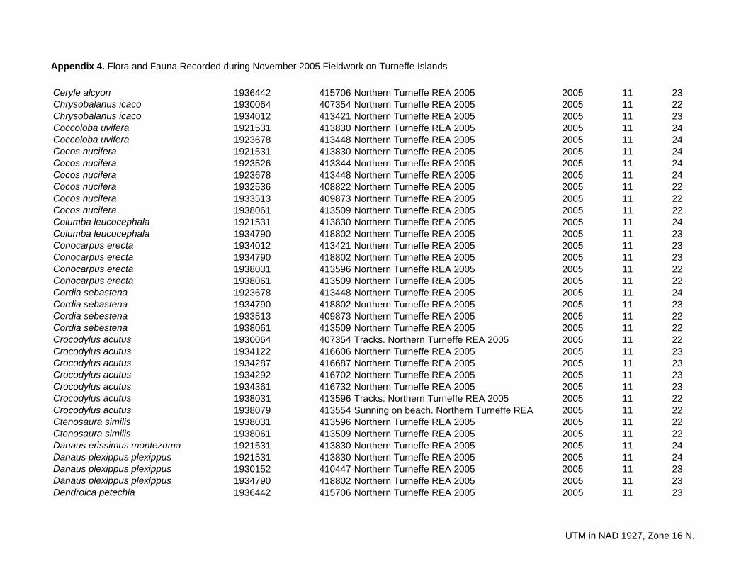
Appendix 4. Flora and Fauna Recorded during November 2005 Fieldwork on Turneffe Islands
Ceryle alcyon 1936442 415706 Northern Turneffe REA 2005 2005 11 23Chrysobalanus icaco 1930064 407354 Northern Turneffe REA 2005 2005 11 22Chrysobalanus icaco 1934012 413421 Northern Turneffe REA 2005 2005 11 23Coccoloba uvifera 1921531 413830 Northern Turneffe REA 2005 2005 11 24Coccoloba uvifera 1923678 413448 Northern Turneffe REA 2005 2005 11 24Cocos nucifera 1921531 413830 Northern Turneffe REA 2005 2005 11 24Cocos nucifera 1923526 413344 Northern Turneffe REA 2005 2005 11 24Cocos nucifera 1923678 413448 Northern Turneffe REA 2005 2005 11 24Cocos nucifera 1932536 408822 Northern Turneffe REA 2005 2005 11 22Cocos nucifera 1933513 409873 Northern Turneffe REA 2005 2005 11 22Cocos nucifera 1938061 413509 Northern Turneffe REA 2005 2005 11 22Columba leucocephala 1921531 413830 Northern Turneffe REA 2005 2005 11 24Columba leucocephala 1934790 418802 Northern Turneffe REA 2005 2005 11 23Conocarpus erecta 1934012 413421 Northern Turneffe REA 2005 2005 11 23Conocarpus erecta 1934790 418802 Northern Turneffe REA 2005 2005 11 23Conocarpus erecta 1938031 413596 Northern Turneffe REA 2005 2005 11 22Conocarpus erecta 1938061 413509 Northern Turneffe REA 2005 2005 11 22Cordia sebastena 1923678 413448 Northern Turneffe REA 2005 2005 11 24Cordia sebastena 1934790 418802 Northern Turneffe REA 2005 2005 11 23Cordia sebestena 1933513 409873 Northern Turneffe REA 2005 2005 11 22Cordia sebestena 1938061 413509 Northern Turneffe REA 2005 2005 11 22Crocodylus acutus 1930064 407354 Tracks. Northern Turneffe REA 2005 2005 11 22Crocodylus acutus 1934122 416606 Northern Turneffe REA 2005 2005 11 23Crocodylus acutus 1934287 416687 Northern Turneffe REA 2005 2005 11 23Crocodylus acutus 1934292 416702 Northern Turneffe REA 2005 2005 11 23Crocodylus acutus 1934361 416732 Northern Turneffe REA 2005 2005 11 23Crocodylus acutus 1938031 413596 Tracks: Northern Turneffe REA 2005 2005 11 22Crocodylus acutus 1938079 413554 Sunning on beach. Northern Turneffe REA 2005 11 22Ctenosaura similis 1938031 413596 Northern Turneffe REA 2005 2005 11 22Ctenosaura similis 1938061 413509 Northern Turneffe REA 2005 2005 11 22Danaus erissimus montezuma 1921531 413830 Northern Turneffe REA 2005 2005 11 24Danaus plexippus plexippus 1921531 413830 Northern Turneffe REA 2005 2005 11 24Danaus plexippus plexippus 1930152 410447 Northern Turneffe REA 2005 2005 11 23Danaus plexippus plexippus 1934790 418802 Northern Turneffe REA 2005 2005 11 23Dendroica petechia 1936442 415706 Northern Turneffe REA 2005 2005 11 23
UTM in NAD 1927, Zone 16 N.
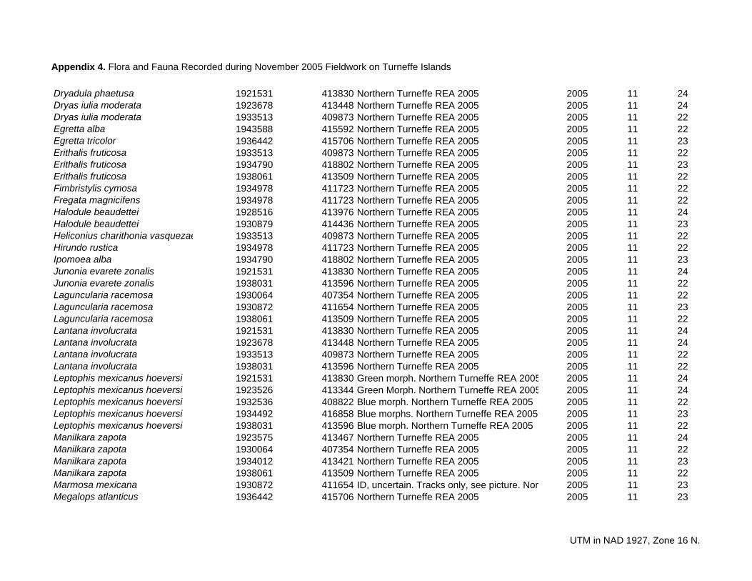
Appendix 4. Flora and Fauna Recorded during November 2005 Fieldwork on Turneffe Islands
e
55
Dryadula phaetusa 1921531 413830 Northern Turneffe REA 2005 2005 11 24Dryas iulia moderata 1923678 413448 Northern Turneffe REA 2005 2005 11 24Dryas iulia moderata 1933513 409873 Northern Turneffe REA 2005 2005 11 22Egretta alba 1943588 415592 Northern Turneffe REA 2005 2005 11 22Egretta tricolor 1936442 415706 Northern Turneffe REA 2005 2005 11 23Erithalis fruticosa 1933513 409873 Northern Turneffe REA 2005 2005 11 22Erithalis fruticosa 1934790 418802 Northern Turneffe REA 2005 2005 11 23Erithalis fruticosa 1938061 413509 Northern Turneffe REA 2005 2005 11 22Fimbristylis cymosa 1934978 411723 Northern Turneffe REA 2005 2005 11 22Fregata magnicifens 1934978 411723 Northern Turneffe REA 2005 2005 11 22Halodule beaudettei 1928516 413976 Northern Turneffe REA 2005 2005 11 24Halodule beaudettei 1930879 414436 Northern Turneffe REA 2005 2005 11 23Heliconius charithonia vasqueza 1933513 409873 Northern Turneffe REA 2005 2005 11 22Hirundo rustica 1934978 411723 Northern Turneffe REA 2005 2005 11 22Ipomoea alba 1934790 418802 Northern Turneffe REA 2005 2005 11 23Junonia evarete zonalis 1921531 413830 Northern Turneffe REA 2005 2005 11 24Junonia evarete zonalis 1938031 413596 Northern Turneffe REA 2005 2005 11 22Laguncularia racemosa 1930064 407354 Northern Turneffe REA 2005 2005 11 22Laguncularia racemosa 1930872 411654 Northern Turneffe REA 2005 2005 11 23Laguncularia racemosa 1938061 413509 Northern Turneffe REA 2005 2005 11 22Lantana involucrata 1921531 413830 Northern Turneffe REA 2005 2005 11 24Lantana involucrata 1923678 413448 Northern Turneffe REA 2005 2005 11 24Lantana involucrata 1933513 409873 Northern Turneffe REA 2005 2005 11 22Lantana involucrata 1938031 413596 Northern Turneffe REA 2005 2005 11 22Leptophis mexicanus hoeversi 1921531 413830 Green morph. Northern Turneffe REA 200 2005 11 24Leptophis mexicanus hoeversi 1923526 413344 Green Morph. Northern Turneffe REA 200 2005 11 24Leptophis mexicanus hoeversi 1932536 408822 Blue morph. Northern Turneffe REA 2005 2005 11 22Leptophis mexicanus hoeversi 1934492 416858 Blue morphs. Northern Turneffe REA 2005 2005 11 23Leptophis mexicanus hoeversi 1938031 413596 Blue morph. Northern Turneffe REA 2005 2005 11 22Manilkara zapota 1923575 413467 Northern Turneffe REA 2005 2005 11 24Manilkara zapota 1930064 407354 Northern Turneffe REA 2005 2005 11 22Manilkara zapota 1934012 413421 Northern Turneffe REA 2005 2005 11 23Manilkara zapota 1938061 413509 Northern Turneffe REA 2005 2005 11 22Marmosa mexicana 1930872 411654 ID, uncertain. Tracks only, see picture. Nort 2005 11 23Megalops atlanticus 1936442 415706 Northern Turneffe REA 2005 2005 11 23
UTM in NAD 1927, Zone 16 N.
Appendix 4. Flora and Fauna Recorded during November 2005 Fieldwork on Turneffe Islands
Melanerpes aurifrons 1934978 411723 Northern Turneffe REA 2005 2005 11 22Metopium brownei 1923678 413448 Northern Turneffe REA 2005 2005 11 24Metopium brownei 1933513 409873 Northern Turneffe REA 2005 2005 11 22Mimus gilvus 1932536 408822 Northern Turneffe REA 2005 2005 11 22Myrica cerifera 1930064 407354 Northern Turneffe REA 2005 2005 11 22Myrica cerifera 1934012 413421 Northern Turneffe REA 2005 2005 11 23Myrmecophylla tibicinis 1934012 413421 Northern Turneffe REA 2005 2005 11 23Neea psychotrioides 1923678 413448 Northern Turneffe REA 2005 2005 11 24Norops sagrei 1923678 413448 Northern Turneffe REA 2005 2005 11 24Norops sagrei 1925293 412986 Northern Turneffe REA 2005 2005 11 24Norops sagrei 1928516 413976 Northern Turneffe REA 2005 2005 11 24Norops sagrei 1934978 411723 Northern Turneffe REA 2005 2005 11 22Norops sagrei 1936442 415706 Northern Turneffe REA 2005 2005 11 23Nycticorax violaceus 1936442 415706 Northern Turneffe REA 2005 2005 11 23Pandion haliaetus 1925107 412936 Active nest. Northern Turneffe REA 2005 2005 11 24Pandion haliaetus 1926785 412735 Active nest. Northern Turneffe REA 2005 2005 11 24Pandion haliaetus 1930879 414436 Northern Turneffe REA 2005 2005 11 23Pandion haliaetus 1943588 415592 Nest. Northern Turneffe REA 2005 2005 11 22Passiflora ciliata 1930064 407354 Northern Turneffe REA 2005 2005 11 22Passiflora suberosa 1923678 413448 Northern Turneffe REA 2005 2005 11 24Passiflora suberosa 1938031 413596 Northern Turneffe REA 2005 2005 11 22Pelecanus occidentalis 1925293 412986 Northern Turneffe REA 2005 2005 11 24Pelecanus occidentalis 1934978 411723 Northern Turneffe REA 2005 2005 11 22Phallacocorax auritus 1934978 411723 Northern Turneffe REA 2005 2005 11 22Phallacocorax auritus 1943588 415592 Northern Turneffe REA 2005 2005 11 22Phyllodactylus tuberculosus 1932536 408822 Northern Turneffe REA 2005 2005 11 22Pithecellobium keyense 1921531 413830 Northern Turneffe REA 2005 2005 11 24Pithecellobium keyense 1923678 413448 Northern Turneffe REA 2005 2005 11 24Pithecellobium keyense 1933513 409873 Northern Turneffe REA 2005 2005 11 22Pithecellobium keyense 1938061 413509 Northern Turneffe REA 2005 2005 11 22Portulaca oleracea 1934978 411723 Northern Turneffe REA 2005 2005 11 22Pouteria campechiana 1921531 413830 Northern Turneffe REA 2005 2005 11 24Pouteria campechiana 1923678 413448 Northern Turneffe REA 2005 2005 11 24Procyon lotor shufeldti 1921531 413830 Seen. Northern Turneffe REA 2005 2005 11 24Procyon lotor shufeldti 1930872 411654 Tracks. Northern Turneffe REA 2005 2005 11 23
UTM in NAD 1927, Zone 16 N.
Appendix 4. Flora and Fauna Recorded during November 2005 Fieldwork on Turneffe Islands
Procyon lotor shufeldti 1938031 413596 Tracks. Northern Turneffe REA 2005 2005 11 22Psychotria nervosa 1923678 413448 Northern Turneffe REA 2005 2005 11 24Quiscalus mexicanus 1930064 407354 Northern Turneffe REA 2005 2005 11 22Quiscalus mexicanus 1934012 413421 Northern Turneffe REA 2005 2005 11 23Quiscalus mexicanus 1934978 411723 Northern Turneffe REA 2005 2005 11 22Rhizophora mangle 1923656 413290 Northern Turneffe REA 2005 2005 11 24Rhizophora mangle 1924781 411549 Northern Turneffe REA 2005 2005 11 24Rhizophora mangle 1928516 413976 Northern Turneffe REA 2005 2005 11 24Rhizophora mangle 1929058 414092 Northern Turneffe REA 2005 2005 11 23Rhizophora mangle 1930064 407354 Northern Turneffe REA 2005 2005 11 22Rhizophora mangle 1930872 411654 Northern Turneffe REA 2005 2005 11 23Rhizophora mangle 1932536 408822 Northern Turneffe REA 2005 2005 11 22Rhizophora mangle 1933513 409873 Northern Turneffe REA 2005 2005 11 22Rhizophora mangle 1934978 411723 Northern Turneffe REA 2005 2005 11 22Rhizophora mangle 1943588 415592 Northern Turneffe REA 2005 2005 11 22Rivina humilis 1934790 418802 Northern Turneffe REA 2005 2005 11 23Salicornia bigelovii 1930872 411654 Northern Turneffe REA 2005 2005 11 23Salicornia bigelovii 1932953 409353 Northern Turneffe REA 2005 2005 11 22Salicornia bigelovii 1934978 411723 Northern Turneffe REA 2005 2005 11 22Seiurus noveboracensis 1932953 409353 Northern Turneffe REA 2005 2005 11 22Sesuvium portulacastrum 1934978 411723 Northern Turneffe REA 2005 2005 11 22Sideroxylon americanum 1933513 409873 Northern Turneffe REA 2005 2005 11 22Sideroxylon americanum 1934790 418802 Northern Turneffe REA 2005 2005 11 23Sideroxylon americanum 1938061 413509 Northern Turneffe REA 2005 2005 11 22Simarouba glauca 1923678 413448 Northern Turneffe REA 2005 2005 11 24Siproeta stelenes bipagiata 1921531 413830 Northern Turneffe REA 2005 2005 11 24Siproeta stelenes bipagiata 1934790 418802 Northern Turneffe REA 2005 2005 11 23Solanum donianum 1921531 413830 Northern Turneffe REA 2005 2005 11 24Solanum donianum 1933513 409873 Northern Turneffe REA 2005 2005 11 22Solanum donianum 1938061 413509 Northern Turneffe REA 2005 2005 11 22Spartina spartinae 1930872 411654 Northern Turneffe REA 2005 2005 11 23Spartina spartinae 1932536 408822 Northern Turneffe REA 2005 2005 11 22Spartina spartinae 1934012 413421 Northern Turneffe REA 2005 2005 11 23Spartina spartinae 1938061 413509 Northern Turneffe REA 2005 2005 11 22Sphyraena barracuda 1936442 415706 Northern Turneffe REA 2005 2005 11 23
UTM in NAD 1927, Zone 16 N.
Appendix 4. Flora and Fauna Recorded during November 2005 Fieldwork on Turneffe Islands
Sterna maxima 1934978 411723 Northern Turneffe REA 2005 2005 11 22Thalassia testudinum 1925293 412986 Northern Turneffe REA 2005 2005 11 24Thalassia testudinum 1928516 413976 Northern Turneffe REA 2005 2005 11 24Thalassia testudinum 1929058 414092 Northern Turneffe REA 2005 2005 11 23Thalassia testudinum 1930879 414436 Northern Turneffe REA 2005 2005 11 23Thespesia populnea 1930064 407354 Northern Turneffe REA 2005 2005 11 22Thrinax radiata 1933513 409873 Northern Turneffe REA 2005 2005 11 22Thrinax radiata 1934012 413421 Northern Turneffe REA 2005 2005 11 23Thrinax radiata 1934790 418802 Northern Turneffe REA 2005 2005 11 23Thrinax radiata 1938061 413509 Northern Turneffe REA 2005 2005 11 22Tournefortia gnaphalodes 1934790 418802 Northern Turneffe REA 2005 2005 11 23Trema micrantha 1921531 413830 Northern Turneffe REA 2005 2005 11 24Tursiops truncatus 1938061 413250 Northern Turneffe REA 2005 2005 11 22Tyrannus forficatus 1938031 413596 Northern Turneffe REA 2005 2005 11 22Urbanus dorantes 1938031 413596 Northern Turneffe REA 2005 2005 11 22Vireo magister 1934012 413421 Northern Turneffe REA 2005 2005 11 23
UTM in NAD 1927, Zone 16 N.