route 58 ppta project submitted by · route 58 ppta project ... committee (irc) ... 2011 were...
TRANSCRIPT

Route 58 PPTA Project
Finance Plan Annual Update Hillsville to Stuart Corridor
Submitted By:
Robert P. Williams
District Construction Engineer Salem District
Virginia Department of Transportation
Submitted To:
Virginia Department of Transportation
June 17, 2016

2
Table of Contents
1.0 Project Background....…………………………………..………………......…..……..3
1.1 Project Procurement………………...…………..……..…………….………...3 1.2 Environmental Permitting……………………………………………………..4
2.0 Project Description and Schedule….………………..………………......…………….5
2.1 Phase 1, Parkway Crossing at Meadows of Dan………………………………5
2.2 Phase 2, Hillsville Bypass……….…………………………………………….6
2.3 Phase 3, Laurel Fork………………...….…………………….……………….7
2.4 Remaining Projects……………………………………………………………8
2.5 Right of Way Status…………………………………………………………...8
3.0 Cost Estimates……..….……………………………..…………...……………..….….9
3.1 Phase 1, Parkway Crossing at Meadows of Dan………………………………9
3.2 Phase 2, Hillsville Bypass……….……………………………………….....…9
3.3 Phase 3, Laurel Fork………………...….…………………….……………...10
3.4 Remaining Projects……………………………..……………………………11
4.0 Finance Plan…………………………………………………………………….……11
4.1 Phase 1, Parkway Crossing at Meadows of Dan…….………………………11
4.2 Phase 2, Hillsville Bypass……….………………………………………...…12
4.3 Phase 3, Laurel Fork………………...….…………………….……………...12
5.0 Project Cash Flow……………………………………………………………………13
5.1 Phase 3, Laurel Fork………………...….…………………….……………...13
6.0 Involvement of Private Enterprise…………………...………………………………13
7.0 Risk and Mitigation Measures………………………………………………...……..13

3
1.0 Project Background
In December 2003, the Virginia Department of Transportation (VDOT) signed a Comprehensive Agreement with Branch Highways Inc. (Developer), in accordance with the Public Private Transportation Act (PPTA), to develop and widen 36 miles of the Route 58 Corridor from Hillsville to Stuart as funding becomes available. The corridor begins southwest of Hillsville and continues east through Carroll, Floyd, and Patrick counties to approximately one mile west of Stuart.
The Route 58 Corridor from Hillsville to Stuart is the last remaining section to complete Route 58 from Virginia Beach to I-77. Once connected with I-77, the long anticipated benefits of the 1989 General Assembly legislated “U.S. Route 58 Corridor Development Program” will greatly be enhanced throughout the entire region. The first phase (Phase 1) of widening Route 58 under this agreement was a 2.7 mile new road construction and a new Blue Ridge Parkway bridge crossing at Meadows of Dan. Phase 1 was completed in May 2006.
The second phase (Phase 2) of this corridor known as the Hillsville Bypass was executed in the fall of 2007. This is a 5.2 mile four-lane divided limited access bypass facility with three full interchanges. The original scope of work included the Hillsville Bypass and Route 669; however, due to funding limitations, Route 669 was eliminated from Phase 2. The third phase (Phase 3), known as Laurel Fork, was executed in December of 2011 and encompasses the sections originally developed as Laurel Fork and Tri-County Connector sections for a combined length of 8.2 miles. This phase is presently under construction. Remaining phases include the Crooked Oak (7.2 miles), Vesta (4.0 miles), Lovers Leap (7.8 miles) sections and Route 669. While design and right of way were initiated in the 1990s, these phases remain incomplete. During the 2013 General Assembly Session, legislation provided additional bond authorization for the Route 58 Corridor Program to fund these remaining phases. The first issuance of these bonds is planned for the FY 2019/FY 2020 timeframe to support construction. Additional information can be found on the Project’s website. http://www.virginiadot.org/projects/salem/route_58_widening.asp The website provides additional links to the Route 58 Corridor Program and project specific sites sponsored by the Route 58 PPTA Contractor. 1.1 Project Procurement
As outlined in the Initial Financial Plan, initiation of the Route 58 PPTA Project (Project) began when VDOT received an unsolicited conceptual proposal in May 2001 in accordance with the Commonwealth’s PPTA to design and construct a planned four-lane

4
section of Route 58 between Stuart and Hillsville (36-mile segment). In accordance with VDOT’s PPTA Implementation Guidelines, dated April 2001, a competition period with public notice was posted for forty-five days beginning May 25, 2001. The result of the competition period was that no other competing proposals were received. Subsequent to the competitive public notice period, VDOT impaneled an Initial Review Committee (IRC) to determine if the conceptual proposal merited advancement to the Commonwealth Transportation Board (CTB) for review and recommendation. The IRC recommended advancement and at the October 17, 2001 public meeting of the CTB, the conceptual proposal was evaluated and recommended to be advanced to the Public-Private Transportation Advisory Panel for further consideration. VDOT requested a detailed proposal which was received in January 2002 and evaluated by the Route 58 Advisory Panel. After several supplemental submittals of information to the Advisory Panel, in July 2003, the Panel recommended to the Commissioner to advance the proposal and begin negotiation for a comprehensive agreement for the entire segment of Route 58 between Stuart and Hillsville. After negotiations related to the cost of Phase 1 and the roles and responsibilities and risk assignments of the entire project were completed, the comprehensive agreement was executed on December 15, 2003. VDOT and the Developer have negotiated the following phases of work. Phase 1 (UPC 56352) consisted of a 2.7-mile section in Meadows of Dan. Phase 2 for the completion of the 5.7-mile section known as the Hillsville Bypass (UPC 17535) was signed on October 2, 2007 and the Bypass was completed in November 2011. Two offsite stream mitigation projects were completed to meet the regulatory permitting requirements for the Hillsville Bypass project in 2012 and 2015. Phase 3, known as Laurel Fork (UPC17533) was executed on December 6, 2011 for an additional 8.2 miles.
1.2 Environmental Permitting
Federal approval of the procurement process for the PPTA Project was denied by the Federal Highway Administration (FHWA) in March 2009 and it is not eligible for federal funding at this time. VDOT has since completed the National Environmental Policy Act (NEPA) permitting process in an effort to secure FHWA concurrence and possible future funding. NEPA documents were completed for the Route 669 project (UPC 18107) and the remaining sections of Route 58 between Phase 1 and Phase 2 (Laurel Fork (UPC 17533), Crooked Creek (UPC 17534) and Tri-County (UPC17538)) and between the Phase 2 and Stuart (Lover’s Leap (UPC 17536) and Vesta (UPC17537)). A Categorical Exclusion (CE) dated November 17, 2010 was approved for the Route 669 project. Two Environmental Assessments (EA) dated March 1, 2011 were completed for the remaining sections of Route 58. One EA included Laurel Fork, Crooked Creek and Tri-County. The second EA included Lover’s Leap and Vesta. Based on the EA’s, the FHWA issued Findings of No Significant Impact (FONSI) dated June 28, 2011. The primary NEPA documentation has therefore been completed for these projects. Future NEPA-related
5
activities would include completing document reevaluations at appropriate stages of the project such as prior to additional right-of-way or easement acquisition or prior to advertisement/construction if federal funds were to be used for the remaining projects/phases. 2.0 Project Description and Schedule
The Route 58 PPTA Project begins at a point just west of Little Reed Island Creek on the southwest side of the Town of Hillsville and continues generally east through Carroll, Floyd and Patrick counties to approximately one mile west of the town limits of Stuart, at which point the project ties into four lanes of existing Route 58. The Project is intended to be designed and constructed in phases. Phase 1 was approximately three miles long, and is referred to as the Parkway Crossing in Meadows of Dan, in Patrick County. Phase 2 is approximately 5.2 miles long and is referred to as the Hillsville Bypass. Phase 3 combines the Laurel Fork and Tri-county sections totaling approximately 8.2 miles long and is referred to as the Laurel Fork section. Two of the remaining sections, Lovers Leap and Vesta are fully funded in fiscal years 2020 and 2021 in the FY2017-2022 Six-Year Improvement Program and a start date is anticipated on or before 2020. The third remaining mainline section, Crooked Oak, is partially funded in FY 2020 and FY 2021 and a start date has not been established.
2.1 Phase I, Parkway Crossing at Meadows of Dan Project
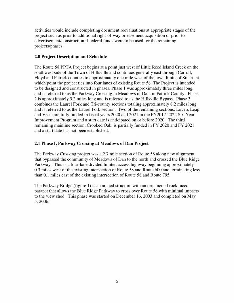
The Parkway Crossing project was a 2.7 mile section of Route 58 along new alignment that bypassed the community of Meadows of Dan to the north and crossed the Blue Ridge Parkway. This is a four-lane divided limited access highway beginning approximately 0.3 miles west of the existing intersection of Route 58 and Route 600 and terminating less than 0.1 miles east of the existing intersection of Route 58 and Route 795. The Parkway Bridge (figure 1) is an arched structure with an ornamental rock faced parapet that allows the Blue Ridge Parkway to cross over Route 58 with minimal impacts to the view shed. This phase was started on December 16, 2003 and completed on May 5, 2006.
6
Figure 1 - The Blue Ridge Parkway Bridge
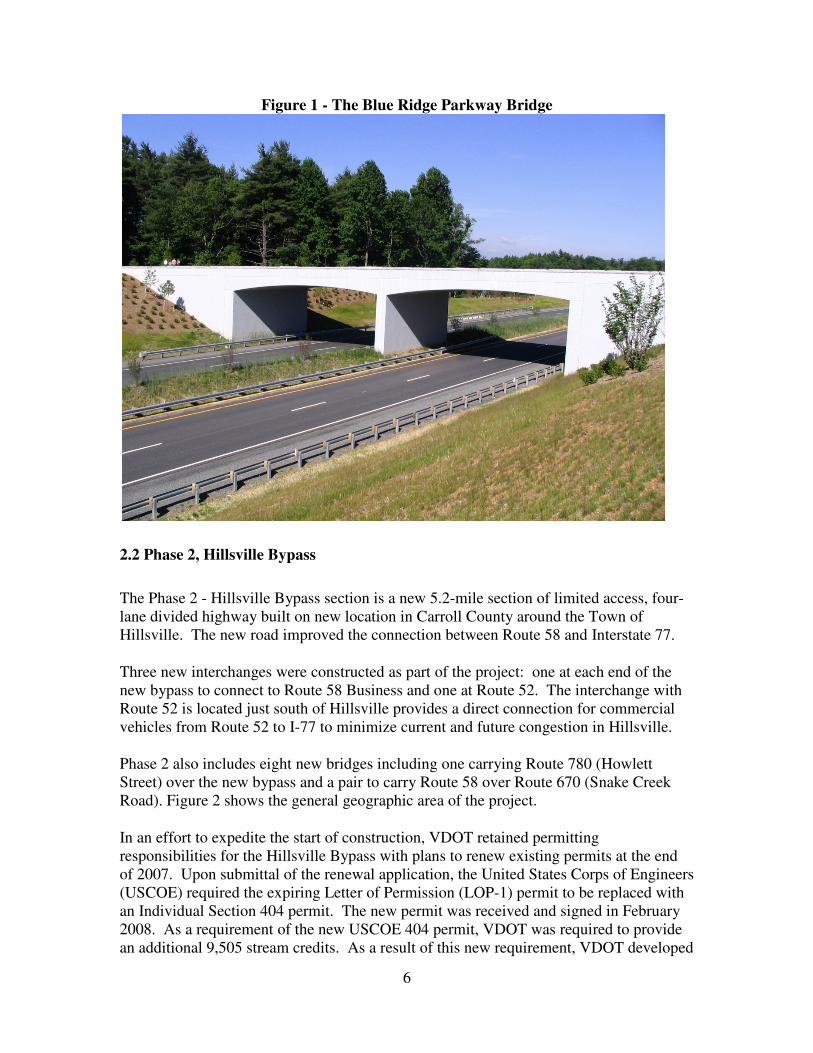
2.2 Phase 2, Hillsville Bypass
The Phase 2 - Hillsville Bypass section is a new 5.2-mile section of limited access, four-lane divided highway built on new location in Carroll County around the Town of Hillsville. The new road improved the connection between Route 58 and Interstate 77.
Three new interchanges were constructed as part of the project: one at each end of the new bypass to connect to Route 58 Business and one at Route 52. The interchange with Route 52 is located just south of Hillsville provides a direct connection for commercial vehicles from Route 52 to I-77 to minimize current and future congestion in Hillsville.
Phase 2 also includes eight new bridges including one carrying Route 780 (Howlett Street) over the new bypass and a pair to carry Route 58 over Route 670 (Snake Creek Road). Figure 2 shows the general geographic area of the project.
In an effort to expedite the start of construction, VDOT retained permitting responsibilities for the Hillsville Bypass with plans to renew existing permits at the end of 2007. Upon submittal of the renewal application, the United States Corps of Engineers (USCOE) required the expiring Letter of Permission (LOP-1) permit to be replaced with an Individual Section 404 permit. The new permit was received and signed in February 2008. As a requirement of the new USCOE 404 permit, VDOT was required to provide an additional 9,505 stream credits. As a result of this new requirement, VDOT developed
7
plans for two stream mitigation sites, the Pine Run site and the Hillsville Elementary site. The Pine Run site was completed in the fall of 2012 and the Hillsville Elementary was completed in the spring of 2015. The Hillsville Bypass was open to traffic on schedule and certified Substantially Complete on August 26, 2011.
Figure 2 – Hillsville Bypass Location Map
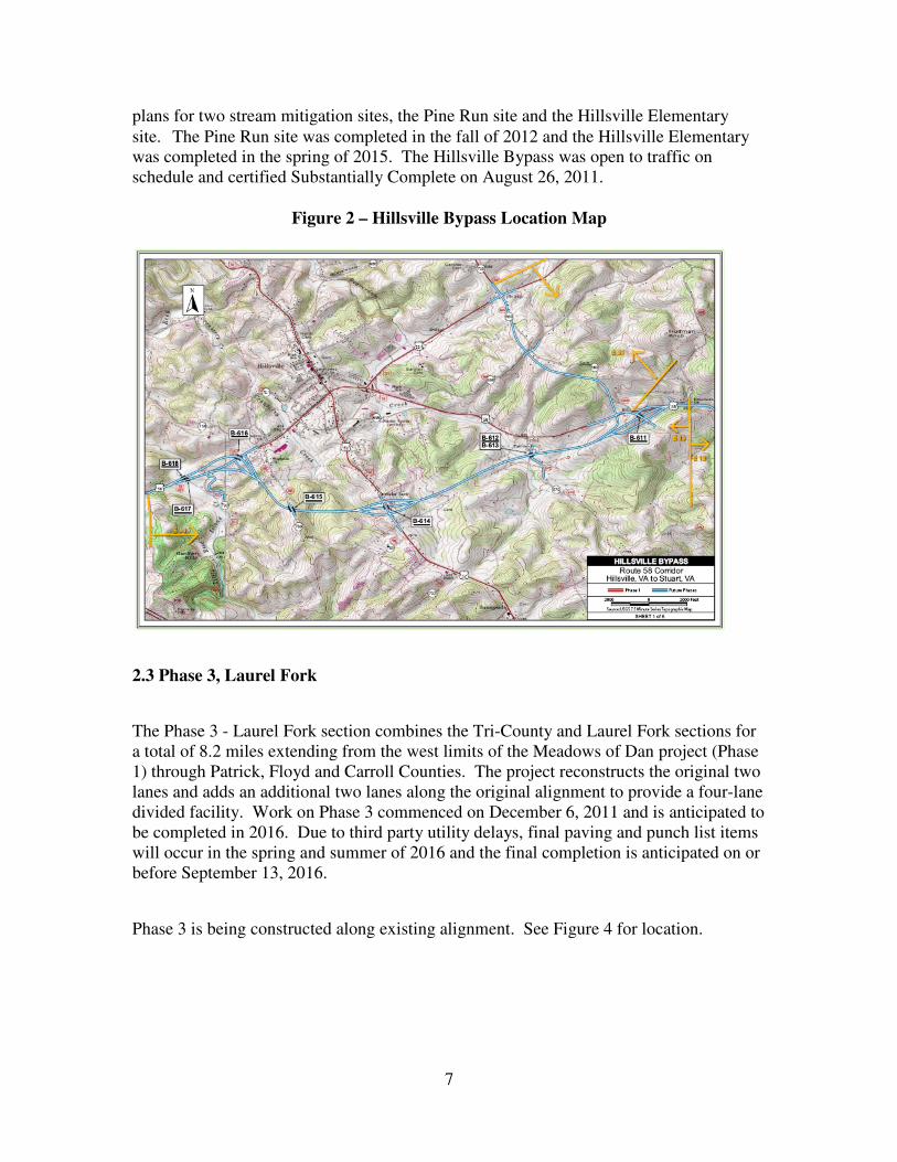
2.3 Phase 3, Laurel Fork
The Phase 3 - Laurel Fork section combines the Tri-County and Laurel Fork sections for a total of 8.2 miles extending from the west limits of the Meadows of Dan project (Phase 1) through Patrick, Floyd and Carroll Counties. The project reconstructs the original two lanes and adds an additional two lanes along the original alignment to provide a four-lane divided facility. Work on Phase 3 commenced on December 6, 2011 and is anticipated to be completed in 2016. Due to third party utility delays, final paving and punch list items will occur in the spring and summer of 2016 and the final completion is anticipated on or before September 13, 2016.
Phase 3 is being constructed along existing alignment. See Figure 4 for location.

8
2.4 Remaining Phases in the PPTA Corridor
There is approximately 19 miles of roadway left in the three remaining phases of this Project excluding the secondary connector, Route 669. The original plans developed prior to 2001 are at 40% to 60% complete. Work was stopped in 2001 following receipt of the PPTA proposal. Environmental permitting activities with regulatory agencies are incomplete and significant work remains in this area. The remaining sections include Lovers Leap, Vesta, Crooked Oak and Route 669 Projects. Figure 4 shows the general geographic area of the remaining phases.
Figure 4 - Remaining Phases of Route 58 Corridor Projects
2.5 Right of Way Status
Table 1 below shows the current right of way status for each of the phases.

9
Table 1 – Right of Way Status
3.0 Cost Estimates
The PPTA Comprehensive Agreement for this project includes six Route 58 mainline sections and the secondary connector, Route 669 to be completed in phases as funding becomes available.
3.1 Phase 1, Parkway Crossing at Meadows of Dan
The original cost estimate for Phase 1 was $22,483,000. The contract obligation was for $19,971,672 with the balance being used VDOT contract administration. The project was completed for $20,381,931 as outlined in table 2 and the surplus funds were transferred to other phases.
Table 2 – Phase 1 Cost Estimate - UPC 56352
Approved Estimate
Expenditures
Date
06/09/2006
PE $0 $0
RW $0 $0
CN $20,381,931 $20,381,931
Total $20,381,931 $20,381,931
3.2 Phase 2, Hillsville Bypass
The Hillsville Bypass original cost estimate was $102,687,240. The original construction contract value was $83M. Two additional offsite stream mitigation projects, Pine Run and Hillsville Elementary, were added for $2,180,000 and $1,700,000 respectively.
UPC Project #
Project
Name Parcels
Parcels
Cleared Status
17535 0058-017-E13, RW
201 Hillsville Bypass 80 Parcels 79 Cleared
Project Complete, R/W Complete
18107 0669-017-E36, RW
201 Route 669 26 Parcels 26 Cleared 100% complete
17534 0058-017-E12, RW
201 Crooked Oak
107 Parcels 93 Cleared 86% complete
17533 0058-017-E11, RW
201 Laurel Fork 115 Parcels 112 Cleared 100% complete
17538 0058-962-E02, RW
201 Tri-County 139 Parcels 137 Cleared 100% complete
56352 0058-070-E02,
C501 Parkway Crossing
Project Complete, R/W Complete
17537 0058-070-E19, RW
201 Vesta 78 Parcels 69 Cleared 88% complete
17536 0058-070-E18, RW
201 Lovers Leap 80 Parcels 55 Cleared 65% complete

10
Phase 2 cost estimate is shown in table 3 and the phase is expected to be completed under the current estimate.
Table 3 – Phase 2 Cost Estimate - UPC 17535
Approved Estimate (Award)
Expenditures (CRD)
Date 07/23/2015 06/07/2016
PE $5,567,795 $5,567,795
RW $10,397,000 $10,234,677
CN $90,602,445 $90,526,052
Total $106,567,240 $106,328,523
3.3 Phase 3, Laurel Fork
The cost estimate for Phase 3 is $142,214,913. Phase 3 was originally developed as two projects, Tri-County (UPC 17538) and Laurel Fork (17533). Following execution of the Laurel Fork work order, a separate UPC (102629) was created to track the construction and engineering contract costs. However, services provided by the Developer for right of way acquisition are being accounted for under the original UPCs 17538 and 17533. The construction contract value for Phase 3 is $119,750,000 which includes allowances for right of way and stream/wetland mitigation. There is currently a deficit on UPC 17533 and we are currently identifying funds to cover the expenditures. The phase estimates are outlined in tables 4, 5 and 6.
Table 4 – Phase 3 Cost Estimate - UPC 17538
Approved Estimate (Financial Plan)
Expenditures (CRD)
Date 07/09/2012 05/04/2016
PE $4,986,000 $4,768,294
RW $7,368,163 $6,674,477
CN $0 $0
Total $12,354,163 $11,442,772
Table 5 – Phase 3 Cost Estimate - UPC 17533
Approved Estimate (Financial Plan)
Expenditures (CRD)
Date 04/12/2013 11/04/2014
PE $2,865,000 $2,783,458
RW $2,920,750 $4,123,765
CN $0 $0
Total $5,785,750 $6,907,223

11
Table 6 - Phase 3 Cost Estimate - UPC 102629
Approved Estimate (Financial Plan)
Expenditures (CRD)
Date 04/19/2012 06/07/2016
PE $0 $0
RW $0 $0
CN $124,075,000 $116,258,904
Total $124,075,000 $116,258,904
3.4 Remaining Phases/Sections
Engineering and right of way acquisition was initiated in the 1990s and are at varying levels of completion. The Developer has provided the following estimates for construction in table 7. The scope of work and actual price will be negotiated at such point additional funding is allocated to these projects.
Table 7 - Cost Estimates for Remaining Phases
Project Estimate Length Project Number UPC
Rte. 58 - Lover's Leap $258,300,000.00 7.8 miles 0058-070-E18 17536
Rte. 58 - Vesta $98,300,000.00 4.0 miles 0058-070-E19 17537
Rte. 58 - Crooked Oak $168,500,000.00 7.2 miles 0058-017-E12 17534
Rte. 669 $19,200,000.00 1.7 miles 0669-017-E36 18107
Total $544,300,000.00 20.7 miles
4.0 Financial Plan
The Virginia General Assembly established the Route 58 Corridor Development Program (Program) in 1989 to enhance economic development potential across this largely rural portion of the state. Work is now completed through to the Town of Stuart, County seat for Patrick County. The Program was initially funded through the sale of bonds through the early 2000s. Due to 2013 House Bill 1953 and 2313, bonds are anticipated to again be a primary source of funding beginning in fiscal year 2020.
4.1 Phase 1, Parkway Crossing at Meadows of Dan
The cost estimate was $20,381,931 and was fully funded with various funding state and local fund sources as shown in table 8.
Table 8 - Funding for sources for Parkway Crossing (UPC 56352)
Revenue Sharing: State Match (CNS202) $100,300
Revenue Sharing: Local Match (CNL202) $100,300
Primary FRANS (CNB294) $14,948,000
Primary PTF (CNS246) $2,535,000
Primary Formula – State (CNS472) $2,698,331
Total $20,381,931

12
4.2 Phase 2, Hillsville Bypass
The Hillsville Bypass had an original construction contract was valued at $83M. Two additional offsite stream mitigation projects, Pine Run and Hillsville Elementary, were added for $2,180,000 and $1,700,000 respectively. The project is fully funded with various state and local fund sources as shown in table 9. Carroll County contributed $150,000 to the Revenue Sharing Program for an equal match.
Table 9 - Funding for sources for Hillsville Bypass (UPC 17535)
Revenue Sharing Funds: Local Match (CNL201) $150,000
Revenue Sharing Funds: State Match (CNS202) $150,000
Bond Proceeds: Route 58 Bond CDP Funds (CNB581) $14,199,712
Transportation Partnership Opportunity Fund: TPOF - FY08 (CNS281) $77,000,000
Formula - Primary: Primary Formula - State : Salem (CNS472) $4,649,140
FRAN Bond Proceeds: Primary FRANS (CNB294) $3,804,968
Priority Transportation Funds: Primary PTF (CNS246) $6,613,420
Total $106,567,240
4.3 Phase 3, Laurel Fork
The cost estimate is $142,214,913. The construction contract value for Phase 3 is $119,750,000 which includes allowances for right of way allowance and stream/wetland mitigation. Phase 3 is funded with various state funds as shown in tables 10, 11 and 12. There is currently a deficit on UPC 17533 and we are currently identifying funds to cover the expenditures.
Table 10 - Funding for sources for Laurel Fork (UPC 17533)
Bond Proceeds: Route 58 Bond CDP Funds (CNB581) $5,785,750
Total $5,785,750
Table 11 - Funding for sources for Laurel Fork/Tri County (UPC 17538)
Bond Proceeds: Route 58 Bond CDP Funds (CNB581) $10,723,244
Priority Transportation Funds: Primary PTF (CNS246) $1,630,919
Total $12,354,163
Table 12 - Funding for sources for Laurel Fork (UPC 102629)
Bond Proceeds: Bond Proceeds - Capital Projects Revenue (CNB267) $119,883,204
Bond Proceeds: Route 58 Bond CDP Funds (CNB581) $4,083,896
Residue Parcel Revenue: Residue Parcel - Salem (CNS453) $107,900
Total $124,075,000
13
5.0 Project Cash Flow
The Comprehensive Agreement between the Developer and VDOT establishes the maximum allowable monthly draw for each phase in Exhibit D, Plan of Finance. The monthly draw requests for Phases 1 and 2 followed slightly behind Exhibit D during most of construction and accelerated in the final months to 100% paid. 5.1 Phase 3, Laurel Fork
Exhibit C to Comprehensive Agreement – Design-Build Contract establishes in Exhibit D the maximum monthly draws to ensure adequate available funding. The Developer has submitted draw requests for Phase 3 with a cumulative total of $114,983,075 as of the 05/20/2016. This is less than the maximum allowable and follows the payout patterns of earlier phases.
6.0 Involvement of Private Enterprise
As outlined above, VDOT signed a PPTA Comprehensive Agreement with the Developer in December of 2003 to design and construct a planned four-lane section of Route 58 between Stuart and Hillsville (36-mile segment). There is no private capital on this project at this time. 7.0 Risk and Mitigation Measures
Phase 2 was certified substantially complete on August 26, 2011 on time. As outlined above, a requirement of the new USCOE 404 permit, VDOT was required to provide an additional 9,505 stream credits. As a result of this new requirement, VDOT developed plans for two stream mitigation sites under this phase, the Pine Run site and the Hillsville Elementary site. The Pine Run site was completed in the fall of 2012. Final completion of this phase was completed in the spring of 2015 with completion of the Hillsville Elementary Stream Mitigation site. The cost of the mitigation sites were added for a total of $3,880,000 and took 4 additional years to design and construct. A Request for Change (RFC) was received from Developer in 2014 for Phase 3 for third party regulatory agency delays and utility relocation delays. While the impacts of the RFC to the budget have not been mutually resolved at the time of this report, any impacts are expected to be mitigated within the current available funding for the Route 58 Corridor. A non-compensatory time extension was granted for the utility relocation delays extending the substantial completion date to July 14, 2016 and final completion date to September 13, 2016. Phase 3 is nearing completion and expected to reach substantial completion on or before July 14, 2016.