review of humping and hollowing on the west coast management/humping a… · the west coast...
TRANSCRIPT

West Coast Regional Council
Review of Humping and
Hollowing on the West Coast
West Coast Regional Council
Review of Humping and Hollowing
on the West Coast
Prepared By ____________________ Opus International Consultants Limited Steph Brown Environmental Principal Resource Management Planner Level 3, Te Waipounamu House 158 Hereford Street, PO Box 1482 Christchurch, New Zealand
Reviewed By ____________________ Telephone: +64 3 363-5400 Daniel Murray Facsimile: +64 3 365-7858 Senior Resource Management Planner
Date: 8 November 2004 Reference: 380145.00/005CP Status: Final
This document is the property of Opus International Consultants Limited. Any unauthorised employment or reproduction, in full or part is forbidden.
© Opus International Consultants Limited 2004
Review of Humping and Hollowing on the West Coast
i
Contents
1 Executive Summary .............................................................................................................................1
2 Introduction...........................................................................................................................................2
3 What is humping and hollowing? ....................................................................................................2
4 Statutory Framework...........................................................................................................................3
5 What are the issues and current knowledge? .................................................................................4 5.1 Soil.................................................................................................................................................5 5.2 Hydrology....................................................................................................................................8 5.3 Discharges..................................................................................................................................10 5.4 Habitat ........................................................................................................................................14
6 Cumulative Effects.............................................................................................................................15
7 Resource Consents .............................................................................................................................16 7.1 Consents issued and trends.....................................................................................................16 7.2 Information requests ................................................................................................................17 7.3 Consent conditions ...................................................................................................................17 7.4 Consent Compliance ................................................................................................................18
8 Incidents...............................................................................................................................................19
9 Summary..............................................................................................................................................19
10 References............................................................................................................................................20

Review of Humping and Hollowing on the West Coast
1
1 Executive Summary
The West Coast Regional Council has commissioned this review of humping and
hollowing to collate what is known about: the effects of the activity, the resource consents
issued by the Regional Council, and monitoring undertaken to date.
The key points are:
• While the effects of humping and hollowing can be divided into four main
categories the effects cannot be considered in isolation as they are interlinked.
• The short term effects during development have the potential to result in adverse
effects from erosion and sedimentation.
• The simplest requirement to avoid or mitigate adverse effects is to impose
buffer/setback conditions.
• The monitoring requirements, as set out in resource consent conditions, need to be
achievable.
• Consideration should be given to developing a layman’s guide to humping and
hollowing and the resource consent process.
• Records of consents issued should be kept up to date so that when making
decisions on resource consent applications the cumulative effects can be considered.

Review of Humping and Hollowing on the West Coast
2
2 Introduction
Farming practices on the West Coast are undergoing a noticeable change in scale and
intensity. Earthmoving activities such as “humping and hollowing” and “flipping” are
techniques used to improve land drainage and pasture production. These techniques are
making development possible on lands where such development was once considered
impracticable.
West Coast Regional Council has commissioned Opus International Consultants to prepare
this review of humping and hollowing. The review covers:
• what is known about the effects of humping and hollowing;
• a summary of the resource consents issued over the last three years; and
• an assessment of monitoring requirements.
3 What is humping and hollowing?
Humping and hollowing (H&H) is a land development technique used in situations where
vertical drainage through the soil structure is impeded by the soils low permeability or iron
pan formations. The objective is to improve the soil drainage and structure by removing
the low permeability solids, breaking through to the iron pan, and mixing and overlying
soils with sand and gravel. A uniform surface is created with the hollows serving as a
drainage path.
The work methodology has been described by Sinclair Knight Merz (Landcorp Farming
Limited resource consent applications) as involving:
• excavation of pilot drains at uniform spacing across the development area. This
establishes the depth and layout of the hollows and forms the drainage pattern for
the H&H land;
• excavation and placement of the overlying soils in the “core” of the humps;
• excavation of iron pan and underlying gravel to form the hollow and build the
hump;
• H&H land left unfinished to consolidate and drain;
• humps and hollows shaped and compacted by digger/bulldozer and roller; and
• fertiliser applied to land by ground application and grass seed sown.
A proportion of the land developed on the West Coast is flipped. Flipping is different from
H&H in that the soil is turned as though the land was ploughed. The paddocks are left flat
with no hollows. Soils are usually being flipped to a depth of 2 to 3 metres.

Review of Humping and Hollowing on the West Coast
3
4 Statutory Framework
In terms of the effects of activities on land as it relates to H&H, section 30 of the RMA gives
regional councils the following responsibilities in order to give effect to the purpose of the
RMA:
(a) the establishment, implementation, and review of objectives, policies, and methods to achieve the
integrated management of the natural and physical resources of the region:
(b) the preparation of objectives and policies in relation to any actual or potential effects of the use,
development, or protection of land which are of regional significance;
(c) the control of the use of land from the purpose of-
(i) soil conservation;
(ii) the maintenance and enhancement of the quality of water in water bodies and
coastal water;
(iii) the maintenance of the quantity of water in water bodies and coastal water;
(iv) the avoidance or mitigation of natural hazards.
Section 9(3) of the RMA states that no person may use land in a manner that contravenes a
rule in a regional plan or proposed regional plan unless allowed by a resource consent or it
is an existing lawful use.
The Regional Council has chosen to regulate land disturbance in order to control soil
conservation and manage water quantity and quality.
Under the Transitional Regional Plan, land contouring of any contiguous area over five
hectares is a discretionary activity. It is intended that this provision be withdrawn when
the Proposed Land and Riverbed Management Plan (PLRMP) becomes operative.
Under the PLRMP the following rules apply to humping and hollowing, flipping or V
blading activities:
• Rule 8.1.1.1 – permitted activity outside of waterbody buffer margins subject to
conditions, including that the area does not exceed 5 hectares per title per 12
months.
• Rule 8.1.5.1 – restricted discretionary where works do not meet the permitted rule
or within a water body buffer margin where greater than 2 hectares.
The wording of the rules are attached as Appendix 1.
In the past the Council issued discharge permits for the discharge of contaminants
(sediment) to land in circumstances where it may enter water. The H&H rules in the

Review of Humping and Hollowing on the West Coast
4
PLRMP include conditions or discretion matters related to water quality. For this reason,
conditions can be imposed on the land use consent to control the discharge of sediment
and a discharge permit for the discharge to land is not required.
The Proposed Water Management Plan covers the discharge from any drain to water (Rule
12.4.2) as a permitted activity subject to conditions. The rule is intended to cover the
discharge from any drain to surface water. With H&H numerous drains will be formed or
existing ones utilised. Any discharge from drains that enter surface water will have to
meet the permitted conditions or a discharge permit will have to be applied for.
Rule 12 from the Regional Plan for Discharges to Land is being relied on by applicants for
the application of fertiliser. The rule permits the application of fertiliser in a manner that
does allow contaminants to enter water.
5 What are the issues and current knowledge?
As the objective of H&H is to improve the soil structure and improve land drainage, there
are a number of effects of the activity that need to be considered. The effects of H&H can
broadly be divided into four main categories:
(i) changes in soil structure
(ii) changes in catchment hydrology
(iii) the discharge of contaminants
(iv) modifications to habitat
Within these four categories the effects cross more than one category as, for example,
changes in hydrology can modify habitat value and the discharge of contaminants can
affect habitat.
Figure 1 lists the matters that need to be considered when looking at H&H activities, and
the following sections explain these matters in more detail.

Review of Humping and Hollowing on the West Coast
5
Figure 1: Matters to consider with H&H activities
5.1 Soil
During earthworks and for several months following H&H the ground surface is bare,
making it susceptible to erosion and sediment transport. Given this, the type of soil will to
some extent govern the risk of erosion.
On the West Coast the soils can be divided into three broad categories: alluvial river flats,
terraced areas; and pakahi soils. The best soils, from a farming perspective, are the alluvial
river flats. These soils can pug but will dry relatively quickly. It would be unusual for
these soils to be the subject of H&H. On terraced country, that once had natural vegetation
of beech, stony silt loams are found. The final main type of soil found on the West Coast is
pakihi terrace soils. These soils had natural vegetation of silver pine (kahikitea), manuka,
moss and fern. They have low natural fertility, poor drainage, and iron pans. It is these
soils where the majority of H&H has occurred to date.
Changes in the soil profile – H&H
Following H&H the soil profile will have been altered so to improve the drainage
characteristics. It is usually the existence of an “iron pan” that means the soil has poor
drainage characteristics.
Iron pan formations have a low permeability and impede water percolation. With H&H
the iron pans are usually removed entirely from the hollows and re-worked into the
HYDROLOGY SOIL
DISCHARGE HABITAT
storage – water holding
capacity
base flows
flood flows
peak flows
subsurface flows
slope
geology
soil type & profile
climate
fishery values
sediment
substrate
clarity
turbidity
nutrients
terrestrial
vegetation stream morphology
invertebrates
wetlands
erosion potential
runoff
water table
soil chemistry
riparian margins terrestrial fauna

Review of Humping and Hollowing on the West Coast
6
humped areas. Breaking the iron pans and reworking the surface soils removes the barrier
to water infiltration at the surface. The drainage then becomes ‘controlled’ by the
permeability of the underlying materials.
Deeper percolation of water to the groundwater table is governed by the permeability of
the underlying geology – this is unchanged by H&H. Large proportions of the areas that
have been, or are likely to be, H&H will comprise underlying geology of gravels that are
moderately compacted with moderate permeability that is unlikely to restrict deeper
vertical drainage.
Following H&H any sandy soils are exposed at the surface in hollows and placed on the
surface of humps. This increases the infiltration and drainage characteristics. The surface
soil should result in a high gravel and sand content, with a reduction in clayey silts and
organic matter. It is noted that gravel is resistant to erosion, while sand is easily eroded.
Changes in the soil profile - flipping
The other, but not so common, technique is to flip the soils. The objective of flipping soils
is the same as H&H: to improve the drainage of the land. The process is to bury what is
usually pakihi soils and bring as much of the sands/gravels to the surface as possible. The
depth of the soil flipping is usually between 2 and 3 metres depending on the depth of the
underlying material and iron pan. By burying the top layer of soil that has poor water
movement and loosening up the underlying soil, the water holding capacity of the soil is
increased.
Erosion and sedimentation
Erosion and sedimentation are the key environmental concerns during earthworks. Once
mobilised, it is the fine silts and clays that are difficult to control. The factors that influence
erosion are: the soil type, slope, rainfall and the way in which the work is undertaken. The
effect of soil type has been covered above, while slope is considered in the Hydrology
section.
The time taken from commencement of excavation until grass is established, to a point the
erosion potential is reduced, varies through the seasons. The optimum time of sowing
grass seeds is during autumn and spring, with the time taken for grass to establish
typically being six to eight weeks. The timing of earthworks therefore becomes an
important factor if erosion is to be avoided or mitigated.
The risk of at least one, if not more, significant rainfall events while the soil is exposed is
high even if the area to be H&H is small. Generally on the West Coast there is a rainfall
surplus, ie. greater rainfall than evaporation, throughout the year, resulting in saturated
soil conditions.
While the risk of erosion/sedimentation needs to be determined for each H&H proposal,
the method in which work is undertaken will have a significant influence. Some examples
of best practice include:

Review of Humping and Hollowing on the West Coast
7
• staging earthworks – do not expose more land than can be revegetated within
timeframes;
• minimise the gradient of hollows;
• use cut-off drains etc to divert runoff from areas not being developed;
• maintain buffers around waterways including riparian planting and fencing; and
• use and maintain sediment control devices.
The effects of erosion/sedimentation on land are temporary, lasting until grass has
becomes established. But sediment that enters waterways can have longer lasting effects.
Soil chemistry - flipping
At Cape Foulwind the Regional Council requested Landcorp to provide an assessment on
the changes in soil pH that could occur following large scale flipping (1,450 ha) of the soil.
The concern was that acid sulphate material would be released and cause acidification.
Any potential acid sulphate material would be present in the iron pan or below it. As
flipping improves the soil aeration any sulphides present may be progressively converted
to sulphuric acid (SKM, February 2003). High levels of organic matter, as found at Cape
Foulwind, give soils low pH (5.2 –4.4) and significant amounts of sulphate in an oxidised
form.
Testing of the soil was carried out to determine if any potential acid sulphate material was
present. Soils were tested where flipping and occurred and on undeveloped land.
The results of the testing showed that:
• The presence of sulphides that could be converted to acid sulphate were found at
levels below detection limits.
• The iron pan did not contain acid generating material. This means that there was no
risk of water contamination associated with redistributing the iron pan layer
through the soil profile.
• Detectable acidification is confined to surface, organic horizons. The acidification is
minor and would occur gradually over a long period of time.
• Any acidity produced by the surface organic horizons can be readily treated with
lime.
While this investigation was to look at any changes that might occur with the soil
chemistry from flipping, the results would be equally applicable to H&H when given the
right soil conditions.

Review of Humping and Hollowing on the West Coast
8
Long term effects
While H&H as a practice has been around for some time, there are a couple of unknowns
about the long terms effects on the soil. It is unknown whether the iron pan would reform
and essentially leave the farmer in the same situation as before the land was developed
with poor draining soils. With flipping there is some concern that sand and clay soils may
not be suitable to flip, as these soils may ‘re-seal’. Given that iron pans form due to
bacteriological processes over a geological time scale, any reforming of the iron pan would
not occur over a short to medium term
5.2 Hydrology
As H&H is designed to convert poorly drained land into productive land, there will be
changes to the hydrologic regime. A number of concerns have been expressed about
whether the changes have positive or negative effects, and what the long-term implications
might be.
The following is a list of perceived issues on what effects H&H might have on the
hydrology of the area H&H:
• higher water velocities;
• changes in the water table;
• changes in flow regime;
• bases flows would be lower;
• providing well defined drainage lines would increase storm runoff;
• the new resulting landscape configuration would drain more rapidly and have little
storage;
• low flows will be reduced with undesirable instream effects ie. the instream
environment would be comprised;
• improved pasture might transpire more;
• improved drainage networks will increase peak flows causing drainage problems
and/or damage downstream, including the need to provide larger culverts; and
• what is the duration of any effects – long term or permanent – are there differences
in the elevated peak flows of H&H vs v-blading.
In 2001 Landcorp Farming Limited (Landcorp) lodged a number of resource consents to
H&H or flip large areas land on the West Coast. The Mawheraiti farm (RC01301) and
Nelson Creek farm (RC01302) resource consents required that pre-development and post
development monitoring of the hydrological effects is undertaken. At both catchments v-

Review of Humping and Hollowing on the West Coast
9
notch weirs, tipping bucket rain gauges and water level records were installed five months
prior to earthworks beginning. At Mawheraiti 28% of the catchment area was to be H&H,
whereas at Nelson Creek it was to be 20%. In total, 16 months monitoring was undertaken.
The study results show that H&H has resulted in little change to the hydrological regimes due to the dominance of rainfall in one catchment and excessive drainage to groundwater in the other. At Mawheraiti prior to H&H there was high rainfall and poor drainage, now with normal drainage the land is saturated most of the time. This results in a large proportion of any rain running off and sustaining low flow. At Nelson Creek the hydrological cycle is dominated by excessive drainage to groundwater. The rainfall is intense enough to produce surface runoff but ceases soon after the rain stops. The results from the Nelson Creek and Mawheraiti investigations are presented in Table 1 below.
Table 1: Summary of resulting hydrological characteristics at Mawheraiti and Nelson
Creek.
Parameter Ephmeral
(Landcorp – Nelson Creek)
Continuous flow
(Landcorp – Mawheraiti)
Water balance Earthmoving either increased or maintained runoff
Established pasture runoff decreased 5mm/day during autumn and winter
Baseflows Greater at earthmoving compared to before H&H
Post H&H slightly higher than before H&H
Site baseflows and low flows not adversely affected
Post H&H decrease compared with prior to
Flood volumes Prior to, and during earthmoving and pasture the same
Post H&H decrease by 25%
No change in runoff between before and after H&H
Flood peak flows Similar for prior to H&H and earthmoving periods
Post H&H flood peaks most likely to be lower before development, especially for high intensity rainfall
Little difference between before development and earthmoving
Flood peaks lower after H&H than before
It is important to note that the conclusions of the study could have been compromised by the short period of monitoring. But it is clear that the earthworks have not had a gross effect on the hydrology (NIWA, 2003).
The potential change in hydrology from H&H need to be considered in light of the percentage of the catchment that is proposed to be H&H.

Review of Humping and Hollowing on the West Coast
10
Effect of slope on runoff
Land slope influences the proportion of runoff resulting from rainfall and the surface
runoff velocity. Steeper slopes will result in increased flow velocities, reduced infiltration
potential and a higher proportion of runoff. If the land being developed has a gentle
gradient, H&H will increase the slope from top of the humps to the base of the hollows.
The slope of the hollows though will usually remain unchanged, thus not altering the
runoff velocity within the hollows from that of pre-development levels.
To determine whether land slope will affect runoff, it is necessary to look at the average
catchment gradient prior to development. It is likely that pre-development there will be
low runoff velocities, given it is gently to rolling land that is usually developed.
Hydrological changes due to flipping
The largest area of land to be flipped to date has been by Landcorp at Cape Foulwind.
When the resource consent application was being lodged the Regional Council requested
further information on the likely hydrological effects of the activity. The likely effects were
modelled by Sinclair Knight Merz and are reported in their further information response
and in a February 2003 report. The effects are summarised in Table 2 below:
Table 2: Summary of predicted hydrological effects resulting from flipping.
Parameter Predicted Effect
Flow duration Reduction in low flow occurrence
Reduction of high flow occurrence
Catchment Discharge Reduction of high flow rate
Increase in low flow rate (base flow)
Catchment Water Balance Slight increase in soil evaporation (due to deeper active zone)
Surface runoff likely to decrease (due to higher infiltration)
Groundwater percolation likely to increase (due to breaking of iron pan)
Instantaneous peak discharge 32% to 35% reduction in peak instantaneous flows
From: Sinclair Knight Merz, February 2003
5.3 Discharges
There will always be a risk of runoff during, and for a period, following earthworks. The
main contaminant that is discharged during H&H is sediment. Other contaminants may
include fertiliser and nutrients. There is essentially a contaminant ‘pathway’ that needs to
be considered.

Review of Humping and Hollowing on the West Coast
11
Sediment
High levels of suspended solids in water bodies can lead to sediment deposition. The
deposition of sediment can reduce invertebrate abundance and diversity by: smothering
them; reducing their food supply or quality; and blocking interstitial spaces and reducing
available habitat. This in turn can affect fish, as invertebrates are a major food source for
them.
High levels of suspended solids also affect the water clarity and can change the habitat
values of a watercourse.
The only monitoring data that has been reported to date is from the initial H&H carried out
by Landcorp at their Weka and Nelson Creek farms. At the Weka Farm (RC01268) four
pairs of monitoring sites were established each with an upstream (US) and downstream
(DS) site. There was also an additional downstream site and control established.
Monitoring was to be carried out at Pairs 1-3 three monthly within six months prior to the
commencement of work in the catchment, once within the first month following work
commencement, and three monthly thereafter. At Pair 4 the monitoring was to be carried
out once within one month prior to the commencement of work in the catchment, three
monthly for one year and then six monthly. Water samples were taken and suspended
solids levels measured along with an assessment of substrate. The results are presented in
Tables 3 and 4 below.
Table 3: Suspended solids and clarity results to date at Weka Farm.
Suspended solids (g/m3) Clarity (cm)
Pair 3 – Weka E
Pair 4 - Deep Creek
Weka D & Control
Pair 3 – Weka E
Pair 4 - Deep Creek
Weka D & Control
Date US DS US DS DS control US DS US DS DS control
8/1/03 <3 <3 5 77 100 42
13/2/03 <2 dry <2 <2 3 63 88 >100 66
13/3/03 3 dry dry 75
8/4/03 <3 5 <3 <3 86 82 82
15/5/03 <3 <3 <3 <3 4 <3 >100 >100 >100 >100 85 >100
19/6/03 24 23
The results from the earthworks at Weka Farm show no overall change in the level of
suspended solids. In all cases the clarity is the same or better downstream.
Review of Humping and Hollowing on the West Coast
12
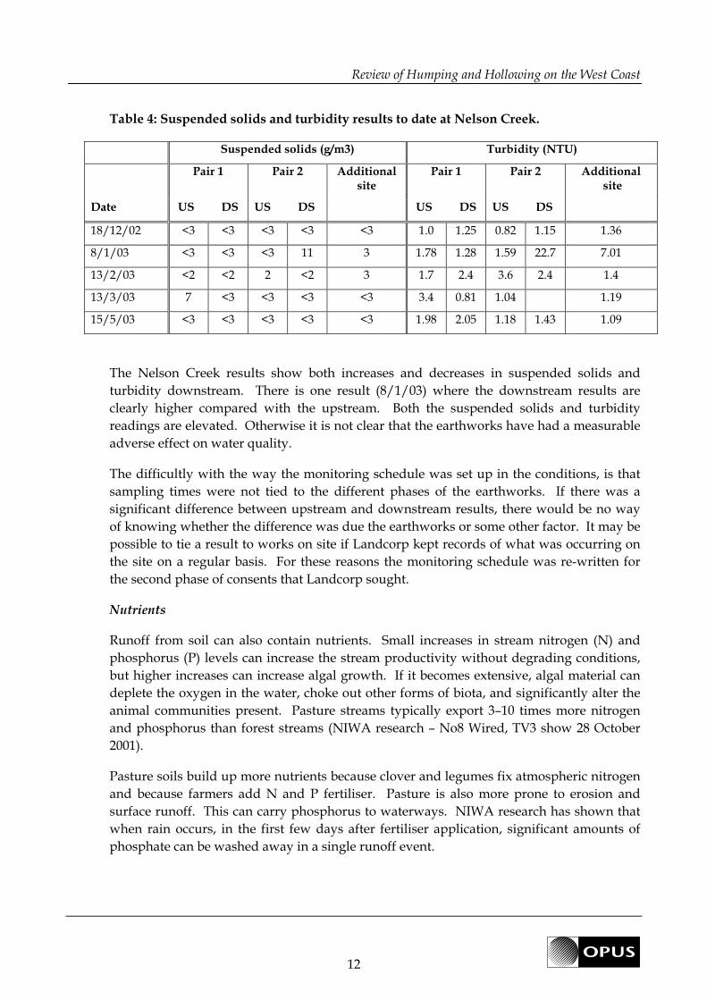
Table 4: Suspended solids and turbidity results to date at Nelson Creek.
Suspended solids (g/m3) Turbidity (NTU)
Pair 1 Pair 2 Additional site
Pair 1 Pair 2 Additional site
Date US DS US DS US DS US DS
18/12/02 <3 <3 <3 <3 <3 1.0 1.25 0.82 1.15 1.36
8/1/03 <3 <3 <3 11 3 1.78 1.28 1.59 22.7 7.01
13/2/03 <2 <2 2 <2 3 1.7 2.4 3.6 2.4 1.4
13/3/03 7 <3 <3 <3 <3 3.4 0.81 1.04 1.19
15/5/03 <3 <3 <3 <3 <3 1.98 2.05 1.18 1.43 1.09
The Nelson Creek results show both increases and decreases in suspended solids and
turbidity downstream. There is one result (8/1/03) where the downstream results are
clearly higher compared with the upstream. Both the suspended solids and turbidity
readings are elevated. Otherwise it is not clear that the earthworks have had a measurable
adverse effect on water quality.
The difficultly with the way the monitoring schedule was set up in the conditions, is that
sampling times were not tied to the different phases of the earthworks. If there was a
significant difference between upstream and downstream results, there would be no way
of knowing whether the difference was due the earthworks or some other factor. It may be
possible to tie a result to works on site if Landcorp kept records of what was occurring on
the site on a regular basis. For these reasons the monitoring schedule was re-written for
the second phase of consents that Landcorp sought.
Nutrients
Runoff from soil can also contain nutrients. Small increases in stream nitrogen (N) and
phosphorus (P) levels can increase the stream productivity without degrading conditions,
but higher increases can increase algal growth. If it becomes extensive, algal material can
deplete the oxygen in the water, choke out other forms of biota, and significantly alter the
animal communities present. Pasture streams typically export 3–10 times more nitrogen
and phosphorus than forest streams (NIWA research – No8 Wired, TV3 show 28 October
2001).
Pasture soils build up more nutrients because clover and legumes fix atmospheric nitrogen
and because farmers add N and P fertiliser. Pasture is also more prone to erosion and
surface runoff. This can carry phosphorus to waterways. NIWA research has shown that
when rain occurs, in the first few days after fertiliser application, significant amounts of
phosphate can be washed away in a single runoff event.

Review of Humping and Hollowing on the West Coast
13
The discharge permits issued along with land use consents for H&H relate only to the
discharge of sediment. While any soil eroded will contain a level of nutrients, the question
is whether the effects of nutrient runoff from H&H is more closely related to the runoff
resulting from fertiliser application. If this is the case the Regional Council permits the
application of fertiliser to land under Rule 12 of the Regional Plan for Discharges to Land.
To be permitted the application of fertiliser shall not contaminate water. How this
condition would be measured is unknown, but compliance with the Code of Practice for
Fertiliser Use would be a useful best practice tool.
Through the Sustainable Farming Fund the Ministry of Agricultural and Forestry has
funded a project being run by Landcare Trust called “Solutions from runoff from West
Coast land conversions”. The project is intended to:
• Determine the effects of humping and hollowing land management on nutrient
runoff;
• Provide practical solutions for mitigating nutrient runoff; and
• Interact with farmers to assess the social and economic costs and benefits of humping
and hollowing land conversions – informal interviews to gain good understanding so
that solutions are practical.
The project is still in its early stages with water sample analysis still in progress. Samples
are being taken from hollows. In addition, hydrological information is being collected with
weirs having been installed in hollows. The results of the study will be useful in
understanding the effects of runoff from land development.
The only monitoring data that has been reported to date is from the initial H&H carried out
by Landcorp at their Weka and Nelson Creek farms. The ammoniacal nitrogen, total
nitrogen and nitrate results are reported in Table 5 below.
Table 5: Nutrient results to date from Weka Farm.
Pair 3 – Weka E Pair 4 - Deep Creek
Date
Ammon-N
US DS
TON
US DS
Nitrate
US DS
Ammon-N
US DS
TON
US DS
Nitrate
US DS
8/1/03 0.01 0.009 0.009 0.01 0.01 0.006 0.087 0.005 0.087
13/2/03 0.02 0.007 <0.002
<0.01 <0.01 0.018 0.097 0.015 0.096
13/3/03
8/4/03
15/5/03 0.093 0.093 0.093 0.046 0.092 0.044 0.02 0.02 0.042 0.136 0.041 0.136
From the limited data above there appears to be no measurable increase in nutrient runoff
as a result of earthworks. It is important to note that while the dates the samples were

Review of Humping and Hollowing on the West Coast
14
collected on are known, it is not known what phase of the works where occurring at the
time.
As periphyton monitoring was also required at Nelson Creek and Weka Farm, this would
provide an additional indicator of whether there has been a change in nutrient
concentrations, as elevated levels of nutrients can increase the growth of periphyton.
The percentage cover of various groups of periphyton had to be measured using method
RAM 1 from the Stream Periphyton Monitoring Manual by Biggs & Kilroy, 2000. The
results from Nelson Creek and Weka do not suggest that there were any discernable
changes in periphyton.
Monitoring of periphyton presents a number of problems. Smaller ephemeral
watercourses are often dry, so periphyton cannot be monitored, and dry spells disrupt
growth. Before setting conditions that require periphyton monitoring it is therefore
important to know whether the watercourse is ephemeral. It must be remembered that
periphyton growth is also influenced by water temperature and flow. Higher temperatures
can encourage growth while changes in the flow can cause material to be dislodged. It is
for these reasons that the value of periphyton monitoring needs to be questioned.
5.4 Habitat
If H&H is proposed to be carried out within a water body buffer margin resource consent
is required as a discretionary activity under the PLRMP (Rule 8.1.3.2). A water body buffer
margin is an area of land of varying width related to land slope type adjacent to a water
body, which contributes to the maintenance and enhancement of soils and bed stability. It
is noted though that water body buffer margins do not apply to ephemeral water bodies.
Changes in the margins around waterways can affect instream habitat.
The terrestrial habitat also needs to be considered as the clearance of vegetation can alter
the habitat and biodiversity.
The habitat issues that need to be considered are:
• The reduction of wetland area can change the hydrology and reduce biodiversity.
Instream habitat
• lower base flows can result in loss of wetted bed area and potential loss of habitat
for aquatic organisms.
• the stream bed substrate composition can be altered.
• The discharge of fine sediment from soil runoff to streams can block up spaces
between stones in the creek. This would result in the loss of habitat for
invertebrates and fish.

Review of Humping and Hollowing on the West Coast
15
Riparian habitat
• loss of streamside vegetation and habitat for fish, as most fish require woody debris
in streams and whitebait need overhanging vegetation.
• the loss of riparian vegetation can change the natural character.
• riparian vegetation can provide a filter for sediment runoff.
Terrestrial habitat
• clearance of terrestrial vegetation can alter habitat and biodiversity, especially in the
case of remnant bush areas.
All the issues above relate to loss of or change in habitat.
It is usually ‘wet’ land that is H&H and some of these wet areas can be classified as
wetlands. Those wetlands that remain on the West Coast are at risk of being drained.
Farmers do not often see the ecological role that wetlands play. Wetlands can support a
wide variety of birds (particularly waterfowl), fish and plants. Another reason to protect
wetlands is to preserve the biological diversity of the area. Wetlands can be incorporated
into a developed by providing ‘treatment’ of runoff and storage. It is noted that the
Regional Council are currently compiling an inventory of wetlands.
The margins of water bodies play an important role in stream morphology, habitat and
overall stream condition. For these reasons buffer zones play an important role in H&H
practice. In avoiding potential adverse effects the requirement for a buffer zone is seen as
essential. In reviewing the consents issued date, the majority of them stipulate buffer
zones, or they have already been identified by the applicant and marked on the
development plan. It is also noted that a significant number of the H&H incidents
reported to the Regional Council refer to those who have not complied with buffer zone
requirements.
While the majority of H&H that has occurred to date has not involved the clearance of
indigenous vegetation, the West Coast District Plans contain rules covering the clearance of
vegetation. While a large number of resource consent applicants leave remnant bush areas,
there are instances where indigenous vegetation is cleared. The clearance of terrestrial
vegetation can alter habitat and biodiversity.
6 Cumulative Effects
Assessing the cumulative effects of any activity is not simple. The two key areas where the
cumulative effects of H&H will be more obvious are changes in hydrology and landscape.
As the percentage of individual catchments developed by H&H increases, depending on
the hydrological characteristics, there is the potential for changes in the catchment
hydrology. The greatest influence will be when wetlands are drained.

Review of Humping and Hollowing on the West Coast
16
The cumulative effects on the landscape will depend on the perceived values people have
of the area. This is not a matter that the Regional Council has direct jurisdiction over.
Records of consents issued should be kept up to date so that when making decisions on
resource consent applications the cumulative effects can be considered.
Without detailed information on the extent to which landowners are relying on the
permitted activity rule, any cumulative effects from this cannot be determined.
7 Resource Consents
7.1 Consents issued and trends
Resource consents issued over the last three years have been examined as part of this
review. As of June 2004, 35 consents for H&H have been issued and are current, 4 issued
and have already expired, and 11 applications are still being processed. A summary table
of the consents and a copy of the consents can be found in Appendix 2.
Approximately half of the consents issued are for areas covering less than 100 hectares.
Area Developed Number of consents
issued
> 200 ha 15
100 – 200 ha 6
50 – 99 ha 4
20 – 49 ha 6
< 20 ha 8
Table 6: Broad Locations of current and expired consents:
Area No. of consents
Karamea to Waimangaroa 2
Westport/Cape Foulwind 4
Inangahua/Reefton 2
Mawheraiti 3
Rotomanu-Bell Hill-Haupiri- Nelson Creek 14
Coal Creek 1
Kumara/Taramakau 2
Hokitika area 5
Harihari/Whataroa 5
Review of Humping and Hollowing on the West Coast
17
The largest scale H&H to occur is that by Landcorp. The following resource consents for
H&H have been issued to Landcorp:
RC02168, RC01300, RC03280 Weka Farm
RC01270, RC01302, RC03240 Nelson Creek
RC01299 Cape Foulwind
RC01267, RC01301 Mawheraiti
RC01269 Blair Farm, Bell Hill
RC03205 Mallinsons
RC03222 Raft Creek, Kokatahi
RC03259 Caroline Terrace
RC04023 Burkes Farm, Reefton
7.2 Information requests
Fifty percent of the consents issued had official information requests for further
information under section 92 of the RMA. Information required to process the consents
was also gained during site visits. A site visit is considered crucial to determining the
effects of the proposal and whether buffers and other mitigation measures proposed are
suitable.
As an example of the type of information that was being requested a copy of guidelines
produced in 2003 by Regional Council consent staff is in Appendix 2.
All s91 RMA requests for further consents were for discharge permits. It is noted that some
s91 requests include work associated with H&H such as culvert installation and stream
protection or realignment works.
7.3 Consent conditions
The level and type of monitoring, and prescriptive conditions that have been required as
part of consents issued over the last three years has varied greatly. The requirements have
included:
• the supply of work programmes;
• hydrological measurements pre- and post development;
• nutrients and periphyton monitoring;
• substrate, suspended solids, re-suspended solids, turbidity, and clarity monitoring;

Review of Humping and Hollowing on the West Coast
18
• implementation of sediment control devices;
• requirements for buffer zones;
• compliance limits specified but no monitoring required; and
• the need to meet s107(1)(c)-(g) of the RMA – after reasonable mixing test.
There is clearly a tier of requirements that are/have been used:
(i) large scale: work programmes, buffers, nutrient and periphyton analysis, substrate,
clarity, pre- and post development hydrological investigations, compliance limits and
a monitoring timetable. (Note: only two Landcorp consents have required this level)
(ii) as for (i) above but without the hydrological investigations;
(iii) medium-large scale: work programme, buffers, substrate, clarity, suspended solids,
compliance limits and a monitoring timetable;
(iv) no monitoring but specifies sediment control devices, buffer zones and compliance
limits; and
(v) no monitoring but specifies sediment control devices, buffers and compliance with
section 107(1) of the RMA.
The requirement for a work programme depends on the scale of the activity and term of
consent granted. The short term consents (1-2 years) do not necessarily require a work
programme as the H&H is usually completed in one stage.
The requirement for buffer zones and sediment control devices has been specified in over
90% of the consents assessed.
Examples of conditions can be found in Appendix 3.
7.4 Consent Compliance
To date little monitoring information has been supplied to the Regional Council. This
partly reflects the wording of consent conditions in requiring monitoring data to be
supplied on completion of the works. Monitoring information that has been supplied,
other than work programmes, is from Landcorp.
Compliance matters that need to be considered are:
• It is questioned whether the periphyton, substrate and suspended solids monitoring
on consents issued to individual landowners will actually be carried out. To improve
the chances of this happening a laymans guide to the conditions would be required
and follow up compliance monitoring by Regional Council compliance staff.

Review of Humping and Hollowing on the West Coast
19
• The key matter that needs to be considered when considering compliance monitoring
is the availability of staff and resources. Should compliance monitoring be
undertaken it is also suggested that the Regional Council prioritise consents.
• If someone makes a H&H enquiry to Consents, and the proposal is permitted,
information should be passed to Compliance staff.
• The Regional Council needs to be liaising with District Councils to avoid potential
conflicts over buffer requirements as differences in requirements can lead to non-
compliances.
8 Incidents
Incidents relating to H&H activities that have been reported from 2000 to now (April 2004)
have been analysed. There are 36 complaints that directly relate to H&H registered in the
Council’s incidents database (see Appendix 4). Of those that have an outcome recorded
against the complaint, the action required, or not, falls into four main categories:
(i) abatement notice issued;
(ii) consent to be applied for;
(iii) need for a buffer zone around a water body; or
(iv) compliant activity.
Council staff have stated that a significant number of the non-compliances resulted from
landowners being ignorant of buffer requirements.
The incidents do cluster around three main areas: Harihari, the Grey Valley and north of
Westport. This reflects the locations in which consents have been issued, but also the areas
in which dairy farming is carried out on the West Coast.
9 Summary
The Regional Council commissioned this review of H&H to considered the effects of H&H,
the resource consents issued by the Regional Council and monitoring undertaken.
The effects of H&H can be divided into four main categories:
(i) changes in hydrology;
(ii) changes in the soil profile;
(iii) effects of discharges to water; and
(iv) effects on habitat values

Review of Humping and Hollowing on the West Coast
20
Within these categories the effects are not isolated, rather changing one parameter can
influence another.
Of the 35 resource consents issued over the last three years for H&H the majority of the
applications relate to land in the Grey Valley with the largest scale development having
been carried out by Landcorp Farming Limited.
The consent conditions imposed and the monitoring information supplied to date suggests
that monitoring needs to be tailored to each application to ensure that data can be collected
and that it relates to the effect of the activity.
As H&H is an activity that will continue to be undertaken on the West Coast, the Regional
Council should consider developing a layman’s guide that inclues:
• information required to be submitted with consent applications;
• a summary of the effects of H&H on soil, water and habitat;
• best practice during earthworks; and
• how to undertake monitoring.
It is also recommended that records of consents issued are kept up to date so that when
making decisions on applications the cumulative effects can be considered.
10 References
NIWA (August 2003), The effects of humping and hollowing on the hydrological regime,
north Westland, NIWA report CHC2003-085.
Sinclair Knight Merz (August 2002), West Coast Farms Hump & Hollowing Project.
Assessment of Hydrological Effects at Mawheraiti Farm. Report prepared for Landcorp
Farming Limited.
Sinclair Knight Merz (February 2003), Cape Foulwind Farm Acid Sulphate Soils
Assessment. Report prepared for Landcorp Farming Limited.
Sinclair Knight Merz (October 2003), Hump and Hollow Consents, Assessment of Effects
on the Environment Weka Sheep and Beef Farm, Resource consent application prepared for
Landcorp Farming Limited.