research on early man in burma
TRANSCRIPT

TRANSACTIONS
OF THE
AMERICAN PHILOSOPHICAL SOCIETY
HELD AT PHILADELPHIA
FOR PROMOTING USEFUL KNOWLEDGE
NEW SERIES-VOLUME XXXII, PART III
RESEARCH ON EARLY MAN IN BURMA
HELLMUT DE TERRA and HALLAM L. MOVIUS, JR.
WITH
Supplementary Reports upon the
Pleistocene Vertebrates and Mollusks of the Region
EDWIN H. COLBERT and J. BEQUAERT
AND
Pleistocene Geology and Early Man in Java
HELLMUT DE TERRA
PHILADELPHIA
THE AMERICAN PHILOSOPHICAL SOCIETY
INDEPENDENCE SQUARE
1943

RESULTS OF THE
AMERICAN SOUTHEAST ASIATIC EXPEDITION FOR
EARLY MAN
Sponsored by
THE ACADEMY OF NATURAL SCIENCES OF PHILADELPHIA
THE PEABODY MUSEUM OF HARVARD UNIVERSITY
with assistance from THE AMERICAN PHILOSOPHICAL SOCIETY
THE CARNEGIE INSTITUTION OF WASHINGTON
THE MUSEUM OF COMPARATIVE ZOOLOGY, HARVARD UNIVERSITY

CONTENTS
I
Introduction........................................
PART I. THE PLEISTOCENE OF BURMA. By HELLMUT DE TERRA
Geographical Elements of the Region Physiography. ....................................
The Terraces of the Ancestral Irrawaddy............. Primary Land Surface ............................. The Shan Highlands. .............................
Climatology ........................................ M eteorological Data .............................. Weathering and Soils. .............................
D rainage ...........................................
Geological Observations in the Irrawaddy Basin The Irrawaddy Series................................
Definition and Stratigraphy ....................... The Problem of the Plio-Pleistocene Boundary........ Sedimentary Characteristics . ...................... Upper Irrawaddian Soils........................... Palaeontology ....................................
The Irrawaddy Terraces and Associated Soils........... Previous W ork. ................................... General Aspects. .................................. Terrace Sections.................................. Soils Associated with the Terraces.... ............... Extra-terrace Soils in the Irrawaddy Basin .......... Remarks on the Soils of the Dry Belt................
Observations in the Northern Shan Highlands Tilted Basin Formations ............................
The Structural Origin of the Basins................. The Superposition of Old and Young Pleistocene For-
m ations........................................ Pleistocene Fans and Terraces .......................
The Boulder Gravels and Terraces of the Namtu and Salween Rivers.................................
The Climatic Nature of the Terraces in the Shan Highlands...... .. .............................
The Pleistocene in the Shan Karst Region.............. General Aspect of the Karst Relief.................. The Mogok Karst and its Pleistocene Filling.........
Caves and Fossils in the Local Tradition........... Fossil-bearing Caves.. ........................... Sinks and Fissures ..............................
The Physiographic Cycle of the Karst............... Sedimentation and Correlations.....................
Basin Deposits ................................ The Origin of the Karst Gravel and Loam..........
The Pleistocene History of Burma in Relation to that of Neighboring Regions
Comparisons with India .............................. Comparisons with China . ............................ Comparisons with Malaya and Java...................
The Cyclic Nature of Pleistocene Stratigraphy The Origin of River Terraces ........................ The Glacial Cycle in Asia and Pleistocene Stratigraphy...
The Influence of Climate on Sedimentation........... The Climatic Conditioning of Soils During the Pleisto-
cene ................... ............ The Influence of Climate on Terrace Formation.......
PAGE
267 PART II. TIIE STONE AGE OF BURMA.
By HALLAM L. MOVIUS, JR. PAGE
Introduction................... .................... 341
Acknowledgments ..................... ... ........... 342
271 271 274 274 275 275 277 278
280 280 280 284 286 287 289 289 290 292 308 310 312
313 313
315 315
316
318 320 320 321 321 323 325 325 328 328 329
330 330 332
333 335 336
337 338
The Palaeolithic Period
Stratigraphy .............. .......................... Summary of the Terrace Sequence ................. The Archaeological Succession......................
The Sites. ......................................... Early Anyathian 1................................ Early Anyathian 2................................ Early Anyathian 3................................ Late Anyathian 1................................. Late Anyathian 2......... ........................
T ypology . ......................................... Raw Material. ................................... Nom enclature ....................................
The Early Anyathian Culture ........................ Early Anyathian 1 ............................... Early Anyathian 2-3 Implements of Fossil Wood..... Early Anyathian 3 Implements of Silicified Tuff......
The Late Anyathian Culture ........................ Late Anyathian 1................................. Late Anyathian 2 .............. ...................
Summary and Conclusions ............ .............
The Neolithic Period Introduction ........................................ The Archaeological Material .........................
Kyaukpadaung . ................................. M agwe .......................................... Yenangyaung.................................... Chauk........... ................................ Pagan and Nyaungu .............................. M inbu...........................................
Summary and Conclusions .........................
Reconnaissance in the Southern Shan States Introduction ........................................ Localities Investigated..............................
Mongta-W a-Ku ................................... Tin-Ain .......................................... Ahyu Taung ..................................... Pa-leng ................... ..................... H tam sang ...................................... M ong Paw n ..................................... Tongt .......................................... Kengtung ........................................
Summary and Conclusions ........................
343 343 346 347 347 347 347 348 348 348 349 350 353 353 353 362 372 372 372 374
378 380 380 382 382 384 386 386 386
387 389 389 389 390 390 390 390 391 391 391
Bibliography of Parts I and II ...................... 392
SUPPLEMENTARY REPORTS
PART III. PLEISTOCENE VERTEBRATES COLLECTED IN BURMA BY THE AMERICAN SOUTHEAST ASIATIC EXPEDITION FOR
EARLY MAN. By EDWIN H. COLBERT
Introduction ................................... . 395
The Pleistocene Fossil Beds of Burma .................... 395
265

TRANSACTIONS OF THE AMERICAN PHILOSOPHICAL SOCIETY
PAGE
Collecting Localities in the Pleistocene of Burma ............ 398 Lower Pleistocene ................................... 398 M iddle Pleistocene .................................. 401
Fossils in situ in Terrace T3 ........................ 401 Fossils from M ogok Fissures ........................ 401
Post-Pleistocene ..................................... 402 Post-Terrace Fossils ............................... 402 "Fossils" found in Superficial Cave Deposits .......... 402
K eng T ung ......................................... 402 Fossils of Unknown Age ........................... 402
The Pleistocene Vertebrate Faunas of Burma The Upper Irrawaddy Fauna as Found in the Upper Irra-
w addy Beds ...................................... 402 The Middle Pleistocene Fauna of Burma as Found in the
Caves at M ogok .................................. 417 The Middle to Upper Pleistocene Mammals of Burma as
Found in situ in the Irrawaddy River Terraces ....... 421
Post-Pleistocene Fossils
Mogok Surface Deposits in Caves .................... 422 Post-terrace Deposits ............................... 422
Fossils of Unknown Age ............................... 423
Relationships and Correlation of the Pleistocene Mammalian Faunas of Burma
Relationships of the Upper Irrawaddy Fauna ........... 423 Relationships of the Mogok Fauna .................... 424 Relationships of the Terrace Fossils ................... 425 The Correlation of the Pleistocene Mammalian Faunas
of B urm a . ....................................... 425
Bibliography of Part III ............................... 428
PART IV. FRESH-WATER SHELLS FROM CAVE DEPOSITS IN THE
SOUTHERN SHAN STATES. By J. BEQUAERT PAGE
L ocalities ............................................ 431 D escription of Shells ................................... 432
Bibliography of Part IV ............................... 436
PART V. PLEISTOCENE GEOLOGY AND EARLY MAN IN JAVA. By HELLMUT DE TERRA
Review of the Discoveries .............................. 437
Summary of the Data Bearing on the Investigations in Central Java ....................................... 439
The Beginning of the Pleistocene in Java ................. 439 The Lower Pleistocene Site of Modjokerto in Eastern Java. . 441 The Middle Pleistocene Sites of Pithecanthropus in Central
Jav a ............................................. 443 The Solo Plain in the Vicinity of Sangiran .............. 443 The Geology of the Sangiran Site ..................... 445 The Madioen Plain in the Vicinity of the Trinil Site .... 447 The Geology of the Trinil Site ........................ 447 The Age of Pithecanthropus and the Glacial Cycle ....... 450
The Upper Pleistocene Terraces and the Age of Solo Man The Geology of the Ngandong Site .................... 455
The Stratigraphic Position of the Palaeolithic Cultures of Java
The Sangiran Industry ......... ...................... 456 The Ngandong Bone Industry ........................ 457 The Early Palaeolithic of Patjitan ..................... 457
Java and the Question of Land-bridges .................. 459
Summary of Prehistoric Migrations to Java .............. 462
Bibliography of Part V ................................ 463
266

INTRODUCTION
BY HELLMUT DE TERRA
PROGRAM OF STUDY
At the International Symposium on Early Man, which was held under the auspices of the Academy of Natural Sciences of Philadelphia in March, 1937, a discussion was held on Fossil Man in Asia. It was felt at that time that the geological chronology of Early Man, which had previously been worked out in India under my direction, required further elucidation with special reference to an eastward extension into China and Java, so that the new data on human origins might be integrated. The greatest obstacle to such work was the lack of data, both stratigraphical and archaeological, in the regions lying between India and China on one hand and India and Java on the other. It was thought that Burma might fill this gap because of its inter- mediate geographical position, and also because of the recent finds of Stone Age tools and of Pleistocene ter- race formations in the Irrawaddy Valley.
Accordingly a plan was worked out by Pere Teilhard de Chardin and myself for an expedition to Burma and Java. Its chief objectives would be: (1) to establish a chronology for the alluvial formations of the Irra- waddy Valley, and (2) to collect new data on the Stone Age of this tropical land. Like India, Burma had long been known for its prehistoric antiquities. Numerous finds of artifacts had been recorded by former members of the Indian Geological Survey, particularly Noetling, Coggin Brown, Cotter and Pascoe. More recently AMr. T. 0. Morris, Geologist of Steel Bros., Ltd., had reported on finds of "Lower Palaeolithic hand-axes" and the occurrence of Pleistocene terrace formations. Hence Burma appeared to be promising in more than one regard, in fact it was to be expected, on the basis of the literature, that there we would encounter geo- logical conditions similar to those which had made possible a detailed analysis of the background of Stone Age man in India.
ACKNOWLEDGMENTS
The expedition plan when submitted to Mr. Charles M. B. Cadwalader, President of the Academy of Nat- ural Sciences of Philadelphia, was received with in- terest and approval. Through his sympathetic sup- port and that of Dr. E. B. Howard, then Curator of the Department of Palaeontology and Geology, appli- cation for financial aid was submitted to the American Philosophical Society at Philadelphia. Through its generosity a grant was made from the Penrose Fund on the condition that a similar grant be secured from
another source. This was supplied by the Peabody Museum of Harvard University, which offered not only to share the expenses of the geological party, but also to delegate at their expense Dr. Hallam L. Movius, Jr. as archaeologist to the expedition. These grants, one from the Penrose Fund of the American Philosophical Society, and the others from the Peabody Museum and the Museum of Comparative Zoology of Harvard Uni- versity, as well as from the Carnegie Institution of Washington, are gratefully acknowledged.
The project could not have been realized without leave of absence, both from the office of the Academy of Natural Sciences and from the Carnegie Institution of Washington, with which the expedition leader was associated. It gives me great pleasure to express my sincerest thanks to Mr. Charles M. B. Cadwalader and to Dr. John C. Merriam for their helpful consideration. A special grant from the Carnegie Corporation of New York through the Carnegie Institution enabled me to work out the results of this expedition in the course of 1939-40. An additional grant was made to cover expenses for illustrations in Part I and Appendix IV of this volume, which is herewith acknowledged with many thanks. I feel particularly indebted to Dr. Van- nevar Bush, President of the Carnegie Institution of Washington, whose unfailing support made the prep- aration of my part of this manuscript possible.
As on a previous occasion, Pere Teilhard de Chardin has given generously of his time and energy by joining this party for a duration of five months. It is difficult to express in words the admiration and gratitude which the expedition members entertain toward their distin- guished associate and friend whose encouragement and vision has been felt as a never-failing source of inspira- tion. He placed a brief summary of his observations at the disposal of the expedition leader which he felt should be incorporated in any form in this volume. This was done in the first part where some of the sections are to be regarded as the joint outcome of our co-operation in the field.
Thanks are also due a number of colleagues both in this country and abroad who have co-operated in vari- ous ways. All the expedition members remember with pleasure the aid they received from Dr. M. A. Heron, Director of the Geological Survey of India, as well as Mr. E. L. C. Clegg and Mr. E. J. Bradshaw of the Burma Division, who contributed to our undertaking by furnishing information on the region and introduc- tions to local officials. The Government of Burma most generously permitted travel in frontier regions; their liberal attitude towards our undertaking made it pos-
267

TRANSACTIONS OF THE AMERICAN PHILOSOPHICAL SOCIETY
sible for us to obtain the material which we were after. Various members of the Burmah Oil Company gave helpful advice and permitted the use of their bungalows. The co-operation of Dr. Edwin H. Colbert, Associate Curator, Department of Geology and Paleontology, Academy of Natural Sciences of Philadelphia, in study- ing the vertebrate fossils secured deserves special recognition.
Itinerary of the Expedition The expedition leader, Dr. H. de Terra, and Dr.
Hallam L. Movius, Jr. and Mrs. Movius met in Cal- cutta, on November 14, 1937. They then proceeded by steamer to Rangoon, and after a few days' stay the party left by rail for Prome where they took the boat. The steamer trip up the Irrawaddy to Yenangyaung was completed on November 23.
The first ten days of field work were spent in the vicinity of Yenangyaung and from there two excur- sions to the Mt. Popa volcano, near Kyaukpadaung, were made. On December 2 the expedition mem- bers left by steamer for Mandalay, where camp was established on the right bank of the river at Mingun. In this region a geological reconnaissance was made and quite a number of fossils were collected from the dissected hills west of the river. From here, Dr. and Mrs. Movius left on December 16 for the Southern Shan States with a plan of searching caves containing cultural deposits of the Pleistocene Period.
My own party proceeded to Mandalay and the North- ern Shan States on December 18. The trip was made first by steamer upstream to Thabeitkyin, whence we went by motor car to Mogok in the Ruby Mines Dis- trict. A week later we were joined by Pere Teilhard de Chardin. who had come directly from China. Jointly we studied the cave and fissure formations in the karst region around Mogok and collected a fair number of vertebrate fossils in Pleistocene deposits. Very soon we realized that a more detailed investiga- tion of the caves would not yield sufficient material to warrant a protracted stay, especially since the main problems had to be solved in the lowlands of the Irra- waddy. First, we paid a brief visit to the dissected slope of the Arakan Yoma Range, west of Minbu, and then proceeded to Magwe, south of Yenangyaung.
At Magwe we were joined by Dr. and Mrs. Movius oil January 15. They had coime from Kyaukpadaung where, on their return from the Southern Shan States, they had discovered an extensive Neolithic site. The terrace sequence and soils found on the higher land surfaces around Magwe gave the first clear indication of sediment and soil forming cycles of the Pleistocene Period. A joint search for Palaeolithic implements finally proved successful a few miles south of Yenang- yaung, near Sadaing. Further collecting of Palaeo- lithic tools made a longer stay for the archaeological party necessary, but the geological analysis of the ter- race sequence required the survey of as many transverse
sections as we could visit within the limited time at our disposal. This survey of Pleistocene terraces and older beds extended from Nyaungu, near Pagan, south to Sale and east to the foot of the Shan Highlands, south of Mandalay. We made daily excursions by car, there- fore we were able to cover most of this territory and see the majority of exposures. Favorable weather helped our investigations so that not a single day was lost. Meanwhile the archaeological party combed the hills and terraces for Palaeoliths, proceeding gradually upstream from Yenangyaung to Chauk and Nyaungu. Dr. and Mrs. Movius continued this work until March 8, when they broke camp and proceeded to Mandalay to pack their collections.
My own geological party left the lowlands on Feb- ruary 24, and traveled by motor car via Mayvmyo to Lashio, capital of the Northern Shan States. From here we made daily trips to all exposures of Pleistocene formations and Tertiary basin deposits, of which we found many in the Lashio coal fields. Two longer ex- cursions were conducted into the Salween Valley and the limestone plateau north of Hsenwi; through these trips we established the long sought-after contact with the border region of China. The return trip from here was made by car via Hsenwi and Mogok. An addi- tional stay of two days at the latter town enabled us to study the gem-bearing deposits at the village of Kathe, near Mogok, where the Pleistocene sequence of the karst region is especially well represented. When we returned to Mandalay, we were warned of the bubonic plague epidemic, which claimed hundreds of victims every day. We left town that very day for Maymyo, a hill station on the edge of the Shan Highlands. Here we packed our collections and expedition baggage. In the meantime Dr. and Mrs. Movius had completed their work and had left for Rangoon, where they embarked for Singapore and Batavia on March 17. My own party followed one week later.
EXCURSIONS IN JAVA
Our headquarters in Java were at Bandoeng, capital of the Preanger Residency and seat of various gov- ernment institutions, including the Geological Survey ("Dienst van den Mijnbouw") of the Netherlands East Indies. Here Dr. G. H. R. von Koenigswald intro- duced us to his colleagues, and to the problems with which he had come to grips during the last few years while searching for Fossil Man. Under his expert guidance we made an extended excursion to various sites where fossil human remains and Palaeolithic arti- facts have been discovered. The expedition members are under a great obligation to Dr. von Koenigswald and various Government officials of the Netherlands East Indies for their arrangements on behalf of our work in Java.
The tour led from Bandoeng via Madioen to Trinil
268

DE TERRA: INTRODUCTION
on the Solo River, and here we visited the famous site of the first Pithecanthropus fossil. From Trinil we proceeded downstream to Ngandong, the second most important Fossil Man locality in the Solo Valley; at Ngandong the fragments of eleven skulls and two tibiae of Hollo soloensis have been discovered. Next we saw the new Pithecanthropus sites near Sangiran on the Tjemoro River in the State of Soerakarta. From Soe- rakarta the route led to Patjitan in the Zuider Moun- tains, where Palaeolithic artifacts and Pleistocene fos- sils were collected. The last site which we visited jointly was near Modjokerto in eastern Java, at which locality we studied the Early Pleistocene beds that had
yielded in 1936 the infant skull of an extinct race- Homo modjokertensis. This general survey was sup- plemented by additional laboratory studies which Dr. and Mrs. Movius carried out in Bandoeng on Dr. von Koenigswald's very rich collections of Stone Age imple- ments. To him, Dr. W. C. B. Koolhoven, Director of the Dutch Geological Survey, and Dr. van Bemmelen, we are greatly indebted for the kind co-operation they extended to us while engaged in this work. Dr. Mo- vius' studies on the Palaeolithic of Java will be pub- lished elsewhere, but a resume of my geological observa- tions on the age of Fossil Man in Java will be given in Part V of this memoir.
269


PART I
THE PLEISTOCENE OF BURMA
BY HELLMUT DE TERRA
Plates I-XII
A. GEOGRAPHICAL ELEMENTS OF THE REGION
1. PHYSIOGRAPHY
The area with which this report is chiefly concerned lies between 20? 10' and 22? 15' N. lat. and 94? 45' to 96? 15' E. long. (Fig. 1). It coincides largely with what is known as the "Dry Belt" of Burma, a narrow strip of country extending from near Minbu in the south to Mandalay on the north, and comprising the lowlands of the Irrawaddy Valley. The extraordinary width of these lowlands adjacent to the Irrawaddy River, which at places amounts to more than 100 miles, justifies their being called a "basin" in this report. This basin is located between the Burma coastal ranges repre- sented by the "Arakan Yoma," and the Shan Highlands. The latter are commonly referred to in literature as the "Shan Plateau," but this term seems hardly appropriate for an elevated land surface possessing greatly differ- entiated relief. The elevation of the basin is about 300 feet above sea level; it slopes perceptibly from north to south at the rate of 1.6 foot per mile over a distance of 400 miles. At the mouth of the Irrawaddy delta, the basin passes into a submerged estuary which is part of the Gulf of Martaban (Fig. 1).
A glance at the topographic map of Upper Burma (Fig. 2) discloses that the Irrawaddy Basin possesses a varied relief. A median ridge, the so-called "Pegu Yoma," divides the basin into a western depression oc- cupied by the Irrawaddy River, and an eastern valley drained on the south by the Sittang River, and on the north by a small tributary of the Irrawaddy. This ridge is of great importance and interest because of its comparatively recent origin. Where the basin widens, this ridge splits into several groups of hilly ranges, many of which coincide with anticlines in Tertiary and Lower Pleistocene rocks. Such an anticline can be seen near the confluence of the Yaw and Irrawaddy Rivers where the Thagyi Hills build an asymmetrical anticline of Old Pleistocene beds (Fig. 3). Farther to the northeast the Shinwadaung Hills rise above the Chindwin Valley flats, and between them and the Mu River there is an- other lesser ridge. Farther north, near Mandalay, the Sagaing Hills accompany the Irrawaddy River from Sagaing northward to the Katha District. Thus there are four ridges, in addition to the Pegu Yoma proper,
none of which attain a height in excess of 2500 feet. These smaller folds are elevated to a much greater
height wherever volcanic rocks are involved in their younger structure. The Pegu Yoma is surmounted by a graceful volcanic cone rising approximately 4,000 feet above the adjoining land. Mt. Popa (P1. I, Fig. 1), and similar landmarks of igneous activity, cluster around the various folds of the Pegu Yoma structure, with which they appear to be related in origin. The south- ernmost of these volcanic areas falls within our terri- tory, and it is of some importance in view of its silici- fied tuff deposits, which furnished part of the raw mate- rial for the later Stone Age races of Burma. Such suitable rocks are encountered in the vicinity of Kyauk- padaung and Mt. Popa (Fig. 1). To the north, in the neighborhood of Monywa, in the Shinmadaung and Shwebo Hills, and in the northern extension of the Sagaing Hills, volcanic craters and lava flows con- tributed their share to the relief-making of the Irra- waddy Basin. The drainage of the basin was in many instances forced to adjust itself to such new obstacles and landmarks as the young volcanicity placed in its way. This is illustrated by the great bend which the Irrawaddy stream makes north of the elevated volcanic structure of the Pegu Yoma.
(a) The Terraces of the Ancestral Irrawaddy
A special feature in the relief of the Irrawaddy Basin is seen while travelling by steamer upstream toward Mandalay. Here one notices the presence of wide, even flats some 30 to 400 feet above stream level (PI. V, Fig. 1; P1. VII, Figs. 1 and 2). They stretch along the left bank up to the higher slopes of the Pegu Yoma. Downstream, especially in the vicinity of Prome, Thay- etmyo and Magwe, it is difficult to recognize in these wide, level surfaces ancient stream terraces. How- ever, from Magwe on upstream the river has cut steep bluffs into the half-consolidated sediments of the Plio- cene and Lower Pleistocene rocks, and it is here that one may clearly recognize a wide terrace, dissected by small tributaries, always gaining in prominence north- ward. At Singu, Chauk and Pagan, this surface is many miles wide, and below it another level appears, which is built of red gravel and sand, in contrast to the upper level on which there seems to be only a thin veneer of coarse boulder gravel and sand. These two
271

_ _._ 94' 95' 96- 97' 98' 99' 100'
~~~~ ~~Hsenwi_~
23-- o ^ ^ ^ ^/>7M.ngm- ^O,,,:y 'iti c -/ /ThabeitkOin --oRT7 SHAN TSPATES
Kabwet * mpong
1% \,ShweboJ|) ^ ^Hsipau ' \ (
wvath^ Sine / y I
\ ^ /*
:~L ^ \ / .-A - ) I a -.. ,^MnyaiJ lw
Monywa k~... 227 Mng-N maymyo
NiY?o 0- f tb. F
'C r~ '\. '
N. f "?andal. a'"-
^. ^^y r^ n Sa,^r 2?{'' SOu H R !':H'_ T G S w
5~~~~~~~~~~~~~~~~~~-, S ̂ w^^ ) ^r^T^^ Kaukse
Myingyan .Pakol k
'/'"-Pakokk~
r?
~4` 41c~Kengtung ,, ,.. . , - ,, yaunguu
Paz- Yenangya
Lo M^^ ^ Yenang'yating ( v , S HAIN S T \ /T kE S
jkpadaug Ate iia -j / ^*
$,lino^~~~ Th e in
Aingmongoe^ ^ | </~9 ;4 nman 19,~~~~~~~~~~~~~~~~~~~~~~~~~~?
Ton IT
Aingm ~ ~ roe Cenma
-- i;gnbaungwe
i %....,.~.."/%' '~; G, .'
,,/' '~ ~ c 'nana ) i/
"'i~ii' ~ , . ~I.ARE) i '.
~~~~~~~~~~~~~~~~~~~~~~~~~~~~~~~~~~~~~~~~?' = 1D'~~!/:~. ~.
~
Toungoo. -1?
- '.v-me ,oChienflmai
PV~~~~~~~~~~~Pg
a?~~~~~~~~~~~~~~~~~~~~~~~~~~~~~~~~~na
.......o' CEYLON
4'~~~~~~~~~~~~~~~~~ : s
?~o .\ ':' I
~ '~~~~~~~3' \ ~ ~~~ S I A~ M
'-:.', ~~~~~~~Pe?u , ":'
'~ TIBET C H J N A
i ~~~~~~~~~~~~~~~~~~~~~~. . .
....
r~~?=? ? ? ?. Madras~~'"
::': V\olmin \ I.D~ ^ 2ZJ iifi: ~ ~ ~ ~ ~ ~ Cluta J ] ,
-LEGEND-
?f XXP^ X G zzu lf o-- Route of the Expedition
?-67 ~'3~5~:~:=? ~if~: :? :;?:?. ir it g a r t a b a n a Scale, - 16' 94^^J^/^^^~~~~~~~~~~ (D, ,-etc., --Terrace Sections
'' ' .?.. ? ^ : ?-. ? 0 20 40 .60 80 100 Miles ^ -y ^ , , -4 T"""" , '' ^. 94. 95' 96' 97T 98' 99' 100'
FIG. 1. Map of Burma, Showing the Routes Traveled by the Expedition and the Pleistocene Terrace Sections Investigated in the Irrawaddy Basin.
272

DE TERRA: THE PLEISTOCENE OF BURMA2
surfaces can clearly be followed over great distances upstream, and at many places a third level appears being above the high floodmark of the river. This charac- teristic is shared by the other two levels, which suggests that they also are abandoned stream levels of the ances- tral Irrawaddy. From the boat one observes how the upper two levels are associated with coarse red gravel, whereas the lowest is built entirely of red and yellow silt. This distinction is important inasmuch as the pres-
ent river deposits only fine-grained matter. Hence it seems probable that the lowest terrace is of sub-recent origin, and that the other two are much older.
From above, the upper valley flanks in this region, i.c. the widest of our three levels, present a complex relief (Fig. 3). There are isolated and rather prominent hil- locks, as at Chauk (P1. V, Figs. 2 and 3), surrounded by greatly dissected and often evenly levelled hill coun- try. Such hillocks maintain rather even levels, the up-
01020 40 60 80 100 10 140 160 180 200 I -..,- 1 -
) I= Miles
FIG. 2. Outline Map of Upper Burma and Neighboring Regions, Showing Topographical Features.
273

TRANSACTIONS OF THE AMERICAN PHILOSOPHICAL SOCIETY
per ones being less uniform than the lower dissected prominences. One cannot help but feel that this relief has passed through a prolonged or at least rapid stream history, which succeeded the deposition of that great valley formation into which the present river has cut its meandering course.
(b) Primary Land Slurface
Between the river terraces and the ridges of the Pegu Yoma there exists in the Dry Belt an intermediate sur- face, which the casual observer might take for a pene- plain, although it is by no means of uniform elevation. In fact, ridges and hills appear to form a part of this
X53 ~ ~ land surface. These are unconsumed portions of re- .er? ~ sistant rocks rising above this level, called by some a
plateau and by others a peneplain. A simple analysis shows that it is neither of these. Thinly covered with
u:=rcn ~ a sporadic veneer of laterite soil, this hilly upland sur- *'a^ ~ mounts the terraces by hundreds of feet and near Mt.
o Popa by over a thousand feet. Obviously its origin '5=~ ~ preceded that of the terraces, and it may well go back ....=1 ~ to the time when the latest folding of the hill ranges took 3|0 ~ place. The underlying Upper Irrawaddian Beds do not
form a part of this surface. They appear to be re-
?.5", ~ stricted to ancient stream channels, a fact suggested by their restricted presence in synclinal folds. As far as
;>,^ the Irrawaddy Valley is concerned, it can be shown -c=^ ~ that the topmost beds of this formation occur only in
synclines, which suggests that the upland originated P. prior to their deposition. Hence the elevated and de- u formed primary surface must have developed in a time
c=^ ~ span between the Lower and Upper Irrawaddy beds
'g~: ~ (Pontian to Early Pleistocene). u
?oE~~~ c(c) The Shan Highlands
The eastern flank of the basin bears all the character-
:o^ ~ ~ istics of a fault-scarp (P1. II, Fig. 2). It rises rather v) abruptly to a height of three thousand feet, and its
-n~g ~ youthful tectonic history is revealed by bold precipitous ? slopes, indicating considerable vertical displacement.
'b~Q ~ Rivers descend over it in gorges, and while their origin 03 is often connected with fault lines, it would appear that
many of them were caused by stream capture in an an- <c^ cjcient karst topography developed on marble and lime-
stone rocks. In the valleys, terraces are found which in many instances appear to correspond both in number and in composition with those flanking the Irrawaddy River. Here in the Shan Highlands alluvial fans and talus formations are frequently encountered, particularly in depressions in the karst relief. Such formations give rise to a restless and irregular surface, probably the most characteristic feature of this mountainous upland. The undulating relief gives way locally to intermontane basins, such as at Lashio, and it is here that we may encounter Late Tertiary and Pleistocene lake and stream beds (P1. XI, Fig. 4). The Salween-Irrawaddy divide
274
cn (L)
z
ac0
11

DE TERRA: THE PLEISTOCENE OF BURMA
extends into our region. Its barren summits rise up to 6000-7000 feet and fall abruptly to the Salween Gorge, through which flows one of Asia's most power- ful rivers. This watershed is not arranged in the same manner as the Arakan or Pegu Yoma, because the Shan Highlands are only part of a greater landblock extending deep into South China. This ancient land mass is built of a basal complex of gneisses and metamorphic rocks, above which lies a complexly folded series of marine limestones, shales and continental red beds, ranging in age from the Permian to Upper Cretaceous. This great variety of rocks makes for a wide range of landforms. Outstanding is the karst, most typically developed in the marble belts of the so-called "Mogok Gneiss Series" (P1. XII, Figs. 1 and 2). But karstification has af- fected also the Late Palaeozoic and Cretaceous marine limestones. The former are apt to stand out in bold escarpments where very impressive gorges are devel- oped. Dense forests, of both hardwood and bamboo, cover the Shan Highlands, and accordingly exposures are rare and penetration is difficult. This green verdure of forests (P1. I, Fig. 2) contrasts remarkably with the dry grassland vegetation of the Irrawaddy Basin, which reflects the opposition of the two geographical re- gions as determined by climate.
2. CLIMATOLOGY
Burma lies in the path of the Southwest Monsoon, which means that for five months of the year heavy tropical rains fall over the Irrawaddy Basin and the adjoining highlands (Fig. 4). The moisture-bearing storms enter our region via the Irrawaddy delta and also across the Coast Ranges in the southwest. In the latter instance a good deal of moisture is lost over the wooded mountains that rise up to 10,223 feet in height, such as Mt. Victoria (Fig. 2). When the storms reach the Irrawaddy tract in Upper Burma, there is relatively little moisture left. The result is a broad stretch of dry land, reaching from the foothills of the Arakan Yoma to the opposite side of the valley at Mandalay. Here the Dry Belt is widest, while southward, about 100 miles from its greatest width, it wedges out in the region south of Magwe (Fig. 4). Here it is only about ten miles wide; farther south at Prome, it is practically non- existent so that tropical verdure here covers the entire width of the valley. In other words the Dry Belt makes a triangle, the apex of which is pointed southward. A glance at the map suffices to understand this peculiar position of the Dry Belt. It is widest where the western mountain rampart, the Arakan Yoma is highest, and its apex lies near the end of the higher country to the west. Another factor which doubtless accounts for this ar- rangement is the drying effect which the valley exerts on the monsoon storms as they proceed upstream from the coast. Thus Burma repeats in all essential features the same type of climatic zoning as that which charac- terizes the northwestern portion of India.
Now the great advantage connected with working in the Dry Belt is the sparse vegetation, allowing favor- able geological observation and unhampered surface col- lecting (PI. VIII, Figs. 1-4). It is this feature which accounts largely for the finds of fossil and archaeological material that previous students have discovered in this field. For a tropical land such a dry belt offers a rather unusual set of circumstances conducive to quick recon- naissance and general survey work, such as we under- took during the winter season of 1937-38.
Meteorological Data
The meteorological conditions found in the Dry Belt of Upper Burma can be appraised through the records of three stations. At Mandalay annual precipitation amounted to 515.9 mm., at Yenangyaung 571.5 mm., and at Minbu 809.3 mm. for the year 1930. These low rainfall figures are in marked contrast with those regis- tered from the adjoining Shan Highlands, which rise 2600 feet above the dry belt. During 1930, Mogok registered 2541.3 mm. and Lashio, at 2802 feet, 1553.8 mm. (Fig. 4). About 80 per cent of the total annual rainfall occurs between the months of June and Sep- tember, as shown in Fig. 5; only 15 per cent falls during the winter months of December and January. This means that Burma enjoys a prolonged dry period lasting from October until the end of April. This dry period is of great importance for an understanding of certain soil-making processes in the Dry Belt. It is the season of gradual desiccation, of large diurnal temperature fluctuations, and of dust storms. All of these factors are active on the vulnerable shale and silt-sand forma- tions which underlie the Irrawaddy Basin.
The average diurnal temperature changes for the year 1930 were 11.87? C. at Minbu, 11.83? C. at Mandalay and 12.56? C. at Lashio (Shan Highlands). Other records for the same stations show the following varia- tions:
Minbu Mandalay Lashio
Jan. Febr. July 16.44 16.9 7.83?C 15.61 16.65 8.73" 16.72 16.83 7.94"
(27.44) (27.11) (21.67)
The mean annual temperature is given in brackets. The 0? C. isotherm lies between 13,000 and 16,000 feet, and the lowest temperature at Lashio was 0.5? C. over a 25-year period. Inhabitants of this picturesque moun- tain town told me of occasional snow flurries during the winter season. These figures suggest that physical weathering is most active in the winter. In March, temperature rises quickly in the Dry Belt and reaches its maximum in May shortly before the rains come. March and February are the driest months, July and August the wettest. Solar radiation is not at all con- stant over the lowland, as has been stated by Stein (1931). In December and during the first half of January the sky may be cloudy for a week at a time.
275

TRANSACTIONS OF THE AMERICAN PHILOSOPHICAL SOCIETY
96
-LEGEND- 240' Altitude in feet b Volcanic regions -L.- Fault Scarp (Pliocene-Pleist)
1000mm. Annual rainfall (1930)
Scale ? 50 00 Miles
%,.
1553 mm. o Lashio
2802'
Co
oTaunggyi
18
of Co
B e g al
of M a.r t a}ll
96
FIG. 4. Map Showing the Contrasts in the Distribution of Rainfall between the Dry Belt and the Shan High- lands. Arrows Indicate the Direction of Monsoon Storms.
276
..!
a. :

DE TERRA: THE PLEISTOCENE OF BURMA
100"-
90*-
80*-
70-
60'-
50-
Jan.
Annual Rainfall, 1933
June
Annual Temperature, 1933
FIG. 5. Annual Rainfall and Temperature Charts for Mandalay (Solid Line) and Lashio (Dotted Line) during the Year 1933.
January until March is the period when clear skies pre- vail and radiation is most intense.
Wind velocities are greatest in the beginning of the monsoon season (June-July). As in northwestern India, there is a regular period of dust-storms herald- ing the onslaught of the monsoon. Storm tracks lie in the Irrawaddy Valley and move both from north to south and vice versa. In March and April these sand- storms may be so violent that they blot out the landscape for days at a time. Then a curtain of suspended silt three thousand feet high hangs over the Dry Belt; often this is not precipitated until the rains come. This is the same process which I had previously observed in north- western India, and which in my opinion is one of the chief agents for mass precipitation of silt or "pluvial loess." I consider that this phenomenon is largely re- sponsible for the formation of extensive Pleistocene loess deposits in the marginal zones of the monsoon rain belt. In a later section of this report I shall describe the role which this process played in the deposition of Late Pleistocene and post-Pleistocene silts.
Weatherilg and Soils
Periodic rainfall during the summer and intermittent showers in the winter months, combined with great diurnal temperature fluctuations and cool desiccating mountain winds, are the main factors of weathering in this country. To this we must add the friable nature of the bedrock, and the reason why so few mature soil profiles are encountered in the Dry Belt can be readily understood. At Yenangyaung for instance, one may walk for hours over perfectly bare rocks with only small patches of red soil preserved at the highest levels. These bare rock surfaces resemble the pediments formed by a constant lowering of the primary basin surface to which reference is made on p. 274.
Physical weathering produces cracking and super- ficial crumbling of the solid rocks. The dry topsoil is either removed by the first summer rainfall, or it is distributed by winter showers over rills and sloping sur- faces. From here the loose surface soil either creeps downhill or is blown off by dust storms, since, with the
lack or great scarcity of vegetation, erosion is rapid and soil movement very active. While the silt components are blown from the surface, the coarser talus remains, only to be broken up under the impact of the agencies mentioned above. And yet in gullies and dry stream- beds one encounters large quantities of talus, incrus- ted with hydrated ferric oxides and completely leached inside. In areas with poor drainage and lime-bearing rocks, hardpan and concretionary soils are commonly found. Especially on the silty red soils of Pleistocene age and on such wind-blown deposits as the "Pagan Silt" (see p. 309) the slopes are covered with small pellets of lime, reminiscent of the "loess kindeln" or the Indian "kankar" (P1. VIII, Fig. 3). Generally the pellets are the size of a pea, but locally they may be as large as walnuts, and they form regular talus fans along the lower slopes of the gullies. It is doubtful whether they are all of recent age, or whether they had started to form during a previous period when the Dry Belt may have been even more arid than it is today. The post-Pleistocene eolian red silts, which I frequently en- countered on the higher surfaces of the Pegu Yoma slopes, indicate such a drier period during which pan soils may have formed to greater extent than at present. Such fossil "kankar" soils may be distinguished from recent pan soils by the red patination commonly found on the pellets.
On the terraces weathering products vary greatly ac- cording to the prevalence of silt or gravel components. The latter disintegrate on the spot, usually by thermal fracture, leaving a sharp angular talus from which the finer material is blown off by storm winds. However, there are no real "stone-armours," such as occur in true semi-arid or desert regions. No ventifacts were found although desert patina was seen at several places, invari- ably on silicified tuff. The arid season is presumably not long enough and the vegetation too effective to pre- vent surface deposition of silica gels.
Lateritic soils are restricted to higher surfaces, and here it is often impossible to say whether the soil is of recent or of older date. Perhaps the paucity of laterites in the vicinity of the river, and their occurrence on
Mandalay Lashio ..............
.. .. I I I
II I I I???? ?
277
Dec. . I I I I I I l I

TRANSACTIONS OF THE AMERICAN PHILOSOPHICAL SOCIETY
higher tracts over Pleistocene terrace formations, indi- cate that the majority of these soils was formed under different climates. These may have been as rainy within the basin as in the Shan Highlands to-day.
In the Shan Highlands red earth and laterite are the most common soils. They are very conspicuous in the bamboo-covered regions and in the teak forests. In fact on the road from Thabeitkyin to Mogok one does not encounter lateritic soils until the edge of the forest is reached, which is also the border of the rain-belt along the slope of the Shan escarpment (Fig. 4). This asso- ciation between red earths and forest is unquestionably one which is connected with the retention of moisture through foliage on one hand, and the general increase of moisture on the other. Dense bamboo jungle and evergreen underbrush tend to increase the capacity of the foliage to retain rain water temporarily, both in the foliage and in the upper soil layers. Thus a fairly even and long-lasting soaking results which must speed up the formation of red earth.
Between the Dry Belt of the basin and the forested Shan Highlands there is a narrow belt with an inter- mediate rainfall. Here hard pan soils and concretion- ary limy soils are encountered. During the winter they receive little of the moisture that falls in December and January, because hard, dried leaves of teak, iron- wood, Bombax and other large trees seal the soil from above.
In general, it may be stated that in the Shan area the evergreen forest goes with a red loam type of soil. The red loam or red earth is commonly five to seven feet thick, but it may locally accumulate near the valley flats to a depth of thirty feet. How much soil-creep there is on the slopes is difficult to say. Judging from the scarcity of landslide-scars on hillsides, and taking into account the considerable thickening of these soils at the base of the hills, I should think that there is some soil-creep, but not much landslide formation. The thickest cover of red earth which I saw was in the vicinity of Mogok in the Ruby Mines District (P1. XII, Fig. 3). From here on westward toward the Shan border escarpment, the soil is uniformly thick, this being the area of maximum rainfall during the summer months.
In addition to these recent red soils, there are in many valleys of the Shan Highlands buried fossil soils. A great many organic soils were encountered near Mogok in the karst depressions. In other instances, I found lateritized fanglomerates and gravel-fans overlain by lake and stream deposits. Again underground, in sink-holes, pits and caves, ocher-colored powdery soils are encountered. These will be described in greater detail in a later section.
Physical weathering has also played a part in the soil- making process of these highlands. Cool nights and hot days make for considerable temperature changes. At altitudes of 5,000 feet or more there are freezing teml-
peratures for weeks at a time, and their effect is par- ticularly evident on shaly and slaty rocks. Even at Mogok (3,200 feet) our tents were coated with frost every night during the second half of December. Here snow flurries are said to occur every other year.
It is scarcely possible to understand completely the genesis of soils and the former sedimentation processes in these regions until we know more about the activities of streams in Upper Burma and about the drainage pattern of the country.
3. DRAINAGE
The masterstream, the Irrawaddy River, or "elephant stream," originates from the confluence of two large rivers which descend from the alpine heights of the Tibetan Plateau. They are the Nmai Hka, and the Mali Hka (compare Bouterwek, 1919, pp. 298-306). The confluence occurs approximately 30 miles north of Myitkyina (Fig. 2). The major confluent is the Nmai Hka which takes its source from the Languela glacier in the snow-capped Tila miassif north of Fort Hertz (27? 24' N. lat.). Kingdon Ward (1924) mentions that the headwaters of this river drain an area of about 450 square miles which is over 15,000 feet high. The snow-line is at about 15,550 feet, the same level as in the sub-Himalayas of Kashmir and the Punjab in India. Winter snow descends here to 6,500 feet and remains on the ground until April and May. The same ex- plorer (1912) maintains that the divide between the Irrawaddy and Salween streams receives the heaviest rainfall of all the mountains in Yunnan, a fact which is important to remember when we come to interpret the meaning of ancient flood deposits in the Lower Irra- waddy Basin. Near Hpimaw (26? N. lat.), Kingdon Ward observed large snowfields at heights of 10-12,000 feet during the month of July. In other words the headwaters of the Nmai Hka River receive greater rainfall and snow water than do the other neighbouring streams.
The annual discharge of the Irrawaddy River tells the story of a powerful stream carrying a load of 400 million tons of sediment, with an annual discharge of 524 million cubic meters, and an extreme high flood discharge of 2 million cubic feet per second during the year 1877. In comparison, the Mississippi has an an- nual discharge of 544 million cubic meters. Gordon (1885) has stated that during the month of August 22 per cent of the total discharge occurs, and that 73.11 per cent of the annual sedimentation takes place within four months (July to October). He estimated the rate of denudation within the drainage area of the Irrawaddy at one foot of surface elevation during 412.9 years, which is about seven times as fast as the erosion rate computed for the Mississippi drainage!
Such figures illustrate vividly the erosive power in the Irrawaddy Basin. Obviously the main force of the river is produced by the monsoon rains. In other
278

DE TERRA: THE PLEISTOCENE OF BURMA
words the load which this stream, together with its tributaries, carries to the sea is chiefly produced by a particular type of climate that is conducive to the de- nudation and accumulation of fine-grained sediment in the lower valley tracts and delta regions.
In flood the Irrawaddy rises 15-20 feet in the Man- dalay region, which is some 400 miles north of the delta, and at the so-called "third defile," near Thabeit- kyin, the stream may rise 25 feet above the mean average. The bench-marks of these high flood-levels can be clearly seen along the river banks. They are marked by pebble or sand layers full of weeds, woody delris and fresh-water clams. In computing my ob- servations on the levels of ancient stream terraces, I adopted a mean 0-point at 15 feet below such high water-marks as I could see on the banks. This task was greatly facilitated by the fact that between Novem- ber and April the stream level undergoes very little vari- ation, permitting one to calculate an average mean for the area between Magwe and Mandalay.
At present the river meanders along approximately one hundred feet below the level of the widely dissected terraces (P1. II, Figs. 1 and 2). In this manner it breaks up great portions of the little consolidated sand- rock underlying the basin. After each high flood the course of the stream changes a little here and a little there, breaking up older sandbanks and building new ones at the next bend downstream. This constant shifting of river banks has caused widespread denuda- tion of the ancient terraces. As the stream meanders it tends to swing toward the west, following the great westward bend in its course below Mandalay. Hence very few if any terrace remnants have been preserved on the right bank.
At present the river carries mainly fine sand and silt in the region of the Dry Belt, and with it a good deal of woody debris, most of which is derived from the middle course and its three "defiles." In these the forested hills are undercut by the stream, so that the natural forests along its banks fall prey to erosion; it is known that floating tree-trunks and branches have been carried out to sea two hundred miles or more. The stream-channel varies greatly in width from three and a half miles at Mandalay to five miles at Yenang- yaung. Here as elsewhere, it is braided in a wide flood plain strewn with sandbanks on which the Burmese vil- lagers establish temporary winter settlements (P1. II, Fig. 1). On these sandbanks rice can be planted sev- eral times before the flood season begins in July, and it is this rice which is particularly rich in flavor.
There are three main types of stream sediment: (1) micaceous, brown silt mixed with small amounts of volcanic ash, derived from the eroded tuff and ash layers upstream; (2) fine, current-bedded sand containing coarse layers and fine lenses of silt, usually rich in or- ganic matter; and (3) pebbly sand with individual pebbles seldom reaching 1 inch in diameter.
Significant is the fact that no red gravels or silts are being deposited at present, in marked contrast to pre- vious times when these colored deposits dominated the valley floors. When dry, the silt is of light gray or yellowish color, and in this state it is swept up by the storm winds when they move upstream.
The second largest river in our region is the Sal- ween (Figs. 1 and 2). (In Burmese "Than-lwen" or "Dragon Stream.") Like the Irrawaddy, its origin is in the snow mountains of Tibet, and it carries a good portion of the monsoon precipitation back to the sea. In the same latitude as the Irrawaddy at Mandalay, the Salween is a boiling, fast-flowing torrent, some 3,500 feet below the Shan Highland divide. Its gradient is steeper than that of the Irrawaddy, being 1:500 as compared to 1:350 for the latter stream. During the rainy season the Salween is known to rise by 30 feet at a distance of 600 miles from the sea, while a few hundred miles from its delta the flood mark is sup- posed to be up to 90 feet above the average (Gazetteer of Upper Burma and the Shan States, Vol. II, Pt. 3, pp. 92 ff., Rangoon, 1900-1901). Owing to the steep- ness of the valley slopes, the Salween Valley has few terraces, as most of them have been destroyed by vigor- ous erosion. But terraces exist and are known from the Chinese border near Kunl6ng and Bhamo (P1. XI, Fig. 2).
The main tributary of the Irrawaddy is the Chindwin (Figs. 1 and 2), which rises near the Irrawaddy water- shed in the Kachin Hills (lat. 20? 40' N. and long. 97? E.). It flows due north as far as the Hukawng Valley; it then turns northwest until it reaches the edge of the valley, where it again turns almost due south. This general southerly course is followed to the point of its confluence with the Irrawaddy, approximately 10 miles northeast of Pakokku. Below Homalin the Chindwin receives one of its most important tributaries-the Uru River-which rises in the Myitkyina District of north- ern Burma.
The Namtu, another important tributary of the Irra- waddy, empties into the master stream near Mandalay (Figs. 1 and 2). Its headwaters descend from the Salween-Irrawaddy divide, only 20 miles distant from the Salween Gorge. From east of Lashio, the Namtu flows across the Shan Highlands in a deeply entrenched valley. Its chief characteristic is the winding shape of its course, with deflections at right angles and can- yons developing within a few miles from mature valleys. Its stream pattern is complex, and it suggests a very complicated history. While the upper course appears to follow the fault-pattern of the N.E.-S.W. strike, the middle and more tortuous course is completely dom- inated by the sink-hole topography of the limestone belt, especially in the "Plateau Limestone" area; the Gogteik Gorge (famous for its scenic beauty) is cut into such giant fissures and sink-holes. The irregular shape of the stream pattern in the Shan Highlands, with
279

TRANSACTIONS OF THE AMERICAN PHILOSOPHICAL SOCIETY
its labyrinth of intertwining rivers, is sufficient proof of our contention that this highland drainage is essen- tially derived from an ancient ill-drained karst land- scape.
On the right bank tributaries like the Yaw and Mu Rivers are slope streams of an antecedent type. Their lower courses are entrenched in normal folds of Late Tertiary and Pleistocene origin, while their middle and upper portions cut across the strike of the eastward-dip- ping marine Tertiaries, which form the slopes of the Arakan Yoma. None of these streams is of any great importance for our studies except the Yaw River, on whose banks I found a series of terraces reminiscent of those in the Irrawaddy Valley.
B. GEOLOGICAL OBSERVATIONS IN THE IRRAWADDY BASIN 1
I. THE IRRAWADDY SERIES
1. Definition and Stratigraphy
A fundamental and well-known characteristic of the Late Cenozoic formations in the Irrawaddy Valley is the sharp distinction between a younger sequence of undisturbed terraces and soils, with which the present drainage is connected, and a very thick older formation of tilted and little-consolidated sandstones and silts, commonly known as the "Irrawaddy Series." Each of these divisions must be considered separately in their
stratigraphic order. According to previous observations, chiefly those of
Noetling (1895), Pilgrim (1910), Pascoe (1912) and others, the 4,000 to 6,000 feet of the Irrawaddy Series ranges in age from the Pontian to the Villafranchian. The former are represented by consolidated sandstones, siltstones and shales containing the so-called Hipparion fauna (Lower Irrawaddies), and the latter by an upper division of conglomeratic sandstones and silts with the
younger Villafranchian fauna (Upper Irrawaddies). In the central portions of the basin, the contact with
the underlying marine Pegu Series (Oligocene to Mio-
cene) is disconformable, rather than unconformable. It is marked by a thin "red bed," about 5 feet thick, containing typical Pontian mammal remains. At the
only place where we could study this layer, it gave us the impression of being derived from an ancient lateritic soil. It does not differ essentially from similar beds
marking minor disconformities in higher sections of the series.
On the eastern border of the basin, near Mezali, 12 miles southeast of Pwynbyu (Fig. 1), Cotter (1938, p. 102) and Clegg (1938, p. 285) have reported the presence of thick gravel beds, almost 4,000 feet thick, which they place at the base of the Irrawaddy Series.
1 In this part the brief outline written by P. Teilhard de Chardin for use in the description of our joint observations is included.
But one wonders whether this considerable pile of coarse debris is not identical with the tilted. gravels ob- served by ourselves near Minbu (see p. 284). In this latter instance the gravel occurs at the base of a layer of overlapping Upper Irrawaddies, and such might well be the case at other places. In commenting on the composition of this formation, both Pascoe (1912) and Cotter (1918) agree that there is no distinct sedi- mentary break within the mass of the Irrawaddian Beds. This is indeed strange, considering that the mammalian fossils indicate a two-fold faunistic division. Pilgrim (1906) stated that those mammalian fossils found in the lower third represented a type of fauna reminiscent of, if not identical with, the Middle Siwaliks of India. Colbert (1938), who recently undertook a new study of the Irrawaddian fauna with the material collected by Dr. Barnum Brown, recognized in the Lower Irra- waddian fauna the Dhok Pathan stage of India, which he had on former occasion (1935) identified as Upper Pliocene. The fossils collected from the upper portion of the Irrawaddian Beds he considered as of Upper Siwalik age closely related to the Tatrot fauna of the Punjab.
Apart froml such paleontological relationships, there are other records in the Irrawaddian deposits to indi- cate that we have to deal with a complex rather than a uniform series. In the first place, lithologically the upper beds are less consolidated than the lower ones. a feature which has been noted by many observers. At Yenangyaung hard, concretionary sand and siltstones occur above the "red bed," with large chunks of silici- fled, limy nodules weathering out on the surface. There are several other "red beds" higher up in the sequence, all of which are associated with hard shales and sandstones reminiscent of the Dhok Pathan type of sediments in the Siwalik formation. Such red beds are not found in the higher division, where sandstone is replaced by sandrock and the conglomerates by loose, or slightly cemented gravels. Hence, we believe that there are at least two different sets of sediments in the sequence, as is the case in India, and also in China. Furthermore in both the latter regions there is a very marked unconformity between the beds with Pontian and Villafranchian mammals.
2. The Problem of the Plio-Pleistoccne Boundary
It is to be regretted that in Burma we did not come across any clear section which might have given us a decisive answer to this important question of Cenozoic stratigraphy in southeastern Asia. However, certain of our observations strongly suggest the presence of a distinct sedimentary and structural break between a lower and an upper division of the Irrawaddian Beds.
One very fine section was observed along the Pakokku-Pauk road (Fig. 1) on the eastern slope of the Thagyi Hills near milestone 28.4 proceeding west- ward from Pakokku (Fig. 12, p. 287). There is a
280

DE TERRA: THE PLEISTOCENE OF BURMA
deeply stained red gravel (layer 2) full of chunks of silicified wood which appears to mark a geological boundary between a lower division with fine-grained sediments and an upper conglomeratic series. Evi- dently it represents an erosion interval, or at least a period of soil-wash during which a great amount of fossil wood weathered out of the underlying deposits, forming a bed of resistant talus and residual soil on the land surface. This section is more fullv discussed on p. 287.
Much more suggestive of an unconformity is the curi- ous section which we encountered at Thabeitkyin, on the Irrawaddy River north of Mandalay (Fig. 1). The section, shown in Fig. 6-A, illustrates in a general way the relationships between an older boulder gravel and a tilted series of sandstones, both of which are overlain by red terrace gravels and concretionary soils. The following features are significant in this section: (1) the fact that a bouldery gravel fan covers a dissected relief of Irrawaddian Beds, and (2) that the former is
Irrawaedda
72' .._-
B T\ I/___ , _
overlain by soils and terrace deposits. The sandstone is tilted, whereas the boulder gravel is not. The latter is not consolidated, while the former is at least as hard as the Lower Irrawaddian Beds near Yenangyaung. In this relationship we believe a structural unconformity is indicated. The horizontal beds are very clearly ex- posed in a small stream, some 300 yards east of the left bank of the Irrawaddy and due north of the village of Thabeitkyin (Fig. 6-B). The cliff is high and ex-
poses a sequence of laminated silts, gravels, grit and reddish concretionary clays. The coarse layers are somewhat indurated; current bedding is dominant. This sequence is identical with another one which we found east of Minbu, at milestone 25 along the road to Ngape (see p. 284), where Pleistocene deposits rest
upon tilted marine Pegu Beds. In this instance the
clays and red gravels could be identified as belonging to the Upper Irrawaddian division, hence we have little doubt that the strata indicated in Figs. 6-A and B repre- sent the Upper Irrawaddian Beds.
Eo
N
W T2-3? E Irrawadd I T2T4 I o o f.
/~.do'o'0 ooooo~$gS~o' I,,3 00'8 aa A , -
OOO ? I ...I Mi ilMe.sf.
FIG. 6. Geological Sections near Thabeitkyin, in the Irrawaddy Valley North of Mandalay.
A. Section on the Road to Mogok. U.I. Upper Irrawaddian Beds.
F. Border Fault. BF. Boulder Fan. Mg. Mogok Gneiss.
T2-4. River Terraces. Small Valley North of the Thabeitkyin Rest House.
a. Red Clay of T4. b. Concretionary Clay. c. Gravel. d. Concretionary Clay. e. Gravel.
B. Section across a
C. Section near the Public Works Department Bungalow at Thabeitkyin. a. Concretionary Clay.
b and c. Gravel.
281

TRANSACTIONS OF THE AMERICAN PHILOSOPHICAL SOCIETY
96
FIG. 7. Map Showing the Location of Fossil-Collecting Localities-Ma. 3, 4, 5, 8 and 9- between Mingun and Kodaung, opposite Mandalay.
Such an interpretation is supported by the position of the red terrace gravel found near the Public Works De- partment bungalow at Thabeitkyin. The section, Fig. 6-C, shows that 15 feet of this gravel is overlain by red concretionary silty clay. The pebbles consist of quartz, granite, silicified tuff, quartzite, etc., which are rather typical components of the Pleistocene gravels along the Irrawaddy River between Magwe and Chauk. The elevation of this gravel above the river is 60 feet, and it may correspond with the fourth or youngest Pleisto- cene terrace in the main valley, where extensive rem- nants can be seen accompanying the river for many miles.
Such relationships as those illustrated in Fig. 6 sug- gest: (1) the cemented Irrawaddian sandstone was eroded; (2) it was covered by fan detritus which re- sulted from repeated faulting along the Shan escarp- ment to the east; (3) another erosion dissected the fan and this time the Irrawaddy River deposited its sedi- ments in the new stream channels; (4) the stream low- ered its bed and left the terrace gravel high on the banks; and (5) this terrace was cut into by a small tributary.
Corroborative evidence for a major break between the two Irrawaddian divisions was observed opposite Mandalay. At Mingun (Fig. 7) a thick series of
282

DE TERRA: THE PLEISTOCENE OF BURMA
Upper Irrawaddian Beds is found on the eastern slope of the Sagaing Hills (Fig. 8-A). They overlie ancient strata of gneiss, marble and schist which form the core of an anticlinal ridge, here 700 feet above the river. This narrow strip of crystalline rocks may be pictured as an upthrust of the basin floor. It is only seven miles distant from the Shan escarpment, and the Sagaing anti- cline is faulted on both sides like the Shan Block. The eastern fault is exposed one and a half miles west of Mingun on the road to Padu (Fig. 7). The section in the Upper Irrawaddian Beds begins about one mile and a quarter from Mingun, at a bend in the road marked by a pagoda to the south (Fig. 8-B; P1. IV, Fig. 1). Here the stream has exposed a section through a fanglomerate composed of angular debris, which is derived from the faulted slope of the anticline. The fanglomerate is overlain by sandy silt and laminated clay. While the former is cross-bedded, the clay is rather firm, and its extension in the strike can be readily deduced from the extension of hillocky ground, characteristic of ill-drained clay surfaces. Near the pagoda, at a place called Lo- cality Ma. 3, I found mammal remains (see p. 398 of Dr. Colbert's report); these were collected in a tough gray clay, containing fossil fresh-water claims and snails near the base of a hill 100 yards distant. The latter occur in a black organic soil, 200 feet below the bone- bearing clay, and at places this black shell-bed is 40 feet thick. The invertebrate fossils were shown to Mr. F. E. Eames, paleontologist of the Burmah Oil Com- pany, at his laboratory at Yenangyaung. He stated that
/
W Sasain3g Hi
I ?,
A
Locality Ma.4
ing Hills a b
2500' ~~~B \ 1= !
lie
they compared favorably with modern fresh-water forms found along the Irrawaddy, and that they were distinctly different from any of the Tertiary fossils which he had collected in the lower beds of the Irrawaddian Series. Now this suggests that the fanglomerate and the clays are Pleistocene in age, which confirms the evidence of the mammalian fossils. The entire section therefore is a basal portion of the Upper Irrawaddies, indicating a period of extensive inundation in the basin. Indeed, on the basis of the red and ocher-stained beds resting on top of the clay and fanglomerate beds, one is inclined to consider them as representing a type of climate different from that of the present.
In Fig. 8-B a cross-section is illustrated in which the mass of the Upper Irrawaddian Beds is exposed. Above the basal fanglomerate (300 feet thick) rest some 600 feet of clays intercalated with thin fossiliferous layers. On top of these lie about 2,000 feet of red ocher-colored sandy grit, with current bedding and indurated layers of coarse gravelly sandstone. Here and there bone fragments may be collected from the indurated gravel beds. They belong chiefly to primitive elephants and cattle, indicating that the mammal fauna was fairly uniform from the basal clay beds through the overlying sandstones. This coarse mass of alluvial sedi- ments is followed by a clay bed some 80 feet thick, in which many leaf impressions were discovered. This plant-bearing silt can also be seen three miles south of Mingun, near Letpan village (Fig. 7), where there is a steep bluff on the right bank of the Irrawaddy (P1. II,
\7 s 700' \' E \ E
Irrawad-dy I
E krrawaddy
I I_
FIG. 8.
A. Section Showing the Geological Structure through the Sagaing Hills, near Mingun (opposite Mandalay). F.-Fault; Ls.-Limestone; Gn.-Gneiss.
B. Geological Section through the Dissected Eastern Slope of the Sagaing Hills. At Locality Ma. 4: a = Shell Bed and b = Fossil Mammal Bed in Basal Upper Irrawaddian Deposit.
283
I . .XI
H.x 2Y2

TRANSACTIONS OF THE AMERICAN PHILOSOPHICAL SOCIETY
20 1 t1 ilMile
FIG. 9. Geological Cross-section through Tertiary and Pleistocene Beds on the Road from Singaung to Pyabwe, West of Minbu. The Numbers on the Base-Line Correspond to Milestones on the Road.
Fig. 1). These leaf impressions were found to be very friable, so that no good specimens were brought back for identification. However, it seemed rather certain that the plants belonged to an evergreen, tropical savan- nah vegetation. The dip of these strata decreases from west to east, from about 30?-35? to 12? at the river bank.
Another interesting section is shown in Fig. 9 in which the contact between the Irrawaddian Beds and the Pegu Series can be clearly seen. On the road from Minbu to Singaung and Pyawbwe (Fig. 1), in the Minbu District, a good exposure is found at milestone 14. In a gravel pit north of the road a gray concre- tionary clay was observed disconformably overlain by red gravel. While the latter extends rather uniformly as a sort of soil-sheet over the hills, the underlying formation displays a slight dip, which is exaggerated in Fig. 9. This becomes more marked farther west. At milestone 20 and two furlongs, a titled, whitish-gray, quartz conglomerate appears intercalated with gray clays. Beyond this the ground rises and low hilly ridges appear. These are built of Pegu rocks, consisting of alternating greenish micaceous sandstones, shales and marine clays, and they contain shell-breccias-the guide fossils of the so-called "Pyawbwe Stage," representing the Aquitanian or Lower Miocene of Burma. These data indicate that the Sarmatian and Helvetian Stages (Middle and Upper Miocene) are missing, hence the Irrawaddian Beds have come to lie directly upon marine
Pegu Beds. The gap between the two series may be due either to faulting or to a disconformable overlapping of the Irrawaddies. The latter is the more likely ex-
planation, in view of the steeper inclination of the older strata as compared with the gravel-bearing beds. The impression gained in this section was that the red gravels and clays form a uniform sheet over the steeply tilted marine and older Irrawaddian rocks. As to the age of the latter, it is more likely that they belong to the Upper Irrawaddies rather than to the older strata, because no red bed was observed in any of the exposures. This would possibly indicate a major unconformity in the upper part of the Irrawaddian sequence.
At another place-Aingma on the Man River (Fig. 1), six miles to the north of the previous section-we studied several good exposures. They are one-quarter of a mile west of the village of Aingma, close to an ox-
bow of the dry river channel. We followed the path from the Aingma resthouse, leading westward through the forest and across a spur to some high cliffs. Here the section shown in Fig. 10 was observed. Again we found a sheet of red gravel overlying a sequence of fine gray sand, containing gravel layers reminiscent of tile Upper Irrawaddies. In the lower two-thirds of the section a deeply stained fossil soil was seen, and be- neath it lay buff and pink colored clays with brick-red speckles and sand lenses. Bed 2 in the section belongs to a tilted series exposed about 50 yards east of the inspection bungalow at Aingma. The dip here is 25? to the southwest. Whatever the age of the underlying strata is, it is quite certain that the upper deposits belong to the Upper Irrawaddian Beds. These disconformably overlie layer c in Fig. 10.
0- * o -o * o L-
o o000 0 0 o 00
/--2
"
'. .' . : ? '. .
'
g0 .
0 0 *
0 0
.o. o' o
FIG. 10. Cliff Section near Aignma, Minbu District. 1. Upper Irrawaddian Beds. 2. Terrace Gravel (T4).
In view of our observations it would seeml that there actually exists a major break between the Lower and Upper Irrawaddian divisions. Most probably the lower portion wNas denuded on the flanks of the Arakan Yoma before the Upper Irrawaddies, containing a Villafranch- ian type of fauna, were laid down. Such a structural break corresponds precisely with conditions found in China and India, where the beds with horse, elephant and primitive cattle lie disconformably on strata yielding a Pontian fauna. A similar unconformity exists in Eu- rope, especially at the foot of the Alps, and here the oldest glacial gravel sheets extend over the tilted Mio- cene and Pliocene formations.
3. Sedimentary Characteristics
On the whole, the Irrawaddian deposits represent a cross-bedded river formation, covering the entire low-
284

DE TERRA: THE PLEISTOCENE OF BURMA
land tract between the Shan Highlands and the foothills of the coastal ranges (P1. III, Figs. 1 and 2). Its thick- ness suggests that it is the result of a complex drainage pattern operating on a large deltaic plain. It has counterparts elsewhere in Asia, such as in the Hoangho Plain of China. As a rule coarseness increases from bottom to top without ever reaching the degree of com- plexity and variation in pebble size found in the Pleisto- cene gravels; Conglomerates occur in lenses rather than in regular beds. As in the case of the Siwalik formation, such conglomerates are likely to yield abun- dant mammalian fossils and silicified wood. The lenses may locally contain boulders of granite weighing fifty pounds or more. This coarse debris may have been carried in the roots of large floating trees, of which we saw many in silicified condition in the upper portion of the series.
This silicification of woody debris must have been completed prior to the tilting and denudation of the Irra- waddian Beds, and certainly prior to the formation of the terraces, because rolled chunks of fossil wood occur abundantly in the Middle and Late Pleistocene sedi- ments. It would be worth while to make a special study of this phenomenon with reference to the age of the silicification process. Previously I have mentioned that in certain horizons, such as in fossil soils (Red Beds, etc.), silicified wood is the chief constituent. Judging by our observations on the comparatively recent ac- cumulation of fossil wood in terraces, it is quite evident that these ancient fossil wood layers are residual soils. Such layers are generally associated with large tree trunks, which would suggest that smaller debris is de- rived from the disintegration of large pieces. Chhibber (1934) states that fossil wood is mainly confined to siliceous beds, and that it is conspicuously absent from the silty clay sediments. W\hile rejecting other people's interpretations concerning the origin of this silicification. Chhibber rightly suggests that it might have been caused by an intensification of colloidal action. In my opinion this could only have occurred during dry periods when woody debris formed a part of the topsoil on the flood- plain. Quite possibly at some places humic acids were more active than at others, causing strong solvent action in the sandy matrix and leading to the formation of silica gels. These did not percolate into the deeper layers because of the upward movement of capillary water under predominantly hot and dry climatic con- ditions. The presence of monocotyledonous fossil wood, such as palm, proves that the climate then was very much the same as it is at present.
Two types of sediment deserve special notice: (1) gravels and (2) silts and clays. While it is true that the former are more abundant in the upper division of the Irrawaddies, it is nevertheless true that gravels occur on the western flank of the basin at irregular intervals throughout the sequence. According to in- formation received from the chief geologist of the
Burmah Oil Company, the total thickness of these conglomerates reaches 5,000 feet in the area north of Minbu. Such conglomerate beds can be readily dis- tinguished from Pleistocene terrace gravels by the great variety of rock constituents, heavy patination and ir- regularity of pebble size. The patina on the pebbles is mainly composed of silica or iron oxides. Porous substances, such as volcanic tuff, fossil wood, or sand- stone pebbles, show a greater degree of silicification than do the other less pervious constituents. The con- glomerate layers are the most heavily stained. No doubt they once constituted the topsoil from which finer particles were blown off; this made for protracted weathering of the heavier constituents. The surface weathering was probably greatly aided by a fluctuating water table, such as exists nowadays in the broad valley flats of the Irrawaddy flood plain. Weathering was so severe that it caused complete ferritization and silicifica- tion of the pebbles. In many instances the fragments are coated with limonite and are leached inside.
No ventifacts were encountered, nor did we notice any desert patina or effects of corrosion, such as occur on the gravel surfaces in the Dry Belt. There is, of course, no reason why the effects of wind action should not have been preserved if they ever existed. We sug- gest that the climate was even less dry during Irra- waddian times than it is nowadays. But the fact is that the Upper Irrawaddies with their heavy gravel accumulations require a much greater stream power. This could hardly have been induced solely by an up- lift of the basin flanks, because of the even distribution of conglomerates in the basin. A rainier type of cli- mate for this stage is also suggested by the character of the Upper Irrawaddian fauna. However, it would be rash to attribute all of the Irrawaddian gravels to a rainy or pluvial climate. River action was no doubt accentuated on the western flank of the basin by uplift, and in the coastal ranges on the east by erosion dur- ing the Late Pliocene. This is at least indicated by the thick accumulation of conglomerates northwest of Minbu. Indeed the-case cited above may be a local facies only, and therefore connected with local uplift. for there are no disconformities to be seen in the upper division. Furthermore, had there been continuous up- lift from the Late Pliocene on, it would be hard to ac- count for the fine-grained sediments, the siltstones and clays, which abound in the lower and uppermost por- tions of the division.
As regards the petrological nature of the silt all we need to emphasize here is its abundance, and its peculiar character. The color varies from ash-gray to green. but it rarely attains the pink and reddish tints of the Pleistocene terrace formations. In the lower third of the division, silts and clays alternate with marl layers. East of Yenangyaung, over 1,000 feet of siltstone was encountered in the lower part of the Upper Irrawaddies. At Mingun (Fig. 8-B, p. 283) these beds contain fresh-
285

TRANSACTIONS OF THE AMERICAN PHILOSOPHICAL SOCIETY
water shells, such as Unio and Melania. In the south- western flank of the Thagyi Hills anticline, brown and gray clays constitute approximately 60 per cent of the entire division. Fig. 11 shows a section from one mile east of Pyinchaung (Fig. 1), where bone-bearing grav- els are intercalated with clays. Here it is obvious that the clays are not lake deposits but precipitations of fine river sediments. In fact they may be flood deposits such as are formed at present on the Irrawaddy flood plain. Considering that this plain must have been broader before the stream had entrenched its course, it is quite possible that flooding led at times to vast inundations and temporary ponding. It is also possible that a good deal of the silt may be of eolian origin, for there must have been plenty of loose soil along the flanks of the basin during Lower Pleistocene times.
The thickness and regional extension of these Upper Irrawaddian silts argue for a relatively stable position of the base-level of erosion, a conclusion which confirms my previous supposition that the conglomerates require a rainier climate rather than an unstable crustal condi- tion. Hence it would seem that the Upper Irrawaddian sediments reflect various stages in the history of the basin. First, there was deposition of fanglomerates while uplift was active along the basin flanks. Then there followed a relatively stable period during which the compact gray clays and siltstones were laid down, such as those recorded in the section (Fig. 8-B) west of Mingun, and east of the Yenangyaung anticline. At this stage a portion of the silt was swept into the basin from the glaciated highlands, because Dr. Krynine's preliminary microscopic studies on our samples from these beds reveal a high percentage of very fine quartz splinters (Cayeux's eclats), suggestive of glacial action.2
2 Soil samples collected by me in Burma were turned over for petrological study to Dr. Paul D. Krynine, of Pennsylvania State College, who had previously contributed to the petrology of Siwalik and Pleistocene sediments (see de Terra and Paterson, 1939). Unfortunately, by the time this work was submitted for publication his report had not yet been completed so that I was obliged to base some of my petrological remarks on a brief pre- liminary study which Dr. Krynine kindly furnished for this pur- pose. It is to be hoped that his invaluable report on the soils of Burma will be published soon.
This may have been the time of the first glaciation in the highlands of the Irrawaddy and Salween watershed. and deposition may have taken place in a temporary lake. This period was followed by the rapid accumula- tion of coarse detritus from the mountains. To this latter stage belong the majority of conglomerates and sandstones containing the Upper Irrawaddian fossil fauna. It was a time of rapid stream accumulation, reminiscent of the Pinjor Zone in the Upper Siwalik sequence of northwestern India. Finally, there was another period of quiet water sedimentation during which plant beds were laid down.
While this division of the Upper Irrawaddies is purely tentative, it should be emphasized that the di- verse character of the sediments indicates that they cannot very well represent a local facies, since each is found in more or less the same stratigraphic position within the sequence at widely scattered places. Such a variety of events may well have led to formation of specific soil types, such as are encountered in the Irra- waddy Series.
4. Upper Irrawaddian Soils
Although little of an ancient land surface was pre- served in the basin, certain sediments are encountered in the buried portions which suggest that some sort of ancient soil was formed on the ancestral valley plain. The buried position of such soil remnants is very often the only criterion for Upper Irrawaddian sediments as far as age is concerned.
A section showing the superposition of ancient soil remnants is illustrated in Fig. 12. The western por- tion of an asymmetrical anticline, composed of Irra- waddian Beds and located near Pyinchaung in the Yaw Valley (Fig. 1), contains two bone-bearing gravel lay- ers, designated layer 1 in the section. The lower one (2) is disconformably overlain by red gravel (3), de- rived from the Irrawaddian rocks. In it only the hard- est rock constituents are preserved, hence it probably represents a "residual gravel." It forms a thin, ancient soil cap in the Thagyi Hills, where it can be seen on the road leading from Pyinchaung to Pakokku. Ex-
L I VZ Mile
FIG. 11. Geological Section East of Pyinchaung in the Thagyi Hills, Yaw Valley. 1. Gray Sand and Clay. 2. Sandrock Containing Nodules. 3. Gray Sandy Clay. 4. Brown Clay. 5. Bone-bearing Conglomerate.
286
I

DE IERRA: 'HE PLEISTOCENE OF BURMA2
.3 1150'
4
in section FIG. 12. Generalized Cross-Section through the Thagyi Hills Anticline, near Pyinchaung in the Yaw Valley.
1. Ferruginous Gravel Containing Fossil Mammals.Upper Iaad ies. 2. Sterile Ferruginous Gravel. J 3. Red Gravel Found on Higher Slopes. 4. Terrace Soil.
posures are found at milestones 24.3 and 26.5, as well as in the dissected western slope. This residual gravel, in which the diameter of the pebbles varies from 2-3 inches, should be younger than the horizons 1 and 2, and it may well have succeeded the anticlinal folding. Another such soil was found along the same road be- tween milestone 11 and milestone 7.4. The bed labeled 4 in the section, Fig. 12, is a clayey red to purplish earth with quartz pebbles overlying Irrawaddian rocks. This is an eluvial fossil soil which will later be referred to as "Nyaungu Red Earth" (see p. 308). It is a lateritic soil mixed with volcanic ash, and we found it to be restricted to a distinct level belonging to Terrace II of our sequence. In view of the fact that the age of this terrace soil is early Upper Pleistocene, the underlying residual gravels, etc., must be older.
Layer 2 in the section (Fig. 12) is a red gravel and possibly indicates a boundary horizon between the Lower and Upper divisions of the Irrawaddy Series. It is only one foot thick and composed of leached limo- nitic pebbles, limonite pellets and sand concretions. In this matrix we found large chunks of fossil wood coated with limonite. The other gravel, called 1 in the section, is 6-10 feet thick and remarkably rich in broken bones of mammals and land reptiles; all of them suggest that the Upper Irrawaddian fauna lived at the time of the deposition of the gravel. This admixture of a fossil fauna with one of the fossil soil remnants demonstrates that the entire sequence is of Lower Pleistocene age.
A second locality, where we can be reasonably certain that we are dealing with Upper Irrawaddian soils, is the one shown in Fig. 6-B near Thabeitkyin. Layer d is a red concretionary soil buried under river sand and buff- colored silty clay. In another section near Kyaukpa- daung (Fig. 13) green concretionary clay, 2-3 feet thick, and lateritic gravel are buried under the lava flow from the Mt. Popa volcano.
Near Nyaungu and Mingun, the Upper Irrawaddian sandrock contains numerous ferruginous layers sug- gestive of buried weathering zones. Here coarse sand and conglomerate are firmly cemented by limonite; lo- cally hard crusts of limonite, 6 inches thick, make con- spicuous layers. Such limonite layers are more fre-
quent in the upper third of the division, and they are usually restricted to the most pervious beds. To judge by the tilted position of these bands, it is certain that their origin preceded the post-Upper Irrawaddian fold- ing and the Middle-Upper Pleistocene terrace forma- tion. In other words these zones of weathering may well be contemporaneous with the Upper Irrawaddian Stage. The criteria for recognizing these limonite bands as fossil zones of weathering are provided by the presence of ground-water laterites in certain of the Late Pleistocene terraces of the Irrawaddy Valley tract. Not only do they occur on top of the most extensive ter- race remnant (Terrace III), but they are also encoun- tered beneath the "Pagan Silt," a wind-blown deposit of Late Pleistocene age (see p. 309). There probably is a genetic correspondence between the two series of weath- ered profiles. One is still connected with the present drainage, while the other seems to be associated with the much more complex and widespread Upper Irrawaddian stream pattern.
The precise meaning of these limonitic layers with reference to former climates is difficult to determine. Their repeated appearance in the upper 2,000 feet of the Irrawaddian Beds indicates that conditions favor- able to their formation were present throughout this period. Such conditions must also have led to the de- velopment of ground-water laterites, such as those de- scribed by J. Thorpe (1937) in the neighboring prov- inces of South China.
5. Palaeontology
Invertebrate as well as vertebrate fossils abound in the Upper Irrawaddian Beds, although none of the lat- ter ever appear in a complete state of preservation. In- vertebrate fossils are especially numerous in the lower clay beds overlying the basal fanglomerates. Usually they occur in a dark blackish clay rich in organic mate- rial, such as at Locality Ma. 4 (Fig. 8-B). The great variety of forms present suggests that swamp conditions prevailed for some time, and, since the silt connected with these shell-bearing layers belongs to the same type as that previously described as derived from glaciated highlands (see p. 286), these fossils may be regarded as
w
YawV
_,r
287
M.26.5

TRANSACTIONS OF THE AMERICAN PHILOSOPHICAL SOCIETY
Lower Pleistocene (Period of the First Himalayan Glaciation).
The vertebrate fossils collected by Dr. Teilhard, Dr. Movius and myself were handed over to Dr. Edwin H. Colbert, Associate Curator of Paleontology of the Acad- emy of Natural Sciences of Philadelphia. His report on the Upper Irrawaddian fauna, as well as on the Middle Pleistocene and later faunas from Upper Burma, forms Part III of this report.
As a result of these studies, it appears that the Upper Irrawaddian fauna is Villafranchian in age. It is roughly contemporary with the Upper Siwalik (espe-
=b;~o cially the Pinjor) fauna of India, and with the Lower =( ~ Sanmenian (Nihowan) fauna of China. Following
my previous discussion of the Pliocene-Pleistocene
a*~ ~ boundary in Asia (1939), I consider that this mammal ;>^ ~ assemblage is of Lower Pleistocene age. It would seem
that the presence of Late Tertiary forms, such as Mery- 4?; copotaimus, and Mastodon might contradict such a view-
Ug0~ point. But the occurrence of their skeletal parts does XS not necessarily mean that the animals actually survived z into Upper Irrawaddian times. For it should be em- ir phasized that such fossils were invariably collected in
g>o , limonite layers and conglomerates, whose constituents 4 h may well be derived from the weathering products of
~ u; ^the Lower Irrawaddian Beds. If these bone-bearing ? m e conglomerates are fossil soils, as I presume they are,
O gE | then obviously the mammal remains may show a slight ctn ? v
c admixture of older types. In their voluminous reports <y ~ and discussions concerning the boundaries of fresh-water X <r o~ ) formations in Eurasia, palaeontologists have unfortu-
3, &! C-o? nately not taken sufficient account of these conditions
E- . P> ' of sedimentation and weathering. One thing is certain:
~ m OQ; _ in our case the preservation of mammal and reptile ' 3 4 4 ' bones was greatly facilitated by a quick burial process,
,, and by subsequent incrustation as a result of percolating o solutions of hydrated ferric oxides.
Ut;j ~ The generic composition of the fauna leaves little cI)^ ~ doubt as to the environment in the valley under a warm U.?< climate. The remains of turtles, crocodiles, buffaloes
0 and elephants are most numerous; with these there 0> roamed on the open valley plain large herds of primi-
tive cattle (Leptobos), horses, gazelles and antelopes. Xc^ ~ Presumably it was an open plain covered by tropical
savannah vegetation, very similar to the present flora fc> ~ outside of the Dry Belt. Life no doubt was abundant,
but few examples have been preserved because of the ever-shifting trend of the large streams that converged on the great ancestral plain. If Early Man had lived hereabouts, he would doubtless have found a most favor- able habitat. But so far no human relics have come to light in the Irrawaddian Beds, and it is very unlikely that any will ever be found in these deposits in an adequate state of preservation. Our collections show that the far more resistant skeletons of large pachyderms were widely scattered and badly broken up in the burial process; therefore there is little chance that suf-
0 0. OC ) (<cM
uL
x I?
- a)
288

DE TERRA: THE PLEISTOCENE OF BURMA
ficient of the more delicate human remains would have, o been preserved to enable us to recognize the phylo- " "'' ''. genetic status of any new species.
II. THE IRRAWADDY TERRACES AND ASSOCIATED SOILS
1. Previous Work
No ancient stream levels were observed in Burma until recently. This is natural, since they are very in- completely preserved and a low scrubby vegetation ob- , scures many details of the surface relief in the Irra- waddy Valley. The first mention of stream terraces in - this region was made by Pascoe (1912, pp. 48-54), who referred to their existence in the oilfield of Yenaung- yaung. He does not go into the matter, but simply mentions the fact that the "Plateau Red Earth" (a lateritic deposit found on the slopes of the Pegu Yoma) a
might be associated with an ancient stream level in that vicinity. Cotter (1914, pp. 163-185) observed in the Yaw Valley (Pakokku District) boulder gravels on ? terraces 300 feet above the present stream level.
The most recent and interesting work on the Irra- waddy terraces was done by Mr. T. O. Morris (1932 and 1935); he recognized six different levels each of . which was named after a type locality in Upper Burma. . His terraces range from 15 or 20 feet to 350 feet above the level of the stream. Such a terrace sequence was M
first mentioned in one of his notes (Morris, 1932) con- cerning the find of a Palaeolithic artifact on what, in his opinon, is the third terrace level in the oilfield of Singu l (Pagan District). No detailed description of these- -
features was given, but later Morris (1935) took occa- sion to refer to these terraces in connection with the de- .> scription of various Palaeolithic tool types from Upper --- Burma. On p. 1 of this publication Morris states: "Five . :
distinct cycles of erosion, graded to successively lower sea-levels, have taken part in the evolution of the physi- , ography of the region since the conclusion of the strong post-Irrawaddian (post-Middle Pliocene) crustal fold- ing. A sixth cycle is at present in progress." In the \ following year Morris (1936-a) reported on the strati- t graphic composition of one of his terraces from the
~
neighborhood of Thaytmyo. His fourth terrace was | found to be composed of 30-40 feet of red gravel at the base overlain by 50 feet of sand. The formation was cross-bedded and had subsequently been lateritized. . This was the first instance which proved the association |~ of ancient river levels with younger alluvium, artifacts and fossil bones. In a previous work Morris (1935, f p. 14, P1. I) referred to a general cross-section drawn across the valley near Seikpyu and Singu (Fig. 20). This profile, reproduced in Fig. 14, shows a wide gently sloping surface, some 900 feet above sea-level (stream- level = ? 160 feet above sea-level), with a steeper slope _ beginning at about 750 feet. On the right bank of the I Irrawaddy this top level is represented by isolated hil- . , ..., locks near Petpedaung. The second terrace lies at ?
289

TRANSACTIONS OF THE AMERICAN PHILOSOPHICAL SOCIETY
about 500 feet above sea-level, and it is found on the right bank only, especially in the vicinity of Sitpin vil- lage. The third terrace, though present on both banks, is more extensive on the west; it is distinctly more dis- sected than the lower levels and occurs at 140 feet above stream level. The fourth terrace is the most complete and extensive. While it is only 40 feet above the river, it would seem to be the most prominent in this region. The fifth terrace is again restricted to the right bank, and its height is given as about 130 feet above sea-level. Finally, a sixth terrace is inferred on the basis of the higher sandbanks in the floodplain, and it is this level which Morris evidently considered to be "still in the making."
It is certain that these studies mark a distinct ad- vance in our knowledge of the Pleistocene in Burma, but they have left open a great many questions pertain- ing to the origin and age of the terraces. In this report an attempt will be made to analyze the terrace sequence, although it must be admitted that the brief time at our disposal for field work did not allow us to go into the Pleistocene geology of Burma with as much detail as in the case of India. The explanations given are tenta- tive only and need to be substantiated by correlations with similar formations in areas bordering on the glaci- ated tracts of Upper Burma. From the following de- scriptions, it may appear that there is a perfect corre- spondence between Morris' interpretation and my own, but in point of fact this exists only with respect to the topographic character of certain terrace levels. From Morris' section (Fig. 14) specific inferences may be drawn. The top terrace is a broad sloping surface which might be anything but a terrace. It can be a pediment level, or it may be a portion of an ancestral surface such as I mentioned previously in connection with the physiographic character of the basin (see p. 274). As far as our studies go, we have been unable to corroborate this observation that T1 is a stream level more than 700 feet above the Irrawaddy. The same holds good for the lowest level, Morris' sixth terrace. This is not a terrace because it is part of the recent floodplain; it is subjected annually to widespread inun- dation. As for Morris' fifth terrace, it is difficult to see how this could be 130 feet above sea-level when the present stream level hereabouts is given as 163 feet on topographic sheet No. 841.3 While it is possible that the topographers surveyed the region at low stream level, it would seem to be improbable that the water- table stood far below the level cited for the fifth terrace. As for the assertion that the terraces owe their forma- tion to eustatic changes of ocean level, I shall refer to the brief discussion of this problem at the close of this report (see p. 335).
Hence a great many problems were left unsolved, and while we ourselves claim to give a definite answer to a good many of them, it would seem that the Irra-
3 Sheet numbers refer to the maps of the Survey of India.
waddy terrace sequence, in conjunction with others ob- served in the Shan Highlands, shows a close degree of correspondence with the terrace systems of both India and South China. For this reason our preliminary survey of these phenomena needs to be correlated with other and more detailed studies undertaken in north- western India, where correlations between the glaciated and unglaciated terrains were worked out by Mr. Pater- son and myself (1939).
2. General Aspects We entered the field with the expectation of finding
well-preserved terraces between Prome and Mandalay. Instead we encountered local remnants of level surfaces, which, when viewed from a river boat or from a high vantage point, presented apparent surfaces or an accord- ance of hilltops. While proceeding by steamer from Prome upstream, we observed the first terrace rem- nants south of Magwe. Here there are at least two wide surfaces at about 100 and 250 feet above stream level. At Magwe the former surface is conspicuous. Hills surmount this terrace suggestive of a higher level, which may also be inferred from the small flat benches that appear here and there along the greatly dissecte(l slope of the oil-bearing anticline, south of Yenangyaung. On approaching this oilfield, one may observe a third level at about 60 feet above the stream, and with it is connected a fine red silt. It can be seen to good ad- vantage at the outlet of smaller tributaries on the left bank. In this region dissection has practically obliter- ated any trace of terraces, at least so it appears from the river boat. At three or four hundred feet above streall level flat benches were detected, but they were neither completely preserved nor very extensive. Far- ther upstream, the 100-foot level and the lower terrace are conspicuous, but dissection has been severe, leaving few unconsumed portions of ancient stream levels. At Singu and Yenangyat (Fig. 1) the river cuts through another oil-bearing anticline, and in doing so it has de- nuded practically all older land forms. At Sale the mlain 100-foot level reappears clearly underlain by a thin layer of red gravel and sand.
The most perfect sequence of successive levels was seen between Sale and Chauk (PI. V, Fig. 1; P1. VII, Figs. 1 and 2). Here Morris drew his standard sec- tion, and here our terrace observations also reached a degree of completeness not attained elsewhere in Burma. From the river boat it is easy to differentiate among three levels: (1) a lowest terrace connected with gray laminated silt and sand, (2) another terrace at about 60 feet underlain by deep red gravel with yellowish silt on top, and (3) a rather extensive surface which dominates the landscape on the left bank. Beyond one can recog- nize a line of benches running along the higher slopes, and a series of level hilltops which are especially well preserved at the outlet of the Yaw River.
This same type of arrangement of levels continues upstream to Pagan and Nyaungu, but opposite Pakokku
290

DE TERRA: THE PLEISTOCENE OF BURMA21
7/ ---_ -
*'= - - / ' 7.1~ ~ ~ ~~---
,ITITir\ n-
- - - 33'2zT3-
-;~= --- KZ--- 0
FIG. 15. Block-Diagram of the Pleistocene Terraces near Chauk, Upper Burma. (Not to Scale.) (Courtesy of the Geographical Review, published by the American Geogr. Soc. of New York.)
the river has cut away all traces of older alluvium. Here and there low ridges and hills appear, none of which, however, bears any trace of gravels. Only op- posite Mandalay, at the eastern flank of the Sagaing Hills, does the "main level" reappear, and above it one notices two higher benches strongly tilted towards the river (P1. II, Figs. 1 and 2). These surfaces are de- veloped on tilted Irrawaddian Beds (PI. IV, Fig. 1). Upstream toward the "second defile," vegetation is so dense that it obscures the relief of the basin, although the main terrace can be followed almost to Thabeitkyin (Fig. 1). Here, at least two ancient levels were en- countered, as illustrated in Fig. 16 (p. 292). This place iarks the northern limit of otir studies in the Irra- waddy tract.
On the whole, it may be said that terrace records are not well preserved. It is this imperfect state of pres- ervation which compelled us to compute from single sections, drawn through the more complete terrace remnants, the general outline of the stream history. Before we present a description of the single sections. it may be well to summarize and enumerate the out- standing characteristics of each terrace.
As we see it, the Irrawaddy Valley originally con- tained a rather complete sequence of five terraces, which we shall describe briefly in their order of age and state of preservation (Fig. 15):
Terrace 5. This is the lowest; at Singu it is about 40 feet above river level. Its sediments, known as "Singu Silt," consist of sand and silt, and they resemble the recent Irrawaddy sediments very closely. The absence of coarse material and of red coloring matter is typical. The terrace deposit is found banked up against a steep slope below the next highest level. Accordingly, it represents a stage of stream aggradation (P1. VI, Figs. 1 and 2).
Terrace 4. More frequently preserved than T,, this level is 55-65 feet high, and it is underlain by a red gravel of medium size (generally walnut-size) and red sand. Both of these layers are covered by a fine pinkish or yellowish silt of eolian origin. The latter is called "Pagan Silt," and it also occurs on the next higher level. Limonite and hematite are found associated with an- cient lateritic soils in the T4 gravels. The total thick- ness does not exceed 30 feet (P1. VI, Figs. 3 and 4; PI. VII, Fig. 2). Implements of Upper Palaeolithic age were discovered in the gravels of T4.
Terrace 3. T.: is the widest and most conspicuous of all levels. This surface, 90-110 feet above stream level, is deeply dissected (P1. IV, Fig. 2; P1. VII, Fig. 2). Its erosional or degradational origin is apparent from the varying thickness of the deposits found underlying it. A boulder-bearing gravel at the base (PI. IX, Fig. 1), overlain by red to pink-colored fluvial sand or silt and locally covered by Pagan Silt, are the chief geological characteristics. Rolled fossil bones of Upper Irrawaddian affinities are frequently encountered in this basal gravel, as are Lower Palaeolithic implements. A firmly cemented gravel or ironstone hardpan with a limy matrix is not uncommon at the base (Pl. III, Fig. 3; P1. VIII, Figs. 2 and 3).
Terrace 2. Generally this is preserved only in the form of wide and rather isolated benches some 90 to 140 feet above T, (P1. V, Fig. 2). Nevertheless it is recognizable by thick eluvial soils of purplish color, which will be referred to hereunder as "Nyaungu Red Earth." Its composition is a mixture of coarse soil- creep material containing silt and clay, which gives rise to miniature badland topography (P1. X, Fig. 1). These soils are underlain by river sand and gravels (PI. VII, Fig. 3), apparently of the same type as those underlying the third terrace. Hence, it may be inferred
,-XV-/ I r r v - 1--
291

TRANSACTIONS OF THE AMERICAN PHILOSOPHICAL SOCIETY
that this second level marks a stage of very thick allu- viation and soil formation.
Terrace 1. This is a somewhat problematical surface, isolated remnants of which either appear in the form of flat hilltops, or in the conformity of hills and ridges surmounting the former terrace by 100 or 200 feet (P1. V, Figs. 1, 2 and 3). It is associated with very coarse red gravel, which differs in certain respects from those encountered at the lower levels. They are held to represent what at other places has been called the "Uru Boulder Conglomerate" of post-Upper Irrawad- dian age (see pp. 302-303). Quite possibly this high- est level was tilted prior to its dissection.
As can be seen from this brief review, none of the recent formations within the Irrawaddy flood plain be- long to any of the stream levels mentioned above.
3. Terrace Sections
Detailed terrace sections were taken between Tha- beitkyin and Magwe (Fig. 1), a distance of some 250 miles, which is about one-sixth of the total known length of the Irrawaddy River.
(a) Section 1 at Thabeitkyin (Fig. 16). The levels referred to as terraces in Fig. 16 do not
give the impression of having once been river flats be- cause of their imperfect state of preservation. The resthouse stands on a narrow flat, some 60 feet above the stream. The latter is underlain by small-sized, red gravel, 2-3 feet thick, which is overlain by red sand approximately 10 feet thick. The pebble constituents are foreign and derived from crystalline formations, e.g. gneiss, granite, schist, quartzite, quartz, and sandstone; all of them are much worn, and many are stained with limonite. This deposit can be followed upstream for a few hundred yards, while eastward it is covered by pink concretionary clay. This clay seems to be con- nected with a higher level as well, since a quarter of a mile eastward it is encountered as a solid sheet over- lying boulder gravel, and here it is 50 to 100 feet higher than near the resthouse. This soil is a pan-soil charged with lime concretions and thin irregular bands of marl. It may well be of recent origin, as the area falls within the zone influenced by the Dry Belt where "planosols"
still form under semi-arid conditions. The soil profile is exposed chiefly along the main road leading toward Mogok. It is hardly more than three feet thick and is superimposed on a gray, calcareous silt and clay formation overlying the ancient boulder fan. As one approaches the escarpment to the east, the lime nodules increase in size, for it is here that schistose marbles of the "Mogok Gneiss" type (see p. 320), abut the valley plain. Hence the lime supply is local, although its accumulation in the soil sheet can hardly be attributed to the present drainage, since the streams are deeply entrenched and carry the solution of lime directly into the master stream. For this reason the pan-soil is genetically tied to the underlying silt and clay forma- tion, which may well represent an ancient deposit con- nected with a stage of intense soil wash on the ad- joining highlands. The two levels mentioned may be followed for some distance downstream on the left bank.
(b) Section 2 at Ywathit, Singu District (Fig. 17). The map (Sheet No. 84, N/14, C1) shows a very
extensive and conspicuous flat level some 9 miles up- stream from Singu (Fig. 17). Its elevation is 300 feet above the river, and its width of four miles suggests the type of terrace designated T:: at other localities. Whether this actually is a terrace or whether it is a down-faulted portion of a flat limestone bench, such as is illustrated in Fig. 16, remains uncertain. I would be inclined to adopt the former view, because elsewhere in this neighborhood terrace remnants are present. One of them maintains a level of 100 feet and is under- lain by red gravel. Another lower one may be fol- lowed downstream from Kabwet almost to Singu. It is probably one of the lower terraces, very likely the fourth in our sequence, and it seems to continue di- rectly across the third defile. Below it, some three miles upstream from Singu, a bench thirty feet high, with coarse-bedded sand and silt, may be seen, which bears all the characteristics of our fifth terrace. It also follows the first defile, and being the most recent of the terraces, it is particularly prominent along tributary streams.
(c) Section 3 at Mingun (Figs. 18 and 19). As mentioned previously (see p. 281), the eastern
slope of the Sagaing Hills, opposite Mandalay (Fig. 7,
1200'
Thabeitkyin D.B.
, TT43 ~00o o oo 0 0
-1000'
- 800'
-600'
- 400'
I - I I /17 / /-/ i i 200'
0 1 2 3 4 5 6 Miles
FIG. 16. Terrace Section (1) through the Escarpment and Adjoining Basin, near Thabeitkyin. The Numbers on the Base-Line Correspond to Milestones on the Road to Mogok. D.B. = Rest House.
292

DE TERRA: THE PLEISTOCENE OF BURMA
-650'
1 2 3
/2 -350' /'I I
4 5 Miles
FIG. 17. Terrace Section (2) Showing Pleistocene Gravels near Ywathit, Singu District, Approximately 50 Miles Upstream from Mandalay.
WA/
Locality 25 Ma. 225'
I 0o.- o oo ? o o0 o o 0
0o o'oo o
o o6 ja 7 0e 0 t ~ 00 n 00 0
ol o'~ 700
FIG. 18. Terrace Section (3) at Locality Ma. 3, Near Mingun, opposite Mandalay.
W ,,,I ,...11 . . ., / _J __4L E
ca. Iu.- ear n
gravel
l/.
FIG. 19. Geological Section through the Terrace Slope (T3) North of Kodaung, opposite Mandalay.
p. 282), is broken up into several surfaces. Although the slope is much dissected, these surfaces can still be reconstructed, especially since there are extensive un- broken flats, some 100 to 225 feet above the stream. The 100-foot level is the most extensive. Fig. 18 gives a cross-section, one of many we studied and probably the most perfect as far as the preservation of its struc- ture is concerned (P1. II, Figs. 1 and 2). At the base are tilted Upper Irrawaddy sands and conglomerates with mammal bones (see p. 398 of Dr. Colbert's report). It so happens that a great many fossils were collected from this neighborhood, especially at Locality Ma. 3, at half a mile southwest of Tanmyin village (Fig. 7), and near Letpan (Localities Ma. 8 and 9). Figures 18 and 19 illustrate the manner in which the basal ter- race gravel overlies the tilted beds. The lower two feet of the gravel are cemented with a limy sand-matrix, while the upper layers are loose and of filler texture. In the basal gravel boulders up to one foot in diameter occur. Also what fossils we found in this terrace came
from this basal layer. The bones are waterworn and carefully selected as to hardness; the fossils include large proboscidean teeth and limb bones, isolated teeth and jaw fragments of bovids and Hippopotamus. On the slopes we found many broken elephant teeth. At first it was thought that these fossils represented a fauna younger than that of the Upper Irrawaddian Beds, but Dr. Colbert who studied the material assured me that this is not the case. The fossils of the basal gravel be- long to Lower Pleistocene forms, such as Elephas hy- sludricus, Merycopotalus dissimilis, Stegodon elephan- toides, and Stegodon insignis birmanicus. All of these are typical guide fossils for the Upper Irrawaddies, and since they occur in a terrace gravel of much later origin, they can only have been washed out of the older forma- tion and subsequently redeposited in the basal layer of the third terrace.
This presence of rolled fossils of Lower Pleistocene age in a terrace formation of much younger date may serve as an instructive example of the inadequacy of
T4
250' 0
:Ly dsanr
293
:
I

TRANSACTIONS OF THE AMERICAN PHILOSOPHICAL SOCIETY
fossil records for age determinations in Pleistocene allu- vial formations. In this case the bones are so well patinated and rolled that there can be no doubt that they were transported by a later stream. Their affinity with an older fauna being clearly established, it may be said that a vertebrate fauna in terrace deposits is not necessarily contemporaneous with the terrace. In this case the third terrace is definitely not of the same age as the fauna, as will be presently explained.
The boulder-bearing gravel is between 6 and 15 feet thick. Where it overlies the Upper Irrawaddian Beds without resting on an intermediate indurated quartz gravel, it contains large pebbles of gneiss, quartz, and slate. The larger boulders are subangular and are ap- parently all of crystalline rock derived from the Sagaing Hills anticline. Bedding is most irregular with gravel lenses wedging out within a few feet and being replaced by sand (Fig. 19). In the higher portions of this terrace cross-bedded red sand and silt appear. Occa- sionally one encounters subangular pebbles; however, the deposit is generally much finer than the underlying boulder gravel, and its constituents belong to fewer rock types. There can be no doubt that this sand is river- laid, but it should be noted that the higher layers have undergone some diagenetic changes. Concretions of limonitic sand as well as indurated beds testify to weathering agencies antedating the deposition of a clay deposit which blankets the terrace gravel. As one ap- proaches the slope to the higher surface, a veneer of brown concretionary clay is found, some 10 feet thick. Its origin is obscure, but it may be suggested that this silty clay is wind-blown material-a facies of what has been called "Pagan Silt."
The second surface is devoid of coarse sediments. Its elevation is approximately 225 feet above the stream, although there is a perceptible slope toward the river which brings its outer rim close to 160 feet. On it we found a brown-reddish silt on the surface of which soils of planosol type are developed. Exposures are few and do not permit of a clear picture of the sequence. The abundance of small quartz pebbles on the slopes and hilltops might indicate that the underlying silt and clay contained thin lenses of gravel. Indeed this is what we encountered at another section near Nyaungu where the "Nyaungu Red Earth" is full of irregular pockets and lenses of subangular gravel (see p. 309). As at Nyaungu and Pagan, this type of sediment is associated with the surface directly above the 100-foot terrace (T2), and it is this evidence which induced me to clas- sify the red silt and clay deposit west of Mingun as belonging to this second stage of stream aggradation.
As one approaches the escarpment of the Sagaing Hills, the ground gets increasingly more broken up into badland forms and steeply sloping stream divides. No benches or flat surfaces were observed here, but there is nevertheless an evenly slanting line of hills and ridges suggestive of an ancient surface (P1. IV, Fig. 1). Whether this is a higher terrace (T1) or the eroded
remnant of a pediment, I do not know. If it is a ter- race, then it must have been tilted, because it dips 25? toward the east. It so happens that this surface lies close to the fault along which Upper Irrawaddies were displaced, and this makes it very probable that posthu- mous disturbances led to a tilting of the relief. In this faulted region the clay hills, as well as those developed from fanglomerates, are strewn over with limestone detritus. The latter cannot be of recent origin as there no longer is a uniform drainage available for the distri- bution of recent fan debris over the hills. One would rather think that these are residual gravels derived from underlying Upper Irrawaddy Beds, particularly from the fanglomerates which contain a great deal of lime- stone debris.
Near Letpan village, south of Mingun, I collected two implements on the slope of T3. One is a flat-based scraper of slate rock, and the other a flaked pebble of quartz. As the edges are not much worn, I thought that they might have been derived from the red sand overlying the basal gravel of this terrace.
The terrace sequence at Mingun is supplemented by a lower level which can be seen in numerous ravines near Letpan. This is one of the two lower terraces-either T or T,. The gravels and red silts extend for over twenty miles southward along the slope of the Sagaing Hills, indicating that this formation accompanies the Irrawaddy River on its way southward to the lowlands of the Pegu Yoma.
(d) Sectionz 4 at Nyaungu (Figs. 21 and 22). From Mandalay on southward the stream swings
widely across the basin, branching out into several chan- nels and removing effectively whatever remains of the Pleistocene terrace formations. As far as our observa- tions permitted us to judge, it seemed that the first good exposures south of Mandalay occur at Nyaungu (Fig. 20). Between Myingyan and Nyaungu we observed several terrace remnants, and again the most prominent one is the 100-foot level (T::), which begins north of Nyaungu on the left bank (P1. III, Fig. 3). It can be followed downstream to Pagan and Chauk. As viewed from the river, this terrace disclosed a thin gravel layer, often only a foot or two in thickness, capping the tilted strata of the Upper Irrawaddy series. About one mile distant from the river, this wide level is capped by a very extensive sheet of yellowish silt, which seems to continue onto a higher level almost reaching the second terrace. Along the bank one cannot fail to notice how the small tributaries have cut through a filling of pink silt 40 feet thick, which marks the lowest of our levels.
This lowest level-terrace five-was most clearly ob- served at Nyaungu, east of the main pagoda, which stands on a slope behind the village and southeast of the steamer jetty (P1. VIII, Fig. 1). Here there are about 40 feet of gravelly sand, with lenses of silt and cross-bedded pink sand. No artifacts or fossils were found. In following the ravine one climbs to the main
294

4: U y\n1w Gwegyo'
. 1 C
| <~a X ils \X C4^^ ^ sNyaungnhla
S ag-
Th a angyaung
M Me-s -r-_ til . A__---r .,,~t./~ .(? '^
~i~'~~i~ T" .1 at ~~~~~~~~~~htaw-
FIG. 20. Map Showing Geological and Archaeological Sites Investigated between Pauk and Magwe in Upper Burma. Arabic Numbers Refer to Terrace Levels; in Circles They Designate Geological Sections Drawn along the Lines Indicated.
295

TRANSACTIONS OF THE AMERICAN PHILOSOPHICAL SOCIETY
terrace (T3), which has been cut into the Upper Irra- waddian sands (Fig. 21). These Lower Pleistocene beds are tilted 40? N.E., and they are capped by the horizontal red gravels of T3, approximately 2-6 feet thick, which form a uniform sheet on an evenly abraded surface. But they have been largely stripped, so that only an ancient ironstone hardpan or lateritic crust re- main. This soil is very extensive, and it everywhere underlies the red gravels (P1. VIII, Fig. 2).
Late Anyathian 2 (surface) Early Anyathian (in situ) // 5 |
o?ooo 0 o ? o 02
.p~ .) . * .
FIG. 21. Geological Section through the Slope of Terrace III, near Nyaungu.
1, 2 and 3. Upper Irrawaddian Beds. (1 = sand; 2 = con- glomerate; 3 = indurated sand.)
4. Ancient Cemented Crust. 5. Pagan Silt.
The lateritic crust, an ironstone hardpan underlying T3;, is composed of both large and small pieces of fossil wood, large limonitic chunks of conglomerate, in addi- tion to quartz and slate pebbles, all of which are firmly cemented in a sandy matrix. It is a residual soil result- ing from the prolonged weathering of the Upper Irra- waddian Beds under climatic conditions different from those prevailing to-day. Desert patina covers much of the fossil wood debris; quartz and slate pebbles are coated with limonite and surface silica. In the matrix silification of sand has taken place, and pure limonite is seen wherever the underlying rock is pervious. At one locality Dr. Teilhard and I encountered a broken log of a fossil tree 5 feet long, still lying in the same position which it apparently occupied when it was stranded on a sandbank during Upper Irrawaddian times. Here one could see how physical weathering had reduced the log to approximately one-half of its original size, and how the desert patina had been acquired during the period of its exposure on the ancient valley floor. For such it must have been: a wide river plain where the loose Upper Irrawaddy rocks underwent prolonged weather- ing.
In view of the absence of any such weathering prod- ucts on the present land surface of the Dry Belt, and also because of the intimate association of this soil with a stratigraphic hiatus, I suggest that the ironstone hard- pan originated during a wet climatic phase, but that it was subsequently altered in a climate in which rainfall was even less than it is to-day. This does not mean that the ironstone hardpan could not have developed from a red soil antedating a dry period. On the con- trary, it may originally have been composed of lateritic
soil formed during wetter conditions and then later have been transformed (or reduced) to a hardpan under a drier type of climate. Such ironstone hardpans have been described by Thorp (1935, p. 140) as occurring in certain Tertiary clay hills of Kwangsi province in South China. Thorp attributes its formation to podsolization "which took place a long time ago, before the present local relief was developed." It is notable that the present rainfall of Kwangsi is four times in excess of that of the Dry Belt of Burma. In the vicinity of Ny- aungu the soil extends under the third terrace for over six miles east of the Irrawaddy River. It is formed on an irregular surface, chiefly determined by the resist- ance of Upper Irrawaddy beds. Subsequently, it was buried under younger alluvium and wind-blown ma- terial. The red gravel overlying it is of the same type as the basal gravel of the preceding section (see Fig. 18). Its fluvial origin becomes apparent from the perfect wear of its pebbles and the cross-bedding. There can be no doubt that the soil was covered by the gravels underlying the third terrace. The abundance of Paleolithic implements, especially those called "Early Anyathian" by Dr. Movius (see p. 341), indicates that this soil, marking an erosion interval, was a time of human occupation. Early Man must have been at- tracted by the type of raw material (fossil wood and silicified tuff), which had accumulated on the surface as a result of weathering. No doubt the implements were manufactured on the spot and discarded after use.
The thin formation of red gravel overlying the soil, may be studied to good advantage in the neighborhood of the ruined pagodas on the road between Nyaungu and Myingyan. The most complete section seen re- vealed 12 feet of gravel. The latter is well rolled and composed chiefly of quartz, quartzite, fossil wood, silici- fled tuff and slate. Boulders up to one foot in diameter are not uncommon. We did not find any fossils here, since the exposures are too incomplete and too weath- ered to permit of the preservation of bones. The boul- der gravel seems to have been overlain by red sand for there are places where the latter can still be seen. Near Pagan this gravel contains a few implements, but the exposures are sporadic and the percentage of paleo- liths collected from the gravel patches is very small as compared with the number extracted from the ancient soil.
A third horizon is encountered on the third terrace. It is a structureless silt of yellow to pinkish color (Fig. 21, P1. III, Fig. 3). It blankets the surface for many miles and is always associated with pansoils, character- ized by lime concretions. As this deposit was first ob- served near Pagan, we have called it the "Pagan Silt." Its composition (PI. VIII, Fig. 3) is as follows: at the base lie a few inches of quartz gravel, its constituents not larger than half an inch or so. In this we have found signs.of stratification, though not the type which one associates with river-laid formations. Small frag-
296

DE TERRA: THE PLEISTOCENE OF BURMA
ments of indurated sandrock suggest that this is an alluvial deposit developed from the underlying Irrawad- dian Beds. The silt itself is some 20-25 feet thick, and it is structureless. It breaks off in steep walls and is of a loose, porous texture. Where sufficiently thick, as for instance one and a half miles south of Nyaungu, miniature badland canyons have formed. At two places we found angular, artificially chipped, pieces of fossil wood, which were heavily encrusted by. lime, not far from deposits of silt; although lying on the surface, these may have been derived from the silt. Lime con- cretions weather out of the slopes and on the surface, but they rarely exceed a quarter of an inch in diameter. Their origin here is connected with a pansoil developed on the Pagan Silt.
According to Dr. Paul D. Krynine's preliminary re- port, this silt is composed of very fine quartz and vol- canic ash. It is to be thought of as a wind-blown loessic type of sediment, whose source material must be looked for (a) in the silt of the valley flats, and (b) in the 0
drifted ash from the neighboring volcanoes during dust = = storms. As has been stated in a previous section (see p. 277), sandstorms are still common in the Dry Belt, - > and they lead to a large-scale shifting of fine sediment, derived from the mudflats of the Irrawaddy Valley. ' 'E Just as the recent duststorms deposit their load irre- D
spective of topography, so the silt of the third terrace - must have been laid down on the then-existing relief.= Judging from the close association between this terrace ; and the Pagan Silt, it might seem as though both are of the same age. However, other sections have revealed that this formation also covers the fourth terrace, and it T .o ; is on this lower level (T,) that it really belongs. In other words, the relief during Upper Pleistocene times u- > must have consisted of a broad valley flat (T)), from
' Z Ct which storms carried and shifted the existing sand and H H H H silt material over the neighboring banks, thereby blanket- ing the slopes and surfaces of the most extensive flat/ level, which was the third terrace. The association of ? 6 the silt with the fourth level is not revealed in this sec- ~/ tion, but more important here is the relationship between the third terrace and the next higher surface (T2).
As one proceeds up the slope in the direction of Kabani, some five miles east-southeast of Nyaungu, red / gravel may be seen as high as the 280-foot contour line A
(Fig: 22). North of milestone 25 on the road from Nyaungu to Kabani, the ancient ferruginous soil is re- placed by a deep red to purplish soil, which gains rapidly .i in thickness until at an elevation of 330 feet an entirely new formation is encountered. Its bright red color, miniature badland topography, and smooth clay surfaces , / , characterize this formation as a thick accumulation of //- lateritic earth. A quarter of a mile east of Kabani lie the best exposures of this deposit, known as the "Nyaungu Red Earth." Except for pockets and lenses of sub- c "\ angular detritus, there is no stratification in the 60 feet H
of Nyaungu Red Earth, which is exposed here. At the " j base, wherever the Upper Irrawaddian rocks outcrop,
297

TRANSACTIONS OF THE AMERICAN PHILOSOPHICAL SOCIETY
one notices an indurated ferruginous layer, but no basal gravel was seen. Owing to the clay content of the soil, peculiar rills and pinnacles are formed by rainwash (P1. X, Fig. 1). In the gullies lie the heavy gravels, containing pieces of fossil wood and quartz, among which a good many scrapers and other implements were recognized. Since none of these were found in the soil, there can be little doubt that this industry is of later date-probably Neolithic.
As has been mentioned above (see p. 309), Nyaungu Red Earth is connected with a certain surface along the slope of the Pegu Yoma. The elevation at which it is generally encountered is 160 feet above T. This is the level of the second terrace between Singu and Chauk, therefore it is very probable that this soil accumulated on top of a terrace which preceded the erosional stage to which the slope of To and the third terrace belong. The question is what mode of deposition was required to form such thick lateritic earth. This may be an- swered by pointing to its peculiar structure: the pockets of sandy debris, and the irregular lenses of gravel and sand in an otherwise fairly homogeneous formation. Its shape, being that of a flattish fan trailing away from the higher slopes of the Pegu Yoma and breaking off rather abruptly above the third terrace, indicates a soil- creep formation. The soils found along the higher slopes, at about 700 to 1100 feet, are very much of the same type, although they are not recent. The few expo- sures which we saw showed that the red earth was over- lain by a light-colored, silty clay with pansoil on top. The underlying Irrawaddian sands produce a deep red gravelly clay, in which all except the most resistant pebbles are preserved. This soil is only 2-3 feet thick, but it is very extensive. In gullies, it may be found in a re-washed condition mixed with pebbly sand and covered by a later soil.
The formation of the Nyaungu Red Earth must be pictured as a process of constant soil-creep down the slope to a stream floor, where its movement was checked. This presupposes that there were thick laterite soils on the higher slopes, which may have been set in motion by torrential rainfall. In other words, the formation un- derlying the second terrace must be divided into a lower gravel and sand division which is of alluvial origin, and a higher soil division. While the former does not ap- pear in this section, except where the soil was removed, the upper red earth division is well preserved.
The Nyaungu Red Earth unquestionably required a type of climate more humid than the present, and cer- tainly more humiid and tropical than that which pre- vailed during the long dry interval preceding the second terrace formation. At present no such lateritic fans are being formed in the Dry Belt, whereas in the adjoining Shan Highlands red earth accumulates on the lower slopes. As was previously mentioned (see p. 275), rain- fall here is five times in excess of the amount registered in the Dry Belt, and while it is not necessary to assume
such high amounts of rainfall for the formation of red earth fans, it is certainly true that they could not have formed in recent times. Against this latter interpreta- tion, one may point not only to the compact structure of the deposit, but also even more conclusively to the fact that it is covered by a younger wind-blown silt, which at places reaches a thickness of six feet. I should think that during the period of the Nyaungu Red Earth rainfall was at least double if not three times as great as it is to-day. At that time the bamboo and hardwood forests probably extended into the basin, covering the entire Irrawaddy tract and providing large amounts of plant debris. This moist period followed upon a dry interval, during which the ironstone hardpan was formed which occurs at the base of the T^ gravel.
(e) Section 5, south of Pagan (Fig. 23). The neighborhood of Pagan provides excellent expo-
sures in the Upper Irrawaddian Beds and the various deposits associated with the third terrace. In fact, it is here that the nature of the soil has determined the building of a vast city of tombs and temples, because the hard ferruginous soil (ironstone hardpan) at the base of the red gravel below T3 provides a firm founda- tion for all these buildings. It is said that about 30,000 pagodas were built over a period of 600 years, and that all the wealth of the ancient kings of Burma went into the construction of this vast city of shrines and memorial monuments. No better foundation could have been chosen by the ancient architects, for there is no other soil in the valley which equals this one in hardness and extension.
The section, Fig. 23, was drawn four miles south of Pagan across the dirt road leading south to Singu. The road leads over barren gravel-strewn land, well dissected by smaller tributaries of the Irrawaddy River. Along the road and in gullies one notices two prevalent types of gravels; one is coarse with large boulders capping the tilted Upper Irrawaddian Beds, and the other is of smaller size with a high percentage of red sand and silt. In the former we recognize the gravel of T,; again there is the hard ferruginous crust, containing Early Anyathian implements, with the Pagan Silt capping ex- tensive portions of the terrace deposits. The smaller gravel is definitely associated with a lower level (about 65 feet above stream level), which is our fourth ter- race. The Pagan Silt is here even more extensive than on T_. Its color is pink or reddish, but otherwise it shows the same structureless composition as in previous sections. Most characteristic of this T4 gravel are thin bands of indurated gravel or sand displaying hard crusts of limonite and thin bands of iron concretions (P1. X, Fig. 3).
Such ferruginous crusts are rather common in the lower parts of the Dry Belt. I presume that they are zones of cementation belonging to ancient soils, which were formed under the influence of a fluctuating ground- water table. One might be tempted to call these
298

DE TERRA: THE PLEISTOCENE OF BURNMA
i
K)
0 "
'O
c---? X *0
O- .o ( o,
JI
.:
o0
C0
o
D. -J
'0
0.
_r,
1s
.
I
O 0
"ground-water laterites," in spite of the fact that they lack the structure and composition of true laterites. Their formation might be pictured as follows: on the ill-drained surface of the basin, precipitation led to surface concentrates of hydrated ferric oxides. The moisture, retarded in the capillaries of the sandy gravel, mnigrated downward until it struck the hard impervious crust which coats the Upper Irrawaddian rocks. Here the descending water was checked, and in so far as it did not evaporate, it precipitated its solution over the old crust. This led to a gradual sealing of capillaries in the lower parts of the profile. Another portion of the rainwater was drawn to the surface during times of lesser rainfall-dry seasons of monsoon climate- causing it to be evaporated, and thereby some of the metallic oxides were precipitated. This leaching in the upper layers prepared the top soil for further surface weathering, during the process of which the silt compo- nents were removed by wind. While the surface solu-
d tions made for an increase in grain size, they caused greater imperviousness. Hence circulation of mineral- laden solutions was augmented, so that more and more
o=^ ~ mineral matter was made available to metamorphose the SO7~ ~ existing mineral grains. Quartz was replaced by these czvl^ ~ ferric solutions, which were aided by humic acids pro- :|X ~ ~ vided by a more luxuriant vegetation. Finally a stage ES^ ~ ~ was reached when the interstitial space was filled out by
the newly precipitated limonite and silica. At that time '4,> ~ a hard crust developed at a depth of eight inches to a
foot; compact layers of limonite sealed the way to fur- ther solutions. But this new crust was eventually
u, I)~1broken up again, as soon as physical weathering had v? proceeded further with the removal of the upper soil,
eL,@ ~ and thus the water could once more percolate to deeper ^~H ~ layers. The limonite crust was reduced to angular de-
bris of hard concretions. Now, if the then-existing river meandered across the wide basin floor, it must have time and again buried such old soil crusts under
>C4~ ~ new gravel layers. In these the same process would
start all over again, until such time as the stream ceased to deposit. As soon as it began to cut into its old valley floor, no further ferruginous soils could have been formed, on the contrary they began to break up on the surface, or they were gradually covered under Pagan Silt. In other words, the sequence of these hard iron- stained crusts in the fourth terrace required a rainier climate, more luxurious vegetation and a fluctuating water-table. The latter can hardly have had anything to do with seasonal rainfalls, because there are no more than four or five such superimposed crusts at any one place in the entire formation. A changing ground-water table on the other hand must have been related to changes in stream courses, and these are clearly indi- cated by the cross-bedded sediments in the fourth ter- race. In almost every section which we studied, gravel, sand and silt occur, so that there must have been a con- stant shifting of the stream course throughout the time
299

TRANSACTIONS OF THE AMERICAN PHILOSOPHICAL SOCIETY
60' Pyinma C.
I T5 40
T4 Ps -3
CUZ
-20'
t00' I-
FIG. 24. Geological Section through the Right Bank of Pyinma Chaung, near Singu. 1 and 2. Lateritic Crusts.
3. Sand. 4. Pagan Silt.
of Terrace 4. Implements of Late Anyathian type were found at a few localities; these have been studied by Dr. Movius, as described in his section (see p. 372).
On approaching Singu the fourth terrace becomes more extensive (PI. VI, Fig. 4). Its upper slope shows fine gravel mixed with a slope-wash of lateritic soil. At Pyinma Chaung, a tributary of the Irrawaddy, a very fine terrace section can be studied (Fig. 24, P1. VI, Figs. 1 and 2). The lowest terrace (T,) exhibits some 35 feet of fine cross-bedded sand and silt, intercalated with thin gravel layers. It is essentially the same type of sediment which the Irrawaddy River deposits at present. The nature of this formation is not related to any of the higher and older alluvial strata, from which we may conclude that Terrace 5 is Post-Pleistocene.
It is interesting to note that the Pyinma Chaung has cut deeply into this filling, but not sufficiently deep to reveal the total thickness of the deposit (P1. VI, Fig. 1). No doubt its bed once lay below the level of the present Irrawaddy, but since the time of its formation, the river has only slightly lowered its bed, causing a tempo- rary dissection of T,. At present the Irrawaddy has entered upon a new phase of aggradation, which has
brought an end to this process. The Singu Silt of Terrace 5 can be seen to invade the left-bank tributaries around Singu (P1. VI, Fig. 1). It is also found three hundred feet upstream on the higher slopes, and here we encounter red soils and wind-blown silt, both of which may be regarded as the source of supply for the sediments of the lowest terrace. In fact such a source would explain why the Singu Silt is more deeply colored than the recent Irrawaddy alluvium.
(f) Section 6 near Chauk (Fig. 25). The lower three terraces may be followed uninter-
ruptedly to Chauk, where they are obliterated by the construction of the oil town of Chauk. About one mile and a quarter south of the town, we studied another section which proved to be the most complete in Upper Burma with regard to preservation of levels and terrace deposits. One of its landmarks is a Buddhist sanctuary called Chinaungma Monastery or Pongyi Kyaung (Fig. 25; P1. V, Fig. 1).
Terraces 5 and 4 may be observed along the river where small remnants are found, each of which shows the characteristic composition described above (P1. VI, Fig. 3). The best preserved surface, T:, lies 100 to 110 feet above stream level. Though greatly dissected, it exhibits extensive flat surfaces capped by coarse red gravel (P1. VII, Fig. 2). The latter is only 3-5 feet thick, but on approaching the higher slope, it thickens perceptibly. Large numbers of implements of Early Anyathian type were collected in this horizon (see p. 347 of Dr. Movius' report). No uniform soil crust was seen here, but there are patches of it preserved at several exposures. In wandering across T3, one also encoun- ters higher patches of gravel, such as near Zigyobin where a very coarse boulder gravel was seen to rise 30 feet above the average surface. These are either un- consumed remnants of the old valley fill, or they are protected portions resting on higher ground.
Ascending from this wide third terrace toward the Buddhist Monastery of Chinaungma, one must climb 120 feet in order to reach the next level. Here the same type of coarse gravel is found, but it is covered with deep-red earth, some 12 feet thick, which spreads in a fanlike fashion above the underlying alluvium (P1. VII, Fig. 3). This then is a repetition of the situation, illustrated in Fig. 22 from near Nyaungu, and it is our second terrace, which extends for many miles all around the high, prominent Hill of Chinaungma (P1. V, Fig. 2). Composed of Lower Irrawaddian sandstone, this landmark is capped by another type of alluvium-T, in the Pleistocene sequence of Upper Burma. Good exposures are found on the western face, some 60 feet below the top of the hill. Here a section, 32 feet high with boulder gravel at the base and fine small-sized pebble layers on top, can be seen. Cross-bedding as well as the perfect waterworn shape of the constituents prove the alluvial origin of this formation. Its main constituents are: fossil wood, quartzite, silicified tuff, chert and gneiss. The matrix is sandy to clayey and deep red. It is a type of alluvium such as might result from the redeposition of river gravel under the contem- porary denudation of lateritic soils. In view of the fact that this formation lies 330 feet above stream level, we
300
I
i I I I I

DE TERRA: THE PLEISTOCENE OF BURMA
can hardly avoid the conclusion that it is part of an ancient and very extensive basin fill, of which only iso- lated remnants are preserved on protected promontories.
(g) Sectioii 7 near Sale (Figs. 26 and 27). This terrace sequence is rather complete, especially in
its lower portions. At Sale and downstream to a point one hundred yards south of the pagoda of Uyin, we observed a good exposure in the fourth terrace (Fig. 26). At the base lies cross-bedded Upper Irrawaddian
60'
PsI. I1.1X
0 0 * . .0
0 . . *0 *0 0 0
u
o o 0
Ooo0 O QO 0
O~ FIG. 26. Geological Section Half a Mile South of Uyin, -,,~*5~~~ ~near Sale. Ps.-Pagan Silt.
3 o
sand, iron-stained, and overlain by a thin layer of coarse conglomerate. The latter has a loose consistency as
.,..o ~ compared with the Irrawaddian conglomerate, and it Xog ~ may well be a basal terrace gravel. It contains an
abundance of fossil wood debris and rolled fragments |WCt ~ of a red conglomerate, which can only have been derived
HF^ ~ from the alluvium underlying T,. A similar section *o3r ~ was seen one mile north of Sale, on the road to Chauk.
Here, Upper Irrawaddian rocks are covered by a hard, ferruginous, conglomeratic crust, overlain by red con-
0SE ~ cretionary soil and Pagan Silt. The terrace gravel of T4 is seen to grade somewhat into the basal layers of the Pagan Silt, hence there is no doubt that the latter is as old as T4. It must be admitted that this gravel can easily be confused with weathered Upper Irrawaddian conglomerate, provided it is not associated with the other two layers.
At another place, 2 miles north of Sale, on the un- paved highway leading along the stream, the Pagan Silt was seen to blanket both T3 and T, in one uninter- rupted sheet. Here also we could see that the Pagan Silt dissects the gravel of T3 in the manner of a
younger formation. The most curious geological formation in this neigh-
borhood is the occurrence of coarse boulder gravel on a hilltop (P. 621), east of Sale, and 450 feet above the level of the stream. In the section, Fig. 27, its thick- ness is somewhat exaggerated, for in nature it does not exceed 12 feet. But there is good reason to believe that this is only an erosion remnant of a once very extensive formation, which must have formerly covered large por- tions of the basin, as is indicated by the occurrence of isolated patches of this gravel both here and at other
E
,0
._
>,
(0 ui
H
cm
301

TRANSACTIONS OF THE AMERICAN-PHILOSOPHICAL SOCIETY
I i I I I I I S o o o o g o
places. Its reduction in thickness as a result of ero- sion must be considerable, on account of its exposed situation on hilltops ald dissected slopes over which the summer rains strike with full force.
This boulder-gravel (P1. IX, Fig. 2) consists of well- rounded pebbles, 6-10 inches in diameter, with white and red vein quartz, black chert, amphibolite. gneiss. serpentine, greenish-gray quartzite, fossil wood, silici- fled tuff and gray-brown sandstone as its chief con- stituents. While the sandstone is either of the Pegu or Irrawaddian variety, the black chert and quartz are probably derived from the crystalline rock complex exposed along the eastern and northern flanks of the l)asin. Some of the boulders measure up to one foot in diameter. The matrix is a red sand containinig a considerable admixture of red clay.
This high gravel is referred to an upper terrace (T,). because as illustrated by Figs. 22 and 23, it is restricted to the higher slopes which have undergone such in- tensive denudation that only isolated hillocks remain.
V)^~t ~ We recognized four of these high gravel-capped hills o ~ l)between Chauk and Sale, but there may be more, jiudg-
ing from the southward continuation of what appears XLLu ~ to be the same level. Tentatively we have referred this ,.5^ ~ gravel to a higher terrace chiefly because of its peculiar ^~= ~ position above the horizon bearing the Nyaungu Red
?* Earth, and also because of the difference in the coIl- OOu^ ~ position of the gravel, as compared to the lower terrace
u formations. The hilltops are by no means at an even elevation. South of Chauk, the Chinaungma Hill is
H - + 330 feet, east of Sale the gravel is 120 feet higher. and south of Hill P. 621 there is an even higher hilltol) which must be close to 500 feet above the level of the Irrawaddy. While it is possible that such differences
0 in elevation are in part due to young tilting movemenlts
~~^ ~ of the Irrawaddy anticline, it is equally probable that "'^ ~ the top gravels are the remnants of an ancient basin
Cs-" ~ fill, which once covered our area to a depth of several hundred feet. There are somle very significant features to support the latter view. In the first place, we have evidence of other flat surfaces corresponding to those at which the highest gravels are found. For instance, at the outlet of the Yaw Valley (Fig. 20), such a high terrace is very conspicuous. Here a coarse boulder gravel of similar type overlies folded Iower Irrawad- dian rocks. Also there are high surfaces and benches in the Upper Yaw Valley, as well as along the eastern slopes of the Sagaing Hills (P1. IV, Fig. 1). This would indicate that a high terrace actually exists, but its elevation differs, due to differential weathering under impact of the monsoon rains. The second line of evi- dence for the former existence of a widespread and thick gravel concerns the appearance of certain con- glomerates of post-Upper Irrawaddian age.
Chhibber (1934, p. 275) mentions a boulder con-
glomerate from the Myitkyina District and the Hu- kawng Valley in Upper Burma (see p. 273 and Fig. 2).
302
o
%O
L -

DE TERRA: THE PLEISTOCENE OF BURMA
These localities are about 300 miles north of our region, situated at the northern border of the Irrawaddy basin, near the latitude of the junction of the two headwaters -the Mali Hka and the Nmai Hka. In view of the importance of the stratigraphy and physiography of this formation for an understanding of the Pleistocene ter- race geology, I asked the Director of the Burma Section of the Geological Survey of India, Mr. E. L. G. Clegg, for an excerpt of Mr. Chhibber's field report dealing with the "Uru Boulder Conglomerate." I quote from this report the following information:
It may be stated at the outset that the formation to be de- scribed below is the source of all jadeite boulders found in the neighbourhood of the Uru River (Fig. 2). So far it has been taken to be alluvium of Recent age, and the jadeite workings in this conglomerate are therefore called alluvium workings. Bleek too mapped it as alluvium, but in reality it is not so. It consists of boulders of all sizes, ranging from a few inches to several feet in diameter. They are generally embedded in red earth, but occasionally in sand- rock too. It is noteworthy that some of the boulders are very big indeed and perfectly water-worn, showing that they must have been transported at least some distance, be- fore being deposited in their present position. The present Uru Chaung 4 does not appear capable of transporting such huge boulders, but the river, however, is liable to tremen- dous floods during the rains. Last year, almost half the im- portant village of Hpakan (25? 36' 38"; 96? 18' 40") was washed away, and I was told by the local inhabitants that at the time of floods, they could hear a rumbling noise on account of the rolling of boulders along the river bed. The formation is entirely composed of boulders conglomerated by red earth, etc., and since it adjoins the Uru, and in all probability was deposited by it or its predecessor, the name Uru Boulder Conglomerate is proposed for it.
The thickness of this formation must be considerable in places, e.g. Balahka (25? 37' 30"; 96? 17' 1") is situated on this conglomerate at a height of a little over 2000 feet. From Balahka there is a rather sudden descent to the valley of the Manaung Chaung, and the cliffs overlooking the stream are seen to be entirely composed of this conglomer- ate. All along in the aforementioned stream, or in the cliffs adjoining it, no other rock is exposed till Hpakan (25? 36' 38"; 96? 18' 40") is reached, which is marked .806 on the map (92 C/6), where the Uru Chaung has exposed a small outcrop of the crystalline schists. From that it seems obvi- ous that this conglomerate must have a thickness of about 1000 feet, in places. Cliffs about 350 feet high, solely composed of this conglomerate, are fairly common. A traverse along any of the important tributaries of the Uru, e.g. Sabyi or Mamon Chaungs, convinces one of the great thickness of this formation.
It attains a maximum width of over four miles in the longitude of Mamon (25? 35' 10"; 96? 15' 57"), which was once very famous for its jadeite workings, and from there it continues towards the north-east and north on the right bank of the Uru, with an average width of about two miles, while workings on the left bank are confined to the stream bank alone. It would be practically correct to re- mark that above the latitude of Sankywe (25? 35' 25"; 96? 17' 47"), the Boulder Conglomerate occurs on the right side of the Uru river.
It comprises boulders of altered peridotites and all va- rieties of serpentine (massive, antigorite, chrysolite, mar- molite, etc.), rhyolite, siliceous breccia and quartz-(colour-
4 Chaung means river in Burmese.
less, pink and smoky). The colour of smoky quartz was observed to be due to inclusions of graphite. Boulders of crystalline schists are very common, e.g. mica, quartz, glaucophane-, graphite-, quartzite-, hornblende- and horn- blende-garnet-anthophyllite schists. Boulders of grano- diorite, diorite and epidiorite also occur. . . . Small boul- ders of hematite and limonite are occasionally observed. The occurrence of jadeite boulders, locally called mowagyi, has already been mentioned. . . . Sometimes beds or lenti- cles of sand-rock are found intercalated in the conglomer- ate, and a specimen hammered from about 1/2 a mile W.N.W. of Mamon (25? 35' 10"; 96? 15' 57") was seen to contain the following minerals, along with the fragments of quartz and other schists: quartz, serpentine, chlorite, garnet, hornblende, muscovite, saussurite, etc.
The following section is generally observed in the Boulder Conglomerate workings for jadeite.
I. Alluvium at the top: thickness variable. II. A layer of pebbles and gravel, which the miners call
'Kadi Kyaw.' III. Boulder Conglomerate, which is locally called 'Kyauk
Kyaw.' IV. Sand-rock with boulders, locally called 'Thai Kyaw,'
which is generally gold-bearing, and according to the miners, a better quality of jadeite boulders is found in this layer. In case this layer is absent, the local inhabitants state that the place is not worth working and valuable finds are not expected.
V. Bed-rock, locally called 'Phah'; all mining is stopped, when this is reached. Jadeite boulders are found only in III and IV.
Chhibber (1934, p. 276) mentions that such coarse gravels occur also in the Hukawng Valley, and he refers the Gem Gravels of the Ruby Mines District to a similar age. Although no mention is made of a section show- ing the contact between the Uru Boulder Conglomerate and the Irrawaddy Series, it is obvious that these coarse gravels are younger, not only on account of their dif- ferent composition, but also because of their slight tilt- ing, which contrasts markedly with the folded structures found in the Upper Irrawaddian Beds.
Now the only deposit which one can compare with the Uru Boulder Conglomerate is the highest terrace gravel between Chauk and Sale. Here we find the same mixture of greenstone and gneissic rocks and younger sandstones. As regards coarseness, it is ob- vious that the boulders cannot very well be as big as those in the Uru Valley, because they have been reduced in size as a result of longer transportation. But one cannot deny its fluvial origin, and that it was in fact accumulated by powerful streams is quite clear. There- fore, our tentative conclusion is that we have to deal with a southern facies of the Uru Boulder Conglom- erate. Its origin must be pictured as connected with an alluviation subsequent to the folding of the Lower Pleis- tocene basin sediments. Then an ancestral Irrawaddv flowed through a wide valley which was flanked by the two ridges-the Pegu Yoma in the east and the Tertiary foothills of the Arakan Yoma to the west. The stream was hemmed in only by the fold-relief of these two anti- clinal ridges, whose strike is approximately parallel to the present course of the river. The level of this an-
303

TRANSACTIONS OF THE AMERICAN PHILOSOPHICAL SOCIETY
cient stream must have been 300 or more feet above the present floor.
(h) Section 8 near Yenangyallng (Fig. 28). From Sale southward very few of the older and
highest terrace remnants can be seen. Along the river bank one notices accumulations of silt and red gravel, which may belong to the fifth and fourth terraces. At , Yenangyaung the slope of the Pegu Yoma is much dis- sected; this and the building activities within the oil- field make the survey of terrace levels extremely diffi- cult.
As at other places, the third terrace is most clearly preserved here, and its deposits yield Early Anyathian implements. South of Thittabwe (Fig. 20) it makes a fairly even surface, about one mile and a quarter wide. i / Its edge along the cliffs of the left bank provided ex- ' cellent exposures (Fig. 28; P1. XIII, Fig. 2). Here Upper Irrawaddian sand-rock and silt contain a good , many fossils (see p. 401 of Dr. Colbert's report), so that there can be no question concerning the actual age of the formation capped by the third terrace gravel. The unconformity is clearly exposed, and generally there is an indurated boulder bed, two feet thick. at / the base of 8 to 12 feet of red gravel. At Sadaing, / where the exposures are especially clear (P1. IV, Fig. .-
2), the red gravel is overlain by 7-10 feet of brown i .
sand and silt. This is not the Pagan Silt of previous _ / sections, instead it should be considered as part of the / terrace deposit underlying T3. The Pagan Silt on the other hand is found on the fourth terrace, where it con-/ tains concretionary layers. The brown sand is gen- erally mixed with small gravel, containing a great tX abundance of fossil wood. These particular strata can V
be seen along the road leading from Yenangyaung to Thittabwe, and about half a mile from the latter village. Here two red gravel layers are divided by 8 feet of brown sand (P1. IX, Fig. 1). Cross-bedding is corn- mon to all these deposits, as is a ferruginous layer at the base. This very frequently overlies a two-foot o layer of cemented conglomerate, containing a hard crust of limonite 2-3 inches thick. I believe that this basal crust corresponds in age and origin to the implement- bearing ironstone hardpan or lateritic crust previously al described from the vicinity of Nyaungu. It can be seen^ as an extensive sheet in all cliff sections where the T.; gravels overlie Upper Irrawaddian rocks, such as at X>
Sadaing and farther downstream toward Magwe (P1. < : III, Fig. 1). The formation underlying the third ter- t ^ race has already undergone such extensive denudation X l that the level has been stripped of alluvial sand, leaving only a few feet of gravel. At other places, especially northeast of Thittabwe, 20-30 feet of sand are pre- served. Such patches occur at various heights, indi- cating that the terrace floor is somewhat uneven. No
F
, doubt the more resistant layers of sandstone and con- glomerate cause the local promontories, which rise from the surface of the dissected relief, and quite frequently- -
304

DE TERRA: THE PLEISTOCENE OF BURMA
170' o o o o 0o o o?o red gravel
. -' ' .." '.. :. brown silt
/o?o o-?o o 0 - o o o areagravel /^^ o o > o = o ^ o O O old soil
FIG. 29. Geological Section Showing Terrace Deposits on the Road from Yenangyaung to Gwegyo.
red gravels are found resting on such protected ground. The third terrace and its associated deposits indicate
a stream history as follows: (1) formation of an iron- stone hardpan on an ancient valley floor which lay some 100 to 150 feet above the present stream level. This was a dry interval with a deficiency of rainfall and degradation of the river; (2) aggradation and formation of a thick valley fill composed of red gravel and sand (Nyaungu Red Earth); (3) degradation and wide- spread erosion which removed most of the former allu- vium; (4) deposition of wind-blown silt (Pagan Silt) derived from a lower valley floor which later became the fourth terrace.
As to the fourth stage, it must be admitted that not much of the Pagan Silt is preserved in this neighbor- hood. Only at Sadaing, south of Thittabwe, was the silt observed on the fourth terrace, and farther north along the Pin Chaung. At Thonzechauk village a culti- vated flat may be seen which is underlain by red gravel and concretionary yellow silt; the latter is the true Pagan Silt. This flat is about a mile wide-and rises gradually toward hill-slopes crossed by the paved high- way, which leads to Gwegyo and Chauk. At an ele- vation of 170 feet, the section shown in Fig. 29 was encountered. Again the Upper Irrawaddy rocks are capped by a crust containing limonite concretions and iron-stained pebbles. Thin bands of indurated, fer- ritized sand run in wavy lines across the face of the exposure. The brown silt on top, derived from a leached gravel, is of the same type as the T, sand, but here it lies 70 feet higher. This may mean that we have to deal with another brown sand layer-one which is associated with the next higher terrace remnant (T2). Indeed the top layer in the section, a thin, red gravel, belongs to an outer edge of a very extensive sheet of red earth, and it may well be that this is a facies of the Nyaungu Red Earth, the lateritic soil which we gen- erally encountered at about this elevation.
This "Plateau Red Earth," as Pascoe (1912) called it, is found chiefly at heights of 300 to 1500 feet above the Irrawaddy. Good exposures are found at milestone 21 on the Yenangyaung-Gwegyo road, and at mile- stone 28.3 on the highway south to Magwe. That we have to deal with a fossil soil is proved by the fact that this deposit is extensively covered by loose red or pink
silt. While the latter exhibits all indications of being an eolian sediment, the former shows irregular banding and is mixed with tough red clay. As will presently be seen, this clay represents the higher slope facies of the Nyaungu Red Earth of the second terrace, so that it may safely be stated that in the main Pascoe's "Pla- teau Red Earth" is most probably a fossil lateritic gravel of Middle Pleistocene age.
(i) Section 9 near Magwe (Figs. 30 and 31). This very extensive profile through the left flank of
the valley is notable for the completeness of its soils. Pagan Silt, Nyaungu Red Earth, Lateritic Gravels and Post-Pleistocene eolian Red Silt are found at their re- spective levels. Irrawaddian Beds are well exposed in the Kadaung Chaung (P1. III, Fig. 2), and near Magwe (P1. VII, Fig. 4). Here we observed large logs of fossilized trees and a wealth of debris of silicified palm wood. In the cliff sections a number of Early Pleisto- cene vertebrate fossils were discovered (see p. 400 of Dr. Colbert's report). It was at Magwe that we found the hard basal conglomerate, about 3 feet thick, under- lying the T3 gravels, and containing a fair amount of lime. From it we extracted a rolled flaked quartz pebble of Early Anyathian type.
The top soil on T3 presented a difficult problem. Fig. 31 shows the complicated stratigraphy of this de- posit, as it was observed by us about one mile and a half east of the ancient gilded pagoda north of Magwe and near a foot-path leading from the steep left bank on to the widest terrace surface northeast to Kadaung Chaung. Here the T3 gravel is overlain by brown sand and red concretionary silt, which locally displays the yellow color of the Pagan Silt. Pan soils cover its relief (P1. X, Fig. 2). This was greatly dissected and then filled up again at least to a depth of 35 feet. The deposits of this fill stage reveal the same type of loose and ill-stratified shingle as that found on T4. Indeed several implements of Late Anyathian type were found here, indicating that this stage was contemporaneous with the formation of Terrace 4. Where ancient gul- lies have cut into the Irrawaddian rocks in this vicinity, they expose the hard ferruginous crust characteristic of the base of T3.
This terrace rises eastward, because here its mantle
305

TRANSACTIONS OF THE AMERICAN PHILOSOPHICAL SOCIETY
of silt thickens. But the underlying Irrawaddian sand- stone slope appears farther on, and some 400 yards east of the section a new level is reached, which is composed of purplish and freckled light gravelly clays, immediately recognized as the Nyaungu Red Earth. Here the mi- nute badland relief is very pronounced, and its eastern boundary is very sharply offset by another soil, RS in
u*"~, ~ Fig. 30. This is a sandy eolian deposit, 4-5 feet thick, E the same formation which we have previously encoun- ,q -
Psi I II l h Ips.
x5 - ' -'". ' Late Anyathian 2 ', * .' ss Q ?:~ O?0 0 0 0
o O 0o o o o o oo 0 0 o o oo o T2 . O 0 0. O ?* O ' 0 . .0 ..0 0 .0 T
it ? O o.? , ?o .? ? 0 * 0 o . o 0 Jo 0 *o o 0 ..
USfw ]~~FIG. 31. Geological Section One Mile and a Half Northeast of Magwe.
Ps. Pagan Silt. Mo ss. Basal Sand. C
T2 Red Gravel Underlying both the T3 and the T2 Deposits. 10 ~ U.I. Upper Irrawaddian Sands.
cs
tered in sections 6 (Fig. 25) and 8 (Fig. 28). A good ?1= ~ many implements were collected at this place (Magwe:
u Loc. 1) from the contact between the Nyaungu Red Earth and the overlying sand, which belong to a Neo-
1. lithic industry. ?l:g ~ ~~Still higher up on the slope, the association of terrace a:I ~ remnants with soils is less clear, and repeated investiga-
tions and barometric determinations of levels were
D1^ ~ ~ made, which helped to clarify the relationships of these deposits. Pascoe's "Plateau Red Earth" covers most
cs*N ^ of the higher ground up to elevations of 350 and 400
.? feet above the stream. At one locality, 11.3 miles from
cny~ Magwe on the Yenangyaung road and some 400 yards ,8^ ~ east of the highway (Magwe: Loc. 5), this sediment is cE? ~ ~ full of iron concretions. The elevation above the Irra-
H?^ ~ waddy is 350 feet, which corresponds roughly with a -<s ~ terrace level marked by stream gravels south of the
0' Kadaung Chaung. At milestone 13.4 this gravel over-
?'Eg ~ lies Upper Irrawaddian sandstone and is located directly vo above a terraced slope on which three lower terrace
levels could be clearly recognized. This relationship ? with the younger stream terraces would indicate that '- the "Plateau Red Earth" is at least as old as the first
r;L,> ~ or second terraces. At another point (Magwe: Loc. 3), between mile-
stone 9.2 and 9.3 on the same highway, a gravel pit was found some 200 feet east of the road (Fig. 32). In a coarse basal layer we extracted several Early Anyathian implements (see p. 347 of Dr. Movius' report). Simi- lar artifacts were found in a somewhat younger gravel, a few hundred feet to the east, which passes into a
concretionary red sandy silt. About half a mile farther eastward, the purple-covered Nyaungu Red Earth is seen. Evidently this is an erosion remnant of the same ancient lateritic soil sheet, to which we referred, in dis-
F-
I-
! I " co
o
o -
Ai 42-
o
C
M UJ
306
8 I -

DE TERRA: THE PLEISTOCENE OF BURMA
cussing the origin of the slope fans under which the second terrace is buried (Fig. 22).
From these observations it would appear that the soils found at lower levels in connection with terraces have their corresponding facies on the adjoining high land surfaces. However, a detailed petrological analysis of these deposits would be required in order to determine
Neolithic E ... Early Anyathian 1 2
20ydFIG. 32. Ancient Soil ht f yd
FIG. 32. Ancient Soils on the Higher Slopes West of Magwe (Magwe: Loc. 3).
1. Magwe Sand (Eolian and Containing Neolithic Implements). 2. Nyaungu Red Earth. 3. Concretionary Red Gravel. 4. Quartz Gravel Containing Early Anyathian 1 Implements. 5. Red Concretionary Silt.
the specific correlations of each and every terrace soil found. As far as the soil of T2 is concerned, it is now rather certain that it is derived from an extensive lat- eritic soil on the higher relief.
(j) Section 10 in the Yaw Valley (Fig. 33). Previously I mentioned the Yaw Valley (see p. 286)
in connection with the stratigraphy and structure of the Upper Irrawaddian anticline in the Thagyi Hills west of Pakokku (Fig. 20). This town lies 12 miles up- stream from Nyaungu, and to reach the Yaw Valley one must proceed westward on the road to a village called Pyinchaung. In its vicinity and further up- stream toward Pauk, we observed a good many terraces (Fig. 33-A). The Yaw river, a right tributary of the Irrawaddy, flows in a syncline of Upper Irrawaddian Beds (Fig. 3). Both T4 and T5 are present along the left bank of the stream. The former exhibits a layer of gray rather structureless silt 6 feet thick, which may be observed to good advantage on the right bank at milestone 39 on the road to Pauk. Its basal gravel contains much vein quartz, greenish quartzite and sand- stone, but no fossil wood. The silt extends for many miles upstream and gives the relief a smooth surface, and here again the association with pan-soils is very conspicuous. T3 is well preserved in this valley, and it is paved by a layer of tufa or surface limestone. In it we found, at milestone 37.2, teeth of Bos and a broken jaw of Stegodon, both of which were presumably washed out of the Upper Irrawaddian Beds and then re-embedded in a surface soil (see p. 400 of Dr. Col- bert's report). Vertebrate fossils abound in this neigh- borhood, in fact bones are still being embedded and cemented in the loose slope debris. A few implements were collected in this limestone surface. The total vertical section here is 30 feet, not including the upper 6 feet of silt.
uL
1.
\
*I
o
I-
z
4-c
a C 1
o%r 4c
.-J
o 'U
V)
307
c: C
,: C'
Ct 3
:>
C
Is
c ) o.
>O oL
o U
0 0 c,
O u
v P
C.,
t,

TRANSACTIONS OF THE AMERICAN PHILOSOPHICAL SOCIETY
Higher up on the slope, there are a few flat-topped benches covered by red gravel of a much coarser variety. These boulder deposits were also seen at milestone 40 on the road to Pauk. Here, about 200 yards up the slope, such formations occur all over the surface of the hill south of the road. Its pebbles are up to one foot in diameter and are much more patinated than in any of the other gravels. Quartzite, amphibolite, quartz and slate are most frequent, but whether these boulders ac- tually belong to a terrace or not could not be decided. Another deposit found in this region is a red gravel with a strong admixture of red clay. It is similar to the "Plateau Red Earth" of Pascoe and may well belong to the same age.
At Pauk (Fig. 33-B) T, contained rolled implements of Late Anyathian type (see p. 348 of Dr. Movius' re- port). These were found one-quarter of a mile north of the District Officer's Bungalow, near a gilded pagoda which stands on a prominent spur. Most of these arti- facts were found in the slope-wash, but as the T4 gravel is the only deposit exposed along the slopes, there can be little doubt that they came from this layer.
Terraces of similar appearance were observed at the outlet of the Yaw Valley, near Seikpyu. In following the path upstream from this village for approximately two miles, patches of a small-sized, red gravel are pres- ent, which might well represent the fourth terrace. Some 200 feet above the river, terrace remnants occur, which are associated with coarse, red gravel similar to the gravel of T3. A high mesa-like surface is seen on top of the divide northwest of the Yaw Valley outlet; this level corresponds well in height with T1 in section 8 (Fig. 28). It is interesting to note that an ancient boulder-bearing alluvium extends up to the height of 360 feet above the stream.
4. Soils Associated with the Terraces
A brief review of our observations on soils in connec- tion with the study of the various terraces in Upper Burma will help to demonstrate the origin and age of these deposits. There are four major soil formations which we must distinguish: (1) the Nyaungu Red Earth associated with terrace 2; (2) the Lateritic Gravel (Pascoe's "Plateau Red Earth"), which generally oc-
curs on the uppermost terrace (T1) and on higher sur- faces; (3) the Pagan Silt related to terraces 3 and 4; (4) the Singu Silt found in T,. Samples of each were collected and these were analyzed by Dr. Krynine, who submitted a brief outline of his study to me. I shall briefly discuss their main characteristics, since they seem to throw some light on the climatic conditions prevailing at the time when the terraces were formed.
Nyazmzg Red Earth.-The most striking of all four soil formations is without doubt the Nyaungu Red Earth (Fig. 34). Its external characteristics have already been mentioned (see p. 298) ; petrologically it is of varied composition. The main mass consists of a brownish- red gravelly sand, which has undergone a certain amount of lateritization. According to Krynine, approxi- mately 50 per cent is derived from igneous rocks, and the balance from metamorphic and subordinate volcanic ash material. This is understandable when one con- siders how varied was the origin of the Irrawaddian sediments that make up the ancient relief of which this soil is composed. Not only do the Irrawaddian Beds contain a considerable amount of fine gravel, but its constituents come from the more ancient highlands of the eastern and northern basin flanks. The volcanic ash can only be derived from one of the extinct volcanoes, either Mt. Popa or the Chindwin craters, most of which continued to be active throughout the Pleistocene. The weathering of the particles is not uniform, although the sandy matrix shows signs of laterite formation "which however at a later date suffered an interruption" (Kry- nine). Presumably this means that the matrix had begun its chemical weathering when it was moved from its native horizon. This is precisely the impression one gets from looking at the texture of this peculiar sedi- ment. It is structureless except for local streamers and pockets of gravel, and it presents a massive forma- tion in which coarseness of grain increases towards the upper portions. At the base we frequently noticed a layer of round limonite pellets 6 inches thick. All this points to a short but violent, or at least rapid, transport. It is presumably the result of the slope-wash of an eluvial soil, which had undergone lateritization-a proc- ess interrupted by re-deposition on top of the alluvium of T2. Whether the slope-wash, or mass transport, was assisted by simple soil-creep, or whether this process was
T2 p
/rrawaddy P. P Ps. ~G~ I '
*c-r \-^' . 100' "
FIG. 34. Section through the Deposits of Nyaungu Red Earth, North of Kabani.
Ps. Pagan Silt. R. Red Earth. P. Ferruginous Pellets. C. Cliffs.
308
T"-

DE TERRA: THE PLEISTOCENE OF BURMA
contributed to by supersaturation with rainwater in the pervious volcanic ash, is very difficult to state. Most likely it was a time of greater rainfall, and of strong volcanic activity. Volcanic ash is known to yield readily to slipping movements on a low-angle slope, and if properly saturated with rainwater, it is bound to cause landslides on a large scale. This probably occurred sometime after the second terrace was formed, and prior to the formation of the lower slope of T^, since no such soils were found on any of the lower levels.
The examination of various samples has revealed that the Nyaungu Red Earth varies in composition. At one place it is richer in volcanic ash than at others where metamorphic and vein quartz constituents may pre- dominate. This agrees with its general structural char- acteristics; the irregular shape of the gravel pockets, the varying grain size, etc.-all of which tends to corrobo- rate our explanation. The combination of such lateri- tized soil with red alluvium suggests that the climate was rainier at that time; the stream carried more water, and the soil weathered much more quickly than it does now. For there can be little doubt that this red lateritic earth was deposited shortly after the second terrace for- mation was completed.
Lateritic Gravel.-Of more regional extent is the Lateritic Gravel or Pascoe's "Plateau Red Earth," be- cause one can see it everywhere on the higher slopes of the Pegu Yoma at heights between 300 and 1500 feet. Petrologically this is a coarse, fluvial, gravelly sand, well rounded and consisting of fragments of schists, quartz- ites, siltstones, red sandstones and quartz grains of sev- eral varieties. All of these components are derived
Neolithic Implements
,Z rrFriT I 4 I ~ o Railroad
FIG. 35. Section Showing the Ancient Valley Deposits and Soils in the Railroad Cutting, near Kyaukpadaung.
a. Red Sand (Magwe Sand?). b. Red Gravel Containing Fossil Logs of Trees (Lateritic
Gravel). U.I. Upper Irrawaddian Sandstone.
from the Irrawaddian Beds, and presumably they under- went a good deal of shifting from one place to another, for the structure in this formation is very irregular, in- dicating a rapid change of transporting power. As in the preceding case, these gravels are linked to older sur- faces. Some of them may be homotaxial with the Nyaungu Red Earth, others are probably still older. In the main, however, they must be older than T, be- cause wherever they occur as a uniform sheet, they are connected with surfaces higher than T2. The origin dates back to a period of intense weathering on the floor of the basin when residual gravel must have covered the Irrawaddy rocks. That they are not of recent date is
proved by the fact that they are buried under extensive red tuffaceous sands containing Neolithic implements (Fig. 35). That all of the Lateritic Gravel is contem- poraneous with the Pleistocene alluvium, and that it passes laterally into the red gravels, as Pascoe (1912) claimed, remains to be proved. We agree with his view that it is of Pleistocene origin, presumably contempo- raneous with the highest terrace gravels,5 and that it is derived from residual gravels on an ancient land sur- face.
Pagan Silt.-The other prominent soil is the Pagan Silt, a fine-grained fluvial product reworked by wind, and containing a high content of lime (Figs. 36 and 37).
Jsl' J ,/ ^ V, 00 0 Pse 10 ,0 __ c
000 o o 0 0 o0 o0
o -
FIG. 36. Section through the Deposit of Pagan Silt on Ta, East of Nyaungu.
Ps. Pagan Silt. a. Pan-soil. b. Pagan Silt Containing Lime Pellets. c. Fine Quartz Gravel.
C. Lateritic Crust Containing Early Anyathian Implements. U.I. Upper Irrawaddian Beds.
On p. 277 I have referred to an eolian, loess-like product derived from the flood plain of the ancestral Irrawaddy. Dr. Krynine's petrological analysis points out the simi- larity between it and the recent Irrawaddy sand, though it is finer and less well sorted. The high percentage (up to 7 per cent) of carbonate of lime suggests that this deposit is somewhat related to a loess. On T, at Mingun (see p. 282), its facies is a coarse gravelly sand containing 44 per cent of carbonate of lime mixed with volcanic ash and metamorphic constituents. Except for the thin basal gravel layer (Fig. 37-B and C), there is no stratification in this formation, but locally one finds pockets of small-sized gravel and slightly facetted peb- bles. All this is indicative of an eolian origin; obvi- ously, however, the material was derived from a loose river sand drifted across the fourth and third stream floors.
Whereas the Pagan Silt is found on T3 (Fig. 36), it is because of its association with the red alluvium of T, (Fig. 37) that I am inclined to regard this deposit as the precipitate of a pluvial climate. Not unlike the pluvial loess of northwestern India-the so-called "Pot- war Loess"-it may have formed at a time when cy- clonic conditions prevailed in the lowlands and when the seasonal rainfall was heavier than at present. I have discussed this process in detail elsewhere (1939, pp.
5 In the Irrawaddy Basin these are the equivalent of the Uru Boulder Conglomerate of northern Burma (see p. 303).
309

TRANSACTIONS OF THE AMERICAN PHILOSOPHICAL SOCIETY
N 5 T3 Pagan Singu
o o. T4 T4 T4 T4 -A ^"--- '" 0o..... ., T5 ,.....
TI.
B z
T4 ;i45' T4-LL .a w4' 4. t t l i a
o o o o o00 o C
5aL- C V/..
FIG. 37.
A. Generalized Section through the Terraces and Soils between Singu and Pagan. B. The Structure of T4 at Singu.
a. Pagan Silt. b. Upper Lateritic Crust. c. Loose Light Sand and Gravel. d. Lower Lateritic Crust in Conglomerate.
C. The Structure of T4 South of Sale. a. Pagan Silt. b. White Sand. c. Basal Limy Crust.
264-76) and need only mention that such pluvial loess is typical of the monsoon-swept lands south of the high Asiatic massifs. Whereas the loess of Central Europe can be regarded as a precipitate of a glaciation, this loessic sand and silt may fall into a late stage of a pluvial period when the transporting power of the streams was slackening, and a general silting of the valleys was taking place. At such a time silt was plenti- ful, and cyclonic storms must have still exerted a great influence over the climates of these lands.
Singu Silt.-The Singu Silt of the fifth terrace (Post- Pleistocene) does not present any special features of climatic interest, except that it is most nearly related to the present Irrawaddy deposits.
In the foregoing description of our terrace studies, the impression may have been gained that these re- spective soils keep strictly to specific levels, but this is not always so. Figs. 34, 36 and 37 indicate how com- plex is the composition of some of these terrace sections.
5. Extra-Terrace Soils in the Irrawaddy Basin
Obviously the Pleistocene deposits which we have called "soils" are not all restricted to the terraces, for soil-making was universal over the basin. Also many soils were covered deeply under the ancient alluvium with which they have little or no relationship.
The most interesting of these fossil soils are the dark red lateritic crusts or ironstone hardpan beneath the gravel of T3, and the loose red sand covering the high relief units and containing workshops of Stone Age people. The lateritic crusts have already been discussed (see p. 296), whereas the other soil type, which is dis- tributed irrespective of former stream levels, requires a brief explanation.
This formation was first observed and studied near Magwe (see p. 306), and hence will be called "Magwe
Sand." The type locality (Magwe: Loc. 1) is two miles and a quarter northeast of Magwe, and it can be reached on a path leading from the Buddhist monastery north of the town up the slope of T3 toward the village of Natkan. On this path one first crosses the gravel- strewn surface of T3, and when one reaches a somewhat higher level, the purplish-colored Nyaungu Red Earth appears. This is overlain by 4-6 feet of red structure- less sand (Fig. 38; P1. VIII, Fig. 4). This is the edge
27'
6' 0'
i I!III lll11f! a Neolithic *..* "';-':"'. :'.-:..., Horizon
.* \. I. .T . *' * ' /C (II
FIG. 38. Section through the Soils at Magwe: Locality 1, 2 Miles Northeast of Magwe.
a. Vermillion-colored Sand (Magwe Sand). b. Nyaungu Red Earth. c. Fine Red Gravel.
U.I. Upper Irrawaddian Beds.
of a very extensive sheet which we observed at many places between Magwe and Kyaukpadaung (see Fig. 35), always on the higher ground. Though hetero- geneous in composition, the Magwe Sand is very uni- form over this area. Derived from rocks of meta- morphic origin (such as the sands and gravels which are abundant in the Irrawaddian Beds), it contains a strong admixture of volcanic ash and is locally rich in carbonaceous matter. In addition to these character- istics, pieces of flaked quartz, fossil wood and silicified tuff are frequently found. At Magwe we observed regular "workshops" of Stone Age people at the base of the sand, yielding large cores of quartzite, flakes,
I
A
310

DE TERRA: THE PLEISTOCENE OF BURMA
small pebble choppers, fine scrapers of silicified tuff, etc. In fact the archaeological material is so characteristic of this formation that one might well use it as a guide fossil for stratigraphic purposes. Equally significant are the inclusions of charcoal and carbonized fragments of grass stalks and roots. Both the grain size and the structure of the sand argue for eolian origin. Deposi- tion presumably took place at a time when the higher land surfaces were populated by prehistoric people who had their camps on a dry grass-covered land. Either they, or natural agencies, were responsible for extensive fires leading to carbonization of the native vegetation. The particular type of silicified tuff pebble from which the people manufactured their implements, does not oc- cur anywhere in the neighborhood. It is not found in the Irrawaddian gravels nor in the Pleistocene terrace formations, but it is peculiarly restricted to the Magwe Sand, as if it had been gathered by the prehistoric set- tlers and utilized in their equipment as they roamed over the land. Indeed this must have been the case, for the only locality where such rocks occur is near Kyauk- padaung. North of the railroad station there is an ancient crater of andesite partly covered and surrounded by tuff and agglomerate. These contain patches of white or pink rock, flint-like in appearance and with a smooth conchoidal fracture, which is eminently suited to artificial flaking. A similar rock was found in large chunks a few hundred yards south of the road leading from Kyaukpadaung to Popaywa, and close to the sec- tion shown in Fig. 39. Considering that no such rocks
W
FIG. 39. Geological Section through the Soils and Mudflow Formation near Kyaukpadaung.
1. Topsoil Containing Artifacts. 2. Brown Volcanic Ash. 3. Gray Tuff Containing Beds of Silicified Ash. 4. Mudflow Deposit. 5. Tilted Upper Irrawaddian Beds. 6. Alluvium.
occur anywhere south of the volcanic area, we must assume that the Late Stone Age people provided them- selves with this raw material when they set out on hunt- ing and food-gathering excursions along the Irrawaddy. These flint artifacts were also found near Minbu, Ye- nangyaung, Singu, Kyaukpadaung and in the gullies carved into Nyaungu Red Earth east of Nyaungu (see p. 306). To judge from the character of the Stone Age industry, the Magwe Sand is a Post-Pleistocene prod- uct of a dry period during which sandstorms were fre- quent and volcanic eruptions active on Mt. Popa.
While the Magwe Sand is of regional extent as far as
the higher slopes of the Pegu Yoma are concerned, there are other soils of similar age which appear to be more restricted to specific rock types. Such a one was found in the valley of the Sai Chaung, near the village of Sebauk and south of milestone 39.2 on the paved high- way leading from Kyaukpadaung to Popaywa, men- tioned above. About 200 feet south of the road the section illustrated in Fig. 39 was observed. The topsoil (Layer 1) is 2-7 feet thick and composed of loose brown silt made up exclusively of volcanic material, e.g. large grains of feldspar, pyroxine, hornblende, apa- tite, and a little quartz, all embedded in a dark very fine- grained matrix. In it are found angular fragments of basalt and silicified tuff, the latter being for the most part worked into implements. We found scrapers, numerous waste flakes, and a polished stone celt in this layer; some fragments of pottery were collected in the alluvium in the floor of the valley (see p. 378 of Dr. Movius' report). A second brown volcanic ash deposit (Layer 2) occurs at a depth of about 6-7 feet, and here it overlies a sheet of light gray tuff with beds of silicified ash and chalcedony (Layer 3). It is this material which Neolithic man used for tool-making. On the opposite side of the gully, along which these strata are exposed, lies a brown sandy silt containing three bands of black clay (Layer 4). These soil bands are each 3-5 feet thick and possess a granular structure. Below the second soil layer and about 10 feet from the surface were found half-fossilized teeth and limb-bones of a horse (or perhaps an ass), of a small deer of the genus Cervus, of an antelope, and of a bovine animal like the modern banting or native cow of Java.6 Quite possibly these and other animals were hunted by the prehistoric people in the vicinity when Mt. Popa was still an active volcano.
Below both the bone- and the implement-bearing soils lies a mud-flow deposit. In any case this must have been its origin, in view of the angular debris of lava and the irregular patches of gravelly soil found in a mass of volcanic ash 60 feet thick. It contains many lenses of what seem to have been gravelly surface soils that were carried along in the mud flow and swept from the Irrawaddian rocks down the slope of Mt. Popa. This mud flow apparently advanced through existing gullies cut into the Irrawaddian formation, as is indi- cated in Fig. 39. It is interesting to note that laterite is entirely absent from these volcanic rocks, at least as far as the lower slopes are concerned. Not even incipient lateritization has taken place in contrast to the higher region on Mt. Popa.
As one proceeds up the slope of the volcano, one notices along the road to the village of Popaywa a de- posit of lateritic gravel. This is younger than the lat- eritized Upper Irrawaddian gravel previously men- tioned. It overlies a basaltic lava flow and appears to
6 These determinations were made by Dr. E. H. Colbert (see p. 402).
311

TRANSACTIONS OF THE AMERICAN PHILOSOPHICAL SOCIETY
Peneplain Tz
T2 T.I... ?
0o 0 . o 0 o.'
Irrawaddy R. \ . ?.?
TI T4 13
:t ..... S....Si-lt T an n Pe
::~ Singu Silt : Ts and on Peneplain llLll Pagan Silt: T4-T3 .#//// Nyaungu Red Earth: Tz and on Peneplain o.o.o Lateritic Gravel (Plateau Red Earth) : Ti and older
FIG. 40. Schematic Cross-Section through the Irrawaddy Valley, Showing the Distribution of Ancient Soils.
cover the entire surface of the "lava plateau." It is difficult to tell whether this lateritic gravel is of recent or Pleistocene age. The latter interpretation is prob- ably the more likely, because similar soils were found at a lower altitude near Kyaukpadaung, where they are capped by red silt of Post-Pleistocene age.
6. Remarks on the Soils of the Dry Belt
In marked contrast to the present-day weathering products of the Shan Highlands. no typical laterites were found in this region; the lateritic gravels and buried lateritic crusts all seem to be fossil and to have developed under wetter climatic conditions. It is astonishing to see how abruptly the soil types change as one descends from the Shan Highlands into the basin along one of the major roads. The most im-
portant change takes place along the main escarpment at an altitude of between 2500 and 1500 feet. Above the 2500-foot level, lateritic red earth predominates, while at the lower elevation pan-soils and concretionary gravels prevail.
In the Dry Belt two main chemical processes seem to be responsible for soil formation: (1) concentration of carbonates of lime by the action of ascending ground- water and evaporation, and (2) oxidation leading to the development of red desert soils. Both processes work together, but their individual range is determined by the bedrock. While pan-soils are invariably asso- ciated with silt and sand, the red desert soils are com- mon on the drier, ill-drained, gravelly slopes of the
Pegu Yoma. As to the fossil soils discussed here, I have tentatively
correlated the various types according to their strati-
graphic position (Fig. 40). Herein the soil-sheets of the Irrawaddy Basin, as exposed in the terrace sections, are connected with those found on the higher slopes and highlands of the Pegu Yoma. Judging from the
superposition of the younger pan-soils on the lateritic
gravels in the highland gullies, one can hardly fail to
appreciate these correlations between a group of soils
of lateritic type with another group of planosol type. Also there is in the basin sequence a distinct genetic trend, for in practically all sections the lateritic soils decrease as the eolian and more arid soil types gain in prominence. The palaeoclimatic significance of this is more fully discussed elsewhere (see p. 337). Here, I would like to suggest a very tentative schemle for the formation of soils in Burma as follows:
Pluvial climate:
Interpluvial:
Pluvial:
Interpluvial:
Pluvial:
Interpluvial:
Lateritic Gravel containing boulders and connected with T, and the higher slopes of Pegu Yoma. Ironstone hardpan or lateritic crust below the T3 gravel (desert patina, ventifacts, etc.). Erosion. Red gravel, sand and red earth (lateritic), connected with T2, either in fans or as alluvial deposits. (Nyaungu Red Earth.) Concretionary and limonitic soils on T. or on higher surfaces. Erosion. Red small-sized gravel and sand (T4) with red sand and concretionary silt (Pagan Silt) on top. Concretionary soils. Eolian sand (Magwe Sand) and fluviatile silt (Singu Silt). Erosion.
It will be noted that in the above outline of soil- making events, red lateritic gravel and red soil are as- sumed to have been associated with wetter types of climate. Now it may be argued that this need not necessarily be so, since these alluvial formations may have acquired their lateritic nature during a succeeding stage, possibly even a relatively drier one. But the very position of the gray hardpan and concretionary soils (Magwe Sand, Pagan Silt, and the ironstone hardpan below the T3 gravel) in the terrace sequence is not in accord with this latter view. These soils are connected with periods of erosion and a decrease in the water sup- ply. The red-colored types of sediments on the other hand are associated with stages of stream aggradation and an increased water supply. It is this intercalation of hardpan and concretionary soils within a sequence of red alluvial deposits which suggests repeated interrup-
312

DE TERRA: THE PLEISTOCENE OF BURMA
tions as a result of climatic changes. If, for instance, the gravel of TX should have been weathered into a red soil during the succeeding wet stage (T,), then it would be difficult to account for the general waning of lateritic soils in the T4 and Post-Pleistocene deposits of T,, as compared with the deeply stained terrace forma- tion underlying T2 and T3. Furthermore if red soils had formed during the dry intervals, why should they be missing in the most recent alluvium of T, in which we should logically expect the most complete preserva- tion of soil profiles? Here it may be well to quote an authority on the soils of China, where analogous Pleisto- cene formations occur. Thorp (1935-a, p. 366) states that "laterization at the present time is taking place only in humid tropical and sub-tropical regions, as far as we know, and for this reason we feel reasonably safe in assuming that fossil laterites and lateritic materials are evidence of former tropical or sub-tropical conditions."
C. OBSERVATIONS IN THE NORTHERN SHAN HIGHLANDS
I. TILTED BASIN FORMATIONS
1. The Strulctulral Origin of the Basins
Tilted Plio-Pleistocene formations occur in the de- pressions of the Shan Highlands. They have been studied and described at some length by La Touche and Simpson (1906), La Touche (1913), Simpson (1906) and Noetling (1891). The most recent gen- eral description may be found in Chhibber's Geology of Butrlmla (1934, pp. 259-269); of the six basins re-
ferred to by the last author, we saw only three (Fig. 41). These are: the Lashio coalfield in the Upper Namyau Valley,1 the neighboring Mongyaw Basin, and the coalfield of Namma, near Man-Se. In addi- tion to these we visited the basin of Mogok in the Ruby Mines District. Our visits to these localities were insufficiently long to permit us to make de- tailed studies of the deposits. All we attempted to learn was the general stratigraphic character of the basin fill, and its relation to the younger Pleistocene alluvium. Each of these basins presents a special set of questions of both a structural and a stratigraphical nature, which we are unable to answer owing to the limited range of our observations.
One outstanding characteristic of all these basin for- mations is their uniform composition. The bulk of the filling consists of greenish-gray sandstone, shale, silt- stone and clay, containing thin gravel beds and promi- nent lignite deposits. The latter are confined to the lower portion of the basin deposits. The total thick- ness of the basin formation is about 1600 feet. In the Lashio Basin, I observed layers of volcanic ash; they may be derived from one of the volcanoes on the Shan Highlands, of which the volcano Loi Han Hun (Fig. 41) is the nearest. About 40 miles south of Lashio this volcano has broken through the Plio-Pleistocene basin filling in a similar manner to that in which Mt. Popa has erupted through the Upper Irrawaddian Beds of the lowlands. The tuffaceous beds in the lower part of the basin fill indicate, however, that volcanism began
1I suggest that these Plio-Pleistocene basin deposits be re- ferred to as the "Lashio Beds."
-I^^~~ ^l'~~~~ "/ff *Mongyai Gokteik. l
6 / 1l 9 10 20 30 40 50 Miles f FIG. 41. Map of Part of th 97e orthern S98' .
FIG. 41.Map of Part of the Northern Shan States, Showing the Geological Fault-Pattern and the Principal Basins.
313

TRANSACTIONS OF THE AMERICAN PHILOSOPHICAL SOCIETY
earlier here, and that it is associated with the formation of the basins. Except for these tuffaceous beds, all of the other sediments are of fluvio-lacustrine origin. The shales and sandstones contain fresh-water shells and plants. The invertebrate fossils, listed by La Touche (1913), suggest a Late Pliocene or Lower Pleistocene age. Unfortunately no vertebrate fossils have thus far been found, although they should occur, to judge by the presence of a Middle Pleistocene fauna in the sink-hole and cave topography of the Mogok district.
Petrological analysis of one of the clayey siltstones found in the Lashio coal basin reveals a very close resemblance to the siltstones of the Upper Irrawaddies. The only difference is that in the former region lateriti- zation is still proceeding. It should be noted that the major portion of these basin deposits were laid down
/F .1/ A.I
Milestone i6 I IY21vlle
FIG. 42. Geological Section through the Faulted Basin at Mile- stone 16 on the Road from Hsenwi to Kontap and Holi.
1. Crystalline Limestone. 2. Old Boulder Fan. 3. Young Boulder Fan. F. Fault.
in sluggish fresh water. At one time the lake level must have been so low that it gave rise to extensive swamps and organic soils. According to our observa- tions there is a distinct correspondence between the large structural outlines of the Shan Highlands and these basins.
The map, Fig. 41, shows that in some cases the drain- age follows the outline of a basin, as in case of the Upper Namtu River, near Hsenwi. The basin is here some four miles wide, at a point ten miles east of the town. The valley flanks exhibit two fault scarps, one between "Plateau Limestone" and red shales of the "Namyau Series" (Jurassic), and a second between
+ 200'
these and fanglomerates of younger age. The former makes a bold escarpment some 2,000 feet high, while the second scarp is only a few hundred feet high. It may be observed to good advantage along the highway leading from Hsenwi eastward to Kontap and Holi; an especially good exposure occurs at milestone 16 (Fig. 42, and P1. XI, Fig. 3), and here two fans are superimposed. The lower consists of much weathered subangular debris of Namyau sandstone and shale with metamorphic rocks. In addition this contains quartz and quartzite boulders several feet in diameter, which are embedded in a hard, sandy matrix. The cross- bedding is tilted southeastward, and its edges are bev- elled by a second fanglomerate. This is less weathered and of looser consistency, containing much red loam and gravel. The boulders are more waterworn and less lateritized. No definite age can be ascribed to any of these fanglomerates, except that the upper one should be Pleistocene, to judge by its f-resh appearance. The lower fan must be post-Jurassic, since it contains Nam- yau shale, and it may well be as late as the Tertiary in view of its position and state of petrification. Since it lies so close to the major escarpment, I suggest that it was formed at the time of the basin faulting. The fault runs half a mile north of the road and is marked by slickensides and breccias both in the Jurassic shale and in the Plateau limestone. This state of affairs sug- gests that the basin is due to graben faulting rather than to warping, as other observers have suggested (La Touche, 1913). The sketch map, Fig. 41, indicates that this faulting is determined by an old structural pattern. It shows the break-up of the trend-lines of folding of Late Cretaceous age (Laramide orogeny) into fault blocks of which we know only the barest outlines. The faults strike from W.S.W. to E.N.E., or from W. to E. and are part of a larger system of faults, which ex- tends all the way across the Shan Highlands into the plateau of Yunnan. The main faults are between the Plateau limestone (Devonian to Carboniferous) and the Jurassic red beds. Others, as at M6ngmit, are between the Upper Irrawaddian formation and the Mogok gneiss or Plateau limestone. Wherever the Plateau limestone is involved, as near Hsenwi and Hsipaw, the faults are marked by precipitous cliffs.
.0. . . 0 0
.0 0' ~ ~ o . 0* o~~~~~~~' :o
P1
F Ns 'I Y2 Mile
FIG. 43. Generalized Cross-Section through the Western Part of the Lashio Coal Field. PI. Plateau Limestone. F. Fault.
Ns. Namyau Shale (Jurassic?). L. Lashio Beds (Plio-Pleistocene). T. Terraces. R. Red Loam.
314
I -

DE TERRA: THE PLEISTOCENE OF BURMA
70 ... Nampon p T a gd Ta 1W' o ~~~LL-40 o
Bridge 0 ? p' b
I --- X_J 200 Yards
FIG. 44. Terrace Section near Nampong. L. Lashio Beds.
Ta, Tb. Terraces.
In this connection it is important to notice how the Shan Highlands border escarpment cuts across this West-East alignment of the faults (Fig. 41). This obviously means that the border escarpment is of some- what younger date. Its strike follows the southward bend of the eastern Himalayas and reflects a Mid- or Late Tertiary fold arrangement, which may actually date back to the time when the Irrawaddy Basin was initiated, i.e., at the close of the Mesozoic. While it is possible that the basins of the Shan Highlands date back to the time of Laramide movement, it is quite certain that they were revived or deepened at the end of the Tertiary.
2. The Superposition of Old and Young Pleistocene Formations
In contrast to the tilted lacustrine beds, there are younger Pleistocene deposits which have not been dis- turbed by recent mountain-making movements. Direct superposition can rarely be observed, except at such places where stream terraces issue out into a basin. Such a case was observed east of Lashio, at the west- ern border of the "Lashio coal field." In the neigh- borhood of the hot springs, which here mark the border fault, an interesting section, Fig. 43, was ob- served. About one mile to the west there is a low ter- race some 10 to 15 feet above the paddy fields. It consists of very fine sand and yellow-gray loam contain- ing molluscan shells and fresh-water gastropods. A 25- foot slope leads up to another surface underlain by red loam and a basal boulder gravel. A similar, though possibly older, red loam was found 120 feet above the rice fields. In it the limestone is completely weathered and lateritized and only quartz pebbles are left in the lateritic matrix. This lateritic earth is found 200 feet above the basin and gives the impression of being a huge fan deposit issuing from the Plateau limestone to the north. Here it is obvious that these fans of red earth and lateritic gravels overlie the basin fill uncon- formably. At the eastern border the same stratigraphic relationships occur. The Namyau stream has left a terrace remnant, some 70 feet high, close to milestone 26 on the road from Lashio to Mongkyet (Fig. 41). The gravel is derived from the northwestern flank of the basin, hence the river must have flowed eastward in- stead of to the west as it does at present. The origin
of such stream reversal is unknown, although it must be connected with the cutting of a steep and narrow gorge at Mongyaw through which the river breaks with rapids across the Namyau red beds. From here it issues into a second smaller basin, east of Mongyaw, which contains the same Plio-Pleistocene beds. Now, since the stream terrace mentioned above lies above the gorge, it would seem as though the two basins made one and the same depression which was once filled by a lake having its outlet in what is now the gorge. Up- lift interrupted this outlet and turned the drainage west- ward into the Namtu River.
More interesting is the superposition of basin and terrace deposits near Nampong, 25 miles southeast of Lashio (Figs. 41 and 44). The Nam Ma River flows in a syncline composed of Lashio Beds. They are ex- posed at the Nampong bridge and from there on down- stream. Here, plant-bearing lake silts and clays inter- calated with gravel dip to the southeast and are in turn horizontally overlain by loose red terrace gravel (Ta). The gravel is mantled by a thin veneer of yellow to reddish concretionary clay, and the same deposit can be seen below the rest house. Here a bouldery red loam forms a steep slope some 30 feet high (Tb). The surface on which the resthouse stands is another stream terrace, which can be followed for several miles up- stream. There seems to be a still higher terrace, but the dense jugle obliterates the finer details of the relief.
In all these instances three different stages of stream history are recorded: (1) a high terrace with bouldery red loam; (2) a terrace of medium height underlain by fine red gravel; (3) a silty to sandy low terrace. Such a succession of ancient stream levels is rather suggestive of the type of arrangement encountered in the Irra- waddy Basin. The superposition of terrace gravels on tilted Lower Pleistocene beds, and the existence of at least three different types of stream deposits, which re- call the sedimentary characteristics of T3, T4 and T, along the Irrawaddy River, are also analogous.
II. PLEISTOCENE FANS AND TERRACES
One of the most notable features in the valleys and basins of the Shan Highlands is the preponderance of coarse red boulder gravels. Their extension is very great; in almost all cases this formation is found at levels lying far above the present stream channels. It
315

TRANSACTIONS OF THE AMERICAN PHILOSOPHICAL SOCIETY
is difficult to appreciate the meaning of these phenomena unless we attempt to analyse them more closely, and at- tempt to correlate them .with the Pleistocene formations of other areas in Upper Burma. To do this we may 2 choose two methods: (1) determine the relationship L
of these red gravels to existing stream terraces, a pro- cedure fully warranted by the fluviatile nature of these e -
deposits; or (2) correlate these with fossiliferous formations, since these are represented by cave- and/ fissure-deposits in the karstified limestone regions of Mogok and Lashio. o
The existing literature mentions the red gravels . under the heading of either Pleistocene or Recent forma- o tion. La Touche (1913) as well as Chhibber (1934)? ; ascribe them to the "Post-Tertiary Period" but refrain 1 a
from detailed classification.
X 1. The Boulder Gravels and Terraces of the Namtlu and Salzeeen Rivers/ !
The relationship of these to each other and to the oo physiography of the northern Shan Highlands becomes o obvious in the section shown in Fig. 45. This was sur- -_o .-0 0 veyed on the road leading from Hsipaw northeastward o H
to the Tati Ferry on the Namtu River (Fig. 41). o -
From a distance the hills here give the impression of o an even surface dotted with a few hillocks and terraced on either side. This ridge is densely forested, and? .
exposures are restricted to the numerous road-cuts C
present at the time of our visit in March 1938. On the road from the town of Hsipaw, the first ex-
posures are encountered at milestone 2, where a small- sized gravel is found overlain by a reddish-brown loanm (T5). As the road climbs to the next level (T4 in/
Fig. 45), a much coarser stream deposit is found; it _ is 8 feet thick with 5 feet of red concretionary clay on i
top. The basal layer is composed of well-worn quartz, slaty quartzite, and light gray, shaly sandstone, all of which are members of the crystalline "Mogok Series." \. This level is 80 feet above the valley floor. At mile-o stone 3, slope-wash debris overlies upturned edges of O 0 Jurassic Red Beds, and two furlongs farther a boulder 00 gravel appears with an admixture of red clay. Thiso ? dark red gravel can be seen 60 feet higher up on the
slope, and apparently it belongs to a thick alluvial formation which underlies To on the corresponding side i
of the ridge. Unfortunately the road-cuts were not X
sufficiently deep to determine the true nature of this gravel loam. There has been a good deal of slipping, which may account for the admixture of stream gravel and red loaml. IH-owever, at mnilestone 4 pure red loam is found, some eight feet thick above the boulder de- posit. These deposits are separated by a band of hard u I
"
lateritic sand. The red loam is leached on top, and '
it contains many concretions. From here on the road follows a flat surface for about two miles, where there are a few exposures, except the gravel and red loam that are present everywhere. At places the gravel
316

DE TERRA: THE PLEISTOCENE OF BURMA
components are decomposed into lumps of soft red grit still showing the original size of the pebbles. To- ward the ferry, the same terrace remnants are en- countered as those existing on the southwestern flank of the ridge. Beyond the stream, the road ascends steeply and exposes subangular gravel in red loam at about the same height as the level marked T4 on the section, Fig. 45.
The four observed levels are capped by three different kinds of terrace deposits. The lowest and youngest is a silty loam full of fine gravel (T,), while the second (T4) is composed of compact gravel and red loam (P1. XII, Fig. 4). Both the second and the third are un- derlain by red bouldery gravel. Also in this vicinity there are level hilltops and small remnants of flat sur- faces which may well represent a still higher terrace (?T1). Hence it looks as if we have five terraces in the region of the Namtu River northeast of Hsipaw.
La Touche (1906, pp. 46-48), in discussing recent changes in the course of the Namtu River, claims that they are connected with a successive alluviation in the stream bed at the outlet of the stream from the moun- tains. This sedimentation is supposed to have raised the stream level to such a height that it caused the stream to cut through the hills along a ravine, which had previously been excavated by two small side streams flowing into the Namtu and Nam Ma respectively. The map, Fig. 41, makes it evident that the river flowed on a semi-circular course several hundred feet higher than the present channel. Above the Tati Ferry, Jurassic Namyau red beds border on the Plateau limestone. This border between the two formations is an overthrust along which the stream follows for approximately forty miles. Now in Pleistocene times the river must have followed this fault in a straight line southward, where it received a tributary from the east. Flow- ing across soft red shales which dip to the east, the river bed slid gradually in the direction of the dip, until it struck the hard limestone which is exposed on the left bank opposite the ferry. It is this eastward dis- placement of the stream channel which accounts for the position of our terraces ten miles to the west of the present gorge. The total amount of vertical erosion in Late Pleistocene times amounted to over 300 feet.
Already we may draw certain parallels between this terrace sequence and the one previously described in the basins near Lashio and Nampang. The second and third terraces are composed of similar red gravel and loam deposits. The latter is lateritic and very similar to the Nyaungu Red Earth (see p. 308) of the second terrace of the Irrawaddy Valley, which we also men- tioned above from east of Lashio, where it covers the medium terrace (Fig. 43).
Another section was studied downstream from Hsipaw. About one mile and a half on the road lead- ing to Bawgyo, one recognizes due north a step-like arrangement of surfaces (P1. I, Fig. 2). These are
in Plateau limestone, and may at first sight be explained by a structural break-up of the massive limestone com- plex along the border fault which runs parallel to the south face of the ridge. However, closer inspection of these surfaces disclosed that they are associated with red alluvium, very similar to the type which we observed at other places where stream terraces are found. Fig. 46 shows what these benches look like, although in nature they are somewhat less clearly defined owing to the dense jungle vegetation. The upper surface in this sec- tion exhibits the same type of red boulder gravel that was indicated in the preceding section. This is part of a thick valley alluvium which the Namtu River deposited while flowing along the higher face of the limestone escarpment. A lower terrace(T3?) was cut into it during a degradational stage, and a still lower terrace remnant (T,?) contains 15 feet of fine silt into which the present stream has cut a meandering pattern. Thus in both these sections there is a close measure of corre- spondence between the number of terraces and their composition with other Pleistocene deposits.
Another region where we saw ancient alluvium at a great height above the present valley floors was in the area between Hsenwi and the Salween River near Kunlong. We followed the dirt road from Hsenwi eastward via Kontap to Holi, a small village on the banks of the Salween opposite Kunlong. On this route one follows the fault-escarpment east of Hsenwi (P1. XI, Fig. 1) until one reaches the Salween-Irrawaddy watershed. This is a ridge, some 4,500 feet above sea level or almost 2,000 feet higher than the Upper Namtu Valley east of Hsenwi. From this ridge one looks east- ward into the Nam Nim Valley, a deep V-shaped side- valley of the Salween. This tributary follows the great fault which extends from Hsenwi on the northern flank of the Namtu River into the Nam Nim and across the Salween, where it bends slightly to the northeast through the remarkably straight valley of the Nam Ting toward Yunchow in the Yunnan Province of South China (Fig. 41).
In descending to the Salween through the Nam Nim Valley, no clear traces of ancient terraces were seen, but from the road a few miles east of the pass we noticed two high-level benches. These were level surfaces of interstream divides on the left bank of the river, and they may have been as high as 1,500 to 2,000 feet re- spectively. Such a great elevation would suggest that they are remnants of an older drainage, presumably of pre-Pleistocene age. Red gravels of the Pleistocene Period were encountered in the lower course, between the villages of Man and Holi (Fig. 41). At milestone 48.2 huge boulder fans are cut through by the road, and enormous blocks of subangular debris are exposed. As a good percentage of this talus material consists of hard rocks (quartzite, sandstone, limestone etc.), it could not have been transported by the river. At some places, however, there are pockets of waterworn gravel
317

TRANSACTIONS OF THE AMERICAN PHILOSOPHICAL SOCIETY
in the talus formation, suggesting that the stream may have swept past these talus accumulations at a level some 200 feet above the present valley floor. The talus has undergone intensive lateritization, and, to judge from the thick deposit of red earth on top of it, this process must still continue. The red bouldery formation makes a notable bench on the left bank of the stream, which becomes rather conspicuous as one approaches the con- fluence with the Salween. Its thickness could not be determined because of the dense vegetation and the in- accessibly steep precipices above the road.
At the confluence point there are two terraces (P1. XI, Fig. 2). The lower one is 40 feet above the stream. At its base lies a coarse gravel 10 feet thick, overlain by fine cross-bedded sand with a 2-foot veneer of red loam on top. This is not a high-water terrace of recent date because the garrison buildings of the military post of the Burma Frontier Guards are on it. Also the native village of KunlSng with its ricefields stands on this lower terrace, which proves that the present high- water level is not as high as 40 feet above the low-water table. Behind Kunl6ng there is a higher terrace com- posed of coarse red gravel; its height is 70-80 feet above the Salween. It displays a much thicker deposit of red loam, but is extensively overgrown by dense bam- boo jungle. At milestone 50, a third terrace, at least 150 feet high, can be seen on the left bank of the Sal- ween, composed of the red talus formation which we observed in the Lower Nam Nim Valley (Fig. 41). Still higher, at about 400 to 500 feet high, there are remnants of terraces underlain by red talus. These pre- sumably constitute the highest of the preserved levels in this neighbourhood.
On the whole it would seem as though we have here a sequence of red gravels similar to that of the adjoining Shan Highlands. First, there is a talus formation of great thickness (at least 500 feet and more), which may be compared with the red boulder gravel underlying the second and third terrace remnants of the Namtu valley. Second, below is a finer red gravel and loam probably representing our fourth terrace. Third, beneath this lies the lowest level on which the Frontier Post of Holi is built, and this may be our silty terrace of the Lashio
region (T5).
2. The Climatic Nature of the Terraces in the Shan Highlands
The above observations lead to the following very ten- tative outline of the Pleistocene stratigraphy in this region:
1) In the Namtu Valley and the adjoining Salween drainage basin three principal types of deposits are found: (a) boulder gravel or talus formation, (b) coarse red gravel with sand and loam, and (c) fine red and grey sand.
2) The thickness of these sediments decreases in the above-named order, the proportion being approxi-
318
0
lo
<Io o I?io
\o all
0O
I0
0
01
0
I0
o 0 m 1?I \oo
a0
II
?3/
F-
ca
a
0.
cd
I..
cn
C)
H
Cd
C)
0
cti
0.
0 U, tct
E- 0
Ctj 5
Itt
0
0
0 a
0
lo
f
4- O 4 ) ( o 0-
<2;sQ
I
.1
. '
o I I- O
I
?J
I

DE TERRA: THE PLEISTOCENE OF BURMA
mately 5:3: 1. There is a general thickening of all three divisions toward the Salween drainage.
3) The relationship between these deposits and the terrace flats is such as to suggest a regional and rather uniform history connected with a geological period of post-Upper Irrawaddian age.
4) This period is characterized by distinct physio- graphical cycles with three stages of stream aggra- dation. Each of these is separated by periods of erosion marking rejuvenation of stream activity and cutting of the older alluvium.
5) We believe that all of the terrace deposits reveal traces of tropical weathering and soil-making. The soils and sediments are not fundamentally different from those that are forming to-day, but they are thicker. Furthermore the structure sug- gests much more violent forces of deposition than that which prevails at present. The coarse and irregular composition of this alluvium perhaps indicates two things-(a) the relief may have been steeper, causing a faster and thicker filling of the newly incised valleys, and (b) the climate may have been rainier so that the Jurassic Red Beds weathered away more rapidly, giving rise to very thick accumulations of red loam. Therefore the question arises as to whether these terrace formations of the Northern Shan Highlands are due to climatic or to physiographic factors or to both.
The problem of the origin of the Shan Highlands and Irrawaddy terraces can hardly be judiciously appraised unless a brief inquiry is made into other indications of climatic changes. There is, for instance, the karst or sink-hole topography which must be briefly discussed, since it sheds new light on the geological and climatic history of this region. Before doing this, however, it might be well to continue with the discussion pertaining to regional stratigraphic and physiographic correlations of the later Pleistocene alluvium. Such a procedure will facilitate the study of the karstified regions and will enable us to focus attention on the climatic factors involved.
Previously I have stated that the terrace formations show a high degree of uniformity as regards both their geological composition and their elevation above present stream levels. Such uniformity demands a set of condi- tions which must have exerted a similar influence both on the stream transporting power and on the soil forma- tion in widely different areas. At this juncture, we should point out that the transporting power of these streams must have formerly been greater, because in order to accumulate such heavy boulder gravels, it is not sufficient to assume steeper gradients. Under pres- ent conditions a narrow stream or brook, such as the Nam Nim River, could not have amassed thick deposits of alluvium containing boulders up to 20 and 30 feet in diameter, even with a steeper gradient. This phe-
nomenon can hardly be explained other than by greater rainfall. It might be argued that the Salween and Irra- waddy River levels differ by only a few hundred feet, and therefore that erosive power must have been greater in the Salween drainage, especially as both rivers have the same base-level of erosion. But this difference can- not account for the thickening of the Pleistocene in the Salween drainage. Thus rainier climate, or climates, is indicated by the nature of the terrace sediments.
The red boulder gravels themselves suggest that they were laid down under a much wetter type of climate. At the time of their deposition laterite and red loam must have formed at a far greater speed than at present, because of the rapid accumulation and great thickness of these deposits in almost all valleys. Then the land was coated with a thick mantle of red earth which was swept into the depressions by rainstorms. This slope- wash could not have been kept up for a long time unless the lateritic soil had rapidly formed again on the higher ground, and this could have been the case only if the rate of tropical soil formation had been greater than it is now. Comparative figures on recent soil accumula- tion are available only from the Ruby Mines, near Mogok, where the rainfall is in excess of 2,000 mm. per annum. Here lateritic soil had not been formed on mining debris dating back to the year 1882. There were signs of incipient lateritization, but no lateritic soil profile such as is found on the adjoining slopes near Mogok. On slopes with a gradient exceeding 40?, streams of average size have removed large portions of the red earth, and on the scars where the unweathered bedrock is exposed, no mature tropical soils were ob- served. From this observation we received the im- pression that formation of red earth today requires a long time, and that under present rainfall conditions no thick accumulations of alluvium could take place. Since these old alluvia fill a deeply dissected relief, it is quite obvious that streams at that time must have been choked by the load of sediment. The valleys were drowned by the tropical wash products of this ancestral landscape, and the Shan Highlands were then subjected to a deluge of mud flows, talus debris and landslide ma- terial. Indeed the accumulation of this material was so rapid that it virtually halted erosion, which must have been after the final uplifting of the Shan Highlands block at the end of the Lower Pleistocene.
The boulder gravel stage was followed by a period of vertical erosion. The process became reversed in as much as the streams carried away much of what had been accumulated during the preceding stage. This down-cutting may have been caused by either an in- crease in the water power, a decrease in the sedimentary supply, or a sudden steepening of stream gradient due to further uplift. I believe that the latter two factors led to rejuvenation, because the karstified relief gives evidence for a distinct decrease in the sedimentary supply at this particular phase. Here the ground-water
319

TRANSACTIONS OF THE AMERICAN PHILOSOPHICAL SOCIETY
level was lowered, and the karst was dissected. The drop in the water table was presumably caused by a general lowering of the stream floors, and this even demanded a stream power which was unhampered by excessive sedimentary load. Rivers then undercut their banks in the old alluvial formations and carried with them a good deal of the former fill. Hence we presume that the climate during this particular phase was less rainy, and that uplift led to further steepening of the valley gradients.
The next stage was again marked by stream aggrada- tion and the contemporaneous supply of soil material. The new valleys that had become incised in the boulder or talus formation, were filled with red gravel and loam. In general these deposits are less thick, better stratified, and there is no talus mixed with the alluvium. This indicates that the streams had cut down to a fairly con- solidated formation which resisted any large-scale de- nudation. The red lateritic earth found on the medium terrace marks a final stage in the cycle of stream ag- gradation. It corresponds to the valley silts, commonly encountered on our American rivers. At this stage the streams were far less powerful than during the pre- ceding period, so that when a lower gradient was finally established, the river carried only the finest sediment in suspension, spreading it across the flat valley floor. The climate was still rainier than at present, to judge from the great amount of lateritic earth accumulated in the alluvium of this stage.
Again dissection took place and another (third) fill- ing followed. At that time the climate must have been very similar, if not identical, to that obtaining today, because the sediments found in the lower terrace are of practically the same order as those deposited by present-day streams. The components are well water- worn, but small, cross-bedded sands and laminated silts are encountered everywhere. Incipient lateritization is seen on the top layers, but for all we know there may well be true laterites associated with this formation.
In general, therefore, the Pleistocene history of the Shan Highlands appears to reveal the records of a distinct climatic cycle, represented by at least three "pluvial" and two "interpluvial" stages. It remains to be seen whether or not and in what manner these stages correspond to those of the Irrawaddy basin.
III. THE PLEISTOCENE IN THE SHAN KARST REGION
1. General Aspect of the Karst Relief
The Shan karst or sink-hole topography was observed by us at many different places, although in the existing literature it has received little if any mention. This type of solution relief is of unusual interest from a physiographic point of view, especially since its forma- tion involved factors of climate and drainage different from those prevailing to-day. The great number of underground shelters found in the karst relief makes
this type of land form also interesting for studlents of ancient man and ancient animal life. The remains of Peking Man and younger extinct human types in China, as well as a great many fossil anthropoid apes, have recently been uncovered in fissures and caves connected with a karst relief. It was this aspect which made us undertake a brief survey of the Shan karst with special reference to the finding of palaeontological and prehistoric human records. While it may be said at the outset that no important finds were made in the field of archaeology in this region, it is nevertheless true that we gained a new perspective of Pleistocene geology and palaeontology through our excursions to the Mogok District.
The phenomenon of the karst is linked with solution of limestone by circulating meteoric waters. In our region it is co-extensive with limestone inlayers of the "Mogok Gneiss Series" and of the Late Palaeozoic "Plateau Limestone." The former are crystalline lime- stones of contact-metamorphic origin, which are found most frequently along the border of ancient granite massifs, especially in the area extending from west of Mogok eastward to the Salween River (Fig. 41). A second belt of crystalline limestone occurs southeast of
Mogok along the Nam Pai River. The former region has become famous because of its wealth of gem stones, most of which are connected with the contact between limestone and granitic gneiss. The most precious of these-rubies and sapphires-are mined in the karst near Mogok, and extensive surface operations are still carried out in this neighbourhood despite the decline in output and demand. The crystalline limestone varies greatly as to both mineral composition and texture. It
may be associated with thin lenses of graphite schist and slate, or with clusters of garnets, wollastonite. spinel, tourmaline and epidote. It is massive near M\o- gok, but slaty or brecciated as a result of faulting and sheering movements along the contact.
The "Plateau Limestone," being the second most im- portant rock on wliich the karst topography is formed, occupies probably more than half of the Northern Shan States. The middle and upper courses of the Namtu River are cut through this rock, and many of the famous gorges (e.g. Gogteik Gorge) are developed in it. Al- though the Plateau limestone is full of caves and fis- sures, it does not lend itself so easily to karstification as does the crystalline limestone of the Mogok region. The cause of this may be structural. Whereas the Mogok limestone varies greatly as to both mineral
composition and texture, the Plateau limestone is more uniform and generally more resistant to weathering, because of its content of dolomite and silica. The schistose and brecciated varieties of the Mogok lime- stone lend themselves more readily to physical break-up on the surface and to chemical weathering underground. Hence it is the Mogok crystalline limestone which has produced the most typical karst relief.
320

DE TERRA: THE PLEISTOCENE OF BURMA
FIG. 47. Diagram of the North( Ls. Mogok Cryst Cz. Mineralized ( Gn. Gneiss. BF. Boulder Fan.
The "Poljen" or sink-hole type of karst relief occurs northeast of Mogok (Fig. 47). Here a large, oval de- pression is found, half a mile wide, two miles long, and in places 1,500 feet deep. Its flanks are very precipi- tous, especially along the southern slope where schist and gneiss form bold cliffs. The floor of this giant sink- hole is occupied by a lake, the level of which undergoes great fluctuations with the seasonal rainfall. In winter its level is so low that the ancient workings of the ruby mines and the irregularly pitted surface of the karst are disclosed (Fig. 47; P1. XII, Fig. 1). In the sum- mer the lake is said to extend for a mile, almost to Leu Village (Fig. 48). The karst at the bottom of the basin with its intricate pattern of gullies, sinks and caverns is best exposed in Mr. Nichol's mine, about one mile and a half northwest of Mogok. At the time of our visit, in December 1937, mining operations had proceeded to a depth of 160 feet below the level of the basin floor. It is here that the contact with the gneiss may be studied to best advantage. Another poljen is seen some 300 feet above the former basin in a small valley north of the town.
One of the most typical of karst depressions was visited near Kathe, west of Mogok (Fig. 48). The filling of the basin has been removed by extensive placer mining, and hence the irregular bedrock is well exposed. The minutely irregular rib and pinnacle surface is here most strikingly shown (P1. XII, Fig. 2), and close to the mountain slope giant sinks can be seen with gaping underground caverns. This basin merges westward into another one at Kyatpyin (Fig. 48); its length is about three miles and the width three-quarters of a mile. As in other basins, the grooved type of karst formation is restricted to the bottom of the basin, whereas the crevasses and larger caverns occur along the slopes. Some five miles west of Kyatpyin, we reached the border of the karst. Here slope streams flowing northward to the Shweli River (Fig. 41), a tributary of the Irrawaddy, have dissected the karst
. X<BFaC" "v BF
ern Flank of the Mogok Basin. :alline Limestone. Contact Zone.
so that their headwaters have cut open a good many of the larger sink-holes. This has given rise to a peculiar sinuate shape of the valleys, many of which still bear the original form of the karstified landscape. Rivers can be seen to plunge suddenly into a ravine, hidden from view by dense vegetation, and to reappear after miles of seemingly underground flow. East of Mogok, "dolinen" or smaller sink-holes dominate the picture. As we are here on higher ground there is less vegeta- tion; thus the topography can be studied to advantage. In the vicinity of Pinpyit and Loi-sang villages (Fig. 48), we observed the best karst forms.
The total area we saw covers about 100 square miles. East of Lashio there is another karst region. It seems to be coextensive with the "Lashio Basin," but it is connected with the Plateau limestone which actually underlies the basin. The southern flank is covered by sinks and grooved forms; these appear farther east along the Namyau River. Here fluvio-lacustrine beds cover the underlying karst, but its sink-holes are clearly revealed on the pitted topography (P1. XI, Fig. 4). This makes it seem probable that the basin itself is a giant sink-hole which was subsequently faulted in a graben-like manner. Approximately 22 miles north- ward, near Hsenwi, another and even larger cluster of sink-holes is encountered. The Plateau limestone belt north of this town is especially rich in elongated drain- less basins.
2. The Mogok Karst and Its Pleistocene Filling
(a) Caves and Fossils in the Local Tradition In the vicinity of the Mogok Caves the inhabitants
relate many tales of buried dragons and underground spirits, which at one time are supposed to have taken refuge underground. The association of these beasts with the cavities presumably traces back to some sort of worship, but today the people are chiefly after gem- bearing deposits: cave loam and sand. In the course
321

TRANSACTIONS OF THE AMERICAN PHILOSOPHICAL SOCIETY
FIG. 48. Map of the Mogok Region, Showing the Location of Places Referred to in the Text.
of these mining operations the miners often find fossils, teeth of elephants and deer, or other bones belonging to animals now extinct. To the local people fossils are known as "naga ajo" or dragon bones. They distin- guish several kinds of dragons, although none of these seem to fall within the range of zoological nomenclature. A miner upon finding a fossil will present his find as a sort of religious offering to a near-by monastery or Buddhist shrine, and here it will be placed before an image. In some cases I learned that fossil teeth of large size, such as elephant molars, are worshipped as "Buddha's teeth," but the monks themselves do not approve of this practice. I presume that they are aware of the fact that this is a pagan attitude, which has its origin in religious customs foreign to Buddhism, or at least to the Buddhist sections of Burma. Quite possibly the magic cult came from China where "dragon bones" continue to play an important role in native pharma- cology and superstitious customs. W. D. Matthew and
W. Granger (1923) reported from the neighbouring province of Szechwan that the Chinese actually mine fossiliferous sink-hole formations for the sole purpose of extracting "dragon bones." Whereas no such opera- tions were witnessed by us in the Northern Shan States, it is quite possible that the villagers occasionally indulge in this operation in order to satisfy the demands of Chinese customers.
During my stay at Mogok, it was generally believed by the natives that I had come to search for a special kind of dragon bone. The result was that after a week's stay, prices for fossil bones soared, until an elephant's molar was valued as highly as a five-carat ruby! This attitude did not make it easy for us to acquire much of the cave fauna. At Leu Village, where I made an attempt to excavate one of the larger caves, the headman told me that years ago, near Pinpyit, miners had come across large bones. They had been so frightened at the sight of the huge animal remains
322

DE TERRA: THE PLEISTOCENE OF BURMA
that they gave up their work, closing the entrance with a stone wall so that the dragon might not walk out and ravage their village!
Anybody intending to study this problem of the cave fauna in Upper Burma will be well advised to take ad- vantage of these legends and local traditions. It is in this manner that the first find of the Burma cave fauna was made. I was fortunate enough to profit from the suggestions of an "old-timer" at Mogok, the late Mr. A. F. Bacon, who had been a surveyor and big-game hunter for over thirty years. It was he who had made the first finds of a fossil fauna in the Mogok Caves. The material was described by Sir Arthur Smith Wood- ward (1917), who called attention to the presence of a new genus of an extinct Panda (Aellrceidoplls baconi).
(b) Fossil-Bearing Caves My first attempt to excavate one of the caves was
made at Let Village, some two and a half miles east of Mogok (Fig. 48). The road from Mogok to M6ngmit goes through this village, and from here a steep footpath may be taken which leads one 700 feet up the northern slope. It took us one and a half hours of climbing through bamboo jungle and thorny thickets before we reached the place which our guide called "Dato," meaning mercury in Burmese. Here was a gaping fissure in the limestone; through it access could be obtained to a series of underground cavities in which the people some twenty years ago had searched for gem- bearing sand. Since mining operations had stopped for so many years, the passage had become obstructed by debris. Thus it became necessary to have the passage cleared, and ladders installed in order to force an entrance to the deeper caverns, reputed to be fabu- lously rich in bones. Preparations were completed in two days, and we were finally able to descend. A first cavern, some 30 feet high and 55 feet long, was struck at a depth of 21 feet. The soil was a fine silt underlain by yellow micaceous loam with a pebbly brown sand at its base. We could see pits and various test-diggings that, as our guide explained, had been futile owing to the lack of water, badly needed for the washing and sifting of the gem-bearing sand. This he claimed was the reason why the miners had to reach a lower level, in order that a ground-water stream could be used for washing operations. A very difficult passage led us some 35 feet deeper, and here a trickle of ground water was encountered. This seemed to issue from the very fissure through which we had descended. It had been sufficiently powerful to wash away part of the cave loam, and residual pebbles and lumps of sand had accumulated along its course. It was here that we collected the fauna which Dr. Colbert (see p. 417) has described (Loc. Mogok C 1 of our collection). We found teeth of pig, deer, a medium-sized ruminant, porcupine and rhinoceros. The fossils are scarcely waterworn, prob- ably because they were first fossilized in the cave loam and later on washed out into an underground
channel. We received the impression that a great portion of the heavy rock-material-the pebbles of quartz and other crystalline rocks-was washed out of the cave loam and assembled at the very bottom of the narrow channels through which the water runs. All the heavy material, especially the gems, were thus de- posited in the lowest portions of these underground caverns, which makes it easy to understand why the miners concentrate on these basal sands. The cave, known as Dato Cave, is apparently different from the one explored by Mr. Bacon. At least I was told by our guide that the other cave lies several hundred feet above our locality. This cave also was visited, but its entrance had been sealed by miners.
A very interesting feature connected with this lime- stone rock is presented by the formation of several karst floors. There are at least three at levels of 300, 700 and 1150 feet above the bottom of the ravine. The signifi- cance of this lies in the fact that ground-water action in limestone starts close to the surface, but it very soon descends to deeper levels, thereby losing its connection with the local level of erosion. In working their way downward by solving action, caverns will attain their greatest size at a level still being fed by surface water. But once this connection is broken, as a result of gradual evaporation and absorption of the water in the cave loam, solving action will quickly be diminished, and the caverns will no longer be deepened. At this stage the underground karst becomes stationary, form- ing what may be called a "floor" or subterranean level, characterized by very large chambers. Subsequently these will be connected by anastomosing sink-holes and fissures with a lower level. To me it seemed that there were at least three such floors on the northern slope near Leu Village.
A second cluster of caves was found in the immediate vicinity of Mogok. Villagers and miners alike fur- nished information about them, and occasionally they brought bones, although these were not always fossil- ized. Indeed two of the caves yielded only remains of recently slaughtered cattle and sheep. There was one cave, however, which attracted my attention, because in its refuse I uncovered a lower human jaw. This cave (Loc. Mogok C 3) is located due east of the "Old Police Lines," in a small attractive valley north of the town of Mogok on the land of a certain Burman, called Maung Tung, of Mogok (Fig. 47 and 49). In front of the cave entrance some 50 feet of deposits had been exposed by a ditch, cut by the miners through the an- cient mine refuse. Here various coarse gravels and talus layers could be seen. These were not cemented, and they appeared to belong to some sort of alluvial deposit which had preceded the mining operations. They were certainly younger than the Pleistocene for- mation found in near-by karstified limestones. My guess is that the gravels are of post-Pleistocene age, a fact also suggested by the fauna from this locality (see
323

TRANSACTIONS OF THE AMERICAN PHILOSOPHICAL SOCIETY
p. 422 of Dr. Colbert's report). As the jaw was found on top of the gravel deposit, it is not certain from where it actually came, but its position was only 40 feet from the cave entrance. Professor E. A. Hooton of Harvard University informs me that the jaw exhibits no remark- ably primitive morphological features, and that in his opinion it represents a brachycephalic individual. Ac- cording to Dr. Hooton, it is a very low jaw and prob-
1 140'
FIG. 49. Section through the Post-Pleistocene Valley Fill near Mogok.
ably belonged to a female. Hence, it may well be the jaw of a prehistoric cave-dweller, such as must have lived here for many years before the present peoples settled in this area. In this connection it is interesting to note that a great many stone implements of Neolithic type have been collected by local surveyors in the vi- cinity of Mogok, and most of them are reputed to have come either from the surface of old lake terraces, ap- proximately 2 miles east of the town, or from the en- trances of caves. Some of these caves are still inhabited by Buddhist hermits, who have installed shrines in them. In one instance I was told of an abandoned cave which has been used as a cemetery, but whether this was in recent or in former times I could not determine. In any case the brief inquiry which I made in this matter resulted in the discovery of an underground burial; unfortunately, however, we were forbidden to investi- gate it. There is no question that the first people to settle in this area took refuge in the caves, because most of them face a valley that must have offered a most favorable habitat in prehistoric times. A lake, several
streams and plenty of game, in addition to fertile loamy soils covering several square miles of flat ground at the valley bottom, would have offered plenty of induce- ment to early settlers. Here, the chase could have been combined either with food-gathering or with argricul- tural practices.
The Mogok caves did not yield any Pleistocene fos- sils, because intensive mining has not even spared the smallest fissures. Obviously there must be some that have been left untouched, but these may lie high above the valley along the limestone cliffs, visible about 1000 to 2000 feet above the town. From such a fissure, reputed to lie a few miles north of Mogok, villagers brought perfect molar teeth of Elephas naImadicus, to- gether with large fragments of well-fossilized leg-bones.
A third and rather more important group of caves was found in the vicinity of Kathe, a village some nine miles by road west of Mogok. At Chausong (Fig. 48), about half a mile north of Kathe, I visited a cave (Loc. Mogok C 2) which yielded teeth of Stegodon orientalis, Hystrix, Elephas namadicus, Rhinoceros, and Bos (see p. 417 of Dr. Colbert's report). These were uncovered in a gravelly sand found below reddish cave loam in a roomy cavern, some 25 feet high and approximately 32 feet underground, which opened on the valley. The entrance faced south and led through a wide rocky fis- sure which still contained patches of the ancient cave filling; at one place about 90 feet from the entrance a bone breccia was seen. The cave floor consisted of reddish loam, 4-6 feet thick, underlain by sandy gravel, and between the two layers there was a thin stratum with limonite pellets. The gravel is composed of per- fectly rolled pieces of quartz, gneiss, slate, and mica schist. These pebbles are about a quarter to half an inch in diameter, and they belong to formations which occur in the immediate vicinity. Fig. 50 illustrates the cave's position with relation to the karst topography. I was told that another floor of caves existed some 400 feet higher up the slope, which would indicate that here also several galleries of underground karst exist.
This suspicion was confirmed by a visit to the ad- joining basin near Kaungba. Here a narrow fissure, which leads to huge caverns of complicated pattern, was seen at a height of 420 feet above the valley floor. Vil-
FIG. 50. Generalized Cross-Section through the Karst Basin of Kathe, West of Mogok. 1. Mogok Crystalline Limestone (Karstified). 2. Karst Filling. 3. Fan Formation.
* 4. Silt and Organic Soils.
324

DE TERRA: THE PLEISTOCENE OF BURMA
lagers told me that they had recovered fossils from these places, but none of them produced any proof of this. at least fourteen caverns existed in that neighbourhood of Kyaukpadaung, north of Kathe. He reported that at least fourteen caverns existed in that neighborhood, some of which were said to be 1500 feet above the valley floor.
(c) Sinks and Fissures East of Mogok, on the road to Mongmit, and near
the village of Pinpyit, sink-holes dominate the relief. Their height is about 1000 feet above Mogok, and they belong to an undissected karst landscape where sinks and poljens are still in the making. These sinks can always be recognized from the distance by clusters of vegetation, because near them water accumulates in the soft loamy earth (P1. XII, Fig. 1). Thus, while the walls of sink-holes are barren and completely devoid of soil, the floors are filled with thick deposits of terra rossa and limestone debris. The gaping clefts usually lie in an excentric manner and are often not wider than one foot. Ten feet underground they may widen into huge caverns, or into larger fissures through which water percolates. In some cases such fissures have been cut open subsequently by stream erosion or mining opera- tions. At the surface there is an abundance of grass and humus that is being constantly washed into the fis- sure. In former times grazing creatures, such as ele- phants, rhinoceroses and deer were trapped in the clefts, where they died, and portions of their skeletons found their way underground. In some instances, however, it is difficult to see how large limb bones of elephants could have been swept into such narrow underground passages. At Pinpyit, a local miner showed me a fis- sure at the bottom of a large sink-hole from which he emerged with large fragments of elephant remains, be- longing to the Pleistocene type: Elephas namadicus. Other fissures were found some 200 feet above this sink-hole. They lay on a ridge of limestone, which pre- viously had separated two big sink-holes from each other. In this case the rock was fissured for an area over 800 feet square, but none of the clefts were larger than 10 inches in diameter.
At Mogok, sinks were seen in Mr. Nichol's mine; one of them was 26 feet wide and issued from a karstified valley floor. It contained the original fill of gravelly sand and loam, and I was told that bones had been ex- tracted from this place. This fissure served as an underground drain for a large basin some 50 square miles in extent. It lay at the contact between marble and gneiss. The fissure deposit consisted of irregular layers of gravel, talus, sand and loam, containing quartz, slate, gneiss, and other well-rounded pebbles. Similar material was observed in the mines at Kathe. Here a surprising amount of coarse gravel has been removed from the karstified bottom of the valley by mining opera- tions, indicating that a conglomeratic alluvium of con- siderable thickness must have once filled some of the
valleys. As regards the age of these sinks, it is obvious that their origin is closely linked with that of the other karst formations found associated with them. Judg- ing by the great depth to which they descend and by the amount of sediment they contain, they would seem to represent a rather long geological period. Invari- ably they are associated with a mature karst topography, which indicates that they may well represent a stage of optimum conditions for karst formation. This does not mean that all fissures are of the same age, but it makes it appear very probable that the majority of them were formed during one of the major pluvial phases of the Pleistocene. In view of the fact that the cave fauna is of Middle Pleistocene type and related, as Teilhard de Chardin (1938) and Colbert (see p. 425), point out, to the Middle Pleistocene fauna of China, it is very likely that the fissures containing the fossiliferous de- posits are of a corresponding age.
3. The Physiographic Cyclc of the Karst
The peculiar land forms encountered in the karst of the Shan Highlands indicate the impacts of varying geo- graphic factors on the relief. In it the large basins represent the most ancient stage. Some of these may be pre-Pleistocene, such as the Lashio Basin where the sedimentary filling is of Upper Irrawaddian age. Oth- ers, like the Mogok Basin, may be younger, but still sufficiently old to contain Lower Pleistocene beds. Such considerations of age bring up the question of the appearance of this land-surface during the Tertiary Period.
Undissected remnants of a pre-Pleistocene relief were seen north of Hsenwi. Here the Plateau lime- stone presents an undulating surface with broad basin- like valleys framed by limestone ridges 1,000 to 3,000 feet above the valley floors. In the Upper Namtu Val- ley this limestone plateau is broken off by a steep escarp- ment (P1. XI, Fig. 1); this may have been non-existent or only faintly outlined in Tertiary times. Drainage must have followed such fault-lines, as indicated by the present course of the Namtu River, which at places keeps close to the boundary between the limestone and the Jurassic red beds. Except for slope streams, re- stricted to either flank of the Shan Highlands Block, drainage consisted chiefly of two types: an open stream pattern, and a closed drainage in the karst and faulted depressions. Just as at present, open streams mean- dered across this low relief, but their courses had low gradients and no very deep gorges then existed. Even during this early period, the same contest between the two types of drainage must have occurred as at present, causing the consumption of an existing karst topography through normal stream work.
When the Shan Highlands experienced uplift, streams must have cut vigorously into their channels, leading to rapid erosion in the headwaters. This brought about widespread stream capture of such closed
325

TRANSACTIONS OF THE AMERICAN PHILOSOPHICAL SOCIETY
drainage systems as existed in the karstified regions. Slope drainage advanced from the Irrawaddv Valley on the east and through the Shweli River on the north, causing intensive dissection of the old upland. Thus the limestone areas were karstified with renewed vigor during the various pluvial phases of the Pleistocene. Only a few of the highland basins and karst regions were left untouched, and it is here that the physio- graphic history can be readily interpreted through the geology of the basin sediments. Obviously, such basins registered better than any other regions the various phases undergone by the Shan Highlands during the Pleistocene period. Two physiographic chapters are of special interest to us: the impact of the Late Tertiary uplift on the existing relief, and the influence which the Pleistocene climate exerted on the undissected por- tions.
The first chapter may be interpreted by the fault- escarpments, which we mentioned previously. Along the larger sink-holes, such as at Mogok, these escarp- ments and fault-line scarps are frequently found asso- ciated with boulder fans. While the fault pattern may be of earlier date, there is little doubt that faulting occurred again along the major formation boundaries when the entire land mass was uplifted. The ensuing stream rejuvenation must have affected the shape of the large existing basins and sink-holes. The latter were then part of the undulating and rather level topography. Down-warping and accelerated deepening, as a result of increased ground-water activities, led to a kind of internal dissection of the larger sink-holes, such as is illustrated by. P1. XII, Fig. 1, taken in the Pinpyit region, near Mogok. At this stage small sink- holes formed within the larger depressions. They al- tered and scooped the interbasin divides, destroying whatever was left of the original flat surfaces. The water collected rapidly at the bottom of these narrowed depressions, leading to an intensified solvent action at their bottoms. This was the period when many of the animals may have been trapped. In other words, the old sink-hole topography, as contrasted with the younger and fresher--looking pits on undissected ground, is of Middle Pleistocene age. At that time the karst "matured," as a result of another widening of the freshly formed lower sink-holes which was in progress. This is the second stage of karst history.
The third stage is indicated by a general rejuvenation of the stream pattern, and a widespread capture of the closed drainage. This modern dissection works both in the major stream valleys as well as in the under- ground channels. Starting from the tributaries, this erosion leads first to a lowering of the local water-table and an intensification of solvent action in the immediate vicinity of the streams. Underground passages are being tapped and free circulation of water is initiated where formerly only underground solvent action pre- vailed. Some sink-holes have collapsed, others are be-
ing gradually consumed by headward erosion. At this point, the karst cycle is interrupted by stream erosion. This is the present stage.
The two physiographic cycles preceding the present stage are connected with uplift and pluvial conditions. Through the uplift of the Shan Highlands Block, normal rainfall increased. In addition more rain was precipi- tated during stages of lower temperature, such as are indicated by the lowering of the snow-line in the Hima- layan regions. Elsewhere (see p. 337 and Fig. 54, p. 334), I have discussed the circumstances which led to increased precipitation in the lowlands adjoining the glaciated massifs. There is no doubt in my mind that the combined effect of the first broad uplift and the pluvial climate, prevailing at the beginning of the Pleis- tocene, initiated a new cycle of karst formation. To this first stage may belong the large poljen and basin formations. We can say practically nothing about the exact age of these features, for no Lower Pleistocene deposits have so far been found in the karst.
The next stage was one of internal dissection and much intensified karstification. I have indicated above that this may have been during the Middle Pleistocene Pluvial Stage, as indicated by the fossils thus far re- covered from caves or fissures in the limestone regions (see p. 425 of Dr. Colbert's report). In most cases such fossil-bearing formations are associated with the mature karst. Hence there must be a genetic rela- tionship between this special type of karst and the fossil fauna.
In another publication (1939-a) I have pointed out that the greatest climatic pessimum in the Pleistocene followed the first period of diastrophism. This was the phase of tilting in the Upper Irrawaddian formation. Its beds are unconformably overlain by boulder-bearing gravels in the Irrawaddy Basin, whose origin we be- lieve is connected with a rainy climate. This occurred in the early part of the Middle Pleistocene period. Now, in view of the type of fauna which we find in the karst formations of the Shan Highlands, I do not hesi- tate to correlate the deposits containing the Stegodon- Elephas-Hystrix fauna with the coarse red gravels underlying the highest of the Irrawaddy terraces. It was then that the existing karst relief was intensified. With fluctuating rainfall this process of underground solution of the limestone rock may have passed through various stages of karstification. At one stage, with greater rainfall, the process was quickened, and at another it was retarded. This is actually recorded in the type of sediments and in certain erosion features, which I shall presently discuss. Here it is important to note that the main period of deposition, which led to a virtual choking of karst drainage with soil, took place in the Middle Pleistocene. This is testified by the fauna.
I hazard the opinion that this was the stage of the second Himalayan glaciation. At that time the rainfall
326

V s^
FIG. 51. Map of Southeastern Asia Showing the Distribution of Middle Pleistocene Karst Formations.
1. Mogok, Burma. 5. Kwangsi Caves, South China. 2. Tam-Hang, Indo-China. 6. Wanshien Karst-Szechwan Pits-Yangtze Valley. 3. Lang-son, Tonkin, Indo-China. 7. Choukoutien, near Peking. 4. Hoshangtung Cave, Yunnan. 8. Patjitan Karst, Zuider Mountains, South Central Java.
327

TRANSACTIONS OF THE AMERICAN PHILOSOPHICAL SOCIETY
was most plentiful and weathering so intensive that it caused the formation of sink-holes. This process must have resulted in the temporary sealing of the karst fis- sures with sediments, and it took place at the close of the mature cycle of karst erosion. The event was not localized in Burma, for, to judge from the regional ex- tent of fissure formations bearing the same type of fauna, it would seem as though similar conditions also prevailed over most of South China. Fig. 51 illus- trates the distribution of the fossil-bearing, Middle Pleistocene fissure deposits in Southeastern Asia. All of them suggest that the climatic control of karst forma- tion was exercised more or less simultaneously over the entire area.
It now remains for us to describe briefly the various deposits connected with the karst formation in Burma. Offhand, we might expect that the sink-holes and allied land forms are filled with the weathering products of the karst landscape.
4. Sedimentation and Correlations
(a) Basin Deposits. The basin fillings of the type found at Mogok are
most conspicuous. Fig. 52 indicates the following types of sediments: (1)' old fanglomerates, (2) young fans, and (3) post-Pleistocene sands. The latter occupy rather extensive stretches on the northern flank of the basin, while the fan-formations appear on the other side at the foot of precipitous cliffs. It is here that mining operations have exposed a most complex sequence of coarse debris piled up 300 feet high at the foot of the cliffs. As Fig. 52 shows, there are three types of detritus. In the topmost quarries, there appears a loamy, reddish boulder deposit in which all the rock components are completely disintegrated. Boulders of gneiss and quartzite range from 6 to 15 feet in diameter, and they are interbedded with sandy red loam. The shape of the boulders is preserved, but their state of decomposition is such that one can easily cut them with a knife. It is a fanglomerate in a state of complete lat-
eritization. Its surface is dissected by a second fan of deep red color, containing sandy layers and larger boulders of subangular shape which are much less decomposed than in the former case (P1. XII, Fig. 3). The disconformable contact between the two fans is exposed at many places in the large surface diggings south of the road to Leu Village. The best exposures are about a quarter of a mile east of Old Mogok. On the basis of the differences of altitude between the upper and lower exposures (Fig. 52), it would seem as though this contact was steeply inclined towards the basin. It indicates an erosion interval prior to deposition of the younger fan, an observation which is significant in con- nection with the question of the climatic control of weathering. The far-reaching decomposition of the older fans could not have taken place unless this formation had been exposed to agencies of tropical weathering for a long time. The old fan must have been lateritized before the younger boulder gravel was formed. Then at a much later time another erosion period occurred, which was succeeded by a general filling of the basin with fine gravelly sand and silt. These deposits are exposed north of the road, and they extend for at least one mile east of Mogok. The fine laminae found in them indicate a fluvio-lacustrine origin. A typical exposure in these sands reveals the following sequence: gravelly sand at the base, some 4 to 6 feet thick, overlain by cross-bedded and laminated sand, 9 to 12 feet thick, and on top fine gray silt which has undergone varying denudation. This formation contrasts remarkably with the lateritized boulder fans on the southern slope against which the sands rest. Fig. 50 indicates that it covers the karst and the an- cient red filling.
This three-fold division of the basin deposits into an old, coarse boulder fan (highly weathered), a younger boulder fan (less weathered), and a loose gray sandy silt deposit, is encountered practically everywhere between Kathe and Lashio. At Kathe the exposures are espe- cially clear, because mining operations have left a con- siderable portion of the basin filling undisturbed. The
FIG. 52. Geological Cross-Section through the Basin Fillings at Mogok. 1. Old Boulder Fan-Deeply Lateritized. 2. Young Boulder Fan-Less Deeply Lateritized. 3. Fluvio-lacustrine Sand and Silt Underlain by Limestone Karst.
328

DE TERRA: THE PLEISTOCENE OF BURMA
sands here contain organic soils, and a peaty layer with plant remains some 8 inches thick. This sort of sedi- ment would be expected in a fluvio-lacustrine formation, which owes its origin to sluggish flowing or ponded water. The total thickness of the karst strata is 90 feet; of these about two-thirds are of fluvio-lacustrine origin.
(b) The Origin of the Karst Gravel and Loam In all the mining pits where the karst filling is well
exposed, a great deal of gravel is encountered. Its con- stituents are well rolled and consist of gneiss, quartz, schist, and marble. All of these are derived from the immediate vicinity, and the miners relate that they are most frequent in the deeper or basal portions of the karst filling. They may be residual gravels washed out of the overlying fans or slope debris. The fans, being rather pervious, may well have acted as percolators in such a manner as to have permitted underground solu- tion and the removal of silt and clay. Since the karst level was deepened at intervals, fanglomerates spreading over the basin from the slopes must have frequently suffered collapse, both from the underground yielding of the karst caverns and the washing out of the silt and clay particles. This no doubt led to mass movement and gravitational pull, which forced the heavy material to the bottom of the sink-holes.
The effects of erosion on such fans is so great that a single rainstorm may produce a new surface relief on the fan. This observation might suggest that the Pleis- tocene gravels had been repeatedly redeposited, espe- cially since rainfall must have been heavier during the pluvial stages. However, the subangular state of the boulders and the uniform degree of weathering which is hardly conceivable under repeated reshuffling of the components, argue against this contention. The fans were static as a mass, but they reacted internally by the slipping movements of the heavier material. Such in- ternal collapse no doubt loosened the structure and permitted small subterranean rivulets to wash gravelly sand into the gaping fissures and pits, where ground- water circulated. Unable to penetrate very deep into the underlying limestone rock, these rivulets may have transported a certain amount of gravel underground through the existing funnels and passages. Such an explanation of karst sedimentation is supported by the picture presented by the mining operations found in the karst pockets. Here the majority of the heavy minerals, such as garnet, spinel, ruby, hematite, etc., is encountered. The miners are quite aware of the fact that nature once washed these minerals out of the bedrock in much the same way as it is being done nowadays by placer-washing.
From these observations two conclusions become clear, both having to do with the formation of karst. Firstly, that the irregular rib and pinnacle surfaces (P1. XII, Fig. 2) are intimately connected with the contact between the limestone and the boulder fans, and sec-
ondly that the karst formation itself is related to the deposition of boulder fans. That the karst at the bot- tom of the basins might be contemporaneous with this formation is indicated by our observations on the cave fillings. These repeat a pattern similar to that found in the karst itself. At the base lies a gravelly sand, which may well correspond to the boulder fan stage. The cave loam might represent the younger fan stage of the open karst, but a great many detailed observations would be required to establish such correlations.
As to the climatic interpretation of the karst deposits, it should be noted that the deeply weathered boulder fans surely required intensive slope-wash under a rain- ier type of climate than exists at present. That there are two types of fans seems to point to at least two such rainy or pluvial stages, especially as both were interrupted by erosion, which presumably was the re- sult of a dry interval. It is suggested that these two stages may be correlated with the gravels of the first and second terraces in the Irrawaddy Basin. In such a case one could assume that the third type of karst sediment, the gray sand, represents the fourth terrace gravel of the Irrawaddy. This, however, cannot be proved, and it might well be that the lacustrine deposits containing organic soils belong to a post-Pleistocene stage. In this connection it is interesting to point out an apparent relationship between the finds of polished celts and other artifacts and the surfaces of the lacus- trine formation, mentioned on p. 324. A thin veneer of loam on the gravelly sand and silt possibly permitted Early Man to practise agriculture.
In conclusion we may say that the formation of the karst was largely brought about by the pluvial periods of Pleistocene Age, and that there were at least two periods of optimum conditions that left visible traces in the relief and in the sedimentary formation. Such records of Pleistocene pluvial climates surely date back to Middle and Late Pleistocene times. Also there seems to be a direct correlation between a sedimentary cycle in the karst and a physiographic cycle of the ad- joining Irrawaddy Valley, which is little understood at present.
A comparison between the two sets of data obtained in the Shan Highlands and in the Irrawaddy Basin re- veals certain analogies and certain differences. Analo- gous, in our opinion, is the stratigraphic composition of Late Cenozoic formations in both areas. This is indi- cated by: (1) an unconformity between the tilted Lower Pleistocene and the terraced Middle and Late Pleisto- cene beds; (2) the presence of weathering and erosion products resulting from tropical pluvial conditions; and (3) similar composition and a seemingly equal number of terraces. On the other hand, there are two signifi- cant differences between the geological data of the two
regions. One of these lies in the fact that the Middle Pleistocene fauna of the Shan Highlands is as yet un- recorded in the terrace formations of the adjoining Irra-
329

TRANSACTIONS OF THE AMERICAN PHILOSOPHICAL SOCIETY
waddy tract. This suggests that possibly the former region constitutes a westernmost outlier of the Pleisto- cene fauna of southeastern Asia. The other difference is in the geological nature of the soil. In the Dry Belt of the Irrawaddy Basin there are alternating layers of lateritic and calcareous soils, while in the more humid Shan Highlands only lateritic soils are found. This might indicate that the climatic zoning of Upper Burma was somewhat different during the Pleistocene Period from that obtaining today, since at present no lateritic soils are being formed in this now arid region. It may well be that the Pleistocene lateritic gravels of the Irra- waddy Basin are represented by the two boulder fans in the highlands. These differences are not sufficiently great, however, to detract from the essential agreement between the two regions as far as the Pleistocene rec- ords are concerned.
D. THE PLEISTOCENE HISTORY OF BURMA IN RELATION TO THAT OF NEIGH-
BORING REGIONS
When we compare the data described above with those previously obtained in India, we notice a close agree- ment as far as the climatic and diastrophic records of the Pleistocene Period are concerned. As it was one of the chief objectives of this expedition to detect analo- gies as well as differences in the environmental condi- tions of Early Human cultures in southern Asia, such comparisons are of special value. This aspect is fur- ther enhanced by supplementary data gained by the ex- pedition members in Malaya, Java and China. In the last-named country, Dr. P. Teilhard de Chardin (1937) had previously attempted correlations which throw a sig- nificant light on the prospects of introducing a new chronological element in the reconstruction of human prehistory.
1. COMPARISONS WITH INDIA
By virtue of certain analogies in structure and geo- graphical position, the Dry Belt of Upper Burma pro- vides a setting similar to that found in the Siwalik region of northwestern India. The two chief structural elements are the same. The Shan Highlands, an up- raised faultblock flanked by a geosyncline in the lrra- waddy Basin, would in the case of India find its analogies in the Salt Range and the Potwar lowlands. In both in- stances the highlands receive monsoon rains, while the adjoining lowland is comparatively dry, which leads to more or less constant erosion in the uplifted block and to deposition in the adjoining lowland. This geological process of denudation on one hand and deposition on the other underwent a series of cyclical changes during the Pleistocene, which I have discussed elsewhere (1939). The nature of the Pleistocene sedimentation was the result of an interference between diastrophic and climatic processes, with the latter playing the donli-
nant role. The same appears to the true of our region in Burma.
The analogies between the two areas are of the fol- lowing order.
1) The Pleistocene is divided into two major divi- sions; a tilted and folded Lower Pleistocene series containing a fauna of Villafranchian type, and a slightly tilted but frequently massive and terraced Middle and Upper Pleistocene.
2) A major angular unconformity between the Lower and Middle Pleistocene.
3) An equal number of terraces revealing a similar geological composition.
4) The presence of fossil soils and of soil records suggesting the impact of four major glacial or pluvial periods.
5) The first appearance of Lower Palaeolithic imple- ments in deposits of second glacial or second pluvial and second interglacial or interpluvial age.
Such are the major relationships between the Indian and Burmese Pleistocene formations found within or near the Siwalik Belt. In detail there are certain differ- ences, which we need not discuss here in view of the incompleteness of our studies as far as the geology of both regions is concerned. But there is one problem which is of considerable interest: the age of the loess of northwestern India as compared with the loessic deposits of Upper Burma and China. In India the so- called "Potwar Loess" was considered to be of third glacial age while in Burma the "Pagan Silt" (being the only loess-like formation encountered by us) is defi- nitely connected with the fourth terrace, which we hold to be of fourth glacial age. Previously (1939) I have called attention to the possibility that the loess of north- western India may have been formed in later times as well. For instance, the fourth terrace in the Potwar region is composed of reddish, often laminated, silt, the origin of which is partly eolian. Also, I have shown that in the Kashmir Valley loess was formed at the time of prehistoric occupation (1939, pp. 231-235), and a much older loess occurs in the Middle Pleistocene "Up- per Karewa" formation. All this suggests that in In- dia, as in Central Europe, there are a great many dif- ferent loess deposits. Although each seems to have spe- cial characteristics, it is as yet not possible to correlate any of the loesses or loess-like formations of eastern Asia with those of Europe.
The accompanying table of correlations is tentative, but in it we have given our interpretation of such cor- relations as can be confidently made with the new in- formation from Burma.
2. COMPARISONS WITH CHINA
The correspondence between the general stratigraphic pattern as found in the Middle Yangtze Valley and in the provinces of Yunnan and Kwangsi on one hand, and
330

331 DE TERRA: THE PLEISTOCENE OF BURMA
TABLE 1 TENTATIVE CORRELATION OF PLEISTOCENE DEPOSITS IN INDIA, BURMA AND CHINA
INDIA
Siwalik Hills & Indus Valley
BURMA
Irrawaddy Basin
Shan Highlands
South China Yangtze Valley
Silt Terrace (T.)
Potwar Loam
Gray Gravel and Loam (T4)
? Potwar Loess
Lowest Terrace (T5)
Singu Silt Magwe Sand
Small Red Gravel & Pagan Silt (T4)
Main Terrace (T3) Main Terrace (T3) Erosion Erosion
Terrace (T2) Gray Gravel and
Potwar Loess
Terrace on Boulder
Fans (T1)
Boulder Conglomerate
(Upper Siwaliks)
Terrace (T2) Red Gravel and
Lateritic Soil (Nyaungu Red
Earth)
Terrace on Red Boulder Gravel
(T1)
Uru Boulder Conglomerate
Lowest Terrace (T5)
Lateritic Loam
Red Gravel and Gray Sand (?T4)
Terrace (Ta) Erosion
Younger Boulder Fan?
Lowest Terrace
Shiashu Terrace (Yellow Loam)
Yiihuatai Terrace
Neichiang Terrace
Panchiao Terrace
Malan Terrace with Loess
"Upper Cave" at Choukoutien
Chingshui Terrace Erosion
Lamprotula Terrace
High Terrace of Ichang
4-> cn
01
bio 0 O
Boulder Fan
------UN( CONFORMITY-
Choukoutien Red Loams (? or Red Loess) and Fissure Deposits Upper Sanmenian
Beds
CHOUKOUTIEN DEPOSITS: Locality 15
Locality 1
Szechwan- Yunnan Caves Choukoutien:
Loc. 13
Pinjor Beds (Upper Siwaliks)
Tatrot Beds (Upper Siwaliks)
Upper
Irrawaddian
Beds
Lashio
Beds
UNCONFORi
the Shan Highlands on the other is very striking. In South China, there exists a series of Pleistocene Beds which can also be divided into two major groups. Dr. Teilhard de Chardin, in a memorandum submitted to
me, comments as follows:
The Late Cenozoic conditions observed on the Shan Plateau are strikingly similar to those in South China (Yunnan, Kwangsi). Dissection and tilting of Late Plio- cene lake-deposits; subsequent accumulation of thick gravel formations; extensive lateritization of the soils (at least up to the close of the Pleistocene); and occurrence of fis- sure formations with a Stegodon-Ailtropus fauna.
Horse Beds
of
Yunnan
Lower Sanmenian
(Nihowan)
Beds
Choukoutien:
Loc. 12
VITY-
Even in the detailed composition of the single strati- graphic units and their landscapes, there is close corre- spondence. Near Lashio, the rounded hills of tilted Late Pliocene to Early Pleistocene gravels look strangely simi- lar to those encountered in the Yungning (Nanning) Basin of Kwangsi. It is here where tilted Pliocene sands and
clays are covered by a lateritized fan of quartz gravels (see Teilhard de Chardin, Young, Pei, and Chang, 1935, Fig. 2). The section given (Fig. 44) of the Mogok basin duplicates exactly the section of a tin mine in northern Kwangsi (Teilhard de Chardin, Young, Pei, and Chang, 1935, Fig. 8). Once these regions have been studied in greater detail, it may well be that the lateritized fans of
PERIOD
CHINA
North China Plain
Cave Sequence
Post- Pleisto-
cene
Q
U
a
I )
1- c4
.-- - 4 -? -- -AC
--?- - - ,,,,,,,,, CCCCV

TRANSACTIONS OF THE AMERICAN PHILOSOPHICAL SOCIETY
Kwangsi, Hunan, Kiangsi and Hupei will reveal terrace sequences similar to those found in the Namtu Valley of the Shan Highlands.
Obviously, the Plio-Pleistocene history is essentially the same over wide regions of continental Asia extending east of the Irrawaddy up to the Middle Yangtze Valley. And we may even observe that detailed analogies exist as far as the physiography of the two powerful streams, the Ir- rawaddy and the Yangtze, are concerned. As is the case of the former stream, the Yangtze, east of Ichang, flows across a thick series of tilted Cenozoic clays, sands and gravels, from which are derived a large portion of the Pleistocene sediments. Furthermore both the Irrawaddy and the Yangtze are skirted by conspicuous remnants of a 30 m. terrace (the Yuhuat'ai terrace), and remains of older river gravels (?T1) are found near Ichang (Teilhard de Chardin and Young, 1935). To be sure the Early and Middle Pleistocene formations of the Yangtze are more lateritized than are those of the Irrawaddy, but this differ- ence may be apparent only. As noted above, such strongly lateritized formations as those found near Minbu in Burma are very similar to those occurring between Nanking and Ichang. On the other hand, true concretionary red clays, presumably identical with those of the Irrawaddy, occur along the northern border of the Yangtze (southern foot of the Tsinling Range). Indeed this is a most curious and probably not fortuitous parallelism.'
To these remarks we must add certain information which Barbour (1933) collected in China. He de- scribed from the middle course of the Yangtze, espe- cially from the Red Basin of Szechwan, three river ter- races. These lie 12 m., 30 m. and 80 m. respectively above the river and are associated with gravelly and
loamy sediments. They are so similar to our own se- quence of alluvium in Upper Burma that it would seem most probable that our second to fourth terraces (T2- T,) correspond to the levels mentioned by Barbour. Such close correspondence in the stream history of the two great rivers is made even more convincing by the
presence of another and higher terrace remnant found
by Barbour on the northwestern rim of the Red Basin. In one instance, he referred to it as a gravel terrace (300 feet above the stream), and in another as a mesa sur- face. This highest level may be our first terrace of India and Burma, especially since it is associated with lateritic gravels. Barbour had suggested that the "Red Earth" formations found associated with the highest terrace were denudation products from the adjoining highland of the karst of Szechwan.
This feature in the Pleistocene geology of the Yangtze Valley is of great significance, because it would indicate a uniformity of river history over very large areas. I have pointed out elsewhere (1939-a) that our survey of terraces in India and Burma suggests an interpretation of the age of these Yangtze terraces different from the one given by Barbour. He argued for a Late Pliocene
age of the highest Yangtze level, because it apparently merged with the karst level of Szechwan Province. This karst level was held to be of Late Pliocene age on the basis of the mammal fauna, described by Matthew
1 For a more detailed discussion of Pleistocene formations in China see de Terra, 1941.
and Granger (1923) and others from sink-hole and fissure deposits, which was originally interpreted as being a Late Tertiary mammal assemblage. However. according to Teilhard de Chardin (1937), this view must be revised, and Colbert also has pointed out in his report, that the karst fauna is of Middle Pleisto- cene age. In view of the close relationships existing between the fissure fauna of Burma and that of Sze- chwan, and because of the presence of a Middle Pleisto- cene faunistic element (Elephas namnadicits), it is now very certain that the major karst filling is of that age. In this case the conclusion that Barbour's highest Yangzte terrace should be of Middle Pleistocene age, provided that its origin can be related to the formation of the Szechwan karst, cannot be avoided. Thus a close correspondence should exist between the terrace se- quence of the Irrawaddy and Yangtze valleys. Obvi- ously such a correlation goes a long way toward clarify- ing the climatic factors involved in the Pleistocene his- tory of the great belt of lowlands extending from the Indus Valley in northwestern India eastward to south-
\*c _ A60 ^3A60'
FIG. 53. Generalized Cross-section through the Pleistocene Valley Fill in the Tin Mine Region East of Port Swettenham, Malaya.
G. Granite-Gneiss. S. Schist. 1. Laterite. 2. Blue Clay, Organic Soil and Silt. 3. Tin-bearing Gravel and Sand.
ern China. I believe that the stratigraphical relation- ships between the Pleistocene of northwestern India and Burma make it almost certain that the streamn his-
tory was controlled by the impact of fluctuating Ice
Age climates, which conditioned the sedimentation within this region.
3. COMPARISONS WITH MALAYA AND JAVA
Little is known of the Pleistocene of the coastal belt of southern Burma, and one has to travel to Malaya in order to find fossiliferous or implement-bearing forma- tions of that age. While no attempt will be made to review the entire mass of scattered information on this
subject, it is nevertheless important that a brief account be given of our observations at a few isolated localities in the Malayan peninsula.
In the region of the tin mines between the coast and Kuala Lumpur, in Selangor, the coastal plain is under- lain by a flat mantle of gravels and red loam. These
deposits form a veneer over a deeply weathered com- plex of gneiss and other crystalline rocks. Gravel-
bearing sand, containing tin minerals and red earth, at-
332

DE TERRA: THE PLEISTOCENE OF BURMA
tain a thickness of 50 to 90 feet. The character of these deposits resembles that of the Middle Pleistocene of the Mogok karst, as illustrated by Fig. 53. A fan forma- tion at the base, overlain by sand and clay with peaty layers, form the two outstanding deposits. The laterite on top of these beds is of recent origin.
Some three miles north of Singapore, we were shown a formation of tilted alluvium containing fossil wood which reminded us of the Upper Irrawaddian Beds in Burma. Mr. H. D. Collings, of the Raffles Museum, Singapore, reported that remains of Elephas nazmadicus had been found in Pleistocene gravels of Perak, and that in this latter neighbourhood a substantial number of Early Palaeolithic implements had been extracted from such deposits. According to Dr. Movius, the im- plements in question bear a certain resemblance to the Early Anyathian of Burma (see p. 377). In addition, Mr. H. D. Collings reported a number of fissure forma- tions from the limestone areas northeast of Singapore. This is also suggestive of the presence of those forma- tions which characterize the upland areas of Burma and South China. Terrace gravels, fossil soils and fissure deposits typify the Pleistocene of these lands, and their regional distribution would suggest that their origin is due to factors exercising regional control over the sedi- mentation in these countries.
As will be pointed out in the supplementary report on my observations in Java (see p. 455), there are some features in the Pleistocene geology of that island which indicate a certain parallelism in the history of Burma and Java. The related features may be briefly sum- marized as follows:
1) An upward crustal movement causing the folding and warping of inland basins connected with vol- canic activity.
2) A terrace sequence along certain streams. 3) A Lower Pleistocene fauna (Djetis fauna) of
Villafranchian type, suggestive of faunistic mi- grations between India, Burma and Java, as pointed out by Dr. Colbert.
4) A limestone karst region in southern Java with fossiliferous fissure deposits of Middle Pleisto- cene age.
In my opinion these relationships are not sufficient to warrant identical stratigraphy, on the contrary it would seem as though the bulk of the Pleistocene formation in Java cannot be subdivided by pluvial and interpluvial stages as has been done in the case of Burma and India. The reason for this is that in Java, volcanism has been active on such a large scale throughout the Pleistocene that it has obscured those sedimentary records which might be compared with the ones formed on the Asiatic mainland. The geological discrepancy between these regions becomes apparent in the age and nature of the terrace formations. In the case of India and Burma, these begin in the late Middle Pleistocene, while in
central Java (Solo Valley), they do not seem to start earlier than the Upper Pleistocene. For this reason alone it is difficult to draw any conclusions as to migra- tions of Stone Age peoples between these lands. Also, in the case of Java, mountain-making has been much more intense during the Upper Pleistocene and in sub- recent times as compared with Burma. Whether the terrace system in Java is due to climatic or diastrophic agencies is a problem worth careful and detailed studies.
E. THE CYCLIC NATURE OF PLEISTOCENE STRATIGRAPHY
I. THE ORIGIN OF RIVER TERRACES
One of the greatest problems connected with Pleisto- cene geology in Asia is the origin of the terrace forma- tions encountered in India, Burma and neighboring regions. Elsewhere (1939-a), I have pointed out how important the method of terrace stratigraphy is for prehistoric archaeology in southeastern Asia, especially for the dating of Stone Age cultures. From the fore- going descriptions of terraces in Burma, it must be evi- dent that we have to deal with a type of stream history analogous to that found in northwestern India and possibly in southern China as well. How are we to explain such a marked correspondence of alluvial forma- tions, of terraces and soils in regions lying thousands of miles distant from each other? At first it might well seem that such relationships were merely fortuitous, and that they had nothing whatever to do with regional control of stream behavior. However, as I have indi- cated (1939-a), the correspondence between the various stream levels is so close as to exclude any but a regional and rather uniformly working agency.
There are two kinds of agencies to which we may at- tribute the responsibility for this phenomenon of ter- race correspondence: climatic and diastrophic. Either the climate changed and pulsated more or less uniformly in these regions, exercising control over the history of the streams, or else mountain uplifts dictated the cycles of cutting and filling. We know that uplift occurred in almost all mountainous lands adjoining the great alluvial belt from the Indus eastward to Burma and the Shan Highlands. The folding, tilting and faulting of Lower and Middle Pleistocene formations prove clearly how active these upward movements in the foothills were, and we even have reason to believe that they continued to the close of the Pleistocene. The seismic regions of India and Burma all cluster along the great boundary faults which separate the highlands from the alluvial belt, hence mountain-making is still continuing within these zones. In my memoir on northwestern India (de Terra and Paterson, 1939), I stated that the Pleistocene in India was characterized by an interference between diastrophic and climatic cycles, but at that time I did not discuss the manner in which sedimentation was in-
333

Pyrenees ,S. fr/ance
Carpathians Poland
I LI I I I L O*O.O -0 .0
Erosion
I I o I I H kfo*oO.* HT
Erosion
0 ._ O
0 - 0
o-- o--- osO
n O - 0
Erosion
?
:o
(U (3
ho
Caucasus US.S.R.
Erosion
1111111 00 000ll 0 0 0
Erosion
0000 0 0
0 0 0 0 0 0 O0
Erosion
0 - 0
?
I n d i a Siwalk I lls A/s
ri Irzda aa Burma China
ULL ,T
LU
0
0
cU
U]
-J
FIG. 54. Tentative Correlation of the Pleistocene Sequences in Lowland Regions Adjoining Mountain Ranges in Eurasia.
G, M, R, W. Giinz, Mindel, Riss and Wurm Glaciations. M. Moraines.
HT. High Terrace. LT. Low Terrace.
G1, G2, G3, G4. Glaciations 1-4. T1, T2--T. Terraces 1-5.
China:
Upper Siwalik Beds. Boulder Fan. Pre-Soan Flakes. Early Soan and Chelleo-Acheul Cultures. Late Soan A Culture. Late Soan B Culture. Pindigheb Culture. Neolithic.
Buirma: U.I. Upper Irrawaddian Beds. B.F. Boulder Fan.
+ Early Anyathian 1 in situ in the Lateritic Gravel of the Irrawaddy Basin.
+ 1. Early Anyathian 1 in situ in T1. +2. Early Anyathian 2. +-3. Early Anyathian 3. +4. Late Anyathian 1. +5. Late Anyathian 2.
N. Neolithic.
Java k!
& 0,
. . .... ... .
Erosion
- '. . . . . 0 3 o.....o0 C
.+o.*"So o Erosion c
/'/1/11/Z tH
? Erosion
ci-
0 0 oot P H
.--.. .. .. . ?.
-I *. -' *
'5 : .P''. >
'" ''' V
-z1 d.- Zevet,Sri/ e /. ey
>
*S. Sinanthropus. +1. Choukoutienian Culture. +2. Ordos Culture. +3. Upper Cave of Choukoutien.
N. Neolithic.
Java: *P1. *P2. *So.
+1. *W.
N.
r
-U)
0
01-
_ Cj
Modjokerto Skull. Pithecanthropus. Solo Man. Bone and Stone Industry of the Solo Terraces. Wadjak Man. Neolithic.
Northern Alps Switzerland ,Germ,an/
India: U.S. BF.
+ +1. +2. +3.
+4, +5. N.
4
r

DE TERRA: THE PLEISTOCENE OF BURMA
fluenced by the changes of climate in the non-glaciated tract. With the new information on hand from Burma, such a relationship between climate and geology would seem to warrant a brief discussion, especially as this may well be the key for a new approach to Pleistocene stratigraphy.
Before entering into a discussion of this problem, it is essential that we answer the question of the origin of the Irrawaddy terraces as it was interpreted by Morris (1935) and Leicester (1932). Morris claimed that the terraces were due to eustatic changes of ocean level (see pp. 289, 290, and Fig. 14). This means that the Irra- waddy River aggraded its course during times of high ocean level, while it eroded or degraded its bed in times of low ocean level. Since the latter state would be caused by glaciation of the Northern Hemisphere and the former by deglaciation, we would have to assume that each stage of gravel accumulation represents an interglacial and each stage of erosion a glacial period. In view of the fact that we have previously assumed that a correspondence between glacial or pluvial stages and stages of aggradation exists, such an interpretation of terrace origins as Morris and Leicester have proposed would lead us to precisely the reverse picture of terrace history. Hence the importance which we attach to this speculative approach to solving the origin of the stream terraces in Burma.
Let us for a moment assume that the sea-level during Pleistocene times underwent uniform fluctuations. The maximum rise of level cited by Daly (1934, p. 48) is about 300 feet, which would mean that the entire present valley flat between the delta of the Irrawaddy and the third defile was submerged under the sea. At another phase the ocean level rose to about 200 feet above its present level, and in this case the sea would have invaded the land almost up to Mandalay. It is of course possible that the basin then was higher, and that the sea proceeded only as far as Prome, about two hundred miles upstream. Even so we cannot imagine that such an event ever occurred, because of the total lack of Pleistocene marine beds in the Irrawaddy Val- ley. So far no traces of marine shore-lines have been encountered on the delta flats or farther upstream. While it is probable that the basin floor sank gradually during the Pleistocene and in subrecent time, and that such marine beds might well have become buried under younger alluvium, it is nevertheless certain that thus far we have no reliable geological data to support the contention for cyclic Pleistocene marine invasions into the Irrawaddy Basin. During the Tertiary Period such invasions actually occurred, but here we have indis- putable records to show in what manner these marine invasions took place. In the case of the Pleistocene, we have only certain deep drill holes and observations on ground-water lnovements in the deltaic plain near Ran- goon. These indicate that the outer fringe of the growing mouth of the river lay a few miles inland, but
we have no such proof in the upper course of the Irra- waddy. Even if there were marine formations, say some hundred miles upstream from the mouth of the river, we could not state with certainty that these were due to eustatic changes of sea-level, because of the tec- tonic instability of the basin, which at times of rapid sinking might have invited the sea to proceed inland. Hence it seems to me as though we need to wait for further convincing evidence before we can accept the hypothesis of eustatic control of stream level, as far as the Irrawaddy is concerned.
The origin of these Pleistocene and subrecent ter- races is in my opinion connected with the glacial cycle, but in a manner different from that implied by the eu- static control hypothesis (Fig. 54). On pages 330, 331, I have already indicated that the number and composi- tion of the terraces in Burma correspond to the nature of the glacial and peri-glacial stream terraces found in the lowlands adjoining the Kashmir Himalaya. To me this relationship appears to be more reliable, as far as geological correlations are concerned, than the previous view, which attempts to link the stream history with a completely unknown process.
II. THE GLACIAL CYCLE IN ASIA AND PLEISTOCENE STRATIGRAPHY
It is rather fortunate that our region in Burma falls within a piedmont belt adjacent to high mountains, which experienced valley glaciations during the Pleisto- cene Period. This makes it possible to relate our geo- logical data on the Pleistocene in the non-glaciated tracts of Burma with those from other regions of similar geo- logical structure and history. While in Burma no cor- relations between fluvial and glacial gravels are as yet available, it is important to note that such relationships have been detected in northwestern India. In other words, what we must try to find out is how the terrace formations of Burma are linked with the glacial cycle of India.
Obviously, an appreciation of the climatic cycle pre- supposes a conception of temperature fluctuations in the Himalayan region. These have been computed, as indi- cated in Fig. 54, on the basic assumption of F. Klute (1928), according to which the present position of the snow-line 2 corresponds to present climatic conditions, in the same way as the last glacial snow-line corresponds to the last glacial climate. The temperature fluctuations in the western Himalayas were computed from the varying position of the snow-line during the Ice Age, as determined by the palaeobotanical, palaeontological and sedimentary nature of Pleistocene formations. For the First Himalayan Glaciation, we calculated a depres- sion of snow-line by 1,600 meters, which corresponds roughly to a lowering of mean annual temperature of 8? C. (at 33? N. latitude). During the First Inter-
2 The snow-line is the uppermost level at which the snow melts.
335

TRANSACTIONS OF THE AMERICAN PHILOSOPHICAL SOCIETY
F1G. 55. Outline Map of Southern Asia Showing the Main Areas of Investigation. (Courtesy of the Geographical Review, published by the American Geogr. Soc. of New York.)
glacial, the climate was warmer in the Kashmir region than it is today and somewhat more moist, as indicated by the spread of the pine-oak forest toward the Inner Himalaya (de Terra and Paterson, 1939). At that time the temperature rose to about 1.5? C. above the present annual mean. For the Second Glaciation a
depression of snow-line by 1,500 meters has already been calculated by Dainelli (1922), which corresponds to an approximate drop of temperature by 7.5? C., as
compared with the recent period. During the long Sec- ond Interglacial, the climatic optimum may have been similar to the present, although there were minor fluc- tuations as recorded by varves in the Upper Karewa clays. We know that the beginning of this Interglacial was relatively dry, because dust storms carried great amounts of silt from the l)iedmont region into the val- leys. The Third Himalayan Glacial indicates a de- pression of the snow-line by 1,400 to 1,500 meters, or a temperature drop of 7? C. At that time the advance of the valley glaciers was enhanced by a preceding steep- ening of the valley gradients due to mountain uplift. No data are available for the Last Interglacial Period, but we may safely assume that it was somewhat drier and warmer than the Second Interglacial, because of
the relative paucity of grazing animals in the adjoining plains, from which larger ruminants, such as the ele- phants and buffalos, had already retreated. In Europe, also, the last interglacial climate is considered warmer than the present, as inferred by. the floras of Pont-ai- Mousson (France), Cannstatt (Germany), and Pianico- Sellere (Lake Ivrea, upper Italy). The last glaciation in the Himalayas was accompanied by a drop of snow- line of 900-1,000 meters, corresponding to a tempera- ture drop of 4.5-5? C., and there were three cold sub- phases, as recorded by terminal moraines. From this point onward a gradual rise of temperature may be assumed, but it must have been interrupted by one or perhaps two brief reverses in post-Glacial times, during which the snow-line dropped by as much as 600 and 400 meters respectively, leading to one or two brief ice advances.
1. Tlle Influence of Climiate on Sedimentation
The first question which arises concerns the nature of the sedimentary composition in the plains region, be- cause if there is correspondence between glacial and non-glacial deposits of the plains, we may expect that
336
DE TERRA: THE PLEISTOCENE OF BURMA
such is practically everywhere the case in lands adjoin- ing the Himalayan highlands. From Fig. 55 it seems obvious that there should be a close correspondence be- tween glaciation, gravel accumulation and pluvial con- ditions in the non-glaciated region.
As to the correspondence of glaciation and alluviation, T. T. Paterson and I (1939) have shown that in the case of Kashmir, the glacial gravels can be traced for long distances into the neighboring lowlands of India. Especially the fluvio-glacial gravels of the Second Gla- ciation form very conspicuous fans at the outlet of the Himalayan tranverse valleys. These fans show them- selves to be uniformly dissected, and the valleys are filled with a younger gravel, which is capped by loess. This deposit can be correlated with the third ice ad- vance, and the terrace belonging to this phase was traced up to the terminal moraines in southern Kashmir. The Third Interglacial was a phase of erosion, as was the preceding Second Interglacial, so that when glaciers later advanced for a fourth time, the melt-waters car- ried their load into these younger valley cuts. There is, therefore, a clear rhythm of deposition to be noted in this area, which is chiefly a function of climatic changes. Successive uplifts cannot produce such close corre- spondence of gravel terraces in the glacial and non- glacial regions. Furthermore, as mentioned above, the same succession of gravels and terraces occurs in Burma, over 1,500 miles distant from the Kashmir region. In the case of the Irrawaddy Valley, I have shown that this correspondence exists in regions lying some 400 miles distant from the glaciated tract. In such instances it is necessary to ascribe a power of transportation to the streams, descending from the gla- ciated highlands during the Pleistocene, greater than that of the present day. Not only are the gravels coarser than any laid down in post-Glacial times, but they are much thicker and usually connected with soils suggestive of heavier rainfall. Such a process of allu- viation cannot be explained solely by the melting of snow or glaciers in the highlands, because at that time water was actually still locked up in the form of ice, and rainfall may well have been less in the mountains. Also, the melting of glaciers is not a catastrophic process which enhances stream power; it is a very gradual wan- ing which may lead to a local accumulation of debris (outwash fans), but never to formation of sheets of shingle trailing for hundreds of miles away from the ice-bound highlands. The formation of such enormous gravel sheets demands specific conditions of climate.
Such conditions evidently correspond to glaciations, and they may well be pictured as pluvial periods. In- crease of rainfall was a result of the lowering of tem- perature, because of the refrigerated air masses resting over the snow-bound Himalayas and over other ranges to the east. These uplands comprise some two million square miles, of which approximately 60 per cent were covered by ice and snow during periods of glaciation.
Cold air rested over these highlands, and barometric "highs" must have been more common then. No doubt the monsoon wind blew against this cold land and cre- ated cyclonic conditions, which caused a condensation of moisture. At such times summer precipitation must have been greater than nowadays, and, therefore, we may speak of "pluvial periods," as far as these particu- lar piedmont and plains regions are concerned. Slope streams must have been choked with debris, because of intensified nivation, frost-action and glacial outwash. Frequent and torrential rains carried this excessive load into the plains, where it spread out in the shape of fans which subsequently coalesced, forming wide mar- ginal gravel belts. Such alluviation was increased by an occasional subsidence of the plains country, since at places these gravel sheets are several thousand feet thick. Another factor that aided in the formation of these gravels was the removal and redeposition of great masses of half-consolidated coarse sediments, such as abound in the Siwalik Hills, as well as in the piedmont regions of Central Asia. Obviously, in these regions it should be possible to recognize three to four gravel zones and the corresponding three erosion periods which mark the interglacial or interpluvial stages. But these gravels might by chance appear in similar successions in areas lying thousands of miles distant from one an- other, and still owe their origin by different climatic or mountain-making conditions. Such uncertainty, how- ever, might be eliminated, if we consider the soils that go with these gravels.
2. The Climatic Conditioning of Soils During the Pleistocene
Vast regions in China, Central Asia and India are covered by Ice Age soils such as loess, loessic siltstones and red earths, which in most cases are closely associated with Pleistocene gravels. In Kashmir and the Punjab, as well as in certain regions of Sinkiang (Chinese Turkestan), there is a close connection between the last glaciation and loess deposition. In India, the bulk of the Potwar Loess is Third Glacial, and in Burma there is a loessic silt-the Pagan Silt-belonging to the fourth terrace, which corresponds probably to the last glacia- tion. G. B. Barbour has shown that in China loessic beds occur in the Sanmenian (Nihowan) Stage (see chart, p. 334). This would clearly argue for an Early Pleistocene Age, a conclusion which is equally justified in the case of Burma and India. Here the Upper Si- walik and Upper Irrawaddian siltstones contain much glacially derived detritus. These earlier loesses are compact and always in a tilted position, while the younger loesses are loose and rarely disturbed by later mountain-making movements. In fact, if we take into account all the evidence on loess and loessic deposits, it would seem as if there were four of these glacial eolian soils. In the case of Kashmir the "Upper Karewa Beds," for instance, mark a period of late Second Gla-
337

TRANSACTIONS OF THE AMERICAN PHILOSOPHICAL SOCIETY
cial and early Second Interglacial dust storms, adding another loess to the three kinds already mentioned.
A second type of soil which we might use as a climatic indicator is found in a group of tropical and subtropical soils, such as laterites and red loam. Very often, as in Upper Burma and in South China, these are found asso- ciated with pluvial gravels. They distribute themselves in such a fashion as to suggest changing periods of greater and lesser rainfall. In some cases, e.g. the ter- races of the Irrawaddy Valley, the ground-water later- ites are invariably associated with stages of alluviation, and since these correspond in type and number to those found in the glaciated tracts of the Himalayan High- lands, I suggest that they represent the precipitates of a pluvial climate. It is to be noted that such fossil laterites occur down to 20? North latitude in regions which are known as "Dry Belts," where the precipita- tion is less than thirty inches a year.
There are other soils in these piedmont lands which are called "kankar" or limy concretionary soils. In Burma these soils are conspicuous on surfaces which have undergone prolonged weathering under drier cli- matic conditions. As I have shown, very often they are deeply buried under younger alluvial and eolian formations.
A special type of soil is found in the more humid highlands of the Shan States and Yunnan. These are the lateritic fans and red loams that appear associated with the karst relief. These soils, especially the boulder fans, are often connected with cave and fissure deposits, containing a Middle Pleistocene type of fauna (Ste- godon orientalis, Elephas namadicus, orang, porcupine, deer, etc.). The famous gem-bearing gravels and sands of the Ruby Mines District in Upper Burma belong to this category. Similar soils from the Kwangsi and Szechwan Provinces of China have been described by J. Thorp (1937), and quite possibly their extension is greater than we know now. In Malaya, the tin-bearing alluvium is associated with such fossil soils, indicating heavy erosion under pluvial conditions.
The correlation of these fossil soils with glacial de- posits makes an interesting and important problem for Pleistocene geology. At the moment we can say that in the case of northern India the glacial gravels merge into pluvial (or fluvial) formations in the piedmont and plains regions, and that in the case of Burma the glacial cycle is clearly documented in areas lying far beyond the glaciated tracts. This correlation becomes even more significant, if we view the terraces of Central and Southern Asia as a whole.
3. The Influence of Climate on Terrace Formation
Previously I have shown that the river terraces of Southern and Central Asia show a surprisingly uniform pattern. As for Central Asia, E. Huntington (1919) has ascribed the gravel formations to the erosive effects of dry periods during which soil-wash proceeded rap-
idly, as a result of prevailing aridity. The studies of Dainelli (1922), however, on the glacial terraces of the Inner Himalaya, and those made recently by Pater- son and myself (1939) afford proof of the synchronous formation of glacial debris with Pleistocene gravels. This holds especially for the aggradational terraces II and IV of our system, while terraces I and III are of interglacial (degradational) origin.
Under the conception that pluvial stages are concomi- tant with glacial stages (at least as far as the areas under discussion are concerned), it is not surprising that the same terraces should be found over regions covering thousands of miles in a west-easterly direction. In fact, between the Indus and the Yangtze Rivers this relation seems to prevail throughout, though much work remains to be done in intervening areas. The terrace sequence found here is characterized by five terraces, of which four are Pleistocene and one postglacial in age-the oldest and highest being superimposed on gravel fans which are younger than the tilted beds con- taining a Villafranchian fauna. In the glaciated re- gions, T1 is of Second Interglacial Age; terraces two and four mark stages of heavy alluviation corresponding to the third and fourth glacial (or pluvial) stages.
It is possible that a similar system of ancient stream levels exists on the Middle Yangtze, as G. B. Bar- bour's studies suggest (see p. 332). Huntington (1919) has described five terraces from the piedmont regions and basins of eastern Persia, which may well corre- spond to our sequence. Confirmation of this would greatly enhance our chances of viewing the Pleistocene in these areas under the conception presented above. But the Pleistocene period reveals other characteristics which are almost equally common to all the regions mentioned; the erosional and structural breaks of the sequences. The greatest of these occurs between the beds with a Villafranchian fauna and the Later Pleisto- cene. This angular unconformity is found almost uni- versally from the Caucasus to Central and Eastern Asia. Other breaks are found between the gravel fans and the loess, and in northwestern India even the loess was slightly effected by subrecent mountain-making. Here. uplift of the Himalayan front ranges during the Pleisto- cene amounted to 6,000 feet or more, and the total am- plitude of crustal deformation in the sub-Himalayan Ranges exceeded 12,000 feet. It is this factor which may account for the local thickness of the Pleistocene in the piedmont region.
From this discussion it is evident that the new ap- proach to Pleistocene stratigraphy by means of terrace geology allows for seven subdivisions, as compared to three which the palaeontological method has suggested. This does not mean that these seven subdivisions could be recognized everywhere in Asia. On the contrary. the system of the climatic control of stream history, out- lined above, is applicable only to lowlands adjoining the high massives which experienced several glaciations
338

DE TERRA: THE PLEISTOCENE OF BURMA
during the Ice Age. For this reason, it is as yet not possible to correlate any of our so called "pluvials" with similar stages such as have been computed from various geological records in Africa and North America. How- ever, I believe it is possible that our stratigraphic ap- proach may improve the status of Pleistocene stratig- raphy and archaeological chronology within the geo- graphical realm of the Mediterranean mountain belt, be- cause here the glacial cycle seems to have been recorded in a very uniform manner, at least as far as the Eurasi- atic mainland is concerned.
A tentative correlation of glacial formations has been
outlined in the accompanying chart (Fig. 54). It must be admitted that such an attempt needs to be substanti- ated by additional studies, but to me it would seem to bear great promise as far as the solution of a great many geological and archaeological problems is concerned. I believe that the problem of human evolution cannot be viewed in true perspective unless such a multistrati- graphic method of Pleistocene geology is adopted. Only in this manner will it be possible to correlate culture-bearing formations with each other, and to es- tablish thereby a firm basis for the chronology of human' evolution.
339


PLATE I
FIG. 1. View eastward from near Kyaukpadaung, Upper Burma, across a level surface composed of Irra- waddian rocks with Mt. Popa volcano (4981 feet) in the background. Note: The sparse xerophytic vegetation of the "Dry Belt." (Compare with Fig. 2 below.)
FIG. 2. Escarpment and high level terraces (Ti_3) east of Hsenwi, Namtu Valley, Northern Shan States.

PLATE II
FIG. 1. Right bank of the Irrawaddy River opposite Mandalay with the Sagaing hills in the background. Right, Low-water sandbanks with temporary huts and rice fields. Left, High-water bench and the third terrace (T3). M, Mingun Pagoda.
FIG. 2. View from the third terrace near Mingun across the Irrawaddy Valley towards Mandalay (Ma.) and the Shan Highlands. The fault escarpment separates the Shan block, composed of crystalline rocks, from the Irrawaddy geosyncline.

PLATE III
FIG. 2. Cross-bedding in Upper Irrawaddian rocks exposed in the Kadaung Chaung, between Magwe and Yenangyaung. Note: Indurated gravel at the base, and fossil tree log in the foreground.
FIG. 1. Cliff section through tilted Upper Irrawaddian Sandstone (I) and T3 gravel, south of Yenangyaung on the left bank of the Irrawaddy River.
FIG. 3. Cliff section through the edge of T3 near Nyaungu, showing Upper Irra- waddian conglomerate (I) and the Lateritic crust overlain by Pagan silt. The Irra- waddy River is on the right.

PLATE IV
FIG. 1. Tilted Upper Irrawaddian rocks (I) exposed on the eastern flank of the Sagaing Hills, west of Mingun.
FIG. 2. Remnants of the third terrace (T3) near Sadaing, south of Yenangyaung.

PLATE V
FIG. 1. Panorama view of the landscape south of Chauk showing the terrace sequence (T1-T4). The Irrawaddy River is on the extreme left; T1 is the hill of Chinaungma.
FIG. 3. The dissected relief of the Irrawaddy anticline south of Chauk, with the hill of Chinaungma (T1) at the left and the Chauk oilfield in the right background.
FIG. 2. Terrace 1 remnant (?) represented by Hill P. 621, east of Sale, with T2 in the foreground.

PLATE VI
FIG. 1. Terrace 5 in a tributary valley, the Pyinma Chaung, near Singu. Note: Dissected upland composed of Irrawaddian rocks in the background.
FIG. 3. Terrace 4 on the left bank of the Irrawaddy south of Zigyobin, between Chauk and Sale.
FIG. 2. Terraces 4 and 5 in Pyinma Chaung near Singu.
FIG. 4. The edge of Terrace 4 on the right bank of Pyinma Chaung, near Singu, showing red gravel (RG) and Pagan silt (PS) overlying Irrawaddian rocks. Terrace 5 in the foreground.

PLATE VII
FIG. 1. Dissected surface of the Irrawaddian formation south of Chauk.
FIG. 3. Close-up view of Laterite overlain by red gravel on Terrace 2 at the base of the hill of Chinaungma, near Chauk.
FIG. 2. View southwestward towards Sale showing dissected remnants of Terrace 3. Terrace 4 and the Irrawaddy River are in the right background.
FIG. 4. Cliffs of Upper Irrawaddian sandstone north of Magwe.

PLATE VIII
FIG. 1. Terraces 4 and 5 at Nyaungu.
FIG. 3. Lateritic crust (LC) overlain by Pagan silt (PS) on T. near Nyaungu.
FIG. 2. Dissected lateritic crust (LC) on T3 near Nyaungu.
FIG. 4. Red eolian sand (Magwe sand), showing a neolithic workshop at the base, overlying the Nyaungu red earth, northeast of Magwe (Magwe: loc. 1).

PLATE IX
FIG. 1. The T3 gravel and red sand on the road from Yenangyaung to Thittabwe.
FIG. 2. Gravel on Hill P. 621, east of Sale; T3 in the background.

PLATE X
FIG. 1. Nyaungu red earth resembling miniature badlands, east of Nyaungu. FIG. 2. Concretionary soil on the surface of Pagan silt, east of Magwe.
FIG. 3. Lateritic crusts (LC)-altogether 3-exposed on the edge of T4 near Singu.

PLATE XI
FIG. 1. The fault escarpment between plateau limestone and red beds east of Hsenwi, Namtu Valley, Northern Shan States.
FIG. 3. Fanglomerate superimposed on a tilted boulder fan deposit at milestone 16 on the road from Hsenwi to Kontap and Holi.
FIG. 2. Terraces 3 and 4 of the Salween River near Kunl6ng.
FIG. 4. Sink-hole topography on the basin filling east of Lashio, Northern Shan States.

PLATE XII
FIG. 1. Sink-hole topography showing the vegetation cluster in a sink-hole, north- east of Mogok.
FIG. 2. Karst formation in the crystalline limestone of the Mogok Region.
FIG. 4. Terrace 4 gravel and red loam near Hsipaw, Northern Shan States. FIG. 3. Lateritized fanglomerate overlain by red fan debris near Mogok.

PART II
THE STONE AGE OF BURMA
BY HALLAM L. MOVIUS, JR.
Plates XIII-XVIII
INTRODUCTION
The first stone implements to be recorded from Burma were discovered near Yenangyaung during the last century by Dr. F. Noetling of the Geological Sur- vey of India. It was claimed by Noetling (1894; 1897) that these were found in situ in an Upper Mio- cene or Early Pliocene deposit, associated with Hippo- theriuml antelopinumi and Acerotherium perimense, hence the discovery aroused considerable interest (com- pare Jones, 1894; Blanford, 1895; Cole, 1895). Whereas none of the subsequent investigators of the site challenged the human origin of the specimens, it was felt that Dr. Noetling had been somewhat misled regarding the stratigraphic horizon of the finds. In fact, as early as 1895 Mr. R. D. Oldham pointed out that identical artifacts occurred in abundance on the sur- face of the plateau, ? 100 feet above Noetling's alleged implementiferous stratum. This observation was con- firmed by Swinhoe (1902; 1903) and Pascoe (1912), but Das Gupta (1923) and Mitra (1927, p. 124-127) accepted Noetling's statements and considered that the evidence demonstrated the presence of Late Tertiary man in Burma. Mr. J. C. Brown (1931), after review- ing the controversy, concluded that in his opinion the matter suffered from too much writing and too little field experience. Recently, on the basis of fresh data, Mr. T. O. Morris (1935, pp. 2-3) has suggested that the implements were derived from the surface and re- deposited in association with Pliocene beds, a statement with which we are in full agreement. However, Mr. Morris' attribution of the material to the Upper Palaeo- lithic Period is not supported by the evidence from the localities investigated by the American Southeast Asiatic Expedition during the 1937-38 season. As will be shown in a later section (see p. 380), the material is not only associated with the post-Pleistocene Magwe Sand, but also with pottery and polished stone. It is there- fore Neolithic in age, but whether or not it represents a true food-producing culture could not be definitely established.
Owing solely to the interest taken in the Pleistocene of Burma by Mr. T. O. Morris, much fresh light has been thrown on the question of the antiquity of man in this section of Asia during the last ten years. From the vicinity of Themathauk Chaung, a small stream which runs through the Singu Oil-Field, and near Yenang-
yaung, Mr. Morris (1932; 1936) has reported artifacts apparently associated with the Pleistocene gravels of the Irrawaddy. Farther south in the valley, near Tha- yetmyo (Morris, 1936-a), several alleged human tools were recovered from commercial excavations in what is stated to be the same horizon. These implements, together with a larger series from several new sites at Yenangyaung and from the Paunglaung Valley, near Pyinmana (Morris, 1937), have been presented by Mr. Morris to the British Museum. Through the courtesy of Mr. C. F. C. Hawkes, F.S.A., Assistant Keeper of the Department of British and Mediaeval Antiquities, the writer had the opportunity of examining the material in 1937 while en route for Rangoon. Whereas the collection includes several quite definite man-made, heav- ily rolled choppers and chopping-tools fashioned on large pebbles of silicified tuff, the bulk of the specimens, if human, have been so extensively worn by river action that it is difficult to recognize them as implements. Ac- cording to Mr. Morris the specimens may be assigned to the Chelleo-Acheulean culture, but the writer failed to recognize a single hand-axe in the entire collection. This observation was confirmed later in the field (com- pare: de Terra, Teilhard, and Movius, 1938; de Terra, 1938; Teilhard, 1939, p. 252), and on the basis of our present knowledge it may be stated with certainty that hand-axes are absent in the Burmese Palaeolithic.
Indeed the implements collected during the 1937-1938 season differ in several fundamental respects from those of Western Europe, and for this reason the culture has been given a new name. After the colloquial Burmese for an Upper Burman (an-ya-tha), it is now known as the ANYATHIAN. The writer is much indebted to Mr. E. J. Bradshaw, Government Geologist at Yenang- yaung, for suggesting this title. In a chronological sense the Early Anyathian roughly covers the time-span of the Lower and Middle Palaeolithic Periods of the Old World, while the Late Anyathian may be considered the equivalent of the Upper Palaeolithic Period. In the Irrawaddy Valley there is no stage of development cor- responding to the Middle Palaeolithic of other regions; in fact, as will be presently demonstrated, the typology of the Anyathian is remarkably uniform throughout the entire Old Stone Age sequence of Burma.
The principal Anyathian sites investigated by the ex- pedition are situated on the left bank of the Irrawaddy between Magwe on the south and Nyaungu, a small vil-
341

TRANSACTIONS OF THE AMERICAN PHILOSOPHICAL SOCIETY
lage near Pagan, on the north (Fig. 20, p. 295). A few implements were also found at Minbu, opposite Magwe, and at Pakokku, 12 miles upstream from Nyaungu, on the right bank of the river. In addition the Pleistocene gravels at Pauk, in the Yaw Valley, yielded a small Late Anyathian series. Although the vicinity of Min- gun in the Mandalay region (Fig. 7, p. 282) was care- fully searched, no very convincing material was found. Our time in this latter area was spent in fossil collecting. Neolithic sites were found everywhere; the most im- portant ones being at Magwe, Minbu, Yenangyaung, Singu, Nyaungu and Kyaukpadaung in the Mt. Popa region. A short reconnaissance was made to investi- gate the possibilities of cave excavation near Taunggyi in the Southern Shan States (Fig. 1, p. 272), and al- though several very fine caves were visited, test pits failed to reveal evidence of occupation during Pleisto- cene times. Early in January 1938 a trip was made to Kengtung in the extreme east of Burma. Here a few Pleistocene fossils were collected, and a small series of polished stone and bronze implements belonging to Dr. J. H. Telford, Director of the American Baptist Mis- sion, Pangwe (near Loimwe), was studied. Lack of time prevented us from visiting Dr. Telford's sites, since this would have required organizing a pack trip and several days' travel. But the archaeology of this vast state, which borders on Yunnan, Indo-China and Siam, would well repay investigation.
ACKNOWLEDGMENTS
It is my very pleasant privilege to add my thanks to those friends and colleagues mentioned by Dr. de Terra in the introduction, who contributed in so many vital ways to the success of the American Southeast Asiatic Ekpedition. As previously explained, it was the Pea- body Museum of Harvard University which made possible the archaeological investigation undertaken by my wife and myself in Burma, under Dr. de Terra's direction. Thus at the outset, we wish to acknowledge the generous financial and moral support received from Mr. Donald Scott, Director of the Peabody Museum, not only in the field, but also throughout the prepara- tion of this archaeological report. From the beginning the project was heartily endorsed by Professor E. A. Hooton, Chairman of the Division of Anthropology at Harvard University, Dr. Thomas Barbour, Director of the University Museum, and Mr. Lauriston Ward, also of the Division of Anthropology, and we are grateful for their advice and wholehearted assistance on many matters connected with the Expedition. We should also like to express our sincere thanks to Dr. de Terra and Dr. Teilhard de Chardin. Their help and co- operation in the field were a constant source of in- spiration to both of us; furthermore their understanding of the Cenozoic sequences in northwestern India and China has provided a broader basis for the work in Burma. It was a pleasure to be affiliated with two such
distinguished men in this research. As leader of the expedition, Dr. de Terra gave us the benefit of his great knowledge of the field of Pleistocene geology, a prerequisite to the establishment of the archaeological sequence.
Prior to our departure for Burma, information re- ceived in Cambridge from Dr. Gordon T. Bowles of the University of Hawaii, and in London from Mr. T. O. Morris, Geologist of Steele Bros., Ltd., proved ex- tremely useful. Mr. Morris went over in detail with us his observations on the Pleistocene of the Irrawaddy Valley, as well as his collections of Stone Age material in the British Museum. In Burma we were grateful for the help and co-operation of Mr. E. L. C. Clegg, Superintendent, and Mr. E. J. Bradshaw, Resident Geologist, of the Burma Division of the Geological Survey of India; Professor G. H. Luce and Professor B. R. Pearn of University College, Rangoon; Mr. Austin C. Brady, American Consul, Rangoon; Dr. James H. Telford, Director of the American Baptist Mission, Pangwe, Kengtung State; Mr. James Ewant, Headmaster of the Shan Chief's School, Taunggyi; in addition to various officials of the Burmah Oil Co., at Yenangyaung and Chauk. In Singapore Mr. M. W. F. Tweedie and Mr. H. D. Collings of the Raffles Museum did everything possible to make the important Stone Age collections from Malaya available to us. We wish to take this opportunity of thanking the Raffles Museum for contributing to our expenses in Singapore while examining Mr. Collings' new Palaeolithic material from Perak.
The success of our trip to Java is due solely to the tireless efforts made by Dr. G. H. R. von Koenigswald on our behalf. Not only did he prove an expert guide to the important Pleistocene localities on that island, but he also placed at our disposal for study his large collec- tion of Palaeolithic implements from the vicinity of Pat- jitan. The results of this study will be reported on else- where. Other scientists in Java whom we wish to thank for their very kind assistance include: Dr. R. W. van Bemmelen and Dr. L. J. C. van Es, of the Geological Survey of the Netherlands East Indies; Dr. John van der Hoop, Director of Archaeology at the Royal Ba- tavian Society's Museum; Dr. W. F. Stiitterheim, Di- rector of the Archaeological Survey of the Netherlands East Indies; Professor A. W. Mijsberg, Department of Anatomy, Batavia University; and Mr. H. R. van Heekeren of Djember, in eastern Java.
On our return from the Far East, we discussed the significance of the Palaeolithic cultures of Burma and Java with various authorities. Among those who saw the material and contributed many valuable suggestions, we wish to mention the following: Professor H. Breuil, Professor M. R. Vaufrey and Mr. Harper Kelley of Paris; Mr. Miles C. Burkitt, Dr. T. T. Paterson and Professor D. A. E. Garrod of Cambridge University; Mr. C. F. C. Hawkes and Mr. E. M. M. Alexander of
342

MOVIUS: THE STONE AGE OF BURMA
the British Museum. In the actual preparation of this report, we gratefully acknowledge the help of Professor Glover M. Allen, Curator of Mammals, and Dr. J. Bequaert, Associate Curator, both of the Museum of Comparative Zoology at Harvard University, for iden- tifying the animal bones and shells from sites in the Southern Shan States, as well as that of Mr. William C. Darragh of the Laboratory of Palaeobotany, Harvard Botanical Museum, and Mrs. M. E. Goodman of the Department of Anthropology, Radcliffe College, for notes and tests on the materials used in the manufacture of the stone tools from Burma. The excellent drawings of the implements, in addition to several of the maps and sections, were done by Mr. Elmer Rising of the Peabody Museum, Harvard University.
A. THE PALAEOLITHIC PERIOD
I. STRATIGRAPHY
In order to provide a basis for understanding the archaeological sequence in Upper Burma, it seems ad- visable at the outset to present a brief summary of the terrace stratigraphy established by Drs. de Terra and Teilhard in the Irrawaddy Valley. The following summary is based on Dr. de Terra's report in which a full description of each section investigated by the American Southeast Asiatic Expedition will be found. In Fig. 56 an attempt has been made to show the various levels present at the archaeological sites as well as their associated deposits.
1. Siummnnary of the Terrace Sequence
There are five terraces (P1. V, Fig. 1) which repre- sent six stages in the history of the river, since between the deposition of T1 and T2 a prolonged period of erosion occurred. These may be considered in (lescend- ing order, beginning with the highest and oldest terrace, as follows:
(a) (b) (c) (d) (e) (f)
Terrace 1- Erosion Period between T1 and T,- Terrace 2- Terrace 3: an Erosion Period Terrace 4- Terrace 5-
(a) At the close of the Lower Pleistocene the Upper Irrawaddian Beds (P1. III, Fig. 1; P1. VII, Fig. 4), which are of Villafranchian age (see p. 427 of Dr. Col- bert's report), were tilted as a result of diastrophic movements connected with mountain building, and there followed a period of peneplanation forming the tre- mendously extensive piedmont plain of Upper Burma (P1. VII, Fig. 1). On this plain thick gravel deposits were laid down during a major pluvial period. These represent an ancient basin fill, called Lateritic Gravel by de Terra (see p. 312), and "Plateau Red Earth" by Pascoe (1912). At present the deposit exists only in
the form of remnants connected with T, and the higher slopes of the Pegu Yoma. According to de Terra, the Lateritic Gravel of the Irrawaddy Basin is the counter- part of the post-Upper Irrawaddian Uru Boulder Con- glomerate of northern Burma, which in turn may be correlated with the Late Upper Siwalik Boulder Con- glomerate of northwestern India-Early Middle Pleis- tocene (2nd Himalayan Glaciation).
(b) Following this period of alluviation a cycle of erosion began during a long dry interval. This repre- sents a major interpluvial period, which witnessed ex- tensive degradation and valley cutting by the river-a process which may be considered as a three-fold sequence:
(i) The removal of a considerable portion of the Lateritic Gravel from the peneplain, since only rem- nants of it remain at present. In a few instances these remnants appear as isolated flat hills, capped by very coarse red boulder gravels at heights varying from 280 to 450 feet above river level. These formations have been identified as representing the highest terrace-T, --in the Irrawaddy sequence (P1. V, Figs. 2 and 3). Thus the gravels found on T, seem to be residual gravels and apparently date from the previous aggradational stage when the river flowed at least 300 feet above its present level.
(ii) Continued erosion led to the cutting of a wide flat valley, which was later partly filled with the de- posits of To and T3.
(iii) Lastly an extensive and firmly cemented fer- ruginous crust or ironstone hardpan was formed on the ancient valley floor 90 to 110 feet above the level of the present stream. This lateritic crust is now exposed under the T. deposits at several localities (P1. VIII, Figs. 2 and 3). It was formed during a prolonged dry interval when the river was much reduced in size, as attested by the typical desert varnish displayed by much of the rock debris of which the crust is formed (see p. 296 of Dr. de Terra's report).
(c) In the following pluvial period, during which the rainfall in the Dry Belt of Upper Burma was probably 2 or 3 times greater than at present, To was formed. This is a depositional terrace, and it is preserved in the form of wide and rather isolated benches 180 to 250 feet above the river. The T2 sediments consist of a coarse, reddish, irregularly-bedded gravel, laid down by the river and containing boulders up to 1 foot in diameter (P1. VII, Fig. 3). This is overlain by cross-bedded, red or pink, fluvial sand. Above occurs the Nyaungu Red Earth-a deep, reddish-purple soil which attains a depth of over 50 feet in some places (P1. X, Fig. 1). The Nyaungu Red Earth is a lateritic soil which was formed on the sides of the valley and which moved into its present position by a process of slope-wash during a period of torrential rainfall, according to de Terra (see p. 308). The nature of this deposit demonstrates that a very humid tropical climate prevailed in Upper Burma at the beginning of Upper Pleistocene times.
343

344 TRANSACTIONS OF THE AMERICAN PHILOSOPHICAL SOCIETY
(d) Terrace 3, the widest and most conspicuous of a - all the levels in the Irrawaddy Valley, is a degradational terrace formed during a period of prolonged and wide- /
spread erosion (PI. II, Fig. 1; P1. IV, Fig. 2; P1. VII, Fig. 2). T3 occurs at a height of 90 to 110 feet above ., __
z- the river. Its relation to T, of great importance from e < c an archaeological point of view, is clearly shown by r Section 4 at Nyaungu, described by de Terra (see p. 297- / and Fig. 22). At the base is a layer 1 to 2 feet thick< z/ < . representing an ancient ironstone hardpan or ferru- z z >
< z < Co ginous crust which is overlain by alluviuml. The latter < < consists of coarse fluvial gravel 8 to 12 feet thick, with - r h o/ o several feet of cross-bedded sand above (P1. IX, Fig. 1;< ' 0 0
Pl. XIV, Fig. 1). On the surface is the same struc- \ ~~
v
tureless, yellow-gray to buff-colored, loessic silt-the / n M
Pagan Silt of de Terra (see p. 297)-which is found on < /<
T4 (PI. III, Fig. 3; P1. VII, Fig. 3). The age of the- - --- / silt is therefore subsequent to the aggradational stage ^ *
during which T4 was formed. According to de Terra, /o the Pagan Silt is very similar to the Potwar Loessic Silt, _j of Northwestern India: both deposits are typical of the . ?o
semi-arid sections of the monsoon-swept regions south of the Himalaya massif. The Pagan Silt found on T3 in Upper Burma was derived from a lower valley / c floor which later became T4. It is an eolian silt laid / down by the monsoon rains, a complex process fully __ / O
described by de Terra in his Indian memoir (with C / CD
Paterson, 1939, pp. 274-276). : x
(e) During the last pluvial period, which occurred at / the end of the Upper Pleistocene, the T4 deposits were / accumulated in the Irrawaddy Valley (P1. VI, Fig. 3). U
'
This terrace is found at a fairly uniform height of 60 -g j to 70 feet above the level of the river, and it marks a ~L <L
stage of aggradation. At the base of the T, deposits there are 6 to 8 feet of medium-sized red gravel and /
F
red sand of fluvial origin. On this rests the same fine / -
silt of eolian origin-Pagan Silt-that is found on T3/ ' (
(P1. VI, Fig. 4; P1. VIII, Fig. 1). According to de / Terra, the latter belongs to a late stage of pluviation v
when the transporting power of the streams had dimin- / ished and a silting up of the valleys was taking place. F p , o
(f) The lowest terrace-T,-is composed of cross- z L = o
bedded gravelly sand and pink silt: called Singu Silt /) -O o -
.(PI. VI, Figs. 1 and 2). It occurs at a height of + 40 m >
> =" -
feet above stream level and represents a post-Pleistocene / - D C
stage of aggradation by the river. In composition it is< / / l C. o very like the recent sediments being laid down by the / ,., 0
'- u- c L
? m river. <J - roUJ
o- \ lI UJ U3J 2-
The only difficulty in understanding the above se- L - j z u
quence arises from the fact that none of the deposits O O o . 0
exposed on T3 are actually of T. age. As previously ' - mentioned, T3 is an erosional or degradational terrace, / i and accordingly its deposits vary greatly in thickness. / a.
On it the following sequence is exposed (see Fig. 56): , z / WM'--
a. 0
(i) A basal cemented ferruginous crust or ironstone >e i n rAl- ',-,\ . Ic iictl upctii.

MOVIUS: THE STONE AGE OF BURMA
(ii) Coarse, reddish, irregularly-bedded gravel overlain by red or pink fluvial sand.
(iii) The surface of T3 is locally covered by Pagan Silt.
These deposits belong to three distinct periods, since
(i) the basal ferruginous crust was formed at the end of the long dry interpluvial period which witnessed the
cutting of T_, (ii) the gravels and sands are referable to the following pluvial stage when the T, deposits-in- cluding the Nyaungu Red Earth-were accumulated, and (iii) the Pagan Silt dates from the time of the for- mation of T4 during the last pluvial period, which marks the close of the Pleistocene in Burma. In other words the moist period, during which the Nyaungu Red Earth
of T2 and the basal gravel and sand of T2 were laid down, followed upon a prolonged dry interval when an extensive ferruginous crust was formed, now exposed either on T3 or at the base of the T3 gravel. The third terrace itself was cut during the succeeding interpluvial period, and the Pagan Silt belongs to the end of a later pluvial phase when the river was flowing in a bed now represented by T4. As both deposits (i) and (ii) in the above sequence contain archaeological material of .Lower Palaeolithic (Early Anyathian) affinities, the geological age of the various T3 horizons is of great importance. The sequence is shown on the accompany- ing chart (Table 2).
BLE 2
CHART SHOWING THE MIDDLE AND LATE PLEISTOCENE STRATIGRAPHY OF THE IRRAWADDY VALLEY, UPPER BURMA. [Based on the sequence given by Dr. de Terra (pp. 312-313) and his chart (Table 1, p. 331), with the ARCHAEOLOGICAL SUCCESSION ADDED]. Dur- ing the Pluvial Periods humid tropical conditions pertained; the Interpluvial Periods were characterized by a climate similar to or pos- sibly drier than the present.
GEOLOGICAL FORMATIONS CLIMATE ARCHAEOLOGY
Accumulation of Singu Silt ...... T INTERPLUVIAL Post- NEOLITHIC
Pleistocene Eolian Deposits ......Magwe Sand Present conditions established
Deposition of Red Gravel and Sand......T4
Pagan Silt on T3 and T4
Cutting of the Main Terrace ...... T3
Prolonged and widespread Erosion
Deposition of Basal Red Gravel and overlying Nyaungu Red Earth...... T2
Erosion of T, and the formation of a cemented ferrugi- nous crust or ironstone hardpan on a former valley
floor now exposed under T3 at several localities
Erosion of Lateritic Gravel except for isolated remnants ...... T
Deposition of Lateritic Gravel...... connected with T1 and the higher slopes of the Pegu Yoma
(This is the equivalent of the Uru Boulder Conglomerate of Northern Burma)
PLUVIAL
INTERPLUVIAL
PLUVIAL
Rainfall 2-3 times that of present in Dry Belt
INTERPLUVIAL
Long dry interval
PLUVIAL
LATE ANYATHIAN 2
LATE ANYATHIAN 1
EARLY ANYATHIAN
EARLY ANYATHIAN 2
EARLY ANYATHIAN 1
UNCONFORMITY-
PERIOD
0 F(-
::L
345

TRANSACTIONS OF THE AMERICAN PHILOSOPHICAL SOCIETY
2. The Archaeological Succession
Our investigations have demonstrated that there are three phases belonging to the Early Anyathian whereas two exist in the Late Anyathian. Each of these phases is based on the stratigraphical succession outlined above. However, the only marked typological difference is be- tween the Early and the Late Anyathian, since the various phases of which each is composed display a sur- prising degree of uniformity. The archaeological suc- cession may be outlined as follows; the sites are all shown on the map, Fig. 20 (p. 295).
(a) Early Anyathian 1.-This is always very heavily rolled and is found in situ in the Lateritic Gravel at Magwe: Loc. 3, as well as in the T, remnants of the same deposit at Chauk: Hill of Chinaungma, and east of Sale: Hill P. 621. Only a total of 23 implements was collected at these sites, but they are very significant, since they are the oldest human artifacts from the Irra- waddy Valley. Thus the Early Anyathian 1 dates from the pluvial period at the beginning of the Middle Pleis- tocene in Burma, which witnessed the deposition of an extensive valley fill now preserved as remnants of La- teritic Gravel on both T, and the higher slopes of the Pegu Yoma.
(b) Early Anyathian 2.-Nearly 100 implements found either in or associated with the basal ferrugi- nous crust (ironstone hardpan) exposed under T3 at Nyaungu represent the second phase of the Early Anyathian. Many of these display a typical desert varnish indicating actual occupation contemporary with the formation of the crust, which occurred during a long interpluvial period in late Middle Pleistocene times. Others are rolled and may either be the same age as the gravels, which were later cemented to form the crust, or derived from older deposits. Although this horizon was observed at several localities in Upper Burma, the outcrops in the vicinity of Nyaungu were the only ones that proved to be implementiferous.
(c) Early Anyathian 3.-The main development of the Early Anyathian-Early Anyathian 3-is demon- strated by a large series of approximately 400 imple- ments from the gravels which are of T2 age and which are at present exposed on T. at Magwe, Minbu, Yenang- yaung, Chauk, Pagan and Pakokku. Of these the lo- calities in the vicinity of Yenangyaung and Chauk are the most important. All the Early Anyathian 3 imple- ments are very heavily rolled and are probably contem- porary with the deposition of the gravels-early Upper Pleistocene. But some of them which display an ex- treme degree of wear may possibly be Early Anyathian 2 specimens derived from the underlying crust. Typo- logically this point is impossible to establish, since, al- though definite stratigraphy exists within the T, de- posits, there is no discernible difference between the implements from the older Early Anyathian 2 phase and those from the Early Anyathian 3 horizon. This question is more fully discussed in a later section (see
p. 372). Furthermore in this deposit degree of rolling is an extremely dangerous criterion of age, as the gravels in question were subjected to considerable re- working during the succeeding period when T3 was cut.
(d) Late Anyathian 1.-In spite of the difficulties arising with regard to the Early Anyathian implements from the T. gravels as discussed above, there exists a
.small series from Magwe, Yenangyaung and Chauk which is only very slightly rolled and which differs in certain typological respects from the Early Anyathian. Accordingly, this has been assigned to Late Anyathian 1, as it seems to have more in common with the later development than with the earlier one. It appears likely that the Late Anyathian 1 dates from the erosion period when T. was cut, exposing the basal gravel deposits laid down during the preceding interval.
(e) Late Anyathian 2.-This represents the final de- velopment of the Burmese Palaeolithic and it occurs slightly rolled in the gravels of T4. Late Anyathian 2 implements were collected in this horizon one-half mile east of Magwe Pagoda, at Pauk in the Yaw Valley, and at several localities along the road between Singu and Pagan. On typological grounds a number of heavily weathered but unrolled implements found on the surface of T3 at the Early Anyathian sites probably belong to this stage. It is impossible to be dogmatic on this point, however, since implements indistinguishable from those of the Anyathian appear as well in the Neolithic of Up- per Burma. It seems likely that the Late Anyathian 2 is associated with the Pagan Silt, but this was not defi- nitely established. Two artifacts were collected near outcrops of this deposit, both of which are heavily en- crusted with silty concretions, but nothing demonstrably human was found in situ. A few extremely heavily rolled Early Anyathian implements were recovered from the T4 gravels, which had obviously been derived from the T3 level.
In general, Palaeolithic tools at the sites investigated by the American Southeast Asiatic Expedition are com- paratively rare; the total collection made during almost four months of intensive work comprises only slightly over 650 Anyathian implements. This is doubtless due in some measure to the enormous extent of the terraces, since T3 is up to one mile and a quarter wide at some localities. The result is that the implementiferous hori- zons are very spread out and relatively thin (P1. IX, Fig. 1; P1. XIV, Fig. 1); no thick Pleistocene gravel exposures were found. Now the Irrawaddy reaches a width of 3 to 5 miles at present when swollen by the floods of the wet season, and it is not improbable that during the pluvial periods of the Pleistocene it attained a width greatly in excess of this figure. Even during interpluvial periods the seasonal melting of ice on the Tibetan Plateau would insure an abundant water supply which would amplify the fairly constant and powerful erosive action of this huge stream. Thus the geological
346

MOVIUS: THE STONE AGE OF BURMA
horizons and the contained archaeological material, de- rived from contemporary occupation sites in the valley, have been spread out over an extensive area. Further- more the country has been greatly dissected since the time of terrace formation (P1. IV, Fig. 2; PI. VII, Fig. 2), which reduces to a minimum the probabilities of finding undisturbed occupation sites. If such sites exist in the Dry Belt, it is unlikely that they will be discovered in the Irrawaddy Valley itself. Small side streams and tributaries of the main river where erosion was not so severe should be explored, but in the time available to the expedition for field work such a plan was not feasible.
II. THE SITES
Palaeolithic implements were collected in Upper Burma at a total of 12 sites between Magwe and Ny- aungu, a distance of approximately 70 miles. The loca- tion of each is shown on the map, Fig. 20. The tools are for the most part heavily rolled, and they appear on the pebble-strewn terrace surfaces where the gravels have been exposed by either erosion or ploughing (PI. IV, Fig. 2). A fair proportion was also extracted from sections cut through the terrace deposits, but no actual
digging was done. The sites are fully described and listed in chronological order below; in each case refer- ence is made to Dr. de Terra's geological report.
1. Early Anyathian 1
(a) Magzwe: Loc. 3 (Section 9, Fig. 32, p. 284). This locality is a small gravel pit approximately 65 yards east of the road from Magwe to Yenangyaung between milestones 9.2 and 9.3. Here a total of nine very rolled
implements was found. This deposit is a remnant of the Lateritic Gravel (Pascoe's "Plateau Red Earth"), hence the implements are presumably the same age as those found in T1. At several other localities in this
vicinity the Lateritic Gravel was observed between 350 and 400 feet above the level of the river.
(b) Chauk-Hill of Chinaulngma (Section 6, Fig. 25, p. 301). Here fluvial gravels up to 32 feet thick were found at a height of 330 feet above stream level (P1. V, Figs. 1 and 3). These gravels appear to be the same
age as those of Magwe: Loc. 3; at this site however
they occur on T1. Five heavily rolled implements were collected on this hill.
(c) East of Sale-Hill P. 621 (Section 7, Fig. 27, p. 302). As in the case of Chinaungma, the 12-foot- thick deposit of coarse boulder gravel capping Hill P. 621 represents an erosion remnant of a very extensive formation with which large portions of the basin were once covered (P1. V, Fig. 2; P1. IX, Fig. 2). At this
locality, considered the upper terrace (TI) by Dr. de
Terra, nine Early Anyathian implements were found. All are rolled to a pronounced degree. The summit of Hill P. 621 is approximately 450 feet above the river.
2. Early Anyathian 2
(a) Nyalingui (Section 4, Fig. 22, p. 297). The Tn level-90 to 110 feet above the stream-is extensively developed east of the village of Nyaungu (P1. XV, Fig. 1), which is 31/2 miles upstream from Pagan. On it the basal ferruginous crust, of T3 age and 1 to 2 feet thick, is exposed on both sides of the road leading to Kabani (P1. VIII, Fig. 2), and from this ironstone hardpan, as well as that found within the area marked "Fuel Reserve" on Sheet 84 K/16 of the 1-inch maps of Burma, 100 heavily weathered and in some cases rolled implements were recovered (P1. XV, Fig. 2). Many display the typical "desert varnish" previously men- tioned, which demonstrates that dry conditions must have pertained during the period when the crust was formed.
3. Early Anyathian 3
(a) Magwe (Section 9, Fig. 30, p. 306). Here the cemented ferruginous crust is likewise well developed; it underlies approximately 3 feet of typical T3 gravel. The crust itself was not implementiferous at this site, but north of Magwe Pagoda, near the village of Wadaw- gyaung, six artifacts were found in association with the gravels.
(b) Minbui.-Seven implements were collected by Drs. de Terra and Teilhard from the T3 gravels at Minbu, which lies directly opposite Magwe on the right bank of the Irrawaddy.
(c) Yenangyatng (Section 8, Fig. 28, p. 304). The
vicinity of Yenangyaung (P1. XIII, Figs. 1 and 2) proved to be the most important prehistoric locality in Upper Burma, in spite of the fact that preliminary in- vestigations in this area were somewhat disappointing. Although the region is much dissected, the cross-bedded gravels of T3 are clearly preserved, and there are many fairly good exposures. At a few places these reveal up to 12 feet of typical fluvial gravels overlain by sandy layers (P1. IX, Fig. 1; P1. XIV, Fig. 1). However, in most cases the T. deposits have been so reduced by erosion that only a thin layer of the original sediments remain. This gravel, as elsewhere in Upper Burma, contains fossil wood and silicified tuff as well as many large to medium-sized quartz pebbles. The same ferru- ginous crust, found at Nyaungu and Magwe, occurs here at the base of T^, but it contains no implements.
The terrace gravels of the 90 to 110 foot (T.) level were investigated southward along the left bank of the river to Thapangyaung, 712 miles from Yenangyaung. This area yielded a total of 226 Early Anyathian 3 im-
plements. Between Thapangyaung and Magwe no im-
plements were found, which reflects the fact that no coarse gravels were observed in this region. But in the vicinities of Sadaing (P1. IV, Fig. 2) and Yonzeik, 31/ and 5 miles south of Yenangyaung respectively, good collections were made. The gravels aroulnd Thittabwe and Nyaunghla also proved implementiferous; immedi-
347

TRANSACTIONS OF THE AMERICAN PHILOSOPHICAL SOCIETY
ately north of Yenangyaung itself, however, no finds were made. Several fossils, derived from the Upper Irrawaddian Beds and described by Dr. Colbert (see p. 401), were found associated with the T3 gravels near Yenangyaung.
(d) Chaltk (Section 6, Fig. 25, p. 301). As at Yenangyaung, the most clearly defined level at Chauk is the dissected third terrace (P1. V, Fig. 1; PI. VII, Fig. 2). Here the coarse, red, early Upper Pleistocene gravels are 3 to 5 feet thick and they are preserved on flat surfaces 100-110 feet above the river. At Chauk this deposit contains a very high percentage of fossil wood debris. The richest archaeological site, a gravel pit on top of a mesa-like terrace remnant, was discovered near the village of Nyaungbyubin, on the southern out- skirts of Chauk (P1. XIV, Fig. 2). Implements were also collected in association with T., deposits between Nyaungbyubin and the pagoda south of Zigyobin. The series from this area is composed of 155 specimens.
(e) Pagan (near Nyaungu, see Section 4, Fig. 22, p. 297). Only scattered remnants of the T, gravels were observed in this area, although the underlying fer- ruginous crust is extensively developed, as previously stated. Probably the gravels, in which six implements were found, were for the most part swept away by the river during the erosion period when T. was formed.
(f) Pakokeku (see p. 295). Pakokku lies approxi- mately 12 miles upstream from Nyaungu on the right bank of the Irrawaddy. Dr. de Terra collected one Early Anyathian implement here at a typical T3 gravel exposure.
4. Late Anyathian 1
A few slightly worn implements of Late Anyathian type occur in the T3 gravels at the following sites:
(a) Magwee-1 implement. (b) Yenangyaung-5 implements. (c) Chauk-10 implements.
As previously stated (see p. -), these artifacts are re-
garded as dating from the erosion interval when T, was cut and are therefore stratigraphically earlier than the Late Anyathian 2 series from T4. The three sites where tools of this period were found are all described above.
5. Late Anyathian 2
In Burma tools of Anyathian type continued in use during Neolithic times, but the Neolithic implements are usually comparatively fresh in appearance and only very slightly patinated. These artifacts were found on the surface of T3 at all the Early Anyathian sites in- vestigated in the Irrawaddy Valley. Associated with them are a number of very heavily patinated, unrolled specimens which have been assigned to the Late Any- athian series. These were found in place and slightly rolled in the T4 gravels. In this latter horizon imple- ments were collected at the following sites:
(a) Magwe-1/2 mile east of Magwe Pagoda (Sec- tion 9, Fig. 30, p. 306). At this site Dr. de Terra dis- covered 4 artifacts in a fill deposit of loose, ill-stratified gravel very similar to that of T4. All the implements are slightly rolled and differ typologically from a typical Early Anyathian series.
(b) Pauk, Yaw Valley (Section 10, Fig. 33-B, p. 307). Seventeen very typical Late Anyathian imple- ments were found by Drs. de Terra and Teilhard both in and on the slopes below the fourth terrace 14 mile north of the District Officer's Bungalow at Pauk. Since the T4 gravels are the only ones exposed in this vicinity, there seems to be little doubt as to their place of origin.
(c) Between Singu and Pagan (Section 5, Fig. 23, p. 299). Numerous exposures of the typical, medium- sized, red gravels and sands of T4 exist on both sides of the road from Singu (just north of Chauk) and Pagan (P1. VI, Fig. 4). The best archaeological sites were found between the villages of Monatk6n and Ywatha, 4 to 8 miles south of Pagan, in the general vicinity of Kinka. Here a total collection of 52 Late Anyathian implements was made; in addition a small series of very heavily rolled Early Anvathian specimens was recovered from the same horizon. These had obvi- ously been derived from T3, which is extensively de- veloped in this region.
No human artifacts were found in direct association with the Pagan Loessic Silt on the T4 level, although it is probable that they occur at its base. As mentioned above (see p. 297), two implements, both heavily en- crusted with silt, were collected on T3 near Nyaungu (P1. VIII, Fig. 3), and, since these are fresh and com- paratively unrolled, it is very likely that they were once covered by this deposit. However, this point was not definitely established.
III. TYPOLOGY
As stated in the introduction, the Burmese Palaeolithic is mainly characterized by various types of choppers and chopping-tools which are essentially core imple- ments. These are accompanied by a few simple flakes and nuclei. For the most part the choppers, and chopping-tools are of primitive type, very similar in many respects to the Early Soan of the Punjab (Pater- son, with de Terra, 1939), and the large choppers found associated with Sinanthropus at Choukoutien, near Peking (Pei, 1931; 1937; 1937-a; 1939; Teilhard de Chardin and Pei, 1932; Black, Teilhard de Chardin, Young, and Pei, 1933). As in India and China, the primitive aspect of the Anyathian seems to be in part connected with the siliceous materials used for manu- facture into tools during Early Palaeolithic times, since no flint is known to occur in Burma. The rocks em- ployed are of such a nature as to have led not only to the development of specialized tool types, but also to regional variations, making a comparison even of con-
348

MOVIUS: THE STONE AGE OF BURMA
temporary series from neighboring localities extremely difficult.
1. Raw Material
There are two materials-silicified tuff and fossil wood-which were extensively employed by Palaeolithic Man in Burma. As will be presently indicated the in- fluence of each with regard to the typology of the implements is considerable.
(a) Silicified Tuff.-Several mutually related mate- rials-tuff, rhyolite, etc.-all silicified and of volcanic origin, are grouped under the general term "silicified tuff." 1 These are all extensively developed in the vol- canic regions of Upper Burma, such as Mt. Popa in the vicinity of Kyaukpadaung (see p. 311 of Dr. de Terra's report), the Lower Chindwin Valley in the
vicinity of Monywa and the Irrawaddy Valley north of
Mandalay, as shown by Chhibber (1934, Fig. 19). Siliceous tuffs are also known to occur near Lagwi Pass on the Chinese frontier in the extreme north (Chhibber, 1934, p. 289). Between Magwe and Chauk the Pleisto- cene terrace gravels of the Irrawaddy contain an abun- dant supply. As Morris points out (1935, p. 5), rocks of this material, which have a fine, homogeneous tex- ture, possess properties little inferior to the Cretaceous flint of Western Europe. Indeed the flake surfaces
display points and bulbs of percussion, radial fissures and concentric rings or waves that are identical with the best flint. The coarser specimens frequently contain
impurities; with these the conchoidal fracture is much less perfect. Nevertheless, in spite of its limitations, it is a material which is not difficult to work. Owing to the presence of a high percentage of iron minerals in the Pleistocene deposits, the prevailing patina is a deep reddish brown. But the colors range from light buff (almost cream), through various shades of tan and russet, to a deep brown. Usually the patination on the flaked surfaces is of a slightly lighter shade than the crust, a portion of which appears on almost all speci- mens. In a few cases black ferruginous stains, produc- ing a somewhat mottled appearance, are present.
(b) Fossil Wood.-As mentioned by de Terra (see p. 285), there is an almost inexhaustible supply of fossil wood in the Late Tertiary-Early Pleistocene Irrawaddian Beds of Upper Burma. Since extensive outcrops of this formation may be found from the Upper Chindwin and Myitkyina Districts in the north, all the way to the Gulf of Martaban on the Indian Ocean, this material must have been always more readily available to Palae- olithic Man than was the far more homogeneous silicified tuff. Both monocotyledonous woods-the remains of
palms showing clearly the vascular hundles-and di-
cotyledonous woods-which form the bulk of the mate- rial-exist. One dicotyledonous form, Dipterocarpoxy- lon burmense has been described by Holden (1916),
1 According to Dr. de Terra this term is preferable to the name "felsite" used by T. O. Morris (1935, p. 5).
and Chhibber (1927) has made a study of the origin and mineral constitution of a large series. According to the latter authority (1934, p. 256), "the constitution of the fossil wood is siliceous, calcareous, ferruginous and carbonaceous. Chalcedony and microcrystalline sil- ica generally and opal occasionally form the bulk of the specimens, while calcite and siderite have also par- ticipated in the formation of some others. The origin of fossil wood is due to colloidal material associated with waters laying down the deposits in which it is preserved. The lithology of the Irrawaddy Series supports such an origin. Both mechanical and chemical weathering must have helped in the formation of the colloids, some of which seem to have been changed into crystalloidal forms afterwards. Fresh-water desert (playa) condi- tions are favorable to the formation of fossil wood, especially when a great deal of alkali is present to de- compose the silicates and liberate colloidal silica to be deposited in the woody tissues." Chhibber concludes that the evidence "seems to point to the climate of the Irrawaddian being a dry one in Central Burma," which is also Dr. de Terra's opinion (see p. 285).
For the most part the fossil wood is patinated a rich, deep brown, but lighter colors, such as light reddish brown, russet, and even a dark shade of buff (almost a cream-color), also occur. Fossil palm usually displays a yellowish-gray or even a bluish-gray patination, while the vascular bundles show up as dark spots on the sur- face. Chhibber (1927, p. 23) states that the latter closely resembles the wood of the toddy palm (Borassits flabellifer), at present the characteristic tree of the Dry Belt of Upper Burma. The structure of both types of wood is clearly apparent, except in those specimens which are more highly siliceous than most of the mate- rial. In marked contrast to the latter the few imple- ments which are made from highly siliceous wood debris have been flaked in several directions irrespective of the growth-rings of the tree. The bulk of the material is extremely friable, however, and controlled flaking is absolutely impossible except when executed along a plane more or less at right angles to the axis of the growth rings. This factor is of the utmost importance, since it has exerted a very marked influence on the typology of the fossil wood implements, most of which are made on tabular fragments of wood derived from near the exterior of the fossil logs found in the Irra- waddian beds. These frequently display such irregu- larities as knots and deep pits that occur in a normal tree just below the bark. To judge by the closeness of the growth-rings, almost all of the dicotyledonous forms used represent hardwoods. Many specimens exhibit spotty black ferruginous stains on the surface. Those derived from the basal crust of T. at Nyaungu fre- quently have a portion of black cemented conglomerate adhering to them.
Mr. William C. Darrah of the Laboratory of Palaeo- botany, Harvard Botanic Museum, comments as follows regarding the fossil woods from Burma:
349

TRANSACTIONS OF THE AMERICAN PHILOSOPHICAL SOCIETY
This report deals with some of the problems suggested by the use of petrified wood in the making of implements by early man in Burma. Seven specimens of wood which have not been worked, i.e. which are not artifacts, were cut for purposes of investigation. Four of these belong to a wood called Dipterocarpoxylon burmense by H. S. Holden. The other three belong to one or two species of palm, which are placed in the form-genus Palmoxylon. These have not been determined to species. I have looked over several hundred specimens which were used in the making of im- plements, and I have found a noteworthy consistent rela- tion between the quality of petrifaction and the suitability for flaking: the more complete the degree of mineralization the more likely it is that the specimen would be selected for use by man. This can be stated in a more logical manner by saying that the best implements are made of the poorest examples of petrified wood. The palm woods, although they are outnumbered approximately 8:1, are much better and more easily worked than are the dicotyledonous woods. There is a fundamental relationship of structure and mode of growth which probably makes this possible: the palm has many relatively large scattered vascular bundles throughout the cross-sectional view of a piece of wood, so that in almost any direction it may be split across what might be called the grain or structure. This is more true of petrifications than of the fresh-cut wood from living trees, where the long bundles give considerable strength to the shaft. In marked contrast, the dicotyledonous wood has a fine grain homogeneous in its construction, and it is worked easily only across the grain, but never with it.
This naturally raises the question to what extent does silicification or any other mode of preservation follow or alter the original growth form of the wood. In other words to what extent does mineralization and so-called mineral re- placement follow the original structure? No complete an- swer can be given because all degrees of preservation are possible, but in the average of hundreds of specimens which I have seen from this and other localities, it is apparent that the planes of weakness always follow along with the grain, i.e. in a vertical direction throughout the growing plant, and there is a close degree of correlation between original structure and mode of preservation. I can find no basis for distinguishing the kind of wood used, nor the average conditions of preservation in the three localities represented in the collections, viz. Yenangyaung, Chauk, and Nyaungu. Aside from the smaller implements from the third locality no apparent typological difference can be determined in those implements made from fossil wood.
It would appear to me that these pieces of wood were selected at random by the original artisans perhaps in com- plete ignorance of the differences in structure between the silicified tuffs and the wood. It would require considerable skill for any one unfamiliar with petrifaction to distinguish some of the poorer examples of petrified wood from some of the structureless specimens of tuff.
My interest in this problem has been whetted by three observations. (1) Flint, chert and what we have called silicified tuff can be worked and chipped in any plane. (2) The fossil palm wood, owing to the peculiarities of its mode of growth, can also be worked in almost any manner. (3) The dicotyledonous wood on the other hand can only be worked satisfactorily across the grain, if the conditions of preservation are at all good.
Two critical notes are necessary in this report. First, the wood called Dipterocarpoxylon in this paper is not closely identified with the living tree called Dipterocarpus. It seems inappropriate at this time to enter into a con- troversy over the identity and affinity of this form. Second, since the silicified woods are derived from gravels, it seems inadvisable to enter into a discussion of age or environ-
ment at the time of formation, except to point out that there is a marked degree of similarity between these fossil plants and living plants in the same vicinity. This argues for a rather recent geological age and not very great fluctuations in climate, with the exception of a relatively greater hu- midity.
(c) Other Rocks.-A few implements of vein quartz and a fine-grained quartzite were collected in Upper Burma. The former is restricted, however, to the Neo- lithic series: two Early Anyathian quartzite implements were found in the Pleistocene gravels of the Irrawaddy Valley.
No true flint was found in Burma, but an attelm)t was made to compare silicified tuff and fossil wood with flint on the basis of quantitative measurements. Mrs. M. E. Goodman of Radcliffe College tested these rocks for density, hardness, resiliency and toughness. using a piece of East Anglian (Brandon) flint as the "stand- ard." It was thought that by thus analyzing these materials from an objective point of view, it might be possible to throw some light on their workability and the possible influence of this on typology. As shown by the following table, however, the results were not particularly convincing with one exception: silicified tuff appears to be less resilient and at the same time it is tougher than either flint or fossil wood. On this basis one would expect that of the samples tested silicified tuff would be the more difficult to work.
SAMPLE
Flint Silicified Tuff Fossil Wood
DENSITY HARDNESS
(Rockwell Tester)
2.57 2.47 2.53
95 92 93
RESILIENCY TOUGHNESS
96 89 98
14 19 16
2. Nomlenclature
In a general discussion of the Burmese Stone Age, it is necessary to consider at the outset the important fac- tor of the two materials used in the manufacture of most of the implements-fossil wood and( silicified tuff. Whereas the latter afforded an excellent medium for Palaeolithic Man, since with it he could make an allost limitless assortment of tools, the former, due to the fri- able nature of the bulk of the material, flakes in only one direction: a plane transverse to the axis of the growth- rings, as explained above by Mr. Darrah. Hence nearly all the implements in fossil wood, from earliest times through the Neolithic, are of the same fundamental type. But, although heavy forms are found associated with the Late Anyathian and Neolithic cultures, there is a decided tendency, in spite of the difficulties imposed by the fossil wood, to develop smaller tools. These can be correctly classified as scrapers. In the Early Any- athian, however, coarse implements of the same basic type predominate; in fact they are as common as the
350

MOVIUS: THE STONE AGE OF BURMA
hand-axes associated with the classic Lower Palaeolithic cultures in other parts of the Old World. Since they apparently relresent a type of chopping implement rather than a tool intended solely for scraping, and since they are worked only on the upper surface of either one (e.g., Fig 59, No. 10) or, in some cases, of both (e.g., Fig. 60, No. 18) ends, they clearly belong to the adze rather than to the axe family of tools. It is therefore proposed to define more precisely the much overworked term "crude or massive scraper," in order to classify these core implements, and the name "hand-adze" is sug- gested for them. In Burma hand-adzes occur in silici- fled tuff (Fig. 64, Nos. 34 and 35) as well as in fossil wood, and they are true core tools in every respect. Chopping-tools with alternately flaked edges are also found in both materials, in addition to choppers flaked on one surface only, as well as other types of cutting and scraping implements. On this basis it seems pref- erable to refer to the Early Anyathian (Lower Palaeo- lithic) of Burma as a chopper-chopping-tool-hand- adze complex in which, although hand-axes are con- spicuously absent, core implelments predominate.
It should be made clear that the criteria used in this report for distinguishing the various categories of im- plements are based on the form and technique of manu- facture of the tools themselves, rather than on their pre- sumed function. As stated above, practically all the material consists of core implements used for chopping, cutting and scraping; indeed it is very likely that many tools served all these purposes. It is therefore clear that form and technique rather than function must be used as a basis for classification. In other words, when the terml chopler is employed, reference is imade to a special shape of tool manufactured in a particular man- ner, rather than to an implement intended solely for chopping. In this sense the following definitions are advocated, and an attempt has been made to adhere rigorously to thelm throughout.
(a) Choppers.-Admittedly when dealing with those implements commonly referred to as crude scrapers, massive scrapers or choppers, no hard and fast rules can be made, since the terms themselves are synony- mous. In the interests of uniformity all are considered choppers in this paper. For the most part choppers have round, semi-oval or almost straight cutting edges which have been formed by the removal of flakes on the upper surface of the implement only (Figs. 63 and 64, Nos. 28-33; PI. XVIII, No. 1), but certain types of choppers are flaked, albeit not extensively, on the lower surface as well (Fig. 62, No. 27; P1. XVII, No. 4). In some cases choppers are also made on flakes (Fig. 68, Nos. 46 and 49).
(b) Chopping-Tool.-This term is used with refer- ence to a well-known form of implement the cutting edge of which has been produced by alternate flaking (Fig. 61, No. 24; Figs. 65-67, Nos. 36-45; PI. XVIII, No. 4). Chopping-tools are always core implements usually made on pebbles, and they have sinuous edges.
(c) Haud-Adzee.-As explained above, a hand-adze is a type of chopping implement of roughly tabular form (Figs. 58 and 59, Nos. 6, 7, 9-15; Fig. 64, Nos. 34 and 35; P1. XVII, Nos. 1 and 2). It is made on a core and has a straight, slightly rounded or even a pointed cutting edge, which forms a right angle with the long axis of the implement. Hand-adzes may be regarded as a special class of chopper, but of square or rectangu- lar rather than of round or oval form. The secondary working along the edge is restricted to the upper sur- face. It is on this basis that a distinction is made be- tween hand-adzes and hand-axes, since the latter are bifacial implements-i.e. they are flaked on both surfaces.
(d) Scrapers.-The essential difference between choppers and scrapers can be determined only by size, the term scraper being reserved for small tools made on both cores and flakes that do not fall into the chopper category (Fig. 61, No. 23; Fig. 68, No. 48; Figs. 71 and 72, Nos. 67-76).
It will be recognized that no absolutely rigid line can be drawn between the above classes of implements in all cases. The chopping-tools with alternately flaked edges are distinctive, but even here certain crude types may converge on choppers which have been flaked on the lower as well as the upper surface. Again, small chop- pers and scrapers, especially of the crude variety, cannot be differentiated on an objective basis, and gross size seems to be the only safe criterion. The most easily determined category is perhaps that for which the term hand-adze is proposed here; in a general sense this may be considered an uniface implement as opposed to the hand-axe, which is bifacial. As emphasized above, these distinctions are based on form and technique of manufacture, rather than on function, which in the case of prehistoric tools can only be arrived at by inference. But for purposes of studying and describing a large collection it is necessary to subdivide the implements into more or less uniform groups, each of which in- cludes one given type of tool. In Burma the bulk of the Stone Age material falls into one or the other of the four categories defined above.
In dealing with such extremely primitive tools as some of the single-edged choppers of silicified tuff and hand-adzes of fossil wood, it is difficult to make a clear distinction between the work of man and the work of natural agencies. This applies only to those specimens in the above categories which display the minimum amount of flaking along a given face or edge. To make the problem even more difficult, as far as material col- lected in the T1 and T3 gravels is concerned, many of the flake facets have been subjected to such a pro- nounced degree of rolling that they are often scarcely discernible. However, certain criteria are helpful, al- though not by any means conclusive. Among these the following have been rigorously adhered to: (1) typologi- cal comparison with similar material known to be human and from the same deposit; (2) comparison with un-
351

TRANSACTIONS OF THE AMERICAN PHILOSOPHICAL SOCIETY
1
0
2 3
Scale s 10 Cm,
4 5
FIG. 57. Early Anyathian 1 Implements. Nos. 1-3 and 5: Steep-ended Hand-adzes; No. 4: Small Chopping-tool with Alternately Flaked Edge, Made on a Pebble. Nos. 1 and 2: T1, East of Sale-Hill P. 621; No. 3: Ti, Chauk-Hill of Chinaungma; Nos. 4 and 5: Lateritic Gravel, Magwe- Loc. 3. Nos. 1, 3 and 5: Fossil Wood; No. 2: Quartzite; and No. 4: Silicified Tuff.
I~~~~~~~~~~~~~~~~~~~~~~
352

MOVIUS: THE STONE AGE OF BURMA
rolled objects of the same type from later sites; (3) observation of the nature of the flaking on rolled stones on the banks of the Irrawaddy and in the beds of side streams; and (4) actual experimentation on samples of fossil wood and silicified tuff. All dubious specimens were discarded either in the field or during the course of laboratory study, and these are not considered in this report.
IV. THE EARLY ANYATHIAN CULTURE
In the Early Anyathian large implements are typical; in fact almost all of the specimens are over 10 cm. in their longest dimension. For the most part the speci- mens have been made on natural fragments of rock either in roughly tabular or in pebble form, and they usually display a large area of cortex. Nearly all the tools are very heavily rolled, especially those from the T1 and Lateritic Gravel deposits at Chauk, east of Sale, and near Magwe: Loc. 3., Throughout the entire series there is very little typological change in the fundamental tool types, although the oldest phase contains very few specialized forms.
1. Early Anyathian 1
Of the 23 implements from the earliest sites, 17 are of fossil wood, 5 of silicified tuff and 1 of quartzite. A typical selection is illustrated in Fig. 57. It will be noted that the hand-adzes, Nos. 1-3 and 5, are all of the steep-ended variety including No. 2, which is made on a flat quartzite pebble. The others are of fossil wood, and the grain of the wood is plainly visible. Pointed hand-adzes, Nos. 1-3 are typical of this phase; round-ended forms seem to be rare, since only two are represented in the collection. No. 5 is a steep, square- ended type, of which there are five examples. Crude chopping-tools with alternately flaked edges, such as No. 4, are all made of silicified tuff; three specimens of this type were found. Throughout the entire series of chop- pers, chopping-tools' and steep-ended hand-adzes the cutting edge has been produced with the minimum amount of work by the removal of two or at most three flakes. Secondary edge-chipping, the result of use, is displayed in all cases, but no retouching occurs. No flakes or nuclei were found.
The general characteristics of the Phase 1 of the Early Anyathian may be summed up as follows:
(a) Both the fundamental types of implements char- acteristic of the Burmese Palaeolithic-the hand-adze and the chopping-tool made on a pebble-are present.
(b) There is no essential difference between the im- plements from T1 at Chauk and east of Sale, and those from the Lateritic Gravels at Magwe: Loc. 3. This is in accord with Dr. de Terra's conclusion (see p. 312) that both deposits are more or less the same age-Sec- ond Pluvial Period.
(c) In all specimens the working edge has been pro- duced on a natural fragment of rock, either roughly
tabular or in pebble form, with the minimum amount of primary flaking-two or three such flakes in each case.
(d) The hand-adzes are all steep-ended, and the pointed type is predominant.
(e) All three materials known to occur in the Any- athian: silicified tuff, fossil wood and quartzite, have been utilized.
Thus Early Anyathian 1 may be regarded as repre- senting a rather crude and generalized phase of the Anyathian culture which later became somewhat more specialized.
2. Early Anyathian 2-3 Implements of Fossil Wood
Although certain types of tools are common to both the fossil wood and the silicified tuff series, it is neces- sary for purposes of description to consider each series separately. Fossil wood implements were collected at all the Early Anyathian 2 and 3 sites, but artifacts of silicified tuff occur mainly from Chauk southward in the valley.2 Thus all the tools made of this rock from the T, deposits belong to Phase 3 of the Early Any- athian. They are in fact more abundant than the fossil wood artifacts at Yenangyaung, whereas the opposite is true at Chauk. Before describing the material it should be pointed out that the fossil wood implements of Phase 2 (represented entirely by fossil wood tools) and of Phase 3 (both materials in common use) are separable on stratigraphical evidence only. The same forms exist in both phases; a careful analysis of the collection failed to reveal any very significant typological difference, in spite of the fact that local factors have contributed to the development at each site. The silici- fled tuff series will be considered in the next section of this report; here the implements of fossil wood are discussed.
(a) Single-eded Hanld-Ad.ze (Fig. 58, Nos. 6, 7 and 9; Fig. 59, Nos. 10-12; P1. XVII, No. 1). Over one-half of the fossil wood implements in the collection fall into this category. All are tabular fragments which have been roughly flaked across one end to produce a sharp adze-like edge, whereas the other five surfaces are natural. The illustrated specimens show the range in size from large, massive forms, Nos. 6, 7, 9 and PI. XVII, No. 1, through medium-sized tools, such as No. 10, to smaller examples, Nos. 11 and 12. The drawings have been somewhat simplified, since actually all display a pronounced degree of rolling,3 and edge-chipping re- sulting from use is apparent. Square-ended, No. 6, and round-ended, Nos. 9, 10; 12 and PI. XVII, No. 1, adzes are typical although pointed specimens, Nos. 7 and 11, also occur. The angle of the cutting edge varies be- tween approximately 45? and 75?
2 Only one implement of silicified tuff was collected at Nyaungu.
3 This comment applies to practically all the Early Anyathian material illustrated in this report.
353

TRANSACTIONS OF THE AMERICAN PHILOSOPHICAL SOCIETY
7
6
Scale 0o 10 cm. s
8 9
FIG. 58. Early Anyathian 2-3 Implements of Fossil Wood. Nos. 6, 7 and 9: Large Hand-adzes; No. 8: Pointed Double-sided Chopper. Nos. 6, 7 and 8: Chauk; No. 9: Nvaungu.
354

MOVIUS: THE STONE AGE OF BURMA
/ -~ulc .1I
11
Scale 0 5 10 cm.
. . . . . ... , = ----
12
14 15
FIG. 59. Early Anyathian 2-3 Implements of Fossil Wood. Nos. 10-12: Medium- and Small-sized Hand-adzes; Nos. 13-15: Steep-ended Hand-adzes. Nos. 10 and 12: Nyaungu; Nos. 11 and 13: Pagan; Nos. 14 and 15: Chauk.
10
13
355
I I
! I

TRANSACTIONS OF THE AMERICAN PHILOSOPHICAL SOCIETY
(b) Single Steep-ended Hand-Adze (Fig. 59, Nos. 13-15). These are normally made on short thick frag- ments of fossil wood debris, and they are very similar to the specimens described above, with the exception that the angle of the cutting edge is always over 75?. Frequently, as in the case of No. 13, it forms nearly a right angle. This artifact has been used at both ends, since several flakes have been removed from the butt to form a double adze-like implement with one very steep edge. For the most part the working edge of the steep-ended hand-adzes are rounded, but a few pointed types, identical with those of Early Anyathian 1 also occur. No. 15 is unusual in that the grain of the wood is transverse to the main axis of the implement.
(c) Double-ended Hand-Adze (Fig. 60, No. 18). Although only one example of a double-ended hand-adze with the edge produced by flaking from the lower sur- face of the implement is shown, this type is fairly com- mon. The illustrated specimen is interesting, since one end is straight whereas the opposite end is round. Both display characteristic edge chipping-the result of use.
(d) Inverse Double-ended Hand-Adze (Fig. 60, Nos. 16 and 17). These implements are not as common as the type just described; a total of 15 was found, whereas there are 20 of the category (c) specimens. The cutting edges are more or less parallel to each other at opposite ends of the tabular fossil wood frag- ment from which the tool is fashioned. However, one cutting edge has been formed by the removal of flakes from the lower surface of the specimen, whereas in the case of the other, the flakes have been struck from the upper surface downward. In this manner a double- ended implement with a roughly parallelogram-shaped section has been produced. Size varies from large massive forms, No. 16, to smaller and more nearly average-sized types, such as No. 17.
(e) Concave-ended Hand-Adze (Fig. 60, No. 19). Hand-adzes or large scrapers with concave edges are rare; only 3 were found in Upper Burma. Implements in this category, probably used for scraping rather than cutting, differ in no essential particular as to method of manufacture from the typical hand-adzes, with the single exception that the cutting edge is concave. The illustrated specimen was found in situ in the gravel pit near Nyaungbyubin, on the southern outskirts of Chauk.
(f) Single-ended and Side Hand-Adze (Fig. 60, No. 20; PI. XVII, No. 2). These implements are like- wise variants of the typical hand-adze and differ only in that one side has been partly sharpened to produce a second cutting edge. No. 20 is made from a particu- larly fine-grained and homogeneous fossil wood frag- ment, and for this reason its flake facets are clearer and less rounded than those displayed by the bulk of the Early Anyathian material. P1. XVII, No. 2, is a larger example and in it the grain of the wood is coarser, which explains the primitive aspect of the flaking.
(g) Side Hand-Adze or Chopper (Fig. 61, Nos. 21 and 22). The extreme rarity of implements of this
type confirms the results of experimentation with fossil wood, as it has been found that controlled flaking with the grain of the wood either transversely or longitudi- nally is virtually impossible. This accounts for the overwhelming predominance of tools of the adze variety in which either one or both of the ends have been sharp- ened. Indeed No. 22 is, strictly speaking, a double- ended hand-adze roughly flaked along one side in an effort to produce a chopper or massive side scraper. No. 21 is a better example; one end has been fashioned into a very crude beaked point formed by a distinct con- cavity at the lower extremity of the cutting edge. The opposite end is unworked.
(h) Side-and-End Scraper (Fig. 61, No. 23). There are very few tools in the Early Anyathian which can be classified as true scrapers, and of these No. 23 is a good example. In the case of this specimen, found in the T3 gravels at Pakokku, the flaking is independent of the grain of the wood. A small notch occurs at one end of the cutting edge, which extends along one side and across the end of the implement.
(i) Swmall Scraper with Scalloped Edge (Fig. 61, No. 25). Two examples of these small scrapers were found-one at Chauk and one at Pagan-and both were in direct association with the T3 gravels. The ends have been produced by alternate flaking, but the side is worked on one surface only in order to produce a double end-and-side scraper. Where the ridges separating the flake scars intersect the edge there are marked projec- tions which give the implement a scalloped outline. Al- though made of silicified tuff, the palaeolith described by Mr. T. O. Morris (1936) as a "Chelleo-Acheulean" hand-axe from Yenangyaung is in reality a small pointed scraper with an alternately flaked edge very similar to the fossil wood example, Fig. 61, No. 25. in every respect.4 Mr. Morris' specimen displays only one worked side and is just under 7 cm. long; it is quite definitely not a hand-axe.
(j) Chopping-Tool with Alternately Flaked Edge (Fig. 61, No. 24). Implements of this type are com- monly found in the Early Anyathian 3 silicified tuff series; only 9 fossil wood examples were recovered. This seems to be directly connected with the nature of the fracture of the latter material, and it makes a com- parison of the two series very difficult. In No. 24 the cutting edge has been produced by the removal of alternating flakes in such a way that when viewed from above the edge itself is in the form of a very broad W. The flake scars are rather deep and they do not carry far back from the point of impact. It was found that it was possible to reproduce these implements by using a hammerstone and a direct percussion technique on a piece of fine-grained, homogeneous fossil wood. Fri- able material cannot be worked in this manner. No. 24
4 We wish to take this opportunity of thanking Mr. C. F. C. Hawkes, F.S.A., Assistant Keeper of British and Mediaeval Antiquities in the British Museum, for kindly furnishing the Peabody Museum with a cast of this implement.
356

MOVIUS: THE STONE AGE OF BURMA
17
16 Scale
0 5 10 cm. { , I j
19 20
18 FIG. 60. Early Anyathian 2-3 Implements of Fossil Wood. Nos. 16 and 17: Inverse Double-ended Hand-
adzes; No. 18: Double-ended Hand-adze; No. 19: Concave-ended Hand-adze. No. 16: Nyaungu; No. 17: Yenangyaung; Nos. 18-20: Chauk.
357

TRANSACTIONS OF THE AMERICAN PHILOSOPHICAL SOCIETY
22
23
I I
I 1
25
FIG. 61. Early Anyathian 2-3 Implements of Fossil Wood. Nos. 21-22: Side Hand-adzes or Chop- pers; No. 23: Side-and-End Scraper; No. 24: Chopping-Tool with Alternately Flaked Edge; No. 25: Small Scraper with Scalloped Edge. Nos. 21-22: Chauk; No. 23: Pakokku; No. 24: Magwe; No. 25: Pagan.
21
0 Scale
5 10 cm.
24
L ? ? I I .
358

MOVIUS: THE STONE AGE OF BURMA
26
0 Scale
s 10 cm.
27
FIG. 62. Early Anyathian 2-3 Implements of Fossil Wood. No. 26: Chopping-Tool with Rounded Edge; No. 27: Double-ended Chopper. All from Chauk.
is made on a well-rolled fragment, an angular edge on which forms an extension of the old fashioned by al- ternate flaking.
(k) Chopping-Tool with Rounded Edge (Fig. 62, No. 26). Only 4 specimens in this category were found at Chauk, and they represent definite attempts to manu- facture typical chopping-tools of fossil wood. As in Nos. 15 and 20-25 the flaking has been executed irre- spective of the direction of the grain of the wood to form a tool with a convex outline. Although the flaking is continuous around three sides of the upper surface, it is more or less haphazard on the lower surface and is restricted mainly to one side. Nevertheless a fairly satisfactory cutting edge has resulted.
(1) Single and Double-ended Chopper (Fig. 62, No. 27; PI. XVII, No. 4). No. 27 is one of the two double- ended choppers, both from Chauk, found in the T3
gravels. It is really a double-ended hand-adze which has been used for chopping, as demonstrated by the stepped flakes removed from the lower surface. These would not have been detached if the artifact had served only as an adze. Single-ended choppers of this type, such as P1. XVII, No. 4, are more common, as 19 ex- amples were collected.
(m) Pointed Double-sided Chopper (Fig. 58, No. 8). If this specimen had been flaked on the lower sur- face, it could be classified as a biface or hand-axe. It is made of a very fine-grained triangular piece of fossil wood, from which broad flat flakes have been detached along two sides in order to form a double-sided chopper with a crude point. On the right side extensive edge chipping, the result of use, is apparent. This imple- ment, which was found at Chauk, is unique in the collec- tion from Upper Burma.
I I I
359

TRANSACTIONS OF THE AMERICAN PHILOSOPHICAL SOCIETY
(n) Pick-like Implement (P1. XVII, No. 3). This implement, found in situ in the ferruginous crust ex- posed on T3 at Nyaungu, is the only one of its type found in the Irrawaddy Valley. It is a large tool- approximately 25 cm. long-and is made on a massive fragment of fossil wood with a smooth "desert varnish" on the lower surface. The crudely pointed end, which shows signs of use, has been formed by the removal of large flakes extending only a short distance back in the direction of the butt. This gives the implement a shouldered appearance.
In summarizing the main characteristics of the fossil wood series, the most important single feature is that it is composed almost exclusively of tabular "end" imple- ments of the hand-adze variety, and that chopping-tools, in addition to forms which have been flaked along the side, are comparatively rare. Hand-axes and true bi- facial artifacts are completely absent, as are cores and flakes. Thus the nature of the fossil wood itself seems to have been the dominant factor controlling the ty- pology of this series. On the whole there are very few small implements, as the bulk of the material is more than 10 cm. in the longest dimension. With regard to the hand-adzes, it is ihteresting to note that round- ended types are more common than are those with square ends; pointed forms are comparatively rare ex- cept in Early Anyathian 1. Table 3 shows the relative frequency of the various fossil wood tool types of Phases 2 and 3 at the main sites.
Since Early Anyathian 2 is known from only one site--the basal ferruginous crust of T, at Nyaungu-it can best be compared with Early Anyathian 3 material. There is, however, very little typological difference be- tween the two phases, as previously stated. In fact
when the total collections from Yenangyaung and Chauk-both Early Anyathian 3 sites-are considered, there is a greater degree of local variation displayed, with regard to implement types, than that which exists between the fossil wood series from Nyaungu and those from the T3 gravels at other localities. But certain ob- servations can be made. Thus, as shown on Table 3, the more complex and evolved forms are not as common at Nyaungu as at Chauk, which may be regarded as the type site for the Early Anyathian 3 fossil wood series. This is especially apparent in the case of the double-ended and inverse double-ended hand-adzes, types that are well represented at Chauk. At Nyaungu many of the large and medium-sized hand-adzes are of the steep-ended rather than of the ordinary form; the steep-ended hand-adze is a primitive form charac- teristic of Early Anyathian 1 (Fig. 57, Nos. 1 and 5) from T1 and the Lateritic Gravel. On the other hand a greater proportion of the tools from the basal T3 crust at Nyaungu are small, in fact the "small hand-adze"
category, as shown on the above table, includes very much smaller forms from Nyaungu than from Chauk. It is therefore evident that, if size is regarded as im-
portant, Nyaungu is somewhat more advanced than Chauk. But the fossil wood debris at the latter site is
larger than at Nyaungu which perhaps explains the size factor. The only really significant difference between the two localities is that at Nyaungu the heavy, steep- ended hand-adzes are fairly common and colmprise just over one-fifth (21.21 per cent) of the entire series. This is a characteristic Early Anyathian 1 form, and on this basis Nyaungu can perhaps be considered as
representing a transitional phase between Early Any- athian 1 and Early Anyathian 3.
TABLE 3
THE RELATIVE FREQUENCY OF THE VARIOUS TYPES OF FOSSIL WOOD IMPLEMENTS FOUND AT THE THREE MAIN EARLY ANYATHIAN
SITES. In each case the percentage frequency of each type has been computed in terms of the total collection from the site; the
percentages in the last column are expressed in terms of the total collection from all three sites.
FOSSIL WOOD IMPLEMENTS
Single-ended Hand-Adze: (1) Massive (2) Large (3) Medium (4) Small
Single Steep-ended Hand-Adze Double-ended Hand-Adze Inverse Double-ended Hand-Adze Concave-ended Hand-Adze Single-ended and Side Hand-Adze Side Hand-Adze or Chopper Small Scraper with Scalloped Edge Chopping-Tool with Alternately Flaked Edge Chopping-Tool with Rounded Edge Single and Double-ended Chopper Pointed Double-sided Chopper Pick-like Implement
'1
YENANGYAUNG CHAUK
3 (8.57%) 7 (20.60%) 8 (22.86%) 4 (11.43%) 5 (14.29%) 1 (2.86%) 1 (2.86%)
1 (2.86%)
4
1
rOTALS: 35
(11.43%)
(2.86%)
127
8 (6.30%) 15 (11.81%) 22 (17.32%) 26 (20.47%)
9 (7.09%) 13 (10.24%) 11 (8.66%)
1 (0.79%) 2 (1.57%) 2 (1.57%) 1 (0.79%) 2 (1.57%) 4 (3.15%)
10 (7.87%) 1 (0.79%)
NYAUNGU
3 (3.03%) 8 (8.08%)
10 (10.10%) 29 (29.29%) 21 (21.21%)
6 (6.06%) 3 (3.03%) 2 (2.02%)
3 (3.03%)
3 (3.03%)
10 (10.10%)
1 (1.01%)
99
TOTALS
14 (5.36%) 30 (11.49%) 40 (15.33%) 59 (22.61%) 35 (13.41%) 20 (7.66%) 15 (5.75%) 3 (1.15%) 3 (1.15%) 5 (1.92%) 1 (0.38%) 9 (3.45%) 4 (1.53%)
21 (8.05%) 1 (0.38%) 1 (0.38%)
261
360

MOVIUS: THE STONE AGE OF BURMA
28 Scale 0 5 lo cm.
29
30
FIG. 63. Early Anyathian 3 Implements of Silicified Tuff (Nos. 28 and 29) and Quartzite (No. 30). Large Choppers Flaked Only on the Upper Surface. No. 28: Yenangyaung. Nos. 29 and 30' Chauk.
361

TRANSACTIONS OF THE AMERICAN PHILOSOPHICAL SOCIETY
3. Early Anyathian 3 Implements of Silicified Tuff The silicified tuff implements are for the most part
larger and more massive than the fossil wood series. Although they differ typologically, both have one essen- tial feature in common; the desire to produce a working edge on either tabular or round pebbles with the mini- mum amount of effort. Nearly 87 per cent of the silici- fled tuff implements are from Yenangyaung, where fossil wood forms occur with almost the same frequency as do silicified tuff specimens at Chauk. Thus the two sites complement each other with regard to the materials used for manufacture into implements. Only one tool of silicified tuff was found at Nyaungu, a medium-sized, single-ended chopper of the type found in fossil wood (see category (1) above). In addition a few examples were found at Magwe and Minbu, but Yenangyaung is the type locality.
(a) Chopper Flaked Only on the Upper Surface (Fig. 63, Nos. 28-30; Fig. 64, No. 31; P1. XVIII, No. 1). As the illustrated specimens clearly show, the choppers made of silicified tuff display a far greater degree of variability than does the fossil wood series. The tools discussed here are all made on either angular (No. 28), flat (No. 29; P1. XVIII, No. 1), or rounded (Nos. 30 and 31) river pebbles. Actually No. 30 is of a fine-grained quartzite, which possesses a fracture very similar to silicified tuff. The flaking on most of the implements is restricted to one end or one side, but on No. 31 it extends around three sides of the specimen, while the butt has had several flakes removed to reduce the thickness. Edge chipping as a result of use is ap- parent in all instances, especially along the left side of No. 31. In spite of the fact that silicified tuff can be easily fractured by direct percussion with a hammer- stone, very few implements have been worked except along the cutting edge, and elsewhere on the surface the original cortex of the pebble remains. Nos. 30, 31, and P1. XVIII, No. 1, are rolled to a pronounced degree, whereas in Nos. 28 and 29 the facets are quite clear. As in the case of the fossil wood implements the draw- ings are a compromise between realistic and diagram- matical representations-i.e., the flake scars have been made to appear fresher than they actually are for the sake of clarification.
(b) Massive Triangular Chopper (P1. XVIII, No. 3). This implement, which is 23.5 cm. long, appears to have been made on a flat river pebble which originally possessed a roughly triangular outline. No attempt has been made to produce a pointed bifacial tool which might be classed as a hand-axe, but along each of the three sides secondary working is apparent. The flaking is of the stepped variety; as a result of rolling, however, the flake scars are extremely indistinct. As the photo- graph shows, numerous small pits, due to the impure nature of the silicified tuff, are present on the surface of the specimen. This implement, found at Chauk, is unique in our collections from the Irrawaddy Valley.
(c) Massive Pick-like Implement (P1. XVIII, No. 2). Only one implement made of silicified tuff which may be classified as a pick was found in Upper Burma. It is a far more massive specimen than the fossil wood example (P1. XVII, No. 3) described on p. 360, and it has been made on a large sub-angular pebble of tuff, approximately 20 cm. long, with a roughly triangular section. The flaking extends from the point in the direction of the butt. This implement was found by Dr. Teilhard in situ in the T3 gravels immediately south of Yenangyaung.
(d) Hand-Adze or Chopper Made on a Pebble (Fig. 64, Nos. 32 and 33). These thick pebble-tools have one more or less square cutting edge formed by the detachment of flakes from the upper surface of the implement. At Yenangyaung they form a distinctive category, but they are unknown elsewhere. Away from the edge, the flaked surface rises steeply, as the result either of hinge fracture (No. 32) or of the removal of short, deeply concave flakes (No. 33), so that the im- plements are very thick in proportion to their length. In No. 32 two flakes have been struck from the butt end; No. 32 has been sharpened along one side, prob- ably for use as a chopper or small adze. Specimens in this category vary in size; they apparently represent attempts to fashion hand-adzes or choppers (?) from river pebbles.
(e) Tabular Hand-Adze (Fossil Wood Type) (Fig. 64, Nos. 34 and 35). With the exception of the mate- rial from which they are made, there is a small series of silicified tuff implements which are indistinguishable from the typical fossil wood hand-adzes. Both square- ended (No. 34) and round-ended (No. 35) tabular forms are known, on which the cutting edge has been produced by striking blows from the lower surface. In all cases these specimens are made on natural pebbles; the angle of the cutting edge varies from approximately 45? to 75?. No steep-ended types, with edges at an angle greater than 75?, were found.
(f) Chopping-Tool with Alternately Flaked Edge (Fig. 65, No. 36; Fig. 66, Nos. 39-41; Fig. 67, No. 44; P1. XVIII, No. 4). Chopping-tools with alter- nately flaked edges may be considered the type imple- ments of the Lower Palaeolithic of Burma, as far as the Early Anyathian silicified tuff series is concerned. The illustrated specimens, all from Yenangyaung, show the typological range of this class. They are made on pebbles, carefully worked by alternate flaking along one edge, to produce a very effective chopping-tool. In most cases angular or sub-angular pebbles were selected, and the edge, which has been battered and chipped by use, has been produced by the removal of two main flakes on one side and three on the other side of the implement. Nos. 36, 39 and 41 are typical specimens with cutting edges forming an angle of less than 70?; the cutting edge of P1. XVIII, No. 4, is approximately 80?. In No. 40 the edge is greater than 90? and the
362

MOVIUS: THE STONE AGE OF BURMA
3' 34
Scale 0 cm....o c.
363
32
35
33
FIG. 64. Early Anyathian Implements of Silicified Tuff. No. 31: Chopper Flaked Only on the Upper Surface; Nos. 32 and 33: Hand-Adzes or Choppers Made on a Pebble; Nos. 34 and 35: Tabular Hand-Adzes (Fossil Wood Type). Nos. 31-34: Yenangyaung: No. 35: Chauk.

TRANSACTIONS OF THE AMERICAN PHILOSOPHICAL SOCIETY
extreme degree of battering which it displays shows that this implement was probably used for breaking and crushing rather than cutting. A broad, flat flaking tech- nique has been employed in the case of No. 41, and, al- though three flakes have been detached on one side, the opposite surface reveals only one scar. As in the case
of No. 44, a small chopping-tool made on a flattened river pebble. all these hand implements are extensively rolled.
(g) Chopping-Tool with "Overthrust" Edge (Fig. 65, Nos. 37 and 38). Characteristic of the Early Any- athian are pebble chopping-tools with high angle (75?-
36
37
0 Scale
5 10 cm.
38
FIG. 65. Early Anyathian Implements of Silicified Tuff. No. 36: Chopping-Tool with Alternately Flaked Edge Nos. 37 and 38: Chopping-Tools with "Overthrust" Edge. All from Yenangyaung.
I
364
.10

MOVIUS: THE STONE AGE OF BURMA
Scale o s ~~~~~~~~~~~10 CM.
40 39
I I ~ ---? I---
:~~~~~~~~~~~~~~~~~~~~~~~~~~~~~~~~~~~~~~~~~~~~~~~~~~~~~~~~~~~~":
:?i~~~~~~~~
~~~~~~~~~~~~41~~~
FIG. 66. Early Anvathian 3 Implements of Silicified Tuff. Nos. 39-41: Chopping-Tools with Alterniatelv Flaked Edge. All from Yenangyraung.
t~~~~ i i I~~~~~~~~~~~~~~~~~~~~~~~~~~~~~~~~~~~~~~~~~~~~~~~~~~~~~~ I
II
41~~~~~~~~~~~~~~~~~i FIG. 6. Erly nyathan 3Implmentsof Sliciied uff. os. 9-41 Chop;.ngTool wit
(~~~~~lentl lkd de l rmYnnyug
365

TRANSACTIONS OF THE AMERICAN PHILOSOPHICAL SOCIETY
42
0 Scale
5
43
O1 cm. --
44 45
FIG. 67. Early Anyathian 3 Implements of Silicified Tuff. Nos. 42 and 45: Chopping-Tools Made on Flat Pebbles; No. 43: Chopping-Tool or Core (?); No. 44: Chopping-Tool with Alternately Flaked Edge. All from Yenangyaung.
- ' . = I
366

MOVIUS: THE STONE AGE OF BURMA
85?) cutting edges, which when viewed from above display a marked projection or "overthrust" appearance. This is produced by the removal of two flakes more or less at right angles to a previously prepared striking platform. The striking platform was next removed by a blow falling exactly at the intersection of the two flakes, so that a sort of "chapeau de gendarme" cutting edge was formed, the projection being caused by the ridge separating two flake scars. Further flaking on one or both of the sides was employed to extend the edge as far as required. In No. 37, a small example, the overthrust portion curves slightly downward and outward, but in No. 38 it is more pointed and beak- shaped. These implements represent a very specialized type of chopping-tool thus far known only from Early Anyathian 3 at Yenangyaung, where 10 specimens were found, and Chauk, which produced one example.
(h) Chopping-Tool made on a Flat Pebble (Fig. 67, Nos. 42 and 45). Flat tabular or oval pebbles have been used for making these artifacts, and No. 42 is a typical example. The edge has been flaked in two directions in such a way that it extends across the pebble. No definite attempt at alternate flaking has been made, but simple chopping-tools of this type with bifacially worked edges must have been fully as effective cutting imple- ments as were those made by the more evolved tech- nique. The small pointed specimen, No. 45, is unique. It is the only implement in the Palaeolithic collection from Burma which really approaches a hand-axe. But, although the flaking extends on both sides of the edge for a short distance near the point, it is not a true biface. In fact the point seems to be an original feature of the pebble rather than a result of purposeful working, as signs of use are apparent only along the flaked sides.
(i) Chopping-Tool or Core (?) (Fig. 67, No. 43). South of Sadaing, near Yenangyaung, two pebble im- plements of the type illustrated by No. 43 were found. They seem to be cores with roughly prepared striking platforms which also served as chopping tools, since the edges, which form almost a right angle, appear to have been used. It is evident that flakes detached from a nucleus of this sort would have facetted butts; how- ever, none of the flakes collected in the T3 gravels in this vicinity display this feature. Thus it seems very probable that No. 43 may be considered a chopping-tool of the type with a slightly "overthrust" edge, made on a well-rolled pebble. Each of the flake scars on this specimen displays a well-defined negative bulb of per- cussion, and, as the implement is made of an especially homogeneous and fine-grained fragment, the facets are also clear.
(j) Flake Implements (Fig. 68, Nos. 46-51). Com- pared to the core tools, flakes are extremely rare in the Early Anyathian 3 silicified tuff series; only 33, or 15 per cent of the total collection, consist of flakes. Large trimming flakes displaying cortex on the upper surface, and with plain unfacetted striking platforms, such as Nos. 46 and 49, are the prevailing type. These reveal
secondary working and edge chipping resulting from use along either the side (No. 46) or the end (No. 49). It seems likely that they were used as rough scrapers or choppers of some sort. Types showing fairly careful core preparation prior to detachment (Nos. 47, 48 and 51) are not common; but implements produced in this fashion demonstrate the workability of silicified tuff. In Nos. 47 and 50 the striking platform is at a high angle (greater than 90?) to the long axis of the artifact. This may possibly be connected with the so-called "anvil technique," although the same result can also be obtained by direct percussion with a hammerstone. The edge chipping is restricted to the broad end of No. 50; how- ever, it extends along both sides as well as the end of Nos. 47 and 51. No. 48 is a large, thick, steeply- worked, double side and end scraper. Along the left side as well as across the end resolved flaking is present. No true points or perforators were found, No. 51 being the nearest approach to a flake implement of this type in the collection. As in the case of the core tools there is abundant evidence of severe water rolling and abra- sion shown by these artifacts.
(k) Cores or Nuclei (Fig. 69, Nos. 52-55). The Early Anyathian cores all display roughly prepared striking platforms formed by the removal of a large trimming flake from one face of a natural pebble of silicified tuff. They vary as to both size and the rela- tion of the striking platform to the long axis of the nodule. This is clearly shown by Nos. 52 and 53; in No. 52 the striking platform forms a right angle with the nodule's long axis, whereas in No. 53 these planes are parallel to each other. Although a series of long, more or less straight-sided blades have been struck from No. 52, no implements of this type were found. Neither do the T3 gravels contain small blades of the type that have been detached from No. 55 at any of the localities investigated by the expedition, in fact imple- ments less than 6 cm. in the longest dimension were found to be altogether lacking at the Lower Palaeolithic sites in the Irrawaddy Valley. No. 53 is an excellent example of an Early Anyathian core from which three broad flakes have been struck. Specimens with only a single flake scar, such as No. 54, are fairly common, but no parent cores or flakes with high-angle striking plat- forms, Nos. 47 and 50, were found. On the whole there is nothing particularly distinctive about the Early Anyathian cores. The simple crude flakes, character- istic of the industry, seem to have been struck by direct percussion from large rounded to subangular pebbles with rough striking platforms. A few types reveal that a fairly advanced blade technique was likewise em- ployed, but no blade implements or small flakes were found in Upper Burma.
The most significant feature of the Anyathian culture is the complete absence of hand-axes. This cannot be explained by the scarcity of good raw material, since the silicified tuff occurs in large boulders. Thus the only logical conclusion seems to be that the people responsi-
367

TRANSACTIONS OF THE AMERICAN PHILOSOPHICAL SOCIETY
46 47
49
0 Scale
5
48
.\ II4
: !I
50 51
FIG. 68. Early Anyathian 3 Implements of Silicified Tuff. Nos. 46, 47 and 49: Large Flake Implements; No. 48: Double Side-and-End Scraper Made on a Flake; Nos. 50 and 51: Small Flake Implements. All from Yenangyaung.
10 cm. TvI
368

MOVIUS: THE STONE AGE OF BURMA 369
52
53 Scale
0 5 10 cm.
55 54
FIG. 69. Early Anyathian 3 Implements of Silicified Tuff. Nos. 52-55: Various Types of Cores or Nuclei. Nos. 52-54: Yenangyaung; No. 55: Magwe.
I tr I

TRANSACTIONS OF THE AMERICAN PHILOSOPHICAL SOCIETY
ble for the Burmese Palaeolithic were not users of hand- axes. Instead chopping-tools and tools of the adze or chopper variety comprise the bulk of the stone imple- ment equipment of the ancient settlers in the Irrawaddy Valley. On the basis of the fossil wood series alone it might be argued that hand-axes are absent because this material does not lend itself to their manufacture. However, such an argument cannot be applied to the silicified tuff for the reason given above (see p. 367). As previously stated the influence of raw material is considerable, and, although the two series of Early Anyathian implements exhibit certain differences from a typological point of view, there can be no question that each is a contemporary industrial expression of the same culture. This is made evident by the fact that hand- adzes, the type fossil wood implement, occur also in silicified tuff, whereas the chopping-tool with alternately flaked edge, the type silicified tuff implement, is like- wise found made of fossil wood. Furthermore each series is characterized by essentially the same types of tools which persist with very little typological change throughout. This is perhaps to be expected, since on the basis of the primitive forms displayed by most of the Early Anyathian tools, it seems unlikely that much change would occur. Such evolved implements as hand- axes can and do cover a wide typological range, but in
dealing with choppers and adzes of various categories one can expect only a certain technological refinement so long as the same fundamental types remained in com- mon use. The present collection from Burma is far too limited to reveal any very marked developmental se-
quence, but local differences, as previously suggested, are apparent.
In a general consideration of the Early Anyathian 3 implements of silicified tuff, it may be noted that chop- ping-tools with alternately flaked edges occur with ap- proximately the same frequency at Chauk as they do at Yenangyaung (see Table 4), although the total series from Chauk is very much smaller. At the latter site flakes and cores are very rare, but with this exception the typology agrees very well with Yenangyaung. Table 4 shows the relative frequency of the various forms of silicified tuff implements; a comparison of Tables 3 (see p. 360) and 4 reveals that, whereas the typology of the two series overlaps to a certain extent, the silicified tuff range is far greater. In the case of the fossil wood the apparent conservatism as regards the typological range of the material is, as previously stated, due to the nature of the fossil wood itself. The tendency in each phase of the Early Anyathian to develop very similar fossil wood implements has already been commented on. The same observation applies to the silicified tuff series, but here one can definitely assert that Early Anyathian 1 chopping-tools with alternately flaked edges are very much cruder and less evolved than are those associated with Phase 3. Implements of this type are unknown in Phase 2, since the only silicified tuff implement from Nyaungu is a small single-ended chopper of the type described in category (1) of the fossil wood series (see p. 353). The small size of the collection and the limited area which it represents makes further comment dif- cult. It appears that such variables as raw mlaterial and local specialization have played an extremely important role in the development of the Lower Palaeolithic of Burma, and more work must be done in the field before the answer to these problems will be clear.
TABLE 4
THE RELATIVE FREQUENCY OF THE VARIOUS TYPES OF SILICIFIED TUFF IMPLEMENTS FOUND AT THE THREE MAIN EARLY
ANYATHIAN SITES. The percentages have been computed in the same manner as those shown in Table 3 (see p. 360).
SILICIFIED TUFF IMPLEMENTS
Choppers Flaked only on the Upper Surface: (1) Massive (2) Large (3) Medium
Massive Triangular Chopper Massive Pick-like Implement Hand-Adze or Chopper Made on a Pebble: (1) Large
(2) Medium Tabular Hand-Adze (Fossil Wood Type) Chopping-Tool with Alternately Flaked Edge Chopping-Tool with "Overthrust" Edge Chopping-Tool Made on a Flat Pebble Chopping-Tool or Core (?) Flake Implements: (1) Massive
(2) Large (3) Medium
Cores or Nuclei: (1) Large-with prepared striking platform (2) Large-with plain striking platform (3) Medium-with plain striking platform (4) Small-with plain striking platform
YENANGYAUNG
16 (8.37%) 15 (7.85%) 17 (8.90%)
1 (0.53%) 6 (3.14%) 7 (3.66%)
10 (5.24%) 14 (7.33%) 10 (5.24%) 10 (5.24%) 2 (1.05%)
11 (5.76%) 12 (6.28%) 9 (4.71%) 6 (3.14%)
15 (7.85%) 19 (9.95%) 11 (5.76%)
CHAUK
1 (3.57%) 6 (21.43%) 4 (14.29%) 1 (3.57%)
5 (17.86%) 3 (10.71%) 1 (3.57%) 3 (10.71%)
1 (3.57%)
2 (7.14%) 1 (3.57%)
NYAUNGU
(100.00%)
TOTALS: 191 28 1
TOTALS
17 (7.73%) 21 (9.55%) 22 (10.00%)
1 (0.45%) 1 (0.45%) 6 (2.73%) 7 (3.18%)
15 (6.82%) 17 (7.73%) 11 (5.00%) 13 (5.91%) 2 (0.91%)
11 (5.00%) 13 (5.91%) 9 (4.09%) 6 (2.73%)
15 (6.8Z%) 21 (9.55%) 12 (5.45%)
220
370
TOTALS: 191 28 1

I s~~~~~~~~~~ V 10 cm. - ? ?
MOVIUS: THE STONE AGE OF BURMA 371
56
Scale 5 0
58
57
59 60
FIG. 70. Late Anyathian 1 Implements of Silicified Tuff. No. 56: Small Bifacial Chopper; No. 57: Hand-adze or Chopper Made on a Flake; Nos. 58 and 60: Cores or Nuclei; No. 59: Small Flake Implement. Nos. 56, 59 and 60: Yenangyaung; Nos. 57 and 58: Chauk.

TRANSACTIONS OF THE AMERICAN PHILOSOPHICAL SOCIETY
V. THE LATE ANYATHIAN CULTURE
As compared with other areas of the Old World there is very little typological difference in the Palaeolithic of Burma, between the "early" and "late" cultures. In many respects the situation is analogous to that which exists in northwestern India when the Early and Late Soan are considered, but the Late Soan development ap- parently begins earlier than does the Late Anyathian of Burma (see Fig. 54, p. 334). Whereas in India Late Soan A is characterized by the development of a Leval- loisian technique, which becomes even more marked in Late Soan B, in Burma no such definite change occurs. Although the Late Anyathian is typologically more ad- vanced than the Early Anyathian, it contains essentially the same basic core implements that have already been considered, with the exception of chopping-tools with alternately flaked edges. In fact no true blade industry appears in Burma until post-Palaeolithic times. But in the Tg gravels there is a small series of slightly rolled material, apparently dating from the erosion period when T:, was cut, which reveals a more advanced flaking tech- nique than that characteristic of the Early Anyathian. This material has been assigned to Late Anyathian 1, and Phase 2 of this culture is well documented by imple- ments from the late Upper Pleistocene gravels of T4. It is not altogether clear if the Late Anyathian repre- sents an indigenous development in response to a new stimulus or if it is due to the introduction of new ele- ments from outside. Before this point can be deter- mined it will be necessary to study a larger collection of material than is now available, and covering a wider geographical area.
1. Late Anyathian 1
The tools considered here all display a very much lighter patination-light shades of gray-blue, tan and brown-than the Early Anyathian series from the same horizon. Furthermore they are only very slightly rolled as compared with the earlier material. Of the total of 16 Early Anyathian 1 implements, 14 are of silicified tuff; the 2 fossil wood specimens include a core and a flake, types unknown in the Early Anyathian collections of fossil wood. Since both cores and flakes of fossil wood do occur in the Late Anyathian 2 of T,, it was decided that the slightly rolled and lightly patinated ma- terial from T3 was in certain respects more closely related to the later development than to the Early Anyathian. In addition there are other distinguishing features, such as the small oval bifacial chopper, Fig. 70, No. 45, flaked on both surfaces, and the 3-sided core, Fig. 70, No. 58. Of the latter type there are several examples; the fossil wood core referred to above is of the same form as the small core of silicified tuff, Fig. 70, No. 60. Several small to medium-sized flakes, similar to Fig. 70, No. 59, which has been retouched on the lower surface, are likewise characteristic. No true
hand-adzes of fossil wood were found, but two large silicified tuff flakes, retouched along the end, Fig. 70, No. 57, seem to have been used as choppers or adzes. Thus the Late Anyathian 1 implements display a more advanced flaking technique in addition to being smaller than the Early Anyathian 3 material. Possibly this may be correlated with the fact that at this time only very fine-grained siliceous rocks, conducive to controlled flak- ing, were used.
2. Late Anyathian 2
Actually the typology of Late Anyathian 2 is very limited, a fact which is doubtless to be correlated with the raw material employed for the manufacture of most of the implements. With only three exceptions they are of fossil wood, so that from a typological point of view the same general observations may be made as in the case of the Early Anyathian 2-3 series of this ma- terial from the T. gravels. Including the heavily weath- ered series from the surface of the T:; sites at Chauk, Pagan and Nyaungu, a total of approximately 150 Late Anyathian 2 implements was collected. Of these only 73 were found in association with T4 deposits at Magwe. Pauk, and between Singu and Pagan (see Section 5 and Fig. 23, p. 299 of Dr. de Terra's report). As stated above, a few specimens were found at Pagan and Nyaungu which may have been derived from the Pagan Loessic Silt. These are comparatively fresh, and al- though they are coated with a thin film or crust of the silt, they were not found in place in the deposit. In addition, both in T4 and on the surface of T. a few rolled Early Anyathian implements were found which dis- played fresh flaking, the result of reworking during Late Anyathian or Neolithic times. As in the case of Phase 1, the Late Anyathian 2 series is not as heavily patinated as the older material. Nevertheless it is easily dis- tinguished from the Neolithic, which is sharp and fresh, in spite of the fact that many of the types are identical.
(a) Hand-Adze zith Scalloped Edge (Fig. 71, Nos. 61 and 62). These are small, somewhat foreshortened hand-adzes fashioned by the removal of three primary flakes parallel to each other and struck from the lower surface of the implement. Since each of these flakes has been detached in such a way as to leave a concave scar, the sharpened edge thus produced has a scalloped appearance; the ridges which separate the flake scars form small points or projections. No. 62 is made of a siliceous fragment of fossil palm in which the vascular bundles are clearly apparent.
(b) Smzall Steep-ended Adze (Fig. 71, Nos. 63 and 66). Tools of this type may have served also as planes or steep scrapers. They are made on short thick frag- ments of fossil wood debris worked in characteristic fashion across one end. In Late Anyathian 2, imple- ments of this type are not common; the flaking is defi- nitely better than that found on the earlier material.
372

MOVIUS: THE STONE AGE OF BURMA
"WI
-1
62 63
65 66
Scale 0 s 10 cm.
67 68 6?' 69 70
FIG. 71. Late Anyathian 2 Implements of Fossil Wood. Nos. 61 and 62: Hand-Adzes with Scalloped Edge; Nos. 63 and 66: Small Steep-ended Hand-Adzes; Nos. 64, 65, 69 and 70: End-Scrapers or Small Hand- Adzes; Nos. 67 and 68: Double-ended Scrapers. Nos. 61 and 62: Chauk; Nos. 63-66, 68, 69 and 70: between Singu and Pagan; No. 67: Nyaungu.
61
64 I 4
373
I

TRANSACTIONS OF THE AMERICAN PHILOSOPHICAL SOCIETY
(c) End Scraperl or Smlall Hand-Adze (Fig. 71, Nos. 64, 65, 69, and 70; Fig. 72, No. 75). Although smaller and more carefully flaked, the tabular artifacts in this category are typologically identical with the larger forms found in the Early Anyathian. It may be noted that square and round-ended types prevail; pointed speci- mens, such as No. 70, are rare. On the basis of size, the series considered here are probably to be regarded as scrapers, in spite of the fact that they are core imple- ments. Strictly speaking they belong to the hand-adze family of tools, but they probably served a variety of purposes. No. 75 is interesting in that it is one of the few examples found of an artifact made on a segment of the trunk or branch of a small fossilized tree with an oval section.
(d) Double-ended Scraper (Fig. 71, Nos. 67 and 68). Completely absent in Late Anyathian 2 are double- ended implements of the hand-adze or scraper variety with inversely sharpened ends. As in the case of Nos. 67 and 68, the flakes have been removed only from the lower surface to produce these composite tools. Speci- mens of this type are not as common as in the Early Anyathian.
(e) Side-and-End Scraper (Fig. 72, Nos. 71-73). Nos. 71 and 73 are worked on one end and along the adjacent side in such a way as to form a semi-oval cut- ting edge. This type is the nearest approach to a true discoidal scraper found in the Burmese Upper Palaeo- lithic. Although No. 72 has a scalloped edge and is not as finely worked, it belongs in this category; it was found at Pagan on T3 lying near deposits of Pagan Silt. Since it was heavily encrusted with silt when found, it seems very probable that it was derived from this de- posit. If so it is presumably contemporary with the Late Anyathian 2 material from T4.
(f) Steep Pyramidal Core-Scraper (Fig. 72, No. 75). The illustrated specimen is the only implement of this type found. It is made of very fine-grained fossil wood, and the flake scars, from which small blades were ap- parently struck, converge at the top to form a rough cone or pyramidal-shaped core, subsequently used as a scraper. The patination, a rich dark brown color, is unusual in the Late Anyathian.
(g) Side Scraper (Fig. 72, No. 76). Side scrapers are very uncommon in both the Lower and the Upper Palaeolithic of the Irrawaddy Valley. In the T4 gravels between Singu and Pagan a few crude examples, of the type illustrated by No. 76, were found. This specimen is made on a rough flake pointed at one end.
(h) Flake Implements (Fig. 72, Nos. 77-79). These are all made of fine-grained fossil wood. The striking platforms are unfacetted, the bulbs clearly defined, and in the case of Nos. 78 and 79 the core was carefully prepared prior to detachment. No. 79, which is made of fossil palm, is extensively worked on the under sur- face of the left edge. The upper surface of the bulbar end of No. 77 has been chipped in an effort to reduce the thickness, whereas the projection on the end has
been retouched. All three implelnents display edge chipping resulting from scraping and cutting.
(i) Core (Fig. 72, No. 80). This is the only arti- fact of silicified tuff found in the T4 gravels. It is patinated a dull pink and is rolled to the same degree as the fossil wood specimens from this horizon. Typo- logically this core, a small pebble from which a tria- angular point has been struck, is very similar to Fig. 70, No. 60, a Late Anyathian 1 implement found in the T3 horizon.
The most significant fact about the typology of the Upper Palaeolithic of Burma is its essential similarity to the Lower Palaeolithic when the fossil wood imple- ments of the two cultures are considered. In both, the hand-adze class of tool predominates, although in the case of the Late Anyathian, implements of this type are considerably reduced in size and display a marked re- finement of technique. It is, however, difficult to decide whether this is entirely due to a survival of tradition or whether the inherent nature of the material itself has been the dominating influence. Various types of scrap- ers, implements with scalloped edges, as well as flakes of fossil wood appear in Late Anyathian 2 for the first time. Furthermore choppers with alternately flaked edges, concave hand-adzes and inverse double-ended hand-adzes of the Early Anyathian are absent. Thus Late Anyathian 2 is in some respects distinctive, but it is practically impossible to compare it with Late Any- athian 1 which is composed almost wholly of silicified tuff artifacts. This difficulty is enhanced by the limited size of the collections. As to the Late Anyathian 1 series, certain forms, especially the small, oval, semi- bifacial chopper, Fig. 70, No. 56, in addition to 3-sided cores, Fig. 70, No. 58, represent types unknown in the Early Anyathian. Thus the possibility that new in- fluences penetrated Burma at this time cannot be over- looked, although this point cannot be definitely estab- lished. Regarding the continuity of type between the Early and Late Anyathian fossil wood implements, a direct parallel may be drawn with northwestern India. According to Paterson (with de Terra, 1939, p. 308), the pebble tools of the Early Soan undergo a certain degree of refinement in the Late Soan phases, but. as Paterson points out, the influence of the material is considerable. Until more is known about the Palaeo- lithic of Eastern and Central Asia in general, this ques- tion of continuity must be left open.
VI. SUMMARY AND CONCLUSIONS
That the primitive nature of the Palaeolithic chopping- tool-hand-adze complex of Burma is not due entirely to the limitations imposed by the nature of the raw material is conclusively demonstrated by the fact that similar developments are found in other regions of southeast- ern Asia, northern India and China. On the basis of the pebble chopping-tools found in the Soan and Indus Valleys of northwestern India, Dr. de Terra and Pat-
374

MOVIUS: THE STONE AGE OF BURMA
72
Scale 0 s 10 cm. - I I
76
75 77
78 79 80
FIG. 72. Late Anyathian 2 Implements of Fossil Wood. Nos. 71-73: Side-and-End Scrapers; No. 74: Steep Pyramidal Core-Scraper; No. 75: End-Scraper; No. 76: Side-Scraper; Nos. 78 and 79: Flake Implements; No. 80: Core or Nucleus. No. 71: Chauk; Nos. 72 and 77: Pagan; No. 75: Nyaungu; Nos. 73, 74 and 79: Pauk, Yaw Valley; Nos. 76, 78 and 80: between Singu and Pagan.
erson (1939) have identified a new Palaeolithic cul- tools do not form part of the Soan development proper, ture-the Soan, and influences from this source seem to which is fundamentally a chopping-tool culture. The have penetrated southward into the Narbada Valley, as stratigraphic evidence proves that the Early Soan may well as to other parts of peninsular India. At the same be assigned to the Middle Pleistocene of northern time true hand-axes appear in the Punjab, but bifacial India, which in turn can be directly correlated with the
71 73
74
375

TRANSACTIONS OF THE AMERICAN PHILOSOPHICAL SOCIETY
Middle Pleistocene of Burma, according to de Terra (see p. 334). At Choukoutien, near Peiping in north- eastern China, the heavy stone industry, known from the excavations at Locality 1 (Sinanthropus deposits) and Locality 15, is basically a chopping-tool-crude scraper culture in which sandstone, chert, flint, volcanic rocks, as well as limestone, were used for raw material (com- pare: Pei, 1931; Teilhard de Chardin and Pei, 1932; Black, Teilhard de Chardin, Young and Pei, 1933; Pei, 1937, 1937-a, 1939). Associated with the choppers, which are of the same basic type as in the Soan and the Anyathian, is a small flake industry in quartz which represents a special facies. As in India and Burma, the Lower Palaeolithic chopping-tool development be- gins at Choukoutien in Middle Pleistocene times, as indicated by the stratigraphic scheme proposed in this report (compare Table 1, p. 331). Farther south near Patjitan in Java, Dr. von Koenigswald has discovered a rich Lower Palaeolithic site, which has been briefly described (von Koenigswald, 1936; 1937, pp. 29-30; 1939, pp. 43-45). A large collection of approximately 2500 implements was studied by the writer in Bandoeng in 1938, and it was found to consist predominantly of chopping-tools of Anyathian type, in addition to many cores and flakes. Hand-axes occur, but they are not typical; in Dr. von Koenigswald's collection, they coln- prise only 6.2 per cent of the entire series. Further- more they seem to represent a special type of pointed bifacial chopper with longitudinal flaking, rather than true Acheulean "coups-de-poing." The Levalloisean is absent in Java, as in Burma and China. This flake culture is well developed in southern India (Paterson, with de Terra, 1939, pp. 327-30; Cammiade and Bur- kitt, 1930; Krishnaswami, 1938, 1938-a), where it seems to be intimately associated with the Madrasian (Acheu- lean). In the Punjab it exerted a very strong influence on the Late Soan development. Thus the Patjitan im- plements appear to be distinctive in comparison with the classical Lower Palaeolithic sequence of the Old World. Although direct proof is still lacking, the chopping-tool culture of Patjitan probably dates from Late Trinil (Middle Pleistocene) times. In Malaya, H. D. Col- lings (1939) has found implements at Kota Tampan, near Lengong in the valley of the Perak River, which are very similar to the chopping-tools of Burma, Java, China and northwestern India. However, the Pleisto- cene of Malaya has never been intensively studied, hence the material from Kota Tampan cannot as yet be ac- curately dated.5 Associated with the choppers at this
5This comment likewise applies to the chopper-like imple- ments found by J. H. Edgar in the Yangtze Valley between Ichang and Chungking and illustrated by Dr. D. C. Graham (1935, Pls. I and II). Two are stated to have been found in situ at the base of a deposit of loess 100 feet thick at Sharatang, while several others were discovered in a cemented conglomerate containing river pebbles. This layer was apparently exposed by erosion, but since its height above the river is not given, it is not certain whether or not it is associated with one of the Yangtze terraces.
site are a few crude hand-axes similar to those from Patjitan. On the basis of Mr. Collings' collection it seems very probable that in Java and Malaya these im- plements developed from pointed chopping-tools, which approach hand-axes in that they are worked on both faces. This view is strengthened by the fact that the Levalloisean technique, which accompanies the hand- axe cultures in other sections of the Old World, is absent in the Far East. Whereas it appears in north- ern India, it seems to indicate an intrusive influence, probably also responsible for the Abbevilleo-Acheulean in the Punjab, rather than an independent develop- ment.
The fact that hand-axes do not exist in Burma and China6 cannot be explained as due to the absence of raw material suitable for their manufacture. It is true that, because of its friable nature, it is virtually impos- sible to miake an implement of this type from the fossil wood of Burma. But, as already pointed out, there is an abundant supply of silicified tuff in the Irrawaddy Valley, a rock with a conchoidal fracture which was ex- tensively used for making hand-axe-like tools in Java. Furthermlore at Choukoutien both sandstone and ig- neous rock were used for the manufacture of the large hand cleavers from Locality 15 (Pei, 1939-a, pp. 173- 176). These implements are actually made on flakes. They not only display a highly developed flaking tech- nique, but they also indicate that the material of which they are made would be eminently suitable for making hand-axes, had the occupants of Locality 15 desired to make them. The samle argument applies to the Soan choppers and scrapers, most of which are Imade of quartzite pebbles. Thus the Soan culture cannot be explained solely as a result of the nature of the available raw material, and it is now evident that it belongs to a great Lower Palaeolithic province documented by the Choukoutienian of China, the Anyathian of Burma, the Tampanian of Malaya and the Patjitanian of Java. Although from widely separated areas, they may be re- garded as local cultures, which collectively form part of the Lower Palaeolithic chopping-tool complex of southeastern Asia, northern India and China. The recognition of this comlplex as distinct from the classic development found in other areas of the Old World has been the most significant contribution of our research in Burma from an archaeological point of view.
Dr. de Terra has clearly shown in the form of a cor- relation table (Fig. 54, p. 334) that the earliest humian industries in northwestern India, Burma and China are all found in deposits referable to the Middle Pleistocene (compare Table 1, p. 331). The evidence may le sum- marized as follows:
6 Although Dr. Pei (1934) has described one artifact from Choukoutien, Loc. 13, as a small hand-axe, the excellent cast of this specimen in the Peabody Museum quite definitely does not represent a true coup-de-poing. The writer suggests that the implement is a pointed bifacial chopping-tool.
376
MOVIUS: THE STONE AGE OF BURMA
1. Northwestern India.-The oldest archaeological material is represented in this region by the so-called "Pre-Soan," an industry of which large crude flakes are typical. These are found in situ in the late Upper Si- walik Boulder Conglomerate (early Middle Pleisto- cene). The true Early Soan development dates from the deposition of T1, which has been assigned to late Middle Pleistocene times.
2. Burma.-Early Anyathian 1 (see p. 347) is found in TI and the Lateritic Gravel of the Irrawaddy Basin, both of which are of Middle Pleistocene age. The T, gravels appear to be erosion remnants of the Lateritic Gravel, a deposit corresponding in age to the Uru Boulder Conglomerate of northern Burma.
3. China.-The implementiferous deposits at Chou- koutien-Localities 13, 1 and 15-all date from the Middle Pleistocene on the basis of the stratigraphic scheme advocated throughout this report. Locality 1, where the Sinanthropuis deposits were discovered, is younger than Locality 13 and older than Locality 15 as demonstrated by the fauna (Pei, 1939-b, p. 7).
In Malaya the dating evidence is still unclear, as stated above, but if the gravels of the Perak Valley are the age of the tin gravels observed by Dr. de Terra between Port Swettenham and Kuala Lumpur, in Se- langor (see p. 332 and Fig. 53), it seems likely that Dr. Collings' Tampanian may also be assigned to the Middle Pleistocene. The situation in Java is less obscure. Whereas it is difficult to fit the Cenozoic sequence of this latter region into that established for the mainland of southern and eastern Asia, the evidence of the fauna indicates that the Trinil Zone belongs to the same Middle Pleistocene horizon under discussion, according to Dr. Colbert (see p. 426). Now Pithecanthropus erectus, originally discovered by Professor Dubois and of which additional examples have recently been found by Dr. von Koenigswald, dates from the early portion of the Trinil Zone. Furthermore, Dr. de Terra has demon- strated that the Patjitanian chopping-tool development probably began at least as early as Late Trinil times (see Part V, p. 458). Thus it appears probable that the Patjitanian is the culture of Pithecanthropus, or at least of his direct descendants. However, the evidence from China, where Sinanithroplus was found at Choukoutien in direct association with chopping-tools and other im- plements, is far more convincing. And the Choukoutien deposits have been shown to be comparable in age with the Trinil Zone in Java. Thus it may well be that one of the most vital reasons why the Lower Palaeolithic of southeastern Asia, northern India and China differs from that of the rest of the Old World lies in the fact that we are also dealing with men of a different evolu- tionary status from that found elsewhere. This point has recently been stressed by Professor Hooton (1940, p. 73), who states that in his opinion "it seems probable that men at the Pithecanthropus-Sinanthropus stage of physical evolution extended down the eastern half of Asia from Peking to Java and westward to Northern
India, and that they had a characteristic culture which was identical, or nearly so, throughout this vast area." Perhaps this may be the explanation of the negative results of previous attempts to fit the Far Eastern Stone Age development into that established for Western Europe.
It is interesting to note that the Lower Palaeolithic first appears in southeastern Asia during a period (Middle Pleistocene) which witnessed the dispersal of what von Koenigswald (1937, p. 28) has called the "Sino-Malayan" fauna. As Dr. Colbert points out (see p. 427), this fauna seems to have spread from Southern China. It is unknown in northern India. Here the Soan culture of the Punjab is probably to be regarded as intrusive from those regions of Central Asia to the north and east of India, since contemporary with its de- velopment a typical Lower Palaeolithic (Abbevilleo- Acheulean) hand-axe-Levallois flake complex is also present. It is a regrettable fact that the only fossils found in association with the Pleistocene terraces of the Irrawaddy Basin-Elephas hysudricus and Hemzibos tri- quetricornis (see p. 424 of Dr. Colbert's report)-may both be considered survivals of the so-called "Siva- Malayan" group of the Lower Pleistocene (Villafranch- ian). Nevertheless an abundant and rich Middle Pleis- tocene fauna is represented by the collection from Mogok in the Northern Shan States of Burma, which has been described by Dr. Colbert. According to de Terra (see p. 329), the deposits in which they occur are contemporary with the Irrawaddy terraces. In Java the "Sino-Malayan" group includes many of the type fossils of the Trinil Zone. Thus in Burma and Java the development of a Lower Palaeolithic of "eastern" affinities begins shortly after the introduction of a new "eastern" faunal assemblage.
That we are dealing with a separate and distinctive Old Stone Age complex in southeastern Asia, northern India and China is emphasized not only by the presence of various primitive types of choppers, but, as has been stated above, by the absence of those flake and core tools which characterize the Lower Palaeolithic horizons in other sections of the Old World. These yield both true hand-axes ("coups-de-poing" or "bifaces") and Leval- lois flake tools. Except on the extreme northwestern periphery of their distribution-i.e., France and Eng- land-these two types of implements, sometimes con- sidered to be mutually distinct industries, cannot be segregated as separate and independent developments. Indeed the distribution of those which are in the so- called Levallois tradition closely follows that of true hand-axe complexes of developed Acheulean type. This distribution extends as a huge triangle from Western Europe to southern India to the Cape of Good Hope, embracing the Mediterranean Basin and the Near East as well as the entire continent of Africa. In certain parts of this area, especially in South and East Africa and peninsular India, chopping-tools occur. These im- plements seem to be fairly typical of the pre-Stellenbosch
377

TRANSACTIONS OF THE AMERICAN PHILOSOPHICAL SOCIETY
of the Vaal Valley (van Riet Lowe, 1937, pp. 75-76), the Oldowan of Tanganyika (Leakey, 1934, pp. 144- 146), the Kafuan and Oldowan of Uganda (Wayland, 1934; O'Brien, 1939, pp. 69-94), as well as the Lower Palaeolithic of the Narbada Valley of central India (de Terra, with Paterson, 1939, pp. 321-326) and elsewhere in the peninsula, according to information received from Mr. E. C. Worman, Jr. It therefore appears probable that primitive tools of the chopper variety were more or less widespread at an early date, but that with the gradual evolution of pointed, bifacial, core tools of true hand-axe form, choppers became of secondary im- portance. Nevertheless in southeastern Asia and China this ancient tradition persisted and continued to develop uninfluenced by the contemporary innovations found elsewhere. In northern India, however, where the same complex occurs, it was strongly modified as a result of contact with influences from other sources. The presence of pointed bifacial choppers or crude hand- axes in Malaya and Java demonstrates, however, that even in the Far East an evolution comparable with that which led to the Acheulean of other regions was under way. Thus the archaeological material discovered dur- ing the last ten years in Asia has proved the obvious fallacy of attempting to classify the Palaeolithic of the Old World on the basis of a single taxonomic scheme. The recognition of the significance of the Anyathian of Burma has thrown new light on such questions as the affinities of the Soan and Choukoutienian, hitherto re- garded as unrelated. It is now clear that the classic Western European sequence is absent in southeastern Asia, and that already during Lower Palaeolithic times we have to deal with independent complexes of cultures, which seem to have followed very different patterns of growth.
B. THE NEOLITHIC PERIOD
I. INTRODUCTION
The archaeological material discussed in this section has been the subject of considerable controversy, as stated on p. 341. Recently Mr. T. 0. Morris (1935, pp. 5-7) has assigned it to the Upper Palaeolithic Pe- riod on the basis of his typological study of a series of implements from 11 surface sites in the Thayetmyo and Magwe Districts. But data secured by the American Southeast Asiatic Expedition demonstrate a post- Pleistocene antiquity for the material in question as originally suggested by Swinhoe (1903, p. 256), in spite of the fact that the typology of certain of the tools is in some respects reminiscent of the Upper Palaeolithic. The stratigraphic position of the implements is con- firmed by the fact that at several localities pottery and polished stone tools were found, suggestive of Neolithic affinities. Whether or not a true Neolithic food- producing culture is represented, however, could not be established. Thus it is possible that, while Neolithic
in time, the culture may be basically a survival of the old food-gathering economy, which was in receipt of higher influences from true Neolithic sources. This latter alternative seems the more likely on the basis of present evidence.
The type Neolithic station is immediately east of the Kyaukpadaung-Popaywa road at milestone 39.2 (see p. 311 of Dr. de Terra's report). Both here and in the vicinity of the Kyaukpadaung railroad station (see p. 311, as well as Fig. 35 of Dr. de Terra's report), there is an abundant supply of a very fine-grained, white or pink silicified tuff, which has a flint-like appearance and which possesses a smooth conchoidal fracture. These outcrops were an important source of supply for raw material for the manufacture of implements during Neo- lithic times. Although this type of silicified tuff does not occur in a native state at any of the localities in- vestigated along the Irrawaddy, between Magwe on the south and Nyaungu on the north, artifacts made from it are found here in profusion. Especially prolific are the sites near Magwe. Here implements and charcoal were found at the base of a deposit of loose red sand, which may attain a thickness of 4-5 feet. According to de Terra (see p. 310), this sand, because of its structure and grain size, is of eolian origin, and it has been called the Magwe Sand. Not only is it found on the surface of the plateau, but in places it overlies the Nyaungu Red Earth. In addition to Magwe, Neolithic material was found at Minbu, Yenangyaung, Chauk, Pagan and Nyaungu; in the vicinity of Kabani, east of Nyaungu, several typical implements were collected at the base of small gullies carved into the Nyaungu Red Earth (P1. X, Fig. 1; see pp. 298 and 311 of Dr. de Terra's re- port). These had apparently been washed down from the surface of the deposit. At the Kyaukpadaung site (Ky. 1), which is at the base of Mt. Popa (Fig. 20 and PI. I, Fig. 1) near the village of Sebauk in the valley of a small stream, the Sai Chaung, a tributary of the Taungzin Chaung, the archaeological horizon is at the base of a soil similar to the Magwe Sand and of similar age (PI. XVI, Figs. 1 and 2; Fig. 39, p. 311). It is 2-7 feet thick and composed of loose brown silt con- taining volcanic ash. Below is a second layer of brown ash from Mt. Popa overlying a bed of light gray vol- canic material containing silicified tuff-one source of the raw material used by Neolithic man. These deposits are clearly exposed along the eastern side of the Sai Chaung Valley. On the opposite side of the valley there is a deposit of brown sandy silt containing bands of black clay, where we collected bones and teeth of Horse (? Ass), Deer, Antelope, and Bos, possibly of banting type (see p. 402 of Dr. Colbert's report).
Although most of the implements are made of silicified tuff, other rocks were used during post-Pleistocene times for the manufacture of tools. Artifacts of fossil wood were found at all the sites, and many of the types rep- resented are identical with Late Anyathian forms. As explained on p. 360, this is due to the structure of the
378

MOVIUS: THE STONE AGE OF BURMA
82
83
C- --4- a bypScale 0 1 2 3 4 scm.
81 84 '-- L-8
85 8687 88 89
90 91 92 93 94
---am~~~~~~~~~9 94- ~i 92~~~~~~~~~~~~~~~~~~~~~~~~~~~~~~":?
FIG. 73. Neolithic Implements from Locality Ky. 1, near Kyaukpadaung in the Vicinity of Mt. Popa.
379

TRANSACTIONS OF THE AMERICAN PHILOSOPHICAL SOCIETY
wood. In addition large hand-adzes reminiscent of the Early Anyathian occur, not only at the actual Neolithic stations, but also on the surface of the Pleistocene ter- races of the Irrawaddy, especially T::. These fresh unpatinated hand-adzes of fossil wood from the T3 level are probably Neolithic in age, but as they cannot be dated, no discussion of them, beyond the fact that they do occur, is included here. Typologically they display no variation from the commlon forms of the Early Any- athian. A few small implements of vein quartz, of similar type to those of silicified tuff, are commonly found. The polished stone tools are mainly of meta- morphic rocks-fine-grained schist and slate-as well as basalt, which have been heavily weathered. As to the patination of the series from Kyaukpadaung, white and light shades of gray and pink prevail, but a few specimens display a deep brick-red color. At the sites along the river where the artifacts are associated with the Magwe Sand, a dull chalky white patina is char- acteristic, and many of the implements have been sub- sequently stained a dull red color by the ferruginous material in the deposit. As the result of sand particles carried by the wind and blasted against the worked stones lying on the surface, silica polish is displayed by many of the specimens from the Neolithic sites. This condition is also met with in the case of many of the potsherds and polished stone axes, which have been ex- posed, along with the silicified tuff, vein quartz and fossil wood implements, by erosion and drifting sand. Although the Singu Silt of T,, the lowest terrace in the Irrawaddy sequence, contained no artifacts, it is prob- ably in part at least of the same age as the Magwe Sand.
II. THE ARCHAEOLOGICAL MATERIAL
With the exception of the Kyaukpadaung locality, the sites are all situated on the surface of the peneplain be- tween Magwe and Nyaungu along the Irrawaddy River. In all nine stations, including Noetling's original locality near Beme, 11/2 miles east of the town of Yenangyaung, were investigated. As previously stated, the most im- portant one for establishing the range of the implement types is at Kyaukpadaung. The evidence obtained at this site will be considered first.
1. Kyaukpadaung
The stratification at Kyaukpadaung is shown in Fig. 39 (p. 311), and the section is fully described by Dr. de Terra. It was determined by careful investigation that the main archaeological horizon consists of an old land surface which lies at the base of the topsoil (P1. XVI, Fig. 2). This latter deposit also yielded a few implements, as did the alluvium covering the floor of the Sai Chaung Valley (P1. XVI, Fig. 1). Although most of the tools are small-consisting of scrapers, points and blades-a few heavy core imple- ments were found. These include several very crude
choppers, as well as one pick, roughly flaked and with a triangular section (Fig. 73, No. 81). Fossil wood im- plements (Fig. 73, No. 83) also occur. \Whether or not this type should be classified as a small hand-adze or a large scraper is immaterial, since the important fact to be observed is that it is very similar to Anyathian forms (compare: Fig. 59, Nos. 10 and 12). That it appears in a Neolithic context does not seem to demon- strate survival, but rather what our own experiments have shown, i.e., that this type of fossil wood can only be flaked successfully in one direction-at right angles to the tree growth-rings and across the grain of the wood. Small flakes and blades showing use (Fig. 73, Nos. 85-87) are typical; the flake scars on the upper surface indicate careful core preparation prior to de- tachment. Scrapers comprise by far the largest category of implements from this site, and for the most part they are small. Nevertheless a few large forms, such as Fig. 73, No. 82, which is extensively worked on one side and across one end, are present. The prevalent types are included in Figs. 73 and 74. No. 84 is a small steep scraper; Nos. 88-92 are various small end- scrapers made on flakes, the bulbar portion of which is usually broken off; Nos. 93 and 94 are roughly dis- coidal; Nos. 95-98 are side scrapers on which the work- ing is frequently executed along more than one edge, a common feature as shown by the illustrated specimens; and Nos. 99-101 are concave scrapers probably used for fashioning wooden or bone shafts. Borers or perfora- tors are not common, but two quite definite forms are represented; a more or less triangular-shaped type (Fig. 74, No. 102), and one fashioned on the projecting corner of a small rectangular blade (Fig. 74, No. 103). The cores, of which Fig. 74, No. 104, is a typical ex- ample, all have plain striking platforms, and, although there is an abundant supply of raw- materials, they are not large. To judge by the small number of chips and waste flakes found at this locality, it is probably to be regarded as an occupation site rather than as a workshop.
In association with the material described above, a small chipped and polished stone celt, Fig. 74, No. 105, was found. It is made of a fine-grained, meta- morphosed, light green stone, of the slate variety, and the length of the specimen is 4.2 cm. The flake facets, which have not been completely removed by grinding, are apparent along the sides. This implement is the only one of its type actually found at the Kyaukpadaung locality, although ground and polished celts are known to occur elsewhere in this region (Swinhoe, 1903, p. 256). Potsherds, of which typical examples are shown, Fig. 74, Nos. 106-108, were also collected at Kyauk- padaung. Many examples were discovered in situ in the alluvium (Layer 6 in Fig. 39, p. 311) which covers the floor of the valley, and they are therefore pre- sumably of alout the same age as the stone tools, since a few scrapers and small blade implements were also found in the same deposit. The ware is of a coarse texture, comprises numerous grits and is a light brown
380

MOVIUS: THE STONE AGE OF BURMA
96
99 100
102
Scale o 1 2 3 4 5 cm. I ii .... ' ........... = I I
104
105
--C1?~~~~~~~~~~~7-
107- . ?-~cu-r\* -- '"-s ;.E-r?
107
FIG. 74. Neolithic Implements from Locality Ky. 1, near Kyaukpadaung in the Vicinity of Mt. Popa.
95 97
98
101 103
I . .
106
....~ 7-'" ;.
-.~ .-:-
;~ t
lOG: 108
381

TRANSACTIONS OF THE AMERICAN PHILOSOPHICAL SOCIETY
or reddish color. It was identified by Messrs. Collings and Tweedie of the Raffles Museum, Singapore, as "matt- or cord-marked ware," but it is hitherto unre- corded in Burma. Admittedly its association with the material from the old land surface at the base of the top- soil is somewhat vague. However, the polished stone celt found at the site suggests that the industry cannot be placed earlier than the Neolithic Period, although it possibly represents the survival of an older tradition. Since Kyaukpadaung is not the only locality where pottery was found together with this industry, it seems probable that the latter appeared in Burma at a time chronologically not far removed from the introduction of polished stone tools. But this suggestion must be regarded in a purely tentative light until more is known about the Neolithic Period as a whole in southeastern Asia.
2. Magwe
At three sites-Magwe: Loc. 1, Loc. 3 and Loc. 5- all in the general vicinity of Magwe (see Fig. 20, p. 295), implements of the same type as those described above from Kyaukpadaung were found in .direct as- sociation with the Magwe Sand. By far the richest of these from an archaeological point of view was Loc. 1 (P1. VIII, Fig. 4), situated on the peneplain 21/4 miles northeast of the town of Magwe on the path leading to the village of Natkin. The geological situation at this site is discussed by Dr. de Terra on pp. 306 and 307 (see Section 9, Figs. 30 and 38). Our investigations revealed that the culture layer is at the base of the sand, which overlies what appears to be an old land surface composed of Nyaungu Red Earth. -Some of the sand has been blown away by the wind exposing an old camp site, where we collected a large series of scraper types made of flakes of silicified tuff (Fig. 75, 113-115) as well as fossil wood fragments (Fig. 75, Nos. 110 and 111). Typical of this locality are small chopping-tools of flat silicified tuff pebbles obtained from the Pleisto- cene gravels of the valley (Fig. 75, No. 112). Three polished stone implements, two polishers and one small axe or celt (Fig. 75, No. 109) were found associated with the chipped stone tools. The last is made of basalt, is 11.8 cm. long and is heavily weathered. Its rounded edge as well as one side have been sharpened by the removal of short flakes subsequent to the original polishing. Whereas it was not found in situ at the base of the Magwe Sand there seems to be no valid reason for doubting that it is the same age as the objects of chipped stone from the site. The same applies to several of the potsherds that were found under similar circumstances, and two examples of them are shown here (Fig. 75, Nos. 116 and 117). The ware is a dark brick-red color. It is well fired and has a very much finer texture than the pottery from Kyaukpadaung. It is likewise better finished and has a somewhat more sophisticated decoration (note the diagonal grooves on
No. 116) than the cord-marked ware described above from the alluvium of the Sai Chaung Valley. Perhaps this indicates that a late survival of the Stone Age in Burma is to be expected; however, none of these sherds can be dated with certainty.
At Magwe: Loc. 3, which is opposite the Early Any- athian 1 site discussed on p. 347, 100 yards east of the Magwe-Yenangyaung road between milestones 9.2 and 9.3 (Fig. 32, p. 307), and at Magwe: Loc. 5, near mile- stone 11.3 on the same road and 400 yards east of it, a small series of typical implements was found (see pp. 306 and 307 of Dr. de Terra's report). Both these lo- calities afford further proof that the culture layer is situated at the very base of the Magwe Sand. The artifacts of silicified tuff from these sites include typical scrapers, points, flakes and small blades, which in some instances are made of vein quartz. Loc. 5 yielded one small, celtiform core implement (Fig. 75, No. 120), apparently used as a side-and-end scraper. Fossil wood tools are numerous at Loc. 3. Fig. 75, No. 121, is a large inverse double-ended hand-adze, a form common in Early Anyathian 3 (see p. 356). Fig. 75, No. 118, is a steep scraper of fossil wood of the type generally found in the Neolithic sites of Upper Burma. Whereas thick flakes of this material are not of infrequent oc- currence, they are usually large and display no second- ary working. Small well-made implements, such as Fig. 75, No. 119-a square-ended scraper with a hook- shaped perforator projection-are rare. This artifact is made from an exceptionally fine-grained and homo- geneous fragment in which the wood structure has al- most completely disappeared.
Approximately a quarter of a mile east of Magwe Pagoda a collection of surface material was made (Fig. 76, Nos. 129-135). No deposits of Magwe Sand were observed at this locality, but there is no difference with regard to patination and degree of silica polish between this series and that found at Loc. 1. The fossil wood material is made up of small end-scrapers, No. 19, steep scrapers, No. 133, and small hand-adzes prob- ably used for scraping, No. 135. The silicified tuff implements are all small. Characteristic types include the thumb-nail scraper, No. 130, the square-ended scraper and perforator, No. 131, and the rectangular perforator or borer, No. 132 (compare Fig. 75, No. 119). Associated with these chipped stone artifacts was a polished stone spindle whorl, Fig. 76, No. 134. This specimen is 4.3 cm. in diameter and is made of a light gray, fine-grained metalnorphic rock.
3. Yenangyaung
East of Yenangyaung, near the southwestern corner of the Beme Reserve, shown on the map (Fig. 20), a small series of typical implements was found in the vicinity of Dr. Noetling's original site. Only two speci- mens are illustrated here. Fig. 76, No. 125, is a small steep side-and-end scraper, while Fig. 76, No. 126, is a
382

MOVIUS: THE STONE AGE OF BURMA
1110
Scale 0 1 2 3 4 5 cm.
113 114
IG
383
111
115
117
118
119 120 121
FIG. 75. Neolithic Implements from Magwe: Loc. 1 (Nos. 109-117); Magwe: Loc. 3 (Nos. 118, 119 and 121); and Magwe: Loc. 5 (No. 120).
109
112

TRANSACTIONS OF THE AMERICAN PHILOSOPHICAL SOCIETY
124 123
126
130
122
127 128
125
129
131
Scale 2 3 4 cm. i I~-
132 133134 134- 135
FIG. 76. Neolithic Implements from Chauk (Nos. 122, 124 and 127); Pagan (No. 123); Beme, near Yenangyaung (Nos. 125 and 126); Nyaungu (No. 128); and Magwe (Nos. 129-135).
similar type of implement of roughly discoidal outline and made on a short thin flake of vein quartz. Mr. Morris, who has also visited the site, mentions the pres- ence of gravers comparable with "Tardenoisean" forms of central India (Morris, 1935, p. 6). Whereas a few "burins de fortune" were collected by the American Southeast Asiatic Expedition, no true burins or gravers were noted at any of the localities investigated in Upper Burma. Nor do any traces of microlithic (Tardenoi- sian) influences, such as are found in India and Ceylon, exist in the Irrawaddy Valley. At Yenangyaung no
implements associated with deposits of Magwe Sand were observed; the archaeological material collected by us was all picked up on the surface of the peneplain.
4. Chauk
Mr. Morris reports that in 1930 he found a hand-axe of "Chelles type" approximately 130 yards northwest of the cairn which marks the northeast corner of Block 50 N of the Singu Oilfield (Morris, 1930, pp. 19-20). This locality was carefully investigated by Dr. de Terra
384

MOVIUS: THE STONE AGE OF BURMA
and the writer in November, 1937. According to Mr. Morris' statement, this section of the oilfield is supposed to mark a river terrace, but we are unable to agree with this observation (see p. 290 of Dr. de Terra's report). However, on the opposite bank of the Themathauk Chaung we found the three implements illustrated in Fig. 76, Nos. 122, 124 and 127. No. 122 is a typical hand-adze of fossil wood, similar in many respects to the so-called Chellean hand-axe discovered by Morris. It is sharp and unrolled, the flake scars are unpatinated, and it was found lying on the surface. Since similar implements occur in the Neolithic sites at Kyaukpa- daung and Magwe, and since two small scrapers, Nos. 124 and 127, were found near by, we venture to suggest
7The Pleistocene sequence in this region as interpreted by Mr. Morris (1935) is discussed by Dr. de Terra on pp. 289 and 290 of this report; Mr. Morris' section is reproduced in Fig. 14, p. 289.
that the specimen illustrated here is Neolithic rather than Palaeolithic in age. Indeed as far as artifacts of fossil wood from Burma are concerned, it must first be demonstrated that they are associated with Pleistocene gravels before remote antiquity for them can be claimed. Owing to the fact that fossil wood implements display very little typological variation from Palaeolithic times down to that part of the Recent Period when stone tools still remained in common use, it is obviously dangerous to assign a definite age to surface material. At the pres- ent stage of our knowledge regarding the prehistory of Burma, however, it seems justifiable to consider that unrolled and only slightly patinated objects picked up on the surface belong to the Late Stone Age. It is still an open question how long this period lasted in the Irra- waddy Valley; in the extreme north of the country there are people still using stone tools.
I I I I^ ^
136 137 138
Scale 0 1 2 3 4 s cm.
[1 1 II ?- -- ! t__
141
FIG. 77. Neolithic Implements from Minbu.
139 140
142
385

TRANSACTIONS OF THE AMERICAN PHILOSOPHICAL SOCIETY
5. Pagan and Nyaungu At the localities investigated in the vicinity of Pagan
and Nyaungu a few scattered artifacts of post-Palaeo- lithic type were collected. Two of these are illustrated (Fig. 76, Nos. 123 and 128); No. 123 is a double side scraper and perforator made on a leaf-shaped flake, which has been worked on the lower surface of the pointed end. The small steep, single end-and- side scraper, No. 128, is an excellent example of the type implement of the culture described in this part of the report and attributed to the Neolithic Period.
6. Minbu
At Minbu, on the right bank of the Irrawaddy oppo- site Magwe (see Fig. 20), Drs. de Terra and Teilhard found a Neolithic surface site containing chipped tools of fossil wood and silicified tuff in association with ma- terial of polished stone (Fig. 77, Nos. 136-142). We therefore have further evidence here that the small scraper-perforator complex of Upper Burma is com- paratively late. From the collection a small series has been selected for illustration, including a small, inverse, double-ended scraper, No. 137, and a steep scraper, No. 138-both of fossil wood-in addition to a blade imple- ment with a deep notch on the right side, No. 140, a perforator with inverse retouch, No. '139, and a small end scraper, No. 141. Nos. 139-141 are of silicified tuff. The polished stone axe (Fig. 77, No. 136) is 8.6 cm. long; it is made of schist. This material seems to have been in fairly common use during the full Neo- lithic Period in Upper Burma, since Morris states (1935, p. 9) that in a series of over 300 polished stone implements examined by him 10 per cent were of schist. As the broken edge on the right side of the present speci- men indicates, schist is too brittle to make a really ef- fective cutting implement. According to Morris (1935, p. 11), only three ring stones are at present known from Burma, one from the Lower Chindwin District and two from Shwebo. Thus the present specimen from Minbu, Fig. 77, No. 142, is of interest. Actually it is only a small segment of a ring stone, the original diameter of which was 11.8 cm., the diameter of the hole being 5.3 cm. The outer edge has been retouched for use as a scraper. It is made of an exceptionally fine-grained piece of silt-stone, and it is considerably thicker than any of the specimens recorded by Morris. In addition to Burma, ring stones also occur in Indo-China, China 8 and Manchuria; they are very characteristic of the Neo- lithic and later periods.
III. SUMMARY AND CONCLUSIONS
The material associated with the old land surface at the base of the topsoil at Kyaukpadaung, and with the
8 At T'ai P'ing Ch'ang, near Hanchow in Szechwan Province, several of these objects ("symbols of Heaven") have been found in a Chou Dynasty (ca. 1100-225 B.C.) grave, according to Dr. D. C. Graham (1934, plate facing p. 118).
Magwe Sand on the left bank of the Irrawaddy, marks the first really significant typological break in the Stone Age sequence of Upper Burma. Whereas during Palaeolithic (Anyathian) times large tools, generally made on cores, are typical, the post-Pleistocene develop- ment witnessed the introduction of a blade and flake technique, with the result that most of the implements are small. It therefore seems evident that a new cul- ture replaced the Anyathian. Now for the first time the extensive outcrops of fine-grained silicified tuff in the Mt. Popa region were exploited, and other materials such as vein quartz were used as well. Of the latter rock there is an abundant supply in the Irrawaddian Beds (see p. 285), but the fine-grained silicified rock was brought from the vicinity of Mt. Popa. Fossil wood continued in use. Owing apparently to its inher- ent properties rather than to a continuity of tradition, types of hand-adzes and scrapers are found similar to those of the Anyathian. Indeed, as has been pointed out, implements made of fossil wood are of the same fundamental type in Upper Burma from Lower Palaeo- lithic times down to the period when stone tools went out of common usage. The fact of their late survival is demonstrated by the presence of pottery and polished stone at several of the sites.
When the data obtained are considered as a whole they point fairly conclusively to the fact that the in- dustry, originally assigned to the Late Tertiary and more recently to the Upper Palaeolithic, is not only post-Pleistocene in age, but also in part contemporary with traits generally indicative of a Neolithic stage of development. At both Kyaukpadaung and Magwe (Loc. 1) implements of polished stone occur along with core tools of fossil wood, in addition to flake artifacts of silicified tuff and rarely of vein quartz. Pottery like- wise occurs at both sites, but the association of the sherds with the chipped stone artifacts is not as defi- nite as in the case of the polished axes and celts. But. on the basis of the evidence from Indo-China and Ma- laya, it seems clear that the so-called "matt- or cord- marked ware" from Kyaukpadaung is the sort of thing one would normally expect to find appearing in Burma along with or very shortly after the earliest tools of polished stone. The French archaeologists, Mansuy and Collani, have made extensive excavations in pre- historic sites in Tonkin, Annam and Cambodia (see papers by Mansuy and Collani, Mc1i. du Service Geol. de l'Indochine and Bull. de l'Ecole Franc. d'Extrlnie Orient; also: Menghin, 1928 and Heine-Geldern, 1932; 1936). Although the stone implements of the Indo- Chinese sites display considerable typological variation as compared with those of Burma, matt-marked pottery appears, along with completely polished stone artifacts, in the late phases of the Hoabinian and Bacsonian Cul- tures as well as in the more advanced Somrong-Sen Cul- ture of the full Neolithic Period. The same is true of Malaya, where cord- or matt-decorated pottery is also
386

MOVIUS: THE STONE AGE OF BURMA
characteristic of the Neolithic. This has been clearly demonstrated by the recent careful excavations con- ducted by Messrs. Collings and Tweedie of the Raffles Museum, Singapore (Collins, 1936, pp. 11-14, Pls. XI, XII and XV; Tweedie, 1936, pp. 20-22, Pls. XXIV and XXV; 1940, p. 16, Pls. VIII-XI). Thus with re- gard to Burma it may be suggested that pottery and polished stone are probably to be considered as having appeared at more or less the same time, on the basis of analogy from elsewhere in southeastern Asia. Ad- mittedly, the present data throw very little specific light on the problem of the chronology of the New Stone Age in Upper Burma, but one fact seems fairly evi- dent: at the sites investigated by the expedition the presence or absence of pottery and/or polished stone cannot be taken as proof that the culture is truly Neo- lithic in the sense that the economy was based on the production of food. It seems very much more likely that in Burma, as in Indo-China and Malaya, a funda- mental Mesolithic food-gathering complex persisted relatively late-perhaps as late as the Buddhist Period- and that it received influences from higher sources. This problem, however, can be solved only by future excavations.
C. RECONNAISSANCE IN THE SOUTHERN SHAN STATES
I. INTRODUCTION
In the limestone country of the Southern States and Tenasserim caves are abundant.9 In the latter region a number have been reported from the vicinity of Moulmein (Fig. 1), which have been described by Chhibber (1933, pp. 120-124). Not much is known about caves in the north of Burma, with the exception of one recorded by Chhibber (1933, p. 126), near the village of Sankywe in the valley of the Uru River, Myit- kyina District. Approximately 8 miles east of Singti and some 50 miles north of Mandalay, Captain Henry Yule and Dr. T. Oldham visited a cave known as Shwe Male in 1855 (Yule, 1858, pp. 177 and 330- 31). This cave, 90-100 yards deep, contained a Bud- dhist shrine. Caves are very numerous in the region of Mogok, Northern Shan States, and several of them were explored by Dr. de Terra, as described on pp. 323, 324. Since Middlemiss (1900, p. 131). Annandale (1918, p. 143), and Coggin Brown and Sondhi (1934, p. 139) all report caves in the Southern Shan States, it was decided that a short reconnaissance in this region should be carried out for the purpose of determining whether or not any of these localities contained Pleisto- cene deposits. Furthermore Professor G. H. Luce of University College, Rangoon, informed us that fossil bones had recently been found in the vicinity of Keng-
9 For a comprehensive account of the caves of Burma, Siam and the Malay Peninsula, see Annandale, Coggin Brown and Gravely (1913).
tung, in the extreme east of Burma (Fig. 78). This region has never been explored from an archaeological point of view, and it was hoped that possibly some trace of Early Man would be discovered. However, the re- sults of our investigations were in this respect negative, although several sites revealed traces of occupation by man during Mesolithic (?) or later times.
The structure of the Southern Shan States is in all essential respects similar to that described by Dr. de Terra for the region farther north (compare Coggin Brown and Sondhi, 1934; 1934-a). The area is an ele- vated tableland rising -- 4000 feet above sea-level, and separated from the plains of Upper Burma by the Shan Border Fault (Fig. 4). Parallel north-south ridges, ris- ing 5000-7000 feet above the sea and separated by inter- mountain valleys, traverse the region. For the most part these ridges are composed of "Plateau Limestone." Just west of Kalaw (Fig. 1), near the village of Myin- daik, is the divide between the watersheds of the two great rivers of Burma-the Irrawaddy and the Salween. The region east of Taunggyi (Fig. 78) has been only superficially investigated by Coggin Brown and Sondhi (1934, see PI. V), but it is obvious that this limestone country exhibits the same typical sink-hole topography, giving rise to karst relief, that is described in detail by Dr. de Terra for the Northern Shan States (compare Coggin Brown and Sondhi, 1934, P1. III, Fig. 2). West of Taunggyi, the geology of the area is better known (Middlemiss, 1900, p. 147; Coggin Brown, 1932, p. 406; Coggin Brown and Sondhi, 1934-a), espe- cially the Yawnghwe Valley area, which lies immediately west of the Taunggyi Range (Fig. 78). Along the base of this range there is a high-level terrace 300 feet above the Yawnghwe Plain, which occurs at a height of + 3000 feet above the sea (see Coggin Brown and Sondhi, 1934-a, PI. X, Fig. 1). This terrace is com- posed of lacustrine deposits, and dates from a period (Late Pliocene-Pleistocene) when the Yawnghwe Val- ley was occupied by an extensive lake of which Lake Inle (Fig. 78) is a shrunken and shallow remnant. Ac- cording to Annandale (1918-a, p. 6), Lake Inle is a solution lake-i.e., one whose bottom has been hollowed out of the limestone by the dissolving action of water (compare Chhibber, 1934, pp. 40-43). Our observa- tions bear out Annandale's statement that this lake is not the only one that once existed in the area, since the superficial deposits found in other now empty basins in other sections of the Southern Shan States make it seem evident that in Plio-Pleistocene times the region was a regular lake country. Indeed the local people of Keng- tung have a tradition that formerly a lake filled this depression, which at present is a fertile valley.
Around Taunggyi, where we made our headquarters during the reconnaissance trip to the Southern Shan States, red clays everywhere overlie the Plateau Lime- stone. These represent the same lateritized soils which are typical of the Northern Shan States (see p. 319 of
387

CA)
H
C/)
0
Cl)
0-
H
1-0 H-
FIG. 78. Map of Part of the Southern Shan States, Showing the Location of Places Referred to in the Text. Dashed Line: Route Travelled by the Expedition.

MOVIUS: THE STONE AGE OF BURMA
Dr. de Terra's report). Occasionally the red clays at- tain a thickness of 40-50 feet, but owing to the dense jungle vegetation exposures are difficult to find. No river terraces were noted by us in this region, nor did we observe any silicified rocks suitable for use in the manufacture of implements. In addition to the caves to be described presently, several fissures in the lime- stones were explored. However, no true breccia or travertine, where one might expect to discover the re- mains of fossil animals, were found in any of them. Instead they contain only lateritic earth, which is not conducive to the preservation of bone. It seems ap- parent that if such deposits exist in the vicinity of Taunggyi, the natives would have discovered them long ago, since bones are regarded as having such strong magical powers that the owner is immune from disaster. One man we talked to was convinced that carrying a portion of a modern jaw in a small leather pouch pro- tected him from snake bites. The fact that he had trav- elled over 70 miles to obtain this object suggests that inhumed bones are scarce in this part of the world where cremation is the rule. Thus our search for fossils in the Taunggyi region yielded only negative results.
II. LOCALITIES INVESTIGATED
Although nothing significant with regard to the pres- ence of Early Man, or of localities containing a Pleisto- cene fauna, resulted from our archaeological recon- naissance in the Southern Shan States, the following brief account of the sites which we visited is included. Undoubtedy further excavations at several of them would yield good results in the form of occupation lay- ers of the Mesolithic and later periods, but the time at our disposal did not permit of more than a superficial examination of each place. As the main object of the expedition was to search for Early Man in Burma-i.e., Palaeolithic material-we did not feel justified in con- ducting excavations in obviously later deposits. The sites, which are described below, are all shown on the map, Fig. 78.
1. Mongta-wa-ku
This is a very large cave, not far from the village of M6ngta-wa and situated just below the summit of the Taunggyi Range, ? 4500 feet above sea-level. It is approximately two and a half miles southwest of Taunggyi, near the top of the 1500-foot escarpment overlooking the Yawnghwe Valley. As the large second chamber of the cave serves as an important shrine con- taining three large statues of Buddha, we had to con- fine our test pits to the first chamber, where the deposits were somewhat disturbed. These yielded both wheel- made and glazed sherds of modern Burmese pottery, in addition to sherds of a hand-made ware decorated in some instances with incision or cord impressions. This latter material was all considered to be prehistoric until we found broken pots decorated in an identical manner
on a refuse heap outside the near-by village of Wabya. Our guide informed us that he could remember when his mother used to make this pottery, and he asserted that wheel-made pottery only came to be extensively used in the small villages in the vicinity of Taunggyi during the last few years. Nevertheless some of the sherds from M6ngta-wa-ku are almost certainly older than the Buddhist Period, on the basis of analogies with other regions of southeastern Asia. But it is impossi- ble to be dogmatic on this point in an area where there has apparently been so little change in pottery style during the last 2000-3000 years. That the upper cave earth containing the pottery represents a deposit which, in part at least, is not older than the Neolithic Period, is confirmed by the fact that at a depth of 25 cm. the last upper molar of a domestic sheep was recovered. This was identified by Professor Glover M. Allen of the Museum of Comparative Zoology, Harvard University. At a depth of 12 cm. a small greenstone chip was found, one surface of which appeared to have been polished. However, whether this was a fragment of a polished stone axe or of a smooth river pebble could not be de- termined. In addition, two species of shells represent- ing modern forms-Melanoides tuberculata and Brotia variabilis-were collected here, as described by Dr. Bequaert (see Part IV, p. 431); these are edible mollusks unquestionably brought into the cave by man for food. Small fragments of charcoal and bone were noted throughout. Below, at a depth varying from 10- 12 cm. to 30 cm., a heavily cemented breccia was en- countered overlying the cave floor. Several exposures of this deposit were investigated, but no bones or cul- tural material were found in it. It is our opinion that the deposits in the first chamber of Mongta-wa-ku have been badly disturbed, but as there are indications that the site may have been occupied as early as Neolithic times, excavations in the second chamber might yield significant results.
2. Tin-A il
Approximately three miles east of Yawnghwe and one mile north of the vilage of Le-pin, we explored two small limestone caves of the eastern slope of the valley of the Hsin-Dawng stream. These caves, Tin-Ain North and Tin-Ain South, lie at the base of the range of moun- tains forming the eastern edge of the Yawnghwe Valley, and they face westward towards Lake Inle. Both are ? 350 feet above the level of the lake, which in turn is 2915 feet above the sea. We were unable to dig in the first chamber of either of the Tin-Ain Caves, as each contains a pagoda. A small test pit in the second chamber of the North Cave yielded negative results: only two small sherds of modern Burmese pottery were obtained. No pottery or artifacts were found in the South Cave; however, in a small chamber to the right of the entrance we recovered a number of animal bones in addition to some shells and charcoal fragments. The
389

TRANSACTIONS OF THE AMERICAN PHILOSOPHICAL SOCIETY
facts that all the bones, with the exception of the teeth, were broken and that ash and charcoal occurred through- out the cave earth, led us to the conclusion that this site had been occupied by man. The shells, which have been described by Dr. Bequaert (see Part IV, p. 431), belong to two species-Taia intermedia and Brotia per- sculpta-representing variants of types now living in Lake Inle. Both of these molluscs are edible. Accord- ing to Professor Allen, the animal bones include the fol- lowing forms: Hog Deer (Cervus porcinus), Eld's Deer or Thamin (Cervus eldi), Sambar Deer (Rusa uni- color), Rhinoceros (1 lower molar fragment), and Cattle (the size of domestic Cattle, but also similar to Wild Cattle or Banting-Bibos sondaicus). Several of the bones are burned, and this supports the view that we are dealing with a culture deposit.
Now these are the only caves in this vicinity, therefore they are almost certainly the ones visited by Annandale and Gravely in 1917 (Annandale, 1918, p. 143; 1919, pp. 217-18). Although Annandale mentions two lime- stone caves in the Hsin-Dawng Valley, + 3 miles east of Yawnghwe and 300-500 feet above the level of Lake Inle, he does not state from which of the caves he ob- tained his collections of shells. Nor does he record any of the mammal fauna with the single exception of teeth of Cervus eldi. The shells on the basis of his inter- pretation all represent extinct species, washed into the cave by floods during a period when the Yawnghwe Valley was filled by a lake, of which the Hsin-Dawng basin was a small but deep subsidiary. Later (Annan- dale and Rao, 1925, p. 102), after a second visit to the locality, this view was somewhat modified, since Annan- dale asserts that "the shells had evidently been washed into the caves mainly through holes in the roof." The archaeological evidence, however, makes it seem much more likely that the shells were brought here by man for food, which is also Dr. Bequaert's opinion (see p. 432). Neither of the caves contains lacustrine deposits; fur- thermore the mammlal fauna includes only post-Pleisto- cene forms. This agrees with Dr. Bequaert's conclusion, based on the conchological evidence, that the supposedly "extinct" species of Taia from Tin-Ain are merely variants of a species now living in Lake Inle. If the pagoda that occupies the main chamber of Tin-Ain South could be removed, a complete archaeological in- vestigation of this site would be well worth while.
3. Ahyli Taung
This locality is situated near the village of Kunlon in the Yawnghwe Valley, 33 miles north of the Kalaw- Taunggyi road on the way to Lawksawk. The site of Ahyfi Taung, which means "Bone Hill" in Burmese, consists of a low hill approximately 8 feet high and 100 feet in diameter which rises from the Kunlon Plain. As this plain is composed of alluvium, laid down when the valley was occupied by a lake (Coggin Brown and Sondhi, 1934-a, pp. 190-193), we were unable to ex-
plain the presence of this very clearly defined low hill or mound. Possibly it represents a deltaic deposit formed where a stream debouched into the lake; in any case the hill itself is not artificial. The remarkable thing about Ahyu Taung is that the surface deposit, which is 15 to 18 cm. thick, is full of the broken bones and teeth of animals. Many of these are burned, and fragments of charcoal as well as angular quartz pebbles, apparently split and cracked as the result of heat, also occur in profusion. Most of the bones, which were heavily weathered, have been identified by Professor Allen as belonging to Cattle, but the material is too fragmentary to determine whether they represent the wild (Bibos sondaicus) or the domestic (Bos taurus) form. A few can probably be attributed to Eld's Deer or Thamin (Cermvs eldi). The condition of the bones suggests that this place has a considerable antiquity, which is borne out by the fact that there is a local tradition about it. A Buddhist monk stated that Ahyu Taung was formerly inhabited by a demon known as Balu, who used to cap- ture men and take them to the hill where he devoured them. When we suggested that possibly the site repre- sented the remains of a prehistoric feast, he calmly stated that such barbaric customs were unknown to the Shans, but that in the days of Balu men lived in terror of this frightful monster!
4. Pd-Leng
Just below the summit of the large hill (4643 feet above sea-level) that rises to the north of the village of Pa-Leng, there is a cave, the mouth of which faces west. This site can be seen on the left of the road ? 10 miles from Taunggyi, on the edge of the Hopong Plain. Al- though the entrance is imposing, the cave itself is a very shallow affair, and it is filled with Buddhist statuary. No deposits overlie the cave floor; furthermore there was no evidence in the talus in front suggesting that this site had ever been occupied during prehistoric times.
5. Htamsdng
Near milestone 25.6 and immediately north of the road between Hopong and M6ng Pawn, there is a small valley near the village of Htamsang. This cave was visited by Coggin Brown and Sondhi (1934, p. 139 and PI. IV). It is filled with very beautiful formations of stalagmites and stalactites, but we could find no indica- tions that it had ever been occupied. Presumably dur- ing Pleistocene or even later times, this cave was partly filled with water; there are many large pools-in it at present, and parts of it are still flooded during the wet season.
6. Mong Pawn
This place is situated ? 40 miles on the road east of Taunggyi, on the west side of the M6ng Pawn Plain. Here to the south of the road and overlooking the Nam
390

MOVIUS: THE STONE AGE OF BURMA
Pawn River, there is a small cave facing east, approxi- mately half a mile west of the town of Mong Pawn. At present this cave is occupied by a Buddhist monk, there- fore no excavations in it were possible. Nearby, how- ever, there is a rock-shelter where we dug a small pit 1.00 m. deep and 75 cm. square. This yielded: 8 broken river pebbles (probably artificially broken), 1 pointed limestone flake, 2 pieces of quartz, numerous shells rep- resenting modern forms--Brotia baccata and Sulcospira praemordica (see p. 434 of Dr. Bequaert's report), bits of charcoal, in addition to numerous fragments of bone too small to identify. The evidence secured leads to the conclusion that the locality was occupied by prehistoric man, probably during the post-Pleistocene Period. Had time permitted, we would have excavated the area more extensively, since this site was the most promising one which we found in the Southern Shan States from an archaeological point of view.
7. Tongta
The village of Tongta is situated in Kengtung State, east of the Salween River and approximately 40 miles from the town of Kengtung. Just north of Tongta on the left bank of a small stream, a tributary of the Nam Hsim, there is a small cave, formed by a cleft in the limestone which has been enlarged by weathering. This site had only a very shallow deposit containing no cul- tural refuse.
8. Kengtung
From Kengtung in the extreme east of Burma, several important trade routes continue eastward into south- western Yunnan and Indo-China, as well as southward into Siam. In fact it is possible to reach Siam by car; otherwise Kengtung is the terminus of the main 300-mile road which starts at Taunggyi and traverses the South- ern Shan States from east to west. As stated above, the trip to Kengtung was made in order to investigate the fossiliferous fissures reported from this region. On arrival we learned that this would have required or- ganizing a pack trip and travelling several (lays south- ward to the valley of the Nam Hkok River, a journey which we were not prepared to make. However, two fossil elephant teeth from the Nam Hkok locality were presented to the expedition by Dr. James H. Telford, Director of the American Baptist Mission, Pangwe (near Loimwe). These have been identified by Dr. Colbert (see p. 423) as possibly a survival of Elephas hysudricuzs but more probably Palaeoloxodon namzadiclts.
III. SUMMARY AND CONCLUSIONS
None of these sites which we investigated during the limited time at our disposal for reconnaissance in the Southern Shan States offered any promise of containing evidence of occupation by Palaeolithic man. But caves abound in the region, and these should be visited. In
fact the presence of caves near Lawksawk, Mongnai, Mawkmai and Loilem were reported to us, but unfortu- nately we were not able to explore them. Of the locali- ties listed above, the rock-shelter near Mong Pawn seems to us the best site for excavation. A superficial examination of the deposits revealed that this place had been occupied by a shell-eating people. Although no actual implements were found, the presence of broken river pebbles, a limestone flake, and shells in profusion suggests that a Mesolithic or Early Neolithic (?) in- dustry similar to that found in the Caves of Kwangsi- Kweilin, near Hsingan, and Wuming, northwest of Yungning-investigated by Drs. Teilhard de Chardin, Young, Pei and Chang (1935, pp. 192-98; see also Pei, 1935)-is also present in Burma. Comparable deposits have likewise been reported from the Heichinglungtsun rock-shelter, near Chiupei, Yunnan, by M. N. Bien and L. P. Chia (1938, pp. 345-7). The archaeological evi- dence from South China has recently been summarized by Dr. W. C. Pei (1939, p. 126), who suggests the possibility of a late Upper Palaeolithic dating on the basis of the degree of mineralization of the fossils. Nevertheless, in spite of the absence of pottery, it seems to us much more likely that the cave deposits of both South China and eastern Burma are the age of the Bacsonian (Early Neolithic) of Indo-China, especially since many of the cultural features of the Kwangsi caves are closely akin to those reported from the Tonkin localities (see Pei, 1935, pp. 407-8). Thus present indications point to the probability that the post- Pleistocene Stone Age sequence of Indo-China and Malaya will some day be extended to include southern China and eastern Burma. This problem, however, can be solved only by further reconnaissance and exca- vation in the sites of the Southern Shan States.
In Burma the presence of Buddhist shrines and pa- godas in the limestone caves is bound to be a really serious handicap to the archaeologist. For instance, our observations at the cave of Tin-Ain South demonstrate that this place was occupied during post-Pleistocene times, but in order to excavate the main deposit, one would have to remove the medium-sized pagoda which occupies practically the whole cave. At Mongta-wa-ku part of the second chamber could be dug without inter- fering with the Buddhist statuary; according to our investigations the Neolithic or later deposits of the first chamber are quite badly disturbed. As regards Pleisto- cene fossils, the gravel and pebble beds in the high-level terraces found in the intermountain valleys might yield some material. Furthermore the southern part of Kengtung State (Nam Hkok Valley) should be investi- gated. The fossil elephant teeth collected in this region by Dr. Telford presumably come from a fossiliferous fissure or cave deposit of the Pleistocene Period. Even so nothing approaching the rich fossil-localities of the Mogok District, described by Dr. de Terra (see p. 323), is suggested by the present evidence from the region of the Southern Shan States.
391

TRANSACTIONS OF THE AMERICAN PHILOSOPHICAL SOCIETY
BIBLIOGRAPHY OF PARTS I AND II
ANNANDALE, N., J. COGGIN BROWN, and P. H. GRAVELY. 1913. The limestone caves of Burma and the Malay Peninsula. Jour. Asiatic Soc. Bengal, IX, pp. 391-424.
ANNANDALE, N. 1918. Aquatic Molluscs of the InIe Lake and Connected Waters. Rec. Indian Mus. Calcutta, XIV (1918) 103-182. . 1918-a. Introductory -Account of the Inle Lake. Rec. Indian Mus. Calcutta, XIV (1918) 1-7.
. 1919. The Gastropod Fauna of Old Lake-Beds in Upper Burma. Rec. Geol. Surv. India, L (1919) 209-240.
ANNANDALE, N., and H. S. RAO. 1926. Further Observations on the Aquatic Gastropods of the Inle Watershed. Rec. Indian Mus. Calcutta, XXVII (1925-26) 101-127.
BARBOUR, G. B. 1935. Physiographic History of the Yangtze. Mem. Geol. Surv. China, XIV (1935) 1-112.
BIEN, M. N., and L. P. CHIA. 1938. Cave and Rock-Shelter Deposits in Yunnan. Bull. Geol. Soc. China, XVIII (1938) 325-347.
BLACK, DAVIDSON, P. TEILHARD DE CHARDIN, C. C. YOUNG, and W. C. PEI. 1933. Fossil Man in China. Mem. Geol. Surv. China, Series A. No. 11 (1933) 1-166.
BLANFORD, W. T. 1895. The Burmese Chipped Flints, Plio- cene and Miocene. Nature, LI (1895) 608.
BOUTERWEK, K. 1919. Das Land der Meridionalen Strom- furchen im Indo-Chinesischen Grenzgebiet. Mitt. d. Geo- graph. Gesell. Miinchen, XIII (1918-19) 161-341.
BROWN, J. COGGIN. 1931. Relics of the Stone Age in Burma. Jour. Burma Research Soc., XXI (1931) 33-43. . 1932. The Geology and Lead-Ore Deposits of Maws6n, Federated Shan States. Rec. Geol. Surv. India, LXV (1931-32) 394-433.
BROWN, J. COGGIN, and V. P. SONDHI. 1934. Geological Re- connaissance in the Southern Shan States. Rec. Geol. Surv. India, LXVII (1933-34) 135-165.
.1934-a. The Geology of the Country between Kalaw and Taunggyi, Southern Shan States. Rec. Geol. Surv. India, LXVII (1933-34) 166-248.
CAMMIADE, L. A., and M. C. BURKITT. 1930. Fresh Light on the Stone Ages of Southeast India. Antiquity, IV (1930) 327-339.
CHHIBBER, H. L. 1927. The Origin and Mineral Constitution of the Late Tertiary Fossil Wood of Burma. Jour. Proc. Asiatic Soc. Bengal, XXIII (1927) 13-26.
1933. The Physiography of Burma. London, 1933. 1934. The Geology of Burma. London, 1934.
CLEGG, E. L. C. 1938. The Geology of the Minbu and Tha- yetmyo Districts, Burma. Mem. Geol. Surv. India, LXXII (1938) 137-317.
COLBERT, E. H. 1935. Siwalik Mammals in the American Mu- seum of Natural History. Trans. Amer. Phil. Soc., XXVI (1935) 1-401.
.1938. Fossil Mammals from Burma in the American Museum of Natural History. Bull. Amer. Mus. Nat. Hist., LXXIV (1938) 255-436.
COLE, G. A. J. 1895. Miocene Man in Burma. Natural Sci- ence, VII (1895) 295.
COLLINGS, H. D. 1936. Report of an Archaeological Excava- tion in Kedah, Malay Peninsula. Bull. Raffles Museum, I (1936) 3-16.
1938. Pleistocene Site in the Malay Peninsula. Nature, CXLII (1938) 575-576.
COTTER, G. DE P. 1914. Some Newly Discovered Coal-Seams near the Yaw River, Pakokku District, Upper Burma. Rec. Geol. Survey India, XLIV (1914) 163-185.
.1918. The Geotectonics of the Irrawaddy Basin. Jour. Proc. Asiatic Soc. Bengal, XIV (1918) 409-420.
.1938. The Geology of Parts of the Minbu, Pakokku, and Lower Chindwin Districts. Mem. Geol. Surv. India, LXXII (1938) 1-136.
DAINELLI, G. 1922. Studi Sul Glaciale nel Himalaya e Cara- corum. Bologna, 1922.
DALTON, L. V. 1908. Notes on the Geology of Burma. Quart. Jour. Geol. Soc. London, LXIV (1908) 604-644.
DALY, R. A. 1934. The Changing World of the Ice Age. New Haven, 1934.
DAS GUPTA, H. C. 1923. Indian Prehistory. Jour. Dept. of Science, Calcutta Univ., V (1923) 10-15.
DE TERRA, H. 1938. Preliminary Report on Recent Geological and Archaeological Discoveries Relating to Early Man in Southeast Asia. Proc. Nat. Acad. Sci., XXIV (1938) 407-413.
DE TERRA, H., P. TEILHARD DE CHARDIN, and H. L. MovIus, JR. 1938. Geological and Archaeological Aspects of South- Eastern Asia. Nature, 142 (1938) 275.
DE TERRA, H., and T. T. PATERSON. 1939. Studies on the Ice Age in India and Associated Human Cultures. Car- negie Inst. Washington Pub. No. 493 (1939), 1-354. (Also quoted as de Terra, 1939; Paterson, 1939; Paterson, with de Terra, 1939; and de Terra, with Paterson, 1939.)
DE TERRA, H. 1939-a. The Quaternary Terrace System of Southern Asia and and the Age of Man. Geog. Review, XXIX (1939) 101-118.
DE TERRA, H. 1941. Pleistocene formations and Stone Age Man in China. Institut de Geo-Biologie, No. 6, Peking, p. 54, 5 figs.
GORDON, R. 1882. The Irrawaddy and the Sanpo. Proc. Roy. Geog. Soc., VI (1882) 559-563.
1885. The Irrawaddy River. Geog. Jour. VII (1885) 292-325.
GRAHAM, D. C. 1934. A Preliminary Report of the Hanchow Excavation. Jour. West China Border Res. Soc., VI (1933-34) 114-131. .1935. Implements of Prehistoric Man in the West China
Union University Museum of Archaeology. Jour. West China Border Res. Soc., VII (1935) 47-56.
HEINE-GELDERN, R. 1932. Urheimat und friiheste Wanderun- gen der Austronesier. Anthropos, XXVII (1932) 543-619. .1936. Prehistoric Research in Indonesia. Ann. Bibliog. Indian Arch., IX (1936) 26-38.
HOLDEN, (Miss) R. 1916. A Fossil Wood from Burma. Rec. Geol. Surv. India, XLVII (1916) 267-272.
HOOTON, E. A. 1940. Why Men Behave like Apes and Vice Versa. Princeton, 1940.
HUNTINGTON, E. 1919. The Pulse of Asia. New York, 1919 (2nd edition).
JONES, T. R. 1894. Miocene Man in Burma. Natural Science, V (1894) 345-349.
KLUTE, F. 1928. Die Bedeutung der Depression der Schnee- grenze fur eiszeitliche Probleme. Zeit. Gesell. Erdkunde, XVI (1928) 70-93.
KRISHNASWAMI, V. D. 1938. Environmental and Cultural Changes of Prehistoric Man near Madras. Jour. Madras Geog. Assoc., XIII (1938) 58-90.
. 1938-a. Prehistoric Man Round Madras. Indian Acad. Sci., Madras Meeting, 1938.
LA TOUCHE, T. D. H. 1906. On Recent Changes in the Course of the Namtu River, Northern Shan States. Rec. Geol. Surv. India, XXXIII (1906) 46-48.
LA TOUCHE, T. D. H., and R. R. SIMPSON. 1906. The Lashio Coalfield, Northern Shan States. Rec. Geol. Surv. India, XXXIII (1906) 117-124.
LA TOUCHE, T. D. H. 1913. The Geology of the Northern Shan States. Mem. Geol. Surv. India, XXXIX (1913) 1-379.
LEAKEY, L. S. B. 1934. The Sequence of Stone Age Cultures in East Africa. Article in "Essays Presented to C. G. Seligman, 1934." London, 1934, pp. 143-147.
392

MOVIUS: THE STONE AGE OF BURMA
LEICESTER, P. 1932. The Geology and Underground Water Supply of Rangoon. Government Press, Rangoon (1932).
MATTHEW, W. D., and W. GRANGER. 1923. New Fossil Mam- mals from the Pliocene of Sze-Chuan, China. Bull. Amer. Mus. Nat. Hist., XLVIII (1923) 563-598.
MENGHIN, OSWALD. 1928. Zur Steinzeit Ostasiens. P. W. Schmidt--Festschrift: Publication d'Hommage. Wien, 1928, pp. 908-942.
MIDDLEMISS, C. S. 1900. Report on a Geological Reconnais- sance in parts of the Southern Shan States and Karenni. General Report of the Geol. Surv. of India for 1899-1900, pp. 122-153.
MITRA, PANCHANAN. 1927. Prehistoric India: its place in the world's cultures. Calcutta, 1927 (2nd edition).
MORRIS, T. 0. 1932. A Palaeolith from Upper Burma. Jour. Burma Research Soc., XXII (1932) 19-20. . 1935. The Prehistoric Stone Implements of Burma. Jour. Burma Research Soc., XXV (1935) 1-39. . 1936. A Palaeolith from Yenangyaung. Jour. Burma Research Soc., XXVI (1936) 119-121. . 1936-a. The Konbyin Terrace of the Irrawaddy at Tha- yetmyo. Jour. Burma Research Soc., XXVI (1936) 163- 169.
-. 1937. Prehistoric Stone Implements from the Konbyin- myint of the Irrawaddy and Paunglaung Rivers. Jour. Burma Research Soc., XXVII (1937) 74.
NOETLING, F. 1891. Report on the Coalfields in the Northern Shan States. Rec. Geol. Surv. India, XXIV (1891) 99- 119. .1894. On the Occurrence of Chipped (?) Flints in the
Upper Miocene of Burma. Rec. Geol. Surv. India, XXVII (1894) 101-103. . 1895. The Development and Sub-Division of the Ter- tiary System in Burma. Rec. Geol. Surv. India, XXVIII
(1895) 59-86. 1897. On the Discovery of Chipped Flint Flakes in the
Pliocene of Burma. Natural Science, X (1897) 233-241. O'BRIEN, T. P. 1939. The Prehistory of Uganda Protectorate.
Cambridge, England, 1939. OLDHAM, R. D. 1895. The Alleged Miocene Man in Burma.
Natural Science, VII (1895) 201. PASCOE, E. H. 1912. The Oil-Fields of Burma. Mem. Geol.
Surv. India, XL (1912) 1-269. PATERSON, T. T. See De Terra, H., and T. T. Paterson. PEI, W. C. 1931. Notice of the Discovery of Quartz and
Other Stone Artifacts in the Lower Pleistocene Hominid- Bearing Sediments of the Choukoutien Cave Deposits. Bull. Geol. Soc. China, XI (1931) 109-139. . 1934. Report on the Excavation of the Locality 13 in Choukoutien. Bull. Geol. Soc. China, XIII (1934) 359-367. . 1935. On a Mesolithic (?) Industry of the Caves of Kwangsi. Bull. Geol. Soc. China, XIV (1935) 393-408. .1937. Palaeolithic Industries in China. Article in
"Early Man" (edited by G. G. MacCurdy). Philadelphia, 1937, pp. 221-232. .1937-a. Les Fouilles de Choukoutien en Chine. Bull.
Soc. Prehist. France. XXXIV (1937) 354-366. . 1939. The Recent Progress of Quaternary Study in China. Quartar, II (1939) 120-132. . 1939-a. A Preliminary Study on a New Palaeolithic Station known as Locality 15 within the Choukoutien Re- gion. Bull. Geol. Soc. China, XIX (1939) 147-187. . 1939-b. An Attempted Correlation of Quaternary Geol- ogy, Palaeontology and Prehistory in Europe and China. Inst. of Arch., Univ. of London, Occ. Paper No. 2. Geo- chronological Table No. 1. London, 1939.
PILGRIM, G. E. 1906. Fossils of the Irrawaddy Series from Rangoon. Rec. Geol. Surv. India, XXXIII (1906) 157- 158. . 1910. Preliminary Notes on a Revised Classification of the Tertiary Freshwater Deposits of India. Rec. Geol. Surv. India, XL (1910) 185-205.
SIMPSON, R. R. 1906. The Namma, Man-sang and Man-se-le Coalfields, Northern Shan States. Rec. Geol. Surv. India, XXXIII (1906) 125-156.
STAMP, D. L. 1922. An Outline of the Tertiary Geology of Burma. Geol. Mag., LIX (1922) 481-501. . 1924. Notes on the Vegetation of Burma. Geog. Jour., LXIV (1924) 231-237.
STEIN, K. 1931. Birma: Das Stromgebiet des Irawadi. Mitt. d. Geograph. Gesell. Miinchen, XXIV (1931) 1-101.
SWINHOE, R. J. C. 1902. Prehistoric Man in Burma. Zool- ogist, VI (1902) 321-336. . 1903. Some Further Notes on Chipped Flints at Ye- nangyaung, Upper Burma. Zoologist, VII (1903) 254-259.
TEILHARD DE CHARDIN, P., and C. C. YOUNG. 1935. The Ceno- zoic Sequence in the Yangtse Valley. Bull. Geol. Soc. China, XIV (1935) 161-178.
TEILHARD DE CHARDIN, P., C. C. YOUNG, W. C. PEI, and H. C. CHANG. 1935. On the Cenozoic Formations of Kwangsi and Kwangtung. Bull. Geol. Soc. China, XIV (1935) 179-205.
TEILHARD DE CHARDIN, P. 1936. Notes on Continental Geol- ogy. Bull. Geol. Soc. China, XVI (1936) 195-220. . 1937. The Post-Villafranchian Interval in North China. Bull. Geol. Soc. China, XVII (1937) 169-176.
.1938. See De Terra, H., P. Teilhard de Chardin, and H. L. Movius, Jr. . 1939. Les recherches prehistoriques en Extreme Orient. Anthropologie, XLIX (1939) 251-252.
TEILHARD DE CHARDIN, P., and W. C. PEI. 1932. The Lithic Industry of the Sinanthropus Deposits in Choukoutien. Bull. Geol. Soc. China, XI (1932) 315-358.
THEOBALD, W. 1870. On the Alluvial Deposits of the Irawadi, more particularly as contrasted with those of the Ganges. Rec. Geol. Surv. India, III (1870) 17-27.
THORP, JAMES, 1935. Geographic Distribution of the Important Soils of China. Bull. Geol. Soc. China, XIV (1935) 119- 146.
1935-a. Soil Profile Studies as an Aid to Understanding Recent Geology. Bull. Geol. Soc. China, XIV (1935) 359- 381.
1937. The Soils of China. Nanking, 1937. TWEEDIE, M. W. F. 1936. Report on Cave Excavations car-
ried out in Bukit Chintamani, near Bentong, Pahang. Bull. Raffles Museum, I (1936) 17-25.
.1940. Report on Excavations in Kelantan. Jour. Ma- layan Branch Roy. Asiatic Soc., XVIII (1940) 1-22.
VAN RIET LOWE, C. (with P. G. S6HNGE, and D. J. L. VISSER). 1937. The Geology and Archaeology of the Vaal River Basin. Dept. of Mines: Geol. Surv. of the Union of South Africa. Memoir 35. Pretoria, 1937.
VON KOENIGSWALD, G. H. R. 1936. Early Palaeolithic Stone
Implements from Java. Bull. Raffles Museum I (1936) 52-60. . 1937. A Review of the Stratigraphy of Java and Its Relation to Early Man. Article in "Early Man" (edited by G. G. MacCurdy). Philadelphia, 1937, pp. 23-32.
.1939. Das Pleistocan Javas. Quartir, II (1939) 28-53. WARD, F. KINGDON. 1912. Through the Lutzu Country to
Menkong. Geog. Jour., XXXIX (1912) 582-592. .1924. The Snow Mountains of Yunnan. Geog. Jour.,
LXIV (1924) 222-231. WAYLAND, E. J. 1934. Rifts, Rivers, Rains and Early Man
in Uganda. Jour. Roy. Anthropol. Inst., LXIV (1934) 333-352.
WOODWARD, SIR A. SMITH, 1915. On the Skull of an Extinct Mammal Related to Aeluropus from a Cave in the Ruby Mines at Mogok, Burma. Proc. Zool. Soc. London, 1915, pp. 425-428.
YULE, CAPTAIN HENRY. 1858. A Narrative of the Mission to the Court of Ava in 1855 (with an Appendix by Dr. T. Oldham). London, 1858.
393


PLATE XIII
FIG. 1. The clearly-defined T3 level immediately south of Yenangyaung. View looking from Thittabwe towards Nyaunghla.
FIG. 2. Dissected T3 remnants between Sadaing and Yonzeik, south of Yenangyaung. Irrawaddy River on the left.

PLATE XIV
FIG. 1. Exposure of T3 gravels south of Sadaing.
FIG. 2. The gravel pit on T3 at Nyaungbyubin, immediately south of Chauk.

PLATE XV
FIG. 1. T3 east of Nyaungu on the road to Kabani. Note the pagodas of Pagan in the distance.
FIG. 2. Collecting implements in the basal ferruginous crust exposed on '3 east of Nyaungu. PS, Pagan silt.

PLATE XVI
FIG. 1. The valley of the Sai Chaung near the village of Sebauk, at the base of Mt. Popa, northeast of Kyaukpadaung.
FIG. 2. Neolithic site (Ky. 1) in the valley of the Sai Chaung near the village of Sebauk. The dashed line indicates the archaeological horizon at the base of the topsoil.

PLATE XVII
Early Anyathian 2-3 implements of fossil wood. 1, Single-ended hand-adze; 2, single-ended and side hand-adze; 3, pick-like im- plement; 4, single-ended chopper. All from Nyaungu.

PLATE XVIII
1
Scale a _$ Jo cm I I _ = * W
3 Early Anyathian 3 implements of silicified tuff. 1, Chopper flaked only on the upper surface; 2, massive pick-like implement; 3,
massive triangular chopper; 4, chopping-tool with alternately flaked edge. 1, 2 and 4 from Yenangyaung; 3 from Chauk.

PART III
PLEISTOCENE VERTEBRATES COLLECTED IN BURMA BY THE AMERICAN SOUTHEAST ASIATIC EXPEDITION
BY EDWIN H. COLBERT
Plates XIX-XXXII
I. INTRODUCTION
In the fall of 1937 an expedition sponsored by the Academy of Natural Sciences of Philadelphia, the Pea- body Museum of Archaeology and Ethnology of Har- vard University, the Carnegie Institution of Washington, and the American Philosophical Society, and designated as "The American Southeast Asiatic Expedition," was sent to Burma for the purpose of studying the Pleisto- cene geology of that region in its relation to Early Man. This expedition was under the leadership of Dr. H. de Terra, then associated with the Academy of Natural Sciences and the Carnegie Institution, and included among its personnel, Dr. Hallam L. Movius, Jr., of Harvard University, and Dr. P. Teilhard de Chardin, of the National Geological Survey of China. In con- nection with their work of studying the sequence of Pleistocene deposits, as an interpretation of the Ceno- zoic history of southeastern Asia, the members of the ex- pedition collected all available fossils of Pleistocene age. In this manner a small but important series of Pleisto- cene vertebrates, consisting for the most part of mam- malian remains, was collected from along the upper reaches of the Irrawaddy River, between Magwe and Mogok. These fossils, which are to be divided equally between the Academy of Natural Sciences of Philadel- phia and the Museum of Comparative Zoology of Har- vard University, were turned over to the writer for identification and description, with the particular object of ascertaining what additional evidence they might offer as to the sequence and relationships of the Qua- ternary vertebrate faunas of Burma.
This investigation logically follows a recently pub- lished study of all of the extinct mammals from Burma hitherto known (Colbert, 1938), and may be considered as supplementary to the paper cited herewith.
I wish at this place to acknowledge the help that I have had from various persons in the preparation of this paper. To Drs. P. Teilhard de Chardin and H. de Terra I am greatly indebted for much advice as to the stratigraphic and geographic relationships of the fos- sils herein described. These gentlemen have also ex- pressed to me quite freely their views, in some cases as yet unpublished, concerning the Pleistocene sequence in southeastern Asia. To Dr. Hallam L. Movius, Jr., of Harvard University, I am indebted for help in estab-
lishing the correct localities for some of the fossils col- lected by him.
I am particularly indebted to Mr. Robert G. Chaffee, of the Academy of Natural Sciences of Philadelphia, for much help in the prosecution of this study. Mr. Chaffee prepared many of the fossils that needed such attention, and he supervised the numbering of the speci- mens. He has been instrumental in sorting and ar- ranging the collection, and in keeping straight the rec- ords of these fossils.
Miss Virginia W. Tomlin (now Mrs. John L. Cotter), formerly of the Academy of Natural Sciences, typed the manuscript and assisted in reading proof. The pen and ink illustrations were made by Mr. John Sheldon, the maps by Mrs. Elsa Arnoux. The photographs were made by Mr. A. Delwin Warden and retouched by Mr. Sheldon.
II. THE PLEISTOCENE FOSSIL BEDS OF BURMA
Before presenting descriptions of the fossils found by members of the American Southeast Asiatic Expedi- tion, it may be well to review briefly certain facts con- cerning the Pleistocene geology of Burma, as we now know them (see Dr. de Terra's report). This brief elucidation of some of the more significant points as to the Pleistocene sequence in Burma, while not in the least definitive, may serve to a certain extent as a basis for the better understanding of the fossils themselves.
Pleistocene fossils in Burma have been found in two distinct physiographic provinces: namely (a) the Shan Plateau and (b) the Central Belt of the Irrawaddy River Valley.
(a) The Shan Plateau occupies the eastern half of the country and is a table-land composed of folded pre- Palaeozoic, Palaeozoic and Mesozoic rocks, limited to the west by the Shan boundary fault. In the northern portion of the plateau, particularly in the vicinity of Mogok, north of Mandalay, is an extensive develop- ment of karst topography, which has resulted in the formation of numerous fissures and caves. It is within the fillings of these fissures that Pleistocene fossils are found in this plateau area of Burma.
(b) The Central Belt of the Irrawaddy River Val- ley lies between the Shan Plateau on the east and the
395

TRANSACTIONS OF THE AMERICAN PHILOSOPHICAL SOCIETY
folded Arakan Yoma on the west. It is a long, nar- row strip of lowlands about 600 miles in length in a north to south direction, and averaging about 130 miles in width. Pleistocene fossils in this region are found most abundantly between the vicinity of Yenangyaung on the south and Mandalay on the north, contained within thick sandstones of the Irrawaddy series and within a series of post-Irrawaddian River Terraces.
The Pleistocene of Burma is inaugurated by the Ir- rawaddian sequence of deposits, from which fossils have been known for more than a hundred years. In- deed, the first fossil vertebrates collected in Burma and described in 1828 were obtained from the Upper Ir- rawaddy beds along the shores of the Irrawaddy River.
As has been shown by several authors, the Irrawaddy beds as a whole contain both Pliocene and Pleistocene deposits, with definitely separable faunas. Thus, in the lower sections of the Irrawaddy series are fossils of Pliocene age, comparable to the assemblage comprising the Dhok Pathan fauna of northern India. Above this faunal horizon, separated from it by a distance of some 4500 feet, according to Stamp, is the zone wherein oc- curs the typical Upper Irrawaddy fauna, a mammalian assemblage of definite Lower Pleistocene affinities. This fauna in many cases lies within a limited stratum or bone bed, which, though in the upper part of the Irrawaddy sequence as a whole, still lies some distance below the top of the series.
After the deposition of the Irrawaddy series there was evidently a period of uplift, during which a certain amount of tilting and erosion of the Irrawaddies took place. As a result of this phase of geological history in Burma there was formed the first and highest of the several river terraces along the Irrawaddy drainage sys- tem. This is T1, as designated by de Terra and Teil- hard de Chardin, probably formed by the degradation of a formerly aggraded "boulder gravel"-this latter perhaps an equivalent of the well-known Boulder Con- glomerate of India. It is an interesting fact, accord- ing to the observations of de Terra and Teilhard, that there are no thick boulder fans in the Irrawaddy Valley comparable to the Boulder Conglomerate of northern India. Therefore it would seem that if such gravels were at one time present, as is probable, they were subsequently degraded to form the high terrace, T1. Consequently T1 is to be regarded as nearly equivalent to, but slightly later than, the Boulder Conglomerate of northern India, perhaps equivalent in part to the Narbada beds of central India and to the Mogok fis- sure deposits, described below. T1 in India is con- sidered as of late Middle Pleistocene age because it is later than the Upper Siwaliks and the Boulder Con- glomerate-the latter belonging to the second glaciation.
Following the high terrace are the two successively lower terraces, designated by de Terra as T. and T3 respectively. These terraces are also of Pleistocene age. In the third terrace, T., are found numerous vertebrate fossils, mostly mammals, but it is important
to note in this connection that practically all of these fossils are derived and not in situ, for they commonly show evidences of a considerable amount of rolling and weathering. Moreover, these fossils are in almost all cases of Upper Irrawaddy relationships, and thus are of Lower Pleistocene age. Occasionally a fossil is found in situ in the third terrace, in which case it is a later Pleistocene form, not an animal of true Irrawad- dian age.
The lowest terraces along the Irrawaddy River sys- tem are the fourth and fifth of the series, designated T4 and T5 respectively by de Terra. Of these, the fourth is probably of late Pleistocene affinities, while the fifth is post-Pleistocene in age. Some fossils are found in or below the fifth terrace, and these are the latest re- mains occurring in the Central Irrawaddy River Valley province.
The terraces as developed along the Irrawaddy River have been briefly described by de Terra (1939, pp. 110- 111) as follows:
On the left bank of the Irrawaddy between Mandalay and Yenangyaung I observed five terraces, three of which are built of various gravels suggesting three major stages of aggradation. The topmost is built of bouldery red gravels, forming the oldest river drift, and lies 350 feet above the present stream-an indication of a stage of lateral erosion that succeeded a period of great water supply and of laterite formation. As in the Narbada region, no later- ite is being formed here at present, because of scanty rain- fall and prolonged dry seasons. Hence we conclude that the oldest river gravel represents a pluvial corresponding to the great second pluvial of India. The next younger terrace is also built of red gravel, which fills the valley to a depth of 90 feet above stream level. This is the major terrace gravel, and in it were found vertebrate fossils that are characteristic of the Middle Pleistocene beds of the Narbada Valley. Also, the early Paleolithic tools found in both these formations belong to all appearances to the same cultural level. Of special significance here is the associa- tion of "Red Earth," a clayey, weathering product contain- ing iron-stained concretions. It is found also on top of lateritic deposits in the hills, whence it was washed down to the second terrace. The third terrace is of very wide extent. As in northern India, the third gravel underlies terrace 4, and it also is associated with a special soil- Pagan silt, reminiscent of the Potwar loess in India. But whereas the Potwar loess dates from the third glacial, the Pagan silt clearly belongs to a younger stage of aggrada- tion and wind deposition, which we correlate with the fourth pluvial. The fifth terrace, finally, is composed of silt and clay, and, as in India, its thickness in places is con- siderable.
In the Shan Plateau province, near Mogok, are nu- merous fissures due to karst development, and these contain deposits in which are found remains of fossil mammals. The Mogok fissure deposits are regarded by Teilhard as equivalent in age to the fissure de- posits of south China, found in Yunnan, Kwangsi, and Szechwan, and specifically to those in the Choukoutien region of north China. This would make the Burma cave deposits of general Middle Pleistocene age. Need- less to say, if these cave deposits are correlative with
396

COLBERT: PLEISTOCENE VERTEBRATES
the Pleistocene cave deposits of China, they are of the utmost importance, for they connect directly the human prehistory of Burma with that of the definitive Chinese area.
Dr. P. Teilhard de Chardin . . . has diagnosed the fis- sure fauna [at Mogok] as Middle Pleistocene, the same age as the Stegodon-Orang-fauna of south China. Since the latter presumably represents the Choukoutien stage, it be- came imperative to investigate its relationship to the Ir- rawaddy Quaternary. [Meaning here, the Quaternary of the Irrawaddy River, not the Upper Irrawaddy beds.]
Our joint excursion from Mogok resulted in a direct correlation of the fissure formation with the boulder fans which veil the hillslopes near the caverns. The former apparently merge with the latter, and subsequently the boulder fans underwent lateritisation. This feature added another element for our stratigraphic correlations with south China. Fissure deposit and boulder fan probably belong to that same stage during which Stegodon, El. namadicus and Panda roamed the highlands of Burma and south China. Judging from the nature of the sediment, this was a period of rapid accumulation of rock debris which evidently required a more pluvial climate and a different physiographic aspect than prevails in the Shan Plateau nowadays. (De Terra, 1938a.)
Finally, in some of the Mogok fissures or caves are found superficial deposits containing mammalian re- mains of a relatively recent character. These remains, comparatively scarce, are undoubtedly post-Pleistocene in age, and in some cases they may be more or less cor- relative with the very late mammalian remains found in or below the fifth terrace of the Irrawaddy River.
From the foregoing discussion, it is evident that Pleistocene vertebrates, particularly mammals, are found in Burma under three principal sets of condi- tions, namely:
1. In the heavy sandstones making up the upper por- tion of the Irrawaddy series, along the Irrawaddy River.
2. In the terraces along the Irrawaddy River, over- lying the Irrawaddy beds. The fossils in these terraces may be derived, or they may be contemporaneous with the terraces and in sitiu.
3. In the fissures or caves of the Shan Plateau karst region, particularly in the vicinity of Mogok. Most of the fissure fossils are undoubtedly of Pleistocene age.
In addition, scattered animal remains of post-Pleisto- cene or Recent age are found in Burma under two sets of conditions:
(a) In the superficial beds along the Irrawaddy River, subsequent in age to the last Irrawaddy terrace.
(b) In superficial cave deposits, at Mogok.
The relationship of these fossil assemblages in geo- logic age and to the physiographic regions in which they are found may be shown in the following tabular manner. The geologic ages here expressed are more fully discussed and explained in subsequent pages, near the end of this present contribution.
Irrawaddy River Shan Plateau Valley
Post-Pleistocene Post-Terrace fossils Fossils from super- ficial cave deposits
Upper Pleistocene Terrace Deposits, fossils in situ (also rewashed Upper Irrawaddy fossils)
Middle Pleistocene Terrace Deposits, Mogok Caves fossils in situ (also rewashed Upper Irrawaddy fossils)
Lower Pleistocene Upper Irrawaddy beds
Upper Irrawaddy fauna
THE PLEISTOCENE FAUNAS OF BURMA
Upper Pleistocene-Terrace Deposits (Fossils in situ)
Elephas hysudricus Falconer and Cautley
Hemibos triqettricornis Riitimeyer
Middle Pleistocene-Mogok Caves
Ailuropoda baconi (Woodward)
Stegodon orientalis (Clift) Palaeoloxodon anamadicus (Falconer and Cautley)
Rhinoceros sp.
Sus sp. Cervus sp. Bovine
Hystrix sp.
Lower Pleistocene-Irrawaddy beds
Stegolophodon latidens (Clift) Stegodon elephantoides (Clift) Stegodon insignis birmanicus Osborn Elephas hysudricus Falconer and Cautley
Rhinoceros sivalensis Falconer and Cautley Hipparion cf. antelopinum (Falconer and Cautley) Equus yunnancnsis Colbert
Potamochoerus sp. Hexaprotodon iravaticls Falconer and Cautley Hexaprotodon cf. sivalensis Falconer and Cautley Merycopotamus dissimlilis (Falconer and Cautley) Cervus sp. Hemibos triquetricornis Riitimeyer Proleptobos birmanicus Pilgrim Bibos (?) cf. sondaicus Hippotragine Gazella sp. Caprine Boselaphine
Gavialis sp.
Chelonian
397

TRANSACTIONS OF THE AMERICAN PHILOSOPHICAL SOCIETY
III. COLLECTING LOCALITIES IN THE PLEISTOCENE OF BURMA
In the following pages are listed all of the localities at which Pleistocene vertebrate fossils were collected by the members of the Southeast Asiatic Expedition. The description of each locality is given verbatim, as it was written by Dr. de Terra in a personal communica- tion to the author. The fossils, as identified and num- bered, are listed for each locality. The localities are shown on the accompanying map. The locality designa- tions are those used by Drs. de Terra and Movius.
The following abbreviations are used in citing museum numbers:
ANSP-Academy of Natural Sciences, Philadelphia. MCZ-Museum of Comparative Zoology at Harvard
College, Cambridge. AMNH-American Museum of Natural History, New
York.
LOWER PLEISTOCENE
Derived Fossils of Upper Irrawaddy Age from the Irrawaddy River Terraces
PAGAN, IRRAWADDY RIVER. LOCALITY PAGAN
"Famous temple city in Upper Burma on the Ir- rawaddy south of Mandalay.
"Fossils apparently all derived from the Upper Ir- rawaddies. Their state of incrustation and waterwear and their occurrence in conglomeratic layers suggest that they were swept together by floods of the ancient Irrawaddy. All specimens except a few collected from hillslopes. Beds are sandy throughout with conglomer- ate layers.
"Remarks: In the Upper Irrawaddies a so-called 'fauna' may be composed of types that lived at the time of the sediment and of others that died and be- came fossilized prior to this time-their remains hav- ing been washed out by the meandering river at a sub- sequent period. This goes for all Upper Irrawaddy and Upper Siwalik sediments. Hence one may ex- pect a mixture of late Pliocene and early Pleistocene types in a similar way as Hopwood suggested for the Eoanthropus gravels of the Thames Valley." ANSP No. 14623, Stegodon insignis birmanicus. Frag.
of ramus with RM3 ANSP No. 14652, Stegodon insignis birmanicus. Left ra-
mus frag. ANSP No. 14653, Stegodon insignis birmanicus. Left ra-
mus with M2 and symph. ANSP No. 14650, Stegodon elephantoides. U. molar
frags. (2) MCZ No. 6283, Stegodon elephantoides. U. molar
frags. (3) ANSP No. 14630, Rhinoceros sivalensis. Left P4
MINGUN, IRRAWADDY RIVER. LOCALITY MA. 3
"On ridge 1/2 mile southwest of Tanmyin village. Collected and purchased from villagers. Derived from Upper Irrawaddies (sandy grit and conglomerate).
"Broken and rolled teeth of Elephas and Stegodon in recent slope wash below outcrop of terrace gravel un- derlying third terrace near limestone ridge.
"Remarks Possibility of mixture between Upper Irrawaddy fossils and terrace fauna. Perhaps to be decided by wear of bones or by their patination." ANSP No. 14629, Elephas hysudricus. Right DM, ANSP No. 14655, Elephas hysudricus. Right ramus and
symph. ANSP No. 14656, Elephas hysudricus. Tooth frags. (6) MCZ No. 6290, Elephas hysudricus. Palate frag. MCZ No. 6293, Elephas hysudricus. Tooth frags. (7) MCZ No. 6284, Stegodon elephantoides. Lower molar
frag. MCZ No. 6285, Stegodon insignis birmanicus. Tooth
frag. MCZ No. 6286, Stegodon insignis birmanicus. Tooth ANSP No. 14634, Merycopotamuits dissimilis. Cranium
MINGUN, IRRAWADDY RIVER. LOCALITY MA. 4
"112 furlongs from fault escarpment on limestone
ridge west of Mingun and identical with the clayey bone bed mentioned under Ma. 3. 11/1 miles from Mingun, on the road to Padu."
MCZ No. 6294, Elephas hysudrictus. Tooth frag. ANSP No. 14639, Cervid (?). Antler frag. (?)
MINGUN, IRRAWADDY RIVER. LOCALITY MA. 5
"11/4 miles south of Ma. 4 in same bone bed of Upper Irrawaddy age.
"To this number belong some teeth of Equus which I found myself in sitt in brown clays of Upper Ir-
rawaddy type. The section here was well exposed and studied in some detail. The ossiferous clays make a regular bone bed below the sandy and conglomeratic upper portion of this zone. Reminiscent of Pinjor- Tatrot clays of India but less bright in color."
ANSP No. 14632, Equus sp. Left [M2] MCZ No. 6258, Equus sp. Right [M2]; radius
MINGUN, IRRAWADDY RIVER. LOCALITY MA. 9
"Bone Bed in Upper Irrawaddy clays. Various out-
crops northeast of Ma. 8, 31/2 miles southwest of
Mingun. 1/2 mile south of Letpan."
AMCZ No. 6275, Rhinoceros sivaleusis. Molar frag. MCZ No. 6274, Hexaprotodon sp. Frag. left lower ca-
nine ANSP No. 14643, Cervid. Base of antler MCZ No. 6271, Cervid (?). Antler frags. ANSP No. 14638, Gazella sp. Horn core MCZ No. 6263, Hemibos triqutetricornis. Two upper
molars MCZ No. 6310, Hemibos triqulctricornis. Distal end
of metapodial MCZ No. 6276, Bibos (?), cf. sondaicus. Teeth ANSP No. 14659, Elephas hysudricus. Tooth frag. ANSP No. 14660, Elephas hysudricus. Tooth frag. MCZ No. 6295, Elephas hysudricus. Tooth frag. MCZ No. 6297. Elephas hysudricus. Tooth frags. (2) MCZ No. 6304, Gavialis sp. Vert.
398

Legend + +++ ++++'++
,,: Recent alluvium + _KATHEoIA0^
Pliocene and Pleis+o- ++++++
cenre-Irrawaddy ! + +
/+
Lower and rriddle i +
Ter+iary-Pequ u[ ++
v v^ Recen + and upper \, +|
v Ter."iary volcanic rocK,
PAUK PAD^UN6 -" * l
,cryS+all1 es ,' ,- R I
EI / ?KY
< g Di ?? . ? NUK ? ^V^e---- KYAUKPADAUN?- ?\
J'.'-^^^^YENANGY^UNy^^^ -- .
/~~ : ~? I - 1e,? ? ?
I ' tiMAGWE '
Scale I t i M iles 0 52.
FIG. 79. Geological map of a portion of Upper Burma, showing localities at which fossils were collected
by the American Southeast Asiatic Expedition.
399

TRANSACTIONS OF THE AMERICAN PHILOSOPHICAL SOCIETY
MINGUN, IRRAWADDY RIVER. LOCALITY MINGUN TER- RACE
"Third Terrace gravel." ANSP No. 14654, Elephas hysudricus. Left ramus MCZ No. 6291, Elephas hysudricus. Ramus MCZ No. 6292, Elephas hysudricus. Ramus ANSP No. 14663, Proboscidean. Ramus frag. MCZ No. 6264, Bibos (?), cf. sondaicus. Mand. frag.
Right M2-3
MAGWE, IRRAWADDY RIVER. LOCALITY MAGWE U. I.
"Various localities along bank of Irrawaddy up- stream from Magwe. Cliffs along river in Upper Ir-
rawaddy sands."
ANSP No. 14622, Stegodon elephantoides. Left M2 ANSP No. 14624, Stegodon elephantoides. Frag. of ra-
mus, Right DM3-4 MCZ No. 6251, Stegodon elephantoides. Left M' MCZ No. 6254, Stegodon elephantoides. Ramus, Right
M2 MCZ No. 6267, Stegodon elephantoides. U. molar MCZ No. 6282, Stegodon elephantoides. Le ft ramus,
molar frag. MCZ No. 6253, Stegodon insignis birmanicus. Left
molar MCZ No. 6287, Stegodon sp. Right ramus, DM MCZ No. 6298, Elephas hysudricus. Tusk frag. ANSP No. 14662, Proboscidean. Ramus frag. MCZ No. 6308, Rhinoceros sivalensis. Ectoloph Left
M. ANSP No. 14633, Potamochoerus sp. Frag. of Ramus
with Right M2 MCZ No. 6259, Hexaprotodon iravaticus. Right M2 ANSP No. 14637, Hemibos triquetricornis. Mand. frag.
Right M1-3 MCZ No. 6260, Hemibos triquetricornis. Portion of
skull MCZ No. 6262, Hemibos triquetricornis. U. molar MCZ No. 6313, Hemibos triquetricornis. Atlas verte-
bra MCZ No. 6270, Hippotragine (?). Horn core MCZ No. 6273, Bibos (?), cf. sondaicus. Horn core ANSP No. 14668, Gavialis sp. Vertebra ANSP No. 14669, Gavialis sp. Tooth MCZ No. 6301, Gavialis sp. Frag. of symphysis MCZ No. 6306, Chelonian. Frags. of shell
PYINCHAUNG, YAW VALLEY. LOCALITY YAW VALLEY
"A side valley of the Irrawaddy with its junction op- posite Chauk. Fossils collected in Upper Irrawaddies on left bank of river near Pyinchaung.
"A single tooth of Bos from a younger tufa deposit at mile stone 37, furlong 2. Beneath this place was found a broken jaw of Stegodon in Upper Irrawaddy gravels. All others collected in dissected western flank of Thagyi Hills, an anticline of Upper Irrawaddy rocks west of Pakkoku. I have noted: Stegodon-tooth, Rhino-tooth fragment, antelope broken horn core, Hexaprotodon jaw fragment, turtle bones.
"Remarks: Searched for two days for a decent bone bed but none was found despite excellent exposures. Fossils chiefly in ferruginous sandstone which is inter-
calated with a thick clay series presumably marking a lower portion of the Upper Irrawaddies. Lithological similarities with Pinjor zone of Punjab Upper Siwaliks rather striking."
ANSP No. 14649, Stegodon elephantoides. Left ramus frag. (erupting molar)
MCZ. No. 6289, Stegodon sp. Tooth frag. MCZ No. 6315, Hexaprotodon iravaticus. Frag. of
mandible MCZ No. 6316, Hexaprotodon iravaticus. Frag. of
mandible ANSP No. MCZ No. ANSP No. MCZ No. MCZ No.
podial MCZ No.
podial MCZ No. MCZ No. MCZ No. ANSP No. MCZ No. ANSP No.
14717, Boselaphine (?). Tooth 6266, Caprine (?). Right horn core
14642, Bibos (?), cf. sondaicus. Teeth 6265, Hemibos triquetricornis. Back of skull 6311, Hemibos triquetricornis. Frag. meta-
6312, Hemiibos triquetricornis. Frag. meta-
6269, Hippotragine (?). Horn core 6272, Hippotragine (?). Frag. horn core 6314, Cervid (?). Astragalus
14664, Gavialis sp. Ramus frag. 6305, Chelonian. Shell frags.
14644, Chelonian. Part of Plastron
SEIKPYU, YAW VALLEY. LOCALITY LOWER YAW VALLEY
"Opposite Chauk at Seikpyu, about 21/% miles up- stream. Bone bed in gravelly sandstone of Upper Ir-
rawaddy age ( ?)."
MCZ ANSP ANSP ANSP ANSP
No. No. No. No. No.
6288, Stegodon sp. Tooth frag. 14640, Caprine. Frag. horn core 14666, Gavialis sp. Scute 14667, Gavialis sp. Vertebra 14670, Chelonian. Frags. of carapace
CHAUK, IRRAWADDY RIVER. LOCALITY IRR. CHAUK
"On left bank of river in Upper, possibly ? Middle
Irrawaddy Series."
ANSP No. 14621, Stegolophodon latidens. Left lower molar
PAUK, PAKOKKU DISTRICT, UPPER IRRAWADDY BEDS, 491 feet above sea-level.
ANSP No. 14631, Hipparion cf. antelopinum. Left P2
"[The Yenangyaung localities] all are similar, con- sisting of remnants of Terrace 3, which is the main terrace in the Irrawaddy sequence. The localities are all places where we found human implements either in the terrace gravels or in derived position on the dissected
slopes along the Irrawaddy. It is, therefore, possible that some of the fossils, which are all surface finds, have been derived from older beds into which the terraces have been cut. Unfortunately I did not find one single fossil in situ in the terrace directly associated with a human artifact. In other words I cannot definitely state that any of the palaeontological material which I
400

COLBERT: PLEISTOCENE VERTEBRATES
collected from this region comes from the implementif- erous horizon in the basal gravels of Terrace 3." (H. L. Movius, Jr., letter to author, 1939.)
YENANGYAUNG, IRRAWADDY RIVER. LOCALITY YG. 4
"? 3 miles south of Yenangyaung, between Ny- aunghla and Sadaing."
MCZ No. 6302, Gavialis sp. Ramus frag., vert. MCZ No. 6312, Hemibos triquetricornis. Distal end of
metapodial ANSP No. 14651, Stegodon elephantoides. U. molar frag.
YENANGYAUNG, IRRAWADDY RIVER. LOCALITY YG. 8
"? 4 miles south of Yenangyaung, and immediately south of Sadaing."
MCZ No. 6307, Chelonian. Shell frag. ANSP No. 14635, Hemibos triquetricornis. Portion of
cranium
YENANGYAUNG, IRRAWADDY RIVER. LOCALITY YG. 9
"? 5 miles south of Yenangyaung, and immediately north of Yonzeik. (Locality 9 is just south of Locality 8.)"
MCZ No. 6261, Hemibos triquetricornis. Frag. horn core
YENANGYAUNG, IRRAWADDY RIVER. LOCALITY YG. 13
"%1 mile south of Yenangyaung, between Yenang- yaung and Thittabwe."
ANSP No. 14641, Hexaprotodon. Left half of symph. MCZ No. 6303, Gavialis. Ramus frag.
MIDDLE PLEISTOCENE
Fossils in situ in Terrace T3
MINGUN, IRRAWADDY RIVER. LOCALITY MA. 3*.
"Rolled molar of Elephas was found 10 feet below edge of terrace III. Derived from bouldery gravel at base of terrace and should be Middle or Upper Pleistocene."
ANSP No. 14657, Elephas hysudricus. Tooth frag.
MINGUN, IRRAWADDY RIVER. LOCALITY MA. 8* TERRACE
"On terrace III, 1/2 mile south of Letpan village downstream from Mingun and 150 feet above river. Brown stained gravel with Elephas molar fragment, teeth of Bos in a jaw fragment. Certainly from basal gravel below third terrace."
ANSP No. 14658, Elephas hysudricus. Tooth frag. MCZ No. 6296, Elephas hysudricus. Tooth frag. ANSP No. 14636, Hemibos triquetricornis. Max. frag.
Right M'3
Fossils from Mogok Fissures
MOGOK, UPPER BURMA. LOCALITY MOGOK C1.
"Dato Cave ("Mercury" cave) 11% hours' climb from Leu village near Mogok (Upper Burma). The locality is not identical with the one mentioned by Smith- Woodward in his description of Aelureidopus baconi but lies some 300 feet below Col. Bacon's cave on the same ridge. Cave was visited several times in the course of our two weeks' stay at Mogok. Bones were collected from ossiferous sand beneath cave loam-Stegodon, Cervus, Sus, Bos, Rhinoceros, rodent. All these are represented by single teeth or antler fragments. Some bones show effects of gnawing by rodents.
"Remarks: If one can assume that Stegodon became extinct during the Middle Pleistocene in this region then the cave fauna must be of that age. Villagers re- ported that large skeletons had been seen by them in neighboring caves but they had buried them for fear the dragon demons might haunt their village. The occur- rence of partial skeletons of Panda, Elephas namadicus and Rhinoceros in these caves is indicated by the find of a Panda skull by Col. Bacon and also by the fact that villagers brought us large limb bones from sink-hole deposits nearby." MCZ No. 6279, Sus sp. Right M3 ANSP No. 14647, Cervus sp. Antler frags. (2) ANSP No. 14648, Medium-sized ruminant. Right upper
M; Right Ms; Left Me. III-IV; Right ast. MCZ No. 6280, Medium-sized ruminant. Right lower
third molar; Right ast.; frags.
MOGOK, UPPER BURMA. LOCALITY MOGOK C2
"Cave near Kathe village (Mogok district) at a ham- let called Chausong. It is situated 2 miles north- northeast of Kathe village which itself is 9 miles west of Mogok. A villager from Chausong brought teeth of:
"Stegodon, Bos, Elephas namadicus, and a piece of bone breccia which supposedly was found at the en- trance. I verified this statement at a later occasion and my assistant entered the deepest parts of the cave where he found at a depth of about 80 feet a pseudo-artifact of brown patinated flint. I saw the main cave room and found that gem-diggers had washed its filling for rubies and other precious stones. At the inner end of the cave entrance I found a bone breccia but since it was only a small remnant I did not start with excavation. It contained ribs of smaller mammals and broken leg bones of artiodactyls. Here also coarse sand with peb- bles underlies the cave loam.
"Remarks: Chausong is one of 14 caves which we searched. Most common fossil in these are molars of immature Stegodon and Elephas, Rhino, and deer ant- lers. Of the first genus there seems to be a selection of immature types. No beasts of prey were found. Ani- mals may have been trapped in superficial pits of the karst and their remains subsequently washed down by underground water."
401

402
ANSP No. ANSP No. ANSP No. MCZ No. MCZ No. ANSP No. MCZ No. MCZ No. ANSP No.
Tusk ANSP No. MCZ No. MCZ No.
atlas
TRANSACTIONS OF THE AMERICAN PHILOSOPHICAL SOCIETY
14646, Hystrix sp. Left P4 14625, Stegodon orientalis. Right DM4 14626, Stegodon orientalis. Left DM4 6252, Stegodon orientalis. Right DM4 6277, Stegodon orientalis. Tooth fragments
14627, Palaeoloxodon namadicus. Right M2 6255, Palaeoloxodon namadicus. Left M2 6256, Palaeoloxodon namsadicus. Left M2
14628, Stegodon (?) or Palaeoloxodon (?).
14645, Rhinoceros sp. Right P3 6278, Rhinoceros sp. Right lower molar 6281, Large bovid. Left P4, left M:, part of
POST-PLEISTOCENE
Post-Terrace Fossils
KYAUKPADAUNG, IRRAWADDY RIVER. LOCALITY LOC.
1, KY.
"At milestone 39, furlongs 2, on road from Yenang- yaung to Popaywa. Fossils in situ, 10 feet below sur- face, in a dark bank of fossil soil overlying a volcanic mudflow deposit.
"Remarks: It is important to ascertain the species because this is the only place known so far where verte- brate fossils of Post-Terrace age have been located in Burma. Also there were some artifacts associated with the bones."
MCZ No. 6317, Equus sp. Right M3 MCZ No. 6318, Cervts sp. Teeth, jaw frags., bones MCZ No. 6319, Antelope ?. Teeth, jaw frags., bones MCZ No. 6320, Bos sp. Teeth, jaw frags., bones
"Fossils" Found in Superficial Cave Deposits
MOGOK, UPPER BURMA. LOCALITY MOGOK C3
"Cave-like fissure (old ruby mine) owned by Maung Tung of Mogok. Located about 2 miles north of Mogok in a small valley containing European cemetery and 'old Police lines.' Two furlongs east of old Police lines.
"In youngest cave loam a jaw of small Bos and one vertebra.
"Remarks: A non-fossilized human jaw of peculiar shape was found in cave detritus in front of entrance. Bones also little fossilized. Suggestive of historic retreat."
ANSP No. 14620, Elephas indicus. Left M1 MCZ No. 6309, Bos. Mandible
KENG TUNG
Fossils of Unknown Age
EASTERN BURMA, NEAR YUNNAN FRONTIER. LOCAL- ITY KENGTUNG.
Collected by Dr. H. L. Movius, Jr., from a mission- ary who found the material in a valley in the southern
part of Kengtung State. Apparently derived from a cave as at Mogok.
"I obtained this material from Dr. J. H. Telford, Di- rector of the American Baptist Mission (Pangwe, near Kengtung), in the far east of Burma, near the Yunnan, Indo-Chinese and Siamese frontiers. He collected it at various times during trips in the Nam Hkok Valley in the south of Kengtung State, but I was unable to de- termine the precise locality." (H. L. Movius, Jr., letter to author, 1939.) MCZ No. 6257, Eleplias sp. Left M2 MCZ No. 6268, Elephas sp. Upper molar
LOCALITY UNCERTAIN
ANSP No. 14639, Bovid. Frag. horn core ANSP No. 14661, Proboscidean. Ramus frag. MCZ No. 6299, Proboscidean. Ramus frag. MCZ No. 6300, Proboscidean. Limb frag. ANSP No. 14665, Gavialis sp. Occiput frag.
IV. THE PLEISTOCENE VERTEBRATE FAUNAS OF BURMA
THE UPPER IRRAWADDY FAUNA AS FOUND IN THE UPPER IRRAWADDY BEDS
MAMMALIA
PROBOSCIDEA
Stegolophodon latidens (Clift) Mastodoii latidens, Clift, 1828. Trans. Geol. Soc. London, (2),
II, Pt. 3, pp. 371, 372, P1. XXXVII, figs. 1, 4; P1. XXXVIII, fig. 1; P1. XXXIX, figs. 1, 2, 3.
Stegolophodon latidens, Schlesinger, 1917. Dellkschr. des K. K. Naturhist. Hofmuseums, Band I, Geol.-Pal. Reihe I, p. 115.
Type (Lectotype).-"An upper jaw containing RM2, RM3. Original in Geol. Soc. Coll.; Brit. Mus. cast. B. M. No. M2888-9. P1. XXXVII, fig. 1, Clift."- Colbert, 1938.
Cotypes.-Brit. Mus. No. 7391 (cast) fragments of tooth; No. 7394 (cast), right lower jaw. Both figured by Clift.
Horizon.-Upper Irrawaddy beds, Lower Pleistocene. Locality.-Irrawaddy River, in the vicinity of Ye-
nangyaung. Diagnosis.-A proboscidean intermediate between the
mastodonts and stegodonts, with low-crowned cheek teeth in which the ridge crests are limited in numbers and composed in each case of a few large, heavy cones.
Specimens under Consideration.-ANSP No. 14621, portion of a left lower molar. From the Upper Irra- waddy beds, near Chauk.
ANSP No. 14623, portion of right mandibular ramus with the third molar. From the Upper Irrawaddy beds, near Pagan.
MCZ No. 6267, upper molar. From the Upper Irra- waddy beds, near Magwe.
Stegolophodon is a genus occupying a position more or less intermediate between the mastodonts and the

COLBERT: PLEISTOCENE VERTEBRATES
true stegodonts. Consequently it is oftentimes a diffi- cult form to deal with, either when one is discussing its probable larger relationships, or determining its specific identity on the basis of incomplete and worn fossil specimens.
The mandibular ramus listed above is identified as belonging to the genus Stegolophodon because its con- tained molar tooth, although much worn, would seem to show characters less advanced than those of the true Stegodon group. Thus the posterior portion of this tooth indicates that the ridge crests were much more brachyodont, and less regular than is typical of Stego- don, and each crest is made up of a few very large conelets, rather than of the numerous mammillae that constitute the ridge crests in a Stegodon tooth. There are seven crests and a small heel, a number that would correspond with the type lower third molar of Stegolo- phodon latidens, in which there are six full crests, with lesser crests anteriorly and posteriorly. This low num- ber of crests may be contrasted with the condition in Stegodon elephantoides, in which there are ten full crests in the third lower molar, and with Stegodon insignis birnimanicus, possessing at least thirteen crests in the same tooth. The back of the tooth in the specimen under consideration tapers markedly, so that it is rather pointed behind-a resemblance to Stegolophodon lati- dcnls and a rather distinct contrast to the abruptly termi- nated tooth of Stegodon. The molar is characterized, too, by the large marginal buccal cuspules that block the external limits of the transverse valleys between the ridge crests-a feature often found in Stegolophodon but not seen in Stegodon. The mandibular ramus is not so deep nor so heavy as is the case in Stegodon from the same beds.
The fragmentary lower tooth, No. 16421, is much worn, and not very well preserved. Four worn, pos- terior ridge crests are observable-perhaps the tooth did not have any more crests than those preserved, as might be possible in an intermediate molar of this genus. The last ridge crest is definitely made up of two large conelets, one on either side of the median line of the tooth. The occlusal surface is concave.
These specimens are valuable in that they give addi- tional evidence for the definite occurrence of Stegolo- phodon latidens in the Upper Irrawaddy beds of Lower Pleistocene age.
The worn upper molar, MCZ No. 6267, is provision- ally referred to this species. Because of its seeming true shortness and low number of ridge crests, its thick enamel and brachyodonty, it is considered as of the genus Stegolophodon. However, it may be a Stegodon tooth of deceiving appearance.
Stegodon elephantoides (Clift) Mastodon elephantoides, Clift, 1828. Trans. Geol. Soc. London,
(2), II, Pt. 3, pp. 372-373, PI. XXXVI, fig. 1; P1. XXXVII, figs. 1, 2; P1. XXXVIII, fig. 2; P1. XXXIX, fig. 6.
Elephas cliftii, Falconer and Cautley, 1846. "Fauna Antiqua Sivalensis," P1. XXX, figs. 1-5 (a synonym).
Elephas insignis, (in parte), Falconer and Cautley, 1846. "Fauna Antiqua Sivalensis," PI. XX, figs. 9, 9a.
Elephas cliftii, Falconer, 1868. Pal. Mem., I, pp. 81-82, 113- 114, 461-462.
Lectotype.-"Left lower jaw figured by Clift, 1828, P1. XXXVIII, fig. 2"-Colbert, 1938.
Cotype.-Brit. Mus. No. 7388 (cast), upper molar. Horizon.-Upper Irradaddy beds, Lower Pleistocene. Locality.-Irrawaddy River, in the vicinity of Ye-
nangyaung. Diagnosis.-A true Stegodon, closely comparable to
Stegodon orientalis but distinguished by the relatively low-crowned cheek teeth, in which each ridge crest is composed of rather heavy mamillae.
Specimens under Consideration.-ANSP, No. 14622, a left upper second molar. From the Upper Irrawaddy beds near Magwe.
ANSP No. 14624, fragment of a ramus with right third and fourth deciduous molars. From the Upper Irrawaddy beds near Magwe.
ANSP No. 14649, fragment of lower ramus (erupt- ing molar). From the Upper Irrawaddy beds. Lo- cality Yaw Valley.
ANSP No. 14650, two upper molar fragments. From the Upper Irrawaddy beds. Found at Pagan.
ANSP No. 14651, upper molar fragment. From the Upper Irrawaddy beds. Found at Yenangyaung. Lo- cality Yg. 4.
MCZ No. 6251, left upper second molar. From the Upper Irrawaddy beds, near Magwe.
MCZ No. 6254, ramus with right lower second molar. From the Upper Irrawaddy beds, near Magwe.
MCZ No. 6282, lower ramus, molar fragment. From the Upper Irrawaddy beds, near Magwe.
MEASUREMENTS
ANSP No. 14623, M3 and ramus
Length ................................. B read th . . .............................. Index .................................. Height ................................. Ridge crests per 100 mm .................. No. of ridge crests....................... Depth of ramus ........................
237 mm. 93
39 40+
3 712
150 mm.
ANSP No. 14621, Lower molar
134 mm. 77
58
3 4+
MCZ No. 6267, Upper molar
145 mm. 92
63
312 6+
403

TRANSACTIONS OF THE AMERICAN PHILOSOPHICAL SOCIETY
MCZ No. 6283, three upper molar fragments. From the Upper Irrawaddy beds. Found at Pagan.
MCZ No. 6284, lower molar fragment. From the Upper Irrawaddy beds at Mingun. Locality Ma. 3.
The specimens herein described probably offer the best supplementary evidence as to the characters of the genotypic species that has been secured since the original discovery and naming of this form, more than a hundred years ago. It will be remembered that Stegodon ele- phantoides was based by Clift upon two specimens, a mandibular ramus containing a complete third molar, which subsequently has been chosen as the lectotype, and an upper molar tooth.
The original lower molar is rather long, with rela- tively low ridge crests, and there are ten of these com- posing the tooth. The upper molar, probably a second molar, is made up of six ridge crests.
In the new material at hand, the two upper teeth are very well preserved and fairly complete. One of these specimens, ANSP No. 14622, is large and broad, with a strongly convex occlusal surface. It is made up of seven well-developed ridge crests, none of which has
homologous as to its position in the jaw with the above- described specimen.
The lower molar, No. 6254, contains seven ridge crests, and is without doubt the second molar. It is large and heavy, and less curved laterally than similar teeth in Stegodon orientalis. The fragment of ramus containing it is very strong and heavy.
The juvenile mandible containing milk teeth is an exceptionally fine specimen-the first published record of a milk dentition in this species. The third and fourth deciduous molars are present, the former con- taining four crests and a large heel, the latter with six crests and a heel. In these teeth the enamel, particu- larly on the side of the teeth, is strongly rugose, and each ridge crest consists of about eight principal conelets. On the basis of these specimens, together with the in- formation already extant as to this species, the ridge formulae for Stegodon elephantoidcs may be written tentatively as:
DM2-, DM3 4/4, DM4 61/2/6 1/, Ml 6-7/7, A3 8-9/10.
6 1/2/6 1/2 M2
MEASUREMENTS
Stegodon elephantoides
a) ANSP No. 14622
M3
Length .................... Breadth ................... Index ..................... Height (4th crest) .......... Ridge crests ............... Crests per 100 mm..........
242 mm 111
53 7 2'2
b) MCZ No. 6251
M3
226+ mm. 108
46 51
6+ 212
c) d) MCZ No. 6254 ANSP No. 14624
M2 DM3
231 mm. 60 mm. 96
55 7 3
42 45
412
d) DM4
119 mm. 58
75 22
/2 6/2 6
49
been touched by wear. These crests are rather widely spaced, and each is composed of about eight very heavy, robust conelets-a distinct contrast to the more numer- ous and much more delicate conelets of other stegodonts, such as S. orientalis. It appears as though a partially formed crest may have been contiguous to the last plate of this tooth, so that the ridge crest formula was very probably eight-instead of seven.
Is this a second or a third upper molar? From its strongly convex occlusal surface, one might suspect it of being the last tooth in the series, in which case it might be thought of as having opposed a longer third lower molar, containing more ridge crests. On the other hand, there is a strong possibility that the second upper molar in this species might have had seven or eight crests, and the third molar ten. A comparison with other related species would favor the former interpretation.
Another tooth, MCZ No. 6251, is similar to the molar just described except that its occlusal surface is not so strongly convex. Six ridge crests are present, but the front of the tooth is broken, so there might have been an additional crest, or two. This tooth is probably
Stegodon insignis birmanicus Osborn
Stegodon insignis birmanicus, Osborn, 1929. Amer. Mus. Novi- tates, No. 393, pp. 15, 16, fig. 16.
Type.-Amer. Mus. No. 20002, a mandible, of which the left ramus and molar are complete.
Horizon.-Upper Irrawaddy beds, Pleistocene. Locality.-Mingun, opposite Mandalay, Burma. Diagnosis.-A large Stegodon with very massive
mandible and elongated molar teeth. "The jaw is more massive and the inferior grinding teeth surpass in length measurement those of any other stegodont type known." (Osborn, 1929.) Conelets of teeth stout, cement pres- ent along the length of each tooth. About thirteen ridge crests in the third inferior molar.
Specilmens under Consideration.-ANSP No. 14652, fragment of left ramus. From the Upper Irrawaddy beds, near Pagan.
ANSP No. 14653, left ramus with M2, and symphy- sis. From the Upper Irrawaddy beds, near Pagan.
MCZ No. 6253, fragment of a lower molar tooth. From the Upper Irrawaddy beds, near Magwe.
MCZ No. 6285, tooth fragment. From the Upper Irrawaddy beds, Mingun. Locality Ma. 3.
404
1.

COLBERT: PLEISTOCENE VERTEBRATES
MCZ No. 6286, lower molar. From the Upper Ir- rawaddy beds. Found at Mingun. Locality Ma. 3.
In this present Burma collection, the Stegodon jaw, ANSP No. 14653, is perhaps one of the best specimens to be collected. This jaw consists of a complete man- dibular ramus of the left side, with the symphyseal re- gion well preserved and a molar tooth in place. The molar, since it has ten ridge crests and is rather blunt at its posterior end, is identified as the second member of the molar series. This tooth is to be compared with the third molar in other specimens (notably Amer. Mus. No. 20002) in which there are thirteen or more ridge crests, with the tooth tapering somewhat at its posterior end. The tooth is elongated, as is characteristic of this species of Stegodon, and owing to its curvature to fit the horizontal ramus, is concave externally along the long axis of the tooth. Each individual crest is mammillated so that there are about eight to eleven conelets making up the ridge.
The ramus is moderately deep, perhaps not so deep in the symphyseal region as the ramus of the American Museum specimen cited above. The symphysis is long, protruding far beyond the anterior border of the molar, and it shows a deep trough dorsally, for the reception of the anterior part of the tongue. There are three openings for the mental foramen below and in front of the anterior border of the molar. The ascending ramus is broad.
MCZ No. 6253, consisting of the two most posterior crests of a lower molar, is referred to Stegodon insignis birmanicus, because of its general resemblance to the type. The conelets making up each crest are large and robust, as compared with the numerous small mamillae that constitute the ridge crests in Stegodon elephan- toides.
Comparative measurements are given below.
MCZ No. 6288, tooth fragment. From the Upper Irrawaddy beds. Found at Seikpyu, Yaw Valley.
MCZ No. 6289, tooth fragment. From the Upper Irrawaddy beds in the Yaw Valley.
Elephas hysudricus Falconer and Cautley
Elephas hysudricus, Falconer and Cautley, 1846. "Fauna An- tiqua Sivalensis," P1. I, fig. 3; Pl. IV; PI. V; Pl. VI, figs. 1--3; P1. VII; P1. VIII. Letterpress, p. 41.
Euelephas hysudricus, Falconer, 1857. Quar. Jour. Geol. Soc. London, XIII, Pt. 4, pp. 315, 317-318.
Elephas meridionalis, Pohlig, 1884. Sitzung. Niederrhein Gesell- schaft, Bonn, pp. 47-61.
Hypselephas hysudricus, Osborn, 1936. "Proboscidea," I, p. 12 (Special Publ., Amer. Mus. Nat. Hist.).
Cotypes.-"The numerous specimens figured by Fal- coner and Cautley in the above-cited plates of the Fauna Antiqua Sivalensis"-Colbert, 1938.
Horizon.-Upper Siwaliks, India. Upper Irrawad- dies, Burma. Lower Pleistocene.
Locality.-Siwalik Hills and adjacent regions. Northern Burma, along the Irrawaddy River and its tributaries.
Diagnosis-An Elephas similar to the modern Asiatic elephant in size and structure. Ridge formula of mo- lars, 9-12, 10-12, 13-17/9-12, 12-13, 14-18. Ridge plates tall and rather thin; enamel of medium thick- ness, and plicated.
Specimens under Consideration.-ANSP No. 14629, a right lower fourth milk molar. From the Upper Ir- rawaddy beds, at Mingun. Locality Ma. 3.
ANSP No. 14654, left ramus. From the Upper Ir- rawaddy beds on the Mingun terrace.
ANSP No. 14655, right ramus and symphysis. From the Upper Irrawaddy beds, at Mingun. Lo- cality Ma. 3.
MEASUREMENTS
ANSP No. 14653
Length of jaw, condyle-symphysis (diagonal) .................
Length of jaw, condyle-symphysis (parallel to lower border) ....
Height of jaw, lower border-con- dyle ......................
Depth of ramus, near middle..... Width (thickness) of ramus...... Breadth of ascending ramus...... Length of molar................ Breadth of molar............... Height at sixth crest............ Ridge crests per 100 mm.........
Amer. Mus. No. 20002 Amer. Mus. No. 20001
655 mm.
575
395 137 222 mm.
195 161
(M2) 229 81
(M3) 359 98 72 32 5
Stegodon sp.
The following specimens of Stegodon from the Up- per Irrawaddies were not regarded as sufficiently well preserved to be specifically identifiable.
MCZ No. 6287, right ramus, DM. From the Upper Irrawaddy beds, near Magwe.
189 mm. 160
(M3) 99 49 33A
ANSP No. 14656, six tooth fragments. From the
Upper Irrawaddy beds, at Mingun. Locality Ma. 3. ANSP No. 14659, tooth fragment. From the Upper
Irrawaddy beds. Found at Mingun. Locality Ma. 9. ANSP No. 14660, tooth fragment. From the Upper
Irrawaddy beds. Found at Mingun. Locality Ma. 9.
405

TRANSACTIONS OF THE AMERICAN PHILOSOPHICAL SOCIETY
MCZ No. 6290, fragment of palate. From the Upper Irrawaddy beds, at Mingun. Locality Ma. 3.
MCZ No. 6291, ramus. From the Upper Irrawaddy beds. Found on the Mingun terrace.
MCZ No. 6292, ramus. From the Upper Irrawaddy beds. Found on the Mingun terrace.
MCZ No. 6293, seven tooth fragments. From the Upper Irrawaddy beds, at Mingun. Locality Ma. 3.
MCZ No. 6294, tooth fragment. From the Upper Irrawaddy beds, at Mingun. Locality Ma. 4.
MCZ No. 6295, tooth fragment. From the Upper Irrawaddy beds. Found at Mingun. Locality Ma. 9.
MCZ No. 6297, two tooth .fragments. From the Up- per Irrawaddy beds. Found at Mingun. Locality Ma. 9.
MCZ No. 6298, fragment of tusk. From the Upper Irrawaddy beds, near Magwe.
The small milk molar, ANSP No. 14629, is referable to Elephas hysudricus, typical of the Upper Siwalik beds in India, and of the correlative Upper Irrawaddies of Burma. It is characterized by its thin, crinkled enamel. There are seven full ridge plates.
MEASUREMENTS ANSP No. 14629
Length ................. ........... . 94 mm. W idth ................... ................ 53 In dex . .. . . ............................... 56 No. of ridge plates ......................... 2 71
The palate, MCZ No. 6290, shows portions of the right and left molars, having characters typical of Elephas hysudricus. The portion of the lower jaw, ANSP No. 14654, is very heavy, with an extremely thick horizontal ramus. The molar, broken at the front, contains fifteen plates-probably three plates are missing. The enamel is rather heavy and crenulated.
MEASUREMENTS Lower jaw ANSP No. 14654
Depth of ramus ......................... 167 mm. Thickness of ramus ...................... 180 Length of M3 (as preserved) .............. 245 Length of complete tooth (estimated) ...... 284 Breadth of tooth, anteriorly .............. 83 Ridge plates per 100 mm .................. 6 2-7
Palate MCZ No. 6290 Width of molar .......................... 92.5 mm. Ridge plates per 100 mm .................. 62-7
Left M3 MCZ No. 6257 Length ................................. 204 m m . W idth .................................. 67 Height ................................. 126 No. of ridge plates ....................... +14 Ridge plates per 100 mm.................. 6
Proboscideans indet.
ANSP No. 14661, fragment of ramus. age. Locality uncertain.
Of unknown
ANSP No. 14662, fragment of ramus. From the Upper Irrawaddy beds, near Magwe.
ANSP No. 14663, fragment of ramus. From the Upper Irrawaddy beds, on Mingun terrace.
MCZ No. 6299, fragment of ramus. Of unknown age. Locality uncertain.
MCZ No. 6300, limb fragment. Of unknown age. Locality uncertain.
PERISSODACTYLA
Rhinoceros sivalensis Falconer and Cautley Rhinoceros sivalensis, Falconer and Cautley, 1847. Fauna An-
tiqua Sivalensis, P1. LXXIII, figs. 2, 3; P1. LXXIV, figs. 5, 6; P1. XXV, figs. 5, 6.
Type (Lectotype).-Brit. Mus. No. 39626, part of a skull, from the Upper Siwalik beds in the Siwalik Hills.
Cotypes.-Brit. Mus. Nos. 39325, a skull; 39646, a mandibular symphysis; 39647, portion of a skull.
FIG. 80. Rhinoceros sivalensis Falconer and Cautlev. ANSP No. 14630, left P4. Crown view, natural size.
Horizon.-Upper Siwaliks, Lower Pleistocene. Also Upper Irrawaddies.
Locality.-Siwalik Hills, northern India. Irrawaddy River, Burma.
Diagnosis.-A large species, with a strong parastyle buttress on the upper molars, a distinct crochet but no crista.
Specimens lunder Consideration.-ANSP No. 14630, a left upper fourth premolar. From the Upper Ir- rawaddy beds at Pagan.
MCZ No. 6275, ectoloph of a right upper molar. From the Upper Irrawaddy beds, Mingun. Locality Ma. 9.
MCZ No. 6308, ectoloph of a left upper molar. From the Upper Irrawaddy beds, near Magwe.
This (no. 14630) is a characteristic Rhinoceros tooth, with a strong parastyle buttress, a well-developed crochet reaching almost to the protoloph at its base and a strong anterior cingulum. There is no crista nor is there an antecrochet. Of rather small size, especially
406

COLBERT: PLEISTOCENE VERTEBRATES
for Rhinoceros sivalensis, but this might be expected within the limits of individual variation. This tooth is closely comparable to the upper premolar of Rhinoceros sivalensis figured by Lydekker (1881, P1. V, fig. 6) except that the crochet is single rather than double. In both teeth there is a strong vertical fold on the posterior part of the ectoloph. Comparable in size to the same tooth in Rhinoceros sinensis, but differing from this latter form by reason of the fold just men- tioned.
MEASUREMENTS ANSP No. 14630
Length ................................... 43.5 m m . W idth .................................... 58
Lydekker first described fossil rhinoceros remains from Burma under the name of Rhinoceros iravaticus. The specimens so named were subsequently regarded by this author to be more properly included in the spe- cies Aceratherium perimense, and were thereby shifted, the name R. iravaticus being regarded as synonymous with A. perimense. If such is the case, it would seem probable that these specimens came from the Lower Irrawaddy beds-correlative with the Dhok Pathan of India. This was evidently Pilgrim's opinion, for (1910b, p. 196) he listed Aceratherium lydekkeri (to which species he assigned most of the specimens previ- ously designated A. perimense) in the Lower Ir- rawaddy fauna.
In this same publication Pilgrim recorded Rlhinoceros sivalensis as from the Upper Irrawaddies of Burma- correlative with the Upper Siwaliks of India. This ex- tension of the range for this typical Upper Siwalik rhinoceros was confirmed by the present author (1938), on the basis of rather tenuous evidence. The present find gives much stronger grounds for regarding the Pleistocene extension of Rhinoceros sivalensis from the Siwaliks into Burma as valid.
Hipparion cf. antelopinum (Falconer and Cautley)
Hippotherium antelopinum, Falconer and Cautley, 1849. "Fauna Antiqua Sivalensis," Pls. LXXXII-LXXXV.
Hipparion antelopinum, Lydekker, 1885. Cat. Siw. Vert. Ind. Mus., pp. 57-58.
Hippodactylus antelopizlnui, Pilgrim, 1910. Rec. Geol. Surv. India, XL, p. 201.
Type (Lectotype).-Brit. Mus. No. M2647, a right maxilla with P2-M3.
Cotypes.-Brit. Mus. Nos. 16710, portion of a skull, M2652, a mandible, M2653, a mandible, M2648, frag- ment of an upper molar; also various limb bones.
Horizon.-Middle Siwaliks, Pliocene. Also Lower Irrawaddies.
Locality.-Siwalik Hills and Salt Range, India. Ir- rawaddy River, Burma.
Diagnosis.-A large species with oval protocone, and crenulated fossette borders in upper cheek teeth. Slender median metapodials in feet.
Specimens under Consideration.-ANSP No. 14631, a left upper second premolar. From the Pleistocene gravels at Pauk. Probably rewashed from beds of Lower Irrawaddy age.
A typical Hipparion, undoubtedly redeposited in Pleistocene sediments from a lower horizon. Hip- parion has been known before from the Lower Ir- rawaddy beds of Burma (see Colbert, 1938, p. 402).
Equus yunnanensis Colbert
Equus yunnanensis, Colbert, 1940. Amer. Mus. Novitates, No. 1099, pp. 1-4.
Type.-Amer. Mus. No. 38960, nine associated up- per cheek teeth.
Paratypes.-Amer. Mus. Nos. 38961-38964, inclu- sive. Upper and lower dentitions and teeth.
Horizon.-Lower Pleistocene. Locality.-Makai Valley, Yunnan, China. Diagnosis.-A rather small equid, characterized in
the dentition by the moderately elongated protocone, the well-developed pli caballin and the crenulated enamel of the fossette border.
Specimens under Consideration.-ANSP No. 14632, a left upper cheek tooth-probably M2. From the Up- per Irrawaddy beds, at Mingun. Locality Ma. 5.
A.N.S.R 14631
I
M.C.Z.6258
A.N.5.P 14632
FIG. 81. Equid teeth from the Upper Irrawaddy beds. Hipparion cf. antelopinum (Falconer and Cautley). Left, above. ANSP No. 14631, left P2. Crown view, natural size.-Equus yunnanensis Colbert. Left, below, and right. MCZ No. 6258, right M2. Crown view, natural size. ANSP No. 14632, left M2. External lateral view above, crown view below; natural size.
407

TRANSACTIONS OF THE AMERICAN PHILOSOPHICAL SOCIETY
MCZ No. 6258, a right upper cheek tooth-probably M2. Associated is a badly-worn distal portion of a radius. From the Upper Irrawaddy beds at Mingun. Locality Ma. 5.
These teeth, definitely of Upper Irrawaddy age, con- stitute the first valid record of Equus in the Pleistocene of Burma. They belong to a medium-sized equid, with rather square molar crowns, a protocone of medium length, a small but distinct pli caballin and fairly com- plex folding of the enamel on the fossette borders. Thus these teeth show resemblances to the teeth in cer- tain Pleistocene horses of China and North America, those equids distinguished by a protocone of medium length and folded enamel, and are distinct from the more primitive horses of basal Pleistocene age with a round to oval protocone and rather simple enamel, exemplified in Europe by Equus stenonis. It is an in- teresting fact that the two teeth now under considera- tion are very close to similar teeth recently described from Yunnan, China (Colbert, 1940). Therefore, the Burmese specimens may be considered to be cospecific with the form from Yunnan.
ARTIODACTYLA
Potamochoerus sp.
Specimen under Consideration.-ANSP No. 14633, a fragment of the right mandibular ramus, containing M2. From the Upper Irrawaddy beds, near Magwe.
FIG. 82. Potamochoerus sp. ANSP No. 14633, right M2. Crown view, natural size.
Because of its robustness, and its rather simple, heavy enamel, this specimen is referred, on the basis of
MEASUREMENTS
ANSP No. 14632 MCZ No. 6258 AMNH No. 38960, type
Antero-posterior diameter of crown ....... Transverse diameter of crown ...........
The extraordinarily close resemblances between the Pleistocene horses of Burma (Upper Irrawaddy) and of Yunnan, point to a close faunal relationship between these two areas in late Cenozoic times similar to the present-day condition. This close relationship is shown by other elements in the separate Pleistocene faunas of the two regions, but in no case is it so strikingly dis- played as it is with the horses. This may have been due, in part, to the nature of the animals involved. Wild ungulates are roving creatures, and it must be supposed that during the Pleistocene horses wandered freely back and forth between the lowlands of the Ir- rawaddy and the mountainous region of western China, just as did the stegodonts, elephants and certain others of the larger elements in the faunas.
As has been shown in the description of the equid from Yunnan, this was a small horse, seemingly related to the true horses rather than to the asses. It may very possibly have been close to the ancestor of the steppe horse of modern times, Equus przewalskii, al- though it probably was not directly ancestral to this modern horse. Certainly it would seem to be distinct from the ancestry of the Asiatic asses, such as Equus hemionus, a relationship assumed by Lydekker to be probable for the Pleistocene horse of India, Equus sivalensis.
its tooth, to the genus Potamochoerus rather than to Sus. The enamel of the four principal cusps is heavy and simple, a distinct contrast to the condition in a
typical Sits molar, and the tooth is rather broad, as contrasted with the relatively narrow tooth in Sus.
Potaimochoerus and related suids were in the Pleisto- cene beds of India-hence the present specimen may be considered as indicative of an eastward extension of this
group of pigs into the Burmese area.
MEASUREMENTS ANSP No. 14633
M 2, length ................................ 22.5 m m . breadth ............................... 18.0
Hexaprotodon iravaticus Falconer and Cautley Hexaprotodon iravaticus, Falconer and Cautley, 1847. Fauna
Antiqua Sivalensis, P1. LVII, figs. 10, 11.
Type (Lectotype).-Brit. Mus. No. 14771, a man- dibular symphysis.
Cotype.-The mandibular symphysis figured in the Fauna Antiqua Sivalensis, P1. LVII, fig. 11.
Horizon.-Upper Irrawaddy beds, Lower Pleisto- cene.
Locality.-Irrawaddy River Valley, Burma. Diagnosis.-A true Hexaprotodon; distinguished by
its small size.
26.5 mm. 28
27.5 mm. 25.5 mm. 26.5
408

COLBERT: PLEISTOCENE VERTEBRATES
Specimens under Consideration.-ANSP No. 14641, left half of mandibular symphysis. From the Upper Irrawaddy beds, near Yenangyaung. Locality Yg. 13.
MCZ No. 6259, a right lower second molar. From the Upper Irrawaddy beds, Magwe.
MCZ No. 6315, fragment of mandible. From the Upper Irrawaddy beds, in the Yaw Valley.
MCZ No. 6316, fragment of mandible. From the Upper Irrawaddy beds, in the Yaw Valley.
The well-preserved single tooth is perhaps somewhat larger than average for this species, but it is definitely smaller than typical H. sivalensis molars. It supple- ments the material already known of the Burmese spe- cies-the type mandibular symphyses in the British Museum, the fragmentary mandibles in'the Indian Mu- seum and the partial skull and canine tooth in the American Museum.
MEASUREMENTS
MCZ No. 6259 M2
47 mm. 31 32
AMNH No. 20037 M2
36 mm. 33.5
The mandibular symphysis is particularly interesting because it shows very plainly the alveoli of the left incisors. The three incisors were large, but of these the middle one was appreciably smaller than the ones placed internally and externally to it. Moreover, this second incisor was pushed up by the first and third incisors so that it occupied a position dorsal to them- a condition noted by Falconer and Cautley and by Lydekker in the case of Hexaprotodon sivalensis from the Siwaliks.
FIG. 83. Hexaprotodon iravaticus Falconer and Cautley. ANSP No. 14641, left half of mandibular symphysis, anterior view, three-fourths natural size, showing the alveoli of the three incisors, and the manner in which the second incisor is pushed out of alignment and reduced by the development of the central and lateral teeth.
MEASUREMENTS
ANSP No. 14641 BM No. 147711
Width, symphysis to external border of ramus ...................... 78 mm. 84 mm. Diameter, alveolus of first incisor ................................. 26 21 Diameter, alveolus of second incisor ............................... 23 18 Diameter, alveolus of third incisor ................................ 25 15 Length of first premolar (roots) ................................... 31 20 Length of second premolar (roots) ................................. 37
1 Measured from figures-approximate.
Hexaprotodon sp., cf. sivalensis
Specimen under Consideration.-MCZ No. 6274, fragment of a left lower canine. From the Upper Ir- rawaddy beds near Mingun. Locality Ma. 9.
This specimen is indicative of a large type of Hexa- protodon in the Upper Irrawaddy sediments, perhaps comparable to the Siwalik form, Hexaprotodon sival- ensis.
Merycopotamus dissimilis (Falconer and Cautley)
Hippopotamus dissimilis, Falconer and Cautley, 1836. Asiatic Researches, XIX, pp. 49-61.
Merycopotainus dissimilis, Falconer and Cautley, 1847. Fauna Antiqua Sivalensis, Pls. LXVII-LXVIII.
Type (Lectotype).-Brit. Mus. No. 18441, a skull. Cotype.-Brit. Mus. No. 18442, right mandibular
ramus. From the Upper Siwalik beds of India. Horizon.-Middle and Upper Siwaliks, Pliocene and
Lower Pleistocene. Upper Irrawaddy beds, Burma. Locality.-Siwalik Hills and Salt Range, India. Ir-
rawaddy River, Burma. Diagnosis.-A large specialized anthracothere, with
elevated orbits, broad mandibular symphysis, deep man- dibular angle and selenodont, quadricuspid molars.
Specimen under Consideration.-ANSP No. 14634, a cranium, of which the post-orbital portion is fairly well preserved. From the Upper Irrawaddy beds, near Mingun. Locality Ma. 3.
Length ................ Breadth ............... Height ................
409

TRANSACTIONS OF THE AMERICAN PHILOSOPHICAL SOCIETY
Falconer, in 1868, described and figured in his "Palae- ontological Memoirs" the front part of a skull of a young Merycopotamus dissimilis, which was found in Burma and sent to him by Professor Oldham. At the time this specimen was collected, there naturally was no distinction made between the different levels of the Irra- waddy series, so that we do not know from what geo- logic horizon the fossil was collected. In 1910 Pilgrim listed the genus as constituting a member of the Lower Irrawaddy fauna, an occurrence that was questioned by the present author in 1938. It was my contention that the form was probably of Upper Irrawaddy relation- ships, occurring in association with Stegodon and Hexa- protodon. By reason of an inexcusable oversight whereby Falconer's description, mentioned above, was overlooked, I made the statement at that time that "to the best of my knowledge the specimen or specimens from Burma were never described." This statement is, of course, quite erroneous.
In 1929 Miss Pearson mentioned a specimen from Yenangyaung (Brit. Mus. no. 8583) as being among the series on which she based her reconstructions of the occiput and basicranium in this genus. Evidently this was the skull previously described by Falconer.
The specimen that forms the subject of the present description is but partially preserved. It consists of the postorbital portion of a cranium, with one condyle broken and the basicranium partially destroyed.
It is representative of a medium-sized ungulate- seemingly about the same size as the Merycopotazimus skulls from the Siwaliks, described by Falconer and Cautley and by Lydekker. The brain case is somewhat expanded, and terminated anteriorly by flat frontals, ex- tending laterally to the high, prominent orbits. There
is a high, strong sagittal crest, merging anteriorly with the strong frontal crests that run out to the supraorbital processes.
Posteriorly the occiput is seen to be rather broad in comparison to its height-perhaps not quite so broad relatively as in Hippopotamius, but certainly more so than in the occiput of Merycopotalmus figured by Miss Pearson. The occiput is marked by the very prominent central supraoccipital region, strongly separated by deep depressions from the laterally expanded exoccipitals and squamosals. These depressions were quite obviously for the insertion of strong neck muscles. There is also a strong surface of attachment for the ligamentum nuchae. The exoccipitals extend laterally from the re- gion of the condyles, and then expand dorsally and later- ally, to form on either side a crescent-shaped plate, closely attached to the post-tympanic process of the squamosal. As seen in side view, the occiput is vertical above the condyles.
The basicranial region is compressed antero-poste- riorly, as noted by Miss Pearson. The post-tympanic and the postglenoid processes are so closely appressed that the tympanic "neck" is squeezed into a very thin plate between them, and they form a virtual closing of the external auditory meatus below. It would appear that the paroccipital processes were small and short. The tympanic bulla, missing in this specimen, probably was small, as shown by Miss Pearson in her recon- struction of the braincase in Merycopotamus. The glenoids are shallow, and they are but slightly raised above the level of the basicranium and the basioccipital is heavy.
In 1935 I presented a detailed argument in which I tried to show that Hippopotamuls is probably a late de-
FIG. 84. Merycopotamus dissimilis (Falconer and Cautley). ANSP No. 14634, cranium. Lateral view of right side, three-fourths natural size.
410

COLBERT: PLEISTOCENE VERTEBRATES
FIG. 85. Merycopotamus dissimilis (Falconer and Cautley). ANSP No. 14634, cranium. Dorsal view, three-fourths natural size.
ANS.P\ 14634 3 A.N.S.P 14634 4 FIG. 86. Merycopotamus dissimilis (Falconer and Cautley). ANSP No.
14634, cranium. Occipital view, three-fourths natural size.
scendant from an advanced anthracothere, such as Merycopotamus, rather than the culmination of a long separate line of evolutionary development having its ulti- mate origin in an ancestor close to the ancestral suids or to Cebochoerus. The specimen described above, in so far as it has any bearing on this question of the origin
of the Hippopotamidae, appears to me to offer additional support to the theory of their anthracothere ancestry. The evidence for this is twofold. In the first place, the skull under consideration shows, in occipital view, a striking resemblance to the skull in occipital aspect of certain of the more primitive hippopotami. Thus, as
411

TRANSACTIONS OF THE AMERICAN PHILOSOPHICAL SOCIETY
compared with Hippopotamus minutus this present skull shows many suggestive similarities, in its general breadth, in the lateral expansion of the supraoccipital region, and in the shortness of the paroccipital processes. Of course there are the characteristic depressions be- tween the supraoccipital and the exoccipitals, as shown also by Miss Pearson's reconstruction, yet these depres- sions are bridged at their outer borders by the lateral reaches of the lambdoidal crest, so that all in all the occi- put has a very hippopotamine appearance, more so than is the case with the Pearson restoration.
In the second place, a strong similarity between this skull and that of the Hippopotamidae is to be seen in the structure of the basicranial region, for in both cases there is a considerable degree of compression in the glenoid region, squeezing the tympanic neck and vir- tually closing the external auditory meatus below, as was pointed out in a preceding paragraph.
It has been argued by certain students of mammalian evolution that the resemblances between such advanced anthracotheres as Merycopotamus and the Hippopotam- idae are due to parallelism, and that the Hippopotam- idae are in fact of ancient lineage. But if this is so, why should it be that there is marked "parallelism" be- tween two artiodactyl groups, of which the ancestry of one may be traced back in great detail to Eocene times, whereas nothing is known as to the ancestry of the other beyond the Upper Pliocene? In other words, why is it necessary to evoke parallelism to account for the similarities between Merycopotamuls and the Hippopo- tamidae in view of the fact that no ancestral primitive hippos have been found in early or even middle Tertiary sediments? Doesn't it seem more logical, on the basis of the many similarities between Merycopotaimus and Hippopotamus, to assume that the latter is a very late Tertiary descendant of the former? Is it not probable that we have never found primitive ancestral hippopo- tamids at a time when the phylogenetic history of most mammalian families is pretty well known, for the simple reason that there are none? The ancestors of the hip- popotamids were specialized anthracotheres.
The base of a rather large antler is the only definitive evidence of a cervid in the Upper Irrawaddies. This was probably a form comparable to the modern Rusa.
MEASUREMENTS ANSP No. 14643
Ant.-post. diameter at base ................. 48 mm. Height of fork above base .................. 49
Cervid (?)
Specinens under Consideration.-ANSP No. 14639, a fragment presumably of an antler. From the Upper Irrawaddy beds, Mingun. Locality Ma. 4.
MCZ No. 6271, two fragments, similar to the above- listed specimen. From the Upper Irrawaddy beds, Mingun. Locality Ma. 9.
MCZ No. 6314, an astragalus. From Pyinchaung, Yaw Valley. May be cervine.
The supposed antlers are at best problematical. They would appear to be of probable cervid relationships. They are solid, as one might expect an antler to be, roughly rounded in cross section, and have heavy fold- ings or striations parallel to the long axis of the bone. This last feature is especially pronounced in ANSP No. 14639.
MEASUREMENTS Diameter
ANSP No. 14639 ................................. 37 m m . M CZ No. 6271 .................. ................ 31
Hemibos triquetricornis Riitimeyer, ex Falconer ms.
Hemiibos triquetricornis, Rutimeyer, 1865. Verh. Naturf. Ges. Basel, IV, (2), p. 330.
Probubalus sivalensis, Riitimeyer, 1865. Idem, p. 331. Heimibos triquiticeras, Falconer, 1868. Pal. Mem., I, p. 546.
(Description of unpublished plate H of the Fauna Antiqua Sivalensis).
Peribos occipitalis, Lydekker, 1878. Pal. Ind. (X), I, p. 141. Hemibos occipitalis, Lydekker, 1880. Pal. Ind. (X), I, p. 174. Bubalus occipitalis, Lydekker, 1885. Cat. Foss. Mam. Brit.
Mus., I, p. 30. Ainoa triquetricornis, Trouessart, 1898. Cat. Mammalium, p. 985.
MEASUREMENTS
Merycopotanmus dissimilis
Length, condyle-front bord. orbit ........ 175 n Length, condyle-postorb. proc........... 135 Breadth, glenoids ...................... 130 Breadth, parietals ..................... 89 Height of occiput above for. mag......... 77
1 Measured from figures-measurements approximate. 2 Crushed (?). 3 Estimated.
o. 14634 BM No. 165511 BM No. 184411
nm. 138 mm. 190 mm. 102 150 1602 144+
102 71e3 782
BM No. 16552
126 mm. 90
150 81 69
Cervus sp.
Specimien under Consideration.-ANSP No. 14643, base of an antler. From the Upper Irrawaddy beds, near Mingun. Locality Ma. 9.
Type.-Brit. Mus. No. 39565, a skull. From the Upper Siwalik beds of the Siwalik Hills, India.
Horizon.-Upper Siwalik beds, Lower Pleistocene. Also Upper Irrawaddies.
412

COLBERT: PLEISTOCENE VERTEBRATES
FIG. 87. Hemibos triquetricornis Rtitimeyer, ex Falconer ms. ANSP No. 14637, right mandibular ramus with M1_3. External lateral view, natural size.
FIG. 88. Hemibos triquetricornis Riitimeyer, ex Falconer ms. ANSP No. 14637, right mandibular ramus with M_-3. Crown view, natural size.
Locality.-Siwalik Hills and Salt Range, India. Also Irrawaddy River, Burma.
Diagnosis.-A broad-skulled bovine, with relatively large parietals, and moderately divergent horn cores of triangular cross section, horn cores arising below oc- cipital plane and tilted backward. Upper molars square.
Specimiens under Consideration.-ANSP No. 14635, back portion of a skull of a male of the "normal" form, with the occiput and cranium preserved, as well as the base of the right horn core. From Upper Irrawaddy beds, Yenangyaung. Locality Yg. 8.
ANSP No. 14637, right ramus with M_1 . From Upper Irrawaddies. Locality Magwe.
MCZ No. 6260, occiput. From Upper Irrawaddies. Locality Magwe.
MCZ No. 6261, fragment of horn core. From Up- per Irrawaddies, Yenangyaung. Locality Yg. 9.
MCZ No. 6262, upper molar. From Upper Irra- waddies. Locality Magwe.
MCZ No. 6263, two upper molars. From Upper Irrawaddies, Mingun. Locality Ma. 9.
MCZ No. 6265, occiput. From Upper Irrawaddies, at Pyinchaung, Yaw Valley.
MCZ No. 6310, distal end of metapodial. From Up- per Irrawaddies, Mingun. Locality Ma. 9.
MCZ No. 6311, metapodial fragment. From Upper Irrawaddies at Pyinchaung, Yaw Valley.
MCZ No. 6312, distal end of metapodial. From Upper Irrawaddies at Pyinchaung, Yaw Valley.
MCZ No. 6313, atlas vertebra. From Upper Irra- waddies. Locality Magwe.
413

TRANSACTIONS OF THE AMERICAN PHILOSOPHICAL SOCIETY
Henmibos triquetricornis, a characteristic Upper Si- walik bovid, is shown by the above-listed specimens to have extended its range into Burma during Lower Pleis- tocene times, another instance of the close relationship between the Lower Pleistocene faunas of India and of Burma.
The best example of this species in the present collec- tion is the partial skull, consisting of cranium and oc- ciput, and the base of the right horn core. The horn core is large and strongly triangular, with an internal, an external and an anterior keel, indicative of the fact that the skull probably represents a male of the "normal" form of this species. The bases of the two horn cores are fairly close together, and the frontals are concave between them-a character typical of Hemibos. The horn cores diverged each from the other at slightly more than a right angle, and as seen from the side the right horn core is tilted backwardly to a pronounced degree- again a characteristic feature of Hewibos. On the top of the cranium are strong parietal crests, bounding the temporal openings and marking the upper limits of the temporal muscles.
The occiput is projected posteriorly, so that the large condyles are situated far behind the strong lambdoidal crest. As seen from the back, the occiput is broad and relatively low. The basicranium is partially destroyed but it would appear that the paroccipital processes were strong and the bullae large and well formed, as is typical of the large bovids.
An occiput, MCZ No. 6260, is definitely of this same species. This specimen, because of the lack of horn cores, is probably a female individual. A third oc- ciput, MCZ No. 6265, is less certainly referable to the form under discussion, although it is a bovid.
A number of isolated teeth in the collection may be considered as belonging to the genus Hemibos, and their specific identity with the skull described above is probable.
Besides the material definitely identifiable as Hem?ibos, there are other fragmentary bovid remains from the
Upper Irrawaddies, the relationships of which are prob- lematical. In this connection it might be said that most, if not all, of the teeth identified above as Hemiibos are
placed in this genus only in a most provisional way. It seems very likely that the upper and lower teeth, ANSP Nos. 14636 and 14637, belong to Hemiibos. The other teeth, however, may very well be referable to Bibos rather than to Hemibos, for these two genera are diffi- cult to distinguish from each other on the basis of dental characters. As for the remaining bovid material, short discussions are presented below.
Bibos (?), cf. sondaicus
Specimens ziuder Consideration.-ANSP No. 14642, upper and lower teeth, from the Upper Irrawaddy beds. Yaw Valley.
MCZ No. 6264, fragment of ramus with right M,_::, from the Upper Irrawaddies, Mingun Terrace.
MCZ No. 6273, fragment of a horn core, from the Upper Irrawaddies, Magwe.
MCZ No. 6276, upper molars and fragment of can- non bone, from the Upper Irrawaddies, at Mingun. Locality Ma. 9.
The teeth listed above are not like those identified as Henmibos, but they do seem to show some resemblance to the teeth of a modern banteng. The section of horn core is large, with a round cross section; it is slightly curved, and it tapers rapidly. It is comparable in these
respects to the basal portion of a large banteng horn core.
MEASUREMENTS
ANSP No. 14635 MCZ No. 6260
Length, ant. bord. orbit-occ. cond............... 225 mm. Breadth, occiput ............................. 154 Breadth, cranium ............................. 103 Breadth, occ. condyles ........................ 92 Height, occiput above for. mag ................. 68 Ant.-post. diam. horn core, at base.............. 70 Transv. diam. horn core, at base............... 64
161 mm. 102 89 71
ANSP No. 14636 MCZ No. 6263
M1, length X width ........................... M 2, length X width ........................... 31 X 27 M 3, length X width ........................... 33 X 26
ANSP No. 14637
Depth of ramus at M ......................... 50 M1, length X width ........................... 25 X 20 M 2, length X width . ......................... 31 X 21.5 Ma, length X width ........................... 46 X 21.5
1 Position not certain (isolated molars).
31.5 X 26.5 1 35 X -
MCZ No. 6265
90 mm.
MCZ No. 6262
36 X 271
414

COLBERT: PLEISTOCENE VERTEBRATES
MEASUREMENTS
ANSP No. 14642
Upper molars, length X width ............... 21 X 22 mm. Upper molars, length X width ............... Upper molars, length X width ............. Upper molars, length X width ..............
MCZ No. 6276 MCZ No. 6264
28 X 24 mm. 28.5 X 22 29 X 23
M2, length X width ........................ M3, length X width .........................
29 X 17 mm. 36.5 X 15 43 X 17
Horn core, ant.-post. diam...................
Hippotragine (?)
Specimtens unllder Consideration.-MCZ No. 6269, basal portion of a horn core, from the Upper Irra- waddy beds, Yaw Valley.
MCZ No. 6270, basal portion of a horn core, from the Upper Irrawaddies, Magwe.
MCZ No. 6272, fragment of a horn core, from the Upper Irrawaddies, Yaw Valley.
These horn cores are rather large, somewhat elliptical in cross section, and appear to have been rather straight. The closest comparisons would seem to be with certain of the modern hippotragines.
This identification, obviously of a most provisional nature, would, if correct, accord with previous descrip- tions by Lydekker and by Pilgrim of hippotragine antelopes in the Upper Siwalik beds.
MEASUREMENTS
MCZ No. 6270 MCZ No. 6269
Ant.-post. diam. horn core, at base ................... 51 m m .
Transverse diam. horn core, at base ................... 45
46 mm.
36
Boselaphine (?)
Specimen tunder Consideration.-ANSP No. 14717, a lower third molar, from the Upper Irrawaddy beds, Yaw Valley.
Characterized by the relatively short crown, rather strongly curved laterally, and the smooth inner surface, on which there are no prominent styles. Because of these charcters, the specimen is considered as of pos- sible boselaphine relationships.
MEASUREMENTS ANSP No. 14717
Lower molar Length (lacking talonid) .................. 27 mm. B readth ................................ 14 H eight .................................. 35
Gazella (?)
Specimen unIder Consideration.-ANSP No. 14638, part of a horn core, from the Upper Irrawaddy beds, at Mingun. Locality Ma. 9.
MCZ No. 6273
69 mm.
AN.5.P 14717
FIG. 89. Boselaphine. ANSP No. 14717, lower molar. Exter- nal lateral view above, crown view below, natural size.
Comparable to the horn cores in some of the modern gazelles. Small, roundish to elliptical cross section and very rugose.
MEASUREMENTS
ANSP No. 14638 Ant.-post. diam. horn core .................. 27.5 mm. Transverse diam. horn core ................. 22
Caprine (?)
Specimen under Consideration.-ANSP No. 14640, portion of a horn core, from Upper Irrawaddy beds, Lower Yaw Valley.
A fair-sized horn core, flat, with blunt anterior and posterior keels. Seemingly very much like the horn cores of certain Caprinae.
MEASUREMENTS ANSP No. 14640
Ant.-post. diam. horn core ................. 40 mm. Transverse diam. horn core ................. 27
Caprine (?)
Specimen under Consideration.-MCZ No. 6266, fragment of a horn core, from the Upper Irrawaddy beds, Yaw Valley.
415

TRANSACTIONS OF THE AMERICAN PHILOSOPHICAL SOCIETY
a. b. c.
d. e. f. g. h.
FIG. 90. Cervus sp. ANSP No. 14643, base of antler. Lateral view. Cervid (?). ANSP No. 14639, fragment of antler. Lateral view. Caprine (?). ANSP No. 14640, fragment of horn core. Lateral view. Caprine (?). MCZ No. 6266, fragment of horn core. Lateral view. Bibos (?). MCZ No. 6273, fragment of horn core. Lateral view. Hippotragine (?). MCZ No. 6270, fragment of horn core. Lateral view. Hippotragine (?). MCZ No. 6269, fragment of horn core. Lateral view. Gazelle (?). ANSP No. 14638, fragment of horn core. Lateral view.
All figures natural size.
This appears to be a caprine, because of its shape and cross section. The latter is roughly triangular near the base, with a blunt anterior keel. The horn core shows a considerable degree of twisting in the portion pre- served. It cannot be correlated definitely with any modern caprine at hand, yet it does not appear to be of antelopine relationships.
MEASUREMENTS MCZ No. 6266
Ant.-post. diam. horn core .................... 34 mm. Transverse diam. horn core. .............. .. 26
REPTILIA
CROCODILIA
Gavialis sp.
Specimens under Consideration.-ANSP No. 14664, fragment of ramus, from the Upper Irrawaddy beds, Yaw Valley.
ANSP No. 14665, occiput fragment, of unknown age and locality.
ANSP No. 14666, scute, from the Upper Irrawad- dies, Lower Yaw Valley.
416

COLBERT: PLEISTOCENE VERTEBRATES
ANSP No. 14667, vertebra, from the Upper Irra- waddies, Lower Yaw Valley.
ANSP No. 14668, vertebra, from the Upper Irra- waddies, Magwe.
ANSP No. 14669, tooth, from the Upper Irrawad- dies, Magwe.
MCZ No. 6301, fragment of symphysis, from the Upper Irrawaddies, Magwe.
MCZ No. 6302, fragment of ramus and vertebra, from the Upper Irrawaddies, Yenangyaung. Locality Yg. 4.
MCZ No. 6303, fragment of ramus from Upper Irra- waddies, Yenangyaung. Locality Yg. 13.
MCZ No. 6304, vertebra, from the Upper Irrawad- dies. Locality Ma. 9.
An assortment of jaw fragments, teeth and vertebrae from various localities, indicates the presence of a very large gavial in the Upper Irrawaddy beds.
Chelonians
Specimens under Consideration.-ANSP No. 14644, part of plastron, from the Upper Irrawaddy beds, Yaw Valley.
ANSP No. 14670, five fragments of carapace, from the Upper Irrawaddies, Lower Yaw Valley.
MCZ No. 6305, shell fragments, from Upper Irra- waddies, Yaw Valley.
MCZ No. 6306, shell fragments, from Upper Irra- waddies, Magwe.
MCZ No. 6307, shell fragments, from Upper Irra- waddies, Yenangyaung. Locality Yg. 8.
Represented by fragments of carapace and plastron. Some of these fragments, especially ANSP No. 14644, may be indicative of a form of trionychid relationships.
THE MIDDLE PLEISTOCENE FAUNA OF BURMA AS FOUND IN THE CAVES AT MOGOK
At Mogok, in Upper Burma, some fifty miles north- east of Mandalay, are numerous caves and fissures, which during many years past have been extensively excavated by the natives for the rubies that are con- tained in the cave deposits. In the course of these ex- cavations, the remains of fossil mammals are occasion- ally encountered, and these are sometimes saved. The expedition, during a two-weeks' stay at Mogok, was able to collect and purchase a number of such fossils.
In 1915 Smith Woodward described the skull of a giant panda from these cave deposits in Upper Burma. This specimen has caused some authorities to wonder if the deposits in which it was found may not be more or less correlative with the fissure deposits of China, in which the giant panda is a prominent faunal element. It is an interesting fact, therefore, that the fossils collected at Mogok by the Southeast Asiatic expedition lend weight to this view-and they go a long way towards linking throughout east Asia that portion of the Pleisto- cene during which Stegodon and Ailuropoda were
widely spread and coexistent. This problem will be more fully discussed in subsequent pages of the present work.
MAMMALIA
PROBOSCIDEA
Stegodon orientalis Owen
Stegodon orientalis, Owen, 1870. Quar. Jour. Geol. Soc., XXVI, p. 421, P1. XXVIII, figs. 1-4.
Type (Cotypes).-"Two fragments regd. 41926, 41927, Brit. Mus. Geol. Dept."-Hopwood, A. T., 1935.
Horizon.-Pleistocene. Localitv.-Szechwan, northwest China (for the
types). Diagnosis.-"A Stegodon which resembles S. insignis
Falconer and Cautley, but differs from it in having the ridges more widely spaced, in the lesser development of the cement, and in the greater lateral curvature of the lower molars, as well as the greater convexity of the oc- clusal surface of the upper molars." (Hopwood, 1935, p. 77.)
Specimens under Consideration.-ANSP No. 14625, a right DM^, the crown complete but the roots some- what broken. From Pleistocene cave deposits. Lo- cality Mogok C2.
ANSP No. 14626, a left DM4, the crown complete but the roots somewhat broken. From Pleistocene cave deposits. Locality Mogok C2.
MCZ No. 6252, a right DM4, the crown complete but the roots eaten away (after death but before fossiliza- tion) by rodents. From Pleistocene cave deposits. Locality Mogok C2.
MCZ No. 6277, tooth fragments. From Pleistocene cave deposits. Locality Mogok C2.
These very important specimens may be identified, without much doubt, as Stegodon orientalis, for they are quite similar to comparable teeth from the Szechwan fissures. They may be described briefly as follows.
The upper tooth consists of seven mammillated crests, each crest having on an average about eleven conelets, or mammillae. The crests are sharp, and the valleys are deeply V-shaped. The last crest, or heel, is but half the size of the others, and might properly be considered as a half-crest-thereby making the formula for the tooth 61/2, instead of 7. The occlusal surface is con- vex, a character cited by Hopwood as distinctive for this species.
The two lower teeth each consist likewise of seven mammillated crests, in which the number of conelets or mammillae is essentially the same as for the upper tooth. In these teeth, as distinguished from the upper tooth, the seventh crest is virtually of full size, and behind it is a very small accessory crest or heel. These teeth are particularly characterized by their strong lateral curva- ture, a feature designated by Hopwood as distinctive of this species, and certainly quite characteristic of the Chinese forms.
417

TRANSACTIONS OF THE AMERICAN PHILOSOPHICAL SOCIETY
Two points with regard to the lower teeth deserve special mention. In ANSP No. 14625, there is an ad- ditional half-crest on the inner side of the tooth-a vari- ation occasionally seen in proboscidean molars, so that there are eight crests along the external surface of the tooth, corresponding to seven along the outer side. This half-crest is intercalated between the second and third full crests.
In MCZ No. 6252, the roots are completely missing, and the base of the tooth is extensively scored as the result of gnawing by rodents, probably Hystrix, after the death of the Stegodon, but before it had been fossil- ized. In this respect the tooth from Mogok may be compared with fossils from caves in China, especially from a cave at Hoshangtung in Yunnan, recently de- scribed by Bien and Chia. These authors attribute the gnawing of the Chinese fossils to Hystrix.
MCZ No. 6255, a left M2, with thirteen ridge plates. (Possibly a left M2, although the grinding surface is concave, as in a lower molar, and the median axis of the tooth seems to be considerably curved, laterally.) From Pleistocene cave deposits. Locality Mogok C2.
MCZ No. 6256, a left M2, with thirteen and a half ridge plates. From Pleistocene cave deposits. Local- ity Mogok C2.
The upper molar has about eleven full ridge plates, and is therefore identified as the penultimate member of the series. It is broad and robust, with tall ridge plates. The enamel is strongly crinkled, as is charac- teristic of Palaeoloxodon.
The two lower teeth are typical Palaeoloxodon teeth, characterized especially by their crinkled enamel. Both have been identified as lower second left molars, for in both the grinding surfaces are concave, as is charac-
ANSP No. 14626 DM4
MEASUREMENTS
ANSP No. 14625 DM4
Length ................ 101 mm. Breadth............... 60 Index ................ 59 H eight ................ 20e (4th crest) No. crests............. 62 Crests per 100 mm...... 6 Average no. mamillae per
crest.............. 12 1 An additional half-crest on the lingual side of the tooth.
122 mm. 55
27 45
712 6
MCZ No. 6252 DM4
117 mm. 56
48 27
7'2 612
11-12
AMNH No. 18630a DM4
130 mm. 62
48 32
7 6
10-11
Palaeoloxodon namadicus (Falconer and Cautley)
Elephas namadicus, Falconer and Cautley, 1846. Fauna Antiqua Sivalensis, Pt. 2, Pls. XII A-D, XIII.
Elephas (Elasmodon) namadicus, Falconer and Cautley, 1847. Fauna Antiqua Sivalensis, PI. XLII.
Elephas (Euelephas) namadicus, Falconer, 1857. Quar. Jour. Geol. Soc. London, XIII, Pt. 4, pp. 315, 317-318.
Elephas antiquus (namadicus), Pilgrim, 1905. Rec. Geol. Surv. India, XXXII, pp. 199-218, Pls. IX-XIII.
Elephas (Palaeoloxodon) namnadicus, Matsumoto, 1924. Jour. Geol. Soc. Tokyo, XXXI, No. 371, pp. 257, 260.
Sivalikia namadica, Osborn, 1924. Amer. Mus. Novitates, No. 152, p. 2.
Type.-Brit. Mus. No. M3092, a skull lacking the alveoli for the tusks, but with portions of both third molars.
Horizon.-Middle Pleistocene.
Locality.-Narbada Valley, central India. (For the
type.) Diagnosis.-A large elephantine with divergent tusks,
and a very strong frontal crest, due to a forward over- growth of the frontal bones. Cheek teeth hypsodont, with wrinkled enamel. Loxodont sinus rudimentary or absent. About eighteen to twenty ridge plates in the third molars.
Specimens lunder Consideration.-ANSP No. 14627, a right upper second molar. From Pleistocene cave
deposits. Locality Mogok C2.
teristic of lower teeth, and the ridge plates agree in number with those of the second molar in P. namadicus. Because of this low ridge plate count-as compared with eighteen to twenty plates in the third molar-and be- cause of the configuration of the posterior portion of each tooth, these specimens would seem to be precluded from identification as third molars.
There is a great disparity in size between the two specimens, the larger of the two teeth, No. 6255, being twenty percent longer than the smaller one, almost thirty percent broader, and twenty-five percent deeper. This means that the cubic content of the larger tooth is more than twice that of the smaller one. In the larger tooth, there are approximately 5/2 ridge plates per 100 millimeters along the worn occlusal surface of the tooth as compared with 71/2 plates per 100 millimeters in the smaller tooth.
Several interpretations might be given for the dis- parity in size between the two molars, MCZ Nos. 6255 and 6256. In the first place, this difference may indi- cate that they represent two extreme variates in one species. Or it is quite possible that the difference in size is due to a considerable degree of sexual dimor- phism-which on the basis of our knowledge of modern proboscideans doesn't seem probable. In the third place, it might be supposed that the one is a dwarf individual belonging to a species of which the other
418

COLBERT: PLEISTOCENE VERTEBRATES
specimen represents a normal-sized individual. Finally, the two teeth might be considered as representative of two species or subspecies-an interpretation that doesn't seem particularly valid in view of the fact that the speci- mens came from the same locality and are of the same geologic age. Taking all factors into consideration, it would seem most likely that the two specimens repre- sent extreme variates in one species, even though this supposes a very considerable difference in the size of adult individual animals.
Measurements of the specimens are given below.
wear and of individual variation. Consequently, identi- fications within the genus, based upon teeth alone, are of little value.
As to the present specimen, it is representative of a very large individual-perhaps somewhat larger than most large individuals of the modern African Hystrix, which in turn would seem to be on the average some- what larger than the Oriental forms. Except for its large size, there is little to be said concerning this tooth. It is considerably abraded, so that the re-entrant folds have been completely eliminated from the outer
ANSP No. 14627 M2
L en g th . . ................................. Breadth ................................... Index .................................... H eig h t . . . . .. . .. . . . . . . . . . . . . . . . . . . . . . . . . .. . Index (height/length)........................ Approx. volume (cc.). .... ............. N o. plates ................................. Plates per 100 mm..........................
210 mm. 86
41 163
77
11Y2-12'2 52
MCZ No. 6255 M2
236 mm. 85
36 130
55 2587
13 5'2
MCZ No. 6256 M2
196 mm. 62
32 119
61 1404
Y2 13Y 712
Stegodon (?) or Palaeoloxodon (?)
Specimen under Consideration.-ANSP No. 14628, a portion of a small tusk. From the Pleistocene cave deposits. Locality Mogok C2.
This specimen is not certainly identifiable as to genus or species.
RODENTIA
Hystrix sp.
Specizmen under Consideration.-ANSP No. 14646, a left lower fourth premolar. From Pleistocene cave deposits. Locality Mogok C2.
In a single modern species of Hystrix, the cheek teeth are extraordinarily variable, owing to factors of
7: N
FIG. 91. Hystrix sp. ANSP No. 14646, left P4. Crown view above, external lateral view below, twice natural size.
enamel borders, to form "lakes" within the tooth crown. There are strong roots, anteriorly and posteriorly.
MEASUREMENTS
ANSP No. 14646
Length ................................... 10.5 m m . W idth .................................... 8.5
The association of Hystri. with giant panda, Stego- don, deer, pig, bovids and other mammals character- izes the Pleistocene cave faunas of China, as has been noted by various authors. Indeed, in some of the Chinese caves, as described recently by Bien and Chia (1938), almost all of the bones found were damaged to a greater or lesser degree by having been gnawed by Hystrix. Probably the porcupines were attracted to the caves, where they fulfilled the role of scavengers to a certain extent-at least by cleaning up all of the softer or less resistant portions of skeletons. As has been noted above, some of the Stegodon teeth from Mogok have had the roots completely gnawed away, so that only the hard, resistant crowns remain. Perhaps the porcupines were not so numerous nor so destructive in the Burma caves as in the Chinese fissures, especially those of Yunnan, but it is quite evident that the same set of conditions existed in both areas so that the en- vironment and the association of mammals must have been almost identical. These facts lend weight to the data supporting a geologic correlation between the fis- sures of Choukoutien, Szechwan, Yunnan and Mogok. The deposits must have been virtually identical in age, and the time of their deposition was approximately in the Middle Pleistocene.
419

TRANSACTIONS OF THE AMERICAN PHILOSOPHICAL SOCIETY
PERISSODACTYLA
Rhinoceros sp.
Specimiens under Consideration.-ANSP No. 14645, a right upper third premolar. From Pleistocene cave deposits. Locality Mogok C2.
MCZ No. 6278, a right lower cheek tooth. Froml Pleistocene cave deposits. Locality Mogok C2.
These are typical Rhinoceros teeth of medium size. The upper premolar is seemingly rather closely com- parable to a P3 of Rhinoceros sivalensis of the Upper Siwaliks. It has two strong vertical folds on the ectoloph, and a prominent "parastyle." The crochet is doubled, while a crista and an antecrochet are lacking. The posterior fossette is closed posteriorly. In these respects it resembles the P3 of Rhinoceros sivalensis figured by Lydekker in 1881.
MEASUREMENTS
ANSP No. 14645 RP3
Length .................. 38.5 mm. Breadth ................. 49
ARTIODACTYLA
Sus sp.
These antler fragments are indicative of a very large deer, comparable to the modern sambar (Cervus (Rusa) unicolor) or barasingha (Cervus duvauceli) in size. They might belong to a species comparable to the Lower Pleistocene form, Cercus elegans, from Nihowan.
M.CZ. 6280
MCZ No. 6278 Lower tooth
47.5 mm. 27
FIG. 93. Cervus sp. MCZ No. 6280, right M3. Crown view above, external lateral view below, natural size.
Specimen under Consideration.-MCZ No. 6279, a much worn right upper third molar. From Pleisto- cene cave deposits. Locality Mogok C1.
FIG. 92. Sus sp. MCZ No. 6279, right M3. Crown view, natural size.
Very little can be said about this specimen except that it affords some evidence of rather modernized pigs in the Middle Pleistocene of Burma. The tooth re- sembles in its general appearance similar teeth from the Szechwan caves.
MEASUREMENTS MCZ No. 6279
Length ..................................... 37 m m . B readth .................................... 20.5
Cervus sp.
Specimens under Consideration.-ANSP No. 14647, base of an antler; portion of an antler, gnawed by rodents. From Pleistocene cave deposits. Locality Mogok C1.
MCZ No. 6280, a right third lower molar; also a right astragalus and some broken rib fragments. From Pleistocene cave deposits. Locality Mogok Cl.
The tooth represents an animal of slightly smaller size, but still close to the Rusa type. Perhaps the dif- ference is ascribable to individual variation in size. This tooth, a lower molar, is hypsodont, with fairly well-developed styles.
MEASUREMENTS ANSP No. 14647
Diameter (at base) ........................ 77 mm. Diameter (beam) .......................... 44
MCZ No. 6280
Length (without talonid) ................... 22 mm. W idth ............... .................... 13 H eight ................................... 33
Medium-sized ruminant
Specimens under Consideration.-ANSP No. 14648, a right upper molar and a right lower third molar. From Pleistocene cave deposits. Locality Mogok C1.
These teeth represent a ruminant of medium to large size, apparently of bovid relationships. It has not been considered advisable to attempt a generic identification.
Bovine
Speciiitens under Consideration.-MCZ No. 6281, a left P4 of a large bovine; also a fragment of a left M3. From Pleistocene cave deposits. Locality Mogok C2.
These specimens represent a large bovine, probably Bibos. The lower molar fragment resembles to some extent comparable elements in the third molar of the banteng.
420

COLBERT: PLEISTOCENE VERTEBRATES
A.N.S.P 14648
FIG. 94. Bovine. ANSP No. 14648, right upper molar and right M3. External lateral view of upper molar, left above; crown view, left below. Crown view of lower molar, right above; external lateral view, right below. All natural size.
| l M.C.Z.6281
I
I ,
FIG. 95. Large bovine, cf. Bibos. MCZ No. 6281, left P4 and a fragment of left M3. External lateral view of P4, left above; crown view, left below. Crown view of M3, right above; external lateral view, right below. Natural size.
THE MIDDLE TO UPPER PLEISTOCENE MAMMALS OF
BURMA AS FOUND IN SITU IN THE IRRAWADDY RIVER TERRACES
FOSSILS OF THE IRRAWADDY RIVER TERRACES
In contradistinction to the fossils of the Upper Ir- rawaddy beds and to those of the Mogok Caves, the specimens discovered in the five successive terraces
along the Irrawaddy River do not constitute a true fauna. In the first place, most of the fossils found in the terraces were not in situ, but were derived speci- mens, quite obviously washed into the terraces from the older Upper Irrawaddy beds. These derived fos- sils have been described in preceding pages of this paper, included within that section dealing with the Upper Irrawaddy fauna, and they have been distin- guished in their locality descriptions from those Upper Irrawaddy fossils found in place in the Irrawaddy beds. It so happens, that in the collections described in this present contribution, only four specimens were found in situ in the Irrawaddy River terraces. All of these fossils were found in the third terrace, T3, as described by de Terra, and may, therefore, be considered as of late Middle or early Upper Pleistocene age.
Unfortunately, these terrace fossils offer little, if any, additional information as to the sequence of fossil faunas in Burma. As identified, they would seem to be specifically the same as like fossils in the Upper Ir- rawaddy fauna. Consequently, it would appear as if there had been a continuation in the Irrawaddy River Valley of the characteristic Lower Pleistocene faunal facies of Siwalik relationships from Lower into Middle and Upper Pleistocene times. Such an occurrence is neither unreasonable nor unusual-for careful studies in various parts of the world, based upon the best faunal and stratigraphic evidence, would indicate that Pleisto- cene faunas generally continued without much change through the duration of the epoch-the differences be- tween the mammalian assemblages of successive de- posits in any one area being due more to facies differ- ences, dependent upon local extinctions, emigrations and immigrations, than to evolutionary changes within the faunas. This explanation, for instance, is the logi- cal one to account for the differences between the Up- per Irrawaddy and the Mogok faunas, of Lower and Middle Pleistocene age respectively, as will be shown in subsequent pages of this present work.
PROBOSCIDEA
Elephas hysudricus Falconer and Cautley
(For synonymy, types, horizon, locality and diagnosis of this species, see page 405)
Specinens under Consideration.-ANSP No. 14657, tooth fragment. Found in situ in Irrawaddy River Terrace III. Locality Ma. 3*.
ANSP No. 14658, tooth fragment. Found in sitlt in Irrawaddy River Terrace III. Locality Ma. 8* ter- race.
MCZ No. 6296, tooth fragment. Found in situ in Irrawaddy River Terrace III. Locality Ma. 8* terrace.
Characterized by the rather thin and much-crenulated enamel. Therefore identified as E. hysldriclts.
421

TRANSACTIONS OF THE AMERICAN PHILOSOPHICAL SOCIETY
ARTIODACTYLA Speciimen unlder Consideration.-ANSP No. 14620,
Hemibos triquetricornis Riitimey, ex Fal r S. left upper first molar. From post-Pleistocene deposits. Hemibos triquetricornis Ruitimeyer, ex Falconer ms. k Locality Mogok C3.
(For synonymy, types, horizon, locality and diagnosis of the A characteristic Indian elephant molar, which shows this species, see page 412)i, if a r o i
little, if any, trace of mineral replacement. 'pecimen under Consideration.-ANSP No. 14636,
right M2-3 in palatal fragment. Found in situ in Ir- rawaddy River Terrace III. Locality Ma. 8* terrace.
Seemingly identical with dentitions of Hemibos from the Upper Irrawaddies and the Upper Siwaliks.
ARTIODACTYLA
Bos sp.
Specimen un1der Consideration.-MCZ No. 6309, a left mandibular ramus, containing P4-M:,. From post- Pleistocene deposits. Locality Mogok C3.
This jaw is representative of a medium-sized Bos- perhaps it belonged to a domesticated animal. It is noteworthy in that it shows little, if any, fossilization, and moreover, in that it has been extensively gnawed by rodents-presumably Hystrix.
POST-TERRACE DEPOSITS
A few scattered teeth and broken bone fragments were found near Kyaukpadaung, at Locality K1 and K2, Ky., in deposits of post-Terrace age. Thus these specimens must be of very late Pleistocene or post- Pleistocene affinities. They are interesting in that they were associated with stone implements.
PERISSODACTYLA
Equus sp.
Specimen under Consideration.-MCZ No. 6317, a right upper third molar, crown broken. From post- Terrace deposits, near Kyaukpadaung, Locality Ky-2.
FIG. 96. Hemibos triquetricornis Riitimeyer, ex Falconer ms. ANSP No. 14636, right maxilla with M2-3. External lateral view above, crown view below, natural size.
V. POST-PLEISTOCENE FOSSILS
A few specimens were collected from deposits of post- Pleistocene age. They are described briefly below.
MOGOK, SURFACE DEPOSITS IN CAVES
PROBOSCIDEA
Elephas maximus Linnaeus
Elephas maximus, Linnaeus, 1766. Syst. Nat., I, p. 48. Elephas indicus, Cuvier, 1817. Regne an. I, p. 231.
FIG. 97. Equus sp. MCZ No. 6317, right M3. External lateral view above, crown view below, natural size
422
I

COLBERT: PLEISTOCENE VERTEBRATES
This specimen represents a rather small equid, char- acterized .in the upper molar by the fairly simple fos- sette borders, the lack of a pli caballin and the very long protocone. From these characters, particularly the lack of the pli caballin, it is possible that the tooth may be that of an ass.
MEASUREMENTS
Length .......................................... 25 m m . W id th . .. . ....................................... 20
ARTIODACTYLA
Cervus sp.
Specimens under Consideration.-MCZ No. 6318, teeth, jaw fragments, bones. From post-Terrace de- posits, near Kyaukpadaung, Locality K1-Ky.
A few jaw fragments and teeth show the presence in the post-Terrace deposits of a small Cervus with hypso- dont teeth.
Antelope ?
Specimens under Consideration.-MCZ No. 6319, teeth, jaw fragments, bones. From the post-Terrace deposits, near Kyaukpadaung, Locality K1-Ky.
The specimens listed under this classification repre- sent a rather large antelope or gazelle. Perhaps more than one type is present.
Bos sp.
Specimens under Consideration.-MCZ No. 6320, teeth, jaw fragments, bones. From the post-Terrace deposits, near Kyaukpadaung, Locality K1-Ky.
Teeth of a large bovid, closely comparable to homolo- gous teeth in Bibos. These may be indicative of a banteng.
In addition to the listed material, is a certain amount of broken limb bones, vertebrae, etc., of ruminant rela- tionships but not further identified.
VI. FOSSILS OF UNKNOWN AGE
PROBOSCIDEA
Elephas sp.
Specimens under Consideration.-MCZ No. 6257, a left lower second (?) molar. From Kengtung, eastern Burma, near the Yunnan border. Horizon unknown.
MCZ No. 6268, an upper molar. From Kengtung. Horizon unknown.
From the nature of the material it is very difficult to make a specific identification of the teeth from Keng- tung. They may be Elephas hysudricus-if so, they possibly represent a mid-Pleistocene survival of this species. On.the other hand, the rather tall ridge plates suggest the possibility of their identification as Palae- oloxodon nanimadicus-a possibility made very probable
if they are from cave deposits, as suggested by de Terra. Unfortunately, the development of the worn enamel
on the lower molar, MCZ No. 6257, offers little aid in an interpretation of relationships.
According to a personal communication from Dr. H. L. Movius, Jr., who secured the specimens:
"I obtained this material from a missionary (Dr. J. H. Telford) in the far east of Burma, near the Yunnan, Indo-Chinese and Siamese frontiers. He collected it at various times during trips in the Nam Hkok Valley in the south of Kengtung State, but I was unable to de- termine the precise locality."
MIEASUREMENTS Lower molar
MCZ No. 6257
Length ..................................... 204 m m. W idth ..................................... 67 Height ..................................... 126 No. ridge plates ............................. 14+ Ridge plates per 100 mm.................... 6
VII. RELATIONSHIPS AND CORRELATION OF THE PLEISTOCENE MAM-
MALIAN FAUNAS OF BURMA
RELATIONSHIPS OF THE UPPER IRRAWADDY FAUNA
It has been a recognized fact from the days of the earliest work on fossil vertebrates in the Orient that the fossil mammalian faunas of Burma are closely re- lated to those of India itself. This fact was made ap- parent by the studies of the earlier workers-Falconer and Cautley, and Lydekker, but it remained for Pilgrim (1910) to emphasize the close relationship of the Bur- mese and Indian faunas. This author pointed out the close correspondence of the Lower Irrawaddy fauna to the Middle Siwalik fauna of Dhok Pathan. Somewhat later Stamp (1922) demonstrated the resemblance of the Upper Irrawaddy fauna to the lower part of the Upper Siwaliks (Tatrot) and suggested a close genetic relationship between them. This correlation has been confirmed recently by Colbert (1938) and by Pilgrim (1939).
In spite of the understood relationship between the Upper Irrawaddy fauna and that of the Upper Siwaliks, no very detailed arguments have been presented to af- ford a background for the conclusions reached. In view of the several additional elements added to the Upper Irrawaddy fauna by the collections described on preceding pages of this paper, thereby affording us a more complete knowledge as to the composition of the fauna than had hitherto been obtained, it is proposed to determine as far as possible by detailed comparisons the stratigraphic and geographic affinities of the Upper Irrawaddy mammalian assemlblage.
One evident fact is that, so far as our knowledge is based upon described species, the number of Upper Si-
423

TRANSACTIONS OF THE AMERICAN PHILOSOPHICAL SOCIETY
walik elements in the Upper Irrawaddy fauna is over- whelmingly preponderant. Of thirteen species of mam- mals known from the Upper Irrawaddy beds, eight are present also in the Upper Siwaliks. In addition, there are three other species seemingly confined to Burma, but very closely related to Siwalik forms. Only one of the described species is seemingly related to a form from outside India-namely Equus yunnanensis, a type of- fering a close tie-up between Burma and Yunnan. A number of genera are known from the Upper Irra- waddy fauna, of which the material is too poorly pre- served to afford specific identifications. Practically all of these genera are also present in the Upper Siwaliks- although in this case comparisons are difficult and in- conclusive, because the forms in question are for the most part widely-spread Eurasiatic or Oriental types. Perhaps the above facts may be brought out to addi- tional advantage by a chart or diagram, as follows:
Pr Upper Irrawaddy Mammalian Fauna Si
Stegolophodon latidens ........................ Stegodon elephantoides ....................... Stegodon insignis birmanicus .................. Elephas hysudricus ..........................
Rhinoceros sivalensis ......................... Hipparion cf. antelopinum.................... Equus yunnanensis ..........................
Potamochoerus sp............................ Hexaprotodon iravaticus ...................... Hexaprotodon cf. sivalensis.................... llerycopotamus dissimilis.....................
Cervus sp................................... H ippotragine ............................... Gazella ..................................... Caprine .................................... Boselaphine ................................ Hemibos triquetricornis ....................... Proleptobos birmanicus ....................... Bibos cf. sondaicus ..........................
From these data it seems reasonable to conclude that the Upper Irrawaddy fauna is essentially an eastwardly extension of the Upper Siwalik fauna. Of course we know that certain elements in the Siwalik fauna ex- tended over wide areas in eastern Asia; Archidiskodon planifrons and Elephas hysudricus, for example. But it appears probable that Burma represents an area near the eastern border of the Siwalik faunas as a whole, while the faunas inhabiting the regions to the east of Burma, though often containing certain Siwalik ele- ments, were essentially independent complexes, having definitive characters of their own. The Burma Equus described above is a local element entering the charac- teristic Upper Siwalik assemblage from the southeast. All of these faunas are essentially of Lower Pleistocene age.
In recent years (1934, 1935, 1939) von Koenigswald has shown that the earliest Pleistocene mammalian as-
semblages of Java are closely related to the Upper Siwalik fauna or faunas of India. These are specifically the Tji Djoelang fauna, which he correlates with the Indian Tatrot, and the Kali Glagah fauna, which is placed by him between the Tatrot and the Pinjor of India, in which there are definite Siwalik elements and a noticeable lack of eastern Asiatic forms, such as are found in the early Pleistocene of southern China. Therefore, the broad faunal assemblage stretching from India through Burma into the East Indian Islands is designated by that author as the "Siva-Malayan Fauna," representing the earliest stage of the Pleistocene (Upper Pliocene of Koenigswald) in the Oriental region. The collections made by Teilhard and de Terra in Burma confirm the reality of this Siva-Malayan fauna, seem- ingly originating in a northern Indian center, pushing to the southeast through Burma-in which region it is but little changed from its original aspect, and finally arriv-
esent in Confined to East of Widely Spread iwaliks Burma Burma in Asia
x x
x x
x
x
x
x
x
x
x x x
x
x
x
x
x
x
x
x
ing, at least in part, in the westernmost islands of the East Indies, which were at that time undoubtedly con- nected with the mainland.
RELATIONSHIPS OF THE MOGOK FAUNA
When we turn to a consideration of the Mogok Cave fauna, we find a picture considerably different from that shown by the Upper Irrawaddy fauna. For the Mogok fossils, even though scanty and insufficiently known, would seem to show affinities with similar cave faunas to the east-rather than with the faunas of the Indian region to the west. The best documented of the Mogok species is Stegodon orientalis, known from a number of teeth and jaw fragments, both upper and lower, and these are seemingly identical with similar fos- sils found in various cavern deposits throughout south- ern and western China. Also, Elephas nanmadicus is a
424

COLBERT: PLEISTOCENE VERTEBRATES
characteristic element in the Mogok fauna, and while this species is quite characteristic of the Middle Pleisto- cene of central India, the type locality, it is nevertheless a widespread form throughout eastern and southern Asia. Of course, Elephas namadicus alone would be insufficient to establish the geographic and faunal rela- tionships of the Mogok fauna, but the fact that it is found associated with Stegodon orientalis increases con- siderably the probability that the Burma fauna is re- lated to cave faunas to the east in China, and this proba- bility is made much more certain by the occurrence of two other fossil forms in the Mogok fauna, namely the giant panda, Aeelreidopus (= Ailuropoda) baconi, and the porcupine, Hystrix. It might be added, also, that the other Mogok fossils, although too fragmentary to be truly definitive, would seem to show resemblances to similar fossils from the Chinese caves.
If we analyze the Mogok fauna, as the Upper Irra- waddy fauna was analyzed, a chart may be prepared somewhat as follows. Since Elephas namadicus is the elephantine at Mogok, the comparison with faunas to the west is made with the Narbada fauna.
Present in Mogok Fauna India
Ailuropoda baconi ..................... Stegodon orientalis ..................... Elephas namadicus........ ............ x Rhinoceros sp ......................... x Sus sp ............................. x Cervus sp ............................. x IHystrix sp .......................... Bovine ..............................
From this it may be seen that the truly definitive spe- cies in the Mogok fauna are essentially southeastern Asiatic forms. And while no one of these species in itself would be particularly definitive in settling the affinities of the Mogok fauna, the combination of forms is such that the Mogok fauna resembles closely the cave faunas of southeastern China.
The weight of evidence founded upon recent work in southeastern Asia would seem to indicate that these cave faunas are later than the Upper Siwalik complex, and therefore might be regarded as of late Lower Pleistocene or as of Middle Pleistocene age. They are correlative with the Narbada fauna of India, and to the south, with the Trinil fauna of Java (Fig. 99).
Von Koenigswald has recognized this fact, for he has shown that whereas the earlier Pleistocene faunas of the East Indies (considered by him to be of Upper Pliocene age) are of Siwalik affinities, constituting his Siva-Malayan complex, the succeeding faunas (the Trinil and associated assemblages, placed by him in the Lower Pleistocene) are related to the cave faunas of south China. Consequently he has named this group of mammalian faunas the Sino-Malayan fauna, having its origin in China. According to von Koenigswald this fauna reached the Javan region through the eastern
archipelago, but it seems to the present author more likely that the spread of the Sino-Malayan fauna to the East Indies was by way of the Malay Peninsula-the natural route for all mammalian migrations from the mainland to the islands during Pleistocene times. The Mogok fauna, being close to the cave faunas of Yunnan. Kwangsi and Szechwan, may be considered as an ele- ment in this large faunal complex.
RELATIONSHIPS OF THE TERRACE FOSSILS
It has already been shown that the terrace fossils contain a mixture of rewashed Upper Irrawaddy speci- mens and fossils in situ, these latter the remains of ani- mals that were contemporaneous with the terrace in which they are deposited. Owing to the small number of these terrace elements in place, no very definite idea as to the characteristics of the "fauna," if so it may be called, is to be had. The evidence would seem to point, however, to the idea that these terrace animals are more or less continuations of the Upper Irrawaddv mammalian assemblage-as was suggested on a preced-
Confined to East of Burma Burma (China)
x
Widely Spread in Asia
(x) x
x
x
x
x
x
ing page of this work. Consequently there might have been two faunal facies in Burma during at least a part of the Pleistocene, the Irrawaddy facies, having its origin in and relationships with mammalian faunas in India, and the Mogok facies, having its origin and re- lationships with mammalian blocks in China and ad- jacent regions. It must be remembered in this connec- tion, and this point is worthy of emphasis, that any conclusions based upon the fossils found in situ in the Irrawaddy River Terraces must of necessity be very tentative at the present time, because of the scarcity of such fossils.
THE CORRELATION OF THE PLEISTOCENE MAMMALIAN
FAUNAS OF BURMA
Perhaps some words of explanation are necessary as to the correlations adopted in the foregoing discussions, and particularly in the chart, as presented in Fig. 98. It will be noted that the Upper Irrawaddy fauna is cor- related with the Pinjor fauna to the west, and with the Ma-Kai fauna of Yunnan and roughly the Djetis fauna of Java; all of which are placed in the Lower Pleisto- cene. Again, the fauna of the Mogok caves is made correlative with the Boulder Conglomerate deposits of India, and roughly with the Narbada fauna, with the
425

TRANSACTIONS OF THE AMERICAN PHILOSOPHICAL SOCIETY
FIG. 98. The relationships of the Pleistocene mammalian faunas of southeastern Asia. The lower arrow shows the southeastern spread of the Indian fauna in Lower Pleistocene times; the upper arrow shows the southwestern spread of the Chinese fauna in lower Middle Pleistocene times.
faunas of the Chinese caves to the east and of Trinil to the southeast; all of these being regarded as more or less of Middle Pleistocene age.
These correlations differ somewhat from the plans adopted separately by Pilgrim and by von Koenigswald. Pilgrim regards the Pinjor, with which the Upper Ir- rawaddy is correlative, as of Villafranchian age, which stage he places in the Upper Pliocene. The underly- ing Tatrot of India is regarded by Pilgrim as of Astian age, while the overlying Boulder Conglomerate and the Narbada, with which latter the Mogok may be cor- related, is placed by this author in the Lower Pleisto- cene. Similarly, in correlating the Javanese faunas, von Koenigswald places the Tji Djoelang and the Kali Glagah, the former of which he would correlate with the Tatrot, in the Pliocene. The Djetis fauna of Java, which is regarded as perhaps somewhat later than the Pinjor of India, is placed by this author in the Lower Pleistocene, while the Trinil fauna above it is placed higher up in the Pleistocene, more or less equal to the Boulder Conglomerate and the Narbada-these latter being regarded by von Koenigswald as of Middle Pleistocene age.
Pilgrim's arguments as to the age of the Upper Siwalik faunas-as recently presented (1938)-are based upon the following considerations:
a. That the Tatrot fauna is quite separate and more primitive than the Pinjor fauna.
b. That the Tatrot fauna is generally equivalent to the Astian stage, as represented by the Rous- sillon fauna of Europe.
c. That the Pinjor fauna is equivalent to the Euro- pean faunas found in the Villafranchian stage.
d. That both the Astian and the Villafranchian are of Pliocene age.
Many of the differences of opinion regarding the cor- relative relationships of the Indian faunas with faunas in other parts of the world, are due to differences in the definition of the Pliocene-Pleistocene boundary. It is my contention that the Villafranchian of Europe, con- taining true Equus, Elephas (Archidiskodon) and Bos, represents the beginning of the Pleistocene, while Pil- grim would place this same stage at the top of the Pliocene.
Let us assume that the Villafranchian does represent the beginning of the Pleistocene, since it is here that Equlits, Archidiskodon and Bos appear, along with nu- merous other "modern" mammalian types. What, then, are the relationships of the Tatrot and Pinjor of India ?
Unfortunately, the Tatrot fauna is rather scanty, as compared with the rich Dhok Pathan and Pinjor faunas below and above it. Even so there is a considerable list of genera and species found in the Tatrot, of which many are holdovers from the Dhok Pathan. Some of these persistent types give a Pliocene aspect to the Tatrot fauna, particularly such genera as Sivaonyx, Agriotherium, Hipparion, Pachyportax and Seleno- portax. On the other hand, as Pilgrim points out, only one Tatrot genus, Proamphibos, fails to persist into the Pinjor; so that the Pleistocene or "Villafranchian" aspect of the fauna is indeed strong. This is made
426

COLBERT: PLEISTOCENE VERTEBRATES
especially so by the presence in the Tatrot of such im- portant and definitive types as Equus, Archidiskodon and Sivatherium. Therefore, it seems to me that, rather than showing Astian affinities as Pilgrim holds, all of the evidence would tend to link the Tatrot with the overlying Pinjor, making it of Lower Pleistocene age. Granting that the Tatrot is separate from the Pinjor, and forms a fauna more or less intermediate between the Pinjor and the underlying Dhok Pathan, nevertheless the aspect of this linking fauna is definitely Pleistocene, and it may be regarded as rather closely related to the succeeding Pinjor assemblage. Conse- quently, if the Tatrot is of Lower Pleistocene or Villa- franchian relationships, the Pinjor must be viewed either as a fauna of post-Villafranchian age, retaining many Villafranchian characters, or as a later and sepa- rate manifestation of the same broad Villafranchian complex.
If the Tatrot and Pinjor faunas are considered as of Lower Pleistocene age, it then seems logical to regard the Boulder Conglomerate horizon, overlying the
Pinjor, as of Middle Pleistocene age, unless we are willing to assign a great thickness to the Lower Pleisto- cene of India, and include the Boulder Conglomerate with the preceding horizons in the earlier part of the Quaternary. This alternative is quite possible. Owing to the lack of fossils in the Boulder Conglomerate itself, direct proof of the age of this horizon is not feasible, although it may be remarked here that Teilhard and de Terra have found evidence supporting the idea that a correlation may be established between the Mogok fis- sure deposits and boulder fans, these in turn being roughly equivalent to the Boulder Conglomerate of India.
The Narbada fauna would appear to be later than the Boulder Conglomerate, and definitely of Middle Pleisto- cene age. Perhaps the first terrace of the Irrawaddy River is equivalent in age to the Narbada.
Von Koenigswald places the Tji Djoelang fauna of Java in the Upper Pliocene, emphasizing particularly the presence of Merycopotamus and the first appear- ance of Archidiskodon as being indicative of the Upper
FIG. 99. Map of southeastern Asia, showing the directions of expansion of the Lower Pleistocene fauna from India (circles and solid arrows), and of the Middle Pleistocene fauna from China (squares and broken arrows). These are the "Siva-Malayan" and "Sino-Malayan" faunas, respectively, of von Koenigswald.
427

TRANSACTIONS OF THE AMERICAN PHILOSOPHICAL SOCIETY
Pliocene age of this horizon. But Merycopotamus is not an especially characteristic Pliocene genus, although many authors seem to have the idea that it is. It is just as typical of the Lower Pleistocene in the Oriental region as it is of the Pliocene. And Archidiskodon, as has been said, is here taken as a marker for the begin- ning of the Pleistocene.
Similarly, the Kali Glagah fauna has every appear- ance of being Pleistocene in its affinities, rather than Upper Pliocene, even though it contains a few primitive holdovers from the Upper Tertiary. Stegodon, Hip- popotanmus, Sus, Cervius, Antilope, and Bubalis cer- tainly make this a typical Pleistocene association.
Von Koenigswald regards the Trinil fauna as of Mid- dle Pleistocene age, about equivalent to the Indian Narbada. This view accords with the ideas set forth in preceding portions of the present work, and need not be elaborated at the present time.
BIBLIOGRAPHY OF PART III
BIEN, M. N., and L. P. CHIA. 1938. Cave and Rock-Shelter Deposits in Yunnan. Bull. Geol. Soc. China, XVIII, nos. 3-4, pp. 325-347.
CHAKRAVARTI, D. K. 1937. A New Stage in the Evolution of Stegodons. Quar. Jour. Geol. Min. Met. Soc. India, IX, no. 2, pp. 33-37.
CHHIBBER, H. L. 1934. The Geology of Burma. MacMillan and Co., London, pp. 224, 232-249, 250-258.
CLIFT, W. 1828. On the Fossil Remains of Two New Species of Mastodon, and of Other Vertebrated Animals Found on the Left Bank of the Irawadi. Trans. Geol. Soc. London, (Second Ser.) II, Pt. 3, pp. 369-376, Pls. XXXVI-XLIV.
COLBERT, E. H. 1935. Siwalik Mammals in the American Museum of Natural History. Trans. Amer. Philos. Soc., (N. S.) XXVI, pp. i-x, 1-401.
1938. Fossil Mammals from Burma in the American Museum of Natural History. Bull. Amer. Mus. Nat. Hist., LXXIV, Art. VI, pp. 255-436.
DE TERRA, H. 1937. First Scientific Field Report of the American Southeast Asiatic Expedition for Cenozoic Geol- ogy and Early Man. Mimeographed, December 25, 1937. . 1938a. Second Scientific Field Report of the American Southeast Asiatic Expedition for Cenozoic Geology and Early Man. Mimeographed, January 30, 1938. . 1938b. Third Scientific Field Report of the American Southeast Asiatic Expedition for Cenozoic Geology and Early Man. Mimeographed, March 25, 1938. -. 1939. The Quaternary Terrace System of Southern Asia
and the Age of Man. Geog. Review, XXIX, no. 1, pp. 101-118.
DE TERRA, H., and P. TEILHARD DE CHARDIN. 1936. Observa- tions on the Upper Siwalik Formation and Later Pleistocene Deposits in India. Proc. Amer. Philos. Soc., LXXVI, no. 6, pp. 791-822.
FALCONER, H. 1868. Palaeontological Memoirs I, pp. i-lvi, 1-590. (Fauna Antiqua Sivalensis, pp. 1-556.)
FALCONER, H., and P. T. CAUTLEY. 1846-1849. Fauna Antiqua Sivalensis.
HoPwooD, A. T. 1935. Fossil Proboscidea from China. Pal. Sinica, Ser. C, IX, Fasc. 3.
LEWIS, G. E. 1937. A New Siwalik Correlation. Amer. Jour. Sci., XXXIII, pp. 191-204.
LYDEKKER, R. 1876. Notes on the Fossil Mammalian Faunae of India and Burma. Rec. Geol. Surv. India, IX, Pt. 3, pp. 86-106.
--. 1878. Crania of Ruminants from the Indian Tertiaries. Pal. Indica, (X), I, Pt. 3, pp. 88-171, Pls. XI-XXVIII.
1880a. A Sketch of the History of the Fossil Vertebrata of India. Jour. As. Soc. Bengal, XLIX, Pt. 2, pp. 8-40.
1880b. Siwalik and Narbada Proboscidea. Pal. Indica, (X), I, Pt. 5, pp. 182-292, Pls. XXIX-XLVI.
- . 1883. Synopsis of the Fossil Vertebrata of India. Rcc. Geol. Surv. India, XVI, pp. 61-93.
.1884. Rodents and New Ruminants from the Siwaliks and Synopsis of Mammalia. Pal. Indica, (X), III, Pt. 3. pp. 105-147.
.1885. Catalogue of Siwalik Vertebrata in the Indian Museum. Part I, Mammalia. Calcutta.
.1886a. Catalogue of Fossil Mammalia in the British Museum. Part II, London.
.1886b. Catalogue of Fossil Mammalia in the British Museum. Part IV, London.
MATTHEW, W. D. 1929. Critical Observations upon Siwalik Mammals. Bull. Amer. Mus. Nat. Hist., LVI, Art 7, pp. 437-560.
MATTHEW, W. D., and W. GRANGER. 1923. New Fossil Mam- mals from the Pliocene of Sze-Chuan, China. Bull. Amcr. Mus. Nat. Hist., XLVIII, Art. 17, pp. 563-598.
OSBORN, H. F. 1929. New Eurasiatic and American Probos- cidea. Amer. Mus. Novitates, no. 393, pp. 1-22.
1936. Proboscidea, a Monograph of the Discovery, Evo- lution, Migration and Extinction of the Mastodonts and Elephants of the World. Volume I, New York.
- . 1942. Idem., volume II, New York.
PILGRIM, G. E. 1906. Fossils of the Irrawaddy Series from Rangoon. Rec. Geol. Surv. India, XXXIII, Pt. 2, pp. 157- 158.
.1910a. Notices of New Mammalian Genera and Species from the Tertiaries of India. Rec. Geol. Surv. India, XL.
pp. 63-71. .1910b. Preliminary Note on a Revised Classification of
the Tertiary Freshwater Deposits of India. Rec. Geol. Surv. India, XL, Pt. 3, pp. 185-205.
.1926. The Tertiary Formations of India, and the Inter- relation of the Marine and Terrestrial Deposits. Proc. Pan-Pacific Sci. Congress (Australia), 1923, pp. 896-931. (Issued, 1926.) .1937. Siwalik Antelopes and Oxen in the American
Museum of Natural History. Bull. Amer. Mus. Nat. Hist., LXXVII, Art. 7, pp. 729-824. . 1938. Are the Equidae reliable for the Correlation of the Siwaliks with the Cenozoic Stages of North America? Rec. Geol. Surv. India, LXXIII, Pt. 4, pp. 437-482.
STAMP, L. D. 1922. An Outline of the Tertiary Geology of Burma. Geol. Mag., LIX, pp. 481-501.
TEILHARD DE CHARDIN, P. 1936-1937. Notes on Continental Geology. Bull. Geol. Soc. China, XVI, pp. 195-220.
.1937. The Post-Villafranchian Interval in North China. Bull. Geol. Soc. China, XVII, no. 1, pp. 169-176.
.1938. Le Villafranchien d'Asie et la Question du Vilia- franchien. C. R. S. de la Soc. geol. de France, no. 17, pp. 325-327.
TEILHARD DE CHARDIN, P., and M. TRASSAERT. 1937. The Proboscideans of Southeastern Shansi. Pal. Sinica, Ser. C, XIII, Fasc. 1.
VON KOENIGSWALD, G. H. R. 1934. Zur Stratigraphie des javenischen Pleistocan. De Ingenieur in Nederlandsch- Indie, no. 11, pp. 185-201.
428

COLBERT: PLEISTOCENE VERTEBRATES 429
. 1935. Die fossilen Saugetierfaunen Javas. Proc. Ko- WADIA, D. N. 1919. Geology of India. MacMillan and Co., ninklijke Akademie van Wetenschappen te Amsterdam. London. XXXVIII, no. 2, pp. 188-198. WOODWARD, A. S. 1915. On the Skull of an Extinct Mammal . 1938-1939. The Relationship between the Fossil Mam- Related to Aeluropus from a Cave in the Ruby Mines at
Mogok, Burma. Proc. Zool. Soc. London, 1915, pp. 425- malian Faunae of Java and China, with Special Reference 428, P1. 1 to Early Man. Peking Nat. Hist. Bull., XIII, Pt. 4, pp. YOUNG, C. C 1932. On Some Fossil Mammals from Yunnan. 293-298. Bull. Geol. Soc. China, XI, pp. 383-393.
1939. Das Pleistocan Javas. Quartar, Band 2, pp. 28- . 1937. New Vertebrate Horizons in China. Bull. Geol. 53, Pls. IX-XI. Soc. China, XVII, nos. 3-4, pp. 269-288.


PLATE XIX
I
2
M.C.Z. 6290
M. C.Z. 6 24 67 FIG. 1. Stegolophodon latidens (Clift). ANSP No. 14621, left lower molar. Crown view. FIG. 2. Stegolophodon latidens (Clift). MCZ No. 6267, upper molar. Crown view. FIG. 3. Elephas hysudricus Falconer and Cautley. MCZ No. 6290, palate with upper molars. All figures three-fifths natural size.

PLATE XX
A.N$.P 14623
Stegolophodon latidens (Clift). ANSP No. 14623, right mandibular ramus with third molar. Crown view above, external lateral view below; one-half natural size.

PLATE XXI
FIG. 1. Stegodon elephantoides (Clift). ANSP No. 14624, right mandibular ramus with DM3s4. Crown view above, external lateral view below.
FIG. 2. Stegodon elephantoides (Clift). ANSP No. 14622, left M2. Lateral view above, crown view below. All figures three-fifths natural size.

PLATE XXII
M.C. Z
FIG. 1. Stegodon elephantoides (Clift). MCZ No. 6251, left M2. Lateral view above, crown view below. FIG. 2. Stegodon elephantoides (Clift). MCZ No. 6254, portion of right mandibular ramus with second molar. Internal lateral view above, crown view below. All figures two-fifths natural size.
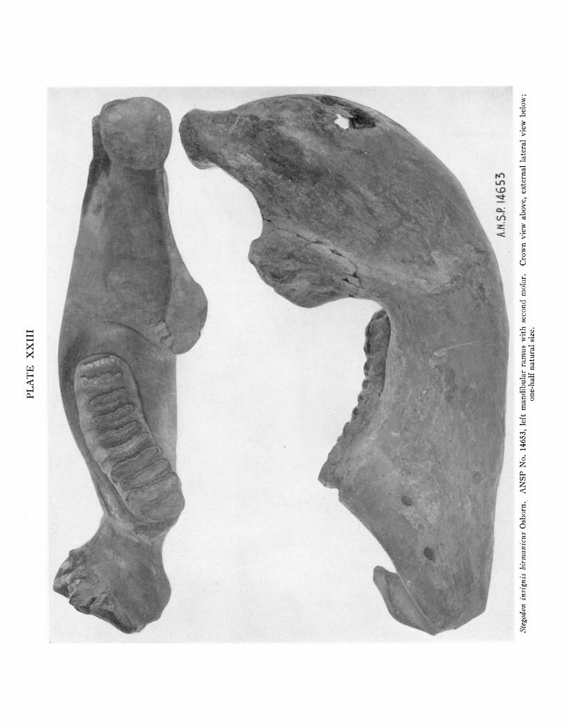
PLATE XXIII
Stegodon insignis birmanicus Osborn. ANSP No. 14653, left mandibular ramus with second molar. Crown view above, external lateral view below; one-half natural size.

PLATE XXIV
Elephas hysudricus Falconer and Cautley. ANSP No. 14654, left mandibular ramus with third molar. Crown view above, internal lateral view below; one-half natural size.

PLATE XXV
M.C.Z. 6291
Elephas hysudricus Falconer and Cautley. MCZ No. 6291, left mandibular ramus with molar. Crown view above, ex- ternal lateral view below, one-half natural size.

PLATE XXVI
L
~~~~~~~~~~~~~~~~
FIG. 1, Elephas hysudricus Falconer and Cautley. MCZ No. 6268, upper molar. Lateral view. FIG. 2. Elephas hysudricus Falconer and Cautley. MCZ No. 6257, left M3. Crown view above, external
lateral view below. All figures three-fifths natuiral size.

PLATE XXVII
A.N,S.R 14635
6260
FIG. 1. Hemibos triquetricornis Riitimeyer, ex Falconer ms. ANSP No. 14635, cranium with right horn core. Dorsal view above, lateral view in middle, occipital view below.
FIG. 2. Hemibos triquetricornis Riitimeyer, ex Falconer ms. MCZ No. 6260, portion of cranium. Dorsal view above, lateral view in middle, occipital view below.
All figures one-half natural size.

PLATE XXVIII
FIG. 1. Stegodon orientalis Owen. ANSP No. 14626, left DM4. External lateral view on left, crown view on right. FIG. 2. Stegodon orientalis Owen. MCZ No. 6252, right DM4. Crown view above, ventral view (to show tooth marks made by Hystrix)
below. FIG. 3. Stegodon orientalis Owen. ANSP No. 14625, right DM4. Crown view above, external lateral view below. All figures three-fourths natural size.

PLATE XXIX
A.
146 27 2
FIG. 1. Stegodon (?) or Palaeoloxodon (?). ANSP No. 14628, tusk. FIG. 2. Palaeoloxodon namadicus (Falconer and Cautley). ANSP No. 14627, right M2. External
lateral view above, crown view below. All figures three-fifths natural size.

PLATE XXX
FIG. 1. Palaeoloxodon namadicus (Falconer and Cautley). MCZ No. 6256, left M2. Crown view above, external lateral view below.
FIG. 2. Palaeoloxodon namadicus (Falconer and Cautley). MCZ No. 6255, left M2. Crown view above, external lateral view below.
All figures three-fifths natural size.

PLATE XXXI
AN.SP. 14645
FIG. 1. Rhinoceros sp. ANSP No. 14645, right P3. Crown view, natural size. FIG. 2. Rhinoceros sp. MCZ No. 6278, right lower cheek tooth. Crown view above,
external lateral view below, natural size. FIG. 3. Cervus sp. ANSP No. 14647, antler fragments. Base of antler, left, two-thirds
natural size; portion of beam, right, showing tooth marks of Hystrix, approximately natural size.

PLATE XXXII
A,N.S.R 14657
.I
6296
3
A.N. 5 14658
FIG. 1. Elephas hysudricus Falconer and Cautley. ANSP No. 14657, tooth fragment. Crown view above, lateral view below.
FIG. 2. Elephas hysudricus Falconer and Cautley. MCZ No. 6296, tooth fragment. Lateral view. FIG. 3. Elephas hysudricus Falconer and Cautley. ANSP No. 14658, tooth fragment. Lateral view. All figures three-fourths natural size.

PART IV
FRESH-WATER SHELLS FROM CAVE DEPOSITS IN THE SOUTHERN SHAN STATES, BURMA
BY J. BEQUAERT
Museum of Comparative Zoilogy, Cambridge, Mass.
Plate XXXIII
LOCALITIES
The fresh-water shells obtained by Dr. H. L. Movius, Jr., in the course of his archaeological excavations in the Southern Shan States, are not numerous. Yet their study has led to some interesting conclusions re- garding variation, which it seems warranted to pub- lish, particularly in order to justify the nomenclature adopted for the several species.
The material is from three localities, in Yawnghwe State, within an area of about 40 square miles. The sites are fully described elsewhere in this memoir (see pp. 389-391 of Dr. Movius' report); but a brief ac- count will be helpful to the malacologist.
1. Cave of Tin-Amin.-Three miles east of the town of Yawnghwe and about one mile north of the village of Le-pin, there are two small caves at the base of the escarpment, about 350 feet above the level of the old alluvial plain of Lake Inle. Shells were collected in the south cave only, from a test pit made in a small side chamber near the right-hand side of the entrance, together with bones of wild animals, but no achaeologi- cal material. The shells belong to two species: Taia intermedia Annandale (fam. Viviparidae) and Brotia persculpta (Ehrmann) (fam. Tiaridae). The Tin- Ain caves were investigated by N. Annandale and F. H. Gravely, in 1917; and again by N. Annandale and H. S. Rao (and their assistants), in March 1922. In the published accounts (Annandale, 1918, 1919 and 1924; Annandale and Rao, 1925) they are referred to as two small limestone caves some 3 miles east of the town of Yawnghwe, on the slope of the valley of the Hsin- Dawng, a stream running down the escarpment toward the alluvial plain of Yawnghwe. Annandale (1918: 143; 1919: 218) listed from these caves three sup- posedly "fossil" (i.e. extinct) species of Taia: T. obesa, T. cylindrica and T. conica, and one species of Tiaridae: Brotia variabilis (a living species). He later found a few imperfect shells of a second species of Tiaridae, on which he based the new form planicostata of his Ac- rostoma elongatum (Brotia persculpta of the present paper). As shown in the sequel, Annandale's three supposedly "fossil" Taia appear to be individual vari- ants of the living Taia intermedia. His figure shows
that the indentification of Brotia variabilis was no doubt correct. Two specimens of Brotia persculpta were also found by Dr. Movius in the Tin-Ain cave.
2. Mongta-wa-ku.-This is a very large cave about two and a half miles southwest of the town of Taunggyi, and about 8 miles (as the crow flies) to the northeast of the Tin-Ain caves. It is near the top of the escarp- ment overlooking the Yawnghwe valley, some 1200 ft. above the alluvial plain and approximately 450 ft. above sea-level. Several test pits were dug, but the shells were all in surface accumulations mixed with broken modern pottery of the Buddhist period. Two species of Tiaridae were recognized: Melanoides tuberculata subsp. grangcri (Wattebled) and Brotia variabilis (Benson), both living at present in the same region. No previous examination of these deposits appears to have been made.
3. Rock-shelter of Miilg Pawn.-About 28 miles due east of the town of Taunggyi, to the south of the road, there is a rock-shelter on the west slope of the Nam Pawn valley. From a test pit about 1 m. deep many shells were removed, together with a few broken bones, some stones which appeared to have been broken artificially and some charcoal fragments. There were no pieces of pottery nor implements. The shells are of two species of Tiaridae: Brotia baccata (Gould), living in the same region; and Sulcospira praemordica Tryon, with a subsp. laevitestacea J. Bequaert, the typical form also now living in Burma.
Annandale believed that the shells of the cave de- posits of Tin-Ain had been buried there by a natural means, namely by floods, a view which no doubt influ- enced him to regard the Taia as representing three "extinct" species. Curiously enough he did not reach the same conclusion for the two species of Tiaridae, al- though he admitted that they were contemporary of the Taia. To account for the absence in the Tin-Ain caves of the smaller fresh-water snails (Lymnaeidae and Hydrobiidae), commonly associated with Taia and Tiaridae in the superficial and lake deposits of the same region, Annandale (1918: 143) suggested that the larger snails were able to float on the surface of a lake
431

TRANSACTIONS OF THE AMERICAN PHILOSOPHICAL SOCIETY
or pool until they were stranded at the base of lime- stone rocks, where they were buried; their unworn condition proving that they were not carried by running water.' It seems much simpler to regard the ac- cumulations of Taia and Tiaridae in the caves and rock shelters of the Southern Shan States, as the work of Man, who discarded the shells after using the snails as food. This explains satisfactorily (a) the occurrence of quantities of shells in shelters at levels far above those of old lake or river alluvial deposits; (b) the un- worn, though often damaged, condition of the shells, together with the absence of opercula, the latter having been removed with the animals; and (c) the lack of small fresh-water snails, which were not used as food. That the ancient aborigines of Burma included fresh- water snails in their diet is scarcely to be doubted, for even nowadays certain species are commonly eaten in Burma, Siam and Indo-China, as well as elsewhere in the Orient. J. de Morgan (1885, Bull. Soc. Zool. France, X: 420-421) mentions several species of Brotia used as food in Perak. According to Tapparone- Canefri (1889, Annl. Mus. Civ. Genova, XXVII: 300-
303), L. Fea bought in the native market at Mandalay four species of Tiaridae, including a form of Melanoides tuberculata. A. Billet (1898, Bull. Scientif. France
Belgique, XXVIII: 329) noted that the natives of northern Tonkin eat large quantities of a species of Viviparus. The Laos of Siam use as food Viviparlts bengalensis and Brotia variabilis (W. M. Daly, 1903, Proc. Mal. Soc. London, V, pt. 5: 281-282).
The finding by Dr. Movius of shells of Tiaridae as- sociated with evident signs of human occupation, lends further support to the view that Man was responsible for selecting and transporting the fresh-water snails now found buried in the limestone caves of the Southern Shan States. The deposits of the three sites in which shells were found are of recent age, Dr. Movius in- forms me. They are apparently post-Pleistocene and perhaps not over a few thousand years old. Hence it is extremely unlikely that the shells could belong to "extinct" species. On purely conchological evidence, I had, moreover, reached the conclusion that the three supposedly "extinct" species of Taia from the Tin-Ain caves were merely variants of a species now living in Lake Inle.
DESCRIPTION OF SHELLS
VIVIPARIDAE
Taia intermedia Annandale Plate XXXIII, Figures 1-9
Taia intermedia Annandale, 1918, Rec. Indian Mus., XIV: 128, P1. 15, fig. 13, and P1. 16, figs. 7-9 (dead in alluvium, He-Ho plain, S. Shan States); 1919, Rec. Geol. Survey India, L, pt. 3: 239, P1. 31, fig. 10.
1 Elsewhere, however, the somewhat contradictory statement is made that the shells had been washed into the Tin-Ain caves, mainly through holes in the roof (Annandale, 1924: 71; Annan- dale and Rao, 1925: 102).
Taia naticoides race intermedia Annandale and Rao, 1925, Rec. Indian Mus., XXVII: 121, fig. 8 (living in Lake Inle, S. Shan States).
Paludina naticoides "Theobald" Hanley and Theobald, 1873, Conchol. Indica, Expl. of Plates: 32, P1. 76, fig. 4 only (Shan States). Not of G. Pfeiffer, 1828, nor of Theobald, 1866.
Vivipara naticoides "Theobald" Kobelt, 1907, Syst. Conch. Cab., I, Abt. 21a: 149, P1. 30, fig. 5 only (copy of Hanley and Theobald's fig. 4).
Taia naticoides "Theobald" Annandale, 1918, Rec. Indian Mus., XIV; 126, P1. 15, figs. 16-17, P1. 16, figs. 3-6, and P1. 18, figs. 1-3 (living at Yawnghwe and in the He-Ho plain, S. Shan States). Ehrmann, 1922, Sitzungsber. Naturf. Ges. Leipzig, XLV-XLVIII, (1918-1921): 23, PI., fig. 9 (living in Loikaw River, S. Shan States).
Vivipara shanensis "Theobald" Kobelt, 1909, Syst. Conch. Cab., I, Abt. 21a: 411, P1. 77, figs. 4-5 (living; Shan States). Preston, 1915, Fauna Brit. India, Moll., Freshw. Gastr. Pelec.: 93. Not of Theobald, 1876.
Taia shanensis "Kobelt" Annandale, 1918, Rec. Indian Mus.. XIV: 129, P1. 15, figs. 14-15, P1. 16, fig. 10, and PI. 18, figs. 4-6 (living in marginal zone of Lake Inle, S. Shan States); 1924, Proc. R. Soc., London, Ser. B, XCVI: 69, fig. 6D. Annandale and Rao, 1925, Rec. Indian Mus., XXVII: 122, fig. 9a. Not of Theobald, 1876.
Taia shanensis form callosa Ehrmann, 1922, Sitzungsber. Naturf. Ges. Leipzig, XLV-XLVIII, (1918-1921): 26 (living in Loikaw River, S. Shan States).
Taia obesa Annandale, 1918, Rec. Indian Mus., XIV: 128, P1. 15,.fig. 19, and P1. 16, fig. 2 (dead in cave deposits near Hsin- Dawng stream, S. Shan States). Annandale and Rao, 1925, op. cit., XXVII: 126.
Taia cylindrica Annandale, 1918, Rec. Indian Mus., XIV: 130, P1. 15, fig. 9, and P1. 17, fig. 2 (dead in cave deposits near Hsin-Dawng stream, S. Shan States). Annandale and Rao, 1925, op. cit., XXVII: 126.
Taia lacustris Annandale, 1918, Rec. Indian Mus., XIV: 131, P1. 15, figs. 10-11, P1. 17, fig. 1, and P1. 18, figs. 7-9 (dead in alluvium, He-Ho plain, S. Shan States).
Taia naticoides race lacustris Annandale and Rao, 1925, Rec. Indian Mus., XXVII: 121.
Taia analoga Annandale, 1918, Rec. Indian Mus., XIV: 132, P1. 15, figs. 6, 7, 12, and P1. 17, figs. 3-4 (dead in alluvium, He-Ho plain, S. Shan States).
Taia conica Annandale, 1918, Rec. Indian Mus., XIV: 133, P1. 15, fig. 8, and P1. 17, fig. 8 (dead in cave deposits near Hsin- Dawng stream, S. Shan States). Annandale and Rao, 1925, op. cit., XXVII: 126.
Taia intha Annandale, 1918, Rec. Indian Mus., XIV: 135, P1. 15, figs. 1-3, P1. 17, fig. 7, and P1. 18, figs. 10-12 (living in central region of Lake InlI, S. Shan States); 1924, Proc. Roy. Soc., London, Ser. B, XCVI: 62, fig. 2D, 67, fig. 5, and 69, fig. 6F. Annandale and Rao,- 1925, Rec. Indian Mus., XXVII: 123, figs. 9b and 10.
Taia elitoralis Annandale, 1918, Rec. Indian Mus., XIV: 134, P1. 15, figs. 4-5, P1. 17, figs. 5-6, and P1. 18, figs. 13-14 (living in intermediate zone of Lake Inle; pool near north end of Lake InlI; canal at Yawnghwe; S. Shan States); 1924, Proc. R. Soc., London, Ser. B, XCVI: 69, fig. 6E. Annandale and Rao, 1925, Rec. Indian Mus., XXVII: 123.
Taia crassicallosa Annandale and Rao, 1925, Rec. Indian Mus., XXVII: 124; figs. 11-14 (living in Yawnghwe River near Tai-O, S. Shan States).
Some 20 shells of Taia were dug up in one of the Tin-Ain caves. As shown by the figures, they vary in size, shape, development of the scaly knobs, and thick- ness of the umbilical callus. So many transitions con-
432

BEQUAERT: FRESH-WATER SHELLS
nect the extreme forms, that I am forced to refer them all to one species. The most common form (Figs. 1-
3) agrees with Annandale's figure of T. cylindrica. Fig. 7 is apparently Annandale's T. conica, while Figs. 4-6 are his T. obesa. Moreover, I am unable to sepa- rate these Tin-Ain shells from the several other simi-
larly sculptured Taia described by Annandale from
living and dead material in the same region, all of which are listed in the synonymy. The oldest valid name for this complex appears to be Taia intermedia, at first described from dead shells, but later found alive in Lake Inle. The extreme likeness of my Fig. 3 and of Annandale's figures of T. intermedia may be noted.
T. intermedia is characterized by the short or elon-
gate conical shape, the whorls little convex or more or less flattened, and the basal callus completely closing the umbilicus and occasionally very heavy, broad and
prominent (crassicallosa Annandale and Rao; see my Figs. 8-9). The sculpture consists of a variable num- ber of prominent spiral ribs bearing small or large nodules, either rounded or more or less raised into scales or squamae, particularly on the peripheral ridge. On specimens from cave deposits the squamae are often broken or worn through handling by man. Moreover, the nodules and scales vary much in living specimens taken from Lake Inle, as shown by Annandale's figures.
Much confusion has arisen from the authors' mis-
taking this species for Theobald's Paludina naticoides, the correct valid name of which is Taia shanensis
(Theobald). As originally described and figured (1866, Jl. Asiat. Soc. Bengal, XXXIV, pt. 2, No. IV:
274, P1. 9, figs. 1-3; fig. 1 is var. fasciata; figs. 2-3 are var. carinata; Shan States), this is less conical than T.
intermedia, with more convex whorls, and weaker umbilical callus. The surface is either almost smooth or more or less spirally ribbed, but the ribs lack the nodules or scaly protuberances of T. intermedia.
Vivipara shanensis Theobald (1876) was proposed as a synonym or substitute for naticoides Theobald
(1866); but Kobelt's (1907) Vivipara shanensis is
T. intermedia. In fact Kobelt's figures (P1. 77, figs.
4-5) agree well with some of the specimens from the Tin-Ain caves. On the other hand, I refer Kobelt's
figures 4, and 6 to 11 of Plate 30 to true T. shanensis
(Theobald). The following names are additional
synonyms of T. shanensis: Vivipara naticoides var.
obsolescens E. von Martens, 1899; Vivipara theobaldi
Kobelt, 1907; Vivipara noetlingi Kobelt, 1908; Taia theobaldi var. leonardi Rao, 1928; Taia theobaldi form
globosa Rao, 1928; and Taia theobaldi form niger Rao, 1928.2
2Paludina naticoides Theobald (1866) is antedated by Palu- dina naticoides G. Pfeiffer (1828). Theobald's names fasciata and carinata are also not available, having been used before 1866 in combination with Paludina. I am unable to find a "Palu- dina naticoides Ferussac," as quoted by G. Pfeiffer.
TIARIDAE (MELANIIDAE)
Brotia (Antimelania) variabilis (Benson)
Plate XXXIII, Figures 11-16
Melania variabilis Benson, 1836, Jl. Asiat. Soc. Bengal, V: 746 (Gumti River at Jonpur; Tally's Nullah near Calcutta; also a var. A from Hughli River, Calcutta; and vars. B, C and D from Sylhet; all localities in northeastern India). Souleyet, 1852, Voyage La Bonite, Zool., II: 545, P1. 31, figs. 12-15. Annandale, 1918, Rec. Indian Mus., XIV: 114, P1. 12, fig. 8 (dead in cave deposits near Hsin-Dawng, S. Shan States).
Melania species A, Benson, 1830, Gleanings in Science, I, P1. 7. Melania (Melanoides) variabilis Brot, 1875, Syst. Conch. Cab.,
I, Abt. 24: 85, P1. 10, figs. 1, 1 a-d. Melania varicosa Troschel, 1837, Arch. f. Naturgesch., III, pt. 1:
174 (Ganges River, India). Philippi, 1843, Abb. Beschr. Conch., I: 59, P1. 2 (Melania), figs. 2 (cotype received from Troschel) and 3.
Melania variabilis var. varicosa Hanley and Theobald, 1874, Conchol. Indica, Expl. of Plates: 44, P1. 109, fig. 2.
Melanoides indica "Eydoux" H. and A. Adams, 1854, Gen. Rec. Moll., I: 296, and III, P1. 31, figs. 5 a-c. [There is no Melania indica "Eydoux" or "Souleyet." The latter used only the French vernacular name "Mdlanie indienne" on his P1. 31 for the species which he referred to Melania variabilis in the text.]
Melania variabilis var. echinata "Benson" Hanley and Theobald, 1874, Conchol. Indica, Expl. of Plates: 44, P1. 109, fig. 3 (Assam).
Melania variabilis var. cincta "Benson" Hanley and Theobald, 1874, Conchol. Indica, Expl. of Plates: 44, PI. 109, fig. 5 (Assam). Not Melania cincta Is. and H. Lea, 1851.
Melania variabilis var. aspera "Benson" Hanley and Theobald, 1874, Conchol. Indica, Expl. of Plates: 44, P1. 109, fig. 6 (Hindustan). Not Melania aspera Lesson, 1831.
Melania crotula "Rafinesque" Brot, 1875, Syst. Conch. Cab., I, Abt. 24: 85 (as a synonym of Melania variabilis).
Melania variabilis var. vittata Theobald, 1866, Jl. Asiat. Soc. Bengal, XXXIV, pt. 2, No. IV: 273, P1. 9, fig. 4 (Shan States). Not Melania vittata Anthony, 1854; nor of Brot, 1860.
Melania variabilis subvar. fasciata G. Nevill, 1885, Hand List Moll. Indian Mus., II, (1884): 256 (Bhootan, India). Not Melania fasciata Menke, 1828.
Melania variabilis var. glabra Theobald, 1866, Jl. Asiat. Soc. Bengal, XXXIV, pt. 2, No. IV: 273 (tepid springs of Nam- moo, Shan States). Not Melania glabra Is. Lea, 1841.
Melania variabilis subvar. microstoma G. Nevill, 1885, Hand List Moll. Indian Mus., II, (1884) : 261 (Sylhet; with description). Not Melania microstoma Is. and H. Lea, 1851.
Melania variabilis var. semilaevigata G. Nevill, 1885, Hand List Moll. Indian Mus., II, (1884): 254 (Sylhet; Daarbund; Sil- curi, Cachar; all in northeastern India).
Melania variabilis subvar. subspinosa G. Nevill, 1885, Hand List Moll. Indian Mus., II, (1884): 253 (Tank opposite Bengal Club, Calcutta; without description).
Melania variabilis subvar. subtuberculata G. Nevill, 1885, Hand List Moll. Indian Mus., II, (1884): 252 (Calcutta; with description).
Melania variabilis var. subvaricosa G. Nevill, 1885, Hand List Moll. Indian Mus., II, (1884): 253 (Arakan and Pegu?; Sibsagar; Namtsik River; Samaguting; Kusiyra River, Sylhet; Sudiya near Darjeeling; all in northeastern India; with description).
Melania (Melanoides) tourannensis "Eydoux and Souleyet" Tapparone-Canefri, 1889, Ann. Mus. Civ. Genova, XXVII: 302 (Bhamo, Upper Burma). Not of Souleyet, 1852, which is probably a distinct subspecies of B. variabilis.
433

TRANSACTIONS OF THE AMERICAN PHILOSOPHICAL SOCIETY
Melania (Brotia) hungerfordiana "Nevill" E. v. Martens, 1899, Arch. f. Naturgesch., LXV, pt. 1, Heft 1: 37, P1. 4, fig. 6 (near Meungyaw, east of Lashio; affluent of the Salween R.; Nampai R.; all in N. Shan States). Not M. hungerfordiana G. Nevill, 1885, which appears to be related to Sulcopsira prac- mordica (Gould).
The foregoing references are only to individual vari- ants of the typical form of the species in Northeastern India, Assam and Burma. B. variabilis is so protean, even in the same colony or stream, that none of the names listed above seem to deserve a separate stand- ing, even as varieties or mutations. In addition, I re- gard the following names as based upon variants, eco- logical forms or geographical races of this species: Melania menkiana Is. Lea, 1844 (= M. plicata Is. Lea, 1838, not of Menke, 1828; India); Melania herculea Gould, 1846 (Lower Burma); Melania tourannensis Souleyet, 1852 (Cochin China, Laos); Melania spinosa Hanley, 1856; Melania swinhoei H. Adams, 1870 (Hainan); Melania herculea var. sowerbii Hanley and Theobald, 1874 (Tenasserim); Melania jugicostis Hanley and Theobald, 1874 (Tenasserim); Melania julieni Brot, 1875 (Cambodia, Laos); Melania godwini Brot, 1875 ( Melanoides hanleyi Godwin-Austen, 1872; not of Brot, 1860; North Cachar, India); Melania sumatrensis Brot, 1875 (Sumatra); Melania boeana Brot, 1881 (Sumatra); Melania provisoria Brot, 1881 (Sumatra); Sermyla chaperi de Morgan, 1885 (Perak); Sermyla perakensis de Morgan, 1885 (- S. kintanensis de Morgan, 1885; Perak); Melania sumatrensis var. mitescens Schepman, 1886 (Sumatra); Melania subplicata Schepman, 1886 (Sumatra); Me- lania curvicosta v. Martens, 1897 (Sumatra); Melania papillosa v. Martens, 1897 (Sumatra); Melania stricti- costa v. Martens, 1897 (Sumatra); and Melania curvi- costa var. prestoniana Bullen, 1906 (Sumatra). A few of these names, such as tourannensis, herculea and sumatrensis, apply perhaps to valid geographical races. Some other Brotia, such as B. pontificalis (v. d. Busch) (Borneo), B. siamensis (Brot) (Siam, Indo-China), B. reevei (Brot) (Burma), and B. episcopalis (Is. and H. Lea) (Malacca, Siam, Indo-China), are very closely related to B. variabilis, but are perhaps best re-
garded as distinct species.3 A series of 19 shells of B. variabilis, some of them
much broken, were dug up in the cave M6ngta-wa-ku. Most of them are moderately large and belong to the
typical form of the species in which the vertical ribs are fairly numerous and regular in the upper half of the body-whorl, while the spiral ribbing of the lower half of the body-whorl is distinct. In a few the verti- cal ribs are broken up into nodules, being more as in tourannensis. There are no true tubercles or spines, however; although in some shells (Fig. 13) the upper
3 Melania carolinae J. E. Gray (1834, in Griffith, Cuvier's Animal Kingdom, XII, Moll: 598, P1. 13, Moll., fig. 3; no locality) appears to have been based upon an abnormal specimen of Brotia dactylus (Is. and H. Lea), of the Philippines, not of B. variabilis.
ends of the vertical ribs stop abruptly and sharply some distance below the suture, exactly as in v. Mar- tens' (1899) figure of "hungerfordiana." Annandale's single shell from the Tin-Ain cave (1918, P1. 12, fig. 8) was like some of the Mongta-wa-ku specimens.
Brotia (Antimelania) persculpta (Ehrmann)
Plate XXXIII, Figures 17-18
Melania baccata subsp. elongata Annandale, 1918, Rec. Indian Mus., XIV: 115, P1. 12, figs. 3-7 (living in Yawnghwe River; dead in alluvium of the He-Ho plain; S. Shan States). Not Melania elongata Is. Lea, 1831.
Acrostomna elongatum Annandale and Rao, 1925, Rec. Indian Mus., XXVII: 117 (living at Tai-O, Yawnghwe State, and in He-Ho plain; S. Shan States).
Melania persculpta Ehrmann, 1922, Sitzungsber. Naturf. Ges. Leipzig, XLV-XLVIII, (1918-1921): 18, PI., fig. 8 (living in Loikaw River, S. Shan States; with form biserialis and form triscrialis).
Acrostomna elongatuml form planicostata Annandale and Rao, 1925, Rec. Indian Mus., XXVII: 117 (living at He-Ho; dead in Hsin-Dawng Cave; S. Shan States).
Two very incomplete shells from the Tin-Ain cave clearly represent B. persculpta (Ehrmann). Both be- long to Ehrmann's form biserialis, which was renamed, rather unnecessarily, planicostata by Annandale and Rao.
The true status of persculpta is far from clear, as it seems to combine certain features of B. variabilis with other more characteristic of B. baccata. Provisionally, however, I retain it as a distinct species. It seems diffi- cult, moreover, to separate persculpta from Melania variabilis var. binodulifera G. Nevill (1885; based in part on Hanley and Theobald, 1873, Conchol. Indica, PI. 72, fig. 7, and P1. 75, figs. 5 and 7), or from Acrostoma baccata form bituberculata Rao (1928, Rec. Indian Mus., XXX: 444, figs. 17 a, b, d, e; N. Shan States).
Brotia (Antimelania) baccata (Gould)
Plate XXXIII, Figures 19-23
Melania baccata Gould, 1847, Proc. Boston Soc. Nat. Hist., II: 219 (Thoung-Yin River, Burma); 1862, Otia Conchol.: 200. Hanley and Theobald, 1873, Conchol. Indica, Expl. of Plates: 32, P1. 75, figs. 1 and 4. Brot, 1875, Syst. Conch. Cab., I, Abt. 24: 81, P1. 9, fig. 6.
Melania (Brotia) baccata E. v. Martens, 1899, Arch. f. Natur- gesch., LXV, pt. 1, Heft 1: 35 (Myitnge, an affluent of Irra- wady, near Bagwyo and Thibaw; Lashio R.; Nampari R.; all in N. Shan States).
Acrostoma baccata Rao, 1928, Rec. Indian Mus., XXX: 442, fig. 17c (Namtu River at Hsenwi and Hsipaw; near Tangyan; Lashio; all in N. Shan States).
Melania variabilis var. baccifera Theobald, 1866, Jl. Asiat. Soc. Bengal, XXXIV, pt. 2, No. IV: 274, P1. 9, fig. 5 (Nammah Stream, S. Shan States).
Acrostoma baccifera Rao, 1928, Rec. Indian Mus., XXX: 447.
434

BEQUAERT: FRESH-WATER SHELLS
Melania variabilis var. turrita Theobald, 1866, J1. Asiat. Soc. Bengal, XXXIV, pt. 2, No. IV: 273, P1. 9, fig. 6 (Shan States). Not Melania turrita Mousson, 1849.
Melania variabilis var. pyramidalis Theobald, 1866, Ji. Asiatic Soc. Bengal, XXXIV, pt. 2, No. IV: 274, PI. 9, fig. 7 (Nam- mah Stream, Shan States). Not Melania pyramidalis More- let, 1849.
Melania baccata var. pyramidalis E. v. Martens, 1899, Arch. f. Naturgesch., LXV, pt. 1, Heft 1: 36 (Nampai R., Lashio R. near Lashio; N. Shan States).
Acrostoma baccata form pyramidalis Rao, 1928, Rec. Indian Mus., XXX: 444 (dead in alluvium near Namtu River, Hsenwi, and near Hsipaw, N. Shan States).
Melania baccata var. fusiformis Hanley and Theobald, 1873, Conchol. Indica, Expl. of Plates: 32, P1. 75, fig. 2 (Shan States). Not Melania fusiformis Is. Lea, 1841.
Melania episcopalis "Lea" Hanley and Theobald, 1873, Conchol. Indica, Expl. of Plates: 31 and 32, P1. 72, fig. 7, and P1. 75, figs. 5 and 7 (Diyung River, N. Cachar, India). Not Me- lania episcopalis Is. and H. Lea, 1851.4
M4elania baccata subvar. recta G. Nevill, 1885, Hand List Moll. Indian Mus., II, (1884): 262 (Upper Salween River, Burma; without description, but with a reference to Brot's P1. 9, fig. 6 of 1875). Not Melania recta Is. and H. Lea, 1851.
Acrostoma baccata form recta Rao, 1928, Rec. Indian Mus., XXX: 445.
Melania (Melanoides) subasperata G. Nevill, 1885, Hand List Moll. Indian Mus., II, (1884): 262 (Shan States; with de- scription and reference to Theobald's P1. 9, fig. 5, of 1866).
Melania iravadica Blanford (1869, Proc. Zool. Soc. London: 445; Upper Irrawady R. in Upper Burma and Yunnan) appears to be a fairly distinct subspecies of Brotia baccata, as first recognized by G. Nevill (1877, Jl. Asiat. Soc. Bengal, XLVI: 33).
Melania henriettae J. E. Gray (1834, in Griffith, Cuvier's Animal Kingdom, XII, Moll.: 598, P1. 13, Moll., fig. 2; no locality), of southern China, is ap- parently also a subspecies of Brotia baccata. If fur- ther study confirms this opinion, the species will have to bear the name Brotia henriettae (J. E. Gray), with the Burmese race subordinated to it as subsp. baccata (Gould). Melania reticulata Is. and H. Lea (1851) is a synonym of B. henriettae.5
I refer to B. baccata some 20 specimens from the rock-shelter of M6ng Pawn, which have the typical sculpture of conical or rounded nodules in 3 or 4 spiral rows between the suture and the periphery. Below the periphery the body-whorl bears spiral ribs, also some- what beaded occasionally. The shells vary from tur- reted to pyramidal. Some of them agree well with Hanley and Theobald's P1. 75, figs. 1 and 2 (1873).
4 The true M. episcopalis Is. and H. Lea, of Malacca, Siam and Indo-China, appears to be the continental representative of Brotia pontificalis (v. d. Busch), of Borneo. It is very closely related to Brotia variabilis (Benson).
5The two "fossil" species of Brotia described by Annandale (1924, Rec. Geol. Survey India, LV, pt. 2, (1923): 98-100), from the Oil Measures of the Dawna Hills, Tenasserim, appear to be closely related to living forms. His Acrostoma inter- medium is scarcely separable from Brotia baccata; while his Acrostoma cotteri shows more affinity to Brotia variabilis. The age of the Dawna Oil Measures is uncertain, but Miocene at the very oldest and probably much younger.
Sulcospira praemordica (Tryon) Plate XXXIII, Figures 24-30
Melania praemordica Tryon, 1866, Amer. Jl. Conch., II, pt. 2: 111, P1. 10, fig. 3 (Burma). Hanley and Theobald, 1876, Conchol. Indica, Expl. of Plates: 61, P1. 153, fig. 2 (Pegu). Tapparone-Canefri, 1874, Zool. Viaggio della Magenta, Mala- col.: 45, P1. 1, fig. 7 (young). Brot, 1875, Syst. Conch. Cab., I, Abt. 24: 108, P1. 13, figs. 8 and 8a.
Melania baccata var. praemordica E. v. Martens, 1899, Arch. f. Naturgesch., LXV, pt. 1, Heft 1: 36 (Chindwin River, an affluent of the Irrawady, near Natu, N. Shan States).
Tiara (? Acrostoma) praemordica Preston, 1915, Fauna Brit. India, Moll., Freshwater Gastr. Pelec.: 31.
In naming this species, I have had the advantage of studying four paratypes (from the Wheatley Collec- tion), at the Museum of Comparative Zoology. I fig- ure one of these (Fig. 24) for comparison. It will be noted that Tryon's original figure is good, except that the aperture is drawn too narrow. Hanley and Theo- bald's figure is even better in some respects; but Brot's P1. 13, fig. 8, is a poor and misleading copy. The spe- cies is characterized by the shape, the unusually large body-whorl, the narrow and somewhat grooved base of the aperture, and the peculiar low and broad spiral ribs, which are slightly wavy at regular intervals, but do not form knobs or nodules. The operculum is un- known. From shell characters alone, S. praetmordica seems to be related to S. hiigelii (Philippi), rather than to the species placed in Brotia, and I refer it provision- ally to Suilcospira. I suspect that Melania (Pachychilus) hungerfordiana G. Nevill (1885), of Upper Burma and Pegu, was based upon a large, smooth specimen of S. praemordica, like those described below,6 while Melania liimborgi Hanley (1879), of the Mule-it Range, Tenas- serim, was possibly the young of this smooth form.
The rock-shelter of M6ng Pawn yielded about 20 specimens of shells with the characteristic shape of S. praezmordica, although none show the pronounced broad spiral ribs of the living paratypes. In two speci- mens these ribs are indicated (Figs. 25-26), although they scarcely show in the photographs.
All the other specimens are smooth, except for oc- casional, irregular, axial growth-striae. It may be useful to distinguish the smooth form by name, as laevitestacea (subsp. nov.), at least until the variation of the species in life is better known. The holotype (Fig. 28) measures 39 mm. by 22 mm., the aperture 20 mm. by 12 mm., one and a half whorls remaining.
Melanoides tuberculata subsp. grangeri
(Wattebled) Plate XXXIII, Figure 10
Melania grangeri Wattebled, 1884, Jl. de Conchyl., XXXII: 127, P1. 6, figs. 3-3a (Long-Xuyen, Cochin China). Brot, 1886, Recueil Suisse Zool., IV: 95, P1. 6, fig. 2 (Siam). 6 The shell figured by E. v. Martens in 1899 as M. hunger-
fordiana was not Nevill's species, but a variant of Brotia vari- abilis (Benson).
435

TRANSACTIONS OF THE AMERICAN PHILOSOPHICAL SOCIETY
Melania paviei Morlet, 1884, J1. de Conchyl., XXXII: 397, P1. 12, figs. 5-5a (Kah Sutine, Cambodia).
Melania (Striatella) tuberculata var. myadoungensis G. Nevill, 1885, Hand List Moll. Indian Mus., II, (1884): 245 (Mya- doung, Upper Burma).
Melania (Striatella) tuberculata var. subplicifera G. Nevill, 1885, Hand List Moll. Indian Mus., II, (1884): 245 (Mya- doung, Upper Burma).
Melania (Striatella) tuberculata G. Nevill, 1877, Jl. Asiat. Soc. Bengal, XLVI, pt. 2: 32 (Irrawady River at Myadoung, Burma). Tapparone-Canefri, 1889, Ann. Mus. Civ. Genova, XXVII: 302 (Mandalay, Burma).
Melania (Melanoides) tuberculata E. v. Martens, 1899, Arch. f. Naturgesch., LXV, pt. 1, Heft 1: 37 (Myitnge near Thibauw; stream near Bangyo, N. Shan States; Mandalay).
Melania tuberculata Annandale, 1918, Rec. Indian Mus., XIV: 114, P1. 12, figs. 1-2 (living in Inle Lake and Yawnghwe R.; dead in alluvium of He-Ho plain; S. Shan States).
Melanoides tuberculatus Annandale and Rao, 1925, Rec. Indian Mus., XXVII: 118 (dead in clay-pit above He-Ho gorge, S. Shan States).
Melania citrinoides Brot (1886), of Siam, is prob- ably also a synonym of grangeri. This race, seemingly common throughout Burma, Siam and Indo-China, ap- pears to be fairly well characterized by the large size (as much as 35 to 40 mm. for adult shells with eroded summit and 6 or 7 whorls preserved) and the later whorls being distinctly flattened along the sides, with the sutures very shallow. The sculpture is as variable as usual in this species, but in full-grown shells the body-whorl is as a rule deeply spirally grooved and without axial ribs.
Melanoides tulberculata sulsp. pyramis (Benson, 1836) (--Melania adspersa Troschel, 1837; llIelania tigrina Hutton, 1849), of India proper, sometimes reaches about the size of grangeri, but the later whorls of adult shells (particularly the body-whorl) are
markedly and regularly convex and separated by deep sutures. It would seem that the areas of pyramis and grangeri scarcely overlap.
One specimen of only 2 preserved whorls, fromi the cave of Mong Ta-wa-ku, agrees well with some living material of grangeri, from Cambodia and Tonkin. at the Museum of Comparative Zoology. One of these. kindly sent by Dr. Mermod, was called gralngri in Brot's collection.
BIBLIOGRAPHY OF PART III
ANNANDALE, N. 1918. Aquatic mollusks of the Inle Lake and connected waters. Rec. Indian Mus., vol. 14: 103-182, Pls. 10-19. . 1919. The gastropod fauna of old lake-beds in Upper Burma. Rec. Geol. Survey India, vol. 50: 209-240, Pls. 31-33. . 1924. The evolution of the shell-sculpture in freshwater snails of the family Viviparidae. Proc. Roy. Soc., LTondon, (B), vol. 96: 60-76.
ANNANDALE, N., and H. S. RAO. 1925. Further observations on the aquatic gastropods of the Inli water shed. Rec. In- dian Mus., vol. 27: 101-127.
436

-? -
"o" a a C
m _, S *T
0D C -' O sro
-* RH o ca
(D < - .
" c?I
.S- L a^
", - '
I _
O t
t a
o- S
W S _ ^ ^
1^ c-
r
0-4

PART V
PLEISTOCENE GEOLOGY AND EARLY MAN IN JAVA
BY HELLMUT DE TERRA
Plates XXXIV-XXXV
I. REVIEW OF THE DISCOVERIES
Ever since Professor Eugene Dubois found the fa- mous skullcap of Pithecanthropus erectus, the "Java Ape-Man," in 1891, the quest for Fossil Man has never quite ceased on the island of Java. Dubois himself, convinced that more fossils could be found, undertook additional excavations, but these did not add much to our knowledge of Fossil Man, except for vertebrate re- mains of extinct mammals of the Pleistocene period. Between his latest explorations and subsequent research there was a lull of six years. In 1907 Frau Lenore Selenka of Munich, widow of a distinguished anatomist, organized an expedition to find more of the Java Ape- Man. These new excavations at Trinil in central Java (Fig. 100 and P1. XXXIV, Fig. 1) yielded a large collection of fossil material, but with the exception of one human tooth found at Sonde, no additional evidence on Pithecanthropus came to light. Nearly twenty-five years later, in 1931, the late Mr. C. ter Haar of the Dutch Geological Survey ("Dienst van den Mijnbouw") discovered near Ngandong (P1. XXXIV, Fig. 2), not far from Trinil, a richly fossiliferous site in a terrace deposit, containing skeletal remains of an extinct human species (ter Haar, 1934). Subsequent excavations, car- ried out here by W. F. F. Oppenoorth (1932; 1936; 1937), produced not less than eleven skulls with "ne- anderthaloid" affinities (Homo soloensis), in association with bone tools and bones of Late Pleistocene mammals. It was this discovery which initiated a new phase of organized study on the problem of Java Man and his geological background.
In 1936 Dr. von Koenigswald (1936-a), as palaeon- tologist of the Geological Survey of the Netherlands East Indies, announced the presence of primitive stone tools in strata containing the Trinil fauna at Sangiran, near Solo (Soerakarta). Soon afterwards, he and Mr. M. W. F. Tweedie (von Koenigswald, 1936; 1936-a) found Palaeolithic implements in a region lying south of Solo, near Patjitan in south central Java (PI. II, Figs. 1 and 2). At once the question arose as to whether these tools had been made by Java Man, or whether they were to be regarded as the products of a
1This is not intended to be a full report on Java Man, but rather a scientific account of an excursion made in the company of Dr. P. Teilhard de Chardin and Dr. H. L. Movius, Jr., under the guidance of Dr. G. H. R. von Koenigswald in April 1938.
more highly developed human of the Homo soloensis type. It seemed that the long-lost trail of Java Man had finally been rediscovered.
While such speculations were running high, news came from eastern Java to the effect that a small fossil human skull had been found near Modjokerto (Fig. 100 and P1. XXXV, Fig. 4), some 25 miles west of Soe- rabaja (von Koenigswald, 1936-b). The great age (Lower Pleistocene) assigned to this fossil, known as Homo modjokertensis, added to the prospects of further discoveries in the Pleistocene beds of the island. Now that each of the three divisions of this epoch had yielded different human remains, it was fairly safe to pre- dict that Java contained an unbroken record of man's evolution.
Upon his return from the "Symposium of Early Man," held in March 1937 under the auspices of the Academy of Natural Sciences of Philadelphia, Dr. von Koenigswald found a jaw fragment of Pithecan- thropus, more perfect than Dubois' specimen from Ke- deng Brubus, among the fossils collected during his ab- sence. The new fossil came from Sangiran, near Solo (P1 XXXIV, Fig. 3), although its exact location was unknown. Dr. von Koenigswald (1937-a) pointed out that this jaw could not have come from the black clay of Lower Pleistocene age, which underlies the beds con- taining the Trinil fauna at Sangiran, but that it must have been washed out of the Middle Pleistocene de- posits. This region had long been known for its wealth of fossils, and it was here that Dr. von Koenigswald had also found the first stone artifacts in 1934.
Two months later, in August 1937, a native collector brought some fragments of a new Pithecanthropus skull to the geological laboratory at Bandoeng. Immediate inspection of the site (P1. XXXIV, Fig. 4) showed that they belonged to a perfect skull, found near Sangi- ran along the bank of the Tjemoro River, but that the natives had broken it up in their eagerness to sell each piece at the price of a complete specimen! Luckily all the fragments were recovered-twenty-nine in all- within a radius of 100 feet of the block of sandstone in which the complete skull had been found. In the labo- ratory at Bandoeng the fossil was restored (von Koe- nigswald, 1938; 1938-a), and it is now called Pithecan- thropus Skull II.
In July 1938, shortly after our visit to Java, a third calvarium of Pithecanthropus was discovered in the
437

(n
0-
0- 0
0)
H)
FIG. 100. Map of Java Showing the Location of Sites Mentioned in the Text.

DE TERRA: PLEISTOCENE GEOLOGY AND EARLY MAN IN JAVA
cliffs near Sangiran (von Koenigswald and Weiden- reich, 1938). In this specimen, which represents a juvenile individual, the parietal and occipital regions were largely intact. The matrix consisted of sandy tuff mixed with lapilli. The new fossil has become known as Pithecanthropus Skull III.
During the following month, Professor F. Weiden- reich, Director of the Cenozoic Research Laboratory at Peking, China, while looking over some new Sangiran material at Bandoeng, recognized in a collection of mam- malian fossils a fourth Pithecanthropus skull (Skull IV). The occipital and large parts of the parietal and temporal regions are present in this specimen, which is thought to be an adult male. Finally during January 1939 a fragment of the right body of the lower jaw and an upper jaw, also belonging to Skull IV, came to light (von Koenigswald and Weidenreich, 1939). The latter was large enough to permit a reconstruction of the facial region to be made (Weidenreich, 1940).
Hence within two and a half years proof of the Pithecanthropus population of Java had accumulated so fast that there was only one other site in Asia which surpassed this area in the number of fossil human re- mains: the Sinanthropus site-Choukoutien-near Pe- king. The data obtained from such an extraordinary contribution to our knowledge will be discussed pres- ently. Here mention should be made of the fact that it was mainly Dr. von Koenigswald's personal initiative and his ability to organize native collecting which have produced the results.
II. SUMMARY OF THE DATA BEARING ON THE INVESTIGATIONS IN CENTRAL JAVA
The history of the investigations in the Solo Valley, central Java, from 1890 to 1935 may be briefly sum- marized as follows:
1890-Eugene Dubois started collecting vertebrate fossils in the Kendeng Hills and at Trinil. These localities had been known both to native bone-collectors and to earlier Dutch naturalists, notably Junghuhn. On November 24 Dubois found a fragment of a human lower jaw exhibiting the alveoli of the canine and the first and second premolars, at a place called Kedeng Brubus, 25 miles E.S.E. of Trinil (Verslag van het Mijniiwezen, Batavia, 1891, pp. 14-15; see also Dubois, 1892, p. 95). This was the first fragment of Pithe- canthropus which was found among the fossils occur- ring in the "Kendeng Deposits" (the "Kaboeh Beds" of the latest geological nomenclature), according to Du- bois' statement. It was said to have come from the sandstone-like andesite tuff characteristic of the fossil- bearing horizon.
1891-At Trinil, Dubois collected in September the molar of a "chimpanzee," which he called Anthropopi- thecus (Verslag van het MijnweZen, Batavia, No. 3, 1891, pp. 13-14). This is nowadays regarded as an orang. One month later the famous skullcap was
found, which Dubois originally described under the name of "A4nthropopithecus" (Verslag van het Mijn- wezen, Batavia, No. 4, 1891, pp. 13-15; see also Dubois, 1894). Both specimens came from the left bank expo- sure opposite Trinil where the Solo River makes a sharp bend (P1. I, Fig. 1).
1892-At the same place, but 15 m. distant from the skullcap locality, Dubois excavated a left femur of "Anthropopithccus" in August (Verslag van het Mijn- wezen, Batavia, 1893, pp. 10-14). In October the sec- ond molar was found only 3 m. from the original Trinil site, and between it and the resting place of the femur (Dubois, 1896, p. 4).
1896-Further excavations at Trinil under Dubois' direction yielded a third molar (a second left lower premolar). The locality is somewhat uncertain, but since it also came from the "sandstone formation" im- mediately adjoining the site, Dubois argued for the indi- vidual identity of origin of all the Pithecanthropus re- mains (Dubois, 1899, p. 273).
1898-1901-Seasonal excavations proved unsuccess- ful with regard to additional Pithecanthropus material.
1907-1908-Frau Lenore Selenka excavated at Trinil with the aid of German and Dutch scientists, among whom was W. F. F. Oppenoorth, who later discovered Solo Man. A human tooth, the "Sonde tooth," was recovered from the surface about 4 miles upstream from Trinil, and in addition a large palaeontological collection was made (Selenka and Blankenhorn, 1911).
1924-Professor Ales Hrdlicka (1925, pp. 57-60) visited Trinil and received the impression that the Pithecanthropus remains had been redeposited by stream action.
1926-Professor W. D. Matthew examined the site under the guidance of Dr. L. J. C. van Es.
1930-1931-New excavations were initiated by Op- penoorth, but no new material was found. Dr. van Es conducted special geological studies in the area.
1933-1935-A new geological survey of central Java was undertaken by J. Duyfjes under the direction of J. Zwierzycki. In conjunction with this work Dr. von Koenigswald collected new and additional vertebrate fossils.
From this historical record it appears that any charges of neglect, or of disinterestedness on the part of Dutch scientists at the important fossil human site of Trinil, are completely unfounded. On the contrary it would seem that there has been a great deal of ac- tivity both at Trinil and elsewhere in the Solo Valley, yet it remains to be determined whether or not the ap- proach was in all instances dictated by broad geological reasoning.
III. THE BEGINNING OF THE PLEISTOCENE IN JAVA
Geologically speaking the island of Java is of such recent origin that one may regard it as one of the
439

TRANSACTIONS OF THE AMERICAN PHILOSOPHICAL SOCIETY
youngest offshoots of the mainland of southern Asia. Fortunately the period of its development coincides in the main with the ascent of man, hence the geological formations laid down since the emergence of the island date from a critical phase in human evolution. In Java several phases of man's fossil record have been pre- served in a most unique manner as a result of the inter- action of volcanic, climatic and mountain-making forces. Volcanic rocks cover some 28 percent of the island, while approximately 40 percent of it is composed of Upper Tertiary formations, mostly laid down by the sea. The balance includes certain complexes of Old Tertiary and Cretaceous rocks of marine and igneous origin, but more important are the estuarine and fresh- water Pleistocene beds in which the land organisms are preserved. Naturally an island as large as Java (48,504 sq. miles) was not formed during one single phase of the Cenozoic Epoch. Rather the process is to be pictured as a very gradual but by no means continu- ous one. At the close of the Miocene period there probably appeared a group of islands in the region now occupied by the mountainous and hilly upland of lime- stone rocks and schists at present called the Zuider Mountains (Fig. 100) and the uplands of western Java. To the north lay a marine strait, beyond which a few isolated islands, forerunners of the two anticlines now known as the "Kendeng Hills" and the North Java ridge, may have risen.
The name, Kendeng Hills, is given to a folded ridge 350-450 m. high which extends from south of Semarang to the vicinity of Soerabaja. This ridge is drained by the Solo River, which descends from the Zuider Moun- tains and flows around the Lawoe Volcano before it cuts through the ridge. Its lower course is bordered by a second hilly range to the north. Van Es (1931, p. 126) mentions that in the southern portion of the Kendeng Hills a limestone conglomerate containing pebbles of Miocene marl often forms the base of the overlying Middle Pliocene beds. The latter being of marine origin indicates that during Pliocene times the movements in the Kendeng area were largely sub- marine, although the sandy nature of the beds suggests that the sea was shallow, with sediment being swept into it from an adjoining upland. Doubtless these move- ments of the sea-bottom became accentuated during the Middle Pliocene when the incipient relief was enlarged. It is difficult to reconstruct the ancient geography of that particular period, but to judge from the presence of a mammalian fauna in the Upper Pliocene beds of cen- tral Java, and particularly from the character of this fauna, it would seem that Java was then linked to the Asiatic mainland. The geological evidence for this as- sumption is found at Kali Glagah in western Java, in the vicinity of Boemiajoe, south of Tegal (Fig. 100), where Lower Pliocene marine beds are disconformably overlain by deposits, known as the "Glagah Series" (ter Haar, 1935). These contain marine invertebrates, as well as the remains of a terrestrial flora and verte-
brate fossils. This formation was evidently laid down in an estuary along the coast, from which streams swept the leaves of tropical plants and trees together with the carcasses of land mammals. In the coastal waters these remains were embedded along with marine mollusks. Oostingh (1935) states that these marine invertebrates had been transported into the lagoon by tidal or longshore currents, and that only the fresh- water mollusks could be regarded as truly in situ. Of 26 species of fresh-water mollusks, eleven or 42 per cent belong to recent types. Ter Haar (1935. p. 36) con- siders that the vertebrate remains are, comparatively speaking, of greater significance for purposes of estal- lishing the geological age of the beds. Indeed the fauna, which includes some 22 species described by Stehlin (1925), van der Maarel (1932), and von Koenigswald (1933; 1934), makes correlations with other faunas of the Asiatic mainland possible. The most characteristic forms are represented by Archi- diskodon planifrons, a primitive elephant; Stegodon trigonocephalls, an ancient though highly specialized proboscidean; Leptobos, a primitive kind of cattle: Hexaprotodon simplex and H. antiqltus, two extinct hippopotami; also antelopes, deer and Colossochclis atlas, the giant land turtle first found in the Siwalik Hills of India. This group, together with the other forms found in the Glagah Beds, presumably came from between India and South China; it is unquestionably related to the post-Pontian (Upper Pliocene or Lower Pleistocene) assemblage known as the Upper Siwalik fauna (see Colbert, p. 424). A similar though per- haps older fauna comes from Tji Djolang, northeast of Rantjah in western Java (Fig. 1), while the earliest trace of land mammals on the island-a tooth of Acera- theriumi-has been found at Tji Sande, south of Cheribon (von Koenigswald, 1935; 1937). The fossils from Tji Djolang are in a very fragmentary condition. and only a few of them can actually be determined. Among them is Merycopotamus, an anthracotheriid, Stegodon, and a primitive hippopotamus. On the basis of this scanty list it is hazardous to venture any precise correlation with the mammal horizons of India. But it can be stated that here also we are dealing with an es- sentially Upper Siwalik type of fauna. In my opinion there is no valid reason to regard the oldest known fauna of land vertebrates in Java as older than the latest Pliocene. As to northwestern India there are several good reasons for assigning the Upper Siwalik fauna to the Lower Pleistocene, contemporaneous with the First Glaciation and First Interglacial in the northwestern Himalaya, as shown first by Matthew and Colbert and geologically substantiated by de Terra and Paterson (1939). Be that as it may, a land-bridge existed at the close of the Pliocene between Java and southern Asia on which herds of ruminants migrated to the newly-born land around the Sunda Sea (Fig. 99). During this period Java appears to have been but a narrow peninsula, possibly less than 55 miles in width.
440

DE TERRA: PLEISTOCENE GEOLOGY AND EARLY MAN IN JAVA
which is the narrowest stretch of land encountered on the island today.
It is a curious fact that the formation of land was not accompanied by volcanic action, as were the later up- lifts and foldings of ridges in this area. Even in the strongly volcanic region of eastern Java, there is no evidence of volcanic action. Duyfjes (1936; 1938) has shown that in Upper Pliocene times eastern Java was still submerged beneath the sea, since Globigerina marls and diatomaceous shales were being deposited to a thickness of 450 m. Evidently at that time large por- tions of Java continued to form part of the geosyncline, which extended south and southwest of the Sunda Shelf and from which the impressive chain of the East Indian islands was to emerge during the course of the Pleistocene period.
But the narrow peninsula existing during Upper Pliocene times soon began to rise more vigorously out of the ocean waters. All along the southern slope of the Kendeng Hills the formations of Tertiary age are overlain by tuffaceous sandstones and shales of fluvial origin containing locally marine fossil-bearing beds. By the beginning of the Pleistocene period, Java had entered its first major phase of eruptions, and volcanoes rose in a long chain of smoking mountains extending from southwest of Soerabaja in the east to the region of Bandoeng in the west. From then on the geological history of Java was determined by the interplay of vol- canic action, stream erosion, and fluctuating sea levels. At first the ocean occupied most of what is now low- land both in the interior and along the coastal plat- form. One of these marine straits extended from the region of Modjokerto westward into central Java as far as Soerakarta; another must have existed in the area southwest of Bandoeng. To the north of these straits lay the ancestral Kendeng Hills, large portions of which were in process of rising gradually from the ocean bottom. This gradual emergence is indicated by the conformable contact between Pliocene and Pleisto- cene beds, which is commonly met with. But discon- formities have also been observed causing breaks in the sedimentary sequence, such as at Trinil along the Solo River. As a result of the initial folding, which divided Java into a number of west-east striking synclines and anticlines, estuarine conditions prevailed throughout the Lower Pleistocene in the depressed region north of the Zuider Mountains. Here fresh- and brackish-water faunas thrived and intermingled with marine organisms. Thus the Lower Pleistocene of Java is characterized by a rather quick change in facies, and in the southern basin volcanic and marine sediments are intercalated. Since man first appeared at this time, this period is of special interest. The infant skull found near the town of Modjokerto, west of Soerabaja, was discovered in Lower Pleistocene beds. On the basis of our present knowledge, this is the oldest datable human fossil in Asia, and for this reason it occupies a special place in our discussion.
IV. THE LOWER PLEISTOCENE SITE OF MODJOKERTO IN EASTERN JAVA
In 1936 two reports concerning the find of a fossil human infant calvarium appeared in an obscure peri- odical of a Dutch engineering society in Bandoeng, Java (Duyfjes, 1936; von Koenigswald, 1936-a). One of these dealt with the geology of the easternmost part of the Kendeng Hills in the vicinity of Modjokerto, a town some 25 miles west of Soerabaja (Fig. 100). This region had attained economic importance on ac- count of petroleum explorations, which warranted a de- tailed study of eastern Java. The Dutch Geological Survey sent Mr. Duyfjes to Soerabaja for a closer in- vestigation of the geological structure, and during the course of his field work the human fossil was found. The great age ascribed to it, its affinity to the Pithlecan- thropuls fossils, and the fact that it had been the first human fossil collected in Old Pleistocene deposits since Dubois' discovery of Pithecanthropuls, all made the Modjokerto find one of the most important contribu- tions to the field of human palaeontology in Asia. Duyfjes (1936, p. 138) reported about the discovery as follows (translated):
Before the completion of Sheet 110 (Modjokerto) of the Geological Mlap of Java, the Javanese collector Andojo was sent out to search for vertebrate remains in the Kaboeh Beds (Middle Pleistocene), and to secure the accurate posi- tion of each find. He was able to visit once more the re- gion of the Poetjaung Beds (Lower Pleistocene), so that he might collect new material of the Djetis fauna. In doing so he discovered at a depth of one meter in an excavation pit, dug into the Poetjang Beds, a fossil skull which von Koenigswald determined as belonging to an immature hominid . . . The exact location which the author visited on May 31, 1936, lies 3 km. north of Perning, and about 300 m. east of the road to Soembertengah within the con- cession of the Bataafsche Petroleum Maatschappij.
According to Dr. von Koenigswald, the discovery was made in February. Hence the site was visited three months after the find was made. Considering that the skull was found at a depth of only one meter, i.e. well within range of normal soil-making processes, one might suspect that the specimen had been redeposited, and perhaps in this way mixed with fossils of a differ- ent age from that of the infant skull. It was this aspect which made a personal inspection of the site desirable.
1. THE GEOLOGY OF THE MODJOKERTO SITE
Near Perning, a few miles northeast of Djetis, the Kendeng Hills are much lower than farther west. The land is flat with well dissected, undulating topography, especially at the crest of the shallow anticline found about one mile north of Perning, on the road to Soembertengah (Fig. 100). The site is about 300 m. east of the road and about one kilometer south of the village, and it is marked on the geological map (Sheet 116, Sidoradjo, 1938) (PI. XXXV, Fig. 4).
441

TRANSACTIONS OF THE AMERICAN PHILOSOPHICAL SOCIETY
As indicated on the section (Fig. 101), the skull was discovered in the upper portion of the so-called Poetjang Beds, or more accurately in the volcanic facies which overlies the marine clays. This locality lies in the eastern part of the ancient marine strait which at that time occupied the lower Solo Plain and parts of central Java. This strait was gradually filled up with fine volcanic material by eolian as well as by fluviatile agencies. Duyfjes (1938) has demonstrated how the volcanic facies and river-laid conglomerates gradually extended farther and farther seaward until the basin was completely filled with sediments. Dur- ing this process, the sea-level and the supply of sedi- ment underwent fluctuations which caused a shifting of the shore-line. Two mollusk horizons indicate two
can be seen to good advantage about one mile north of Perning village. The road cuts into the two mollusk- bearing beds which dip 35? south at the point where I saw them in 1938. Once the top of the ridge is reached, there appears a thick series of stratified tuffaceous sand- stone and ash-layers. The excavation pit in which the skull had been found looked as fresh as though it had been dug only a few months prior to our visit. In reality it was three years old and had during that time been exposed to tropical rains and strong surface wash. Under the circumstances, it seemed hardly credible that the pit had survived such weathering, and yet the ques- tion arose whether there had been much weathering at all. This region is one of the driest in Java. The pit itself lies in a protected gully on a gentle slope where
Klagenblandong H. modjok
I '
I _
,. . / f ~tirl Tii In
^ ''i'*' ^*' ,.kMi.e/ '
.-^ -'.
Soembertengah kertensis
_I I
I I I N I
Tn + t
_ .N _.1
FIG. 101. Geological Section North of Perning, Near Modjokerto (after Duyfjes). 1. Lower Pleistocene Poetjang Beds Containing the Djetis Fauna.
la. Marine Deposits. lb. Fresh-water Deposits; m-marine layers.
2. Middle Pleistocene Kaboeh Beds Containing the Trinil Fauna.
marine transgressions which are 10 m. and 20 m. thick respectively, and which appear as distinct layers in the 290 m. sequence of tuffaceous conglomeratic sandstones exposed in the section. Remains of land vertebrates occur chiefly in the coarser layers. These were formed during periods of intense volcanic activity, and they were laid down by streams along the coast (Duyfjes, 1938, p. 34). No doubt the animals lived in the for- ested foothills of the volcanoes; in fact they may well have been killed by eruptions-their carcasses after having been carried downstream eventually were em- bedded in the sand. Some of them actually were car- ried out to sea and were preserved together with sea clams and other marine forms (compare Cosijn, 1931). The human skull lay in conglomeratic sandstone in the northern portion of an anticline. The sandstone itself was laid down in shallow water near the then-existing shore as indicated by the mollusk-bearing horizons shown in the section (Fig. 101). The skull was therefore presumably swept into the coastal region by a stream descending from the adjoining volcanic region. Duyfjes (1938, p. 34) calculated that the shoreline at that time lay some 10 km. west of this region.
The entire geological sequence is well exposed along the road to Soembertengah. The anticlinal structure
not much rain-wash was in evidence. The northern slope exposes two layers of tuffaceous sandstone di- vided by ? 10 feet of fine tuff. Vertebrate fossils oc- cur in two specific horizons of which the upper is ex- posed in the excavation pit. From the gravel Dr. Movius and I extracted a tooth of Cervus zwaani, the guide fossil of the Djetis fauna. Other bones and tooth fragments could be picked up in the adjoining fields, indicating that we were standing on the very bone bed from which the Djetis fossils had been previously collected. The dip of the strata is northward, and the axis of the anticline is half a mile to the south. The geological structure is perfectly normal and apparently without any break; at least the exposures along the road show an unbroken sequence, and the upper bone bed can be accurately determined in relation to the entire structure. Hence there is no doubt as to the correct assignment of the fossil layer within the sequence.
There still remains the possibility that the human fossil was derived from an eluvial or colluvial soil. At first glance one does not notice much of any soil in this neighborhood. There is no laterite as there is in other parts of Java, and there are no younger volcanic ashes. The ground looked surprisingly barren, yet consider- able crops are cultivated in the neighborhood, including
."&. - . - - I
442

DE TERRA: PLEISTOCENE GEOLOGY AND EARLY MAN IN JAVA
especially sugar cane, which demands a good loamy or silty soil. Patches of silt were seen, but no real soil profiles. On the slope near the pit there is some an- gular talus; however, there was no trace either of landslides or of any other formations which might con- ceivably be responsible for the redeposition of the hu- man fossil. I admit that my observations were very limited, and that it is remotely possible that the cover- ing sediments have been stripped from this surface. Yet if these ever had been present and if they had been of a later age, they surely would have left traces of younger fossils in the valleys. Now the investigators claim that no younger mammalian fauna was found by them in this area, and hence an overlap of younger fossiliferous beds is unlikely.
What is of decisive importance for establishing the age of the Modjokerto fossil is the fact that the matrix adhering to the original skull can be matched with that from the layer exposed in the pit. This at least was the result of my experiment. I had seen the infant skull in Bandoeng, and I studied the matrix, taking de- tailed notes of the mineralogical composition. Later in the laboratory at Bandoeng I examined the material from the pit and found it to be identical with the matrix. This convinced me of the Early Pleistocene age of the fossil, or at least of its contemporaneity with the Djetis fauna in Java.
This Djetis fauna was named after a near-by village where the tuffaceous sandstone has yielded a consider- able number of vertebrates. Dr. von Koenigswald (1935) introduced the term for the Lower Pleistocene fauna of Java, which is earlier than the Pithecanthropus or Trinil fauna. Here again the majority of the fossils occurs in the upper half of the tuffaceous facies of the Poetjang Beds, usually in the gravelly parts. The list given by von Koenigswald (1939, p. 35) is as follows:
Homo modjokertensis v. K. (= Pithecantthropus sp. ?) Simia satyrus L. Hylobates sp. Symlphalangus syndactylus Desm. Macaca sp. Presbytis sp. Leptobos cosijni v. K. Bos (Bubalus) sp. Cervus (Rusa) zwaalli v. K. Ccrvus (Rusa) problematicus v. K. MIuntiacus sp. Tragulus cf. kanchil Raffl. Antilope modjokertensis v. K. Antilope saatensis v. K. Antilope sp. Sus brachygnathus Dub. Siis coerti v. K. Sits sp. Hippopotamus antiquuis v. K. Rhinoceros cf. sondaicus Desm. Tapirus cf. indicus Desm. (- T. pandanlicus Dub.) Nestoritherium sivalense Falc. Stegodon trigonoceplialus praccuirsor v. K. Elephas sp. Felis cf. pardus v. K. Fclis cf. tigris L.
Epimacheiroduis zwierzyckii v. K. Hyaena siznensis Ow. (-H. brachygnathus Dub.) Paradoxirus sp. Canis sp. Lutra robusta Ursus cf. malayanus Raffl. Ursits cf. kokeni M. et G. Manis palaeojavanica Dub.
Dr. von Koenigswald (1939, p. 35) in commenting on the above assemblage says: "Very characteristic for this fauna is the presence of Leptobos, Nestoritherium, Epimacheirodus and Hyaena, which are missing in the younger beds. None of the genera present is re- stricted to the Tertiary." The two antelopes and deer are considered good guide fossils. As regards Hip- popotamus antiqtus, von Koenigswald states that of its six lower incisors the I2 have already been pushed up- ward without having suffered reduction in size. This means that the species occupies an intermediary evolu- tionary rank between the primitive H. simplex of the older Glagah fauna and the more specialized H. nama- dicus of the Trinil fauna.
Of great interest is the association of Early Man with anthropoid apes in this Lower Pleistocene horizon, be- cause it indicates that man had already differentiated from them at this period. Orang and gibbon still live in Borneo and Sumatra, but they are now extinct in Java. The human skull is that of an infant about three to four years old (von Koenigswald, 1936-b). The bones are thin and the fontanelles closed. But since the facial part and the base of the skull are missing, its true phylogenetic rank is unknown. Dr. Weidenreich (with von Koenigswald, 1939) has drawn attention to the similarity between the skulls of Pithecanthropus and this infant fossil. This is especially marked with re- gard to the postorbital narrowing and sharp bending of the occipital, from which Weidenreich has concluded (1940-a, p. 376) that the fossil is that of an infant of Java Man. From a paleontological point of view, few will object to the long life-span for Pithecanthropus implied by Dr. Weidenreich's analysis, since it is pos- sible that here we deal with another species of Pithe- canthropus.
V. THE MIDDLE PLEISTOCENE SITES OF PITHECANTHROPUS IN CENTRAL JAVA
1. THE SOLO PLAIN IN THE VICINITY OF SANGIRAN
From the folded hills of Modjokerto westward to central Java, the anticlinorium of the Kendeng Hills exposes an almost unbroken geological record of the Pleistocene. Thus far only the southern slopes have been surveyed, but this has been done in such detail that every phase of the Pleistocene may be interpreted. The Lower Pleistocene Poetjagly Beds gradually lose their marine character, which is replaced by a volcanic facies and fresh-water deposits. As one approaches the Solo Plain, near Soerakarta, black clays containing
443

TRANSACTIONS OF THE AMERICAN PHILOSOPHICAL SOCIETY
CHART 1
COMPARATIVE STRATIGRAPHY ALONG THE SOUTHERN SLOPE OF THE KENDENG HILLS IN CENTRAL AND EASTERN JAVA
EASTERN JAVA
Vicinity of Modjokerto (Kendeng Hills)
Sands and clays with black clay layers intercalated Tuffaceous sands
Volcanic breccia (lahar formation) River sands and clays, 4-240 m. Tuffaceous sandstone and clay, 60 m. Agglomerate
Volcanic facies, 4-260 m.: tuffaceous littoral sands and gravels with two mollusk-bearing horizons
DJETIS FAUNA-Homo modjokertensis Marine facies, 4-450 m.: argillaceous beds with foram-
inifera clays
Upper Kalibeng Beds: Globigerina marl and sandstone Diatomaceous marls Globigerina marl and calcareous sandstone 4450 m.
GEOLOGICAL PERIOD
AND BEDS
UPPER PLEISTOCENE
Notopoero Beds
MIDDLE PLEISTOCENE
Kaboeh Beds
LOWER PLEISTOCENE
Poetjang Beds
UPPER PLIOCENE
Kalibeng Beds
CENTRAL JAVA
Sangiran Anticline (Solo Plain)
River gravel and sand, 14 m. NGANDONG FAUNA-H. neanderthalensis soloensis Volcanic breccia (lahar formation), 3 m. River sand-tuffaceous, 4 m.
-ce - - - -- - - ---Disconformit X Agglomerate and river sand, 9 m. River sand (cross-bedded)-tuffaceous, with clay bed at
base, 27 m. TRINIL FAUNA-Pithecanthropus erectus Cemented agglomerate, 4 m.
Black lake clay, 8 m., with diatomaceous and tuffaceous layers and one marine clay bed (50 cm.) intercalated
DJETIS FAUNA Volcanic breccia (lahar agglomerate), 30 m. Corbicula bed (lacustrine)-limnic and tuffaceous, 3 m.
Unconformity (?)
Balanus limestone, 0.50-1.50 m. Turritella bed-argillaceous sand, 30 m. Marine deposits-bluish-gray clay
layers with fresh-water mollusks become more frequent. In the domelike hills of Sangiran (Fig. 102), fresh- or brackish-water beds dominate the Poetjang Beds. Thus it is in the area west of the Solo River where we reach what was the coastal region of Lower Pleistocene times. Here the great plain of Solo extends from the faulted rim of the Zuider Mountains on the south to the slope of the Kendeng Hills on the north. This plain was filled
by a fresh-water lake in which black laminated clays and diatomaceous beds containing fresh-water mollusks were
deposited. Chart 1 gives the sequence of strata at
Sangiran, which is compared with that at Modjokerto. There is a slight unconformity between the Corbicula bed and the underlying marine Balanus limestone, and in the southern part of the Sangiran dome the latter is
missing altogether, since the fresh-water bed lies on an older (Upper Pliocene) marine layer. Volcanic activity was great at that time as indicated by a boulder breccia or "lahar" formation (volcanic mudflow agglomerate) which covers the lake beds up to a depth of 30 m. This mudflow must have completely filled the lake, and when it was laid down it may have scooped up parts of the bottom of the basin because lumps of marine fossil- iferous clays are enclosed in beds containing clams. But as van Es (1931, p. 62) states, "notwithstanding the occurrence of marine fossils, the boulder breccia is not a marine deposit." These lahar deposits have played a
significant geological role in the earliest periods of human habitation on this island. In them we find buried remains of the fauna and flora which was asso-
ciated with Early Man and, more important still, lahar
deposits were instrumental in building up layer after
layer of water-laid sediment of volcanic derivation. For this reason it is essential to review briefly what is known of their origin. A very good concise description is
given by van Es (1931, pp. 62-63), from which we
quote the following passage:
After an eruption, volcanic ashes, heaped around the cone of the volcano, are swept by a big rain storm into the steeply descending valleys of the rivers. The mud-laden water, having high specific gravity and great velocity, picks up boulders from the river bed and undermines the steep slopes of the valleys, thereby adding new material to the already swollen rivers. The swiftly descending "lahar"-in a way comparable to the "muhrgang" in Switzerland-with a height often attaining several dozens of meters, arrives in the lower plains, where it floods the banks of the rivers and spreads out, destroying everything it meets, whilst often big tracts of land are covered by it. The "lahar" deposits are easily recognizable by being unstratified and unassorted. The material is mostly of volcanic origin and consists of tuff in large quantities mixed with sand and gravel and boulders of andesite of sometimes amazing di- mensions. Where the lahar passes over sediments of dif- ferent origin, part of these may be easily picked up, espe- cially as the eroding force is exceedingly great.
It is this dual role of mass-movement and scooping or erosive power which makes a lahar deposit a very puzzling geological feature. For one thing the capacity of scooping and picking up older sediments explains why at Sangiran patches and lumps of older marine clays were found in the volcanic boulder breccia. Also
444

DE TERRA: PLEISTOCENE GEOLOGY AND EARLY MAN IN JAVA
it would seem that such a formation might pick up bones or plant remains and transport them a consider- able distance, necessitating special care in the interpreta- tion of geological sections.
At Sangiran the lahar formation was flooded once more by the fresh-water lake in which black clay, diatom beds and tuff layers alternate. Van Es (1931, p. 64) suggested, with some resrvation, an Upper Pliocene age for these fresh-water beds, chiefly because they contain a greater percentage of extinct species of fresh-water mol- lusks than those found in the Trinil Beds which he con- sidered Lower Pleistocene. However, more recent col- lecting by von Koenigswald has proved the presence of the Djetis fauna in this stage, hence their Lower Pleis- tocene age has been established. Of special interest is the find of a new large anthropoid ape in these beds.2
The Sangiran lake suffered a short invasion by the sea which left a thin layer of yellow marine clay, only 50 cm. thick, containing a few marine mollusks. This incident tends to show that the region was almost at sea-level during the Lower Pleistocene, and that the ocean had easy access to the lake basin. But this defi- nitely was the last submergence of central Java, because the Middle and Upper Pleistocene formations are devoid of any marine beds.
2. THE GEOLOGY OF THE SANGIRAN SITE
Along the Tjemoro River, near the village of Bapang, there is an uninterrupted sequence of Pleistocene beds which furnishes a very complete record. It was here that Pithecanthropuis remains were found in 1937, and since then this region has become the most prolific in Java. It has yielded no less than three calvaria and two mandibles, in addition to the countless vertebrate fossils
2 Unpublished-information communicated through Professor F. Weidenreich.
w
and Paleolithic artifacts. The site can be reached on foot from a fairly good road which leads to Sangiran, a village located in the center of the domelike structure, which rises 170 m. above sea-level and some 140 m. above the plain of Soerakarta, or Solo, north of this ancient native town (Fig. 100). The Kali Tjemoro, a small tributary of the Solo River which flows eastward from the foot of the great Merapi Volcano, has super- imposed its meandering course on the anticline, and in doing so has exposed to view all the formations from the marine Lower Pliocene through the Uppermost Pleis- tocene. Before reaching Sangiran, one may ascend the prominent rim of the slightly elliptical dome. Here one notices how the volcanic boulder deposits form a dis- tinct escarpment enclosing a maze of dissected hills composed of less resistant members of the Late Ceno- zoic marine-lacustrine series. The more important ex- posures lie a few miles downstream, near the village of Bapang, where the stream has cut down to the base of the Lower Pleistocene. Fig. 102 shows the succes- sion of strata at the Pithecanthropuls site of Bapang, near Sangiran, and P1. XXXIV, Fig. 3, illustrates the land- scape in which this section is located.
Layer 1 is a thin agglomerate, 4 m. thick, comiposed of a cemented deposit of gravel with fresh-water gas- tropods, including Mclauiia. This marks a distinct hori- zon that can be followed a great distance downstream. Beneath lies a black, lacustrine clay, which marks the beginning of the Lower Pleistocene Poetjang Beds. This-alternates with tuffaceous sand and contains a rich vertebrate fuana of Djetis type. According to van Es (1931, p. 63), the black clay contains fresh-water mol- lusks. It originated from a fine mud deposited in the center of a fresh-water lake.
Layer 2 is a gray to greenish-colored sand with fine pebble layers and cross-bedding. The constituents are
S @0 00. a
.. .- .
* a 0 0flaa
4 a " ' . .': - ... :. '. . ... ? . .n.....-.'- : . -':
E
Nofopoero Beds NGANDONG FAUNA
(artifacts) Kaboeh Beds TRINIL FAUNA
(36 m.)
Poetjang Beds DJETIS FAUNA
FIG. 102. Geological Section on the Tjemoro River at Bapang, Near Sangiran. (Partly after Van Bemmelen.) 1. Cemented Basal Agglomerate, 4 m. L. Landslide Material (?). 2. Cross-bedded Sands and Fine Gravel with Basal Clay Bed, 27 m. 3. Sand and Clayey Silt Containing Plant Remains, 9 m. 4. Volcanic Breccia (Lahar Formation) and River Sand, 7 m. 5. River Gravel and Sand, 14 m.
445

TRANSACTIONS OF THE AMERICAN PHILOSOPHICAL SOCIETY
well waterworn and consist of volcanic rocks typical of the Merapi region from which the river descends. This horizon is some 27 mn. thick including the basal clay bed, and it represents a fluvial deposit laid down in a shifting stream channel. The river carried a great deal of vol- canic material, ashes as well as lapilli; in addition it must have picked up a great many bones of land fauna which populated the foothills of the great volcanic range in the south. This would explain the wealth of such fossils, representing the Trinil fauna, in the tuffaceous sands at Bapang, and particularly the occurrence of human remains. It was in this layer that the second Pithe- canthropus skull as well as the lower jaw were found (von Koenigswald, 1937-a; 1938; 1938-a). Confirma- tion of their original stratigraphic position was received when we visited the site in April 1938. At that time a rockfall lay some 20 feet above the stream, blocking a small path which leads along the left bank of the river (P1. XXXIV, Fig. 4). Ten feet above there was a large scar in the cliff from which the rockfall had come. According to Dr. von Koenigswald, his native collector had found the skull in perfect condition in a block of sand amidst the rockfall. Now the block could still have been reinserted in the scar, hence there is little doubt that the fossil came from layer 2. This means that originally the skull lay 35 to 40 feet above the for- mational boundary between these and the Lower Pleis- tocene (Djetis) beds.
The geological age of the Sangiran skull becomes clear from further analysis of the upper sequence. Layer 3 (9 m. thick) is a coarse, cross-bedded sand, which may well represent a flood deposit, with clayey silt containing plant remains above. The latter have thus far yielded no recognizable forms, but I am confident that fossil plants could be collected in this horizon, which is appar- ently the same as the one at Trinil (Layer 5, see p. 447).
Layer 4 is some 7 m. thick, and it makes a prominent cliff. There is a slight dip to the north in these beds. At the base lies a bouldery agglomerate, and in it occur blocks that measure up to 10 feet in diameter. The matrix is silty to sandy; it contains small subangular pieces of andesite and lateritized scoriaceous lava. The peculiar structure of this sediment, with its angular blocks lying in a fine-grained medium, cannot be ex- plained otherwise than by catastrophic deposition, such as results from volcanic mudstreams. Hence this layer is a lahar formation similar to the one at Trinil (see p. 447). It marks the beginning of a new kind of sedi- mentation brought about by a new eruptive phase of the neighboring Merapi Volcano. In the opinion of the Dutch geologists at Bandoeng, especially Dr. von Bem- melen, this bouldery agglomerate marks the base of the Notopoero Beds of Upper Pleistocene age. It is suc- ceeded by gravelly sands and silt beds, undoubtedly representing a quiet-water deposition. At a later stage, however, torrential stream deposition set in, causing the
accumulation of cross-bedded coarse debris. These mark the uppermost portion of our Pleistocene se- quence near Sangiran. Since this alluvium was also spread over the plain, it is obvious that the folding of the Sangiran anticline is of later date.
The last coarse layer-Layer 5-of the sequence heralds an abrupt change of relief somewhere in the upper reaches of the stream (P1. XXXV, Fig. 3). It lies disconformably on the cross-bedded sands and gravels which make a compact and more resistant cap above the soft underlying beds. There is a notable wealth of various rock fragments in this upper gravel unknown in any other Pleistocene deposits in this re- gion. In addition to the common volcanic rocks one finds Tertiary cherty limestones, black chert and quartz, clearly indicating that the stream descended from a western upland where Tertiary formations were already being denuded. In view of the fact that the drainage underwent profound changes during this stage, it would seem that the Upper Pleistocene ended rather abruptly with the uplifting and erosion of the plain, which for so long had been the scene of heavy alluviation. This analysis is in complete agreement with the results ob- tained from tectonic studies in central Java. These have shown that mountain-making was most active at the very close of the Pleistocene (van Bemmelen, 1937).
This picture of a basin being filled by stream-action is typical of the entire Late Pleistocene history of the island. While volcanic activity developed on an ever- increasing scale, and large masses of eruptive rock debris came to be deposited, the streams carried masses of loose volcanic material into the plains. Occasionally a lahar deposit would advance rapidly into the lowland, burying channels and blocking rivers, thus causing a temporary ponding of water and the deposition of lami- nated clays. In these fossil leaves have been preserved, revealing some of the ancient flora. But the eruptions were by no means local, since the Notopoero Beds con- tain the same type of lahar formations and boulder breccias between Sangiran and the vicinity of Mt. Pan- dan, south of the Kendeng Hills, as well as in eastern Java at Djombang (van Es, 1931, p. 122). No doubt this increase in volcanic activity was connected with a period of uplift in central Java, as Dr. van Bemmelen
(1934) has demonstrated in the vicinity of Bandoeng. Erosion was intensified, and while the axis of the Kendeng Hills was rising, the adjoining basins subsided further and received masses of detritus from the rising land. Rivers now began to incise their course into the slopes of the rising folds. In this manner the first stream terraces came into existence, and it is with these that the later chapters of human evolution in Java are connected. A typical record of these events is found along the Solo River, in the Residency of Madioen, be- tween the famous Pithecanthropus site at Trinil and the village of Ngandong (see p. 454).
446

DE TERRA: PLEISTOCENE GEOLOGY AND EARLY MAN IN JAVA
3. THE MADIOEN PLAIN IN THE VICINITY OF THE
TRINIL SITE
The plain of Solo extends eastward into the plain of Madioen, which surrounds the northern rim of the great Lawoe Volcano. The Solo River, which has incised a channel some 35 feet deep in the Pleistocene for- mations, meanders across it, its course being forced against the Kendeng anticlinorium by the resistant rocks of many ancient lava flows which the Lawoe and Willis Volcanoes spread in this direction. As a result of its position the river is passing repeatedly from one Ceno- zoic formation into another, thereby exposing many good sections (compare van Es, 1929). Geologically speaking the Madioen Plain is part of the same ancient marine strait which in Upper Pliocene times divided the Zuider Mountains in the south from the ancestral Ken- deng Hills in the north. For this reason we find here the same type of stratigraphy as at Sangiran-i.e. the Upper Pliocene or Kalibeng Beds of Duyfjes (1936) are conformably overlain by the tuffaceous sandstones and agglomerates of the Poetjang Beds which in turn are followed by the Middle Pleistocene Kaboeh and Up- per Pleistocene Notopoero Beds. As at Sangiran, the marine strait was gradually filled up with alluvial de- posits containing much volcanic detritus as the ancestral Solo River heightened its floor. Carthaus (1911) and van Es (1931) claim that the contact between the Pliocene, represented by coral limestone and Globigerina marl, and Pleistocene is uncomformiable, but Duyfjes (1936) has not upheld this view, and from his investi- gations it becomes increasingly clear that facies changes are coimmnon in )both formations, causing minor overlaps. Be that as it may, the Lower Pleistocene is here de- cidedly more influenced by volcanicity than at either Modjokerto or Sangiran. It consists of some 100 m. of tuffaceous sandstone and agglomerate, the latter pre- sumably representing a lahar formation from the Lawoe Volcano, as Carthaus (1911) has suggested. His cross-section (1911, P1. VI) shows this layer between two bands of bluish-black clay underlain by sandy clay which in turn overlies a thin conglomerate. The latter is presumably the same horizon as that at Bapang (Fig. 102), near Sangiran, hence we must assume a brief
Pliocene marine regression. This uplift may not have been sufficiently violent to have caused an unconformity, but there is, according to all available information, a clear break in the sequence from marine to fluvio- lacustrine sedimentation. Duyfjes (1936, p. 147) places the lahar breccia at the very end of the Lower Pleistocene and considers that the Trinil bone-bed rep- resents the lower portion of the Kaboeh Beds (Middle Pleistocene).
This period was one of great volcanic activity during which streams were repeatedly ponded as a result of lava and mudflows which advanced onto the Madioen Plain. Doubtless the river built its flood plain higher and higher, and its southern tributaries swept down from the ever-rising slopes of the Lawoe Volcano, bringing with them the remains of those animals and plants which thrived in the adjoining hills. It is this combination of erosion on the volcanic upland and rapid accumulation in the river flat, together with catastrophic mudflows and ash falls, which accounts for the abun- dance of fossil remains in this region. But since the depositional agencies lacked regularity and gentleness of action, most of the fossils were embedded in frag- mentary condition.
4. THE GEOLOGY OF THE TRINIL SITE
Trinil lies on the right bank of the Solo River in the Residency of Madioen in central Java (Fig. 100 and P1. XXXIV, Fig. 1). The country in this vicinity is flat except to the north, where there rises the low wooded range of the Kendeng Hills. Below Ngawi the Solo River leaves the Madioen Plain and turns abruptly northeastward, flowing across the Kendeng Hills through a steep valley, presumably of antecedent origin. On this stretch the stream exposes an anticlinal thrust-fault structure, in which marine Miocene and Pliocene formations, as well as Pleistocene beds, are involved.
The most important cross-section through the Pleis- tocene sequence at Trinil is the one already referred to, which is presented by Carthaus in the Selenka Expedi- tion Report (Selenka and Blankenhorn, 1911, P1. VI). A modified version of this is illustrated in Fig. 103. As
FIG. 103. Geological Section at Trinil. (Partly after Carthaus.) 1. Black Clay with Globigerina Marl. 2. Sandy Clay. 3. Lahar Conglomerate (Lowermost Pleistocene). 4. Bone-Bed. 5. Gray Tuff-Sandstone with Plant-Beds. 6. Gray Sandstone and Silt with Bones. 7. Gray Sandy Tuff. 8. Terrace Sand and Loam.
447

TRANSACTIONS OF THE AMERICAN PHILOSOPHICAL SOCIETY
a general characteristic of this sequence of strata, we mention only three outstanding features: (1) the vol- canic origin of the sedimentary components, (2) the stratified, often cross-bedded structure, and (3) the presence of fresh-water mollusks in most of the layers.
Layer 3,3 the basal deposit, can be studied only at low water, but it was carefully analyzed by Dr. Carthaus of the Selenka Expedition (1911). He interpreted it as a volcanic agglomerate or lahar conglomerate, formed by a mudflow from the Lawoe Volcano, as mentioned above. According to Duyfjes' (1936) recent regional studies, this agglomerate is part of a formation of uni- form consistency in the Kendeng Hills, containing the remains of the Lower Pleistocene Djetis fauna. These Poetjang Beds are characterized by a volcanic facies, underlain by a thin marine layer, and by limnic, mollusk- bearing sandstones and tuffs. Hence it is evident, Duyfjes states, that the Poetjang Beds represent re- washed volcanic material. Near Trinil they are about 100 m. thick and overlie conformably the Late Pliocene Upper Kalibeng Beds of marine origin (Layer 2). For the history of Pithecanthropus it is rather signifi- cant to note that at Trinil itself there are only 16 feet of these lahar deposits between the Trinil Zone and the coral formation of Pliocene age.
Layer 4 in the section is the famous Trinil bone-bed. It consists of tuffs, pumice and small lapilli, with occa- sional, large rounded blocks of andesite and andesite lava, intercalated with few clay lenses. According to Carthaus (1911), the bone-bed is 40 cm. to 1 m. thick. Since some of the blocks occurring in it weigh up to 100 pounds, it is apparent that they could not have been transported by streams. Furthermore the bones show no signs of water transport. Still more convincing is the absence of entire skeletons, which shows that the carcasses of mammals were broken up and their remains widely scattered prior to their being embedded in the Trinil layer. Obviously such phenomena corroborate Carthaus' statement concerning the catastrophic origin of the bone-bed, and this point will be further discussed presently. The clay layers, on the other hand, suggest that the volcanic mudstream was reworked by river ac- tion; this may have led to temporary ponding and depo- sition of clays and silts. In the light of this interpreta- tion, the fauna of Layer 4 must be considered as con- temporary with the deposition.
Layer 5 is partially represented by plant beds (60 to 80 cm. thick) composed of strata of thin and very bi- tuminous clay, containing well-preserved leaves, roots, flower fragments and fruits. At certain places the leaves were seen to form a thick band of lacerated vege- table matter, such as results from flood deposition. The palaeobotanical analysis of this material is given by J. Schuster (1909) and in the Selenka Expedition Report (1911). These plant-bearing clay beds occur in a mat-
3 This is apparently the lowest stratum exposed to view at the site of the former excavation.
rix of whitish-gray sandstone of which Layer 5 is mainly composed. From the literature (especially Carthaus, 1911), it appears that this is a volcanic tuff, but my observations at Trinil suggest that it is a river- laid sediment with volcanic components. These are derived from an andesite rock, most commonly found in the foot-hills of the neighboring volcanoes. Duyfjes (1936) mentions that Layer 5 contains vertebrate re- mains of Trinil age and so does von Koenigswald (1934, p. 188). Fresh-water mollusks are quite common, in- cluding Unio and Melania; locally, as Duyfjes points out, this layer contains Globigerina, derived from the underlying marine Pliocene marls.
Layer 6 is also a fine volcanic tuff redeposited in slug- gish water, as demonstrated by the frequency of clay layers.
Layer 7 is a conglomeratic, partly cross-bedded, tuf- faceous sandstone from 3 to 6 m. thick. This is clearly exposed on the right bank near Trinil. Bone fragments and entire skulls of Stegodon and crocodile occur in this horizon, together with fossils of Trinil age. I investi- gated a layer of lime pellets in the upper 30 cm. of this stratum. These pellets are apparently derived from a fossil soil and their presence unquestionably marks a time break in the sequence. This observation is sig- nificant in view of Duyfjes' (1936, p. 147) statement that the Middle Pleistocene Kaboeh Beds are discon- formably overlain by terrace deposits.
Layer 8 is a fine, fluvial tuffaceous sand, covered by dark clay soil (Duyfjes' Notopoero Beds). This layer lies on top of the fossil soil horizon, and apparently be- longs to a stage of terrace-making, traces of which are visible on the left bank opposite Trinil. In the dark soil-cap I also found limy pellets, but they are fewer in number and smaller in size as compared with those occurring in the fossil soil layer. This is the first hori- zon in the entire sequence which has not been affected by folding, although there are indications that the ter- races at Ngandong and elsewhere have been tilted, as will be discussed below.
The Lower Pleistocene Djetis fauna (see p. 443) is well represented at the near-by locality of Guning Boetak (Fig. 100), some twenty-five miles east of Trinil (von Koenigswald, 1934, p. 188). This horizon lies between two volcanic agglomerates, of which the higher is also represented in the Trinil section; it is the lahar conglomerate (Layer 3 in the section). At the Trinil site the chief fossil-bearing localities are the bone-bed directly overlying the lahar formation and the plant bed above it (Layers 4 and 5). The fauna as listed by von Koenigswald (1939, p. 38) is as follows:
Pithecainthropus erectus Dub. Homo sp. (--Pith. erectus Dub.) Simia satyrus L. (-=Pith. erectus Dub.) Symphalangus syndactylus Desm. Hylobates cf. leuciscus Macaca div. sp. Bos (Bibos) sondaicus palaeosondaicus Dub.
448

DE TERRA: PLEISTOCENE GEOLOGY AND EARLY MAN IN JAVA
Bos (Bubalus) bubalis palaeokerabau Dub. Bos (Bubalus) sp. Cervus (Axis) lydckkeri Mart. (= C. liroceros Dub.) Cervus (Rusa) hippelaphus Cuv. Muntiacus mntuntjak kendengensis Str. Dziboisia kroesenii Strem. Tragzlus kanchil Raffl. Sus brachygnathus Dub. Sus macrognathus Dub. Hippopotamus namladicus Falc. Rhinoceros sondaicus Desm. (- Rh. sivasondaicus Dub.) Tapirus cf. indicus Desm. Stegodon t. trigonocephalts Mart. Elephas cf. namadicuis Falc. Cryptomastodon martini v. K. Fclis palaeojavanica Str. ;elis tigris L. (=F. trinilensis Dub.)
Felis parduls L. Felis bengalensis Kerr. (-F. microgale Dub.) Viverricula malacccnsis Gmel. Viverra sp. Mececyonz trinilclsis Strem. Canis sp. Ursus cf. imalayanus Raffl. Lepus sp. Hystrix div. sp. Rhizomys cf. sumiatrensis Raffl. Ecliinosorcx sp.
In this group the straight-tusked elephant (El. cf. namnadicus), and the Stegodon, represent distinctly spe- cialized proboscideans not found in the Djetis fauna. The former species is truly a guide fossil to the Middle Pleistocene, being a form closely allied to El. antiqtius of Europe. Of Stegodon, the Selenka expedition ex- cavated several whole skulls complete with tusks. An idea of the richness of the bone-bed may be obtained from the original report of the Selenka Expedition (1911): a total of 3.5 bones per square meter were counted. The distribution of the bones is irregular, but the relative percentages of the various genera rep- resented is rather uniform in the various excavation pits. The most numerous (about 22 per cent) are horns, especially those belonging to the small Axis lydekkeri and to Dlboisia kroesenii, the only survivor of the antelope group in Java. Second only to these are teeth and skull fragments of pigs. Hundreds of deer antlers have been found at Trinil and very few of them show any signs of water transport, although curiously enough there are no complete skeletons. This led Carthaus (1911, p. 27) to the assumption that the bones were embedded in a lahar stream which had previously passed over a landscape that had been rav- ished by volcanic eruptions to which many of the forest dwellers had fallen prey. The hills were burnt and covered by ash falls, and the rain-water carved gullies into the soft burial ground, thereby digging up thou- sands of skeletons which were carried away by the rivulets and scattered along their courses. Then came the mudflow sweeping away the previous wreckage and reburying the skeletal remains of the forest animals along with the debris of burnt or broken trees and un- derbrush. We will refer later to the plant remains,
but in order to visualize the cataclysmic nature of these events at Trinil, let us turn to a description of the
ravishing effects of a lahar inundation given by Jung- huhn (1852-54, p. 707 ff.). Junghuhn described such an event most vividly from the vicinity of the great Kloet Volcano in Eastern Java (Fig. 100), as follows:
The great navigable stream, the Brantas which drains the Kloet Volcano on its semicircular course, became so swollen overnight and carried such a tremendous load of uprooted trees, dead buffalos, wild cattle (Bantengs), mon- keys, turtles and crocodiles that the great bridge at Kediri, the largest on the island of Java, . . . soon gave way and was completely destroyed. The water was as black as ink and consisted of 25 per cent of fine sediment, which when evaporated, furnished a very fine volcanic ash mixed with pumice stone. In a delta branch, the Kali Gempol, on the border of Soerabaja and Pasuruan, floated . . . besides other wild animals, a tiger and eight human corpses.
From the same vicinity comes the strange story of a Dutchman, owner of a coffee plantation, who was un-
willingly carried away by the lahar and emerged alive to tell the tale of how he floated in a warm muddy paste of sand without ever feeling any hard knocks from floating boulders (Carthaus, 1911, p. 27). This unusual experience might explain why the bone frag- ments of the Trinil bone-bed show so little wear.
This picture of a catastrophic burying near Trinil gave rise to the conception that the fossil plant remains found in the thin clay band above the lahar bed were
swept down from a higher forest region (van Es, 1931, p. 14). But Schuster (1911, p. 245) in describing the
plant remains came to the conclusion that they grew near Trinil, representing a type of flora closely akin to that now living some 3,000 feet above the Madioen Plain. Schuster, as well as Elbert (1907), interpreted this as an indication of a climatic change, and in our
opinion they were justified in this assumption. The
suggestion made by Dubois and van Es that the plants were swept into the plain by the mudflow is neither borne out by the uniform character of the flora, nor by the fact that the finest plant tissues are perfectly pre- served. Had this material been transported from higher regions, it surely would have reflected the mixed nature of plants growing at various altitudes. It has been claimed that in some cases the identifications of the
plant remains are unreliable, since they are mainly based on leaves. However, in Schuster's report a good many fruits, flowers and stems are pictured, and their per- centage in relation to the entire collection far exceeds what one is accustomed to in palaeobotanical work. If these identifications are questioned, one wonders how many determinations of fossil plants would stand a critical appraisal by botanists.
Of the 52 species of plants found in the clay layer, only 21 occur on the island at present, and of these four are still living near Trinil (Schuster, 1911; 1911-a). But there is no truly extinct form. Van Es (1931, p. 11) considers this as an argument against the great age
449

TRANSACTIONS OF THE AMERICAN PHILOSOPHICAL SOCIETY
of the plant bed, but do the interglacial floras of Europe behave any differently? Indeed they prove rather con- clusively that changes of flora during the Pleistocene were more in the nature of vertical shifts of plant zones than of horizontal migrations. Amongst the fossil plants there are some which Schuster considered as climatic indicators, such as Reevesia wallichii, of the family Sterculiaceae, and a citrus tree, Feronia ele- phantum, found in India from the Himalayan foothills southward to Ceylon. The laurel, Altyngia excelsa, still grows some 3,000 feet above the Madioen Plain. There were five more species of laurels in the ancestral forest, and amongst the trees there was one which at present has a very limited altitude range. This is the Rasumela tree, Liquidambar excelsa, a tall member of the Javanese forest not found below 600 m. or above 1200 m. In the underbrush of the forest which shel- tered members of the Pithecanthropus family, thrived a species of snowball, Viburnum coriaceum, which in Java rarely grows below 1200 m. Elbert (1908; 1911) pointed out that the plant layer contains some members of the fig-tree family which today grow at the lower limit of the cool and at the upper limit of the temperate plant zone in Java. They required temperatures 6-8? C. lower than those prevailing near Trinil at present. This thermal difference corresponds to an altitudinal variation of about 1100 m. and a snowline of about 3000 to 3100 m. The latter computation has a distinct analogy to the snowline depression of the Second Glaciation in the Himalayas, as I have pointed out else- where (de Terra, 1940). Schuster insists that the Pleistocene assemblage at Trinil corresponds most closely to the "flora of laurel plants," such as now characterizes the Khasi Hills of Assam, located in the rainiest corner of the Asiatic monsoon tract. Another point in favor of Schuster's argument is the fact that he discovered another fossil flora from the tufa de- posits at Lasem (Residency of Rembang) in which he identified eleven species out of a total of twelve, which appear at Trinil. In this flora an oak, Qltcrcus laiel- losa, occurs at present only in Sikkim, at the extreme north of Bengal, between 1500 and 2400 m. Since these fossil plants were found at an elevation of 100 m. it is evident that Java must have experienced wide climatic fluctuations during the Pleistocene. It ap- pears that this conclusion must have seemed rather in-
significant thirty years ago when nothing was known of the nature of the sediments, soils and fauna charac- terizing the Pleistocene of southern Asia and adjoin- ing lands, and reflecting climatic changes. However, to-day a new aspect of the palaeobotanical problem at Trinil is apparent from the improved knowledge of Ice Age climates in India and China.
5. THE AGE OF Pithecanthropus AND THE GLACIAL CYCLE
The geological age of the Pithecanthroputs beds has been discussed by many palaeontologists and geolo-
gists (compare Elbert, 1907; Dubois, 1908; Dietrich, 1924). In reviewing these writings, two types of ap- proach are apparent. According to one, the mammal fauna is related to that of the Asiatic mainland. This method of determining the age has to date been em- ployed with varying results. The other approach was attempted by van Es (1931), who tried to base the Pleistocene stratigraphy of Java on the ratio between extinct and living invertebrate species found in the fresh-water deposits. This latter method, however. cannot lead to reliable results, because of the incom- plete number of fresh-water fossils, and more so be- cause of the varying adaptability of fresh-water animals to environmental changes.
Shortly after the discovery of Pithecanthroputs, Du- bois (1908) claimed that the mammal fauna of Trinil was similar to that found in the Upper Siwalik beds of India, which at that time were held to be Upper Plio- cene. The mammal fauna collected by the Selenka Expedition, as described by Stremme (1911) and Janensch (1911), did not permit of drawing final con- clusions as to age. This collection, although being very remarkable as far as well-preserved specimens were concerned, unfortunately did not contain many type fossils, such as Elephas, which would have al- lowed a clear stratigraphic analysis. Stremme, how- ever, pointed out that certain affinities existed between the Narbada fauna of central India and that of Trinil. But Dr. von Koenigswald's recent collecting of verte- brate remains at the many neighboring localities have permitted a new and more definite analysis of the problem, and he has presented evidence to the effect that Dubois' Trinil or Kendeng fauna consists in re- ality of not less than three different Pleistocene mam- mal assemblages (von Koenigswald, 1933; 1934; 1935). This new classification of the Pleistocene is based on the fact that the beds with the Trinil fauna are under- lain near Kedeng Brubus, Gunung Boetak and San- giran by strata containing older mammals such as Leptobos (a primitive bovid), Epimiachairodus (the sabre-tooth tiger) and a new species of Hippopotanllus which is characterized by the small size and initial dif- ferentiation of the incisors as compared with the Hip- popotalmus simplex from Kali Glagah (see p. 426). As a guide fossil for this stage, Dr. von Koenigswald recognized Cervus swaani, a small deer with almost vertical antlers (see p. 443). Eleplias is represented by a few molars showing lower and fewer lamellae than Elephas namadicus. Stegodon, also recorded by mo- lars only, shows affinities with St. trigonocephalls praecursor rather than with the Trinil form. On the other hand, the Trinil fauna, as collected from Sangiran and Kedeng Brubus, contains Elephas namadicus and Stegodon trigonloccphalus, two forms belonging to a dis- tinctly later stage of evolution (see p. 449). Von Koenigswald (1937) has called this fauna "Sino- Malayan" because of the presence of orang, rusa deer, Malayan bear, tapir, rhinoceros and Stegodon. This
450

DE TERRA: PLEISTOCENE GEOLOGY AND EARLY MAN IN JAVA
assemblage contrasts remarkably with the Lower Pleistocene group, where such types as Leptobos (primitive bovid), primitive elephant, primitive hip- popotamus, and Epimiachairoduts (sabre-tooth tiger) indicate close affinities with the Villafranchian fauna of Eurasia. Because of its relationship to the Upper Siwalik fauna of India, von Koenigswald called this older mammal group a "Siva-Malayan" fauna. Thus, while it is perfectly clear that along the Kendeng Hills both a Lower and a Middle Pleistocene fauna are rep- resented, it still remains to be determined on a more precise basis how the Javanese succession may be cor- related with the well-established sequence on the Asiatic mainland.
\\e know that Asia experienced an Ice Age and that repeated glaciations in its southern mountain ram- part gave rise to distinct cycles of erosion, clearly re- corded in the foothills and adjoining plains of India, Burma and Central Asia (de Terra, 1937, 1940, 1941; de Terra and Paterson, 1939). The immediate effect of each glaciation on these piedmont lowlands was a general process of aggradation in the valleys of those streams which descended from the highlands. They aggraded their courses chiefly owing to an overloading of sediment supplied as a result of severe glacial denu- dation in the mountains. As a rule such stages of glacial advance correspond to stages of alluviation in the adjoining plains, which means that during the Glacial periods the streams deposited gravel and sand, thereby heightening their floors. When, during an In- terglacial period, the rivers incised their courses in these deposits, terraces were left above their newly- formed valley floors. Hence in a general way the glacial cycle made for rhythmic alternations of fill- ing and cutting, corresponding as a rule to glaciation and deglaciation. Ever since A. Penck (1882), R. A. Daly (1934), and others have speculated on the ef- fects of the glacial cycle upon ocean levels, the ques- tion of stream behavior in nonglaciated lands has been placed in a new light. On the assumption that glaciation causes ocean level to drop, Molengraff and Weber (1921) and Brouwer (1926) and Lehmann (1936) have discussed the possible eustatic effects which such events might have on the geographical configuration of the various islands which constitute the Malayan Archipelago. Valuable as these con- siderations are, they seem to lack an objective approach to the question of the origin of stream cycles in Java. Lehmann (1936, p. 107) discussed these relationships in a purely speculative manner and suggested that in the case of the Solo River the two terraces were laid down during stages of high ocean level, representing the last Interglacial and Early Postglacial periods re- spectively. In the following discussion on the terrace problem near Ngandong, reference will be made to this view (see p. 454). Here it is only essential to point out that such relationships might have been established
long before the initiation of the terrace-making cycle during the time of the formation of the Poetjang or Trinil Beds. These, as previously mentioned, repre- sent a period of rapid alluviation or filling of the basin north of the volcanic range. Although it is true that during the Middle Pleistocene the sedimentary supply was greatly augmented by volcanic action, it is like- wise true that these beds could only have accumulated as a result of stream action. In the basins proper all the Middle and Upper Pleistocene deposits are water- laid, and at the time of the Trinil fauna the streams were rapidly aggrading their beds. This might well have been the result of a higher ocean level-i.e., an Interglacial period. However, since the bone and plant beds appear at the very base of the Middle Pleistocene Kaboeh Beds, it is obvious that stream aggradation had not yet fully begun. Quite possibly erosion per- sisted for a short time, in spite of the fact that its action was interfered with by the advance of a lahar stream and by the temporary ponding of the river. In such an event both bone and plant beds would fall into the late stage of a major glaciation, an as- sumption which would also help to explain the peculiar character of the Trinil flora. Schuster, as well as Elbert and Carthaus, seem to agree that this flora existed in a pluvial climate, which Blanckenhorn (1911, p. 264) correlated with the First Glacial or First In- terglacial. But in view of the new stratigraphic stud- ies, it is evident that this particular Pluvial period should be younger, since Lower Pleistocene beds are present below the Trinil Zone. Accordingly, the lat- ter does not fall into the beginning of the Pleistocene, but rather into its middle portion, hence the Pluvial period must correspond to the second major glaciation on the Asiatic mainland. On the assumption that Schuster's determinations are correct, the Trinil flora represents a lowland vegetation of a slightly refriger- ated equatorial belt. It so happens that the Second Glaciation was the most effective as far as the Hilna- layan region is concerned (de Terra and Paterson, 1939, pp. 225-229), and we may therefore justly as- sume that its effect upon the warm, humid, tropical belt was particularly strong at that time. The ocean level was still low, but may have begun to rise shortly after the plant-bearing horizon was laid down, because the bulk of the Kaboeh Beds overlie the clays containing the fossil flora. For this reason we are inclined to cor- relate the actual layer containing the Pithecalnthropits remains with the Boulder Conglomerate Stage of the Siwalik foothills, rather than with the somewhat more recent Narbada Zone, as von Koenigswald has pro- posed (1939, p. 50). Whereas this correlation is to be regarded as a mere suggestion based on both fossil and physiographical records, there is a strong argument in favor of linking the youngest Siwalik fauna of India with the Trinil fauna, as Dubois (1908) maintained. Now the Boulder Conglomerate of India is in a large
451

TRANSACTIONS OF THE AMERICAN PHILOSOPHICAL SOCIETY
measure homotaxial with the moraines of the Second Himalayan Glaciation, a fact which connects the Trinil Stage with the Asiatic glacial cycle in a manner which no previous workers could have appreciated.
Almost from the very beginning, Dubois' age deter- mination of the Pithecanthropuls finds at Trinil were questioned. One group of students pointed out that the fossils were insufficient to permit of any strati- graphic correlations, while others claimed that the re- mains may actually have been found in a redeposited condition. Hrdlicka (1925) emphasized the "second- ary nature" of the deposits at Trinil and doubted whether skull and femur of Pithecanthropus had really belonged to the same individual as Dubois had claimed. Little can be added to these discussions except for one point which concerns redeposition.
At the time of our visit it occurred to me that two low terraces could be recognized at Trinil. One can be seen during high water extending a few hundred yards downstream (compare PI. XXXIV, Fig. 1). It was present at the time of the Selenka excavations, as indi- cated by one of their expedition photographs (1911, Fig. 17). Now, since Dubois as well as later investi- gators dug on that side of the stream-meander where deposition is still taking place, is it possible that their pits were partially sunk into this younger terrace? To all appearances, these deposits should be post-Pleisto- cene, and if excavations had been carried out close to the river bank, they would have struck, in all probability, the younger alluvial formation. It is therefore conceiv- able that some -of the fossils excavated were derived from this horizon. Nevertheless, incomplete as the ini- tial excavation records are, it would seem that most of them, especially the Pithecanlitropus remains, were actu- ally discovered in situ in the bone-bed and not simply "found" as some of the text-books state. In fact Du- bois was very emphatic about the exact location of the finds, and the Selenka Expedition could also prove that most of their material was recovered in the bone-bed. A sceptic, however, might still argue that the Pithecan- thropus fragments show varying degrees of weathering, and that the admixture of more modern human remains with the older forlm argue for redeposition, as von Koenigswald (1939, p. 40) claims. Dubois himself says that the skullcap as well as the four femora de- scribed in 1932 and 1934 are intensely corroded,4 whereas the first femur and the jaw fragment from Kedeng Brubus are quite fresh-looking. However, such variations in the degree of fossilization may well have occurred prior to the final deposition of the material; one must remember that it was exposed for some time prior to the formation of the bone-bed, and that it may well have been exposed on several subsequent occasions in the shifting sands on the flat river bottom during the Middle Pleistocene. Of a more fundamental na-
4 The femur fragment, allegedly from Kedeng Brubus (Du- bois, 1935), is likewise stated to have been heavily corroded.
ture perhaps is the other argument concerning the presence of two human genera in the same layer. Both Weidenreich (1938) and von Koenigswald (1939) em- phasize the presence of Homo at Trinil, and the latter even goes so far as to state, "So bleibt als einzig sicherer Pithecanthropus Rest von Trinil nur das Schadeldach iibrig" (1939, p. 40). On another occasion von Koe- nigswald (1938) pointed out that the presence of arti- facts of specialized type in beds containing the Trinil fauna at Sangiran suggests the contemporaneity of Pithecanthroputs and true Homo. During our visit to this site in 1938 we did not feel altogether convinced of this latter claim, not at least as far as the Middle Pleistocene age of the artifacts are concerned. But it is peculiar that thus far no good fossil remains of Homo have been recovered at this otherwise very prolific site near Sangiran. Furthermore the lack of any sure traces of implements in the fossiliferous Middle Pleisto- cene of Java leaves us with a certain shadow of doubt regarding the above claims. To judge from our knowl- edge of other sites of Early Man in other parts of the Old World, it seems improbable that the two genera ex- isted side by side. Hence the question of whether there has not been some redeposition in the Trinil horizon during Late Pleistocene or even post-Pleistocene times demands further field study.
VI. THE UPPER PLEISTOCENE TERRACES AND THE AGE OF SOLO MAN
Of the three divisions of the Pleistocene in Java the upper is the least known. This is because the Upper Pleistocene formations have been largely denuded from the crests of the young anticlines, while at other places they are covered by recent alluvium and are not ex- posed. Actually they are only known on the Solo River in connection with ancient stream terraces, at least the fossiliferous division of them has thus far been found only in these deposits. Hence our .description con- cerns chiefly those localities which can reliably be re- garded as Upper Pleistocene.
Along the slopes of the Kendeng Hills the Upper Pleistocene deposits are known by the term of Noto- poero Beds. Wherever I saw them in the field I was impressed by the variety of rock constituents which they contain, by their very low dip, and by the prevalence of rather coarse boulder-bearing layers in them. The latter form the resistant escarpment at Sangiran (see p. 445 and Fig. 102), where they are derived from older eruptions of the Lawoe Volcano. Similar volcanic detritus is present along the Solo River downstream from Ngawi, where fine, gray, tuffaceous layers and tuffaceous sandstones reveal distinct cross-bedding. While the three above-mentioned characteristics dis- tinguish the Upper Pleistocene Notopocro Beds from the two older divisions, it is evident that the formation of terraces is the main event which introduces an en- tirely new chapter into the geological history of this
452

DE TERRA: PLEISTOCENE GEOLOGY AND EARLY MAN IN JAVA
region. For from now on we are dealing with deposits closely associated with the present drainage lines-e.g. along the Solo River the Upper Pleistocene is docu- mented by terrace deposits only. Evidently there was an uplifting of the Kendeng Hills which caused the stream meanders to cut vigorously into the anticlinorium until stream equilibrium was established. Under these conditions aggradation led to the deposition of the younger alluvium. Before we discuss the physiographi- cal aspects of this new development, it is necessary to look into the geological and palaeontological evidence for the Upper Pleistocene age.
From the foregoing remarks about the Upper Pleis- tocene, it seems evident that the terrace formation must be younger than the synclinical beds containing the Trinil fauna. In fact their superposition on the folded Older Pleistocene was possible only after the uplift and dissection of the anticline. This uplift is regional and very characteristic of the orogenic history of the Ken- deng anticlinorium. Duyfjes (1938, pp. 59 ff.), in de- scribing the evidence for this Pleistocene folding in the Soerabaja area states (translated):
After the Middle Pleistocene (Kaboeh Period) there again occurred a strong orogenic phase which made itself felt all over eastern Java and to which the various anti- clinal hill countries owe their present form. . . . The in- tensity of the folding in the Kendeng anticlinorium grew weaker toward the east . . . so that the various anticlines one after another split off from the folded belt and vanished into the syncline to the south. ... In the north the anti- clinorium of northern Java was formed, the core of which already existed at the close of the Miocene. The intensity of the folding is here generally less as compared to the Kendeng Hills.... The place of this youngest folding phase in the geological time-scale . .. is indicated by the fact that it has influenced the Middle Pleistocene Kaboeh Beds, while in the vicinity of Ngawi this stage is discon- formably overlain by terraces which are not folded and which von Koeningswald regards as Upper Pleistocene on the basis of the vertebrates (Ngandong fauna) embedded therein. ... In any case it is certain that this orogenic phase took place after the Middle Pleistocene while a still younger age is not entirely excluded.
The last statement contradicts somewhat the former observation concerning the discordance between the Middle and Upper Pleistocene, for obviously the folding must have taken place prior to the appearance of the Ngandong fauna. Hence, it would be more correct to say that the folding took place solletime between the deposition of the Kaboeh and the Notopoero Beds, and that it may have been revived during post-Pleistocene times. In fact we know that some of the stream ter- races were tilted, and that in central Java strong com- pression of the folded belt took place at a much later period (van Bemmelen, 1937).
The palaeontological evidence for the Upper Pleisto- cene age of the fossiliferous terrace formations is based on the following faunal list given by von Koenigswald (1939, p. 45):
Homo neandcrthalenlsis soloensis Opp. Macaca sp. Bos (Bibos) sondaiculs palaeosondaicus Dub. Bos (Bitbaluis) bubalis palaeokerabau Dub. Cervus (Axis) lydekkeri Mart. Cervus (Axis) axis javanicits v. K. Ccrvius (Rusa) hippelaphus Cuv. Cervus oppenoorthi v. K. Mulntiacus muntjak Zim. Sus terhaari v. K. Sus macrognatlhs Dub. Sits ex. aff. vittatus Tem. Sus vatuzalangensis v. K. Hippopotanmus namadicus v. K. Rhinoceros sondaicus Desm. Stegodon t. trigonocephalus Mart. Elephas cf. namadicus Falc. Felis palaeojavanica Str. Felis cf. pardus L. Felis tigris soloensis v. K. Cuon crassidens v. K. Sits ex. aff. vittatus Tem.
It is an impoverished Trinil fauna, as von Koenigs- wald has remarked, and was therefore formerly re- garded as a special facies of it. What exactly caused impoverishment is not discussed, but we suggest two possible reasons: (1) the isolation of Java due to the submergence of a land-bridge, or (2) the extermina- tion of certain forms by Stone Age man, or both. Of all these genera Stegodon is the only truly extinct form; the modern character of the assemblage is emphasized, however, by the absence of antelopes and of Crypto- mtastodon, and by the presence of modern Indian deer. Von Koenigswald himself admitted that it was the stratigraphical position of this fauna in terrace deposits which prompted this distinction from the Middle Pleistocene. In my opinion, of equal if not of decisive importance is its association with a neanderthaloid type of man who had a fairly specialized culture, which in- cludes tool implements made of bone and rock. While it is impossible as yet to assess the technical achieve- ments of these people in terms of those of other Upper Pleistocene races in Asia, it is evident that the bone in- dustry of Ngandong indicates a fairly high standard of living as compared with that of such Middle Pleistocene cultures as are found associated with Peking Man at Choukoutien. At Karsono, on the Solo River, between Ngawi and Ngandong, Dr. Movius and I found chert and jasper implements in 1938 in the gravel of the high- est terrace-T, in Fig. 104-A. These implements closely resemble the so-called Sangiran industry. The latter I believe to be of Notopoero age (see p. 455), which would correspond with the age of the Solo ter- races. Archaeological sites will no doubt be found at many new places in Java as soon as a systematic search for them is begun. In any case it is my opinion that an Upper Pleistocene dating of the Solo terraces can- not be questioned, and on this basis it is safe to state that the Upper Pleistocene in central Java forms a distinct break with the previous development of the landscape. This break is marked by a disconformity.
453

TRANSACTIONS OF THE AMERICAN PHILOSOPHICAL SOCIETY
T2 :o.. .o .. o'.- ::6.o o
0/ oooo __ 0 00 oo 0 000ooo0
A SoloR T3
T2 (20 m.)
06 ......... T3 /o6 . 7f
B l RSo (4m.) /
Ti
FIG. 104.
A. Geological Section Through the Terrace Deposits of the Solo River, Near Karsono. T2. Ngandong Terrace containing Artifacts. T3. Silt Terrace.
B. Section Through the Solo Terraces at Padasmalang. T1. High Terrace (40-50 m.). T2. Low Terrace containing Vertebrates (20 m.). T3. Silt Terrace.
From the beginning of the Upper Pleistocene on the Solo River, the most important drainage system of central Java has had to cope with the uplift of the Kendeng Hills across which it flows. This uplift evi- dently was not continuous, rather it was intermittent, as in the case of most mountain uplifts, and the stream adjusted itself to the new conditions. These adjust- ments are indicated in part by at least three terraces which can be seen on both sides of the river between Ngawi and Ngandong. At a village called Padas- malang I made a sketch of these terrace profiles shown in Fig. 104-B. The highest-T--is some 40-50 m. above the stream. Intensely dissected, it consists of hills covered by rather coarse gravel and sand from which fossil collectors of the Dutch Geological Survey collected Stegodon and other remains of the so-called Ngandong fauna. This level presumably is what Op- penoorth (1932) called the "Ngandong" terrace after the village downstream from Padasmalang where the eleven skulls of Solo Man were found. The under-
lying Miocene bedrock outcrops along the slopes; its
dip is 60? toward the west. The next lower terrace- T2-lies about 20 m. above the stream and is charac- terized by gravelly tuffaceous sandstone and fine tuff. Lehmann (1936, pp. 80 and 104) refers to T1 and T2 as the "High" and the "Low" terraces respectively. The former, T1 in my sequence, he assigns to the last Interglacial. He pointed out that its average elevation of 50 m. above sea-level corresponds well with A. Penck's (1933) requirement for a maximum rising of the ocean by 55 m. during complete deglaciation of the polar regions. While such a computation might ap- pear uncertain in the light of subrecent diastrophism in Java, it fits rather well with our conception of Up- per Pleistocene stratigraphy in Java as shown by Chart 2 (see p. 455). In such a case the slope below the Low Terrace (T2), as well as the Low Terrace itself,
presumably represent erosional features formed during the last great lowering of sea-level in the Pleistocene, i.e., the last glaciation. Fig. 5-B would indicate that there may be two substages in this Low Terrace; evi- dently it was greatly dissected as a result of a further lowering of the base-level. Lehmann (1936, p. 99 ff.) has shown that the Low Terrace (T2) was tilted and the same is true of the High Terrace (T1). It must be mentioned, however, that Lehmann assigns the High Terrace to the "younger Old Quaternary" by which he means a phase intermediate'between the Trinil Beds and the Young or Upper Pleistocene stage. The term "younger Old Quaternary" therefore is somewhat mis- leading and should rather read "older Upper Pleisto- cene." Thus it occupies an analogous stratigraphic position between the Middle and Uppermost Pleisto- cene as in the case of T3-an erosion terrace-in India and Burma (see Table 1, p. 331). Now such an analogy may seem puzzling in view of the radically different origin of the several terrace systems. But, whereas in southern Asia streams degraded their courses during interglacial periods, the rivers of Java and the coastal regions aggraded theirs, in consequence of the higher ocean level. Hence, if such an analogy really exists, it appears doubtful if the Solo terraces were really controlled by uplift rather than by changes of ocean level. Nevertheless Lehmann's excellent work must be followed by a more detailed field survey in the Solo Valley before we will have a satisfactory solution to the question of terrace correlations. It is very prob- able that marine platforms exist on the coast which may prove the key to correlations between high ocean levels and terrace deposits.
To complete the physiographical picture of the Solo terraces, it should be stated that a low bench (T.) ac- companies the river over great distances (Fig. 104-A and B). Its height is 4-5 m. above stream level and
(40- 0 m.)
454

DE TERRA: PLEISTOCENE GEOLOGY AND EARLY MAN IN JAVA
on it are found the "sawahs" or fields, and villages. Lehmann (1936, p. 107) correlated this with a Post- glacial phase of marine sedimentation in the lower course of the river. This phase of aggradation was followed in recent times by erosion, probably a result of a last lowering of the sea-level.
1. THE GEOLOGY OF THE NGANDONG SITE
The presence of river terraces near Trinil had al- ready been suspected by Elbert (1907, p. 658), and
when the new geological survey of this area was made by Mr. ter Haar in August 1931, a complete skull of an extinct buffalo was found by him near Ngandong (Fig. 100). The next month W. F. F. Oppenoorth, then director of the Dutch Geological Survey, started an ex- cavation at this very place (Oppenoorth, 1932; 1937; ter Haar, 1934). It yielded two human calvaria and three skull fragments; towards the end of the year two excavation pits had produced not less than three thou- sand fossil animal bones. During the following year
CHART 2
PLEISTOCENE STRATIGRAPHY IN JAVA ALONG THE SOUTHERN SLOPES OF THE KENDENG HILLS AND SUGGESTED
CORRELATION WITH THE ASIATIC GLACIAL SUCCESSION GEOLOGICAL
GEOLOGICAL PERIOD
SUBRECENT
V)
CP 0
0
0 0
Q, ck
F34 (Z
C-) :4 w 0
C,)
DEPOSITS AND FAUNAL SUCCESSION
Silt terraces (Ts) and high flood plains SAMPOENG FAUNA-Proto-Australoid people Volcanism and uplift accompanied by tilting
Erosion-formation of T2 (20 m.) Volcanism and earth movements WADJAK MAN (?)
Stream aggradation-T1 (40-50 m.) NGANDONG FAUNA-Homo neanderthalensis soloensis Opp. Volcanism
Erosion and uplift NGANDONG FAUNA Volcanic lahar deposits
Erosion and strong uplift of the hills Aggradation in the synclines
KABOEH BEDS (4175 m.)-fluvial TRINIL FAUNA-Pithecanthropus erectus Dub. Volcanic lahar deposits
POETJANG BEDS (= 100 m.)-estuarine and fluvial deposits containing volcanic material
DJETIS FAUNA-Pithecanthropuls sp. (?) Homo modjokertensis v.K.
0 I UPPER KALIBENG BEDS-
Marine Globigerina and coral limestones
SUGGESTED GLACIAL
CORRELATION
POSTGLACIAL
4th GLACIAL
3rd INTERGLACIAL
3rd GLACIAL
2nd INTERGLACIAL
2nd GLACIAL
1st INTERGLACIAL
1st GLACIAL
LOWER KALIBENG BEDS- Globigerina marl
UPPER PLIOCENE
1h C fi ermf itvtv
455

TRANSACTIONS OF THE AMERICAN PHILOSOPHICAL SOCIETY
two additional human skulls and one skull fragment were found in association with bone tools (Oppenoorth, 1936), and as the excavation proceeded, six other calvaria were brought to light.5 This represents with- out doubt the richest haul of human fossils ever to have been made in an alluvial formation.
The bones excavated by Oppenoorth were found some 20 m. above the river (PI. XXXIV, Fig. 2). Between the river and this site a narrow bench can be seen on which the small village of Ngandong is built. This is Lehmann's Low Terrace-T2 in my sequence (see p. 454). Now, as stated above, the ex- cavation pits lie on the upper edge of the 20 m. plat- form, a level which was formed during an erosion period when the river incised its channel into the older T1 de- posits. Thus, since T, is an erosional terrace, the ma- terial fourrd in it presumably dates from the preceding depositional cycle when T--the main or "Ngandong" terrace-was formed. At Ngandong itself the T2 level
slopes perceptibly towards the river, giving the impres- sion that some tilting has occurred. Twenty to thirty meters above this level another flat surface appears, which is our first terrace (T,).
The deposits on T, are composed of alternating layers of loose tuffaceous sand (marly in places), and of silt
up to 3.50 m. thick. According to Oppenoorth (1932, p. 51), the skulls and the majority of the other fossils were recovered from a basal gravelly sand (40 cm.
thick) and the overlying limy tuffaceous sands (10-30 m. thick), which rest directly on Late Pliocene Glo-
bigerina marl. These layers are covered by 2.50 m. of volcanic material of alluvial origin. This means that the human material was deposited at the beginning of a
stage of stream aggradation (see Chart 2, p. 455). Probably the remains of Homo neanderthalensis soloen- sis were washed from the land surface into the river bed, and they may have suffered weathering prior to their deposition. This contention is borne out by the thick incrustations found on most of the calvaria, which were covered by a hard, limy matrix similar in com-
position to the pellets observed in an exposure some
seventy meters distant from the skull site. Here small
pellets of lime form a thin layer in gray tuffaceous silt. Animal bone fragments and teeth were similarly in- crusted, and I have no doubt that this represents a fossil soil at the base of the terrace, subsequently buried under alluvium.
The two excavation pits at Ngandong lie south of a
large river bend that follows the strike of the marine
Tertiary formations. Here a tributary joins the Solo River from the northwest, and it has assisted in widen-
ing the loop by forcing the current towards the opposite bank. This situation must have made for quick deposi- tion in a quiet backwater of the Solo stream. In such a protected corner, where mud flats were surrounded
5 Professor W. J. Mijsberg very kindly allowed me to ex- amine the original Ngandong skulls in Batavia, which courtesy is gratefully acknowledged.
by evergreen jungle, animals such as buffalo, deer, bison, pigs and elephants came to drink or to ford the tributary stream. In so doing some of them may have been caught in the quicksand during the period of stream aggradation (T1). Others probably were preyed upon by jungle cats, and many may have been trapped by man, for it is at such places that the trapping of big game is facilitated by the boggy nature of the ground. Very likely Stone Age man had a camp here. This is indicated by the presence of implements such as harpoons, bone scrapers or knives, awls, and antler picks. Oppenoorth remarks that many of the animal bones were split and artificially pointed (1936, p. 405). At this site there is no doubt that the tools are con- temporaneous with extinct man.
The prevalence of buffalo and bison remains at Ngandong has been interpreted as indicating a pre- historic sacrifice, or purposeful slaughtering of animals over long periods of time. In spite of the fact that the human skulls exhibit traces of decapitation, it seems obvious from their stratigraphic position, described above, that they were swept together by the river rather than killed on the spot. Hence it is doubtful whether any permanent settlement connected with the sacrificial killing of animals can be held responsible for the extra- ordinary accumulation of over 20,000 bones.
VII. THE STRATIGRAPHIC POSITION OF THE PALAEOLITHIC CULTURES
OF JAVA
1. THE SANGIRAN INDUSTRY
In 1934 Dr. von Koenigswald found a series of primi- tive artifacts of stone in what he took to be the Trinil horizon at Sangiran, near Soerakarta, and he speculated on their possible association with "some human teeth with marked Neanderthal affinities . . . found with a fauna typical of the Trinil horizon" (1936, p. 52). While visiting Sangiran, we searched deliberately for these stone tools, first in the layers with a derived Trinil fauna and later in the overlying Notopoero Beds (Layers 4 and 5 in Fig. 102). While the former were found to be sterile as far as implements are concerned, the uppermost gravels (P1. XXXV, Fig. 3-Layer 5 in the section, Fig. 102) proved to be rather rich in
precisely the type of flake tools which Dr. von Koenigs- wald had ascribed to the Middle Pleistocene deposits. In a later publication (1939, p. 42), he mentioned that the flake tools did not come from the same beds as those containing Pitlhecanthropius, but from layers somewhat higher in the sequence. While it is possible that im- plements occur in the upper deposits, I doubt that these beds belong to the Middle Pleistocene for two rea- sons: (1) no artifacts were found by us below the upper gravel of the Notopoero Beds, and (2) the in- dustry found in the upper horizon is much too advanced to have been manufactured by so primitive a type as
456

DE TERRA: PLEISTOCENE GEOLOGY AND EARLY MAN IN JAVA
Pitlecanthlropus. For these tools do not resemble in the least the earliest known Stone Age cultures in Asia, such as the industry of Choukoutien; on the contrary, they can be compared only with the semi-precious stone industry of central India, which is surely not older than the Upper Pleistocene. At Sangiran there are small single- and double-ended scrapers, steep scrapers, cores, blunt and pointed flakes, and burin-like tools. Similar artifacts were collected by Dr. Movius and myself on the surface of a Solo River terrace (?T.) several miles upstream from Ngandong at Karsono (see p. 454). I presume that both belong to the same period, and that they represent an Upper Palaeolithic culture, which is definitely not to be associated with Pithecanthropus, but which may possibly be connected with Homno n. soloensis. This attribution is verified by their associa- tion with the Ngandong fauna in the Solo terraces. Another argument in favoring a Late Pleistocene age for this industry is suggested by the fact that pebbles of chalcedony and jasper (of which the artifacts are made) are found in large quantities all along the Kendeng Hills in the Nlotopocro Beds, but not in earlier deposits.
2. THE NGANDONG BONE INDUSTRY
Oppenoorth (1936) has reported on a peculiar bone industry found in the terrace deposits near Sidoredjo (near Ngawi) and Ngandong in the Solo Valley. Van Stein-Callenfels (1933) also described some of these tools and was inclined to regard them as Mesolithic or Early Neolithic. The former authority even spoke of a harpoon of Magdalenian type, but this seems hardly justified in view of the absence in Java of any known dated cultures such as the Magdalenian of Western Europe. Oppenoorth (1937, p. 359) argued that one of the differences between the Solo and the Neanderthal Man was cultural, in as much as "the Neanderthal civili- zation is characterized by stone implements, that of Ngandong by implements of bone or stag horn." Of course this may be purely accidental, since stone balls do occur and chert flakes have been found near by on the terraces. Naturally Solo Man made use of the enor- mous supply of stag horn at the Ngandong locality, in fact this may well have been the sole supply of work- able raw material at his disposal in this case. I believe that the data are as yet far too incomplete to warrant any clear evaluation of correlations between typological stage of cultural development and geological age, in the case of the Solo Valley. Here lies a fruitful field for research in a region which may possibly provide the key to the problem of Stone Age civilization in southern Asia.
3. THE EARLY PALAEOLITHIC OF PATJITAN
An Early Palaeolithic hand-axe industry has been reported by von Koenigswald (1936; 1936-a) from the vicinity of Patjitan in the Zuider Mountains (Fig. 100 and PI. XXXV, Fig. 1). The implements were found
in a dry river bed, although a few were said to have been extracted from a "boulder conglomerate" on the river bank. In a more recent article von Koenigswald (1939, p. 43) stated that this culture was known from surface sites only. The boulder bed was originally described as having been folded, and this led the dis- coverers to assume a Middle Pleistocene age for the ma- terial, an assumption which at first appeared to be cor- roborated by the typology of the implements. These were alleged to represent the "Chellean" of Western Europe. The discovery was regarded as highly signifi- cant, because thus far no Palaeolithic hand-axe cultures had been found in Java or any other of the neighboring islands. These new finds focused attention on the prob- lem of stone tool manufacture in the Pleistocene of southeastern Asia. The first impression evidently was that here a basic Palaeolithic culture had been found.
Now the Zuider Mountains are a karst region formed by an uplifted and tilted block of Upper Miocene lime- stone, which rests on a volcanic formation (Fig. 105). While the latter is represented by shales and agglom- erates, the limestones form compact homogenous masses of rock. Naturally both these formations differ con- siderably in their resistance to stream erosion and to weathering. The volcanic shales and tuffaceous beds might be considered the least resistant of the series, except for the fact that they are made harder by layers of silicified tuff and fossil wood. These can be seen in the bottom of the valleys, where the streams have cut into this old volcanic formation, washing out sizeable pebbles or even boulders of silicified material. Whether the structure of this karst landscape is normal, or whether the limestone was thrust up on top of the vol- canic series, was impossible to decide in the short time at our disposal. I would even hesitate to state with any degree of certainty that the limestone actually overlies the volcanic series. But this question is of no great im- portance as far as the stratigraphic position of the Palaeolithic implements is concerned. What is signifi- cant is the fact that the karst in this area is filled both with red earth (terra rossa) and with a younger volcanic ash deposit. The latter is the younger because it fills the dissected relief; the terra rossa on the other hand is presumably of Pleistocene age, as it forms part of the fissure and sink-hole fillings of the Zuider karst. Dr. von Koenigswald (1937, p. 29) stated that the fissure fauna which he collected in this region corresponds to the Trinil fauna. Thus we seem to have in Java a close analogy with the karst sequence of the Northern Shan Highlands (see p. 327). As in Burma, the Zuider karst may be connected with a pluvial climate: very likely in the main with the second pluvial of Early Middle Pleistocene age. Another analogy may be cited between Java and South China, where the fissure fauna is also of Middle Pleistocene type.
Our investigations are not sufficiently thorough to permit us to discuss Lehmann's observations presented
457

TRANSACTIONS OF THE AMERICAN PHILOSOPHICAL SOCIETY
in a special memoir dealing with the origin of the Zuider karst (Lehmann, 1936). In general we can confirm his impression that there has been a considerable amount of tilting of the limestone massif, but whether this resulted in the karstification, as he claimed, seems to me doubtful. I presume that the formation of karst here as elsewhere in southeastern Asia is chiefly a result of climate. Probably it began at the close of the Ter- tiary, when Java emerged as an island, and it may have received its greatest stimulus through the successive pluvial periods of the Pleistocene. The present drain- age of this region is directed northward, following the dip of the tilted and uplifted limestone block. The karst streams originate near the coast, and they flow through deep youthful valleys, some of which are up to 300 m. deep. These deep valleys may date back to the time when an incipient stream pattern had just started to drain the karst depressions. On the basis of the fis- sure fauna we know that the depressions existed during the Middle Pleistocene; presumably the karst was fully developed at that time. At a later stage (perhaps Upper Pleistocene), the streams attained a more even gradient and the valleys were filled with alluvium: the present high-terrace deposits. Another dissection en- sued. Again this was followed by a stage of alluvia- tion, leading to the formation of a lower terrace. Sub- sequent to the period of the first terrace, a great volcanic eruption occurred in the neighborhood. The ashes and agglomerates resulting therefrom buried the karst and the existing relief. These volcanic deposits are pre- sumably part of the younger Mt. Lawoe eruptive series, and homotaxial with the Notopoero Beds of the central plain of Java. Inforlnation to that effect was furnished by Dr. van Bemmelen at Bandoeng, whose intimate knowledge of the structural and volcanic history of the island was imparted to us on several occasions. Ac- cording to his interpretation, the younger Mt. Lawoe volcanics can be easily recognized by their petrological characteristics, hence there can be little doubt as to the validity of the correlation indicated above. In other words, in the vicinity of Patjitan there are at least two
Pleistocene formations which may be called Middle and Upper Pleistocene. These probably correspond re- spectively to the Trinil and Ngandong Stages of central Java. The two terraces mentioned above cannot as yet 1)e fitted with certainty into either of these divisions, but to judge from their relation to the Mt. Lawoe volcanic series, it appears that the first is of Ngandong and the second of post-Ngandong age.
As previously stated, Dr. von Koenigswald announced in 1936 that he and Mr. W. F. Tweedie of the Raffles Museum, Singapore, had discovered Palaeolithic arti- facts in situ in a tilted conglomerate in the vicinity of Patjitan. We therefore expected to find implements in one of the terrace gravels. Now the bed of the Baksoka River at the village of Poenoeng (P1. XXXV, Fig. 2) is actually one of the main sources of the Palaeolithic material. Most of the tools are made of silicified tuff; they are waterworn and apparently have been derived frolm an older alluvium. In the Baksoka Valley (Fig. 105) there are two terraces: one lies 10 m. above stream level and the other is 15-20 m. high. At the base of the former is a thin layer of shingle, composed chiefly of silicified tuff and fossil wood. The accumula- tion of silicified tuff and fossil wood in this lower ter- race greatly exceeds the present supply of these rocks in the recent stream beds. Hence it is quite certain that Palaeolithic man found a richer supply of suitable raw material during the time of his occupation of the area. It was from the basal stratum of the 10-m. terrace that we extracted a few rolled implements of "Patji- tanian" type, and I presume that this is the "boulder conglomerate" referred to by the above-mentioned authors.
A second level or terrace was seen some two miles upstream from the village of Poenoeng. On the right bank there are dissected remnants of flat benches some 50 to 60 feet above the level of the stream. They are composed of very coarse boulder gravel with 20 feet of red loam on top. This formation is free from volcanic ash, indicating that it originated prior to the younger Mt. Lawoe eruptions. Quite possibly the implements
FIG. 105. Generalized Geological Section Near Poenoeng (Zuider Mountains). 1. Miocene Limestone-Karstified. 2. Red Earth (Terra Rossa). 3. Volcanic Ash. 4. Older Volcanics with Silicified Tuff and Fossil Wood. T1. Upper Terrace. T2. Lower Terrace.
458

DE TERRA: PLEISTOCENE GEOLOGY AND EARLY MAN IN JAVA
were manufactured during this first terrace stage, but we did not actually find any in the boulder gravel or loam. Rainy weather prevented us from intensive searching, as the ground was so moist and swampy that it was difficult to find any clear exposures. My impres- sion is that the question of the absolute age of the Patjitanian industry can be determined only when the terrace geology of the region is known. No doubt the finds of promising fossiliferous fissure deposits in the Patjitan area would be greatly augmented if a physio- graphical study of the entire karst drainage were done. Then it should be possible to trace the karst deposits into the alluvium in the same manner as the fossiliferous karst formations of Burma were correlated with the boulder fan stage of the depressions (see p. 324).
One question which occurred to me was whether the distribution of the implements near Poenoeng could be traced to a special concentration of raw material. If it is true that fossil wood and silicified tuff are more com- mon in the older volcanic series than elsewhere, such a supply could have been available only after the streams had cut down into this volcanic formation. This could hardly have taken place when the fossil karst fauna lived in the region, because at that time karstification was still in progress, and it was not seriously intercepted by rejuvenated slope drainage. In other words the streams could not have reached the older volcanic series (containing silicified tuff and fossil wood), before the later part of the Middle Pleistocene. Therefore it is probable that the most primitive implements of the Patjitanian industry are late Middle Pleistocene or possibly early Upper Pleistocene.
VIII. JAVA AND THE QUESTION OF LAND-BRIDGES
With the discovery of Late Tertiary and Pleistocene land mammals in Java the problem of their possible migration route is connected. Up to the present zoo- geographers and geologists have been in rather close agreement concerning the former land connection of Sumatra, Java and Borneo as part of the so-called "Sunda Shelf," which extended from the Malay Penin- sula southeastward to the Straits of Timor and Macas- sar (Fig. 106). According to Rensch (1936), there can be no doubt that mammals, as well as lower vertebrates, dispersed from "Sundaland" to these various islands. Stresemann (1939) has recently shown that many birds also migrated on another route: via the Philip- pines and Celebes. He suggests that some, such as the weaver bird, reached Java during a dry period when grasslands extended over eastern Java, southern Borneo, the Lesser Sunda Islands, Luzon and eastern New Guinea. It is certain that the latter connection was of no importance as far as the majority of the land mam- mals in Java is concerned, since it is much more likely that most of the migrations took place via Sumatra and Malacca. This generally excepted view was challenged
by a statement by von Koenigswald (1935) who main- tained that "Sumatra . . . did not play any role in the connection with Asia since it has yielded no Tertiary and Pleistocene mammal remains." His other argu- ment is based on the fact that the so-called "Middle" and "Upper Pliocene" faunas of Java are impoverished as compared to those of India. For instance the Equi- dae and Giraffidae do not appear in Java, and elephants and highly specialized pigs are also missing in these deposits. His conclusion is that Java cannot have been intimately connected with Asia, not at least over long periods. More recently, however, the same author (1939, pp. 48-49) voiced a different opinion. "The growing Java," he said, "was populated first from India. This is indicated by Hippopotalmus and Merycopotanims, both typical for the Siwalik fauna of India." He con- tinued: "In the Djetis fauna on the other hand we find elements which are lacking in the Siwaliks: Simllia, Symiphalangus, Hylobates, Tapirus, Malayan bear etc. ..." This statement needs correction in as much as
Simia is represented in the Upper Siwaliks (Colbert, 1935). Furthermore, how much do we know of the geographical range of the Indian Upper Siwalik fauna toward the southeast? Must the Siwalik elements in the Kali Glagah and earlier mammal faunas of Java necessarily have come from India? Indeed nor, be- cause it is an established fact that the geographical range tended southeastward into the Irrawaddy Valley of Up- per Burma, and it may indeed have gone into what is now Chinese Yunnan. Colbert (1940) has shown that the Upper Siwalik type of horse in Burma, which I collected in the Irrawaddy Valley in 1937, is identical with Equils yunnanensis of southern China (see p. 3). Also there are close relationships between the Middle Pleistocene fissure fauna of Upper Burma and that of the Yangtze Valley. All this would indicate an extended range of the Siwalik fauna over southeastern Asia, pointing to the conclusion that the early land mammals should have had a choice between two chief migration routes: one leading via the Sunda Shelf, past Sumatra or Borneo, and the other via Formosa, Luzon, and Borneo to Java. In this light it may be ques- tioned whether von Koenigswald's differentiation be- tween a "Siva-Malayan" and a "Sino-Malayan" fauna during the Pleistocene carries any significance with regard to the past geography of the early mammal migrations to Java. As far as our records permit us to judge this matter, it would seem that the former route was the most likely of the two.
During the Middle Pleistocene the island was popu- lated, at least in the eastern lowlands, by men of the Pithecanthropus type. The close phylogenetic rela- tionship between Pitlhecanthlroplts and Sinanthroplts would suggest a common origin for both-possibly somewhere in southern Asia. Presumably Java Man migrated from there with the straight-tusked elephant, with Cervuls lydetkkeri and Hippopotamus, an associa-
459

a 1Z0' \130 14. >
ORMOSA
20Z
00
-,iow. z i
WA", 7
Pleistocene Land-bridges: : -40 Fathom line in the Sunda and Sahul regions
---- 100 Fathom line Main drainage channels
.---. in Sunda region ==C = Migration routes
9 Fossils with Upper Siwalik affinities 0 Fossil Man A Palaeolithic cultures E Pleistocene caves (Fossiliferous)
0 100 200 300 400 500 1000
l C e I IC
t.\ F"
),.A"O",
t' I["
Ir
a~oSU~';C O
^ '- --
,.-a . !) ^
' , /::
...:':.'".i eV V
0 C ,& 72
'100'
FIG. 106. Pleistocene Land Connections in the East Indies During the Glacial Periods of Low Sea-level and the Suggested Migration Routes.
10' _,
4 r..- .::
I .:.
t...;
L':. I: C',
10? I-e
N
..'..A
Imfiles
0 c s &A A 0 000*
10l
10*
roml
I - -
I L -wO P**S t=
! A h t
-- =mamma
1120' ,130' 14o05.20- t110O
I. ,....
(7..
1--
g rlc
:-Scl-I??.?: = '5. r?r? ' ? r
t =?' I:= -::::'=I
_z.. *? .l" I
M - .. -- -
-r (I;e ? ?
IA jf
1120? l110o

DE TERRA: PLEISTOCENE GEOLOGY AND EARLY MAN IN JAVA
tion comlmon to both these extinct human races. But the route of this interesting migration is yet to be estab- lished. It may have led via the Philippines, where re- mains of an Old Pleistocene type of fauna have been recovered in Luzon and Mindanao.6 On the other hand, there are cultural relationships between Java and Burma which suggest the western route. A distinct typological relationship exists between the Patjitanian (Lower Palaeolithic) culture of Java, and the chop- ping-tool industry of Perak in northern Malaya. This in turn closely resembles the Early Anyathian culture of Burma, as pointed out by Dr. Movius (see pp. 376- 377). In any case, there was close correspondence both faunistic as well as cultural between the southern Asiatic mainland and Java during the Middle Pleistocene. The Sunda Shelf must have had its maximum extension as a land-bridge during the Second Glaciation, which to all appearances was the most effective in Eurasia. If the Fourth Glaciation caused a lowering of the ocean level in the Sunda region by 72 m. (? 40 fathoms), as Molengraff and Weber (1921) have pointed out, then we may safely assume that during the Second Glaci- ation the drop was much greater. How much greater is difficult to say, but the differences between the snow- lines during the Second and Fourth Glacial Stages (1500 m. and 900 m.) in the Himalayan region make it seem probable that it may have been at least as much as 125 m. (? 70 fathoms, see Fig. 106). While this does not greatly alter the countours of the Sunda Shelf, as reconstructed by Molengraff and Weber (1921, Fig. 1) for the last glaciation, it makes it virtually certain that during the earlier glaciation this shelf must have stood as much as 100 m. or more above sea-level. No doubt it was covered by jungle and dotted with marshy plains; in any case it must have been an attractive habitat for the large ruminants with whom the early human races were associated. These animals may have found it easier to move about in the alluvial tracts of this newly emerged land, traces of which have been detected by the accurate soundings of the Snellius Ex- pedition (Brouwer, 1926). The main drainage chan- nels were apparently directed radially from a hilly up- land around the islands of Billiton and Banka, with one master stream flowing northward into a bay of the China Sea, and the other master stream running south- eastward to an estuary due north of Madoera. It can be readily seen how such drainage lines must have been highly conducive to animal migrations to eastern Java and southeastern Borneo, since they afforded easy ac- cess to the easternmost terminus of the Sunda region, already at that time demarcated by the Straits of Ma- cassar and Bali.
Another effect of the Ice Age on migration routes has lately been touched on by Stresemann ( 1939, pp. 412 ff.) in his discussion of the distribution of such grassland
6 According to von Koenigswald (1939, p. 49), the University of Manila's collection contains an as yet undescribed fauna con- sisting of Stegodon, Elcphas and Rhinoceros from Luzon.
birds as the weaver in the Sunda area. Species and racial differentiations in their geographical range sug- gest that the area suffered at least two pluvial and two dry periods. Following a suggestion made by van Steenis (1935, p. 398), Stresemann considers that these climatic changes were induced by the varying outlines of the Sahul Shelf (see Fig. 106), which during peri- ods of glaciation, or low ocean level, exerted a dessicat- ing effect upon the monsoon winds. But, in our opin- ion, the effect of a general lowering of the temperature during the Ice Age is the more plausible explanation; and this in turn had a profound effect on the course of the monsoon tracts. We have already mentioned Schuster's evidence for a lower temperature during the Trinil Stage, as well as the existing probabilities of cor- relating this with one of the glaciations in the Hima- layas (see p. 451). For the moment, however, it is not possible to decide what may have caused the grass- land avifauna to expand in the manner indicated by Stresemann. Nevertheless the question helps focus at- tention on the necessity of investigating the amplitude of climatic changes in the tropical belt of Ice Age Asia.
From the geological records, it appears that the tran- sition from the Middle to the Upper Pleistocene was a critical period in the early migration across Sundaland. The combination of a lowering of the sea-level during the Third Glaciation and the uplifting of eastern and central Java suggests optimum conditions for land- making processes and faunal migrations. Indeed the neanderthaloid race of Solo Man probably dispersed at that time, since its remains are associated with the more modern Ngandong fauna. Its stratigraphic position in the oldest terrace deposits at Ngandong (see p. 455) corroborates our contention that this fauna appeared at the beginning of the Upper Pleistocene. Of this group Hippopotamus namadicus and the Indian elephant sug- gest the type of association one frequently encounters when dealing with the bearers of Palaeolithic cultures in Eurasia. Again the focus of dispersal can only be guessed at, but it was probably not in Java in as much as this island is situated in too peripheral a position in the Sunda region. One feels that the present data point toward Indo-China and South China.
As regards modern man, we shall base our discussion of migration routes on the assumption that Wadjak Man represents a race ancestral in some way to the liv- ing Australoids, most primitive of modern peoples. This fossil Homo sapiens was discovered in 1888 at Wadjak in south central Java (Fig. 100) in what seems to have been a cave or a fissure deposit. Du- bois (1920) described the two skulls, and he claimed that Wadjak Man might be an ancestral type to the living Australian race. Pinkley (1936) on the other hand denied this because of the "advanced character" of the Wadjak anatomy, which is characterized by a general robustness of the skull and a slender body build: Recently Weidenreich (1939, p. 111) has sug-
461

TRANSACTIONS OF THE AMERICAN PHILOSOPHICAL SOCIETY
gested a clear line of ascendence from Pithecanthropus to Solo and Wadjak Man to the living Australoids.
Unfortunately almost nothing is known of the geo- logical age of Wadjak Man. In any case he cannot be much older than the last Glacial Period, since it is very unlikely that he was a contemporary of the neander- thaloid people of Ngandong, who inhabited the fringe of Sundaland during the Third Interglacial. Von Koenigswald even went so far as to suggest that Wadjak Man might be contemporaneous with his post- Pleistocene "Sampoeng fauna," an as yet largely un- explored group from Sampoeng Cave in central Java (Fig. 100). Mijsberg (1932) described skeletal re- mains with australoid affinities from this locality, and these appear to be associated with the Sampoeng fauna. But, since he ascribed the manufacture of polished stone axes and barbed arrowheads to this prehistoric race, we cannot see how this evidence throws much light on the problem of the dating of Wadjak Man, whom we regard as an older type. Von Koenigswald, however, considers it possible that his age does not exceed 5,000 years, an assumption not supported by the ancient char- acter of the Sampoeng fauna. In this assemblage we have three mammals: Cervus eldi, Bubalus sp., Elephas sp., which are now extinct on the island. The question of whether or not Neolithic implements were really found associated with this fauna remains to be investi- gated.
Taylor (1937, pp. 73 and 99) has discussed the mi- gration routes of Early Man in the Sunda region with reference to the first peopling of the Australian conti- nent. He envisioned a Negrito migration from Asia across Sundaland during an "early glacial period" with- out stating what geological age he would assign to it. He also assumed that a second migration of Australoids occurred "during an Ice Age when the Sunda and Sahul areas were dry land." In our opinion this could only have been at the time of the Fourth Glaciation, for Taylor proceeds to demonstrate how the primitive Tas- manians were obliged to migrate farther eastward to Australia during the period when an enlarged Sahul Shelf still existed. Later on these aboriginals became stranded in northern Australia owing to the submer- gence of Sahul-land "in a late Interglacial age." Again we interpret this to mean that the final separation of the Australian shelf from Sundaland was an Early Post- glacial event, rather than one referable to the Third Interglacial, as implied by Taylor's remark. Assum- ing that Taylor's conception of migrations, based on the zonal distribution of races, is correct, one might say that the Negrito and Australoid races invaded the Sunda region during the last major lowering of the ocean level, and that they occupied their recent habitat during Early Postglacial times.
As to the later migration of peoples to Oceania, we are entirely dependent on archaeological or ethnological evidence, and these cannot be discussed without depart- ing from the main thesis of this paper. But Strese-
mann's (1939, p. 414) recent hypothesis pertaining to the introduction of fowl by prehistoric man in the Celebes and adjoining regions merits our attention. To judge from the present distribution of the jungle fowl (Gallus gallus gallus), it appears that this sub- species is found by itself in the eastern Sunda Islands and in the Philippines, whereas in Java it is associated with Gallus gallus bankiva. Stresemann considers that this latter form was ecologically isolated from the other region as a result of having migrated to Java via Sumatra prior to the peopling of this area by modern man, who introduced the jungle fowl. In other words, the jungle fowl (Gallus gallus gallus) was introduced in the domesticated form via the Philippines and Su- matra to the Celebes and the Lesser Sunda Islands, where in a few instances it reverted to wild life. While such a method of dispersal does not necessarily imply a land connection across the Philippines, it seems to indi- cate that prehistoric races migrated this way to the easternmost Sunda region. We suggest that it was the Neolithic people who introduced the jungle fowl, be- cause the distribution of polished celts, as shown by Heine-Geldern (1932), is almost identical with that of these birds.
IX. SUMMARY OF PREHISTORIC MIGRATIONS TO JAVA
In conclusion let us summarize the salient points which emerge from the previous discussion regarding the migrations across Sundaland (see Chart 2, p. 455, and Fig. 106):
1. During Upper Pliocene times Java emerged from the sea and was linked to the southern Asiatic mainland. The newly formed peninsula became the habitat of mammals which migrated from the southern portion of Asia. The remains of this fauna occur in the fresh- water beds of western and central Java and indicate affinities with the Upper Siwalik fauna of India and Burma. While this would suggest a migration route via Malaya (Route 1 on Fig. 106), it does not exclude the possibility of a more northern derivation, as indi- cated by the geographical range of the Siwalik fauna over large portions of what is now South China.
2. The Lower Pleistocene witnessed the continua- tion of free faunistic interchange with the mainland of Asia, and the island was populated by man (H. modjokertensis), possibly a representative of the Pithe- canthropus race. In his company appeared other an- thropoids, including orang and gibbon. Large por- tions of northern and eastern Java were submerged under the sea at this time; volcanism became an impor- tant factor in sedimentation.
3. In the Early Middle Pleistocene period, Sunda- land experienced its maximum emergence partly in consequence of a major maximum glaciation (Second Glacial Stage) and the lowering of the ocean level and partly dtle to uplift. This made possible an influx of
462

DE TERRA: PLEISTOCENE GEOLOGY AND EARLY MAN IN JAVA
new faunistic elements from Malaya and South China (Routes 1 and 2, Figs. 106), and probably led to a wider dispersal of Pith ecanthroputs. The main part of the Middle Pleistocene beds in Java, however, were laid down during the succeeding stage of high ocean level (Second Interglacial), at the close of which strong mountain-making movements caused an uplift- ing of the Kendeng Hills. Volcanism was very active all over the island.
4. Following this phase of uplift, new drainage lines were established in Early Upper Pleistocene times. A new type of Man-Solo Man-appeared with strong neanderthaloid affinities. His migration may be con- nected with the emergence of Sundaland during the Third Glacial Stage. Stream terraces and alluvial formations contain records of prehistoric cultures.
5. During the Late Upper Pleistocene, stream ag- gradation led to a mass burial of faunal remains in the Solo Valley, possibly as ancient as the Third Inter- glacial. The following phase of low ocean level (Fourth Glacial Stage) witnessed the appearance of modern man (Honmo sapiens wadjakensis). Also the first migration of Negrito peoples may have occurred at this time, as well as a subsequent dispersal of Man to Australia.
6. In the Postglacial Period no maximum lowering of ocean level has been recorded, although temporary land connections may have existed via Sumatra. Neo- lithic peoples introduced the jungle fowl via the north- ern route (Route 2 on Fig. 106) to the Celebes and the Lesser Sunda Islands.
BIBLIOGRAPHY OF PART V
BLANCKENHORN, MI. 1911. Allgemeine Betrachtungen iiber die wissenschaftlichen Ergebnisse der Selenka-Trinil Expedi- tion. Report in Selenka and Blanckenhorn, 1911.
BROUWER, H. A. 1928. History of the Strand Line in the Netherlands East Indies during Pleistocene and Post- Pleistocene Times. Proceedings of the Third Pan-Pacific Science Congress, Tokyo, II (1926) 1807.
CARTHAUS, E. 1911. Zur Geologie von Java. Report in Se- lenka and Blanckenhorn, 1911.
COLBERT, E. H. 1935. Siwalik Mammals in the American Museum of Natural History. Trans. Amer. Philos. Soc., XXVI (1935) 1-401.
1940. Pleistocene Mammals from the Ma Kai Valley of Northern Yunnan, China. Amer. Mus. Novitates, No. 1099 (1940) 1-10.
COSIJN, J. 1931. Voorloopige Mededeeling omtrent het voor- komen van fossile beenderen in het heuvelterrein ten Noor- den van Djetis en Perning. Verhand. Geol. Mijnbouw Genootsch. Nederl. e. Kol., Geol. Serie, IX (1931) 113-119.
DALY, R. A. 1934. The Changing World of the Ice Age. New Haven, 1934.
DE TERRA, H. 1937. The Siwaliks of India and Early Man. Article in "Early Man" (edited by G. G. MacCurdy). Philadelphia, 1937, pp. 257-268.
DE TERRA, H., and T. T. PATERSON. 1939. Studies on the Ice Age in India and Associated Human Cultures. Car- negie Institution of Washington, Pub. No. 493 (1939) 1- 354.
DE TERRA, H. 1940. Geologic Dating of Human Evolution in Asia. The Scientific Monthly, LI (1940) 112-124.
DE TERRA, H. 1941. Pleistocene Formations and Early Man in China. Institut de Geo-Biologie, Peking, No. 6 (1941) 1-54.
DIETRICH, W. 0. 1924. Zur Altersbestimmung der Pithecan- thropus Schichten. Sitzungsber. Ges. Naturforsch. Freunde Berlin. Jahrg. 1924, pp. 134-139.
DUBOIS, E. 1892. Voorloopig bericht omtrent het oderzoek naar de pleistocene en tertiaire Vettebratenfauna van Su- matra en Java gedurende het jaar 1890. Natuurk. Tijd- schr. voor Nederl.-Indie, LI (1892) 93-100. . 1894. Pithecanthropus crectus, eine menschenahnliche Ubergangsform aus Java. Batavia, 1894. Also in: Jaar- boek van het Mijnwezen, XXIV (1895) 5-77.
1896. On Pithecanthropuls erectus: A Transitional Form between Man and the Apes. Sci. Trans. Roy. Dublin Soc., VI (1896) 1-18. . 1899. Remarks on the Brain-Cast of Pithecanthropus erectus. Jour. of Anat. & Physiol., XXXIII (1899) 273- 276.
1908. Das geologische Alter der Kendengschichten oder Trinilfauna. Tijdschr. Kon. Nederl. Aardr. Genoot- schap, XXV (1908) 1235-1270.
.1920. De Proto-Australische fossiele Mensch van Wadjak, Java. Proc. Kon. Akad. van Wetensch., Amster- dam, XXIX (1920) 88-105; 866-887.
.1932. The Distinct Organization of PithecanthZropus of Which the Femur Bears Evidence, Now Confirmed from Other Individuals of the Described Species. Proc. Kon. Akad. van Wetensch., Amsterdam, XXXV (1932) 716-722.
.1934. New Evidence of the Distinct Organization of Pithecanthropus. Proc. Kon. Akad. van Wetensch., Am- sterdam, XXXVII (1934) 139-145.
1935. The Sixth (Fifth New) Femur of Pithecan- thropus erectus. Proc. Kon. Akad. van Wetensch., Amster- dam, XXXVIII (1935) 850-852.
DUYFJES, J. 1936. Zur Geologie und Stratigraphie des Ken- denggebietes zwischen Trinil und Soerabaya (Java). De Ingenieur in Nederlandsch-Indie. IV. De Mijningenieur, III (1936) 136-149.
.1938. Geological Description of Sheet 110 (Mod- jokerto) : Geologische Kaart van Java, 1/100,000. Batavia, 1938.
ELBERT, J. 1907. Uber das Alter der Kendenggeschichten mit Pithecanthropus erectus. Neues Jahrb. f. Min., Geol., etc., Beil. XXV (1907) 648-662.
1908. De nieuwste onderzoekingen over het Pithecan- thropusvraagstuk. Natuurk. Tijdschr. voor Nederl.-Indie, LXVII (1908) 125-142.
1911. Die Selenka'sche Trinil-Expedition und ihr Werk. Centralbl. f. Min., Jahrg. 1911, pp. 736-741.
HEINE-GELDERN, R. 1936. Prehistoric Research in Indonesia. Ann. Bibliog. Ind. Arch., Leiden, IX (1936) 26-38.
HRDLICKA, A. 1930. The Skeletal Remains of Early Man. Smithsonian Misc. Coll., LXXXIII (1930) 1-379.
'JANENSCH, W. 1911. Die Proboscidier-Schadel der Trinil- Expeditions-Sammlung. Report in Selenka and Blanken- horn, 1911.
JUNGHUHN, F. 1852-1854. Java. 2 vols., Leipzig, 1852; 1854. LEHMANN, H. 1936. Morphologische Studien auf Java.
Geogr. Abhandl. Dritte Reihe. Heft IX. Stuttgart, 1936. MIJSBERG, W. A. 1932. Recherches sur les restes humains
trouves dans les fouilles de l'abri sous-roche du Guwa Lawa a Sampung et des sites prehistoriques a Bodjonegoro (Java). Hommage Serv. Archeol. Indes Neerl. Congr. Prehist. Extreme-Orient, Hanoi, Jan. 1932, pp. 39-54.
MOLENGRAAFF, G. A. F., and M. \VEBER. 1921. On the Rela- tion between the Pleistocene Glacial Period and the Origin of the Sunda Sea, and its Influence on the Distribution of
463

TRANSACTIONS OF THE AMERICAN PHILOSOPHICAL SOCIETY
Coral Reefs and on the Land and Freshwater Fauna. Proc. Kon. Akad. van Wetensch., Amsterdam, XXIII (1921) 395-439.
OOSTINGH, C. H. 1935. Die Mollusken des Pliozians von Boemiajoe (Java). Wetensch. Mededeel. Dienst v. d. Mijnbouw in Nederl.-Indie, No. 26 (1935) 1-247.
OPPENOORTH, W. F. F. 1932. Holmo (Javanthroplus) soloensis, een pleistoceene mensch van Java. Wetensch. Mededeel. Dienst v. d. Mijnbouw in Nederl.-Indie, No. 20 (1932) 49-74.
.1936. Een prehistorisch Cultuur-Centrum langs de Solo River. Tijdschr. Kon. Nederl. Aardr. Genootschap, LIII (1936) 399-411. . 1937. The Place of Honmo soloensis among Fossil Men. Article in "Early Man" (edited by G. G. MacCurdy). Philadelphia, 1937, pp. 349-360.
PENCK, A. 1882. Schwankungen des Meerespiegels. Jahrb. d. Geogr. Ges. Miinchen, VII (1882) 1-70.
.1933. Eustatische Bewegungen des Meerespiegels wah- rend der Eiszeit. Geog. Zeit., XXXIX (1933) 329-339.
PINKLEY, G. 1936. The Significance of Wadjak Man, a Fossil Homo sapiens from Java. Peking Nat. Hist. Bull., X (1936) 183-200.
RENSCH, B. 1936. Die Geschichte des Sundabogens: eine tiergeographsiche Untersuchung. Berlin, 1936.
SCHUSTER, J. 1909. Ein Beitrag zur Pithecanthropus Frage. Sitz. Ber. K. Bayer. Akad. Wiss., Math.-Phy. KI., Minchen, Abh. XVII (1909) 1-30.
1911. Die Flora der Trinil-Schichten. Report in Se- lenka and Blankenhorn, 1911.
.1911-a. Monographie der fossilen Flora der Pithecan- thropus-Schichten. K. Bayer. Akad. Wiss., Math.-Phys. Kl., Mfinchen, Abh. 17, XXV (1911) 1-70.
SELENKA, L., and M. BLANCKENHORN. 1911. Die Pithecan- thropus-Schichten auf Java. Geologische und Palaeontolo- gische Ergebnisse der Trinil-Expedition (1907-1908). Leipzig, 1911. This includes the following reports:
CARTHAUS, E. Zur Geologie von Java. DozY, C. Bemerkungen zur Stratigraphie der Sedimente in
der Triniler Gegend. MARTIN-ICKE, H. Die fossilen Gastropoden. MARTIN, K. Notizen iiber die Sfisswasserbivalven aus den
Pithecanthrlopus-Schichten von Trinil. FELIX, J. Die fossilen Anthozoen aus der Umgegend von
Trinil. STREMME, H. Die Saugethiere mit Ausnahme der Probos-
cidier. JANENSCH, W. Die Proboscidier-Schadel der Trinil-Expedi-
tions-Sammlung. CARTHAUS, E. Spuren von moglicherweise menschlicher
Tatigkeit in den Trinil-Schichten. SCHUSTER, J. Die Flora der Trinil-Schichten. BLANCKENHORN, M. Allgemeine Betrachtungen fiber die
wissenschaftl. Ergebnisse der Selenka-Trinil Expedition. STEHLIN, G. 1925. Fossile Siugetiere aus der Gegend von
Simbangan (Java). Wetensch. Mededeel. Dienst v. d. Mijnbouw in Nederl.-Indie, No. 3 (1925) 1-12.
STREMME, H. 1911. Die Siugetiere mit Ausnahme der Pro- boscidier. Report in Selenka and Blanckenhorn, 1911.
STRESEMANN, E. 1939. Die V6gel von Celebes. Jour. ffir Ornithologie, LXXXVII (1939) 299-425.
TAYLOR, G. 1937. Environment, Race, and Migration. Chi- cago, 1937.
TER HAAR, C. 1934. Homio soloensis. De Ingenieur in Nederlandsch-Indii. IV. De Mijningenieur, I (1934) 51- 57.
. 1935. Geological Description of Sheet 58 (Boemiajoe): Geologische Kaart van Java, 1/100,000, Batavia, 1935.
VAN BEMMELEN, R. W. 1934. Geological Description of Sheet 36 (Bandoeng) : Geologische Kaart van Java, 1/100,- 000, Batavia, 1934.
1937. Examples of Gravitational Tectogenesis from Central Java. De Ingenieur in Nederlandsch-Indie. IV. De Mijningenieur, IV (1937) 55-65.
VAN DER MAAREL, F. H. 1932. Contribution to the Knowledge of the Fossil Mammalian Fauna of Java. Wetensch. Me- dedeel. Dienst v. d. Mijnbouw in Nederl.-Indie, No. 15 (1932) 1-208.
VAN Es, L. J. C. 1929. Excursion Guide E. 5: Trinil. Fourtl Pacific Science Congress, Java, 1929. . 1931. The Age of Pithecanthropus. The Hague, 1931.
VAN STEENIS, C. G. G. D. 1935. On the Origin of the Malay- sian Mountain Flora. Bull. Jard. Botan. Buitenzorg, XIII (1935) 135-263; 289-417.
VAN STEIN-CAILENFELS, P. 1933. L'industrie osseuse (ie Ngandong. L'Anthropologie, XLVI (1933) 359-362
VON KOENIGSWALD, G. H. R. 1933. Beitrag zur Kenntnis der fossilen Wirbeltiere Javas. Wetensch. Mededeel. Dienst v. d. Mijnbouw in Nederl.-Indie, No. 23 (1933) 1-185.
1934. Zur Stratigraphie des javanischen Pleistocan. De Ingenieur in Nederlandsch-Indie. IV. De Mijningenieur, I (1934) 185-201. - . 1935. Die fossile Saugetierfauna Javas. Proc. Kon. Akad. van Wetensch., Amsterdam, XXXVIII (1935) 188- 198.
1936. Early Palaeolithic Stone Implements from Java. Bull. Raffles Museum, Singapore. I (1936) 52-60. . 1936-a. Uber Altpalaeolithische Artefakte von Java. Tijdschr. Kon. Nederl. Aardr. Genootschap, LIII (1936) 41-44. . 1936-b. Ein fossiler Hominide aus dem Altpleistozan von Java. De Ingenieur in Nederlandsch-Indie. IV. De Mijningenieur, III (1936) 149-157. . 1937. A Review of the Stratigraphy of Java and Its Relations to Early Man. Article in "Early Man" (edited by G. G. MacCurdy). Philadelphia, 1937, pp. 23-32. . 1937-a. Ein Unterkieferfragment des Pithecalnthropus aus den Trinilschichten Mitteljavas. Proc. Kon. Akad. van Wetensch., Amsterdam, XL (1937) 883-893. . 1938. Ein neuer Pithlecanthropiis-Schadel. Proc. Kon. Akad. van Wetensch., Amsterdam, XLI (1938) 3-10. . 1938-a. Nieuw Pithecanithropis vondsten uit Midden- Java. Natuurkundig Tijschr. voor Nederl.-Indie, XCVIII (1938) 195-207.
1939. Das Pleistocin Javas. Quartar, II (1939) 28-53. VON KOENIGSWALD, G. H. R., and F. WEIDENREICH. 1938.
Discovery of an Additional Pithlecanthropus Skull. Nature, 142 (1938) 715.. . 1939. The Relationship between Pithecanthroplus and Silnanthropus. Nature, 144 (1939) 926-929.
WEIDENREICH, F. 1938. Tatsachen und Probleme der Mensch- heitsentwicklung. Bio-Morphosis, I (1938) 5-29.
.1939. The Classification of Fossil Hominids and their Relations to Each Other with Special Reference to Sinaun- throplus pekinensis. C. R. Cong. Int. des Sciences Anth. et Eth. Deuxieme Session, Copenhague, 1938, pp. 107-112. (Published in 1939). .1940. Man or Ape? Natural History, XLV (1940)
32-37. .1940-a. Some Problems Dealing with Ancient Man.
Amer. Anthropologist, XLII (1940) 375-383.
464

PLATE XXXIV
FIG. 1. The site of Trinil on the Solo River, central Java. FIG. 2. The main terrace at Ngandong, showing the excavated area. FIG. 3. Cliff section at Sangiran. In the foreground, black clay containing the Djetis fauna (Poetjang Beds). Above, cross-bedded sands and gravels containing the Trinil
fauna (Kaboeh Beds). FIG. 4. The site of the discovery of Pithecanthropus skull II at Sangiran. Right, the Tjemoro River. Left, Middle Pleistocene Kaboeh Beds showing the rockfall and the
block in which the skull was found.

PLATE XXXV
FIG. 1. The Baksoka Valley east of Poenoeng, near Patjitan, south central Java, showing terrace deposits and karst topography. FIG. 2. The bed of the Baksoka River near Poenoeng. The gravel underlying the 30-foot terrace (T2) is exposed on the bank of the river. In this layer, as well as on such
gravel-strewn surfaces as the one shown in the foreground, the Palaeolithic implements are found. FIG. 3. The uppermost part of the cliff section at Sangiran, showing the disconformity between layers 4 and 5. Stone implements of Upper Palaeolithic type occur in the
upper gravel layer (5). FIG. 4. The site of the discovery of HIomo modjokertensis. Dr. von Koenigswald is sitting on the edge of the small pit where the skull was found.