republic of rwandaminema.gov.rw/fileadmin/user_upload/ncp_floods_and_landslides.pdf · the overall...
TRANSCRIPT
REPUBLIC OF RWANDA
MINISTRY IN CHARGE OF EMERGENCY MANAGEMENT
NATIONAL CONTINGENCY PLAN FOR
FLOODS AND LANDSLIDES
October, 2018
FOREWORD
This contingency plan covers the planned activities to be undertaken in any case
of major floods and landslides with scenarios for the likely occurrence based on
the Rwanda risk profile especially in prone areas. The previous rainfall forecast
has revealed that most parts of the country receive normal to above normal
rainfall between October and December, and March to May. Based on previous
experience, the occurrence of above normal rainfall may precipitate the
occurrence of excessive rainfall or flash floods in low lying areas and landslides in
the hilly topographic areas of the country.
The overall objective of the Contingency Plan for floods and landslides (NCP) is to
support the timely, consistent and coordinated response to anticipated floods and
landslides thus effectively minimizing the impact of the floods and landslides on
human population, livelihoods, lifelines, properties and the environment. This will
in turn help reduce the scale of humanitarian needs to the affected population.
The contingency plan shall be implemented at three stages i.e. before the
emergency, during and after. Preparedness activities before the emergency are
informed by sector response plans. The sectors covered in the contingency plan
are Human Settlement and Shelter, Health and Nutrition, Water and Sanitation,
Education, Agriculture and Food Security, Infrastructure and Security. Scenario
analysis and assumptions are the main determining factors responsible for the
scope and depth of the contingency plan.
In order to ensure a coordinated response, guidance is provided on who should
carry out rapid assessments and later on disseminate the related information. In
the same vein, participation of all cooperating partners and stakeholders are
maximized in the plan by encouraging them to isolate activities whose
implementation are in a position to support.
KAMAYIRESE Germaine
Minister in Charge of Emergency Management

ACKNOWLEDGMENT
This floods and landslides contingency plan was made for the Republic of
Rwanda, with technical support of the members of the National Platform for
Disaster Risk Reduction.
I wish to acknowledge and thank the following individuals, who were very
resourceful during the process of compiling this plan. In particular I thank Mr
URAMUTSE Gilbert, NSENGIYUMVA Jean Baptiste and BUDEDERI Eric and the
key informant the Ministry of Natural Resources Authority especially Mr
UWIZEYE Emmanuel.
I wish to thank members who participated in the process of reviewing and
updating the National Contingency Plan for floods and landslides from different
government institutions: SSP Jean de Dieu RUTAYISIRE from Rwanda National
Police, KAYITESI Marie Claire from RUBAVU District, DUSENGIMANA Theophile
from the Ministry of Environment, KANYESIGYE Nathan from Rwanda Water and
Forest Authority and RUTI Yves from Rwanda Red Cross, NIYORUREMA Didier
from the Ministry in Charge of Emergency Management.
I thank also the members of the national platform for disaster risk reduction for
their proofreading and technical validation.
I however reiterate the need of collaboration of all stakeholders as their support
will also be needed in reviewing and adapting this plan when necessary but more
importantly to implement it in order to mitigate floods and landslides risk,
prepare and respond to and recover from effects of the mentioned disasters if they
occur.
Sincerely,
HABINSHUTI Philippe
Director of Response and Recovery Unit
Ministry in Charge of Emergency Management

Table of Contents
FOREWORD .................................................................................................................................................... 2
ACKNOWLEDGMENT ................................................................................................................................. 3
Table of Contents ............................................................................................................................................. 4
LIST OF ABBREVIATIONS/ACCRONYMS .............................................................................................. 5
1. INTRODUCTION .................................................................................................................................... 6
1.1. Context .............................................................................................................................................. 7
1.2. Plan Scope and Purpose ................................................................................................................. 8
1.3. Plan Authority and Activation ...................................................................................................... 8
1.4. Public Access to Plan ...................................................................................................................... 8
2. FLOOD AND LANDSLIDE VULNERABILITY AND RISK ANALYSIS IN RWANDA .............. 9
Floods and landslide vulnerability context.............................................................................................. 9
2.1. National catchment basins/watersheds ...................................................................................... 9
2.2. Flood and landslides impacts ...................................................................................................... 10
2.3. Historic Flood and landslide Records ........................................................................................ 12
2.4. Disaster Damages caused by floods, landslides and heavy rains by type of disaster (July
2016- June 2018) ......................................................................................................................................... 12
a) Damages to livelihood of the population .................................................................................. 12
b) Damages to infrastructure ........................................................................................................... 12
c) Disaster Damages caused by floods, landslides and heavy rains by Districts to livelihood
13
d) Disaster Damages caused by floods, landslides and heavy rains by Districts to
infrastructure .......................................................................................................................................... 14
3. SCENARIO and PLANNING ASSUMPTION .............................................................................. 15
3.1. Scenario (January – December 2019) .......................................................................................... 15
3.2. PLANNING ASSUMPTION (January – December 2019) ....................................................... 15
4. PREPAREDNESS, RESPONSE AND RECOVERY ACTIVITIES .................................................... 17
5. FLOODS AND LANDSLIDES INCIDENT MANAGEMENT CHART ......................................... 23

LIST OF ABBREVIATIONS/ACCRONYMS
DIDIMAC: District Disaster Management Committees
DASSO: District Administrative Security Support Organ
DDMOs: District Disaster Management Officers
MINEMA: Ministry in Charge of Emergency Management
MINAGRI: Ministry of Agriculture
MINALOC: Ministry of Local Government
MINEDUC: Ministry of Education
MININFRA: Ministry of Infrastructure
MoE: Ministry of Environment
MoH: Ministry of Health
NADIMAC: National Disaster Management Committee
NADIMATEC: National Disaster Management Technical Committee
NCP: National Contingency Plan
NGOs: Non-Government Organizations
NPDM: National Platform for Disaster Management
RAB: Rwanda Agricultural Board
RDF: Rwanda Defense Forces
RHA: Rwanda Housing Authority
RNP: Rwanda National Police
RRC: Rwanda Red Cross
RTDA: Rwanda Transport Development Agency
SEDIMAC: Sector Disaster Management Committees
UN: United Nations
UNDP: United Nations Development Programme
UNISDR: United Nations Office for Disaster Risk Reduction
WASAC: Water and Sanitation Corporation Limited
WFP: World Food Programme
WHO: World Health Organization

1. INTRODUCTION
The frequency, intensity and impact of natural hazard events are growing and
causing more disasters with negative impacts on humans, economy and
environment. Many areas in the world are prone to one or several natural
hazards. Hazard events result in disasters when risk factors such as hazard,
vulnerability and inadequate capacity (coping capacities) overlaps in space and
time. Avoiding or reducing the impact of disasters can be reached by reducing the
Disaster risks. Consequently, focusing on Disaster Risk Reduction is an issue at
stake worldwide (UNISDR, 2005). Natural hazards by themselves do not cause
disasters. It is the combination of an exposed, vulnerable and ill prepared
population or community with a hazard event that results in a disaster. Disasters
undermine development achievements, impoverishing people and nations and
states. In the absence of combined efforts to address root causes, disasters
represent an increasingly serious obstacle to the achievement of the Millennium
Development Goals.
Floods and Landslides have been amongst the major disasters in Rwanda and
have had a great impact on human development, properties, infrastructures as
well as environment. Floods and landslide are key disasters that frequently affect
localized areas of the country and most of the affected people do not have efficient
mechanisms to cope with natural hazards. In addition, the hilly topography and
high annual precipitation rates with overexploitation of the natural environment
such as deforestation, inappropriate farming and poor housing techniques
accelerate the disaster risks and hence result into losses of lives and damages to
property from the community exposed to these disaster risks.
In Rwanda, most vulnerable areas prone to landslides and floods are located in
the North-Western parts namely Nyabihu, Ngororero, Rubavu, Musanze, Burera
and Gakenke. This situation calls upon the Ministry in Charge of Emergency
Management together with other disaster management stakeholders to put in a
place a contingency plan for floods and landslides all over the country since this
will contribute a lot in the process of sustainable management, prevention,
mitigation and response to disaster risks.
This contingency plan is developed with scenarios for the likely situation based
on the risk and hazard profile and on rainfall forecasts. The rainfall forecast has
revealed that most parts of the country currently receive normal to above normal
rainfall between March and May and between October and December every year.
The Contingency Plan also draws on historical data and experiences of the

occurrence of disasters of floods and landslides as a building block for coming up
with planning assumptions and likely scenarios.
The overall objective of the Rwanda National Contingency Plan for floods and
landslides is to support the timely, efficient, consistent and coordinated response
to anticipated floods and landslides in the rainy season, thus effectively reducing
the impacts on human population, livelihoods, lifelines, infrastructure and the
environment. This will in turn help reduce the scale of humanitarian needs to the
affected population.
1.1. Context
Rwanda is a landlocked country situated in the Great Lakes region of East Africa.
It is bordered by Uganda, Tanzania, Burundi and the Democratic Republic of
Congo (DRC). It is a small country with an area of 26,338 square kilometres and
a population of about 12 million people; Rwanda’s population density is
considered amongst the highest in Africa.
Known as “the land of a thousand hills”, Rwanda is at high elevation, with a
geography dominated by mountains and hills, five volcanoes, twenty-three lakes
throughout the country and numerous rivers, some forming the source of the
River Nile. The variety of the landscapes in this green country is dominated to the
north by volcanoes and bordered by Lake Kivu to the west. Its vegetation ranges
from dense equatorial forest in the north-west of the country to tropical savannah
in the east. There are also high altitude forests. The altitude of Rwanda is in the
ranges from 1000-4500m above sea level. The rainy seasons are from March to
May and from October to November with the average of 110-200 mm per month.
The country’s topography and its natural environment shape to a large extent the
natural hazards to which it is prone. Natural hazards in Rwanda are categorized
as: (a) hydro-meteorological, (b) geological, and (c) biological and technological.
The country is vulnerable to a wide range of natural hazards such as floods, flash
floods, landslides/mudslides, drought, storms, lightning, earthquake, volcanic
eruption, fires and epidemics. Threats of secondary hazards such as famine
resulting from long droughts also remain a potential.

1.2. Plan Scope and Purpose
The Flood and landslide Contingency Plan primarily addresses the Rwanda
Operational Area’s planned response to floods and landslides situation affecting
the County. This contingency plan establishes detailed procedures for response
to areas that have flooded and slided or may be jeopardized by potential floods
and landslides. The purpose of this Plan is to minimize the loss of life and
properties through an organized notification and evacuation process and to
provide for re-entry into areas that may have been evacuated and/or damaged.
The objectives the National Contingency Plan for floods and landslides are as
follows:
• To improve the management and coordination of preparedness, response
and recovery arrangements
• To improve early warning information sharing to ensure effective
mitigation and response.
• To ensure timely resource mobilization and response
• To reduce the risk of secondary hazards,
• To ascertain the sector based level of impact of floods
• To ascertain the type and quantities of assistance to be required as a
result of the emergency.
• To identify and define roles and responsibilities of all partners involved in
emergency response
• To utilize emergency and recovery assistance as baselines towards
building long term interventions
1.3. Plan Authority and Activation
The National Contingency Plan for floods and landslides will be implemented
upon the decision of the lead Ministry in charge of the management of floods
and landslides.
1.4. Public Access to Plan
As a national and public document, this contingency Plan for floods and
landslides and other specific disaster events contingency plans are accessible
via the Ministry in charge of Emergency Management.

2. FLOOD AND LANDSLIDE VULNERABILITY AND RISK
ANALYSIS IN RWANDA
Floods and landslide vulnerability context
The vulnerability of Rwanda to floods and landslides is largely due to its
topographic and demographic characteristics. This is further exacerbated by
the impacts of climate change such as the increasing variability in rainfall
frequencies and intensity causing climatic hazards such as droughts, floods,
extreme temperatures and prolonged dry spells.
2.1. National catchment basins/watersheds
Catchment Code District Rivers
Kivu CKIV Rubavu, Nyabihu, Rutsiro, Karongi,
Nyamasheke and Rusizi
Sebeya
Rusizi CRUS Rusizi, Nyamasheke and Nyamagabe Rusizi, Rubyiro,
Ruhwa
Mukungwa NMUK ❖ Burera, Musanze, Gakenke, Nyabihu and
Ngororero
❖ Mpenge, Rwebeya,
Mugara, flows from
Rugezi marshland
Upper
Nyabarongo
NNYU ❖ Ngororero, Rutsiro, Muhanga, Karongi,
Nyamagabe, Ruhango, Nyanza, and Huye
❖ Mwogo,
Mbirurume,
Rukarara
Lower
Nyabarongo
NNYL ❖ Gakenke, Muhanga, Rulindo, Kamonyi,
Gicumbi, Gasabo, Nyarugenge, Gatsibo,
Rwamagana and Kayonza
❖ Nyabugogo
Akanyaru NAKN Nyaruguru, Gisagara, Huye, Nyanza,
Ruhango, Kamonyi and Bugesera
Akanyaru,
Agatobwe,
Akavuguto, Giswi
Upper
Akagera
NAKU ❖ Bugesera, Ngoma, Kirehe, Rwamagana,
Kicukiro, Kayonza and Gasabo
❖ Akagera
Lower
Akagera
NAKL ❖ Nyagatare, Gatsibo, Kayonza and Kirehe ❖ Ruvubu, Akagera,
Muvumba NMUV ❖ Gicumbi, Nyagatare and Gatsibo ❖ Mulindi, Walufu,
Muvumba, Ngoma

Figure: The catchment management units proposed for the Rwanda
NWRMP.
2.2. Flood and landslides impacts
The impact from any flooding or landslide event will vary based upon a number
of factors: source of water; location of water flow; duration/intensity of rainfall
or source release; topography; presence and/or effectiveness of flood control
systems; changes in land use; vegetation; etc. In any event of floods or
landslides, the following are the sectors which are likely to be affected: Human
settlement and shelter, Health and nutrition, water and sanitation, education,
agriculture and food, infrastructure, and crosscutting issues.
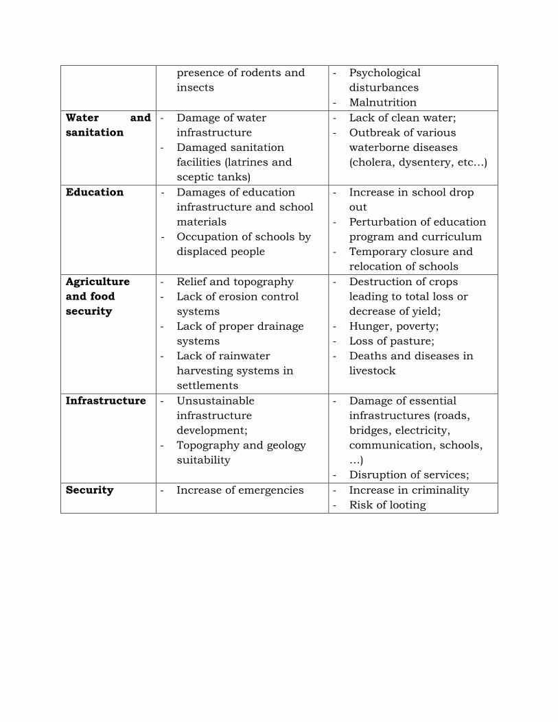
Affected
sectors
Factors contributing to
vulnerability
Impacts
Human
settlement
and shelter
- Poor quality construction
materials
- Unplanned settlement sites
- Injuries and loss of life
- Destruction of houses
- Loss of properties
- Mass displacement
Health and
nutrition
- Damage and
contamination of potable
water sources;
- Long term presence of
standing water with
- Loss of life
- Outbreak of epidemics
and water bone diseases
- Increased risk of vector
borne diseases
presence of rodents and
insects
- Psychological
disturbances
- Malnutrition
Water and
sanitation
- Damage of water
infrastructure
- Damaged sanitation
facilities (latrines and
sceptic tanks)
- Lack of clean water;
- Outbreak of various
waterborne diseases
(cholera, dysentery, etc…)
Education - Damages of education
infrastructure and school
materials
- Occupation of schools by
displaced people
- Increase in school drop
out
- Perturbation of education
program and curriculum
- Temporary closure and
relocation of schools
Agriculture
and food
security
- Relief and topography
- Lack of erosion control
systems
- Lack of proper drainage
systems
- Lack of rainwater
harvesting systems in
settlements
- Destruction of crops
leading to total loss or
decrease of yield;
- Hunger, poverty;
- Loss of pasture;
- Deaths and diseases in
livestock
Infrastructure - Unsustainable
infrastructure
development;
- Topography and geology
suitability
- Damage of essential
infrastructures (roads,
bridges, electricity,
communication, schools,
…)
- Disruption of services;
Security - Increase of emergencies - Increase in criminality
- Risk of looting

2.3. Historic Flood and landslide Records
Floods and landslides disasters have caused the loss of lives, the displacement
of affected population as well as damage to infrastructures (roads, bridges,
houses, schools, and other properties), crops and a serious environmental
degradation.
Floods and landslides usually originate from heavy rainfall, which causes rapid
and unpredictable surges in the flow of rivers downstream mainly in rain
season (from March to June) and from (October to December).
The two predominant types of floods are:
i. localised floods caused by exceptionally heavy rains and run-offs
ii. widespread floods caused by overflowing rivers and their tributaries.
They also cause physical damage by washing away structures, crops, animals
and submerging human settlements.
Therefore, Landslide usually follows also heavy rainfall and high ground water
flowing through cracked bed rock and earthquakes and lead to the movement
of soil or sediment. The most vulnerable areas prone to landslides and floods
include the Districts of North-western provinces such as Nyabihu, Rubavu,
Musanze, Burera, Ngororero, Karongi, Rutsiro, and Gakenke.
2.4. Disaster Damages caused by floods, landslides and heavy rains by type of disaster (July 2016- June 2018)
a) Damages to livelihood of the population
Event Deaths Injured
Houses
Damaged
Crops
Ha. Livestock
FLOODS 31 8 1900 4713.46 940
LANDSLIDES 93 39 1362 802.98 128
TOTAL 124 47 3262 5516.44 1068
b) Damages to infrastructure
Event
Class
rooms
Health
centers Roads
Churches
Bridges
Admin
offices
Water
supply
Transm
lines
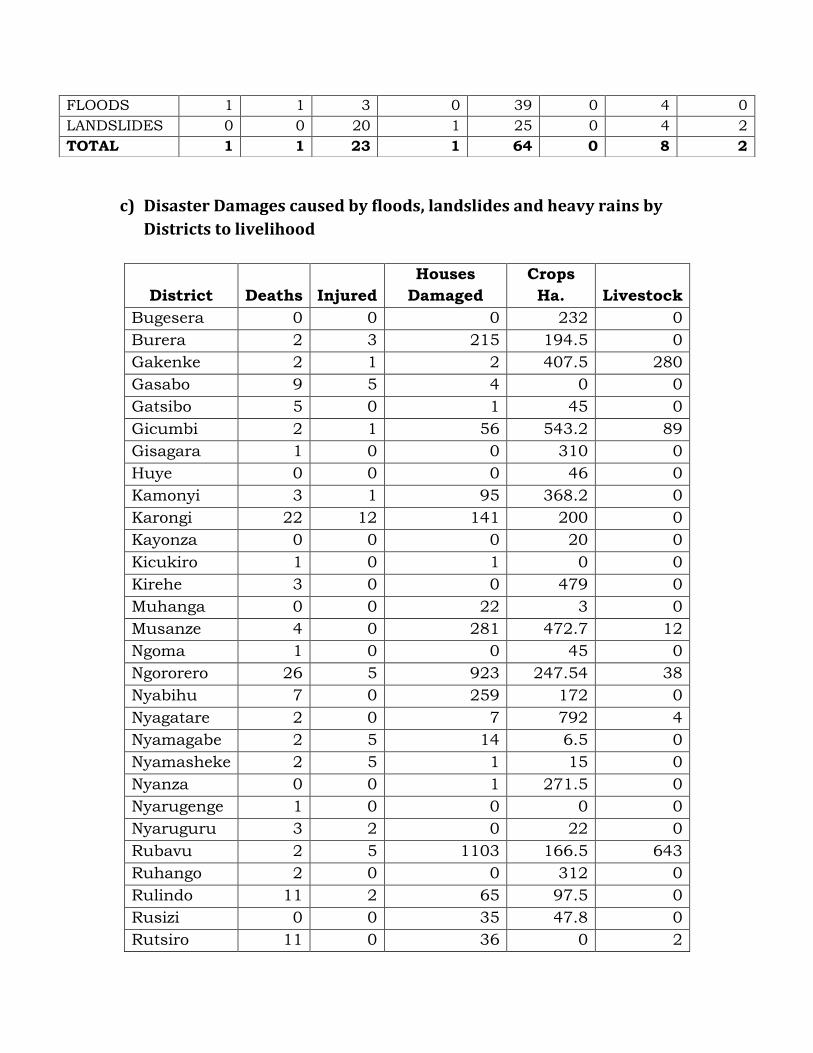
c) Disaster Damages caused by floods, landslides and heavy rains by
Districts to livelihood
District Deaths Injured
Houses
Damaged
Crops
Ha. Livestock
Bugesera 0 0 0 232 0
Burera 2 3 215 194.5 0
Gakenke 2 1 2 407.5 280
Gasabo 9 5 4 0 0
Gatsibo 5 0 1 45 0
Gicumbi 2 1 56 543.2 89
Gisagara 1 0 0 310 0
Huye 0 0 0 46 0
Kamonyi 3 1 95 368.2 0
Karongi 22 12 141 200 0
Kayonza 0 0 0 20 0
Kicukiro 1 0 1 0 0
Kirehe 3 0 0 479 0
Muhanga 0 0 22 3 0
Musanze 4 0 281 472.7 12
Ngoma 1 0 0 45 0
Ngororero 26 5 923 247.54 38
Nyabihu 7 0 259 172 0
Nyagatare 2 0 7 792 4
Nyamagabe 2 5 14 6.5 0
Nyamasheke 2 5 1 15 0
Nyanza 0 0 1 271.5 0
Nyarugenge 1 0 0 0 0
Nyaruguru 3 2 0 22 0
Rubavu 2 5 1103 166.5 643
Ruhango 2 0 0 312 0
Rulindo 11 2 65 97.5 0
Rusizi 0 0 35 47.8 0
Rutsiro 11 0 36 0 2
FLOODS 1 1 3 0 39 0 4 0
LANDSLIDES 0 0 20 1 25 0 4 2
TOTAL 1 1 23 1 64 0 8 2

TOTAL 124 47 3262 5516.44 1068
d) Disaster Damages caused by floods, landslides and heavy rains by
Districts to infrastructure
District
Class
rooms
Health
centers Roads
Churches
Bridges
Admin
offices
Water
supply
Transm
lines
Bugesera 0 0 0 0 0 0 0 0
Burera 1 1 1 0 11 0 0 0
Gakenke 0 0 0 0 6 0 4 0
Gasabo 0 0 0 0 0 0 0 0
Gatsibo 0 0 0 0 1 0 0 0
Gicumbi 0 0 3 0 8 0 4 0
Gisagara 0 0 0 0 0 0 0 0
Huye 0 0 0 0 2 0 0 0
Kamonyi 0 0 0 0 0 0 0 0
Karongi 0 0 0 0 0 0 0 0
Kayonza 0 0 0 0 0 0 0 0
Kicukiro 0 0 0 0 0 0 0 0
Kirehe 0 0 0 0 0 0 0 0
Muhanga 0 0 4 0 1 0 0 0
Musanze 0 0 2 0 0 0 0 0
Ngoma 0 0 0 0 0 0 0 0
Ngororero 0 0 5 0 7 0 0 0
Nyabihu 0 0 1 0 5 0 0 0
Nyagatare 0 0 0 0 0 0 0 0
Nyamagabe 0 0 3 1 6 0 0 0
Nyamasheke 0 0 0 0 0 0 0 0
Nyanza 0 0 0 0 0 0 0 0
Nyarugenge 0 0 0 0 0 0 0 0
Nyaruguru 0 0 1 0 0 0 0 0
Rubavu 0 0 0 0 13 0 0 0
Ruhango 0 0 1 0 0 0 0 1
Rulindo 0 0 0 0 0 0 0 0
Rusizi 0 0 2 0 0 0 0 0
Rutsiro 0 0 0 0 4 0 0 1
TOTAL 1 1 23 1 64 0 8 2
Source: Disaster Communication System/MIDIMAR Assessment

3. SCENARIO and PLANNING ASSUMPTION
3.1. Scenario (January – December 2019)
Type of hazard Floods and landslides
Likelihood Almost certain
Magnitude High (North-Western parts of the country and the city of Kigali
Moderate ( Southern Province)
Low (Eastern part of the country)
Impact Medium for most locations on Infrastructure, health, food security,
water and sanitation, generally on livelihoods and education
Location and
Geographical Area
highly prone to
floods and
Landslides
Western Province (Rubavu, Nyabihu, Ngororero, Karongi, Rutsiro,
Rusizi and Nyamasheke),
Northern Province (Musanze, Burera, Gicumbi and Rulindo);
Southern Province (Kamonyi, Ruhango, Nyanza, Huye, Muhanga) ,
City of Kigali (Nyarugenge district),
Eastern Province( Bugesera District)
Triggers High levels of rainfall (above normal rainfall), the intensity of rainfall,
rising water levels in the river basins (Nyabarongo, Mukungwa, Sebeya,
Akanyaru, Nyabugogo), rate of drainage, landuse and landcover type,
human activities and Water springing from the ground
Timeframe January 2019 –December 2019
3.2. PLANNING ASSUMPTION (January – December 2019)
Sector People /area
affected
Deaths Injuries Missing Damages Consequences
Health and
nutrition
325,670 30 150 N/A 6 health centers
Sanitation
systems
Water sources
contaminated
Diseases
Malnutrition
Psycho-social
problems
Water and
sanitation
150,642 N/A N/A N/A 11 Water supply
systems
750 Latrines
and septic
Water shortage
Waterborne
diseases

tanks
Agriculture
and food
security
185,000 N/A N/A N/A 2,535ha of
crops
1,100 Deaths of
livestock
Loss of pasture
Food shortage
(27,988 MT of
cereals)
Poverty
Infrastruct
ure
Nyabihu
Ngororero,
Gakenke
Rubavu,
Kivu belt,
Nyarugenge,
Kamonyi
N/A N/A N/A 13 Roads,
33 bridges,
19 electrical
poles, markets,
communication
facilities
Temporary
disruption of
services,
Economic costs
Human
settlement
and shelter
Affected:
38,160
Displaced:
7,200
N/A N/A N/A Houses
destroyed:1,309
Houses
damaged: 5,628
Displacement
and loss of
shelter
Education 5,000 N/A N/A N/A 10 schools Disruption of
education
programs
School drop
out
Security 325,670 N/A N/A 10 N/A Increase in
criminalities

4. PREPAREDNESS, RESPONSE AND RECOVERY ACTIVITIES
The main objective of the National Contingency Plan for floods and landslides
has been stated in the introduction of this document and is reinforced by
sectors based specific objectives i.e. support the timely and coordinated
response to anticipated floods and landslides in the 2018-2019 heavy rainy
seasons, thus effectively minimizing the impacts of the floods and landslides on
human population, livelihoods, properties and the environment.
As per the National Disaster Management Policy of 2012, Disaster
Management is the responsibility of everyone. It is line with this that we
expect all players ranging from Government Agencies, cooperating partners,
the UN System, the Private Sector, Non-governmental organisations (Local and
International) and those that are community based to be fully involved in the
mobilisation of the required resources to implement the contingency plan:
The Government of the Republic of Rwanda will not take kindly to individual
organisations that may choose to unilaterally carry out assessments and later
on disseminate their findings without Government clearance.

MITIGATION, RESPONSE AND RECOVERY ACTIVITIES (SECTOR BY SECTOR)
LEAD
INSTITUTION
Action Mitiga
tion
Respo
nse
Reco
very
INSTITUTI
ON
Ministry in
Charge of
Emergency
Management
✓ Identify and map floods and landslides hazards; ✓ ✓ NADIMAC
NPDM
District
✓ Develop a comprehensive risk analysis for floods and
landslides;
✓ ✓
✓ Ensure that involved public institutions receive
relevant information to efficiently prepare, respond
and recover from floods and landslides;
✓ ✓
✓ Provide relief assistance ✓
✓ Put in place all necessary actions required to
prepare, respond and recover to a hazard;
✓
✓ Receive information, processing it and disseminating
it to the stakeholders through the various channels;
✓ ✓ ✓
✓ Review, update and test contingency plan for flood
and landslides
✓
✓ Organize periodic briefings for stakeholders and
raising community awareness,
✓ ✓ ✓
✓ Mobilization of initial supplies and logistics to enable
the cooperating partners come on board in
responding to the floods and landslides emergencies
✓
✓ Organize and conduct trainings for floods and
landslides emergency management
✓
✓ Activate contingency plan for flood and landslides ✓
✓ Coordinate the humanitarian response to ensure
that there are no duplications for effective
humanitarian response.
✓
Rwanda Defense ✓ Search, Rescue and Evacuation of victims ✓ Ministry in

Forces ✓ Support in personnel and logistics in relief
operations
✓ charge of
Emergency
Manageme
nt
MINALOC
Districts
✓ Medical support and assistance during emergencies ✓ ✓
✓ Provide recovery assistance ✓
✓ Ensure the public order security ✓ ✓ ✓
Rwanda National
Police
✓ Search, Rescue and Evacuation of victims ✓ Ministry in
charge of
Emergency
Manageme
nt
MINALOC
Districts
✓ Provide security for displaced people and their
properties
✓ ✓
✓ Support in personnel and logistics in relief
operations
✓
✓ Conduct trainings ✓
✓ Provide recovery assistance ✓
✓ Provide safety and security of the community ✓ ✓ ✓
National
Platform for
Disaster
Management
(NPDM)
✓ Ensure the use of all mechanisms such as flash
appeals and consolidates appeals to mobilize
resources for the emergency.
✓ ✓ Ministry in
charge of
Emergency
Manageme
nt
NADIMAC
✓ To provide humanitarian assistance for affected
people
✓
✓ The private sector should contribute to the
humanitarian response as part of their responsibility
to support the Government
✓
Ministry of Local
Government
✓ Ensure that all districts are providing required
assistances to the floods and landslides incidents.
(Risk assessment, Early warning, damages
assessment, response and recovery activities)
✓ ✓ ✓ Ministry in
charge of
Emergency
Manageme

✓ Ensure that all information related to floods and
landslides are shared in order to promptly respond to
the emergency.
✓ ✓ ✓ nt
Districts
District
✓ Disseminate relevant information and assessment
findings to relevant and concerned entities
✓ ✓ Ministry in
charge of
Emergency
Manageme
nt
Rwanda
Red Cross
RHA
DIDIMAC
SEDIMAC
✓ Provide quick assistance and first aid to affected
people for disasters of Level 1 and Level 2
✓
✓ Raise community disaster awareness and be involved
in Early Warning for floods and landslides
✓
✓ Convene DIDIMAC emergency meetings for floods
and landslides
✓
✓ Identification of site and relocation of displaced
people
✓ ✓
✓ Conduct Prompt assessment in case of floods and
landslides incidents
✓
✓ Conduct deep assessment on damages and needs of
the affected population
✓
✓ Assist in search and rescue operations ✓
Ministry of
Environment
✓ Conduct a nationwide assessment of erosion prone
areas likely to be affected by floods and landslides
✓ Ministry in
charge of
Emergency
Manageme
nt
RWFA
Meteo
Rwanda
✓ Develop guidelines to implement measures to
mitigate floods and landslides disasters
✓
✓ Ensure proper mechanisms of weather forecast and
early warnings
✓
✓ Enhance rain water harvesting and water storage to
meet water security demands and reduce disaster
risk.
✓ ✓

✓ Ensure that watershed are protected and resilient to
extreme events
✓ ✓
✓ Gazette flood basins
✓ Availing weather information
✓ ✓
RWANDA RED
CROSS
✓ Develop a comprehensive risk analysis for floods and
landslides;
✓ MINEMA
Districts
✓ Put in place all necessary actions required to
prepare, respond and recover to a hazard;
✓ ✓
✓ Conduct assessment of disaster damages ✓
✓ Organize and conduct trainings for floods and
landslides emergency management
✓
✓ Search, Rescue and Evacuation of affected victims ✓
✓ Provide relief assistance ✓
✓ Conduct family reunification ✓ ✓
✓ Provide psychosocial support to affected population ✓ ✓
MINEDUC ✓ Integrate courses related to disaster management
into the curriculum
✓ MINEMA
REB
District ✓ Provide temporary learning facilities and materials ✓
✓ Carryout rehabilitation works on all school
infrastructure damaged by floods and landslides
✓ ✓
✓ Demobilize and shift school back to original place ✓
MINAGRI ✓ Farmer sensitization on flood mitigation measures
involving crop/variety selection and conservation
farming
✓ MINEMA
RAB
Meteo-
Rwanda
Rwanda-
✓ Damages control ✓
✓ Assessment of floods prone area ✓

✓ Surveillance of transmittable diseases ✓ ✓ ✓ Red Cross
RNP
RDF
Districts
✓ Provide food items to affected population ✓
✓ Survey of suspected livestock diseases outbreaks and
mapping
✓ ✓
✓ Awareness creation among livestock owners on
disease prevention and control measures in affected
districts
✓ ✓
✓ Livestock vaccinations and treatment for cattle ✓ ✓
✓ Regeneration of crops ✓
✓ Compensation for loss (Crops and Livestock) ✓
MoH ✓ Community sensitization on personal hygiene ✓ MINEMA
SAMU
RBC
Rwanda
Red Cross
Districts
✓ Map out inaccessible areas in the districts ✓
✓ Provide medical services including mobile clinics in
affected areas
✓
✓ Mobilize medical teams and monitor disease
outbreaks
✓ ✓
✓ Support integrated disease surveillance and
reporting
✓
MININFRA ✓ Develop a comprehensive infrastructure risk
analysis for floods and landslides
✓ ✓ MINEMA
Districts
RHA
RDF Eng
Brigade
WASAC
RTDA
REG
✓ Initial infrastructure rehabilitation (roads,
communication, water supply, electricity, bridges,…)
✓
✓ Conduct post-disaster need assessment ✓
✓ Support in recovery activities ✓
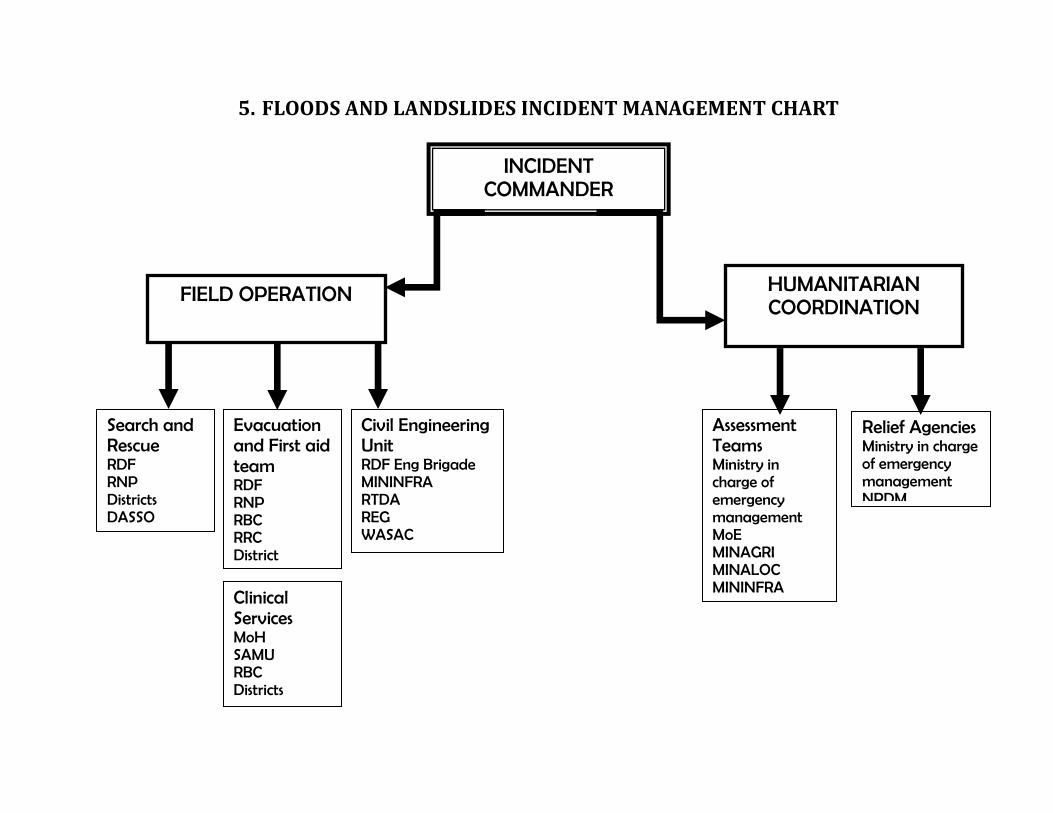
5. FLOODS AND LANDSLIDES INCIDENT MANAGEMENT CHART
INCIDENT COMMANDER
FIELD OPERATION HUMANITARIAN COORDINATION
Search and Rescue RDF RNP Districts DASSO
Evacuation and First aid team RDF RNP RBC RRC District
Civil Engineering Unit RDF Eng Brigade MININFRA RTDA REG WASAC
Clinical Services MoH SAMU RBC Districts
Assessment Teams Ministry in charge of emergency management MoE MINAGRI MINALOC MININFRA MINILAF RDF RNP
Relief Agencies Ministry in charge of emergency management NPDM