republic of armenia ministry of energy … · michael suqiasyan - committee member vidok tovmasyan...
TRANSCRIPT

Translation from Armenian
REPUBLIC OF ARMENIA
MINISTRY OF ENERGY INFRASTRUCTURE AND NATURAL
RESOURCES STAFF
STATE COMMITTEE OF RESERVES
STATE SUBSOIL EXPERTISE
CONCLUSION N6
ABOUT CONDITION PARAMETERS AND CONFIRMATION OF RESERVES OF
ARAGATSOTN REGION TOUKHMANUK GOLD MINE SOUTHERN AND
MIRAK SECTIONS AND KOTAYK REGION TSITSKAR GOLD MINE OF
REPUBLIC OF ARMENIA
EREVAN 2016
2
STATE SUBSOIL EXPERTISE
CONCLUSION N6
of November 4th, 2016
ABOUT CONDITION PARAMETERS AND CONFIRMATION OF RESERVES OF
ARAGATSOTN REGION TOUKHMANUK GOLD MINE SOUTHERN AND MIRAK SECTIONS
AND KOTAYK REGION TSITSKAR GOLD MINE OF REPUBLIC OF ARMENIA
Guided by RA government decision number 1588-Ն point 1 sub-point “a”, Exhibit 1,
point 8 and 8, dated September 26, 2002, and finalizing the results of state subsoil expertise of
“About report of reserves calculation as of 01.04.2016 and by technical-economical
corroboration of condition parameters in Southern, Mirak and Kotayk region Tsitskar sections
concerning geological survey works implemented in Toukhmanuk mineral field of Aragatsotn
region, Republic of Armenia”, discussed in hearing dated November 4, 2016 of state subsoil
expertise commission of mineral reserves agency of ministry of energy infrastructure and
natural resources of Republic of Armenia, the agency of mineral reserves hold a decision:
1. Agreeing with RA mineral reserves state agency (MRSA) state subsoil expertise
commission – rename the investigated areas to Southern and Mirak sections of
Toukhmanuk gold mine of Aragatsotn region of Republic of Armenia and Tsitskar
gold mine of Kotayk region of Republic of Armenia.
2. Ascribe Southern and Mirak sections of Toukhmanuk gold mine of Aragatsotn region
of Republic of Armenia and Tsitskar gold mine of Kotayk region of Republic of
Armenia to complexity level 3 by geological structure.
3. Confirm the parameters of conditions for reserves border outlining and calculation of
the Southern and Mirak sections of Toukhmanuk gold mine of Aragatsotn region of
Republic of Armenia and Tsitskar gold mine of Kotayk region of Republic of Armenia
as follows:
1) Outline the mineral bodies by geological borders,
2) Minimum content of gold in border section is 1.0 g/t
3) Consider the minimum power of mineral body in reserves calculation as 1.0m, in
case of less power – guide by metrogramms,
4) Minimum industrial content of gold in calculation block is 1.6g/t,
5) Stripping border coefficient is not more than 24.2t/t.
4. Confirm the reserves of Southern and Mirak sections of Toukhmanuk gold mine of
Aragatsotn region of Republic of Armenia and Tsitskar gold mine of Kotayk region of

3
Republic of Armenia as of 01.04.016, in final border outline of open mine presented
by the authors of the report by the following categories and quantities:
Reserves
classification
Ore
reserves,
thousand
ton
Average content of
metals
Quantity of metals
Au. g/t Ag. g/t Au, kg Ag, t
1 2 3 4 5 6
Southern section of Toukhmanuk gold mine of Aragatsotn region of RA
C1 391.12 6.69 12.65 2616.98 4.95
C2 1656.90 4.60 10.10 7613.74 16.73
C1+C2 2048.02 5.00 10.59 10230.72 21.68
Mirak section of Toukhmanuk gold mine of Aragatsotn region of RA
C2 345.25 3.00 8.89 1037.17 3.07
Tsitskar gold mine of Kotayk regions of RA
C2 176.47 4.96 10.44 875.72 1.84
5. Fact, that the resource potential of Southern and Mirak sections of Toukhmanuk gold
mine of Aragatsotn region of Republic of Armenia and Tsitskar gold mine of Kotayk
region of Republic of Armenia is not exhausted by the resources confirmed by point 3
of the current conclusion, and until today, pursuant to accumulated geological
information, the prospect of increase of reserves in Southern section, on the account
of investigation of its deep horizons, pursuant to realistic appraisal of the author, are
anticipated to be 2.5 million tons, gold and silver correspondingly 8.0 tons and 17.6
tons, anticipated resources of class P
6. Offer RA ministry of energy infrastructure and natural resources (also refer to as
MEINR) staff Subsoil state inspection to implement survey of credibility of geological
information presented to state subsoil expertise by report of “Mego Gold” LLC.
7. Offer “Republican geological fund” state non-commercial company of MEINR to take
into registration the reserves confirmed by point 4 of the current conclusion.
Chief of MRSA of RA /signature/ Haykaz Nazaryan
Chief of department of expertise of
material calculations of mineral reserves
of MRSA of RA, responsible of material expertise /signature/ Hrant Avetisyan
4
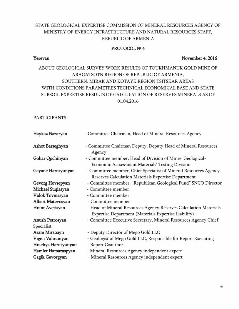
STATE GEOLOGICAL EXPERTISE COMMISSION OF MINERAL RESOURCES AGENCY OF
MINISTRY OF ENERGY INFRASTRUCTURE AND NATURAL RESOURCES STAFF,
REPUBLIC OF ARMENIA
PROTOCOL № 4
Yerevan November 4, 2016
ABOUT GEOLOGICAL SURVEY WORK RESULTS OF TOUKHMANUK GOLD MINE OF
ARAGATSOTN REGION OF REPUBLIC OF ARMENIA,
SOUTHERN, MIRAK AND KOTAYK REGION TSITSKAR AREAS
WITH CONDITIONS PARAMETRES TECHNICAL ECONOMICAL BASE AND STATE
SUBSOIL EXPERTISE RESULTS OF CALCULATION OF RESERVES MINERALS AS OF
01.04.2016
PARTICIPANTS
Haykaz Nazaryan -Committee Chairman, Head of Mineral Resources Agency
Ashot Barseghyan - Committee Chairman Deputy, Deputy Head of Mineral Resources
Agency
Gohar Qochinyan - Committee member, Head of Division of Mines' Geological-
Economic Aassessment Materials' Testing Division
Gayane Harutyunyan - Committee member, Chief Specialist of Mineral Resources Agency
Reserves Calculation Materials Expertise Department
Gevorg Hovsepyan - Committee member, “Republican Geological Fund” SNCO Director
Michael Suqiasyan - Committee member
Vidok Tovmasyan - Committee member
Albert Matevosyan - Committee member
Hrant Avetisyan - Head of Mineral Resources Agency Reserves Calculation Materials
Expertise Department (Materials Expertise Liability)
Anush Petrosyan - Committee Executive Secretary, Mineral Resources Agency Chief
Specialist
Aram Mirzoayn - Deputy Director of Mego Gold LLC
Vigen Vahramyan - Geologist of Mego Gold LLC, Responsible for Report Executing
Hrachya Harutyunyan - Report Coauthor
Hamlet Hamazaspyan - Mineral Resources Agency independent expert
Gagik Gevorgyan - Mineral Resources Agency independent expert

5
AGENDA
Geological Survey Work Results Of Toukhmanuk Gold Mine Of Aragatsotn Region of Republic
of Armenia, Southern, Mirak And Kotayk Region Tsitskar Areas With Conditions Parameters
Technical Economical Base And State Subsoil Expertise Results Of Calculation Of Reserves
Minerals as of 01.04.2016 materials state geological expertise results discussion is presented by
Mego Gold LLC.
1. Brief information about the materials presented for state geological expertise by report
author
Author reference (appendix 1)
Reporter- “Mego Gold” LLC geologist V.Vahramyan
2. Presentation of expertize results by Mineral Resources Agency Independent Experts
Expertise Conclusion (appendix 2)
Reporter-G. Gevorgyan
Expertise Conclusion (appendix 3)
Reporter- H.Hamazaspyan
3. State geological expertise process consolidation by the responsible person for the
materials expertise
Conclusion (appendix 5)
Reporter – H. Avetisyan
4. Exchange of ideas
5. Committee resolution.

6
Discussions
In opening speech H. Nazaryan welcomed committee members and presented agenda
which was accepted unanimous․
Concerning first issue of agenda V. Vahramyan presented “Geological Survey Work
Results Of Toukhmanuk Gold Mine Of Aragatsotn Region of Republic of Armenia,Southern,
Mirak And Kotayk Region Tsitskar Areas With Conditions Parametres Technical Economical
Base And State Subsoil Expertise Results Of Calculation Of Reserves Minerals as of 01.04.2016”
report mane sections.
V. Vahrmanyan and report coauther H. Harutyunyan clarified the questions raised by M.
Suqiasyan, V. Tovmasyan, A. Matevosyan. Especially, M. Suqiasyan and G. Hovsepyan
mentioned that explored areas names must be edited. H. Avetisyan mentioned that that question
was discussed during expertise also and presented by appropriate suggestion in “Conclusion”.
V.Tovmasyan mentioned that areas exploration has been done by boreholes and for the
deep horizons reserves assessment underground mountain cuttings are needed. The suggestion
was accepted by H. Harutyunyan who mentioned that undergroung mountain cuttings will be
done during the exploration of deep horizons.
A. Matevosyan asked about the mineral veins structure․ In response, H. Harutyunyan
mentioned that 5/1, 5/3 and 5/4 veins are the apophyses of 5/2, which despite of its low
mineralization is characterized as stronger and belongs to earlier stage of mineralization.
A. Barseghyan raised internal and external control analyses comparability issue. H.
Harutyunyan mentioned that both internal and external control analyses have been done in
compani’es and “Analitic” CJSC’s laboratories. Due to modern equipment of laboratory the degree
of accuracy of the test results increased by 15%․ The results of internal and external analyses are
comparable which is affirmed in Report appropriate table appendixes. Associated components
analyses have been done in “Alex Stuart” laboratory.
G. Hovsepyan mentioned that in the areas presented in Report is noticed the sharp increase
in the average content of metals between the past fund materials and present results. H. Harutyunyan
told that only excessive levels characterized and industrial importance veins have attended in
calculation, resulting the average content of metals are increased.
Concerning second issue of agenda G. Gevorgyan and H. Hamazaspyan presented the
results of expertise conclusion concerning the second issue of agenda. G. Gevorgyan mentioned
that despite of some defects in work, expertised materials allowed to confirm Toukhmanuk Gold
Mine Of Aragatsotn Region of Republic of Armenia,Southern, Mirak And Kotayk Region
Tsitskar Areas resources with the contours and quality presented by the authors classifying
Mirak and Tsitskar areas resources wholly as C2 category resources.
7
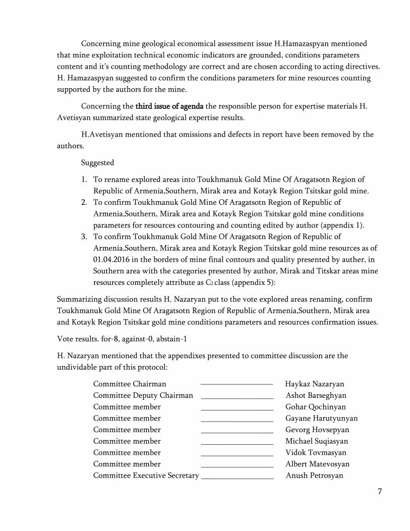
Concerning mine geological economical assessment issue H.Hamazaspyan mentioned
that mine exploitation technical economic indicators are grounded, conditions parameters
content and it’s counting methodology are correct and are chosen according to acting directives.
H. Hamazaspyan suggested to confirm the conditions parameters for mine resources counting
supported by the authors for the mine.
Concerning the third issue of agenda the responsible person for expertise materials H.
Avetisyan summarized state geological expertise results.
H.Avetisyan mentioned that omissions and defects in report have been removed by the
authors.
Suggested
1. To rename explored areas into Toukhmanuk Gold Mine Of Aragatsotn Region of
Republic of Armenia,Southern, Mirak area and Kotayk Region Tsitskar gold mine.
2. To confirm Toukhmanuk Gold Mine Of Aragatsotn Region of Republic of
Armenia,Southern, Mirak area and Kotayk Region Tsitskar gold mine conditions
parameters for resources contouring and counting edited by author (appendix 1).
3. To confirm Toukhmanuk Gold Mine Of Aragatsotn Region of Republic of
Armenia,Southern, Mirak area and Kotayk Region Tsitskar gold mine resources as of
01.04.2016 in the borders of mine final contours and quality presented by auther, in
Southern area with the categories presented by author, Mirak and Titskar areas mine
resources completely attribute as C2 class (appendix 5):
Summarizing discussion results H. Nazaryan put to the vote explored areas renaming, confirm
Toukhmanuk Gold Mine Of Aragatsotn Region of Republic of Armenia,Southern, Mirak area
and Kotayk Region Tsitskar gold mine conditions parameters and resources confirmation issues.
Vote results. for-8, against-0, abstain-1
H. Nazaryan mentioned that the appendixes presented to committee discussion are the
undividable part of this protocol:
Committee Chairman ————————— Haykaz Nazaryan
Committee Deputy Chairman __________________ Ashot Barseghyan
Committee member __________________ Gohar Qochinyan
Committee member __________________ Gayane Harutyunyan
Committee member __________________ Gevorg Hovsepyan
Committee member __________________ Michael Suqiasyan
Committee member __________________ Vidok Tovmasyan
Committee member __________________ Albert Matevosyan
Committee Executive Secretary __________________ Anush Petrosyan

8
Copyright notice
About geological survey results of Toukhmanuk Gold Mine Of Aragatsotn Region
of Republic of Armenia, Southern, Mirak And Kotayk Region Tsitskar Areas with
conditions parameters technical economic base and resources calculation Report as of
01.04.2016.
With the aim of strengthening and expanding the resource potential of
Aragatsotn and Kotayk regions mine areas and Toukhmanuk MEP impact zone
complex geological survey explorations of mine field and surrounding areas have
been done since 2001.
Either Toukhmanuk gold mine “central” area resources, which are being exploited
from 2004, or mine surrounding areas and other occurrences of mining field have
been explored during years, geological study of the works of which started back in
the geological department of the Armenian SSR.
Kotayk Region Hankavan mining field western part gold mining occurrences are
included in geological exploration works from the sight of administrative separation
of RA geological and structural features of which are a number of the Toukhmanuk
mining field occurrences analogs and their ore can be processed and enriched in
constructed mining plant by the same technology of enrichment. This is the main
reason why some occurrences of Hankavan mining field (except copper and
molybdenum occurrences) attributed to Toukhmanuk mineral field occurrences.
Based on this the areas, occurrences and mines existing in this Report have been
presented as Toukhmanuk mining field parts during Mining Rights documents
formatting process.
This report was formed by the results of work implementation provided by the
work project of subsoil geological exploration mine exploitation agreement for mine
exploitation permit number ԵՀԹ 29/136 issued on July 2, 2012 by the agenda of
implementation of occurrences geological survey works and areas with possible
industrial importance in the zone of affection of active mine enrichment plant and
Toukhmanuk mine area of Aragatsotn region of RA.
Geological exploration work has been carried out in Tukhmanuk gold mine
"South" area (No. 5 vein zone), in Mirak, Vanatun, Lusagyugh, Bacatlich, Voskedzor,
Tsitskar, Talma and Melik Gyugh areas. In addition to this, the search included other
parts of the known mineralized area and mineralogical points also.
The works were carried out in 1:10000 scale survey routes crossing through
superficial mountain openings and surface pipe drilling. The most perspective
occurrences have been explored. Fund materials are collected and analyzed.
Gold and polymetallic mineralization mineral zones and vein surfaces with
mountain hollows, bore holes are explored in mining field and company influence

9
zone as a result. This ore bodies are calculated as C1 and C2 category resources and
estimated as P1 category forecasting resources. Technical economic evaluation has
been done which becomes the base of acting company indicators. The areas industrial
importance is confirmed as a result. Toukhmanuk mining field and company
influence zone territory given for exploration attracts more than 5380 hectares
covering the areas east and north-east from Toukhmanuk mine.
Exploration territory specifically includes Kasakh and Marmarik rivers watershed
areas including Hankavan mine field western area. In terms of the total study area is
located in the north-western slope of the mountain range Tsaghkunyats.
Starting in 1983, by an expedition group of the Geological Department, in Mirak-
Toukhmanuk gold occurrence aeas survey-evaluation works have been done
intended to gold quartz-sulphide zones mapping and study.
In Touhkmanuk mining field geological structure are existing upper proteroz
metamorphic complex, upper-lower chalk, neogen and quaternary age volcanic,
sedimentary and volcanic rocks and sedimentary formations which are torn by the
lower and upper chalk and acid composition of medium height and subvolcanic
intrusive formations.
The studied area, under the name of Toukhmanuk mineral field, is the north-
western part of Tsaghkunyats anticlinoria. Tsaghkunyats anticlinoria is one of the
most complex structures Transcaucasia. It’s situated in Bazum-Zangezur intense
corrugated tectonic zone fully occupying contemporary Tsaghkunyats Ridge area. It
is divided from north located Sevan-Shirak sinclinoria by Marmarik deep rupture.
Anticlinoria’s southern and south-western boundaries, respectively, Yerevan oregon
moles concavity and Kasakh (Aparan) newest rupture-sinclinoria are also tectonic
(Bjni Arzakan-Buzhakan-Gegharot). Thus, Tsaghkunyats anticlinoria is being
bordered by abyssal fractures from three sides and in fact, represents a real horst-
anticlinoria.
There are two solid large gaps in Toukhmanuk mining field- Lusaghyugh and
Hankavan as Kotlyar showed. On Aghamalyan’s map are shown some large gaps also
which according to the author are fixing Aparan series supposed 3 layer group
borders. East from Melikgyugh, Lusagyugh rupture is connecting by sharp angle with
Hankavan rupture north-western continuation in North. In eastern part Hankavan
rapture is the border of transform complex separated in the North and Hankavan
intrusive quartz diorites in South, till Toukhmanuk gold mine continuing through
metamorphic complex.
Some areas are separated in Toukhmanuk mining fileld that structurally belong to
the same tectonic structures. They are alike from the sight of metal emergence, mine
emergence and mine accumulation and are the reason of the same metal emergence
genetic processes.

10
In initial phase of exploration of these mining occurrences and mineralized areas
were considered as single Toukhmanuk mining field occurrences due to their
uniform structural feature.
Mineralization of this occurrences are enclosed in upper chalk tectonic
formations and upper proteros plagiogranites which are torn by rhyolite porphyries,
granodiorit porphyrins dyke complex rocks and shtock bodies. The last phase of inset
of intrusive bodies was accompanied by intense hydrothermal metasomaphic changes
forming in them and enclosing rocks argil, beresite, propylitic and quartz-sericite
metasomatik and altered rocks crowns. In many areas of magmatic insets and
exocytosis parts are formed broken rocks parts which were cemented by
hydrothermal quartz-carbonate cement composition and consists gold- polymetallic
mineralization.
Either in Toukhmanuk mine or within occurrences other veins of mining field
mineralization is presented by quartz-carbonate-gold mining type and veins he
structural features of which are conditioned by tectonic medium and small gaps in
rocks. Mineralization basically is localized with tectonic gaps and bretch zones, but
mineral columns are recorded in different directions and kinds gaps connecting areas.
Mineral field rocks are characterized with intensively expressed isocheimal and
allochemical modifications which have been occurred during different periods and
processes of geological history.
Area’s rocks metamorphic and metasomatic modifications are genetically
connected with regional metamorphism, auto metamorphism, contact-
metamorphism, hydrothermal metamorphism and nearmining metasomatic
modifications.
During the geological survey works provided by the company in the mining field
occurrences exploration stage had been the target goal to implement the evaluation of
previous years geological explorations and discovered quartz-sulphide veins and
mining zones through crossing mountain openings from surface and drill holes
drilling conjunction with 1:10000 scale search routes. The challenge was to get the
new data compression through chain compression, to perform ore bodies connections
either by depth or by separation.To accomplish resources calculation.
With the results of previous works is proven the noble metal existence in
metasomatic modification zones which became a base for survey works
implementation in occurrences field. Geological exploration works within
occurrences have been implemented through ditches, clearings mechanical-
column drilling, documentation and sampling of geological routes.
Ore bodies mineralogical composition, their structural- textural feature, the
exploration of minerals paragenetic associations’ age relationship allows to
differentiate quartz pyrite-chalcopyrite, gold-pyrite-arsenopyrite, gold-polymetallic,

11
antimony and quartz-carbonate mineralization paragenetic associations which are
correspond to the individual phases of mineralization.
Toukhmanuk mine field ore bodies mineral compound
Minerals prevalence Hypogenous minerals
Hypergenous minerals mineral non mineral
The main minerals
Pyrite
arsenopyrite
galen
sphalerite
chalcopyrite
tennantite
tetraedrite
congenital gold
quartz
chalcedony
calcite
anchorite
kheritsite
chlorite
kaolinite
epidot
opalite
limonite
bornite
koveline
khalkozine
secondary
Magnetite
markazite
antimonite
bulanzherit
retile
rodokhrozit
manganokaltsit
Ceresit
amitosis
anglesite
rare
molybdenyt
burnonite
tetradimite
vismutin
telurobismutite
krenerite
kalaverite
Altaic
hesit
dolomite
Adulyan
gypsum
malachite
azurite
12
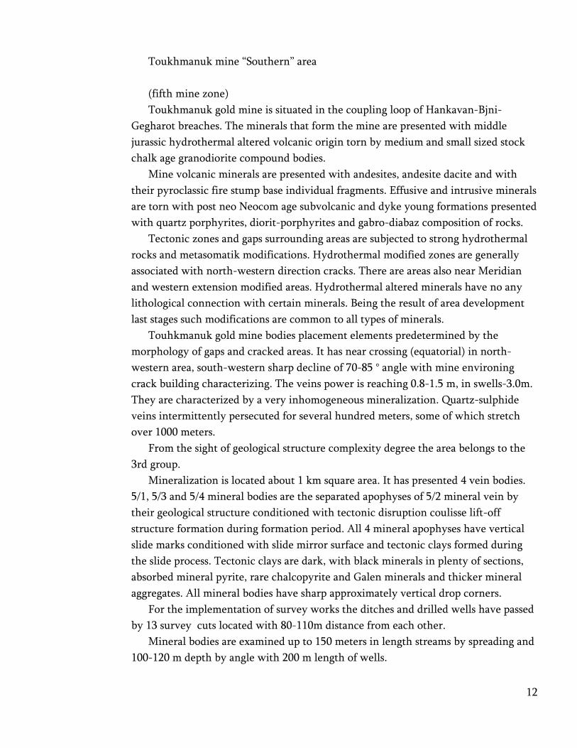
Toukhmanuk mine “Southern” area
(fifth mine zone)
Toukhmanuk gold mine is situated in the coupling loop of Hankavan-Bjni-
Gegharot breaches. The minerals that form the mine are presented with middle
jurassic hydrothermal altered volcanic origin torn by medium and small sized stock
chalk age granodiorite compound bodies.
Mine volcanic minerals are presented with andesites, andesite dacite and with
their pyroclassic fire stump base individual fragments. Effusive and intrusive minerals
are torn with post neo Neocom age subvolcanic and dyke young formations presented
with quartz porphyrites, diorit-porphyrites and gabro-diabaz composition of rocks.
Tectonic zones and gaps surrounding areas are subjected to strong hydrothermal
rocks and metasomatik modifications. Hydrothermal modified zones are generally
associated with north-western direction cracks. There are areas also near Meridian
and western extension modified areas. Hydrothermal altered minerals have no any
lithological connection with certain minerals. Being the result of area development
last stages such modifications are common to all types of minerals.
Touhkmanuk gold mine bodies placement elements predetermined by the
morphology of gaps and cracked areas. It has near crossing (equatorial) in north-
western area, south-western sharp decline of 70-85 ° angle with mine environing
crack building characterizing. The veins power is reaching 0.8-1.5 m, in swells-3.0m.
They are characterized by a very inhomogeneous mineralization. Quartz-sulphide
veins intermittently persecuted for several hundred meters, some of which stretch
over 1000 meters.
From the sight of geological structure complexity degree the area belongs to the
3rd group.
Mineralization is located about 1 km square area. It has presented 4 vein bodies.
5/1, 5/3 and 5/4 mineral bodies are the separated apophyses of 5/2 mineral vein by
their geological structure conditioned with tectonic disruption coulisse lift-off
structure formation during formation period. All 4 mineral apophyses have vertical
slide marks conditioned with slide mirror surface and tectonic clays formed during
the slide process. Tectonic clays are dark, with black minerals in plenty of sections,
absorbed mineral pyrite, rare chalcopyrite and Galen minerals and thicker mineral
aggregates. All mineral bodies have sharp approximately vertical drop corners.
For the implementation of survey works the ditches and drilled wells have passed
by 13 survey cuts located with 80-110m distance from each other.
Mineral bodies are examined up to 150 meters in length streams by spreading and
100-120 m depth by angle with 200 m length of wells.
13
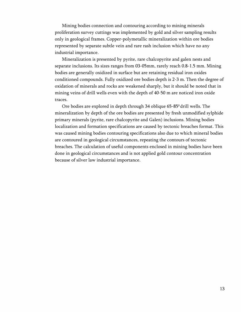
Mining bodies connection and contouring according to mining minerals
proliferation survey cuttings was implemented by gold and silver sampling results
only in geological frames. Copper-polymetallic mineralization within ore bodies
represented by separate subtle vein and rare rash inclusion which have no any
industrial importance.
Mineralization is presented by pyrite, rare chalcopyrite and galen nests and
separate inclusions. Its sizes ranges from 03-05mm, rarely reach 0.8-1.5 mm. Mining
bodies are generally oxidized in surface but are retaining residual iron oxides
conditioned compounds. Fully oxidized ore bodies depth is 2-3 m. Then the degree of
oxidation of minerals and rocks are weakened sharply, but it should be noted that in
mining veins of drill wells even with the depth of 40-50 m are noticed iron oxide
traces.
Ore bodies are explored in depth through 34 oblique 65-850 drill wells. The
mineralization by depth of the ore bodies are presented by fresh unmodified sylphide
primary minerals (pyrite, rare chalcopyrite and Galen) inclusions. Mining bodies
localization and formation specifications are caused by tectonic breaches format. This
was caused mining bodies contouring specifications also due to which mineral bodies
are contoured in geological circumstances, repeating the contours of tectonic
breaches. The calculation of useful components enclosed in mining bodies have been
done in geological circumstances and is not applied gold contour concentration
because of silver law industrial importance.

14
Mirak area
Mirak area is placed south-west from Toukhmanuk mining field. It’s located 2.5-3
km north-east from Mirak village.
Mineralization is enclosed in Mirak intrusion quartz diorites and Aparan layer
group basalt-andesite basalt lavas and tuff breccia.
Hydrothermal modified zones (10-15m) are controlled with north-eastern gaps
along which rocks are severely broken, modified and filled with quartz-carbonate
quartz-mineral mineral veins and little veins. Veins are about 100-120m in length
and up to 0.3-0.6 m capacity, decline in the southeast corner of 60-800. Little veins
capacity is not exceeding 2-3sm. Mineral bodies contact with lateral rocks is sharp,
sometimes conditioned witհ the presence of clays. Gradual transitions are also
observed.
By the results of geological survey works only 1 mineral body has industrial
importance which is presented with north-eastern spreading and south-eastern 600
declined tectonic disruption structure. It’s characterized with clearly contacts, in the
laying rib of which exists a mirror slide and the hanging rib is characterized by
intensive broken and clay quartz-carbonate las cemented substances, 1-1.5 m capacity
varying degrees mineralized rocks. According to the ditches data tectonic fault
rupture has a lift-off of 1-3 m vertical deviation amplitude.
Other tectonic buildings exiting in the area have alike structure but are differing
from 1 mineral body with law mineralization and don’t have industrial importance.
15
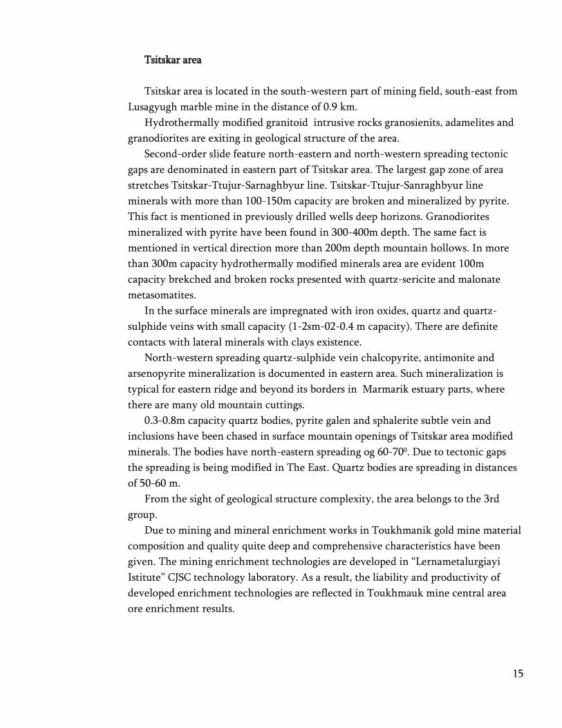
Tsitskar area
Tsitskar area is located in the south-western part of mining field, south-east from
Lusagyugh marble mine in the distance of 0.9 km.
Hydrothermally modified granitoid intrusive rocks granosienits, adamelites and
granodiorites are exiting in geological structure of the area.
Second-order slide feature north-eastern and north-western spreading tectonic
gaps are denominated in eastern part of Tsitskar area. The largest gap zone of area
stretches Tsitskar-Ttujur-Sarnaghbyur line. Tsitskar-Ttujur-Sanraghbyur line
minerals with more than 100-150m capacity are broken and mineralized by pyrite.
This fact is mentioned in previously drilled wells deep horizons. Granodiorites
mineralized with pyrite have been found in 300-400m depth. The same fact is
mentioned in vertical direction more than 200m depth mountain hollows. In more
than 300m capacity hydrothermally modified minerals area are evident 100m
capacity brekched and broken rocks presented with quartz-sericite and malonate
metasomatites.
In the surface minerals are impregnated with iron oxides, quartz and quartz-
sulphide veins with small capacity (1-2sm-02-0.4 m capacity). There are definite
contacts with lateral minerals with clays existence.
North-western spreading quartz-sulphide vein chalcopyrite, antimonite and
arsenopyrite mineralization is documented in eastern area. Such mineralization is
typical for eastern ridge and beyond its borders in Marmarik estuary parts, where
there are many old mountain cuttings.
0.3-0.8m capacity quartz bodies, pyrite galen and sphalerite subtle vein and
inclusions have been chased in surface mountain openings of Tsitskar area modified
minerals. The bodies have north-eastern spreading og 60-700. Due to tectonic gaps
the spreading is being modified in The East. Quartz bodies are spreading in distances
of 50-60 m.
From the sight of geological structure complexity, the area belongs to the 3rd
group.
Due to mining and mineral enrichment works in Toukhmanik gold mine material
composition and quality quite deep and comprehensive characteristics have been
given. The mining enrichment technologies are developed in “Lernametalurgiayi
Istitute” CJSC technology laboratory. As a result, the liability and productivity of
developed enrichment technologies are reflected in Toukhmauk mine central area
ore enrichment results.

16
“Southern” Area
Choosing areas resources calculation methodology mining bodies geological,
morphological and structural feature has taken into account. As a result the resources
have been contoured and calculated in all mining veins in geological borders.
The mine was explored by surface mountain recesses and column drilling oblique
wells cross type to spreading of mining bodies and almost parallel to each other.
Considering the morphological features of the exploration method and nodules
geological block calculation method in vertical cuts was adopted, implementing
mineralized areas contouring on longitudinal incisions according to obtained
information.
Survey chain concentration formed with wells in mine allows to contour the
resources by C1 and C2 category.
Resources calculation has been implemented in 5/4, 5/3 and 5/1 bodies in which
gold and silver resources were calculated.
Following conditions parameters are confirmed for mining bodies resources
calculation.
- Contouring of mining bodies by capacity in geological borders
- Gold minimum content in marginal facet is accepted 0.1 g/t
- Gold minimum industrial content in counting block accepted 1.6g/t
- The resources calculation process attended mining body minimum capacity is
accepted 1.0m, in the case of less capacity but gold high concentration must be
used appropriate metagramms.
The contouring and calculation of resources have been implemented with
longitudinal incisions projected in mining bodies vertical plane by the methodology
of geological blocks (graph appendix 7). Mining bodies are characterizing with
different degree of exploration. Explored resources have been assessed as C1 and C 2
category conditioned by exploration chain density․ Also, P1 category forecastինգ
resources are assessed.
Resources calculation works results are proving the economical high potential of
mine.

Southern area ore and metals resources calculation by mineral bodies and calculation blocks
Calculation blocks
numbers and
resources category
Mining body
capacity, m
Surface in
vertical
plane (S1)
m2
Mine body
falling
angle,
degree
The real
surface (S2), 2
m
Mineral body
volume in
block, m 3
Ore mass
t/m3
Ore resources,
t
Metals content Metals resources
Au Ag Au Ag
g/t g/t kg t
1 2 3 4 5 6 7 8 9 10 11 12
vein 5/4
Block 5/4-1-C2 2.36 11148 75 11542 27238.10 2.84 77356.20 4.56 11.75 352.52 0.91
Block 5/4-2-C2 2.53 19228 75 19907 50364.26 2.84 143034.50 4.88 11.36 697.86 1.62
Block 5/4'-3-C2 2.07 38328 75 39681 82288.74 2.84 233700.01 4.88 10.47 1139.90 2.45
Block 5/4-4-C2 1.73 17473 75 18090 31295.47 2.84 88879.12 3.62 7.50 321.98 0.67
Block 5/4-5-C2 1.64 3488 75 3611 5922.27 2.84 16819.25 4.01 9.30 67.47 0.16
Block 5/4-1-P1 2.18 131832 75 136486 298085.81 2.84 846563.71 3.23 7.27 2731.31 6.15
Total C2 559789.08 4.61 10.37 2579.74 5.80
Total C2+ P1 1406352.79 3.78 8.50 5311.05 11.95
vein 5/3
Block 5/3-1-C2 2.36 5896 80 5987 14099.4 2.84 40042.27 4.71 10.02 188.71 0.40
Block 5/3-2-C2 2.06 26735 80 27148 55807.8 2.84 158494.15 3.81 8.16 603.13 1.29
Block 5/3-3-C2 2.15 20524 80 20841 44859.8 2.84 127401.77 3.83 8.08 488.44 1.03
Block 5/3-4-C2 2.40 17205 80 17471 41929.3 2.84 119079.29 4.48 9.86 533.27 1.17
Block 5/3-5-C2 1.72 34688 80 35223 60584.2 2.84 172059.24 4.01 8.72 690.55 1.50
Block 5/3-1-P1 2.14 169444 80 172059 367629.3 2.84 1044067.15 2.88 6.21 3005.18 6.48
Total C2 617076.72 4.06 8.75 2504.11 5.40
Total C2+ P1 1661143.87 3.32 7.15 5509.29 11.88
18
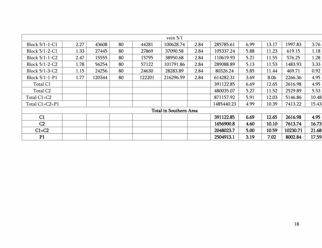
vein 5/1
Block 5/1-1-C1 2.27 43608 80 44281 100628.74 2.84 285785.61 6.99 13.17 1997.83 3.76
Block 5/1-2-C1 1.33 27445 80 27869 37090.58 2.84 105337.24 5.88 11.23 619.15 1.18
Block 5/1-1-C2 2.47 15555 80 15795 38950.68 2.84 110619.93 5.21 11.55 576.25 1.28
Block 5/1-2-C2 1.78 56254 80 57122 101791.86 2.84 289088.89 5.13 11.53 1483.93 3.33
Block 5/1-3-C2 1.15 24256 80 24630 28283.89 2.84 80326.24 5.85 11.44 469.71 0.92
Block 5/1-1-P1 1.77 120344 80 122201 216296.59 2.84 614282.31 3.69 8.06 2266.36 4.95
Total C1 391122.85 6.69 12.65 2616.98 4.95
Total C2 480035.07 5.27 11.52 2529.89 5.53
Total C1+C2 871157.92 5.91 12.03 5146.86 10.48
Total C1+C2+P1 1485440.23 4.99 10.39 7413.22 15.43
Total in Southern Area
C1 391122.85 6.69 12.65 2616.98 4.95
C2 1656900.8 4.60 10.10 7613.74 16.73
C1+C2 2048023.7 5.00 10.59 10230.71 21.68
P1 2504913.1 3.19 7.02 8002.84 17.59
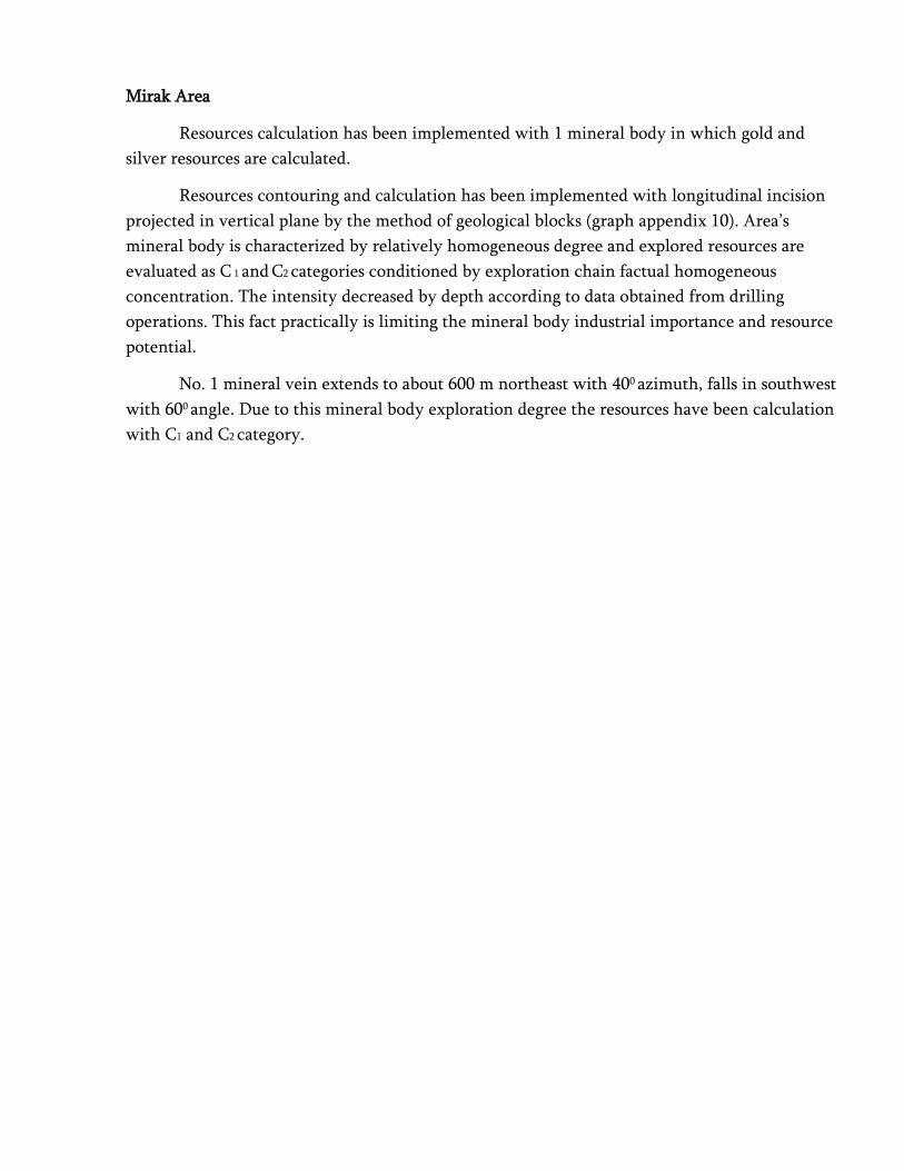
Mirak Area
Resources calculation has been implemented with 1 mineral body in which gold and
silver resources are calculated.
Resources contouring and calculation has been implemented with longitudinal incision
projected in vertical plane by the method of geological blocks (graph appendix 10). Area’s
mineral body is characterized by relatively homogeneous degree and explored resources are
evaluated as C 1 and C2 categories conditioned by exploration chain factual homogeneous
concentration. The intensity decreased by depth according to data obtained from drilling
operations. This fact practically is limiting the mineral body industrial importance and resource
potential.
No. 1 mineral vein extends to about 600 m northeast with 400 azimuth, falls in southwest
with 600 angle. Due to this mineral body exploration degree the resources have been calculation
with C1 and C2 category.
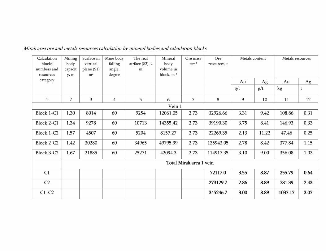
Mirak area ore and metals resources calculation by mineral bodies and calculation blocks
Calculation
blocks
numbers and
resources
category
Mining
body
capacit
y, m
Surface in
vertical
plane (S1)
m2
Mine body
falling
angle,
degree
The real
surface (S2), 2
m
Mineral
body
volume in
block, m 3
Ore mass
t/m3
Ore
resources, t
Metals content Metals resources
Au Ag Au Ag
g/t g/t kg t
1 2 3 4 5 6 7 8 9 10 11 12
Vein 1
Block 1-C1 1.30 8014 60 9254 12061.05 2.73 32926.66 3.31 9.42 108.86 0.31
Block 2-C1 1.34 9278 60 10713 14355.42 2.73 39190.30 3.75 8.41 146.93 0.33
Block 1-C2 1.57 4507 60 5204 8157.27 2.73 22269.35 2.13 11.22 47.46 0.25
Block 2-C2 1.42 30280 60 34965 49795.99 2.73 135943.05 2.78 8.42 377.84 1.15
Block 3-C2 1.67 21885 60 25271 42094.3 2.73 114917.35 3.10 9.00 356.08 1.03
Total Mirak area 1 vein
C1
72117.0 3.55 8.87 255.79 0.64
C2
273129.7 2.86 8.89 781.39 2.43
C1+C2
345246.7 3.00 8.89 1037.17 3.07

Tsitskar area
Choosing the methodology of resources calculation in 1 and 1 ap mineral bodies
structural and beneficial components localization geological feature is taken into account.
Mineralization is enclosed in hydrothermally somatic modified granodiorite type intrusive
minerals in tectonic disruption building development boundaries. Mineralization is localized
within disruption broken and postmagnatic hydrothermal operation results being limited
between tectonic contacts. Taking into consideration mineralization insertion and development
feature, the resources have been contoured and calculated in geological boundaries.
Resources calculation has been implemented with number 1 mineral body and with
number 1 ap mineral body in east in which gold and silver resources have been calculated.
Resources contouring and calculation has been implemented with longitudinal incision
projected in vertical plane by the method of geological blocks (graph appendix 13). Area’s
mineral body is characterized by relatively homogeneous degree and explored resources are
evaluated as C 1 and C2 categories conditioned by exploration chain factual homogeneous
concentration. Within mineral body 7 calculating blocks are contoured by exploration degree.

Tsitskar area ore and metals resources calculation by mineral bodies and calculation blocks
Calculation blocks
numbers and
resources category
Mining
body
capacity,
m
Surface in
vertical
plane (S1)
m2
Mine body
falling
angle,
degree
The real
surface (S2), 2
m
Mineral
body
volume in
block, m 3
Ore mass
t/m3
Ore
resources, t
Metals content Metals resources
Au Ag Au Ag
g/t g/t kg t
1 2 3 4 5 6 7 8 9 10 11 12
vein 1
Block 1 1-C1 0,95 14809,00 70 15761,00 14950,43 2,66 39768,16 4,97 10,86 197,76 0,43
Block 1 2-C1 0,87 8790,00 70 9355,00 8115,46 2,66 21587,13 4,95 8,49 106,82 0,18
Block 1 3-C1 0,82 22818,00 70 24285,00 19981,16 2,66 53149,88 5,22 11,48 277,29 0,61
Block 1 1-C2 0,54 13829,00 70 14718,00 7947,72 2,66 21140,94 4,38 7,65 92,58 0,16
Block 1 2-C2 0,64 10202,00 70 10858,00 6927,40 2,66 18426,89 5,31 11,49 97,85 0,21
Total C1 114505,17 5,08 10,70 581,87 1,23
Total C2 39567,83 4,81 9,44 190,42 0,37
Total C1+C2 154073,00 5,01 10,38 772,30 1,60
vein 1 ap
Block 1 ap 1-C1 0,55 9384,00 70 9987,00 5447,45 2,66 14490,23 4,36 9,84 63,14 0,14
Block 1 ap 1-C2 0,45 6256,00 70 6658,00 2973,91 2,66 7910,59 5,09 12,83 40,28 0,10
Total C1+C2
22400,82 4,62 10,90 103,42 0,24
Total Tsitskar area
C1 128995,40 5,00 10,61 645,02 1,37
C2 47478,42 4,86 10,00 230,70 0,47
C1+C2 176473,82 4,96 10,44 875,71 1,84

Further prospective areas and occurrences research is largely conditioned with more
advanced and less stringent and safe environmental technologies development and introduction.
Company upcoming projects will give an opportunity to make researches in other mining areas
and already explored occurrences areas and deep horizons.
The gold occurrences explored in the area basically are characterized with middle and
law gold and silver concentration within 0.5-3.0 g/t. Occurrences samples explored during years
with recorded 10 g/t and higher concentration have been attributed to “gold accidental seed”
impact. This is the reason why company aims to invest the hydrometallurgical technology of
extraction metals from poor ore.
In general the area total mineral resource potential is estimated at more than 40 tons of
gold. Theoretically the investment of such technologies will give an opportunity to extract law
concentration copper, lead, zinc and other metals from ore which have no industrial importance
currently and are not calculated in resources.
Toukhmanuk mine “Southern” area 5 vein zone mineral bodies structural feature,
installation conditions, exploration methodology and exploration degree predetermined
conditions parameters following compound.
1. To contour and implement the calculation in mining veins geological boundaries.
2. To accept resources calculation mineral body minimum capacity as 1.0 m, in the case
of lower capacity use metrogramms.
3. Gold minimum concentration in marginal facet is 0.1 g/t.
4. Gold minimum industrial concentration in calculating block is 1.6 g/t.
5. To implement the resources calculation within pits final contours.

INDEPENDENT EXPERT OF MINISTRY OF ENERGY AND
NATURAL RESOURCES STAFF
STATE COMMITTEE OF RESERVES
GAGIK GEVORGYAN
Yerevan October
07, 2016
EXPERTISE CONCLUSION
ABOUT GEOLOGICAL SURVEY WORK RESULTS OF TOUKHMANUK GOLD MINE OF
ARAGATSOTN REGION OF REPUBLIC OF ARMENIA,
SOUTHERN, MIRAK AND KOTAYK REGION TSITSKAR AREAS
WITH CONDITIONS PARAMETRES TECHNICAL ECONOMICAL BASE AND STATE
SUBSOIL EXPERTISE RESULTS OF CALCULATION OF RESERVES MINERALS AS OF
01.04.2016
According to the Employment Agreement signed with the chief of stuff of Ministry of
Energy and Natural Resources in this expertise conclusion includes the provisions of report
which matches the following issues proposed by Mineral Resources Agency.
1. About the Mine and Mine Area geological structure
Mining area geological structure is based on 1:10000 map prepared by V. Aghamalyan
(1987) and is accepted for changes. The area geological structure is investigated deeply and
does not contradict the geological structure of the area.
2. About the Mine (area) investigation methods and dimensions
The geological survey works in Toukhmanuk mining field Southern, Mirak and Tsitskar
areas have been implemented since 2007. Within mining area occurrences veins and
mining zones evaluation has been implemented in the base of previous year’s
explorations. In order to calculate the resources the ditches column drilling, geological
documentation methods have been used.

25
The geological survey works have been projected to implement according to
“Инструкция по применению классификации запасов к золоторудным
месторождениям” directive’s recommendations according to which mining field
occurrences are evaluated as 2-rd category from the sight of complexity.
The implemented works in areas give reliable information about the occurrences
inner structure and metal concentration and provides areas reserves realistic evaluation.
Implemented analyzing researches and its geological control has been done due to acting
HCAM method.
3. About the mineral quality technology feature
The mineralization by mineral bodies is presented by fresh not modified sulphide
primary minerals (pyrite, rare chalcopyrite and galen) inclusions.
Mirak area mineralization is enclosed in Mirak intrusive quartz diorites and Aparan
streak group basalt andesite basalt tuff breckches.
Hydrothermally modified zones (10-15m) are under control of north-eastern gaps,
across which minerals are too broken and modified and full of quartz-carbonate-mining
and quartz-mining veins and law veins.
In Tsitskar area modified minerals exists 0.3-0.8m capacity quartz bodies.
Mining enrichment technologies are developed by “Lenrnametalurgiayi Institute” CJSC
laboratory. As a result, the liability and productivity of developed enrichment
technologies are reflected in Toukhmauk mine central area ore enrichment results. Thus,
high gold ramp is predicted.
Mentioned quality technology characteristics do not raise objections. Additional
laboratory and technological researches are needed in Mirak and Tsitskar areas for ore
research.
4. About mine exploitation natural conditions (hydro, engineer geological, geotechnical,
environmental)
During area surveying hydro geological, engineer geological, geotechnical conditions
research was implemented. Aquatic horizons, flows mode have been explored. Physical
mechanical comparison indicators of minerals are determined. Mining inclusive minerals
stability and infiltration feature, its evaluation during exploiting process is evaluated.
Hydro geological monitoring is implemented for aqua quantity and quality assessment.
The implemented researches are enough for mine resources evaluation and calculation.
It’s taken into consideration that mine underground quarrying is influencing negatively
the environment like empty rock dumps, flowing of underground and surface waters in
pools and ect.
5. About the resources contouring validness and calculations liability
Southern area (5 mining zone)
Choosing Toukhmanuk mine <<Southern area>> mineral resources calculating
methodology mining bodies exploration degree, contact validness between surveying

26
lines, spreading azimuth towards each other, falling angle have been taken into
consideration.
According to surveying method and mineral bodies morphology feature, the method of
geological block calculating in vertical cuttings is accepted which is completely
acceptable.
The resources calculating by 1 mine body in Mirak area are classified as C1 and C2
categories. Within 2 blocks of C1 category spreading exploration chain concentration is
95-100m which is appropriate to C2 category. Therefore, blocks resources (block 1-C1,
block 2- C2) should be attribute to C2 category.
In Tsitskar area 1 and C2 categories resources are calculated. In upper horizon 1-2-C
blocks drilled part’s drill holes distance from each other by spreading is 100m, which is
appropriate to C2 category resources chain. It’s advisable to attribute C1 category blocks
resources to C2 category also because of incomplete technological exploration degree.
6. About the converging of expertise and stock materials geological information
The stock materials studying by me showed the accordance of report geological
information to stock materials.
Summarizing abovementioned I am suggesting to confirm Geological Survey Work
Results of Toukhmanuk Gold Mine of Aragatsotn Region of Republic of Armenia, Southern,
Mirak and Kotayk Region Tsitskar Areas with Conditions Parametres Technical Economical
Base and State Subsoil Expertise Results of Calculation of Reserves Minerals as of 01.04.2016
report with the contours and quality presented by authors classifying Mirak and Titskar area
resources wholly as C2 category.
Independent expert of Mineral Resources Agency, RA Gagik Gevorgyan
INDEPENDENT EXPERT OF MINISTRY OF ENERGY AND
NATURAL RESOURCES STAFF
STATE COMMITTEE OF RESERVES
HAMLET HAMAZASPYAN
EXPERTISE CONCLUSION
ABOUT GEOLOGICAL SURVEY WORK RESULTS OF TOUKHMANUK GOLD MINE OF
ARAGATSOTN REGION OF REPUBLIC OF ARMENIA,
SOUTHERN, MIRAK AND KOTAYK REGION TSITSKAR AREAS
WITH CONDITIONS PARAMETRES TECHNICAL ECONOMICAL BASE AND STATE
SUBSOIL EXPERTISE RESULTS OF CALCULATION OF RESERVES MINERALS AS OF
01.04.2016
Resp. performer V.Vahramyan
According to the N 6-Մ/Մ Employment Agreement signed with the employer the
expert commits to get acquainted with the materials, to evaluate its content and formatting
conformity to acting demands, to participate with materials authors and expertise responsible
person in material’s work discussions, to present suggestions about the defects of material, to
present the expert conclusion to Agency within a month.
The subject of expertise is Toukhmanuk mining field Souther, Mirak and Tsitskar areas
resources calculation conditions parameters form and technical economical validity clarification
which is composed in 1 book.
Presented work is includes all source materials in general from the view of formation
and semantics which is a base to substantiate resources calculation conditions form and quantity.
However, some remarks are mentioned by expert that must be taken into consideration.
According to expert heading last part must be changed to “Southern, Mirak and Tsitskar
areas resources calculation with conditions parameters technical economical base and resources
calculation by 01.04.2016”.
As all parts of the report is the base of mine evaluation and conditions parameters
proposition its expedient to touch briefly its meaning.

28
The chapter 1 of report is dedicated to exploration area geographical economical
description. Toukhmanuk mining field localization, nearest locations, river chains and other
conditions are reflected in the work. Unfortunately, there is no information in this part about
Toukhmanuk mining factory. In this part schematic map is needed to make visible exploration
object localization conditions.
In the chapter 2 mine geological exploration history is described which was ended in
2008, although new operations have been implemented since that.
Area geological structure, geological survey works methodology and results are posted
in chapter 5. Detailed description of Southern area is posted in this section which mineral bodies
with its localization conditions, mineral components are homogenous with Central area. Mirak
and Tsitskar areas are described considering probably that areas are homogeneous with Southern
area mineral bodies.
Ore quality technical description is important for proposition of conditions parameters
which is included in chapter 6. Toukhmanuk factory technological process is described in this
section which can be used for explored areas ore enrichment proceeding from material
composition analogy. Acting factory technological scheme includes ore gravitation and
gravitation tailings flotation. Gold recovery concentrate is 85 %.
Taking into consideration abovementioned circumstances ore processing technology
can be considered as grounded.
The 7 chapter is dedicated to exploration areas hydro geological and engineer geological
conditions. Area explorations and exploration results are posted in this part and the information
got during exploitation also. According to report there are no aqua horizons in mine, spring thaw
and rain water flows are seasonal and are leaving the area through rocks cracks. Additional
drainage measures are not undertaken. Engineer geological conditions are homogeneous with
Central area conditions. Additional ore volume and moisture test was done.
In the environmental protection section (chapter 8) is mentioned that appropriate
environmental action is designed during Touhkmanuk mine exploitation and factory building
project. In this part is needed brief description of abovementioned operations.
As for Southern area open pit mining method, its chosen correctly based on explored
areas and exploiting Toukhmanuk mine Central area mining body’s morphology, placement
geotechnical, hydro geological comparison. However here (9.2) is needed company productivity
size per year which depends on enrichment factory capacity. Open pit schematic cuttings are
needed to show in the work.
In resources calculation conditions parameters quality determination base Toukhmanuk
mine de facto indicator are accepted. In appropriate sections stripping border coefficient, open pit
productivity per year, open mountain works technology, gold ramping are shown.

29
Conditions parameters composition and the calculation of its variables are done
appropriate to the directives demands. This qualities can be used for Mirak and Tsitskar areas
resources calculation also on the base of mining bodies structure, insertion conditions, ore
material composition similarity with Southern area. It should be noted that authors have taken
into account the distance from enrichment factory and dumps. Due to calculations mining,
transportation and processing cost of 1 t ore is not exceeding 30 $.
There are some technical mistakes in table 10.6.1 which is pointed to work authors.
Summarizing expertise results we can tell that geological survey works in Toukhmanuk
mining field should be continued. Southern, Mirak and Tsitskar areas exploitation which are
already explored will be productive.
Mine exploitation open method and opening scheme is acceptable.
Ore enrichment technological scheme is accepted with the Central area analogy which
can be used for processing or ore in explored areas.
Mining exploitation technical economical coefficients are grounded.
Conditions parameters composition and its calculating methodology is chosen correctly
and is appropriate to directives.
For resources calculation is suggested to confirm Southern, Mirak and Tsitskar area
resources calculation conditions following parameters.
- To contour mining bodies in geological boundaries
- Gold minimum concentrations in marginal facet is 1.0g/t
- Gold minimum industrial concentrations in counting block is 1.6g/t
- To accept mineral body’s, included in resources calculation, minimum capacity
as 1.0m, in the case of lower capacity use metragramms.
- To accept stripping borde coefficient as 24.2 t/t.
Independent expert of Mineral Resources Agency, RA Hamlet Hamazaspyan

MINISTRY OF ENERGY AND NATURAL RESOURCES STAFF
STATE COMMITTEE OF RESERVES
Republic of Armenia
Yerevan, Aygedzor 67
MINISTRY OF ENERGY AND NATURAL RESOURCES STAFF
HEAD OFMINERAL RESOURCES AGENCY
HAYKAZ NAZARYAN
Dear Mr. Nazaryan
In response to your 28.06.2016 N27.2/[78556]-16 letter, I am informing you that no restrictions
were applied toward “Mego Gold” LLC ‘s liabilities established by State Committee of
Reserved according to 02.07.2012 Պ-136 agreement and can’t be applied till 31.12.2016
according to 30.07.2015 N 839 Ա resolution of Government, RA. Therefore it's not possible to
provide information about company contractual obligation.
Best Regards
Head of State Committee of Reserves
Subsoil chief inspector ANUSHAVAN AYVAZYAN

31
Appendix 5
FINAL CONCLUSION
About geological survey works results in Southern, Mirak and Kotayk Region, RA, Tsitskar areas
with conditions parameters technical economical base and resources calculation as if 01.04.2016
report materials state subsoils expertise results presented by “Mego Gold” LLC
Summarizing state subsoil expertise results, taking into account independent experts
expertise conclusions it’s concluded
1. Presented report consists of 3 Books, from which Book 1- the main text- 161 pages,
Book 2- text and table appendixes-159 pages, Book 3- a folder (graphic appendixes)-
13 pages.
2. “Mego Gold” LLC geological survey works results within July 2, 2012 ԵՀԹ 29/136
exploitation license given by Ministry of Energy and Natural Resources of the
Republic of Armenia are posted in presented report.
3. Mine geological economical assessment with the base of conditions parameters and
resources calculation presentation herewith in report in small size case does not raise
any objection.
4. By its structure and meaning report is appropriate to acting directive documents
demands, copyright notice reflects report main provisions.
5. According to mining bodies’ morphology and feature, useful components spatial
distribution regularity, geological structure degree and geological indication
modification degree, observed areas attribution into geological structure 3-rd group
complexity by authors is acceptable.
6. Mining area geological structure is due to Aghamalyan’s (1987) 1:10000 scale map
which is accepted.
Toukhmanuk gold mine explored area geological structure is revealed deeply and
does not contradict area’s geological structure.
7. The methods of geological survey works are connected with the geological structure
feature of areas and are providing resources complete quality and quantity
assessment.
8. Minerals’ furrow sampling in surface mountain scoops and extracting methods of
boreholes does not generate any objection. Samplings processing (sawing, grinding,
ect.) scheme does not rise for comments.
Sampling analyzes have been done in company’s and “Analitic” CJSC’s and chemical
analyzes- in company’s laboratories.
In order to detect accidental and systematic mistakes size during chemical and worth
laboratory works inner and external control has been performed. External control
works have been done by “Analitic” CJSC laboratory.

32
Ordinary and inspection analyzes data are proceeding annually by concentration
consolidated classes. The data show satisfactory reproduction of primary
concentration analyzes. Thus, ordinary analyzes quality is satisfying for resources
calculation. Ordinary and inspection analyzes comparison is demonstrating absence
of systematic mistakes in ordinary analyzes.
In Toukhmanuk gold mine ore material composition more than 30 minerals are
existing from which gold and silver have industrial importance.
Associated components qualities have been invested during laboratory explorations of
39 ore samples. Associated minerals resources calculation was not done based on
sampling results because of non industrial law concentration in ordinary samples
which is acceptable.
Area surveying scoops and appropriate natural pieces sampling has done. As a
result area’s ore volume and rawness has been determined.
Toukhmanuk mine ore processing (enrichment) is being implemented in
company owned enrichment factory by gravitation and gravitation tailings flotation
way. Gravitation and gravitation tailings flotation way using is providing 85% factual
ramp of gold from ore.
Mine enrichment technologies are processed in “Lernametalurgiayi
Institute” CJSC laboratory. As a result enrichment technologies liability and
efficiency is stated by Toukhmanik mine “Central” area mining enrichment results.
The methodology of implemented quality technological feature
exploration does not raise any objection. Additional laboratory technological research
is needed for Mirak and Tsitskar are ore exploration which was mentioned
independent expert G.Gevorgyan (appendix 2).
9. Hydro geological and engineer geological researches have been done in Toukhmanuk
gold mine “Central” area, aquatic horizons have been explored with its surface flows
quantity.
Mineral bodies ore and inclusive rocks physical mechanical characteristic has been
explored. Additionally, area ore volume and rawness tests have been implemented.
10. The base for resources calculation has become the works implemented during
geological surveying phase and the data received from previous phases of geological
exploration. Areas have been explored by surface mountain scoops and mining bodies
spreading crosswise and almost parallel oriented to each other column drilling pits
sorted on survey lines.
In choosing resources calculation methodology in areas the mining bodies surveying
degree, mining bodies contact liability between survey lines, the elevation towards
each other, spreading azimuth, falling angle and ect. have been taken into account.
Considering exploration method and mining bodies morphological feature geological
blocks method on vertical cuttings has been accepted implementing contouring of
33
mineralized areas on vertical cuttings. Surveying resources are classified as C1 and C2.
P category forecasting resources assessment was given also which is acceptable.
In Mirak area resources calculated by 1 mining body are attributed to C1 and C2
category. However within C1 category two blocks (Block 1- C1, Block 2- C2) survey
chain consistence is 95-100m, which is appropriate to C2 category resources
exploration chain.
C1 and C2 category resources are calculated in Tsitskar area also. In inner horizon of
Block 1-1-C1 and Block 1-2- C1 part surveyed by wells the distance between each
other by spreading is 100m, which is appropriate to C2 category resources chain.
Mirak and Tsitskar resources should be attributed to C2 category wholly which was
told by independent expert G.Gevorgyan too (appendix 2).
11. The determination base for resources calculation conditions parameters is accepted
Toukhmanuk MEP factual indicators and technical economical calculations also.
Stripping boundary coefficient, open pit annual productivity, open mountain
technologies, gold concentrate ramp are given in appropriate subsections.
Conditions parameters compounds and its size calculation is done due to appropriate
directive demands.
Conditions parameters compounds and size can be used for Mirak and Tsitskar area
resources calculation also considering mining body structures, insertion conditions,
ore substantial composition similarity to “Southern” area.
Areas exploitation open method and opening scheme is acceptable.
Ore enrichment technological scheme is accepted with Central MEP similarity.
Resources calculating conditions parameters needed compounds and its counting
sizes are appropriate to mine geological structural feature. Condition parameters
compounds and bordering quantities due to chosen exploitation way suggested in
report are providing ore resources definite contouring and calculation.
Following condition parameters are contemplated for mining body resources
calculation
- To contour mining bodies in geological plane
- Gold minimum concentration in bordering cross section- 1.0 g/t
- Resources calculation including mining body minimum capacity- 1.0m, use
metragramms for lower capacity
- Gold minimum industrial concentration in counting block- 1.6 g/t
- Stripping border coefficient-24.2 t/t
12. Source geological information for resources calculation is presented thoroughly. The
information about mine was used without modifications by the author what was told
by independent expert G.Gevorgyan (appendix 2).
13. There is no objection about resources contouring and recalculation process
illustrating graphical materials and tablet appendixes content and formation. Area
34
resources calculation is implemented with computer program usage. Illustrated tablet
data is appropriate to graphical materials and are easily checking.
Counting blocks contouring and resources block up principles, extrapolation usage in
geologically based boundaries and resources category attribution methods are correct.
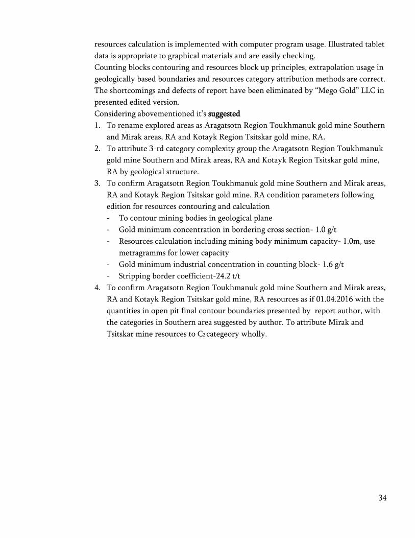
The shortcomings and defects of report have been eliminated by “Mego Gold” LLC in
presented edited version.
Considering abovementioned it’s suggested
1. To rename explored areas as Aragatsotn Region Toukhmanuk gold mine Southern
and Mirak areas, RA and Kotayk Region Tsitskar gold mine, RA.
2. To attribute 3-rd category complexity group the Aragatsotn Region Toukhmanuk
gold mine Southern and Mirak areas, RA and Kotayk Region Tsitskar gold mine,
RA by geological structure.
3. To confirm Aragatsotn Region Toukhmanuk gold mine Southern and Mirak areas,
RA and Kotayk Region Tsitskar gold mine, RA condition parameters following
edition for resources contouring and calculation
- To contour mining bodies in geological plane
- Gold minimum concentration in bordering cross section- 1.0 g/t
- Resources calculation including mining body minimum capacity- 1.0m, use
metragramms for lower capacity
- Gold minimum industrial concentration in counting block- 1.6 g/t
- Stripping border coefficient-24.2 t/t
4. To confirm Aragatsotn Region Toukhmanuk gold mine Southern and Mirak areas,
RA and Kotayk Region Tsitskar gold mine, RA resources as if 01.04.2016 with the
quantities in open pit final contour boundaries presented by report author, with
the categories in Southern area suggested by author. To attribute Mirak and
Tsitskar mine resources to C2 categeory wholly.

35
5. To state that Aragatsotn Region Toukhmanuk gold mine Southern and Mirak
areas, RA and Kotayk Region Tsitskar gold mine, RA resources potential is not
exhausted with the resources confirmed by conclusion 3-rd point. By existing
geological information there is increasing opportunity due to deep horizons
exploration and according to author realistic assessment ore 2.5 million t. gold and
silver and accordingly 8.0 and 17.6 t P1 category forecasting resources are
expected.
6. To concentrate soil manager attention to following
1) additional exploration is needed for mining bodies resourcing potential
assessment
2) it’s risky to begin exploitation process with exploration low degree
characterized small scaled C1 category resources existence and in non
completely assessed ore technological feature conditions.
7. To suggest MINISTRY OF ENERGY AND NATURAL RESOURCES, RA staff
State Committee of Reserves implement geological information validity
confirmation operation presented by “Mego Gold” LLC for state subsoil expertise.
8. To suggest MINISTRY OF ENERGY AND NATURAL RESOURCES “Republican
Geological Fund” SNCO, RA to register in state balance confirmed resources by 4-
rd point of this conclusion.
Mineral resources counting materials
Expertise department head,
Materials expertise responsible H.Avetisyan
Resources
category
Ore resources
Thous/t
Metals middle conc. Metals quantity
Au g/t Ag g/t Au kg Ag kg
1 2 3 4 5 6
Aragatsotn Region Toukhmanuk gold mine Southern area, RA
C1 391.12 6.69 12.65 2616.98 4.95
C2 1656.90 4.60 10.10 7613.74 16.73
C1+C2 2048.02 5.00 10.59 10230.72 21.68
Aragatsotn Region Toukhmanuk gold mine Mirak area, RA
C2 345.25 3.00 8.89 1037.17 3.07
Kotayk Region Tsitskar area, RA
C2 176.47 4.96 10.44 875.72 1.84
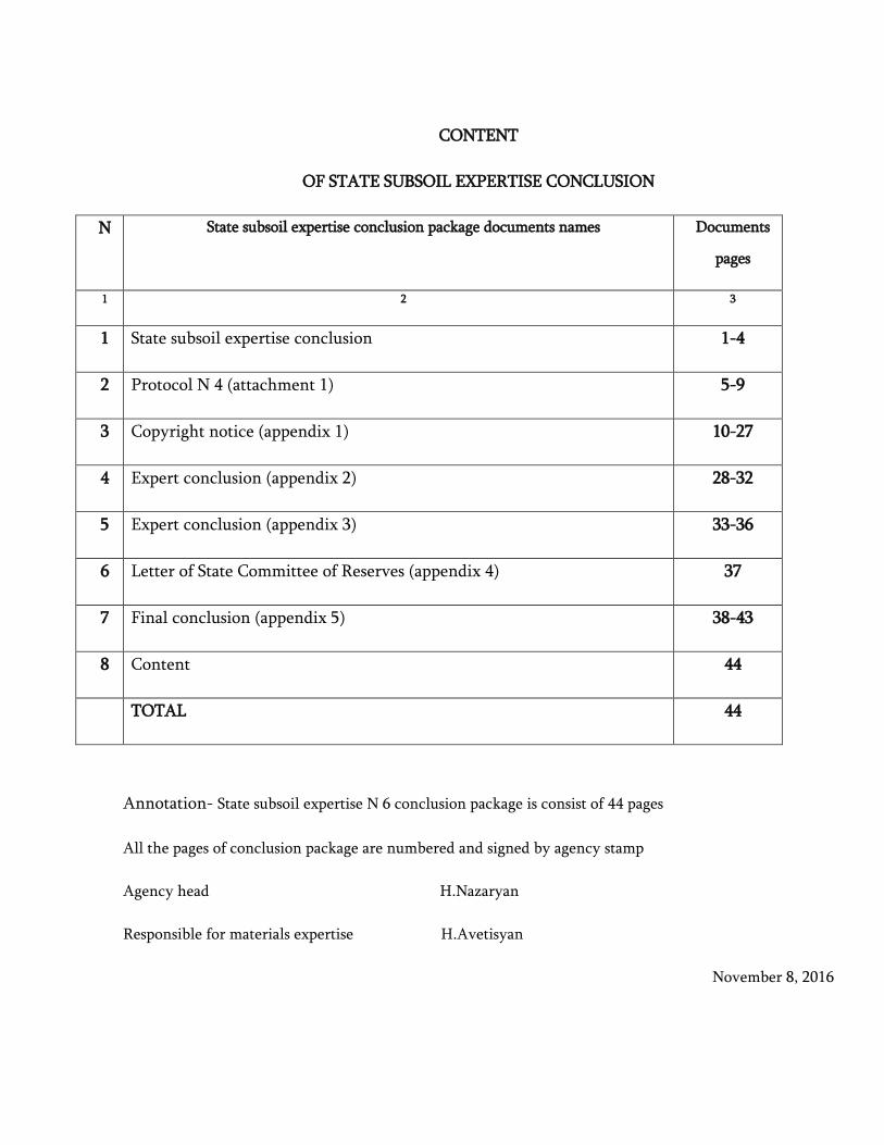
CONTENT
OF STATE SUBSOIL EXPERTISE CONCLUSION
N State subsoil expertise conclusion package documents names Documents
pages
1 2 3
1 State subsoil expertise conclusion 1-4
2 Protocol N 4 (attachment 1) 5-9
3 Copyright notice (appendix 1) 10-27
4 Expert conclusion (appendix 2) 28-32
5 Expert conclusion (appendix 3) 33-36
6 Letter of State Committee of Reserves (appendix 4) 37
7 Final conclusion (appendix 5) 38-43
8 Content 44
TOTAL 44
Annotation- State subsoil expertise N 6 conclusion package is consist of 44 pages
All the pages of conclusion package are numbered and signed by agency stamp
Agency head H.Nazaryan
Responsible for materials expertise H.Avetisyan
November 8, 2016


38

