report of the board of commissioners on the irrigation of the san
TRANSCRIPT

Report of tlie Board of Co~issioners on the Irrigation Qf the S Joaquin,
Tulare, and Sacramento :Valle~ of the Sbteofeduonma, ~3
Engineer Historical Studies NumberS

Other Office of History Books of Related Interest
"Dear Friends at Home ... ": The Letters and Diary of Thomas James Owen, Fijiieth New York Volunteer Engineer Regiment, During the Civil War, edited and with an introduction by Dale E. Floyd (GPO S/N 008-022-00224-3).
The Nation Builders: A Sesquicentennial History of the Corps of Topographical Engineers, 1838-1863, edited by Frank N. Schubert (GPO S/N 008-022-00248-1).
THE COVER
The illustration is hased on the map of the San Joaquin, Sacramento, and Tiilare valleys that was prepared under the direction of the Board of Commissioners on Irrigation in 1873.

ENGINEERS AND IRRIGATION
REPORT OF THE BOARD OF COMMISSIONERS ON THE IRRIGATION OF THE SAN JOAQUIN,
TULARE, AND SACRAMENTO VALLEYS OF THE STATE OF CALIFORNIA, 1873
Annotated and with an introduction by
W. Turrentine Jackson Rand F. Herbert Stephen R. Wee
of Jackson Research Pr.ojects
Engineer Historical Studies NumberS
OFFICE OF HISTORY UNITED STATES ARMY CORPS OF ENGINEERS
FORT BELVOIR, VIRGINIA 1990

Library of Congress Cataloging in Publication Data
United States. Board of Commissioners on the Irrigation of the San Joaquin, Tulare, and Sacramento Valleys of the State of California.
[Report of the Board of Commissioners on the Irrigation of the San Joaquin, Tulare, and Sacramento Valleys of the State of California]
Engineers and irrigation : report of the Board of Commissioners on the Irrigation of the San Joaquin, Tulare, and Sacramento Valleys of the State of California, 1873 I annotated and with an introduction by W Turrentine Jackson, Rand E Herbert, Stephen R. Wee.
p. em. - (Engineer historical studies ; no. 5) Originally published: Report of the Board of Commissioners on the
Irrigation of the San Joaquin, Tulare, and Sacramento Valleys of the State of California I B.S. Alexander, George H. Mendell, George Davidson. Washington: G.P. 0., 1874.
Includes bibliographical references. 1. Irrigation-California-San Joaquin River Valley.
2. Irrigation-California-Tulare Lake Region. 3. IrrigationCalifornia-Sacramento River Valley. I. Alexander, B.S. (Barton Stone), 1819-1878. II. Mendell, George H. (George Henry), 1831-1902. III. Davidson, George, 1825-1911. IV. Title. V. Series. TC824.C2U55 1990 333.91 '3'097948-dc20 89-17625
First Printing
EP 870-1-39
For sale by the Superintendent of Documents, U.S. Government Printing Office Washington, D. C. 20402

Foreword
The role of the U.S. Army Corps of Engineers in opening the West is not as well known as the Corps' work on nationwide flood control and navigation projects. Yet, in the 19th century the surveys, explorations, scientific studies, and reports of Army engineer and topographical officers were major contributions to our understanding of the undeveloped arid regions of the United States. The following report illustrates the skill and dedication of these soldiers. The Board of Commissioners that explored the interior valleys of California was composed of two Army engineer officers and one civilian scientist for the Coast Survey. Their report, published in 1874, was the first federal irrigation survey. It still has value for its detailed information on central California and on irrigation practice in the American West and, indeed, around the world.
The introductory essay puts the report into its historical setting and provides a wealth of information about both the survey and the political and economic forces that dominated California over a hundred years ago. I trust the report and the essay will be of interest to all those interested in the development of the West.
iii
ROBERT W PAGE Assistant Secretary of the Army (Civil Works)

Acknowledgments
Many dedicated professionals assisted us in researching and writing this report. While listing all those who helped would be impossible we must thank Richard Terry, Ruth Berger, and their fellow librarians at the California State Library, California Section and Government Documents Section; Joe Zamora at the California State Archives; Irene Moran and the staff of the Bancroft Library; the archivists of the Old Army Branch, National Archives, Washington, D.C.; Richard Smith of the Cartographic and Architectural Branch of the National Archives, Alexandria, Virginia; and Martin Reuss and John Greenwood of the Office of History, Headquarters, U.S. Army Corps of Engineers. Sharon Schuler of our own staff keyed in the text and helped produce the final product in a cheerful and competent manner.
IV

Preface
This report is the fifth in the series Engineer Historical Studies. The series provides primary source materials that shed significant light on the history of the Army Corps of Engineers. More than that, the·materials are part of our nation's history, because they suggest the diverse ways in which the Corps has contributed to national development.
The reports of 19th century Army engineers reflect a commitment to scientific research and analysis. Like several other reports-some of which have been published in the present series-the 1873 study of the San Joaquin, Tulare, and Sacramento valleys of California offers insights into the Corps' role in western expansion. I hope readers will gain useful insights into the relationship between technology and politics and between the federal government and the states. Comprehending such relationships is essential to understanding natural resource development in a democratic system.
v
H.J. HATCH Lieutenant General, U.S. Army Commanding

Contents
INTRODUCTION by W. Turrentine Jackson, Rand F. Herbert, and Stephen R. Wee . . . . . . . . . . . . . . . . . . . . . . . . . . . . . . . . . . . . . . . . . . 3
Notes . . . . . . . . . . . . . . . . . . . . . . . . . . . . . . . . . . . . . . . . . . . . . . . . . . . . . . . . . 37
REPORT OF THE BOARD OF COMMISSIONERS ON THE IRRIGATION OF THE SAN JOAQUIN, TULARE, AND SACRAMENTO VALLEYS OF THE STATE OF CALIFORNIA . . . . . . . . . . . . . . . . . . . 49
Notes . . . . . . . . . . . . . . . . . . . . . . . . . . . . . . . . . . . . . . . . . . . . . . . . . . . . . . . . . 161
BIBLIOGRAPHY . . . . . . . . . . . . . . . . . . . . . . . . . . . . . . . . . . . . . . . . . . . . . . . . . . 165 INDEX ......................................... ·.................. 175
Figures
No.
I. Showing the System of Irrigation as Practiced on the San Joaquin and Kings River Canal . . . . . . . . . . . . . . . . . . . . . . . . . . . . . . . . . . . . . . . . . . 29
Maps
I. Map of the San Joaquin, Sacramento, and Tulare Valleys, State of California ................................... inside back cover
2. Map of the Delta of the River Cauvery Showing the System of Irrigation in the Tanjore and Trichinopoly Districts of India . . . . . . . . . 30
3. Map Showing the Tank System in India Between the Kistna and Godavery Rivers . . . . . . . . . . . . . . . . . . . . . . . . . . . . . . . . . . . . . . . . . . . . . . . 30
Illustrations
Lieutenant Colonel Barton S. Alexander . . . . . . . . . . . . . . . . . . . . . . . . . . . . . . . . 48 Major George H. Mendell . . . . . . . . . . . . . . . . . . . . . . . . . . . . . . . . . . . . . . . . . . . . 48 Professor George Davidson . . . . . . . . . . . . . . . . . . . . . . . . . . . . . . . . . . . . . . . . . . . 48
Illustrations courtesy of the following sources: p. 48 (bottom, right), Bancroft Library, University of California, Berkeley; pp. 29, 30, and inside back cover, National Arc\lives and Records Administration, Washington, D.C., Record Group 77, Civil Works Map file Wl70-4, -5, and -6 and W170-l, Sheets I and 2. All other illustrations from the files of the Office of History, Headquarters, U.S. Army Corps of Engineers.
Vll
----------------·-····----···----·--·

ENGINEERS AND IRRIGATION
REPORT OF THE BOARD OF COMMISSIONERS ON THE IRRIGATION OF THE SAN JOAQUIN,
TULARE, AND SACRAMENTO VALLEYS OF THE STATE OF CALIFORNIA, 1873

Introduction
by W. Turrentine Jackson
Rand F. Herbert Stephen R. Wee
I
Following the Civil War, many Americans, responding to the era's expansionist mood, expressed unbounded confidence in the economic benefits of rapid settlement of the West and in the region's capacity to absorb nearly limitless population. At the same time liberalization of public land disposal policies encouraged western migration. The future of California, which constituted much of the far West, lay in settling unclaimed public lands, redeeming its vast desert regions, and transforming the state into a home for millions. Irrigation was central to this vision. Little reliable or scientific information was available on the environmental problems that would confront farmers who came to conquer the arid West. In the 1870s many respected scientists, as well as western congressmen and town site boosters in semi-arid regions, still promoted the belief that "rain follows the plow."1 However, it was the technological manipulation of water supplies that enabled the new West to blossom in the early decades of the 20th century. California's agricultural development was not a saga of individual enterprise but the story of people who built organizations and institutions to control a problematic environment through use of technology.
The increase in the number of engineers in California, from 6 in 1850 to 158 in 1870, is one indication of their expanding role in shaping California during the first decades of statehood. Engineers of the latter 19th century, writes historian Raymond H. Merritt, "often pictured themselves as the vanguards of civilization who stimulated intellectual thought and promoted the expansion of cultural values, as well as developing natural resources and fulfilling material needs." Civil engineers enjoyed a high professional status in America because of their ability to manipulate the environment. When leveling mountains, draining swamplands, irrigating deserts, bridging rivers, and designing safer and speedier transportation, engineers in the American West thought of their profession as the one most responsible for developing civilization on the frontier and for promoting better economic, social, and cultural institutions. 2
By 1870 the great Central Valley of California had been opened to settlement for more than a quarter century. (Map 1) The region had about 15 million acres of land capable of producing crops given a proper system of reclamation and irrigation, yet only a few thousand people were engaged in cultivating the soil. Various reclamation and irrigation

4 ENGINEERS AND IRRIGATION
projects in the 1860s failed to attract widespread or dense agricultural settlement, particularly in areas removed from the major navigable rivers of the interior valley. In 1871 Prussian-born journalist and author Charles Nordhoff described the San Joaquin Valley: "Wheat, wheat, wheat, and nothing but wheat, is what you see on your journey, as far as the eye can reach over the plain in every direction." The valley was still open range dominated by the "cattle kings" Henry Miller and Charles Lux and the interminable wheat fields of Frank Norris's Octopus. Small houses and barns were scattered at great distances. There were few small irrigation ditches and almost no fenced fields; towns were dusty roads lined with a few saloons. "Fields of two, three, and four thousand acres," observed Nordhoff, "make but small farms." 3
Up until the late 1860s mining had dominated the economy of California, but between 1860 and 1870 the number of miners fell from 83,000 to 36,000. Agriculture had expanded and soon became the state's principal industry. During the same decade the number of farmers statewide increased from 20,000 to 48,000.4 Many Californians foresaw that the future of their state lay in judiciously exploiting its vast plains and tule marshes by replacing local control and piecemeal development with more efficient and scientific planning. A permanent agricultural empire based on irrigation and export by ship and railroad would bring more order and control over violent fluctuations of the regional agricultural economy. In post-Civil War California, members of the State Agricultural Society, most of whom were affluent agriculturalists and proponents of scientific farming, stressed the link between transportation improvements and farm markets, land values, and population growth. Many who joined the organization favored corporate development of water resources~ others wished to invoke the sovereign power of the government to plan or build the necessary public works. Both groups looked to the engineering profession to help capitalists or the state control the environmental forces threatening economic development of agricultural lands in the valley that was destined to become "the garden and granary of California."5
As early as September 1867 prominent farmers called for statewide action. Ex-congressman John Bidwell, a gentleman farmer and a Sacramento Valley resident since his arrival at Sutter's Fort in 1841, called for "a great design or system" to save the plains from destructive inundations. He asked that the state appropriate "vast sums of money" and hire "the best engineering talent in the country" to design an integrated system of mountain reservoirs, levees, drainage canals, and irrigation ditches to reclaim the swamps and irrigate dry lands throughout the valley.6
A veteran of the levee wars in the Sacramento-San Joaquin Delta, J. Ross Browne complained in 1872 that "the resources of a country are intrinsically valuable [only] in proportion to the facilities existing for their development." However, for more than twenty years, valley residents had remained generally apathetic about public improvements for flood control and irrigation. Without an organized effort to press for comprehensive solutions, numerous bills submitted to the state legislature had failed. Browne called on the legislature to establish a permanent commission, "to consist of at least three of the ablest engineers m the

INTRODUCTION 5
country, whose duty it should be to make a thorough and comprehensive survey of all the lands in the state subject to overflow [and] to agree upon a system of irrigation, reclamation, and drainage."7
In his 1871 annual report to the governor, Charles F. Reed, president of the State Board of Agriculture, advocated a joint plan of reclamation and irrigation for the entire portion of the state lying between the Coast Range aad the Sierra Nevada. Reed claimed that the longer the state delayed in formulating a general plan, the greater the difficulties in implementing one would become. Conflicting vested interests would result in "vexatious questions of water privileges" and "unfriendly contention and fruitless litigation."8 The messages of Reed, Bidwell, and Browne bore a common theme: an appropriate system of water management might extend benefits equitably, but water distribution could not be left in the hands of ordinary people and a chaotic, decentralized population.
The heartland of California's agriculture since the last quarter of the 19th century has been its great Central Valley, comprised of four smaller interconnected basins known as the Kern, Tulare, San Joaquin, and Sacramento river valleys. Alluvial in ongm, the Central Valley is bordered on the east by the lofty 400-mile-long Sierra Nevada and on the west by the Coast Range. The valley runs generally north-south for some 450 miles and has an average width of 50 miles. Its area encompasses roughly 25,000 square miles, or nearly 15 million acres of prime farmland. The Sacramento River, California's largest stream, flows southward through the center of the northern half of the valley; the San Joaquin River runs northward through the southern half. They meet in a vast delta region before discharging into Suisun and San Francisco bays. Some ten smaller tributaries flow out of the Sierra Nevada, cutting through the eastern side of the valley before emptying into the two great rivers. Before the irrigation age began, in the extreme southeastern corner of the valley the western-flowing Kern, Kings, and Kaweah rivers emptied into low basins. These formed three huge seasonal lakes -- Kern, Buena Vista, and Tulare -that covered some 750 square miles during the wet season. With the exception of Cache Creek and Stony Creek in the Sacramento Valley, on the west side no major streams flow into the valley from the Coast Range.
Because rainfall in the Central Valley is unevenly distributed, much of the land was vulnerable to periodic floods and acute drought. Hence, water engineers sought to devise a hydraulic system for equitably distributing winter rains. With such a system, farmers could have all the water required in dry seasons and protection against overflow in seasons of flood. Population growth and economic development hinged on storage, diversion, and redistribution of water on a scale unprecedented in the United States. However, large water projects require considerable start-up capital and the history of large irrigation enterprises indicated that they were generally unprofitable as corporate ventures. Irrigation promoters wrestled with ways to raise funds to develop water projects in isolated, rural areas on the far western frontier. They had to find institutional structures; private organizations; or local, state, territorial, or

6 ENGINEERS AND IRRIGATION
federal agencies to plan, build, and operate complex, multifunctional water projects on a sound engineering basis.
Government-financed irrigation and reclamation systems in the highly centralized "hydraulic societies" of Egypt, Italy, India, and China where more sophisticated irrigation institutions had evolved attracted the attention of American engineers and scientists, progressive farm organizations, and the Republican leadership in California during the late sixties and early seventies. Proponents of Old World irrigation methods rarely noticed the ecological problems that technology created, the disastrous effect on native cultures, or the antidemocratic forms of social organization associated with the control of water in foreign countries. Instead they viewed the ancient hydraulic civilizations as useful technological models of how to manage natural resources and create opportunity for millions of autonomous individuals who could never conquer the arid western desert alone.9 Those advocating centralized control did not go unopposed. Grass-roots organizations of small farmers, who had their own vtswn of farm life grounded in republican agrarianism and whose political influence peaked in the antimonopolist fervor of the 1870s, challenged the outlook of the "elite" farmers. In California a weak administrative apparatus for governing water rights combined with economic, political, and ideological conflicts to make water management policy a battleground in the last half of the 19th century and beyond. 10
The need for water storage and irrigation in the arid West was just beginning to capture the nation's attention in the 1870s. Knowledge of western climates and soils was rudimentary at best. Nobody knew how much land was irrigable or whether enough water was available to make irrigation profitable. Over the ensuing decades water became the critical issue in the American West. How much irrigation water went with the land, the number of acre feet required to raise crops, and the cost per acre foot became the most important factors to be considered in deciding where to farm. With guarded optimism the federal government began studying the potential of western irrigation. An act of Congress in 1873 authorized an investigation to ascertain the extent to which the great Central Valley of California could benefit from a comprehensive system of water conservation and management that would store flood waters, enhance inland navigation, and provide water to irrigate millions of acres. Although two of the three persons on the resulting commtsswn were military engineers trained at West Point, the commissioners did not have extensive experience in river management, dam building, or constructing irrigation systems. Nevertheless, these "functional intellectuals" undertook the work with the confidence and authority that typified their profession. In doing so, they cultivated an image of responsible and utilitarian public service. 11
The Irrigation Commission lacked fundamental information about the natural environment, knowledge absolutely essential to planning a comprehensive system of reclamation and irrigation. The commission's initial work consisted principally of an old-style military reconnaissance and collection of basic data heretofore unpublished on the topography, climate, precipitation, soil conditions, extent of irriga ble and reclaimable land, water supply, and general hydrological characteristics of the

INTRODUCTION 7
valley basins. Much of this information came from California state surveys of the west side of the Sacramento Valley, San Joaquin & Kings River Canal and Irrigation Company irrigation surveys in the southern and western portions of the San Joaquin Valley, and the Southern Pacific Railroad surveys down the east side of the San Joaquin Valley to Bakersfield.
Because of limited time and funding, the commiSSioners hastily conducted their field work in a matter of months. It was more like a preliminary examination than a detailed scientific investigation. Nevertheless, the comm1sswners developed a comprehensive scheme for building storage and diversion dams, proposed a system of canals and levees, and concluded that the problems associated with unreliable rainfall could be overcome through flood control and irrigation without damage to the navigation interests of the region. The report was so broad in scope as to be visionary. It captured the imagination and respect of engineers, businessmen, and political leaders throughout the state and nation. The conclusions reached by the commissioners, and their recommendations, remained significant contributions to future planning for development of the Central Valley and its water resources. Although environmental misconceptions and engineering flaws precluded the use of the report as a blueprint for future work in the 20th century, the report was an important addition to the scanty literature available to American engineers on planning and building irrigation projects in arid regions. 12 The comm1sswners realized that irrigation was neither cheap nor an inexact science; farmers could not simply go out, dig a ditch, and watch the water flow onto their fields. The commisswners recommended complete hydrographic surveys to determine the amount of water available in each river basin and detailed topographic surveys to determine the best location for the main canals and lateral ditches before construction of major irrigation or reclamation works. They realized this work might require decades of study. In the interim, the commiSSioners suggested that regions sufficiently populated should undertake irrigation work on a small scale, but only if consistent with the long-range general plan.
Sixty-five years after the work of the Irrigation Commission was completed California State Engineer Edward Hyatt, father of the State Water Project, assessed the effect of the commission's report on state water policy, water engineers, and California's water management bureaucracy in a 1939 national radio broadcast on California's agricultural program. The Central Valley Project, the centerpiece of California's massive hydraulic system, he stated, was "conceived as a dream as early as 1873." Hyatt credited the members of the federal Irrigation Commission with carrying out "one of the earliest attempts at water resources planning on a regional scale comprehending all needs of water regulation and utilization." The first state water agency, the State Engineers Office, labored from 1878 to 1888 to implement some of the basic recommendations suggested by the commission. During the 1920s and 1930s the Division of Water Resources, together with the Bureau of Reclamation and the Corps of Engineers, invested millions of dollars to perform the studies necessary to formulate a technically and economically feasible plan to irrigate and reclaim the Central Valley on a scale similar to that proposed by the Irrigation Commission more than 60 years earlier.13

8 ENGINEERS AND IRRIGATION
II
During the last third of the 19th century, federal, state, and territorial officials confronted multiple problems in settling the American West. One related to the interlocking problems of water distribution and the disposal of public lands. In California three conflicting water rights doctrines had evolved to meet particular local needs: the tradition of community control as exemplified by pueblo water rights and by local water commissions in the southern counties of the state; the doctrine of prior appropriation growing out of local mmmg customs in northern California; and the common law principle of riparianism that recognized the usufructuary rights of landowners adjacent to a stream to divert water for their own use. The system of community control over water rights survived for decades in some southern California communities, but elsewhere in the state the power of private water companies became dominant by the 1870s. The laissez-faire doctrine of prior appropriation, recognized in the 1872 water code and protected by judicial decisions, encouraged corporate irrigation enterprises to make expansive claims to the waters flowing in California streams to the limit of the supply.14
The shape of the arid agricultural society built on irrigation depended as much on land settlement patterns and federal land policy as on water rights. By the 1870s Californians had reason to worry about the threat of a land and water monopoly. In the 11 leading agricultural counties 100 landowners controlled over five million acres. The Central Pacific Railroad owned another three million acres in California gran ted to them by the federal government. In 1870 the railroad magnates, under the guise of a second railroad company, the Southern Pacific, rushed to build a branch line down the unsettled east side of the San Joaquin Valley. The project brought lucrative revenues from shipping wheat and through acquisition of hundreds of thousands of acres of grant lands. Laid out along the major streams of the Central Valley, some 70 Mexican land grants -- comprised of tens of thousands of acres each -- had become large cattle and wheat ranches. During the 1860s a large share of the San Joaquin Valley's previously unclaimed grasslands fell into the hands of a few shrewd land speculators. An estimated eight million acres of public land in California passed into private hands during this decade. A considerable part was fraudulently obtained under federal legislation limiting grants to 160 acres and under liberal swampland disposal policies of the state of California.15
For the most part during the 1860s, these land grants and the federal subsidies extended to the Central Pacific Railroad were considered appropriate financial assistance to promote immigration and the economic growth of the state. By the 1870s, known as the "Terrible Seventies" in California, the economic and social benefits had not materialized and opposition grew to government aid of this type. Tales of outrageous construction profits, fraud, bribes to public officials, fraudulent affidavits, and graft by government inspectors were covered widely by the press and became major issues in the state and national elections of 1872.16

INTRODUCTION 9
Many of the bonanza wheat men who owned vast tracts and looked on farming as a speculative venture were reluctant to invest in canal building. Between 1868 and 18 7 3 California suffered a prolonged drought. Wheat crops failed completely in some years and in others yields were light. Small farmers throughout the valley who had bought farmland at inflated prices during the boom suffered severe hardship. Herdsmen fled the region with their stock, and farmers located near streams hurriedly formed irrigation companies to save their crops. One observer in the San Joaquin Valley in 1872 estimated that local farmers had constructed from 40 to 50 irrigation ditches in the past few dry years and were irrigating approximately 100,000 acres, some of the acreage planted in corn, cotton, flax, and barley. With few exceptions these ditches, built by hand by individuals or small associations of farmers, were ephemeral enterprises that quickly failed altogether or required substantial reconstruction between irrigation seasons. They were expensive and impractical solutions except under the worst drought conditionsP
After the Civil War, San Francisco capitalists with experience in forming municipal water companies and in supplying the hydraulic mines with water showed some interest in the commercial building of canals and ditches for irrigation. The actions of these urban capitalists, with their imaginative and bold schemes for reclamation and irrigation of large tracts of desert land, led circuitously to the appointment of the Irrigation Commission.
John Bensley launched the first major corporate irrigation venture in the San Joaquin Valley. In 1848 Bensley arrived in Sacramento and bought half-interest in two steamboats engaged in the Sacramento River trade. After the great Sacramento fire of 1852, Bensley moved to San Francisco. There he helped found the California Steam Navigation Company, a joint stock venture that controlled the bulk of the river traffic on the Sacramento and San Joaquin rivers until it sold out to the railroad. During 1857 he also organized the San Francisco Water Works Company to provide municipal water to that city. He remained president of the company until its consolidation with the Spring Valley Water Company a decade later. In the mid-1860s, when San Francisco began seeking new sources of water to meet its expanding needs, Bensley planned to bring water more than 100 miles south to the city from Clear Lake in Lake County. His plan never materialized; the ·-Spring Valley · Water· ·Co:mp.an..y developed reservoir sites southwest of the city in San Mateo County instead.
On 7 March 1866 Bensley organized the San Joaquin & Kings River Canal Company to irrigate land with water claimed under a notice of appropriation he posted on the San Joaquin River at Firebaugh's Ferry. After laying out a right-of -way, he began building the canal with his own capital. To demonstrate the practicality of irrigating wheat and barley crops in the San Joaquin Valley, he leased farmland along the canal route and put it into cultivation. Unable to attract sufficient investors in California, in 1867 to 1868 Bensley went to New York seeking financial support. He failed there also and was forced temporarily to quit work on the canal in 1868. In the spring of 1871 Bensley renewed his efforts, employing 1,000 Chinese laborers who managed to complete 40 miles of the canal. 18

10 ENGINEERS AND IRRIGATION
The high costs of labor and of transporting equipment and supplies 75 miles through the Coast Range and across the plains drained Bensley of capital. He turned to his old friend William Ralston and the Bank of California for help. Ralston organized a group of San Francisco capitalists who took over Bensley's irrigation scheme and incorporated in May 1871 as the San Joaquin & Kings River Canal and Irrigation Company. The company was capitalized at $10 million and included some of the most powerful financial interests in San Francisco: William S. Chapman, Lloyd Tevis, Isaac Friedlander, Henry Miller, Charles Lux, J. Mora Moss, and Nicholas Luning. Each of these men had extensive property interests in the San Joaquin Valley adjacent to the right-of-way for the proposed canal. Eventually Ralston hoped to build a second irrigation and navigation canal through the Sacramento Valley.19
The directors of the canal company hired a young British civil enginee·r, Robert Maitland Brereton. Brereton had exceptional administrative skills honed in India between. 1856 and 1870 on the practical engineering work he carried out on the British government's transportation and irrigation projects. The British hydraulic engineering works in India included several huge dams and canal lines designed to irrigate an area in excess of ten million acres. The British built 6,000 miles of canal, of which 2,300 were navigable, and 18,000 miles of distributing lines. Having worked on these projects as a construction engineer, Brereton seemed extraordinarily well prepared by training and experience to take on the challenges of conquering the desert and building an irrigation empire in the San Joaquin Valley. 20
Brereton came to the United States with an established standing in British society, prepared to meet influential dignitaries on the East Coast. Letters of introduction from the Secretary of the Institution of Civil Engineers in London, the Secretary of State for India, and the Secretary of State for Foreign Affairs gave him access to the leading civil engineers; military officers and public officials in Washington, D.C.; financiers in New York and San Francisco; and some of the most important railroad entrepreneurs of the era. After a few months on the East Coast, he traveled by train to San Francisco and then proceeded up the Pacific Coast studying the route and resources adjacent to the Northern Pacific Railroad in Oregon, Washington, and British Columbia.21
Brereton arr-ived in San Francisco in the summer of 1871. There he met William Ralston who hired him to work on his irrigation and mining ventures on the Pacific Coast. The board of trustees of the San Joaquin & Kings River Canal and Irrigation Company appointed Brereton as chief consulting engineer at a generous salary of $1,000 per month in gold. Departing for the valley immediately thereafter, Brereton inspected the work already accomplished and conducted preliminary surveys of the west side of the valley between Banta Station and Fresno in the fall of 1871. Although a drought had made the plains "a mere dusty desert," Brereton reported that irrigation would render the region suitable for wheat, corn, sugar beets, cotton, tobacco, hemp, ramie, and other products. The hot wind, dry climate, and dusty soil reminded him of the valleys of India before irrigation. These conditions, predicted Brereton, signaled a bright future for the region as "one of the richest and most productive valleys in the United States."

INTRODUCTION 11
The San Joaquin & Kings River Canal and Irrigation Company had already begun work earlier in the year on a 40-mile stretch of canal from Fresno Slough to Los Banos. An experienced professional civil engineer, Brereton was a harsh critic of haphazard and inefficient irrigation developments. In his initial report to the board, he complained to canal company officials that shoddy work by his predecessor had not been based on any instrumental survey or comprehensive plan. Furthermore, the work was unsuitable to meet the irrigated acreage projections or the navigation requirements of the company. The canal as constructed was useful only for local purposes and would irrigate less than one-third of the acreage contemplated. Furthermore, the high velocity of the water precluded upstream navigation. He advised the trustees to consider a more comprehensive project to irrigate the entire valley below Tulare Lake, but expressed concern about earning the cooperation of landowners, the rate of settlement on farms within the irrigable area of the proposed canal, and potentii:tl legal battles with those holding riparian rights to water. 22
The board responded by ordering Brereton to prepare a more comprehensive report on a "complete system of irrigation for the San Joaquin valley, from the foot of Tejon Pass to the delta lands of the San Joaquin river around Antioch." The area covered nearly eight million acres, including hundreds of thousands of acres of marshlands that could be purchased without any acreage restrictions at the cost of reclamation under the 1868 state swamp and overflow land disposal act. Brereton recommended that the company build large storage reservoirs on the Kern and Kings rivers and file claims to appropriate all the unappropriated waters on these streams together with those of the other smaller tributaries draining into Tulare Lake. Two canals from the Kern River above Bakersfield and one from Kern Lake would irrigate 640,000 acres in Kern County. Any surplus water would be stored for irrigating lands from the main headgates at Tulare Lake by embanking Kern and Buena Vista lakes and connecting them with Tulare Lake by dredging existing overflow channels. The cost for this portion of the work was estimated at $3,500,000; the annual value of crops grown in the same region was ultimately expected to be $21 million. Assuming farmers were willing to pay $1.25 per acre for irrigation water for each crop and fees for water for grazing and domestic purposes, Brereton calculated. the company coulcf obtain ·a ~minimum of '$800;{)00 in revenue from water sales each year once the irrigated lands were fully settled.
In the vicinity of Tulare Lake, Brereton planned to levee the eastern, southern, and southwestern shores, thereby reclaiming 207,000 acres of swamp and overflow lands on its borders. Two hundred miles of levee along the lower Kings River, Fish Slough, and Fresno Slough would control floods and channel water from the northern outlet of Tulare Lake to the San Joaquin River, reclaiming another 100,000 acres of prime agricultural land. Storage reservoirs and distributing ditches in Tulare County in the vicinity of Visalia and Centerville would irrigate approximately 800,000 acres. Nearly all the irrigable land on the west side of the valley from Summit Lake to Antioch, some 500,000 acres, would be irrigated from the main 160-mile-long canal, diverting 2,500 cubic feet per second from Tulare Lake. Brereton estimated the total cost for these elements of the project at $2.6 million and annual revenues at $750,000 when farmers settled all the irrigable land.

12 ENGINEERS AND IRRIGATION
Finally, Brereton contemplated building levees on both sides of the San Joaquin River from Millerton to Hill's Ferry, a distance of 90 miles, to reclaim about 276,000 acres of swamp and overflow lands. By damming the San Joaquin above Millerton, tunneling through Table Mountain, and carrying the water in a flume to Jones' Ferry then north 80 miles along the foothill contour, 400,000 acres could be irrigated on the east side of the valley between the San Joaquin and Merced rivers at a cost not to exceed $2 million. Brereton's investigations did not extend north beyond the Merced River.23
By 1871 and in the middle of a horrible drought, Fresno, Tulare, and Kern county farmers had experimented sufficiently with building irrigation works to recognize the potential value of water conservation and irrigation during dry years. Their experiments had also taught them that constructing headworks, canals, distribution ditches, and levees required substantial capital and engineering skill. Brereton's plan to centralize and scientifically develop irrigation works caught the imagination of farmers everywhere in the valley, but public reactions were mixed. Many applauded the plan because the canals would bring water to dry lands and provide a measure of flood control, and because Brereton had designed the main and major branch canals as a water carriage system for barges. Cheap water transit from fields to the grain ports of Antioch and Martinez might restrain the power of the railroad and lead to lower freight rates. Furthermore, the canals could facilitate movement of coal, lumber, salt, and farm implements upstream to valley communities. However, fear of a land and water monopoly in the San Joaquin Valley soon remolded public opinion.24
The San Joaquin & Kings River Canal and Irrigation Company owned none of the lands subject to irrigation from its canal system. However, the company had secured appropriative water rights under state law and purchased rights-of -way from private landowners, many of whom were shareholders. Naturally, the company wished to acquire private lands at preirrigation value. Once reclaimed and irrigated the land would escalate in value to $25 or $30 per acre, or could be rented at $4 to $5 per acre and held until cultivation, improvements, and settlement raised the value. The project promoters also hoped to acquire vast tracts of fertile land adjacent to rivers and streams from the state as swamp and overflow land grants and from the federal government as subsidy grants in· The form' of ·· alternate sections of public land along the canal route. If the company could not acquire land by these methods, it would be necessary to recoup its entire investment through per-acre fees for the delivery and use of water and from transportation charges. Brereton and Ralston realized that the latter arrangement would not be profitable for investors. Those who stood to gain most were the owners of lands to be irrigated -- Henry Miller, Charles Lux, William S. Chapman, Isaac Friedlander, ·Timothy Paige, and T. Grayson -- whose pro~erty might increase in value tenfold when irrigation water became available. 5
Ralston and the trustees of the San Joaquin & Kings River Canal and Irrigation Company petitioned the legislature in January 1872 to memorialize Congress for a land grant.26 Ralston anticipated the support of Governor Newton Booth, who had been elected in 1871 on the Republican

INTRODUCTION 13
ticket but who had also taken a stand against subsidies to the railroad. After he became governor, Booth began to fashion a new political machine, the People's Independent Party, to address the concerns of the emerging farm bloc in California politics. By 1873 he was identified as a champion of the small farmers' cause and was backed strongly by the Patrons of Husbandry, a farmers' organization opposed to monopolies, control of water resources by large landowners, government corruption, and high freight rates. Booth and his political followers favored strict government control of railroad and steamboat transportation, public utilities, and natural resources. The new party distrusted the alliance of land monopolists and civil engineers. Booth desired that the valley's irrigable land be developed by sturdy American yeomen and that local associations comprised of farmers cooperate in irrigating their lands. Branding Brereton a British adventurer, Booth questioned his reputation and his credentials for designing and constructing the colossal system. Booth also attacked the company's colonization program and water distribution system as "utterly utopian."27
Having failed to attract the support of either the state or private investors, Ralston hoped to raise capital in England. In May 1872 Brereton traveled to London to solicit capitalists willing to form a syndicate to provide funding. He carried endorsements from Ralston, former governor Henry H. Haight, the British consul, an agent for the Rothschilds, and 13 prominent businessmen in California. Ralston's Bank of California was heavily indebted to its London agent, The Oriental Bank, and money was tight everywhere in Europe. On 17 July 1872 Brereton wrote to Ralston of his failure in England because "no one believes in California projects." They were all branded as speculative, badly managed, and "not solid, moderate investments." Although he returned without any capital, Brereton did secure promises from a dozen potential investors that they would visit California in March 1873 to see the enterprise with the intention of investing if sufficiently impressed. Brereton pledged to remain in California for ten years as trustee and agent if they backed the project.28
Against this background, in February 1873 Ralston sent Brereton . to Wflsh.i}lgto_Q, _))~£., to discuss with President Grant, his cabinet, and members -of Congress the importan~e of irriga-tion in the arid West. While he was on the East Coast, Brereton hired Samuel Ward, a forty-niner and cousin of the famous San Francisco McAllisters, to help him guide the San Joaquin & Kings River Canal and Irrigation Company's measures through Congress. Ward was celebrated in the decade following the Civil War as "The King of the Lobby" for the dinners he arranged between clients and members of the executive branch or chairmen of strategic legislative committees. During the sixties, the Republican Party had controlled Congress and had drafted a blueprint for developing a new America that strengthened political bonds and economic ties with the West. At that time, Ward represented California gold-mining interests, land speculators, railroad promoters, and financiers in the stocks and bonds market; those who were the primary beneficiaries of new transportation, public land, and currency legislation.29 Writing 25 years later, Brereton remembered Ward as a "genial and kind hearted man." "He helped me greatly in my mission and was

14
my chaperone and right hand bers of Congress and others," [sic] incurred during the six mission."30
ENGINEERS AND IRRIGATION
at the several dinners I gave to the memhe recalled. "This was my only expense I months I remained in Washington on this
The lobbying activities of Ward and Brereton and the support of the California delegation could not garner enough votes in the 1873 congressional session for the San Joaquin & Kings River Canal and Irrigation Company's entire legislative package. The Republican Party had split in 1872, with a substantial segment bolting to the Liberal Republican Party for diverse reasons including opposition to corruption and further land grants to corporations. In addition, Governor Booth's antisubsidy and antimonopoly forces in California opposed any federal assistance to the canal company through grants of public lands. The Senate and House Committees on Public Lands had gone on record against further disposal of public lands as subsidies for railroad construction and were understandably reluctant to provide these incentives to canal companies.31 While in Washington, Brereton lobbied for two separate but related pieces of legislation. One was purely a special-interest item aimed at obtaining a federal land grant for Ralston's company to encourage construction of a canal for irrigation and navigation in the Central Valley. The second item enjoyed broader appeal. It sought a modest appropriation for appointment of a board of commissioners to report on a system of irrigation for the San Joaquin and Tulare valleys.32
Republican Senator Cornelius Cole of San Francisco, who four years earlier had unsuccessfully carried a bill in the Senate granting alternate sections of public land to the Sacramento Irrigation and Navigation Canal Company, introduced the subsidy bill on 17 January 1873. The measure was referred to the Senate Committee on Public Lands. On 10 February 1873 Republican Congressman Sherman 0. Houghton of San Jose introduced the same bill in the House. The bills provided for a subsidy to the San Joaquin & Kings River Canal and Irrigation Company for building an irrigation and navigation canal diverting the waters of Buena Vista and Tulare lakes and San Joaquin and Kern rivers by canal along the east slope of the Coast Range to Antioch and then to Oakland at a terminus 125 feet above sea level. The bill provided that the government would grant to the company two sections of public land per. mile, a right-of -way 300 feet wide on
·. each side of the~ canal through public lands, "itnd a~ fOO:foof riiht~·or -wa~y~·-. on feeder lines and side ditches.3s-
On 14 February the ~acramento Bee went on record opposing the "Houghton" canal legislation. A bill to encourage irrigation in the valley would benefit future iDhabitants, wrote the ~. However, conditions in California offered considerable cause for alarm. The preponderance of farmers working in the Central Valley did not own the land. It belonged to Friedlander, Chapman, and other speculators who would perpetuate their holdings through the canal subsidy. The newspaper was more troubled by the link between aridity, water control, and social power: "They have monopolized the land, and now they want to monopolize that other great element of life, water -- and having the water of the San Joaquin Valley in their control, they would rule it forever." The Tulare Times inveighed against the twin evils of land and transportation monopoly. If

INTRODUCTION 16
the canal subsidy passed, the "land sharks" and the railroad would battle each other for "the power to crush and rule this portion of the valley."36
The Sacramento Union opposed reclaiming the desert through concentrated capital because of the effect of corporate farming on the rural social structure in California. The Union lashed out at the "non-resident proprietors" living in London, Paris, New York, or San Francisco who held back the progress of the valley by farming in the "Arab method" with a large work force of cheap seasonal labor.
In the spring and winter they erected tents to accommodate the plowmen, after seed is deposited tents are struck and the workmen all vanish. Desolation reigns until harvest time, when the tents reappear, and for two months more there are signs of busy life, and then another exodus of laborers.
These farming methods brought on conditions that were antithetic to the Union's vision of the ideal countryside: a diversified agricultural region dotted with small farms, schoolhouses, libraries, churches, decent roads, and prosperous towns. To enrich urban capitalists who would "fix upon California the system of non-resident proprietorship of English landlords in Ireland," absentee owners and speculators were asking the U.S. government for $10 million to $30 million in public lands and water rights. In turn, millions of acres of desert would be transformed into gardens and granaries ruled by distant corporations. Irrigation was still a novelty for westerners and its effect on society was unknown. The editors of the Union remained confident that a wise public policy would enable local communities to conquer the desert through irrigation. If family farmers could gain access to irrigable tracts of the state's most arable land, a more perfect agricultural economy and rural society dominated by men and women of modest means would result. Recognizing that farming had social ends as well as economic means, J. D. Spencer, editor of the Stanislaus County News, cautioned his readers that while federal
.. ass.istance-~-, f.or-~-~.westem .irrigation enterprises may seem desirable,~_ any~·--~ special grants had to safeguird the rights of the individual farmer and preserve the family farm.36
In February 1873 the £rut Francisco Chronicle, the only major paper to support the subsidy, stated that the desert could not be redeemed without government assistance and concentrated capital investment by corporations. The proposed canal would benefit the entire region by ensuring good annual crop production and cheap freight rates. The Chroni~ claimed the legislation provided for use of the streams to enrich and fertilize the barren plains that, when irrigated, would attract "first-class immigrants" from other farming regions in the eastern states and Europe. While the plans for transformation of the agricultural economy of the region had been formulated by capable leaders of California industry and under the direction of an experienced engineer who had helped build the great irrigation systems of India, the Chronicle observed that the undertaking could never be profitable without the land grant subsidy.

16 ENGINEERS AND IRRIGATION
Monopoly had to be controlled, but the subsidy bill would enable the company to offer its bonds on the European market, acquire financing cheaply, and speed the project to completion. Any scheme that attracted foreign investment to develop the state's natural resources was worth considering. "Just because the men advancing it are rich capitalists doesn't mean it won't develop commerce, promote California industries and property, and add greatly to the wealth and population of California," insisted the Chronicle. The introduction of corporate irrigation enterprises to the valley, the editors of the San Francisco paper believed, would not necessarily create a rural class structure that could threaten the democratic values of the American frontier.37
The Senate Committee on Public Lands refused to report the bill to the floor without substantial modifications. On 2 February 1873 Senator Cole wrote Ralston that he had been pushing the irrigation bill in committee hoping to have it reported. He had testified personally before the committee and had scheduled Brereton for a hearing. However, Cole confessed that even with western irrigation enthusiasts Senator William Stewart of Nevada and Senator Eugene Casserly of California sitting on the committee, "chances for success in this session are not bright."38
Two weeks later George C. Gorham, Secretary of the Senate, complained to Ralston that a few unnamed "personally and politic;ally offensive" men were blocking the bill. He had done everything possible to assist Brereton, but the promoters of the canal enterprise would have to settle for "a partial result." Gorham wrote Ralston that an irrigation commtsswn might be created "to give assurance to the most prudent that the future would bring all desired national aid to the noble enterprise the company had undertaken." Nothing further could be accomplished with respect to the subsidy legislation during the 1873 session.39
According to articles in the Sacramento and San Francisco newspapers, the final bill as amended in committee made no mention of Buena Vista Lake, but granted the company the right to appropriate the waters of Kern and Tulare lakes. The bill dropped the Kern River from its list of streams but added Kings River and its tributaries along with the San Joaquin River "and other small streams as may be available." Land grants in the public domain for reservoirs to store water and enhance navigation were limited to a maximum of 100 acres for ea.c.b~ 10 -m.il"-of .. canal·.·Thebill retained its original features as to disposal of public lands as grants, but restricted the benefits to the company to cash proceeds of actual sales "to be paid upon completion of sections five miles in extent." The modifications also restricted distribution of water to bona fide settlers and set maximum charges for that water at $1.25 per acre. The state of California was empowered to regulate all other rates and tolls associated with operating the navigation and irrigation canals. Finally, the property granted to the canal company would be subject to state taxation. Senator Casserly, a member of the Committee on Public Lands, was reported as the author of the amended bi11.40
Even with these compromises to safeguard the public interest, Congress remained reluctant to act on any measure that granted more than 250,000 acres of land and exclusive water rights to a private company without more study. Just four days before Congress was scheduled to

INTRODUCTION 17
adjourn, Casserly announced that his committee did not intend to put the bill up for a vote during the 1873 session. However, the committee members agreed to print the bill, an outline for federal assistance for irrigation development of the American West, as amended by Casserly. This action enabled congressmen and senators to study the proposed bill during the congressional recess because, Casserly noted, "the subject to which it relates is substantially a new one in the legislation of Congress." Speaking before the Senate, Casserly stated that irrigation had become the pivotal issue in the economic development and rapid settlement of the arid western states, for without irrigation great regions of arable land would remain barren in California and other western states and territories. The subject demanded immediate congressional attention. Casserly intended to fight for passage of special legislation on behalf of the irrigation and canal company during the next congressional session that would give all the federal aid possible to the company while providing "the proper guards for the general interests."41
Throughout the following summer, citizens discussed the propriety of federal subsidies for private canal ventures at public meetings and political conventions throughout the northern half of the state. The subsidy bill was strongly opposed by farm clubs, the Patrons of Husbandry, and newly organized chapters of the California Grange. Major valley newspapers joined the assault on the San Joaquin & Kings River Canal and Irrigation Company, urging no further land or water grants. Yet these same groups desperately wanted irrigation in the Central Valley. Unlike the subsidy bill, the bill to provide for a Board of Irrigation Commissioners to study the feasibility of irrigation in the Central Valley was applauded by small farmers, state agricultural organizations, and public officials. Before giving grants to private citizens, wrote D. M Adams of the Tulare Times, state and federal engineers should make scientific surveys and study the available sources of water. The government then could act to prevent water monopolies. If, as the capitalists contended, high cost estimates mandated incentives to the builders of artificial waterways, the rights of the people to equal enjoyment of nature's bounty needed to be protected by state intervention and regulation.42
- --~ ~- Senator- Stewart- of Nevada, sometimes known as the thiro senat~-from California because of his conspicuous service to the monied interests of the state, introduced the bill to form the Board of Irrigation Commissioners. What Stewart proposed, wrote the editor of the Sacramento Union, was to let government scientists and engineers identify the best irrigation prospects and then open them up for private exploitation. The newspaper claimed that Stewart's bill "looked toward construction of a system of irrigating canals in the San Joaquin Valley at government expense." Why was Ralston's old friend, "the sage-brush senator," sponsoring the bill when California had its own senators and the project was wholly within its borders, questioned the Union.43
The bill, referred to the Committee on Public Lands, authorized a study of the San Joaquin and Tulare valleys only. Sacramento Valley interests protested and asked Congress to have the commission also look into a comprehensive system to reclaim the three million acres of swamp and overflow land in the state. According to the Marysville Appeal, the present

18 ENGINEERS AND IRRIGATION
system whereby local reclamation districts erected higher and higher levees to repel flood waters was inadequate. Proper drainage and irrigation of the valley required canals to relieve the main streams of some of their water and to provide more direct outlets to San Francisco Bay. If the commission was to study irrigation in all its aspects, drainage and reclamation studies were essential. Senator Casserly reported the bill out of committee on 14 February with an amendment extending the duties of the Irrigation Commission to include an irrigation survey of the Sacramento Valley. However, the requested study of reclamation and flood control problems was not authorized. On 17 February Congressman Sherman 0. Houghton of San Jose brought the bill before the House, where it was referred to the Committee on Public Lands. Casserly's amendment and news that the subsidy bill would fail appeased some opponents of the Irrigation Commission bill. The Sacramento Bee praised the bill as one that might "confer lasting benefits upon California." Although the Sacramento Union remained skeptical of Stewart's motives, it termed the bill "comparatively harmless . . . if not followed up by supplemental schemes for subsidy in connection with another and far different bill introduced by Houghton." The Union reminded its readers to remain vigilant, for the subsidy bill would be revived during the next congressional session.''4
On 28 February the bill creating a Board of Irrigation Commissioners to investigate the Central Valley went . before the full Senate. The bill met with only token opposition from Senator Lyman Trumbull of Illinois, who expressed concern that when the commission submitted its report to Congress the next year, its recommendations and cost estimates might be translated into an appropriations bill of as much as $500,000 for construction of an irrigation system in the Central Valley. Senator Cole denied that such aid would be requested. Stewart assured Trumbull that the bill was not intended as a preliminary survey aimed at securing federal appropriations for construction. However, he did concede that the federal government might be expected to grant a right-of -way over public lands for a private irrigation enterprise. Casserly dismissed Trumbull's fears by noting that the survey would take less than a year, cost less than $6,000, and provide for only a preliminary examination. The bill easily passed in the Senate and went before the House on 3 March, the last day of the session. With the sanction of the House Committee on "Public Lands, it moved swiftly through the House and passed by a margin of two to one.45
III
Congress specified in the act that the President was to assign two Army Engineers and an officer of the Coast Survey to the Irrigation Commission. They could "associate themselves" with two persons not in federal service. One was to be the state geologist of California; the other a "civilian distinguished for his knowledge of the subject." The five-person Board of Irrigation Commissioners was to make "a full report to the president on the system of irrigation" of the Sacramento, San Joaquin, and Tulare valleys. The board also was to provide · maps, plans, and engineering or other statistical details as necessary. The President then would send recommendations to Congress. The Secretary of War was

INTRODUCTION 19
ordered to provide subsistence and transportation for the board. The act specified that federal commxsswners were to draw their normal salaries, while the nonfederal members were allowed a fee of $2,000 each.46
President Grant appointed two Army Engineers who were stationed on the Pacific Coast, Lieutenant Colonel Barton Stone Alexander and Major George H. Mendell. Brigadier General Andrew A. Humphreys, the Chief of Engineers, welcomed an expanded role for the federal government and the Corps of Engineers in developing the natural resources of California and in creating an irrigated agricultural empire on the Pacific Coast. In congressional testimony, he personally supported passage of the bill creating the commission.47 Humphreys notified Alexander on 12 April that Professor George Davidson would represent the Coast Survey. He told Alexander to convene the board in San Francisco, or some other convenient place, and to proceed with field work as soon as practicable. Humphreys also requested monthly reports on the commission's progress. Once field work was complete, the commission was to write a report for the Secretary of War, if possible before 1 December 1873. Although Congress had set a salary cap for civilian members of the commission, it had not allocated a special appropriation for the study. General Humphreys informed Alexander that the survey could use no more than $5,000, drawn from the fund for "surveys for military defenses."48
Alexander, Mendell, and Davidson were all highly educated advocates of orderly and rational development of natural resources. All three were engineers, were influential in scientific and corporate circles in San Francisco, and were well-respected agents of the federal government. Alexander was the senior military engineer on the West Coast, Mendell supervised harbor work in San Francisco Bay and other ports, and Davidson since the 1850s had been involved in coastal surveys and other scientific activities from Panama to Alaska. Experienced, innovative, and creative problem-solvers, they were as knowledgeable as anyone about the resources and geography of the region and were natural choices for appointment to the commission. 49
Barton Stone Alexander, a native of Kentucky, graduated from West Point in 1842. Appointed a second lieutenant in September 1843, he worked between 1843 and 1848 on construction and repair of Forts Pulaski and
- iackson and on defensive works in New York Harbor. After service Tiltile~-· Mexican War in 1848, Alexander served in a variety of construction assignments. These included working on the technically difficult six-year project to build Minot's Ledge lighthouse and the extensive alterations to the Smithsonian Institution in Washington, D.C.
A captain when the Civil War started, Alexander served both in combat and in supervising construction of defenses. He participated in the Manassas campaign of July 1861 and was promoted to brevet major for gallantry and meritorious service. After a stint in Washington, D.C., preparing defensive works and training Engineer troops for the Army of the Potomac, he served in the Virginia Peninsula campaign from April to August 1862. He also saw action at the siege of Yorktown and at several other places.

20 ENGINEERS AND IRRIGATION
From August 1862 through May 1864 Alexander served on various boards overseeing defensive planning and construction, and supervised building of fortifications in coastal New England and Washington, D.C. He was promoted to major on 3 March 1863. He again saw action with Major General Sheridan in the Shenandoah Valley in October 1864, including serving in the Battle of Cedar Creek. Alexander was given brevet promotions to colonel and brigadier general in March 1865 for meritorious service during the rebellion. Near the end of the Civil War he returned to construction and repairs, rebuilding Fort Washington, Maryland. In 1866 Alexander again was ordered to New England to work on fortifications and improvements to navigation on rivers in Maine. These were his last activities on the East Coast. On 7 January 1867 Alexander was named senior Engineer and charged with general supervision and inspection of Corps construction on the Pacific Coast. He also was made a member of the Pacific Board of Engineers for Fortifications. On 7 March 1867 he was promoted to lieutenant colonel.6o
Alexander arrived in California when civil engineering experts were in short supply. His engineering skills, broad interests, and political and social connections made him an influential leader in the professional community. He soon became associated with a group of San Franciscans interested in establishing a public institution for higher learning in California. He befriended land law attorney John W. Dwinelle, the California legislator who drafted the university bill, and had close contact with the other men organizing the institution at Berkeley. Through the fall of 1867 and into 1868 he corresponded regularly with his friend John LeConte about the founding of the university. A physics professor in Georgia, LeConte (who became president of the University of California) was interested in obtaining positions at the new public institution for himself and his brother Joseph. On returning from a trip to "Russian America" in September 1868, Alexander discovered his intervention on behalf of the LeConte brothers had been successful and they had been offered chairs in the school of natural sciences.61
Between 1868 and 1870 Alexander investigated conditions in small harbors along the Pacific Coast. His unofficial report on Wilmington Harbor (near San Pedro and modern Long Beach, California) led to a Corps survey that suggested a solution to <<the siltation problems that made the harbor mouth too shallow for deep-draft shipping. Major Mendell prepared plans in 1871 for the 7,000-foot breakwater that was later constructed to protect the harbor. Alexander also- served as federal representative on a state survey of Santa Cruz and Salinas Slough to assess their utility as harbors of refuge for coastal shipping.62
In the winter of 1870-1871 Alexander made a series of surveys for the Stockton Ship Canal Company for a proposed navigation canal running through the Sacramento-San Joaquin Delta. Alexander's suggested channel ran through the low-lying delta islands, providing a straightened channel to replace the sinuous San Joaquin River. He observed that Stockton would, with construction of the ship channel, become the head of navigation for ocean-going ships, leaving the river above that city available for irrigation. He speculated, however, that navigation on the upper San Joaquin River might be maintained for smaller steamboats if the water of Tulare

INTRODUCTION 21
Lake was directed into the river to replenish the flows lost by diverting from the Tuolumne, Stanislaus, Merced, and upper San Joaquin rivers. He believed that the lake held sufficient water to provide not only for irrigation, but also for a navigation canal from the lake to Stockton. William Hammond Hall, a young engineer-surveyor from Stockton, carried out the actual survey of the channel line for Alexander.53
Later in 1871 San Francisco's Special Committee on Water Supply asked Alexander and Professor Davidson to investigate additional sources of water for the city. The two men determined that sources and reservoir sites on the San Francisco peninsula would provide enough water for the city, thus obviating the necessity of bringing in water from distant mountain sources for 50 years. Alexander also provided informal advice and prepared engineering reports on flood control methods and levee construction techniques for owners of tule lands in the Sacramento Valley and the Sacramento-San Joaquin Delta. Such projects, along with his other varied activities, introduced Alexander to many of California's leading citizens. Hall later wrote that Alexander "stood very high in the estimation of his corps, was a man of broad ideas and extensive reading and experience, and was looked to by the moneyed and landed interests of this state as the engineering authority of the Pacific Coast." In 1873 Alexander was 54 years old and at the height of his career.54
The second member of the Irrigation Commission from the Corps was Major George H. Mendell. Mendell graduated from West Point and joined the Topographical Engineers as a brevet second lieutenant in July 1852. For the next eight years he served in the field as an assistant topographical engineer on the survey of the Northwestern Lakes, on the staff of Major General Wool of the Department of the Pacific, and as a topographical engineer on surveys for a railroad from San Francisco to Yuma, Arizona, and for the District of Puget Sound. Mendell also took part in campaigns against Indians in the Oregon and Washington territories. Between 1856 and 1858 he was in charge of construction of military roads in the Pacific Northwest. In 1859 he was ordered back to West Point as an instructor, a position he retained until 1863.
During the Civil War Mendell saw action in the Pennsylvania, Rapidan, and Richmond campaigns, "making reconnaissances, building, guard-ing, and destroying bridges, constructing batteries, "--~-bfocl<:.nouses, --rifle-trenches, etc. making and repairing roads, and carrying on Siege Operations before and about Petersburg, Va." After being promoted to major and breveted lieutenant colonel, in August 1864 he was sent to oversee construction of defenses for Baltimore. He spent the remainder of the Civil War as an instructor of "Practical Military Engineering" at the Military Academy.
Mendell went to New England at the end of the war to supervise construction of coastal defenses in Massachusetts. He reported to California in January 1867. There he was in charge of river and harbor improvements and construction of coastal fortifications. Mendell designed defensive works on Alcatraz Island, Fort Point, and Lime Point in San Francisco Bay, and at the mouth of the Columbia River. He also supervised the removal of Rincon Rock, a major hazard to navigation in San Francisco Bay; cleared wrecks from waterways; and investigated or planned improvements to other harbors on the Pacific Coast.55

22 ENGINEERS AND IRRIGATION
The third federal representative on the commtsston was Professor George Davidson of the U.S. Coast Survey. Born in Nottingham, England, but raised in Philadelphia, Davidson studied under Professor Alexander D. Bache at Central High School in that city. Bache became head of the Coast Survey in 1844, and soon selected Davidson as his private secretary. Davidson then met A. A. Humphreys, who had been transferred to the Coast Survey from the Topographical Engineers at Bache's request in 1844 and worked as an assistant there until 1850.
Davidson remained Bache's clerk for a year, after which he volunteered for duties "more congenial to his active tastes." Life in Washington, D.C., must have chafed; in his letters Davidson referred to "Washington, D(reary) C(ity)." He performed field work during the winters in the South 'between 1846 and 1850; in the other seasons he acted as astronomical observer for Bache's own parties in New England. In 1850 Davidson volunteered to take charge of an astronomical and triangulation party operating on the Pacific Coast. He spent the next five years surveying harbors, selecting sites for lighthouses and other aids to navigation, and scientifically determining geographical positions of landmarks. Between 1852 and 1853 his crews determined accurate latitudes and longitudes for numerous points between San Diego and the 49th parallel. His activities in 1853 and 1854 helped sustain American claims to the Canal de Haro, between the mainland of Washington and Vancouver Island. His work in Washington Territory continued through 1857, when he returned to the East to recover his health. Davidson went back to work on the California coast in 1858, but in 1860 was forced by illness to return east to recuperate. He served in a variety of capacities during the Civil War. In 1863, during Lee's invasion of Pennsylvania, Davidson worked on fortifications near Philadelphia, an effort that continued through the spring of 1864. After the Civil War he undertook sur.veys in Chesapeake Bay and on the coasts of Maine, New Brunswick, Nova Scotia, Cape Breton, and Newfoundland. He then took leave to serve as chief engineer of a party surveying a proposed ship canal through the Isthmus of Panama. When this effort collapsed, Davidson rejoined the Coast Survey, ill with a tropical fever that weakened him for years thereafter.
Davidson returned to the West Coast in 1867 and performed surveys in Alaska. As a part of the work_!t~ gathe.red _lnJ..Qrmation~Qn timper,fisberies, furs, and other industries that aided the U.S. negotiators in dealing with Russia preparatory to the Alaska purchase. He then did coastal survey work and astronomical observations in California and Alaska and, through precise use of telegraph relays, attempted to determine more accurately the correct difference in longitude between San Francisco and Cambridge, Massachusetts, and between points on the West Coast running north from San Diego to Puget Sound. Between 1868 and 1873 he worked on triangulation of the coast, studied the hydrography and topography of the coastline and ocean currents of the Pacific, and performed surveys of the Channel Islands and the coast from Panama to San Diego. During these years Davidson prepared his Directory for .th.s<. Pacific Coast, containing maps, observations, information on winds and currents, and other scientific data of such practical assistance to coastal mariners that they referred to it as "Davidson's Bible." In 1873 Davidson began a systematic triangulation of

INTRODUCTION 23
the Sierra Nevada and Coast Range to prepare for a triangulation across the continent along the 39th parallel. It was at this time that the superintendent appointed him to the federal Irrigation Commission.56
The three commissioners met at San Francisco on 23 April 1873, and elected Alexander president, Davidson secretary, and Mendell treasurer. The men then wrote a letter to Josiah Dwight Whitney, the California state geologist, asking him to serve. He refused. 57
Whitney had been California state geologist since April 1860, when the office was first established. His reports were important additions to scientific knowledge, but they did not seem immediately applicable to the interest of the entrepreneur. "Whitney was a scholar and a scientist," wrote historian Richard Bartlett, "and he never understood the necessity of coming down from the clouds of scientific speculation and doing some earthly lobbying."58 However, Whitney's assistants included some of the brightest and most daring young scientists of the time, among them Clarence King and William Brewer. But appropriations for Whitney's efforts withered, and by 1868 the legislature refused to fund his payroll or expenses. For the next few years he carried on by paying for the work out of his own pocket. While he was eventually reimbursed, by 1873 his tenure as state geologist was nearly over. When Whitney declined the post on the Irrigation Commission, Albert Bierstadt, the famed painter, and William Ralston urged Humphreys to appoint Clarence King. The general advised them that neither he nor Secretary of War Belknap had the power to appoint anyone. The general stated that he had not framed the act creating the commission; if he had, he would have provided for more flexibility in appointment. 59
Given his role tn the promotion and passage of the Irrigation Commission act, it is easy to suppose that the other distinguished civilian mentioned in the measure was to be Robert M Brereton. Shortly after passage of the act creating the commission, however, the Srul Francisco Chronicle, which had given moderate support to the canal company's subsidy bill, argued that no one connected with the San Joaquin & Kings River Canal and Irrigation Company should be an official part of the survey. "We have a right to expect," said the editor, "that the President will appoint no one as comm1ss1oner who is directly or indirectly interested in the company, or who might be influenced in his conclusions or I~commendations by the company." More specifically, the article stated "the Commissioners should be able, without the assistance of the company's engineer, to determine how far the navigation of the San Joaquin River would be disturbed by the construction of the proposed canal." The President had appointed the commissioners to evaluate the costs and benefits of valley irrigation systems and to determine what role government should play.60 Nevertheless, the comm1ss1oners invited Brereton to serve. He declined, citing the press of "professional engagements." At that time Brereton was at work on the canal project and perhaps he did not want to appear to taint the commissioners' recommendations. Brereton, writing to Davidson more than 40 years later, maintained that he declined the paid position in order to assure that the survey's meager budget was not consumed by salaries, thus limiting its effectiveness. Despite his unwillingness to serve in an official capacity, Brereton did travel with the commissioners on their field

24 ENGINEERS AND IRRIGATION
examination of the southern San Joaquin Valley and made available to them technical data he had developed for the canal project. Alexander, Mendell, and Davidson decided, after Brereton and Whitney declined to serve, to begin the work of the commission "without any further addition to our numbers." They later noted that, without the expense of the two commissioners, the $5,000 allotment was sufficient to finish their tasks. Had they been compelled to pay out $4,000 in fees, the remaining funds might have been inadequate.61
Farmers' groups took a keen interest in the work of the commission, particularly agriculturalists in the San Joaquin Valley. The recent droughts of 1870, 1871, and 1873 had impressed upon them the need for irrigation. At a 17 May meeting of the Merced County farm club, farmers appointed a special committee to confer with the commissioners about Irri
gation. Local farm organizations throughout the Central Valley did likewise. In Bakersfield, the Kern County Weekly Courier announced that the Irrigation Commission was expected to visit in May and the party would consist not only of Alexander, Mendell, and Davidson but of Whitney, Brereton, and Clarence King as well. Of the latter three, only Brereton was indeed along and the press thought his knowledge of Kern County and its resources would greatly assist the commission in evaluating the country. By bringing the subject of irrigation to the attention of Congress, the Bakersfield paper hoped that the commission could induce the federal government, as a matter of public policy, "to take char~e of [irrigation] in all the larger areas of the county where it may be necessary."6
Following the first meeting of the commissioners, Davidson wrote to the superintendent of the Coast and Geodetic Survey that the commissioners were ready to take to the field and inquired about further instructions. On 2 May he scribbled a note to Samuel Hein, Coast Survey disbursing agent. Davidson said that during the next week the commissioners would be moving north up the Central Valley and confided, "I don't hanker after the work." As the commissioners prepared to leave, Davidson became ill and Alexander postponed their departure from San Francisco for a few days. On 12 May Alexander wrote Mrs. Davidson, "I think we must leave tomorrow afternoon. The business is such that it cannot be put off on account of the sickness of one member, however important his services may be." Two days later Alexander wrote from the town of Merced that he and Mendell were leaving for Yosemite at, 8:00 AM and would go up the Merced River "as much as we can." They planned to be back in town by 21 May and hoped to meet Davidson then. A telegram dated that day revealed that all three were aboard the train on their way to Tipton.63
At Tipton the commissioners took the stage for Bakersfield. They met Brereton there and observed the Kern River from the canyon to Kern and Buena Vista lakes. They launched a boat on Kern Lake and took soundings for two hours. Brereton had previously surveyed the whole ground, made studies of the elevation lines suitable for canals and the places best adapted for reservoirs, and calculated from State Geological Survey maps the size of the drainage basin of each of the larger streams and estimated their ordinary runoff. Next the commissioners examined the country

INTRODUCTION 25
extending to Goshen, visited Visalia, and followed the Kings River through the foothills. They also visited Centerville and examined the headworks of the proposed irrigation canal. The party reached the San Joaquin River at Sycamore Bend and followed it to the Fresno Slough. Here they visited the lands irrigated on Henry Miller's ranch and those of others, in all about 20,000 acres. They moved on to Hill's Ferry on the San Joaquin River and the following day reached Banta Station. There they collected additional information on irrigation in the vicinity before returning by train to San Francisco. They had been in the field more than two weeks.64
(Figure 1) The Fresno Expositor, edited by J. W. Ferguson, who was running
for the state legislature on the Republican ticket, reported regularly on the whereabouts of the irrigation party during May. The newspaper suggested that its readers cooperate with the commissioners "that they may be enabled to see the great necessity of recommending to the government aid for this much needed· project." Ferguson did not have in mind aid to corporate land or water companies. He maintained that to protect the public interest the state should retain ownership of its waters, irrigation should be managed by local farmers and manufacturers, and no legislation should be passed that aided the "land grabbers" in obtaining control over more land or water. Up and down the valley, newspapers printed the same antisubsidy and antimonopoly message. During the summer of 1873 the San Joaquin Farmers' Club drew up a model resolution for distribution to all farm organizations in the valley, asking each to memorialize the Congress against the federal or state government granting any subsidies to the San Joaquin & Kings River Canal and Irrigation Company.ss
In letters to friends, Davidson revealed a lack of enthusiasm for the work of the commission during its early phases. He complained on 17 May to Professor J. E. Hilgard: "This irrigation (irritation) committee breaks into my field plans and annoys me, but I suppose it is best for the survey and therefore I will do the best I can in the matter." He confided to his superintendent a few days later, "Although this irrigation commission breaks- my: -plans-- badly yet T can use part of -the- 'contingency' of appropriation for the Pacific field work to advantage for the season's campaign and will do so unless you decide against it."66
On 7 June the commission met in San Francisco to discuss the first leg of their journey and to agree on a program for the next phase of field work involving the country between the Tuolumne and American rivers. The work still interfered with Davidson's personal agenda: "It retards my work but I have benefitted in health from the trip." On 16 June the commissioners headed for Modesto to follow the Tuolumne to La Grange and to visit the dam at the mouth of the canyon. They then examined the Stanislaus at Knight's Ferry and continued their survey of the Calaveras, Mokelumne, and Cosumnes rivers and their tributaries among the foothills. After reaching the American River at Folsom, the commissioners decided to reserve it for a later examination. By 21 June they were back in San Francisco. They met with Professor Whitney, who had proposed withdrawing his

26 ENGINEERS AND IRRIGATION
telegram declining a position on the commission. Apparently, nothing developed from his offer.67
After this second trip, Davidson began to see the possibilities of an agricultural empire nsmg from the great interior desert and to have greater appreciation for the commission's work. "The magnitude and importance of the great question of irrigation for such an extensive valley grows upon us," he wrote. "With water sufficient to give from 3 to 6 more inches than the rainfall there can be irrigated not less than 5,000,000 of acres capable of yielding an average of 30 bushels of wheat per acre for some years," he added. However, Davidson was prescient about the financial, technological, and legal difficulties involved in making the valley bloom: "the surveys & engineering work will require comprehensiveness, time, skill and large amounts of money; whilst the rights to the waters will demand the decision of the highest court. This last problem will prove the most difficult to reconcile; but it does not come within our province."68
On 9 July, Alexander forwarded the reports for April, May, and June that Davidson, as secretary of the commtsston, had belatedly prepared. He admitted that the instruction to report "progress monthly" had "escaped my eye until a few days ago." He stated that the commission had examined both sides of the San Joaquin and Tulare valleys, had examined the lands already irrigated, and had followed the rivers nsmg in the Sierra Nevada such as the Kern, Kings, San Joaquin, Merced, Tuolumne, Stanislaus, Calaveras, and Cosumnes. The board members had planned to leave on 4 July to examine the Sacramento and its tributaries.69
Actually, the commtsstoners left San Francisco on 14 July to examine Clear Lake and Putah and Cache creeks. They returned five days later. Davidson wrote, "I have just returned from a trip with the Irrigation Commission to Clear Lake . . . to study its capabilities as a reservoir. Clear Lake is a misnomer. Out on the lake it was 120° and 101° in the shade. Now shivering in this cold, foggy city." On 29 July the commissioners started their fourth field trip, where they saw the effects of hydraulic mmmg debris on the western-flowing tributaries of the Sacramento River. They headed for the Yuba River, where they ascended its south fork from Smartsville to the point where the ·-Stt:eam- I.ca.ves--t-he-- --mountains and. pours into the valley. They examined the Middle and North forks of the Yuba, the Feather River at Oroville and Cherokee, and the Sacramento to Red Bluff, Redding, and Shasta before returning to San Fran-cisco on 5 August. Davidson reported that they had gone to the extreme head of the Sacramento Valley and beyond the limit of irrigation. It was an onerous trek carried out in the burning heat of summer but, Davidson confessed, it had been a most instructive journey.70
Their summer travels now over, the commission began to analyze their data, study irrigation in foreign countries, and divide up the work according to their areas of expertise. On 11 August, Alexander asked Davidson to write a report of the commission's July operations and to submit it within the next few days. He also requested Davidson to meet with him and Mendell that day to compare impressions about their field study and, if possible, to "cut out our work." Alexander later reported to Humphreys that because of the intense heat in the Central Valley the

INTRODUCTION 27
commissioners made no further examinations in the field during September. Should the weather change, further trips would be made in October. Meanwhile, the commission was to have a large map prepared delineating a scheme for irrigation.71
Alexander and Davidson corresponded extensively during October. On 21 October Alexander sent Davidson a copy of William H. Bryan's 1868 report to the governor of California on an irrigation and navigation canal on the west side of the Sacramento Valley. Alexander had been reviewing the document and wanted Davidson's evaluation. Although the report contained more engineering detail than the commiSSIOners could use, Alexander suggested that the general concept was useful. The Irrigation Commission's reclamation and irrigation plan for the west side of the valley borrowed heavily from Bryan's report. In late October Alexander informed Davidson that "if we are going to make any further examinations of the country, it is about time we were doing so." On 29 October he sent the almost-finished map and asked Davidson to critique it and suggest a title. On 7 November, Alexander and Davidson went to Josiah Whitney's office to inspect a draft of the completed map. Four days later Alexander informed Humphreys that the map, indicating a provisional system of irrigation, had been completed. The commissioners continued their studies on irrigation methods and results achieved in India and Europe.72
The commissioners returned to the field between l and 6 November to examine the valley of the upper Sacramento on the western side of the river and the headwaters of Stony Creek. They ventured forth again between 18 and 21 November to examine the lower Sacramento, Capay, and Berryessa valleys. In December the commiSSioners planned to visit two of the principal irrigating canals in the San Joaquin Valley and to observe the spreading of water over the land as practiced by the companies owning the canals. The commissioners expected to prepare their report upon their return but it could not be ready by the December deadline. Alexander confessed to Humphreys, "I ought to add that the magnitude of this subject, and the difficulties attending it grow upon us as the investigation progresses. We will try however to have our report ready some time dudngiliemo~nth of January next."73
The November trip through the Sacramento Valley was rushed. The Weekly Colusa Sun criticized the field work of the commissioners and suggested that the "scientific" gentlemen merely took a quick glance at the countryside in a buggy for two or three days before returning to the comforts of their homes in San Francisco. How could the commissioners prepare a comprehensive irrigation scheme for the Sacramento Valley when they knew so little about the physical characteristics and environmental problems confronted by farmers in the region? "This is the great Irrigation Reclamation Commission appointed by Congress," scoffed the SJ!n.'s editor Will Green. "We have but little faith in it, and shall be agreeably disappointed if any good comes of it."74
Early in January 1874 Alexander notified Humphreys that the heavy and almost continuous rains in California during December had rendered roads impassable in many places. So the board had not made its proposed trip to see the distribution of water by the San Joaquin & Kings River Canal and Irrigation Company and the Fresno Canal Company in the San

28 ENGINEERS AND IRRIGATION
Joaquin Valley. Nevertheless, the board was preparing a drawing of one company's method of distribution and planned to include it in its report.76
The men now concentrated on their final report, already a month late. Alexander wrote Humphreys that the commissioners had spent all of January working on the report. They had hoped to finish and forward it on 10 February but would not be able to send it for several days or perhaps a week. Alexander notified Davidson that the latter's paper on "The Necessity of Irrigation" would be incorporated as chapter II. He requested Davidson's assistance in preparing a synopsis, and stated his intention to send the completed report to the Chief of Engineers on 17 February. 76
While the commiSSIOners were still working on the report, the final session of the 42d Congress convened. Intense public interest in the issue of the subsidy and water monopoly continued. Congressmen John K. Luttrell and Horace F. Page introduced joint resolutions from the California legislature asking Congress to grant to the people of the state an exclusive right to use and control the unnavigable waters within the state and to "oppose the passage of all laws which are intended to grant water-rights in the State of California to private corporations or individuals." Newly elected Senator A. A. Sargent presented a second resolution from the California legislature barring subsidies to the San Joaquin & Kings River Canal and Irrigation Company, or any other water company, for the purpose of aiding them to complete canal and ditch systems on public lands.77
During the winter of 1873-1874 Alexander had to consider many requests from California politicians and newspapers eager for information on the commissioners' recommendations to Congress. Senator Sargent, for example, forwarded a request to the Secretary of War asking that members of the Irrigation Commission be allowed to informally share their conclusions with the editor of the Sacramento Record, primarily to benefit the water policy deliberations of the California legislature. The legislature was considering a Grange..;sponsored bill, introduced by Assemblyman J. W. Veneble of Los Angeles on 21 January 1874, providing for the classification of irrigable lands, state control over water for irrigation, and cre~tion_. of a state board of engineers to prepare plans for setting up local irrigation districts. Alexander and Humphreys agreed that the board might furnish orally and informally such information as may be important to the legislature or the general public, but no portion of the report was to be released prior to its submission to Congress. Alexander suggested that he retain several copies of the report to be distributed to newspapers and government officials once he was notified by telegraph that it had gone to Congress.78
Misunderstandings about the nature of the report continued throughout the course of the Irrigation Commission's work. As the commissioners pointed out in the text, the report was not intended to be a detailed survey upon which a definitive irrigation system could be constructed but a general reconnaissance or preliminary survey aimed at suggesting a general course of irrigation development, anticipated difficulties, and the roles of private capital and public entities in that development. For instruction the commissioners had looked to the methods of construction

INTRODUCTION
Fig. 1 • \'lulff'i'!f/11, Stpdrm tAl 'lrr~ij,him n.v .J(hufirr,/ o11 thr
.\''tm .),,,/,,;, ,,/ l"iw.•· /limy· fmwl
Beginning with a catch drain ditch on .the left, the major vertical ditches alternate between catch drain and primary ditches. Water enters the primary ditches from the canal (bottom of diagram) and flows through the diagonal secondary ditches into the plough furrows (thin vertical lines on diagram). The furrows are diagonally cross-hatched by irrigation checks. Both checks and furrows conduct and distribute water. Unused water flows into the catch drain ditches. Checks are 50 yards apart, and furrows are 40 yards apart. All ditches are macle with a 4-foot "V" scraper with the exception of furrows, which are made with a 30-inch "V" scraper.
29
and administration of water projects throughout the world. Irrigation was practiced for thousands of years in India and Egypt. (Maps 2 and 3) Cultivation using various modes of irrigation had been practiced in many other places, including the Hispanic Southwest and in areas of California. The lessons of private irrigation enterprise elsewhere in the world demonstrated to the commissioners that although irrigation systems had to be efficiently operated on a business-like basis, generally private investers had not profited.
The study emphasized the necessity for state planning and control over water resources; long-range comprehensive development of the agricul-
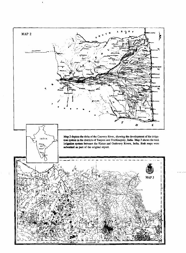
MAP 2
/ 0 .. 0 A
+
1 " \)
/1. R
£
Map 2 depicts the delta of the Cauvery River, showing the development of the irrigation system in the districts of Tanjore and Trichinopoly, India. Map 3 shows the tank irrigation system between the Kistna and Godavery Rivers, India. Both maps were submitted as part of the original report .
.......... _,_
MAP3
I f
!.

INTRODUCTION 81
tural potential of the Central Valley; and the cooperative use of state, federal, and private resources to control nature and build an agricultural empire that exceeded anything ever accomplished -- even in the ancient irrigation societies. The Irrigation Commission felt that to achieve these objectives the state and federal government had to coordinate planning and perhaps undertake the construction of the dams, levees, and canals. Because the principles of self -government were so deeply imbued in American political culture, the commissioners thought it essential that the management and distribution of water be controlled by the irrigators, perhaps formed into canal districts under regulations prescribed by the government. If the farmers themselves did not own the irrigating works, the commiSSioners believed that they at least had to maintain control over the distribution of water, and under no circumstances should the administration of water resources be given to private entities having no direct interest in the land. Construction and management of irrigation systems in the American West, wrote the commiSSioners, would require cooperation between capitalists, government, and local farmers. Individual farmers, local communities, and even large corporations had proven themselves ineffective in obtaining adequate capital, mastering technological and engineering problems, and building permanent irrigation facilities. In the modern agricultural world, farming had to be done on a business-like basis. Gone was the old agrarian vision of the individual farmer advancing civilization by confronting nature alone on the frontier. The modern ideal was that of the engineer-scientist bringing orderly economic development to the West through technological domination over nature and scientific management of natural resources.
The new technologies did not come without costs. Californians in the late 19th century experienced an environmental crisis as thousands of acres of agricultural land were robbed of their fertility. Wheat farmers had not fallowed or rotated crops; irrigators had saturated the soil, flushing the earth of nutrients and creating a favorable environment for the spread of malaria; and hydraulic miners had filled the channel beds of the Feather, Yuba, Bear, American, and Sacramento rivers with hundreds of millions of cubic yards of debris that poured over levees during floods and-- rli'ih.ed- -agrlculhiral 1-ands. --Tire commiSSioners ·expressed some concern over the environmental effects of water manipulation but did not demonstrate the same degree of caution as had George Perkins Marsh in Irrigation: Its Evils, the Remedies, a..n.d. 1M. Compensations. The Department of Agriculture submitted Marsh's report to Congress during the same session as the irrigation survey of the Central Valley. Marsh was an early promoter of the gospel of conservation and a pioneer in the modern viewpoint that man is a strong geographic agent. While he was alarmed about the potential for ecological disaster "in attempting a great and general revolution in our agricultural methods," he also saw beneficial applications for irrigation in the arid West where water was necessary to raise crops. Like Marsh, the Irrigation Commission advocated an activist role for federal and state government in planning and in the study of adapting "Old· World" irrigation laws and institutions to American society and customs." 79

32 ENGINEERS AND IRRIGATION
In the decades following the Civil War, a great quantity of new and more reliable scientific information on the arid West was assembled by the Department of War and the Interior Department. Much of this work focused on reshaping public land laws west of the hundredth meridian where agriculture must depend on irrigation. The small quantity of surface water restricted the amount of land susceptible to irrigation and placed a premium on discovering methods to conserve and increase water supplies. The report of the Irrigation Commission was one of the initial attempts to state general principles on which rules and regulations might be developed to carry out the colonization of the arid region. By unanimous consent, on II April 18 7 4 Congress resolved to print 5,000 copies of the Report on Irrigation of the Board of Commissioners for general distribution.80
IV
With the close of the commission's work, Alexander, Mendell, and Davidson returned to their regular duties. Later that year Davidson arranged for his subordinates to continue work on the triangulation project while he traveled to Japan to make astronomical observations of the transit of Venus. He asked for a leave of absence from his position with the Coast and Geodetic Survey and returned to the United States by way of China, India, Egypt, and Europe to examine the water projects and study the irrigation practices he had read about while on the commission. During his trip Davidson corresponded with Ralston, describing his investigations and boasting of his newly acquired expertise: "I have a broad and comprehensive view of the results, present and prospective, with a vast amount of information that will interest you in the development of California." On his return, Davidson wrote several articles on irrigation and related matters and submitted a report to the federal government on observations made during his trip. These experiences, coupled with his service on the commission, provided the foundation for Davidson's later activities as water consultant on several large irrigation projects.81
Brereton continued his efforts to arrange financing and build the San Joaquin canal project. By late 1873 he had supervised the construction
·---or improvement of 40 miles of canal and had· put· 0,000 acres-under irriga.;,;--· tion. He proposed to the landowners who might be served by the project, some of the richest and largest in California, that they trade 100,000 acres of irrigable land for an equal number of shares in the company, each worth $25. However, the canal company was still struggling for survival. It had failed to convince farmers within the irrigated district to exchange water contracts for land. During the heavy winter rains that year, the ditch banks in several areas washed away, destroying the canal and adjacent lands. Some claimed the construction engineer had built the canal on too steep a grade. The cost of repairs and reimbursement to landowners for damages nearly equaled the expense of initial construction. On 9 Decem-ber the trustees of the company, convinced that the government subsidy would not materialize, asked the state to condemn the canal, surveys, water rights, and company land and to have the property appraised by an impartial commtsston appointed by the governor or the legislature and taken over by the state at a price fixed by the commission. Governor Booth refused.82

INTRODUCTION 33
Ralston suggested to Brereton Ia te in 18 7 4 that he seek the necessary capital to improve the canal, some $2.5 million, in London. Brereton's second trip also failed and the major landowners then backed out of the deal. Advocating big irrigation systems for the San Joaquin plains had become "like fiddling Irish jigs to Egyptian mummies, and expecting them to dance to the music," wrote a correspondent to the Pacific Rural Press. Capitalists in California and elsewhere were more interested "in mines and mining, Palace Hotels, and bankruptcy." Unwise investments and loose banking practices caused the collapse of Ralston's Bank of California and may have contributed to Ralston's death in August 1875. These events not only shook the state's economy but dashed Brereton's hopes for private financing for the irrigation project. Except for Miller and Lux, all of the major landowners who might have been served by the canal went bankrupt as the Bank of California foreclosed on their loans. With the project collapsing around him, Brereton's renewed appeals to the state to rescue the project were futile. In an open letter to the new governor, Democrat William Irwin, he urged that the state reform its laws to provide for the organization of local irrigation districts and that the state assume ownership and control of its waters. Brereton estimated a state expenditure of $7 million would be required to irrigate the project's 300,000 acres. The project could be financed by the landowners served by tying the value of water to the newly irrigated lands. In the midst of an economic depression, state officials had no interest in purchasing a poorly engineered canal with dubious water rights that could practicably irrigate only one-tenth of the land estimated by promoters of the scheme. Otherwise, the San Joaquin & Kings River Canal and Irrigation Company canal may have become the first state water project. In an ironic twist, the company's works and water rights eventually became the property of Miller and Lux, the largest of the land monopolists, whose riparian water claims held up agricultural development in the southern San Joaquin Valley for decades.83
Alexander, Davidson, and Mendell, through their work on the commiSSIOn, enhanced their reputations as experts on the technical, engineering, and economic aspects of irrigation in California. Alexander and Mendell became principal figur..es in California water policy development in the 1870s and 1880s. When John Wesley Powell began his famous study of irrigation in the arid West for the U.S. Geological Survey, he asked Davidson for his papers on irrigation and consulted with him on Practices abroad. In 1876, James Ben Ali Haggin began his surveys on the ill-fated West Side Canal, an ambitious plan to irrigate 340,000 acres from a ditch running from Tulare Lake, to extend north 185 miles to Antioch. The three members of the original Irrigation Commission served as consulting engineers on the project. Besides irrigation, the Corps of Engineers during the 1870s became increasingly involved in the growing controversy over reclamation of tule marshes and tidelands, and the effects of hydraulic mininf debris on flood control and navigation of California rivers and bays.8
From the 1850s through the 1870s the democratic political culture of California staved off strong central control of natural resources management. Building irrigation systems required new forms of social organiza-

34 ENGINEERS AND IRRIGATION
tion and a greater degree of governmental intervention along with technological skills and engineering expertise. However, the Irrigation Commission recognized that American society was not ready for the central government to control planning, construction, and management.
In India the government does everything and the people do nothing in the management of the canal system. On the other hand, in our country we expect the people to do everything and the Government nothing. There all power and authority are in the hands of the officials, whose range extends to the merest details. This state of affairs is much lamented by intelligent observers, but in the present condition of the people any other system is impossible. We shall find in Italy and Spain that the principles of self-administration, and, in some degree, of self -government, have existed in irrigation associations for years, and in some cases for ages.
Americans will doubtless find this kind of administration something congenial with their opmwns, and perhaps they may discover in it the germ of their own modified system of the future.85
During the 1870s Californians struggled to discover this "modified system of the future." The need for more comprehensive state water policies was being felt in the state legislature. The great Marysville flood of 1875 touched off a campaign to regulate the dumping of hydraulic mining debris into the rivers. Efforts by local reclamation districts in the Sacramento Valley to hold back flood waters with levees had failed. Meanwhile, in the San Joaquin Valley, successive drought years accelerated the distress farmers and ranchers experienced during the "Terrible Seventies." Agitation by those concerned with these issues -- miners, farmers, and valley tesidents -- in 1876 led Republican Senator Creed Haymond of Sacramento County to propose a special state irrigation and reclamation commtsston including at least one engineer capable of planning irrigation and reclamation works. His bill was defeated. However, the clamor from flood-endangered and drought-ridden farmers persisted and soon led to a statewide investigation of the interrelated problems concerning irrigation, reclamation, inland navigation, and debris control.86
In January 1878, at the next session of the California legislature, Senator Haymond again presented a water management reform package. According to William Hammond Hall, who later became the first state engineer on the recommendation of Alexander, Haymond invited Alexander to Sacramento to give expert advice on how to deal with the debris, flood . control, and irrigation problems in the state. Alexander suggested that "money, organization, and central control" were the keys to solving the problem. He argued that the state should conduct an in-depth investigation related to the concerns of all factions. Hall thought this suggestion laid the foundation for Senator Haymond's decision to forge a coalition of interests and, in 1878, to introduce a bill to establish an investigative commission. Hydraulic mining interests, however, saw in the bill an attempt by valley farmers to attack their industry.87

INTRODUCTION 35
In February 1878 the mining debris-choked Sacramento River again spilled over its levees. This event encouraged competing interests to accept a state investigation into the problems confronting valley residents. Haymond introduced a second bill creating the Office of State Engineer, the first statewide water planning agency in California. The State Engineer was given the unenviable task of studying irrigation and debris problems; mapping all irrigable lands in the state and designing plans to irrigate them; studying the effects of debris on navigation and flooding; and devising a plan to prevent injury to valley agriculture. The report was to be submitted to the legislature at its 1880 session.88
After the Haymond bill had passed in May 1878, Alexander was angered to find that Mendell had written the final draft. Alexander considered it "interference on the part of his subordinate officer in a movement he had fathered." While Hall thought that Mendell might not have understood Alexander's prominent role in drafting the earlier version of Haymond's water reform bill, he recalled, "General Alexander took offense, and there was bitterness between these two ~entlemen who were called to act as advisors to the State Engineer."8 It later caused "personal inharmony" between Mendell and Alexander, and many anxious moments for Hall, who had to work closely with both men. However, Alexander died in San Francisco on 15 December 1878 at age 59. Hall eulogized Alexander in his first annual report to the governor, saying that "in him the engineering profession lost one of its masters, the State Engineer was deprived of an able and most agreeable counsellor, and from the State was taken one who has seen most, thought much, and to a purpose, of the field in which this Department is called upon to act."90
The act creating the Office of. State Engineer ordered a study of the three major problems facing the valley: irrigation, reclamation, and mmmg debris. With respect to irrigation the foremost task assigned to the State Engineer was determining needs, organizing water districts based on hydrographic boundaries, collecting data on stream flow and soil quality, and locating reservoir sites. From 1878 to 1888, California made the first major attempt to develop its water resources, spending more than $250,000 through the State Department of Engineering. As head of jh~depariment, Hall examined the areas of irrigation, reclamation, and debris control. He worked closely with Mendell, who replaced Alexander as the senior Corps Engineer, on the problems of flood control and navigation of inland rivers. Tutored by the Army Corps of Engineers, Hall came to his new position with a passionate belief that "the State, through a scientific board, should regulate and control all matters pertaining to the appropriation and distribution of the wate.rs of her streams." Like his mentors, he also looked to such countries as Italy, Egypt, Spain, and India as positive examples of government involvement in irrigation. He remained, in the face of political and entrepreneurial opposition, a firm advocate of centralized governmental control over water resources in California. Thus, through the education of a young group of engineers and the rise of Hall to his prominent position as State Engineer, Alexander left a legacy on California water policy that lasted well into the 20th century.91
What emerged from the irrigation debates of the 1870s and 1880s, as an alternative to centralized state-controlled or corporate reclama-

36 ENGINEERS AND IRRIGATION
tion, was a system of public control by local agencies. The Wright Act in 1887 and subsequent amendments provided a method for organizing and taxing landowners for irrigation projects, and established some minimal public control over water rights for irrigation systems in California through local irrigation districts. Forty-nine districts covering two million acres were organized in the first eight years following passage of the act. Many of them failed, beleaguered by construction cost overruns and litigation over water rights.92 By the 1890s, the western irrigation lobby turned to Washington as drought, falling farm prices, rural depopulation, and declining land values contributed to a new farm crisis in the arid West. The irrigation crusade of the nineties culminated in the passage of the Reclamation Act of 1902.
Mendell, Davidson, and Brereton lived to see the passage of the Reclamation Act on 17 June 1902. Mendell, by this time retired from Army service and acting as a private consulting engineer, died in October 1902. At the end of his life, Brereton wrote a series of somewhat wistful letters to Davidson, complaining that "wealth has gone from me through the swindling propensity of others." On the other hand, he looked back with a sense of achievement on his own and other engineers' pioneering efforts to introduce irrigated agriculture to the Central Valley, and thought that subsequent generations of Californians would be "proud of the men of the 70ties [sic]." Brereton firmly believed that the 1873 survey set a new standard for investigations as the first scientific examination of irrigation. He told Davidson that Senator Stewart had written him that the survey had formed the "nucleus of the present Reclamation Service of the U.S." Professor Davidson, who served with the Coast Survey until June 1895, stayed active in scientific and educational circles until his death on 2 December 1911.93
The Irrigation Commission in 1873 laid the foundation for a system that the commissioners believed would control the rivers, redistribute water, and conquer the harsh environment of the Central Valley. A comprehensive irrigation plan for the Central Valley remained a dream of ambitious engineers for generations. Large-scale Reclamation Bureau projects, such as that built at Orland in the northern Sacramento Valley in 1906-1910, competed for the public imagination --with gran<f-vTs1ons- such -a.s the so-called Marshall Plan of 1919-1920. Colonel Robert Bradford Marshall, chief geographer of the Geological Survey, suggested a large storage dam at Kennett on the Sacramento River (now the site of Shasta Dam) that would partially feed a "grand canal" ringing the Central Valley. Water stored at Kennett, combined with supplies from smaller storage reservoirs on tributaries and augmented by the Klamath River, would provide water for irrigating most of the Central Valley and for navigation on the grand canal. Additional canals would supply the growing demands in Los Angeles and San Francisco.94 Grandiose in scope, the plan rekindled public enthusiasm for a comprehensive program of irrigation during the next decade. Throughout the 1920s and into the 1930s, state and federal efforts in the valley were aimed at either adopting Marshall's plan or investigating and planning alternative projects that achieved some of his goals. California's Central Valley Project, planned in the late 1920s and adopted during the New Deal as a federal public works project, used the scientific data and built upon the general engineering concepts developed by Brereton, the Irrigation Commission, Hall, and Marshall.

1.
2.
Henry Nash Smith, "Rain Rainfall for the Great (1947), pp. 175-188.
Notes
Follows the Plow: The Notion for Increased Plains," Huntington Library Quarterly 10
Raymond (Lexington: 110-135.
H. Merritt, Engineering in American The University of Kentucky Press,
Society, 1850-1875 1969), pp. 2, I 0,
3. Charles Nordhoff, California for Health, Pleasure, and Residence. A Book f.Qr Travelers and Settlers (New York: Harper & Brothers Publishers, 1876), pp. 182-188.
4. Eighth Census Q.( 1M. United ~. lM.Q. (Washington, DC, 1864), p. 662; Ninth Census Q.( 1M. United States, il1.Q. (Washington, DC, 1872), 3:820.
5. James H. Budd, "Annual Address Delivered Before the San Joaquin Agricultural Society," Transactions Q.( ~ California ~ Agricultural Society, ill.l (Sacramento: State Printer, 1873), pp. 603-609. Hereafter cited as TCSAS. J.A. Hosmer, "Annual Address Delivered Before the San Joaquin Agricultural Society," TCSAS. 1874 (Sacramento: State Printer, 1874), pp. 616-625.
6. John Bidwell, "Annual Address Delivered Before the State Agricultural Society, September 12, 1867," TCSAS. ll..QQ-l.Ml (Sacramento: State Printer, 1867), pp. 419-436.
7. TCSAS. .l.MQ-llQI, pp. 46-47; George Barstow, "Agricultural Address," TCSAS. ~-ll22., pp. 327-328; J. Ross Browne, "Reclamation and lrdgation," TCSAS. ill.Q., __ pp . . 413-420. --~--·-.
8. Charles F. Reed, "Report to Governor Newton Booth," Biennial Report of ~ S1m 1l.Q.a.r4 Q.( Agriculture ill ~ Y.gn ill.Q-181.l (Sacramento: State Printer, 1872), pp. 25-26.
9. Browne, "Reclamation and Irrigation," TCSAS. ill.Q, pp. 413-419; Bidwell, "Annual Address," pp. 426-429. Regarding the effect of water on history in irrigation societies, see Donald Worster, Rivers of Empire: .IDU..tl, Aridity &, ~Economic Growth Q.( ~ American West (New York: Pantheon Books, 1985), pp. 17-60. For several works that explore how proponents of efficiency and centralization tried to replace the chaos and disorganization of national life in mid-19th century America, see Robert H. Weihe, The Search for Q.,rlli, ll11-1920 (New York: Hill & Wang, 1967); George M. Fredrickson, The Inner Civil War: Northern Intellectuals (Harper & Row, 1965); and Morton Keller, Affairs Q.( ~: Public Life in Late Nineteenth Century America (Cambridge: The Belknap Press of Harvard University, 1977).

38 ENGINEERS AND IRRIGATION
10. Gerald L. Prescott, "Farm Gentry vs. the Grangers: Conflict in Rural California," California Historical Quarterly 56:4 (Winter 1977-1978), pp. 328-345.
11. Merritt, Engineering in American Society, pp. 27-62.
12. All of the comprehensive plans for irrigation of the San Joaquin Valley in the 20th century have recognized the need to transport water from the north into the water-deficient regions of the southern San Joaquin Valley. The commissioners proposed to impound water in the south and move it north.
13. Edward Hyatt, "National Broadcast on California Agricultural Programs, Under the Auspices of the State Grange, NBC Studios, San Francisco, November 10, 1939," Edward Hyatt Papers 2, Water Resources Center Archives, University of California, Berkeley.
14. Gordon R. Miller, "Shaping California Water Law, 1781-1928," Southern California Quarterly 55 (Winter 1973), pp. 9-42; A.E. Chandler, "Appropriation of Water in California," California l.Jlli:. Review 4 (March 1916), pp. 206-216. Michael C. Meyer, ~ in thk Hisoanic Southwest: A ~ lli l.&gM History, 1550-1850 (Tucson: The University of Arizona Press, 1984); Robert G. Dunbar, Forging New Rights in Western Waters (Lincoln: University of Nebraska Press, 1983), pp. 1-8; Donald J. Pisani, From thk Family Farm 1Q. Agribusiness: IM. Irrigation Crusade in California a.rut thk American ~ 1850-1931 (Berkeley: University of California Press, 1984), pp. 30-53; Douglas Littlefield, "Water Rights during the California Gold Rush: Conflict over Economic Points of View," Western Historical Quarterly 14:4 (October 1983), pp. 415-434; Robert G. Dunbar, "The Adaptability of Water Law to the Aridity of the West," Journal Q.( thk ~ 24 (January 1985), pp. 57-65; Donald J. Pisani, "Enterprise and Equity: A Critique of Western Water Law in the Nineteenth Century," Western Historical Quarterly
.. 18:1 (January 1987), pp. 15-37. -----~·--. -·--·· ·-·--· ...
15. Paul W. Gates, "Public Land Disposal in California," A2ricultural History 49:1 (January 1975), pp. 158-178; Warren A. Beck and Ynez D. Haase, Historical A1.l!l..s. Q.( California (Norman: University of Oklahoma Press, 1974), pp. 24-34, 67-71; Lawrence J. Jelinek, Harvest Empire: A History of California Agriculture (San Francisco: Boyd & Fraser Publishing Co., 1982), pp. 28-35;. TCSAS. il..ZQ-1.1. pp. 15-16; TCSAS. !.[U, p. 632. Among the major beneficiaries of the land disposal policies of the federal and state government were William S. Chapman, who brought irrigation to large tracts of valley land with his Fresno Canal and Irrigation Company; Henry Miller and Charles Lux, the cattlemen who controlled the San Francisco meat market and eventually owned both banks of the San Joaquin River from west of Modesto to near Madera, a distance of 100 miles; Billy Carr, Lloyd Tevis, and James

INTRODUCTION 39
Ben Ali Haggin, whose San Joaquin Valley holdings became the basis of the Kern County Land Company; Isaac Friedlander, "the wheat king"; and William C. Ralston. ·
16. Walton Bean, California: An Interpretive History, 3d ed. (New York: McGraw-Hill Book Co., 1978), pp. 182-194.
17. Pisani, From the Family Farm, p. 105; Nordhoff, California, p. 129; Irrigation in California: The SAn Joaquin rul4. Tulare Plains (Sacramento: Record Steam Book & Job Printing House, 1873), pp. 12-18. Several irrigation canals were under construction in the valley in 1872-1873. The most important were the Fresno Canal built by Isaac Friedlander near Borden Station; Lower Kings River ditch built by the Peoples Ditch Company of Tulare; Lower Kings River ditches in the vicinity of Centerville; Chapman's Canal on the San Joaquin River, diverting water 25 miles above Firebaugh's Ferry; and the Kings River & San Joaquin County Canal.
18. Pisani, From 1M. Family Farm, pp. 106-107; John Bensley Biographical Sketch, MS, John Bensley Papers, Bancroft Library, University of California, Berkeley; Marysville Appeal, 14 June 1873.
19. David Lavender, Nothing Seemed Impossible: William !:.. Ralston and Early San Francisco (Palo Alto, CA: American West Publishing Co., 1975), pp. 353-355; Commercial Herald a..ru! Market Review. 12 January 1872, in Cecil G. Tilton, William Chaoman Ralston: Courageous Builder (Boston: The Christopher Publishing Co., 1935), pp. 161-164.
20. Michael Edwardes, British !n..ill.a.. 1772-1947: A Survey Q[ 1M. Nature and Effects Q[ Alien Rule (New York: Tapinger Publishing Co., 1967), pp. 149-155, 216-228; Robert Burton Buckley, Irrigation Works in !n..ill.a. and &&:v.lll (New York: Spon & Chamberlain, 1893), pp. 269-294; Robert Maitland Brereton, Reminiscences Qf. SUl Qlil. English Civil Engineer .
.. --- ·-----!:la-122£-(-P-a.rtla-nd, -OR:-The Irwin-Hodson Co., 1908), pp. ,7-17. -- ------ ---- -------
21. Brereton, Reminiscences Q[ il Civil Engineer, pp. 18, 23-24. In a letter written to George Davidson forty years later Brereton claimed he had come to the United States on "a mission from the Government of India" to inspect railroad construction methods in the United States and had let Ralston convince him to abandon this work and enter into the irrigation scheme. Although he remained proud of his efforts to bring irrigation to the San Joaquin Valley, later in life Brereton was embittered by his association with the enterprise as it had deprived him of prestigious career opportunities as chief engineer of railways in India, Japan and Australia. Brereton to Davidson, 14 and 19 Apr. 1911, Davidson MS, Bancroft Library.

40 ENGINEERS AND IRRIGATION
22. Brereton, "Report No. 1 to Messrs. Friedlander, Ralston, Chapman, and Others," 19 Aug. 1871, in Robert M. Brereton, Reminiscences of ru1 Irrigation Enterprise in California (Portland, OR: The Irwin-Hodson Co., 1903), pp. 54-59; Stockton Independent, 29 April and 17 May 1871.
23. Brereton, "Report No. 2 to Messrs. Friedlander, Ralston, Chapman, and Others," 6 Oct. 1871, in Brereton, Reminiscences Q( ru1 Irrigation Enterprise, pp. 59-72.
24. Sacramento Union, 2 November 187i; Stockton Independent, 15 August and 18 October 1871.
25. Brereton, Reminiscences of a. Civil Engineer, pp. 28-30; J. Ross Browne to W.C. Ralston, 11 Nov. 1871, William C. Ralston Collection, Bancroft Library. Hereafter cited as Ralston Collection.
26. Sacramento Union, 30 January 1872; Appendix 1.Q. ~ Journals Q( 1M, Senate and Assembly of the Legislature Q[ 1M, ~ Q( California. 19th sess., vol. III.
27. Winfield J. Davis, History Q( Political Conventions in California. 1849-1892 (Sacramento: Publications of the California State Library, 1893), pp. 303-304; W.C. Ralston to Newton Booth, 18 Jan. 1872, and Ralston to Booth, 18 June 1872, in Brereton, Reminiscences Q.( a. Civil Engineer, pp. 74-75, 86; Biographical Directory Q[ m American Congress, 1774-1971, Sen. Doc. 92-8, 92d Cong., 1st sess. (Washington, DC: Government Printing Office, 1971), p. 612·; Royce D. Delmathier et al., The Rumble of California Politics, 1848-121Q. (New York: John Wiley & Sons, Inc., 1970), pp. 40-69.
28. Brereton, Reminiscences Q.( a. Civil Engineer, p. 30; Brereton, Reminiscences of .!!.!l Irrigation Enterprise, pp. 8, 18-20; Charles Stuart to William Ralston, 13 Apr. 1872, 27 July 1872, and 15 Aug. 1872; Brereton to Ralston.- lL July --18-72, --Ralston---Collec-t-ion; --Bane-r-oft- -Library.
29. Louise Hall Tharp, Three Sfti.n1s. a.ru1 a. Sinner, JJ!li.a. ~ Howe, Louisa, Annie and Sam Ward (Boston: Little, Brown & Co., 1956).
30. Brereton, Reminiscences of a. Civil Engineer, p. 27.
31. A good general discussion of the antimonopoly attitudes in California is contained in David B. Griffiths, "Anti-Monopoly Movements in California, 1873-1898," Southern California Quarterly 52 (Spring 1970), pp. 93-121.
32. Brereton, Reminiscences Q.( a. Civil Engineer, p. 27; SAn. Francisco Chronicle, 21 February 1873.

INTRODUCTION 41
33. Congressional Globe, 41st Cong., 1st sess., 22 March 1869, p. 190; Stockton Independent, 1 and 22 February 1873, 22 May 1873, 6 and 9 June 1873, and 2 July 1873; Sacramento Union, I, 2, 7, and 19 July 1873 and 18 October 1873.
34. By the middle of February most of the newspapers began referring to this bill as "the Stewart Bill." William M. Stewart, Senator from Nevada, introduced the bill providing for the appointment of a Board of Irrigation Commissioners. He was also a major supporter of the subsidy bill that many newspapers initially tended to view as a companion bill to the canal subsidy legislation.
35. Sacramento Bee, 14 February 1873; Tulare Times, 15 February 1873.
36. Sacramento Union, 15 February 1873; Stanislaus County News, 21 February 1973.
37. San Francisco Chronicle, 21 February 1873.
38. Cole to Ralston, 2 Feb. 1873, Ralston Collection, Bancroft Library.
39. Gorham to Ralston, 16 Feb. 1873, Ralston Collection, Bancroft Library.
40. San Francisco Chronicle, 29 February 1873; Sacramento Union, 28 February 1873. The last provision was particularly significant because at that time the Central Pacific Railroad was claiming in the courts that the land grants it received from the federal government were quasi-federal property and therefore exempt from local taxation until sold. San Francisco Chronicle, 22 February 1873.
41. Congressional Globe, 42d Cong., 3d sess., 27 February 1873, p. 1846.
---------- 42 .. On-.. the ... .nrganiza-tion of farm clubs and Grange_ ... chap.ters-.-and __ their-~-opposition to the bill, see the weekly issues of the Pacific Rural Er_m from March through December 1873; Tulare Times, 22 February 1873.
43. Congressional Globe, 42d Cong., 3d sess., 13 February 1873; Sacramento Union, 15 February 1873; Russell R. Elliott, Servant of Power: A Political Biograohy Q[ Senator William M. Stewart (Reno: University of Nevada Press, 1983). When he left the Senate in 1875, Stewart served as attorney for a number of large landowners in California and represented Haggin and Tevis in their San Joaquin Valley water battles in the 1870s and 1880s. When he returned to the Senate in 1887, he became a champion of irrigation in the arid West and was in part responsible for passage of the act authorizing a federal irrigation survey of western territories and states in 1888-1889. He was chairman of the Senate Subcommittee on Irrigation and Reclamation of Arid Lands when

42 ENGINEERS AND IRRIGATION
that special body was added to the Public Lands Committee in 1889. Stewart invited Brereton to work on the irrigation survey but Brereton declined. See Brereton, Reminiscences of ru1 Irrigation Enterprise, pp. 20-21.
44. Sacramento Bee, 25 February 1873; Sacramento Union, 6 March 1873; Marysville Appeal, 16 February 1873. Houghton's bill was numbered H.R. 3966.
45. Congressional Globe, 42d Cong., 3d sess., 17 January 1873, p. 660; 10 February 1873, p. 1232; 13 February 1873, p. 1297; 14 February 1873, p. 1313; 17 February 1873, p. 1422; 27 February 1873, p. 1846; 28 February 1873, pp. 1916 and 1930; 3 March 1873, pp. 2135, 2200, and 2202.
46. Message from the President Q.( the United ~ Transmitting the Report Q.( 1M. Commissioners Qn. the Irrigation of the San Joaquin, Tulare, and Sacramento Valleys, in the ~ Q.( California. H. Exec. Doc. 290, 43d Cong., 1st sess., 24 March 1874.
47. Brereton, Reminiscences Q.( a. Civil Engineer, p. 26.
48. Special Orders No. 75, 9 Apr. 1873; Brig. Gen. A.A. Humphreys to Lt. Col. B.S. Alexander, 12 Apr. 1873; Benjamin Peirce to George Davidson, 25 Apr. 1873. All cited in Message from .th.k President Qf the United States.
49. For example, see the correspondence between Mendell and Davidson in Davidson Papers, Bancroft Library, 1870-1873.
50. "Barton S. Alexander," Office of History Biographical Files.
51. LeConte had been worried that his service in the Confederate Army during the Civil War would be held against him. Alexander assured him that it would not, __ Alexander himself- was strongly_ opposed to Radical -Reconstruction, and commented on the possible negative effects of "the event of negro supremacy" in LeConte's horne state of South Carolina. B.S. Alexander to John LeConte, 25 Oct. 1867, 19 June 1868, and 24 Sept. 1868, Box I, folder: Alexander, Barton Stone, LeConte Family Papers, Bancroft Library. LeConte Hall on the Berkeley campus is named in honor of the LeConte brothers, who both served long terms on the faculty.
52. Anthony F. Turhollow, A History Qf 1M. Los Angeles District, !l...S.. Army Corps of Engineers, 1898-1965 (Los Angeles: U.S. Army Engineer District, 1975), pp. 24-28; Lt. Col. B.S. Alexander and C.W. Lightner, Report of the Commissioners Appointed 1.Q. Examine the Harbor Q.( Srul1a. Cruz and Salinas Slough in 1M. .ful.v. Qf Monterey, 26 February 1870, pamphlets on engineering, Bancroft Library.

INTRODUCTION 48
53. Lt. Col. Barton S. Alexander, Reports Q.( !!.S.. Alexander, Lieut. CQl. Engineers of the Preliminary Surveys, Cost of Construction, ~. Q.( the Stockton Ship Channel. Stockton California (Stockton: Independent Press, October 1874); William Hammond Hall, State Engineer, to the Governor of California, "Drainage and Debris Work of 1878-1881, First Letter, The Origin and Conditions of the Investigation," 8, file F3748: 20-42, Records of the State Engineer, California State Archives, Sacramento; see also Nicholas P. Hardeman, The Harbor Q.( the Heartlands: A History Q.( 1.b& Inland Seaport Q.( Stockton, California, From 1.b& Gold Rush 1Q. ~ (Stockton: Holt-Atherton Center for Western Studies, 1986), pp. 33-34. Hardeman says Alexander was "later known as the father of the Central Valley Project." Stockton is a major deepwater port in California because of the maintenance of a shipping channel similar to that proposed by Alexander.
54. Report Q.( 1.b& Special Committee Q.( 1.b& ~ Q.( Supervisors, Together With Recommendations Q.( Qm.. !!.S.. Alexander, !.[.S..A., a.rut Prof. George Davidson U.S..Q.S.., Q1l 1.b& ~ Supplies for 1.b& Ci1Y Q.( Srul Francisco (San Francisco: A.L. Bancroft & . Co., 1872); "Report of General Barton Stone Alexander on the Reclamation of the Rancho Pescadero, San Joaquin County," 1877, Bancroft Library Pamphlets; William Hammond Hall, State Engineer, to the Governor of California, "Drainage and Debris Work of 1878-1881, First Letter, The Origin and Conditions of the Investigation," 7, file F3748: 20-42, Records of the State Engineer, California State Archives, Sacramento.
55. "George H. Mendell," Office of History Biographical Files. Mendell's San Francisco office letter press books are housed at the Bancroft Library. During the time of the irrigation survey, Mendell was pressed for information regarding an action during the war where his men destroyed a barn to obtain timber for a temporary bridge across a stream. (The farmer wanted compensation for his wrecked building.) Mendell recalled that circumstances -- he and his men were under Confederate guns at the time -- had dictated that -demolition and construction be done quickly. See Letterbook, vol. I.
56. Oscar Lewis, George Davidson: Pioneer ~ QQ.ill Scientist (Berkeley: University of California Press, 1954), pp. 1-5, 8-9, 38-39, 51-52; George Davidson to Benjamin Peirce, see various 1873 Letterbooks, vol. 25, Davidson Papers, Bancroft Library; Alonzo Phelps, Contemporary Biography of California's Representative ~ ~ Contributions From Distinguished Scholars ruul Scientists (San Francisco: A.L. Bancroft & Co., 1881), pp. 97-101. Lewis's biography provides a comprehensive description of Davidson's career, interests, and accomplishments.
57. Message from the President Q.( 1.b& United ~. p. 5.
58. Richard A. Bartlett, Qrill Surveys of the American ~ (Norman: University of Oklahoma Press, 1962), pp. 135-136.
ENGINEERS AND IRRIGATION
59. The history of Whitney's experience in California is detailed in William H. Goetzmann, Exploration and Empire: The Explorer and the Scientist in the Winning Q[ 1M. American West (New York: Random House, 1972), pp. 355-389; Albert Bierstadt and William C. Ralston to General A.A. Humphreys, 13 and 20 May 1873; Humphreys to Bierstadt and Ralston, 2 June 1873, entry 52, 929 GR 1874, enc. 1027, Record Group 77, National Archives.
60. Sa.n. Francisco Chronicle, 17 March 1873.
61. Robert Brereton to George Davidson, 9 Sept. 1911, Davidson Papers, Bancroft Library; Message from the President Q[ 1M. United ~. pp. 5-6.
62. Pacific B...Yr.ru. ~. 7 June 1873, 5:356; quote from Kern County Weekly Courier, 17 May 1873. No evidence confirming the presence of Whitney or King with the commissioners has been found. Stanislaus County News, 30 May 1873.
63. Davidson to Samuel Hein, 2 May 1873, Letterbooks. Alexander to Davidson, 9, 14, and 21 May 1873; Alexander to Ellinor Davidson, 12 May 1873. All in Davidson Papers, Bancroft Library.
64. Kern County Weekly Courier, 17 May 1873; Davidson to Alexander, Monthly Report, 31 May 1873, entry 52, 927 GR 1874, RG 77, National Archives.
65. Fresno Exoositor, 21 May 1873; Pacific B...Yr.ru. f.llis., 7 June and 12 July 1873; The Weekly Apoeal (Marysville), 14 June 1873.
66. Davidson to J.E. Hilgard, 17 May 1873. Davidson to Superintendent of the Coast and Geodetic Survey, 21 May 1873. Both Letterbooks, Davidson Papers, Bancroft Library.
67. Davidson to Alexander, Monthly Report, 30 June 1873: -entry 52, 927 GR 1874, RG 77, National Archives; quote from Davidson to Samuel Hein, 9 June 1873, Davidson Papers, Bancroft Library.
68. Davidson to Superintendent of the Coast and Geodetic Survey, 23 June 1873, Letterbooks, Davidson Papers, Bancroft Library.
69. Alexander to Humphreys, Monthly Report, 9 July 1873, entry 52, 927 GR 1874, RG 77, National Archives.
70. Alexander to Humphreys, Monthly Report, 20 Aug. and 10 Sept. 1873, entry 52, 927 GR 1874, RG 77, National Archives; quote from Davidson to Superintendent of the Coast and Geodetic Survey, 24 July 1873; Davidson to Superintendent of the Coast and Geodetic Survey, 6 Aug. 1873. Both in Letterbooks, Davidson Papers, Bancroft Library.

INTRODUCTION 45
71. Alexander to Humphreys, 20 Aug. 1873, entry 52, 927 GR 1874, RG 77, National Archives; quote from Alexander to Davidson, 11 Aug. 1873, Davidson Papers, Bancroft Library; Alexander to Humphreys, Monthly Report, 7 Oct. 1873, entry 52, 927 GR 1874, RG 77, National Archives.
72. Alexander to Davidson, 21 Oct. 1873, Davidson Papers, Bancroft Library; William H. Bryan, Report of the Engineer of the Sacramento Valley Irrigation and Navigation Canal (Sacramento: State Printer, 1868). Quote from Alexander to Davidson, 28 Oct. 1873; Alexander to Davidson, 29 Oct. 1873; Alexander to Humphreys, 7 Nov. 1873. All in Davidson Papers, Bancroft Library. Alexander to Humphreys, 11 Nov. 1873, entry 52, 927 GR 1874, RG 77, National Archives.
73. Alexander to Humphreys, 4 Dec. 1873, entry 52, 927 GR 1874, RG 77, National Archives.
74. Weekly Colusa Sun, 8 November 1873.
75. Alexander to Humphreys, 5 Jan. 1874, entry 52, 927 GR 1874, RG 77, National Archives.
76. Alexander to Humphreys, 10 Feb. 1874, entry 52, 927 GR 1874, RG 77, National Archives; Alexander to Davidson, 16 Feb. 1874, Davidson Papers, Bancroft Library; Alexander to Humphreys, 5 Mar. 1874, entry 52, 927 GR 1874, RG 77, National Archives.
77. Congressional Record, 43d Cong., 1st sess., 5 January 1874, p. 387; 6 January 1874, p. 388; 6 February 1874, p. 1255.
78. Assembly Bill 172, 21 January 1874, Assembly Bills, 1873-74, California State Archives. The Veneble bill passed in the Grangercontrolled assembly but was voted down in the Senate. Pacific Rural ~' 15 November 1873, 6:308; and 28 March f874~- 7:20r;~-A.lexailder to Humphreys, undated correspondence, entry 52, 927 GR 1874, RG 77, N a tiona! Archives.
79. George Perkins Marsh, Irrigation: Its Evils, the Remedies, and the Compensations, Sen. Misc. Doc. 55, 43d Cong., 1st sess., 6 February 1874. John Wesley Powell, a scientist and explorer who spent much of his time after 1867 observing and studying the natural resources of the West, also submitted a report to Congress in April 1874. He advocated "cooperative organizations" of great capitalists, the states, and the national government to develop projects for irrigating extensive acreages on the main watercourses of the American West. H. Ex. Doc. 612, 43d Cong., 1st sess., 21 Apr. 1874.
80. Congressional Record, 43d Cong., 1st sess., 6 February 1874, p. 3009.
81. Phelps, Contemporary Biography, p. 101; Davidson to Ralston, 15 May 1875, Ralston Papers, Bancroft Library; George Davidson, Report upon

ENGINEERS AND IRRIGATION
~ Methods Employed in Irrigating Land in India, &gyQ!, Italy, and Other Countries, Sen. Ex. Doc. 94, 44th Cong., 1st sess., 1875; Davidson, "Lectures on Irrigation Before the Legislature of California," 15-16 Jan. 1878, Davidson Papers, Bancroft Library.
82. Brereton, Reminiscences Q.( i!. Civil Engineer, pp. 28-30; Pacific Rural Press, 22 November 1873 and 4 April 1874, 7:10; Sacramento Union, 20 February 1874.
83. Pacific Rural ~. 30 October 1875; Brereton, Reminiscences of i!. Civil Engineer, pp. 28-30; Bean, California: An Interpretive History, pp. 192-193; Brereton, Reminiscences of l!.!l Irrigation Enterprise, pp. 24-35. Brereton sent his letter to Governor Irwin on 16 November 1875; it was published by the San Francisco Chronicle on 21 November 1875.
84. John Wesley Powell to Davidson, 25 May 1877; James B. Haggin to Davidson, 6 Nov. 1877; Alexander to Davidson, 5 Dec. 1877 and 10 Mar. 1878, Davidson Papers, Bancroft Library. Haggin published their short report, which drew heavily on the 1873 irrigation survey, as a part of his larger document, The Desert Lands Q[ Kern County, California (San Francisco: C.H. Street, 1877); William Hammond Hall, Report of l..M ~ Engineer 1Q ~ Legislature Q.( the ~ Q[ California, Part I (Sacramento: State Office of Printing, 1881 ).
85. Message from the President of l..M United States, pp. 48-49.
86. Robert L. Kelley, QQM Y.,S.. Grain: The Hydraulic Mining Controversy in California'~ Sacramento Valley: A Chapter in the Decline of the Concept of Laissez Faire (Glendale, CA: The Arthur H. Clark Co., 1959), pp. 57-131; Thomas E. Malone, "The California Irrigation Crisis of 1886: Origins of the Wright Act" (Ph.D. diss., Stanford University, 1965), pp. 64-65; Pisani, From the Family Farm, p. 162.
87. William Hammond Hall, State Engineer, to the Governor of California, "Drainage and Debris Work of 1878-1881, First Letter, The Origin and Conditions of the Investigation," pp. 5-10, Records of the State Engineer, file F3748: 20-42, California State Archives, Sacramento; Pisani, From ~Family Farm, p. 167.
88. "An Act to Provide a System of Irrigation, Promote Rapid Drainage, and Improve the Navigation of the Sacramento and San Joaquin Rivers," 28 March 1878, 22 Cal. Stats., pp. 634-636; Kelley, Gold Y.,S.. Grain, pp. 65-84.
89. William Hammond Hall, State Engineer, to the Governor of California, "Drainage and Debris Work of 1878-1881, First Letter, The Origin and Conditions of the Investigation," pp. 5-10, Records of the State Engineer, file F3748: 20-42, California State Archives, Sacramento.
INTRODUCTION 47
90. Alta California, 16 December 1878; William Hammond Hall, Report of the State Engineer, p. 26.
91. Charles P. Korr, "William Hammond Hall: The Failure of Attempts at State Water Planning in California, 1878-1888," Southern California Quarterly 45:4 (December 1963), pp. 305-321; quote from William Hammond Hall, Report 1.Q. 1M. Honorable ~ Q.( Commissioners Q.( ~ ~ ~ Irrigation District, 18 December 1877, Appendix 1.Q. 1.b& Journals of the Senate a..n..Q. Assembly Q.( the ~ Q.( California, 22d sess., 1877-1878, vol. 4 (Sacramento: State Printer, 1878); Lt. Col. George H. Mendell, Report Q1l a. Project 1.Q. Protect the Navigable Waters Q.( California from ~ Effects Q.( Hydraulic Mining, H. Ex. Doc. 98, 47th Cong., lst sess. (Washington, DC: Government Printing Office, 1882).
92. Department of Public Works, Division of Water Resources, Financial and General Data Pertaining 1Q. Irrigation, Reclamation i!llil Q1.hg_ Public Districts in California, Bulletin No. 37 (Sacramento: California State Printing Office, 1931), pp. 25-106.
93. "George H. Mendell," Office of History Biographical Files; Srut Francisco Chronicle, 20 October 1902; Srul Francisco ~. 21 October 1902; Robert Brereton to George Davidson, 16 Apr. 1899, 3 Sept. 1910, 14 Apr. 1911, and 29 Sept. 1911, Davidson Papers, Bancroft Library; Lewis, George Davidson, pp. 121-128.
94. Pisani, From the Family Farm, pp. 396-403.

Lieutenant Colonel Banon S. Alexander
Major George H. Mendell Professor George Davidson

REPORT
OF THE
BOARD OF COMMISSIONERS
ON
THE IRRIGATION
OF
THE SAN JOAQUIN, TULARE, AND SACRAMENTO VALLEYS
OF THE STATE OF CALIFORNIA.
Lieut. Col. B.S. ALEXANDER, Corps of Engineers, U.S.A.,
Maj. GEORGE H. MENDELL, Corps of Engineers, U.S.A.,
Prof. GEORGE DAVIDSON, United States Coast Survey,
COMMISSIONERS.
WASHINGTON:
GOVERNMENT PRINTING OFFICE.
1874.

43d Congress 1st Session
HOUSE OF REPRESENTATIVES Ex. Doc. No. 290
IRRIGATION OF THE SAN JOAQUIN, TULARE, AND SACRAMENTO
VALLEYS, CALIFORNIA
MESSAGE
FROM THE
PRESIDENT OF THE UNITED STATES,
TRANSMITTING
The report of the Commissioners on the Irrigation of the San Joaquin,
Tulare, and Sacramento Valleys, in the State of California.
MARCH 24, 1874.--Referred to the Committee on the Public Lands and ordered to be printed.
To the Senate and House of Representatives: I have the honor to transmit herewith the report of the Board of
Commissioners on the Irrigation of the San Joaquin, Tulare, and Sacramento Valleys of the State of California, and also the original maps accompanying said report.
U.S. Grant
EXECUTIVE MANSION, March 23, 1874.

Report of the Board of Commissioners on the Irrigation of the San Joaquin, Tulare, and Sacramento Valleys of the State of California.-Lieut. Col. B. S. Alexander, Corps of Engineers, U.S.A.; Major Geo. H. Mendell, Corps of Engineers, U.S.A.; Prof. George Davidson, United States Coast Survey, Commissioners.--February, 1874.
CONTENTS
CHAPTER I.
I. Introductory.--2. Preliminary reconnaissance.--3. The map.
CHAPTER II.
The necessity for irrigation in California.
I. Necessity influence of irrigation ?--5. considerations.
CHAPTER III.
of surveys.--2. The system irrigation on the navigation
Existing and hypothetical
CHAPTER IV.
of irrigation.--3. The of rivers.--4. What is
canals.--6. General
History, description, and statistics of irrigation in foreign countries.
CHAPTER V.
Cost of irrigation.--Conclusions.
APPENDIXES.
No. 1. Irrigating Association in Italy. No. 2. Statistics of San Joaquin and Tulare Valleys. No. 3. Existing legislation on irrigation.

IRRIGATION IN CALIFORNIA 53
CHAPTER I.
1. Introductory--Law of Congress authorizing the commission--Order of the President creating it--Its final organization--Scarcity of funds.
2. Preliminary reconnaissance--Examination of the rivers and lakes in the valleys of San Joaquin, Tulare, anq Sacramento--These three valleys designated "the Great Valley of California."
3. The map; it embraces the Great Valley of California; what it shows--Sketch of the valleys and foot-hills.
INTRODUCTORY.
The following is the act of Congress authorizing the commission:
AN ACT to provide a board of commissioners to report a system of irrigation for the San Joaquin, Tulare, and Sacramento Valleys, in California.
Be it enacted by the Senate and House of Representatives of the United States of America in Congress assembled, That the President be, and he is hereby, authorized to assign two engineers of the Army and one officer of the Coast Survey now stationed on the Pacific coast, for the purpose of examining and reporting on a system of irrigation in the San Joaquin, Tulare, and Sacramento Valleys of the State of California; and for that purpose the officers so assigned may associate with themselves the chief of the geological survey of California, and also one other civilian distinguished for his knowledge of the subject.
Sec. 2. That these five pers-onr···stnrll-cOl'lsttnne· a· ooard, ·witw-·pow·er to fill vacancies, whose duty it shall be to make a full report to the President on the best system of irrigation for said valleys, with all necessary plans, details, engineering, statistical, and otherwise; which report the President shall transmit to Congress at its next session, with such recommendations as he shall think proper.
Sec. 3. That the Secretary of War shall furnish subsistence and transportation for the board while in the field, and the compensation of the members of the board who are not in the service of the United States shall not exceed two thousand dollars each, but the other members of the board shall receive no additional compensation for their services.
Approved March 3, 1873.

54 ENGINEERS AND IRRIGATION
We insert here the following order of the Secretary of War, organizing the board of commissioners:
[Special Orders No. 75.] WAR DEPARTMENT, ADJUTANT-GENERAL'S OFFICE,
Washington, April 9, 1873.
Under the act of Congress approved March 3, 18 7 3, published in General Orders No. 56 of 1873 from this office, Lieut. Col. Barton S. Alexander and Maj. George H. Mendell, Corps of Engineers, are hereby appointed members of the commission, Lieut. Col. Alexander to be president thereof, for the purpose of examining and reporting on a system of irrigation in the San Joaquin, Tulare, and Sacramento Valleys of the State of California, and will hold themselves in readiness to proceed to the duties of the commission on receipt of further instructions from the Secretary of War.
By order of the President of the United States:
Official: J. P. Martin,
Assistant Adjutant-General.
E. D. TOWNSEND, Adjutant-General.
Also the further instructions of the Secretary of War:
OFFICE OF THE CHIEF OF ENGINEERS, Washington, D.C., April 12, 187 3.
SIR: A copy of the act of Congress approved March 3, 1873, published in General Orders No. 56, current series, Adjutant-General's Office, authorizing the assignment of two engineers of the Army and one officer of the Coast Survey now stationed on the Pacific coast, for the purpose of exammmg and reporting on a system of irrigation in the Sn Joaquin, Tulare, and Sacramento Valleys of the State of California, and for that purpose the officers so assigned may associate with themselves the chief of the__ geologicaL-S-U-r-vey -0C California, and also one other civilian distinguished for his knowledge of the subject, is herewith transmitted for your information and guidance.
The President has, in Special Orders No. 75, Adjutant-General's Office, Washington, April 9, 1873, a copy of which is inclosed herewith, appointed you and Major Mendell members of the board, and also Prof. George Davidson, assistant m the Coast Survey, as contemplated in the first section of the act.
The board so constituted are authorized to associate with themselves the chief of the geological survey of California, and also one other civilian distinguished for his knowledge of the subject.
As the president thereof, you will convene the board in San Francisco, or such other convenient place as you may select, and proceed to the business devolving upon it.

IRRIGATION IN CALIFORNIA 55
As soon as practicable, the board will proceed to the valleys mentioned, and make the investigations called for in the act, reporting progress monthly.
Having completed these investigations, the board will return to San Francisco and make up their report, and, if practicable, transmit it to this office in time to be handed to the Secretary of War before December 1, 1873.
Estimates will be made upon this office from the appropriation for "surveys for military defenses," for such sums as may be necessary to carry out the provisions of the act, not exceeding in amount five thousand dollars.
By order of the Secretary of War: Very respectfully, your obedient servant,
Lieut. Col. B. S. Alexander,
A. A. HUMPHREYS, Brigadier-General and Chief of Engineers.
Corps of Engineers, San Francisco, Cal.
Professor Davidson received the following instruction from Prof. Benjamin Peirce, the Superintendent of the Coast Survey:
Cambridge, Mass., April 25, 1873. Dear Sir: As already advised by telegraph, you have been appointed by
the President of the United States as commissioner for examining and reporting on a system of irrigation in the San Joaquin, Tulare, and Sacramento Valleys of California, as by act of Congress approved March 3, 1873.
You are authorized to accept the appointment, and to proceed to the discharge of the duties specified in the act.
Yours, truly,
George Davidson, Esq.,
BENJAMIN PEIRCE, Superintendent United States Coast Survey.
Assistant, Coast Survey, San Francisco, Cal.
In accordance with these instructions the board, consisting of Lieut. Col. B. S. Alexander, Corps of Engineers; Maj. George H. Mendell, Corps of Engineers; and Prof. George Davidson, of the Coast Survey, met in San Francisco, April 23, 1873, organized, and elected Professor Davidson its secretary and Major Mendell its treasurer.
A letter signed by the members of the board was forwarded to Prof. Joseph D. Whitney, State geologist of California, but then at Cambridge, Mass., inviting him, in accordance with the first section of the act of Congress, authorizing the commission, to become a member of the same.
At the same time a telegram was sent to Professor Whitney asking him to join the commission as a member.
In answer to the telegram, Professor Whitney replied that he could not join the commission.

56 ENGINEERS AND IRRIGATION
On the 6th of May, 1873, it was unanimously resolved that the president of the commtsston be instructed to invite Mr. R. M. Brereton, of San Francisco, to join the board· as a member, in accordance with the terms of the act of Congress.
In answer to the letter of the president of the commission, Mr. Brereton declined to become a member in consequence of professional engagements.
Having thus exhausted the requirements of the law creating the Board of Commissioners on Irrigation in reference to its organization, it was determined to proceed to the duties before us, under our present organization, and without any further addition to our numbers.
We may add that we were driven to this course by the want of funds at the disposal of the commission for the purpose of making the necessary reconnaissance and report.
Only $5,000 were allotted to us for carrying out the provisions of the act of Congress in reference to this subject.
If two civilians had been associated with the board, they would each, by the terms of the law, have been entitled to $2,000 as compensation for their services. This would have left us only $1,000 for making the necessary maps to illustrate our report, and for the transportation and subsistence of five members instead of the present organization of only three members without salaries.
With only $1,000 for these purposes, we feared that the object to be attained in creating the commission would have been defeated.
PRELIMINARY RECONNAISSANCE.
On the 13th of May the board proceeded to make an examination of the Merced, San Joaquin, King's, Kaweah, and Kern Rivers, from the plains to the mountains. They also examined the eastern side of Tulare Valley as far as Kern Lake, and inspected the systems of irrigation that have been introduced at Centreville, Visalia; and Bakersfield.
Returning, the board examined the west side of the San Joaquin Valley, between ·Watson's ferry-· and- ·Banta's,! observing particularly · the works of the San Joaquin and King's River Canal and Irrigation Company, 2 and the system of irrigation which this company is introducing on the west side of that valley.
In the month of June, the board examined the Tuolumne, Stanislaus, Calaveras, Mokelumne, and Cosumnes Rivers, on the east side of the San Joaquin Valley, from the points where they escape from the foot-hills to the plains. This completed our examination of the San Joaquin and Tulare Valleys.
The Sacramento Valley was also thoroughly examined at various times during the summer and fall.
On the east side, we examined the American River, the different branches of the Yuba and Feather Rivers, and the various small streams emptying into the Sacramento River between the Feather River and Tehama; and on the west side of the valley we examined the Sacramento River itself as high up as the town of Shasta; also Stony Creek, Cache Creek, (including Clear Lake,) and Puta Creek.

IRRIGATION IN CALIFORNIA 57
Having thus examined the three valleys mentioned in the act of Congress, the San Joaquin, Tulare, and Sacramento, which, taken together, we have designated "the Great Valley of California," and having seen the lands which may be irrigated, and ascertained from observation the necessity for its irrigation, and having seen the principal lakes, rivers, and creeks from which the water for irrigation must be obtained, we proceed, in accordance with our instructions, to present our views on the subject of the irrigation of these valleys.
THE MAP.
For the purpose of illustrating this report we have had a topographical map of the great "Valley of California" prepared. This map embraces the San Joaquin, Tulare, and Sacramento Valleys, and shows the Sierra Nevada Mountains on the east side of the valley, and the Coast Range of Mountains on the west side, to the summits of the respective ranges. We refer to this map in all subsequent discussions. The map shows the "Great Valley of California," and the foot-hills and mountains by which it is surrounded, all the lakes, rivers, and principal creeks, with their catchment-areas; the overflowed or swamped lands, of which there are about 1,225,000 acres; the division into counties, and the township-lines of the United States surveys; the railroads and principal towns. On this map the canals that have already been constructed are laid down in heavy, full, red lines; the canals that have been projected, and actually surveyed, on the southern end and west side of the valley, in light, full, red lines; and we have also indicated a hypothetical system of irrigating canals on the eastern side of the valley in dotted red lines.
On the eastern side of the Great Valley, all the way from the southern end of Tulare Valley, south of Kern Lake to Red Bluff, the ground rises from the lowest depressions or central lines of drainage in a gentle inclined plain, swelling then into undulations, ~nd then into foot-hills, which, as we proceed eastward, rise into mountains, culminating in the Sierra Nevada.
On the western side of the valley th-e -gtoun<:l first rises--in -a plain- of gentle slope, then swells into foot-hills, then mountains, culminating in the Monte Diablo range on the west side of the San Joaquin and Tulare Valleys, and in the Coast Range on the west side of the Sacramento Valley.
The ascent from the foot-hills to the summit of the mountains is much steeper on the western side of the Great Valley than it is on the eastern side, and the drainage-area is much smaller on the western side than it is on the eastern.
Again, the Sierra Nevada being much higher than the Coast Range or the Monte Diablo range of mountains, the condensation of moisture, or the amount of rain-fall and snow in a year, is far greater on the Sierra Nevada than on the lower mountains to the westward.
An inspection of the map shows a marked contrast as regards the water-supply of the eastern and western sides of the valley.

58 ENGINEERS AND IRRIGATION
CHAPTER II.
1. Necessity for irrigation in California--The subject a novel one to the United States--Reasons why irrigation is necessary.
2. The climatic conditions of the Pacific coast--The wet and dry seasons described--Tabular statements.
3. The oro graphical features of California--The mountain -ranges and their effect upon the law of precipitation of rain.
4. The average yearly rain-fall sufficient to insure good crops--The amount of rain-fall necessary for a crop--The rain-fall at different localities throughout the Valley of California.
5. The variability of the average yearly rain-fall, and the irregularity of rain-fall in each year--Tabular statement of extremes of rain-fall--Seasons of drought.
6. Annual crops may be secured by a proper system of controlling and delivering the waters of precipitation--Visit to irrigated lands --Crude methods adopted for irrigation.
7. Mildness of the climate especially well adapted for agricultural pursuits--Appearance of the face of the country in the wet season--The weather in the dry season--Matured crops standing all summer--Tables of temperature.
8. The Great Valley of California is admirably adapted for irrigation--It is the marked geographical feature of the Pacific coast in the United States--Detailed description of the Great Valley--Map to show its relation to California and Nevada--Soil of the Great Valley--Average product per acre--Volunteer crops--Permanent effects of irrigation --Prospective population.
- THE NECESSITY FOR IRRIGATION IN CALIFORNIA.
The subject of irrigation is a novel one to the inhabitants of the States lying east of the one hundredth meridian, where the harvests are so uniformly assured that a season of five or six weeks of continuous drought during the growing of the crops would be looked upon as a great national calamity, and prayers would doubtless, as heretofore, be offered in the churches for rain. There the average yearly rain-fall is 39 inches, somewhat regularly distributed through the different months; but on the Pacific coast there are two very marked seasons, one long, dry, and almost cloudless, embracing part of the spring-months, all of the summer, and part of the autumn, the other comparatively short and wet.

IRRIGATION IN CALIFORNIA 59
Some of the peculiarities of the climate and of the rain-fall have been frequently stated throughout the United States and abroad, but their effects upon our agricultural industry have been very rarely considered. The subject, however, has been practically brought home to the people of this coast; and all painfully realize the fact that if the country bordering the Pacific and that lying between the Rocky Mountains and the Sierra Nevada are to be developed and the crops assured for the support of their inhabitants and for exportation, some system of controlling the available waters and delivering them to the land must be devised and executed.
The extent of the Great Valley of California is hardly appreciated by the inhabitants of the State itself, certainly not throughout the United States or in Europe, and yet it contains in one body an area of almost level plains equal in the aggregate to the States of Massachusetts, Connecticut, and Rhode Island, and greater than that of Maryland, or of New Jersey and Delaware. If the area of the rolling foot-hills be added to the plains, the total arable land of the Great Valley is equal to the area of Massachusetts and Maryland, or nearly equal to half of the entire State of Ohio.
The soil of this great valley is capitally adapted for the cultivation of grain, cotton, tobacco, the vine, and many of the subtropical fruits. The exportation of wheat, &c., after seasons of good rain-fall, is ample confirmation of this fact if the personal knowledge of the commissioners did not certify to it.
Under circumstances so anomalous in the States, it therefore appears necessary to reasons that render irrigation necessary; to these reasons; and, subsequently, to tions and illustrations.
state, then, give
experience of the United in consecutive order, the
to add short explanations more extended exemplifica-
STATEMENT OF REASONS WHY IRRIGATION IS NECESSARY ON THE PACIFIC COAST.
A. The climatic conditions of the -Pacific coast are such that crops are uncertain south of latitude 42°.
B. The orographical features of the country conspire with the climatic conditions to render crops especially uncertain in certain localities.
C. The average yearly rain-fall over the basin of the Great Valley is sufficient to insure good crops annually.
D. The rain-fall in different years is very variable, and seasons of drought and of great floods occur; and in any one season it is very unequally distributed in different sections.
E. With a proper system of controlling the waters of precipitation, and delivering them to cultivated lands when needed, annual crops may be assured.
F. The climate is mild throughout the wet or winter season, and especially well suited for all agricultural pursuits.
G. The Great Valley of California is admirably adapted for irrigation.

60 ENGINEERS AND IRRIGATION
A.--The climatic conditions of the Pacific coast are such that crops are uncertain south of latitude 42°.
The climate of the Pacific coast west of the Sierra Nevada and Cascade Mountains is altogether different from that of the Atlantic coast, and differs also from that of the country included between the eastern slope of the Rocky Mountains and the Sierra Nevada. The ordinary form of rain-fall tables fails to exhibit its characteristic, so that upon this coast tabulated results of precipitation of rain and snow are made out for the rainy season, which extends from about October 15 to April I. No rain, in the ordinary acceptation of the term, falls during the dry season, between April 1 and October 15, in the latitude of 38°. Northward of that latitude, and especially northward of latitude 40°, there is frequently a small rain-fall during the summer and a heavy rain-fall during the winter.
Southward of 38° the rainy season is shortened and the dry season lengthened, so that at San Diego, in latitude 32 1/2°, the rain-fall on the immediate coast averaged only 9.2 inches during twenty-three years.
On the coast, about latitude 28°, is the region of the "doldrums," where little rain falls, but where a cloudy region exists. South of that latitude, the seasons are changed, and our rainy season is the dry season of the southern part of Lower California, and our dry season their wet season.
At the extremity of the peninsula of Lower California only 3 1/2 inches fell last summer. The rain-fall at San Francisco, which may be taken as a type, averages 23.5 inches annually, distributed as follows:
June July August September October November December January February March April May
Yearly Average
Inches. 0.04 0.01 0.02 0.10 0.64 2.83 5.42 5.30 3.60 3.18 1.74 0.64
Source: Tables and Results Snow in the United Knowledge, No. 222, p. 133.
Inches.
Total for the summer 0.07
Total for the autumn 3.57
Total for the winter 14.32
Total for the spring 5.56
23.5
of the Precipitation of Rain and States, Smithsonian Contributions to by Chas. A. Schott, U.S.C.S., 187 2,
The tabulated results of rain-fall upon the western coast of the United States, from San Diego to Puget Sound, given by the Smithsonian Contributions, No. 222, confirm this example as a type, having the following characteristics:

IRRIGATION IN CALIFORNIA
A most decided mtntmum during the summer-months, amounting, at some places, to an absence of rain, and a well-marked maximum late in December. Range excessive.
61
But, perhaps, the marked conditions of the wet and dry seasons of the Pacific coast, as compared with the rain-fall in the Atlantic States, can be best illustrated in the two charts annexed, wherein is graphically shown the peculiarity of the summer and winter rain-falls over the whole United States.
Other tables and other more extended charts could be produced to illustrate a characteristic in the winter rain-fall, namely, that during that season there is a marked cessation of rain, ranging from one to four weeks.
This cessation does not occur at any regular epoch, so that its effect is not seen in a chart constructed only upon average quantities, but it has occurred nine years out of ten. Very frequently during this cessation of rain, the cold winds from the north, accompanied by a clear sky, blow fiercely, and blast the young growing crops; or when this dry interval is prolonged, even without these cold northers, the weather is usually clear and fine, perhaps hot, and the young grain withers and may be wholly lost, even for fodder, if the last rains of· the season come late.
In some years the rains cease suddenly in February, and the crop is lost. This was notably so in the Great Valley in the spring of 1873, where a most promising harvest was blighted by the ceasing of the rains, and only those few fields that were irrigated yielded a crop; those that had been summer-fallowed yielded about half an average crop; the remainder, especially in the southern half of the valley, yielded probably an average of six or eight bushels.
Southward of the Great Valley, to the Mexican boundary, the necessity for irrigation increases, and the problem becomes more intricate, because the extensive arable sections have a limited supply of water, and the country is not so easily watered. In the San Diego River no water flowed through its lower parts for abo-ut five yarsendtng November, 1873.
Although the commission has not been required to examine any other than the Great Valley, the foregoing fact is stated in confirmation of the peculiar climatic conditions of the coast.
B.--The orographical features of the country conspire with the climatic conditions to render crops uncertain in particular sections.
The orographical features other conditions equal, the place.
of the Pacific slope are such that, uniformity of rain-fall can nowhere
were take
Speaking generally, the Coast Range of Mountains and the Sierra Nevada run parallel with the coast-line, and the Great Valley lies between them.
The Coast Range of Mountains maintains an average elevation of over 2,000 feet, reaching as much as 6,200 a few miles south of Monterey; and 3,800 on the peninsula of San Francisco.

62 ENGINEERS AND IRRIGATION
The southerly storms of winter bring up rain north of latitude 28° to 30°, and drive the moisture-laden air against the southwestly or sea ward flanks of these mountain-ranges, and the precipitation of rain amounts to two and a half times the quantity that falls upon the eastern flanks. This has been established by measurement at the reservoirs of the Spring Valley Water Company, and confirms the reports of the farmers and stockmen.
Nine years' observations at Pillarcitos Dam3 give an average of 58 inches of rain, while San Francisco, distant only fourteen miles, has 23.5 inches.
The same law holds good along the western flank of the Sierra Nevada, which chain averages 9,500 feet elevation. From several years' observations on the line of the Central Pacific Railroad, the fall of rain at Summit station is three times that between Rocklin and Auburn, and many times greater than on the eastern flank of the Sierra, where the rain-fall is very limited.
The same law is well known along the southernmost part of Lower California.
At the head of the Sa cram en to Valley, in Ia ti tude 41°, where the Coast Range of Mountains crowds upon the Sierra Nevada, the clouds are banked up heavily, and it is safe to say that four times, and in some seasons perhaps ten times, as much rain falls at Shasta as in the region of Kern Lake at the southwestern extremity of the valley. This latter section is the driest region in the whole valley, and probably only half the rain falls there that falls about the vicinity of Bakersfield.
On the Coast Range of Mountains snow very rarely falls, and never lies over twenty-four hours; but on the Sierra Nevada it falls to a depth of 60 or 70 feet, (observations at Summit station, 1866-'67,) and lies throughout the winter with an average depth of 14 feet. This snow forms a great natural store-house of water. It supplies the streams throughout the year. If the greater body of it is melted during the winter by warm rains it causes disastrous floods; but in ordinary seasons the main body of it is melted about June and causes the summer-rise in the rivers.
The law of the greater precipitation of rain upon the western flanks of the mountains is well -exhibited in the number, size, and volume of the streams which have their sources in these mountain-ranges. The streams of the west, or seaward, flank of the peninsula of San Francisco and of the Coast Range northward are greater than those on the eastern flank; and especially marked is this in the case of the Sierra Nevada, where it may be also noted that the streams of the west flank exceed in aggregate volume those of both flanks of the Coast Range.
The figures to establish this well-known law are not produced in this place, as they will be used in the remarks upon the unequal fall of rain over the country.
C.--The average yearly rain-fall over the basin of the Great Valley is sufficient to insure good crops annually.
This proposition embraces two vital questions:

IRRIGATION IN CALIFORNIA 63
1st. What amount of rain-fall, if properly distributed, will insure a crop?
2d. What amount of rain-fall is there over the entire basin? Because if the amount of water is insufficient to insure crops over the entire valley, the whole subject of irrigation becomes limited and restricted, and also more complicated in every aspect.
We are satisfied that the proposition is correct. We can best determine what amount of rain-fall will guarantee a crop
by a good practical example, and fortunately that is at hand. During the rainy seasons of 1870-'71, 1871-'72, 1872-'73, a record of the rain-fall at Visalia, in the southeastern part of the Great Valley, was kept by Dr. James W. Blake, and is so instructive that we introduce the daily rainfall for the year, upon which good crops were obtained in that section.
In 1870-'71, the total rain-fall was about 6.8 inches; in 1871-'72, 10.3 inches; in 1872-'73, 7.2 inches. In the first and third of these years the crops were failures; in the second year the harvest was an abundant one. In 1872-'73 the distribution of the rain-fall was very equable and adequate to the end of February; after that only one-quarter of an inch of rain fell upon one day in March and one in April, and the crops were virtually lost.
The critical period in the growing crops appears, in this as in other districts, to be about the middle or end of February, when the grain is several inches high, and another rain-fall of one or two inches would give good crops, whilst a cessation of rain leaves them blighted.
Rain-fall at Visalia, 1871-'72, when a full crop was secured.
Inches. Inches. 1870. November 26 0.50 1871. January 9 1.05
27 0.24 February 4 0.30 28 0.44 5 0.16
December 17 0.10 9 0.17 18 '0.12 22 0,45 19 0.33 23 0.50 20 0.06 24 0.38 21 0.28 27 0.40 22 0.68 March 28 0.91 23 0.15 29 0.05 27 0.20 April 13 0.08 28 0.98 16 0.48 29 0.62 17 0.07 31 0.40 27 0.13
28 ..QJ.l Total inches 10.34
Throughout the southern sections of California crops have been secured when 12 inches of rain have fallen in the wet season; but the precipitation is not so reliably uniform as farther north. Farmers and stockmen claim good crops with 15 inches of rain, if it has fallen somewhat evenly

64 ENGINEERS AND IRRIGATION
throughout the season. This amount would not be necessary to mature the crops if, at the beginning of the rainy season, the earth had not been parched several feet deep by the excessive dryness and heat of summer.
The land cannot be plowed until the first rains have moistened the earth to a sufficient depth. During May we experienced a temperature of 130° in the sun between Bakersfield and San Emedio Canyon,4 and for months the temperature in the sun ranges over 100°. This great heat, accompanied by excessive dryness of the atmosphere and months of cloudless sky, evaporates every particle of moisture from the ground, and produces conditions which the farmers of the Atlantic States can hardly comprehend. It also demands a larger supply of water for maturing a crop than would be the case if the ground were moist when the proper season of plowing and sowing arrived.
The second question under this proposition now arises, What is the amount of rain-fall over the basin of the Great Valley?
Although the statistics are not as numerous as could be desired, yet they are sufficient to enable us to affirm with certainty that the average yearly rain-fall is not less than 20 inches, and may be much larger. This, it must be understood, is over the whole basin, from the crest of the Sierra Nevada to the crest-line of the Coast Range.
Commencing at the northward, we gather the following statistics from the Smithsonian publication already noticed, and from other sources:
At Fort Crook,5 on the Upper Sacramento River, elevation 3,390 feet, in eight years, from January, 1858, to October, 1867, an average of 23.7 inches of rain-fall.
At Fort Reading,6 on the Sacramento River, near Redding, in three and three-quarter years, from April, 1852, to March, 1856, 29.1 inches.
At Clear Lake, head of Cache Creek, in six years, from 1867 to 1873, 34.4 inches.
At Sacramento, in twenty-four years, from September, 1849, to August, 1872, 19.6 inches.
At Benicia, in thirteen and a half years, from November, 1849, to December, 1864, 15.1 inches.
At Stockton, jn_ three and one-half years, from January, 1854, to Decem·ber, 1857, 13.7 inches.
At Millerton/ on the San Joaquin River, in six and three-quarter years, from July, 1851, to June, 1858, 19.0 inches.
Thence, through the broadest part of the valley to Fort Tejon,8
we have no observations except those at Visalia during the three dry winters of 1870-'71-'72-'73, as already detailed, and averaging 8.1 inches.
At ley, in inches.
Fort Tejon, 3,240 feet above the sea and 3,000 feet above the valfour and two-third years, from March, 1855, to August, 1864, 19.5
From the mouth of the Sacramento southward along the west side of the valley, to its extremity, there are no records by which we can approximate the rain -fall.
The averages of the foregoing results, giving them weights proportionate to the number of years of observations, give the following results:

IRRIGATION IN CALIFORNIA 65
Average yearly rain-fall in the valley, or foot-hills of the Valley of California, north of the mouth of the Sacramento River, equals 23 inches; average in the valley south of the Sacramento River, 16 inches.
In the southern part of the valley, the average rain-fall over the valley proper is barely sufficient for maturing a crop if we consider that at Fort Tejon, in the mountains, the rain-fall is he a vier than in the valley, and therefore that the derived average of 16 inches, which was obtained for a short period and few stations, is too great.
This is confirmed by the experience of the country where the usual estimate is that one crop in three years or two crops in five years is all that can be raised.
But both in the northern and southern parts of of the mountains, where, as we have shown, the place, have a greater area than the plains of the throughout the northern anq southern parts of the the average, a superabundance of water for all the crops.
the valley, the flanks largest rain-fall takes valley, and therefore basin there falls, on purposes of maturing
D.--The rain-fall in different years is very drought and of great floods occur, and in unequally distributed in different sections.
variable, and seasons of any one season it is very
A glance at the annexed charts of rain-fall will show to what a narrow belt of coast the rain-fall upon the Pacific slope is restricted, in fact, embracing but the State of California, part of Oregon, and Washington Territory, while the region for which irrigation is required embraces but a fraction of California.
Hence it is very evident that any slight modification in the immediate causes which occasion the precipitation of rain along the coast will lead to large variations in the rain-fall of different localities and of different seasons.
A deflection of the oceanic current which bathes the western coast of the United States, or the decrease of the temperature of this stream by a few degrees, and the a'bsence of the vapor-laden air which hangs over it, or the absence or moderate character of the "southeasters" during the winter months, or all combined, will be accompanied by months of beautifully clear skies, mild weather, and a very small amount of rain-fall.
But no matter what the causes are, we have to deal with the facts as we find them, and can best illustrate our proposition by some examples in California from the Smithsonian tables collated to 1867.
Table showing the extremes of rain-fall at various localities in California.
At Fort Reading, (3 years,) range At Sacramento, ( 17 years,) range At Millerton, (6 years,) range At Stockton, (3 years,) range
Inches. 37.4 27.5 49.3 20.3
to to to to
Inches. 15.9 11.2 9.7
11.6

66 ENGINEERS AND IRRIGATION
Table showing the extremes of rain-fall at various localities in California, cont.
At Fort Tejon, (5 years,) range At Monterey, (5 years,) range At San Diego, (12 years,) range At Benicia, (12 years,) range
Inches. 34.2 21.6 13.4 20.0
to to to to
Inches. 9.8 8.2 6.9
11.8
Source: Smithsonian Contributions to Knowledge No. 222, already cited.
These results do not, however, fairly represent the ranges, because the yearly averages of the tables are computed from January 1 to December 31 of each year, as is done in the Atlantic States, but they are the best available.
From other sources we have the following results reckoned by wet sea-sons.
At Clear Lake, ( 1,300 feet elevation, 6 years,) range
At Visalia, (3 years,) range At San Francisco, (22 years,) range At Pillarcitos, (9 years,) range At Sacramento, (24 years,) range At San Diego, (22 years,) range At Modesto, (1870-'71) At Stockton, (1870-'71) At Marysville, (1870-'71)
Note: At Shasta it is reported that 94
Inches.
66.7 10.3 49.3 82.0 36.4 14.8
inches of 1870-'71, which was a dry winter over the State, and 32 inches in 1872-'73, which was with mod~rately dry spring.
Inches.
to 16.2 to 6.7 to 7.0 to 39.0 to 4.7 to 4.5
2.4 5.0 6.7
rain jell in rest of the
a wet winter ~- .. _,, ' '· '. '-! •.. .__ t/ .. -
These minima clearly indicate that there must exist years of drought when the crops cannot mature, and we have shown that a few inches more of water from rain-fall or from irrigation would have saved the produce of large areas of land.
In some seasons the greater volume of rain falls early in the season, and if the seed is sown before that the crops seem assured; but a following dry spring, as in 1873, cuts off one-half the crop throughout the moister parts of the valley, and totally destroys the crops in the southern part, except those isolated places blessed with the waters of irrigation, which we visited at localities on the east and west sides of the southern part of the valley.
The rain-fall of the years 1868-'69, 1869-'70, 1870-'71, was marked as not only below the average over the whole extent of the country, but throughout the southern section south of Monterey, and in the southern part of the Great Valley the rain-fall was so limited that neither grain nor grass grew. Hundreds of farms were abandoned, and stock-men were

IRRIGATION IN CALIFORNIA 67
compelled to drive their cattle, horses, and sheep to the gulches of the mountains not only for food but for water.
In February, 1870, not a blade of grass was to be seen over the extensive valley of the Santa Clara; and the broad plains of Los Angeles, covering over one million of acres of arable land, were nearly desolate even to the borders of the streams. From Tulare Lake to San Diegb, the country was nearly desolate; and in March, 1871, the usual season when the crops should be luxuriant, not a blade of grass was to be seen over the great plains and through the valleys, which are richly covered after favorable rains. Hundreds of thousands of sheep, horses, and cattle were lost by starvation.
The practical deduction of the farmers in the southern part of the Great Valley is that they can secure about two crops in five seasons; but this is still reduced in the extreme southern section, where we traversed ten and twenty miles at a time without a cabin to indicate a claim, yet where the land was remarkably good. The great drought of the seasons 1862-'63, 1863-'64, when only 13.6 and 10.1 inches of rain fell at San Francisco, was not so severely felt by the State, because the population was much smaller, and grain-crops were not then so largely cultivated; but a recurrence of such years at the present time or in the future would be accompanied by the most disastrous results to the prosperity of the country, unless artificial means be adopted to secure the use of the waters from the streams.
In 1850 only 7.0 inches of rain fell at San Francisco; such a season now without irrigation would produce a famine.
E.--With a proper system of controlling the waters of precipitation and delivering them to cultivated lands when needed, annual crops may be assured.
The statistics of rain-fall which we have presented and our personal knowledge of the country satisfy us that the average rain-fall is sufficient to secure an annual crop if the water be properly distributed; but a still - more important <-question -arises, whether in seasons of insufficient rain-fall enough water can be gathered from the streams draining the flanks of the mountain-range and applied to the cultivated lands, in addition to the rain-fall, to mature the crop. The statistics of rain-fall and crops at Visalia, already given, though limited, are valuable in this connection; but the experience last spring of the farmers on and beyond the line of the San Joaquin and King's River Canal is particularly interesting.
In this section we examined about twenty thousand acres of nearly matured crops at the end of May, and received from the farmers themselves their statement of the effects of irrigation.
Up to the time when the rains ceased, in February, the prospects of the farmers were particularly bright, and they would not take the waters of irrigation.
The grain was about six inches high, and very strong; but the dry weather, clear skies, and north winds soon parched up the earth, and the wheat began to grow yellow and sickly.

68 ENGINEERS AND IRRIGATION
About the beginning of March every exertion was made to use the waters of the canal for irrigation; secondary ditches were hurriedly cut, and the water conveyed to the lands in a very crude manner.
One good flooding was given to saturate the soil; the grain revived, the crop was saved, and when we visited it the farmers claimed from thirty to as high as fifty-five bushels of wheat per acre.
They were earnest and enthusiastic in their praise of irrigation, as well they might be, for it was simply the difference of a total loss of their year's labor and grain that would yield them $1.20 per bushel.
Much of this land had previously failed to secure purchasers at $2.50 per acre, and many farmers had debated whether to abandon their farms or wait for another rainy season to make up for previous losses.
These crops raised the value of all lands capable of irrigation from $2.50 and less to $25 and $30 per acre. Many farmers from the western side of the valley visited these growing crops to compare them with their own parched fields, and there was a unanimous expression of opinion of the value of irrigation.
We examined similar effects at other points on the western side of the valley, and throughout the whole of the flanks of the Sierra Nevada where the water from the mining-ditches is used for irrigating the hill-sides for grain, grass, alfalfa, and fruit.
But all the irrigation that has been effected so far has, with one or two notable exceptions, been done with little or no system, and with a lavish waste of water that could never be permitted in any well-arranged system where the minimum of water would necessarily have to be husbanded to accomplish a maximum of results.
So-called canals and ditches have been constructed without regard to permanency or regimen, or the least foresight. And the "dog-in-the-manger" policy has been carried out by those claiming the water-rights, some of which are . of the most extravagant character, and if fully persisted in must prevent the full development of which irrigation is capable.
Our examination has taken us over the entire valley and foot-hills, and we have visited all the principal and most of the small streams of the eastern and western sides. From rough measurements we became satisfied that with well-constructed main irrigating-canals- to recetve · · and conduct the waters of the streams and lakes, with the secondary, tertiary, and other ditches leading therefrom, and with a proper system of distribution of water, there was ample water to irrigate a large part of the whole valley; and, moreover, that if the waters were properly stored in those localities where large areas of good land exist with the smallest amount of rain-fall, there would be sufficient water to irrigate the whole area of the valley. But the system of irrigation would require to be of the highest character to attain this end; with some exceptions, the disjointed canals now constructed could not be made to approximate such a result; and when others area added in similar defiance of sound engineering, the result will be a partial and temporary good for only a part of the valley, and will lead to an intricacy of endless legal troubles. Those canals that have been properly constructed can be readily consolidated with an extensive system.

IRRIGATION IN CALIFORNIA 69
F.--The climate is mild throughout the wet or winter season, and especially well suited for all agricultural pursuits.
Throughout the whole of the Great Valley a slight fall of snow, such as occurred in December, 1873, is looked upon as strange and unusual. It then fell to a depth of a few inches and lasted but a few hours; but many years intervene without the occurrence of snow.
Ice is very seldom seen, and only in the early morning of some day far below the usual temperature, which averages nearly 50° Fahrenheit throughout the winter.
During this season, all agricultural pursuits are steadily carried on without a thought or care of a cold period sufficient to injure the crops; the stock roam the pastures and hill-sides without protection from the weather, and by the first of February the whole valley and mountain-flanks are clad in the brightest and richest green.
Delicate flowers that thrive only in hot-houses in the Atlantic and Western States are cultivated in the open-air and grow to great size. If the rains have been late, plowing is carried on to the end of December, and even later; or if the early rains have been very heavy and have inundated the lowlands so that the seed is destroyed, the land is again plowed and another crop planted. In fact, open-air pursuits are here carried on during the winter-months as comfortably as during May in the Middle States.
The exceptional "northers" that blow strongly and cold with a dry wind are apt to blight the young crops; but toward the end of a moderately dry season they have a good effect if without much force.
After the last rains in March, the warm weather increases rapidly; the clear, sunny weather, and the dryness of the atmosphere aid in maturing the grain very rapidly. Then follows a remarkable feature in the agriculture of this country: the crops when ripened need not be cut for months; in some cases they are not cut until the next wet season approaches, or if cut and thrashed to grain is sacked, piled up, and if necessary allowed to remain upon the dry earth untilthe rains of October.
The effect of this dry weather is seen in the quality of the wheat, which produces a flour with much less moisture than any in the Atlantic States.
During this dry season the heat is very excessive, but unaccompanied by the enervation and lassitude which an equally-heated and humid atmosphere would certainly cause.
Throughout the valley at midday, in the middle of summer, the temperature very closely approximates 100° in the shade, and is frequently above that.
While we were in the vicinity of Kern Lake, the temperature at the end of May was 130° in the sun, yet we were able to drive in an uncovered wagon, forty miles per day, without much discomfort; even with this high day-temperature, the nights were pleasant.

70 ENGINEERS AND IRRIGATION
Table of temperatures in and adjacent to the Great Valley.
Geographical Temperature. position .
.; r:: 4>
"' 0 4> ~ ..c: ...,
i: ... ..., 4> "' :! • Places > 4> 4>
"' ..., :g 0 0 .D ..., .: .D 0 0 0
"' .; ..c: u "' 4> .; "' '3 .... .... "' "' "' ::s 0 0
~ a ::s E ·Q "' .: . a :::. g 0 ~ ~ .: ·;:: "' ~ a .:
~"' 4> "' " ~ < 0 " ::?1 "' ..:I ..:I p., ~ ::?1
In the Great feet 0 ' 0 ' 0 0 0 0 In Valley: Fort _£1eading 1 674 40.31 122.05 4 yrs 83.0 44.0 39.0 62.1 29.1 Chico 150 39.46 121.50 I 1/2 yrs 92.3 37.0 55.3 64.7 17.7 Colfax2 2,421 39.03 120.55 1 1/2 yrs 91.7 33.3 58.4 62.7 30.8 Marysville3 76 39.12 121.42 1 yr 90.0 38.0 52.0 63.3 --Sacramento4 54 38.31 121.20 24 yrs 94.0 32.0 62.0 60.3 19.6 Vacaville
5 100 38.20 122.00 1 yr 86.0 37.0 49.0 53.3 24.2 Solano Stockton6 23 37.37 121.14 1 1/2 yrs 91.0 41.0 50.0 66.0 4.8 Fort Miller,
(Milleiton) 7 402 37.00 119.40 5 yrs 90.0 47.0 43.0 66.0 24.5 Auburn 1,363 38.57 121.02 1 1/2 yrs 91.0 34.3 56.7 62.8 17.6 Benicia8 183 38.08 122.14 18 yrs 80.0 44.0 36.0 59.1 22.9 San Franciaco9 22 37.48 122.27 19 yrs 78.0 37.0 41.0 56.4 21.5 Monterey 1 140 36.36 121.52 6 yrs 59.0 50.0 9.0 55.0 12.2 Santa Bar~~ra 11 300 34.31 119.38 1 yr 92.0 42.0 50.0 60.2 15.0 San Diego 150 32.42 117.14 7 yrs 74.0 52.0 22.0 62.0 10.4 Fort Yuma 12 120 32.43 114.36 6 yrs 92.0 56.0 36.0 74.0 3.2 Port Or~ ~rd,
Oreg. 50 42.44 124;29 4 yrs 61.0 46.0 15.0 53.6 71.6
Authorities and Remarks: 1. Army Meteorological Register, 1855. 2. Engineer department Central Pacific Railroad, 1870-'71. 3. W. C. Belcher, 1858. 4. Thomas M. Logan, M.D. 5. Prof. J. C. Simmon. 6. Engineer department Central Pacific Railroad. 7. Army Meteorological Register. 8. W. W. Hays, surgeon U.S.A. 9. Henry Gibbons, M.D. 10. Army Meteorological Register. 11. J. A. Johnson. 12. Army Meteorological Register.

IRRIGATION IN CALIFORNIA 11
Along the foot-hills of the Sierra, the heat of last July was very great, reaching from 100° to 116° in the shade for seventeen consecutive days in some localities.
But before this excessively-heated season reached, the crops have been matured and are weather and the parched surface of the ground from being mildewed, and it is not even shriveled.
of the year has been safe, because the hot, dry prevent the standing grain
It has been difficult to collect observations connected series; but the following tables have been the yearly mean temperature at various localities, maxima and minima temperatures.
for temperature in compiled to exhibit together with the
They fully confirm the mildness of the winter-season and the equable temperature of all seasons.
The foregoing tabular statement gives a mean temperature of 61°.4 to the different results in the average of the maxima, 35°.4; and the extreme range
throughout the valley, g1vmg weights proportion to the years of observation; 91 °.8; and the average of the minima, observed, 58°.4.
The following table exhibits the monthly temperature of one station, Sacramento, in the valley, and of three upon the coast; the latter introduced to exhibit the relation between them.
Months Sacramento, Fort Point San Diego, Astoria, Ore. 10 years 11 years 20, 10-12 years 11 1/4 years
Thermometer Thermometer Thermometer Thermometer
December 46.791 . t.221 . till . r-831 . January 4559 Wmter 50 59 Wmter 53.55 Wmter 38.44 Wmter
February 50.86 47.75 5·1:81 51.54 54.60 54.09 38.78 39.35 March 54.021 . r.151 . r
7·11
1 · r-241 . April 59.45 Spnng 55.52 Spnng 60.72 Spnng 48.75 Spnng May 63.12 58.86 57.61 55.43 62.59 60.14 53.16 48·72
June 70.351 r8.931
r.681
!57.50! July 73.45 Summer 59.86 Summer 70.32 Summer 60.29 Summer
August 71.03 71.61 58.84 59.21 72.02 69.67 60.77 59.52
September 68.841 v9.311 F 11 r9.381 F 11 r.30l October 62.56 Fall 58.36 58 a04 65.18 a 52.69 Fall November 53.28 61.56 56.44 . 59.04 6453 46.23 52.4 1
Yearly average 59.91 56.05 62.11 50.00
The observations at Sacramento are by Dr. Thomas M. Logan; those at Fort Point, San Diego, and Astoria, by the United States Coast Survey.

72 ENGINEERS AND IRRIGATION
G.--The Great Valley of California is admirably adapted for irrigation.
This great valley is a marked geographical feature of the Pacific coast of the United States.
To show its relation to the State of California and of Nevada, we append the map of the State geological. surveys; and to exhibit it in greater detail, we append the map of the valley on a larger scale as drawn in the office of the geological survey, with additions under the direction of the commission. It lies between latitudes 34° 50' near Fort Tejon, and 40° 41' near Shasta, giving an extreme length of four hundred and fifty miles, and an average width of forty miles, including the foot-hills of the mountains. The general trend of its longer axis is north-northwest and south-southeast, lying parallel to the Pacific coast line, from which the middle line averages a distance of eighty-five miles.
It lies between the great range of the Sierra Nevada on the east and the Coast Mountains on the west, the crest-lines of these ranges being nearly parallel.
The average elevation of the former is perhaps 9,500 feet; that of the latter over 2,000; while the valley ranges from 30 feet at Sacramento, to 282 feet at Kern Lake at the south, and to 556 feet at Redding at the north. These ranges of mountains are separated by an average breadth of one hundred and ten miles; and from Mount Shasta at the headwaters of the Sacramento River to the Tejon Pass, the length is five hundred and twenty miles. This gives an area of 57~200 square miles, equal to that of Illinois, or Wisconsin, or Michigan, or Iowa, or Ohio and half of Indiana combined, or of half the area of all the Middle States.
The drainage of this large area is effected through the Sacramento and San Joaquin Rivers, the former being one of the few great rivers of North America emptying into the Pacific.
This great basin is hemmed in on all sides by mountains, except at the great rupture in the Coast Range occupied by San Francisco, San Pablo, and Suisun Bays, into which the Sacramento River empties.
The only direct communication with the Pacific Ocean is through the Golden Gate, which is one mile wide at its narrowe~tJ>a.rt..:_ _____ __
· ··The - northern part of the valley is more contracted than the southern part, and the extent of the low flat lands much less. It is drained by the Sacramento River and its tributaries through the center of the valley proper.
This river presents a striking peculiarity, in that, with mountains on either side, it does not receive a tributary of note for two hundred miles of its course northward from the confluence of the Feather River.
Like all rivers flowing through broad valleys, it presents the phenomenon of running on a ridge down the middle line of the valley; on either side, at a distance of three or four miles, the valley is lower than the river-banks, reaching 20 feet in the vicinity of Colusa; and in seasons of continuous heavy rains, the river discharges part of its volume through sloughs into the parallel depressions, which also receive the discharge of the mountain-streams, and large areas thus become overflowed.

IRRIGATION IN CALIFORNIA 73
On the western side from the mouth of the Sacramento northward the flanks of the mountains are narrow and nearly treeless, the rain-fall comparatively small, and the streams very short and generally dry in summer.
The only streams that carry water in summer are Puta Creek, Cache and Stony Creeks, but in summer these lose their waters beneath their beds soon after leaving the hills. On the western side, north of Knight's landing,9 the plains are destitute of trees.
On the eastern side, north of the mouth of the Sacramento River, the distance from the river to the crest of the Sierra Nevada is nearly twice that of the western side. The flanks receive the winter-clouds driven against them by the southerly gales, and condense the vapor into rain or snow, and the rain-fall over given areas is three or four times that on the west side of the valley. There are consequently more and larger streams tributary to the Sacramento, the Mokelumne, Cosumnes, American, Yuba, Feather, and numerous smaller streams, each equal, or nearly so, to the Puta, Cache, or Stony Creeks.
The mountains are well timbered; the foot-hills moderately so. The lowlands and plains have a narrow belt of wood along the streams, and scattered trees and groves are found over the greater part of the plains.
South of the mouth of the Sacramento River the valley gradually increases in width to the vicinity of the Kaweah River, where it reaches a breadth of seventy miles.
Through the middle or rather west of the middle line of the valley runs the San Joaquin River and the connecting line of sloughs and lakes from the southern extremity of the valley.
As on the Sacramento River, the banks of the San Joaquin River are higher than the land two or three miles on either side, but in a much less marked degree than in the former case; and the same general feature holds good for all the streams.
On the western side the flanks of the mountains are narrow and treeless, and the rain-fall upon them probably not over one-third or one-fourth that of the eastern side; consequently the streams are all very short,----the courses small, and in summer t-he beds dry- at the - ba-se of ---the--foot-hills, while the plains are treeless, except a narrow fringe along the banks of the streams.
On the eastern side of the valley, the flanks of the mountains are very broad, averaging over fifty miles in width, well timbered in many places, but the quantity of the timber decreasing to the southward, while the foot-hills are sparsely wooded and in very many localities treeless.
The number of the streams and their relative volumes decrease to the southward, but they drain large areas, as we have elsewhere shown.
The Calaveras, Stanislaus, Tuolumne, Merced, San Joaquin, King's, Kaweah, and Kern Rivers are all good streams, and some of them quite large. The plains and most of the foot-hills are treeless, except along the valleys of the streams; and toward the southern extremity many miles are passed without seeing a tree.
One of the features of this part of the valley is the large lakes, Kern, Buena Vista, and Tulare, 10 which receive the drainage of the streams at the southward, King's, Kaweah, and Kern.

74 ENGINEERS AND IRRIGATION
Tulare Lake has an area of seven hundred square miles, equal to half the area of the State of Rhode Island. It is about 40 feet deep, and has very low marshy banks, which are subject to overflow in wet seasons, when the area of the lake becomes very much increased.
The lakes Kern and Buena Vista have an aggregate area of about forty-four square miles; the former we sounded across, and at the end of May, 1873, it had a maximum depth of 16 2/3 feet. The water was then very green, warm, and unfit for domestic use.
As a general proposition, the whole valley may be considered as formed of four plains, two north of the mouth of the Sacramento River and two south of it. The two northern plains slope toward each other along the line of the Sacramento River, and at the same time slope toward the south. The two southern plains slope toward each other along the line of lakes and San Joaquin River, and at the same time toward the northward.
So flat and level do these plains appear that the eye is constantly deceived by them and the judgment undetermined which way they slope until instrumental means are applied.
From Redding to the mouth of the Sacramento River, the fall of the valley is 556 feet in one hundred and ninety-two miles; from Kern Lake to the mouth of the San Joaquin, it is 282 feet in two hundred and sixty miles; while cross-sections indicate that the slope of the east and west plains toward the line of greatest depression is quite moderate.
In the southwestern section of the valley, between Firebaugh's and Hill's ferries/ 1 the levelings show that the ground falls from the foot-hills to within four and a half miles of the river at the rate of 6 feet per mile, thence it is nearly level to within a half mile of the river, which it then approaches with an ascent of 1 1/2 feet per mile.
At Banta's the plains are contracted, and the fall reaches 18 feet per mile toward the river. In the southeastern section of the valley the fall of the land from the vicinity of Bakersfield to Tulare Lake is about 5 1/2 feet per mile for thirty-eight miles; Tulare River, from the crossing of the Southern Pacific Railroad, falls at the rate of 3 feet per mile to the lake in eighteen miles; and the fall from Visalia to the north point of Tulare Lake is 4 1/2 feet per mile for twenty-nine miles.
For the northeastern and northwestern sections·· of .. the valley the com-·· mission has no data available to exhibit the cross-section.
We have mentioned in general terms the two main rivers which drain the valley; but it appears necessary to state more in detail that their tributaries are generally well distributed for controlling and delivering water, and that they divide the valley into natural irrigation-districts. This is notably so on the eastern side of the valley from its northern extremity to the Kaweah River at Visalia. In the southeastern part the main reliance is upon Kern River, which is a good-sized stream, flowing probably 2,500 cubic feet a second, (May 23, 1873,) where it leaves the canyon, and losing comparatively little in volume where it leaves the foot-hills near Bakersfield. But the area to be irrigated from this source, aided by the small streams in the extreme southeastern part of the valley, is very large, and the water must be economically distributed.
This river drains the highest and wildest part of the Sierra Nevada, and its course is said to be marked by deep canyons, above each of which

IRRIGATION IN CALIFORNIA 75
there may doubtless be opportunities to establish large reservoirs, while advantage can be taken of forming reservoirs in the hills to hold the water of all the minor streams. These are, of course, propositions for the future.
North of the Kaweah the streams are well distributed, and there is an ample supply to supplement the ordinary rain-fall on the plains, except possibly, in a long series of years of drought.
The principal streams on the eastern side of the valley, commencing at the southward, with their area of catchment above the points where dams should be constructed, as taken from the map herewith appended, are the following:
San Emedio and other small streams Agua Caliente, Tehatchipi, &c. Kern River Posa Creek Tule River Kaweah River King's River San Joaquin River Fresno Creek Chowchilla Creek Mariposa and Bear Creeks Merced River Tuolumne River Stanislaus River Calaveras River Mokelumne River The branches of Dry Creek Cosumnes River American River Coon and Bear Creek and branches
-··---·--- . Yu_b_aRive_r _ . Feather River·-· Small streams hence to Redding, about
Square miles 650 461
2,382 278 446 608
1,853 1,630
258 303 248
1,072 1,513
971 389 573 208 589
1,889 484
1,329 3,393 1,600
Several small streams lying between some of those enumerated have not been mentioned as having less than one hundred miles area each. The total of those enumerated is 22,127 square miles of catchment; but without surveys it is impracticable to estimate the ratio of area of each catchment to the area to be irrigated in the different districts.
On the southwestern side of the valley the streams are, as already related, short, small, and drain small areas where the rain-fall is a minimum. There the main reliance for the waters of irrigation must be upon Kern and Buena Vista Lakes, with an aggregate of forty square miles, upon Tulare Lake with an area of seven hundred square miles, and upon the waters of the San Joaquin, as already used by the San Joaquin and King's River Canal and Irrigation Company.

76 ENGINEERS AND IRRIGATION
Although the small streams of the southwestern side lose themselves as soon as they leave the foot-hills, yet they drain a total area of two thousand square miles, and in the future the waters may be retained in hill-reservoirs for the uses of irrigation. In this section the following are the areas of catchment of streams having each over a hundred square miles, the areas reckoned above the positions of the necessary dams:
Los Gatos Cantua Big Panoche Little Panoche
Square miles 420 164 319 136
Thence to the northward as far as Corral Hollow Creek12 the total area of catchment is five hundred and thirty-three square miles.
On the northwestern side of the Great Valley the streams are larger than on the southwestern. Some of them drain large areas, and are capable of affording a good supply of water for comparatively broad tracts of land. Clear · Lake, with an area of eighty square miles, and 1,350 feet above the sea, forms a great natural reservoir, discharged through Cache Creek; and for a very trifling sum its- surface may be raised 15 or 25 feet by the construction of a dam a few miles below the head of the creek.
The waters of this creek have already been dammed for irrigation, as elsewhere related. But the main source of supply for this northwestern section is from the Sacramento River at a point near Red Bluff. A canal from this vicinity will irrigate the lands skirting the foot-hills and reaching to the bottom of the trough described as running about three miles from and parallel with the Sacramento River and as much as 20 feet below its bank, while another canal may follow the right bank of the river to irrigate westward to the lowest line of the valley.
The rain-fall in this region averages larger than throughout the whole southern or San Joaquin part of the valley, but it is probably less than one-half what falls on the northeastern side.
For the irrigation of the comparatively small belt of flat land lying between the foot-hills and the canal, leaving the Sacramento River. at Red Bluff, there are numerous small streams available, but the · fofiowing are the principal streams, naming them from the mouth of the Sacramento River northward, with their areas of catchment above the proper location of the necessary dams:
Putah Creek Cache Creek, (Clear Lake) Stony Creek Arroyo de los Sancos Reed's Creek Cottonwood, near Redding, about
Or, a total of
Square miles 584
1,024 591 212 219 700
2,330

IRRIGATION IN CALIFORNIA
We elsewhere state that the area of irrigated is about 7,650,000 acres, and, swamp or overflowed lands, this area is or 8,500,000 acres; but if the low estimated that 18,750 square miles, or irrigation.
77
the lands which may be readily if we include what are called increased to 13,300 square miles, foot-hills are included, it is
12,000,000 acres, are capable of
In the former case, the area of catchment outside of the lands to be irrigated is between three and three and a half square miles to each square mile to be irrigated, while in the latter case it is about three square miles to one.
Now, if a monthly average of 3 inches of the rain-fall over the whole area of catchment was delivered during the rainy season by all the streams, they would furnish a supply equal to a monthly average depth of 10 inches of water over the whole of the first-mentioned area. Of course, in consecutive seasons of drought this amount would be much decreased.
From rough observations of the actual discharge of Kern River near the end of May, 1873, it was found to be equal to a depth of I 1/2 inches per month from the whole area of catchment of 2,400 square miles. This would give a depth of 3 inches for irrigation over 1,200 square miles, or 768,000 acres, which is larger than its natural irrigation-district; or, to express the foregoing quantity in other terms, the Kern River in May was daily discharging a body of water equal to a stratum 3 inches deep over an area of 25,600 acres. The discharge was doubtless much larger from the middle of February to the end of March, when the waters of irrigation are most needed. These partial results are very suggestive and satisfactory, and we are convinced that the whole eastern side of the valley northward of the Kern River will yield more ample supplies of water.
The soil throughout the Great Valley is of the best and most readilyworked character, but the commission has not the data to enter into a detailed description of such an extensive region.
In some of the localities visited by us, more especially in the southern section of the valley, small areas of otherwise fine land showed the presence of "alkali;"13 and east of Kern Lake a rude manufacture of salt had been attempted by the evaporation of water obtained from shallow wells. ····---··
Broad belts of "adobe..l4 are found throughout the southern section of the valley, while loam occupies the larger part of the main depression through which the rivers and lakes drain.
On the southwest side of the valley we found that on some of the irrigated lands near Los Banos Creek the adobe soil, dried hard to a depth of 2 inches after one complete flooding in March, prevented the evaporation of the moisture beneath, and the owners of one tract of three thousand acres claimed for the standing club-wheat (June 1) a probable yield of fifty-five bushels per acre. This crop would have been a total failure but for the waters of the San Joaquin and King's River Irrigation Company.
Along the eastern side of the valley, close under the foot-hills, there are considerable areas of good soil of small depth underlaid by what is locally known as "hard pan." Over other areas the soil is of moderate depth over gravel deposits. But throughout large areas of the valley and on the eastern side, extending in many places from the foot-hills to beyond the line of the Southern Pacific Railroad, the surface of the soil is peculiarly marked by innumerable and contiguous nearly circular mounds,

78 ENGINEERS AND IRRIGATION
locally known as "hog-wallows." These mounds, lying without perceptible symmetrical arrangement, are moderately uniform in shape and size; ranging from 6 inches in height to as much as 3 or 4 feet, although by far the greater number average about I to I 1/2 feet, as exhibited in the railroad-cuttings, and from 20 to 50 feet in diameter. The largest we saw were on the Kaweah, above Visalia, and were composed of gravel, &c.
In many places the immediate substratum of these mounds is "hard pan;" but over large areas, where they abound, there appears to be no difference between their soil and the subsoil.
The mounds are mentioned because, where they occur on otherwise level plains, the waters of irrigation will not reach the tops of them, and it will require two or more seasons of plowing, conducted with special reference, to sufficiently reduce them for rece1vmg irrigation. This we saw successfully done when crossing the valley from Millerton to Watson's Ferry. The farmers agree in saying that the summits of these mounds give a ranker growth of grass or grain than the low intervals between them. It is not our province to discuss their mode of formation, although it would appear to be the results of glacial action.
Notwithstanding these drawbacks, which are comparatively limited, it may be safely said that with water, the life-blood of this country, and with intelligent cultivation, the greater part of the plains of this great valley will annually yield an average of thirty bushels of wheat, or an equivalent of any other crop, to an acre.
The average in seasons of ample rains on fresh soil well cultivated is over that amount; but, unfortunately, there is little or no rotation of crops, no manure is supplied to the ground, and the cultivation is generally of the poorest character.
Where water has been available from rain-fall or irrigation, and the cultivation intelligently conducted, remarkable crops have been gathered, reaching from fifty to eighty bushels of wheat per acre, and as many as five crops of ~lfalfa, yielding an aggregate of fifteen tons an acre per year.
Throughout the country "volunteer crops" (that is, crops without cultivation, from dropped seed of the previous crop) are frequently relied upon for successive seasons, and reach· as high as forty-five...,..tltrshels of barley per acre under favorable circumstances.
The official reports of the State Agricultural Society abound with proof of the great fertility of these virgin plains, and of the salubrity of the climate for maturing and harvesting.
It is on record that in the San Joaquin Valley two crops of barley, each averaging over forty bushels per acre, were grown and harvested in two hundred and forty-five consecutive days.
Nevertheless, without a regular and certain supply of water to the land, the limit of cultivated land will soon be reached, and, consequently, the limits of population; but when five, eight, and twelve millions of acres are cultivated, and the regularity of good crops almost assured, it will be impossible to estimate the vast population and the varied industries which the valley will support.
But it will not be the Great Valley alone whic]). will be filled with people; the valley of every stream, large and small, will be cultivated with part of the water which will subsequently reach the lower lands.

IRRIGATION IN CALIFORNIA 79
This great basin should in twenty years become the granary of the world.
The effects of irrigation will be permanently advantageous, because, when the soil once becomes moistened it will subsequently require the application of less water for each crop, and when once a thorough and comprehensive system is adopted the waters could readily be applied, if necessary, before the first rains to soften the ground and make it fit for the plow.
In fact, the whole method and season of cultivation would doubtless be modified, and it is within the range of probability to look forward to an average of two crops a year.
In the development of the irrigation of the valley another favorable feature would naturally be added in the cultivation of trees. These would not only be a remunerative source of investment, but would have a beneficial influence upon the soil and upon the young crops, because, if in sufficient bodies and numbers, they would protect the crops from the strong cold northers which have been mentioned as blighting the young and tender grain; and they would in a measure prevent the excessive rate of evaporation which now prevails during the hot summer-months in this comparatively treeless valley.
CHAPTER Ill.
1. Necessity of surveys--The funds at the disposal of the commission would not authorize surveys--Necessity of an instrumental reconnaissance and of detailed surveys.
2. System of irrigation--No continuous canal on the eastern side of the Great Valley--Each river may have one or more dams and canals--The San Joa.quin and King's River Canal--Other canals--Some portion of the plain cannot be thoroughly irrigated--Canals on the western side of the Sacramento River--Main canal may be navigable--Clear Lake and its contents.
3. Influence of irrigation on the navigation of rivers--This influence is small--Experience in Italy and in India--Argument , to show that this influence will be small on the navigation of the Sacramento and San Joaquin Rivers--Compensation by making some canals navigable.
4. What is irrigation?--Mistakes that have been made--Description as to how water is to be taken from a river and distributed over the land by dams, head-works, and canals--Examples taken from the San Joaquin and King's River Canal Company.
5. Existing and hypothetical canals--Existing canals at Bakersfield and Visalia--Canals from the King's River--The Chapman Canal--The Fresno Canal--Small canals--Hypothetical canals shown on the map.

80 ENGINEERS AND IRRIGATION
6. General considerations--Necessity of proper plans and location of works--Necessity of some authority--Farmers alone will never project and execute a comprehensive system--Connection between the irrigation of the foot-hills and mining and reclamation--Duty of Government.
NECESSITY OF ·suRVEYS.
We remark that it was evident to us from the moment we commenced our examination of the Great Valley that it would be entirely impossible for us, on account of the limited time at our command, as well as the limited means at our disposal, to enter into details as regards the many problems in engineering which must present themselves for solution before a full report on the best system of irrigating these valleys could be perfected.
Such a report, as well as the first legislation on the subject of irrigating the Great Valley, should be founded on a careful instrumental reconnaissance, to embrace all the streams, and determine where a dam or dams on each of them can be best located; the amount of water that may be utilized; and the lines of main irrigating-canals. This would enable the valley to be divided into districts, and determine the amount of land that may be irrigated in each.
After such reconnaissances shall have established the extent and resources of the natural districts into which the valley is divided, then, when works of irrigation are contemplated in any given district, a minute survey should be made of that district, to determine the detailed location of the main canals and distributing-ditches.
The first reconnaissance specified outlay, but the subsequent minute plans, and estimates of the cost expenditure.
could be made of a reasonable surveys, embracing specifications,
of works, will require a large
It is not necessary, however, that the proposed instrumental reconnaissance shall be undertaken and carried through the entire valley at once, because the different districts are somewhat independent of each other, and are not in the same immediate need of irrigation.
THE SYSTEM OF IRRIGATION.
We see from the topographical features of the eastern slope of the Great Valley that although water for irrigation is abundant, yet there cannot be any long line of continuous canal on that side, because all the rivers named above, and many smaller streams, flow down from the Sierra Nevada Mountains, and enter the plains in a direction more or less perpendicular to the Sacramento and San Joaquin Rivers, into which nearly all of these rivers finally empty.
No continuous canal can, therefore, be built, without great cost, along the foot-hills on the east side of the valley, because such a canal would cross the rivers escaping from the Sierra Nevada Mountains generally at right angles. The expense of bridging these streams with aqueducts or siphons to carry an irrigating-canal, in this country, with the present price of labor and material, would be enormous.

IRRIGATION IN CALIFORNIA 81
The system of irrigation on the eastern side of the Great Valley must, therefore, be by many short canals, so as to avoid crossing the different rivers and smaller streams by aqueducts.
Each river may have one or more dams thrown across it in the most favorable places.
All other considerations being the same, the higher up the streams the dams are placed the better, because it will always be desirable that the location and plan of the canals should be adapted to the irrigation of the largest area practicable at reasonable cost; and, besides, by keeping the canals which draw their supplies of water from the main rivers on a higher level, we will be enabled to draw from them to supply those canals which are fed from the smaller streams, such as the Fresno, Chowchilla, Calaveras, Cosumnes, and Bear Rivers, as well as many others still smaller, which do not head in the high mountains, and whose water will, therefore, fail in the dry season. These dams across the larger rivers, as a general thing, will not be for the purpose of storing the river-water, however desirable such storage might be, but for the purpose of raising the surface of the water to such a height as will enable it to be carried out over or through the banks of the rivers, and get the canals into the plains which are to be irrigated at the least possible expense.
Each main river on the eastern side of the valley may thus have two canals, one on its right bank, the other on the left bank, and these main canals may be carried along on the proper grade so as to intersect the similar canals of the adjacent rivers to the right and left, supplying water, also, where it is wanted and where it can be made available to those smaller canals on a lower level which draw their supplies from the streams that do not head high enough in the mountains to have a perennial supply.
The proper location of the dams across the main rivers, and of the head-works and alignment of the main exterior canals, will present the most difficult and important problem which the hydraulic engineer undertaking the irrigation of the eastern side of the Great Valley will have to solve.
The dividing-line between a cost too great, in order to embrace more ..land, and the sacrifice of land that should be- irrigared;---wnl -men have··-...,.;..~
to be carefully determined by financial considerations. It may be remarked that the banks of the rivers as well as of the
smaller streams, as they flow through the lower plains, are, in many cases, higher than the plains to the right and left. The increased elevation of the banks of the rivers and creeks is usually discernible by the naked eye; but where instrumental levels have been taken the increased height of the banks, in some cases, appears to be very marked. Thus, on the Sacramento River, a few miles south of Colusa, the bank on the west side of the river was found by accurate levels to be twenty-one feet higher than the land at a distance of two and a half miles westward from the river. On the lower parts of the plains, where the river-banks are higher than the adjacent country, it will be necessary to carry the primary or secondary canals along on these banks in order that the adjacent plains may be irrigated.

82 ENGINEERS AND IRRIGATION
It being impossible for us, on account of the limited time and means at our command, to enter upon such a minute reconnaissance of the Great Valley as must be made before a comprehensive and economical system of irrigation can be planned, we have availed ourselves of all attainable information bearing on the subject of irrigation of the valleys mentioned in the act of Congress.
The information thus obtained, mostly from surveys for proposed canals and from railroad-surveys, together with our own observations while traveling through and examining the country, furnish much of the data for this report.
Fortunately, our information about the west side of the San Joaquin and Sacramento Valleys is quite full, and is sufficient to enable us to lay down, with tolerable accuracy, the alignment, size, and slope of the main canals on that side of the Great Valley.
The San Joaquin and King's River Canal and Irrigating Company have already built a canal for irrigation from the great bend in the San Joaquin River (a few miles below Watson's Ferry) to Los Banos Creek, a distance of forty miles, and that company have caused an extensive system of experimental surveys to be made on the west side of the San Joaquin River, all the way from near the mouth of that river, to and around Kern Lake, to Kern River.
These surveys were made with the view of extending their present canal and also of ascertaining the practicability of constructing other canals on a higher level, drawing their supply of water from Tulare Lake and Kern River.
The company having kindly placed all the data in their office at our disposal, we are enabled to lay down the alignment of the canals for irrigation on the west side of the San Joaquin Valley.
These canals are: 1st. The canal already built from the great bend of the San Joaquin
River to Los Banos Creek, a distance of forty miles. It is 28 feet wide on the bottom, is 6 feet deep, has a sectional area, when full, of 276 square feet, and with a grade of 1 foot per mile. The canal, when full, will therefore deliver 726 cubic feet of water per second, which would irrigate one hundred and fortyJive thousand acres of --la-114;· allowing 1 cubic foot of water per second for two hundred acres.
2d. The proposed continuation of this canal, on a grade of 6 inches to the mile, to the Lower San Joaquin River, near Moore's landing.16
3d. A proposed canal from Summit Lake/6 but actually drawing its supply of water from Tulare Lake, (which is fed by King's, Kaweah, Tule, and Kern Rivers,) and extending from Summit Lake to the Lower San Joaquin River at Antioch.17 This canal is laid down from actual surveys made by the company and is on a grade of 6 inches per mile.
4th. A proposed canal carried from Kern River, on a grade of 3 inches to the mile, beginning on the left bank of that river above Bakersfield and extending around and to the southward of Kern and Buena Vista Lakes. This canal would irrigate the country between it and Kern River and those lakes.
Here we may properly remark that the plain to the east and south of this latter canal, lying between it and the surrounding foot-hills, does

IRRIGATION IN CALIFORNIA 83
not seem to be capable of irrigation, because it is higher than the proposed canal, even with its small grade.
Doubtless, some irrigation of portions of this plain can be effected by storing the water which now escapes through the small streams from the surrounding mountains during the winter-season. It may be possible, too, in the distant future, when the country becomes rich enough to stand the expense, to irrigate all of this land by taking the water out of Kern River high enough up that river to enable it to flow over the entire plain, but the expense of such a construction would be too great for many years to come.
The same remarks apply to the extensive plains southwest and northwest of Tulare Lake, between that lake and the line of the upper canal, (leading to Antioch,) and the foot-hills of the Coast Range. Except partial irrigation of small portions of these plains by storage-reservoirs, they must be considered as non-irrigable; for there is no large supply of water on this side of the valley that can be spread over them, and water cannot be brought from the large rivers on the eastern side of the valley except at a cost which would be disproportionate to the benefits to be derived from such enterprises.
We also have a very good preliminary survey of the alignment of a canal for irrigation and navigation on the west side of the Sacramento River, leading from a point just below Red Bluff to the navigable waters of Cache Slough. This survey was made under the auspices and by authority of the State of California in 1866.
We have laid down on our map the route of this canal as projected by its engineers. It leaves the Sacramento River just below Red Bluff, keeps close to the foot-hills, so as to irrigate all the lands below it, and finally terminates at the head of navigation at Cache Slough.
The quantity of land to be irrigated by this canal was estimated to be 782,000 acres, and the quantity of water necessary for the irrigation of this land and for navigation was supposed to be 6,571 cubic feet per second. This canal was projected for navigation as well as irrigation. In view of this fact, we think if a canal for irrigation alone were to be built here, important changes in the location, size, and slope of such
--~·-···-canal could be made, whereby the cost would be greatry· reduced. - --·-- -But even if this canal be made for navigation, which it probably ought
to be, its size may be greatly reduced if Stony, Cache, and Puta Creeks be used as feeders, which was not done in the original project.
A branch-canal leaves this main canal on the right bank of Stony Creek, and extends thence to the Sacramento River, and then down on the right bank of the river to Knight's landing, for the purpose of irrigating the land between the river-bank and the "trough," or lowest depression of the valley between the river and the foot-hills to the westward.
A private corporation, the Clear Lake Water-Works Company, has undertaken the appropriation of the waters of Cache Creek for purpose of irrigation.
A canal is now partially completed for the irrigation of sixteen thousand acres of land in Capay Valley, and a dam has been constructed at the lower end of this valley for the purpose of starting two canals, one on

84 ENGINEERS AND IRRIGATION
either side of Cache Creek, for the irrigation of the plains in Solano and Yolo Counties.
Clear Lake, which is drained by Cache Creek, is a fine natural reservoir, covering about eighty square miles; and as its drainage-area, together with that of Cache Creek, is one thousand square miles in extent, and as most of the water can be stored in the lake by inexpensive works, when it is not wanted for irrigation it follows that a large body of land, probably four hundred thousand acres, can be irrigated by the proposed canals, which are to draw their supply of water from Cache Creek. This company has also kindly placed at our disposal all the information which their plans and surveys furnish, and we have laid down their finished canal as well as their proposed canals on our map.
THE INFLUENCE OF IRRIGATION ON THE NAVIGATION OF RIVERS.
It has been supposed by some persons that the withdrawal of large quantities of water from the Sacramento and San Joaquin Rivers, and from their tributaries, and the appropriation of these waters to purposes of irrigation, would be inconsistent with the navigation of these rivers.
The supposition is natural; but, anomalous as it may seem, the experience of the extensive irrigation of the plains of India and of Italy would seem to contradict it.
Captain Baird Smith, 18 in his "Italian Irrigation" says, pp. 171 and 172:
I may mention here that the singular and interesting phenomenon of percolation, which is so marked in the beds of the Himalayan rivers of India, is not less strikingly shown in those of Northern Italy. In seasons of great dryness the entire volumes of the Ticino19 and other irrigating rivers have at times been entirely exhausted to meet the demands of the cultivators. The results are thus adverted to by M. Lombardini, a minute and accurate observer, who has devoted himself especialli-to the study of rfver piien"omena:
"The subterranean water with which the plain is charged are also occasionally collected in the rivers, whose beds are below the level of the ground. These streams, exhausted in their upper portions by the channels of irrigation derived from them, are found to become gradullllY refilled at lower levels with new waters. The Ticino at Tornavento, the Adda at Cassano, and the Oglio at Torre Pallavicina,20
in times of great dryness, are entirely closed and exhausted. Yet, without the aid of any visible affluent whatever, the streams soon re-appear, formed by new supplies derived from percolation through the banks and springs in the beds, so that they early again become navigable."
This is precisely the result observed in Northern India, and with which the main objection urged against the

IRRIGATION IN CALIFORNIA
grand Ganges Canal,21 that it will ruin the navigation of the river, has hitherto been combated. I am glad to be able to bring Italian as well as Indian experience to the support of this work, besides which even the greatest of the Lombardian canals appear small.
85
In speakin~ of the effect of the canals on the navigation of the river Jumna in India, 2 the same author says, (Baird Smith, p. 386:)
During four months it is occasionally necessary to abstract the entire visible stream for the supply of the canals, and for eight or ten miles below the bunds or embankments employed for the purpose, the bed is dry. Beyond this distance water appears; and by the time the river has reached the latitude of Saharunpur,23 it has become a deep unfordable stream, with a considerable velocity of current. The explanation of this singular result, observed in greater or less degree in all streams which traverse the tract of country under the Siwalic Hills,24 both east and west of the Ganges, is not difficult. From sections exposed by wells sunk in the vicinity of the Jumna, it is evident that the bed of the river is composed of a porous, readily permeable stratum of shingle resting upon clay or clay sand, which is comparatively impervious. The upper or shingle stratum is thoroughly saturated with water to a depth which, from sections we have observed, may be estimated at from 60 to 80 feet. The slope of the bed for the first ten miles from the lower hills is excessive, and there is consequently a considerable under-current through the shingle bed. The volume of the river may therefore be regarded as consisting of two separate parts: 1st. The visible stream, over the shingle bed; and, 2d, the invisible or under-stream through the shingle bed. The canal bunds affect only the former; and it is the latter which makes its appear;,.nce when, at. the lower levels of the river's course, the sub-stratum of clay outcrops, and the porous shingle bed terminates. The under-current is thus thrown to the surface, and constitutes the main body of the river, and, with the additions it receives from affluents, is the volume available for navigation during the months of minimum supply.
From our observations, we believe that if a general system of irrigation of the San Joaquin, Tulare, and Sacramento Valleys is carried out, the effect of such irrigation will have very little influence on the navigation of the Sacramento and San Joaquin Rivers, which are the only na vi gable rivers in the Great Valley of California.
It should be observed that the quantity of water that will be used for the irrigation of the valleys mentioned above will be only a portion of the flow of these two rivers at and below the points at which they are now

86 ENGINEERS AND IRRIGATION
navigable; and of this portion a certain quantity will find its way back into the rivers again by percolation and underground drainage after it has done its work of irrigation. This will be particularly true of the San Joaquin River, where the greatest amount of irrigation is required.
This river is navigable for steamboats in its high stage only as high as the mouth of Fresno Slough, where the head-works of the San Joaquin and King's River Canal are located, and in its lowest stage only as high as Stockton Slough, which below the influence of the tides. Now, during its high stages when water is always abundant in the rivers flowing from the Sierra Nevada, the San Joaquin River receives the drainage of the whole Tulare Valley through Fresno Slough, a few miles below Watson's ferry.
The irrigation of the Great Valley above this point can therefore have very little influence on the navigation below it; for it is only the quantity of water which is taken up by the increased evaporation due to irrigation, and that going to form a component part of the increased vegetation of the country that is lost to navigation.
After once wetting the soil down to the water-bearing strata, all the remainder of the water of irrigation will be carried off by undergrounddrainage, and will find its way into the river at or above the point where winter-navigation ceases. Indeed, it may well be questioned whether the irrigation of the southern end of the Great Valley will not tend rather to improve than to InJUre the navigation of the river; for the water of irrigation will be held back during floods, when it is not wanted for navigation, and that portion of it which finds its way again into the river by underground-drainage will do so in a great measure when the river is falling, and at the time, therefore, when it is wanted for navigation.
In considering the effect of the abstraction of water for the irrigation of the San Joaquin Valley from that river, and from its tributaries below the mouth of Fresno Slough ·on the navigation of the river, we have on the west side the San Joaquin and King's River Canal, with a maximum discharge of 726 cubic feet per second, which is only about one-tenth the actual flow of the river at that point in the summer-season. It is said that the effect of this canal in lowering the water in the river has been tested by the experiment of closing the head-gates in the canal so as to exclude all water from the canal. __ The effect was to. raise the water in .the ·-river belo-~---the --heacl'~works on~ inch and a half, from which we may conclude that the withdrawal of the quantity of water which the canal carries from the river lowers the water in the river one inch and a half.
To this extent, therefore, this canal may at certain stages of water injure its navigation.
The effect of canals of irrigation drawing their supply of water from the tributaries of the San Joaquin River on its eastern side, say from the right bank of the Upper San Joaquin River itself, from the Fresno, the Merced, the Tuolumne, and the Stanislaus, on the navigation of the river between Stockton and the head of high-water navigation, we believe will not be injurious, and, in fact, may be beneficial.
The effect of drawing water for irrigation from the tributaries of the San Joaquin below Stockton, from the Calaveras, the Mokelumne, and the Cosumnes can scarcely be felt on the navigation of the San Joaquin below that point, for here the depth of the water in the river is influenced by the ebb and flow of the tides.

IRRIGATION IN CALIFORNIA 87
The west side of the Sacramento Valley, as we have seen, must be irrigated by water drawn from the Sacramento River at, or a short distance below, Red Bluff,25 and from Stony, Cache, and Puta Creeks.
The Sacramento River is navigable during the season of high water as far as Red Bluff; though since the consolidation of the railroad company with the California Steam Navigation Company it is rare that steamers are sent up the river higher than Princeton.26
During the low stage of water, Colusa27 may be regarded as the head of navigation.
The effect of withdrawing a large quantity of water by a canal for irrigation, leaving the river in the vicinity of Red Bluff, would be to decrease the depth of water in the river at and immediately below that point.
At the time, however, when irrigation will be most needed--during the winter and spring--the river is always high, and the withdrawal of the quantity of water that will be required for irrigation would scarcely be felt.
During the late summer and early fall, when the river is low, but little water will be wanted for irrigation, and the withdrawal of what would be required could have but little effect on the navigation of the river at Colusa or Princeton, the head of navigation at that season of the year, for these places are one hundred miles by the river below the head of the proposed canal.
Of course, there will be a certain stage of the river when it is falling, and again when it is rising, when, without the withdrawal of any water from the river for irrigation, it would just be navigable for small steamers between Colusa and Red Bluff. If, at this stage, a large quantity of water be withdrawn from the river, the depth of water would be decreased, and the river would not be navigable.
How much the influence of such a canal on the navigation of the upper part of the river at these stages would not be felt, it will be impossible to state with certainty without knowing the discharge of the river at such times and the quantity of water that would be taken from it by the canal.
We may remark, however, that it is only the falling phase of the river that need be considered in this conn-ectimr:··-rrr-th-e-nr01TrliF-ol 1uly · and August the river falls very slowly; and if it is just navigable at a certain stage, the withdrawal of a large quantity of water from it at that time might affect the navigation for some weeks; but in the fall, when the river rises, after the first rains, it rises suddenly, and the effect of the cause we are considering could only be felt for a few days, and generally for a few hours.
The effect of· withdrawing a portion of the waters of Stony Creek for irrigation could have but little, if any, influence on the navigation of the river; for the greater portion of this water would find its way back again into the river above Princeton, which is the practical head of na vigation, unless the river above be improved. And the appropriation of the waters of Cache and Puta Creeks to irrigating-purposes cannot affect the navigation of the river; for both of these streams find their escape into the river through Cache Slough, a tidal arm of the Lower Sacramento.

88 ENGINEERS AND IRRIGATION
On the east side of the Sacramento River, between Red Bluff and the city of Sacramento, the principal tributaries are the Feather, the Yuba, Bear and American Rivers. Besides these rivers, there are numerous smaller streams, escaping from the foot-hills of the Sierra Nevada, and emptying into the Sacramento River above the mouth of the Feather, the largest of which are Butte and Chico Creeks, which are living streams all the year round, in the vicinity of the town of Chico.28
We do not think that the appropriation of all the water that will be wanted for the irrigation of the eastern side of the Sacramento will have any injurious effect on the navigation of that river, and for the reasons already stated in speaking of the tributaries of the San Joaquin on its eastern side.
On the whole, therefore, we conclude this subject by stating it as our belief that the irrigation of the Great Valley of California, in the manner we have sketched on our map, will have no injurious effect on the navigation of the San Joaquin and Sacramento Rivers except for a short time, at a certain stage of their waters, and for a short distance below the points where the proposed canals leave them, viz, the mouth of Fresno Slough on the San Joaquin, and Red Bluff on the Sacramento. Even here we do not think that the injury to navigation will be at all serious.
The canals for irrigation on the western side of the valley, owing to the necessity of giving them a gentle slope, may easily be made navigable. The San Joaquin and King's River Canal as far as constructed is navigable, and its continuation as projected will furnish a more certain and cheap navigation than that of the Upper San Joaquin River.
A canal from the Sacramento River, leaving it at Red Bluff, on its western side, may readily be made navigable. Thus, these two navigable canals would afford compensation to any supposed or real injury they might do to the navigation of the rivers.
When we reflect that no canal for navigation could be proposed in this or any part of the United States without the possible or supposed injury of some railroad, and, in fact, that no great public work of any kind can be carried into execution without injuriously affecting some existing interests, we think, if a comprehensive scheme for the irrigation of the Great Valley of. CalifO£nia· -is . ever undertaken, the effect of such irrigation on the navigation of its rivers may be disregarded.
WHAT IS IRRIGATION?
It may be well to state here, in general terms, in what the works of irrigation for these plains must consist; or, in other words, how the water is to be taken out of the rivers and spread over the land. This appears to us to be necessary to a proper comprehension of the subject, because the irrigation of the land has been practiced but very little by the farmers of the United States. With the exception of rice-culture along the sea-coast of a few of the Southern States, agricultural irrigation may be said to be almost unknown in this country.

IRRIGATION IN CALIFORNIA 89
Even in California it is yet in its infancy, although it was practiced for many years in some places by the old Spaniards particularly in the southern portion of the State.
The profession of the hydraulic engineer for agricultural purposes is almost unknown, and the farmers, as a general thing, do not understand how to use the water when it is delivered alongside their lands.
We have noticed that in some of the new canals which have been built, many mistakes as to their alignment and slope have been committed. In fact, the very first principles of hydraulic engineering, as applicable to agriculture, have been violated.
This is particularly the case in relation to the canals, or irrigating-ditches, at Visalia and Bakersfield. The irrigating-ditches at these places have too great a slope. The consequence is that the banks are washed away and the bottoms of the ditches scoured out, so that the water cannot be elevated sufficiently in many places to flow over the surface of the land which was intended to be irrigated.
Again, no attention, apparently, has been paid to drainage. The consequence is that the surplus water of irrigation, and that which escapes at low places through the banks of the ditches and sloughs, settles in pools in the lowest ground, becomes stagnant, and, under the influence of a sun which may be called tropical, renders the vicinity of these two towns unhealthful in the summer-season.
A main canal for irrigation must be taken from a river or lake. The quantity of land to be irrigated, the nature of the soil, the minimum rain-fall on this land during the year, and the kind of cultivation, or the amount of water which the land will require in a given period, are the elements which determine the size of the canal or the quantity of water it must deliver in a given time.
The first thing to be done is to raise the surface. of the water in the river to such a height as will enable it to flow out through a canal on to the plain to be irrigated at the least possible expense. This is usually done by a dam across the river, though sometimes water can be taken from a river without a dam. The dams, as a general thing, will not require to be built to the full height of the banks of the rivers, but only high enough
- to command the highest land to be irrigate<r. --- -- -- ----· ·· - ·· ·---The canal will then be carried from the water above the dam, through
the river-bank, in more or less deep cutting, on to the irrigable land. These works, by which the water is taken from the river out to the
land to be irrigated and its quantity regulated, are usually called "The head-works of the canal." It would be useless to enter into a detailed description concerning them, because they will differ in every river.
In looking over the "head-works" of the canals for irrigation in India and in Italy, we find great numbers of these works, but no two of them alike.
The size and slope of the main canals will depend on the quantity of water which they must carry in a given time, and the tenacity of the soil forming their bottoms and sides.

90 ENGINEERS AND IRRIGATION
Perhaps the easiest way of showing how the land in these plains should be irrigated will be by an example. But it must be understood that these examples, in practice, will be of almost infinite variety, and it is only by understanding the principles upon which the canals and ditches must be laid out and constructed that a proper system of irrigation can be successfully introduced.
Let it be borne in mind that the object to be accomplished is, at any given time, to put from two to four inches of water on the soil, and hold it there until it is absorbed; say, one irrigation in the fall of the year, to enable the land to be plowed and the grain to be sowed; and three or four irrigations in the winter and spring, depending in number and quantity on the kind of cultivation and the amount of rain-fall during that time.
In order to show in the clearest manner in what the works for spreading the water from a main canal over the land usually consist, we have taken a case from the actual practice of the San Joaquin and King's River Canal Company, in which a portion of the land represented is prepared for the irrigation of wheat or barley, and the remaining portion for grass-pasturage. The system is shown on the sheet herewith, marked A.
The main canal has a grade of I foot per mile, and the ground slopes from the canal toward the lowest depression of the valley, which in this case is the San Joaquin River, about 8 feet per mile. The slope is shown on the sketch by dotted contour-lines for each foot of elevation.
Water is not taken directly from the main canal to the ground to be irrigated. It is first drawn from the main canal into a series of smaller canals, called "primary ditches." These primary ditches leave the main canal where the slope of the ground is favorable, in a direction more or less at right angles to its course. They follow the highest part of the land to be irrigated.
The distance apart of these primary ditches will vary according to the circumstances of the ground. In the example we are considering this distance is one mile.
The section of these primary ditches, like that of the main canal, is usually made partly in excavation and partly in embankment. In the example before" us,- however, these primary ditches are· entirely in embankment, the water r'unning on the natural su~face of the ground, the earth to form the embankment being taken from outside the ditch. As a general rule, the water should not be taken from them directly to the ground to be irrigated. They are feeders drawing the water from the main canal and distributing it through a series of secondary ditches of smaller size, in which the water is on the surface of the ground, and retained in a given channel by banks of earth from 1 to 2 feet high. It is from these secondary ditches that the water is drawn off into the plow-furrows, and distributed on to and over the land to be irrigated.
It will be noticed that in the example of practical irrigation shown on our map, the contour-lines show that the ground slopes in nearly a true plane away from the main canal at the rate of about 8 feet to the mile. We have seen how the water is first delivered from the main canal into primary ditches, running down this slope at distances of one mile apart, and

IRRIGATION IN CALIFORNIA 91
how this water is again distributed from the primary into secondary ditches, located one quarter of a mile apart, and running parallel to each other, with a slope of from 4 to 5 feet per mile; each of the secondary ditches is to irrigate the land between it and the next one below it. This piece of land in the example is eighty acres. We have now to show how the water is actually applied to the ground. For the sake of clearness we will confine our attention for the moment to the eighty acres shaded on the map, shown also in the sketch annexed marked B. The secondary ditch, marked AB, is to irrigate these eighty acres.
This land is first divided by plow-furrows parallel with the primary ditches and placed 40 yards apart. These are shown at 1-2, 3-4, 5-6, &c., up to 39-40. It is again divided by plow-furrows, called "checks," laid out parallel to the secondary ditch AB, at distances of fifty yards apart, measured along the line parallel with the secondary ditch. These are shown at 41-42, 43-44, up to 53-54.
The note on the drawing marked A shows that each secondary ditch has a capacity sufficient to fill ten of the little boxes leading from it at 1, 3, 5, 7, &c., into the plow furrows.
To irrigate this land, then, we first close the gate at C in the middle of the secondary ditch AB, and open the gate at A, which communicates with the primary ditch, then the water will flow into the secondary ditch from A to C. Open the little gates at 1, 3, 5, 7, &c., and it will escape into the plow-furrows and run down to the first check-furrow, 41 41 1/2, where its flow will be checked, and it will gradually flow over the belt of land between AC and 41 41 1/2. This little belt can then be irrigated to any depth that may be required. When this is done, the plow-furrows at the intersection with the first check at 1 2, 3 4, &c., with 41 42, are opened with a hoe, and the water will then run down on to the next belt, included between 41 41 1/2 and 43 43 1/2, and so the process is continued until the forty acres included in the parallelogram ACDE has all been irrigated.
Now, if the gate at C be opened and those at 1, 3, 5, 7, &c., be closed, the water will flow into the lower part of the secondary ditch from C to B; and if the gates at 21, 23, &c., be opened, the other forty acres, CBFE, can be irrigated in the same manner.
As the ground slopes away from the secondary ditches and the parallel check-furrows at the rate of 8 feet to the mile, and as these checks are fifty yards apart, the slope between the adjacent checks will be 2.7 inches. When the water has backed up on the upper side of any given check-furrow to the depth of 2.7 inches, it follows that the ground on the lower side of the next check-furrow above will just be covered, and when it is 4 inches deep on the upper side of the lower check it will be only 1.3 inches deep on the lower side of the upper check. This does not give an entirely equal distribution of the water, but in porous soils there is a system of compensation for this unequal distribution by the percolation of the water standing in the secondary ditches and check-furrows finding its way to the belts of land immediately below them.

92 ENGINEERS AND IRRIGATION
/;.37~/ / '/
Skt4r.h B.
I
' I .......
-~ / .. :_' ·:
i // i 1\ ;t; -.,.-, ~--'-----:,."'-1 ....l\r--. .,:.._---~-'--=-..!.~ -=-·· :::.'t=-~'· .. )i )~-· _/ ____ --~--Y' -------- iff!
! i
jJ.s; '. I \ ...;.__.::.;;;~::..·'.-_.\:
jf/l., / ' ' / \/. '! ~:·-.:..--.;.---:'· . ' --· ,3i7_.:
i'f~~ . / \ / /· I ::..'7 I . / I
/I I ' ---,c---_.,.,.,..,--....,,"---//~. I .' ,- / ~;-~·' I ,.:.--.,.._.'+--;"--/--7-·~.-.
it~~ ' ..... . :· \ /;,%..:~.. •, 'JJ . I \
''( ,. __ .' I · · i . \ ./
GAT:r:. I \ ~-
j._ ----7---:- ·-· - -·c -----:~ -----.- .• :_J~' .. ;:::·}._,'. l ' i ,:;. · .
. : I _____ , / 7SI.::"'· ·, 1;' --:. .' / ;.~'
'h • \ I ---J-4;~~;· './ I /' I ·
1 I /I .
. · • I / \' 1-f.//
/ ,,. ·----r-· I /\ f:? I; I J!-/---/~.-!--1 _)--_-_--;· I / ~t// :L_j_ I ' \ / / ; I A' X
}\~,.. / / / X / . / ~,~ . ·-:--·I
::s-.---1 I 1 1 \1 I I .,\ I I / 1 y / / ,
. :..'~.·· ·- -.,......---. .
I / /
I I / / I 1\ I i ~-, 1 \_,1 I 1 / 1; 11 I:?
/ , "-. l' . I ·~ 11 "' 1 ~II · .• _.,y 11 v1o '<t-1\ -·?f ';</ ):./ ).~ . :!.. ··?t Jj
-..S::ZO :>- PP..!':\A'.~..lt"'! D!":"C . 1 ( y-----"0, .. \
v \\
\"\ ' ' '.\ \\
\\ \' .. \
.\

IRRIGATION IN CALIFORNIA 93
. Thus, in. th~ ~xample we are c?nside~ing, the water from the secondary dttch AB wtll trngate the ground tmmedtately below this ditch by percolation if the soil is porous, and the water on the upper side of the checks 41 42, 43 44, &c., will be absorbed and irrigate the soil immediately below them. Of course, where the soil is impervious to water, like clay or adobe, the check-furrows should be closer together, in order to insure a more equal irrigation.
In the example of irrigation for alfalfa or permanent pasturage, the little furrow-channels are multiplied, insuring a more equal distribution of water.
The water which is not absorbed by the ground is carried off by the catch-drains and utilized for irrigating lands at a lower level.
This whole system of the distribution of water on to the land, as illustrated in our sketch, is in accordance with the principles which the experience of European countries as well as of India has established.
It should not be forgotten, however, that the quantity of water, as well as the details of its distribution, will vary acccording to the kind of cultivation. As the cultivation of wheat will require a difference in the times and details of irrigation from that of alfalfa or other grasses, so the cultivation of Indian corn will differ from wheat, and sugar-cane would differ from either of the others. In fact, each product will require a difference in the method of distributing and a difference in the quantity of water for each irrigation.
EXISTING AND HYPOTHETICAL CANALS.
Although we have been enabled to lay down on our map, with some approach to accuracy, the canals for a comprehensive system of irrigation on the west side of the Great Valley of California, because we have had access to surveys which were made for that purpose, such is not the case on the eastern side of the valley. Here we have no detailed surveys of the country.
It is true there are several small canals and irrigating-ditches on the eastern side of the valley, some of which- are- completed and in operation; but, as a general thing, those canals have not been laid out on scientific principles; they have not been projected on a plan, so as to form a part of a comprehensive irrigation-system for this side of the valley, and the surveys of these canals, even if attainable, would furnish us with very little valuable information.
We may mention, among these small canals and irrigating-ditches, those at Bakersfield, where the water is taken from Kern River; the irrigation at Visalia, where the water is taken from Kaweah River; three small canals leading from King's River, now partially completed; the Chapman Canal, on the right bank of the San Joaquin River; and the Fresno Canal, on the left bank of the Fresno River, (both partially completed, and laid down on our map.) Of these, the Fresno Canal is the best.
Besides the foregoing, there are small systems of irrigation scattered at different points throughout the foot-hills, all the way from the Tuolumne River to the Feather, the water for irrigation being drawn from ditches that were originally constructed for mining-purposes.

94 ENGINEERS AND IRRIGATION
Many of these ditches have been more or less abandoned for mmmg, and their water is now diverted to the irrigation of gardens, orchards, and vineyards, which betoken the permanent settlement and cultivation of these foot-hills.
It results from our lack of detailed topographical knowledge of the country on the eastern side of the Valley of California that we can now only sketch a hypothetical system of irrigating-canals on that side of the valley. This we have done on our map.
The location of the supposed canals are shown in broken red lines, and are laid down as near as may be in accordance with the principles heretofore mentioned in this report; that is, each main river has two canals, one on either bank, extending to the right and left just below the base of the foot-hills, until they meet similar canals from the adjacent rivers; the whole of them taken together forming, as it were, a main exterior canal of large size, extending from the Kern River, on the south, to the vicinity of Red Bluff on the east side of the Sacramento River. From these main exterior canals, hugging close to the foot-hills, the country below them and lying between them and the central lines of drainage of the Great Valley can be irrigated by branch-canals, which will be the service-canals for the distribution of water for irrigation. The branch-canals in their turn would have their system of primary and secondary ditches, as has been already explained.
The hypothetical system of exterior and branch canals for the eastern side of the valley shown on the map must be understood as being only hypothetical. Although we have examined all the rivers on the eastern side of the valley with great attention, we do not know that we have in any single case selected the proper point on any river from which a main exterior canal should leave it, and, of course, it follows that we do not know that we have laid down any canal in the position it ought to occupy.
No comprehensive system for the irrigation of this portion of the valley, nor in fact for the irrigation of any country, can be made without a complete instrumental survey made for that special purpose. Then, the proper location, size, and height of the dams across the different rivers and streams can be discovered; the alignment, size, and slope of _ the exterior and interior---- canals, . as well - as of distributing-ditches, determined, and the country divided into different irrigating-districts which would be more or less independent of each other.
Here it may be remarked that all such natural districts, because they are natural, cannot be altered by legislation, and their boundaries are independent of the artificial boundaries of a State, county, or township unless those boundaries follow the natural lines of drainage, or the divisions of drainage-areas into different water-sheds.
GENERAL CONSIDERATIONS.
THE IRRIGATION OF THE FOOT-HILLS, STORAGE-RESERVOIRS, MINING, RECLAMATION OF OVERFLOWED LANDS, ETC.
In the preceding discussion of this subject, we have confined ourselves entirely to the irrigation of the valleys mentioned in the act of

IRRIGATION IN CALIFORNIA 95
Congress. We have endeavored to show the necessity of their irrigation, and some of the results that will flow from it.
That these plains will be extensively irrigated in the future, we have no doubt. But the works for a complete system of irrigation will be enormous and the cost too great for the present day.
A large increase of population in these valleys will be necessary before such works can be perfected. Time will bring this about, but probably fifty years will be necessary to complete it.
It is all-important that the works should be properly planned and located in the beginning, so that whatever is done to meet the present requirements of a sparse population may form a part of those that will be necessary to meet the demands of a population of millions by simply enlarging them.
Canals that may eventually cost $15,000 per mile need not at first cost more than $5,000 per mile, but they should be located on the right ground and so planned and built as to admit of enlargement without shifting the banks.
The works required, even at the present time, will be extensive and costly, and unity of action is absolutely necessary to their proper execution. If the Government of the United States lends any aid toward the accomplishment of this great scheme of irrigation, it should do so in full accord with the government of the State of California; and whatever action the State government may take in the matter should be taken in the interests of the people of the State, or otherwise the scheme of irrigation will be a failure.
Some authority must be exercised, in the first instance, in planning and locating any proper system for comprehensive irrigation. If left to themselves, the farmers in any country of large extent can never devise or execute such a system.
Constant conflicts would take place among them about the rights of water. The streams ought not to be left to the exclusive control of those living on their banks.
The main canal in many places will be miles away from where the water is most required; and if the location and construction of such canal and the distribution ditches be left to riiaiiY- differerif · proprietors to carry out, each anxious for his own interests, and those interests in conflict or in apparent conflict with each other, and there be no authority to control their action, it is manifest that the system of irrigation will be begun in confusion and will end in financial disaster.
In future the foot-hills, particularly the foot-hills of the Sierra Nevada range, will also call for irrigation. In fact, as we have before stated, they are already irrigated in many places by water from miningditches.
The plains will furnish the large farms, but the homes of the wellto-do farmers will be found in the foot-hills or mountains. Their more healthful climate, more varied and picturesque scenery, finer fruits, and greater facilities of obtaining building-materials, as well as wood and water, mark them as places for the farmer's permanent home, and then they

96 ENGINEERS AND IRRIGATION
too will call for irrigation. This will be an irrigation different from that of the plains. The water will come from the Sierra Nevada Mountains. Large storage-reservoirs will then be constructed in the gorges and valleys of the mountains, and water will be brought down from them in ditches, pipes, and flumes, as water for hydraulic mining is now carried to the mines.
This system of irrigation for the foot-hills will doubtless be combined with obtaining water for mining those extensive gravel deposits of gold, which are yet almost untouched for want of water at sufficient elevation to work them profitably; many of which deposits could not be exhausted in a hundred years.
As the gold production of these mines will be immense, we may suppose that in the future the works for supplying them with water and for irrigating the foot-hills will be in like proportion.
The western flank of the Sierra Nevada will be dotted with reservoirs like some portions of India. Their water will first be used for miningpurposes, where it will be as valuable as for irrigation. Afterward it will be used for watering the foot-hills, and the waste water finally carried into the canals leading from the different rivers built for watering the plains.
We are aware that we are not called upon by the strict letter of our instructions to mention these considerations, and we allude to them only to show that in a complete and comprehensive consideration of the subject of irrigation in California they should not be forgotten.
And there is one other view of the subject which should be stated: we allude to the reclamation of the overflowed and swamp lands in the San Joaquin, Tulare, and Sacramento Valleys. Extensive irrigation will assist in their reclamation, for the water of irrigation, and particularly that stored for future use, will be held back during floods, when these lands are liable to damage, and will escape by percolation or be let into the rivers again through artificial channels after the floods are over, when it can do no injury.
It has been well said that "water is the wealth of California." If it has been so in the past, we believe it will be still more so in the fu-
-rure·:····-- ·----~------~- -----~--- ------- ·---- ----If the people of this State can be once convinced that the irrigation
of the plains will be extended in time to the foot-hills, and their irrigation will be combined with the development of new and extensive miningenterprises; that all irrigation will assist in the reclamation of more than one million acres of rich land, now almost valueless on account of being overflowed in wet winters; and that the water, after having been used for mining, will not be injured, but rather benefited for purposes of irrigation, we believe, after a complete system of irrigation is laid out for them, and proper laws and regulations in reference to the use and abuse of water established and enforced, that unity of action would be insured, and the people would take hold of the subject of irrigation with a will, and carry it out, except perhaps in particular instances, without much aid from Government.

IRRIGATION IN CALIFORNIA 97
But it is the duty of the Government to teach the value of irrigation, and lay out a comprehensive system, and enforce proper laws on the subject.
CHAPTER IV.
History, description, and statistics of irrigation in foreign countries.
Introductory remarks: Authorities--Irrigation in India; its necessity--Famines--Extent of proposed works--Price of labor--Description of Ganges Canal--Other canals in the Punjab and in the northwest provinces--Delta-systems of Southern India--Other canals in India--Tanks; their numbers and dimensions--Mudduk Masoor tank--Mode of construction --Inundation-canals--Wells--Superiority of channel-irrigation--Improvements by the English--Silt--Velocity of canals--Drainage; its relation to health--Measuring water; its necessity in California--Navigation of canals--Primary ditches--Administration of canals in India.
Statistics: Of Western Jumna Canal--Of Bari Doab Canal--Of other irrigation-canals in the Punjab--Of inundation-canals from the Sutlej and Indus Rivers--Of the Ganges Canal--Of Eastern Jumna Canal--Of Dhoon Canals.
General remarks: Financial aspect--Cost of maintenance; of repairs. Description and statistics: Of Delta-irrigation in Madras--The Cauvery
Delta--The Kistna Delta--The Godavery Delta--Official report for 1873 --Financial statement--Prospects for the next five years--Private enterprises in India--Madras Irrigation Company; its agreement; embarassments--The East India Irrigation Company; agreement; failure --Opinions of governor-general of India and of home office.
In the rainless regions oC .. Egypr a net Til soriie-:portfons-- of ltioia, irrigation and systematic agriculture are of the same age, the latter being quite impossible separate from the former. The present purpose does not require an inquiry into the date of its origin and the circumstances attending the introduction of irrigation in ancient times. It is sufficient on this point for us to know that it has been used for thousands of years, and that in some countries it has been continuously applied throughout their historic existence. The wide distribution and range of this mode of cultivation under the most diverse climatic conditions deserves to be ref erred to.
This range is almost as long and as wide as that of civilization itself. It embraces countries where the rain-fall is high and the mean temperature that of the temperate zone, and others where the temperature

98 ENGINEERS AND IRRIGATION
is tropical and the rain-fall small or very unequally distributed. Within its limits are included England, France, Spain and Italy, Egypt and India, Java and the neighboring islands, the West India and the Sandwich Islands, Mexico and Peru. Even in our own country, irrigation exists in the river-cultivation of the South and on a small scale in our acquired territory where it was introduced by the Spaniards, who, in their turn, derived it from the Moors. The vestiges of works found in Arizona and Mexico point to a time when this mode of cultivation existed to a much greater degree than it does at present, and when perhaps the rain-fall was in excess of its present amount. It is also practiced to some extent in Utah.
In an investigation looking to the extensive introduction of irrigation into our imperfectly-watered plains, it is essential to inquire into the circumstances of its existence in other countries, in order to ascertain the proper principles of construction and of administration as they appear to have been established by the experience of other nations. The literature of irrigation is extensive, and the occasion is such that one might easily be tempted to collate historical and descriptive information, all interesting enough, on a scale that might defeat or interfere with the practical ends in view. It will be sufficient to give our attention chiefly to the modern phases of the subject, and to examine the conditions existing in countries whose civilization corresponds in some degree to our own; to ascertain the principles of administration; and to refer to those countries where it has long been established, or where it is being most widely extended, to learn its effects and its methods.
It is, then, the object of this chapter to take a cursory view of irrigation as it exists in some of the countries where it has long been established; to ascertain whether its influence is or has been favorable upon the prosperity, manners, and health of the people; to learn how works of this kind are provided and managed; to inquire into their financial condition, the cost of construction and of maintenance; and, generally, to inform ourselves as to what other nations have done or are now doing to introduce or extend this system of cultivation.
It may be remarked here that a sound financial basis is essential for the existe-nce of -irr-igation;-- and if this basis be wanting, we ought- not to permit the judgment to be carried away by beautiful pictures of trees and flowers and growing crops; these have in some cases been purchased at too dear a price. Irrigation may be desirable, but indiscriminate irrigation may be disastrous. The same conditions of care and prudence and judgment apply to this as to all other industrial enterprises.
Some of our points of inquiry could be better studied on the fields of practice than from the descriptions in books; but under existing circumstances we are compelled to draw our information from the researches of others. Fortunately, we have descriptions of most of the existing systems from the hands of intelligent observers, and, if we find diversity of opinions and inequality of mental vision when directed to the same circumstances, we only repeat a common experience. Irrigation has its panegyrists and its depreciators. The truth will most probably be found to lie between--in the middle way.

IRRIGATION IN CALIFORNIA 99
The principal authorities for what follows are these, namely: Col. Baird Smith, Irrigation in the Madras Provinces; Col. Baird Smith, Italian Irrigation; Lieut. Moncrieff, Irrigation in Southern Europe; M Aymard, Irrigation du midi de l'Espagne; I. B. Roberts, Irrigation in Spain; papers and discussions by various civil engineers in England, published in Proceedings of Institution of Civil Engineers; various parliamentary and official reports in regard to Indian irrigation from 1848 to 1872.
IRRIGATION IN INDIA.
India affords us the most conspicuous examples of irrigation on a grand scale, and it is here more than anywhere else in the world that a great systematic scheme is in progress of development. Irrigation in some other countries is merely an incident. It permits the cultivation of certain crops, which, indeed, add greatly to general and individual wealth, and if it were withdrawn the general prosperity would doubtless suffer, but the basis of future existence would remain. In many parts of 'India, irrigation is the very condition of existence, both of the government and of the people. More than half of the revenue of India comes directly from the products of the soil; and the country is so vast, and the communications have been so difficult, that a generally good harvest has not sufficed to preserve large districts no so favored from the most dreadful ravages of famine. The failure of the northeast monsoon in 1832 caused in the Madras presidency most severe and extended suffering; and in Guntoor, out of a population of 500,000, it is estimated that 200,000 persons died of famine and of the fevers resulting from scarcity of food. More recently, in Orissa, a severe famine, causing a great loss of life, occurred, (said to be 1,000,000 persons;) and now in Bengal a similar disaster is impending. 29
Hence, for double reasons, both for humanity and for the sake of its own revenue, the government is impelled to provide a remedy for these terrible evils. This remedy is irrigation, which is indispensable to insure a crop of rice, the main staple of food among the people. Under the influence of these powerful motives, the government has been, for some years, and- is -now~ actively" eifgagea in"ou1ld1ng-canals . and in extending irrigation on a scale that certainly appears, at first glance, large but which, in comparison with the work to be done, is no more than reasonable. The works that are now in course of construction and that are now projected, it is estimated, will cost $175,000,000, and the rate of expenditure is now many millions of dollars each year. When we attempt to realize the possible results of so great expenditure, it is important to notice that prices of labor and of most materials are very much below those ruling in our own country. The wages of a skilled laborer are 50 cents per day, and of an ordinary laborer 12 cents per day. Earth-excavation may be done for 5 cents per cubic yard, and masonry from $1.50 to $3 per yard. On the other hand, it is well to remark that the constructions are of the most permanent character, and of a much more expensive kind than we would be likely to adopt in our western plains.

100 ENGINEERS AND IRRIGATION
The great extent of the country, its topographical features, its enormous population, and the volume of its large rivers, permit and require canals of length and section surpassing beyond all comparison any to be found elsewhere, unless it be in the single instance of the Imperial Canal in China.
The Ganges Canal is, indeed, an artificial river. It is intended to carry nearly 7,000 cubic feet of water per second. Its depth is I 0 feet, and its width 170 feet in its upper part. Including its principal branches, it is nine hundred miles in length, and it is intended to irrigate 1,500,000 acres of land, an extent equal to that watered by the whole system of canals in Lombardy and Piedmont. Its length much exceeds the aggregate of the irrigation-lines in Lombardy and Egypt combined. It is the unrivaled instance of modern times. Its original capital cost was about $12,000,000, not including interest or other charges. In the United States the same work would cost $100,000,000.
The Ganges Canal is arranged for navigation as well as for irrigation. This circumstance, and others, relating to the difficulties of the country, and to its populous condition, which rendered necessary a great number of bridges, account for its cost, which, with the low prices ruling in India, is, however, regarded as excessive. Its aqueducts and embankments are necessarily on a very large scale, and it presents many points of interesting study in an engineering point of view. Some of these are the proper slope of the bed, which at first was, and, although improved, is still too great; the means for reducing this slope by overfalls; and the different arrangements to effect the result.
We learn from its history the prime necessity of giving the proper velocity to the water, and of the disastrous results that may follow from the velocity being too great or too small. Reference will be made to this point again in the statistics of the canal.
This canal is purely the work of the English; it was projected and built by the government.
The other canals of importance in the northwest provinces and of the Punjab are the Eastern Jumna, the Western Jumna, and the Bari Doab Canals, carrying from two to three thousand cubic feet of water per second, and each several hundred miles in length.30
Passing from Northern to Southern India, we find in the deltas of the Cauvery, the Godavery, and the Kistna Rivers, a comprehensive system of canals, no one of which, indeed, can compare in length or in dimensions with those just named, but which, taken together, irrigate large areas in their respective deltas.
The map of the Cauvery Delta, herewith attached, will illustrate better than a verbal description the arrangement of the canals and the system of irrigation. These delta-systems were not the earliest of the works restored and extended by the English, but they have been the most successful. They have enriched people and state alike. They have placed declining districts in a condition of the highest prosperity, and they have produced this result in a remarkably short time.
The slow development of irrigation, so noticeable generally on other canals, is wanting here.

IRRIGATION IN CALIFORNIA 101
The flowing water was in demand and was brought into use at once. The reasons for this remarkable success were the facts that the people were familiar with irrigation, and that from the conditions of the climate there could be no successful cultivation without irrigation, and, further, that by a conjuction of fortunate circumstances the works were very cheaply provided.
These systems form the staple of the argument for the extension of this mode of cultivation in other parts of the country.
The limits of this meagre review of the Indian system will permit us only to refer by name to some of the other important canals recently completed or in course of construction. These are the Soonsekala and Bellairy Canals from the Toombuddra River, three hundred and fifty miles long; the Saone,31 just completed, from the river of the same name, to carry 4,500 cubic feet per second, with a capacity to irrigate about 1,000,000 acres; the Sirhind Canal, from the Sutlej River,32 to cost $15,000,000; the Lower Ganges Canal, to carry 6,000 cubic feet per second; the Orissa Canal,33 built by the East India Irrigation Company, all of which are very large enterprises, some of them rivaling the Ganges Canal in magnitude and importance. We may add to these the Agra Canal from the Jumna, and the Eastern Ganges Canal. There are other new works and extensions of existing systems to which it is not necessary to allude by name.
The government has built or restored, or is in the act of building, all of these canals but two, and it now owns all except one.
The history of private enterprise in this connection will elsewhere. Its efforts thus far have been unsuccessful, and there be no prospect that it desires or that it will be permitted to any further enterprise of this character.
be given seems to
undertake
This for the present may end our sketch of the channel-system, and we may pass to the notice of another conspicuous feature in Indian agriculture, namely, irrigation from tanks, or, to use our own more familiar term, from reservoirs.
One cannot restrain surprise when he first looks upon a map of the Madras provinces, and notices the number and distribution of these tanks. They appear- to occupy nearly as much land as remains to be· cultivatea.--rrf fourteen districts of the Madras presidency, the English found, in better or worse condition of preservation, fifty-three thousand tanks, estimated by Col. Baird Smith to have 30,000 miles of embankment and 300,000 separate masonry works, consisting of sluices and waste-weirs. These tanks afford a revenue of $7,500,000. How many more there are in India it is probable no one knows. We do know that the numbers above given are found in a relatively small area.
These tanks are, it is believed, all, or nearly all, of native origin, and the dates of their construction remain in uncertainty. It is known that some have been in existence for many hundred years.
The English have repaired many of these works, but so far as is known they have not built them, at least to any great extent.
Recently there have been plans for building new or restoring old tanks on a large scale.

102 ENGINEERS AND IRRIGATION
Tanks are necessary adjuncts to a system of irrigation which aspires to use a very large portion of the water in a country where heavy freshets prevail, or where the rains fall in a short interval, for they store the surplus waters.
In size tanks vary greatly. The Ponairy tank in Trichinipoly34
had an embankment of thirty miles in length and a storage-area of about seventy square miles. The Veevanum tank, which is shown on the map of the Cauvery Delta, has an embankment of twelve miles in length and an area of over thirty square miles.
A reference to the details of the Mudduk Masoor tank on the river Choardy may serve to give us some sort of conception of the labors undertaken by the natives four hundred years ago to secure a supply of water for cultivation.
It is interesting, too, in an engineering point of view, to notice the height of the dam; for it has been claimed by high authority that it is impossible to build safely earthen dams approaching this one in height.
The dam, or bund, as it is called in India, bridges a narrow gorge, its extremities resting on high mountains on either side. Its length on top is 550 yards. Its interior slope varies from 2 1/2 to 3 base for 1 in altitude. This slope was revetted with large stones laid dry. The greatest height of the dam is 108 feet and the base in its broadest part is 1,100 feet; it is made of red earth containing considerable gravel. It possessed no waste-weir, and this fact is supposed to account for its ruin. The depth of water in the tank is believed to have been from 90 to 95 feet, which would give a storage-area of forty square miles, and contents of 1,400,000,000 cubic yards of water. Its drainage-basin is about five hundred square miles.
Most of these tanks are, of course, not nearly so large, and those on the plains are generally shallow, having a depth of 6 feet and up to · 10 feet. They were generally placed where the accidents of the ground favored an economical storage. In some cases they were supplied directly from the natural drainage; in other cases they were filled by artificial channels which brought to them the flood-waters of the rivers to be stored for times of need.
The dam is usually of earth and built in ~t-he ~n-ative way, that is, the earth was carried in baskets and distributed in layers of 6 to 8 inches in thickness, which were packed by the feet of the carriers passing to and fro; no clay puddling was used, the silt, carried by the infiltrating water, serving to render the dam finally water-tight. They were provided with masonry sluices to deliver water into the channels which irrigated the land below.
The interior slope was usually revetted with stones. They were generally provided with masonry waste-weirs, which stopped several feet short of the height of the earthen dam. In the crest of the weir were placed stone posts 4 or 5 feet high, which permitted the easy construction of a light dam of brush or straw to hold the water up as high as possible. If a flood came, this temporary dam, when not previously removed, gave way easily and the flood-water took its course over the weir.
From various causes, their numbers are becoming less; some are filled by silt; others are breached from want of attention and repair.

IRRIGATION IN CALIFORNIA 108
The extension of the channel-system through the tank-districts supersedes the tank-irrigation by degrees.
The fertilizing silt, brought from the mountains, gives the running water a value superior to that stored in tanks, where the matter in suspension is deposited. On the other hand, by reason of this deposit in tank-beds, they are classed, where dry, as among the most fertile lands of India.
A map of a small district in the Madras presidency is attached which may serve to give some conception of the numbers and average areas of these reservoirs.
Among the irrigation-facilities not yet noticed are what are termed inundation-canals. These differ from the class first noticed, which may, with some allowance, be called perennial, in the fact that they only carry water from the rivers in seasons of high freshets. The beds are on a higher level than those of the perennial canals. The season of (reshets is so unequal, and the supply of water is so precarious, that irrigation by inundation-canals becomes peculiarly uncertain, even when the water carried by them is stored in reservoirs. The irrigation in Egypt is of this character.
These canals are of native origin. As a rule, they have no headworks, and they are peculiarly liable to injury from breaches, by floods, and by silt deposit.
Some of the principal canals of this character are taken from the Indus and the Sutlej Rivers.
Wells afford another source of supply, from which an unknown acreage of very large extent is watered. These wells are generally square pits lined with masonry, from a few feet to 60 feet in depth, and from each three to ten acres are irrigated.
The details of the ratsmg and distribution of the water are very curious and interesting, but for our purposes we may dismiss them with the remark that they indicate a patient, painstaking population of which the people of our own western country afford few examples. This system may impress us with the value of water, but otherwise it has no lesson for us.
The water in these wells rises to a higher level where the canal ):)asses near them, a fact which may be noticed in California;
The cost of irrigation from wells in some cases is stated to be as much as $7.50 per acre each season.
The canals afford better water so much more cheaply that the wellsupply loses its importance. The change to channel irrigation is, however, slow, as the history of the various canals hereafter to be alluded to will show.
This completes the outline of the modes of irrigation-supply existing in India. We do not find any statement of land irrigated nor of the relative proportions irrigated from the various sources. Nor is it important that we should be able to state this amount with even an approach to accuracy.
The main conclusions are plain that canal-irrigation is considered to be the most economical and the most valuable, and that every effort is made to replace the old methods by the new, and that· as yet the work has only been begun.

104 ENGINEERS AND IRRIGATION
British India contains 800,000 square miles and a population of 200,000,000, and but a small proportion of the land is yet under this mode of cultivation.
The English appear as restorers and promoters of irrigation, and not as its originators.
The service they render is to place the system under sound principles of construction. The native system, like all the earlier systems of the world, was defective in alignment and expensive in repairs.
The English are introducing proper slopes and proper velocities, and are making the arrangements permanent, where before they were temporary. The construction of permanent dams in the sandy beds of the rivers was beyond the native skill. They were compelled to rely upon temporary structures, generally banks of sand, which were swept away by the annually recurring floods. To protect the canals from the destructive action of floods, the natives closed the head by a temporary bank, to be removed when the flood had passed. The English have provided permanent headworks, arranged with sluices, by which the floods may be controlled. The drainage, which was little considered by the natives and which yet remains in need of correction in some places, is now attended to, and regulations are provided to guard against the sanitary evils which follow upon the presence of stagnant pools in hot countries.
Silt is a formidable enemy in India. The rivers in floods come down laden with particles of soil in suspension. The Ganges in flood has in suspension one fifteen-hundredth of its bulk. The Ganges Canal, flowing 6,000 cubic feet, therefore receives for a time 4 cubic feet a second, or nearly 13,000 cubic yards of silt in a day.
The great problem is to dispose of these large quantities. When the velocity is slackened, as it must be in a canal, for generally the banks and beds cannot sustain so great a velocity as the river maintains, the silt begins to make deposits. Then, again, if the silt is of a fertilizing character, it is very desirable to transport it in suspension to the irrigated land to assure its fertility.
Again, the water of the river in its lower stages may contain very little silt, and a velocity which silt-laden water may carry with safety through earthen beds and slopes becomes under the changed-- condition erosive and produces great lllJUry. So the conditions may contradict themselves, as, indeed, they actually do in the Ganges Canal.
The question of the proper velocity to be given may thus not admit of positive solution in some cases; but when the solution is possible, its importance cannot be overestimated. Upon this point may hinge the success or failure of the canal.
If the velocity be too great, it may involve heavy expenditures for repairs, which finally may become so burdensome that the canal has to be lined with masonry, as is the case on the canal of Caluso and others in Italy; or, if the velocity be too low, the canal-section has to be increased to carry the requisite quantity of water, thus entailing increased expense, and perhaps the canal must be closed once or twice a year for clearance, at a large outlay.
The canals in India show great differences in the cost of repairs.

IRRIGATION IN CALIFORNIA 105
In some cases the canal-section at its head for a mile or so is made wider than the general section to insure the deposit in this part, so that when clearance has to be made it is done at one place rather than all along the line. Then, too, the river at the head of the canal may silt up to the level of the crest of the dam, and the canal-supply may thus be cut off. This is generally provided for by placing a number of sluices in the dam or adjoining it, so arranged as to scour out a channel above and leave the canal-head clear.
For clearance of flood-water in the canal, waste weirs are sometimes placed in its banks connecting with natural channels, which shall carry off the surplus water.
DRAINAGE.
Standing pools of water as connected with irrigation are, of course, the result of defective drainage, but they may be produced in different ways or proceed from different causes. In India these cases occur when an embankment is carried across a natural channel, leaving no exit for the water collected above. Such a construction, it is plain, endangers the safety of the canal. Again, there is leakage through the pervious beds and banks, and when the canal is carried 20 or 30 feet above the ground, as is the case in the Ganges Canal, this leakage may be considerable.
Another source is careless practice in distributing the water, and in not providing for its escape after it has done its duty. There is plain loss to the canal in all of these cases, and, worse than this, the sanitary condition of the neighborhood becomes unfavorable.
The rice-cultivation, which, in a certain sense, involves the opposite of drainage, is too well known to be productive of miasmatic diseases, in all parts of the world, to deserve more than a reference here.
We know what to expect of rice-fields, but there is danger that wheatfields may prove no mean rivals of rice-fields in unhealthfulness. It costs money to secure good drainage; and if this fact is no reason why there ought not to be good drainage, it certainly accounts, in common with ignorance, for its absence in many cases.
It has·-been thought by many that the 'itHtoductio]f of a--syslencor sen:--: ing water by the cubic foot instead of making a definite charge per acre irrigated would, by making it to the interest of the cultivator to use the water economically, put an end both to waste and to part of the evils of bad drainage.
The same crop on different soils requires different quantities of water, while there is equal variety in the amount required by different crops on the same soil. This latter difference is recognized in India, the charges depending on the character of the crop; the sugar-cane, for instance, pays about $3, while cereals pay about one-fourth as much, but no discrimination is made either for the receptiveness of the soil or for care and economy on the part of the irrigator.
It certainly seems to be a reasonable proposition that water should be sold, as all other articles of commerce are sold, by measure; but the difficulties attending its measurement under different and ever-varying heads, and through varying dimensions and shapes of outlets, and more than

106 ENGINEERS AND IRRIGATION
this, the ignorance and susptctous character of the cultivators, have thus far been able to defeat the establishment of such a system.
It may well be considered whether such a system ought not to be ingrafted upon the irrigation of California in its infancy, where the people are in some degree familiar with the measurement of water by the miner's inch, and where their superior intelligence ought to be equal to the comprehension of its justice, and of the favorable sanitary results it promises to secure. If, however, this mode of measurement cannot be established at once, we may be doubtful of its later success.
The new canals in India generally combine navigation with irrigation. It may be remarked that in the abstract those objects conflict. The irrigation-canal ought to carry water at a high velocity, as high as its bed and banks will permit. The navigation-canal ought to have little or no velocity. Where the soil is light, the velocity of the irrigation-canals may of necessity be so low as to permit navigation at little or no additional expense. The case is one to be determined by attendant circumstances of facility of communication and expense, and no absolute rule can be laid down.
A canal from Tulare Lake, for instance, to irrigate the west side of the valley, would necessarily have a low grade in order to insure a command over the maximum quantity of land. The velocity would be small, and navigation would be practicable as well as desirable.
PRIMARY DITCHES.
It is important for the success of the canal that the primary ditches should be laid out on the proper lines. This line may not be the one desired by any particular cultivator. The considerations that should govern its location are mainly topographical and general.
To insure a good location and an economical distribution of the water, it seems essential that the owners of the canal should mark them out even if they do not build them.
It is also regarded as conducive to economy and good drainage that irrigation shoQld oQ1. Jle.. __ allowecL directly .from the canal, but only from the primary or secondary ditches.
It is to other countries more nearly assimilated to our own institutions and modes of civilization than is India that we must look for an administration-system that shall fit our condition, if, indeed, any such system can be found. In India, the government does everything and the , .. people do nothing in the management of the canal-system. On the other hand, in our country we expect the people to do everything and the Government nothing. There, all power and authority are in the hands of the officials, whose range extends to the merest details. This state of affairs is much lamented by intelligent observers, but in the present condition of the people any other system is impossible. We shall find in Italy and Spain that the principles of self -administration, and, in some degree, of self-government, have existed in irrigation-associations for years, and in some cases for ages.

IRRIGATION IN CALIFORNIA 107
Americans will doubtless find in this kind of administration something congenial with their opinions, and perhaps they may discover in it the germ of their own modified system of the future.
We may terminate this review of Indian systems with the following observations from the pen of an intelligent observer and critic, well informed in the history and experience of irrigation:
Statistical details and magisterial experience show clearly that where irrigation, with its pleasant train of consequences, is introduced, crime diminishes, plenty and security prove the best policemen, lawless habits yield to their genial influences, and men who were the Ishmaelites of society fall without force or constraint into the ranks of the great army of industry.
STATISTICS OF CANALS IN INDIA.
CANALS IN THE PUNJAB.
Western Jumna Canal.
This canal was built in the fourteenth century by the Mogul Emperor and was restored by the English about 1820. In 1871 the capital account stood at $1,381,000, leaving out the interest and charges which had accumulated against the enterprise during the years when its receipts did not defray its expenses. It required fourteen years to work up to its expenses. It irrigated, in 187 I, 444,385 acres; the capital cost per acre being something over $3. Its length is over four hundred miles. It carries from 1,800 to 2,200 cubic feet of water per second. The maximum water-rate per acre is $2.50; the minimum 67 cents, the average being $1.22 per acre. The cost of maintenance in 1871 was 46 cents per acre. The profit for the year was 26 per cent. The government reaps additional profit from increased tax on lands. The principal crops are sugar, rice, cotton, and wheat. One cubic foot per second irrigates in ·thC'":'·-summe1' -+02 acres and-· in the winter I 14, making a total of 216 acres. The rain-fall near head of canal in 1871 was 70 inches and at the lower end about 1 I inches.
The Bari Doab Canal.
This canal was built by the English, and opened about 1860. To 1871 it had cost $6,297,600, to which should be added for interest and deficit, in paying expenses, $1,388,672, making a total cost of $7,686,272. It irrigated, in 187 I, 287,070 acres. The canal has carried 2,300 cubic feet per second, but in low water it may come to 1,300 feet, and has capacity to irrigate about 500,000 acres. When it attains this extent of irrigation, the capital cost per acre will be about $15; the maximum charge for water per acre, $2.94; the minimum charge for water per acre, 75 cents; the average gross income per acre irrigated, $1.17; cost of maintenance, 65 cents per acre, being 56 per cent profit on original capital in 1871; and

108
in 1872, 2.68 per cent., rates are the same for distri bu ting-di tches about acres per foot a second; total, 152 acres.
ENGINEERS AND IRRIGATION
and, including land-tax, 4 2/3 per cent., which the next preceding year; repairs of principal
$8 per acre. It irrigates in hot weather 41 in cold weather, Ill acres per foot a second;
OTHER IRRIGATION-WORKS IN THE PUNJAB.
Delhi and Gargaon Works.
These works have cost $92,000, and they irrigated in 1871 about 8,000 acres. They were worked at a loss of over $3,000, and in the previous year the loss was about $7,000. If the enhancement of the land-revenue be included, the profit is said to be about 10 per cent.
Lower Sutlej and Chenab Inundation Canals.
These are old Mohammedan works, which carry water only during the prevalence of freshets. The period of freshet fluctuates very much, and irrigation is peculiarly uncertain. Capital expended, $56,000. Expenses exceed direct revenue to the extent of 33 per cent. of capital; acres irrigated, 188,000.
Upper Sutlej Canals.
These canals are of the same character as those last mentioned. They have cost $282,000. Deficit, 1871 and 1872, $50,000, 16 per cent. of capital; 87,000 acres irrigated. These inundation-canals in all are six hundred and fifty miles in length. The repairs upon them are enormous. In the last year 2,300,000 cubic yards of silt had to be taken from them.
Indus Inundation-Canals.
These are old native works over five hundred miles in length; cost, $192,569; loss in 1871---and- 1872 about $50,000, over 25 per cent. of capital; loss previous year, 6 per cent; irrigate 144,000 acres.
CANALS IN THE NORTHWEST PROVINCES.
The Ganges Canal.
This canal was begun in 1842 and opened in 1856. In the year 1860-'61 it first paid its expenses; 1862-'63, deficit of $50,000; 1863-'64, paid I per cent. profit; 1864-'65, paid less than 1 per cent.; 1865-'66, paid 2.83 per cent.; 1866-'67, paid 3 1/2 per cent.; 1867-'68, paid 2.44 per cent.; 1868-'69, paid 7.29 per cent.; 1869-'70, paid 4.69 per cent. At the end of 1870 this canal had cost $12,038,305. The deficit of revenue and

IRRIGATION IN CALIFORNIA 109
the interest on the capital had accumulated a further charge, variously stated, the minimum being $4,000,000, the maximum more than $5,000,000. This added makes the cost of the canal in 1871 from 16,000,000 to $17,000,000, and as the profits above given are calculated only on the paid-up capital, the rates should be diminished in a corresponding ratio.
In acres; acres; acres; acres.
1861-'62, 1863-'64, 1865-'66, 1868-'69,
irrigated irrigated irrigated
irrigated
Progress of irrigation.
372,322 449,788 573,129
1,441,918
acres; acres; acres; acres;
1862-'63, 1864-'65, 1866-'67,
1869-'70,
irrigated irrigated irrigated
irrigated
205,605 566,517 634,734
1,089,673
Sugar-cane, $2.20 per acre; 12 per cent. of land pays this rate. Gardens, rice, $1.25 per acre; 20 per cent. of land. pays this rate. Indigo, cotton, &c., 80 cents per acre; 51 per cent. of land pays this rate.
Grains, 60 cents. per acre; 17 per cent. of land pays this rate. Giving mean rate of $1.02 per acre. In 1866 and 1867 average gross revenue per acre irrigated, $1.21; cost
of maintenance per acre, 50 per cent., or 61 cents. It required ten years for this canal to reach 30 per cent. of its probable ultimate irrigation. The Eastern Jumna, which now pays a handsome profit, took thirty years to reach the same condition.
EASTERN JUMN A CANAL.
This is a canal taken from the river Jumna. It was an old native work, which had fallen out of repair, and it was restored by the English and opened in January, 1830. It did not pay its expenses until the year 1838; the deficit up to that time being about $130,000. In 1839, 1841, and 1844 it ran largely behind its expenses. In 1845, 1846, and 1847 its income was insignificant; including 1847, and counting from its opening, it was behind its working expenses $141,000, to say no~hing of interest on its capital cost and of previous defiCits. In 1856 it was again behind $20,000. In 1857 and 1858 deficit were $3,230, and it was not until 1865 that its profits caught up with charges of interest and maintenance. In 1867 its capital was $876,030, and it irrigated 239,555 acres. The capital cost was at this time $3.70 per acre. It paid this year a revenue of 25 per cent., and the state was further benefited, indirectly, by increase of land-assessment. The average income .per acre irrigated was $1.12; cost of maintenance, 25 cents, being 22 per cent.
DHOON CANALS.
Capital expended to end of 1865, $266,850. Worked at a loss ever since 1841. Accumulation of charges and interest to 1865, $129,770. In 1866 and 1867 Dhoon paid a profit of 2 3/4 per cent. on original capital, and irrigated 8,852 acres. Capital cost per acre irrigated, about $30.

110 ENGINEERS AND IRRIGATION
The Rohilcund Canals35 irrigate about 100,000 acres; in some without interest, at a loss. The
years, often very much less. The cost of these canals, is about $170,000. They have generally been worked water-tax is only about 25 cents per acre.
Agra Irrigation Works36 cost over $100,000, and have in some years not paid their expenses, while in other years they have returned an insignificant income. Since 1864 they have been closed for sanitary reasons.
GENERAL REMARKS.
The canals and irrigation works in the northwest provinces, comprising Ganges, Eastern Jumna, Dhoon, and minor works, had cost, at the end of 1869, $13,503,525; add interest and charges, $4,589,000, giving a total of $18,092,525; net revenue 1869-'70, $683,515, being about 5 per cent. on the capital alone, and less than 4 per cent., including capital, accumulated interest, and charges. If we include the enhanced land-tax due to irrigation, the revenue is considerably increased. The amount of increased tax to be estimated as due to irrigation cannot be ascertained with precision, but it is probably sufficient, when added to the direct revenue to make a fair return on the capital invested. Nevertheless, the financial aspect of these enterprises, taken as a whole, is not at present satisfactory. The slow development of irrigation is certainly a remarkable feature in their history; it is sufficient alone to ruin financially an enterprise of this· character. No joint-stock company could exist on such a basis; none could be formed to build a canal which, when finished could not for five or ten years pay its expenses, and from which no profitable return could be expected for twenty or thirty years. Yet it deserves to be remarked that the value of these properties increases from year to year, and that the time must come when they will be very valuable. It may also be noticed that an enterprise of this kind may, be reason of increase in land-tax, be profitable to the government when it would be disastrous to a joint-stock company.
In India the government is really the landlord, a circumstance which makes the obligation of irrigating the country pec·uliarly strong, and· which, at the same time, insures a share of profit which could not inure to a private company. The cost of maintenance of the canals when built and in full operation deserves to be remarked. This ranges from 56 per cent. of gross receipts on the Bari Doab, 50 per cent. on the Ganges, 37 per cent. on the Western Jumna, to 22 per cent. on the Eastern Jumna. In this item are included all expenses of salaries, of repairs, and of contingencies. It is the item of repairs which it is important to notice, for the repairs may alone eat up all the profits, as indeed they actually do in the inundation-canals of the Sutlej and Indus. The repairs on the Bari Doab Canal are 33 per cent. of the whole expense of maintenance, whereas they are but 15 per cent. on the Western Jumna.
In the Ganges Canal the expenses on this account have been enormous, amounting almost to a remodeling of the work. Both in the Bari Doab and the Ganges Canals these repairs are stated to be necessary, on account of the faulty original construction, owing to which great erosion of the beds

IRRIGATION IN CALIFORNIA 111
and banks occurs in some places and large deposits are made in other places. This is alluded to here merely to show that a correct adjustment of dimensions, slope, and mode of construction has a direct relation to the financial state of these enterprises.
CHANNEL-IRRIGATION IN THE DELTAS OF RIVERS IN THE MADRAS PROVINCES.
The works in the deltas of the Cauvery, Godavery, and the Kistna Rivers87 have been the most remunerative in India; but some explanation of the circumstances attending the development of irrigation is necessary for even an incomplete comprehension of the case. Different authorities estimate returns from these works so variously that we may well despair of getting any clear knowledge.
First, in the Cauvery delta there have been irrigation-works from the dawn of history. A dam made of. stones of moderate dimensions, set in clay, is still in existence, which has stood sixteen hundred years, and which is yet an important part of the system. Many channels were cut from the river-bank, which were supplied by the aid of temporary dams, and an extensive system of channel-irrigation has existed for ages.
The English came into possession of Tanjore in 1801, and about thirty years afterward attempts were made to correct some evils which had been growing in magnitude, and which affected the prosperity of the district and even threatened to destroy it.
The Cauvery River on entering the delta is divided into two channels, one called the Cauvery, and the other the Coleroon. From the Cauvery 505,000 acres of rice-land were irrigated, which required a supply of 12,600 cubic feet per second; while from the Coleroon 165,000 acres were watered, requiring 4,125 cubic feet per second. Now, the trouble was this, namely, that the Cauvery in 1833 could supply but 9,375 feet, while the Coleroon had 7,500 feet. The Coleroon had too much water, the Cauvery, too little, the gross amount, however, being equal to the duty required of both channels. Moreover, there was considerable danger that the whole river would go to the Coleroon, and leave the Cauvery district without water.
The English began to regulate the rivers, first, by building a dam across the Coleroon adjusted in height to give the Cauvery the needed increment of supply. After a time, the Cauvery, instead of not getting enough water, got too much, and there was danger that the whole river would go to the Cauvery, to the destruction of the lands depending on both streams. This danger was averted by a dam across the Cauvery, and after eight or ten years the engineers were able to control both rivers, and to distribute the water as was required. This was accomplished in 1845.
The whole story is very interesting and instructive, and it is well told by Col. Baird Smith.
The English, therefore, did not build the system of canals shown on the map of the Cauvery Delta. They, however, saved them from ruin, and improved them, and thereby assured the prosperity of the district. When, therefore, we hear of the profits of irrigation in this delta being so great, we should reflect that the profits paid are on the capital expended

112 ENGINEERS AND IRRIGATION
to save, and in some cases to restore, old works, and not to build them. This district is termed the Lombardy of India.
Col. Baird Smith estimates the profits in 1853 to be 23 per cent.; others place them much higher. The fluctuations of the crops, which, before these operations, were as much as 50 per cent., have since been quite insignificant. In these provinces the government-tax is in the form of a percentage of the products. The rate m this district is two-fifths of the gross products, which includes land and water tax, and which certainly appears very high.
We cannot avoid having respect for the ancient rulers of India when we reflect upon the intelligence displayed in the arrangement of the system of canals in the Cauvery Delta.
The Kistna Delta.
The irrigation of the Kistna Delta was effected by the English, who were moved to undertake it by the terrible famine in Guntoor, already referred to. These works are comparatively recent, having been commenced in 1852. The profits are estimated at 15 per cent.
The Godavery Delta.
The Godavery Irrigation Works are intended to irrigate about 800,000 acres. They were constructed by the English, beginning in 184 7; and in 1862 and 1863 the returns were estimated to be 47 per cent. on the capital expended.
It has already been stated that the circumstances of these delta-works were peculiarly favorable. The rivers run on the crest of the alluvial deposits they have themselves made, and their banks are from 6 to 20 feet above the land to be irrigated. This circumstance gives the canals command of the land at once. There were many old channels in these deltas, which were used to convey the water, which saved the construction of new works; and when new channels were needed they were easily excavated in the alluvial soil.
The delta-works on these three rivers, in all, irrigate about 1,500,000 acres of land. The cultivation is generally in rice, 40 acres of which require a cubic foot per second. The quantity of water used would be sufficient to irrigate fully five times as much land in cereals.
Among the projects sanctioned by the government, which are now in course of execution, are large extensions of irrigation-works in each of these deltas.
From the official report of the government of has just been received, we make the following present financial condition of the irrigation-works "best information available:"
India for 1873, which extracts, showing the
as estimated from the

IRRIGATION IN CALIFORNIA
Madras, (30 works only) Bombay, including Sindh Bengal Northwestern provinces Punjab Sindh
Total***
Capital account to the end of 1871-'72.
*$6,535,000 * 3,990,000 10,815,000 16,655,000 11,300,000
* 4.000.000
53,295,000
* Amounts not known; these are approximate sums.
Net income as per latest information.
$1,835,000 7,500
** 112,500 @ 830,000 @@940,000
950.000
4,450,000
** Loss. A capital of $10,000,000 in Bengal nets a loss of $112,500. @ Includes increase of land-revenue due to the canals of $220,000. @@ Includes increase of land-revenue due to the canals of $490,000. *** Pounds sterling converted at $5.
This report states--
That so far as existing information goes, the net results of the entire outlay on irrigation-works, up to the year 1872-'73, is a return of $2,068,200 per annum above the interest, at 4 per cent., on the first cost of the works.
113
We may remark, in regard to this claim, first, that the government is receiving a very large portion of this revenue from works which it never built, but to which it fell heir, and of which the cost does not enter the capital account; secondly, the deficits of working expenses on many of these works ··for years, and · the interest on these deficits, are not included in these capital accounts.
In further considering the prospects of works of this character for six years in advance, the report states:
No profits have been calculated from any of the new works within the period embraced in the forecast.
It is found by experience that, as a rule, the growth of irrigation from new canals is slow, and in the first few years the canals hardly pay working expenses.
The only source of increased income to be reckoned, therefore, is the growth of the returns from the canals already working.

114 ENGINEERS AND IRRIGATION
It has been found from experience that returns continue to grow long after the works are apparently in full use.
This growth is largely due to increasing economy in the use and management of the water, which permits the cultivation of a larger area with the same amount of water.
The increase of net revenue for the next five years it is estimated will be $100,000 for each year.
The new works sanctioned by the government, which are now in progress, are estimated to cost $115,000,000, and the estimated yearly expenditure from loans on this account runs from $5,000,000 to $8,000,000 for the next six years.
Other works are contemplated, and are in course of survey and examination, which are not included in the statement given above.
It further appears from this report that the Ganges Canal irrigated in the last year but 684,139 acres; that its capital account is now $13,000,000; and that the direct returns for the past year were 2 1/3 per cent. on this expenditure; that the capital account of the Eastern Jumna Canal is now $1,030,000; that its acreage last year was 184,153, and its direct returns were 16 3/4 per cent. on the invested capital. These returns are less favorable than those which we have already given for the preceding year. No explanation for this difference is known to us, but it is probable that the rain-fall was more favorable to the cultivators than was the case in the two preceding years, and hence that there was not so great a necessity for irrigation.
A large portion of the cultivation in these districts is devoted to cereals, and in some seasons the rain-fall is such that these crops do not require irrigation.
The facts contained in this last official report add further evidence in support of the conclusions, resulting from our previous inquiry, and confirm the opm10n that, except in particular and favorable instances, the irrigation-works of India are not such investments of capital as private companies would desire to make. It does not follow from this proposition that it is not good financial policy for the government to extend these works. The government has indirect sources- of revenue--depending upon the production of the country, which may more than make up for direct deficits. This, at least, is the opinion of the government of India.
PRIVATE CANALS IN INDIA.
Under the English supremacy, the native works of irrigation remained, as before, the property of the government, which undertook to keep them in repair, to administer them, and to receive their revenues. The results of irrigation have always appeared so favorable to the Indian government that it has endeavored in every way to extend their range and increase their facilities. In order to hasten the work, after very full discussion, it was decided to call in the aid of private capital. To this course there were many objections. It was generally held that the property in water could not safely be intrusted to private hands; that the ignorant cultivators would, without the intervention of the government, be helpless

IRRIGATION IN CALIFORNIA 115
against a powerful corporation; and that any supervision by the government, to be effectual in protecting the cultivators, would interfere with the freedom of the enterprise, and, therefore, with its prosperity and success. At this time it was thought by the government that the profits of irrigation were great and immediate, and that they should inure to the government and not to a corporation. On the other hand, the demands upon India for railways and other improvements were so great, and its resources so inadequate, that it appeared indispensable to call in private aid, if the development of irrigation was to be undertaken on an extensive scale. So it was determined to make the experiment of private irrigation; and in 1858 an agreement was entered into with the Madras Irrigation Company to build a canal, estimated to cost $5,000,000, and upon this sum the government guaranteed an income of 5 per cent. The system of guarantee had been the rule with the government for some years in constructing the lines of railways. The government was to divide all profits above 12 per cent. The other conditions of the agreement were substantially the same as those yet to be mentioned in the contract with the East India Irrigation Company for the construction of a canal in Orissa. The history of the Madras Company's enterprise is briefly this: The company raised and expended $5,000,000. They found that a considerable sum would yet be required to complete their works. They applied to the government for guarantee on an increase of capital. The government declined to grant further guarantee, and the company was unable to raise any more funds. The government under these circumstances felt obliged to give further assistance, which it did by lending the company $3,000,000, to be repaid from the profits of irrigation. In 1872 the government had paid $2,559,260 in interest, and had expended in all $5,559,260. The company had expended $5,000,000, making the total expenditure $10,559,260, to which should be added, for five years' interest on $3,000,000 at 5 per cent., $750,000; total cost, $11,309,260. The works were commenced in 1859 and completed in 1871. The prospect of immediate returns is quite unfavorable. The company expected to irrigate in 1872 at least 40,000 acres and perhaps as. much as 100,000 acres. The rate is $3 per acre. The estimate by the government is not as favorable as that entertained by the company. It is worthy of remark that
--the system of guarantee of interest on the capital removes from --the company a great motive for economy. The operations of this company have been considered extravagant, and the cost unnecessarily large.
THE EAST INDIA IRRIGATION COMPANY.
The Madras Company had hardly made a beginning before the East India Company undertook to build a canal in the delta country of Orissa under the following conditions: No guarantee of interest by the government; the government to give, free of charge, all land required for permanent works; when the works are completed, the company shall sell to the government all the water that irrigators shall desire to use; that the government shall distribute the water, and shall return to the company the net amount received from cultivators, full expenses of distribution and collection of water-rates to be deducted from gross receipts; the price of water shall be fixed by the government and the company, by arbitrators, two chosen by each party, and an umpire selected by the arbitrators in case they fail to

116 ENGINEERS AND IRRIGATION
agree; the government to have the right to purchase for six months after the expiration of the twentieth, thirtieth, fortieth, and fiftieth years of occupation, paying the mean market-value of the stock in London for three years preceding purchase; the company shall keep their works in good repair, and if they fail so to do the government may make the necessary repairs, re-imbursing itself from the water-revenue; when the net profits exceed 25 per cent., the excess shall be equally shared by the company and the government; the works shall be executed under inspection of the government, and the company shall reconstruct any part not approved by the government.
It appears, from this statement, that the company builds the works and keeps them in order. The government acts as the agent of the company, and reserves to itself the right to protect the cultivators from inordinate charges on the part of the company.
The company proceeded under this contract to execute an extensive system of irrigation, but before long they fell into embarrassment, and were unable to raise the means to carry on the work. The government gave them assistance from time to time, and finally purchased the works from the company before they were completed.
The famine which occurred in Orissa during the progress of these works, by which many hundred thousand persons perished, demanded the speedy construction of the canal, and this added to a growing conviction, now become settled, that under the peculiar circumstances in India it was undesirable that irrigation-works should be intrusted to private parties, induced the government to make propositions of purchase to the company, which were accepted and the works passed out of its hands. This transfer leaves the Madras Company, before mentioned, the only private corporation engaged in selling water for irrigation, as least on a large scale.
All the principal works now in progress or that have been undertaken for the past ten years are in the hands of the government. Private enterprise, never heartily engaged in this kind of work, appears now to have been compelled to abandon the field. The opinions of the government are made clear by the following extracts, viz:
Minute by his excellency Sir William January, 1864, and dispatch of the of India, dated August 8, 1864.
Denison, governor-general of India, home government to the government
These extracts give a fair statement of the views of all the government council of India, and it does not, therefore, seem necessary to quote further from the official correspondence on the subject.
Minute by his excellency Sir William Denison, governor-general of India.
My experience of the working of the Irrigation Company in Madras justifies me in asserting that the system which has been adopted in dealing with this company is essentially faulty, and will lead to every kind of complication; disputes will arise, as indeed they have already arisen, as to

IRRIGATION IN CALIFORNIA
the value of the water, the mode of distribution, the quantity to be given per acre, whether the occupier of land under the level of the supply-channel is to be compelled to take water, &c., ad infinitum. I see no means of framing the clauses of a contract in such a manner as will reconcile the rights of the government as proprietor of the water, as landlord of the estate, and as protector of the rights of its subjects, with the claims of a company whose only object is to make as large a profit as it can upon the capital it expends.
In our anxiety a few years ago to introduce capital and to hasten the completion of certain works of acknowledged utility, we overlooked the difficulties which we were warned would arise out of the conjoint action of the government and the company in dealing with questions relating to assessment of land, I think our experience now is sufficient to justify a statement on our part that the system upon which we have dealt with the company is not likely to be to our advantage, and that we decline altogether to extend it beyond the projects which have already been undertaken and commenced, viz, that of the Madras Irrigation Company under a partial guarantee and the Orissa project; and I should propose to word this communication to the company in such a manner as to exclude any proposed extension of their undertakings under existing contracts.
There are two modes in which this or similar companies should be dealt with. They may act either as contractors for the execution of the works, in which case they would not be responsible for the plans; or, they may agree to carry out a given work for the supply of water to a given district, such water to be delivered at points determined by the government, and to be paid at a fixed price per 100 cubic yards, or for any selected amount of measurement; it will then be for the government to determine the quantity it can profitably employ at each issue from the canal, and to statx the maximum it will pay for under any circumstances, and the minimum which the company must be bound to deliver. The company should have nothing to do with the profits of the application of the water.
Public works.--Dispatch from the secretary of state to the government of India, dated 8th August. (No. 39,) 1864.
* * * * * * * *
117

118 ENGINEERS AND IRRIGATION
2. The plan of intrusting the execution of irrigationworks to the agency of private companies was, as you are aware, introduced in 1858 as an experiment. The arguments for and against the system were fully considered; and it was during the period of financial difficulties, when doubts were entertained of the government being able to raise funds for the execution, on a grand scale, of works of this character, that it was determined by the home government to avail itself of the offer of a private company as an experimental measure.
3. It is now for consideration whether, ent state of financial affairs, the system should be continued, or whether works of as a general rule, in future be carried out control of the government.
under a differthen introduced
irrigation should, under the direct
4. The experience that has already been had of the working of irrigation companies tends to show the correctness of the objections to the employment of this agency which those opposed to the system entertained, and which have been now so forcibly put forward, as well by the late governor-general, Lord Elgin, and by Sir William Denison, when temporarily acting as governor-general, as by Mr. Maine, in his minute of the 30th September last; and it appears that however desirable it may be for the government to avail itself of the agency of companies in carrying on railways and other similar works of public utility, the close connection between the interests of the government which receives and those of the rigot (farmer) who pays the rent of the land, and the intimate relations which are thereby created between them, render it very undesirable that works of irrigation, and the arrangements connected with the return from them, by which those interests and relations may be so materially affected, should be in other hands than those of the govern.ment.
* * * * * * 7. After carefully considering this important subject in
all its bearings, and the able minutes recorded by the several members of your government, I have to signify to you my concurrence in the conclusions at which you have arrived: that the state should undertake directly all the irrigation-works that it can practically manage in preference to intrusting them to private companies; and that when the surplus revenues and available balances prove insufficient to supply the requirements of the country, funds, by means of loans, should be

IRRIGATION IN CALIFORNIA
raised; and I shall be prepared to give favorable attention to the practical steps you may propose to adopt to give to these conclusions.
8. In the mean time it would seem to be premature to inquire what concessions it might in certain contingencies be proper to make to private irrigation-companies.
Undoubtedly, it would be better that such companies should be encouraged than that important irrigation-works should either not be undertaken at all or should be indefinitely postponed.
But since it has been determined that your government shall at once make arrangements for prosecuting such works to the extent of its means, it will be advisable to wait to see whether those means may not suffice of themselves before considering on what terms extraneous aid might be obtained. The objections to irrigation-companies in India may not be insuperable, but they are sufficiently strong to make it desirable that resort should not be had to such companies.
IRRIGATION IN ITALY.
119
Rain-fall and temperature--Mean and maximum temperature--Comparison with California--Historical sketch --Canals in Lorn bard y--Ta hula tions--Canals in Piedmont--Tabulations--Area irrigated in Piedmont; in Lombardy; cost--The Cavour Canal; · agreement; history; details of canal --Ownership of canals--Administration--Associations--Marcite meadows--Measurement of water.
If California possessed a rain-fall equal in amount, and distributed in the same way as it is in Italy, she would not require artificial means of water-supply, at least for the staples she now produces.
The mean annual rain-fall of Lombardy and Piedmont differ little, and may be taken at 37 to 38 inches.
In Piedmont 28 1/2 inches fall in the irrigating-months, from March to September inclusive, giving an average of seventy-one rainy days.
The meteorological facts are contained in the following table, viz:

120 ENGINEERS AND IRRIGATION
Table showing temperature, rain-fall, and weather during the season of irrigation in Piedmont.
Mean temperature, Rain-fall, Clear Cloudy Rainy Fahrenheit, degrees. in inches. days. days. days.
March 45 2.84 13 10 8 April 52 4.14 9 IO 11 May 61.5 6.33 8 9 14 June 74.8 3.7I 9 II IO July 74.6 3.37 I2 IO 9 August 71.5 4.80 I1 10 10 September 63 3.37 I2 9 9
For Lombardy we have the following table, viz:
Statement of the rain-fall and weather in the irrigated region of Lombardy during the season of irrigation.
Rain-fall, in Clear Cloudy Rainy inches. days. days. days.
March 2.3 I7.5 IO.l 3.4 April 3.I I5.9 7.8 6.3 May 3.8 14.I IS.I 1.8 June 3.I I9.4 8.8 0.9 July 2.8 21.7 7.5 0.9 August 3.2 21.3 8.2 1.5 September 3.4 I7.8 9.3 2.9
Winter 8 42.2 31.5 I3.3 Spring 9.3 47.5 34.7 9.8 Summer 9.2 62.4 26.3 3.3 Autumn .!1.& 46.8 ..1ll II.7
38.3 198.9 I28 38.1
Including the statistics for other parts of Lombardy, we have about 22 inches of rain-fall in the irrigating-season and about eighteen rainy days.
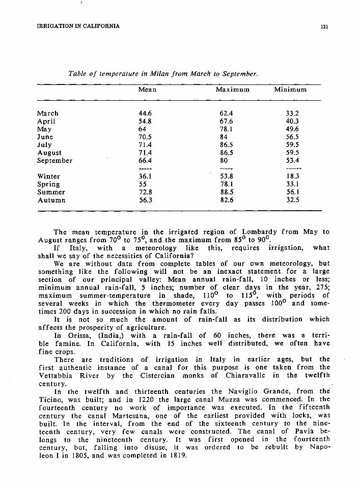
IRRIGATION IN CALIFORNIA
Table of temperature in Milan from March to September.
March April May June July August September
Winter Spring Summer Autumn
Mean
44.6 54.8 64 70.5 71.4 71.4 66.4
36.1 55 72.8 56.3
Maximum
62.4 67.6 78.1 84 86.5 86.5 80
53.8 78.1 88.5 82.6
Minimum
33.2 40.3 49.6 56.5 59.5 59.5 53.4
18.3 33.1 56.1 32.5
121
The mean temperature in the irrigated region of Lombardy from May to August ranges from 70° to 75°, and the maximum from 85° to 90°.
If Italy, with a meteorology like this, requires irrigation, what shall we say of the necessities of California?
We are without data from complete tables of our own meteorology, but something like the following will not be an inexact statement for a large section of our principal valley: Mean annual rain-fall, 10 inches or less; minimum annual rain-fall, 5 inches; number of clear days in the year, 275; maximum summer-temperature in shade, l10° to l15°, with periods of several weeks in which the thermometer every day passes 100° and sometimes 200 days in succession in which no rain falls.
It is not so much the amount of rain-fall as its distribution which affects the prosperity of agriculture.
In Orissa, (India,) with a rain-fall of 60 inches, there was a terrible famine. In California, with 15 inches well distributed, we often have fine crops.
There are traditions of irrigation in Italy in earlier ages, but the first authentic instance of a canal for this purpose is one taken from the Vettabbia River by the Cistercian monks of Chiaravalle in the twelfth century.
In the twelfth and thirteenth centuries the Naviglio Grande, from the Ticino, was built; and in 1220 the large canal Muzza was commenced. In the fourteenth century no work of importance was executed. In the fifteenth century the canal Martesana, one of the earliest provided with locks, was built. In the interval, from the end of the sixteenth century to the nineteenth century, very few canals were constructed. The canal of Pavia belongs to the nineteenth century. It was first opened in the fourteenth century, but, falling into disuse, it was ordered to be rebuilt by Napoleon I in 1805, and was completed in 1819.

122 ENGINEERS AND IRRIGATION
The above enumeration relates to Lombardy. In Piedmont the canal-system dates from a later age, the first works
having been executed in the fourteenth century. In the fifteenth century there was considerable activity in this kind of enterprise, while in the sixteenth, seventeenth, and eighteenth centuries there was but little extension of irrigation. In the nineteenth century we have the canal of Charles Albert and the Cavour Canal from the Po, the last the greatest and perhaps the most unfortunate of all.
The following tables, taken from Col. Baird Smith's work on Italian irrigation, places before us in condensed form the principal facts which we are now concerned to know.
CANALS IN LOMBARDY.
Data in regard to the canals from the Ticino River.
Navoglio Grande Berequrdo Pavia
Date of construction. 1178 1460 1359 1847
Length, in miles. 30.5 11.5 20 Discharge per second,
in cubic feet. 1,851 156 213 Area in acres irrigated. 93,440 10,400 9,550 Price of water per foot
per second. $35 to $65 $35 to $65 $35 to $65 Annual expenditure. $8,500 $6,960 Income. $8,980 $9,375 Area irrigated per cubic foot. 61.8 66.6 69.2 Annual indirect returns. $300,000 $ 31,200 $ 28,650
From other small streams, viz, the Lamb-ro,--Blena;-~&c;;~-canals -contain.;-ing 240 cubic feet irrigate 20,181 acres, giving 84 acres per foot, and furnishing indirect returns of $60,540.
Data in regard to the canals from the Adda River.
Date of construction. Length, in miles. Volume per second, in
cubic feet. Area in acres irrigated
in summer.
Canal Muzza
1220 43.5
2,652
182,500
Canal Martesanae Naviglio Interno
of Milan.
1457, 1440 27.5
981
58,900
Three small canals
414
38,000

IRRIGATION IN CALIFORNIA
Data in regard to the canals from the Adda River, cont.
Price of water per foot per second.
Annual expenditure. Annual income. Irrigation in acres
per foot per second. Indirect returns.
$ 4.12 $3,970 $7,380
83.9 $522,500
$55 to $65 6,000 7,000
67.2 176,700
123
Canals from Brembo, five in number, which carry 298 cubic feet per second, and irrigate 27,425 acres.
Canals from Serito, fourteen in number, carry 501 cubic feet, and irrigate 44,200 acres.
Canals from the right bank of the Oglio, carry 1,372 cubic feet, and irrigate 142,500 acres.
Canals from the left bank of the Oglio, ten in number, carry 1,522 cubic feet, and irrigate 136,432 acres.
Canals from the Mella, six in number, carry 429 cubic feet, and irrigate 36,300 acres.
Canals from the Clisio, four in number, carry 828 cubic feet, and irrigate 74,500 acres.
A canal carrying an average of 510 cubic feet per second is taken from the Mincio, which irrigates 20,500 acres, principally of rice. In addition, this river supplies five small canals, which irrigate a few thousand acres.
CANALS IN THE PIEDMONT.
Canals from the Dora Stura and Orco Rivers.
-Seven- canal-s-- are taken from these streams. They were built at various~ periods between 1556 and 1790. Their aggregate length is fifty miles. They carry 770 cubic feet of water per second, and irrigate 19,855 acres. The price per acre irrigated is from 62 to 75 cents. The net income is $6,855.
Statistics of canals from the Dora Baltea.
Date of construction. Length in miles.
main line branches
Canal of Ivrea
1468
44 55
Cigliano Canal
1725
20 10
Canal del Rolto
1450
8 40.5

124 ENGINEERS AND IRRIGATION
Statistics of canals from the Dora Baltea, cont.
Discharge in cubic feet per second.
Price per foot. Net income. Indirect returns.
Date of construction. Length of channel, in miles.
Discharge per second, in cubic feet.
Area irrigated, in acres.
Price per cubic foot per second.
Net income. Indirect returns.
700 $80 to $105 $22,100 $90,000
650 $80 to $105 $ 26,025 $100,000
Statistics of canals from the Sesia, &c.
Gattinara Gattinara Mora
1320 1482 1481
23 3/4 2 1/2 32 1/2
100 22.5 130
4,500 1,250 7,000
$40-$50 40-50 157.5 $ 6,000 1,250 5,000 $13,500 3,750 21,000
600 $80 to $105 $21,875 $75,000
Busca Rizzo Biraga
1380 1488
39 1/4 88 1/4
65 90
6,915 9,059
140 140
20,145 27,175
Statistics of canals from the Sesia, &c., cont.
Date of construction.
Length of channel, in miles.
Discharge per second, in cubic feet.
Area irrigated, in acres.
Price per cubic foot per second.
Net income. Indirect returns.
Sartirana Sundry canals from Agogna
1380 various
60 1/2 78
220 222
13,860 20,112
$ 210 175 $17,500 $41,580 60,335
Sundry canals Sundry canals from Arbugmr-rrom!erooptfie~:. ~··~·
various various
13 1/4 35
18 136
906 7,488
175 175
2,720 23,465

IRRIGATION IN CALIFORNIA
Statistics of canals from the Ticino, &c.
Canals from
Langosco Sforzesca Molinara Castellana Magna springs
Discharge/second, 249 216 25.4 114 25 788 in cubic feet.
Area irrigated, in acres. 19,142 14,878 2,483 9,125 2,040 52,500
Price of water/ foot/second. $210 159 113 98 98
Net income. $7,500 Indirect returns. $56,925 44,635 7,450 27,375 6,120 157,500
The Cavour Canal taken from the Po at Chivasso is intended to carry 3,885 feet per second.
This completes the enumeration of the principal works in Lombardy and Piedmont.
To gather the main facts in a summary form, it may be stated, first, for Piedmont, that the total quantity of water applied to irrigation is 8,290 cubic feet per second, not counting the supply of the Cavour Canal.
The total area of irrigable land commanded by these canals is stated to be 1,335,680 acres. If we deduct one-third for roads, villages, marshes, &c., the net irrigable land will be about 900,000 acres, of which 306,600 are actually irrigated.
If we add the scattered irrigation in the upper valleys of Piedmont not before included, amounting to 180,000 acres, the total area irrigated is 486,600 acres.
In particular districts the area actually irrigated is about half of the irrigable area.
-111. - Lorfioaray t"'lfe"=~a:rea-actiililly irrigated at the date of Cot Bair(f Smith's report, 1851, was 1,074,129 acres, which is about one-fifth of the productive area.
Between the rivers Ticino and Adda nearly nine-tenths of the surface, between the Adda and the Oglio two-tenths, and between the Oglio and the Adige one-seventh of the plain are irrigated. It is estimated that the aggregate length of the canals and their principal branches in Lombardy exceeds 4,500 miles.
To sum up, we may state that Italy employs for irrigation more than 24,000 cubic feet of water per second, supplying 1,600,000 acres of land.
It is estimated that there have been expended for the irrigation of 1,000,000 acres in Lombardy not less than $200,000,000. This expenditure has been spread over seven hundred years, and has made Lombardy a garden. This estimate, however, is made from very incomplete and uncertain data, and is supposed to cover outlay made for every purpose connected with irrigation, not only the construction of the channels, large and small,

126 ENGINEERS AND IRRIGATION
the aqueducts and siphons, but also the adaptation of the ground for the special irrigation required. This expenditure, therefore, includes not only that made by the owners of the canals, but also that incurred by the cultivators. The returns from this large investment of capital are to be sought in the indirect revenues accruing to the government from the mcreased production and the general prosperity of the country.
The canals are chiefly owned by the government; some, however, are in private hands. The same lesson is to be learned here as in India; as a financial investment for private parties, irrigation-works have not generally been favorable.
So far as the government is concerned, it is to be said that on the old canals the many private grants of water, made ages ago for services rendered to the state or from caprice, detract largely from the revenue, and they should be considered in estimating the financial character of this kind of enterprise.
The Cavour Canal, before mentioned, is the most important work of the kind in Italy; and, inasmuch as it is a recent construction, and as it was made by a joint-stock company, it will be of interest to inquire what conditions were considered necessary by the government in the light of its extended experience of the working and requirements of irrigation. It was the intention of the government to construct this canal; but on account of its financial difficulties, arising from the wars with Austria and Russia, it was prevented from carrying out the project, and was induced to intrust it to a corporation.
The principal points of the contract between the government and the English company, made in 1862, are as follows, viz:
The company were to construct and work a canal from the river Po, to contain 3,885 cubic feet per second, to irrigate the Novarese and Lorvellino districts, and to combine with this the waters of the Dora Baltea, to be used also in the Vercellese. The company was to commence the work in six months, and to complete it within four years, in spite of all circumstances of every kind.
The government granted a reduction of 50 per cent. of the customsduties on all material introduced for the construction and maintenance, a complete remission of duties on all instruments and -tcrols, and a partia-l- -remission of registration-duties on all deeds and contracts.
The government sold to the company the royal canals from the Dora Baltea, with every appurtenance of factories, mills, &c., for the sum of $4,060,000, to be paid in installments.
The company is to have the use of the irrigation for fifty consecutive irrigating-years, after which time it shall revert to the state, without any compensation whatever to be made to the company.
The company is to raise a capital of $16,000,000, of which $10,680,000 is to be devoted to the construction of the new works, and the remainder to be applied to the purchase of the crown canals above mentioned, and other canals or volumes of water.
The government guarantees interest to the amount of 6 per cent. annually on the capital of $16,000,000.
The company is authorized to issue 6 per cent. bonds to the extent of $11,000,000, the shares to be issued for $5,000,000. The sum raised by

IRRIGATION IN CALIFORNIA 127
bonds is to be deposited in the public treasury, to be issued to the company as required. The government must approve of the works to be constructed; and it has the right to superintend their execution, and to inspect the management of the canal.
The amount of the water-rate and the price of water-power "shall be fixed by the government in consultation with the society, and approximation to the average of current prices being agreed on, and the society shall not vary the prices without the approval of the government."
The company is obliged to lease the water carried beyond the Sesia to an association of proprietors at a price to be fixed in the way just stated.
The obligation of the government to pay the 6 per cent. interest is conditional, and shall only apply when the net income of the canals shall be insufficient to meet the expense.
The canal-rates shall be collected by the proper officer of the government in the same way that public taxes are collected.
The company shall deposit in the treasury, as security, $200,000 in Italian bonds at their nominal value, to be refunded when the company shall have expended $2,000,000.
The state shall have the right to purchase the works after twenty years' occupation, paying the capital corresponding to the mean annual net income for the preceding three years at 5 per cent., deducting the sum previously paid by the government on account of its guarantee.
These are the important points of the agreement, and it must be confessed that the government made a good bargain.
The history of the enterprise is melancholy. In the first place, the Po, instead of carrying 4,000 feet a second in its lowest stage, falls to 1,500 feet. It is simply impossible to understand how such an error could have been committed in Italy.
The Dora Baltea has, however, water in sufficient excess of its requirements, and it is possible to remedy the error by a comparatively small expenditure.
Then there was extravagance and bad management on the part of the company, and the government declined to pay interest on the capital because the works were not ahscHutety co~mpleted within the specified time;
By decision of the courts, however, the government was required to pay the interest. Under all these disadvantages, the company failed, and the enterprise passed into the hands of its creditors.
The character of the works on this canal may perhaps be in some degree realized by an enumeration of its principal features.
The canal is 55 miles long, and at its head it is 131 feet wide on the bottom, and 6 feet in depth. The general slope of the bed is I in 4,000; in places it is as much as I in 2,800. The side-slopes are one upon one; but on the curves and on the embanked portions, the slopes are revetted with masonry. These dimensions give a velocity varying from 4 1/2 to 5 feet a second. The soil, however, is gravelly.
The canal crosses five streams of torrential character by aqueducts and siphons of considerable length; the aqueducts being approached by long embankments.

128 ENGINEERS AND IRRIGATION
There are 345 bridges, or passages, for water over and under the canal, being more than six for each mile. These constructions are of the most substantial character.
The cost of the work, however, is largely due to the fact that the canal is carried across the drainage of the country. Its alignment would have its counterpart in California in a canal skirting the base of the foot-hills of the Sierra Nevada, and crossing, by aqueducts or by siphons, the successive parallel streams which discharge into the Sacramento or into the San Joaquin River. Indeed, the resemblance between the topography of the southern flank of the Alps and the eastern side of the valley of California is complete. The Sierra corresponds to the Alps, the Po to the San Joaquin, and the feature of parallel drainage-lines is common to both.
The canals are quite generally owned by the state. They are under the control of the finance department of the government, which has a staff of engineers to superintend the repairs and to see that the works are kept in efficient order.
The usual practice is for the government to farm out the canals to contractors for a period of nine years. The contractors arrange with the cultivators for the distribution and measurement of the water, and fix the rate of payment under some restrictions.
Disputes between the contractors and cultivators are decided by the civil tribunals.
Each canal forms a district for administration; it may, however, include more than one district.
In each district, under regulations prescribed by the government, the irrigators form associations, which administer the affairs connected with the distribution and use of the water.
We need make no further reference here to the description of these associations, for the reason that we attach to this report, as an appendix, a full account of one established by Count Cavour about twenty years ago, for the irrigation of the Vercellese district. This association may be regarded as the most recent result of Italian experience. It embodies the principles which are believed in Italy to be most conducive to the interests of all concerned in irrigation.
This description is taken from a book by Lieut. G. C. S. -Moncrieff~ Royal Engineers, entitled "Irrigation "in Southern Europe."
We should infer, from the meteorological details already given, that cereals and most other products scarcely need irrigation in Italy. Indian corn and flax are irrigated to some extent, but irrigation is mainly confined to rice-cultivation in the summer, and to meadows in the winter. These meadows are devoted to the cultivation of a grass called marcite. This crop requires that a thin film of water shall pass continuously or almost without intermission, except at the periods of cutting, over the grass. This is secured by shaping the land in planes about 30 feet wide, with a slope of I in 12 or 15. On the crest of the planes there is an irrigating-channel, from which the water is spread over the land; the surplus being carried off by drainage-channels.
The accompanying section of the land will convey an idea of the arrangement for the distribution of the water.

IRRIGATION IN CALIFORNIA
E E H
E, minor irrigating channels, generally 12 inches wide and 6 or 7 deep.
H, minor drainage channels, about half the above dimensions.
129
E
The amount of water necessary for these meadows exceeds, beyond comparison, that required for any other cultivation. A cubic foot per second, if economized, may irrigate as much as three acres. The production is very great. The meadows near Milan are cut seven times a year. An ordinary result is 50 tons a year, with exceptional yields of 75 tons, per acre. These meadows are, however, fertilized by the sewerage of Milan, which is distributed over the land directly by the irrigating-channels. In less-favored localities, the yield falls as low as 24 tons per acre. This production cannot, however, be sustained unless the land is richly manured.
On the crown-canals, water is measured as it leaves the principal channels by an apparatus known as the module. There are various examples in different provinces but the best known and most reliable is that used in the Milanese.
It seems scarcely necessary here to give a description of the arrangements made for this purpose, inasmuch as the information is readily accessible. We may, however, mention that the principle of the measurement is that the head of water is kept constant, whatever may be the changes in the level of the canal. After the water leaves the main channels, there does not seem to be a uniform practice of measuring it on its distribution into the secondary ditches. There are so many usages in this country, sanctioned by long periods of time, that it has hitherto been impracticable to introduce complete and thorough measurement.
There ate always some persons who. profit by tJie absence of regulations on this point, and their influence exerted against change has proved sufficient to defeat the purpose of the government.
IRRIGATION IN SPAIN.
Rain-fall and temperature--Comparison with California--Value of irrigated land in various parts of Spain--Irrigation introduced by the Moors-Water annexed to land in Valencia--Variety in ownership of water--Value of water in different provinces--Spanish law--Method of obtaining a grant of water--Privileges to irrigation-enterprises--Exemption from taxation--Minority compelled to pay their part for canals--Subsidies; how given--Position of government of Spain--Irrigating-associations--Subsidies to canals--Area of irrigation--

180 ENGINEERS AND IRRIGATION
Huerta of Valencia--Administration of irrigation--General assembly--Syndic --Kinds of cultivation--Drought--Tribunal for deciding disputes--Its composition and modes of procedure--The canal of Mencade.
In some parts of Spain we seem to be near home. There is something familiar in a rain-fall of 7 inches and a temperature of lll 0 .
The mean annual rain-fall for different parts of Spain for jour years, from 1858 to 1861.
Granada Seville Valadolid Saragossa Valencia Alicante Madrid
Inches. 33.4 22.5 20.9 17.0 15.9 13.6 12.0
In 1859, at Alicante there were only 7.1 inches of rain.
Table of rain-fall and temperature for the irrigatingmonths, from March to September.
Madrid Alicante Valadolid Seville
Mean rainfall, in inches.
5.31-7.66 8.98 5.45
Mean temperature, in degrees, Fahrenheit.
64.69 69.41 62.51 77.98
Maximum temperature, in degrees, Fahrenheit.
98 94 90
111
A comparison of the meteorology of these parts of Spain and of the irrigated portions of Italy, will show for Spain both a higher temperature and a smaller rain-fall.
The climate in our interior valleys differs from that of Spain, in the fact that the latter country has a summer rain-fall ranging from 5 to 9 inches, whereas in California we often have no rain worth measuring from April to December; and generally from the beginning of May to the end of October not a rain-cloud obscures the sun.
Spain, by common consent, needs irrigation, and perhaps of all the countries in the world it best repays irrigating.

IRRIGATION IN CALIFORNIA 131
We might establish the remunerative character of this mode of cultivation in other ways, but it is probable that no way can be more satisfactory than to give the values of land as established by sales, both of irrigated and of unirrigated land.
Near the city of Valencia,38
running from $700 to $900 per acre, $400 to $500 per acre, while land sold at $80 or less per acre.
irrigated land is sold at prices and at a distance from the city from of the same quality not irrigated is
Don Juan Ribera, a Spanish engineer, states that land near Madrid39 is increased in value by irrigation from four to ten fold, land of the lowest price being most appreciated in value.
From sales made at Castellon40 in 1859, it appears that the average price of irrigated land was $700 per acre, while unirrigated land in the same neighborhood was sold for $50 per acre.
Parts of the huerta of Murcia have been sold at $2,500 per acre, dry land close by being worth $150.
At San Fernando, near Madrid, the rental of irrigated land is $25 per acre, which is the price in fee of dry land in the vicinity.
In the valley of the Esla River irrigated land is worth $600 per acre, and dry land $50.
In the valley of the Tagus it is said the produce from irrigated land is twelve times that from unirrigated land. In parts of France where irrigation is not nearly so much needed, irrigated land is only appreciated 50 per cent. by irrigating.
Spain may be described as a country where the water is more valuable than the land in a ratio of from 5 to 20, and we feel assured that the same proposition is equally true of large parts of California.
Spain is, from the value attached to water, an interesting study. It is interesting to know what steps have in recent years been taken to extend the use of water, and what systems have been adopted.
The Spaniards have an experience of a thousand years behind them, and they ought to be convinced of the value of this mode of cultivation.
There is probably no part of the world where water is more carefully applied, and there certainly is no country where the legislation is more clear and precise: · ··
Irrigation in Spain is a legacy left by the Moors. All or nearly all of the old systems were the work of this wonderful people. Not only the works but the customs of the Moors remain in some provinces almost untouched since their departure. These customs may be said to be imbedded in the hearts and minds of the people of certain provinces, and we must regard it as a tribute to the intelligence of the conquered race that their regulations, adopted by their enemies, have been able to exercise a sway so complete that the efforts of rulers and the progress of events have alike failed to change them in their essential features.
We find in Spain every variety in administrative systems for using water. In Valencia, in the lands irrigated from the Jucar River, and in Murviedro, the water and the land are, so to speak, married, without a possibility of divorce. When the land is sold, the water that irrigates it goes with it; neither can be sold separately. The irrigator cannot even
132 ENGINEERS AND IRRIGATION
dispose of his turn or privilege of water. The same is true in the province of Murcia, and at Almansa.
As Elche, on the other hand, the water belongs to parties who do not own the land. The land has no rights. When the farmer needs water. he buys it as he buys any other article. There is a daily water exchange, where one may buy the use of water in an irrigating channel for twenty-four hours, beginning at six in the evening. The prices that are stated to have been paid in times of scarcity, tax our credulity very much.
In 1861 it is said that water was sold at more than $11,000 per cubic foot a second.
At Lorca there is an auction of water held daily. These are all old works, where the customs of past ages prevail. The new
canals are generally built and owned by capitalists, under conditions which will hereafter be explained. On the Heuares Canal, just built, it appears that the company owning the works made agreements with the farmers before building as to the price to be paid for irrigation. The government fixed the value of water on this canal to be $1,875 for one cubic foot a second for one year.
It will be remembered that in Italy the annual value of the same quantity is about $75 to $80.
The different meteorologies of the two countries make the basis of this difference of value.
On the Heuares Canal to cover an acre with twelve inches of water costs $2.88; on the Esla Canal, $1. 70.
At Alicante the price of 16,000 cubic feet of water, which is about 4 1/4 inches over an acre, has varied, according to scarcity, from 50 cents to $13.
At Larca the average price of 17,500 cubic feet of water, nearly 5 inches over an acre, is $6.25.
The canal Llobregat charges on an average $2.75 per acre, and as high as $4.25.
The canal of Urgel charges $4.75 per acre. In Malaga the price is about the same.
On the old Moorish works, which are now the property of the irrigators, the price is only what is necessary to pay the expenses of the works and keep them in repair. · ·
The farmers have agreed to take water from a new canal in Navarra, and to pay $3 per acre for four irrigations in a season. An irrigation in Spain is generally from 2 1/2 to 3 inches in depth.
SPANISH LAW IN REGARD TO CANALS, AND CONDITIONS OF AGREEMENTS MADE WITH PRIVATE COMPANIES.
The latest enactment, which seems to be most complete and detailed, and which contains three hundred paragraphs, is dated August 3, 1866. Although all the provisions would doubtless be of interest to those called upon to legislate upon the subject of water, we cannot do more than refer to those points which bear immediately upon our subject.

IRRIGATION IN CALIFORNIA 133
Article 236 states that all grants of water made to owners of land for its irrigation shall be in perpetuity. All grants made to parties to irrigate the lands of others shall be for a period not exceeding ninety-nine years, which period expired, the works shall become the property of the irrigators. An application for a grant of water shall be accompanied by proof that the applicant owns the land he proposes to irrigate; or if not, the rates of payment proposed to be paid by the parties who own the land or who are to buy the water; or if a particular district is to be irrigated by the owners thereof, that the agreement made by the majority of the owners reckoned by the area owned. The project is then to be advertised, and objections may be made for a month. The project is referred to various authorities, to ascertain whether it is desirable, whether it interferes with any vested rights, whether it promises to endanger the public health, or whether the constructions proposed are suitable. Any grant of water is subject to rights of other parties previously established.
Certain privileges are granted to undertakings of this class, as follow, viz: 1st. To quarry on the public land. _ Sites for the necessary works, shops,
kilns, &c., on the public lands are given free. 2d. Exemption from certain charges required in transfer of property. 3d. The capital invested is exempted from tax of every kind; and all
foreign capital invested in these enterprises will be under the protection of the government, and it shall never be confiscated in time of war.
4th. Employes have certain local privileges. If the company allows the works to fall into bad repair, and does not restore them within the period assigned by the government, or if the new works shall not be finished in the stipulated time, they may be sold at public auction to the highest bidder.
All the land included in any project which is called for by the majority of the proprietors shall pay the approved rate, whether the owners wish to take water or not; and those who refuse to pay are obliged to sell their lands to the company at a price equal to the assesse<f value of Jhe land, for -taxation, increased by 50 per cent. If the company· declines to purchase the lands at this price, the proprietor shall be exempt from any payment.
The law of April 22, 1849, provides, that for ten years after the works are completed all products of irrigation shall be free from taxation.
All land brought under irrigation is taxed as unirrigated land for ten years.
The law of July 11, 1865, appropriated $5,000,000 to be given as subsidy or as loans, without interest, to irrigating enterprises, in sums not to exceed $100,000 for each enterprise. The special authority of the Cortes is necessary to permit a larger grant. This subsidy is generally given to the amount of 15 per cent. of the estimated cost, as certified by the government engineers, and it is paid in three installments:

1S4 ENGINEERS AND IRRIGATION
1st. When the earth-work is finished. 2d. When the bridges and culverts are finished. 3d. When the work is completed and the irrigating is begun. The attitude of the government toward the administration of these
enterprises is commended by M. Aymard in the following terms:
We may inquire, What is the nature of the action of the government in regard to enterprises of irrigation? What is the character of its intervention or supervision? Does it lead or does it follow the people?
The government is in advance of the people, but it does not exercise an injudicious pressure. Where customs sanctioned by antiquity prevail, it does not seek to overthrow them merely for the purpose of securing unity of administration.
It is in advance of the people in this sense, namely; that it lays down with clearness and precision in the laws the modern principles of the administration, so that the moment that the necessity for a reform is felt, the people are at once informed in what direction that reform is to be sought.
In regard to the terms on which new concessions are granted, the same author says:
In the activity which has recently prevailed in the extension of enterprises of irrigation, the problem was to guard the rights and interests of future generations, while making such concessions to the commercial spirit of the present as would induce the extension of these necessary works. In its decrees the government lays down with great wisdom the general terms of all concessions of water-franchises, and defines the respective rights of the proprietors, and of the users; so that enterprises of this character may be undertaken without hesitation or embarrassment. The outline of every possible enterprise is defined 'ih' thcf · Statute's, and--in 'ea'ch particular case it is only necessary to fill in the details.
One clause in these statutes provides that in every irrigating-district or community there ought to be established a syndicate or association, and a system of regulations fixing the details in every respect concerning the use of the water; which regulations must be approved by the government or by the provincial authorities, as the case may be.
The general principle which forms the base of the syndicate is this, namely, that the administration of the water-supply and use shall be in the hands and under the control of the irrigators.
We see that the Spanish systems of a thousand years' duration lead to the same general conclusion that the experience in Italy has established and exemplified in the association for the irrigation of the Vercellese, an account of which is given elsewhere.

IRRIGATION IN CALIFORNIA 135
This conclusion may be stated in these terms: that where the irrigators do not own the irrigating-works, they ought nevertheless to have the control of the distribution of the water, and of the details of irrigation.
A conclusion which is fortified by the experience of hundreds of years in Italy and Spain, where the people cannot be supposed to be more familiar with the principles of self -government than are our own people, which is supported by the wisdom of a man like Cavour, which promises relief from the difficulties attending the administration of water by capitalists having no direct interest in the land, but looking for the best return for their money invested, and which, moreover, is congenial to the habits and feelings of people like our own, must, perhaps, with modifications, prove the solution of our own vexed problem.
It is worthy of remark, and it is confirmatory of the general conclusions derived from the experience elsewhere, that in a country where irrigation is so desirable, and where its effect is to increase in so striking a manner the value of the lands, the government feels obliged to aid works of this kind by subsidy and by exemption from taxes.
According to the official reports, the area of irrigated land in Spain if four thousand four hundred and thirty-nine square miles.
The principal canals, however, irrigate only 500,000 acres. There are many small canals and a few tanks or reservoirs, which increase this area considerably. If we accept the official reports, the greater part of the land must be irrigated by wheels or norias. These wheels have buckets or jars attached to the circumferences, by means of which the water is raised. The motive power may be the current of the river, or it may be animal power.
We close this review of Spanish irrigation by a brief description of the agriculture and system of administration in the highly-cultivated huerta of Valencia.
This district extends for eight or nine miles along the river Guadalaviar, from which the canals which irrigate it are derived.
It has been under this kind of cultivation for perhaps a thousand years. The Moors introduced irrigation, and the executive and judicial system -- established by them retains to this day its essenHaJ characteristics.
The water in this district is, as has already been stated, annexed to the land, and when land is sold the right to water goes with it. A person cannot even give to another the water to which he has a right; if he does not use it, it reverts to the common benefit.
The plain of Valencia is irrigated by eight small canals, four of which are on each side of the river. Each canal is entitled to an aliquot part of the river-supply, and the proportions are established by the levels of the sills of the head-works, which are of masonry, and which have remained unchanged since the days of the Moors. It is, however, only in the low stages of the river that it becomes essential to observe the prescribed division of water, for at other periods there is an abundance for all.

136 ENGINEERS AND IRRIGATION
The aggregate length of these canals is but forty-two miles. The longest is but twelve miles in length. The dams are of masonry.
The administration of these canals is at least curious, and it will be interesting to recount it briefly.
Each canal forms a district, the irrigators of which meet once in two years to elect a permanent committee of administration, to assess the expenses or taxes, and to elect the officers of the district. The principal officer is called the syndic; we should probably call him the superintendent. He must be an actual cultivator; not a proprietor merely, but one who actually holds the plow. He must have a good character and be owner of a certain quantity of land in his own zone or district. He is elected by a majority of votes, and he may be re-elected. His term of office varies between two and four years. He is chief administrator; he expends the funds, and in time of drought he is an absolute dictator in regard to the distribution of the water. The other employes are appointed by the syndic, or by the permanent committee, or sometimes they are elected by the general assembly.
Usually the taxes are assessed by the general assembly. Generally each irrigator pays according to the land under cultivation, but not always so. In some cases he pays in a measure proportionately to the quantity of water used. The taxes are collected in a summary manner. If any one fail[s] to pay his taxes, he is deprived of the use of the water, and if he take[s] it he is liable to a severe fine; or if any official shall allow him to take water, the latter is exposed to the same fine.
There is no regulating machinery for the distribution of water. The arrangements are at the discretion of the officials, who keep themselves informed as to the condition of the crops, and who supply water to those which seem to need it most. No cultivator can claim a definite quantity of water.
The cultivation is various; hemp, corn, wheat, beans, pears, melons, artichokes, and peppers are among the products of the soil. Hemp is regarded as the most valuable crop. It is cut in July, before the water gets very low, and therefore it seldom suffers from scarcity of water.
In times of drought the syndic gives water to the crop that needs it most; keeping in view, however, the value of the crop._Hemp being the most valuable crop, receives attention first if it needs it, which is seldom the case; next come artichokes, the order being established by long custom. If all of a given crop cannot be saved, the water is applied to half of each field, the other half being allowed to suffer. The decision is in the hands of the officials, none of the cultivators being permitted to take water without permission.
This is certainly a very rigorous kind of administration. It is democratic so far as its deliberations and constitution are concerned, but in its action it is essentially autocratic. Doubtless the long line of customs descending from a thousand years serves in practice as a guide for the action of the syndic, and divests it, in a measure, of its arbitrary appearance. The responsibility is, however, not divided. In times of drought some responsibility must be taken, and one man can take it better than a number. The working of the system must be favorable, or it would long since have fallen under the opposition of its enemies.

IRRIGATION IN CALIFORNIA 137
These canals have a curious tribunal, which has come down from the Moors, and which is as simple and untechnical in its constitution and in its modes of procedure as can be desired. Its proceedings are not recorded, unless at the request of one or both of the parties concerned. It enforces its decrees in a summary manner, and there is no appeal from its decisions.
This tribunal of the canals is composed of the syndics of the canals of the plains. It meets every Thursday at II o'clock in the public square in front of the Cathedral in Valencia. The judges are seated, while the parties concerned and the spectators stand respectfully a few paces distant. The syndic in whose district the grievance or offense was committed brings the case before the court. He questions the witnesses and presents the case, but he does not vote. When the case is heard, the judges discuss in a low tone for a few minutes, and announce their decision. No expense is incurred by the parties to the case, if the fines or damages assessed are paid at once. If they are not so paid, the tribunal has power to enforce its decisions by processes which entail expense upon the recusant party. The fines attached to particular offenses are stated in a code of laws. The jurisdiction of the court is absolute in matters of fact and police over those who appear before it. Any person may decline to appear before the tribunal. If, having been twice summoned, any person shall fail to appear, the matter is turned over to the ordinary courts, where its adjudication is attended with considerable expense. It is said that cultivators rarely fail to appear before this tribunal when summoned.
It may well be supposed that this institution has often been assailed. A court of peasant judges, whose proceedings are not recorded and whose decisions admit of no appeal, could not fail to attract criticism and invite intervention. The government has more than once attempted to make changes in harmony with the usual course of procedure, but the steadfast attachment of the people interested in the tribunal has sufficed to maintain it substantially as it descended from the Moors. Whatever may be its defects, we cannot doubt that it has dispensed even-handed justice; otherwise it could not have existed so long.
The canal of Moncade, which is ~!lJso taken from the Guadalaviar River, has .. some· differences in administration which indicate . the . character·· .. o-r- ihe ·changes which the government has wished to make in the case just described. This association has a code of regulations which prescribes fines for the various offenses. The superintendent or syndic of the canal is invested with authority to impose fines in accordance with the code. The parties concerned have the right of appeal to a court elected by the irrigators, which resembles in many respects the tribunal of the canals, and there is a further right of appeal to one of the ordinary civil courts. On this canal each irrigator has a right to water on fixed days for a certain number of hours.
IRRIGATION IN FRANCE.
Government owns canals--How canals are built and how managed.
Irrigation is quite extensively practiced in France, and several new canals have been built in the past few years.

138 ENGINEERS AND IRRIGATION
There is nothing so specially distinctive in French irrigation as to require detailed description. The principle of management of works by the irrigators applies here as well as in Spain and Italy. There is, however, more interference by the government.
The government owns no canals. They are generally built by the land-owners. The government encourages the construction of canals.
In the charter of the Carpentras Canal, built in 1854, the irrigators were guaranteed that no increase of the land-assessment should be made for twenty-five years after completion of the works.
There is no provision in the French law corresponding to the Spanish statute which permits a majority of proprietors to carry on an irrigation enterprise and compels the minority to bear their share of the expense.
When a charter for a canal is given it states the quantity of water which is granted. The plans for the works must be approved by the government. In some cases the canals are built under direction of engineers of the Corps of Ponts et Chausees. In all cases the works are periodically inspected by engineers of this corps.
CHAPTER V.
1. Cost of irrigation--Quantity of water required--Secondary and tertiary ditches to be made by cultivators--Canals and primary ditches will cost about $10 per acre irrigated.
2. Conclusions--Large bodies of land in "the great Valley of California" require irrigation; abundance of water; irrigation much needed--Cost-Ignorance of the subject--A comprehensive system cannot be devised by the farmers--Duty of government--Proper laws depend on reconnaissance and surveys--Irrigation will be the work of time--Land and water should be joined together--State and counties benefitted--Private capital--Relation of the United States to irrigation--Supervision.
COST OF IRRIGATION.
Before making an estimate of the cost of canals, it is necessary to inquire how much water is required to irrigate an acre of land. It will readily be understood that the quantity will depend upon a number of considerations. In the first place, it will depend upon the character of the soil, whether sandy or clayey; upon the character of the substratum, whether pervious or impervious, and upon the depth and inclination of an impervious stratum. It will depend upon the character of the cultivation. Rice and sugar fields, vegetable-gardens, orchards, and meadows require more water than cereals.

IRRIGATION IN CALIFORNIA 139
The present staples of this country are cereals. There is some cotton-cultivation, which will probably be extended; and, with abundance of water, we shall doubtless have a good deal of Alfalfa or Lucerne grass. Every farmer will have a little orchard, and will raise the vegetables required for home consumption.
The evaporation is high in the interior valleys of the State, quite equal to that in Madrid, where it is about 13 inches in July.
The amount of water lost by absorption in the bed and banks of the canal, is an unknown and variable quantity, depending on the dimensions of the canals and on the character of the soil. In the absence of exact data upon these points, we may for the present adopt the rule laid down by engineers for other countries of similar climate, and estimate the loss of water from these causes at 15 per cent.
The rivers of California generally run full for about seven months. The rains of the winter increase their discharge, and the melting of the snows keeps it up, so that we may say that the streams from the Sierra Nevadas are well supplied with water from December to August. The streams from the coast range have no snow reservoirs of much extent, and they are generally dry in summer.
Let us assume that the streams on the east side of the valley are well supplied with water for two hundred days in the year, and, to make up for any overestimate on this point, let us neglect their flow for the remainder of the year.
How much land ought a cubic foot of water, supplied every second for two hundred days, to irrigate?
We will make a further supposition that the water is used for fourteen hours out of the twenty-four. Irrigation at night is practiced in other counties, and we may be assured that in seasons of scarcity it will be practiced here if it shall prove to be necessary to save the crops.
In fourteen hours there are fifty thousand four hundred seconds, and hence one day's supply, at one cubic foot per second, will give us the same number of feet. Deducting 15 per cent. for loss by absorption and evaporation, we shall have remammg 42,840 cubic feet, which number, although a little less, we may take to be the same as the number of square feet in an acre. Hence, one daY's supply will put 12 inches of water over .... ;..~ ,._ an acre, or 2 inches of water over six acres, and in two hundred days a supply of a cubic foot per second will cover two hundred acres with 12 inches of water.
Wheat planted in October or November on summer-fallowed land, well watered when the rivers are high, will probably make a good crop without further watering, except what it gets from the winter rains, even when they prove scanty.
Wheat planted in January or February will probably need one or two irrigations of 3 inches each to make a crop. Wheat or barley planted later, and with irrigating facilities, (there seems to be no reason why, in these hot valleys, the sowing-time may not be extended to April,) will probably ripen with 12 inches of water judiciously applied. We know that good crops of wheat are raised without irrigation when there is a rain-fall of 12 inches, or even less, which comes at the required times.

140 ENGINEERS AND IRRIGATION
On the Tule or reclaimed lands, barley sowed after wheat-harvest has been gathered comes to maturity.
The water required for cotton will probably not exceed that necessary for wheat. Rice-cultivation is so unhealthful that its introduction into California will hardly be looked upon with favor.
Alfalfa, if cut fives times for hay, will require 12 inches of water or more, depending on the nature of the soil; this in addition to the usual rain-fall.
There is another point to be considered. The whole of the land commanded by the canal will not be irrigated; some of it will be waste or unsuitable for cultivation; some will be fallow, and if we add the areas taken up by . the roads, fences, buildings, farm-yards, &c., we ought, according to experience elsewhere, to deduct one-fourth, at least, from the irrigable lands. This deduction of one-fourth, we assume, will make up for any kind of cultivation, such as gardens, orchards, &c., requiring larger supplies of water.
Our opinion is, therefore, that a reasonable allowance for the land commanded by the canals is one cubic foot a second for each two hundred acres.
In seasons when there is a great surplus of water there can be no objection to a more liberal use of it, but it seems to us indispensable that the State should lay down a general rule. There ought to be an established allotment, which may vary in different districts. The cultivators who come first ought not to be allowed to appropriate more water than they require, because, if they do, those who come after will not be able to procure a fair supply.
There are probably exceptional places where the lower average of rain-fall and porosity of the soil may combine to require a larger allotment of water than we have assigned. Such places are about Tulare Lake, on the west side of the valley. There is no cultivation in these portions, and before the occasion may arise to irrigate them further information will probably be available to enable a proper conclusion to be reached.
As the population of the irrigated districts increases there will be an increased demand for water, and it will probably result that the allowance. ~hich. is sufficient in this generation,· m:ay. prove entirely inadequate fifty years in the future.
When the state makes the survey elsewhere recommended in this report, we will learn both how much water and how much land there is, and will be enabled to proportion the supply to be granted.
It may then be a question, in seasons of scarcity, whether a smaller supply of water will be given to the whole land or a larger supply to a portion of it.
There is so much variety on this point, in the circumstances of climate, soil, and cultivation, and so much difference in the statements of different authorities. that we cannot derive, from the experience of other countries, any definite conclusions applicable to our own; but as a matter of interest it will not be amiss to mention the duty of water in other irrigating districts.

IRRIGATION IN CALIFORNIA 141
In North India a cubic foot of water per second irrigates five acres per day.
Taking the interval of irrigation at forty days, we have the duty of two hundred acres for one foot a second for cereals.
In Granada a canal from the Genii irrigates, of wheat, barley, and vines, two hundred and forty acres per cubic foot.
In Valencia, where it is very hot, wheat is watered four or five times, giving about two hundred acres per foot.
In Elche, where water is very scarce, a cubic foot goes as far as to irrigate one thousand acres. Wheat here in some years scarcely requires artificial watering.
Rice-fields in different parts of the world vary from thirty to sixty, and even eighty acres, to the cubic foot.
In the heavy monsoons of India ninety acres per foot are irrigated. In some of the huertas or gardens in Valencia, only from thirteen
to twenty acres per foot are irrigated. Here, however, there are at least two crops a year, and a part is devoted to rice.
The grants for six recent canals in Spain run from seventy acres per foot to two hundred and sixty acres per foot.
Assuming, then, that a cubic foot per second will water two hundred acres of land, we proceed to give some considerations in regard to the probable cost of construction of the canals and their primary ditches.
The second and tertiary ditches will, it is supposed, be made by the cultivators. They can be made by the farmer in seasons of leisure, and in the general case their cost will hardly be felt. The case will be somewhat different with the cultivator who farms on a large scale, and who is obliged to hire laborers.
It is plain, on the slightest consideration, that the cost of a canal will be so dependent on local and special circumstances that it is impossible to deduce a perfectly satisfactory conclusion from a given or hypothetical case.
The dam, the character of the soil, the quantity of land to be irrigated, the manner in which it is disposed, the relative remoteness, and the resources and population along the line, are all elements which vary from case to case, and either of- which may affect the cost by a very consider.~"' able percentage.
Still it seems essential to know within some limits the probable cost. If a canal is to cost $100 per acre irrigated, the subject may be
dismissed without any further consideration. It is plain that we cannot afford to pay that price. If, on the other
hand, canals may be built for five or twice five dollars per acre, it is equally plain that now or before many years we shall be able to afford them, and shall have a fair prospect of return from such investment.
The value of the estimate which we proceed to give, will be understood from what precedes.
Let us take the most favorable case that can happen, namely, when the excavation equals the embankment.
We assume a canal to carry 315 cubic feet of water per second, having the dimensions given in the figure. Deducting from this 15 per cent. for loss, the water available for irrigation is 268 cubic feet, which will irrigate 53,600 acres.

142 ENGINEERS AND IRRIGATION
If we suppose the irrigable land to lie on one side of the canal in a strip five miles wide, and that the ground permits straight parallel primary ditches spaced one mile apart, it follows that for each mile of canal there must be five miles of primary ditches, and that the quantity of irrigable land for each mile of canal will be 3,200 acres. Deducting one-fourth for land not actually watered, we shall have 2,400 acres of irrigated land for each mile of canal.
Let us take a primary ditch of capacity to carry 50 feet of water per second. Allowing for loss, this size will be rather more than sufficient to cover the 2,400 acres with 3 inches of water in seven days and seven nights.
The canal can fill at the same time six of the primary ditches, so that in seven days 14,400 acres can be covered with 3 inches of water, only six of the primary being full at a time. And in twenty-six days 3 inches of water may be put over the whole amount of the land, namely, 53,600 acres.
If the water necessary to go forty-five days.
is used only for fourteen hours for each day, the time over all the land with 3 inches of water will be
Under our hypothesis, in order to irrigate 2,400 acres, we must build one mile of main canal and five miles of -primary ditches.
Placing the excavation at 30 cents per cubic yard, we find the cost per acre to be about $5.
The section of the main canal will diminish toward its lower end, but to be on the safe side, so far as cost is concerned, we keep it of uniform size. The price of excavation may be somewhat in excess of its actual cost in some places; but inasmuch as in it are included all incidental and contingent expenses, we believe it is not far from correct.
We have omitted from this calculation all estimates for inequality of the ground, by reason of which the amount of excavation may be considerably increased; all expense due to the fact that generally one or several miles of canal have to be made at its head before the water is high enough relatively to the adjoining land to irrigate it, and we do not include the cost of a dam, which generally will be indispensable. Neither do we include the cost of head-works or of the bridges and sluices which will be required, or of the measures that may be necessary to pass the drainage of the country into, over, or under the canal. We do not estimate for these points, for the reason that no estimate can be made, the circumstances in no two cases being the same.
Speaking generally, we are of the opinion that the omitted points will cost as much as the excavation, and hence that the rate per acre just given should be double.
This brings us to the conclusion that it will cost about $10 per acre to irrigate these valleys.
It is, however, to be remarked, that large portions of the eastern side of the San Joaquin Valley are underlaid 2 or 3 feet from the surface by a hard stratum, which it will be necessary to blast, or, if not blasted, the canals must be very shallow. This fact leads us to believe that

IRRIGATION IN CALIFORNIA 143
the cost per acre in these sections will be increased 25 to 33 per cent. above the estimate already given.
The irrigation of the foot-hills will of course cost more. Here the problem will be more similar to that presented in other countries. So far as we are able to judge from descriptions given by writers, we are inclined to believe that the physical conditions in these valleys are exceptionally favorable for irrigation. This fact accounts in a great measure for the smallness of our estimates as compared with the actual cost of canals in Spain; for instance, where the price of labor is so much cheaper than it is in California.
A further reason for this difference lies in the character of the constructions. The dams, head-works, and sluices of foreign works are made of masonry, and in the most thorough manner. In California all of these constructions will for many years be of wood. It is cheaper, with the present rates of interest, to build of wood, and to rebuild when the works decay, than to construct once for all of masonry.
The cheapest canal that we find in Spain is that from the Esla, which cost $15 per acre. The other modern canals in Spain have cost more than twice as much. There are no longer in these old countries any lands which admit of easy irrigation, and on all these lines there is a great deal of heavy work in excavation, tunneling, aqueducts, and in revetment-walls, which the valley works in California will not require.
CONCLUSIONS.
1st. That there are large bodies of fertile land in the great valley of California--extensive plains, in fact--that require irrigation to make them productive, and that the natural features of these plains are favorable to artificial irrigation.
2d. That there is an abundance of water for the irrigation of all land on the eastern side of the valley by canals from the rivers.
3d. While there is a scarcity of water on the western side of the valley, at the necessary elevation, particularly on the western side of the San Joaquin and Tulare Valleys, yet therels-- suffiCient water -attainable there, and at a sufficient elevation, to irrigate large areas of land on that side.
4th. That irrigation is much needed, particularly in the San Joaquin and Tulare Valleys. The productions of these valleys could be increased many fold by a comprehensive system of irrigation. The value of the irrigable land and of the revenue derived from it, both by the State and by the people, will be increased in the same ratio.
5th. The cost of a comprehensive system of irrigation for these valleys will be great, but as the different portions are not equally in want of irrigation, the complete system may be the work of time.
6th. Irrigation is but little understood in this country, either by our engineers, who must design, plan, lay out, and execute the works for that purpose, or by the farmers who are to use the water when it is brought alongside their farms.

144 ENGINEERS AND IRRIGATION
7th. That the experience of other countries appears to prove that no extensive system of irrigation can ever be devised or executed by the farmers themselves, in consequence of the impossibility of forming proper combinations or associations for that purpose. That while small enterprises may be undertaken by the farmers in particular cases, it would not be in accordance with the experience of the world to expect of them the means or inclination to that co-operation which would be necessary to construct irrigating-works involving large expenditures. That enterprises of this character, if built at all, must be built by the State or by private capital.
8th. That it is the duty of government, both State and national, to encourage irrigation, and the first step in that direction ought to be to make a complete instrumental reconnaissance of the country to be irrigated, embracing the sources from whence the irrigating-canals ought to commence, gauging the flow of the rivers and streams, and defining the boundanes of the natural districts of irrigation into which the country is divided.
9th. Then, when it is proposed to irrigate any particular district, an accurate topographical survey of that district should be made, so that the canal and other necessary works for its irrigation may be designed on an intelligent and comprehensive system, and in harmony with the neighboring canals, and these works executed in the most economical manner. In this way every farmer will be informed, before he will be called upon to contribute to the works of irrigation, whether or not his land is irrigable; and if it is, of the quantity of water he will obtain; the exact place or places where it will be delivered to him, and of its probable cost.
lOth. While these surveys are being made, we think it would be a step in the right direction if the Government of the United States, as well as of the State of California, would inaugurate measures for obtaining from foreign countries all possible information relating to the more modern systems of irrigation in these countries, and for disseminating this information throughout this country.
11th. After the necessary reconnaissance shall have been made, and a knowledge of the most improved systems of irrigation in other countries has been obtained, the general system of irrigation can be properly planned and the outline of the principal works determined, the laws under which a proper system of irrigation for the great valley can then be decided upon intelligently, the country divided into those natural districts which its topographical features require, and all, or nearly all, the land-owners will then know what benefits they are to derive from irrigation. Light will be thrown on a subject which is now in comparative darkness; unnecessary clashing of private interests can be a voided or harmonized. The rights of water which have given so much trouble in other countries where the laws regulating these rights have grown up with their systems of irrigation, and, as history teaches us, have often been made for the benefit of private parties or particular districts of country, can be established beforehand, if not for all time, at least on the principle of "the greatest good for the greatest number."

IRRIGATION IN CALIFORNIA 145
12th. That while the irrigation of these plains would probably be effected in the cheapest and most thorough manner by a comprehensive system of canals, such as we have sketched, we by no means recommend that all irrigation should await the development of such a system. We are taught by the experience of other countries to expect. such development to be the work of many years. In the mean time, ten or twenty or fifty farmers, having lands so situated as to be irrigable from a neighboring stream, may desire to construct the works necessary for that purpose, to be operated for their benefit, or they may desire to enter into an agreement with other parties, who shall build the required works. In either case, if the proposed works do not conflict with the general system of irrigation, we believe that such an enterprise should be permitted and encouraged by the State.
13th. As a matter of public policy, it is desirable that the land and water should be joined together, never to be cut asunder; that the farmers should enjoy in perpetuity the use of the water necessary for the irrigation of their respective lands; that when the land is sold the right to water shall also be sold with it, and that neither should be sold separately.
14th. That the parties chiefly benefited by irrigation are the farmers or land-owners. That there is every reason to believe that the value of land in the driest districts will be appreciated many fold; that it results from this that the lands should, as far as possible, pay for the construction of the necessary works.
15th. That the State and counties will be directly benefited by the appreciation of land and by the increase of wealth in their revenues from taxation. That, consequently, it may be good policy for them to aid such enterprises.
16th. That there is this difficulty in the way of the proposition that the lands shall pay for the canals, namely, that in many places the lands at present are not worth more than $5 per acre, if so much, and that the irrigation-works may cost $10 per acre.
17th. That whatever aid is given by the State or county should be extended in a cautious way. That in many parts of the country where irrigation will ultimately best repay expenditure there are now· no people; that the population must be imported, the houses, barns, and equipments of the farms must be created before returns can follow the investment. That for these reasons we must look for a comparatively slow development of the country.
18th. That while we believe, as we have already stated, that the best policy is for farmers to build and own the canals, we also believe that where the farmers are unable to build, and where the State is unable or unwilling to build, it may be, and it probably will be, the best policy to invite the aid of private enterprise. We refer to numerous instances in Spain and Italy, where this system is now in successful operation, in support of our opinion.
19th. That private companies undertaking such enterprises should be subjected to certain conditions, some of which are as follows:

146 ENGINEERS AND IRRIGATION
That after a stated period the franchise shall lapse in favor of the State or of the irrigators; or that, after a certain period, the State shall have the right to purchase on certain previously-defined conditions. That the price of water shall be fixed by agreement, each party in interest being represented by arbiters. That the State shall have the right to charter an association of irrigators to administer the works, the company merely selling the water, and having nothing to do with it after it leaves their channels, the association making all arrangements for its distribution and for the collection of the water-rates. This latter provision has several advantages: It relieves the company from the odious duty of discriminating in times of scarcity, and from the endless disputes which attend the distribution of water, and puts the responsibility where it belongs, on- the irrigators. It favors each irrigator; for he becomes a member of a company, which is strong enough to stand up for its rights in any contest with the capitalists.
For a successful system of this kind, we refer to the "Association for Irrigation in the Vercelles, Italy," given elsewhere in this report. That we see no reason why the rights of farmers and the rights of capitalists may not be adjusted by some such plan, on the basis of justice and of mutual interest.
We observe that the conditions just referred to place a company of capitalists in the light of temporary owners, and that they contemplate a period when the works shall be owned by the State or by the farmers.
20th. That there is no reason to suppose that for a long time capital will look upon this kind of investment with favor. The financial history of most irrigating enterprises in other countries is not favorable, so far as the interests of shareholders are concerned. It may be a question for the State to consider whether it is good policy to offer any special inducements in aid of such enterprises.
21st. That the relation of the United States to 'the irrigation of California is for the most part indirect, but that--in the southern end of the valley, between Visalia and Bakersfield, and south of this town--it is believed that the United States own many thousand acres of land which are capable of irrigation; that most of this land cannot be cultivated under existing circumstances; that it has ··no value, except for pasturage, during part of the year; that, if irrigated, its value would be increased many fold; that under these circumstances it may be a question whether the United States ought not in some way to encourage the irrigation of these lands.
22d. That when any canals are built, the State should establish a system of inspection by which a proper construction shall be assured; that the quantity of water to be taken from a river at its mean stage, for the irrigation of a definite quantity of land, should be fixed by a reasonable rule, so that those who come later shall not find all the water taken up, and so that proper drainage shall be secured.
23d. That such supervision will probably be distasteful to the parties concerned; that, nevertheless, we believe it is essential to future prosperity, and that its neglect now will bring a fruitful crop of contentions in the future, will delay the development of the country, and that by making irrigation unhealthful it may make it odious.

IRRIGATION IN CALIFORNIA 147
24th. That the water-rights of the streams now taken up for miningpurposes in the mountains do not conflict with the irrigation of the plains, the water being returned to the natural channels above the points where it will be taken out for irrigation, at least for many years to come.
Respectfully submitted. B. S. ALEXANDER,
Lieut. Col. of Engineers, U. S. A., Pres't Board of Commissioners.
SAN FRANCISCO, CAL., February 20, 1874.
APPENDIX 1.
GEORGE DAVIDSON, Assistant U. S. Coast Survey.
G. H. MENDELL, Major of Engineers.
A large portion of the water in the Cavour Canal is sold to a species of co-operative society at Vercelli, known as the "General Association of Irrigation west of Sesia."
This society was founded by government under an act of 3d of July, 1853, and owes it[s) origin to Count Cavour. It had for its object, at starting, to lease, administer, and employ in general, according to an economical and matured system of irrigated cultivation, the waters of the Crown Canals derived from the Dora Baltea, in terms of the grant made with the state finance for the irrigation of the respective properties of the shareholders, with the power of extending successively the benefits of the association, even to the mutual assurance against losses by hail, fire, and such like, and to other social objects of mutual profit.
By the terms of the agreement made between the society and government, the society were thereby granted a thirty years' lease of all the waters of the Crown Canals of the Dora Baltea, with certain exceptions in favor of the owners of old hereditary rights, entitling them to a free use of a portion of their waters .
. The volume thus reserved amounts to no less than 793 cubic feet per second.
When the Cavour Canal Company was formed it was obliged to abide by this agreement with the irrigation society, and in 1867 there was supplied to the latter from the waters of the Po 900 cubic feet, and from those of the Dora Baltea Canals, after the deduction above alluded to, 537 cubic feet per second, while this year (1868) they have sent in an application

148 ENGINEERS AND IRRIGATION
for 971 cubic feet of the former and for 659 cubic feet per second of the latter waters.
The regulations and statutes of this Irrigation Society are too long to give in detail, for they consist of 379 articles, in 76 pages octavo; but the system possesses sufficient interest to be described minutely.
In each commune or parish irrigated by these canals, there is a society termed a consorzio agrario, composed of all the proprietors within the parish who take water for their lands; or, in certain cases, a consorzio may be composed of proprietors of adjoining small parishes. Each consorzio elects by universal suffrage one or two deputies, according as it uses a discharge of less or more than 30 module (61.4 cubic feet per second) on its irrigation. These deputies form an assembly for the general administration of affairs. They must be themselves members of the society, over twenty-five years of age, "sufficiently acquainted with agriculture," and men of good character. They receive no salary as deputies, nor are they allowed to hold any paid office under the society. They are elected for three years, and may be re-elected. They meet regularly twice a year, on the 15th of March and the 15th of November, and half their number form a quorum. They elect from among themselves a president and vice-president, whose functions last for three years, and each year they choose also an honorary secretary and two assistants. They pass the accounts of the year, settle how much is to be paid by each consorzio, what salaries their employes are to have, listen to suggestions for the benefit of the society, and, in short, generally direct and control the whole of its business. The rules passed by the assembly are binding on all the members of the society. To help them in forming decisions, they have a legal and an engineering adviser.
From among themselves the assembly elect three committees: the direction-general, the committee of surveillance, and the council of arbitration.
The first is the committee of management of the affairs of the society. It consists of a director-general, three members, a secretary, and an assistant secretary. If the director-general likes, he may appoint a colleague, with the approval of the assembly, to take his place in case of illness or absence;
The director-general may call on the assembly to dismiss any of the members of his committee, or he himself may suspend them for not doing their duty. He has in every way to watch over the interests of the society, to see to the conduct of its servants, and to give them rules for their guidance, to direct any works, to disburse expenses, to arrange with the government (or with the canal company) for the amount of water required at each point, to see generally to the distribution of the water over the irrigated district, to carry on all communications with the government--in short, to be general manager. The director-general receives an allowance of $1,800 a year, from which he is expected to pay a number of small charges, and each member of his committee receives a certain salary. This committee has its headquarters at Vercelli, and renders an account of its proceedings at each meeting of the general assembly.
The committee of surveillance is "the eye of the assembly over the direction-general," and has to see that it carries out faithfully its

IRRIGATION IN CALIFORNIA 149
duties toward the society. It consists of three members, of whom the oldest presides. They meet once a week, and each time receive a ticket which entitles them to a small allowance, as fixed at each general assembly; in 1866 the whole amount being only $152. Should they think necessary, they may call an extraordinary meeting of the assembly, and at each ordinary meeting they make a report of their proceedings.
The council of arbitration has for its object, "1st, to settle all disputes regarding affairs of the society which may arise between the members and the society, or between the society and its servants; 2d, to decide cases of breaches of the rules and discipline of the society; 3d, to assist the society in actions before the courts; 4th, to give their advice on whatever may be referred to them by the director-general; 5th, to fix and settle, in case of dispute, the compensation for the passageoutlet, or any other obligation or damage occasioned by the flowing distribution, employment, recovery in drains, and escape of the waters of the society, whether affecting the interests of the society with its members or among the consorzios or members with each other."
This council is composed of three members of the assembly, who must be resident in Vercelli, and are elected annually. They receive no regular pay, but get certificates of attendance at meetings like the committee of surveillance, and these certificates entitle them to a small remuneration, of which the whole amount in 1866 was $223. Their decisions are settled by the opinion of the majority. There is always the power of appeal from them to the ordinary courts of justice; and, to admit of this appeal, the execution of their sentences is deferred for fifteen days after being promulgated, unless in cases where, for the sake of the crops, it must be carried out at once. After fifteen days, if no appeal has been made, the decisions of the council are looked on as final. When necessary, the council summons a lawyer or engineer to their assistance. All charges of this council are paid by whoever loses the case. The director-general is not allowed to carry on any lawsuit on the part of the society without the previous sanction of the council of arbitration.
The money transactions of the society are under a cashier, who has to give a security for $4,000, and. who is responsible for _all connected with their cash. His chest has thre·e keys, of which he , keeps one, the director-general another, and the third is held by the largest shareholder of the society, who is a member of the general assembly, and happens to live in Vercelli. Money is issued on the checks of the director-general, and once a month he and the member who keeps the third key of the cash-box count the cash and audit the cashier's books.
To effect the distribution of the water, the area irrigated is divided into a certain number of districts, (at first only four, but increased since.) in each of which there is an overseer in charge of the irrigation, termed the delegato, who receives his orders from the direction-general, and several guards or water-bailiffs, termed acquainolo. These officers patrol the water-courses, see that the modules are discharging their proper amount, that the water that passes off the fields is not running to waste, but is caught in catch-water drains, from which at a lower level it can be again utilized, (a point attended to with admirable care in the Piedmontese irrigation,) and do all

150 ENGINEERS AND IRRIGATION
the other ordinary duties connected with their position. Neglect of duty or disobedience of orders subjects them to fines, reduction of salary, or dismissal.
It may be seen by the agreement between the society and government that, while the latter became responsible for the entire maintenance of the main canals, the irrigation society has to pay for all current repairs, &c., of the minor canals, which repairs the government (or now the Italian Canal Company) executes for them, and that all further operations of distributing water, &c., are entirely carried out by the irrigation society's agents, and at their cost. This society, then, has in its employ no engineers, but a number of irrigators. Their executive operations are divided into those of interest to all, and those affecting merely single consorzii. To the former belong the general maintenance of the branch canals, the formation of new ones, the catch-water drains, &c., which are paid for from the funds of the society at large. To the latter belong the maintenance of small water-courses and minor works, which are charged to those consorzii alone who are benefited by them.
The cost of executing such works is paid for at the time by the society and recovered from the consorzii afterward, who tax each individual according to the extent and species of his irrigated crops, which is supposed to give a fair approximation to the proportionate share of water which he has consumed.
This is a point to be noted. Previously to visiting these canals, I understood that water was universally issued by module, and that the administration of the canal had no monetary interest in the question of whether a cultivator made an economical use or not of the discharge allotted to him. I believe this is nearly the case in Lombardy, but by no means in Piedmont.
The Piedmontese module of 2.047 cubic feet per second is too large a unit to apply to small properties, and in most cases the cultivator may be said to pay, according to the area he waters, just as much as with us in India.
Article 16 of the statutes of the irrigation society runs as follows: "All payments for irrigation are to be made in money at the rate of so much per ·hectare." The society, it is true, buys its water from the canal company by module. It distributes it by module among its districts, and the irrigation overseers supply it by module to the various consorzii. But there the measure ceases.
In November of each year each consorzio makes out an indent of the number of acres of each description of crop that is desired to be irrigated within its limits during the summer of the year following, and each December this ought to be sent in to the director-general; and on these indents are settled how many modules are to be issued to each.
At the end of the season each consorzio is called on to pay for a certain discharge of water received by it, as well as for the maintenance, repairs, &c., of the works particularly connected with it, and for its share in the general expenses of the whole society. The proper system, then, is to make out a calculation for each irrigator, which is done in

IRRIGATION IN CALIFORNIA 151
each consorzio, allowing at the rate of one cubic foot a second for 43 3/4 acres of rice, one cubic foot a second for 100 acres of meadow, and one cubic foot a second for 304 acres of Indian corn.
Supposing, then, that an irrigator had watered 10 hectares of rice, 20 of meadow and 20 of maize, he would be charged for 60 modules, or 1.23 cubic feet per second; and if the whole consumption of the consorzio had been 24 modules, and the whole cost $6,000, he would have to pay one-fortieth, or $150, for the irrigation of his 50 hectares, or 123.5 acres. But the next year he might find he would have to pay considerably more or less, according as the working-expenses of the year had increased or diminished.
Should any cultivator have used great economy of water, and irrigated fields which he had not entered in the annual indent, he would be charged for all this irrigation, although by so doing he might help to cheapen the water issued to the consorzio; that is, the consorzio as a whole would pay for its 24 modules; and if, by any means, some of its members make these 24 go as far as 30 modules that had been calculated for, the effect would be to reduce the rate on every hectare within the consorzio. This, however, is not a case that is likely to occur. The certainty of getting a fixed supply and having to pay a fixed rate for it, irrigating year after year precisely the same lands, is preferred to the chances connected with any system by which a man's endeavors to economize water might be rewarded by having to pay less for it. Nor do I believe there is much waste, so carefully is the water collected in drains round the fields and passed off to other distribution-channels.
In North India the case is totally different. There a man's irrigable area, as a rule, far exceeds that for which in any one year he will have sufficient water. Here the whole irrigable area may be watered; and if it is not, it is because in the rotation of crops irrigation is not required for it all, not because there is any lack of water.
While, then, the Italian irrigator is enabled every year to get the fields watered which he wishes, and is contented to pay a fixed moderate sum for it, the more intelligent and industrious of the North Indian peasantry consider the more water they can get the more the area they will irrigate. The system of supplying water by module to them, which has been so highly extolled, and which as yet has never succeeded, would doubtless be an inducement for the more indolent classes to use the precious element with economy; but I think my brother canal-officers who have most experience in the matter will agree with me that among the villages inhabited by the hard-working castes (I instance especially the Jats in the districts of Delhi, Meerut, and Kurnal, with whom I am personally best acquainted) there will be very little saving of water effected by introducing the module system. Its other advantages in restricting the canal establishment to their own works and removing the interference with the villages caused by the yearly measuring parties, with their concomitant amount of rascality and bribery, I think are undeniable.
The system above described has been called the proper system, for it is the one which the society has laid down in its statutes. In the case of the water-rate for rice, however, the old system is still in vogue, to some extent, of paying in kind.

152 ENGINEERS AND IRRIGATION
Before the cultivator is allowed to reap his rice-crops he is obliged to give due notice to the acquainolo, in order that one of the society's agents may inspect the field. When the rice is cut it must be conveyed to a thrashing-floor provided in each consorzio by the society, and there its agent takes as payment for the irrigation one-sixth of the crop, which is thereupon conveyed at the expense of the irrigator to the great central granary which the society possesses at Salasco.
Why this system should be still allowed to exist seems strange. In Col. B. Smith's time he found it unpopular, and the society in their statutes provide for doing away with it and receiving payment in money for rice as for the other crops; but still it goes on, although only to a small extent.
The rice irrigation is generally continuous, any one taking just what he requires, and when he requires it. The other irrigation is conducted by a rotation, or ruota, as it is termed, of fifteen days, beginning each year on the first of April.
The marcite fields or meadows, arranged in succession of ridges and furrows, receive their waters in summer in the same way as the regular crops by a regular rotation; but in winter the system is quite different. This is the only species of irrigation that goes on at all during these months, and the waters of the jontanili (springs) having a higher temperature in winter than that of the canals, is generally preferred for this kind of irrigation, which must go on continuously, or the frost sets in about the grass and checks its growth.
The irrigation society has the lease of all the jontanili belonging to the crown and of many others within the limits of its irrigation, and these are put up to auction, for periods not exceeding nine years, to be used for marcite irrigation from the middle of September to the middle of March. For the rest of the year these jontanili are used for general irrigation, and do not belong to the winter tenants.
For the local management of the consorzii, the members in each elect, along with their deputy who represents them at the general assembly, six others, (or, if there be over 200 electors, nine others,) and these, with the deputy as president, form an administrative committee. They have the whole management of the! irrigation with their own consorzio. They correspond with the direction-general, arrange what works require repair, and in fact are the mouth-piece and representative of their parish.
The society undertakes, when it has enough of water, to supply lands with irrigation which do not properly come within its area, as, for instance, when they only require an occasional watering, and are so situated as not to be able to receive it continuously. These lands are charged at the same rate as those belonging to the society.
The water-power is let to millers, the rates being fixed by the number of stones driven, rather than by the head of water disposable.
Article 244 of the statutes lays down that "every member of the society is obligated to place, without any return of identification, at the full disposal of the society all the trenches, channels of jontanili, ditches, and water-courses, with the buildings pertaining to and connected with them, and all the works of all kinds without exception, which exist

IRRIGATION IN CALIFORNIA 153
on his property, in order that the same may be made use of for the passage, distribution, and employment of fresh waters, as well as for those recovered by the drains, and for the transit of drains."
The proprietor, too, is obliged to keep these channels in workingorder at his own expense, or, if he neglects to do it, the directiongeneral will do it for him, and charge him with the amount. All the water that passes off the irrigated fields into the society's drains becomes again the property of the society, so that the irrigator has only a right to the use of the water while it passes over his lands, and he must not prevent its escape into the drains provided for it.
If any member of the society possesses a jontanile, or has a hereditary right to a certain discharge of water beforehand, he may make this over to the society at a valuation, which they will give him for it by way of yearly rental.
The statutes provide a number of fines for breach of canal laws. Any one interfering with the channels or water-courses may be fined from $4 to $12. Any one tampering with the canal-buildings or altering the sluices may be fined from $6 to $18. There is a fine of $3 for hindering the water from going into the drains, and one . of from $20 to $60 for wasting the society's water. Any member caught selling the water is fined double the sum he is believed to have got for it.
Whoever tries to cheat in paying his rice contribution is fined double the amount he tried to escape paying, and whoever conceals fields he has irrigated is charged $10 for every hectare he has concealed. The amount of fines goes one-half to the funds of the society and the other half to the charitable support of old acquainoli who are unfit for work. The half that accrued to the society's fund in 1866 was only; $68 double of that, $136, represents the whole fines of the year. They are certainly very low.
There remains to describe not the least important part of the society's administration, namely, the financial. By its agreement with government, the irrigation society was bound to raise and maintain a reserve fund of $60,000, as a security for its proper management. It was permitted, however, to borrow from this fund capital to carry on its expenses the first year, and in any other year when there should be extraordinary charges to meet. It was fl!rther allowed to raise this capital by a loan to be paid off in four installments, so as not to press too heavily the first year on the society. Each irrigator then, from the government canals, was called on to become a member of the society, and to send in a statement of the area and description of crops which he was in the habit of watering and wished to continue to water. The same calculation was then gone through as given, allowing per hectare .028 module for rice, .012 module for meadow irrigation, and .004 module for Indian corn, and, according to the number of modules thus required by any irrigator, he became a shareholder in the society.
Supposing his whole area required .60 module, and that all the original shareholders together require 300 modules, he would be considered as the owner of one five-hundredth of the concern, and would have to pay that fraction of the fund of $60,000, or $120. The original shares thus formed are liable, like any others, to rise or sink in value, and may be divided, sold, and bought, &c., along with the lands to the irrigation of which

164 ENGINEERS AND IRRIGATION
they refer. Any irrigating proprietor not entering the society when he might have done so, and wishing to do so afterward, is bound to pay for the shares according to their market-value at the time, and, in addition, an entrance subscription equal to half the original value of his shares.
Those, however, joining afterward, on account of the society having brought them irrigation they had not before, (the new irrigators, for instance, on the Cavour Canal,) are not obliged to pay this entrance subscription, but merely to buy their shares at their value at the time.
I have before me the detailed accounts for the year 1866, from which I have made the following abstract:
ASSOCIATION-GENERAL OF IRRIGATION WEST OF THE SESIA.
Abstract of expenditures and receipts for the year 1866.
Expenditure, (neglecting the decimals:) Salaries for establishment for the year Price of water purchased, Italian Canal Company Price of water purchased from various private
sources Maintenance and supervision of secondary channels Maintenance and supervision of water-courses, &c.,
from fountains Hire of buildings Compensation for land occupied General expenses of office and direction Expenses of society's rice-granary at Salasco Allowance to members of committee of surveillance
for their sittings Allowance to members of council of arbitration Legal expenses Interest at 5 per cent. of the capital of society House of refuge for old servants Advances to consorzii for carrying on works Sundry ordinary charges Construction of various new works Various extraordinary charges--purchase of land, &c. Balance of receipts paid as bonus to shareholders
Grand total
Receipts: For 1,559 cubic feet per second of water sold for
irrigation Price agreed on for watering about 4,750 acres of
rice in various places Value of 1,043 sacks of rice of sorts, paid in
kind as water-rent For sundry other detached portions of irrigation Rent of rice and corn mills, with water-power
$12,350 135,505
7,200 8,355
7,360 315 400
5,290 1,125
150 225
1,480 5,380
760 38,775 1,355 7,325 2,940
11.770 248,060
$152,480
20,955
5,745 8,970 7,270

IRRIGATION IN CALIFORNIA
Receipts, cont.: Advances, for carrying on works, to various
consorzii, recovered Interest received from capital of the society Fines for breach of rules Commission paid to council of arbitration
for cases ref erred to them Rent of houses and lands belonging to the society Various sundry ordinary receipts Sundry ordinary receipts, recovery of advances, &c Refunded by Italian Canal Company for work done
for them Capital of society increased by purchase of shares
Grand total
38,775 8,160
70
195 465 965
2,370
1,305 335
248,060
166
The chief item of expenditure of course is for the water brought from the Italian Canal Company. Of this, 714.4 cubic feet per second was water brought by the Cavour Canal from the river Po, and bought at $200 per module, or $87.39 per cubic foot per second; and 674 cubic feet per second was water of the Dora Baltea, bought at $160 per module, or $69.91 per cubic foot per second. These were the prices stipulated in the agreement with the government, the extra value of the Po being due to the fact of its alluvial silt being considered highly fertilizing, while that of the Dora Baltea is rather the reverse. The expenses for repairs, establishment, &c., appears very moderate. Five thousand three hundred and eighty dollars was paid as interest, at 5 per cent., to shareholders, on the capital of the society, which appears to have amounted altogether to $107,140 at the end of the year. Thirty-eight thousand seven hundred and seventy-five was advanced throughout the year to various consorzii, to help them to carry on works, and recovered again, as shown among the receipts, 5 per cent. being charged for it while lent.
On the other side, of course, the principal receipt is for water sold to the different consorzii, that of the Po being charged for generally $220 per. module, or $96.11 per cubic foot per second; and that of the Dora Baltea at $175.50 per module, or $76.89 per cubic foot per second, an increase in price of 10 per cent. above what was paid for it; $5,745 worth appears to have been received as payment for irrigation, and the society must have invested their capital to good advantage, getting $8,160 of interest for it, or about 7 1/2 per cent.
The result leaves a balance of $11,770 to be paid as a bonus to the shareholders, altogether a satisfactory conclusion, considering that they have received 5 per cent. on the value of their shares, as well as uninterrupted and well-organized irrigation at a reasonable price throughout the year.
As to the important question of what the area actually watered by this society is, and how far they make a cubic foot of water go, I could gain no exact statistics. On the latter point I was told that at V ercelles they were supposed to get more duty out of water than anywhere else, and that it was as high as 84 acres per cubic foot per second. This is, of course, very

156 ENGINEERS AND IRRIGATION
small indeed, compared with our results in India, but the reasons are perfectly satisfactory, showing that we can take no credit to ourselves there for being better irrigators than the Italians.
While in India there are few weeks in the year when the whole amount of water is not being fully used and in high demand, the irrigation season proper in Italy only lasts for the six or seven months beginning with April, and during the remammg months all the water is given to the marcite fields, which require an immense quantity, and which probably would not be of nearly so great an extent if it were not that there is plenty of water to give them. Another important difference, both here and in Spain, from our irrigation in India is, that in the former countries rice is grown, and therefore irrigated during the months in the year when the whole rain-fall does not exceed 5 inches in Spain and 22 inches in Piedmont, while in Northern India advantage is always taken of the monsoon for this cultivation, and the irrigation is assisted by heavy rains.
Altogether I believe we may take the whole area watered by the irrigation society at about 138,000 acres. I have thought it worth while to describe at some length the system adopted by it, both because it was originated by one of the ablest statesmen, Count Cavour, a man much interested in agriculture, and so it is likely to be worth describing, and also because it has practically shown by its working for the last fourteen years that irrigation may be successfully administered by an agency perfectly distinct from that which has the control of the canals supplying it.
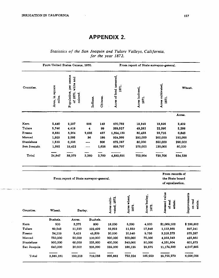
_ ...... ~---·--··-
IRRIGATION IN CALIFORNIA 157
Counties.
Kern
Tulare
Fresno
Merced
Stanislaus
San Joaquin
Total
Counties.
Kern
Tulare
Fresno
Merced
Stanislaus
San Joaquin
Total
APPENDIX 2.
Statistics of the San Joaquin and Tulare Valleys, California, for the year 187 2.
From United States Census, 1870. From report of State surveyor-general.
5,440
5,746
8,881
1,919
1,519
1,892
24,847
2,197
4,418
8,264
2,585
6,198
19,422
88,079
585
4
2,685
86
8,260
~ :a 0
148
99
427
186
806
1,628
2,789
670,782
889,527
1,894,129
924,869
675,087
885,797
4,889,691
From report of State surveyor-general.
• .!. c-0 ... t-. '3 00 .... u
f ..,; tl
Wheat. Barley. u ~ < >
Bushels. Acres. Bushels.
500 8,275 800 18,000
60,542 11,528 122,429 82,822
84,119 5,415 45,809 20,000
750,000 50,000 100,000 800,000
900,000 60,000 225,000 400,000
640,000 20,000 225,000 225,000
2,885,161 150,218 119,088 995,882
... -<II tl
..d jlr;
c-0 f t-.
00 u .... <
5,000
11,559
10,540
200,000
840,000
186,125
18,249
49,282
80,428
250,000
80,000
275,000
752,954
>: tl
-.:: <II
..0 .. f u <
c-0 t-. 00 ....
4,000
17,848
9,786
75,000
50,000
29,875
758,224 185,959
18,595
22,895
28,716
200,000
850,000
120,000
729,706
Wheat.
Acres.
2,409
5,286
6,848
150,000
290,000
80,000
584,588
From records of
the State board
of equali11ation.
tl .. ::s ... 'i = 8 >
'i Gi 'i Gi '1:1 f ~
tl f ~ tl e = 'S ... = ... tl .. ..
~ tl
~ 0 tl -
$1,069,102 $286,892
1,118,565 897,241
8,218,278 879,287
4,918,248 422,860
4,281,504 601,878
11,174,592 4,017,885
25,725,279 6,056,088

158 ENGINEERS AND IRRIGATION
APPENDIX 3.
AN ACT to authorize the incorporation of canal companies and the construction of canals, approved May 14, 1862.
SECTION 1. Corporations may be formed under the provisions of an act entitled "An act to provide for the formation of corporations for certain purposes," passed April fourteenth, eighteen hundred and fifty-three, and the several acts amendatory thereof and supplementary thereto, for the following purposes: The construction of canals for the transportation of passengers and freights, or for the purpose of irrigation or water-power, or for the conveyance of water for mining or manufacturing purposes, or for all of such purposes.
SEC. 2. The right is hereby granted to any company organized under the authority of this act to construct all works necessary to the objects of the company, to make all surveys necessary to the selection of the best site for the works and of the lands required therefor, and to acquire all lands, waters not previously appropriated, and other property necessary to the proper construction, use, supply, maintenance, repairs, and improvements of the works, in the manner, and by the mode of proceedings prescribed in an act entitled "An act to provide for the incorporation of railroad companies and the management of the affairs thereof, and other matters relating thereto," passed May twentieth, eighteen hundred and sixty-one.
SEC. 3. Every company organized as aforesaid shall have power, and the same is hereby granted, to make rules and regulations for the management and preservation of their works not inconsistent with the laws of this State, and for the use and distribution of the waters and the navigation of the canals, and to establish, collect, and receive rates, water-rents, or tolls, which shall be subject to regulation by the board of supervisors of the county or counties in which the work is situated, but which shall not be reduced by the supervisors so low as to yield to the stockholders less than one and one-half per cent. per month upon the capital actually invested.
SEC.-4. Every company organized under the authority of this act--shalf construct and keep in good repair at all times, for public use across their canal, all of the bridges that the board of supervisors of the county or counties in which such canal is situated shall require, said bridges being on the lines of public highways, and necessary for public use in connection with such highways.
SEC. 5. The provisions of this act shall not apply to the counties of Nevada, Placer, Amador, Sierra, Klamath, Del Norte, Trinity, Butte, Plumas, Calaveras, and Tuolumne.
SEC: 6. This act shall take effect from and after its passage.

IRRIGATION IN CALIFORNIA 159
ACT OF CONGRESS APPROVED JULY 26, 1866 .
• • • • • • • SEC. 9. And be it further enacted, That whenever, by priority of
possession, rights to the use of water for mmmg, agricultural, manufacturing, or other purposes have vested and accrued, and the same are recognized and acknowledged by the local customs, laws, and the decisions of the courts, the possessors and owners of such vested rights shall be maintained and protected in the same, and the right of way for the construction of ditches and canals for the purposes aforesaid is hereby acknowledged and confirmed.
ACT OF THE LEGISLATURE OF CALIFORNIA, APRIL 2, 1870.
AN ACT to authorize the incorporation of canal companies, and to provide for the construction of canals and ditches.
SECTION 1. Corporations may be formed under the provisions of the act of April fourteenth, eighteen hundred and fifty-three, entitled "An act to provide for the formation of corporations for certain purposes, and of the several acts amendatory thereof and supplementary thereto, for the following purposes, namely, the construction of canals for the transportation of passengers and freights, for the supplying water for irrigation, for procuring water-power, for conveying water for mining or manufacturing purposes, or for all such purposes combined.
SEC. 2. The right is hereby granted to any company organized under this act, or which may have been organized under preceding acts, to con-struct all reservoirs, dams, embankments, canals, ditcbes, and _<>ther works necessary to the objects of such company; to make the surveys necessary to the selection of the sites and routes of such works, and to acquire all lands, waters not previously appropriated, and other property required for the proper construction, use, supply, maintenance, repairs, and improvements of the same, in the manner hereinafter provided.
SEC. 3. Any company organized in pursuance of this act, or any company organized under any pre-existing acts for similar purposes, shall have the power to locate or fix up on the line or route of its proposed ditch or canal, and select the site or sites of its proposed dams, embankments, and reservoirs in conformity with the designation of its engineers or business manager.
SEC. 4. In case the route so fixed upon, or any part therefor, or the site so selected, be upon land owned by individuals, or upon public land possessed and occupied by individuals, and the right to such route or site over or upon such land has not been acquired by agreement with such owners

160 ENGINEERS AND IRRIGATION
or occupant, then it shall be lawful for such company to present to the county judge of the county wherein such land is situated a petition, verified by an officer or agent of the company, showing that such route or site is necessary to such company, that it passes over or is upon such land, and that a right to the same has not been acquired by agreement with the owner or occupant (naming him) of the land. It shall conclude with a prayer for the appointment of commissioners to assess the damages resulting to such owner or occupant, because of the selection and appropriation of such route or site.
* * * * * * * SEC. 12. Every company organized in pursuance of this act shall con
struct and keep in good repair, at all times, for public use, the various bridges across any canal or ditch owned by it, required by the board of supervisors of the county wherein such crossing is situated, such bridge being on the line or crossing a public highway or county road, and necessary for public use.

Notes
1. Watson's Ferry is located a few miles above the town of Tranquillity on Fresno Slough, while Banta's was a depot of the Southern Pacific Railroad located west of the San Joaquin River.
2. Considered the most important irrigating enterprise in California in the 1870s, the San Joaquin and King's River Canal stretched a distance of 67 miles from the junction of Fresno Slough and the San Joaquin River to its terminus at Orestimba Creek in Stanislaus County.
3. Pillarcitos Dam on Pillarcitos Creek, holds the run-off of the northern Santa Cruz Mountains which would otherwise empty into the Pacific Ocean at Half Moon Bay, San Mateo County.
4. San Emedio Creek, an intermittent stream flowing through San Emedio [Emegdio] Canyon originates in the Tehachapi Mountains and flows into Buena Vista Lake.
5. Established July 1, 1857, on the Fall River, a tributary of the Pit, Fort Crook served as a garrison to settlers in Fall Valley, Shasta County.
6. Named after Major Pierson B. Reading, the fort was established in May 1852 on Cow Creek, six miles northeast of Anderson, Shasta County.
7. Coover's Ferry once crossed the upper San Joaquin River near Millerton. Today Friant Dam and Lake Millerton have inundated this location.
8. Fort Tejon provided a resting spot for travelers crossing the Tehachapi Mountains. Tejon Pass connects the southern Tulare Valley with the Los Angeles Basin.
9. The community of Knight's Landing was established in 1843 on the Sacramento River approximately 20 miles northwest of Sacramento and has served as an important shipping point for the northern Central Valley.
10. These lakes are now almost completely dry lake beds or farm land, as ditches and canals diverted the supplying flows of the rivers to irrigate farmers' fields.
11. Firebaugh's Ferry is located on the west bank of the San Joaquin River in Fresno County. Hill's Ferry was established on the San Joaquin River during the Gold Rush, ten miles south of Modesto in Stanislaus County.

162 ENGINEERS AND IRRIGATION
12. Corral Hollow Creek is located in western Fresno County near Patterson Pass, southwest of the city of Tracy.
13. Alkalai, a soluable mineral salt, causes alkaline soils which are damaging to crops.
14. The clay present in suitable for growing irrigation practices.
adobe soils renders them impermeable, thus uncertain crops and liable to damage by poor
15. South of Stockton in San Joaquin County, Moore's Landing is on the left bank of the San Joaquin River.
16. Summit Lake was once located southeast of Fresno, west of Visalia and directly north of Tulare Lake in Fresno County.
17. Situated at the confluence of the San Joaquin and Sacramento rivers in the San Joaquin Delta, Antioch. serves as a port town for Contra Costa County.
18. R. Baird Smith, F.G.S., (Captain of Engineers, Bengal Presidency) wrote Italian Irrigation: A Report on the Agricultural Canals of Piedmont and Lombardy in 1855 addressed to the "Honourable Court of Directors of the East India Company."
19. The waters of the Ticino River flow out of Lake Maggiore in the Italian Alps, in the northwestern corner of Lombardy, bordering on the Piedmont region to the west and Switzerland to the north. The Ticino is a major tributary of the Po River.
20. At Tornavento, west of Milan, the "Naviglio Grande," a canal, carries water diverted from the Ticino River to supply irrigation water to Lombardy. Canals of the Adda River, the second largest in Lombardy, utilized over 50 percent of its 6,540 cfs. flow (in 1855) for irrigation purposes. The Oglio River, also a tributary of the Po, originates in the mountains north of the Po Valley and east of the Ticino and Adda rivers. A canal at Torre Pallavicina took water from the Oglio to irrigate the valley.
21. Beginning in the northwestern provinces and running east into the Bay of Bengal, the Ganges (modern Ganga) River constitutes one of the great rivers of India. The upper and lower Ganges Canal system includes 8,299 miles of distributing canals providing irrigation water for the Ganges flood plain. The project was completed in 1854.
22. The Jumna (Yamuna) River, a tributary river to the southeast, then gradually Ganges flood plain and joins the Ganges holy city Varanas.
of the Ganges, parallels the turns northeast through the
at Allahabad, near the Hindu

NOTES 163
23. Saharunpur is located along the Jumna River north of Dehli, at the base of the Himalayan Mountains. The Ganges River and Jumna originate in the southern flanks of the Himalya.
24. The Siwalic Hills parallel the Himalayas from Kashmir to Eastern Nepal. Mountain streams, which form the tributaries of the Jumna and Ganges, flow southwesterly from the Siwalic Hills.
25. On the west side of the Sacramento River in Tehama County, Red Bluff sits between the junctions of Dibble and Pine creeks, tributaries of the Sacramento River.
26. The Princeton ferry crosses the Sacramento River in northeastern Colusa County.
27. Colusa, the county seat of Colusa County, sits on the right bank of the Sacramento River about 50 miles upriver from Sacramento.
28. In the late 1840s General John Bidwell bought a Mexican rancho near the present site of the town of Chico, founded by Bidwell in 1860. Later he donated land from his rancho to establish the Northern Branch State Normal School, now California State University, Chico. Bidwell was a pioneer agriculturist and as state senator helped shape the early agricultural development of the state.
29. The Madras presidency covered the eastern coast Comorin in the south to the province of Orissa Orissa in Bengal, the Ganges River flows into through what is now Bangladesh.
of India from Cape in the north. Above the Bay of Bengal
30. The Eastern Jumna Canal, which was adapted from a canal built during the Mogul dynasty, first irrigated the United Provinces in 1830. The British modified the 14th century imperial canals near Delhi to form the Western "Jumna Can11t. The Bari Doab Canal made use of a system built in 1633 on the Ravi River, a tributary of the Indus, by Shah Jahan, and was used to water the royal gardens at Lahore.
31. A tributary of the Indus River, the Saone begins in the Himalaya and flows in a southwestern direction through the northern portion of the Punjab before merging with the Indus.
32. Completed in 1884, the Sirhind Canal irrigates a tract of land south of the Sutlej River, a tributary of the Indus, northwest of Delhi in the Punjab.
33. The Orissa Canals formed a system of navigation and irrigation canals from the Mahanadi River at Cuttack down the delta of the Hooghly River which flows into the Bay of Bengal below Calcutta.

164 ENGINEERS AND IRRIGATION
34. See Map 2, "Map of the Delta of the River Cauvery" for details.
35. The Rohilcund Canals consist of four systems in the Tarai region of the United Provinces in northern India.
36. The Agra Irrigation Works were part of 755 miles of canals, laterals, distribution ditches, and drains serving the area south west of Agra in India's North West Provinces. The main canal at Agra allowed for navigation as well as provided irrigation water.
37. The Cauvery Delta is located on the eastern coast of India, on the Bay of Bengal, about 250 miles north of Cape Camorin. The mouths of the Kistna (Krishna) and Godavery rivers are within 50 miles of one another, emptying into the Bay of Bengal, about 600 miles north of the cape.
38. The mouth of the Guadalaviar River is at Valencia, along the southeastern coast of Spain.
39. Madrid, the capital of Spain, is located on the Manzanares River in the center of the country.
40. The Mediterranean port city of Castellon de Ia Plana is at the mouth of the Mijares River, approximately 50 miles north of Valencia on the southeastern coast.

Bibliography
BOOKS
Alexander, Lt. Col. Barton S. Reports Q[ I!..S... Alexander, IJ.rn. CQ.l. Engineers Q[ ~ Preliminary Survevs. Qru. Q[ Construction, ~. Qf the Stockton S.hi.l2 Channel, Stockton California. Stockton: Independent Press, October 1874.
Bartlett, Richard A. ~ Survevs Q[ ~ American West. Norman: University of Oklahoma Press, 1962.
Bean, Walton. California: An Interpretive History. 3d ed~ New York: McGraw-Hill Book Co., 1978.
Beck, Warren A. and Haase, Ynez D. Historical A1W Q[ California. Norman: University of Oklahoma Press, 1974.
Brereton, Robert Maitland. Reminiscences Q[ n Q!d Ensdish Civil Engineer, ~-12M.. Portland, OR: The Irwin-Hodson Co., 1908.
Reminiscences Q( n Irrigation Enterorise in California. Portland, OR: The Irwin-Hodson Co., I 903.
Buckley, Robert Burton. Irrigation ~ in l.n.d.a i!.ru! .&&v.P1. New York: Spon & Chamberlain, 1893.
California State Agricultural Society. Transactions Q( ~ Agricultural Society. 1..8.2.2.-1874. Sacramento: 1866-1874.
~ California State Printer,
Clough, Shepard B. and Saladino, Salvatore. A History Q[ Modern !talv.. New York: Columbia University Press, 1968.
Davis, Winfield J. History Q.( Political Conventions in California, 1849-18.22.. Sacramento: Publications of the California State Library, 1893.
Delmathier, Royce D. et al., The Rumble Q.( California Politics, l.M£-1970. New York:John Wiley & Sons, Inc., 1970.
Dunbar, Robert G. Forging ~ Rights in Western Waters. Lincoln: University of Nebraska Press, 1983.
Edwardes, Michael. British l.n.d.a. 1772-.!2.4.1: A Survey Q.( ~ Nature and Effects Q.( ~ R.l!k. New York: Tapinger Publishing Co., 1967.

166 IRRIGATION IN CALIFORNIA
Elliott, Russell R. Servant Q[ Power: A Political Biograohy Q[ Senator William M Stewart. Reno: University of Nevada Press, 1983.
Frederickson, George M The Inner Civil War: Northern Intellectuals. Harper & Row, 1965.
Goetzmann, William H. Army Exploration in 1h.k American ~ !.W-~. New Haven: Yale University Press, 1959.
__ ....... Exoloration illlil. Empire: The Explorer illlil. 1h.k Scientist in 1h.k Winning Q[ the American~. New York: Random House, 1972.
Haggin, James B. The Desert L.ru,uU Q[ Kern County. California. San Francisco: C.H. Street, 1877.
Hagwood, Joseph J. Engineers U 1h.k Golden ~. San Francisco: U.S. Army Corps of Engineers, San Francisco District, 1980.
Hardeman, Nicholas P. The Harbor Q[ 1h.k Heartlands: A History Q[ 1h.k Inland Seaport Q[ Stockton, California, fr.Q.m 1h.k QQW. Rlilll 1Q .l2,U. Stockton: Holt-Atherton Center for Western Studies, 1986.
Holt, W. Stoll. The Office Q[ 1h.k Qlk( Q[ Engineers Q[ 1h.k Army, lli Non-Military History, Activities, a.rut Organization. Baltimore: Johns Hopkins University, 1923.
Irrigation in California: The San Joaquin illlil. Tulare Plains. Sacramento: Record Steam Book & Job Printing House, 1873.
Jackson, W. Turrentine. Wagon Roads ~: A S!.Y.Q.v. Q[ Federal &.Qru1 Surveys and Construction in 1h.k Trans-Mississippi, ~-!lli. Berkeley and Los Angeles: University of California, 1952.
Jelinek, Lawrence J. Harvest Empire: A History Q[ California Agriculture. San Francisco: Boyd & Fraser Publishing Co., 1982.
Keller, Morton. Affairs Q[ ~: Public Life in. ~ Nineteenth Century America. Cambridge: The Belknap Press of Harvard University, 1977.
Kelley, Robert L. QQW. Y.§.. Qmin.: IM Hydraulic Mining Controversy in. California'~ Sacramento Valley: A. Chapter in 1h.k Decline Q[ 1h.k Concept Q[ Laissez Faire. Glendale, CA: The Arthur H. Clark Co., 1959.
Lavender, David. Nothing Seemed Impossible: William ~. Ralston illlil. llilv. S1ill. Francisco. Palo Alto, CA: American West Publishing Co., 1975.
Lewis, Oscar. Geonze Davidson: Pioneer ~ ~ Scientist. Berkeley: University of California Press, 1954.

BIBLIOGRAPHY ' 167
Manning, Thomas G. Government in Science: The .U..S.. Geological Survey l..Ml-~. University of Kentucky Press, 1967.
Meyer, Michael C. Water in !.h.k Hispanic Southwest: A ~ and Legal History, U2.Q.-il.iQ.. Tucson: The University of Arizona Press, 1984.
Merritt, Raymond H. Engineering in American Society, !.8.2Q.-llll. Lexington: The University of Kentucky Press, 1969.
Montgomery, Mary and Clawson, Marion. History Qf Legislation arul Policy Formation 21. 1h.s:. Central Valley Project. Berkeley: U.S. Department of Agriculture, Bureau of Agricultural Economics, March 1946.
Nordhoff, Charles. California fQr. Health. Pleasure. and Residence. A Book for Travelers and Settlers. New York: Harper & Brothers Publishers, 1876.
Phelps, Alonzo. Contemporary Biography Qf California's. Representative Men With Contributions From Distinguished Scholars arul Sc;ientists. San Francisco: A.L. Bancroft & Co., 1881.
Pisani, Donald J. From !.h.k Family Farm 1Q. Agribusiness: The Irrigation Crusade in California and !.Ill:. American .WW., .!..82Q.-!.2.ll. Berkeley: University of California Press, 1984.
Smith, R. Baird. Italian Irrigation Being a. Report Q.D. !.Ill:. Agricultural Canals Qf Piedmont and Lombardy. 2 vols. London: William Blackwood and Sons, 1855.
Smith, Vincent A. The Oxford History Qf ~. Edited by Percival Spear. New Dehli: Oxford University Press, 1981.
T}J;trp, Louise Hall. Three Sa.i1ill. il..Jlll. a. Sinner, lJ.!.lia. ~ Howe, Louisa, Annie il..Jlll. £run~. Boston: Little, Brown & Co., 1956. ·
Thomas, Lately. Sn..m ~: "King Qf !.Ill:. Lobby." Boston: Houghton Mifflin Co., 1965.
Tilton, Cecil G. William Chapman Ralston: Courageous Builder. Boston: The Christopher Publishing Co., 1935.
Turhollow, Anthony F. A History Qf !.Ill:. L.Q.s. Angeles District, !.!..£. .Ar.my ~ Qf Engineers, lli8.-!.2§i. Los Angeles: U.S. Army Engineer District, 1975.
Weibe, Robert H. I..M_ Search for Q..r.Qn, ll11-ill.Q.. New York: Hill & Wang, 1967.

168 IRRIGATION IN CALIFORNIA
Worster, Donald. Rivers of Empire: Water, Aridity & The Economic Growth of the American West. New York: Pantheon Books, 1985.
ARTICLES
Bennett, MK. "Climate and Agriculture in California." Economic Geography 15 (I 939): 153-164.
Browne, J. Ross. "Agricultural Capacity of California: Overflows and Droughts." Overland Monthly 10 (1873): 297-314.
Burcham, L.T. "Cattle and Range Forage in California: 1770-1880." Agricultural History 35 (I 961): 140-149.
Chandler, A.E. "Appropriation of Water in California," California Law Review 4 (March 1916): 206-216.
Davidson, George. "The Application of Irrigation to California." In Contemporary Biography Q[ California'~ Representative Men With Contribut.i.Q..ru. From Distinguished Scholars and Scientists. By Alonzo Phelps. San Francisco: A.L. Bancroft & Co., 1881.
Dunbar, Robert G. "The Adaptability of Water Law to the Aridity of the West," Journal Q[ !.ill:_ West 24 (January 1985): 57-65.
Ganoe, John T. "The Beginnings of Irrigation in the United States." Mississippi Valley Historical Review (now American Historical Review) 25 (I 938): 59-78.
Gates, Paul W. "Adjudication of Spanish-Mexican Land Claims in California." Huntington Library Quarterly 21 (1958): 213-236.
__ . "Public Land Disposal in California." Agricultural History · 49~no. 1 (January 1975): 158-178.
Griffiths, David B. "Anti-Monopoly Movements in California, 1873-1898." Southern California Quarterly 52 (Spring 1970): 93-121.
Guinn, J.M. "A History of California Floods and Drought." Annual Publi-cation Q[ the Historical Society of Southern California, 1890 ( 1890): 33-39.
Hardy, Osgood. "Agricultural Changes in California, 1860-1900." Pro-ceedings Q[ !.ill:_ American Historical Association, Pacific Coast Branch, l2l.2.. 216-230.
House, Albert V., Jr. "Proposals of Government Aid to Agricultural Settlement During the Depression of 1873-1879." Agricultural History 12 ( 1938): 46-66.

BIBLIOGRAPHY ' 169
Korr, Charles P. "William Hammond Hall: The Failure of Attempts at State Water Planning in California, 1878-1888." Southern California Quarterly 45, no. 4 (December 1963): 305-321.
Lilley, William. "The Western Irrigation Movement, 1878-1902: A Reappraisal." In The American ~: A Reorientation. Edited by Gene M. Gressley. pp. 57-74.
Littlefield, Douglas. "Water Rights during Conflict over Economic Points of View." 14, no. 4 (October 1983): 415-434.
the California Gold Rush: Western Historical Quarterly
Meinig, Donald W. "The Growth of Agricultural Regions in the Far West: 1850-191 0." The Journal Qf. Geography 54 ( 1955): 223-232.
Miles, Nelson A. "Our Unwatered Empire." North American Review 150 (1890): 370-81.
Miller, Gordon R. "Shaping California Water Law, 1781-1928." Southern California Quarterly 55 (Winter 1973): 9-42.
Miller, M Catherine. "Riparian Rights and the Control of Water in California, 18 79-1928: The Relationship Between an Agricultural Enterprise and Legal Change." Agricultural History 59 (1985): 1-24.
Orsi, Richard. "The Octopus Reconsidered: The Southern Pacific and Agricultural Modernization in California, 1865-1915." California Historical Quarterly 54 (1975): 197-200.
Paul, Rodman W. "The Beginnings of Agriculture in California: Innovation v. Continuity." California Historical Quarterly 52 (1973): 16-27.
___ ,. "The Wheat Trade Between California and the United Kingdom." Mississippi Valley Historical Review 45 (DecemberJ958): 391-412.
-----'· "The Great California Grain War: The Grangers Challenge the Wheat King." Pacific Historical Review 27 (November 1958): 331-349.
Pisani, Donald J. "Enterprise and Equity: A Critique of Western Water Law in the Nineteenth Century." Western Historical Quarterly 18, no. I (January 1987): 15-37.
Prescott, Gerald L. "Farm Gentry vs. California." California Historical 1977-1978): 328-345.
the Grangers: Quarterly 56,
Conflict no. 4
in Rural (Winter
Reed, Howard S. "Major Trends in California Agriculture." Agricultural History 20 (I 946): 252-255.

170 IRRIGATION IN CALIFORNIA
Reuss, Martin. "Andrew A. Humphreys and the Development of Hydraulic Engineering: Politics and Technology in the Army Corps of Engineers, 1850-1950." Technology aru1. Culture 26, no.1 (January 1985): 1-33.
Shaw, John A. "Railroads, Irrigation, and Economic Growth: The San Joaquin Valley of California." Exolorations in Economic History 10 (1973): 211-227.
Smith, Henry Nash. "Rain Follows the Plow: The Notion Rainfall for the Great Plains." Huntington Library (1947): 175-188.
for Increased Quarterly 10
Thompson, Kenneth. "Historic Flooding in the Sacramento Valley." Pacific Historical Review 29 (1960): 349-360.
Thompson, Kenneth and Eigenheer, Richard A. "The Agricultural Promise of the Sacramento Valley: Some Early Views." Journal Q.( 1h.k ~ 18, no. 4 (1979): 33-41.
Wood, H.J. "Water Plan for the Great Valley of California." Economic Geograohy 14 (1938): 22-31.
Wooster, Clarence M "Building the Railroad Down the San Joaquin in 1871." California Historical Quarterly 18 (1939): 22-31.
PUBLISHED GOVERNMENT DOCUMENTS
Alexander, Lt. Col. B.S. and Lightner, C.W. Reoort Q.( 1h.k Commissioners Apoointed 12. Examine 1h.k Harbor Q.( ~ ~ aru1. Salinas Slough in 1h.k Bu. Q.( Monterey. 26 February 1870.
Bryan, William H. Reoort Q.( 1h.k Engineer Q.( 1h.k Sacramento Valley Irrigation aru1. Na vi gat ion ~~Sa_c_l'a~~-!!to: S_!:_l\te. ~!J~ter,_J ~68.
California. State Board of Agriculture. Biennial Report Q.( 1h.k ~ 1l.Q.arQ Q.( Agriculture for 1h.k Y.ail ll1.Q.- l.81l. State Printer, 1872.
California. State Engineer. Report Q.( 1h.k ~ Engineer 12. 1h.k ~~ Q.( 1h.k ~ Q.( California. Part I. By William Hammond Hall. Sacramento: State Office of Printing, 1881.
California. State Legislature. Appendix 1Q 1h.k Journals Q.( 1h.k Senate aru1. Assembly Q.( 1h.k Legislature of 1h.k ~ Q.( California. 19th sess., vol. 3.
"An Act to Provide a: System of Irrigation, Promote Rapid Drainage, and Improve the Navigation of the Sacramento and San Joaquin Rivers." 28 March 1878, 22 QU. 51ili.

BIBLIOGRAPHY 171
Report to ~ Honorable Board of Commissioners Q.( the West Side Irrigation District. I 8 December I 877. By William Hammond Hall. Appendix to the Journals Q.( the Senate and Assembly of the ~ of California. 22d sess. 1877-1878. vol. 4. Sacramento: State Printer, 1878.
Davidson, George. Report YQQ!l the Methods Employed in Irrigating Land in India, &&.v.o.l, lll!v., and Q1.hll Countries. Sen. Ex. Doc. 94, 44th Con g., I st sess., I 8 7 5.
Department of Public Works, Division of Water Resources. Financial and General ~ Pertaining 1Q. Irrigation, Reclamation ruld ~ Public Districts in California. Bulletin No. 37. Sacramento: California State Printing Office, 1931.
Government of India. Public Works Department. Irrigation in. India: Review for the Year 1...2JQ-!.2.!2. Calcutta: Superintendent Government Printing, India, 1918.
Mendell, Lt. Col. George H. Report Q1l a_ Project 1Q. Protect the Navigable Waters of California from 1b.k Effects Q[ Hydraulic Mining. H. Ex. Doc. 98, 47th Cong., 1st sess. Washington, D.C.: Government Printing Office, 1882.
San Francisco. Board of Supervisors. Report Q.( l..M_ Special Committee Q.( ~ Board Q.( Supervisors. Together ~ Recommendations Q[ ~ I!.S... Alexander, U.S.A., ruu! fr.Qf.. George Davidson U.S.C.S., Q1l l..M. ~ Supplies ill 1M. Q1y Q.( Srul Francisco (San Francisco: A.L. Bancroft & Co., 1872).
U.S. Congress. Congressional ~.
U.S. Congress. Congressional Record.
U.S. Congress. House Committee on Public Lands. Message from 1M. President Q.( ~ United ~ Transmitting 1M. Report Q.( t..M. Commissioners Q.U. ~ Irrigation Q.( ~ S.U. Joaquin, Tulare, 3.rui Sacramento Valleys, in. ~ ~ Q.( California. H. Ex. Doc. 290, 43d Cong., 1st sess., 24 March 1874 and H. Ex. Doc. 612, 43d Cong., 1st sess., 21 Apr. 1874.
U.S. Congress. House. Report Q.( 1M. Commissioner Q.( Agriculture: Irrigation in California. H. Ex. Doc. 1652, 43d Cong., 2d sess., 1874.
___ .. Biographical Directory Q.( l..M_ American Congress 1774-1.21!: The Continental Congress, September ~ 1774, 1Q. October ll, .!.7..81, i!l.d 1M. Congress Q.( 1M. United ~ from 1b.k First Through 1M. Ninety-first Congress March ~. 11!2., 1Q. January J., 1.21!, Inclusive. Washington, D.C.: Government Printing Office, 1971.

172 IRRIGATION IN CALIFORNIA
U.S. Congress. Senate. Letter Q[ the Commissioner Q[ Agriculture Transmitting ~ Paper Entitled "Irrigation: Its Evils, the Remedies, a.n.Q. the Compensations." By George P. Marsh. Sen. Misc. Doc. 55, 43d Con g., I st sess., 18 7 4.
U.S. Department of Commerce. Bureau of the Census. Eighth Census Q[ the United States, ll..Q.Q.. Washington, D.C., 1864.
Ninth Census Q[ the United States, 1870. Washington, D.C., 1872.
U.S. War Department. Report of the Secretary Q[ War. H. Ex. Doc. I, Pt. 2, p. I, 43d Cong., 2d sess.
NEWSPAPERS AND PERIODICALS
Alta California (San Francisco)
Fresno QJill.v. Republican
Fresno Expositor
Kern County Weekly Courier (Bakersfield)
Marysville Appeal
Pacific R.Y..rn! ~(San Francisco)
Sacramento }!tt
Sacramento Union
SAn. Francisco ~
San Francisco Chronicle
San Joaquin Valley Ar.&.Y.1
Stanislaus County News
Stockton Independent
Tulare Times
Weekly Colusa Sun
UNPUBLISHED MATERIAL
Carothers, Alice L. "The History of the Southern Pacific Railroad in the San Joaquin Valley." Master's thesis, University of Southern California, 1934.

BIBLIOGRAPHY 173
Eigenheer, Richard Allen. "Early Perceptions of Agricultural Resources in the Central Valley of California." Ph.D. dissertation, University of California, Davis, 1976.
Jewell, Marion N. "Agricultural Development in Tulare County 1870-1900." Master's thesis, U ni versi ty of Southern California, 19 50.
Malone, Thomas E. "The California Irrigation Crisis of 1886: Origins of the Wright Act." Ph.D. dissertation, Stanford University, 1965.
Miller, M Catherine. "Law and Entrepreneurship in California: Miller and Lux and California Water Law, 1879-1928." Ph.D. dissertation, University of California, San Diego, 1982.
ARCHlY AL MATERIAL
Bensley, John. MS. Papers. Bancroft Library, University of California, Berkeley.
Davidson, George. Papers. Bancroft Library, University of California, Berkeley.
Hyatt, Edward. "National Broadcast on California Agricultural Programs, Under the Auspices of the State Grange, NBC Studios, San Francisco, November 10, 1939," Edward Hyatt Papers 2, Water Resources Center Archives, University of California, Berkeley.
Ralston, William Chapman. Collection. Bancroft Library, University of California, Berkeley.
Records of the California State Legislature. Assembly Bills, 1873-1874. California State Archives.
Records of the Office of the Chief of Engineers. Record Group 71, "Records Relating to Various Functions." 1790-1945. National Archives. Executive Branch.
"Records of Engineer Boards and Commissions." 1824-1954. National Archives. Executive Branch.
"Report of General Barton Stone Alexander on the Reclamation of the Rancho Pescadero, San Joaquin County." 1877. Bancroft Library Pamphlets. Bancroft Library, University of California, Berkeley.
State of California. Office of the State Engineer. Reports of the State Engineer to the Governor, 1880. California State Archives, Sacramento.
U.S. Army Corps of Engineers. Office of History. Biographical Files. Fort Belvoir, Virginia.

IRRIGATION IN CALIFORNIA
MAPS
National Archives. Record Group 77, Civil Works Map File. Washington, D.C. Board of Commissioners on Irrigation. Map of the San Joaquin, Sacramento, and Tulare Valleys, State of California, 1873. (W170-9)
Commissioners on Irrigation. Diagram Showing the System of Irrigation as Practiced on the San Joaquin and Kings River Canal. (W170-4).
__ _.. Map of the Delta of the River Cauvery Showing the Development of the System of Irrigation in the Districts of Tanjore, Trichinopoly, and part of South Arcot, Madras Presidency. (W170-5)
U.S. Coast Survey. Rain Chart of the United States. August 1868. Engineering Department, 1874. (W170-3)

Alexander, Lt. Col. Barton S., career of, 19-21, in California, 20-21, Civil War, 19-20, Mexican War, 19; consultant to city of San Francisco Special Committee on Water Supply, 21; death, 34; forwards monthly reports, 26; order to serve on commission, 19; role in preparation of final report, 28; state engineer, role in establishing office of, 34-35; surveys for Stockton Ship Canal Company, 20-21
American River, 25-26, 31, 56, 75 Antioch, 11, 12, 14, 33, 82 Auburn, 62
Bache, Alexander D., 22 Bakersfield, 6-7, 24-25, 7 4;
irrigation near, 56 Bank of California, 13; role in
financing irrigation works, 10, 32-33
Banta Station, 10, 24-25, 74 Bear River, 31, 75, 81 Benicia, 64 Bensley, John, 9; organizes
California Steam Navigation Co., 9; organizes San Francisco Water Works Company, 9; organizes San Joaquin and Kings River Canal Company, 9-10
Berryessa Valley, 27 Bidwell, John, 4, 5 Board of Irrigation Commissioners,
6-7, 14; appointments to, 18-19; bill to organize, 14, I 7, 18; composition, 18-19; evaluation of efforts of, 36; final report, preparation of,
26-29, release of, 29, 31, submission of, 28;
foreign irrigation projects, 26-27, 28-29; acquisition of works on, 27, 28-29; study of, 26-27, 28-29;
Index
public interest in the work of, 24, 25; in the Sacramento Valley, 27; in the San Joaquin Valley, 26, 27; in the Tulare Valley, 26
Booth, Newton, opposition to government subsidies, 12-13, 14; views on Brereton, 12-13; opposition to canal company, 12-13, 32
Brereton, Robert Maitland, arrival in San Francisco, 10; career in India, 10; death, 36; San Joaquin and Kings River Canal and Irrigation Company, involvement with, 10-14, discussions in Washington, D.C., 13-14, failure of company, 32-33, seeks financing in London and Europe, 13, 32-33, plans for canals, 11-12; promotion in Washington, D.C., of a government irrigation survey, 13-14; service after commission, 32-33, 36; service to commission as advisor, 23-24
Brewer, William, 23 • Browne, J. Ross, on irrigation, 4-5 Buena Vista Lake, 5, 11, 14, 16,
74, 82 Butte Creek, 88
Cache Creek, 5, 26, 56, 64, 73, 76, 83
Cache Slough, 83 Calaveras River, 25-26 California,
canal companies, acts to incorporate, 158-160, variable nature of, 59-61; orographical conditions, 59, 61, 62; potential benefits of irrigation, 143-144; temperatures of selected toea tions, 69-71
California Geological Survey, 24-25, 72

176
California State Agricultural Society, 4
California State Board of Agriculture, 5
California Steam Navigation Company, 9
Capay Valley, 83 Casserly, Eugene, 16-18 Centerville, 11, 24-25, 56 Central Pacific Railroad Company, 8 Central Valley see Great
Valley. Central Valley Project (CVP), 7,
36 Chapman, William S., 10, 12-13,
14-15 Cherokee, 26 Chico, 88 Chico Creek, 88 Chowchilla River, 75 Clear Lake, 9, 26, 56, 64, 66, 76,
83 Clear Lake Water-Works Company,
proposed canal of, 83 CoaH Range, 5,14,62 Cole, Cornelius, 14, 16, 18 Colusa, 72, 81, 87 Cosumnes River, 25-26, 56, 81, 86
Davidson, George, order to serve on commission, 19, 22-23; attitude toward commission, 24, 25-26; career with Coast and Geodetic Survey, 22-23,
__ ,_ ____ , in.Alaska, 22~23, California, 22-23, New England, 22, Panama, 22, Washington, D.C., 22; consultant to City of San Francisco regarding water supplies, 21; continuing interest in irrigation, 32; death, 36; education, 22-23; preparation of final report, role in, 28; triangulation of the Coast Range and Sierra Nevada, 22-23; work after commission, 32, 36
ENGINEERS AND IRRIGATION
Denison, Sir William, comments on irrigation in India, 116-119
Drought, in California, 9, 10, 33 Dwinnelle, John W., 20
Feather River, 26, 31, 56, 72, 75, 88
Firebaugh's Ferry, 9, 74 Fish Slough, 11 Flooding,
in Central Valley, 34-35; introduction of control works, 35
Fort Crook, 64 Fort Reading, 64, 65 Fort Tejon, 64, 65 Fresno, 10, 81 Fresno Canal Company, 27-28 Fresno Slough, 11, 24-25, 86 Friedlander, Isaac, 10, 12, 14-15
Goshen, 24-25 Grange, 17, 28
opposition to San Joaquin and Kings River Canal and Irrigation Company subsidy bill, 17
Grayson, T., 13 Great Valley, adaptability for irrigation, 5, 59, 143-44; canals, existing and hypothetical, 57; climate, 5, 59, 63; defined, 5; extent of, 56; farming methods in, 5-6, 59, 63; land ownership patterns, 6, 12; opened for settlement, 3-4; rainfall in, 59;_s.tudies of irrigation in, 6-7, 143-44; temperatures, 59
Haggin, James Ben Ali, 33 Haight, Henry H., 13 Hall, William Hammond, 34-35, 36 Haymond, Creed, 34 Hilgard, J.E., 25 Hill's Ferry, 12, 24-25

INDEX
Houghton, Sherman 0., 14-15, 17-18 Humphreys, Brig. Gen. Andrew A.,
career, 19; support of bill to create Board of Irrigation Commissioners, 19; urged to appoint Clarence King to the commission, 23; view of commission report, 54-55
Hyatt, Edward, 7
lrriga tion, in California, 72-74, 77, 88,
138-147, foothills, 143; general considerations of, 143-144; necessity for, 58, 140; potential costs of canals,
· -· ........ ·-· .... ·M+"i-4·4;· role of government in, 140, 144, 146; role of private enterprise, 146; value of crops, 144;
in China, 6; Imperial Canal, 100
cost of, 138-143; defined, 88; drainage, general description of,
I44; in foreign countries, 97, 98,
140-I41; in Egypt, 97, 98; in France, 13 7 -138; in Great Valley, possible
systems, 146; in India, 28-29, 97, 98, 99-119,
141; canals, statistics of, I07; in Madras Provinces, channel
irrigation in deltas of rivers, 111-114, Cauvery delta, 111, God a very delta, Ill, Kistna delta, Ill;
in Northwest Provinces, 109-110, Dhoon Canals, 109; Eastern Jumna Canal, 100, 109; Ganges Canal, I 00, I 08, II 0; general remarks on, IOO, 111-112;
private canals in, 114-116; East India Irrigation Company, 115;
Madras Irrigation Company, 115-116;
177
in Punjab, 107-108; Bari Doab Canal, 107, 11 0; Delhi and Garagaon Works, 108; Indus Inundation Canals, 108, 110; Lower Sutlej and Chenab Inundation Canals, 108, 110; Upper Sutlej Canals, 108, 110; Western Jumna Canal, 107;
general remarks on, 99-100, 141 in Italy, 97, 98, 119-129;
Association-General of Irrigation West of the Sesia, 127, 154-156; canals, in Lombardy, 122-123; in th_e Piedmont, 123-129; Cavour Caifal,--·-... -
122, 147, 154-155; government financing for, 126-127, 147, 154-155;
climate, 120-121; general remarks, 119-122
navigation of rivers, influence on, 83, 84-86; in India, 85; in Italy, 84; rivers in California, potential
effects, 84-88, 137-138; in Spain, 129-137; climate, 130;
in Elche, 141; in Granada, 141; irrigated land, value of, 131; laws and customs, 132, 136-137, as regards canals, 136; Moorish traditions and legacy, 131-132; toward private companies, 134-135; in Valencia, 135, 141
Irwin, William, 32-33
Jones' Ferry, 12
Kaweah River, 5, 56, 75 Kern County, 11 Kern Lake, 5, 16, 24-25, 72, 74,
77, 82 Kern River, 5, 11, 14, 16, 24-25,
26, 56 King, Clarence, 23-24 Kings River, 5, 11, 16, 24-25, 26,
56,. 75 Knight's Ferry, 25-26

178
La Grange, 25 LeConte, John, 20 LeConte, Joseph, 20 Los Banos, 11 Los Banos Creek, 82 Luning, Nicholas, 10 Lux, Charles, 3-4, 10, 12, 32-33
Marsh, George Perkins, 31 Marshall, Col. Robert Bradford, 36;
Marshall Plan 1919-1920, 36 Martinez, 12 Mendell, Maj. George H., career in
California, 21; death, 36; militarv career, 21; order to
_, --" -- ~. -· . -.-•• ~::;:..,t! . . .,.._ .. -,.,....,""",..'"" .,.-.. -·-·--·~~- ...... ·~~~ .. - ..
serve on commtssion, 19; -Merced County farm club, 24 Merced River, 12, 20-21, 24, 26,
56, 75 Mexican land grants, 8 Miller, Henry, 3-4, 10, 12, 24-25,
32 Millerton, 12, 64, 65, 78 Mining, replaced by agriculture, 4,
94, 96; debris in rivers, 26, 31, 34-35, 96 .
Modesto, 25-26, 66 Mokelumne River, 25-26, 56, 75, 86 Monterey, 66 Moore's Landing, 82 Moss, J. Mora, 10
Oakland, 14 Orland, 36 Oroville, 26
Paige, Timothy, 12 Peoples' Independent Party, 12-13 Pillarcitos Dam, 62 Powell, John Wesley, 33 Princeton, 87 Puta (or Putah) Creek, 26, 56, 73
Rainfall, in California see Great Valley, climate in.
Ralston, William, 10, 12-14, 16, 23, 32-33
ENGINEERS AND IRRIGATION
Red Bluff, 26, 56 Redding, 26, 72 Reed, Charles F., 5 Rocklin, 62
Sacramento River, 5, 26, 27, 31, 36, 56, 64-65, 72
Sacramento Valley, 5, 27, 33, 56 San Francisco Bay, 5 San Joaquin & Kings River Canal
and Irrigation Company, 6-7, 23-24,75,77,82, 90;canab built by, 82-83, 90; canals proposed by, 9, 10-12; efforts to obtain government subsidies for, 13-17; land ownership, 12-13; · opposition to subsidies for, 13-17, 26, 28; see also Brereton, M; techniques used for spreading water, 85-87; use of canal for navigation, 86-87
San Joaquin Farmers' Club, 25 San Joaquin River, 5, 11, 12, 14,
16, 20-21, 24-25, 26; Chapman Canal on, 43
San Joaquin Valley, 3-4, 5, land ownership patterns in, 8
San Pablo Bay, 72 Sargent, A.A., 28 Shasta, 26, 56, 66 Sierra Nevada, 5, 26, 62 Smartsville, 26 Smith, Col. Baird, 101, 111, 112,
122 Southern Pacific Railroad Company,
6-7, 8 Spring Valley Water Company, 9, 62 State Agricultural Society, 4 State Board of Agriculture, 5 Stanislaus River, 20-21, 26, 56 Stewart, William M., 16,17-18,35 Stockton, 20-21 Stony Creek, 5, 27, 56, 73, 87 Suisun Bay, 5, 72 Summit Lake, 11, 82 Sycamore Bend, 24-25

INDEX
Table Mountain, 12 Tehama, 56 Tejon Pass, 11, 72 Tevis, Lloyd, 10 Tipton, 24-25 Topographical Engineers, 21, 22 Tulare Lake, 5, 11, 14, 16, 33 Tulare Valley, 5, 26, 56 Tule River, 75 Tuolumne River, 20-21, 25-26, 56
U.S. Army Corps of Engineers, 33 U.S. Coast and Geodetic Survey,
22-23, 24 U.S. Geological Survey, 33
.Visalia, rainfall at, "TC-24~-25~-56, 63; irrigation from Kaweah River, 56, 63; problems with irrigating ditches, 64, 66
Ward, Samuel, 13-14 Watson's Ferry, 56, 78, 82 West Side Canal, 33 Wheat, 8, 9, 139-140 Whitney, Josiah D.,
asked to join commission, 55; declines invitation to serve on commission, 23-24; meets with members of commission, 25-26, 27; state geologist, 23
Wright Act, 35-36
Yuba River, 26, 56, 75
179

US Army Corps of Engineers
EP 870·1· 39 AUGUST 1990