report - hydrogeological assessment incorporating …
TRANSCRIPT

ENRS PTY LTD ABN 68 600 154 596 T 02 4448 549 0F 02 9037 4708 E: [email protected] www.enrs.com.au
REPORT - HYDROGEOLOGICAL
ASSESSMENT INCORPORATING 48
HOUR PUMP TEST
27782 HUME HIGHWAY, BOWNING, NSW,
LOT 172 DEPOSITED PLAN 649063
Prepared For: Barker Group
Project Number: ENRS0978
Date: December 2018

Hydrogelogical Assessment 27782 Hume Highway, Bowning
ENRS0978_HA48HRPT_27782 HUME HWY BOWNING PAGE i
COMMERCIAL IN CONFIDENCE This document has been prepared consistent with accepted scientific practice, supported by available data and resource conditions, as determined by limited data acquisition during the assessment period, evident at the site at the time. The designated recipients of this report accept all risks and responsibility for losses, damages, costs and other consequences resulting directly or indirectly from using the results of the interpretation, the data, and any information or conclusions drawn from it, whether or not caused by any negligent act or omission. To the maximum permitted by law, ENRS Pty Ltd excludes all liability to any person or identity, arising directly or indirectly from using the information or material contained herein.
INTELLECTUAL PROPERTY LAWS PROTECT THIS DOCUMENT
Copyright in the material provided in this document is owned by ENRS Pty Ltd, and third parties may only use the
information in the ways described in this legal notice:
• Temporary copies may be generated, necessary to review the data.
• A single copy may be copied for research or personal use.
• The documents may not be changed, nor any part removed including copyright notice.
• Request in writing is required for any variation to the above.
• An acknowledgement to the source of any data published from this document is mandatory.
Author and Document Control
Record of Distribution
Copies Report No. & File Name Status Date Prepared for:
1 x PDF ENRS0978_HA48hrPT_27782 Hume Hwy Bowning Rev.1 18th Dec. 2018 Barker Group
Written/Submitted by: Reviewed / Approved by:
Matt Lemcke
Geologist & Environmental Consultant
Rohan Last
Hydrogeologist & Environmental Scientist

Hydrogelogical Assessment 27782 Hume Highway, Bowning
ENRS0978_HA48HRPT_27782 HUME HWY BOWNING PAGE ii
EXECUTIVE SUMMARY
Environment & Natural Resource Solutions (ENRS Pty Ltd) were commissioned as independent
groundwater consultants to prepare a Hydrogeological Assessment (HA) incorporating the results
of a 48 Hour Pump Test for a new production Bore at Lot 172 in DP 649063, street number 27782
Hume Highway, Bowning, NSW, 2582 (herein referred to as the Site).
ENRS understand this HA is required to document the groundwater supply at the Site in
anticipation of development of a Highway Service Centre. The Centre will not be connected to
the Yass Shire reticulation system. The proposal is to utilise groundwater at the Site to meet the
design peak daily demand of approximately 20 Kilolitres per day.
Test drilling during the scope of work culminated in the construction and airlift testing of one (1)
proposed production bore. The bore has intersected fractured and porous rock aquifers at depths
between 48 and 115 metres with a cumulative yield up to 1.7 L/s demonstrated during air lifting.
The bore was subject to a 48 hour drawdown and recovery pump test which reported a final
drawdown level of 21.28 mbgl which is significantly shallower than the available limit at 108
metres.
This report documents the findings of a hydrogeological assessment incorporating aquifer testing
(drillers airlift) in general accordance with requirements for water bores outlined by the NSW
Office of Water (NOW) and consistent with the spirit and principles of the NSW State Groundwater
Policy Framework Document (NSW Government 1997), the NSW State Groundwater Quality
Protection Policy (NSW Government 1998) and the NSW State Groundwater Dependent
Ecosystems Policy (NSW Government 2002).
The project objectives were to prepare a site specific hydrogeological assessment to document
the hydrogeological setting and aquifer properties, and provide an assessment if the bore is
capable of meeting the project water supply requirements supported by a 48 Hour Pump Test.
Provide recommendations on bore yield, sustainable pumping regimes and assess potential
impacts, if any, in context of the Site proposal.
A hydrogeological assessment was conducted for the site by undertaking the following scope of
work:
➢ Pre-commencement groundwater target study - desktop review of available site data
including; previous reports (if any); aerial photographs; geological and topographic maps;
registered bore records;
➢ Review of the site proposal, water demand and operational requirements;
➢ Site inspection, check licensing requirements for distance setbacks and peg drilling targets;
➢ Prepare and lodge test bore drilling licences with NOW;
➢ Drill and construct test bore by licensed driller. Log cuttings and record details of aquifer
intercepts. Conduct a minimum two (2) hour airlift to measure cumulative bore yield;
➢ 48 Hour drawdown and recovery Pump Test and data analysis;
➢ Collect representative water samples upon completion of pump testing and submit samples
for NATA accredited laboratory analysis. Tabulate and compare the laboratory results
against the Australian Drinking Water Guidelines (ADWG);

Hydrogelogical Assessment 27782 Hume Highway, Bowning
ENRS0978_HA48HRPT_27782 HUME HWY BOWNING PAGE iii
➢ Review the drilling and aquifer testing results. Identify any potential impacts from the
proposed bore operations on existing bores, groundwater users (if any) and groundwater
dependent ecosystems (GDEs), if any; and
➢ Compile the investigation results, prepare a Hydrogeological Assessment (HA) report
including recommendations for bore licensing, groundwater management, and pumping
regimes.
Based on the findings obtained during the scope of work the following conclusions and
recommendations may be made:
➢ The subject bore was drilled and constructed by Bungendore Water Bores in April 2018.
The bore was drilled to a depth of 120 m with 48 metres of solid surface casing and a 5
metre clay sanitary seal at the surface to prevent connection with any shallow soil water.
The bore was completed with slotted PVC casing and gravel packed in general accordance
with the Minimum Construction Requirements for Water Bores in Australia – 3rd Edition
(2012). The bore sustained a drillers air lift yield of 1.7 L/s for three (3) hours during test
drilling;
➢ The bore was subjected to a 48 hour (Bore 1) drawdown and recovery pumping test. The
results indicate the subject bore is capable of sustaining an allocation of 24ML under the
following pumping regime:
➢ Bore 1 - up to 1.15 L/s; 16 hr Pumping; 8 hrs Recovery; 24 ML per year at 66 % duty. A higher pumping rate and operating duty may be realised supported by monitoring of pumping performance and recovery rates.
➢ The proposal is to convert the test bore to a production bore with a commercial, industrial
and domestic groundwater access licence with an entitlement of 24 ML to facilitate the
proposed development. The pumping yield of 1.15 L/s exceeds the estimated peak demand
for the Site proposal of approximately 30,000 Litres per day (or up to 11 ML per year);
➢ Based on the capable yield the recommended pumping regime is considered low risk for
groundwater impacts. Final drawdown in the bore was 21.28 mbgl which is significantly
shallower than the available drawdown limit at a depth of 108 m below ground level at the
top of the slotted casing and the primary aquifer zone. No registered water bores are
present within a 1 km radius of the site and similarly no GDEs were identified at the Site
area. Hence, it is assessed that under the proposed operating regime the bore will have no
significant measurable impact on the groundwater environment and existing users in the
area;
➢ NATA certificated laboratory results report water quality is generally within the criteria
outlined by the ADWG (2016). Minor levels of iron and manganese are expected to reduce
with long-term pumping as drilling sediment decrease, and any residual levels may be
managed through primary treatment systems; and
➢ It is recommended that this report be submitted for final endorsement by the regulator.

Hydrogelogical Assessment 27782 Hume Highway, Bowning
ENRS0978_HA48HRPT_27782 HUME HWY BOWNING PAGE iv
TABLE OF CONTENTS
EXECUTIVE SUMMARY ................................................................................................. II
1.0 INTRODUCTION ................................................................................................ 6
1.1 Objectives ......................................................................................................... 6
1.2 Scope of Work .................................................................................................. 6
2.0 SITE DESCRIPTION .......................................................................................... 7
2.1 Location ............................................................................................................ 7
2.2 Topography ....................................................................................................... 7
2.3 Geology ............................................................................................................ 8
2.4 Hydrogeology .................................................................................................... 9
3.0 TEST DRILLING ............................................................................................... 11
3.1 Test Bore Licence ........................................................................................... 11
3.2 Selection of Drilling Targets ............................................................................ 12
3.3 Airlift Test Results ........................................................................................... 13
3.4 Drilling Results ................................................................................................ 13
4.0 BORE CONSTRUCTION .................................................................................. 14
5.0 AQUIFER TESTING ......................................................................................... 14
5.1 Pump Test Methodology ................................................................................. 14
5.2 Pump Test Results ......................................................................................... 15
5.3 Capable Yield ................................................................................................. 16
6.0 WATER QUALITY ............................................................................................ 16
6.1 Potential Hydrogen ......................................................................................... 16
6.2 Salinity ............................................................................................................ 17
6.3 Metals and Metalloids ..................................................................................... 17
7.0 IMPACT ASSESSMENT .................................................................................. 17
7.1 Distance Drawdown ........................................................................................ 17
7.2 Groundwater Dependent Ecosystems (GDE) ................................................. 18
8.0 CONCLUSIONS AND RECOMMENDATIONS ................................................ 19
9.0 REFERENCES ................................................................................................. 20
10.0 REFERENCES ................................................................................................. 21
LIMITATIONS ................................................................................................................ 24

Hydrogelogical Assessment 27782 Hume Highway, Bowning
ENRS0978_HA48HRPT_27782 HUME HWY BOWNING PAGE v
LIST OF TABLES, FIGURES & APPENDICES
TABLES
Table 1: Site Identification
Table 2: Stratigraphic Formations
Table 3: Registered Bores within 5 km of the Site
Table 4: Test Bore Licence Summary
Table 5:Test Bore Drilling Results
Table 6: Bore Construction Summary
Table 7: Summary of Drawdown and Recovery Test Results
Table 8: Water Salinity Criteria
Table 9: Identified Potential GDEs
FIGURES
Figure 1: Site Location Map
Figure 2: Geological Setting
Figure 3: Registered bore locations (Water NSW online database)
Figure 4: Test Bore Targets
APPENDICES
Appendix A Form A Drillers Logs
Appendix B Pump Test Results
Appendix C NATA Laboratory Certificates of Analysis (CoA)

Hydrogelogical Assessment 27782 Hume Highway, Bowning
ENRS0978_HA48HRPT_27782 HUME HWY BOWNING PAGE 6
1.0 INTRODUCTION
Environment & Natural Resource Solutions (ENRS Pty Ltd) were commissioned as independent
groundwater consultants to prepare a Hydrogeological Assessment (HA) incorporating the results of
a 48 Hour Pump Test for a new production Bore at Lot 172 in DP 649063, street number 27782
Hume Highway, Bowning, NSW, 2582 (herein referred to as the Site).
ENRS understand this HA is required to document the groundwater supply at the Site in anticipation
of development of a Highway Service Centre. The Centre will not be connected to the Yass Shire
reticulation system. The proposal is to utilise groundwater at the Site to meet the design peak daily
demand of approximately 20 Kilolitres per day.
Test drilling during the scope of work culminated in the construction and airlift testing of one (1)
proposed production bore. The bore has intersected fractured and porous rock aquifers at depths
between 48 and 115 metres with a cumulative yield up to 1.7 L/s demonstrated during air lifting. The
bore was subject to a 48 hour drawdown and recovery pump test which reported a final drawdown
level of 21.28 mbgl which significantly shallower than the available limit at 108 metres.
This report documents the findings of a hydrogeological assessment incorporating aquifer testing
(drillers airlift) in general accordance with requirements for water bores outlined by the NSW Office
of Water (NOW) and consistent with the spirit and principles of the NSW State Groundwater Policy
Framework Document (NSW Government 1997), the NSW State Groundwater Quality Protection
Policy (NSW Government 1998) and the NSW State Groundwater Dependent Ecosystems Policy
(NSW Government 2002).
1.1 OBJECTIVES
The project objectives were to prepare a site specific hydrogeological assessment to document the
hydrogeological setting and aquifer properties, and provide an assessment if the bore is capable of
meeting the project water supply requirements supported by a 48 Hour Pump Test. Provide
recommendations on bore yield, sustainable pumping regimes and assess potential impacts, if any,
in context of the Site proposal.
1.2 SCOPE OF WORK
A hydrogeological assessment was conducted for the site by undertaking the following scope of
work:
➢ Pre-commencement groundwater target study - desktop review of available site data including;
previous reports (if any); aerial photographs; geological and topographic maps; registered bore
records;
➢ Review of the site proposal, water demand and operational requirements;
➢ Site inspection, check licensing requirements for distance setbacks and peg drilling targets;
➢ Prepare and lodge test bore drilling licences with NOW;
➢ Drill and construct test bore by licensed driller. Log cuttings and record details of aquifer
intercepts. Conduct a minimum two (2) hour airlift to measure cumulative bore yield;

Hydrogelogical Assessment 27782 Hume Highway, Bowning
ENRS0978_HA48HRPT_27782 HUME HWY BOWNING PAGE 7
➢ 48 Hour drawdown and recovery Pump Test and data analysis;
➢ Collect representative water samples upon completion of pump testing and submit samples for
NATA accredited laboratory analysis. Tabulate and compare the laboratory results against the
Australian Drinking Water Guidelines (ADWG);
➢ Review the drilling and aquifer testing results. Identify any potential impacts from the proposed
bore operations on existing bores, groundwater users (if any) and groundwater dependent
ecosystems (GDEs), if any; and
➢ Compile the investigation results, prepare a Hydrogeological Assessment (HA) report including
recommendations for bore licensing, groundwater management, and pumping regimes.
2.0 SITE DESCRIPTION
2.1 LOCATION
The Site is located approximately two (2) kilometres west of the Township of Bowning in the Southern
Tablelands of NSW. The site location is shown in Figure 1. The key features required to identify
the Site are summarised in Table 1.
Table 1: Site Identification
SITE DESCRIPTION
Street Address 27782 Hume Highway, Bowning, NSW, 2582
Lot / Deposited Plan 172 / 649063
Local Government Area Yass Valley
Water Sharing Plan NSW Murray Darling Basin Fractured Rock
2.2 TOPOGRAPHY
A review of the Yass (8628-2N) 1:25,000 topographic map sheet was conducted to assess the
regional topography and identify potential groundwater controls including the location of structural
lineaments, paleo-channels, recharge and discharge zones, and groundwater flow gradients. The
Site is situated in a relatively flat and undulating area with a subtle regional gradient to the east as
illustrated by drainage features mapped as blue lines on the topography sheet in Figure 1. The
drainage features mapped within the Site are expected to be ephemeral.

Hydrogelogical Assessment 27782 Hume Highway, Bowning
ENRS0978_HA48HRPT_27782 HUME HWY BOWNING PAGE 8
Figure 1: Site Location Map
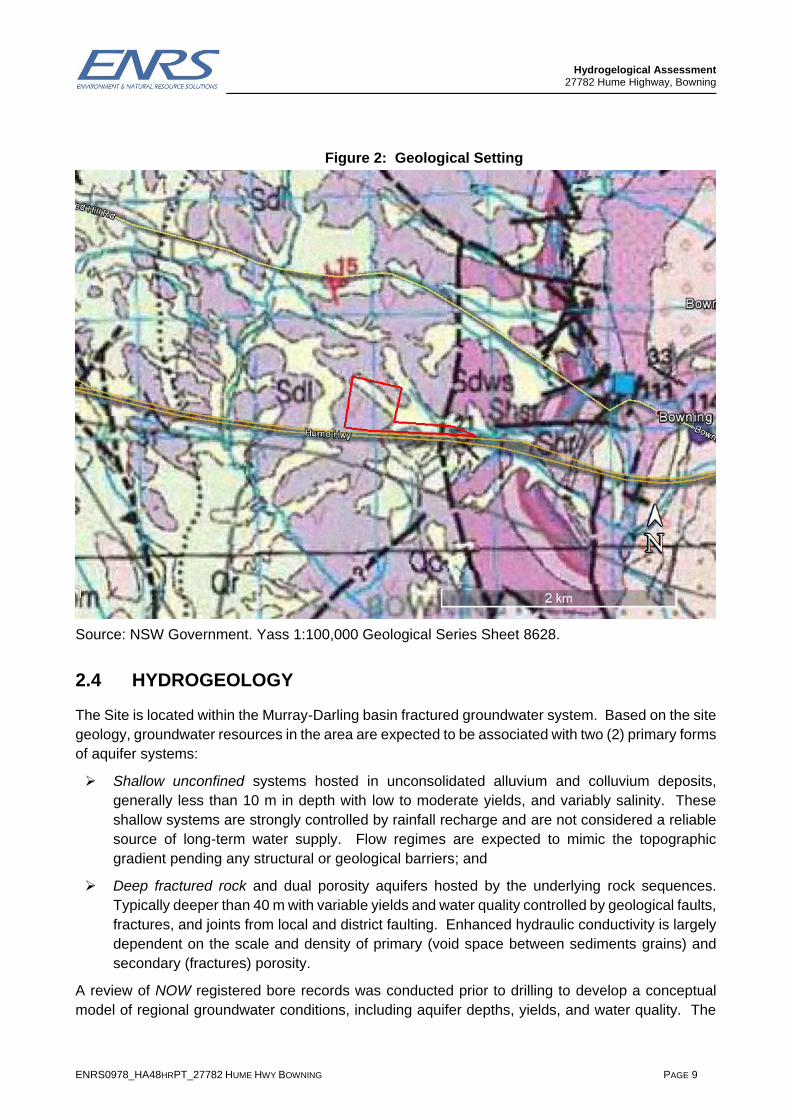
2.3 GEOLOGY
Review of the geological setting was conducted with reference to the Yass 1:100,000 geological
series sheets. The site geology is provided in Figure 2. The assessment area is mapped as
underlain by Laidlaw Volcanic (Sdl) with residual Quaternary deposits in lower lying areas through
the central north and to the east. The mapped geology indicates there is a structural boundary in
the far east of the site where the volcanics meet sedimentary deposits (Sdws-Mudstone). The
stratigraphy is summarised in Table 2 below:
Table 2: Stratigraphic Formations
Period Stratigraphy /
Formation Symbol Lithology
Quaternary Quaternary Qa Alluvial gravel, sand silt and clay.
Siluro-Devon Laidlaw Volcanics Sdl Porphyritic rhyodacitic ignimbrite (extrusive volcanic)
Siluro-Devon Brickies Creek Mudstone
Sdws Light grey to beige aphanitic vitric tuff, light to grey siliceous mudstone
Approximate bore location
Lot 172 DP649063
BOWNING
Hydrogelogical Assessment 27782 Hume Highway, Bowning
ENRS0978_HA48HRPT_27782 HUME HWY BOWNING PAGE 9
Figure 2: Geological Setting
Source: NSW Government. Yass 1:100,000 Geological Series Sheet 8628.
2.4 HYDROGEOLOGY
The Site is located within the Murray-Darling basin fractured groundwater system. Based on the site
geology, groundwater resources in the area are expected to be associated with two (2) primary forms
of aquifer systems:
➢ Shallow unconfined systems hosted in unconsolidated alluvium and colluvium deposits,
generally less than 10 m in depth with low to moderate yields, and variably salinity. These
shallow systems are strongly controlled by rainfall recharge and are not considered a reliable
source of long-term water supply. Flow regimes are expected to mimic the topographic
gradient pending any structural or geological barriers; and
➢ Deep fractured rock and dual porosity aquifers hosted by the underlying rock sequences.
Typically deeper than 40 m with variable yields and water quality controlled by geological faults,
fractures, and joints from local and district faulting. Enhanced hydraulic conductivity is largely
dependent on the scale and density of primary (void space between sediments grains) and
secondary (fractures) porosity.
A review of NOW registered bore records was conducted prior to drilling to develop a conceptual
model of regional groundwater conditions, including aquifer depths, yields, and water quality. The

Hydrogelogical Assessment 27782 Hume Highway, Bowning
ENRS0978_HA48HRPT_27782 HUME HWY BOWNING PAGE 10
search did not identify any registered bores within a one (1) kilometre radius of the site (Figure 3)
which is expected to be well beyond the maximum radius of any potential drawdown due to the low
proposed pumping rate at the Site. The bore search area was expanded to include bores within a 5
km radius of the Site to assess groundwater conditions in other bores within the area. A summary
of the available hydrogeological records is summarised below in Table 3.
➢ Bore depths in the area ranged between 19.5 to 90 metres,;
➢ Yields ranged from 0.18-0.95 L/s;
➢ Standing Water Levels ranged from 3-14m below ground level (mbgl) and
➢ Host units are listed as both volcanic and igneous rocks.
Table 3: Registered Bores within 5 km of the Site
Bore ID Lat. Long. Bore Depth
(m)
Yield L/s
SWL (mbgl)
Aquifer Geology Drilled Date
Use
GW416182 - - 54 0.18 11 18-20, 46-48
0-36 shale, 36-54 volcanics
18/03/2013 S&D
GW061248 -34.7652 148.8065 41.1 0.2 3 16.7-18.2 Shale 1/05/1985 N/A
GW014383 -34.7557 148.7695 25 0.51 13.4 15-25 Granite 1/01/1958 S&D
GW020967 -34.7334 148.8087 37.3 0.59 - 26-37 Porphyry 1/08/1953 N/A
GW016395 -34.7093 148.8093 19.5 0.63 4 14.6-19.5 Porphyry 1/07/1957 S&D
GW031388 -34.7512 148.7606 27.4 0.95 - 18-18.3 Shale 1/01/1967 Unknown
GW409412 -34.7505 148.7663 250 2.13 20 22-39, 96-99
0-60 shale 60-250 granite
15/01/2010 N/A
GW045239 -34.7546 148.7737 34.1 - 14 29-34 Shale 1/04/1976 Monitoring
GW415395 - - 90 - - - - 4/07/1905 Domestic
Note: S&D = Stock and Domestic

Hydrogelogical Assessment 27782 Hume Highway, Bowning
ENRS0978_HA48HRPT_27782 HUME HWY BOWNING PAGE 11
Figure 3: Registered bore locations (Water NSW online database)
3.0 TEST DRILLING
3.1 TEST BORE LICENCE
Prior to commencement ENRS submitted applications for test drilling and borehole construction with
NOW. A Test Bore Licence was issued by NOW under Section 115 of the Water Act 1912. A
summary of the test bore license is provided in Table 4 below:
Table 4: Test Bore Licence Summary
Licence Purpose Lot/DP Issued Valid Number of Bores
40BL192710 Test Bore
263//753596
128//753596
18//246891
172//649063
107//753596
16//246891
262//753596
20/3/2018 Perpetuity 8x Test Bores
Investigation Area
~1km radius

Hydrogelogical Assessment 27782 Hume Highway, Bowning
ENRS0978_HA48HRPT_27782 HUME HWY BOWNING PAGE 12
3.2 SELECTION OF DRILLING TARGETS
Drilling targets were selected following a desktop review of the hydrogeological setting with
consideration of the following:
➢ Test bore licence terms and conditions;
➢ Land tenure and property boundary;
➢ Proximity to geological lineaments and potential groundwater controls;
• 40 m from high bank (blue line on topographic maps);
• 400 m from another WAL bore (irrigation/commercial pumping bore);
• 200 m from a Basic Landholder Right (BLR/stock & domestic) bore;
• 200 m from property boundary (or letter of non-objection from neighbouring landowners);
• 500 m from Town Water Supply (TWS) Bores;
• 400 m from NOW government monitoring bores; and
• 250 m from effluent disposal area (or up/across gradient supported by Hydro
Assessment).
➢ The distribution of alluvial deposits where additional surface casing is required to stabilise the
borehole during drilling;
➢ Suitable distances between boreholes to minimise potential pumping interference;
➢ Suitable distance setback from potential sources of contamination including any dangerous
goods storage and effluent disposal areas; and
➢ Drilling rig access, and proximity to services, namely power and existing reticulation pipelines;
Three (3) test bore targets were identified as Sites A, B, and C. The primary area of interest was
positioned adjacent potential geological lineaments inferred from site topography. The location of
test bore targets is shown in Figure 4.

Hydrogelogical Assessment 27782 Hume Highway, Bowning
ENRS0978_HA48HRPT_27782 HUME HWY BOWNING PAGE 13
Figure 4: Test Bore Targets
3.3 AIRLIFT TEST RESULTS
The bore was subject to minimum three (3) hour airlift test at completion of drilling. The flow rate
during air lifting was recorded by the driller and documented on the Form A construction log.
Bore 1 (Site A) was airlift tested for three (3) hours at an average rate of 1.7 L/s. The bore
sustained a constant flow throughout the duration of the airlift and no significant variation in water
quality (pH and EC) was observed.
3.4 DRILLING RESULTS
Test drilling encountered two (2) metres of shallow soil and clay overlying volcanics. As sufficient
flow was intercepted during the first test bore to warrant construction no further bores were drilled.
A summary of the drilling results is provided below in Table 5:
Table 5:Test Bore Drilling Results
Site E (MGA) N (MGA) Depth Result Status
TB1 664195 6151138 120m 50-52m 0.21 L/s
112-115m 1.47 L/s
Site ‘A’ constructed as Pumping
Bore 1

Hydrogelogical Assessment 27782 Hume Highway, Bowning
ENRS0978_HA48HRPT_27782 HUME HWY BOWNING PAGE 14
4.0 BORE CONSTRUCTION
Drilling and borehole construction was conducted by Bungendore Water Bores during April 2018 in
accordance with the minimum construction requirements for water bores in Australia (3rd ed. 2012).
Details of the bore construction are documented in the ‘Form A’ reports contained in Appendix A
with a summary provided in Table 6 below.
➢ The bore was constructed with 48 metres of rigid surface casing sealed with expanding clay
to prevent connection with surface water and shallow aquifers; and
➢ The bore casing extends above the surface and fitted with a sealed cap to prevent ingress
from any flood water or surface water.
Table 6: Bore Construction Summary
Bore ID Production Bore 1 (TB1)
Easting (MGA 56) 664195
Northing (MGA) 6151138
Drilled Depth (m) 120
Final Depth (m) 120
SWL (metres below ground level - mbgl)
0.5 mbgl (10/4/2018)
Casing (150mm Cl 9) 0-120 m
Slots (150mm Cl 9) 48-54 m 108-120 m
Clay Seal 0-5.0 m
Gravel pack (4-6mm) 5.0-120m
TDS Lab 392 mg/L
EC Lab 602 µS/cm
pH Lab 8.17 pH
5.0 AQUIFER TESTING
5.1 PUMP TEST METHODOLOGY
Pumping test design and methodology was developed and conducted in accordance with the
Australian Standard for Test Pumping of Water Wells (AS 2368-1990). The pumping rate, duration
and depth setting was selected following detailed review of the hydrogeological conditions including
depth of target aquifers, aquifer type, available drawdown, and bore construction. Testing was
conducted using a submersible pump. Water level data was collected in the pumping bore both
manually and automatically with a submersible water level data logger programmed to record water
levels at 10 minute intervals.

Hydrogelogical Assessment 27782 Hume Highway, Bowning
ENRS0978_HA48HRPT_27782 HUME HWY BOWNING PAGE 15
5.2 PUMP TEST RESULTS
A summary of the drawdown and recovery test results is provided in Table 7. Drawdown and
recovery data was tabulated and plotted to produce aquifer response curves. The drawdown and
recovery curves (refer to Appendix B) demonstrate high quality aquifer response data to support
graphical analysis of aquifer properties.
No monitoring bores were constructed at the site during this assessment. Monitoring was conducted
in the pumping bore. Aquifer response data was analysed in Aqtesolv software applying Cooper-
Jacob and Theis straight line methods. Transmissivity (T) values for late drawdown data report
values between 3.99 m2/day and 5.92 m2/day. Whilst the recovery data reports T values between
6.75 m2/day and 7.46 m2/day. From these reported values the Median T is 6.335 m2/day.
The drilling and aquifer test results indicate the subject bore is capable of sustaining discharge rates
of 1.5 L/s supported by equipping the bore with cut out transducers to prevent drawdown below the
available limit at 108 mbgl. Based on the test results it is recommended to operate the bore under
the following pumping regime:
➢ Bore 1 - up to 1.5 L/s; 10 hrs Pumping; 14 hrs Recovery; 20 Mega Litres (ML) per year at 50 %
pumping duty. A higher pumping rate and duty may be realised supported by monitoring of
pumping performance and recovery rates.
Table 7: Summary of Drawdown and Recovery Test Results
Bore ID Bore 1
Test Date 3 / 12 / 2018
Drawdown Test Duration (hrs) 2 Day (48 Hours)
Recovery Test Duration (hrs) 1 Day (26 Hours)
Pump Test Flow Rate (Litres per second) 1.15 L/s
Static Water Level (SWL) (mbgl) 2.5 (pump test)
Aquifers m-m~L/s (reported by driller) 50-52 m ~0.21 L/s
112-115 m ~1.47 L/s
Indicative Yield (driller L/s) 1.7 L/s sustained during 3 hour airlift
Available Drawdown 108 mbgl to top of the slotted casing at the primary aquifer zone.
Final Drawdown during testing 21.28 mbgl (18.78 mbSWL)
Transmissivity (m2/day) ~6.335 m2/day
Recommended discharge rate (L/s) ~1.15 L/s (or Up to 1.5 L/s)
Recommended pump setting (mbgl) Max depth 108m with shroud
Recommended pumping schedule (hrs on – hrs off) 16hr On – 8hr Off
Pump Duty % 66 %
Capable Annual Yield (ML) 24 ML per year
Bore 1 was pump tested for 48 hours at a rate of 1.15 L/s with a maximum drawdown to 21.28 mbgl
(or 18.78 mbSWL). The drawdown curve indicates a relatively steady drawdown rate with no
significant barrier or boundary effects. The driller’s aquifer intercepts and pump test results indicate
the available drawdown is to a depth of 108 mbgl to the top of the slotted casing at the primary

Hydrogelogical Assessment 27782 Hume Highway, Bowning
ENRS0978_HA48HRPT_27782 HUME HWY BOWNING PAGE 16
aquifer zone. Initial water level recovery at completion of pumping is noted to be rapid becoming
gradual. The bore recovered rapidly to within 20 cm of the initial SWL after 24 hours of ceasing to
pump. Groundwater yields are supported by the intersection of dual porosity regional scale aquifers
supported by an extensive recharge area.
The drilling and aquifer test results indicate the subject bore is capable of sustaining discharge rates
greater than 1.15 L/s. It is recommended to operate the bore under the following pumping regime:
➢ Bore 1 – pumping at 1.15L/s; 16 hours on followed by 8 hours recovery; 24 ML per year
at 66 % duty.
5.3 CAPABLE YIELD
Groundwater investigations comprised drilling of one (1) test bore culminating in the construction of
one (1) production bore. The bore has intersected deep fractured rock aquifers supported by an
extensive recharge area and no competing registered groundwater users. Based on the drillers airlift
results the bore has a capable yield of 24 ML per annum operating at 66 per cent duty. The
pumping yield of 1.15 L/s exceeds the estimated peak daily demand for the Site of approximately
30,000 Litres per day (or up to 11 ML per year).
It should be noted that the indicated groundwater extraction regimes are based on the aquifer
response during a 48 hour period of testing and simulation stress. Groundwater extraction should
be supported by appropriate groundwater management practices including regular water level
monitoring. Bore performance may alter as a result of structural and chemical changes within the
bore or due to variations in aquifer recharge, namely extended droughts or reductions in recharge
from rainfall. It is recommended that groundwater bores be pumped on a cyclic pump duty such as
(16 hours on and 8 hours off) to provide for sufficient water level recovery between pumping cycles
and ensure the long-term sustainability of the groundwater resources. The Bore should also be
equipped with cut-out probes to prevent dewatering below the primary aquifer.
6.0 WATER QUALITY
Water samples were collected after 48 hour pumping and submitted to a NATA accredited laboratory
for analysis. The reader is referred to Appendix C for copies of Laboratory Certificates of Analysis
(COA). The following section summarises the key water quality results. In general, the results report
concentrations of key analytes within the criteria set by the Australian Drinking Water Guidelines
(2016). Minor levels of iron and manganese are expected to decrease during long term pumping as
residual sediments from drilling reduce. These minerals may also be managed through primary
treatment and storage:
6.1 POTENTIAL HYDROGEN
pH is a measure of hydrogen activity. pH determines the balance between positive hydrogen ions
(H+) and negative hydroxyl ions (OH-) and provides a test of water acidity (low pH) or alkalinity (high
pH). Most natural freshwaters have a pH in the range 6.5 to 8.0. pH in the bore was reported at
7.57 (B1) which is within the Australian Drinking Water (ADWG;2011) guideline of 6.5-8.5 pH.

Hydrogelogical Assessment 27782 Hume Highway, Bowning
ENRS0978_HA48HRPT_27782 HUME HWY BOWNING PAGE 17
6.2 SALINITY
Salinity reported as TDS is within the ADWG aesthetic criteria which is suitable for the proposed use
(industrial, commercial and domestic). The ADWG note that typical values for TDS in regional water
supplies can be up to 1,000 mg/L or higher due to groundwater characteristics. A summary of the
salinity guidelines for palatability is provided in Table 8.
Table 8: Water Salinity Criteria
Bore ID
TDS Criteria (ADWG;2016) Palatability
0 – 600 Good
600 – 900 Fair
900 – 1200 Poor
>1200 Unacceptable
Bore 1 404 mg/L (600 uS/cm) Good
6.3 METALS AND METALLOIDS
Water samples were analysed for a suite of sixteen (16) selected heavy metals and metalloids
including:
➢ Aluminium (Al);
➢ Arsenic (As);
➢ Boron (B);
➢ Barium (Ba);
➢ Cadmium (Cd);
➢ Calcium (Ca);
➢ Total Chromium (T.Cr.)
➢ Copper (Cu);
➢ Iron (Fe);
➢ Lead (Pb);
➢ Magnesium (Mg);
➢ Manganese (Mn);
➢ Mercury (Hg);
➢ Nickel (Ni);
➢ Silver (Ag); and
➢ Zinc (Zn).
Analysis for Heavy Metals and Metalloids generally reported concentrations below the limits
stipulated in the Australian Drinking Water Guidelines (ADWG 2016). These results are considered
satisfactory. Minor concentrations of total Iron were detected with 0.33 mg/L which is slightly above
the aesthetic criteria of 0.3 mg/L. Similar levels of manganese were reported with 0.591 mg/L.
Table 10.6 of the ADWG (2016) documents that Manganese occurs naturally in water and is higher
in oxygen-depleted water (e.g. groundwater at bottom of deep storages). Section 8.3.5 of the ADWG
(2016) outlines treatment options for iron and manganese by oxidation, through chlorination which
enables ready removal by coagulation, flocculation and filtration. The reported concentrations of
iron and manganese are not expected to limit site operations and may be managed by treatment
and filtration.
7.0 IMPACT ASSESSMENT
7.1 DISTANCE DRAWDOWN
A search of the NOW groundwater database did not identify any licensed water bores within one (1)
kilometre of the assessment site which indicates there is no existing users in proximity to the site.

Hydrogelogical Assessment 27782 Hume Highway, Bowning
ENRS0978_HA48HRPT_27782 HUME HWY BOWNING PAGE 18
Given the significant distance from registered bores and minor drawdown in the bore after continuous
pumping for 48 hours it is assessed that there is a low risk for distance drawdown impacts on existing
groundwater users in the area. No further impact assessment or calculations are considered
necessary.
7.2 GROUNDWATER DEPENDENT ECOSYSTEMS (GDE)
Review of the property and surrounding landuse indicates that the site is located within the Bowning
Creek sub catchment area. It was identified that there is potential for shallow colluvium aquifers to
interact with intermittent streams recorded on the topographic map sheet. An online search of the
Bureau of Meteorology (BOM) GDE atlas was conducted to identify any potential sensitive
ecosystems within 5 km of the Bore. Information held in the GDE atlas includes:
➢ The supplied ecosystem type;
➢ The GDE potential, which is a measure of the assessed dependence potential of the
ecosystem on groundwater resources; and
➢ The Inflow Dependent Ecosystem (IDE) likelihood, which is a measure of the likelihood of the
landscape accessing water in addition to rainfall.
A summary of identified potential ecosystems within 5km of the bore is presented below in Table 9.
Table 9: Identified Potential GDEs
Distance from Bore Site Supplied Ecosystem Type GDE Potential
600m Northern slopes dry grass woodland Low potential
3km Western slopes herb/grass woodland Moderate potential
4km to Bowning Creek
riparian area
Western slopes herb/grass woodland Moderate potential
Further review of the Site’s hydrogeological setting including walkover and aerial imagery did not
identify any GDE’s at the Site. Furthermore, given the borehole has been constructed with solid
casing to 48 metres and at least a five (5) metre clay sanitary seal to prevent inflow of shallow soil
water, this assessment considers the bore to be adequately constructed so as not to be in direct
hydraulic connection with any overlying shallow aquifer. Hence, the proposed pumping from the
deep fractured rock aquifers is not assessed to present any measurable impact on Groundwater
Dependent Ecosystems (GDE’s) in connection with the colluvial systems.

Hydrogelogical Assessment 27782 Hume Highway, Bowning
ENRS0978_HA48HRPT_27782 HUME HWY BOWNING PAGE 19
8.0 CONCLUSIONS AND RECOMMENDATIONS
Based on the findings obtained during the scope of work the following conclusions and
recommendations may be made:
➢ The subject bore was drilled and constructed by Bungendore Water Bores in April 2018. The
bore was drilled to a depth of 120 m with 48 metres of solid surface casing and a 5 metre clay
sanitary seal at the surface to prevent connection with any shallow soil water. The bore was
completed with slotted PVC casing and gravel packed in general accordance with the Minimum
Construction Requirements for Water Bores in Australia – 3rd Edition (2012). The bore
sustained a drillers air lift yield of 1.7 L/s for three (3) hours during test drilling;
➢ The bore was subjected to a 48 hour (Bore 1) drawdown and recovery pumping test. The
results indicate the subject bore is capable of sustaining an allocation of 24ML under the
following pumping regime:
➢ Bore 1 - up to 1.15 L/s; 16 hr Pumping; 8 hrs Recovery; 24 ML per year at 66 % duty. A higher pumping rate and operating duty may be realised supported by monitoring of pumping performance and recovery rates.
➢ The proposal is to convert the test bore to a production bore with a commercial, industrial and
domestic groundwater access licence with an entitlement of 24 ML to facilitate the proposed
development. The pumping yield of 1.15 L/s exceeds the estimated peak demand for the Site
proposal of approximately 30,000 Litres per day (or up to 11 ML per year);
➢ Based on the capable yield the recommended pumping regime is considered low risk for
groundwater impacts. Final drawdown in the bore was 21.28 mbgl which is significantly
shallower than the available drawdown limit at a depth of 108 m below ground level at the top
of the slotted casing and the primary aquifer zone. No registered water bores are present
within a 1 km radius of the site and similarly no GDEs were identified at the Site area. Hence,
it is assessed that under the proposed operating regime the bore will have no significant
measurable impact on the groundwater environment and existing users in the area;
➢ NATA certificated laboratory results report water quality is generally within the criteria outlined
by the ADWG (2016). Minor levels of iron and manganese are expected to reduce with
long-term pumping as drilling sediment decrease, and any residual levels may be managed
through primary treatment systems; and
➢ It is recommended that this report be submitted for final endorsement by the regulator.
Hydrogelogical Assessment 27782 Hume Highway, Bowning
ENRS0978_HA48HRPT_27782 HUME HWY BOWNING PAGE 20
9.0 REFERENCES
Cooper H.H. and Jacob C.E. 1946. A Generalised Graphical Method for Evaluating
Constants and Summarising Field History. Trans. Amer. Geophys. Union. Vol. 27,
pp.526
Australian Government National Water Commission (2012). Minimum Construction
Requirements for Water Bores in Australia (third Edition).
Australian Government, 2016. Australian Drinking Water Guidelines 6. National Water
Quality Management Strategy. Natural Resource Management Ministerial Council.
National Health and Medical Research Council.
Australian Standard AS 2368--1990 Test Pumping of Water Wells
Murray-Darling Basin Commission 1997, Murray-Darling Basin Groundwater Quality
Sampling Guidelines, Technical Report No. 3, MDBC Groundwater Working Group,
Commonwealth of Australia.
Standards Australia 1998a, AS/NZS 5667.1:1998 Water quality sampling guidance on
the design of sampling programs, sampling techniques and the preservation and
handling of samples
Standards Australia, New South Wales. 1998b, AS/NZS 5667.11:1998 Water Quality
Sampling Guidance on Sampling of Groundwaters, Standards Australia, New South
Wales.
Hydrogelogical Assessment 27782 Hume Highway, Bowning
ENRS0978_HA48HRPT_27782 HUME HWY BOWNING PAGE 21
10.0 REFERENCES
Air-lift yield: a yield obtained using compressed air (via a compressor normally coupled to a drilling rig) to lift water flowing into a well to the surface, to enable measurement of its flow.
Alluvium: Sediment (gravel, sand, silt, clay) transported by water (i.e. deposits in a stream channel or floodplain).
Anisotropy: The condition of a porous medium where the permeability is different in different directions.
Aquiclude: A low-permeability unit that forms either the upper or lower boundary of a groundwater flow system.
Aquifer: Rock or sediment in a formation, group of formations, or part of a formation which is saturated and sufficiently permeable able to transmit quantities of water to wells and springs. An aquifer may be porous rock, unconsolidated gravel, fractured rock, or cavernous limestone.
Aquitard: A low-permeability unit than can store ground water and also transmit it slowly from one aquifer to another.
Beneficial Use: general categorization of groundwater uses based on water quality and the presence or absence of contaminants. Beneficial use is the equivalent to the environmental value of water.
Bore: A deep hole of small diameter bored into the aquifer, through which water equilibrates and may rise under hydrostatic pressure.
Colluvium: Sediment (gravel, sand, silt, clay) transported by gravity (i.e. deposits at the base of a slope).
Cone of Depression: The depression in the water table around a well or excavation defining the area of influence of the well. Also known as cone of influence.
Confined Aquifer: an aquifer that is overlain by a confining bed. The confining bed has a significantly lower hydraulic conductivity than the aquifer.
Drawdown: A lowering of the water table of an unconfined aquifer or the potentiometric surface of a confined aquifer caused by pumping of ground water from wells or excavations.
Dual porosity aquifer: upon pumping releases water from both intergranular pores and fractures
Environmental flow: A water regime provided within a river, wetland or estuary to improve or maintain ecosystems and their benefits where there are competing water uses and where flows are regulated.
Groundwater Dependant Ecosystems (GDE): GDEs are ecosystems that use groundwater as part of survival, and can potentially include wetlands, vegetation, mound springs, river base flows, cave ecosystems, playa lakes and saline discharges, springs, mangroves, river pools, billabongs and hanging swamps. The groundwater dependence of ecosystems will range from complete reliance to those that partially rely on groundwater, such as during droughts.
Groundwater recharge: Inflow of water to an aquifer from the surface. Infiltration of precipitation and its movement to the water table is one form of natural recharge.
Hanging swamps: ancient freshwater wetlands often rich in biodiversity. The soil structure is fragile generally with low fertility and a loose structure that is highly susceptible to erosion and fire. Hanging Swamps rarely show surface water, but large amounts of water are often held in

Hydrogelogical Assessment 27782 Hume Highway, Bowning
ENRS0978_HA48HRPT_27782 HUME HWY BOWNING PAGE 22
the soil beneath the surface, filtering through the swamp and flowing into the downstream creek. The Hanging swamps in the Hawkesbury-Nepean catchment have been identified as an Endangered Ecological Community under the Environment Protection and Biodiversity Conservation Act 1999 (EPBC Act).
Hydraulic Conductivity The ease with which a fluid will flow through a porous medium. It is a function of the pore size and fluid properties of viscosity and density.
Hydraulic gradient: The hydraulic gradient is a vector gradient between two or more hydraulic head measurements over the length of the flow path. The distribution of hydraulic head through an aquifer determines where groundwater will flow.
Hydrogeology: The branch of geology that deals with the occurrence, distribution, and effect of groundwater.
Igneous intrusions: Igneous intrusions are rocks which form when magma cools and solidifies before it reaches the earth’s surface. Three common types of intrusion are sills, dykes, and batholiths.
Infiltration: The flow of water downward from the land surface into and through the upper soil layers.
Losing Stream A stream in which the water surface is lower than the adjacent water table, thus causing water to flow from the groundwater system into the stream.
Packer test: An aquifer test performed in an open borehole; the segment of the borehole to be tested is sealed off from the rest of the borehole by inflating seals, called packers, both above and below the segment.
Perched aquifer: A region in the unsaturated zone where the soil or rock may be locally saturated because it overlies a low-permeability unit.
Permeability The property of a porous medium to transmit water. It is a function of pore diameter.
Piezometer: A non-pumping well, generally of small diameter, that is used to measure the elevation of the water-table or potentiometric surface. A piezometer generally has a short well screen through which water can enter.
Porosity: ratio of pore spaces and voids to that of solid aquifer matrix.
Potentiometric surface: a pressure head surface commonly, but sometimes incorrectly referred to as the water table. The movement of groundwater is largely driven by elevation (pressure head). Aka as piezometric head – a piezometer being a special bore that monitors pressure head.
Primary Porosity The porosity characteristic of a rock or soil when first formed.
Pumping Test: A test made by pumping a well for a period of time and observing the response/change in hydraulic head in the aquifer.
Secondary Porosity The porosity that is added to a rock or soil after formation; it can include faults, fissures, fractures, etc.
Semi-Confined Aquifer An aquifer overlain or underlain by a semi-permeable aquitard which will allow limited flow of water to pass through.
Slug Test: A test made by the instantaneous addition, or removal, of a known volume of water to or from a well. The subsequent well recovery is measured.

Hydrogelogical Assessment 27782 Hume Highway, Bowning
ENRS0978_HA48HRPT_27782 HUME HWY BOWNING PAGE 23
Specific yield: effective or drainable porosity – a measure of the ratio of groundwater that may be extracted from an aquifer relative to the solid matrix.
Spring: a location where groundwater naturally emerges from the earth’s subsurface in a seep or defined flow. Occurs when the water table is higher than the ground surface. Pressure head forces the water out of the land at a weak point which creates the spring. The existence of a spring requires that below the subsurface, the infiltrating water encounters a low-permeability zone and is unable to continue to percolate downward as fast as it is supplied at the surface. As a result, the water spreads laterally until it intersects the land surface where erosion has lowered the topography to the water’s level (e.g., on the side of a gully, hill or valley). For many people, springs are the most obvious and interesting evidence of groundwater.
Standing Water Level: Depth to groundwater (m) below a datum point or reference point, usually from the top of casing or natural surface.
Storativity: The volume of water an aquifer releases from or takes into storage per unit surface area of the aquifer, per unit change in head.
Sustainable yield: volume of groundwater that may be abstracted from an aquifer without detrimentally affecting existing supplies or flows / fluxes to the environment including groundwater dependent environments. The estimation of sustainable yield takes into account rainfall amount, recharge as a proportion of rainfall and environmental water requirements (environmental flows to creeks as ‘baseflow’ and groundwater dependent ecosystems).
Transmissivity: A measure of the rate at which water moves through an aquifer of unit width under a unit hydraulic gradient.
Unconfined Aquifer: An aquifer in which there are no confining beds between the saturated zone and the surface. There will be a water-table in an unconfined aquifer.
Unsaturated zone: The zone between the land surface and the water table. It includes the root zone, intermediate zone, and capillary fringe. The pore spaces contain water at less than atmospheric pressure, as well as air and other gases. Saturated bodies, such as perched ground water, may exist in the unsaturated zone. Also called zone of aeration and vadose zone.
Water budget: An evaluation of all the sources of supply and the corresponding discharges with respect to an aquifer or a drainage basin.

Hydrogelogical Assessment 27782 Hume Highway, Bowning
ENRS0978_HA48HRPT_27782 HUME HWY BOWNING PAGE 24
LIMITATIONS
This report and the associated services performed by ENRS are in accordance with the scope of
services set out in the contract between ENRS and the Client. The scope of services was defined
by the requests of the Client, by the time and budgetary constraints imposed by the Client, and by
the availability of access to Site.
ENRS derived the data in this report primarily from visual inspections, and, limited sample collection
and analysis made on the dates indicated. In preparing this report, ENRS has relied upon, and
presumed accurate, certain information provided by government authorities, the Client and others
identified herein. The report has been prepared on the basis that while ENRS believes all the
information in it is deemed reliable and accurate at the time of preparing the report, it does not
warrant its accuracy or completeness and to the full extent allowed by law excludes liability in
contract, tort or otherwise, for any loss or damage sustained by the Client arising from or in
connection with the supply or use of the whole or any part of the information in the report through
any cause whatsoever.
Limitations also apply to analytical methods used in the identification of substances (or parameters).
These limitations may be due to non-homogenous material being sampled (i.e. the sample to be
analysed may not be representative), low concentrations, the presence of ‘masking’ agents and the
restrictions of the approved analytical technique. As such, non-statistically significant sampling
results can only be interpreted as ‘indicative’ and not used for quantitative assessments.
The data, findings, observations, conclusions and recommendations in the report are based solely
upon the state of Site at the time of the investigation. The passage of time, manifestation of latent
conditions or impacts of future events (e.g. changes in legislation, scientific knowledge, land uses,
etc) may render the report inaccurate. In those circumstances, ENRS shall not be liable for any loss
or damage that may be occasioned directly or indirectly through the use of, or reliance on, the
contents of the report.
This report has been prepared on behalf of and for the exclusive use of the Client, and is subject to
and issued in connection with the provisions of the agreement between ENRS and the Client. ENRS
accepts no liability or responsibility whatsoever and expressly disclaims any responsibility for or in
respect of any use of or reliance upon this report by any third party or parties.
It is the responsibility of the Client to accept if the Client so chooses any recommendations contained
within and implement them in an appropriate, suitable and timely manner.

ENRS0978_HA48HRPT_27782 HUME HWY BOWNING
Appendix A Form A Drillers Logs

27782 Hume Hwy Bowning Supply Bore
NSW DEPARTMENT OF WATER & ENERGY
Natural Resource Products
B L 40BL192710
Completion Date:
DRILLING DETAILS
Other (specify)
WATER BEARING ZONES
CASING / LINER DETAILS
Casing support method Code
Type of casing bottom Code
Centralisers installed No Yes (indicate on sketch)
Sump installed No Yes From m To m
Pressure cemented No Yes From m To m
Casing Protector cemented in place No Yes
WATER ENTRY DESIGN
GRAVEL PACK
Litres or m3
Rounded Graded
Crushed Ungraded
Bentonite/Grout seal No Yes
Method of placement of Gravel Pack 1
For D W E use only: G W
To
Code
1
54
120.0 m
From
Code
Aperture
(mm)Code
type
General Screen
Final Depth
120
Driller's Licence No:
Assistant Driller:
Class of Licence:
Driller's Name:
1623
4
Danny Hill
Gerry Hill
Slot Details
Material
Code
OD Wall Fixing
From To
Depth
(m)
From To
(mm)
Grade
Type Grain size Quantity
Thickness
(mm) (m)
Opening
602112 115 3
0.21
0.5
0.21
Aquifer
50
1.471.26
1
Code
Material
OD
5
(mm)
150
From ToWall
1
(m)
2
(mg/L)
Hrs
0
0.5
120
Code
min Cond.
FixingThickness
Salinity
Cumulative
Estimated Yield Test
Individual TDS
120
5
method
Width
(mm)
1
Duration
(mm) (m)
(m)
(L/s)
(mm)
D D L
Length
5
150
5 108
150
48
V
5
1
0 5
6 5 120
Wayne Lawrence
Domestic Supply
Code(m)
To
Hole
(mm)
Code
40
Intended Use:
Name of Licensee:
Work Licence No:
Replacement bore
Enlarged (m)
4
52
(m) (m) (m) (m)
5
From
To Thickness S W L (Conductivity or TDS)at end of test
Code
V
(mm)
2
2
Alignment
(m)
Method
Apr-18
Diameter
200
Drilling
Method
Contractor: Bungendore Water Bores
From
Reconditioned
New bore
Deepened
0
FORM A PARTICULARS OF COMPLETED WORK
3
21
4
5
7
6
Page 1
X
X
X
XX
X
(μS/cm)

27782 Hume Hwy Bowning Supply Bore
NSW DEPARTMENT OF WATER & ENERGY
Natural Resource Products
Work Licence No: 4 0 40BL192710
Chemical used for breaking down drilling mud No Yes Name:
Other:
hrs hrs hrs hrs hrs hrs
Height of measuring point above ground level Test Method Code See Code Table 4
Original depth of work: metres Is work partly backfilled: No Yes
Is work abandoned: No Yes Method of abandonment: Backfilled Plugged Capped
Has any casing been left in the work No Yes From m To m
Site chosen by: Hydrogeologist Geologist Driller Diviner Client Other
Lot No DP No
Work Location Co ordinates Easting Northing Zone
GPS: No Yes >> AMG/AGD or MGA/GDA (See explanation)
Please mark the work site with "X" on the DWE CLID map.
Indicate also the distances in metres from two (2) adjacent boundaries, and attach the map to this Form A package.
Driller: Licensee:
Date: Date:
BORE DEVELOPMENT
DISINFECTION ON COMPLETION
PUMPING TESTS ON COMPLETION
Recovery
Single stage
16
To depth
(m)
From depthFrom depth To depth
246891
Danny Hill (on behalf of applicant)
9/05/2018 9/05/2018
664195 6151138 55H
Signatures:
WORK PARTLY BACKFILLED OR ABANDONED
(m)
Sealing / fill type
(constant rate)
Sealing / fill type
Code(m)(m)Code
Stage 1
Stage 2
Stage 3
Stage 4
Multi stage
(stepped
drawdown)
(mins)(hrs)
level
(m)
of Test Time taken
Quantity applied (litres)
Pump
Water
Durationat end of
pumping
Method JettingBailing/Surging Airlifting
Duration
Backwashing
Chemical/s used Method of application
(m)
Test
type
intake
depth
(SWL)
(m)
(DDL)
(m)
Date Water
Level rate
Initial
B L
3
(L/s)
Pumping
(hrs)
Water Level
Pumping
FORM A …………………..PARTICULARS OF COMPLETED WORK
x
X
8
11
10
9
12
13
Page 2
X
X
XX
X

27782 Hume Hwy Bowning Supply Bore
NSW DEPARTMENT OF WATER & ENERGY
Natural Resource Products
Work Licence No: 4 0 40BL192710
Method of excavation: Hand dug Back hoe Dragline Dozer Other
(m)
Geologist log No Yes Laboratory analysis of water Sample No Yes Pumping test(s) No Yes
Geophysical log No Yes Sieve analysis of aquifer material No Yes Installed Pump details No Yes
80
60
65
40
45
50
55
2
33
56
120
120
110
95
115
85
90
70
75
100
105
Please attach copies of the following if available
To DepthDimentions ofLining
material liner (m)
From Depth
(m)
Depth
(m)
Length
(m)
WORK NOT CONSTRUCTED BY DRILLING RIG
Width
(m)
Diameter
(m)
0
2
30
35
56
Soil, brow clay
Light brown volcanics
Black fractured volcanics
Grey brown volcanics33
B L
(m)
To
(m)
Description
Depth
DRILLER'S ROCK/STRATA DESCRIPTION (LITHOLOGY)
WORK CONSTRUCTION
SKETCHFrom
FORM A …………………..PARTICULARS OF COMPLETED WORK
15
16
17
Page 3
X
X
X
X X
X
6" Class 9 PVC Casing 0-120m4-6mm
Graded gravel pack 5-120m
6" Class 9 slotted PVC 48-54m
Clay 0-5m
6" Class 9 slotted PVC 108-120m

Bowning Bore 1 – During Pump Test
664195E 6151138N
➢ The bore is constructed with 48 metres of rigid surface casing sealed with expanding clay to
prevent connection with surface water and shallow aquifers; and
➢ The bore casing extends above the surface and is finished with a monument pad and fitted with
a sealed cap to prevent ingress from any flood water or surface water.

Bore Location Work Licence No: 40BL: 40BL192710
700 m
N
➤➤
NImagery © Department Finance, Services and Innovation 2016
Imagery © Department Finance, Services and Innovation 2016
Imagery © Department Finance, Services and Innovation 2016
Data © Department Finance, Services and Innovation 2016
Data © Department Finance, Services and Innovation 2016
Data © Department Finance, Services and Innovation 2016
Lot 172DP 649063

ENRS0978_HA48HRPT_27782 HUME HWY BOWNING
Appendix B Pump Test Results

TABLE 1
DRAWDOWN ANALYSIS DATA PROJECT : Bowning
SINGLE RATE PUMP TEST CLIENT : -
Test date : 3/12/2018 BORE No # Pumping Bore #1
Start time : 12:00 PM Tested by: GoulProd
Pump Off: 5/12/2018 12:30 PM Av.Pump Rate (L/sec): 1.15L/s
Casing I.D.: 150 mm SWL (mbtoc): 2.50
Pump type/mod: - Ref. Point (m): 0.00
Pump O.D.: -
Pump Intake m: 100m Depth to water Discharge Time
Time Drawdown metres below Rate to fill Comments /
Real time Hours minutes metres ground level L/sec 200L Observations
T S1 mbgl Q Secs
12:00 PM 0 0.00 2.50 - - = SWL
10 8.35 10.85 - -
20 9.15 11.65 - - Note: Data recorded at
30 9.25 11.75 20.00 10.0 10 minute intervals
40 10.33 12.83 - - on Diver Logger
50 10.13 12.63 - -
1:00 PM 1 60 9.99 12.49 20.00 10.0
70 11.50 14.00 - -
80 12.12 14.62 - -
90 12.60 15.10 17.39 11.5
2:00 PM 2 120 12.72 15.22 13.99 14.3
130 12.80 15.30 10.00 20.0
150 13.00 15.50 - -
3:00 PM 3 180 13.27 15.77 - -
210 13.41 15.91 - -
4:00 PM 4 240 13.66 16.16 - -
270 13.82 16.32 - -
5:00 PM 5 300 13.31 15.81 - -
330 13.38 15.88 - -
6:00 PM 6 360 13.45 15.95 - -
7 420 15.12 17.62 10.00 20.0
8 480 15.13 17.63 - -
9:00 PM 9 540 14.64 17.14 - -
10 600 14.72 17.22 9.09 22.0
11 660 14.77 17.27 - -
11 670 15.53 18.03 - -
12:00 AM 12 720 15.91 18.41 - -
14 840 16.06 18.56 - -
16 960 16.14 18.64 - -
6:00 AM 18 1080 16.34 18.84 - -
8:00 AM 20 1200 16.52 19.02 8.40 23.8
20.2 1210 16.56 19.06 10.00 20.0
20.3 1220 16.56 19.06 10.00 20.0
12:00 PM 24 1440 17.14 19.64 - -
28 1680 18.77 21.27 - -
32 1920 18.18 20.68 - -
36 2160 18.37 20.87 - -
40 2390 18.65 21.15 - -
44 2640 18.54 21.04 - -
12:00 PM 48 2880 18.78 21.28 - -
ENRS0978_Bowning 48ht PT 1

TABLE 2
RECOVERY ANALYSIS DATA PROJECT : Bowning0
SINGLE RATE PUMP TEST CLIENT : -
Test date : 3/12/2018 BORE No # Pumping Bore #1
Start time : 12:00 PM Tested by: GoulProd
Pump Off: 5/12/2018 12:30 PM Av.Pump Rate (L/sec): 1.15L/s
Casing I.D.: 150 mm SWL (mbtoc): 2.5
Pump type/mod: - Ref. Point (m): 0.00
Pump O.D.: -
Pump Intake m: 100m
Minutes Time since Depth to water Residual Comments /
Real time since pump pump stopped metres below Drawdown Observations
Started Hrs Minutes ground level Ratio metres
t t' mbgl t/t' S'
12:30 PM 2910 0.1 21.25 29101 18.75 = depth to water at
2920 10 8.31 292 5.81 instant pump stopped
2930 20 7.09 147 4.59
2940 30 6.68 98.0 4.18
2950 40 6.39 73.8 3.89
2960 50 6.16 59.2 3.66
1:30 PM 2970 1 60 5.94 49.5 3.44
2980 70 5.77 42.6 3.27
2990 80 5.61 37.4 3.11
3000 90 5.47 33.3 2.97
2:30 PM 3030 2 120 5.08 25.3 2.58
3060 150 4.78 20.4 2.28
3:30 PM 3090 3 180 4.53 17.2 2.03
3120 210 4.32 14.9 1.82
4:30 PM 3150 4 240 4.15 13.1 1.65
3180 270 4.00 11.8 1.50
5:30 PM 3210 5 300 3.87 10.7 1.37
3240 330 3.76 9.8 1.26
6:30 PM 3270 6 360 3.67 9.1 1.17
7:30 PM 3330 7 420 3.50 7.9 1.00
8:30 PM 3390 8 480 3.38 7.1 0.88
9:30 PM 3450 9 540 3.27 6.4 0.77
10:30 PM 3510 10 600 3.19 5.9 0.69
11:30 PM 3570 11 660 3.13 5.4 0.63
12:30 AM 3630 12 720 3.05 5.0 0.55
2:30 AM 3750 14 840 2.93 4.5 0.43
4:30 AM 3870 16 960 2.87 4.0 0.37
6:30 AM 3990 18 1080 2.81 3.7 0.31
8:30 AM 4110 20 1200 2.76 3.4 0.26
12:30 PM 4350 24 1440 2.68 3.0 0.18
2:30 PM 4470 26 1560 2.64 2.9 0.14
- - - - - - -
- - - - - - -
- - - - - - -
- - - - - - -
- - - - - - -
- - - - - - -
- - - - - - -
- - - - - - -
ENRS0978_Bowning 48ht PT 2

ENRS0978_Bowning 48ht PT 3
0
1
2
3
4
5
6
7
8
9
10
11
12
13
14
15
16
17
18
19
20
1 10 100 1000
Dra
wd
ow
n &
Resid
ual D
raw
do
wn
(m
bS
WL
)
Time in Minutes & Ratio T/t'
Drawdown & Recovery Curves - Bowning Bore 1 Pumping at 1.15 for 48 Hours
Drawdown Recovery
Transmissivity (T)≈6.7m2/day based on early recovery data.≈5.9m2/day based on late drawdown data.

ENRS0978_Bowning 48ht PT 4
0
10
20
30
40
50
60
70
80
90
100
110
120
Dra
wd
ow
n (
m b
elo
w g
rou
nd
level)
Time since pump started (min)
Time-Drawdown & Recovery - Bowning Bore 1 Pumping at 1.15 L/sec for 48 Hours
Drawdown Recovery
SWL ~2.5 mbgl
Available Drawdown to top of screen at 108-120 metres
50-52m aquifer yield 0.21L/s
112-115m aquifer yield 1.26L/s

AQTESOLV for Windows
Data Set: Date: 12/17/18Time: 11:15:23
PROJECT INFORMATION
Company: ENRSProject: ENRS0978Location: BowningTest Date: 3/12/2018Test Well: Bore 1
AQUIFER DATA
Saturated Thickness: 3. mAnisotropy Ratio (Kz/Kr): 1.
PUMPING WELL DATA
No. of pumping wells: 1
Pumping Well No. 1: Bore 1
X Location: 0. mY Location: 0. m
Casing Radius: 0.075 mWell Radius: 0.11 m
Fully Penetrating Well
No. of pumping periods: 3
Pumping Period DataTime (min) Rate (L/sec) Time (min) Rate (L/sec)
1. 1.15 2881. 0.2880. 1.15
OBSERVATION WELL DATA
No. of observation wells: 1
Observation Well No. 1: Bore 1
X Location: 0. mY Location: 0. m
Radial distance from Bore 1: 0. m
Fully Penetrating Well
No. of Observations: 455
Observation DataTime (min) Displacement (m) Time (min) Displacement (m)
10. 8.35 2290. 18.5620. 9.145 2300. 18.5330. 9.253 2310. 18.5240. 10.33 2320. 18.5150. 10.13 2330. 18.6460. 9.991 2340. 18.5470. 11.5 2350. 18.5780. 12.12 2360. 18.5790. 12.6 2370. 18.63100. 12.56 2380. 18.62110. 12.59 2390. 18.65120. 12.72 2400. 18.68
12/17/18 1 11:15:23

AQTESOLV for Windows
Time (min) Displacement (m) Time (min) Displacement (m)130. 12.8 2410. 18.64140. 12.93 2420. 18.66150. 13. 2430. 18.63160. 13.09 2440. 18.69170. 13.19 2450. 18.66180. 13.27 2460. 18.67190. 13.31 2470. 18.62200. 13.4 2480. 18.64210. 13.41 2490. 18.62220. 13.56 2500. 18.63230. 13.63 2510. 18.49240. 13.66 2520. 18.63250. 13.71 2530. 18.54260. 13.8 2540. 18.51270. 13.82 2550. 18.56280. 13.42 2560. 18.56290. 13.31 2570. 18.48300. 13.31 2580. 18.5310. 13.31 2590. 18.5320. 13.34 2600. 18.51330. 13.38 2610. 18.44340. 13.41 2620. 18.55350. 13.4 2630. 18.58360. 13.45 2640. 18.54370. 13.47 2650. 18.55380. 13.5 2660. 18.62390. 13.5 2670. 18.6400. 13.55 2680. 18.61410. 13.56 2690. 18.65420. 15.12 2700. 18.63430. 15.95 2710. 18.68440. 16.39 2720. 18.67450. 16.51 2730. 18.7460. 16.61 2740. 18.71470. 16.58 2750. 18.78480. 15.13 2760. 18.78490. 14.82 2770. 18.78500. 14.7 2780. 18.78510. 14.7 2790. 18.73520. 14.7 2800. 18.87530. 14.65 2810. 18.83540. 14.64 2820. 18.86550. 14.67 2830. 18.95560. 14.67 2840. 18.9570. 14.67 2850. 18.75580. 14.68 2860. 18.85590. 14.75 2870. 18.85600. 14.72 2880. 18.78610. 14.74 2890. 18.78620. 14.76 2900. 18.84630. 14.77 2910. 18.75640. 14.76 2920. 5.813650. 14.77 2930. 4.591660. 14.77 2940. 4.183670. 15.53 2950. 3.885680. 15.84 2960. 3.656690. 15.9 2970. 3.441700. 15.9 2980. 3.272710. 15.9 2990. 3.107720. 15.91 3000. 2.968730. 15.92 3010. 2.832740. 15.92 3020. 2.706750. 15.95 3030. 2.584760. 15.97 3040. 2.491770. 15.98 3050. 2.377780. 15.99 3060. 2.276
12/17/18 2 11:15:23

AQTESOLV for Windows
Time (min) Displacement (m) Time (min) Displacement (m)790. 15.98 3070. 2.201800. 16.02 3080. 2.111810. 16.03 3090. 2.029820. 16.03 3100. 1.957830. 16.05 3110. 1.893840. 16.06 3120. 1.821850. 16.08 3130. 1.749860. 16.1 3140. 1.699870. 16.11 3150. 1.646880. 16.08 3160. 1.595890. 16.07 3170. 1.545900. 16.15 3180. 1.502910. 16.09 3190. 1.452920. 16.09 3200. 1.409930. 16.14 3210. 1.37940. 16.15 3220. 1.327950. 16.14 3230. 1.298960. 16.14 3240. 1.262970. 16.18 3250. 1.233980. 16.16 3260. 1.205990. 16.18 3270. 1.173
1000. 16.21 3280. 1.141010. 16.2 3290. 1.1011020. 16.2 3300. 1.0691030. 16.24 3310. 1.0511040. 16.25 3320. 1.0291050. 16.27 3330. 0.99691060. 16.27 3340. 0.97541070. 16.31 3350. 0.95751080. 16.34 3360. 0.9361090. 16.38 3370. 0.91451100. 16.42 3380. 0.8931110. 16.38 3390. 0.87511120. 16.44 3400. 0.86441130. 16.44 3410. 0.84291140. 16.47 3420. 0.83211150. 16.44 3430. 0.80341160. 16.48 3440. 0.79271170. 16.47 3450. 0.77121180. 16.51 3460. 0.75691190. 16.49 3470. 0.74971200. 16.52 3480. 0.72821210. 16.56 3490. 0.71741220. 16.56 3500. 0.69951230. 16.6 3510. 0.68521240. 16.57 3520. 0.66731250. 16.57 3530. 0.66731260. 16.6 3540. 0.64941270. 16.63 3550. 0.63861280. 16.63 3560. 0.62431290. 16.62 3570. 0.62791300. 16.64 3580. 0.60641310. 16.71 3590. 0.60281320. 16.67 3600. 0.58491330. 17. 3610. 0.56691340. 17.02 3620. 0.55621350. 17.06 3630. 0.55261360. 17.01 3640. 0.55261370. 17.08 3650. 0.53111380. 17.08 3660. 0.52391390. 17.06 3670. 0.52041400. 17.05 3680. 0.50241410. 17.08 3690. 0.50241420. 17.11 3700. 0.49171430. 17.06 3710. 0.48091440. 17.14 3720. 0.4702
12/17/18 3 11:15:23

AQTESOLV for Windows
Time (min) Displacement (m) Time (min) Displacement (m)1450. 17.22 3730. 0.45231460. 17.17 3740. 0.44151470. 17.14 3750. 0.43081480. 17.14 3760. 0.43081490. 17.11 3770. 0.421500. 17.09 3780. 0.40931510. 17.13 3790. 0.40931520. 17.17 3800. 0.40931530. 17.17 3810. 0.39851540. 17.16 3820. 0.38781550. 17.13 3830. 0.38781560. 17.15 3840. 0.3771570. 17.16 3850. 0.38061580. 17.16 3860. 0.36991590. 17.16 3870. 0.36991600. 18.17 3880. 0.36631610. 18.42 3890. 0.35911620. 18.44 3900. 0.33761630. 18.68 3910. 0.34481640. 18.93 3920. 0.33761650. 18.89 3930. 0.33761660. 18.94 3940. 0.32691670. 18.95 3950. 0.31611680. 18.77 3960. 0.31611690. 17.11 3970. 0.31611700. 16.7 3980. 0.30541710. 16.63 3990. 0.30541720. 16.55 4000. 0.29461730. 16.51 4010. 0.29461740. 17.44 4020. 0.28741750. 17.82 4030. 0.28741760. 17.99 4040. 0.27671770. 18.09 4050. 0.28391780. 18.08 4060. 0.27311790. 18.13 4070. 0.28391800. 18.14 4080. 0.27671810. 18.14 4090. 0.25521820. 18.18 4100. 0.26591830. 18.27 4110. 0.26241840. 18.28 4120. 0.26241850. 18.32 4130. 0.25521860. 18.31 4140. 0.25521870. 18.2 4150. 0.24441880. 18.18 4160. 0.2481890. 18.17 4170. 0.24441900. 18.25 4180. 0.2481910. 18.09 4190. 0.23731920. 18.18 4200. 0.23371930. 18.14 4210. 0.23731940. 18.08 4220. 0.22651950. 18.01 4230. 0.22651960. 18.06 4240. 0.22651970. 18.14 4250. 0.22291980. 18.09 4260. 0.22291990. 18.16 4270. 0.22292000. 18.2 4280. 0.2052010. 18.26 4290. 0.21222020. 18.17 4300. 0.21222030. 18.36 4310. 0.19432040. 18.27 4320. 0.20142050. 18.32 4330. 0.19432060. 18.18 4340. 0.18352070. 18.34 4350. 0.18352080. 18.26 4360. 0.18352090. 18.34 4370. 0.17992100. 18.36 4380. 0.1728
12/17/18 4 11:15:23

AQTESOLV for Windows
Time (min) Displacement (m) Time (min) Displacement (m)2110. 18.35 4390. 0.17282120. 18.38 4400. 0.16562130. 18.39 4410. 0.16562140. 18.5 4420. 0.1622150. 18.39 4430. 0.16562160. 18.37 4440. 0.16562170. 18.43 4450. 0.15492180. 18.37 4460. 0.15132190. 18.34 4470. 0.14412200. 18.51 4480. 0.14052210. 18.53 4490. 0.13342220. 18.54 4500. 0.12262230. 18.54 4510. 0.12982240. 18.61 4520. 0.12262250. 18.54 4530. 0.1192260. 18.62 4540. 0.1192270. 18.61 4550. 0.1192280. 18.65
SOLUTION
Pumping TestAquifer Model: ConfinedSolution Method: Cooper-Jacob
VISUAL ESTIMATION RESULTS
Estimated Parameters
Parameter EstimateT 6.07 m2/dayS 0.002893
K = T/b = 2.023 m/day (0.002342 cm/sec)Ss = S/b = 0.0009642 1/m
12/17/18 5 11:15:23

10. 100. 1000. 1.0E+4
0.
2.
4.
6.
8.
10.
12.
14.
16.
18.
20.
Time, t/t' (min)
Dra
wdo
wn
(m)
WELL TEST ANALYSIS
Data Set: Date: 12/17/18 Time: 11:27:18
PROJECT INFORMATION
Company: ENRSProject: ENRS0978Location: BowningTest Well: Bore 1Test Date: 3/12/2018
AQUIFER DATA
Saturated Thickness: 3. m Anisotropy Ratio (Kz/Kr): 1.
WELL DATA
Pumping WellsWell Name X (m) Y (m)Bore 1 0 0
Observation WellsWell Name X (m) Y (m)
Bore 1 0 0
SOLUTION
Aquifer Model: Confined Solution Method: Cooper-Jacob
T = 5.916 m2/day S = 0.003901

10. 100. 1000. 1.0E+4
0.
2.
4.
6.
8.
10.
12.
14.
16.
18.
20.
Time, t/t' (min)
Dra
wdo
wn
(m)
WELL TEST ANALYSIS
Data Set: Date: 12/17/18 Time: 11:31:44
PROJECT INFORMATION
Company: ENRSProject: ENRS0978Location: BowningTest Well: Bore 1Test Date: 3/12/2018
AQUIFER DATA
Saturated Thickness: 3. m Anisotropy Ratio (Kz/Kr): 1.
WELL DATA
Pumping WellsWell Name X (m) Y (m)Bore 1 0 0
Observation WellsWell Name X (m) Y (m)
Bore 1 0 0
SOLUTION
Aquifer Model: Confined Solution Method: Cooper-Jacob
T = 3.998 m2/day S = 0.1

1. 10. 100. 1000.
0.
4.
8.
12.
16.
20.
Time, t/t'
Res
idua
l Dra
wdo
wn
(m)
WELL TEST ANALYSIS
Data Set: D:\...\bowning.aqtDate: 12/18/18 Time: 14:26:00
PROJECT INFORMATION
Company: ENRSProject: ENRS0978Location: BowningTest Well: Bore 1Test Date: 3/12/2018
AQUIFER DATA
Saturated Thickness: 3. m Anisotropy Ratio (Kz/Kr): 1.
WELL DATA
Pumping WellsWell Name X (m) Y (m)Bore 1 0 0
Observation WellsWell Name X (m) Y (m)
Bore 1 0 0
SOLUTION
Aquifer Model: Confined Solution Method: Theis (Recovery)
T = 7.458 m2/day S/S' = 2.946

1. 10. 100. 1000. 1.0E+4
0.
4.
8.
12.
16.
20.
Time, t/t' (min)
Rec
over
y (m
)
WELL TEST ANALYSIS
Data Set: Date: 12/17/18 Time: 11:37:52
PROJECT INFORMATION
Company: ENRSProject: ENRS0978Location: BowningTest Well: Bore 1Test Date: 3/12/2018
AQUIFER DATA
Saturated Thickness: 3. m Anisotropy Ratio (Kz/Kr): 1.
WELL DATA
Pumping WellsWell Name X (m) Y (m)Bore 1 0 0
Observation WellsWell Name X (m) Y (m)
Bore 1 0 0
SOLUTION
Aquifer Model: Confined Solution Method: Cooper-Jacob
T = 6.752 m2/day S = 9.347E-5

ENRS0978_HA48HRPT_27782 HUME HWY BOWNING
Appendix C NATA Laboratory Certificates of Analysis (CoA)


17/12/2018 Sample ID 1 Bowning Bore 1
Project# ENRS0978- Bowning
Results Date Sampled 7/12/2018
Order # EW1805133001
Analyte CAS # Units LOR Health Aesthetic Results
EA005P: pH by PC Titrator
pH Value pH Unit 0.01 - 6.5-8.5 7.57
EA010P: Conductivity by PC Titrator
Electrical Conductivity @ 25°C µS/cm 1 - - 600
EA015: Total Dissolved Solids dried at 180 ± 5 °C
Total Dissolved Solids @180°C mg/L 10 - 600 404
EA041: Colour (True)
Colour (True) PCU 1 - 15 <1
pH Colour pH Unit 0.01 - - 7.49
EA045: Turbidity
Turbidity NTU 0.1 - 5 2
EA065: Total Hardness as CaCO3
Total Hardness as CaCO3 mg/L 1 - - 246
ED037P: Alkalinity by PC Titrator
Bicarbonate Alkalinity as CaCO3 71-52-3 mg/L 1 - - 194
Carbonate Alkalinity as CaCO3 3812-32-6 mg/L 1 - - <1
Hydroxide Alkalinity as CaCO3 DMO-210-001 mg/L 1 - - <1
Total Alkalinity as CaCO3 mg/L 1 - - 194
ED041G: Sulfate (Turbidimetric) as SO4 2- by DA
Sulfate as SO4 - Turbidimetric 14808-79-8 mg/L 1 - 250 31
ED045G: Chloride by Discrete Analyser
Chloride 16887-00-6 mg/L 1 - 250 28
ED093F: Dissolved Major Cations
Calcium 7440-70-2 mg/L 1 - - 82
Magnesium 7439-95-4 mg/L 1 - - 10
Potassium 7/09/7440 mg/L 1 - - 3
Sodium 7440-23-5 mg/L 1 - 180 27
EG020T: Total Metals by ICP-MS
Aluminium 7429-90-5 mg/L 0.01 - 0.2 0.02
Antimony 7440-36-0 mg/L 0.001 0.003 - <0.001
Arsenic 7440-38-2 mg/L 0.001 0.01 - 0.008
Barium 7440-39-3 mg/L 0.001 2 - 0.004
Boron 7440-42-8 mg/L 0.05 4 - <0.05
Cadmium 7440-43-9 mg/L 0.0001 0.002 - <0.0001
Chromium 7440-47-3 mg/L 0.001 0.05 - <0.001
Copper 7440-50-8 mg/L 0.001 2 1 <0.001
Iron 7439-89-6 mg/L 0.05 - 0.3 0.33
Lead 7439-92-1 mg/L 0.001 0.01 - <0.001
Manganese 7439-96-5 mg/L 0.001 0.5 0.1 0.591
Molybdenum 7439-98-7 mg/L 0.001 0.05 - <0.001
Nickel 7440-02-0 mg/L 0.001 0.02 - <0.001
Selenium 7782-49-2 mg/L 0.01 0.01 - <0.01
Silver 7440-22-4 mg/L 0.001 0.1 - <0.001
Zinc 7440-66-6 mg/L 0.005 - 3 <0.005
EG035T: Total Recoverable Mercury by FIMS
Mercury 7439-97-6 mg/L 0.0001 0.001 - <0.0001
EK025G: Free cyanide by Discrete Analyser
Total Cyanide 57-12-5 mg/L 0.004 0.08 - <0.004
EK040P: Fluoride by PC Titrator
Fluoride 16984-48-8 mg/L 0.1 1.5 - 0.6
EK055G: Ammonia as N by Discrete Analyser
Ammonia as N 7664-41-7 mg/L 0.01 - 0.5 0.01
EK057G: Nitrite as N by Discrete Analyser
Nitrite as N 14797-65-0 mg/L 0.01 3 - <0.01
EK058G: Nitrate as N by Discrete Analyser
Nitrate as N 14797-55-8 mg/L 0.01 50 - 1.2EK059G: Nitrite plus Nitrate as N (NOx) by
Discrete Analyser
Nitrite + Nitrate as N mg/L 0.01 - - 1.2
EK085M: Sulfide as S2-
Sulfide as S2- 18496-25-8 mg/L 0.1 - - <0.1
EN055: Ionic Balance
Ionic Balance % 0.01 - - 7.45
Total Anions meq/L 0.01 - - 5.31
Total Cations meq/L 0.01 - - 6.17
0 0.00 True
Environmental
CERTIFICATE OF ANALYSISWork Order : Page : 1 of 4EW1805133
:: LaboratoryClient ENVIRONMENT & NATURAL RESOURCE SOLUTIONS Environmental Division NSW South Coast
: :ContactContact Mr Rohan Last Aneta Prosaroski
:: AddressAddress 25 River Rd
Shoalhaven Heads 2535
1/19 Ralph Black Dr, North Wollongong 2500
4/13 Geary Pl, North Nowra 2541
Australia NSW Australia
:Telephone ---- :Telephone +61 2 4225 3125
:Project ENRS0978- Bowning Date Samples Received : 07-Dec-2018 13:28
:Order number ENRS0978 Date Analysis Commenced : 07-Dec-2018
:C-O-C number ---- Issue Date : 17-Dec-2018 09:01
Sampler : ----
Site : ----
Quote number : EN/222
1:No. of samples received
1:No. of samples analysed
This report supersedes any previous report(s) with this reference. Results apply to the sample(s) as submitted. This document shall not be reproduced, except in full.
This Certificate of Analysis contains the following information:
l General Comments
l Analytical Results
Additional information pertinent to this report will be found in the following separate attachments: Quality Control Report, QA/QC Compliance Assessment to assist with
Quality Review and Sample Receipt Notification.
SignatoriesThis document has been electronically signed by the authorized signatories below. Electronic signing is carried out in compliance with procedures specified in 21 CFR Part 11.
Signatories Accreditation CategoryPosition
Ankit Joshi Inorganic Chemist Sydney Inorganics, Smithfield, NSW
Celine Conceicao Senior Spectroscopist Sydney Inorganics, Smithfield, NSW
R I G H T S O L U T I O N S | R I G H T P A R T N E R

2 of 4:Page
Work Order :
:Client
EW1805133
ENRS0978- Bowning:Project
ENVIRONMENT & NATURAL RESOURCE SOLUTIONS
General Comments
The analytical procedures used by the Environmental Division have been developed from established internationally recognized procedures such as those published by the USEPA, APHA, AS and NEPM. In house
developed procedures are employed in the absence of documented standards or by client request.
Where moisture determination has been performed, results are reported on a dry weight basis.
Where a reported less than (<) result is higher than the LOR, this may be due to primary sample extract/digestate dilution and/or insufficient sample for analysis.
Where the LOR of a reported result differs from standard LOR, this may be due to high moisture content, insufficient sample (reduced weight employed) or matrix interference.
When sampling time information is not provided by the client, sampling dates are shown without a time component. In these instances, the time component has been assumed by the laboratory for processing
purposes.
Where a result is required to meet compliance limits the associated uncertainty must be considered. Refer to the ALS Contact for details.
CAS Number = CAS registry number from database maintained by Chemical Abstracts Services. The Chemical Abstracts Service is a division of the American Chemical Society.
LOR = Limit of reporting
^ = This result is computed from individual analyte detections at or above the level of reporting
ø = ALS is not NATA accredited for these tests.
~ = Indicates an estimated value.
Key :
Ionic Balance out of acceptable limits due to analytes not quantified in this report.l
Sodium Adsorption Ratio (where reported): Where results for Na, Ca or Mg are <LOR, a concentration at half the reported LOR is incorporated into the SAR calculation. This represents a conservative approach
for Na relative to the assumption that <LOR = zero concentration and a conservative approach for Ca & Mg relative to the assumption that <LOR is equivalent to the LOR concentration.
l

3 of 4:Page
Work Order :
:Client
EW1805133
ENRS0978- Bowning:Project
ENVIRONMENT & NATURAL RESOURCE SOLUTIONS
Analytical Results
----------------Bowning Bore 1Client sample IDSub-Matrix: WATER
(Matrix: WATER)
----------------07-Dec-2018 00:00Client sampling date / time
--------------------------------EW1805133-001UnitLORCAS NumberCompound
Result ---- ---- ---- ----
EA005P: pH by PC Titrator
7.57 ---- ---- ---- ----pH Unit0.01----pH Value
EA010P: Conductivity by PC Titrator
600 ---- ---- ---- ----µS/cm1----Electrical Conductivity @ 25°C
EA015: Total Dissolved Solids dried at 180 ± 5 °C
404 ---- ---- ---- ----mg/L10----Total Dissolved Solids @180°C
EA041: Colour (True)
<1 ---- ---- ---- ----PCU1----Colour (True)
7.49 ---- ---- ---- ----pH Unit0.01----pH Colour
EA045: Turbidity
2.0 ---- ---- ---- ----NTU0.1----Turbidity
EA065: Total Hardness as CaCO3
246 ---- ---- ---- ----mg/L1----Total Hardness as CaCO3
ED037P: Alkalinity by PC Titrator
<1Hydroxide Alkalinity as CaCO3 ---- ---- ---- ----mg/L1DMO-210-001
<1Carbonate Alkalinity as CaCO3 ---- ---- ---- ----mg/L13812-32-6
194Bicarbonate Alkalinity as CaCO3 ---- ---- ---- ----mg/L171-52-3
194 ---- ---- ---- ----mg/L1----Total Alkalinity as CaCO3
ED041G: Sulfate (Turbidimetric) as SO4 2- by DA
31Sulfate as SO4 - Turbidimetric ---- ---- ---- ----mg/L114808-79-8
ED045G: Chloride by Discrete Analyser
28Chloride ---- ---- ---- ----mg/L116887-00-6
ED093F: Dissolved Major Cations
82Calcium ---- ---- ---- ----mg/L17440-70-2
10Magnesium ---- ---- ---- ----mg/L17439-95-4
27Sodium ---- ---- ---- ----mg/L17440-23-5
3Potassium ---- ---- ---- ----mg/L17440-09-7
EG020T: Total Metals by ICP-MS
0.02Aluminium ---- ---- ---- ----mg/L0.017429-90-5
<0.001Silver ---- ---- ---- ----mg/L0.0017440-22-4
0.008Arsenic ---- ---- ---- ----mg/L0.0017440-38-2
<0.05Boron ---- ---- ---- ----mg/L0.057440-42-8
0.004Barium ---- ---- ---- ----mg/L0.0017440-39-3
<0.0001Cadmium ---- ---- ---- ----mg/L0.00017440-43-9
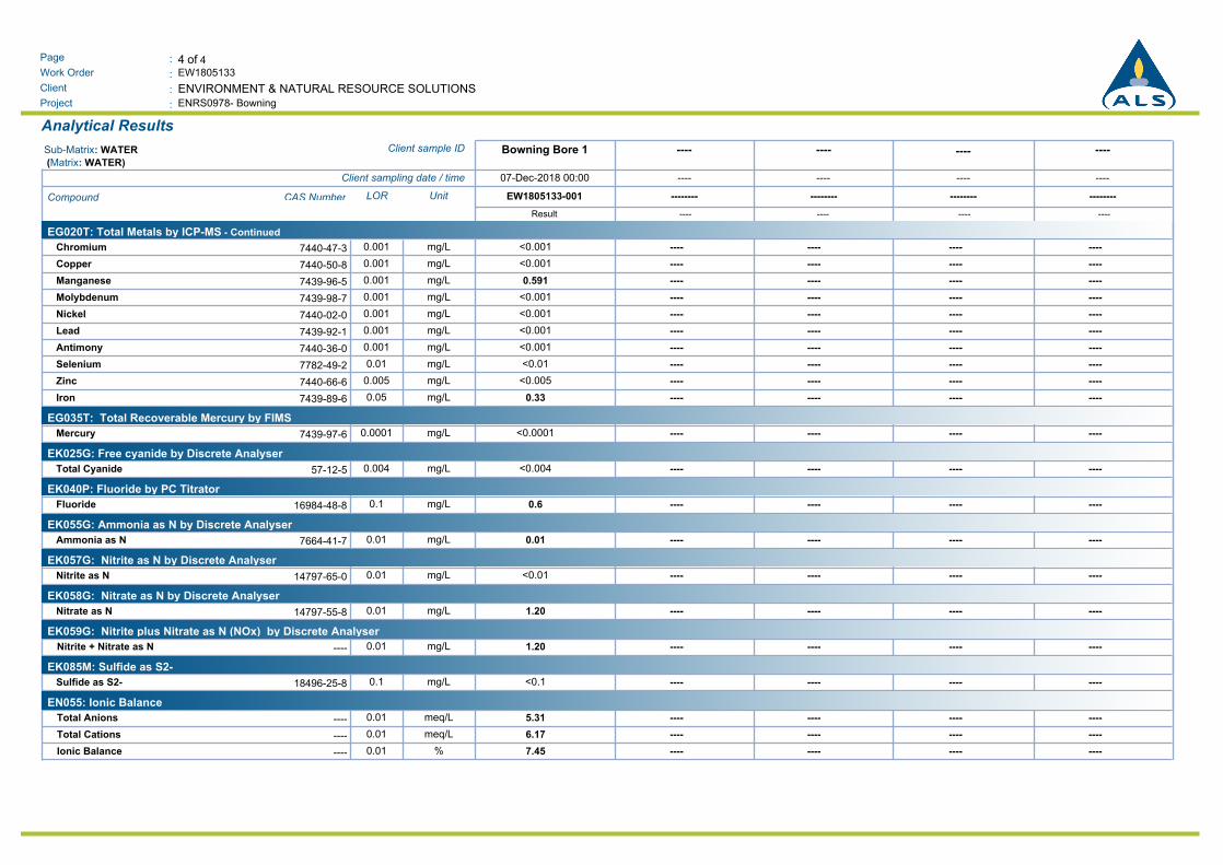
4 of 4:Page
Work Order :
:Client
EW1805133
ENRS0978- Bowning:Project
ENVIRONMENT & NATURAL RESOURCE SOLUTIONS
Analytical Results
----------------Bowning Bore 1Client sample IDSub-Matrix: WATER
(Matrix: WATER)
----------------07-Dec-2018 00:00Client sampling date / time
--------------------------------EW1805133-001UnitLORCAS NumberCompound
Result ---- ---- ---- ----
EG020T: Total Metals by ICP-MS - Continued
<0.001Chromium ---- ---- ---- ----mg/L0.0017440-47-3
<0.001Copper ---- ---- ---- ----mg/L0.0017440-50-8
0.591Manganese ---- ---- ---- ----mg/L0.0017439-96-5
<0.001Molybdenum ---- ---- ---- ----mg/L0.0017439-98-7
<0.001Nickel ---- ---- ---- ----mg/L0.0017440-02-0
<0.001Lead ---- ---- ---- ----mg/L0.0017439-92-1
<0.001Antimony ---- ---- ---- ----mg/L0.0017440-36-0
<0.01Selenium ---- ---- ---- ----mg/L0.017782-49-2
<0.005Zinc ---- ---- ---- ----mg/L0.0057440-66-6
0.33Iron ---- ---- ---- ----mg/L0.057439-89-6
EG035T: Total Recoverable Mercury by FIMS
<0.0001Mercury ---- ---- ---- ----mg/L0.00017439-97-6
EK025G: Free cyanide by Discrete Analyser
<0.004Total Cyanide ---- ---- ---- ----mg/L0.00457-12-5
EK040P: Fluoride by PC Titrator
0.6Fluoride ---- ---- ---- ----mg/L0.116984-48-8
EK055G: Ammonia as N by Discrete Analyser
0.01Ammonia as N ---- ---- ---- ----mg/L0.017664-41-7
EK057G: Nitrite as N by Discrete Analyser
<0.01Nitrite as N ---- ---- ---- ----mg/L0.0114797-65-0
EK058G: Nitrate as N by Discrete Analyser
1.20Nitrate as N ---- ---- ---- ----mg/L0.0114797-55-8
EK059G: Nitrite plus Nitrate as N (NOx) by Discrete Analyser
1.20 ---- ---- ---- ----mg/L0.01----Nitrite + Nitrate as N
EK085M: Sulfide as S2-
<0.1Sulfide as S2- ---- ---- ---- ----mg/L0.118496-25-8
EN055: Ionic Balance
5.31 ---- ---- ---- ----meq/L0.01----Total Anions
6.17 ---- ---- ---- ----meq/L0.01----Total Cations
7.45 ---- ---- ---- ----%0.01----Ionic Balance