quonset point davisville - grow smart rhode island
TRANSCRIPT
QUONSET POINT DAVISVILLE
North Kingstown, Rhode Island
PLANNING FOR THE PROPOSED PORT AND COMMERCE PARK: AN UPDATE
May 24, 2002
GROW SMART RHODE ISLAND 345 South Main Street
Providence, Rhode Island 02903 401-273-5711
CONTENTS EXECUTIVE SUMMARY AND CONCLUSIONS 1
Overview of Findings 1
Specific Conclusions 2 THE PURPOSE OF THIS REPORT 5 BACKGROUND AND PERSPECTIVE 7 CHANGES IN THE MASTER PLAN 8 THE PLANNING GAPS – WHERE ARE WE NOW? 9
ON-SITE INFRASTRUCTURE 9
Water Supply 9
Wastewater Treatment and Disposal 10
Stormwater Management 11
Transportation – Road and Rail 12
OFF-SITE TRANSPORTATION INFRASTRUCTURE 13 Rail Service and the Third Track 13
Traffic Projections and the Highway Network 14
Relocation of RI- 403 15
Quonset State Airport 16
IMPACTS ON SURROUNDING COMMUNITIES 17
FINANCING 19
DREDGING 20
PERMITTING 21
WHAT HAPPENS AFTER BUILDOUT 23
THE ENVIRONMENTAL IMPACT STATEMENT 24 REFERENCES 25
EXECUTIVE SUMMARY AND CONCLUSIONS
Overview of Findings Grow Smart Rhode Island (Grow Smart) is interested in the redevelopment and reuse of the former Navy bases in North Kingstown, now known as the Quonset Davisville Port and Commerce Park. We recognize both the potential benefits that this significant asset can bring to this state, and the problems that will result from misuse of this property. Our primary concern is for the development patterns that can result. They may range from real opportunities to bring about compact communities housing workers at the Park, to unmitigated sprawl that will destroy the rural character that people throughout the state respect and want to preserve. In 1999 Grow Smart released Quonset Point Davisville - Planning for the Proposed Port and Commerce Park: An Overview. We briefly reviewed the recent history and the status of this 4.7 square mile site. We evaluated the draft Master Plan completed in December 1997. Our examination of the major findings and recommendations of that plan disclosed a number of gaps in the planning done up to that time that held significant implications for successful development of the Park., and especially for impacts upon the communities surrounding the Park and on the state as a whole. Seven planning gaps were identified, some with major components, and we recommended that six of these be addressed. A revised and updated Master Plan was completed in 2001, and was adopted by the Rhode Island Economic Development Corporation (RI EDC) in November of that year. Like the predecessor draft, the official plan caused widespread controversy. Most of this focused on the inclusion of a possible container port in the plan. Grow Smart takes no position on the port proposal at this time. Instead, our concerns are for proper growth and servicing of all economic and supporting facilities at the site, and for the off-site development that this activity will induce. This report updates our earlier publication, and focuses on the gaps in planning that we identified three years ago. We review what has happened, and what has not happened, in the subsequent time. We see some progress, but a disappointing lack of attention to many critical aspects of this project, the most important potential contributor to the state's economy in the first two decades of the new century. Its impact can be as great as that now taking place in the Capitol Center of Providence. Whether this impact will be mostly positive or negative remains unclear, particularly in its community building and environmental dimensions. Careful attention to the planning gaps discussed in this report can go far in relieving many of these uncertainties.
1
Specific Conclusions
The 1997 and 2001 Master Plans differ in only one substantial way: a change in the concept of the port that may be part of the Quonset Davisville Port and Commerce Park. The resulting downsizing of the potential port changes the projections of employment, traffic, utility services, and other dimensions of the project. Most of the planning gaps identified by Grow Smart in 1999 remain as critical needs that must be addressed if the entire Quonset Davisville (QD) project, with a container port, a feeder port, or without a port, is to make the optimum contribution to the people of Rhode Island and their economy and environment. Only the "water supply" gap cited in Grow Smart's 1999 report has been addressed in full. If demand management objectives are achieved, and the anticipated groundwater potential of the Big River Management Area is realized, there should be an adequate supply of water for all users. Eleven gaps must be addressed. Six of these were explicitly recognized in Grow Smart's 1999 report. Another five gaps reflect concerns that were discussed in 1999, but are pinpointed as gaps in planning for the first time in this update. Their enhanced importance results from the 2001 Master Plan or changes that have occurred in the context for planning and development of the Quonset Davisville Port and Commerce Park. The six gaps that were presented in our 1999 report and that still need to be addressed are summarized below. They are listed in approximate order of importance from the standpoint of Grow Smart's mission. ♦ Impacts on Communities: The growth in employment at QD (with or without a port)
can overwhelm many of the communities most likely to house these new employees if "business as usual" continues. The Washington County Regional Planning Council (WCRPC) is working toward identification of the areas where growth should be concentrated, but implementation of their findings is a matter of the political will and financial capabilities of the municipal governments affected.
♦ RI-403 and I-95/RI-4 Interchange: Scheduling of completion of the relocation of
RI-403 and the I-95/RI-4 Interchange project are both uncertain, and, even if kept on schedule, may delay development of QD. In a "worst case" situation RI EDC may find it necessary to support these projects financially. At the least, this possibility should be integrated into the financial program.
♦ Impacts on the Highway System: The volume of traffic generated at QD may cause
congestion at points away from the immediate vicinity of the project. The means of identifying any of these potential bottlenecks is available now through four-step traffic forecasting models and should be used now.
2
♦ Stormwater Management: The area-by-area approach recommended by the 2001 Master Plan can create serious problems later. At a minimum, a "framework" management plan is needed now.
♦ Financing: Capital improvements at QD will require "bridge funding." Ways of
securing this funding should be explored now. ♦ Dredging: No significant dredging has been done in Rhode Island waters for more
than a quarter century. Assuming that the obstacles that have been so persistent thus far can be overcome on schedule, or at any time, is dangerous. The experience of the Army Corps of Engineers (CoE) with their proposal for the Providence River shipping channel, to be released this summer, should be instructive.
Five additional situations that emerged from this analysis of the 2001 Master
Plan and from the events of the past three years have become sufficiently critical to merit designation as gaps in planning for the QD Port and Commerce Park. They are: ♦ Third Track: Although the total number of employees at QD and the volume of
containers to be handled if a port is part of the plan have been substantially reduced in the 2001 Master Plan as compared with the 1997 Plan, the daily number of freight trains required has increased. The earlier projection of daily traffic was 6 trains for containers and 2 for other freight users. The revised figure (at buildout) is 12 trains per day for containers alone. Adding 2 trains daily for other users, the total of 14 trains daily exceeds the maximum traffic assumed in the study of the Freight Rail Improvement Project by 4. The results of that study are now being implemented, and may not provide the capacity required.
The 2001 Master Plan also accepts the possibility of future commuter rail operations on the Amtrak main line, but does not account for these or evaluate their effect on the capacity of the third track project to handle the total demand for rail service.
♦ The Wastewater Treatment Plant: The need for expansion of this facility depends
upon the pace of development of QD (but the demand to be placed upon this plant at buildout can be clarified now; this is not a function of the capacity of the collection system). Rough schedules and cost estimates can be used now to begin discussions with permitting and financing authorities. For example, will the State Revolving Fund for wastewater facilities be needed? If so, a lead-time of several years should be built into the schedule. Will the cost of plant expansion exceed the amount available from this Fund? If so, alternative sources of funds must be identified.
Although an adequate water supply is available to QD, wastewater from the QD
treatment plant should be used in industrial processes or cooling applications that do not require potable water.
♦ Quonset State Airport: Consideration of shortening the runway in the primary wind
direction, creating obstacles to air navigation, and any other violations of the
3

agreement through which the State obtained this facility should stop until the state airport system plan and airport master plan updates are complete
♦ Local Oversight Role: Statutes that concern the local role in planning and permitting
for the various Master Plan proposals may need clarification. It may also be necessary to replace the obsolete language now used in Section 42-64-13 of the General Laws. If there is a serious problem here, the longest and most uncertain route to resolution is litigation.
♦ What Happens After Buildout: This is a critical matter to the public, but one that has
not even been the subject of intelligent speculation thus far. The most likely outcome of following the 2001 Master Plan is that the project as envisioned will not fit exactly the site available. A project both more and less successful than anticipated, and its impacts on surrounding areas, should be considered.
Many of the eleven "gaps" identified in this analysis are not the direct responsibility of RI EDC. Their resolution, however, is essential to the success of the Port and Commerce Park. RI EDC, and State government as a whole, must take actions to insure that these will be successfully resolved. This involves policy, financial, and scheduling commitments that should be part of a revised and extended master plan.
4
THE PURPOSE OF THIS REPORT Grow Smart Rhode Island has followed proposals and progress in utilizing the former Navy bases now known as the Quonset Davisville Port and Commerce Park since the group was formed in 1997. Appropriate, well-planned new uses of this 3,047-acre site can contribute positively to the economy and environment of Rhode Island. Inappropriate, poorly planned uses can distort development patterns, cause growth that rural and suburban communities are not prepared to address, and waste resources that are all too scarce in this state of 1,214 square miles. In May 1999, Grow Smart released Planning for the Proposed Port and Commerce Park: An Overview. That report was prepared by Dan Varin, former head of Statewide Planning and Municipal Affairs, at the request of a Grow Smart task force. It presented an overview of the site and an outline of proposals for civilian redevelopment and reuse that have appeared since the Navy declared surplus the Quonset Point Naval Air Station in 1973 and the Davisville Construction Battalion Center in 1991. The 1999 report also analyzed the Master Plan for the site that was completed in December 1997 and identified a number of planning gaps that must be addressed if the plan's objectives were to be achieved. Grow Smart believes that a "three year review" of what has happened at the Quonset Davisville Port and Commerce Park is needed at this time. That is why we have asked Dan Varin to update our previous findings. This review encompasses the entire site, including the 752 acres classified as available and suitable for development, not just the possible container port. Our review includes the revised Master Plan completed in November 2001 and other documents and material listed in the "References" section. Readers should be aware that Grow Smart at this time is not advocating a specific use or development of the various parcels that make up the Quonset Davisville Port and Quonset Park. But as we stated in 1999, the site and the issues that it raises "challenges us all to 'do it right.’ Public discussion about Rhode Island's future is essential." The 1997 and 2001 Master Plans differ in only one substantial way: a change in the concept of the port that may be part of the Quonset Davisville Port and Commerce Park. The resulting downsizing of the potential port changes the projections of employment, traffic, utility services, and other dimensions of the project. Most of the planning gaps identified by Grow Smart in 1999 remain as critical needs that must be addressed if the entire QD project, with a container port, a feeder port, or without a port, is to make the optimum contribution to the people of Rhode Island and their economy and environment. Our interest in "doing it right" is inherent in the mission of Grow Smart. The QD site comprises about 4.8 square miles. An area of about 1.2 square miles is available and suitable for development. The other area of 3.6 square miles includes both land that is already in use by more than 100 manufacturing and service firms, Quonset State Airport,
5
and other facilities, or is not suitable for development. QD's extensive waterfront includes three large piers, four beaches, and relatively untouched wetlands. About 21,500 employees are anticipated at buildout in 2021, approximately 15,000 more than now work at the site. Rhode Island has very few large sites (50 acres or more) that are suitable for and zoned for industrial development; most are located here. The Port and Commerce Park is at the current edge of urban development, and what happens here will influence (and largely determine) the future of both suburban and rural areas in Washington and Kent Counties The "planning gaps" identified in our 1999 report must be addressed if any of the alternative proposals considered for QD's future, or others that may be brought forward, are to be successfully executed. This is true whether or not a container port of any type or size is located at QD. While all of these gaps must be of concern to the RI EDC, many are the primary responsibility of other parties. This analysis supplements, but does not replace, the 1999 study. Readers are referred to that report for further information on each of the "planning gaps" discussed. The planning gaps identified by Grow Smart in 1999 are grouped as follows: On-site infrastructure: utilities, roads.
Off-site transportation infrastructure: roads, rail, public transit, airport, and air quality.
Impacts on surrounding communities: employment, population, housing, infrastructure, and quality of life. Financing: estimated costs, sources of funds. Dredging: depth required, sites and methods for disposal of spoil. Permitting: approvals, permits, and licenses required, water quality and water use classifications. What happens after buildout? Potential for further growth, activities involved, possible locations and impacts. This report also examines any additional gaps that have emerged in the past five years. A standard format is used in reviewing what has happened in the areas outlined above. This includes (1) a brief summary of the findings of the 1999 report, (2) their status in 2002, (3) future actions planned or anticipated, and (4) our conclusions, in bold italics.
6
BACKGROUND AND PERSPECTIVE The State of Rhode Island acquired most of the QD property by transfer or purchase as parcels became available through the federal surplus property disposition procedures. A total of $ 47 million was raised through bond issues and allocated to the acquisition and cleanup of these properties. RI EDC was given primary responsibility for management and development of these two former bases. The airport and an adjoining "revenue area" to support improvement and operation of the airport were transferred to the Rhode Island Department of Transportation (RI DOT). The Town of North Kingstown acquired the golf course, as well as some satellite housing, under the special disposition procedures for these kinds of facilities. Economic impacts of closing these and three other Navy bases in the state prompted efforts to bring these properties back into productive use as rapidly as possible. This process was slowed by federal surplus property transfer requirements and by periodic recessions nationally, but two major and several smaller firms have located here during the first twenty-five years of state ownership, and there are now approximately 6,000 individuals working at the site. Planning for reuse of surplus Navy properties includes the Quonset State Airport Master Plan (1987), the Comprehensive Reuse Plan, Davisville Construction Battalion Center (1994), and planning by the Town of North Kingstown for the base and satellite sites that it obtained. The first definitive (but draft) Master Plan, Quonset Davisville Port and Commerce Park was completed in December 1997, by a consulting team under contract to RI EDC. A two-volume Quonset/Davisville Port Alternatives Report was issued in 1999 to provide economic, social, and environmental baseline data for use by Governor Almond's Stakeholders' Group in evaluating development proposals, and particularly the proposal for a large container port.
Notwithstanding all these documents and numerous other forms of input, a broad consensus has not emerged, particularly on a port facility of any size (except for shipment of automobiles, an expanding activity at the Davisville piers). Input has ranged from eighteen meetings of the 60 member Stakeholders' Group, critiques by the Rhode Island Department of Environmental Management (RI DEM), the US Environmental Protection Agency, and at least thirteen municipalities to numerous official hearings and less formal public meetings, comments by General Assembly members representing the Port and Commerce Park and surrounding communities, and continuous and extensive publicity by news media. The Stakeholders' Group did prepare a statement of 24 principles to guide future development of the site. An expanded list of 45 “Strategic Guiding Principles” is incorporated into the 2001 Master Plan.
7
Planning for the area continued with completion of a Master Plan, Quonset Davisville Port and Commerce Park in November 1998 by Parsons Brinckerhoff Quade and Douglas, Inc, the same consulting group that authored the 1997 draft Master Plan . This publication, referred to as a "draft resubmission" was forwarded to the Quonset Davisville Management Corporation in April 2000. This detailed (344 pages) document was intended to provide background information for the more concise master plan. The Quonset Davisville Port And Commerce Park Master Plan (88 pages) and an accompanying volume of four Technical Support Documents were received and reviewed by the Quonset Davisville Management Corporation, a subsidiary corporation of RI EDC, in August-October, 2001. The QD Management Corporation recommended, by a 5 to 3 vote, that RI EDC adopt the Master Plan. RI EDC voted 8 to 2 for its adoption on November 14, 2001. The dissenting votes in both bodies primarily reflect disagreement concerning what the Master Plan should say about a possible container port. The Rhode Island General Assembly appropriated $ 1.5 million during its 2001 session for preparation of an environmental impact statement on the Master Plan. Later in the year, a "feeder port" concept was put forth as an alternative to the "container port" discussed in the Master Plan. Under this scenario containers (and perhaps other items) would be shipped on barges traveling between QD and the Port Authority of New York and New Jersey. On March 25, 2002, RI EDC voted to explore this feeder port concept. Objections to a feeder port were voiced by General Assembly members, local officials, and environmentalists. This concept is not examined in the 2001 Master Plan, and is not considered in this report, but may be addressed in the forthcoming environmental impact statement.
CHANGES IN THE MASTER PLAN The Master Plan completed in 2001 is not simply a refined version of earlier plans. The Executive Summary of the more recent document states that “The 2001 Master Plan updates the much more detailed 1998 Draft Master Plan…” in order to "accommodate a slightly different mix of industrial and commercial development….” Revisions reflect a new market analysis, updated traffic projections, and a review of the role of Quonset State Airport. The fact that several different documents are called " Master Plans “ causes some confusion. This evaluation identifies these by the phrases underlined below: 1997 Master Plan. This is the plan that Grow Smart examined in our May 21, 1999, Overview, sometimes referred to as the "gaps report." The 1997 Master Plan was not adopted by RI EDC, but was referred to the Governor's Stakeholders' Group. 1998 Master Plan is a "Resubmission" dated November 1998. This document, not adopted by RI EDC, provides detailed information for the following plan.
8
2001 Master Plan: This is formally titled the "Quonset Davisville Port and Commerce Park / Master Plan" and the Technical Support Documents. It was published in 2001 and adopted by RI EDC in November of that year. The most significant revision from the first to the third plans is a change in concept of the port from a "load center" port to a "possible container port." In the new concept containers would be loaded directly onto railroad cars, rather than being held on site awaiting transshipment. Consequently, the area that might be used for a port is reduced from 800 acres to 200 acres, including reduction in the area of Narragansett Bay that might be filled to accommodate this activity, from 500 acres to an estimated 150 to 200 acres. The number of jobs at the scaled-down port is estimated to be 400 at initiation and reach 1,650 at buildout. (This is in addition to those people now working in the automobile importing and fish processing activities at the Davisville Piers.) The previous Master Plan estimated 2,500 employees at the container port alone at buildout. (Transshipment of automobiles also continues to grow in both volume of vehicles and number of employees.)
These and some additional minor changes reduce the total employment anticipated at buildout of the Port and Commerce Park from 25,700 to 21,500. This affects the estimates of need for utility services, roads, and some other facilities.
THE PLANNING GAPS -- WHERE ARE WE NOW? ON-SITE INFRASTRUCTURE Water Supply FINDINGS IN 1999: The then-current requirement for an average of 0.59 million gallons per day (MGD) of potable water was easily met from existing sources. Future average needs were projected to reach as high as 3.2 MGD. The real capacity of existing and possible new sources was not known since the study of the Hunt-Annaquatucket-Pettaquamscutt (HAP) Stream-Aquifer System by the US Geological Survey was just getting under way. This water source is used by QD, the Town of North Kingstown, and the Kent County Water Authority (KCWA), and by private wells. STATUS TODAY: As discussed above, there are now lower employment projections for QD. This has reduced the estimated future average water need from 3.2 MGD to 2.4 MGD. The HAP study is complete, and shows that total withdrawals from this source average 5.5 MGD and have exceeded 8 MGD during peak water use periods. This withdrawal is from 14 public water supply system wells and 4 private wells. Modification of the existing network of wells including two new wells in the
9
Annaquatucket sector would permit increasing withdrawals by as much as 50 percent over the 5.5 MGD average. This seems to meet the year 2020 average daily needs of the three major systems using the HAP system, but the margin is slim and could disappear depending on future growth, particularly in the KCWA service area. Peak (summer) needs could easily exceed available supplies. FUTURE ACTIONS: The Rhode Island Water Resources Board will be able to produce groundwater from the Big River Management Area in one to two years. The quantity available depends upon the optimization study now nearing completion by USGS, but may range from 6 to 10 MGD. Supplying some of this water to KCWA could reduce that system's withdrawal from the HAP area, making more of that water available to the other major users, QD and the Town of North Kingstown.
Water supply to QD can meet the need estimated at the site through 2021 (the projected buildout date) unless growth significantly exceeds current expectations and/or if the anticipated water saved through demand management fails to occur.
Wastewater Treatment and Disposal FINDINGS IN 1999: The treatment plant was upgraded in 1992 to provide secondary treatment, and sewers were extended to West Davisville. The then existing plant capacity was 1.78 MGD (average flow) and 3.56 MGD (peak flow). The 1997 Master Plan projected future flows at 3.48 MGD (average) and 6.4 MGD (peak). Provision for expansion of plant capacity was designed into the prior improvements. STATUS TODAY: Future (2021) average daily and associated peak flows to the plant are projected to be 3.26 MGD and 5.89 MGD, respectively. This does not include flows from the Town of North Kingstown, which is not planning a sewerage system at this time. These flows could be handled by future expansion of the plant, at an estimated cost of $ 2.34 million. But the 2001 Master Plan states that: "The 1998 Master Plan indicated that there was sufficient capacity to serve the wastewater collection needs of the industrial park with 5,000 more employees on site than now projected. Therefore, it is concluded that the Park's Wastewater Treatment Facility is capable of serving the future needs of the Park as now projected. . . ." (emphasis added) The 2001 Master Plan does not explain how the capacity of the collection system will accommodate the increased demand placed on the treatment plant. FUTURE ACTIONS: This apparent contradiction may be resolved in the Implementation Program, which is not yet part of the Master Plan. This detailed program will be developed by the Quonset Davisville Management Corporation and by RI EDC, according to the final section of the 2001 Master Plan. It will update the 1998 draft plan
10
and describe how new recommendations in the 2001 Master Plan and other actions called for in the "Strategic Guiding Principles" are to be implemented. A preliminary outline of the Implementation Program calls for six major sections: 1. The Development Program, allocating land to activities supported by current and anticipated market conditions over a twenty-year period. Annual revenues from land sales will be estimated and additional financing needed to complete installation of needed infrastructure will be programmed. 2. The Marketing Program will be designed to attract activities that can make use of QD's multimodal assets, especially those that will use rail and marine facilities and that require large parcels. 3. Land Use Controls and Environmental Reviews will complete the preliminary work done during review of the 2001 Master Plan. They will be adopted by RI EDC 4. The Capital Improvement Program will update estimates of revenues and expenses made in 1998. Strategic infrastructure packages will be developed and early action projects will be accelerated. 5. Project Financing data in the 1998 draft plan will be updated and public investments necessary to support development in the early years will be analyzed. Bond financing mechanisms will be described. Opportunities for public-private partnership funding will be identified. 6. Other Actions will facilitate implementation of the adopted Vision and Strategic Guiding Principles. New initiatives and approaches will be sought.
GAP: The capacity of the treatment plant, not of the collection system, is the major concern. The timing for planning and construction of additional capacity for wastewater treatment and disposal is not yet determined. RI EDC will make these determinations as necessary to meet the requirements of the discharge permit issued by RI DEM.
Stormwater Management FINDINGS IN 1999: A stormwater management plan for QD had not yet been prepared. STATUS TODAY: The 2001 Master Plan notes that QD lacks "any significant measures to control non-point source pollution." It calls for preparation of a stormwater management plan specific to each area as each is redeveloped. FUTURE ACTIONS: The approach recommended by the 2001 Master Plan may repeat the problems often created in residential and commercial developments, when
11
management of stormwater in one subdivision or shopping center creates or exacerbates the problem for adjoining or nearby areas, and particularly when one or more of these areas is developed.
GAP: A stormwater management plan has not been prepared. The 2001 Master Plan recommends that:
"as each area of the facility is redeveloped, a Stormwater Management Plan specific to that area is used to identify Best Management Practices (BMPs) which provide protection and restoration of the various receiving waters . . .."
This approach may fail unless the "specific area plans" are formulated within a framework plan for the entire site. A CRMC/RI DEM agreement delineates jurisdictional responsibilities for wetlands regulation but does not provide the framework needed.
Transportation - Road and Rail FINDINGS IN 1999: QD's system of local access roads is not well suited to an industrial site. Most of these are in only fair or poor condition. The two main trunk rail lines are adequate but reconfiguration and extensive rehabilitation of the rest of the system is needed. A multiple track storage yard is required for the port. STATUS TODAY: The 2001 Master Plan proposes a system of arterial roads (two existing and one new) and collector streets. Local access streets will be developed as needed. Much of the rail track has been removed. Rail serves existing users and can be extended from the trunk lines to future users as needed. A rail yard is proposed paralleling the Davisville main line at the point where this line is closest to existing residential areas north and west of Newcomb Road. Other on-site transportation systems are proposed in the 2001 Master Plan, including RIPTA bus service to two intermodal centers, shuttle busses on-site, possible water transit, extension of commuter rail south of Providence to Westerly (but without a station at West Davisville), three bicycle paths, and greater attention to pedestrian needs. RIPTA initiated bus service to the Park entrance on two lines, but later discontinued one due to low ridership. FUTURE ACTIONS: The 2001 Master Plan is more a policy document than either the 1997 and 1998 editions and can be executed as QD is developed. RIPTA urges that employers at QD be proactive in encouraging employees to use transit service. RIPTA states that without these actions, transit service to the Park will not be sufficiently utilized and will not be operated.
12
Most of the problems of the earlier plan have been addressed. The 2001 Plan proposes "Strategies to Reduce Vehicle Trips" and establishment of a Transportation Management Association to be initiated by RI EDC, but the onus for continued operation and actions to encourage transit use is placed on the present and future employers at QD. This makes it very difficult to predict future levels of potential transit use by QD workers.
OFF-SITE TRANSPORTATION INFRASTRUCTURE Rail Service and the Third Track FINDINGS IN 1999: Shipment of containers totaling 800,000 twenty-foot equivalent units (TEUs) was expected by 2010. The 1997 Master Plan anticipated that 70 % of these, or 560,000 TEUs, would be shipped by rail. This and other QD freight traffic would require 6 to 8 freight trains daily. (Study of the Freight Rail Improvement Project anticipated a demand of up to 10 freight trains per day.) The 800,000 TEUs projected by 2010 could grow to as many as 3.4 million TEUs in total at buildout, with 2.38 million TEUs to be shipped by rail, assuming that the 70 % assumption holds true. A partial third track was recommended to accommodate this traffic together with increased Amtrak and commuter rail trains. The estimate that 70 percent of the containers would be transported by rail was criticized by some, who believed that this expectation was too high and not consistent with experience at other ports. As a result, the projections of truck traffic on RI-403 and other roads were thought to be too low, and that the impacts of truck traffic on communities traversed by this and other highways accessing the port were substantially understated. STATUS TODAY: Construction of the partial third track is underway. The need to avoid delaying Amtrak trains, including increased frequency of rail passenger service between Boston and Washington, is acknowledged by the 2001 Master Plan. Increased commuter rail operations (from zero south of Providence) is also acknowledged but the use they may make of the existing and improved track is not addressed. The 2001 Master Plan incorporates projections of potential port activity presented in the Quonset Port Feasibility Study (R K Johns and Associates, Inc., July, 2000). This report suggests that a smaller port could handle 110,000 to 400,000 TEUs (75,000 to 250,000 containers) at an assumed start-up in 2008. This could grow to 2 million TEUs (1.2 million containers) in 2028. Forty to sixty percent of these are projected to be shipped by rail. The train trips required would be 2 per day at start-up, and increase to 12 per day at buildout. FUTURE ACTIONS: Since the use of rail to ship containers has changed in two dimensions--a smaller number of containers and a smaller percentage handled by rail--the authors of the 2001 Master Plan must explain why the projected number of trains
13
required daily increases from 8 to 12. This is particularly important since the Freight Rail Improvement Project study of new freight service in and out of QD anticipated handling only up to 10 trains per day.
GAP: If a container port of the size and volume of containers discussed in the 2001 Master Plan is in fact incorporated into the Plan, more detailed analysis is needed to determine whether the future rail system including the partial third track can handle the volume of traffic projected. If not, the volume of truck traffic, and the ability of the future road system to handle this traffic, must be determined.
Traffic Projections and the Highway Network FINDINGS IN 1999: Container volume in 2010 was projected at 800,000 TEUs. At full buildout this could grow to 3.4 million TEUs. Up to 6 trains per day for containers were expected, together with one or two trains for general freight traffic (including motor vehicles). Seventy percent of the containers were projected to be shipped by rail, 20 percent by truck, and 10 percent by boat. Vehicular trip generation analysis used an employment projection at buildout of almost 27,000 and Institute of Traffic Engineers (ITE) trip generation rates derived from experience at other "light industrial" parks. Average daily traffic at buildout was projected at 71,671 vehicles; with a morning peak hour inbound of 8,973 and an afternoon peak hour outbound of 7,724. A system-wide analysis using simulation modeling was not available. STATUS TODAY: Projected employment at buildout has decreased to 21,200. This still exceeds the peak employment of 15,350 Navy personnel and civilian employees at the site in 1942, and affects future traffic projections. These traffic projections are further reduced by an apparent anomaly at QD. When updated ITE trip generation rates are applied to current employment at QD the number of trips generated is found to exceed current traffic counts. For example, the 2001 actual traffic count (ADT) of 14,195 is substantially below the 26,803 trips (ADT) derived for 2001 using the ITE rate. The Master Plan Technical Support Document concludes "there are unique travel characteristics for Quonset Davisville that do not conform to ITE national standards." Although these unique travel characteristics are not explained, future trip generation rates are reduced so as to produce the following future traffic volumes:
14
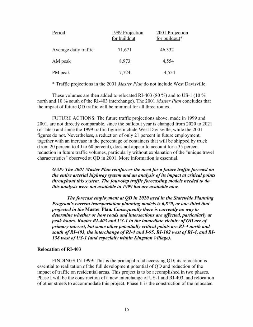
Period 1999 Projection 2001 Projection for buildout for buildout* Average daily traffic 71,671 46,332 AM peak 8,973 4,554 PM peak 7,724 4,554
* Traffic projections in the 2001 Master Plan do not include West Davisville. These volumes are then added to relocated RI-403 (80 %) and to US-1 (10 % north and 10 % south of the RI-403 interchange). The 2001 Master Plan concludes that the impact of future QD traffic will be minimal for all three routes. FUTURE ACTIONS: The future traffic projections above, made in 1999 and 2001, are not directly comparable, since the buildout year is changed from 2020 to 2021 (or later) and since the 1999 traffic figures include West Davisville, while the 2001 figures do not. Nevertheless, a reduction of only 21 percent in future employment, together with an increase in the percentage of containers that will be shipped by truck (from 20 percent to 40 to 60 percent), does not appear to account for a 35 percent reduction in future traffic volumes, particularly without explanation of the "unique travel characteristics" observed at QD in 2001. More information is essential.
GAP: The 2001 Master Plan reinforces the need for a future traffic forecast on the entire arterial highway system and an analysis of its impact at critical points throughout this system. The four-step traffic forecasting models needed to do this analysis were not available in 1999 but are available now. The forecast employment at QD in 2020 used in the Statewide Planning Program's current transportation planning models is 6,870, or one-third that projected in the Master Plan. Consequently there is currently no way to determine whether or how roads and intersections are affected, particularly at peak hours. Routes RI-403 and US-1 in the immediate vicinity of QD are of primary interest, but some other potentially critical points are RI-4 north and south of RI-403, the interchange of RI-4 and I-95, RI-102 west of RI-4, and RI-138 west of US-1 (and especially within Kingston Village).
Relocation of RI-403 FINDINGS IN 1999: This is the principal road accessing QD; its relocation is essential to realization of the full development potential of QD and reduction of the impact of traffic on residential areas. This project is to be accomplished in two phases. Phase I will be the construction of a new interchange of US-1 and RI-403, and relocation of other streets to accommodate this project. Phase II is the construction of the relocated
15
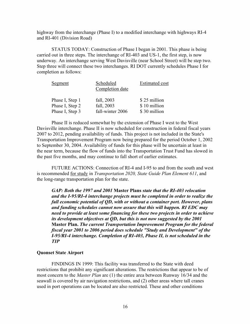
highway from the interchange (Phase I) to a modified interchange with highways RI-4 and RI-401 (Division Road) STATUS TODAY: Construction of Phase I began in 2001. This phase is being carried out in three steps. The interchange of RI-403 and US-1, the first step, is now underway. An interchange serving West Davisville (near School Street) will be step two. Step three will connect these two interchanges. RI DOT currently schedules Phase I for completion as follows: Segment Scheduled Estimated cost Completion date Phase I, Step 1 fall, 2003 $ 25 million Phase I, Step 2 fall, 2003 $ 10 million Phase I, Step 3 fall-winter 2006 $ 30 million Phase II is reduced somewhat by the extension of Phase I west to the West Davisville interchange. Phase II is now scheduled for construction in federal fiscal years 2007 to 2012, pending availability of funds. This project is not included in the State's Transportation Improvement Program now being prepared for the period October 1, 2002 to September 30, 2004. Availability of funds for this phase will be uncertain at least in the near term, because the flow of funds into the Transportation Trust Fund has slowed in the past five months, and may continue to fall short of earlier estimates. FUTURE ACTIONS: Connection of RI-4 and I-95 to and from the south and west is recommended for study in Transportation 2020, State Guide Plan Element 611, and the long-range transportation plan for the state.
GAP: Both the 1997 and 2001 Master Plans state that the RI-403 relocation and the I-95/RI-4 interchange projects must be completed in order to realize the full economic potential of QD, with or without a container port. However, plans and funding schedules cannot now assure that this will happen. RI EDC may need to provide at least some financing for these two projects in order to achieve its development objectives at QD, but this is not now suggested by the 2001 Master Plan. The current Transportation Improvement Program for the federal fiscal year 2001 to 2006 period does schedule "Study and Development" of the I-95/RI-4 interchange. Completion of RI-403, Phase II, is not scheduled in the TIP
Quonset State Airport FINDINGS IN 1999: This facility was transferred to the State with deed restrictions that prohibit any significant alterations. The restrictions that appear to be of most concern to the Master Plan are (1) the entire area between Runway 16/34 and the seawall is covered by air navigation restrictions, and (2) other areas where tall cranes used in port operations can be located are also restricted. These and other conditions
16
attached to transfer of the airport are so onerous that the 1997 Master Plan included a cost of relocating the airport of $ 70 to $ 100 million. This did not include the cost of relocating any current occupants of the site or constructing highway access and other supporting infrastructure. STATUS TODAY: The 2001 Master Plan states that the airport "will continue to play an important role in the industrial park. . . .. RI EDC . . . expects that its use will be continued." (The conditions of transfer require that it be operated forever.) The Technical Support Document evaluates shortening or eliminating Runway 5/23. This report notes that this runway "provides the necessary alignment with crosswinds [actually, the primary wind direction] needed for smaller aircraft." Neither the Technical Support Document nor the 2001 Master Plan references the Quonset State Airport Master Plan prepared in 1986-87 as a precondition of transfer of the airport to the State. The 2001 Master Plan "Summary of Transportation Plan Recommendations" makes no proposals for the airport. FUTURE ACTIONS: The Federal Aviation Administration has stated that updating of the State Airport System Plan, Element 640 of the State Guide Plan, is necessary before discussing Quonset State Airport. The Rhode Island Airport Corporation initiated this work in 2001, suspended it for a period following the attack on the World Trade Center, but has now resumed work on the update.
GAP: Neither the 1997 nor the 2001 Master Plan addresses issues and potential conflicts between the airport and development of some parts of the QD site.
IMPACTS ON SURROUNDING COMMUNITIES FINDINGS IN 1999: The Alternatives Report, a compilation of baseline data prepared for the Governor's Stakeholders' Group, identifies thirteen municipalities that accounted for about 72 percent of the total employment at QD in 1995. Nine of these are in Kent and Washington Counties: Coventry, East Greenwich, Exeter, Narragansett, North Kingstown, South Kingstown, Warwick, West Greenwich, and West Warwick. The others are Cranston, Jamestown, Johnston, and Providence. Four factors were used to indicate the capacity of these thirteen municipalities to manage the growth that continued development to buildout of QD will stimulate: (1) availability of municipal services, (2) capacity of schools, (3) police and fire protection, and (4) growth management measures in place or planned. Grow Smart added a fifth factor, availability of vacant land. STATUS TODAY: The 2001 Master Plan surveyed employees in April 2001 to identify commuting patterns. More than half of the employees either responded or were located by zip code from employer records. The results obtained were similar to those obtained from the earlier survey. More than one-third of the employees live within 10 miles of QD, and 89 percent live in Rhode Island. The largest number of employees live in the following municipalities, listed in the order of the number of employees residing there: North Kingstown, Warwick, Coventry, Providence, West Warwick, Cranston, and
17
East Greenwich. Other communities with a significant number of employees include Central Falls, Cumberland, Exeter, Hopkinton, Jamestown, Johnston, Narragansett, Newport, Portsmouth, Richmond, South Kingstown, and West Greenwich. Kent and Washington Counties continue to be the most popular locations for QD employees. The concentrations of future employee residences have serious implications for many of the communities listed above that have substantial amounts of vacant land, but do not have the facilities or services needed to support significant population growth over the next two decades. Many communities near QD are trying to slow growth by requiring minimum lot sizes of 4 or 5 acres, capping the annual number of building permits issued, and imposing impact fees that are as high as $ 7,500 and $ 8,000 per dwelling unit. The success of such measures is not yet clear, but the penalties for failure and inaction in growth management are. At the current growth rate town officials are quoted as expecting that every buildable lot in Washington County will be developed by 2020. This "wall-to-wall sprawl" hardly fits the preferences expressed by officials and citizens in the "Vision 2020" process conducted by the Washington County Regional Planning Council (WCRPC) less than two years ago. The WCRPC was formed in the mid-1990's to assist in and coordinate the efforts of the nine towns to cope with the high levels of population growth experienced over the prior three decades or more. The WCRPC first produced a vision of what residents want to see happen, and not happen, in the county over the next twenty years. An overview, Growth Management in Washington County, reprinted as a five-part series of Providence Journal articles, was published in 2000. FUTURE ACTIONS: Many of the towns most significantly affected by QD's development have passed resolutions opposing a container port at the site. These resolutions may reflect, at least in part, the communities' lack of confidence in their ability to deal with the new housing, the related retail and office construction, the traffic, and the infrastructure that the QD Master Plan foresees implicitly in its employment projections and distribution. But buildout of QD without a port, but with that part of the site used instead for other industrial and commercial development, will create approximately the same demands on the same communities. Growth projections reflecting the number of employees anticipated at QD, and their expected distribution, could spell major congestion on the two east-west arterial roads in Washington County, RI-102 and 138. The proportions of the additional trips that can be shifted to public transit or to US-1 are probably very small (or nonexistent if new housing is built on 4 and 5 acre lots). But the decisions to not make any substantial improvements to either east-west road have already occurred. The WCRPC is undertaking two research projects that can lead to an effective response to increasing employment at QD, and population growth spurred by employees who want housing in the primary areas already identified. The first is the "Green Space" project, an inventory of natural and cultural resources made in cooperation with RI DEM.
18
The second is a "Sustainable Economy" study co-sponsored by Grow Smart and designed to identify appropriate types of economic activity for the region, and appropriate sites for these activities. When complete, these two will be merged to identify those areas where development should be accommodated. WCRPC will then work with the municipalities to encourage development of these centers, so as to avoid a continuation and acceleration of sprawl.
GAP: To prevent overwhelming the communities most directly affected by continued growth at QD areas most suitable for more intensive use must be identified and necessary infrastructure (schools, utilities, transportation) must be provided to support higher density housing and concentrated commercial development. These locations can include both established small urban and town centers and designated new development centers. Identification of areas suitable for growth is the essential first step, but WCRPC must secure the participation of local governments in taking the often-controversial actions necessary to achieve this pattern of development. The public infrastructure essential, in some cases, to support more compact centers must be financed and constructed.
FINANCING FINDINGS IN 1999: The 1997 Master Plan listed the projects to be financed in three categories: 1) The port - to be privately financed. 2) On-site infrastructure - state-issued revenue bonds and state and federal grants. 3) Off-site infrastructure (RI-403 relocation and the Freight Rail Improvement Project) - federal highway program and appropriations for the rail project, with state matching funds (general obligation bonds and/or appropriations). The total costs of lines (2) and (3) above were estimated at $ 252.5 million, with a federal share of $ 165.4 million and a state share of $ 87.1 million. A more detailed breakdown is given in Grow Smart's 1999 Overview. Grow Smart called for more specifics about the combination of methods to be used to finance on-site infrastructure. STATUS TODAY: The 2001 Master Plan states that "A detailed Implementation Program will be developed by QDMC/RIEDC after adoption of the Master Plan. . . . The development of the Park will require significant public investment in infrastructure to stimulate private investment." Revenues and expenses and the fiscal analysis presented in the 1998 draft master plan will be reevaluated and updated as part of the forthcoming Implementation Program. The 1998 Master Plan presents a summary of revenues and expenses over a twenty-year period beginning in 1998. Cost estimates are in 1997 dollars, adjusted to the scheduled time of construction. Revenues from land sales are scheduled over four, five-year periods. In summary:
19
Capital investment required: $ 90,908,000 Revenues from land sales: $ 100,273,800 Surplus of revenues over costs $ 9,365,800 However, the analysis notes that much of the capital investment in infrastructure must occur during the first ten years, while most revenue from land sales will be received during the last ten years. "Bridge financing" is required during the first ten years. FUTURE ACTIONS: The 2001 Master Plan was adopted by RI EDC in November, 2001. Preparation of the detailed implementation program (and updated estimates of costs and revenues) can now proceed.
GAP: Further consideration of any "financing gaps" should be deferred until the Implementation Program is completed. At that time, all cost estimates and sources of funds must be defined. The methods of obtaining "bridge funding" are of particular concern.
DREDGING FINDINGS IN 1999: As much as 14 million cubic yards of material would be dredged for the shipping channels associated with the port at QD. Some would be used as fill for the port. Dredging of any area has been a contentious issue for at least a quarter century and all dredging has been stalled. "Worst case" cost estimates for dredging are needed. STATUS TODAY: A port at either the Davisville or Quonset Point sites will require dredging to a depth of 52 feet, according to the 2001 Master Plan. The existing depths are 33 to 35 feet. The channel connecting either site to the main shipping channel (East Passage) also requires dredging. Uncertainties about dredging plans prevent the 2001 Master Plan from proposing a specific port layout. Dredging throughout the state's waters continues to be stalled. The shipping channel in Narragansett Bay and Providence River was last dredged, more than 30 years ago, to a depth of 40 feet. Shoaling has now reduced the depth to 26 feet in spots. Navigation restrictions have been imposed, including one-way travel for ships using the channel. An estimated 4.3 million cubic yards of material would be removed and disposed of in the dredging project proposed in 2001 by the US Army Corps of Engineers (CoE). FUTURE ACTIONS: The CoE will issue an environmental impact statement on the Providence River and Harbor Maintenance Dredging Project in the summer of 2002. This EIS will not directly address the shipping channel to QD, but should contain much information useful in evaluating the prospects for this channel, and the areas adjoining the seawall and piers. Preliminary indications are that an open ocean disposal site will be proposed for most of this material, with more than one million cubic yards of contaminated sediments being buried in the channel itself. Some of the material removed
20
to create these burial pits may also be used in projects such as the relocation of I-195. Dredging may begin as early as fall, 2002.
GAP: The specifics of the CoE plan and the response to it by numerous interested groups may provide an indication of the feasibility of dredging at QD. The past history of the issue strongly points out that nothing can be assumed.
PERMITTING FINDINGS IN 1999: Grow Smart, assisted by RI DEM, assembled a list of permits required for either the entire project or for specific sites and structures. The number, by source of the requirement, were: Federal: 8 State, including federal programs administered by the state: 18 Local, including state laws or regulations administered by municipalities: 4 Total: 30 Some of these may no longer apply, depending on the specific activities to be undertaken throughout development of QD. A potential conflict lies in the water quality and water use classifications adopted by state agencies for that part of Narragansett Bay adjoining QD. RI DEM designates these waters as Class SA or SB. The Coastal Resources Management Council (CRMC) designates the same waters as Type 6. The potential conflict lies in the definitions of these classifications: DEM: Class SA waters permit shellfish harvesting for direct human consumption, the activity most sensitive to water quality. They are also for primary and secondary contact recreational activities, fish and wildlife habitat, aquaculture, navigation, and industrial cooling, and have good aesthetic value. Class SB waters permit primary and secondary contact recreational activities, shellfish harvesting for controlled relay and purification, and fish and wildlife habitat. CRMC: Type 6 waters are industrial waterfronts and commercial navigation channels. The highest priorities are for berthing, loading, unloading, and servicing commercial vessels, construction and maintenance of port facilities, navigation channels, and berths, and construction and maintenance of facilities for support of commercial shipping and fishing. Any uses that detract from or interfere with these priority uses are prohibited. It might be possible to achieve the RI DEM water quality standards while at the same time achieving CRMC water use goals, but in practice this seemed to be very
21
unlikely. The activities considered in the 1997 Master Plan may not be able to meet the RI DEM water quality standards. STATUS TODAY: The 2001 Master Plan does not discuss permitting requirements. Few, if any, permitting requirements in the federal and state categories have changed since 1999. The status of local permitting has changed. Section 42-64-13 of the Rhode Island General Laws governs RI EDC's relations with municipalities. Subsection (a)(1) describes the basic relationship as follows: "With respect to projects situated on federal land, the corporation is authorized to plan, construct, reconstruct, rehabilitate, alter, improve, develop, maintain, and operate projects: . . . (ii) without regard to the zoning or other land use ordinances, codes, plans, or regulations of any municipality or political subdivision. . .." Subsection (a)(2) says that:
"As used in this section, 'the comprehensive plan' means a comprehensive plan adopted pursuant to chapter 22 of title 45 by a planning board or commission;…and 'the project plan' shall mean a general description of a proposed project situated on federal land, describing in reasonable detail its location, nature, and size." This language is obsolete and confusing. Some municipal planning boards or commissions did adopt a comprehensive plan under this authorization. None are still in effect, and this authorization has been repealed. Nevertheless, Subsection 42-64-13 (a)(2) goes on to differentiate between these nonexistent comprehensive plans and "project plans" Subsections 42-64-13 (a)(3) through (5) describe how project plans prepared by RI EDC for "proposed projects situated on federal land" relate to the local comprehensive plans as defined above [which no longer exist]. In simplified form, project plans [which are to be formulated for areas designated in the 2001 Master Plan] by RI EDC are referred to community advisory committees, which report back to RI EDC with comments. (Failure to report within 45 days is deemed to be approval.) If a project plan does not "conform to the land use goals, objectives, and standards of the applicable comprehensive plan" [apparently due to findings by a community advisory committee] RI EDC refers the project plan to the city or town council. The council must "advise the corporation of its approval or disapproval of that plan" within 45 days. (Again, failure to report on time is considered approval.) The RI EDC Board of Directors can override local disapproval by a majority vote of all members at an open meeting:
22
"The project plan's conformity with the applicable comprehensive plan shall be determined by the board of directors of the corporation and its determination shall be binding and conclusive for all purposes."
The statutory provisions introduce some confusion into the relationship between RI EDC and municipalities: 1) Does the phrase "federal land" also include former federal land that has been acquired by RI EDC prior to application of Section 42-64-13? 2) This section refers to comprehensive plans "adopted pursuant to chapter 22 of title 45 by a planning board or commission." In fact, comprehensive plans are adopted by city or town councils, not by planning boards. They must be adopted by ordinance, under Chapter 45-22.2, RIGL. There is no authorization for adoption of a comprehensive plan by anyone under Chapter 45-22; this authorization was repealed in 1988. All plans adopted under Chapter 45-22 are no longer in effect. 3) If these statutes are construed strictly, does North Kingstown's comprehensive plan as adopted under Chapter 45-22.2 and approved by the Director of Administration apply to QD? The critical provision is Section 45-22.2-10 (D): "Once a municipality's comprehensive plan has been approved, programs and projects of state agencies… shall conform to that plan." The term "state agency" is not defined in this chapter. An appeal procedure is provided for state agencies wishing to contravene a local comprehensive plan. FUTURE ACTIONS: RI EDC adopted the QD Master Plan in 2001. At some point in the future, it presumably will formulate and adopt project plans that carry out various pieces of the Master Plan.
GAP: Although Grow Smart takes no legal position on the unresolved issues surrounding the relationship between RI EDC and municipalities; these issues should be clarified before RI EDC proceeds with preparation of project plans under the 2001 Master Plan. Amendment of existing law may be necessary.
WHAT HAPPENS AFTER BUILDOUT? FINDINGS IN 1999: The 1997 Master Plan and discussion of it focused on the QD property owned by RI EDC and its development and use within a twenty-year time frame. With or without a port, it was very unlikely that this development would exactly fill the site as presently owned. No real attention was paid to the prospect of a project that is much more successful, or much less successful, than that envisioned in the plan. STATUS IN 2002: The 2001 Master Plan does not address either of these possibilities.
23
FUTURE ACTIONS; There is some public discussion of the possibility that the Port and Commerce Park will be successful and will outgrow the QD site. The prospects of such growth are difficult to assess, but some policy response is appropriate at this time.
GAP: No commitment has been given concerning what will be done in the event that QD is more successful than now anticipated.
THE ENVIRONMENTAL IMPACT STATEMENT In 2001 the General Assembly, at the Governor's request, appropriated $ 1.5 million for preparation of an environmental impact statement (EIS) and other studies of the proposed container port. The actions taken to date are: 1) Submission of applications for development of the port to the Corps of Engineers and Coastal Resources Management Council. This will trigger preparation of an EIS by the Corps. 2) Issuance of Requests for Proposals for a study of the port's market potential and for a public relations program to inform the public about the proposed project.
All of these actions have been taken by the Governor's office. The next major step in the EIS process will be the "scoping meeting" to be held in the next few months, and perhaps as early as April. Decisions on what to address in the EIS will be determined, in large part, as a result of the scoping process. This report can be used to promote inclusion of the questions and planning requirements noted in the previous pages in the formulation of the EIS.
24
REFERENCES Barlow, Paul and David C. Dickerman, Numerical-Simulation and Conjunctive Management Models of the Hunt-Annaquatucket-Pettaquamscutt Stream-Aquifer System, Rhode Island, US Geological Survey Professional Paper 1636 (2001) Barbara Sokoloff Associates, Inc. Baseline Information (Draft) (1998) Bartish, T and A. Desbonnet, Growth Management in Washington County (a five-part series from the Providence Journal, RI Sea Grant Technical Report) (2000) Cohen, Marilyn and B. Pellerin, North Kingstown Planning and Development Dept., meeting, January 30, 2002 Federal Highway Administration and Federal Railroad Administration, Record of Decision, Rhode Island Freight Rail Improvement Project (1988) Grow Smart Rhode Island, Quonset Point Davisville, Planning for the Proposed Port and Commerce Park: an Overview, 1999 Johnson, George, telephone conversation, February 22, 2002 Maguire Group, Inc., Comprehensive Reuse Plan, Davisville Naval Construction Battalion Center, Executive Summary (1994) Minutes of Joint Business Development Subcommittee of Quonset Davisville Management Corporation and Economic Development Corporation, November 8, 2001 O'Brien, John, George Johnson, and Katherine Trepani, RI Statewide Planning Program, meeting, January 25, 2002 Parker, Edward, PE, Chief Engineer, RI DOT, telephone conversations, February 26, 2002 Parsons Brinckerhoff Quade and Douglas, Inc., Master Plan, Quonset Davisville Port and Commerce Park, Draft Resubmission, 1998 _____ Quonset Davisville Port and Commerce Park Master Plan, 2001 _____ Technical Support Documents, Quonset Davsiville Port and Commerce Park Master Plan, 2001 Preston, Devon, Executive Director, WCRPC, telephone conversations, February-March, 2002
25
Rhode Island Department of Transportation, Rhode Island Freight Rail Improvement Project, Final Environmental Statement and Final Section 4(f) Evaluation, Executive Summary (1998) Rhode Island Statewide Planning Program, Inventory of Local Zoning Ordinances and Land Development Regulations, Technical Paper 148 (2001) _____ Transportation 2020, State Guide Plan Element 611 (2001) _____ Quonset State Airport Master Plan (1987)
26