proton magnetometer king's bay project nts 52-j-2 phantom
TRANSCRIPT
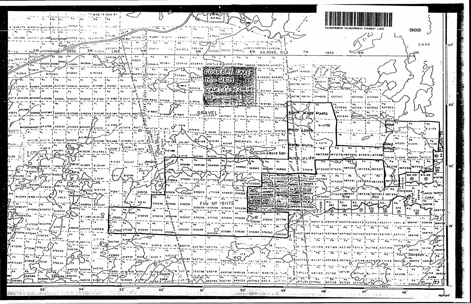
, , — --.—. -. ...•...••••••••••••l lS2J02SW0e48 52J02SWM44 FOURBAY LAKE
010
Proton Magnetometerand
VLF Electromagnetic Surveys
King's Bay Project NTS 52-J-2
Phantom Exploration Services
July, 1983 R. D. Middaugh
INTRODUCTION
Steep Rock Iron Mines Limited of Atikokan, Ontario
contracted Phantom Exploration Services Ltd. of Thunder
Bay, Ontario, to conduct magnetic and electromagnetic
surveys on the King's Bay project during the fall and
winter of 1982-1983.
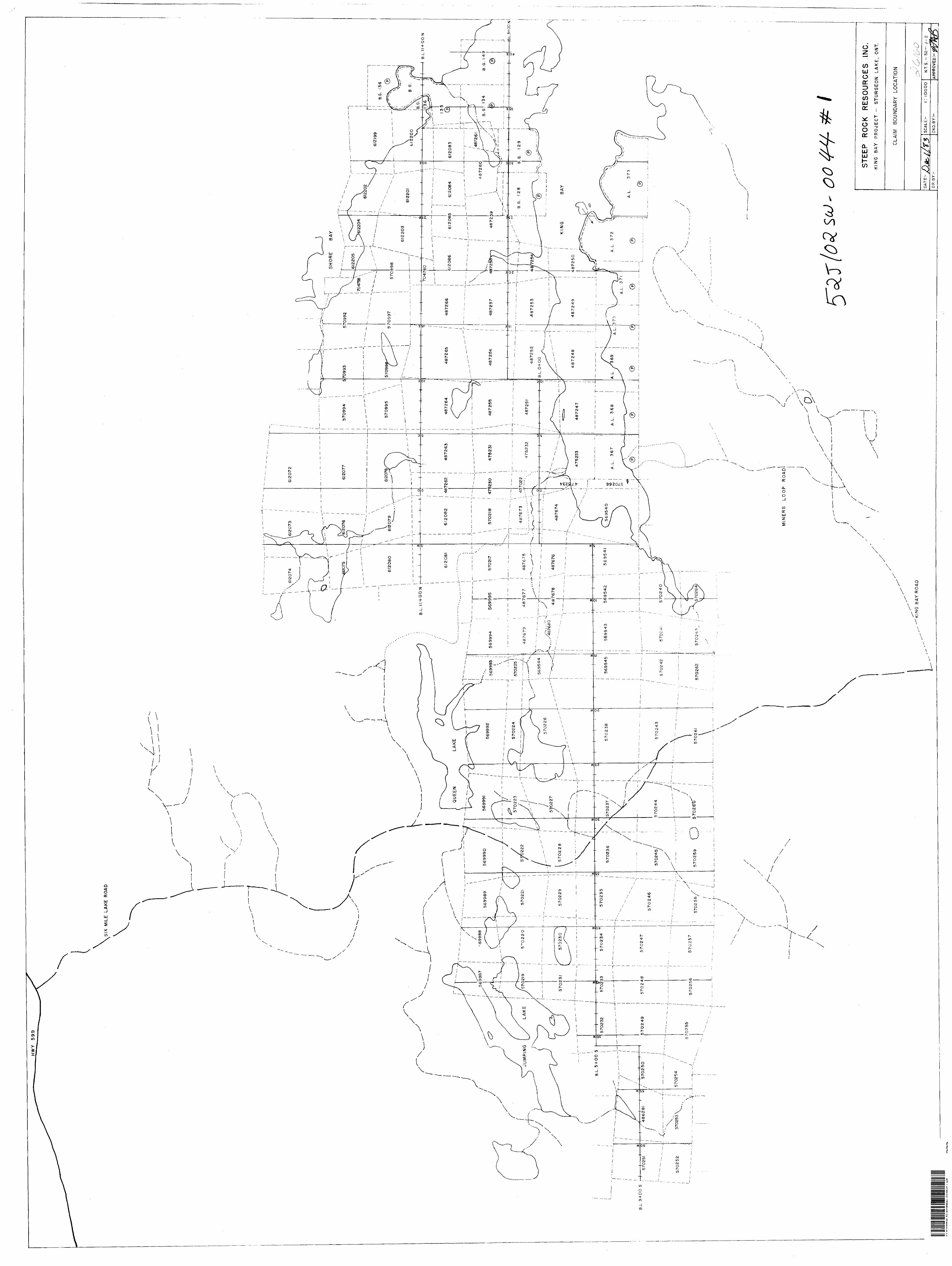
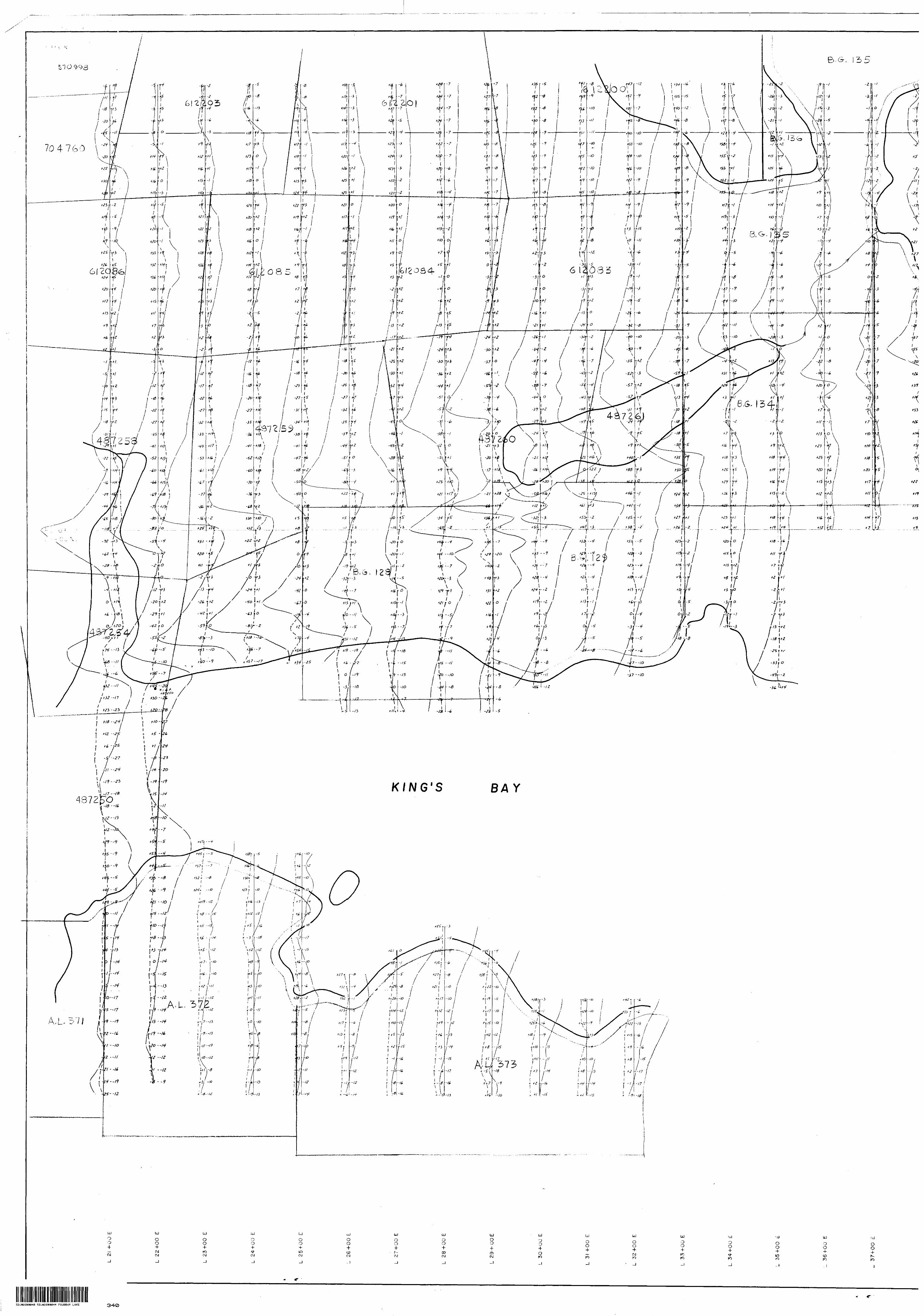
LOCATION. ACCESS AND GRIDS
The survey area is located on King's Bay on
Sturgeon Lake approximately 25 kilometers south of
Savant Lake, Ontario. The area is protected by 13
patented claims numbered BG 128, BG 129, BO 13**, BG 135,
BG 136, BG 149, and AL 367-AL373 inclusive and 131
unpatented claims numbered 612198-612205 inclusive,
570992-570998inclusive, 6l2083-864 inclusive, 475230-
34 inclusive, 612072-82 inclusive, 487247-66 inclusive,
487673-80 inclusive, 569540-45 inclusive, 570217-266
inclusive,569987-95 inclusive, 704758, 704760, 437022,
and 486281. These claims are either held by or are
under option to Steep Rock Iron Mines Limited. The
claims under option are from several different parties.
Access to the general area via highway #599 is
excellent all year round. The Great Lakes Forest
Products Six Mile Lake Road and related haul roads can
be easily travelled during the summer and greatly facilitate
access to the property by snow machine in the winter.
-2-
The grid was established by Steep Rock Iron Mines
Limited, who contracted the work to Mrt Allen Best of
Savant Lake, Ontario. Approximately 270 kilometers of
wing lines and 19 kilometers of base and tie lines were
cutt chained, and picketed at 25 meter intervals. The
work was done during the fall and winter of 1982-83.
PERSONNEL - .
The day to day and over-all supervision of the
geophysical program was under R.D. Middaugh of Phantom
Exploration Services Ltd.
INSTRUMENTATION
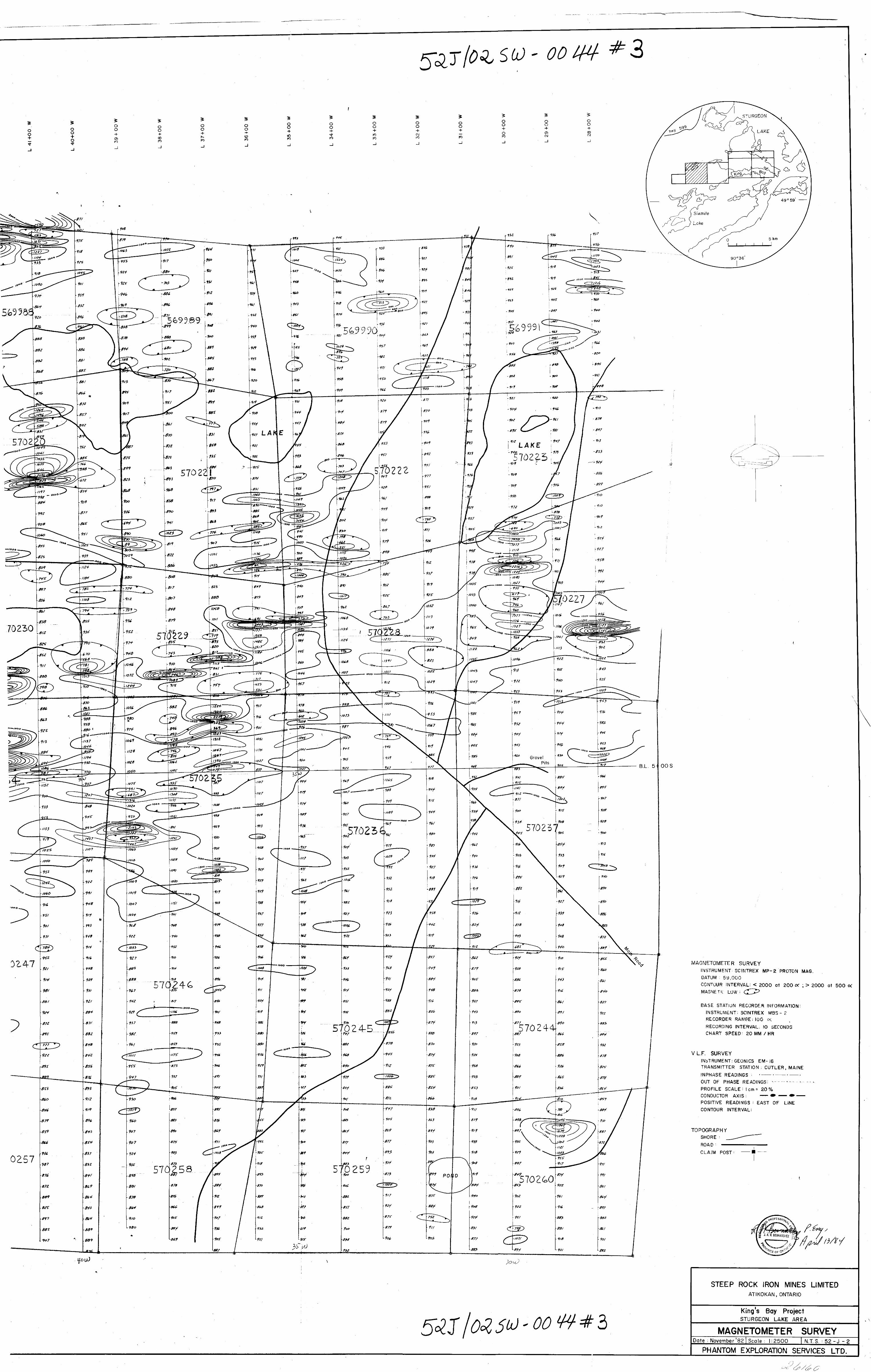
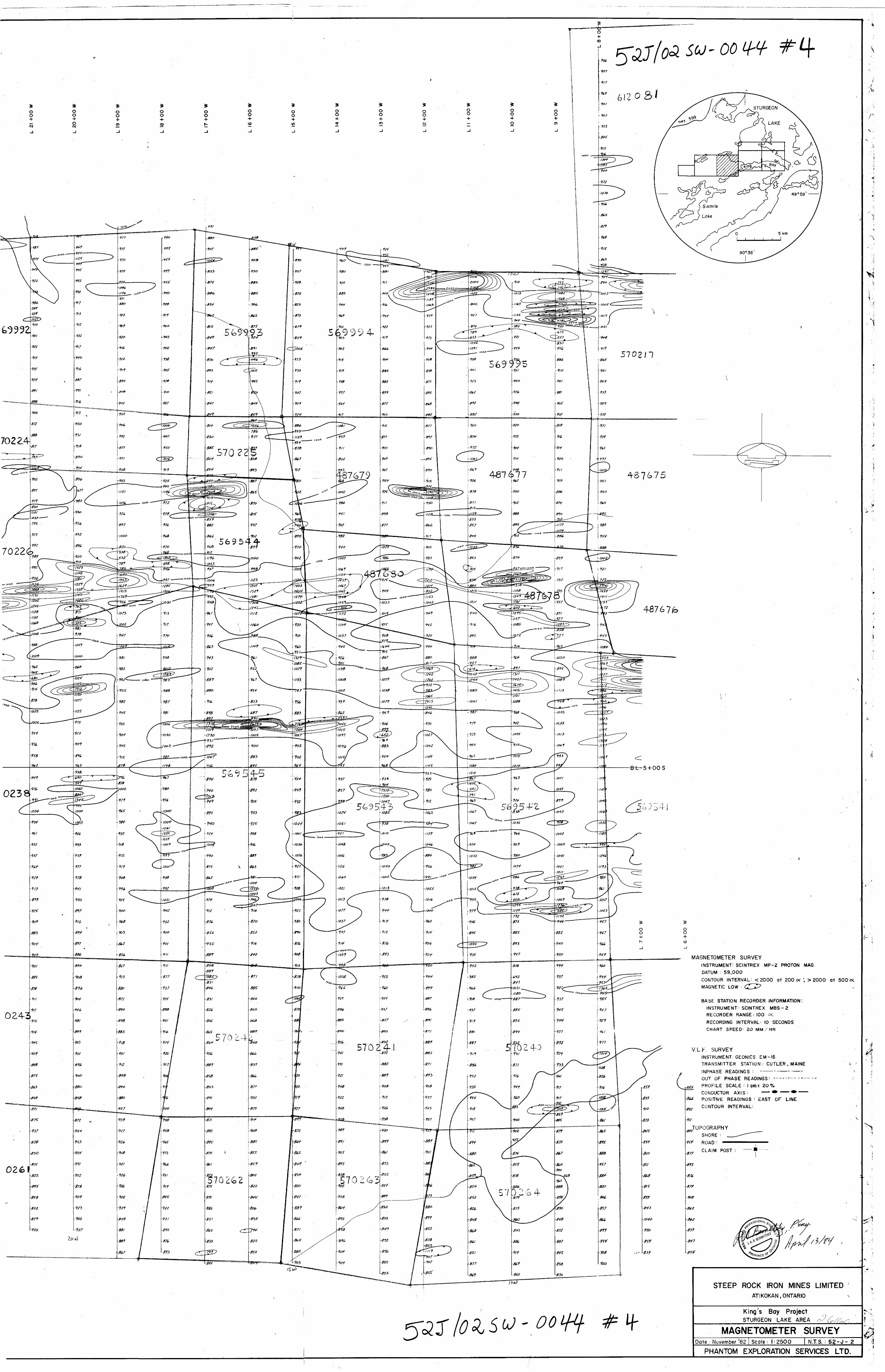
Magyetic•OMMMMMaMMMMOOTMM ^
A proton precession magnetometer (model MP-2)
manufactured by Scintrex Ltd. of Concord, Ontario
was used for this survey. The total field measure
ment was read with a resolution of one gamma and
all values were corrected for diurnal variations
using a MBS-2 model base station recorder, also
manufactured by Scintrex Ltd. Readings were re
corded at 25 meter intervals on the grid lines. Where
the magnetic gradient exceeded 300 gammas between
25 meter stations, an intermediate reading wan
taken at 12.5 meters.
-3-
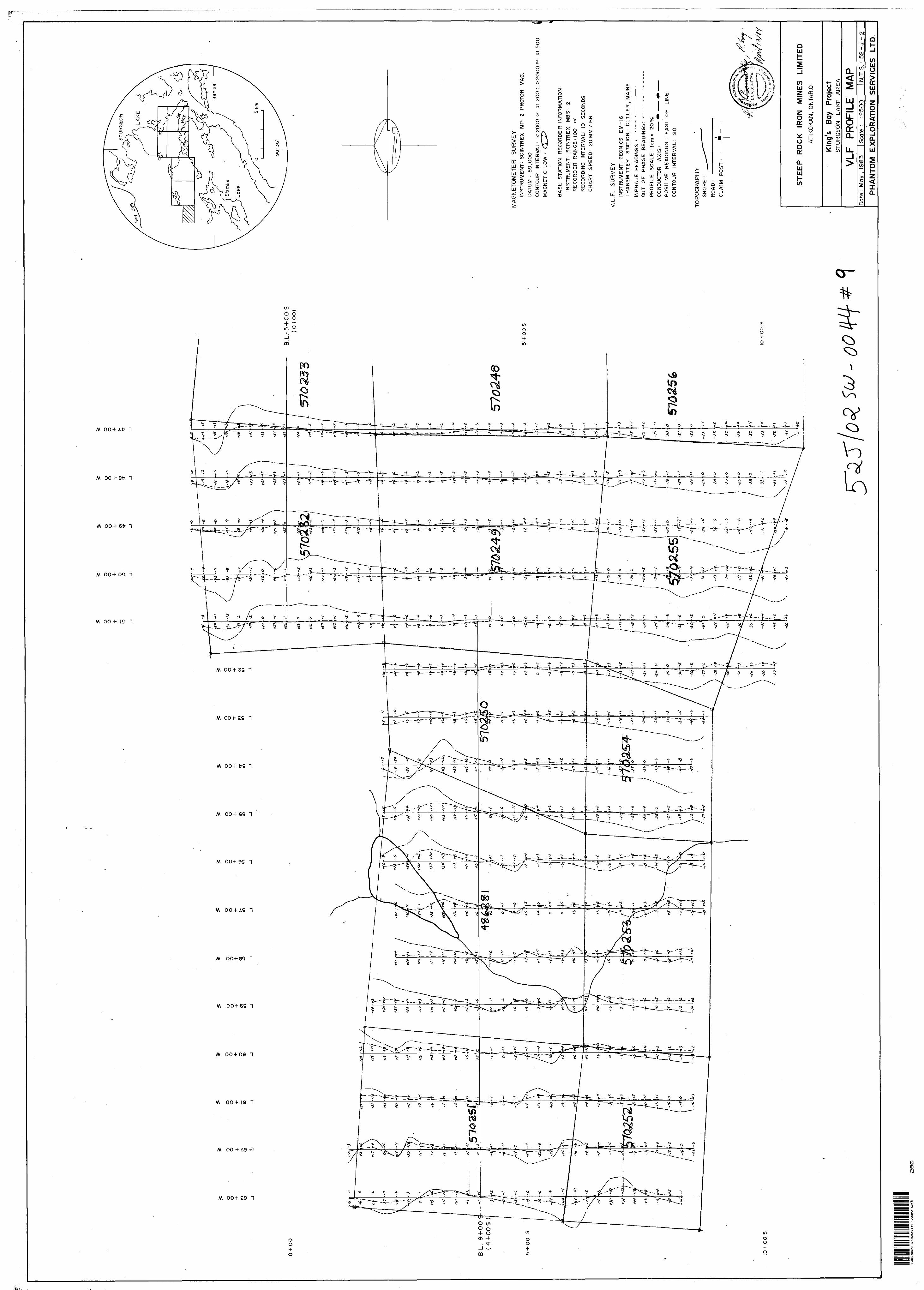
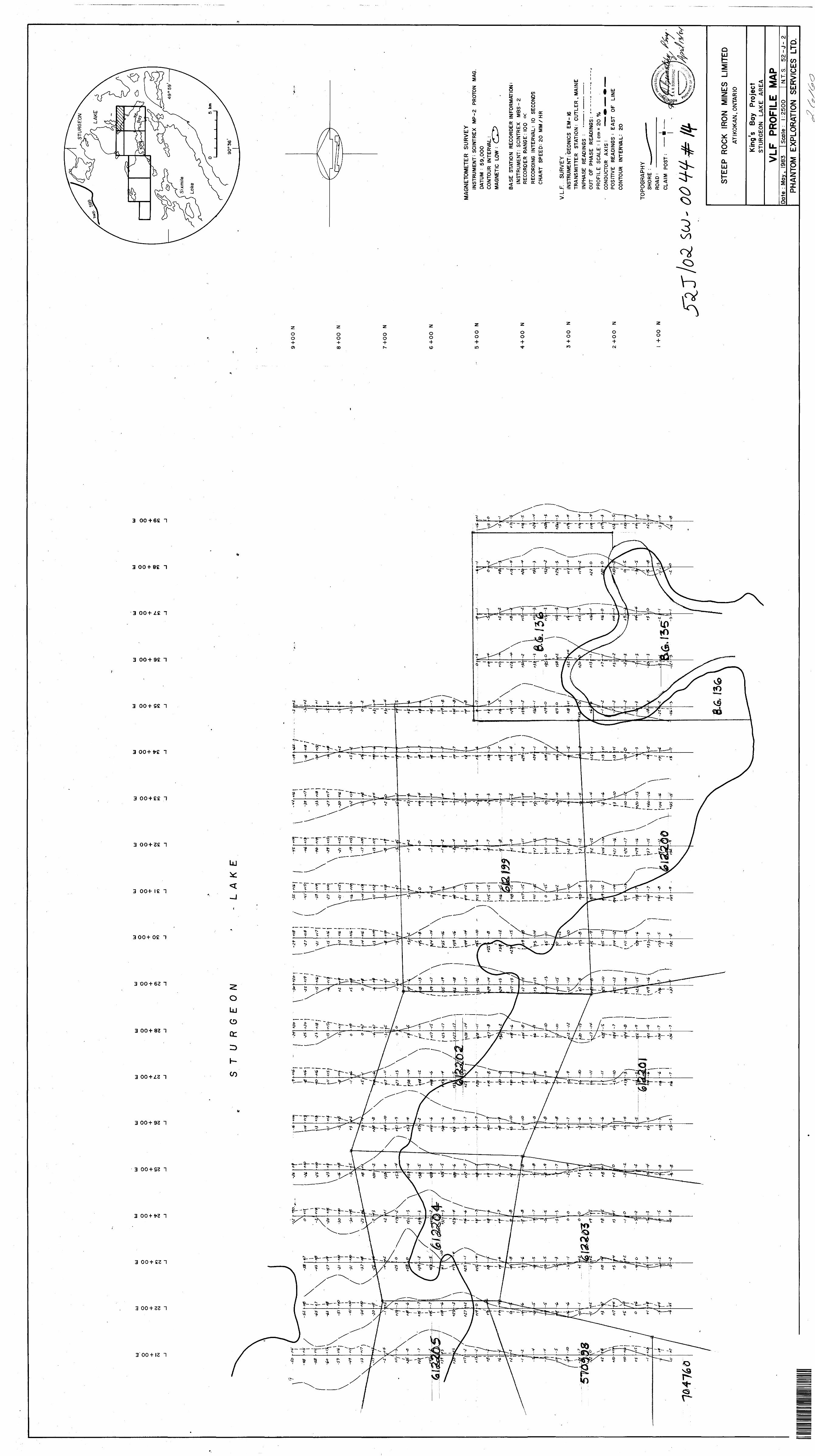
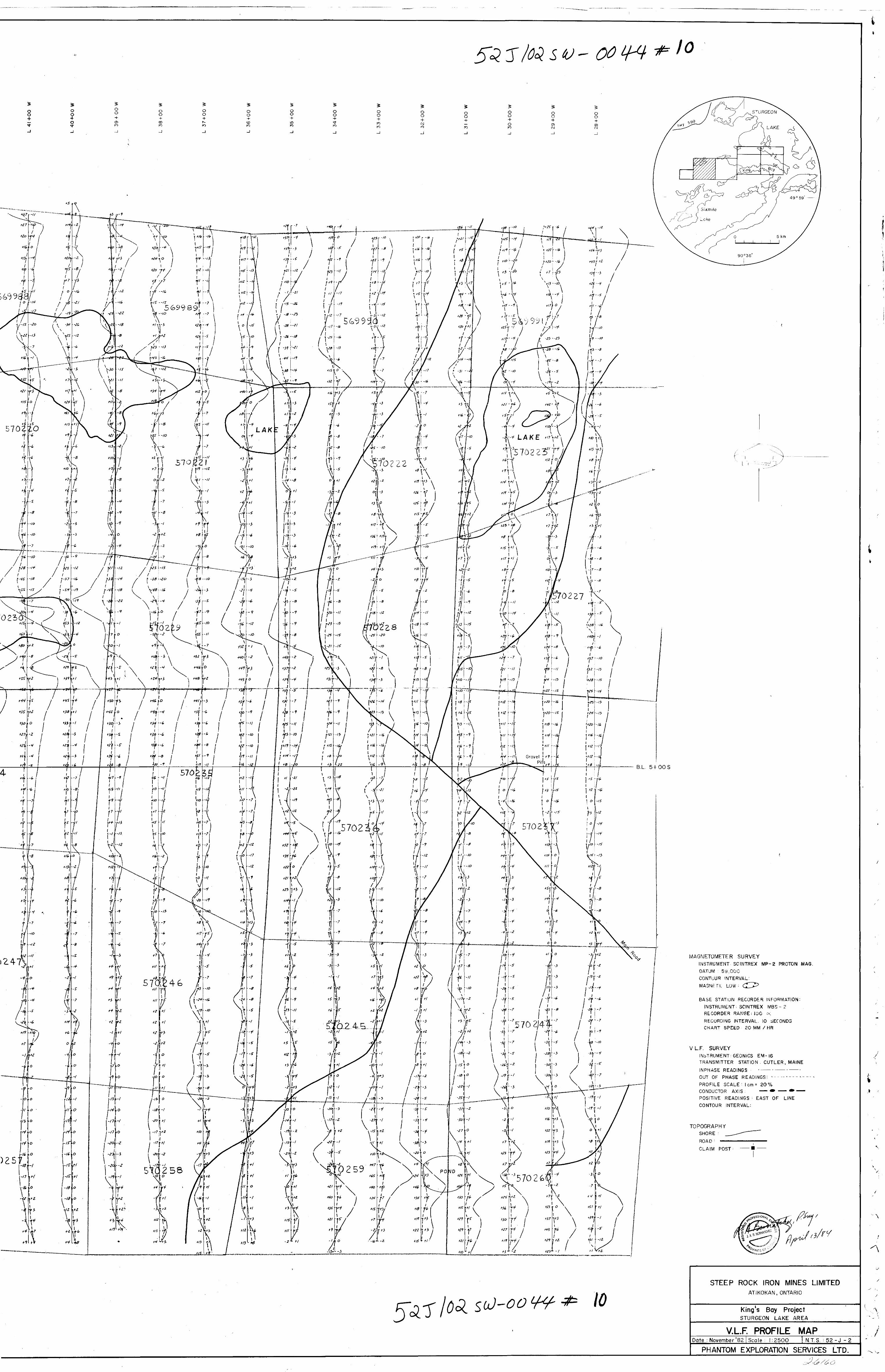
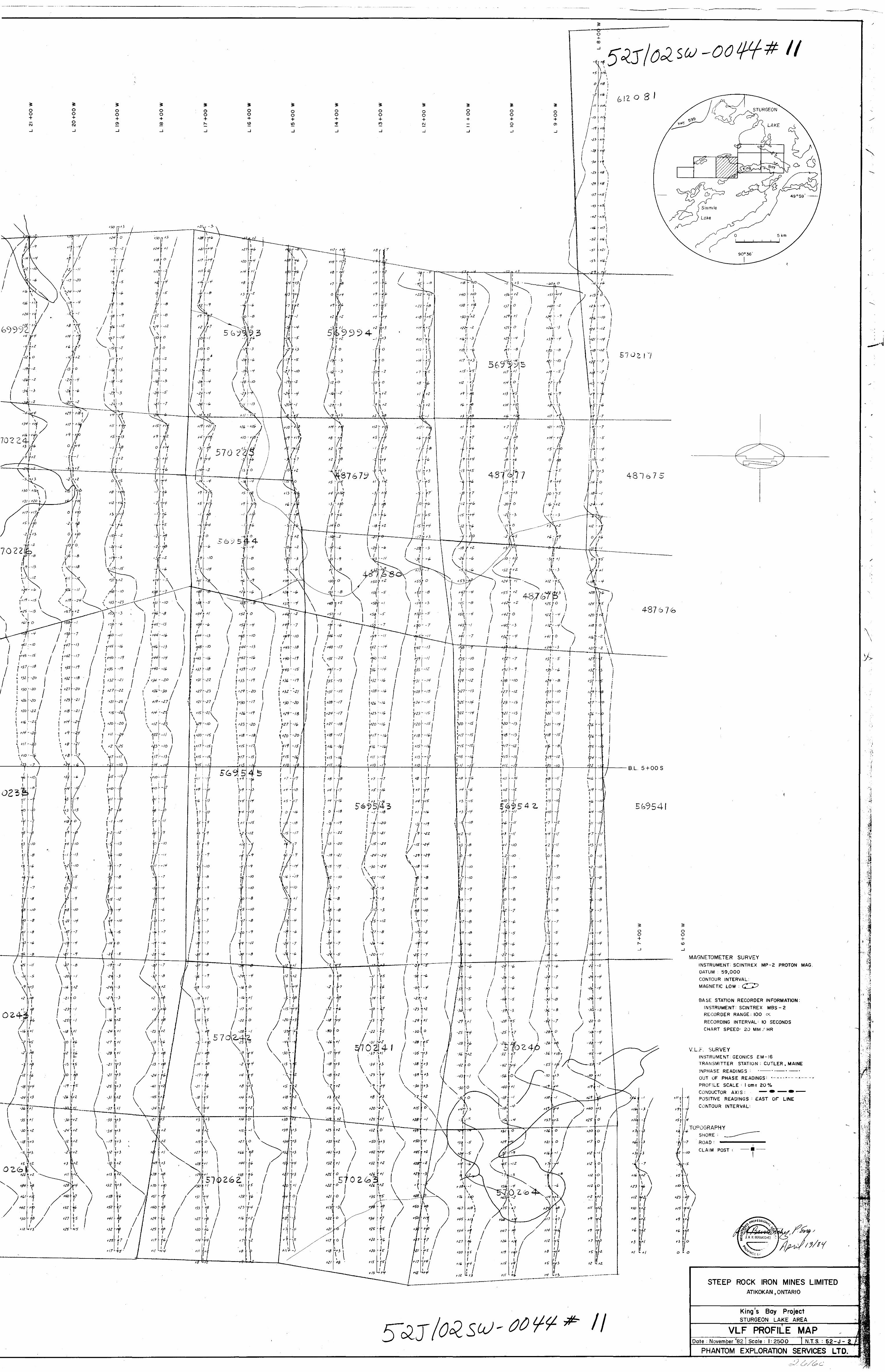
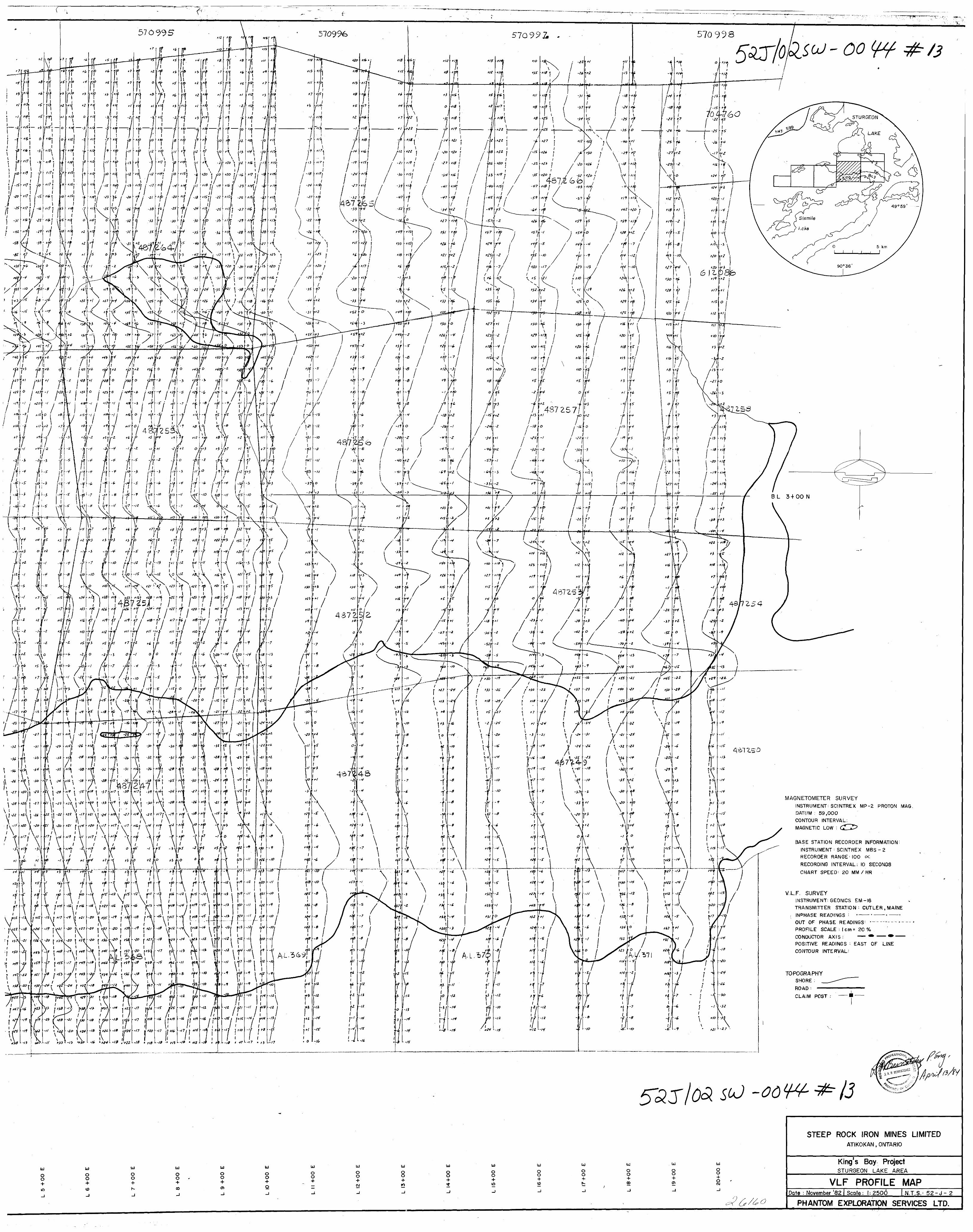
Electromagnetic
A VLF EM-16 unit manufactured by Geonics Ltd. of
Mississauga, Ontario was used for this survey. Both
in and out of phase readings were taken at 25 meter
intervals on the grid lines. The transmitter station
used was Cutler, Maine with a frequency of 17.8 KHz.
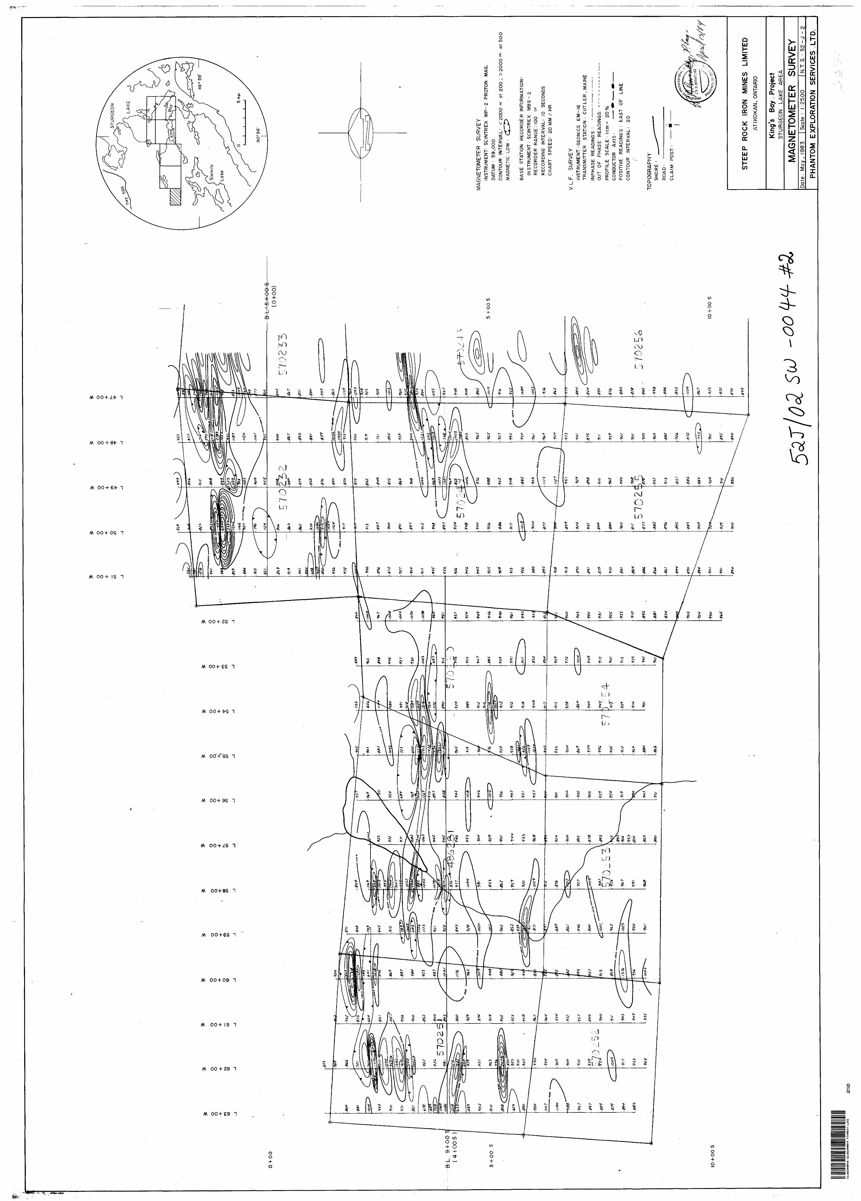
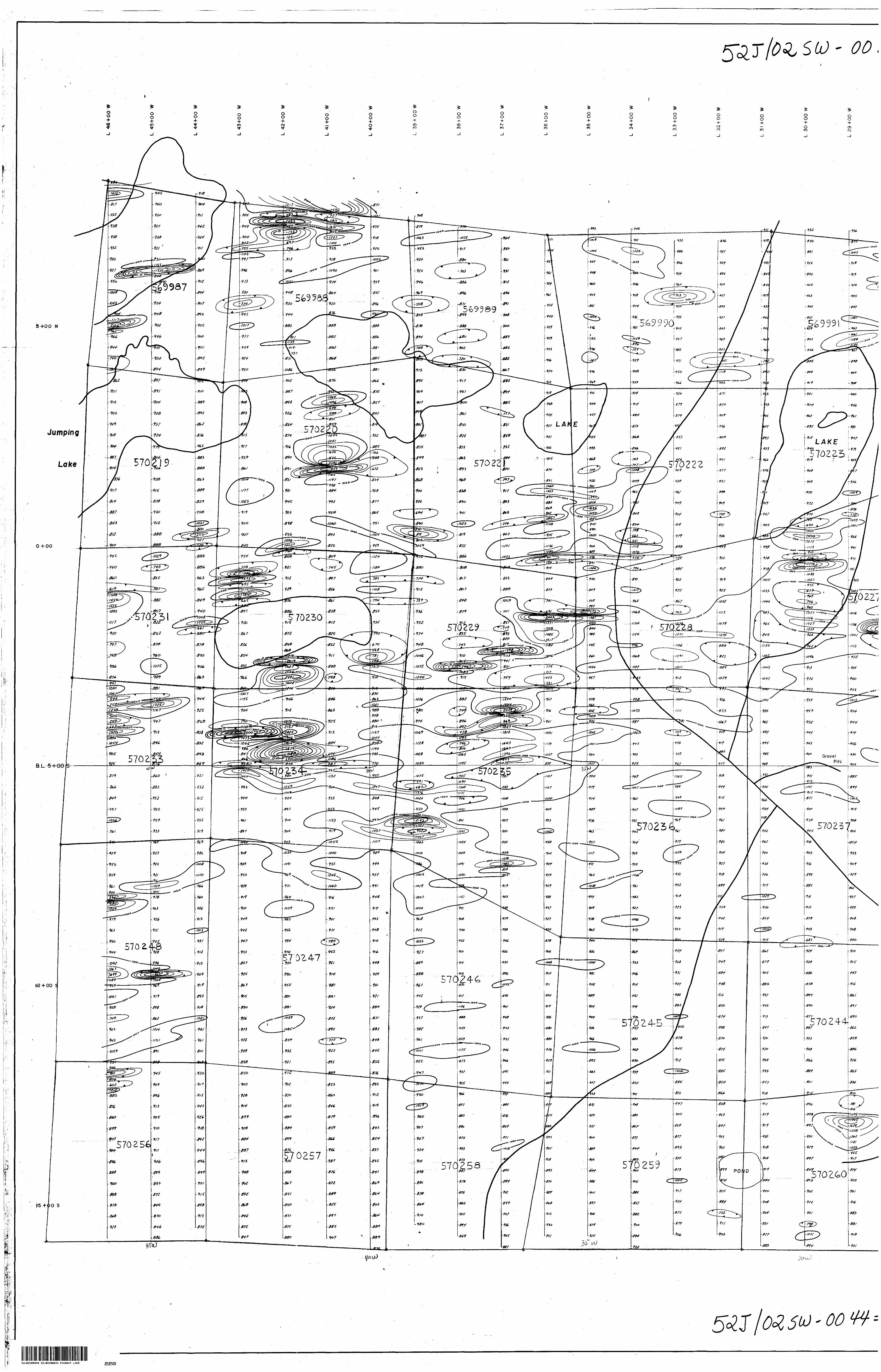
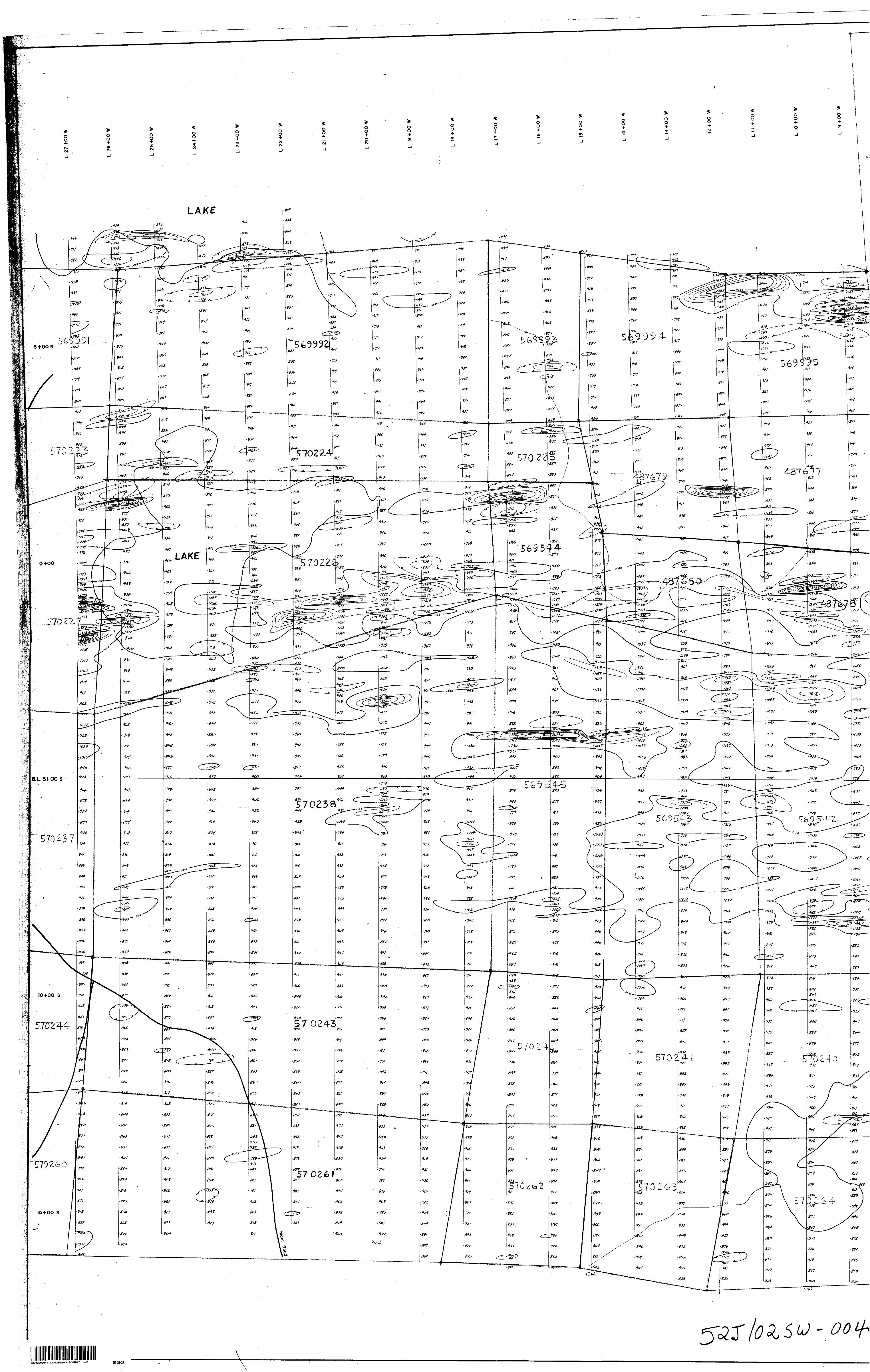
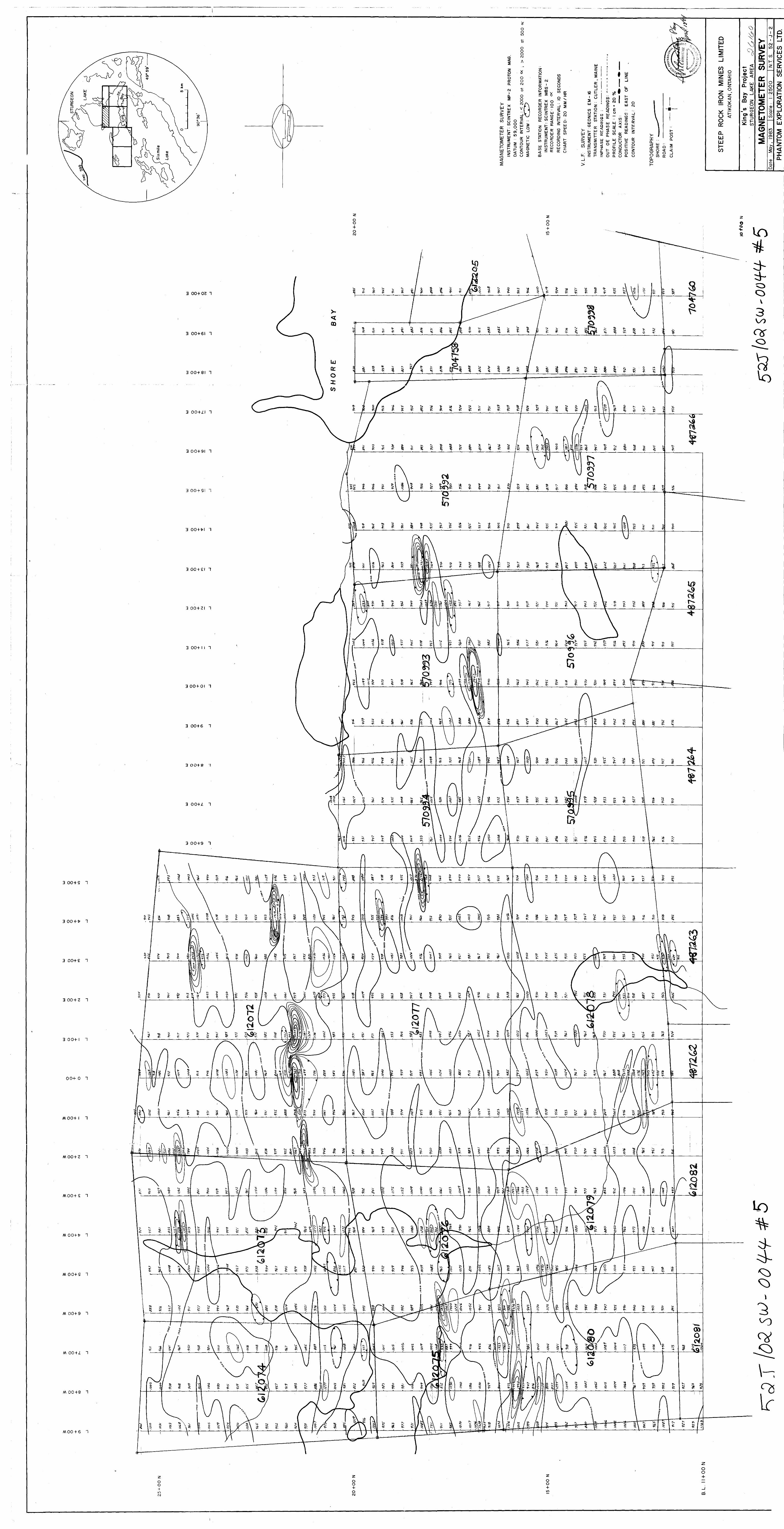
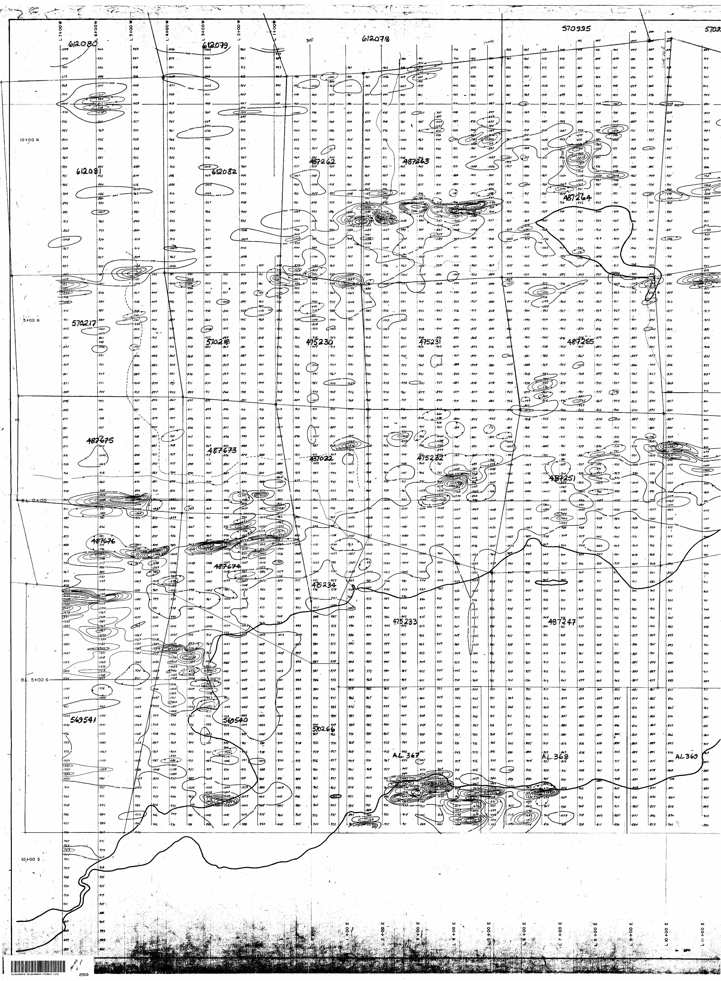
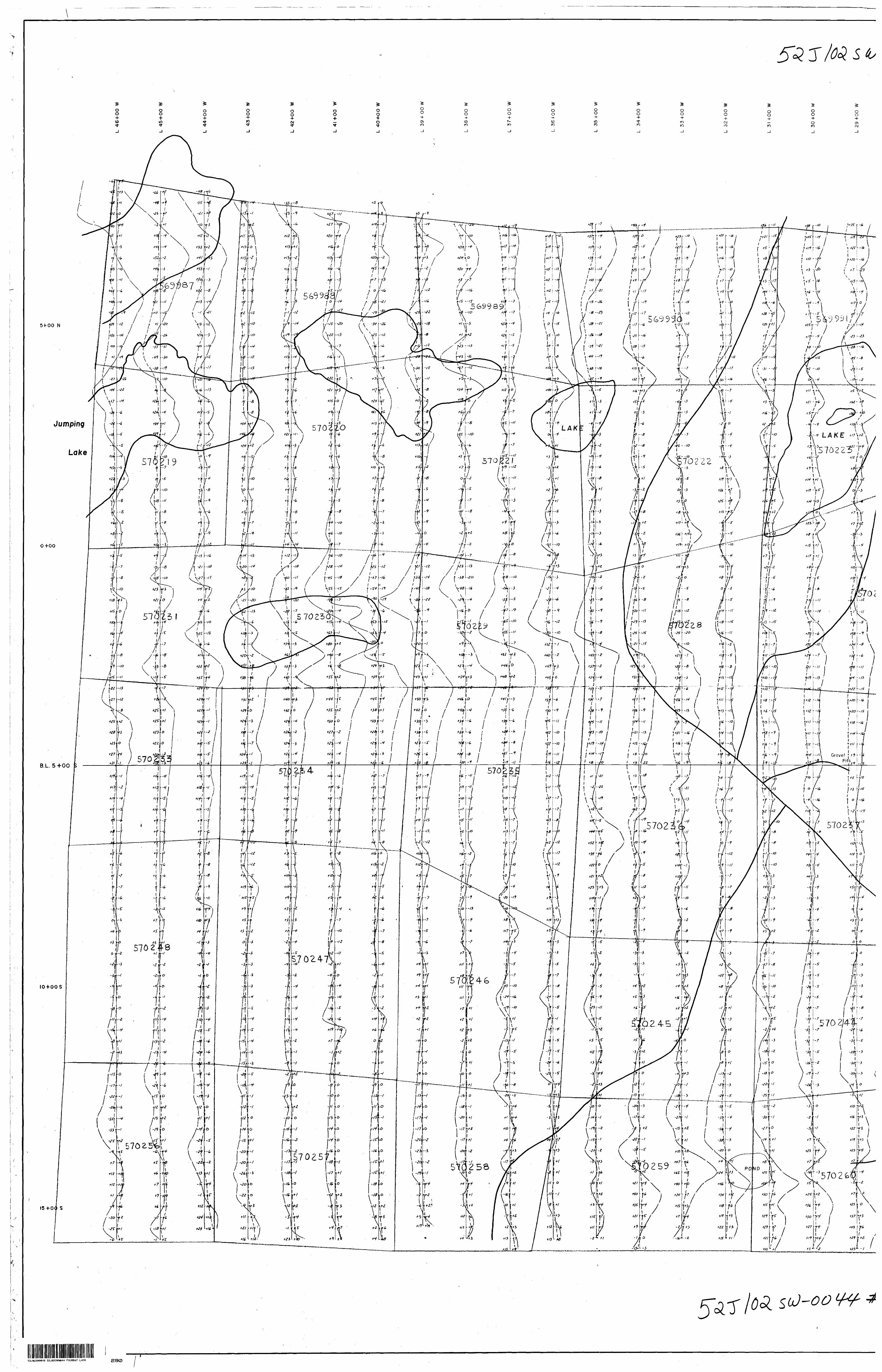
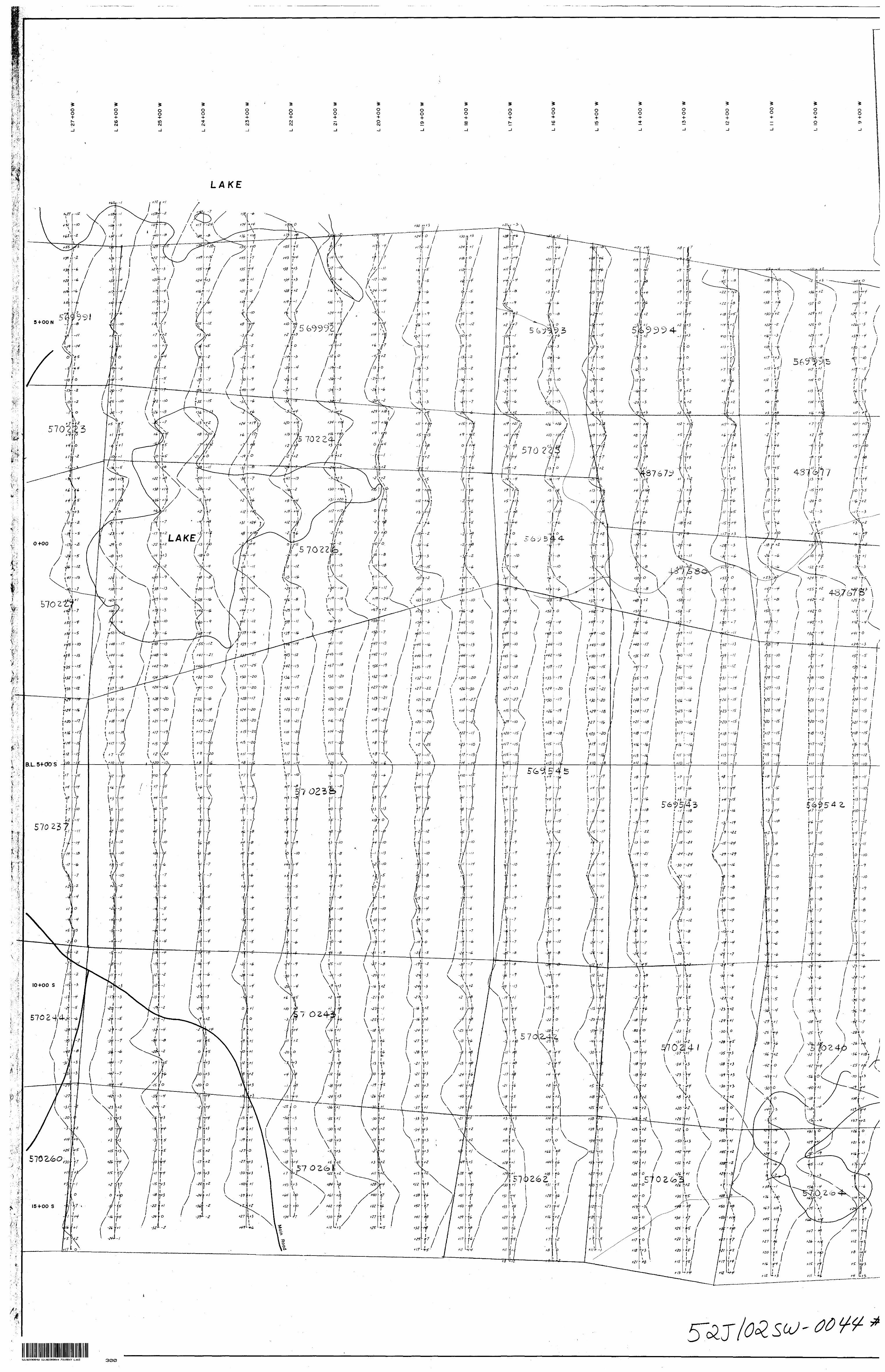
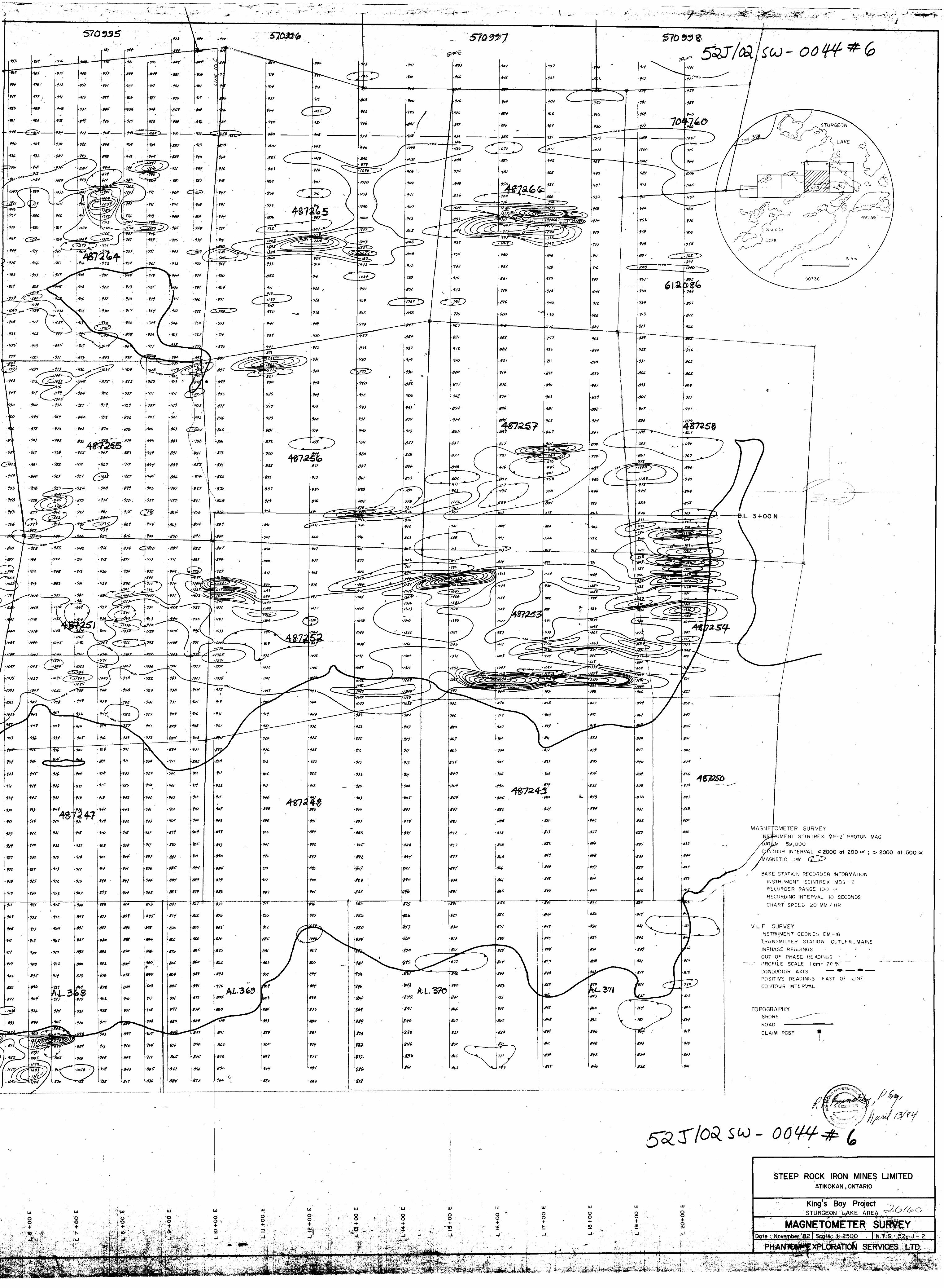
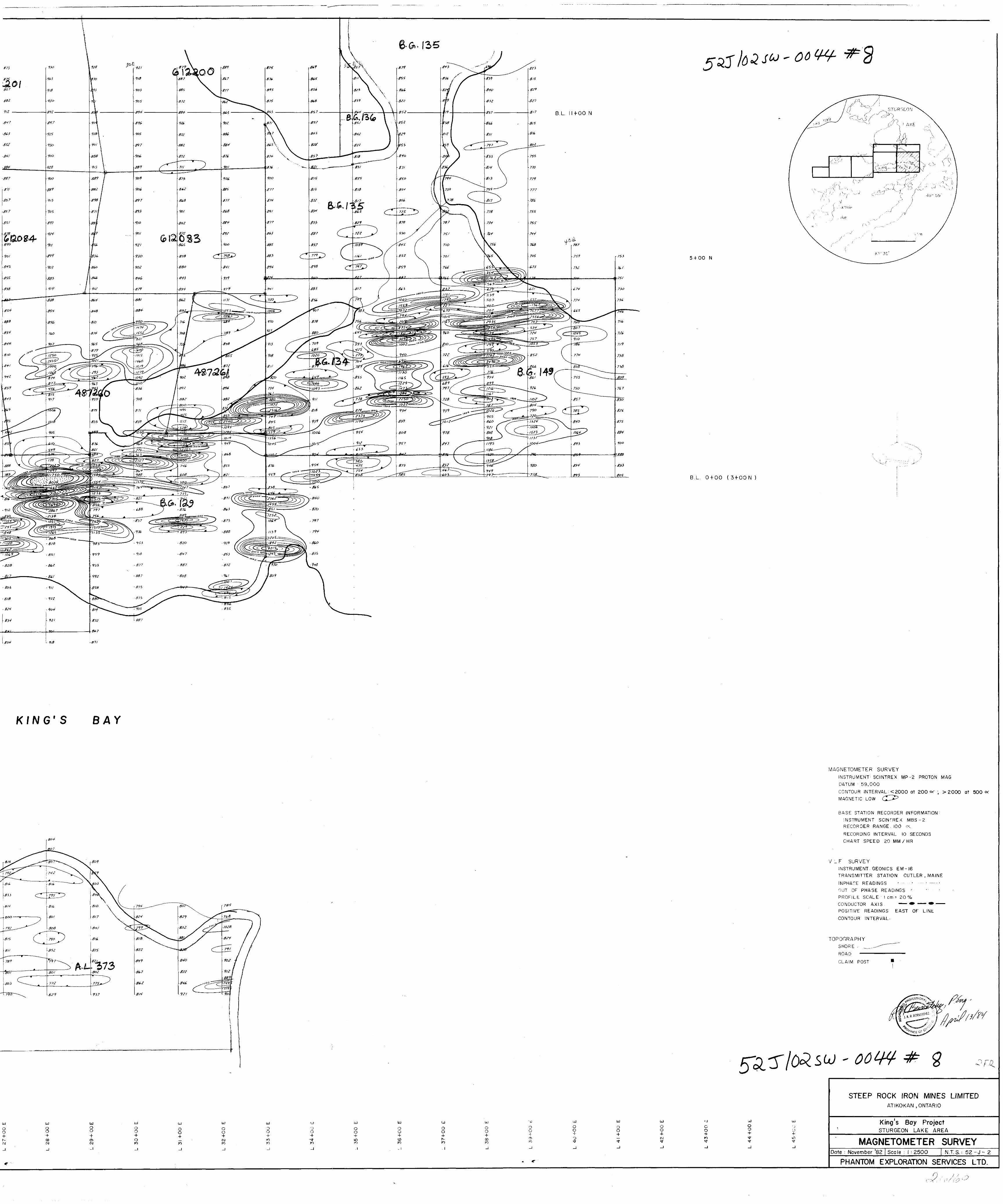
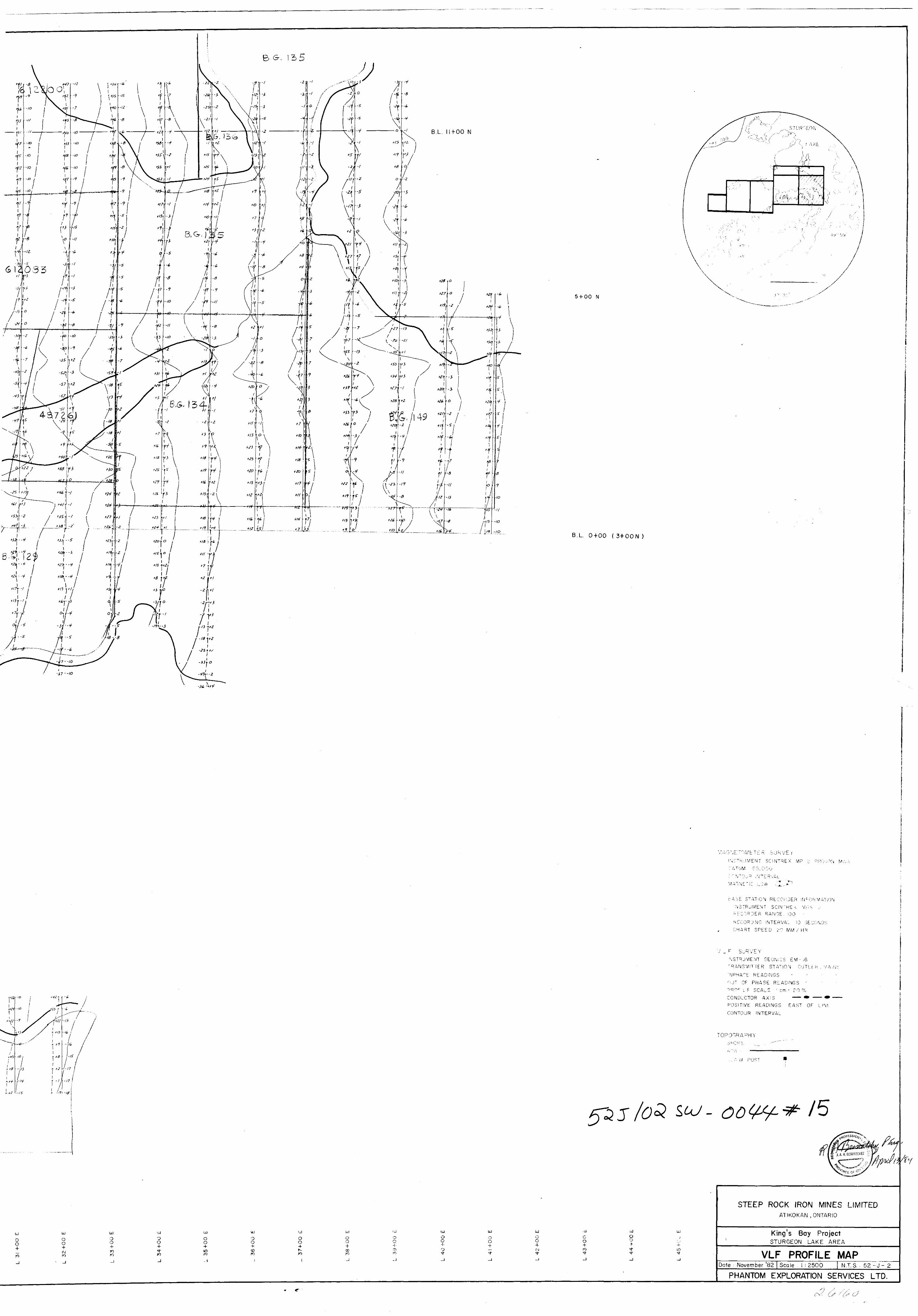
DISCUSSION OF RESULTS
Magnetic
The survey area is presented in plan form on
seven maps at a scale of 112500. The corrected
magnetic data is plotted on these maps and con
toured at 200 gamma intervals where feasible. The
datum was selected to be 59)000 gammas.
While no regional magnetic gradient is evident,
the data does indicate a sequence of rocks that
exhibit an east-west regional trend. East of line
21+OOE, however, this trend bends east north-east.
The sequence is magnetically heterogeneous although
broad bands of rather quiet magnetics do exist.
These areas probably represent thick flow sequences
within the volcanic pile. The magnetic highs are
narrow in width and are discontinuous along strike*
Magnetic lows are intimately associated with these*
highs and are due to dipole effects. These highs
probably represent interflow exhalative iron rich
J
units within the volcanogenic sequence.
Other magnetic lows found within the survey
area and not associated with magnetic highs may
be due to felsic intrusive rocks. This is definitely
true of large areas located on the eastern portion
of the grid.
One very prominent magnetic feature is located
between lines 1+OOE and 7+OOE at about 8+OOS to 9+OOS,
This feature seems to be quite isolated and' could
possibily represent the result of some sort of
north-south tectonic movement.
f'
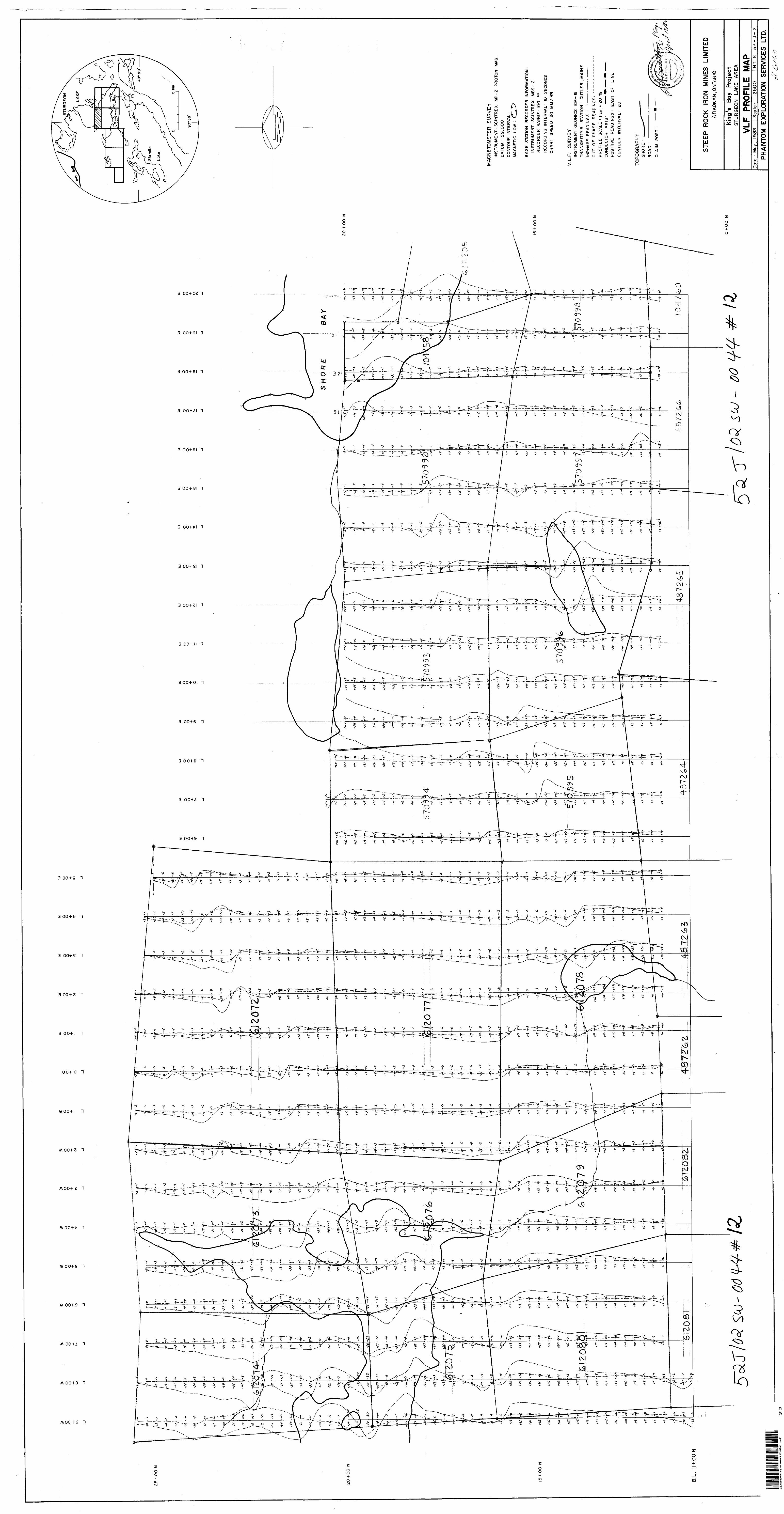
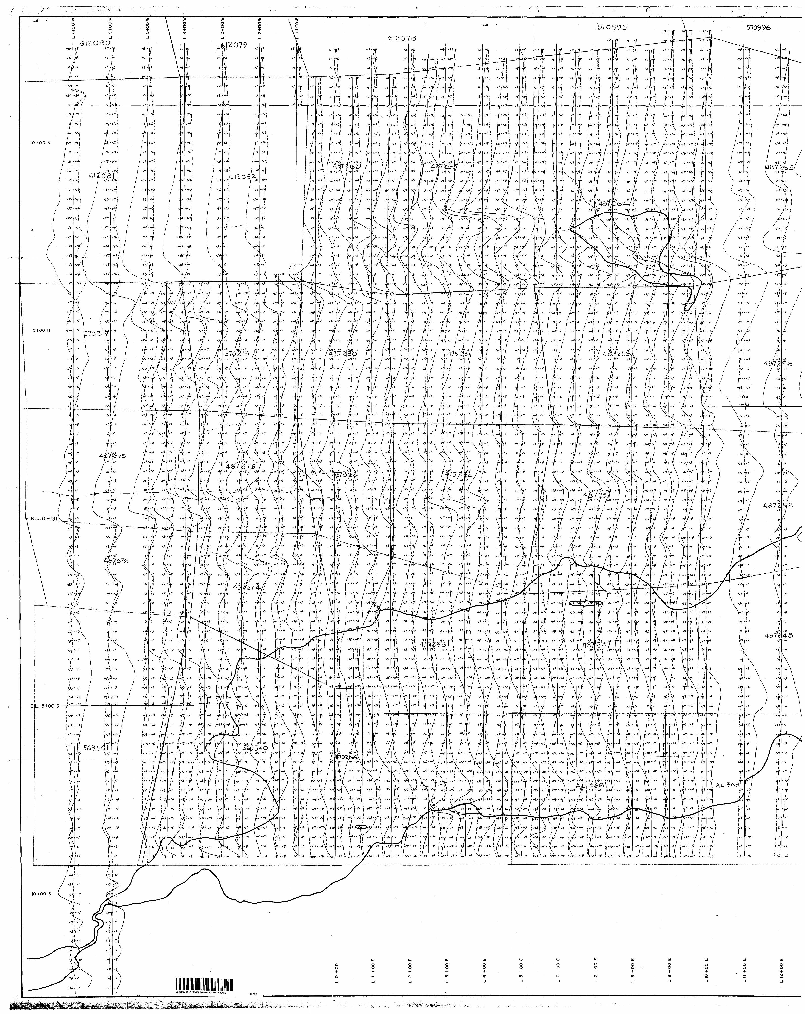
Electromagnetic
The survey area is presented in plan form
at a scale of 112500 on seven maps with a vertical
scale set at l cm a 20# for the EM profiles. A
second set of maps at the same scale presentsithe
filtered data which is contoured at +20 intervals.
The numerous conductive trends located within
the survey area conform, for the most part, to
the regional magnetic trend and commonly are
directly related to the magnetic features. A few
trends, however, cut across strike at both north
east and north-west angles: suggesting that the ;
area has undergone east-west compressional forces.
The origin of these features was probably con-

-5-
temporaneous with the emplacement of the felsic
intrusive rocks found in the general area.
Some of the trends are traceable across the
entire survey area although the conductivity is
variable along strike. Many of the anomalies,'
however, tend to be discontinous along strike
while others pinch out completely.
The anomalies located in Sturgeon Lake
under King's Bay and Shore's Bay commonly have
moderate to good conductivity but no magnetic
signature. Although these conductors may be lake
bottom effect, their location relative to the
volcanic-intrusive contact area, warrant them;
some consideration.*
Many of the more prominent conductive trends
are summarized below.
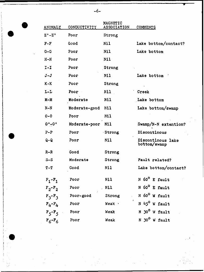
MAGNETICANOMALY
A-A
B-B
B'-B'
B"-B" '
B"'-B H '
C-C
D-D
E-E
CONDUCTIVITY
Good
Good
Moderate-poor
Moderate
Poor
Poor- goo d
Poor-good
Good
ASSOCIATION
Strong
Strong
Strong
Strong
Nil
Strong
Nil-good
Strong
COMMENTS
Sulphide horizon
Sulphide horizon
Fault related?
East extention B-B
Lake- swamp
^ ,
-6-
MAGNETICANOMALY
E'-E 1
F-F
G-G
H-H
I-I
J-J
K-K
L-L
M-M
N-N
0-0
O'-O*
P-P
Q-Q
R-R
S- S
T-T
VP1
F2-F2
F3-P3
F4-F4
F5-F5
FA-P*
CONDUCTIVITY
Poor
Good
Poor
Poor
Poor
Poor
Poor
Poor
Moderate
Moderate- good
Poor
Moderate -poor
Poor
Poor
Good
Moderate
Good
Poor
Poor
Poor-good
Poor
Poor
Poor
ASSOCIATION
Strong
Nil
Nil
Nil
Strong
Nil
Strong
Nil
Nil
Nil
Nil
Nil
Strong
Nil
Strong
Strong
Nil
Nil
. Nil
Strong
Weak -
Weak
Weak
COMMENTS
Lake bottom/contact?
Lake bottom
Lake bottom '
Creek
Lake bottom
Lake bottom/swamp
Swamp/N-N extent ion?\
Discontinous
Oiscontinous lakebottom/swamp
Fault related?
Lake bottom/contact?
N 600 E fault
N 600 E fault
N 600 W faulti
N 450 W fault
N 300 W fault
N 300 W fault
-7-
Conclusions and Recommendations
The area is underlain by an east- west strikingi
near vertical dipping sequence of volcanogenic
rocks. They consist for the most part of intermediate
flows with minor tuffs and associated volcano-
clastic sediments. This sequence has undergone
minor regional east-west compressionali forces which
v&s contemporaneous with the emplacement of large
felsic intrusives found in the general area. The
magnetic and electromagnetic trends probably outline
the more sulphide rich interflow exhalative sequences'
Detailed mapping and prospecting should be
carried out in order to better evaluate the geo
physical results. Since the main economic interest
on the property is gold mineralization, geochemical
sampling of a suitable nature may better define
any gold bearing horizons not necessarily outlined
by the geophysical methods used to date. A detailed*,
tightly controlled magnetic survey over a relatively
small area around the discovery could possibly aid
in any structural control interpretation of the
gold mineralization.
Subsequent to the above recommendations a
drill program should be considered to test the
resulting target areas*
//r Submitted by
Phantom Exploration.Services Ltd.
R. D. Middaugh otologist
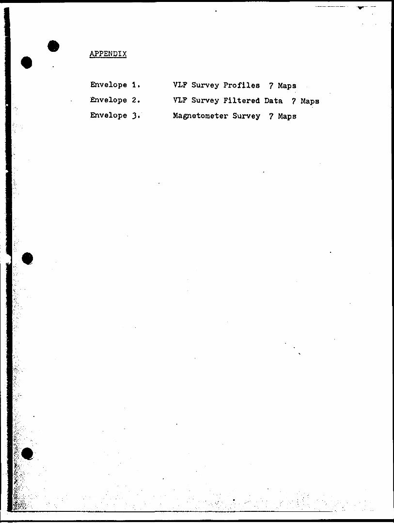
APPENDIX
Envelope 1. VLF Survey Profiles 7 Maps
Envelope 2. VLF Survey Filtered Data 7 Maps
Envelope 3. Magnetometer Survey 7 Maps
Z',:": -Viff:
fei?ft
^.-....
.1
L ..
- -
. -. l. - -
— 4
. - - - ~
1.T
- - -

Ontnr;o t-***!*. (Vi
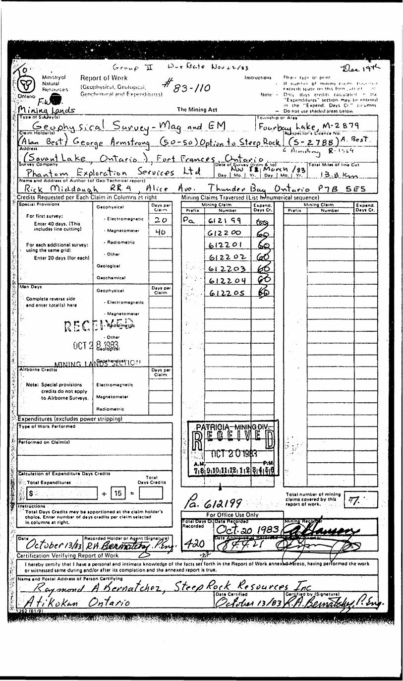
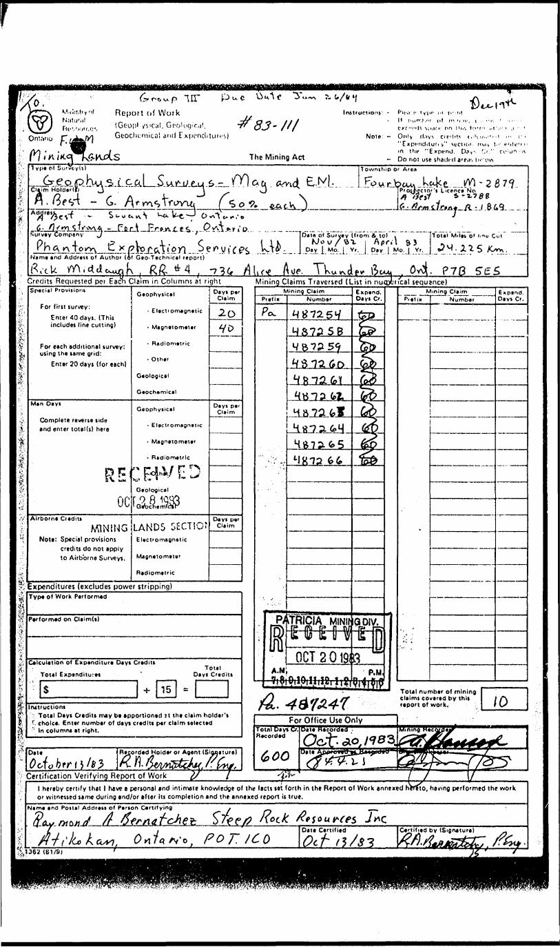
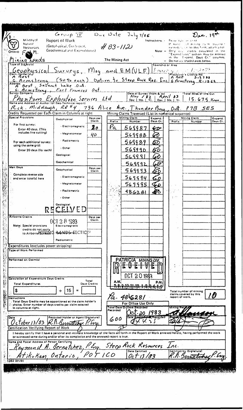
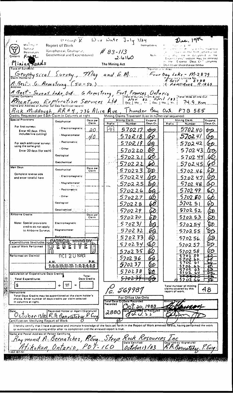
Grroup X
Report o l WorkiGeophyMCul, oi okiy.i d', Geochomical and Expenditures)
The Mining Act
Instruct rms - Pic IM i*;-* ;.i piinili Mint.- ot n,!nir,g ' . ;\ I M 1'avi :-* ! ' '•-i ^ i. rv(),K* p on th'S lo'm, ;*U4irh ('i hsi
Nnip - (i''\ (I.'V. r f(!:u ulcuialfJ si. the "f .iM.-iitiii'- .'s" section may t^'enterfil in 'in- "Expend Osys C'." (Olumns. D 1"; i!Oi nil ihjrtf il areal br'otv.
Type ol
G ^ . l . l Q -- _ *?.iiLpJ!)yiJ5!j Cc^ L .r* VCraim Holde"rTsV
k M
Address(f
v/
Survey Company
P h a n fo n Ir x pi o ra l it) y^i 'Name and Address of Author (of Geo Technical report)
bate of Survey (lrom.fi tol tolel Miles of line Cut
2 7. 85
Credits Requested per Each Claim in Columns at ri Mining Claims Traversed ( ist in numerical sequence)Special Piovijiont
For first survey:
Enter 40 days. (This includes line cutting)
- Electromagnetic
For each additional survey: using the tame grid:
Enter 20 days (for each)
Geophysical
* ElectromagneticComplete reverse side and enter total(s) here
Radiometric
Airborne Credits
Not*: Special provisions credits do not apply to Airborne Surveys.
Electromagnetic
Magnetometer
Radiometric
Expenditures (excludes power stripping)Type Of Work Performed
Performed on Qaim(t)
Calculation of Expenditure Days Credits
Total ExpendituresTotal
Days Credits
InstructionsTotal Days Oedits may be apportioned at the claim holder's choice.. Enter number of de y J credits per claim selected In columns at right.
Recorded Holder or Actnl (Signature)
Certification Verifying Report of Work
lO-t GM* k) o*- i
MfO'i!v d;s"E*pcmMgriV section rray, IK- ••ntcii-i);n the "Enpend. Days C" " en umnsDo not u',c shadftl areas below
83 ~ 110
The Mining Act
yv 5 v CAoClaim HolderltT
" 2.788)*-****-" ~
Address
/X-Survey Company
-
Qy.'ttxr.'ft oTotal Miles ci line Cut
Day \ Mo. j Yr. ] Day J Mo. f YiT j '.J^L^ 'Nim* and Addratt of Author (of Geo-Technical report)
''•Credits Requested per Each Claim in Columns rt rightSpecial Provision!
For first survey:Enter 40 days. (This includes line cutting)
For each additional survey: using the same grid:
Enter 20 days (for each)
Man O* y t
Complete reverse side and enter total (s) here
OCT5
r, i AAirborne Credits
Note: Special provisionscredits do not apply to Airborne Surveys.
Geophytiol
- Electromagnetic
- Magnetometer
- Radiometric
. Olh.r
Geological
Geochemical
Geophysical
- Electromagnetic
- Magnetometer
' O ther
Mognatomet*'
Radiometric
Oayk par Cmm
• O
HO
Oayi per Claim
Days p*r Claim
Expenditures (excludes power stripping)
Mining Claims Traversed (List hrnumerical sequence)Mining C**im
Number
61 i l
6(22 00
6 l 2.7. OS
Expend. Days C'.
M i ni ftg--Cj*J nPt01(K Nurr*b*r
Expend. Days Cr.
Type of Work Performed
Performed on Clalmd)
Calculation of Expenditure Dtyt C'ediu
"Total ExpendituresTotal
Days C'edits
mtructloni' Total Days Credit! may be apportioned at the claim holder's choice. Enter number of days credits per claim selected In columns at right.
Certification Verifying Report of Workl hereby certify that l have a personal and intimate knowledge of the facts set forth in the Report of Work annexW-hfireio, having performed the work or witnessed same during and/or after its completion and the annexed report is true.
Name and Costal Address of Person Certifying
Oni.vio
(•y r-biA p lil
Report of Work (Geof)i Geoclicmicai and
Instructions' -
Noio: -
Cu-;i c tyjic CM j, "r, t H no^.t'"' ol MI *i H-, t . -M'. tjrfc'ls \;i,in: on IN.-, tti-t'i ,.r Only d.iy, cn-'lut (..'IM./V ."Expl'lldltUtl i" MrCIItil. IIliH l.
in the "Expend. Do*' O." Do not use ihaiird a'e.v. lifin\
e....^0 - 2 B 7 *?Ptasrcciof'i Liconc* No
__ - Namtand Address of Author (4l Gio-Technical report)
....... ... _ . . ... —....... ^ . ... __ , ,. .Djio ol Survey (from 4 to) . om Mile* o* imt-
^r. J D. yj Vj. .Y.r, .
- P70Credits Requested pet Eacli Claim in Columns at right
f*
*
lFjrVrt
l r/.
Special Provisions
For first survey:Enter todays. (This includes line cutting)
For each additional survey: using the same grid:
Enter 20 days (for each)
Man Days
Complete reverse side and enter total(s) here
ocAirborne Ci edits
MININGNote: Special provisions
credits do not apply to Airborne Surveys.
Geophysical
~ Electromagnetic
- Magnetometer
- Radiometric
- Other
Geological
Geochemical
Geophysical
- Electromagnetic
- Magnetometer
* Radiornetrlc
Geological
LANDS SECTIONElectromagnetic
Magnetometer
Radiometric
Days per Claim
~————
Days pe' Claim
Days p*r Claim
Expenditures (excludes power stripping)Type of Work Performed
Performed on Claim(s)
Calculation of Expenditure Days Credits - Total
Total Expenditures ' Days Credits
S -i- 1 5 * |rutructions
Total Days Credits may b* apportioned 21 the claim holder's ' choice. Enter number of days credits per claim selected
In columns at right.
Mining Claims Traversed (List in niKpbtical sequence)Mining CUim Expmd,
Diyi Cr.Mining Claim
NumberExpind. Davs C'.
f Date Recordad Hold** or Agent (Sloflature)
; Certification Verifying Report of Workl hereby certify that l have a personal and intimate knowledge of the facti set forth in the Report of Work annexed l or witnessed same during and/or after its completion and the annexed report is true.
, having performed the work
Name and Postal Address of Person Certifying
C* r L iv.* p Ty
M.iiiMryof Report ol Work Instructions: -
Ontano f?
Type of :
GcochcmiLal yid
fit-nv M il* HUM,i
f:"' (Til:, '.,
The Mining A ct
; fin inn i.i'm, Ht!:i'h i ' l -s' Note: — OrVy c. , ntxltts roiiuintcil ii Hir
"Exti'.'iul :.iri iv" M-ctir.i fl rndv't)!- pntr^inj in the f 'pend. Days C'." columns.
— Do not ir.i shaded artas below
Clain,
Township o' Area
—Address
o o ,,A^.cUcj4l\JLE)JL^i'i'i'';^..::. v :.^:::iii'-..._•J [PTOIO^Cto/'i Licence No.
Survey Company .V
5era (f 5 L c/Name and Address of Author (of Geo-TechnicAi report)
rt.ck.
Data ol Survey (from 6. to) IT'OUI Miles of line Cut
15. ^75
Credits Requested per EacfS Claim in Columns at right Mining Claims Traversed (List in nixiierical sequence)Qvfr. f
4-'.'
K-S r;;
Special Provisions
For first survey:
Enter 40 days. (This includes line cutting)
For each additions! survey: using the same grid:
Enter 20 days (foi each)
Man Days
Complete reverse side ; and entsr total(s) here
Airborne Credits
Nott: Special provisions credits do to Airborne^
O
Geophysical Days per Claim
- Magnotomoter
- Radiometric
- Other
Geological
Geochemicalj———
Geophysical
- Electromagnetic
- Magnetometer
- Radiometric
- Other
Geologicel
CEIV E DPT 2 8 '983
E tec t' o m* jnet le
Radiometric
Da y t p* r Claim
Days per Claim
•xpcnditures (excludes power stripping)T y p* o l W ork Performed
" rformed on Claim(s)
Calculation o( Expenditur* Days Credits
Total ExpendituresTotal
Days Credits
15mtructions' : Total Days Credit! m*y b* apportioned at the claim holder's ,'- choice. Enter number of deyi credits p*i claim selected
In columns at right.
Mining CUimPrefix Numb* r
4862.fi!
Expend. Days Cr.
Mining ClaimPrefix Numbtr
Expend. Diys Cr,
Date Recorded Holder or Agent (Signature)'Certification Verifying Report of Work
l hereby certify that l have a personal and intimate knowledge of the facts set forth in the Report of Work annexed hereto, having performed the work or witnessed same during and/or after its completion and the annexed report is true.
Name and Postal Address of Penon Certifyin
ftou-nonc/ tf.s Dtt* Certili*d (Signature)
: 1302 (81/9)
"'f^S ty?i?;~*jF'ffiisiiffi!'!'' P'^ty^f'-K^sfi^^j'^vffV!f'frvf^K^ff
Ontario
Report of Work(Gfophysic di, Gt'oi Gt'octu'mtccjl iHid E
-*
(Ml.l.S. ' ;n r; ". : f i-, ' u 'ct ion *VMV *'( pn'foO
'". i'tp C xjienti L**v* *-' f i'O'unms Do r r.{ us* stuul'Hi flu-cis hftow
ce *Jb.z 7 n e y. S. ^t-Jtt t— '
Survey Company.**J
,t
Nami and Aodret. o' Author (of Geo Tectm-cai rsno'U
.Dal. of Su'.ey I'-om fc lo)/(Jov a A^ i Miiet of line Cut
SB?Credits Requested per Each Claim in Columns at right___ Mining Claims Traversed (List in numerical sequence)Special Proviiiont
For first survey:
Enter 40 days, (This includes lin* cutting)
For each additional survey: using the same grid:
Enter 20 days (lor each)
Man Da y i
Complete reverse side and enter totel(s) here
Airborne Credit*
Note: Special provisions credits do not apply to Airborne Surveys.
^
Geophysical
- Electromagnetic
- Magnetometer
- Radiometric
- Other
Geological
Geochemical
Geophysical
' Electromagnetic
- Magnetometer
- Radiometric
- Olh*r
Geological
Geochnrpicel i ! '
Electromagnetic
Magnetometer
Hftriinmplrir
Days per Claim
20
40i
Od y t per Claim
—— ,^^-
.^,
Da yi por Claim
Expenditures (excludes J^TO^'fiU WIWK, VP. Of Work Performed W (fe (^ ]fi l) V/ lb M
Performed on CI*imU) Q P j g !J 1PR3
7|8i9ilpiIIil2il|?i9iM|pCalculation of Expenditure Days Credits!
i Total v Total Expenditures Days Credit!
rls +IIF -Initructiont
Total Days Cradits m* y b* apportioned at the claim holder't choice. Enter number of days credits per claim selected in columni at right.
Mining ClaimPrefix Number
5702.il
57o2 2.1
5.702,2V
570235"57023^5701*7
Expend. Days Cr. Prefix
Mining ClaimNumber
S702
570?-
S70J.
Expend. Days Cr.
Total number of mining claims covered by this report of work.
Date i
O cto b f r^ '3/33Recorded Holder or Agent (Signature)
Certification Verifying Report of Work
For Office Use OnlyTotarDayTCr. Recorded
Date Recorded Mi n i n g"pegp r**r
tsztf'*'
jz:l hert-tiy certify thai l have a personal and intimate knowledge of the facts set forth in the Report of Work annexed heTetO, having performed the wotk O! witnessed same during and/or after its completion end the annexed report is true.
Name and Postal
./l AV 7*70*7
of Person Cerf
d A -AtCtfo. Tt Ae zDate Certified
^-^m,
2iicCertified by (Signature)j? h. 0 .t—, KM ffcimZcZts. 7s162 (61/9)
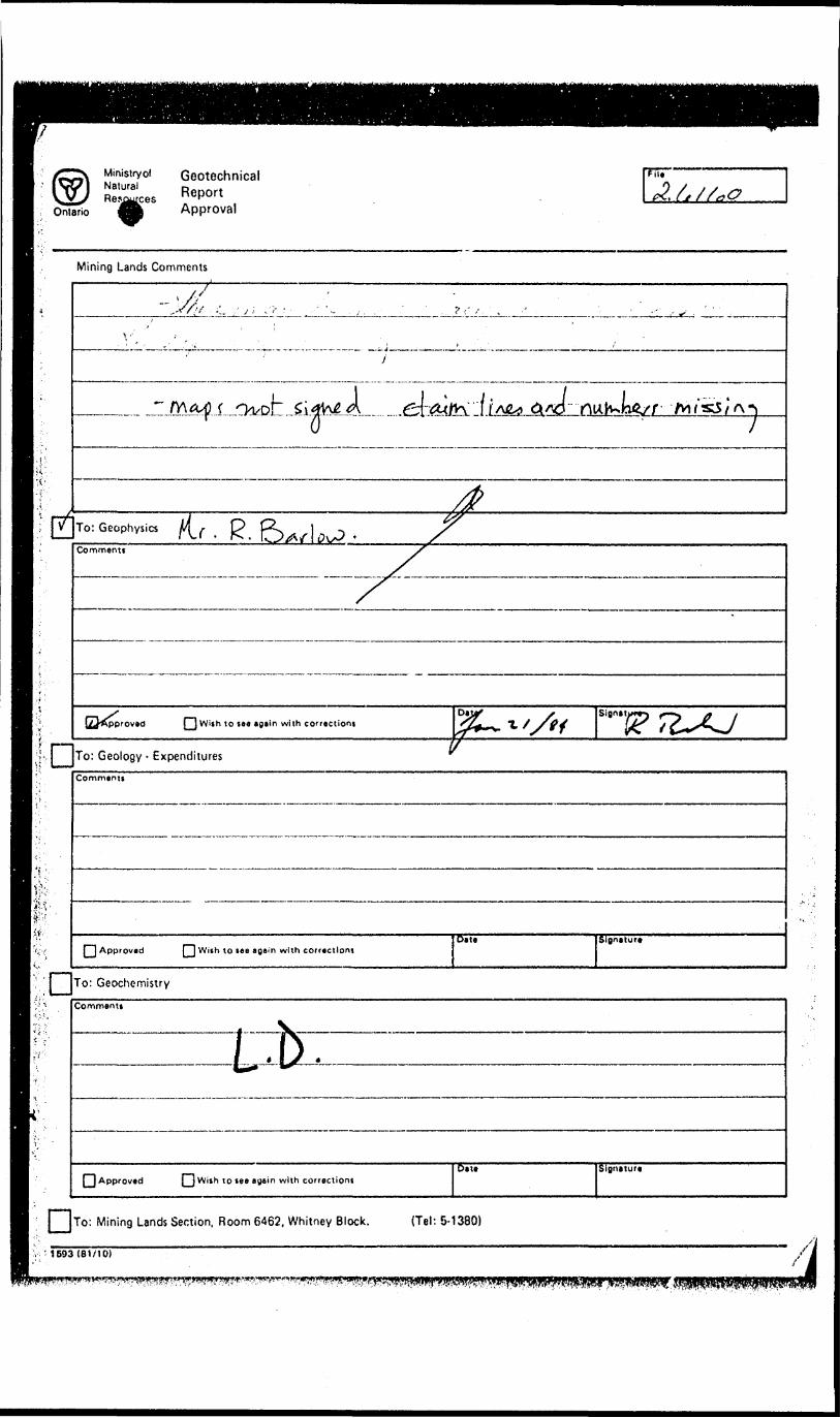
Ontario
Ministry olNaturalRe^^ces
GeotechnicalReportApproval
Mining Lands Comments
O
lAO
To: Geophysics Mr^Comment!
f~l With to tea agein with correction!Signttu
To: Geology - ExpendituresComment*
[~] Approved [ ] With to tee egein with correction)D* t* Sl8netore
To: Geochemistry
Commentt
(~) Approved j) With to tee egiin with correction!Date SlBtKtur*
j JTo: Mining Lands Section, Room 6462, Whitney Block. (Tel: 5- 1380)
' 1693 (81/10)
!^^^
x>rrt-H
ZLJ*
X*y*hh
y'xM-Zx
XsrIb
X1tbOf.
IbJLTS"
Qx"xrrxr X"xx*
*vr X1
rT0)/Lx
xxr-f- O0)
X
xxx*
rX1xx"t rX"X*Ir3
x15or
*"X1b'Xsxx"
Xs
O*x"
XsLL
X"x"
x"
S" t X *(,Xs
x"x*
S(-b
/o•f /^x*X1
f)
X,x1X"
ALi*-,U49 VJUl
TELEPHONE (41B) 977-USO TELEX 065-2*758
STEEP ROCK RESOURCES INC.40 UNIVERSITY AVENUE, SUITE 710
TORONTO, ONTARIOMSI 2G5
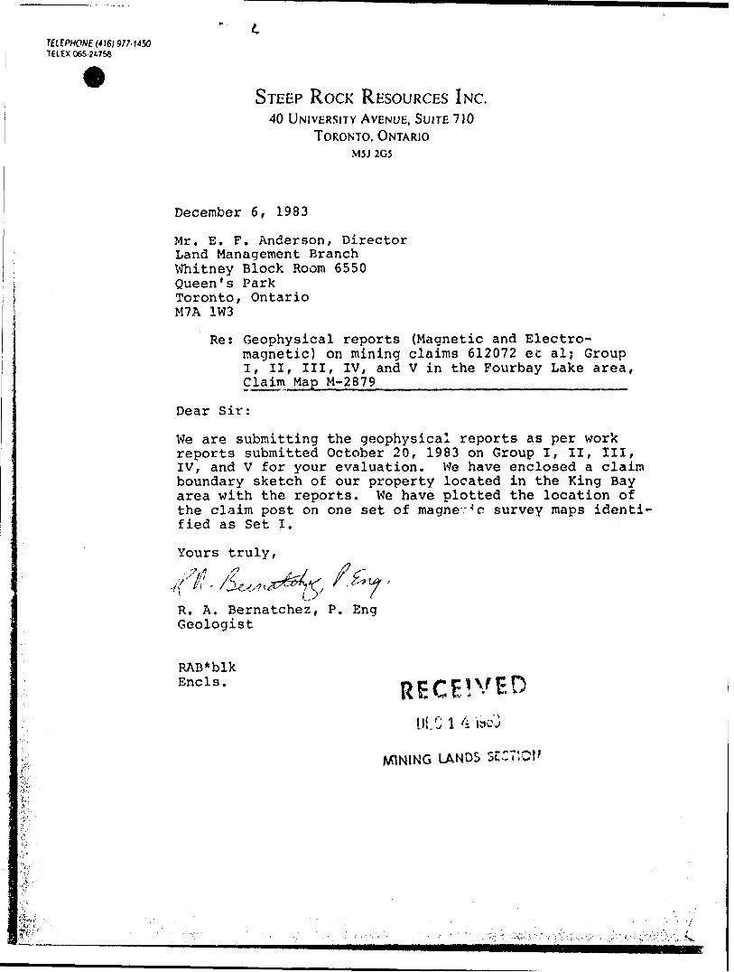
December 6 , 1983
Mr. E. F. Anderson, Director Land Management Branch Whitney Block Room 6550 Queen's Park Toronto, Ontario M7A 1W3
Re: Geophysical reports (Magnetic and Electro magnetic) on mining claims 612072 ec al; Group I, I I f III, IV, and V in the Fourbay Lake area, Claim Map M-2879^^^^^^^^^^^^^.^^^.^^
Dear Sir:
We are submitting the geophysical reports as per work reports submitted October 20, 1983 on Group I, II, III, IV, and V for your evaluation. We have enclosed a claim boundary sketch of our property located in the King Bay area with the reports. We have plotted the location of the claim post on one set of magnev'c survey maps identi fied as Set I.
Yours truly,
R. A. Bernatchez, P. Eng Geologist
RAB*blk Encls.
Df. C l 4 we j
MINING LANDS SE
•'A W.'
V .,. Jv.
\ J
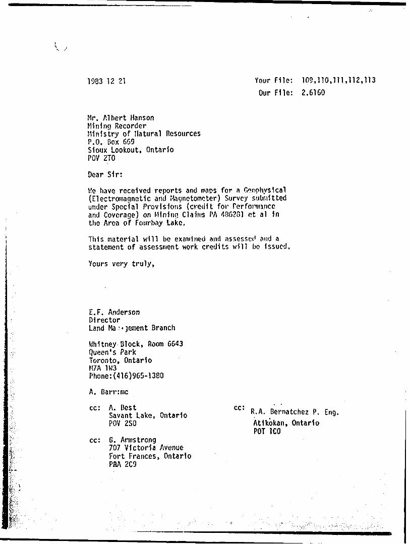
1983 12 21 Your File: 109,110,111,112,113 Our File: 2.6160
Mr. Albert HansonMining RecorderMinistry of natural ResourcesP.O. Box 669Sioux Lookout, OntarioPOV 2TO
Dear Sir:
He have received reports and maps for a Geophysical {Electromagnetic and Magnetometer) Survey submitted under Special Provisions (credit for Performance and Coverage) on Minimi Claims PA 486281 ot al 1n the Area of Fourbay Lake.
This material will be examined and assesset' and a statement of assessment work credits will be Issued.
Yours very truly,
E.F. AndersonDirectorLand Ma.^ jement Branch
Whitney Block, Room 6643 Queen's Park Toronto, Ontario M7A 1W3 Phone:(416)965-1380
A. Barr:me
cc: A. BestSavant Lake, Ontario POV 2SO
cc: G. Armstrong707 Victoria Avenue Fort Frances, Ontario PflA 2C9
cc: R.A. Bernatchez P. Eng.Atikokan, Ontario POT ICO
f Initial Checl.
Assessed
Approved Reports of Work sent out
Notice of Intent filed
Approval after Notice of Intent sent out
Duplicate sent to Resident Geologist
Duplicate sent to A.F.R.O.
''frfflt-
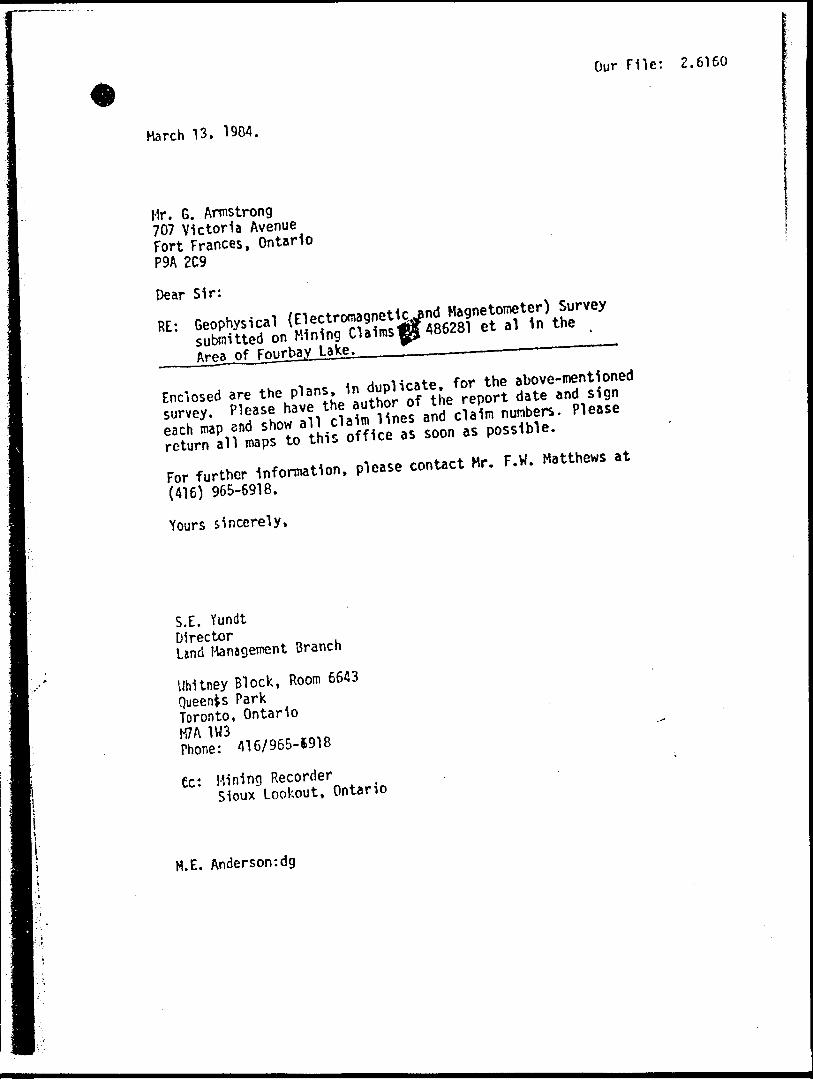
Our File: 2.6160
March 13, 1904.
Mr. G. Armstrong 707 Victoria Avenue Fort Frances, Ontario P9A 2C9
Dear Sir:
^ ,i, nitrate for the above-mentionedEnclosed are the plans. In duplicate, for^t ^ s 1gn survey. Plea se have the ut tor o ft he ^ ^^ plfiase
as soon as possible.
For further mfor^o*. pie- conUct Hr. F .H. Matthews ,t
(416) 965-6918.
Yours sincerely,
S.l. Y undtDirectorLand Management Branch
Whitney Block, Room 6643 Queenis Park Toronto, Ontario
Sne: 3 416/965-1918
ec: Mining RecorderSioux Lookout, Ontario
H.E. Anderson:dg
TELE.PHONE(4^977.USO TELEX 065-24758
y
STEEP ROCK RESOURCES INC.40 UNIVERSITY AVENUE, SUITE 710
TORONTO. ONTARIOM5J 205
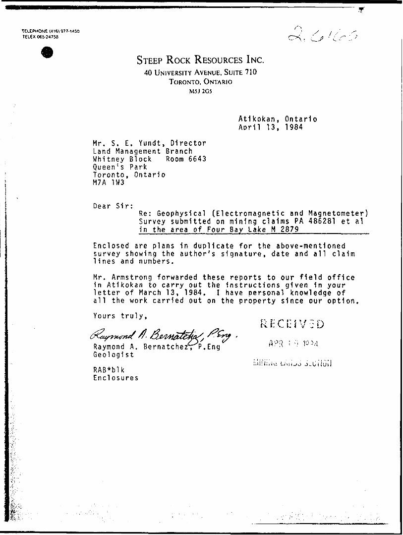
Atikokan, Ontario Aorll 13, 1984
Mr. S. E. Yundt, Director Land Management Branch Whitney Block Room 6643 Queen's Park Toronto, Ontario M7A 1W3
Dear Sir:Re: Geophysical (Electromagnetic and Magnetometer) Survey submitted on mining claims PA 486281 et al In the area of Four Bay Lake H 2879 ———--—
Enclosed are plans in duplicate for the above-mentioned survey showing the author's signature, date and all claim lines and numbers.
Mr. Armstrong forwarded these reports to our field office in Atikokan to carry out the instructions given in your letter of March 13, 1984. I have personal knowledge of all the work carried out on the property since our option.
Yours truly,
Raymond A. Bernatche Geologist
RAB*blk Enclosures
p. r- s* r "1 t * f :— c-vk \: ^ i: i v !; U
P.Eng
SEE ACCOMPANYING
MAP(S) IDENTIFIED AS
53 r'jC#
LOCATED IN THE MAP CHANNEL IN THEFOLLOWING SEQUENCE
(X)
FOR ADDITIONAL
INFORMATION
SEE MAPS
SIX
M
ILE
LA
KE
R
OA
D
B.L
. 9
+ 0
0 S
SH
OR
E
BA
Y
B.L
.ll
+ O
ON
B.L
.11
+ 0
0 N
IB.L
.S+O
CN
i
48
76
73
\
437
02
2JU
MP
ING
B.L
-5 +
00
S
IT
570233
A.L
. 3
67
A.L
. 368
A.L
. 3
73
MIN
ER
S
LOO
P
RO
AD
KIN
G
BA
Y R
OA
D
STE
EP
R
OC
K R
ES
OU
RC
ES
IN
C.
KIN
G
BA
Y
PR
OJE
CT
- S
TU
RG
EO
N
LA
KE
, O
NT.
CLA
IM
BOU
ND
ARY
LOC
ATI
ON
DR. B
Y:-
SCAL
E:-
i: to
ooo
CKD.
BY:-
N.T
.S. - 5
2-
J-2
APPR
OVED
:-
rniiD
Riv
t
AL
T
o o 4-
O
O H- o 10
O o 4-
O)
o o -H
00
o o 4-
o o -*-
ro
o
o 4- OU
(O
o o 4-
(D
0+
00
B;L
. 9
-I-O
O
( 4+
00 S
5 +
00
S
10
+0
0 S
10 +
00
S f f
MA
GN
ETO
ME
TER
S
UR
VE
YIN
STR
UM
EN
T: S
CIN
TRE
X
MP
-2
PRO
TON
M
AG.
DAT
UM
:
59
,00
0C
ON
TOU
R
INT
ER
VA
L1
< 2
OO
O *
* at
2O
O ;
^00
0"*
at
50
0M
AGN
ETIC
LO
W -
^
^
BA
SE
ST
ATIO
N
RE
CO
RD
ER
IN
FOR
MA
TIO
N1
INS
TRU
ME
NT
: S
CIN
TRE
X
MB
S -
2 R
EC
OR
DE
R
RA
NG
E:
100
^
REC
OR
DIN
G
INTE
RV
AL'
10
SE
CO
ND
S C
HA
RT
SP
EE
D:
20 M
M X
HR
V.L
.F.
SU
RV
EY
INS
TR
UM
EN
T:
GE
ON
ICS
E
M-1
6
TR
AN
SM
ITT
ER
S
TATI
ON
:
CU
TL
ER
, M
AIN
EIN
PH
AS
E
RE
AD
ING
S
: ' —
——
- —
— -
——
'
OU
T O
F P
HA
SE
R
EA
DIN
GS
: *-------*-
PR
OF
ILE
S
CA
LE :
l c
m -
2
0 0
Xc
CO
ND
UC
TOR
A
XIS
- —
— m
~ ~
——
PO
SIT
IVE
R
EA
DIN
GS
-
EA
ST
O
F LI
NE
CO
NTO
UR
IN
TE
RV
AL:
20
TOP
OG
RA
PH
Y
SHO
RE
:R
OAD
1 -
CLA
IM
PO
ST
:
STE
EP
R
OC
K IR
ON
M
INES
LI
MIT
ED
AT
IKO
KA
N,
ON
TAR
IO
King
's Ba
y . P
roje
ctS
TUR
GE
ON
LA
KE
A
RE
A
MAG
NET
OM
ETER
SU
RVE
YD
ate:
May
, 19
83
Scal
e :
1-25
00N.
T. S
. ; 5
2-J
- 2
PH
AN
TOM
EX
PLO
RAT
ION
SE
RVI
CES
52Je2SW8048
52J82SW0044
FOURBAY
LAKE
210
fe+OO N
Jumping
0+00
"Y.
^T t-^ i ^ ij iiJi'" f S - i-M."
^5+0 s
O OH-
OO+ in
o o o o+ to
oo+CM
Oo
oo
o o
orO
O O-t-CD ro
-J
OO
ro-J
OO
ro-l
O O
ro
O O
rO
O O ^ ro ro
O O-f(M fO
Oo-f-to
o o -f-oro
Oo
CM
57-&Z47
S70Z579/0
-W
•f Af
L fctf \-roj.
————— i
377 f
38}
-'07/Jm^^^^^
W?
-1/&
-9*/b ———————————————— M ——— ———————————————— ^^
03 5V'00 W-
52J02SWa94B 52JB2SWa044 FOURBAY LAKE
LAKE
5702
5695LAKE
?70Z3S
570Z4-357ZJZ44-
57024]
52J0aSW(W48 52J02S**ei44 FOURBAY LAKE
as-o
o N
20
+0
0 N
15
+0
0 N
B.L
. 11
+ 0
0 N
o
o .J
O
O * 00
o o
o o
+
to
o o -h
IO
o
oo
o -I-o
o (M -J
O oo
o
LU o
o -H
LU o
o CVJ
UJ o o + ro
UJ O
O
UJ O
O IO
UJ
LULU
O o 00
UJ o o 5 -J
UJ o o o CM
5703
57
7047
6061
2082
20
+ 0
0
N
15 +
00 N
IQ+
OQ
N
MAG
NET
OM
ETER
S
UR
VE
YIN
STR
UM
EN
T: S
CIN
TRE
X
MP
-2
PRO
TON
M
AG.
DA
TUM
:
59
,000
CO
NTO
UR
IN
TER
VA
L: <
200
0 at
2
00
oc
, >
2000
at
50
0M
AG
NE
TIC
LO
W :
^*"
BA
SE
ST
ATIO
N
REC
OR
DER
IN
FOR
MA
TIO
N:
INS
TR
UM
EN
T:
SC
INTR
EX
M
BS
- 2
R
EC
OR
DE
R
RA
NG
E1 1
00
e*
REC
OR
DIN
G
INTE
RV
AL:
10
SE
CO
ND
S C
HA
RT
SP
EE
D:
20
MM
/HR
V.L
.F.
SU
RV
EY
INS
TRU
ME
NT
:GE
ON
ICS
E
M-1
6
TR
AN
SM
ITT
ER
S
TATI
ON
: C
UT
LER
, M
AIN
E
INP
HA
SE
R
EA
D4N
GS
:
'——
—'—
—-
——
—'
OU
T O
E
PH
AS
E
RE
AD
ING
S: *-- -
*—
—*-
PR
OF
ILE
S
CA
LE '
\ c
m ^
20
0Xe
COND
UCTO
R AX
IS:
-—*
— * —
PO
SITIVE
RE
ADIN
GS :
EAST
OF
LINE
CONT
OUR
INTE
RVAL
: 20
TO
PO
GR
AP
HY
SH
OR
E :
RO
AD
:
CLA
IM
PO
ST
:
STEE
P RO
CK
IRO
N M
INES
LI
MIT
EDA
TIK
OK
AN
, ON
TAR
IO
Kin
g's
Bay
Pro
ject
STU
RG
EON
LA
KE
A
RE
A
MA
GN
ETO
ME
TER
S
UR
VE
YD
ate
: May
, 19
83
Sca
le:
h 25
00N
T. S
. 5
2-J
-2
PHAN
TOM
EX
PLO
RAT
ION
SE
RVI
CES
LTD
.
570935
475231
__^ ^———— ruf "!OZ8^~*—-ttZ--—,
B.i,. 5+00 S
250
LJ O O 4- CM -1
UJ o
o -f CM .w -J
UJ o o H- ro CM -J
UJ o o •1- st- CVJ —l
UJ o o -f- .
in (M ,
Ul o o -1- co CM
UJ o o H- K
CM
UJ O O * CO CM
UJ O
O * m CM
UJ o
o H- o ro
UJUJ O O -h ro -t
Ul o o -r- CM ro -l
UJ o o H- ro
ro -l
UJ O o H- * to -1
UJ o o H- in
ro -l
UJ o o •f (D ro -J
UJ o o -f- h-
ro -J
UJ O O -f- OD 10 -1
O o H-
0* 10 -l
ST
UR
GE
ON
LA
KE
9+
00
N
8+
00
N
7+
00
N
6 +
00
N
5+
00
N
4 +
00
N
3+
00
N
2+
00
N
l +
00
N
MA
GN
ETO
MET
ER
SU
RV
EY
INST
RUME
NT; S
CINT
REX
Mp-
2 PR
OTON
MAG
.D
ATU
M :
5
9,0
00
CO
NTO
UR
IN
TER
VA
L ^2
00
0.
at
200
** ;
>
2000
at
500
MA
GN
ETI
C
LOW
: dZ
t?
BA
SE
STA
TIO
N R
ECO
RD
ER I
NFO
RM
ATI
ON
!IN
STR
UM
EN
T: S
CIN
TREX
M
BS
-2
REC
OR
DER
R
AN
GE
: 10
0 **
REC
OR
DIN
G
INTE
RV
AL;
10
SE
CO
ND
S C
HA
RT
SP
EE
D:
20 M
M/H
R
V.L.
F.
SUR
VEY
INS
TRU
ME
NT;
GE
ON
ICS
E
M-1
6 TR
AN
SM
ITTE
R
STA
TIO
N:
CU
TLE
R ,
MA
INE
IN
PH
AS
E
RE
AD
ING
S
: -—
——
-"——
—-—
—-
OU
T O
F P
HA
SE
R
EA
DIN
GS
: *-
——
- -—
" -
PR
OFI
LE
SC
ALE
M c
m *
20
VoCO
NDUC
TOR
AXIS
: —
—
* —
PO
SITIVE
REA
DING
S: E
AST
OF L
INE
CONT
OUR
INTE
RVAL
: 20
TOP
OG
RA
PH
Y
SHO
RE :
RO
AD :
CLA
IM
PO
ST:
STEE
P RO
CK
IRO
N M
INES
LIM
ITED
ATIK
OKA
N, O
NTAR
IO
King
's Ba
y P
roje
ct__
__S
TU
RG
EO
N
LAK
E
AR
EA
MAG
NETO
MET
ER
SURV
EYDo
te :
May
. 19
83
Scal
e:
1:25
00
N.T.
S.
52-J
- 2
PHAN
TOM
EX
PLO
RATI
ON
SERV
ICES
LTD
.
6120 BS#76
KING'S
A .t- 372
LJ LU
0 0 0 04 ^-^ -OJCM CM
.J -1
LJ
Oo4roOJ
-i
L±J
Oo+sfrCNJ
-J
LJ
OO+ID OJ
-1
UJ
O O4toOJ
- J
UJ
OO+r-OJ
-1
* '-
UJ
oo400 OJ
-J
UJo o+CiOJ
J
UJ
Oo+oro
.J
UJ
o o4ro.j
UJ
Oo+CMro-j
UJ
3O -fro ro
j
ijjQ O4-
*^t ro-l
UJ
Oo + inro
LU
O O
ro
o o
ro
UJ
o ooo ro-l
52ja2S*ee44 FOURBAY LAKE
o o H-
in
O
o o
m
o
o H- O)
o o H-
00 t -i
o o -f
o o 10
o o -J- C\J
(O
o
o -h (D
0+
00
B.L
. 9
+ O
OS
(
4-1-
00 S
5 +
00
S
10
+0
0 S
5702
46
LrS
+ O
O S
(0+
00)
5 +
00 S
10 +
00
S
MA
GN
ETO
ME
TER
S
UR
VE
YIN
STR
UM
EN
T: S
CIN
TRE
X
MP
-2
PRO
TON
M
AGD
ATU
M :
5
9,0
00
CO
NTO
UR
IN
TE
RV
AL
1 <
20
00 ^
at
2O
O ;
MAGN
ETIC
LOW
- ""
~^
BASE
STA
TION
RECO
RDER
INF
ORMA
TION
1 IN
STRU
MENT
^ SC
INTR
EX
MBS
-2R
EC
OR
DE
R
RA
NG
E :
100
of
RE
CO
RD
ING
IN
TE
RV
AL:
10
SE
CO
ND
S C
HA
RT
SP
EE
D:
20
MM
X H
R
V,L
F.
SU
RV
EY
INS
TR
UM
EN
T:
GE
ON
ICS
E
M-1
6
TR
AN
SM
ITT
ER
S
TA
TIO
N:
CU
TL
ER
, M
AIN
EIN
PH
AS
E
RE
AD
ING
S
: ' —
——
- —
— -
——
-
OU
T O
F P
HA
SE
R
EA
DIN
GS
: *---*---*-
PR
OF
ILE
S
CA
LE :
lcm
* 2
0 y
. C
ON
DU
CTO
R
AX
IS :
——
~ —
— * —
—
PO
SIT
IVE
R
EA
DIN
GS
: E
AS
T
OF
LIN
E
CO
NTO
UR
IN
TE
RV
AL:
20
TO
PO
GR
AP
HY
SH
OR
E '
RO
AD:
-
at 5
00
CLA
IM
PO
ST
:
STE
EP
R
OC
K IR
ON
M
INES
LI
MIT
ED
ATI
KO
KA
N,
ON
TAR
IO
King
's Ba
y Pr
ojec
tS
TUR
GE
ON
LA
KE
A
RE
A
VLF
PR
OFI
LE
MAP
Dat
e:
May
, 19
85
Scal
e -
h2
50
0N
.T.S
. ; 5
2-J
- 2
PH
AN
TOM
EX
PLO
RAT
ION
SE
RVI
CES
LT
D.
52J02SW0e48
52J02SW0*44
FOURBAY
LAKE
28
0
O O-h (0
o o*in
o o
o oro
5 f 00 N
Jumping
0+00
o oCVJ
-J
o oo oo
o o
-l
o o-f-CO ro
Oo
ro
O O
ro
o oH- lO
OO
ro
-l
OO-t- ro ro
O O-fC\J iO
o o-4-
to
o o-T-
orO
OoH- cn
570Z47\
SIQ2-4.5.
*i*^'a*''i"MiMin^^
5aJ92SW884fl 52J92SWae44 FOURBAY LAKE 230
52JG2SW8048 52J*2S*a*44 FOURBAY LAKE 300
25-^
-00 N
20
+O
O N
I54-
OO
N
B.L
. 114-0
0 N
o
oO o 4-
00
o oO o H
-
o o tn .j
5 O
Oo o ro -l
O o * CO
5 o
oO
O H- O
UJ O
O -I-
LU O
O CJ
UJ o
o + rO
UJ o o H-
UJ o o in -i
UJU
JUJ o o H- o CM
20 +
OO
N
15
+00
N
iO+
00
N
MAG
NET
OM
ETER
S
UR
VE
YIN
ST
RU
ME
NT
: S
CIN
TR
EX
M
P-2
P
RO
TON
M
AG
DA
TUM
:
59
,000
CO
NTO
UR
IN
TE
RV
AL:
MA
GN
ETI
C
LOW
:
BA
SE
S
TATI
ON
R
EC
OR
DE
R
INFO
RM
ATI
ON
IN
ST
RU
ME
NT
: S
CIN
TR
EX
M
BS
- 2
R
EC
OR
DE
R
RA
NG
EM
OO
**
RE
CO
RD
ING
IN
TE
RV
AL:
IO
S
EC
ON
DS
CH
AR
T
SP
EE
D:
20
M
M/H
R
V.L
.F.
SUR
VEY
INS
TRU
ME
NT
:GE
ON
ICS
E
M-1
6
TR
AN
SM
ITT
ER
S
TA
TIO
N:
CU
TLE
R,
MA
INE
IN
PH
AS
E
RE
AD
ING
S
: '—
——
-——
—-
——
*—
—
——
——
*
—
—
——
— K
—
—
——
—
KO
UT
OF
PH
AS
E
RE
AD
ING
S:
PR
OF
ILE
S
CA
LE -
l c
m -
20
7cCO
NDUC
TOR
AXIS
: —
^ —
*
POSI
TIVE
READ
ING?
; EA
ST O
F LIN
ECO
NTOU
R IN
TERV
AL^
20
TO
PO
GR
AP
HY
SH
OR
E R
OA
D:
CLA
IM
POST
:
STEE
P RO
CK
IRO
N M
INES
LI
MIT
EDA
TIK
OK
AN
.ON
TAR
IO
Kin
g's
Bay
Pro
ject
STU
RG
EO
N
LAK
E
AR
EA
VLF
PR
OFI
LE
MAP
Dot
e : M
ay,
1983
S
cale
: h
2500
.T S
. 52-J
-2
PHAN
TOM
EX
PLO
RAT
ION
SE
RVI
CES
LT
D.
52Je2SWW48 52J02SWee44
FOURBAY
LAKE
310
570995 510996
6IZ03Q 12019
r T ir
is r\ f \
^H"l "7r ^ l "
48^255-1rf •K* ** - 7
\ l V s\ M \ \
^v" \ f/f-its \
v \ . Nli/ r/, ,7 . v ,' -kb .L,\
l LI y "irli l^ * 7
\ I
ri *nr -a r-t f
f \ / \ l
tfi f ffi ' -/rf': j-t-27 -'6 * -tf*
56954
i v/^ --/
T y^ "
\ f9 "V\ f \ A.L-369j rr
-2p Vj^ -j-fl *
' \ ! v
fsV . ~/4 f
v 7 -
17 -"t/""*ri /^ i ^ ^ i\
.7/t#f{-t1 "'
S2J02SW8046 Saj*2S*ea44 FOURBAY LAKE
^"'i-^' v^ ik- i*"*ii^' !^s*ssi4:: .'iffi"' '-•i"'.' i '" r "'^.vii'''?''r'''""^"
Ul o o + CM -1
LJ O o CM CM -1
UJ O O + IO CM -J
UJ o o -\- CM -J
Ul o o in CM -1
UJ O o H- U)
CM -1
UJ o o H- CM -J
UJ O o H- 00 CM -J
UJ O
O 4. o CM -J
uj O o 4- o
to -1
UJ o o H- ro .J
UJ O o H- CM ro -i
UJ o o •4- IO
10 U
UJ O
O H- IO -i
UJ o o -*- m IO -i
LJ O
O 4- (O io -J
td o o -h IO -J
UJ o o -t- 00
IO -I
UJ o o -J- OJ
10 -1
ST
UR
GE
ON
LA
KE
— yt r ft
jp-im
.A.
~-Q
..5Td
a, \ \ +Z HO
f/0 f? "V i l"i/-4 •-
t -s ~IO ^G
J&
\0 \ \ •r/^ Tf
,ri j f "t
ji
T ''l *7
l
9+
00 N
8 +
00
N
7+
00
N
6 +
00
N
5 +
00
N
4 +
00
N
3 +
00
N
2 +
00
N
+ 0
0
N
STU
RG
EON
LAK
E
O 5
kml
i i
i i
l
MAG
NET
OM
ETER
S
UR
VE
YIN
STRU
MENT
: SCI
NTRE
X M
P-2
PROT
ON M
AGD
ATU
M :
59,0
00
CO
NTO
UR
IN
TER
VA
L:
MA
GN
ETI
C
LOW
: d
BA
SE
S
TATI
ON
R
EC
OR
DE
R I
NFO
RM
ATI
ON
: IN
STR
UM
EN
T:
SC
INTR
EX
M
BS
-2
RE
CO
RD
ER
R
AN
GE
MO
O
oC
REC
OR
DIN
G
INT
ER
VA
L:
10
SEC
ON
DS
CH
AR
T S
PE
ED
: 20
M
M/H
R
V.L.
F.
SUR
VEY
INS
TRU
ME
NT
iGE
ON
ICS
E
M-1
6
TRA
NS
MIT
TER
S
TA
TIO
N:
CU
TLE
R ,
MA
INE
IN
PH
AS
E
RE
AD
ING
S
: -—
——
-——
—-—
—-
OU
T O
F P
HA
SE
R
EA
DIN
GS
: *~
P
RO
FIL
E
SC
ALE
M c
m *
20 0
XoCO
NDUC
TOR
AXIS
: —
^*
POSIT
IVE
READ
INGS
^ EA
ST O
F LIN
E CO
NTOU
R IN
TERV
AL:
20
TOPO
GR
APH
Y SH
ORE
:R
OA
D:
CLA
IM
PO
ST
:
STEE
P RO
CK
IRO
N M
INES
LIM
ITED
ATI
KO
KA
N,
ON
TAR
IO
King
's
Bay
Pro
ject
STU
RG
EO
N
LAK
E
AR
EA
VLF
PR
OFI
LE
MAP
Dat
e : M
oy,
1983
S
cale
: 1:
2500
N.T.
S.
52-J
- 2
PHAN
TOM
EX
PLO
RAT
ION
SE
RVIC
ES
LTD.
UJ LJ
O 0 0 0 4 4 CM TO CM CM
U)
O O4
CM
-J
UJ
O O 4 IO CM
-J
* *f
LJ
Oo4
CM
UJ
Oo4 r--CM
UJOO400CM
-1
UJo o4O) CM
-J
LJ
Oo4O ro
LJ
Oo4 ro-j
UJ
O O4CMro
UJ
OO-t-ro ro
tjjOo4 to-J
UJ
O O 4 in(O'
LU
O O4ti) ro
o o 4r- ro
52J02SW0848 52J82sw0a44 FOURBAY LAKE 340
O O
57074^.
MAGNETOMETER S URVEYINSTRUMENT: SCINTREX MP-2'PROTON MAG.DATUM : 5y ; 000
CONTOUR INTERVAL: < 2000 at 200 oc ; > 2000 at 500 c*MAGNETIC LOW :
BASE STATION RECORDER INFORMATION: INSTRUMENT: SCINTREX MBS - 2 RECORDER RANGE: 100 cX
RECORDING INTERVAL. 10 SECONDS CHART SPEED; 20 MM X HR
V.LF. SURVEYINSTRUMENT: GEONICS EM-16 TRANSMITTER STATION ; CUTLER, MAINEINPHASE READINGS - ' —— ' ——— -——- OUT OF PHASE READINGS: —---- ~--^-
PROFILE SCALE: l cm = 20 0Xo CONDUCTOR AXIS : —— * —— ^ ——
POSITIVE READINGS : EAST OF LINE CONTOUR INTERVAL:
TOPOGRAPHY SHORE ;ROAD - "
CLAIM POST'
- 00 W 4 Z
STEEP ROCK IRON MINES LIMITEDATIKOKAN, ONTARIO
King's Bay ProjectSTURGEON LAKE AREA
MAGNETOMETER SURVEYDate ; November 82 Scale : l: 2500 N.T.S. :52-J -2
PHANTOM EXPLORATION SERVICES LTD.
SOJ'OO
5702/1
702 Z4570?
4674774-87679
0238
MAGNETOMETER SURVEYNSTRUMENT: SCINTREX MP-2 PROTON MAG.
DATUM : 59 t OOO
CONTOUR INTERVAL: C 2000 at 200 cX *, > 2000 at 500MAGNETIC LOW :
BASE STATION RECORDER INFORMATION: INSTRUMENT: SCINTREX MBS - 2 RECORDER RANGE: 100
RECORDING INTERVAL: 10 SECONDS CHART SPEED : 2O MM 7 HR
V.L.F. SURVEYINSTRUMENT: GEONICS EM-16 TRANSMITTER STATION : CUTLER , MAINE
INPHASE READINGS :OUT OF PHASE READINGS: x----------PROF1LE SCALE M cm ? 2O CONDUCTOR AXIS:POSITIVE READINGS : EAST OF LINE CONTOUR INTERVAL:
TOPOGRAPHY SHORE :
ROAD :
r X
STEEP ROCK IRON MINES LIMITEDATIKOKAN, ONTARIO
King s Bay ProjectSTURGEON LAKE AREA
MAGNETOMETER SURVEYDate ; November 82 Scale: h 2500 N.T.S. : 52-J- 2
PHANTOM EXPLORATION SERVICES LTD.
570955
05* CJ&ftg^
MAGNETOMETER SURVEYSCINTREX MP-2 PROTON MAG
59,OOO
TOUR INTERVAL. ^000 a t 200 ^ ; > 2000 at 500MAGNETIC LOW
BASE STATION RECORDER INFORMATION
INSTRUMENT SCINTREX MBS - 2 RECORDER RANGE 100 ex
RECORDING INTERVAL K) SECONDS
CHART SPEED ZO MM /' MR
VLF SURVEYINSTRUMENT GEONlCS EM -16
TRANSMITTER STATION CUTLFR , MAINE
INPHASE READINGS -
OUT OF PHASE HEADINGS - ' ' PROFILE SCALE l cm - "?0 "/ CONDUCTOR AXIS —— ^ —— ^
POSITIVE READINGS EAST OF LINE
CONTOUR INTERVAL
TOPOGRAPHYSHORE
ROAD
STEEP ROCK IRON MINES LIMITEDATIKOKAN , ONTARIO
King's Bay ProjectSTURGEON ' l^AKE AREA
MAGNETOMETER
B.L 11+00 N
- 75,5 5 + 00 N
B.L. 0 + 00 ( 3 + CON
KfNG'S BAY
MAGNETOMETER SURVEYINSTRUMENT- SCINTREX MP-2 PROTON MAGDATUM 59,000
CONTOUR INTERVAL ^2000 at 200^ ; > 2000 at 500MAGNETIC LOW
52.tr/o2
BASE STATION RECORDER INFORMATION:
NSTRUMENT SCINTREX MBS -2 RECORDER RANGE. 100 ^
RECORDING INTERVAL 10 SECONDS
CHART SPEED 20 MM j H R
VLF SURVEYINSTRUMENT. GEONICS EM-16 TRANSMITTER STATION CUTLER , MAINE
INPHASE READINGS --- - --- — ---
OUT OF PHASE READINGS " ~ PROFILE SCALE - l cm = 20 07o CONDUCTOR AXIS —— ^ —— ^ ——
POSITIVE READINGS EAST OF LINE
CONTOUR INTERVAL-
TOPOGRAPHYSHORE . ^
ROAD —
CLAIM POST
r/i
UJ LU UJ LU LU LU LU -U LU LU LU LU ' U LU LU LJ 'U UJ LU
8 888g88888888888go:Jiwio^w^-^i^^oo.Jg-^^J^cvicvjcvj ro lo ro rorororororo^^^^r^^^
i i -J i i i j —i l iij.j.j—i— i-J—i— i_ i _ i — ' — i . — i — i — i — * — " - p -
e ' e
STEEP ROCK IRON MINES LIMITEDATIKOKAN , ONTARIO
King's Bay Project1 STURGEON LAKE AREA
MAGNETOMETER SURVEYDate : November '82 Scale : 1 : 2500 NT. S. : 52 -J- 2
PHANTOM EXPLORATION SERVICES LTD.
s v
o o
f S - r//
98 S/f/i --0 ^
\ 569989
"fyTSf r"J'|' —---
MAGNETOMETER S URVEYINSTRUMENT SCINTREX MP-2 PROTON MAGDATUM : 5y ; 000 CONTuUR INTERVAL:
MAGNETIC LOW -
BASE STATION RECORDER INFORMATION: INSTRUMENT: SCINTREX MBS- 2 RECORDER RANGE: 100 ex:
RECORDING INTERVAL. 10 SECONDS CHART SPEED 20 MM X HR/' T i 5703.33 f-r
V L.F. SURVEYINSTRUMENT :GEONICS EM-16 TRANSMITTER STATION ; CUTLER, MAINE
INPHASE READINGSOUT OF PHASE READINGS: *------
PROFILE SCALE: l cm * 20 0Xo CONDUCTOR AXIS : —— ^ —— ^ POSITIVE READINGS ; EAST OF LINE CONTOUR INTERVAL:
TOPOGRAPHY SHORE 'ROAD -
CLAIM POST-"
0259
\
WSTEEP ROCK IRON MINES LIMITED
ATIKOKAN, ONTARIO
/
King s Bay ProjectSTURGEON LAKE A REA
V.LR PROFILE MAPDate : November 82 Scale; 1:2500 N.T.S. :52-J -2
PHANTOM EXPLORATION SERVICES LTD
-7 /A O O ^/O Z d 4-
4 X"\ ——v . -""7 t*— o l 6 7 o
7022/&r
4 *"**\ -"^ -^i 876;
5^9541
MAGNETOMETER SURVEYINSTRUMENT: SCINTREX MP-Z PROTON MAGDATUM : 59,000 CONTOUR INTERVAL: MAGNETIC LOW :
BASE STATION RECORDER INFORMATION: INSTRUMENT: SCINTREX MBS - 2 RECORDER RANGE: 100 oc
RECORDING INTERVAL - 10 SECONDS CHART SPEED ; 20 MM ' HR
V.L.F. SURVEYINSTRUMENT: GEONICS EM-16 TRANSMITTER STATION: CUTLER , MAINE
1NPHASE READINGS :OUT OF PHASE READINGS: -c-----—-"
PROFILE SCALE : l cm? ZQ
CONDUCTOR AXIS:POSITIVE READINGS : EAST OF LINECONTOUR INTERVAL:
STEEP ROCK IRON MINES LIMITEDATIKOKAN .ONTARIO
King s Bay ProjectSTURGEON LAKE A REA
VLF PROFILE MAPNT.S. : 52-J- Z . fDate ; November 82 Scale : l: 2500
PHANTOM EXPLORATION SERVICES LTD.
STURGEON
LAKE
\ ^^, til "f* f- /rW*
2571
B L 3400N
-4 rt*': o \ v*/V
A \ \ r ff i ****S
;1 r^5"" 'f j"3 "T i "* 'r /' i il il i J
^ i *2t\ rf i *20 \- *6 */ ' //'
t/t* 1*6 - t /it 7f it o i
4S7ES/2f.0 O
,/^ -^ y'-?*6 r ^
MAGNETOMETER SURVEYINSTRUMENT: SCI NTREX MP-2 PROTON MAG DATUM : 59,000 CONTOUR INTERVAL: MAGNETIC LOW :
BASE STATION RECORDER INFORMATION:iINSTRUMENT : SCINTREX MBS - 2 RECORDER RANGE - 1 00 cxl RECORDING INTERVAL: 10 SECONDS CHART SPEED' 20 MM X HR
V.L.F. SURVEYINSTRUMENT GEONICS EM-16 TRANSMITTER STATION : CUTLER , MAINE INPHASE READINGS :WS" -/Si f W7 -VfOUT OF PHASE READINGS 1 --- PROFILE SCALE : lcm= 20 CONDUCTOR AXIS: —— ^ —— *
POSITIVE READINGS - EAST OF LINE CONTOUR INTERVAL:
TOPOGRAPHYSHORE :
ROAD :
y ^7 i -ft f** -j* r
STEEP ROCK IRON MINES LIMITEDATIKOKAN , ONTARIO
King's Bay ProjectSTURGEON LAKE AREA
VLF PROFILE MAPDate : November '82 Scale : l: 2500 N.T.S.: 52-J- 2
PHANTOM EXPLORATION SERVICES LTD.
UJ
o o
in
5-hOO N
B.L 0+00 ( 3+OON
SLIEVE T
SCINTREX MP M
::ASE STATiQN RtCOiOER IN^
'INSTRUMENT SCIN^HE ^ MI-..^t-"C'O^OER RANGE. 100 -
RLCORONG INTERVAL 10 S CHART SPEED ' M M X H F?
!'#
J ~ F SJRVEY•MSTR'JMENT GEONiCS EM-16 "RANSVIT'SER STATION CUTLt
INPHA^L READINGS
''JU'T OF PHASE READINGS "' H! - " t., 4.. o L, A L- il "C
CONDUCTOR AXIS POSITIVE READINGS CONTOUR INTERVAL
EAST OF L IN
15
UJ
O O
o
LU
Oo-\-OJro
LaJ
O O -f ro ro
O O
ro
LLl
O O*inro
UJ
Oo^IDro
oo4- N- ro
UJ
oo00roJ
O
-J
UJ
O O 4-O
UJ
Oo
UJOo4-OJ
••L)
C O-f- ro "t
UJOOt-
-J
UJ
}i4-LO
STEEP ROCK I RON MINES LIMITEDATIKOKAN , ONTARIO
King*s Bay ProjectSTURGEON LAKE AREA
VLF PROFILE MAPDate : November 82 Scale l : 2500 NT.s. . 52 -J- 2
PHANTOM EXPLORATION SERVICES LTD.