processing laser scans into deliverables€¦ · plant & building tools include: n best-fit...
TRANSCRIPT
Cyclone’s Object/Database foundation. Finally, Cyclone MODEL reflects the data quality & accuracy-consciousness advantages that users worldwide expect from Leica Geosystems.
Features and Benefits n New! Model catalogue for saving, sharing and inserting models n New! Scripting functionality n Auto Pipe finder – automatically find cylinders n Multiple, fast, convenient visualisation modes n Texture mapping and rectified orthophotos
Plant & building tools include: n Best-fit modelling, catalogue fitting, clash detection n Automated pip run, steel fitting and intelligent modelling
Civil & related tools include: n Data collector emulation, contours and cross sections n TIN/mesh creation, volumes, areas, clearances n Fast import/export utilities
For civil, plant, architectural and other 2D & 3D projects
Unmatched versatility and performance help make Leica Cyclone MODEL the industry’s most popular standalone software for analysing rich, laser scan data and converting the data into deliverables.
Among its advantages, Cyclone MODEL boasts powerful visualisation and point cloud navigation plus the industry’s most complete tool set. These tools cover a wide range of High-Definition Surveying (HDS™) applications in engineering, construction, asset management, heritage, forensics, and other areas.
Cyclone MODEL provides unmatched office productivity, automating many time-consuming tasks and even letting multiple users work on the same data sets simultaneously – thanks to
Leica Cyclone MODEL 9.1Processing laser scansinto deliverables
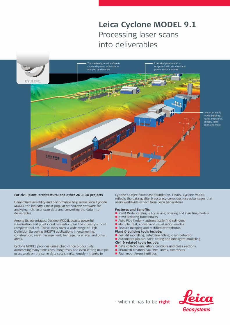
The meshed ground surface is shown displayed with colours mapped by elevation
A detailed plant model is integrated with structure and ground surface models
Users can easily model buildings, roads, structures, bridges, light poles and more
CYCLONE

Leica Geosystems AG Heerbrugg, Switzerland
www.leica-geosystems.com/hds
Leica Cyclone MODEL 9.1Efficient Point Cloud Manipulation & NavigationLeica Cyclone has many features that let users work efficiently with rich laser scan data sets. Cyclone’s Level of Detail (LOD) graphics display and visualisa-tion modes allow users to “see through” walls, apply shaded rendering, or enhance edges for improved comprehension of dense point clouds. Texture mapping tools allow users to accurately “drape” photos of the scanned scene onto point clouds for an even more realistic viewing experience. Cyclone MODEL’s friendly key plan and TruSpace panoramic viewing modes provide intuitive navigation and viewing options.
High-Performance Modeling for a Wide Range of ApplicationsAccurately model a selected geometry type, such as pipes, planes, and topographic surfaces. Least-squares fitting and quality-of-fit statistics ensure reliable results, while Cyclone’s advanced memory management provides high performance.
Wealth of Plant & Structure-specific Tools A new Model Catalogue allows user to save complex models and save them to a catalogue. Users can then insert these models and or share them with others. New Automatic pipe finder finds all cylinders in a point cloud or group of points clouds.Continuous pipe runs, including elbows, can be modelled automatically. Leica Cyclone MODEL’s Piping Mode even lets plant designers add intelligent piping data, including specification, line ID, insulation thickness and SKEYs. Validation of proposed design models – including clash detection – can be done within Leica Cyclone or via export to popular plant design applications.
Rich Tool Set for Civil, Architectural and Other Applications For excavation and grading, Surface Deviation tools provide accurate quantity calculations. Volume and area for cut and fill are precisely calculated. Output options include volumes, contours, and/or tables with elevation differences at a user-specified grid sample. A Clearance tool even finds and reports absolute minimum vertical and horizontal clearances for overpasses, bridges, interchanges, and overhead sign structures. A Virtual Surveyor tool emulates a data collector for creating topographic maps.
Leica Geosystems HDS Software FamilyCyclone MODEL is part of a full software family for managing laser scan data. Check the web address below for additional information.
Windows is a registered trademark of Microsoft Corporation. Other trademarks and trade names are those of their respective owners.
Illustrations, descriptions and technical data are not binding. All rights reserved. Printed in Switzerland – Copyright Leica Geosystems AG, Heerbrugg, Switzerland, 2014. 755759en – 06.15 - INT
The automated Pipe Run feature lets users select points on connected, straight pipe sections, and the system automatically models a best fit pipe run with elbows in seconds.
Industry first robust steel fitter that automatically places catalog steel shapes quickly and accurately.
Leica Cyclone MODEL Specifications* Hardware and System RequirementsSurvey Includes all functionality of Cyclone SURVEY Minimum Specifications
Processor: 2 GHz Dual Core processor or betterRAM: 2 GB (4 GB for Windows Vista or Windows 7)Hard disk: 40 GBDisplay: SVGA or OpenGL accelerated graphics card (with latest drivers)Supported operating systems: Windows 7 (32 or 64), or Windows 8 & 8.1 (64bit only)File system: NTFS
Recommended SpecificationsProcessor: 3.0 GHz Quad Core w/ Hyper-threading or higherRAM: 32 GB’s or more 64 bit OSHard disk: 500 GB SSD DriveLarge project disk option: RAID 5, 6, or 10 w/ SATA or SAS drivesDisplay: Nvidia GeForce GTX 680, Quadro K4000 or ATI Radeon 7850 or better, with 2GB’s memory or more.Operating system: Microsoft Windows 7 – 64bitFile system: NTFS
Large pointcloud mgt
3D limit boxes, slices, interactive visualisation of massive data setsCyclone Object Database Technology: fast efficient point cloud mgt.
Visualisation Full 3D fly, pan, zoom, rotate. Control colour mapping using intensity, true-colour, gray scale, colour by elevation, one-sided (front or back), silhouette (enhanced edges). Map external photos to point cloud. Key plan and panoramic viewing.
3D Modeling New Model Catalog, Auto Pipe Finder and Move commands. Least-squares fitting of 3D geometry. Statistical QA reports. Fit cloud to standard object tables items, AISC steel, ASME pipe, user defined tables.
Piping tools Embed attribute info Line-ID, Spec, SKEY. Fit flange and tie point, automated pipe run with elbows.
Animation Create fly-through animations of 3D point clouds and modelsScripting New Scripting capabilities in the ModelSpaceCOE Seamless two-way data integration with AutoCAD and MicroStationImport Data from CAD via COE (Cyclone Object Exchange)
Control data from ASCII formats & X-Function DBXExport Point data in standard formats: XYZ, PTS, PTX, DXF,
X-Function DBX, Land XML, etc.Point data in special formats: ZFS, TOPO pci & cwfImage and model data: COE, BMP, JPEG, TIFF
* Reference the Leica Cyclone 9.1 Technical Specifications document for a complete listing of product specifications.