problematic roadway environments for automated vehicles · national surface transportation safety...
TRANSCRIPT
Problematic Roadway Environments for Automated Vehicles
Database Development
Report #18-UR-064
Travis N. Terry Stephen Tanner
Submitted: April 3, 2018

ACKNOWLEDGMENTS The authors of this report would like to acknowledge the support of the stakeholders of the National Surface Transportation Safety Center for Excellence (NSTSCE): Tom Dingus from the Virginia Tech Transportation Institute, John Capp from General Motors Corporation, Chris Hayes from Travelers Insurance, Martin Walker from the Federal Motor Carrier Safety Administration, and Cathy McGhee from the Virginia Department of Transportation and the Virginia Transportation Research Council. The NSTSCE stakeholders have jointly funded this research for the purpose of developing and disseminating advanced transportation safety techniques and innovations.
i
EXECUTIVE SUMMARY
Progress in the area of automated vehicles (AVs) will benefit safety, mobility, and environmental sustainability. Of the roughly 30,000 traffic-related fatalities reported yearly, 94% are due to human error. AVs replace the human element of driving with sensors, cameras, actuators, and algorithms and aim to drastically reduce crashes and associated fatalities. The advent of AVs is also predicted to increase mobility by reducing congestion via ride sharing and more deliberate AV-performed navigation procedures. AVs are also expected to reduce fossil fuel use and improve urban land usage, resulting in positive economic and environmental sustainability effects.
AV-related policies and laws are beginning to taking shape, and already differ between some states. While forward-thinking can be beneficial, the consequence of having non-overlapping laws and policies regarding AVs is a potential issue. A complete survey of laws, standards, and regulations regarding AVs for each state is outside of the scope of this project. However, as of the time of this report, 21 states had enacted AV policies, some which impact the testing and regulation of AV technology. Rigorous testing often proves to be a challenge since AV technologies can differ based on a vehicle’s manufacturer, each of whom provides their own suite of systems to perform the autonomous tasks.
It is the potential failure of these systems to perform in certain scenarios that impedes progress, both in terms of AV development and policy. This effort seeks to capture, classify, and distribute real-world scenarios that could be problematic for AVs. The developed Visually Confusing Automated Vehicle (VCAV) database of videos, which is available via an online interface, highlights specific elements of the roadway, such as improper lane markings, that AV technology relies upon for guidance. The goal of the VCAV is to promote research in specific areas regarding these scenarios and to inform policymakers, manufacturers, designers, and Departments of Transportation about problematic scenarios.
At the time of this report, the database consisted of approximately 12 hours of recorded scenarios. Most scenarios were recorded on restricted-access highways, such as interstates, which are a likely domain for early deployment of highly automated AVs. Other focus areas include inclement weather and any work zone activity. Because these scenarios are often problematic for human drivers, it is important that AVs outperform their counterparts in these situations.
The VCAV can be found online at visualconfusion.vtti.vt.edu and will require user login and registration. Once granted access, users can leverage the database to sort by types of scenarios, such as improper lane markings, types of work zones, and video duration. Researchers will continue to curate and manage the database as time and personnel resources allow. More scenarios will be added and categorized within the database as they become available.

iii
TABLE OF CONTENTS
LIST OF FIGURES ..................................................................................................................................................... v LIST OF TABLES .................................................................................................................................................... vii
LIST OF ABBREVIATIONS AND SYMBOLS ......................................................................................................ix
CHAPTER 1. BACKGROUND.................................................................................................................................. 1 POTENTIAL BENEFITS OF AUTOMATED VEHICLES ................................................................................................. 1 CURRENT STATE OF AUTOMATION ......................................................................................................................... 2
Levels of Autonomy ........................................................................................................................................... 2 Policy and Guidelines for Autonomous Vehicles ............................................................................................. 3
AUTONOMOUS METHODS ........................................................................................................................................ 5 AUTONOMY AND DRIVER AWARENESS ................................................................................................................... 6
CHAPTER 2. AREAS OF AUTONOMOUS LIMITATION .................................................................................. 7
PEDESTRIAN DETECTION AND COMMUNICATION .................................................................................................. 7 ADVERSE WEATHER ................................................................................................................................................ 7 WORK ZONES ........................................................................................................................................................... 8 EMERGENCY VEHICLE RESPONSE........................................................................................................................... 8 NIGHTTIME ISSUES................................................................................................................................................... 8
CHAPTER 3. APPROACH AND METHOD ......................................................................................................... 11 DEVELOPMENT GOALS .......................................................................................................................................... 11 DATA ACQUISITION ................................................................................................................................................ 11 DATA REDUCTION AND CHARACTERIZATION ....................................................................................................... 12
CHAPTER 4. VCAV DATABASE CONTENT ...................................................................................................... 15 CHAPTER 5. VCAV ONLINE DATABASE TOOL ............................................................................................. 17
DEVELOPMENT ....................................................................................................................................................... 17 STRUCTURE ............................................................................................................................................................ 18 LOGIN AND REGISTRATION ................................................................................................................................... 18 APPLICATION WORKFLOW .................................................................................................................................... 19
CHAPTER 6. FUTURE EFFORTS ......................................................................................................................... 21
REFERENCES .......................................................................................................................................................... 23

v
LIST OF FIGURES
Figure 1. Photo. GoPro Hero 3 camera (GoPro, 2014)............................................................ 12
Figure 2. Screenshot. Registration form. .................................................................................. 18
Figure 3. Screenshot. Welcome and login page. ....................................................................... 19
Figure 4. Screenshot. Available clips and data layout. ............................................................ 19
Figure 5. Screenshot. Upload a CSV page. ............................................................................... 20


vii
LIST OF TABLES
Table 1. Levels of autonomy and associated autonomous and human tasks. .......................... 3
Table 2. Database outline for keyword and parameter entry. ................................................ 12
Table 3. Lane marking descriptors and definitions. ................................................................ 15

ix
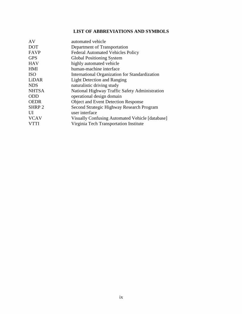
LIST OF ABBREVIATIONS AND SYMBOLS
AV automated vehicle DOT Department of Transportation FAVP Federal Automated Vehicles Policy GPS Global Positioning System HAV highly automated vehicle HMI human-machine interface ISO International Organization for Standardization LiDAR Light Detection and Ranging NDS naturalistic driving study NHTSA National Highway Traffic Safety Administration ODD operational design domain OEDR Object and Event Detection Response SHRP 2 Second Strategic Highway Research Program UI user interface VCAV Visually Confusing Automated Vehicle [database] VTTI Virginia Tech Transportation Institute

1
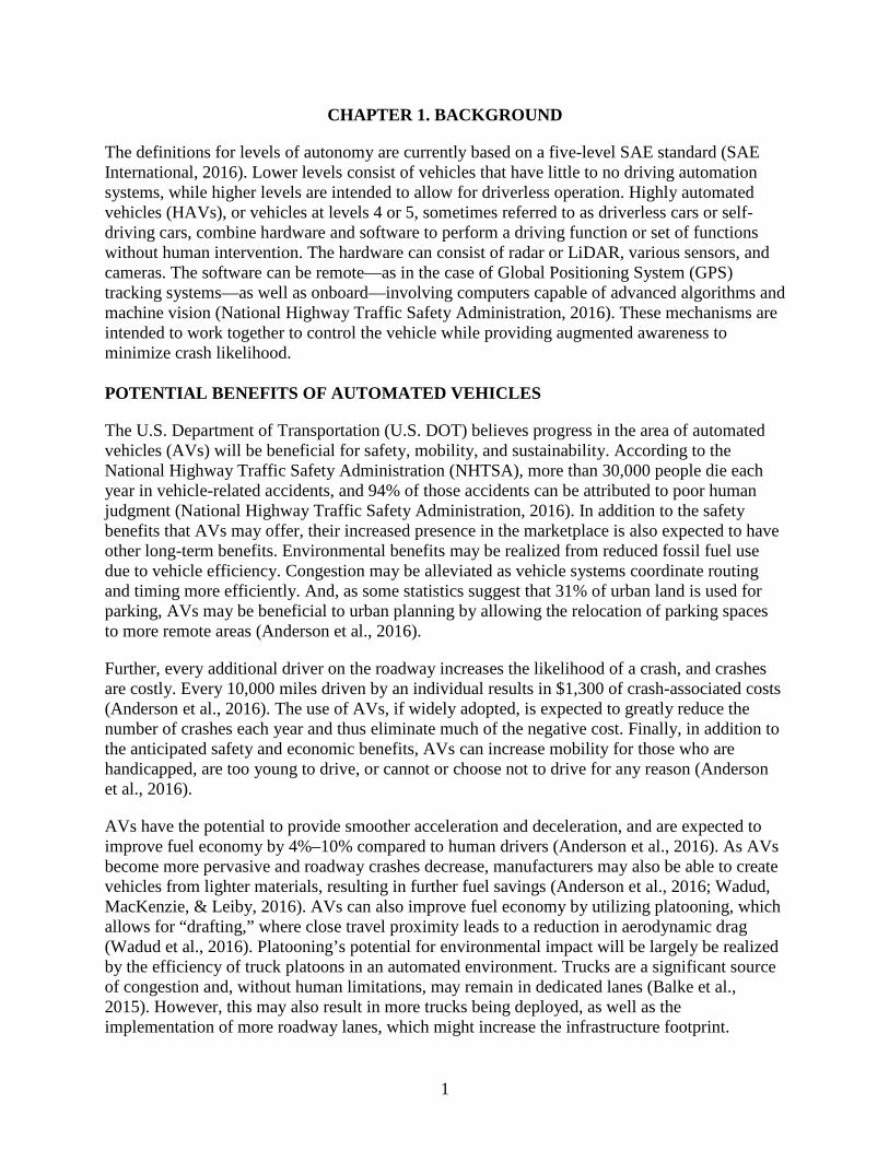
CHAPTER 1. BACKGROUND
The definitions for levels of autonomy are currently based on a five-level SAE standard (SAE International, 2016). Lower levels consist of vehicles that have little to no driving automation systems, while higher levels are intended to allow for driverless operation. Highly automated vehicles (HAVs), or vehicles at levels 4 or 5, sometimes referred to as driverless cars or self-driving cars, combine hardware and software to perform a driving function or set of functions without human intervention. The hardware can consist of radar or LiDAR, various sensors, and cameras. The software can be remote—as in the case of Global Positioning System (GPS) tracking systems—as well as onboard—involving computers capable of advanced algorithms and machine vision (National Highway Traffic Safety Administration, 2016). These mechanisms are intended to work together to control the vehicle while providing augmented awareness to minimize crash likelihood. POTENTIAL BENEFITS OF AUTOMATED VEHICLES
The U.S. Department of Transportation (U.S. DOT) believes progress in the area of automated vehicles (AVs) will be beneficial for safety, mobility, and sustainability. According to the National Highway Traffic Safety Administration (NHTSA), more than 30,000 people die each year in vehicle-related accidents, and 94% of those accidents can be attributed to poor human judgment (National Highway Traffic Safety Administration, 2016). In addition to the safety benefits that AVs may offer, their increased presence in the marketplace is also expected to have other long-term benefits. Environmental benefits may be realized from reduced fossil fuel use due to vehicle efficiency. Congestion may be alleviated as vehicle systems coordinate routing and timing more efficiently. And, as some statistics suggest that 31% of urban land is used for parking, AVs may be beneficial to urban planning by allowing the relocation of parking spaces to more remote areas (Anderson et al., 2016).
Further, every additional driver on the roadway increases the likelihood of a crash, and crashes are costly. Every 10,000 miles driven by an individual results in $1,300 of crash-associated costs (Anderson et al., 2016). The use of AVs, if widely adopted, is expected to greatly reduce the number of crashes each year and thus eliminate much of the negative cost. Finally, in addition to the anticipated safety and economic benefits, AVs can increase mobility for those who are handicapped, are too young to drive, or cannot or choose not to drive for any reason (Anderson et al., 2016).
AVs have the potential to provide smoother acceleration and deceleration, and are expected to improve fuel economy by 4%–10% compared to human drivers (Anderson et al., 2016). As AVs become more pervasive and roadway crashes decrease, manufacturers may also be able to create vehicles from lighter materials, resulting in further fuel savings (Anderson et al., 2016; Wadud, MacKenzie, & Leiby, 2016). AVs can also improve fuel economy by utilizing platooning, which allows for “drafting,” where close travel proximity leads to a reduction in aerodynamic drag (Wadud et al., 2016). Platooning’s potential for environmental impact will be largely be realized by the efficiency of truck platoons in an automated environment. Trucks are a significant source of congestion and, without human limitations, may remain in dedicated lanes (Balke et al., 2015). However, this may also result in more trucks being deployed, as well as the implementation of more roadway lanes, which might increase the infrastructure footprint.
2
With regard to reducing congestion and emissions, it has been proposed that AVs be delegated to providing taxi services, in which case many “driverless” miles would be accrued as the vehicle travels to pick up people (Balke et al., 2015). It has also been posited that AVs might serve as shared vehicles that are limited to certain ideal conditions and locations where they operate most reliably (Anderson et al., 2016; Fagnant & Kockelman, 2018; Litman, 2017). The impact of AVs on congestion costs are not limited to only to fuel and infrastructure-related savings. Their use may also allow an increase in the amount of additional work that can be accomplished by an AV-using commuter, who would otherwise allot working time to driving and attending to the roadway (Anderson et al., 2016; Fagnant & Kockelman, 2015).
Land use, specifically in cities, may change drastically with the addition of AVs on the roadway, as the need for proximal parking will lessen. In theory, an AV could drop a passenger off at a location and then drive away to park on its own, potentially in a remote location, allowing a large portion of urban centers that are currently reserved for parking structures to be replaced with other architecture, such as more conveniently placed buildings and other essential infrastructure (Anderson et al., 2016; Fagnant & Kockelman, 2014). The need for street parking may also be diminished, improving visibility and removing clutter in downtown areas. However, this does bring with it a potential downside in that the income that cities generate and rely on from parking would be reduced. Additionally, taxi and shuttle companies and their human drivers would become less necessary, affecting company revenue and driver employment (Anderson et al., 2016; Fagnant & Kockelman, 2014).
CURRENT STATE OF AUTOMATION
The current state of automation includes ongoing discussion of a variety of topics among technology companies, automakers, and policymakers. SAE has created a hierarchy defining each level of autonomy (SAE International, 2016). These levels present a roadmap for the eventual goal of AVs— complete autonomy—but also serve as a benchmarking system for the technology as it currently exists. Acceptance, both public and among policymakers, is assisted by comparing the performance of AVs to manual vehicles with rigorous testing and scientific literature. Lawmakers are also currently working toward future-proofing rules and regulations regarding AVs so that they can keep up with the rapid pace of the technology’s development (Wagner, Loftus-Otway, Morrisey, Havinoviski, & Serian, Submitted for publication).
Levels of Autonomy
There are varying levels of autonomy as defined by SAE and detailed in the U.S. DOT’s Federal Automated Vehicles Policy (FAVP). These autonomy levels and their definitions are detailed in Table 1 (Anderson et al., 2016; National Highway Traffic Safety Administration, 2016; SAE International, 2016).
3
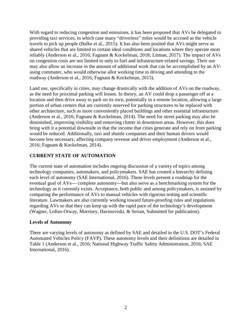
Table 1. Levels of autonomy and associated autonomous and human tasks. SAE Level Definition
Level 0 The human driver does everything. Level 1 An automated system on the vehicle can sometimes assist
the human driver conduct some parts of the driving task. Level 2 An automated system on the vehicle can actually conduct
some parts of the driving task, while the human continues to monitor the driving environment and performs the rest of the driving task.
Level 3 An automated system can both conduct some parts of the driving task and monitor the driving environment in some instances, but the human driver must be ready to take back control when the automated system requests.
Level 4 An automated system can conduct the driving task and monitor the driving environment, and the human need not take back control, but the automated system can operate only in certain environments and under certain conditions.
Level 5 The automated system can perform all driving tasks, under all conditions that a human driver could perform them.
As of early 2018, most vehicles on the roadway are level 0 or level 1. Level 1 vehicles assist in some tasks, such as adaptive cruise control, but the driver is still mostly in control and determines whether or not the vehicle will perform a task. Level 2 vehicles are, however, also currently in production. These vehicles provide longitudinal and lateral control of the vehicle, either at higher speeds (e.g., on freeways) or at lower speeds (e.g., while parking). Level 2 is currently the highest level of AV on the roadway; in a level 2 vehicle, automation is conditional and humans are still necessary for most tasks. Lastly, while level 5 AVs are completely autonomous with no need for any human input, level 4 AVs still require humans to monitor the systems in a number of scenarios or conditions, such as at the very beginning or end of a trip.
AVs at levels 1–4, and specifically levels 2 and 3, are complicated by the question of how and when to alert the driver to take back control of the vehicle. This human factors issue may be the biggest hurdle for these levels of vehicles to overcome (Daniels, 2015). The transition from the vehicle’s driving automation system to the occupant driver should be done smoothly; however, if a selling point for AVs at these levels is encouraging human drivers to do other work or relax while the systems do the driving, expecting the human driver to be on high alert in the case of a transition of control may be risky (Anderson et al., 2016; Merat, Jamson, Lai, Daly, & Carsten, 2014). In addition, for AVs to meet the needs of the handicapped, those too young for a driver’s license, or anyone else unlicensed, a level 5 vehicle would be required (Anderson et al., 2016).
Policy and Guidelines for Autonomous Vehicles
The U.S. DOT and NHTSA recently generated the aforementioned FAVP, which defines many terms commonly used in regard to AVs. The term HAV, or highly automated vehicle, corresponds to SAE level 3–5 automated driving system equipped vehicles, which fall between some autonomy and complete autonomy (National Highway Traffic Safety Administration, 2016).
4
NHTSA intends to monitor HAVs by requesting that manufacturers provide product reports that include a safety assessment as well as an outline describing how their systems meet existing guidelines. Currently, there is no formal certification or testing procedure for determining if an HAV has met particular safety benchmarks. The safety self-assessment that manufacturers are expected to provide to NHTSA would include details about data recording and sharing, system safety, crashworthiness, post-crash behavior, object and event detection and response, and validation methods, among others. These assessments are also required for any remote automated driving system updates to HAVs that may affect the vehicle’s compliance in the areas detailed in the safety assessment (National Highway Traffic Safety Administration, 2016). NHTSA’s Voluntary Safety Self-Assessment, released in 2017 to replace 2016’s FAVP, includes a template with suggestions for the type of information that entities should provide to the public in order to demonstrate the ways that they are addressing safety (National Highway Traffic Safety Administration, 2017).
A guide for policymakers, provided by Anderson et al. (2016), details standards and regulations for AVs and the processes involved in developing them. The terms standards and regulations mean different things and it is important to distinguish the two. Standards are essentially recommendations that, in most domains, including transportation, manufacturers voluntarily meet in an effort to maintain order and consistency (Anderson et al., 2016). Regulations are enforceable, with NHTSA being the primary safety regulator with the ability to require a manufacturer to recall a product (Anderson et al., 2016). Due to the speed at which AV technology can transform, setting regulations that all states can agree upon in a timely manner may not be practical. Further, overregulation may occur if multiple states devise their own sets of regulations for AVs, making cross-state travel problematic (Anderson et al., 2016). In addition to the problematic nature of safety standards, there is currently no agreed upon method for assigning liability, which may affect the introduction and wide adoption of AVs (Anderson et al., 2016; LeValley, 2013).
While AVs are still largely under development and their regulation in flux, some guidelines do exist. As of 2017, 21 states had put AV-related policies in place. Six other states have issued AV-related executive orders (National Conference of State Legislatures, 2013). These legislative efforts differ in purpose; some are for testing AVs and others are operations- and deployment-related. This could be worrisome if states adopt different equipment policies, forming a non-uniform array of obstacles for manufacturers and consumers to navigate. In general, the current legislation regarding safe testing, passenger services, or platooning would not impact deployment-related requirements and can exist as separated by geographical boundaries. The adoption of policies can also be seen as a positive, as it means that legislators are actively engaged in a dialog about AVs (Anderson et al., 2016).
There are also a number of entities that engage in efforts to observe and determine standards for AVs, such as SAE International (National Conference of State Legislatures, 2017). The National Cooperative Highway Research Program is currently engaged in a project seeking to identify and research critical AV issues that state and local agencies will face.1 The American Association of Motor Vehicle Administrators’ Autonomous Vehicle Best Practices Working Group is working with jurisdictions, law enforcement, and federal agencies to gather, organize, and share
1 http://apps.trb.org/cmsfeed/TRBNetProjectDisplay.asp?ProjectID=3824
5
information related to AVs in order to develop a best practices guide.2 The American Association of State Highway and Transportation Officials,3 the Uniform Law Commission,4 the Governors Highway Safety Association,5 the National Conference of State Legislatures,6 and the National Governors Association7 all have committees that aim to explore policy developments that surround AVs. More specific efforts also exist, such as the Forward Collision Warning Requirements Project, which sets standards about alert functions and interface requirements for systems that incorporate forward collision warnings. In addition, the International Organization for Standardization (ISO) has a technical committee concerning intelligent transportation systems, which observes and evaluates guidelines and recommends standards (Anderson et al., 2016).
At present, there is no universally accepted set of performance requirements and no entity has set forth to determine benchmarks for performance requirements. However, a NHTSA-sponsored project is currently underway at the Virginia Tech Transportation Institute (VTTI) to develop and translate technical standards for nontraditional vehicle designs into existing Federal Motor Vehicle Safety Standards (FMVSS) (Virginia Tech, 2017). Currently, according to the FAVP, “…performance standards for AV technologies must specify environmental conditions under which the tests must occur and ideally will include testing under a wide range of environmental conditions” (Anderson et al., 2016). In short, any testing for standards must be thorough and rigorous with regard to the vehicle’s awareness of its surroundings. AUTONOMOUS METHODS
AVs generally utilize LiDAR, radar, or both, in addition to cameras, ultrasonic sensors, inertial measurement systems, detailed mapping, and infrared technologies. These act in three phases that can be compared to a human’s ability to sense, decide, and act in any given scenario. In phase one, all of these instruments collect data from the environment and are an augmented representation of a human’s visual and cognitive system. In phase two, the instruments combine information and, via advanced computing and algorithms, form a plan of action much as the human brain operates cognitively. In the last phase, the AV acts or executes that plan, which may include a maneuver, a change in acceleration, or some other driving action (Anderson et al., 2016).
LiDAR uses lasers to determine distance by calculating the time it takes for the laser light to be reflected back to its source. LiDAR is most practical for shorter ranges, up to 120 meters, and is limited by the amount of a material’s reflectivity (Anderson et al., 2016; Ilas, 2013). Moisture may also scatter light particles and affect reflectivity (Ilas, 2013).
Radar is similar to LiDAR in that it depends on “time-of-flight” to determine distance. Instead of light, radar bounces radio waves off objects and back to the source. Radar works best when objects are made of metal, performing more poorly at detecting people or smaller objects. Radar
2 https://www.aamva.org/Autonomous-Vehicle-Best-Practices-Working-Group/ 3 https://news.transportation.org/Pages/072117fedCAVbill.aspx 4 http://www.uniformlaws.org/Committee.aspx?title=Highly%20Automated%20Vehicles 5 https://www.ghsa.org/issues/autonomous-vehicles 6 http://www.ncsl.org/research/transportation/autonomous-vehicles-self-driving-vehicles-enacted-legislation.aspx 7 https://medium.com/nga-future/preparing-for-the-inevitable-the-future-of-autonomous-vehicles-e8e7af23b3e6
6
has a significantly longer range than LiDAR, but is also more accurate at short distances (Anderson et al., 2016; Ilas, 2013).
AVs are capable of determining accurate visual locations by using the information acquired through LiDAR and creating 3D maps of the environment (Wolcott & Eustice, 2014, September). This allows an AV to compare its current environment to historical roadway data and note any changes (De Sliva, Roche, & Kondoz, 2017), which can be crucial in determining changes to the roadway, such as those that may occur during roadwork. That information can also be shared with other network AVs.
In addition to radar and LiDAR, other sensors, such as ultrasonic and infrared sensors, are used to map the roadway environment. Ultrasonic sensors are short range, about 10 meters, and are currently best used for operations in tight spaces, such as parking areas (Alonso et al., 2010; Anderson et al., 2016; W. Wang, Song, Zhang, & Deng, 2014). Infrared sensors are used to detect lane markings. They are particularly useful in low-light settings, where they can detect lane markings when cameras are unable to. They are also efficient at detecting pedestrians and bicyclists at night (Anderson et al., 2016; John, Mita, Liu, & Qi, 2015).
AUTONOMY AND DRIVER AWARENESS
The FAVP warns manufacturers to place an emphasis on assessing the risk of driver complacency, as drivers may rely too much on automation and neglect to take action when necessary (National Highway Traffic Safety Administration, 2016). Driver awareness becomes most critical at automation levels 2 and 3, where the vehicle may request that the driver take back control (Daniels, 2015). At level 3, the driver may have become accustomed to the AV doing most of the driving task and decide to perform another task, such as texting, reading, or even napping (Daniels, 2015). If the vehicle needs the driver to take control of the vehicle due to an unexpected circumstance, the system needs make accommodations by providing sufficient time for the driver to reorient to the driving situation and gracefully resume control.
Driver response can be critical in unexpected circumstances, especially those involving a moral dilemma. Any automated algorithm that can process a scenario and predict the outcome of an event that will result in a crash should make rational decisions that minimize the impact of the crash as a whole (Goodall, 2014). Whereas a driver might make a choice in favor of self-preservation, an AV might take an action that favors preventing fatalities to occupants of surrounding vehicles (Goodall, 2014).
7
CHAPTER 2. AREAS OF AUTONOMOUS LIMITATION
The purpose of this project was to focus on areas where AVs are currently limited, especially in regard to navigating complex scenarios, in order to identify for researchers, designers, manufacturers, and policymakers areas where current automated driving technology might fail or be inappropriate for use. These include pedestrian detection, visibility in adverse weather, navigating work zones or temporary traffic patterns, and behavior around emergency vehicles.
PEDESTRIAN DETECTION AND COMMUNICATION
In a broad sense, the vehicle’s perception of the environment is the greatest challenge for reliable and complete autonomy (Anderson et al., 2016). Communication with pedestrians is typically an unguided nuance involving informal gestures or signals. Whether a hand wave inside or outside the vehicle, or a flash of high beams, these forms of communication are commonplace when a human driver is attempting to communicate with other road users. These methods of communication are often termed “anticipatory behavior” and are currently not factored into the design of AVs (Beggiato, Witzlack, Springer, & Krems, 2017), though a 2017 VTTI study investigated the effectiveness of signalized intents from self-driving vehicles to pedestrians (results pending) (Shuttleworth, 2017), indicating that this is an area that may receive more focus. Contemporary research has mainly focused on AVs’ braking behavior as an indicator to pedestrians at crosswalks that they have been identified and it is safe to cross (Baiming, Ding, & Huei, 2017; Beggiato et al., 2017).
Pedestrian detection by AVs continues to improve, with one of the more critical areas being unsignalized intersections where pedestrian traffic is high (Chen, Zhao, & Peng, 2017). A recent project using 3D LiDAR and machine vision to classify artifacts in the scene as pedestrians or not pedestrians resulted in some success (H. Wang, Wang, Liu, Meng, & Yang, 2017). In addition, various technologies (e.g., Mobileye® driver assistance systems) are now available to sense when a vehicle crosses a lane or approaches too close to another vehicle or object (MobilEye, 2017). Most recent research in this area has focused on modeling and predicting pedestrian movements at crosswalks, though detailed models do not yet exist, or have not yet been made publicly available (Chen et al., 2017).
ADVERSE WEATHER
Heavy precipitation and fog can reduce the capabilities of several different sensors and sensor types at once. Humans also have difficulty in these conditions, so it is possible that AVs, while not performing perfectly in some situations, may still be more reliable than a human driver (Anderson et al., 2016).
The Tesla S manual warns drivers against relying on some of the AV’s features, such as forward collision warning, lane assist, auto-steer, and driver assistance, in the presence of heavy rain, fog, or snow (Tesla, 2016), as these elements can affect the cameras’ performance. The AV’s radars can also be susceptible to obstructions like snow. In addition to adverse weather, bright and direct sunlight can also diminish the ability of the cameras to interpret the environment accurately (Tesla, 2016).
8
WORK ZONES
Work zones, specifically temporary work zones, may be the most challenging situation to any near-future implementation of level 5 AVs. Work zones can present a variety of unusual circumstances not typically encountered during normal driving (Anderson et al., 2016). Depending on the type of work being done, the roadway surface may be different, and in some cases even absent of a hard surface and replaced with gravel. The lines on the roadway may be removed or obscured, and the amount of lighting from equipment and the presence of equipment itself may give the AV’s sensors the wrong impression about what is taking place around it. Additionally, the vehicle may be unable to interpret alternative and variable signage such as LED caution boards warning what to expect. Finally, the presence of humans, such as traffic flaggers and other workers, present many of the same obstacles to AVs as general pedestrian activity.
EMERGENCY VEHICLE RESPONSE
Google’s self-driving cars are equipped with sensors designed to recognize numerous emergency sirens. When the vehicle detects a siren, it begins to drive more “conservatively” or slows down. Once the vehicle has a better grasp of where the emergency siren is being emitted, either by detecting the emergency vehicle via camera, or when the siren is close enough to determine the emergency vehicle’s location, the vehicle then executes the appropriate maneuver to either pull over, slow down, stop, or do nothing (Thompson, 2015).
In September, 2016, Google filed a patent application for technology that would allow an AV to detect common emergency light schemes behind it in the event of a pullover stop. This technology allows for the differentiation between traffic lights and other light sources from emergency vehicle lighting. The system would also know the difference between types of emergency vehicles, such as fire trucks, ambulances, and police vehicles (Migliore, 2016; Tian, Lo, & Ferguson, 2016).
Even with these technologies on the cusp or even in place, there remain unaddressed issues related to emergency vehicle lighting. For instance, AVs must know when to merge or move away from an emergency vehicle parked on the shoulder and when to come to a halt in the case of a checkpoint. In addition, police vehicles are often used to increase driver attention at temporary work zones due to their visible lighting (Debnath, Blackman, & Haworth, 2015); AVs must recognize this situation and react accordingly.
NIGHTTIME ISSUES
Operating AVs at night has both advantages and disadvantages. LiDAR and radar systems used for sensing lane markings and three-dimensional objects work regardless of ambient light and often can perform better at sensing their surroundings at night than their human counterparts. However, at night, cameras used to determine lane markings are not as useful, though infrared sensors can replace cameras in these scenarios. So, initially, there appears to be no great or obvious obstacle to AVs operating at night.
However, many nighttime temporary work zones and paving operations take place at night, and involve lane closings, tapers, and lane marking adjustments (Ellis & Kumar, 1993; Lee, 1969), which could disrupt an AV’s ability to safely navigate a highway construction zone or work area.
9
Additionally, similar to direct and bright sunlight, oncoming headlamps are known to impact the ability of the Tesla S’s cameras to accurately interpret the environment (Tesla, 2016). The impact may depend on the angle of light incident, in particular at unique intersections or certain horizontal curves. The advent of smart headlamps that can sense an oncoming vehicle and dim during a pass (Helton, 2016) may address this issue.
Further, unexpected wildlife behavior, which has long been a problem for human drivers, appears to persist for current AV models. While a number of both passive and active methods to deter animals from roadways have been attempted in the past, simply using cameras to detect them as early as possible has been established as the most effective animal collision avoidance method (Mammeri, Zhou, & Boukerche, 2016). Cameras, however, have similar limitations as humans in terms of line of sight and ability to detect objects in low-light conditions.

11
CHAPTER 3. APPROACH AND METHOD
The goal of this effort was to produce a tool for roadway designers as well as AV technology designers and manufacturers that would provide a wide variety of common situations that may confuse or prove difficult for AVs to overcome. To accomplish this, the research team recorded video of instances where lane markings, signage, barriers, or other roadway indicators were unclear and could prove problematic on real roadways. The videos were then reviewed and keywords and search parameters applied before they were added to a queryable database.
DEVELOPMENT GOALS
The Visually Confusing Automated Vehicle (VCAV) database is anticipated to benefit users involved in the autonomous technology industry. Researchers, designers, and manufacturers can leverage the tool for pinpointing specific real-world scenarios where current autonomous technology might fail, and policy planners can assess a wide range of potential scenarios where automation may be necessarily restrained.
The VCAV was conceived in such a way that it may also be presented as a set of goals that higher levels of automated technology need to achieve to further HAV progress and acceptance. In broad terms, HAVs strive to reach a point where navigating complex scenarios, such as a temporary work zone, absent of driver input is normal. To reach that point, advances in technology must overcome issues such as avoiding in-lane pylons, determining speed limit changes and changing traffic patterns, and anticipating the actions of surrounding vehicles and equipment. The VCAV is a step toward developing a complete array of scenarios that technology must successfully address to reach the ultimate goal of complete autonomy.
Another perceived benefit of the VCAV is the ability of departments of transportation (DOTs) to leverage the database footage as a means of standardizing practices in regard to work zone operation and temporary lane markings. Level 5 automation may require AV manufacturers and DOTs to work together to ensure safe, unimpeded travel. Doing so will require DOTs to implement standardized lane markings and work zone features that are easily detectable and discernible to ensure safe AV navigation.
DATA ACQUISITION
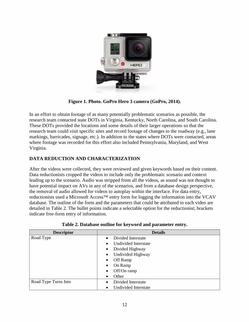
Database videos were recorded using a GoPro Hero 3 camera (Figure 1) mounted to the windshield of an ordinary vehicle. When researchers encountered a real-world scenario that they deemed potentially problematic for AVs, they recorded that segment of roadway.
12
Figure 1. Photo. GoPro Hero 3 camera (GoPro, 2014).
In an effort to obtain footage of as many potentially problematic scenarios as possible, the research team contacted state DOTs in Virginia, Kentucky, North Carolina, and South Carolina. These DOTs provided the locations and some details of their larger operations so that the research team could visit specific sites and record footage of changes to the roadway (e.g., lane markings, barricades, signage, etc.). In addition to the states where DOTs were contacted, areas where footage was recorded for this effort also included Pennsylvania, Maryland, and West Virginia.
DATA REDUCTION AND CHARACTERIZATION
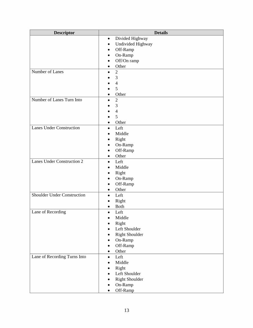
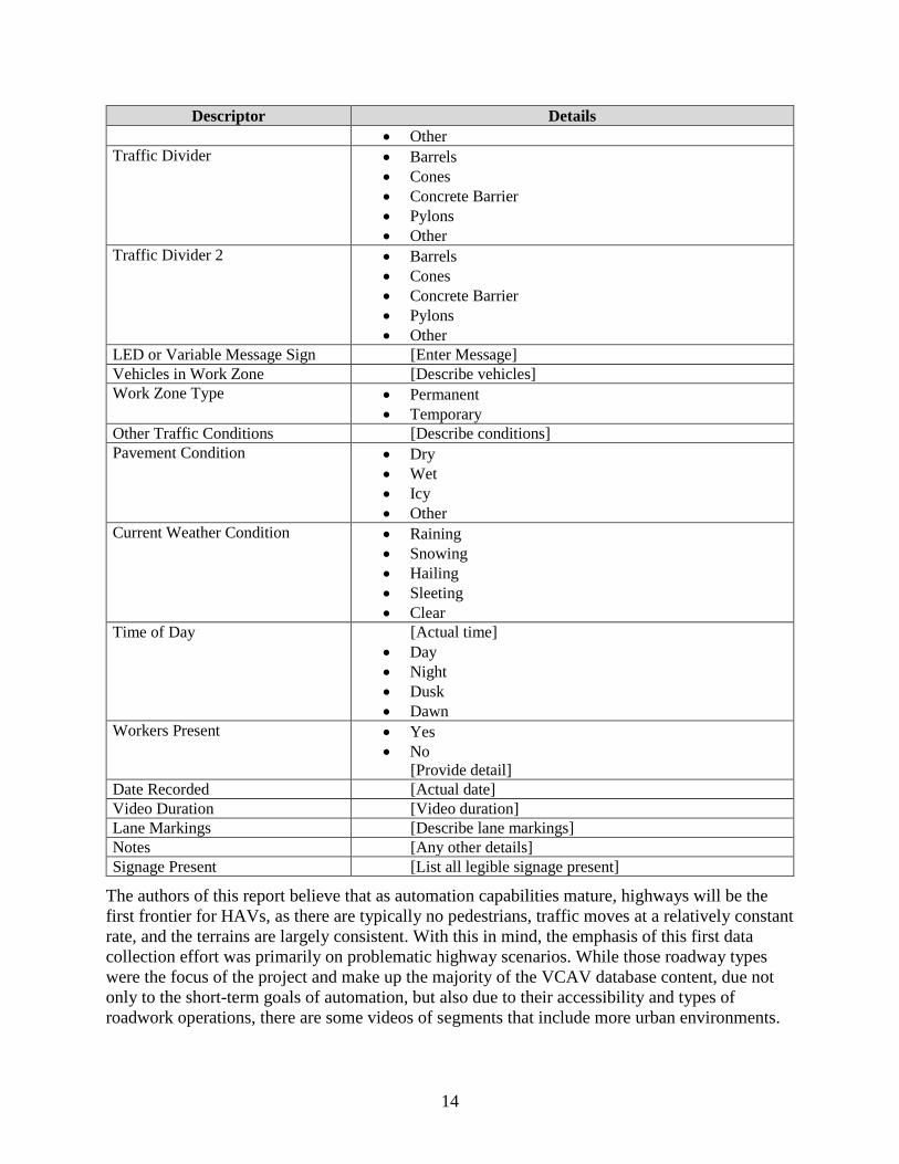
After the videos were collected, they were reviewed and given keywords based on their content. Data reductionists cropped the videos to include only the problematic scenario and context leading up to the scenario. Audio was stripped from all the videos, as sound was not thought to have potential impact on AVs in any of the scenarios, and from a database design perspective, the removal of audio allowed for videos to autoplay within the interface. For data entry, reductionists used a Microsoft Access™ entry form for logging the information into the VCAV database. The outline of the form and the parameters that could be attributed to each video are detailed in Table 2. The bullet points indicate a selectable option for the reductionist; brackets indicate free-form entry of information.
Table 2. Database outline for keyword and parameter entry. Descriptor Details
Road Type • Divided Interstate • Undivided Interstate • Divided Highway • Undivided Highway • Off Ramp • On Ramp • Off/On ramp • Other
Road Type Turns Into • Divided Interstate • Undivided Interstate
13
Descriptor Details • Divided Highway • Undivided Highway • Off-Ramp • On-Ramp • Off/On ramp • Other
Number of Lanes • 2 • 3 • 4 • 5 • Other
Number of Lanes Turn Into • 2 • 3 • 4 • 5 • Other
Lanes Under Construction • Left • Middle • Right • On-Ramp • Off-Ramp • Other
Lanes Under Construction 2 • Left • Middle • Right • On-Ramp • Off-Ramp • Other
Shoulder Under Construction • Left • Right • Both
Lane of Recording • Left • Middle • Right • Left Shoulder • Right Shoulder • On-Ramp • Off-Ramp • Other
Lane of Recording Turns Into • Left • Middle • Right • Left Shoulder • Right Shoulder • On-Ramp • Off-Ramp
14
Descriptor Details • Other
Traffic Divider • Barrels • Cones • Concrete Barrier • Pylons • Other
Traffic Divider 2 • Barrels • Cones • Concrete Barrier • Pylons • Other
LED or Variable Message Sign [Enter Message] Vehicles in Work Zone [Describe vehicles] Work Zone Type • Permanent
• Temporary Other Traffic Conditions [Describe conditions] Pavement Condition • Dry
• Wet • Icy • Other
Current Weather Condition • Raining • Snowing • Hailing • Sleeting • Clear
Time of Day [Actual time] • Day • Night • Dusk • Dawn
Workers Present • Yes • No
[Provide detail] Date Recorded [Actual date] Video Duration [Video duration] Lane Markings [Describe lane markings] Notes [Any other details] Signage Present [List all legible signage present]
The authors of this report believe that as automation capabilities mature, highways will be the first frontier for HAVs, as there are typically no pedestrians, traffic moves at a relatively constant rate, and the terrains are largely consistent. With this in mind, the emphasis of this first data collection effort was primarily on problematic highway scenarios. While those roadway types were the focus of the project and make up the majority of the VCAV database content, due not only to the short-term goals of automation, but also due to their accessibility and types of roadwork operations, there are some videos of segments that include more urban environments.
15
CHAPTER 4. VCAV DATABASE CONTENT
The VCAV database consists of video clips recorded when a researcher deemed an area potentially problematic for an AV. At the time of this report, there are approximately 12 hours of problematic scenario video data. It is important to note that a number of the instances repeat due to the structure of the database. For example, a video of a researcher driving through a large work zone may take several minutes and the researcher may encounter a number of intermittent problematic scenarios, such as barrels in the lane, obscured lane markings, or heavy equipment entering and exiting the lane. Those videos are in the database in their entirety (and are henceforth referred to as “root videos”), and shorter clips from those root videos isolate a specific problematic element (e.g., a half-minute clip of only the obscured lane markings, barrels, or large equipment). The VCAV database was designed this way so that users could observe both the entirety of a sequence of close events and also focus on a specific type of scenario.
Currently, there are approximately 150 root video entries in the VCAV database, with more being added regularly and more clips from those root videos being made over time. Over 75% of the videos were recorded during the day and 88% were recorded in clear conditions. The only other weather condition recorded was rain (12%). Approximately 86% of the videos recorded dry pavement conditions and the remaining videos recorded wet conditions. No snow or icy conditions were recorded, as a majority of the first round of data collection occurred primarily in the summer in the southeastern U.S.
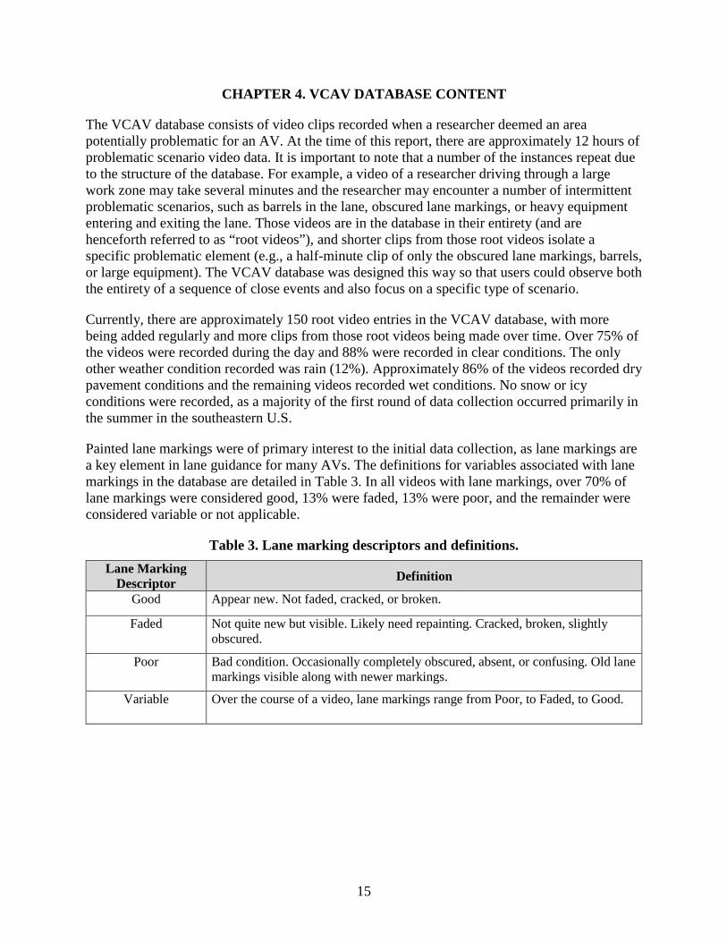
Painted lane markings were of primary interest to the initial data collection, as lane markings are a key element in lane guidance for many AVs. The definitions for variables associated with lane markings in the database are detailed in Table 3. In all videos with lane markings, over 70% of lane markings were considered good, 13% were faded, 13% were poor, and the remainder were considered variable or not applicable.
Table 3. Lane marking descriptors and definitions. Lane Marking
Descriptor Definition
Good Appear new. Not faded, cracked, or broken.
Faded Not quite new but visible. Likely need repainting. Cracked, broken, slightly obscured.
Poor Bad condition. Occasionally completely obscured, absent, or confusing. Old lane markings visible along with newer markings.
Variable Over the course of a video, lane markings range from Poor, to Faded, to Good.

17
CHAPTER 5. VCAV ONLINE DATABASE TOOL
The VCAV online database tool was developed as a means of searching for and exhibiting the various obstacles AVs must overcome prior to achieving true level 5 automation. The ultimate goal of the database is to include multiple real-world scenarios that may be problematic to AVs’ navigation sensors. Instances of poor lane markings, barricades too close to a lane, or issues created by inclement weather are a small percentage of potential scenarios. The initial data added to the VCAV database consists of highway work zone operations, which are typically the most disruptive to the generally predictable highway infrastructure that AVs rely on. The first step in producing a software tool to work with research data is understanding the intended workflow. By understanding the type of data, as well as the intended use cases for accessing it, an initial feature set can be created. At this stage, programmers often discuss potential adjustments to the workflow, as well as different user interface (UI) elements that could be used to progressively guide the users to the data they seek. Balancing useful UI elements with screen real estate is often a challenge, as the size of monitors and display devices varies. Additionally, providing streaming video to users was a central goal of this application, so ease of user access on multiple platforms was imperative. DEVELOPMENT
In application programming, gathering requirements and use cases for end users helps guide the choice of programming tool. For this project, the Python programming language and the Django® web framework were chosen. These tools allowed programmers to focus on the critical portions of the research and abstract out the more common aspects, such as user authentication and permission handling. Development of the application was tracked via a distributed version control system called Git. Some of the automation features within our Git hosting service were utilized to run testing and deploy new versions. This allowed new changes and features to be iterated quickly and easily as the project matured and additional ideas were formulated. The application itself is bundled within a Docker container. Much like a virtual machine, this container isolates the application from the outside world. This is both for security and ease of deployment, in that it reduces dependencies and possible hacking access points. The application can be deployed to a public cloud service like Amazon Web Services or to a private server for more restricted access to the video files. Since the video annotations were stored in a Microsoft Access database, it was important to develop a workflow for importing and updating the data in the application. It was ultimately decided to export the data from Access via CSV, and then import that data into the application, thus automatically updating or creating new clip entries. The end UI for accessing root clips relies on the JavaScript library DataTables. This provides a browser-based method for implementing filtering, sorting, and column hiding that allows users to reorganize the data in a more interactive way, similar to a spreadsheet.
18
STRUCTURE
Using the framework provided by the Microsoft Access Database, programmers were able to match the VCAV database scheme for the online application. An import interface was programmed to retrieve the exported CSV files produced by Access to be uploaded to a secure section of the website. The VCAV application itself sits behind an Nginx® web-server. This web-server handles routing the incoming requests for the application, serving static files like CSS and JavaScript files, and streaming the video files for playback in HTML 5 video players. All videos were converted to H.264 encoding in an MP4 container and watermarked using FFmpeg™, a software application that produces libraries and programs for handling multimedia data. The conversion requires the use of certain encoding settings for increased compatibility across browsers and platforms. The watermark is encoded into the videos at this stage, before they are accessible to users. LOGIN AND REGISTRATION
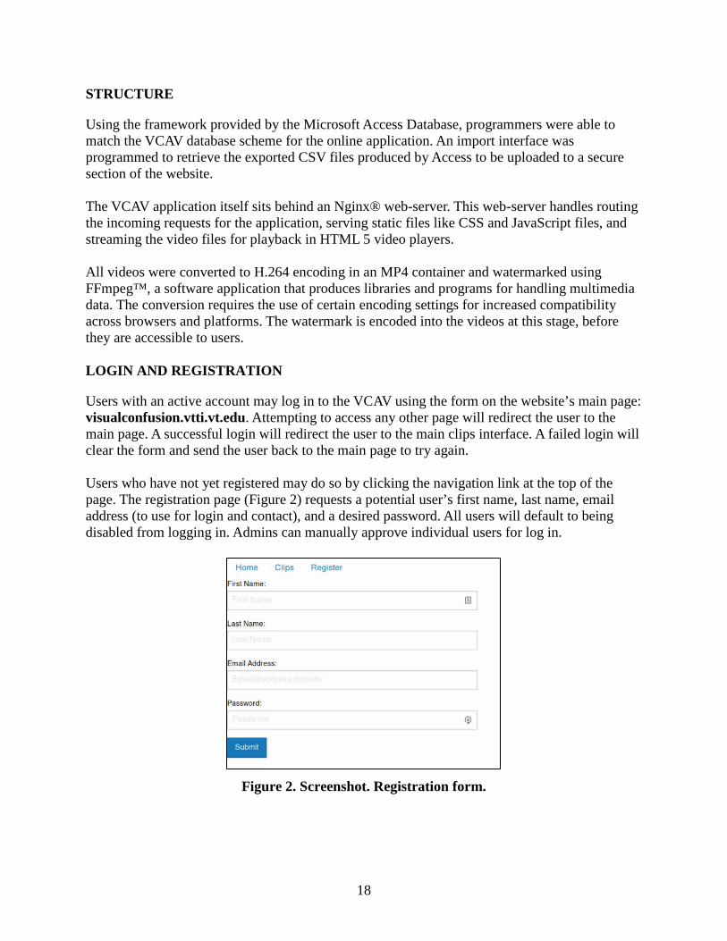
Users with an active account may log in to the VCAV using the form on the website’s main page: visualconfusion.vtti.vt.edu. Attempting to access any other page will redirect the user to the main page. A successful login will redirect the user to the main clips interface. A failed login will clear the form and send the user back to the main page to try again. Users who have not yet registered may do so by clicking the navigation link at the top of the page. The registration page (Figure 2) requests a potential user’s first name, last name, email address (to use for login and contact), and a desired password. All users will default to being disabled from logging in. Admins can manually approve individual users for log in.
Figure 2. Screenshot. Registration form.
19
APPLICATION WORKFLOW
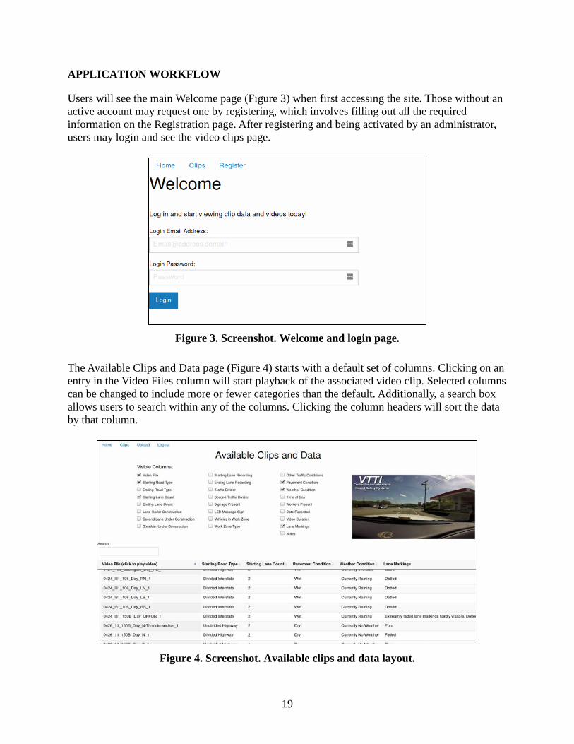
Users will see the main Welcome page (Figure 3) when first accessing the site. Those without an active account may request one by registering, which involves filling out all the required information on the Registration page. After registering and being activated by an administrator, users may login and see the video clips page.
Figure 3. Screenshot. Welcome and login page.
The Available Clips and Data page (Figure 4) starts with a default set of columns. Clicking on an entry in the Video Files column will start playback of the associated video clip. Selected columns can be changed to include more or fewer categories than the default. Additionally, a search box allows users to search within any of the columns. Clicking the column headers will sort the data by that column.
Figure 4. Screenshot. Available clips and data layout.
20
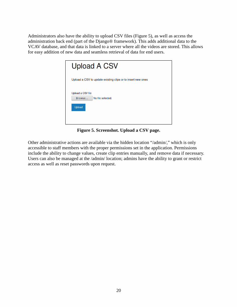
Administrators also have the ability to upload CSV files (Figure 5), as well as access the administration back end (part of the Django® framework). This adds additional data to the VCAV database, and that data is linked to a server where all the videos are stored. This allows for easy addition of new data and seamless retrieval of data for end users.
Figure 5. Screenshot. Upload a CSV page.
Other administrative actions are available via the hidden location “/admin/,” which is only accessible to staff members with the proper permissions set in the application. Permissions include the ability to change values, create clip entries manually, and remove data if necessary. Users can also be managed at the /admin/ location; admins have the ability to grant or restrict access as well as reset passwords upon request.

21
CHAPTER 6. FUTURE EFFORTS
The recording of scenarios that may be problematic to AVs, especially in terms of work zones, and the development of VCAV database and end user interface comprised the bulk of this effort. The development of this database and interface will allow further videos and scenarios to be added more rapidly and efficiently. Accordingly, additional efforts to seek and record problematic scenarios are being planned for future VCAV database addition. As time and personnel availability allow, the database will continue to expand and grow.
The current dataset is of such a size and scale that refinement by scenario type is possible. The method by which the data is organized and the keywords that are assigned to each video can be expanded or changed. It may be that future efforts and future recorded scenarios require different types of information to be accurately described in the database. If this is the case, the structure of the VCAV database is malleable enough and the size small enough that sweeping changes and adjustments can be made.
The research team would like to provide more videos that include scenarios involving weather, such as snow banks and fog. Other scenarios involving temporary lane markings in areas of intersections, interchanges, roundabouts, and merge lanes are also of key interest to this work. Lastly, urban zones with street parking, parking garages, and parking lots are major issues for AVs that should be cataloged as well.

23
REFERENCES
Alonso, L., Milanès, V., Torre-Ferrero, C., Godoy, J., Oria, J. P., & Pedro, T. d. (2010). Ultrasonic sensors in urban traffic driving-aid systems. Sensors, 11(1), 661-673. doi:10.3390/s110100661
Anderson, J. M., Kalra, N., Stanley, K. D., Sorensen, P., Samaras, C., & Oluwatola, O. A. (2016). Autonomous vehicle technology: A guide for policymakers. Santa Monica, CA: Rand Corporation.
Baiming, C., Ding, Z., & Huei, P. (2017). Evaluation of automated vehicles encountering pedestrians at unsignalized crossings. IEEE Intelligent Vehicles Symposium.
Balke, K., Beaubein, D., Gettman, D., Hedden, C., Kuciemba, S., & Lower, J. (2015). Connected and automated vehicles: Ready or not, here they come! (Highlights from the ITE Automated Vehicles Interactive Design Workshop). ITE Journal, 85(12), 17-20.
Beggiato, M., Witzlack, C., Springer, S., & Krems, J. (2017). The right moment for braking as informal communication signal between automated vehicles and pedestrians in crossing situations. Paper presented at the International Conference on Applied Human Factors and Ergonomics.
Chen, B., Zhao, D., & Peng, H. (2017). Evaluation of automated vehicles encountering pedestrians at unsignalized crossings. Paper presented at the IEE Intelligent Vehicles Symposium, Redondo Beach, CA.
Daniels, J. (2015). Automated vehicles: Monitoring the people inside. Retrieved from http://www.umtri.umich.edu/what-were-doing/news/automated-vehicles-monitoring-people-inside
De Sliva, V., Roche, J., & Kondoz, J. (2017). Fusion of LiDAR and camera sensor data for environment sensing in driverless vehicles. IEEE Sensors Journal. (Under review).
Debnath, A. K., Blackman, R., & Haworth, N. (2015). Common hazards and their mitigating measures in work zones: A qualitative study of worker perceptions. Safety Science, 72, 293-301.
Ellis Jr., R. D., & Kumar, A. (1993). Influence of nighttime operations on construction cost and productivity. Transportation Research Record, 1389, 31-37.
Fagnant, D. J., & Kockelman, K. M. (2014). The travel and environmental implications of shared autonomous vehicles, using agent-based model scenarios. Transportation Research Part C: Emerging Technologies, 40, 1-13.
Fagnant, D. J., & Kockelman, K. (2015). Preparing a nation for autonomous vehicles: opportunities, barriers and policy recommendations. Transportation Research Part A: Policy and Practice, 77, 167-181.
24
Fagnant, D. J., & Kockelman, K. M. (2018). Dynamic ride-sharing and fleet sizing for a system of shared autonomous vehicles in Austin, Texas. Transportation, 45(1), 143-158.
Goodall, N. J. (2014). Ethical decision making during automated vehicle crashes. Journal of the Transportation Research Board, 2424, 58-65. doi:10.3141/2424-07
GoPro. (2014). How to update your HERO3. Retrieved from https://gopro.com/update/hero3
Helton, L. G. (2016). United States Patent No. US9313862BI.
Ilas, C. (2013). Electronic sensing technologies for autonomous ground vehicles: A Review. Paper presented at the The 8th International Symposium on Advanced Topics in Electrical Engineering, Bucharest, Romania.
John, V., Mita, S., Liu, Z., & Qi, B. (2015). Pedestrian detection in thermal images using adaptive fuzzy C-means clustering and convolutional neural networks. Paper presented at the 14th IAPR International Conference on Machine Vision Applications, Tokyo, Japan.
Lee, C. D. (1969). Nighttime construction work on urban freeways. Traffic Engineering, 39(3), 26-29.
LeValley, D. (2013). Autonomous vehicle liability—application of common carrier liability. Seattle UL Rev., 36, 5, 7.
Litman, T. (2017). Autonomous vehicle implementation predictions: Victoria Transport Policy Institute.
Mammeri, A., Zhou, D., & Boukerche, A. (2016). Animal-vehicle collision mitigation system for automated vehicles. IEEE Transactions on Systems, Man, and Cybernetics: Systems, 46(9), 1287-1299. doi:10.1109/TSMC.2015.2497235
Merat, N., Jamson, A. H., Lai, F. C., Daly, M., & Carsten, O. M. (2014). Transition to manual: Driver behaviour when resuming control from a highly automated vehicle. Transportation Research Part F: Traffic Psychology and Behaviour, 27, 274-282.
Migliore, G. (2016). Google designs autonomous car feature to detect emergency vehicles. Retrieved from https://www.autoblog.com/2016/09/12/google-autonomous-car-emergency-lights/
MobilEye. (2017). How it works. Retrieved from http://www.mobileye.com/en-us/technology/how-it-works/
National Conference of State Legislatures. (2017). Autonomous vehicles: Self-driving vehicles enacted legislation. Retrieved from http://www.ncsl.org/research/transportation/autonomous-vehicles-self-driving-vehicles-enacted-legislation.aspx
25
National Highway Traffic Safety Administration. (2016). Automated vehicles for safety. Retrieved from https://www.nhtsa.gov/technology-innovation/automated-vehicles-safety
National Highway Traffic Safety Administration. (2017). Voluntary safety self-assessment template. Retrieved from https://www.nhtsa.gov/sites/nhtsa.dot.gov/files/documents/voluntary_safety_self-assessment_for_web_101117_v1.pdf
SAE International. (2016). US Department of Transportation’s new policy on automated vehicles adopts SAE International’s levels of automation for defining driving automation in on-road motor vehicles. Retrieved from https://www.sae.org/news/3544/
Shuttleworth, J. (2017). Ford, Virginia Tech partner to develop common visual communications interface for autonomous vehicles. Automotive Engineering. http://articles.sae.org/15628/
Tesla. (2016). Tesla Model S: Owner’s Manual. Retrieved from https://www.tesla.com/sites/default/files/model_s_owners_manual_north_america_en_us.pdf
Thompson, C. (2015, Dec. 2). Here’s how Google's self-driving cars know what to do in an emergency situation. Business Insider. http://www.businessinsider.com/how-googles-self-driving-cars-respond-to-emergency-sirens-2015-12
Tian, Y., Lo, W.-Y., & Ferguson, D. I. F. (2016). Real-time active emergency vehicle detection: Google Patents.
Virginia Tech. (2017). Transportation institute awarded federal contract to study alternative vehicle designs and how they affect current safety standards. Retrieved from https://vtnews.vt.edu/articles/2017/11/110917-vtti-FMVSS.html
Wadud, Z., MacKenzie, D., & Leiby, P. (2016). Help or hindrance? The travel, energy and carbon impacts of highly automated vehicles. Transportation Research Part A: Policy and Practice, 86, 1-18. doi:https://doi.org/10.1016/j.tra.2015.12.001
Wagner, W., Loftus-Otway, L., Morrisey, S., Havinoviski, G., & Serian, B. (Submitted for publication). Connected and automated driving systems legal and regulatory inventory audit. Washington, DC: National Cooperative Highway Research Program.
Wang, H., Wang, B., Liu, B., Meng, X., & Yang, G. (2017). Pedestrian recognition and tracking using 3D LiDAR for autonomous vehicle. Robotics and Autonomous Systems, 88, 71-78.
Wang, W., Song, Y., Zhang, J., & Deng, H. (2014). Automatic parking of vehicles: A review of literatures. International Journal of Automotive Technology, 15(6), 967-978. doi:10.1007/s12239−014−0102−y
Wolcott, R., & Eustice, R. (2014, September). Visual localization within LIDAR maps for automated urban driving. 2014 IEEE/RSJ International Conference on Intelligent Robots and Systems, Chicago, IL.