prepared for— - boulder, colorado species analysis boulder reservoir. b. oulder . c. ounty, c....
TRANSCRIPT
BIOLOGICAL SPECIES ANALYSIS BOULDER RESERVOIR
BOULDER COUNTY, COLORADO
Prepared for—
City of Boulder Parks and Recreation 3198 Broadway
Boulder, Colorado 80304
Prepared by—
ERO Resources Corporation 1842 Clarkson Street
Denver, Colorado 80218 (303) 830-1188
ERO Project #5200
February 2013
ERO Project #5200 i
CONTENTS
Introduction ..........................................................................................................................1
Biological Setting.................................................................................................................2
Biological Resources ...........................................................................................................5 Open Water and Shorelines ...........................................................................................5
Vegetation Resources...............................................................................................6 Wildlife Resources ...................................................................................................7 Desired Future Conditions .......................................................................................8
Herbaceous Wetlands ....................................................................................................9 Vegetation Resources.............................................................................................12 Wildlife Resources .................................................................................................15 Desired Future Conditions .....................................................................................15
Wooded Riparian .........................................................................................................16 Vegetation Resources.............................................................................................16 Wildlife Resources .................................................................................................19 Desired Future Conditions .....................................................................................21
Shortgrass Prairie .........................................................................................................22 Vegetation Resources.............................................................................................23 Wildlife Resources .................................................................................................23 Desired Future Conditions .....................................................................................24
Biological Resources of High-Priority Conservation Targets .....................................25 Vegetation Communities .......................................................................................25 Rare Plants .............................................................................................................25 Noxious Weeds ......................................................................................................25 Prairie Dogs ...........................................................................................................26 Northern Harriers ...................................................................................................28 American Bittern ....................................................................................................28 Savannah Sparrow .................................................................................................32 Osprey ....................................................................................................................32 Short-eared Owl .....................................................................................................34 Bald Eagle ..............................................................................................................34 Raptors ...................................................................................................................34 Frogs ......................................................................................................................38 Aquatic Nuisance Species ......................................................................................39
Recommendations ..............................................................................................................40 Vegetation ....................................................................................................................42
General Recommendations ....................................................................................42 Recommendations by Management Area ....................................................................43
North Shore including Surrounding Shortgrass Prairie .........................................43 Coot Lake ...............................................................................................................44 North and South Dam ............................................................................................44 South Shore ............................................................................................................44 West Shore .............................................................................................................44
ERO Project #5200 ii
Wildlife ........................................................................................................................45 General Recommendations ....................................................................................45 Recommended Indicator Species for Monitoring and Management .....................45
Summary ............................................................................................................................47
References ..........................................................................................................................49
TABLES Table 1. Most prevalent vegetation communities within management units at Boulder
Reservoir. .....................................................................................................................5 Table 2. Desired Future Conditions and Recommendations Matrix. ................................40
FIGURES Figure 1. Boulder Reservoir Site Location and Management Areas. Figure 2. Changes in the Type and Functions of Wetlands in Boulder County. Figure 3. Changes in Wetlands in the Boulder Area from 1976 to Present. Figure 4. Example of Noxious Weed Control Efforts – 2011. Figure 5. Bird Species and Riparian Habitats in the Western U.S. Figure 6. Composite Map of All Areas On and Near Boulder Reservoir Occupied by
Prairie Dogs at Some Time Between 1996 and 2012. Figure 7. Prairie Dog Colonies Mapped at Boulder Reservoir in 2006. Figure 8. Prairie Dog Colonies Mapped at Boulder Reservoir in 2011. Figure 9. Boulder Reservoir Prairie Dog Counts 2000 – 2012. Figure 10. Osprey Nest Sites and Foraging Areas. Figure 11. Bald Eagle Nest and Roost Sites Mapped by Colorado Parks and Wildlife. Figure 12. Bald Eagle Winter Forage Mapped by Colorado Parks and Wildlife. Figure 13. Boulder Reservoir Winter Raptor Concentration Areas.
PHOTOS Photo a. Open water and bare shoreline of the reservoir. ....................................................6 Photo b. Eroding North Shore of the reservoir. ...................................................................7 Photo c. Coot Lake shoreline. ..............................................................................................7 Photo d. Little Dry Creek wetlands that have expanded over time. ..................................12 Photo e. Herbaceous wetlands at the western edge of Coot Lake. ....................................13 Photo f. Wooded riparian vegetation along Dry Creek. .....................................................17 Photo g. Degraded understory of North Shore wooded riparian. ......................................18 Photo h. Wooded riparian and herbaceous wetlands at the western end of Coot Lake. ....19

ERO Project #5200 iii
APPENDICES Appendix A – Study Methods Appendix B – List of Wildlife Species Known or Likely to Occur at Boulder Reservoir
ERO Project #5200 1
BIOLOGICAL SPECIES ANALYSIS BOULDER RESERVOIR
BOULDER COUNTY, COLORADO
FEBRUARY 2013
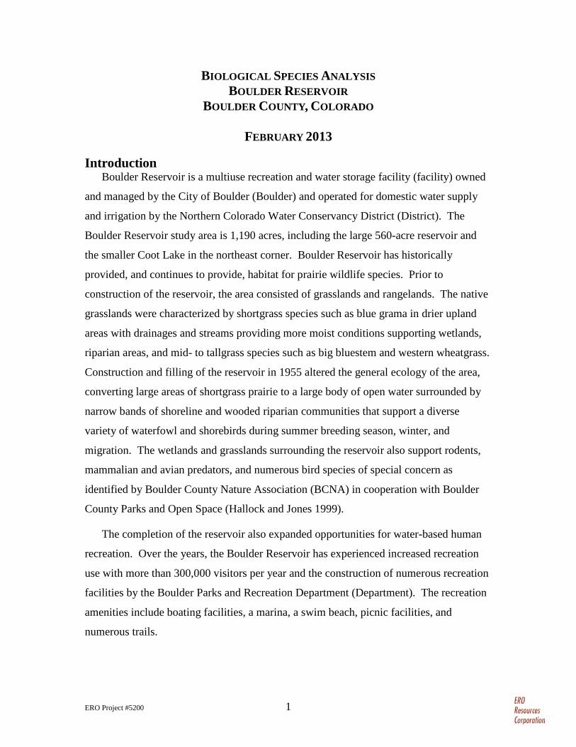
Introduction Boulder Reservoir is a multiuse recreation and water storage facility (facility) owned
and managed by the City of Boulder (Boulder) and operated for domestic water supply
and irrigation by the Northern Colorado Water Conservancy District (District). The
Boulder Reservoir study area is 1,190 acres, including the large 560-acre reservoir and
the smaller Coot Lake in the northeast corner. Boulder Reservoir has historically
provided, and continues to provide, habitat for prairie wildlife species. Prior to
construction of the reservoir, the area consisted of grasslands and rangelands. The native
grasslands were characterized by shortgrass species such as blue grama in drier upland
areas with drainages and streams providing more moist conditions supporting wetlands,
riparian areas, and mid- to tallgrass species such as big bluestem and western wheatgrass.
Construction and filling of the reservoir in 1955 altered the general ecology of the area,
converting large areas of shortgrass prairie to a large body of open water surrounded by
narrow bands of shoreline and wooded riparian communities that support a diverse
variety of waterfowl and shorebirds during summer breeding season, winter, and
migration. The wetlands and grasslands surrounding the reservoir also support rodents,
mammalian and avian predators, and numerous bird species of special concern as
identified by Boulder County Nature Association (BCNA) in cooperation with Boulder
County Parks and Open Space (Hallock and Jones 1999).
The completion of the reservoir also expanded opportunities for water-based human
recreation. Over the years, the Boulder Reservoir has experienced increased recreation
use with more than 300,000 visitors per year and the construction of numerous recreation
facilities by the Boulder Parks and Recreation Department (Department). The recreation
amenities include boating facilities, a marina, a swim beach, picnic facilities, and
numerous trails.
BIOLOGICAL SPECIES ANALYSIS BOULDER RESERVOIR
BOULDER COUNTY, COLORADO
ERO Project #5200 2
The Department is currently developing the Boulder Reservoir Master Plan (BRMP;
Boulder 2012a). The purpose of the BRMP is to establish a long-range vision, goals, and
objectives for Department-managed land and activities for Boulder Reservoir and Coot
Lake. The intent is to guide future management and investment strategies by integrating
the principles of economic, social, and environmental sustainability, including
recommendations addressing water quality, natural habitat, and recreational uses at
Boulder Reservoir. The Department contracted with ERO Resources Corporation (ERO)
to collect existing biological information and work with the Department to develop the
biological resource data needed for the public involvement phase of the planning process.
ERO’s analysis focuses on research and synthesis of existing biological data from the
Department and other relevant sources to illustrate the past and present ecological
conditions of Boulder Reservoir (see Appendix A for detailed study methods). The
objectives of this study are to:
1. Generally describe, through graphics and text, historic vegetation and wildlife communities based on available information.
2. Provide maps and written descriptions of current conditions of vegetation and wildlife communities based on existing information.
3. Present a cohesive narrative of vegetation and wildlife resources that sets the stage for future decision making.
Biological Setting The physical environment of Colorado has a diverse array of topography and
landforms that in turn influences our unpredictable climatic patterns of temperature and
precipitation. The combination of landforms and climate determines the types and
distribution of vegetation, and subsequently influences the types and distribution of
animals on the landscape.
Biological resources can be evaluated at several levels: as a species, a group of
species sharing similar characteristics (e.g., birds of prey or raptors and waterfowl), a
community, or a functional component of the ecosystem. For purposes of this report,
ERO describes the biological resources of Boulder Reservoir and the surrounding area in
terms of five landforms and vegetation types based on the following ecological
communities:
BIOLOGICAL SPECIES ANALYSIS BOULDER RESERVOIR
BOULDER COUNTY, COLORADO
ERO Project #5200 3
• Open water and shorelines – Includes the waters of the reservoir and Coot Lake and their surrounding shorelines below the high water level.
• Herbaceous wetlands – Herbaceous wetlands are areas where water saturates the soil long enough to support wetland grasses and other nonwoody vegetation (U.S. Army Corps of Engineers (Corps) 2010). Herbaceous wetlands occur along the tributaries that flow into the reservoir, along ditches, and on the west side of Coot Lake.
• Wooded riparian – Wooded riparian areas contain trees and shrubs supported by aboveground and belowground streamflows, in addition to annual precipitation. Cottonwoods, peachleaf willows, and other trees dominate the wooded riparian areas within Boulder Reservoir. Sandbar willow shrubs are also common. Wooded riparian is most prevalent along the west end of Boulder Reservoir where tributaries flow into the reservoir, although narrow bands occur around the remainder of the shoreline. Wooded riparian vegetation also surrounds Coot Lake.
• Shortgrass prairie – Shortgrass prairie occurs in the uplands around the reservoir. The dominant species largely depends on the previous management practices. Nonnative grasses, such as smooth brome, occur in areas previously planted for hay production or reclaimed disturbed areas. In relatively undisturbed areas, native shortgrass species such as blue grama dominate, although invasive species are common.
• Disturbed/urban parkland – This classification includes areas permanently altered for construction and maintenance of the dam, reservoir, and water facilities; other buildings and structures; roads; parking lots; and active recreation facilities. For example, the South Shore of the reservoir that is intensely used for park activities has been landscaped with turf grasses and is classified as disturbed/urban parkland.
These communities are similar to the vegetation communities identified in the BMRP
(Boulder 2012a), except that the high-functioning wetlands described in the BMRP have
been divided in this report into open water and shorelines, herbaceous wetlands, and
wooded riparian.
Brief descriptions of biological resources, including biology, distribution over time,
and susceptibility to changing conditions, are provided below by community type.
Biological resources of high-priority conservation targets have also been identified.
Boulder Reservoir is divided into the following four management units (Figure 1):
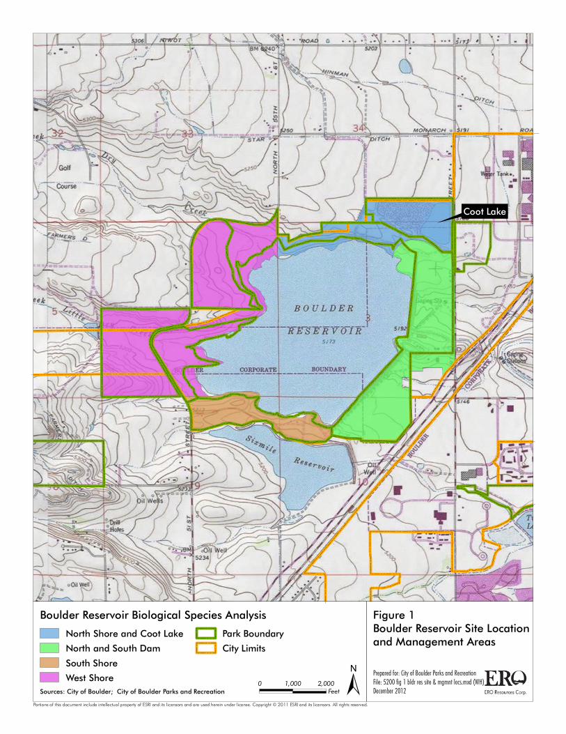
Coot Lake
Prepared for: City of Boulder Parks and RecreationFile: 5200 fig 1 bldr res site & mgmnt locs.mxd (WH)December 2012±
Figure 1Boulder Reservoir Site Locationand Management Areas
Boulder Reservoir Biological Species Analysis
Portions of this document include intellectual property of ESRI and its licensors and are used herein under license. Copyright © 2011 ESRI and its licensors. All rights reserved.
0 2,0001,000Feet
North Shore and Coot Lake
North and South Dam
South Shore
West Shore
Park Boundary
City Limits
Sources: City of Boulder; City of Boulder Parks and Recreation
BIOLOGICAL SPECIES ANALYSIS BOULDER RESERVOIR
BOULDER COUNTY, COLORADO
ERO Project #5200 5
• North Shore, including Coot Lake
• North and South Dam
• South Shore
• West Shore
Each of these management units contains one or more of the communities described
above as presented in Table 1.
Table 1. Most prevalent vegetation communities within management units at Boulder Reservoir.
Vegetation Communities
Management Units
North Shore North and South Dam
South Shore
West Shore
Open Water and Shorelines X X X X Herbaceous Wetlands X (minor) X Wooded Riparian X X Shortgrass Prairie X X X Disturbed/Urban Parkland X X
Biological Resources The following sections describe the historical and existing conditions of biological
resources at Boulder Reservoir and the desired future conditions to protect and maintain
those high value resources and enhance or restore degraded resources and to healthy
diverse communities.
Open Water and Shorelines Water levels at the Boulder Reservoir have fluctuated greatly since filling of the
reservoir began in 1955, depending on the amount of water storage needed and periodic
climatic fluctuations. This fluctuation contributes to the vegetation communities that
have developed surrounding the reservoir and the wildlife communities associated with
these communities. Additionally, Coot Lake was originally excavated as a borrow pit to
provide materials for the dam construction and since then has filled with water (Design
Studios West Inc. 1983). Wave action on Coot Lake eventually resulted in severely
eroded shorelines and degraded wildlife habitat, particularly along the south and east

BIOLOGICAL SPECIES ANALYSIS BOULDER RESERVOIR
BOULDER COUNTY, COLORADO
ERO Project #5200 6
shores. Boulder initiated a project in 2000 to stabilize banks and shorelines using logs,
boulders, and native vegetation (Professional Wetlands Consulting, Inc. 1999).
Vegetation Resources Within the permanent waters of the reservoir, patches of pondweed and other
submergent vegetation occurs amidst the unconsolidated pond bottoms. Along the
shoreline, little vegetation grows except for annuals and seedlings of cottonwoods and
willows (Photo a). This vegetation may persist for several years during dry periods but
would disappear when water levels rise. This pattern of sparse permanent vegetation
along the shoreline is likely to continue because of varying water storage needs.
Photo a. Open water and bare shoreline of the reservoir.
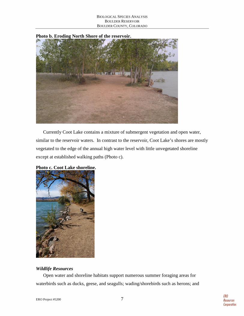
The North Shore of the reservoir is eroding due to wave action, fluctuating water
levels, and human trampling (Photo b). This erosion has caused the loss of cottonwood
trees and other vegetation.
BIOLOGICAL SPECIES ANALYSIS BOULDER RESERVOIR
BOULDER COUNTY, COLORADO
ERO Project #5200 7
Photo b. Eroding North Shore of the reservoir.
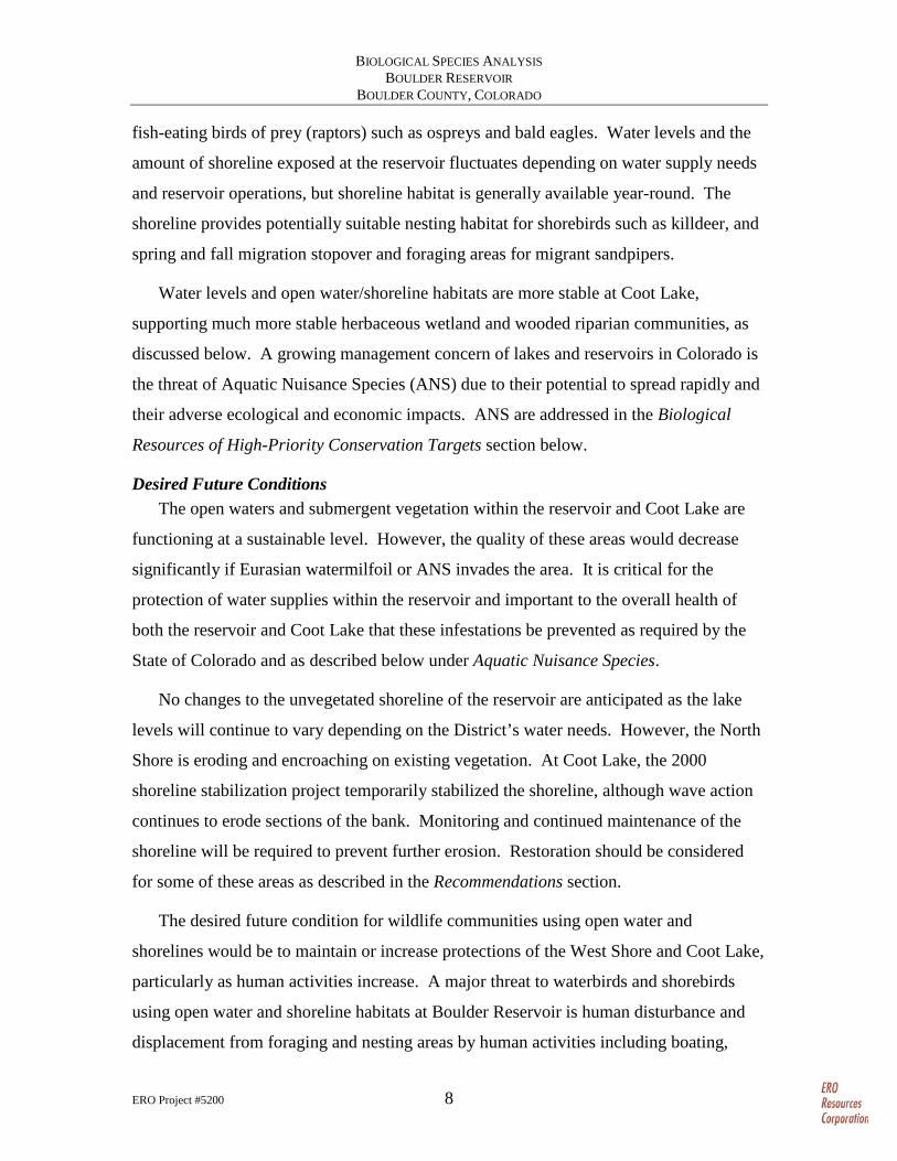
Currently Coot Lake contains a mixture of submergent vegetation and open water,
similar to the reservoir waters. In contrast to the reservoir, Coot Lake’s shores are mostly
vegetated to the edge of the annual high water level with little unvegetated shoreline
except at established walking paths (Photo c).
Photo c. Coot Lake shoreline.
Wildlife Resources Open water and shoreline habitats support numerous summer foraging areas for
waterbirds such as ducks, geese, and seagulls; wading/shorebirds such as herons; and
BIOLOGICAL SPECIES ANALYSIS BOULDER RESERVOIR
BOULDER COUNTY, COLORADO
ERO Project #5200 8
fish-eating birds of prey (raptors) such as ospreys and bald eagles. Water levels and the
amount of shoreline exposed at the reservoir fluctuates depending on water supply needs
and reservoir operations, but shoreline habitat is generally available year-round. The
shoreline provides potentially suitable nesting habitat for shorebirds such as killdeer, and
spring and fall migration stopover and foraging areas for migrant sandpipers.
Water levels and open water/shoreline habitats are more stable at Coot Lake,
supporting much more stable herbaceous wetland and wooded riparian communities, as
discussed below. A growing management concern of lakes and reservoirs in Colorado is
the threat of Aquatic Nuisance Species (ANS) due to their potential to spread rapidly and
their adverse ecological and economic impacts. ANS are addressed in the Biological
Resources of High-Priority Conservation Targets section below.
Desired Future Conditions The open waters and submergent vegetation within the reservoir and Coot Lake are
functioning at a sustainable level. However, the quality of these areas would decrease
significantly if Eurasian watermilfoil or ANS invades the area. It is critical for the
protection of water supplies within the reservoir and important to the overall health of
both the reservoir and Coot Lake that these infestations be prevented as required by the
State of Colorado and as described below under Aquatic Nuisance Species.
No changes to the unvegetated shoreline of the reservoir are anticipated as the lake
levels will continue to vary depending on the District’s water needs. However, the North
Shore is eroding and encroaching on existing vegetation. At Coot Lake, the 2000
shoreline stabilization project temporarily stabilized the shoreline, although wave action
continues to erode sections of the bank. Monitoring and continued maintenance of the
shoreline will be required to prevent further erosion. Restoration should be considered
for some of these areas as described in the Recommendations section.
The desired future condition for wildlife communities using open water and
shorelines would be to maintain or increase protections of the West Shore and Coot Lake,
particularly as human activities increase. A major threat to waterbirds and shorebirds
using open water and shoreline habitats at Boulder Reservoir is human disturbance and
displacement from foraging and nesting areas by human activities including boating,

BIOLOGICAL SPECIES ANALYSIS BOULDER RESERVOIR
BOULDER COUNTY, COLORADO
ERO Project #5200 9
hiking along the shore, and off-leash dog activity. Boating is seasonally restricted along
the West Shore of the reservoir and a recently installed fence separating the North Shore
from the West Shore management areas provides a physical barrier to human
encroachment. Fencing also limits human disturbance to the west shore of Coot Lake.
Based on vegetation characteristics, it appears the fence is deterring some human
encroachment, but barriers and restrictions are dependent on enforcement and
compliance with Department rules.
Herbaceous Wetlands Herbaceous wetlands (wetlands dominated by sedges, forbs, and grasses with few
trees or shrubs) in Boulder County have been manipulated since gold mining days in the
1850s when pioneer farmers diverted creeks to water agricultural fields. Creation of
ditches and water storage reservoirs to support agriculture and increased urban
development has continued through recent times, including construction of Boulder
Reservoir in 1954 (Design Studios West Inc. 1983). Since 1976, wetlands throughout the
region have been lost due to construction of subdivisions and gravel mines (National
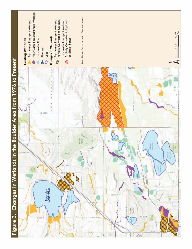
Wetland Inventory (NWI) 2012; Google Earth 2012) (Figure 2). Some of these lost
wetlands were replaced as required under the Clean Water Act of 1972.
The manipulation of wetlands since gold mining days has resulted in fewer wetlands
within the riparian areas around natural streams and more human-created wetlands along
ditches and reservoirs on the Plains. A study conducted in 1988 found that although the
amount of wetlands in the City of Boulder may not have changed significantly from
presettlement to recent times, the type and function of wetlands have changed with about
one-half of the wetlands now formed by human activity (Boulder 1988). This loss of
about one-half of the natural wetlands in Boulder was caused by channelization of
streams and prevention of annual spring overflows supporting floodplain wetlands
(Figure 3). The functions of the human-created wetlands are very different from natural
wetlands. The loss of natural wetlands has resulted in the loss of important wetland
functions such as general wildlife habitat (except for waterfowl), water quality functions
– nutrient retention and sediment trapping, food chain support, and shoreline

Wetlands
Figure 2. Changes in the Type and Functions of Wetlands in Boulder County
1850s
Most of wetlands in Boulder County were associated with streams
Present
Only half of today’s wetlands are associated with streams (riparian)and many of the remaining wetlands have diminished functions
Half of current wetlands are associated with man-made ditches and ponds
Wetland Functions
Riparian Wetland Pond/Ditch Wetland Gravel Pond Wetland
May be high functioning(depending on the amount of disturbance)
• Wildlife habitat• Sediment trapping• Food chain support• Shoreline anchoring
Medium to low functions
• Flood storage• Wildlife habitat
Medium to low functions except
• Flood storage - High• Fish habitat - High
Bould
er
Rese
rvoir
±04,
000
2,00
0Fe
et
Exis
tin
g W
etl
an
ds
Fres
hwat
er E
mer
gent
Wet
land
Fres
hwat
er F
ores
ted/
Shru
b W
etla
nd
Fres
hwat
er P
ond
Rive
rine
Lake
Cha
ng
es in
Wet
lan
ds
Fres
hwat
er E
mer
gent
Wet
land
Part
ially
Con
vert
ed to
Upl
ands
Fres
hwat
er E
mer
gent
Wet
land
Part
ially
Con
vert
ed to
Upl
and
sor
Gra
vel P
onds
Sour
ce: N
atio
nal W
etla
nd In
vent
ory
1976
wet
land
map
ping
Fig
ure
3.
Cha
nges
in W
etla
nds
in the
Bould
er A
rea f
rom
1976 t
o P
rese
nt
BIOLOGICAL SPECIES ANALYSIS BOULDER RESERVOIR
BOULDER COUNTY, COLORADO
ERO Project #5200 12
anchoring. These functions generally are not being replaced by human-created wetlands
(Boulder 1988).
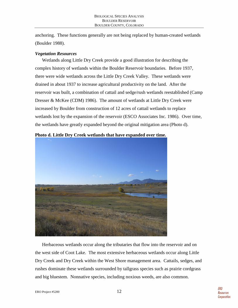
Vegetation Resources Wetlands along Little Dry Creek provide a good illustration for describing the
complex history of wetlands within the Boulder Reservoir boundaries. Before 1937,
there were wide wetlands across the Little Dry Creek Valley. These wetlands were
drained in about 1937 to increase agricultural productivity on the land. After the
reservoir was built, a combination of cattail and sedge/rush wetlands reestablished (Camp
Dresser & McKee (CDM) 1986). The amount of wetlands at Little Dry Creek were
increased by Boulder from construction of 12 acres of cattail wetlands to replace
wetlands lost by the expansion of the reservoir (ESCO Associates Inc. 1986). Over time,
the wetlands have greatly expanded beyond the original mitigation area (Photo d).
Photo d. Little Dry Creek wetlands that have expanded over time.
Herbaceous wetlands occur along the tributaries that flow into the reservoir and on
the west side of Coot Lake. The most extensive herbaceous wetlands occur along Little
Dry Creek and Dry Creek within the West Shore management area. Cattails, sedges, and
rushes dominate these wetlands surrounded by tallgrass species such as prairie cordgrass
and big bluestem. Nonnative species, including noxious weeds, are also common.

BIOLOGICAL SPECIES ANALYSIS BOULDER RESERVOIR
BOULDER COUNTY, COLORADO
ERO Project #5200 13
The wetlands along Dry Creek and Little Dry Creek, including the reservoir, rate high
in functions such as flood storage, sediment trapping, nutrient retention, and wildlife
habitat (both terrestrial and aquatic) (Boulder 1988). One concern within these wetlands
is the high amount of noxious weeds (Figure 4), which are currently being treated by
Department staff.
Extensive wetlands were constructed to the west of Coot Lake as part of a mitigation
effort (Professional Wetlands Consulting, Inc. 1999). Currently, the Coot Lake western
wetlands are a complex mosaic of open water lined with sedges, other wetland
graminoids (grasses), and wooded riparian vegetation (Photo e). Patches of native
tallgrass species including switchgrass form patches on the upper banks, especially along
the south shore of Coot Lake. Purple loosestrife, a noxious weed that the state requires to
be eradicated, infests this wetland. Boulder Reservoir staff are actively treating this and
other noxious weeds within the Coot Lake western wetlands (Boulder 2012b). Coot Lake
is rated as very high for four wetland functions (fish habitat, wildlife habitat, active
recreation, and passive recreation) and as high for four additional wetland functions
(shoreline anchor, nutrient retention (short-term and long-term), and basic food chain
support) (Boulder 2012a, 2012c). The wetland restoration efforts have been successful in
creating extensive wetlands to the west and stabilizing the shoreline; however, wave
action continues to erode the East and South shores of Coot Lake and small islands
constructed to protect the South Shore are greatly reduced in size and effectiveness.
Photo e. Herbaceous wetlands at the western edge of Coot Lake.
.

Yellow toadflax
Purple loosestrife
Tamarisk
Russian olive
Yellow toadflax
Perennial pepperweed
Perennial sowthistle
Scotch thistle
Sowthistle
Tamarisk
Russian olive
Musk thistle
Teasel
Canada thistle
North
51st S
treet
BoulderReservoir
Source: City of Boulder Parks and Recreation Department. Integrated Pest Management and Conservation Crew, 2011 Summary of Crew Activities
Figure 4. Example of Noxious Weed Control Efforts – 2011Northwestern End Reservoir Area Weeds (West Shore Management Area)
0 500250 feet
±
BIOLOGICAL SPECIES ANALYSIS BOULDER RESERVOIR
BOULDER COUNTY, COLORADO
ERO Project #5200 15
Wildlife Resources Wetlands provide essential resources for numerous wildlife species, including food
sources, water, and cover for breeding or hiding from predators. Combined with wooded
riparian communities, wetland/riparian areas are some of the most diverse and productive
wildlife habitats, particularly in the arid West. Many wildlife species are considered
wetland dependent or wetland obligate species (depend on wetlands for some portion or
the entire annual life cycle, respectively). Wildlife species using herbaceous wetlands at
Boulder Reservoir include muskrat, frogs and toads, red-winged blackbird, Wilson’s
snipe, sora, and Virginia rail.
The wetlands at Boulder Reservoir also support several Boulder County bird species
of special concern. The prominent species include American bitterns, northern harriers,
and savannah sparrows that have nested west of Coot Lake and in wetlands along Dry
Creek and Little Dry Creek, west of the reservoir (Hallock and Jones 1999; Jones 1993,
Jones 2012). Another species of special concern, the short-eared owl, is frequently
observed wintering at Boulder Reservoir (Jones and Mahoney 2010; Hallock and Jones
2011). These and other species are discussed in more detail in the Biological Resources
of High-Priority Conservation Targets section.
In addition to the species of concern described above that are monitored on an annual
basis, and some opportunistic observations, little specific or consistently collected
information on wildlife species occurring in herbaceous wetlands at Boulder Reservoir
currently exists.
Desired Future Conditions The herbaceous wetlands along Little Dry Creek, Dry Creek, and the west end of
Coot Lake are currently functioning at a high level and impacts on these wetlands should
be avoided wherever possible to prevent the degradation of these wetlands. Maintenance
of these high-functioning wetlands will require continued management and control of
noxious weeds per the State of Colorado requirements (Colorado Department of
Agriculture (CDOA) 2012) and the BRMP (Boulder 2012a).
Data on wildlife species are currently lacking and breeding bird and small mammal
inventories would assist the Department in managing and monitoring these high-
BIOLOGICAL SPECIES ANALYSIS BOULDER RESERVOIR
BOULDER COUNTY, COLORADO
ERO Project #5200 16
functioning wetland communities. Continued seasonal restrictions and increased
enforcement of restrictions within sensitive herbaceous wetlands, particularly west of
Coot Lake and along Little Dry Creek and Dry Creek, are recommended.
Recommendations and minimization measures to protect herbaceous wetlands are
provided in the Recommendations section.
Wooded Riparian Before construction of the reservoir, there was probably little or no woody vegetation
within the area except for narrow bands along the streams. Since inundation of the
reservoir, woody vegetation has established along the tributaries to Dry Creek and Little
Dry Creek, around Coot Lake, and in scattered pockets along the North Shore and other
shorelines around the reservoir. The establishment and expansion of these tree and shrub
stands create wildlife habitat that was not present before construction of the reservoir.
Depending on the specific history of each area, these stands occur in various sizes and
state of health.
Vegetation Resources At the West Shore of the reservoir, mixed stands of native trees, such as plains
cottonwood and peachleaf willow, and the noxious weed tamarisk grow where Little Dry
Creek flows into the reservoir (Design Studios West Inc. 1983). Large stands of trees
and shrubs also have established in other areas such as on the South Shore (Bing Maps
2012). Along Dry Creek to the north, older established trees are adjacent to herbaceous
wetlands with juvenile trees (between 20 and 40 feet tall) occurring closer to the current
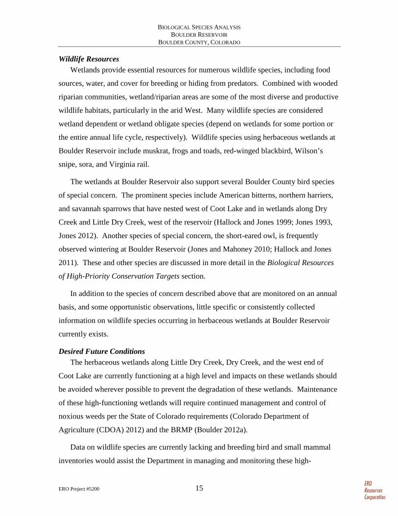
shoreline (Photo f).
BIOLOGICAL SPECIES ANALYSIS BOULDER RESERVOIR
BOULDER COUNTY, COLORADO
ERO Project #5200 17
Photo f. Wooded riparian vegetation along Dry Creek.
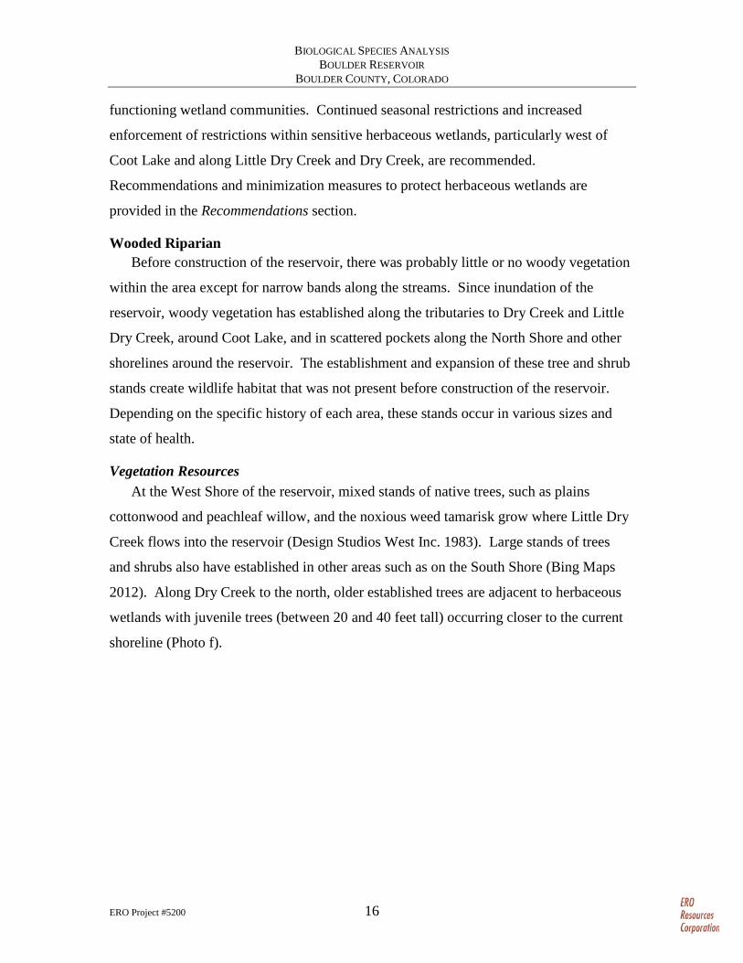
Human activities and wave action has degraded the wooded riparian vegetation on the
North Shore and this community is generally lower quality than riparian vegetation along
the creeks (Photo b and Photo f). The North Shore of the reservoir consists of an eroding
shelf covered with narrow bands of mostly plains cottonwood and peachleaf willow trees
between 20 and 40 feet high. In many areas, a vegetation understory is absent, resulting
in extensive bare areas caused by foot traffic and other activities (Photo g). The absence
of any shrub or herbaceous layer provides very limited cover or breeding habitat for
wildlife. In other areas, the understory is more vegetated and includes patches of shrubs
dominated by sandbar willow and a variety of grasses ranging from native western
wheatgrass to nonnative reed canarygrass, and noxious weeds such as diffuse knapweed
and Russian olive. The plains cottonwoods along the North Shore mostly occur in stands
ranging from sapling trees less than 20 feet tall to even-aged trees 20 to 40 feet tall.
Little regeneration of riparian trees is currently occurring. No seedlings were noted and
only a few young trees, 1 to 5 feet tall, were found scattered along the North Shore.
Although the bare, moist soils within portions of the North Shore would provide an
excellent growth medium for the germination of cottonwoods, either the fluctuating water
levels, which can drown the seedlings, or trampling has likely prevented the
establishment of seedlings.
BIOLOGICAL SPECIES ANALYSIS BOULDER RESERVOIR
BOULDER COUNTY, COLORADO
ERO Project #5200 18
Photo g. Degraded understory of North Shore wooded riparian.
The North Shore is included as part of the reservoir wetlands, which is classified as
high functioning by the City of Boulder (Boulder 2012b) because of the large flood
storage capacity and the high-quality wetlands along Little Dry Creek and Dry Creek.
However, the wetlands along the North Shore are not of similar quality as the other
reservoir wetlands. If analyzed separately, the wetland functions of the North Shore
would be lower because the eroding banks do not provide adequate bank stabilization,
and the lack of ground cover and shrubs does not provide food chain support or diverse,
high-quality habitat consisting of the multiple vegetation layers.
At Coot Lake, wooded riparian vegetation rings the lake and forms a complex mosaic
with the herbaceous wetlands at the west end of the lake. Native cottonwoods and
peachleaf willows are intermixed with nonnative trees, especially Russian olives, that
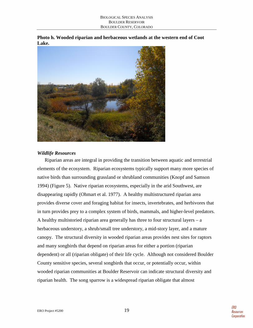
grow in patches on the western end of the lake (Photo h). Underneath the trees are
patches of sandbar willow shrubs, nonnative pasture grasses, and native tallgrass species
including switchgrass.
BIOLOGICAL SPECIES ANALYSIS BOULDER RESERVOIR
BOULDER COUNTY, COLORADO
ERO Project #5200 19
Photo h. Wooded riparian and herbaceous wetlands at the western end of Coot Lake.
Wildlife Resources Riparian areas are integral in providing the transition between aquatic and terrestrial
elements of the ecosystem. Riparian ecosystems typically support many more species of
native birds than surrounding grassland or shrubland communities (Knopf and Samson
1994) (Figure 5). Native riparian ecosystems, especially in the arid Southwest, are
disappearing rapidly (Ohmart et al. 1977). A healthy multistructured riparian area
provides diverse cover and foraging habitat for insects, invertebrates, and herbivores that
in turn provides prey to a complex system of birds, mammals, and higher-level predators.
A healthy multistoried riparian area generally has three to four structural layers – a
herbaceous understory, a shrub/small tree understory, a mid-story layer, and a mature
canopy. The structural diversity in wooded riparian areas provides nest sites for raptors
and many songbirds that depend on riparian areas for either a portion (riparian
dependent) or all (riparian obligate) of their life cycle. Although not considered Boulder
County sensitive species, several songbirds that occur, or potentially occur, within
wooded riparian communities at Boulder Reservoir can indicate structural diversity and
riparian health. The song sparrow is a widespread riparian obligate that almost
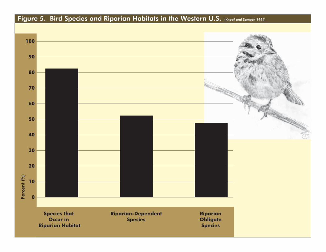
Figure 5. Bird Species and Riparian Habitats in the Western U.S. (Knopf and Samson 1994)
40
30
20
10
0
100
90
80
70
60
50
Perc
ent
(%)
Species that Occur in
Riparian Habitat
Riparian-DependentSpecies
RiparianObligateSpecies
BIOLOGICAL SPECIES ANALYSIS BOULDER RESERVOIR
BOULDER COUNTY, COLORADO
ERO Project #5200 21
exclusively uses understory vegetation. The yellow-breasted chat is a widespread
riparian obligate most often found in the understory and mid-story. The yellow warbler
and Bullock’s oriole are widespread riparian species most often found in mid-story and
canopy vegetation. The warbling vireo is a widespread riparian-dependent species found
almost exclusively in canopy vegetation (Bureau of Land Management undated).
Desired Future Conditions The desired future conditions for wooded riparian communities are healthy
multistructured riparian areas consisting of a diverse species composition of trees and
shrubs within multiage stands and/or a mosaic of stands of differing ages. A healthy
riparian woodland with diverse species and structures provides excellent habitat for a
variety of birds and other animals that would not otherwise be found in the area.
The wooded riparian stands at the West Shore and around Coot Lake are of good to
excellent quality except for the infestation of Russian olives and other weeds, which are
currently being partially treated. Further control of noxious weeds would increase the
quality of this habitat type.
Some of the bands of cottonwoods along the North Shore contain trees more than 20
feet tall that provide wildlife habitat for numerous bird species. It is likely these stands
would become increasingly valuable over time as the trees grow and the community
matures, providing additional riparian structure and riparian habitat for riparian-
dependent bird species and potential nesting sites for raptors. The desired future
conditions would involve protection and enhancement of herbaceous and shrub
understory within wooded riparian stands on the North Shore.
One concern for wooded riparian communities is that new stands may not establish
because of the lack of bare, moist soil conditions required for the germination and
establishment of cottonwoods and willows. Cottonwood regeneration is a vital
component of reestablishing a long-term healthy riparian ecosystem at Boulder
Reservoir. Native plains riparian trees – cottonwoods and peachleaf willows – are fairly
short-lived species (less than a 150-year life span). Both of these species germinate after
spring runoff and seasonal flood events have scoured the banks of streams, creating bare,
moist soils that are optimal for tree germination and growth. These bare, moist soil

BIOLOGICAL SPECIES ANALYSIS BOULDER RESERVOIR
BOULDER COUNTY, COLORADO
ERO Project #5200 22
conditions are becoming increasingly rare in Colorado because of dam building, stream
channelization, and other human alterations of native stream systems. Some bare, moist
soil conditions exist at the reservoir because of fluctuations in water levels, resulting in
the establishment of different age-class stands around the reservoir. Conversely, frequent
changes in water levels discourage the establishment of cottonwoods below the high
water mark because sustained high-water levels will drown seedlings that have
germinated during previous periods of low-water levels.
At Coot Lake, a native riparian community has established along the shores
consisting of cottonwoods and sandbar willows with an understory of sedges, rushes,
tallgrass species, and other native vegetation along the shore. This healthy assemblage of
native species is vulnerable to human activities such as trampling, removing vegetation,
and introducing noxious weeds and other invasive species including reed canarygrass.
Surveying for invasive species and monitoring changes in the amount and distribution of
these species over time within wooded riparian areas would assist the Department in
protecting and managing this community. Recommendations and minimization measures
to protect wooded riparian areas are provided in the Recommendations section.
Shortgrass Prairie Before settlement, the northern Great Plains was a vast prairie covered by blue grama
and other grasses. During the last century and a half, farmers converted the prairie to
agricultural lands. Only 15 percent of Boulder County remained grasslands in 1975 (Soil
Conservation Service 1975), with some of the native grasslands converted to pasturelands
dominated by introduced species. In 1983, the grasslands were dominated by blue grama
and buffalograss, sometimes with wheatgrasses and bluegrasses (Design Studios West
Inc. 1983).
The shortgrass prairie of Colorado once supported vast migrating herds of bison,
pronghorn, and the carnivores that trailed the herds, specifically wolves. These large
mammal species are gone, but the grasslands of eastern Boulder County and Boulder
Reservoir currently provides habitat for many of the wildlife species such as prairie dog,
coyote, cottontail rabbit, and badger, typically found within shortgrass prairie
communities of modern-day Colorado.
BIOLOGICAL SPECIES ANALYSIS BOULDER RESERVOIR
BOULDER COUNTY, COLORADO
ERO Project #5200 23
Vegetation Resources Currently, the shortgrass prairie at Boulder Reservoir is a patchwork of native
vegetation such as blue grama, buffalograss, and yucca interspersed with areas that were
likely irrigated that now contain smooth brome and other introduced and invasive
species. Noxious weeds such as diffuse knapweed have invaded many areas of Boulder
Reservoir, particularly along trails and other heavily trafficked areas.
Wildlife Resources Historically, the native shortgrass landscape was a series of habitat patches created by
grazing animals and ranged from extensive disturbance to areas of infrequent or no
grazing (Samson and Knopf 1996). As such, shortgrass prairie bird communities
generally require a mosaic of grass heights, from very short grass with a high percentage
of bare ground to taller grass with more structure, including some shrubs. Thus, active
prairie dog colonies create important habitat for several species of grassland birds.
The black-tailed prairie dog once ranged over vast areas of the Great Plains, including
eastern Boulder County. Currently in Colorado, the prairie dog is paradoxically
classified both as a “destructive rodent pest” by the CDOA (see Colorado Revised Statute
(C.R.S.) § 33-7-203), and small game and a species of concern by the Colorado Parks and
Wildlife (CPW) (C.R.S. § 33-1-102). Settlement of the West depleted prairie dog
populations through conversion of habitat for agriculture and development, introduction
of disease, and active control. During the late 1970s and early 1980s, prairie dog
colonies appeared to expand in many areas of Boulder County as open space programs
expanded and private developers acquired agricultural lands on the periphery of
expanding urban centers (Geitzen et al. 1996).
Black-tailed prairie dogs are important ecosystem components of prairie grasslands
and are often considered a keystone species (a species that has a disproportionately large
effect on its environment and plays a critical role in maintaining the structure of an
ecological community, affecting many other organisms). Animals such as the cottontail
rabbit, burrowing owl, prairie rattlesnake, amphibians, and numerous insects are closely
linked to prairie dog burrow systems in Boulder County for food and/or cover. Prairie
dogs also provide an important prey resource for numerous predators at Boulder
BIOLOGICAL SPECIES ANALYSIS BOULDER RESERVOIR
BOULDER COUNTY, COLORADO
ERO Project #5200 24
Reservoir including American badger, coyote, bald eagle, golden eagle, ferruginous
hawk, and other raptors (Jones 1993; Geitzen et al. 1996). More information on black-
tailed prairie dog is provided in the Biological Resources of High-Priority Conservation
Targets section below.
The shortgrass prairie at and surrounding Boulder Reservoir provides suitable nesting
substrate (large trees); abundant perches (trees, shrubs, and structures); and prey
resources (small mammals, prairie dogs, and birds) to support some of the highest density
and diversity of summer and winter raptors in Boulder County (CDM 1986; Jones 1993;
Geitzen et al. 1996).
Shortgrass prairie also provides habitat for grassland-dependent bird species.
Grassland bird species identified on territories at Boulder Reservoir include western
meadowlark, vesper sparrow, and grasshopper sparrow (Jones 1993). Western
meadowlarks are common in Boulder County, whereas grasshopper sparrows are more
common further east and vesper sparrows are more common in mid- and upper-elevation
grasslands (Kingery 1998).
Desired Future Conditions The desired future conditions of the shortgrass prairie would be to protect existing
areas of native grass communities and restore degraded areas or areas dominated by
nonnative species or noxious weeds. Extensive human activities within native shortgrass
prairie areas should be avoided as much as practicable because it is difficult to restore
this plant community, especially some of the slow-growing species. Restoration should
include a mosaic of species and vegetation height to provide diverse habitats for
grassland birds and mammals. Prairie dog colonies should contain mostly native
vegetation and the density and revegetation of areas dominated by invasive species would
benefit the community as a whole. Revegetation of active prairie dog colonies is
challenging at best and priority should be placed on areas that have been decimated by
plague and not yet repopulated.
Noxious weeds currently present a problem within the shortgrass prairie area of
Boulder Reservoir. Control of noxious weeds should be prioritized based on threats to
intact areas of native shortgrass prairie, state control requirements, and resources.
BIOLOGICAL SPECIES ANALYSIS BOULDER RESERVOIR
BOULDER COUNTY, COLORADO
ERO Project #5200 25
Biological Resources of High-Priority Conservation Targets Vegetation Communities
Boulder Reservoir has a wide range of plant communities – from various aged plains
cottonwood stands to native short-grass prairie. In previous studies, these communities
have been broadly described with several different types of communities lumped
together. For example, the short-grass prairie community shown in the 2012 BRMP
(Boulder 2012a) includes both high-quality native short-grass prairie and previously
disturbed pasturelands dominated by introduced grasses.
In order to recommend specific management goals for Boulder, a more detailed
vegetation community inventory should be conducted. Understanding where high-
quality, difficult-to-reestablish vegetation communities occur compared to low-quality
communities would be critical to designing facilities that minimize impacts on the
ecosystems. The vegetation inventory either can be for the entire Boulder Reservoir site
or targeted to high-value areas, such as the West Shore, Coot Lake western wetlands, and
areas vulnerable to human activities, such as around the North Shore.
Rare Plants Although rare plants, such as Bell’s twinpod, have been noted within Boulder
Reservoir, the locations of known or potential habitat are not well understood. Potential
habitat for any rare plants that may occur within the Boulder Reservoir site should be
mapped and presence/absence surveys conducted when the plants are flowering. This
mapping would assist Boulder Reservoir staff in managing these areas to preserve and
protect the rare plants from harmful activities. For example, if an area contains both rare
plants and noxious weeds, certain weed-control methods should be avoided to prevent
harm to the rare plants.
Noxious Weeds Department staff spends significant man hours and budget on controlling noxious
weeds. This weed management program has resulted in the reduction and elimination of
many populations of noxious weeds, improving the quality of the vegetation communities
currently at the reservoir. However, many areas at the reservoir still degraded by
invasive weeds would benefit from increased weed management. Preventing
BIOLOGICAL SPECIES ANALYSIS BOULDER RESERVOIR
BOULDER COUNTY, COLORADO
ERO Project #5200 26
reintroduction of these invasive plants, as part of a detailed integrated weed management
plan should be a high priority when constructing any facilities or conducting any other
activities within the reservoir, such as races, special events, and firefighter staging.
Additionally, the noxious weed plans should be reviewed and updated as needed to set
priorities based on state regulations, the feasibility of control, and the vulnerability of
noxious weed invasions specifically within Boulder Reservoir. Updated weed plans
should identify areas at risk of invasion, areas of high-quality vegetation that should be
protected, and policies and processes to prevent noxious weed introductions.
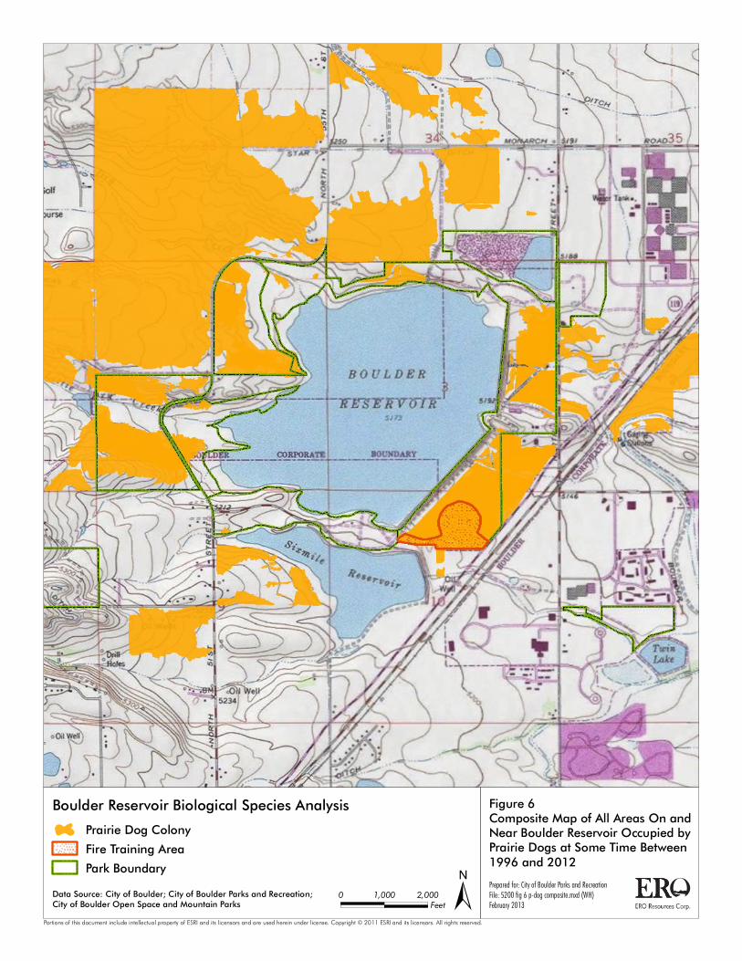
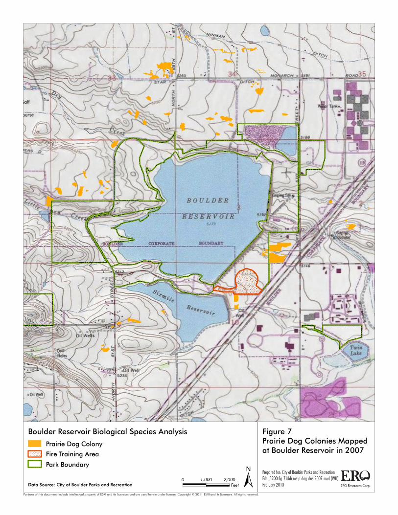
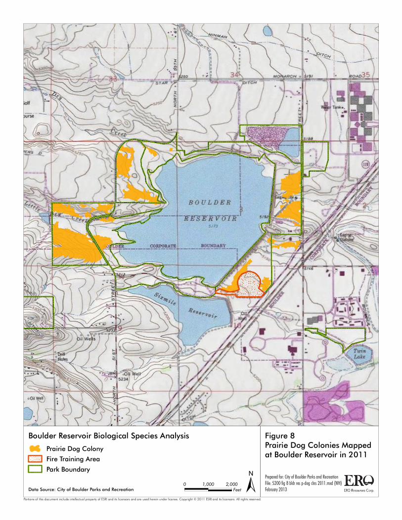
Prairie Dogs Most of the upland grasslands at Boulder Reservoir have been occupied by prairie
dogs at some time in the past (Figure 6). Populations in Boulder County, and specifically
at the reservoir, have fluctuated widely over the last several decades, due primarily to
disease. In spring 1986, a Sylvatic plague epizootic swept through the Boulder Reservoir
area, killing most of the prairie dogs in that region (Geitzen et al. 1996). By 1996, prairie
dogs again occupied 297 acres at the reservoir. The Boulder Reservoir area was again
affected by Sylvatic plague between 2005 and 2009 (Figure 7). By 2011, prairie dog
populations at Boulder Reservoir and in the surrounding area showed signs of recovery
(Figure 8 and Figure 9). Active prairie dog colonies recovered from 93.7 acres in 2008 to
296.6 acres in 2011 ( Boulder Open Space and Mountain Parks (OSMP) 2011).
Prepared for: City of Boulder Parks and RecreationFile: 5200 fig 6 p-dog composite.mxd (WH)February 2013±
Figure 6Composite Map of All Areas On andNear Boulder Reservoir Occupied byPrairie Dogs at Some Time Between1996 and 2012
Boulder Reservoir Biological Species Analysis
Portions of this document include intellectual property of ESRI and its licensors and are used herein under license. Copyright © 2011 ESRI and its licensors. All rights reserved.
0 2,0001,000Feet
Prairie Dog Colony
Fire Training Area
Park Boundary
Data Source: City of Boulder; City of Boulder Parks and Recreation;City of Boulder Open Space and Mountain Parks
BIOLOGICAL SPECIES ANALYSIS BOULDER RESERVOIR
BOULDER COUNTY, COLORADO
ERO Project #5200 28
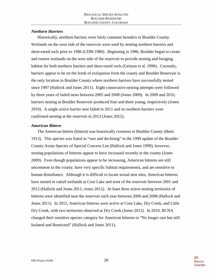
Northern Harriers Historically, northern harriers were fairly common breeders in Boulder County.
Wetlands on the west side of the reservoir were used by nesting northern harriers and
short-eared owls prior to 1986 (CDM 1986). Beginning in 1986, Boulder began to create
and restore wetlands on the west side of the reservoir to provide nesting and foraging
habitat for both northern harriers and short-eared owls (Geitzen et al. 1996). Currently,
harriers appear to be on the brink of extirpation from the county and Boulder Reservoir is
the only location in Boulder County where northern harriers have successfully nested
since 1997 (Hallock and Jones 2011). Eight consecutive nesting attempts were followed
by three years of failed nests between 2005 and 2008 (Jones 2009). In 2009 and 2010,
harriers nesting at Boulder Reservoir produced four and three young, respectively (Jones
2010). A single active harrier nest failed in 2011 and no northern harriers were
confirmed nesting at the reservoir in 2012 (Jones 2012).
American Bittern The American bittern (bittern) was historically common in Boulder County (Betts
1913). This species was listed as “rare and declining” in the 1999 update of the Boulder
County Avian Species of Special Concern List (Hallock and Jones 1999); however,
nesting populations of bitterns appear to have increased recently in the county (Jones
2009). Even though populations appear to be increasing, American bitterns are still
uncommon in the county, have very specific habitat requirements, and are sensitive to
human disturbance. Although it is difficult to locate actual nest sites, American bitterns
have nested in cattail wetlands at Coot Lake and west of the reservoir between 2001 and
2012 (Hallock and Jones 2011; Jones 2012). At least three active nesting territories of
bitterns were identified near the reservoir each year between 2006 and 2008 (Hallock and
Jones 2011). In 2012, American bitterns were active at Coot Lake, Dry Creek, and Little
Dry Creek, with two territories observed at Dry Creek (Jones 2012). In 2010, BCNA
changed their sensitive species category for American bitterns to “No longer rare but still
Isolated and Restricted” (Hallock and Jones 2011).
Prepared for: City of Boulder Parks and RecreationFile: 5200 fig 7 bldr res p-dog clns 2007.mxd (WH)February 2013±
Figure 7Prairie Dog Colonies Mappedat Boulder Reservoir in 2007
Boulder Reservoir Biological Species Analysis
Portions of this document include intellectual property of ESRI and its licensors and are used herein under license. Copyright © 2011 ESRI and its licensors. All rights reserved.
0 2,0001,000Feet
Prairie Dog Colony
Fire Training Area
Park Boundary
Data Source: City of Boulder Parks and Recreation
Prepared for: City of Boulder Parks and RecreationFile: 5200 fig 8 bldr res p-dog clns 2011.mxd (WH)February 2013±
Figure 8Prairie Dog Colonies Mappedat Boulder Reservoir in 2011
Boulder Reservoir Biological Species Analysis
Portions of this document include intellectual property of ESRI and its licensors and are used herein under license. Copyright © 2011 ESRI and its licensors. All rights reserved.
0 2,0001,000Feet
Prairie Dog Colony
Fire Training Area
Park Boundary
Data Source: City of Boulder Parks and Recreation
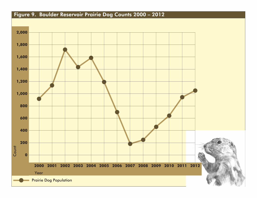
Figure 9. Boulder Reservoir Prairie Dog Counts 2000 – 2012
800
600
400
200
0
2,000
1,800
1,600
1,400
1,200
1,000
2000 2001 2002 2003 2004 2005 2006 2007 2008 2009 2010 2011 2012
Prairie Dog Population
Year
Cou
nt
BIOLOGICAL SPECIES ANALYSIS BOULDER RESERVOIR
BOULDER COUNTY, COLORADO
ERO Project #5200 32
Savannah Sparrow Savannah sparrows (sparrows) are rare to locally uncommon on the northeastern
plains of Colorado (Andrews and Righter 1992). Savannah sparrows favor moist
mountain meadows in Colorado; however, this species occurs throughout the state in
moist, grassy meadows; irrigated fields; and streamside sedge meadows (Kingery 1998).
In Boulder County, mountain populations of the sparrow appear to have declined since
the early 1900s, possibly because of elimination of hay cultivation in mountain meadows
(Hallock 1998). Savannah sparrows were reported in 1993 as regularly observed at
Boulder Reservoir during summer (Jones 1993) and are still occasionally reported as
breeding at the reservoir (Jones 2012). Jones (1993) observed sparrows singing during
the breeding season in the Dry Creek drainage and west of Coot Lake. Although not
considered a species of special concern by BCNA or CPW, the savannah sparrow is a
good indicator of wetland ecosystem health.
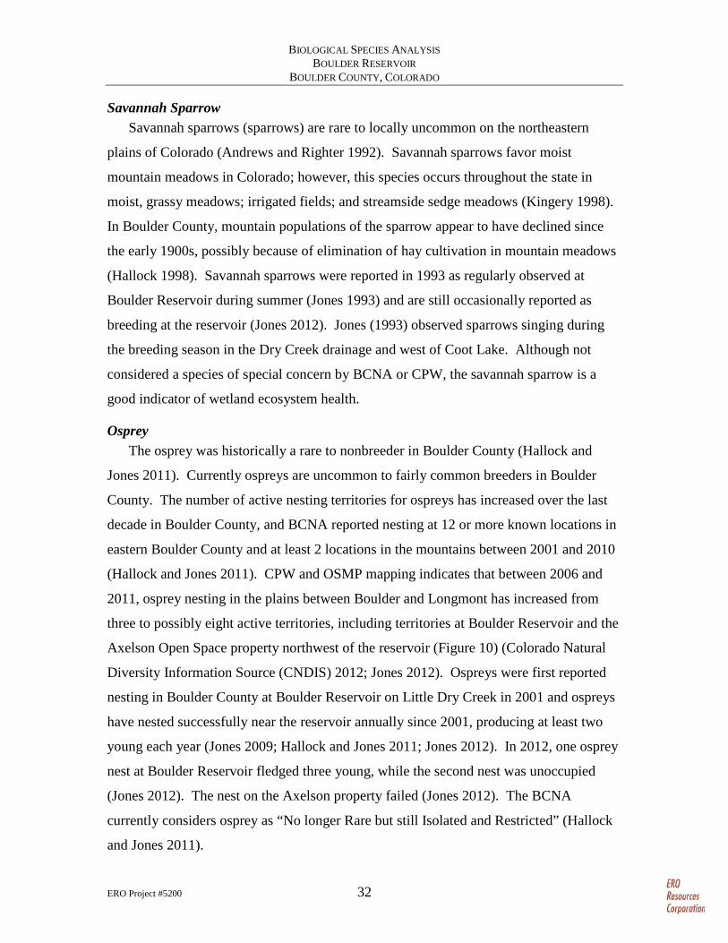
Osprey The osprey was historically a rare to nonbreeder in Boulder County (Hallock and
Jones 2011). Currently ospreys are uncommon to fairly common breeders in Boulder
County. The number of active nesting territories for ospreys has increased over the last
decade in Boulder County, and BCNA reported nesting at 12 or more known locations in
eastern Boulder County and at least 2 locations in the mountains between 2001 and 2010
(Hallock and Jones 2011). CPW and OSMP mapping indicates that between 2006 and
2011, osprey nesting in the plains between Boulder and Longmont has increased from
three to possibly eight active territories, including territories at Boulder Reservoir and the
Axelson Open Space property northwest of the reservoir (Figure 10) (Colorado Natural
Diversity Information Source (CNDIS) 2012; Jones 2012). Ospreys were first reported
nesting in Boulder County at Boulder Reservoir on Little Dry Creek in 2001 and ospreys
have nested successfully near the reservoir annually since 2001, producing at least two
young each year (Jones 2009; Hallock and Jones 2011; Jones 2012). In 2012, one osprey
nest at Boulder Reservoir fledged three young, while the second nest was unoccupied
(Jones 2012). The nest on the Axelson property failed (Jones 2012). The BCNA
currently considers osprey as “No longer Rare but still Isolated and Restricted” (Hallock
and Jones 2011).
Prepared for: City of Boulder Parks and RecreationFile: 5200 fig 10 osprey habitat.mxd (WH)February 2013±
Figure 10Osprey Nest Sites andForaging Areas
Boulder Reservoir Biological Species Analysis
Portions of this document include intellectual property of ESRI and its licensors and are used herein under license. Copyright © 2011 ESRI and its licensors. All rights reserved.
0 21Miles
Osprey 1/4-Mile Active Next Site Buffer (2006)
Osprey 1/2-Mile Active Nest Site Buffer (2011)
Osprey Foraging Area (2006 - 2011)
Park Boundary
Sources: Colorado Parks and Wildlife, Natural DiversityInformation Source; City of Boulder Parks and Recreation
BIOLOGICAL SPECIES ANALYSIS BOULDER RESERVOIR
BOULDER COUNTY, COLORADO
ERO Project #5200 34
Short-eared Owl The short-eared owl was historically a rare winter visitor to Boulder County (Hallock
and Jones 2011), although this species is commonly reported during winter inventories.
Short-eared owls have been reported to the Boulder Audubon Society Monthly Wildlife
Inventory during 20 of 26 winters from 1981 to 2006, often associated with the cattail
wetlands at the reservoir (Hallock and Jones 2011). From 1979 to 2009, individual short-
eared owls were reported during winter at the reservoir in 9 of the 20 years (Jones and
Mahoney 2010).
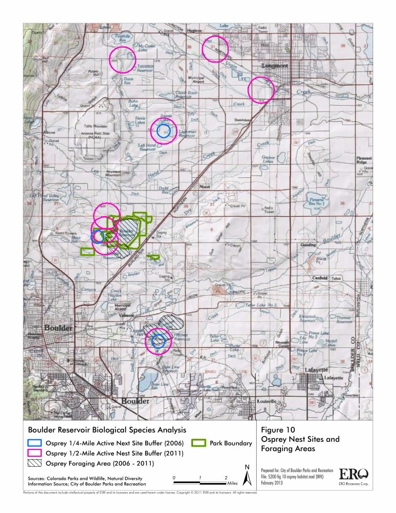
Bald Eagle Bald eagles historically were occasional migrants or winter residents in Boulder
County with no known breeding (Geitzen et al. 1996; Kingery 1998). Over the last
decade, both the number of summer nest sites and winter roost sites in Boulder County
have increased (Figure 11) (CNDIS 2012). CPW mapping indicates that between 2006
and 2011, bald eagles nesting in the plains between Boulder and Longmont have
increased from two to three active territories (Figure 11). Prior to 1984, few bald eagles
had been sighted in the reservoir area (Geitzen et al. 1996). Currently bald eagle winter
range extends throughout most of eastern Boulder County and eagles are commonly
observed at the reservoir in winter. Bald eagle winter forage areas are concentrated on
lake and river habitats along Boulder and St. Vrain creeks and larger reservoirs, including
Boulder Reservoir (Figure 12). Winter bald eagle observations at Boulder Reservoir
mostly occur on or around the reservoir or near prairie dog colonies.
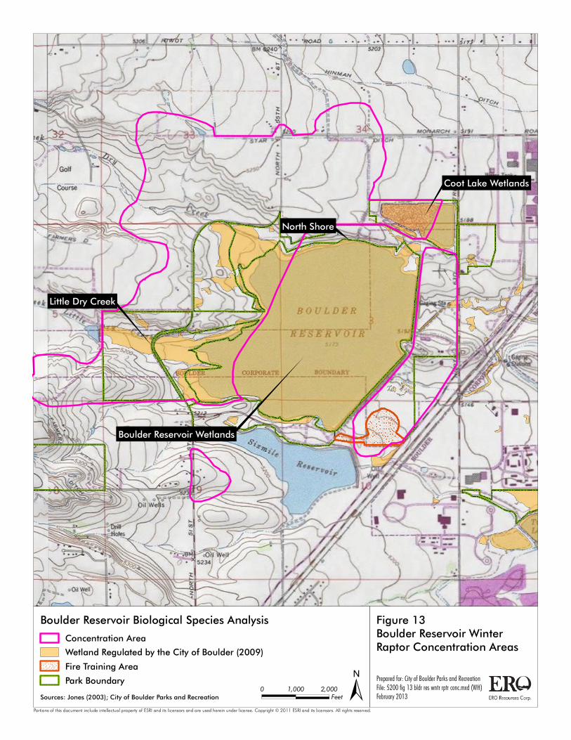
Raptors In addition to the raptor species described above, Boulder Reservoir supports
numerous other raptor species and nesting red-tailed hawks, Swainson’s hawks, great
horned owls, and American kestrels. In winter, as many as nine species of raptors have
been observed perching, foraging, and roosting at the reservoir, primarily along Dry and
Little Dry creeks and east of the dam (Figure 13). Historic Audubon Christmas Bird
Count data (1978–2010) suggest that wintering raptors, particularly those that feed on
prairie dogs, were less numerous in Boulder County during the 1950s and 1960s than
during the 1970s, 1980s, and 1990s. Prior to 1970, ferruginous hawks and bald eagles
Prepared for: City of Boulder Parks and RecreationFile: 5200 fig 11 be nest & roost sites.mxd (WH)February 2013±
Figure 11Bald Eagle Nest and Roost SitesMapped by Colorado Parks andWildlife
Boulder Reservoir Biological Species Analysis
Portions of this document include intellectual property of ESRI and its licensors and are used herein under license. Copyright © 2011 ESRI and its licensors. All rights reserved.
0 21Miles
Bald Eagle 1/2-Mile Active Nest Site Buffer (2008)
Bald Eagle 1/2-Mile Active Nest Site Buffer (2011)
Bald Eagle Roost Site (2006)
Bald Eagle Roost Site (2011)
Park Boundary
Source: Colorado Parks and Wildlife, Natural DiversityInformation Source

Prepared for: City of Boulder Parks and RecreationFile: 5200 fig 12 bald eagle winter forage.mxd (WH)February 2013±
Figure 12Bald Eagle Winter ForageMapped by Colorado Parksand Wildlife
Boulder Reservoir Biological Species Analysis
Portions of this document include intellectual property of ESRI and its licensors and are used herein under license. Copyright © 2011 ESRI and its licensors. All rights reserved.
0 21Miles
Winter Forage (2006)
Winter Forage (2011)
Park Boundary
Source: Colorado Parks and Wildlife, Natural DiversityInformation Source
Boulder Reservoir Wetlands
Coot Lake Wetlands
Little Dry Creek
North Shore
Prepared for: City of Boulder Parks and RecreationFile: 5200 fig 13 bldr res wntr rptr conc.mxd (WH)February 2013±
Figure 13Boulder Reservoir WinterRaptor Concentration Areas
Boulder Reservoir Biological Species Analysis
Portions of this document include intellectual property of ESRI and its licensors and are used herein under license. Copyright © 2011 ESRI and its licensors. All rights reserved.
0 2,0001,000Feet
Concentration Area
Wetland Regulated by the City of Boulder (2009)
Fire Training Area
Park Boundary
Sources: Jones (2003); City of Boulder Parks and Recreation

BIOLOGICAL SPECIES ANALYSIS BOULDER RESERVOIR
BOULDER COUNTY, COLORADO
ERO Project #5200 38
were rarely seen in Boulder County (Geitzen et al. 1996). The number of ferruginous
hawks, red-tailed hawks, and bald eagles seen on Boulder Audubon Christmas Counts
increased throughout the 1970s and early 1980s (Geitzen et al. 1996; Kingery 1998). The
number of these three species more than doubled from 1984 to 1986, coinciding with a
steady increase in the number of prairie dogs in the Boulder Reservoir region (Geitzen et
al. 1996). Plague epizootics, killing many prairie dogs within Boulder County during
1985–1986 and 1993–1994, caused sharp short-term declines in the populations of
wintering ferruginous hawks, red-tailed hawks, and bald eagles.
Volunteers for the BCNA have counted wintering raptors along designated survey
routes in Boulder County for more 25 years (BCNA 2012; Geitzen et al. 1996) and
additional surveys and monitoring have been conducted by Department staff and
volunteers. These surveys have found that:
• Wintering raptor populations in Boulder County fluctuate with prey resources. The BCNA noted that in the area along U.S. 36 “numbers of ferruginous hawks and bald eagles seen on winter raptor surveys declined by more than 85% from 1993-96 as one prairie dog colony after another succumbed to development.”
• Wintering raptors, particularly those that feed on prairie dogs, were less numerous in Boulder County during the 1950s and 1960s than during the 1970s, 1980s, and 1990s.
• In spring, 1986, a Sylvatic plague epizootic swept through the Boulder Reservoir–Haystack Mountain area, killing most of the prairie dogs in that region. By the following winter, ferruginous hawk sightings on the Boulder Reservoir survey route had declined by 70 percent, and bald eagle sightings had declined by more than 90 percent.
• The 1993–1994 plague epizootic affected prairie dog colonies throughout Boulder County, including Boulder Reservoir, and contributed to a countywide decline in the number of ferruginous hawks, red-tailed hawks, and bald eagles.
• A more recent plague epizootic in 2005–2007 at Boulder Reservoir (Figure 9) again reduced prey resources for wintering and nesting raptors.
Frogs The northern leopard frog was once widespread across North America, but has
sharply declined nationally and has become scarce in many areas of Colorado
(Hammerson 1999). The northern leopard frog is a species of special concern in
BIOLOGICAL SPECIES ANALYSIS BOULDER RESERVOIR
BOULDER COUNTY, COLORADO
ERO Project #5200 39
Colorado. The bullfrog is a large nonnative frog species in Colorado that can outcompete
and prey on native amphibians. In 2006, OSMP initiated northern leopard frog surveys
(Germaine 2007). The goal of the surveys was to document the current distribution of
leopard frogs and bullfrogs in OSMP wetlands. The surveys did not include Boulder
Reservoir or OSMP parcels near the reservoir. The surveys were conducted in four types
of wetlands – ponds, perennial streams, intermittent streams, and irrigation ditches. In
total, 32 wetlands were surveyed by volunteers with 172 leopard frogs and 1,102
bullfrogs observed (Germaine 2007). Leopard frogs and bullfrogs each occurred at
approximately 50 percent of the sites surveyed; leopard frogs were more abundant than
bullfrogs at irrigation ditches and bullfrogs were more abundant than leopard frogs at the
other three wetland types (Germaine 2007). Bullfrogs appeared more abundant at ponds
and both the number and distribution of bullfrogs appeared to have increased in the 10
years between 1996 and 2006.
Aquatic Nuisance Species As previously mentioned, ANS are a growing management concern in Colorado due
to their potential to spread rapidly and their adverse ecological and economic impacts.
To help address this concern, an ANS Prevention Plan was developed for Boulder
Reservoir in 2010 (Bonnell 2010). Following is a summary of the information in Bonnell
(2010). Boulder Reservoir has been identified as high risk for two ANS – zebra and
quagga mussels (Bonnell 2010). Conditions at the reservoir are favorable for mussel
development and recreational boating provides the potential for overland transport from
distant infested waters. Prevention is the most cost-effective and ecologically sound way
to address ANS. Once infested, the costs to control ANS are exorbitant. Boulder
Reservoir is not currently infested with ANS. To maintain this ANS status, the
Department has implemented both the state’s management guidelines and the more
specific recommendations of the Boulder Reservoir ANS Prevention Plan (Bonnell
2010). The recommendations of the ANS Prevention Plan include a) enhancing
preventive practices, b) continuing to monitor for ANS, c) detecting ANS early and
responding rapidly, d) containing and controlling ANS, e) supporting research on ANS, f)

BIOLOGICAL SPECIES ANALYSIS BOULDER RESERVOIR
BOULDER COUNTY, COLORADO
ERO Project #5200 40
enhancing education about ANS, and g) evaluating and improving ANS prevention and
management action (Bonnell 2010).
Recommendations ERO has the following recommendations for developing the biological resource data
needed for the public involvement phase of the BRMP planning process and developing a
detailed Biological Resources Management Plan. Recommendations are presented by
management area, including several reservoir-wide recommendations (Table 2).
Although Coot Lake is within the North Shore management area, several
recommendations specifically identify Coot Lake as a focal resource.
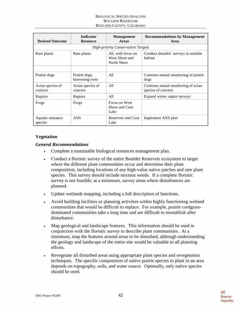
Table 2. Desired Future Conditions and Recommendations Matrix.
Desired Outcome Indicator Resource
Management Areas
Recommendations by Management Area
Reservoir-wide
Improved baseline inventory on biological resources
Flora All Conduct a floristic survey Noxious weeds All Map weeds Wetlands All Update and enhance wetland mapping, Landscape All Map geological and landscape features Breeding birds All Conduct baseline breeding bird survey
following breeding bird atlas protocol; focus on indicator species
Bats All Conduct baseline bat inventories Mammals All Conduct large and small mammal
inventories
Improved long-term monitoring of wildlife
Frogs and toads, insects, and butterflies
All with focus on West Shore, North Shore, and Coot Lake
Develop “Citizen Science” monitoring programs for wildlife communities not currently monitored (frogs and insects)
Breeding birds All with focus on West Shore, North Shore, and Coot Lake
Develop “Citizen Science” annual breeding bird survey
Integrated restoration plan
Vegetation All Develop restoration plan and restoration criteria
Open Water and Shoreline Stable shorelines Shoreline Coot Lake Monitor shoreline erosion
Healthy aquatics and shoreline communities
ANS Reservoir, West Shore
Implement ANS plan
West Shore Continue West Shore seasonal closure Herbaceous Wetlands

BIOLOGICAL SPECIES ANALYSIS BOULDER RESERVOIR
BOULDER COUNTY, COLORADO
ERO Project #5200 41
Desired Outcome Indicator Resource
Management Areas
Recommendations by Management Area
Maintain and increase protection of wetlands
West Shore and Coot Lake
Seasonal closure, barriers, and educate visitors
High-functioning wetlands
West Shore and Coot Lake
Noxious weed control
Protection of high-value wildlife habitat
West Shore and Coot Lake
Prepare detailed biological site assessment
Protection of high-value bird habitat
American bittern, northern harrier, savannah sparrow, common yellowthroat, Wilson’s snipe, red-winged blackbird
West Shore and Coot Lake
Inventory breeding birds (see reservoir-wide)
Wooded Riparian
Healthy multistructured riparian community
Song sparrow, yellow breasted chat, yellow warbler, bullocks oriole, and warbling vireo
West Shore and North Shore
Inventory breeding birds (see reservoir-wide)
Riparian vegetation West Shore and North Shore
Protect and enhance North Shore riparian
Cottonwood trees West Shore and North Shore
Monitor wooded riparian
Negative indicators – Russian olive, noxious weeds, European collared dove
West Shore and North Shore
Control Russian olive and othernoxious weeds
Shortgrass Prairie
Healthy native vegetation community
Shortgrass vegetation, western meadowlark, vesper sparrow, grasshopper sparrow
West Shore and North Shore
Revegetate disturbed and weed-infested areas
West Shore and North Shore
Manage and control noxious weeds
West Shore and North Shore
Restore prairie
West Shore and North Shore
Monitor vegetation next to trails
Disturbed/Urban Parkland Educate visitors South Shore Educate visitors
BIOLOGICAL SPECIES ANALYSIS BOULDER RESERVOIR
BOULDER COUNTY, COLORADO
ERO Project #5200 42
Desired Outcome Indicator Resource
Management Areas
Recommendations by Management Area
High-priority Conservation Targets Rare plants Rare plants All, with focus on
West Shore and North Shore
Conduct detailed surveys in suitable habitat
Prairie dogs Prairie dogs,
burrowing owls All Continue annual monitoring of prairie
dogs Avian species of concern
Avian species of concern
All Continue annual monitoring of avian species of concern
Raptors Raptors All Expand winter raptor surveys Frogs Frogs Focus on West
Shore and Coot Lake
Aquatic nuisance species
ANS Reservoir and Coot Lake
Implement ANS plan
Vegetation
General Recommendations • Complete a sustainable biological resources management plan.
• Conduct a floristic survey of the entire Boulder Reservoir ecosystem to target where the different plant communities occur and determine their plant composition, including locations of any high-value native patches and rare plant species. This survey should include noxious weeds. If a complete floristic survey is not feasible, at a minimum, survey areas where disturbances are planned.
• Update wetlands mapping, including a full description of functions.
• Avoid building facilities or planning activities within highly functioning wetland communities that would be difficult to replace. For example, prairie cordgrass-dominated communities take a long time and are difficult to reestablish after disturbance.
• Map geological and landscape features. This information should be used in conjunction with the floristic survey to describe plant communities. At a minimum, map the features around areas to be disturbed, although understanding the geology and landscape of the entire site would be valuable to all planning efforts.
• Revegetate all disturbed areas using appropriate plant species and revegetation techniques. The specific composition of native prairie species to plant in an area depends on topography, soils, and water source. Optimally, only native species should be used.

BIOLOGICAL SPECIES ANALYSIS BOULDER RESERVOIR
BOULDER COUNTY, COLORADO
ERO Project #5200 43
• Manage and control noxious weeds as required by the State of Colorado Noxious Weed Act (CDOA 2012). Noxious weed control strategies and efforts should be determined by Boulder staff, with priorities given to:
o Species targeted by the state for eradication (list A).
o Infestation within high-quality native areas or rare plant habitat.
• Manage invasive species, such as Russian olive, that often outcompetes native vegetation and wildlife habitat. Monitor native grasslands that occur next to trails or other heavily trafficked areas to determine if foot traffic has decreased the native species composition and cover and increased noxious weeds. This monitoring should include measurement of the width of the trail and documenting any social trails that develop in the shortgrass prairie so that they can be removed. Monitoring efforts would also include:
o Photo points – taken from the same location each year.
o Vegetation description – either generally describe the vegetation including estimates of species cover or for a more complete picture establish permanent transects.
• Monitor wooded riparian communities along the reservoir shore and Coot Lake. Where recreational activities occur, establish several monitoring locations within each of three types of wooded riparian stands. For each monitoring location, record species composition, cover, and evidence of recreational activities. The three stands to monitor are:
o High-quality stand – A healthy plains cottonwood stand with an understory of sandbar willows and native herbaceous species should be monitored to determine if human activities would negatively affect the stands in the future. Evidence of negative recreational impacts include a decrease in overall plant cover, decrease in native species, and an increase in noxious weeds and other nonnative species such as reed canarygrass.
o Medium-quality stand – A stand with a mixture of native and nonnative species that show evidence of moderate recreational impacts. This stand should be monitored to determine if changes in recreational use causes changes in the vegetation.
o Low-quality stand – A stand with mostly bare understory should be monitored to see if vegetation establishes over time. Recruitment of cottonwood seedlings should be especially noted.
Recommendations by Management Area North Shore including Surrounding Shortgrass Prairie
• Monitor trails (as described above) near native shortgrass prairie stands to determine the effects of recreational activities.

BIOLOGICAL SPECIES ANALYSIS BOULDER RESERVOIR
BOULDER COUNTY, COLORADO
ERO Project #5200 44
• Monitor shoreline riparian habitat – Monitor the bands of cottonwoods (as described above) to determine if tree regeneration is occurring and the effects of recreational activities. Determine areas where restoration is feasible and what actions are needed to allow establishment of healthy wooded riparian communities. Restoration areas may include:
o where fencing or other barriers could be placed to allow vegetation to regrow without trampling; and
o where planting of willows and herbaceous vegetation would help control erosion along the shore.
Coot Lake • Monitor shoreline riparian habitat – Monitor locations along the southern shore of
Coot Lake where stands of native vegetation have established to determine the effects of recreational activities.
• Monitor shoreline erosion – Monitor the south and east shores of Coot Lake to determine the effects of erosion and the effectiveness of maintenance or revegetation activities to halt erosion.
• Monitor Wetlands – Each year take photos as permanent photo points established within the western wetland to monitor changes to the existing conditions. This will allow any potential detrimental effects, such as a new noxious weed invasion, to be caught early and controlled more easily.
North and South Dam • The sitewide floristic survey should determine if grasslands on the North and
South dams are degraded and need restoration. Based on the survey, the Department should develop a detailed restoration plan that considers soils (which may be alkaline), aspect, exposure, and other barriers to the establishment of healthy native grasslands.
South Shore • Educate visitors – Provide signs, pamphlets, or other means of educating boaters
and other visitors on the importance of seasonal closures and the rules and regulations to protect vegetation and wildlife resources.
West Shore • Prepare a detailed biological sites assessment – Conduct a detailed survey of the
plant and animal communities to determine opportunities and constraints for future trails and other recreational development. Opportunities include areas where a physical trail and the human disturbance associated with trails would have negligible effects on sensitive biological resources. Constraints include areas of high sensitivity that support sensitive plant and animal resources that should be avoided and mitigated.
• Establish restoration criteria – Based on the biological site assessment, identify restoration criteria based on ecological sensitivity. For example, areas with plant communities dominated by hard to reestablish species, such as prairie cordgrass,
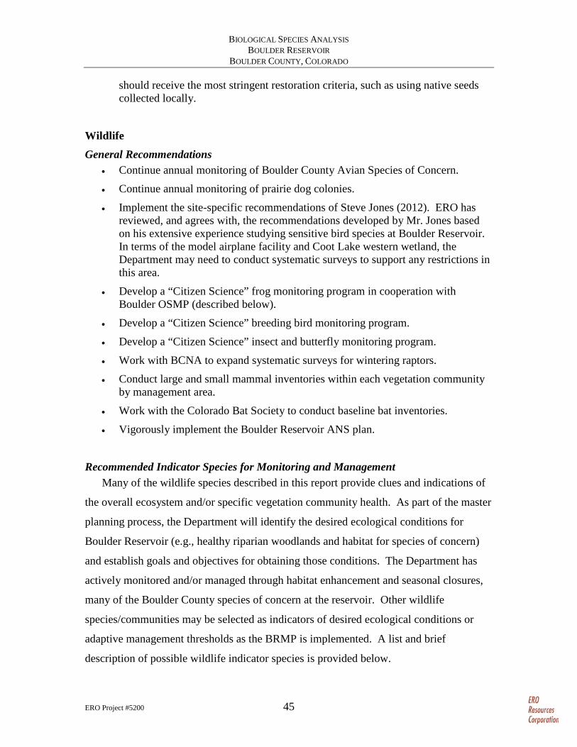
BIOLOGICAL SPECIES ANALYSIS BOULDER RESERVOIR
BOULDER COUNTY, COLORADO
ERO Project #5200 45
should receive the most stringent restoration criteria, such as using native seeds collected locally.
Wildlife General Recommendations
• Continue annual monitoring of Boulder County Avian Species of Concern.
• Continue annual monitoring of prairie dog colonies.
• Implement the site-specific recommendations of Steve Jones (2012). ERO has reviewed, and agrees with, the recommendations developed by Mr. Jones based on his extensive experience studying sensitive bird species at Boulder Reservoir. In terms of the model airplane facility and Coot Lake western wetland, the Department may need to conduct systematic surveys to support any restrictions in this area.
• Develop a “Citizen Science” frog monitoring program in cooperation with Boulder OSMP (described below).
• Develop a “Citizen Science” breeding bird monitoring program.
• Develop a “Citizen Science” insect and butterfly monitoring program.
• Work with BCNA to expand systematic surveys for wintering raptors.
• Conduct large and small mammal inventories within each vegetation community by management area.
• Work with the Colorado Bat Society to conduct baseline bat inventories.
• Vigorously implement the Boulder Reservoir ANS plan.
Recommended Indicator Species for Monitoring and Management Many of the wildlife species described in this report provide clues and indications of
the overall ecosystem and/or specific vegetation community health. As part of the master
planning process, the Department will identify the desired ecological conditions for
Boulder Reservoir (e.g., healthy riparian woodlands and habitat for species of concern)
and establish goals and objectives for obtaining those conditions. The Department has
actively monitored and/or managed through habitat enhancement and seasonal closures,
many of the Boulder County species of concern at the reservoir. Other wildlife
species/communities may be selected as indicators of desired ecological conditions or
adaptive management thresholds as the BRMP is implemented. A list and brief
description of possible wildlife indicator species is provided below.
BIOLOGICAL SPECIES ANALYSIS BOULDER RESERVOIR
BOULDER COUNTY, COLORADO
ERO Project #5200 46
• Prairie dogs – Prairie dogs are often considered a keystone species, and a healthy prairie dog community provides habitat for numerous other bird, mammal, reptile, and invertebrate species. Prairie dogs are also easily monitored and mapped. Prairie dogs are very susceptible to disease, particularly sylvatic plague. The Department should continue to map and monitor prairie dog colonies as an indicator of ecosystem health and work to promote healthy populations. The Department should also be opportunistic and implement native grassland restoration immediately following any plague event.
• Raptors – Raptors, as top predators, can be good indicators of ecosystem health and decreases/increases in populations or productivity can indicate responses to physical factors of the habitat such as contaminants, climate, and severe weather events; ecological factors such as prey abundance and availability; or behavioral factors such as nest abandonment and decreased productivity from stress/human disturbance. Changing species composition, such as more human-sensitive species being replaced by more human-adapted species, can indicate changing human population or disturbance effects. However, as wide-ranging and territorial species, raptors are more appropriate as indicators of regional or landscape changes, rather than small isolated parcels.
• Osprey – Osprey have some of the same characteristics and limitations as raptors; in general because they are prey specialists (fish) and have limited foraging resources in the Boulder Reservoir area. Changes in nest occupancy and productivity can indicate changes in prey abundance and availability, prey quality, and human disturbance at the nest site or foraging areas.
• Amphibians – Amphibians are frequently used as ecological indicators, particularly for aquatic ecosystems. Amphibians are sensitive to habitat changes and environmental conditions such as water quality, temperature, and turbidity. Frogs and toads can be identified during all life stages, including eggs, larva (tadpole), and metamorphosed adults, and can be surveyed during the day or at night using spotlighting or call back techniques. OSMP initiated a northern leopard frog inventory on open space properties in 2006 (Germaine 2007).
• Avian wetland indicators – Birds can be particularly good indicator species because they are generally active during the day, easy to see, can be sensitive to changing habitat conditions, and are suitable for citizen science monitoring. Suitable wetland indicator species include species of concern such as northern harrier, American bittern, and savannah sparrow, but can also include wetland obligate species such as common yellowthroat, Wilson’s snipe, and red-winged blackbird.
• Avian riparian indicators – Suitable avian riparian indicators described above include yellow warbler, yellow-breasted chat, song sparrow, Bullock’s oriole, and warbling vireo. A negative indicator may be the increasing populations of European collared dove, particularly if there is a correlation with decreased populations of mourning dove.
BIOLOGICAL SPECIES ANALYSIS BOULDER RESERVOIR
BOULDER COUNTY, COLORADO
ERO Project #5200 47
• Avian upland indicators – Besides burrowing owls, which are largely dependent on the occurrence and distribution of fluctuating prairie dog populations, suitable upland indicator species include western meadowlark, vesper sparrow, and grasshopper sparrow.
• Small mammal community – A change in species abundance/richness can provide an indication of community or ecosystem health; however, small mammal populations can be highly variable from year to year and monitoring requires extensive trapping and long-term monitoring.
• Aquatic Nuisance Species – The Department has already established an ANS threshold of Zero ANS in the reservoir as part of their ANS Prevention Plan (Bonnell 2010). The Department should vigorously implement the ANS plan and continue to work with CPW to monitor the reservoir and watercraft, and prevent introduction of ANS.
• Bats – Very little information is currently known about bat populations on Boulder Reservoir and surveys for the presence and distribution of bats would benefit potential future bat management.
Summary Boulder Reservoir is a water storage facility that is heavily used for a variety of
recreational activities. These activities have impacted the vegetation and wildlife
resources at the Boulder Reservoir. To manage these impacts, the Department is
developing the Boulder Reservoir Master Plan to establish a long-range vision, goals, and
objectives. To provide the biological resource data needed by the Department to develop
this plan, ERO collected existing information to illustrate past and present ecological
conditions and describe desirable future conditions for four ecological communities at
Boulder Reservoir. A summary of this information is provided below by ecological
community:
• Reservoir-wide – Detailed information on biological resources at Boulder Reservoir is lacking or dated. Improved baseline inventory of biological resources at the reservoir and implementation of long-term monitoring programs would assist the Department in developing science-based management decisions and identifying adaptive management thresholds and decisions points.
• Open Water and Shorelines – The open water community is generally healthy and provides important habitat for waterfowl and other wildlife; although this community is vulnerable to invasion by European milfoil and ANS. Parts of the reservoir and Coot Lake shorelines are being eroded by wave action. Further studies are needed to determine what actions may be possible to halt the erosion along the reservoir and Coot Lake. Maintaining and increasing protections along the western end of the reservoir would protect the large number of waterfowl and
BIOLOGICAL SPECIES ANALYSIS BOULDER RESERVOIR
BOULDER COUNTY, COLORADO
ERO Project #5200 48
other wildlife that use the reservoir. Aggressive implementation of the ANS plan developed for Boulder reservoir is vital to protecting aquatic ecosystems, recreational activities and water supply infrastructure. .
• Herbaceous Wetlands – Extensive wetlands occur along the Dry Creek and Little Dry Creek tributaries flowing into the reservoir and the western end of Coot Lake. These wetlands are important wildlife habitat, especially for wetland-dependent species such as native frogs and red-winged blackbirds. These wetlands are currently functioning at a high level, but are vulnerable to disturbances from construction activities and noxious weed invasions. Controlling noxious weeds, avoiding and minimizing impacts on these wetlands through careful design of any construction activity, and monitoring the site would avoid degrading these extensive, highly functioning wetlands.
• Wooded Riparian – Stands of cottonwood and willow trees with willow shrubs have developed around the reservoir and Coot Lake. A healthy, multistructured riparian woodland provides diverse cover and foraging habitat for a complex range of wildlife species. Healthy woodlands occur in many locations within the reservoir – along Little Dry Creek and Dry Creek and the western end of Coot Lake; however, many of the stands are degraded, especially along the northern shore of the reservoir. One concern is that new stands may not establish because of the lack of adequate germination conditions. Human traffic, weed invasion, and shore erosion are all factors that detrimentally affect these woodlands. Further studies are needed to target the best way to manage the different areas of riparian woodlands throughout the Boulder Reservoir site.
• Shortgrass Prairie – Before European settlement, most of the Boulder Reservoir site was covered with native shortgrass prairie. Currently, the upland grasslands are a mixture of native patches interspersed with nonnative grasslands. Prairie dogs, grassland birds, and other wildlife use these grasslands. Areas dominated by native grasses should be protected, and degraded areas should be restored based on studies targeted to areas vulnerable to negative impacts from recreational activities.
• Disturbed/Urban Parkland – Most of the South Shore is dedicated to recreation and recreation-related facilities. Because of the heavy human use of the area little native vegetation and wildlife habitat exists. Active recreation activities (boating, swim beach, picnicking, special events) should continue to be concentrated on the South Shore. Because of the concentration of people in this area, the South Shore is an ideal location for developing and distributing educational materials on the value and importance of protecting the natural systems and biological resources of the reservoir.
Specific recommendations to maintain and enhance these valuable ecological
communities at Boulder Reservoir are discussed in this document and are grouped by
management zone. Included in this report is recommended indicator species that would
BIOLOGICAL SPECIES ANALYSIS BOULDER RESERVOIR
BOULDER COUNTY, COLORADO
ERO Project #5200 49
provide clues and indications of the overall ecosystem and/or specific vegetation
community health.
References Andrews, R. and R. Righter. 1992. Colorado birds: A reference to their distribution and
habitat. Denver Museum of Natural History, Denver.
Betts, N. 1913. Birds of Boulder County, Colorado. The University of Colorado Studies 10:177-232.
Bing Maps. 2012. Aerial photo of Boulder Reservoir. Available at: http://www.bing.com/maps/?FORM=Z9LH2#JnE9LmJvdWxkZXIlMmJyZXNlcnZvaXIlMmJjb2xvcmFkbyU3ZXNzdC4wJTdlcGcuMSZiYj01OC4zNTY2NTU1MTAzNTU1JTdlLTU3LjA4NTI1MDg1NCU3ZTE0LjM1MTQ0MDg3Nzk0MDIlN2UtMTUyLjg4NjAzMjEwNA==. Last accessed: August 23, 2012.
Bonnell, J. 2010. Aquatic Nuisance Species Prevention Plan for Boulder Reservoir in Boulder, Colorado. University of Denver Capstone Project. May.
Boulder County Audubon Society. 1978–2010. Monthly wildlife inventories. Available at: www.boulderaudubon.org.
Boulder County Nature Association (BCNA). 2012. Boulder County Nature Association. Available at: http://www.bcna.org/publications.html. Last accessed: September 15.
Boulder Open Space and Mountain Parks (OSMP). 2011. OSMP 2011 Final Raptor Report. Available at: http://www.bouldercolorado.gov/index.php?option=com_content&task=view&id=15385&Itemid=411. Last accessed: August 30, 2012.
Boulder, City of. 1988. Study Session on Wetlands and Wildlife. July 26.Boulder, City of. 2011. Prairie Dog Status Report Assessment of Priority Park Sites. December 19.
Boulder, City of. 2012a. Boulder Reservoir Master Plan. City of Boulder Parks and Recreation.
Boulder, City of. 2012b. Noxious weed control data provided by Nick DiFrank. August 17.
Boulder, City of. 2012c. City of Boulder Stream, Wetland, and Water Body Protection Program – 2004 Mapping of Regulatory Wetlands. Available at: http://gisweb.ci.boulder.co.us/website/pds/pds_eMapLink/viewer.htm. Last accessed: August 23.
Camp Dresser & McKee (CDM). 1986. Boulder Reservoir Environmental Study Draft Impact Report. Prepared for: City of Boulder Public Works Department, Northern Colorado Water Conservancy District, Boulder Parks and Recreation Department, Boulder Real Estate and Open Space Department.
BIOLOGICAL SPECIES ANALYSIS BOULDER RESERVOIR
BOULDER COUNTY, COLORADO
ERO Project #5200 50
Colorado Department of Agriculture (CDOA). 2012. Noxious Weed List. Available at: http://www.colorado.gov/cs/Satellite?blobcol=urldata&blobheader=application%2Fpdf&blobkey=id&blobtable=MungoBlobs&blobwhere=1191397772709&ssbinary=true.
Colorado Parks and Wildlife (CPW). 2012. Colorado Natural Diversity Information Source Wildlife Species Page for Boulder County. Available at: http://ndis.nrel.colostate.edu/aspresponse/spxbycnty_res.asp. Last accessed: December 12, 2012.
Colorado Natural Diversity Information Source (CNDIS). 2012. Bald eagle: species of special concern Colorado. Available at: http://wildlife.state.co.us/WildlifeSpecies/Profiles/Birds/Pages/baldeagle.aspx. Last accessed: August 30, 2012.
Design Studios West Inc. Shapins/Moss. 1983. Boulder Reservoir Development Master Plan. Prepared for the City of Boulder, CO.
ESCO Associates Inc. 1986. Boulder Reservoir – Wetland Construction Plan. Prepared for the City of Boulder Public Works Department.
Fitzgerald, J.P., C.A. Meaney, and D.M. Armstrong. 1994. Mammals of Colorado. University Press of Colorado and Denver Museum of Natural History.
Geitzen, R.A., S.R. Jones, and R.J. McKee. 1996. Wintering populations in Boulder County 1983–1996. Boulder County Nature Association, Boulder, CO. Available at: http://www.bcna.org/library/raptrep.pdf.
Germaine, S. 2007. Northern leopard frog inventory surveys: 2006 report. Boulder Open Space and Mountain Parks (OSMP). January.
Google Earth. 2012. Aerial photography, 2011. Earth.Google.com/. Last accessed: August 20, 2012.
Hallock, D. 1998. Indian Peaks Bird Counts fifteen year summary. Boulder County Nature Association, PO Box 493, Boulder, CO 80306.
Hallock, D. and S. Jones. 1999. Boulder County Avian Species of Special Concern 1999: Boulder County Nature Association, Boulder, CO.
Hallock, D. and S. Jones. 2011. Boulder County Avian Species of Special Concern 2010: Boulder County Nature Series No 1. Boulder County Nature Association, Boulder, CO.
Hammerson, G.A. 1999. Amphibians and Reptiles in Colorado, Second edition. University Press of Colorado/Colorado Division of Wildlife.
Jones, S. 1993. Boulder Reservoir Wildlife Habitat Impact Study. December 5.
Jones, S. 2009. Boulder Reservoir 2009 Avian Species of Special Concern Monitoring Report. Unpublished report for the Boulder Parks and Recreation Department. August 22.
Jones, S. 2010. Boulder Reservoir 2010 Avian Species of Special Concern Monitoring Report. Unpublished report for the Boulder Parks and Recreation Department.

BIOLOGICAL SPECIES ANALYSIS BOULDER RESERVOIR
BOULDER COUNTY, COLORADO
ERO Project #5200 51
Jones, S. 2012. Boulder Reservoir 2012 Birds of Special Concern Monitoring Report. Unpublished report for the Boulder Parks and Recreation Department. October 20.
Jones, S. and L. Mahoney. 2010. Owls of Boulder County. Boulder County Nature Association.
Kingery, H.E. 1998. Colorado Breeding Bird Atlas (editor). Colorado Breeding Bird Atlas Partnership and Colorado Division of Wildlife.
Knopf, F.L. and F.B. Samson. 1994. Conservation of avian diversity in riparian corridors. Conservation Biology 8:669-676.
National Wetland Inventory (NWI). 2012. Wetland mapping conducted in 1976 and available on the NWI Wetland Mapper. Available at: http://107.20.228.18/Wetlands/WetlandsMapper.html#. Last accessed: August 22, 2012.
Ohmart, R.D., W.O. Deason, and C. Burke. 1977. A riparian case history: the Colorado River. Pages 35-47 in R.R. Johnson and D.A. Jones, tech. coords. Importance, preservation and management of riparian habitat; a symp. USDA For. Serv. Gen. Tech. Rep. RM-43.
Professional Wetlands Consulting, Inc. 1999. City of Boulder Wetland Permit Application for the Coot Lake Bank Restoration Project. Prepared for: Joe Mantione, City of Boulder, Mountain Parks.
Samson, F.B. and F.L. Knopf. 1996. Prairie conservation: preserving North America’s most endangered ecosystem. Island Press. Washington DC. 337 pp.
Soil Conservation Service. 1975. Soil Survey of Boulder County Area, Colorado. United States Department of Agriculture Soil Conservation Service in Cooperation with Colorado Agricultural Experiment Station.
U.S. Army Corps of Engineers (Corps). 2010. Regional Supplement to the Corps of Engineers Wetland Delineation Manual: Great Plains Region (version 2.0). March.
U.S. Bureau of Land Management. Undated. Birds as indicators of riparian vegetation condition in the western U.S. Bureau of Land Management, Partners in Flight, Boise, ID. BLM/ID/PT-98/004+6635. Available at: http://www.blm.gov/pgdata/etc/medialib/blm/id/publications.Par.59518.File.dat/indicators.pdf.

ERO Project #5200 A-1
Appendix A – Study Methods
ERO evaluated previous studies of soils, vegetation, wetlands, and riparian resources
at Boulder Reservoir (Camp Dresser & McKee 1986; Design Studios West Inc. 1983;
ESCO 1986; SCS 1975) to determine conditions at the time of these studies and factors
that may have caused changes to these resources’ wetland and riparian data. These
reports were compared to the City of Boulder’s wetland mapping and descriptions (City
of Boulder 2012b) and recent aerial photography (Bing Maps 2012). Because the
wetlands at Boulder Reservoir are part of a larger interconnected wetland system, ERO
Resources Corporation (ERO) assessed the changes in wetlands over time for the plains
portion of Boulder County between Boulder and Longmont (region). Riparian data,
where classified as wetlands, were also studied. The historical data studied included
descriptive information from a variety of reports and 1976 National Wetland Inventory
(NWI) mapping of the wetlands in Boulder County (NWI 2012). The 1976 NWI
mapping was compared to recent aerial photographs (Google Earth 2012) to assess what
type and size of wetlands may have been lost due to urbanization and other factors.
ERO reviewed available quantitative and descriptive data available from the Boulder
Parks and Recreation Department, City of Boulder Open Space and Mountain Parks
(OSMP), Boulder County Nature Association (BCNA), Colorado Parks and Wildlife
(CPW) and other resources to develop an understanding of any changes in wildlife
communities at Boulder Reservoir and the surrounding area over time. Long-term
wildlife data for the reservoir and surrounding area are generally sparse and are focused
on a few highly visible and high-priority species.
To understand the current conditions of the shortgrass prairie at Boulder Reservoir
and how these conditions may have changed, ERO reviewed available descriptive data
from the reservoir and surrounding regional studies. These data include the 1983 Boulder
Reservoir Master Plan (Design Studios West Inc. 1983) and Boulder County Soil
Mapping. ERO observed the site on August 15, 2012.
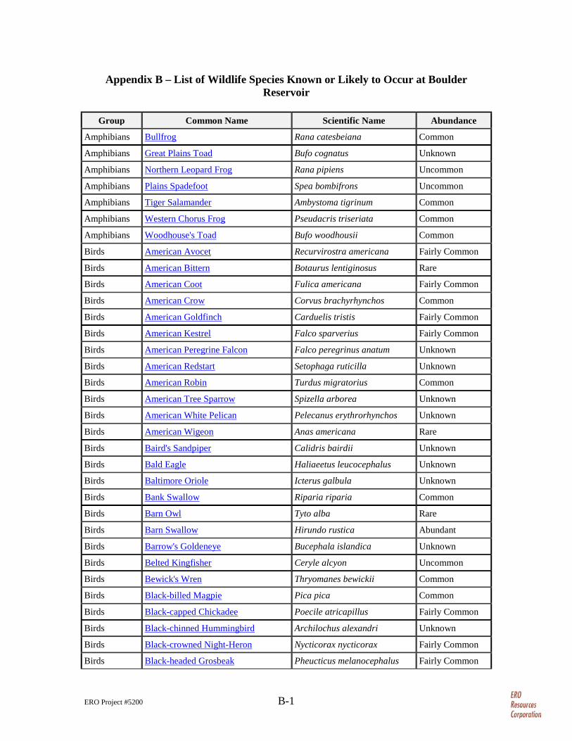
ERO Project #5200 B-1
Appendix B – List of Wildlife Species Known or Likely to Occur at Boulder Reservoir
Group Common Name Scientific Name Abundance
Amphibians Bullfrog Rana catesbeiana Common
Amphibians Great Plains Toad Bufo cognatus Unknown
Amphibians Northern Leopard Frog Rana pipiens Uncommon
Amphibians Plains Spadefoot Spea bombifrons Uncommon
Amphibians Tiger Salamander Ambystoma tigrinum Common
Amphibians Western Chorus Frog Pseudacris triseriata Common
Amphibians Woodhouse's Toad Bufo woodhousii Common
Birds American Avocet Recurvirostra americana Fairly Common
Birds American Bittern Botaurus lentiginosus Rare
Birds American Coot Fulica americana Fairly Common
Birds American Crow Corvus brachyrhynchos Common
Birds American Goldfinch Carduelis tristis Fairly Common
Birds American Kestrel Falco sparverius Fairly Common
Birds American Peregrine Falcon Falco peregrinus anatum Unknown
Birds American Redstart Setophaga ruticilla Unknown
Birds American Robin Turdus migratorius Common
Birds American Tree Sparrow Spizella arborea Unknown
Birds American White Pelican Pelecanus erythrorhynchos Unknown
Birds American Wigeon Anas americana Rare
Birds Baird's Sandpiper Calidris bairdii Unknown
Birds Bald Eagle Haliaeetus leucocephalus Unknown
Birds Baltimore Oriole Icterus galbula Unknown
Birds Bank Swallow Riparia riparia Common
Birds Barn Owl Tyto alba Rare
Birds Barn Swallow Hirundo rustica Abundant
Birds Barrow's Goldeneye Bucephala islandica Unknown
Birds Belted Kingfisher Ceryle alcyon Uncommon
Birds Bewick's Wren Thryomanes bewickii Common
Birds Black-billed Magpie Pica pica Common
Birds Black-capped Chickadee Poecile atricapillus Fairly Common
Birds Black-chinned Hummingbird Archilochus alexandri Unknown
Birds Black-crowned Night-Heron Nycticorax nycticorax Fairly Common
Birds Black-headed Grosbeak Pheucticus melanocephalus Fairly Common
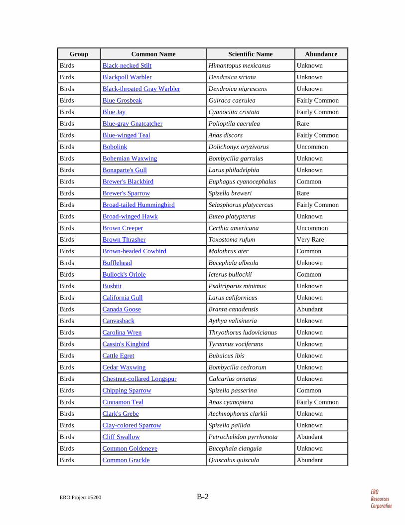
ERO Project #5200 B-2
Group Common Name Scientific Name Abundance
Birds Black-necked Stilt Himantopus mexicanus Unknown
Birds Blackpoll Warbler Dendroica striata Unknown
Birds Black-throated Gray Warbler Dendroica nigrescens Unknown
Birds Blue Grosbeak Guiraca caerulea Fairly Common
Birds Blue Jay Cyanocitta cristata Fairly Common
Birds Blue-gray Gnatcatcher Polioptila caerulea Rare
Birds Blue-winged Teal Anas discors Fairly Common
Birds Bobolink Dolichonyx oryzivorus Uncommon
Birds Bohemian Waxwing Bombycilla garrulus Unknown
Birds Bonaparte's Gull Larus philadelphia Unknown
Birds Brewer's Blackbird Euphagus cyanocephalus Common
Birds Brewer's Sparrow Spizella breweri Rare
Birds Broad-tailed Hummingbird Selasphorus platycercus Fairly Common
Birds Broad-winged Hawk Buteo platypterus Unknown
Birds Brown Creeper Certhia americana Uncommon
Birds Brown Thrasher Toxostoma rufum Very Rare
Birds Brown-headed Cowbird Molothrus ater Common
Birds Bufflehead Bucephala albeola Unknown
Birds Bullock's Oriole Icterus bullockii Common
Birds Bushtit Psaltriparus minimus Unknown
Birds California Gull Larus californicus Unknown
Birds Canada Goose Branta canadensis Abundant
Birds Canvasback Aythya valisineria Unknown
Birds Carolina Wren Thryothorus ludovicianus Unknown
Birds Cassin's Kingbird Tyrannus vociferans Unknown
Birds Cattle Egret Bubulcus ibis Unknown
Birds Cedar Waxwing Bombycilla cedrorum Unknown
Birds Chestnut-collared Longspur Calcarius ornatus Unknown
Birds Chipping Sparrow Spizella passerina Common
Birds Cinnamon Teal Anas cyanoptera Fairly Common
Birds Clark's Grebe Aechmophorus clarkii Unknown
Birds Clay-colored Sparrow Spizella pallida Unknown
Birds Cliff Swallow Petrochelidon pyrrhonota Abundant
Birds Common Goldeneye Bucephala clangula Unknown
Birds Common Grackle Quiscalus quiscula Abundant
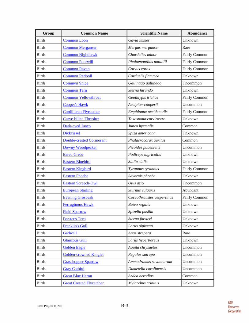
ERO Project #5200 B-3
Group Common Name Scientific Name Abundance
Birds Common Loon Gavia immer Unknown
Birds Common Merganser Mergus merganser Rare
Birds Common Nighthawk Chordeiles minor Fairly Common
Birds Common Poorwill Phalaenoptilus nuttallii Fairly Common
Birds Common Raven Corvus corax Fairly Common
Birds Common Redpoll Carduelis flammea Unknown
Birds Common Snipe Gallinago gallinago Uncommon
Birds Common Tern Sterna hirundo Unknown
Birds Common Yellowthroat Geothlypis trichas Fairly Common
Birds Cooper's Hawk Accipiter cooperii Uncommon
Birds Cordilleran Flycatcher Empidonax occidentalis Fairly Common
Birds Curve-billed Thrasher Toxostoma curvirostre Unknown
Birds Dark-eyed Junco Junco hyemalis Common
Birds Dickcissel Spiza americana Unknown
Birds Double-crested Cormorant Phalacrocorax auritus Common
Birds Downy Woodpecker Picoides pubescens Uncommon
Birds Eared Grebe Podiceps nigricollis Unknown
Birds Eastern Bluebird Sialia sialis Unknown
Birds Eastern Kingbird Tyrannus tyrannus Fairly Common
Birds Eastern Phoebe Sayornis phoebe Unknown
Birds Eastern Screech-Owl Otus asio Uncommon
Birds European Starling Sturnus vulgaris Abundant
Birds Evening Grosbeak Coccothraustes vespertinus Fairly Common
Birds Ferruginous Hawk Buteo regalis Unknown
Birds Field Sparrow Spizella pusilla Unknown
Birds Forster's Tern Sterna forsteri Unknown
Birds Franklin's Gull Larus pipixcan Unknown
Birds Gadwall Anas strepera Rare
Birds Glaucous Gull Larus hyperboreus Unknown
Birds Golden Eagle Aquila chrysaetos Uncommon
Birds Golden-crowned Kinglet Regulus satrapa Uncommon
Birds Grasshopper Sparrow Ammodramus savannarum Uncommon
Birds Gray Catbird Dumetella carolinensis Uncommon
Birds Great Blue Heron Ardea herodias Common
Birds Great Crested Flycatcher Myiarchus crinitus Unknown
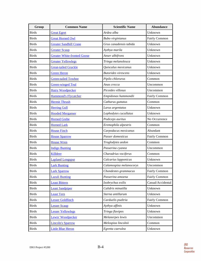
ERO Project #5200 B-4
Group Common Name Scientific Name Abundance
Birds Great Egret Ardea alba Unknown
Birds Great Horned Owl Bubo virginianus Fairly Common
Birds Greater Sandhill Crane Grus canadensis tabida Unknown
Birds Greater Scaup Aythya marila Unknown
Birds Greater White-fronted Goose Anser albifrons Unknown
Birds Greater Yellowlegs Tringa melanoleuca Unknown
Birds Great-tailed Grackle Quiscalus mexicanus Unknown
Birds Green Heron Butorides virescens Unknown
Birds Green-tailed Towhee Pipilo chlorurus Common
Birds Green-winged Teal Anas crecca Uncommon
Birds Hairy Woodpecker Picoides villosus Uncommon
Birds Hammond's Flycatcher Empidonax hammondii Fairly Common
Birds Hermit Thrush Catharus guttatus Common
Birds Herring Gull Larus argentatus Unknown
Birds Hooded Merganser Lophodytes cucullatus Unknown
Birds Horned Grebe Podiceps auritus No Occurrence
Birds Horned Lark Eremophila alpestris Common
Birds House Finch Carpodacus mexicanus Abundant
Birds House Sparrow Passer domesticus Fairly Common
Birds House Wren Troglodytes aedon Common
Birds Indigo Bunting Passerina cyanea Uncommon
Birds Killdeer Charadrius vociferus Common
Birds Lapland Longspur Calcarius lapponicus Unknown
Birds Lark Bunting Calamospiza melanocorys Uncommon
Birds Lark Sparrow Chondestes grammacus Fairly Common
Birds Lazuli Bunting Passerina amoena Fairly Common
Birds Least Bittern Ixobrychus exilis Casual/Accidental
Birds Least Sandpiper Calidris minutilla Unknown
Birds Least Tern Sterna antillarum Unknown
Birds Lesser Goldfinch Carduelis psaltria Fairly Common
Birds Lesser Scaup Aythya affinis Unknown
Birds Lesser Yellowlegs Tringa flavipes Unknown
Birds Lewis' Woodpecker Melanerpes lewis Uncommon
Birds Lincoln's Sparrow Melospiza lincolnii Common
Birds Little Blue Heron Egretta caerulea Unknown
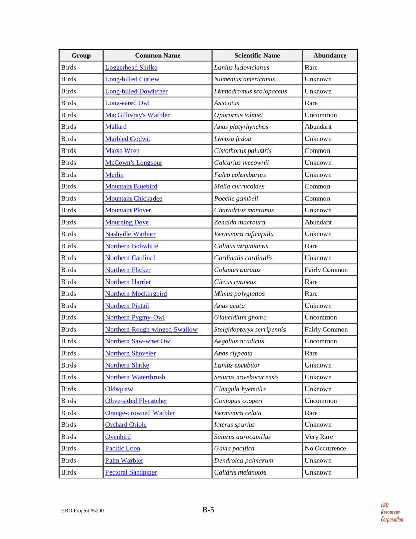
ERO Project #5200 B-5
Group Common Name Scientific Name Abundance
Birds Loggerhead Shrike Lanius ludovicianus Rare
Birds Long-billed Curlew Numenius americanus Unknown
Birds Long-billed Dowitcher Limnodromus scolopaceus Unknown
Birds Long-eared Owl Asio otus Rare
Birds MacGillivray's Warbler Oporornis tolmiei Uncommon
Birds Mallard Anas platyrhynchos Abundant
Birds Marbled Godwit Limosa fedoa Unknown
Birds Marsh Wren Cistothorus palustris Common
Birds McCown's Longspur Calcarius mccownii Unknown
Birds Merlin Falco columbarius Unknown
Birds Mountain Bluebird Sialia currucoides Common
Birds Mountain Chickadee Poecile gambeli Common
Birds Mountain Plover Charadrius montanus Unknown
Birds Mourning Dove Zenaida macroura Abundant
Birds Nashville Warbler Vermivora ruficapilla Unknown
Birds Northern Bobwhite Colinus virginianus Rare
Birds Northern Cardinal Cardinalis cardinalis Unknown
Birds Northern Flicker Colaptes auratus Fairly Common
Birds Northern Harrier Circus cyaneus Rare
Birds Northern Mockingbird Mimus polyglottos Rare
Birds Northern Pintail Anas acuta Unknown
Birds Northern Pygmy-Owl Glaucidium gnoma Uncommon
Birds Northern Rough-winged Swallow Stelgidopteryx serripennis Fairly Common
Birds Northern Saw-whet Owl Aegolius acadicus Uncommon
Birds Northern Shoveler Anas clypeata Rare
Birds Northern Shrike Lanius excubitor Unknown
Birds Northern Waterthrush Seiurus noveboracensis Unknown
Birds Oldsquaw Clangula hyemalis Unknown
Birds Olive-sided Flycatcher Contopus cooperi Uncommon
Birds Orange-crowned Warbler Vermivora celata Rare
Birds Orchard Oriole Icterus spurius Unknown
Birds Ovenbird Seiurus aurocapillus Very Rare
Birds Pacific Loon Gavia pacifica No Occurrence
Birds Palm Warbler Dendroica palmarum Unknown
Birds Pectoral Sandpiper Calidris melanotos Unknown
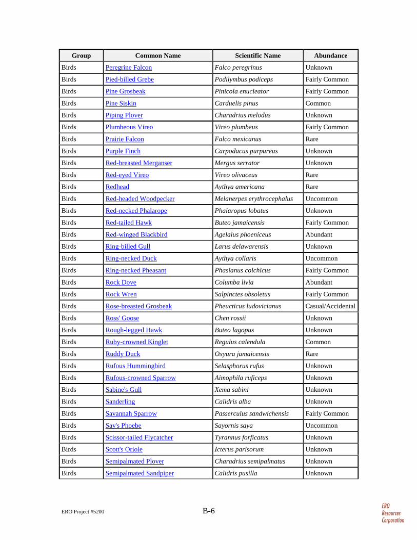
ERO Project #5200 B-6
Group Common Name Scientific Name Abundance
Birds Peregrine Falcon Falco peregrinus Unknown
Birds Pied-billed Grebe Podilymbus podiceps Fairly Common
Birds Pine Grosbeak Pinicola enucleator Fairly Common
Birds Pine Siskin Carduelis pinus Common
Birds Piping Plover Charadrius melodus Unknown
Birds Plumbeous Vireo Vireo plumbeus Fairly Common
Birds Prairie Falcon Falco mexicanus Rare
Birds Purple Finch Carpodacus purpureus Unknown
Birds Red-breasted Merganser Mergus serrator Unknown
Birds Red-eyed Vireo Vireo olivaceus Rare
Birds Redhead Aythya americana Rare
Birds Red-headed Woodpecker Melanerpes erythrocephalus Uncommon
Birds Red-necked Phalarope Phalaropus lobatus Unknown
Birds Red-tailed Hawk Buteo jamaicensis Fairly Common
Birds Red-winged Blackbird Agelaius phoeniceus Abundant
Birds Ring-billed Gull Larus delawarensis Unknown
Birds Ring-necked Duck Aythya collaris Uncommon
Birds Ring-necked Pheasant Phasianus colchicus Fairly Common
Birds Rock Dove Columba livia Abundant
Birds Rock Wren Salpinctes obsoletus Fairly Common
Birds Rose-breasted Grosbeak Pheucticus ludovicianus Casual/Accidental
Birds Ross' Goose Chen rossii Unknown
Birds Rough-legged Hawk Buteo lagopus Unknown
Birds Ruby-crowned Kinglet Regulus calendula Common
Birds Ruddy Duck Oxyura jamaicensis Rare
Birds Rufous Hummingbird Selasphorus rufus Unknown
Birds Rufous-crowned Sparrow Aimophila ruficeps Unknown
Birds Sabine's Gull Xema sabini Unknown
Birds Sanderling Calidris alba Unknown
Birds Savannah Sparrow Passerculus sandwichensis Fairly Common
Birds Say's Phoebe Sayornis saya Uncommon
Birds Scissor-tailed Flycatcher Tyrannus forficatus Unknown
Birds Scott's Oriole Icterus parisorum Unknown
Birds Semipalmated Plover Charadrius semipalmatus Unknown
Birds Semipalmated Sandpiper Calidris pusilla Unknown
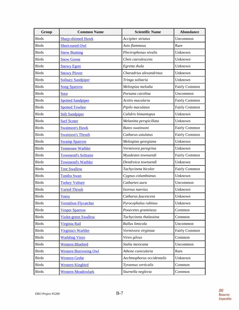
ERO Project #5200 B-7
Group Common Name Scientific Name Abundance
Birds Sharp-shinned Hawk Accipiter striatus Uncommon
Birds Short-eared Owl Asio flammeus Rare
Birds Snow Bunting Plectrophenax nivalis Unknown
Birds Snow Goose Chen caerulescens Unknown
Birds Snowy Egret Egretta thula Unknown
Birds Snowy Plover Charadrius alexandrinus Unknown
Birds Solitary Sandpiper Tringa solitaria Unknown
Birds Song Sparrow Melospiza melodia Fairly Common
Birds Sora Porzana carolina Uncommon
Birds Spotted Sandpiper Actitis macularia Fairly Common
Birds Spotted Towhee Pipilo maculatus Fairly Common
Birds Stilt Sandpiper Calidris himantopus Unknown
Birds Surf Scoter Melanitta perspicillata Unknown
Birds Swainson's Hawk Buteo swainsoni Fairly Common
Birds Swainson's Thrush Catharus ustulatus Fairly Common
Birds Swamp Sparrow Melospiza georgiana Unknown
Birds Tennessee Warbler Vermivora peregrina Unknown
Birds Townsend's Solitaire Myadestes townsendi Fairly Common
Birds Townsend's Warbler Dendroica townsendi Unknown
Birds Tree Swallow Tachycineta bicolor Fairly Common
Birds Tundra Swan Cygnus columbianus Unknown
Birds Turkey Vulture Cathartes aura Uncommon
Birds Varied Thrush Ixoreus naevius Unknown
Birds Veery Catharus fuscescens Unknown
Birds Vermilion Flycatcher Pyrocephalus rubinus Unknown
Birds Vesper Sparrow Pooecetes gramineus Common
Birds Violet-green Swallow Tachycineta thalassina Common
Birds Virginia Rail Rallus limicola Uncommon
Birds Virginia's Warbler Vermivora virginiae Fairly Common
Birds Warbling Vireo Vireo gilvus Common
Birds Western Bluebird Sialia mexicana Uncommon
Birds Western Burrowing Owl Athene cunicularia Rare
Birds Western Grebe Aechmophorus occidentalis Unknown
Birds Western Kingbird Tyrannus verticalis Common
Birds Western Meadowlark Sturnella neglecta Common
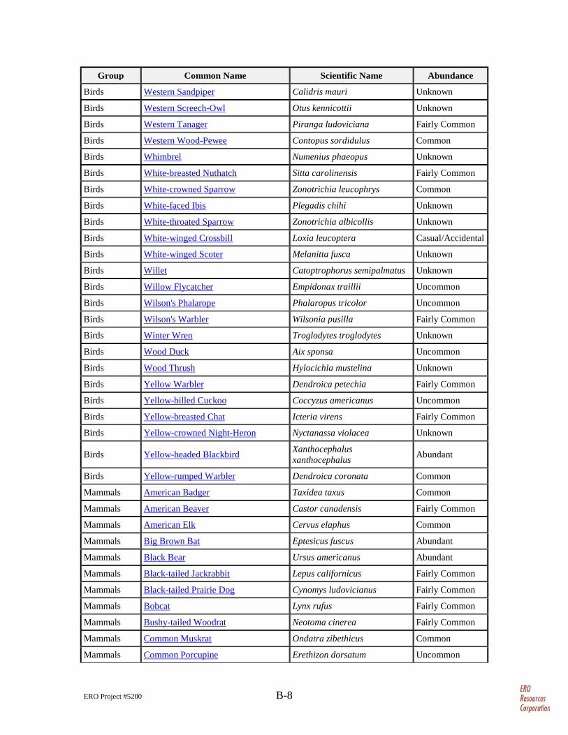
ERO Project #5200 B-8
Group Common Name Scientific Name Abundance
Birds Western Sandpiper Calidris mauri Unknown
Birds Western Screech-Owl Otus kennicottii Unknown
Birds Western Tanager Piranga ludoviciana Fairly Common
Birds Western Wood-Pewee Contopus sordidulus Common
Birds Whimbrel Numenius phaeopus Unknown
Birds White-breasted Nuthatch Sitta carolinensis Fairly Common
Birds White-crowned Sparrow Zonotrichia leucophrys Common
Birds White-faced Ibis Plegadis chihi Unknown
Birds White-throated Sparrow Zonotrichia albicollis Unknown
Birds White-winged Crossbill Loxia leucoptera Casual/Accidental
Birds White-winged Scoter Melanitta fusca Unknown
Birds Willet Catoptrophorus semipalmatus Unknown
Birds Willow Flycatcher Empidonax traillii Uncommon
Birds Wilson's Phalarope Phalaropus tricolor Uncommon
Birds Wilson's Warbler Wilsonia pusilla Fairly Common
Birds Winter Wren Troglodytes troglodytes Unknown
Birds Wood Duck Aix sponsa Uncommon
Birds Wood Thrush Hylocichla mustelina Unknown
Birds Yellow Warbler Dendroica petechia Fairly Common
Birds Yellow-billed Cuckoo Coccyzus americanus Uncommon
Birds Yellow-breasted Chat Icteria virens Fairly Common
Birds Yellow-crowned Night-Heron Nyctanassa violacea Unknown
Birds Yellow-headed Blackbird
Xanthocephalus xanthocephalus Abundant
Birds Yellow-rumped Warbler Dendroica coronata Common
Mammals American Badger Taxidea taxus Common
Mammals American Beaver Castor canadensis Fairly Common
Mammals American Elk Cervus elaphus Common
Mammals Big Brown Bat Eptesicus fuscus Abundant
Mammals Black Bear Ursus americanus Abundant
Mammals Black-tailed Jackrabbit Lepus californicus Fairly Common
Mammals Black-tailed Prairie Dog Cynomys ludovicianus Fairly Common
Mammals Bobcat Lynx rufus Fairly Common
Mammals Bushy-tailed Woodrat Neotoma cinerea Fairly Common
Mammals Common Muskrat Ondatra zibethicus Common
Mammals Common Porcupine Erethizon dorsatum Uncommon
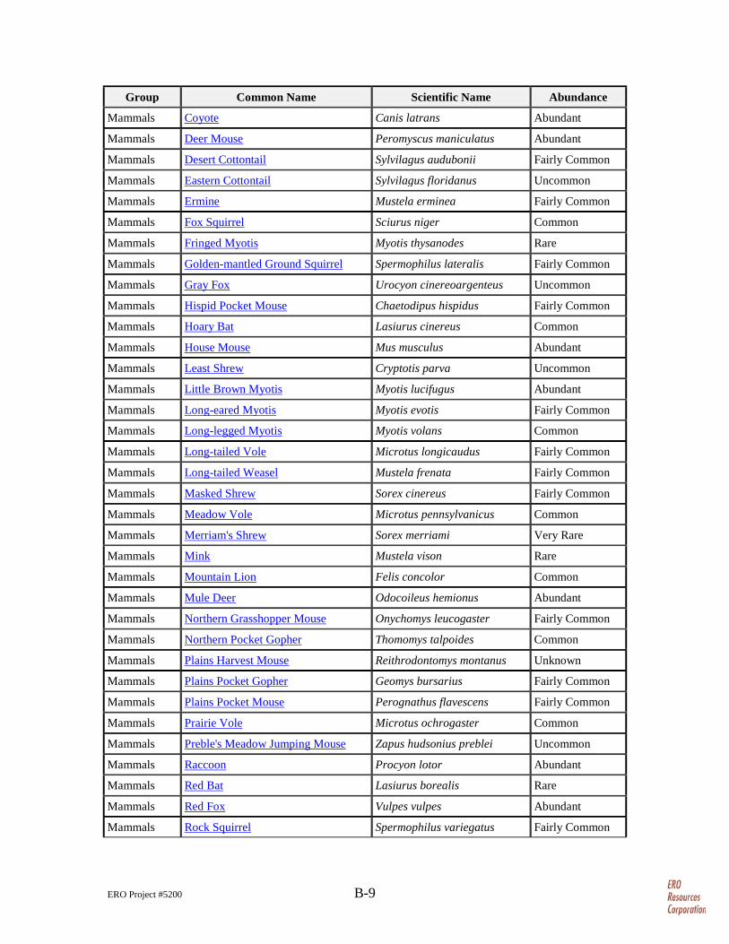
ERO Project #5200 B-9
Group Common Name Scientific Name Abundance
Mammals Coyote Canis latrans Abundant
Mammals Deer Mouse Peromyscus maniculatus Abundant
Mammals Desert Cottontail Sylvilagus audubonii Fairly Common
Mammals Eastern Cottontail Sylvilagus floridanus Uncommon
Mammals Ermine Mustela erminea Fairly Common
Mammals Fox Squirrel Sciurus niger Common
Mammals Fringed Myotis Myotis thysanodes Rare
Mammals Golden-mantled Ground Squirrel Spermophilus lateralis Fairly Common
Mammals Gray Fox Urocyon cinereoargenteus Uncommon
Mammals Hispid Pocket Mouse Chaetodipus hispidus Fairly Common
Mammals Hoary Bat Lasiurus cinereus Common
Mammals House Mouse Mus musculus Abundant
Mammals Least Shrew Cryptotis parva Uncommon
Mammals Little Brown Myotis Myotis lucifugus Abundant
Mammals Long-eared Myotis Myotis evotis Fairly Common
Mammals Long-legged Myotis Myotis volans Common
Mammals Long-tailed Vole Microtus longicaudus Fairly Common
Mammals Long-tailed Weasel Mustela frenata Fairly Common
Mammals Masked Shrew Sorex cinereus Fairly Common
Mammals Meadow Vole Microtus pennsylvanicus Common
Mammals Merriam's Shrew Sorex merriami Very Rare
Mammals Mink Mustela vison Rare
Mammals Mountain Lion Felis concolor Common
Mammals Mule Deer Odocoileus hemionus Abundant
Mammals Northern Grasshopper Mouse Onychomys leucogaster Fairly Common
Mammals Northern Pocket Gopher Thomomys talpoides Common
Mammals Plains Harvest Mouse Reithrodontomys montanus Unknown
Mammals Plains Pocket Gopher Geomys bursarius Fairly Common
Mammals Plains Pocket Mouse Perognathus flavescens Fairly Common
Mammals Prairie Vole Microtus ochrogaster Common
Mammals Preble's Meadow Jumping Mouse Zapus hudsonius preblei Uncommon
Mammals Raccoon Procyon lotor Abundant
Mammals Red Bat Lasiurus borealis Rare
Mammals Red Fox Vulpes vulpes Abundant
Mammals Rock Squirrel Spermophilus variegatus Fairly Common
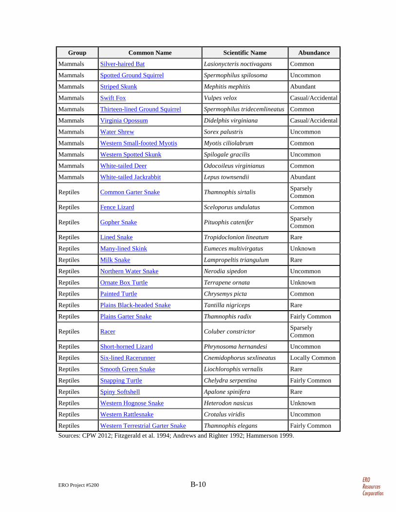
ERO Project #5200 B-10
Group Common Name Scientific Name Abundance
Mammals Silver-haired Bat Lasionycteris noctivagans Common
Mammals Spotted Ground Squirrel Spermophilus spilosoma Uncommon
Mammals Striped Skunk Mephitis mephitis Abundant
Mammals Swift Fox Vulpes velox Casual/Accidental
Mammals Thirteen-lined Ground Squirrel Spermophilus tridecemlineatus Common
Mammals Virginia Opossum Didelphis virginiana Casual/Accidental
Mammals Water Shrew Sorex palustris Uncommon
Mammals Western Small-footed Myotis Myotis ciliolabrum Common
Mammals Western Spotted Skunk Spilogale gracilis Uncommon
Mammals White-tailed Deer Odocoileus virginianus Common
Mammals White-tailed Jackrabbit Lepus townsendii Abundant
Reptiles Common Garter Snake Thamnophis sirtalis Sparsely Common
Reptiles Fence Lizard Sceloporus undulatus Common
Reptiles Gopher Snake Pituophis catenifer Sparsely Common
Reptiles Lined Snake Tropidoclonion lineatum Rare
Reptiles Many-lined Skink Eumeces multivirgatus Unknown
Reptiles Milk Snake Lampropeltis triangulum Rare
Reptiles Northern Water Snake Nerodia sipedon Uncommon
Reptiles Ornate Box Turtle Terrapene ornata Unknown
Reptiles Painted Turtle Chrysemys picta Common
Reptiles Plains Black-headed Snake Tantilla nigriceps Rare
Reptiles Plains Garter Snake Thamnophis radix Fairly Common
Reptiles Racer Coluber constrictor Sparsely Common
Reptiles Short-horned Lizard Phrynosoma hernandesi Uncommon
Reptiles Six-lined Racerunner Cnemidophorus sexlineatus Locally Common
Reptiles Smooth Green Snake Liochlorophis vernalis Rare
Reptiles Snapping Turtle Chelydra serpentina Fairly Common
Reptiles Spiny Softshell Apalone spinifera Rare
Reptiles Western Hognose Snake Heterodon nasicus Unknown
Reptiles Western Rattlesnake Crotalus viridis Uncommon
Reptiles Western Terrestrial Garter Snake Thamnophis elegans Fairly Common Sources: CPW 2012; Fitzgerald et al. 1994; Andrews and Righter 1992; Hammerson 1999.