predicting the bus arrival time using gps and gsm … would also work as anti theft system and...
TRANSCRIPT

International Journal of Science and Research (IJSR) ISSN (Online): 2319-7064
Index Copernicus Value (2013): 6.14 | Impact Factor (2013): 4.438
Volume 4 Issue 5, May 2015
www.ijsr.net Licensed Under Creative Commons Attribution CC BY
Predicting the Bus Arrival Time Using GPS and
GSM Technology
Sudhakar K N1, Rashmi K
2
1Associate Professor, Department of CSE, CMRIT, Bangalore, India
2M.Tech (CNE), Department of CSE, CMRIT, Bangalore, India
Abstract: The primary information to most city transport travelers is bus arrival time. It often discourages the passengers for
excessively waiting long time at bus stops and makes them reluctant to take the public transport, buses. To enable the passenger to track
the vehicle or bus an electronic device is installed in a vehicle is known as Vehicle tracking System. This paper proposes a bus arrival
time prediction using GPS and GSM technology. It would also work as anti theft system and cheapest source of vehicle tracking. It is an
embedded system using GPS (Global Positioning System), GSM (Global System for Mobile Communication) and Microcontroller for
tracking the bus. The real time co-ordinates obtained from the GPS will continuously monitor a moving vehicle and report the status of
the vehicle on request to passengers. The GPS/GSM unit is mounted on the bus sends the data to the central monitoring system
microcontroller using the GSM module and displays bus location name on the LCD. The position i.e Latitude and Longitude of a vehicle
from remote place is sent by the GSM module to the Server and then the server calculates the arrival time of the bus and sends to the
requested user through GSM module.
Keywords: GPS, GSM, Microcontroller, Vehicle Tracking, Bus arrival time and mobile phones
1. Introduction
The transportation system serves as the heart in the
economic and social development of the country. Due to the
fast rate of population in India there is a rapid increase in
vehicle which results in a burden on metropolitan traffic
management. As the public transport has become an
important part of the urban transportation advance in easily
available technology can be implemented which not only
help the person who commutes between a suburb and city to
get the travelling information and also help a person in
command to track down there fleet with the final real time
location [1].In many parts of the world, public transport
especially the bus transport has been well developed. In
order to reduce the fuel consumption, private car usage and
alleviate traffic congestion we can use the bus transport
services. The passengers want to know the accurate arrival
time of the bus, when travelling with the buses. The
passengers become anxious while extremely waiting for a
long time at the bus stop and make them hesitant to take
buses. Many travelers are usually late to office and most of
the students are delayed to the class as they decide to wait
for the bus instead of taking an alternate transportation. The
passengers are often in a dilemma whether to walk or to take
a cab or a rickshaw or else to wait for a next bus in order to
reach their destination quicker. [2] The 38% is the overall
approval rate of the current transportation notification
service. About 96% of the people insisted to know the
position of the bus so that they can decide whether to wait
for a bus instead of walking and also to know the location of
the buses is more productive of wait time than an exact
arrival time. Around 75% of people claim that they had been
delayed to their destination as they decided to wait for the
bus instead of walking. The passengers can make an exact
decision of whether or not to wait at a bus stop if they had an
easy approach to see which bus is near to their location and
an accurate time it would take to reach the bus stop. A
design of an embedded system which is used for tracking
and positioning of any vehicle by using Global Positioning
System (GPS) and Global system for mobile communication
(GSM) is proposed in this paper. A combination of computer
hardware and software, and perhaps additional mechanical
part designed to perform a specific function is known as an
Embedded System. An embedded system is software driven,
real-time control system, microcontroller-based, reliable,
human or network interactive, autonomous, operating on
diverse physical variables and in diverse environments and
sold into a competitive and cost conscious market. The
quality of life in every society can be contributed by
effective movement of people and goods which is lead by
the efficient transportation system.
2. Literature Survey
Participatory Sensing, user activity recognition and Urban
Sensing provides a rich contextual information for
applications of mobile such as location based services and
social networking. Mobile devices consumes huge amount
of energy by continuously capturing this contextual
information. A new design framework for an Energy
Efficient Mobile Sensing System (EEMSS) is proposed in
this paper. To recognize user states as well as to detect state
transitions EEMSS uses hierarchical sensor management
strategy. EEMSS significantly improves device battery life
by powering only a minimum set of sensors and using
appropriate sensor duty cycles. A set of users' daily activities
in real time using sensors on an off-the-shelf high-end smart
phone can be automatically recognized by EEMSS. This
approach increases the mobile battery life by more than 75%
while maintaining both low latency and high accuracy in
recognizing transitions between end-user activities by design
, implementation and evaluation of EEMSS with 10 users
over one week has been presented in this paper[3]. To
provide location-based or context-aware services many
emerging smart phone applications require position
information. In spite of the GSM/Wi-Fi based positioning
Paper ID: SUB154971 2880

International Journal of Science and Research (IJSR) ISSN (Online): 2319-7064
Index Copernicus Value (2013): 6.14 | Impact Factor (2013): 4.438
Volume 4 Issue 5, May 2015
www.ijsr.net Licensed Under Creative Commons Attribution CC BY
systems; GPS is often preferred over its alternatives as it is
known to be more accurate. A positioning system that
provides accurate position information while spending
minimal energy is the main requirement of such
applications. This paper proposes a Rate-Adaptive
Positioning System (RAPS) for smart phone applications.
Generally GPS is less accurate in urban areas, so it is
sufficient to turn on GPS only when it is necessary to
achieve this accuracy. To cleverly determine when to turn on
GPS, RAPS uses a collection of techniques. It turns on GPS
adaptively only if the estimated uncertainty in position
exceeds the accuracy threshold based on the location-time
history of the user to estimate user velocity. Using a duty-
cycled accelerometer it efficiently estimates user movement
and to reduce position uncertainty among neighboring
devices it make use of Bluetooth communication. To avoid
turning on GPS it employs cell tower-RSS blacklisting to
detect GPS unavailability i.e indoors. Using a prototype
implementation on a modern smart phone .We evaluate
RAPS through real-world experiments and prove that it can
increase mobile battery lifetime by more than a factor of 3.8
where GPS is always on[4]. A crucial task in many
applications is Activity monitoring, often conducted using
expensive video cameras. Analyzing images from multiple
cameras in effectively monitoring a large field remains a
challenging issue. In other way it is necessary to attach the
special devices to track the object which is not feasible in
many scenarios. To resolve this issue, this paper proposes to
use RF tag arrays for monitoring the activity where data
mining plays a vital role. Due to the low cost of RF readers
and tags the RFID technology provides an economically
attractive solution. The tracking objects do not need to be
equipped with any RF transmitters or receivers is another
important feature of this design. The noise of RF tag data
and mine frequent trajectory patterns are offset to model the
regular activities by designing a practical fault-tolerant
method. The feasibility and the effectiveness of this design
can be determined by empirical study using real RFID
systems and data sets [5]. Most of the emerging context
aware services and location based applications require the
position information. These applications make use of more
energy-hungry GPS instead of preferring the use cell tower-
based localization because of its inaccuracy. This paper
proposes a Cell-ID Aided Positioning System (CAPS).
CAPS influence the position history of a user and near-
continuous mobility to significantly achieve better accuracy
than the cell tower-based approach by keeping the low
energy overhead. Based on the insight that users exhibit
consistency in routes traveled, and that cell-ID transition
points that the user experiences on a frequently traveled
route, uniquely identify position CAPS is designed. To
estimate current position based on the GPS position
sequences that match the current cell-ID sequence and
history of cell-ID CAPS uses a cell-ID sequence matching
technique. CAPS have been implemented on Android based
smart phones and evaluates it at different platforms, and
different carriers and locations which results in 90% of the
energy spent by the positioning system compared to where
GPS is always used and reasonably provides a accurate
position information with less than 20% of errors than the
cell tower-based scheme[6]. In order to use a EasyTracker, a
transit agency must obtain android- based smart phones,
install an application and to place a phone in each transit
vehicle. The online algorithm in transit vehicle automatically
determines the location server, infer schedules and locate
stops at a given time and predict its arrival time in its
upcoming stops. The main goal of this paper is to reduce the
cost and complexity in offering these services by developing
an an automatic system for mapping, transit tracking and
arrival time prediction i.e. EasyTracker. This system consists
of four main components 1. Smartphone - installed in each
bus or vehicle, which functions as a tracking device or an
automatic vehicle location system. 2. Back-end server-
which stores vehicle trajectories into schedules, route maps
and prediction parameters, 3. Online processing - which uses
the real-time location of a vehicle to predict arrival time. 4.
User interface - allows a user to access current vehicle
locations and predicted arrival times [7].
3. Related Technology
1. GPS Technology
A highly integrated smart GPS module with a ceramic GPS
patch antenna is G7020 GPS as shown in below fig 1. with
14 channel track engine and 51 channel acquisition engine
the module is capable of of receiving signals from up to 65
GPS satellites and transferring them into the precise position
and timing information that can be read over either UART
port or RS232 serial port. Operable at 3.6V-6V, Cold start ≈
29 seconds under clear Sky, Hot start ≈ 1 second under clear
Sky. Capable of Satellite-Based Augmentation System
(SBAS) (Wide Area Augmentation System
(WAAS)/EGNOS (European Geostationary Navigation
Overlay Service)) and Low power control of Integral LNA
(Low Noise Amplifier)
Figure 1: GPS Receiver
2. GSM Technology
SIM300 is a Tri-band GSM/GPRS engine that works on
frequencies , DCS 1800 MHz, Personal Communication
System (PCS) 1900 MHz and Enhanced GSM (EGSM) 900
MHz. SIM300 features GPRS multi-slot class 10/ class 8
(optional) and supports the GPRS coding schemes CS-1,
CS-2, CS-3 and CS-4. To get information in SIM card you
can use AT Command. Both 3.0V and 1.8V SIM Cards are
supported. An internal regulator in the module having
nominal voltage 2.8V is used to power the SIM interface.
All the pins will be reset to as outputs driving will be low.
Paper ID: SUB154971 2881

International Journal of Science and Research (IJSR) ISSN (Online): 2319-7064
Index Copernicus Value (2013): 6.14 | Impact Factor (2013): 4.438
Volume 4 Issue 5, May 2015
www.ijsr.net Licensed Under Creative Commons Attribution CC BY
Figure 2: GSM Interfacing Board
3. P89V51RD2 Microcontroller
The P89V51RD2 is a 80C51 microcontroller with 64KB
flash and 1024B of data RAM as shown in below fig 3.
P89V51RD2 has X2 mode option which is one of the key
features of the microcontroller. To achieve twice the
throughput at the same clock frequency The design engineer
can choose to run the application with the conventional
80C51 clock rate (12 clocks per machine cycle) or select the
X2 mode (six clocks per machine cycle). By reducing the
clock frequency by half the same performance can be
achieved is another feature of this microcontroller. Parallel
programming and in serial ISP (In – System Programming)
are supported by the flash program memory.
Figure 3: P89V51RD2 Microcontroller
4. Design and Implementation
A design of an embedded system which is used for tracking
and positioning of any vehicle by using Global Positioning
System (GPS) and Global system for mobile communication
(GSM) is proposed in this paper. For interfacing with
various hardware peripherals P89V51RD2 Microcontroller
is used. To continuously monitor a moving Vehicle and
report the status of the Vehicle on demand an embedded unit
is designed in the bus. For doing so P89V51RD2
microcontroller is interfaced serially to a GPS Receiver and
GSM Modem. To send the position (Latitude and
Longitude) of the vehicle from a remote place a GPS
Modem is used. The block diagram of tracking system using
GPS and GSM technology is shown in fig 4
Figure 4: Block Diagram of Tracking system using GPS and GSM
It will send the data i.e. the latitude and longitude indicating
the position of the vehicle. The GPS modem gives many
parameters as the output and sends it to the Server through
GSM modem. When the request by user is sent to the
number at the modem, the server system calculate the time
the vehicle may take to reach the corresponding user bus
stop and automatically sends a return reply to that mobile
indicating the time . It is possible to locate the vehicle
around the globe with micro controller, GPS receiver, and
GSM modem. The microcontroller used is P89V51RD2. The
internal memory of Microcontroller i.e. ROM contains the
code. It acts as interface between GSM and GPS with help
Paper ID: SUB154971 2882
International Journal of Science and Research (IJSR) ISSN (Online): 2319-7064
Index Copernicus Value (2013): 6.14 | Impact Factor (2013): 4.438
Volume 4 Issue 5, May 2015
www.ijsr.net Licensed Under Creative Commons Attribution CC BY
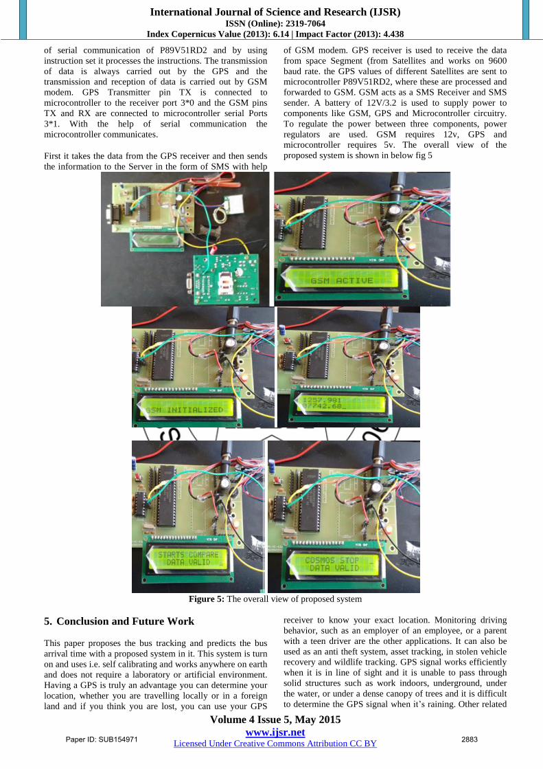
of serial communication of P89V51RD2 and by using
instruction set it processes the instructions. The transmission
of data is always carried out by the GPS and the
transmission and reception of data is carried out by GSM
modem. GPS Transmitter pin TX is connected to
microcontroller to the receiver port 3*0 and the GSM pins
TX and RX are connected to microcontroller serial Ports
3*1. With the help of serial communication the
microcontroller communicates.
First it takes the data from the GPS receiver and then sends
the information to the Server in the form of SMS with help
of GSM modem. GPS receiver is used to receive the data
from space Segment (from Satellites and works on 9600
baud rate. the GPS values of different Satellites are sent to
microcontroller P89V51RD2, where these are processed and
forwarded to GSM. GSM acts as a SMS Receiver and SMS
sender. A battery of 12V/3.2 is used to supply power to
components like GSM, GPS and Microcontroller circuitry.
To regulate the power between three components, power
regulators are used. GSM requires 12v, GPS and
microcontroller requires 5v. The overall view of the
proposed system is shown in below fig 5
Figure 5: The overall view of proposed system
5. Conclusion and Future Work
This paper proposes the bus tracking and predicts the bus
arrival time with a proposed system in it. This system is turn
on and uses i.e. self calibrating and works anywhere on earth
and does not require a laboratory or artificial environment.
Having a GPS is truly an advantage you can determine your
location, whether you are travelling locally or in a foreign
land and if you think you are lost, you can use your GPS
receiver to know your exact location. Monitoring driving
behavior, such as an employer of an employee, or a parent
with a teen driver are the other applications. It can also be
used as an anti theft system, asset tracking, in stolen vehicle
recovery and wildlife tracking. GPS signal works efficiently
when it is in line of sight and it is unable to pass through
solid structures such as work indoors, underground, under
the water, or under a dense canopy of trees and it is difficult
to determine the GPS signal when it’s raining. Other related
Paper ID: SUB154971 2883

International Journal of Science and Research (IJSR) ISSN (Online): 2319-7064
Index Copernicus Value (2013): 6.14 | Impact Factor (2013): 4.438
Volume 4 Issue 5, May 2015
www.ijsr.net Licensed Under Creative Commons Attribution CC BY
devices in a vehicle such as sensors can be integrated in a
vehicle. An intelligent tracking system can be formed by
sensors installed in our vehicle can report the vehicle
information to our server.
6. Acknowledgement
I would like to thank Mr. Sudhakar K N for his guidance,
support and valuable suggestion.
References [1] “Mining frequent trajectory patterns for activity
monitoring using radio frequency tag arrays,” Y. Liu, L. [2] Chen, J. Pei, Q. Chen, and Y. Zhao in Proc IEEE
PerCom, WhitePlains,NY,USA,2007
[3] “A framework of energy efficient mobile sensing for
automatic user state recognition,” Y. Wang et al,
inProc,ACM Mobisys,2009,pp 179-192 [4] Energy-efficient rate-adaptive GPS-based positioning
for smartphones,” J. Paek, J. Kim, and R. Govindan
inProc,ACM Mobisys, Sanfrancisco,CA,USA,2010,pp
299-314 [5] Energy-efficient positioning for smartphones using cell-
ID sequence matching,” in Proc. ACM MobiSys,
Bethesda, MD, USA, 2011, pp. 293–306. J. Paek, K.-H.
Kim, J. P. Singh, and R. Govindan, [6] Easytracker: Automatic transit tracking, mapping, and
arrival time prediction using smartphones,” in Proc.
ACM SenSys, 2011, pp. 1–14. J. Biagioni, T. Gerlich, T.
Merrifield, and J. Eriksson, [7] Real Time Bus Monitoring System Using GPS Dr.
(Mrs.) Saylee Gharge, Manal Chhaya, Gaurav Chheda ,
Jitesh Deshpande , Niket Gajra, RACST – Engineering
Science and Technology: An International Journal
(ESTIJ), ISSN: 2250-3498, Vol.2, No. 3, June 2012 [8] Smart Onboard Public Information System using GPS
& GSM Integration for Public Transport BY Mr. Prafull
D. Patinge , Ms. N. R. Kolhare, International Journal of
Advanced Research in Computer and Communication
Engineering Vol. 1, Issue V, July 2012
Paper ID: SUB154971 2884