port of olympia development guidelines commission approval
TRANSCRIPT

1 Commission Approved – May 22, 2017
Port of Olympia
Development Guidelines
Commission Approval Date: May 22, 2017
I. Introduction
This document contains the Port’s Development Guidelines for its lands holdings in Thurston County; Olympia,
Lacey, and Tumwater. The Port properties at the Olympia location are comprised of Northpoint, Swantown Marina
and Boatworks, Marine Terminal, West Bay and East Bay. The Port properties in Tumwater are the Olympia
Regional Airport and the New Market Industrial Campus. The properties the Port may acquire in Lacey consist of light
industrial and warehouse space at the Commerce Business Center.
II. Olympia Properties
A. Property Description
The Olympia properties consist of approximately 150 acres on the Port Peninsula and 26 acres of tidelands on West
Bay. This ownership is shown on Attachment 1. Much of the City of Olympia’s downtown areas were constructed on
tidelands in the late 1800s and early 1900s, with the first major fill projects completed prior to formation of the Port
District in 1922. The peninsula properties represent the tip of tidelands filled over the century. A significant function of
the peninsula is the marine terminal, which provides 2,500 linear feet of wharf and 76,000 square feet of
warehousing. The marine terminal can host three modern ships simultaneously, or a combination of vessels. The
federal navigation channel which serves the marine terminal is dredged to a depth of -30 feet, based on mean-low-
low-water.
The Swantown Marina is on the east side of the peninsula, which was created in the early 1980’s. The boat basin
was built for a capacity of 1,000 moorage slips, with fifty-four acres of upland for support areas as well as additional
cargo storage and maneuvering areas.
Approximately 13 acres of the northeast portion of the Port Peninsula were used by companies which produced
treated wood products, the last being McFarland Cascade Pole Company. The Site is known as the Cascade Pole
site and has undergone a Washington State Model Toxics Control Act remediation effort. The Port’s goal has been to
return this property back to productive use. Conditions of the remediation require limiting water that can enter the
2 Commission Approved – May 22, 2017
contained portions of the site and prohibiting any penetrations that could compromise the low-permeable aquitard
underneath the site.
The Port’s upland ownership on West Bay consists of approximately 26 acres of tidelands, and the approximate 11
acres known as the Port Lagoon, which is under a perpetual easement to the U.S. Fish & Wildlife Service to serve as
a fish and wildlife conservancy area and as mitigation for the development of the East Bay Marina.
Approximately 54 acres of land fill on the Port Peninsula is conditioned with uses that must be consistent with Section
404 of the Federal Water Pollution Control Act permit issued by the Army Corps of Engineers in 1982. Since a portion
of the 54 acres of the land was created by filling in waters of the United States, uses on that land must be water
dependent to a certain extent, or marina related. The following uses are consistent with this condition if the primary
reason they are there is to provide support to those using boats in the marina:
Restaurants Coffee Shops
Boat Sales Yacht Brokers
Marine Surveyors Marine Insurance
Sail Loft & Sales Canvas/Boat Tops and Upholstery
Engine Repairs, Parts & Service Marine Supplies & Hardware
Boat Repair Facilities Dry Storage – Open Covered
Haul-out Facilities Boating Apparel
Electronic Sales & Services (marine related) Fishing supplies
Fueling Facilities Groceries
Charter Boats & Boat Rentals Yacht Designers, Naval Architects
Boat Trailer Dealers Marina Parking
Coast Guard or Police Facilities Canoe/Kayak Facilities
Shell House – Crew Racing Laundry Facilities
Restrooms Public Transit Shelters – park and ride
Marina Maintenance Building Marina Administration Building
Port Administration Building Offices Relating to Maritime Business
Boat Builders, Shipyards Seaplane Landing
Ferry Terminal Recycling Area for Boaters
Fishing, Viewing Piers & Towers Boat Shows
Yacht Maintenance & Management Boat Rental
Boat Appliance Repair Fish Buyers
3 Commission Approved – May 22, 2017
Commercial Fish Boat Facilities Dry Dock
Yacht Deliveries Oceanographic Mapping/Charting
Boat Salvage Boat Pup Out & Service
Seafood Market Fish Processing – load/unload
Accessory Uses, e.g. pump stations, substations, phone booths, signage, etc.
Boat Names – Commercial Painters & Lettering
B. Design Guidelines
This plan conceptually addresses site development factors that are considered elements of design such as
architecture, landscaping, development themes, and parking. It recommends a design character for each district, and
general design guidelines for all Olympia property. These design recommendations are supplemented by more
detailed design guidelines administered at the Staff level. The following general design guidelines apply to each
district listed below.
Materials from which a building or group of buildings are constructed contribute to the character of the surrounding
area. Therefore, the use of blank walls such as concrete cinder block (without façade ornamentation) uninterrupted
glass curtain walls, and mirrored glass, are not acceptable design for any district; as well as the design of large,
unbroken expanses of parking.
These design concepts are encouraged:
Shade trees and shrubs to screen parking lots;
Connections between adjacent site parking lots for shared parking;
Landscaping and architectural details with distinctive accent colors to lessen the impact of larger buildings;
Shade trees to line and define the property, and indicate entrances;
Landscaped berms;
Rooflines and wall heights with varied gables, dormers, architecturally fenestrated fascias and eaves to add
variety;
Entrance canopies and plazas to delineate the office entrance;
Architecturally contoured walls to provide attractive shadow line appearance from the street; and
Use of building materials such as brick, masonry, glass, tile, stone, or wood on portions of the building
façade.
C. Port Districts
4 Commission Approved – May 22, 2017
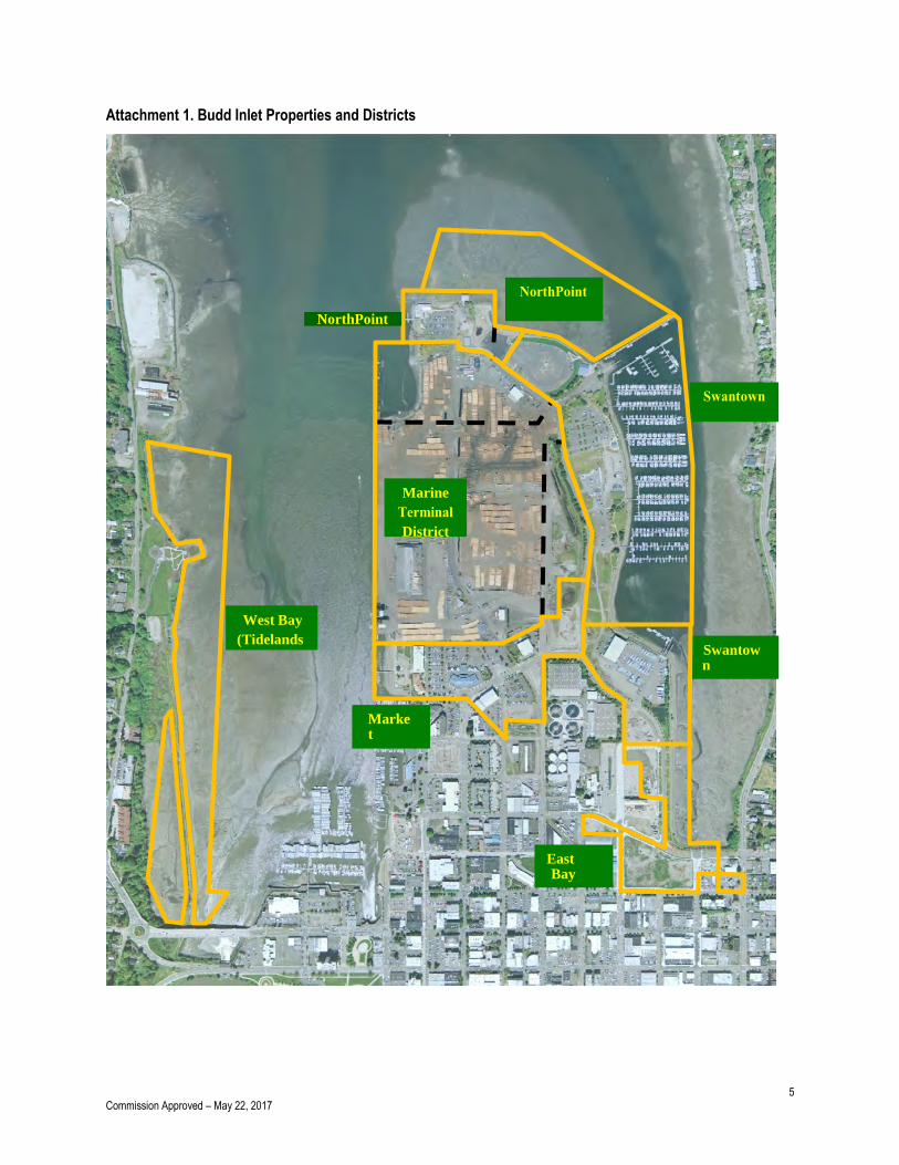
The Olympia property is divided into ten districts, with corresponding uses and standards for each district. These
districts are shown on Attachment 1:
1. Market District
2. Swantown Boatworks
3. East Bay District
4. Swantown Marina
5. Marine Terminal District
6. NorthPoint
7. NorthPoint (Tidelands)
8. West Bay (Tidelands)
1. Market District.
Intent: The Market District is a vibrant waterfront development which supports a variety of uses
and encourages people to walk along the waterfront and shop in the downtown area. This District is the
transition between downtown and the Marine Terminal. It is home to retail, commercial and light
industrial uses; such as the local farmer’s market, a coffee roaster, restaurants, offices, recreational
moorage and community event space.
Use: Retail, commercial, office and light industrial.
Character: The design intent for the Market District is Pacific Northwest, possibly featuring Native
American designs and architecture, or the Granville Island character of a mix of building styles of a
more rural flavor than urban. Retail building windows should have transoms and canopies, with
boardwalk style entries.
Vehicle access is via Capitol Way and Marine Drive. Pedestrian access is from multiple points including
Percival Landing, local streets, and East Bay. The traffic circle and other street treatments such as
pavers and trees create an atmosphere of an entry instead of a through street.
Placement: Buildings are oriented towards the street and primary entrances, with shared parking and
open space. A traffic circle and extra wide sidewalks add character and access to the area in
recognition of the pedestrian oriented nature of the uses.
5 Commission Approved – May 22, 2017
Attachment 1. Budd Inlet Properties and Districts
Marine
District
West Bay
(Tidelands
)
(Tidelands NorthPoint
Marina
Swantown
Market
East Bay
6 Commission Approved – May 22, 2017
2. Swantown Boatworks
Intent: Swantown is a 6-acre marine center for vessel and haul-out, service and repair,
associated retail sales, and restaurant use. It is a vibrant and modern working waterfront, with
expansive indoor and outdoor working areas and sophisticated and effective pollution control systems
for boat maintenance and repair. Swantown consolidated marine businesses into a single area, creating
a one-stop, full-service marine facility.
Use: Industrial, retail, commercial, recreational. Limited residential use is allowed. Coordination
with the U.S. Army Corps of Engineer’s Section 404 permit is required for uses in this area.
Character: The recommended design character is Cannery-Rose-nouveau warehouse style.
Elements of this design character feature: buildings of metal or mill construction with heavy exposed
structural members and lofts; metal roofs; retail windows with transoms and canopies; and boardwalk-
style entries. Industrial buildings require fewer window and access treatments than retail buildings.
Since Swantown and Market Districts create a significant east to west linkage, the design character
should reflect this linkage.
Placement: Placement of buildings is a matter of function, with the larger workshops which require
travel lift access located in the yard. The commercial and retail uses which depend upon high visibility
and vehicle access are located around the parking lot.
3. East Bay District
Intent: The East Bay District has valuable waterfront frontage and frontage along State Avenue.
The intent of this area is to take advantage of the high volume frontage with commercial and retail uses,
as well as the waterfront views and access the district offers.
Use: Office, commercial, retail and mixed use, including limited residential.
Character: Development character in this area should be pedestrian oriented, walkable, limited
residential, business district.
Placement: Placement of buildings is use and site dependent in this area.
4. Swantown Marina
7 Commission Approved – May 22, 2017
Intent: The Marina District consists of a 733 slip marina (1,100 at full build-out), boat launch, and
marine fueling facility (anticipated spring 2017) with upland marina-related services which include
commercial, retail and limited office use. Typical uses in this area should be restaurants, boat supplies,
grocery/deli, yacht clubs, yacht brokers, boutique hotel, etc. This district supports both upland and over-
the-water uses which are of a water-dependent nature. A boat launch and parking is also included.
Use: Marina, marina support, commercial, retail, office. Coordination with the U.S. Army Corps
of Engineer’s Section 404 permit is required for uses in this area.
Character: The design character should add to the goal of making the marina a destination facility. All
buildings which face the pedestrian plaza should include retail windows with transoms and canopies,
with boardwalk-style entries. Where appropriate, buildings should also form smaller open spaces which
will each take on their own character.
Placement: Buildings should be located off of the plaza. Parking should be located to the side of the
buildings.
5. Marine Terminal
Intent: The Marine Terminal and supporting cargo yards handle inbound and outbound cargoes
from ocean going vessels and barges. The types of cargo handled are from traditional forest products
to break bulk, bulk, roll-on/roll-off cargo, and containerized cargoes. This cargo moves in/out via all
moves of transportation. Use and development within the Marine Terminal are opportunity and market-
driven, so development flexibility must be maintained.
Use: Industrial.
Character: Metal buildings should be appropriate in this area.
Placement: The placement of buildings and other support activities should support the efficient
loading and unloading of cargo.
6. NorthPoint
Intent: NorthPoint is intended to be a destination, pedestrian friendly, mixed-use district which
benefits from remarkable mountain, water and downtown views, and offers recreational marine access.
8 Commission Approved – May 22, 2017
No specific plan has been approved by the Commission. This area is also the end point of the East Bay
Promenade, which skirts the north and east sides of the Port peninsula.
Use: Marina, marina support, commercial, retail, and office.
Character: The character of development in this area should be a pedestrian oriented commercial
waterfront nature.
Placement: Buildings in this area should be located to take advantage of the views, without creating
large visual barriers for other locations on the Peninsula. Parking should be located to the side of
buildings.
7. NorthPoint (Tidelands)
Intent: A portion of the Tidelands District is contaminated and is a part of the McFarland Cascade
Pole Model Toxics Control Act (MTCA) clean-up efforts. The most highly contaminated sediments were
removed and placed in an upland containment cell in 2003. Activities in the area may include additional
clean-up and habitat mitigation. Mitigation for this site may include other sites in the Budd Inlet
watershed which are not Port-owned.
Use: Clean-up, mitigation, and education.
8. West Bay
The Port sold the majority of its upland West Bay properties to the City of Olympia for use as a park,
and retained the tidelands. The remaining uplands were previously used by ARCO and are subject to
ongoing environmental remediation work.
Intent: The intent of this district is to provide habitat, potential habitat mitigation, and public
access. The Port and the U.S. Fish & Wildlife Service have designated approximately 11 acres in this
area for conservation. Upon completion of the environmental remediation, the Port will evaluate the
highest and best use for the remaining uplands.
Use: Wildlife habitat, educational, recreational, and conservation.
Character: Wildlife habitat and public access.
9 Commission Approved – May 22, 2017
9. Landscape Guidelines and Port Landscape Management Plan
A few conceptual development guidelines are needed which promote landscaping that will enhance and
unify the Port Peninsula properties. These guidelines promote a neat and well maintained appearance
in areas not covered by buildings or parking and minimize the adverse visual and environmental
impacts of large buildings and/or paved areas.
Outlined below are a few general requirements which should be followed by tenants to meet this intent.
Landscaping should delineate site entrances.
The setback space between streets and parking lots should be fully landscaped.
Landscaping should be used to help define pedestrian paths and areas.
Landscaping should accentuate the architectural details of site buildings.
Shade trees should lien and define the building and property perimeters (when feasible with
adjacent uses). Sidewalks adjacent to the building should be setback with landscaping in
between.
Street trees and on-site landscaping must conform, at a minimum, to City standards.
The tenant is responsible for maintaining landscaping associated with their site in a groomed, weed-
free condition. This requirement is monitored and enforced by both Port and City staff, relying upon the
original landscaping plan as the standard.
10. Transportation Network
Routes and Street Standards
There are a variety of City and Port street ownerships on the Port Peninsula. Marina Drive is the
primary road owned by the Port, and a portion of Franklin Street. The Port built and dedicated Market
Street to the City. The proposed Olympia Avenue extension will likely also be built and dedicated to the
City. Plum Street is designated to the City for use for heavy trucks. The Port and City have previously
partnered to provide additional strength to this roadway to improve it in order to accommodate heavy
trucks and their loads. Plum Street is used for routine truck access to the Marine Terminal as well as
occasional over-dimensional cargo, in coordination with the City of Olympia.
East Bay Promenade
10 Commission Approved – May 22, 2017
The goal of the pedestrian promenade is to provide and maintain a safe, slow paced, convenient,
community-oriented access way along and near the water’s edge. Overall, the promenade is a
coordinated system of connected pathways, sidewalks, and shoreline access points that increases the
amount and diversity of opportunities for walking and chances for personal discoveries along the Port
Peninsula waterfront.
In response to ideas from the City of Olympia’s East Bay Enhancement project, the Port is
implementing a lawn conversion project to create a vegetated edge with interesting gardens that also
provide habitat value and a buffer to East Bay.
As part of the Comprehensive Planning process the Port and its advisory committees considered the
nature of the promenade and opted to keep the long sections of the trail ADA accessible with a hard
surface but not paved. The intent is to make the area accessible but to discourage fast moving activities
such as rollerblading, biking, and skateboarding. Hard surface areas would be focused around
destination points such as the Marina Village within the Marina District, and the Marina Plaza near the
M-N-O docks. This compromise accommodated both approaches for some paved surfaces yet a trail
that would not become so competitive with potential conflicting uses that all enjoyment was
compromised.
III. Airport Development Guidelines
The current Airport Master Plan Update is incorporated by reference into these Development Guidelines and serves
as the basis for the summary below. The current Airport Master Plan Update illustrates both airside and landside
facilities, and is a graphic depiction of the existing and ultimate airport facilities that will be required to enable the
airport to properly accommodate the future forecast demand. In addition, the current Airport Master Plan Update
provides detailed information on both airport and runway design criteria which is necessary to define relationships
with applicable standards.
A. Property Description
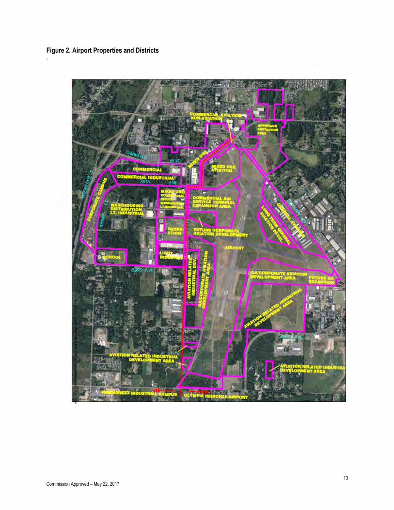
The Olympia Regional Airport is located within the City of Tumwater and the Port’s ownership is illustrated
on Figure 2. Airport operations and development are governed largely by Federal Aviation Administration
(FAA) grant assurances and FAA Order 5190.6A, Airport Compliance Handbook, because the property was
once owned by the federal government, and because the FAA continues to contribute financially to the
development of the Airport through issuance of Federal Grants. In 1994 and 1995, the Port acquired
11 Commission Approved – May 22, 2017
additional property from property owners north and south of its existing holdings, in the area of Case and
Tilley roads.
B. Development Area Guidelines
In 1996, the Washington State Grown Management Act of 1990 was amended by Washington State Bill
6422, which recognized airports as essential public facilities. This bill requires every city, town, code city,
charter city and county having a general aviation airport in its jurisdiction to discourage site uses that are
incompatible with airports. According to representatives of the Washington State Department of
Transportation (WSDOT) Aviation Division, the Tumwater Comprehensive Plan and the Tumwater/Thurston
County Joint Plan have been prepared in accordance with the requirements of the Growth Management Act
and determined to be in compliance with the current Washington State Aviation Policy. Future uses as
reflected by these documents are depicted in the current Airport Master Plan Update at Figure E-3.
This plan recommends a general design character for reach use development area depicted in the current
Airport Master Plan Update.
Materials from which a building or group of buildings are constructed contribute to the character of the
surrounding area. Airport facilities are fairly universal in design, which is attributable to the functionality and
FAA design standards associated with aircraft dimensional clearances and separation standards.
These landside design concepts are encouraged when appropriate:
Short, utility friendly shade trees located outside the Air Operations Area and shrubs and to screen
parking lots;
Connections between adjacent site parking lots for shared parking;
Landside landscaping, landscaped berms and building architectural details with colors and design
consistent with existing development to promote standardization;
Short shrubbery to line and define the property, and indicate entrances;
Landside entrance canopies and plazas to delineate the office entrance;
Architecturally contoured walls to provide attractive shadow line appearance from the street; and
Use of building materials such as brick, masonry, glass, tile, stone or wood on portions of the
landside building façade.
C. Airport Development Areas
12 Commission Approved – May 22, 2017
The current Airport Master Plan Update visually depicts several use development site areas which are
depicted on Attachment 2 and are as follows:
1. General Aviation (GA)
2. Corporate Aviation
3. Light Industrial (Aviation & Non-Aviation)
4. Commercial Air Service
5. North Airport Commercial (Aviation & Non-Aviation)
The next section generally describes the use development areas in terms of intent, specific use, character, and
building placement.
1. General Aviation (GA)
Intent: These development areas (shown as 1-5 on drawing) have runway/taxiway access, and
are reserved for airside access dependent on uses.
Use: A broad mix of uses are allowed in the General Aviation development area excluding
residential. The defining criteria for allowable uses in this area are the extent to which they are dependent
on access to the runway, and the type and size of aircraft operations.
Character: Architectural details are dependent on aircraft type and size, the scale of the development
(single hangar vs. T-hangar complex), ALP designated Building Restriction Lines and dimensional
standards outlined in FAA Advisory Circular 150/5300-13 (series) Airport Design. Landscaping should only
be considered outside the Air Operations Area. Building design should be consistent with accepted industry
design standards and FAA approved building materials.
Placement: Development of these sites generally accommodates the mixing of ground vehicle and
airplane activities with some sort of access controls and parking restrictions. Side or rear-yard setbacks and
aircraft object-free areas vary depending on the taxiway or taxi lane type and the specific type hangar
development. Development details are governed by City of Tumwater development standards and design
review requirements.
13 Commission Approved – May 22, 2017
Figure 2. Airport Properties and Districts
14 Commission Approved – May 22, 2017
2. Corporate Aviation
Intent: This development area has runway/taxiway access, and is reserved for airside access
dependent uses. Customers site development areas range from individuals to corporations with high
performance turbo-prop and turbojet aircraft.
Use: A broad mix of uses is allowed in the Corporate Aviation development area excluding
residential. A defining criteria for allowable uses in this area are the extent to which they are dependent on
access to the runway, and the type and size of aircraft operations.
Character: The buildings should define the professional quality of the district. Architectural details are
dependent on aircraft type and size, the scale of the development (single hangar vs. multi-hangar complex),
ALP designated Building Restriction Lines and dimensional standards outlined in FAA Advisory Circular
150/5300-13 (series) Airport Design. Landscaping should only be considered outside the Air Operations
Area. Building design should be consistent with accepted industry design standards and FAA approved
building materials. Landscaping and short, utility friendly shade trees and landscaped berms should only be
considered outside the Air Operations Area. Use of existing trees in landside landscaping is preferred
consistent with City of Tumwater Ordinance. Entrance canopies and plazas should be used to delineate the
office/landside entrance. The Peninsula Properties building is one example for the architectural and
landscaping character for this type of area.
Placement: Office buildings when separated should be oriented toward the vehicle access; hangars
should be oriented toward the taxiways. Combination office/hangar complexes are common to the industry
and are authorized. Parking should be located to the side and rear of the buildings and, where feasible,
interconnected parking lots are encouraged. Development of these sites should generally have two
orientations – one to the taxiway and the other to the roadway. Placement of buildings generally shall
separate vehicle and airplane activities. Airport security should play a significant role in determining facility
layout and design. Setbacks and aircraft object-free areas vary depending on the taxiway or taxi lane type
and the specific type of hangar development. Development details are governed by City of Tumwater
development standards and design review requirements.
3. Light Industrial (Aviation and Non-Aviation)
Intent: These development areas (shown as 1-4 on drawing) are intended for light industrial uses
such as Cardinal CG.
15 Commission Approved – May 22, 2017
Use: A broad mix of uses is allowed in the light industrial development area excluding
residential. Uses may be aviation related or non-aviation related and will be recommended by the Port
business team based on the overall fit with the goals of the Port.
Character: Landscaping and architectural details with distinctive accent colors should serve to lessen
the impact of larger buildings. Short, utility friendly shade trees should line and define the property, and
indicate entrances. Landscaped berms are encouraged. Use of existing trees is required consistent with City
of Tumwater ordinance. Entrance canopies and plazas should be used to delineate the office entrance.
Building materials such as metal, brick, masonry, glass, tile, stone or wood are allowed on the building
façade.
Placement: Access to the area provided off of Terminal Street or Armstrong Road on the southwest
side of the Airport or 88th Street or future access roads at the southeast corner of the airport. Buildings
should be sited according to function or to facilitate compliance with City of Tumwater codes and
development standards. Parking areas should be screened with landscaping.
4. Commercial Air Service
Intent: This development area has runway/taxiway access, and is reserved for commercial air
service terminal and support services.
Use: This area is restricted to commercial air service and support services.
Character: Uses in this area will cater to the traveling public and planes. The street side character
should be pedestrian friendly with entrances well marked to eliminate confusion.
Placement: Development of within this district should generally have two orientations – one to the
taxiway and the other to the traveler arriving by roadway. Placement of buildings generally shall separate
pedestrian, vehicle and airplane activities. Airport security should play a significant role in determining
facility layout and design.
5. North Airport Commercial
Intent: This development area has Tumwater Boulevard frontage which influences its uses and
character.
16 Commission Approved – May 22, 2017
Use: Commercial and retail are the target uses.
Character: Buildings should be oriented toward the sidewalk and Tumwater Boulevard and should
have amenities which draw people to it including windows, attractive ornamentation, and clearly delineated
entrances.
Placement: Building placement should be adjacent to Tumwater Boulevard to define the street edge
and serve as a draw to the high volume of traffic, similar to the existing building on the corner.
IV. New Market Industrial Campus Development Guidelines
A. Property Description
New Market Industrial Campus is about 686 acres in size, which includes a portion of the Olympia Airport as shown
on Attachment 2. Both New Market Industrial Campus and the Airport are governed – to some extent – by the
Federal Aviation Administration because the property was once owned by the federal government and because the
FAA continues to assist in the development of the Airport. New Market Industrial Campus is located within Tumwater
city limits. In 1994 and 1995, the Port acquired property north and south of its existing holdings in the area of Case
and Tilley roads.
A majority of New Market Industrial Campus is located south of Tumwater Boulevard. Existing uses in New Market
Industrial Campus are manufacturing, warehousing, distribution, office, commercial, highway retail and recreational.
B. Development Design Guidelines
This plan recommends a design character for each use district, and addresses site development factors that are
considered elements of design. These include architecture, landscaping, development themes, and parking.
Materials from which a building or group of buildings are constructed contribute to the character of the surrounding
area. Therefore, the use of blank walls such as concrete cinder block (without façade ornamentation), uninterrupted
glass curtain walls, and mirrored glass, are not acceptable design for any district; as well as the design of large,
unbroken expanses of parking.
These design concepts are encouraged:
Shade trees, shrubs, and berms to screen parking lots;
Connections between adjacent site parking lots for shared parking;
17 Commission Approved – May 22, 2017
Landscaping and architectural details with distinctive access colors to lessen the impact of larger buildings;
Shade trees to line and define the property, and indicate entrances;
Landscaped berms;
Rooflines and wall heights with varied gables, dormers, architecturally fenestrated facias and eaves to add
variety;
Entrance canopies and plazas to delineate the office entrance;
Architecturally contoured walls to provide attractive shadow line appearance from the street; and
Use of building materials such as brick, masonry, glass, tile, stone or wood on portions of the building
façade.
C. Use Districts
New Market Industrial Campus (New Market) is divided into nine districts, with corresponding uses and standards for
each district. These are shown on Attachment 2 and the districts are as follows:
1. Commercial
2. Commercial Industrial
3. Office/Retail
4. Corporate Campus
5. Mixed Use
6. Light Industry District
7. Warehousing, Distribution and Light Industrial
8. Recreational District
9. School
The first 3 districts listed above have a strong association with the City of Tumwater’s concept for a Tumwater Town
Center north of Tumwater Boulevard. A focused master plan was prepared for these 3 districts titled Tumwater Town
Center Land Use Plan, December 2004. The objectives, design principles, streets and block patterns, street types
and trees, street walls, parking concepts, upper level stepbacks and open spaces for these districts are articulated in
this plan. Rather than include all of this detail in this document, the Port of Olympia’s Tumwater Town Center Land
Use Plan, December 2004, is adopted by reference.
Beginning with the Corporate Campus, the next section describes the nine districts in terms of intent, use, character
and building placement.
1. Commercial District
18 Commission Approved – May 22, 2017
Intent: With close access and parcels adjacent to I-5, this location is ideal for freeway orientated
commercial including retail, office and hotel development. This gateway area of New Market should contain
a variety of commercial uses, service uses, such as the existing hotels, professional offices, and retail.
Across the street are several large State office buildings which would benefit from, and would support these
uses.
Use: Commercial, retail, and office.
Character: The character of this district should develop a distinct, strong, cohesive identity for the
area. The urban intensity should be maximized by structuring and encouraging growth toward a more
concentrated, pedestrian friendly, and transit supportive area. Development practices in the area should
embody environmentally sustainable principles. All buildings facing the internal circulation streets should
include windows and overhead protection along the sidewalks. Signage will be freeway oriented.
Existing trees should be incorporated into the landscaping to lend an established look to development.
Placement: Buildings should be located on the street edge along Harper, 75th and Center Street in a
manner that frames the street. This development technically provides a sense of urban intensity, generally
slowing vehicular movement and facilitating pedestrian activity. Parking should be located to the side and
rear of the building and, where feasible, interconnected parking lots are encouraged to the extent that this
should be compatible in the long term. Where appropriate, buildings should also form smaller open spaces
which should each take on their own character. A public open space, such as a plaza, would serve as the
focal point for lunchtime and after work activities.
2. Commercial Industrial District
Intent: Located south of Tumwater Boulevard, this location will include commercial, office,
warehouse and light industrial development.
Use: Commercial, office, warehousing and light industrial.
Character: The character of this district should develop a distinct, strong, cohesive identity for the
area. The urban intensity should be maximized by structuring and encouraging growth toward a more
concentrated, pedestrian friendly, and transit supportive area. Development practices in the area should
embody environmentally sustainable principles. All buildings facing the internal circulation streets should
19 Commission Approved – May 22, 2017
include windows and overhead protection along the sidewalk. Signage type will be appropriate to its arterial
orientation.
Existing trees should be incorporated into the landscaping to lend an established look to the development.
Placement: The buildings along 75th and Center in this district are generally encourage to abut the
street to mirror building placements on these same streets but in the Commercial District. Where
appropriate, buildings should also form smaller open spaces which should each take on their own character.
Parking should be located to the side and rear of the buildings and, where feasible, interconnected parking
lots are encouraged to the extent that this should be compatible in the long term.
3. Office/Retail District
Intent: This district overlaps the City of Tumwater’s designated Town Center, and will include
commercial, office and retail uses. Architectural standards for Clearwater Center apply to this project area.
This may include mixed use development, especially north of Tumwater Boulevard. In keeping with the
massing, design and intent of this district, signage will be pedestrian oriented.
Use: Commercial, office, and retail.
Character: Landscaping and architectural details with distinctive accent colors should serve to lessen
the impact of larger buildings. Shade trees should like and define the property, and indicate entrances.
Rooflines should be varied; gables, dormers, and entrance canopies should add variety as well as
architecturally fenestrated fascias and eaves. Walls should be architecturally contoured to provide attractive
shadow line appearance from the street.
Incorporations of existing trees into site landscaping is required.
Placement: Buildings should be located near the street edge with separate vehicle and truck access.
Parking should be located to the side and rear of the buildings and, where feasible, interconnected parking
lots are encouraged and it is anticipated as the site becomes denser surface parking would convert to
parking garages. Parking areas should be screened with landscaping.
4. Corporate Campus District
20 Commission Approved – May 22, 2017
Intent: The intent for this district is to provide visibility for businesses from 1-5. The design should
be of high quality because of its visibility.
Use: Office and commercial.
Character: The buildings should define the area as a professional quality office park. Landscaping
and architectural details with distinctive accent colors should serve to lessen the impact of larger buildings.
Shade trees should line and define the property, and indicate entrances. Rooflines and wall heights should
be varied; gables, dormers, architecturally fenestrated facias and eaves should add variety. Entrance
canopies and plazas should be used to delineate the office entrance. Walls should be architecturally
contoured to provide attractive shadow line appearance from the street.
The Peninsula Properties building is a model for the architectural and landscaping character for this area.
Placement: Two to three-story buildings should face Kimmie Street, with ample front yard setbacks.
Parking should be located to the side and rear of the buildings and, where feasible, parking lots should be
interconnected.
5. Mixed Use District
Intent: The Mixed Use District should contain uses consistent with the Mixed Use definition as
set forth in the City of Tumwater’s Chapter 18.23 TC Town Center Zone District.
Use: See the City of Tumwater’s Chapter 18.23 TC Town Center Zone District.
Character: Landscaping and architectural details with distinctive accent colors should serve to lessen
the impact of larger buildings. Shade trees should line and define the property and indicate entrances.
Landscaped berms are encouraged. Rooflines should be varied gables, dormers and entrance canopies
should add variety as well as architecturally fenestrated fascias and eaves. Walls should be architecturally
contoured to provide attractive shadow line appearance from the street.
Incorporation of existing trees into site landscaping is required.
Placement: Buildings should be located near the street edge with separate vehicle and truck access.
Parking should be located to the side and rear of the buildings and, where feasible, interconnected parking
21 Commission Approved – May 22, 2017
lots are encouraged to the extent that this will be complete in the long term. Parking areas should be
screened with landscaping.
6. Light Industry District
Intent: This district is intended for light industrial uses such as Cardinal CG.
Use: Light industrial.
Character: Large metal buildings are appropriate in this area with high levels of ornamentation and
modulation to indicate key entrances for customers and employees. Landscaping and architectural details
with distinctive accent colors should serve to lessen the impact of larger buildings. Shade trees should line
and define the property and indicate entrances. Use of existing trees is required to meet landscaping
requirements. Walls should be architecturally contoured to provide attractive shadow line appearance from
the street.
Placement: Access to the area is provided off of Pat Kennedy Way. Buildings should be located near
the street edge. Parking should be located to the side and rear of the buildings, with shared parking lots
where feasible. Parking areas should be screened with landscaping.
7. Warehousing, Distribution, and Light Industrial District.
Intent: This district is intended for some of the larger buildings within New Market. These
buildings will be used by businesses which require large spaces for manufacturing, warehousing, and
distribution. A linear greenbelt stormwater facility should be developed through the interior as part of a sub-
regional stormwater system for New Market. This stormwater greenbelt would be designed to meet each on-
site abutting development’s stormwater needs, and create an attractive amenity. Pedestrian trails, used by
employees for lunchtime walks or after work jogs, will also be available to citizens of the larger community
as a recreational amenity.
Use: Manufacturing, warehousing, and distribution.
Character: Large metal buildings are appropriate in this area with high levels of ornamentation and
modulation to indicate key entrances for customers and employees. Landscaping and architectural details
with distinctive accent colors should serve to lessen the impact of the larger buildings. Shade trees should
line and define the property, and indicate entrances. Rooflines and wall heights should be varied; gables,
22 Commission Approved – May 22, 2017
dormers, architecturally fenestrated facias and eaves should add variety. Entrance canopies and plazas
should be used to delineate the office entrance. Walls should be architecturally contoured to provide
attractive shadow line appearance from the street.
Placement: Buildings should be located near the street edge with separate truck and vehicle access.
Parking should be located to the side and rear of the buildings. Interconnected parking lots are encouraged.
Parking areas should be screened with landscaping.
8. Recreational District
Intent: To maximize use of properties located within the cross-wind runway protection zone, per
Federal Aviation Administration guidelines. Land uses on this site should be low intensity recreational uses.
Use: Recreational. Structures which would enter the runway airspace are not allowed. No night
lighting or glare will be allowed.
Character: Low density development with large open spaces for outdoor recreational activity.
The rooflines and wall heights should be varied with the use of gables, dormers, architecturally fenestrated
facias and eaves. Walls should be architecturally contoured to provide attractive shadow line appears from
the street.
Placement: Development of this site must take into consideration neighboring uses and compatibility
issues.
9. School District
Intent: This parcel is in long term school use and no other use is envisioned for this site in the
long term.
D. Transportation Network
All streets at New Market are Port-owned except for Center Street, Tumwater Boulevard, and New Market Street
north of Tumwater Boulevard.
Recreational Path
23 Commission Approved – May 22, 2017
On most warm summer days, especially during the lunch hour, joggers and walkers travel the New Market Industrial
Campus street network. A recreational path is incorporated into the street standard for Kimmie Street to
accommodate this recreational use.
E. Landscaping and Greenbelt Guidelines
Landscaping Guidelines
These guidelines promote the establishment of compatible and continuous landscape development to enhance and
unify New Market Industrial Campus. The goal is to create the sense of an established, professional, business-park
atmosphere. To some extent each preceding section of this plan has addressed landscaping, from streets standards,
to development uses and stormwater management. These guidelines reinforce earlier concepts; and to promote a
neat and well maintained appearance in areas not covered by buildings or parking; to enhance the existing site
character, and to minimize the adverse visual and environmental impacts of the large paved areas.
Landscaping should delineate site entrances.
Parking lots should be shaded and landscaped inside as well as on the perimeter.
The setback space between streets and parking lots should be fully landscaped. Where possible, berms
should be provided in order to screen parked cars and to prevent headlights from disrupting traffic. Where
berms are not possible due to space limitation, the parking should be screened through use of coniferous
trees and/or appropriate shrub plantings.
Landscaping should be used to help define pedestrian paths and areas.
Landscaping should accentuate the architectural details of the site buildings.
Shade trees should line and define the building and property perimeters (when feasible with adjacent uses).
Sidewalks adjacent to the building should be setback with landscaping in between.
Retention of existing trees is strongly encouraged and should be retained where possible.
The tenant is responsible for maintaining landscaping associated with their site in a groomed, weed-free condition.
Greenbelt Guidelines
Two greenbelt systems are proposed for New Market and are illustrated on the attached drawing. One is around the
perimeter of New Market, primarily on the south and west sides. Most of the trees which should be a part of this
system are existing trees. A second system is proposed as part of the north-south sub-regional stormwater facility.
Some trees which would be part of this system are existing trees; others would have to be added, especially at the
north end of the system.
24 Commission Approved – May 22, 2017
The existing trees in the undeveloped areas of New Market are a significant amenity and should be preserved and
incorporated into site designs for each parcel that abuts the greenbelt. As a rule, the greenbelt areas should not be
included within the future leases unless the tenant is committed to retaining and maintaining the Greenbelt. Adjacent
tenants should ensure that development on their site do not adversely impact the greenbelt system.
Existing and new trees should be combined in the following greenbelt areas:
At the entrance to New Market on Center Street. These trees create a boulevard atmosphere and add to the
aesthetic value of Tumwater Boulevard. A viable strip should be preserved the length of Center Street
between Tumwater Boulevard and 77th (or so);
Along Armstrong Road;
North of the existing bulk fuel farm;
Within the Commercial District, primarily on the north perimeter and within the future sub-regional
stormrwater facility;
On the western border of the Corporate Campus;
Between the school site and future uses to the north;
Along the north-south future sub-regional stormwater facilities in the Warehousing District;
Along 83rd and Armstrong Street;
Along the north-south future sub-regional stormwater facility in the Mixed Use District; and Grange; and
those trees within the development to the south of 73rd;
Around the Light Industrial District.
V. Lacey Properties
A. Property Description
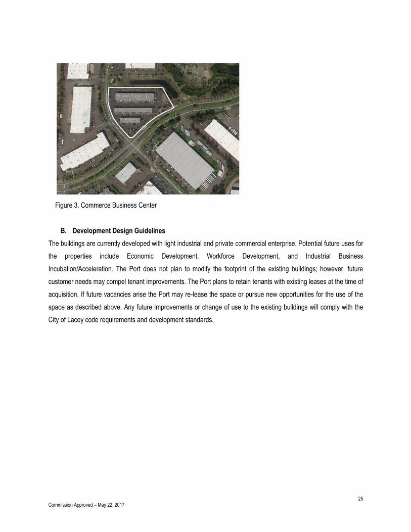
On August 8, 2016, the Port Commission authorized entry into a purchase and sale agreement for the potential
acquisition of three buildings located in Lacey, Washington located at 2625, 2633, and 2641 Willamette Drive NE
(Parcel Numbers: 42040000300, 42040000200, 42040000100) subject to review and appraisal. The structures were
built in 2004. Total site acreage is 4.9 acres with Building 1 being 9500 square feet, building 2 being 18350 square
feet, and building 3 being 28654 square feet. The buildings are currently used for light industrial and private
commercial enterprise. See Figure 3.
25 Commission Approved – May 22, 2017
Figure 3. Commerce Business Center
B. Development Design Guidelines
The buildings are currently developed with light industrial and private commercial enterprise. Potential future uses for
the properties include Economic Development, Workforce Development, and Industrial Business
Incubation/Acceleration. The Port does not plan to modify the footprint of the existing buildings; however, future
customer needs may compel tenant improvements. The Port plans to retain tenants with existing leases at the time of
acquisition. If future vacancies arise the Port may re-lease the space or pursue new opportunities for the use of the
space as described above. Any future improvements or change of use to the existing buildings will comply with the
City of Lacey code requirements and development standards.