port and waterway safety assessment haro strait ......port and waterway safety assessment haro...
TRANSCRIPT

Port and Waterway Safety Assessment Haro Strait / Boundary Pass
USA - Canada Workshop Report
Introduction A Port and Waterway Safety Assessment (PAWSA) Workshop was conducted for Haro Strait / Boundary Pass on February 25 - 26, 2002 in Richmond, British Columbia, Canada. This workshop report provides the following information:
• Brief description of the process used for the assessment; • List of participants; • Numerical results from the following activities:
• Team Expertise • Waterway Risks Evaluation • Existing Waterway Mitigations Evaluation • VTM Tools Evaluation; and
• Summary of risks and mitigations discussion Strategies for reducing unmitigated risks will be the subject of a separate report.
Assessment Process
The PAWSA process is a structured approach to obtaining expert judgments on the level of waterway risk. The process also addresses the relative merits of specific types of Vessel Traffic Management (VTM) improvements for reducing risk in the waterway. The PAWSA process uses a select group of waterway user / stakeholders in each port / waterway to evaluate waterway risk factors and the effectiveness of various VTM improvements. The process requires the participation of local Coast Guard officials before and throughout the workshops. Thus the process is a joint effort involving waterway experts and the agencies / entities responsible for implementing selected risk mitigation measures. This methodology employs a generic model of port risk that was conceptually developed by a National Dialog Group on port risk and then translated into computer algorithms by Potomac Management Group, Inc. In that model, risk is defined as the sum of the probability of a casualty and its consequences. Consequently, the model includes variables associated with both the causes and the effects of vessel casualties. The first step in the process is for the participants to assess their expertise with respect to the six risk categories in the model. Those assessments are used to weight the experts’ inputs during all subsequent steps. The second step is for the participants to discuss and then numerically evaluate the absolute risk level in the waterway using pre-defined qualitative risk descriptors. In the third step, the participants discuss and then evaluate the effectiveness of existing mitigation strategies in reducing risk. Next, the participants are asked to offer new ideas for further reducing risk, for those factors where risk is not well balanced with existing mitigations. Finally, the effectiveness of various vessel traffic management tools in reducing unmitigated risk is evaluated.

PAWSA Haro Strait / Boundary Pass February 25 - 26, 2002
Participants
The following is a list of waterway users and stakeholders who participated in the process:
Participant Organization Phone Email
Mr. Ken Alger USCG VTS Puget Sound (206) 217-6152 [email protected]
LCDR Keith Bradford USCG MSO Puget Sound (206) 217-6251 [email protected]
Mr. George Collazo Coastal Transportation (800) 544-2580 [email protected]
Mr. Michael Cormier Vancouver Port Authority (604) 665-9086 [email protected]
Mr. Chris Cue Canadian Fishing Company (604) 681-0211 [email protected]
Mr. Norm Dyck Rec. Boating Advisory Council (604) 594-3335 [email protected]
Mr. Colin Eckford Washington Marine Group (604) 988-3111 [email protected]
Capt. Miklos Endrody Puget Sound Pilots (425) 646-1003 [email protected]
Capt. Ed Goudy BC Coast Pilots Ltd (604) 688-0291 [email protected]
Mr. George Hall RBAW (360) 293-9699 [email protected]
Mr. Andrea Heba Vancouver Port Authority (604) 665-9086 [email protected]
Capt. Robert Kromann Puget Sound Pilots (425) 743-1147 [email protected]
Mr. Dan Kukat Intl Whale Watch Op. NW (250) 658-6016 [email protected]
Capt. Neil J MacDougall BCCP (604) 534-7338 [email protected]
Capt. Gordie Mann Transport Canada (604) 666-0946 [email protected]
Mr. Kevin Monahan Canadian Coast Guard (250) 480-2730 [email protected]
Capt. Ed Monteiro PACMAR/UAIS Steering Com. (604) 467-2330 [email protected]
Capt. Chris O’Brien Alaska Tanker Company (360) 647-2605 [email protected]
Mr. Richard Osborne The Whale Museum (360) 378-4710 [email protected]
Capt. Craig Rackham Canadian Coast Guard (604) 278-7717 [email protected]
CWO James Robson USCGC Henry Blake (425) 304-5740 [email protected]
Mr. Dave Schneidler Port of Seattle (206) 728-3523 [email protected]
Mr. Steve Simpson Port of Friday / Islds. Oil Spill (360) 378-2688 [email protected]
Capt. E.W. Storzer BCCP (604) 688-0291 [email protected]
Mr. David Watson Canadian Petroleum Products (250) 758-0798 [email protected]
Ms. Cath Wehrle Victoria MCTS (250) 363-6818 [email protected]
Observers Organization Phone Email
LTJG Katie Blanchard USCG 13rh District (206) 220-7274 [email protected]
CAPT Chip Boothe USCG 13th District (206) 220-7220 [email protected]
Mr. Rick Bryant Chamber of Shipping of BC (604) 681-2351 [email protected]
2

PAWSA Haro Strait / Boundary Pass February 25 - 26, 2002
Participants (continued)
CDR Bill Devereaux USCG VTS Puget Sound (206) 217-6048 [email protected]
Mr. Paul Devries BC Coast Pilots Ltd (604) 688-0291 [email protected]
Lt Lesley Dion USCG 13th District (206) 220-7217 [email protected]
CDR Danny Ellis USCG Commandant (G-MWV) (206) 217-6205 [email protected]
Mr. John Mein TSB (604) 666-4956 [email protected]
CAPT Mike Moore USCG MSO Puget Sound (206) 217-6205 [email protected]
Ms. Yvette Myers Canadian Coast Guard (604) 775-8852 [email protected]
Mr. Stan Norman WA Dept. of Ecology (360) 407-7465 [email protected]
LT Bo Stocklin USCG MSO Puget Sound (206) 217-6237 [email protected]
LTJG Alisa Praskovich USCG MSO Puget Sound (206) 217-6216 [email protected]
LCDR Jane Wong USCG 13th District (206) 220-7224 [email protected]
Mr. John Yeung Transport Canada (604) 666-9179 [email protected]
Facilitation Team Organization Phone Email
Mr. Jorge Arroyo USCG Commandant (G-MWV) (202) 267-0352 [email protected]
Doug Perkins Potomac Management Group (703) 836-1037 [email protected]
Chuck Klingler Potomac Management Group (703) 836-1037 [email protected]
Leanne Rebuck Potomac Management Group (703) 836-1037 [email protected]
Geographic Area:
Scope of the port area under consideration: The participants defined the geographic bounds of the waterway area to be discussed.
• From Discovery Island, extending through Haro Strait around Turn Point, thru Boundary Pass up to Patos Island.
• Note — The group agreed not to discuss the Port Impact category due to the geographic bounds of the waterway.
Numerical Results
Book 1 – Team Expertise
In Book 1, the participants were asked to assess their level or expertise compared to the other participants in the workshop. They were asked to rate themselves as top one-third, middle third, or lower third with respect to the six categories in the Waterway Risk Model. For the most part, 1/2 of the participants placed themselves in the top third, 1/3 in the middle third, and 1/6 in the bottom third overall.
3

PAWSA Haro Strait / Boundary Pass February 25 - 26, 2002
Book 2 – Waterway Risks
Vessel & Crew Vessel Traffic Navigation
Conditions Waterway Immediate Consequences
Subsequent Consequences
Seaworthiness
2.0
Commercial
2.7
Winds
2.9
Visibility Impediments
1.4
Injuries
8.4
Health and Safety
3.8
Mariner Proficiency
2.6
Recreational
3.3
Currents
3.1
Dimensions
2.4
Hazardous Discharge
9.0
Environment
8.7
Boater Proficiency
6.1
Traffic Mix
5.2
Visibility Restrictions
2.2
Bottom Type
5.6
Property Damage
8.4
Aquatic Resources
8.3
Significant Vessels
8.1
Congestion
2.4
Obstruction
3.8
Configuration
7.8
Port Impact
—
Economic
5.1
Analysis: The participants evaluated the absolute risk level in the waterway by selecting a qualitative descriptor for each risk factor that best described conditions in the Haro Strait / Boundary Pass area. Those qualitative descriptors were converted to numerical values using a national risk measurement scale. On that scale, 1.0 represents low risk (Port Heaven) and 9.0 represents high risk (Port Hell), with 5.0 being the mid-risk value. In the Haro Strait / Boundary Pass area, 11 risk factors were scored above the mid-risk value. They were (in descending order):
• Hazardous Discharge (9.0) • Environment (8.7) • Injuries (8.4) • Property Damage (8.4) • Aquatic Resources (8.3) • Significant Vessels (8.1) • Configuration (7.8) • Boater Proficiency (6.1) • Bottom Type (5.6) • Traffic Mix (5.2) • Economic (5.1)
4

PAWSA Haro Strait / Boundary Pass February 25 - 26, 2002
Book 3 – Mitigated Level of Risk
Vessel & Crew
Vessel Traffic
Navigation Conditions Waterway Immediate
Consequences Subsequent
Consequences
Seaworthiness Commercial Winds Visibility Impediments Injuries Health and
Safety
2.0 2.1 2.7 2.5 2.9 2.4 1.4 1.8 8.4 5.2 3.8 2.3
OK OK OK OK OK OK
Mariner Proficiency Recreational Currents Dimensions Hazardous
Discharge Environmental
2.6 2.6 3.3 3.1 3.1 2.6 2.4 2.2 9.0 6.4 8.7 6.7
ALERT NO OK OK ALERT OK
Boater Proficiency
Traffic Mix
Visibility Restrictions
Bottom Type
Property Damage
Aquatic Resources
6.1 5.2 5.2 4.4 2.2 2.5 5.6 4.3 8.4 5.7 8.3 6.6
NO ALERT OK OK OK ALERT
Significant Vessels Congestion Obstructions Configuration Port
Impact Economic
8.1 5.3 2.4 2.5 3.7 2.7 7.8 5.0 — — 5.1 4.4
OK ALERT OK OK —— OK
KEY Book 2 Absolute level of risk Book 3 Level of risk taking into account existing mitigations Risk
Factor OK Consensus (2/3 of participants) that risks were well balanced by existing mitigations
Book 2 Book 3 ALERT No consensus that risks were adequately reduced by existing mitigations
ALERT
NO Consensus that existing mitigations do NOT adequately reduce risk
Legend:
The tool listed is determined by the majority of participant teams as the effect of the existing mitigations on the absolute risks developed in Book Two. The chart above shows the risk factor and the Book 2 and 3 results. For each factor box, an OK shows consensus that risks were well
5

PAWSA Haro Strait / Boundary Pass February 25 - 26, 2002
Legend: (continued) balanced by existing mitigations. An ALERT indicates that there was consensus and the risks were NOT adequately reduced by the existing mitigations. A NO shows that there was no good consensus on whether existing mitigations adequately reduced the risk. Once a green OK was determined, that risk factor was considered balanced and not discussed further.
Analysis: The participants examined all risk factors and applied existing mitigations for the Haro Strait / Boundary Pass area. For 21 risk factors, the participants were in consensus that risks were well balanced by existing mitigations. Consensus is defined as 2/3 of the participants being in agreement. In 2 risk .factors, the participants were in consensus that risks were NOT adequately reduced by existing mitigations. For the other 5 risk factors, there was not good consensus on whether existing mitigations adequately reduced risk.
Book 4 – VTM Tool Effectiveness
Vessel & Crew
Vessel Traffic
Navigation Conditions Waterway Immediate
Consequences Subsequent
Consequences
Seaworthiness Commercial Winds Visibility Impediments Injuries Health and
Safety
OK OK OK OK OTH 1.0 OK
4
Mariner Proficiency Recreational Currents Dimensions Hazardous
Discharge Environmental
OK OK OK OK OTH 0.5 OTH 0.8
7 5
Boater Proficiency
Traffic Mix
Visibility Restrictions
Bottom Type
Property Damage
Aquatic Resources
OTH 1.7 OTH 2.0 OK OK OK OTH 1.5
2 ALERT 1 3
Significant Vessels Congestion Obstructions Configuration Port
Impact Economic
OTH 0.4 OK OK OTH 0.8 OK OK
8 ALERT 6 ALERT
6
PAWSA Haro Strait / Boundary Pass February 25 - 26, 2002
Book 4 – VTM Tool Effectiveness (continued)
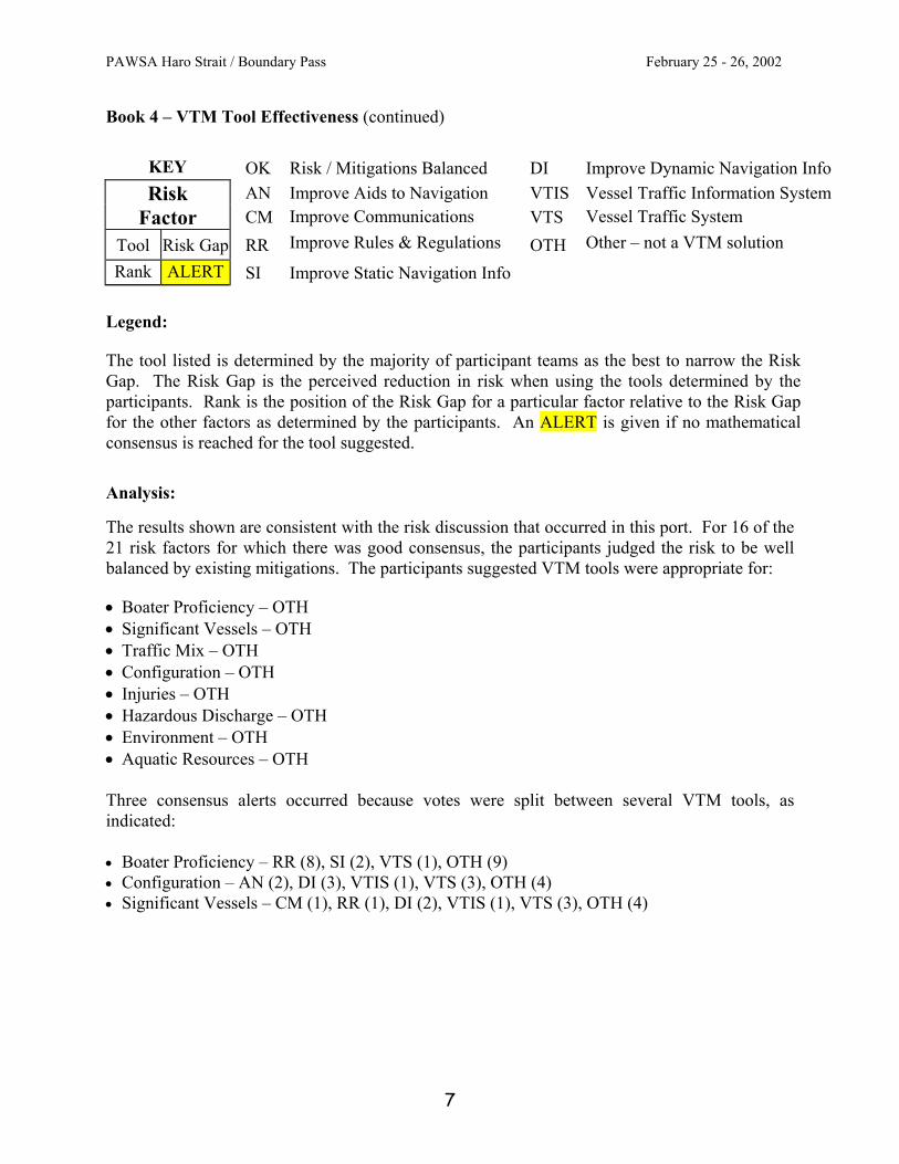
KEY OK Risk / Mitigations Balanced DI Improve Dynamic Navigation Info
AN Improve Aids to Navigation VTIS Vessel Traffic Information System Risk Factor CM Improve Communications VTS Vessel Traffic System
Tool Risk Gap RR Improve Rules & Regulations OTH Other – not a VTM solution
Rank ALERT SI Improve Static Navigation Info
Legend:
The tool listed is determined by the majority of participant teams as the best to narrow the Risk Gap. The Risk Gap is the perceived reduction in risk when using the tools determined by the participants. Rank is the position of the Risk Gap for a particular factor relative to the Risk Gap for the other factors as determined by the participants. An ALERT is given if no mathematical consensus is reached for the tool suggested. Analysis: The results shown are consistent with the risk discussion that occurred in this port. For 16 of the 21 risk factors for which there was good consensus, the participants judged the risk to be well balanced by existing mitigations. The participants suggested VTM tools were appropriate for: • Boater Proficiency – OTH • Significant Vessels – OTH • Traffic Mix – OTH • Configuration – OTH • Injuries – OTH • Hazardous Discharge – OTH • Environment – OTH • Aquatic Resources – OTH Three consensus alerts occurred because votes were split between several VTM tools, as indicated: • Boater Proficiency – RR (8), SI (2), VTS (1), OTH (9) • Configuration – AN (2), DI (3), VTIS (1), VTS (3), OTH (4) • Significant Vessels – CM (1), RR (1), DI (2), VTIS (1), VTS (3), OTH (4)
7

PAWSA Haro Strait / Boundary Pass February 25 - 26, 2002
RISKS RISK MITIGATION STRATEGIES
Vessel and Crew: Seaworthiness
Today: •
•
•
•
•
•
•
•
•
•
•
•
•
•
•
•
•
•
Deep draft: small percentage has questionable seaworthiness and the owners are known to have walked away from the ships.
Tank ships move in and out of Vancouver. All ships that go into Cherry Point are highly inspected TAPS trade tankers
Low risk for foreign ships.
Recreational vessels:
o 1400-1500 small craft incidents annually (not necessarily related to seaworthiness) in the Canadian area.
o Seaworthiness not a problem for the recreational boating population.
o Material condition reflects financial condition of the vessel.
o Records show minimal responses to vessels broken down.
Maintenance on small, uninspected vessels follows the profitability of fishing season. This includes small tugs and small Fishing vessels.
Trends: • Vessel condition is good and appears to be
improving.
Existing Mitigations:
For USA:
Courtesy exams are provided to 3000 boats annually (of 300,000 in the area).
Small passenger vessels inspected for safety.
USCG has manufacturer compliance program for recreation boat construction.
Commercial fishing vessels are steel hull and designed for Alaskan waters.
Tugs have redundant propulsion. Some tugs are ABS classed. Companies have AWO / RCP.
For deep draft, PSC covers foreign flag vessels.
For Canada:
Small vessels in Victoria area are inspected. There is a level of standard and proficiency.
Deep draft ships are inspected. Oil cargo owner has exposure of spill liability. Certificates are inspected. ISM is checked.
Port State Control in place. 25% of vessels inspected. 50 of 459 were deficient and denied access. All tankers are inspected.
Fishing vessels of 12m or more are inspected. Others have a safety program. Inspected by Transport Canada.
Longshoremen at Vancouver will not accept a poorly maintained ship.
All:
Class societies and flag state set a high standard. Insurance companies getting stricter. Marine surveyors inspect smaller vessels.
Economic health keeps seaworthiness up.
New ideas:
• Poor maintenance may result in citations in Canada in the future.
8

PAWSA Haro Strait / Boundary Pass February 25 - 26, 2002
RISKS RISK MITIGATION STRATEGIES
Vessel and Crew: Mariner Proficiency
Today: •
•
•
•
•
•
•
•
•
•
•
•
•
•
•
•
•
•
Small fishing vessels:
o Crew fatigue.
o Crew low knowledge level.
Violations of COLREGS are result of being asleep or no knowledge of the rules.
o Not all close calls are captured.
Deep draft vessels:
o Bridge resource management problems include language barriers and untrained personnel. Vast majority of foreign ships have language problems.
o Up to ten different nationalities sometimes crew a vessel.
Tugs and barges have highly proficient performance.
Trends: Deep draft crew performance is getting worse.
Small vessel operators seem to be getting better.
Existing Mitigations: There is a compulsory (over 350 G.T.) requirement for pilots to navigate deep draft vessels. Pilots have extensive training. Ships that use a pilot have generally no problems as they proceed up Haro Strait.
Small vessel operator certifications are highly regulated by Transport Canada.
USA tug operators are certified. Crew is STCW certificated.
Deep-sea fleet is regulated by PSC.
For Alaskan fishing vessels, 90% have STCW certificates on vessels of 200 gross tons and larger.
All Canadian tugboat deck officers are certified in accordance with STCW.
In some cases, there are two pilots on 40,000 DWT tankers when transiting (Canada).
Canadian VTS is providing info and training to navy operators on smaller vessels.
USA is conducting VTS 101 that addresses vessels going in and out of Bangor.
Canada follows up on complaints on foreign vessel crew language problems.
North Pacific Fishing Vessel Owner Assn. offers safety training to fishing vessel crews.
Numerous fishermen go to navigation schools.
New ideas:
Transport Canada is currently working on process where all operators on all non-pleasure craft will go through training.
9

PAWSA Haro Strait / Boundary Pass February 25 - 26, 2002
RISKS RISK MITIGATION STRATEGIES
Vessel and Crew: Boater Proficiency
Today: •
•
•
•
•
•
•
•
•
•
•
•
•
•
•
•
•
•
•
•
Boat operators show weak knowledge of
o Handling characteristics of larger vessel.
o Use of charts and their location relative to TSS.
o Rules of the Road.
Of 1200 recreational boaters, about 90% seem competent and proficient. In some cases, the smaller the boat the higher the accident rate.
On some boats, experience and competency are low.
Sometimes, boaters tend to be preoccupied looking for whales
Bare boat charter fleets have least competent people and are, without question, the worst.
Trends: Boaters are getting more competent.
All people operating power vessels must be certified by 2009 in Canada.
Awaiting brochure on Turn Point operating area.
Existing Mitigations: Operation Make Way uses Coast Guard Auxiliary to train boaters on the water.
Boaters who belong to an organization receive better information and training/education.
Haro Strait and Boundary Pass are large and the recreational boater will probably not cross.
Canada has a mandatory certification program for boaters to operate boats under 4 meters.
USA provides a VTS brochure.
Sound Watch (USA) and M3 (Canada) are programs that focus on contact with boater about approaching either wildlife preserve or whale watching.
In Canadian waters, 3000 boaters took courses last year. A challenge exam in lieu of a course is also offered. In USA waters, 1200 people took courses.
New ideas: Provide help to support the State of Washington legislature to pass a measure requiring proof of vessel operator education.
Improve the updating and availability of charts. Provide QA of free charts or chart like information.
Reduce registration cost with proof of boating education.
Increase recreational boater education. This to include monitoring VTS communications. Consider a national education program/requirement tailored to local circumstances.
Urge insurance carriers to provide better rates with proof of proper training.
10

PAWSA Haro Strait / Boundary Pass February 25 - 26, 2002
RISKS RISK MITIGATION STRATEGIES
Vessel and Crew: Significant Vessels
Today: •
•
•
•
•
•
•
•
•
•
•
99% of deep draft traffic going into Vancouver has not called in any other North American port prior to arrival. Some of these routes originate in the Middle East.
In Haro Strait recreational traffic comes from everywhere and present a possible threat of collision with other vessels.
[This is a terrorist issue]
Trends: No trends were discussed
Existing Mitigations: The ships have had to come thru the Straits of Juan de Fuca.
Foreign ships must give 96-hour notice of arrival. Authority able to then screen people and vessels.
Ships must pick up a pilot who will control the ship.
The area has few critical structures and transportation centers.
USA conducts armed boardings and Sea Marshall programs.
USA and Canada offer radar monitoring of vessel movements.
New ideas: Provide more stringent enforcement of STCW requirements.
Mask the AIS signal for security purposes.
11

PAWSA Haro Strait / Boundary Pass February 25 - 26, 2002
RISKS RISK MITIGATION STRATEGIES
Vessel Traffic: Commercial
Today: •
•
•
•
•
•
•
•
•
•
•
•
•
•
•
•
•
•
Tug traffic is 2/3 of the traffic moving through the area.
40,000 fishing vessel transits are not captured in the data.
Military vessels conduct exercises in the area.
100 vessels participate in whale watching and carry between 200,000 and 250,000 passengers a year.
Canadian VTS infrastructure cannot accept any additional workload.
On average 16 vessels greater than 100m pass Turn Point per day.
Trends: Deep draft volume increasing slowly.
Fishing vessels (F/V). Presence in waterway is variable. Numbers may be increasing. Large masses of F/V may be moving through the waterway.
Existing Mitigations: Marine Communications and Traffic Services (MCTS) support vessels transiting the area.
In Canada, fishing vessels over 24m, yachts over 30m, tugs / barges over 20m, other power driven vessels over 20m, and vessels carrying 50+ passengers must participate in VTS.
In U.S., tugs over 8m, other power driven vessels over 40m, and vessels carrying 50+ passengers must participate in VTS.
Commercial vessels over 100m must comply with the Turn Point Standard of Care.
Pilots work together.
Established VTS provides information to the vessels.
Passing arrangements made on VTS channel 11 in Canadian waters.
Pilots can down load up to date transit schedule from Canadian and USA web databases.
Wide and deep waterway. When the flow keeps moving, risk is low.
New ideas: No new ideas discussed.
12

PAWSA Haro Strait / Boundary Pass February 25 - 26, 2002
RISKS RISK MITIGATION STRATEGIES
Vessel Traffic: Recreational
Today: •
•
•
•
•
•
•
•
•
•
Recreational vessels using Haro Strait / Boundary Pass are not captured in VTS data.
Moderate number of vessels in the waterway in the summer; non-existent in the winter.
For whale watching 26 boats are in the area on average, over 100 boats at highest are grouped together.
Local U.S. yacht clubs will conduct three or more Marine Events which involve the study area.
Sometimes there is a significant number of recreational boats to the south of Stewart Island.
Customs recorded 21,000 clearances for recreational boaters last year.
Trends: Numbers are decreasing. Peak was in 1996.
Steady numbers off west side of San Juan Island.
Existing Mitigations: No mitigations were discussed to deal with the volume of recreational boats.
New ideas:
Develop small boat passive AIS.
13

PAWSA Haro Strait / Boundary Pass February 25 - 26, 2002
RISKS RISK MITIGATION STRATEGIES
Vessel Traffic: Traffic Mix
Today: •
•
•
•
•
•
•
•
•
•
•
Recreational boats compete with deep draft for the waterway at Turn Point (TP): Pilots claim to have never had a problem at Turn point.
Following data was produced:
o 20-30 times deep draft come around TP and whale watching industry in the area that must pull out of the way. Deep-sea vessel keeps going.
o 240 meeting situations since June 1st. at Turn Point. Only 4 have come within 3 cables of Turn Point since June 2001.
o Whale watchers are watching the whales and following them.
o Rules of the road are not being followed. This could exacerbate the problem.
o Container ship conflict with sailing vessel. A number of incidents were cited. There have been close quarters.
Military vessels are engaged in exercises in the waterway.
Commercial vessels have differing maneuvering characteristics.
Whale watchers, power boats, kayaks are in conflict. Wakes may swamp the smaller boats. Location not specific.
With more than 2 vessels, at Turn Point, deep-sea vessels must maintain a minimum CPA of 1000 yards.
Trends: • Still looking at the Turn Point operating area.
Existing Mitigations: A traffic lane has been approved by IMO at this time: One traffic lane, two way traffic on one side. Precautionary area is at Turn Point. Vessels will be able to meet in the area.
Turn Point special operating area has been recently put into place. Applies to vessels over 100 meters. Deep-sea vessels cannot close TP inside 3 cables.
Commercial vessels communicate with one another.
The Transportation Safety Board investigates casualties and near misses.
Internal communications provide incident reporting to appropriate MSO.
New ideas: • Consider the problems of locating kayaks when
then are on the water. Consider controlling their crossing of the lanes.
• Need to provide more enforcement.
• Non-participating VTS vessels should monitor channel 11(Victoria Traffic) and 5A(US outside the strait) to predict possible traffic problems. These include recreational boats.
• Canada should consider using a separate bridge-to-bridge channel. Consider using more frequencies to prevent cluttering.
• Consider extending the SOA into a traffic separation scheme. Extend TSS to include Haro Strait and Boundary Pass and make it two-way traffic.
• Consider the use of maneuvering speed for deep draft as opposed to program speed.
• Consider examining other traffic lane scenarios for use as a benchmark, e.g. in and around Seattle, Puget Sound.
14

PAWSA Haro Strait / Boundary Pass February 25 - 26, 2002
RISKS RISK MITIGATION STRATEGIES
Vessel Traffic: Congestion
Today: •
•
•
•
•
•
•
At Turn Point, when the whales are present, many vessels are out and in close proximately within each other. As many as 60 vessels clustered around a pod.
Three sailing regattas are scheduled to take place.
No other major issues.
First week of July, most boats are out.
Trends: • No trends were discussed.
Existing Mitigations: Sound Watch and M3 programs keep boaters informed.
Voluntary guidelines between whale watching boats help keep them controlled.
A marine event permitting process exists in American waters, but not in Canadian waters.
o In Canadian waters, the VTS would issue a notice to shipping.
New ideas:
• For Canada, consider putting a regulatory process in place to require a marine event permit.
Navigation Conditions: Winds
Today: •
•
•
•
•
•
•
•
•
•
•
•
High winds create rough seas for smaller vessel transits
Large vessels experience rough water at Discovery and East Points when wind (60 kts) opposes current (standing wave).
Inaccurate predictions due to problems of timing the changes.
High winds have greater impact during summer months when most small boats are out on the water.
Trends: Working to get real time wind speeds at critical geographic locations.
Existing Mitigations: Commercial vessel at speed may not be affected by 22-25 knot wind.
High wind reduces recreational boat traffic.
Weather forecasts fairly accurate.
o Severity is often overstated.
o Weather forecasting has improved over last 30-40 years.
Lighthouse at Lyme Kiln and Andrews Bay provide wind speed. Information is available through the BC pilots’ website and updated every hour.
Other vessels provide wind information through VTS
Discovery Island submits weather information.
New ideas:
AIS is designed to broadcast real-time wind information.
15

PAWSA Haro Strait / Boundary Pass February 25 - 26, 2002
RISKS RISK MITIGATION STRATEGIES
Navigation Conditions: Currents
Today: •
•
•
•
•
•
•
•
•
•
•
•
•
Currents are a result of tidal range.
Wind opposing current sets up rough seas at Discovery Island and East Point.
Discovery Island and East Point have large ebbs during spring times.
Some current runs cross channel.
No accurate current predictions for Turn Point for Canadians.
Powerless ship drifted in Turn Point at 3 knots before being taken in tow.
Trends: No trends were discussed.
Existing Mitigations: Pilots compensate for currents.
Pilots have a process for tankers to time passing a certain point with regard to the stage of the current (slack water). This was started because the escort tugs could not keep up. Tankers with escort have a max speed of 11 knots.
Currents are predicted for USA pilots.
No speed restriction due to the open water scenario.
Boater education and awareness of local area knowledge provided.
New ideas:
No new ideas discussed.
Navigation Conditions: Visibility Restrictions
Today: •
•
•
•
•
•
•
•
•
•
•
•
•
Sometimes as much as 10 days fog in December.
o Not usually in the waterway.
In summer morning haze occurs that lifts by noon.
During late August and September fog burns off in TP area and Haro Strait. Fog occurs less than 24 days a year.
During low-lying fog, deep sea vessels cannot see the smaller vessels.
Trends: No new trends discussed.
Existing Mitigations: Radar provides information.
Whale watching fleet has radar, and a radar reflector.
Tugs have radar
Fishing fleet has radar.
Sailboats in organized and sanctioned regattas (PIYA) are required to carry radar reflector (except the dinghies).
VTS can provide traffic information to fogbound recreational boater.
Some recreational boats have radar.
New ideas:
Need to get feedback on the effectiveness of radar reflectors on the whale watchers.
16

PAWSA Haro Strait / Boundary Pass February 25 - 26, 2002
RISKS RISK MITIGATION STRATEGIES
Navigation Conditions: Obstructions
Today: •
•
•
•
•
•
Vessels dodge deadheads in Haro Strait.
o High tides take the lumber off the shore and put it in the water.
o Primarily a hazard to small boats.
o Deep draft vessels are too large to avoid deadheads.
Trends: Tows are better constructed today than before.
Existing Mitigations: In Fraser River, a program exists to remove the deadheads.
Log salvors recover logs.
Notice to shipping report numbers of deadheads.
New ideas:
No new ideas were discussed.
Waterway: Visibility Impediments
Today: •
•
•
•
Need to see around Turn Point.
Trends: No trends were discussed.
Existing Mitigations: Keep the intensity of the light at Turn Point.
New ideas:
No new ideas were discussed.
Waterway: Dimensions
Today: •
•
•
•
•
•
•
Kelp Reef and the north end of San Juan Islands in the vicinity of the reef seem narrow.
Trends: None were discussed.
Existing Mitigations: Vessels cannot pass within 1/2 mile of each other in the waterway area.
This is a very wide waterway.
VTS provides reports of observed traffic in the area.
Bridge to bridge communication.
New ideas:
No new ideas were discussed.
17

PAWSA Haro Strait / Boundary Pass February 25 - 26, 2002
RISKS RISK MITIGATION STRATEGIES
Waterway Configuration: Bottom Type
Today: •
•
•
•
•
•
•
•
Bottom type consists of rock.
Cannot anchor due to a power cable down the center of the channel.
Trends: No trends were discussed.
Existing Mitigations: There is no channel in Haro Strait. It is a waterway 1.5 – 3 miles wide.
At times, tugboat escorts required for high risk vessels.
105 tugs participate in International Tug of Opportunity System, which are distributed throughout Puget Sound and the world. Not all are available at any one time for Haro Strait / Boundary Pass. There are a number of non-ITOS tugs in the area too.
ATON exists to provide positioning.
New ideas:
No new ideas were discussed.
18

PAWSA Haro Strait / Boundary Pass February 25 - 26, 2002
RISKS RISK MITIGATION STRATEGIES
Waterway Configuration: Configuration
Today: •
•
•
•
•
•
•
•
•
•
•
•
•
•
•
Three bends over 70 degrees.
Traffic crosses the waterway from side channels in approximately 4 areas.
Vessels from Swanson join the traffic flow in Haro.
Trends: AIS may take the pilot’s eyes away from the waterway.
There is a concern about information overload due to AIS.
• Will be conducting a site survey to determine positioning accuracy for AIS. AIS information will be provided to USCG VTS.
Existing Mitigations: Passing arrangements allow vessels to safely work together.
VTS provides information about unseen traffic.
Volume of traffic is relatively light.
Generally, visibility is good.
Rules of the Road provide order.
Presence of pilots provides local knowledge and experience.
Navigational aids exist for positioning.
Wide area augmentation system (accurate to within 3 meters) is being used by mariners.
LORAN C is a back up for navigation.
DGPS in area. Transmitter is at Pt. Robinson.
New ideas: • Consider a dedicated tug to be available to help
out. Up to 105 are available in the ITOS program.
• Insure/enforce the requirement for the deck officer to navigate the vessel along with pilot.
19

PAWSA Haro Strait / Boundary Pass February 25 - 26, 2002
RISKS RISK MITIGATION STRATEGIES
Immediate Consequences: Injuries
Today: •
•
•
•
•
•
•
•
•
•
•
•
•
•
•
•
•
•
•
Small passenger vessels (whale watchers) expose people to injury. They carry from 12 to 150 passengers.
Washington State Ferries operate twice a day and can carry over 150 passengers.
The Victoria Clipper carriers 300 passengers.
Cruise ships also use the waterway and carry about 3000 passengers. Two ships transit approximately once a week.
Trends: Cruise ships may begin carrying up to 5000 passengers.
The number of ships using this area is increasing.
Existing Mitigations: ITOS program lays out all the tugs available to respond to an incident. These are vessels of opportunity to respond to a casualty.
USCG and Canadian VTS would broadcast the emergency.
Ships have own internal design features, operational emergency response teams, emergency equipment, and lifesaving devices.
A joint exercise has been performed to evacuate vessels.
Most response craft are small, about 40 foot long;
A hovercraft will respond and has a large foredeck.
CG vessel of opportunity may be available at Pat Bay.
Other ferries can help out.
SARTEL exists between Canadian and USA RCC.
New ideas: Consider exercising the mass rescue plan.
How will the shore side provide infrastructure support?
Examine internal changes to cruise ship emergency response plan. Consider drills on cruise ships with luggage in the hallways.
Consider piggy backing on the regulations for security.
20

PAWSA Haro Strait / Boundary Pass February 25 - 26, 2002
RISKS RISK MITIGATION STRATEGIES
Immediate Consequences: Hazardous Discharge
Today: •
•
•
•
•
•
•
•
•
•
•
•
•
•
•
•
•
•
•
•
6-9 crude carriers leave West Point over a year.
Outbound tankers from Cherry Point sometime use the strait.
Currents running through the area are strong.
There is concern about getting equipment into the Haro Strait / Boundary Pass quickly.
Is there deep-sea type of boom for high current and sea conditions?
As size of spills increase, it will take longer to provide equipment. Anticipate a 36 – 48 hour response.
Trends: Regional Response teams are in place and planning and exercising. Plan is to continue this.
More double hull vessels (ships and barges) are entering the service and the single hull tankers are being phased out.
Existing Mitigations: VTS and USCG provide communications.
San Juan Island has resources to handle a purse seine vessel level of spill.
Have conducted tabletop exercises have been conducted.
Larger vessels carry a contractor to help out.
At Sea Island, there is an environmental response unit with equipment to offer some response depending on size of spill.
Tank ships have contract with OSROS. This is required. Equipment is stored in Victoria and other quickly assessable areas. Other resources will come from Seattle.
There is a vessel in Friday Harbor for an immediate response.
The plan calls to protect the environmentally sensitive areas first.
There are spill response resources at Cherry Point and other oil terminal.
Hazsmat persons are available.
Training purse seine vessels on how to react to oil spills in the event they are used as first response vessels.
Recent barge construction all double hull.
New ideas: • Consider standby tugs.
• COTP to order tugs when they see high-risk conditions.
• Establish more cleanup resources in the San Juan Islands area.
21

PAWSA Haro Strait / Boundary Pass February 25 - 26, 2002
RISKS RISK MITIGATION STRATEGIES
Immediate Consequences: Property Damage
Today: •
•
•
•
•
•
•
If a tank vessel grounds and spills oil, there will be clean up costs. Anticipate they will be high in addition to the cost of lost cargo and cost to repair the vessel.
Trends: No trends were discussed.
Existing Mitigations: There are good insurance companies for tugs and fishing vessels.
Petroleum carriers need liability insurance. For Canada, the max value is $500,000,000. OPA 90 requires a higher level.
Certificates of financial responsibility are required before entering U.S. waters.
Chartered vessels go through an international clearinghouse. Can get a history of the vessel.
New ideas:
No new ideas were presented.
Immediate Consequences: Port Impact
Today: •
•
•
•
Group agreed not to address this risk factor
Trends: No new trends discussed.
Existing Mitigations: No existing mitigations discussed.
New ideas:
No new ideas discussed.
Subsequent Consequences: Health and Safety
Today: •
•
•
•
•
•
•
•
Chemical tankers trade in/out of Vancouver and go through the waterway.
Victoria has 300,000 people, not many within 1.5 miles of the waterway.
San Juan Island has 1,400 people, not many within 1.5 miles of the waterway.
Trends: No trends were discussed.
Existing Mitigations: Not many people along the waterway.
There is a disaster response plan for San Juan Island, but it is not written for a waterway casualty.
Chemical carriers are double hulled vessels.
New ideas:
No ideas were discussed.
22

PAWSA Haro Strait / Boundary Pass February 25 - 26, 2002
RISKS RISK MITIGATION STRATEGIES
Subsequent Consequences: Environmental
Today: •
•
•
•
•
•
•
•
90,000 DWT tankers transit the area.
The most likely spill scenario is a grounding and tank rupture.
Several species in the area are endangered: marine birds, killer whales, and golden eagles.
Wetlands are located along the waterway, and are most sensitive around Henry Island and southern part of San Juan Island.
People want a pristine environment. High recreational use, high tourism prevails.
Trends: GATX is laying a 17-inch pipeline through Boundary pass.
Existing Mitigations: See Hazardous Discharge above.
New ideas:
No new ideas were discussed.
Subsequent Consequences: Aquatic Resources
Today: •
•
•
•
•
•
•
•
The following resources are harvested commercially:
o Crab, prawns, shrimp
o Dive fishery
o Urchins, gooey ducks
o Shellfish
There are bottom trawls for sole, flounder.
There is potential for salmon and migratory salmon in this area. Some salmon are headed for the upstream rivers. Commercial salmon fishery is currently shut down.
The waterway is a primary route for Fraser River salmon.
Trends: No new trends discussed.
Existing Mitigations: Stop harvesting the resource until the water quality improves.
Not all species are exposed during the entire year. Some are migratory.
New ideas: No new ideas discussed.
23

PAWSA Haro Strait / Boundary Pass February 25 - 26, 2002
24
RISKS RISK MITIGATION STRATEGIES
Subsequent Consequences: Economic
Today: •
•
•
•
•
•
•
•
•
•
•
•
Waterway has never been closed.
Efficiency of port operations might suffer.
Commercial operations impacted:
o Whale watchers
o Ferry boats
Tourism impact: This is seasonal. This is a billion dollar business in British Columbia.
Impact could be national as Vancouver is the largest port in Canada. Delay or slow down impacts the nation. Rosario could not contain all of the traffic.
Trends: No trends were discussed.
Existing Mitigations: Rosario Strait is the back door. Most of the traffic would divert through Rosario Strait.
Vessels can also come down the inside passage.
More escort tugs would be brought on line.
Seattle and Tacoma are available as alternate ports.
Railroad can offer some transportation.
New ideas:
No new ideas were discussed.