inland waterway transport and port development in … presentation on iwt and...inland waterway...
TRANSCRIPT

Inland Waterway Transport and Port Development
in the Lao PDR
Prepared by Department of WaterwaysDated 14 October 2014
Lao People’s Democratic RepublicPeace Independence Democracy Unity and Prosperity
Ministry of Public Works and TransportLao PDR

CONTENT
1. Introduction
2. Inland Waterway Transport
3. Ports and Navigation channel
4. Future Plans
5. Conclusion

� Name: Lao People's Democratic Republic (Lao PDR)
� Area: 236,800 sq km
� Population: 6.5 million
� Capital: Vientiane
� Neighbors : China, Myanmar, Thailand, Cambodia and Vietnam.
� Rivers: Mekong River flows through
� Laos abou1,898 km
� River port : 29 ports
1. INTRODUCTION

� The Lao PDR is among the world least
developed countries and also the land-lock
country in the South East Asia Region only
one of the Forty land-locked countries in
the world.
� The policy of our country is to transform
the country from landlocked to land-linked,
particularly in the Greater Mekong Sub-
region.
� Mekong river is an international river
connecting to six countries in Asia (China,
Myanmar, Laos, Thailand, Vietnam and
Cambodia) and it is very important for
navigation and waterways transport in
Laos.
INTRODUCTION (Cont)

�Inland Waterway Transport had
been playing an important role,
since several hundred years ago
but it was a traditional mode of
transport for our earlier
generation.
�After the construction of the Road
No.13N and No.13S was
completed then the waterway
transport is reduced its
performance from year to year;
1. Inland Waterways Transport
IWT (Cont)
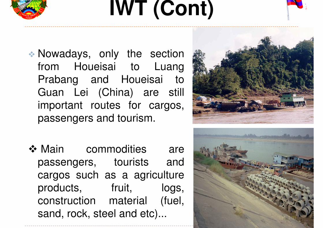
� Nowadays, only the section
from Houeisai to Luang
Prabang and Houeisai to
Guan Lei (China) are still
important routes for cargos,
passengers and tourism.
� Main commodities are
passengers, tourists and
cargos such as a agriculture
products, fruit, logs,
construction material (fuel,
sand, rock, steel and etc)...
15/10/2014

15/10/2014
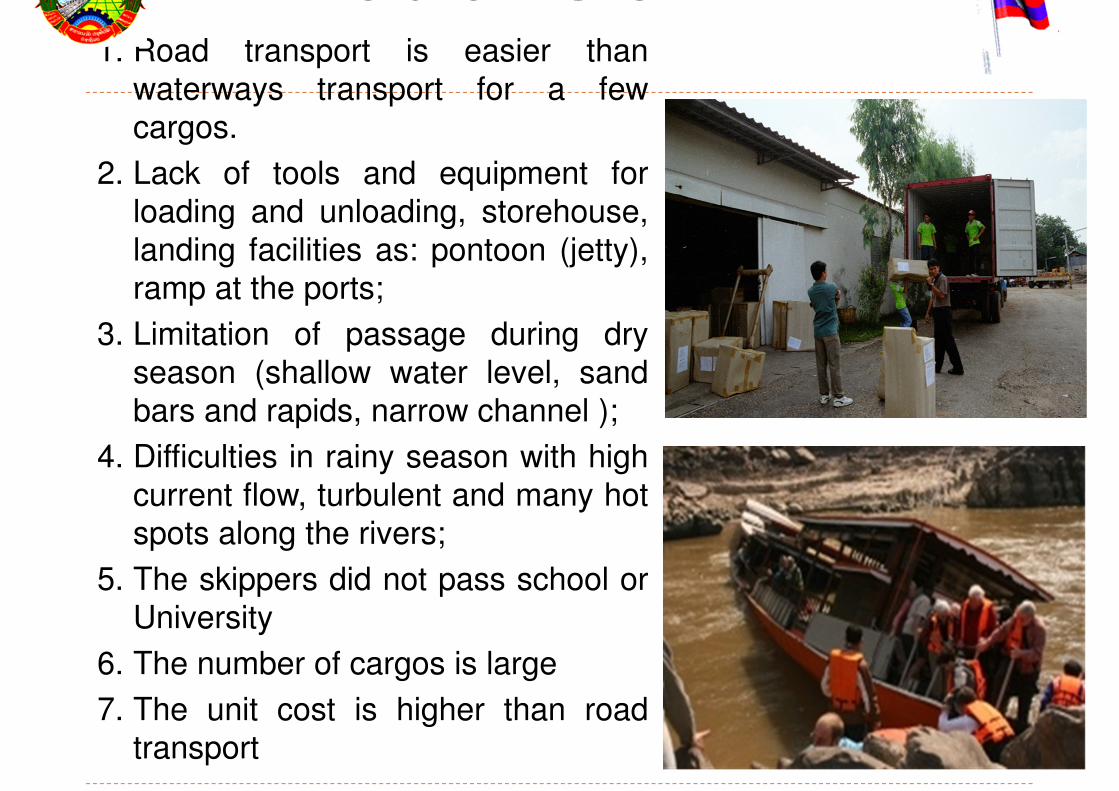
Problems on IWT1. Road transport is easier than
waterways transport for a few
cargos.
2. Lack of tools and equipment for
loading and unloading, storehouse,
landing facilities as: pontoon (jetty),
ramp at the ports;
3. Limitation of passage during dry
season (shallow water level, sand
bars and rapids, narrow channel );
4. Difficulties in rainy season with high
current flow, turbulent and many hot
spots along the rivers;
5. The skippers did not pass school or
University
6. The number of cargos is large
7. The unit cost is higher than road
transport
15/10/2014

� There are 29 existing ports located
along the Mekong river.
� Some port are located along
tributaries such as Nam Tha, Nam
Ou, Nam Soueng, Nam Khan, Nam
Ngum, Nam San, Nam Kading, Xe
Bang Fai, Xe Bang Hieng, Xe Don
and Xe Kong.
� Many river ports are still in their
natural condition without concrete
ramp often difficult to berth
throughout loading and unloading.
2. River Ports in Laos

River port with Ramp
15/10/2014

River ports without ramp
15/10/2014

3. Navigation Channel Improvement
� The Navigation Channel in theMekong River and its tributariesare still in their natural state as:narrow navigation channels, withsandbars, reefs, rapids and rockoutcrops which are makingnavigation unsafe and dangerousfor navigation.
� In 2001-2004 the navigationchannel has been improved fromKouan Lei Port (China) to BorkeoProvince over a distance of about333 kilometers by rock blastingand removal of 11 scattered reefsmost seriously hinderingnavigation. Some 57 navigationmarks have been installed, 19name plates of localities and 6sets of winching facilities.

Aid to Navigation
� After the Waterways Department
has been established in 2008, and
improved the waterways
transportation corporate with MRC
under the NAP.
� Early 2009, the aids to navigationsystem has been installed betweenLouang Prabang and Vientiane.
� Condition survey for hot spot and
dangerous area between Houay
Sai to Pakse.
� Installation of aids to navigation in
dangerous area along the Mekong
river between Houay Sai and
Vientiane.15/10/2014


Landing facilities
� Installation 24 sets of landing
facilities along the Nam Tha,
Nam Ou and Mekong river.
� Installation 2 water gauges of
low water to navigation.
� Pilot project on GPS vessel
guidance system in Mekong
river from Houay sai to Louang
Prabang
15/10/2014
1. Setting up the waterways transport strategy plan.
2. Improve the navigation channel and installation of
aid to navigation along the Mekong River from the
north to the south.
3. Set up the navigation safety system (AIS) to
connect from port to ship.
4. Set up the training course to the skipper in the
training center
5. Upgrading the navigation training and research
center into waterways institute or school.
15/10/2014
4. Future Plans
6. Construction new river ports with warehouse andequipment as: Xieng Kok (Luang Namtha), PakBeng (Oudom Xay) and Khok Chong (LuangPrabang).
7. Improvement some ports along the Mekong Riverwith concrete ramp, install pontoon that can beeasy to berth and get off/out from the boat;
8. Providing facilities equipment for loading andunloading throughout landing facilities at theport.
9. Capacity building to the staffs of waterwaysdepartment for survey and navigation lockdesign.

Conclusion
� Lack of recourse person andengineering of waterways
� Lack of fund to improve the river works
� Need the assistance and support fromneighboring countries and from otherinternational donors.
15/10/2014
