planning canadian regions · 1.7 diagram showing patrick geddes’s model of the valley section |...
TRANSCRIPT

Gerald Hodge | Heather M. Hall | Ira M. Robinson
Planning Canadian RegionsS E C O N D E D I T I O N
Sample Material © UBC Press 2017

© UBC Press 2017
All rights reserved. No part of this publication may be reproduced, stored in a retrieval system, or transmitted, in any form or by any means, without prior written permission of the publisher.
Library and Archives Canada Cataloguing in Publication
Hodge, Gerald, authorPlanning Canadian regions / Gerald Hodge, Heather M. Hall, Ira M. Robinson.
– Second edition.
Includes bibliographical references and index. Issued in print and electronic formats. ISBN 978-0-7748-3414-8 (paperback). – ISBN 978-0-7748-3415-5 (pdf)
1. Regional planning – Canada. I. Hall, Heather M., 1982-, authorII. Robinson, Ira M. (Ira Miles), 1924-, author III. Title.
HT395.C3H62 2016 307.1’20971 C2016-906150-7 C2016-906151-5
UBC Press gratefully acknowledges the financial support for our publishing program of the Government of Canada (through the Canada Book Fund), the Canada Council for the Arts, and the British Columbia Arts Council.
Printed and bound in Canada by FriesensSet in Calibri and Revival by Artegraphica Design Co. Ltd.Copy editor: Frank ChowProofreader: Katrina PetrikIndexer: Lillian Ashworth
Cover photographs: Gerald Hodge (top); Heather M. Hall (bottom); istockphoto.com (right and left)
UBC PressThe University of British Columbia2029 West MallVancouver, BC V6T 1Z2www.ubcpress.ca
Sample Material © UBC Press 2017

D E D I C AT E D TO
Dr. Ira M. Robinson
1924–2015
For his contributions to the end
Sample Material © UBC Press 2017

Contents
List of Figures, Tables, and Text Boxes | ix
Preface to the Second Edition | xiii
Acknowledgments | xiv
Abbreviations | xvi
Introduction | 1
Part 1 Roots and Rationale of Regional Planning
1 Roots of Regional Planning: Precursors and Perspectives | 92 Canadian Regional Planning in Transition, 1950–2015 | 413 Key Features of Regional Planning Practice | 64
Part 2 Planning Resource Regions, Rural Regions, and Regional Environments
4 Planning Peripheral Resource Regions | 995 Planning Rural Regions and Their Communities | 1476 Regional Planning for Conservation and the
Environment | 185
Part 3 Planning Metropolitan Regions
7 Planning Metropolitan Regions | 2378 Planning the Multi-Metropolitan Region | 276
Part 4 The Future Shape of Canadian Regional Planning
9 The Continuing Need for Regional Planning | 321
About the Authors | 354
Index | 356Sample Material © UBC Press 2017

ix
List of Figures, Tables, and Text Boxes
Figures
1.1 Distribution of population in northern North America, 1500 | 11
1.2 Farm lots conceded near Quebec, 1709 | 16
1.3 Original plan for Toronto, 1788 | 18
1.4 Differences between treaty boundaries and traditional territories of the Fort William First Nation | 21
1.5 Division of township lands showing allotments to railway company, Hudson’s Bay Company, and schools | 23
1.6 Ebenezer Howard’s diagram of the Social City | 29
1.7 Diagram showing Patrick Geddes’s model of the valley section | 31
3.1 Parameters that shape regional planning practice | 72
3.2 Contrasting views of regional planning doctrines: Geddes versus Isard | 75
4.1 The Canadian North | 101
4.2 Regional boundaries in Northern Ontario | 103
4.3 Population change across British Columbia | 109
4.4 Employment trends in the resource industries in Canada, 1976–2012 | 111
4.5 Area covered by the Plan Nord | 124
5.1 The spatial extent of the rural-urban fringe around a medium-sized metropolitan area | 151
5.2 Relationships between agriculture and planning | 164
5.3 The scope of food system planning | 166
5.4 Rural versus urban preferences for regional growth strategies | 170
5.5 Perspectives of the Penticton Indian Band in its comprehensive community plan | 174
Sample Material © UBC Press 2017

x | Figures, Tables, and Text Boxes
6.1 Protected areas in Canada, 2013 | 191
6.2 The Peel Watershed, Yukon | 203
6.3 Regional Strategic Environmental Assessment (R-SEA) framework | 209
6.4 Greater Toronto Bioregion | 211
7.1 Four forms of metropolitan development | 256
7.2 National Capital Region and Ottawa Greenbelt | 260
7.3 Key relationships in metropolitan region planning | 266
8.1 Toronto-Centred Region concept, 1970 | 279
8.2 Greater Toronto Area (GTA) and constituent municipal units, 1996 | 280
8.3 The Ontario Greenbelt Area Plan, 2005 | 282
8.4 The Growth Plan for the Greater Golden Horseshoe, Ontario, 2006 | 286
Tables
2.1 Population of Aboriginal peoples, Canada, provinces, and territories, 2001–31 | 58
3.1 Key features of selected Canadian regional planning initiatives | 69
3.2 Modes of defining regions, with Canadian examples | 79
5.1 Rural population, farm population, and number of farms in Canada, 2001–11 | 156
5.2 Population and growth rate in metropolitan and non-metropolitan Canada, 2006 and 2011 | 158
5.3 Population age composition (2006) and change (1996–2006) in predominantly urban and rural regions in Canada | 159
6.1 Comparative perspectives on water | 198
6.2 Canada’s Regional Adaptation Collaboratives Climate Change Program, 2011 | 220
6.3 Five steps to climate change adaptation in Nunavut | 223
7.1 Growth of census metropolitan areas in Canada, 1951–2011 | 239
7.2 Population of census metropolitan areas, 1991–2011 | 241
7.3 Census metropolitan areas by median age, 2013 | 245Sample Material © UBC Press 2017

Figures, Tables, and Text Boxes | xi
7.4 Changes in the spatial distribution of census metropolitan area populations, 2006–11 | 250
7.5 Population distribution (%) within spatial components of census metropolitan areas, 1996, 2006, and 2011 | 251
7.6 Types of planning structures used in metropolitan planning regions in Canada, 2014 | 264
8.1 Distribution of population and employment for the Greater Golden Horseshoe, 2001–31 | 288
8.2 Extent to which municipal official plans conformed to the Growth Plan for the Greater Golden Horseshoe, 2012 | 294
8.3 Examples of transit investments and commitments for the Greater Toronto and Hamilton Area, 2006–11 | 298
8.4 Examples of investments in social infrastructure in the Growth Plan for the Greater Golden Horseshoe, 2006–11 | 302
9.1 Selected monitoring indicators for the Regional District of North Okanagan Regional Growth Strategy | 343
9.2 Practice principles for collaborative/decolonized planning in Aboriginal communities | 345
Text Boxes
Major events in the development of regional planning in Canada, 1885–2015 | 44
Regional districts, British Columbia | 90
Municipalités régionales de comté (MRCs) (regional county municipalities), Québec | 91
The Fair Share Agreement: Peace River Regional District, BC | 112
Major events in the history of regional planning in the Canadian territories | 128
Major events in the evolution of Canadian regional planning for conservation and the environment, 1885–2015 | 188
“Acreage Angst: Do the City and Surrounding RM Need a Regional Plan?” | 268
Six steps to successful adaptation planning | 346
Sample Material © UBC Press 2017

xiii
Preface to the Second Edition
In just over a decade and a half, the twenty-first century is revealing a regional landscape with significant and substantial differences from its immediate past. This new edition of Planning Canadian Regions ad-dresses the emerging perspective of increasing spatial complexity be-tween cities and their regions and between different regions, and the impact of this spatial complexity on regional planning practice. The per-ennial development inequities faced by peripheral resource regions are given special attention, as are the growing demands of planning for cli-mate change and the need for planners to respond to uneven growth in regions large and small. Throughout, the need to accommodate the rights and cultures of Aboriginal peoples in the planning of regions across the country is emphasized.
For these tasks, this edition draws upon the extensive Canadian lit-erature on regional planning as well as relevant international litera-ture. Contemporary examples of regional planning practice from across Canada are highlighted, from Québec Nord to the Regional District of North Okanagan in British Columbia, the Greater Golden Horseshoe in south-central Ontario, and the North Baffin Region in Nunavut. Modes of practice are described and analyzed, with the help of relevant data and illustrations. The main text has been supplemented by three learn-ing resources: (1) Guiding Questions at the beginning of each chapter encourage readers to explore the content in greater depth; (2) Inter net Resources are included in each chapter; and (3) Planning Practice Point-ers suggest useful approaches that a planner might apply in practice.
In this second edition, Planning Canadian Regions again challenges regional planners, planning educators, and policymakers to engage with the latest thinking on the interlocking issues confronting the planning of Canada’s regions in the twenty-first century, and to strive for best practices.
Sample Material © UBC Press 2017

xiv
Acknowledgments
We would like to thank, first of all, Ira Robinson for his practised eye in earlier versions of this edition of Planning Canadian Regions, and for his legacy of ideas from the first edition. We also thank Ira’s wife, Ruth MacDonald, for all her help.
As with the first edition, UBC Press provided much-needed advice and assistance, and exhibited great patience. Special thanks go to our editor once again, Randy Schmidt, and to Melissa Pitts, Valerie Nair, Laraine Coates, Kerry Kilmartin, and Eric Leinberger for their timely responses to our frequent requests. The expert attention that Holly Keller, Frank Chow, and Katrina Petrik gave to the final manuscript is very much appreciated.
Only as the book neared completion did it become apparent how many people had participated in this endeavour, both directly and in-directly. For their various contributions, we thank Ian Wight (University of Manitoba); Robert Patrick, Ryan Walker, and Bram Noble (University of Saskatchewan); Leonie Sandercock (University of British Columbia); Anthony Kittel and Laura Frank (Regional District of North Okanagan); Roberto Morales (Hul’qumi’num First Nation); Sean Markey and Sarah Breen (Simon Fraser University); Kelly Vodden, Rob Greenwood, Sarah Minnes, and Keith Storey (Memorial University of Newfound land); Ryan Gibson (St. Mary’s University); Ray Bollman (Statistics Canada); Bill Crumplin (Laurentian University); and the team at the International Centre for Northern Governance and Development at the University of Saskatchewan. We also appreciate the kindness of academic colleagues Wayne Caldwell and Cole Harris, who allowed us to use images and charts from their publications. The generosity of the Canadian Institute of Planners in providing access to materials from Plan Canada also added immensely to this edition. Of course, responsibility for the book’s contents – errors, omissions, and commissions – rests entirely with us.
Sample Material © UBC Press 2017

Acknowledgments | xv
Lastly, as every author knows, there are neither sufficient words nor ways to acknowledge the support and patience of one’s partner over the course of a project that can quickly seem endless. To ours, Sharron Milstein and Rob Simard, very special thanks.
GERALD HODGE HEATHER M. HALLHornby Island, British Columbia Waterloo, Ontario
Sample Material © UBC Press 2017

xvi
Abbreviations
ACOA Atlantic Canada Opportunities Agency
ADB Atlantic Development Board
ALR Agricultural Land Reserve
ARDA Agricultural Rehabilitation and Development Act
CA census agglomeration
CIP Canadian Institute of Planners
CMA census metropolitan area
DIAND Department of Indian Affairs and Northern Development
DREE Department of Regional Economic Expansion
DRIE Department of Regional Industrial Expansion
EA environmental assessment
FedNor Federal Economic Development Initiative for Northern Ontario
FIFO fly-in/fly-out
GGH Greater Golden Horseshoe
GTA Greater Toronto Area
GTHA Greater Toronto and Hamilton Area
GVWD Greater Vancouver Water District
ICSP Integrated Community Sustainability Plan
MMAH Ministry of Municipal Affairs and Housing
MRC municipalité régionale de comté
MVA Meewasin Valley Authority
NCC National Capital Commission
OCP official community plan
OMB Ontario Municipal Board
PAS Protected Areas Strategy
Sample Material © UBC Press 2017

Abbreviations | xvii
PPS Provincial Policy Statement of 2005
RD regional district (British Columbia)
RDNO Regional District of North Okanagan
REDA regional economic development area
REDBs Regional Economic Development Boards
RGS regional growth strategy
RM regional municipalities
RPAA Regional Planning Association of America
R-SEA Regional Strategic Environmental Assessment
SWP source water protection
TISAP Transit Investment Strategy Advisory Panel
TVA Tennessee Valley Authority
UFA Umbrella Final Agreement
WED Western Economic Diversification
Sample Material © UBC Press 2017

1
Introduction
The task is to find the right places for each sort of people; places where they will really flourish.
– Patrick Geddes, 1915
The “places” Patrick Geddes refers to are the spatial settings, the re-gions that provide a context for the communities in which people live. Our daily economic and social activities and those of businesses and institutions are played out over extensive areas, over regions that sel-dom correspond to local political and administrative boundaries. Indeed, “there is an irrepressible regional imperative” in our lives (Wannop 1995, 48). These areas are not limitless; they have practical, cultural, and nat-ural boundaries that people identify with and to which they ascribe meaning. This way of thinking about regions is not new: for many mil-lennia, Aboriginal peoples have taken this approach to the territories they live in. The “task” Geddes refers to is regional planning, a public practice widespread in Canada for over three-quarters of a century.
The first edition of Planning Canadian Regions (2001) described the intellectual history of regional planning as well as the growth and de-velopment of the field in Canada, particularly in the second half of the twentieth century. In those often tumultuous political and economic decades, regional planning practice evolved, adapted, and became more widespread, diverse, and complex. As the century waned, it was already evident that the regional landscape and concerns over its planning had begun to shift significantly. Just over a decade and a half into the twenty-first century, there is a growing need to revise regional planning’s
Sample Material © UBC Press 2017

2 | Introduction
practice and perspective. This new edition of Planning Canadian Regions examines the shift and, in particular, explores four prominent aspects:
▪ the planning of urban regions comprising several metropolitan areas, as with the “megaregion” of south-central Ontario, the Greater Golden Horseshoe, already with a plan and lessons to be learned
▪ the planning needs of “peripheral regions” north of the major metro-politan regions, notably the Territorial North and Provincial North, including their corollary settlement, transportation, energy, and insti-tutional needs
▪ the “reclaiming” of planning practices for their regions by Aboriginal peoples, which is relevant for the planning of all regions of Canada
▪ the developing dimensions of climate change and environmental sus-tainability and their impacts on the planning of regions.
These issues alone confirm the need for regional planning to continue to be an imperative in public policy. For these tasks, this book draws upon the extensive Canadian and international literature on regional planning and associated topics that has grown since 2000.
Many of the situations facing regional planners today may seem much the same as those in the 1960s: expanding metropolitan regions, in constant growth in rural and peripheral resource regions, and environ-mental protection. The contexts of these regional settings have changed dramatically, however – socially, economically, politically, and environ-mentally. Demographic factors such as international migration have fuelled population growth in some metropolitan regions, while decline and slow growth have characterized others. Economic thinking has shifted towards a more neoliberal approach, which has both strength-ened and weakened senior government commitments to the develop-ment and planning of regions. And consider the changes in the scale of regional planning: 2,000 square kilometres was deemed necessary for planning the metropolitan Toronto region in 1953, whereas the 2005 Growth Plan for the Greater Golden Horseshoe encompasses an area twenty times that size. Or consider the greatly expanded assortment of matters the regional planner encounters, from planning health services in rural and remote resource regions, to the intricacies of climate change adaptations in the Arctic, to the duty to consult Aboriginal peoples about their land rights everywhere in Canada. This new edition of
Sample Material © UBC Press 2017

Introduction | 3
Planning Canadian Regions discusses these new challenges and those that continue from the past.
Perspective of the Book
This book reviews the roots of regional planning in Canada and else-where, describes emerging trends in the field, and discusses their im-plications for regional planning practice over the coming decades. It is divided into four sections.
PART 1: ROOTS AND RATIONALE OF REGIONAL PLANNING
A number of elements are fundamental to understanding the field of regional planning in general and its practice in Canada, including its his-tory, central concepts, and institutional arrangements. The formal pub-lic practice of planning regions is a fairly recent activity with intellectual roots dating back to the middle of the eighteenth century. However, the roots of regional planning in Canada extend back thousands of years with Aboriginal peoples. The backdrop of both public practice and Ab-original use are presented in Part 1, along with contemporary planning approaches and theories. Chapter 1 describes the nature, use, and ex-tent of Aboriginal regions in the northern half of North America prior to the time of contact with European traders and settlers around 1500 and the transformation of these regions over the ensuing four centuries. Rounding out the chapter is a discussion of the conceptual foundations of regional planning and it use in Canada prior to 1950. Chapter 2 cov-ers the development of regional planning in Canada since 1950, a period of major transitions in the field. Special attention is given to the challen-ges confronting contemporary regional planners, including adaptation to climate change and accommodation of Aboriginal land rights. Chapter 3 discusses the basic factors that are central to regional planning practice, including delineating planning boundaries, the legislative milieu that allows for and supports regional planning in Canada, and the role of planning doctrine in shaping practice.
PART 2: PLANNING RESOURCE REGIONS, RURAL REGIONS, AND REGIONAL ENVIRONMENTS
Regional planning in rural and in non-metropolitan regions has the long-est history of practice in Canada and provides a good introduction to the
Sample Material © UBC Press 2017

4 | Introduction
concerns and complexities encountered by planners. Chapter 4 exam-ines the persistent planning needs of peripheral resource regions across the Provincial North and in the Territories from the mid-twentieth century to the present. New place-based planning approaches are dis-cussed, along with planning practices in Aboriginal resource regions. Chapter 5 reviews the regional planning activities undertaken in Can-ada’s rural regions from the peripheries of metropolitan centres to the Prairies, and agricultural and coastal regions. Chapter 6 presents the evolving efforts in planning for the environment, from the conservation initiatives of the 1940s to present-day efforts to attain sustainable de-velopment and adapt to climate change.
PART 3: PLANNING METROPOLITAN REGIONS
Canada has been a leader in the planning of metropolitan regions for over seventy years. The experience gained from the planning of Win ni-peg in the 1940s to the planning of the Greater Golden Horseshoe of Southern Ontario today is presented in this part. However, the image of greater and greater size and unending population growth in metro-politan regions needs to be revised, as does their planning. Two chapters describe the range of situations, from expanding spatial boundaries to slow growth and decline, as well as the emerging planning needs that accompany them. Chapter 7 sets out the planning parameters for metro-politan regions, including setting of boundaries, possible metropolitan forms, and organizational arrangements. Chapter 8 covers the planning of the Greater Toronto megaregion, a regional planning situation with few precedents, and the innovative arrangements devised for this region of multiple metropolitan areas.
PART 4: THE FUTURE SHAPE OF CANADIAN REGIONAL PLANNING
Finally, Chapter 9 takes stock of what the past has shown us about regional planning, including the lessons that can be learned from that experience and the basic building blocks that must be retained. It also addresses the need to adapt practice to four emerging trends and ten-dencies that will shape future planning: (1) uneven growth among metro politan regions; (2) globalization of the economy; (3) accommo-dation of Aboriginal planning practice; and (4) planning for environ-mental sustainability and the impacts of climate change. In order to
Sample Material © UBC Press 2017

Introduction | 5
develop approaches to these new situations, examples of Canadian practice are also presented as potential benchmarks. They include mon-itoring and evaluation of regional plans, making of plans in collabora-tion with Ab original peoples, and setting of parameters for climate change adaptation. A final section offers four possible initiatives towards achieving a Canada-wide regional perspective on regional planning and development.
Learning Resources
The chapters in the main text of this book are supplemented by three types of learning resources: Guiding Questions, Internet Resources, and Planning Practice Pointers.
GUIDING QUESTIONS
A set of questions at the beginning of each chapter indicate the general direction in which the chapter will unfold. They also encourage greater depth and breadth of thinking on the subject matter.
INTERNET RESOURCES
The Internet is rich in resources that can be used to further the task of regional planning. Included in each chapter is a selection of websites related to the subject matter of that chapter. Web addresses are current as of the year of publication.
PLANNING PRACTICE POINTERS
In each chapter through Parts 2 and 3, the reader will find suggestions for useful approaches that a planner might apply in practice. These are drawn from the experiences of the authors and various colleagues, and are set off from the main text.
References
Geddes, Patrick. 1915. Cities in Evolution: An Introduction to the Town Planning Movement and to the Study of Civics. London: Ernest Benn.
Wannop, Urlan. 1995. The Regional Imperative: Regional Planning and Governance in Britain, Europe, and the United States. London: Jessica Kingsley.
Sample Material © UBC Press 2017

6 | Introduction
Internet Resources
Several websites are important in themselves for regional planning, and also act as gateways to an array of links to other relevant sites.
American Planning Associationhttp://www.planning.org
Canada Mortgage and Housing Corporationhttps://www.cmhc-schl.gc.ca/
Canadian Institute of Plannershttp://www.cip-icu.ca/
Indigenous and Northern Affairs Canadahttps://www.aadnc-aandc.gc.ca/eng/1100100013785/1304467449155
Muniscope: Intergovernmental Committee on Urban and Regional Researchhttps://www.muniscope.ca/
Planetizenwww.planetizen.com
United Nations Habitathttp://www.unhabitat.org
Sample Material © UBC Press 2017

PART 1
Roots and Rationale of Regional Planning
Sample Material © UBC Press 2017

9
1 Roots of Regional Planning: Precursors and Perspectives
The country was made without lines of demarcation, and it is no man’s business to divide it.
– Chief Joseph, ca. 1877
The Roots of Regional Planning
Regional planning in Canada is stamped by two historic influences. The older derives from the culture and practices of Canada’s First Peoples regarding land that extend back well over twelve thousand years. The other derives from the customs and cultures regarding the use and dis-position of land that were introduced by French and English settlers starting nearly five hundred years ago. Both developments affect present- day regional planning in fundamental ways and will continue to do so. Also important are the ideas and perspectives that arose in Europe two hundred years ago regarding the effects of industrialization on cities and regions. From these roots, which, not unexpectedly, are intertwined, emerged the modern concepts of regional planning as a public practice. This chapter traces those roots by identifying the forebears of regional planning and their perspectives on the role, use, and planning of land to the mid-twentieth century. It begins by examining the approaches of the Aboriginal/Indigenous1 peoples in their use of the land in the northern half of North America up to 1500, prior to contact with Europeans.2 Much of this knowledge derives from the stories told by, for example, the Mi’kmaq elders of Nova Scotia and the Tsilhqot’in elders of north-ern British Columbia, whose oral histories have been accepted by the Supreme Court of Canada (Asch 2014). The approach of the European
Sample Material © UBC Press 2017

10 | Roots and Rationale of Regional Planning
explorers and colonizers is then described, specifically their use and disposition of the lands they “discovered.” This intersection of the Ab-original residents and the European newcomers commenced a narrative for Canada of two profoundly different “maps of the world,” or world-views, regarding land. Each saw “regions,” and by extension their use and planning, differently.
This chapter discusses a number of intersections of the two world-views and their outcomes after 1500, including the different land survey models employed first by the French and then by the English that af-fected the traditional territories of the Aboriginal peoples. The creation of Rupert’s Land, the making of formal treaties, the introduction of the Dominion Lands Survey by the new Dominion of Canada, and their effects on Aboriginal lands and relationships are discussed. These en-counters continue to contribute to present-day concerns of Aboriginal peoples regarding their lands (Saul 2014, 137ff). As a result, regional planners in Canada cannot avoid confronting this history and incorporat-ing these concerns into their practice.
Successive sections in this chapter describe the regional planning pre-cepts that emerged in the nineteenth century in Europe from concerns over industrialization and its effects on cities and society. The main pre-cursors of these latter perspectives, including Ebenezer Howard and Patrick Geddes, are identified and their ideas are discussed. Concluding the chapter is a discussion of the evolution of regional planning ideas and practice in North America up to the mid-twentieth century, in cluding the work of Thomas Adams and Lewis Mumford. Two basic questions should be kept in mind while tracing these roots of regional planning:
▪ Why is the Aboriginal view of land likely to be encountered in contem-porary regional planning?
▪ In what ways are the ideas of Patrick Geddes important to present-day regional planners?
Aboriginal Regions to 1500: Their Use and Planning
The Americas, which European explorers encountered some five hun-dred years ago, were peopled almost completely by the forebears of today’s Aboriginal population. Their presence resulted from extensive
Sample Material © UBC Press 2017

Roots of Regional Planning: Precursors and Perspectives | 11
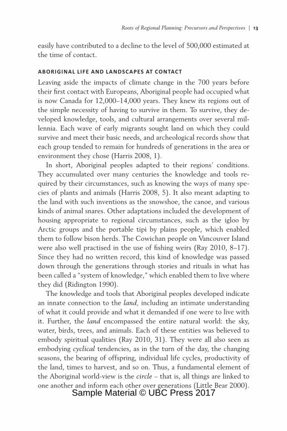
migration from Asia of big-game (mammoth, musk ox, bison) hunters beginning over twelve to fourteen thousand years ago, across the Bering Sea “land bridge” as North American glaciers melted (Fagundes et al. 2008). These migrants spread across the continent, southward, and into the Arctic over hundreds of years and involved a mix of peoples and languages. They settled across the Americas in regions that met their needs and capabilities. Over time, they learned the attributes and limits of their regions for food, shelter, and protection. It is estimated that at the time of European contact, in the late 1400s, the Aboriginal popu-lation in northern North America numbered 500,000 (Dickason 1992). The distribution of that population is shown in Figure 1.1.
FIGURE 1.1 Distribution of population in northern North America, 1500
Source: Harris (2008, 2, Map 1.1).
Sample Material © UBC Press 2017

12 | Roots and Rationale of Regional Planning
CONDITIONS AFFECTING ABORIGINAL POPULATIONS PRIOR TO CONTACT
The precise numbers of Aboriginal peoples at contact will probably never be known. However, it is known that in the six hundred years prior to contact, from 900 to the late 1300s, two environmental phe-nomena occurred that are thought to have affected numbers signifi-cantly, both upward and downward. The first was a four-hundred-year period, from 900 to 1200, of very favourable climatic conditions that changed natural and human landscapes across North America (Bryson and Wendland 1967). The regional biomass was strengthened, enabling the addition of agriculture to the traditional hunting, fishing, and gather-ing activities of many Aboriginal peoples living on the eastern Great Lakes and St. Lawrence Lowlands. Foods that were grown included squash, kidney beans, and sunflowers; tobacco was also grown (Harris 2008, 12).
This extended period of positive climatic conditions likely favoured the growth of Aboriginal populations in many areas. It fostered a refash-ioning of the social organization among the peoples of the northern plains, for example, from “nomadic, band-level societies [into] large, sophisticated ‘tribally’ organized communities” (Daschuk 2013, 4), while to the south a major population centre, Cahokia, developed at the confluence of the Missouri, Mississippi, and Ohio Rivers. Cahokia reached an estimated population of twenty thousand or more and was larger than any North American city would become for another five hundred years (Young and Fowler 2000).
A second environmental shift, this time to a much colder climate, began abruptly between 1275 and 1300. It came to be called the Little Ice Age and persisted for another hundred years across the entire North-ern Hemisphere (Miller et al. 2012). Flora and fauna were adversely affected, as were the Aboriginal populations that depended on them for food, clothing, and shelter. As hunting and gathering activities were disrupted, malnutrition became common and social organizations were shaken. Rivalries arose among Indigenous groups over food and land re-sources, often with violent consequences. In addition to these misfor-tunes, Aboriginal North America was not disease-free. Tuberculosis was present, along with other microbial diseases such as hepatitis and polio (Daschuk 2013, 2). The adverse effects of each of these factors on Aboriginal population numbers are not known, but together they could
Sample Material © UBC Press 2017
Roots of Regional Planning: Precursors and Perspectives | 13
easily have contributed to a decline to the level of 500,000 estimated at the time of contact.
ABORIGINAL L IFE AND LANDSCAPES AT CONTACT
Leaving aside the impacts of climate change in the 700 years before their first contact with Europeans, Aboriginal people had occupied what is now Canada for 12,000–14,000 years. They knew its regions out of the simple necessity of having to survive in them. To survive, they de-veloped knowledge, tools, and cultural arrangements over several mil-lennia. Each wave of early migrants sought land on which they could survive and meet their basic needs, and archeological records show that each group tended to remain for hundreds of generations in the area or environment they chose (Harris 2008, 1).
In short, Aboriginal peoples adapted to their regions’ conditions. They accumulated over many centuries the knowledge and tools re-quired by their circumstances, such as knowing the ways of many spe-cies of plants and animals (Harris 2008, 5). It also meant adapting to the land with such inventions as the snowshoe, the canoe, and various kinds of animal snares. Other adaptations included the development of housing appropriate to regional circumstances, such as the igloo by Arctic groups and the portable tipi by plains people, which enabled them to follow bison herds. The Cowichan people on Vancouver Island were also well practised in the use of fishing weirs (Ray 2010, 8–17). Since they had no written record, this kind of knowledge was passed down through the generations through stories and rituals in what has been called a “system of knowledge,” which enabled them to live where they did (Ridington 1990).
The knowledge and tools that Aboriginal peoples developed indicate an innate connection to the land, including an intimate understanding of what it could provide and what it demanded if one were to live with it. Further, the land encompassed the entire natural world: the sky, water, birds, trees, and animals. Each of these entities was believed to embody spiritual qualities (Ray 2010, 31). They were all also seen as embodying cyclical tendencies, as in the turn of the day, the changing seasons, the bearing of offspring, individual life cycles, productivity of the land, times to harvest, and so on. Thus, a fundamental element of the Aboriginal world-view is the circle – that is, all things are linked to one another and inform each other over generations (Little Bear 2000).
Sample Material © UBC Press 2017

14 | Roots and Rationale of Regional Planning
This view is symbolized in the medicine wheel and the talking circle for making decisions, including those about the land, how it was being used, and how it should be used in the future – in other words, how it should be planned.
The Aboriginal approach to planning did not involve individual prop-erty ownership, land titles, surveying, or land use regulations (Matunga 2013, 7). Aboriginal peoples did not use formal maps of the land, for “as they needed to know it, [the land] was embedded in their stories, place names, and experience” (Harris 2008, 9). Particular landforms – a mountain crag, river delta, canyon – came to have spiritual significance where ceremonies were held, stories told, and so on, and became part of the people’s history (Battiste and Henderson 2008). This history of con-nections to their habitual territory was embedded in the culture and “known” to all generations. Thus, Aboriginal “planning” was not the out-come of a central authority since the land was “owned” by the commun-ity that held the rights to the area and its resources. Decisions were reached by consensus in which all generations were involved, in keeping with the belief that decisions about the future of the land must be made by past, present, and future generations. This approach has been called the Seven Gen erations Model, in which decisions combine the know-ledge of three past generations, the present generation, and three future generations (Jojola 2013).
At the larger scale, where the territories of different cultural/linguistic groups bordered one another, there was no hard boundary. Each group knew the extent of its region, in terms such as where changes occurred in species being gathered and/or hunted. These borders were permeable as well, to allow for kinship connections and sharing of resources in times of climate change or natural catastrophe (Harris 2008, 7). The Fort William First Nation describes it in this way: “Our ancestors lived off the land, in seasonal migrations between their wintering hunting grounds and fall/summer fishing grounds. We gathered in large numbers at our summer grounds called ‘Nee-bing’ for the purposes of trade, mar-riage, cementing alliances, ceremonies and feasting” (Fort William First Nation 2014).
The situation Europeans faced at contact was a vast territory that was entirely peopled by a multitude of Aboriginal groups. The following sec-tions describe the spatial outcomes of contact on that same territory over subsequent centuries.
Sample Material © UBC Press 2017
Roots of Regional Planning: Precursors and Perspectives | 15
Transforming the Regions in Aboriginal Canada, 1500–1900
Along with their physical presence, the European explorers and col-onists brought to the Aboriginal territories new thinking about land, its ownership, and its disposition. These new perspectives grew out of long-lived customs regarding the spatial organization of land in their home countries. They involved precise boundaries to define individual parcels of land and covenants prescribing their use and ownership. Overall, it was a linear perspective, one of successively adding new physical fea-tures and ownership arrangements to the land. By contrast, Aboriginal peoples tended to view all changes to land as highly linked, or cyclical. Over the approximately five hundred years since contact, the intersec-tion of these perspectives has taken different forms that have unalterably changed the landscape of Canada. They resulted in the seigneuries of the French, the English townships, Rupert’s Land ceded to the Hudson’s Bay Com pany, and the new Dominion of Canada’s own Dominion Land Survey (DLS). This section discusses how these – each in its own way a form of regional planning – progressively brought about the “lines of demarcation” that Chief Joseph warned of in the epigraph that opens this chapter (McLuhan 1972, 123ff).
THE FRENCH APPROACH TO LAND IN CANADA
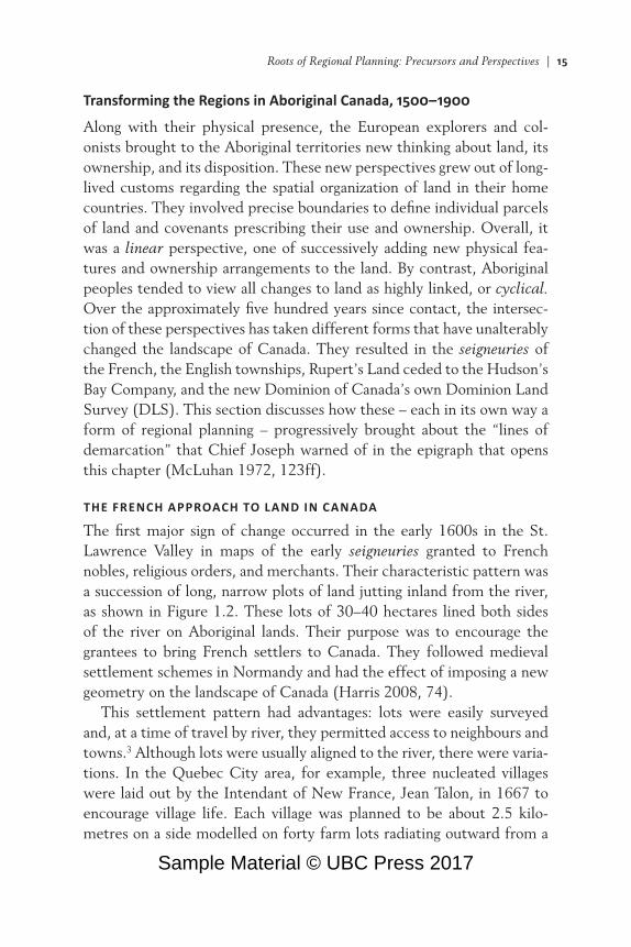
The first major sign of change occurred in the early 1600s in the St. Lawrence Valley in maps of the early seigneuries granted to French nobles, religious orders, and merchants. Their characteristic pattern was a succession of long, narrow plots of land jutting inland from the river, as shown in Figure 1.2. These lots of 30–40 hectares lined both sides of the river on Aboriginal lands. Their purpose was to encourage the grantees to bring French settlers to Canada. They followed medieval settlement schemes in Normandy and had the effect of imposing a new geometry on the landscape of Canada (Harris 2008, 74).
This settlement pattern had advantages: lots were easily surveyed and, at a time of travel by river, they permitted access to neighbours and towns.3 Although lots were usually aligned to the river, there were varia-tions. In the Quebec City area, for example, three nucleated villages were laid out by the Intendant of New France, Jean Talon, in 1667 to encourage village life. Each village was planned to be about 2.5 kilo-metres on a side modelled on forty farm lots radiating outward from a
Sample Material © UBC Press 2017

16 | Roots and Rationale of Regional Planning
central square. None of these village plans, the earliest formal plans in Canada, was fully completed, but the radial patterns of Charlesbourg and Bourg Royal can still be seen in aerial photographs of the suburbs of present-day Quebec City (Hodge and Gordon 2013, 41). The towns of Montreal and Quebec dating from this same period were laid out as a general rectangular grid with surrounding fortifications.
FIGURE 1.2 Farm lots conceded near Quebec, 1709
Source: Harris (2008, 75, Map 3.6); modified from Harris and Matthews (1987, plate 52), cartographer le Sieur de Catalogne.
Sample Material © UBC Press 2017

Roots of Regional Planning: Precursors and Perspectives | 17
French land practices would persist for nearly two hundred years, until the French defeat by the English in 1760. It was during this period that extensive fur trading began and many Aboriginal peoples became involved in the world of international commerce. Aboriginal groups vied to be suppliers of furs in return for the “luxuries” brought by the European traders: iron kettles, axes, chisels, and guns. Rivalries ensued among Aboriginal groups, often with violent outcomes, as the French and later the English sought to protect their fur trade routes. These same routes also became “vectors of disease” that allowed strains of measles, smallpox, and influenza (previously unknown to Aboriginal people) to infect and decimate groups near French settlements (Daschuk 2013, 13). In fact, smallpox epidemics would affect Aboriginal populations right across the Plains in the mid-1700s. By the end of the 1780s, the spread of smallpox had caused major changes among Aboriginal groups (Hackett 2002). Several were decimated and survivors were often forced to amalgamate with other survivors, which permanently changed the composition of Aboriginal populations in western Canada and their relation to lands they had occupied for millennia (Russell 1991).
THE ENGLISH TOWNSHIP APPROACH TO LAND
The British defeat of the French in 1760 led to the creation of the col-ony of Québec and the introduction of the English system of land allo-cation featuring the township. With the end of the American War of Independence and the signing of the Treaty of Paris in 1783 that estab-lished the boundary with the new United States of America came large streams of Loyalist settlers to the newly created Upper Canada and Nova Scotia.4 To accommodate them, the land was surveyed into town-ships of about 100 square miles (259 square kilometres). Inland town-ships were 10 miles square; along waterways, they were 9 by 12 miles. Allowances were made for roads on the perimeters. Each township was then divided into 100- or 200-acre (40- or 80-hectare) lots. Little atten-tion was given to natural features. This format provided an orderly means of distributing land to individuals and also of reserving land for the Crown (the state) and the Anglican Church – one-seventh of a township for each of the latter (Harris 2008, 287).
Early survey plans, prepared in Britain, also envisioned each township having a “market town” that was a mile square surrounded progressively by a common, 10-hectare “park lots” for favoured settlers, and 80-
Sample Material © UBC Press 2017

18 | Roots and Rationale of Regional Planning
FIGURE 1.3 Original plan for Toronto, 1788. Called the “mile square” plan for the central town grid (a), which was one mile (1.6 kilometres) on each side, it designated five public squares and a wide surrounding common (b). This part of the plan was never implemented, but the subdivision of medium-sized “park lots” (c) and the larger farms (d) did materialize. The old Garrison Reserve (e) to the west of the town became Canada’s first public park in 1848. A less ambitious town grew up beside the well-protected harbour (f).
Source: Hodge (1998, 47, Figure 3.4).
hectare farm lots. The original plan for Toronto, shown in Figure 1.3, illustrates this concept. However, practical considerations entered into the planning of the first five major towns – Toronto, Kingston, London, Hamilton, and Ottawa – and none of them wholly followed this design.
Sample Material © UBC Press 2017
Roots of Regional Planning: Precursors and Perspectives | 19
Local planning constraints included topographical conditions, political obligations to prominent people, and the need for schools, a hospital, a prison, and so on (Hodge and Gordon 2013, 43–44).
The land on which the township surveys took place had, of course, been Aboriginal land. Some lands were acquired by direct purchase and delayed-payment arrangements that paid annuities towards ultimate purchase. These transactions were able to take place under the terms of the Royal Proclamation of 1763, which set out conditions for the dispos-ition of Aboriginal lands. It provided in part that “such Part of Our Dominions and Territories as, not having been ceded to or purchased by Us, are reserved to them, or any of them, as their Hunting Grounds.” However, the proclamation’s assurances were often not fulfilled in prac-tice by officials of the Crown in Canada. Further, in historian Arthur J. Ray’s judgment (2010, 129), “it was a document born of expediency rather than from a deeply held sense of moral obligation towards Native people.” (The town ship survey model was largely replicated a century later in the Dominion Lands Survey, discussed below.)
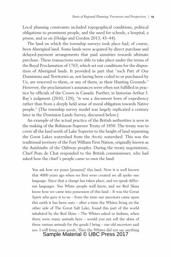
An example of the actual practice of the British authorities is seen in the making of the Robinson-Superior Treaty of 1850. The treaty was to cover all the land north of Lake Superior to the height of land separating the Great Lakes watershed from the Arctic watershed. This was the traditional territory of the Fort William First Nation, originally known as the Anishnabe of the Ojibway peoples. During the treaty negotiations, Chief Peau de Chat responded to the British commissioner, who had asked how the chief ’s people came to own the land:
You ask how we poses [possess]5 this land. Now it is well known that 4000 years ago when we first were created we all spoke one language. Since that a change has taken place, and we speak differ-ent languages. You White people well know, and we Red Skins know how we came into possession of this land – It was the Great Spirit who gave it to us – from the time our ancestors came upon this earth it has been ours – after a time the Whites living on the other side of The Great Salt Lake, found this part of the world inhabited by the Red Skins – The Whites asked us Indians, when there were many animals here – would you not sell the skins of these various animals for the goods I bring – our old ancestors said yes. I will bring your goods. They the Whites did not say anything
Sample Material © UBC Press 2017

20 | Roots and Rationale of Regional Planning
more, nor did the Indian say anything. I did not know that he said come I will buy your land, everything that is on it and under it, he the White said nothing to me – and this is the reason why I believe we poses [possess] this land up to this day. (Fort William First Nation 2014)
The resulting treaty boundaries greatly reduced the size of territory allotted to the Fort William people. Treaty lines paid little attention to the hunting and fishing grounds traditionally used by them. It also al-located them a small reserve with little connection to their traditional region (see Figure 1.4). (Such spatial disjuncture also occurred during the treaty making between Aboriginal peoples and the Canadian govern-ment for the purpose of opening up the West, and the repercussions, as discussed below, continue to the present.)
FROM NATIVE LAND TO RUPERT’S LAND
One-third of what is now Canada was for two hundred years, from 1670 to 1870, the exclusive commercial domain of the Hudson’s Bay Com-pany (HBC). A Royal Charter granted to the HBC all the lands contained in the river basins emptying into Hudson Bay. This totalled 3.9 million square kilometres in what is today northern Quebec and Ontario, all of Manitoba, most of Saskatchewan, southern Alberta, and parts of Nuna-vut and the Northwest Territories. It was named Rupert’s Land in hon-our of Prince Rupert, the cousin of King Charles II, who became the company’s first governor. Aboriginal peoples had no part in this trans-action, although it would forever affect their relationships with govern-ments at all levels regarding the use of those lands.
The HBC grant initiated an intense rivalry in the fur trade between British and French entrepreneurs that would last for 150 years. It was detrimental in several ways to the Aboriginal peoples who had been drawn into this international competition. Diseases spread and upset the balance between groups, and trading rivalries led to hostilities among them. During this time, weather conditions worsened, leading to drought and record low temperatures on the Plains. This affected both food and fur resources, which in turn brought starvation and death to many Native people (Daschuk 2013, 54ff). The merger of the HBC and its main rival, the North West Company from Montreal, in 1821 ended the commercial fur trade wars and brought relative stability to fur-trading
Sample Material © UBC Press 2017

Roots of Regional Planning: Precursors and Perspectives | 21
FIGURE 1.4 Differences between treaty boundaries and traditional territories of the Fort William First Nation
Source: Adapted from Fort William First Nation (2014).
Sample Material © UBC Press 2017

22 | Roots and Rationale of Regional Planning
peoples for a few decades. In 1869, however, their lands were once again disposed of when Rupert’s Land was sold to the new Dominion of Canada. In effect, the sale of Aboriginal lands by the HBC and their purchase by the Canadian government essentially treated these lands as though they were vacant (Ray 2010, 196). No Aboriginal peoples were involved in the transaction, but it did not escape their attention. This soon became apparent when the Dominion government set out to real-ize its plan for western Canada.
CLEARING THE PLAINS
In the late 1840s, Canadian and British financial and political interests began pressing for an end to the fur trade on the Plains. Greater possi-bilities for profit were seen through further settlement of the Plains along with a railway to the Pacific that was being proposed. Visions of settlers wanting machinery from eastern manufacturers, the production of valuable export crops, and lingering fears of northward US expansion fuelled the drive to create a British dominion in northern North America. This was done through the British North America Act (BNA Act) in 1867. The Dominion government faced three tasks to firmly link this vast new territory together:
▪ to recognize as the province of Manitoba the 100 × 100 mile terri-tory surrounding the Red River Settlement formed by Métis settlers. It did this through the Manitoba Act of 1870. However, promises of land rights to the settlers and their children in the act were never fulfilled, and led to protests that lasted nearly 150 years, until the Supreme Court of Canada secured them in 2013 (Saul 2014, 254–58).
▪ to prepare the land for its distribution to settlers and other interests. The Dominion Lands Act of 1872 established the means of accom-plishing this through the Dominion Lands Survey (DLS).
▪ to secure access to the land from its Aboriginal owners. This was pursued by concluding treaties with Native groups beginning in 1871.
Dominion Lands SurveyThe Dominion Lands Survey was the means by which most of western Canada was divided for agricultural and other purposes. It was modelled
Sample Material © UBC Press 2017

Roots of Regional Planning: Precursors and Perspectives | 23
on the Public Land Survey for creating homestead lands in the American West, but with substantial differences regarding road allowances. Essen-tially, it divided the territory that now comprises the three Prairie prov-inces and part of British Columbia into a grid of 36-mile townships each comprising thirty-six 1 square mile (2.6 square kilometre) sections. Cov-ering about 800,000 square kilometres, it was the world’s largest survey grid laid down in a single integrated system (Thomson 1966–69) and, by the same token, the world’s largest planning region (see Figure 1.5).
As it turned out, less than half of the 36 sections of the new township lands (45 percent) were available to incoming settlers through home-steads or nominal purchase from the government. There were several reasons for this. Part of the transaction transferring Rupert’s Land from
FIGURE 1.5 Division of township lands showing allotments to railway company, Hudson’s Bay Company, and schools
Source: Caldwell (2011, 72, Figure 8).
Sample Material © UBC Press 2017

24 | Roots and Rationale of Regional Planning
the HBC granted the latter 5 percent of the DLS lands, or 1.75 sections in each township. And 15 sections were set aside for railway grants as an incentive for the railway companies to build lines. Notably, the Canadian Pacific Railway was granted 100,000 square kilometres for the construc-tion of its line from Ontario to the Pacific.6 A further two sections were set aside for future school use. This geometric division of western Canada paid little attention to the physical features of the land or to its productive capacities. It was a simple and accurate way of defining boundaries that, Thomas Adams concluded fifty years later, “appears to have been designed to promote speculation – both private and public – rather than economic use of the land” (Caldwell 2011, 62).
Treaty Making and ImplementationIn 1871, the government of the Dominion of Canada began a process of negotiating treaties with the Aboriginal groups in Canada West and the Northwest Territories. This vast region covered what are now north-western Ontario, Manitoba, Saskatchewan, Alberta, and northeastern British Columbia. With this move, the government was entering into a paradoxical situation. On the one hand, the Dominion was acknowledg-ing Aboriginal tenure on these lands as the Royal Proclamation of 1763 required (Asch 2014, 73–77). On the other hand, the government had recently purchased most of these same lands from the HBC.
The post-Confederation treaties – the “numbered treaties,” as they are commonly called – were sought by both the Canadian government and the Aboriginal peoples living on these lands. The object of each treaty was to arrive at an agreement such that the affected Aboriginal peoples would permit Canada to settle the land contained within each treaty area. For the Dominion, the treaties were a legal requirement if other settlement was to occur. For Aboriginal peoples, they represented a means of achieving a stable future for themselves on lands where the fur trade had disappeared, the bison herds were quickly diminishing, the climate was changing, and railroads and new settlers were immin-ent. It is important to note, as Ray (2010, 211) points out, that “Native peoples asked for treaties well before the government was willing to sign them.” Seven treaties were concluded between 1871 and 1877 (i.e., signed by each party). In today’s terms, each treaty could be considered broadly as a “regional plan” for its treaty area.
Sample Material © UBC Press 2017

Roots of Regional Planning: Precursors and Perspectives | 25
A simple question arose soon after the signing of the treaties, how-ever: how did each party understand the terms offered to the Native groups to obtain their consent? (Asch 2014, 76). In regional planning terms, upon signing of the treaties, the question became one about how the plan, or the treaty, would be implemented, in which ways, and by whom. To this day, the Canadian government and Aboriginal peoples have opposite views on the answers. The government claims that the treaties extinguished Aboriginal rights to the land, whereas Aboriginal peoples hold that they were agreeing only to share the land with the Crown/government. Such a difference represents what is known in plan-ning terms as a “disconnect” between the goals of a plan and the actions being taken to carry them out or to implement them (Loh 2012). It is reasonable to say that this difference of understanding lies at the heart of many cases involving Aboriginal issues brought to court in both the past and present (Poelzer and Coates 2015, 27).
Regardless of the disputed understanding of treaty terms, the gov-ernment proceeded to implement them. In many cases, the pledges made to the Aboriginal peoples of the Plains fell far short of both the spirit of the treaties and their written promises. Consider the assurance given in each of the first seven treaties that the government would help the treaty people practise agriculture on their reserve lands by providing seeds, tools, and instruction. As Asch (2014, 143) notes, the govern-ment “routinely provided seed too late for planting” that was also of poor quality, as well as providing the wrong kind of ploughs. Restricting the supply of food to those facing famine in order to force them onto inadequate reserves was another tactic at odds with treaty wording (Daschuk 2013, 99ff). These and other travesties were carried out by officials of the newly established Department of Indian Affairs. The Superintendent of Indian Affairs from 1879 to 1888, Edgar Dewdney, is often cited for his ruthlessness (Ray 210, 314–15). His successor, Hayter Reed, was equally rigid in his approach and helped introduce the “pass system,” which prohibited Aboriginal people from leaving their reserves without a “pass” (Ray 2010, 232). The growing costs of sustain-ing them on their reserves also began alarming officials in the Department of Finance, who often referred to these as “welfare” costs and demanded cutbacks. The various tactics employed by government officials in the field and in Ottawa were not explicit government policy, but their use
Sample Material © UBC Press 2017