phase i and phase ii ground ... - east staffordshire · phase i and phase ii ground investigation...
TRANSCRIPT

PHASE I AND PHASE II GROUND INVESTIGATION AND TEST REPORT FOR THE CONSTRUCTION OF A NEW RESIDENTIAL
DEVELOPMENT AT LICHFIELD ROAD, ABBOTS BROMLEY
Date: 07/07/2015 Our Ref: DNB/23240
Report Status: Final
Client: Planet Petrouis The Muckley Corner House Walsall Road Lichfield Staffordshire WS14 0BG
Engineer: GHW Consulting Wellington House Starley Way Solihull B37 7HB
P_2016_01710Received 12/12/2016
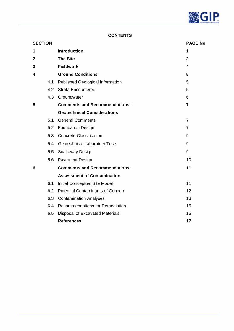
CONTENTS
SECTION PAGE No.
1 Introduction 1
2 The Site 2
3 Fieldwork 4
4 Ground Conditions 5
4.1 Published Geological Information 5
4.2 Strata Encountered 5
4.3 Groundwater 6
5 Comments and Recommendations:
Geotechnical Considerations
7
5.1 General Comments 7
5.2 Foundation Design 7
5.3 Concrete Classification 9
5.4 Geotechnical Laboratory Tests 9
5.5 Soakaway Design 9
5.6 Pavement Design 10
6 Comments and Recommendations:
Assessment of Contamination
11
6.1 Initial Conceptual Site Model 11
6.2 Potential Contaminants of Concern 12
6.3 Contamination Analyses 13
6.4 Recommendations for Remediation 15
6.5 Disposal of Excavated Materials 15
References 17

APPENDICES
A Machine Excavated Trial Pit Logs
B Soakaway Test Results
C California Bearing Ratio (CBR) Test Results
D Geotechnical Laboratory Test Results (GIP)
E CLEA Statistical Assessment Sheets
CATWaste Summary Sheet
Contamination, WAC and Concrete Classification Test Results (Alcontrol)
F Groundsure Report
G Drawing No. 1 - Exploratory Hole Location Plan
Proposed Site Layout (Neil Boddison Associates Ltd)
H Notes on Site Investigation Reports
Page 1 of 17
1 Introduction
1.1 It is proposed to develop a parcel of land located to the south of Thyme House, Abbots Bromley in
Staffordshire. It is understood that the proposals include the construction of five detached properties with
associated parking and gardens. An illustrative proposed layout, prepared by Neil Boddison Associates
Limited, is included within the appendix.
1.2 GIP Ltd were instructed by GHW Consulting to carry out a Phase I desk study and Phase II intrusive
investigation for the proposed development, the results of which are included within this report. The scope
of the investigation was specified by GHW Consulting. The Phase I desk study comprised the undertaking
of a site walkover by a geo-environmental engineer from GIP and the consultation of historical and
geological maps of the site area. Information made available by the Environment Agency was also
consulted and the environmental setting of the site assessed.
1.3 This was followed by a Phase II intrusive investigation which comprised the excavation of machine dug pits
to assess the prevailing foundation engineering geology with regards to future construction, together with
assessing the contaminative status of the site. A number of soakaway tests were carried out to assess the
permeability of the underlying strata and eight California Bearing Ratio (CBR) tests were carried out to aid
in pavement construction. The locations of the exploratory positions are shown on the appended Drawing
No. 1.
1.4 Geotechnical laboratory testing has been undertaken by GIP Limited. The laboratory tests are accredited
by the United Kingdom Accreditation Services (UKAS). The laboratory tests, carried out in accordance
with British Standards (BS) 1377 (Ref. 1) where appropriate, are detailed in Table 1 below, the results of
which are included within the appendix. Contamination, Waste Acceptance Criteria (WAC) and concrete
classification tests have been undertaken by Alcontrol Laboratories, the results of which are appended.
Table 1: Geotechnical laboratory testing undertaken by GIP.
1.5 This report contains a description of the site, anticipated geology and strata encountered together with
comments and recommendations upon the foundation engineering geology with respect to the construction
of the proposed residential development. An environmental risk assessment is provided which includes
comments on the potential for contamination to affect Controlled Waters and Human Health (future users)
together with possible remedial measures. It is outside the scope of this report to comment on issues
regarding ground gases.
Test Description
Part
Method
UKAS Accredited Test
Number of Tests
Sieving wet 2 9.2/9.3 2 Moisture Content 2 3 2 Atterberg Limit 2 4 & 5 2

Page 2 of 17
1.6 We are confident that the conclusions drawn from the findings of this investigation and desk study are
appropriate for the proposed development. However, we cannot guarantee that they would be accepted by
regulatory authorities without question. It is recommended that the reports are submitted and approval
gained from such bodies prior to the undertaking of detailed design, construction work or other irreversible
processes.
2 The Site
2.1 Site Location
2.1.1 The proposed development is situated to the west of Lichfield Road, Abbots Bromley in Staffordshire.
National Grid Reference 408420, 324010 denotes the approximate centre of the site.
2.2 Site Layout
2.2.1 At the time of the site walkover, the site comprised an approximately rectangular shaped parcel of land
which was characterised by grass at surface. The eastern boundary was marked by a mature hedge,
beyond which was Lichfield Road, with Thyme House to the north of the site. The wider area was
characterised by agricultural land.
2.3 Historical Considerations and Environmental Setting
2.3.1 A Groundsure Report has been obtained for the site which gives details of historical site usage and also
comments upon the environmental setting of the site. The Groundsure Report is reproduced within the
appendix.
Old Ordnance Survey Records
2.3.2 The Groundsure Report contains a number of historical maps covering the site area, the salient
morphological features of which can be summarised as follows.
Mapping Date : 1882 - 1923
The first available map shows the site to lie within a wider parcel of unoccupied land. Lichfield Road
borders the site to the east with a number of detached residential properties to the north and south east,
some of which have Wells associated with them. Town End Farm is located to the north with a number of
ponds within the wider area.

Page 3 of 17
Mapping Date : 1969 – Present Day
The 1969 edition shows a number of residential properties have been constructed on the eastern side of
Lichfield Road. The site remains unoccupied with the wider area remaining predominantly agricultural in
nature.
Environmental Setting
2.3.3 The Groundsure Report also contains information made available by the Environment Agency and other
regulatory bodies and this can be used to assess the environmental setting of the site. The main findings
can be summarised as follows:
Authorisations, Incidents and Registers
► There are no IPC or IPPC Authorisations within 500m of the site.
► There is no record of any Water Industry Act Referral (potentially harmful discharges to the public sewer)
within 500m of the site.
► There is no record of any Red List (potentially harmful discharges to Controlled Waters) sites located within
500m of the site.
► There is no record of any List 1 or List 2 Dangerous Substance Inventory Sites within 500m of the site.
► There are no records of any Part A or Part B Activities and Enforcements within 500m of the site.
► There are no records of Category 3 or 4 Radioactive Substance Licenses within 500m of the site.
► The nearest Licensed Discharge Consent is located 459m to the south of the site.
► There are no records of any Planning Hazardous Substance Consents and Enforcements within 500m.
► There are no COMAH & NIHHS sites located within 500m of the site.
► There are no Environment Agency recorded pollution incidents within 500m of the site.
► There are no sites within 500m determined as ‘Contaminated Land’ under Section 78R of the
Environmental Protection Act 1990.

Page 4 of 17
Waste
► There are no operational landfill sites located within 1000m of the site.
► The nearest recorded historical landfill site is recorded 790m to the west which accepted ‘household’
waste. No details on the last date of input are noted. It is a commonly accepted principal that only landfills
within 250m are deemed as being within influencing distance of a site.
Hydrology and Hydrogeology
► In terms of Groundwater Vulnerability, the Mercia Mudstone Formation strata beneath the site is classed as
a ‘Secondary (B) Aquifer’. The superficial deposits are noted to be a ‘Secondary (A) Aquifer’.
► There are no groundwater, surface water or potable water abstraction licenses within 1000m of the site.
► The nearest surface water feature is a pond 127m to the south east of the site.
► The site is not located within a Source Protection Zone.
Environmental Sensitivity
► There are no SSSIs, National Nature Reserves, Special Areas of Conservation, Special Protection Areas,
Ramstar sites, World Heritage Sites, Areas of Outstanding Natural Beauty or National Parks within 1000m
of the site.
► There are no Environmentally Sensitive Areas within 1000m of the site.
► The site is within a Nitrate Vulnerable Zone.
Radon
► No radon protective measures are deemed necessary in the construction of new buildings.
3 Fieldwork
3.1 General Comments
3.1.1 The prevailing ground conditions were determined with the use of machine excavated trial pits. All the
exploratory holes were undertaken, where appropriate, in accordance with BS5930 (Ref. 2). The positions of
the exploratory holes, as determined by the proposed site layout, are detailed upon the appended Drawing
No. 1.

Page 5 of 17
3.2 Machine Excavated Trial Pits
3.2.1 Six machine dug trial pits were excavated to depths of between 2.30m (TPs 1 and 4) and 4.30m (TPs 2
and 5) ground level using a wheeled, backacting, hydraulic excavator (JCB 3CX) to investigate the
geotechnical design parameters of the near surface soils and obtain samples for geotechnical and
contamination testing. Hand vane tests were carried out in the cohesive soils to better refine the shear
strength of the materials. Soakaway tests were carried out in TPs 1 and 2 to assess the permeability of the
prevailing ground conditions. Engineer verified logs are included within the appendix together with the
results of the soakaway tests.
Soil Sampling
3.2.2 Soil samples were collected for contamination analyses and placed into appropriate sampling containers
(plastic tubs, amber jars and vials). The samples were then placed in cool boxes which contained ice
packs and collected by courier for delivery to Alcontrol Laboratories.
4 Ground Conditions
4.1 Published Geological Information
4.1.1 Within the accuracy of the available geological information (Ref. 3) the ‘solid’ geology beneath the area of the
site comprises the Mercia Mudstone Formation of the Triassic Period. Superficial deposits are shown to
be present overlying the ‘solid’ geology in the area of the site.
4.2 Strata Encountered
4.2.1 For full details of the strata encountered by the exploratory holes of this investigation, reference should be
made to the appended logs. However, the salient features of the engineering geology horizons are
summarised below.
Made Ground / Topsoil: encountered in all positions to depths of between 0.20m (TP6) and 0.40m (TPs
1, 3 and 4) as sand with gravel of quartz and sandstone. This horizon is typical of what would be expected
given the historically undeveloped nature of the site. No visual or olfactory evidence of contamination (e.g.
stains or odours) was recorded within any of the recovered soils.
Superficial Deposits: revealed beneath the Made Ground in all positions as variably medium dense sand
and stiff clay. These strata contained gravel of quartz and sandstone and occasional sandstone cobbles.
No visual or olfactory evidence of contamination (e.g. stains or odours) was recorded within any of the
recovered soils.

Page 6 of 17
Mercia Mudstone Formation: revealed beneath the superficial soils in all positions from depths of
between 1.10m (TP4) and 2.00m (TP1) as firm becoming stiff and very stiff red brown coloured clay with
mudstone lithorelicts. This strata represents the uppermost weathered horizon of the Mercia Mudstone
Formation. No visual or olfactory evidence of contamination (e.g. stains or odours) was recorded within
any of the recovered soils.
4.3 Groundwater
4.3.1 During the excavation of the pits, the granular superficial deposits were revealed to be saturated in parts
within TPs 2 and 5 from as shallow as 1.00m. This likely reflects perched groundwater within the
superficial soils.

Page 7 of 17
5 Comments & Recommendations : Geotechnical Considerations
5.1 General Comments
5.1.1 Appropriate comments are presented below upon the prevailing foundation engineering geology revealed
by the exploratory holes of this investigation with respect to the construction of a new residential
development on land to the south of Thyme House, Abbots Bromley in Staffordshire. It is understood that
the proposals include the construction of five detached properties with associated parking and gardens. An
illustrative proposed layout, prepared by Neil Boddison Associates Limited, is included within the appendix.
An assessment of contamination in terms of impact on Human Health and Controlled Waters is also
included within Section 6. It is outside the scope of this report to comment on ssues regarding ground
gases.
5.2 Foundation Design
5.2.1 The Made Ground is considered in its existing state to be unsuitable to constitute a reliable formation
horizon for any form of traditional style of foundation without the risk of unpredictable and excessive levels
of total or differential settlements.
5.2.2 From a visual observation of the underlying superficial and residual soils together with the results of the in
situ shear vane testing carried out within the cohesive soils, the natural soils beneath the site are believed
sufficiently competent to support traditional style strip / trench fill foundations for the proposed new
residential structures. Future foundations should be extended through the Made Ground and bear within
the underlying medium dense granular superficial soils or firm and stiff cohesive superficial and residual
soils. Care should be taken to fully penetrate any soft or loose horizons (if encountered) and bear within
more competent strata below. Upon exposure at the time of construction the formation horizon should be
carefully inspected by a suitably qualified and experienced engineer to ensure that it is adequately firm or
dense and any soft or loose horizons encountered are excavated and replaced with lean mix concrete or
well compacted clean granular materials (e.g. Department for Highways Series 600 6F1/6F2).
5.2.3 It is likely that in places the foundations will be required to span contrasting granular and cohesive
formation horizons within the superficial and residual soils. Hence, suitable mesh reinforcement should be
incorporated where necessary within the top and bottom of the foundations in these areas to accommodate
any minor differential settlements. This measure can, however, be dispensed with where the mass of
concrete in the foundation outweighs the beneficial effects of the reinforcement (e.g. trench fill
foundations).

Page 8 of 17
5.2.4 On the basis of the exploratory works carried out to date, upon an adequately competent natural strata,
presumed nett design bearing pressures in the order of 120kN/m2 could be available for standard strip /
trench fill footings up to 1m wide. At such bearing pressures, settlements have been estimated as being
less than 25mm.
Support to Excavations
5.2.5 It is recommended that excavations below 1.00m should be fully supported throughout, as wholesale
collapse in trenches in Made Ground or natural granular materials could occur if left open for extended
periods. Full trench support will therefore be necessary whenever site operatives are working below 1.00m
depth (e.g. for the emplacement of foundations and services) and an allowance be made for some
overbreak of unsupported trenches. This may even require shuttering if collapses are significant. It should
be noted that whilst the sidewalls of the majority of the pits remained stable throughout excavation, side
collapse was recorded within the granular superficial soils in TP2. Practical guidance on trench excavation
is given in CIRIA Report 97 ‘Trenching Guidance’. Guidance on groundwater control is given in CIRIA
Repot 113 ‘Control of Groundwater for Temporary Works’. Any temporary works should be designed by a
suitably qualified engineer or competent person, particularly where personnel access is necessary, in
accordance with the requirements with of the Construction (Design and Management) Regulations.
Groundwater Control
5.2.6 During the excavation of the trial pits, the granular superficial deposits were revealed to be saturated in
parts within TPs 2 and 5 from as shallow as 1.00m. This likely represents perched groundwater within the
granular superficial soils. It is likely that there will be some degree of groundwater influx into foundation
excavations and groundwater control may be required. It is noted that levels of groundwater can vary
seasonally and ingress may be greater in volume and shallower in wetter weather. If there is groundwater
ingress into the excavations, the use of pumping from sumps could be adopted. Where ingress is constant
then continuous pumping may be needed or an alternative solution considered such as well pointing.
Reference should be made to specialist dewatering contractors for further advice.
Wells and Pumps
5.2.7 The historical maps detail the presence of a number of pumps within the surrounding area, however no
such features are shown within the boundaries of the proposed development plot. It is, however,
recommended that a close watch be kept for such features during development works and should any
such features be uncovered (e.g. buried, circular brickwork) then they are infilled to an appropriate
structural specification and capped at surface to ensure future stability.

Page 9 of 17
5.3 Concrete Classification
5.3.1 Concrete classification tests have been carried out by Alcontrol Laboratories upon selected soil samples in
accordance with those listed in Building Research Establishment (BRE) Special Digest 1 (Ref. 4) and the
results are included within the appendix, listed together with the contamination analyses. These tests
determine the class of concrete for any future development and in view of the presence of shallow
groundwater beneath the site it is recommended that the ACEC class of AC-1 is adopted for the design of
buried concrete structures (e.g. foundations for the proposed houses).
5.4 Geotechnical Laboratory Tests
Index Property Tests
5.4.1 Two index property tests have been carried out upon samples of the cohesive residual soils and the results
are included within the appendix together with an A line plot. These tests classify the soils as being of high
plasticity and medium volumetric change potential in accordance with NHBC Standards Chapter 4.2 (Ref. 5)
modified by BRE Digest 240 (Ref. 6). The NHBC Standards recommend a minimum foundation depth of
0.90m where medium volume change potential soils are present. There are a number of mature and semi
mature trees along the site boundaries. It is recommended that an arboreal survey be undertaken to
identify the species and maturity of the trees and enable the depth of construction to be determined for
foundations upon cohesive strata proximal to removed or retained trees.
Particle Size Distribution
5.4.2 Two sieving tests have been carried out on samples of the superficial soils which have been used to refine
the soil description. These may be of use to specialist contractors.
5.5 Soakaway Design
5.5.1 This phase of works has included an assessment of the suitability of the prevailing ground conditions for
constructing soakaways to deal with surface water drainage. Soakaway tests were carried out within TPs 1
and 2 as shown on the appended Drawing No. 1, in general accordance with the guidelines detailed in
Building Research Establishment (BRE) Digest 365 (Ref. 7). The tests have shown the strata to be
practically impermeable and therefore an alternative method should be utilised to deal with surface water
drainage.

Page 10 of 17
5.6 Pavement Design
5.6.1 It is understood that it is proposed to construct an access road and parking facilities for the new properties.
The exploratory holes of this investigation have recorded granular Made Ground to depths of between
0.20m and 0.40m, underlain by variably granular and cohesive superficial soils.
5.6.2 Eight in situ California Bearing Ratio (CBR) tests have been carried out in the area of the proposed new
road at locations detailed upon the appended Drawing No. 1. The soils exposed at the test depths
comprised granular Made Ground and granular and cohesive superficial deposits, full descriptions of which
are provided on the appended CBR results sheets. The results sheets are included within the appendix
and have produced CBR values as shown in Table 2 below.
Table 2: Summary of CBR results in the area of the proposed new road
Test Location Depth (m) CBR Value
(%)
Moisture Content
(%)
Material Tested
CBR1 0.30 6.4 8.9 Granular superficial
CBR2 0.30 6.1 19 Granular superficial
CBR3 0.30 5.0 17 Granular Made Ground
CBR4 0.30 3.0 17 Cohesive superficial
CBR5 0.30 3.1 20 Cohesive superficial
CBR6 0.30 2.7 20 Cohesive superficial
CBR7 0.30 1.5 20 Cohesive superficial
CBR8 0.30 4.7 19 Granular Made Ground
5.6.3 As a general guide to pavement construction and taking into account any improvement due to proof rolling
and Transport and Road Research Laboratory (TRRL) Report LR1132 (Ref. 8), as the area will in all
likelihood be underlain by variably granular and cohesive soils, a design CBR value of 2% is recommended
for the construction of hardstanding associated with the construction of the new road. Any inferior pockets
revealed at the time of construction should be removed and replaced with a well compacted clean granular
material (e.g. Series 600 6F1/6F2). It is cautioned that where cohesive soils are encountered near
surface, they may be susceptible to softening in wet weather and when repeatedly tracked across. As
such, the CBR values available can be expected to vary with moisture content and degree of reworking.

Page 11 of 17
6 Comments and Recommendations : Assessment of Contamination
6.1 Initial Conceptual Site Model
6.1.1 In accordance with Environment Agency (EA) document CLR11 ‘Model Procedures for the Management of
Land Contamination’ (Ref. 9) the information from the desk study and site investigation have been used to
generate a preliminary risk assessment. The purpose of this is to develop an initial Conceptual Site Model
(CSM) to establish whether there are any potentially unacceptable risks present and determine the action
required to provide further information to refine the model.
6.1.2 On the basis of the information available to date there are a number of contaminant linkages between
sources and receptors. These are discussed below.
Potential Sources of Contamination
• Potential On Site Historical Contaminant Sources
6.1.3 An examination of the historical maps shows the site to have been within a wider parcel of unoccupied
agricultural land from the earliest available plan (1882) until the present day. Therefore the risk of historical
on site activities causing contamination is thought to be ‘low’.
• Potential On Site Current Contaminant Sources
6.1.4 At the time of this investigation, the site was unoccupied and relatively level at surface. During the site
walkover, there were no obvious surface sources (e.g. fuel tanks) that could be causing contamination of
the underlying soils and groundwater. The investigation has revealed the presence of Made Ground /
Topsoil to as deep as 0.40m which represents a potential source of contamination. However, no visual or
olfactory evidence of contamination was noted in the recovered soils. Therefore, on the basis of the
observations made to date, there is a ‘low’ risk of current on site sources of contamination.
• Potential Off Site Contaminant Sources
6.1.5 The historical information shows the area directly surrounding the site to have been agricultural land, with a
number of detached residential properties in the vicinity. It is unlikely that historical off site activities could
have led to significant contamination of the soils and groundwater in the surrounding area which could lead
to the migration of contaminated groundwater onto the site, and the risk is considered to be ‘low’.

Page 12 of 17
Potential Receptors
Human Health • Humans including construction workers and future occupiers of the proposed new
residential properties.
Controlled Waters • Groundwater present beneath the site within the superficial deposits.
Other Receptors • Building Substructures.
Potential Pathways
Human Health • Skin / eye contact, ingestion and inhalation during site development and by contact
/ inhalation from future occupiers.
• Ingestion of vegetables and soil adhering to vegetables propagated within the
gardens.
Controlled Waters • Percolating water may act to mobilise contaminants and transport them
downwards under gravity towards the water table.
6.2 Potential Contaminants of Concern
6.2.1 The contamination testing has included for a range of contaminants specified by GHW Consulting,
including the following:
• Arsenic
• Cadmium
• Chromium (hexavalent)
• Copper
• Lead
• Mercury
• Nickel
• Selenium
• Vanadium
• Zinc
• Cyanide
• Phenols
• Polycyclic Aromatic Hydrocarbons (speciated)
• Petroleum Hydrocarbons (speciated)
• Benzene, Toluene, Ethylbenzene and Xylene
(BTEX)
• Methyl Tert-Butyl Ether (MTBE)

Page 13 of 17
6.3 Contamination Analyses
6.3.1 In order to assess the potential for contamination, five samples of the near surface soils were forwarded to
Alcontrol Laboratories for analysis for a range of contaminants in accordance with the Conceptual Site
Model. The samples tested appeared to be representative of the soils present upon the site. It should be
appreciated that there remains the potential for unidentified areas of contamination to exist. Suspect areas
as may be identified in the future would have to be further investigated / assessed. Risk assessment work
has its limitations and uncertainties ranging from those introduced by the type and quality of the data,
analytical methods through to the model chosen.
Soils Analysis: Assessment of Risk to Human Health
6.3.2 The CLEA (Contaminated Land Exposure Assessment) model combines information on the toxicity of soil
contaminants with estimates of potential exposure by adults and children living, working and/or playing on
land affected by contamination over long periods of time. It predicts the amount of contaminant to which
they might be exposed based on a given soil contaminant concentration. By comparing predicted
exposure with health criteria values on tolerable or acceptable contaminant intakes the model can be used
to generate Critical Concentrations (Cc).
6.3.3 The soils analytical data is compared to the Cc using the statistical methods outlined in ‘Guidance on
Comparing Soil Contamination Data with a Critical Concentration’ (Ref. 10). For this site, the results have
been analysed using in-house GIP software. Excel spreadsheets generated from the analysis are included
within the appendix.
6.3.4 The aim of the assessment is to prove, or otherwise, that the land under investigation is suitable for the
intended use in that the level of contamination is low compared to an appropriate measure of risk. In
statistical terms this question is assessed using formal hypotheses. These are known as the Null
Hypothesis (whereby the true mean concentration of a given contaminant is greater than or equal to the Cc
[H0 µ ≥ Cc]), and the Alternative Hypothesis (whereby the true mean is less than the critical value [H1 µ ≤
Cc]). If the Null Hypothesis is rejected (i.e. the Alternative Hypothesis is proven correct) then the land is
deemed suitable for the intended use. If the Null Hypothesis is proven correct then the land is deemed
unsuitable for the intended use or remediation is necessary to render it suitable for the intended use.
6.3.5 Initially, generic Cc have been used as a screening process adopting Soil Screening Values (SSVs)
produced by Atkins Consultants and available from the ATRiskSoil web site (Ref. 11). As it is proposed to
construct a number of houses upon the site, threshold values for Residential with Plant Uptake end usage
have been adopted for this assessment. Where Category 4 Screening Levels (C4SLs) produced by the
Department for the Environment and Rural Affairs (DEFRA) or Soil Guideline Values (SGVs) as produced
by DEFRA / Environment Agency (EA) are available, these are adopted in preference to SSVs.

Page 14 of 17
Results – Soil Testing
Metals (arsenic, cadmium, chromium, copper, lead, mercury, nickel, selenium, vanadium, zinc), Cyanide and Phenols
6.3.6 The results of the analyses of a total of five samples are included within the appendix together with the
statistical assessment. As detailed on the appended CLEA excel spreadsheets, no statistical outliers have
been identified. The analytical data has been reviewed and either the results are below the method limit of
detection (mercury, selenium, cyanide and phenols) or the Null Hypothesis has been rejected (Alternative
Hypothesis has been accepted) for all of the contaminants
Polyaromatic Hydrocarbons (PAHs)
6.3.7 SSVs have been derived for 14 out of the 16 United States Environmental Protection Agency (US EPA) list
of priority contaminants. The results of the analyses of a total of five samples are included within the
appendix together with the statistical assessment. As detailed on the appended CLEA excel spreadsheets,
no statistical outliers have been recorded within the assessment. The analytical data has been reviewed
and either the results are below the method limit of detection (acenapthene, anthrace, dibenzo (a)
anthracene, fluorine and napthalene) or the Null Hypothesis has been rejected (Alternative Hypothesis has
been accepted) for all of the contaminants.
Petroleum Hydrocarbons
6.3.8 SSVs are available for the fractionated analysis of petroleum hydrocarbons in accordance with those
outlined by the Total Petroleum Hydrocarbon Criteria Working Group (TPH CWG). The results of the
analyses of a total of four samples are included within the appendix together with the statistical
assessment. As detailed on the appended CLEA excel spreadsheets, no statistical outliers have been
recorded within the assessment. The analytical data has been reviewed and either the results are below
the method limit of detection or the Null Hypothesis has been rejected (Alternative Hypothesis has been
accepted) for all of the contaminants.
Benzene, Toluene, Ethylbenze and Xylene (BTEX)
6.3.9 There are SGVs available for benzene, toluene, ethylbenzene and xylene. The results of the analyses of a
total of four samples are included within the appendix together with the statistical assessment. As detailed
on the appended CLEA excel spreadsheets, no statistical outliers have been recorded within the
assessment. The analytical data has been reviewed and all results are below the method limit of detection.

Page 15 of 17
Methyl Tert-Butyl Ether (MTBE)
6.3.10 The results of the analyses of a total of four samples are included within the appendix together with the
statistical assessment. As detailed on the appended CLEA excel spreadsheets, no statistical outliers have
been recorded within the assessment. The analytical data has been reviewed and all results are below the
method limit of detection.
6.4 Recommendations for Remediation
Human Health
6.4.1 No elevated contaminant concentrations have been recorded during the testing undertaken to date and
therefore no special precautionary measures are considered necessary with regards to the protection of
Human Health.
6.4.2 As will be required in accordance with a Health and Safety Plan which should be prepared for the project,
personnel involved in site development works should observe a high standard of personal hygiene. For
example, gloves, boots and overalls should be worn and washing facilities should be provided.
Controlled Waters
6.4.3 It is the remit of the Environment Agency to protect Controlled Waters which includes groundwater and
surface waters. The Environment Agency are also statutory consultees in the planning process. Saturated
strata were recorded in TPs 2 and 5 from as shallow as 1.00m and in view of the past site history (site
within agricultural land), and environmental setting (underlying Mercia Mudstone Formation being a
‘Secondary (B) Aquifer’, superficial deposits being a ‘Secondary (A) Aquifer’ and site not within a Source
Protection Zone) the sensitivity of the site is believed to be ‘low’. Given the findings of this investigation, it
is thought unlikely that the Environment Agency will require further sampling and testing to determine the
extent of the risk that the site poses to Controlled Waters (groundwater and nearby surface water courses).
6.5 Disposal of Excavated Materials
6.5.1 If excavated materials are to be removed for disposal off site, in accordance with the EU Landfill Directive
(England and Wales) Regulations 2002 there are three main categories; Inert, Non Hazardous and
Hazardous Waste. Each category is defined by individual parameters which govern the types of waste
accepted for classification. However it should be noted that individual landfill sites will have the final
decision regarding the acceptance of the waste for disposal.
6.5.2 Waste Acceptance Criteria (WAC) testing has been carried out on two soil samples, the result of which are
appended, listed together with the contamination analysis.

Page 16 of 17
6.5.3 It should be appreciated that the above comments have not been made in consultation with either the
Local Authority or the Environment Agency. Each of these bodies may have additional comments to make
in view of the test results and the methods of investigation and their opinions should be sought in this
matter.
FOR AND ON BEHALF OF
GIP LIMITED
D. N. Brown B.Sc. (Hons) F.G.S
SENIOR GEOTECHNICAL ENGINEER
Author Contact Details: [email protected]. 01902 459 558
J. P. Hughes B.Sc. M.Sc. C.Geol. F.G.S. C.SCi
MANAGING DIRECTOR

Page 17 of 17
References
1 British Standards Institution BS 1377 (1990) ‘Method of Tests for soils for Civil Engineering Purposes’.
2 British Standards Institution 5930 (1999) ‘Code of Practice for Site Investigation’.
3 British Geological Survey Sheet 140 (Burton upon Trenth) at a scale of 1:50,000
4 Building Research Establishment Special Digest 1 ‘Concrete in Aggressive Ground’ 2005.
5 National House Building Council 1995. Chapter 4.2 ‘Building Near Trees’.
6 Building Research Establishment Digest 240 ‘Low Rise Buildings on Shrinkable Clay Soils’: Part 1
September 1993.
7 Building Research Establishment Digest 365 ‘Soakaway Design’ September 1991.
8 Transport and Road Research Laboratory (TRRL) Laboratory Report 1132 ‘The Structural Design of
Bituminous Roads (1984)
9 Department for Environment, Food and Rural Affairs (DEFRA) and the Environment Agency (EA) ‘The
Model Procedures for the Management of Land Contamination’. R&D Publication CLR11. 2004
10 Contaminated Land: Applications in Real Environments ‘Guidance on Comparing Soil Contamination
Data with a Critical Concentration’ May 2008
11 www.atrisksoil.co.uk Atkins Consultants have developed Soil Screening Values (SSVs) applicable to
the UK for common contaminants not currently covered by SGVs issued by DEFRA and the
Environment

APPENDIX A

DESCRIPTION OF STRATALegendDepth
(m bgl )Level
(m AOD)Samples
Tests (m bgl )
OTHER INFORMATIONSAMPLES / TESTST
D
B
W
HV
Environmental Sample
Disturbed
Bulk
Water
Hand Vane
Water strike
Water level
GROUND INVESTIGATION & PILING LTDTrial Pit LogLevel (mAOD):
Coordinates E: N:
Plant:
Date:
Location:
Client:
Engineer:
TP No.
Ground Investigation & Piling Limited,Devonshire House, Ettingshall Road, Wolverhampton. Tel. 01902 459558 Fax. 01902 459085
Project No.
Depth
ANNOTATED SKETCH DRAWING (Not to Scale)
Side Stability:
Other Details:
Logged by
Checked by
Document 4.62 WV2 2JT.
-
28/04/2015
-
JCB 3CX
-
No groundwater encountered.1.2. Densities ascribed to granular horizons are based upon speed, ease and
stability of excavation and as such should be used as a guide.3.Soakaway test carried out in open trial pit. See separate sheet for
results.
Pit walls remained stable throughout the excavation.
Lichfield Road, Abbots Bromley
Planet Petrouis
GHW Consulting
TC
DNB
TP1
23240
0.40
1.30
2.00
2.30
B
B
B
B
0.10
0.40
1.30
2.00
TOPSOIL: (Medium dense) Dark brown and light grey slightly clayey slightly gravellySAND with some rootlets. Gravels are sub angular to subrounded medium grainedsandstone and quartz.
(Medium dense) orange and brown speckled black slightly clayey slightly gravellyfine SAND. Frequent pockets of orange silty clay. Gravels are subrounded sandstoneand quartz. Occasional carbonaceous material. (Superficial deposits)
Stiff dark brownish orange and light bluish grey slightly sandy slightly gravellyCLAY. Occasional pockets of weakly cemented bluish grey fine gravel sized clasts.Gravels are subrounded quartz. (Superficial Deposits)
Stiff red brown and light bluish grey slightly sandy CLAY. (Weathered MerciaMudstone Group)
Trial Pit Complete
Sheet 1 of 1

DESCRIPTION OF STRATALegendDepth
(m bgl )Level
(m AOD)Samples
Tests (m bgl )
OTHER INFORMATIONSAMPLES / TESTST
D
B
W
HV
Environmental Sample
Disturbed
Bulk
Water
Hand Vane
Water strike
Water level
GROUND INVESTIGATION & PILING LTDTrial Pit LogLevel (mAOD):
Coordinates E: N:
Plant:
Date:
Location:
Client:
Engineer:
TP No.
Ground Investigation & Piling Limited,Devonshire House, Ettingshall Road, Wolverhampton. Tel. 01902 459558 Fax. 01902 459085
Project No.
Depth
ANNOTATED SKETCH DRAWING (Not to Scale)
Side Stability:
Other Details:
Logged by
Checked by
Document 4.62 WV2 2JT.
-
28/04/2015
-
JCB 3CX
-
No groundwater encountered. Saturated gravelly zone at 1.0m, water seepinginto pit.
1.
Densities ascribed to granular horizones are based upon speed, ease andstability of the excavation and as such should be used as a guide.
2.
3. Soakaway test carried out in open trial pit. See separate sheet forresults.
Side collapse at 1.0m
Lichfield Road, Abbots Bromley
Planet Petrouis
GHW Consulting
TC
DNB
TP2
23240
0.25
1.00
1.80
2.30
4.00
4.30
B
B
BHV
HV
76kPa
140kPa
0.25
1.00
1.801.90
2.40
TOPSOIL: (Medium dense) Dark brown and light grey slightly clayey slightly gravellySAND with frequent topsoil and rootlets. Gravels are sub angular to subrounded finegrained sandstone and quartz.
(Medium dense) Dark brown speckled white and orange very silty fine SAND withoccasional subrounded to rounded sandstone and quartz gravels . Frequent rootlets.(Superficial deposits)
(Medium dense) saturated brownish orange speckled black and light orange slightlyclayey slightly gravelly SAND with occasional pockets of sandy clay. Gravels arefine to medium grained quartz and sandstone. (Superficial Deposits)
Firm to stiff orangish brown speckled black slightly silty slightly sandy CLAY.Occasional pockets of light grey weakly cemented silt clasts. (Weathered MerciaMudstone Group)
Very stiff red brown mottled bluish grey slightly sandy CLAY. Occasionalcarbonaceous seams. Frequent pockets of fine orange sand. (Weathered Mercia MudstoneGroup)
Firm to stiff red brown and light orange sandy CLAY with occasional pockets ofbluish grey silt. Frequent sandy horizons. (Weathered Mercia Mudstone Group)
Trial Pit Complete
Sheet 1 of 1
DESCRIPTION OF STRATALegendDepth
(m bgl )Level
(m AOD)Samples
Tests (m bgl )
OTHER INFORMATIONSAMPLES / TESTST
D
B
W
HV
Environmental Sample
Disturbed
Bulk
Water
Hand Vane
Water strike
Water level
GROUND INVESTIGATION & PILING LTDTrial Pit LogLevel (mAOD):
Coordinates E: N:
Plant:
Date:
Location:
Client:
Engineer:
TP No.
Ground Investigation & Piling Limited,Devonshire House, Ettingshall Road, Wolverhampton. Tel. 01902 459558 Fax. 01902 459085
Project No.
Depth
ANNOTATED SKETCH DRAWING (Not to Scale)
Side Stability:
Other Details:
Logged by
Checked by
Document 4.62 WV2 2JT.
-
28/04/2015
-
JCB 3CX
-
No groundwater encountered, however strata noted to be saturated at 0.40m.1.2. Densities ascribed to granular horizons are based upon speed, ease and
stabillity of excavation and as such should be used as a guide.3. Pit backfilled upon completion
Pit walls remained stable throughout excavation
Lichfield Road, Abbots Bromley
Planet Petrouis
GHW Consulting
TC
DNB
TP3
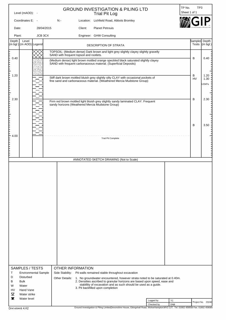
23240
0.40
1.20
2.30
4.00
B
BHV
B
B
120kPa
0.40
1.201.30
2.30
3.50
TOPSOIL: (Medium dense) Dark brown and light grey slightly clayey slightly gravellySAND with frequent topsoil and rootlets.
(Medium dense) light brown mottled orange speckled black saturated slightly clayeySAND with frequent carbonaceous material. (Superficial Deposits)
Stiff dark brown mottled bluish grey slightly silty CLAY with occasional pockets offine sand and carbonaceous material. (Weathered Mercia Mudstone Group)
Firm red brown mottled light bluish grey slightly sandy laminated CLAY. Frequentsandy horizons (Weathered Mercia Mudstone Group)
Trial Pit Complete
Sheet 1 of 1

DESCRIPTION OF STRATALegendDepth
(m bgl )Level
(m AOD)Samples
Tests (m bgl )
OTHER INFORMATIONSAMPLES / TESTST
D
B
W
HV
Environmental Sample
Disturbed
Bulk
Water
Hand Vane
Water strike
Water level
GROUND INVESTIGATION & PILING LTDTrial Pit LogLevel (mAOD):
Coordinates E: N:
Plant:
Date:
Location:
Client:
Engineer:
TP No.
Ground Investigation & Piling Limited,Devonshire House, Ettingshall Road, Wolverhampton. Tel. 01902 459558 Fax. 01902 459085
Project No.
Depth
ANNOTATED SKETCH DRAWING (Not to Scale)
Side Stability:
Other Details:
Logged by
Checked by
Document 4.62 WV2 2JT.
0.00
28/04/2015
0.00
JCB 3CX
0.00
No Groundwater encountered.1.Densities ascribed to granular horizons are based upon speed, ease andstability of excavation and as such should be used as a guide.
2.
Pit backfilled upon completion. 3.
Pit walls remained stable throughout investigation
Lichfield Road, Abbots Bromley
Planet Petrouis
GHW Consulting
TC
DNB
TP4
23240
0.40
1.10
2.00
2.30
-0.40
-1.10
-2.00
-2.30
B
B
B
0.40
1.10
2.00
TOPSOIL: (Medium dense) Dark brown slightly clayey slightly gravelly SAND with somerootlets. Gravel is fine to medium grained sub angular to subrounded quartz.
(Medium dense) Orange dark red to dark brown speckled black slightly gravellyslightly silty SAND. Gravels are medium to coarse grained sub rounded quartz.(Superficial Deposits)
Stiff to very stiff dark brown streaked bluish grey slightly sandy CLAY withoccasional medium grained sub rounded quartz gravel and pockets of fine orange sand.(Weathered Mercia Mudstone Group)
Stiff red brown streaked bluish grey sandy CLAY with occasional cemented fine gravelsized clasts of silt. (Weathered Mercia Mudstone Group)
Trial Pit Complete
Sheet 1 of 1

DESCRIPTION OF STRATALegendDepth
(m bgl )Level
(m AOD)Samples
Tests (m bgl )
OTHER INFORMATIONSAMPLES / TESTST
D
B
W
HV
Environmental Sample
Disturbed
Bulk
Water
Hand Vane
Water strike
Water level
GROUND INVESTIGATION & PILING LTDTrial Pit LogLevel (mAOD):
Coordinates E: N:
Plant:
Date:
Location:
Client:
Engineer:
TP No.
Ground Investigation & Piling Limited,Devonshire House, Ettingshall Road, Wolverhampton. Tel. 01902 459558 Fax. 01902 459085
Project No.
Depth
ANNOTATED SKETCH DRAWING (Not to Scale)
Side Stability:
Other Details:
Logged by
Checked by
Document 4.62 WV2 2JT.
-
28/04/2015
-
JCB 3CX
-
No groundwater encountered.1.2. Densities ascribed to granular horizons are based upon speed, ease and
stability of excavation and as such should be used as a guide.3. Pit backfilled upon completion.
Pit walls remained stable throughout the excavation.
Lichfield Road, Abbots Bromley
Planet Petrouis
GHW Consulting
TC
DNB
TP5
23240
0.30
2.60
3.30
4.30
B
B
B
B
B
0.30
1.00
1.80
2.60
3.30
TOPSOIL: (Medium dense) Dark brown slightly silty slightly gravelly SAND and topsoiland rootlets. Gravels are sub angular to subrounded fine grained quartz.
(Medium dense) orangish brown speckled black slightly clayey SAND with occasionalfine to medium grained subrounded quartz and sandstone gravels. Frequentcarbonaceous seams. (Superficial deposits)
At 1.0m material is saturated.
Between 1.8m and 2.6m: Pockets of firm clay and inclusions of weakly cemented finegravel sized clasts of silt.
Firm to stiff brown mottled orange and bluish grey streaked black slightly sandyCLAY and weak dark brown highly weathered thinly lamintaed sandstone. (WeatheredMercia Mudstone Group)
Firm red brown mottled orange streaked black slightly silty fine sandy CLAY.(Weathered Mercia Mudstone Group)
Trial Pit Complete
Sheet 1 of 1

DESCRIPTION OF STRATALegendDepth
(m bgl )Level
(m AOD)Samples
Tests (m bgl )
OTHER INFORMATIONSAMPLES / TESTST
D
B
W
HV
Environmental Sample
Disturbed
Bulk
Water
Hand Vane
Water strike
Water level
GROUND INVESTIGATION & PILING LTDTrial Pit LogLevel (mAOD):
Coordinates E: N:
Plant:
Date:
Location:
Client:
Engineer:
TP No.
Ground Investigation & Piling Limited,Devonshire House, Ettingshall Road, Wolverhampton. Tel. 01902 459558 Fax. 01902 459085
Project No.
Depth
ANNOTATED SKETCH DRAWING (Not to Scale)
Side Stability:
Other Details:
Logged by
Checked by
Document 4.62 WV2 2JT.
-
28/04/2015
-
JCB 3CX
-
No groundwater encountered.1.Densities ascribed to granular horizons are based upon ease, speed andstability of excavation and as such should be used as a guide.
2.
Pit backfilled upon completion. 3.
Pit walls remained stable throughout excavation
Lichfield Road, Abbots Bromley
Planet Petrouis
GHW Consulting
TC
DNB
TP6
23240
0.20
1.50
2.10
2.50
BHV
B
B
84kPa
0.500.60
1.50
2.10
TOPSOIL: (Medium dense) Dark brown and light grey and speckled black slightly clayeyslightly gravelly SAND with frequent topsoil and rootlets. Gravels are sub angularto subrounded fine grained quartz.
Stiff orangish brown streaked black light grey and yellow slightly sandy slightlygravelly CLAY with occasional sandstone cobbles. (Superficial deposits)
Firm and stiff dark orange streaked light grey speckled and black slightly slightlysandy CLAY with a high silt content. Pockets of saturated light grey sand. Frequentcarbonaceous seams. (Weathered Mercia Mudstone Group)
Stiff to very stiff red brown and light bluish grey silty CLAY. (Weathered MerciaMudstone Group)
Trial Pit Complete
Sheet 1 of 1

APPENDIX B

Test No: S1
Contract No: 23240Site: Lichfield Road, Abbots Bromley
Client / Engineer: Planet PetrouisDate: 28/04/2015
Type of Test: PitWidth of pit (m) 0.35
Length of pit (m) 2.00Depth of pit (m) 2.30
Standing Water Level Prior to Test (m) 0Depth of Water at T=0 Below g.l (m) 0.81
Time Taken to Fill to Standing Level (mins) 9.43
Time Depth to Water Time Depth to Water Time Depth to Water
(mins) (m.b.g.l.) (mins) (m.b.g.l.) (mins) (m.b.g.l.)
0 0.81 50 0.82 210 0.87
1 0.81 60 0.82 240
2 0.81 70 0.83 270
3 0.81 80 0.83 300
4 0.81 90 0.83 360
5 0.81 100 0.84 420
10 0.81 110 0.84 480
15 0.81 120 0.84 540
20 0.81 130 0.84 600
25 0.82 140 0.85 660
30 0.82 150 0.86 720
40 0.82 180 0.86 780
NOTES
Strata practically impermeable
Devonshire House, Ettingshall Road,
Wolverhampton. WV2 2JT.
Tel. 01902 459558 Fax. 01902 459085
Water Level Records
In-situ Soakaway Test Record
Document 4.75 Rev 1

Test No: S2
Contract No: 23240Site: Lichfield Road, Abbots Bromley
Client / Engineer: Planet PetrouisDate: 28/04/2015
Type of Test: PitWidth of pit (m) 0.35
Length of pit (m) 2.00Depth of pit (m) 4.30
Standing Water Level Prior to Test (m) 0Depth of Water at T=0 Below g.l (m) 1.86
Time Taken to Fill to Standing Level (mins) 10
Time Depth to Water Time Depth to Water Time Depth to Water
(mins) (m.b.g.l.) (mins) (m.b.g.l.) (mins) (m.b.g.l.)
0 1.86 50 1.84 210
1 1.86 60 1.84 240
2 1.86 70 1.84 270
3 1.86 80 1.84 300
4 1.86 90 1.84 360
5 1.86 100 1.83 420
10 1.86 110 1.83 480
15 1.85 120 1.83 540
20 1.85 130 1.83 600
25 1.85 140 1.83 660
30 1.85 150 720
40 1.85 180 780
NOTES
Strata practically impermeable. Rise in water level due to saturated superficial strata.
Devonshire House, Ettingshall Road,
Wolverhampton. WV2 2JT.
Tel. 01902 459558 Fax. 01902 459085
Water Level Records
In-situ Soakaway Test Record
Document 4.75 Rev 1

APPENDIX C

GROUND INVESTIGATION & PILING LIMITEDREPORT FOR IN-SITU CALIFORNIA BEARING RATIO
Site:- Lichfield Road, Abbot's Bromley.Job No:- 23240 Customer:- GHW Consulting. Test No:- 1Test date:- 28.04.15 Report:- 29.04.15 Depth:- 0.30m
California Bearing Ratio: 6.4 %CBR: Natural Moisture Content: 8.9 %
BS1377:Part9:1990: Surcharge: 9.2 kgClause 4.3 Equivalent overburden pressure: 1.82 kPa
Presence of material > 20.0mm: SomeMoisture Preparation: Position of material > 20.0mm beneath plunger: Partially BS1377:Part2:1990 Weather conditions: Dry
Clause 3
Temperature: 8 °CSample Description:- Brown slightly clayey very gravelly SAND.
Gravel is quartz. Page 1 of 8
Registration No. 1639070 Registered Office:- Devonshire House, Ettingshall Road, Wolverhampton, West Midlands. WV2 2JT. Phone:- 01902 459558
TEST METHODS:-
0
50
100
150
200
250
300
350
400
0 0.5 1 1.5 2 2.5 3 3.5 4 4.5 5 5.5 6 6.5 7 7.5
Un
its
Penetration mm.

GROUND INVESTIGATION & PILING LIMITEDREPORT FOR IN-SITU CALIFORNIA BEARING RATIO
Site:- Lichfield Road, Abbot's Bromley.Job No:- 23240 Customer:- GHW Consulting. Test No:- 2Test date:- 28.04.15 Report:- 29.04.15 Depth:- 0.30m
California Bearing Ratio: 6.1 %CBR: Natural Moisture Content: 19 %
BS1377:Part9:1990: Surcharge: 9.2 kgClause 4.3 Equivalent overburden pressure: 1.82 kPa
Presence of material > 20.0mm: Occasional Moisture Preparation: Position of material > 20.0mm beneath plunger: None BS1377:Part2:1990 Weather conditions: Dry
Clause 3
Temperature: 9 °CSample Description:- Brown slightly clayey and very clayey slightly gravelly
SAND. Gravel is quartz. Page 2 of 8
Registration No. 1639070 Registered Office:- Devonshire House, Ettingshall Road, Wolverhampton, West Midlands. WV2 2JT. Phone:- 01902 459558
TEST METHODS:-
0
50
100
150
200
250
300
0 0.5 1 1.5 2 2.5 3 3.5 4 4.5 5 5.5 6 6.5 7 7.5
Un
its
Penetration mm.

GROUND INVESTIGATION & PILING LIMITEDREPORT FOR IN-SITU CALIFORNIA BEARING RATIO
Site:- Lichfield Road, Abbot's Bromley.Job No:- 23240 Customer:- GHW Consulting. Test No:- 3Test date:- 28.04.15 Report:- 29.04.15 Depth:- 0.30m
California Bearing Ratio: 5.0 %CBR: Natural Moisture Content: 17 %
BS1377:Part9:1990: Surcharge: 9.2 kgClause 4.3 Equivalent overburden pressure: 1.82 kPa
Presence of material > 20.0mm: NoneMoisture Preparation: Position of material > 20.0mm beneath plunger: None BS1377:Part2:1990 Weather conditions: Dry
Clause 3
Temperature: 10 °CSample Description:- MADE GROUND: Brown clayey and very clayey
gravelly SAND. Gravel is quartz, rare glass and Page 3 of 8ash.
Registration No. 1639070 Registered Office:- Devonshire House, Ettingshall Road, Wolverhampton, West Midlands. WV2 2JT. Phone:- 01902 459558
TEST METHODS:-
0
50
100
150
200
250
0 0.5 1 1.5 2 2.5 3 3.5 4 4.5 5 5.5 6 6.5 7 7.5
Un
its
Penetration mm.

GROUND INVESTIGATION & PILING LIMITEDREPORT FOR IN-SITU CALIFORNIA BEARING RATIO
Site:- Lichfield Road, Abbot's Bromley.Job No:- 23240 Customer:- GHW Consulting. Test No:- 4Test date:- 28.04.15 Report:- 29.04.15 Depth:- 0.30m
California Bearing Ratio: 3.0 %CBR: Natural Moisture Content: 17 %
BS1377:Part9:1990: Surcharge: 9.2 kgClause 4.3 Equivalent overburden pressure: 1.82 kPa
Presence of material > 20.0mm: NoneMoisture Preparation: Position of material > 20.0mm beneath plunger: None BS1377:Part2:1990 Weather conditions: Dry
Clause 3
Temperature: 9 °CSample Description:- Soft brown sandy slightly gravelly CLAY.
Gravel is quartz. Page 4 of 8
Registration No. 1639070 Registered Office:- Devonshire House, Ettingshall Road, Wolverhampton, West Midlands. WV2 2JT. Phone:- 01902 459558
TEST METHODS:-
0
20
40
60
80
100
120
140
160
0 0.5 1 1.5 2 2.5 3 3.5 4 4.5 5 5.5 6 6.5 7 7.5
Un
its
Penetration mm.

GROUND INVESTIGATION & PILING LIMITEDREPORT FOR IN-SITU CALIFORNIA BEARING RATIO
Site:- Lichfield Road, Abbot's Bromley.Job No:- 23240 Customer:- GHW Consulting. Test No:- 5Test date:- 28.04.15 Report:- 29.04.15 Depth:- 0.30m
California Bearing Ratio: 3.1 %CBR: Natural Moisture Content: 20 %
BS1377:Part9:1990: Surcharge: 9.2 kgClause 4.3 Equivalent overburden pressure: 1.82 kPa
Presence of material > 20.0mm: NoneMoisture Preparation: Position of material > 20.0mm beneath plunger: None BS1377:Part2:1990 Weather conditions: Dry
Clause 3
Temperature: 9 °CSample Description:- Soft light brown sandy slightly gravelly CLAY.
Gravel is quartz. Page 5 of 8
Registration No. 1639070 Registered Office:- Devonshire House, Ettingshall Road, Wolverhampton, West Midlands. WV2 2JT. Phone:- 01902 459558
TEST METHODS:-
0
20
40
60
80
100
120
140
160
0 0.5 1 1.5 2 2.5 3 3.5 4 4.5 5 5.5 6 6.5 7 7.5
Un
its
Penetration mm.

GROUND INVESTIGATION & PILING LIMITEDREPORT FOR IN-SITU CALIFORNIA BEARING RATIO
Site:- Lichfield Road, Abbot's Bromley.Job No:- 23240 Customer:- GHW Consulting. Test No:- 6Test date:- 28.04.15 Report:- 29.04.15 Depth:- 0.30m
California Bearing Ratio: 2.7 %CBR: Natural Moisture Content: 20 %
BS1377:Part9:1990: Surcharge: 9.2 kgClause 4.3 Equivalent overburden pressure: 1.82 kPa
Presence of material > 20.0mm: NoneMoisture Preparation: Position of material > 20.0mm beneath plunger: None BS1377:Part2:1990 Weather conditions: Dry
Clause 3
Temperature: 10 °CSample Description:- Soft light brown sandy slightly gravelly CLAY.
Gravel is quartz. Page 6 of 8
Registration No. 1639070 Registered Office:- Devonshire House, Ettingshall Road, Wolverhampton, West Midlands. WV2 2JT. Phone:- 01902 459558
TEST METHODS:-
0
50
100
150
200
250
300
350
400
450
0 0.5 1 1.5 2 2.5 3 3.5 4 4.5 5 5.5 6 6.5 7 7.5
Un
its
Penetration mm.

GROUND INVESTIGATION & PILING LIMITEDREPORT FOR IN-SITU CALIFORNIA BEARING RATIO
Site:- Lichfield Road, Abbot's Bromley.Job No:- 23240 Customer:- GHW Consulting. Test No:- 7Test date:- 28.04.15 Report:- 29.04.15 Depth:- 0.30m
California Bearing Ratio: 1.5 %CBR: Natural Moisture Content: 20 %
BS1377:Part9:1990: Surcharge: 9.2 kgClause 4.3 Equivalent overburden pressure: 1.82 kPa
Presence of material > 20.0mm: NoneMoisture Preparation: Position of material > 20.0mm beneath plunger: None BS1377:Part2:1990 Weather conditions: Dry
Clause 3
Temperature: 10 °CSample Description:- Soft light brown sandy slightly gravelly CLAY.
Gravel is quartz. Page 7 of 8
Registration No. 1639070 Registered Office:- Devonshire House, Ettingshall Road, Wolverhampton, West Midlands. WV2 2JT. Phone:- 01902 459558
TEST METHODS:-
0
50
100
150
200
250
300
0 0.5 1 1.5 2 2.5 3 3.5 4 4.5 5 5.5 6 6.5 7 7.5
Un
its
Penetration mm.

GROUND INVESTIGATION & PILING LIMITEDREPORT FOR IN-SITU CALIFORNIA BEARING RATIO
Site:- Lichfield Road, Abbot's Bromley.Job No:- 23240 Customer:- GHW Consulting. Test No:- 8Test date:- 28.04.15 Report:- 29.04.15 Depth:- 0.30m
California Bearing Ratio: 4.7 %CBR: Natural Moisture Content: 19 %
BS1377:Part9:1990: Surcharge: 9.2 kgClause 4.3 Equivalent overburden pressure: 1.82 kPa
Presence of material > 20.0mm: NoneMoisture Preparation: Position of material > 20.0mm beneath plunger: None BS1377:Part2:1990 Weather conditions: Dry
Clause 3
Temperature: 9 °CSample Description:- MADE GROUND: Brown clayey and very clayey
gravelly SAND. Gravel is quartz, occasional ash Page 8 of 8and rare brick and glass.
Registration No. 1639070 Registered Office:- Devonshire House, Ettingshall Road, Wolverhampton, West Midlands. WV2 2JT. Phone:- 01902 459558
TEST METHODS:-
0
20
40
60
80
100
120
140
160
180
200
0 0.5 1 1.5 2 2.5 3 3.5 4 4.5 5 5.5 6 6.5 7 7.5
Un
its
Penetration mm.

APPENDIX D
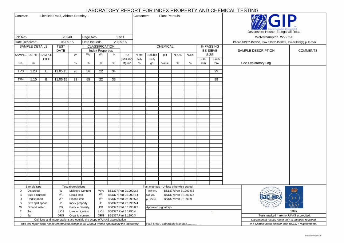
LABORATORY REPORT FOR INDEX PROPERTY AND CHEMICAL TESTINGContract: Lichfield Road, Abbots Bromley. Customer: Plant Petrouis.
Job No:- 23240 Page No:- 1 of 1
Date Received:- 06.05.15 Date Issued:- 20.05.15 SAMPLE DETAILS TEST CHEMICAL % PASSING
DATE BS SIEVE SAMPLE DESCRIPTION COMMENTSSAMPLE DEPTH SAMPLE W WL WP IP PD *Total Soluble pH *L.O.I. *ORG SIZE
TYPE (Gas Jar) SO4 SO4 2.00 0.425
No. m % % % % Mg/m³ % g/L Value % % mm mm
TP3 1.20 B 11.05.15 26 56 22 34 99
TP4 1.10 B 11.05.15 23 55 22 33 98
Sample type Test abbreviations Test methods - Unless otherwise stated.
D Disturbed W Moisture Content W% BS1377:Part 2:1990:3.2 Total SO4 BS1377:Part 3:1990:5.5
B Bulk disturbed WL Liquid limit WL BS1377:Part 2:1990:4.4 Sol SO4 BS1377:Part 3:1990:5.5
U Undisturbed WP Plastic limit WP BS1377:Part 2:1990:5.3 pH Value BS1377:Part 3:1990:9
S SPT split spoon IP Index property IP BS1377:Part 2:1990:5.4
W Ground water PD Particle Density PD BS1377:Part 3:1990:8.2 Approved signatory:-
T Tub L.O.I Loss on ignition L.O.I BS1377:Part 3:1990:4 1897J Jar ORG Organic content ORG BS1377:Part 3:1990:3 Tests marked * are not UKAS accredited.
Opinions and interpretations are outside the scope of UKAS accreditation The reported results relate only to samples received.
This test report shall not be reproduced except in full without written approval by the laboratory. # = Sample mass smaller than BS1377 requirements.
See Exploratory Log
CLASSIFICATIONIndex Properties
Devonshire House, Ettingshall Road,
Wolverhampton. WV2 2JT
Phone 01902 459558, Fax 01902 459085, Email [email protected]
Paul Smart, Laboratory Manager…………PC:\excel\involet\000.xls

A-Line Plot
01
02
03
04
05
06
07
08
0
0 10 20 30 40 50 60 70 80 90 100 110 120 130
Pla
stic
ity
Ind
ex (
%)
Liquid Limit (%) A-Line PI Modified PI
HighLow Plasticity Intermediate Very High Extremely High PlasticityLo
wM
ediu
mH
igh
Vol
ume
chan
ge p
oten
tial
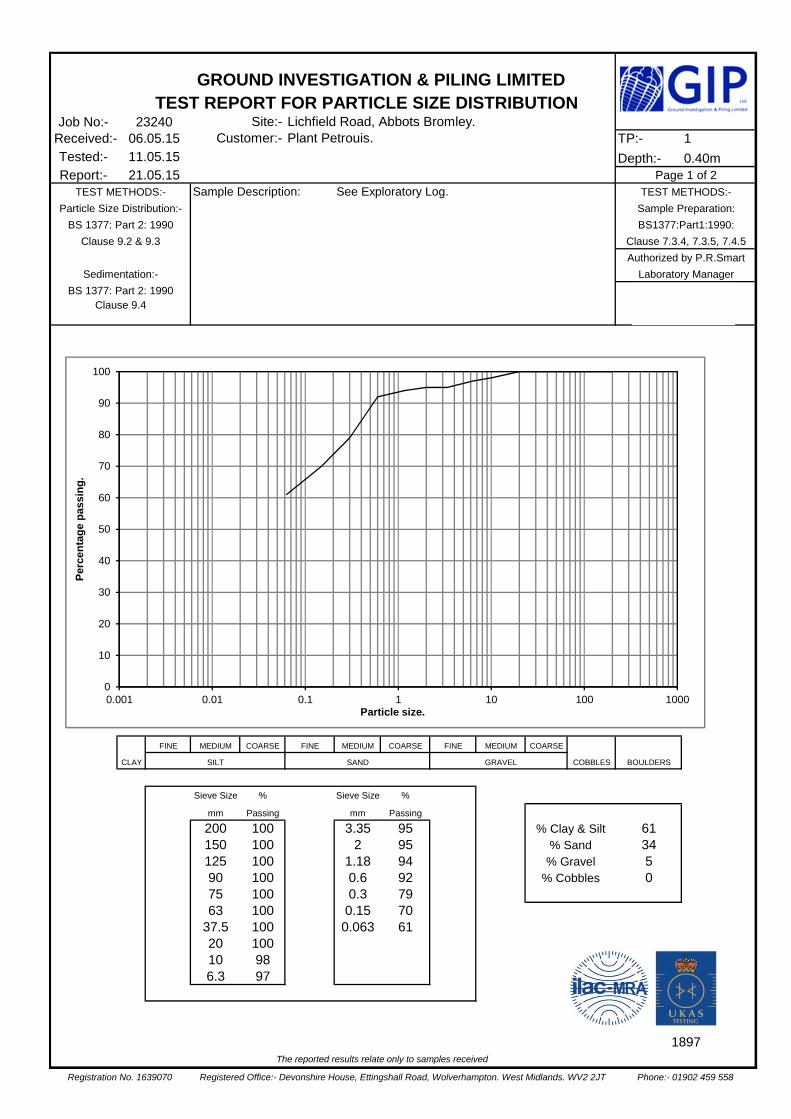
Job No:- 23240 Site:- Lichfield Road, Abbots Bromley.Received:- 06.05.15 Customer:- Plant Petrouis. TP:- 1Tested:- 11.05.15 Depth:- 0.40mReport:- 21.05.15 Page 1 of 2
TEST METHODS:- Sample Description: See Exploratory Log. TEST METHODS:-
Particle Size Distribution:- Sample Preparation:
BS 1377: Part 2: 1990 BS1377:Part1:1990:
Clause 9.2 & 9.3 Authorized by P.R.Smart
Sedimentation:- Laboratory Manager
BS 1377: Part 2: 1990 Clause 9.4
FINE MEDIUM COARSE FINE MEDIUM COARSE FINE MEDIUM COARSE
CLAY SILT SAND GRAVEL COBBLES BOULDERS
Sieve Size % Sieve Size %
mm Passing mm Passing
200 100 3.35 95 % Clay & Silt 61150 100 2 95 % Sand 34125 100 1.18 94 % Gravel 590 100 0.6 92 % Cobbles 075 100 0.3 7963 100 0.15 70
37.5 100 0.063 6120 10010 986.3 97
1897
The reported results relate only to samples received
Registration No. 1639070 Registered Office:- Devonshire House, Ettingshall Road, Wolverhampton. West Midlands. WV2 2JT Phone:- 01902 459 558
Clause 7.3.4, 7.3.5, 7.4.5
GROUND INVESTIGATION & PILING LIMITEDTEST REPORT FOR PARTICLE SIZE DISTRIBUTION
P
0
10
20
30
40
50
60
70
80
90
100
0.001 0.01 0.1 1 10 100 1000
Per
cen
tag
e p
assi
ng
.
Particle size.

Job No:- 23240 Site:- Lichfield Road, Abbots Bromley.Received:- 06.05.15 Customer:- Plant Petrouis. TP:- 3Tested:- 11.05.15 Depth:- 0.40mReport:- 21.05.15 Page 2 of 2
TEST METHODS:- Sample Description: See Exploratory Log. TEST METHODS:-
Particle Size Distribution:- Sample Preparation:
BS 1377: Part 2: 1990 BS1377:Part1:1990:
Clause 9.2 & 9.3 Authorized by P.R.Smart
Sedimentation:- Laboratory Manager
BS 1377: Part 2: 1990 Clause 9.4
FINE MEDIUM COARSE FINE MEDIUM COARSE FINE MEDIUM COARSE
CLAY SILT SAND GRAVEL COBBLES BOULDERS
Sieve Size % Sieve Size %
mm Passing mm Passing
200 100 3.35 88 % Clay & Silt 45150 100 2 86 % Sand 41125 100 1.18 84 % Gravel 1490 100 0.6 81 % Cobbles 075 100 0.3 7063 100 0.15 54
37.5 100 0.063 4520 10010 936.3 90
1897
The reported results relate only to samples received
Registration No. 1639070 Registered Office:- Devonshire House, Ettingshall Road, Wolverhampton. West Midlands. WV2 2JT Phone:- 01902 459 558
Clause 7.3.4, 7.3.5, 7.4.5
GROUND INVESTIGATION & PILING LIMITEDTEST REPORT FOR PARTICLE SIZE DISTRIBUTION
P
0
10
20
30
40
50
60
70
80
90
100
0.001 0.01 0.1 1 10 100 1000
Per
cen
tag
e p
assi
ng
.
Particle size.

APPENDIX E

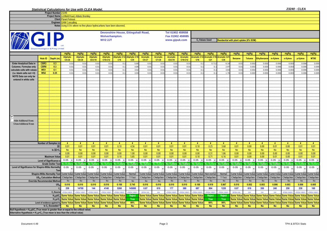
Statistical Calculations for Use with CLEA Model. 23240 - CLEA
Devonshire House, Ettingshall Road, Tel 01902 459558 Wolverhampton. Fax 01902 459085WV2 2JT www.gipuk.com
mg/kg mg/kg mg/kg mg/kg mg/kg mg/kg mg/kg mg/kg mg/kg mg/kg mg/kg mg/kg
CBR3 0.3 8.86 0.412 1.2 22.9 91.3 0.14 11.9 1 20.7 81.3 1 0.035
CBR8 0.3 8.2 0.355 1.2 17.2 78.7 0.14 11.3 1 17.7 80 1 0.035
WS1 0.1 8.81 0.576 1.2 18.3 62.8 0.14 11.9 1 22.7 82.4 1 0.035
WS2 0.25 7.32 0.302 0.6 14.9 47.5 0.14 10 1 18.7 65.9 1 0.035
WS3 0.40 20.4 1.96 0.6 12.4 64.2 0.14 18.5 1 47.9 91.5 1 0.035
Hide Additional RowsShow Additional Rows
5 5 5 5 5 5 5 5 5 5 5 510.72 0.72 0.96 17.14 68.90 0.14 12.72 1.00 25.54 80.22 1.00 0.04
No No No No No No No No No No No No5.45 0.70 0.33 3.94 16.70 0.00 3.32 0.00 12.65 9.20 0.00 0.00
20.40 1.96 1.20 22.90 91.30 0.14 18.50 1.00 47.90 91.50 1.00 0.04
No Outliers No Outliers No Outliers No Outliers No Outliers No Outliers No Outliers No Outliers No Outliers No Outliers No Outliers No Outliers
Non-normal Non-normal Non-normal Normal Normal Same Value Non-normal Same Value Non-normal Normal Same Value Same ValueChebychev Chebychev Chebychev T-Test T-Test Chebychev Chebychev Chebychev Chebychev T-Test Chebychev Chebychev Chebychev Chebychev Chebychev Chebychev Chebychev Chebychev Chebychev Chebychev
21.341 2.086 1.601 20.894 84.819 0.140 19.199 1.000 50.198 88.988 1.000 0.03537 26 21 4020 200 170 130 350 115 17200 34 420
DEFRA C4SL DEFRA C4SL DEFRA C4SL ATRISK 31/03/11 DEFRA C4SL SGV SGV SGV ATRISK 31/03/11 ATRISK 31/03/11 SGV ATRISK 31/03/11
Reject Reject Reject Reject Reject Same Value Reject Same Value Reject Reject Same Value Same ValueTrue True True True True Same Value True Same Value True True Same Value Same Value99% 99% 99% 99% 99% Same Value 99% Same Value 99% 99% Same Value Same ValueNo No No No No No No No No No No No
Null Hypothesis = H0 µ≥Cc (True mean is greater than or equal to the critical value)Alternative Hypothesis = H1 µ<Cc (True mean is less than the critical value)
s
Number of Samples (n)
Is >Cc
ArsenicDepth (m)
Enter Analytical Data in Columns. Formulae only
calculate cells with values (i.e. blank cells not = 0) NOTE Data can only be entered in white cells
Maximum ValueLevel of Significance α
PhenolsHole ID Nickel
Notes
Project NumberProject Name
ClientEngineer
23240
Planet PetrouisLichfield Road, Abbots Bromley
GHW Consulting
Cc Values Used
Using SSVs where no free phase hydrocarbons have been observed.
Residential with plant uptake (6% SOM)
Cadmium Chromium (hexavalent) Copper Selenium CyanideVanadiumLead
Grubb Outlier TestLevel of Significance for Shapiro-Wilks Normality
Test
Level of evidence against H0
ZincInorganic Mercury
Shapiro-Wilks Normality TestUS95 Calculation Method
Override Recommended Method
Is Cc Exceeded ?
Cc
Cc SourceH0 µ≥Cc
H1 µ<Cc
US95
0.05 0.05 0.05 0.05 0.05 0.05 0.05 0.05 0.05 0.05 0.05 0.05 0.05 0.05 0.05 0.05 0.05 0.05 0.05 0.05
0.05 0.05 0.05 0.05 0.05 0.05 0.05 0.05 0.05 0.05 0.05 0.05 0.05 0.05 0.05 0.05 0.05 0.05 0.05 0.05
No No No No No No No No No No No No No No No No No No No No
Document 4.49 Page 1 General Stats

Statistical Calculations for Use with CLEA Model. 23240 - CLEA
Devonshire House, Ettingshall Road, Tel 01902 459558 Wolverhampton. Fax 01902 459085WV2 2JT www.gipuk.com
mg/kg mg/kg mg/kg mg/kg mg/kg mg/kg mg/kg mg/kg mg/kg mg/kg mg/kg mg/kg mg/kg mg/kg
CBR3 0.3 0.008 0.016 0.0814 0.0829 0.117 0.0654 0.0434 0.065 0.023 0.131 0.01 0.0557 0.009 0.112
CBR8 0.3 0.008 0.016 0.014 0.015 0.015 0.024 0.014 0.01 0.023 0.017 0.01 0.018 0.009 0.015
WS1 0.1 0.008 0.016 0.0412 0.0334 0.0541 0.0341 0.018 0.0317 0.023 0.0502 0.01 0.0259 0.009 0.0449
WS2 0.25 0.008 0.016 0.014 0.015 0.015 0.024 0.014 0.01 0.023 0.017 0.01 0.018 0.009 0.015
WS3 0.40 0.008 0.016 0.014 0.015 0.015 0.024 0.014 0.01 0.023 0.017 0.01 0.018 0.009 0.015
Hide Additional RowsShow Additional Rows
5 5 5 5 5 5 5 5 5 5 5 5 5 50.01 0.02 0.03 0.03 0.04 0.03 0.02 0.03 0.02 0.05 0.01 0.03 0.01 0.04No No No No No No No No No No No No No No
0.00 0.00 0.03 0.03 0.04 0.02 0.01 0.02 0.00 0.05 0.00 0.02 0.00 0.040.01 0.02 0.08 0.08 0.12 0.07 0.04 0.07 0.02 0.13 0.01 0.06 0.01 0.11
No Outliers No Outliers No Outliers No Outliers No Outliers No Outliers No Outliers No Outliers No Outliers No Outliers No Outliers No Outliers No Outliers No Outliers
Same Value Same Value Non-normal Non-normal Non-normal Non-normal Non-normal Non-normal Same Value Non-normal Same Value Non-normal Same Value Non-normalChebychev Chebychev Chebychev Chebychev Chebychev Chebychev Chebychev Chebychev Chebychev Chebychev Chebychev Chebychev Chebychev Chebychev Chebychev Chebychev Chebychev Chebychev Chebychev Chebychev
0.008 0.016 0.091 0.090 0.130 0.069 0.046 0.072 0.023 0.143 0.010 0.059 0.009 0.1222130 18300 8.54 5 9.86 103 100 927 1 2160 1930 9.75 8.71 1550
ATRISK 31/03/11 ATRISK 31/03/11 ATRISK 31/03/11 DEFRA C4SL ATRISK 31/03/11 ATRISK 31/03/11 ATRISK 31/03/11 ATRISK 31/03/11 ATRISK 31/03/11 ATRISK 31/03/11 ATRISK 31/03/11 ATRISK 31/03/11 ATRISK 31/03/11 ATRISK 31/03/11
Same Value Same Value Reject Reject Reject Reject Reject Reject Same Value Reject Same Value Reject Same Value RejectSame Value Same Value True True True True True True Same Value True Same Value True Same Value TrueSame Value Same Value 99% 99% 99% 99% 99% 99% Same Value 99% Same Value 99% Same Value 99%
No No No No No No No No No No No No No NoNull Hypothesis = H0 µ≥Cc (True mean is greater than or equal to the critical value)Alternative Hypothesis = H1 µ<Cc (True mean is less than the critical value)
Notes
Project NumberProject Name
ClientEngineer
Residential with plant uptake (6% SOM)
Using SSVs where no free phase hydrocarbons have been observed.
23240
Planet PetrouisLichfield Road, Abbots Bromley
GHW Consulting
Cc Values Used
Benzo(a) pyrene Chrysene Fluorene Indeno(123cd) pyrene
Dibenzo(ah) anthracene Naphthalene PyreneBenzo(b)
fluorantheneAcenaphthene Anthracene Benz (a) anthracene FluorantheneBenzo(ghi)
peryleneBenzo(k)
fluoranthene
Number of Samples (n)
Is >Cc
s
Hole ID Depth (m)
Enter Analytical Data in Columns. Formulae only
calculate cells with values (i.e. blank cells not = 0) NOTE Data can only be entered in white cells
Shapiro-Wilks Normality TestUS95 Calculation Method
Override Recommended MethodUS95
Maximum ValueLevel of Significance α
Grubb Outlier TestLevel of Significance for Shapiro-Wilks Normality
Test
Level of evidence against H0
Is Cc Exceeded ?
Cc
Cc SourceH0 µ≥Cc
H1 µ<Cc
0.05 0.05 0.05 0.05 0.05 0.05 0.05 0.05 0.05 0.05 0.05 0.05 0.05 0.05 0.05 0.05 0.05 0.05 0.05 0.05
0.05 0.05 0.05 0.05 0.05 0.05 0.05 0.05 0.05 0.05 0.05 0.05 0.05 0.05 0.05 0.05 0.05 0.05 0.05 0.05
No No No No No No No No No No No No No No No No No No No No
Document 4.49 Page 2 PAH Stats
Statistical Calculations for Use with CLEA Model. 23240 - CLEA
Devonshire House, Ettingshall Road, Tel 01902 459558 Wolverhampton. Fax 01902 459085WV2 2JT www.gipuk.com
mg/kg mg/kg mg/kg mg/kg mg/kg mg/kg mg/kg mg/kg mg/kg mg/kg mg/kg mg/kg mg/kg mg/kg mg/kg mg/kg mg/kg mg/kg mg/kg mg/kg
CBR3 0.3 0.01 0.01 0.01 0.01 0.1 5.85 0.01 0.01 0.01 0.01 0.1 0.711 6.16 0.01 0.002 0.003 0.006 0.003 0.006 0.005
CBR8 0.3 0.01 0.01 0.01 0.01 0.1 4.85 0.01 0.01 0.01 0.01 0.1 0.1 2.97 0.01 0.002 0.003 0.006 0.003 0.006 0.005
WS1 0.1 0.01 0.01 0.01 0.01 0.1 3.62 0.01 0.01 0.01 0.01 0.1 0.1 3.83 0.01 0.002 0.003 0.006 0.003 0.006 0.005
WS2 0.25 0.01 0.01 0.01 0.01 0.1 3.93 0.01 0.01 0.01 0.01 0.1 0.1 1.76 0.01 0.002 0.003 0.006 0.003 0.006 0.005
Hide Additional RowsShow Additional Rows
4 4 4 4 4 4 4 4 4 4 4 4 4 4 4 4 4 4 4 40.01 0.01 0.01 0.01 0.10 4.56 0.01 0.01 0.01 0.01 0.10 0.25 3.68 0.01 0.00 0.00 0.01 0.00 0.01 0.01No No No No No No No No No No No No No No No No No No No No
0.00 0.00 0.00 0.00 0.00 1.00 0.00 0.00 0.00 0.00 0.00 0.31 1.86 0.00 0.00 0.00 0.00 0.00 0.00 0.000.01 0.01 0.01 0.01 0.10 5.85 0.01 0.01 0.01 0.01 0.10 0.71 6.16 0.01 0.00 0.00 0.01 0.00 0.01 0.01
No Outliers No Outliers No Outliers No Outliers No Outliers No Outliers No Outliers No Outliers No Outliers No Outliers No Outliers No Outliers No Outliers No Outliers No Outliers No Outliers No Outliers No Outliers No Outliers No Outliers
Same Value Same Value Same Value Same Value Same Value Normal Same Value Same Value Same Value Same Value Same Value Non-normal Normal Same Value Same Value Same Value Same Value Same Value Same Value Same ValueChebychev Chebychev Chebychev Chebychev Chebychev T-Test Chebychev Chebychev Chebychev Chebychev Chebychev Chebychev T-Test Chebychev Chebychev Chebychev Chebychev Chebychev Chebychev Chebychev
0.010 0.010 0.010 0.010 0.100 5.745 0.010 0.010 0.010 0.010 0.100 0.919 5.867 0.010 0.002 0.003 0.006 0.003 0.006 0.005259 14700 144 4140 5260 145000 0.87 610 177 389 687 804 1220 0.87 610 350 240 250 230 160
ATRISK 31/03/11 ATRISK 31/03/11 ATRISK 31/03/11 ATRISK 31/03/11 ATRISK 31/03/11 ATRISK 31/03/11 DEFRA C4SL SGV ATRISK 31/03/11 ATRISK 31/03/11 ATRISK 31/03/11 ATRISK 31/03/11 ATRISK 31/03/11 DEFRA C4SL SGV SGV SGV ATRISK 31/03/11 ATRISK 31/03/11 ATRISK 31/03/11
Same Value Same Value Same Value Same Value Same Value Reject Same Value Same Value Same Value Same Value Same Value Reject Reject Same Value Same Value Same Value Same Value Same Value Same Value Same ValueSame Value Same Value Same Value Same Value Same Value True Same Value Same Value Same Value Same Value Same Value True True Same Value Same Value Same Value Same Value Same Value Same Value Same ValueSame Value Same Value Same Value Same Value Same Value 99% Same Value Same Value Same Value Same Value Same Value 99% 99% Same Value Same Value Same Value Same Value Same Value Same Value Same Value
No No No No No No No No No No No No No No No No No No No NoNull Hypothesis = H0 µ≥Cc (True mean is greater than or equal to the critical value)Alternative Hypothesis = H1 µ<Cc (True mean is less than the critical value)
s
Number of Samples (n)
Is >Cc
Aliphatic C5-C6Depth (m)
Enter Analytical Data in Columns. Formulae only
calculate cells with values (i.e. blank cells not = 0) NOTE Data can only be entered in white cells
Maximum ValueLevel of Significance α
Aromatic C16-C21Hole ID Aromatic
C5-C7
Notes
Project NumberProject Name
ClientEngineer
23240
Planet PetrouisLichfield Road, Abbots Bromley
GHW Consulting
Cc Values Used
Using SSVs where no free phase hydrocarbons have been observed.
Residential with plant uptake (6% SOM)
MTBEm-XyleneEthylbenzeneAliphatic C6-C8
Aliphatic C8-C10 o-XyleneAromatic C21-
C35 TolueneBenzeneAliphatic C10-C12
Aromatic C7-C8
Aromatic C12-C16
Aromatic C8-C10
Aliphatic C12-C16
Grubb Outlier TestLevel of Significance for Shapiro-Wilks Normality
Test
Level of evidence against H0
p-XyleneAromatic C10-C12
Aliphatic C16-C35
Shapiro-Wilks Normality TestUS95 Calculation Method
Override Recommended Method
Is Cc Exceeded ?
Cc
Cc SourceH0 µ≥Cc
H1 µ<Cc
US95
0.05 0.05 0.05 0.05 0.05 0.05 0.05 0.05 0.05 0.05 0.05 0.05 0.05 0.05 0.05 0.05 0.05 0.05 0.05 0.05
0.05 0.05 0.05 0.05 0.05 0.05 0.05 0.05 0.05 0.05 0.05 0.05 0.05 0.05 0.05 0.05 0.05 0.05 0.05 0.05
No No No No No No No No No No No No No No No No No No No No
Document 4.49 Page 3 TPH & BTEX Stats

Devonshire House, Ettingshall Road, Wolverhampton. WV2 2JT Tel 01902 459558 Fax 01902 459085
The Null Hypothesis = H0 µ≥Cc (or the true mean is greater than or equal to the critical value)
The Alternative Hypothesis = H1 µ<Cc (or the true mean is less than the critical value)
• Firstly the Grubbs Outlier test is used to determine the presence of any anomalously high values in the data. These may either be “hot spots” of contamination or possibly erroneous results.
If the Null Hypothesis is rejected then there is an at least 95% confidence level that the true mean concentration of the site is less than the critical concentration and no further action is required. If the Null Hypothesis is accepted then the true mean concentration is deemed to be greater than the critical concentration and the land is unsuitable for its proposed end use or requires remediation to render it suitable.
• Accounting for any outliers using the above method the data is tested to determine whether it falls within a normal distribution using the Shapiro-Wilks normality test.
• If the data does not deviate from normality then the 95% confidence limit is calculated using the one-sample t-test. Otherwise the 95% Upper confidence limit is calculated using the one-sided Chebychev Theorem.
• The Upper 95% confidence limit is then compared to the Cc
The critical concentrations (Cc) used in this assessment are the Soil Screening Values (SSV) from the ATRISKSOIL website www.atrisksoil.co.uk. These are generated by Atkins Consultants.
Notes on the Statistical Calculations for Use With the CLEA Model
The preceding tables are from a spreadsheet which takes the analytical data from chemical analyses of soils and compares them with a critical concentration (Cc) using a number of statistical methods. The spreadsheet has been written using the methodology described in “Guidance on Comparing Soil Contamination Data with a Critical Concentration” – May 2008 (The Chartered Institute of Environmental Health and CL:AIRE with support from The Soil and Groundwater Technology Association)
The aim of the assessment is to prove, or otherwise, that the land under investigation is fit for purpose in that the level of contamination is low compared to an appropriate measure of risk. In statistical terms this question is handled using formal hypotheses. These are:-
If the Null Hypothesis is proven incorrect then the land is deemed fit for purpose and the Alternative Hypotheis is true. If the Null Hypothesis is proven correct then the land is deemed unfit for purpose or remediation is necessary to render it fit for purpose.
and
Following verification of the data a process of statistical methods is used.

Unit 7-8 Hawarden Business Park
Manor Road (off Manor Lane)
Hawarden
Deeside
CH5 3US
Tel: (01244) 528700
Fax: (01244) 528701
email: [email protected]
Website: www.alcontrol.com
Ground Investigation & Piling Ltd
Ettingshall Road
Wolverhampton
West Midlands
WV2 2JT
Attention: Dave Brown
CERTIFICATE OF ANALYSIS
Location:
Your Reference:
Sample Delivery Group (SDG):
Customer:
Date: 27 May 2015
H_GIP_WLV
150512-40
DNB/23240
Lichfield Road, Abbots Bromley.
We received 7 samples on Tuesday May 12, 2015 and 7 of these samples were scheduled for analysis which was
completed on Wednesday May 27, 2015. Accredited laboratory tests are defined within the report, but opinions,
interpretations and on-site data expressed herein are outside the scope of ISO 17025 accreditation.
Should this report require incorporation into client reports, it must be used in its entirety and not simply with the data
sections alone.
All chemical testing (unless subcontracted) is performed at ALcontrol Hawarden Laboratories.
Report No: 314268
Operations Manager
Sonia McWhan
Approved By:
Alcontrol Laboratories is a trading division of ALcontrol UK Limited
Registered Office: Units 7 & 8 Hawarden Business Park, Manor Road, Hawarden, Deeside, CH5 3US. Registered in England and Wales No.
Page 1 of 16

CERTIFICATE OF ANALYSISSDG:
Job:
Client Reference:
150512-40
DNB/23240
Location:
Customer:
Attention:
Order Number:
Report Number:H_GIP_WLV-1194 Ground Investigation & Piling LtdLichfield Road, Abbots Bromley.
Dave Brown
37995314268
Superseded Report:
Validated
Received Sample OverviewSampled DateLab Sample No(s) Customer Sample Ref. AGS Ref. Depth (m)
11346969 CBR3 0.30
11346971 CBR8 0.30
11346964 WS1 0.10
11346965 WS2 0.25
11346966 WS3 0.40
11346967 WS3 1.20
11346968 WS6 0.50
Only received samples which have had analysis scheduled will be shown on the following pages.
10:16:58 27/05/2015
Page 2 of 16

CERTIFICATE OF ANALYSISSDG:
Job:
Client Reference:
150512-40
DNB/23240
Location:
Customer:
Attention:
Order Number:
Report Number:H_GIP_WLV-1194 Ground Investigation & Piling LtdLichfield Road, Abbots Bromley.
Dave Brown
37995314268
Superseded Report:
Validated
SOLID
Results Legend
X Test
NNo Determination
Possible
Lab Sample No(s)
Customer
Sample Reference
Depth (m)
Container
AGS Reference
11
346
96
9
11
346
97
1
11
346
96
4
11
346
96
5
11
346
96
611
346
96
711
346
96
8
CB
R3
CB
R8
WS
1
WS
2
WS
3W
S3
WS
6
0.3
0
0.3
0
0.1
0
0.2
5
0.4
01.2
00.5
0
250g
Am
be
r Jar (A
L40
0g T
ub (A
LE
21
4)
60g
VO
C (A
LE
215)
250g
Am
be
r Jar (A
L40
0g T
ub (A
LE
21
4)
60g
VO
C (A
LE
215)
250g
Am
be
r Jar (A
L40
0g T
ub (A
LE
21
4)
60g
VO
C (A
LE
215)
250g
Am
be
r Jar (A
L40
0g T
ub (A
LE
21
4)
60g
VO
C (A
LE
215)
250g
Am
be
r Jar (A
L40
0g T
ub (A
LE
21
4)
60g
VO
C (A
LE
215)
40
0g T
ub (A
LE
21
4)
40
0g T
ub (A
LE
21
4)
Anions by Kone (soil) All NDPs: 0
Tests: 4
X
X
X
X
Anions by Kone (w) All NDPs: 0
Tests: 2
X
X
CEN Readings All NDPs: 0
Tests: 2
X
X
Cyanide
Comp/Free/Total/Thiocyanate
All NDPs: 0
Tests: 5
X
X
X
X
X
Dissolved Metals by ICP-MS All NDPs: 0
Tests: 2
X
X
Dissolved Organic/Inorganic
Carbon
All NDPs: 0
Tests: 2
X
X
EPH CWG (Aliphatic) GC (S) All NDPs: 0
Tests: 4
X
X
X
X
EPH CWG (Aromatic) GC (S) All NDPs: 0
Tests: 4
X
X
X
X
Fluoride All NDPs: 0
Tests: 2
X
X
GRO by GC-FID (S) All NDPs: 0
Tests: 5
X
X
X
X
X
Hexavalent Chromium (s) All NDPs: 0
Tests: 5
X
X
X
X
X
Mercury Dissolved All NDPs: 0
Tests: 2
X
X
Metals in solid samples by OES All NDPs: 0
Tests: 5
X
X
X
X
X
Mineral Oil All NDPs: 0
Tests: 2
X
X
PAH by GCMS All NDPs: 0
Tests: 5
X
X
X
X
X
10:16:58 27/05/2015
Page 3 of 16
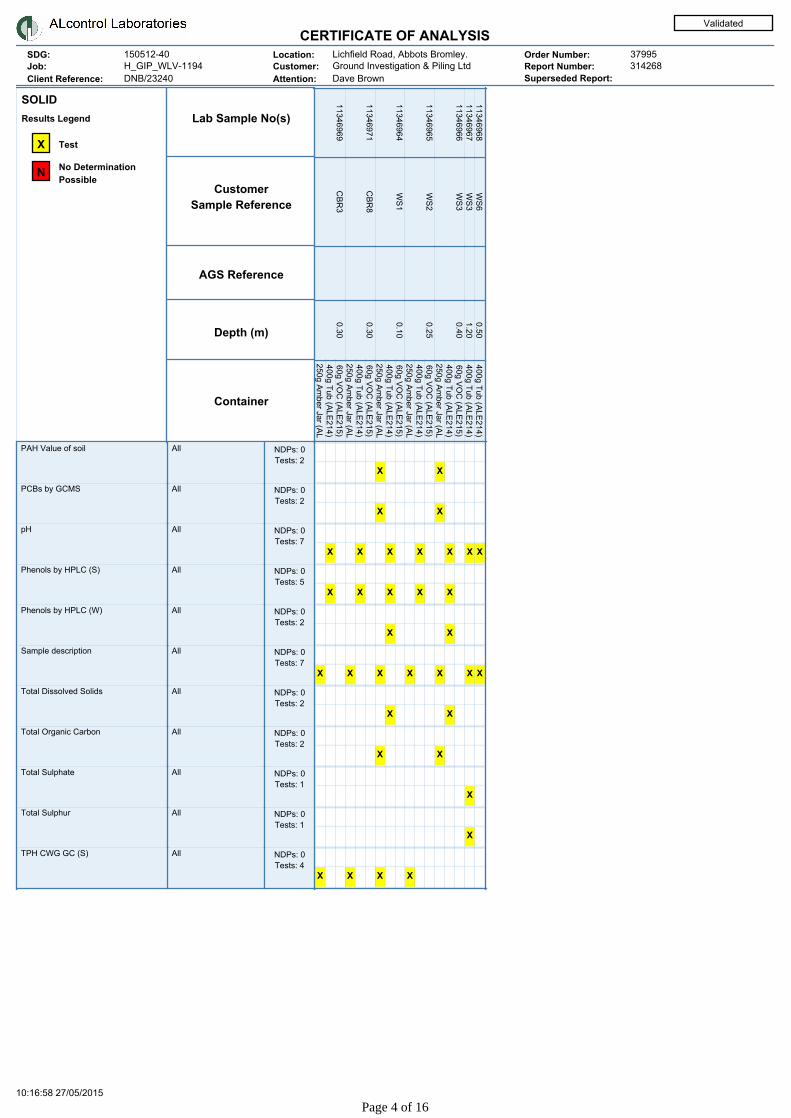
CERTIFICATE OF ANALYSISSDG:
Job:
Client Reference:
150512-40
DNB/23240
Location:
Customer:
Attention:
Order Number:
Report Number:H_GIP_WLV-1194 Ground Investigation & Piling LtdLichfield Road, Abbots Bromley.
Dave Brown
37995314268
Superseded Report:
Validated
SOLID
Results Legend
X Test
NNo Determination
Possible
Lab Sample No(s)
Customer
Sample Reference
Depth (m)
Container
AGS Reference
11
346
96
9
11
346
97
1
11
346
96
4
11
346
96
5
11
346
96
611
346
96
711
346
96
8
CB
R3
CB
R8
WS
1
WS
2
WS
3W
S3
WS
6
0.3
0
0.3
0
0.1
0
0.2
5
0.4
01.2
00.5
0
250g
Am
be
r Jar (A
L40
0g T
ub (A
LE
21
4)
60g
VO
C (A
LE
215)
250g
Am
be
r Jar (A
L40
0g T
ub (A
LE
21
4)
60g
VO
C (A
LE
215)
250g
Am
be
r Jar (A
L40
0g T
ub (A
LE
21
4)
60g
VO
C (A
LE
215)
250g
Am
be
r Jar (A
L40
0g T
ub (A
LE
21
4)
60g
VO
C (A
LE
215)
250g
Am
be
r Jar (A
L40
0g T
ub (A
LE
21
4)
60g
VO
C (A
LE
215)
40
0g T
ub (A
LE
21
4)
40
0g T
ub (A
LE
21
4)
PAH Value of soil All NDPs: 0
Tests: 2
X
X
PCBs by GCMS All NDPs: 0
Tests: 2
X
X
pH All NDPs: 0
Tests: 7
X
X
X
X
X
X
X
Phenols by HPLC (S) All NDPs: 0
Tests: 5
X
X
X
X
X
Phenols by HPLC (W) All NDPs: 0
Tests: 2
X
X
Sample description All NDPs: 0
Tests: 7
X
X
X
X
X
X
X
Total Dissolved Solids All NDPs: 0
Tests: 2
X
X
Total Organic Carbon All NDPs: 0
Tests: 2
X
X
Total Sulphate All NDPs: 0
Tests: 1
X
Total Sulphur All NDPs: 0
Tests: 1
X
TPH CWG GC (S) All NDPs: 0
Tests: 4
X
X
X
X
10:16:58 27/05/2015
Page 4 of 16

CERTIFICATE OF ANALYSISSDG:
Job:
Client Reference:
150512-40
DNB/23240
Location:
Customer:
Attention:
Order Number:
Report Number:H_GIP_WLV-1194 Ground Investigation & Piling LtdLichfield Road, Abbots Bromley.
Dave Brown
37995314268
Superseded Report:
Validated
Sample Descriptions
very fine <0.063mm 0.063mm - 0.1mm 0.1mm - 2mm 2mm - 10mm >10mmfine medium coarse very coarse
Grain Sizes
Colour Description Grain size Inclusions Inclusions 2
11346969 CBR3 0.30 Dark Brown Sandy Clay
Loam
0.1 - 2 mm Stones Vegetation
11346971 CBR8 0.30 Dark Brown Sandy Loam 0.1 - 2 mm Stones Vegetation
11346964 WS1 0.10 Dark Brown Sandy Loam 0.1 - 2 mm Stones Vegetation
11346965 WS2 0.25 Dark Brown Sandy Clay
Loam
0.1 - 2 mm Stones Vegetation
11346966 WS3 0.40 Light Brown Clay <0.063 mm Stones None
11346967 WS3 1.20 Dark Brown Clay <0.063 mm Vegetation None
11346968 WS6 0.50 Dark Brown Clay <0.063 mm Vegetation None
Customer Sample Ref. Depth (m)Lab Sample No(s)
These descriptions are only intended to act as a cross check if sample identities are questioned, and to provide a log of
sample matrices with respect to MCERTS validation. They are not intended as full geological descriptions.
We are accredited to MCERTS for sand, clay and loam/topsoil, or any of these materials - whether these are derived from
naturally ocurring soil profiles, or from fill/made ground, as long as these materials constitute the major part of the sample.
Other coarse granular materials such as concrete, gravel and brick are not accredited if they comprise the major part of the
sample.
10:16:58 27/05/2015
Page 5 of 16

CERTIFICATE OF ANALYSISSDG:
Job:
Client Reference:
150512-40
DNB/23240
Location:
Customer:
Attention:
Order Number:
Report Number:H_GIP_WLV-1194 Ground Investigation & Piling LtdLichfield Road, Abbots Bromley.
Dave Brown
37995314268
Superseded Report:
Validated
ISO17025 accredited.
mCERTS accredited.
Aqueous / settled sample.
Dissolved / filtered sample.
Total / unfiltered sample.
Subcontracted test.
% recovery of the surrogate standard to
check the efficiency of the method. The
results of individual compounds within
samples aren't corrected for the recovery
Trigger breach confirmed
Sample deviation (see appendix)
#
M
aq
diss.filt
tot.unfilt
*
**
(F)
1-5&♦§@
Results Legend
AGS Reference
Lab Sample No.(s)
SDG Ref
Date Received
Date Sampled
Sample Type
Depth (m)
Customer Sample R
MethodLOD/UnitsComponent
Sample Time
CBR3
0.30
Soil/Solid
-
.
12/05/2015
150512-40
11346969
CBR8
0.30
Soil/Solid
-
.
12/05/2015
150512-40
11346971
WS1
0.10
Soil/Solid
-
.
12/05/2015
150512-40
11346964
WS2
0.25
Soil/Solid
-
.
12/05/2015
150512-40
11346965
WS3
0.40
Soil/Solid
-
.
12/05/2015
150512-40
11346966
WS3
1.20
Soil/Solid
-
.
12/05/2015
150512-40
11346967
Moisture Content Ratio (%
of as received sample)
% PM024 14
§
13
§
12
§
13
§
16
§
19
§
Mineral oil >C10-C40 <1 mg/kg TM061 3.81
§
1.77
§
Mineral Oil Surrogate %
recovery**
% TM061 85.4
§
85.5
§
Phenol <0.01
mg/kg
TM062 (S) <0.01
§ M
<0.01
§ M
<0.01
§ M
<0.01
§ M
<0.01
§ M
Cresols <0.01
mg/kg
TM062 (S) <0.01
§ M
<0.01
§ M
<0.01
§ M
<0.01
§ M
<0.01
§ M
Xylenols <0.015
mg/kg
TM062 (S) <0.015
§ M
<0.015
§ M
<0.015
§ M
<0.015
§ M
<0.015
§ M
Phenols, Total Detected
monohydric
<0.035
mg/kg
TM062 (S) <0.035
§ M
<0.035
§ M
<0.035
§ M
<0.035
§ M
<0.035
§ M
Organic Carbon, Total <0.2 % TM132 0.724
§ M
0.33
§ M
Sulphur, Total <0.02 % TM132 0.0435
§ #
Sulphate, Total potential <0.06 % TM132 0.131
§
pH 1 pH
Units
TM133 7.03
§ M
7.39
§ M
7.36
§ M
6.93
§ M
7.6
§ M
7.23
§ M
Chromium, Hexavalent <0.6
mg/kg
TM151 <1.2
§ #
<1.2
§ #
<1.2
§ #
<0.6
§ #
<0.6
§ #
Cyanide, Total <1 mg/kg TM153 <1
§ M
<1
§ M
<1
§ M
<1
§ M
<1
§ M
PCB congener 28 <0.003
mg/kg
TM168 <0.003
§ M
<0.003
§ M
PCB congener 52 <0.003
mg/kg
TM168 <0.003
§ M
<0.003
§ M
PCB congener 101 <0.003
mg/kg
TM168 <0.003
§ M
<0.003
§ M
PCB congener 118 <0.003
mg/kg
TM168 <0.003
§ M
<0.003
§ M
PCB congener 138 <0.003
mg/kg
TM168 <0.003
§ M
<0.003
§ M
PCB congener 153 <0.003
mg/kg
TM168 <0.003
§ M
<0.003
§ M
PCB congener 180 <0.003
mg/kg
TM168 <0.003
§ M
<0.003
§ M
Sum of detected PCB 7
Congeners
<0.021
mg/kg
TM168 <0.021
§
<0.021
§
Arsenic <0.6
mg/kg
TM181 8.86
§ M
8.2
§ M
8.81
§ M
7.32
§ M
20.4
§ M
Cadmium <0.02
mg/kg
TM181 0.412
§ M
0.355
§ M
0.576
§ M
0.302
§ M
1.96
§ M
Chromium <0.9
mg/kg
TM181 13.6
§ M
11.9
§ M
15.7
§ M
12.9
§ M
27.7
§ M
Copper <1.4
mg/kg
TM181 22.9
§ M
17.2
§ M
18.3
§ M
14.9
§ M
12.4
§ M
Lead <0.7
mg/kg
TM181 91.3
§ M
78.7
§ M
62.8
§ M
47.5
§ M
64.2
§ M
Mercury <0.14
mg/kg
TM181 <0.14
§ M
<0.14
§ M
<0.14
§ M
<0.14
§ M
<0.14
§ M
Nickel <0.2
mg/kg
TM181 11.9
§ M
11.3
§ M
11.9
§ M
10
§ M
18.5
§ M
Selenium <1 mg/kg TM181 <1
§ #
<1
§ #
<1
§ #
<1
§ #
<1
§ #
Vanadium <0.2
mg/kg
TM181 20.7
§ #
17.7
§ #
22.7
§ #
18.7
§ #
47.9
§ #
Zinc <1.9
mg/kg
TM181 81.3
§ M
80
§ M
82.4
§ M
65.9
§ M
91.5
§ M
Polyaromatic
hydrocarbons, Total 17
<10
mg/kg
TM213 <10
§
<10
§
10:16:58 27/05/2015
Page 6 of 16

CERTIFICATE OF ANALYSISSDG:
Job:
Client Reference:
150512-40
DNB/23240
Location:
Customer:
Attention:
Order Number:
Report Number:H_GIP_WLV-1194 Ground Investigation & Piling LtdLichfield Road, Abbots Bromley.
Dave Brown
37995314268
Superseded Report:
Validated
ISO17025 accredited.
mCERTS accredited.
Aqueous / settled sample.
Dissolved / filtered sample.
Total / unfiltered sample.
Subcontracted test.
% recovery of the surrogate standard to
check the efficiency of the method. The
results of individual compounds within
samples aren't corrected for the recovery
Trigger breach confirmed
Sample deviation (see appendix)
#
M
aq
diss.filt
tot.unfilt
*
**
(F)
1-5&♦§@
Results Legend
AGS Reference
Lab Sample No.(s)
SDG Ref
Date Received
Date Sampled
Sample Type
Depth (m)
Customer Sample R
MethodLOD/UnitsComponent
Sample Time
CBR3
0.30
Soil/Solid
-
.
12/05/2015
150512-40
11346969
CBR8
0.30
Soil/Solid
-
.
12/05/2015
150512-40
11346971
WS1
0.10
Soil/Solid
-
.
12/05/2015
150512-40
11346964
WS2
0.25
Soil/Solid
-
.
12/05/2015
150512-40
11346965
WS3
0.40
Soil/Solid
-
.
12/05/2015
150512-40
11346966
WS3
1.20
Soil/Solid
-
.
12/05/2015
150512-40
11346967
Sulphate, Total <48
mg/kg
TM221 113
§ M
Soluble Sulphate 2:1
extract as SO4 BRE
<0.004 g/l TM243 <0.004
§ M
0.0173
§ M
0.0323
§ M
10:16:58 27/05/2015
Page 7 of 16
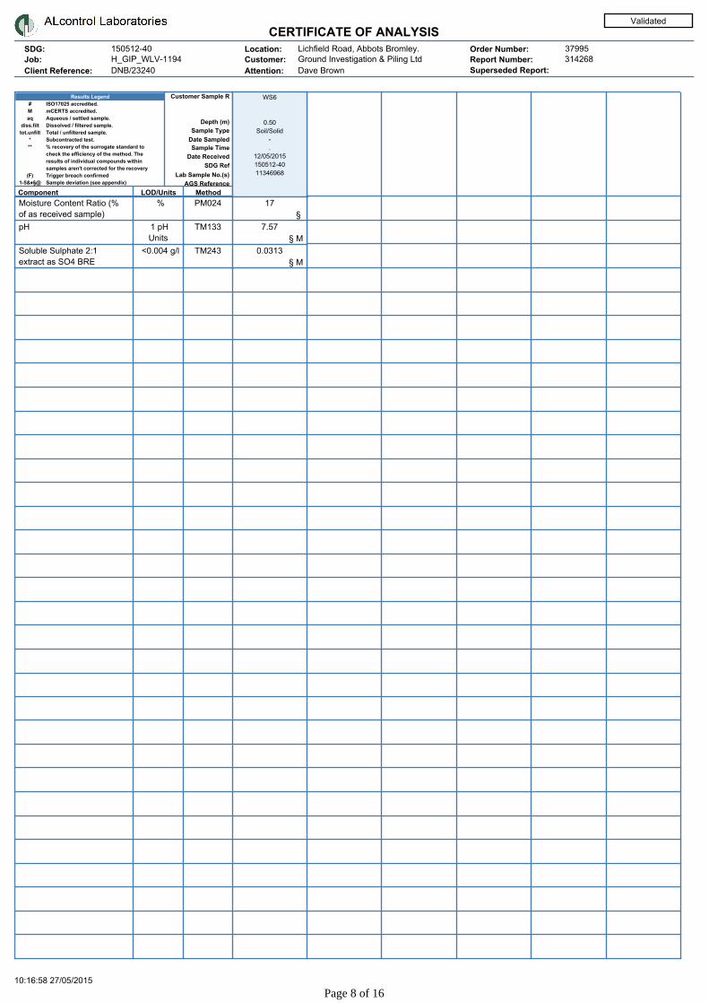
CERTIFICATE OF ANALYSISSDG:
Job:
Client Reference:
150512-40
DNB/23240
Location:
Customer:
Attention:
Order Number:
Report Number:H_GIP_WLV-1194 Ground Investigation & Piling LtdLichfield Road, Abbots Bromley.
Dave Brown
37995314268
Superseded Report:
Validated
ISO17025 accredited.
mCERTS accredited.
Aqueous / settled sample.
Dissolved / filtered sample.
Total / unfiltered sample.
Subcontracted test.
% recovery of the surrogate standard to
check the efficiency of the method. The
results of individual compounds within
samples aren't corrected for the recovery
Trigger breach confirmed
Sample deviation (see appendix)
#
M
aq
diss.filt
tot.unfilt
*
**
(F)
1-5&♦§@
Results Legend
AGS Reference
Lab Sample No.(s)
SDG Ref
Date Received
Date Sampled
Sample Type
Depth (m)
Customer Sample R
MethodLOD/UnitsComponent
Sample Time
WS6
0.50
Soil/Solid
-
.
12/05/2015
150512-40
11346968
Moisture Content Ratio (%
of as received sample)
% PM024 17
§
pH 1 pH
Units
TM133 7.57
§ M
Soluble Sulphate 2:1
extract as SO4 BRE
<0.004 g/l TM243 0.0313
§ M
10:16:58 27/05/2015
Page 8 of 16

CERTIFICATE OF ANALYSISSDG:
Job:
Client Reference:
150512-40
DNB/23240
Location:
Customer:
Attention:
Order Number:
Report Number:H_GIP_WLV-1194 Ground Investigation & Piling LtdLichfield Road, Abbots Bromley.
Dave Brown
37995314268
Superseded Report:
Validated
GRO by GC-FID (S)
ISO17025 accredited.
mCERTS accredited.
Aqueous / settled sample.
Dissolved / filtered sample.
Total / unfiltered sample.
Subcontracted test.
% recovery of the surrogate standard to
check the efficiency of the method. The
results of individual compounds within
samples aren't corrected for the recovery
Trigger breach confirmed
Sample deviation (see appendix)
#
M
aq
diss.filt
tot.unfilt
*
**
(F)
1-5&♦§@
Results Legend
AGS Reference
Lab Sample No.(s)
SDG Ref
Date Received
Date Sampled
Sample Type
Depth (m)
Customer Sample R
MethodLOD/UnitsComponent
Sample Time
WS3
0.40
Soil/Solid
-
.
12/05/2015
150512-40
11346966
Methyl tertiary butyl ether
(MTBE)
<0.005
mg/kg
TM089 <0.005
§ M
Benzene <0.01
mg/kg
TM089 <0.01
§ M
Toluene <0.002
mg/kg
TM089 <0.002
§ M
Ethylbenzene <0.003
mg/kg
TM089 <0.003
§ M
m,p-Xylene <0.006
mg/kg
TM089 <0.006
§ M
o-Xylene <0.003
mg/kg
TM089 <0.003
§ M
sum of detected mpo
xylene by GC
<0.009
mg/kg
TM089 <0.009
§
sum of detected BTEX by
GC
<0.024
mg/kg
TM089 <0.024
§
10:16:58 27/05/2015
Page 9 of 16

CERTIFICATE OF ANALYSISSDG:
Job:
Client Reference:
150512-40
DNB/23240
Location:
Customer:
Attention:
Order Number:
Report Number:H_GIP_WLV-1194 Ground Investigation & Piling LtdLichfield Road, Abbots Bromley.
Dave Brown
37995314268
Superseded Report:
Validated
PAH by GCMS
ISO17025 accredited.
mCERTS accredited.
Aqueous / settled sample.
Dissolved / filtered sample.
Total / unfiltered sample.
Subcontracted test.
% recovery of the surrogate standard to
check the efficiency of the method. The
results of individual compounds within
samples aren't corrected for the recovery
Trigger breach confirmed
Sample deviation (see appendix)
#
M
aq
diss.filt
tot.unfilt
*
**
(F)
1-5&♦§@
Results Legend
AGS Reference
Lab Sample No.(s)
SDG Ref
Date Received
Date Sampled
Sample Type
Depth (m)
Customer Sample R
MethodLOD/UnitsComponent
Sample Time
CBR3
0.30
Soil/Solid
-
.
12/05/2015
150512-40
11346969
CBR8
0.30
Soil/Solid
-
.
12/05/2015
150512-40
11346971
WS1
0.10
Soil/Solid
-
.
12/05/2015
150512-40
11346964
WS2
0.25
Soil/Solid
-
.
12/05/2015
150512-40
11346965
WS3
0.40
Soil/Solid
-
.
12/05/2015
150512-40
11346966
Naphthalene-d8 %
recovery**
% TM218 93.9
§
99.5
§
98.4
§
101
§
94.1
§
Acenaphthene-d10 %
recovery**
% TM218 91.5
§
97.4
§
96.3
§
98.1
§
90.9
§
Phenanthrene-d10 %
recovery**
% TM218 90.9
§
97.3
§
97
§
98.9
§
92.2
§
Chrysene-d12 %
recovery**
% TM218 86.2
§
89.7
§
90.7
§
90.2
§
83
§
Perylene-d12 %
recovery**
% TM218 86.7
§
86.7
§
90.1
§
84.8
§
75.6
§
Naphthalene <0.009
mg/kg
TM218 <0.009
§ M
<0.009
§ M
<0.009
§ M
<0.009
§ M
<0.009
§ M
Acenaphthylene <0.012
mg/kg
TM218 <0.012
§ M
<0.012
§ M
<0.012
§ M
<0.012
§ M
<0.012
§ M
Acenaphthene <0.008
mg/kg
TM218 <0.008
§ M
<0.008
§ M
<0.008
§ M
<0.008
§ M
<0.008
§ M
Fluorene <0.01
mg/kg
TM218 <0.01
§ M
<0.01
§ M
<0.01
§ M
<0.01
§ M
<0.01
§ M
Phenanthrene <0.015
mg/kg
TM218 0.0378
§ M
<0.015
§ M
<0.015
§ M
<0.015
§ M
<0.015
§ M
Anthracene <0.016
mg/kg
TM218 <0.016
§ M
<0.016
§ M
<0.016
§ M
<0.016
§ M
<0.016
§ M
Fluoranthene <0.017
mg/kg
TM218 0.131
§ M
<0.017
§ M
0.0502
§ M
<0.017
§ M
<0.017
§ M
Pyrene <0.015
mg/kg
TM218 0.112
§ M
<0.015
§ M
0.0449
§ M
<0.015
§ M
<0.015
§ M
Benz(a)anthracene <0.014
mg/kg
TM218 0.0814
§ M
<0.014
§ M
0.0412
§ M
<0.014
§ M
<0.014
§ M
Chrysene <0.01
mg/kg
TM218 0.065
§ M
<0.01
§ M
0.0317
§ M
<0.01
§ M
<0.01
§ M
Benzo(b)fluoranthene <0.015
mg/kg
TM218 0.117
§ M
<0.015
§ M
0.0541
§ M
<0.015
§ M
<0.015
§ M
Benzo(k)fluoranthene <0.014
mg/kg
TM218 0.0434
§ M
<0.014
§ M
0.018
§ M
<0.014
§ M
<0.014
§ M
Benzo(a)pyrene <0.015
mg/kg
TM218 0.0829
§ M
<0.015
§ M
0.0334
§ M
<0.015
§ M
<0.015
§ M
Indeno(1,2,3-cd)pyrene <0.018
mg/kg
TM218 0.0557
§ M
<0.018
§ M
0.0259
§ M
<0.018
§ M
<0.018
§ M
Dibenzo(a,h)anthracene <0.023
mg/kg
TM218 <0.023
§ M
<0.023
§ M
<0.023
§ M
<0.023
§ M
<0.023
§ M
Benzo(g,h,i)perylene <0.024
mg/kg
TM218 0.0654
§ M
<0.024
§ M
0.0341
§ M
<0.024
§ M
<0.024
§ M
PAH, Total Detected
USEPA 16
<0.118
mg/kg
TM218 0.791
§
<0.118
§
0.333
§
<0.118
§
<0.118
§
10:16:58 27/05/2015
Page 10 of 16

CERTIFICATE OF ANALYSISSDG:
Job:
Client Reference:
150512-40
DNB/23240
Location:
Customer:
Attention:
Order Number:
Report Number:H_GIP_WLV-1194 Ground Investigation & Piling LtdLichfield Road, Abbots Bromley.
Dave Brown
37995314268
Superseded Report:
Validated
TPH CWG (S)
ISO17025 accredited.
mCERTS accredited.
Aqueous / settled sample.
Dissolved / filtered sample.
Total / unfiltered sample.
Subcontracted test.
% recovery of the surrogate standard to
check the efficiency of the method. The
results of individual compounds within
samples aren't corrected for the recovery
Trigger breach confirmed
Sample deviation (see appendix)
#
M
aq
diss.filt
tot.unfilt
*
**
(F)
1-5&♦§@
Results Legend
AGS Reference
Lab Sample No.(s)
SDG Ref
Date Received
Date Sampled
Sample Type
Depth (m)
Customer Sample R
MethodLOD/UnitsComponent
Sample Time
CBR3
0.30
Soil/Solid
-
.
12/05/2015
150512-40
11346969
CBR8
0.30
Soil/Solid
-
.
12/05/2015
150512-40
11346971
WS1
0.10
Soil/Solid
-
.
12/05/2015
150512-40
11346964
WS2
0.25
Soil/Solid
-
.
12/05/2015
150512-40
11346965
GRO Surrogate %
recovery**
% TM089 94
§
86
§
94
§
89
§
GRO TOT (Moisture
Corrected)
<0.044
mg/kg
TM089 <0.044
§ M
<0.044
§ M
<0.044
§ M
<0.044
§ M
Methyl tertiary butyl ether
(MTBE)
<0.005
mg/kg
TM089 <0.005
§ M
<0.005
§ M
<0.005
§ M
<0.005
§ M
Benzene <0.01
mg/kg
TM089 <0.01
§ M
<0.01
§ M
<0.01
§ M
<0.01
§ M
Toluene <0.002
mg/kg
TM089 <0.002
§ M
<0.002
§ M
<0.002
§ M
<0.002
§ M
Ethylbenzene <0.003
mg/kg
TM089 <0.003
§ M
<0.003
§ M
<0.003
§ M
<0.003
§ M
m,p-Xylene <0.006
mg/kg
TM089 <0.006
§ M
<0.006
§ M
<0.006
§ M
<0.006
§ M
o-Xylene <0.003
mg/kg
TM089 <0.003
§ M
<0.003
§ M
<0.003
§ M
<0.003
§ M
sum of detected mpo
xylene by GC
<0.009
mg/kg
TM089 <0.009
§
<0.009
§
<0.009
§
<0.009
§
sum of detected BTEX by
GC
<0.024
mg/kg
TM089 <0.024
§
<0.024
§
<0.024
§
<0.024
§
Aliphatics >C5-C6 <0.01
mg/kg
TM089 <0.01
§
<0.01
§
<0.01
§
<0.01
§
Aliphatics >C6-C8 <0.01
mg/kg
TM089 <0.01
§
<0.01
§
<0.01
§
<0.01
§
Aliphatics >C8-C10 <0.01
mg/kg
TM089 <0.01
§
<0.01
§
<0.01
§
<0.01
§
Aliphatics >C10-C12 <0.01
mg/kg
TM089 <0.01
§
<0.01
§
<0.01
§
<0.01
§
Aliphatics >C12-C16 <0.1
mg/kg
TM173 <0.1
§
<0.1
§
<0.1
§
<0.1
§
Aliphatics >C16-C21 <0.1
mg/kg
TM173 <0.1
§
<0.1
§
<0.1
§
<0.1
§
Aliphatics >C21-C35 <0.1
mg/kg
TM173 5.75
§
4.75
§
3.52
§
3.83
§
Aliphatics >C35-C44 <0.1
mg/kg
TM173 <0.1
§
<0.1
§
<0.1
§
<0.1
§
Total Aliphatics >C12-C44 <0.1
mg/kg
TM173 5.75
§
4.75
§
3.52
§
3.83
§
Aromatics >EC5-EC7 <0.01
mg/kg
TM089 <0.01
§
<0.01
§
<0.01
§
<0.01
§
Aromatics >EC7-EC8 <0.01
mg/kg
TM089 <0.01
§
<0.01
§
<0.01
§
<0.01
§
Aromatics >EC8-EC10 <0.01
mg/kg
TM089 <0.01
§
<0.01
§
<0.01
§
<0.01
§
Aromatics >EC10-EC12 <0.01
mg/kg
TM089 <0.01
§
<0.01
§
<0.01
§
<0.01
§
Aromatics >EC12-EC16 <0.1
mg/kg
TM173 <0.1
§
<0.1
§
<0.1
§
<0.1
§
Aromatics >EC16-EC21 <0.1
mg/kg
TM173 0.711
§
<0.1
§
<0.1
§
<0.1
§
Aromatics >EC21-EC35 <0.1
mg/kg
TM173 6.16
§
2.97
§
3.83
§
1.76
§
Aromatics >EC35-EC44 <0.1
mg/kg
TM173 5.47
§
4.87
§
4.93
§
5.23
§
Aromatics >EC40-EC44 <0.1
mg/kg
TM173 3.07
§
3.02
§
3.03
§
3.42
§
Total Aromatics
>EC12-EC44
<0.1
mg/kg
TM173 12.3
§
7.84
§
8.76
§
6.99
§
Total Aliphatics &
Aromatics >C5-C44
<0.1
mg/kg
TM173 18.1
§
12.6
§
12.3
§
10.8
§
10:16:58 27/05/2015
Page 11 of 16
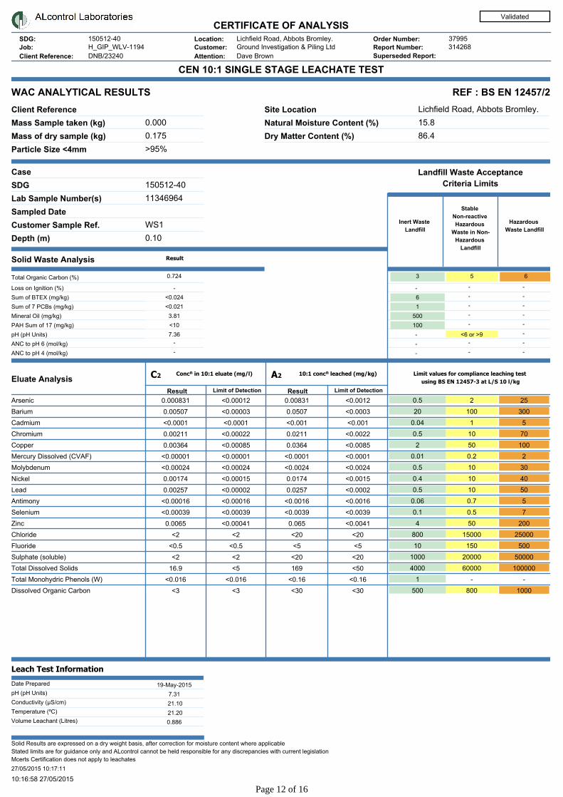
CERTIFICATE OF ANALYSISSDG:
Job:
Client Reference:
150512-40
DNB/23240
Location:
Customer:
Attention:
Order Number:
Report Number:H_GIP_WLV-1194 Ground Investigation & Piling LtdLichfield Road, Abbots Bromley.
Dave Brown
37995314268
Superseded Report:
Validated
-
-
-
-
-
-
-
-
-
CEN 10:1 SINGLE STAGE LEACHATE TEST
WAC ANALYTICAL RESULTS REF : BS EN 12457/2
Client Reference
Mass Sample taken (kg)
Mass of dry sample (kg)
Particle Size <4mm
0.175
>95%
Site Location
Natural Moisture Content (%)
Dry Matter Content (%)
15.8
86.4
Case
Depth (m)
Customer Sample Ref.
Sampled Date
Lab Sample Number(s)
SDG 150512-40
11346964
WS1
0.10
Solid Waste Analysis
ANC to pH 4 (mol/kg)
ANC to pH 6 (mol/kg)
pH (pH Units)
PAH Sum of 17 (mg/kg)
Mineral Oil (mg/kg)
Sum of 7 PCBs (mg/kg)
Sum of BTEX (mg/kg)
Loss on Ignition (%)
Total Organic Carbon (%)
Eluate Analysis
Leach Test Information
Date Prepared
pH (pH Units)
Conductivity (µS/cm)
Temperature (ºC)
Volume Leachant (Litres)
Solid Results are expressed on a dry weight basis, after correction for moisture content where applicable
Stated limits are for guidance only and ALcontrol cannot be held responsible for any discrepancies with current legislation
Mcerts Certification does not apply to leachates
27/05/2015 10:17:11
19-May-2015
7.31
0.886
21.20
21.10
7.36
<10
3.81
<0.021
<0.024
0.724 -
-
-
-
-
-
-
-
-
-
-
-
-
-
-
-
-
-
-
-
-
-
-
-
-
-
-
Lichfield Road, Abbots Bromley.
0.000
Result ResultLimit of Detection Limit of Detection
C2 Concⁿ in 10:1 eluate (mg/l) A2 10:1 concⁿ leached (mg/kg)
Result
Limit values for compliance leaching test
using BS EN 12457-3 at L/S 10 l/kg
Hazardous
Waste Landfill
Stable
Non-reactive
Hazardous
Waste in Non-
Hazardous
Landfill
Inert Waste
Landfill
<6 or >9
100
500
1
6
653
Landfill Waste Acceptance
Criteria Limits
-----Arsenic 0.000831 0.00831 0.5<0.00012 <0.0012 2 25
-----Barium 0.00507 0.0507 20<0.00003 <0.0003 100 300
-----Cadmium <0.0001 <0.001 0.04<0.0001 <0.001 1 5
-----Chromium 0.00211 0.0211 0.5<0.00022 <0.0022 10 70
-----Copper 0.00364 0.0364 2<0.00085 <0.0085 50 100
-----Mercury Dissolved (CVAF) <0.00001 <0.0001 0.01<0.00001 <0.0001 0.2 2
-----Molybdenum <0.00024 <0.0024 0.5<0.00024 <0.0024 10 30
-----Nickel 0.00174 0.0174 0.4<0.00015 <0.0015 10 40
-----Lead 0.00257 0.0257 0.5<0.00002 <0.0002 10 50
-----Antimony <0.00016 <0.0016 0.06<0.00016 <0.0016 0.7 5
-----Selenium <0.00039 <0.0039 0.1<0.00039 <0.0039 0.5 7
-----Zinc 0.0065 0.065 4<0.00041 <0.0041 50 200
-----Chloride <2 <20 800<2 <20 15000 25000
-----Fluoride <0.5 <5 10<0.5 <5 150 500
-----Sulphate (soluble) <2 <20 1000<2 <20 20000 50000
-----Total Dissolved Solids 16.9 169 4000<5 <50 60000 100000
-----Total Monohydric Phenols (W) <0.016 <0.16 1<0.016 <0.16 - -
-----Dissolved Organic Carbon <3 <30 500<3 <30 800 1000
10:16:58 27/05/2015
Page 12 of 16

CERTIFICATE OF ANALYSISSDG:
Job:
Client Reference:
150512-40
DNB/23240
Location:
Customer:
Attention:
Order Number:
Report Number:H_GIP_WLV-1194 Ground Investigation & Piling LtdLichfield Road, Abbots Bromley.
Dave Brown
37995314268
Superseded Report:
Validated
-
-
-
-
-
-
-
-
-
CEN 10:1 SINGLE STAGE LEACHATE TEST
WAC ANALYTICAL RESULTS REF : BS EN 12457/2
Client Reference
Mass Sample taken (kg)
Mass of dry sample (kg)
Particle Size <4mm
0.175
>95%
Site Location
Natural Moisture Content (%)
Dry Matter Content (%)
23.1
81.3
Case
Depth (m)
Customer Sample Ref.
Sampled Date
Lab Sample Number(s)
SDG 150512-40
11346966
WS3
0.40
Solid Waste Analysis
ANC to pH 4 (mol/kg)
ANC to pH 6 (mol/kg)
pH (pH Units)
PAH Sum of 17 (mg/kg)
Mineral Oil (mg/kg)
Sum of 7 PCBs (mg/kg)
Sum of BTEX (mg/kg)
Loss on Ignition (%)
Total Organic Carbon (%)
Eluate Analysis
Leach Test Information
Date Prepared
pH (pH Units)
Conductivity (µS/cm)
Temperature (ºC)
Volume Leachant (Litres)
Solid Results are expressed on a dry weight basis, after correction for moisture content where applicable
Stated limits are for guidance only and ALcontrol cannot be held responsible for any discrepancies with current legislation
Mcerts Certification does not apply to leachates
27/05/2015 10:17:11
19-May-2015
7.25
0.879
21.20
16.30
7.6
<10
1.77
<0.021
<0.024
0.33 -
-
-
-
-
-
-
-
-
-
-
-
-
-
-
-
-
-
-
-
-
-
-
-
-
-
-
Lichfield Road, Abbots Bromley.
0.000
Result ResultLimit of Detection Limit of Detection
C2 Concⁿ in 10:1 eluate (mg/l) A2 10:1 concⁿ leached (mg/kg)
Result
Limit values for compliance leaching test
using BS EN 12457-3 at L/S 10 l/kg
Hazardous
Waste Landfill
Stable
Non-reactive
Hazardous
Waste in Non-
Hazardous
Landfill
Inert Waste
Landfill
<6 or >9
100
500
1
6
653
Landfill Waste Acceptance
Criteria Limits
-----Arsenic 0.000442 0.00442 0.5<0.00012 <0.0012 2 25
-----Barium 0.00393 0.0393 20<0.00003 <0.0003 100 300
-----Cadmium <0.0001 <0.001 0.04<0.0001 <0.001 1 5
-----Chromium 0.000727 0.00727 0.5<0.00022 <0.0022 10 70
-----Copper 0.00776 0.0776 2<0.00085 <0.0085 50 100
-----Mercury Dissolved (CVAF) <0.00001 <0.0001 0.01<0.00001 <0.0001 0.2 2
-----Molybdenum 0.000669 0.00669 0.5<0.00024 <0.0024 10 30
-----Nickel 0.00174 0.0174 0.4<0.00015 <0.0015 10 40
-----Lead 0.00115 0.0115 0.5<0.00002 <0.0002 10 50
-----Antimony 0.000716 0.00716 0.06<0.00016 <0.0016 0.7 5
-----Selenium <0.00039 <0.0039 0.1<0.00039 <0.0039 0.5 7
-----Zinc 0.00239 0.0239 4<0.00041 <0.0041 50 200
-----Chloride <2 <20 800<2 <20 15000 25000
-----Fluoride <0.5 <5 10<0.5 <5 150 500
-----Sulphate (soluble) <2 <20 1000<2 <20 20000 50000
-----Total Dissolved Solids 15.1 151 4000<5 <50 60000 100000
-----Total Monohydric Phenols (W) <0.016 <0.16 1<0.016 <0.16 - -
-----Dissolved Organic Carbon 4.59 45.9 500<3 <30 800 1000
10:16:58 27/05/2015
Page 13 of 16
CERTIFICATE OF ANALYSISSDG:
Job:
Client Reference:
150512-40
DNB/23240
Location:
Customer:
Attention:
Order Number:
Report Number:H_GIP_WLV-1194 Ground Investigation & Piling LtdLichfield Road, Abbots Bromley.
Dave Brown
37995314268
Superseded Report:
Validated
Table of Results - AppendixMethod No Reference Description
Wet/Dry
Sample ¹
Surrogate
Corrected
PM001 Preparation of Samples for Metals Analysis
PM024 Modified BS 1377 Soil preparation including homogenisation, moisture screens of
soils for Asbestos Containing Material
PM115 Leaching Procedure for CEN One Stage Leach Test 2:1 & 10:1
1 Step
TM061 Method for the Determination of
EPH,Massachusetts Dept.of EP, 1998
Determination of Extractable Petroleum Hydrocarbons by
GC-FID (C10-C40)
TM062 (S) National Grid Property Holdings Methods for the
Collection & Analysis of Samples from National
Grid Sites version 1 Sec 3.9
Determination of Phenols in Soils by HPLC
TM089 Modified: US EPA Methods 8020 & 602 Determination of Gasoline Range Hydrocarbons (GRO) and
BTEX (MTBE) compounds by Headspace GC-FID (C4-C12)
TM090 Method 5310, AWWA/APHA, 20th Ed., 1999 /
Modified: US EPA Method 415.1 & 9060
Determination of Total Organic Carbon/Total Inorganic Carbon
in Water and Waste Water
TM104 Method 4500F, AWWA/APHA, 20th Ed., 1999 Determination of Fluoride using the Kone Analyser
TM123 BS 2690: Part 121:1981 The Determination of Total Dissolved Solids in Water
TM132 In - house Method ELTRA CS800 Operators Guide
TM133 BS 1377: Part 3 1990;BS 6068-2.5 Determination of pH in Soil and Water using the GLpH pH
Meter
TM151 Method 3500D, AWWA/APHA, 20th Ed., 1999 Determination of Hexavalent Chromium using Kone analyser
TM152 Method 3125B, AWWA/APHA, 20th Ed., 1999 Analysis of Aqueous Samples by ICP-MS
TM153 Method 4500A,B,C, I, M AWWA/APHA, 20th
Ed., 1999
Determination of Total Cyanide, Free (Easily Liberatable)
Cyanide and Thiocyanate using the Skalar SANS+ System
Segmented Flow Analyser
TM168 EPA Method 8082, Polychlorinated Biphenyls by
Gas Chromatography
Determination of WHO12 and EC7 Polychlorinated Biphenyl
Congeners by GC-MS in Soils
TM173 Analysis of Petroleum Hydrocarbons in
Environmental Media – Total Petroleum
Hydrocarbon Criteria
Determination of Speciated Extractable Petroleum
Hydrocarbons in Soils by GC-FID
TM181 US EPA Method 6010B Determination of Routine Metals in Soil by iCap 6500 Duo
ICP-OES
TM183 BS EN 23506:2002, (BS 6068-2.74:2002) ISBN
0 580 38924 3
Determination of Trace Level Mercury in Waters and Leachates
by PSA Cold Vapour Atomic Fluorescence Spectrometry
TM184 EPA Methods 325.1 & 325.2, The Determination of Anions in Aqueous Matrices using the
Kone Spectrophotometric Analysers
TM213 In-house Method Rapid Determination of PAHs by GC-FID
TM218 Microwave extraction – EPA method 3546 Microwave extraction - EPA method 3546
TM221 Inductively Coupled Plasma - Atomic Emission
Spectroscopy. An Atlas of Spectral Information:
Winge, Fassel, Peterson and Floyd
Determination of Acid extractable Sulphate in Soils by IRIS
Emission Spectrometer
TM243 Mixed Anions In Soils By Kone
TM259 by HPLC Determination of Phenols in Waters and Leachates by HPLC
¹ Applies to Solid samples only. DRY indicates samples have been dried at 35°C. NA = not applicable.
10:16:58 27/05/2015
Page 14 of 16

CERTIFICATE OF ANALYSISSDG:
Job:
Client Reference:
150512-40
DNB/23240
Location:
Customer:
Attention:
Order Number:
Report Number:H_GIP_WLV-1194 Ground Investigation & Piling LtdLichfield Road, Abbots Bromley.
Dave Brown
37995314268
Superseded Report:
Validated
Test Completion DatesLab Sample No(s)
Customer Sample Ref.
Depth
Type
AGS Ref.
11346969 11346971 11346964 11346965 11346966 11346967 11346968
CBR3 CBR8 WS1 WS2 WS3 WS3 WS6
0.30 0.30 0.10 0.25 0.40 1.20 0.50
SOLID SOLID SOLID SOLID SOLID SOLID SOLID
Anions by Kone (soil) 18-May-2015 18-May-2015 22-May-2015 22-May-2015
Anions by Kone (w) 22-May-2015 22-May-2015
CEN 10:1 Leachate (1 Stage) 20-May-2015 20-May-2015
CEN Readings 21-May-2015 21-May-2015
Cyanide Comp/Free/Total/Thiocyanate 22-May-2015 22-May-2015 22-May-2015 22-May-2015 22-May-2015
Dissolved Metals by ICP-MS 22-May-2015 22-May-2015
Dissolved Organic/Inorganic Carbon 22-May-2015 22-May-2015
EPH CWG (Aliphatic) GC (S) 21-May-2015 21-May-2015 21-May-2015 21-May-2015
EPH CWG (Aromatic) GC (S) 21-May-2015 21-May-2015 21-May-2015 21-May-2015
Fluoride 21-May-2015 21-May-2015
GRO by GC-FID (S) 20-May-2015 20-May-2015 20-May-2015 20-May-2015 20-May-2015
Hexavalent Chromium (s) 27-May-2015 27-May-2015 27-May-2015 27-May-2015 21-May-2015
Mercury Dissolved 22-May-2015 22-May-2015
Metals in solid samples by OES 18-May-2015 18-May-2015 18-May-2015 18-May-2015 18-May-2015
Mineral Oil 20-May-2015 20-May-2015
PAH by GCMS 19-May-2015 20-May-2015 20-May-2015 20-May-2015 20-May-2015
PAH Value of soil 15-May-2015 15-May-2015
PCBs by GCMS 15-May-2015 15-May-2015
pH 22-May-2015 22-May-2015 22-May-2015 22-May-2015 22-May-2015 22-May-2015 22-May-2015
Phenols by HPLC (S) 22-May-2015 22-May-2015 22-May-2015 22-May-2015 22-May-2015
Phenols by HPLC (W) 22-May-2015 22-May-2015
Sample description 13-May-2015 13-May-2015 13-May-2015 13-May-2015 13-May-2015 14-May-2015 14-May-2015
Total Dissolved Solids 21-May-2015 21-May-2015
Total Organic Carbon 20-May-2015 20-May-2015
Total Sulphate 19-May-2015
Total Sulphur 19-May-2015
TPH CWG GC (S) 21-May-2015 21-May-2015 21-May-2015 21-May-2015
10:16:58 27/05/2015
Page 15 of 16

CERTIFICATE OF ANALYSISSDG:
Job:
Client Reference:
150512-40
DNB/23240
Location:
Customer:
Attention:
Order Number:
Report Number:H_GIP_WLV-1194 Ground Investigation & Piling LtdLichfield Road, Abbots Bromley.
Dave Brown
37995314268
Superseded Report:
Appendix
1. Results are expressed on a dry weight basis (dried at 35ºC) for all soil analyses except
for the following: NRA and CEN Leach tests, flash point LOI, pH, ammonium as NH 4 by the
BRE method, VOC TICS and SVOC TICS.
2. Samples will be run in duplicate upon request, but an additional charge may be incurred.
3. If sufficient sample is received a sub sample will be retained free of charge for 30 days
after analysis is completed (e-mailed) for all sample types unless the sample is destroyed
on testing. The prepared soil sub sample that is analysed for asbestos will be retained for a
period of 6 months after the analysis date. All bulk samples will be retained for a period of 6
months after the analysis date. All samples received and not scheduled will be disposed of
one month after the date of receipt unless we are instructed to the contrary. Once the initial
period has expired, a storage charge will be applied for each month or part thereof until the
client cancels the request for sample storage. ALcontrol Laboratories reserve the right to
charge for samples received and stored but not analysed.
4. With respect to turnaround, we will always endeavour to meet client requirements
wherever possible, but turnaround times cannot be absolutely guaranteed due to so many
variables beyond our control.
5. We take responsibility for any test performed by sub -contractors (marked with an
asterisk). We endeavour to use UKAS/MCERTS Accredited Laboratories, who either
complete a quality questionnaire or are audited by ourselves. For some determinands there
are no UKAS/MCERTS Accredited Laboratories, in this instance a laboratory with a known
track record will be utilised.
6. When requested, the individual sub sample scheduled will be analysed in house for the
presence of asbestos fibres and asbestos containing material by our documented in house
method TM048 based on HSG 248 (2005), which is accredited to ISO17025. If a specific
asbestos fibre type is not found this will be reported as “Not detected”. If no asbestos fibre
types are found all will be reported as “Not detected” and the sub sample analysed deemed
to be clear of asbestos. If an asbestos fibre type is found it will be reported as detected (for
each fibre type found). Testing can be carried out on asbestos positive samples, but, due
to Health and Safety considerations, may be replaced by alternative tests or reported as No
Determination Possible. The quantity of asbestos present is not determined unless
specifically requested.
7. If no separate volatile sample is supplied by the client, or if a headspace or sediment is
present in the volatile sample, the integrity of the data may be compromised. This will be
flagged up as an invalid VOC on the test schedule and the result marked as deviating on
the test certificate.
8. If appropriate preserved bottles are not received preservation will take place on receipt .
However, the integrity of the data may be compromised.
9. NDP -No determination possible due to insufficient/unsuitable sample.
10. Metals in water are performed on a filtered sample, and therefore represent dissolved
metals -total metals must be requested separately.
11. Results relate only to the items tested.
12. LODs for wet tests reported on a dry weight basis are not corrected for moisture
content.
13. Surrogate recoveries - Surrogates are added to your sample to monitor recovery of
the test requested. A % recovery is reported, results are not corrected for the recovery
measured. Typical recoveries for organics tests are 70-130%, they are generally wider for
volatiles analysis, 50-150%. Recoveries in soils are affected by organic rich or clay rich
matrices. Waters can be affected by remediation fluids or high amounts of sediment. Test
results are only ever reported if all of the associated quality checks pass; it is assumed
that all recoveries outside of the values above are due to matrix affect.
14. Product analyses -Organic analyses on products can only be semi -quantitative due to
the matrix effects and high dilution factors
employed.
15. Phenols monohydric by HPLC include phenol, cresols (2-Methylphenol, 3-Methylphenol
and 4-Methylphenol) and Xylenols (2,3 Dimethylphenol, 2,4 Dimethylphenol, 2,5
Dimethylphenol, 2,6 Dimethylphenol, 3,4 Dimethyphenol, 3,5 Dimethylphenol).
16. Total of 5 speciated phenols by HPLC includes Phenol, 2,3,5-Trimethyl Phenol,
2-Isopropylphenol, Cresols and Xylenols (as detailed in 15).
17. Stones/debris are not routinely removed. We always endeavour to take a
representative sub sample from the received sample.
18. In certain circumstances the method detection limit may be elevated due to the sample
being outside the calibration range. Other factors that may contribute to this include
possible interferences. In both cases the sample would be diluted which would cause the
method detection limit to be raised.
Identification of Asbestos in Bulk Materials & Soils
The results for identification of asbestos in bulk materials are obtained from supplied bulk
materials which have been examined to determine the presence of asbestos fibres using
Alcontrol Laboratories (Hawarden) in-house method of transmitted/polarised light
microscopy and central stop dispersion staining, based on HSG 248 (2005).
The results for identification of asbestos in soils are obtained from a homogenised sub
sample which has been examined to determine the presence of asbestos fibres using
Alcontrol Laboratories (Hawarden) in-house method of transmitted/polarised light
microscopy and central stop dispersion staining, based on HSG 248 (2005).
-Fibrous Tremolite
-Fibrous Anthophyllite
-Fibrous Actinolite
Blue AsbestosCrocidolite
Brown AsbestosAmosite
White AsbestosChrysotile
Common NameAsbestos Type
-Fibrous Tremolite
-Fibrous Anthophyllite
-Fibrous Actinolite
Blue AsbestosCrocidolite
Brown AsbestosAmosite
White AsbestosChrysotile
Common NameAsbestos Type
Visual Estimation Of Fibre Content
Estimation of fibre content is not permitted as part of our UKAS accredited test other than :
- Trace - Where only one or two asbestos fibres were identified.
Further guidance on typical asbestos fibre content of manufactured products can be
found in HSG 264.
The identification of asbestos containing materials and soils falls within our
schedule of tests for which we hold UKAS accreditation, however opinions,
interpretations and all other information contained in the report are outside the
scope of UKAS accreditation.
Sample Deviations
Container with Headspace provided for volatiles analysis
Incorrect container received
Deviation from method
Holding time exceeded before sample received
Samples exceeded holding time before presevation was performed
Sampled on date not provided
Sample holding time exceeded in laboratory
Sample holding time exceeded due to sampled on date
Sample Holding Time exceeded - Late arrival of instructions.
Asbestos
General19. Mercury results quoted on soils will not include volatile mercury as the analysis is
performed on a dried and crushed sample.
20. For the BSEN 12457-3 two batch process to allow the cumulative release to be
calculated, the volume of the leachate produced is measured and filtered for all tests. We
therefore cannot carry out any unfiltered analysis. The tests affected include volatiles
GCFID/GCMS and all subcontracted analysis.
21. For all leachate preparations (NRA, DIN, TCLP, BSEN 12457-1, 2, 3) volatile loss may
occur, as we do not employ zero headspace extraction.
22. We are accredited to MCERTS for sand, clay and loam/topsoil, or any of these
materials - whether these are derived from naturally occurring soil profiles, or from fill /made
ground, as long as these materials constitute the major part of the sample. Other coarse
granular material such as concrete, gravel and brick are not accredited if they comprise the
major part of the sample.
23. Analysis and identification of specific compounds using GCFID is by retention time
only, and we routinely calibrate and quantify for benzene, toluene, ethylbenzenes and
xylenes (BTEX). For total volatiles in the C5 -C12 range, the total area of the
chromatogram is integrated and expressed as ug /kg or ug/l. Although this analysis is
commonly used for the quantification of gasoline range organics (GRO), the system will
also detect other compounds such as chlorinated solvents, and this may lead to a falsely
high result with respect to hydrocarbons only. It is not possible to specifically identify these
non-hydrocarbons, as standards are not routinely run for any other compounds, and for
more definitive identification, volatiles by GCMS should be utilised.
1
2
3
4
5
§
♦
@
&
10:17:40 27/05/2015
Page 16 of 16

APPENDIX F
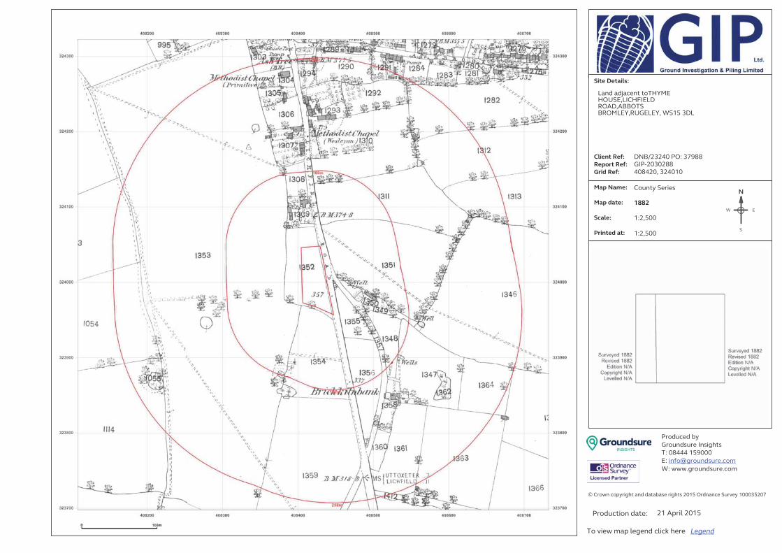
�
�������������
�
�
�
�
�
�
�
�
�
������� �����
������ �����
����� ���� �
���������� � � �
�
���������� �
�
��������
�
������������
����
�
�
��
�
��������� !��
"���#�$����%#$&'()$�
*+�,-...�/01,,,�
2+��4'���#�$���5��6��
7+�8885'���#�$���5��6�
�
9�:��8#���;!�&'()�<#���<)< <$���&'()$�=,/0�>��#<#���?��@�!�/,,,A0=,B�
�
���������)&�#��<)�+���
*��@&�8�6<;�C�'�#���C&�D�(������EFGFHI�

�
�������������
�
�
�
�
�
�
�
�
�
������� �����
������ �����
����� ���� �
���������� � � �
�
���������� �
�
��������
�
������������
����
�
�
��
�
��������� !��
"���#�$����%#$&'()$�
*+�,-...�/01,,,�
2+��4'���#�$���5��6��
7+�8885'���#�$���5��6�
�
9�:��8#���;!�&'()�<#���<)< <$���&'()$�=,/0�>��#<#���?��@�!�/,,,A0=,B�
�
���������)&�#��<)�+���
*��@&�8�6<;�C�'�#���C&�D�(������EFGFHI�

Ground Investigation and Piling Ltd
DEVONSHIRE HOUSE GROUND INVESTIGATION & PILING LTD, ETTINGSHALL ROAD, WOLVERHAMPTON, WV2 2JT
Groundsure Reference:
GIP-2030289
Your Reference: DNB/23240 PO: 37988
Report Date 21 Apr 2015
Report Delivery Method:
Email - pdf
Groundsure Enviroinsight
Address: Land adjacent toTHYME HOUSE,LICHFIELD ROAD,ABBOTS BROMLEY,RUGELEY, WS15 3DL
Dear Sir/ Madam,
Thank you for placing your order with Groundsure. Please find enclosed the Groundsure Enviroinsight as requested.
If you need any further assistance, please do not hesitate to contact our helpline on 08444 159 000 quoting the above report reference number.
Yours faithfully,
Ground Investigation & Piling Ltd
Enc.Groundsure Enviroinsight

GroundsureEnviroinsight
Address: Land adjacent toTHYME HOUSE,LICHFIELD ROAD,ABBOTS BROMLEY,RUGELEY, WS15 3DL
Date: 21 Apr 2015
Reference: GIP-2030289
Client: Ground Investigation and Piling Ltd
NW N NE
W E
SW S SE
Aerial Photograph Capture date: 31-May-2009Grid Reference: 408420,324010Site Size: 0.26ha

Contents Page Contents Page ..............................................................................................................................................................3Overview of Findings...................................................................................................................................................5Using this report...........................................................................................................................................................91. Environmental Permits, Incidents and Registers Map...................................................................................101. Environmental Permits, Incidents and Registers............................................................................................11
1.1 Industrial Sites Holding Licences and/or Authorisations.........................................................................................111.1.1 Records of historic IPC Authorisations within 500m of the study site:..........................................................................................................111.1.2 Records of Part A(1) and IPPC Authorised Activities within 500m of the study site:.................................................................................111.1.3 Records of Water Industry Referrals (potentially harmful discharges to the public sewer) within 500m of the study site:..............111.1.4 Records of Red List Discharge Consents (potentially harmful discharges to controlled waters) within 500m of the study site:.....111.1.5 Records of List 1 Dangerous Substances Inventory Sites within 500m of the study site:.........................................................................111.1.6 Records of List 2 Dangerous Substance Inventory Sites within 500m of the study site:...........................................................................121.1.7 Records of Part A(2) and Part B Activities and Enforcements within 500m of the study site: ................................................................121.1.8 Records of Category 3 or 4 Radioactive Substances Authorisations:............................................................................................................121.1.9 Records of Licensed Discharge Consents within 500m of the study site:.....................................................................................................121.1.10 Records of Planning Hazardous Substance Consents and Enforcements within 500m of the study site:...........................................13
1.2 Dangerous or Hazardous Sites...................................................................................................................................... 131.3 Environment Agency Recorded Pollution Incidents.................................................................................................13
1.3.1 Records of National Incidents Recording System, List 2 within 500m of the study site:...........................................................................131.3.2 Records of National Incidents Recording System, List 1 within 500m of the study site:...........................................................................13
1.4 Sites Determined as Contaminated Land under Part 2A EPA 1990......................................................................132. Landfill and Other Waste Sites Map..................................................................................................................142. Landfill and Other Waste Sites...........................................................................................................................15
2.1 Landfill Sites..................................................................................................................................................................... 152.1.1 Records from Environment Agency landfill data within 1000m of the study site: .....................................................................................152.1.2 Records of Environment Agency historic landfill sites within 1500m of the study site: ...........................................................................152.1.3 Records of BGS/DoE non-operational landfill sites within 1500m of the study site:..................................................................................162.1.4 Records of Local Authority landfill sites within 1500m of the study site:.....................................................................................................16
2.2 Other Waste Sites........................................................................................................................................................... 162.2.1 Records of waste treatment, transfer or disposal sites within 500m of the study site: ............................................................................162.2.2 Records of Environment Agency licensed waste sites within 1500m of the study site: ............................................................................16
3. Current Land Use Map..........................................................................................................................................173. Current Land Uses.................................................................................................................................................18
3.1 Current Industrial Data.................................................................................................................................................. 183.2 Petrol and Fuel Sites....................................................................................................................................................... 183.3 Underground High Pressure Oil and Gas Pipelines...................................................................................................18
4. Geology....................................................................................................................................................................194.1 Artificial Ground and Made Ground............................................................................................................................. 194.2 Superficial Ground and Drift Geology ........................................................................................................................ 194.3 Bedrock and Solid Geology ........................................................................................................................................... 19
5. Hydrogeology and Hydrology............................................................................................................................205a. Aquifer Within Superficial Geology.................................................................................................................205b. Aquifer Within Bedrock Geology and Abstraction Licenses......................................................................215c. Hydrogeology – Source Protection Zones and Potable Water Abstraction Licenses..........................225d. Hydrology Source Protection Zones within confined aquifer...................................................................235 e. Hydrology – Detailed River Network and River Quality.............................................................................245. Hydrogeology and Hydrology............................................................................................................................25
5.1 Aquifer within Superficial Deposits.............................................................................................................................. 255.2 Aquifer within Bedrock Deposits.................................................................................................................................. 25

5.3 Groundwater Abstraction Licences.............................................................................................................................. 265.4 Surface Water Abstraction Licences............................................................................................................................ 265.5 Potable Water Abstraction Licences........................................................................................................................... 265.6 Source Protection Zones................................................................................................................................................ 275.7 Source Protection Zones within Confined Aquifer...................................................................................................275.8 Groundwater Vulnerability and Soil Leaching Potential..........................................................................................275.9 River Quality..................................................................................................................................................................... 27
5.9.1 Biological Quality:................................................................................................................................................................................................... 28 5.9.2 Chemical Quality:.................................................................................................................................................................................................... 28
5.10 Detailed River Network................................................................................................................................................ 285.11 Surface Water Features .............................................................................................................................................. 29
6. Environment Agency Flood Map for planning (from rivers and the sea)..................................................306. Flooding...................................................................................................................................................................31
6.1 Zone 2 Flooding............................................................................................................................................................... 316.2 Zone 3 Flooding............................................................................................................................................................... 316.3 Flood Defences................................................................................................................................................................ 316.4 Areas benefiting from Flood Defences....................................................................................................................... 316.5 Areas benefiting from Flood Storage.......................................................................................................................... 316.6 Groundwater Flooding Susceptibility Areas............................................................................................................... 32
6.6.1 Are there any British Geological Survey groundwater flooding susceptibility areas within 50m of the boundary of the study site?............................................................................................................................................................................................................................................... 326.6.2 What is the highest susceptibility to groundwater flooding in the search area based on the underlying geological conditions?....32
6.7 Groundwater Flooding Confidence Areas.................................................................................................................. 327. Designated Environmentally Sensitive Sites Map..........................................................................................337. Designated Environmentally Sensitive Sites...................................................................................................34
7.1 Records of Sites of Special Scientific Interest (SSSI) within 2000m of the study site:......................................347.2 Records of National Nature Reserves (NNR) within 2000m of the study site:....................................................347.3 Records of Special Areas of Conservation (SAC) within 2000m of the study site:.............................................347.4 Records of Special Protection Areas (SPA) within 2000m of the study site:.......................................................347.5 Records of Ramsar sites within 2000m of the study site:........................................................................................347.6 Records of Ancient Woodland within 2000m of the study site: ............................................................................357.7 Records of Local Nature Reserves (LNR) within 2000m of the study site:..........................................................357.8 Records of World Heritage Sites within 2000m of the study site:.........................................................................357.9 Records of Environmentally Sensitive Areas within 2000m of the study site: ...................................................357.10 Records of Areas of Outstanding Natural Beauty (AONB) within 2000m of the study site: .........................357.11 Records of National Parks (NP) within 2000m of the study site: .......................................................................357.12 Records of Nitrate Sensitive Areas within 2000m of the study site:...................................................................367.13 Records of Nitrate Vulnerable Zones within 2000m of the study site:..............................................................367.14 Records of Green Belt land within 2000m of the study site:................................................................................36
8. Natural Hazards Findings....................................................................................................................................378.1 Detailed BGS GeoSure Data.......................................................................................................................................... 378.1.1 Shrink Swell................................................................................................................................................................... 378.1.2 Landslides...................................................................................................................................................................... 378.1.3 Soluble Rocks................................................................................................................................................................ 388.1.4 Compressible Ground.................................................................................................................................................. 388.1.5 Collapsible Rocks......................................................................................................................................................... 388.1.6 Running Sand................................................................................................................................................................ 39
9. Mining.......................................................................................................................................................................409.1 Coal Mining....................................................................................................................................................................... 409.2 Shallow Mining................................................................................................................................................................. 409.3 Brine Affected Areas ...................................................................................................................................................... 40
Contact Details...........................................................................................................................................................41Standard Terms and Conditions.............................................................................................................................43

Overview of FindingsFor further details on each dataset, please refer to each individual section in the main report as listed. Where the database has been searched a numerical result will be recorded. Where the database has not been searched '-' will be recorded.
Section 1: Environmental Permits, Incidents and Registers
On-site 0-50m 51-250 251-500
1.1 Industrial Sites Holding Environmental Permits and/or Authorisations
1.1.1 Records of historic IPC Authorisations 0 0 0 0
1.1.2 Records of Part A(1) and IPPC Authorised Activities 0 0 0 0
1.1.3 Records of Water Industry Referrals (potentially harmful discharges to the public sewer)
0 0 0 0
1.1.4 Records of Red List Discharge Consents (potentially harmful discharges to controlled waters)
0 0 0 0
1.1.5 Records of List 1 Dangerous Substances Inventory sites 0 0 0 0
1.1.6 Records of List 2 Dangerous Substances Inventory sites 0 0 0 0
1.1.7 Records of Part A(2) and Part B Activities and Enforcements
0 0 0 0
1.1.8 Records of Category 3 or 4 Radioactive Substances Authorisations
0 0 0 0
1.1.9 Records of Licensed Discharge Consents 0 0 0 3
1.1.10 Records of Planning Hazardous Substance Consents and Enforcements
0 0 0 0
1.2 Records of COMAH and NIHHS sites 0 0 0 0
1.3 Environment Agency Recorded Pollution Incidents
1.3.1 National Incidents Recording System, List 2 0 0 0 0
1.3.2 National Incidents Recording System, List 1 0 0 0 0
1.4 Sites Determined as Contaminated Land under Part 2A EPA 1990
0 0 0 0
Section 2: Landfill and Other Waste Sites
On-site 0-50m 51-250 251-500 501-1000 1000-5000
2.1 Landfill Sites
2.1.1 Environment Agency Registered Landfill Sites 0 0 0 0 0 Not searched
2.1.2 Environment Agency Historic Landfill Sites 0 0 0 0 1 2
2.1.3 BGS/DoE Landfill Site Survey 0 0 0 0 0 0
2.1.4 Groundsure Local Authority Landfill Sites Data 0 0 0 0 0 0
2.2 Landfill and Other Waste Sites Findings

Section 2: Landfill and Other Waste Sites
On-site 0-50m 51-250 251-500 501-1000 1000-5000
2.2.1 Operational and Non-Operational Waste Treatment, Transfer and Disposal Sites
0 0 0 0 Not searched Not searched
2.2.2 Environment Agency Licensed Waste Sites 0 0 0 0 0 0
Section 3: Current Land Use On-site 0-50m 51-250 251-500
3.1 Current Industrial Sites Data 0 0 1 Not searched
3.2 Records of Petrol and Fuel Sites 0 0 1 0
3.3 Underground High Pressure Oil and Gas Pipelines 0 0 0 1
Section 4: Geology4.1 Are there any records of Artificial Ground and Made Ground present beneath the study site?
No
4.2 Are there any records of Superficial Ground and Drift Geology present beneath the study site?
Yes
4.3 For records of Bedrock and Solid Geology beneath the study site see the detailed findings section.
Section 5: Hydrogeology and Hydrology
0-500m
5.1 Are there any records of Strata Classification in the Superficial Geology within 500m of the study site?
Yes
5.2 Are there any records of Strata Classification in the Bedrock Geology within 500m of the study site?
Yes
On-site 0-50m 51-250 251-500 501-10001000-2000
5.3 Groundwater Abstraction Licences (within 2000m of the study site)
0 0 0 0 0 0
5.4 Surface Water Abstraction Licences (within 2000m of the study site)
0 0 0 0 0 1
5.5 Potable Water Abstraction Licences (within 2000m of the study site)
0 0 0 0 0 1
5.6 Source Protection Zones (within 500m of the study site) 0 0 0 0 Not searched Not searched
5.7 Source Protection Zones within Confined Aquifer 0 0 0 0 Not searched Not searched
5.8 Groundwater Vulnerability and Soil Leaching Potential (within 500m of the study site)
1 0 0 2 Not searched Not searched
On-site 0-50m 51-250 251-500 501-10001000-1500
5.9 Is there any Environment Agency information on river quality within 1500m of the study site?
No No No No No No
5.10 Detailed River Network entries within 500m of the site 0 0 0 10 Not searched Not searched
5.11 Surface water features within 250m of the study site No No Yes Not searched Not searched Not searched
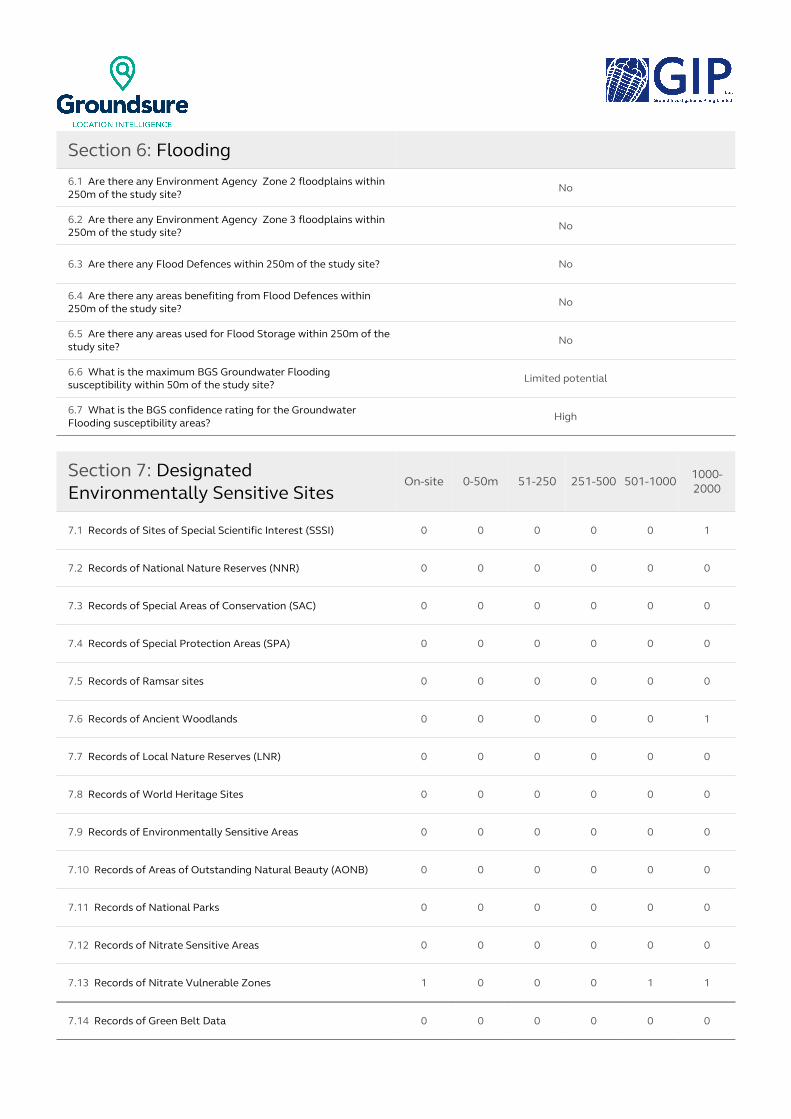
Section 6: Flooding
6.1 Are there any Environment Agency Zone 2 floodplains within 250m of the study site?
No
6.2 Are there any Environment Agency Zone 3 floodplains within 250m of the study site?
No
6.3 Are there any Flood Defences within 250m of the study site? No
6.4 Are there any areas benefiting from Flood Defences within 250m of the study site?
No
6.5 Are there any areas used for Flood Storage within 250m of the study site?
No
6.6 What is the maximum BGS Groundwater Flooding susceptibility within 50m of the study site?
Limited potential
6.7 What is the BGS confidence rating for the Groundwater Flooding susceptibility areas?
High
Section 7: Designated Environmentally Sensitive Sites
On-site 0-50m 51-250 251-500 501-1000 1000-2000
7.1 Records of Sites of Special Scientific Interest (SSSI) 0 0 0 0 0 1
7.2 Records of National Nature Reserves (NNR) 0 0 0 0 0 0
7.3 Records of Special Areas of Conservation (SAC) 0 0 0 0 0 0
7.4 Records of Special Protection Areas (SPA) 0 0 0 0 0 0
7.5 Records of Ramsar sites 0 0 0 0 0 0
7.6 Records of Ancient Woodlands 0 0 0 0 0 1
7.7 Records of Local Nature Reserves (LNR) 0 0 0 0 0 0
7.8 Records of World Heritage Sites 0 0 0 0 0 0
7.9 Records of Environmentally Sensitive Areas 0 0 0 0 0 0
7.10 Records of Areas of Outstanding Natural Beauty (AONB) 0 0 0 0 0 0
7.11 Records of National Parks 0 0 0 0 0 0
7.12 Records of Nitrate Sensitive Areas 0 0 0 0 0 0
7.13 Records of Nitrate Vulnerable Zones 1 0 0 0 1 1
7.14 Records of Green Belt Data 0 0 0 0 0 0

Section 8: Natural Hazards
8.1 What is the maximum risk of natural ground subsidence? Very Low
8.1.1 What is the maximum Shrink-Swell hazard rating identified on the study site?
Very Low
8.1.2 What is the maximum Landslides hazard rating identified on the study site? Very Low
8.1.3 What is the maximum Soluble Rocks hazard rating identified on the study site?
Negligible
8.1.4 What is the maximum Compressible Ground hazard rating identified on the study site? Negligible
8.1.5 What is the maximum Collapsible Rocks hazard rating identified on the study site?
Very Low
8.1.6 What is the maximum Running Sand hazard rating identified on the study site? Very Low
Section 9: Mining
9.1 Are there any coal mining areas within 75m of the study site? No
9.2 What is the risk of subsidence relating to shallow mining within 150m of the study site?
Negligible
9.3 Are there any brine affected areas within 75m of the study site? No
Using this reportThe following report is designed by Environmental Consultants for Environmental Professionals bringing to-gether the most up-to-date market leading environmental data. This report is provided under and subject to the Terms & Conditions agreed between Groundsure and the Client. The document contains the following sections:
1. Environmental Permits, Incidents and RegistersProvides information on Regulated Industrial Activities and Pollution Incidents as recorded by Regulatory Au-thorities, and sites determined as Contaminated Land. This search is conducted using radii up to 500m.
2. Landfills and Other Waste SitesProvides information on landfills and other waste sites that may pose a risk to the study site. This search is con-ducted using radii up to 1500m.
3. Current Land UsesProvides information on current land uses that may pose a risk to the study site in terms of potential contamina-tion from activities or processes. These searches are conducted using radii of up to 500m. This includes informa-tion on potentially contaminative industrial sites, petrol stations and fuel sites as well as high pressure under -ground oil and gas pipelines.
4. GeologyProvides information on artificial and superficial deposits and bedrock beneath the study site.
5. Hydrogeology and HydrologyProvides information on productive strata within the bedrock and superficial geological layers, abstraction li -censes, Source Protection Zones (SPZs) and river quality. These searches are conducted using radii of up to 2000m.
6. FloodingProvides information on surface water flooding, flood defences, flood storage areas and groundwater flood areas. This search is conducted using radii of up to 250m.
7. Designated Environmentally Sensitive Sites Provides information on the Sites of Special Scientific Interest (SSSI), National Nature Reserves (NNR), Special Areas of Conservation (SAC), Special Protection Areas (SPA), Ramsar sites, Local Nature Reserves (LNR), Areas of Outstanding Natural Beauty (AONB), National Parks (NP), Environmentally Sensitive Areas, Nitrate Sensitive Areas, Nitrate Vulnerable Zones and World Heritage Sites and Scheduled Ancient Woodland. These searches are conducted using radii of up to 2000m.
8. Natural HazardsProvides information on a range of natural hazards that may pose a risk to the study site. These factors include natural ground subsidence.
9. MiningProvides information on areas of coal and shallow mining.
10. ContactsThis section of the report provides contact points for statutory bodies and data providers that may be able to provide further information on issues raised within this report. Alternatively, Groundsure provide a free Technic-al Helpline (08444 159000) for further information and guidance.
Note: MapsOnly certain features are placed on the maps within the report. All features represented on maps found within this search are given an identification number. This number identifies the feature on the mapping and correlates it to the additional information provided below. This identification number precedes all other information and takes the following format -Id: 1, Id: 2, etc. Where numerous features on the same map are in such close proxim -ity that the numbers would obscure each other a letter identifier is used instead to represent the features. (e.g. Three features which overlap may be given the identifier “A” on the map and would be identified separately as features 1A, 3A, 10A on the data tables provided). Where a feature is reported in the data tables to a distance greater than the map area, it is noted in the data table as “Not Shown”. All distances given in this report are in Metres (m). Directions are given as compass headings such as N: North, E: East, NE: North East from the nearest point of the study site boundary.

1. Environmental Permits, Incidents and Registers Map
NW N NE
W E
SW S SE
Environmental Permits, Incidents and Registers Legend
© Crown copyright and database rights 2015. Ordnance Survey license 100035207.
Report Reference: GIP-2030289Client Reference: DNB/23240 PO: 37988
10

1. Environmental Permits, Incidents and Registers1.1 Industrial Sites Holding Licences and/or Authorisations
Searches of information provided by the Environment Agency and Local Authorities reveal the following information:
1.1.1 Records of historic IPC Authorisations within 500m of the study site: 0
Database searched and no data found.
1.1.2 Records of Part A(1) and IPPC Authorised Activities within 500m of the study site:
0
Database searched and no data found.
1.1.3 Records of Water Industry Referrals (potentially harmful discharges to the public sewer) within 500m of the study site:
0
Database searched and no data found.
1.1.4 Records of Red List Discharge Consents (potentially harmful discharges to controlled waters) within 500m of the study site:
0
Database searched and no data found.
1.1.5 Records of List 1 Dangerous Substances Inventory Sites within 500m of the study site:
0
Database searched and no data found.
Report Reference: GIP-2030289Client Reference: DNB/23240 PO: 37988
11

1.1.6 Records of List 2 Dangerous Substance Inventory Sites within 500m of the study site:
0
Database searched and no data found.
1.1.7 Records of Part A(2) and Part B Activities and Enforcements within 500m of the study site:
0
Database searched and no data found.
1.1.8 Records of Category 3 or 4 Radioactive Substances Authorisations:
0
Database searched and no data found.
1.1.9 Records of Licensed Discharge Consents within 500m of the study site:
3
The following Licensed Discharge Consents records are represented as points on the Environmental Permits, Incidents and Registers Map:
ID Distance Direction NGR Details
1 459.0 S 408400323500
Address: Fishing Lodge, Mill Green, Abbots Bromley, Nr Rugeley, StaffordshireEffluent Type: Sewage Discharges - Final/treated Effluent - Not Water CompanyPermit Number: T/06/02301/SPermit Version: 1
Receiving Water: Mires BrookStatus: Pre Nra Legislation Where Issue Date < 01-sep-89 (historic Only)Issue date: 28/6/1968Effective Date: 28/6/1968Revocation Date: -
2A 488.0 W407920323930
Address: Abbots Bromley Sewage Treatment Wks, Off Goose Lane, Abbots Bromley, Burton-upon-trent, StaffordshireEffluent Type: Sewage Discharges - Final/treated Effluent - Water CompanyPermit Number: T/06/08289/RPermit Version: 1
Receiving Water: Mires BrookStatus: Pre Nra Legislation Where Issue Date < 01-sep-89 (historic Only)Issue date: -Effective Date: -Revocation Date: 27/9/2001
3A 488.0 W 407920323930
Address: Abbots Bromley Sewage Treatment Wks, Off Goose Lane, Abbots Bromley, Burton-upon-trent, StaffordshireEffluent Type: Sewage Discharges - Stw Storm Overflow/storm Tank - Water CompanyPermit Number: T/06/08289/RPermit Version: 1
Receiving Water: Mires BrookStatus: Pre Nra Legislation Where Issue Date < 01-sep-89 (historic Only)Issue date: -Effective Date: -Revocation Date: 27/9/2001
Report Reference: GIP-2030289Client Reference: DNB/23240 PO: 37988
12

1.1.10 Records of Planning Hazardous Substance Consents and Enforcements within 500m of the study site:
0
Database searched and no data found.
1.2 Dangerous or Hazardous Sites
Records of COMAH & NIHHS sites within 500m of the study site: 0
Database searched and no data found.
1.3 Environment Agency Recorded Pollution Incidents
1.3.1 Records of National Incidents Recording System, List 2 within 500m of the study site:
0
Database searched and no data found.
1.3.2 Records of National Incidents Recording System, List 1 within 500m of the study site:
0
Database searched and no data found.
1.4 Sites Determined as Contaminated Land under Part 2A EPA 1990
How many records of sites determined as contaminated land under Section 78R of the Environmental Protection Act 1990 are there within 500m of the study site? 0
Database searched and no data found.
Report Reference: GIP-2030289Client Reference: DNB/23240 PO: 37988
13
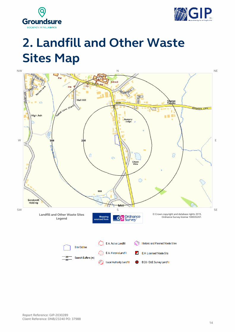
2. Landfill and Other Waste Sites Map
NW N NE
W E
SW S SE
Landfill and Other Waste Sites Legend
© Crown copyright and database rights 2015. Ordnance Survey license 100035207.
Report Reference: GIP-2030289Client Reference: DNB/23240 PO: 37988
14

2. Landfill and Other Waste Sites2.1 Landfill Sites
2.1.1 Records from Environment Agency landfill data within 1000m of the study site:
0
Database searched and no data found.
2.1.2 Records of Environment Agency historic landfill sites within 1500m of the study site:
3
The following landfill records are represented as either points or polygons on the Landfill and Other Waste Sites map:
IDDistance (m)
Direction NGR Details
Not shown
790.0 W 407500323900
Site Address: Refuse Tip off Port Lane, Port Lane, Abbots Bromley, StaffordshireWaste Licence: -Site Reference: EAST STAFFORDSHIRE 41, 9999/9498Waste Type: HouseholdEnvironmental Permitting Regulations (Waste) Reference: -
Licence Issue: Licence Surrendered: Licence Hold Address: -Operator: -
Not shown
1321.0 SE409600323300
Site Address: Hurst Farm, Abbots Bromley, Near Rugeley, StaffordshireWaste Licence: YesSite Reference: 5/E/77/0129, WDL/B25, 9999/9751Waste Type: Inert, IndustrialEnvironmental Permitting Regulations (Waste) Reference: -
Licence Issue: 30-Nov-1977Licence Surrendered: 31-Oct-1991Licence Hold Address: Hurst Farm, Abbots Bromley, StaffordshireOperator: -
Not shown
1372.0 SE 409600323300
Site Address: Hurst Farm, Abbots Bromley, Near Rugeley, StaffordshireWaste Licence: YesSite Reference: 5/E/77/0129, WDL/B25, 9999/9751Waste Type: Inert, IndustrialEnvironmental Permitting Regulations (Waste) Reference: -
Licence Issue: 30-Nov-1977Licence Surrendered: 31-Oct-1991Licence Hold Address: Hurst Farm, Abbots Bromley, StaffordshireOperator: -
Report Reference: GIP-2030289Client Reference: DNB/23240 PO: 37988
15

2.1.3 Records of BGS/DoE non-operational landfill sites within 1500m of the study site:
0
Database searched and no data found.
2.1.4 Records of Local Authority landfill sites within 1500m of the study site:
0
Database searched and no data found.
2.2 Other Waste Sites
2.2.1 Records of waste treatment, transfer or disposal sites within 500m of the study site:
0
Database searched and no data found.
2.2.2 Records of Environment Agency licensed waste sites within 1500m of the study site:
0
Database searched and no data found.
Report Reference: GIP-2030289Client Reference: DNB/23240 PO: 37988
16

3. Current Land Use MapNW N NE
W E
SW S SE
Current Land Use Legend © Crown copyright and database rights 2015. Ordnance Survey license 100035207.
Report Reference: GIP-2030289Client Reference: DNB/23240 PO: 37988
17

3. Current Land Uses3.1 Current Industrial Data
Records of potentially contaminative industrial sites within 250m of the study site: 1
The following records are represented as points on the Current Land Uses map.
IDDistance
(m)Direction Company NGR Address Activity Category
1 149.0 N Tank WS15 Tanks (Generic) Industrial Features
3.2 Petrol and Fuel Sites
Records of petrol or fuel sites within 500m of the study site: 1
The following petrol or fuel site records provided by Catalist are represented as points on the Current Land Use map:
IDDistance
(m)Direction NGR Company Address LPG Status
2 246.0 NW408259324245
Obsolete
Market Place Filling Station, Market Place, Market Place, Abbots
Bromley, Rugeley, Staffordshire, WS15 3BP
Not Applicable Obsolete
3.3 Underground High Pressure Oil and Gas Pipelines
Records of high pressure underground pipelines within 500m of the study site: 1
The following Underground High Pressure Oil and Gas pipeline records provided by Linewatch are represented as linear features on the Current Land Use map:
ID Distance (m)
Direction Address Operator Telephone
3 428.0 SELand And Wayleaves Department, BPA, 5-7 Alexandra Road, Hemel
Hempstead, Hertfordshire, HP2 5BSBPA pipelines 01442 242200
Report Reference: GIP-2030289Client Reference: DNB/23240 PO: 37988
18
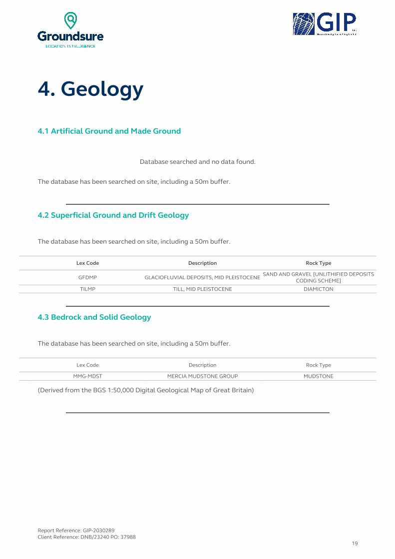
4. Geology
4.1 Artificial Ground and Made Ground
Database searched and no data found.
The database has been searched on site, including a 50m buffer.
4.2 Superficial Ground and Drift Geology
The database has been searched on site, including a 50m buffer.
Lex Code Description Rock Type
GFDMP GLACIOFLUVIAL DEPOSITS, MID PLEISTOCENESAND AND GRAVEL [UNLITHIFIED DEPOSITS
CODING SCHEME]
TILMP TILL, MID PLEISTOCENE DIAMICTON
4.3 Bedrock and Solid Geology
The database has been searched on site, including a 50m buffer.
Lex Code Description Rock Type
MMG-MDST MERCIA MUDSTONE GROUP MUDSTONE
(Derived from the BGS 1:50,000 Digital Geological Map of Great Britain)
Report Reference: GIP-2030289Client Reference: DNB/23240 PO: 37988
19

5. Hydrogeology and Hydrology5a. Aquifer Within Superficial Geology
NW N NE
W E
SW S SE
Aquifer Within Superficial Geology © Crown copyright and database rights 2015. Ordnance Survey license 100035207.
Report Reference: GIP-2030289Client Reference: DNB/23240 PO: 37988
20
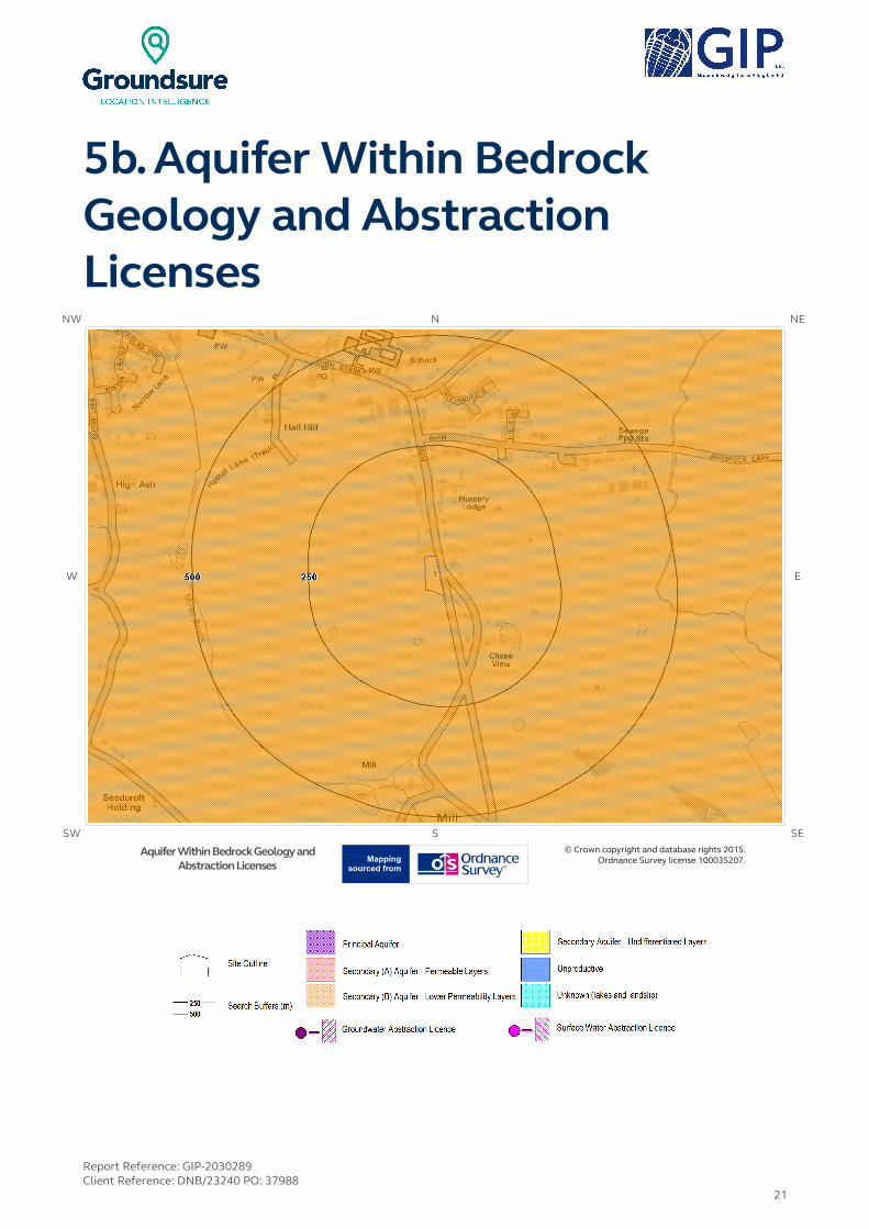
5b. Aquifer Within Bedrock Geology and Abstraction Licenses
NW N NE
W E
SW S SE
Aquifer Within Bedrock Geology and Abstraction Licenses
© Crown copyright and database rights 2015. Ordnance Survey license 100035207.
Report Reference: GIP-2030289Client Reference: DNB/23240 PO: 37988
21

5c. Hydrogeology – Source Protection Zones and Potable Water Abstraction Licenses
NW N NE
W E
SW S SE
Map LegendSource Protection Zonesand PotableWater Abstraction
Licenses
© Crown copyright and database rights 2015. Ordnance Survey license 100035207.
Report Reference: GIP-2030289Client Reference: DNB/23240 PO: 37988
22

5d. Hydrology Source Protection Zones within confined aquifer
NW N NE
W E
SW S SE
Hydrology Source Protection Zones © Crown copyright and database rights 2015. Ordnance Survey license 100035207.
Report Reference: GIP-2030289Client Reference: DNB/23240 PO: 37988
23

5 e. Hydrology – Detailed River Network and River Quality
NW N NE
W E
SW S SE
Hydrology – Detailed River Network and River Quality
© Crown copyright and database rights 2015. Ordnance Survey license 100035207.
Report Reference: GIP-2030289Client Reference: DNB/23240 PO: 37988
24

5. Hydrogeology and Hydrology5.1 Aquifer within Superficial Deposits
Are there records of strata classification within the superficial geology at or in proximity to the property?Yes
From 1 April 2010, the Environment Agency's Groundwater Protection Policy has been using aquifer designations consistent with the Water Framework Directive. For further details on the designation and interpretation of this information, please refer to the Groundsure Enviroinsight User Guide.
The following aquifer records are shown on the Aquifer within Superficial Geology Map (5a):
ID Distance (m)
Direction Designation Description
1 0.0 On Site Secondary APermeable layers capable of supporting water supplies at a local rather than
strategic scale, and in some cases forming an important source of base flow to rivers. These are generally aquifers formerly classified as minor aquifers
4 19.0 SE UnproductiveThese are rock layers or drift deposits with low permeability that have
negligible significance for water supply or river base flow
5 474.0 W Unproductive These are rock layers or drift deposits with low permeability that have negligible significance for water supply or river base flow
5.2 Aquifer within Bedrock Deposits
Are there records of strata classification within the bedrock geology at or in proximity to the property?Yes
From 1 April 2010, the Environment Agency's Groundwater Protection Policy has been using aquifer designations consistent with the Water Framework Directive. For further details on the designation and interpretation of this information, please refer to the Groundsure Enviroinsight User Guide.
The following aquifer records are shown on the Aquifer within Bedrock Geology Map (5b):
IDDistance
(m)Direction Designation Description
1 0.0 On Site Secondary BPredominantly lower permeability layers which may store/yield limited amounts of groundwater due to localised features such as fissures, thin permeablehorizons and weathering. These are generally the water-bearing parts of the former non-aquifers
Report Reference: GIP-2030289Client Reference: DNB/23240 PO: 37988
25
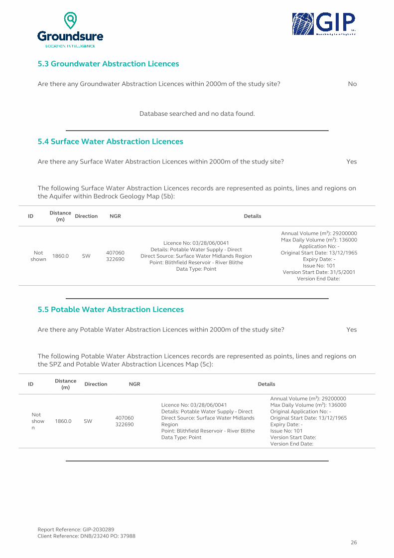
5.3 Groundwater Abstraction Licences
Are there any Groundwater Abstraction Licences within 2000m of the study site? No
Database searched and no data found.
5.4 Surface Water Abstraction Licences
Are there any Surface Water Abstraction Licences within 2000m of the study site? Yes
The following Surface Water Abstraction Licences records are represented as points, lines and regions on the Aquifer within Bedrock Geology Map (5b):
ID Distance (m)
Direction NGR Details
Not shown
1860.0 SW 407060322690
Licence No: 03/28/06/0041Details: Potable Water Supply - Direct
Direct Source: Surface Water Midlands RegionPoint: Blithfield Reservoir - River Blithe
Data Type: Point
Annual Volume (m³): 29200000Max Daily Volume (m³): 136000
Application No: -Original Start Date: 13/12/1965
Expiry Date: -Issue No: 101
Version Start Date: 31/5/2001Version End Date:
5.5 Potable Water Abstraction Licences
Are there any Potable Water Abstraction Licences within 2000m of the study site? Yes
The following Potable Water Abstraction Licences records are represented as points, lines and regions on the SPZ and Potable Water Abstraction Licences Map (5c):
ID Distance (m)
Direction NGR Details
Not shown
1860.0 SW407060322690
Licence No: 03/28/06/0041Details: Potable Water Supply - DirectDirect Source: Surface Water Midlands RegionPoint: Blithfield Reservoir - River BlitheData Type: Point
Annual Volume (m³): 29200000Max Daily Volume (m³): 136000Original Application No: -Original Start Date: 13/12/1965Expiry Date: -Issue No: 101Version Start Date: Version End Date:
Report Reference: GIP-2030289Client Reference: DNB/23240 PO: 37988
26

5.6 Source Protection Zones
Are there any Source Protection Zones within 500m of the study site? No
Database searched and no data found.
5.7 Source Protection Zones within Confined Aquifer
Are there any Source Protection Zones within the Confined Aquifer within 500m of the study site?
No
Historically, Source Protection Zone maps have been focused on regulation of activities which occur at or near the ground surface, such as prevention of point source pollution and bacterial contamination of water supplies. Sources in confined aquifers were often considered to be protected from these surface pressures due to the presence of a low permeability confining layer (e.g. glacial till, clay). The increased interest in subsurface activities such as onshore oil and gas exploration, ground source heating and cooling requires protection zones for confined sources to be marked on SPZ maps where this has not already been done.
Database searched and no data found.
5.8 Groundwater Vulnerability and Soil Leaching Potential
Is there any Environment Agency information on groundwater vulnerability and soil leaching potential within 500m of the study site? Yes
Distance (m) Direction Classification Soil Vulnerability Category Description
0 On SiteMinor Aquifer/High Leaching
PotentialH2
Deep, permeable, coarse textured soils which readily
transmit a wide range of pollutants because of their rapid
drainage and low attenuation potential.
317 SMinor Aquifer/High Leaching
Potential H1
Soils which readily transmit liquid discharges because they are shallow or susceptible to
rapid flow directly to rock, gravel or groundwater.
351 NE Minor Aquifer/Intermediate Leaching Potential
I1 Soils which can possibly transmit a wide range of pollutants.
5.9 River Quality
Is there any Environment Agency information on river quality within 1500m of the study site? No
Report Reference: GIP-2030289Client Reference: DNB/23240 PO: 37988
27

5.9.1 Biological Quality:
Database searched and no data found.
5.9.2 Chemical Quality:
Database searched and no data found.
5.10 Detailed River Network
Are there any Detailed River Network entries within 500m of the study site? Yes
The following Detailed River Network records are represented on the Hydrology Map (5e):
ID Distance (m)
Direction Details
1 358.0 SRiver Name: -
Welsh River Name: -Alternative Name: -
River Type: Tertiary RiverMain River Status: Currently Undefined
2 415.0 SRiver Name: -
Welsh River Name: -Alternative Name: -
River Type: Tertiary RiverMain River Status: Currently Undefined
3 415.0 SRiver Name: -
Welsh River Name: -Alternative Name: -
River Type: Tertiary RiverMain River Status: Currently Undefined
4 442.0 SRiver Name: -
Welsh River Name: -Alternative Name: -
River Type: Secondary RiverMain River Status: Currently Undefined
5 442.0 SRiver Name: -
Welsh River Name: -Alternative Name: -
River Type: Secondary RiverMain River Status: Currently Undefined
6 451.0 SRiver Name: -
Welsh River Name: -Alternative Name: -
River Type: Tertiary RiverMain River Status: Currently Undefined
7 453.0 ERiver Name: Ash Brook
Welsh River Name: -Alternative Name: -
River Type: Secondary RiverMain River Status: Currently Undefined
8 460.0 SRiver Name: -
Welsh River Name: -Alternative Name: -
River Type: Lake/ReservoirMain River Status: Currently Undefined
9 471.0 SRiver Name: Mires Brook
Welsh River Name: -Alternative Name: -
River Type: Secondary RiverMain River Status: Currently Undefined
10 477.0 WRiver Name: Mires Brook
Welsh River Name: -Alternative Name: -
River Type: Tertiary RiverMain River Status: Currently Undefined
Report Reference: GIP-2030289Client Reference: DNB/23240 PO: 37988
28

5.11 Surface Water Features
Are there any surface water features within 250m of the study site? Yes
The following surface water records are not represented on mapping:
Distance (m) Direction
127.0 SE
Report Reference: GIP-2030289Client Reference: DNB/23240 PO: 37988
29

6. Environment Agency Flood Map for planning (from rivers and the sea)
NW N NE
W E
SW S SE
Environment Agency Flood Map for planning (from rivers and the sea)
© Crown copyright and database rights 2015. Ordnance Survey license 100035207.
Report Reference: GIP-2030289Client Reference: DNB/23240 PO: 37988
30

6. Flooding6.1 Zone 2 Flooding
Environment Agency Zone 2 floodplains estimate the annual probability of flooding as between 1 in 1000 (0.1%) and 1 in 100 (1%) from rivers and between 1 in 1000 (0.1%) and 1 in 200 (0.5%) from the sea. Any relevant data is represented on Map 1 – Environment Agency Flood Map for Planning:
Is the site within 250m of an Environment Agency Zone 2 floodplain? No
Database searched and no data found.
6.2 Zone 3 Flooding
Zone 3 shows the extent of a river flood with a 1 in 100 (1%) or greater chance of occurring in any year or a sea flood with a 1 in 200 (0.5%) or greater chance of occurring in any year. Any relevant data is represented on Map 1 – Environment Agency Flood Map for Planning.
Is the site within 250m of an Environment Agency Zone 3 floodplain? No
Database searched and no data found.
6.3 Flood Defences
Are there any Flood Defences within 250m of the study site? No
Database searched and no data found.
6.4 Areas benefiting from Flood Defences
Are there any areas benefiting from Flood Defences within 250m of the study site? No
6.5 Areas benefiting from Flood Storage
Are there any areas used for Flood Storage within 250m of the study site? No
Report Reference: GIP-2030289Client Reference: DNB/23240 PO: 37988
31

6.6 Groundwater Flooding Susceptibility Areas
6.6.1 Are there any British Geological Survey groundwater flooding susceptibility areas within 50m of the boundary of the study site?
Yes
Does this relate to Clearwater Flooding or Superficial Deposits Flooding? Superficial Deposits Flooding
Notes: Groundwater flooding may either be associated with shallow unconsolidated sedimentary aquifers which overlie unproductive aquifers (Superficial Deposits Flooding), or with unconfined aquifers (Clearwater Flooding).
6.6.2 What is the highest susceptibility to groundwater flooding in the search area based on the underlying geological conditions?
Limited potential
Where limited potential for groundwater flooding to occur is indicated, this means that although given the geological conditions there may be a groundwater flooding hazard, unless other relevant information, e.g. records of previous flooding, suggests groundwater flooding has occurred before in this area, you need take no further action in relation to groundwater flooding hazard.
6.7 Groundwater Flooding Confidence Areas
What is the British Geological Survey confidence rating in this result? High
Notes: Groundwater flooding is defined as the emergence of groundwater at the ground surface or the rising of groundwater into man-made ground under conditions where the normal range of groundwater levels is exceeded.
The confidence rating is on a threefold scale - Low, Moderate and High. This provides a relative indication of the BGS confidence in the accuracy of the susceptibility result for groundwater flooding. This is based on the amount and precision of the information used in the assessment. In areas with a relatively lower level of confidence the susceptibility result should be treated with more caution. In other areas with higher levels of confidence the susceptibility result can be used with more confidence.
Report Reference: GIP-2030289Client Reference: DNB/23240 PO: 37988
32
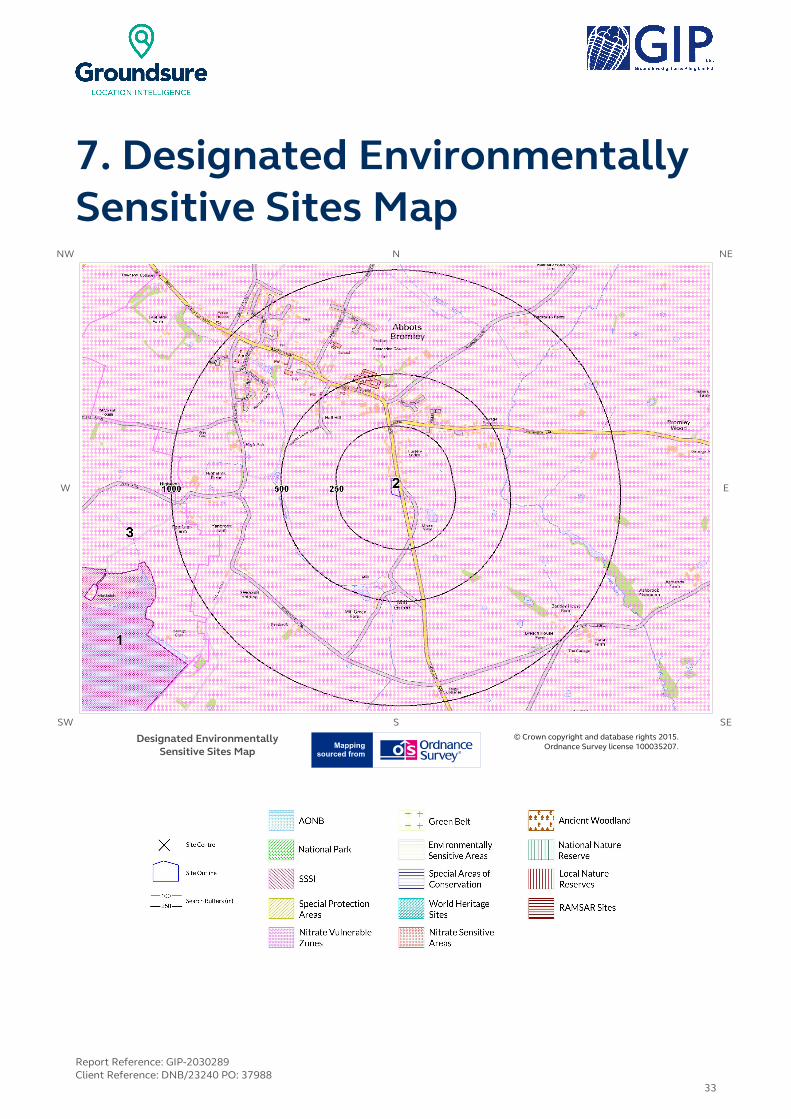
7. Designated Environmentally Sensitive Sites Map
NW N NE
W E
SW S SE
Designated Environmentally Sensitive Sites Map
© Crown copyright and database rights 2015. Ordnance Survey license 100035207.
Report Reference: GIP-2030289Client Reference: DNB/23240 PO: 37988
33

7. Designated Environmentally Sensitive SitesPresence of Designated Environmentally Sensitive Sites within 2000m of the study site? Yes
7.1 Records of Sites of Special Scientific Interest (SSSI) within 2000m of the study site:
1
The following Site of Special Scientific Interest (SSSI) records provided by Natural England/Natural Resources Wales are represented as polygons on the Designated Environmentally Sensitive Sites Map:
ID Distance (m)
Direction SSSI Name Data Source
1 1158.0 W Blithfield Reservoir Natural England
7.2 Records of National Nature Reserves (NNR) within 2000m of the study site:
0
Database searched and no data found.
7.3 Records of Special Areas of Conservation (SAC) within 2000m of the study site:
0
Database searched and no data found.
7.4 Records of Special Protection Areas (SPA) within 2000m of the study site:
0
Database searched and no data found.
7.5 Records of Ramsar sites within 2000m of the study site:
0
Database searched and no data found.
Report Reference: GIP-2030289Client Reference: DNB/23240 PO: 37988
34

7.6 Records of Ancient Woodland within 2000m of the study site:
1
The following records of Designated Ancient Woodland provided by Natural England/Natural Resources Wales are represented as polygons on the Designated Environmentally Sensitive Sites Map:
ID Distance (m)
Direction Ancient Woodland Name Data Source
Not shown
1731.0 N UNKNOWN Ancient Replanted Woodland
7.7 Records of Local Nature Reserves (LNR) within 2000m of the study site:
0
Database searched and no data found.
7.8 Records of World Heritage Sites within 2000m of the study site:
0
Database searched and no data found.
7.9 Records of Environmentally Sensitive Areas within 2000m of the study site:
0
Database searched and no data found.
7.10 Records of Areas of Outstanding Natural Beauty (AONB) within 2000m of the study site:
0
Database searched and no data found.
7.11 Records of National Parks (NP) within 2000m of the study site:
0
Database searched and no data found.
Report Reference: GIP-2030289Client Reference: DNB/23240 PO: 37988
35

7.12 Records of Nitrate Sensitive Areas within 2000m of the study site:
0
Database searched and no data found.
7.13 Records of Nitrate Vulnerable Zones within 2000m of the study site:
3
The following Nitrate Vulnerable Zone records produced by DEFRA are represented as polygons on the Designated Environmentally Sensitive Sites Map:
IDDistance
(m)Direction NVZ Name Data Source
2 0.0 On Site Existing DEFRA
3 806.0 W New DEFRA
Not shown
1553.0 E Existing DEFRA
7.14 Records of Green Belt land within 2000m of the study site:
0
Database searched and no data found.
Report Reference: GIP-2030289Client Reference: DNB/23240 PO: 37988
36

8. Natural Hazards Findings8.1 Detailed BGS GeoSure Data
BGS GeoSure Data has been searched to 50m. The data is included in tabular format. If you require further information on geology and ground stability, please obtain a Groundsure GeoInsight, available from our website. The following information has been found:
8.1.1 Shrink Swell
What is the maximum Shrink-Swell** hazard rating identified on the study site? Very Low
The following natural subsidence information provided by the British Geological Survey is not represented on mapping:
Hazard
Ground conditions predominantly low plasticity. No special actions required to avoid problems due to shrink-swell clays. No special ground investigation required, and increased construction costs or increased financial risks are unlikely due to potential problems with shrink-swell clays.
8.1.2 Landslides
What is the maximum Landslide* hazard rating identified on the study site? Very Low
The following natural subsidence information provided by the British Geological Survey is not represented on mapping:
Hazard
Slope instability problems are unlikely to be present. No special actions required to avoid problems due to landslides. No special ground investigation required, and increased construction costs or increased financial risks are unlikely due to potential problems with landslides.
* This indicates an automatically generated 50m buffer and site.
Report Reference: GIP-2030289Client Reference: DNB/23240 PO: 37988
37
8.1.3 Soluble Rocks
What is the maximum Soluble Rocks* hazard rating identified on the study site? Negligible
The following natural subsidence information provided by the British Geological Survey is not represented on mapping:
Hazard
Soluble rocks are present, but unlikely to cause problems except under exceptional conditions. No special actions required to avoid problems due to soluble rocks. No special ground investigation required, and increased construction costs or increased financial risks are unlikely due to potential problems with soluble rocks.
8.1.4 Compressible Ground
What is the maximum Compressible Ground* hazard rating identified on the study site? Negligible
The following natural subsidence information provided by the British Geological Survey is not represented on mapping:
Hazard
No indicators for compressible deposits identified. No special actions required to avoid problems due to compressible deposits. No special ground investigation required, and increased construction costs or increased financial risks are unlikely due to potential problems with compressible deposits.
8.1.5 Collapsible Rocks
What is the maximum Collapsible Rocks* hazard rating identified on the study site? Very Low
The following natural subsidence information provided by the British Geological Survey is not represented on mapping:
Hazard
Deposits with potential to collapse when loaded and saturated are unlikely to be present. No special ground investigation required or increased construction costs or increased financial risk due to potential problems with collapsible deposits.
Report Reference: GIP-2030289Client Reference: DNB/23240 PO: 37988
38
8.1.6 Running Sand
What is the maximum Running Sand** hazard rating identified on the study site? Very Low
The following natural subsidence information provided by the British Geological Survey is not represented on mapping:
Hazard
Very low potential for running sand problems if water table rises or if sandy strata are exposed to water. No special actions required, to avoid problems due to running sand. No special ground investigation required, and increased construction costs or increased financial risks are unlikely due to potential problems with running sand.
* This indicates an automatically generated 50m buffer and site.
Report Reference: GIP-2030289Client Reference: DNB/23240 PO: 37988
39
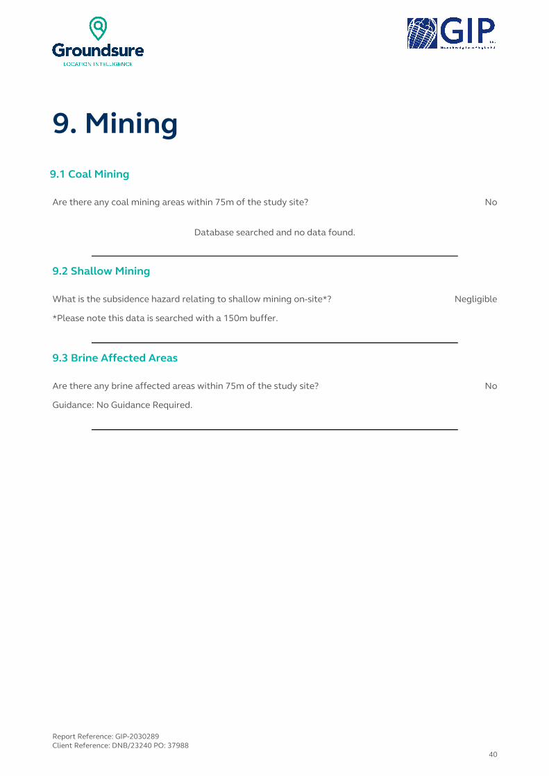
9. Mining9.1 Coal Mining
Are there any coal mining areas within 75m of the study site? No
Database searched and no data found.
9.2 Shallow Mining
What is the subsidence hazard relating to shallow mining on-site*? Negligible
*Please note this data is searched with a 150m buffer.
9.3 Brine Affected Areas
Are there any brine affected areas within 75m of the study site? No
Guidance: No Guidance Required.
Report Reference: GIP-2030289Client Reference: DNB/23240 PO: 37988
40

Contact DetailsGround Investigation & Piling Ltd
Telephone: 01902 [email protected]
Ground Investigation & Piling Ltd, Devonshire House, Ettingshall Road, Wolverhampton, West Midlands, WV2 2JT
British Geological Survey Enquiries
Kingsley Dunham CentreKeyworth, Nottingham NG12 5GG
Tel: 0115 936 3143.Fax: 0115 936 3276.
Email: [email protected]:www.bgs.ac.uk
BGS Geological Hazards Reports and general geological enquiries
Environment Agency
National Customer Contact Centre, PO Box 544Rotherham, S60 1BYTel: 08708 506 506
Web:www.environment-agency.gov.ukEmail:[email protected]
Public Health England
Public information access officePublic Health England, Wellington House
133-155 Waterloo Road, London, SE1 8UGhttps://www.gov.uk/government/organisations/public-health-
englandEmail:[email protected]
Main switchboard: 020 7654 8000
The Coal Authority
200 Lichfield LaneMansfield
Notts NG18 4RGTel: 0345 7626 848
DX 716176 Mansfield 5 www.coal.gov.uk
Ordnance Survey
Adanac Drive, SouthamptonSO16 0AS
Tel: 08456 050505
Local Authority Authority: East Staffordshire Borough Council
Phone: 01283 508 000 Web: http://www.eaststaffsbc.gov.uk/
Address: Town Hall, Burton upon Trent, Staffordshire, DE14 2EB
Gemapping PLC
Virginia Villas, High Street, Hartley Witney,Hampshire RG27 8NW
Tel: 01252 845444
Report Reference: GIP-2030289Client Reference: DNB/23240 PO: 37988
41

Acknowledgements: Site of Special Scientific Interest, National Nature Reserve, Ramsar Site, Special Protection Area, Special Area of Conservation data is provided by, and used with the permission of, Natural England who retain the Copyright and Intellectual Property Rights for the data.PointX © Database Right/Copyright, Thomson Directories Limited © Copyright Link Interchange Network Limited © Database Right/Copyright and Ordnance Survey © Crown Copyright and/or Database Right. All Rights Reserved. Licence Number [03421028].This report has been prepared in accordance with the Groundsure Ltd standard Terms and Conditions of business for work of this nature.
Report Reference: GIP-2030289Client Reference: DNB/23240 PO: 37988
42

Standard Terms and Conditions
1 Definitions
In these terms and conditions unless the context otherwise requires:
“Beneficiary” means the person or entity for whose benefit the Client has obtained the Services.
“Client” means the party or parties entering into a Contract with Groundsure.
“Commercial” means any building or property which is not Residential.
“Confidential Information” means the contents of this Contract and all information received from the Client as a result of, or in connection with, this Contract other than
(i) information which the Client can prove was rightfully in its possession prior to disclosure by Groundsure and
(ii) any information which is in the public domain (other than by virtue of a breach of this Contract).
“Support Services” means Support Services provided by Groundsure including, without limitation, interpreting third party and in-house environmental data, providing environmental support advice, undertaking environmental audits and assessments, Site investigation, Site monitoring and related items.
“Contract” means the contract between Groundsure and the Client for the provision of the Services, and which shall incorporate these terms and conditions, the Order, and the relevant User Guide.
“Third Party Data Provider” means any third party providing Third Party Content to Groundsure.
“Data Reports” means reports comprising factual data with no accompanying interpretation.
“Fees” has the meaning set out in clause 5.1.
“Groundsure” means Groundsure Limited, a company registered in England and Wales under number 03421028.
“Groundsure Materials” means all materials prepared by Groundsure and provided as part of the Services, including but not limited to Third Party Content, Data Reports, Mapping, and Risk Screening Reports.
“Intellectual Property” means any patent, copyright, design rights, trade or service mark, moral rights, data protection rights, know-how or trade mark in each case whether registered or not and including applications for the same or any other rights of a similar nature anywhere in the world.
“Mapping” means a map, map data or a combination of historical maps of various ages, time periods and scales.
“Order” means an electronic, written or other order form submitted by the Client requesting Services from Groundsure in respect of a specified Site.
“Ordnance Survey” means the Secretary of State for Business, Innovation and Skills, acting through Ordnance Survey, Adanac Drive, Southampton, SO16 0AS, UK.
“Order Website” means the online platform through which Orders may be placed by the Client and accepted by Groundsure.
“Report” means a Risk Screening Report or Data Report for Commercial or Residential property.
“Residential” means any building or property used as or intended to be used as a single dwelling.
“Risk Screening Report” means a risk screening report comprising factual data with an accompanying interpretation by Groundsure.
“Services” means any Report, Mapping and/or Support Services which Groundsure has agreed to provide by accepting an Order pursuant to clause 2.6.
"Site" means the area of land in respect of which the Client has requested Groundsure to provide the Services.
“Third Party Content” means data, database information or other information which is provided to Groundsure by a Third Party Data Provider.
"User Guide" means the user guide, as amended from time to time, available upon request from Groundsure and on the website (www.Groundsure.com) and forming part of this Contract.
2 Scope of Services, terms and conditions, requests for insurance and quotations
2.1 Groundsure agrees to provide the Services in accordance with the Contract.
2.2 Groundsure shall exercise reasonable skill and care in the provision of the Services.
2.3 Subject to clause 7.3 the Client acknowledges that it has not relied on any statement or representation made by or on behalf of Groundsure which is not set out and expressly agreed in writing in the Contract and all such statements and representations are hereby excluded to the fullest extent permitted by law.
2.4 The Client acknowledges that terms and conditions appearing on a Client’s order form, printed stationery or other communication, or any terms or conditions implied by custom, practice or course of dealing shall be of no effect, and that this Contract shall prevail over all others in relation to the Order.
2.5 If the Client or Beneficiary requests insurance in conjunction with or as a result of the Services, Groundsure shall use reasonable endeavours to recommend such insurance, but makes no warranty that such insurance shall be available from insurers or that it will be offered on reasonable terms. Any insurance purchased by the Client or Beneficiary shall be subject solely to the terms of the policy issued by insurers and Groundsure will have no liability therefor. In addition you acknowledge and agree that Groundsure does not act as an agent or broker for any insurance providers. The Client should take (and ensure that the Beneficiary takes) independent advice to ensure that the insurance policy requested or offered is suitable for its requirements.
2.6 Groundsure's quotations or proposals are valid for a period of 30 days only unless an alternative period of time is explicitly stipulated by Groundsure. Groundsure reserves the right to withdraw any quotation or proposal at any time before an Order is accepted by Groundsure. Groundsure's acceptance of an Order shall be binding only when made in writing and signed by Groundsure's authorised representative or when accepted through the Order Website.
3 The Client’s obligations
3.1The Client shall comply with the terms of this Contract and
(i) procure that the Beneficiary or any third party relying on the Services complies with and acts as if it is bound by the Contract and
(ii) be liable to Groundsure for the acts and omissions of the Beneficiary or any third party relying on the Services as if such acts and omissions were those of the Client.
3.2 The Client shall be solely responsible for ensuring that the Services are appropriate and suitable for its and/or the Beneficiary’s needs.
3.3 The Client shall supply to Groundsure as soon as practicable and without charge all requisite information (and the Client warrants that such information is accurate, complete and appropriate), including without limitation any environmental information relating to the Site and shall give such assistance as Groundsure shall reasonably require in the provision of the Services including, without limitation, access to the Site, facilities and equipment.
3.4 Where the Client’s approval or decision is required to enable Groundsure to carry out work in order to provide the Services, such approval or decision shall be given or procured in reasonable time and so as not to delay or disrupt the performance of the Services.
3.5 Save as expressly permitted by this Contract the Client shall not, and shall procure that the Beneficiary shall not, re-sell, alter, add to, or amend the Groundsure Materials, or use the Groundsure Materials in a manner for which they were not intended. The Client may make the Groundsure Materials available to a third party who is considering acquiring some or all of, or providing funding in relation to, the Site, but such third party cannot rely on the same unless expressly permitted under clause 4.
3.6 The Client is responsible for maintaining the confidentiality of its user name and password if using the Order Website and the Client acknowledges that Groundsure accepts no liability of any kind for any loss or damage suffered by the Client as a consequence of using the Order Website.
4 Reliance
4.1The Client acknowledges that the Services provided by Groundsure consist of the presentation and analysis of Third Party Content and other content and that information obtained from a Third Party Data Provider cannot be guaranteed or warranted by Groundsure to be reliable.
4.2 In respect of Data Reports, Mapping and Risk Screening Reports, the following classes of person and no other are entitled to rely on their contents;
(i) the Beneficiary,
(ii) the Beneficiary's professional advisers, (iii) any person providing funding to the Beneficiary in relation to the Site (whether directly or as part of a lending syndicate),
(iv) the first purchaser or first tenant of the Site, and
(v) the professional advisers and lenders of the first purchaser or tenant of the Site.
4.3 In respect of Support Services, only the Client, Beneficiary and parties expressly named in a Report and no other parties are entitled to rely on its contents.
4.4 Save as set out in clauses 4.2 and 4.3 and unless otherwise expressly agreed in writing, no other person or entity of any kind is entitled to rely on any Services or Report issued or provided by Groundsure. Any party considering such Reports and Services does so at their own risk.
5 Fees and Disbursements
5.1Groundsure shall charge and the Client shall pay fees at the rate and
frequency specified in the written proposal, Order Website or Order acknowledgement form, plus (in the case of Support Services) all proper disbursements incurred by Groundsure. The Client shall in addition pay all value added tax or other tax payable on such fees and disbursements in relation to the provision of the Services (together “Fees”).
5.2 The Client shall pay all outstanding Fees to Groundsure in full without deduction, counterclaim or set off within 30 days of the date of Groundsure’s invoice or such other period as may be agreed in writing between Groundsure and the Client ("Payment Date"). Interest on late payments will accrue on a daily basis from the Payment Date until the date of payment (whether before or after judgment) at the rate of 8% per annum.
5.3 The Client shall be deemed to have agreed the amount of any invoice unless an objection is made in writing within 28 days of the date of the invoice. As soon as reasonably practicable after being notified of an objection, without prejudice to clause 5.2 a member of Groundsure’s management team will contact the Client and the parties shall then use all reasonable endeavours to resolve the dispute within 15 days.
6 Intellectual Property and Confidentiality
6.1 Subject to
(i) full payment of all relevant Fees and
(ii) compliance with this Contract, the Client is granted (and is permitted to sub-licence to the Beneficiary) a royalty-free, worldwide, non-assignable and (save to the extent set out in this Contract) non-transferable licence to make use of the Groundsure Materials.
6.2 All Intellectual Property in the Groundsure Materials are and shall remain owned by Groundsure or Groundsure's licensors (including without limitation the Third Party Data Providers) the Client acknowledges, and shall procure acknowledgement by the Beneficiary of, such ownership. Nothing in this Contract purports to transfer or assign any rights to the Client or the Beneficiary in respect of such Intellectual Property.
6.3 Third Party Data Providers may enforce any breach of clauses 6.1 and 6.2 against the Client or Beneficiary.
6.4 The Client shall, and shall procure that any recipients of the Groundsure Materials shall:
(i) not remove, suppress or modify any trade mark, copyright or other proprietary marking belonging to Groundsure or any third party from the Services;
(ii) use the information obtained as part of the Services in respect of the subject Site only, and shall not store or reuse any information obtained as part of the Services provided in respect of adjacent or nearby sites;
(iii) not create any product or report which is derived directly or indirectly from the Services (save that those acting in a professional capacity to the Beneficiary may provide advice based upon the Services);
(iv) not combine the Services with or incorporate such Services into any other information data or service;
(v) not reformat or otherwise change (whether by modification, addition or enhancement), the Services (save that those acting for the Beneficiary in a professional capacity shall not be in breach of this clause 6.4(v) where such reformatting is in the normal course of providing advice based upon the Services);
(vi) where a Report and/or Mapping contains material belonging to Ordnance Survey, acknowledge and agree that such content is protected by Crown Copyright and shall not use such content for any purpose outside of receiving the Services; and
(vii) not copy in whole or in part by any means any map prints or run-on copies containing content belonging to Ordnance Survey (other than that contained within Ordnance Survey’s OS Street Map) without first being in possession of a valid Paper Map Copying Licence from Ordnance Survey,
6.5 Notwithstanding clause 6.4, the Client may make reasonable use of the Groundsure Materials in order to advise the Beneficiary in a professional capacity. However, Groundsure shall have no liability in respect of any advice, opinion or report given or provided to Beneficiaries by the Client.
6.6 The Client shall procure that any person to whom the Services are made available shall notify Groundsure of any request or requirement to disclose, publish or disseminate any information contained in the Services in accordance with the Freedom of Information Act 2000, the Environmental Information Regulations 2004 or any associated legislation or regulations in force from time to time.
7.Liability: Particular Attention Should Be Paid To This Clause
7.1 This Clause 7 sets out the entire liability of Groundsure, including any liability for the acts or omissions of its employees, agents, consultants, subcontractors and Third Party Content, in respect of:
(i) any breach of contract, including any deliberate breach of the Contract by Groundsure or its employees, agents or
subcontractors;
(ii) any use made of the Reports, Services, Materials or any part of them; and
(iii) any representation, statement or tortious act or omission (including negligence) arising under or in connection with the Contract.
7.2 All warranties, conditions and other terms implied by statute or common law are, to the fullest extent permitted by law, excluded from the Contract.
7.3 Nothing in the Contract limits or excludes the liability of the Supplier for death or personal injury resulting from negligence, or for any damage or liability incurred by the Client or Beneficiary as a result of fraud or fraudulent misrepresentation.
7.4 Groundsure shall not be liable for
(i) loss of profits;
(ii) loss of business;
(iii) depletion of goodwill and/or similar losses;
(iv) loss of anticipated savings;
(v) loss of goods;
(vi) loss of contract;
(vii) loss of use;
(viii) loss or corruption of data or information;
(ix) business interruption;
(x) any kind of special, indirect, consequential or pure economic loss, costs, damages, charges or expenses;
(xi) loss or damage that arise as a result of the use of all or part of the Groundsure Materials in breach of the Contract;
(xii) loss or damage arising as a result of any error, omission or inaccuracy in any part of the Groundsure Materials where such error, omission or inaccuracy is caused by any Third Party Content or any reasonable interpretation of Third Party Content;
(xiii) loss or damage to a computer, software, modem, telephone or other property; and
(xiv) loss or damage caused by a delay or loss of use of Groundsure’s internet ordering service.
7.5 Groundsure’s total liability in relation to or under the Contract shall be limited to £10 million for any claim or claims.
7.6 Groundsure shall procure that the Beneficiary shall be bound by limitations and exclusions of liability in favour of Groundsure which accord with those detailed in clauses 7.4 and 7.5 (subject to clause 7.3) in respect of all claims which the Beneficiary may bring against Groundsure in relation to the Services or other matters arising pursuant to the Contract.
8 Groundsure’s right to suspend or terminate
8.1 If Groundsure reasonably believes that the Client or Beneficiary has not provided the information or assistance required to enable the proper provision of the Services, Groundsure shall be entitled to suspend all further performance of the Services until such time as any such deficiency has been made good.
8.2 Groundsure shall be entitled to terminate the Contract immediately on written notice in the event that:
(i) the Client fails to pay any sum due to Groundsure within 30 days of the Payment Date; or
(ii) the Client (being an individual) has a bankruptcy order made against him or (being a company) shall enter into liquidation whether compulsory or voluntary or have an administration order made against it or if a receiver shall be appointed over the whole or any part of its property assets or undertaking or if the Client is struck off the Register of Companies or dissolved; or
(iii) the Client being a company is unable to pay its debts within the meaning of Section 123 of the Insolvency Act 1986 or being an individual appears unable to pay his debts within the meaning of Section 268 of the Insolvency Act 1986 or if the Client shall enter into a composition or arrangement with the Client’s creditors or shall suffer distress or execution to be levied on his goods; or
(iv) the Client or the Beneficiary breaches any term of the Contract (including, but not limited to, the obligations in clause 4) which is incapable of remedy or if remediable, is not remedied within five days of notice of the breach.
9. Client’s Right to Terminate and Suspend
9.1 Subject to clause 10.1, the Client may at any time upon written notice terminate or suspend the provision of all or any of the Services.
9.2 In any event, where the Client is a consumer (and not a business) he/she hereby expressly acknowledges and agrees that:
(i) the supply of Services under this Contract (and therefore the performance of this Contract) commences immediately upon Groundsure's acceptance of the Order; and
(ii) the Reports and/or Mapping provided under this Contract are
(a) supplied to the Client's specification(s) and in any event
(b) by their nature cannot be returned.
10 Consequences of Withdrawal, Termination or Suspension
10.1 Upon termination of the Contract:
(i) Groundsure shall take steps to bring to an end the Services in an orderly manner, vacate any Site with all reasonable speed and shall deliver to the Client and/or Beneficiary any property of the Client and/or Beneficiary in Groundsure’s possession or control; and
(ii) the Client shall pay to Groundsure all and any Fees payable in respect of the performance of the Services up to the date of termination or suspension. In respect of any Support Services provided, the Client shall also pay Groundsure any additional costs incurred in relation to the termination or suspension of the Contract.
11 Anti-Bribery
11.1 The Client warrants that it shall:
(i) comply with all applicable laws, statutes and regulations relating to anti-bribery and anti-corruption including but not limited to the Bribery Act 2010;
(ii) comply with such of Groundsure's anti-bribery and anti-corruption policies as are notified to the Client from time to time; and
(iii) promptly report to Groundsure any request or demand for any undue financial or other advantage of any kind received by or on behalf of the Client in connection with the performance of this Contract.
11.2 Breach of this Clause 11 shall be deemed a material breach of this Contract.
12 General
12.1 The Mapping contained in the Services is protected by Crown copyright and must not be used for any purpose other than as part of the Services or as specifically provided in the Contract.
12.2 The Client shall be permitted to make one copy only of each Report or Mapping Order. Thereafter the Client shall be entitled to make unlimited copies of the Report or Mapping Order only in accordance with an Ordnance Survey paper map copy license available through Groundsure.
12.3 Groundsure reserves the right to amend or vary this Contract. No amendment or variation to this Contract shall be valid unless signed by an authorised representative of Groundsure.
12.4 No failure on the part of Groundsure to exercise, and no delay in exercising, any right, power or provision under this Contract shall operate as a waiver thereof.
12.5 Save as expressly provided in this Contract, no person other than the persons set out therein shall have any right under the Contract (Rights of Third Parties) Act 1999 to enforce any terms of the Contract.
12.6 The Secretary of State for Business, Innovation and Skills (“BIS”) or BIS’ successor body, as the case may be, acting through Ordnance Survey may enforce a breach of clause 6.4(vi) and clause 6.4(vii) of these terms and conditions against the Client in accordance with the provisions of the Contracts (Rights of Third Parties) Act 1999.
12.7 Groundsure shall not be liable to the Client if the provision of the Services is delayed or prevented by one or more of the following circumstances:
(i) the Client or Beneficiary’s failure to provide facilities, access or information;
(ii) fire, storm, flood, tempest or epidemic;
(iii) Acts of God or the public enemy;
(iv) riot, civil commotion or war;
(v) strikes, labour disputes or industrial action;
(vi) acts or regulations of any governmental or other agency;
(vii) suspension or delay of services at public registries by Third Party Data Providers;
(viii) changes in law; or
(ix) any other reason beyond Groundsure’s reasonable control.
In the event that Groundsure is prevented from performing the Services (or any part thereof) in accordance with this clause 12.6 for a period of not less than 30 days then Groundsure shall be entitled to terminate this Contract immediately on written notice to the Client.
12.8 Any notice provided shall be in writing and shall be deemed to be properly given if delivered by hand or sent by first class post, facsimile or by email to the address, facsimile number or email address of the relevant party as may have been notified by each party to the other for such purpose or in the absence of such notification the last known address.
12.9 Such notice shall be deemed to have been received on the day of delivery if delivered by hand, facsimile or email (save to the extent such day is not a working day where it shall be deemed to have been delivered on the next working day) and on the second working day after the day of posting if sent by first class post.
12.10 The Contract constitutes the entire agreement between the parties and shall supersede all previous arrangements between the parties relating to the subject matter hereof.
12.11 Each of the provisions of the Contract is severable and distinct from the others and if one or more provisions is or should become invalid, illegal or unenforceable, the validity and enforceability of the remaining provisions shall not in any way be tainted or impaired.
12.12 This Contract shall be governed by and construed in accordance with English law and any proceedings arising out of or connected with this Contract shall be subject to the exclusive jurisdiction of the English courts.
12.13 Groundsure is an executive member of the Council of Property Search Organisation (CoPSO) and has signed up to the Search Code administered by the Property Codes Compliance Board (PCCB). All Risk Screening Reports shall be supplied in accordance with the provisions of the Search Code.
12.14 If the Client or Beneficiary has a complaint about the Services, written notice should be given to the Compliance Officer at Groundsure who will respond in a timely manner.
12.15 The Client agrees that it shall, and shall procure that each Beneficiary shall, treat in confidence all Confidential Information and shall not, and shall procure that each Beneficiary shall not (i) disclose any Confidential Information to any third party other than in accordance with the terms of this Contract; and (ii) use Confidential Information for a purpose other than the exercise of its rights and obligations under this Contract. Subject to clause 6.6, nothing shall prevent the Client or any Beneficiary from disclosing Confidential Information to the extent required by law.
© Groundsure Limited June 2013

Report Reference: GIP-2030287
Your Reference: DNB/23240 PO: 37988
Report Date 21 Apr 2015
Report DeliveryMethod:
Email - pdf
Groundsure Radon Check
Address: Land adjacent toTHYME HOUSE,LICHFIELD ROAD,ABBOTSBROMLEY,RUGELEY, WS15 3DL
Dear Sir/Madam,
Thank you for placing your order with Ground Investigation & Piling Ltd.
Please find enclosed the Groundsure Radon Check as requested.
If you need any further assistance, please do not hesitate to contact our helpline on 08444 159 000quoting the above report reference number.
Yours faithfully,
Ground Investigation & Piling Ltd
Enc.Groundsure Radon Check

GroundsureRadon Check
Address: Land adjacent toTHYME HOUSE,LICHFIELD ROAD,ABBOTS BROMLEY,RUGELEY,WS15 3DL
Date: 21 Apr 2015
Report Reference: GIP-2030287
Your Reference: DNB/23240 PO: 37988
Grid Reference: 408420,324010
Brought to you by Ground Investigation & Piling Ltd
Report Reference: GIP-2030287 If you would like any further assistance regarding this reportthen please contactGroundsure on (T) 08444 159 000, email: [email protected] Page
Brought to you by Ground Investigation &Piling Ltd

1. Residential Radon Potential Result
1.1 Is the property in a Radon Affected Area?
The information in this section provides an answer to one of the standard legal enquiries onhouse purchase in England and Wales, known as CON29 standard Enquiry of Local Authority;3.13 Radon Gas: Location of the Property in a Radon Affected Area.
Question: Is the property in a Radon Affected Area as defined by Public Health England(PHE)and if so what percentage of homes are above the Action Level?
Answer: The property is not in a Radon Affected Area, as less than 1% of properties are abovethe Action Level.
1.2 Are Radon Protective Measures required?
The information in this section will detail the level of protection required for new dwellingsunder as described in the latest Building Research Establishment guidance on radon protectivemeasures for new dwellings. This may include extensions to the property.
Question: Is the property in an area where Radon Protection Measures are required for newproperties or extensions to existing ones as described in either publications BR211 (Englandand Wales) or BR376 (Scotland) by the Building Research Establishment?
Answer: No Radon Protective Measures are necessary.
1.3 Combined Radon Guidance
Radon is a colourless, odourless radioactive gas which is present in all areas of the UnitedKingdom, usually at levels that pose a negligible risk to homebuyers. However, in some areaslevels of radon are much higher than in others, and in these cases it can pose a health risk.The data supplied by the Public Health England (PHE) and the British Geological Survey (BGS)is not able to determine exact Radon levels, as this information can only be obtained throughsite-specific, in-situ testing. As less than 1% of properties in the area may be radon affected,the PHE do not consider that further action is necessary.
The responses given on the level of Radon Protective Measures required are based on a jointradon potential dataset from the Public Health England (PHE) and the British Geological Survey(BGS). No Radon Protective Measures are required for new builds or extensions.
Report Reference: GIP-2030287 If you would like any further assistance regarding this reportthen please contactGroundsure on (T) 08444 159 000, email: [email protected] Page 1
Brought to you by Ground Investigation &Piling Ltd
1.4 Further details on Radon
Radon is a naturally occurring radioactive gas, which enters buildings from the ground.Outdoors, it is diluted to very low levels. However, in some cases the radon level indoors canbuild up to high concentrations. In such cases, it does pose a serious risk to health. Exposureto high concentrations increases the risk of lung cancer. Public Health England recommendsthat radon levels should be reduced in homes where the annual average is at or above 200becquerels per cubic metre (200 Bq m-3). This is termed the Action Level. Public HealthEngland defines Radon Affected Areas as those with 1% chance or more of a house having aradon concentration at or above the Action Level of 200 Bq m-3.
The joint PHE-BGS digital Radon Potential Dataset used in this report provides the currentdefinitive map of Radon Affected Areas in England and Wales.
Indoor radon levels can usually be substantially reduced at a cost comparable to many homeimprovements, such as replacing carpets. Details of methods of reducing radon levels are givenon the Building Research Establishment Website. http://www.bre.co.uk/radon/index.html
Report Reference: GIP-2030287 If you would like any further assistance regarding this reportthen please contactGroundsure on (T) 08444 159 000, email: [email protected] Page 2
Brought to you by Ground Investigation &Piling Ltd

2. Contact DetailsGround Investigation & Piling Ltd Telephone: 01902 459558 [email protected] Ground Investigation & Piling Ltd, DevonshireHouse, Ettingshall Road, Wolverhampton, WestMidlands, WV2 2JT
Local Authority - East Staffordshire BoroughCouncil. Address: Town Hall, Burton upon Trent,Staffordshire, DE14 2EB. Web:www.eaststaffsbc.gov.uk. Tel: 01283 508 000
British Geological Survey EnquiriesKingsley Dunham CentreKeyworth, Nottingham NG12 5GGTel: 0115 936 3143. Fax: 0115 936 3276.Email: [email protected]: www.bgs.ac.ukBGS Geological Hazards Reports and generalgeological enquiries
Public Health EnglandPublic information access office, Public HealthEngland Wellington House, 133-155 Waterloo Road,London, SE1 8UGhttps://www.gov.uk/government/organisations/public-health-englandEmail: [email protected]
Ordnance SurveyAdanac Drive, SouthamptonSO16 0ASTel: 08456 050505
CoPSO29 Harley Street, London W1G 9QR Tel: 020 7927 6836(www.copso.org.uk)
This report is produced by Groundsure Ltd, whose correspondence address is Groundsure Ltd, Sovereign House, Church Street,Brighton, BN1 1UJ (Tel: 08444 159 000, Fax: 01273 763569, Email: [email protected]). Groundsure's registered address isGreater London House, Hampstead Road, London NW1 7EJ. Registration Number: 3421028. VAT Number 486 4004 42.
This report has been prepared in accordance with the Groundsure Ltd standard Terms and Conditions of business for work of this nature.
Report Reference: GIP-2030287 If you would like any further assistance regarding this reportthen please contactGroundsure on (T) 08444 159 000, email: [email protected] Page 3
Brought to you by Ground Investigation &Piling Ltd
Search Code
IMPORTANT CONSUMER PROTECTION INFORMATION
This search has been produced by Groundsure Ltd, Sovereign House, Church Street, Brighton, BN1 1UJ. Tel: 08444159 000. Email: [email protected] which is registered with the Property Codes Compliance Board (PCCB) as asubscriber to the Search Code. The PCCB independently monitors how registered search firms maintain compliancewith the Code.The Search Code:·provides protection for homebuyers, sellers, estate agents, conveyancers and mortgage lenders who rely on theinformation included in property search reports undertaken by subscribers on residential and commercial propertywithin the United Kingdom·sets out minimum standards which firms compiling and selling search reports have to meet·promotes the best practice and quality standards within the industry for the benefit of consumers and propertyprofessionals·enables consumers and property professionals to have confidence in firms which subscribe to the code, theirproducts and services.By giving you this information, the search firm is confirming that they keep to the principles of the Code. Thisprovides important protection for you.
The Code’s core principles
Firms which subscribe to the Search Code will:
·display the Search Code logo prominently on their search reports·act with integrity and carry out work with due skill, care and diligence·at all times maintain adequate and appropriate insurance to protect consumers·conduct business in an honest, fair and professional manner·handle complaints speedily and fairly·ensure that products and services comply with industry registration rules and standards and relevant laws·monitor their compliance with the Code
COMPLAINTS
If you have a query or complaint about your search, you should raise it directly with the search firm, and ifappropriate ask for any complaint to be considered under their formal internal complaints procedure. If you remaindissatisfied with the firm’s final response, after your complaint has been formally considered, or if the firm hasexceeded the response timescales, you may refer your complaint for consideration under The Property Ombudsmanscheme (TPOs). The Ombudsman can award compensation of up to £5,000 to you if they find that you have sufferedactual loss as a result of your search provider failing to keep to the Code.
Please note that all queries or complaints regarding your search should be directed to your searchprovider in the first instance, not to TPOs or to the PCCB.
TPOs Contact Details:
The Property Ombudsman schemeMilford House43-55 Milford StreetSalisburyWiltshire SP1 2BPTel: 01722 333306Fax: 01722 332296Email: [email protected] can get more information about the PCCB from www.propertycodes.org.uk.
PLEASE ASK YOUR SEARCH PROVIDER IF YOU WOULD LIKE A COPY OF THE SEARCH CODE
Report Reference: GIP-2030287 If you would like any further assistance regarding this reportthen please contactGroundsure on (T) 08444 159 000, email: [email protected] Page 4
Brought to you by Ground Investigation &Piling Ltd

COMPLAINTS PROCEDURE
If you want to make a complaint, we will:
·Acknowledge it within 5 working days of receipt.·Normally deal with it fully and provide a final response, in writing, within 20 working days of receipt.·Keep you informed by letter, telephone or e-mail, as you prefer, if we need more time. ·Provide a final response, in writing, at the latest within 40 working days of receipt. ·Liaise, at your request, with anyone acting formally on your behalf.
Complaints should be sent to:Groundsure Ltd, Sovereign House, Church Street, Brighton, BN1 1UJ. Tel: 08444 159000. Email: [email protected] If you are not satisfied with our final response, or if we exceed the response timescales, you may refer the complaintto The Property Ombudsman scheme (TPOs): Tel: 01722 333306, E-mail: [email protected] will co-operate fully with the Ombudsman during an investigation and comply with their final decision.
Report Reference: GIP-2030287 If you would like any further assistance regarding this reportthen please contactGroundsure on (T) 08444 159 000, email: [email protected] Page 5
Brought to you by Ground Investigation &Piling Ltd

Standard Terms and Conditions1 DefinitionsIn these terms and conditions unless the context otherwise requires:“Beneficiary” means the person or entity for whose benefit the Client has obtained the Services.“Client” means the party or parties entering into a Contract with Groundsure.“Commercial” means any building or property which is not Residential.“Confidential Information” means the contents of this Contract and all information received from the Client as a resultof, or in connection with, this Contract other than
(i) information which the Client can prove was rightfully in its possession prior to disclosure byGroundsure and
(ii) any information which is in the public domain (other than by virtue of a breach of this Contract).“Support Services” means Support Services provided by Groundsure including, without limitation, interpreting thirdparty and in-house environmental data, providing environmental support advice, undertaking environmental auditsand assessments, Site investigation, Site monitoring and related items.“Contract” means the contract between Groundsure and the Client for the provision of the Services, and which shallincorporate these terms and conditions, the Order, and the relevant User Guide.“Third Party Data Provider” means any third party providing Third Party Content to Groundsure.“Data Reports” means reports comprising factual data with no accompanying interpretation.“Fees” has the meaning set out in clause 5.1.“Groundsure” means Groundsure Limited, a company registered in England and Wales under number 03421028.“Groundsure Materials” means all materials prepared by Groundsure and provided as part of the Services, includingbut not limited to Third Party Content, Data Reports, Mapping, and Risk Screening Reports.“Intellectual Property” means any patent, copyright, design rights, trade or service mark, moral rights, dataprotection rights, know-how or trade mark in each case whether registered or not and including applications for thesame or any other rights of a similar nature anywhere in the world.“Mapping” means a map, map data or a combination of historical maps of various ages, time periods and scales. “Order” means an electronic, written or other order form submitted by the Client requesting Services fromGroundsure in respect of a specified Site. “Ordnance Survey” means the Secretary of State for Business, Innovation and Skills, acting through OrdnanceSurvey, Adanac Drive, Southampton, SO16 0AS, UK. “Order Website” means the online platform through which Orders may be placed by the Client and accepted byGroundsure.“Report” means a Risk Screening Report or Data Report for Commercial or Residential property.“Residential” means any building or property used as or intended to be used as a single dwelling.“Risk Screening Report” means a risk screening report comprising factual data with an accompanying interpretationby Groundsure. “Services” means any Report, Mapping and/or Support Services which Groundsure has agreed to provide by acceptingan Order pursuant to clause 2.6."Site" means the area of land in respect of which the Client has requested Groundsure to provide the Services.“Third Party Content” means data, database information or other information which is provided to Groundsure by aThird Party Data Provider."User Guide" means the user guide, as amended from time to time, available upon request from Groundsure and onthe website (www.Groundsure.com) and forming part of this Contract. 2 Scope of Services, terms and conditions, requests for insurance and quotations2.1 Groundsure agrees to provide the Services in accordance with the Contract.2.2 Groundsure shall exercise reasonable skill and care in the provision of the Services.2.3 Subject to clause 7.3 the Client acknowledges that it has not relied on any statement or representation made byor on behalf of Groundsure which is not set out and expressly agreed in writing in the Contract and all suchstatements and representations are hereby excluded to the fullest extent permitted by law. 2.4 The Client acknowledges that terms and conditions appearing on a Client’s order form, printed stationery or othercommunication, or any terms or conditions implied by custom, practice or course of dealing shall be of no effect, andthat this Contract shall prevail over all others in relation to the Order.2.5 If the Client or Beneficiary requests insurance in conjunction with or as a result of the Services, Groundsure shalluse reasonable endeavours to recommend such insurance, but makes no warranty that such insurance shall beavailable from insurers or that it will be offered on reasonable terms. Any insurance purchased by the Client orBeneficiary shall be subject solely to the terms of the policy issued by insurers and Groundsure will have no liabilitytherefor. In addition you acknowledge and agree that Groundsure does not act as an agent or broker for anyinsurance providers. The Client should take (and ensure that the Beneficiary takes) independent advice to ensurethat the insurance policy requested or offered is suitable for its requirements.2.6 Groundsure's quotations or proposals are valid for a period of 30 days only unless an alternative period of time isexplicitly stipulated by Groundsure. Groundsure reserves the right to withdraw any quotation or proposal at any timebefore an Order is accepted by Groundsure. Groundsure's acceptance of an Order shall be binding only when made inwriting and signed by Groundsure's authorised representative or when accepted through the Order Website. 3 The Client’s obligations3.1The Client shall comply with the terms of this Contract and
(i) procure that the Beneficiary or any third party relying on the Services complies with and acts as if itis bound by the Contract and
(ii) be liable to Groundsure for the acts and omissions of the Beneficiary or any third party relying onthe Services as if such acts and omissions were those of the Client.
Report Reference: GIP-2030287 If you would like any further assistance regarding this reportthen please contactGroundsure on (T) 08444 159 000, email: [email protected] Page 6
Brought to you by Ground Investigation &Piling Ltd
3.2 The Client shall be solely responsible for ensuring that the Services are appropriate and suitable for its and/or theBeneficiary’s needs.3.3 The Client shall supply to Groundsure as soon as practicable and without charge all requisite information (and theClient warrants that such information is accurate, complete and appropriate), including without limitation anyenvironmental information relating to the Site and shall give such assistance as Groundsure shall reasonably requirein the provision of the Services including, without limitation, access to the Site, facilities and equipment.3.4 Where the Client’s approval or decision is required to enable Groundsure to carry out work in order to provide theServices, such approval or decision shall be given or procured in reasonable time and so as not to delay or disrupt theperformance of the Services.3.5 Save as expressly permitted by this Contract the Client shall not, and shall procure that the Beneficiary shall not,re-sell, alter, add to, or amend the Groundsure Materials, or use the Groundsure Materials in a manner for which theywere not intended. The Client may make the Groundsure Materials available to a third party who is consideringacquiring some or all of, or providing funding in relation to, the Site, but such third party cannot rely on the sameunless expressly permitted under clause 4.3.6 The Client is responsible for maintaining the confidentiality of its user name and password if using the OrderWebsite and the Client acknowledges that Groundsure accepts no liability of any kind for any loss or damage sufferedby the Client as a consequence of using the Order Website.4 Reliance4.1The Client acknowledges that the Services provided by Groundsure consist of the presentation and analysis ofThird Party Content and other content and that information obtained from a Third Party Data Provider cannot beguaranteed or warranted by Groundsure to be reliable.4.2 In respect of Data Reports, Mapping and Risk Screening Reports, the following classes of person and no other areentitled to rely on their contents;
(i) the Beneficiary, (ii) the Beneficiary's professional advisers, (iii) any person providing funding to the Beneficiary in
relation to the Site (whether directly or as part of a lending syndicate), (iv) the first purchaser or first tenant of the Site, and (v) the professional advisers and lenders of the first purchaser or tenant of the Site.
4.3 In respect of Support Services, only the Client, Beneficiary and parties expressly named in a Report and no otherparties are entitled to rely on its contents. 4.4 Save as set out in clauses 4.2 and 4.3 and unless otherwise expressly agreed in writing, no other person or entityof any kind is entitled to rely on any Services or Report issued or provided by Groundsure. Any party considering suchReports and Services does so at their own risk. 5 Fees and Disbursements5.1Groundsure shall charge and the Client shall pay fees at the rate and frequency specified in the written proposal,Order Website or Order acknowledgement form, plus (in the case of Support Services) all proper disbursementsincurred by Groundsure. The Client shall in addition pay all value added tax or other tax payable on such fees anddisbursements in relation to the provision of the Services (together “Fees”).5.2 The Client shall pay all outstanding Fees to Groundsure in full without deduction, counterclaim or set off within 30days of the date of Groundsure’s invoice or such other period as may be agreed in writing between Groundsure andthe Client ("Payment Date"). Interest on late payments will accrue on a daily basis from the Payment Date until thedate of payment (whether before or after judgment) at the rate of 8% per annum.5.3 The Client shall be deemed to have agreed the amount of any invoice unless an objection is made in writing within28 days of the date of the invoice. As soon as reasonably practicable after being notified of an objection, withoutprejudice to clause 5.2 a member of Groundsure’s management team will contact the Client and the parties shall thenuse all reasonable endeavours to resolve the dispute within 15 days. 6 Intellectual Property and Confidentiality6.1 Subject to
(i) full payment of all relevant Fees and (ii) compliance with this Contract, the Client is granted (and is permitted to sub-licence to the
Beneficiary) a royalty-free, worldwide, non-assignable and (save to the extent set out in this Contract) non-transferable licence to make use of the Groundsure Materials.6.2 All Intellectual Property in the Groundsure Materials are and shall remain owned by Groundsure or Groundsure'slicensors (including without limitation the Third Party Data Providers) the Client acknowledges, and shall procureacknowledgement by the Beneficiary of, such ownership. Nothing in this Contract purports to transfer or assign anyrights to the Client or the Beneficiary in respect of such Intellectual Property.6.3 Third Party Data Providers may enforce any breach of clauses 6.1 and 6.2 against the Client or Beneficiary.6.4 The Client shall, and shall procure that any recipients of the Groundsure Materials shall:
(i) not remove, suppress or modify any trade mark, copyright or other proprietary marking belongingto Groundsure or any third party from the Services;
(ii) use the information obtained as part of the Services in respect of the subject Site only, and shall notstore or reuse any information obtained as part of the Services provided in respect of adjacent or nearby sites;
(iii) not create any product or report which is derived directly or indirectly from the Services (save thatthose acting in a professional capacity to the Beneficiary may provide advice based upon the Services);
(iv) not combine the Services with or incorporate such Services into any other information data orservice;
(v) not reformat or otherwise change (whether by modification, addition or enhancement), the Services(save that those acting for the Beneficiary in a professional capacity shall not be in breach of this clause 6.4(v) wheresuch reformatting is in the normal course of providing advice based upon the Services);
Report Reference: GIP-2030287 If you would like any further assistance regarding this reportthen please contactGroundsure on (T) 08444 159 000, email: [email protected] Page 7
Brought to you by Ground Investigation &Piling Ltd
(vi) where a Report and/or Mapping contains material belonging to Ordnance Survey, acknowledge andagree that such content is protected by Crown Copyright and shall not use such content for any purpose outside ofreceiving the Services; and
(vii) not copy in whole or in part by any means any map prints or run-on copies containing contentbelonging to Ordnance Survey (other than that contained within Ordnance Survey’s OS Street Map) without first beingin possession of a valid Paper Map Copying Licence from Ordnance Survey,6.5 Notwithstanding clause 6.4, the Client may make reasonable use of the Groundsure Materials in order to advisethe Beneficiary in a professional capacity. However, Groundsure shall have no liability in respect of any advice,opinion or report given or provided to Beneficiaries by the Client.6.6 The Client shall procure that any person to whom the Services are made available shall notify Groundsure of anyrequest or requirement to disclose, publish or disseminate any information contained in the Services in accordancewith the Freedom of Information Act 2000, the Environmental Information Regulations 2004 or any associatedlegislation or regulations in force from time to time.7.Liability: Particular Attention Should Be Paid To This Clause7.1 This Clause 7 sets out the entire liability of Groundsure, including any liability for the acts or omissions of itsemployees, agents, consultants, subcontractors and Third Party Content, in respect of:
(i) any breach of contract, including any deliberate breach of the Contract by Groundsure or itsemployees, agents or subcontractors;
(ii) any use made of the Reports, Services, Materials or any part of them; and (iii) any representation, statement or tortious act or omission (including negligence) arising under or in
connection with the Contract.7.2 All warranties, conditions and other terms implied by statute or common law are, to the fullest extent permittedby law, excluded from the Contract.7.3 Nothing in the Contract limits or excludes the liability of the Supplier for death or personal injury resulting fromnegligence, or for any damage or liability incurred by the Client or Beneficiary as a result of fraud or fraudulentmisrepresentation.7.4 Groundsure shall not be liable for
(i) loss of profits; (ii) loss of business; (iii) depletion of goodwill and/or similar losses; (iv) loss of anticipated savings; (v) loss of goods;(vi) loss of contract; (vii) loss of use; (viii) loss or corruption of data or information; (ix) business interruption;(x) any kind of special, indirect, consequential or pure economic loss, costs, damages, charges or
expenses; (xi) loss or damage that arise as a result of the use of all or part of the Groundsure Materials in breach
of the Contract;(xii) loss or damage arising as a result of any error, omission or inaccuracy in any part of the Groundsure
Materials where such error, omission or inaccuracy is caused by any Third Party Content or any reasonableinterpretation of Third Party Content;
(xiii) loss or damage to a computer, software, modem, telephone or other property; and(xiv) loss or damage caused by a delay or loss of use of Groundsure’s internet ordering service.
7.5 Groundsure’s total liability in relation to or under the Contract shall be limited to £10 million for any claim orclaims. 7.6 Groundsure shall procure that the Beneficiary shall be bound by limitations and exclusions of liability in favour ofGroundsure which accord with those detailed in clauses 7.4 and 7.5 (subject to clause 7.3) in respect of all claimswhich the Beneficiary may bring against Groundsure in relation to the Services or other matters arising pursuant tothe Contract. 8 Groundsure’s right to suspend or terminate 8.1 If Groundsure reasonably believes that the Client or Beneficiary has not provided the information or assistancerequired to enable the proper provision of the Services, Groundsure shall be entitled to suspend all furtherperformance of the Services until such time as any such deficiency has been made good.8.2 Groundsure shall be entitled to terminate the Contract immediately on written notice in the event that:
(i) the Client fails to pay any sum due to Groundsure within 30 days of the Payment Date; or(ii) the Client (being an individual) has a bankruptcy order made against him or (being a company) shall
enter into liquidation whether compulsory or voluntary or have an administration order made against it or if a receivershall be appointed over the whole or any part of its property assets or undertaking or if the Client is struck off theRegister of Companies or dissolved; or
(iii) the Client being a company is unable to pay its debts within the meaning of Section 123 of theInsolvency Act 1986 or being an individual appears unable to pay his debts within the meaning of Section 268 of theInsolvency Act 1986 or if the Client shall enter into a composition or arrangement with the Client’s creditors or shallsuffer distress or execution to be levied on his goods; or
(iv) the Client or the Beneficiary breaches any term of the Contract (including, but not limited to, theobligations in clause 4) which is incapable of remedy or if remediable, is not remedied within five days of notice of thebreach. 9. Client’s Right to Terminate and Suspend
Report Reference: GIP-2030287 If you would like any further assistance regarding this reportthen please contactGroundsure on (T) 08444 159 000, email: [email protected] Page 8
Brought to you by Ground Investigation &Piling Ltd

9.1 Subject to clause 10.1, the Client may at any time upon written notice terminate or suspend the provision of all orany of the Services. 9.2 In any event, where the Client is a consumer (and not a business) he/she hereby expressly acknowledges andagrees that:
(i) the supply of Services under this Contract (and therefore the performance of this Contract)commences immediately upon Groundsure's acceptance of the Order; and (ii) the Reports and/or Mapping provided under this Contract are
(a) supplied to the Client's specification(s) and in any event (b) by their nature cannot be returned.
10 Consequences of Withdrawal, Termination or Suspension10.1 Upon termination of the Contract:
(i) Groundsure shall take steps to bring to an end the Services in an orderly manner, vacate any Sitewith all reasonable speed and shall deliver to the Client and/or Beneficiary any property of the Client and/orBeneficiary in Groundsure’s possession or control; and
(ii) the Client shall pay to Groundsure all and any Fees payable in respect of the performance of theServices up to the date of termination or suspension. In respect of any Support Services provided, the Client shallalso pay Groundsure any additional costs incurred in relation to the termination or suspension of the Contract. 11 Anti-Bribery11.1 The Client warrants that it shall:
(i) comply with all applicable laws, statutes and regulations relating to anti-bribery and anti-corruptionincluding but not limited to the Bribery Act 2010;
(ii) comply with such of Groundsure's anti-bribery and anti-corruption policies as are notified to theClient from time to time; and
(iii) promptly report to Groundsure any request or demand for any undue financial or other advantage ofany kind received by or on behalf of the Client in connection with the performance of this Contract.11.2 Breach of this Clause 11 shall be deemed a material breach of this Contract.12 General12.1 The Mapping contained in the Services is protected by Crown copyright and must not be used for any purposeother than as part of the Services or as specifically provided in the Contract.12.2 The Client shall be permitted to make one copy only of each Report or Mapping Order. Thereafter the Client shallbe entitled to make unlimited copies of the Report or Mapping Order only in accordance with an Ordnance Surveypaper map copy license available through Groundsure.12.3 Groundsure reserves the right to amend or vary this Contract. No amendment or variation to this Contract shallbe valid unless signed by an authorised representative of Groundsure. 12.4 No failure on the part of Groundsure to exercise, and no delay in exercising, any right, power or provision underthis Contract shall operate as a waiver thereof.12.5 Save as expressly provided in this Contract, no person other than the persons set out therein shall have anyright under the Contract (Rights of Third Parties) Act 1999 to enforce any terms of the Contract.12.6 The Secretary of State for Business, Innovation and Skills (“BIS”) or BIS’ successor body, as the case may be,acting through Ordnance Survey may enforce a breach of clause 6.4(vi) and clause 6.4(vii) of these terms andconditions against the Client in accordance with the provisions of the Contracts (Rights of Third Parties) Act 1999. 12.7 Groundsure shall not be liable to the Client if the provision of the Services is delayed or prevented by one ormore of the following circumstances:
(i) the Client or Beneficiary’s failure to provide facilities, access or information;(ii) fire, storm, flood, tempest or epidemic;(iii) Acts of God or the public enemy; (iv) riot, civil commotion or war;(v) strikes, labour disputes or industrial action;(vi) acts or regulations of any governmental or other agency; (vii) suspension or delay of services at public registries by Third Party Data Providers;(viii) changes in law; or(ix) any other reason beyond Groundsure’s reasonable control.
In the event that Groundsure is prevented from performing the Services (or any part thereof) in accordance with thisclause 12.6 for a period of not less than 30 days then Groundsure shall be entitled to terminate this Contractimmediately on written notice to the Client.12.8 Any notice provided shall be in writing and shall be deemed to be properly given if delivered by hand or sent byfirst class post, facsimile or by email to the address, facsimile number or email address of the relevant party as mayhave been notified by each party to the other for such purpose or in the absence of such notification the last knownaddress.12.9 Such notice shall be deemed to have been received on the day of delivery if delivered by hand, facsimile oremail (save to the extent such day is not a working day where it shall be deemed to have been delivered on the nextworking day) and on the second working day after the day of posting if sent by first class post.12.10 The Contract constitutes the entire agreement between the parties and shall supersede all previousarrangements between the parties relating to the subject matter hereof.12.11 Each of the provisions of the Contract is severable and distinct from the others and if one or more provisions isor should become invalid, illegal or unenforceable, the validity and enforceability of the remaining provisions shall notin any way be tainted or impaired.12.12 This Contract shall be governed by and construed in accordance with English law and any proceedings arisingout of or connected with this Contract shall be subject to the exclusive jurisdiction of the English courts.
Report Reference: GIP-2030287 If you would like any further assistance regarding this reportthen please contactGroundsure on (T) 08444 159 000, email: [email protected] Page 9
Brought to you by Ground Investigation &Piling Ltd

12.13 Groundsure is an executive member of the Council of Property Search Organisation (CoPSO) and has signed upto the Search Code administered by the Property Codes Compliance Board (PCCB). All Risk Screening Reports shallbe supplied in accordance with the provisions of the Search Code.12.14 If the Client or Beneficiary has a complaint about the Services, written notice should be given to theCompliance Officer at Groundsure who will respond in a timely manner.12.15 The Client agrees that it shall, and shall procure that each Beneficiary shall, treat in confidence all ConfidentialInformation and shall not, and shall procure that each Beneficiary shall not (i) disclose any Confidential Information toany third party other than in accordance with the terms of this Contract; and (ii) use Confidential Information for apurpose other than the exercise of its rights and obligations under this Contract. Subject to clause 6.6, nothing shallprevent the Client or any Beneficiary from disclosing Confidential Information to the extent required by law
© Groundsure Limited June 2013
Report Reference: GIP-2030287 If you would like any further assistance regarding this reportthen please contactGroundsure on (T) 08444 159 000, email: [email protected] Page 10
Brought to you by Ground Investigation &Piling Ltd

APPENDIX G

Contract: 23240 Drg: 1
Scale: Not to Scale Date: May 2015
Title: Ground Investigation at Lichfield Road, Abbots Bromley
Plan Detailing Existing Site Layout & Exploratory Hole Locations
Devonshire House, Ettingshall Road, Wolverhampton, WV2 2JT. Tel: 01902 459558 Fax: 01902 459085 E-Mail: [email protected]
Client : Planet Petrouis Engineer : GHW Consulting
Site Location
All positions are approximate as shown
Key:
= Machine Excavated Trial Pit
= California Bearing Ratio (CBR)Test
CBR1
TP3
TP1
TP2
TP4
TP5
TP6
CBR2
CBR3
CBR4
CBR5
CBR6
CBR7
CBR8
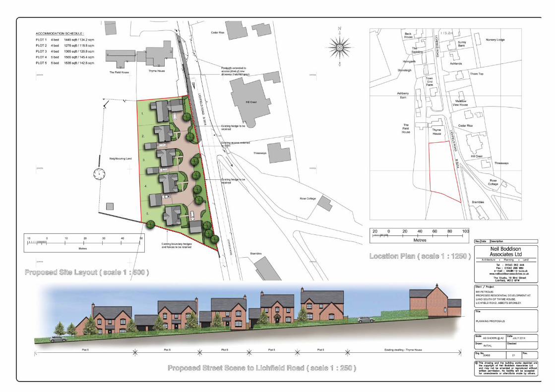

APPENDIX H

General Notes
1. The copyright of this report and other plans and documents prepared by Ground Investigation and Piling Limited are owned by them. No such report plan or document may be produced, published or adapted without the written consent of Ground Investigation and Piling Limited. Copies of this report may however, be made and distributed by the Client as an expedient in dealing with matters related to its commission. 2. This report is provided for sole use by the client and is confidential to the Client and the Clients professional advisors. No responsibility whatsoever for the contents of the report will be accepted to any other person other than the client. 3. The report and/or opinion will be prepared for the specific purpose stated in the document and in relation to the nature and extent of proposals made available to us at the time of your enquiry. The recommendations should not be used for other schemes on or adjacent to the site without further reference to Ground Investigation and Piling Limited. The assessment of the factual data will be provided to assist the client and his Engineer and/or advisors in the preparation of their designs. 4. The report will be based on the ground conditions encountered in the exploratory holes together with results of field and laboratory testing in the context of the proposed development. Conditions between exploratory holes have been interpolated, however soils and rock conditions are highly variable and may differ from our interpolation There may be conditions, appertaining to the site, which may not be revealed by the investigation, and which may not be taken into account in the report. 5. Methods of construction and/or design other than those proposed by the designers or referred to in the report may require consideration during the evolution of the proposals and further assessment of the geotechnical data would be required to provide discussion and recommendation appropriate to these methods. 6. The accuracy of the results reported will depend upon the technique of measurement, investigation and test used and these values should not be regarded necessarily as characteristic of the strata as a whole. Where such measurements are critical, the technique of the investigation will need to be reviewed and supplementary investigation undertaken in accordance with the advice of the company where necessary. 7. Whilst the report may express an opinion on possible configurations of strata between or beyond exploratory holes, or on possible presence of a feature based on either visual, verbal, written, cartographical, photographic or published evidence, this will be for guidance only and no liability can be accepted for its accuracy. 8. Ground conditions should be monitored during the construction of the works and the recommendations of the report re-evaluated on the light of these data by the supervising geotechnical engineers. 9. Any comments on groundwater conditions will be based on observations made at the time of the investigation, unless specifically stated otherwise. It should be noted, however, that the observations are subject to the method and speed of the boring, drilling or excavation and that groundwater levels will vary due to seasonal or other effects. 10. Unless specifically stated, the investigation will not take into account possible effects of mineral extraction. 11. The economic viability of the proposals referred to in the report, or of the solutions put forward to any problems encountered, will depend on very many factors in addition to geotechnical considerations hence its evaluation will be outside the scope of the report