people’s republic of bangladeshopen_jicareport.jica.go.jp/pdf/12085783.pdfministry of local...
TRANSCRIPT
People’s Republic of Bangladesh
Preparatory Survey on the Northern Region Rural Development
and Local Governance Improvement Project
Final Report
November 2012
Japan International Cooperation Agency (JICA)
IC Net Limited
SAD
CR (3)
12-35
People’s Republic of Bangladesh Ministry of Local Government, Rural Development and Cooperatives Local Government Division Local Government Engineering Department


Preparatory Survey on the Northern Region Rural Development and Local Governance Improvement Project in Bangladesh
Final Report
i
Abbreviations and acronyms
AADT Annual Average Daily Traffic ACE Additional Chief Engineer ADB Asian Development Bank ADP Annual Development Program AE Assistant Engineer ARAP Abbreviated Resettlement Action Plan ARIPO Acquisition and Requisition of Immovable Property Ordinance BARD Bangladesh Academy for Rural Development BBS Bangladesh Bureau of Statistics BC Bituminous Carpeting BCR Benefit Cost Ratio BDT Bangladesh Taka BMDF Bangladesh Municipal Development Fund BME Benefit Monitoring and Evaluation BOQ Bill of Quantities BPC Bangladesh Planning Commission BRDB Bangladesh Rural Development Board BRTA Bangladesh Road Transport Authority CBO Community-based Organization CBRS Community-based Road Safety CC Cement-concrete CE Chief Engineer CEO Chief Executive Officer CI Corrugated iron CIDA Canadian International Development Agency CPTU Central Procurement Technical Unit CRDP City Region Development Project CVD Commercial Vehicles per Day DANIDA Danish International Development Agency DC Deputy Commissioner DFID Department for International Development DG Director General DMC District Maintenance Committee DOC Department of Cooperatives DOE Department of Environment DPD Deputy Project Director DPHE Department of Public Health Engineering DPP Development Project Proposal DRSC District Road Safety Committee DRUC District Road Users Committee DSAE Draftsman cum Sub-Assistant Engineer DSM Design, Supervision and Monitoring DTIDP District Town Infrastructure Development Project EA Executing Agency ECA Environment Conservation Act ECC Environmental Clearance Certificate ECF Extended Credit Facility ECNEC Executive Committee of National Economic Council ECR Environment Conservation Rules

Preparatory Survey on the Northern Region Rural Development and Local Governance Improvement Project in Bangladesh
Final Report
ii
EE Executive Engineer EIA Environmental Impact Assessment EIRR Economic Internal Rate of Return EMA External Monitoring Agency EMAP Environmental Management Action Plan EMP Environmental Management Plan EOI Expression of Interest EPS Equipment Procurement Support ERD Economic Relations Division ES Environmental Specialist FGD Focus Group Discussion FY Fiscal Year GC Growth Center GDP Gross Domestic Product GICD Governance Improvement and Capacity Development GIS Geographic Information System GOB Government of Bangladesh GRC Grievance Redress Committee GRDP Gross Regional Domestic Product GTZ Gesellschaft für Technische Zusammenarbeit HBB Herringbone Bond Brick HFL High Flood Level HIES Household Income and Expenditure Survey HILIP Haor Infrastructure and Livelihoods Improvement Project HLC Horizontal Learning Center HLP Horizontal Learning Program HOPE Head of the Procuring Entity HQ Headquarters IAWG Inter-agency Working Group ICB International Competitive Bidding IDA International Development Association IEE Initial Environmental Examination IFAD International Fund for Agricultural Development IFT Invitation for Tender IMED Implementation Monitoring and Evaluation Department IMSC Inter-ministerial Steering Committee INGO Implementing Non-Government Organization IRI International Roughness Index IDB Islamic Development Bank JBIC Japan Bank for International Cooperation JICA Japan International Cooperation Agency JMBP Jamuna Multipurpose Bridge Project JPY Japanese Yen JVT Joint Verification Team KCC Khash Collection Committee KfW Kreditanstalt fur Wiederaufbau KII Key Informant Interview LCS Labor Contracting Society LGD Local Government Division LGED Local Government Engineering Department LGI Local Government Institution LGSP Local Governance Support Project LGSP-2 Second Local Governance Support Project
Preparatory Survey on the Northern Region Rural Development and Local Governance Improvement Project in Bangladesh
Final Report
iii
M/M Minutes of Meeting MDGs Millennium Development Goals MIDPCR Market Infrastructure Development Project in Charland Region MLGRD&C Ministry of Local Government, Rural Development and Cooperatives MMC Market Management Committee MMT Mobile Maintenance Team MOEF Ministry of Environment and Forest MPRC Municipal Performance Review Committee MSP Municipal Service Project MSP-2 Second Municipal Services Project MSU Municipal Support Unit MTBF Medium Term Budget Framework NCB National Competitive Bidding NEC National Economic Council NGO Non-Government Organization NILG National Institute of Local Government NOC No Objection Certificate NPV Net Present Value NRDP National Rural Development Policy 2001 NRRDLGIP Northern Region Rural Development and Local Governance Improvement
Project NRSC National Road Safety Council NRSSAP National Road Safety Strategic Action Plan NUP National Urban Policy NUSP National Urban Sector Policy O&M Operation and Maintenance ODA Official Development Assistance OJT on-the-job training OMC Other miscellaneous consultants PAP Project-Affected Persons PAS Project Accounting Support PBMC Performance-based Maintenance Contracting PC Publicity Campaign PCU Passenger Car Unit PD Project Director PDP Pourashava Development Plan PEC Proposal Evaluation Committee PFMS Project Financial Management Support PI Plasticity Index PIO Project Implementation Office PIOMAP Pourashava Infrastructure Operation and Maintenance Action Plan PIU Project Implementation Unit PM Person Month PME Performance Monitoring and Evaluation PMMC Pourashava Market Management Committee PMO Project Management Office PMRS Project Monitoring and Reporting Support POC Proposal Opening Committee PPR 2003 Public Procurement Regulations 2003 PPR 2008 Public Procurement Rules 2008 PRAP Poverty Reduction Action Plan PRDP Participatory Rural Development Project PRDP-2 Second Participatory Rural Development Project

Preparatory Survey on the Northern Region Rural Development and Local Governance Improvement Project in Bangladesh
Final Report
iv
PSC Project Steering Committee PVAT Property Valuation Advisory Team QCBS Quality & Cost Based Selection RAP Resettlement Action Plan RCC Reinforced Cement-concrete RDA Rural Development Academy RDCD Rural Development and Cooperatives Division RDEC Rural Development Engineering Center RDP Rural Development Project RDPD Regional Deputy Project Director RDS/2005 Road Design Standards 2005 RERMP Rural Employment Road Maintenance Program RFP Request for Proposal RFQ Request for Quotation RHD Roads and Highways Department RIIP-2 Second Rural Infrastructure Improvement Project RIMMU Rural Infrastructure Maintenance Management Unit RMRSU LGED Road Maintenance and Road Safety Unit RPF Resettlement Policy Framework RPM Rehabilitation and Periodic Maintenance RRAP Revised Resettlement Action Plan RRRE Regional Rehabilitation and Resettlement Expert RRS Rehabilitation and Resettlement Specialist RSDMS Road and Structure Database Management System RSE Regional Superintending Engineer RSEP Rate Schedule and Estimate Preparation RTIP Rural Transport Improvement Project RTIP-2 Second Rural Transport Improvement Project RUMSU Regional Urban Management Support Unit SA Statistical Analysis SAE Sub-Assistant Engineer SBCQ Selection Based on Consultant’s Qualifications SCF Standard Conversion Factor SE Superintending Engineer SFB Selection under a Fixed Budget SFYP Sixth Five Year Plan FY2011-FY2015 SIC Slum Improvement Committee SIDA Swedish International Development Cooperation Agency SMO Supervision and Monitoring Office SRIIP Sustainable Rural Infrastructure Improvement Project SSWRDSP Small-Scale Water Resources Development Sector Project STIFPP Secondary Towns Integrated Flood Protection Project SWBRDP South Western Bangladesh Rural Development Project TA Technical Assistance TLCC Town Level Coordination Committee TOR Terms of Reference TOT Training of trainers UCC Union Coordination Committees UCCM Union Coordination Committees Meeting UE Upazila Engineer UGIIP Urban Governance and Infrastructure Improvement Project UGIIP-2 Second Urban Governance and Infrastructure Improvement Project UMMC Upazila Market Management Committee

Preparatory Survey on the Northern Region Rural Development and Local Governance Improvement Project in Bangladesh
Final Report
v
UMSU Urban Management Support Unit UNDP United Nations Development Program UNO Upazila Nirbahi Officer UNR Union Road UP Union Parishad UPPRP Urban Partnerships for Poverty Reduction Project URDO Upazila Rural Development Officer URSC Upazila Road Safety Committee URUC Upazila Road Users Committee UTIDP Upazila Town Infrastructure Development Plan UZP Upazila Parishad UZR Upazila Road VAT Value Added Tax VOC Vehicle Operating Cost WASA Water and Sewage Authority WBM Water-bound Brick Macadam WLCC Ward Level Coordination Committee WMS Women’s Market Section XEN Executive Engineer
List of local terms
Aman Rice cultivated in the monsoon season Aus Rice cultivated in the pre-monsoon season Beel Relatively small surface water body such as pond or small lake with static
water from internal drainage system lying depression or low land and drying up in winter
Bigha A unit of area equal to approximately 0.13 hectare Boro Rice cultivated in the winter season under irrigated condition Bundh Small, often temporary, earthen embankment to keep out water Char Island in river Choukider Security guard Country boat Manually propelled rural boat, usually wooden Engine boat Rural boat powered by a small diesel engine, wooden or steel construction Ghat A rural boat landing station, often connected to a market Haor Surface water body with water from rivers and canals during the rainy season
lying bowl-shaped large tectonic depression and drying up in winter Hat day Market day KAIZEN (in Japanese)
Total quality management
Khash Government-owned communal Nirbahi Executive Parishad Council Pucca Reinforced cement concrete, cement concrete, or brick with cement mortar Banik Samity organization of business person

Preparatory Survey on the Northern Region Rural Development and Local Governance Improvement Project in Bangladesh
Final Report
vi
Table of contents Executive Summary ........................................................................................................................ xvii 1 Introduction .............................................................................................................................. 1-1
1.1 Background ........................................................................................................................... 1-1
1.2 Objectives ............................................................................................................................. 1-2
1.3 Terms of Reference ................................................................................................................ 1-2 2 Institutional framework for rural development and local governance ...................................... 2-1
2.1 History and political system in Bangladesh ............................................................................. 2-1
2.2 Policies on rural development and local governance .............................................................. 2-2
2.2.1 National development policies ........................................................................................ 2-2
2.2.2 Rural development policy ............................................................................................... 2-5
2.2.3 Urban development policy .............................................................................................. 2-6
2.2.4 Rural infrastructure policy ............................................................................................. 2-13
2.2.5 Technical standards for infrastructures .......................................................................... 2-18
2.2.6 Other laws and regulations ........................................................................................... 2-55
2.3 Public organizations for rural development and local governance .........................................2-57
2.3.1 Ministry of Local Government, Rural Development and Cooperatives ............................2-57
2.3.2 Ministry of Finance ........................................................................................................2-73
2.3.3 Planning Commission.....................................................................................................2-74
2.3.4 Ministry of Environment ................................................................................................2-74
2.3.5 Local governments........................................................................................................ 2-75
2.3.6 User’s committees and beneficiary groups .................................................................... 2-86
2.4 Government budget and donor assistance ............................................................................2-92
2.4.1 General government budget ..........................................................................................2-92
2.4.2 Donor assistance .......................................................................................................... 2-94
2.5 Relevant projects ................................................................................................................. 2-95
2.5.1 Projects for rural infrastructure development ............................................................... 2-95
2.5.2 Projects for local governance improvement ...................................................................2-97
2.5.3 Good practices and lessons of relevant projects ...........................................................2-102 3 Project area: Current situations and key issues ......................................................................... 3-1
3.1 Proposed Project area ........................................................................................................... 3-1
3.2 Natural environment ............................................................................................................. 3-1
3.3 Demographic dynamics ......................................................................................................... 3-4
3.4 Economic development ......................................................................................................... 3-7
3.5 Social development ............................................................................................................. 3-23
3.6 Rural infrastructure development ........................................................................................ 3-33
3.7 Local public administration in Project area ............................................................................3-47
3.7.1 National government organizations ...............................................................................3-47
3.7.2 Local government ......................................................................................................... 3-50
3.8 Non-government organizations and community organization .............................................. 3-63
3.8.1 Non-government organizations ..................................................................................... 3-63
3.8.2 Community organizations ............................................................................................. 3-65
3.8.3 User committees, labor contracting societies, and other beneficiary groups ................. 3-66
3.9 Project needs .......................................................................................................................3-67

Preparatory Survey on the Northern Region Rural Development and Local Governance Improvement Project in Bangladesh
Final Report
vii
4 Project plan ............................................................................................................................... 4-1
4.1 Project purpose ..................................................................................................................... 4-1
4.2 Project rationale .................................................................................................................... 4-1
4.3 Project components .............................................................................................................. 4-4
4.3.1 Component 1: Rural infrastructure development ............................................................ 4-4
4.3.2 Component 2: Urban infrastructure and governance improvement ............................... 4-18
4.3.3 Component 3: Project implementation support ............................................................ 4-33
4.3.4 Component 4: Project Administration Support .............................................................. 4-39
4.3.5 Technical cooperation for local governance improvement ............................................. 4-42 5 Selection of subprojects and Pourashavas ................................................................................. 5-1
5.1 Selection procedures ............................................................................................................. 5-1
5.2 Selection of subprojects in Component 1 ............................................................................... 5-1
5.2.1 LGED priorities ................................................................................................................ 5-1
5.2.2 Selection criteria for rural infrastructure subprojects ...................................................... 5-4
5.2.3 Selection of priority subprojects ................................................................................... 5-13
5.2.4 The need for large bridges .............................................................................................5-17
5.3 Selection of Pourashavas ..................................................................................................... 5-18
5.3.1 Selection by category .................................................................................................... 5-18
5.3.2 Selection criteria ........................................................................................................... 5-19
5.3.3 Results of selection ....................................................................................................... 5-21
5.4 Selection of infrastructure subprojects in Subcomponent 2-1 .............................................. 5-23
5.4.1 Participatory approach to the selection of subprojects .................................................. 5-23
5.4.2 Selection criteria ........................................................................................................... 5-24
5.4.3 Implementation process of Pourashava subprojects ...................................................... 5-28 6 Project cost estimate ................................................................................................................. 6-1
6.1 Project costs .......................................................................................................................... 6-1
6.1.1 Basic assumptions for cost estimate ................................................................................ 6-1
6.1.2 Price escalation............................................................................................................... 6-1
6.1.3 Summary of Project costs ............................................................................................... 6-2
6.1.4 Costs of components ...................................................................................................... 6-5
6.2 Cost saving measures .......................................................................................................... 6-20
6.3 Comparison of project costs with other similar projects ....................................................... 6-22
6.4 Procurement methods and processes .................................................................................. 6-23
6.4.1 Procurement of works .................................................................................................. 6-25
6.4.2 Procurement of goods .................................................................................................. 6-25
6.4.3 Procurement of services ............................................................................................... 6-25
6.4.4 Consultancy services ..................................................................................................... 6-25
6.4.5 Administration costs ..................................................................................................... 6-25
6.4.6 Safety measures and quality control in procurement of goods and works .......................6-27
6.4.7 Process of procurement of consultancy services ............................................................6-27
6.4.8 Anti-corruption measures in LGED ................................................................................ 6-28
6.5 Implementation schedule .................................................................................................... 6-28
6.6 Financing plan and annual cost schedule ............................................................................. 6-29
6.7 Process of payment and disbursement of implementing agencies ........................................ 6-32 7 Economic evaluation of project plan ......................................................................................... 7-1
7.1 Expected benefits .................................................................................................................. 7-1
7.2 Economic appraisal ................................................................................................................ 7-2

Preparatory Survey on the Northern Region Rural Development and Local Governance Improvement Project in Bangladesh
Final Report
viii
7.2.1 Overview ........................................................................................................................ 7-2
7.2.2 Appraisal of Component 1 .............................................................................................. 7-2
7.2.3 Appraisal of Component 2 .............................................................................................. 7-2
7.2.4 Synergy effect between Components 1 and 2 ................................................................. 7-4
7.3 Summary results of economic appraisal ................................................................................. 7-5
7.3.1 Component 1 .................................................................................................................. 7-5
7.3.2 Subcomponent 2-1 ......................................................................................................... 7-5
7.3.3 Synergy effect between Component 1 and Subcomponent 2-1 ....................................... 7-6 8 Environmental and social considerations .................................................................................. 8-1
8.1 Institutional framework for environmental and social considerations .................................... 8-1
8.1.1 Legal and policy framework ............................................................................................ 8-1
8.1.2 Organizational framework for environmental and social considerations .......................... 8-7
8.1.3 Consistency with the “JICA Guidelines for Environmental and Social Considerations” ...... 8-9
8.2 Policy for environmental and social considerations .............................................................. 8-12
8.2.1 Infrastructure and work type of the Project .................................................................. 8-12
8.2.2 Environmental category ................................................................................................ 8-12
8.2.3 Subprojects to be noticed ............................................................................................. 8-14
8.2.4 Policy for environmental and social considerations ....................................................... 8-15
8.2.5 Alternatives ...................................................................................................................8-17
8.3 Potential environmental and social impacts and mitigation measures .................................. 8-18
8.3.1 Methodology of semi-IEE investigations for sample subprojects.................................... 8-18
8.3.2 Potential impacts and mitigation measures of upgrading of Upazila and Union roads .... 8-19
8.3.3 Potential impacts and mitigation measures of market improvement ..............................8-26
8.3.4 Potential impacts and mitigation measures of urban infrastructures improvement ........8-27
8.4 Environmental management system .................................................................................... 8-29
8.4.1 Environmental and social monitoring ............................................................................ 8-29
8.4.2 Institutional arrangement ............................................................................................. 8-32
8.5 Environmental checklist ........................................................................................................8-37
8.6 Land acquisition and resettlement in the Project ..................................................................8-37
8.6.1 Calculation of unit area and unit cost required for land acquisition ................................8-37
8.6.2 Estimation of the scale of land acquisition and the required cost for the Project ........... 8-39 9 Institutional arrangements for implementation of the Project .................................................. 9-1
9.1 Assessment of executing agency ............................................................................................ 9-1
9.2 Institutional arrangements for implementation ..................................................................... 9-2
9.3 Action plan for capacity development of concerned organizations ....................................... 9-21 10 Operation and maintenance system and process .................................................................... 10-1
10.1 Current operation and maintenance of the rural transport and trading infrastructure ........ 10-1
10.1.1 Overview of institutional responsibilities and financing ............................................... 10-1
10.1.2 Maintenance of Upazila and Union roads .................................................................... 10-3
10.2 Rural Road Maintenance Action Plan ................................................................................10-15
10.2.1 Background ...............................................................................................................10-15
10.2.2 Objective of the Rural Road Maintenance Action Plan ................................................10-17
10.2.3 Outputs of the Rural Road Maintenance Action Plan ..................................................10-17
10.2.4 Implementation of the Action Plan ............................................................................10-24
10.3 Operation and maintenance of Pourashava infrastructure ................................................10-25
10.3.1 Operation and maintenance in general ......................................................................10-25
10.3.2 Operation and maintenance of Pourashava markets ..................................................10-26

Preparatory Survey on the Northern Region Rural Development and Local Governance Improvement Project in Bangladesh
Final Report
ix
10.3.3 Operation and maintenance in UGIIP-2 Pourashavas ..................................................10-26
10.3.4 Pourashava Infrastructure Operation and Maintenance Action Plan in the NRRDLGIP. 10-27 11 Monitoring and evaluation ...................................................................................................... 11-1
11.1 Operation and effect indicators ......................................................................................... 11-1
11.2 Monitoring arrangement ................................................................................................... 11-5
11.2.1 Progress monitoring.................................................................................................... 11-5
11.2.2 Effect monitoring and evaluation ................................................................................ 11-6
List of annexes Annex 1 Standards and specifications for roads
Annex 2 Standards for markets and ghats
Annex 3 Costs-LGED schedules of rates, unit cost analysis, and assessment of cost implications of different pavement standards
Annex 4 Public procurement regulations
Annex 5 Leasing procedure of government-owned market
Annex 6 Household survey on socioeconomic conditions in Pourashavas and Unions
Annex 7 Labor Contracting Society Annex 8 Proposed mechanism for the special allocation for rural-urban linkages
Annex 9 Subproject Agreement for Phase 2 of UGIIP-2
Annex 10 Financial status of Pourashavas and loan financing to Pourashavas
Annex 11 Draft Urban Governance Improvement Action Program
Annex 12 Draft Performance Indicators for the Urban Governance Improvement Action Program
Annex 13 Concept note for technical cooperation for local governance improvement
Annex 14 LGED priorities for infrastructure investment
Annex 15 HILIP long lists of ghat subprojects
Annex 16 Selection of Upazila and Union road upgrading subprojects
Annex 17 Selection of Upazila road rehabilitation subprojects
Annex 18 Selection of Growth Center and rural market improvement subprojects
Annex 19 Need for large bridges on project roads Annex 20 Project costs Annex 21 Comparison of project costs with similar projects Annex 22 Proposed anti-corruption measures Annex 23 Project implementation schedule Annex 24 Economic evaluation
Annex 25 Draft Environmental Framework
Annex 26 Draft Resettlement Policy Framework
Annex 27 Environmental checklist
Annex 28 Operation and maintenance of rural transport and trading infrastructure
Annex 29 Risk and mitigation measures

Preparatory Survey on the Northern Region Rural Development and Local Governance Improvement Project in Bangladesh
Final Report
x
List of supplementary annexes Supplementary Annex 1 Draft Environmental Impact Assessment report Supplementary Annex 2 Draft Initial Environmental Examination report Supplementary Annex 3 Draft Abbreviated Resettlement Action Plan (Mallikbari Bazar-Borchona
Upazila Road in Bhaluka Upazila, Mymensingh District) Supplementary Annex 4 Draft Abbreviated Resettlement Action Plan (Rampura Habibpur
More-Mongalpur via Ketra GC and Ekoir GC Upazila Road in Birampur Upazila, Dinajpur District)
List of tables Table 1 Project cost summary ........................................................................................................... xxi Table 2 Financing plan and annual cost schedule .............................................................................. xxi Table 3 Procurement and packaging methods ................................................................................. xxii Table 4 Proposed infrastructure subprojects in Component 1 ..........................................................xxiii Table 5 List of candidate Pourashavas ..............................................................................................xxiv
Table 6 EIRR of subprojects that passed the selection and appraisal procedures ..............................xxiv
Table 7 Sample economic appraisal of Pourashava markets ............................................................. xxv
Table 8 Categorization of subprojects under the Environmental Conservation Rules 1997 ...............xxvi Table 9 Outputs of Rural Road Maintenance Action Plan ................................................................. xxix
Table 1-1 Headcount poverty rate in Bangladesh (%) ....................................................................... 1-1
Table 2-1 Bangladesh political systems from 1971 to the present .................................................... 2-1
Table 2-2 Key targets of SFYP, MDGs and Perspective Plan ............................................................... 2-4
Table 2-3 Thirty programs under NRDP 2001 ................................................................................... 2-5
Table 2-4 Preparation of Pourashava Master Plan and Pourashava Development Plan ................... 2-12
Table 2-5 Rural road network classification .................................................................................... 2-15
Table 2-6 Extent, standard, and condition of rural road network, 2004 .......................................... 2-16
Table 2-7 Increase in all-weather rural roads and cross-drainage structures (from 2004 to 2011) ....2-17
Table 2-8 Design standards and traffic criteria for Upazila and Union Road .................................... 2-19
Table 2-9 Pavement standards for Upazila and Union Road ............................................................ 2-21
Table 2-10 Latest guidance on bridge design ................................................................................. 2-24
Table 2-11 Technical specifications for road and structures works ..................................................2-27
Table 2-12 Improved facilities at Growth Centers........................................................................... 2-29
Table 2-13 Ghat improvement measures ....................................................................................... 2-30
Table 2-14 Contents of technical specifications for market and ghat improvement works .............. 2-32
Table 2-15 Standard types of drains............................................................................................... 2-36
Table 2-16 Main components of slum improvement activities ....................................................... 2-48
Table 2-17 Applicable Districts for Schedule of Rates Region-wise ..................................................2-52
Table 2-18 Comparison of work items applied with market prices and the standard rates ...............2-53
Table 2-19 Cost comparison of pavement standards by type and Region ....................................... 2-54
Table 2-20 Indicative unit cost for Pourashava subprojects ............................................................ 2-55
Table 2-21 Programs, functions, and activities of LGED .................................................................. 2-59
Table 2-22 Overall activities of the LGED and concerned ministries and agencies regarding urban planning and development .......................................................................................... 2-60

Preparatory Survey on the Northern Region Rural Development and Local Governance Improvement Project in Bangladesh
Final Report
xi
Table 2-23 Deployment of LGED staff members ..............................................................................2-62
Table 2-24 Staff composition of LGED Regional office .....................................................................2-62
Table 2-25 Staff composition of LGED District office ...................................................................... 2-63
Table 2-26 Staff composition of LGED Upazila office ...................................................................... 2-63
Table 2-27 Summary of functions and duties of LGED field offices ................................................. 2-63
Table 2-28 Coverage Regions of RMSU and RUMSU ....................................................................... 2-66
Table 2-29 Composition of MSU/UMSU members ......................................................................... 2-66
Table 2-30 Composition of RMSU/UMSU members ........................................................................2-67
Table 2-31 Training programs for Pourashavas conducted by UMSU and RUMSU in the third year of UGIIP-2 .........................................................................................................................2-67
Table 2-32 Main functions of DPHE ................................................................................................2-70
Table 2-33 Structure and content of Development Project Proposal (DPP) ......................................2-74
Table 2-34 Categorization of Pourashavas and their numbers .........................................................2-78
Table 2-35 Authorized numbers of Pourashava staff ...................................................................... 2-80
Table 2-36 Composition of Ward Level Coordination Committee ................................................... 2-82
Table 2-37 Composition of Town Level Coordination Committee ................................................... 2-83
Table 2-38 Composition of District Road Users Committee .............................................................2-87
Table 2-39 Composition of Upazila Road Users Committee .............................................................2-87
Table 2-40 Composition of DRSC ................................................................................................... 2-88
Table 2-41 Composition of URSC ................................................................................................... 2-88
Table 2-42 Composition of UMMC................................................................................................. 2-89
Table 2-43 Composition of MMC ................................................................................................... 2-90
Table 2-44 Composition of PMMC ................................................................................................. 2-90
Table 2-45 Fiscal components ....................................................................................................... 2-93
Table 2-46 Public expenditures of LGD and RDCD .......................................................................... 2-93
Table 2-47 Trend of public debt ..................................................................................................... 2-94
Table 2-48 Disbursement of foreign aid FY01/02 – FY10/11 ............................................................ 2-95
Table 2-49 Disbursement of foreign aid by development partners FY71/72-FY10/11 ....................... 2-95
Table 2-50 Comparison of characteristics of MSP, UGIIP-2, and UPPRP..........................................2-100
Table 3-1 Number of administrative units in the Project area .......................................................... 3-1
Table 3-2 Land size and distribution by land types ........................................................................... 3-2
Table 3-3 Demographic characteristics of the project area in 2011 .................................................. 3-4
Table 3-4 Proportion of internal migrants ........................................................................................ 3-5
Table 3-5 Proportion of lifetime internal migrants to total population ............................................. 3-5
Table 3-6 Proportion of internal migrants by place of origin, destination, and reason for migration . 3-6
Table 3-7 External migrants and remittance .................................................................................... 3-6
Table 3-8 Number of external migrants in 2005 ............................................................................... 3-7
Table 3-9 Gross Domestic Product of Bangladesh ............................................................................ 3-7
Table 3-10 Gross Regional Domestic Product of the project area in FY1999/2000............................. 3-8
Table 3-11 Major economic activities of employed population aged 10 years and above in 2001 ..... 3-9
Table 3-12 Cultivated land in the project area in 2008 ................................................................... 3-10
Table 3-13 Distribution of households by cultivated land size in 2008 ............................................ 3-11
Table 3-14 Proportion of farm households using Tubewells and agricultural machines in 2008 ...... 3-12
Table 3-15 Production and cultivated area of major crops ............................................................. 3-13
Table 3-16 Production of fishery in FY2008/09 ............................................................................... 3-13
Table 3-17 Proportion of households raising livestock and poultry and numbers of livestock and poultry in 2008 ............................................................................................................ 3-14
Table 3-18 Number of establishments and persons engaging in establishments ............................. 3-15
Table 3-19 Distribution of establishments and population employed in establishments across sectors .................................................................................................................................... 3-16

Preparatory Survey on the Northern Region Rural Development and Local Governance Improvement Project in Bangladesh
Final Report
xii
Table 3-20 Labor force, economic participation rate, and unemployment rate in 2010 ...................3-17
Table 3-21 Monthly household income and consumption by Divisions in 2010 ...............................3-17
Table 3-22 Composition of household income by sources in 2010 ..................................................3-17
Table 3-23 Household income, expenditure, consumption, and income Gini coefficient ................ 3-18
Table 3-24 Poverty ratio in 2005 and 2010..................................................................................... 3-18
Table 3-25 Poverty gap index and squared poverty gap index in 2010 ............................................ 3-19
Table 3-26 Poverty ratio by educational status and size of landholdings in 2010 ............................ 3-19
Table 3-27 Balances of bank loan and deposit in FY2008/09 ........................................................... 3-20
Table 3-28 Coverage and disbursement of Grameen bank in 2009 ................................................. 3-21
Table 3-29 Percentage of households having information and communication facilities in 2010 .... 3-21
Table 3-30 Major economic activities of employed population ...................................................... 3-22
Table 3-31 Employment status of employed population aged 15 years and over in 2010 ............... 3-22
Table 3-32 Comparative indicators between urban and rural areas on income and expenditure, poverty, and information and communication facilities in 2010.................................... 3-23
Table 3-33 School attendance rate and adult literacy rate .............................................................. 3-24
Table 3-34 Infant mortality rates in 2009 ....................................................................................... 3-24
Table 3-35 Birth delivery assistance from 2007 to 2009 ................................................................. 3-25
Table 3-36 Sources of drinking water in 2009 and time to sources in 2006 ......................................3-26
Table 3-37 Toilet facilities of households in 2010 ............................................................................3-26
Table 3-38 Distribution of households by sources of light and fuel in 2010 .....................................3-27
Table 3-39 Ethnic minority population and religious distribution of all population in 2001............. 3-28
Table 3-40 Child labor, birth registration, and early marriage ......................................................... 3-29
Table 3-41 Youth population, economic participation rate, and unemployment rate in 2010 ......... 3-30
Table 3-42 Population and number of households in slum in 2001 ................................................ 3-31
Table 3-43 Indicators on conditions of slums regarding education, health, sanitation, energy source, and child...................................................................................................................... 3-32
Table 3-44 Comparative indicators between urban and rural areas regarding education, health, sanitation, water, energy source, child, and youth........................................................ 3-33
Table 3-45 Rural administrative, land and population characteristics of the Project area ............... 3-34
Table 3-46 Rural population density and poverty characteristics of the Project area ...................... 3-36
Table 3-47 Extent and level of development of UZR and UNR in the Project area ............................3-37
Table 3-48 Upazila-level variations in development of rural road network ..................................... 3-38
Table 3-49 Growth Centers in the Project area .............................................................................. 3-39
Table 3-50 Current conditions of roads and gap structures in Pourashavas in 2012 ........................ 3-40
Table 3-51 Length and density of drains in Pourashavas in 2012 .................................................... 3-41
Table 3-52 Current conditions of solid waste collection points in Pourashavas in 2012 ................... 3-41
Table 3-53 Conditions of water supply in Pourashavas ................................................................... 3-42 Table 3-54 Distribution of households by toilet facilities in Pourashavas in 2011 ............................ 3-43
Table 3-55 Number of bus and truck terminals in Pourashavas in 2012 .......................................... 3-43
Table 3-56 Number of markets in Pourashava in 2012 ................................................................... 3-43
Table 3-57 Number of and required installment of streetlights in Pourashavas in 2012 .................. 3-44
Table 3-58 Number of slaughterhouses in Pourashavas in 2012 ..................................................... 3-44
Table 3-59 Trend of road traffic accidents (2001 – 2010) ................................................................ 3-44
Table 3-60 Administrative classification of LGED at the field level ...................................................3-47
Table 3-61 LGED field offices and manpower at the field level ....................................................... 3-48
Table 3-62 Organizational structure and manpower of LGED Upazila office .................................... 3-48
Table 3-63 Administrative classification of DPHE at the field level .................................................. 3-49
Table 3-64 DPHE field offices and manpower at the field level ....................................................... 3-50
Table 3-65 Organizational structure and manpower of DPHE Upazila office ................................... 3-50
Table 3-66 Overview of local governments in Project area ..............................................................3-51

Preparatory Survey on the Northern Region Rural Development and Local Governance Improvement Project in Bangladesh
Final Report
xiii
Table 3-67 List of sampled Pourashavas ..........................................................................................3-52
Table 3-68 Vacancy of key Pourashava officials ...............................................................................3-53
Table 3-69 Average number of staff per 10,000 people .................................................................. 3-54
Table 3-70 Average amount of budget in 2011 by category ............................................................ 3-55
Table 3-71 Per capita revenue by category in 2010 ........................................................................ 3-56
Table 3-72 Composition of annual income of Pourashavas ............................................................. 3-56
Table 3-73 Block allocation per capita by Pourashava category in FY2010/11 ..................................3-57
Table 3-74 Average expenditures in 2010 by category ....................................................................3-57
Table 3-75 Average development expenditure (2009-2011) by category ........................................ 3-58
Table 3-76 Development needs identified in key informant interviews and focus group discussions .................................................................................................................................... 3-61
Table 3-77 Number of NGOs working in the project area ............................................................... 3-63
Table 3-78 Name of NGOs in the sample 12 Pourashavas ............................................................... 3-65
Table 4-1 Conditions of relending to Pourashavas for revenue-generating subprojects .................. 4-22
Table 4-2 Major activities of Pourashavas and fund allocation in each phase ................................. 4-32
Table 4-3 Composition of DSM consultants ................................................................................... 4-35
Table 4-4 Composition of GICD consultants ....................................................................................4-37
Table 4-5 Summary of capacity development by consultants ......................................................... 4-38
Table 4-6 Composition of BME consultants.................................................................................... 4-39
Table 4-7 Composition of PMRS assistant ...................................................................................... 4-40
Table 4-8 Composition of PAS assistant ......................................................................................... 4-40
Table 4-9 Composition of EPS assistant ......................................................................................... 4-40
Table 4-10 Composition of PME and SA assistants ......................................................................... 4-41
Table 4-11 Composition of Publicity Campaign (PC) assistant ........................................................ 4-42
Table 4-12 Comparison between the Project and TA project regarding capacity development ....... 4-45
Table 5-1 Summary of LGED list of rural infrastructure priorities ...................................................... 5-2
Table 5-2 Selection criteria of roads upgrading subprojects in Component 1 .................................... 5-5
Table 5-3 Selection criteria of UZR rehabilitation subprojects in Component 1 ................................ 5-7
Table 5-4 Selection criteria of market improvement subprojects in Component 1 ............................ 5-9
Table 5-5 Number of long-listed ghats ........................................................................................... 5-12
Table 5-6 Proposed rural infrastructure works, physical outputs .....................................................5-17
Table 5-7 Proposed rural infrastructure works and costs at 2012 prices ..........................................5-17
Table 5-8 Selection criteria of Pourashavas .................................................................................... 5-21
Table 5-9 List of Pourashavas supported by MSP-2 and UGIIP-2 ..................................................... 5-22
Table 5-10 List of Pourashavas with third or more ranking in each District ..................................... 5-22
Table 5-11 List of candidate Pourashavas ....................................................................................... 5-23
Table 5-12 Eligible types of subprojects under Subcomponent 2-1 ................................................ 5-25
Table 5-13 General criteria for subprojects under Subcomponent 2-1 ............................................5-26
Table 5-14 Sector-specific criteria for subprojects under Subcomponent 2-1 ..................................5-27
Table 5-15 Main steps and activities for the selection of subprojects ............................................. 5-29
Table 5-16 Main activities in the process of subproject planning and implementation ................... 5-30
Table 5-17 Type-specific activities in the process of subproject planning and implementation ....... 5-32
Table 6-1 Summary of project costs ................................................................................................. 6-3
Table 6-2 Detailed summary of project costs ................................................................................... 6-4
Table 6-3 UZR upgrading cost summary by District .......................................................................... 6-6
Table 6-4 UNR upgrading cost summary by District.......................................................................... 6-6
Table 6-5 Phase 1 UZR rehabilitation cost summary by District ........................................................ 6-7
Table 6-6 Growth center and rural market improvement cost summary by District .......................... 6-7
Table 6-7 Capacity development cost summary ............................................................................... 6-8
Table 6-8 Budget allocation by types of subprojects for category-B Pourashava ............................. 6-10

Preparatory Survey on the Northern Region Rural Development and Local Governance Improvement Project in Bangladesh
Final Report
xiv
Table 6-9 Budget allocation by types of subprojects for category-C Pourashava ............................. 6-11
Table 6-10 Numbers of vehicles, construction equipment and office equipment distributed to project offices .......................................................................................................................... 6-13
Table 6-11 Costs of vehicles, and construction and office equipment for Component 1 ................. 6-14
Table 6-12 Costs of vehicles, and construction and office equipment for Subcomponent 2-1 ......... 6-15
Table 6-13 Costs of vehicles and office equipment for Subcomponent 2-2 ..................................... 6-16
Table 6-14 Costs of vehicles and office equipment for Component 3 ..............................................6-17
Table 6-15 Summary of Project implementation office staff cost for Six Years ................................ 6-18
Table 6-16 Office operation cost .................................................................................................... 6-19
Table 6-17 Maintenance of vehicle and equipment ....................................................................... 6-19
Table 6-18 Development of office facilities .................................................................................... 6-19
Table 6-19 Comparison of project costs with other similar projects ............................................... 6-23
Table 6-20 Summary of unit costs of major subprojects for other similar projects.......................... 6-23
Table 6-21 Procurement and packaging methods ...........................................................................6-26
Table 6-22 Summary of Project implementation schedule ............................................................. 6-30
Table 6-23 Financing plan and annual cost schedule ...................................................................... 6-31
Table 7-1 Expected benefits from the Project .................................................................................. 7-1
Table 7-2 Evaluation approach used in the preceding urban infrastructure development projects ... 7-2
Table 7-3 Selected Pourashava for sample economic analysis .......................................................... 7-3
Table 7-4 Evaluation approach on Subcomponent 2-1 ..................................................................... 7-3
Table 7-5 Expected synergy effects between Component 1 and Subcomponent 2-1 ........................ 7-4
Table 7-6 Example of economic appraisal on Pourashava markets ................................................... 7-6
Table 8-1 Requirements by environmental categories ...................................................................... 8-2
Table 8-2 Comparison between relevant laws, regulations and guidelines of GOB and JICA (environment) ................................................................................................................ 8-10
Table 8-3 Comparison between relevant laws, regulations and guidelines of GOB and JICA (land acquisition and resettlement) ......................................................................................... 8-11
Table 8-4 Categorization of subprojects under the Environmental Conservation Rules 1997 .......... 8-14
Table 8-5 Number of sample subprojects for field investigation ..................................................... 8-19
Table 8-6 Overall rating of potential adverse impacts under the NRRDLGIP .................................... 8-20
Table 8-7 Mitigation measures for road upgrading ......................................................................... 8-24
Table 8-8 Environmental and social monitoring items for the NRRDLGIP ........................................ 8-30
Table 8-9 Responsibilities of relevant entities for Component 1 ..................................................... 8-35
Table 8-10 Responsibilities of relevant entities for Component 2 ................................................... 8-36
Table 8-11 Area and cost required for land acquisition of the past similar projects ........................ 8-38
Table 8-12 Estimated scale and cost of land acquisition and resettlement under the Project ......... 8-39
Table 9-1 Comparison of SWBRDP and NRRDLGIP Component 1...................................................... 9-1
Table 9-2 Comparison of UGIIP-2 and NRRDLGIP Component 2........................................................ 9-1
Table 9-3 Coverage area of MSU and UMSU .................................................................................... 9-2
Table 9-4 Roles of Staff of MSU/UMSU and RMSU/RUMSU.............................................................. 9-2
Table 9-5 Composition of members of IMSC .................................................................................... 9-4
Table 9-6 Composition of members of IAWG ................................................................................... 9-5
Table 9-7 Composition of members of proposed MPRC ................................................................... 9-7
Table 9-8 Composition of members of PMO .................................................................................... 9-9
Table 9-9 Schedule for appointment of key persons of the PMO for preparation of the Project ........ 9-9
Table 9-10 Composition of UMSU .................................................................................................. 9-13
Table 9-11 Composition of SMO members .................................................................................... 9-15
Table 9-12 Composition of PIO officials ......................................................................................... 9-16
Table 9-13 Composition of PIU members ....................................................................................... 9-18
Table 9-14 Achievement levels of capacity development outcome in the Project ........................... 9-22

Preparatory Survey on the Northern Region Rural Development and Local Governance Improvement Project in Bangladesh
Final Report
xv
Table 9-15 Summary of capacity development activities under Component 1 ............................... 9-25
Table 9-16 Summary of capacity development activities under Component 2 .................................9-26
Table 10-1 GOB revenue budget for rural road maintenance ......................................................... 10-6
Table 10-2 Scoring system for ranking rural road maintenance schemes .......................................10-12
Table 10-3 Outputs of Rural Road Maintenance Action Plan .........................................................10-17
Table 10-4 Work plan and budget for Output 1 .............................................................................10-19
Table 10-5 Present extent and condition of al-weather standard rural roads in the project area ...10-21
Table 10-6 Members of Pourashava Market Management Committee ..........................................10-26
Table 10-7 Proposed format of Pourashava Infrastructure O&M Action Plan (PIOMAP).................10-30
Table 11-1 Logical Framework of NRRDLGIP .................................................................................. 11-1
List of figures Figure 1 Project area of the NRRDLGIP ............................................................................................ xvii Figure 2 Institutional arrangements for implementation of the Project ......................................... xxviii Figure 2-1 Comparison of the draft National Urban Policy 2006 and the draft National Urban Sector
Policy 2011 – (1) ............................................................................................................ 2-8
Figure 2-2 Comparison of the draft National Urban Policy 2006 and the draft national Urban Sector Policy 2011 – (2) ............................................................................................................ 2-9
Figure 2-3 Pourashava classification .............................................................................................. 2-11
Figure 2-4 Type 4A Upazila Road ................................................................................................... 2-20
Figure 2-5 Type 6 Upazila Road...................................................................................................... 2-20
Figure 2-6 Possible modified pavement design, Type 5A ................................................................ 2-23
Figure 2-7 Submersible road ..........................................................................................................2-26
Figure 2-8 Example of standard LGED design for landing steps ...................................................... 2-31
Figure 2-9 Need for routine pavement maintenance ..................................................................... 2-34
Figure 2-10 Periodic maintenance ................................................................................................. 2-34
Figure 2-11 Labor Contracting Society at work .............................................................................. 2-34
Figure 2-12 Open brick drain (Type A) ........................................................................................... 2-36
Figure 2-13 RCC rectangular drain ................................................................................................. 2-36
Figure 2-14 Application of normal drain and roadside drain ...........................................................2-37
Figure 2-15 Brick roadside drain (Type B) .......................................................................................2-37
Figure 2-16 Typical design of dustbin............................................................................................. 2-38
Figure 2-17 Typical design of transfer station................................................................................. 2-39
Figure 2-18 Design of sanitary landfill ........................................................................................... 2-40
Figure 2-19 Layout of composting plant in Mymensingh Pourashava ............................................. 2-41
Figure 2-20 Section of water pipe.................................................................................................. 2-42
Figure 2-21 Design for deep tubewell ............................................................................................ 2-43
Figure 2-22 Small-scale arsenic and iron removal plant ................................................................. 2-43
Figure 2-23 Design of twin pit toilet (twin off-set-pit pour-flush toilet) .......................................... 2-44
Figure 2-24 Typical design for public toilets ................................................................................... 2-45
Figure 2-25 Layout plan of bus terminal ........................................................................................ 2-46
Figure 2-26 Typical design for slaughterhouses...............................................................................2-47
Figure 2-27 Typical design for streetlights .......................................................................................2-47
Figure 2-28 Standard design for footpaths and drains in slums ...................................................... 2-50
Figure 2-29 Standard design for dustbins in slums ..........................................................................2-51
Figure 2-30 Standard design for sanitary toilets in slums ................................................................2-52

Preparatory Survey on the Northern Region Rural Development and Local Governance Improvement Project in Bangladesh
Final Report
xvi
Figure 2-31 Organizational structure of the MLGRD&C ...................................................................2-57
Figure 2-32 Organization structure of LGED ................................................................................... 2-61
Figure 2-33 Structure of local government system ......................................................................... 2-75
Figure 3-1 Casualty accidents by type of collision .......................................................................... 3-45
Figure 3-2 Casualty accidents by type of road shape...................................................................... 3-45
Figure 3-3 Casualty accidents by type of vehicle ............................................................................ 3-45
Figure 3-4 Number of road accident fatalities by age group ........................................................... 3-45
Figure 3-5 Casualty accident rates by District in 2010 .................................................................... 3-46
Figure 3-6 Assessment of the performance of Pourashavas ........................................................... 3-59
Figure 3-7 Linkage among the Pourashava, TLCC, WLCC, CBO, and Federation ............................... 3-66
Figure 4-1 Project area of the Project .............................................................................................. 4-1
Figure 4-2 Proposed organization structure for the NRRDLGIP road safety program ....................... 4-14
Figure 4-3 Example of safety infrastructure (mainly road safety furniture) ..................................... 4-15
Figure 6-1 Fund flow ..................................................................................................................... 6-32
Figure 8-1 Procedures of Orange-B category projects ...................................................................... 8-3
Figure 8-2 Procedures of Red category projects ............................................................................... 8-4
Figure 8-3 Procedures of land acquisition ........................................................................................ 8-6
Figure 8-4 Organogram of the Department of Environment ............................................................. 8-9
Figure 9-1 Project Institutional Arrangement .................................................................................. 9-3
Figure 9-2 Process of capacity development under the Project ...................................................... 9-23
Figure 10-1 Rural road maintenance in LGED ................................................................................. 10-5
Figure 10-2 Change in Bangladesh consumer price index............................................................... 10-8
Figure 10-3 Organizational chart of RMRSU ................................................................................... 10-9
Figure 10-4 LGED maintenance planning and implementation procedure .....................................10-11

Preparatory Survey on the Northern Region Rural Development and Local Governance Improvement Project in Bangladesh
Final Report
xvii
Executive Summary The preparatory survey for the Northern Region Rural Development and Local Governance Improvement Project (hereinafter the “Project”) was conducted in March–October 2012 in collaboration with the Local Government Engineering Department (LGED) and with the support of the Japan International Cooperation Agency (JICA). The main objectives of this survey were to conduct a study on topics that were required for appraisal of the Project, and propose a Project plan to be implemented with the support of JICA. The main characteristics of the proposed Project are three fold. First, the Project will strengthen rural-urban connectivity and linkages from regional development perspectives. Integrating rural and urban development in one project is new to the LGED, since rural and urban interventions have been undertaken with separate projects in the past. Second, the proposed Project will allocate investment in urban infrastructure based on improvement in urban governance performance. This performance-based approach builds on successful experiences of the Urban Governance and Infrastructure Improvement Projects 1 and 2 (UGIIP-1 and 2) of the LGED. Finally, the Project will enhance sustainability of improved infrastructure by strengthening its operation and maintenance (O&M) systems and processes in rural and urban areas. The explicit incorporation of O&M in this Project reflects the lessons learned from the past projects of the LGED in which O&M of improved infrastructure has not been paid sufficient attention. Project Purpose. The Project Purpose is to expand access to rural and urban infrastructures and services, and improve urban governance in the northern region of Bangladesh. This will be achieved by improving and sustaining: 1) rural infrastructures such as Upazila roads (UZRs) and Union roads (UNRs), and trading facilities such as Growth Centers and rural markets; 2) urban infrastructures, service delivery and governance of target Pourashavas; and 3) linkages between rural and urban areas. Project area. The Project area covers 32,740 km2 or 32% of the total land area of the country. It consists of 14 Districts, among which eight Districts are located in Rangpur Division, and six in Mymensingh area of Dhaka Division (Figure 1). The target groups of the Project comprise 33 million people or 23.1% of the total population of Bangladesh in 2011. The target group in Rangpur Division is 16 million people whereas that in Mymensingh area of Dhaka Division is 17 million people.
Rangpur Division
Northern area of Dhaka Division
Rangpur Division
Northern area of Dhaka Division
Figure 1 Project area of the NRRDLGIP
Project Area 14 Districts in the northern
part of Bangladesh
Mymensingh area of Dhaka Division Jamalpur, Sherpur,
Tangail, Mymensingh, Netrokona, Kishoreganj
Rangpur Division Rangpur, Kurigram,
Gaibandha, Nilphamari, Dinajpur, Panchagarth,
Thakurgaon, Lalmonirhat
Preparatory Survey on the Northern Region Rural Development and Local Governance Improvement Project in Bangladesh
Final Report
xviii
Main beneficiaries. The main beneficiaries of the Project include: 1) users of rural infrastructures improved in the Project area; 2) urban residents of the target Pourashavas who use basic infrastructures and receive public services; and 3) destitute women who participate in Labor Contracting Societies (LCS) that will carry out off-pavement routine maintenance and tree plantation and caretaking on Project roads. Rationale. The Sixth Five-Year Plan (SFYP) of the Government of Bangladesh (GOB) identifies rural infrastructure development and capacity development of Local Government Institutions (LGIs) as key strategies to achieve its goals. In addition, the draft National Urban Sector Policy stresses the importance of rural-urban linkages and integrated rural-urban development as a key strategy. The proposed Project plan is consistent with that plan and policy, since the Project will improve the condition of infrastructure in rural and urban areas and rural-urban linkages, and local governance and service delivery of urban areas in the Project area. The Project area is one of the most economically lagging areas of the country. The poverty rate in the Project Districts is 51.1%, much higher than the national average 40.0% in 2005. Access to all-weather standard Upazila roads and Union roads in the Project area are 70% and 28% respectively, which are lower than the respective national averages of 72% and 40%. Although the Project area is predominantly rural, 4.4 million or 13.4% of the population in the Project area lived in the urban area in 2001. The urban population has been increasing rapidly in recent years, and urban infrastructure and public services of LGIs have become increasingly important. In particular, Pourashavas surrounded by rural areas are expected to grow as nuclei of rural-urban linkages that will promote dynamic, integrated rural and urban development in the future. The average population of Pourashavas in categories B and C in the Project area are 43,100 and 30,500, respectively, which is considerably smaller than 94,800 of Pourashavas in category A (Population Census 2001). The average population density of those Pourashavas reaches nearly 3,000 persons per km2. The preparatory survey revealed that the needs of assistance are considerable for basic infrastructure and capacity development in Pourashavas, particularly those in categories B and C, in the Project area. Approaches. First, the Project will further develop rural infrastructure in the Project area by: 1) ensuring consistency with SFYP, Rural Development Policy, and Rural Roads Master Plan of the Government; and 2) building on the achievements and lessons from completed and ongoing projects of LGED such as the South Western Bangladesh Rural Development Project (SWBRDP), the Rural Transport Improvement Projects (RTIP-1 and 2), and the Sustainable Rural Infrastructure Improvement Project (SRIIP). Second, the Project will improve basic infrastructure, service delivery, and local governance of Pourashavas by: 1) ensuring consistency with the draft National Urban Sector Policy; 2) supporting Pourashavas in categories B and C to grow as nuclei of integrated rural and urban development; and 3) complementing urban sector projects of the LGED such as the UGIIP-1 and 2, the Municipal Support Project (MSP), and the City Region Development project (CRDP). Finally, the Project will improve rural-urban linkages from regional development perspectives, aiming to generate extra benefits that could not be achieved if rural and urban interventions were implemented separately. To achieve this, the Project will select and improve governance of category-B and C Pourashavas in rural areas, and select subprojects that can improve connectivity between those Pourashavas and adjacent rural areas. Project period. The proposed Project duration is six years, starting from July 2013 and competing in June 2019.

Preparatory Survey on the Northern Region Rural Development and Local Governance Improvement Project in Bangladesh
Final Report
xix
Components. The Project supported by the yen-loan scheme of JICA will consist of the following four components: 1) rural infrastructure development; 2) urban infrastructure and governance improvement; 3) project implementation support; and 4) project administration support. In addition to the yen-loan supported Project, technical assistance (TA) will be considered for local governance improvement that will complement and strengthen the yen-loan Project. Component 1 (rural infrastructure development). This component will develop and sustain rural infrastructure in the Project area by implementing eight Subcomponents presented below. Local contractors will be used for works in Component 1 to contribute to the creation of local employment. The UZRs and UNRs make up the core rural road network that is given high priority in Rural Roads Master Plan. In addition, high economic returns are expected from investment in Growth Centers and rural markets since these investments directly improve trading and are typically low cost with high economic benefits. Ghats in haor areas in Kishoreganj and Netrokona Districts play a prominent role in trading as much as rural roads. For those reasons, the following investments are made under Component 1. Subcomponent 1-1 will upgrade UZRs with bridges and culverts in the Project area. The UZRs selected for upgrading are total 69 and 637 km. The numbers of the bridges exceeding 100 m are three. Subcomponent 1-2 will upgrade UNRs with bridges and culverts in the Project area. The UNRs selected for upgrading are total 47 and 332 km. The number of the bridges exceeding 100 m is one. Subcomponent 1-3 will rehabilitate UZRs with bridges and culverts in the Project area. The UZRs selected for rehabilitation in Phase 1 are total 11 and 152 km. The selection of UZR for rehabilitation in Phase 2 will be done at the implementation stage of the Project. Subcomponent 1-4 will improve Growth Centers and rural markets in the Project area. The Growth Centers and rural markets selected for improvement are 70 and 74 in total, respectively. Subcomponent 1-5 will improve ghats in the Project area. 20 ghats in total in Kishoreganj and Netrokona Districts will be selected at the implementation stage by the participatory process. Subcomponent 1-6 will implement a poverty reduction program through the use of LCS that consists of destitute women in the Project area. The LCS will conduct off-pavement routine maintenance and tree plantation on embankment slopes of Project roads. Subcomponent 1-7 will implement a participatory Community-based Road Safety (CBRS) program that will help local people mitigate any adverse effects arising from road improvement subprojects, and improve road safety in the Project area. The soft aspects of road safety such as capacity development are included in this subcomponent whereas the hard ones are included in Subcomponents 1-1, 1-2, and 1-3. Subcomponent 1-8 will implement training and capacity development for agencies and people involved in Component 1, including the LGED officials, members of LCS, Women Market Sections (WMS), and Market Management Committees (MMC), local contractors, and CBRS program participants. Component 2 (urban infrastructure and governance improvement). This component will improve urban infrastructure, service delivery, and local governance, and consist of two subcomponents: Subcomponent 2-1 (urban infrastructure development and service delivery); and Subcomponent 2-2 (governance improvement and capacity development). The Project will support 18 Pourashavas in categories B and C, among which 10 and 8 are located in Rangpur Division and Mymensingh area of

Preparatory Survey on the Northern Region Rural Development and Local Governance Improvement Project in Bangladesh
Final Report
xx
Dhaka Division, respectively. Subcomponent 2-1 will develop basic urban infrastructures and service delivery in Pourashavas in the Project area. The types of subprojects include the following: 1) Pourashava roads including bridges and culverts; 2) drains; 3) municipal markets; 4) slaughterhouses; 5) water distribution networks and tubewells; 6) public and community toilets; 7) solid waste management; 8) bus and truck terminals; 9) streetlights; 10) parking areas; and 11) basic infrastructures for the poor (e.g., construction and improvement of footpaths, drains, dustbins, tubewells, toilets and streetlights in slums). Local contractors will be used for works to contribute to the creation of local employment. One of the salient features of this subcomponent is that target Pourashavas will select the subprojects at the implementation stage of the Project. The subprojects will be selected from the investment plan under the Pourashava Development Plan (PDP) that each target Pourashava will formulate through a participatory planning approach under Subcomponent 2-2. Subcomponent 2-2 will improve governance and develop the capacity of Pourashavas in the Project area. This subcomponent consists of the two main activities: 1) strengthen institutional foundations of Pourashavas; and 2) implement the Urban Governance Improvement Action Plan (UGIAP). The first activity under Subcomponent 2-2 will assist target Pourashavas in laying institutional foundations for good governance, such as the establishment of a Town Level Coordination Committee (TLCC) and Ward Level Coordination Committees (WLCCs) and the formulation of a PDP. The second activity will improve the following six areas of governance in target Pourashavas: 1) citizen awareness and participation; 2) improvement of urban planning; 3) women’s participation; 4) integration of the urban poor; 5) financial accountability and sustainability; and 6) administrative capacity. Component 3 (project implementation support). This component will support project implementation through consultancy services consisting of three subcomponents: 1) design, monitoring and supervision (DSM); 2) governance improvement and capacity development (GICD); and 3) benefit monitoring and evaluation (BME). Subcomponent 3-1, i.e., DSM, will provide engineering services for design, supervision, and monitoring for the implementation of Component 1 (rural infrastructure development) and Subcomponent 2-1 (urban infrastructure development and service delivery). Subcomponent 3-2, i.e., GICD, will provide a broad range of technical services for the implementation of Subcomponent 2-2 (governance improvement and capacity development). Subcomponent 3-3, i.e., BME, will provide technical services for overall benefit monitoring and evaluation of the entire Project. Component 4 (project administration support). This component will provide administrative support for the Project Management Office (PMO) of the Project at the LGED headquarters, consisting of administrative assistants for: 1) project monitoring and reporting support (PMRS); 2) project accounting support (PAS); 3) equipment procurement support (EPS); 4) project monitoring and evaluation (PME); 5) statistical analysis (SA); and 6) public campaigns (PC). Technical assistance. In addition to the yen-loan Project in Components 1-4, technical assistance (TA) with JICA grant assistance will be considered. This TA will aim to create synergy between the yen-loan Project and the TA. It will strengthen the institutional capacity of the urban wing of the LGED to support capacity development of Pourashavas for improved public service delivery in infrastructure project implementation and good governance. The main activities of this TA will be to: 1) strengthen the organizational structure of the LGED urban wing; 2) enhance the capacity of the LGED urban wing; 3) establish training modules in key areas of

Preparatory Survey on the Northern Region Rural Development and Local Governance Improvement Project in Bangladesh
Final Report
xxi
capacity development in Pourashavas; 4) carry out pilot activities by the urban wing of the LGED to improve the Pourashava capacity in key areas; and 5) enhance the horizontal learning program (HLP) on public service delivery of Pourashavas. The TA will directly contribute to the yen-loan Project in two main aspects: 1) elaboration of guidelines and manuals; and 2) implementation of pilot activities. These activities will be conducted as part of the development of training modules in the yen-loan Project. In addition, the TA will indirectly contribute to the yen-loan Project through the HLP, in which all Pourashavas in the Project area, targeted and non-targeted ones alike, will learn good practices from their peers to improve their service delivery and governance. Project cost and financing. The total project cost amounts to BDT 27,791 million (= JPY 26,696 million), in which JICA and the GOB will finance 78% and 22%, respectively (see Table 1 for details). Table 2 summarizes the financing plan and annual cost schedule over six years of the Project period.
Table 1 Project cost summary Item Local currency
(million BDT) Foreign currency
(BDT 1 = JPY 0.9606) (million JPY)
% to total
FC LC Total FC LC Total TOTAL PROJECT COST (A+B) 1,220 26,571 27,791 1,172 25,524 26,696 100% A. PORTION ELIGIBLE FOR JICA LOAN 1,220 20,469 21,690 1,172 19,663 20,835 78% Component 1: Rural infrastructure development 27 11,293 11,320 26 10,848 10,874 41% Component 2: Urban infrastructure and
governance improvement 2,851 2,851 2,738 2,738 10%
Component 3: Project implementation support 567 1,773 2,339 544 1,703 2,247 8% Component 4: Project administration support 470 291 761 452 279 731 3% Price escalation (foreign 2.1% and local 4.9%) for
C1, C2 and C4 42 2,959 3,001 40 2,842 2,882 11%
Physical contingency (5%) for C1, C2 and C4 27 870 897 26 835 861 3% Price escalation (foreign 2.1% and local 4.9%) for C3 48 329 376 46 316 362 1% Physical contingency (5%) for C3 31 105 136 30 101 131 0% Interest during construction 9 9 9 9 0% B. PORTION NON-ELIGIBLE FOR JICA LOAN 6,102 6,102 5,861 5,861 22% Capacity development 18 18 18 18 0% Administration cost 1,415 1, 415 1,359 1, 359 5% Price escalation (foreign 2.1% and local 4.9%) 275 275 265 265 1% Physical contingency (5%) 85 85 82 82 0% Land acquisition and resettlement 701 701 674 674 3% Taxes and duties 3,606 3,606 3,464 3,464 13%
Table 2 Financing plan and annual cost schedule Unit: JPY million
Item Total 2013 2014 2015 2016 2017 2018 2019 A. JICA (portion eligible for yen-loan) 20,827 311 3,560 4,530 4,736 4,818 2,874 0 B. GOB (portion non-eligible for yen-loan) 5,861 313 1,015 1,184 1,239 1,277 832 0 C. Interest during construction1 9 0 0 1 1 2 2 2 Grand total 26,696 624 4,576 5,715 5,977 6,097 3,708 2 Grand total (%) 100 2.3 17.1 21.4 22.4 22.8 13.9 0.0 Note: 1. Interest during construction is financed from JICA. Implementation schedule. The Project will start in July 2013 which is at the beginning of FY 2013/14. During the first Project year, the major activities will be the preparation and establishment of the PMO and the UMSU at the LGED headquarters, and other management offices at Regional, District, Upazila, and Pourashava levels, selection and survey of subprojects, selection of consulting

Preparatory Survey on the Northern Region Rural Development and Local Governance Improvement Project in Bangladesh
Final Report
xxii
firms, procurement of vehicles and equipment, and preparation of capacity development programs for Components 1 and 2. During the second Project year, almost of all the construction works and capacity development programs for Component 1 and 2 will start, and they will reach their peak period during the third and fourth Project years. During the fifth Project year, most of construction works for Component 1 will be completed, while the subproject construction works and capacity development programs for Component 2 will continue. The sixth Project year is reserved for implementation of delayed works caused by unforeseen events for Component 1, and for completion of construction works and capacity development programs for Component 2. Procurement. Table 3 presents the procurement and packaging methods under the Project. All the construction works and the procurement of goods (except for vehicles and heavy construction equipment), and capacity development training will follow the National Competitive Bidding (NCB) method, whereas the procurement of vehicles and heavy construction equipment, and consultancy services will follow the International Competitive Bidding (ICB) method. Project components will be broken down into small packages to promote a large number of bidders for participation of tendering and to be easily manageable by the implementation agencies such as the LGED District Offices and Upazila Offices and Engineering Division of Pourashavas for supervision of the construction work.
Table 3 Procurement and packaging methods Item Procurement
method Packaging
A. PORTION ELIGIBLE FOR JICA LOAN Component 1 Subcomponent 1-1: Improvement of Upazila roads
Subcomponent 1-2: Improvement of Union roads NCB 1 road ranged from 10-15 km with small bridges
and culverts/Road Package 1 bridge more than 30m length/Bridge Package Road safety measures: to be included in the Road
Package
Subcomponent 1-3: Rehabilitation of Upazila roads NCB 1 road ranged from 10-15 km/Road Package Subcomponent 1-4: Improvement of GC and RM NCB 1 District/Market Package (up to 4 markets/package) Subcomponent 1-5: Improvement of ghats 1 District/Ghat Package (up to 4 ghats/package) Subcomponent 1-6: Labor contracting society (LCS)
scheme Direct
procurement 1 road (max.7 km length)/package
Subcomponent 1-7: Community-based road safety program
NCB 1 program/package
Subcomponent 1-8: Training and capacity development Direct procurement
1 training/package
Component 2 Subcomponent 2-1: Urban infrastructure development
and service delivery NCB Similar-subproject group/Sub-projects Package,
ranged from BDT 5 to 40 million Subcomponent 2-2: Governance improvement and
capacity development Direct
procurement 1 training/package
Component 3 Subcomponent 3-1: DSM consultant ICB
(Short listing & QCBS)
1team package/Consultant Package Subcomponent 3-2: GICD consultant Subcomponent 3-3: BME consultant Component 4 Administration assistant (PMRS. PAS, EPS, PME, SA
and PC) Direct
procurement 1 assistant /package
Vehicles and heavy construction and maintenance equipment
ICB 4WD jeep, pick-up and microbus/package Dump truck/package Static roller/package Vacuum cleaner/package
Motorcycles, small construction equipment and office equipment
NCB Motorcycle/package Each equipment/package
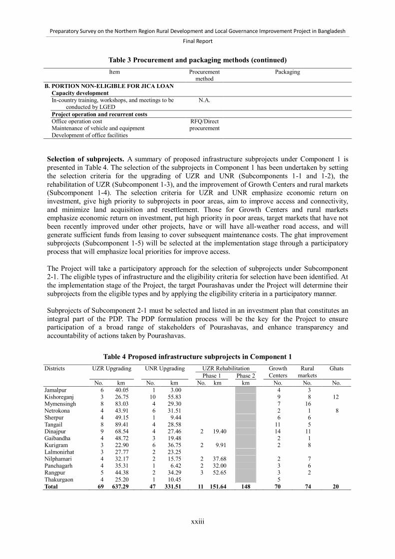
Preparatory Survey on the Northern Region Rural Development and Local Governance Improvement Project in Bangladesh
Final Report
xxiii
Table 3 Procurement and packaging methods (continued) Item Procurement
method Packaging
B. PORTION NON-ELIGIBLE FOR JICA LOAN Capacity development In-country training, workshops, and meetings to be
conducted by LGED N.A.
Project operation and recurrent costs Office operation cost RFQ/Direct
procurement
Maintenance of vehicle and equipment Development of office facilities Selection of subprojects. A summary of proposed infrastructure subprojects under Component 1 is presented in Table 4. The selection of the subprojects in Component 1 has been undertaken by setting the selection criteria for the upgrading of UZR and UNR (Subcomponents 1-1 and 1-2), the rehabilitation of UZR (Subcomponent 1-3), and the improvement of Growth Centers and rural markets (Subcomponent 1-4). The selection criteria for UZR and UNR emphasize economic return on investment, give high priority to subprojects in poor areas, aim to improve access and connectivity, and minimize land acquisition and resettlement. Those for Growth Centers and rural markets emphasize economic return on investment, put high priority in poor areas, target markets that have not been recently improved under other projects, have or will have all-weather road access, and will generate sufficient funds from leasing to cover subsequent maintenance costs. The ghat improvement subprojects (Subcomponent 1-5) will be selected at the implementation stage through a participatory process that will emphasize local priorities for improve access. The Project will take a participatory approach for the selection of subprojects under Subcomponent 2-1. The eligible types of infrastructure and the eligibility criteria for selection have been identified. At the implementation stage of the Project, the target Pourashavas under the Project will determine their subprojects from the eligible types and by applying the eligibility criteria in a participatory manner. Subprojects of Subcomponent 2-1 must be selected and listed in an investment plan that constitutes an integral part of the PDP. The PDP formulation process will be the key for the Project to ensure participation of a broad range of stakeholders of Pourashavas, and enhance transparency and accountability of actions taken by Pourashavas.
Table 4 Proposed infrastructure subprojects in Component 1 Districts UZR Upgrading UNR Upgrading UZR Rehabilitation
Growth Centers
Rural markets
Ghats Phase 1 Phase 2
No. km No. km No. km km No. No. No. Jamalpur 6 40.05 1 3.00 4 3 Kishoreganj 3 26.75 10 55.83 9 8 12 Mymensingh 8 83.03 4 29.30 7 16 Netrokona 4 43.91 6 31.51 2 1 8 Sherpur 4 49.15 1 9.44 6 6 Tangail 8 89.41 4 28.58 11 5 Dinajpur 9 68.54 4 27.46 2 19.40 14 11 Gaibandha 4 48.72 3 19.48 2 1 Kurigram 3 22.90 6 36.75 2 9.91 2 8 Lalmonirhat 3 27.77 2 23.25 Nilphamari 4 32.17 2 15.75 2 37.68 2 7 Panchagarh 4 35.31 1 6.42 2 32.00 3 6 Rangpur 5 44.38 2 34.29 3 52.65 3 2 Thakurgaon 4 25.20 1 10.45 5 Total 69 637.29 47 331.51 11 151.64 148 70 74 20

Preparatory Survey on the Northern Region Rural Development and Local Governance Improvement Project in Bangladesh
Final Report
xxiv
Selection of Pourashavas. The proposed Pourashavas to be supported under the Project are listed in Table 5. These target Pourashavas fall under categories B and C. They have potentials to grow as nuclei of development and poverty reduction in rural areas, and will enhance linkages and complementarity between rural and urban areas. Among the 48 Pourashavas in categories B and C in the Project area, 18 are proposed for support by the Project. The selection of the target Pourashavas has been undertaken by applying criteria that consider the following: 1) complementarity; 2) regional balance; 3) lagged areas; 4) needs of infrastructure improvement; 5) financial status; 6) urbanization; 7) economic potential; and 8) preparedness.
Table 5 List of candidate Pourashavas No. Division District Pourashava Category Final
score Ranking
among 44 Pourashavas
Ranking within each
District 1 Rangpur Kurigram Ulipur B 30.84 1 1 2 Dhaka Tangail Kalihati B 30.81 2 1 3 Dhaka Mymensingh Nandail C 30.24 3 1 4 Dhaka Jamalpur Dewanganj C 29.59 4 1 5 Dhaka Sherpur Sreebardi C 28.53 5 1 6 Rangpur Dinajpur Fulbari B 27.55 6 1 7 Dhaka Mymensingh Phulpur B 27.46 7 2 8 Rangpur Nilphamari Jaldhaka C 27.29 8 1 9 Rangpur Rangpur Haragach C 27.27 9 1 10 Dhaka Jamalpur Melandah C 26.59 10 2 11 Rangpur Thakurgaon Pirganj B 25.77 13 1 12 Rangpur Gaibandha Sundarganj C 25.25 14 1 13 Rangpur Dinajpur Birganj B 24.51 15 2 14 Rangpur Kurigram Nageswari B 24.50 16 2 15 Dhaka Tangail Madhupur B 24.30 18 2 16 Rangpur Rangpur Badarganj B 22.60 23 2 17 Dhaka Kishoreganj Pakundia C 22.20 24 1 18 Rangpur Thakurgaon Ranishankail C 21.75 25 2
Economic appraisal. The infrastructure subprojects in Component 1 and Subcomponent 2-1 are expected to bring benefits in a number of development sectors and for different beneficiaries such as: 1) rural transport—transport operators and passengers; 2) local industry—farmers and fishers; 3) real estate—land owners; 4) trade—producers, traders, consumers and government; 5) employment—local residents and destitute people; and 6) gender—female shopkeepers and rural women in general. The results of economic appraisals of infrastructure subprojects in Component 1 and Subcomponent 2-1 are presented in Table 6. The reasonably high EIRRs of subprojects in both Component 1 and Subcomponent 2-1 indicate that substantive economic benefits can be expected from the interventions by the Project.
Table 6 EIRR of subprojects that passed the selection and appraisal procedures Infrastructure type Number Range of EIRR Average EIRR Component 1
UZR upgrading 69 From 12% to 57% 26% UZR rehabilitation 18 From 15% to 53% 31% UNR upgrading 47 From 12% to 41% 21% Growth Centers 70 From 16% to 2,076% 199% Rural markets 126 From 12% to 1,580% 115%
Subcomponent 2-1 1 Pourashava roads 4 From 68% to 150% 107% Municipal markets 4 From 75% to 254% 175% Drainage 4 From 53% to 116% 72%
Note: 1. The EIRR of Subcomponent 2-1 are estimated for Pourashava roads, municipal markets, and drainage in four sample Pourashavas—Ulipur in Kurigram District, Haragach in Rangpur District, and Gouripur and Nandail in Mymensingh District.
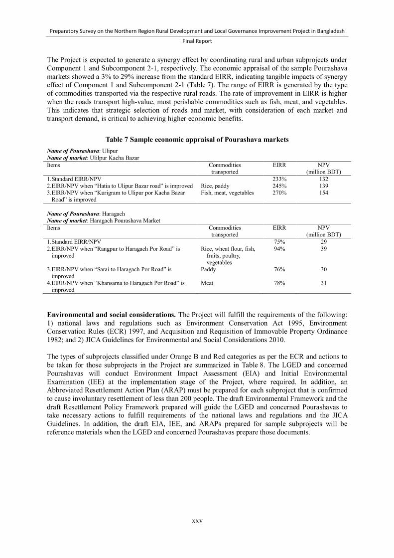
Preparatory Survey on the Northern Region Rural Development and Local Governance Improvement Project in Bangladesh
Final Report
xxv
The Project is expected to generate a synergy effect by coordinating rural and urban subprojects under Component 1 and Subcomponent 2-1, respectively. The economic appraisal of the sample Pourashava markets showed a 3% to 29% increase from the standard EIRR, indicating tangible impacts of synergy effect of Component 1 and Subcomponent 2-1 (Table 7). The range of EIRR is generated by the type of commodities transported via the respective rural roads. The rate of improvement in EIRR is higher when the roads transport high-value, most perishable commodities such as fish, meat, and vegetables. This indicates that strategic selection of roads and market, with consideration of each market and transport demand, is critical to achieving higher economic benefits.
Table 7 Sample economic appraisal of Pourashava markets Name of Pourashava: Ulipur Name of market: Ulilpur Kacha Bazar Items Commodities
transported EIRR NPV
(million BDT) 1. Standard EIRR/NPV 233% 132 2.EIRR/NPV when “Hatia to Ulipur Bazar road” is improved Rice, paddy 245% 139 3.EIRR/NPV when “Kurigram to Ulipur por Kacha Bazar
Road” is improved Fish, meat, vegetables 270% 154
Name of Pourashava: Haragach Name of market: Haragach Pourashava Market Items Commodities
transported EIRR NPV
(million BDT) 1.Standard EIRR/NPV 75% 29 2.EIRR/NPV when “Rangpur to Haragach Por Road” is
improved Rice, wheat flour, fish,
fruits, poultry, vegetables
94% 39
3.EIRR/NPV when “Sarai to Haragach Por Road” is improved
Paddy 76% 30
4.EIRR/NPV when “Khansama to Haragach Por Road” is improved
Meat 78% 31
Environmental and social considerations. The Project will fulfill the requirements of the following: 1) national laws and regulations such as Environment Conservation Act 1995, Environment Conservation Rules (ECR) 1997, and Acquisition and Requisition of Immovable Property Ordinance 1982; and 2) JICA Guidelines for Environmental and Social Considerations 2010. The types of subprojects classified under Orange B and Red categories as per the ECR and actions to be taken for those subprojects in the Project are summarized in Table 8. The LGED and concerned Pourashavas will conduct Environment Impact Assessment (EIA) and Initial Environmental Examination (IEE) at the implementation stage of the Project, where required. In addition, an Abbreviated Resettlement Action Plan (ARAP) must be prepared for each subproject that is confirmed to cause involuntary resettlement of less than 200 people. The draft Environmental Framework and the draft Resettlement Policy Framework prepared will guide the LGED and concerned Pourashavas to take necessary actions to fulfill requirements of the national laws and regulations and the JICA Guidelines. In addition, the draft EIA, IEE, and ARAPs prepared for sample subprojects will be reference materials when the LGED and concerned Pourashavas prepare those documents.
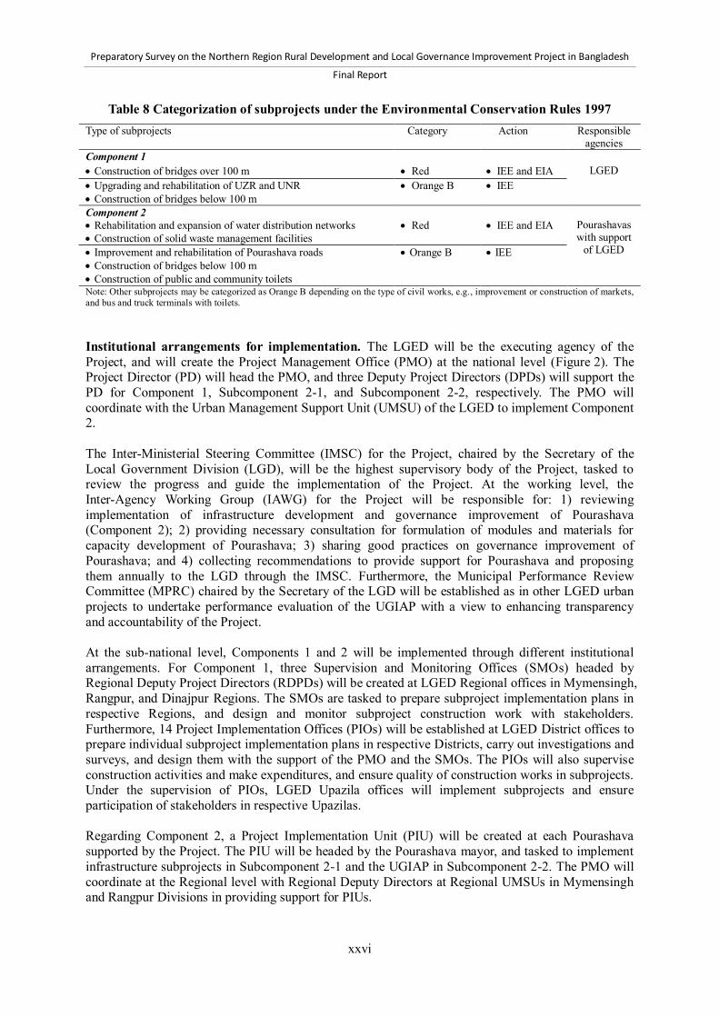
Preparatory Survey on the Northern Region Rural Development and Local Governance Improvement Project in Bangladesh
Final Report
xxvi
Table 8 Categorization of subprojects under the Environmental Conservation Rules 1997 Type of subprojects Category Action Responsible
agencies Component 1 Construction of bridges over 100 m Red IEE and EIA LGED Upgrading and rehabilitation of UZR and UNR Construction of bridges below 100 m
Orange B IEE
Component 2 Rehabilitation and expansion of water distribution networks Construction of solid waste management facilities
Red IEE and EIA Pourashavas with support
of LGED Improvement and rehabilitation of Pourashava roads Construction of bridges below 100 m Construction of public and community toilets
Orange B IEE
Note: Other subprojects may be categorized as Orange B depending on the type of civil works, e.g., improvement or construction of markets, and bus and truck terminals with toilets. Institutional arrangements for implementation. The LGED will be the executing agency of the Project, and will create the Project Management Office (PMO) at the national level (Figure 2). The Project Director (PD) will head the PMO, and three Deputy Project Directors (DPDs) will support the PD for Component 1, Subcomponent 2-1, and Subcomponent 2-2, respectively. The PMO will coordinate with the Urban Management Support Unit (UMSU) of the LGED to implement Component 2. The Inter-Ministerial Steering Committee (IMSC) for the Project, chaired by the Secretary of the Local Government Division (LGD), will be the highest supervisory body of the Project, tasked to review the progress and guide the implementation of the Project. At the working level, the Inter-Agency Working Group (IAWG) for the Project will be responsible for: 1) reviewing implementation of infrastructure development and governance improvement of Pourashava (Component 2); 2) providing necessary consultation for formulation of modules and materials for capacity development of Pourashava; 3) sharing good practices on governance improvement of Pourashava; and 4) collecting recommendations to provide support for Pourashava and proposing them annually to the LGD through the IMSC. Furthermore, the Municipal Performance Review Committee (MPRC) chaired by the Secretary of the LGD will be established as in other LGED urban projects to undertake performance evaluation of the UGIAP with a view to enhancing transparency and accountability of the Project. At the sub-national level, Components 1 and 2 will be implemented through different institutional arrangements. For Component 1, three Supervision and Monitoring Offices (SMOs) headed by Regional Deputy Project Directors (RDPDs) will be created at LGED Regional offices in Mymensingh, Rangpur, and Dinajpur Regions. The SMOs are tasked to prepare subproject implementation plans in respective Regions, and design and monitor subproject construction work with stakeholders. Furthermore, 14 Project Implementation Offices (PIOs) will be established at LGED District offices to prepare individual subproject implementation plans in respective Districts, carry out investigations and surveys, and design them with the support of the PMO and the SMOs. The PIOs will also supervise construction activities and make expenditures, and ensure quality of construction works in subprojects. Under the supervision of PIOs, LGED Upazila offices will implement subprojects and ensure participation of stakeholders in respective Upazilas. Regarding Component 2, a Project Implementation Unit (PIU) will be created at each Pourashava supported by the Project. The PIU will be headed by the Pourashava mayor, and tasked to implement infrastructure subprojects in Subcomponent 2-1 and the UGIAP in Subcomponent 2-2. The PMO will coordinate at the Regional level with Regional Deputy Directors at Regional UMSUs in Mymensingh and Rangpur Divisions in providing support for PIUs.

Preparatory Survey on the Northern Region Rural Development and Local Governance Improvement Project in Bangladesh
Final Report
xxvii
The PMO, SMOs, PIOs, UMSU, RUMSUs, and PIUs will be supported by consultancy services in the following aspects: 1) design, supervision and monitoring (DSM) for Component 1 and Subcomponent 2-1; 2) governance improvement and capacity development (GICD) for Subcomponent 2-2; 3) benefit monitoring and evaluation (BME) for the Project.

xxviii
Prep
aratory Su
rvey on th
e No
rthern
Region R
ural D
evelop
men
t and Lo
cal Go
vernan
ce Imp
rovem
ent P
roject in B
angladesh
Final Rep
ort
`
Municipal Performance ReviewCommittee(MPRC)
chaired by LGD
BMEConsultants
DPHE UpazilaOffices
LGED UpazilaOffice
59 Upazilas
RegionLevel
Upazila/Pourashava
Levels
GICDConsultants
GICD Consultants
Project Management Office(PMO)
CentralLevel
DSM Consultants
DSM Consultants
DSM Consultants GICD
Consultants
PIUı
8 Pourashavas
DistrictLevel
LGD
Chief EngineerLGED
Regional DeputyProject Director
(M)
Regional DeputyProject Director
(R)
Regional DeputyProject Director
(D)
Supervision and Monitoring Office (SMO)
NationalInstitute for
LocalGovernment
(NILG)
Department ofPublic HealthEngineering
(DPHE)
Deputy Project Directorfor Subcomponent 2-2
Deputy Director ofUMSU
Urban ManagementSupport Unit
(UMSU)
Regional DeputyDirector (M)
Regional DeputyDirector (R)
DirectorUMSU
for Subcomponent 2-2
Regional UMSU
LGED UpazilaOffice
29 Upazilas
LGED UpazilaOffice
29 Upazilas
PIU
10 Pourashavas
PIOLGED District
Office6 Districts
Source: Survey teamLegend: BME = Benefit Monitoring and Evaluation, D = Dinajpur Region, DPHE = Department of Public Health Engineering , DSM = Design, Supervision and Monitoring, EPS = Equipment Procurement Support, GICD = Governance Improvement andCapacity Development , M = Mymensingh Region, PAS = Project Accounting Support, PC = Publicity Campaign, PIO = Project Implementation Office, PIU = Project Implementation Unit, PME = Performance Monitoring and Evaluation, SA = StatisticalAnalysis , R = Rangpur Region, UMSU = Urban Management Support Unit
PIOLGED District
Office4 Districts
PIOLGED District
Office4 Districts
Deputy Project Directorfor Subcomponent 2-1
Component 1 Component 2
Project Director(PD)
Inter-Agency Working Group(IAWG)
Inter-Ministerial Steering Committee(IMSC)
chaired by LGD
PMRS, PAS ,EPS, PME,SA and PCAssistants
Deputy Project Directorfor Component 1
DSMConsultants
Figure 2 Institutional arrangements for implementation of the Project

Preparatory Survey on the Northern Region Rural Development and Local Governance Improvement Project in Bangladesh
Final Report
xxix
Operation and maintenance (O&M) system and process. The Project will take a number of measures to enhance sustainability in order to ensure that the benefits to people from investment in improved rural and urban infrastructures are sustained in the long term. In Component 1, the Project will: 1) undertake rehabilitation of UZRs with a yen loan; 2) conduct off-pavement routine maintenance by LCS of all roads under the Project; 3) invest in Growth Centers and rural markets that generate lease values high enough to finance routine maintenance. Under Component 2, the Project will: 1) require the preparation of an O&M action plan of urban infrastructure as part of the Pourashava Development Plan (PDP); and 2) adopt partial sub-lending to Pourashavas for revenue-generating infrastructure subprojects such as markets and bus and truck terminals. Furthermore, the Project will implement a Rural Road Maintenance Action Plan to contribute to improving sustainability of an all-weather core rural road network (= UZR and sealed UNR) in the Project area. This action plan is consistent with the draft Rural Road Maintenance Policy. The Rural Road Maintenance Action Plan will have the four outputs shown in Table 9.
Table 9 Outputs of Rural Road Maintenance Action Plan Output 1 Project investments in rural road upgrading and rehabilitation sustained Output 2 Sustainability of the core rural road network in the project area increased Output 3 Rural roads maintenance policy adopted and implemented Output 4 Rural road network performance monitoring system developed, tested, and applied
The first output focuses on the investments in improved rural roads under the Project. The second output is broader, addressing rural road maintenance at the Project area level. The third output has a national perspective. The final output is concerned with measuring the LGED’s performance as a service provider in sustaining access on the rural road network. The Road Maintenance and Road Safety Unit (RMRSU) of the LGED will take the lead in implementing this action plan, for which the Project will provide technical assistance through the DSM consultancy services. The Project will also explore the possibility to adopt Performance-Based Maintenance Contracting (PBMC), a new O&M scheme of the LGED that will be used in the Second Rural Transport Improvement Project (RTIP-2) supported by the World Bank. The target Pourashavas under the Project will prepare and implement Pourashava Infrastructure Operation and Maintenance Action Plans (PIOMAPs) in order to strengthen their O&M capacity and enhance sustainability of benefits from infrastructure investment. They will prepare PIOMAPs as part of Pourashava Development Plans. In the PIOMAP, each Pourashava will set up and operationalize institutional arrangements for O&M, prepare and implement annual and 5-year O&M plans with citizen participation through TLCC and WLCCs, and strengthen technical capacity of concerned O&M personnel. Monitoring and evaluation. The Project will conduct: 1) progress monitoring; and 2) effect monitoring and evaluation. For the progress monitoring, the PMO will prepare and submit the Annual Development Review Format on a monthly basis, the quarterly Project Monitoring Form for the Implementation Monitoring and Evaluation Department (IMED) of the Ministry of Planning, the Quarterly Progress Monitoring Report to JICA, and the Project Completion Report at the end of the Project. Regarding the effect monitoring and evaluation, the Project will adopt the LGED Guideline 1999 for effect monitoring and evaluation. In accordance with this Guideline, the Project will: 1) conduct a baseline survey in Year 1; 2) finalize the logical framework and methods for effect monitoring and

Preparatory Survey on the Northern Region Rural Development and Local Governance Improvement Project in Bangladesh
Final Report
xxx
evaluation in Year 1; and 3) conduct a mid-term assessment and a terminal assessment in line with the methodologies of Benefit Monitoring and Evaluation and Socio-Economic Monitoring and Evaluation taken by all LGED projects.

Preparatory Survey on the Northern Region Rural Development and Local Governance Improvement Project in Bangladesh
Final Report
1-1
1 Introduction 1.1 Background Bangladesh has made remarkable progress in socioeconomic development since its independence in 1971. Over the last 40 years, the real per capita income of Bangladesh increased by more than 130%, and the poverty rate was reduced by more than half.1 The country’s real Gross Domestic Product (GDP) growth recorded around 6% per annum on average in the 2000s, and reached 6.7% in 2011. This relatively high growth performance was accompanied by a steady decline in the national poverty rate from 56.6% in 1990 to 40% in 2005, and further down to 31.5% in 2010. Based on the robust growth performance, the Government of Bangladesh aims to reduce the national poverty rate to 15% and transform Bangladesh into a middle income country by 2021.2 The benefit of the economic growth, however, has not been broadly shared among the people of Bangladesh, and a wide poverty gap between rural and urban areas persists. The poverty rate in rural areas in 2010 was 35.2%, exceeding the poverty rate of 21.3% in urban areas by more than 10% (Table 1-1). Since 100 million people, or 70% of the total population, live in rural Bangladesh, poverty reduction in rural areas is clearly one of the most important policy issues in the country.
Table 1-1 Headcount poverty rate in Bangladesh (%) Division 1995/96 2000 2005 2010
Total Rural Urban Total Rural Urban Total Rural Urban Total Rural Urban Total 53.1 56.7 35.0 48.9 52.3 35.2 40.0 43.8 28.4 31.5 35.2 21.3 Barisal 59.9 60.6 47.7 53.1 55.1 32.0 52.0 54.1 40.4 39.4 39.2 39.9 Chittagong 44.9 47.2 29.2 45.7 46.3 44.2 34.0 36.0 27.8 26.2 31.0 11.8 Dhaka 52.0 58.9 33.6 46.7 55.9 28.2 32.0 39.0 20.2 30.5 38.8 18.0 Khulna 51.7 51.5 53.3 45.1 46.4 38.5 45.7 46.5 43.2 32.1 31.0 35.8 Rajshahi 62.2 65.7 33.9 56.7 58.5 44.5 51.2 52.3 45.2 29.7 29.0 32.6 Rangpur 42.3 44.5 27.9 Sylhet 42.4 41.9 49.6 33.8 36.1 18.6 28.1 30.5 15.0 Source: GOB (2011) A look at poverty by region reveals that the poverty rates in the western part of Bangladesh including Rangpur, Khulna, and Barisal Divisions tend to be higher than those in the eastern part of the country including Dhaka and Chittagong Divisions. In particular, the poverty rate of Rangpur Division recorded 42.3%, the highest among the seven Divisions in 2010. Looking at poverty at the Upazila level, the poverty rate in the Mymensingh Region of Dhaka Division recorded 45.1%, which is much higher than the national average 40.0% in 2005. In the Sixth Five Year Plan (SFYP), the Government of Bangladesh identifies regional disparities as a major concern. As a response, the SFYP set a strategy to reduce the regional disparities by further developing infrastructure, promoting industrialization, improving agricultural productivity, strengthening local governance by area-based regional development planning systems, and thereby vitalizing regional economies. Poverty reduction in the rural area is the key to alleviating persistent disparities between urban and rural areas. The prerequisites to achieve this goal are to 1) vitalize rural economies, and 2) improve the quality of public services in rural areas. First, a strategy to vitalize rural economies should include measures to develop rural towns and markets
1 GOB (2011). 2 GOB (2010).

Preparatory Survey on the Northern Region Rural Development and Local Governance Improvement Project in Bangladesh
Final Report
1-2
as nucleus of rural development, and strengthen rural-urban linkages, namely the linkages between the nucleuses and their surrounding rural areas socially and economically. Potential candidates of the nucleuses would include Pourashavas (municipalities), Upazila towns, Growth Centers, and rural markets. By strengthening rural-urban linkages, both rural and urban people would greatly benefit from improved access to transport infrastructure, expanded markets, improved access to education and health services, and more job opportunities. If the rural-urban linkages are strengthened and rural economies are vitalized, this would help alleviate current pressures on rural people to migrate to large cities such as Dhaka and Chittagong. Second, poverty reduction in rural areas will require significant improvement in the quality and quantity of public goods and services to local residents. This includes not only basic public services such as education, health, and sanitation, but also provision of basic infrastructure such as roads, bridges, and markets. The improvement in basic infrastructure will contribute to vitalizing local economies, improving access to services in health and education, and creating job opportunities. In Bangladesh, central government has been playing the main roles in formulating policies and providing public goods and services for local people. However, local governments are also mandated by law to provide certain types of public goods and services to local people. As emphasized in the SFYP, Bangladesh aims to move toward a more decentralized governance system in which local governments would play more prominent roles in providing public goods and services to better address local needs. 1.2 Objectives Against this background, the Government of Bangladesh submitted a request for a Preparatory Survey (hereinafter the “Survey”) to formulate a project entitled the Northern Region Rural Development and Local Governance Improvement Project (hereinafter the “Project”). This was followed by an agreement between the Government of Bangladesh and the Japan International Cooperation Agency (JICA) regarding the scope of the Survey as recorded in the Minutes of Meeting (M/M) signed on November 21, 2011. The objective of the Survey is to conduct a study on topics that are required for appraisal of the Project to be implemented with the support of Japan’s yen-loan scheme. Those topics include the objectives of the Project, target area, scope and cost of the Project, implementation schedule, implementation methods (such as procurement and construction), implementation arrangements of the Project, arrangements of operation and maintenance (O&M), and social and environmental considerations. To study those topics, collect and analyze basic information, formulate the Project plan, examine implementation arrangements of the Project and arrangements of O&M, confirm items concerned with social and environmental considerations, and support preparing Development Project Proposals (DPPs). Furthermore, the Survey will conduct capacity assessment of Pourashavas in the target area, and examine a technical cooperation project that might be necessary to develop capacity of Pourashavas in project planning, fund management, and other important municipal services. 1.3 Terms of Reference The following are the detailed Terms of Reference (TOR) of the Survey. TOR 1: Collect and analyze basic data and information
1.1. Review the existing report, studies, and development plans, and confirm the background of the Project
1.2. Conduct the socioeconomic survey in the target area to assess poverty level and accessibility to services

Preparatory Survey on the Northern Region Rural Development and Local Governance Improvement Project in Bangladesh
Final Report
1-3
1.3. Review and assess the current situation at the field level and analyze problems related to regional development in the target area
1.4. Review the current situation and analyze problems related to public administration mechanisms in the target area
TOR 2: Prepare the Project plan
2.1. Confirm the target area and select subprojects for the rural infrastructure development component (Component 1), with clarification of selection criteria
2.2. Confirm the target Pourashavas, with clarification of selection criteria, whole process and methodology for selection and prioritization of selected subprojects, and make implementation guidelines or manuals for the Pourashava capacity development component (Component 2)
2.3. Consider the detailed scope of the Project including the outline of consulting services 2.4. Consider the implementation plan of the Project, including the different tier of stakeholders’
consultation 2.5. Estimate the project cost with different options 2.6. Compare the estimated project cost with other similar projects to verify the appropriateness of
the project cost 2.7. Propose the financing plan of the Project 2.8. Prepare a procurement plan, methods, and packages of the Project 2.9. Propose an implementation schedule of the Project 2.10. Consider the Project effects including establishment of operation and effects indicators,
baseline data, and targets, and evaluate qualitative and quantitative effects, including Economic Internal Rate of Return (EIRR) with Net Present Value (NPV) and Benefit Cost Ratio of the Project
2.11. Propose an outline of the required technical cooperation project for capacity development of Pourashavas
TOR 3: Examine and prepare institutional arrangements for implementation, operation and
maintenance 3.1. Propose the Project implementation arrangements with definite roles and responsibilities of
each concerned section of the Local Government Engineering Department (LGED) and other relevant organizations
3.2. Examine the necessary O&M and rehabilitation framework and structure for the Project TOR 4: Confirm environmental and social considerations
4.1. Review the environmental and social impacts of the Project including details of land acquisition and resettlement, and prepare mitigation measures and a monitoring plan in accordance with the requirement of JICA’s “Guideline for Environmental and Social Considerations”
4.2. Prepare: 1) Resettlement Action Plan (RAP) with explanation to the attached people against involuntary resettlement and loss of means of livelihood; and 2) Initial Environmental Examination (IEE) and/or Environmental Impact Assessment (EIA), if required, which also include considerations for the people living in the Project area, in accordance with the laws and regulations of Bangladesh as well as JICA’s “Guideline for Environmental and Social Considerations”
4.3. Consider vulnerability of the target area and propose adaptation measures against climate change under the Project
TOR 5: Prepare Development Project Proposal
5.1. Finalize the project proposal document 5.2. Assist preparation of DPP based on TOR 5.1

Preparatory Survey on the Northern Region Rural Development and Local Governance Improvement Project in Bangladesh
Final Report
2-1
2 Institutional framework for rural development and local governance 2.1 History and political system in Bangladesh Bangladesh has gone through a number of changes in political systems since gaining its independence in 1971 (Table 2-1). The new-born country started as a parliamentary democracy with the promulgation of the Constitution of the People’s Republic of Bangladesh in 1972. This was, however, followed by an era of autocratic regimes in which the military ruled the country from 1975 to 1990. The year 1991 marked the restoration of parliamentary democracy with general parliamentary elections. Although there was a brief period of a military-backed caretaker (interim) government in 2007-2008, parliamentary democracy was restored again in 2009 after the general parliamentary elections in 2008.
Table 2-1 Bangladesh political systems from 1971 to the present
Year Political system Dominant political party End in 1971-1975 Parliamentary democracy Awami League Civilian coup d’état 1975 Civilian autocracy Bangladesh Krishak Sramik
Awami League Military coup d’état
1975-1981 Military autocracy Bangladesh Nationalist Party Assassination 1982-1990 Military autocracy Jatiyo Party Resignation 1991-1996 Parliamentary democracy Bangladesh Nationalist Party Elections 1996-2001 Parliamentary democracy Awami League Elections 2001-2006 Parliamentary democracy Bangladesh Nationalist Party Take-over by caretaker
government 2007-2008 Autocracy Caretaker government Elections 2009-present Parliamentary democracy Awami League Source: Based on a table in Van Schendel (2009), pp. 200-201. The information from 2007 to the present was added by Survey Team. The 1972 Constitution of Bangladesh states that the country is a unitary, independent, sovereign state, and that trust and faith in the Almighty Allah, nationalism, democracy and socialism constitute the fundamental principles of state policy.3 The 1972 Constitution of Bangladesh also stipulates the promotion of Local Government Institutions (LGIs) as one of the fundamental principles of state policy, stating that “the State shall encourage LGIs composed of representatives of the areas concerned and in such institutions special representation shall be given, as far as possible, to peasants, workers and women.”4 Furthermore, the Constitution declares that rural development is one of the constitutional mandates of the country, stating that “the State shall adopt effective measures to bring about a radical transformation in the rural areas … so as progressively to remove the disparity in the standards of living between the urban and the rural areas.”5 Finally, the 1972 Constitution stipulates that local governments shall perform functions related to: 1) administration and the work of public officers; 2) the maintenance of public order; and 3) the preparation and implementation of plans for public services and economic development, for which they are granted powers to impose taxes for local purposes, prepare their budgets, and maintain funds.6
3 Article 8 (1), 1972 Constitution of Bangladesh 4 Article 9, 1972 Constitution of Bangladesh 5 Article 16, 1972 Constitution of Bangladesh 6 Articles 59 and 60, 1972 Constitution of Bangladesh

Preparatory Survey on the Northern Region Rural Development and Local Governance Improvement Project in Bangladesh
Final Report
2-2
2.2 Policies on rural development and local governance 2.2.1 National development policies Since its independence in 1971, five-year plans have been the main national development policy of the Government of Bangladesh (GOB). The government has formulated six five-year plans as of the point of this writing. Under the present government, the Outline Perspective Plan of Bangladesh 2010-2021: Making Vision 2021 a Reality (Perspective Plan), the Sixth Five Year Plan FY2011-FY2015 (SFYP), and Millennium Development Goals (MDGs) constitute the national development policies of this country. (1) Outline Perspective Plan The Perspective Plan is a ten-year plan that articulates the government’s development vision, mission, and the goals and objectives to be achieved by 2021.7 According to the Perspective Plan, the government’s Vision 2021 for national development is to “build Bangladesh into a resilient, productive, innovative and prosperous nation with a caring society consisting of healthy, happy, and well-educated people.”8 The Perspective Plan identifies rural development as “a process that encompasses the entire gamut of techno-economic and socio-political changes to relevant public and private efforts designed to increase the wellbeing of rural people.”9 A strategy for rural development in the Perspective Plan is “to establish a powerful autonomous local government body that is imperative to initiate and provide coordination among private and public rural development institutions.”10 Here, LGIs are expected to engage a wider range of institutions in collaboration with each other, including cooperatives, non-government organizations (NGOs), local financial institutions, and the private sector. The Perspective Plan identifies rural transport infrastructure and more efficient functioning of rural markets as important in supporting rural economies. Construction and maintenance of rural road networks, in particular Upazila roads, Union roads, and village roads along with waterways, Growth Centers, and rural markets, are stressed in the plan. The strategies for rural infrastructure in the Perspective Plan are to: 1) implement the Rural Roads Master Plan; 2) adopt a Maintenance Plan with priority on maintenance over new construction; and 3) involve LGIs more actively to ensure utilization and maintenance of constructed facilities.11 (2) Sixth Five Year Plan By its design, the Perspective Plan is expected to be implemented through two successive five-year plans in the periods FY2011-FY2015 and FY2016-FY2020. The current government formulated the SFYP and put it into operation in July 2010. The main objective of the SFYP is to reduce and ultimately eradicate poverty to ensure a “Sonar Bangla.” Two specific paths were set to achieve this objective: 1) accelerate economic growth and create productive employment opportunities; and 2) ensure distributive justice. The SFYP provides a comprehensive set of strategies to achieve the objective of the SFYP. The
7 The Perspective Plan was approved on 10 May 2012 by the National Economic Council. 8 Page 8, GOB (2010). 9 Page 52, GOB (2011). 10 Page 53, GOB (2011). 11 Page 75, GOB (2011).

Preparatory Survey on the Northern Region Rural Development and Local Governance Improvement Project in Bangladesh
Final Report
2-3
following are the areas of the strategies covered in the SFYP:12 Accelerate growth and employment Benefit from higher labor force growth (“demographic dividend”) and ensure labor quality Improve factor productivity through information technology Reduce population growth Ensure food security Address land constraints Manage the special dimension of growth Reduce income inequality Ensure social protection for the under-privileged population Ensure gender parity Improve governance
The SFYP devotes an entire chapter to the issue of managing regional disparities in Bangladesh.13 In the SFYP, the government expressed its concern about regional disparities in terms of poverty, income, and human development, and therefore its strong commitment to taking the necessary steps to reduce disparities. The factors affecting regional disparities identified in the SFYP are: 1) access to Growth Centers; 2) natural disasters and weather factors; 3) access to energy; 4) availability of transport and communication systems; 5) availability of financial infrastructure; and 6) access to international migration and foreign remittances. To address those factors affecting regional disparities, the SFYP sets out the following strategies: 1) develop infrastructure; 2) industrialize lagging regions; 3) develop agriculture and rural economic activities; 4) create opportunities for international migration; and 5) promote human development and social protection policies. In particular, the strategy 1) above emphasizes that both inter-District and intra-District road communication systems would be developed to increase economic mobility within the lagging regions, whereas the strategy 3) stresses strengthening LGIs to conduct the government’s rural development activities through these institutions. (3) Millennium Development Goals Bangladesh adopted the Millennium Development Goals (MDGs) during the UN Millennium Summit in September 2000. Since the end of the SFYP coincides with the terminal year for the MDGs in 2015, the MDGs have been integrated in the SFYP. Bangladesh’s progress towards achieving the MDGs is on track for most of the targets, including poverty reduction, expansion of primary and secondary education, infant and child mortality rates, containing the spread and fatality of malaria and tuberculosis, reforestation, access to safe drinking water and sanitation latrines, especially in urban areas, and gender parity in primary and secondary education. However, challenges remain in improving maternal health, forest cover and maintaining protected areas, especially wetlands, for bio-diversity, and access to safe drinking water and sanitary latrines particularly in rural areas. It is also a challenge to address certain pockets of poverty that are lagging far behind the
12 Pages 23-33, GOB (2011). 13 Chapter 6 (Managing regional disparities for shared growth and poverty reduction), GOB (2011).
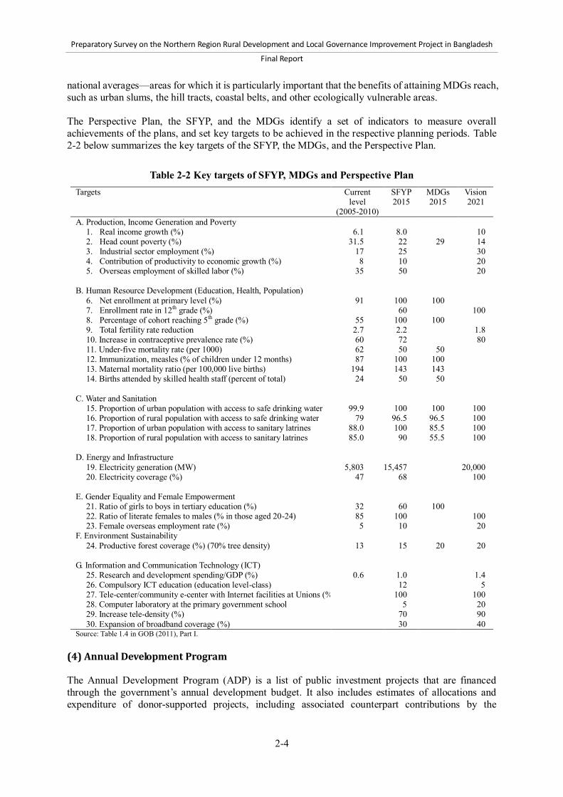
Preparatory Survey on the Northern Region Rural Development and Local Governance Improvement Project in Bangladesh
Final Report
2-4
national averages—areas for which it is particularly important that the benefits of attaining MDGs reach, such as urban slums, the hill tracts, coastal belts, and other ecologically vulnerable areas. The Perspective Plan, the SFYP, and the MDGs identify a set of indicators to measure overall achievements of the plans, and set key targets to be achieved in the respective planning periods. Table 2-2 below summarizes the key targets of the SFYP, the MDGs, and the Perspective Plan.
Table 2-2 Key targets of SFYP, MDGs and Perspective Plan
Targets Current level
(2005-2010)
SFYP 2015
MDGs 2015
Vision 2021
A. Production, Income Generation and Poverty 1. Real income growth (%) 6.1 8.0 10 2. Head count poverty (%) 31.5 22 29 14 3. Industrial sector employment (%) 17 25 30 4. Contribution of productivity to economic growth (%) 8 10 20 5. Overseas employment of skilled labor (%) 35 50 20
B. Human Resource Development (Education, Health, Population)
6. Net enrollment at primary level (%) 91 100 100 7. Enrollment rate in 12th grade (%) 60 100 8. Percentage of cohort reaching 5th grade (%) 55 100 100 9. Total fertility rate reduction 2.7 2.2 1.8 10. Increase in contraceptive prevalence rate (%) 60 72 80 11. Under-five mortality rate (per 1000) 62 50 50 12. Immunization, measles (% of children under 12 months) 87 100 100 13. Maternal mortality ratio (per 100,000 live births) 194 143 143 14. Births attended by skilled health staff (percent of total) 24 50 50
C. Water and Sanitation
15. Proportion of urban population with access to safe drinking water 99.9 100 100 100 16. Proportion of rural population with access to safe drinking water 79 96.5 96.5 100 17. Proportion of urban population with access to sanitary latrines 88.0 100 85.5 100 18. Proportion of rural population with access to sanitary latrines 85.0 90 55.5 100
D. Energy and Infrastructure
19. Electricity generation (MW) 5,803 15,457 20,000 20. Electricity coverage (%) 47 68 100
E. Gender Equality and Female Empowerment
21. Ratio of girls to boys in tertiary education (%) 32 60 100 22. Ratio of literate females to males (% in those aged 20-24) 85 100 100 23. Female overseas employment rate (%) 5 10 20
F. Environment Sustainability 24. Productive forest coverage (%) (70% tree density) 13 15 20 20
G. Information and Communication Technology (ICT)
25. Research and development spending/GDP (%) 0.6 1.0 1.4 26. Compulsory ICT education (education level-class) 12 5 27. Tele-center/community e-center with Internet facilities at Unions (%) 100 100 28. Computer laboratory at the primary government school 5 20 29. Increase tele-density (%) 70 90 30. Expansion of broadband coverage (%) 30 40
Source: Table 1.4 in GOB (2011), Part I. (4) Annual Development Program The Annual Development Program (ADP) is a list of public investment projects that are financed through the government’s annual development budget. It also includes estimates of allocations and expenditure of donor-supported projects, including associated counterpart contributions by the
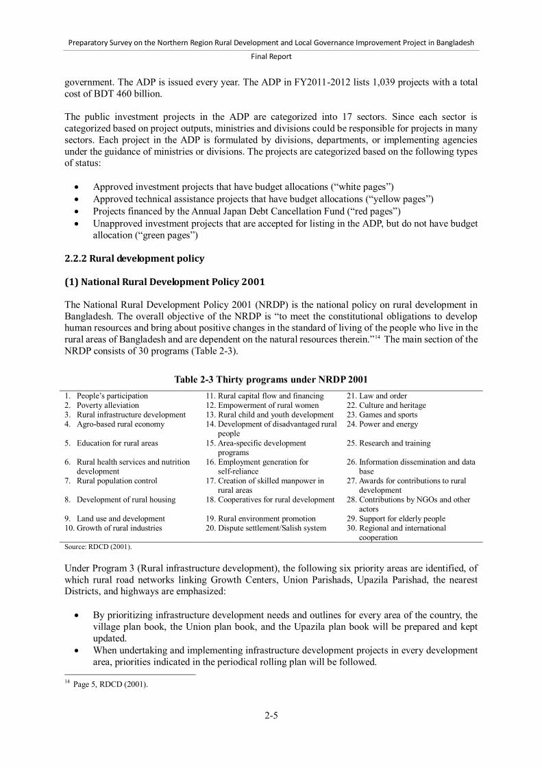
Preparatory Survey on the Northern Region Rural Development and Local Governance Improvement Project in Bangladesh
Final Report
2-5
government. The ADP is issued every year. The ADP in FY2011-2012 lists 1,039 projects with a total cost of BDT 460 billion. The public investment projects in the ADP are categorized into 17 sectors. Since each sector is categorized based on project outputs, ministries and divisions could be responsible for projects in many sectors. Each project in the ADP is formulated by divisions, departments, or implementing agencies under the guidance of ministries or divisions. The projects are categorized based on the following types of status: Approved investment projects that have budget allocations (“white pages”) Approved technical assistance projects that have budget allocations (“yellow pages”) Projects financed by the Annual Japan Debt Cancellation Fund (“red pages”) Unapproved investment projects that are accepted for listing in the ADP, but do not have budget
allocation (“green pages”) 2.2.2 Rural development policy (1) National Rural Development Policy 2001 The National Rural Development Policy 2001 (NRDP) is the national policy on rural development in Bangladesh. The overall objective of the NRDP is “to meet the constitutional obligations to develop human resources and bring about positive changes in the standard of living of the people who live in the rural areas of Bangladesh and are dependent on the natural resources therein.”14 The main section of the NRDP consists of 30 programs (Table 2-3).
Table 2-3 Thirty programs under NRDP 2001
1. People’s participation 11. Rural capital flow and financing 21. Law and order 2. Poverty alleviation 12. Empowerment of rural women 22. Culture and heritage 3. Rural infrastructure development 13. Rural child and youth development 23. Games and sports 4. Agro-based rural economy 14. Development of disadvantaged rural
people 24. Power and energy
5. Education for rural areas 15. Area-specific development programs
25. Research and training
6. Rural health services and nutrition development
16. Employment generation for self-reliance
26. Information dissemination and data base
7. Rural population control 17. Creation of skilled manpower in rural areas
27. Awards for contributions to rural development
8. Development of rural housing 18. Cooperatives for rural development 28. Contributions by NGOs and other actors
9. Land use and development 19. Rural environment promotion 29. Support for elderly people 10. Growth of rural industries 20. Dispute settlement/Salish system 30. Regional and international
cooperation Source: RDCD (2001). Under Program 3 (Rural infrastructure development), the following six priority areas are identified, of which rural road networks linking Growth Centers, Union Parishads, Upazila Parishad, the nearest Districts, and highways are emphasized: By prioritizing infrastructure development needs and outlines for every area of the country, the
village plan book, the Union plan book, and the Upazila plan book will be prepared and kept updated.
When undertaking and implementing infrastructure development projects in every development area, priorities indicated in the periodical rolling plan will be followed.
14 Page 5, RDCD (2001).

Preparatory Survey on the Northern Region Rural Development and Local Governance Improvement Project in Bangladesh
Final Report
2-6
Use of agricultural land, especially land with irrigation facilities, for non-agricultural purposes will be discouraged.
In case of new establishment and development of rural communication, priority will be given to roads linking to Growth Centers, Union Parishads, and Upazila Parishads, as well as roads connecting the nearest Districts and highways.
The implementation and financing of projects aiming to control floods and all other natural calamities and agricultural infrastructure development projects will get priority over other projects.
Scheduled periodic maintenance of roads and other physical infrastructure will be emphasized. In Program 15 (area specific, special development programs), the following six points are identified as the priority, among which area-specific development planning is emphasized and the important roles of LGIs are noted: For comprehensive development of particular regions with varying socioeconomic
characteristics, e.g., the Barind Tract, char areas (islands in rivers), coastal areas, island, hill tracts, and haor areas (water bodies such as ponds or lakes that dry up in winter), sustainable integrated programs will be adopted and implemented with priority to ensure the development of education, human resources, family planning, agriculture, water resource, physical infrastructure, and housing in these areas.
The LGIs will be involved and assigned coordinating roles to implement integrated development programs for the above-mentioned locations.
Social movements will be conducted to organize and unite people socially with a view to unleashing their potential and creativity.
A proper management system will be devised to strengthen and integrate rural development activities to be taken in the above-mentioned areas and responsibility will be given to the District level government authority for coordination.
Area-specific integrated development programs will be formulated through assessment of local needs with the active participation and involvement of local people.
Arrangements will be made to coordinate the activities of government and NGOs in the respective areas to avoid misuse, overlapping, and unequal and unhealthy competition among the government and NGOs in all spheres of rural development, as well as to ensure proper use and distribution of resources.
2.2.3 Urban development policy According to the SFYP, urbanization is one of the major problems facing the country. Currently, urbanization is directly related to the country’s economic growth, an increase in urban poverty, and deteriorating urban environment. In response to the growing concern over urbanization, the government formulated the draft National Urban Policy in 2006 (NUP 2006) and the draft National Urban Sector Policy in 2011 (NUSP 2011). The urban policy is aimed at improving the role of urban areas in the country’s socioeconomic development, and minimizing adverse socioeconomic and environmental consequences through a multi-dimensional process. The LGED started the formulation of the Pourashava Master Plans to accelerate the process of decentralization in the country in line with NUSP 2011. This section attempts to review the above-mentioned two national policies and explore effective use for local urban planning in the Northern Region Rural Development and Local Governance Improvement Project (NRRDLGIP).

Preparatory Survey on the Northern Region Rural Development and Local Governance Improvement Project in Bangladesh
Final Report
2-7
(1) National Urban Policy in 2006 (draft) In Bangladesh, cities and towns play a crucial role in the country’s socioeconomic development, despite the adverse socioeconomic and environmental consequences resulting from rapid growth of these urban centers. At present, urban dwellers constitute about 26% of the total population of the country, but their contribution to Gross Domestic Product (GDP) is more than 45%, indicating that labor productivity in urban areas is much higher than that in rural areas. Such gains in productivity, however, cannot be sustained if Bangladesh does not take appropriate steps to combat the negative consequences of urbanization. If Bangladesh aims to strengthen the beneficial aspects of urbanization and at the same time effectively deal with its negative consequences so as to achieve sustainable urbanization, the country needs to formulate policies, bearing in mind the multi-dimensional nature of the urbanization process. Urban sector policies, therefore, should cover economic, social, and environmental aspects of urban life and should be directed towards achieving an urban environment that can ensure “freedom from hunger; capacity to live a healthy life; access to education, shelter, and basic services; and a secure and livable environment at home and in the workplace.” The ten major objectives of draft NUP 2006 are shown in Figure 2-1, including the first objective: “to facilitate economic development, employment generation and poverty eradication through appropriate regulatory framework and infrastructure provisions.” An effective response to the challenges posed by rapid urbanization will require giving priority to the dimensions shown in Figure 2-2, while formulating national urban sector policies. (2) National Urban Sector Policy in 2011 (draft) The draft NUP 2006 was revised in 2011 to formulate the draft NUSP 2011. The NUSP 2011 has five sections, namely, “1.0 Objectives of National Urban Policy” of NUP 2006, which is subdivided into five sections: 1) background; 2) future vision; 3) objectives; 4) major dimensions of the policy; and 5) national urban policy recommendations. In the NUSP 2011, newly emerging issues, measures, and dimensions were added to cope with rapid acceleration of urbanization and changing global economic and environmental circumstances. a) Future vision The NUP 2006 envisions strengthening the beneficial aspects of urbanization and at the same time effectively dealing with its negative consequences so as to achieve sustainable urbanization, keeping in mind the multi-dimensional nature of the urbanization process. The policy also envisions a decentralized and participatory process of urban development in which the central government, local governments, private sector, civil society, and people have their own respective roles to play. The policy, therefore, should cover spatial, economic, social, cultural, aesthetic, and environmental aspects of urban life directly to achieve an urban reality that can ensure “freedom from hunger and poverty; capacity to live a healthy life; access to education, shelter, and basic services; and a secure and livable environment at home and at the workplace.” The policy will be gender-sensitive, and friendly to children, the aged, and disadvantaged. b) Objectives The twelve major objectives of NUSP 2011 are shown in Figure 2-1, including the first objective: “to ensure regionally balanced urbanization through decentralized development and a hierarchically structured urban system.”

Preparatory Survey on the Northern Region Rural Development and Local Governance Improvement Project in Bangladesh
Final Report
2-8
Objectives of National Urban Policy Background
Stated in 3 phrases Future Vision
Objectives
a) a)
b) b)
c)c)
d)
e) d)
e)
f)
f)
g)
g)
h)
i)h)
j)
i)
j)
k)
Note: Letters in bold are newly added in NUSP 2011.
l)
protect, preserve and enhance the urbanenvironment and the cultural and historical heritageof cities;
involve all sectors of the community in participatorydecision-making and implementation process;
1.0
2.0
3.0
ensure regionally balanced urbanization throughdecentralized development and hierarchicallystructured urban system;
ensure optimum utilization of land resources andmeet increased demand for housing and urbanservices through public-private and otherpartnerships;
ensure social justice and inclusion by measuresdesigned to increase the security of poor peoplethrough their access to varied livelihoodopportunities, secure tenure and basic affordableservices;
involve all sectors of the community, includingwomen and poor, in participatory decision-makingand implementation process;
�develop authority at the local urban level andstrengthen local governments through appropriatepowers, resources and capabilities so that these cantake effective responsibility for a wide range ofplanning, infrastructure provision, service deliveryand regulatory functions;
take into account particular needs of women, men,children, youth, the elderly and the disabled indeveloping policy responses and implementation;
ensure social justice and inclusion by measuresdesigned to increase the security of poor peoplethrough their access to varied livelihoodopportunities, secure tenure and basic affordableservices;
National Urban Policy (2006) National Urban Sector Policy (2011)
facilitate economic development, employmentgeneration and poverty eradication throughappropriate regulatory frameworks andinfrastructure provision;
ensure optimum utilization of land resources andmeet increased demand for housing and urbanservices through public-private and otherpartnerships;
facilitate economic development, employmentgeneration, reduction of inequality and povertyeradication through appropriate regulatoryframeworks and infrastructure provision;
1.0
The major objectives of the National Urban Sector Policyare to:
The major objectives of the National Urban Policy are to:
protect, preserve and enhance the urbanenvironment, particularly water bodies;
assure health, safety and security of all citizensthrough multifaceted initiatives to reduce crime andviolence;
develop and implement urban managementstrategies and governance arrangements forenhancing complementary roles of urban and ruralareas in sustainable development; and
ensure good governance by enhancing transparencyand establishing accountability.
protect, preserve and enhance the historical andcultural heritage of cities and enhance theiraesthetic beauty;
assure health, safety and security of all citizensthrough multifaceted initiatives to reduce crime andviolence;
ensure good governance by enhancing transparencyand establishing accountability.
develop and implement urban managementstrategies and governance arrangements forenhancing complementary roles of urban and ruralareas in sustainable development; and
strengthen local government throughappropriate powers, resources and capabilitiesso that these can take responsibility for widerange of planning, infrastructure provision,service delivery and regulatory functions;
strengthen local governments through appropriatepowers, resources and capabilities so that these cantake responsibility for wide range of planning,infrastructure provision, service delivery andregulatory functions;
Figure 2-1 Comparison of the draft National Urban Policy 2006 and the draft National Urban Sector Policy 2011 – (1)
c) Major dimensions of the Policy An effective response to the challenges posed by rapid urbanization and fulfillment of the stated objectives will require giving priority to the dimensions shown in Figure 2-2.

Preparatory Survey on the Northern Region Rural Development and Local Governance Improvement Project in Bangladesh
Final Report
2-9
Major Dimensions Major Dimensions of the Policy
Note: Letters in bold are newly added in NUSP 2011.
National Urban Policy (2006)
Effective responses to the challenges posed by rapidurbanization and fulfilling the stated objectives willrequire giving priority to the following dimensions whileformulating the National Urban Sector Policy
● i.Patterns and process of urbanization
1.1
Effective responses to the challenges posed by rapidurbanization will require giving priority to the followingdimensions while formulating the National UrbanPolicies
4.0
National Urban Sector Policy (2011)
Patterns and process of urbanization
iii.
Urban Housing
Urban Poverty
Urban Environmental Management
Urban Land Management and Planning
Infrastructure and Services
●
●
v.
vi.
ii.
●
●
iv.
x.
●
●
●
xi.
Local Economic Development
Rural-Urban Linkages
Urban Governance
Urban Transport
●
Urban Research, Training and Information
Law and Order
Legislation
Urban Governance
Urban Poverty and Slum Improvement
xv.
xvi.
xii.
Gender Concerns
xx.
xxi.
xvii.
xviii.
xix.
xiii.
xiv.
Local Urban Planning
Local Economic Development and Employment
Urban Local Finance and Resource Mobilization
Urban Land Management
●
ix.
Health and Education
●
vii.
Urban Housing
Urban Environmental Management
Infrastructure and Services
Urban Transportation
viii.
Rural-Urban Linkage
Social Structure
Gender Concerns
Urban Children, Aged, the Disabled and theScavengers
Urban Recreation, Playground, Park, Open Spacesand Graveyards
Cultural and Aesthetic Development
Figure 2-2 Comparison of the draft National Urban Policy 2006 and the draft national Urban
Sector Policy 2011 – (2) d) National Urban Sector Policy recommendations The NUSP makes the recommendations that enable the proper implementation of the vision and objectives along the dimensions shown in Figure 2-2. Among these recommendations, “ii) Local Urban Planning” is directly related to the NRRDLGIP. Its outline, therefore, is provided below. Local Urban Planning There are the strong needs for planned development of urban areas, but the ineffectiveness of local governments in urban planning has been brought up in institutional development forums repeatedly. Although Ministry of Local Government, Rural Development and Cooperatives (MLGRD&C) is in charge of both urban and rural local governments, there are also many other agencies under the Ministry of Works, Ministry of Land, and Ministry of Communications which work on the urban sector with overlapping mandates (see Section 2.3.1). There are also serious overlaps of functions and responsibilities between different levels of governments, although local urban planning should essentially be the function of urban local authorities.

Preparatory Survey on the Northern Region Rural Development and Local Governance Improvement Project in Bangladesh
Final Report
2-10
(3) Summary of draft National Urban Policy 2006 and draft National Urban Sector Policy 2011
The main objective of draft NUP 2006 is to strengthen the beneficial aspects of urbanization and, at the same time, effectively deal with its negative consequences, such as an increase in the urban poor and a degraded urban environment, through a multi-dimensional process, as shown in Figure 2-1 and Figure 2-2. The following issues and countermeasures are raised in draft NUSP 2011: Accelerated, rapid urbanization, especially by limited capital and premier cities, causes spatially
unbalanced patterns for the land use of the whole country. To avoid this, urban policy claims to introduce decentralization of the land use pattern in the
country and promotes stakeholder participation, including central government, local governments, and other stakeholders in the urban development process.
Urban policy should also cover not only economic, social, cultural, aesthetic and environmental aspects, but also spatial aspects of urban life directly related to achieving urban reality.
Urban policy strongly recommends the formulation of “rural urban planning,” including spatial aspects and urban-rural linkage. In this way, the concentration of the population in large cities can be prevented, and well-balanced land use can be achieved in the nation. This strengthens the beneficial aspects of urbanization and, at the same time, effectively deals with its negative consequences.
(4) Pourashava Master Plan a) Background As of September 30, 2012, there are 315 Pourashavas in Bangladesh. Pourashavas are also categorized into three groups based on their annual revenues, namely, category A, B, and C. Pourashavas in category A have relatively large populations mostly ranging from 50,000 to 200,000, and most of them are located in the centers of Districts. Because of the relatively good financial conditions, Pourashavas in category A have relatively sufficient personnel and better-developed infrastructure facilities, such as roads and markets. On the other hand, these Pourashavas have been experiencing negative impacts due to the growing number of the urban poor, leading to deterioration in the urban environment, traffic jams, and other problems that are seen in large cities. By contrast, Pourashavas in categories B and C have smaller populations than those in category A, mostly ranging from populations of 20,000 to 50,000 and located in the centers of Upazilas. These Pourashavas have a small number of personnel and poor infrastructure such as roads and markets. Figure 2-3 shows the classification of Pourashavas from their different aspects.
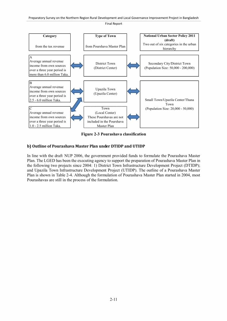
Preparatory Survey on the Northern Region Rural Development and Local Governance Improvement Project in Bangladesh
Final Report
2-11
Category Type of Town
A
B
C
from Pourshava Master Plan Two out of six categories in the urbanhierarchy
Small Town/Upazila Center/ThanaTown
(Population Size: 20,000 - 50,000)
National Urban Sector Policy 2011(draft)
Secondary City/District Town(Population Size: 50,000 - 200,000)
Average annual revenueincome from own sourcesover a three year period ismore than 6.0 million Taka.
Average annual revenueincome from own sourcesover a three year period is2.5 - 6.0 million Taka.
Average annual revenueincome from own sourcesover a three year period is1.0 - 2.5 million Taka.
District Town(District Center)
Upazila Town(Upazila Center)
Town(Local Center)
These Pourshavas are notincluded in the Pourshava
Master Plan
from the tax revenue
Figure 2-3 Pourashava classification
b) Outline of Pourashava Master Plan under DTIDP and UTIDP In line with the draft NUP 2006, the government provided funds to formulate the Pourashava Master Plan. The LGED has been the executing agency to support the preparation of Pourashava Master Plan in the following two projects since 2004: 1) District Town Infrastructure Development Project (DTIDP); and Upazila Town Infrastructure Development Project (UTIDP). The outline of a Pourashava Master Plan is shown in Table 2-4. Although the formulation of Pourashava Master Plan started in 2004, most Pourashavas are still in the process of the formulation.
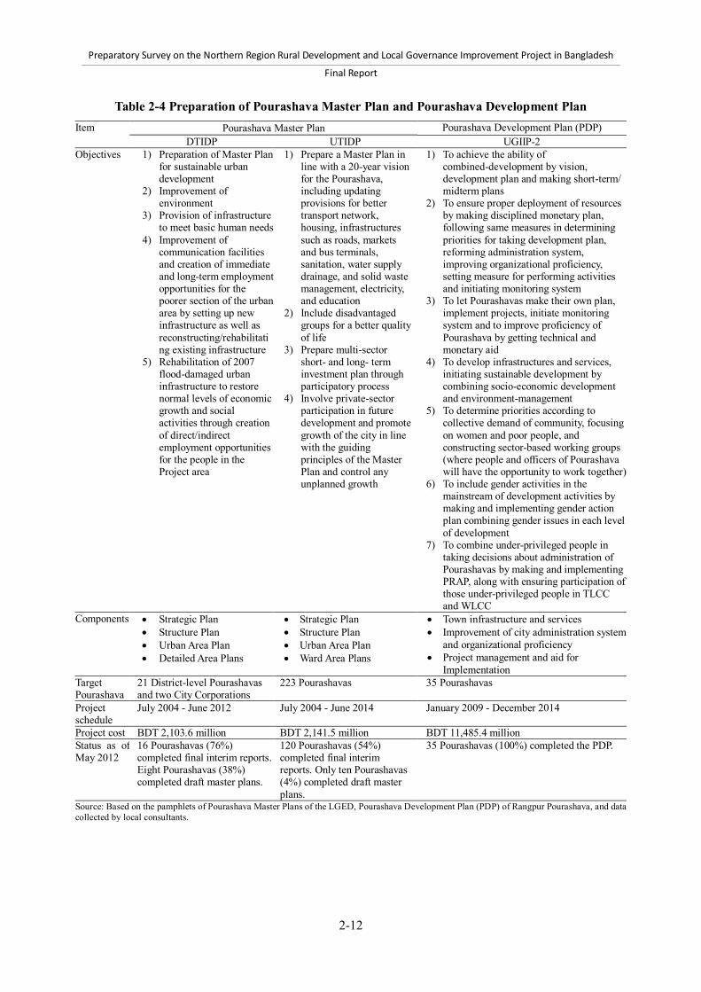
Preparatory Survey on the Northern Region Rural Development and Local Governance Improvement Project in Bangladesh
Final Report
2-12
Table 2-4 Preparation of Pourashava Master Plan and Pourashava Development Plan Item Pourashava Master Plan Pourashava Development Plan (PDP)
UGIIP-2 DTIDP UTIDP Objectives 1) Preparation of Master Plan
for sustainable urban development
2) Improvement of environment
3) Provision of infrastructure to meet basic human needs
4) Improvement of communication facilities and creation of immediate and long-term employment opportunities for the poorer section of the urban area by setting up new infrastructure as well as reconstructing/rehabilitating existing infrastructure
5) Rehabilitation of 2007 flood-damaged urban infrastructure to restore normal levels of economic growth and social activities through creation of direct/indirect employment opportunities for the people in the Project area
1) Prepare a Master Plan in line with a 20-year vision for the Pourashava, including updating provisions for better transport network, housing, infrastructures such as roads, markets and bus terminals, sanitation, water supply drainage, and solid waste management, electricity, and education
2) Include disadvantaged groups for a better quality of life
3) Prepare multi-sector short- and long- term investment plan through participatory process
4) Involve private-sector participation in future development and promote growth of the city in line with the guiding principles of the Master Plan and control any unplanned growth
1) To achieve the ability of combined-development by vision, development plan and making short-term/ midterm plans
2) To ensure proper deployment of resources by making disciplined monetary plan, following same measures in determining priorities for taking development plan, reforming administration system, improving organizational proficiency, setting measure for performing activities and initiating monitoring system
3) To let Pourashavas make their own plan, implement projects, initiate monitoring system and to improve proficiency of Pourashava by getting technical and monetary aid
4) To develop infrastructures and services, initiating sustainable development by combining socio-economic development and environment-management
5) To determine priorities according to collective demand of community, focusing on women and poor people, and constructing sector-based working groups (where people and officers of Pourashava will have the opportunity to work together)
6) To include gender activities in the mainstream of development activities by making and implementing gender action plan combining gender issues in each level of development
7) To combine under-privileged people in taking decisions about administration of Pourashavas by making and implementing PRAP, along with ensuring participation of those under-privileged people in TLCC and WLCC
Components Strategic Plan Structure Plan Urban Area Plan Detailed Area Plans
Strategic Plan Structure Plan Urban Area Plan Ward Area Plans
Town infrastructure and services Improvement of city administration system
and organizational proficiency Project management and aid for
Implementation Target Pourashava
21 District-level Pourashavas and two City Corporations
223 Pourashavas 35 Pourashavas
Project schedule
July 2004 - June 2012 July 2004 - June 2014 January 2009 - December 2014
Project cost BDT 2,103.6 million BDT 2,141.5 million BDT 11,485.4 million Status as of May 2012
16 Pourashavas (76%) completed final interim reports. Eight Pourashavas (38%) completed draft master plans.
120 Pourashavas (54%) completed final interim reports. Only ten Pourashavas (4%) completed draft master plans.
35 Pourashavas (100%) completed the PDP.
Source: Based on the pamphlets of Pourashava Master Plans of the LGED, Pourashava Development Plan (PDP) of Rangpur Pourashava, and data collected by local consultants.

Preparatory Survey on the Northern Region Rural Development and Local Governance Improvement Project in Bangladesh
Final Report
2-13
c) Pourashava Master Plan under DTIDP and UTIDP and Pourashava Development Plan under UGIIP-2
Many Pourashavas are in the process of formulating their respective Pourashava Master Plan, and they have yet to complete their Plans. In the case of the Second Urban Governance and Infrastructure Improvement Project (UGIIP-2), the formulation of the Pourashava Development Plan (PDP) is one of the requirements to improve Pourashava infrastructure facilities. The concept of the PDP is the same as that of the Pourashava Master Plan, in terms of envisioning on a scale from Pourashava to Ward level, and adopting the stakeholder participation process to the planning and formulation of development plan. The field visit in May 2012 to Mirzapur Pourashava located in the northern area of Dhaka Division revealed that the Pourashava had started formulating its 20-year Pourashava Master Plan in 2006, but the planning work remained at the stage of the situation analysis.15 By contrast, the same Pourashava started preparation of its PDP under the UGIIP-2 in 2008, and completed its preparation. The PDP was not coordinated with the Master Plan in the process of drafting in this Pourashava. In addition, the officials of Mirzapur Pourashava did not have a full grasp on the status of drafting since the consultants assigned by the LGED mainly worked on the drafting of the Master Plan. At the time of the field visit, many subprojects in the PDP were being implemented in Mirzapur Pourashava. The challenges facing Mirzapur Pourashava include: 1) the lack of coordination between the Pourashava Master Plan and PDP, namely, the lack of harmony between the 20-year long-term plan and the five-year short-term plan; and 2) the preparation of spatial plans such as land use plans, which have yet to be completed. 2.2.4 Rural infrastructure policy (1) Strategy for Rural Development Projects (1984) In the early 1980s, the Bangladesh Planning Commission (BPC) designated the locations of about 1,400 rural local assemblies and secondary markets as Growth Centers, to be focal points for rural economic and social development where investments in rural infrastructure and services should be concentrated. They were selected from more than 8,000 rural markets in Bangladesh based on revenue potential and volume of trade, population served, and the distances between adjacent Growth Centers. In 1984, the GOB adopted a new strategy for Rural Development Projects (RDPs) (BPC 1984). This took into account the policy of developing Growth Centers as foci for rural development. The strategy aimed to reduce poverty and improve the life of rural people by emphasizing critical aspects of the rural development process – agricultural development, improved physical infrastructure, and income-generation for the poor. The strategy defined that RDPs should comprise one or more of three investments components: Development of physical infrastructure including roads, storage, and rural markets Development of irrigated agriculture, minor drainage, and flood control works Production and employment programs for the rural poor
In terms of infrastructure, the strategy emphasized the development of a network of all-weather roads to provide access to and from Growth Centers (at that time termed Feeder Roads Type-B, now Upazila Roads); the improvement of rural roads, including provision of cross-drainage structures to span gaps on them, to provide rural people with better access to markets and to social and administrative services; and 15 The Master Plan was not completed as of September 2012.

Preparatory Survey on the Northern Region Rural Development and Local Governance Improvement Project in Bangladesh
Final Report
2-14
improvement of physical facilities at Growth Centers for efficient trading. The 1984 strategy has continued to guide the formulation, financing, and implementation of RDPs. Following the adoption of the strategy, the Works Program Wing of the MLGRD&C was upgraded to become the Local Government Engineering Bureau, the predecessor of the LGED. The strategy has been applied through a series of rural infrastructure development projects in different parts of Bangladesh with strong support from international financing agencies. In 1993, an additional 700 rural market locations were designated as Growth Centers - bringing the total to 2,100 - in accordance with changes in spatial distribution of agricultural production and marketing potential, and in order to meet the demands of population and regional growth. (2) Bangladesh Rural Infrastructure Strategy (1996) In 1996, the LGED and the BPC, in association with the World Bank, jointly conducted a study to review the outcomes and impacts of the 1984 strategy in respect of the development of rural transport and trading infrastructure (LGED and BPC, 1996). The study found that the strategy had provided a valid framework for investment in rural infrastructure and that the investments had generated positive socioeconomic impacts and contributed to reducing poverty. The approach of boosting local economic development by targeting public investments to Growth Centers with high potential was found to be effective. The designation of an additional 700 Growth Centers had re-set targets for the spatial distribution of infrastructure development in line with the agricultural potential of the different regions of Bangladesh. The study argued for the need to continue and increase investment in rural infrastructure and provide an efficient transport and trading system. The study recommended adjusting, or fine-tuning, the strategy in the following ways: To give more emphasis to user and community participation in planning, implementation, and
monitoring To improve the use of local resources, such as local materials To continue the use of labor-intensive techniques supported by appropriate construction
equipment To recognize and expand the role of the private sector, strengthening the capacity of local
contractors to provide cost-effective and labor-intensive skills To develop the role of labor contracting societies (LCS) as a mechanism to create additional paid
employment for the poor, including disadvantaged women, on construction and maintenance works.
To establish, and fund, a sustainable system for the maintenance of roads and markets in rural areas so that the economic and social benefits of improved infrastructure continue to flow
To coordinate the development of the rural road network with the use of rural waterways To continue the institutional strengthening of the LGED, at headquarters and at the local level,
with an emphasis on community participation These findings and recommendations were substantively adopted, and have subsequently been reflected in the NRDP, the 2005 Poverty Reduction Strategy Paper (Planning Commission, 2005) and 2009 National Strategy for Accelerated Poverty Reduction (Planning Commission, 2009), and the SFYP (GOB, 2011). All of these have emphasized the importance of continuing to develop and sustain an efficient and employment-generating rural transport and trading infrastructure. The LGED has evolved into a large and efficient rural engineering organization represented in every District and Upazila of Bangladesh and employing over 10,000 engineers and other staff, with nearly 90% working at the local level (see Chapter 3 for more detail). It has continued to receive substantial support from the international financing agencies to develop an efficient rural transport and trading
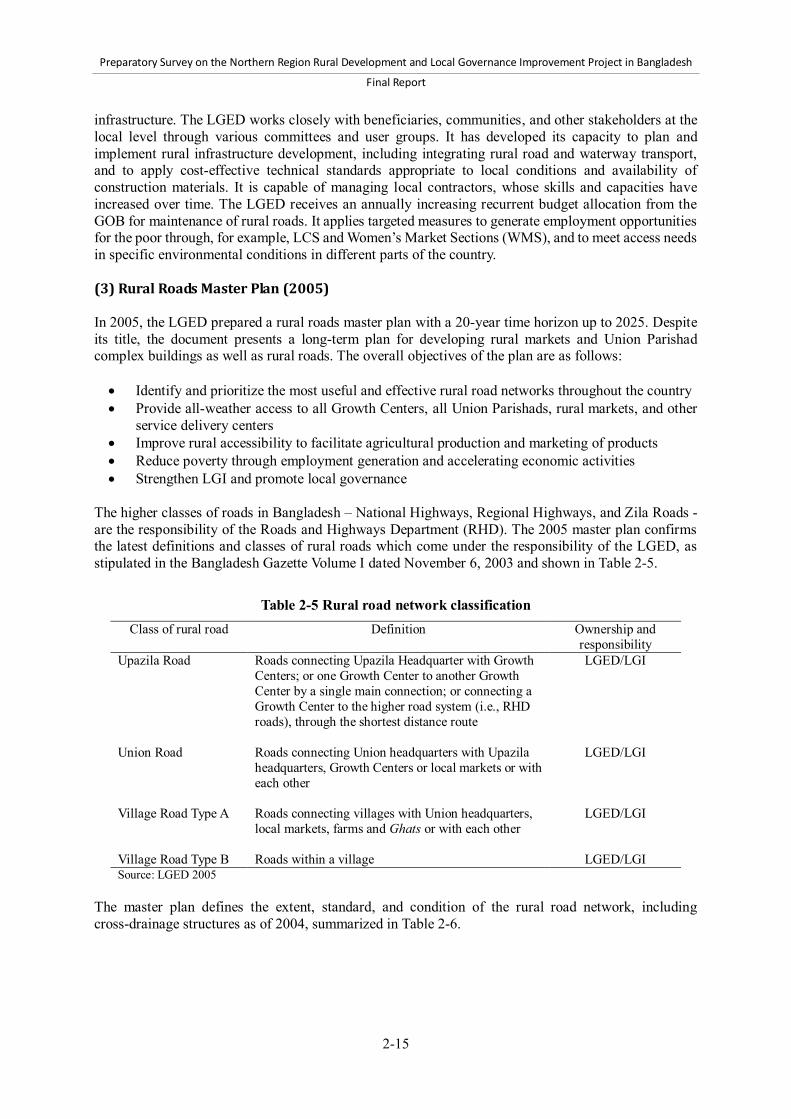
Preparatory Survey on the Northern Region Rural Development and Local Governance Improvement Project in Bangladesh
Final Report
2-15
infrastructure. The LGED works closely with beneficiaries, communities, and other stakeholders at the local level through various committees and user groups. It has developed its capacity to plan and implement rural infrastructure development, including integrating rural road and waterway transport, and to apply cost-effective technical standards appropriate to local conditions and availability of construction materials. It is capable of managing local contractors, whose skills and capacities have increased over time. The LGED receives an annually increasing recurrent budget allocation from the GOB for maintenance of rural roads. It applies targeted measures to generate employment opportunities for the poor through, for example, LCS and Women’s Market Sections (WMS), and to meet access needs in specific environmental conditions in different parts of the country. (3) Rural Roads Master Plan (2005) In 2005, the LGED prepared a rural roads master plan with a 20-year time horizon up to 2025. Despite its title, the document presents a long-term plan for developing rural markets and Union Parishad complex buildings as well as rural roads. The overall objectives of the plan are as follows: Identify and prioritize the most useful and effective rural road networks throughout the country Provide all-weather access to all Growth Centers, all Union Parishads, rural markets, and other
service delivery centers Improve rural accessibility to facilitate agricultural production and marketing of products Reduce poverty through employment generation and accelerating economic activities Strengthen LGI and promote local governance
The higher classes of roads in Bangladesh – National Highways, Regional Highways, and Zila Roads - are the responsibility of the Roads and Highways Department (RHD). The 2005 master plan confirms the latest definitions and classes of rural roads which come under the responsibility of the LGED, as stipulated in the Bangladesh Gazette Volume I dated November 6, 2003 and shown in Table 2-5.
Table 2-5 Rural road network classification
Class of rural road Definition Ownership and responsibility
Upazila Road Roads connecting Upazila Headquarter with Growth Centers; or one Growth Center to another Growth Center by a single main connection; or connecting a Growth Center to the higher road system (i.e., RHD roads), through the shortest distance route
LGED/LGI
Union Road Roads connecting Union headquarters with Upazila headquarters, Growth Centers or local markets or with each other
LGED/LGI
Village Road Type A Roads connecting villages with Union headquarters, local markets, farms and Ghats or with each other
LGED/LGI
Village Road Type B Roads within a village LGED/LGI Source: LGED 2005
The master plan defines the extent, standard, and condition of the rural road network, including cross-drainage structures as of 2004, summarized in Table 2-6.

Preparatory Survey on the Northern Region Rural Development and Local Governance Improvement Project in Bangladesh
Final Report
2-16
Table 2-6 Extent, standard, and condition of rural road network, 2004
Road class Total length (km)
Length by pavement type (km) Span of structures (m)
Span of gaps (m) Flexible
bitumen Rigid
concrete Brick Earthen
Upazila 36,166 17,664 225 3,388 14,889 270,060 112,233 Union 42,329 8,320 193 3,267 30,551 205,142 125,267 Village A 94,059 6,322 179 4,363 83,195 230,439 216,957 Village B 77,276 1,025 57 1,371 74,824 92,703 156,226 Total 249,830 33,331 654 12,389 203,459 798,344 610,683 Source: LGED 2005 Of the paved roads, 56.4% were assessed to be in good condition, 29.3% fair, and 14.3% poor or bad. The data highlight a characteristic of the rural road network in Bangladesh, namely, the presence of many “gaps” where water flows across the road but there is no bridge or culvert. These gaps are a consequence of the flood plain terrain of the country, and of the fact that many rural roads were originally built as earthen embankments under food-for-work programs, with no resources available to construct cross-drainage structures. The master plan sets the following criteria to prioritize rural roads for improvement to an all-weather standard: The route selection shall extend the road network; no scattered road links should be selected. The priority rural road network should consist of Upazila Roads. All these road links should be the shortest route and not necessarily limited within Upazila or
District boundaries, and should maximize community benefits. Road links connecting Union headquarters to Upazila headquarters, Union headquarters to a
Growth Center, Union headquarters to a rural market, and Union headquarters to Union headquarters – i.e., Union Roads - shall be included.
The road links connecting the maximum number of rural markets, villages, and other socioeconomic infrastructure such as schools and hospitals shall be prioritized.
Routes that have already been partially developed shall be prioritized over a completely new route.
The master plan sets the following targets for developing the rural road network, which as of mid-2012 is behind schedule: All remaining Upazila Roads to be bitumen surfaced or concrete paved, and all gaps spanned by
bridges and culverts, by FY2014/15 – estimated cost BDT 153,893 million. All remaining Union Roads to be bitumen surfaced or concrete paved, and all gaps spanned by
bridges and culverts, by FY 2019/20 – estimated cost BDT 245,746 million. All gaps on Village Roads Type A to be spanned by bridges and culverts by FY2024/25 –
estimated cost BDT 120,678 million. The master plan also assessed the need for funding of road maintenance, but this has now been superseded by the draft Rural Road Maintenance Policy 2012 (see below). The master plan gives higher figures for the numbers of rural markets than earlier documentation, a total of 17,363 rural markets in Bangladesh, of which 12,863 are primary, 1,000 local assembly, and 3,500 secondary markets. 1,059 of the total of 2,100 Growth Centers were defined as improved in 2005, with a target set to improve the remaining 1,041 by FY 2009-10 at a cost of BDT 4,146 million. Only about 950 of the other rural markets had been improved as of 2005, with a target to improve the remaining 14,307 by FY 2024/25 at a cost of BDT 69,314 million.

Preparatory Survey on the Northern Region Rural Development and Local Governance Improvement Project in Bangladesh
Final Report
2-17
(4) Draft Rural Road Maintenance Policy 2012 The LGED has prepared a new rural road maintenance policy (LGED, 2012). This has been developed in parallel with the formulation of the forthcoming World Bank-financed Second Rural Transport Improvement Project (RTIP-2), with support from the World Bank. The current status of the policy is that it has been approved internally by the LGED and submitted to the MLGRD&C. It now awaits approval by the Cabinet to be adopted as official Government policy. The World Bank has been encouraging the prompt adoption of the policy by the GOB. The proposed policy represents the LGED’s recognition of the need for sustainable management of rural road assets. Since the adoption of the Strategy for RDPs in 1984, great progress has been made, and continues to be made, in developing an improved all-weather rural road network in Bangladesh. This is illustrated in Table 2-7, which summarizes the increase in the length of all-weather rural roads (defined as roads with a flexible bitumen carpet or rigid concrete pavement) and in the provision of cross-drainage structures from 2004, at the time the Rural Roads Master Plan 2005 was being prepared, to November 2011. During this period, the length of all-weather roads increased by nearly 30,000 km, and the total span of bridges and culverts by about 356,000 m.
Table 2-7 Increase in all-weather rural roads and cross-drainage structures (from 2004 to 2011) Class of rural road % all-weather road,
2004 % all-weather road,
2011 % increase in cross-drainage
structures, 2004-2011 Upazila road 49.5 72.1 36.9 Union road 20.1 39.7 48.9 Village road Type-A 6.9 12.8 40.7 Village road Type-B 1.4 4.1 67.3 Total 13.6 21.2 44.6 Sources: LGED 2005 and LGD 2012
The total length of all classes of rural roads with all-weather pavements is currently about 63,350 km, and the total span of bridges and culverts is about 1,154,000 m. The continuing development of rural roads, and the spanning of gaps through the construction of bridges and culverts, provides more efficient, all-weather and uninterrupted access for rural people to markets, social facilities, and administrative services, generating economic and social benefits. However, in order to sustain the improved access and the benefits generated, an annually increasing recurrent budget is required for planned maintenance in order to keep the roads in their improved condition – if the improved roads are not maintained, their condition, and the level of access they provide, will deteriorate and the economic and social benefits will progressively diminish. Sustainable management of the improved road asset through effective, planned maintenance is proven to be economically efficient. It comprises the following: Continuing routine maintenance of the improved road pavements, shoulders, embankments,
cross-drainage structures, and road safety measures in order to address minor damage before it develops into major damage
Periodic maintenance of the improved roads, at intervals of several years, to re-seal pavements, and repair any significant damage to shoulders, embankments, cross-drainage structures, and road safety measures that are beyond the scope of routine maintenance
Budgetary provision for emergency maintenance in order to repair, at short notice, damage caused by severe climatic events, road accidents, or overloaded vehicles
The LGED has faced two fundamental constraints in applying this kind of sustainable management strategy to the rural roads it has improved: Insufficient financial resources for planned maintenance. Since FY1992/93, the LGED has

Preparatory Survey on the Northern Region Rural Development and Local Governance Improvement Project in Bangladesh
Final Report
2-18
received an annual revenue budget allocation from the GOB for road maintenance. This has increased year-by-year to BDT 6,250 million, but it remains far from sufficient to meet the increasing requirement for planned maintenance, particularly with high annual inflation rates. The LGED estimates that the current budgetary need is BDT 27,230 million, which means that the current revenue budget only meets 23% of the need.
The LGED still lacks the maintenance planning and management systems and capacity to apply available maintenance funds efficiently in order to optimize the overall level of access and service provided by the rural road network.
The proposed rural road maintenance policy addresses these deficiencies. Its goal is to facilitate safe, comfortable, and fast transport; minimize periods when road access is limited or not available; reduce vehicle operating costs; and reduce road accidents. Its key features are as follows: The LGED will take sole responsibility for planned maintenance of Upazila roads, Union roads,
and paved Village roads, including their cross-drainage structures. The annual GOB revenue budget allocation for rural roads should increase by at least 20% per
annum until the gap between need and available financing comes down to 25%. Three-year projections of maintenance budget requirements will be prepared.
The GOB should allow the LGED to earmark a portion of development project funds for maintenance of Upazila and Union roads in the Project area during its implementation period.
Because of inadequate maintenance resources over an extended period of time, the condition of many Upazila and Union roads which have previously been improved to all-weather standard has deteriorated significantly. These roads now require rehabilitation, or “backlog maintenance” work, to bring them back into good condition before a regime of planned maintenance can be applied. A portion of development project funds should be allocated to rehabilitation of such roads in the project area, particularly those previously improved with foreign financing.
Mechanisms are proposed for LGIs and the private sector to contribute to funding for rural road maintenance.
Regulations to prevent overloading of vehicles on rural roads should be strictly enforced. The LGED needs to strengthen the capacity and manpower skills of its Road Maintenance and
Road Safety Unit (RMRSU) – formerly the Rural Infrastructure Maintenance Management Unit (RIMMU) – to manage a road maintenance database and plan the utilization of the maintenance budget. The LGED will develop a more comprehensive inventory database of rural roads and cross-drainage structures linked to Geographic Information System (GIS) spatial data. This will provide the information needed to prioritize the use of annual maintenance budget allocations based on clearly defined standards to be achieved and rational prioritization criteria.
Routine and periodic maintenance of roads will ensure environmental sustainability and improved road safety, involve local stakeholders, including women, in planning and implementation, and maximize employment generation for the poor.
The LGED will expand the ongoing trials of Performance-based Maintenance Contracting (PBMC), and conduct research on cost-efficient labor-based maintenance techniques. 2.2.5 Technical standards for infrastructures (1) Design standards for roads and cross-drainage structures a) Rural roads In 2005 the LGED, with assistance from JICA, prepared design standards for rural roads, based on the re-classification of roads and the delineation of responsibilities issued by the Planning Commission in 2003 (LGED & JICA, 2005). The design standards provide the basis for planning and construction of

Preparatory Survey on the Northern Region Rural Development and Local Governance Improvement Project in Bangladesh
Final Report
2-19
improved, all-weather UZR and UNR. The standards are based on LGED’s accumulated experience in the construction of rural roads and take account of the environmental and terrain conditions in the country. They also reflect the limited local availability of basic construction materials in Bangladesh. In particular, rock suitable for producing aggregate is only available in Sylhet District, and the country is very reliant on imports from India. The LGED design standards are comprehensive. They cover design life; alignment geometry, super elevation and gradients; construction materials; road safety; and embankment, pavement and shoulder cross-sections and specifications. They include specific cross-section standards for hilly areas. They also define specific design features for intersections, bus bays, and road cross-sections in the vicinity of market places and in built-up areas. There are seven cross-section design standards for UZR and UNR, with different embankment crest and carriageway widths and pavement and shoulder specifications. In all cases, the embankments are to be constructed with 1:1.5 (vertical:horizontal) side slopes, which may be increased in terrain that is low-lying and/or vulnerable to erosion. In circumstances where it is not possible to achieve the full embankment toe width, e.g., where there are water bodies on one or both sides of the road, the design standards include specifications for palasiding and toe walls. As examples, Figure 2-4 and Figure 2-5 present the standard cross-sections for Type 4A and Type 6 UZR. The cross-sections for all seven Types of UZR and UNR are in Annex 1. The choice of standard for a particular road is determined based on two criteria of traffic level, peak hour maximum passenger car units (PCU) and commercial vehicles (i.e., trucks and buses) per day (CVD), as shown in Table 2-8.
Table 2-8 Design standards and traffic criteria for Upazila and Union Road Class of road Cross-section and
pavement type Embankment
crest width (m) Carriageway
width (m) Traffic criteria
Peak hour maximum
PCU
Maximum CVD
Upazila Road
Type 4A 9.8 5.5 530 600 Type 4B 9.8 5.5 530 600 Type 5A 7.3 3.7 290 300 Type 5B 7.3 3.7 290 300 Type 6
7.3 3.7 210 200
Union Road Type 7 5.5 3.7 130 100 Type 8 5.5 3.0 90 50
Source: LGED and JICA (2005)

Preparatory Survey on the Northern Region Rural Development and Local Governance Improvement Project in Bangladesh
Final Report
2-20
Figure 2-4 Type 4A Upazila Road
Figure 2-5 Type 6 Upazila Road

Preparatory Survey on the Northern Region Rural Development and Local Governance Improvement Project in Bangladesh
Final Report
2-21
The pavement specifications, which are summarized in Table 2-9, reflect the expected traffic loading measured by the forecast number of equivalent standard axles, 8.2 ton. In all cases the pavement is to be constructed on a subgrade compacted to a minimum of 98% standard soaked California Bearing Ratio, and the surface treatment is retained within the embankment by brick-on-end edging.
Table 2-9 Pavement standards for Upazila and Union Road Pavement Type Improved Sub-grade Sub-base Base Surfacing Type 4A 250 mm compacted
improved sand-soil mix
200 mm compacted brick aggregate and sand mix
200 mm compacted water bound brick macadam (WBM)
40 mm bituminous carpeting (BC) with 12 mm seal coat
Type 4B As Type 4A 150 mm compacted brick aggregate and sand mix
150 mm compacted water bound brick macadam (WBM)
As Type 4A
Type 5A As Type 4A As Type 4B As Type 4B 40 mm bituminous carpeting (BC) with 7 mm seal coat
Type 5B As Type 4A As Type 4B As Type 4B 25 mm bituminous carpeting (BC) with 7 mm seal coat
Type 6 As Type 4A As Type 4B As Type 4B As Type 5B Type 7 As Type 4A As Type 4B As Type 4B As Type 5B Type 8 As Type 4A As Type 4B As Type 4B As Type 5B Source: LGED and JICA (2005) Type 4A and 4B roads have 2.15 m wide soft shoulders on each side of the pavement. Type 5 roads have 0.9 m hard shoulders on either side of the pavement, then 0.9 m soft shoulders. However, for Type 5A the hard shoulder is sealed with a 12 mm bitumen seal coat, for Type 5B it is herringbone bond brick (HBB). Type 6, 7, and 8 roads have soft shoulders on each side of the pavement, 1.8 m, 0.9 m, and 1.25 m wide respectively. The LGED design standards are considered appropriate to be applied to the improvement of UZR and UNR under NRRDLGIP to provide all-weather access. However, certain issues need to be addressed. It will be essential to ensure that the road embankment crests are at least 0.6 m above the 10-year return high flood level (HFL), and that sufficient cross-drainage capacity is provided to avoid water congestion during the monsoon period. This is particularly important in view of the possible longer-term impacts of climate change in rural Bangladesh. The improvement of UZR and UNR to provide all-weather access will, as far as possible, follow existing alignments. No new road alignments will be constructed, but some minor re-alignments will be required on specific roads: For safety reasons, to provide safe bridge approaches and to widen very tight curves and ensure
sight-lines To avoid encroaching on cultural sites such as cemeteries To by-pass permanent buildings
Other safety measures will be incorporated into the detailed design of each road. These will include: 1) proper warning signage of potential hazards at education and health facilities, religious buildings, junctions, and congested areas; 2) safe design of junctions, bus bays, and access to and from education, health, and religious facilities; and 3) specific safety features around market places and in other built-up areas, including provision for off-road parking and traffic calming measures.

Preparatory Survey on the Northern Region Rural Development and Local Governance Improvement Project in Bangladesh
Final Report
2-22
Section 2.2.5(15) of this report presents estimated costs for the seven different UZR and UNR pavement types. There are significant variations in the costs, excluding embankment works, of the different pavement standards: For UZR, the Type 4A pavement is almost twice as costly as the Type 6, about BDT 6,000,000
(USD 70,000) per km more. For UNR, the Type 7 pavement is about 13%, or about BDT 700,000 (USD 8,500) per km, more
costly than Type 8. It will therefore be very important to pay careful attention to the selection of the pavement standard for each of the UZR and UNR to be improved by the Project. Cost-effectiveness must be balanced with the need to ensure that the roads are durable and provide sustained improved access with the expected levels of traffic. There is also a safety consideration. Type 5 pavements have hard shoulders alongside the 3.7 m carriageway, while the Type 6 pavement does not. The provision of hard shoulders improves the safety for slow-moving vehicles such as rickshaws and rickshaw vans on roads which carry larger volumes of larger, faster moving traffic, since they can move off the carriageway when such vehicles approach. It is very risky for these slow-moving vehicles to move on to a soft shoulder, particularly during the monsoon season. In many cases, the existing embankments of the UNR and UZR to be improved will be narrower, more steeply sloped, and lower than required by the design standard. Improving these to the design standard will result in significantly wider embankment toe widths, and hence the need to acquire additional land. Acquiring land under the Bangladesh legal procedure, and paying compensation to affected persons, is time-consuming and costly, and key steps in the process are outside the control of the LGED. It is important to note that measures to reduce the need for land acquisition by, for example, compromising on carriageway width, shoulder width or embankment height, should be avoided wherever possible. They will put at risk the durability of the roads, and create an undesirable road safety hazard. On the other hand, there will be circumstances where compromise on the cross-section standard will be unavoidable. This will be the case where there are significant numbers of permanent buildings and other structures already existing adjacent to the unimproved road, and the options of compulsory acquisition and compensation, or of re-aligning the road, are both unacceptably costly. In these circumstances, the embankment cross-section standard, but not the carriageway width, must be compromised to “squeeze” the improved road between the existing buildings. Under the existing design standards, the road pavement is constructed by box-cutting the completed embankment, and then “inserting” the successive pavement layers, each of which is the same width. This method could be improved by the following: Constructing the pavement and the adjacent compacted embankment layer-by-layer, with each
pavement layer extended 250 mm on either side beyond the layer above Inserting sub-grade sand drains at 7.5 m intervals along each side of the embankment to take
away water that would otherwise penetrate into the pavement. Sub-grade drains were used in the past, but were abandoned because it was difficult to prevent them becoming blocked. However, this problem can now be overcome by covering the drains with geotextile material.
These possible changes to the pavement specification are illustrated for a Type 5A road in Figure 2-6. It is estimated that they would increase the cost of 1 km of Type 5A pavement by about BDT 260,000, or approximately USD 3,200 (Annex 1). This matter requires further discussion with the LGED.

Preparatory Survey on the Northern Region Rural Development and Local Governance Improvement Project in Bangladesh
Final Report
2-23
Figure 2-6 Possible modified pavement design, Type 5A
b) Bridges and culverts The LGED rural road standards provide some guidance on design standards for bridges and culverts, but the most comprehensive documentation is in the more recent manuals for double lane bridges and single lane bridges (LGED 2008b,c,d, and LGED 2011c,d). These later documents provide comprehensive standards covering pipe, slab, box culverts, and bridges. They present standard designs for different types of culvert, and typical designs for bridges of 12 to 30 m span. Bridges larger than 30 m span must be purpose-designed, following the guidance in the manuals and based on detailed site investigations. All piling designs must be based on soil bore tests. The 2005 rural road standards state that culverts should only be used for spans up to 6 m, but it is conventional practice to use multiple-vent box culverts for larger spans, sometimes longer than 12 m where, depending on the site conditions, they can be more economical than small bridges. Culverts should always be constructed to the full embankment crest width so that they do not in future become a constraint to growth of traffic on the roads. They should be clearly marked by warning signs, and fitted with guard rails. The LGED Design Unit has provided guidance on current bridge design practices for all projects set out in Table 2-10:

Preparatory Survey on the Northern Region Rural Development and Local Governance Improvement Project in Bangladesh
Final Report
2-24
Table 2-10 Latest guidance on bridge design Design loading criterion
AASHTO-LFRD-HL-93 – this supersedes the H20S16 loading specified previously
Carriageway width 5.5 m, i.e., double lane, is standard to allow for future growth of traffic. 7.32 m to be used for more important roads with higher traffic levels
Footpath 0.65 m width on each side of the carriageway. Increased to 1.0 m width on each side of the carriageway for more important roads
Girder web width 450 mm Deck slab thickness 200 mm Railings 1,050 mm height, posts 200 mm x 200 mm reinforced cement-concrete (RCC),
bars 150 mm x 150 mm RCC Cast-in-situ piles Minimum diameter 500 mm, maximum diameter 1,200 mm
Minimum pile depth 15 m, maximum pile depth 55 m Pile cap should be 500 mm above the lowest water level
Pier geometry For normal water flow, two circular columns Where skewed, one column For height greater than 12 m, single H type
Concrete strength 25 MPa, except for pre-stressed girders 35 MPa Mild steel reinforcement rod
60 grade
Source: LGED Design Unit The LGED bridge and culvert standards are comprehensive, and applicable to the Project. An important consideration in the design of larger bridges is that the cost can often be reduced by making the span larger than the gap to be crossed. The reduced cost of piers located on solid, dry ground often more than offsets the higher cost of a longer deck. More details of bridge and culvert design standards are provided in Annex 1. c) Urban roads Unlike rural roads, there are no specific design standards for urban roads within Pourashavas. The road network in Pourashavas can be characterized as comprising three categories of road: First, most Pourashavas have one or more RHD roads passing across their boundaries, or connecting them to higher levels of the road network. These roads of course fall under the responsibility of RHD and will be built and maintained to their standards. Second, most category-B and C Pourashavas are located at Upazila headquarters, and by definition will therefore have a section of UZR which connects a rural Growth Center to the Pourashava. For the sections of such roads that are within the Pourashava boundary, the relevant LGED rural road design standard will apply, but with the following considerations: The urban sections of these roads will often have high levels of traffic, including heavy bus and
truck traffic. For such roads it is necessary: 1) to apply the 5.5 m rather than the 3.7 m carriageway width standard; and/or 2) if they are expected to carry high levels of heavy axle-load traffic, to specify a strengthened pavement in order to avoid rapid deterioration.
Pourashavas are by their nature very densely populated. The need to compromise on embankment width in order to avoid excessive demolition of buildings and other structures and associated compensation payments is likely to be greater than in the rural situation discussed earlier. However, 1) it is highly desirable to avoid compromise on pavement width in view of the expected relatively high traffic levels; and 2) it is essential that these roads are improved above the 10-year return HFL, and with sufficient cross and side-drainage capacity, to ensure that their

Preparatory Survey on the Northern Region Rural Development and Local Governance Improvement Project in Bangladesh
Final Report
2-25
improvement does not exacerbate the urban drainage problems. Ideally, their design should be integrated with the master drainage plan for the Pourashava.
In situations where UNR cross Pourashava boundaries, the same considerations apply as for UZR.
The LGED rural road design standards do include specific recommendations for shoulder treatment of UZR and UNR at market places and in built-up areas. These specify 150 mm brick-bonded cement-concrete (CC) hard shoulders, and side drains adjacent to the shoulders. The side drains are 150 mm x 150 mm square cross-section with a 75 mm CC base and brick side walls. The capacity of these side drains seems very small to cope with intense monsoonal rainfall. The third category comprises internal roads within the Pourashava boundary or connecting to local places close to the urban center. It is proposed that for these roads the LGED UNR or Village Type-A standards should be applied, according to the function of and expected level of traffic on each link. The same considerations of compromise on embankment width and ensuring proper drainage will apply as for urban UZR and UNR. However, for these internal roads the construction of physical barriers to prevent their use by heavy trucks and buses, which would rapidly cause significant damage, should be considered. Restricting selected internal roads to use by lighter, slower-moving vehicles will make them more sustainable. (2) Submersible roads and flash flood refuges Two Project Districts, namely Kishoreganj and Netrokona, contain haor areas. Haors are deep natural depressions which are deeply flooded during the monsoon season, but drain and dry out after the rains end. Environmentally they play a crucial role in controlling the drainage of annual flood waters by acting as seasonal reservoirs, and they must be protected. However, transport is very problematic for rural people living in haor areas. During the monsoon season they have good access using boats. However, in the dry season, after the haors have drained, there are no roads for people to move themselves and their goods. It is impractical to build conventional road embankments in haor areas. First, the very high embankments required would be unrealistically costly, and they would be very vulnerable to damage from wave action. Second, such embankments would represent a serious environmental risk, since they would interrupt the natural flow of water when the haors are flooded. The LGED has therefore developed, and successfully applied, the innovative concept of submersible roads for haor areas. These submersible roads are built on low-level embankments with adequate cross-drainage. They are designed, with embankment protection, to be over-topped with water during the flood period, but to emerge when the haors drain and provide efficient dry-season vehicular access for local people. A standard design for a submersible road is included in the rural road design standards document (LGED and JICA 2005) and shown in Figure 2-7. The cross-section standards are the same as for conventional rural roads: UZR, 3.7 m pavement, 7.3 m crest width; UNR, 3.0 m pavement, 5.5 m crest width. A concrete pavement is used, retained within the embankment by brick guide walls and with expansion joints at 7 m intervals. It comprises three layers above the compacted formation: 150 mm improved sub-grade, compacted soil and sand mix 75 mm CC base 150 mm RCC pavement
The earthen shoulders are planted with close turfing, and the embankment slopes with Hikar grass, in both cases to protect the embankment even when the water level is rising and falling. In circumstances where the embankments are particularly vulnerable to damage from wave action, they can be protected
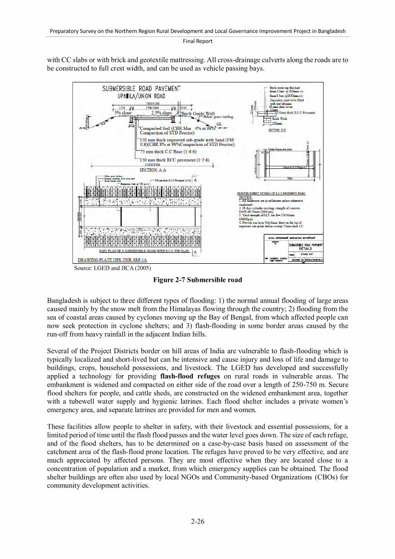
Preparatory Survey on the Northern Region Rural Development and Local Governance Improvement Project in Bangladesh
Final Report
2-26
with CC slabs or with brick and geotextile mattressing. All cross-drainage culverts along the roads are to be constructed to full crest width, and can be used as vehicle passing bays.
Source: LGED and JICA (2005)
Figure 2-7 Submersible road
Bangladesh is subject to three different types of flooding: 1) the normal annual flooding of large areas caused mainly by the snow melt from the Himalayas flowing through the country; 2) flooding from the sea of coastal areas caused by cyclones moving up the Bay of Bengal, from which affected people can now seek protection in cyclone shelters; and 3) flash-flooding in some border areas caused by the run-off from heavy rainfall in the adjacent Indian hills. Several of the Project Districts border on hill areas of India are vulnerable to flash-flooding which is typically localized and short-lived but can be intensive and cause injury and loss of life and damage to buildings, crops, household possessions, and livestock. The LGED has developed and successfully applied a technology for providing flash-flood refuges on rural roads in vulnerable areas. The embankment is widened and compacted on either side of the road over a length of 250-750 m. Secure flood shelters for people, and cattle sheds, are constructed on the widened embankment area, together with a tubewell water supply and hygienic latrines. Each flood shelter includes a private women’s emergency area, and separate latrines are provided for men and women. These facilities allow people to shelter in safety, with their livestock and essential possessions, for a limited period of time until the flash flood passes and the water level goes down. The size of each refuge, and of the flood shelters, has to be determined on a case-by-case basis based on assessment of the catchment area of the flash-flood prone location. The refuges have proved to be very effective, and are much appreciated by affected persons. They are most effective when they are located close to a concentration of population and a market, from which emergency supplies can be obtained. The flood shelter buildings are often also used by local NGOs and Community-based Organizations (CBOs) for community development activities.

Preparatory Survey on the Northern Region Rural Development and Local Governance Improvement Project in Bangladesh
Final Report
2-27
Typical designs of flood shelters and cattle sheds are in Annex 1. The flood shelters are constructed on a concrete platform with brick walls, windows, steel roof trusses, and corrugated iron (CI) or CC roof sheet. (3) Technical specifications for roads and structures works Technical specifications form part of the contract documentation for rural infrastructure civil works, and are the main tool for operationalizing design standards, defining and controlling quality, and specifying payments due to contractors. In order to harmonize the construction procedures and quality requirements under various projects, in 1999 the LGED prepared and issued standard technical specifications for the construction of what are now defined as UZR and UNR (LGED 1999). The specifications were prepared by a working group, drawing on best practices used in different rural infrastructure development projects. The 1999 LGED specifications are applicable to the construction, improvement, upgrading, rehabilitation, and periodic maintenance of UZR and UNR, including bridges and culverts. They cover all aspects of road and cross-drainage structure works. The specifications describe each activity and the work methods to be applied. They define the materials specifications, the quality standards to be achieved and the associated inspection, field and laboratory testing and approval procedures. They also specify the methods of work measurement and the pay items. The contents of the specifications are summarized in Table 2-11.
Table 2-11 Technical specifications for road and structures works
Specification for road works Traffic maintenance, site facilities and testing Earthworks Pavement works
Specification for bridges Specification of structure works
General Specification of environmental mitigation works Specification of social impacts Specification of incidental works (including road safety measures)
There have been refinements and improvements since the specifications were first issued. The LGED updated the specifications for bridges on UZR and UNR with assistance from JICA (LGED 2004). The specifications have been modified to be consisted with the 2005 rural road design standards. Additions have been made over time to the sections dealing with environmental mitigation and health and safety matters, social measures and road safety as these have emerged as more important issues in the LGED. These technical specifications are now used for all rural road infrastructure projects in the LGED including SWBRDP, and are proposed for the forthcoming Second Rural Transport Improvement Project (RTIP-2). They are comprehensive and technically sound and consistent with the rural road design standards, although the LGED Design Unit is currently reviewing details of some items to ensure internal consistency with their standard Bill of Quantities and Schedules of Rates. The specifications have been prepared for rural road works, but are equally applicable to urban road works in Pourashavas. The specifications provide all the information required to achieve the defined technical and quality standards, and for proper engineering supervision of works. However, for the Project, it will be important that adequate laboratory facilities and sufficient trained staff are available in order to ensure that the defined material specifications and quality standards are achieved.

Preparatory Survey on the Northern Region Rural Development and Local Governance Improvement Project in Bangladesh
Final Report
2-28
(4) Design standards for Growth Centers and rural markets and ghats a) Growth Centers Unlike roads, the layout of each improved Growth Center must be individually planned and designed: 1) to fit the available government or khas land area, shape, and connection into the road network; and 2) to provide the priority facilities needed by users to suit the characteristics of trading in the particular market. Only then can detailed designs be prepared for each of the specific improved facilities to be provided in the market. There are therefore three components to the design standards for Growth Centers: The detailed layout plan for the improved market Design standards for each of the improved facilities Contract drawings for each of the improved facilities, since the standard designs often have to be
adapted, e.g., in terms of their dimensions, to fit into the layout plan The Manual for Growth Center Planning sets out comprehensively the procedure for preparing a detailed layout plan for an improved market (LGED 1995). It sets out the framework of the role of markets in rural development, defines the planning process, presents planning guidelines, and provides a standard format for preparing, and gives examples of, a detailed layout plan. Annex 2 presents an example of an improved Growth Center market layout plan. The process for preparing the layout plan should be participatory, involving different categories of market buyers and sellers, transport operators, members of the Market Management Committee (MMC), representatives of women and local NGOs and CBOs, and other local stakeholders. Starting with a layout of the existing market, consultation with and participation by these beneficiaries in preparing the plan will ensure that the improved market design will meet local priorities and incorporate the knowledge of the users in respect of the numbers and types of different facilities to be provided and the location of these facilities within the market area. There is a standard “menu,” included in the Manual, from which the improved facilities are selected, as set out in Table 2-12. The Growth Center planning Manual defines the design standards for each of these facilities. This is complemented by detailed technical drawings prepared by the LGED Design Unit. Examples of these standard designs, which are more up-to-date than the Manual, are in Annex 2. As noted above, contract drawings are also prepared for each facility in each market. However, some innovations have been made since the Manual was prepared. Notably, it is now the established practice in the LGED to provide a Women’s Market Section (WMS) at each market. This structure comprises 6-12 permanent and secure shops exclusively targeted at female shopkeepers. This facility is aimed at increasing business opportunities for women, particularly poor women, and encouraging them to utilize the market for income-generating activities. An example of a WMS is in Annex 2. The provision of the facility should be complemented by targeted social development and capacity-building work in order to achieve the full potential of these WMS to improve the lives of poor rural women. Another recent innovation is to provide solar-powered lighting in the markets, which will serve to mitigate the potential future impacts of climate change.

Preparatory Survey on the Northern Region Rural Development and Local Governance Improvement Project in Bangladesh
Final Report
2-29
Table 2-12 Improved facilities at Growth Centers Raised and paved market area To bring the market above the flood level, to ensure free-drainage and that
the market area remains dry during the monsoon season. The area is paved with brick flat soling or CC.
Paved parking area Adjacent to the market and the road that serves it, but off-road for safety, where vehicles can wait, and be loaded and unloaded. Accompanied if necessary by road safety measures on the section of UNR that passes by the market.
Paved internal roads and pathways HBB or RCC paved, these improve access and facilitate maintenance in the market
Market drainage system CC lined drains to take water away from the market and keep it dry at all times
Tubewell pump water supply For use by all market users. Separate supplies may be provided for fish and meat selling sheds and for slaughter slabs.
Flush toilet facilities With waste disposal tanks and partitioned by stalls with doors - separate toilet facilities for men and women
Concrete garbage bins With sufficient capacity to serve the needs of the market - located remote from the selling areas to avoid attracting flies to these areas and so that incineration does not negatively affect market operations
Multi-purpose selling sheds With a raised concrete platform and CI or CC sheet roofing, for the selling of products such as rice, milk, vegetables, spices and household goods
Fish and meat selling sheds Purpose designed, provided according to need, and located close to a water supply
Covered slaughter slab Provided if animals will be slaughtered in the market - constructed away from the crowded selling areas and close to waste disposal bins, and served with a water supply
MMC office To facilitate and stimulate the activities of MMC and encourage participatory and transparent management of the facility. Each office should include a storage room, meeting room, and toilet.
Notice board Prominently located, displaying the names of the leaseholders and MMC members and the tolls charged in the market.
The technical guidance provided by the Manual and the detailed design drawings is comprehensive and applicable to the NRRDLGIP. However, it should be noted that proper management and maintenance of improved Growth Centers remains problematic, in respect of cleaning, keeping water supplies and toilets in working order, taking good care of the market structures, and serving the needs of the users. The Manual provides detailed guidance on proper management and maintenance but in many cases this is not practiced. b) Rural markets Although the Manual, and the associated technical standards for specific facilities, were prepared for the development of improved Growth Centers, they are equally applicable to the improvement of other, smaller rural markets. The menu of possible improved facilities at a rural market is the same as for a Growth Center. The same process of developing a market layout plan through a participatory process, and then designing the specific improved facilities in accordance with the standards, also applies. However, because rural markets are typically smaller, and have a lower volume of trading, than Growth Centers, the investment in improved facilities will be lower. Careful choices therefore have to be made about the real priorities for improvement. For certain facilities, lower (and therefore cheaper) standards can be applied, particularly for: 1) internal roads, which may be herringbone bond brick (HBB) rather than reinforced cement-concrete (RCC); and 2) paved areas which may be brick flat soled rather than cement-concrete (CC). However, the trading efficiency and hygiene of the market must not be

Preparatory Survey on the Northern Region Rural Development and Local Governance Improvement Project in Bangladesh
Final Report
2-30
compromised by applying lower standards. Thus, for example, the improved rural market must be free-draining and apply durable and reliable water supply and sanitation standards. A WMS can be incorporated into an improved rural market, according to the local demand, but the size of the facility is likely to be smaller than in a Growth Center. c) Ghats Historically, river transport has always played an important role in the rural marketing and trading system of Bangladesh. There are numerous unclassified and unimproved ghats where rural country boats and engine boats moor and discharge and load passengers and goods. They are important locations for inter-modal transfer between river and road transport in rural areas. Some also function as ferry ghats for cross-river transport services. Unimproved ghats typically have primitive and unsafe arrangements for loading and unloading of goods and people, and lack any hygiene, sanitation, or safe storage facilities. Many of the ghats are located at or near rural markets, including Growth Centers. The technical requirements for improved ghat infrastructure are in two parts as shown in Table 2-13.
Table 2-13 Ghat improvement measures Improved riverbank facilities
Landing station For boats to land, and to unload and load their passengers and/or goods efficiently and in safety
Mooring area Large numbers of boats may turn up on a hat day at important ghats connected to markets. A separate mooring area is provided so that waiting boats do not block the landing station
Improved land-side facilities Internal roads To provide access within the ghat area and to connect into the road that serves the
ghat Paved parking area So that road vehicles serving the ghat can park off-road and avoid congestion Paved ghat area Above the flood level, and free-draining so that the ghat facilities remain dry
throughout the year Hygiene facilities Tubewell water supply, latrines with separate facilities for men and women, garbage
bins Covered passenger shed on CC base
To provide ghat users with protection from sun and rain
Storage shed on CC base To provide secure storage for cargo held at the ghat, protected from sun and rain Ghat offices For collection of fees, to facilitate effective management of the ghat, and for use by
local boat operators’ associations The planning of an improved ghat, within the available government or khas land area, requires the same participatory process as for a market, to define the improved facilities to be provided and their locations and to prepare a detailed layout plan. It is essential to ensure that the ghat is efficiently connected to the road network. Where a ghat serves a market, the improvements should be planned together to provide an integrated improved market and ghat facility. This will include providing common facilities for water supply, toilets, waste disposal, and access roads. Hydrological conditions vary very substantially between different ghat sites, in particular the degree of seasonal change in the level and width of the river or canal between wet and dry seasons. The specific conditions at each site will determine the type of riverbank landing station required. There are three options: A jetty projecting from the riverbank out into the waterway Landing steps built out from the riverbank down into the water A floating pontoon which rises and falls with the water level, connected to the riverbank by a

Preparatory Survey on the Northern Region Rural Development and Local Governance Improvement Project in Bangladesh
Final Report
2-31
gangway These civil works involve specialized construction, but the LGED has experience of the design of each of the different types of landing station, and has standard or “typical” designs which can be adapted to local site conditions. In the case of landing steps, standard designs are included in the LGED rural road design standards (LGED & JICA, 2005), and an example is shown in Figure 2-8. The improved land-side facilities are essentially the same as those provided at markets. The design standards embodied in the Growth Center planning manual and in the detailed technical drawings for different facilities are therefore applicable.
Figure 2-8 Example of standard LGED design for landing steps
(5) Technical specifications for market and ghat works As for roads, the technical specifications form part of the contract documentation for market and ghat improvement works, in this case accompanied in the contract by detailed design drawings for each of the specific improved facilities to be built. The specifications and drawings together operationalize the design standards. They are the main tool to define and control quality, and specify payments due to contractors, during the implementation of the contracts. Unlike roads and cross-drainage structures, the LGED does not yet have harmonized, standard technical specifications for market and ghat improvement contracts that are used on all its projects. The LGED has issued standard technical specifications for buildings, parts of which are relevant to market and ghat

Preparatory Survey on the Northern Region Rural Development and Local Governance Improvement Project in Bangladesh
Final Report
2-32
works (LGED 2005). The proposed capacity-building technical assistance under the forthcoming World Bank financed RTIP-2 includes support to prepare harmonized and updated technical specifications for market and ghat works. However there has already been a significant degree of harmonization through the preparation and adoption of comprehensive technical specifications for the previous World Bank financed Rural Transport Improvement Project (RTIP-1), which will also be used by RTIP-2 and are being applied on SWBRDP. These technical specifications cover all aspects of market and ghat improvement works and describe each activity and the work methods to be applied. They define the materials specifications, the quality standards to be achieved and the associated inspection, field and laboratory testing and approval procedures. They also specify the methods of work measurement and the pay items. The contents of the specifications are in Table 2-14. These specifications are quite comprehensive and technically sound, and consistent with the design standards set out in the Manual for Growth Center Planning. They provide all the information required to achieve the defined technical and quality standards, and for proper engineering supervision of works. The specifications are applicable to the construction of improved Growth Center and rural markets and ghats under the NRRDLGIP, and to Pourashava market works. However, the following refinements will be needed: 1) ensure that all work items are consistent with the items in the Bill of Quantities (BOQ) for market and ghat works; 2) update them in respect of recent innovations such as solar-powered lighting; and 3) expand the coverage of health, safety, and social aspects. For the NRRDLGIP, it will be important that adequate laboratory facilities and sufficient trained staff are available in order to ensure that the defined material specifications and quality standards are achieved.
Table 2-14 Contents of technical specifications for market and ghat improvement works Section 1: General Specifications
Location of works, general requirements, description of works, site information, quality control of materials and workmanship, materials testing, measurement of work, basis of payment, contractor’s general obligations
Section 2: Specifications for Structures Demolition and removal of existing structures, excavation and backfill for structures, earthen ring and cross bundh, brick masonry works, brick soling and HBB, RCC piles, load testing of piles, concrete for structures, reinforcement for RCC, slope protection
Section 3: Specifications for Building Works a. Civil Works Steel works in roof trusses, CI roofing, plastering and painting, woodwork for doors and window shutters, septic tanks b. Sanitary and Plumbing Works Plumbing and piping, overhead tanks, ferrule connections and toilet fittings c. Electrical Works Circuit wiring in a building, pipe work, cable work, wire and cable installation, feeders, lighting and appliance circuits, electrical fittings and accessories, ceiling and exhaust fans, water pumps and motors, electrical cable, control wiring, certification d. Miscellaneous Lime terracing and twin-pit water-seal latrines
Section 4: Specifications for Roads and Incidental Works a. Road Works General requirements, removal of existing structures, embankments, pavement works, drainage repair, surface repair b. Incidental Works Clay covers, brick-lining of side-drains, kilo meter and guard posts, boundary pillars, road signs
Section 5: Environmental Specifications Pre-construction stage, construction stage, post-construction stage, certification of completed works for payments, Environment Management Action Plan (EMAP) and Environmental Codes of Practice (ECP)

Preparatory Survey on the Northern Region Rural Development and Local Governance Improvement Project in Bangladesh
Final Report
2-33
(6) Guidelines and practices for rural road maintenance Section 2.2.4 refers to the issues faced by the LGED in maintaining in good condition the progressively increasing network of all-weather UZR and UNR, and the proposed policy to address these. Inspections of roads during field visits indicate significant problems (Figure 2-9). Although these issues remain, the LGED has already done much to develop procedures for the planning, implementation, and management of rural road maintenance. The latest practices are set out in its Rural Roads and Culverts Maintenance Implementation Manual (LGED 2010). This manual covers routine, periodic, and emergency maintenance of UZR and UNR and of small cross-drainage structures on those roads – an example of periodic maintenance is shown in Figure 2-10. The manual is detailed, and suitable for use by field-level staff. The contents of the manual are summarized below: Definition and objectives Road maintenance categories Re-classification of roads Routine maintenance Periodic maintenance Emergency maintenance Maintenance of bridges and culverts Road appurtenant structure inventory Condition assessment of pavement and classification for maintenance Maintenance needs and preparation of priority scheme list Finalization of District annual road maintenance program District-wise allocation of maintenance fund District maintenance committee Scheme preparation and cost estimation
It is now established practice in the LGED to contract directly with LCS for the off-pavement routine maintenance of UZR and UNR, and for tree-caretaking (Figure 2-11). Contracting with LCS has proved to be effective in reducing embankment erosion, keeping small cross-drainage structures free of obstructions, and growing mature trees along road embankment slopes. At the same time, poor women are given an opportunity to earn a regular income and improve their livelihoods. Finally, brief reference should be made to Performance-based Maintenance Contracting (PBMC). Currently, apart from works undertaken by LCS, UZR and UNR routine, periodic, and emergency maintenance works are carried out by local contractors under conventional BOQ contracts. Under PBMC a contract is given for maintenance of one or more roads for an extended period of time, typically three to five years. The contractor is paid monthly, not on the basis of works carried out (activities) but on the condition of the road (the outcome), as determined by monthly inspections. The LGED has carried out initial PBMC trials under a Danish International Development Agency (DANIDA) -supported project. RTIP-2 proposes to extend the use of PBMC to about 450 km of planned routine and periodic road maintenance in ten Districts under five-year contracts. The contracts will also include a provisional sum which can be applied for the contractor to carry out emergency works. There is much still to be learnt about the effectiveness of, and systems and procedures for, PBMC of UZR and UNR in Bangladesh. However, it offers the prospect of providing a mechanism to utilize maintenance funds more efficiently to sustain the level of service provided by an improved rural road network.

Preparatory Survey on the Northern Region Rural Development and Local Governance Improvement Project in Bangladesh
Final Report
2-34
Figure 2-9 Need for routine pavement maintenance
Figure 2-10 Periodic maintenance
Figure 2-11 Labor Contracting Society at work

Preparatory Survey on the Northern Region Rural Development and Local Governance Improvement Project in Bangladesh
Final Report
2-35
(7) Technical standards for drains Technical standards for drains in urban areas are specified in LGED (1998), Urban Drainage Manual. Pourashavas have constructed drains in line with the manual in LGED projects such as the UGIIP-1&2, the STIDP-2, and the STIFPP-2. This section reviews the technical standards specified in the manual.16 a) Design standard Design procedure The design procedure according to LGED (1998) is as follows: Mapping of existing and proposed drains: Topographic and land use maps are to be scrutinized.
Existing drains and new drains are to be marked on the maps. Preparation of a schematic plan and coding of drains: A schematic plan of a drainage network
in a Pourashava is prepared. It is a simplified plan, aiming to visualize the network. The plan codes each drain in the network.
Assessment of contributing area: Contributing area or catchment area is to be identified and measured. This assessment is aimed to determine suitable sizes of drains.
Estimation of time of entry: Time of entry, which is the time for run-off to flow across a contributing area into a drain, is estimated for each drain based on ground slope and maximum distance of the overland flow.
Confirmation of water levels: The average, highest annual 10-day water level at a downstream water body or in a drain, to which a new drain will be connected, needs to be assessed. This is to ensure that the level of the new drain be above the water level at its outlet.
Calculation of rainfall intensity and peak flow: Rainfall intensity and design peak flow are calculated. This calculation is worked out mostly based on the modified rational method, which is suitable for an area of less than 60 ha. For a larger area, the hydrograph routing method is to be applied.
Design of drain: The shape, type, hydraulic gradient, and size of a drain are determined, and a design drawing is prepared.
Standard designs The standard types of drains are summarized in Table 2-15. The shapes of drains are determined, given the available land size and possible slope. The most common shape for pucca drains (drains of reinforced concrete, cement concrete, or brick with cement mortar) in urban areas is a rectangle. Rectangular standard drains are Types A to H specified in the manual. Trapezoidal drains (Types J, K, and Z) are recommended where available land is large enough, because they are bigger in size but more efficient at flowing water than rectangular drains. With regard to materials, brick is to be used for drains of 1,350 mm or less depth, while RCC is for deeper ones. RCC is also used where space is relatively small. Type A drain and RCC rectangular drain are illustrated in Figure 2-12 and Figure 2-13, respectively.
16 The manual describes a methodology primarily for small- or middle-size drains such as secondary and tertiary ones. When drains are larger than those, like primary drains, they should be designed on an individual basis.

Preparatory Survey on the Northern Region Rural Development and Local Governance Improvement Project in Bangladesh
Final Report
2-36
Table 2-15 Standard types of drains
No. Drain type Application (locations, way of utilization, etc.) A. Standard open brick drain Generally used where roads are away B. Open brick roadside drain Used where roads are adjacent C. Standard brick drain with footpath top slab Used when a footpath is necessary D. Brick roadside drain with footpath top slab Used as a footpath next to roads
Slab needs to be at least 0.15 m higher than an adjacent road to keep vehicles away.
E. Brick road cross drain with road top slab Designed for vehicles to cross over F. Brick roadside drain with road top slab Designed for vehicles to run along Z. Trapezoidal brick drain Same as Type A to F except for its shape G. Reinforced concrete drain Designed on an individual basis
Used where available space is too small to apply brick drains or when the depth of a drain is over 1.35 m
H. Box culvert Designed on an individual basis Used where top slab is required
I. Pipe drain Used where space is available and close drain is needed J. Trapezoidal lined drain (in-situ concrete) Used where space is available but a pucca drain is needed K. Trapezoidal lined drain (concrete slabs) Used where space is available but a pucca drain is needed L. Market drain Used in markets and similar areas
Source: LGED (1998)
Source: LGED (1998)
Figure 2-12 Open brick drain (Type A)
Source: LGED (1998)
Figure 2-13 RCC rectangular drain
Whether to apply roadside drains (Types B to F) is determined by considering adjacent roads. For instance, Type A, which is not roadside drain, is applicable if a drain is more than 0.5 m away from the nearest road shoulder because pressure from vehicles running the road is negligible. Otherwise, Type B (open brick roadside drain, Figure 2-15) should be constructed. Figure 2-14 illustrates this application condition of Types A and B. When a road is narrow, Type F (roadside drain with road top slab) is to be applied.
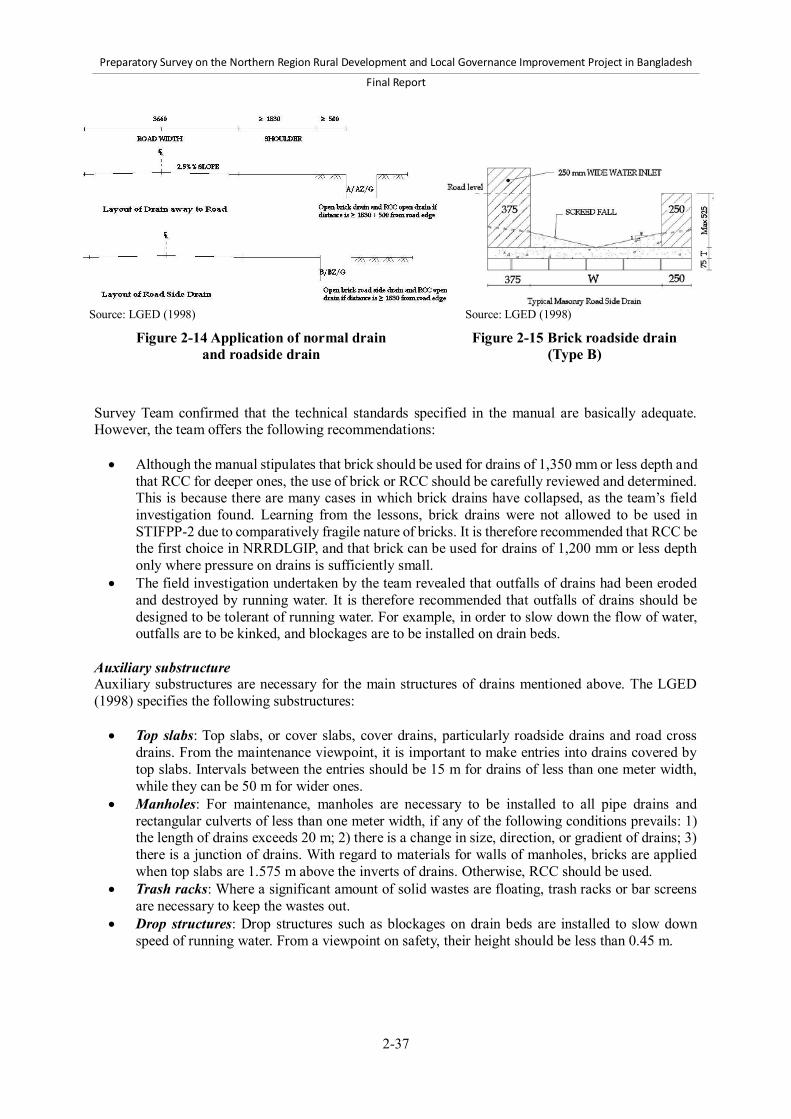
Preparatory Survey on the Northern Region Rural Development and Local Governance Improvement Project in Bangladesh
Final Report
2-37
Source: LGED (1998)
Figure 2-14 Application of normal drain and roadside drain
Source: LGED (1998)
Figure 2-15 Brick roadside drain (Type B)
Survey Team confirmed that the technical standards specified in the manual are basically adequate. However, the team offers the following recommendations: Although the manual stipulates that brick should be used for drains of 1,350 mm or less depth and
that RCC for deeper ones, the use of brick or RCC should be carefully reviewed and determined. This is because there are many cases in which brick drains have collapsed, as the team’s field investigation found. Learning from the lessons, brick drains were not allowed to be used in STIFPP-2 due to comparatively fragile nature of bricks. It is therefore recommended that RCC be the first choice in NRRDLGIP, and that brick can be used for drains of 1,200 mm or less depth only where pressure on drains is sufficiently small.
The field investigation undertaken by the team revealed that outfalls of drains had been eroded and destroyed by running water. It is therefore recommended that outfalls of drains should be designed to be tolerant of running water. For example, in order to slow down the flow of water, outfalls are to be kinked, and blockages are to be installed on drain beds.
Auxiliary substructure Auxiliary substructures are necessary for the main structures of drains mentioned above. The LGED (1998) specifies the following substructures: Top slabs: Top slabs, or cover slabs, cover drains, particularly roadside drains and road cross
drains. From the maintenance viewpoint, it is important to make entries into drains covered by top slabs. Intervals between the entries should be 15 m for drains of less than one meter width, while they can be 50 m for wider ones.
Manholes: For maintenance, manholes are necessary to be installed to all pipe drains and rectangular culverts of less than one meter width, if any of the following conditions prevails: 1) the length of drains exceeds 20 m; 2) there is a change in size, direction, or gradient of drains; 3) there is a junction of drains. With regard to materials for walls of manholes, bricks are applied when top slabs are 1.575 m above the inverts of drains. Otherwise, RCC should be used.
Trash racks: Where a significant amount of solid wastes are floating, trash racks or bar screens are necessary to keep the wastes out.
Drop structures: Drop structures such as blockages on drain beds are installed to slow down speed of running water. From a viewpoint on safety, their height should be less than 0.45 m.
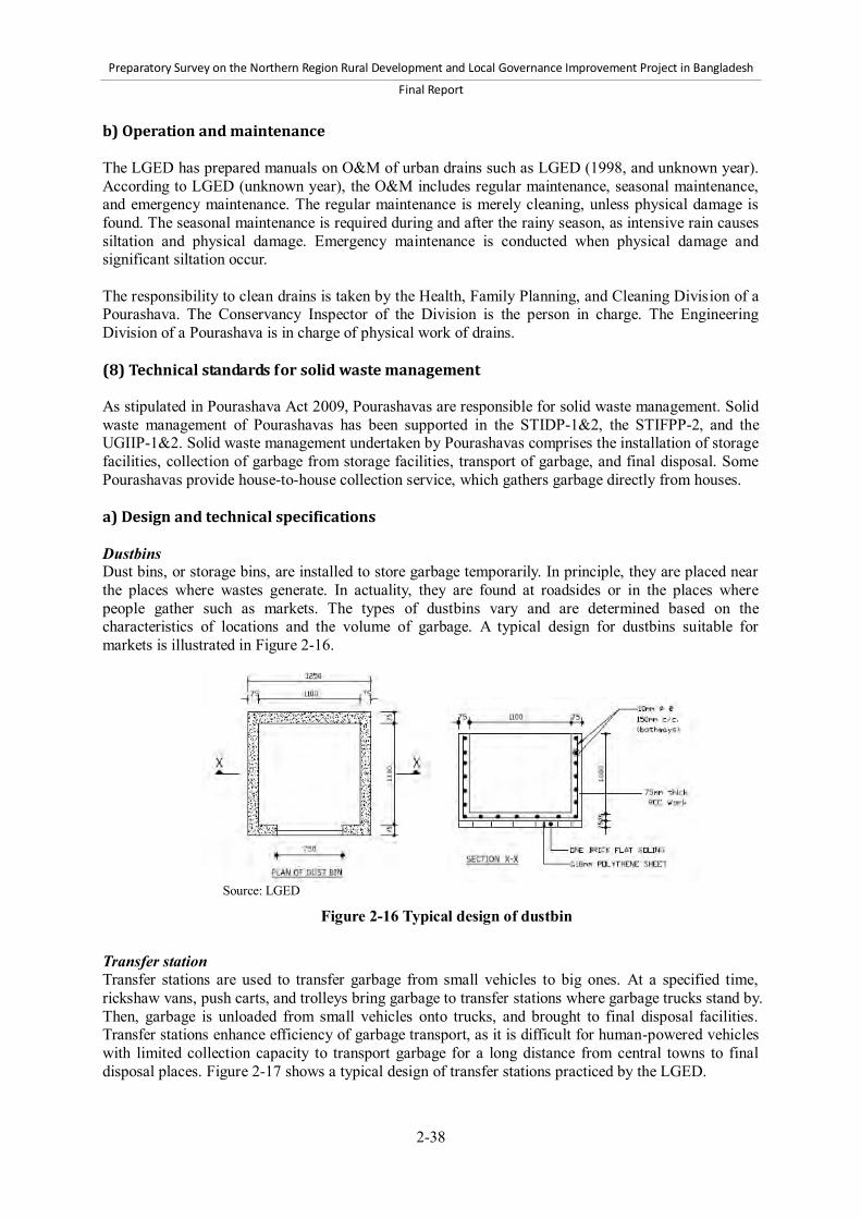
Preparatory Survey on the Northern Region Rural Development and Local Governance Improvement Project in Bangladesh
Final Report
2-38
b) Operation and maintenance The LGED has prepared manuals on O&M of urban drains such as LGED (1998, and unknown year). According to LGED (unknown year), the O&M includes regular maintenance, seasonal maintenance, and emergency maintenance. The regular maintenance is merely cleaning, unless physical damage is found. The seasonal maintenance is required during and after the rainy season, as intensive rain causes siltation and physical damage. Emergency maintenance is conducted when physical damage and significant siltation occur. The responsibility to clean drains is taken by the Health, Family Planning, and Cleaning Division of a Pourashava. The Conservancy Inspector of the Division is the person in charge. The Engineering Division of a Pourashava is in charge of physical work of drains. (8) Technical standards for solid waste management As stipulated in Pourashava Act 2009, Pourashavas are responsible for solid waste management. Solid waste management of Pourashavas has been supported in the STIDP-1&2, the STIFPP-2, and the UGIIP-1&2. Solid waste management undertaken by Pourashavas comprises the installation of storage facilities, collection of garbage from storage facilities, transport of garbage, and final disposal. Some Pourashavas provide house-to-house collection service, which gathers garbage directly from houses. a) Design and technical specifications Dustbins Dust bins, or storage bins, are installed to store garbage temporarily. In principle, they are placed near the places where wastes generate. In actuality, they are found at roadsides or in the places where people gather such as markets. The types of dustbins vary and are determined based on the characteristics of locations and the volume of garbage. A typical design for dustbins suitable for markets is illustrated in Figure 2-16.
Source: LGED
Figure 2-16 Typical design of dustbin
Transfer station Transfer stations are used to transfer garbage from small vehicles to big ones. At a specified time, rickshaw vans, push carts, and trolleys bring garbage to transfer stations where garbage trucks stand by. Then, garbage is unloaded from small vehicles onto trucks, and brought to final disposal facilities. Transfer stations enhance efficiency of garbage transport, as it is difficult for human-powered vehicles with limited collection capacity to transport garbage for a long distance from central towns to final disposal places. Figure 2-17 shows a typical design of transfer stations practiced by the LGED.

Preparatory Survey on the Northern Region Rural Development and Local Governance Improvement Project in Bangladesh
Final Report
2-39
Plan
3,000
7,5
00
4,000
7,500
3,0
00
3,4
00
Side Elevation Source: LGED
Figure 2-17 Typical design of transfer station
Landfills Landfills are the final stage of solid waste disposal. Some Pourashavas do not have landfills that are artificially constructed. They dump wastes into natural dips, which are likely to create environmental hazard. On the other hand, donor-funded projects such as the STIDP-2, the STIFPP-2, and the UGIIP-1&2 have supported construction of landfills. The designs and layout of landfills are simple as they are mere earthen trenches. The most important aspect to be considered at planning is site selection. The site selection should: 1) avoid floodplains and wetlands; 2) avoid areas where the groundwater level is high; 3) avoid residential areas; and 4) have a buffer zone within 500 m distance from landfills. In addition, it is recommended to construct an embankment around landfills that is higher than 3 m. Sanitary landfills Sanitary landfills are designed to minimize environmental pollution caused by wastes, particularly leachate from wastes. They are not yet common in Pourashavas, however, because their construction cost is high. Only a few Pourashavas constructed them in donor-funded projects such as STIDP-2. Figure 2-18 shows a typical design for sanitary landfills which was prepared for STIFFP-2. The most important function of sanitary landfills is control and treatment of leachate. Sanitary landfills contain leachate ponds, where leachate is stored, treated, and finally discharged into outside drains or river. To leak leachate from trenches into the ponds, drains are constructed between the ponds and trenches. In order to prevent permeation of leachate, the surface of ponds and trenches is covered with non-permeable lining such as impervious clay liner or high-density polyethylene sheet. The following are other technical specifications on sanitary landfills: A drainage system for storm water is to be constructed to quickly drain water away from trenches.
This helps prevent internal flooding, mitigate marshy conditions of dumped waste, and minimize the volume of leachate.
The base of landfills is to be at least 3 m above the level of groundwater table. Wastes are covered periodically by soil of 75-100 mm thickness to reduce odor and vectors. Wastes dumped into the landfills are compacted by equipment items such as bulldozers and
compactors to reduce their volume.

Preparatory Survey on the Northern Region Rural Development and Local Governance Improvement Project in Bangladesh
Final Report
2-40
Plan
60
,00
0
70,000
Section
Barbed wire post
Earth filing
Source: LGED
Figure 2-18 Design of sanitary landfill Composting plant Composting is biological transformation of organic materials into compost that is brought about by microorganisms and invertebrates. Composting of wastes is environmentally friendly and generates revenue. It is being practiced by Pourashavas on a pilot basis. Figure 2-19 shows a composting plant of Mymensingh Pourashava. The process practiced by Mymensingh Pourashava is as follows: Remove recyclable and non-biodegradable materials from garbage manually. Shred garbage into small sizes to increase the surface of garbage so that biological
decomposition accelerates. Hasten aerobic composting by controlling moisture, oxygen, and carbon-nitrogen ratio. Process compost in the form of final product by screening out impurities, blending with
additives, and packaging. An advantage of composting plants is the potential for revenue generation from, for instance, vegetable cropping nearby Pourashavas. In the case of Mymensingh Pourashava, the composting plant, which was initiated as a pilot a few years ago, has recently attained the breakeven point of profitability.

Preparatory Survey on the Northern Region Rural Development and Local Governance Improvement Project in Bangladesh
Final Report
2-41
Source: Survey Team
Figure 2-19 Layout of composting plant in Mymensingh Pourashava b) O&M The Cleaning Section in the Health, Family Planning, and Cleaning Division of a Pourashava holds responsibility to handle O&M of solid waste management. The Conservancy Inspector of this Section executes direct control of O&M, and workers are contracted for the collection and transport of garbage. In most cases, Pourashavas collect wastes from dustbins by such means as rickshaw van, power trolley, and dump trucks. Residents are required to bring and dump their wastes into the bins. The collection is to be carried out every day or more frequently depending on requirement. In some Pourashavas, house-to-house collection service is performed, where small vehicles such as rickshaw vans and pushcarts pick up wastes directly from the houses. In some cases, the operation of house-to-house collection is contracted out to NGOs or delegated to CBOs that employ vehicle pullers and collect service charge from residents. With regard to disposal facilities, landfills are directly operated by Pourashavas in most cases. Since composting plants create revenues but require substantial human resources and several areas of expertise on composting and marketing, it is recommended to lease out the management. (9) Technical standards for piped water supply and tube wells Water supply in Pourashavas is categorized into: 1) piped water supply; and 2) low-cost water supply, mainly hand tubewells. As for the piped water supply, the Department of Public Health Engineering (DPHE) executes major construction works, and Pourashavas performs their operation and maintenance. Therefore, Pourashavas in the previous LGED projects mostly rehabilitated and expanded piped water supply systems. As for the tubewells, Pourashavas constructed them in several projects with technical support from the DPHE.

Preparatory Survey on the Northern Region Rural Development and Local Governance Improvement Project in Bangladesh
Final Report
2-42
a) Piped water supply The piped water supply system is composed of the following: 1) collection system; 2) water treatment system; and 3) distribution system. The collection system is required for water intake. Its forms are dependent on water sources, but the most common type is tubewells, or called “production tubewells,” because groundwater is abundant and less costly in comparison to other sources such as surface water and rainwater. The type and degree of water treatment hinge on the quality of water. Although groundwater is relatively free of disease bacteria, it is rich in mineral substances compared with surface water. Therefore, it may require removal of arsenic, iron, fluoride, and so forth. The most common methods for the treatment include screening, sedimentation, aeration, chemical treatment, filtration, and demineralization. As for arsenic removal, the most common technologies are co-precipitation and adsorption onto coagulated flocs, lime treatment, adsorption onto sorptive media, ion exchange resin, membrane techniques, and microbial processes. The distribution system includes pipes, pumping devices, storage reservoirs, overhead tanks, hydrants, and service connections. A single pipeline which conveys bulk amounts of water is called transmission main, while pipes arranged to distribute the conveyed water to consumption points are called distribution mains. Figure 2-20 illustrates a section of a typical pipeline. House connections are water service pipes connecting water distribution mains and in-house water pipes with taps. The distribution system is to be designed for peak water demand. b) Tubewells Tubewells can be grouped into: 1) shallow tubewells; and 2) deep tubewells. A popular type of shallow tubewells is No. 6 hand pump tubewell. Its name comes from its barrel diameter in inches. Generally, it is composed of hand pump, blind pipe, strainer, and sand trap. It performs average discharge of 30 to 40 liters per minute and is usable for 15 to 20 years. Deep tubewells withdraw water from deep aquifers that are usually more than 75 m below ground. As the groundwater table has been declining and shallow aquifers are more likely to contain iron and arsenic, deep tubewells are an option preferred to shallow tubewells. A typical design for deep tubewells is illustrated in Figure 2-21. When they are constructed, it is important to install tubewells straightly and vertically.
Source: LGED
Figure 2-20 Section of water pipe

Preparatory Survey on the Northern Region Rural Development and Local Governance Improvement Project in Bangladesh
Final Report
2-43
Source: LGED
Figure 2-21 Design for deep tubewell
Site selection for tubewells should ensure the acceptable level of dissolved mineral substances in groundwater. However, if no place is found free from the contamination of the minerals, installation of mineral removal plants to tubewells is an option to address the contamination. Figure 2-22 shows a small-scale arsenic and iron removal plant installed to hand tubewells at the community level.
Plan
Source: Asia Arsenic Network
Section A-A
Section B-B
Figure 2-22 Small-scale arsenic and iron removal plant
(10) Technical standards for sanitary toilets The LGED does not establish rigid technical standards for sanitary toilets, but has supported Pourashavas in constructing sanitary toilets in LGED projects. Toilets can be categorized into community toilets and public toilets. The former is provided in residential areas for people having no toilet in their houses, whereas the latter is located in public spaces such as markets and bus terminals.

Preparatory Survey on the Northern Region Rural Development and Local Governance Improvement Project in Bangladesh
Final Report
2-44
a) Community toilets The twin off-set-pit pour-flush toilet, or simply called “twin-pit toilet,” is recommended as a community toilet in urban areas. It consists of four major parts: 1) superstructure; 2) toilet pan with water seal; 3) Y-junction; and 4) twin leach pits (Figure 2-23). Water seal between pan and pits prevents generation of odors and insects. Y-junction directs excreta to one of the two pits until the pit is full. When the first one becomes full, Y-junction changes direction of the excreta flow to the other one so that the first one is left for decomposition for one to two years. The decomposition lessens toxicity of human excreta and enables manual removal of sludge inside the pit. After the removal, the pit can be reused. The single-pit toilet is more affordable than the twin-pit toilet, but not able to reduce pathogens inside a pit by decomposition. It is applicable in urban areas when equipment for mechanical de-sludging such as vacuum tankers is available. It is also possible to install only one pit at the initial construction of a toilet, but install another one when the first one becomes full. Pit toilets are a potential source of groundwater pollution, as liquid in the pits soaks into the ground. Thus, careful considerations should be made to avoid the pollution. The following points should be considered:17 It is desirable that pits are shallow in depth. It is desirable to keep the gap between the pit bottom and the water table more than 2 m. The bottom of pits should remain undisturbed and unsealed if it is 2 m above the water table. If a serious risk of aquifer pollution is anticipated, the base of pits should be sealed with concrete
and sand should be placed underneath the base. This considerably reduces pollutants reaching groundwater.
Pits should be constructed on elevated earthen mounds with at least 1.5 m-radius earth covering all around pits.
The distance between pits and tubewells should be at least 10 m.
Section
1,200
2,3
00
30
0
800
2,5
00
Plan
1,200
1,2
00
Source: Ahmed & Rahman (2010) (left), LGED (right)
Figure 2-23 Design of twin pit toilet (twin off-set-pit pour-flush toilet)
17 Ahmed & Rahman (2010)

Preparatory Survey on the Northern Region Rural Development and Local Governance Improvement Project in Bangladesh
Final Report
2-45
b) Public toilets A typical design for public toilets is presented in Figure 2-24. Public toilets are equipped with flush toilets, a suitable number of urinals, pans, and washbasin. They should have separate sections for men and women. It is important to ensure sufficient water supply. If piped water is not available, tubewells and electrical pumps should be installed to pump up water to overhead water tanks. It is also important to dispose excreta properly. If there is no sewerage system, septic tanks and soak wells should be installed. Capacity of septic tanks should be determined in accordance with the volume of discharge. Otherwise, discharge cannot be stored in the tanks until pathogens get decomposed.
Source: LGED
Figure 2-24 Typical design for public toilets c) O&M The Cleaning Section in the Health, Family Planning, and Cleaning Division of a Pourashava holds the mandate for O&M of toilets. The Conservancy Inspector in the Section shall perform direct management of O&M. Under the overall responsibility of the Section, there are several forms of institutional arrangements for O&M. In the case of community toilets, the responsibility of daily maintenance is usually devolved to beneficiaries. The beneficiaries bear daily cleaning tasks, whereas Pourashavas bear responsibility to remove sludge in pits and physical rehabilitation. In the case of public toilets, it is common to lease out their operation to private companies in which the lessees shall perform operation and daily maintenance. They raise revenue by levying charges for use, unless toilets are leased out together with facilities such as municipal markets and bus terminals. When they are leased out as part of such facilities, the charge may not be imposed upon toilet users, but the lessees raise revenue from tenants in markets and bus owners. (11) Technical standards for bus and truck terminals In the STIDP-1&2 and the UGIIP-1, bus and truck terminals have been designed for specific locations and needs and available budgets, whereas paving and drains in those terminals follow respective standards.

Preparatory Survey on the Northern Region Rural Development and Local Governance Improvement Project in Bangladesh
Final Report
2-46
A layout plan for bus terminals is illustrated in Figure 2-25. Desirable facilities in bus and truck terminals include gas filling stations, servicing places, and terminal buildings. Facilities for terminal buildings include ticket counters, toilets, waiting spaces with chairs, prayer rooms, general stores, and food corners, although they vary depending on respective situations. The size of the terminals should be determined based on the present and future volumes of traffic. A recommended location is outskirts of Pourashavas to avoid traffic congestion, noise, and air pollution. The sites with availability of adjacent land for future expansion are preferable. Parking areas should be designed to carry off rainwater. They should have at least 1% slope from center toward outside. Storm water drains should be constructed around parking areas and be connected to outside drains. With regard to O&M of terminals, Pourashavas usually lease it out to private companies. Lessees should take responsibility of daily operation and maintenance in return for the collection of charges from drivers that follow the governmental schedule of rates.
Source: Survey Team
Figure 2-25 Layout plan of bus terminal
(12) Technical standards for slaughterhouses According to the Pourashava Act, Pourashavas are responsible for establishment and management of slaughterhouses. Many Pourashavas have constructed slaughterhouses under donor-funded projects and block grants from the GOB. Currently there is no established standard of slaughterhouse in the LGED. The slaughterhouses are therefore designed on an ad hoc basis. A typical design for slaughterhouses is shown in Figure 2-26. As carcasses and blood are strong pollutants and impose high environmental burden, adequate attention should be paid to prevent an adverse impact on the environment. Sufficient water supply, drains, septic tanks, soak wells, and waste storage facilities should be installed to gather and treat carcasses and blood.

Preparatory Survey on the Northern Region Rural Development and Local Governance Improvement Project in Bangladesh
Final Report
2-47
Soak well and Septic tank
Plan
5,4
00
Tube well with Powered pump
Source: LGED
Figure 2-26 Typical design for slaughterhouses (13) Technical standards for streetlights As of today there are no technical standards of the LGED for streetlights in Pourashavas. Streetlights are usually installed to streetlight poles of Pourashavas or electric poles of the Power Development Board. Materials for poles are RCC or galvanized iron. Streetlights are equipped with light control boards, circuit breakers, and earthing devices.
Source: LGED
Figure 2-27 Typical design for streetlights

Preparatory Survey on the Northern Region Rural Development and Local Governance Improvement Project in Bangladesh
Final Report
2-48
(14) Technical standards for slum improvement activities and small-scale infrastructure in slums
The LGED started slum improvement activities on a pilot basis with the support of UNICEF in 1985, and has since then supported slum improvement in several projects such as the STIDP-1&2, the STIFPP-1&2, and the UGIIP-1&2. The slum improvement activities have been implemented in line with guidelines developed by the LGED such as LGED (1997, 2011b). This section summarizes slum improvement activities specified in the guideline prepared for the UGIIP-2 (LGED, 2011b). a) Main component of slum improvement activities The standard slum improvement activities under LGED projects consist of the following five main components: 1) community mobilization and participation; 2) infrastructure development; 3) support for self-employed economic activities; 4) primary health care; and 5) satellite school. Brief descriptions of respective components are given in Table 2-16.
Table 2-16 Main components of slum improvement activities Components Descriptions Community mobilization and participation
Formation of Primary Groups, each of which comprises 10 to 15 poor households Formation of a Slum Improvement Committee (SIC) in each identified slum
Infrastructure development Tubewell installation Sanitary toilet installation Footpath construction Drain construction Dustbin installation Streetlight installation
Support for self-employed economic activities
Support for income generation activities Education on saving Support for group saving and credit
Primary health care Selection of community health workers from slum dwellers Training for community health workers on primary health care Supply of equipment and medicine for primary health care
Satellite school Selection and training of female teachers from slum dwellers Establishment of satellite schools for children not going to primary school Provision of free education up to the first grade Supply of books, education materials, and school uniforms Assistance for children to enroll in primary school
Source: LGED (2011b) b) Concerned organizations Slum Improvement Committee The Slum Improvement Committee (SIC) plays a vital role in slum improvement activities. An SIC is formed in each slum, consisting of a chairperson, a vice chairperson, a secretary, and other members selected from leaders of beneficiary groups, named Primary Groups. All the committee members except the secretary are chosen from beneficiaries. It is worth noting that either a chairperson or a vice chairperson should be female, and that at least two thirds of the members should be female. The SIC is expected to take initiative and ownership for slum improvement activities, and hold responsibility for planning and implementation of all activities in its slum, including financial management.

Preparatory Survey on the Northern Region Rural Development and Local Governance Improvement Project in Bangladesh
Final Report
2-49
The process to establish an SIC is as follows: Slums are identified by a Pourashava and certified by PMO. A Pourashava, land holders, and representatives of slum dwellers enter into agreements on land
use, holding tax, tenancy, and so forth. A Pourashava identifies and registers beneficiaries by conducting a household survey. Primary Groups consisting of 10 to 15 beneficiaries are formed. Each Primary Group selects a
leader and a secretary from its members, either of which shall be female. An SIC is formed consisting of leaders of Primary Groups and Community Field Workers.
Pourashava and PRAP Steering Committee A Pourashava holds overall responsibility for slum improvement activities and all other works related to poverty reduction. It provides training courses and instructions to SICs, and also facilitates coordination between SICs and other organizations. It is also responsible for preparing a Poverty Reduction Action Plan (PRAP), which specifies long-term plans to alleviate poverty through improving infrastructure and public services. For PRAP-related works including slum improvement activities, a Pourashava forms a PRAP Steering Committee comprising: 1) councilors; 2) key officials including Slum Development Officer; and 3) representatives from SICs, Primary Groups, CBOs, and Gender Committee. Slum Development Officer and Community Field Worker A focal official for slum improvement activities is Slum Development Officer who is responsible for managing all activities related to slum improvement. The position is presently placed only in category-A Pourashavas. In the case of category-B and C Pourashavas and even category-A Pourashavas with the position vacant, Pourashava mayors assign the responsibility of Slum Development Officer to other officials. Community Field Workers are another group of key staff for slum improvement. They are recruited on a project basis by PMO for every three wards. They work mostly at the community level. They have closest communication with, and provide daily support for, beneficiaries, Primary Groups, and SICs. They assist SICs as member secretaries. c) Process for small-scale infrastructure development Small-scale infrastructure development under slum improvement activities follows the process different from usual infrastructure development undertaken by Pourashavas. The small-scale infrastructure development is directly constructed by SICs without contracting out. Beneficiaries living in slums contribute part of required funds and their labor for unskilled work. The process is as follows: Preparation of a development plan: Each SIC prepares a development plan of basic
infrastructure with the support of Assistant Engineer of a Pourashava. The development plan shows locations of basic infrastructure to be constructed.
Fund transfer: PMO releases and transfers fund to a bank account of the Pourashava, then the Pourashava transfers the fund to a bank account of an SIC as deposit for physical work.
Implementation: The SIC implements physical work under the guidance of engineers of the Pourashava. It purchases materials and carries out the construction. Engineers and Slum Development Officer of the Pourashava visit sites to monitor the work.
Expenditure settlement: After completion of the work, the SIC prepares and submits expense vouchers to the Pourashava for expenditure settlement.

Preparatory Survey on the Northern Region Rural Development and Local Governance Improvement Project in Bangladesh
Final Report
2-50
In the UGIIP-2, a PRAP is to be prepared prior to the first step above. The PRAP specifies: 1) objectives and program/schemes in the areas of economic activities, infrastructure, education, health, and equity and governance; 2) target communities; 3) estimated budget; 4) schedule; and 5) responsible persons. Then, in the first step, Community Action Plans (CAPs) are prepared by SICs as the development plans of basic infrastructure. CAPs specify current conditions and problems in slum, actions to address problems, locations and description of proposed infrastructures, lists of beneficiary households, and so on. d) Technical specifications for small-scale infrastructure Small-scale infrastructure in slums typically includes footpaths, drains, dustbins, tubewells, toilets, and streetlights. Footpath and drain A standard design for footpaths and drains in slums stipulated by the guideline is illustrated in Figure 2-28. The size of footpaths and drains is adjusted for site conditions. The design for drains is the same as that described in Section 2.2.5(7), although the size is relatively small. Footpaths near main roads are to be given high priority for construction, while drains connecting isolated drains are given high priority. The cost is estimated based on schedules of rates of the LGED. Beneficiaries are required to contribute their labor to the construction and undertake periodical maintenance, while maintenance requiring substantial physical work is conducted by Pourashavas.
Source: LGED (2011b)
Figure 2-28 Standard design for footpaths and drains in slums
Dustbin A standard design for dustbins in slums is presented in Figure 2-29. The design does not significantly differ from ordinary designs.18 A dustbin is installed for every 50 to 100 households. Dustbins are located ideally at places where garbage trucks can have access.
18 See Section 2.2.5(8).

Preparatory Survey on the Northern Region Rural Development and Local Governance Improvement Project in Bangladesh
Final Report
2-51
Source: LGED (2011b)
Figure 2-29 Standard design for dustbins in slums
Tubewell A standard design for tubewell in slums is similar to that presented in Section 2.2.5(9). A shallow tubewell is to be provided for one Primary Group consisting of about 15 households, while a deep tubewell is for two Primary Groups. Beneficiaries are required to contribute fund for the construction. The maintenance is under the responsibility of the Primary Group. A female beneficiary is to be appointed to maintain the tubewell and is given training on maintenance when necessary.

Preparatory Survey on the Northern Region Rural Development and Local Governance Improvement Project in Bangladesh
Final Report
2-52
Toilet A standard type of sanitary toilets in slums is twin off-set-pit pour-flush toilet (Figure 2-30). It is essentially the same as the typical community toilets described in Section 2.2.5(10), although its soak wells are relatively small. A toilet is to be shared by three households in slums. Materials for toilet construction such as ring and pit-cover are provided by Pourashavas, whereas beneficiaries provide labor for construction as their in-kind contribution. The maintenance is carried out by the beneficiaries. Streetlight A standard design for streetlights in slums is the same as presented in Section 2.2.5(13). A streetlight is installed for every 35 to 40 households. The Primary Groups are responsible for maintenance and bear the cost of light bulbs for replacement. (15) Costs-LGED schedules of rates, unit cost analysis, and assessment of cost implications
of different pavement standards a) Costs-LGED schedules of rates and market prices The 2012 LGED Schedules of Rates of unit construction cost for four Regions: Mymensingh, Tangail, Rangpur, and Dinajpur, are applied for the whole Project area of 14 Districts. The applicable Districts in the four Regions are tabulated in Table 2-17.
Table 2-17 Applicable Districts for Schedule of Rates Region-wise Region for Schedule of Rates
Mymensingh Tangail Rangpur Dinajpur
Applicable District Mymensingh, Kishoreganj, Netrokona
Tangail, Jamalpur, Sherpur
Rangpur, Nilphamari, Kurigram, Gaibandha, Lalmonirhat
Dinajpur, Thakurgaon, Panchagarh
Source: LGED Schedule of Rates July 2012 for each Region of Tangail, Mymensingh, Dinajpur, and Rangpur
Source: LGED (2011b)
Figure 2-30 Standard design for sanitary toilets in slums
Preparatory Survey on the Northern Region Rural Development and Local Governance Improvement Project in Bangladesh
Final Report
2-53
Since the latest Schedule of Rates was published in July 2012, actual current market prices of major construction items were collected through LGED District Offices and by field investigations to analyze the standard rates. The major items of the Schedule of Rates and the current actual market prices for the four Regions are shown in Annex 3. b) Unit cost analysis The comparative table of rates for the four Regions shows that the costs of the major construction materials have increased substantially in recent months. Labor and other supporting skilled and non-skilled manpower charges have also increased abruptly. Analyzing the above finding, the prices and rates of 12 sampled construction major items were compared to study the magnitude of price rises in the Project area. Those samples were selected from raw materials (stone, sand, etc.), processed materials (cement, bitumen, steel rod, etc.), fuel, and labor on the LGED Schedule of Rate published in July 2011, July 2012, and the market in March 2012. In the Project area of 14 Districts, the rise in prices of major construction materials from the LGED Schedule of Rate 2011 to 2012 was in the range of 15% to 67%, and the average was 32%. The details are given in the Table A3-3 of Annex 3. During the period from 2011 to 2012, prices have continued to rise because the government has raised the prices of fuel, lubricant, and electricity, and the costs of different construction items and related items for various types of infrastructure have also been increasing with the appreciation of foreign currency values. The LGED Schedule of Rate 2012 is also compared with the market rates in March 2012. The average gap in prices of major construction materials was 7.9% between the two sources of prices. Though the Schedule of Rates was revised through a market survey around in March and April 2012, the market prices are higher than the rates in the Schedule. The details are also given in the Table A3-3 of Annex 3. The standard rates and current market prices were applied for the bill of quantities for infrastructure construction work to analyze the price gap between market prices in March 2012 and the LGED Schedule of Rate 2012. The summary is tabulated in Table 2-18 and details are shown in Annex 3.
Table 2-18 Comparison of work items applied with market prices and the standard rates Item code 3.2.03.04 Pavement foundation work
Item code 3.2.30.2 Bituminous paving work
Item code 4.2.03.1 Reinforced concrete work
The market price is 5.15% higher than the Schedule of Rate 2012
The market price is 0.51% higher than the Schedule of Rate 2012
The market price is 5.06% higher than the Schedule of Rate 2012
Source: Survey Team From the above comparison and analysis among the Schedule of Rate 2011, market prices in March 2012, and the Schedule of Rate 2012, it is obvious that prices of the major construction materials used for various types of infrastructure construction have increased during the period after the publication of the LGED Schedule of Rates in July 2011. Even though the Schedule of Rate 2012 was revised to reflect the actual market prices, there are some gaps between the market prices and the Schedule of Rate. Therefore, for estimation of project cost, the gaps between market prices and Schedule of Rate, and predictable inflation in the rates of construction materials, and associated labor during the project period should be taken into account.

Preparatory Survey on the Northern Region Rural Development and Local Governance Improvement Project in Bangladesh
Final Report
2-54
c) Assessment of cost implications of different pavement standards The different standard pavement designs of Upazila roads and Union roads have been estimated using the 2012 Schedule of Rates to compare the cost variations both by pavement type and by Region. The summary is tabulated in Table 2-19 and details are shown in Annex 3.
Table 2-19 Cost comparison of pavement standards by type and Region Road Type Construction cost applying Schedule of Rate 2011 (BDT)
Mymensingh Region Tangail Region Rangpur Region Dinajpur Region Upazila Road (UZR)
Type-4 A 14,761,415 14,634,023 14,113,056 13,750,057 B 12,864,028 12,776,049 12,336,864 12,026,582
Type-5 A 11,234,508 11,135,676 10,741,291 10,445,202 B 9,609,436 9,481,722 9,103,997 8,826,749
Type-6 A 7,576,394 7,503,675 7,246,473 7,046,097 Union Road (UNR)
Type-7 7,547,880 7,474,303 7,212,908 7,006,559 Type-8 6,700,969 6,644,179 6,420,249 6,246,504
Source: Survey Team This assessment will be used to determine the pavement standard for each project road based on the technical standards, expected traffic level, and budget. d) Indicative costs for Pourashava subproject Infrastructure subprojects in various sectors (transport, sanitation, solid waste management, and water sectors) for Pourashava development were estimated to apply the LGED Schedule of Rate 2012 for four Regions. The Union Road Type-7 and 8 above mentioned will be applied for Pourashava road construction. The indicative estimate costs of subprojects are tabulated in Table 2-20 and details are shown in Annex 3.

Preparatory Survey on the Northern Region Rural Development and Local Governance Improvement Project in Bangladesh
Final Report
2-55
Table 2-20 Indicative unit cost for Pourashava subprojects Subproject Description of the facility Construction cost applying Schedule of Rate 2012 (BDT)
Mymensingh Region
Tangail Region
Rangpur Region
Dinajpur Region
Bus terminal Site area 50m x 60m with a terminal building and parking area
11,491,255 11,421,614 10,980,940 10,321,922
Truck terminal Site area 40m x 50m with a terminal building and parking area
3,539,836 3,486,745 3,355,093 3,332,337
Street lighting Per 1000m at a pitch of 40 m, total 26 RCC poles
778,918 779,066 778,332 648,510
Masonry drain 0.300 m x 0.525 m (Type B), 100 m long
425,290 417,767 402,332 394,557
RCC primary drain 0.750 m x 1.12 5m x 0.15 m (type G), 100 m log
859,265 858,630 851,124 850,032
Single pit latrine 1.2 m x 1.2 m x 2.5 m, GI corrugated roofing with masonry wall
26,457 26,260 25,474 25,190
Twin pit latrine 1.2 m x 1.2 m x 2.5 m, masonry wall with RCC roofing
38,330 37,805 37,208 36,907
Public toilet 7.5 m x 4.0 m x 3.0 m, masonry wall with RCC roofing
915,110 911,087 892,886 887,005
Solid waste collection station
1.25 m x 1.25 m x 1 m, RCC wall 12,568 12,562 12,490 12,486
Solid waste transfer station
7.5 m x 7.0 m, masonry wall with RCC roofing
715,074 712,400 703,621 700,126
Solid waste disposal ground
70 m x 60 m 417,548 417,548 417,548 417,548
Composting plant 31.6 m x 10.5 m, masonry wall with RCC roofing
1,634,552 1,622,744 1,595,354 1,581,646
Installation of a tube well
With PVC pipe 38 mm x 200 m deep 71,266 71,266 71,266 71,266
Water pipeline laying and rehabilitation
PVC pipe 200 mm x 100 m length with accessories
282,717 282,556 281,231 279,181
Slaughter house 9.6 m x 5.4 m x 3.6 m, masonry wall with RCC roofing
1,079,756 1,075,276 1,055,527 1,048,501
Source: Survey Team 2.2.6 Other laws and regulations (1) Public procurement regulations The government introduced the Public Procurement Regulation in 2003 (PPR 2003), Public Procurement Act in 2006, and Public Procurement Rules in 2008 (PPR 2008) for public procurement of goods and related services, works and physical services, and intellectual and professional services. The outlines of procurement procedures stipulated in these documents are provided in Annex 4. a) Procurement of goods and works The following methods are applicable for the procurement of goods and related services, works and physical services. The procuring entity can select the following methods of procurement as per appropriate regulations and procedures: Open tendering method Limited tendering method Direct procurement method Two-stage tendering method Request for quotation method

Preparatory Survey on the Northern Region Rural Development and Local Governance Improvement Project in Bangladesh
Final Report
2-56
These procurement methods are applicable for national and international procurement. However, additional conditions for selecting international procurement (e.g., the time allowed for submission of foreign tenders, and international standards of technical specifications) are stipulated in the procurement guidelines. The standard process of tendering starts from the preparation of a procurement plan and bid documents followed by a pre-qualification if applicable, or an invitation for tender. After closing the tender, the tenders shall be opened and evaluated by a designated committee. When the successful tenderer is notified of the award, the contract shall be signed by the concerned parties. b) Procurement of intellectual and professional services The prime consideration in the selection of consultant is the quality of a consultant’s technical proposal. Depending on the nature and complexity of assignment, the following two methods may be used for selection of consultants: Quality and cost-based selection Selection under fixed budget
The following procedures are a standard flow of selection for procurement of intellectual and professional services guided by PPR 2008 and regulations: 1) Submission, opening, and assessment of Expression of Interest (EOI), and preparation of a
shortlist 2) Preparation of the terms of reference, and issuance of request for proposal 3) Opening and evaluation of technical and financial proposals 4) Negotiation and signing of contract
These procedures are similar to the procedures of the procurement of goods and works. However, potential tenderers are selected from the shortlist prepared through assessment of EOI by the procuring entity for the procurement of services. (2) Leasing procedures for government-owned markets The leasing procedures of Pourashava, City Corporation, and Upazila controlled hat-bazars are stipulated in the Market Management and Leasing Manual 2011 (LGED). The authority for giving leases shall provide notification for invitation of tender, receive sealed tenders, evaluate proposed rates submitted by tenderers, inform the successful tenderer, and finalize the agreement. The lease of hat-bazar shall be given for one year. The desired lease value of the hat-bazar shall be mentioned in the lease advertisement, and the money received from leasing can be spent for expenditures incurred in connection with the leasing. The lease money shall be distributed according to the designated allocation for each purpose, e.g., maintenance, development, deposit in a bank, and revenue income. Detailed leasing procedures stipulated in the document above are shown in Annex 5. (3) National Road Safety Strategic Action Plan The National Road Safety Council (NRSC) approved the National Road Safety Strategic Action Plan 2011-2013 (NRSSAP 2011-2013) in 2011, which is the sixth NRSSAP in Bangladesh. The NRSSAP 2011-2013 is composed of the following nine activities:

Preparatory Survey on the Northern Region Rural Development and Local Governance Improvement Project in Bangladesh
Final Report
2-57
Planning, management, and co-ordination of road safety Road traffic accident data system Road safety engineering Road and traffic legislation Traffic enforcement Driver training and testing Vehicle safety Road safety education and publicity Medical services for road traffic accident victims
The vision for road safety and the goal of the NRSSAP 2011-2013 are as follows: Vision: To achieve nearly 50% reduction in road accident fatalities within the next ten years and
to reduce the frequency of road accidents to nearly 30% Goal: To achieve a 15-20% reduction in the annual number of road accident fatalities by the end
of the year 2013 2.3 Public organizations for rural development and local governance 2.3.1 Ministry of Local Government, Rural Development and Cooperatives (1) Overview of the ministry The MLGRD&C is the primary government body supervising local governments and rural development and cooperative initiatives in the country.
Ministry of Local Government, RuralDevelopment and Co-operatives
(MLGRD&C)
Local Government EngineeringDepartment (LGED)
Departmennt of Public HealthEngineering (DPHE)
Water and Sewage Authority(WASA)
National Institute for LocalGovernment (NILG)
Bangladesh Rural DevelopmentBoard (BRDB)
Department of Co-operatives(DOC)
Bangladesh Academy for RuralDevelopment (BARD)
Rural Development Academy(RDA)
Training Institutes/Centres
Local Government Division (LGD) Rural Development and CooperativesDivision (RDCD)
Source: Adopted and modified from JBIC (2008) and websites of LGD and RDCD
Figure 2-31 Organizational structure of the MLGRD&C
The MLGRD&C has two Divisions, i.e., the Local Government Division (LGD) and the Rural Development and Cooperative Division (RDCD). Under the Divisions, technical departments and

Preparatory Survey on the Northern Region Rural Development and Local Governance Improvement Project in Bangladesh
Final Report
2-58
institutions are established. Figure 2-31 shows the organizational structure of the MLGRD&C. The organizations most relevant for the NRRDLGIP are as follows: the LGD including the LGED, the DPHE, and the National Institute for Local Government (NILG); and the RDCD including the Bangladesh Rural Development Board (BRDB) and the Department of Cooperatives (DOC). (2) Local Government Division The LGD is mandated to plan and implement development programs and projects at the local level, conduct surveys and research on local government, and enhance capacities of local governments, in particular elected representatives. The activities of LGD cover all levels of LGIs, i.e., Union Parishad, Upazila Parishad, Pourashava, City Corporation, and District. The LGED, the DPHE, the Water and Sewage Authorities (WASA) in four metropolitan cities (Dhaka, Chittagong, Khulna, and Rajshahi), and the NILG are established under the LGD, and the LGD is responsible for monitoring and supervising programs and projects implemented by these organizations. Through the activities of these departments and authorities, the LGD delivers various development activities and services for poverty alleviation, enhances good governance at the local level, develops rural and urban infrastructure development, and provides drinking water supply and sanitation services and other public services for the local population. The major mandates of the LGD related to LGIs include the following: 1) financing, regulation, and inspection of authorities established for local government and village administration; and 2) management, monitoring, and supervision of all activities carried out by the LGED, DPHE, WASAs, and NILG. (3) Local Government Engineering Department a) Mission The LGED is a public sector organization under the MLGRD&C. The mission of the LGED is “development and management of local infrastructure for increasing farm/non-farm production, generating employment, improving socioeconomic conditions, promoting local governance, reducing poverty and acting as an agent of change at the local level.”19 b) Main functions and activities The main functions of the LGED can be categorized in three broad programs: 1) rural infrastructure development; 2) urban infrastructure development; and 3) small-scale water resources development. In addition, the LGED is extensively involved in rural infrastructure maintenance program throughout the country. Table 2-21 summarizes the main functions and activities of the three main programs and rural infrastructure maintenance program.
19 LGED website (http://www.lged.gov.bd/)

Preparatory Survey on the Northern Region Rural Development and Local Governance Improvement Project in Bangladesh
Final Report
2-59
Table 2-21 Programs, functions, and activities of LGED Programs Main functions Activities Rural infrastructure development
Develop rural road transport network to improve accessibility to Growth Centers (GCs)20 and important social and administrative points
Develop GCs to expand marketing facilities of farm and non-farm products of the rural areas.
Plan, monitor, and support routine, periodic, and emergency maintenance of rural infrastructure
Construct: 1) Upazila and Union roads and bridge/culverts on those roads; 2) GCs; 3) Union Parishad complexes and primary schools; 4) jetty and boat landing ghats; and 5) cyclone shelters and killas (elevated earthen places for the shelter of livestock during flood)
Develop and update: 1) technical specifications and manuals for construction of rural infrastructures; 2) rural road master plans, infrastructure database, and digital maps; 3) Upazila and Union Plan Books to facilitate local-level planning and participation
Provide technical support for Zila and Upazila Parishads Plant trees on the slope of roads and embankments Update and maintain roads and structure database Prepare annual maintenance plan and budget Develop maintenance guidelines and manuals Conduct traffic and road condition surveys
Urban infrastructure development
Provide technical and management support for urban local government institutions (City Corporations, Pourashavas) to implement urban infrastructure development projects
Plan and implement projects on: 1) integrated town centers such as bus terminals and markets; 2) municipal roads, bridges/culverts, drainage, water supply, and sanitation facilities; 3) solid waste management; 4) slum upgrading
Develop and update: 1) land use plan, survey and digital mapping; 2) District and Upazila town master plans; 3) database and software for the use of municipalities to improve planning & management capacity and resources mobilization & management; 4) technical specifications and manuals for construction of urban infrastructures
Provide technical support for institutional development of municipalities through training and computerization
Small-scale water resource development
Develop small-scale water resources infrastructure up to the area of 1,000 ha
Construct flood protection embankments Conserve water for irrigation and improve irrigation systems Construct water control structures and Rubber Dams Excavate and re-excavate canals Train stakeholders and Water Management Cooperatives
Association members21 Source: LGED website LGED provides technical and management support to urban Local Government Institutions (City Corporations and Pourashavas) to implement urban infrastructure development projects. It should be noted that there are some overlapping or similar mandates among ministries and agencies in urban planning and development, as pointed out in the National Urban Sector Policy 2011 (draft) (see Section 2.2.3). The overall activities of the LGED and concerned ministries and agencies regarding urban planning and development are shown in Table 2-22. 20 Growth Centers are economically important markets which play an important role as the economic nucleus of rural areas. There are 2,100 Growth Centers and 18,000 small markets across the country. 21 LGED involves stakeholders during the preparation and implementation stages of water resource management projects. This was aimed at ensuring that operation & maintenance (O&M) of the projects are taken up by stakeholders through the Water Management Cooperative Association, a committee elected by stakeholders.

Preparatory Survey on the Northern Region Rural Development and Local Governance Improvement Project in Bangladesh
Final Report
2-60
Table 2-22 Overall activities of the LGED and concerned ministries and agencies regarding urban planning and development
Ministry and Agency Overall activities LGED • Planning and implementation of integrated town center (bus terminals, markets
etc.) • Planning and implementation of municipal roads, bridges/culverts, drainage,
water supply and sanitation projects. • Planning and implementation of solid waste management projects • Planning and implementation of slum upgrading projects • Development of land use plan, survey and digital mapping • Development of database and software for the use of municipalities to improve
planning & management capacity and resources mobilization & management. • Institutional development of municipalities through training and computerizations • Preparation of District and Upazila Town Master Plans • Development of technical specifications and manuals for construction of urban
infrastructures Ministry of Housing and Public Works
• Preparation of design of government buildings and other infrastructure • Planned development and extension in the four big cities • Construction of road, bypass etc. for development of communication in the town
area • Advise government for planned urbanization, land utilization and land
development • Participate to prepare master plan for each District and Upazila
Ministry of Communication
• Preparation of policy on roads and road transport • Create integrated road and transport management system • Development, extension and maintenance of important roads, bridges, culverts
including national, Regional and District roads • Determine and implement specification of road safety
Urban Development Directorate
• To advise the Government on matters of policies relating to urbanization, land use and land development
• To prepare and co-ordinate regional plans, land use/master plans and detailed layout and site plans for the existing as well as the new urban centers (already formulated 50 District Towns/Pourashava and 392 Upazila Towns’ land use/master plans) excluding the areas covered by the present town development authorities of Dhaka, Chittagong, Khulna and Rajshahi;
• To undertake socio-economic research and collection of data for determination of the location and pattern of future urban development;
Source: Survey Team based on website of each ministry and agency c) Organizational structure and staffing The organization structure of the LGED is presented in Figure 2-32.

2-61
Prep
aratory Su
rvey on th
e No
rthern
Region R
ural D
evelop
men
t and Lo
cal Go
vernan
ce Imp
rovem
ent P
roject in
Banglad
esh
Final Rep
ort
F I E L D O P E R A T I O N
Deputation ReservePost
UE (41 Upazilas)
EE (6 Districts)
EE (10 Districts)
EE (8 Districts)
EE (8 Districts)
UE (122 Upazilas)
UE (101 Upazilas)
UE (38 Upazilas)
UE (38 Upazilas)
EE (17 Districts)
EE (11 Districts)
EE(4 Districts)
EE(4 Districts)
SE-2 Regions SE-1 Region
ACE (Dhaka Division)
ACE* (Sylhet Division)
SE (Quality Control)Unit)
SE-3 Regions
SE (ProjectMonitoring & Eva.
Unit)
(Dhaka, Faridpur &Mymensingh Regions)
ACE* (Chittagong Division)
ACE* (Chittagong Division)
SE (ProcurementUnit)
Chief Engineer
Asst. ChiefEngineer(Asst. CE)
(Comilla & ChittagongRegions) (Sylhet Region)
SE (Primary Edu.Infr. Mgt. Unit)
SE (ICT Unit)
ACE(Maintenance, Asset
Management)
ACE (Planning & Design)
ACE (Urban Management)
ACE(Integrated Water
ResourceManagement)
ACE*(Primary Educational
InfrastructureManagement)
ACE(Implementation)
ACE* (Rangpur Division)
ACE (Rajshahi Division)
SE-2 Regions SE-2 Regions SE-2 Regions SE-2 Regions
SE (Maintenance Unit) SE (AdministrationUnit)
SE (Design Unit) SE (UrbanManagement Unit)
SE (WR Planning &design Unit)
ACE* (Barisal Division)
ACE* (Khulna Division)
SE (Training) Unit) SE (Planning Unit)SE (WR Operation &
Maint. Unit)
UE (59 Upazilas)
UE(58 Upazilas)
UE (66 Upazilas)
(Barisal & PatuakhaliRegions)
(Khulna & JessoreRegions)
(Dinajpur & RangpurRegions)
(Rajshahi & BograRegions)
Source: LGED Note: The seven positions of ACE* are not yet to be approved by the GOB as of October 2012. Legend: ACE = Additional Chief Engineer; CE = Chief Engineer; EE = Executive Engineer; SE = Superintending Engineer; UE = Upazila Engineer
Figure 2-32 Organization structure of LGED

Preparatory Survey on the Northern Region Rural Development and Local Governance Improvement Project in Bangladesh
Final Report
2-62
The LGED, which is headed by a Chief Engineer (CE), is a relatively large public sector agency with 10,838 staff members in total (Table 2-23). One of the notable characteristics of the LGED is its decentralized organizational structure, in which 98% of the total staff members are posted at the sub-national levels—Division (0.2%), Regions (1.1%), Districts (10.9%), Upazilas (84.9%), and deputation reserve (1.9%). Staff members at the headquarters comprise only 2% of the total staff numbers.
Table 2-23 Deployment of LGED staff members Location of posts Number of staff members Percentage (%) Headquarters 214 2.0 Divisions (Lab & Training) 22 0.2 Regions 118 1.1 Districts 1,074 10.9 Upazilas 9,204 84.9 Deputation reserve posts1 204 1.9 Total 10,838 100.0 Source: Superintending Engineer (Administration), LGED, April 2012 Notes: 1. Including Zila Parishad and three Hill Districts.
At the headquarters level, the CE is supported by five Additional Chief Engineers (ACEs) who are respectively in charge of: 1) maintenance and asset management; 2) planning and design, 3) urban management; 4) integrated water resource management; and 5) implementation. Under the supervision of the ACEs, 13 Superintending Engineers (SEs) manage their respective Units to perform the specialized functions assigned to them. At the field level, as of October 2012, seven ACEs are attached to seven Division offices and 14 SEs to Regional offices in Barisal, Bogra, Chittagong, Comilla, Dhaka, Dinajpur, Faridpur, Jessore, Khulna, Mymensingh, Patuakhali, Rajshahi, Rangpur, and Sylhet. At the District and Upazila levels, the LGED attaches 64 Executive Engineers (EEs) to manage District offices, and 485 Upazila Engineers (UEs) to Upazila offices. Out of 486 Upazila, only Taltuli Upazila under Barisal Division is not yet posted UE by the LGED. Table 2-24, Table 2-25, and Table 2-26 show the staff composition of the LGED field offices at Regional, District, and Upazila levels, respectively. A Regional office has two senior-class engineers, two assistant-class engineers, and staff for supervision and coordination of entire activities in the respective Region. A District office has six assistant-class engineers with staff to conduct supervision and coordination of District activities. This office has a sociologist and an assistant engineer for maintenance to deal with social issues including land, gender, and environmental matters and infrastructure maintenance issues. An Upazila office has three-assistant class engineers and a draftsman, surveyor, and electrician to conduct field works required for project implementation. In addition, a community organizer is assigned for this office to manage community based activities such as organizing local NGOs and LCS.
Table 2-24 Staff composition of LGED Regional office
Position Number Position Number Superintending Engineer 1 Executive Engineer 2 to 3 Assistant Engineer 1 Sub Assistant Engineer 1 Account Assistant 1 Stenographer Typist/Computer Operator 1 Driver 1 MLSS 2 Total number: 10 to 11 Source: LGED
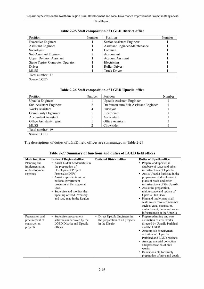
Preparatory Survey on the Northern Region Rural Development and Local Governance Improvement Project in Bangladesh
Final Report
2-63
Table 2-25 Staff composition of LGED District office
Position Number Position Number Executive Engineer 1 Senior Assistant Engineer 1 Assistant Engineer 1 Assistant Engineer-Maintenance 1 Sociologist 1 Foreman 1 Sub Assistant Engineer 2 Accountant 1 Upper Division Assistant 1 Account Assistant 1 Steno Typist/ Computer Operator 1 Electrician 1 Driver 1 Roller Driver 1 MLSS 1 Truck Driver 1 Total number: 17 Source: LGED
Table 2-26 Staff composition of LGED Upazila office
Position Number Position Number Upazila Engineer 1 Upazila Assistant Engineer 1 Sub-Assistant Engineer 2 Draftsman cum Sub-Assistant Engineer 1 Works Assistant 4 Surveyor 1 Community Organizer 1 Electrician 1 Accountant Assistant 1 Accountant 1 Office Assistant/ Typist 1 Office Assistant 1 MLSS 2 Chowkider 1 Total number: 19 Source: LGED
The descriptions of duties of LGED field offices are summarized in Table 2-27.
Table 2-27 Summary of functions and duties of LGED field offices Main functions Duties of Regional office Duties of District office Duties of Upazila office Planning and implementation of development schemes
Assist LGED headquarters in the preparation of Development Project Proposals (DPPs)
Assist implementation of national government programs at the Regional level
Supervise and monitor the updating of road inventory and road map in the Region
Prepare and update the database of roads and other infrastructures of Upazila
Assist Upazila Parishad in the preparation of development plans of roads and other infrastructures of the Upazila
Assist the preparation, maintenance and update of Upazila Plan Book
Plan and implement small scale water resource schemes such as canal excavation, embankment, drain and water infrastructure in the Upazila
Preparation and procurement of construction projects
Supervise procurement activities undertaken by the LGED District and Upazila offices
Direct Upazila Engineers in the preparation of all projects in the District
Prepare planning and cost estimation of civil works directed by Upazila Parishad and the LGED
Accomplish procurement activities of Upazila Parishad and LGED projects
Arrange material collection and preservation of civil works
Be responsible for timely preparation of store and goods

Preparatory Survey on the Northern Region Rural Development and Local Governance Improvement Project in Bangladesh
Final Report
2-64
Table 2-27 Summary of functions and duties of LGED field offices (continued) Main functions Duties of Regional office Duties of District office Duties of Upazila office Implementation, supervision, and quality control of construction
Supervise, inspect, and control quality of all civil works in the Region
Monitor environment and gender issues in the LGED activities in the Region
Supervise and monitor road safety activities
Ensure proper utilization of District quality control laboratory
Order transfer of construction equipment between Districts in the Region
Monitor land use issues in LGED activities
Manage material stock of LGED projects
Visit District and Upazila offices and activity sites, and prepared and send field visit reports to LGED headquarters and all other offices concerned
Implement projects in the District
Send progress reports of activities at the District and Upazila levels to LGED headquarters
Visit projects and submit report to Superintending Engineers at District offices
Resolve disputes with contractors
Ensure laboratory tests for quality control of projects under District and Upazila
Arrange payment of contractor’s bill
Ensure utilization, and update inventory list, of all equipment belonging to the District
Supervise civil works as directed by Upazila Parishad and the LGED
Review the progress of development activities
Implement civil works related to primary education as directed by Upazila Parishad and the LGED
Submit implementation progress reports of civil works under the jurisdiction of Upazila Parishad and respective authority
Technical assistance and capacity development
Provide technical assistance, supervise and coordinate activities of local government institutions (LGIs)
Assist District and Upazila offices in design of large bridges
Supervise and monitor training, workshops, seminar, and so on at the Regional and District levels
Take necessary actions to utilize Information and Communication Technology (ICT) in official activities
Initiate disciplinary actions against third and fourth class LGED employees within the District
Assist Upazila offices in activities related to Upazila Plan Book
Arrange training for all LGED officials within the District
Render technical advice and assistance to Upazila Parishad and Union Parishad in civil works
Coordinate utilization of ICT at the Upazila office
Coordination among stakeholders
Invite District Executive Engineers for monthly coordination meetings to review and update all LGED works
Coordinate and supervise activities of consultants, NGOs, and so on who have been deployed under projects and programs of LGED
Coordinate among concerned stakeholders to address issues related to disaster management and land acquisition in the Region
Coordinate and supervise various activities and stakeholders at the Upazila level
Ensure participation of local government institutions (LGIs) in management committees of Growth Center markets and Ghats (River jetties)
Source: LGED Charter of Duties (2010 and 2012) and LGED website d) Units and MSU/ UMSU Among 13 units at the headquarters of the LGED, Design Unit, Road Maintenance and Road Safety Unit (RMRSU), Training Unit, and Urban Management Unit are particularly important for the

Preparatory Survey on the Northern Region Rural Development and Local Governance Improvement Project in Bangladesh
Final Report
2-65
implementation of the NRRDLGIP. The functions of those four units are described as follows: Design Unit Prepare plan, design, and bill of quantities of different infrastructures Provide design support to different local government institutions (LGIs) such as Zila Parishad,
Upazila Parishad, Pourashava, and so on Develop manuals, design catalogue, technical specifications, and construction methodology Support field engineers on design and related planning issues Organize training program on structural analysis, design, and construction methodology Carry out innovative research activity to find cost effective and sustainable options for different
infrastructure under prevailing situations in different regions of the country Road Maintenance and Road Safety Unit (RMRSU) Formulate maintenance policy and annual maintenance program Take initiative to accomplish different types of survey and update road database Collect and organize data Assess annual maintenance needs Prepare priority scheme list Allocate District-wise fund Approve annual maintenance scheme Supervise and provide quality control Follow the policy and guidelines of the NRSC Activate and facilitate the District and Upazila Road Safety Committees as per GOB guidelines
and instruction Work closely with BRTC and other agencies Protect LGED roads with appropriate and approved road signs and related notifications Undertake necessary training and motivate concerned persons like drivers, public, school/college
students and others Gradually develop the road safety norms within LGED activities
Training Unit Assess training needs Prepare annual training calendar under LGED at the beginning of each financial year Prepare training manual, modules, handouts, and so on Prepare training budget for different training courses Update and preserve detailed data bank information on training Select participants, trainers, and resource persons for different training courses Implement, manage, coordinate, and evaluate different training courses Prepare monthly, semi-annual, and annual progress reports on training
Urban Management Unit Construct, extend, and maintain pucca market, kitchen market, auditorium, and community
center to enhance self generating income, marketing, and commercial activities of Pourashavas Meet needs of basic infrastructure for slum dwellers and displaced persons Improve environment through appropriate waste management Create employment opportunities through construction and reconstruction, and increase
economic activities by extension and maintenance of physical infrastructure Enhance the capacity of Paurashava to run local government business Integrate urban population and ensure better participation Computerize and improve tax records, water records, and accounts records of City Corporations
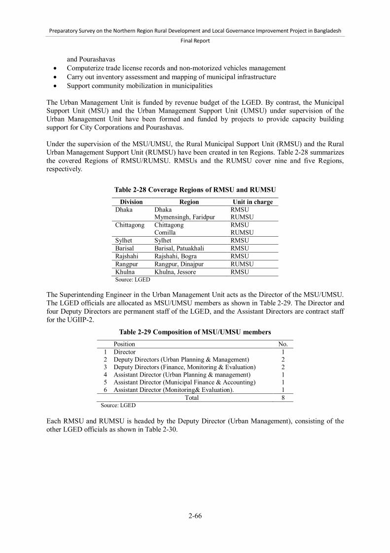
Preparatory Survey on the Northern Region Rural Development and Local Governance Improvement Project in Bangladesh
Final Report
2-66
and Pourashavas Computerize trade license records and non-motorized vehicles management Carry out inventory assessment and mapping of municipal infrastructure Support community mobilization in municipalities
The Urban Management Unit is funded by revenue budget of the LGED. By contrast, the Municipal Support Unit (MSU) and the Urban Management Support Unit (UMSU) under supervision of the Urban Management Unit have been formed and funded by projects to provide capacity building support for City Corporations and Pourashavas. Under the supervision of the MSU/UMSU, the Rural Municipal Support Unit (RMSU) and the Rural Urban Management Support Unit (RUMSU) have been created in ten Regions. Table 2-28 summarizes the covered Regions of RMSU/RUMSU. RMSUs and the RUMSU cover nine and five Regions, respectively.
Table 2-28 Coverage Regions of RMSU and RUMSU Division Region Unit in charge
Dhaka Dhaka RMSU Mymensingh, Faridpur RUMSU Chittagong Chittagong RMSU Comilla RUMSU Sylhet Sylhet RMSU Barisal Barisal, Patuakhali RMSU Rajshahi Rajshahi, Bogra RMSU Rangpur Rangpur, Dinajpur RUMSU Khulna Khulna, Jessore RMSU
Source: LGED The Superintending Engineer in the Urban Management Unit acts as the Director of the MSU/UMSU. The LGED officials are allocated as MSU/UMSU members as shown in Table 2-29. The Director and four Deputy Directors are permanent staff of the LGED, and the Assistant Directors are contract staff for the UGIIP-2.
Table 2-29 Composition of MSU/UMSU members Position No.
1 Director 1 2 Deputy Directors (Urban Planning & Management) 2 3 Deputy Directors (Finance, Monitoring & Evaluation) 2 4 Assistant Director (Urban Planning & management) 1 5 Assistant Director (Municipal Finance & Accounting) 1 6 Assistant Director (Monitoring& Evaluation). 1
Total 8 Source: LGED Each RMSU and RUMSU is headed by the Deputy Director (Urban Management), consisting of the other LGED officials as shown in Table 2-30.
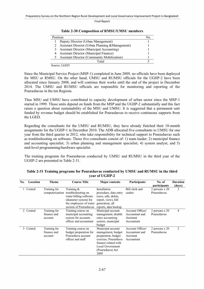
Preparatory Survey on the Northern Region Rural Development and Local Governance Improvement Project in Bangladesh
Final Report
2-67
Table 2-30 Composition of RMSU/UMSU members Position No.
1 Deputy Director (Urban Management) 1 2 Assistant Director (Urban Planning &Management) 1 3 Assistant Director (Municipal Accounting) 1 4 Assistant Director (Municipal Finance) 1 5 Assistant Director (Community Mobilization) 1
Total 5 Source: LGED Since the Municipal Service Project (MSP-1) completed in June 2009, no officials have been deployed for MSU or RMSU. On the other hand, UMSU and RUMSU officials for the UGIIP-2 have been allocated since January 2008, and will continue their works until the end of the project in December 2014. The UMSU and RUMSU officials are responsible for monitoring and reporting of the Pourashavas in the ten Regions. Thus MSU and UMSU have contributed to capacity development of urban sector since the MSP-1 started in 1999. Those units depend on funds from the MSP and the UGIIP-2 substantially and this fact raises a question about sustainability of the MSU and UMSU. It is suggested that a permanent unit funded by revenue budget should be established for Pourashavas to receive continuous supports from the LGED. Regarding the consultants for the UMSU and RUMSU, they have already finished their 18-month assignments for the UGIIP-1 in December 2010. The ADB allocated five consultants to UMSU for one year from the third quarter in 2012, who take responsibility for technical support to Pourashavas such as troubleshooting on software. Those five consultants consist of: 1) team leader; 2) municipal finance and accounting specialist; 3) urban planning and management specialist; 4) system analyst; and 5) mid-level programming/hardware specialist. The training programs for Pourashavas conducted by UMSU and RUMSU in the third year of the UGIIP-2 are presented in Table 2-31.
Table 2-31 Training programs for Pourashavas conducted by UMSU and RUMSU in the third year of UGIIP-2
No. Location Theme Course Title Major contents Participants No. of participants
Duration (days)
1 Central Training for computerization
Training & troubleshooting on water billing software (diameter system) for the employees of water section of Pourashavas
Installation procedure, data entry (save, edit, delete, report, view), bill generation, all reports, data backup
Bill clerk and casher
2 persons x 20 Pourashavas
3
2 Central Training for finance and account
Training course on municipal accounting system for accounts officer and accountant
Municipal account management, double entry accounting system, municipal budget
Account Officer/ Accountant and Assistant Accountant
2 persons x 20 Pourashavas
4
3 Central Training for finance and account
Training course on budget preparation for Pourashava account officer and staff
Municipal account management, budget preparation, budget exercise, Pourashava finance related with Local Government (Pourashava) Act 2009
Account Officer/ Accountant and Assistant Accountant
2 persons x 20 Pourashavas
2

Preparatory Survey on the Northern Region Rural Development and Local Governance Improvement Project in Bangladesh
Final Report
2-68
Table 2-31 Training programs for Pourashavas conducted by UMSU and RUMSU in the third year of UGIIP-2 (continued)
No. Location Theme Course Title Major contents Participants No. of participants
Duration (days)
4 Central Training on Engineering work
Training on public procurement rules (PPR) rules 2008 and contract management
Public procurement rules
Mayor, Executive Engineer, and Assistant Engineer
3 persons x 20 Pourashavas
2
5 Central Training on Engineering work
Training on quality control and supervision of civil works of Pourashava
Quality control and supervision of civil works, and cost estimation
Assistant Engineer, Sub Assistant Engineer, and Work Assistant
4 persons x 20 Pourashavas
3
6 Central Training on Engineering work
Training course on estimating for Pourashava work assistant
Estimate of HBB Road, CC road, iron concrete beam, box culvert and 10 estimates of bleedings’ slab and exercise, and group wise practical session
Estimator 1 person x 20 Pourashavas
5
7 Central Training for UMSU
Orientation on accounts, trade, tax and water billing updated software
Installation procedure, data entry (save, edit, delete, report, view), bill generation, all reports, data backup
Assistant Director in charge of Finance of UMSU, Consultants in charge of Finance
1 person x 20 Pourashavas
3
8 Central Training of Trainers (developing a group of trainers)
TOT for selected Pourashava and RMSU officials
Training concept, qualities of a good trainer, facilitation skill, principals of use training materials use of manual
Executive Engineer/ Assistant Engineer, Secretary, Town Planner of Pourashava, and Assistant Director of RUMSU
5 persons x 20 Pourashavas
5
9 2 Regions Training for computerization
Basic computer training for Pourashava officials
Introduction of basic computer, Microsoft Office, advance MS Word technique, Microsoft Excel, and overview of MS Access
Assistant Engineer, Subassistant Engineer, Accountant, Assistant Accountant, Tax Assessor, Tax Collector, Trade License Officer, Assistant Collector, Bill Clerk, and Cashier
10 persons x 20 Pourashavas
5
10 2 Regions Training for computerization
Training on tax billing, municipal accounts, and trade license
Installation procedure, data entry (save, edit, delete, report, view), bill generation, all reports, data backup
Accountant, Assistant Accountant Tax assessor, Tax Collector, Trade license officer, Assistant Collector, Bill Clerk, and Cashier
6 persons x 20 Pourashavas
5

Preparatory Survey on the Northern Region Rural Development and Local Governance Improvement Project in Bangladesh
Final Report
2-69
Table 2-31 Training programs for Pourashavas conducted by UMSU and RUMSU in the third year of UGIIP-2 (continued)
No. Location Theme Course Title Major contents Participants No. of participants
Duration (days)
11 2 Regions Training for urban planning
Training on Infrastructure database and base map preparation
Survey, infrastructure data collection using format, and computerized database preparation
Assistant Engineer, Sub-Assistant Engineer, Surveyor, and Estimators
5 persons x 20 Pourashavas
5
12 2 Regions Training for urban planning
Training on Pourashava base map preparation using Auto CAD
Auto CAD operation, data review, base map preparation method
Assistant Engineer, Sub-Assistant Engineer, Surveyor, and Estimators
5 persons x 20 Pourashavas
5
13 2 Regions Orientation on community mobilization
Orientation workshop on community mobilization for Pourashava officials
Community mobilization, CBO formation, preparation of social development
Executive Engineer/ Assistant Engineer, Secretary, and Slum Development Officer
3 persons x 20 Pourashavas
1
14 2 Regions Orientation on community mobilization
Orientation workshop on community mobilization for chairman & secretary of CBO and steering committee
Community mobilization, roles of chairman & secretary of CBO and steering committee, preparation of social development
Chairman and Secretary of CBO
4 persons x 20 Pourashavas
1
15 20 Pourashavas
Training on community mobilization
Orientation for CBO members on performing CBO activities
Members roles & responsibilities, active participation in WLCC, preparation of social development
CBO members 12 persons x 20 Pourashavas
1
16 20 Pourashavas
Sensitization Workshop
Sensitization workshop for TLCC members at Pourashava Level
Responsibilities of TLCC members, group work on citizen participation
TLCC members 50 persons x 20 Pourashavas
1
(4) Department of Public Health Engineering The DPHE is a public sector agency under the MLGRD&C. The DPHE is responsible for water supply and sanitation in rural and urban areas of the country. The urban areas covered by the DPHE include all City Corporations, Pourashavas, Upazila headquarters, and Growth Centers, except Dhaka, Chittagong and Narayanganj cities. The main functions of the DPHE are summarized in Table 2-32.
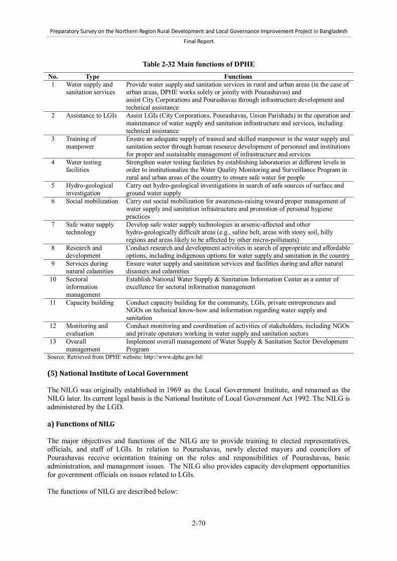
Preparatory Survey on the Northern Region Rural Development and Local Governance Improvement Project in Bangladesh
Final Report
2-70
Table 2-32 Main functions of DPHE
No. Type Functions 1 Water supply and
sanitation services Provide water supply and sanitation services in rural and urban areas (in the case of urban areas, DPHE works solely or jointly with Pourashavas) and assist City Corporations and Pourashavas through infrastructure development and technical assistance
2 Assistance to LGIs Assist LGIs (City Corporations, Pourashavas, Union Parishads) in the operation and maintenance of water supply and sanitation infrastructure and services, including technical assistance
3 Training of manpower
Ensure an adequate supply of trained and skilled manpower in the water supply and sanitation sector through human resource development of personnel and institutions for proper and sustainable management of infrastructure and services
4 Water testing facilities
Strengthen water testing facilities by establishing laboratories at different levels in order to institutionalize the Water Quality Monitoring and Surveillance Program in rural and urban areas of the country to ensure safe water for people
5 Hydro-geological investigation
Carry out hydro-geological investigations in search of safe sources of surface and ground water supply
6 Social mobilization Carry out social mobilization for awareness-raising toward proper management of water supply and sanitation infrastructure and promotion of personal hygiene practices
7 Safe water supply technology
Develop safe water supply technologies in arsenic-affected and other hydro-geologically difficult areas (e.g., saline belt, areas with stony soil, hilly regions and areas likely to be affected by other micro-pollutants)
8 Research and development
Conduct research and development activities in search of appropriate and affordable options, including indigenous options for water supply and sanitation in the country
9 Services during natural calamities
Ensure water supply and sanitation services and facilities during and after natural disasters and calamities
10 Sectoral information management
Establish National Water Supply & Sanitation Information Center as a center of excellence for sectoral information management
11 Capacity building Conduct capacity building for the community, LGIs, private entrepreneurs and NGOs on technical know-how and information regarding water supply and sanitation
12 Monitoring and evaluation
Conduct monitoring and coordination of activities of stakeholders, including NGOs and private operators working in water supply and sanitation sectors
13 Overall management
Implement overall management of Water Supply & Sanitation Sector Development Program
Source: Retrieved from DPHE website: http://www.dphe.gov.bd/ (5) National Institute of Local Government The NILG was originally established in 1969 as the Local Government Institute, and renamed as the NILG later. Its current legal basis is the National Institute of Local Government Act 1992. The NILG is administered by the LGD. a) Functions of NILG The major objectives and functions of the NILG are to provide training to elected representatives, officials, and staff of LGIs. In relation to Pourashavas, newly elected mayors and councilors of Pourashavas receive orientation training on the roles and responsibilities of Pourashavas, basic administration, and management issues. The NILG also provides capacity development opportunities for government officials on issues related to LGIs. The functions of NILG are described below:

Preparatory Survey on the Northern Region Rural Development and Local Governance Improvement Project in Bangladesh
Final Report
2-71
Conduct training of elected representatives and appointed officials of both urban and rural local
government Conduct training of government officials who are concerned with LGIs Hold national and international seminars, workshops, conferences, and other meetings Conduct research on issues of local governments Publish books, research reports, and journals on local government and related subjects Provide consultancy services to the LGD and LGIs Collect information, and conduct monitoring and evaluation on the activities of LGIs Provide facilities for documentation, and build up a national documentation center on LGIs Coordinate training and research programs, and develop an institutional network on local
government training and research Conduct collaborative programs on local government with international organizations with the
approval of the government Introduce a certificate course on subjects related to local government
b) Organizational structure of NILG Board of Governors The NILG is managed by the Board of Governors which is composed of the following members: 1) Minister for Local Government, Rural Development and Cooperatives: Chairperson 2) State Minister for Local Government, Rural Development and Cooperatives: Vice Chairperson 3) Secretary of LGD 4) Director General of Bangladesh Academy for Rural Development (BARD) 5) Director General of the Bangladesh Institute of Management 6) Chief Engineer of the LGED 7) Chief Executive Officer of the Dhaka City Corporation 8) Representatives from each of the following government organizations: Bangladesh Public
Administration Training Center, Ministry of Public Administration, Finance Division of the Ministry of Finance, Rural Development and Cooperatives Division
9) Four representatives from local government bodies nominated by the government 10) Director General of NILG: Member Secretary
Administrative body The Director General acts as Chief Executive Officer of the NILG as per the decisions and guidance of the government and the Board of Governors. The NILG has four departments that are headed by directors, respectively: 1) Training and Consultancy; 2) Research and Planning; 3) Administration and Coordination; and 4) Programming and Evaluation. The NILG does not have any field offices outside Dhaka. The total manpower of the NILG is 113, among which 21 are assigned for the Training and Consultancy Department, and 28 for the Research and Planning Department.22 The NILG also hosts the Horizontal Learning Center (HLC), the coordination mechanism of the Horizontal Learning Program (HLP). The HLP is a platform to facilitate mutual learning of good practices among Union Parishads and other LGIs. The HLC is currently a project-specific task force in the NILG and not funded by the revenue budget. However, the institutionalization of the HLC in the NILG is also in progress.23
22 The latest organizational chart issued on January 29, 2006. 23 The Director General of the NILG expressed the view to institutionalize the HLC on July 16, 2012.

Preparatory Survey on the Northern Region Rural Development and Local Governance Improvement Project in Bangladesh
Final Report
2-72
c) Training courses provided by NILG The NILG held a total of 235 training courses in FY 2010-2011, and the number of participants accounted for 11,690 in total.24 The major areas of training are: laws and policies including local government acts, ordinances, rules, and regulations; financial management including taxation, budgeting, accounting, and auditing; office and personnel management; local planning and development; social and economic development in relation to the Poverty Reduction Strategy Paper and the
Millennium Development Goals; child rights, and birth and death registration; and gender, environmental and disaster management, sanitation, anti-corruption, anti-terrorism, and
smuggling prohibition laws. The training programs for elected representatives of LGIs and staff members on legal and policy framework and administrative management are conducted with the revenue budget. The NILG also provides special training programs designed for projects funded by the government and international donors. (6) Rural Development and Cooperatives Division The RDCD aims to reduce poverty and improve living conditions in rural areas. The RDCD is responsible for policy formulation and implementation, as well as coordination among rural development-related activities of the government. More specifically, the RDCD is mandated to: 1) formulate policies, laws, rules, and plans regarding rural development and cooperatives; 2) formulate and implement programs and projects to reduce rural poverty; 3) support entrepreneurs by providing micro-credit and agricultural credit, enhancing cooperative-based small businesses and cooperative insurance, and promoting other rural and cooperative related activities; 4) provide capacity development support for members of cooperatives; 5) conduct research on rural development and cooperatives; 6) conduct action research to develop innovative approaches related to rural development; and 7) support rural women in socioeconomic development and empowerment by organizing formal and informal groups under cooperative programs. The BRDB, DOC, RDA, and BARD are under the jurisdiction of the RDCD. The following subsections give a brief explanation of these organizations. a) Bangladesh Rural Development Board The BRDB is a government organization working on rural development and poverty alleviation under the RDCD. It is mandated to promote rural development and poverty alleviation activities, focusing on small and marginal farmers and poor people in rural areas, by mainly increasing agricultural production. Organizing such farmers and people into cooperative societies and providing them with technical and financial supports and trainings are the main tasks of the BRDB. The BRDB is managed by a Board of Directors comprising representatives from ministries and government agencies. The Board is chaired by the Minister for Local Government, Rural Development and Cooperatives. The BRDB consists of five divisions: 1) Administration; 2) Field Services; 3) Planning, Evaluation and Monitoring; 4) Finance, Accounts and Audits; and 5) Training.
24 The Annual Report of the LGD FY 2010-2011

Preparatory Survey on the Northern Region Rural Development and Local Governance Improvement Project in Bangladesh
Final Report
2-73
b) Department of Cooperatives The DOC is mandated to facilitate economic growth and poverty reduction through enhancing activities of cooperatives. At the central level, the Registrar, an Additional Secretary level, is the head of the DOC. At the local level, there are Divisional Joint Registrars, District Cooperative Officers, and Upazila Cooperative Officers, and they are responsible for the registration of cooperatives at the respective local level. The major mandates of the DOC include 1) registration, liquidation, auditing, and inspection of cooperatives; 2) settlement of disputes related to the operation of cooperatives; 3) training and education of cooperatives for management and business skills; 4) advice and assistance to cooperative members in arranging finances; and 5) sensitization of other government agencies in favor of activities of cooperatives. c) Rural Development Academy The RDA, located in Bogra District of Rajshahi Division, is a government institution in charge of training, research, and policy formulation regarding rural development. It pursues an innovative approach in the field of rural development. The major domains of RDA activity include: 1) developing irrigation by using buried pipes and deep tube wells; 2) supplying arsenic-free water; 3) enhancing marginal labor productivity in rural areas through irrigation and water management, and development of technical protocol for the production of hybrid maize seed; 4) promoting women’s seed businesses; 5) promoting water-saving technology for rice production; and 5) a rural development program in cooperation with the BARD and DOC. The RDA is managed by the Board of Governors headed by the Minister for Local Government, Rural Development and Cooperatives. d) Bangladesh Academy for Rural Development The BARD, located in Comilla District of Chittagong Division, is an autonomous institute for research and training of local people and field staff in the field of rural development. The BARD was established in 1959, and is famous for implementing the Comilla Model, widely known as a model for rural development, in the 1960s. The BARD provides training for local people and other private sector persons as well as officials working for rural development. It also conducts research activities, aiming to collect basic data for planning and preparation of various projects and programs, and evaluate national rural development programs. The BARD is governed by the Board of Governors whose chair is the Minister for Local Government, Rural Development and Cooperatives. 2.3.2 Ministry of Finance The Ministry of Finance consists of four Divisions: 1) Finance Division; 2) Economic Relations Division (ERD); 3) Bank and Financial Institutions Division; and 4) Internal Resources Division. Among them, Finance Division and ERD are the organizations that will require coordination for the formulation and implementation of the NRRDLGIP. Therefore, the functions of these two Divisions and their involvement in the NRRDLGIP are discussed below. The main function of the Finance Division is budget and financial management of the GOB. The Finance Division has been formulating the Medium-Term Budget Framework (MTBF), a tool for linking policy, planning, and budgeting of the government over a medium term (five years). The MTBF includes all government ministries, divisions, and agencies, including the LGD, LGED, DPHE, and

Preparatory Survey on the Northern Region Rural Development and Local Governance Improvement Project in Bangladesh
Final Report
2-74
other agencies concerned with the NRRDLGIP. The Finance Division also prepares and allocates the annual revenue budget of the government in coordination with all other ministries, divisions, and agencies. It issues budget call circulars, which shows the indicative budget ceiling based on MTBF, in September and December for the preparation of the government’s annual budget. The main function of the ERD under the Ministry of Finance is mobilization of external resources for the socioeconomic development of the country. The ERD serves as the focal point of the government in interacting with development partners and coordinating all inflows of external assistance. It also assesses the need for external assistance, and formulates strategies for negotiating and mobilizing external assistance. The ERD signs loans and grant agreements with development partners as the representative of the GOB. 2.3.3 Planning Commission The Planning Commission is the central policy organization that oversees public investment management in Bangladesh. The Planning Commission advises the National Economic Council (NEC) chaired by the Prime Minister, and assumes critical functions, i.e., the formulation of development plans such as the Perspective Plan, Five Year Plan, and ADP, and the appraisal of public investment and technical assistance projects proposed by ministries, divisions, and agencies in the process of the ADP. The ADP plays the central role in public investment management in Bangladesh. The Planning Commission is responsible for overall management of the ADP process. The Finance Division sets annual budget ceilings for the ADP with budget call circulars, which are based on the MTBF. Ministries, divisions, and agencies are responsible for the preparation of the Development Project Proposal (DPP) and Technical Assistance Project Proposal and the implementation of approved projects. Since the NRRDLGIP is a new development project, the LGED needs to prepare a DPP for appraisal by the Planning Commission and final approval by Executive Committee of National Economic Council (ECNEC). The structure and contents of a DPP are presented in Table 2-33.
Table 2-33 Structure and content of Development Project Proposal (DPP)
Structure Content Part A: Project Summary
16 items related to the basic information of the project, including its cost resources and breakdown.
Signature of officer(s) responsible for the preparation of the DPP with seal and date is required at the end of Part A.
Part B: Project Details
16 items mostly related to the background of the project, and its relevance, effectiveness, efficiency, impact, risk management and sustainability.
Signature of the officer. Annex 1 Cost breakdown by location (cost breakdown by Division/District and Sub-District/Upazila) Annex 2 Project management setup (organizational setup of the project management team) Annex 3 Total procurement plan for development project/program (divided into three forms; goods,
work and services) Annex 4 Financial and physical target plans by year (breakdown by revenue/capital components) Annex 5 Detailed annual phasing of cost Annex 6 Amortization schedule Source: Ministry of Planning (2008a)
2.3.4 Ministry of Environment The Ministry of Environment and Forest is the primary government organization for the environmental conservation of Bangladesh. The Department of Environment of the Ministry is in charge of the issuance of the Environmental Clearance Certificate that all development projects need to obtain. The mandates

Preparatory Survey on the Northern Region Rural Development and Local Governance Improvement Project in Bangladesh
Final Report
2-75
and responsibilities of the Ministry and the Department are detailed in Chapter 8. 2.3.5 Local governments (1) Structure of local government system Local governments are the basic administrative and political units in Bangladesh. There are now seven Divisions, 64 Districts, ten City Corporations, and 315 Pourashavas in the urban areas, and 486 Upazila and 4,545 Unions in the rural areas as of the end of September 2012.25 Figure 2-33 presents the basic structure of the local government system in Bangladesh.
Central GovernmentMinistry of Local Government, Rural Development and Co-operatives
Divisions (7)
Districts (64)
Deconcentrated agenciesLGED, DPHE, WASAs, etc.
Rural Local GovernmentsUpazilas (486)
Union Parishads (4545)
Urban Local GovernmentsCity Corporations (10)
Pourashavas (315)
Source: Adopted and modified from the World Bank (2010), and interview with the Senior Assistant Secretary of the LGD
Figure 2-33 Structure of local government system
The Divisions are the sub-national administrative units formed for administrative convenience. Many government agencies, including the LGED, have their extension offices at the Divisional level, but a Division per se is not a local government. A Division is headed by a Commissioner, who normally has the rank of Joint Secretary under the Ministry of Public Administration.26 Major responsibilities of a Divisional Commissioner include monitoring, coordinating, and supervising the implementation of policy decisions of the central government at the divisional level. A Division is divided into Districts. A District is the largest political and administrative structure comprising urban and rural areas. A District is further divided into Upazilas or Sub-Districts, and then into Unions. In urbanized areas, City Corporations and Pourashavas are the basic political and administrative units. The following sections briefly describe the City Corporation, District, Pourashava, and Union. Councils are established in City Corporations, Pourashavas, Upazilas, and Unions, and their mayors/chairmen and councilors/members are directly elected by the local population. (2) District a) Mandates The Zila Parishad Act 2000 is the legal basis for the establishment and operation of Districts. Section 2.7 (2) and 2.7 (3) of the Act mandates Districts to perform the two types of functions, i.e., compulsory and optional. The major compulsory functions cover the following: Review all development programs implemented in the District
25 The numbers of Division and District is based on BBS (2010d), and those of Upazila and Union, City Corporation, and Pourashavas are based on the interview with the Senior Assistant Secretary of the LGD. 26 The Divisional Commissioners of Dhaka and Khulna Division have the rank of the Additional Secretary.

Preparatory Survey on the Northern Region Rural Development and Local Governance Improvement Project in Bangladesh
Final Report
2-76
Review implementation progress of development projects initiated by Upazila and Pourashava Construct and maintain highways, roads, culverts, and bridges that are not under the jurisdiction
of Upazila and Pourashava, and the government Develop and maintain general libraries Plant and maintain trees alongside the road used by the public Develop and maintain garden, playground and open space for public use Manage and control ferry services not covered by the government, Upazila and Pourashava Develop and maintain guest houses, bungalows, and rest houses Implement the government’s development plan for the Zila Parishad
On the other hand, the optional functions cover the field of education, culture, social welfare, economic welfare, public health, and public works. b) Organizational structure of Districts Section IV of the Zila Parishad Act determines the organizational structure of a District. Each District council consists of a Chairman (presently an administrator appointed by the government), and 18 members, including five women members in a reserved list. As for the administrative organization, a District is headed by the Deputy Commissioner (DC), who is appointed by the government and belongs to the Ministry of Public Administration. The DCs are basically Revenue Collectors of 64 Districts in Bangladesh, and they are also known as District Magistrates. In the context of the administrative unit, a District has five departments, i.e., 1) district magistracy, 2) general, 3) revenue, 4) land acquisition, and 5) education and science, which are headed by Additional Deputy Commissioners below the rank of DC. (3) City Corporation City Corporations are the self-governing organizations governing the big municipal areas of Bangladesh. There are ten City Corporations in Bangladesh, i.e., Barisal, Chittagong, Comilla, Dhaka North, Dhaka South, Khulna, Narayanganj, Rajshahi, Rangpur, and Sylhet. To be declared as City Corporation, Section 3 of the Local Government Act (City Corporation) 2009 (hereinafter referred to as the “City Corporation Act”) stipulates the following criteria: Population size of existing Pourashava Density of population Sources of permanent income Economic importance of the area Existing infrastructure facilities and scope for their expansion Annual income of the existing Pourashava Public opinion
a) Mandates The mandates, functions, and responsibilities of a City Corporation are stipulated in Section 41 of the City Corporation Act. The major mandates and functions of the City Corporations cover the following areas: Public health, including preventing infectious diseases, providing health and maternal welfare,
operating hospitals and dispensary services, and medical care, assistance and health education Development of infrastructures, including roads, private and general market, water supply, and

Preparatory Survey on the Northern Region Rural Development and Local Governance Improvement Project in Bangladesh
Final Report
2-77
drainage system Town planning, building regulation, and traffic control Trees, park, garden, and forest Disaster management Other administrative and development activities including registration of births, deaths and
marriages, education and culture, social welfare, livestock management, and public security b) Organizational structure of City Corporation A City Corporation consists of a Mayor and councilors, who are directly elected by local people. The number of councilors is specified based on the government gazette notification for each corporation. The administrative structure of City Corporations is presented in Section 5 of the City Corporation Act. A City Corporation has seven departments including the secretariat, but Dhaka City Corporation has 16 departments. The departments in all City Corporations except for Dhaka City Corporation are Secretariat, Engineering, Health, Education, Revenue, Conservancy, and Accounts. In contrast, the departments in Dhaka City Corporation are Secretariat, Accounts, Chief Executive Officers (CEO) office, Conservancy, Engineering, Establishment, State, Health, Information Technology, Internal Audit, Law, Public Relation, Revenue, Slum Development, Social Welfare, Transport, and Urban Planning. (4) Pourashava a) Overview Pourashava is one of the LGIs established in the urban area. Its legal basis is the Local Government (Pourashava) Act 2009 (hereinafter referred to as the “Pourashava Act”). Section 3 of the Pourashava Act stipulates that the government can express the intention to declare any rural area to be a Pourashava by a gazette notification, taking into account: 1) population; 2) density of population; 3) local income sources; 4) percentage of non-agricultural profession; and 5) economic importance of such area. The following are the four specific conditions to be declared as Pourashavas: Three-fourths of the people are involved in non-agricultural professions. Thirty-three (33) % of the total land area is non-agricultural. Density of population is no less than 1,500/km2. Population is no less than 50,000.
The number of Pourashavas has been increasing over time as a result of continuous urbanization of the country. There are 315 Pourashavas in Bangladesh as of July 31, 2012. Category of Pourashava Pourashavas are categorized as A, B, or C under two criteria: 1) revenue income; and 2) the rate of holding tax collection (Table 2-34).

Preparatory Survey on the Northern Region Rural Development and Local Governance Improvement Project in Bangladesh
Final Report
2-78
Table 2-34 Categorization of Pourashavas and their numbers Category Criteria Number
A Revenue of last 3-year average should be BDT 10 million or more. Rate of holding tax collection should be 75 % or more.
110 1
B Revenue of last 3-year average should be BDT 6 million or more. Rate of holding tax collection should be 75 % or more.
104
C Revenue of last 3-year average should be BDT 2 million or more. 101
Source: LGD Memo No.46.064.028.28.07.015.2011/811 dated May 31, 2011, and the information from the UMSU of the LGED as of July 2012
Note: 1. Inclusive a special case of Pourashava Tongi. b) Mandates Section 50 of the Pourashava Act stipulates the main responsibilities and functions of Pourashava. The main responsibilities include: 1) providing all municipal services as stipulated in the Pourashava Act; 2) coordinating among Pourashava administration and government officials and undertaking coordinated programs; 3) formulating and implementing town development planning, including infrastructure development and building regulations; and 4) maintaining citizens’ security and public order. To fulfill these responsibilities, Pourashavas shall provide the following basic services as per Section 50 (2) of the Pourashava Act: Water supply for residential, industrial and commercial use Water and sanitation Waste management Formulation of plans to ensure economic and social justice Construction of roads and footpaths to develop a communication system and construct terminals
for the benefit of people’s movement and goods Activities under the Birth and Death Registration Act 2004 Traffic management planning for better transport management, passenger shade, road lighting,
parking places, bus stands and bus stops for walkers Public health and environment conservation, tree planting and conservation Market and slaughter house setup and management Create and spread the opportunity for and support to sports, games, and amusement, and increase
beautification of the locality Any other functions under ordinance, rules, regulations, or any order from the government
In addition, the Second Schedule of the Pourashava Act details the functions of Pourashavas. They include the areas of public health, water supply and drainage, food and beverage control including public and private market management, animal management including livestock improvement, town planning, building control, street management, public safety, parks and forest management, education and culture, social welfare, and development planning. Furthermore, Section 51 of the Pourashava Act states that Pourashavas, with the approval from the Government of Bangladesh (GOB), can perform functions including, but not limited to, primary education, health care, transport, fire control and safety, and poverty reduction. Thus, Pourashavas are mandated to perform broad areas of socioeconomic development. However, the extents to which Pourashavas execute those functions and deliver the services greatly vary. According to the sample survey, birth and death control and health care services are relatively well performed, whilst infrastructure development cannot sufficiently meet the people’s needs.

Preparatory Survey on the Northern Region Rural Development and Local Governance Improvement Project in Bangladesh
Final Report
2-79
Education services are not effectively provided, either. The education section under the Administration Division of Pourashava is responsible for the schools and other educational institutes established by Pourashava, and yet no such section has been found in sampled Pourashavas. The survey on sample Pourashavas revealed that almost all schools located in those Pourashavas were operated by Upazila Education Office under the Ministry of Primary and Mass Education for primary schools, or the Upazila Secondary and Higher Education Office under the Ministry of Education for the other education institutes. It was also found that only a few Pourashavas had established schools by themselves, and sometimes even such schools established by Pourashavas had been taken over by the GOB due to the lack of financial capacity of the Pourashavas to operate those schools. Thus, the institutional setup for the education sector in Pourashavas, in particular category-B and C, is considered insufficient to perform their mandates effectively. Moreover, the functions of Pourashavas stipulated by the Pourashava Act do not necessarily cover all the development areas. For instance, agricultural services do not fall under the jurisdiction of Pourashavas, although it is crucial for socioeconomic development in Pourashavas. The Department of Agriculture Extension under the Ministry of Agriculture provides agricultural services, and farmers living in Pourashavas have direct access to those services. However, Pourashavas sometimes collaborate with the Department of Agriculture Extension in agricultural services delivery. For instance, it was reported in the sample survey that the Pourashavas had assisted the Department of Agricultural Extension in identifying farmers, and distributing seeds or other agricultural materials at the Pourashava office, responding to the request from the Department. Such collaboration between the Department and Pourashavas emerge on ad hoc basis, and no permanent coordination mechanism has been established so far. One way to address this issue might be to use Upazila Parishad meetings for such coordination. c) Organizational structure of Pourashava Section 6 of the Pourashava Act determines the organizational structure of a Pourashava. Each Pourashava consists of a mayor and councilors, including female councilors. The mayor and councilors are directly elected by local residents. The number of councilors is the same as the number of wards defined by the government. One-third of the defined number of the councilors shall be reserved for females (Section 7). The term of mayors and councilors is five years (Section 8). The executive powers of Pourashavas are vested in mayors and councilors. Key officers of Pourashavas also exercise such powers under the guidance of mayors and councilors. The decisions of Pourashavas are basically made in the Pourashava Parishad, which is called by a mayor and must be held at least once a month (Section 63 of the Pourashava Act). Critical issues such as budgets, projects under the ADP, master plan, and employee appointments are first discussed at committees of Pourashavas (Section 64). The decisions of the committees are to be discussed in the general assembly meeting of the Pourashava Parishad. Standing committee The standing committees to be established under a Pourashava are presented below (Section 55 (1) of the Pourashava Act): Establishment and finance Tax fixation and collection Accounts and audit Town planning, identification and development of services for citizens Law and order and public security Communication and physical infrastructure development

Preparatory Survey on the Northern Region Rural Development and Local Governance Improvement Project in Bangladesh
Final Report
2-80
Women and children Fisheries and livestock Information and culture Market price supervision, monitoring and control
In addition, a Pourashava can form additional committees, with the participation of NGOs, especially on the areas of disaster management, market management, poverty reduction and slum development, health, water and sanitation, and waste management (Section 55 (2)). The Ward Level Coordination Committees (WLCCs) and the Town Level Coordination Committee (TLCC) are also formed, as described later. A standing committee consists of five members who are councilors. The chairperson of the committee shall be a councilor, but a mayor will chair the law and order and public security committee (Section 55 (3) and (6)). In each committee, there shall be no less than 40% of female members. If separate committees cannot be formed due to the shortage of councilors, a committee dealing with more than one issue can be formed. In addition, an expert of the respective issues can be the co-opt member of the committee. However, the co-opt member does not have voting rights in decision making. In each standing committee, specific issues assigned to each committee are discussed. The committee will elaborate a recommendation on particular issues, and the recommendation will be conveyed to and discussed in the General Meeting of the Pourashava Parishad. If the General Meeting of the Pourashava Parishad does not accept the recommendation, the reason shall be informed to the concerned standing committee (Section 56 of the Pourashava Act). The sample survey revealed that this standing committee system had not been well functioning in Pourashavas. Only one out of four sampled Pourashavas have established standing committees. Furthermore, even in the Pourashava where they have been established, the standing committees are neither held regularly, nor functioning effectively. Administrative organization With respect to the administrative organization, a Pourashava consists of: 1) Engineering Division headed by an Executive Engineer; 2) Administrative Division headed by a Secretary; and 3) Health Division headed by a Health Officer. The authorized number of staff is indicated in Table 2-35. Category-A Pourashavas are authorized to employ more staff members than category-B and C.
Table 2-35 Authorized numbers of Pourashava staff Category Division Staff numbers
A Engineering Division Administration Division Health Division Total
57 42 28
127 B Engineering Division
Administration Division Health Division Total
32 35 22 89
C Engineering Division Administration Division Health Division Total
27 26 16 69
Source: LGED (2011c) The principal executive officer of a Pourashava is a CEO who assists the mayor in the Pourashava affairs (Section 74 of the Pourashava Act). The CEO is a senior administrative post, and shall be appointed by
Preparatory Survey on the Northern Region Rural Development and Local Governance Improvement Project in Bangladesh
Final Report
2-81
the government (LGD). The CEO oversees the overall activities of Pourashavas and is deputized with the authority of the mayor. However, as described later in this report, the post of the CEO is often vacant in many Pourashavas. The functions of respective divisions are not defined by the Pourashava Act and thus, will be determined by Pourashavas based on Section 121, and the item 11 of the Schedule 7 of the Pourashava Act. This implies that actual functions of each division could be different from one Pourashava to another. The typical functions of each division, based on the information of sample Pourashavas, are presented below.
1) Engineering Division Construct and maintain infrastructures such as public markets, public roads, drains, bridges
and culverts in the jurisdiction of Pourashava Implement necessary programs for the watering of public streets, and planting trees on public
streets and other public places Maintain public garden and open space in the municipal area Prepare a master plan for the area of Pourashava Implement all kinds of development plans Issue building approval within Pourashava Supply drinking water for Pourashava people Provide public services including traffic signaling and public latrines Maintain vehicles and other equipment of Pourashava
2) Administration Division
Execute administrative works to operate Pourashava smoothly Prepare budget, and manage financial and accounting issues Assess holding tax by investigating building and other assets Collect holding tax, market rents, trade license fees and other fees Issue trade licenses to Pourashava people Promote and organize social activities and celebrate the national and other special days Execute and undertake relief activities during natural disaster or famine Other services including but not limited to cemetery management, promotion of commercial
activities
3) Health Division Control infectious diseases Establish, maintain, and contribute to hospitals, health centers, and dispensaries Register all births and death within Pourashava Promote family planning program Promote public health, including education in health Control of animals including stray animal management, illegal and disease animal for
slaughtering, and dangerous animals for detention and disposal The Administration Division is in charge of overall management of Pourashavas. It is responsible for financial and accounting matters including the preparation of budget, and decision making on actual budget allocation, in close collaboration with the other divisions. The Administration Division is also in charge of the operation of TLCC and WLCCs. All divisions are involved in development planning, but the Engineering Division usually takes a lead role since such plans typically contains civil works.

Preparatory Survey on the Northern Region Rural Development and Local Governance Improvement Project in Bangladesh
Final Report
2-82
d) Coordination mechanism Coordination with stakeholders of Pourashava There are several coordination mechanisms within Pourashavas. Although the general assembly of the Pourashava Parishad and its permanent committees are considered a key coordination mechanism among various stakeholders, a system pursing direct engagement of local population and civil society is also statutorily installed, i.e., the TLCC and the WLCC. Section 115 of the Pourashava Act requires Pourashavas to form a committee for the dialogue with community people, and Section 14 stipulates that every ward can form a ward committee to promote local people’s participation in development and administrative activities of Pourashavas. The Memo No: 46.063.022.01.00.001.2011-258 issued on March 9, 2011 by the LGD requires Pourashavas to form the TLCC and the WLCC, and describes the detailed structures and Terms of Reference (TOR) of the TLCC and the WLCC. Table 2-36 shows the composition of the WLCC. The WLCC shall not contain more than 10 people in total. The formation of the WLCC and its TOR shall be approved by the Pourashava Parishad.
Table 2-36 Composition of Ward Level Coordination Committee Respective Ward Counselor Chairperson Respective (Reserve) Female Counselor Co-Chairperson Poor Representative (Total 3 including 1 female) Member Civil Society Representative (Total 2 including 1 Female) Member Occupational Organization (Total 2 including 1 Female) Member Assistant Engineer or Sub-Assistant Engineer Member-Secretary Source: LGD Memo No: 46.063.022.01.00.001.2011-258 dated March 19, 2011
Below is the major part of the TOR for the WLCC stipulated in the Memo by the LGD. Discuss the progress, quality, and problems of the ongoing development work at the Ward level Organize an open discussion meeting for citizens to engage in Pourashavas governance and
development activities Discuss problems and issues regarding infrastructures and public services in Ward to be
discussed at the TLCC Conduct a public awareness program in the Ward for taxes and user charges Involve the WLCC in operation and management for extending specific services such as water
supply and waste management Work on other issues of the Ward related to the environment, health, law and order, and birth and
death registration Hold a meeting at least quarterly, prepare minutes of the meeting, and review the implementation
of decisions in the previous meeting, and continue the same process Arrange an open discussion meeting with about 150 Ward-level citizens at least once every six
months on the overall activities of the Ward, list the needs of the citizens, and submit the list to the Pourashava Parishad for implementation
Table 2-37 shows the composition of the TLCC whose members shall be as follows: 1) one to three members from each Ward shall be chosen; and 2) at least one-third of the total members must be female.

Preparatory Survey on the Northern Region Rural Development and Local Governance Improvement Project in Bangladesh
Final Report
2-83
Table 2-37 Composition of Town Level Coordination Committee Mayor Chairperson Counselors (12 members selected by Mayor) Member Associate institutional representatives, including District Administration, LGED, DPHE, and Departments of Roads and Highways, Public Works, Social Services, Cooperatives, and Telephone and Telegraph (Total: 8)
Member
Occupational representatives, including Education, Cultural, Advocate, Businessman, and Physician (Total: 5)
Member
NGO representatives (Total: 4) Member Civil society representatives (Total: 12) Member Town level poor representatives (Total: 7) Member Chief Executive Officer/Secretary Member-Secretary
Source: LGD Memo No: 46.063.022.01.00.001.2011-258 dated March 19, 2011 The major part of the TOR for the TLCC is prescribed in the Memo by the LGD: Take initiative in preparing the overall development plan of Pourashava, including awareness
raising to ensure people’s participation in various development planning Monitor, supervise and coordinate the progress of preparation of the overall development plan of
Pourashava Discuss tax collection including Pourashava tax assessment in the committee meeting Discuss public services that Pourashava provides to the citizens Organize the first meeting of the TLCC within 15 days of the formation Hold at least one meeting in each quarter, and prepare the minutes of each meeting Discuss the progress, quality, and problems of development activities being implemented by the
Pourashava Discuss the improvement of operational management of Pourashava Discuss citizens’ participation in Pourashava development activities Discuss the progress of Pourashava standing committees’ activities Document all decisions of the TLCC, and discuss the implementation status of the decision
The TLCC and WLCC shall be held at least once in every three months as per the Memo by the LGD. This is the minimum requirement of the TLCC, however, and the frequency of the meeting may need to be increased when necessary. For instance, during the field survey, it was reported that the investment plan within the PDP under the UGIIP-2 had been revised by the Pourashava Parishad instead of the TLCC. This is because the TLCC was held only once per three months and thus it was too late for the Pourashava to make the revision. Such situation, however, can be avoided if the frequency of the meeting is increased. Discussion topics in the TLCC and WLCCs are basically within the mandates of Pourashavas, thus agriculture-related issues, for instance, had been rarely discussed at the sample Pourashavas. However, it should be ensured that any discussion topics, as far as they relate to development of the Pourashavas, can be raised by participants of the TLCC and WLCCs. Coordination with stakeholders outside Pourashava As a coordination mechanism with other organizations, each Upazila holds an Upazila Parishad meeting monthly. This meeting consists of Upazila Chairman, mayors of all Pourashavas and chairpersons of all Union Parishads. Chaired by Upazila Chairman, Upazila Parishad discusses all related issues of the Upazila, including agriculture and irrigation, primary education, health and family planning, rural water supply and sanitation, and other matters. No official and structured coordination mechanism was observed among Pourashavas and Regional

Preparatory Survey on the Northern Region Rural Development and Local Governance Improvement Project in Bangladesh
Final Report
2-84
offices of government agencies during the sample survey conducted in the following 12 Pourashavas: Dhanbari, Madhupur, Kalihati, Parbotipur, Hakimpur, Birampur, Jaldhaka, Patgram, Tangail, Mohonganj, Kendua, and Durgapur Pourashavas. Details will be described later. Pourashavas and such coordination mechanism are meant to interact, e.g., to implement a joint development project. (5) Upazila a) Mandates Upazila is the second lowest tier of the local government system in Bangladesh. The mandates, functions and responsibilities of Upazila Parishad are provided by the Upazila Parishad Act 2011. Functions at the Upazila level can be divided into two categories, i.e., retained and transferred subjects (As-Saber and Rabbi, 2009). Retained subjects include issues related to law and order, justice, central revenues, large-scale irrigation, large-scale industries, and higher and technical education, and they are controlled by the government. On the other hand, all development activities which are considered local in nature are transferred subjects, and are the responsibility of Upazila Parishad. Transferred subjects include agriculture and irrigation, primary education, health and family planning, rural water supply and sanitation, rural works, disaster management, and others. More specifically, the major functions of Upazila Parishad are as follows: Preparation of five-year and other development plans Implementation of programs under various government departments at the Upazila level and
supervision and coordination of activities of such departments Construction, repair and maintenance of inter-Union linked roads Implementation of small irrigation projects to ensure optimal utilization of surface water as per
government guidelines Services in terms of health, nutrition, and family planning Improvement of sanitation and drainage system, and supply of safe drinking water Motivation and assistance in expansion of education at Upazila level Assistance and coordination of activities of cooperative societies and NGOs Assistance and implementation of women, children, social welfare and youth, sports and cultural
activities Implementation of activities for improvement of agriculture, livestock, fisheries, and forest
resources Review of the law and order situation of Upazila Implementation of programs for the creation of self-employment and poverty eradication Coordination and monitoring of Union Parishad development activities Safeguard activities including creation of public awareness against crimes Preventive measures including creating public awareness against violence, thieving, robbery,
smuggling, use of drugs, etc. Undertaking environmental conservation programs, including social forestry Any other activities as directed by the government
b) Organizational structure of Upazila The Upazila Parishad consists of a Chairman who is directly elected by the local people; two Vice Chairmen, including one female, directly elected by the local people; women members of the reserved seats; ex-officio representative members; and official members of selected government departments. Standing committees are formed to perform the activities of the Upazila Parishad smoothly, covering the following themes: 1) Law and order; 2) Health and family planning; 3) Agriculture, fisheries, livestock, irrigation, and environment; 4) Education; 5) Social welfare, women, and child development; 6) Sports,

Preparatory Survey on the Northern Region Rural Development and Local Governance Improvement Project in Bangladesh
Final Report
2-85
culture, and youth development; 7) Communication and development of infrastructure; 8) Establishment, finance, and accounts; and 9) Audit and evaluation. In addition, the Upazila Parishad can form additional standing committees in accordance with the Upazila Parishad Act. All decisions of the standing committees shall be discussed at the general meeting of the Parishad. In terms of the administrative structure, the government deputes several officers to the Parishad. The Upazila Nirbahi Officer acts as the Chief Executive Officer of the Upazila. Other officers that the government may depute include the 1) Assistant Director by the LGD; 2) Upazila Engineer and his subordinate officials and employees by the LGED, and 3) Upazila-level Sub-Assistant Engineer and his subordinate staff by the DPHE. Other ministries that can deploy their staff include the Ministry of Agriculture, Health and Family Welfare Ministry, Ministry of Education, Ministry of Primary and Mass Education, Fisheries and Livestock Ministry, Social Welfare Ministry, Rural Development and Social Welfare Department, Youth and Sports Ministry, Ministry of Women and Children Affairs, Ministry of Food and Disaster Management, and Ministry of Home Affairs. (6) Union a) Mandates A Union Parishad is the lowest rural LGI in Bangladesh. The Local Government (Union Parishads) Act 2010 (hereinafter referred to as the “Union Parishads Act”) provides the legal framework for the Unions Parishads. Section 47 of the Union Parishads Act provides the overall functions of Union Parishad, namely 1) administration and establishment issues; 2) maintaining law and order; 3) services for public welfare; and 4) planning and implementing local economic and social development. The major specific functions of Unions include the following (the Second Schedule): Preparation of five-year plan and development plans of various terms Development, protection and maintenance of rural infrastructures Education and primary & mass education activities Health and family planning related-activities Activities on agriculture, fisheries, livestock and other economic development Activities on epidemic control and disaster management Assessment and collection of taxes, fees, tolls, etc. Actions for development and conservation of environment Duties given by the government to maintain law & order and take necessary actions Registration of births and deaths Preservation of government land, open space, gardens, and playground Provision of lights on Union roads and on government land Tree plantation and caretaking and protecting the trees from thieves and destruction by mischief Preservation of public streets from any mislays, destruction and damage Control construction/reconstruction of new houses and buildings and prevention of the
construction of risky buildings Management and preservation of wells, tube wells, water bodies, ponds, and the sources of water
supply Prevention of contamination of drinking water sources Any other responsibilities as directed by the government time to time
b) Organizational structure of Union A Union Parishad consists of a Chairman and 12 members including three members exclusively reserved for women. They are directly elected by local people. There are standing committees in the

Preparatory Survey on the Northern Region Rural Development and Local Governance Improvement Project in Bangladesh
Final Report
2-86
Parishad for dealing with important themes, including 1) finance and establishment; 2) audits and accounts; 3) tax assessment and collection; 4) education, health, and family planning; 5) agriculture, fisheries, livestock, and other economic development work; 6) rural infrastructure development, protection, and maintenance; 7) maintenance of law and order; 8) birth and death registration; 9) sanitation, water supply, and drainage; 10) social welfare and disaster management; 11) environmental conservation and tree planting; 12) resolution of family conflicts, women and children welfare; and 13) culture and sports. Furthermore, the Union Parishad may, with the approval of the DC, establish additional standing committees. The recommendations of the standing committees are discussed in the subsequent general meeting of the Parishad. Decisions of Union Parishad are usually made in the general meeting of the Union Parishad. Section 42 of the Union Parishad Act requires each Union Parishad to hold a meeting at least once a month. All the decisions shall be taken upon the vote of the majority of the members attending in the meeting. The officers of line ministries may, by invitation, attend the meeting and participate in the discussion, but they hold no right to vote. As for the administrative structure of Union Parishads, Section 62 of the Union Parishad Act stipulates that every Union Parishad shall have a Secretary and an Accounts Assistant cum Computer Operator. However, the latter has never been assigned to Unions to date. They are to be appointed by the LGD or any other authority as directed by the government. The Union Parishad, on prior approval of the government, may employ additional staff if necessary. Salaries and allowances of such staff shall be incurred by the Parishad. In addition, certain line ministries may deploy government officers to Union Parishads to perform general and special work under the supervision of the Parishads concerned. Such ministries include LGD for sub-assistant engineers and tube well mechanics, Ministry of Agriculture for sub-assistant agriculture extension officer, Ministry of Health and Family Planning for health inspectors and family welfare inspectors, and others. 2.3.6 User’s committees and beneficiary groups (1) Road Users Committee The District Road Users Committee (DRUC) and the Upazila Road Users Committee (URUC) are formed in accordance with the circular/instruction letter issued by the LGD in 2000. The members of the Committee are shown in Table 2-38 and Table 2-39, respectively. The objective of establishing the DRUG and URUC is to ensure proper utilization and maintenance of all Upazila, Union, and Village roads in the Districts and Upazilas.

Preparatory Survey on the Northern Region Rural Development and Local Governance Improvement Project in Bangladesh
Final Report
2-87
Table 2-38 Composition of District Road Users Committee
1. Chairperson DC 2. Member Secretary LGED Executive Engineer 3. Member RHD Executive Engineer 4. Member Police Superintendent 5. Member Civil Surgeon 6. Member Assistant Director, Bangladesh Road Transportation Association 7. Member 8. Member 9. Member
Chairperson, District Truck Owners Association Chairperson, District Bus Owners Association Chairperson, Bus and Truck Drivers Association
10. Member Chairperson, Rickshaw/Van Owners Association 11. Member Chairperson, Rickshaw/Van Drivers Association 12. Member Chairperson, Auto-rickshaw Owners Association 13. Member Chairperson, Auto-rickshaw Drivers Association 14. Member Chairperson, District Merchants Association Source: LGD (2000)
Table 2-39 Composition of Upazila Road Users Committee
1. Chairperson UNO (Upazila Nirbahi Officer) 2. Member Secretary LGED Upazila Engineer 3. Member Officer in charge, Police 4. Member Concerned Union Parishad Chairperson 5. Member Upazila representative from the Association of Industries and Traders 6. Member Upazila representative from the Association of Bus/Truck Owners 7. Member Upazila representative from the Association of Bus/Truck Drivers 8. Member Upazila representative from the Association of Rickshaw/Van Owners 9. Member Upazila representative from the Association of Rickshaw/Van Drivers 10. Member Upazila representative from the Association of Drivers 11. Member Representative from a local non-governmental organization (NGO) Source: LGD (2000)
According to the 2000 circular, the DRUC is requested to have meetings at least twice a year to discuss District-specific issues regarding road safety, traffic movement and management, and road development and maintenance. When the recommendations from the DRUC are appropriate under its jurisdiction, the LGED executes follow-up activities. URUC also holds meetings to share and discuss Upazila- and Union-specific road-related issues in order for the LGED to consider follow-up activities. However, according to field observations, the DRUC and URUC are not functioning as expected. In most cases, the issues which should be considered by the DRUC and URUC are instead discussed in the Upazila Parishad meetings at which Union Parishad Chairpersons, UNO, and line department officials are present. The coordination and communication between the Pourashava and the LGED offices are limited. As per the Upazila Parishad Act 2009, all Mayors of the Pourashavas under the jurisdiction of the Upazila are also present at the Upazila Parishad meetings, as the member of the Upazila Parishad, and can discuss specific issues regarding road safety, traffic movement and management, and road development and maintenance related to their Pourashavas. (2) Road Safety Committee Currently, two core organizations are responsible for preparing national policies on road safety and ensuring its implementation: the National Road Safety Council (NRSC) and the Road Safety Cell

Preparatory Survey on the Northern Region Rural Development and Local Governance Improvement Project in Bangladesh
Final Report
2-88
(RSC). The NRSC acts as the main body for approving and executing the national policies and plans. The RSC is established at the Bangladesh Road Transport Authority (BRTA), preparing plans, and coordinating and carrying out monitoring and evaluation on planned activities assigned to different agencies and implementation of some programs assigned to it. Besides the NRSC, the District Road Safety Committee (DRSC) and the Upazila Road Safety Committee (URSC) are formed as stipulated by the 2003 circular of the BRTA. Their compositions are shown in Table 2-40 and Table 2-41, respectively.
Table 2-40 Composition of DRSC
1. Chairperson DC 2. Member Secretary Officer from Bangladesh Road Transport Authority (nominated by the
Chairperson, Bangladesh Road Transport Authority) 3. Member 4. Member
All members of Regional Transport Committee Chairperson of URSC
5. Member Information Officer 6. Member Civil Surgeon 7. Member RHD Executive Engineer 8. Member 9. Member 10. Member 11. Member
LGED Executive Engineer One representative from Chamber and Commerce Four representatives (one from each) from school, college, university,
polytechnic institute (nominated by DC) One representative from the organization named “Want Safe Road”
Source: BRTA (2003a)
Table 2-41 Composition of URSC
1. Chairperson UNO 2. Member Secretary LGED Upazila Engineer 3. Member 4. Member
Upazila Health and Family Planning Officer Officer in charge, Police
5. Member1 Head of Trauma Care Center 6. Member Representative of RHD Executive Engineer 7. Member Union Parishad Chairperson from Union where national highways,
Regional highways, and other accident-prone roads exist (nominated by UNO)
8. Member 9. Member 10. Member 11. Member
One representative from roadside schools/colleges/vocational institutes (nominated by UNO)
One representative from transport organizations One representative from NGOs working in the road safety sector
(nominated by UNO) Officer from Bangladesh Road Transport Authority
Note: 1. The member is chosen only when applicable. Source: BRTA (2003b)
Although the roles and responsibilities of the DRSC and URSC are very similar, the DRSC is responsible for coordinating road safety activities at the District level, reporting on these activities, and making recommendations to the NRSC. The URSC is in charge of dealing with the unidentified dead in traffic accidents as per prevailing law and rules, taking care of the injured, including first-aid treatment, reporting on accident-prone areas to the DRSC, and raising awareness on road safety issues and measures. (BRTA, 2003a,b) However, these committees do not yet function as stipulated in the circular 2003. Field observations revealed that road safety issues and management are discussed at the monthly Upazila Parishad meetings in which most URSC members participate. When undertaking road safety management activities, the LGED Upazila offices collaborate with the LGED Central Road Safety Unit, the Regional
Preparatory Survey on the Northern Region Rural Development and Local Governance Improvement Project in Bangladesh
Final Report
2-89
Road Safety Unit, and Upazila Parishad rather than the URSC. The LGED’s activities include the following: collection of information and analysis of road accidents that occur on roads developed by the LGED, identification of accident-prone sites, and implementation of road safety measures and mass awareness programs in collaboration with local governments, line departments, and the private sector. (3) Road Operation and Maintenance Committee After road construction works are completed, Road Operation and Maintenance Committees are voluntarily formed with eight to ten beneficiaries, including the Union Parishad Chairperson. As the LGED has responsibility for the maintenance of UZRs and UNRs, the functions of the committees are limited to reporting on the damage and repair of roads to Union Parishads and Upazila Engineers when necessary. (4) Market Management Committee The UNO on behalf of an Upazila Parishad is responsible for initiating the process for leasing all rural markets within the jurisdiction of the Upazila. Similarly, the Chief Executive Engineer/Secretary on behalf of a Pourashava Parishad is responsible for processing the leasing of markets within the Pourashava jurisdiction as stipulated in the Market Management and Leasing Manual 2011 (LGED). The markets are leased every year through an open tendering process. Lessees are responsible for cleaning the leased market area, displaying the approved toll rates in the market, and collecting tolls from permanent shopkeepers and vendors. To oversee market management, the Upazila Market Management Committee (UMMC) and Market Management Committee (MMC) are formed at the Upazila level and the market level, respectively. According to the Manual 2011, an UMMC is formed by the DC with seven members who supervise and advise the MMC at the market level. The members of UMMC are presented in Table 2-42. The composition of MMC at each market is listed in Table 2-43.
Table 2-42 Composition of UMMC
1. Chairperson UNO 2. Member One Government Officer at Upazila level (nominated by the Deputy
Commissioner) 3. Member LGED Upazila Engineer 4. Member Respective Union Parishad Chairman 5. Member One elite person of Upazila level (nominated by Upazila Parishad
Chairman) 6. Member Two representatives from Member Secretaries of all MMC under the
Upazila (nominated by Upazila Parishad) 7. Member Secretary Assistant Commissioner (Land) Source: LGD (2011b)

Preparatory Survey on the Northern Region Rural Development and Local Governance Improvement Project in Bangladesh
Final Report
2-90
Table 2-43 Composition of MMC 1. Chairperson Concerned Union Parishad Chairperson 1. Chairperson Concerned Union Parishad Chairperson 2. Member Union Parishad member of the respective Ward 3. Member Union Parishad female member of the respective Ward 4. Member Union Land Officer/Assistant Land Officer 5. Member1 One elected/nominated representative from female shopkeepers (if
applicable) 6. Member Community Organizer of Upazila Engineer Office 7. Member One representative elected/nominated from the temporary traders with at
least six months of business experience 8. Member One representative elected/nominated from van/rickshaw pullers 9. Member1 One representative nominated from the bus/truck owners association 10. Member Secretary One representative elected from the permanent shopkeepers of the concerned
market Source: LGD (2011b) Note: 1. The member is chosen only when applicable.
The Manual 2011 designates that the Union Parishad Chairperson serves concurrently as the MMC Chairperson to make MMC operations accountable and transparent. Since Union Parishad Chairpersons are accountable to higher authorities and their constituencies, they have the legitimate responsibility for maintaining the proper operation of public markets. In order to increase transparency of toll collection, the Manual 2011 requests that MMC, for example, ensure that lessees display the list of toll rates set by the government at the market. As per the manual, the Pourashava Market Management Committee (PMMC) is also formed. The composition of PMMC is shown in Table 2-44.
Table 2-44 Composition of PMMC 1. Chairperson Pourashava Mayor/Administrator 2. Member Representative of DC in case of A class Pourashava 3. Member LGED Upazila Engineer in case of Upazila level Pourashavas 4. Member All Ward Commissioners of respective Pourashava 5. Member Two elite persons of Pourashava area, including one teacher nominated by DC 6. Member Two representatives from shopkeepers/businessmen of each market under
Pourashava 7. Member Executive Engineer/Assistant Engineer of respective Pourashava 8. Member Secretary Chief Executive Officer/Secretary of respective Pourashava Source: LGD (2011b)
The Manual 2011 states that the PMMC is responsible for preparation and implementation of the overall development plan in consultation with the respective DC in order to ensure collection of tolls as per rate schedule to be displayed at public places in the market, to ensure law and order and the cleanliness of the market, and to provide market facilities, e.g., latrines and urinals. The PMMC may form MMC at each market level located within the jurisdiction of Pourashava. The Manual 2011 also outlines the provision of “Khash Collection” (toll collection by the government itself through Khash Collection Committee (KCC) for the markets), which could not be leased-out, if the tender value quoted by the bidders even in the third tender is lower than the government value.27 The KCC comprises nine members, headed by UNO for markets under Upazila and five to seven members, headed by the mayor/administrator for markets under Pourashava.
27 The government value will be the average value of the value in the last three years.

Preparatory Survey on the Northern Region Rural Development and Local Governance Improvement Project in Bangladesh
Final Report
2-91
(5) Banik Samity Local permanent shopkeepers form Banik Samity as informal traders’ associations. The Chairperson and Member Secretary of a Banik Samity are elected by the permanent shopkeepers of each market. Members of Banik Samity pay the membership fee as per the rules and regulations. The number of members in each Banik Samity ranges from 20 to 500, depending on the size of the market. The objectives of the Banik Samity are to look after the interest of the traders of the respective market, to improve the business of their members, and to mitigate disputes and security problems in the concerned market. (6) Women’s Market Sections and their shopkeepers WMSs are established as a special component of market infrastructure development in RDPs undertaken by the LGED. In WMS, five to 12 shops are constructed exclusively for women shopkeepers in Growth Centers. The Guidelines 2001 (LGD) lays out the rules and procedures for the operation of WMS. Based on the criteria set by the Guidelines 2001, the women shopkeepers are selected by a committee consisting of the Union Parishad Chairperson, Union Parishad Members, and MMC members in collaboration with the Upazila Engineer. Initially, destitute women were allocated shops on a lottery basis in many RDPs. The arrangement has changed so that interested women with at least some capital are allocated shops in WMS to increase the success rate of their businesses. The shops are leased out for five years with a rental rate of BDT 120-150 per month. The selected women shopkeepers are given training in business skills such as shop management and accounting. Toilet and water facilities for women shopkeepers are also built in WMS by a number of RDPs. As a result of the WMS initiatives, increased access to economic activities, increased income, and improved social status are observed among women shopkeepers. However, the performance of shops in WMS varies widely in the competitive business environment. (7) Labor Contracting Society A LCS is composed of destitute landless and asset-less people, particularly disadvantaged women, and is involved in undertaking unskilled or semi-skilled construction tasks. The LCS scheme is a standard practice in rural infrastructure development projects implemented by the LGED. The main reason is that the scheme is able to provide scarce employment opportunities to disadvantaged people in rural areas through direct contracting. The LGED has developed the LCS Management Guidelines 2004 (LGED, 2004) to be applied in all rural infrastructure development projects. The Guidelines 2004 allows individual projects to develop their own manuals on LCSs to meet the specific needs of the projects. LCSs have been involved not only in earthworks but also routine maintenance, tree-planting and caretaking, pipe casting, and culvert installation. An Upazila Engineer prepares a work plan and estimates for LCS contracts in consultation with the LGED District office. The Upazila Engineer then informs the Upazila Parishad and Union Parishads at their meetings of the plan’s approval and the estimates made by the LGED, and explains the details of the plan and the number of LCS groups to be hired. LCS members are selected and proposed for approval by the Upazila Engineer and relevant project staff based on the criteria defined in the Guidelines 2004. For earthen road maintenance and tree-planting and caretaking, only female LCS members can be assigned. Destitute women and widows are given first priority in selecting the female members. The size of the group depends on the characteristics of each project. For example, in water resource projects, the LCS for earthwork in rivers and canal beds could be comprised of 45 members. A contract with LCS group members is made without competitive bidding. Their wages are fixed in

Preparatory Survey on the Northern Region Rural Development and Local Governance Improvement Project in Bangladesh
Final Report
2-92
accordance with the volume of work involved. The total cost of a contract with an LCS shall not exceed BDT 0.1 million for a normal LCS and BDT 0.5 million for a pre-qualified LCS (LGED, 2004). Large schemes which exceed the aforementioned cost need to be divided into several separate contracts. A contract agreement is signed by an Upazila Engineer of the LGED, the LCS Chairperson, and LCS Secretary. LCS is required to open a joint bank account with the Chairperson and Secretary as signatories. LCS receives full payment after the work is completed in line with the specifications and quality levels stipulated in the agreement. Payment is usually made in three to five installments. The first installment is to be in the form of an advance payment for the start of work, i.e., purchasing and carrying materials to the construction site. The remaining installments are to be paid upon satisfactory progress and completion of the work. In the case of earthen road maintenance and caretaking of trees, the mode of payment is different from the above in that advance payments are not made. Fixed wages, defined by the rate schedule issued by the LGED, are paid fortnightly or monthly to LCS members based on their attendance. Before the work commences, LCS group members receive training which covers awareness-raising and technical issues regarding group formation and execution of work. While the work is being carried out, on-the-job training is also provided. They are encouraged to accumulate savings for the purpose of improving their living conditions. While some savings are made voluntarily by LCS members, others are imposed by LGED projects. In the latter case, LCS members jointly deposit BDT 10-20 per person per day from their wages. In several donor-financed projects, socio-economists and/or local NGOs promote the saving activities of LCS members and provide training on income generation, entrepreneurship, and marketing. The LGED has been using the LCS system since the 1990s and it has had a substantial nationwide impact on providing employment, increasing incomes and improving the living conditions of poor rural people, particularly disadvantaged women. In the case of routine road maintenance, the LCS system provides long-term employment for poor women (see Annex 7 for detail). 2.4 Government budget and donor assistance 2.4.1 General government budget In the period of fairly high GDP growth in the first decade of the twenty-first century, both public revenues and expenditures of Bangladesh government have increased steadily with similar rates of GDP. As a result, total revenues hovered between 9.6% and 11.4% of GDP in FY01-FY10, whereas total expenditures were between 14.1% and 17.2% in the same period (Table 2-45). It should be noted, however, that ADP expenditure has been declining in the last decade, from 6.4% in FY01 to 3.7% in FY10. This is alarming because the ADP is the primary instrument of public investment in Bangladesh, which includes most development projects. Bangladesh has experienced annual budget deficits in eight out of the ten years in FY01-FY10. The deficits were financed by both external sources (loans and grants from overseas) and internal sources (banks and non-bank institutions) (Table 2-45). The proportion of external and domestic financing does not appear to have changed much, although there were some fluctuations in FY01-FY10.
Preparatory Survey on the Northern Region Rural Development and Local Governance Improvement Project in Bangladesh
Final Report
2-93
Table 2-45 Fiscal components (Unit: as % of GDP)
Components FY01 FY02 FY03 FY04 FY05 FY06 FY07 FY08 FY09 FY10 Total revenue 9.6 10.2 10.3 10.3 10.4 10.6 10.4 11.4 10.4 10.9 Tax revenue 7.8 7.8 8.3 8.2 8.5 8.5 8.3 9.1 8.7 9.0 Non-Tax revenue 1.8 2.4 2.1 2.1 2.0 2.1 2.2 2.3 1.8 1.9 Total expenditure 14.8 14.9 14.5 14.8 15.0 14.7 14.1 17.2 14.3 14.6 Revenue expenditure 8.1 8.3 8.4 8.6 9.4 9.2 9.6 10.6 11.2 11.0 ADP expenditure 6.4 5.2 5.1 5.1 5.1 4.6 3.8 3.1 3.2 3.7 Overall balance
(excluding grant) -5.2 -4.7 -4.2 -4.2 -4.4 -3.9 3.7 5.7 -3.9 -3.7
Overall balance (including grant)
-4.1 -3.7 -3.4 -3.4 -3.7 -3.3 4.6 6.6 -4.2 -4.3
Financing 4.8 4.8 3.5 3.3 3.5 3.8 3.5 4.4 3.9 3.7 External 2.0 2.1 2.2 1.1 1.8 1.6 1.6 1.9 0.8 1.4 Grants 1.1 1.0 1.0 0.6 0.4 0.8 0.8 0.8 0.3 0.6 Loan 1.8 2.0 2.1 1.2 2.1 1.7 1.5 1.8 1.6 Amortization 0.9 0.9 0.9 0.7 0.7 0.8 0.8 0.7 0.8 0.7 Domestic 2.8 2.7 1.3 2.2 1.8 2.2 1.9 2.6 3.1 2.3 Bank 1.1 0.9 -0.3 0.8 1.0 1.5 0.9 2.0 2.2 -0.3 Non-bank 1.7 1.7 1.6 1.4 0.8 0.7 1.0 0.6 0.9 2.6 Memorandum: Nominal GDP
(billion BDT) 2,535 2,732 3,005 3,330 3,707 4,157 4,725 5,458 6,148 6,943
Source: Table 27, GOB (2011), Part II. Looking at public expenditures by public sector entity, the LGD and RDCD have been increasing their expenditure shares in total ADP expenditures in FY05-FY11 (Table 2-46). The amount of expenditures of the LGD and RDCD combined increased from BDT 42.79 billion in FY05 to BDT 86.47 billion in FY11, and its share in total ADP expenditure increased steadily from 22.1% in FY05 to 24.8% in FY11. This perhaps reflects the heightened priority of local government and rural development in the policies of Bangladesh.
Table 2-46 Public expenditures of LGD and RDCD Organizations FY05 FY06 FY07 FY08 FY09 FY10 FY11 Expenditure amount (BDT 10 million)
LGD 4,185 3,803 4,668 4,290 4,856 6,295 8,178 RDCD 93 144 150 244 249 385 469 LGD and RDCD combined 4,279 3,948 4,819 4,534 5,105 6,681 8,647 Total ADP expenditures 19,365 17,905 19,108 18,270 19,590 26,200 34,801
Share in total ADP expenditures (%)
LGD 21.6 21.2 24.4 23.5 24.8 24.0 23.5 RDCD 0.5 0.8 0.8 1.3 1.3 1.5 1.3 LGD and RDCD combined 22.1 22.0 25.2 24.8 26.1 25.5 24.8 Total ADP expenditures 100.0 100.0 100.0 100.0 100.0 100.0 100.0
Percentage change from previous fiscal year (%)
LGD -9.1 22.7 -8.1 13.2 29.6 29.9 RDCD 54.7 4.3 62.0 2.4 54.5 21.7 LGD and RDCD combined -7.7 22.1 -5.9 12.6 30.9 29.4 Total ADP expenditures -7.5 6.7 -4.4 7.2 33.7 32.8
Source: Survey Team calculation based on Table 36, GOB (2011), Part II The amount of the total public debt in Bangladesh has more than doubled from BDT 1,104 million in FY00 to BDT 2,444 million in FY09 (Table 2-47). However, the debt-GDP ratio has in fact declined from 46.6% in FY00 to 39.7% in FY09, reflecting relatively high economic growth, sound macroeconomic management, and prudent debt management in this period. It is also important to
Preparatory Survey on the Northern Region Rural Development and Local Governance Improvement Project in Bangladesh
Final Report
2-94
observe that the ratio of external debt relative to GDP has declined considerably from 34.4% in FY00 to 24.5% in FY09, whereas that of internal debt relative to GDP has increased 12.2% to 15.3% in the same period. The structure of public debt has been shifting away from external toward internal debt in the last decade. In the SFYP, the government expressed its commitment to continuing sound macroeconomic management and prudent debt management in FY11-FY15. In the macroeconomic scenario presented in the SFYP, the government would maintain a debt-to-GDP ratio of 39.8%, and an average debt service ratio of 2.6% in FY11-FY15.28 However, more recently in 2011 and 2012 macroeconomic pressures on the Bangladesh economy have been intensified due to significant external shocks, such as an adverse terms-of-trade shock, increasing oil imports, and increasing oil prices. As a result, Bangladesh’s balance of payment reverted to a deficit in FY11, and the country’s foreign currency reserves declined. Facing this challenge, the government reached agreements to receive a three-year Extended Credit Facility (ECF) of USD 987 million in April 2012. Under the ECF-supported program, the government is required to implement “upfront macro-tightening measures buttressed by greater exchange and interest rate flexibility, sound debt management, and complementary reforms to tax policy and administration, public financial management, and the financial sector.”29
Table 2-47 Trend of public debt Component FY00 FY01 FY02 FY03 FY04 FY05 FY06 FY07 FY08 FY09 Amount (billion BDT)
Total public debt 1,104 1,211 1,314 1,415 1,540 1,684 1,821 1,961 2,234 2,444 Of which: External debt (in USD) 16 15 16 17 19 19 19 21 21 22 External debt (in BDT) 816 813 935 1,008 1,091 1,184 1,303 1,430 1,461 1,503 Domestic debt 289 398 379 407 449 499 518 531 773 940
Percentage of GDP (%) Total public debt 46.6 47.8 48.1 47.1 46.3 45.4 43.8 41.5 40.9 39.7
of which: External debt 34.4 32.1 34.2 33.6 32.8 31.9 31.3 30.3 26.8 24.5 Domestic debt 12.2 15.7 13.9 13.6 13.5 13.5 12.5 11.2 14.2 15.3
Memorandum: Nominal GDP (billion BDT) 2,371 2,536 2,732 3,005 3,330 3,707 4,157 4,725 5,458 6,149
Source: Table 39, GOB (2011) 2.4.2 Donor assistance A total of USD 17 billion in foreign aid has been disbursed in FY01/02-FY10/11 (Table 2-48). The following points can be observed in the breakdown of foreign aid disbursement. First, foreign aid has shifted away from food and commodity aid toward project aid. The share of the project increased from 86.8% in FY01/02 to 96.9% in FY10/11. Today project aid is a dominant purpose of foreign aid for Bangladesh. Second, the share of grants and loans in total foreign aid hovered around 32% and 68% on average, respectively, in the last decade. The share of loan disbursement in total foreign aid fluctuated widely between 58% and 84%, and yet no clear trend of decline or increase can be observed in the last decade.
28 Page 96, Part I, GOB (2011). 29 IMF (2012).

Preparatory Survey on the Northern Region Rural Development and Local Governance Improvement Project in Bangladesh
Final Report
2-95
Table 2-48 Disbursement of foreign aid FY01/02 – FY10/11 Fiscal Year 01/02 02/03 03/04 04/05 05/06 06/07 07/08 08/09 09/10 10/11 Total I. Amount (Million USD) By purpose:
Food aid 36 48 32 33 97 60 111 52 93 55 617 Commodity aid 155 175 - 22 0 0 0 0 0 0 352 Project aid 1,251 1,362 1,002 1,434 1,470 1,571 1,951 1,795 2,134 1,722 15,692 Total 1,442 1,585 1,034 1,489 1,568 1,631 2,062 1,847 2,228 1,777 16,661
By type: Grant 479 510 339 244 501 590 658 658 639 745 5,363 Loan 963 1,075 695 1,244 1,067 1,040 1,403 1,190 1,589 1,032 11,298 Total 1,442 1,585 1,034 1,488 1,568 1,631 2,062 1,847 2,228 1,777 16,661
II. Percentage (%) By purpose:
Food aid 2.5 3.0 3.1 2.2 6.2 3.7 5.4 2.8 4.2 3.1 3.7 Commodity aid 10.7 11.1 0.0 1.5 0.0 0.0 0.0 0.0 0.0 0.0 2.1 Project aid 86.8 85.9 96.9 96.3 93.8 96.3 94.6 97.2 95.8 96.9 94.2 Total 100.0 100.0 100.0 100.0 100.0 100.0 100.0 100.0 100.0 100.0 100.0
By type: Grant 33.2 32.2 32.8 16.4 31.9 36.2 31.9 35.6 28.7 41.9 32.2 Loan 66.8 67.8 67.2 83.6 68.1 63.8 68.1 64.4 71.3 58.1 67.8 Total 100.0 100.0 100.0 100.0 100.0 100.0 100.0 100.0 100.0 100.0 100.0
Source: ERD (2011), Table 3.8 Regarding the disbursement of foreign aid by development partners, the International Development Association (IDA) of the World Bank Group is the largest multinational development partner, with USD 12.5 billion, or 23% of the total foreign aid in FY71/71-FY10/11 (Table 2-49). Among bilateral development partners, Japan is the largest, providing USD 7.2 billion or 13% of total foreign aid in the same period. The amount provided by the top five development partners (IDA, Japan, ADB, USA, and Canada) exceeds 60% of the total foreign aid for Bangladesh since 1971.
Table 2-49 Disbursement of foreign aid by development partners FY71/72-FY10/11 Development Partners Amount (Million USD) Share (%) Grant Loan Total Grant Loan Total 1 IDA 448 12,044 12,492 1.9 38.8 23.0 2 Japan 3,342 3,860 7,202 14.3 12.4 13.2 3 ADB 155 8,514 8,669 0.7 27.4 15.9 4 USA 2,787 764 3,550 11.9 2.5 6.5 5 Canada 2,118 16 2,134 9.1 0.1 3.9 All development partners 23,347 31,027 54,374 100.0 100.0 100.0 Source: ERD (2011), Table 5.0
2.5 Relevant projects 2.5.1 Projects for rural infrastructure development A number of development partners have been supporting the rural infrastructure sector in Bangladesh. Those development partners include ADB, Canadian International Development Agency (CIDA), Danish International Development Agency (DANIDA), Department for International Development (DFID), Government of the Netherlands, GTZ, International Fund for Agricultural Development (IFAD), Islamic Development Bank (IDB), JICA (JBIC), Kreditanstalt für Wiederaufbau (KfW), Swedish International Development Cooperation Agency (SIDA), Swiss Agency for Development and Cooperation, United States Agency for International Development, World Bank, and World Food Programme. Among them, JICA, the ADB, and the World Bank are the three largest development partners for rural

Preparatory Survey on the Northern Region Rural Development and Local Governance Improvement Project in Bangladesh
Final Report
2-96
infrastructure development through the LGED. JICA- (JBIC-) financed projects in recent years include: 1) Northern Rural Infrastructure Development Project; 2) Greater Faridpur Rural Infrastructure Development Project; 3) Eastern Bangladesh Rural Infrastructure Development Project; and 4) SWBRDP (ongoing). ADB/KfW/GTZ co-financed three projects in recent years: 1) Rural Infrastructure Improvement Project (RIIP-1); 2) Second Rural Infrastructure Improvement Project (RIIP-2); and 3) Sustainable Rural Infrastructure Improvement Project (SRIIP) (ongoing). Finally, the World Bank financed: 1) Rural Transport Improvement Project (RTIP-1); and 2) RTIP-2 (ongoing). In the following, three ongoing or forthcoming projects by JICA, the ADB, and the World Bank are highlighted as relevant projects for the NRRDLGIP. (1) South-Western Bangladesh Rural Development Project The LGED started the implementation of the SWBRDP in 2010. The objectives are to increase economic opportunities for the rural poor, improve their accessibility to social services, and promote recovery from damage by natural disasters in rural areas in the south-western part of Bangladesh by the construction and rehabilitation of rural infrastructure, thereby contributing to poverty reduction and alleviating economic disparities in the South-West. This project is expected to be completed in 2014. The total project cost is covered by JICA (JPY 14,264 million) and the GOB (BDT 4,095.984 million). The project will achieve the objectives by implementing the following seven components: Upgrading of Upazila roads (88 roads; 723 km of paved roads; 2,730 m of bridges and culverts;
road safety measures such as bus bays, guard posts, and sign boards) Upgrading of Union roads (19 roads; 69 km of paved roads; 2 m of bridges and culverts Upgrading of Growth Centers and RMs (58 Growth Centers; 18 rural markets) Procurement of vehicles & equipment Poverty reduction interventions (Mobilization of LCS; tree-planting and caretaking on 759 km of
roads; maintenance of 1,400 km of village roads Capacity development (Training of LGED officials and stakeholders) Upgrading of Upazila roads to be financed by GOB (18 roads; 158 km of paved roads; 705 m of
bridges and culverts; road safety measures such as bus bays, guard posts, and sign boards) The target areas of the project include 14 Districts: Barisal, Patuakhali, Pirojpur, Faridpur, Madaripur, Shairatpur, Bagerhat, Khulna, Bhola, Jhalakati, Barguna, Gopalganij, Rajbari, and Satkhira in Barisal Division, Greater Faridpur of Dhaka Division, and Greater Khulna of Khulna Division. (2) Sustainable Rural Infrastructure Improvement Project The LGED started implementing the SRIIP in 2011. This project is expected to be completed in 2016. Total project cost is USD 108.4 million, which is co-financed by ADB (USD 60 million), KfW (USD 15.9 million) and GOB (USD 32.5 million). This project is aimed to reduce poverty and raise incomes in 21 Districts of northwest and southwest Bangladesh by fostering economic growth, capacity development, and gender equity. The impact of the project will be reduced poverty in intervention areas. The key performance target is a 6% point reduction in the percentage of the population in project areas living in poverty from 42.7% in 2010. The project outcome will be widened access to economic opportunities and social services for the poor and women. The impact and outcome will be achieved by delivering three outputs: Improved road connectivity: upgrade 700 km of Upazila roads and 100 km of Union roads to
Preparatory Survey on the Northern Region Rural Development and Local Governance Improvement Project in Bangladesh
Final Report
2-97
bitumen-surfaced standard, mainstreaming climate proofing and greening of roads Upgraded marketing facilities: develop up to 92 Growth Center market infrastructures,
including women market sections consisting of 6-12 shops dedicated to women in 50 of those markets
Improved rural infrastructure management: upgrade rural infrastructure management capacity of the LGED and LGIs by providing training to LGED staff, and functionaries and staff of LGIs; on a pilot basis, providing access to Union Parishads to infrastructure funds, based on women’s participation level in LGIs; prepare a sustainable road maintenance plan based on pilot activities in three high traffic volume roads, and mainstream climate risk reduction into policy formulation and infrastructure development
The SRIIP supports 21 Districts in northwest and southwest Bangladesh: 1) Kushtia, Chuadanga, Meherpur, Jessore, Jhenidah, Narail, and Magura in Khulna Division; 2) Rajshahi, Natore, Joypurhat, Bogra, Naogaon, and Chapai Nawabgonj in Rajshahi Division; and 3) Panchagarh, Thakurgaon, Nilphamari, Dinajpur, Rangpur, Gaibandha, Kurigram, and Lalmonirhat in Rangpur Division. (3) Second Rural Transport Improvement Project The LGED has recently completed the formulation of RTIP-2, and is expecting to start this project from sometime soon. The duration of this project is six years from 2012 to 2018. The total project cost is USD 417 million, of which financing of IDA and GOB comprise USD 302 million and USD 115 million, respectively. The Project Development Objective of this project is to improve rural accessibility in project areas (covering 26 Districts) and strengthen institutional capacity for sustainable rural road maintenance. The project rationale is to scale up the accomplishments in the rural roads infrastructure under the RTIP-1 and further expand on it by adding improvements in the inland water transportation and introducing performance-based (routine and periodic) maintenance contracts of the rural roads. The objective will be achieved by implementing the following components of the project: Accessibility improvement: rural road improvement; rural road rehabilitation and maintenance;
rural waterways and Ghats; Growth Center; project supervision and monitoring Institutional building, capacity building and governance enhancement: institutional
development and governance; improving project performance monitoring and management Rural transport safety: strengthen road safety capacity of the LGED; upgrade LGED design
standards, codes, and practices in road safety engineering; develop a comprehensive Road Safety Training Program for the LGED; improve rural road accident data collection process, database and analysis capacity; provide training for representatives of participating LGIs and communities, police, school teachers, members of the (rural) rickshaw drivers’ associations, other local road transport operators and local-level works contractors and associated advocacy, and monitoring and survey activities in the concerned project Districts.
The target area of the project includes 26 Districts, among which 2 and 24 are located in the west and east of the Jamuna River, respectively. Chittagong Hill Tracts are excluded from the project. 2.5.2 Projects for local governance improvement Regarding local governance improvement, several projects have been implemented in Bangladesh. The experiences of those projects indicate that infrastructure development would not be able to ensure sustainability successfully without necessary institutional arrangements and capacity development. Learning from the lessons, the Municipal Service Project (MSP), the Urban Governance and Infrastructure Improvement Project (UGIIP-1) and the UGIIP-2 were designed to incorporate

Preparatory Survey on the Northern Region Rural Development and Local Governance Improvement Project in Bangladesh
Final Report
2-98
institutional reform and capacity building into infrastructure development. The participatory approach for planning and implementation is another key aspect of their approaches to improve effectiveness of the projects. Under the UGIIP-1 and the UGIIP-2, TLCC, WLCC, and CBOs were organized to enhance awareness of and participation in the project. The Participatory Rural Development Project Phase II (PRDP-2) utilized the “Link Model” to facilitate vertical and horizontal dialogue and improve coordination mechanisms. The Link Model was developed through PRDP-1 and PRDP-2 as well as their predecessors. The Secondary Town Water Supply and Sanitation Sector Project (STWSSP) and the Urban Partnerships for Poverty Reduction Project (UPPRP) provide ample information regarding development of water supply and sanitation, and slum improvement for the urban poor and extremely poor. Regarding capacity enhancement of Union Parishads, the Local Governance Support Project (LGSP-1) has contributed to strengthening local governance through provision of the block grant and training to Union Parishads. Based on the success of LGSP-1, LGSP-2 started recently. Brief information is given below. (1) Municipal Service Project This project was initiated in June 1999 to finance four components: 1) urban infrastructure construction and rehabilitation through the Bangladesh Municipal Development Fund (BMDF); 2) urban infrastructure construction and rehabilitation in about 20 municipalities planned and carried out before the establishment of BMDF; 3) rehabilitation of urban infrastructure damaged by floods; and 4) institutional development for creation and operation of BMDF and Municipal Support Unit (MSU) under the LGED. The project was extended twice with additional credits, and closed in June 2012. The credit of USD 208 million is totally financed by IDA. The project has contributed urban infrastructure subprojects in 167 municipalities and capacity building activities in 142 municipalities through the MSU. The MSU of the project and Urban Management Support Unit (UMSU) of the UGIIP-2 were set up to provide hardware and software support continuously. The main activities of the MSU and the UMSU are: 1) computerization and improved management of tax records; 2) computerization and improved management of water supply records; 3) computerization and improved reporting of accounting records; 4) computerization of trade license management; 5) computerization of non-motorized vehicles management; 6) inventory and assessment and mapping of municipal infrastructure; and 7) community mobilization support to Pourashavas. (2) Urban Governance and Infrastructure Improvement Project The project was implemented from October 2002 to December 2010. The project area includes 22 Pourashavas. The total cost of the project was BDT 5,141.7 million (USD 87 million). This was co-financed by the ADB (69%), the GOB (26.1%), Pourashavas (4.5%), and beneficiaries (0.4%). The project consists of three components. The first component is urban infrastructure improvement for urban roads and bridges, storm-water drainage, sanitation, solid waste management, water supply, municipal facilities, and slum upgrading. The second component is urban governance improvement that includes microcredit, community poverty reduction activities, institutional reform and capacity building. The third component is capacity building and implementation support, including: 1) strengthening Urban Management Wing of the LGED; 2) providing consulting services for subproject design and supervision; and 3) institutional strengthening of Pourashavas. (3) Second Urban Governance and Infrastructure Improvement Project The project started in January 2009 and will be closed in December 2014. The target Pourashavas are 35 Pourashavas, including eight Pourashavas in the Project area of NRRDLGIP. The total estimated cost is

Preparatory Survey on the Northern Region Rural Development and Local Governance Improvement Project in Bangladesh
Final Report
2-99
BDT 11,485.4 million (USD 167.5 million), which is funded by the GOB (18.94%), Pourashavas (4.36%), beneficiaries (0.42%), a grant from GTZ (2.81%), KfW (21.53%), and ADB loan (51.94%). The project has three components: A) urban infrastructure and services delivery; B) urban governance improvement and capacity development; and C) project management and implementation support. The output of Component A is developed infrastructure and improved service delivery, including municipal transport, drainage, solid waste management, water supply, sanitation, and municipal facilities. The output of Component B is improved governance and developed capacity in Pourashavas. Pourashavas carry out a series of reform activities in six key areas defined in the Urban Governance Improvement Action Program: 1) citizen awareness and participation; 2) urban planning; 3) women’s participation; 4) integration of the urban poor; 5) financial accountability and sustainability; and 6) administrative transparency. Under Component C of the project, a Project Management Office (PMO) in the LGED headed by a Project Director and a Project Implementation Unit (PIU) in each Pourashava headed by a Pourashava Mayor with assistance from a Chief Executive Officer and other staff are set up. The PMO is responsible for overall project implementation, while PIUs implement activities for governance improvement and physical infrastructure development with the support from consultants and facilitators. The project involved consultants using procurement guidelines on the use of consultants under the ADB to support the PMO and PIUs to strengthen the institutional, administrative and financial capacities of the Pourashava and LGED. The major packages for consultancy services are “Package-1: Governance Improvement and Capacity Development” and “Package-2: Management Design and Supervision.” The process of selecting Pourashavas was guided by the Project Steering Committee (PSC) and finalized before commencement of the project implementation through the following process. First, three Pourashavas (Bhanga, Rangpur, and Cox’s Bazar) were selected by the PSC as pilot Pourashavas to assess development and financial needs of Pourashavas, examine feasibility of the project implementation in Pourashavas, and design mechanisms for the project implementation. Then, 35 Pourashavas were selected. Six category-C Pourashavas were selected, covering six administrative divisions and considering socioeconomic aspects, economic growth potential, and services delivery gaps. In selecting the remaining 26 category-A and B Pourashavas, a number of parameters were considered with regional balance such as: 1) demographic factors; 2) economic growth potential of Pourashava; 3) infrastructure and service delivery deficiency; 4) investment received in recent years; 5) incidence of poverty; 6) capability of Pourashavas for effective implementation; and 7) its creditworthiness. Considering methods promoting citizen’s participation in development activities undertaken by Pourashavas, the committees, i.e., TLCC, WLCC, CBO, and Gender Committee, are formed as a coordination forum. To ensure effective participation, the selection of members follows a bottom-up approach to the extent possible. (4) Urban Partnerships for Poverty Reduction Project The project commenced in March 2008 and will continue until March 2015. The project covers seven City Corporations and 23 Pourashavas. The initial total cost of the project, USD 120 million, is shared by DFID and the United Nations Development Program (UNDP). UN Human Settlements Program, International Labour Organization, UN Children's Fund (UNICEF), and CARE participate in the project as implementing partners. The project aims to improve the livelihoods and living conditions of three million urban poor and extremely poor, especially women and children. In 2010 alone, the project formed over 6,000 new Primary Groups with over 125,000 members to plan and implement physical improvement activities for their healthy and secure living environments. More than 1,700 community contracts were approved for more than 1,000 community development committees providing 12,700 block grants to extremely poor women and over 13,000 apprenticeships. Some 14,000 high-school age

Preparatory Survey on the Northern Region Rural Development and Local Governance Improvement Project in Bangladesh
Final Report
2-100
girls continue to stay in school as a result of education grants and over 250,000 people have benefited from social development activities. Comparison on characteristics of MSP, UGIIP-2, and UPPRP is shown in Table 2-50.
Table 2-50 Comparison of characteristics of MSP, UGIIP-2, and UPPRP Item MSP UGIIP-2 UPPRP Project period June 1999 to June 2012 January 2009 to December 2014 March 2008 to March 2015 Number of target City Corporation and Pourashavas (PSs)
- 2 City Corporations - 14 PSs - 3Hill PSs - Flood Damaged
Rehabilitation works: (a) Flood 1998: 147 PSs; (b) Flood 2000: 19 PSs; (c) Flood 2004: 119 PSs; and (d) Flood 2007: 65 PSs
- 35 PSs (Phase 1 and 2) - 47 PSs (Phase 3) Among 35 PSs in Phase 1 and 2, four PSs dropped out from the UGIIP-2. Three PSs could not fulfill performance requirements of Phase 2, whereas one PS became a City Corporation. In addition to the original 31 PSs, 16 PSs newly joined in the UGIIP-2 from Phase 3.
- 7 City Corporation - 23 PSs
Subcomponents on basic infrastructure
(a) water supply; (b) drainage; (c) urban roads; (d) sanitation; (e) solid waste management; (f) bus and truck terminals; (g) markets; (h) slum upgrading; (i) landing ghat; (j) twin pit latrine; (k) water supply components; and (l) rehabilitation works of urban infrastructures damaged in 1998, 2000, 2004 and 2007 floods
(a) water supply; (b) sanitation; (c) solid waste management; (d) drains and roads; (e) municipal services; and (f) basic services for the urban poor
(a) water supply; (b) sanitation; (c) drainage; (d) electricity and public lighting; (e) waste management (f) road access; and (g) community facilities
Subcomponents on governance improvement and capacity development
- Strengthening institutional and financial capacity
- Computerization and improved management of holding tax bills and records, trade license records: development of infrastructure inventory and preparation of base maps; and support community mobilization
- Governance improvement: (a) citizen awareness and participation; (b) urban planning (c) women’s participation; (d) integration of the urban poor; (e) financial accountability and sustainability; and (f) administrative transparency
- Computerization and improved management of tax records; computerization and improved management of water billing; computerization of tax assessment / re-assessment; improved reporting of budget and accounting records; inventory, assessments and mapping of municipal infrastructure; and community mobilization
- Mobilizing of urban poor communities and groups: (a) formation of the Primary Groups and Community Development Committees (CDCs); and (b) CDC clusters and federation
- Acquirement of resources, knowledge and skills to increase to increase income and assets by urban poor
- Capacity building of local government officials and elected representatives for poverty reduction including town to town and international exchange programs and the establishment of town networks
Source: Adopted and modified from LGED (2010d, 2012b) and GOB & UNDP (2008)

Preparatory Survey on the Northern Region Rural Development and Local Governance Improvement Project in Bangladesh
Final Report
2-101
(5) Participatory Rural Development Project Phase II This project was implemented with support from JICA from 2005 to 2010 after the Joint Study on Agriculture and Rural Development (1986-1990), Joint Study on Rural Development Experiment (1992-1995), and Participatory Rural Development Project (PRDP) (2000-2004). The project covered 20 Unions under five Upazilas in three Districts. The succeeding project started in 2010 and is being implemented by the BRDB until June 2014, involving 200 Unions under 85 Upazilas in 64 Districts. The objective of the project is to make Link Models function in the project area and establish the extending system of the Link Model. The Link Model has been introduced through: 1) vertical linkages between Union and village and 2) horizontal linkages among Union Parishad members, national government departments, and village representatives to establish effective mechanisms of coordination, and to strengthen local governance at the Union and village level to promote rural development. The Link Model has proven to be an effective mechanism to strengthen the dialogue and coordination among Union Parishad functionaries, government and NGO extension workers at the Union level, and village representatives through organizing Union Coordination Committees (UCCs). UCCs hold monthly meetings, called the Union Coordination Committee Meeting (UCCM), at the Union Parishad Complex conference hall with the participation of Union Parishad functionaries, field workers of national government departments, NGOs, and representatives of villages. In the UCCM, government and NGO field workers report the progress of their programs and formulate their work schedule of the following month, and coordinate with village representatives who are the recipients of the services. All the participants in the UCCM discuss extension activities and performance. At the Upazila level, Union Rural Development Officers (URDOs) are assigned under the BRDB, and Union Development Officers work under the supervision of URDOs at the Union level. Based on the experiences and lessons learned from the UCCM, the National Institute of Local Government (NILG) proposed the draft on Union Development Coordination Committee (UDCC) to the LGD with support from JICA. After discussions, the circular on Union Development Coordination Committee (No 46.018.031.00.00.002.2011-74) was issued in February 2011. (6) Secondary Towns Water Supply and Sanitation Sector Project The project started in August 2006 and terminated in June 2012, covering 17 Pourashavas. The total cost of the project is BDT 5,176 million. This is shared by the ADB (66.2%), the GOB (27.6%), and Reimbursable Project Aid (6.2%). The DPHE is the executing agency and is responsible for the overall technical supervision and execution of the project. The objectives are: 1) to increase the water supply coverage; 2) to increase the sanitation coverage; 3) to improve the capacity of Pourashavas to plan, implement, operate, manage, maintain, and finance water supply and sanitation investments; and 4) to improve capacity of the DPHE to plan, design, supervise, monitor, and provide technical assistance to local water utilities and sanitation units. (7) Local Governance Support Project (1&2) The LGSP-1 was launched in January 2007 by the LGD and ended in September 2011, covering all 4,504 Union Parishads in the country. The total cost of the project, USD 189.9 million, is shared by IDA (58.7%) and GOB (41.3%). LGSP-1 became the first nationwide initiative to strengthen local governments. Through the project, Union Parishads are provided direct block grants and full discretion in deciding their spending priorities through a participatory process. Based on the success of LGSP-1, LGSP-2 started recently to further strengthen the local government system in the country. The project period of LGSP-2 is from FY2011/12 to FY 2015/16. The total cost of the LGSP-2 is USD 534.86 million co-financed by IDA (54.6%) and the GOB (45.4%).
Preparatory Survey on the Northern Region Rural Development and Local Governance Improvement Project in Bangladesh
Final Report
2-102
2.5.3 Good practices and lessons of relevant projects Through a series of local governance projects in the LGED, a number of good practices and lessons learned have been accumulated to date. First of all, institutional strengthening and financial capacity building are an integral part of management and sustainability of the project. MSP is one of leading projects which focuses on infrastructure development and governance improvement, supporting the creation and operation of MSU. MSP has provided technical assistance and training for the information systems on management and revenue enhancement. These activities are followed by the UGIIP-1 which set up UMSU. All Pourashavas under the UGIIP-2 have substantially increased their revenues and improved their tax efficiency. According to the Performance Evaluation Report of the UGIIP-2 (LGED 2012b), aggregate holding tax collection in 35 Pourashavas during FY 2009/10 was BDT 297 million with the collection efficiency of around 46% for all Pourashavas. The same for FY 2010/11 was respectively BDT 389 million with collection efficiency of 55%, while the figures for FY 2011-2012 were BDT 621 million and 85%, respectively. Governance reform can be effectively achieved by connecting it to infrastructure improvement and creating proper incentive mechanism. Performance-based allocation of investment funds under the UGIIP-1&2 has proven to be an effective mechanism to create incentives for Pourashavas to improve their governance and management. The UGIIP-1&2 adopted this mechanism and defined performance criteria on governance improvement. Most of the Pourashavas have met the performance requirements of the Urban Governance Improvement Action Program (UGIAP) (Phase 2) and improved their governance. However, in the field survey and interviews with concerned persons under the NRRDLGIP, it was reported that the facilitators and consultants often worked hard to achieve the requirements instead of Pourashavas officials. This raises questions about sustainability of project activities after completion of the project. Based on actual capacity of Pourashavas, there is a need to assess and set up an adequate level of performance requirements under the UGIAP. People’s participation including women and the poor in planning, implementation, and O&M of infrastructure development is one of key success factors of the project. The UPPRP aims to mobilize urban poor communities and extremely poor groups. For this purpose, Community Development Committees that represent the whole of the community have been formed. The project supports activities based on a Community Action Plan which was prepared using participatory research and analysis method, identified and prioritized the needs of the community. The UGIIP-2 introduced participatory urban planning to Pourashavas through the development of the Pourashava Development Plan (PDP). According to the Performance Evaluation Report of the UGIIP-2 (LGED, 2012b), the participatory formulation of the PDP made Pourashavas officials and elected representatives more accountable to communities and increased transparency on the use of resources and achievements in improving service delivery.

Preparatory Survey on the Northern Region Rural Development and Local Governance Improvement Project in Bangladesh
Final Report
3-1
3 Project area: Current situations and key issues 3.1 Proposed Project area The proposed Project area comprises 14 administrative Districts in the northern region of Bangladesh: eight Districts under Rangpur Division and six Districts of Mymensingh area under Dhaka Division, as presented in Table 3-1. The project area includes 117 Upazilas, 1085 Unions, and 71 Pourashavas. Among 71 Pourashavas, 23 fall in category A, 24 in category B, and 24 in category C.
Table 3-1 Number of administrative units in the Project area Districts Upazilas Pourashavas Unions
Category A Category B Category C Total Dinajpur 13 2 4 2 8 101 Gaibandha 7 1 1 1 3 82 Kurigram 9 1 2 0 3 72 Lalmonirhat 5 2 0 0 2 42 Nilphamari 6 2 0 2 4 42 Panchagarh 5 1 1 0 2 43 Rangpur 8 0 1 1 2 83 Thakurgaon 5 1 1 1 3 51 Rangpur Division 58 10 10 7 27 516 Jamalpur 7 2 1 3 6 68 Kishoreganj 13 2 1 5 8 110 Mymensingh 12 6 3 1 10 146 Netrokona 10 1 1 3 5 86 Sherpur 5 1 1 2 4 52 Tangail 12 1 7 3 11 107 Mymensingh area 59 13 14 17 44 569 Project area total 117 23 24 24 71 1,085 Source: LGED 3.2 Natural environment (1) Geographical features and land use The project area is bound in the north and west by India, the southwest by Rajshahi Division, the south by Greater Dhaka, and the east by Sylhet Division. The project area covers 32,740 km2, constituting 23% of the total area of the country. Relatively high land in altitude, i.e., high land and medium-high land, covers nearly 80% of Rangpur Division and 53% of Mymensingh area, while relatively low land spreads over 6% of Rangpur Division and 31% of Mymensingh area. In Kishoreganj and Netrokona Districts, flood-prone areas such as low land and very-low land cover a significant portion.

Preparatory Survey on the Northern Region Rural Development and Local Governance Improvement Project in Bangladesh
Final Report
3-2
Table 3-2 Land size and distribution by land types District Land area
(km2) Distribution of land
HL MHL MLL LL VLL Settle- ment
Water bodies
River Other area
Dinajpur 3,438 44.7 42.6 0.7 9.9 0.7 0.7 0.8 Gaibandha 2,143 25.6 37.2 13.6 5.2 7.2 0.8 6.9 3.4 Kurigram 2,232 22.9 35.2 14.1 2.8 6.8 0.8 10.2 7.2 Lalmonirhat 1,241 33.7 43.5 5.1 6.2 0.3 2.4 8.8 Nilphamari 1,641 39.7 44.6 1.4 0.1 7.8 0.2 1.5 4.7 Panchagarh 1,303 54.3 35.7 0.1 8.0 0.3 1.0 0.5 Rangpur 2,297 37.6 46.4 2.8 8.2 0.8 1.4 2.8 Thakurgaon 1,810 56.4 32.1 1.0 9.2 0.5 0.7 0.1 Rangpur Division 16,105 38.9 39.9 5.0 1.1 8.1 0.6 3.2 3.2 Jamalpur 2,089 19.2 33.4 27.6 3.2 8.2 1.1 6.4 1.0 Kishoreganj 2,573 10.4 15.9 16.5 29.2 10.1 9.0 3.1 5.8 Mymensingh 4,321 28.5 34.0 12.6 3.9 0.8 14.7 2.5 3.1 Netrokona 2,980 20.5 30.9 16.3 15.1 6.0 8.8 0.9 1.3 0.2 Sherpur 1,319 35.2 38.1 15.0 3.0 7.4 0.6 0.7 Tangail 3,353 20.6 32.9 21.2 8.6 0.6 11.9 0.7 2.5 1.1 Mymensingh area 16,635 22.0 30.7 17.7 10.6 3.0 10.8 1.6 3.3 0.4 Project Districts 32,740 30.3 35.2 11.4 5.9 1.5 9.5 1.1 3.2 1.8 Bangladesh 143,050 27.4 30.2 11.6 6.0 1.9 10.9 1.2 6.4 4.4 Source: BBS (2011i) Note: HL stands for highland; MHL, medium high land; MLL, medium low land; LL, low land; and VLL, very low land. The elevation of the project area is mostly about 20 meters above the mean sea level from the downstream floodplain of Tista River in the range of 20 to 100 meters with downward gradient from the northwest to the south. The topography in the project area can be divided into the following five types (BBS, 2010b): High land: The land is relatively high so that it does not submerge during the monsoon. Medium-high land: The land is normally flooded up to about 0.9 meter depth during the rainy
season for more than two weeks consecutively. Medium-low land: The land is usually flooded between 0.9 to 1.8 meters depth during the rainy
season. Low land: The land is mostly flooded between 1.8 to 2.8 meters depth during the monsoon. Very-low land: The land consists of haors (water bodies such as pond or lack drying up in
winter), beels (relatively small water bodies such as pond or lake drying up in winter), canals, and other low lying areas which look like ponds or lakes during the rainy season. The depth of water can rise as high as 9 meters. Even in winter, water does not dry up in its center.
(2) Climate Bangladesh has a tropical monsoon climate characterized by high temperatures, high humidity, and wide seasonal variations in rainfall. Regional climatic differences in the country are minor. There are three climatic periods: winter from November to February, summer from March to May, and rainy season from June to October. Generally, in the project area, it is hottest during April to June and coldest in January. In Rangpur District, for example, monthly average maximum temperatures range from 22°C to 33°C in a year, and monthly average minimum temperatures range from 10°C to 27°C (BBS, 2011a).

Preparatory Survey on the Northern Region Rural Development and Local Governance Improvement Project in Bangladesh
Final Report
3-3
There are three main sources of rainfall in Bangladesh: western depressions of winter from January to February, early summer thunderstorms from the middle of March, and rains during the monsoon from late May to the middle of October. Mean annual rainfall in the project area varies regionally in the range of 1,900 mm to 2,300 mm. Most of the annual precipitation is recorded from May to September. (3) Hydrology There are four major river systems in Bangladesh: Brahmaputra river system, Ganges river system, Meghna river system, and southeastern hilly river system. The project area belongs to the former two river systems. The three mighty rivers flow in the project area: Tista River, or Teesta River; Brahmaputra-Jamuna River; and Old Brahmaputra River. Tista River is the most important river in Rangpur Division, crossing the northeastern part of the Division. Brahmaputra-Jamuna River is the second largest river in Bangladesh with not less than 5 km wide anywhere in the rainy season. The river is known as Brahmaputra River in the upper point where the river meets Tista River, and known as Jamuna River in the lower point. It is studded with islands locally called chars, many of which submerge under water during the rainy season. Chars are mostly found in Kurigram and Jamalpur Districts. Taking off from Brahmaputra-Jamuna River, Old Brahmaputra River passes by Jamalpur and Mymensingh Districts to the southeast and falls into Meghna River, which is another major river forming the east of Brahmaputra river system outside the project area. Old Brahmaputra River is about half a kilometer broad in Mymensingh Districts. Floods from May to July usually arise from Brahmaputra-Jamuna River and Meghna River, and ones from August to October are due to combined flows of these rivers and Ganges River (Rashid, 1991). (4) Flooding The project area generally experiences the following three types of floods (Islam, 2006): Flash flood: This type of flood is characterized by high discharge velocities and quick rises and
recessions. Despite its short duration, it can be devastating. It occurs in hilly regions along the border with India in Sherpur, Mymensingh, and Netrokona Districts.
Rainfall flood: This type of flood is caused by high-intensity rainfalls during the monsoon. It is seldom harmful, but normally benefits cropping by bringing fertile alluvial soil. It takes place in most of the project area.
River flood: This type of flood is caused by spilling of water over banks of major rivers and their tributaries. It tends to be catastrophic particularly when the three major rivers: Brahmaputra, Ganges, and Meghna Rivers, rise simultaneously. Parts of Kurigram and Lalmonirhat Districts along Tista River and Tangail District suffer from this type of flood.
(5) Flora and fauna Bangladesh enjoys a number of diverse eco-systems and their associated richness of flora and fauna, as Bangladesh is situated in a bio-geographically transitional point between the Indo-Himalayan and Indo-Chinese sub-regions. The ecosystem of the country can be classified into ten types, out of which four cover the project area. The ecosystem of evergreen and semi-evergreen forests spreads over Netrokona and Sherpur District; that of deciduous forests of Sal and other mixed species is in Jamalpur and Mymensingh Districts; that of Undulating terrains with acid soil is in Panchagarh District; and that of chars is in major river beds (BBS, 2010b). The country reportedly holds approximately 5,000 species of angiosperms, five gymnosperms, 250 pteridophytes, 400 bryophytes, 6,000 algae, 1,797 vertebrates, 2,165 invertebrates, 341 protista, and 166 monera, although inventory of flora and fauna is not fully produced or updated. The number of species has decreased significantly due to habitat destruction mainly caused by anthropogenic

Preparatory Survey on the Northern Region Rural Development and Local Governance Improvement Project in Bangladesh
Final Report
3-4
activities. 96 species of seed-bearing plants are threatened, and 40 species of mammals, 24 reptiles, and two amphibian are endangered (BBS, 2010b). Three kinds of protected areas are stipulated in Bangladesh: National Park, Wildlife Sanctuary, and Game Reserve. There are six National Parks in the project area: 1) Shingra, 2) Birganj, 3) Ramsagar, and 4) Nababganj National Parks in Dinajpur District; 5) Madhupur National Park in Tangail District; and 6) Kadigarh National Park in Mymensingh District. 3.3 Demographic dynamics (1) Demographic characteristics 33 million people in total, or 23.1% of the national population, live in the project area in 2011 (Table 3-3). Among 14 Districts in the project area Mymensingh District has the largest population with 5 million, followed by Dinajpur, Rangpur, and Kishoreganj Districts. The District with the smallest population is Panchagarh District with 0.98 million. The urban population consists of 13.4% of the total population in the project area, which is 10% lower than the national average. The population growth rate in the project area is 1.1% per annum in the last 10 years, which is 0.06% higher than the national average. The rate of population growth is higher in Rangpur Division than in Mymensingh area. The project area has a higher population density than the national average. The population densities vary among 14 Districts, in which Rangpur, Mymensingh, Nilphamari, and Jamalpur Districts have high densities whereas Panchagarh, Thakurgaon, and Netrokona Districts are relatively sparsely populated.
Table 3-3 Demographic characteristics of the project area in 2011
District Population (1,000
persons)
Sex ratio (%)
% of urban population
(%)1
Population density
(persons/km2)
Average annual growth rate of 2001-2011 (%)
Number of households
Household size
(persons) Dinajpur 2,970 101.9 14.0 864 1.17 716,800 4.1 Gaibandha 2,349 96.6 9.1 1,078 0.94 608,700 3.9 Kurigram 2,050 95.6 15.5 893 1.35 507,300 4.0 Lalmonirhat 1,249 100.2 12.7 1,006 1.19 290,800 4.3 Nilphamari 1,820 101.6 15.0 1,152 1.48 421,100 4.3 Panchagarh 981 101.4 8.6 698 1.61 228,100 4.3 Rangpur 2,866 100.6 18.0 1,210 1.21 721,600 4.0 Thakurgaon 1,380 102.1 9.7 762 1.29 320,900 4.3 Rangpur Division 15,665 99.8 13.5 960 1.24 3,815,500 4.1 Jamalpur 2,265 97.0 15.7 1,115 0.72 561,300 4.0 Kishoreganj 2,853 96.8 13.8 1,061 0.95 618,000 4.6 Mymensingh 5,042 98.8 14.7 1,156 1.17 1,150,400 4.4 Netrokona 2,207 99.6 9.5 786 1.05 479,000 4.6 Sherpur 1,334 99.1 10.6 978 0.42 338,500 3.9 Tangail 3,571 95.2 13.3 1,046 0.82 866,800 4.1 Mymensingh area 17,272 97.6 13.4 1,036 0.93 4,014,000 4.3 Project Districts 32,937 98.6 13.4 998 1.07 7,829,300 4.2 Bangladesh 142,319 100.3 23.53 964 1.01 32,067,700 4.4 Source: Modified from BBS (2007e, 2011e). Note: 1. Percentages of urban population are figures of year 2001. (2) Migration Migration is classified into two types: internal migration and external migration. The former refers to

Preparatory Survey on the Northern Region Rural Development and Local Governance Improvement Project in Bangladesh
Final Report
3-5
migration within the country, and the latter is migration across the national borders of Bangladesh. a) Internal migration The number of internal migrants almost doubled in the last decade (Table 3-4). The numbers of in-migrants and out-migrants in 1991 were around 21 and 15 per 1,000 persons, respectively, whereas those in 2010 were 35.3 and 36.1.30 The migration in urban areas is larger in scale than that in rural areas. In 2010, there are 73.4 in-migrants and 65.7 out-migrants per 1,000 persons in urban areas, whereas 22.2 in-migrants and 25.9 out-migrants are in rural areas. The average duration of internal migration is approximately five years (Sharma and Zaman, 2009).
Table 3-4 Proportion of internal migrants (Number of migrants per 1,000 persons)
Type of migration 1999 2000 2001 2002 2003 2004 2005 2006 2007 2008 2009 2010 In-migrants To urban 42.7 44.7 45.4 50.8 51.7 54.1 63.8 60.2 64.8 51.7 50.2 73.4 To rural 13.2 13.7 14.0 13.0 13.1 16.9 17.1 17.5 20.7 16.6 19.5 22.2 Total 21.3 22.2 22.6 27.3 27.7 34.1 36.1 33.6 37.1 30.6 30.9 35.3 Out-migrants From urban 21.0 21.5 22.7 30.1 42.6 49.8 46.0 46.2 61.4 44.7 51.1 65.7 From rural 13.3 14.1 16.0 14.3 14.8 18.4 19.6 19.5 22.3 16.1 21.0 25.9 Total 14.7 15.8 17.3 19.8 24.5 26.3 28.9 28.9 37.2 28.6 31.7 36.1 Source: BBS (2011h) Table 3-5 presents the District-wise number of lifetime internal migration. 31 The internal migration is less prevalent in the project area, as the proportion of the internal migrants in 2004, 3.47%, is lower than the national average of 9.59%. The national average is significantly influenced by mass migration into major cities such as Dhaka and Chittagong. The migration to Dhaka and Chittagong accounts for 61% and 13% of all internal migration, respectively, whereas the migration to relatively small urban areas accounts for only 18% (Sharma and Zaman, 2009). Table 3-6 shows a breakdown of internal migration by place of origin, destination, and reason for migration. Population flows from rural to urban areas in net terms. In urban areas, there are 73.4 in-migrants and 65.7 out-migrants among 1,000 persons, implying that the inflow exceeds the outflow in urban areas. By contrast, there are 22.2 in-migrants and 25.9 out-migrants in rural areas, indicating that the outflow exceeds the inflow in rural areas. Education and employment are more commonly cited reasons for migrants to urban areas than for migrants to
30 In-migrants are defined as internal migrants who migrate into certain areas. Out-migrants are defined as internal-migrants who migrate from certain areas. 31 Lifetime migrants are defined to be persons whose current places of residence are different from their places of birth.
Table 3-5 Proportion of lifetime internal migrants to total population
District Proportion of internal migrants (%)
1991 2004 Dinajpur 1.55 5.54 Gaibandha 0.51 2.11 Kurigram 0.43 1.63 Lalmonirhat 0.76 4.17 Nilphamari 0.82 3.65 Panchagarh 0.79 6.72 Rangpur 2.17 4.53 Thakurgaon 0.82 4.90 Rangpur Division n.a. 4.01 Jamalpur 0.67 2.68 Kishoreganj 1.03 3.42 Mymensingh 1.31 3.25 Netrokona 0.56 3.17 Sherpur 0.68 3.72 Tangail 0.83 2.09 Mymensingh area n.a. 2.99 Project Districts n.a. 3.47 Bangladesh n.a. 9.59 Source: BBS (2008) Legend: n.a. = not available

Preparatory Survey on the Northern Region Rural Development and Local Governance Improvement Project in Bangladesh
Final Report
3-6
rural areas. Among in-migrants to urban areas, education and employment (looking for and getting jobs) are more frequent reasons for the in-migrants from rural areas than those from urban ones. 8.7%, 17.6%, and 5.3% of in-migrants to urban from rural areas mentioned education, looking for jobs, and getting jobs are the reasons for migration, respectively, which contrasts with only 4.7%, 12.7%, and 2.6% of in-migrants to urban from urban areas.
Table 3-6 Proportion of internal migrants by place of origin, destination, and reason for migration
Type of internal migration Proportion of migrants (number per
1,000 persons)
Reason for migration (%) Marriage Education Looking
for job Getting
job Others
In-migrants to rural 22.2 25.3 2.2 8.9 1.6 62.0 From rural 16.2 31.8 2.2 6.8 1.4 55.3 From urban 6.0 7.7 2.1 8.0 2.0 80.3 In-migrant to urban 73.4 5.7 6.0 14.4 3.5 70.5 From rural 24.5 11.6 8.7 17.6 5.3 56.9 From urban 48.9 2.8 4.7 12.7 2.6 72.3 Out-migrants from rural 25.9 21.9 3.0 18.9 2.9 53.3 To rural 16.1 32.0 1.5 10.4 1.1 55.0 To urban 9.8 5.2 5.6 32.9 5.8 50.6 Out-migrants from urban 65.7 6.0 3.6 13.9 2.0 74.5 To rural 15.4 13.7 3.1 17.3 1.6 64.4 To Urban 50.4 3.6 3.8 12.9 2.1 79.6 Source: BBS (2011h) Note: In all types of migration, almost all of those who migrate because of marriage are women. Few men migrate for the purpose of marriage. b) External migration External migration has had a significant impact on Bangladeshi economy and society. More than four million people migrated into foreign countries for work in 2001-2010 (Table 3-7), and 5.6 million Bangladeshi people in total were employed overseas as of 2009 (GOB, 2011). Remittances from them increased from USD 2 billion in 2001 to USD 11 billion in 2010. The amount of remittance is significant, equivalent to 10% of Gross Domestic Product (GDP), six times the amount of Official Development Assistance (ODA), and 12 times the amounts of foreign direct investment. Bangladesh is one of the top ten remittance-receiving countries in the world (World Bank, 2012). The average amount of annual remittance per migrant is estimated to be BDT 102,102 (WB, 2009). In addition, 21% of the external migrants’ households were moderately poor prior to the migration, although the proportion dramatically declined to 7% after the migration period (BMET, 2011). A recent study reported that 18% of poverty reduction over the period from 2000 to 2005 can be attributed to the increase of remittance (Raihan, Khondker, Sugiyarto, & Jha, 2009).
Table 3-7 External migrants and remittance
Year Number of external migrants
Remittance (bill. USD)
2001 188,965 2.07 2002 225,256 2.85 2003 254,190 3.18 2004 272,958 3.56 2005 252,702 4.25 2006 381,516 5.48 2007 832,609 6.57 2008 875,055 9.01 2009 475,278 10.72 2010 390,702 11.00 Source: BMET (2011)

Preparatory Survey on the Northern Region Rural Development and Local Governance Improvement Project in Bangladesh
Final Report
3-7
Table 3-8 shows the number of external migrants from different Districts in 2005. The number of external migrants from the project area totals 31,668, in which Mymensingh area comprises a relatively large 29,158, whereas Rangpur Division only 2,510. Tangail District sent the fourth largest number of migrants after Comilla District, Chittagong, and Dhaka. The external migration to Saudi Arabia accounts for 47% of the total external migration from Bangladesh, followed by the United Arab Emirates (16%), Kuwait (10%), Malaysia (8%), and Oman (5%). One of the most striking features of Bangladeshi emigrants is that they are mostly unskilled. Around 48% of the emigrants during 1976-2007 are categorized into unskilled workers such as cleaners and servants, and 15% are semi-skilled workers such as farmers (BMET, Year unknown). Unskilled and semi-skilled emigrants hold less than 10 years of schooling and are almost unable to communicate in English or languages of destinations (Raihan, et al., 2009). 3.4 Economic development (1) Gross domestic product Bangladesh has achieved a rapid GDP growth at an annual rate of 5.7 to 6.7% since FY2006/07 (Table 3-9). This was accompanied by a rapid increase in GDP per capita from USD 487 in FY 2006/07 to USD 755 in FY2010/11. The sectoral composition of the GDP remained largely unchanged. Among the three sectors, services occupied the highest share around 49-50%, whereas the agriculture’s share slightly declined from 21.4% in FY2006/2007 to 20.0% in FY2010/2011.
Table 3-9 Gross Domestic Product of Bangladesh Item FY2006/07 FY2007/08 FY2008/09 FY2009/10 FY2010/111 GDP at current prices (billion BDT) 4,725 5,458 6,148 6,943 7,875 GDP at constant prices (1995/96 prices) 3,030 3,217 3.402 3,608 3,849 Growth rate of GDP at constant prices (%) 6.43 6.19 5.74 6.07 6.66 GDP per capita at current prices (BDT) 33,607 38,330 42,628 47,536 53,236 GDP per capita at constant prices (BDT) 21,550 22,593 23,588 24,705 26,019 GDP per capita at current prices (USD) 487 559 620 687 755 Sectoral share in GDP (%) Agriculture 21.37 20.83 20.48 20.29 19.95 Industry 29.45 29.70 29.86 29.93 30.33 Services 49.18 49.47 49.66 49.78 49.72 Source: BBS (2000, 2011d) Note: 1. Figures of FY2011 are provisional.
Table 3-8 Number of external migrants in 2005
District Number % to total external migrants
Dinajpur 377 0.2 Gaibandha 742 0.3 Kurigram 286 0.1 Lalmonirhat 88 0.0 Nilphamari 196 0.1 Panchagarh 68 0.0 Rangpur 596 0.3 Thakurgaon 157 0.1 Rangpur Division 2,510 1.1 Jamalpur 1,745 0.7 Kishoreganj 5,443 2.3 Mymensingh 5,577 2.4 Netrokona 558 0.2 Sherpur 398 0.2 Tangail 15,437 6.5 Mymensingh area 29,158 12.4 Project Districts 31,668 13.4 Bangladesh 236,045 100.0 Source: BMET (Year unknown) Note: The total number of external migrants in the country differs between Table 3-7 and Table 3-8 for unknown reasons.

Preparatory Survey on the Northern Region Rural Development and Local Governance Improvement Project in Bangladesh
Final Report
3-8
Gross Regional Domestic Product (GRDP) of 14 Districts in the project area is presented in Table 3-10.32 The total GRDP of the project area in FY 1999/2000 accounted for BDT 452 billion, or 19.1% of GDP. The Districts with comparatively higher GRDP are Mymensingh (BDT 73.1 billion), Tangail (BDT 47.9 billion), Dinajpur (BDT 43.9 billion), and Rangpur (BDT 39.4 billion). The Districts with smaller GRDP are Panchagarh (BDT 12.4 billion) and Sherpur (BDT 18.8 billion). GDP per capita in the project area, USD 287, falls below the national average, USD 367. GDP per capita of all 14 Districts is also below the average. Comparing GDP per capita among 64 Districts in the country, five out of 14 Districts ranked at the bottom 10 Districts. Particularly, Kurigram and Gaibanda District ranked at the second and fourth lowest from the bottom, respectively. These facts demonstrate that poor Districts concentrate in the project area. Annual growth rate of the total GRDP is 5.5%, which is slightly above the national average of 5.4%, with a variation between 4.8% and 7% among 14 Districts in the project area. The share of agriculture in GDP is relatively high in the project area. All Districts in the project area have higher share of agriculture than the national average, 25.5%. This suggests that agriculture plays relatively large role in economy of the project area compared with the rest of the country. By contrast, industry is less significant in the project area as the share of industry in every District in the project area falls below the national average of 25.3%. This indicates that the industrialization in the project area lags behind.
Table 3-10 Gross Regional Domestic Product of the project area in FY1999/2000 District GDP at current
price in FY1999/2000 (million BDT)
Annual GDP growth rate FY1995/96-
FY1999/2000 (%)
GDP per capita in FY1999/2000
Sectoral share in GDP
BDT USD Rank among 64 Districts
Agriculture Industry Services
Dinajpur 43,986 5.64 15,940 317 24 36.64 16.63 46.73 Gaibandha 29,606 5.23 12,444 247 63 35.94 16.65 47.41 Kurigram 26,719 6.99 13,757 273 61 37.59 14.51 47.90 Lalmonirhat 15,228 6.58 13,855 275 54 36.56 14.72 48.72 Nilphamari 21,701 5.48 13,292 264 58 35.32 14.42 50.26 Panchagarh 12,416 5.70 15,152 301 39 40.95 14.25 44.80 Rangpur 39,450 5.52 14,936 297 36 29.42 17.87 52.71 Thakurgaon 21,235 5.74 17,385 346 34 36.15 13.28 50.56 Rangpur Division 210,341 5.69 14,511 288 35.37 15.75 48.88 Jamalpur 31,249 5.97 13,834 275 50 31.46 19.01 49.53 Kishoreganj 38,266 4.96 13,903 276 43 36.83 16.63 46.54 Mymensingh 73,117 5.58 15,430 307 33 39.17 14.83 45.99 Netrokona 32,020 4.99 15,410 306 30 43.95 13.07 42.98 Sherpur 18,842 5.61 13,748 273 55 36.78 17.32 45.90 Tangail 47,986 4.81 13,297 264 56 31.03 20.98 47.99 Mymensingh area 241,480 5.27 14,368 285 36.63 16.84 46.53 Project Districts 451,821 5.47 14,434 287 36.04 16.33 47.63 Bangladesh 2,370,856 5.36 18,269 363 25.51 25.29 49.20 Source: Modified from BBS (2000, 2007d)
32 As GRDP has not been calculated in Bangladesh since FY2000/01, the statistics on GRDP of FY1999/2000 are still worth referring to, although current economic conditions has changed, probably to remarkable extent, since FY1999/2000.

Preparatory Survey on the Northern Region Rural Development and Local Governance Improvement Project in Bangladesh
Final Report
3-9
(2) Major economic activities Agriculture is the most significant economic activity in the project area (Table 3-11). 65.9% of employed population aged 10 years and above in the project area is engaged in agriculture. As the ratio of agriculture in the project area is higher than that of the national average of 52.8%, the project area relies on agriculture more than the rest of the country. Apart from agriculture, business is moderately significant economic activity with 11.3% of the employed population. Few people are engaged in the rest such as industry, construction, and services.
Table 3-11 Major economic activities of employed population aged 10 years and above in 2001 District Agri-
culture Industry Water,
Electri- city, Gas
Const- ruction
Trans- port
Hotel, Restau-
rant
Business Services Others
Dinajpur 65.2 1.1 0.1 1.5 3.3 0.4 11.6 1.2 15.7 Gaibandha 68.2 1.0 0.1 1.6 4.0 0.3 11.3 1.0 12.5 Kurigram 71.1 0.5 0.1 1.2 2.1 0.3 9.5 0.8 14.3 Lalmonirhat 72.8 0.6 0.1 1.0 2.3 0.4 9.6 1.1 12.3 Nilphamari 69.9 0.9 0.1 1.3 2.8 0.4 10.8 1.3 12.4 Panchagarh 70.5 0.6 0.0 1.1 3.1 0.4 8.3 0.6 15.4 Rangpur 63.0 1.8 0.1 1.7 3.6 0.4 12.2 1.1 15.9 Thakurgaon 73.7 0.6 0.1 1.4 2.7 0.4 9.0 0.8 11.4 Rangpur Division 68.2 1.0 0.1 1.4 3.1 0.4 10.7 1.0 14.0 Jamalpur 66.0 1.2 0.1 1.7 2.9 0.3 11.1 1.2 15.6 Kishoreganj 62.7 1.2 0.1 1.8 3.1 0.3 14.5 1.5 14.9 Mymensingh 62.1 1.0 0.1 1.9 3.4 0.2 10.9 1.5 18.8 Netrokona 72.4 0.6 0.1 1.4 2.0 0.1 10.2 1.1 12.1 Sherpur 63.2 1.3 0.1 1.3 3.1 0.3 10.2 0.8 19.5 Tangail 60.9 2.9 0.1 1.9 3.5 0.2 12.6 1.1 16.8 Mymensingh area 63.9 1.4 0.1 1.7 3.1 0.2 11.7 1.2 16.5 Project Districts 65.9 1.2 0.1 1.6 3.1 0.3 11.3 1.1 15.4 Bangladesh 52.8 3.5 0.2 2.4 3.8 0.4 14.2 1.8 20.8 Source: BBS (2005) a) Farming As shown in Table 3-12, the project area has the net cultivated area of 2,344,000 ha, which constitutes 30.3% of the total net cultivated area in the country. The Districts with the largest cultivated areas are Mymensingh District (308,000 ha) and Dinajpur District (286,000 ha). More proportion of land is allocated to farming in the project area than the rest of the country, as the proportion of net cultivated area to the total area is 71.1% in the project area, which is substantially higher than the national average of 52.4%. The irrigation ratio in the project area reaches nearly 80%, exceeding the national average of 62.7%. The ratio varies between the Project Districts in the range from 48.4% of Panchagarh District to 90.0% of Thakurgaon District. The intensity of cropping, which indicates the extent to which land is utilized intensively for crop cultivation,33 is 185% in the project area, which is above the national average of 173%. All the Project Districts, except for Kishoreganj and Netrokona, have the intensity no less than 183%.
33 Intensity of cropping is equal to gross area under temporary crops divided by net area under temporary crops.

Preparatory Survey on the Northern Region Rural Development and Local Governance Improvement Project in Bangladesh
Final Report
3-10
Table 3-12 Cultivated land in the project area in 2008 District Net cultivated area Proportion of
irrigated area to net cultivated
area (%)
Net area under temporary crops
(1,000 ha)
Gross area under temporary crops
(1,000 ha)
Intensity of cropping
(%) Size
(1,000 ha) % to total area (%)
Dinajpur 286 83.1 87.1 281 554 197 Gaibandha 148 67.9 83.1 145 274 189 Kurigram 125 54.5 67.8 119 234 197 Lalmonirhat 88 70.9 75.6 85 164 192 Nilphamari 113 71.4 72.6 111 225 202 Panchagarh 99 70.5 48.4 96 180 188 Rangpur 184 77.7 86.4 181 375 207 Thakurgaon 153 84.5 90.0 150 301 200 Rangpur Division 1,195 73.3 79.4 1,169 2,307 197 Jamalpur 161 79.3 82.8 158 301 190 Kishoreganj 174 64.7 84.6 171 234 136 Mymensingh 308 70.6 79.3 296 541 183 Netrokona 187 66.5 82.9 184 278 151 Sherpur 103 75.5 87.4 101 196 194 Tangail 216 63.2 70.3 202 369 188 Mymensingh area 1,149 68.9 80.2 1,112 1,918 172 Project Districts 2,344 71.1 79.8 2,281 4,226 185 Bangladesh 7,729 52.4 62.7 7,151 12,337 173 Source: BBS (2010a) Table 3-13 presents the distribution of households by size of cultivated land. Farm households account for 58.8% in the project area. This proportion is 5.9% higher than the national average of 52.9%. This suggests that the project area is more agrarian area compared with the rest of the country. With respect to the composition of farm households, a majority in the project area are marginal and small farm households which cultivate 0.05–0.49 acres and 0.50–0.99 acres, respectively, constituting 24% and 60% of all farm households in the project area.

Preparatory Survey on the Northern Region Rural Development and Local Governance Improvement Project in Bangladesh
Final Report
3-11
Table 3-13 Distribution of households by cultivated land size in 2008 District Number of
households Non-farm households (%) Farm households (%) 0 acre 0.01-0.49
acre Sub total
Marginal 0.05-0.49
acre
Small 0.50-0.99
acre
Medium 2.50-7.49
acre
Large 7.50+ acre
Sub total
Dinajpur 662,677 40.2 0.7 40.9 11.5 32.7 12.9 2.1 59.1 Gaibandha 581,289 42.3 1.5 43.8 16.5 32.6 6.6 0.6 56.2 Kurigram 469,713 37.7 3.6 41.3 17.8 32.4 7.8 0.7 58.7 Lalmonirhat 274,769 33.8 3.5 37.3 16.8 35.0 10.0 0.8 62.7 Nilphamari 384,629 45.9 1.0 46.9 13.6 29.7 8.9 0.9 53.1 Panchagarh 203,831 30.5 1.3 31.9 11.8 39.2 15.1 2.0 68.1 Rangpur 680,116 46.7 1.0 47.7 13.4 30.2 8.0 0.7 52.3 Thakurgaon 297,962 32.3 1.0 33.2 12.0 36.7 15.5 2.6 66.8 Rangpur Division 3,554,986 40.4 1.6 41.9 14.2 32.7 9.9 1.2 58.1 Jamalpur 546,075 36.9 1.4 38.3 15.5 37.8 7.8 0.6 61.7 Kishoreganj 597,752 46.0 2.4 48.4 12.4 31.3 6.9 1.0 51.6 Mymensingh 1,103,260 39.1 1.7 40.8 13.0 37.7 7.9 0.6 59.2 Netrokona 458,472 35.6 2.7 38.3 11.0 37.4 11.6 1.6 61.7 Sherpur 335,460 38.7 1.2 39.9 13.3 37.3 8.7 0.8 60.1 Tangail 801,637 33.2 4.3 37.5 16.3 39.0 6.8 0.4 62.5 Mymensingh area 3,842,656 38.2 2.4 40.6 13.7 36.9 8.0 0.8 59.4 Project Districts 7,397,642 39.2 2.0 41.2 14.0 34.9 8.9 1.0 58.8 Bangladesh 28,695,763 43.2 3.9 47.1 14.8 29.8 7.4 0.8 52.9 Source: BBS (2011c) Note: A household cultivating land of 0.049 acre or less is classified as non-farm household because such small cultivated land is considered to be generally used for kitchen garden and to be unqualified as a farm. Table 3-14 presents the proportion of farm households using Tubewells and agricultural machines, which indicates the extent of investment and mechanization in agriculture. Shallow Tubewells are more commonly used in the project area than the national average. Out of 1,000 farm households, 61.8 households use shallow Tubewells in the project area, whereas 40.5 households use them on the national average. By contrast, deep Tubewells are used by few farm households in the project area where only 4.8 among 1,000 farm households use deep Tubewells. Agricultural mechanization has not been progressing to a full extent in either the project area or the whole country, as very low utilization rates indicate. Low lift pumps, tractors, and power tillers are used by merely 4.8, 1.7, and 9.7 per 1,000 farm households, respectively, in the project area.
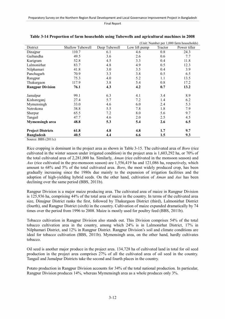
Preparatory Survey on the Northern Region Rural Development and Local Governance Improvement Project in Bangladesh
Final Report
3-12
Table 3-14 Proportion of farm households using Tubewells and agricultural machines in 2008 (Unit: Number per 1,000 farm households)
District Shallow Tubewell Deep Tubewell Low lift pump Tractor Power tiller Dinajpur 110.7 6.1 4.6 0.8 24.3 Gaibandha 49.5 3.6 2.6 0.6 7.7 Kurigram 52.8 4.5 3.3 0.4 11.8 Lalmonirhat 83.7 4.8 4.9 0.5 12.3 Nilphamari 41.8 3.0 3.5 0.4 3.9 Panchagarh 70.9 3.3 3.8 0.5 6.5 Rangpur 75.3 4.0 5.2 1.1 13.5 Thakurgaon 117.9 3.8 5.4 0.8 17.2 Rangpur Division 76.1 4.3 4.2 0.7 13.2 Jamalpur 99.1 6.3 4.1 3.4 8.9 Kishoreganj 27.4 5.7 7.2 1.4 6.2 Mymensingh 33.0 4.6 6.0 2.4 5.3 Netrokona 38.8 5.5 7.8 1.8 7.9 Sherpur 65.5 7.2 8.0 5.6 9.7 Tangail 47.7 4.6 2.0 2.5 4.5 Mymensingh area 48.8 5.3 5.4 2.6 6.5 Project Districts 61.8 4.8 4.8 1.7 9.7 Bangladesh 40.5 4.4 6.6 1.5 9.3 Source: BBS (2011c) Rice cropping is dominant in the project area as shown in Table 3-15. The cultivated area of Boro (rice cultivated in the winter season under irrigated condition) in the project area is 1,603,292 ha, or 70% of the total cultivated area of 2,281,000 ha. Similarly, Aman (rice cultivated in the monsoon season) and Aus (rice cultivated in the pre-monsoon season) are 1,556,419 ha and 121,086 ha, respectively, which amount to 68% and 5% of the total cultivated area. Boro, the most widely produced crop, has been gradually increasing since the 1980s due mainly to the expansion of irrigation facilities and the adoption of high-yielding hybrid seeds. On the other hand, cultivation of Aman and Aus has been declining over the same period (BBS, 2011b). Rangpur Division is a major maize producing area. The cultivated area of maize in Rangpur Division is 125,936 ha, comprising 44% of the total area of maize in the country. In terms of the cultivated area size, Dinajpur District ranks the first, followed by Thakurgaon District (third), Lalmonirhat District (fourth), and Rangpur District (sixth) in the country. Cultivation of maize expanded dramatically by 74 times over the period from 1996 to 2008. Maize is mostly used for poultry feed (BBS, 2011b). Tobacco cultivation in Rangpur Division also stands out. This Division comprises 54% of the total tobacco cultivation area in the country, among which 24% is in Lalmonirhat District, 17% in Nilphamari District, and 12% in Rangpur District. Rangpur Division’s soil and climate conditions are ideal for tobacco cultivation (BBS, 2011b). Mymensingh area, on the other hand, hardly cultivates tobacco. Oil seed is another major produce in the project area. 134,728 ha of cultivated land in total for oil seed production in the project area comprises 27% of all the cultivated area of oil seed in the country. Tangail and Jamalpur Districts take the second and fourth places in the country. Potato production in Rangpur Division accounts for 34% of the total national production. In particular, Rangpur Division produces 14%, whereas Mymensingh area as a whole produces only 3%.
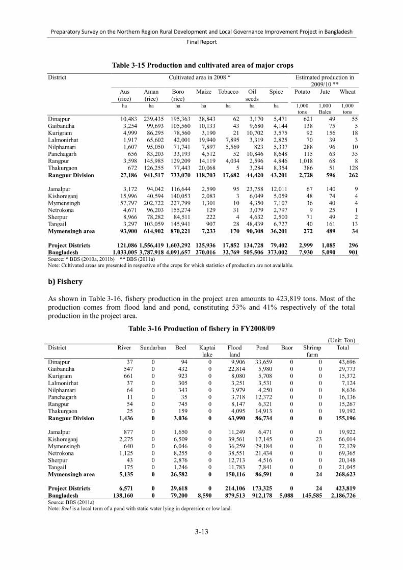
Preparatory Survey on the Northern Region Rural Development and Local Governance Improvement Project in Bangladesh
Final Report
3-13
Table 3-15 Production and cultivated area of major crops District Cultivated area in 2008 * Estimated production in
2009/10 **
Aus (rice)
Aman (rice)
Boro (rice)
Maize Tobacco Oil seeds
Spice Potato Jute Wheat
ha ha ha ha ha ha ha 1,000 tons
1,000 Bales
1,000 tons
Dinajpur 10,483 239,435 195,363 38,843 62 3,170 5,471 621 49 55 Gaibandha 3,254 99,693 105,560 10,133 43 9,680 4,144 138 75 5 Kurigram 4,999 86,295 78,560 3,190 21 10,702 3,575 92 156 18 Lalmonirhat 1,917 65,602 42,001 19,940 7,895 3,319 2,825 70 39 3 Nilphamari 1,607 95,050 71,741 7,897 5,569 823 5,337 288 96 10 Panchagarh 656 83,203 33,193 4,512 52 10,846 8,648 115 63 35 Rangpur 3,598 145,985 129,209 14,119 4,034 2,596 4,846 1,018 68 8 Thakurgaon 672 126,255 77,443 20,068 5 3,284 8,354 386 51 128 Rangpur Division 27,186 941,517 733,070 118,703 17,682 44,420 43,201 2,728 596 262 Jamalpur 3,172 94,042 116,644 2,590 95 23,758 12,011 67 140 9 Kishoreganj 15,996 40,594 140,053 2,083 3 6,049 5,059 48 74 4 Mymensingh 57,797 202,722 227,799 1,301 10 4,350 7,107 36 40 4 Netrokona 4,671 96,203 155,274 129 31 3,079 2,797 9 25 1 Sherpur 8,966 78,282 84,511 222 4 4,632 2,500 71 49 2 Tangail 3,297 103,059 145,941 907 28 48,439 6,727 40 161 13 Mymensingh area 93,900 614,902 870,221 7,233 170 90,308 36,201 272 489 34 Project Districts 121,086 1,556,419 1,603,292 125,936 17,852 134,728 79,402 2,999 1,085 296 Bangladesh 1,033,005 3,787,918 4,091,657 270,016 32,769 505,506 373,002 7,930 5,090 901 Source: * BBS (2010a, 2011b) ** BBS (2011a) Note: Cultivated areas are presented in respective of the crops for which statistics of production are not available. b) Fishery As shown in Table 3-16, fishery production in the project area amounts to 423,819 tons. Most of the production comes from flood land and pond, constituting 53% and 41% respectively of the total production in the project area.
Table 3-16 Production of fishery in FY2008/09 (Unit: Ton)
District River Sundarban Beel Kaptai lake
Flood land
Pond Baor Shrimp farm
Total
Dinajpur 37 0 94 0 9,906 33,659 0 0 43,696 Gaibandha 547 0 432 0 22,814 5,980 0 0 29,773 Kurigram 661 0 923 0 8,080 5,708 0 0 15,372 Lalmonirhat 37 0 305 0 3,251 3,531 0 0 7,124 Nilphamari 64 0 343 0 3,979 4,250 0 0 8,636 Panchagarh 11 0 35 0 3,718 12,372 0 0 16,136 Rangpur 54 0 745 0 8,147 6,321 0 0 15,267 Thakurgaon 25 0 159 0 4,095 14,913 0 0 19,192 Rangpur Division 1,436 0 3,036 0 63,990 86,734 0 0 155,196 Jamalpur 877 0 1,650 0 11,249 6,471 0 0 19,922 Kishoreganj 2,275 0 6,509 0 39,561 17,145 0 23 66,014 Mymensingh 640 0 6,046 0 36,259 29,184 0 0 72,129 Netrokona 1,125 0 8,255 0 38,551 21,434 0 0 69,365 Sherpur 43 0 2,876 0 12,713 4,516 0 0 20,148 Tangail 175 0 1,246 0 11,783 7,841 0 0 21,045 Mymensingh area 5,135 0 26,582 0 150,116 86,591 0 24 268,623 Project Districts 6,571 0 29,618 0 214,106 173,325 0 24 423,819 Bangladesh 138,160 0 79,200 8,590 879,513 912,178 5,088 145,585 2,186,726 Source: BBS (2011a) Note: Beel is a local term of a pond with static water lying in depression or low land.

Preparatory Survey on the Northern Region Rural Development and Local Governance Improvement Project in Bangladesh
Final Report
3-14
c) Livestock Table 3-17 presents the proportion of households raising livestock or poultry and the numbers of livestock and poultry per household raising livestock or poultry. In the project area, fowls, cattle, goats, and ducks are popular, as respectively 55.8%, 45.6%, 26.3%, and 24.1% of all households raise them. A livestock farmer in the project area raises 2.6 cattle, 2.7 buffalos, 2.6 goats, 2.9 sheep, 6.3 fowls, 5.0 ducks, and 6.9 pigeons on average. These figures are at par with the national average.
Table 3-17 Proportion of households raising livestock and poultry and numbers of livestock and poultry in 2008
District Proportion of households raising livestock and poultry (%)
Numbers of livestock and poultry per household who raises them (heads)
Cattle Buffalo Goat Sheep Fowl Duck Pigeons Cattle Buffalo Goat Sheep Fowl Duck Pigeons Dinajpur 63.1 1.3 41.5 3.5 62.5 32.3 1.8 2.9 2.4 2.9 3.3 8.1 7.0 1.2 Gaibandha 47.0 0.3 21.3 4.8 55.4 29.9 1.3 2.6 3.4 2.7 2.8 6.2 4.4 11.3 Kurigram 45.6 0.4 24.5 8.8 64.8 37.8 2.7 2.6 2.8 2.3 2.3 6.0 4.7 8.8 Lalmonirhat 51.2 0.6 43.3 2.4 52.9 14.7 5.7 2.6 2.6 2.5 2.9 5.3 4.3 6.9 Nilphamari 46.7 0.5 31.7 0.9 46.9 14.1 2.9 2.6 2.8 2.4 3.6 5.5 4.6 7.6 Panchagarh 60.1 0.7 47.8 1.2 58.4 15.2 3.1 3.0 2.9 2.9 3.5 6.7 4.8 8.2 Rangpur 49.0 0.5 28.2 1.7 54.5 23.1 2.2 2.4 2.7 2.4 3.0 6.2 4.8 9.3 Thakurgaon 67.9 1.8 58.1 0.5 62.5 16.4 2.4 3.2 2.4 3.1 4.2 7.3 4.6 9.0 Rangpur Division 53.0 0.7 34.2 3.3 57.4 25.2 2.5 2.7 2.6 2.7 2.8 6.6 5.2 7.5 Jamalpur 38.3 0.6 22.0 2.4 59.0 20.0 1.9 2.5 2.8 2.4 2.9 6.1 4.6 9.4 Kishoreganj 35.6 0.4 12.3 0.4 52.8 19.0 2.5 2.3 2.5 2.0 3.4 5.7 4.9 5.2 Mymensingh 39.4 0.3 21.5 0.4 53.7 27.3 3.2 2.4 3.0 2.3 3.7 6.2 4.5 5.4 Netrokona 43.0 0.4 15.4 0.4 52.6 27.1 1.9 2.6 3.6 2.3 4.4 5.8 5.4 4.4 Sherpur 40.0 0.5 22.6 0.8 63.4 23.6 1.9 2.5 2.7 2.3 3.4 5.8 4.8 7.8 Tangail 38.0 0.3 18.9 2.4 49.7 20.0 3.0 2.5 3.2 2.7 2.9 5.9 4.5 7.6 Mymensingh area 38.8 0.4 19.0 1.1 54.2 23.1 2.6 2.4 2.9 2.4 3.1 6.0 4.7 6.4 Project Districts 45.6 0.5 26.3 2.2 55.8 24.1 2.5 2.6 2.7 2.6 2.9 6.3 5.0 6.9 Bangladesh 35.7 0.6 21.6 1.4 50.4 27.3 3.0 2.5 3.2 2.6 3.3 2.7 5.0 8.6 Source: BBS (2011c) (3) Industrial development and the private sector According to Table 3-18, 805,620 establishments in total operate in the Project area, accounting for 22% of all establishments in the country.34 The District-wise number of establishments varies between 20,000 and 120,000 across the Project area. The Districts with the large number of establishments are Mymensingh, Tangail, and Dinajpur. Most of the establishments in the project area are small establishments. The proportion of small establishments exceeds 97% in all project Districts as in the national average. The proportion is equally high in both urban and rural areas. In the project area, most of the establishments operate in rural areas. The ratio of establishments operating in rural areas is 74.6%, and this figure varies from 69% to 83% among Districts in the project area. Since the ratio of every Project District is above the national average of 62.6%, the concentration of establishments in rural areas is more intense in the project area than in the rest of the country. Permanent establishments create employment of 1.7 million people in the project area, 35 which
34 An establishment is defined as a basic unit of economic activity at a single location under single ownership. 35 Permanent establishments are defined as those having fixed locations and permanent structure lasting for more than a year.

Preparatory Survey on the Northern Region Rural Development and Local Governance Improvement Project in Bangladesh
Final Report
3-15
accounts for 20.9% of total employment. This proportion is smaller than the national average of 28.4%.
Table 3-18 Number of establishments and persons engaging in establishments District Number of establishments Persons engaging in
permanent establishments1 Total Composition in
size (%) Distribution in
locality (%) Number Proportion to
total employed population2 Small Large Urban Rural
Dinajpur 86,833 97.8 2.2 27.4 72.6 197,019 26.6 Gaibandha 62,655 98.4 1.6 21.4 78.6 124,841 21.5 Kurigram 42,621 97.7 2.3 25.1 74.9 95,119 20.1 Lalmonirhat 27,757 98.8 1.2 24.9 75.1 58,737 19.4 Nilphamari 47,988 98.4 1.6 27.9 72.1 96,199 23.1 Panchagarh 24,496 97.3 2.7 21.3 78.7 57,710 25.0 Rangpur 78,842 97.5 2.5 30.5 69.5 199,381 28.2 Thakurgaon 34,391 97.5 2.5 16.5 83.5 80,204 24.0 Rangpur Division 405,583 97.9 2.1 25.4 74.6 909,210 24.0 Jamalpur 54,724 98.7 1.3 30.2 69.8 104,886 17.7 Kishoreganj 59,859 98.7 1.3 28.1 71.9 129,913 18.4 Mymensingh 114,740 98.9 1.1 23.5 76.5 226,740 18.2 Netrokona 44,292 99.1 0.9 24.6 75.4 86,840 15.5 Sherpur 30,944 98.6 1.4 29.0 71.0 61,443 16.9 Tangail 95,478 97.2 2.8 22.3 77.7 189,955 20.7 Mymensingh area 400,037 98.4 1.6 25.4 74.6 799,777 18.2 Project Districts 805,620 98.2 1.8 25.4 74.6 1,708,987 20.9 Bangladesh 3,708,152 97.6 2.4 37.4 62.6 9,702,282 28.4 Source: BBS (2007a) Note: Small establishments are those which employ 1 to 9 persons. Large establishments are those which employ 10 or more persons. 1. Persons engaging in temporary establishments are not included. 2. The total number of employed people in 2001 according to the Population Census (National Series Vol. 1) is applied to calculate the proportion of persons engaging in permanent establishments to the total employed population. The distribution of establishments and population employed in the establishments across sectors are presented in Table 3-19. In both the project area and the rest of the country, more than half of establishments are involved in trade, and the other sectors are relatively insignificant. Trade establishments account for nearly 60% in the project area, and manufacture establishments 8.2%. The distribution of establishments by sector does not differ between the project area and the rest of the country. The distribution of employed population in establishments shows a similar pattern. In the project area, the population employed by trade and manufacture establishments accounts for 42.5% and 15.6%, respectively.

Preparatory Survey on the Northern Region Rural Development and Local Governance Improvement Project in Bangladesh
Final Report
3-16
Table 3-19 Distribution of establishments and population employed in establishments across sectors District Mining Manu-
facture Electri-
city, gas, water
Const- ruction
Trade Hotel, Restau-
rant
Transport, communi-
cation
Finance Real estate
Public admini- stration, defense
Edu- cation
Health, social works
Community, social, and personal services
Distribution of establishments Dinajpur 0.0 7.6 0.1 0.1 53.5 6.6 1.5 1.1 0.9 1.1 7.2 2.8 17.7 Gaibandha 7.9 0.0 0.1 58.8 5.5 1.1 0.9 0.6 0.6 7.5 1.7 15.3 Kurigram 0.0 7.5 0.0 0.1 55.8 6.2 1.3 0.8 0.6 1.2 7.4 1.4 17.8 Lalmonirhat 6.6 0.1 0.0 58.9 7.3 2.6 0.6 0.6 1.1 5.9 1.8 14.5 Nilphamari 0.0 5.8 0.1 0.0 59.2 6.3 1.7 0.8 0.6 0.9 7.8 1.5 15.1 Panchagarh 0.5 5.6 0.1 0.0 54.3 6.6 2.2 0.8 0.6 1.5 8.2 1.8 17.9 Rangpur 5.8 0.1 0.1 60.4 6.8 1.4 1.2 0.9 0.7 6.2 2.3 14.2 Thakurgaon 8.0 0.1 0.0 52.5 8.3 1.2 1.1 0.7 1.0 7.6 1.7 17.9 Rangpur Division 0.0 6.9 0.1 0.1 56.9 6.6 1.5 1.0 0.7 1.0 7.1 2.0 16.1 Jamalpur 0.0 8.1 0.1 0.1 60.1 4.3 1.7 1.0 1.2 1.3 6.2 1.7 14.2 Kishoreganj 0.0 10.2 0.0 0.0 59.9 6.2 1.9 0.5 1.2 0.9 4.6 0.9 13.5 Mymensingh 8.8 0.0 0.2 60.6 6.2 1.5 0.4 0.9 0.5 6.0 1.2 13.5 Netrokona 0.0 10.6 0.0 0.1 57.3 8.4 1.0 0.4 0.9 0.7 5.6 1.3 13.5 Sherpur 8.9 0.1 0.0 61.6 4.2 1.1 0.4 1.3 0.6 6.2 1.6 14.1 Tangail 0.0 10.5 0.0 0.0 58.8 4.3 1.7 0.9 1.1 0.8 5.1 1.1 15.7 Mymensingh area 0.0 9.5 0.0 0.1 59.7 5.6 1.6 0.6 1.1 0.8 5.6 1.3 14.2 Project Districts 0.0 8.2 0.1 0.1 58.3 6.1 1.5 0.8 0.9 0.9 6.4 1.7 15.2 Bangladesh 0.0 8.6 0.1 0.1 59.3 6.8 2.0 0.7 1.2 0.8 4.9 1.9 13.7
Distribution of population employed in establishments Dinajpur 0.2 16.5 0.3 0.1 36.9 7.4 1.6 3.2 0.7 4.1 13.9 3.4 11.6 Gaibandha 14.0 0.0 0.1 43.7 6.7 1.4 2.2 0.5 2.0 15.3 2.3 11.7 Kurigram 10.1 0.7 0.2 39.7 7.5 1.8 3.2 0.5 4.9 16.7 2.3 12.6 Lalmonirhat 11.7 0.2 0.1 42.0 9.9 4.0 2.2 0.5 4.0 11.5 2.4 11.5 Nilphamari 0.7 11.9 0.4 0.4 42.0 9.1 2.2 2.2 0.5 3.0 13.9 2.2 11.7 Panchagarh 3.6 12.4 0.1 0.0 34.6 7.4 2.1 3.0 0.5 5.4 15.7 2.9 12.3 Rangpur 16.4 0.4 0.4 39.0 7.5 2.5 3.0 0.7 4.2 11.8 3.2 10.9 Thakurgaon 15.6 0.9 0.3 35.6 8.2 1.6 3.5 0.7 3.1 16.8 2.3 11.6 Rangpur Division 0.3 14.3 0.4 0.2 39.2 7.8 2.0 2.8 0.6 3.8 14.1 2.8 11.6 Jamalpur 0.0 12.5 0.1 0.3 46.4 5.4 1.9 2.6 1.0 3.9 11.9 1.9 12.0 Kishoreganj 0.0 19.9 0.1 0.0 46.2 6.2 1.8 1.8 1.1 3.8 7.3 1.3 10.5 Mymensingh 16.5 0.1 0.5 47.0 6.6 1.7 1.3 0.9 2.5 11.1 1.7 10.2 Netrokona 0.2 15.2 0.1 0.1 48.9 8.2 1.2 1.1 0.8 2.5 10.7 1.6 9.2 Sherpur 16.0 0.2 0.0 50.3 5.8 1.1 1.4 1.1 1.9 9.9 1.8 10.7 Tangail 0.0 19.0 0.2 0.0 42.4 4.1 1.4 3.0 0.9 2.5 12.3 1.4 12.7 Mymensingh area 0.0 16.9 0.1 0.2 46.1 5.9 1.6 1.9 0.9 2.9 10.7 1.6 11.0 Project Districts 0.2 15.6 0.3 0.2 42.4 6.9 1.8 2.4 0.8 3.3 12.5 2.2 11.3 Bangladesh 0.1 23.8 0.3 0.3 39.7 6.4 2.0 2.4 1.2 3.5 8.7 2.3 9.2 Source: BBS (2007a) Note: Only permanent establishments are taken into account.
(4) Household income and expenditure As shown in Table 3-20, the labor force in the project area is 15 million people, out of which 2 million and 13 million live in urban and rural areas, respectively. The economic participation rate in the project area is 64.8%, which is 5.5% higher than the national average.36 The unemployment rate in the project area is 2.9% on average. Although the unemployment rate in the project area is below the national average, there is regional disparity between Project Districts and rural and urban areas, ranging from 0% to 10%.
36 According to BBS (2011f), economic participation rate is defined as the ratio of labor force to population aged 15 or above.

Preparatory Survey on the Northern Region Rural Development and Local Governance Improvement Project in Bangladesh
Final Report
3-17
Table 3-20 Labor force, economic participation rate, and unemployment rate in 2010
District Labor force (1,000 persons) Economic participation rate1 (%)
Unemployment rate (%) Total Urban Rural Total Urban Rural
Dinajpur 1,380 161 1,218 64.4 2.2 1.2 2.3 Gaibandha 926 70 855 61.5 2.5 0.0 2.6 Kurigram 926 145 781 65.6 1.6 0.7 1.8 Lalmonirhat 670 101 568 67.7 3.7 6.9 3.0 Nilphamari 810 122 689 65.2 1.9 4.1 1.6 Panchagarh 475 55 420 71.8 1.7 3.6 1.4 Rangpur 1,332 207 1,125 63.7 2.9 3.4 2.8 Thakurgaon 701 56 645 68.9 0.6 0.0 0.8 Rangpur Division 7,220 917 6,301 65.3 2.2 2.6 2.1 Jamalpur 1,054 162 891 67.1 3.3 4.9 2.9 Kishoreganj 1,246 174 1,071 62.7 3.9 7.5 3.3 Mymensingh 2,212 352 1,859 64.7 3.0 6.5 2.2 Netrokona 1,046 128 918 63.7 3.5 10.2 2.6 Sherpur 673 53 620 67.2 3.3 1.9 3.4 Tangail 1,600 227 1,372 63.1 4.1 4.4 3.9 Mymensingh area 7,831 1,096 6,731 64.4 3.5 6.2 3.0 Project Districts 15,051 2,013 13,032 64.8 2.9 4.6 2.6 Bangladesh 56,651 13,278 43,371 59.3 4.5 6.5 3.9 Source: BBS (2011f) Note: 1. Economic participation rate is the ratio of labor force to population aged 15 years and over. Table 3-21 reveals that the average household income and consumption in the Rangpur Division are the lowest among all the six Divisions. The monthly income in Rangpur Division is BDT 8,359, which is 27% below the national average.37 According to Table 3-22, the largest portion of household income comes from professional salary. Professional salary constitutes 35.6% of the total income. The portion of income from agriculture differs significantly between urban and rural areas. It is 5.6% in urban areas, and 29.7% in rural areas.
Table 3-22 Composition of household income by sources in 2010 (Unit: %)
Locality Agriculture Business and commerce
Professional salary
Housing services
Remittance and gift
Others
National 20.44 19.16 35.55 7.27 13.62 3.93 Urban 5.56 25.75 45.14 10.63 7.75 5.15 Rural 29.73 15.05 29.57 5.18 17.28 3.16 Source: BBS (2012)
37 Average income and consumption in Mymensingh area are not available.
Table 3-21 Monthly household income and consumption by Divisions in 2010
(Unit: BDT) Division Income Consumption Barisal 9,158 9,826 Chittagong 14,092 14,360 Dhaka 13,226 11,643 Khulna 9,569 9,304 Rajshahi 9,342 9,254 Rangpur 8,359 8,298 Sylhet 11,629 12,003 National 11,479 11,003 Source: BBS (2012)
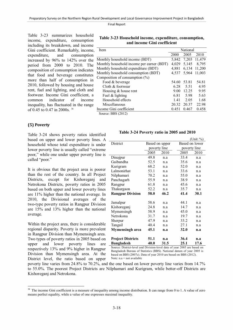
Preparatory Survey on the Northern Region Rural Development and Local Governance Improvement Project in Bangladesh
Final Report
3-18
Table 3-23 summarizes household income, expenditure, consumption including its breakdown, and income Gini coefficient. Remarkably, income, expenditure, and consumption increased by 96% to 142% over the period from 2000 to 2010. The composition of consumption indicates that food and beverage constitutes more than half of consumption in 2010, followed by housing and house rent, fuel and lighting, and cloth and footwear. Income Gini coefficient, a common indicator of income inequality, has fluctuated in the range of 0.45 to 0.47 in 2000s. 38 (5) Poverty Table 3-24 shows poverty ratios identified based on upper and lower poverty lines. A household whose total expenditure is under lower poverty line is usually called “extreme poor,” while one under upper poverty line is called “poor.” It is obvious that the project area is poorer than the rest of the country. In all Project Districts, except for Kishoreganj and Netrokona Districts, poverty ratios in 2005 based on both upper and lower poverty lines are 11% higher than the national average. In 2010, the Divisional averages of the two-type poverty ratios in Rangpur Division are 15% and 13% higher than the national average. Within the project area, there is considerable regional disparity. Poverty is more prevalent in Rangpur Division than Mymensingh area. Two types of poverty ratios in 2005 based on upper and lower poverty lines are respectively 13% and 9% higher in Rangpur Division than Mymensingh area. At the District level, the ratio based on upper poverty line varies from 24.8% to 70.2%, and the one based on lower poverty line varies from 14.7% to 55.0%. The poorest Project Districts are Nilphamari and Kurigram, while better-off Districts are Kishoreganj and Netrokona.
38 The income Gini coefficient is a measure of inequality among income distribution. It can range from 0 to 1. A value of zero means perfect equality, while a value of one expresses maximal inequality.
Table 3-23 Household income, expenditure, consumption, and income Gini coefficient
Item National 2000 2005 2010
Monthly household income (BDT) 5,842 7,203 11,479 Monthly household income per earner (BDT) 4,029 5,145 8,795 Monthly household expenditure (BDT) 4,881 6,134 11,200 Monthly household consumption (BDT) 4,537 5,964 11,003 Composition of consumption (%) Food & beverage 54.60 53.81 54.81 Cloth & footwear 6.28 5.51 4.95 Housing & house rent 9.00 12.25 9.95 Fuel & lighting 6.81 5.98 5.63 Household effects 1.41 2.05 1.68 Miscellaneous 20.32 20.37 22.98 Income Gini coefficient 0.451 0.467 0.458
Source: BBS (2012)
Table 3-24 Poverty ratio in 2005 and 2010 (Unit: %)
District Based on upper poverty line
Based on lower poverty line
2005 2010 2005 2010 Dinajpur 49.8 n.a 33.4 n.a Gaibandha 52.5 n.a 35.6 n.a Kurigram 68.2 n.a 52.0 n.a Lalmonirhat 53.1 n.a 33.6 n.a Nilphamari 70.2 n.a 55.0 n.a Panchagarh 55.9 n.a 38.9 n.a Rangpur 61.8 n.a 45.6 n.a Thakurgaon 52.2 n.a 35.7 n.a Rangpur Division 58.0 46.2 41.4 30.1 Jamalpur 58.6 n.a 44.1 n.a Kishoreganj 24.8 n.a 14.7 n.a Mymensingh 58.9 n.a 45.0 n.a Netrokona 31.7 n.a 19.7 n.a Sherpur 47.9 n.a 33.2 n.a Tangail 40.4 n.a 27.1 n.a Mymensingh area 45.1 n.a 32.0 n.a Project Districts 51.1 n.a 36.4 n.a Bangladesh 40.0 31.5 25.1 17.6 Source: District-level and Division-level data of year 2005 are based on Bangladesh Bureau of Statistics (BBS). National datum of year 2005 is based on BBS (2007c). Data of year 2010 are based on BBS (2012). Note: n.a = not available

Preparatory Survey on the Northern Region Rural Development and Local Governance Improvement Project in Bangladesh
Final Report
3-19
The progress in reducing poverty is remarkable as far as available data on poverty ratios indicate. Two types of poverty ratios declined more than 10% in Rangpur Division, and 7% in the whole country from 2005 to 2010. Poverty gap index and squared poverty gap index at the Division level are presented in Table 3-25.39 Rangpur Division is the worst among all the six Divisions in terms of both poverty gap and squared poverty gap.40 The indices of Rangpur Division are nearly double the national average. Table 3-26 presents the correlation between poverty and potential factors on poverty, i.e., education and landholdings. First, the incidence of poverty is negatively correlated with educational status of household heads, i.e., the poverty ratio of households measured by upper poverty line declines as educational status of household heads rises: 25.1% in household heads with no education; 15.8% with grade 1 to 5; 11.4% with grade 5 to 9; and 3.4% over grade 9. It is worth noting that the causality between poverty and educational attainment could go either way, indicating that the poor is likely to be trapped in a vicious circle, where not only 1) low educational attainments makes it difficult for the poor to escape from poverty, but also 2) poverty hampers educational attainment. The latter causality is supported by the evidence that the enrolment rates of children aged 6-10 and 11-15 are respectively 78.3% and 70.2% in poor households, which are much lower than 89% and 85.5% of non-poor households (BBS, 2012). Therefore, the substantial educational gap between poor and non-poor children implies that the poor is likely to suffer from a vicious cycle. Landholding size is also negatively correlated with the incidence of poverty, i.e., as landholding size increases, poverty ratio decreases. Indeed, the poverty ratio measured by upper poverty line is 27.8% among households with land less than 0.05 acre, 17.7% among households with 0.05-0.49 acre of land, 39 The poverty gap is the average gap between the poor’s living standards and poverty line, indicating the average extent to which overall people fall below the poverty line. The squared poverty gap indicates the weighted average gap from poverty line with a higher gap receiving greater weight, taking inequality among the poor into account. 40 Of the four indices regarding poverty gap and squared gap in Table 3-25, only one, squared poverty gap based on lower poverty line, is the second worst in Rangpur Division although the other three are the worst in Rangpur Division.
Table 3-25 Poverty gap index and squared poverty gap index in 2010
Division Based on upper poverty line
Based on lower poverty line
Poverty gap
Squared poverty gap
Poverty gap
Squared poverty gap
Barisal 9.8 3.4 5.4 1.6 Chittagong 5.1 1.5 2.2 0.6 Dhaka 6.2 1.8 2.7 0.7 Khulna 6.4 2.0 2.7 0.8 Rajshahi 6.2 1.9 2.8 0.7 Rangpur 11.0 3.5 5.5 1.4 Sylhet 4.7 1.3 3.3 0.9 National 6.5 2.0 3.1 0.8 Source: BBS (2012)
Table 3-26 Poverty ratio by educational status and size of landholdings in 2010
Characteristics of households
Poverty Ratio (%) Based on upper
poverty line Based on lower
poverty line Educational status of household heads
No education 25.1 42.8 Grade 1 to 5 15.8 35.7 Grade 5-9 11.4 22.6 Over grade 9 3.4 7.5
Landholding size (in acres)
No land 19.8 35.4 < 0.05 27.8 45.1 0.05-0.49 17.7 33.3 0.50-1.49 13.3 25.3 1.50-2.49 7.6 14.4 2.50-7.49 4.1 10.8 > 7.50 3.7 8.0
Source: BBS (2012)

Preparatory Survey on the Northern Region Rural Development and Local Governance Improvement Project in Bangladesh
Final Report
3-20
and 3.7% among households with 7.5 acres or more land. (6) Access to financial services Balances of bank loan and deposit are presented in Table 3-27. This data indicates that the access to and utilization of financial services in the project area is severely limited. In the project area, the growth in the balances of loan and deposit is significantly lower than the national average, and so are the balances per capita. A similar pattern can be found in every Project District. Comparison between urban and rural areas demonstrates that financial service is more widely available in urban areas than in rural areas. The balances per capita of loan and deposit in urban areas are respectively six times and 14 times larger than those in rural areas. This disparity between urban and rural areas prevails in every Project District.
Table 3-27 Balances of bank loan and deposit in FY2008/09 District Loan Deposit
Total balance (million BDT)
Growth from
FY2005/06 (%)
Balance per capita1 (BDT)
Total balance (million BDT)
Growth from
FY2005/06 (%)
Balance per capita1 (BDT)
Total Urban Rural Total Urban Rural Dinajpur 10,392 23 3,932 19,398 1,408 13,849 46 5,240 28,395 1,461 Gaibandha 5,662 14 2,648 9,709 1,939 5,390 34 2,521 14,159 1,352 Kurigram 3,964 15 2,212 5,656 1,580 3,967 40 2,213 9,077 953 Lalmonirhat 3,154 30 2,843 7,218 2,204 2,403 44 2,167 9,653 1,073 Nilphamari 6,683 29 4,252 17,869 1,848 5,878 54 3,740 18,948 1,055 Panchagarh 2,576 27 3,080 15,590 1,902 1,924 27 2,301 13,435 1,251 Rangpur 10,729 33 4,220 15,768 1,688 13,663 57 5,374 23,142 1,478 Thakurgaon 3,738 20 3,078 17,497 1,528 4,328 37 3,564 25,025 1,258 Rangpur Division 46,897 24 3,387 14,071 1,720 51,402 46 3,712 19,348 1,273 Jamalpur 7,688 11 3,649 10,040 2,456 7,161 48 3,399 14,126 1,397 Kishoreganj 6,133 32 2,363 8,842 1,330 11,065 63 4,264 22,596 1,340 Mymensingh 12,705 42 2,830 8,624 1,831 18,768 51 4,180 21,538 1,187 Netrokona 4,663 14 2,345 7,648 1,792 3,708 35 1,865 11,961 812 Sherpur 3,650 12 2,853 11,649 1,805 2,902 49 2,268 15,085 742 Tangail 5,351 9 1,626 6,326 904 23,026 58 6,997 30,611 3,372 Mymensingh area 40,190 23 2,552 8,515 1,629 66,632 54 4,230 21,168 1,610 Project Districts 87,087 24 2,942 11,124 1,672 118,034 50 3,988 20,313 1,452 Bangladesh 2,090,486 62 16,811 65,659 5,797 2,793,912 66 22,467 82,857 12,643 Source: Modified from BBS (2011i). Note: 1. Population in 2001 as per the Population Census 2001 is applied to calculate the balances per capita. Table 3-28 presents the coverage and disbursement of Grameen Bank that provides financial services in rural areas. The data clearly indicates that the Grameen Bank provides significant financial services for landless people, as the proportion of landless members to all households in the project area reaches 28%.41 Moreover, the amount of disbursement per landless member is BDT 48,294 in the project area, which is approximately equivalent to eight-month income of landless household.42
41 If it is taken into account that this proportion is not in relation to landless households but to all households, its financial services is more important for landless people than values of the proportion alone indicate. 42 The monthly income of landless household is BDT 5,713 on national average in 2010 (BBS, 2012).

Preparatory Survey on the Northern Region Rural Development and Local Governance Improvement Project in Bangladesh
Final Report
3-21
Table 3-28 Coverage and disbursement of Grameen bank in 2009 District Number of
covered villages Number of branches
Number of landless members
% to total households
Disbursement per landless member (BDT)
Dinajpur 1,244 29 103,988 15 38,325 Gaibandha 1,729 45 158,418 26 39,432 Kurigram 2,893 68 279,270 55 43,965 Lalmonirhat 2,105 50 184,056 63 66,400 Nilphamari 1,574 41 144,725 34 69,830 Panchagarh 780 24 86,345 38 63,127 Rangpur 1,090 37 161,085 22 36,409 Thakurgaon 2,468 69 246,522 77 62,370 Rangpur Division 13,883 363 1,364,409 36 52,425 Jamalpur 1,348 41 105,304 19 57,330 Kishoreganj 1,818 49 115,906 19 33,885 Mymensingh 3,372 106 350,196 30 36,724 Netrokona 1,736 49 142,437 30 29,106 Sherpur 989 32 79,579 24 65,816 Tangail 792 29 63,642 7 55,737 Mymensingh area 10,055 306 857,064 21 41,719 Project Districts 23,938 669 2,221,473 28 48,294 Bangladesh 83,566 2,539 7,670,203 24 54,614 Source: BBS (2007b, 2011i) Note: Population in 2001 is applied to calculate percentage of the members to the total population. (7) Access to information and communication technology Table 3-29 presents the access to land-line phone, mobile phone, computer, and e-mail by households of respective Divisions. 43 A remarkable feature is a widespread use of mobile phone among households, with 63.74% of the total households in the country. Furthermore, the access to mobile phone has been rapidly expanding, as the penetration rate in 2005 was only 11.29% nationwide (BBS, 2007c). By contrast, the access to the other information and communication facilities is still limited and expanding slowly. The access to land line-phone, computer and e-mail is limited to only 2.1%, 3.0%, and 1.4%, and these rates have not improved much since 2005. As for the disparity among six Divisions, Rangpur is lagging behind all other Divisions. It ranks the worst in terms of mobile phone and computer coverage, and the second worst in terms of land-line phone and e-mail coverage. (8) Comparison between economic development in urban and rural areas As the Project is to cover both urban and rural areas, it is important to understand the difference between urban and rural areas regarding current conditions of economic development. The following
43 Since the available data are disaggregated up to the Division level, it is difficult to figure out the situation in Mymensingh area.
Table 3-29 Percentage of households having information and communication facilities in 2010
(Unit: %) Division Land-line
phone Mobile phone
Computer E-mail
Barisal 1.14 59.56 1.41 0.65 Chittagong 3.02 70.84 3.61 1.70 Dhaka 2.38 71.71 4.70 2.35 Khulna 1.65 61.09 1.84 0.80 Rajshahi 1.33 59.85 1.33 0.20 Rangpur 1.25 41.59 0.70 0.43 Sylhet 2.76 60.63 4.51 1.73 National 2.07 63.74 3.01 1.39 Source: HIES2010
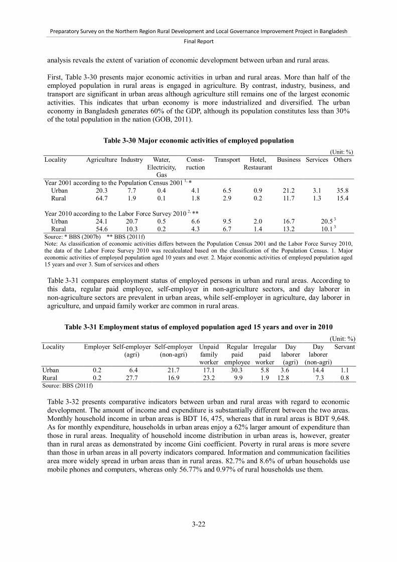
Preparatory Survey on the Northern Region Rural Development and Local Governance Improvement Project in Bangladesh
Final Report
3-22
analysis reveals the extent of variation of economic development between urban and rural areas. First, Table 3-30 presents major economic activities in urban and rural areas. More than half of the employed population in rural areas is engaged in agriculture. By contrast, industry, business, and transport are significant in urban areas although agriculture still remains one of the largest economic activities. This indicates that urban economy is more industrialized and diversified. The urban economy in Bangladesh generates 60% of the GDP, although its population constitutes less than 30% of the total population in the nation (GOB, 2011).
Table 3-30 Major economic activities of employed population (Unit: %)
Locality Agriculture Industry Water, Electricity,
Gas
Const- ruction
Transport Hotel, Restaurant
Business Services Others
Year 2001 according to the Population Census 2001 1, * Urban 20.3 7.7 0.4 4.1 6.5 0.9 21.2 3.1 35.8 Rural 64.7 1.9 0.1 1.8 2.9 0.2 11.7 1.3 15.4 Year 2010 according to the Labor Force Survey 2010 2, ** Urban 24.1 20.7 0.5 6.6 9.5 2.0 16.7 20.5 3
Rural 54.6 10.3 0.2 4.3 6.7 1.4 13.2 10.1 3 Source: * BBS (2007b) ** BBS (2011f) Note: As classification of economic activities differs between the Population Census 2001 and the Labor Force Survey 2010, the data of the Labor Force Survey 2010 was recalculated based on the classification of the Population Census. 1. Major economic activities of employed population aged 10 years and over. 2. Major economic activities of employed population aged 15 years and over 3. Sum of services and others Table 3-31 compares employment status of employed persons in urban and rural areas. According to this data, regular paid employee, self-employer in non-agriculture sectors, and day laborer in non-agriculture sectors are prevalent in urban areas, while self-employer in agriculture, day laborer in agriculture, and unpaid family worker are common in rural areas.
Table 3-31 Employment status of employed population aged 15 years and over in 2010 (Unit: %)
Locality Employer Self-employer (agri)
Self-employer (non-agri)
Unpaid family worker
Regular paid
employee
Irregular paid
worker
Day laborer (agri)
Day laborer
(non-agri)
Servant
Urban 0.2 6.4 21.7 17.1 30.3 5.8 3.6 14.4 1.1 Rural 0.2 27.7 16.9 23.2 9.9 1.9 12.8 7.3 0.8 Source: BBS (2011f)
Table 3-32 presents comparative indicators between urban and rural areas with regard to economic development. The amount of income and expenditure is substantially different between the two areas. Monthly household income in urban areas is BDT 16, 475, whereas that in rural areas is BDT 9,648. As for monthly expenditure, households in urban areas enjoy a 62% larger amount of expenditure than those in rural areas. Inequality of household income distribution in urban areas is, however, greater than in rural areas as demonstrated by income Gini coefficient. Poverty in rural areas is more severe than those in urban areas in all poverty indicators compared. Information and communication facilities area more widely spread in urban areas than in rural areas. 82.7% and 8.6% of urban households use mobile phones and computers, whereas only 56.77% and 0.97% of rural households use them.
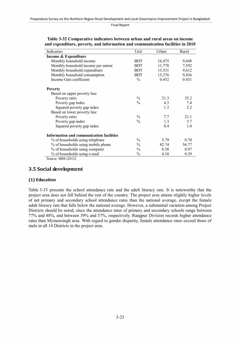
Preparatory Survey on the Northern Region Rural Development and Local Governance Improvement Project in Bangladesh
Final Report
3-23
Table 3-32 Comparative indicators between urban and rural areas on income and expenditure, poverty, and information and communication facilities in 2010 Indicators Unit Urban Rural Income & Expenditure
Monthly household income BDT 16,475 9,648 Monthly household income per earner BDT 11,778 7,592 Monthly household expenditure BDT 15,531 9,612 Monthly household consumption BDT 15,276 9,436 Income Gini coefficient % 0.452 0.431
Poverty
Based on upper poverty line Poverty ratio % 21.3 35.2 Poverty gap index % 4.3 7.4 Squared poverty gap index 1.3 2.2
Based on lower poverty line Poverty ratio % 7.7 21.1 Poverty gap index % 1.3 3.7 Squared poverty gap index 0.4 1.0
Information and communication facilities
% of households using telephone % 5.79 0.70 % of households using mobile phone % 82.74 56.77 % of households using computer % 8.58 0.97 % of households using e-mail % 4.10 0.39
Source: BBS (2012) 3.5 Social development (1) Education Table 3-33 presents the school attendance rate and the adult literacy rate. It is noteworthy that the project area does not fall behind the rest of the country. The project area attains slightly higher levels of net primary and secondary school attendance rates than the national average, except the female adult literacy rate that falls below the national average. However, a substantial variation among Project Districts should be noted, since the attendance rates of primary and secondary schools range between 77% and 88%, and between 39% and 57%, respectively. Rangpur Division records higher attendance rates than Mymensingh area. With regard to gender disparity, female attendance rates exceed those of male in all 14 Districts in the project area.

Preparatory Survey on the Northern Region Rural Development and Local Governance Improvement Project in Bangladesh
Final Report
3-24
Table 3-33 School attendance rate and adult literacy rate District Net school attendance rate in 2009 (%)* Female
adult literacy rate (%) Primary school Secondary school Total Male Female Total Male Female Year 2006 ** Year 2009 *
Dinajpur 88.3 86.7 90.1 57.6 51.3 65.2 66.9 76.2 Gaibandha 79.5 77.9 81.3 49.2 47.1 51.7 62.8 64.4 Kurigram 77.8 76.7 79.2 46.1 42.2 51.4 53.3 61.7 Lalmonirhat 82.4 81.2 83.8 53.3 47.9 60.4 62.4 68.1 Nilphamari 86.2 83.4 89.3 46.4 40.4 53.8 63.1 65.6 Panchagarh 81.8 78.2 85.9 56.2 52.0 61.1 67.9 71.6 Rangpur 81.3 79.4 83.4 53.3 48.7 59.4 74.2 73.6 Thakurgaon 85.0 83.7 86.6 53.1 50.8 55.9 67.5 69.2 Rangpur Division 82.9 81.1 85.0 52.1 47.5 57.9 65.1 69.4 Jamalpur 82.8 81.3 84.5 50.1 49.8 50.6 52.5 62.0 Kishoreganj 79.0 77.7 80.4 40.8 35.6 46.8 57.7 63.8 Mymensingh 81.3 79.8 83.0 46.7 43.5 50.3 68.7 65.5 Netrokona 77.1 76.4 78.0 39.6 35.5 44.5 59.6 61.4 Sherpur 77.5 74.8 80.5 41.2 37.3 46.3 50.7 56.9 Tangail 85.3 84.1 86.6 55.6 54.4 57.3 59.0 69.4 Mymensingh area 80.4 79.0 81.9 45.4 42.4 49.2 59.9 64.1 Project Districts 81.6 80.0 83.4 48.7 44.9 53.5 62.4 66.8 Bangladesh 81.3 80.2 82.5 49.0 45.5 53.0 69.9 72.0 Source: * BBS & UNICEF (2010) ** BBS & UNICEF (2008) Note: Literacy rate of women aged 15-24 years (2) Health As indicated in Table 3-34, the project area has higher infant mortality rates than the national average. In particular, Panchagarh, Nilphamari, Netrokona, and Gaibandha Districts suffer from high infant mortality rates—58%, 54%, 53%, and 52%, respectively, considerably exceeding the national average of 39%. It should be also noted that male infants experience a higher infant mortality rate than female ones. Table 3-35 illustrates the situations of birth delivery assistance in the project area. The ratio of assistance by skilled personnel in the project area is 6% below the national average of 24.4%. Mymensingh area is particularly low with 13.9%, whereas Rangpur Division is close to the national average. Traditional birth attendant, who is classified as unskilled personnel, is the most widely used type of assistants in the project area, accounting for 54.4%. However, this ratio varies significantly from 29.0% in Thakurgaon District to 81.9% in Netrokona District. It is worth noting that the assistance by relatives and friends is common in the project area, accounting for 28.6% and 18.5% in Rangpur Division and Mymensingh area, respectively.
Table 3-34 Infant mortality rates in 2009 District Infant mortality rate
(deaths/ 1,000 births) Total Male Female Dinajpur 36 27 44 Gaibandha 52 69 37 Kurigram 49 56 43 Lalmonirhat 42 55 27 Nilphamari 54 71 37 Panchagarh 58 80 36 Rangpur 41 54 30 Thakurgaon 33 53 12 Rangpur Division 46 58 33 Jamalpur 45 45 46 Kishoreganj 30 31 29 Mymensingh 40 43 37 Netrokona 53 58 47 Sherpur 48 34 60 Tangail 37 37 37 Mymensingh area 42 41 43 Project Districts 44 51 37 Bangladesh 39 42 36 Source: BBS (2011g) Note: The figures of Rangpur Division, Mymensingh area, and Project Districts are non-weighted averages calculated from District-level data.

Preparatory Survey on the Northern Region Rural Development and Local Governance Improvement Project in Bangladesh
Final Report
3-25
Table 3-35 Birth delivery assistance from 2007 to 2009 (Unit: %)
District Persons who assist birth delivery
Skilled personnel Auxiliary/ Midwife
Traditional birth
attendant
Community health worker
Relative/ friend
Other/ missing
No attendant Medical
doctor Nurse/
Midwife Sub total
Dinajpur 28.8 5.9 34.7 2.5 35.3 2.5 24.7 0.2 0.3 Gaibandha 8.4 1.6 10.0 0.3 58.2 0.8 29.2 0.3 1.2 Kurigram 11.6 2.7 14.3 0.2 49.2 1.5 33.9 0.9 0.0 Lalmonirhat 10.1 1.6 11.7 3.0 66.4 0.6 13.5 3.6 1.2 Nilphamari 15.1 3.8 18.9 2.0 41.6 0.4 35.4 1.2 0.4 Panchagarh 22.0 4.1 26.1 3.6 38.9 3.3 26.2 0.8 1.0 Rangpur 35.1 3.0 38.1 0.8 35.1 2.1 23.1 0.5 0.2 Thakurgaon 21.1 1.8 22.9 0.5 29.0 0.2 44.6 1.2 1.6 Rangpur Division 20.0 3.3 23.3 1.6 43.3 1.5 28.6 1.0 0.6 Jamalpur 10.3 2.4 12.7 0.8 38.1 0.9 46.1 0.3 1.0 Kishoreganj 9.3 4.4 13.7 3.1 68.3 0.7 13.6 0.1 0.6 Mymensingh 11.9 1.8 13.7 1.1 71.6 0.8 12.5 0.2 0.1 Netrokona 8.2 1.8 10.0 0.3 81.9 0.8 6.0 0.8 0.2 Sherpur 9.6 4.2 13.8 0.8 67.9 0.5 15.8 0.5 0.8 Tangail 16.6 2.0 18.6 0.0 53.0 0.6 26.7 0.7 0.4 Mymensingh area 11.1 2.8 13.9 1.2 64.9 0.7 18.5 0.4 0.5 Project Districts 15.4 3.0 18.4 1.4 54.4 1.1 23.4 0.7 0.6 Bangladesh 20.5 3.8 24.4 1.2 58.4 0.9 14.5 0.4 0.3 Source: BBS & UNICEF (2010) Note: The figures above are percentage of women aged 15-49 with a birth by type of personnel assisting birth delivery.
(3) Access to water and sanitation services As shown in Table 3-36, 99.4% of the people in the project area have access to improved drinking water sources. This proportion is slightly higher than the national average of 97.8%. With regard to composition of the improved sources, almost all improved sources in the project area are shallow Tubewells, which cover 97.8% of the population. This is much higher than the national average of 70.9%, but in the rest of the country, deep Tubewells and piped water cover much larger portions—16.1% and 9.7%, respectively. The data in Table 3-36 also reveals that people in the project area enjoy easier access to water than the rest of the country. The percentage of households having water sources on their premises in the project area is 14.6% higher than the national average. Furthermore, the mean time to the sources is 8.7 minutes in the project area, which is shorter than the national average of 12.2 minutes. It can thus be concluded that the project area has accomplished better access to drinking water although there is considerable scope for improving access to the piped water supply system.

Preparatory Survey on the Northern Region Rural Development and Local Governance Improvement Project in Bangladesh
Final Report
3-26
Table 3-36 Sources of drinking water in 2009 and time to sources in 2006 District Distribution of population by source of drinking water (%)* Time to source of drinking water**
Improved sources Unimproved sources
Proportion of households
with source on premises (%)
Mean time to source (minutes)1 Piped
water Shallow Tubewell
Deep Tubewell
Others Sub- total
Dinajpur 0.7 96.4 2.0 0.3 99.4 0.7 83.7 6.5 Gaibandha 0.8 97.3 0.5 0.5 99.1 1.0 85.8 8.0 Kurigram 0.9 91.2 7.5 0.1 99.7 0.2 87.0 7.3 Lalmonirhat 0.5 98.8 0.2 0.2 99.7 0.2 94.6 7.8 Nilphamari 0.1 98.5 0.6 0.3 99.5 0.4 86.9 7.0 Panchagarh 1.3 95.6 1.7 1.0 99.6 0.4 88.9 7.1 Rangpur 0.9 97.6 0.3 0.4 99.2 0.8 91.7 5.6 Thakurgaon 1.2 96.7 0.8 0.3 99.0 1.0 93.7 5.6 Rangpur Division 0.8 96.3 2.0 0.4 99.4 0.6 88.4 6.8 Jamalpur 0.2 98.4 0.7 0.2 99.5 0.5 89.7 9.4 Kishoreganj 0.6 91.2 7.5 0.3 99.6 0.2 70.2 8.6 Mymensingh 0.9 96.7 1.5 0.4 99.5 0.4 77.3 12.1 Netrokona 2.2 88.0 8.5 0.2 98.9 1.1 47.9 12.3 Sherpur 0.2 96.7 1.4 0.1 98.4 1.4 89.0 10.7 Tangail 0.7 98.0 0.3 0.8 99.8 0.1 86.3 9.1 Mymensingh area 0.9 94.3 3.8 0.4 99.4 0.5 77.4 10.5 Project Districts 0.8 95.3 2.9 0.4 99.4 0.6 82.6 8.7 Bangladesh 9.7 70.9 16.1 1.1 97.8 2.2 68.0 12.2
Source: * BBS & UNICEF (2010) ** BBS & UNICEF (2008) Note: Improved drinking water sources consist of piped water, public tap, borehole/Tubewell, protected well, and protected spring/rainwater. Other improved source includes protected well, protected spring, collected rainwater, pond sand filter, and bottled water. Unimproved source includes unprotected well, unprotected spring, and surface water. 1. Mean time to sources excluding sources on premises. Time to source of drinking water demotes time to go to source of drinking water, get water, and return. Table 3-37 presents distribution of households by toilet facility. The proportion of households using sanitary toilet facilities in the project area is 57.9%, which is below the national average by 6% points. 2.6% of the households in the project area do not use any kind of toilets. (4) Energy sources The distribution of households by source of light and fuel is presented in Table 3-38. With regard to sources of light, 39.5% of households use electricity in the project area. This electrification rate is significantly lower than the national average of 57.7%. The rate differs considerably among the Project Districts, ranging from 17% and 20% in Lalmonirhat and Kurigram Districts to 58% in Tangail District. In general, Rangpur Division is less electrified than Mymensingh area. The major sources of fuel in the project area are wood, bamboo, and straw. About 90% of the households use wood, bamboo, or straw. Gas is not widely used as a source of fuel in the project area as in the rest of the country.
Table 3-37 Toilet facilities of households in 2010 (Unit: %)
District Sanitary Others None Dinajpur 60.17 37.75 2.08 Gaibandha 54.92 42.01 3.07 Kurigram 62.75 34.66 2.59 Lalmonirhat 68.97 27.41 3.62 Nilphamari 59.77 36.15 4.07 Panchagarh 57.45 40.33 2.22 Rangpur 57.41 40.56 2.03 Thakurgaon 57.19 41.11 1.70 Rangpur Division 59.83 37.50 2.67 Jamalpur 51.64 45.28 3.07 Kishoreganj 55.56 43.07 1.37 Mymensingh 63.75 32.42 3.82 Netrokona 52.92 42.16 4.92 Sherpur 53.35 45.41 1.23 Tangail 54.13 44.79 1.08 Mymensingh area 55.23 42.19 2.58 Project Districts 57.86 39.51 2.63 Bangladesh 63.54 34.25 2.22 Source: BBS (2011h) Note: The figures of Rangpur Division, Mymensingh area, and Project Districts are non-weighted averages calculated from District-level data.
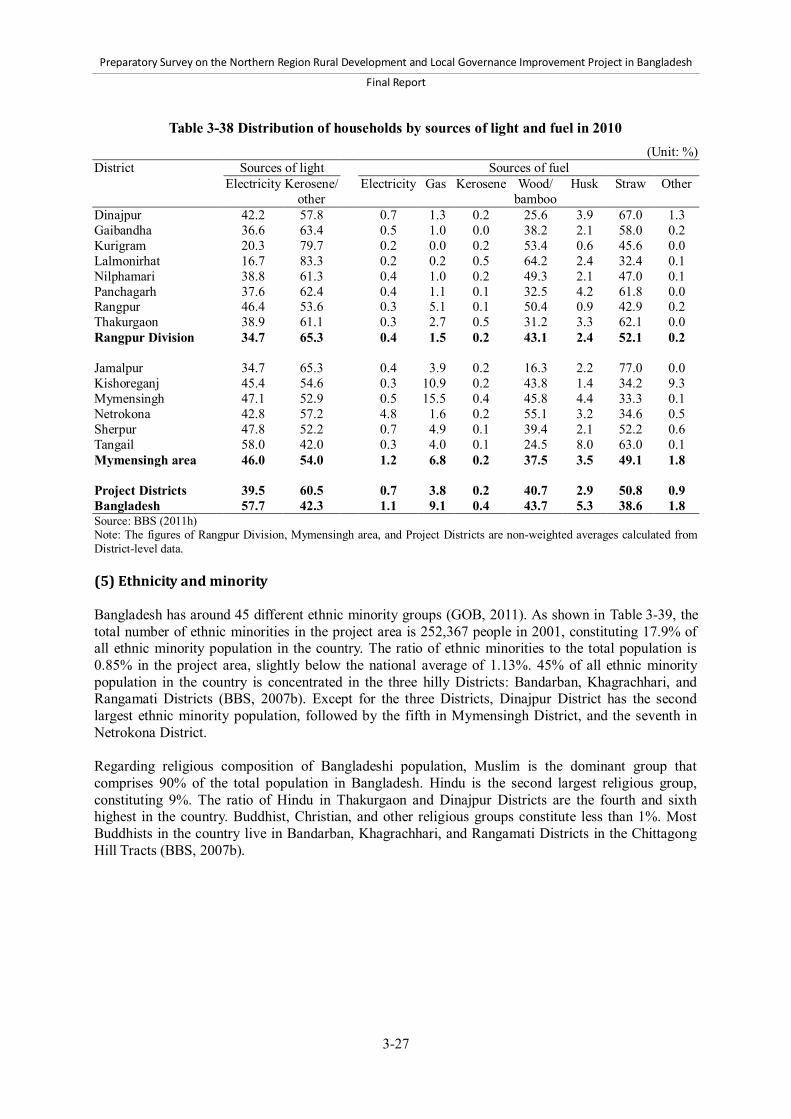
Preparatory Survey on the Northern Region Rural Development and Local Governance Improvement Project in Bangladesh
Final Report
3-27
Table 3-38 Distribution of households by sources of light and fuel in 2010 (Unit: %)
District Sources of light Sources of fuel Electricity Kerosene/
other Electricity Gas Kerosene Wood/
bamboo Husk Straw Other
Dinajpur 42.2 57.8 0.7 1.3 0.2 25.6 3.9 67.0 1.3 Gaibandha 36.6 63.4 0.5 1.0 0.0 38.2 2.1 58.0 0.2 Kurigram 20.3 79.7 0.2 0.0 0.2 53.4 0.6 45.6 0.0 Lalmonirhat 16.7 83.3 0.2 0.2 0.5 64.2 2.4 32.4 0.1 Nilphamari 38.8 61.3 0.4 1.0 0.2 49.3 2.1 47.0 0.1 Panchagarh 37.6 62.4 0.4 1.1 0.1 32.5 4.2 61.8 0.0 Rangpur 46.4 53.6 0.3 5.1 0.1 50.4 0.9 42.9 0.2 Thakurgaon 38.9 61.1 0.3 2.7 0.5 31.2 3.3 62.1 0.0 Rangpur Division 34.7 65.3 0.4 1.5 0.2 43.1 2.4 52.1 0.2 Jamalpur 34.7 65.3 0.4 3.9 0.2 16.3 2.2 77.0 0.0 Kishoreganj 45.4 54.6 0.3 10.9 0.2 43.8 1.4 34.2 9.3 Mymensingh 47.1 52.9 0.5 15.5 0.4 45.8 4.4 33.3 0.1 Netrokona 42.8 57.2 4.8 1.6 0.2 55.1 3.2 34.6 0.5 Sherpur 47.8 52.2 0.7 4.9 0.1 39.4 2.1 52.2 0.6 Tangail 58.0 42.0 0.3 4.0 0.1 24.5 8.0 63.0 0.1 Mymensingh area 46.0 54.0 1.2 6.8 0.2 37.5 3.5 49.1 1.8 Project Districts 39.5 60.5 0.7 3.8 0.2 40.7 2.9 50.8 0.9 Bangladesh 57.7 42.3 1.1 9.1 0.4 43.7 5.3 38.6 1.8 Source: BBS (2011h) Note: The figures of Rangpur Division, Mymensingh area, and Project Districts are non-weighted averages calculated from District-level data. (5) Ethnicity and minority Bangladesh has around 45 different ethnic minority groups (GOB, 2011). As shown in Table 3-39, the total number of ethnic minorities in the project area is 252,367 people in 2001, constituting 17.9% of all ethnic minority population in the country. The ratio of ethnic minorities to the total population is 0.85% in the project area, slightly below the national average of 1.13%. 45% of all ethnic minority population in the country is concentrated in the three hilly Districts: Bandarban, Khagrachhari, and Rangamati Districts (BBS, 2007b). Except for the three Districts, Dinajpur District has the second largest ethnic minority population, followed by the fifth in Mymensingh District, and the seventh in Netrokona District. Regarding religious composition of Bangladeshi population, Muslim is the dominant group that comprises 90% of the total population in Bangladesh. Hindu is the second largest religious group, constituting 9%. The ratio of Hindu in Thakurgaon and Dinajpur Districts are the fourth and sixth highest in the country. Buddhist, Christian, and other religious groups constitute less than 1%. Most Buddhists in the country live in Bandarban, Khagrachhari, and Rangamati Districts in the Chittagong Hill Tracts (BBS, 2007b).

Preparatory Survey on the Northern Region Rural Development and Local Governance Improvement Project in Bangladesh
Final Report
3-28
Table 3-39 Ethnic minority population and religious distribution of all population in 2001 District Ethnic minority Religious composition of all population (%)
Population Ratio of ethnic
minority (%)
% to total ethnic minority in the country
Muslim Hindu Buddhist Christian Others
Dinajpur 70,049 2.65 5.0 77.8 19.7 0.0 1.1 1.3 Gaibandha 8,578 0.40 0.6 92.5 7.2 0.0 0.1 0.2 Kurigram 3,243 0.18 0.2 93.0 6.9 0.0 0.0 0.1 Lalmonirhat 1,698 0.15 0.1 84.8 15.0 0.0 0.1 0.1 Nilphamari 3,498 0.22 0.2 83.5 16.4 0.0 0.1 0.1 Panchagarh 1,803 0.22 0.1 82.6 17.0 0.0 0.3 0.1 Rangpur 33,777 1.33 2.4 90.3 9.0 0.1 0.2 0.3 Thakurgaon 10,143 0.84 0.7 76.1 23.0 0.0 0.6 0.3 Rangpur Division 132,789 0.96 9.4 85.7 13.5 0.0 0.3 0.4 Jamalpur 5,065 0.24 0.4 98.1 1.8 0.0 0.0 0.1 Kishoreganj 3,523 0.14 0.2 93.7 6.2 0.0 0.0 0.1 Mymensingh 40,671 0.91 2.9 95.5 3.7 0.0 0.6 0.1 Netrokona 32,934 1.66 2.3 88.7 10.3 0.0 1.0 0.1 Sherpur 19,923 1.56 1.4 96.5 2.7 0.0 0.7 0.1 Tangail 17,462 0.53 1.2 92.5 7.1 0.0 0.4 0.0 Mymensingh area 119,578 0.76 8.5 94.2 5.3 0.0 0.4 0.1 Project Districts 252,367 0.85 17.9 90.2 9.2 0.0 0.4 0.2 Bangladesh 1,410,169 1.13 100.0 89.6 9.3 0.6 0.3 0.2 Source: (BBS, 2007b) (6) Socially vulnerable groups The following in this part describes the situations of child, youth, and slum dwellers. a) Child Table 3-40 presents summary indicators on child labor, birth registration, and girl’s early marriage. The prevalence of child labor, which is represented by the proportion of children aged 6-14 years not attending school but engaging in work, is lower in the project area than the national average. The proportion in the project area is 1.8% on average with variation between 0.9% and 3.0% depending on Project Districts. Boys are more likely to be engaged in child labor than girls. Birth registration should be considered as a fundamental mean to secure children rights.44 In the project area, only 53.1% of the children aged less than five years hold birth registration, which is around the national average of 53.6%. Among Project Districts, Tangail District records the lowest ratio of 36.8%. Early marriage of girls likely leads to the loss of education, employment opportunity, and decision-making power within household. Moreover, maternal and infant mortality rates are reportedly high among adolescent mothers (GOB, 2011). Early marriage of girls is more prevalent in the project area than in the rest of the country, with some variations among Project Districts. 41.7% of women aged 15 to 49 years in the project area married before 15th birthday, higher than the national average of 33.1%. Among the Project Districts, Kurigram District has the most frequent occurrence of the early marriage 59.0%, whereas Thakurgaon District has the least frequent occurrence 26.8%.
44 The International Convention on the Rights of the Child states that every child has the right to a name and a nationality and the right to protection from being deprived of his or her identity.
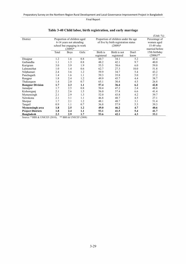
Preparatory Survey on the Northern Region Rural Development and Local Governance Improvement Project in Bangladesh
Final Report
3-29
Table 3-40 Child labor, birth registration, and early marriage (Unit: %)
District Proportion of children aged 6-14 years not attending
school but engaging in work (2009)*
Proportion of children under the age of five by birth registration status
(2009)*
Percentage of women aged 15-49 who
married before 15th birthday
(2006)** Total Boys Girls Birth is
registered Birth is not registered
Don't know
Dinajpur 1.2 1.6 0.8 60.7 34.1 5.2 43.4 Gaibandha 1.1 1.3 0.8 48.2 42.1 9.7 40.0 Kurigram 3.0 3.9 1.9 55.5 38.6 6.0 59.0 Lalmonirhat 1.0 1.4 0.6 62.7 27.3 10.0 51.8 Nilphamari 2.4 3.6 1.2 59.9 34.7 5.4 43.2 Panchagarh 1.4 1.6 1.1 59.3 35.8 5.0 37.2 Rangpur 1.8 2.4 1.2 49.9 45.7 4.4 38.7 Thakurgaon 1.4 2.0 0.7 65.1 30.4 4.5 26.8 Rangpur Division 1.7 2.3 1.1 57.4 36.4 6.2 42.8 Jamalpur 1.7 2.5 0.8 50.4 47.2 2.4 48.8 Kishoreganj 2.1 2.6 1.5 56.0 37.4 6.6 41.4 Mymensingh 2.1 2.9 1.3 52.0 43.8 4.2 39.7 Netrokona 2.1 3.1 1.1 46.8 48.7 4.5 27.1 Sherpur 1.7 2.1 1.2 48.1 48.7 3.1 51.4 Tangail 0.9 1.1 0.7 36.8 57.9 5.3 39.3 Mymensingh area 1.8 2.5 1.2 49.0 46.2 4.7 40.6 Project Districts 1.8 2.4 1.1 53.1 41.5 5.4 41.7 Bangladesh 2.3 2.9 1.7 53.6 42.1 4.3 33.1 Source: * BBS & UNICEF (2010), ** BBS & UNICEF (2008)

Preparatory Survey on the Northern Region Rural Development and Local Governance Improvement Project in Bangladesh
Final Report
3-30
b) Youth 9.2 million youths live in the project area, as presented in Table 3-41. The economic participation rate of the youth is 59.6% in the project area, higher than the national average of 53.2%. Among the economically inactive youths in the country, 78.1% of males and 25.6% of females are students, and 11.1% of males and 71.3% of females are engaged in household work (BBS, 2011f). This indicates that the relatively high economic participation rate in the project area is partly because of fewer males going to school and fewer females being engaged exclusively in household work. The unemployment rate in the project area is 4.5%, which is much lower than the national average of 7.4%. The rate is particularly low at 2.7% in Rangpur Division, whereas it is 6.2% in Mymensingh area.
Table 3-41 Youth population, economic participation rate, and unemployment rate in 2010 District Youth population aged 15 to
29 (1,000 persons) Economic participation
rate (%) Unemployment rate
(%) Total Male Female Total Male Female Total Male Female
Dinajpur 856 440 416 55.8 68.0 43.0 2.1 2.0 2.8 Gaibandha 603 268 335 53.7 70.1 40.6 4.6 3.7 5.1 Kurigram 536 277 259 59.0 78.3 38.2 3.5 2.8 5.1 Lalmonirhat 402 189 212 59.5 72.0 48.6 1.3 0.7 2.9 Nilphamari 479 239 239 55.9 71.1 41.0 1.9 1.2 2.0 Panchagarh 299 146 153 70.2 84.2 56.9 2.4 0.8 3.4 Rangpur 865 430 434 61.8 82.8 41.2 3.7 4.2 2.8 Thakurgaon 462 218 243 59.5 74.8 46.1 0.7 0.0 1.8 Rangpur Division 4,502 2,207 2,291 58.8 74.9 43.3 2.7 2.3 3.2 Jamalpur 593 281 313 61.2 70.5 52.7 6.3 5.1 7.9 Kishoreganj 806 385 420 58.7 77.9 41.2 7.2 3.7 13.9 Mymensingh 1,336 659 676 61.4 74.8 48.4 5.4 4.9 6.1 Netrokona 653 308 345 57.3 75.6 40.9 5.9 1.7 12.1 Sherpur 379 179 200 63.6 81.6 47.5 3.7 4.8 2.1 Tangail 966 451 516 61.0 74.3 49.2 7.5 10.4 3.5 Mymensingh area 4,733 2,263 2,470 60.4 75.3 46.8 6.2 5.3 7.4 Project Districts 9,235 4,470 4,761 59.6 75.1 45.1 4.5 3.8 5.4 Bangladesh 39,253 18,857 20,396 53.2 69.5 38.2 7.4 6.8 8.5 Source: BBS (2011f)

Preparatory Survey on the Northern Region Rural Development and Local Governance Improvement Project in Bangladesh
Final Report
3-31
c) Slum 160,934 people in total live in slums in the project area, constituting 18.2% of the total number of slum dwellers in the country (Table 3-42). The slum dwellers consist of 0.54% of the total population in the project area, with moderate variation from 0.03% in Tangail District to 1.53% in Thakurgaon District.
Table 3-42 Population and number of households in slum in 2001 District Slum population Ratio of slum
population (%) % to total slum
population in the country
Number of households in slum
Dinajpur 18,206 0.69 2.1 4,253 Gaibandha 11,497 0.54 1.3 2,754 Kurigram 9,874 0.55 1.1 2,071 Lalmonirhat 6,817 0.61 0.8 1,591 Nilphamari 10,678 0.68 1.2 2,286 Panchagarh 4,166 0.50 0.5 936 Rangpur 11,190 0.44 1.3 2,563 Thakurgaon 18,621 1.53 2.1 3,947 Rangpur Division 91,049 0.66 10.3 20,401 Jamalpur 5,673 0.27 0.6 1,324 Kishoreganj 12,755 0.49 1.4 2,788 Mymensingh 26,545 0.59 3.0 5,683 Netrokona 15,446 0.78 1.7 3,315 Sherpur 8,358 0.65 0.9 1,996 Tangail 1,108 0.03 0.1 267 Mymensingh area 69,885 0.44 7.9 15,373 Project Districts 160,934 0.54 18.2 35,774 Bangladesh 883,080 0.71 100.0 194,711 Source: BBS (2005) Table 3-43 presents indicators on conditions of slums with regard to education, health, sanitation, and child. It clearly indicates that slum dwellers suffer from extremely poor living conditions. Educational attainments of slum dwellers are far worse than those of non-slum dwellers. The net primary school attendance rate in slums is 16% lower than the national average. Furthermore, the primary school dropout rate in slums is six times the national average. As a result of this high dropout rate, only 48% of the pupils entering primary school in slums are able to reach grade 5, much lower than the national average of 79.8%. As for secondary education, the net attendance rate in slum is 30% lower, and the dropout rate is nearly four times the national average. The disparity between slums and the other area are also apparent in health and sanitation. The infant mortality rate in slums is 68 per 1,000 births, much higher than the national average of 49. The proportion of birth delivery assisted by skilled personnel in slums is 15.1%, much lower than the national average of 24.4%. These differences clearly indicate that slum dwellers live in extremely poor conditions of health services even by the standards of Bangladesh. As for sanitation, only 12% of the slum dwellers use sanitary toilets, which is less than one fourth of the national average. Children in slums are found in distressing situations. The prevalence of child labor in slums is nearly three times the national average. Only one fourth of the children in slums complete birth registration, which is nearly a half of the national average.

Preparatory Survey on the Northern Region Rural Development and Local Governance Improvement Project in Bangladesh
Final Report
3-32
Table 3-43 Indicators on conditions of slums regarding education, health, sanitation, energy source, and child
Indicators Year Unit Slum National Education
Net primary school attendance rate 2009 % 65.1 81.3 Primary school dropout rate (% of children who attended
primary school in 2008 but dropped out in 2009) 2009 % 7.9 1.2
% of pupils starting grade 1 who reach grade 5 2009 % 48.0 79.8 Net secondary school attendance rate 2009 % 18.3 49.0 Secondary school dropout rate (% of children who attended
secondary school in 2008 but dropped out in 2009) 2009 % 13.2 3.5
Health Infant mortality rate 2009 deaths per
1,000 births 68 49
% of birth delivery assisted by skilled personnel1 2007- 2009
% 15.1 24.4
Sanitation % of population using an sanitary facility 2009 % 12.0 51.5
Child Child labor: % of children aged 6-14 years not attending
school and engaging in work 2009 % 6.5 2.3
Birth registration: % of children under the age of five whose births are registered
2009 % 28.6 53.6
Source: * BBS & UNICEF (2010) Note: 1. The figures above are percentage of women aged 15-49 with a birth by type of personnel assisting birth delivery (7) Comparison between social development in urban and rural areas This section analyzes the disparity of social development between urban and rural areas based on Table 3-44. The analysis indicates that urban areas are more advanced than rural ones in social development. Educational conditions are slightly better in urban areas than in rural areas. Net attendance rates of primary and secondary schools in urban areas are respectively 3% and 5% higher than those in rural areas. In addition, urban areas are more advanced in health, sanitation, and water that in rural areas. The infant mortality rate is 2 points lower than that in rural areas. The percentage of birth delivery assisted by skilled personnel in urban areas is 26% higher than that in rural areas. 79% of the households in urban areas use sanitary toilets, much higher than 58.1% in rural areas. 99.5% of the urban population has access to an improved drinking water source, which is higher than 97.4% in rural areas. A larger portion of the urban population benefits from the supply of electricity and gas in comparison with the rural population. 24% of the urban population uses gas or electricity as source of fuel, a sharp contrast with only 2% of the rural population. 87% of the urban population uses electric light, nearly a double of 43% in rural areas. The child labor ratio is slightly higher in urban areas than in rural areas. The birth registration rate is almost the same in both areas. Early marriage is less common in urban areas than in rural ones. By contrast, the youth unemployment rate is much higher in urban areas than in rural ones.

Preparatory Survey on the Northern Region Rural Development and Local Governance Improvement Project in Bangladesh
Final Report
3-33
Table 3-44 Comparative indicators between urban and rural areas regarding education, health, sanitation, water, energy source, child, and youth
Indicators Year Unit Urban Rural Education
Net primary school attendance rate * 2009 % 83.9 80.8 Net secondary school attendance rate * 2009 % 53.2 48.0
Health Infant mortality rate *** 2010 Number per
1,000 births 35 37
% of birth delivery assisted by skilled personnel 1,* 2007- 2009
% 45.3 19.2
Sanitation % of households that have sanitary toilets *** 2010 % 79.7 58.1
Water % of population using improved drinking water source * 2009 % 99.5 97.4 % of households with source of drinking water on premises 2006 % 33.0 25.5 Mean time to source of drinking water * 2006 minutes 11.4 15.6
Energy source % of households whose fuel sources are gas or electricity *** 2010 % 24.1 2.0 % of households whose light sources are electricity *** 2010 % 87.0 43.2
Child Child labor: % of children aged 6-14 years not attending school and
engaging in work * 2009 % 3.0 2.2
Birth registration: % of children under the age of five whose births are registered *
2009 % 52.6 53.8
Early marriage: % of women aged 15-49 who married before 15th birthday **
2006 % 26.9 36.1
Youth Youth population aged 15 to 29 **** 2010 1,000
persons 10,075 29,178
Youth economic participation rate **** 2010 % 50.2 54.3 Youth unemployment rate **** 2010 % 9.9 6.7
Source: * BBS & UNICEF (2010) ** BBS & UNICEF (2008) *** BBS (2011h) **** BBS (2011f) Note: 1. The figures are percentage of women aged 15-49 with births in 2007-2009 that were assisted by skilled personnel. 2. The figures are percentage of women aged 15-49 with births in 2004-2006 that were delivered in health facilities. 3.6 Rural infrastructure development (1) Rural transport and trading infrastructure development The crucial importance of developing an efficient rural transport and trading infrastructure, in order to stimulate socioeconomic development and reduce rural poverty in Bangladesh, was formally recognized with the adoption in 1984 of the Strategy for Rural Development Projects (Planning Commission, 1984). The emphasis on infrastructure development for pro-poor rural growth is essential. Rural Bangladesh is fertile, but very densely populated. Productive agriculture is combined with a high degree of landlessness and functional landlessness. Productive farmers require good access to inputs and markets, while the landless must engage in the cash economy in order to meet their basic needs, and all rural people need access to health, education, administrative, and economic services. The result is a much more intensive demand for rural transport and trading than is the case in many other developing countries. An improved and efficient rural transport and trading infrastructure will reduce road user costs and costs of production, and thus facilitate socioeconomic development. It will contribute directly to the reduction of poverty by creating employment opportunities for all, including women, increasing the mobility of working people, and facilitating the distribution of capital and consumption goods. It will also support human resource development through improved access to health and education services. It is in this context that the current state of rural transport and trading infrastructure development in the Project area, and issues arising, are examined here.
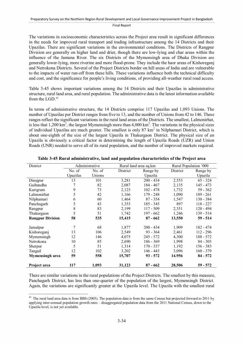
Preparatory Survey on the Northern Region Rural Development and Local Governance Improvement Project in Bangladesh
Final Report
3-34
The variations in socioeconomic characteristics across the Project area result in significant differences in the needs for improved rural transport and trading infrastructure among the 14 Districts and their Upazilas. There are significant variations in the environmental conditions. The Districts of Rangpur Division are generally on higher land and drier, though there are low-lying and char areas within the influence of the Jamuna River. The six Districts of the Mymensingh area of Dhaka Division are generally lower-lying, more riverine and more flood-prone. They include the haor areas of Kishoreganj and Netrokona Districts. Several of the Project Districts border on hill areas of India and are vulnerable to the impacts of water run-off from these hills. These variations influence both the technical difficulty and cost, and the significance for people’s living conditions, of providing all-weather rural road access. Table 3-45 shows important variations among the 14 Districts and their Upazilas in administrative structure, rural land area, and rural population. The administrative data is the latest information available from the LGD.45 In terms of administrative structure, the 14 Districts comprise 117 Upazilas and 1,093 Unions. The number of Upazilas per District ranges from five to 13, and the number of Unions from 42 to 146. These ranges reflect the significant variations in the rural land areas of the Districts. The smallest, Lalmonirhat, is less that 1,200 km2, the largest Mymensingh more than 4,000 km2. The variations in the physical sizes of individual Upazilas are much greater. The smallest is only 87 km2 in Nilphamari District, which is about one-eighth of the size of the largest Upazila in Thakurgaon District. The physical size of an Upazila is obviously a critical factor in determining the length of Upazila Roads (UZR) and Union Roads (UNR) needed to serve all of its rural population, and the number of improved markets required.
Table 3-45 Rural administrative, land and population characteristics of the Project area District Administrative Rural land area sq.km Rural Population ‘000
No. of Upazilas
No. of Unions
District Range by Upazila
District Range by Upazila
Dinajpur 13 101 3,281 200 - 434 2,553 65 - 324 Gaibandha 7 82 2,087 184 - 467 2,135 145 - 473 Kurigram 9 73 2,123 102 - 478 1,732 59 - 362 Lalmonirhat 5 42 1,166 179 - 248 1,090 189 - 261 Nilphamari 6 60 1,464 87 - 354 1,547 130 - 384 Panchagarh 5 43 1,353 185 - 345 897 118 - 227 Rangpur 8 83 2,199 117 - 509 2,351 120 - 494 Thakurgaon 5 51 1,742 197 - 662 1,246 139 - 514 Rangpur Division 58 535 15,415 87 - 662 13,550 59 - 514 Jamalpur 7 68 1,877 200 - 434 1,909 182 - 474 Kishoreganj 13 106 2,549 93 - 364 2,461 112 - 296 Mymensingh 12 146 4,075 245 - 572 4,300 188 - 572 Netrokona 10 85 2,690 186 - 369 1,998 84 - 303 Sherpur 5 51 1,314 170 - 337 1,192 156 - 383 Tangail 12 102 3,202 146 - 443 3,096 160 - 379 Mymensingh area 59 558 15,707 93 - 572 14.956 84 - 572 Project area 117 1,093 31,123 87 - 662 28,506 59 - 572
There are similar variations in the rural populations of the Project Districts. The smallest by this measure, Panchagarh District, has less than one-quarter of the population of the largest, Mymensingh District. Again, the variations are significantly greater at the Upazila level. The Upazila with the smallest rural
45 The rural land area data is from BBS (2005). The population data is from the same Census but projected forward to 2011 by applying inter-censual population growth rates – disaggregated population data from the 2011 National Census, down to the Upazila level, is not yet available.

Preparatory Survey on the Northern Region Rural Development and Local Governance Improvement Project in Bangladesh
Final Report
3-35
population, in Kurigram District, has only about one-tenth of the number of rural people of Phulpur Upazila in Mymensingh District (570,000 or more population). These major variations clearly imply significant differences among the Upazilas in the lengths of UZR and UNR need to provide access for their rural people, and in the numbers of improved markets required to facilitate efficient trading. Table 3-46 presents data on the rural population density and poverty characteristics of the Project Districts and Upazilas. The population density figures are calculated from the data used in Table 3-45. The poverty data, for poor and extreme poor people, is from BBS (2007c). The more recent, 2010 survey indicates a significant decline in poverty, though the regional dimensions of rural poverty remain essentially unchanged, but disaggregated data down to the Upazila level is not yet available. Although relatively old, the 2005 data is adequate for comparative analysis of variations within the project area. The rural population density of the Project Districts ranges from 660 persons per km2 in Panchagarh District to nearly 1,100 persons per km2 in Rangpur District. Again, there are much greater variations at the Upazila level. One Upazila in Netrokona District has a density of only 300 persons per km2, while another in Mymensingh District has nearly 1,800 persons per km2. Population density impacts on the needs for rural transport and trading infrastructure as follows: Lower population density areas cannot justify as many roads as those with higher densities, and
the roads in general will carry lower levels of traffic. Lower population density areas will have fewer markets, and each market is likely to have a
larger influence area, than in more densely populated areas. Rural poverty in the Project area is known to be higher than for Bangladesh as a whole, and is higher in Rangpur Division than in the Mymensingh area of Dhaka Division. By District, Nilphamari is the poorest and Netrokona the least poor. Again, there are significant variations at the Upazila level – the percentage of poor ranges from 20.7% to 75.7%, and of extreme poor from 12.0% to 61.5%. Given the Project Objective, consideration must be given to targeting investments in improved rural transport and trading infrastructure towards poorer Upazilas.
Preparatory Survey on the Northern Region Rural Development and Local Governance Improvement Project in Bangladesh
Final Report
3-36
Table 3-46 Rural population density and poverty characteristics of the Project area District Rural population density
per sq.km % poor % extreme poor
District Range by Upazila
District Range by Upazila
District Range by Upazila
Dinajpur 778 635 - 959 49.8 45.6 - 54.7 33.4 29.3 - 37.6 Gaibandha 1,023 489 - 1,266 52.5 50.0 - 60.0 35.6 33.3 - 42.7 Kurigram 816 406 - 1,139 68.2 64.0 - 73.9 52.0 47.3 - 58.8 Lalmonirhat 935 762 - 1,166 53.1 49.1 - 56.5 33.6 30.4 - 36.9 Nilphamari 1,057 776 - 1,495 70.2 59.2 - 75.7 55.0 43.2 - 61.5 Panchagarh 663 630 - 684 55.9 47.9 - 58.6 38.9 31.1 - 42.0 Rangpur 1,069 938 - 1,063 61.8 55.3 - 67.0 45.6 40.2 - 50.1 Thakurgaon 715 637 - 777 52.2 50.5 - 55.6 35.7 34.0 - 38.6 Rangpur Division 879 406 - 1,495 58.0 45.6 - 75.7 41.4 29.3 - 61.5 Jamalpur 1,017 831 - 1,185 58.6 50.3 - 67.7 44.1 35.8 - 51.7 Kishoreganj 965 394 - 1,768 24.8 20.7 - 34.8 14.7 12.0 - 22.1 Mymensingh 1,055 758 - 1,300 58.9 50.7 - 68.0 45.0 38.0 - 53.7 Netrokona 743 302 - 952 31.7 28.7 - 34.6 19.7 17.5 - 21.8 Sherpur 907 680 - 1,139 47.9 46.1 - 53.0 33.2 31.6 - 37.8 Tangail 967 564 - 1,423 40.4 33.6 - 48.4 27.1 21.7 - 33.8 Mymensingh area 952 302 - 1,768 45.1 20.7 - 68.0 32.0 12.0 - 53.7 Project area 916 302 - 1,768 51.1 20.7 - 75.7 36.4 12.0 - 61.5
(2) Current status of rural transport and trading infrastructure development
As has been discussed earlier, it is clearly stated in the national policies and strategies to: 1) develop an efficient all-weather rural road network in order to link Growth Centers, rural markets, Union, and Upazila headquarters and provide connectivity between rural and urban areas; 2) provide efficient and hygienic trading conditions in Growth Centers and other important rural markets; and 3) integrate rural road and waterway transport. This section examines the current state of development of this rural transport and trading infrastructure in the Project area. a) Rural roads Although every District and Upazila in the Project area has numerous Village roads, the main focus is on the development of UZR and UNR. Table 3-47 summarizes the current extent and level of development of UZR and UNR in the Project area. There are just over 9,000 km of UZR and about 12,000 km of UNR, with Rangpur Division having a greater length of roads than the Mymensingh area. The Project area accounts for about 25% of the total length of UZR and UNR in Bangladesh. 70% of the total length of UZR in the Project area is of all-weather standard, i.e., bitumen surfaced or, in a few cases, concrete paved, 75% in Rangpur Division and only 65% in the Mymensingh area, compared with the national average of 72%. Taking UZR and UNR together, about 46% of the total length in the Project area is all-weather, significantly below the national average of 54.5%. A characteristic of the rural road system in Bangladesh is that there are still about 215,000 m of “gaps” on UZR and UNR which need to be spanned by bridges and culverts. The gaps – which are a consequence of Bangladesh’s distinctive geography and the fact that in earlier years many of the rural road works were under food-for-work programs with no funds to construct cross-drainage structures - constitute a major constraint to rural mobility. In the Project area, there are still about 21,000 m of gaps on UZR, and more than 30,000 m on UNR. The total length of gaps is much greater in the Mymensingh area, with its

Preparatory Survey on the Northern Region Rural Development and Local Governance Improvement Project in Bangladesh
Final Report
3-37
low-lying riverine terrain, than in Rangpur Division. The extent of the problem in the Mymensingh area is illustrated by the following figures: Nationwide, there remain about 2.5 m of gaps per km of UZR, and 2.7 m per km of UNR. The equivalent figures for the Mymensingh area are 4.0 m per km and 3.8 m per km,
approximately 50% higher.
Table 3-47 Extent and level of development of UZR and UNR in the Project area District UZR UNR % roads all-weather
Length (km) Gaps (m) Length (km) Gaps (m) UZR UZR+UNR Dinajpur 1,085 1,173 1,337 2,718 75% 45% Gaibandha 599 721 765 1,551 77% 48% Kurigram 381 0 634 426 81% 56% Lalmonirhat 329 183 589 1,083 83% 47% Nilphamari 652 579 787 862 69% 43% Panchagarh 429 653 592 621 72% 49% Rangpur 869 582 1,048 1,611 74% 49% Thakurgaon 491 172 779 875 72% 38% Rangpur Division 4,835 4,063 6,530 9,746 75% 47% Jamalpur 618 4,799 783 4,277 61% 51% Kishoreganj 595 2,489 737 1,754 66% 51% Mymensingh 1,108 1,554 1,671 4,090 63% 40% Netrokona 624 2,514 857 4,592 56% 34% Sherpur 435 1,669 344 1,180 74% 55% Tangail 887 3,937 1,110 5,042 71% 51% Mymensingh area 4,267 16,961 5,501 20,934 65% 46% Project area 9,102 21,025 12,031 30,681 70% 46% Source: LGED Road Inventory Database In addition to the need for further investment in construction of bridges and culverts, particularly in the Mymensingh area, there are still nearly 3,000 km of UZR and over 11,000 km of UNR in the Project area that have not been developed to all-weather standard. Therefore, much remains to be done to achieve an all-weather rural road network. There are significant variations in the level of development of rural roads among the Districts. For UZR, the proportion of roads not to all-weather standard ranges from 17% in Lalmonirhat District to 44% in Netrokona District. For UZR and UNR together, the range is from 44% in Kurigram District to 66% in Netrokona District. At the Upazila level, there are much more significant variations. This is shown in Table 3-48 which presents data for the best served Upazila in each District (highest proportion of all-weather roads) and the worst served. In some Upazilas, all the UZR are already paved. In others, less than 50% are to this standard, and in one extreme case in Kishoreganj District, in a haor area, only 4% of the UZR are paved. Taking UZR and UNR together, all Upazilas still require further investment in road improvement, but to differing extents – in some Upazilas more than 80% of the important rural roads are already paved, in others less than 30%. In planning terms, the implication is that some priority should be given to upgrading roads in the Upazilas which are currently less well-served. The above analysis examines the level of development of the rural road network in terms of the extent to which it has already been improved to paved standard, and the need for additional cross-drainage structures. The other important consideration is the current condition of the paved roads, since some have subsequently deteriorated following their improvement as a result of inadequate maintenance. The LGED conducts annual road roughness surveys of all paved sections of UZR and some paved sections of

Preparatory Survey on the Northern Region Rural Development and Local Governance Improvement Project in Bangladesh
Final Report
3-38
UNR. The results are presented in the road inventory database as the average International Roughness Index (IRI) of each road. The assessment shows many roads with an average IRI greater than 8. The IRI is an average indicator of the road surface condition. IRI greater than 8 indicates significant deterioration in the surface and pavement condition of the previously constructed sealed pavement due to lack of adequate planned maintenance. These roads require rehabilitation works or, in some cases, periodic maintenance to bring them back in to good condition with an IRI of 4.
Table 3-48 Upazila-level variations in development of rural road network (Unit: %)
District UZR all-weather UZR+UNR all-weather Best served
Upazila Worst served
Upazila Best served
Upazila Worst served
Upazila Dinajpur 100 41 71 29 Gaibandha 100 59 62 36 Kurigram 100 48 80 28 Lalmonirhat 100 74 62 41 Nilphamari 77 58 55 30 Panchagarh 90 58 67 35 Rangpur 91 43 60 34 Thakurgaon 88 50 46 24 Rangpur Division 100 41 80 24 Jamalpur 82 29 68 34 Kishoreganj 100 4 83 13 Mymensingh 85 35 64 18 Netrokona 86 9 56 15 Sherpur 81 65 67 43 Tangail 94 42 54 34 Mymensingh area 100 4 83 13 Project area 100 4 83 13
Source: LGED Road Inventory Database b) Growth Centers and rural markets There are 543 Growth Centers (GC) in the Project area. Table 3-49 shows the average influence area of, and rural population served by, the Growth Centers in each Project District. The average influence area is about 60 km2 and is reasonably consistent across the Project Districts, though significantly higher in Thakurgaon District. The average rural population served is about 52,500, ranging from 42,500 in Netrokona District to nearly 63,000 in Gaibandha District. During the first field survey in April-May 2012, an exercise has been carried out, through the LGED and its District offices, to collect detailed data on the level of development of these Growth Centers and their physical and operational characteristics. It was assessed that many of the Growth Centers had already been improved, either comprehensively under foreign-financed projects, or specific improvement made using the Government of Bangladesh (GOB) funds. However, some of the improvement works were carried out more than 10 years ago, and rehabilitation works are now required.
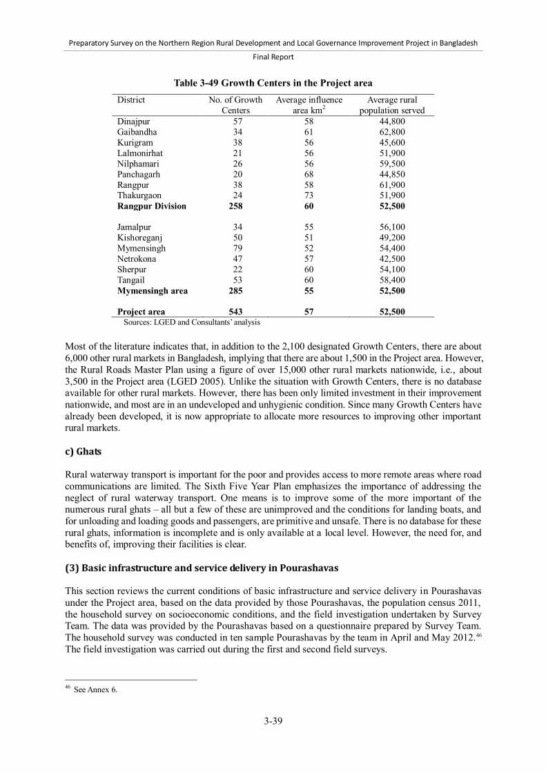
Preparatory Survey on the Northern Region Rural Development and Local Governance Improvement Project in Bangladesh
Final Report
3-39
Table 3-49 Growth Centers in the Project area District No. of Growth
Centers Average influence
area km2 Average rural
population served Dinajpur 57 58 44,800 Gaibandha 34 61 62,800 Kurigram 38 56 45,600 Lalmonirhat 21 56 51,900 Nilphamari 26 56 59,500 Panchagarh 20 68 44,850 Rangpur 38 58 61,900 Thakurgaon 24 73 51,900 Rangpur Division 258 60 52,500 Jamalpur 34 55 56,100 Kishoreganj 50 51 49,200 Mymensingh 79 52 54,400 Netrokona 47 57 42,500 Sherpur 22 60 54,100 Tangail 53 60 58,400 Mymensingh area 285 55 52,500 Project area 543 57 52,500
Sources: LGED and Consultants’ analysis Most of the literature indicates that, in addition to the 2,100 designated Growth Centers, there are about 6,000 other rural markets in Bangladesh, implying that there are about 1,500 in the Project area. However, the Rural Roads Master Plan using a figure of over 15,000 other rural markets nationwide, i.e., about 3,500 in the Project area (LGED 2005). Unlike the situation with Growth Centers, there is no database available for other rural markets. However, there has been only limited investment in their improvement nationwide, and most are in an undeveloped and unhygienic condition. Since many Growth Centers have already been developed, it is now appropriate to allocate more resources to improving other important rural markets. c) Ghats Rural waterway transport is important for the poor and provides access to more remote areas where road communications are limited. The Sixth Five Year Plan emphasizes the importance of addressing the neglect of rural waterway transport. One means is to improve some of the more important of the numerous rural ghats – all but a few of these are unimproved and the conditions for landing boats, and for unloading and loading goods and passengers, are primitive and unsafe. There is no database for these rural ghats, information is incomplete and is only available at a local level. However, the need for, and benefits of, improving their facilities is clear. (3) Basic infrastructure and service delivery in Pourashavas This section reviews the current conditions of basic infrastructure and service delivery in Pourashavas under the Project area, based on the data provided by those Pourashavas, the population census 2011, the household survey on socioeconomic conditions, and the field investigation undertaken by Survey Team. The data was provided by the Pourashavas based on a questionnaire prepared by Survey Team. The household survey was conducted in ten sample Pourashavas by the team in April and May 2012.46 The field investigation was carried out during the first and second field surveys.
46 See Annex 6.
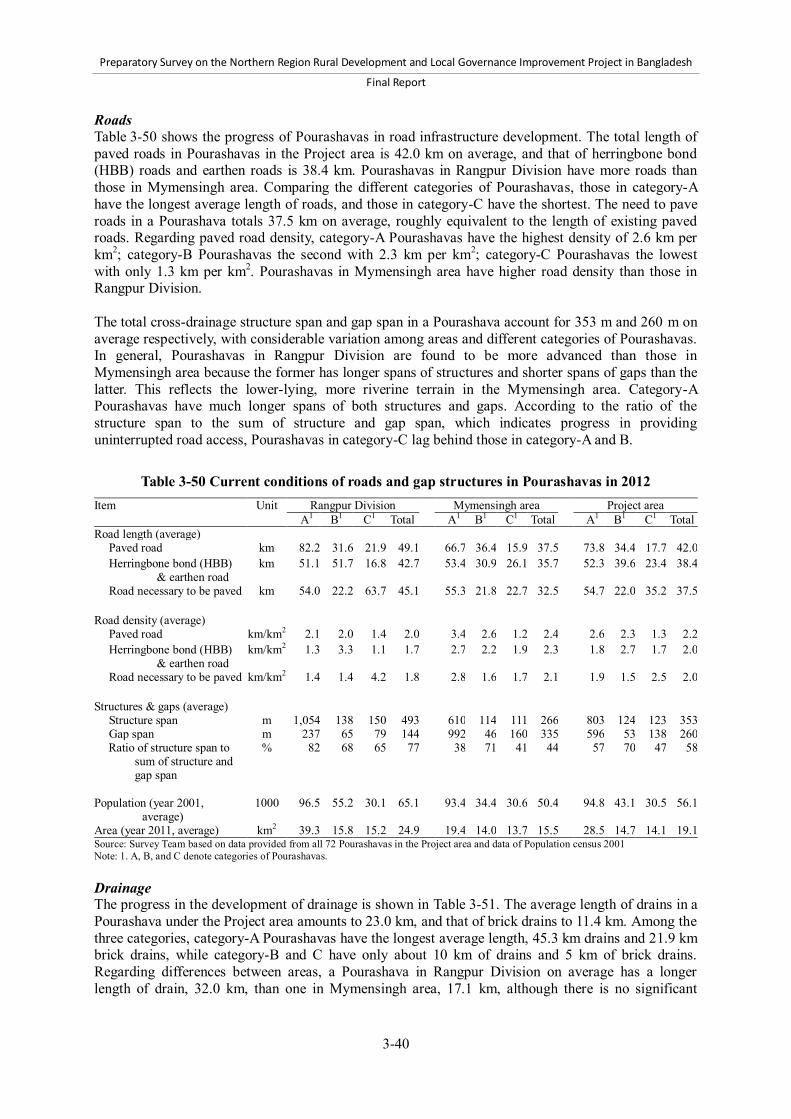
Preparatory Survey on the Northern Region Rural Development and Local Governance Improvement Project in Bangladesh
Final Report
3-40
Roads Table 3-50 shows the progress of Pourashavas in road infrastructure development. The total length of paved roads in Pourashavas in the Project area is 42.0 km on average, and that of herringbone bond (HBB) roads and earthen roads is 38.4 km. Pourashavas in Rangpur Division have more roads than those in Mymensingh area. Comparing the different categories of Pourashavas, those in category-A have the longest average length of roads, and those in category-C have the shortest. The need to pave roads in a Pourashava totals 37.5 km on average, roughly equivalent to the length of existing paved roads. Regarding paved road density, category-A Pourashavas have the highest density of 2.6 km per km2; category-B Pourashavas the second with 2.3 km per km2; category-C Pourashavas the lowest with only 1.3 km per km2. Pourashavas in Mymensingh area have higher road density than those in Rangpur Division. The total cross-drainage structure span and gap span in a Pourashava account for 353 m and 260 m on average respectively, with considerable variation among areas and different categories of Pourashavas. In general, Pourashavas in Rangpur Division are found to be more advanced than those in Mymensingh area because the former has longer spans of structures and shorter spans of gaps than the latter. This reflects the lower-lying, more riverine terrain in the Mymensingh area. Category-A Pourashavas have much longer spans of both structures and gaps. According to the ratio of the structure span to the sum of structure and gap span, which indicates progress in providing uninterrupted road access, Pourashavas in category-C lag behind those in category-A and B.
Table 3-50 Current conditions of roads and gap structures in Pourashavas in 2012 Item Unit Rangpur Division Mymensingh area Project area
A1 B1 C1 Total A1 B1 C1 Total A1 B1 C1 Total Road length (average)
Paved road km 82.2 31.6 21.9 49.1 66.7 36.4 15.9 37.5 73.8 34.4 17.7 42.0
Herringbone bond (HBB) & earthen road
km 51.1 51.7 16.8 42.7 53.4 30.9 26.1 35.7 52.3 39.6 23.4 38.4
Road necessary to be paved km 54.0 22.2 63.7 45.1 55.3 21.8 22.7 32.5 54.7 22.0 35.2 37.5
Road density (average)
Paved road km/km2 2.1 2.0 1.4 2.0 3.4 2.6 1.2 2.4 2.6 2.3 1.3 2.2
Herringbone bond (HBB) & earthen road
km/km2 1.3 3.3 1.1 1.7 2.7 2.2 1.9 2.3 1.8 2.7 1.7 2.0
Road necessary to be paved km/km2 1.4 1.4 4.2 1.8 2.8 1.6 1.7 2.1 1.9 1.5 2.5 2.0
Structures & gaps (average)
Structure span m 1,054 138 150 493 610 114 111 266 803 124 123 353 Gap span m 237 65 79 144 992 46 160 335 596 53 138 260 Ratio of structure span to
sum of structure and gap span
% 82 68 65 77 38 71 41 44 57 70 47 58
Population (year 2001,
average) 1000 96.5 55.2 30.1 65.1 93.4 34.4 30.6 50.4 94.8 43.1 30.5 56.1
Area (year 2011, average) km2 39.3 15.8 15.2 24.9 19.4 14.0 13.7 15.5 28.5 14.7 14.1 19.1 Source: Survey Team based on data provided from all 72 Pourashavas in the Project area and data of Population census 2001 Note: 1. A, B, and C denote categories of Pourashavas. Drainage The progress in the development of drainage is shown in Table 3-51. The average length of drains in a Pourashava under the Project area amounts to 23.0 km, and that of brick drains to 11.4 km. Among the three categories, category-A Pourashavas have the longest average length, 45.3 km drains and 21.9 km brick drains, while category-B and C have only about 10 km of drains and 5 km of brick drains. Regarding differences between areas, a Pourashava in Rangpur Division on average has a longer length of drain, 32.0 km, than one in Mymensingh area, 17.1 km, although there is no significant

Preparatory Survey on the Northern Region Rural Development and Local Governance Improvement Project in Bangladesh
Final Report
3-41
difference between them in terms of density of drains. With regard to the needs for construction of drains, the longest average length, 24.8 km, is identified in category-A Pourashavas. However, the density of drains demonstrates that all the three categories Pourashavas have similar degrees of need in terms of the requirement for drain construction per unit land area. The field investigation and household survey identified the scope for improving existing drains as well. The field investigation found a significant number of collapsed and clogged drains that should have been maintained and cleaned properly. The household survey pointed to considerable needs for cleaning, widening, deepening, and covering of existing drains as well as construction of new ones.
Table 3-51 Length and density of drains in Pourashavas in 2012 Item Unit Rangpur Division Mymensingh area Project area
A1 B1 C1 Total A1 B1 C1 Total A1 B1 C1 Total Drain length (average)
Drains km 58.9 16.1 10.2 32.0 33.8 10.3 8.4 17.1 45.3 12.7 9.0 23.0
Brick drains km 24.1 8.9 6.0 14.2 20.0 6.6 3.0 9.5 21.9 7.6 3.9 11.4
Drains necessary to be constructed
km 39.0 14.1 7.2 22.1 12.8 6.4 9.9 9.7 24.8 9.8 9.0 14.8
Drain density: drain length per area (average)
Drains km/km2 1.5 1.0 0.7 1.3 1.7 0.7 0.6 1.1 1.6 0.9 0.6 1.2
Brick drains km/km2 0.6 0.6 0.4 0.6 1.0 0.5 0.2 0.6 0.8 0.5 0.3 0.6
Drains necessary to be constructed
km/km2 1.0 0.9 0.5 0.9 0.7 0.5 0.7 0.6 0.9 0.7 0.6 0.8
Source: Survey Team based on data provided from all 72 Pourashavas in the Project area. Note: 1. A, B, and C denote categories of Pourashavas. Solid waste management According to Table 3-52, public and community waste collection points were operated in 74% of the Pourashavas in the Project area. This proportion considerably varies between different categories of Pourashavas, while it is not much different between areas. Category-A Pourashavas are most likely to have the collection points, and category-C are least likely. Coverage ratio of the collection points, which means the ratio of wards where the points were installed to the ones where they were not, is only about 50% on average in the Pourashavas where the points were installed. The average ratio of category-A Pourashavas, 60%, is the highest among the three categories, while those of category-B and C are 46% and 33% respectively. These results suggest considerable needs for expanding waste collection service in Pourashavas. The household survey also confirmed the needs for improving the solid waste management. For instance, it revealed that: 1) 60% of the respondents faced problems with waste disposal; 2) about a half of them scattered household wastes outside as a way to dispose of them; and 3) most of them raised the need of increasing and properly operating the collection points.
Table 3-52 Current conditions of solid waste collection points in Pourashavas in 2012 Item Unit Rangpur Division Mymensingh area Project area
A B C Total A B C Total A B C Total % of Pourashavas where public and
community waste collection points are operated
% 73 100 57 79 92 62 62 71 83 78 60 74
% of wards where public and community waste collection points are installed1
% 77 49 39 57 48 42 31 41 60 46 33 48
Source: Survey Team based on data provided from all 72 Pourashavas in the Project area. Note: 1. The average percentage was calculated only for Pourashavas having operational collection points.

Preparatory Survey on the Northern Region Rural Development and Local Governance Improvement Project in Bangladesh
Final Report
3-42
Water supply According to Table 3-53, only 29.2% of category-B Pourashavas and 4.2% of category-C have piped water supply. By contrast, 83.3% of category-A Pourashavas have piped water supply. The dominant source of drinking water in Pourashavas in the Project area is tubewells. 90% of the households in the Project area depend on tubewells. The coverage ratio of piped water supply is only 6.5% with variation across the categories of Pourashavas. The ratio reaches 12.4% in category-A Pourashavas, while it remains only 4.6% and 2.2% in category-B and C Pourashavas, respectively. It is worth noting that 2.7% of the households still depend on sources categorized as “other” which includes unsafe sources such as rivers and ponds. Regarding water quality of tubewells, the problems of arsenic, iron and manganese, turbidity, and microbe persist in 18.2%, 58.0%, 11.8%, and 38.2% of Pourashavas, respectively. Interestingly, Mymensingh area suffers from arsenic and turbidity, whereas none of the Pourashavas in Rangpur Division does. In the household survey, respondents identified not only the problems of water quality of tubewells but also ones of water quantity. One third of the respondents reported that they are facing problems of drinking water, and most of them were experiencing the decline in the ground water level.
Table 3-53 Conditions of water supply in Pourashavas Item Unit Rangpur Division Mymensingh area Project area
A B C Total A B C Total A B C Total % of Pourashavas where piped water
supply exist* % 90.9 30.0 0.0 46.4 76.9 28.6 5.9 34.1 83.3 29.2 4.2 38.9
Distribution of households by sources**
Tap (piped water) % 10.2 2.8 1.7 5.4 14.2 5.9 2.5 7.2 12.4 4.6 2.2 6.5 Tubewell % 88.3 95.5 96.0 92.8 83.3 90.9 93.7 89.5 85.6 92.8 94.5 90.8 Other % 1.5 1.8 2.4 1.8 2.5 3.3 3.8 3.2 2.1 2.6 3.3 2.7
% of Pourashavas having the following problems with water quality of tubewells1,
***
Arsenic % 0.0 0.0 0.0 0.0 9.1 35.7 37.5 29.3 4.8 21.7 27.3 18.2 Iron and manganese % 54.5 50.0 50.0 51.9 41.7 71.4 68.8 61.9 47.8 62.5 63.6 58.0 Turbidity % 0.0 0.0 0.0 0.0 8.3 21.4 25.0 19.0 4.3 13.0 18.2 11.8 Microbe % 36.4 50.0 16.7 37.0 50.0 30.8 37.5 39.0 43.5 39.1 31.8 38.2
Source: *Survey Team based on data of year 2012 provided from the Department of Public Health Engineering **Based on the population census 2011 ***Based on data of year 2012 provided from all 72 Pourashavas Note: 1. Percentages of Pourashavas that answered “yes” to the questions, “Do many tubewells in your Pourashava have arsenic, iron and manganese, turbidity, and microbial problems?” Sanitation In the Pourashavas under the Project area, 65.8% of the households have sanitary toilets at home, whereas 29.4% and 7.8% of them have non-sanitary toilets and no toilet facility, respectively. This indicates the needs for expanding the use of sanitary toilets. With regard to disparity between the different categories of Pourashavas, category-C Pourashavas lag behind category-A and B.

Preparatory Survey on the Northern Region Rural Development and Local Governance Improvement Project in Bangladesh
Final Report
3-43
Table 3-54 Distribution of households by toilet facilities in Pourashavas in 2011 Item Unit Rangpur Division Mymensingh area Project area
A B C Total A B C Total A B C Total Distribution of households by toilet facilities
Sanitary % 76.3 69.1 60.6 69.8 67.3 65.5 57.3 63.2 71.4 67.0 58.4 65.8 Non-sanitary % 23.5 25.6 34.5 27.0 28.9 29.4 34.2 31.0 26.4 27.8 34.3 29.4 None % 8.4 11.4 13.7 10.8 3.8 5.1 8.5 5.9 5.9 7.7 10.1 7.8
Source: *Survey Team based on the population census 2011 **Based on data of year 2012 provided from all 72 Pourashavas Bus and truck terminals The average number of existing bus terminals per Pourashava is 0.9 in the Project area (Table 3-55). Category-A Pourashavas have the highest number, on average 1.9 terminals, whereas category-B and C have only 0.6 and 0.7, respectively. The average number of new bus terminals to be constructed is 1.1 with a slight variation across the categories. Regarding the conditions of existing bus terminals, the household survey identified the needs to improve physical facilities at the terminals. The average numbers of existing and required new truck terminals are 0.5 and 1.1 in the Project area, respectively. There is little variation among the categories of Pourashavas in the number of required new truck terminals. By contrast, a significant variation is observed in the number of existing truck terminals, average 1.1 terminals in category-A Pourashavas, whereas only 0.3 and 0.1 in category-B and C.
Table 3-55 Number of bus and truck terminals in Pourashavas in 2012 Item Unit Rangpur Division Mymensingh area Project area
A B C Total A B C Total A B C Total Bus terminals
Average number of existing bus terminals 1 1.1 0.5 0.3 0.7 1.5 0.6 0.9 1.0 1.3 0.6 0.7 0.9 Average number of bus terminals to be
newly constructed 1 0.9 1.1 1.0 1.0 1.3 1.0 1.3 1.2 1.1 1.0 1.2 1.1
Truck terminals Average number of existing truck terminals 1 2.0 0.3 0.0 0.8 0.5 0.2 0.1 0.3 1.1 0.3 0.1 0.5 Average number of truck terminals to be
newly constructed 1 0.8 0.9 1.2 0.9 1.2 1.1 1.2 1.2 1.0 1.0 1.2 1.1
Source: Survey Team based on data provided from all 72 Pourashavas in the Project area Public markets According to Table 3-56, the average numbers of markets are the highest in category-A Pourashavas, which have 1.5 Growth Centers and 4.8 other urban markets, whereas the other two categories have only about 1.2 Growth Centers and 2.0 other urban markets.
Table 3-56 Number of markets in Pourashava in 2012 Item Unit Rangpur Division Mymensingh area Project area
A B C Total A B C Total A B C Total Average number of markets
GCs 1 1.8 1.3 1.1 1.5 1.2 1.2 1.0 1.1 1.5 1.3 1.0 1.3 Other urban markets 1 5.1 1.3 1.4 2.8 4.6 2.5 2.3 3.0 4.8 2.0 2.0 3.0
Source: Survey Team based on data provided from all 72 Pourashavas in the Project area Streetlights Category-A Pourashavas in the Project area have 2,773 streetlight poles on average, whereas category-B and C have only 340 and 195, respectively (Table 3-57). The average length of roads requiring installment of streetlight poles is significant: 195 km in category-A Pourashavas, 299 km in category-B, and 131 km in category-C. These data indicate substantial need for installing new streetlights. The household survey also identified the need to maintain existing streetlights, in

Preparatory Survey on the Northern Region Rural Development and Local Governance Improvement Project in Bangladesh
Final Report
3-44
particular to replace blown light bulbs.
Table 3-57 Number of and required installment of streetlights in Pourashavas in 2012 Item Unit Rangpur Division Mymensingh area Project area
A B C Total A B C Total A B C Total Average number of existing streetlight poles
1 2,924 361 102 1,338 2,623 327 239 925 2,773 340 195 1,092
Average length of roads requiring instalment of new streetlight poles
km 370 722 70 410 35 26 155 80 195 299 131 207
Source: Survey Team based on data provided from all 72 Pourashavas in the Project area Slaughterhouses As shown in Table 3-58, there are only 0.8 to 0.9 slaughterhouses per Pourashava in the Project area. There is no significant variation among the categories of Pourashavas. This suggests insufficiency of slaughterhouses and the need to construct them.
Table 3-58 Number of slaughterhouses in Pourashavas in 2012 Item Unit Rangpur Division Mymensingh area Project area
A B C Total A B C Total A B C Total Average number of slaughterhouses 1 1.1 0.8 1.2 1.0 0.7 0.9 0.8 0.8 0.9 0.8 0.9 0.9 Source: Survey Team based on data provided from all 72 Pourashavas in the Project area (4) Road safety in rural roads According to the National Road Traffic Accident Report 2010 by the Bangladesh Road Transport Authority (BRTA), the main features of road accidents in Bangladesh are as follows: The average number of accidents that caused death or injury (grievous and simple) in 2001-2010
is 2,457 and 807, respectively (Table 3-59). The average accident rate measured by the number of casualties per 10,000 people is 0.235 during the same period.
Table 3-59 Trend of road traffic accidents (2001 – 2010)
Year No. of accidents Accident (fatal + injury) rates (no. per 10,000 people) Fatal Grievous Simple injury Total
2001 2,029 642 137 2,808 0.228 2002 2,599 904 200 3,703 0.279 2003 2,752 921 239 3,912 0.290 2004 2,447 664 211 3,322 0.243 2005 2,424 631 142 3,197 0.231 2006 2,668 610 127 3,405 0.242 2007 2,893 679 172 3,744 0.263 2008 2,723 658 150 3,531 0.229 2009 2,153 469 69 2,691 0.184 2010 1,883 378 58 2,319 0.156 Average (2001-2010)
2,457 656 151 3,263 0.235
The casualty accident rates by District in the Project area in 2010 are shown in Figure 3-5. High
accident rates are observed in Lalmonirhat (0.266), Sherpur (0.173) and Tangail (0.160). By type of collision, nearly half of casualty accidents are “hit pedestrian,” which is followed by
“head on (18%)” and “rear end (15%)” (Figure 3-1). Two-thirds of casualty accidents occur on straight roads (Figure 3-2). A half of the vehicles that have caused casualty accidents are large vehicles, such as buses and

Preparatory Survey on the Northern Region Rural Development and Local Governance Improvement Project in Bangladesh
Final Report
3-45
trucks (Figure 3-3). Accident victims who fall under the age cohort 21-40 make up 46% of the total victims (Figure
3-4). In conclusion, the report states that there are 17 causes of accidents. Among these, the three
leading causes are “reckless driving,” “over-speeding,” and “over-loading.”
Figure 3-1 Casualty accidents by type of collision
Figure 3-2 Casualty accidents by type of road shape
Figure 3-3 Casualty accidents by type of vehicle
Figure 3-4 Number of road accident fatalities by age group
Traffic accidents result in huge economic losses for the country. Even more importantly, they bring a tragic loss to affected families. From the above figures reported, it is obvious that safety and its underlying causes have become one of the major issues in Bangladesh.

Preparatory Survey on the Northern Region Rural Development and Local Governance Improvement Project in Bangladesh
Final Report
3-46
Figure 3-5 Casualty accident rates by District in 2010
As discussed in Section 2.2.6, the government formulated the sixth National Road Safety Strategic Action Plan 2011-2013 in 2011 to improve road safety in Bangladesh. The activities laid out in this plan, however, focus mainly on national highways and main regional highways where traffic accidents occur most frequently. The issues of road safety and accidents in rural roads are less pronounced in the plan. However, once Upazila and Union roads are improved under the Project, it is expected that the number of traffic accidents will increase as drivers generally tend to increase speed on the newly improved roads. Anticipating the potential road safety risks, the Project will need to take preventive measures of road safety in both hard and soft aspects. The following road safety issues in rural areas should be taken into consideration in the scope of the Project: The improvement of rural roads will generate more traffic, particularly faster-moving, heavy
vehicles such as trucks and buses. Local people living along the roads, particularly children and older people, are unaware of the increased safety risks for pedestrians and operators of slow-moving vehicles (e.g., bicycles and rickshaws). Therefore, education and awareness-raising at completion of the improvement in roads are critical.
If improved rural roads are quire narrow, and the conflict between faster-moving, heavier traffic, and slow-moving vehicles is a real safety hazard. The provision of shoulders with adequate width, and preferably hard shoulders, is therefore crucial. This will enable slow-moving vehicles to move safely onto these shoulders in the face of faster, larger vehicles, even in the monsoon season when soft shoulders become muddy.
0.020
0.173
0.088
0.055
0.088
0.266
0.058
0.077
0.132
0.055
0.056
0.108 0.160
0.091
Dhaka City’s Average = 0.581
Bangladesh’s Average = 0.156

Preparatory Survey on the Northern Region Rural Development and Local Governance Improvement Project in Bangladesh
Final Report
3-47
It is common to find facilities such as educational, health, religious, and markets that cause traffic congestion near rural road alignments. The provision of specific safety design features at these locations is important to ensure safe passage of motor vehicles. 3.7 Local public administration in Project area 3.7.1 National government organizations This section discusses the key national public organizations in the Project area concerned with the implementation of the Northern Region Rural Development and Local Governance Improvement Project (NRRDLGIP). The analysis in this section focuses on the LGED field offices in the project area, since the LGED will be the Project’s implementing agency. Another key national government organization in the Project area is the Department of Public Health Engineering (DPHE). (1) LGED in the Project area a) Administrative classification Table 3-60 shows the field-level administrative classification of the LGED. In the Project area, the Rangpur Division is divided into the Rangpur and Dinajpur Regions, each of which includes four Districts. The northern area of the Dhaka Division is called the Mymensingh Region that includes six Districts. This new classification that added the Division level has been officially approved by the Ministry of Planning in May 2012, and two Division offices, Dhaka and Rajshahi, have been approved to be allocated revenue budget. Furthermore, the other five Division offices have been approved on September 10, 2012. The Regional offices have been functioning.47
Table 3-60 Administrative classification of LGED at the field level Divisions Total : 7
Regions Total: 14
Districts Total: 64
Dhaka Dhaka Dhaka, Gazipr, Mnkgnj, N-gonj, Munsigonj, Narsingdi (6) Mymensingh Mymensingh, Netrokona, Tangail, Kishoreganj, Sherpur, Jamalpur (6) Faridpur Faridpur, Rajbari, Gopalgonj, Madaripur, Shariatpur (5)
Chittagong Chittagong Chittagong, Coxbazar, Bandrbond, Rngmati, Kh.chari (5) Comilla Comilla, B-Baria, Chandpur, Noakhali, Feni, Laxmipur (6)
Sylhet Sylhet Sylhet, Sunamgonj, Moulvibazr, Hobigonj (4)
Barisal Barisal Barisal, Jhalokathi, Perojpur, Bhola (4) Patuakhali Patuakhali, Borguna (2)
Rajshahi Rajshahi Rajshahi, Nwbgnj, Natre, Naogn (3) Bogra Bogra, Joyprhat, Pabna, Sirajgnj (4)
Rangpur Rangpur Rangpur, Gaibandha, Lalmonirhat, Kurigram (4) Dinajpur Dinajpur, Nilphamari, Thakurgaon, Panchagarh (4)
Khulna Khulna Khlna, Bgerhat, Narail, Stkhira (4) Jessore Jessore, Jhenidah, Magura, Chuadanga, Meherpur, Kushtia (6) Source: Organogram of LGED Note: The Regions and Districts in the Project area are presented in boldface.
47 Interview with an Executive Engineer of the LGED on September 11, 2012
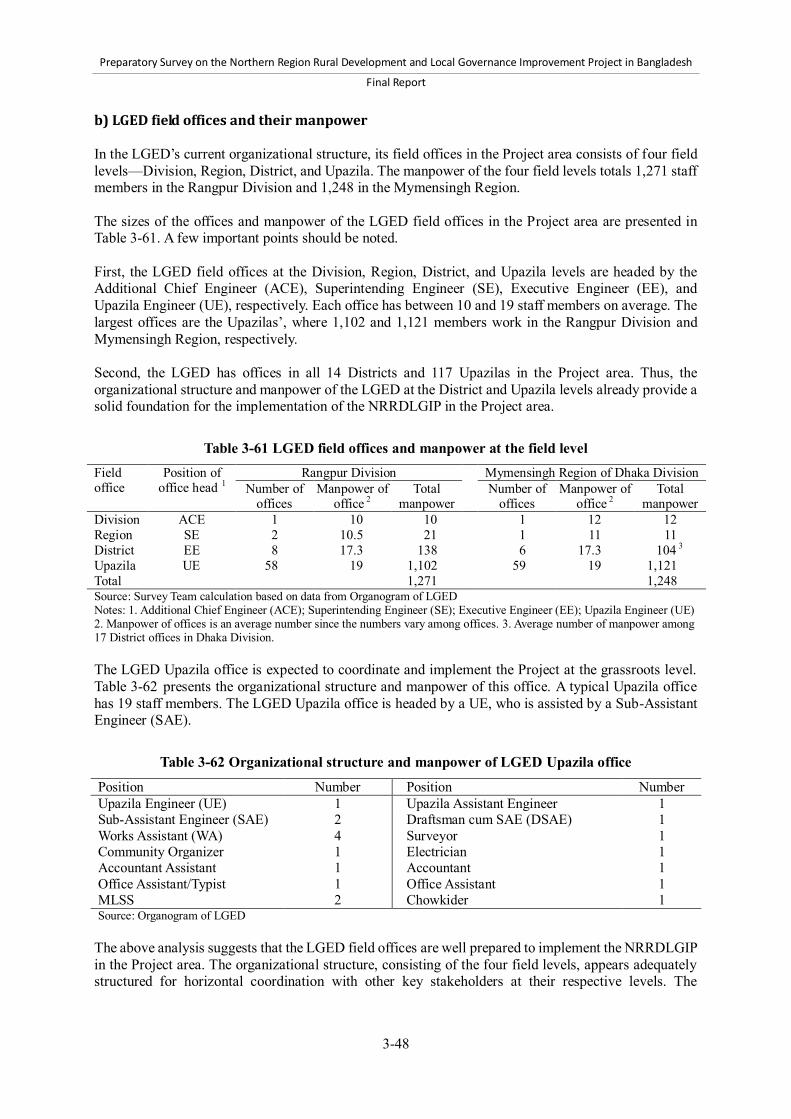
Preparatory Survey on the Northern Region Rural Development and Local Governance Improvement Project in Bangladesh
Final Report
3-48
b) LGED field offices and their manpower In the LGED’s current organizational structure, its field offices in the Project area consists of four field levels—Division, Region, District, and Upazila. The manpower of the four field levels totals 1,271 staff members in the Rangpur Division and 1,248 in the Mymensingh Region. The sizes of the offices and manpower of the LGED field offices in the Project area are presented in Table 3-61. A few important points should be noted. First, the LGED field offices at the Division, Region, District, and Upazila levels are headed by the Additional Chief Engineer (ACE), Superintending Engineer (SE), Executive Engineer (EE), and Upazila Engineer (UE), respectively. Each office has between 10 and 19 staff members on average. The largest offices are the Upazilas’, where 1,102 and 1,121 members work in the Rangpur Division and Mymensingh Region, respectively. Second, the LGED has offices in all 14 Districts and 117 Upazilas in the Project area. Thus, the organizational structure and manpower of the LGED at the District and Upazila levels already provide a solid foundation for the implementation of the NRRDLGIP in the Project area.
Table 3-61 LGED field offices and manpower at the field level Field office
Position of office head 1
Rangpur Division Mymensingh Region of Dhaka Division Number of
offices Manpower of
office 2 Total
manpower Number of
offices Manpower of
office 2 Total
manpower Division ACE 1 10 10 1 12 12 Region SE 2 10.5 21 1 11 11 District EE 8 17.3 138 6 17.3 104 3 Upazila UE 58 19 1,102 59 19 1,121 Total 1,271 1,248 Source: Survey Team calculation based on data from Organogram of LGED Notes: 1. Additional Chief Engineer (ACE); Superintending Engineer (SE); Executive Engineer (EE); Upazila Engineer (UE) 2. Manpower of offices is an average number since the numbers vary among offices. 3. Average number of manpower among 17 District offices in Dhaka Division. The LGED Upazila office is expected to coordinate and implement the Project at the grassroots level. Table 3-62 presents the organizational structure and manpower of this office. A typical Upazila office has 19 staff members. The LGED Upazila office is headed by a UE, who is assisted by a Sub-Assistant Engineer (SAE).
Table 3-62 Organizational structure and manpower of LGED Upazila office
Position Number Position Number Upazila Engineer (UE) 1 Upazila Assistant Engineer 1 Sub-Assistant Engineer (SAE) 2 Draftsman cum SAE (DSAE) 1 Works Assistant (WA) 4 Surveyor 1 Community Organizer 1 Electrician 1 Accountant Assistant 1 Accountant 1 Office Assistant/Typist 1 Office Assistant 1 MLSS 2 Chowkider 1 Source: Organogram of LGED
The above analysis suggests that the LGED field offices are well prepared to implement the NRRDLGIP in the Project area. The organizational structure, consisting of the four field levels, appears adequately structured for horizontal coordination with other key stakeholders at their respective levels. The

Preparatory Survey on the Northern Region Rural Development and Local Governance Improvement Project in Bangladesh
Final Report
3-49
presence of field offices in all Districts and Upazilas will facilitate the mobilization and coordination of key stakeholders such as Pourashavas, community organizations, associations, and NGOs in the implementation of the Project. (2) DPHE in the Project area a) Administrative classification Table 3-63 shows the field-level administrative classification of the DPHE. In the proposed Project area, six target Districts are included in Dhaka Circle and the other eight target Districts are included in Rangpur Circle in the DPHE jurisdiction.
Table 3-63 Administrative classification of DPHE at the field level Circle Total: 9
Districts Total: 64
Chittagong Comilla, Chittagonj, Noakhali, Chandpur, Cox’s Bazar, Bharambaria, Lakshmipur, Feni (8) Dhaka Dhaka, Mymensingh, Jamalpur, Narayanganj, Kishoreganj, Sherpur, Gazipur, Munshiganj,
Netrokona, Manikganj, Narshingdi, Tangail (12) Khulna Khlna, Bgerhat, Narail, Stkhira, Jessore, Jhenidah, Magura, Chuadanga, Meherpur, Kushtia (10) Rajshahi Rajshahi, Pabna, Chapai Nawabganj, Serajganj, Natore, Naogaon (6) Chittagong Hill Bandarban, Khagrachari, Rangamati, Chittagong (3) Sylhet Sylhet, Sunamgonj, Moulvibazr, Hobigon (4) Faridpur Faridpur, Gopalganj, Madaripur, Shariatpur, Rajbari (5) Barisal Barisal, Patuakhali, Bhola, Barguna,Jhalokathi, Perojpur (6) Rangpur Rangpur, Bogra, Dinajpur, Joypurhat, Gaibandha, Nilphamari, Panchagarh, Lalmunirhat,
Thakurgaon, Kurigram (10) Source: Organogram of DPHE Note: The Regions and Districts in the Project area are presented in boldface. b) DPHE field offices and their manpower In the DPHE’s current organizational structure, its field offices in the Project area consist of three field levels—Circle, District, and Upazila. The manpower of the three field levels totals 500 staff members in Rangpur Circle, and 681 in Dhaka Circle. The sizes of the offices and manpower of the DPHE field offices in the Project area are presented in Table 3-64. A few important points should be noted. First, the DPHE field offices at the Circle, District, and Upazila levels are headed by the Superintending Engineer (SE), Executive Engineer (EE), and Assistant Engineer (AE), respectively. Each office has between 1 and 15 staff members on average. Rangpur Circle office has only one SE, whereas Dhaka Circle office has 15 staff members including a SE. The largest offices are at the Upazila level, where 445 and 598 members work in the Rangpur Circle and Dhaka Circle, respectively. Second, the DPHE also has offices in all 14 Districts and 117 Upazilas in the Project area. This is the same jurisdiction as the LGED in those two field levels of the Project area.
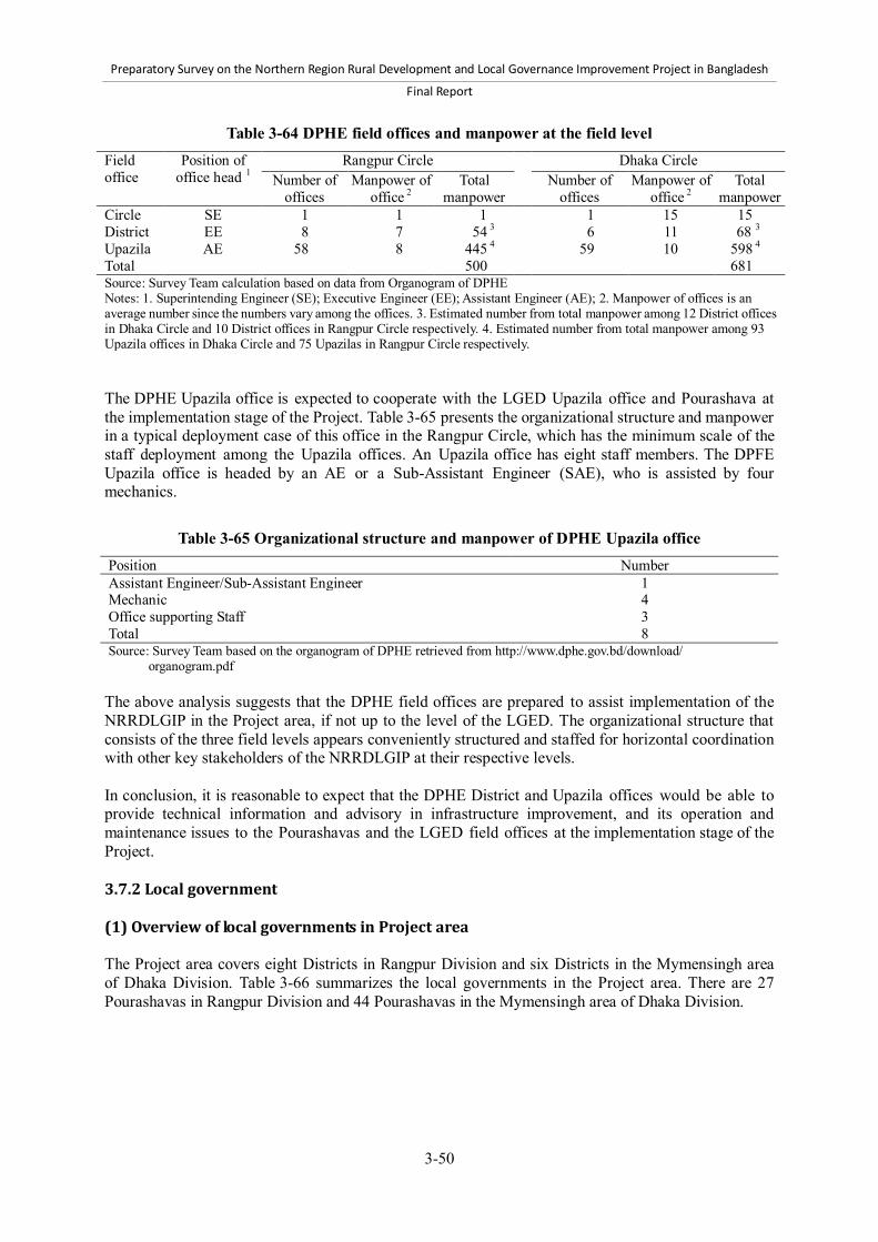
Preparatory Survey on the Northern Region Rural Development and Local Governance Improvement Project in Bangladesh
Final Report
3-50
Table 3-64 DPHE field offices and manpower at the field level Field office
Position of office head 1
Rangpur Circle Dhaka Circle Number of
offices Manpower of
office 2 Total
manpower
Number of offices
Manpower of office 2
Total manpower
Circle SE 1 1 1 1 15 15 District EE 8 7 54 3 6 11 68 3 Upazila AE 58 8 445 4 59 10 598 4 Total 500 681 Source: Survey Team calculation based on data from Organogram of DPHE Notes: 1. Superintending Engineer (SE); Executive Engineer (EE); Assistant Engineer (AE); 2. Manpower of offices is an average number since the numbers vary among the offices. 3. Estimated number from total manpower among 12 District offices in Dhaka Circle and 10 District offices in Rangpur Circle respectively. 4. Estimated number from total manpower among 93 Upazila offices in Dhaka Circle and 75 Upazilas in Rangpur Circle respectively. The DPHE Upazila office is expected to cooperate with the LGED Upazila office and Pourashava at the implementation stage of the Project. Table 3-65 presents the organizational structure and manpower in a typical deployment case of this office in the Rangpur Circle, which has the minimum scale of the staff deployment among the Upazila offices. An Upazila office has eight staff members. The DPFE Upazila office is headed by an AE or a Sub-Assistant Engineer (SAE), who is assisted by four mechanics.
Table 3-65 Organizational structure and manpower of DPHE Upazila office Position Number Assistant Engineer/Sub-Assistant Engineer 1 Mechanic 4 Office supporting Staff 3 Total 8 Source: Survey Team based on the organogram of DPHE retrieved from http://www.dphe.gov.bd/download/ organogram.pdf The above analysis suggests that the DPHE field offices are prepared to assist implementation of the NRRDLGIP in the Project area, if not up to the level of the LGED. The organizational structure that consists of the three field levels appears conveniently structured and staffed for horizontal coordination with other key stakeholders of the NRRDLGIP at their respective levels. In conclusion, it is reasonable to expect that the DPHE District and Upazila offices would be able to provide technical information and advisory in infrastructure improvement, and its operation and maintenance issues to the Pourashavas and the LGED field offices at the implementation stage of the Project. 3.7.2 Local government (1) Overview of local governments in Project area The Project area covers eight Districts in Rangpur Division and six Districts in the Mymensingh area of Dhaka Division. Table 3-66 summarizes the local governments in the Project area. There are 27 Pourashavas in Rangpur Division and 44 Pourashavas in the Mymensingh area of Dhaka Division.

Preparatory Survey on the Northern Region Rural Development and Local Governance Improvement Project in Bangladesh
Final Report
3-51
Table 3-66 Overview of local governments in Project area Division/Area (No. of Pourashavas)
District No. of Pourashavas
List of Pourashavas (Category)
A B C Rangpur Division (27)
Dinajpur 2 4 2 Birampur (A), Dinajpur (A), Birganj (B). Parbatipur (B), Bochaganj (Setabganj) (B), Fulbari (B), Ghoraghat (C), Hakimpur (C)
Gaibandha 1 1 1 Gaibandha (A), Gobindaganj (B), Sundarganj (C) Kurigram 1 2 0 Kurigram (A), Ulipur (B), Nageswari (B) Lalmonirhat 2 0 0 Lalmonirhat (A), Patgram (A) Nilphamari 2 0 2 Nilphamari (A), Sayedpur (A), Domar (C),
Jaldhaka (C) Panchagarh 1 1 0 Panchagar (A), Boda (B) Rangpur 0 1 1 Badarganj (B), Haragach (C) Thakurgaon 1 1 1 Thakurgaon (A), Pirganj (B), Ranishankail (C)
Mymensingh area (44)
Jamalpur 2 1 3 Jamalpur (A), Sharishabari (A), Islampur (B), Dewanganj (C), Madarganj (C), Melandah (C)
Kishoreganj 2 1 5 Bhairab (A), Kishoreganj (A), Bajitpur (B), Hossainpur (C), Karimganj (C), Kotiadi (C), Kuliarchar (C), Pakundia (C)
Mymensingh 6 3 1 Mymensingh (A), Iswarganj (A), Muktagacha (A), Trishal (A), Bhaluka (A), Gafargaon (A), Gouripur (B), Fulbaria (B), Phulpur (B), Nandail (C)
Netrokona 1 1 3 Netrokona (A), Mohonganj (B), Durgapur (C), Kendua (C), Madan (C)
Sherpur 1 1 2 Sherpur (A), Nalitabari (B), Nakla (C), Sreebardi (C) Tangail 1 7 3 Tangail (A), Bhuapur (B), Ghatail (B), Gopalpur (B),
Kalihati (B), Madhupur (B), Mirzapur (B), Dhanbari (B), Basail (C), Elenga (C), Shakhipur (C)
Source: Data collected from LGED and Pourashavas in the project area Basic information collection Survey Team collected basic information from all Pourashavas in the Project area, the main target of the Project’s Component 2, which will form part of the NRRDLGIP’s implementation mechanism. The information, collected by Pourashavas through LGED District offices, concerns the economic situation, infrastructure status, fiscal data, the coordination mechanism, human resources, logistical capacity, and development planning issues.48 Despite the best efforts of Survey Team working in close collaboration with the LGED, they found obvious errors and missing data in the dataset submitted by the Pourashavas. These were either corrected or uncounted for aggregation, yet some minor errors in the dataset might remain. Sample survey In addition to the basic information collected by Pourashavas through questionnaires, a sample survey was conducted to collect more detailed data concerning the Pourashavas. As shown in Table 3-67, 12 Pourashavas were sampled for collection and analysis of the 71 identified in the project area. The sample survey aimed to 1) draw the insights and perceptions of stakeholders on the current situation and the development needs and challenges of the Pourashavas; and 2) identify stakeholder capacities and capacity development needs. The sample Pourashavas were selected in consultation with the LGED, taking into account the Regional distribution and coverage of other initiatives supported by donor agencies. Table 3-67 lists 48 Survey Team would like to express its special gratitude to the Superintending Engineer (Urban Management), who provided valuable advice and support in the design and implementation of the questionnaires for the Pourashavas.
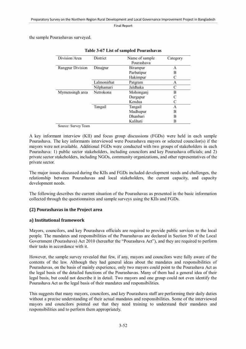
Preparatory Survey on the Northern Region Rural Development and Local Governance Improvement Project in Bangladesh
Final Report
3-52
the sample Pourashavas surveyed.
Table 3-67 List of sampled Pourashavas Division/Area District Name of sample
Pourashava Category
Rangpur Division Dinajpur Birampur A Parbatipur B Hakimpur C Lalmonirhat Patgram A Nilphamari Jaldhaka C Mymensingh area Netrokona Mohonganj B Durgapur C Kendua C Tangail Tangail A Madhupur B Dhanbari B Kalihati B Source: Survey Team
A key informant interview (KII) and focus group discussions (FGDs) were held in each sample Pourashava. The key informants interviewed were Pourashava mayors or selected councilor(s) if the mayors were not available. Additional FGDs were conducted with two groups of stakeholders in each Pourashava: 1) public sector stakeholders, including councilors and key Pourashava officials; and 2) private sector stakeholders, including NGOs, community organizations, and other representatives of the private sector. The major issues discussed during the KIIs and FGDs included development needs and challenges, the relationship between Pourashavas and local stakeholders, the current capacity, and capacity development needs. The following describes the current situation of the Pourashavas as presented in the basic information collected through the questionnaires and sample surveys using the KIIs and FGDs. (2) Pourashavas in the Project area a) Institutional framework Mayors, councilors, and key Pourashava officials are required to provide public services to the local people. The mandates and responsibilities of the Pourashavas are declared in Section 50 of the Local Government (Pourashava) Act 2010 (hereafter the “Pourashava Act”), and they are required to perform their tasks in accordance with it. However, the sample survey revealed that few, if any, mayors and councilors were fully aware of the contents of the law. Although they had general ideas about the mandates and responsibilities of Pourashavas, on the basis of mainly experience, only two mayors could point to the Pourashava Act as the legal basis of the detailed functions of the Pourashavas. Many of them had a general idea of their legal basis, but could not describe it in detail. Two mayors and one group could not even identify the Pourashava Act as the legal basis of their mandates and responsibilities. This suggests that many mayors, councilors, and key Pourashava staff are performing their daily duties without a precise understanding of their actual mandates and responsibilities. Some of the interviewed mayors and councilors pointed out that they need training to understand their mandates and responsibilities and to perform them appropriately.

Preparatory Survey on the Northern Region Rural Development and Local Governance Improvement Project in Bangladesh
Final Report
3-53
b) Human resources Human resource management is a critical issue for Pourashavas. The information gained from the Pourashavas in the project area indicated that staff sizes are too small in almost all Pourashavas for them to perform their assigned tasks. Vacancy of key staff Table 3-68 shows the vacancy numbers and rates for the key Pourashava officials: Chief Executive Officer (CEO), Executive Engineer or Assistant Engineer, Secretary, and Health Officer. The CEO post is vacant in 17 out of the 28 Pourashavas in Rangpur Division and in 31 out of the 44 in the Mymensingh area.
Table 3-68 Vacancy of key Pourashava officials Division/ Area
Number of Pourashavas in which key posts are vacant (% of total Pourashavas) CEO Engineer Secretary Health Officer
Project area Total: 48 (70.6%) A: 13 (56.5%) B: 18 (81.8%) C: 17 (73.9%)
Total: 14 (20.0%) A: 2 (8.7%) B: 5 (20.8%) C: 7 (30.4%)
Total: 23 (32.4%) A: 5 (21.7%) B: 10 (41.7%) C: 8 (33.3%)
Total: 46 (69.7%) A: 10 (43.5%) B: 19 (82.6%) C: 17 (85.0%)
Rangpur Division
Total: 17 (68.0%) A: 5 (50.0%) B: 7 (77.8%) C: 5 (83.2%)
Total: 9 (34.6%) A: 2 (20.0%) B: 3 (30.0%) C: 4 (66.7%)
Total: 8 (29.6%) A: 2 (20.0%) B: 4 (40.0%) C: 2 (28.6%)
Total: 20 (74.1%) A: 5 (50.0%) B: 8 (80.0%) C: 7(100.0%)
Mymensingh area
Total: 31 (72.1%) A: 8 (61.5%) B: 11 (84.6%) C: 12 (70.6%)
Total: 5 (11.4%) A: 0 (0%) B: 2 (14.3%) C: 3 (17.6%)
Total: 15 (34.1%) A: 3 (23.1%) B: 6 (42.9%) C: 6 (35.3%)
Total: 26 (66.7%) A: 5 (38.5%) B: 11 (84.6%) C: 10 (76.9%)
Source: Survey Team The CEO vacancy rate is at 70.6% among the 72 Pourashavas in the project area. Since the CEO is in charge of overall Pourashava management, vacancies in this post will significantly affect the Pourashavas’ administrative performance. The reasons for the vacancies, as revealed during the KIIs and FGDs, include the following: 1) those qualified to be CEOs are usually not willing to work in rural areas, and 2) they do not wish to work under mayors and councilors whose educational qualifications and work experience are below those of the CEOs. In support of this, BMB Mott MacDonald & EPC (2011) also states that CEOs are not willing to serve mayors whom they consider inferior in education and experience. The Health Officer vacancy rate is also high (69.7% in total and more than 80% in Categories B and C). According to information gathered from the KIIs and FGDs, doctors do not find it attractive to work in Pourashavas for financial and career development reasons. As a result, health departments in most Pourashavas are managed by junior-level health staff. Moreover, several category-B and C Pourashavas have no health department staff. This suggests that Pourashava health departments are generally considered less important, as primary health care is provided by Upazila health authorities. On the other hand, Engineer and Secretary positions are less often vacant. The Engineer vacancy rate is only 20.0% and that of Secretary is 32.4%. However, the variations among categories and regions, especially for Engineers, should be noted: 66.7% of category-C Pourashavas in Rangpur Division lack both Executive and Assistant Engineers. In addition to the vacancy of key staff, the KIIs and FGDs of the sample survey revealed a staff shortage in the engineering departments, especially in category-B and C Pourashavas. Moreover, the

Preparatory Survey on the Northern Region Rural Development and Local Governance Improvement Project in Bangladesh
Final Report
3-54
qualifications of the key engineers are considered insufficient. The Executive Engineers in the sampled category-A Pourashavas were all certified engineers from polytechnic institutes rather than B.Sc. graduates of universities. Two reasons for this that were identified during the sample survey are the lack of financial capacity to pay for qualified engineers, and their dependence on LGED local officers to assist them in filling the capacity gaps of the Pourashava engineers. Survey Team got the impression from the survey that Pourashavas seem satisfied with this situation. Number of staff The staff numbers mandated by the Pourashava Act have not been met. Table 3-69 shows the average sizes of Pourashava staff by Division category.
Table 3-69 Average number of staff per 10,000 people Division/Area Category Simple average
no. of staff Average of staff per
10,000 people Project area Total 35.6 8.4 A 66.8 10.2 B 25.3 9.3 C 14.8 5.8 Rangpur Division Total 31.4 8.3 A 59.4 10.4 B 25.6 9.2 C 14.9 5.9 Mymensingh area Total 42.3 8.6 A 75.6 10.0 B 25.0 9.4 C 14.4 5.4 Source: Survey Team
The average Pourashava staff size in the Project area is very limited, falling well short of the required total. As described in Chapter 2, the required staff size is 127 for category-A Pourashavas, 89 for category-B, and 69 for category-C. However, there is an average of only 66.8 members for category-A Pourashavas, 25.3 for category-B, and 14.8 for category-C. Category-C’s average size represents only 21.4% of the requirement. The average staff sizes per 10,000 people also indicate the inadequacy of the Pourashavas’ staff sizes, particularly for category-C. Its staff size per 10,000 is only 5.8, significantly less than that of category-A and B. On the other hand, there is little difference between the numbers for category-A and B, approximately 10 for both. Thus, the Pourashavas’ current human resources are very limited. Their staff sizes are insufficient and are below the required numbers, with category-C Pourashavas facing the most severe situation. However, it should be noted that considerable variation exists among Pourashavas in the Project area. For instance, Mymensingh Pourashava (category-A) and Rangpur Pourashava (category-A) have hired the required number of staff while some category-A Pourashavas have fewer staff per 10,000 people than the average number of category-C Pourashavas. For instance, the figures for Jamalpur, Sharishabari, and Sayedpur Districts are 3.9, 2.1, and 4.2 respectively. c) Financial resources Survey Team collected and analyzed the financial data collected from sample Pourashavas in the

Preparatory Survey on the Northern Region Rural Development and Local Governance Improvement Project in Bangladesh
Final Report
3-55
Project area mainly through a questionnaire survey.49 The results of the analysis are presented below. Budget scale The information on financial resources of Pourashavas was collected from all Pourashavas in the Project area. Table 3-70 displays the average budget amounts and the average amounts per 10,000 people of Pourashavas in 2011.
Table 3-70 Average amount of budget in 2011 by category (Unit: BDT million)
Division/Area Category Simple average Average per 10,000 people
Project area Total A B C
135.9 275.2
71.0 53.5
30.3 40.6 25.8 23.8
Rangpur Division Total A B C
118.5 185.1
94.1 37.0
26.7 21.1 37.2 19.7
Mymensingh area Total A B C
147.6 357.8
54.5 60.6
32.7 58.5 17.7 25.6
Source: Survey Team The simple budget averages of the Pourashavas in the Project area indicate that the budgets of Categories A, B, and C are larger. category-A Pourashavas appear to have significantly larger amounts, BDT 275.2 million compared to BDT 71.0 million of category-B and BDT 53.5 million of category-C. The differences in average per 10,000 people among categories are less noticeable: the amounts for Categories A, B, and C are BDT 40.6 million, BDT 25.3 million, and BDT 23.8 million respectively. This suggests that per capita budgets are similar among Pourashavas, although the absolute amounts for category-A and the other categories differ significantly. It should be noted, however, that the figures presented here are averages and that there are significant variations among Pourashavas. Revenue per capita Own-source revenues are critical to the Pourashavas’ performance of their tasks. Table 3-71 shows the per capita revenue of Pourashavas in 2010.
49 It should be noted that the financial data collected from Pourashavas through the questionnaire survey have contained a number of errors. Survey Team corrected them to the extent possible by reconfirming with Pourashavas via telephone. Although some remaining errors had to be eventually excluded from the analysis, the analysis in this section is sufficient to understand the overall tendency of financial status of Pourashavas among categories and regions.

Preparatory Survey on the Northern Region Rural Development and Local Governance Improvement Project in Bangladesh
Final Report
3-56
Table 3-71 Per capita revenue by category in 2010 (Unit: BDT)
Division/Area Category Revenue per capita Project area Total
A B C
378.8 644.9 269.6 168.0
Rangpur Division Total A B C
318.2 401.4 382.6 125.9
Mymensingh area Total A B C
415.7 901.6 243.5 187.7
Source: Survey Team The average per capita revenue of Pourashavas in the Project area was BDT 362.8. Category-A Pourashavas in the Mymensingh area raised the highest revenue, BDT 901.6. Category-C Pourashavas in Rangpur Division have limited revenues, only BDT 125.0 per capita. On average, category-A Pourashavas have more per capita revenue, followed by category-B. Category-C Pourashavas have only limited own-source revenues. Revenue source In the questionnaire survey, three Pourashavas in the following were sampled from the Project area for the detailed financial analysis: Mymensingh (category-A), Gouripur (category-B), and Nandail (category-C). In addition, two Pourashavas that are assisted under the UGIIP-2, i.e., Sreepur (category-B) and Poushuram (category-C), were sampled in the questionnaire survey. The composition of annual income of these sample Pourashavas is given in Table 3-72.
Table 3-72 Composition of annual income of Pourashavas (Unit: 1,000 BDT)
Item Mymensingh Sreepur Poushuram Gouripur Nandail Category A B C B C Total Income 237,647 83,067 18,207 14,174 9,930 Total Revenue Income 101,502 100% 76,367 100% 7,399 100% 5,130 100% 5,274 100% Holding tax and rates 39,847 39% 10,134 13% 929 13% 839 16% 1,271 24% Other taxes and rates 42,577 42% 56,537 74% 2,709 37% 2,053 40% 1,281 24% Fees 1,229 1% 846 1% 52 1% 105 2% 771 15% Lease/ rent of assets 9,776 10% 6,260 8% 3,157 43% 1,872 36% 1,595 30% Revenue grant from government 2,091 2% 25 0% 182 2% 142 3% 209 4% Others 5,982 6% 2,566 3% 371 5% 119 2% 147 3%
Total Development Income 136,145 100% 6,700 100% 10,808 100% 8,900 100% 4,800 100% Grant from GOB 11,000 8% 6,700 100% 6,300 58% 8,900 100% 4,800 100% Fund from projects/ BMDF 125,145 92% 0 0% 4,508 42% 0 0% 0 0% Source: Survey Team based on financial statements provided by Pourashavas Note: The figures are actual income of FY10/11, except for the figures of Gouripur Pourashava, which are of FY09/10. Annual income of Pourashavas consists of revenue and development incomes. Major sources of the revenue income of Pourashavas are holding tax and rates, and other taxes and rates. The other taxes and rates include taxes on immovable property transfer, business, vehicles, and others. Development income consists of grant from the central government, and other project-based funds. The grant from the central government to Pourashavas is called “block allocation” or “Annual Development Program (ADP) allocation”. According to the LGD, during FY 2012/13, total BDT 7.4 million is planned to be allocated to a category-A Pourashava, and 6.0 million to a category-B, and 5.5 million to a category-C.
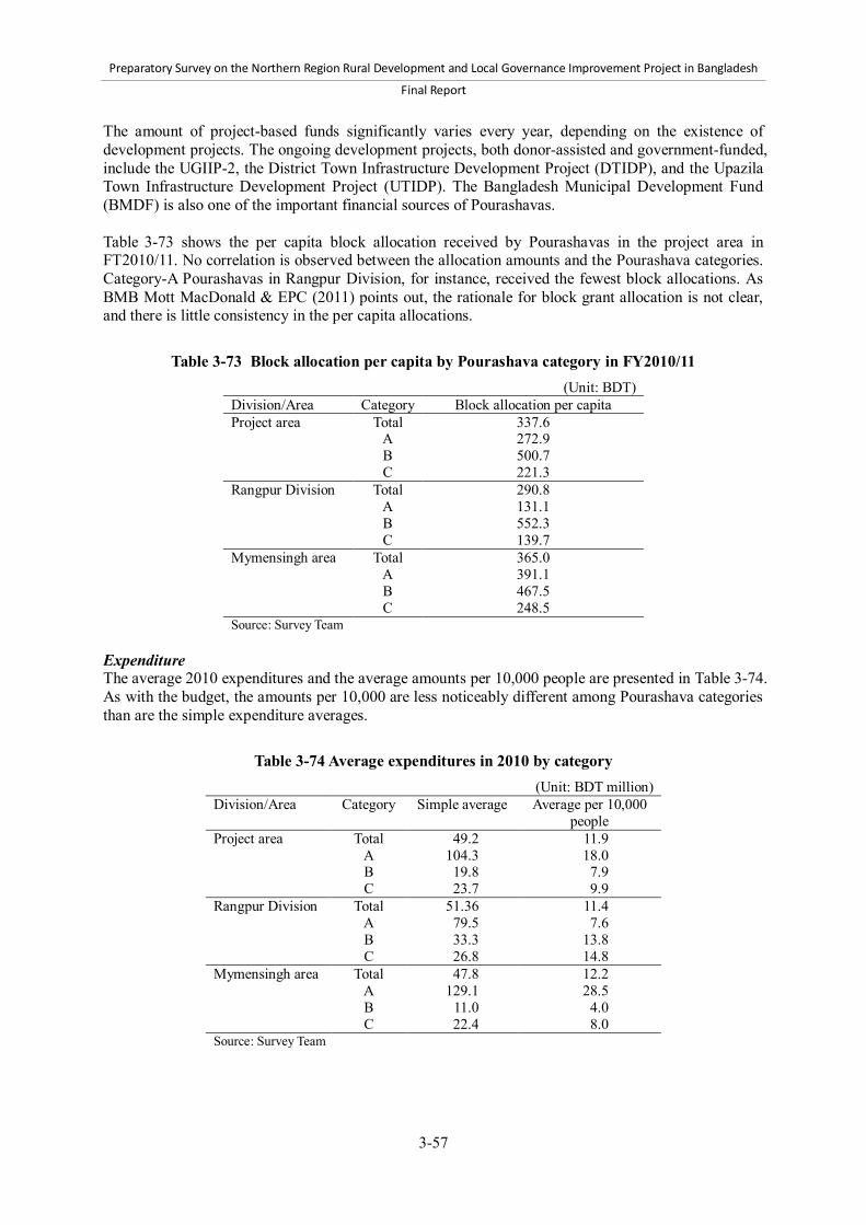
Preparatory Survey on the Northern Region Rural Development and Local Governance Improvement Project in Bangladesh
Final Report
3-57
The amount of project-based funds significantly varies every year, depending on the existence of development projects. The ongoing development projects, both donor-assisted and government-funded, include the UGIIP-2, the District Town Infrastructure Development Project (DTIDP), and the Upazila Town Infrastructure Development Project (UTIDP). The Bangladesh Municipal Development Fund (BMDF) is also one of the important financial sources of Pourashavas. Table 3-73 shows the per capita block allocation received by Pourashavas in the project area in FT2010/11. No correlation is observed between the allocation amounts and the Pourashava categories. Category-A Pourashavas in Rangpur Division, for instance, received the fewest block allocations. As BMB Mott MacDonald & EPC (2011) points out, the rationale for block grant allocation is not clear, and there is little consistency in the per capita allocations.
Table 3-73 Block allocation per capita by Pourashava category in FY2010/11 (Unit: BDT)
Division/Area Category Block allocation per capita Project area Total
A B C
337.6 272.9 500.7 221.3
Rangpur Division Total A B C
290.8 131.1 552.3 139.7
Mymensingh area Total A B C
365.0 391.1 467.5 248.5
Source: Survey Team Expenditure The average 2010 expenditures and the average amounts per 10,000 people are presented in Table 3-74. As with the budget, the amounts per 10,000 are less noticeably different among Pourashava categories than are the simple expenditure averages.
Table 3-74 Average expenditures in 2010 by category
(Unit: BDT million) Division/Area Category Simple average Average per 10,000
people Project area Total
A B C
49.2 104.3
19.8 23.7
11.9 18.0 7.9
9.9 Rangpur Division Total
A B C
51.36 79.5 33.3 26.8
11.4 7.6
13.8 14.8
Mymensingh area Total A B C
47.8 129.1
11.0 22.4
12.2 28.5
4.0 8.0
Source: Survey Team

Preparatory Survey on the Northern Region Rural Development and Local Governance Improvement Project in Bangladesh
Final Report
3-58
Development expenditure Development expenditures in the recent three years of Pourashavas in the Project area are summarized in Table 3-75.
Table 3-75 Average development expenditure (2009-2011) by category (Unit: BDT million)
Division/Area Category Development expenditure
% to total expenditure
Project area Total A B C
25.0 57.5 9.6 9.1
(46.8%) (52.5%) (39.1%) (46.8%)
Rangpur Division Total A B C
12.9 17.9 10.5 9.1
(46.3%) (54.7%) (37.1%) (45.3%)
Mymensingh area Total A B C
33.2 91.7 8.7 9.2
(47.1%) (50.7%) (41.1%) (47.5%)
Source: Survey Team The average amount of annual development expenditure is BDT 25 million. This accounts for 46.8% of annual total expenditures. Category-A Pourashavas, on average, have allocated more funds for development, in particular in Mymensingh area. The figures of category-A Pourashavas in Mymensingh area are, however, affected by those of two Pourashavas with the significantly highest development expenditures, i.e., BDT 229 million of Jamalpur and BDT 248 million of Mymensingh. Except for the two, BDT 33.1 million (36.3% of total expenditure) were allocated for development expenditures in category-A Pourashavas in Mymensingh area. On the other hand, no clear difference is observed between category-B and C Pourashavas, and between Rangpur Division and Mymensingh area. On average, they have roughly BDT 10 million or less development expenditures annually. d) Performance of Pourashava service delivery To identify the current quality of Pourashava services, Survey Team held FGDs and facilitated a self-assessment by pubic stakeholders, including councilors and key Pourashava officials, on the quality of their service delivery. The assessment identified the percentages of performed tasks relative to total requirements. The self-assessment aimed to understand the opinions of public sector stakeholders about which services should be improved rather than to determine absolute percentages. The assessment results comprised the consensus views of stakeholders with detailed knowledge of the Pourashavas’ situations. Thus, it is fair to say that the results represent their perceptions of public service performance. Figure 3-6 shows the results of their assessment of the Pourashavas’ performances of major tasks. As indicated, there is little difference in the assessment results among categories. The activities rated relatively low during the FGDs were: 1) construction and maintenance of drainage; 2) installation and maintenance of streetlights; 3) construction and maintenance of roads, bridges, and culverts; and 4) water supply. Waste management and sanitation were also rated low but higher than the aforementioned four. On the other hand, it is fair to say that infectious disease and epidemic prevention and birth and death registration were well performed.

Preparatory Survey on the Northern Region Rural Development and Local Governance Improvement Project in Bangladesh
Final Report
3-59
0%
20%
40%
60%
80%
100%
Roa
d, b
ridge
&cu
lver
t
Stre
et li
ght
Dra
inag
e
Solid
was
tem
anag
emen
t
Infe
ctio
usdi
seas
e &
epid
emic
s
Birt
h &
dea
thre
gist
ratio
n
Wat
er su
pply
Sani
tatio
n
Ave. of Category A
Ave. of Category B
Ave. of Category C
Source: Survey Team
Figure 3-6 Assessment of the performance of Pourashavas
This suggests that Pourashavas in the Project area generally lack the capacity to develop and maintain infrastructure, particularly roads, bridge, culverts, drainage, streetlights, and water supply. Solid waste management and sanitation-related duties can also be considered poorly performed. These two issues appear to be more critical for category-A Pourashavas, where urbanization is rapidly progressing, while Pourashavas in less urbanized areas may not prioritize them, since they are typically associated with urbanization. Finally, infectious disease and epidemic prevention and birth and death registration are considered satisfactorily performed, and no need for assistance can be identified. (3) Inter-organizational coordination mechanism between local governments There is an Upazila Parishad meeting in each Upazila, comprising an Upazila chairperson and the mayors of Pourashavas and chairpersons of all Union Parishads. The Upazila Parishad Meeting shall be held once in a month. Similar monthly coordination meetings are also held at the District level. The District level meeting is chaired by Deputy Commissioners and includes Upazila chairpersons, mayors, and representatives of line departments such as the LGED, the DPHE, health, education, and the police. According to the KIIs and FGDs held with the sampled Pourashavas, a number of mayors and councilors have spoken of the Upazila Parishad meeting as an opportunity to interact with other organizations within the Upazilas. Apart from the Upazila and District level meetings, there is no official coordination mechanism for Pourashavas. Mayors and councilors have stated that they occasionally communicate with government agencies like the LGED and DPHE. (4) Development needs and challenges of Pourashavas in the Project area The development needs and challenges of the Pourashavas in the project area were identified during the KIIs and FGDs. In those sessions, Survey Team asked mayors and public and private stakeholders to list the three priority needs in their Pourashavas. Participants also listed their development needs. Table 3-76 shows the prioritized development needs of each sample Pourashava. According to the KIIs and FGDs, the highest priority development need is drainage improvement. All KII and FGD participants listed drainage system improvements as their highest priority issue.

Preparatory Survey on the Northern Region Rural Development and Local Governance Improvement Project in Bangladesh
Final Report
3-60
Similarly, road and bridge construction were ranked as the second highest priority. Only one mayor and four groups of FGDs did not list road construction as their highest priority area. Water supply, market development, and bus and truck terminals were also highlighted in many Pourashavas, as were sanitation and solid waste management. The major KII and FGD discussion points are briefly summarized below in the order in which they were prioritized by stakeholders. Drainage Water logging is a serious problem in many Pourashavas, especially in the rainy season. It causes several problems in people’s daily lives, such as traffic disruption, sanitation problems, and the spread of infectious diseases. Thus improvement of drainage systems is an urgent issue. Possible ways of improving the drainage include constructing and maintaining small drains, improving the connections among drainage systems, and extending the drainage networks within the Pourashavas. Connecting the main drains is critical for the improvement of drainage systems in the Pourashavas. Even if main drains are constructed in or near Pourashavas, the Pourashavas often lack the financial and human resource capacity to connect their internal drains to them. As a result, water logging persists. For instance, major drainage systems are being developed by the Roads and Highways Department in Dhanbari Pourashava, but the internal drains connecting to those systems are not well developed. Many others among the sampled Pourashavas face similar connection problems. Water logging adversely affects not only roads but also houses, buildings, and public facilities. For instance, most of Hakimpur Pourashava is severely inundated after a rainfall, including the main and internal roads, customs, and warehouses at the nearby port. Water logging also causes damage to infrastructure such as road shoulders, according to the stakeholders in Patgram Pourashava. Construction of roads and bridges Constructing roads, culverts, and bridges is the second highest priority Pourashava need, according to the stakeholders who participated in the KIIs and FGDs. The roads of many Pourashavas are in extremely poor condition. Some have many holes and gaps, and others are still earthen. Even the paved roads have not been well maintained and are in poor condition. For instance, Dhanbari Pourashava’s roads are mainly earthen, hindering its people’s communication and travel. Roads in other Pourashavas such as Kalihati are poor, but no maintenance has been undertaken. Roads in Pourashavas are often too narrow for vehicles and pedestrians to pass each other safely. Pourashavas including Patgram and Birampur identified specific locations where bridges need to be constructed. The mayor of Patgram Pourashava stated that two bridges are necessary, over the Shingimari and Donapar Rivers, for better communication among wards and habitats.

Preparatory Survey on the Northern Region Rural Development and Local Governance Improvement Project in Bangladesh
Final Report
3-61
Table 3-76 Development needs identified in key informant interviews and focus group discussions
Division/Area District
Pourashava
Interviewees/ participants
Roa
d &
B
ridge
Stre
etlig
hts
Bus
/truc
k te
rmin
al
Dra
inag
e
Sani
tatio
n
Mar
ket
deve
lopm
ent
Solid
was
te
man
agem
ent
Wat
er su
pply
Oth
er
Rangpur Dinajpur Birampur (A) Mayor X X x X x x
Public Stakeholders X x X x x X X Private Stakeholders X x X X X Parbatipur (B) Mayor X x X x x X Public Stakeholders X X x x X Private Stakeholders X X X Hakimpur (C) Mayor X x X X x Public Stakeholders x X X X x Private Stakeholders x X X X
Lalmonirhat Patgram (A) Mayor X X X X Public Stakeholders X X X X Private Stakeholders X X X X X
Nilphamari Jaldhaka (C) Mayor X x X X x x x Public Stakeholders X X X X X x Private Stakeholders X X X X X Mymensingh
Tangail Tangail (A) Mayor X X X X Public Stakeholders X X X X X x Private Stakeholders X X X X x Madhupur (B) Mayor X X X Public Stakeholders X X X X Private Stakeholders X X X Dhanbari (B) Mayor X X X X Public Stakeholders X X X Private Stakeholders X X X X x Kalihati (B) Mayor X X X Public Stakeholders X X X Private Stakeholders X X x X
Netrokona Mohonganj (B) Mayor X X X Public Stakeholders X X X Private Stakeholders X X X Durgapur (C) Mayor X X X Public Stakeholders X X X Private Stakeholders X X X Kendua (C) Mayor X X X Public Stakeholders X X X Private Stakeholders X X X
Source: Survey Team Note: “X” indicates the area’s highest priority development need; “x” indicates high priority development needs. “Other” are needs that only a few stakeholders identified as important. Water supply At the household level, many Pourashava dwellers lack a safe water supply that can be used for drinking and washing. Pourashavas such as Jaldhaka do not have piped water systems, and most people depend on shallow tube wells or deep tube wells. Pourashavas such as Parbatipur have installed piped water systems, but their capacities have become insufficient because of a rapid population increase. Many poor people in town areas are often forced to use unsafe pond water. The urban water supply problem is considered more severe than the rural one. For instance, the mayor of Madhupur Pourashava pointed out that people living in towns have limited access to safe water

Preparatory Survey on the Northern Region Rural Development and Local Governance Improvement Project in Bangladesh
Final Report
3-62
because of the lack of a piped water system, whereas villagers can access safe water through hand tube wells. This view was supported by the other stakeholders who participated in the KIIs and FGDs. The other issue raised in the FGDs concerns the fall in the ground water level. For instance, because of the excessive extraction of ground water for irrigation projects in Hakimpur Pourashava, household tube wells are now unable to lift sufficient water. Similarly, Parbatipur Pourashava stakeholders pointed out that their groundwater level was falling, although they could not say why. Market Development Many stakeholders identified local market development as a high priority issue. Market construction includes activities such as the creation of shade, the improvement of the internal drainage system, the rehabilitation of internal roads, the construction of multi-story market complexes, the construction of slaughterhouses, and the building of parking spaces. Since local markets represent revenue generating potential for Pourashavas, most stakeholders pointed out that improving market conditions is critical if they are to secure their own revenue and eventually bear the cost of their basic development needs. Sanitation Sanitation in the Project area refers to the installation of sanitary latrines. Although many households are equipped with sanitary latrines, non-sanitized households exist. The sanitary condition of the urban poor is so severe that it has become a priority issue in town development. Constructing public toilets as well as bus and truck terminals was identified as another important market development activity. Tangail Pourashava stakeholders pointed out the necessity of sewage systems. Tangail’s population has been rapidly increasing, and consequently, sanitary conditions have been deteriorating. Solid waste management Solid waste management is another critical issue, especially in Pourashavas where urbanization is more advanced. Solid waste management refers to the collection of garbage, the dumping of collected wastes, and composting. Pourashavas such as Jaldhaka and Hakimpur have only a small, insufficient number of rickshaw vans dedicated to waste collection. Constructing dumping sites is also critical. Few Pourashavas have them, and in Pourashavas like Jaldhaka and Hakimpur, waste is dumped into low-lying areas without the necessary treatment, causing serious environmental problems. Bus and truck terminals In Pourashavas such as Parbatipur, Hakimpur, Patgram, Jaldhaka, and Tangail, constructing bus and truck terminals is considered high priority. Their lack forces many buses and trucks to park along roadsides, causing heavy traffic jams and even accidents in town areas. More bus and truck terminals will help alleviate traffic jams and improve traffic safety in the towns as well as enhance the convenience felt by passengers and drivers. Streetlights The installation of streetlights is also a priority need, though many stakeholders appear to consider this a lower priority. In Hakimpur and Birampur, for instance, stakeholders stated that women and children do not feel safe after dusk because of the insufficient streetlight coverage in the town areas. Other development needs Other development needs raised by a few stakeholders include the construction of community centers, children’s parks, funeral places for the Hindus, clinics, and institutions for the handicapped.

Preparatory Survey on the Northern Region Rural Development and Local Governance Improvement Project in Bangladesh
Final Report
3-63
3.8 Non-government organizations and community organization 3.8.1 Non-government organizations According to ADAB (2003), 14 to 70 local NGOs operate in each District of the Project area. The variation in the number of NGOs among Districts is large, with a high concentration of NGOs in Tangail District in Dhaka Division and in Dinajpur District in Rangpur Division, and with low concentration in relatively remote Districts. Table 3-77 shows the District-wise numbers of local and international NGOs working in the Project area. The presence of international NGOs is limited.
Table 3-77 Number of NGOs working in the project area Area District Number of NGOs
Local International Total Rangpur Division Dinajpur 69 1 70
Thakurgaon 27 1 28 Panchagarh 14 0 14 Rangpur 36 5 41 Lalmonirhat 19 0 19 Nilphamari 16 3 19 Kurigram 26 2 28 Gaibandha 36 0 36 Average 30.4 1.5 31.9
Mymensingh area Jamalpur 35 0 35
Sherpur 17 1 18 Tangail 70 0 70 Mymensingh 56 3 59 Netrokona 21 2 23 Kishoreganj 22 3 25 Average 36.8 1.5 38.3
Project Districts Average 33.1 1.5 34.6 Source: ADAB (2003) Note: 1. A number of NGOs work in more than one District
BRAC, Proshika, ASA and TMSS are the four major NGOs in the project area and cover most of the Districts. Some NGOs work across Districts, but a majority operates within a District. The areas of their activities include microcredit, income generation and employment, non-formal and formal education for children and adults, health, nutrition, family planning, environment, water supply and sanitation, disaster management, legal issues and human rights including women’s rights, agriculture, poultry and livestock, social mobilization, awareness raising and advocacy, networking, and training. In the LGED, several national and local NGOs have been deployed by its various projects such as Greater Faridpur Infrastructure Development Project (RDP-24), Rural Infrastructure Improvement Project (RDP-25), and Market Infrastructure Development Project in Charland Region. Major roles given to NGOs include mobilization of Labor Contracting Society (LCS) members, formation of LCS groups, and training of LCS members, Market Management Committee Members, and women shopkeepers in Women’s Market Sections. NGOs are selected through open tendering based on a number of criteria set by each project. With regard to NGO status in the sample 12 Pourashavas under the Project area, the findings and observations are outlined below.50 50 A key informant interview (KII) and focus group discussions (FGDs) were held in 12 sample Pourashavas from April 2012

Preparatory Survey on the Northern Region Rural Development and Local Governance Improvement Project in Bangladesh
Final Report
3-64
Many NGOs are carrying out their program activities in Pourashavas and implement their programs independently. They hardly perform activities jointly or in cooperation with the Pourashavas. The NGO programs are mainly driven by their own program designs and priorities, apart from similar Pourashava activities, if any. However, councilors and key Pourashava staff members are aware of NGO activities in the area as they are used to maintain informal interactions with NGO staff members. NGOs are not formally involved in any Pourashava activities due to the lack of an agreed mechanism. NGOs normally depend on specific donors (mainly foreign ones) to implement various non-credit community development programs based on financial and other management supports including staff salaries and logistics. These supports are normally based on the track record and experience of individual NGOs for specific programs. The NGOs have their own community development program activities for the target groups, which might be similar to Pourashava activities benefitting the same group of people in particular cases. However, there is no formal linkage between NGOs and Pourashava with respect to providing common services to the Pourashava people in surveyed areas. The NGOs have expressed keen interest in working with Pourashava under a bilateral agreement. However, in such cases, the national level NGOs working in Paurashava need approval from their headquarters, while locally-based NGOs can make decision at the local level. NGO programs focus mainly on credit and non-credit programs. Typical non-credit programs of NGOs include, but are not limited to, the following: primary health care; non-formal education; health awareness; legal aid; gender equity; aboriginal land rights campaign programs; leprosy prevention and treatment programs; free consultancies to pregnant mothers for safe delivery; and campaign programs for children on prevention of various diseases. Table 3-78 shows the names of NGOs in the sample 12 Pourashavas. to June 2012. The key informants were Pourashava Mayors, or selected councilors if the Mayors are not available. FGDs were also conducted to a two groups of stakeholders in each Pourashava: 1) Public sector stakeholders including councilors and key officials of Pourashavas; and 2) Private sector stakeholders including NGOs, community organizations, and other representatives of the private sector. Major issues discussed during the KII and FGD include development needs and challenges, relationship between Pourashavas and local stakeholders, the current capacity, and the capacity development needs.

Preparatory Survey on the Northern Region Rural Development and Local Governance Improvement Project in Bangladesh
Final Report
3-65
Table 3-78 Name of NGOs in the sample 12 Pourashavas District Pourashava Name of available NGOs Tangail Tangail ASA, BURO, BRAC, RDRS, TMSS, Grameen Bank, Proshika, RASDO,
PROKASH, USHA, SONALI BHABISHYAT, PROTTASHA, Tangail
Dhanbari PDBF, BURO, Grameen Bank, Caritas, Grameen Proshar Society, ASA, SAS, BRAC, Proshika, BSS, Nijera Kori
Tangail Madhupur BRAC, Grameen Bank, ASA, BASA, Family & Child welfare, SS, SUSS, BURO, TIB, POSKK, Chahida
Tangail Kalihati BRAC, ASA, Nagorik Uddok, Pally Progoti Kallyan Sangstha, Swanirvar Bangladesh
Netrokona Mohonganj BRAC, Grameen Bank, ASA, Shabolombi, SBKS, Dhaka Ahsania Mission, Pari, Buro, Maxim, Popi, DSK, JTS
Netrokona Kendua BRAC, Grameen Bank, ASA, Shabolombi, Proshika, Popi Netrokona Durgapur BRAC, Grameen Bank, ASA, World Vision, Popi, Sabolombi, Pari Sushama,
Dhaka Ahsania Mission, Buro, DSK Dinajpur Parbotipur BRAC, Kanchan Samity, LAMB, Gram Bikash Kendra, Pally Shree Dinajpur Hakimpur BRAC, ASA, Podokkhep, Grameen Bank, TMSS, Proshika, Gram Bikash,
Proyash, RDRS, Heed Bangladesh, Jakas Foundation Dinajpur
Birampur Podokkhep, BRAC, TMSS, ASA, World Vision, Pollysree, TMSS, Heed Bangladesh, RDRS, Development Council, Gram Bikash, UDPS, Polly Bandhab, Pally Unnayan Kendra
Nilphamari Jaldhaka Plan international, BRAC, RDRS, LAMB, ASA, Grameen Bank, Podokkhep, Popy, Prip trust, Bichitra, Dhaka Ahsania Mission, CWFD, USS
Lalmonirhat Patgram Samonty, RDRS, TMSS, BRAC, Grameen Bank, ASA Source: Survey Team
3.8.2 Community organizations Community organizations are formed by the local inhabitants residing in a certain area. Local inhabitants of a village, town, or certain area are those who usually reside in their own land and use social assets jointly or on the basis of joint ownership. They usually share opinions and ideas with each other on personal or social issues. Community organizations usually involve local leaders, social workers, professionals, and local dwellers in development of the community and their practice. The typical purpose of community development is to empower inhabitants and community through acquiring necessary knowledge and skills in order to bring changes to their society. People who work as community organization campaigners must realize how they will work with a person or a group of people with the broader social and institutional viewpoint and how they will play their roles as facilitators for bringing improvement in the conditions and situations of the respective community. In the UGIIP-2 of the LGED, the PDP has been prepared and implemented through involvement of organization and committees: 1) Town Level Coordination Committee (TLCC); 2) Ward Level Coordination Committee (WLCC); and 3) Community-based Organization (CBO). To ensure the participation of citizens, particularly the poor and women, in the formulation of PDP and to assist the Pourashava in socio-economic development and infrastructure maintenance, a number of CBOs are formed in each Pourashava involving 200–300 families under the UGIIP-2. The formation process of CBOs involves organizing “courtyard meetings,” “general meeting,” and “formation of CBO Executive Committee.” A courtyard meeting is attended by 30–50 household representatives comprising around 30–100 participants. The general meeting is organized with the participants of five courtyard meetings comprising 50 to 200 participants, who form CBOs and the executive committee of respective CBOs. An Executive Committee is formed by a CBO’s 12 general

Preparatory Survey on the Northern Region Rural Development and Local Governance Improvement Project in Bangladesh
Final Report
3-66
members: one President; one Vice President; one Secretary; two joint Secretaries; one Treasurer: and six other members specially assigned for drain and sanitation management, household solid waste management, clinical and market waste management, community infrastructure supervision, road cleaning and sweeping management, streetlight management, and miscellaneous management. A Pourashava-level platform of CBOs is called a Federation of CBOs, with a view to interacting with each other, and bargaining and assisting the urban authority to formulate favorable community-based urban policies. The linkage among Pourashava, TLCC, WLCC, CBO, and Federation is shown in Figure 3-7.
Figure 3-7 Linkage among the Pourashava, TLCC, WLCC, CBO, and Federation
Under the UGIIP-2, eight out of 72 Pourashavas formed CBOs in the target area. Out of the sample 12 Pourashavas, which are not covered by the UGIIP-2, three Pourashavas completely formed CBOs, while ten Pourashavas completed or are under formation of WLCC and TLCC. Field work in the sample Pourashavas revealed that public and private sector stakeholders are not well aware of this platform, indicating the need for more intensive awareness campaign. One of the reasons might be that the system of CBO and other committees have been introduced only recently. However, the participants of KII and FGDs in the sample 12 Pourashavas have unanimously agreed that if the CBO and committees like WLCC and TLCC are formed and function successfully, these will be an effective mechanism for ensuring transparency and accountability. 3.8.3 User committees, labor contracting societies, and other beneficiary groups Pourashavas in general do not organize a Road Users Committee or Road Safety Committee. In the case of sample Pourashavas under the second field survey (Nandail and Gouripur Pourashavas in Mymensingh District), they contract out road maintenance works to contractors, and neither LCS nor NGO is formed to carry out off-pavement routine maintenance. Pourashava mayors, however, regularly attend the monthly District Development Coordination Committee and the Upazila Development Coordination Committee to discuss road maintenance and safety issues as part of other development issues. The field visits to Growth Centers in the Project area by Survey Team revealed that Market Management Committees were not formed in most Pourashavas. However, Banik Samities are taking responsibility to maintain peace and order by arranging night guards for the Growth Centers. In addition, the interviews with the people who are involved in Growth Centers and Pourashavas in the Project area reported that they have only limited knowledge of the Market Management and Leasing Manual 2011 (LGED). With regard to operation and maintenance of Growth Centers in Pourashavas visited, Pourashavas use their own resources to hire cleaners to clean the markets, because leaseholders and tenants of the Growth Centers do not play any role in cleaning and routine maintenance of the facilities in the Growth Centers. A word of caution should be noted about Women’s Market Sections in Growth Centers. Survey Team found in their field visits that Women’s Market Sections were occupied by male shopkeepers in many
Pourashava TLCC
CBO Federation WLCC WLCC
CBO CBO CBO CBO

Preparatory Survey on the Northern Region Rural Development and Local Governance Improvement Project in Bangladesh
Final Report
3-67
cases. It was reported that primary female tenants had subleased their sections to those male shopkeepers. Although the number of samples in this field survey is very limited and therefore the finding cannot be generalized, this issue should be kept in mind and appropriate measures should be taken when Women’s Market Sections in Growth Centers are constructed and shopkeepers are selected at the implementation stage of the Project. 3.9 Project needs The previous sections in this chapter analyzed the current situations and key issues in the Project area proposed by the Government of Bangladesh. This section recapitulates the results of the analysis, and assesses project needs in the proposed Project area. (1) Socioeconomic developments The Project area covers 32,740 km2 or 32% of the total land area of the country, and around 33 million people or 23.1% of the national population live there. The population density of the Project area is 998 persons per km2, which is higher than the national average 964 persons per km2. The poverty rate (upper poverty line) in the Project Districts is 51.1%, much higher than the national average 40.0% in 2005. The Gross Regional Domestic Product (GRDP) per capita in the Project area was USD 287, which was much smaller than USD 363 in the country in 2000. The agriculture sector comprises 66% of employed population in the Project area, exceeding the national average 53%. Rice is the dominant produce in the Project area. In addition, Rangpur Division produces a significant portion of national production in maize, tobacco, oil seeds, and potatoes, whereas fishery production is significant in Kishoreganj, Mymensingh, and Netrokona Districts in Mymensingh area. Regarding social development, school enrolment, literacy rates, and access to improved drinking water in the Project area are comparable with those in the rest of the country. However, there remains large scope for improvement in health and sanitation. For instance, the infant mortality rate in the Project area is 44 deaths per 1,000 births, which is much higher than the national average 39 deaths per 1,000 births. This may be associated with the low rate of birth delivery with assistance by skilled personnel. Also, the proportion of households using sanitary toilet facilities in the Project area is 58%, falling short of the national average 64%. (2) Need for rural infrastructure The access to rural infrastructure in the Project area is also lagging behind the rest of the country. The electrification rate in the Project area is only 39.5%, significantly lower than the national average 57.7%. Access to all-weather standard Upazila roads in the Project area is 70%, compared with 72% nationwide. Access to all-weather Union roads in the Project area is only 28%, much lower than the nationwide figure of 40%. Further, some of the roads which are of all-weather standard are in deteriorating condition and need rehabilitation. In the Mymensingh area, gaps in the roads, which interrupt vehicle access and require new bridges and culverts, are a major problem. There are about 4 m of gaps per km of Upazila and Union road, 50% higher than the nationwide figure of 2.6 m. Important Growth Centers in the Project area require improvement or rehabilitation. Most other rural markets are unimproved, even though some play a significant role in the rural supply chain. Similarly, almost all rural ghats, which are the locations for inter-modal transfer of goods and people between road and water transport, are inefficient, unsafe, and unhygienic.

Preparatory Survey on the Northern Region Rural Development and Local Governance Improvement Project in Bangladesh
Final Report
3-68
(3) Need for infrastructure in Pourashava Pourashavas are responsible for the development, maintenance, and rehabilitation of basic infrastructures, including roads, drains, markets, bus and truck terminals, streetlights, and others. The infrastructures, however, are not properly managed by Pourashavas due mainly to the lack of human and financial resources. The survey on basic infrastructures in sampled Pourashavas revealed that Pourashavas were not able to meet the demand of basic infrastructure development. Engineers in Pourashavas are less qualified compared with those in the LGED, and Assistant Engineers, who are the head of the Engineering Divisions of category-B and C Pourashavas, are sometimes vacant. Financial resources to invest in basic infrastructures are very limited, and this results in the poor conditions of such infrastructures. This also leads to poorly planned development of basic infrastructures. The findings above clearly indicate urgent and high needs for basic infrastructure in Pourashavas. This was also confirmed during the key informant interviews and focus group discussions in sample Pourashavas conducted by Survey Team. In particular, the participants reported that the top priority infrastructures for investment include: 1) drainage; 2) Pourashava roads, bridges, and culverts; 3) water supply; 4) market development; and 5) bus or truck terminals. Pourashavas are generally incapable of investing in basic infrastructures without the support of the government and international donors, due to limited financial capacity to collect their own revenues on the one hand, and limited human resource capacity for development, operation, and maintenance of basic infrastructure in Pourashavas on the other, as discussed below. (4) Capacity development for service delivery and local governance Pourashavas located in rural areas have great potential to grow as nuclei of integrated rural and urban development. Indeed, the Sixth Five Year Plan (SFYP) stipulates that LGIs, including Pourashavas, are “a key instrument to fulfill the Government’s goal of bringing services to the doorsteps of the people,” and are expected to play “an important role in delivering programs and building public awareness which in turn meet national objectives as well, such as poverty reduction, disaster management, delivery of social protection services, and support for local economic development.”51 The analysis of Pourashavas in the Project area, however, confirms a clear need to strengthen and improve capacity of Pourashavas. The level of public service of Pourashavas is far from sufficient to achieve the goals of the national government and meet the needs of the people. This is mainly due to the lack of administrative and financial capacities of Pourashavas. The survey on the sampled 12 Pourashavas revealed that elected representatives of Pourashavas were not well aware of their legal mandates. In addition, self-assessment of public service performance resulted that several public services were not properly delivered. The questionnaires completed by all Pourashavas in the Project area identified two key issues that adversely affect their performance of administration and service delivery: 1) vacancies of key staff such as Chief Executive Officer; and 2) limited financial resources. For the latter, tax collection efficiency is low, in particular among those without receiving any support, though it varies from about 10% to more than 80% regardless of the category. To ensure effective and efficient public service delivery, local governance improvement is essential, especially in relation to the accountability, participation, development planning, administrative transparency, among others. Without such local governance improvement, Pourashavas will not be able to play an expected role stipulated in the SFYP. All findings of the current survey indicate that Pourashavas do need support to improve their service delivery and local governance if they are to perform their expected roles in the SFYP. In particular, most of Pourashavas in category-B and C in the Project area have not received, or no plan to receive, capacity development support to improve 51 Page 229, GOB (2011)

Preparatory Survey on the Northern Region Rural Development and Local Governance Improvement Project in Bangladesh
Final Report
3-69
their service delivery and local governance. In conclusion, all the findings above provide sufficient justification for the Project to support capacity development of Pourashavas in category-B and C. (5) Assessment of Project needs The analysis of key indicators on socioeconomic development clearly indicates that the Project area is characterized as one of the most lagging areas of the country. There is a high need to accelerate economic development and reduce poverty in the Project area through further development of rural roads and markets to create a more efficient rural transport and trading infrastructure, improve access to social facilities, extend connectivity between rural and urban areas, and create job opportunities. Although the Project area is predominantly rural, 4.4 million or 13.4% of the population in the Project area lived in the urban area in 2001. The urban population has been increasing rapidly in recent years, and urban infrastructure and public services of local government institutions (LGIs) has become increasingly important. In particular, Pourashavas surrounded by rural areas are expected to grow as nucleus of rural-urban linkages that promote dynamic, integrated rural and urban development. The analysis in the Survey revealed that there are considerable needs of assistance for basic infrastructure development and service delivery improvement in Pourashavas in the Project area. The Sixth Five Year Plan (SFYP) identifies rural infrastructure development and capacity development of LGIs as key strategies to achieve its goals. These strategies provide the strong rationale to develop the condition of rural infrastructure and improve local governance of urban areas in the proposed Project area.

Preparatory Survey on the Northern Region Rural Development and Local Governance Improvement Project in Bangladesh
Final Report
4-1
4 Project plan 4.1 Project purpose In Chapter 2, key national policies were reviewed, such as Outline Perspective Plan 2010-2021, Sixth Five Year Plan, National Rural Development Policy 2001, Rural Roads Master Plan 2005, draft National Urban Policy 2006, draft National Urban Sector Policy 2011, and other key national policies. In line with those national policies, the NRRDLGIP (hereinafter called “the Project”) is aimed to contribute to the overall goal of promoting economic growth and reducing poverty in the northern region of Bangladesh. Toward this end, the Project purpose is as follows:
“Extend access to rural and urban infrastructures and services, and improve urban governance in the northern region of Bangladesh”
This will be achieved through improving and sustaining: 1) rural infrastructure; 2) urban infrastructure; service delivery and governance; and 3) linkages between rural and urban areas. 4.2 Project rationale (1) Project area The LGED proposed that the target area of the NRRDLGIP would be 14 Districts in total: eight in Rangpur Division (Dinajpur, Thakurgaon, Panchagarh, Rangpur, Lalmonirhat, Nilphamari, Kurigram, Gaibandha); and six in Mymensingh area of Dhaka Division (Jamalpur, Sherpur, Tangail, Mymensingh, Netrokona, Kishoreganj). The analysis in the previous chapters confirms that the intervention in the proposed Project area is broadly consistent with the key national policies, and is relevant since the intervention to invest in rural infrastructure and promote economic growth and poverty reduction is highly needed in the Project area. The proposed Project area is one of the most lagged rural areas in the country. First, the poverty rate of the 14 Districts in the proposed target area is 51.1% on average, which is much higher than that of the national average of 40.0% in 2005 (measured by upper poverty line). In addition, the Project area is predominantly rural with the rural population of 86.6%, which is also much higher than the national average of 74.5%. Despite the high need to promote economic growth and poverty reduction, rural infrastructure such as
Rangpur Division
Northern area of Dhaka Division
Rangpur Division
Northern area of Dhaka Division
Figure 4-1 Project area of the Project
Project Area 14 Districts in the northern
part of Bangladesh
Mymensingh area of Dhaka Division Jamalpur, Sherpur,
Tangail, Mymensingh, Netrokona, Kishoreganj
Rangpur Division Rangpur, Kurigram,
Gaibandha, Nilphamari, Dinajpur, Panchagarh,
Thakurgaon, Lalmonirhat

Preparatory Survey on the Northern Region Rural Development and Local Governance Improvement Project in Bangladesh
Final Report
4-2
roads and bridges in the target area is less developed than in the rest of the country. Nationwide, based on November 2011 data from the LGED Road Maintenance and Road Safety Unit (RMRSU), over 72% of Upazila Roads (UZRs) have been improved to all-weather pavement standard, compared with less than 70% in the 14 Project Districts and only 65% in the six Mymensingh area Districts. For Union Roads (UNRs), 40% of them nationwide have been improved to all-weather standard compared with 28% in the 14 Project Districts. Additional cross-drainage structures on UZRs and UNRs are needed, particularly in the Mymensingh area – nearly 4 m span per km of road compared with the national average of 2.6 m per km. Rural transport infrastructure development therefore remains a high priority need in the target area. (2) Target group and beneficiaries The population of the Project area is estimated to be 33 million, or 23.1% of the total population in Bangladesh. The population in Rangpur Division is 16 million, whereas that in Mymensingh area of the Dhaka Division is 17 million. Around 87% of the population in the Project area lives in the rural area. The Project will bring benefits to the following groups of people: 1) Generate benefits for users of rural infrastructures in the Project area through improved access to
rural road network and more efficient trading and marketing 2) Create employment opportunities for poor women who participate in Labor Contracting
Societies (LCS) that will be involved in off-pavement routine maintenance and tree plantation through Component 1
3) Improve living conditions of urban residents who use basic infrastructures and receive public services of target Pourashavas through Component 2
(3) Components and Subcomponents The Project will have two main components: Component 1 (rural infrastructure development); and Component 2 (Urban infrastructure and governance improvement). Those main components are supported by Component 3 (project implementation support) and Component 4 (project administration support). In addition to the yen-loan Project, a technical assistance (TA) project will be considered for local governance improvement that will complement and strengthen the yen-loan Project. Component 1 will develop and sustain rural infrastructure in the Project area through the following eight Subcomponents: 1) Upazila roads; 2) Union roads; 3) Upazila roads rehabilitation; 4) Growth Center (GC) and rural markets; 5) ghats; 6) Labor contracting society (LCS) scheme; 7) community-based road safety (CBRS) program; and 8) training and capacity development. Local contractors will be used for works to contribute to the creation of local employment. Under this component, a poverty reduction program will be implemented through the use of LCS that consists of destitute women in rural areas. The LCS will conduct off-pavement routine maintenance and plantation on embankment slopes of rural roads. In addition, a participatory CBRS program will be implemented to provide assistance to local people to mitigate any adverse effects arising from road improvement subprojects, and improve road safety in the Project area. Furthermore, capacity development will be provided for agencies involved in Component 1, including LGED officials, members of LCS, Women Market Section (WMS), Market Management Committee (MMC), local contractors, and CBRS program participants.

Preparatory Survey on the Northern Region Rural Development and Local Governance Improvement Project in Bangladesh
Final Report
4-3
In addition, the LGED has agreed to implement a rural road maintenance action plan which will contribute to improving sustainability of the all-weather core rural road network (UZR and UNR) in the Project area. Component 2 will improve urban infrastructure, service delivery, and local governance, and consist of two subcomponents: Subcomponent 2-1 (urban infrastructure development and service delivery); and Subcomponent 2-2 (governance improvement and capacity development). Subcomponent 2-1 will develop basic infrastructures in Pourashavas in the Project area. The types of subprojects include: 1) Pourashava roads including bridges and culverts; 2) drains; 3) municipal markets; 4) slaughterhouses; 5) water distribution network and tubewells; 6) public and community toilets; 7) solid waste management; 8) bus and truck terminals; 9) streetlight; 10) parking area; and 11) basic services for the poor. Local contractors will be used for works to contribute to the creation of local employment. One of salient features of this subcomponent is that target Pourashavas will select the subprojects at the implementation stage of the Project. The subprojects will be selected from the investment plan under the Pourashava Development Plan (PDP) that target Pourashavas will formulate through a participatory planning approach under Subcomponent 2-2. Subcomponent 2-2 will improve governance and develop capacity of Pourashavas in the Project area. This Subcomponent consists of the two main activities: 1) strengthen institutional foundations of Pourashavas; and 2) implement Urban Governance Improvement Action Plan (UGIAP). The first activity under Subcomponent 2-2 will assist target Pourashavas in laying institutional foundations for good governance, such as the establishment of a Town Level Coordination Committee (TLCC) and Ward Level Coordination Committees (WLCCs) and the formulation of PDP. The second activity will improve the six areas of governance in target Pourashavas: 1) citizen awareness and participation; 2) improvement of urban planning; 3) women’s participation; 4) integration of the urban poor; 5) financial accountability and sustainability; and 6) administrative capacity. Component 3 (Project implementation support) will support implementation of Components 1 and 2 through the following three subcomponents: 1) design, supervision and monitoring (DSM) for Component 1 and Subcomponent 2-1; and 2) governance improvement and capacity development (GICD) for Subcomponent 2-2; and 3) benefit monitoring and evaluation (BME) for Components 1 and 2. Three packages of consulting services will be engaged for Component 3. Component 4 (Project administration support) will provide administrative support for the Project Management Office (PMO) of the Project at the LGED headquarters, consisting of: 1) project monitoring and reporting support (PMRS); 2) project financial management support (PFMS); 3) project accounting support (PAS); and 4) equipment procurement support (EPS). In addition to the yen-loan Project above, a TA project with grant assistance of JICA will be considered. This TA project is aimed to create synergy between the yen-loan Project and the TA project by strengthening institutional capacity of the urban wing of the LGED to support capacity development of Pourashavas with regards to public service delivery improvements in infrastructure project implementation and good governance. The main activities of this TA project will be to: 1) strengthen organizational structure of the LGED urban wing; 2) enhance capacity of the LGED urban wing; 3) establish training modules in key areas of capacity development in Pourashavas; 4) carry out pilot activities to improve Pourashava’s capacity in key areas by the urban wing of the LGED; and 5) enhance horizontal learning program (HLP) on public service delivery of Pourashavas.

Preparatory Survey on the Northern Region Rural Development and Local Governance Improvement Project in Bangladesh
Final Report
4-4
The TA project will directly contribute to the yen-loan Project in two main aspects: 1) elaboration of guidelines and manuals; and 2) implementation of pilot activities. These activities will be conducted as part of training modules development in the yen-loan Project. In addition, the TA project will indirectly contribute to the yen-loan Project through the HLP, in which all Pourashavas in the Project area, targeted and non-targeted ones alike, will learn good practices from their peers to improve their service delivery and governance. (4) Approach Component 1 of this Project will further develop basic rural infrastructure in the Project area, which is consistent with Rural Development Policy, Sixth Five Year Plan, and Rural Roads Master Plan. This component has been designed to build on the achievements of, and lessons from four projects of the LGED with yen-loan support of JICA, including the ongoing South Western Bangladesh Rural Development Project (SWBRDP). Survey Team also studied the achievements and lessons from the Rural Transport Improvement Project (RTIP-1 and 2) supported by the World Bank, and the Second Rural Infrastructure Improvement Project (RIIP-2) supported by the Asian Development Bank. Component 1 has been designed to ensure complementarity with ongoing and forthcoming projects in the Project area including the RTIP-2, the SRIIP, and the Haor Infrastructure and Livelihoods Improvement Project (HILIP). Component 2 will assist in improving urban infrastructure, service delivery and governance of Pourashavas that are located in rural areas. This is consistent with the National Urban Sector Policy (draft). In designing Component 2, Survey Team considered the experience of and lessons learned from other urban sector projects such as the Urban Governance and Infrastructure Improvement Project (UGIIIP-1 and 2), MSP, and other projects summarized in Chapter 2. The team also considered the experience of Participatory Rural Development Project II (PRDP-2) with support of JICA, in particular a HLP that has contributed to service delivery improvement and capacity building of local governments in rural areas. This component has been designed to make this Project complementary with those key urban sector projects of the LGED. Finally, the Project will improve rural-urban linkages between Components 1 and 2 from regional development perspectives. This is aimed to generate extra benefits that could not be achieved if the two components were implemented in isolation. The subprojects in Component 1 and subprojects of Pourashavas in Component 2 will be selected in a strategically coordinated manner to improve connectivity between, and thereby create extra benefits for both rural and urban areas. Governance improvement and capacity building of Pourashavas under Subcomponent 2-2 will further strengthen Pourashavas to grow as nuclei of “integrated rural and urban development.”52 4.3 Project components This section presents a brief description of project components. 4.3.1 Component 1: Rural infrastructure development (1) Subcomponent 1-1: Upgrading of Upazila roads An extensive network of UZR already exists throughout the project area. The Project will therefore focus on upgrading important existing UZR which are currently partly or completely brick-paved or earthen to all-weather paved standard. All-weather paved standard is defined as meeting the LGED 52 The term “integrated rural and urban development” is used in draft National Urban Sector Policy 2011, and stated as a policy to promote rural-urban linkages in Bangladesh.

Preparatory Survey on the Northern Region Rural Development and Local Governance Improvement Project in Bangladesh
Final Report
4-5
pavement standard with bituminous carpeting (BC) surfacing (or in specific cases concrete pavement). These improved roads will provide continuous, efficient access between important rural locations – Growth Centers, Upazila headquarters, and connections to higher levels of the road network under the management of RHD – and extend efficient connectivity between rural areas and Pourashavas and other local urban centers. A key element of providing continuous access will be the construction of new bridges and culverts to span existing “gaps” along the road alignments and the repair or replacement of existing damaged cross-drainage structures. The Project will not construct new UZR alignments. All UZR will be improved in accordance with the 2005 LGED Design Standards (LGED & JICA, 2005), as set out in detail in Section 2.2.5 (1). The total length of UZR to be improved, and the associated length of bridges and culverts required is reported in Chapter 5. The following key considerations will apply to the design of the improved UZR: The pavement design for each road will be selected from Types 4A, 4B, 5A, 5B and 6 in the
LGED standards, using traffic level as the key selection criterion. This will be a crucial decision since the choice of pavement type will have a significant impact on cost of road improvement. However, consideration will also be given to the mix of traffic expected on each road in order to ensure that, where required for the safety of slow-moving vehicles, hard shoulders are provided on each side of the pavement.
The embankment crest will be 0.6 m above the 10-year return high flood level (HFL). In specific locations where the soil along the road alignment is of poor quality, the subgrade and
embankment soils will be improved to meet the technical standard. In low-lying and sandy areas which are subject to seasonal flooding, particularly in the northern
Mymensingh area Districts, the embankment slopes must be protected to prevent erosion. Two technical options are already practiced by the LGED. The first is to lay a blanket of clay material, imported from outside the local area, over the embankment slope. The second is to line the embankment slope with concrete slabs.
Existing alignments will only be re-aligned where this is necessary: 1) for safety reasons to widen very tight curves and provide adequate sight lines on bends, to ensure safe approaches to bridges; and to provide safe access to health, education, and religious facilities; 2) to avoid encroaching on cultural heritage sites such as cemeteries; and 3) where, for a short section of road, it is a preferable alternative to demolishing, and compensating for, existing buildings.
Special attention will be given, in accordance with the LGED design standards, to the safe design of intersections; of bus-bays; of access to social facilities; and of sections of UZR that pass by markets or through built-up areas where parking areas and road widening may be specified to minimize congestion.
Other safety measures will comprise the installation of warning signs, and where necessary traffic calming, for all locations where concentrations of people are expected (e.g., schools, hospitals, and markets), for all junctions and cross-drainage structures, for curves in the road, and for other road safety hazards. Roadside barriers will be installed on bridge approaches and on any other locations where high embankment constitute a significant safety risk.
The soft shoulders and slopes of all UZR embankments will be turfed, and trees will be planted on the slopes on each side of the road. LCSs will take care of the trees and carry out routine off-pavement maintenance.
As a general principle, the Project will apply the LGED UZR embankment cross-section standards – 7.3 m or 9.8 m crest width and 1:1.5 vertical: horizontal slopes, shallower where the terrain conditions require this to avoid the risk of erosion. However, in certain situations, it will be necessary to compromise on these embankment cross-section standards: Where a road passes alongside water bodies, the shoulder width (but not the pavement width)
may be reduced, and toe walls or palisades constructed on each side to further reduce the
Preparatory Survey on the Northern Region Rural Development and Local Governance Improvement Project in Bangladesh
Final Report
4-6
embankment toe width while maintaining the specified slope. Along sections of UZR where there are concentrations of permanent buildings close to the
existing pavement and it is unrealistic to demolish and compensate for these structures, the improved road will have to be “squeezed” between the existing buildings. In these situations, the key requirements will be to: 1) maximize the pavement width; 2) ensure stability of the road formation/embankment; and 3) where necessary provide side and lead-off drainage.
A key concern in the upgrading of UZRs to the LGED design standard is the need for compulsory land acquisition and compensation of affected people. This is a complex and time-consuming process over which the LGED does not have full control, and can be costly. On the other hand, it is wrong to threaten the livelihoods of poor people by taking over part of their land for road widening. Some projects have addressed this issue by reducing the shoulder width of UZRs significantly below the defined standard. This practice should not be adopted: It jeopardizes road safety, threatens the structural durability of the road, and creates increasing problems for the future as traffic levels increase. The Project will address these complex issues in the approach laid out in Chapter 8. All UZR upgrading works will be executed by local contractors selected through a competitive and transparent procedure in accordance with the Bangladesh Public Procurement Regulations 2003 (PPR 2003). The technical specifications for road works described in Section 2.2.5(3) will form part of the contract documents. Proper and effective site supervision by the LGED, supported by DSM consultants at the Regional and District levels and accompanied by the necessary site and laboratory testing facilities, will ensure that the roads are improved in accordance with the technical specifications to achieve the design standards. (2) Subcomponent 1-2: Upgrading of Union roads As with UZRs, an extensive network of UNRs already exists throughout the Project area, though it is less well developed. The Project will focus on upgrading important existing UNRs which are currently partly or completely brick-paved or earthen to all-weather paved standard. All-weather paved standard is again defined as meeting the LGED pavement standard with BC surfacing (or in specific cases concrete paved). These improved roads will provide continuous, efficient access to connect rural areas to important locations – rural markets, Union headquarters, Growth Centers and all-weather UZRs – and further extend efficient connectivity in rural areas and to Pourashavas and other local urban centers. A key element of providing continuous access will be again the construction of new bridges and culverts to span existing “gaps” along the road alignments and the repair or replacement of existing damaged cross-drainage structures. The Project will not construct new UNR alignments. All UNRs will be improved in accordance with the 2005 LGED Design Standards (LGED & JICA, 2005), as set out in detail in Section 2.2.5 (1). The total length of UNR to be improved, and the associated length of bridges and culverts required are presented in Chapter 5. The key considerations that will apply to the design of the improved UNR are the same as for UZR, with the following exception: the pavement design for each road will be selected from Types 7 and 8 in the LGED standards, using traffic level as the key selection criterion. This will be a crucial decision since the choice of pavement type will have a significant impact on cost of road improvement. As for UZR, the embankment crest will be 0.6 m above the ten-year return HFL – this is very important as a measure to protect against the possible future impacts of climate change. As a general principle, the Project will apply the LGED UNR embankment cross-section standards – 5.5 m crest width and 1:1.5 (vertical: horizontal) slopes, shallower where the terrain conditions require this to avoid the risk of erosion. However, in the same situations, and with the same adjustments, as set out above for UZRs, it will be necessary to compromise on these embankment cross-section standards. Similarly, the land acquisition issue explained in detail above for UZRs also applies to UNRs.

Preparatory Survey on the Northern Region Rural Development and Local Governance Improvement Project in Bangladesh
Final Report
4-7
All UNR improvement and upgrading works will be executed by local contractors selected through a competitive and transparent procedure in accordance with the PPR 2003. The technical specifications for road works described in Section 2.2.5 (3) will form part of the contract documents. Proper and effective site supervision by the LGED, supported by DSM consultants at the Regional and District levels and accompanied by the necessary site and laboratory testing facilities, will be needed to ensure that the roads are improved in accordance with the technical specifications to achieve the design standards. (3) Construction of bridges and culverts The provision of continuous, all-weather access between the start- and end-points of UZRs and UNRs under Subcomponents 1-1 and 1-2 will involve the construction of numerous new bridges and culverts, and the repair or replacement of existing damaged cross-drainage structures. It is absolutely essential that sufficient cross-drainage capacity is provided on all Project roads to avoid drainage congestion during the monsoon season. If this is not achieved, there will be adverse environmental and livelihood impacts. This is a design factor which is becoming increasingly important given the possible future impacts of climate change in the project area. Comprehensive hydrological data are not available for many rural areas. The best source of information to determine the required cross-drainage capacity is the recollection of local people who have lived in the area for many years. Small cross-drainage structures will be pipe culverts. In the past it has been proposed that small bridges should be constructed for all spans greater than 6 m. However, in practice, and depending on the site conditions, multiple-vent reinforced cement-concrete box culverts – two or three times 4.5 m span - are often suitable for spans up to about 15 m and cheaper than small bridges under many site conditions. As explained in Section 2.2.5 (1), the LGED has comprehensive design standards for cross-drainage structures, including standard designs for pipe culverts and single and multiple vent box culverts. All bridges will be of reinforced cement-concrete construction, with piled foundations where more than one girder span is required. The LGED has typical standard designs for small bridges up to 30 m span. Larger bridges greater than 30m span will be purpose-designed, based on the LGED Design Unit specifications. Site investigations of topography and soil and hydrological conditions will be carried out for all new bridges. The LGED Design Unit specifications provide comprehensive guidance. The LGED design standards and specifications for bridges are acceptable, adapted to local conditions in Bangladesh, and will be used for the NRRDLGIP subprojects. The Project will construct a small number of large bridges of 100 m or greater in span. Hydrological and morphological survey consultant services will be required to provide the data needed for the technically sound design of these large bridges. The definition of the width of cross-drainage structures is an important issue, since if they are too narrow they will not cope with expected future traffic growth. For the Project: Pipe and box culverts will be constructed to the full crest width of the embankment – 7.3 m or 9.8
m for UZR, 5.5 m for UNR. All bridges will be constructed with a 5.5 m carriageway and, for safety reasons, a 0.65 m
footpath on each side, except that for bridges expected to carry very heavy levels of traffic, the carriageway width should be increased to 7.3 m and the footpaths to 1.0 m.
Other design considerations for Project cross-drainage structures are as follows: Bridge approaches and safety warning signs for cross-drainage structures have already been
discussed. Guard rails will be installed on each side of all bridges and box culverts. Structures spanning navigable waterways must have sufficient high water level freeboard for the
Preparatory Survey on the Northern Region Rural Development and Local Governance Improvement Project in Bangladesh
Final Report
4-8
types of vessels that will pass through them. However, their approaches must have shallow gradients (3–4% maximum) to avoid creating difficulties for the operation of heavily loaded non-motorized vehicles such as rickshaws and rickshaw vans.
For planning purposes, the LGED rural road inventory database provides information on the numbers of new structures required on each road to cross existing gaps, and their spans. However, these spans are measured from river bank to river bank, and two points should be noted: - The cost of a new bridge can often be reduced by locating the piers on more solid ground
inboard of the river banks. This increases the span, and hence the cost of the deck, but can substantially reduce the cost of the piers. Such design decisions will be made on a case-by-case basis following site inspections.
- For large bridges, and particularly those where a higher freeboard is required, the total design span will include part of the approach roads as well as the deck.
For bridges which span flowing waterways, careful design attention must be given to
determining the need for protection works at the piers, and for the upstream and downstream river banks.
All cross-drainage construction works will be carried out by local contractors selected through a competitive and transparent procedure in accordance with the Bangladesh Public Procurement Regulations 2003 (PPR 2003). Culverts and small bridges up to 30 m span on a road will be included in the contract for the road works. Bridges greater than 30 m span will be let as separate contracts. The large bridges greater than 100 m total span will be let to specialized contractors who can demonstrate, in their tenders, their capability to undertake such works. The technical specifications for road works described in Section 2.2.5 (3) include all the necessary information for culvert and bridge works and will form part of the contract documents. Proper and effective site supervision by the LGED, supported by Design Supervision and Monitoring (DSM) consultants at the Regional and District levels and accompanied by the necessary site and laboratory testing facilities, is particularly important to ensure that box culverts and bridges are constructed in accordance with the material and strength specifications. (4) Component 1-3: Upazila road rehabilitation The need to increase expenditure on, and to improve the effectiveness of, planned maintenance has progressively emerged as a key issue in sustaining the improved level of service provided by the continuing investment in development of the rural road network. This is emphasized in the Sixth Five Year Plan and, as discussed in Section 2.2.4, the LGED has now prepared the draft Rural Road Maintenance Policy 2012. This draft policy, which is awaiting GOB approval, sets out clearly the rationale for giving priority to sustaining the benefits of, and protecting the investment made in, improved rural roads through effective maintenance. The draft policy includes provision for foreign-financed development projects to fund both: 1) rehabilitation of previously improved roads which have fallen into a state of disrepair because of inadequate maintenance; and 2) planned maintenance of rural roads currently in maintainable condition. The LGED and JICA have decided to include rehabilitation of UZRs in the scope of the Project, on condition that the LGED provides a credible operation and maintenance action plan. Chapter 5 presents the scope of UZRs to be rehabilitated under the Project, whereas Chapter 10 provides the rural road operation and maintenance action plan of the LGED. UZR rehabilitation works will include repairs to pavements, embankments and cross-drainage structures, and pavement resealing where necessary. There will be no widening of embankments or pavements, rather the intention is to return the roads to their previously improved condition. All UZR rehabilitation works will be executed by local contractors selected through a competitive and

Preparatory Survey on the Northern Region Rural Development and Local Governance Improvement Project in Bangladesh
Final Report
4-9
transparent procedure in accordance with the PPR 2003. The technical specifications for road works described in Section 2.2.5 (3) will form part of the contract documents. Proper and effective site supervision by the LGED, supported by the DSM consultants at the Regional and District levels and accompanied by the necessary site and laboratory testing facilities, will be needed to ensure that the roads are rehabilitated in accordance with the technical specifications. (5) Subcomponent 1-4: Improvement of Growth Centers and rural markets The Growth Centers are the most important locations for trading in rural areas: for the buying and selling of crops, fish, meat, other foods, household goods, and other products. The Project will focus on improving important Growth Centers that have not yet benefited from improvement works, and on refurbishing others which were improved more than ten years ago. In the latter case, the Project interventions may be limited to replacement or rehabilitation of specific facilities, rather than comprehensive improvement. The selection of the Growth Centers to be included in the Project is presented in Chapter 5. They will be integrated with the all-weather UZR system in order to extend an efficient rural transport and trading network and its connectivity to Pourashavas and other local urban areas. The improvement of facilities at Growth Centers is established practice in the LGED. Its purpose is to provide efficient and hygienic trading facilities at important markets, improve traffic safety around the markets, and promote market trading by women, particularly poor women. The Manual for Growth Center Planning (LGED 1995) defines the basic standards applied, and the planning and design procedures, for market improvement, as already discussed in Section 2.2.5 (4). Growth Centers are located on government land, known as khas land. Market improvements will be made within the confines of this land – the Project will not compulsorily acquire private land for market development. Each Growth Center development will be planned and designed separately to fit within the boundaries of the existing government land area, to suit the particular characteristics of trading in the market, and to address the priorities expressed by the market users. The types, sizes, and numbers of improved facilities to be provided at each Growth Center will be determined from a standard menu: If necessary, raise the market area above the flood level to ensure free drainage Paving of the market area Paved parking areas adjacent to the market and the road that serves it, but off-road for safety,
where vehicles can wait, and be loaded and unloaded. This will be accompanied if necessary by road safety measures (e.g., traffic calming) on the section of Upazila Road that serves, and is impacted by, the market.
Reinforced cement-concrete (RCC) or herringbone bond brick (HBB) internal roads and pathways within the market area. This improves hygiene and facilitates maintenance of a clean market area.
A concrete lined drainage system to ensure that rainwater is drained away from the market area during the rainy season
A tubewell pump water supply for use by market users themselves and for washing and preservation of products on sale in the market
Flush toilet facilities with waste disposal tanks partitioned by stalls with doors - separate toilet facilities for men and women
Concrete garbage bins with sufficient capacity to serve the needs of the market - located remote from the selling areas to avoid attracting flies to these areas and so that incineration does not negatively affect market operations
Multi-purpose selling sheds, with a raised concrete platform and corrugated iron (CI) sheet roofing, for the selling of products such as rice, milk, vegetables, spices, and household goods
Fish selling sheds and meat selling sheds, according to need, which should be located close to

Preparatory Survey on the Northern Region Rural Development and Local Governance Improvement Project in Bangladesh
Final Report
4-10
their own water supply Slaughter house, if animals will be slaughtered in market - to be constructed away from the
crowded selling areas and close to waste disposal bins, and served with water supply Solar-powered lighting A MMC office to facilitate and stimulate the activities of MMC and encourage participatory and
transparent management of the facility. Each office will include a storage room, meeting room, and toilet facility.
A prominent notice board displaying the names of the leaseholders and MMC members and the tolls charged in the market
A WMS will be established at each market. This structure will provide permanent and secure shops exclusively targeted at female shopkeepers. This facility is aimed at increasing business opportunities for women, particularly poor women, and encouraging them to utilize the market for income-generating activities. The provision of the facilities will be complemented by targeted social development and capacity-building work in order to achieve the full potential of these WMS to improve the lives of poor rural women. The civil works for the improvement of Growth Centers will therefore include construction of roads, buildings, and water supply and sanitation facilities. The LGED planning manual and the existing detailed technical drawings of the standard facilities, presented in Section 2.2.5 (4) provide acceptable technical standards for the Project. However, these will be adapted and the dimensions modified as required by the DSM consultants to provide specific contract drawings for each subproject. The detailed planning and design of each market will be through a participatory process involving the different local stakeholders – buyers, sellers, transport operators, MMC members, local political representatives including women’s representatives, and local NGOs – preceded by the preparation of a layout plan of the existing market. The purpose of the participatory process will be to achieve consensus on: 1) the numbers and types of different facilities to be provided, within the constraints imposed by the existing khas land area and site conditions, and taking account of the particular characteristics of trading activities in that market and the needs and priorities of the users; and 2) the location of the different facilities within the market area. The Sociologist/Gender Specialist in the DSM Consultant team will support LGED in carrying out the participatory planning and design processes. Based on the outcome of the participatory consultations, the DSM consultants will prepare a draft market layout plan for review and agreement by the participants. Once the layout plan is agreed, the DSM will prepare the detailed contract drawings for the improved market. All Growth Centers construction works will be carried out by local contractors selected through a competitive and transparent procedure in accordance with the PPR 2003. The technical specifications for markets and ghats described in Section 2.2.5 (5) include all the necessary information for the works and will form part of the contract documents. Proper and effective site supervision by the LGED, supported by DSM consultants at the Regional and District levels and accompanied by the necessary site and laboratory testing facilities, will be important to ensure that the improved markets are constructed in accordance with the standards and specifications. There are many other rural markets within the Project area, some of which will be improved under the Project. The selection of the rural markets presented in Chapter 5 is aimed to further extend the efficient rural transport and trading network and its connectivity with Pourashavas and other local urban centers. The design process, technical standards, specifications, and contracting and supervision procedure will in most respects be the same as for Growth Centers. However: 1) the typical investment in a rural market will be lower than in a Growth Center, primarily because they are generally smaller, have a lower trading

Preparatory Survey on the Northern Region Rural Development and Local Governance Improvement Project in Bangladesh
Final Report
4-11
volume and require fewer facilities; and 2) since few rural markets in the target area have been improved to date, the focus will be on comprehensive upgrading of the facilities. (6) Subcomponent 1-5: Improvement of ghats One of the recommendations of the 1996 Rural Infrastructure Strategy Study was to coordinate the development of the rural road network with the use of rural waterways. The LGED responded to this by taking up the improvement of riverbank and land-side facilities at rural ghats in order to facilitate the efficient and safe transfer of people and goods between waterway and road transport. This has become the standard practice on many rural infrastructure projects implemented by the LGED. It has proved to be very effective, particularly since many rural markets are located adjacent to waterways, a consequence of the historical development of marketing networks when the main means of rural transport in Bangladesh was by boat. Consistent with the emphasis in the Sixth Five Year Plan on integration of rural road and waterway systems, ghats have been included in the scope of the Project as agreed by the GOB and JICA. Many parts of the Project area are not riverine, and there is little demand for improved ghat facilities. However, in the lower-lying and more riverine parts of the Project area it is expected that some of the market improvement subprojects will benefit from provisions of safe and efficient facilities for boats serving the market. These needs will be determined during Project implementation at the time of detailed survey of the markets. Where appropriate, the provision of improved ghat facilities will be integrated into the design and construction of these improved markets. There is a specific need and demand for improved ghats, often for use by fishing boats, in the two “haor” Districts of Kishoreganj and Netrokona. The forthcoming HILIP will finance the construction of improved ghats, selected through a participatory process, in these Districts. It is proposed that the NRRDLGIP should complement the HILIP and, in close coordination, finance the improvement of additional ghats in Kishoreganj and Netrokona Districts, as presented in Chapter 5. Ghats selected for improvement by the Project will be constructed by local contractors in accordance with the standards, planning and design process, and technical specifications already described in Section 2.2.5 (4) and (5). Safe riverbank facilities for loading and unloading of passengers and goods will be provided. The appropriate type of landing station – steps, jetty, or pontoon – will be determined from assessment of seasonal variations in the river width and level at each site. The following improved land-side facilities may also be provided, depending on the requirements of specific ghat locations: protection from the weather for people and goods and drainage; water supply, toilets and garbage bins; ghat office; paved and parking areas, internal roads and connection into the all-weather road network. As noted above, for ghats which serve markets, the planning and design of the improved market and ghat facilities will be integrated. The detailed planning and design of each ghat should be carried out and agreed, to meet local needs and priorities, through a participatory process involving users, beneficiaries and other local stakeholders similar to that for the markets. (7) Haor and flash-flood prone areas Reference has been made in Section 2.2.5 (2) to the development by the LGED of technologies for the construction of submersible roads in haor areas, and of flood refuges in areas prone to flash-flooding. The lack of pre-monsoon season transport in haor areas is a real constraint to the socioeconomic development of the people living there. The selected UZR and UNR upgrading subprojects (see Chapter 5) include eight roads in the haor Upazilas of Kishoreganj District (Austagram, Itna, Mithamoin, Nikla) and Netrokona District (Kalmakanda, Khaliajuri, Madan, Mohanganj). Decisions on which of these subprojects should be constructed as submersible roads will be made during Project implementation based on the findings from detailed engineering survey.

Preparatory Survey on the Northern Region Rural Development and Local Governance Improvement Project in Bangladesh
Final Report
4-12
There are flash-flood prone areas in the northern parts of some Project Districts bordering on to Indian hill areas – Jamalpur, Mymensingh, Netrokona and Sherpur Districts. The selected UZR and UNR upgrading subprojects (see Chapter 5) include roads in the border haor Upazilas of these Districts. Decisions on which of these subprojects should be designed to incorporate flood refuges will be made during Project implementation based on the findings from detailed engineering survey. (8) Subcomponent 1-6: Poverty reduction by using labor contracting society schemes Under Component 1, the Project will put emphasis on poverty reduction through the approach that has been developed by the LGED for rural infrastructure development projects. LCS will be utilized for off-pavement routine maintenance, and tree plantation and caretaking, works on UZR and UNR upgraded or rehabilitated by the Project. This will benefit LCS members that consist of destitute and disadvantaged women. The LCS will perform the following maintenance work under the Project: Maintenance of shoulders of UZR and UNR to its proper width as per design standards Cutting of high shoulders to maintain 5% cross-fall at road shoulders Filling of low or depressed shoulders at proper grade with proper compaction Repairing of rain cuts, rat-holes on shoulders and slopes Removal of weeds from abutment and wing walls and other part of road structures Removal of debris at the in-let and out-let or inside of culverts Replacement of turf on the side slopes of roads Planting of trees on the embankment slopes of upgraded roads Care taking of roadside trees and vegetation
Upazila Engineers will take care of all preparatory works of the yearly maintenance program at the Upazila level. They are responsible for the preparation of work plans and cost estimates for works to be contracted with LCS. The road length, the number of necessary laborers, and the conditions of infrastructures will be taken into account for the estimation, based on the LGED schedule of rates. Upazila Engineers will be also in charge of implementation and quality control of maintenance work of LCS. In addition, the Project will provide training for LCS members to ensure that they can perform their tasks properly, supported by the Sociologist/Gender Specialist in the DSM Consultant team. The training will cover a broad range of areas including skills in labor works, livelihood improvement, and organizational management of LCS’s. It was reported that some LCS programs had encountered problems with delayed or non-payment of salaries to members, and unfair selection of participants which did not fully target the most disadvantaged women. Thus, in order to address these issues and enhance transparency and ensure fairness in activities under the LCS scheme, this subcomponent will involve local government institutions, specifically Union Parishads and their women members, and Union Development Coordination Committees, in selecting LCS members and monitoring their activities. The LGED Upazila Community Organisers and the DSM consultant, Regional Sociologists/Gender Specialists, will assist the Unions to ensure fair and transparent LCS activities. Payments made to LCS will be reported in quarterly progress monitoring reports. The scheme of LCS is detailed in Annex 7, including concepts, procedures, types of works, responsibilities of stakeholders, and contract management.

Preparatory Survey on the Northern Region Rural Development and Local Governance Improvement Project in Bangladesh
Final Report
4-13
(9) Subcomponent 1-7: Community-based road safety program The Project will formulate and implement a participatory Community-based Road Safety (CBRS) program. The PMO will coordinate with the Road Maintenance and Road Safety Unit (RMRSU) to implement this Program. The objective of the participatory CBRS program will be to provide assistance to local people to mitigate any adverse effects arising from road improvement subprojects, and to improve road safety in the Project area. The program will enable local communities located in the subproject areas to protect and mobilize them as road safety actors. In the CBRS program, the Project will create and strengthen CBRS Groups as the main local actors of road safety, building on good practices of Community Road Safety Groups that were formed under the RTIP of the LGED supported by the World Bank. In particular, road users in the age group of 21 to 40 will be encouraged to participate in the program as volunteers, aiming to generate peer education effect and enhance sustainability. In addition, women will be strongly encouraged to engage themselves in this program. The coordination with the Gender Action Plan in this Project will be the key to the success of the program. The proposed organizational structure of the CBRS program shown in Figure 4-2 will: introduce the concept of “3Es (E1: Engineering, E2: Education; and E3: Enforcement)”; maximize the use of the participatory concept of the UGIIP-2 and CBRS activities in the RTIP-1;
and newly create the CBRS groups consisting of road safety facilitators and volunteers at the
Pourashava and Union levels. E1: Engineering for road safety Infrastructure plays a crucial role in road safety. For example, a well-designed road can help people use roads safely and minimize the risk of motor vehicle crash. Another essential element in road safety is the appropriate installation of road safety furniture such as road marking and traffic signs at hazardous locations. However, the effectiveness of road safety furniture is only as good as the understanding of them by people. The CBRS program will include activities to make the meaning of the road safety furniture easily understandable to the people living along the subproject areas. Figure 4-3 shows an example of typical and anticipated hazardous locations, general accident type and remedial measures. Currently, the Office of the Upazila Engineer in the LGED is preparing “the Periodic Maintenance Scheme for Rural Roads” that includes maintenance of not only road and other road facilities, but also road safety works. This presents a good practice for E1 in the CBRS program. E2: Education and publicity on road safety The Project will implement road safety education for adults as one of the most important activities in the CBRS program. This activity is aimed to change the behaviors of various road users and protect vulnerable road users such as the elderly and children, in order for all road users to use the road system safely and responsibly. For this to happen, the Project will raise awareness and bring change in attitudes among road users.

Preparatory Survey on the Northern Region Rural Development and Local Governance Improvement Project in Bangladesh
Final Report
4-14
Figure 4-2 Proposed organization structure for the NRRDLGIP road safety program
E3: Enforcement of traffic legislation Traffic legislation provides the framework for traffic police and other enforcement authorities to ensure compliance of drivers with driving rules and regulations. Even with excellent provision of safe infrastructure, the traffic safety circumstances will not improve without proper enforcement of traffic legislation. The effective enforcement will change road users’ attitudes and behaviors and reduce road crashes and casualties. Since the Project area is located in rural areas, the number of traffic police officers and enforcement authorities as well as their enforcement capability is limited. Therefore, the importance of collaboration between the 3Es (E1: Engineering, E2: Education, and E3: Enforcement) and the participation in the CBRS program is more pronounced for the rural roads in the Project area. Thus the cooperation between Office of Upazila Engineer of the LGED and Upazila Police Station will be the key to the success of this activity.

Preparatory Survey on the Northern Region Rural Development and Local Governance Improvement Project in Bangladesh
Final Report
4-15
Figure 4-3 Example of safety infrastructure (mainly road safety furniture)
Four phases of the CBRS program The CBRS program is divided in four segments: 1) Preparation
This phase is to set up the institutional structure and identify core teams composed of the following groups:
i. CBRS coordinating team
This team will be led by the Project Director (PD) and based at the LGED. There are nine members including the PD who should have a road safety background, such as experience of involvement in the RTIP-1. The other eight members are LGED officials at the Regional (2) and the District (6) levels. This team will organize the CBRS coordinating committee, holding kick-off and progress meetings of the CBRS program.

Preparatory Survey on the Northern Region Rural Development and Local Governance Improvement Project in Bangladesh
Final Report
4-16
ii. Upazila/Union CBRS team This team will be responsible for planning and coordination of CBRS activities and link to the CBRS coordinating team. Two members are to be assigned to participate in meetings of and report to the CBRS coordinating team.
iii. CBRS facilitators
CBRS facilitators are responsible for coordination and implementation of CBRS activities in respective wards. 30% of the facilitators should be female members. Two members of the team should participate in relevant Upazila/Union level meetings.
iv. Ward level volunteers
These volunteers will undertake various tasks including giving regular advice to road users or roadside communities and conducting surveys in wards. 40% will be females and majority of them will be the youth. Two members should participate in community level meetings.
2) Capacity development
This segment will include all training foreseen in the framework of CBRS, such as road safety seminar and training-of-trainers (TOT) targeting Upazila and Union CBRS team, CBRS facilitators, and school teachers.
3) Community road safety awareness/education
This will include all road safety awareness activities for all community members, and all road safety education activities at school or for specific groups (e.g., women and teachers) in the wards located along the roads. These are: 1) local road safety information; 2) annual road safety week; 3) road safety information boards; 4) road safety school program; and 5) road safety program for women.
4) Advice on road safety improvement on Project roads
CBRS coordinating team will give advice to the Project road design team, consisting of LGED officials and Design, Supervision and Monitoring (DSM) consultants, for the installation of appropriate road safety furniture for rural roads through the implementation of the CBRS program.
Implementation arrangement The PMO will implement the CBRS program in consultation with RMRSU at the LGED. This program is a relatively new activity for the LGED. Therefore two consultants with expertise in road safety will be assigned to help the PMO ensure effectiveness of the program implementation. Two consultants are Road Safety Specialist (Engineering) and Road Safety Specialist (Education), who are members of Design, Supervision and Monitoring consultant team (see Section 4.3.3). Road Safety Specialist (Engineering) will assist the PMO specifically in: 1) setting new standards of CBRS and managing CBRS program; 2) formulating road safety monitoring and evaluation framework for assessment of effectiveness of rural road safety activities; and 3) arranging awareness programs and training programs for vehicle drivers in enforcement of traffic legislation. Road Safety Specialist (Engineering) will assist the PMO specifically in: 1) developing materials and organizing TOT for Upazila and Union CBRS team, CBRS facilitators, and school teachers; 2) operating road safety education, training, publicity campaign of road safety; and 3) preparing materials on road safety for road users. (10) Subcomponent 1-8: Training and capacity development a) Arrangement of training Under Component 1, various training courses will be provided to develop capacities of stakeholders.

Preparatory Survey on the Northern Region Rural Development and Local Governance Improvement Project in Bangladesh
Final Report
4-17
The stakeholders whose capacities are to be developed covers: 1) LGED officials; 2) contractors and construction workers; 3) concerned Upazila and Union Chairpersons; 4) stakeholders of Growth Centers and rural markets, including women shopkeepers and physically challenged shopkeepers; 5) LCS members; and 6) concerned members of the CBRS program. The responsible entities for training implementation and facilitation will include: 1) LGED officials and consultants; 2) NGOs; and 3) external training institutions. The LGED officials and national consultants with expertise in relevant fields will be responsible for planning, coordination, and implementation of those training courses. Local NGOs will be in charge of social mobilization, awareness-raising, and training of local beneficiaries including women and physically challenged shopkeepers and LCS members. Training modules and guidelines will need to be developed as guides for the trainers. The Project will first examine and adapt the existing modules that have been already developed for rural infrastructure development projects. If they are not available for some fields, new modules will need to be developed. b) Thematic areas of training Below are the thematic areas by trainees to be covered by the Project. Training for LGED officials The Project will provide various types of training and workshops to LGED officials at the central, District, and Upazila levels. Training themes will cover kick-off and orientation for the Project, training of trainers, project administration, technical and financial management, environmental and social management, and special foundation training.53 Overseas training will also be provided for selected LGED officials in the field of operation and maintenance of rural infrastructure, community participation, effect monitoring and evaluation of rural infrastructure, quality control and assurance of rural infrastructure, and road safety management. Contractors and construction workers The Project will provide training for contractors and construction workers to upgrade knowledge of contractual, technical, and financial management. This will enable awarded contractors to ensure the smooth implementation of high-quality civil works without any delays. The training areas will cover contractual, technical, and financial management, and skill improvement of construction workers. Upazila and Union Chairpersons The orientation meeting for Upazila and Union Chairpersons will be organized at the earlier stage of the Project. The meeting will explain the outline of the Project covering the scope, objectives, institutional arrangements, procedures, activities, budgets, and roles of stakeholders. Stakeholders of Growth Centers and rural markets Capacity development of Growth Centers and rural market stakeholders, including women and physically challenged shopkeepers, will be one of the foci of the Project. It is essential to involve such stakeholders for proper planning, operation, and maintenance of Growth Centers and rural markets. The training courses will include sensitization workshop, orientation on participatory planning of Growth Centers and rural markets, land ownership in Growth Centers and rural markets and the leasing system, proper operation and maintenance of Growth Centers and rural markets, functions of MMC, and gender and environmental and social issues. For women shopkeepers, special training will be provided on shop 53 Foundation training is a mandatory training for the newly recruited civil service officers and is carried out by Bangladesh Public Administration Training Center and BARD as per the standardized modules set by the National Training Council. In the case of newly recruited LGED officials, BARD has organized a two-month Special Foundation Training. The training mainly covers government policies, development resources, public administration and development economics, which are required for civil service officers or engineers.
Preparatory Survey on the Northern Region Rural Development and Local Governance Improvement Project in Bangladesh
Final Report
4-18
management and skill development, and gender issues. LCS members The Project will provide training for LCS members to be recruited. The training themes will cover skill development on maintenance of rural roads, tree-planting and caretaking, social and gender awareness, group formation and management, health and hygiene, saving and credit management, and skill development for income generation. CBRS program members and concerned people The Project will provide TOT for target Upazila and Union CBRS team members and CBRS facilitators. The TOT themes will cover the CBRS program itself and road safety awareness building. Another TOT regarding road safety education will be organized for school teachers to include road safety in the curriculum of primary and secondary school students. Road safety seminars will be held for Local Government Institutions (LGIs), community leaders, and the Road Safety Committee members at Upazila and District level. The seminar themes will cover road safety policy and activities in the target areas. Training-oriented workshops for local associations of drivers and rickshaw/van pullers will be conducted in the thematic areas of road safety awareness building about traffic rules and regulations. The training for traffic police will be organized based on the training needs during project implementation, covering rural road policing, road enforcement, and data collection. 4.3.2 Component 2: Urban infrastructure and governance improvement The LGED has been undertaking urban governance improvement through various initiatives assisted by international donor agencies such as the ADB and the World Bank. In particular, the UGIIP-2 has produced remarkable achievements in the governance improvement of Pourashavas through the implementation of the UGIAP. The UGIAP under the UGIIP-2 covers six key areas of governance: 1) citizen awareness and participation; 2) improvement of urban planning process; 3) women’s participation; 4) integration of the urban poor; 5) financial accountability and sustainability; and 6) administrative transparency. Survey Team found ample evidence that the UGIAP, together with the performance-based allocation system, has effectively encouraged Pourashavas to improve their governance. For instance, the ADB confirmed the effectiveness of the UGIAP approach under the UGIIP-1.54 The mid-term review of the UGIIP-2 in June 2012 concluded that almost all Pourashavas have improved the governance indicators through the implementation of the UGIAP. Survey Team’s field survey also found that the UGIIP-2 contributed significantly to the improvement of performance of the six areas of governance, and enhanced administrative and financial capacities of Pourashavas. Therefore, building on the achievements of and lessons from the UGIIP-1 and 2, the current Project will follow the UGIIP approach as the backbone of Component 2. The salient features of Component 2 are presented in the following. (1) Salient features of Component 2 Component 2 consists of two subcomponents that are strategically interconnected: urban infrastructure development and service delivery (Subcomponent 2-1); and governance improvement and capacity development (Subcomponent 2-2). Those two subcomponents have been designed to maximize the impact of the intervention by the Project and, therefore, will be implemented in a coordinated way. 54 Asian Development Bank (ADB). (2008b)
Preparatory Survey on the Northern Region Rural Development and Local Governance Improvement Project in Bangladesh
Final Report
4-19
a) Participatory approach to planning under Pourashava Development Plan The Project will put special emphasis on a participatory approach to development planning in Pourashavas by introducing and strengthening a participatory approach in the preparation and implementation of the PDP of target Pourashavas. The PDP will be discussed and approved by TLCC and WLCCs of a target Pourashava. The TLCC and WLCCs will serve as the core mechanism to promote people’s participation and coordinate development activities of the Pourashava. A wide range of local people, including representatives of the poor, civil society organizations, and women will be involved in the TLCC and WLCC meetings. Through this participatory process, the PDP is expected to properly reflect people’s needs on the ground. It should be noted that the subprojects for infrastructure and service delivery improvement under Subcomponent 2-1 will be identified and prioritized in the process of PDP preparation. Therefore, the subprojects under Subcomponent 2-1, except for those implemented the initial allocation at Phase 1, will not be determined until the PDP has been formulated. The PDP under the Project will consist mainly of the following components:55
1) Situation analysis of Pourashava, including socioeconomic situations, current land use, people’s access to service delivery, institutional capacity and governance
2) Pourashava development vision, consisting of overall vision and ward-level visions, goals, and means or measures to achieve the goals
3) Time-bound action plans for achieving the goals 4) Financial plan to ensure sustainability of Pourashava’s financial system 5) Investment plan for the physical infrastructure and service delivery for the next five years 6) Plan for governance reform, institutional strengthening, and capacity development 7) Environment and resettlement guidelines to ensure the proper management of environmental
and social issues 8) Strategies for poverty reduction and gender development
The PDP first declares a Pourashava vision, which is a long term development vision of Pourashava. To realize the vision, short- and medium-term action plans are enclosed in the PDP. They are the plans for financial system improvement, physical investment, and institutional capacity development. The financial plan will cover the analysis of the current income and expenditures, strategies and actions to increase revenue income, and revenue projection. The investment plan will determine which types of infrastructure or service will be improved in the next five years. The eligible types of infrastructure and service under the NRRDLGIP are described in Section 4.3.2 (2). The plan for governance reform, institutional strengthening, and capacity development will elaborate measures to improve transparency and accountability, human resource development strategy, and service delivery improvement strategy, among others, based on the situation analysis. Finally, the strategies for poverty reduction and gender development will declare overall policies, which will serve as the basis in formulating the detailed action plans. In addition, four plans will be formulated as part of the PDP during Phase 2. They are 1) land use management plan; 2) gender action plan (GAP); 3) poverty reduction action plan (PRAP); and 4) Pourashava infrastructure operation and maintenance action plan (PIOMAP).
55 The contents of the PDP under the Project will differ from the PDP developed under the UGIIP-2, considering the characteristics of category-B and C Pourashavas. The main differences are the following: 1) the GAP and the PRAP will be formulated in Phase 2 under the Project; and 2) annual review of the PDP, with assistance of the Urban Planning and Management Facilitator, will be institutionalized in the UGIAP.

Preparatory Survey on the Northern Region Rural Development and Local Governance Improvement Project in Bangladesh
Final Report
4-20
The contents of the PDP are basically confined to issues under the jurisdiction of Pourashavas, and thus, agriculture-related issues, for instance, will not be addressed in the PDP. In fact, few of the PDPs formulated under the UGIIP-2 contain agriculture-related development activities. However, even for issues that are not under the jurisdiction of Pourashavas, the collaboration with government departments such as the Department of Agricultural Extension may be stated in the PDP where required. b) Phased approach to investment The implementation of Component 2 will be divided into Phases 1, 2 and 3, each of which takes two years. In Phase 1, target Pourashavas will implement governance improvement activities listed in the UGIAP, and will receive funds for initial investment in infrastructure development. This is followed by Phase 2 in which Pourashavas will implement more advanced governance-improving activities in the UGIAP, and invest in urban infrastructures and service delivery. At the beginning of Phase 3, the PMO will review the experiences and achievements of Phases 1 and 2, and establish governance improvement activities and performance criteria of the UGIAP for Phase 3. Then, Pourashavas will implement the UGIAP for Phase 3 and investment subprojects in urban infrastructure and service delivery. In each phase, Pourashavas will tackle governance improvement activities, and funds for the infrastructure investments will be allocated up to the ceiling of each phase. In this process Pourashavas are expected to strengthen their capacity progressively as the levels of required activities become more advanced in each step. The details of activities and performance criteria of the UGIAP are described in the following sections. c) Performance-based allocation The Project will adopt performance-based allocation of investment fund in Component 2. This approach has proven to work as an effective incentive mechanism under the UGIIP-1 and 2. Similar to the UGIIP approach, this Project will allocate Pourashavas a certain amount of fund for infrastructure investment up to the pre-determined levels of ceiling. The actual amount to be allocated for each Pourashava will vary depending on its performance in the UGIAP implementation. The performance of each Pourashava in governance improvement will be assessed at the end of each phase. Furthermore, the Pourashavas that fail to meet the performance criteria will not proceed to the next phase. This approach of linking governance improvement to infrastructure investment will provide Pourashavas with positive incentives to improve their governance. The approach that determines whether Pourashavas will proceed to the next phase at the end of Phases 1 and 2 will also make the Project funding more flexible, compared with the conventional approach in which respective investments are pre-defined at the beginning of the Project. This is because a portion of unutilized funds of low performing Pourashavas may be re-allocated to better-performing Pourashavas. This will eventually contribute to effective and efficient implementation of the Project. d) Special allocation to facilitate rural-urban linkage As Pourashavas are expected to grow as nuclei for integrated rural-urban development, urban infrastructures to be developed by Pourashavas need to incorporate the regional development perspectives and are expected to play key roles in linking and integrating rural and urban areas. Thus the Project will introduce special allocation of investment fund to subprojects that will strengthen linkages between Pourashavas and surrounding rural areas. Pourashavas that will implement such subprojects will be provided with additional fund from the special allocation. The special allocation is intended to create a new, additional financial incentive mechanism for Pourashavas to implement such

Preparatory Survey on the Northern Region Rural Development and Local Governance Improvement Project in Bangladesh
Final Report
4-21
subprojects and thereby strengthen rural-urban linkages.56 Particularly, the special allocation in the Project will be targeted at improving Pourashava roads in poor conditions which create gaps in road networks and lower road connectivity between Pourashavas and surrounding rural areas. In general, the LGED has achieved significant improvement in rural roads, i.e. Upazila and Union roads. By contrast, Pourashava roads that fall under the jurisdiction of Pourashavas have not been developed and maintained well compared with rural roads. As a result, road connectivity and rural-urban linkages are weakened. This challenge has been emerging more prevalently, according to several key officials of the LGED. Therefore, the special allocation is aimed to respond to this challenge by allocating additional funds to Pourashava road improvement that strengthen the connectivity and rural-urban linkages. (2) Subcomponent 2-1: Urban infrastructure development and service delivery a) Fund allocation for subprojects under Subcomponent 2-1 Under Subcomponent 2-1, the target Pourashavas will invest in subprojects for infrastructure and public service delivery improvement. At the preparatory survey stage, eligible types and eligibility criteria of subprojects have been designed (see Section 5.4). Then at the implementation stage of the Project, the target Pourashavas will select the subprojects by applying the eligibility criteria and implement them. The eligible types of subprojects include urban transport, public markets, drainage, solid waste management, water supply, sanitation, bus and truck terminals, parking area, streetlights, slaughter houses, and basic services for the poor. With regard to Subcomponent 2-1, the LGED and a Pourashava will sign a Subproject Agreement at the beginning of each Phase of Component 2. The agreement stipulates roles and responsibilities of the LGED and the Pourashava, the maximum amount of investment funds allocated by the Project, and so forth. Annex 9 presents an example of Subproject Agreement prepared for Phase 2 of the UGIIP-2. For the implementation of subprojects, investment funds will be allocated to each Pourashava. The maximum amount or ceiling of the funds to be allocated is up to BDT 150 million for category-B Pourashavas, and BDT 100 million for category-C Pourashavas.57 The amounts do not include in-kind contributions by Pourashavas and beneficiaries. Those ceilings are determined based on the arrangements of the previous urban sector projects and consultations with the LGED and other stakeholders. The investment funds will be composed of grants and loans. Funds for revenue-generating subprojects such as the development of bus and truck terminals will consist of both grants and concessional loans (this type of loans to Pourashava from GOB is called “relending” hereinafter), while funds for the other types of subprojects, or non-revenue-generating subprojects, will consist of only grants. The conditions of the relending are as follows: 1) the loan portion constitutes 30% of a subproject cost; 2) the interest rate is fixed at 4% per annum; 3) the repayment period is ten years including a three-year grace period; 4) for each revenue-generating subproject, a Subsidiary Loan Agreement will be entered into between a corresponding Pourashava and the Ministry of Finance (MOF) (Table 4-1). These conditions are proposed based on the review of relending schemes in other LGED projects and the assessment of Pourashavas’ financial capacity that were undertaken by Survey Team.58
56 A proposed mechanism for the special allocation is presented in Annex 8. 57 In addition to these ceilings, the Project will offer special allocations for subprojects which will enhance rural-urban linkages. 58 See Annex 10 for the analysis on financial status of Pourashavas and loan financing to Pourashavas.

Preparatory Survey on the Northern Region Rural Development and Local Governance Improvement Project in Bangladesh
Final Report
4-22
Table 4-1 Conditions of relending to Pourashavas for revenue-generating subprojects
Item Description 1. Types of revenue-generating
subprojects Subprojects of bus/truck terminals, markets, and piped water supply
2. Composition of investment fund
Loan : 30% of total subproject cost Grant : 70% of total subproject cost
3. Annual interest rate
4%
4. Repayment and grace period
10 years including 3-year grace period
5. Arrangement A Subsidiary Loan Agreement between a Pourashava and the MOF will be made for each revenue-generating subproject.
The relending scheme is proposed for the following three reasons. First, the relending scheme is expected to enhance fiscal discipline and soundness of Pourashavas, as the repayment obligation will induce Pourashavas to be more cautious about their income and expenditures. It is expected to increase their concern over profits from revenue-generating infrastructures and their attention to maintaining such infrastructures. Second, the relending scheme will make Pourashavas more experienced in and capable of utilizing outside funds for development subprojects. This effect will help Pourashavas to obtain outside fund sources such as the Bangladesh Municipal Development Fund (BMDF) even after the termination of the Project. Third, the financial analysis undertaken by Survey Team demonstrated that the relending would not create significant financial burden to Pourashavas.59 b) Subproject types As stated in Chapter 4, Overall Goal of NRRDLGIP is to promote economic growth and reduce poverty, and Project Purpose is to extend access to rural and urban infrastructures and services. Given these Overall Goal and Project Purpose, Subcomponent 2-1 will concentrate on infrastructures and services described below that will directly contribute to economic growth and poverty reduction. It will not include infrastructures such as community centers, municipal parks, and facilities for landscaping because these are not directly linked to economic growth and poverty reduction. Pourashava roads As discussed in 2.2.5 (1), many Pourashavas will have a higher-level Zila Road which falls under the responsibility of the RHD rather than the Pourashava Parishad, and is outside the scope of the Project. Many Pourashavas will also have a section of UZRs, or in some cases UNRs, which connects to the surrounding rural area. If such roads are to be improved under the NRRDLGIP, then logically they should be implemented as single subprojects (the Pourashava section plus the rural section) under the responsibility of the LGED. However, special attention will have to be paid to certain design measures in the Pourashava section because of the very high population density and level of congestion. These include the following: Road safety – signage, widening of pavement, provision of parking areas, traffic calming, safe
access to public buildings, and intersections Given high densities of buildings, the improved roads may have to be “squeezed” between
existing structures as discussed earlier, maintaining the maximum pavement width and ensuring the stability of the road formation.
If a road is expected to carry high levels of heavy buses and trucks in the urban area then, on a case-by-case basis, the pavement design will have to be strengthened above the LGED design standard to avoid rapid deterioration under the action of traffic.
59 See Annex 10 for the financial analysis.

Preparatory Survey on the Northern Region Rural Development and Local Governance Improvement Project in Bangladesh
Final Report
4-23
The road drainage must have sufficient capacity to avoid congestion and flooding, and its design should be integrated into the Pourashava Drainage Master Plan.
It is envisaged that most of the Pourashava road subprojects will be “internal roads,” connecting RHD roads or UZRs to important local places within the Pourashava or just outside. There are no specific design standards for such roads, but the LGED UNR standards are the most appropriate. For these roads, and their cross-drainage structures, then the considerations set out earlier in this chapter for rural roads will apply. Again, road safety, “squeezing” of the roads between existing buildings, and integrating the drainage system will be important in the urban area. It may be appropriate to install physical barriers to prevent the use of these internal roads by heavy trucks and buses – restricting their use to lighter and slower vehicles will enhance their sustainability while still serving to meet local access needs. Pourashava roads will be constructed by local contractors selected through a competitive and transparent procedure in accordance with the PPR 2008, and with the Pourashava Parishad as the contracting entity. The LGED technical specifications for road works can be used for the contract documents. Proper and effective site supervision by Pourashava engineering staff, supported by the DSM consultants will be needed to ensure that the roads are improved in accordance with the technical specifications to achieve the design standards. Since Pourashavas do not have their own site and laboratory testing facilities they will have to call upon the LGED to provide these services. Pourashava markets The Project approach to improvement of Pourashava markets will essentially be the same as that for Growth Centers and rural markets, indeed because of the progressive identification of additional urban areas, some Growth Centers are now located within Pourashava boundaries. Each Pourashava market selected for improvement will be assessed to determine whether it should be comprehensively improved, or simply have specific new facilities provided. The planning and design process, and the standards to be applied, will be the same as for rural market infrastructure except for three aspects: Congestion is a major issue within the restricted government land confines of urban markets.
Consideration should therefore be given, on a case-by-case basis, to whether it is appropriate to construct two-story, rather than single-story, selling areas, and WMS.
Where a Pourashava has an existing piped water supply with sufficient capacity, consideration should be given to connecting this to the market rather than installing tubewells.
The design of the market drainage system should be integrated with the Pourashava Drainage Master Plan
Pourashava markets will be constructed by local contractors selected through a competitive and transparent procedure in accordance with the PPR 2008, and with the Pourashava Parishad as the contracting entity. The LGED technical specifications for market and ghat works can be used for the contract documents. Proper and effective site supervision by Pourashava engineering staff, supported by the DSM consultants will be needed to ensure that the markets are improved in accordance with the technical specifications to achieve the design standards. Since Pourashavas do not have their own site and laboratory testing facilities they will have to call upon the LGED to provide these services. Drainage This subproject will improve, rehabilitate, and expand drainage systems. It will be intended to reduce inundation and water logging of rainwater, sewage, and wastewater, and ultimately to provide a hygienic environment in Pourashavas. As drainage systems will be functional only when they are in line with drainage master plans, the formulation of these master plans will be a prerequisite for this subproject. The master plans may be prepared in the process of formulating PDP.
Preparatory Survey on the Northern Region Rural Development and Local Governance Improvement Project in Bangladesh
Final Report
4-24
The design of drains will follow the urban drainage manual of the LGED.60 Adequate consideration should be given to application of brick drains. It is recommended that brick drains be applied only when drains are sufficiently distant from roads and less than 1,200 m depth. It is also important to ensure that drains are connected to appropriate outfalls. Solid waste management This subproject will improve solid waste management by implementing the following activities: 1) Construction of storage, transfer, and disposal facilities 2) Procurement of collection and storage equipment 3) Establishment and improvement of house-to-house collection service
The first activity will include construction of dustbins, transfer stations, ordinary and sanitary landfills, and composting plants. To ensure sustainability, Pourashavas will identify the capacity, numbers, and locations of such facilities with consideration of their operation and management (O&M). In the second activity, collection and storage equipment such as pushcarts, rickshaw vans, trolleys, and trash baskets will be procured. In the third activity, Pourashavas will initiate or improve house-to-house wastes collection service as a new initiative, since most Pourashavas currently gather wastes only from storage points. This subproject will strengthen O&M of facilities and equipment for solid waste management by requiring that the formulation of O&M plans will be an important prerequisite for funding of this subproject. Those plans should specify institutional arrangements for O&M in Pourashavas, including responsible persons, regulations, procedures, and required budget. The inventories of facilities and equipment procured will be also developed. In the construction of sanitary landfills and composting plants, the availability of required technical capacity for facility management will be confirmed prior to funding decisions. Composting plants will be leased out for revenue generation and cost recovery. House-to-house collection service will be outsourced through contracting NGOs, private companies, or Community-based Organizations (CBOs) with the appropriate amount of payment for their operational cost and remuneration. Water supply This subproject will improve citizens’ access to safe water by implementing the following activities: 1) Rehabilitation and expansion of piped water supply systems 2) Construction of tubewells 3) Installation of iron/arsenic removal facilities for hand tubewells 4) Procurement of metering equipment
The first activity will rehabilitate collection, treatment, and distribution systems, and increase their capacity. It will target only existing piped water supply systems, and will not include major works such as source augmentation and establishment of treatment facilities. For instance, it will repair production tubewells, install additional overhead tanks, replace old pipelines to reduce leakage, and expand distribution networks. The second activity will construct tubewells. Pourashavas will determine the types of installed tubewells, given the characteristics of construction sites. They should select sites free from contamination of minerals, especially arsenic and iron. However, if such sites cannot be found, they will install iron/arsenic removal facilities along with tubewells as the third activity. The third activity may include the installation of removal facilities for existing tubewells. The fourth activity will introduce metering equipment for Pourashavas to initiate a meter-rate system for water billing. 60 See Section 2.2.5(9).

Preparatory Survey on the Northern Region Rural Development and Local Governance Improvement Project in Bangladesh
Final Report
4-25
With regard to operation and maintenance (O&M), Pourashavas will take responsibility for piped water supply systems of O&M. On the other hand, CBOs will take over O&M of constructed tubewells and arsenic/iron removal facilities for hand tubewells, while Pourashavas will be responsible for rehabilitation of them. This subproject will be implemented in line with relevant governmental guidelines and standards, particularly in coordination with those of the DPHE. Besides, the DPHE will be requested to provide the LGED and Pourashavas with technical support, whenever necessary. The support will relate to information on groundwater, technical standards, cost estimation, water quality test, and so forth. To ensure the coordination with and the support from the DPHE, the LGED will sign a memorandum of understanding with the DPHE at the central level, based on which Pourashavas will coordinate with District and Upazila offices of the DPHE. Sanitation This subproject will enhance citizens’ access to sanitary toilets. The main activities under this subproject will be the following: 1) Construction, improvement, and rehabilitation of public toilets 2) Construction, improvement, and rehabilitation of community toilets 3) Awareness campaign about hygiene 4) Procurement of equipment for sludge disposal
Public toilets will be located in such places as markets and bus/truck terminals where people gather. If the subproject will target public toilets in markets or bus/truck terminals that are also invested under Subcomponent 2-1, these subprojects will be combined together. With regard to O&M, public toilets will be leased out to NGOs or private companies wherever possible to undertake daily maintenance. However, Pourashavas will be responsible for periodical maintenance such as physical rehabilitation and cleaning of septic tanks and soak wells. If public toilets are located in markets or bus/truck terminals that are already leased out, O&M will be added to the responsibility of lessees. Community toilets will be used by identified beneficiaries living in small communities. Each community toilet typically serves three to five households. Since community toilets will be exclusively used by those beneficiaries and too dispersed for Pourashavas to conduct daily maintenance, CBOs or equivalent organizations will be involved. They will assist Pourashavas to identify locations of toilets and provide contribution in kind or cash. If no CBO or equivalent organization is available, Pourashavas will establish CBOs prior to the commencement of the subproject. With regard to O&M, CBOs will be in charge of daily maintenance and prepare and implement O&M plans, whereas Pourashavas will be responsible for periodical maintenance such as cleaning of pits. Short-term training on O&M will be provided to CBOs according to a training manual that will be prepared by the PMO. The PMO will prepare typical designs of public toilets and community toilets in this subproject, based on the past experiences in LGED projects. The designs will ensure that the toilets will not create any environmental pollution. Besides, designs for public toilets will incorporate consideration for socially vulnerable people such as women, children, and the disabled. The awareness among users about hygiene is one of the critical determinants for sustained use of toilets. The subproject will carry out awareness campaigns for beneficiaries, particularly of community toilets. This activity will complement physical work on toilets. As part of its activities, this subproject will procure equipment for sludge disposal such as vacuum machines to clean pits and soak wells.

Preparatory Survey on the Northern Region Rural Development and Local Governance Improvement Project in Bangladesh
Final Report
4-26
Bus and truck terminals This subproject will construct, improve, and rehabilitate bus and truck terminals, aiming to improve efficiency of passenger and freight transport, enhance economic potential of Pourashavas and adjacent rural areas, and mitigate traffic congestion by reducing the numbers of stopping and parking of buses and trucks at roadsides. The subproject will include gas filling stations, servicing places, and terminal building equipped with ticket counters, toilets, waiting spaces, prayer rooms, and stores, when possible and appropriate. It will ensure that the terminals have appropriate drainage systems to drain rainwater to the outside of the facilities. It will also ensure that the terminals do not create traffic congestion in the neighborhood. In this subproject, O&M of the terminals will be leased out to private companies to free Pourashavas from daily maintenance and generate revenues. Pourashavas will be responsible for supervision of the lessees and major rehabilitation work of facilities in the terminals. Parking areas This subproject will construct, improve, and rehabilitate parking areas to reduce vehicles parking on roads and enhance traffic mobility. The subproject will select their locations carefully to provide sufficient space and reduce traffic congestion. At the planning stage of this subproject, the PMO and Pourashavas will assess the need and relevance to impose parking fees and lease out O&M to private companies or NGOs. Streetlights This subproject will provide streetlights to enhance road safety and public security. This will consist of the following activities: 1) Installation of streetlights and poles 2) Switching to energy saving light bulbs
The first activity will construct new poles along with streetlights or install streetlights to existing electric poles of the Power Development Board, and ensure that the streetlights be equipped with light control boards, circuit breakers, and earthing devices. The PMO will prepare the standards of streetlights in Pourashavas since the LGED does not establish its own technical standards. The second activity will replace energy inefficient light bulbs such as incandescent light bulbs by energy saving bulbs. Recommended energy saving light bulbs are spiral fluorescent light bulbs that have a longer life and three to five times energy-efficiency than incandescent light bulbs. This subproject will require Pourashavas to prepare O&M plans that specify responsible officials and procedures of O&M of streetlights, particularly periodical replacement of blown light bulbs. This is to sustain the benefits of the subproject and avoid the situation in which streetlights are not functional due to blown light bulbs. Slaughterhouses This subproject will construct, improve, and rehabilitate slaughterhouses, aiming to promote livestock and meat processing industries and to reduce environmental hazards caused by wastes from animal slaughtering. The PMO will support Pourashavas in designing respective slaughterhouses. In their designs, the subproject will pay adequate considerations on environmental management by ensuring sufficient water supply, drains, septic tanks, and soak wells, in order to prevent slaughterhouses from becoming sources of strong pollutants such as carcasses and blood. This subproject will mostly lease out daily operation and maintenance of slaughterhouses to private

Preparatory Survey on the Northern Region Rural Development and Local Governance Improvement Project in Bangladesh
Final Report
4-27
contractors. The preparation of O&M plans by Pourashavas that stipulate responsible officials, procedures and budget will be a prerequisite for funding of this subproject, whether O&M is leased out or not. The slaughterhouses will be leased out together with markets if the former are located in the latter. Basic services for the poor This subproject will execute a Poverty Reduction Action Plan (PRAP) and provide basic services for the urban poor in line with a PRAP. The subproject will be comprised of the following activities in line with a PRAP: 1) Basic infrastructure improvement under a PRAP 2) Support for livelihood and living standard improvement under a PRAP
The first activity will construct footpaths, drains, dustbins, tubewells, dustbins, and streetlights. The second activity will provide support for livelihood and living standard improvement such as: 1) group saving and credit; 2) income-generating activities such as vocational training program; 3) primary health care including hygiene education; 4) pre-primary school education such as satellite school program; and 5) birth registration. The PMO will finalize the contents of the second activity during the first phase of Component 2, and specify the details in an implementation guideline for the PRAP. This subproject will utilize the experiences of the past and ongoing LGED projects such as the STIDP-1&2 and the UGIIP-1&2 to guide its implementation. The PMO will prepare the implementation guideline during the first phase of Component 2, based on the similar guidelines prepared for the other LGED projects. Each Pourashava will establish a PRAP Steering Committee and mobilize a Slum Development Officer and Community Field Workers for the subproject. This subproject will establish implementation systems for 1) slums, and 2) poor areas outside slums. As for the first case, this subproject will adopt the implementation system of slum improvement activities in the other LGED projects.61 The PMO will support Pourashavas in establishing Primary Groups and Slum Improvement Committees (SICs) that are given key roles in stages of planning, implementation, and O&M. The subproject will support respective SIC in formulating a Community Action Plan (CAP) in each slum. In the second case, the subproject will establish only Primary Groups. CBOs will be requested to support Primary Groups, if they are available. The PMO and Pourashavas will support Primary Groups in preparing action plans that are similar to a CAP but more concise than a CAP. Since targeting poor areas outside slum is a new initiative in the LGED, its implementation system needs to be carefully assessed in the first phase of Component 2. The implementation system will be specified in the implementation manual. (3) Subcomponent 2-2: Governance improvement and capacity development a) Focused areas of governance improvement Subcomponent 2-2 will support Pourashavas in improving key areas of governance through capacity development. The Project will improve the same six areas as those of the UGIIP-2 with some refinements as per the features of the Project. The main difference of the current Project from the UGIIP-1 and 2 is that the Project targets category-B and C Pourashavas located in rural areas. This contrasts with the UGIIP-1 and 2 in which category-A Pourashavas in urban areas are the primary targets. Reflecting this difference adequately, proposed areas, activities, and criteria of UGIAP under the Project are fine-tuned to the situations and realities of category-B and C Pourashavas. The 61 See Section 2.2.5(16).

Preparatory Survey on the Northern Region Rural Development and Local Governance Improvement Project in Bangladesh
Final Report
4-28
activities of Subcomponent 2-2 are summarized in the following subsections (see more details in Annex 11). b) Activities of Subcomponent 2-2 Under Subcomponent 2-2, Pourashavas will improve their governance by undertaking activities of UGIAP of the Project. Capacity development of Pourashavas, including support to implementing UGIAP and ensuring effective and timely implementation of engineering works, will also comprise important part of Subcomponent 2-2. Pourashavas will implement a different set of UGIAP in each phase. In Phase 1, UGIAP will support Pourashavas in laying institutional foundations for governance improvement. This mainly involves the formation of TLCC and WLCC, establishment of an urban planning unit in each Pourashava, and formulation of Pourashava Development Plan (PDP). By completing Phase 1 of UGIAP, Pourashavas will consolidate the institutional foundations for performing governance improvement activities in the following phases. In Phase 2, Pourashavas will further develop their governance capacities by implementing the Phase 2 UGIAP that contains more concrete and advanced activities. The UGIAP in Phase 3, on the other hand, will be defined at the beginning of Phase 3, based on the lessons learned during Phases 1 and 2. The Project will provide various training programs to assist Pourashavas in performing the UGIAP. The programs will cover all six areas of UGIAP, and other basic areas regarding Pourashava governance. In addition, the Project will provide training on Pourashava management and engineering works. The trainees under the training programs include mayors and councilors, secretaries, assistant engineers and other key officials of Pourashavas, and citizen members who participate in TLCC and WLCCs. In addition to the training, the Project will also deploy four facilitators to each Pourashava: 1) Governance Improvement Facilitator; 2) Urban Planning and Management Facilitator; 3) Municipal Finance and Accounting Facilitator; and 4) Community Mobilization Facilitator. Those facilitators will support Pourashava officials in performing activities of UGIAP through the provision of on-the-job-training for Pourashava officials, and ensure proper and smooth implementation of UGIAP. The performance of Pourashavas in UGIAP activities will be monitored and evaluated quarterly. Furthermore, at the end of each phase, the Municipal Performance Review Committee (MPRC) will assess the achievements of Pourashavas. Based on the assessment, the MPRC will determine whether Pourashavas are allowed to proceed to the next phases and how much investment fund will be allocated to each Pourashava. c) Activities under the UGIAP The detailed activities of the key six areas of the UGIAP under the Project are proposed as follows. Citizen awareness and participation In Phase 1, each Pourashava will form a TLCC and WLCCs in accordance with the Local Government (Pourashava) Act 2009 (hereinafter the “Pourashava Act”). The TLCC and WLCCs are the coordination mechanisms among various stakeholders in Pourashavas about a broad range of development issues. The mechanisms will need to ensure effective participation of local people, and eventually help Pourashavas respond to local people’s needs properly in implementing development activities and delivering public services. To make the TLCC and WLCCs effective, Pourashavas will need to ensure that the selection process of their members be selected from a broad range of stakeholders in locality.

Preparatory Survey on the Northern Region Rural Development and Local Governance Improvement Project in Bangladesh
Final Report
4-29
The TLCC and WLCCs may also have a potential to function as an effective coordination mechanisms between Pourashavas and government departments at Upazila levels. For instance, through the TLCC mechanism, mayors may be able to play a catalytic role by reporting TLCC’s requests to concerned departments at the Upazila Parishad meeting, and sharing what is discussed in the Upazila Parishad meeting with the TLCC members. In Phase 2, each Pourashava will prepare and adopt a citizen charter, a requirement of the Pourashava Act. The charter will need to declare the long-term vision and missions of Pourashava, and describe public services that the Pourashava provides. The charter will need to be discussed and approved by TLCC. The TLCC of each Pourashava will conduct and approve citizen report cards, an important tool to survey local people’s perception. It will conduct and distribute the report cards to local people on a regular basis. In addition, each Pourashava will establish a grievance redress cell under Pourashava to respond to complaints from local people properly and timely. Furthermore, each Pourashava will establish a mass-communication cell to implement effective public relations activities. Furthermore, each Pourashava will prepare annual budget in a participatory manner through discussion and approval at the TLCC. Improvement of urban planning process Each Pourashava will formulate a PDP in Phase 1. The PDP will include the long-term vision of the Pourashava, situation assessment, short term investment plan, and basic policies and strategies of Pourashava development. Each Pourashava will prepare a PDP in a participatory manner through the discussion at TLCC and WLCCs. Each Pourashava will establish a planning unit in Phase 1 so that it can formulate appropriate urban development plans, and implement socioeconomic development activities based on those plans. Currently, a full-time urban planner is required only for category-A Pourashavas as per the current organogram issued by the LGD (LGED 2011c). It would therefore be difficult for category-B and C Pourashavas to recruit a full-time urban planner. Considering this situation, the UGIAP under the Project will require a Pourashava official to be assigned to the planning unit, and the Project will provide a training program on urban planning for the official. As UGIAP proceeds and Pourashava’s tax and non-tax revenues increase over time, Pourashavas will be encouraged to hire a full-time urban planner. Each Pourashava will complete verification and updating of a base map and a land use plan of Pourashava during Phase 2, since these are essential prerequisites for development planning. Finally, each Pourashava will prepare O&M plans to ensure sustainable use of physical assets developed by the Project. It will need to prepare the plans together with subproject proposals, and submit to the PMO for review and approval. Women’s participation Survey Team assessed that Pourashavas’ initiatives on gender issues are generally insufficient, although female councilors are elected and some gender-related activities have been undertaken. The interviews in sample Pourashavas revealed that no prominent activities were conducted to promote gender equity. Responding to this situation, each Pourashava will form a gender committee headed by female Ward Councilor in Phase 1. The gender committee will coordinate gender-related issues in Pourashavas, and formulate and review a Gender Action Plan (GAP). Each Pourashava will develop a gender strategy in Phase 1 that need to be discussed with and approved by TLCC, and incorporate this strategy as part of the PDP. This gender strategy will provide an overall policy and strategic framework on gender issues in Pourashavas. Based on this framework,

Preparatory Survey on the Northern Region Rural Development and Local Governance Improvement Project in Bangladesh
Final Report
4-30
each Pourashavas will formulate the GAP in Phase 2. The GAP will indicate a list of gender-related actions with clear timeframe and budget requirements. Each Pourashava will need to fully implement the GAP, and the gender committee will monitor the implementation status of the GAP. Integration of the urban poor Survey Team assessed that, although poverty reduction is one of the crucial areas of Pourashava governance, no concrete initiative has been found in the sample Pourashavas surveyed. Therefore, the Project will facilitate Pourashavas to take concrete actions for poverty reduction, particularly in slum areas. In Phase 1, Pourashava will prepare a poverty reduction strategy of Pourashavas and incorporate it in the PDP. This strategy will need to be discussed and approved by the TLCC. The strategy will declare the overall policy directions, and detailed actions will be identified in Phase 2. In Phase 2, the Project will assist formulation of SICs in target slums. Pourashava’s slum development officer, community field workers, and other officials will identify development needs of the poor by conducting a series of focus group discussions with SIC members and other stakeholders. Pourashava will incorporate identified needs in a PRAP to be formulated in Phase 2. The PRAP will identify target groups of the poor, actions to be taken, their timeframe, and required budget. Pourashavas and SICs will fully implement the actions listed in the PRAP, and monitor the progress on a quarterly basis. SICs will be responsible for management and maintenance of community infrastructure developed under the PRAP. If the PRAP identifies target groups of the poor who are located outside slums, CBOs may be formed to manage community infrastructure for the poor, as necessary. Financial accountability and sustainability In Phase 1, Pourashavas will conduct interim assessments of holding tax on a regular basis. The tax revenue is one of the critical resources of Pourashavas to perform their mandates, and thus the assessment of the total amount to be collected is the first step to increase their financial stability. In Phase 2, Pourashavas will continue the regular interim tax assessments, and will be required to increase the collection amount annually. Pourashavas will also increase non-tax revenues in Phase 2. At the end of Phase 2, it is expected that Pourashavas secure target levels of their own-source revenues stipulated in UGIAP for development activities or human capacity enhancement. Pourashavas will computerize their accounting and tax record systems in Phase 2 to enhance efficiency and transparency of financial management. The UMSU of the LGED will support computerization, and provide the software and capacity development for concerned officials in Pourashavas. Survey Team found that audit of financial statements in sample Pourashavas had not been conducted annually. To address this issue, the account and audit standing committee of the Pourashava Parishad will conduct audit of financial statements annually within three months after the closure of a fiscal year. In addition, Pourashavas will repay their accumulated debt, or at least agree with creditors on the terms and conditions of payment rescheduling to improve financial sustainability. Administrative capacity Pourashavas will develop administrative capacities from Phase 2. In Phase 2, Pourashavas will develop the staff structure with job descriptions according to the size and needs based on their self-assessment. The Project will provide a variety of training programs for urban governance and public service delivery improvement for elected leaders, Pourashava officials, and concerned citizens, aiming to enhance their capacity, and contribute to improving governance and service delivery as a result.

Preparatory Survey on the Northern Region Rural Development and Local Governance Improvement Project in Bangladesh
Final Report
4-31
Survey Team also found that many Pourashava Parishads in the sample Pourashavas had not had established standing committees, despite the requirement of their establishment under the Pourashava Act. Therefore, the Project will assist Pourashavas in establishing and activating standing committees of Pourashava Parishads to have them conduct in-depth discussions in specialized fields. The UMSU of the LGED will support e-governance activities of Pourashavas, such as the establishment of their websites. (4) Process of performance-based allocation a) Conditions for performance-based allocation The Project will adopt a performance-based allocation in implementing Component 2. Under the Project, Pourashavas will receive a certain amount of fund based on their performance of governance improvement activities. The ceiling of fund to be allocated to a category-B Pourashava is BDT 150 million in total, whereas that for category-C Pourashavas is BDT 100 million. It should be noted, however, that the actual amount of allocated fund will vary among Pourashavas, depending on their performance in the implementation of the UGIAP. In Phase 1, Pourashavas will implement governance improvement activities in the UGIAP for Phase 1. Pourashavas will receive up to 20% of the ceiling for infrastructure and service improvement in Subcomponent 2-1. This initial allocation will provide positive incentives for Pourashavas to tackle governance improvement and capacity development including on-the-job-training for their engineers. At the end of Phase 1, the MPRC will evaluate the performance of UGIAP activities of Pourashavas according to the performance criteria under the Project. Pourashavas that successfully complete all activities and fulfill the criteria of the Phase 1 UGIAP will be qualified to proceed to Phase 2. In Phase 2, Pourashavas will receive up to 40% of the ceiling of fund allocation to implement infrastructure works under Subcomponent 2-1. At the same time, Pourashavas will implement more advanced activities and performance criteria in the Phase 2 UGIAP. The Phase 2 UGIAP includes two levels of performance criteria, i.e., “fully satisfactory” and “partially satisfactory.” The MPRC will evaluate Pourashavas’ performance at the end of Phase 2. Pourashavas that successfully meet the criteria of either “fully satisfactory” or “partially satisfactory” will be qualified to enter into Phase 3. Those that fail to meet the criteria of “partially satisfactory” will not enter into Phase 3, and thus lose chances to receive fund. In Phase 3, Pourashavas will implement the Phase 3 UGIAP and infrastructure works. The Project will formulate the Phase 3 UGIAP at the beginning of Phase 3, and seek approval by the Inter-ministerial Steering Committee. The amount of funds to be allocated in Phase 3 will vary depending on the performance level of Pourashavas. Pourashavas that satisfy the criteria of “fully satisfactory” will receive up to 40% of the ceiling, whereas those that meet only “partially satisfactory” criteria will receive up to 20 % of the ceiling. Table 4-2 shows the summary of activities to be conducted by target Pourashavas and fund allocation in each phase.

Preparatory Survey on the Northern Region Rural Development and Local Governance Improvement Project in Bangladesh
Final Report
4-32
Table 4-2 Major activities of Pourashavas and fund allocation in each phase Item Phase 1 Phase 2 Phase 3 Period 2 years 2 years 2 years Activity by Pourashava
Conduct Phase 1 activities of the UGIAP
Implement urban infrastructure works
Conduct Phase 2 activities of the UGIAP
Implement urban infrastructure works
Conduct Phase 3 activities of the UGIAP
Implement urban infrastructure works
Investment fund to be allocated
20% of the ceiling 40% of the ceiling 40% of the ceiling for “fully satisfactory” Pourashavas
20% of the ceiling for “partially satisfactory” Pourashavas
Conditions to proceed to the next phase
Pourashavas need to fulfill all the performance criteria of the Phase 1 UGIAP.
Pourashavas need to fulfill at least all the performance criteria of Phase 2 UGIAP in “partially satisfactory.”
No more phase after Phase 3, but Pourashavas are encouraged to continue the Phase 3 UGIAP.
Source: Survey Team Learning from the experiences of the UGIIP, the Project will maintain a certain degree of flexibility in applying the conditions for performance based allocation. First, although Phase 1 is set for two years, Pourashavas can enter Phase 2 in less than two years if they fulfill all performance criteria of the Phase 1 UGIAP. In addition, Pourashavas that fail to meet some of the performance criteria by the end of Phase 1 will be given an additional half year to meet them. If these Pourashavas fail to meet the performance criteria for Phase 1 in two and half years, they will not be allowed to enter Phase 2 and lose the investment fund from the Project. Second, category-B and C Pourashavas in the Project area which are not targeted under the Project will be informed and encouraged to conduct UGIAP activities. If those Pourashavas express their interest in participating in the Project and implement UGIAP activities, the MPRC will assess and rank their performance of UGIAP at the end of Phase 2. Approximately five Pourashavas that have achieved the highest ranking of performance will be entitled to enter the Project from Phase 3, and receive up to 40% of the ceiling.62 The Inter-ministerial Steering Committee will determine the actual number of Pourashavas to be included through this path, taking into account the availability of the fund. The PMO and the MPRC will monitor the performance of the UGIAP periodically. Pourashavas will collect relevant information, consolidate them into quarterly progress reports, and submit them to the PMO. The MPRC will conduct evaluation on the progress based on the quarterly progress reports. In addition, the MPRC will assess the achievement of each Pourashava at the end of each phase, and determine whether Pourashavas are qualified to proceed to the next phase and receive additional investment funds. b) Performance indicators Pourashavas will be required to meet all the performance criteria of the UGIAP to proceed to the next phase and receive investment funds. The PMO and the MPRC will monitor and assess the progress of each activity and the achievement of performance criteria of the UGIAP periodically. The monitoring and assessment is one of the crucial activities of the Project since the monitoring result will directly affect whether Pourashavas can proceed to the next phases. Therefore, the performance indicators need
62 Approximately 20 % of eligible Pourashavas, i.e., approximately five out of 26 Pourashavas, are to be entitled to enter into Phase 3. The number of the eligible Pourashavas is 26 as described in Section 5.3.3.

Preparatory Survey on the Northern Region Rural Development and Local Governance Improvement Project in Bangladesh
Final Report
4-33
to be carefully determined. The points to consider setting the performance indicators are identified as follows based on the experiences of previous projects and discussions with key senior officials of the LGED: The performance indicators need to cover all necessary indicators, but they also need to be
simplified and minimized as much as possible. Otherwise Pourashavas may need to allocate their limited manpower to monitoring activities.
The PMO and MPRC shall check evidence such as minutes of meetings and list of members to monitor whether the activities have actually been undertaken.
Some prerequisite activities need to be set as part of the indicators. For instance, the formation of a core group and arrangement of focus-group discussions would be some important prerequisites for the formulation of the PDP.
Based on the above considerations, the performance indicators for the Project are determined. The indicators are presented in Annex 12. 4.3.3 Component 3: Project implementation support Component 3 will provide supports for rural and urban infrastructure development and capacity development of Components 1 and 2. This component consists of the following three subcomponents that deploy consultancy services: Subcomponent 3-1: Design, Supervision and Monitoring (DSM) for Component 1 and
Subcomponent 2-1 Subcomponent 3-2: Governance Improvement and Capacity Development (GICD) for
Subcomponent 2-2 Subcomponent 3-3: Benefit Monitoring and Evaluation (BME)
Subcomponent 3-1 (DSM) will provide engineering services for design, supervision, and monitoring (DSM) for the implementation of Component 1 (rural infrastructure development) and Subcomponent 2-1 (urban infrastructure development and service delivery). Subcomponent 3-2 (GICD) will provide a broad range of technical services for the implementation of Subcomponent 2-2 (governance improvement and capacity development). Subcomponent 3-3 (BME) will provide technical services for overall benefit monitoring and evaluation of the entire Project. (1) Subcomponent 3-1: Design, Supervision and Monitoring a) Summary TOR for DSM Consultants Support for implementation of Component 1 and Subcomponent 2-1 The DSM consultants will support the PMO at the national level, SMOs at the Regional level, PIOs at the District level, and PIUs at the Pourashava level in the implementation of Component 1 and Subcomponent 2-1, in order to ensure that: 1) designs of subprojects are properly prepared in consultation with local stakeholders through consultation meetings at subproject sites, and that the stakeholders have agreed with the designs to be adopted; 2) tender documents and engineering cost estimates are well prepared; 3) procurement is timely, transparent, and in accordance with PPR 2003 and PPR 2008; 4) effective supervision, quality control, and monitoring systems are incorporated into the project implementation process; and 5) sustainable technical, institutional, and financial mechanisms for maintenance of infrastructures are established. Support for capacity development under Component 1 and Subcomponent 2-1 For Component 1 the DSM consultants will provide support for assisting capacity development of

Preparatory Survey on the Northern Region Rural Development and Local Governance Improvement Project in Bangladesh
Final Report
4-34
Project staff in: 1) planning, designing, and implementing subprojects; 2) conducting progress and effect monitoring and evaluation of Project activities; and 3) promoting stakeholders’ participation. The DSM consultants will also support the PMO and PIUs in capacity development for Subcomponent 2-1. The DSM consultants will coordinate orientation meetings, training sessions, and workshops to be conducted by the PMO and PIUs for Assistant Engineers, Sub-assistant Engineers, Work Assistants, Secretaries, Health Officers, Inspectors, and other relevant staff of Pourashavas. The training courses and workshops will cover basic design and cost estimation, implementation of infrastructure work, quality control and supervision of civil works of Pourashava, O&M of infrastructure and facilities, planning of drainage system, solid waste management, compost plant, sanitary environment and water supply for subprojects, and other topics. The scope of work of the DSM consultants will include: 1) developing and refining guidelines and manuals to be used for orientation meetings, training sessions, and workshops; 2) conducting orientation meetings, training sessions, and workshops on the technical subjects mentioned above; and 3) arranging OJT related to the training courses and workshops. b) Composition of DSM consultants The DSM consultant team will be composed of international and local consultants. They will work for the PMO at the LGED headquarters, SMOs at LGED Regional offices, PIOs at LGED District offices, and PIUs in the Pourashavas, all under the supervision of the PD. The composition of the DSM consultants is presented in Table 4-3. All members of the team will be expected to contribute to the effective implementation of Component 1 and Subcomponent 2-1, and to supporting the capacity development of Project staff.

Preparatory Survey on the Northern Region Rural Development and Local Governance Improvement Project in Bangladesh
Final Report
4-35
Table 4-3 Composition of DSM consultants
Post No. PM Component (C) orSubcomponent (SC)
mainly in charge
Duty Station
International consultantInfrastructure Development Specialist (Team Leader) 1 58 C1&SC2-1 PMORoad Maintenance Specialist 1 6 C1 PMO
Local consultantsDesign and Construction Quality Control Specialist 1 60 C1 PMORoad Design Engineers 2 36 C1 PMOMarket/Ghat Designers 2 36 C1 PMOStructural Engineers (Bridges) 3 72 C1 PMORoad Safety Specialist (Engineering) 1 34 C1 PMORoad Safety Specialist (Education) 1 39 C1 PMOMaterials Engineer 1 18 C1 PMOSociologist/Gender Specialist 1 29 C1 PMORoad Maintenance Specialist 1 24 C1 PMOTraining Coordinator 1 24 C1 PMOSenior Municipal Engineer (Deputy Team Leader) 1 60 SC2-1 PMOMunicipal Drainage Engineer 1 27 SC2-1 PMOWaster Management Engineer 1 29 SC2-1 PMOMunicipal Road and Transport Engineer 1 40 SC2-1 PMOMunicipal Water and Sanitation Engineer 1 40 SC2-1 PMOMunicipal Structural Design Engineer 1 40 SC2-1 PMOMunicipal Architect 1 40 SC2-1 PMOSociologist/Gender Specialist 1 60 C1&SC2-1 PMORehabilitation and Resettlement Specialist 1 60 C1&SC2-1 PMOEnvironmental Specialist 1 60 C1&SC2-1 PMOProcurement and Contract Management Specialist 1 60 C1&SC2-1 PMOComputer Expert 1 28 C1&SC2-1 PMO
Technical support staffJunior Office Engineers 3 141 C1 PMOAutoCAD Operators 3 93 C1 PMOSubtotal 34 1,214
International consultantsResident Engineer 3 147 C1 SMO
Local consultants Assistant Resident Engineer 3 151 C1 SMOQuality Control Engineer 3 151 C1 SMORegional Sociologist/Gender Specialist 3 141 C1&SC2-1 SMORegional Rehabilitation & Resettlement Expert 3 141 C1&SC2-1 SMORegional Environmental Expert 3 141 C1&SC2-1 SMOSubtotal 15 872
Local consultants Field Engineer (Assistant Engineer) 14 672 C1 PIOSite Engineer (Sub-Assistant Engineer) 14 504 C1 PIOSubtotal 28 1,176
Local consultants Municipal Engineer 18 1,080 SC2-1 PIUSubtotal 18 1,080Total 4,342
LGED Headquarters
LGED Regional Offices
LGED District Offices
Pourashavas
Source: Survey Team

Preparatory Survey on the Northern Region Rural Development and Local Governance Improvement Project in Bangladesh
Final Report
4-36
(2) Subcomponent 3-2: Governance Improvement and Capacity Development (GICD) The GICD consultants will support the UMSU, the RUMSUs, and PIUs in implementing the UGIAP and conducting training courses for Pourashavas using standard modules: 1) computerization of tax records; 2) computerization of accounting; 3) inventory and mapping of infrastructure; and 4) community mobilization. Summary TOR of GICD consultants The scope of work of the GICD consultants will be to provide capacity development and other support to the UMSU, the RUMSUs, and PIUs at Pourashavas in implementing the UGIAP, including: 1) refine training modules and guidelines utilized by the UMSU and the PMO under the MSP and
the UGIIP-2 and the modules and guidelines that will be developed by the JICA technical cooperation proposed in Section 4.3.5;
2) expand the types of training modules to be provided by the UMSU; 3) prepare the PDP with the land use plan, poverty reduction strategy, PRAP, gender strategy, and
GAP; 4) train Pourashava Assistant Engineer (Urban Planner) and other staff in charge of urban planning; 5) introduce a modern, computerized accounting system; 6) introduce a computerized tax record system; 7) provide training on accounting and financial management; 8) improve holding tax assessment and collection; 9) rationalize user charges and tariff setting; 10) establish TLCCs, WLCCs, CBOs, and SICs; 11) introduce and implement a citizen report card; 12) implement communication campaign; and 13) introduce e-governance such as web-based information management and disclosure.
Composition of GICD consultants The GICD consultants will be headed by a Team Leader with a Deputy Team Leader stationed at the LGED headquarters. The package will include arrangement and management of four UGIAP facilitators engaged. The four facilitators will support and facilitate the activities in target Pourashavas through the OJT. The GICD consultants will be deployed at the LGED headquarters, two Regions, and target Pourashavas. Out of the four UGIAP facilitators in each Pourashava, Municipal Finance and Accounting Facilitator and Urban Planning and Management Facilitator will finish their assignment by the end of Phase 2 of Component 2, since the preparation of the PDP, the installation of software called the municipal financing and accounting system, and their follow-up facilitation will have been completed by then. By contrast, Governance Improvement Facilitator (Pourashava Team Leader) and Community Mobilization Facilitator will continue their work until the end of the Project to enhance sustainable local governance with proper participation of community stakeholders and efficient use of the outputs of other activities. Therefore, those facilitators will be assigned throughout the three phases of Component 2.

Preparatory Survey on the Northern Region Rural Development and Local Governance Improvement Project in Bangladesh
Final Report
4-37
Table 4-4 Composition of GICD consultants
Post No. PM Duty Station Local consultants
Senior Urban Governance Specialist (Team Leader) 1 60 UMSU Urban Governance Specialist (Deputy Team Leader) 1 60 UMSU Urban Planning and Management Specialist 1 35 UMSU Municipal Finance and Accounting Specialist 1 35 UMSU Community Mobilization Specialist 1 35 UMSU Mid-level Programmer/ Hardware Specialist 1 35 UMSU System Analyst 1 35 UMSU Urban Governance Specialist (Regional Team Leader) 2 116 RUMSUs in two Regions Urban Planning and Management Specialist 2 116 RUMSUs in two Regions Municipal Finance and Accounting Specialist 2 74 RUMSUs in two Regions Community Mobilization Specialist 2 116 RUMSUs in two Regions Mid-level Programmer/ Hardware Specialist 2 116 RUMSUs in two Regions Governance Improvement Facilitator (Pourashava
Team Leader) 18 1,080 PIUs in the 18 Pourashavas
Urban Planning and Management Facilitator 18 684 PIUs in the 18 Pourashavas Municipal Finance and Accounting Facilitator 18 684 PIUs in the 18 Pourashavas Community Mobilization Facilitator 18 1,080 PIUs in the 18 Pourashavas
Total 93 4,361 (3) Summary of capacity development by the consultants The essence of capacity development to be supported by the consultants is summarized in Table 4-5. The DSM and GICD consultants will develop a variety of capacity development activities, namely: 1) development and refinement of training modules and materials; 2) implementation of seminars, orientations, workshops, and training courses including TOT; and 3) carrying out OJT and facilitation. Capacity development in six areas of the UGIAP for governance improvement will be mainly supported by the GICD consultants, while capacity development on infrastructure will be supported by the DSM consultants. The GICD consultants will mainly support capacity development for Pourashava mayors, key staff, and citizens through orientations, training, workshops, and TOT, while GICD facilitators will support capacity development at all levels of Pourashava staff and citizens. The GICD consultants will implement standardized training, facilitation, and OJT for key staff of Pourashavas.

Preparatory Survey on the Northern Region Rural Development and Local Governance Improvement Project in Bangladesh
Final Report
4-38
Table 4-5 Summary of capacity development by consultants Item GICD for UGIAP GICD for UMSU DSM Objectives Implementation support of
UGIAP of the Project 1) Capacity development
of LGED for Pourashava support
2) Monitor Pourashava performance
Technical capacity development of Pourashavas for implementation and O&M of urban infrastructure and service delivery
Target Pourashavas
Target Pourashavas of the Project
Target Pourashavas of the Project
Target Pourashavas of the Project
Target groups 1) Mayors 2) Pourashava key staff 3) Pourashava citizens
1) Pourashava common staff in practical levels
2) Pourashava citizens
Pourashava key staff
Target aspects of capacity development
UGIAP 6 areas: 1) Citizen awareness 2) Urban Planning 3) Gender awareness 4) Inclusion of urban poor 5) Financial & accounting
sustainability 6) Administrative transparency
3 specific aspects included in UGIAP 6 areas: 1) Computerization &
improved management of record
2) Urban planning 3) Community
mobilization
The following aspects on Subcomponent 2-1 1) Planning and design 2) Implementation, quality
control, and contract management
3) O&M
Type of capacity development activity
1) Refining training modules and guidelines currently utilized by the UMSU and the PMO under the MSP and the UGIIP-2 and modules and guidelines which will be revised by the proposed JICA technical cooperation
2) Expanding the types of training modules to be provided by the UMSU
3) Orientation training courses, workshops at central & Regional levels
4) Facilitation 5) OJT 6) Top Management Seminars 7) Training courses in foreign
countries
1) Detailed and practical levels of standardized training courses
2) Facilitation 3) OJT
1) Development and refinement of guidelines/ manuals/ training modules
2) Orientation, training courses, workshops
3) OJT
Who will support capacity development activities directly?
1) Orientation training: GICD specialists in Region
2) Facilitation, monitoring, and report: GICD facilitators in PIU (Pourashava)
Training, OJT, M&E: GICD specialists in RUMSU
1) Development and refinement of guidelines, manuals, and training: DSM specialists in PMO
2) Orientation, training courses, workshops: DSM specialists in PMO
3) OJT: DSM specialists in PIU (Pourashava)
Fund source Project Related projects that needs capacity development with the UMSU
Project
Source: Survey Team (4) Subcomponent 3-3: Benefit Monitoring and Evaluation Benefit Monitoring and Evaluation (BME) means monitoring and evaluation of benefits generated by

Preparatory Survey on the Northern Region Rural Development and Local Governance Improvement Project in Bangladesh
Final Report
4-39
the Project at the outcome and impact levels. The main objective of BME is to monitor and evaluate the level of achievements of the outcomes and impacts specified in the Project logical framework and to draw lessons learned and make recommendations. The activities for BME will include a baseline survey and midterm and terminal assessments. Summary TOR of BME consultants The scope of work of the BME consultants is to assist the PMO in implementing the BME of the Project, including: 1) establish a methodology and system to collect and compile data; 2) identify appropriate indicators and targets and propose the logical framework for its finalization; 3) ensure the quality of data collection and compilation; 4) assess and analyze the collected data; and 5) produce reports. The scope of work of the BME consultants will relate to Components 1 and 2. Composition of BME consultants Four consultants, including one international consultant, and 16 surveyors will be engaged and work as a team.
Table 4-6 Composition of BME consultants
Post No. PM Duty Station International consultants
Senior Monitoring & Evaluation Specialist (Team Leader) 1 6 PMO Local consultants
Monitoring & Evaluation Specialist 1 (Deputy Team Leader) 1 18 PMO Monitoring & Evaluation Specialist 2 1 18 PMO Economic Analysis Specialist 1 9 PMO Monitoring & Evaluation Surveyor 1 7 105 PMO Monitoring & Evaluation Surveyor 2 9 108 PMO
Total 20 264 4.3.4 Component 4: Project Administration Support Component 4 will provide administration supports for smooth implementation, monitoring, and evaluation of the Project. This component consists of: 1) project monitoring and reporting support (PMRS); 2) project accounting support (PAS); 3) equipment procurement support (EPS); 4) performance monitoring and evaluation (PME); 5) statistical analysis (SA); and 6) publicity campaign (PC). a) Project Monitoring and Reporting Support Summary TOR of PMRS assistant The Project Monitoring and Reporting Support (PMRS) assistant will work full time under the PD during the Project implementation period. The scope of work for the PMRS assistant is to assist the PD in the following tasks: 1) Compile and integrate data and information submitted from three Deputy Project Directors
(DPDs) for overall monitoring of the Project implementation 2) Compile and integrate reports submitted from DPDs and prepare integrated quarterly reports of
the Project to be submitted to the CE of the LGED, IMSC members, and JICA 3) Prepare any other necessary documents for project management and coordination with the other
parties

Preparatory Survey on the Northern Region Rural Development and Local Governance Improvement Project in Bangladesh
Final Report
4-40
Table 4-7 Composition of PMRS assistant
Post No. PM Duty Station Local assistant
Project Monitoring and Reporting Support (PMRS) Assistant 1 72 PMO b) Project Accounting Support Summary TOR of PAS assistant The Project Accounting Support (PAS) assistant will help the PMO strengthen accounting and internal control procedures. The assistant will support the PMO in reporting and responding to the independent auditor on the operation of Components 1 and 2. The assistant will be responsible for assisting the PMO on the following tasks: 1) Review project documents, especially ones on financial management and disbursement
arrangement of the Project, including financial rules and procedures of JICA 2) Work under the supervision and guidance of the PD and assist the SMOs, PIOs, and PIUs in
maintaining all records and accounts of all goods, works, and services financed by the Project 3) Assist the PMO in operating and maintaining special accounts of JICA, including disbursement
and replenishment or direct disbursement according to the Brochure on Special Account Procedure for Japanese ODA Loans (JICA, 2012c) and the other relevant JICA guidelines
4) Assist the SMOs, PIOs, and PIUs in maintaining project operating accounts in an efficient and transparent manner, including supporting the PMO and PIUs in establishing internal control and checking
5) Assist the PMO in developing computerized accounting system consistent with LGED’s Uniform Financial Management System
6) Assist the PMO in responding to audit observations of Foreign Aided Project Audit Directorate or any other external/internal auditors appointed
7) Assist the PMO in providing JICA, not later than six months after the close of each financial year, certified copies of audited accounts, and financial statements and the auditor report
Table 4-8 Composition of PAS assistant
Post No. PM Duty Station Local assistant
Project Accounting Support (PAS) Assistant 1 72 PMO c) Equipment Procurement Support Summary TOR of EPS assistant The Equipment Procurement Support (EPS) assistant will be engaged to support the PMO in procuring equipment and vehicles, including preparation of specifications and bid documents, management of tender evaluation, and quality assurance for Component 1 and 2.
Table 4-9 Composition of EPS assistant
Post No. PM Duty Station Local assistant
Equipment Procurement Support (EPS) Assistant 1 27 PMO

Preparatory Survey on the Northern Region Rural Development and Local Governance Improvement Project in Bangladesh
Final Report
4-41
d) Performance Monitoring and Evaluation and Statistical Analysis Summary TOR of PME and SA assistants The Performance Monitoring and Evaluation (PME) and Statistical Analysis (SA) assistants will support the LGD and the LGED to strengthen performance monitoring by Municipal Performance Review Committee (MPRC), review national budgetary process for Pourashavas, and other urban policy issues. The assistants will examine how to utilize MPRC monitoring to sustain governance improvement in target Pourashavas. Composition of PME and SA assistants A national assistant for PME will be deployed under the Deputy Project Director (DPD) for Subcomponent 2-2 to support the UMSU in monitoring, evaluating, and rating the performance of Pourashavas in line with the UGIAP. In addition, a national assistant for SA will be allocated to support PME.
Table 4-10 Composition of PME and SA assistants
Post No. PM Duty Station National assistants
Performance Monitoring and Evaluation Assistant 1 60 UMSU Statistical Analysis Assistant 1 35 UMSU
Total 2 e) Publicity Campaign An assistant will support the PMO in planning and implementing publicity campaigns (PCs) on the Project, especially on governance improvement and capacity development of Subcomponent 2-2. Summary TOR of PC assistant The assistant will produce printed and other materials for the campaigns. The person will be responsible for assisting the PMO, the UMSU, and the PIUs on the following tasks: 1) Review project documents, particularly project components including UGIAP, and identify the
area of intervention for public information campaign under the Project 2) Assist the PMO and PIUs in identifying different means such as leaflet and publicity board rally,
addressing Pourashava people with the microphone to inform them about UGIAP activities 3) Discuss with PIUs and encourage disseminating UGIAP related activities through local cable and
TV channel 4) Design and produce printed and other materials containing specific messages on such topics as
paying holding tax, use of sanitary latrines, handling and disposal of solid waste, safe drinking water, cleaning drains and home yards, women’s participation, and integration of the urban poor in Pourashava administration; and assist the PMO and PIUs in using those for public campaign through holding rally and distributing them among Pourashava people
5) Support the PMO in planning and implementation of the public campaign on local governance reforms in all target Pourashavas under the Project
6) Coordinate with Regional-level GICD consultants and the concerned facilitators to assist implementation of the public campaign at the Pourashava level
7) Assist PIUs in establishing an effective working relationship with NGOs, media, and local community leaders, and make appropriate arrangements for their participation in public information campaign

Preparatory Survey on the Northern Region Rural Development and Local Governance Improvement Project in Bangladesh
Final Report
4-42
Table 4-11 Composition of Publicity Campaign (PC) assistant
Post No. PM Duty Station Local assistants
Publicity Campaign Assistant 1 35 PMO 4.3.5 Technical cooperation for local governance improvement (1) Background Local governance improvement is one of the key goals of Component 2. Pourashavas will improve their governance under Component 2 by implementing the UGIAP and developing their capacities with the support of the Project. This Survey revealed, however, that it would be extremely difficult for Pourashavas to achieve and maintain the sufficient level of capacity by the support of the Project alone because of the limited capacity of category-B and C Pourashavas at present. This indicates the need of technical assistance that complements the activities under the Project. This is because capacity development support under the Project will focus primarily on the facilitation of the UGIAP activities. In this context, the LGED requested JICA to provide assistance in preparing and updating implementing guidelines and manuals for the Project. Such guidelines and manuals were already prepared by the MSU/UMSU under the previous urban sector projects such as the UGIIP-2, but they need to be adjusted to the characteristics and capacities of category-B and C Pourashavas to be supported by the Project. Although the Project will provide a series of training courses and manpower support of engineers and facilitators to Pourashavas, this support cannot cover the whole areas of capacity development of Pourashavas in a sustainable manner. Since capacity development is a long-term, continuous process, it is critical that government organizations such as the LGD and the LGED provide continuous support to Pourashavas. However, Survey Team’s assessment revealed that the LGED has been providing support to Pourashavas with a project-based organization called the MSU/UMSU that is not funded by revenue budget of the GOB. There is a concern about sustainability of the LGED’s support to Pourashavas. On the other hand, the LGED fully recognizes the need for long-term support to Pourashavas, and has expressed its willingness to expand capacity development activities of Pourashavas through the MSU/UMSU to the whole nation. Therefore, the capacity of the government in particular the LGED will need to be strengthened to ensure that the LGED has sufficient capacity to support Pourashavas to continue and sustain improvement of public service delivery of Pourashavas. A technical assistance (TA) project is, therefore, proposed to complement and further enhance the achievements of the Project. It will strengthen institutional capacity of the government with special focus on the LGED to provide continuous support to Pourashavas, with a view to increasing sustainability of the Project achievements in terms of the governance improvement activities as well as operation and maintenance of the improved infrastructures. (2) Concept of technical assistance The proposed outline of the TA project is described below. The concept note is enclosed as Annex 13. The TA will be provided in the form of either the dispatch of individual TA experts or Technical Assistance Project.

Preparatory Survey on the Northern Region Rural Development and Local Governance Improvement Project in Bangladesh
Final Report
4-43
Project purpose The purpose of the TA project is proposed as follows: “Institutional capacity of the LGD and the LGED is strengthened to support capacity development of Pourashavas for public service delivery improvements in infrastructure project implementation and good governance.” The capacity of the LGD to be strengthened will be to formulate concerned policies and supervise implementing agencies such as the LGED, whereas that of the LGED will be to implement capacity development of Pourashavas. Output
1) Organizational structure of the government, with special focus on the LGED urban wing, to support Pourashavas’ capacity development is strengthened.
2) Capacity of the LGED urban wing to support Pourashavas’ capacity development is enhanced. 3) Training modules for Pourashavas to enhance their public service delivery capacities are
established in key areas. 4) Pilot activities to improve Pourashavas’ capacity in key areas are effectively carried out in
selected Pourashavas with support from the LGED urban wing. 5) HLP on public service delivery of Pourashavas is enhanced.
Key Activity The TA project will propose institutional setup of the LGD and the LGED to support Pourashavas. The institutionalization of the organizational structure of the LGED to support Pourashavas will be assisted. This will enable the LEGD to continuously support capacity development of Pourashava engineers and other staff. The capacity of the LGED urban wing will be strengthened in selected key areas based on training needs assessment. In particular, TOT for officials of the LGED urban wing will be provided. Training modules for the improvement of Pourashava public service delivery will be developed. Guidelines and manuals for service improvement of similar projects will be refined, and the drafts will be prepared. The drafts will be verified through pilot activities in selected Pourashavas. Based on the results of pilot activities, the drafts will be finalized, and training modules are to be developed as well. The training modules will be finally approved by the LGD and the LGED. The pilot activities indicated above will offer Pourashava staff to have a chance of OJT. The pilot areas may include support to: 1) establishment and operation of TLCC and WLCCs; 2) preparation and review of a PDP; 3) formulation and implementation of a poverty reduction action plan; 4) administrative capacity development including the use of total quality management and public financial management; and 5) implementation and quality control of engineering works. Under the TA project, the identification and documentation of good practices of Pourashavas will also be facilitated through the HLP. Pourashavas’ capacity to document and disseminate good practices will also be enhanced. This activity will cover the whole Bangladesh with a special emphasis on the target area of the Project. (3) Relationship with capacity development component of the Project a) Capacity development under the Project The primary target group of the Project is Pourashava mayors, councilors, and staff members. The Project will assist them in implementing the UGIAP by providing relevant training and manpower support. Training regarding engineering works, such as contract management, quality control, and implementation of infrastructure works, will also be provided. This will eventually contribute to the improvement of public service delivery in Pourashavas as well as to the smooth progress of the

Preparatory Survey on the Northern Region Rural Development and Local Governance Improvement Project in Bangladesh
Final Report
4-44
Project. The capacity development under the Project will focus mainly on facilitating the UGIAP implementation in Pourashavas. This implies that it will not be able to cover the whole areas of capacity development. In addition, the capacity development support under the Project will be in large-scale and extensive, which will make it difficult for the Project to provide detailed support that are adjusted to respective needs, capacities, and conditions of the target Pourashavas. b) Capacity development under the proposed TA project The TA project will aim to strengthen the capacity of the government with special focus on the LGED to support Pourashavas. Thus the institutional foundation to support Pourashavas will be consolidated in the long run. The primary target group will be urban wing staff of the LGED, though the elected representatives and staff members of the pilot Pourashavas also benefit from the TA project. As part of the activity of developing the training module for Pourashava capacity development, the TA project will prepare guidelines and manuals to be used under the Project. Major guidelines and manuals, such as the guidelines for the formation and operation of the TLCC and WLCCs, the preparation and implementation of the PDP, and the implementation of UGIAP, will be prepared under the TA, since they need to be prepared well in advance of the commencement of the Project activities. The remaining guidelines and manuals necessary for the Project will be prepared under the Project. To verify the effectiveness of the guidelines and manuals, the TA will conduct capacity development activities in pilot Pourashavas. Those pilot activities will include the following: 1) elaboration and refinement of guidelines for PDP preparation; 2) formulation of PDP in pilot Pourashavas; 3) elaboration and refinement of guidelines for TLCC and WLCC organization and operation; 4) facilitation of TLCC and WLCC meetings; and 5) facilitation of UGIAP key activities. To ensure complementarity, the pilot Pourashavas will be selected mainly from those targeted under the Project. However, some Pourashavas that are not under the Project (hereinafter “non-target Pourashavas”) will also be selected to expand governance improvement activities to the whole nation. c) Synergy between the NRRDLGIP and the TA project Table 4-12 summarizes the relationship between the Project and the proposed TA project that are discussed in the previous sections.

Preparatory Survey on the Northern Region Rural Development and Local Governance Improvement Project in Bangladesh
Final Report
4-45
Table 4-12 Comparison between the Project and TA project regarding capacity development Item Capacity development
under Component 2 of the Project Capacity development under the TA project
Purpose of capacity development
Strengthen capacity of Pourashavas Strengthen institutional capacity of the government with special focus on the LGED to support Pourashava
Primary Target group Pourashava staff Urban wing of the LGED Capacity to be developed
Pourashavas’ capacity to improve their public service delivery
LGED’s capacity to support Pourashavas
Activity for capacity development
Prepare guidelines and manuals, except for those prepared under the TA, for key activities of Pourashavas
Provide training for Pourashava staff on UGIAP implementation
Facilitate Pourashava staff to implement the UGIAP through facilitators
Provide training for LGED staff to strengthen their capacities to support Pourashavas
Prepare major guidelines and manuals, such as those for TLCC/WLCCs, PDP, and UGIAP, for key activities of the Project as part of the training module
Provide training for staff of pilot Pourashavas as part of pilot activities
Develop training modules for Pourashavas
Facilitate mutual learning on good practices
Source: Survey Team The TA project will directly contribute to the Project in two main aspects: 1) elaboration of guidelines and manuals; and 2) implementation of pilot activities. These activities will be conducted as part of the development of training modules. In addition, as an indirect contribution, it is expected that the governance of category-B and C Pourashavas in the Project area will be improved through mutual learning of good practices. Pilot activities in non-target Pourashavas will also contribute to governance improvement. Such support by the TA project will enhance capacities of those Pourashavas that are not included under the Project, but express their interests in participating in Phase 3 of Component 2 of the Project. The training modules to be developed under the TA project will incorporate lessons learned from the Project and the result of the pilot activities. In other words, the training module will reflect experiences of many Pourashavas rather than a limited number of pilot Pourashavas. It is therefore expected that the training module will become more practical and relevant for Pourashavas as a whole. However, it should be noted that the TA project should be designed to be flexible so that it can develop the training module even without inputs from the Project due to the delay in its implementation. The Project will offer large-scale and extensive capacity development to take advantage of the availability of a large loan fund under the Project. The TA project, on the other hand, will be more detailed and elaborate, and flexible as per the progress of the achievements of capacity development. The approach of combining those capacity development activities under the Project and the TA is expected to enable effective and sustainable capacity development of Pourashavas.

Preparatory Survey on the Northern Region Rural Development and Local Governance Improvement Project in Bangladesh
Final Report
5-1
5 Selection of subprojects and Pourashavas This chapter discusses the selection criteria of subprojects and Pourashavas in Components 1 and 2. Setting a set of good selection criteria for subprojects and Pourashavas is one of the critical issues in the project formulation process for a number of reasons. First, it will affect the extent to which the Project is able to achieve the Project Purpose discussed in Chapter 4. Second, it will determine the extent of the transparency of the selection and help the LGED make convincing arguments among stakeholders. Last but not least, the selection criteria will affect the level of ownership of the Project among national and sub-national stakeholders, the public and private sectors alike, and affect the overall efficiency in the implementation of the Project. This chapter begins with a discussion pertaining to the overall selection procedures of the subprojects and Pourashavas in the Project. Next, the selection criteria of the subprojects in Components 1 and 2 are explained in turn. 5.1 Selection procedures The selection criteria and the selection results reported in this Chapter are the outcomes of the analysis, intensive dialogues and discussions with the many LGED officials and JICA officials in the Survey period. Furthermore, Survey Team with support of the LGED conducted a stakeholder workshop in July 2012 for which many stakeholders outside the LGED have been invited to in order to discuss those issues. It should be noted, however, that the results presented in this Chapter are not the final ones. There will be further discussions between the LGED and JICA through which an agreement be reached. The following stages of discussions are expected: 1) the JICA appraisal mission of the proposed Project; 2) the loan negotiation of the Project between the LGED and JICA; and 3) the commencement of the Project. Regarding Component 2, it is essential that Pourashavas and their stakeholders participate in the selection process of subprojects in Subcomponent 2-1. To prepare for the implementation of this selection process at the Pourashavas, Survey Team laid out the process for the selection, approval, planning and implementation of the subprojects under Subcomponent 2-1, and reported it in Section 5.4.3. 5.2 Selection of subprojects in Component 1 5.2.1 LGED priorities It is now agreed that Component 1 will upgrade the Upazila roads (UZR) and Union roads (UNR) to provide continuous all-weather access between locations that are important economically and socially; rehabilitate UZRs that had been previously improved to all-weather standards but have subsequently deteriorated in condition due to inadequate maintenance; improve facilities at Growth Centers and other important rural markets to provide efficient and hygienic trading conditions including opportunities for women traders; and provide safe and efficient loading and unloading facilities for passengers and goods at rural ghats. The starting point in the selection of rural infrastructure subprojects that the Project would finance was for the LGED to identify its priorities. In Appendix 2 of the Minutes of Meeting of the Contact Mission for the Preparatory Survey of NRRDLGIP dated November 21, 2011, the LGED agreed to “prepare a prioritized list of subprojects for each infrastructure item (UZRs, UNRs, Growth Centers, rural markets, bridges and culverts, ghats in the target area with the latest data (road length, number,

Preparatory Survey on the Northern Region Rural Development and Local Governance Improvement Project in Bangladesh
Final Report
5-2
etc.) before the Preparatory Survey was to be started.” The LGED produced such lists for the consultants in early April 2012. The detailed analysis made at the time the lists were submitted is presented in Annex 14 (including analysis of the LGED’s priorities for Pourashava infrastructure). The LGED priorities for rural infrastructure subprojects are summarized in Table 5-1.
Table 5-1 Summary of LGED list of rural infrastructure priorities Subprojects No. of
Schemes Length (km)
Structures (m)
Cost Unit Cost BDT
million USD
million BDT
million USD
million Component 1: Rural Infrastructure UZR improvement 209 1,815.0 7,418 18,106 226.3 9.98 0.125 UNR improvement 235 1,757.5 5,686 11,040 138.0 6.28 0.079 UZR rehabilitation 96 802.2 2,407 30.1 3.00 0.038 Growth Center market 148 1,117 14.0 7.55 0.094 Rural market 200 878 11.0 4.39 0.055 Total Rural 888 4,374.7 13,104 33,548 419.3
Source: LGED Note: Exchange rate BDT 80 = USD 1 The LGED lists compiled for each rural infrastructure category were consolidated from priorities identified by the LGED staff in the Districts and Upazilas. For roads (and associated cross-drainage structures), guidance was given to them to prioritize subprojects which: have a higher length of unpaved road; require less earthworks; will not involve resettlement; and have fewer gaps.
They were also asked to rank, for each Upazila, the subprojects they proposed in each category. The LGED set out to achieve an approximately even distribution of subprojects across the 117 Upazilas in the Project area. For example, in almost all cases, the two highest ranked UZR and UNR in each Upazila were prioritized. Two points should be noted about the categories of prioritized rural infrastructure subprojects: No ghat improvement works were included. This issue is discussed in more detail in Section
5.2.2 below. The LGED prioritized UZR for rehabilitation, i.e., for repairs to bring them back to their
previously-improved condition, although this category of rural infrastructure subproject was not included in the originally envisaged scope of the NRRDLGIP. It was subsequently agreed upon during the Discussion Meeting in June 2012 that the rehabilitation of UZR should be included.
The LGED’s prioritized lists included cost estimates. These can be characterized as preliminary and indicative costs which have subsequently been developed in much more detail. However, the unit cost estimates used were realistic. They showed that the total estimated cost, at base prices, of the rural infrastructure subprojects prioritized by the LGED was about USD 420 million. This was significantly greater than the total indicated financial scope of the NRRDLGIP, without taking into account the effects of price escalation, and the fact that part of the project’s financing will be allocated to the urban focused Component 2. This indicated that a detailed selection process was needed to reduce the LGED prioritized lists in order to match the availability of the Project’s budget. At the Discussion Meeting on May 22, 2012, the LGED made two strong points regarding the

Preparatory Survey on the Northern Region Rural Development and Local Governance Improvement Project in Bangladesh
Final Report
5-3
selection criteria for the rural infrastructure subprojects: Vigorous arguments were made that each Upazila in the Project area should receive at least one
road (UZR or UNR) upgrading subproject. The LGED regards this as being the means by which it can demonstrate “equity” to the participating Districts and Upazilas. However, in another sense this criterion might be regarded as “inequitable,” since as discussed in Section 3.6.1 there are very significant differences in the needs of rural road improvement among the 14 Districts and 117 Upazilas. Nevertheless, the LGED considers satisfying its local stakeholders to be an important criterion of its mission. The other concern in addressing this issue was that, depending on the indicated financial scale of the NRRDLGIP, this demand for one road per Upazila might substantially limit the scope for using rational selection criteria as the means for prioritizing subprojects that best meet the Project Purpose – in fact this concern proved to be unfounded. The rationale for selecting one road upgrading subproject per Upazila, and its impact on the selection procedure, are discussed in Sections 5.2.2 and 5.2.3 respectively.
The LGED also expressed very strongly the view that the Project should include construction of bridges greater than 100 m in span on the roads selected for improvement. There are two main arguments for avoiding the construction of such large bridges. First, under Bangladesh environmental laws, any proposed bridge construction longer than 100 m requires a detailed environmental impact assessment (EIA), which is resource-intensive and time-consuming. Second, is the benefit foregone by using funds to construct one large bridge rather than using the funds to build a section of improved road – the cost of a 100 m bridge equates to about 4-5 km of improved UZR. However, the LGED emphasized that in the low-lying parts of the Project area, particularly in Districts in the Mymensingh area of Dhaka Division, many UZR and UNR require bridges longer than 100 m in span (this has been confirmed by checking the rural road inventory data base and during field visits), and that the provision of this continuous vehicular access can have major impacts on economic development and poverty reduction. Based on further discussions following the LGED meeting on May 22 it was subsequently agreed that bridges with spans of greater than 100 m could be Project financed, but subject to the following:
- Each proposed road requiring a bridge or bridges longer than 100 m should generate an economic rate of return (EIRR) of more than 12%) and be prioritized through the selection process.
- Each proposed bridge longer than 100 m must be subject to a detailed Environmental Impact Assessment (EIA).
The outcome of the selection procedure, in terms of the number of large bridges now proposed, is presented in Section 5.2.4 below. As the work of the Preparatory Survey progressed, and the selection criteria for the rural infrastructure subprojects were defined and understood, the LGED made some changes to their lists of subprojects: Minor changes were made to the list of priority UZR upgrading subprojects, with no significant
impact on the progress of selection. The final list of LGED priorities comprises 212 UZR, with a total length of 1,828 km.
Minor changes were also made to the list of priority UNR upgrading subprojects, again with no significant impact on the progress of selection. The final list of LGED priorities comprises 238 UNR, with a total length of 1,756 km.
The LGED prepared a revised list of priority UZR rehabilitation subprojects. Initially they had proposed only to rehabilitate UZR upgraded under the RDP-21 project co-financed by JICA (then named JBIC). Subsequently however, they recognized the benefits of applying a network planning approach to identifying road rehabilitation schemes. The LGED’s revised priority list comprises 132 roads, totaling 1,141 km of rehabilitation works.
Very substantial changes were made to the priority lists of the Growth Centers and rural markets.

Preparatory Survey on the Northern Region Rural Development and Local Governance Improvement Project in Bangladesh
Final Report
5-4
These substantial changes were justified because The LGED was concerned about ensuring that its priorities were identified based on a proper understanding of the selection criteria. These changes caused some additional work and delays, particularly because of the time needed to obtain the primary data for the economic appraisal of the markets. However, we have received full cooperation from the LGED, and as a result it has been possible to complete all the analysis for the selection of markets. The LGED’s revised priority lists comprise 159 Growth Center markets and 205 rural markets.
5.2.2 Selection criteria for rural infrastructure subprojects (1) Upazila and Union Road upgrading The rural road upgrading subprojects comprise improving the roads to LGED bitumen-surfaced standards and constructing all the necessary cross-drainage structures, bridges and culverts. The approach applied to the selection of the rural road upgrading subprojects, taking the LGED lists of priorities as the starting point, was to apply the exclusion/inclusion criteria and ranking criteria, and then to finalize the lists of selected subprojects within the funds available and to meet the requirement for distributional equity. The selection criteria were defined with the aim of achieving significant improvements in access; extending connectivity from rural to urban areas and in rural areas; minimizing land acquisition and resettlement; giving higher priority to subprojects in poorer areas, and emphasizing the economic return on investment. The selection criteria are presented in Table 5-2, and the procedures for applying these criteria are described in Section 5.2.3.l In respect of the inclusion/exclusion criteria, the following points should be noted: Criterion 3, Environmental, is simply a matter of checking that the proposed road is not located in
an environmentally sensitive area as identified during the detailed design phase. Criterion 5, National Planning, is intended to ensure that the Project investments are consistent
with the priorities set out in the Rural Roads Master Plan (LGED, 2005). In practice this has resulted only in the exclusion of a small number of UZR which, although categorized as UZR, do not fulfill the functions defined for this class of road.
Criterion 6, Connectivity, has been simplified from what was originally envisaged. Analysis of data, complemented by the findings from field visits, has identified one key connectivity issue, which is particularly applicable to UZR. In a significant number of cases, these roads cross Upazila (and occasionally District) boundaries, and are then identified in the LGED road inventory as two separate UZRs in two adjacent Upazilas. In these cases it is essential to ensure that, where necessary to provide all-weather connectivity between important places, both road links in the inventory are selected.
Criteria 8 and 9, Distributional equity and capacity, are applied after the ranking of the roads that passed the inclusion/exclusion criteria. The LGED has strongly expressed the importance of improving at least one UZR or UNR in each of the 117 Project Upazilas. There are two justifications for applying this criterion. First, it ensures that the investment is distributed across the whole of the Project area, and generates a positive impact in all participating Upazilas, while at the same time the selection process will bias the investment to the more needy Upazilas. Second, it minimizes the risk of incurring unnecessary transaction costs for the LGED in mediating and resolving inter-Upazila political grievances during subproject preparation and implementation. The distributional capacity criterion is intended simply as a final check that the total number of subprojects selected for any Upazila does not exceed its implementation capacity.

Preparatory Survey on the Northern Region Rural Development and Local Governance Improvement Project in Bangladesh
Final Report
5-5
Table 5-2 Selection criteria of roads upgrading subprojects in Component 1
No Objective Criteria Indicators A. Exclusion/inclusion criteria 1 Existing road
standard Whether the proposed road is already to all-weather standards without gaps
Yes (exclude, but consider for rehabilitation), No (include)
2 Resettlement Whether the proposed road requires the resettlement of 200 or more people
Yes (exclude), No (include)
3 Environment Whether the proposed road passes through an environmentally sensitive area
Yes (exclude), No (include)
4 Other project Whether the proposed road is included for improvement under an ongoing/pipeline foreign-financed project
Yes (exclude), No (include)
5 National planning Whether the proposed road is consistent with the Rural Roads Master Plan
Yes (include), No (exclude)
6 Improved network connectivity
Whether, after the proposed subproject is completed, there will be continuous all-weather connectivity between the important places located at the start and end-points of the road
Yes (include), No (exclude)
7
Economic viability
Whether the investment in the proposed road is economically viable
Exclude any proposed roads with an EIRR of < 12%
8 Distribution of rural road investments - Equity
Whether each Upazila in the project area has at least one UZR or UNR improvement subproject
In the final lists of selected UZR and UNR, ensure that every Upazila has at least one road improvement subproject (UZR or UNR)
9 Distribution of rural road investments - Implementation capacity
Whether sufficient LGED local-level capacity exists to implement all the road subprojects selected
Apply maximum limit to the number of road subprojects per Upazila
B. Ranking criteria Indicators Weight 10 Poverty Need to address poverty (higher poverty level =
higher priority) Headcount
poverty rate at Upazila level
30%
11 Social impact Need for the acquisition of additional land to widen embankments (higher need = lower priority)
LGED standard crest width minus current crest width
10%
12 Improvement in road condition
The present condition of the road (lower standard = higher priority)
% of length of road which is still earthen
Length of gaps per km
15%
13 Social access Improved direct access to important social facilities – education, health, etc. (higher improved access = higher priority)
Number of important social facilities located along the road alignment
5%
14 Economic impact Economic return of investment in the subproject (higher return = higher priority)
EIRR 40%
The procedure for the weighting of the ranking criteria is as follows. The ranking criteria are in three categories:
Preparatory Survey on the Northern Region Rural Development and Local Governance Improvement Project in Bangladesh
Final Report
5-6
1) Poverty impact: “10. Poverty Level” and “11. Social Impact” (land loss impacts particularly on the poor)
Weight 40% = Poverty level 30% + Social impact 10% 2) Change in access level: “12. Improvement in road standards” and “13. Social access.”
Weight 20% = Improvement in road standards 15% + Social impact 5% 3) Economic return: “14. Economic impact”
Weight 40% The methodology for calculating the ranking indicators is as follows. Each indicator is calculated so that the highest candidate road scores 1, and other candidates are scored in proportion. 10. Poverty. The data source is upper and lower headcount poverty rates by Upazila:
Indicator = (Upper poverty line x 0.5) + (Lower poverty line x 0.5) Highest upper poverty line Highest lower poverty line 11. Social Impact. The data source is the current crest width in the LGED Road Inventory Data
Base. The standard crest width is 7.32 m for UZR (5.5 m for UNR), the indicator example below is for UZR:
Indicator = Current crest width 7.32 12. Improvement in road standards. The data source is the LGED Road Inventory Data Base.
Indicator = (Proportion of earthen x 0.8) + (Length gaps per km x 0.2) Max. length gaps per km
13. Social Access. The data source is the number of education and health facilities along the road, obtained from the inspection of LGED maps.
Indicator = Number of social facilities Maximum number of social facilities 14. Economic Impact. The data source is the EIRR from the Economic Appraisal.
Indicator = EIRR of roads Highest EIRR of candidate roads (2) Upazila road rehabilitation UZR rehabilitation subprojects will be on roads which have previously been improved to all- weather bitumen-surfaced standards but have subsequently deteriorated in condition and require significant repair works to restore them to the improved level of access. The works will comprise repairs to, and the replacement of, sections of damaged pavement and re-sealing, together with repairs to embankments and cross-drainage structures. There will be no widening of embankments, and there are no land acquisitions or environmental issues since the roads have previously been upgraded. The approach applied to the selection of the UZR rehabilitation subprojects, taking the LGED lists of priorities as the starting point, is to apply exclusion/inclusion criteria and ranking criteria, and then to finalize the lists of selected subprojects within the funds available and the constraints of the implementation capacity.

Preparatory Survey on the Northern Region Rural Development and Local Governance Improvement Project in Bangladesh
Final Report
5-7
The selection criteria were defined with the aims of achieving a significant impact in restoring improved access; giving higher priority to subprojects in poorer areas, and emphasizing the economic return on investment. The selection criteria are essentially a simplified version of those used for rural road upgrading subprojects and are presented in Table 5-3.
Table 5-3 Selection criteria of UZR rehabilitation subprojects in Component 1 No Objective Criteria Indicators A. Exclusion/inclusion criteria 1 Existing road
standards Whether the proposed road is already up to all-weather standard without gaps
Yes (include), No (exclude)
2 Existing road conditions
Whether the road is in a significantly deteriorated condition
Exclude any roads with an IRI < 7
3 Other projects Whether the proposed road is included for rehabilitation under an ongoing/pipeline foreign-financed project
Yes (exclude), No (include)
4 National planning Whether the proposed road is consistent with the Rural Roads Master Plan
Yes (include), No (exclude)
5
Economic viability Whether the investment in the proposed road is economically viable
Exclude any proposed roads with an EIRR of < 12%
6 Distribution of rural road investments – Implementation capacity
Whether sufficient LGED local-level capacity exists to implement all the road subprojects selected
Apply maximum limit to the number of road subprojects per Upazila
B. Ranking criteria Indicators Weight 7 Poverty Need to address poverty (higher poverty level =
higher priority) Headcount poverty rate at Upazila level
40%
8 Improvement in road condition
The present condition of the road (lower condition = higher priority)
The extent to which the road IRI exceeds 7
20%
9 Economic impact Economic return of investment in subproject (higher return = higher priority)
EIRR 40%
In respect of the inclusion/exclusion criteria, the following points should be noted: Criterion 1 “Existing Road Standards”: This is the opposite case from upgrading subprojects. The
roads should already be bitumen (or concrete) surfaced, with no gaps. Criterion 2 “Road Conditions”: roads with a relatively low IRI are not priority candidates for
rehabilitation. Criterion 4 “National Planning” is intended to ensure that the Project investments are consistent
with the priorities set out in the Rural Roads Master Plan (LGED, 2005). It will exclude a small number of UZR which, although categorized as UZR, do not fulfill the functions defined for this class of road.
Criterion 6 “Distributional capacity” is intended simply as a final check that the total number of subprojects selected for any Upazila does not exceed its implementation capacity.
The procedure for the weighting of the ranking criteria is as follows: 1) Poverty impact: “7. Poverty level”
Weight 40%

Preparatory Survey on the Northern Region Rural Development and Local Governance Improvement Project in Bangladesh
Final Report
5-8
2) Change in access level: “8. Improvement in road conditions”
Weight 20% 3) Economic return: “9. Economic impact”
Weight 40% The methodology for calculating the ranking indicators is as follows. Each indicator is calculated so that the highest candidate road scores 1, and other candidates are scored in proportion. 7. Poverty. The data source is the upper and lower headcount poverty rates by Upazila:
Indicator = Upper poverty line x 0.5 + Lower poverty line x 0.5 Highest upper poverty line Highest lower poverty line
8. Improvement in Road Conditions. The data source is the current IRI in the LGED Road
Inventory database.
Indicator = IRI of road Highest IRI of candidate roads
9. Economic Impact. The data source is the EIRR from the Economic Appraisal
Indicator = EIRR of road Highest EIRR of candidate roads
(3) Growth Center and rural market improvement Growth Center and rural market improvement subprojects comprise the construction of improved facilities – selling sheds, internal roads and paved areas, drainage and water supply systems, garbage disposal facilities, market management offices and Women’s Market Sections – at existing market locations. The approach applied to the selection of the market improvement subprojects, taking the LGED lists of priorities as the starting point, is to apply exclusion/inclusion criteria and ranking criteria, and then to finalize the lists of selected subprojects within the funds available. The selection criteria were defined with the aims of developing markets which 1) have not benefited from any recent improvements; 2) have good connectivity; 3) are not at risk of river erosion; 4) do not suffer from land disputes; 5) and have the potential to be properly maintained. Other criteria include giving higher priority to subprojects in poorer areas, and emphasizing the economic return on investment. The selection criteria are presented in Table 5-4, and the procedures for applying these criteria are described in Section 5.2.3.

Preparatory Survey on the Northern Region Rural Development and Local Governance Improvement Project in Bangladesh
Final Report
5-9
Table 5-4 Selection criteria of market improvement subprojects in Component 1 No Objective Criteria Indicators A. Exclusion/inclusion criteria 1 Connectivity Whether the market is, or will be, served by an
all-weather road Yes (include), No (exclude)
2 Standard Whether the market has been comprehensively improved by another project in the last 10 years
Yes (exclude), No (include)
3 Management Whether the market is currently leased out Yes (include), No (exclude)
4 Land problem Whether there are any disputes over government ownership of market land
Yes (exclude), No (include)
5 Environment Whether the market is at serious risk from river erosion
Yes (exclude), No (include)
6 Other project Whether market is included for improvement under an ongoing/pipeline project
Yes (exclude), No (include)
7 Sustainability Whether the market generates sufficient lease revenue to cover proper maintenance of the improved facilities – determined from average lease value over the last three years
Yes (include), No (exclude)
8 Economic impact Economic return on investment in subproject Exclude any markets with an EIRR of < 12%
B. Ranking criteria 9 Poverty Need to address poverty (higher
poverty level = higher priority) Headcount poverty rate at Upazila level
Weight 40%
10 Sustainability Potential for market to generate revenue for O&M and development activities (higher potential = higher priority)
Average lease value over last 3 years
Weight 10%
11 Importance (general)
Utilization of market (higher utilization = higher priority)
Market: Average toll collection, hat day and non-hat day
Weight (11+12) 5%
12 Importance (specific)
Market is an important center for the trading of a specific commodity, e.g., cattle (if yes = higher priority)
Yes/No, and name of commodity
13 Impact on rural people
Area of influence of the market (larger area = higher priority)
Influence area of market
Weight 5%
14 Economic impact Economic return on investment in the subproject (higher return = higher priority)
EIRR Weight 40%
These criteria have been applied comprehensively to the selection of the Growth Center markets. However, it has proved necessary to make some compromises in respect of rural markets, primarily because these tend to operate more informally, there is much less secondary data available, and the standard of connectivity achievable is lower than for the Growth Center markets. The differences in the treatment of rural markets are explained below. In respect of inclusion/exclusion criteria, the following points should be noted: Criterion 1 “Connectivity”: It has proved to be the case that this criterion can applied to Growth
Center Markets, but is too ambitious for rural markets, many of which are served by UNR which are not to all-weather standards.
Criterion 7 “Sustainability”: This has been applied rigorously to Growth Center markets. The

Preparatory Survey on the Northern Region Rural Development and Local Governance Improvement Project in Bangladesh
Final Report
5-10
calculation applied is that a reasonable target annual funding requirement for routine maintenance is 1% of the investment cost in improvement. This has to be financed by 15% of the annual lease revenue that is allocated to the maintenance of the market. However, earlier evaluation studies have indicated that lease values increase after market improvements have been made – an increase of 50% being a reasonable assumption. Based on an investment cost of BDT 7.5 million, an average lease value over the last three years of about BDT 0.33 million is required. Candidate Growth Center markets with a lower lease values have been excluded. A similar calculation is not applicable to rural markets, most of which would be excluded by this criterion. Rather, rural markets which are not leased out have been excluded, and the strategy must be to take an active initiative to increase the competitive leasing of rural markets after they are improved.
The procedure for the weighting of the ranking criteria is as follows. The ranking criteria are in four categories: 1) Poverty impact: “9. Poverty level”
Weight 40%:
2) Sustainability: “10. Revenue potential”
Weight 10%
3) Importance of the market in the lives of rural people: “11 Importance (general)”, “12 Importance (specific)”, and “13. Impact on rural people.”
Weight 10% = Importance general and specific: 5% + Impact on rural people: 5% 4) Economic Return: “14. Economic impact”
Weight 40% This has been modified slightly for rural markets. It has proved impossible to derive an indicator for 13, Impact on rural people (see below). 12, the General and specific Importance of a rural market has therefore been weighted at 10%. The methodology for calculating the ranking indicators is as follows. Each indicator is calculated so that the highest candidate market scores 1, and other candidates are scored in proportion. 9. Poverty. The data source is the upper and lower headcount poverty rates by Upazila:
Indicator = Upper Poverty Line x 0.5 + Lower Poverty Line x 0.5 Highest Upper Poverty Line Highest Lower Poverty Line
10. Revenue Potential. The data source is the three years’ lease values obtained from the LGED
District offices:
Indicator = Average lease value of the market Maximum average lease value
Note: For rural markets, it has only been possible to obtain lease values for 2011, not for the full three years.
11 & 12. Importance General and Specific. The data sources are information from the LGED
District offices - toll collections and sales of different products.
Preparatory Survey on the Northern Region Rural Development and Local Governance Improvement Project in Bangladesh
Final Report
5-11
Indicator = Average Toll Collection in Market x 0.9 + 0.1 if important for specific commodity Maximum Average Toll Collection 13. Impact on Rural People. Originally it was intended to derive an indicator from mapping
analysis, but this proved impractical. Instead, the average area served by the Growth Center markets in the District has been used.
Indicator = Average area served in the District Maximum average area in the project area
Note: The data is simply not available to calculate this indicator for rural markets 14. Economic Impact. The data source is the EIRR from the Economic Appraisal
Indicator = EIRR of market Maximum EIRR
Finally, it is proposed that, for all selected market subprojects, a pre-qualification criterion for the implementation of the improvement works to start should be that there is a functioning Market Management Committee (MMC) in place. (4) Ghat improvement As noted earlier, the LGED has not submitted a list of priorities for ghat subprojects. In most Project Districts ghats do not appear to be a high priority for the LGED, which is understandable because large parts of the Project area are not riverine. However, at the time of detailed design of the market subprojects during Project implementation, it is likely that a need will be identified to provide improved facilities for boat landings, and the loading and unloading of goods and passengers, at some markets. These facilities can be integrated into the design and construction of these improved markets. However, the situation is different in the haor areas of Kishoreganj and Netrokona Districts, where there is a demand for ghats, often for the unloading and loading of fishing boats. These two Districts will also benefit from the Haor Infrastructure and Livelihoods Improvement Project (HILIP), financed by the International Fund for Agricultural Development (IFAD) and the Spanish Trust Fund, which has recently been approved and which will be implemented by the LGED. As part of the preparation of the HILIP, detailed participatory planning exercises were held to identify the need for ghats. Through this process, 40 ghats were identified in four Upazilas of Kishoreganj District, and 22 ghats in four Upazilas of Netrokona District. The HILIP will finance ten ghat improvement subprojects in Kishoreganj, and eight in Netrokona. It is therefore proposed that some budgetary provisions should be made in the NRRDLGIP for investment in ghat improvement subprojects in Kishoreganj and Netrokona. Further, it is also proposed that the ghats to be improved should be selected during Project implementation through a participatory planning process, building on the work that has been done during the preparation of the HILIP. For planning purposes, it is assumed that the NRRDLGIP will finance three ghat subprojects in each of four Upazilas of Kishoreganj District and two in each of four Upazilas in Netrokona, a total of 20 ghat subprojects. The starting point for the participatory selection will be the long lists of ghats generated by the HILIP preparatory work. These are summarized in Table 5-5 and, for information and future reference, presented in full in Annex 15.

Preparatory Survey on the Northern Region Rural Development and Local Governance Improvement Project in Bangladesh
Final Report
5-12
Table 5-5 Number of long-listed ghats District Upazila Number of long-listed ghats Kishoreganj Austagram 12 Itna 11 Mithmahoin 10 Nikli 7 Total 40 Netrokona Khaliajuri 9 Kalmakanda 5 Mohanganj 4 Modan 4 Total 22
The LGED District offices will organize one participatory meeting in each of the eight Upazilas to select the priority ghat improvement subprojects to be financed by the Project. Each meeting will be moderated by an experienced facilitator – the Sociologist/Gender Specialist from the Design, Supervise, and Monitoring (DSM) consultant team, assisted by the Community Organizer from the LGED Upazila office. The participants, to be invited by the LGED District offices after consultation with local government bodies and other stakeholder groups, will include representatives of passenger and cargo boat operators, fishermen, boat users, the Union and Upazila Parishads (including women members), and local NGOs/CBOs who can represent the interests of different sectors of the community in the area. At each meeting, the HILIP long-list of ghat priorities for the Upazila will be presented. Using participatory planning techniques, and guided by the facilitator, the meeting will reach a consensus on the selection and ranking of its highest priority sub-projects (3 per Upazila in Kishoreganj, two per Upazila in Netrokona). Each meeting will be requested to consider the following criteria in determining its priorities: The importance of the ghats in the economic and social activities of people living in the area. The numbers of persons and/or the volumes of goods passing through the ghats. The ghats should be connected to the road network or a market to provide a good location for
inter-modal transfer of people and/or goods. The ghats should be located at a place which is not vulnerable to river erosion.
If participants propose that other criteria are also important, or that ghats which do not appear on the HILIP long-list are important, these will be incorporated into the conduct of the meeting. The facilitator will prepare a report of each meeting presenting the rationale for selection of the proposed ghats. The PMO will then finalize the consolidated list of proposed ghats. Throughout the process of selecting and preparing the Project ghat subprojects, the PMO will coordinate closely with the HILIP project in LGED to ensure that there is no duplication in the selection of ghat improvements, and no conflicts in terms of implementation. The ghat subprojects will be selected during the third year of Project implementation, and the final selection will be presented to JICA for its approval. Since the HILIP is already starting up, it is expected that it will have selected its ghat subprojects before this, so that these can be excluded from the long-lists. The Project will also have the opportunity to benefits from HILIP’s initial experience in implementation of ghat subprojects. The Deputy Project Director (DPD) for Component 1 will be directly responsible for coordination with the PMO of the HILIP, overseen by the Project Director (PD) to ensure that: 1) there is no duplication in the selection of subprojects; and 2) the lessons from the HILIP experience in the planning, selection, and implementation of ghat improvements are fully applied by the NRRDLGIP. It is recognized that there are some risks in financing ghat improvement subprojects that will only be selected during project implementation, in haor areas. However, this subcomponent has been designed

Preparatory Survey on the Northern Region Rural Development and Local Governance Improvement Project in Bangladesh
Final Report
5-13
to minimize these risks: The participatory selection process has been carefully designed, it builds on HILIP’s experience,
and its results will be reported in detailed to JICA for final approval of the selection. By the time this subcomponent starts, the HILIP will have been working in the project area for
some time. Since the HILIP is also implemented by the LGED, full and effective coordination between the two projects is expected.
The environment in haor areas is fragile. However, 1) there are no formally identified environmentally sensitive areas in the two Districts; 2) the proposed selection criteria take account of environmental considerations, and the participatory process provides a mechanism to ensure that environmental issues are fully considered, 3) each selected subproject will be subject to an Initial Environmental Examination (IEE), 4) IFAD has also financed a predecessor project to the HILIP in haor areas, also implemented by LGED – there is therefore substantial accumulated experience to draw upon in planning and implementing this subcomponent. 5.2.3 Selection of priority subprojects (1) Upgrading of Upazila and Union roads The UZR and UNR upgrading subprojects have been selected in two stages. Draft final lists of selected subprojects were presented in the Draft Final Report. But at that stage it had only proved possible to identify subprojects for 112 of the 117 Upazilas in the Project area. In order to meet the target of “one road upgrading subproject per Upazila”, LGED identified one more UZR and five more UNR to be considered. In addition: One UZR has been dropped when LGED identified that it required substantially more new
cross-drainage structures than indicated in the road inventory database. With these additional bridges the investment would not be economically viable.
The costs of two roads have been reduced because works have already started, using GOB funds, to construct bridges on these roads.
The connectivity analysis of proposed UZR has been completed as described in Section 5.2.2(1). A significant proportion of the prioritized UZR road links actually cross Upazila boundaries. In some cases the proposed roads are sufficient to provide full connectivity between important places. In other cases the remaining section of road in the adjacent Upazila either already provides all-weather connectivity or has also been selected for upgrading by the Project. However, in six cases, it has been necessary to increase the length, and hence the cost, of the proposed subprojects to include works in the adjacent Upazila to achieve full connectivity. The total increase in length of these six roads is 15.2 km. This does not have any significant impact on the economic viability of these subprojects.
The final selection process and its results are described below for UZR and UNR. The selection criteria have been applied to the long list of 212 UZR priorities provided by the LGED. The first step was to locate the LGED priority roads in the LGED road inventory database. This was followed by the detailed process of clarifying disparities in the data between the LGED inventory and the information provided from the LGED Districts. The successful conclusion of this process provides greater confidence in the reliability of the data used to select the subprojects. A first run of the selection procedures was then made, but with some criteria not yet applied. This excluded 50 UZR, reducing the long list to 162 candidate UZRs. Each of these 162 UZR has been subjected to economic appraisal. A simple cost model was developed,

Preparatory Survey on the Northern Region Rural Development and Local Governance Improvement Project in Bangladesh
Final Report
5-14
for each LGED cost region, using the detailed unit cost data which is described in Chapter 6. Each road had its cost assessed for the purposes of economic appraisal, based on terrain type and embankment height (to estimate earthworks costs), UZR design class (based on traffic and used to estimate pavement costs), and need for cross-drainage structures to span gaps and replace old or damaged structures (to estimate bridge and culvert costs). The results from the economic appraisal were fed back into the selection procedure to generate a ranked list of 100 UZR, with a total length of 882.8 km; and a total cost, at 2012 prices, of BDT 8,914.71 million, which passed the exclusion tests. This list of 100 acceptable and viable UZR is presented in Table A16-1 (by ranking) and Table A16-2 (by District) of Annex 16. This list represents the total possible scope of the NRRDLGIP investment in UZR if sufficient funds were available, and can be used to finalize the selection of UZR under different funding scenarios. Exactly the same procedure was applied for the selection of the UNR upgrading subprojects, with one exception. The LGED priority list of UNR is far longer than can be financed under the NRRDLGIP. Therefore an initial ranking was prepared and only the first ranked UNR in each Upazila was subjected to economic appraisal (though a few additional UNR were appraised subsequently). This has generated a ranked list of 106 UNR, with a total length of 791.6 km, and a total cost, at 2012 prices, of BDT 6,103.54 million which passed the exclusion tests. This list of 106 acceptable and viable UNR is presented in Table A16-3 (by ranking) and Table A16-4 (by District) of Annex 16. This list represents the total possible scope of NRRDLGIP investment in UNR if sufficient funds were available and can be used to finalize the selection of UNR under different funding scenarios. Again this list should be regarded as “draft final” at this stage, although there are fewer connectivity issues than for UZR. The final step was to address the criterion of selecting one UZR or UNR upgrading subproject per Upazila. This was done as follows: From the ranked list of 100 acceptable and viable UZR the first-ranked road in each Upazila was
selected. This generated a list of 69 UZR which are detailed, by ranking and by District, in Tables A16-5 and A16-6 of Annex 16 (these Tables highlight the six roads for which the length and cost has been increased to ensure that full connectivity is achieved).
For the remaining 48 Upazilas, the first ranked UNR in each Upazila was selected. This generated a list of 47 UNR which are detailed, by ranking and by District, in Tables A16-7 and A16-8 of Annex 16.
The present state of selection of “one road per Upazila” is therefore as follows: 69 Upazilas, UZR selected, with a total length of 637.3 km, and a total cost, at 2012 prices, of
BDT 6,396.42 million 47 Upazilas, UNR selected, with a total length of 331.5 km, and a total cost, at 2012 prices, of
BDT 2,531.28 million This leaves one Upazila, Taraganj in Rangpur District, without a road upgrading subproject. However, LGED has confirmed that this is acceptable since the Upazila does not have any other suitable UZR or UNR to propose for upgrading by the Project. (2) UZR rehabilitation The LGED has prioritized a long list of 132 UZR for rehabilitation, with a total length of 1,141 km, which is substantially in excess of the funding allocated for this category of rural infrastructure investment by the Project. There is also a technical issue related to the selection of UZR rehabilitation subprojects. The condition of a road can change significantly during only one wet season, particularly in

Preparatory Survey on the Northern Region Rural Development and Local Governance Improvement Project in Bangladesh
Final Report
5-15
terms of the quantity and type of rehabilitation works required. Priorities can change significantly year-by-year. In technical terms it is therefore not appropriate to select rehabilitation subprojects several years prior to their implementation. Rather the selection should be an annual process, based on up-to-date information on road conditions. The appropriate targets during project preparation have therefore been to 1) define the UZR rehabilitation subproject selection methodology (see Section 5.2.2) and 2) select the first phase program of subprojects. For planning purposes, and to meet the indicative funding allocation for rural infrastructure works, it is assumed that the Project will finance the rehabilitation of about 300 km of UZR. It is proposed that these rehabilitation works should be implemented in two phases. Hence, the target for selection of the first phase UZR rehabilitation subprojects is about 150 km of road. In order to reduce LGED’s long-list of 1,141 km of roads to a manageable short-list of Phase 1 subprojects for economic appraisal, the following procedure was applied: The exclusion/inclusion criteria were applied to all LGED proposed roads. A simplified version of the ranking procedure was applied, using a simple traffic level: cost ratio
as a surrogate for EIRR. The top ranked 225 km of roads (50% more than the Phase 1 target) from this exercise were
short-listed for Phase 1 except that, in order to avoid overloading implementation capacity, a maximum of one UZR per Upazila and three UZR per District was included.
This generated a short-list of 18 roads, from the top 25 ‘ranked’ roads, total length 227.26 km, which were then subjected to economic appraisal. A simple cost model was used for the economic appraisal, using a standard cost per km of road adjusted by LGED cost region. All 18 roads have an EIRR greater than 12%. The full ranking procedure was then applied to these 18 roads, using the EIRR data. The list of 18 short-listed Phase 1 UZR rehabilitation subprojects is presented in Table A17-1 (by ranking) and Table A17-2 (by District) of Annex 17. The final selection of Phase 1 rehabilitation subprojects comprises the eleven top ranked roads from this shortlist, total length 151.64 km and total cost at 2012 prices BDT 517.55 million. The selected Phase 1 subprojects are presented in Table A17-3 (by ranking) and Table A17-4 (by District) of Annex 17. A further 150 km of UZR rehabilitation subprojects will be selected during Project implementation for the Phase 2 works. The inclusion/exclusion and ranking selection criteria and the economic appraisal methodology will be exactly the same as for the Phase 1 subprojects, as presented in Section 5.2.2 (2) and Chapter 7. The selection will be made by the PMO, under the direction of the Deputy Project Director for Component 1, assisted by the DSM consultant, Design and Construction Quality Control Specialist. By the end of the second quarter of 2015, each of the 14 Project Districts will submit to the PMO its two priority proposed UZR rehabilitation subprojects. Using the latest road inventory data available with up-to-date information on UZR conditions, the selection procedure used for the Phase 1 works will be applied by the PMO to this long-list of 28 possible sub-projects. The highest ranked subprojects, up to a total of about 150 km, will be selected for Phase 2. The LGED will present full information on the procedure for and results of the Phase 2 selection process to JICA for its review and approval. Detailed cost estimates and tender documents will then be prepared, with the aim of commencing the second phase UZR rehabilitation works in the fourth quarter of 2015. (3) Improvement of Growth Centers and rural markets For the selection of the Growth Centers, the data provided by the LGED on its priorities was cross-checked against available inventory information, and any disparities clarified. The initial application of the inclusion/exclusion criteria eliminated some proposed subprojects, and the remainder was subjected to economic appraisal. A simple cost model was used for the economic appraisal, using a standard cost per market adjusted by LGED cost region. The results of the economic appraisal were fed

Preparatory Survey on the Northern Region Rural Development and Local Governance Improvement Project in Bangladesh
Final Report
5-16
back into the selection procedure. This process generated a list of 70 Growth Centers, with a total cost, at 2012 prices, of BDT 525.77 million, which are acceptable and economically viable. These are presented in Table A18-1 (by ranking) and Table A18-2 (by District) of Annex 18. A further 15 Growth Centers were economically viable but we lacked the data to confirm whether they pass the inclusion/exclusion criteria. LGED subsequently confirmed that we should not consider these 15 markets further for inclusion in the Project. The 70 viable and acceptable Growth Center subprojects are therefore proposed to be financed by the Project. The selection procedure for rural markets was the same as for Growth Centers with one exception. A few Upazilas presented long lists of priority rural markets. To make the selection procedure more manageable, only the two rural markets with the highest toll revenues in each of these Upazilas were analyzed. The selection procedure has generated a list of 126 rural markets, with a total cost, at 2012 prices of BDT 567.14 million, which are acceptable and economically viable. These are presented in Table A18-3 (by ranking) and Table A18-4 (by District) of Annex 18. This list represents the total possible scope of the NRRDLGIP investment in rural markets if sufficient funds were available, and can be used to finalize the selection of rural markets under different funding scenarios. To meet the target Project budget for rural infrastructure works, the 74 highest ranked rural markets have been selected, the total cost, at 2012 prices, is BDT 333.18 million. These are presented in Table A18-5 (by ranking) and Table A18-6 (by District) of Annex 18. (4) Improvement of ghats As noted above, it is proposed that ghat improvement subprojects should be selected during Project implementation through a participatory process. For planning purposes, it is assumed that the NRRDLGIP will finance three ghat subprojects in each of four Upazilas of the Kishoreganj District and two in each of the four Upazilas in Netrokona, a total of 20 ghat subprojects. (5) Summary of the selection of subprojects The selected subprojects are consistent with an indicative budget allocation of BDT 11 billion for investment in rural infrastructure works. Table 5-6 summarizes the proposed physical outputs by District for this budget allocation.

Preparatory Survey on the Northern Region Rural Development and Local Governance Improvement Project in Bangladesh
Final Report
5-17
Table 5-6 Proposed rural infrastructure works, physical outputs District UZR upgrading UNR upgrading UZR rehabilitation Growth
Center markets
Rural markets
Ghats Phase 1 Phase 2
No. km No. km No. km km No. No. No. Jamalpur 6 40.05 1 3.00 4 3 Kishoreganj 3 26.75 10 55.83 9 8 12 Mymensingh 8 83.03 4 29.30 7 16 Netrokona 4 43.91 6 31.51 2 1 8 Sherpur 4 49.15 1 9.44 6 6 Tangail 8 89.41 4 28.58 11 5 Dinajpur 9 68.54 4 27.46 2 19.40 14 11 Gaibandha 4 48.72 3 19.48 2 1 Kurigram 3 22.90 6 36.75 2 9.91 2 8 Lalmonirhat 3 27.77 2 23.25 Nilphamari 4 32.17 2 15.75 2 37.68 2 7 Panchagarh 4 35.31 1 6.42 2 32.00 3 6 Rangpur 5 44.38 2 34.29 3 52.65 3 2 Thakurgaon 4 25.20 1 10.45 5 Total 69 637.29 47 331.51 11 151.64 148 70 74 20 It should be noted that there are no market improvement works in the Lalmonirhat District - the LGED did not prioritize any markets in Lalmonirhat District. Table 5-7 summarizes the investment cost by category of rural infrastructure subprojects.
Table 5-7 Proposed rural infrastructure works and costs at 2012 prices Type of subproject Cost estimate
(BDT million) Upgrading of UZR 6,396.42 Upgrading of UNR 2,531.28 Rehabilitation of UZR 1,050.00 Improvement of Growth Centers 525.77 Improvement of rural markets 333.18 Improvement of ghats 80.00 Total 10,836.55
5.2.4 The need for large bridges All bridges 100 m or longer in span to be financed by the Project must be identified since they are subject to detailed EIAs. Furthermore, experience has shown that for larger bridges, the actual span constructed is often greater than the span as defined in the LGED road inventory, which is measured “river bank to river bank.” This is a particular problem for bridges which cross rivers navigated by large vessels, and which therefore require high clearance above the high water level. The approach adopted to identify large bridges, has therefore been as follows: To identify all proposed bridges 80 m or longer in span (as defined in the LGED road inventory)
as “potential large bridges” which require a more detailed analysis. To conduct on-site inspections of a sample of proposed large bridge locations and measure the
actual spans needed by locating suitable positions for the abutments and using GPS. 17 possible bridge sites were inspected, and in about half the cases the actual span required was longer (typically by about 20%) than the data indicated in the LGED road inventory.

Preparatory Survey on the Northern Region Rural Development and Local Governance Improvement Project in Bangladesh
Final Report
5-18
The application of the selection and economic appraisal procedure to the LGED lists of priority UZR and UNR upgrading subprojects has eliminated many of the proposed roads that required large bridges. The findings from the analysis of large bridge requirements are presented in Annex 19 and are summarized below. Table A19-1 of Annex 19 presents the findings for UZR: Of the 69 UZRs selected to meet the target of “one subproject per Upazila,” there are three which
each require one large bridge, with spans ranging from 100 m to 150 m. A further three of the 69 UZRs also require large bridges but these are already under construction
by LGED using GOB funds, and will be completed prior to Project-start. Of the remaining 30 UZRs which passed the selection and appraisal process but have not been
selected, there are three which would each require one large bridge, ranging from 105 m to 200 m in span. This information is provided only in case there are any changes to the selected UZR during subsequent processing of the Project.
Table A19-2 of Annex 19 presents the findings for UNR: Of the 47 UNRs selected to meet the target of “one subproject per Upazila,” there is one which
requires a large bridge with a 198 m span. There is also one road which requires a large bridge with a 100 m span, but this is already under
construction using GOB funds and will be completed prior to Project-start. Of the remaining 58 UNRs which passed the selection and appraisal process but have not been
selected, there is one road which, subject to field checking, may require a bridge with a 100 m span. This information is provided only in case there are any changes to the selected UNR during subsequent processing of the Project.
In summary, four of the UZR and UNR selected for upgrading will each require construction of one bridge larger than 100 m span. 5.3 Selection of Pourashavas This section discusses the methodology and results of the selection of Pourashavas to be supported under the Project. Survey Team has articulated the selection methodology to be clear, simple, and meet the Project objectives. Two main steps have been taken to determine target Pourashavas. First, the team examined which categories of Pourashavas (i.e., category A, B or C) should be supported under the Project. Second, the Pourashavas in the selected categories have been ranked according to the weighted averages of indicators in the selection criteria. The total number of Pourashavas to be supported by the Project will be decided from the perspectives of the availability of funds and manageability of the Project. 5.3.1 Selection by category There are 71 Pourashavas in the Project area, among which 23 are in category-A, 24 in category-B, and 24 in category-C. 13 out of the 23 category-A Pourashavas are District towns. Category-A Pourashava is defined as one that satisfies the following criteria: 1) the average revenue in the last three years should be BDT 10 million or more; and 2) the ratio of holding tax collection in total revenue should be 75% or more. Similarly, category-B Pourashavas satisfy the following two criteria: 1) the average revenue in the last 3 years should be BDT 6 million or more; and 2) the ratio of holding tax collection in total revenue should be 75% or more. As for category-C Pourashava, BDT 2 million or more revenue of last 3 year-average is required.
Preparatory Survey on the Northern Region Rural Development and Local Governance Improvement Project in Bangladesh
Final Report
5-19
As the definition of category indicates, category-A Pourashavas have larger own revenue sources and higher tax collecting capacity than category-B and C Pourashavas. They also have relatively many opportunities to receive support from GOB and donors compared with category-B and C Pourashavas. From the perspective of regional economic development, City Corporations can be the main driver for national and regional development. Category-A Pourashavas, mainly ones with District headquarters can be the next tier of development at the District level. Urban projects of the LGED such as the CRDP, the MSP, the UGIIP-1&2 focus primarily on City Corporation and category-A Pourashavas. In contrast, the Project will select target Pourashavas that fall in category-B and C for the two following reasons. First, the Project aims to alleviate poverty and improve living standards of people not only in urban areas but also in rural areas through improving connectivity in rural and urban areas in Component 1 and 2. The Project is aimed to stimulate the flow of people and goods between rural and urban areas. For example, people living in rural areas will have improved access to economic and social facilities such as markets, hospitals and schools in urban areas. Category-B and C Pourashavas are located in rural areas. Focusing on category-B and C will enhance linkages and complementarities between rural and urban areas. Second, target Pourashavas in category-B and C have potential to grow as nuclei of development with support of the Project. As mentioned above, City Corporation and category-A Pourashavas have been playing an important role as Regional and District economic centers. However, excessive concentration of population and economic activities in those large municipalities has had unfavorable effects such as traffic congestion, pollution, and urban slums. In addition to the developments of City Corporation and category-A Pourashavas, the development of Pourashavas in category-B and C as “small- and medium-size towns” will facilitate balanced regional development.63 Those Pourashavas will function as nuclei of economic development in rural and urban areas. For those reasons, category-B and C Pourashavas have been selected as target Pourashavas. 5.3.2 Selection criteria There are 48 category-B and C Pourashavas in total in the Project area. Even among those categories, Pourashavas differ widely in many respects. For instance, the amounts of development budget by category in FY 2011/2012 vary from BDT 1.8 million (minimum) to BDT 37 million (maximum) in category-B, and from BDT 5 million to BDT 28 million in category-C, according to the data collected from 48 Pourashavas in the Project area. The populations of category-B and C Pourashavas in 2011 also vary considerably from 15,000 to 252,000 people, and the land area from five km2 to 28 km2. As described by category in 3.7.2 (2), the progress of basic infrastructure development in Pourashavas varies considerably among them. Therefore, the Project will select target Pourashavas by setting selection criteria that meet the following objectives: Complementarity: Among 48 Pourashavas in the Project area, 44 have no support from recent similar projects for infrastructure improvement or capacity development. The Project will select target Pourashavas from the remaining 44. Regional balance: Regionally balanced development in the Project areas is one of key objectives. The maximum number of Pourashavas to be selected from one District will be restricted to three, considering the total number of target Pourashavas. Lagged areas: The Project is aimed to contribute to poverty reduction through improving access to public infrastructure and services in rural and urban areas. The Project will therefore select lagged areas where poverty rate is high. 63 The term “small and medium-sized towns” is referred to in the draft National Urban Sector Policy (2011).

Preparatory Survey on the Northern Region Rural Development and Local Governance Improvement Project in Bangladesh
Final Report
5-20
Needs of infrastructure improvement: Infrastructure improvement is one of the main outputs of the Project. Poor infrastructure conditions and the number of beneficiaries will be taken into account. Financial status: The access to development funds is the key to improve infrastructures. The Project will support Pourashavas that have not had access to development funds. Urbanization: Rapid urbanization is likely to cause deterioration of living conditions of people in Pourashavas. Therefore, the Pourashavas that have been urbanizing rapidly and significantly will be selected. Economic potentials: Economic development will bring job opportunities and increase income in both rural and urban areas. Therefore, economic potentials of Pourashavas will be considered in the process of selecting Pourashavas. Preparedness: The basic level of human resources and finance capacity is a prerequisite to implement subprojects in the Project. Therefore, the ratio of occupied posts over mandated posts, and tax collection efficiency will be used to assess preparedness of Pourashavas. To achieve these objectives, selection criteria have been developed in two broad categories: (A) Exclusion/inclusion criteria; and (B) Ranking criteria. The latter focuses on two aspects: B.1 Necessity of support; and B.2 Capacity of Pourashavas. Table 5-8 summarizes the selection criteria of Pourashavas.

Preparatory Survey on the Northern Region Rural Development and Local Governance Improvement Project in Bangladesh
Final Report
5-21
Table 5-8 Selection criteria of Pourashavas No Objective Selection criteria Indicators A. Exclusion criteria
1 Complementarity
Whether Pourashavas have received support from other similar projects (UGIIP-2, MSP-2)
Yes (exclude), No (include)
2 Regional balance
The maximum number of Pourashavas to be selected in one District is restricted to two.
Ranking of Pourashava in each District
B. Ranking criteria B.1 Necessity of support (Weight 70%)
3 Lagged areas Incidence of poverty (higher poverty level = higher priority)
Headcount poverty rate at Upazila level
20%
4 Needs of infrastructure improvement
Extent of basic infrastructure development (less development = high priority)
Density (by land area and population) of all-weather roads without gaps in Pourashava (8%)
20%
Density (by land area and population) of bricks or RCC drains in Pourashava (7%)
Number of beneficiaries of infrastructure improvement (larger population = high priority)
Total population of Pourashava (5%)
5 Financial status
Access to development funds (less funds = high priority)
Amount of development expenditure of Pourashava
10%
6 Urbanization Risks of deterioration in service delivery (high risk = high priority)
Population density of Pourashava (5%)
10%
Population growth rate of Pourashava (5%)
7 Economic potentials
Extent of business activities (more activities = high priority)
Number of trade licenses in Pourashavas (5%)
10%
Number of Growth Centers and urban markets in Pourashavas (5%)
B.2 Capacity of Pourashavas (Weight 30%) 8 Preparedness Adequacy of staffing and
revenue collection (more adequacy = high priority)
Percentage of occupied posts of Pourashavas (15%)
30%
Tax collection efficiency of Pourashavas (15%)
Source: Survey Team 5.3.3 Results of selection The selection criteria discussed in the previous subsection have been applied to prioritize Pourashavas. The result is presented as follows. (1) Complementarity criterion Four of 48 Pourashavas in the Project area have been receiving support from the MSP-2 and the UGIIP-2 (Table 5-9). Based on the complementarity criterion, they have been excluded from the Project.
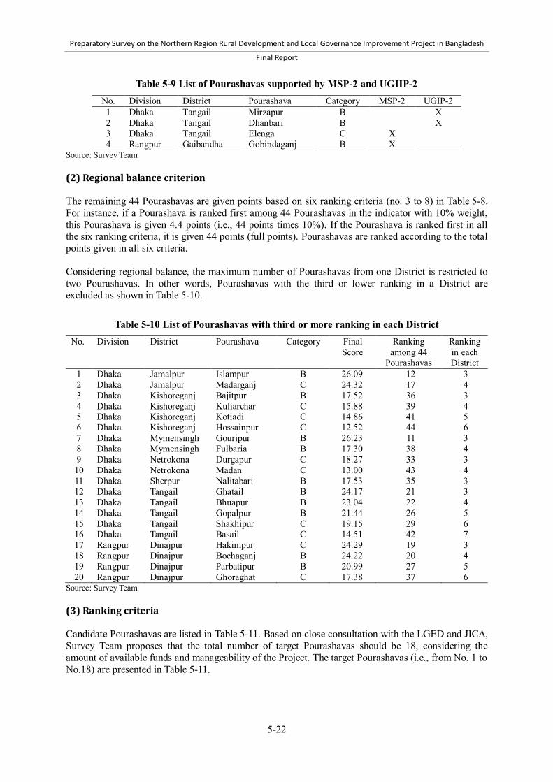
Preparatory Survey on the Northern Region Rural Development and Local Governance Improvement Project in Bangladesh
Final Report
5-22
Table 5-9 List of Pourashavas supported by MSP-2 and UGIIP-2 No. Division District Pourashava Category MSP-2 UGIP-2 1 Dhaka Tangail Mirzapur B X 2 Dhaka Tangail Dhanbari B X 3 Dhaka Tangail Elenga C X 4 Rangpur Gaibandha Gobindaganj B X
Source: Survey Team (2) Regional balance criterion The remaining 44 Pourashavas are given points based on six ranking criteria (no. 3 to 8) in Table 5-8. For instance, if a Pourashava is ranked first among 44 Pourashavas in the indicator with 10% weight, this Pourashava is given 4.4 points (i.e., 44 points times 10%). If the Pourashava is ranked first in all the six ranking criteria, it is given 44 points (full points). Pourashavas are ranked according to the total points given in all six criteria. Considering regional balance, the maximum number of Pourashavas from one District is restricted to two Pourashavas. In other words, Pourashavas with the third or lower ranking in a District are excluded as shown in Table 5-10.
Table 5-10 List of Pourashavas with third or more ranking in each District No. Division District Pourashava Category Final
Score Ranking
among 44 Pourashavas
Ranking in each District
1 Dhaka Jamalpur Islampur B 26.09 12 3 2 Dhaka Jamalpur Madarganj C 24.32 17 4 3 Dhaka Kishoreganj Bajitpur B 17.52 36 3 4 Dhaka Kishoreganj Kuliarchar C 15.88 39 4 5 Dhaka Kishoreganj Kotiadi C 14.86 41 5 6 Dhaka Kishoreganj Hossainpur C 12.52 44 6 7 Dhaka Mymensingh Gouripur B 26.23 11 3 8 Dhaka Mymensingh Fulbaria B 17.30 38 4 9 Dhaka Netrokona Durgapur C 18.27 33 3 10 Dhaka Netrokona Madan C 13.00 43 4 11 Dhaka Sherpur Nalitabari B 17.53 35 3 12 Dhaka Tangail Ghatail B 24.17 21 3 13 Dhaka Tangail Bhuapur B 23.04 22 4 14 Dhaka Tangail Gopalpur B 21.44 26 5 15 Dhaka Tangail Shakhipur C 19.15 29 6 16 Dhaka Tangail Basail C 14.51 42 7 17 Rangpur Dinajpur Hakimpur C 24.29 19 3 18 Rangpur Dinajpur Bochaganj B 24.22 20 4 19 Rangpur Dinajpur Parbatipur B 20.99 27 5 20 Rangpur Dinajpur Ghoraghat C 17.38 37 6
Source: Survey Team (3) Ranking criteria Candidate Pourashavas are listed in Table 5-11. Based on close consultation with the LGED and JICA, Survey Team proposes that the total number of target Pourashavas should be 18, considering the amount of available funds and manageability of the Project. The target Pourashavas (i.e., from No. 1 to No.18) are presented in Table 5-11.

Preparatory Survey on the Northern Region Rural Development and Local Governance Improvement Project in Bangladesh
Final Report
5-23
Table 5-11 List of candidate Pourashavas No. Division District Pourashava Category Final
Score Ranking
among 44 Pourashavas
Ranking within each
District 1 Rangpur Kurigram Ulipur B 30.84 1 1 2 Dhaka Tangail Kalihati B 30.81 2 1 3 Dhaka Mymensingh Nandail C 30.24 3 1 4 Dhaka Jamalpur Dewanganj C 29.59 4 1 5 Dhaka Sherpur Sreebardi C 28.53 5 1 6 Rangpur Dinajpur Fulbari B 27.55 6 1 7 Dhaka Mymensingh Phulpur B 27.46 7 2 8 Rangpur Nilphamari Jaldhaka C 27.29 8 1 9 Rangpur Rangpur Haragach C 27.27 9 1
10 Dhaka Jamalpur Melandah C 26.59 10 2 11 Rangpur Thakurgaon Pirganj B 25.77 13 1 12 Rangpur Gaibandha Sundarganj C 25.25 14 1 13 Rangpur Dinajpur Birganj B 24.51 15 2 14 Rangpur Kurigram Nageswari B 24.50 16 2 15 Dhaka Tangail Madhupur B 24.30 18 2 16 Rangpur Rangpur Badarganj B 22.60 23 2 17 Dhaka Kishoreganj Pakundia C 22.20 24 1 18 Rangpur Thakurgaon Ranishankail C 21.75 25 2 19 Dhaka Netrokona Mohonganj B 19.61 28 1 20 Dhaka Sherpur Nakla C 18.56 30 2 21 Dhaka Netrokona Kendua C 18.37 31 2 22 Dhaka Kishoreganj Karimganj C 18.32 32 2 23 Rangpur Nilphamari Domar C 18.03 34 2 24 Rangpur Panchagar Boda B 14.90 40 1
Source: Survey Team 5.4 Selection of infrastructure subprojects in Subcomponent 2-1 5.4.1 Participatory approach to the selection of subprojects The Project will adopt a participatory approach for the selection of subprojects under Subcomponent 2-1. At the preparatory survey stage, Survey Team identified the eligible types of infrastructure and the eligibility criteria to select subprojects under Subcomponent 2-1. Then, at the implementation stage of the Project, the target Pourashavas under the Project will determine their subprojects from the eligible types and by applying the eligibility criteria in a participatory manner. Subprojects of Subcomponent 2-1 will need to be selected and listed in an investment plan that consists of an integral part of the Pourashava Development Plan (PDP). The PDP formulation process will be the key process for the Project to ensure participation of a broad range of stakeholders of Pourashavas, and enhance transparency and accountability of actions taken by Pourashavas as a result. The PDP will be formulated based on the discussion at the Town-Level Coordination Committee (TLCC) and Ward-Level Coordination Committees (WLCCs), and shall be approved by the TLCC. The members of TLCC and WLCC include councilors, representatives of government agencies, sector representatives, women and the poor. In addition to the TLCC and WLCC meetings, several consultations will be held with stakeholders at the levels of Pourashava, ward, and community, involving sector groups such as teachers and commercial associations, and vulnerable groups such as women-headed families and the poor. These consultations as well as the TLCC and WLCC will enable the investment plan to reflect citizens’ needs and perceptions. Furthermore, the TLCC and WLCCs

Preparatory Survey on the Northern Region Rural Development and Local Governance Improvement Project in Bangladesh
Final Report
5-24
will ensure the participation of Pourashava stakeholders in the subproject selection through the discussion and approval process of the PDP. The investment plan of the PDP will be a five-year plan for urban infrastructure development with the identification of funding sources. Investment projects will be prioritized through the discussion at the TLCC and WLCCs and consultations with the stakeholders indicated earlier. The PDP including the investment plan will serve as the basis for the selection of subprojects under Subcomponent 2-1.64 After the TLCC’s approval of the PDP, Pourashavas will finalize the list of prioritized infrastructure projects and implement selected subprojects as per the investment plan. It should be noted, however, that the priority in the investment plan could be modified with concurrence of the TLCC if emergency needs arise due to natural disasters and other unexpected events. 5.4.2 Selection criteria The selection criteria of subprojects under Subcomponent 2-1 consist of 1) eligible types of subprojects, and 2) eligibility criteria. The eligible types are defined as “the types of subprojects that will be eligible for financing under Subcomponent 2-1.” Pourashavas will select only subprojects falling in the eligible types. The eligibility criteria must be applied for candidate subprojects of eligible types to be qualified for selection. The eligibility criteria are: 1) general criteria; and 2) sector-specific criteria. The former must be fulfilled by all types of subprojects, while the latter is to be applied only for specific sectors. In each phase of Component 2, Pourashavas will select and approve subprojects through the following steps: 1) A Pourashava identifies eligible types of subprojects that are identified in preparing a
Pourashava Development Plan (PDP).65 2) The Pourashava prepares a shortlist of subprojects to be financed under Subcomponent 2-1 from
the subprojects identified in the step 1) above.66 3) The Pourashava conducts a feasibility study on the shortlisted subprojects, and confirms whether
they satisfy all eligibility criteria. If some of them turn out not to satisfy some criteria, they are to be omitted and others are to be selected. Based on the feasibility study, the Pourashava prepares appraisal documents of subprojects and submits them to the PMO.
4) The PMO evaluates the appraisal documents of subprojects, and approves or disapprove them. It should be noted that ranking criteria are not proposed in the selection of subprojects in Subcomponent 2-1, which differs from the selection of subprojects in Component 1. This is because Component 2 is aimed to strengthen capacity of Pourashavas on participatory, planning-based infrastructure development centered on PDPs. In this approach, Pourashavas are expected to formulate and implement subprojects in multiple sectors that contribute to achieving the goals and strategies in their respective PDPs. Under this approach, pre-set ranking criteria by sector are not suitable because the strategies and goals in PDPs may vary significantly across Pourashavas. Therefore, the pre-set criteria should not be applied uniformly across all Pourashavas. However, this does not exclude the possibility that a Pourashava develops its own ranking criteria for the selection of subprojects that are in line with the goals and strategies in its PDP. 64 Subprojects to be implemented in Phase 1 will be determined regardless of the contents of the PDP since the PDP will be only finalized in the end of Phase 1. Subprojects of Phase 1, however, need to be discussed and approved by the TLCC to ensure stakeholders’ participation in the selection of subprojects of Phase 1. 65 In Phase 1, subprojects will be determined based on existing infrastructure development plans such as Pourashava Master Plan and through discussions at TLCC and WLCCs. because PDP will be finalized in the end of Phase 1. 66 In Phase 1, each Pourashava will prepare the shortlist of subprojects based on existing infrastructure development plans such as Pourashava Master Plan, discussions at TLCC and WLCCs, and consultations with other stakeholders.

Preparatory Survey on the Northern Region Rural Development and Local Governance Improvement Project in Bangladesh
Final Report
5-25
Eligible types of subprojects Table 5-12 shows proposed eligible types of subprojects. This proposal has been prepared through the following two steps. First, Survey Team collected and analyzed information on: 1) development needs in Pourashavas; 2) legal mandates of Pourashavas over infrastructures and public services stipulated in Pourashava Act 2009; 3) administrative and financial capacity of Pourashavas; and 4) eligible types of subprojects funded by the other similar LGED projects such as the UGIIP-2. This was followed by the second step in which Survey Team and key LGED officials discussed the information and analysis above, and determined the eligible types of subprojects to be proposed.
Table 5-12 Eligible types of subprojects under Subcomponent 2-1 Sector Eligible types of subprojects Urban transport (a) Roads, traffic junctions, and foot paths: Improvement and rehabilitation of
Pourashava roads, traffic junctions, and foot paths (b) Culverts and bridges: Rehabilitation of existing culverts and bridges, and
construction of new culverts and bridges not exceeding 100 m in length (c) Ghats: Development and rehabilitation of ghats (d) Traffic management and safety: Installation of facilities for traffic management
and road safety Drainage (a) Drainage system: Improvement, rehabilitation, and expansion of drainage system Solid waste management
(a) Storage, transfer, and disposal facilities: Construction of storage, transfer, and disposal facilities
(b) Collection and storage equipment: Procurement of collection and storage equipment
(c) House-to-house collection service: Establishment and improvement of house-to-house collection service
Water supply (a) Piped water supply system: Rehabilitation and expansion of piped water supply system
(b) Tubewells: Construction of tubewells (c) Iron/arsenic-removal facilities: Installation of iron- and arsenic-removal facilities
for hand tubewells (d) Metering: Procurement of equipment for metering
Sanitation (a) Public and community toilets: Construction, improvement, and rehabilitation of public and community toilets
(b) Sludge disposal equipment: Procurement of equipment for sludge disposal (d) Awareness campaign about hygiene
Municipal facilities (a) Bus and truck terminals: Construction, improvement, and rehabilitation of bus and truck terminals
(b) Parking areas: Construction, improvement, and rehabilitation of parking areas (c) Streetlights: Installation of streetlights including poles and energy saving bulbs (d) Public markets: Construction, improvement, and rehabilitation of public markets (e) Slaughterhouses: Construction, improvement, and rehabilitation of
slaughterhouses Basic services for poor*
(a) Basic infrastructure improvement under a Poverty Reduction Action Plan (PRAP)*: Construction and improvement of footpaths, drains, dustbins, tubewells, toilets, and streetlights
(b) Livelihood improvement support under a PRAP* Note: The types of subprojects with an asterisk (*) in this table is not eligible in Phase 1.

Preparatory Survey on the Northern Region Rural Development and Local Governance Improvement Project in Bangladesh
Final Report
5-26
General criteria From the perspectives of relevance, feasibility, efficiency, impact, sustainability, and social and environmental safety, Survey Team proposes general criteria in Table 5-13.
Table 5-13 General criteria for subprojects under Subcomponent 2-1
Perspectives General criteria for subprojects under Subcomponent 2-1 Relevance
The subproject is in accordance with long-term holistic development plans of Pourashavas such as Pourashava Master Plan and Pourashava Development Plan.*
The subproject matches citizens’ needs identified in a participatory manner. The subproject is neither included in, nor overlapped with, other projects.
Feasibility Implementation of the subproject is feasible in terms of technical, financial, and managerial aspects.
The Pourashava has adequate technical and managerial capacity to implement the subproject.
Efficiency The design of the subproject ensures the least-cost of capital, operation, and maintenance expenditures in order to achieve its objectives.
Impact EIRR of the subproject is 12% or more, if EIRR is applicable and can be calculated.
Sustainability An O&M plan for the subproject, which stipulates required budget, financial sources, organizational structure, and procedure, has been prepared and confirmed to be credible and feasible to implement.
There is no dispute over ownership of land where the subproject is undertaken. Implementation arrangement of the subproject incorporates a measure to
enhance capacity of Pourashava officials with regard to the subproject preparation, implementation, and O&M in the course of the subproject.
Social and environmental safety
The subproject complies with the Environmental Conservation Act 1995 and other relevant regulations, and, if required, undertakes Environmental Impact Assessment (EIA) and Initial Environmental Examination (IEE).
The subproject minimizes involuntary resettlement. It does not permanently displace 200 persons and more or affect 10% or more of their productive assets.
The subproject complies with Acquisition and Requisition of Immovable Property Ordinance 1982 and other relevant regulations, if the subproject requires land acquisition.
The subproject does not adversely affect indigenous communities. An Indigenous Peoples Plan is prepared, if required.
The subproject does not result in labor retrenchment, or encourage child labor, or directly or indirectly contribute to the spread of HIV/AIDS, human trafficking, or the displacement of girls and women.
Note: The criterion with an asterisk (*) in this table is not applied for subprojects to be implemented in Phase 1.

Preparatory Survey on the Northern Region Rural Development and Local Governance Improvement Project in Bangladesh
Final Report
5-27
Sector-specific criteria The proposed sector-specific criteria in Table 5-14 have been identified based on the sector-specific characteristics.
Table 5-14 Sector-specific criteria for subprojects under Subcomponent 2-1
Sectors and types Sector-specific criteria for subprojects under Subcomponent 2-1 Municipal transport Municipal roads A basic traffic survey has been carried out, and the subproject is designed
in line with the survey results such as estimated future traffic. Proper roadside drains and shoulders along the road exist or are proposed.
Municipal bridge A basic traffic survey has been carried out, and the subproject is designed in line with the survey results such as estimated future traffic.
Municipal ghat The ghat is not at serious risk from river erosion. Drainage A comprehensive master plan has been prepared, and the subproject is in
accordance with the master plan. Pourashava has conducted a survey on frequency of flooding and
waterlogging, and estimated damage to roads and other facilities. Then, it has confirmed inadequacy of existing drains’ capacity and the necessity of the subproject.
The subproject does not alter surface runoff regimes in the area of agricultural land or natural wetlands.
Drains improved, rehabilitated, and extended by the subproject are connected to appropriate outfalls.
Solid waste management A management plan and a marketing plan to construct a composting plant have been prepared and confirmed to be feasible. Besides, a Pourashava possesses adequate technical capacity to operate the plant or has identified outsourcing organizations with management experiences and capacity
Construction of a sanitary landfill. A Pourashava possesses adequate technical capacity to operate the landfill or has identified outsourcing organizations for with management capacity and experiences.
If user charges are levied for house-to-house collection, planned rates of the charge have been confirmed to be affordable, and willingness of users to pay the charges has been confirmed.
Water supply The available quantity of raw water that meets standards for safe drinking water has been confirmed.
The subproject is in line with relevant governmental guidelines and standards.
If a subproject is on piped water supply system, coordination with a District office of the DPHE has been ensured. An agreement of a District office of DPHE on its cooperation for the subproject has been obtained.
If a subproject is on a piped water supply system, the Pourashava has examined the need to revise tariff. When the need has been confirmed, the Pourashava has submitted to the LGD a proposal on revised tariff which covers O&M cost and is affordable for users.
The Pourashava has established a separate account for water revenues and expenditures.

Preparatory Survey on the Northern Region Rural Development and Local Governance Improvement Project in Bangladesh
Final Report
5-28
Table 5-14 Sector-specific criteria for subprojects under Subcomponent 2-1 (continued) Sectors and types Sector-specific criteria for subprojects under Subcomponent 2-1 Sanitation The design of sanitation facilities suits the requirements of socially
vulnerable people such as women, children, and the disabled. If a subproject is on community toilets, a written confirmation has been
provided that beneficiaries are willing and able to provide labor and other in-kind support to construct and manage the facilities.
If a subproject is on community toilets, at least one community-based organization (CBO) has been formed and plans to be trained for O&M. A management plan of the CBO has been prepared.
If a subproject is on community toilet, the subproject includes hygiene education and awareness campaign.
Municipal facilities Bus and truck
terminals A basic traffic survey has been carried out, and the subproject is in line
with the survey results such as estimated future traffic. The terminal is designed to reduce traffic congestion.
Public markets A survey has confirmed the need for the subproject based on the estimated number of stalls, their size, and demand for trading in the market.
A plot allocation plan has been prepared, defining the price, lease terms, and process for allocating plots.
The market is not at serious risk from river erosion. Slaughterhouses The subproject includes appropriate measures to dispose and treat
pollutants from the slaughterhouse such as carcasses and blood. Basic services for the poor Components of the subproject have been identified in a PRAP.
Beneficiaries have committed to making in-kind and financial contributions to meet the cost of O&M.
A physical and social survey of the site has been completed. If the subproject is on targets slums, a Slum Improvement Committee
(SIC) has been established. The SIC has prepared an implementation and maintenance plan for the subproject that stipulates institutional arrangement and procedures.
If the subproject is on basic infrastructure improvement in slums or informal settlements on government-owned land, a resolution that affirms no eviction or relocation of the residents for a period of at least 15 years has been adopted by the Pourashava Parishad. If the subproject is on private lands, the landowner has confirmed that there would be no eviction or relocation for at least 15 years.
5.4.3 Implementation process of Pourashava subprojects (1) Process of selection and approval of subprojects Subprojects under Subcomponent 2-1 will be selected based on an investment plan to be included in the Pourashava Development Plan (PDP). 67 The investment plan will list prioritized physical investment projects, and describe their contents, implementation schedule, and sources of financing. The subprojects shall be selected as per the eligibility criteria for subprojects under Subcomponent 2-1. Any subprojects that do not meet the criteria shall not be selected. In formulating the investment plans, the PIUs shall ensure that projects to be financed by the Project are in line with the eligibility criteria. However, it should be noted that the investment plan can contain projects to be financed by other
67 Subprojects to be implemented in Phase 1 will be determined regardless of the investment plan in the PDP since the PDP will be only finalized in the end of Phase 1.

Preparatory Survey on the Northern Region Rural Development and Local Governance Improvement Project in Bangladesh
Final Report
5-29
financing sources such as Pourashavas’ own source revenues, GOB grants, and the Bangladesh Municipal Development Fund (BMDF). This is because the PDP aims to provide a short- and medium-term development framework of a Pourashava, and therefore will not be prepared just for the implementation of subprojects under the Project. The PDP including the investment plan will be finalized during Phase 1 upon approval of TLCC. The approval of Pourashava Parishad is also necessary. Upon the adoption of the PDP, subprojects under Subcomponent 2-1 will be selected. The PIU in Pourashavas will submit the approved PDP including the investment plan to the PMO. In the course of the PDP preparation, subprojects and other physical investment projects will be identified and selected as described in Table 5-15.
Table 5-15 Main steps and activities for the selection of subprojects Main steps Main activities Identification of subprojects
A core group at Pourashavas, consisting of Mayor, Councilors, Assistant Engineer, Secretary and Health Officer, will identify subprojects, taking into account their development priorities and financial availability.
In the process of the identification, consultations will be held with sector groups and communities.
Selection of subprojects The PIU will select subprojects to be funded by the Project. The PIU will ensure that the subprojects meet the eligibility criteria of
Subcomponent 2-1. Approval of subprojects The draft investment plan will be discussed at the TLCC and WLCCs, and
approved by them as part of the PDP. The PDP will be approved by the Pourashava Parishad. The PIU will submit the PDP to the PMO.
Source: Survey Team Subprojects under Subcomponent 2-1 shall be selected and implemented based on the approved investment plan, except for those to be implemented during Phase 1. The subprojects for Phase 1 will be selected based on the Pourashava Master Plan, other relevant planning documents, or consultations with stakeholders. The subprojects in Phase 1 shall be discussed and approved by the TLCC to ensure participatory decision making on the selection of the subprojects. Pourashavas can modify the contents of investment plan if any urgent needs occur, such as those caused by natural disasters. However in such a case, Pourashavas will need to obtain approval of the TLCC and the Pourashava Parishad on the modification, and then submit the modified version of the investment plan to the PMO, and obtain its approval. (2) Process of planning and implementation of subprojects After the selection of candidate subprojects in the investment plan under the PDP,68 the PIUs will proceed to the stage of subproject planning and implementation. Although details of the process for the planning and implementation vary among different types of subprojects, the process shall take some basic stages and conduct main activities that are common across all types of subprojects (Table 5-16). In the process of planning of subprojects, the PIUs will conduct detailed designing of subprojects from technical, institutional, and financial viewpoints. They will make design drawings, clarify technical specifications, and estimate subproject cost with support from the PMO and DSM consultants. In
68 In Phase 1, candidate subprojects will not be selected from the investment plan under the PDP.

Preparatory Survey on the Northern Region Rural Development and Local Governance Improvement Project in Bangladesh
Final Report
5-30
addition, as part of the designing, they will prepare implementation plans and O&M plans that specify institutional arrangements and necessary budget for O&M with support from the PMO, DSM and Governance Improvement and Capacity Development (GICD) consultants. The estimated budget for implementation and O&M is to be incorporated in annual budget of Pourashavas. Based on the designing, PIUs will prepare appraisal documents on subprojects. After the acceptance of the documents by the PMO, financing of subprojects will be finally approved. In addition to the preparation and approval of the appraisal documents on subprojects, the LGED and a Pourashava sign a Subproject Agreement at the beginning of each phase of Component 2. If the financing includes loans to revenue-generating subprojects, a Pourashava will sign a Subsidiary Loan Agreement on each revenue-generating subproject with the Ministry of Finance. These activities and other relevant points in the planning process are summarized in Table 5-16. It is important to note that the designing of subprojects will be also carried out in the process of formulating PDP. This is because subprojects will need to be appraised during the formulation of PDP to: 1) ensure feasibility and relevancy of selected candidate subprojects; 2) increase accuracy of estimated subproject cost; and 3) enhance reliability of the investment plan, whether the study is in small or full scale.
Table 5-16 Main activities in the process of subproject planning and implementation Stage Main activities in the process Items to be specified in
guidelines and manuals Planning PIU will carry out detailed designing of subprojects from
technical, organizational, and financial aspects. Technical designing will clarify design drawings, technical
specifications, and cost estimation. Through the designing, PIU will prepare implementation
plans and O&M plans. These plans specify organizational arrangements and necessary budgets. The necessary budgets for implementation and O&M shall be reflected in the annual budget of Pourashava.
DSM consultants will assist PIU in designing. GICD consultants will also assist PIU, particularly with regard to organizational and financial aspects.
In the course of the designing, PIU will assess that subprojects satisfy all relevant eligibility criteria.
PIU will prepare an appraisal document on each subproject based on the results of the designing. After the PMO’s approval, financing of subprojects will be approved as a result.
Standard design drawings
Standard technical specifications
Guidance on preparation of O&M plans
Format for appraisal document
Implementation PIU will call tender of contractors and procure equipment. PIU will monitor and supervise contractors and progress of
the implementation. PIU will prepare and submit monitoring reports to the PMO. PIU will carry out inspection on the completion of subproject
implementation, and prepare completion reports to the PMO, and send request for final payment.
Methods for construction supervision
Monitoring tools and report formats
Source: Survey Team In the process of the implementation of subprojects, the PIUs will prepare tendering documents based on the designing, and call tender for procurement of goods and works. Then, they will supervise contractors and monitor the implementation. On completion of the implementation, they will inspect outputs and make final payment to contractors. For the purpose of the implementation, the PMO with support of consultants will prepare relevant

Preparatory Survey on the Northern Region Rural Development and Local Governance Improvement Project in Bangladesh
Final Report
5-31
guidelines and manuals after the commencement of the Project. Those guidelines and manuals will specify standard design drawings, standard technical specifications, guidance on preparation of O&M plans, and other items. In addition, there are type-specific steps and activities in the process of subproject planning and implementation. Table 5-17 enlists such type-specific activities in the process. For instance, PIUs will not contract out physical work on basic infrastructure for the poor, but provide construction materials for the poor and assist them to execute physical works by themselves. Another example is that active involvement of beneficiaries’ groups is a key factor for some subprojects such as house-to-house waste collection, community toilets, hand tubewells, and basic services for the poor. Thus, in such projects, facilitation and assistance for the groups will be critical for the PIU in the process of planning and implementation.

Preparatory Survey on the Northern Region Rural Development and Local Governance Improvement Project in Bangladesh
Final Report
5-32
Table 5-17 Type-specific activities in the process of subproject planning and implementation Type of subprojects
Type-specific activities in the process Items to be specified in guidelines and manuals
Urban transport
Planning PIU will carry out basic traffic survey with support from the PMO and
DSM consultants.
Methods and tools for basic traffic survey
Drainage Planning Prior to detailed designing of individual subprojects, PIU will formulate
a drainage master plan with support from the PMO and DSM consultants.
Basic instruction on a drainage master plan such as purpose, usage, and update of the plan
Solid waste management
Planning PIU will prepare a management plan and marketing plan for composting
plant. In the case of subproject on house-to-house collection, PIU will
establish CBOs, and undertake the designing in close consultation with the CBOs.
Implementation PIU will execute construction work, procurement of equipment, and
operation of waste collection and disposal. In the case of subproject on house-to-house collection, CBOs will be
involved. PIU will provide CBOs with training and practical support. PIU may contract out the implementation to NGOs.
Materials to support CBOs in house-to-house collection
Manuals on waste collection, composting plants, and landfills
Water supply Planning & implementation PIU will communicate and coordinate closely with the DPHE. In the case of subproject on hand tubewells, PIU will consult with and
involve CBOs and beneficiaries.
Instructions for CBOs regarding maintenance of tubewells
Manuals for PIUs regarding CBO support
Community toilets
Planning & implementation PIU will involve and consult with CBOs and beneficiaries. Planning If CBOs do not exist in subproject sites, PIU will support the
establishment of CBOs. PIU will provide CBOs with short training courses on maintenance of
toilets.
Training materials on toilet maintenance
Basic services for poor
Planning & implementation The selection of subprojects shall be in line with a poverty reduction
strategy and poverty reduction action plan (PRAP). PIU will effectively consult with and involve target groups such as Slum
Improvement Committees (SICs), Primary Groups, CBOs, and other beneficiaries.
PIU will provide target groups with necessary training and instruction. Planning PIU will support the establishment of SICs and Primary Groups if they
are not yet formed. PIU will assist SICs in preparing Community Action Plans (CAPs), and
assist target Primary Groups outside slums in preparing concise action plans. Based on these plans, PIU will design subprojects in close consultation with the target groups.
Implementation In the case of subprojects in slums, implementation process in other
similar projects such as the UGIIP-2 will be followed. For instance, basic infrastructure development work will not be contracted out, but executed directly by beneficiaries.
In the case of subprojects outside slums, the implementation process will be similar to that for slums, although the former shall be easier and simpler than the latter.
Planning and implementation manuals specialized for this type of subprojects
Source: Survey Team

Preparatory Survey on the Northern Region Rural Development and Local Governance Improvement Project in Bangladesh
Final Report
6-1
6 Project cost estimate 6.1 Project costs 6.1.1 Basic assumptions for cost estimate The project costs are estimated based on the assumptions listed below: The cost of construction work is calculated separately for Mymensingh, Tangail, Rangpur, and
Dinajpur Regions. For cost estimation of construction work, the Schedules of Rates for Mymensingh, Tangail, Rangpur, and Dinajpur published by the LGED in July 2012 are applied for the whole Project area of 14 Districts to establish unit costs.
The calculation only includes the cost of new banking materials required for upgrading existing Upazila roads (UZRs) and Union roads (UNRs), rather than considering the cost required for the construction of new roads.
Vegetation cover will be provided on side-slopes and soft shoulders of roads. Culverts will be constructed at gaps equal to or less than 15 m, while reinforced cement concrete
(RCC) bridges will be built where the gaps are between 15 m and 200 m. Traffic signs will be installed near schools, hospitals, and Growth Centers and rural markets. 20 guard posts per km will be installed on curved road sections. A total of eight guard posts will
be built to the front, back, right, and left of each approach road to an RCC bridge. One bus bay per 2 km will be constructed, with one side of the road extended. Physical contingencies are calculated at 5% of the base cost total. Price escalation is calculated at 4.9% compound of the base cost total (see Section 6.1.2). Fees for consultancy services related to surveys, designs, tender documents, selection of
contractors, and supervision of construction are included in the base cost of the consultancy service fee.
The costs are divided into those payable in foreign currency (JPY) and those payable in local currency (BDT). The exchange rates as of October 2012 (USD 1 = JPY 78.7; USD 1 = BDT 81.9; and BDT 1 = JPY 0.9606 or JPY 1 = BDT 1.0410) are used for calculation.
The costs payable in foreign currency are: 1) consultancy fees, overhead, and direct costs for international consultants; 2) costs for overseas procurement of vehicles and construction equipment; and 3) costs for overseas training.
The costs payable in local currency are: 1) costs for civil works; 2) consultancy fees, overhead, and direct costs for national consultants; 3) costs for in-country procurement and maintenance of equipment and material; 4) costs for Project staff training; 5) duties and taxes; and 6) costs for land acquisition.
6.1.2 Price escalation The prices of construction materials in Bangladesh have increased markedly since 2007/2008. To establish a better estimate of their upward trend, a smoothed curve was adapted to the index data for 1999/2000 to 2009/2010, as shown in Annex 20. The analysis indicates that the construction costs will be increased constantly by 7.8% per year during the implementation period of the Project. However, most part of the Project budget will be disbursed from a JICA loan in JPY. The yearly average exchange rates of JPY against BDT from 1996/1997 to 2011/2012 were evaluated to study the trend of the exchange rates in the last 15 years. In this study, a smoothed curve was also adapted to the exchange rate data to establish a better estimate of their upward trend, as shown in Annex 20. The evaluation from the past data indicates that the exchange rate will be appreciated constantly 6.1% per year.

Preparatory Survey on the Northern Region Rural Development and Local Governance Improvement Project in Bangladesh
Final Report
6-2
Although the inflation of the construction cost index will continue its trend, the appreciation of JPY/BDT exchange rate will probably affect the construction costs with a positive impact since the most of the Project budget will be disbursed in JPY. However, the LGED Schedule of Rate has still been escalating and the market rate is higher that the Schedule of Rate in the same year. Taking both the positive and negative impacts to the construction costs into account, 4.9% of compound price escalation rate is applied to the cost estimates for the Project. The summary of the analysis of price escalation is shown in Annex 20. If cost fluctuations cannot be absorbed by the contingency, the number of road and/or other subprojects could be increased or decreased based on the ranking results presented in Chapter 5 to adjust total project costs. 6.1.3 Summary of Project costs The summary of Project costs is shown in Table 6-1. The total cost of the Project is BDT 27,791 million, which is equivalent to JPY 26,696 million. Costs are classified into: 1) portion eligible for JICA loan, which can be financed by JICA with 78% of the total budget; and 2) portion non-eligible for JICA loan, which should be financed by the Government of Bangladesh (GOB) with 22% of the total budget. The largest component in the portion eligible for JICA loan is “Component 1: Rural infrastructure development” and its base cost accounts for 41% of the total budget. The second largest are “Component 2: Urban infrastructure and governance” with 10% of the total followed by “Component 3: Project implementation support” with 8% of the total to ensure the quality of project outputs and to increase the implementation capacity of the Project. For project management, 5% is allocated to “Administration cost” to finance the costs of staff remuneration of Project management and implementation, operation of offices, and so on. To manage economic and other uncertainties 13% and 4% of the total cost are allocated to price escalation and physical contingency, respectively.

Preparatory Survey on the Northern Region Rural Development and Local Governance Improvement Project in Bangladesh
Final Report
6-3
Table 6-1 Summary of project costs Item Local currency
(million BDT) Foreign currency
(BDT 1 = JPY 0.9606) (million JPY)
% to total
FC LC Total FC LC Total TOTAL PROJECT COST (A+B) 1,220 26,571 27,791 1,172 25,524 26,696 100% A. PORTION ELIGIBLE FOR JICA LOAN 1,220 20,469 21,690 1,172 19,663 20,835 78% Component 1: Rural infrastructure development 27 11,293 11,320 26 10,848 10,874 41% Subcomponent 1-1: Upgrading of Upazila roads 6,396 6,396 6,144 6,144 23% Subcomponent 1-2: Upgrading of Union roads 2,531 2,531 2,432 2,432 9% Subcomponent 1-3: Rehabilitation of Upazila roads 1,050 1,050 1,009 1,009 4% Subcomponent 1-4: Improvement of Growth Centers and rural markets 859 859 825 825 3% Subcomponent 1-5: Improvement of ghats 80 80 77 77 0% Subcomponent 1-6: Labor contracting society (LCS) scheme 318 318 305 305 1% Subcomponent 1-7: Community-based road safety program 4 4 4 4 0% Subcomponent 1-8: Training and capacity development 27 55 82 26 53 79 0% Component 2: Urban infrastructure and governance improvement 2,851 2,851 2,738 2,738 10% Subcomponent 2-1: Urban infrastructure development and service
delivery 2,810 2,810 2,699 2,699 10%
Subcomponent 2-2: Governance improvement and capacity development
41 41 39 39 0%
Component 4: Project administration support 470 291 761 452 279 731 3% Price escalation (foreign 2.1% and local 4.9%) for C1, C2 and C4 42 2,959 3,001 40 2,842 2,882 11% Physical contingency (5%) for C1, C2 and C4 27 870 897 26 835 861 3% Component 3: Project implementation support 567 1,773 2,339 544 1,703 2,247 8% Subcomponent 3-1: Engineering services of Design, Supervision and
Monitoring (DSM) 546 816 1,362 525 783 1,308 5%
Subcomponent 3-2: Governance Improvement and Capacity Development (GICD)
915 915 879 879 3%
Subcomponent 3-3: Benefit Monitoring and Evaluation (BME) 20 42 62 20 40 60 0% Price escalation (foreign 2.1% and local 4.9%) for C3 48 329 376 46 316 362 1% Physical contingency (5%) for C3 31 105 136 30 101 131 0% Interest during construction 9 9 9 9 0% B. PORTION NON-ELIGIBLE FOR JICA LOAN 6,102 6,102 5,861 5,861 22% Capacity development 18 18 18 18 0% Administration cost 1,415 1,415 1,359 1,359 5% Price escalation (foreign 2.1% and local 4.9%) 275 275 265 265 1% Physical contingency (5%) 85 85 82 82 0% Land acquisition and resettlement 701 701 674 674 3% Taxes and duties 3,606 3,606 3,464 3,464 13% The detailed summary of project costs is shown in Table 6-2.
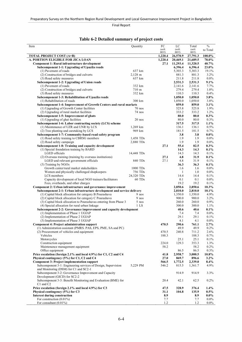
Preparatory Survey on the Northern Region Rural Development and Local Governance Improvement Project in Bangladesh
Final Report
6-4
Table 6-2 Detailed summary of project costs Item Quantity FC
(mill. BDT)
LC (mill. BDT)
Total (mill. BDT)
% to Total
TOTAL PROJECT COST (A+B) 1,220.4 26,570.9 27,791.3 100.0% A. PORTION ELIGIBLE FOR JICA LOAN 1,220.4 20,469.1 21,689.5 78.0% Component 1: Rural infrastructure development 27.1 11,293.4 11,320.5 40.7% Subcomponent 1-1: Upgrading of Upazila roads 6,396.4 6,396.4 23.0% (1) Pavement of roads 637 km 5,303.3 5,303.3 19.1% (2) Construction of bridges and culverts 2,128 m 881.3 881.3 3.2% (3) Road safety measures 637 km 211.8 211.8 0.8% Subcomponent 1-2: Upgrading of Union roads 2,531.3 2,531.3 9.1% (1) Pavement of roads 332 km 2,141.6 2,141.6 7.7% (2) Construction of bridges and culverts 710 m 279.4 279.4 1.0% (3) Road safety measures 332 km 110.3 110.3 0.4% Subcomponent 1-3: Rehabilitation of Upazila roads 1,050.0 1,050.0 3.8% (1) Rehabilitation of roads 300 km 1,050.0 1,050.0 3.8% Subcomponent 1-4: Improvement of Growth Centers and rural markets 859.0 859.0 3.1% (1) Upgrading of Growth Center facilities 70 nos 525.8 525.8 1.9% (2) Upgrading of rural market facilities 74 nos 333.2 333.2 1.2% Subcomponent 1-5: Improvement of ghats 80.0 80.0 0.3% (1) Upgrading of ghat facilities 20 nos 80.0 80.0 0.3% Subcomponent 1-6: Labor contracting society (LCS) scheme 317.5 317.5 1.1% (1) Maintenance of UZR and UNR by LCS 1,269 km 136.1 136.1 0.5% (2) Tree planting and caretaking by LCS 969 km 181.5 181.5 0.7% Subcomponent 1-7: Community-based road safety program 3.8 3.8 0.0% (1) Road safety training to CBRSG members 1,458 TDs 1.9 1.9 0.0% (2) Road safety campaign 2,880 TDs 1.9 1.9 0.0% Subcomponent 1-8: Training and capacity development 27.1 55.4 82.5 0.3% (1) Special foundation training by BARD 14.3 14.3 0.1% LGED officials 14,448 TDs 14.3 14.3 0.1% (2) Overseas training (training by overseas institutions) 27.1 4.8 31.9 0.1% LGED and relevant government officials 840 TDs 27.1 4.8 31.9 0.1% (3) Training by NGOs 36.3 36.3 0.1% Growth center/rural market stakeholders 1000 TDs 1.6 1.6 0.0% Women and physically challenged shopkeepers 756 TDs 1 1.0 0.0% LCS members 24,320 TDs 14.4 14.4 0.1% Capacity development of local NGO trainers/facilitators 60 TDs 0.1 0.1 0.0% Fees, overheads, and other charges 19.2 19.2 0.1% Component 2: Urban infrastructure and governance improvement 2,850.6 2,850.6 10.3% Subcomponent 2-1: Urban infrastructure development and service delivery 2,810.0 2,810.0 10.1% (1) Capital block allocation for category B Pourashava 9 nos 1,350.0 1,350.0 4.9% (2) Capital block allocation for category C Pourashava 9 nos 900.0 900.0 3.2% (3) Capital block allocation to Pourashavas entering from Phase 3 5 nos 260.0 260.0 0.9% (4) Special allocation for rural urban linkage 1 LS 300.0 300.0 1.1% Subcomponent 2-2: Governance improvement and capacity development 40.6 40.6 0.1% (1) Implementation of Phase 1 UGIAP 7.4 7.4 0.0% (2) Implementation of Phase 2 UGIAP 29.1 29.1 0.1% (3) Implementation of Phase 3 UGIAP 4.1 4.1 0.0% Component 4: Project administration support 470.5 290.6 761.1 2.7% (1) Administration assistant (PMRS. PAS, EPS, PME, SA and PC) 49.9 49.9 0.2% (2) Procurement of vehicles and equipment 470.5 240.8 711.2 2.6% Vehicles 188.3 188.3 0.7% Motorcycles 25.1 25.1 0.1% Construction equipment 224.0 129.3 353.3 1.3% Maintenance management equipment 58.2 58.2 0.2% Office equipment 86.5 86.5 0.3% Price escalation (foreign 2.1% and local 4.9%) for C1, C2 and C4 41.8 2,958.7 3,000.5 10.8% Physical contingency (5%) for C1, C2 and C4 27.0 869.7 896.6 3.2% Component 3: Project implementation support 566.5 1,772.5 2,339.0 8.4% Subcomponent 3-1: Engineering services of Design, Supervision
and Monitoring (DSM) for C1 and SC2-1 5,229 PM 546.2 815.5 1,361.7 4.9%
Subcomponent 3-2: Governance Improvement and Capacity Development (GICD) for SC2-2
914.9 914.9 3.3%
Subcomponent 3-3: Benefit Monitoring and Evaluation (BME) for C1 and C2
20.4 42.1 62.5 0.2%
Price escalation (foreign 2.1% and local 4.9%) for C3 47.5 328.9 376.4 1.4% Physical contingency (5%) for C3 31.1 104.8 135.9 0.5% Interest during construction 8.9 8.9 0.0% For construction (0.01%) 7.7 7.7 0.0% For consultant (0.01%) 1.2 1.2 0.0%
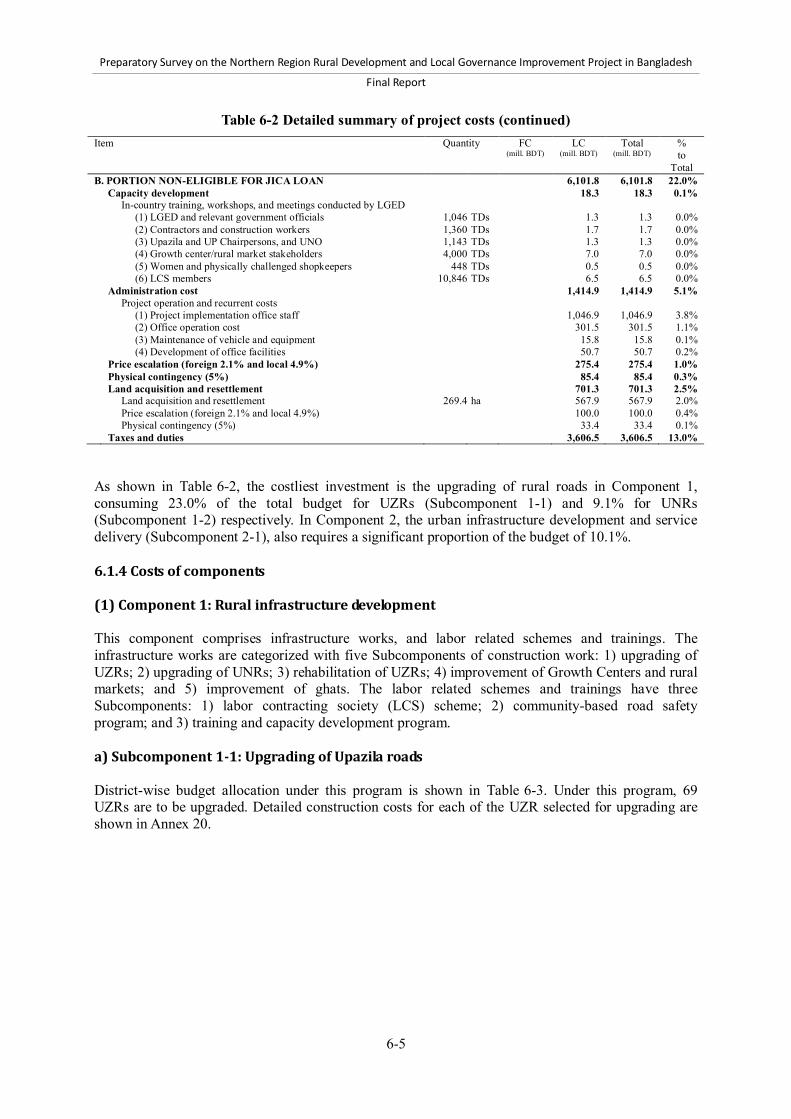
Preparatory Survey on the Northern Region Rural Development and Local Governance Improvement Project in Bangladesh
Final Report
6-5
Table 6-2 Detailed summary of project costs (continued) Item Quantity FC
(mill. BDT) LC
(mill. BDT) Total
(mill. BDT) % to
Total B. PORTION NON-ELIGIBLE FOR JICA LOAN 6,101.8 6,101.8 22.0% Capacity development 18.3 18.3 0.1% In-country training, workshops, and meetings conducted by LGED (1) LGED and relevant government officials 1,046 TDs 1.3 1.3 0.0% (2) Contractors and construction workers 1,360 TDs 1.7 1.7 0.0% (3) Upazila and UP Chairpersons, and UNO 1,143 TDs 1.3 1.3 0.0% (4) Growth center/rural market stakeholders 4,000 TDs 7.0 7.0 0.0% (5) Women and physically challenged shopkeepers 448 TDs 0.5 0.5 0.0% (6) LCS members 10,846 TDs 6.5 6.5 0.0% Administration cost 1,414.9 1,414.9 5.1% Project operation and recurrent costs (1) Project implementation office staff 1,046.9 1,046.9 3.8% (2) Office operation cost 301.5 301.5 1.1% (3) Maintenance of vehicle and equipment 15.8 15.8 0.1% (4) Development of office facilities 50.7 50.7 0.2% Price escalation (foreign 2.1% and local 4.9%) 275.4 275.4 1.0% Physical contingency (5%) 85.4 85.4 0.3% Land acquisition and resettlement 701.3 701.3 2.5% Land acquisition and resettlement 269.4 ha 567.9 567.9 2.0% Price escalation (foreign 2.1% and local 4.9%) 100.0 100.0 0.4% Physical contingency (5%) 33.4 33.4 0.1% Taxes and duties 3,606.5 3,606.5 13.0% As shown in Table 6-2, the costliest investment is the upgrading of rural roads in Component 1, consuming 23.0% of the total budget for UZRs (Subcomponent 1-1) and 9.1% for UNRs (Subcomponent 1-2) respectively. In Component 2, the urban infrastructure development and service delivery (Subcomponent 2-1), also requires a significant proportion of the budget of 10.1%. 6.1.4 Costs of components (1) Component 1: Rural infrastructure development This component comprises infrastructure works, and labor related schemes and trainings. The infrastructure works are categorized with five Subcomponents of construction work: 1) upgrading of UZRs; 2) upgrading of UNRs; 3) rehabilitation of UZRs; 4) improvement of Growth Centers and rural markets; and 5) improvement of ghats. The labor related schemes and trainings have three Subcomponents: 1) labor contracting society (LCS) scheme; 2) community-based road safety program; and 3) training and capacity development program. a) Subcomponent 1-1: Upgrading of Upazila roads District-wise budget allocation under this program is shown in Table 6-3. Under this program, 69 UZRs are to be upgraded. Detailed construction costs for each of the UZR selected for upgrading are shown in Annex 20.
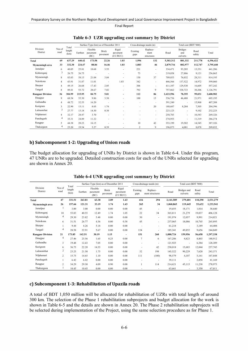
Preparatory Survey on the Northern Region Rural Development and Local Governance Improvement Project in Bangladesh
Final Report
6-6
Table 6-3 UZR upgrading cost summary by District
Total 69 637.29 440.42 173.58 22.26 1.03 1,996 132 5,303,312 881,332 211,778 6,396,422
Mymensingh area 33 332.30 224.47 88.84 16.46 1.03 1,883 46 2,879,716 802,977 112,747 3,795,440Jamalpur 6 40.05 25.81 10.68 3.55 - 221 - 334,471 93,285 13,531 441,286 Kishoreganj 3 26.75 26.75 - - - 73 - 219,858 27,886 9,121 256,865 Mymensingh 8 83.03 58.15 21.04 3.84 - 150 37 709,853 76,032 28,311 814,195 Netrokona 4 43.91 31.87 11.01 - 1.03 342 - 446,566 137,522 14,972 599,060 Sherpur 4 49.15 26.68 17.43 2.05 - 306 - 411,107 129,530 16,605 557,242 Tangail 8 89.41 53.72 28.67 7.02 - 792 9 757,862 338,723 30,206 1,126,791
Rangpur Division 36 304.99 215.95 84.75 5.81 - 112 86 2,423,596 78,355 99,031 2,600,982 Dinajpur 9 68.54 55.30 9.86 3.38 - 100 15 536,736 46,488 21,971 605,195 Gaibandha 4 48.72 32.53 16.20 - - - - 391,240 - 15,968 407,208 Kurigram 3 22.90 13.11 8.05 1.74 - - 20 188,687 8,204 7,505 204,396 Lalmonirhat 3 27.77 13.18 14.30 0.30 - - - 223,123 - 9,102 232,225 Nilphamari 4 32.17 28.47 3.70 - - - - 258,783 - 10,543 269,326 Panchagarh 4 35.31 24.09 11.22 - - - - 274,955 - 11,319 286,274 Rangpur 5 44.38 28.23 16.15 - - 10 42 353,199 19,582 14,545 387,326 Thakurgaon 4 25.20 19.54 5.27 0.39 - 2 9 196,873 4,081 8,078 209,032
Division District
Nos ofroad
Totallength(km)
Surface Type (km) as of December 2011 Cross-drainage needs (m) Total cost (BDT '000)
EarthenFlexible
paxement(BC)
Brickpavement Total
Rigidpavement(CC/RCC)
Existinggaps
Replace-ment
structuresRoad
Bridgesand
culverts
Roadsafety
b) Subcomponent 1-2: Upgrading of Union roads The budget allocation for upgrading of UNRs by District is shown in Table 6-4. Under this program, 47 UNRs are to be upgraded. Detailed construction costs for each of the UNRs selected for upgrading are shown in Annex 20.
Table 6-4 UNR upgrading cost summary by District
Total 47 331.51 263.81 63.38 2.89 1.43 416 294 2,141,589 279,401 110,290 2,531,279
Mymensingh area 26 157.66 121.31 33.19 1.74 1.43 265 34 1,060,865 119,445 53,632 1,233,941Jamalpur 1 3.00 3.00 0.00 0.00 0.00 45 - 19,455 18,171 1,014 38,640 Kishoreganj 10 55.83 40.55 12.49 1.74 1.05 22 34 365,811 21,279 19,037 406,128 Mymensingh 4 29.30 23.82 5.48 0.00 0.00 30 - 191,974 12,057 9,991 214,021 Netrokona 6 31.51 26.77 4.36 0.00 0.38 45 - 237,065 18,086 10,745 265,895 Sherpur 1 9.44 4.26 5.18 0.00 0.00 - - 61,218 - 3,189 64,408 Tangail 4 28.58 22.91 5.67 0.00 0.00 124 - 185,341 49,852 9,656 244,849
Rangpur Division 21 173.85 142.51 30.19 1.15 - 151 260 1,080,724 159,956 56,658 1,297,338 Dinajpur 4 27.46 25.56 1.65 0.25 0.00 7 6 167,286 4,823 8,803 180,912 Gaibandha 3 19.48 12.43 7.05 0.00 0.00 - - 121,925 - 6,384 128,309 Kurigram 6 36.75 22.20 14.55 0.00 0.00 - 42 230,018 15,683 12,044 257,745 Lalmonirhat 2 23.25 21.50 1.75 0.00 0.00 32 198 145,522 90,229 7,620 243,371 Nilphamari 2 15.75 14.65 1.10 0.00 0.00 111 (100) 98,579 4,107 5,161 107,848 Panchagarh 1 6.42 6.42 0.00 0.00 0.00 - - 39,111 - 2,058 41,169 Rangpur 2 34.29 29.30 4.09 0.90 0.00 1 114 214,621 45,115 11,238 270,973 Thakurgaon 1 10.45 10.45 0.00 0.00 0.00 - - 63,661 - 3,350 67,011
TotalRigid
pavement(CC/RCC)
Existinggaps
Replace-ment structures Road Bridges and
culvertsRoadsafety
Division District
Nos ofroad
Totallength(km)
Surface Type (km) as of December 2011 Cross-drainage needs (m) Total cost (BDT '000)
EarthenFlexible
paxement(BC)
Brickpavement
c) Subcomponent 1-3: Rehabilitation of Upazila roads A total of BDT 1,050 million will be allocated for rehabilitation of UZRs with total length of around 300 km. The selection of the Phase 1 rehabilitation subprojects and budget allocation for the work is shown in Table 6-5 and the details are shown in Annex 20. The Phase 2 rehabilitation subprojects will be selected during implementation of the Project, using the same selection procedure as for Phase 1.

Preparatory Survey on the Northern Region Rural Development and Local Governance Improvement Project in Bangladesh
Final Report
6-7
Table 6-5 Phase 1 UZR rehabilitation cost summary by District District Number of road Total length
(km) Total cost
(BDT '000) Dinajpur 2 19.40 64,932 Kurigram 2 9.91 34,143 Nilphamari 2 37.68 129,883 Panchagarh 2 32.00 107,104 Rangpur 3 52.65 181,485 Total 11 151.64 517,547
d) Subcomponent 1-4: Improvement of Growth Centers and rural markets A total of BDT 859 million is allocated for the improvement of Growth Centers and rural markets. District-wise budget allocation under this program is shown in Table 6-6. Under this program, 70 Growth Centers and 74 rural markets are to be improved. Detailed construction costs for each of the Growth Centers and rural markets selected for improvement are shown in Annex 20.
Table 6-6 Growth center and rural market improvement cost summary by District Division
District Number of
Growth Center Cost of GCs (BDT '000)
Number of rural market
Cost of markets (BDT '000)
Total 70 525,770 74 333,180 Mymensingh area 39 297,030 39 178,120 Jamalpur District 4 30,520 3 13,740 Kishoreganj District 9 68,400 8 36,480 Mymensingh
District 7 53,200 16 72,960
Netrokona District 2 15,200 1 4,560 Sherpur District 6 45,780 6 27,480 Tangail District 11 83,930 5 22,900 Rangpur Division 31 228,740 35 155,060 Dinajpur District 14 103,180 11 48,620 Gaibandha District 2 14,800 1 4,440 Kurigram District 2 14,800 8 35,520 Lalmonirhat
District 0 - 0 -
Nilphamari District 2 14,800 7 31,080 Panchagarh District 3 22,110 6 26,520 Rangpur District 3 22,200 2 8,880 Thakurgaon District 5 36,850 0 -
e) Subcomponent 1-5: Improvement of ghats 20 ghats will be improved and a total budget of BDT 80 million will be allocated for the work. The selection of the ghats and budget allocation for the work will be executed during implementation of the Project. f) Subcomponent 1-6, 7 and 8: Poverty reduction, road safety, and capacity development programs Per km unit costs for tree-planting and caretaking, and the maintenance of UZRs and UNRs are shown in Annex 20. The poverty reduction program will budget BDT 317.5 million and the road safety program will budget BDT 3.8 million. The types of training courses, costs, and organizations charged with their implementation for the capacity development programs are presented in Table 6-7. Training courses conducted by organizations outside of the LGED are eligible for finance by JICA, while the training courses conducted by the LGED are owed by the GOB.
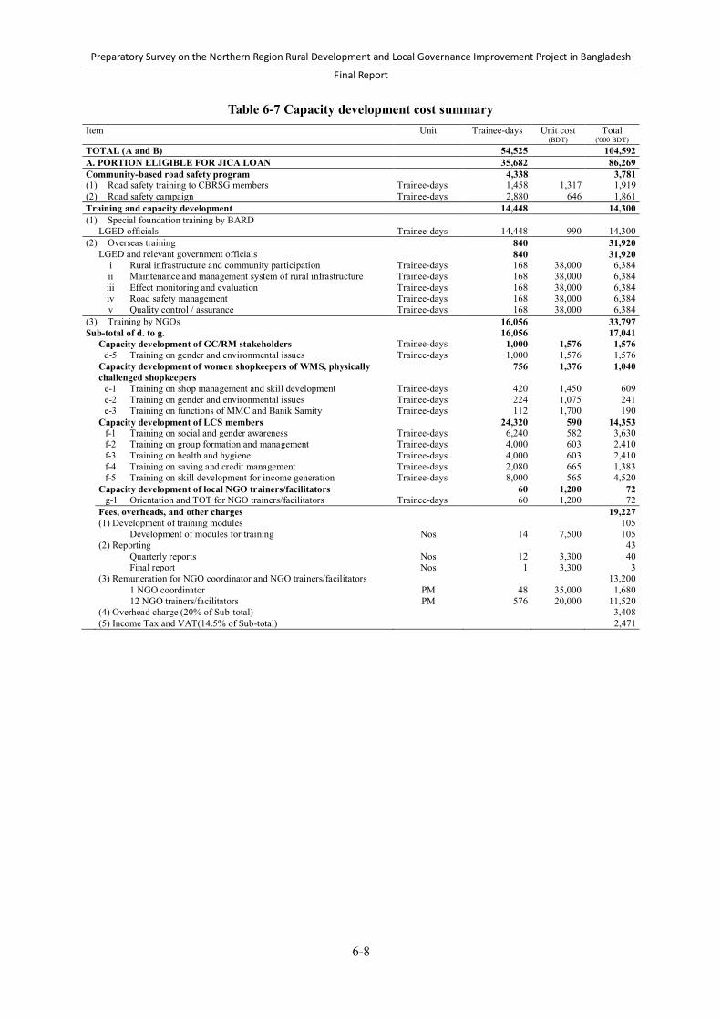
Preparatory Survey on the Northern Region Rural Development and Local Governance Improvement Project in Bangladesh
Final Report
6-8
Table 6-7 Capacity development cost summary Item Unit Trainee-days Unit cost
(BDT) Total
('000 BDT) TOTAL (A and B) 54,525 104,592 A. PORTION ELIGIBLE FOR JICA LOAN 35,682 86,269 Community-based road safety program 4,338 3,781 (1) Road safety training to CBRSG members Trainee-days 1,458 1,317 1,919 (2) Road safety campaign Trainee-days 2,880 646 1,861 Training and capacity development 14,448 14,300 (1) Special foundation training by BARD LGED officials Trainee-days 14,448 990 14,300
(2) Overseas training 840 31,920 LGED and relevant government officials 840 31,920 i Rural infrastructure and community participation Trainee-days 168 38,000 6,384 ii Maintenance and management system of rural infrastructure Trainee-days 168 38,000 6,384 iii Effect monitoring and evaluation Trainee-days 168 38,000 6,384 iv Road safety management Trainee-days 168 38,000 6,384 v Quality control / assurance Trainee-days 168 38,000 6,384
(3) Training by NGOs 16,056 33,797 Sub-total of d. to g. 16,056 17,041 Capacity development of GC/RM stakeholders Trainee-days 1,000 1,576 1,576 d-5 Training on gender and environmental issues Trainee-days 1,000 1,576 1,576 Capacity development of women shopkeepers of WMS, physically
challenged shopkeepers 756 1,376 1,040
e-1 Training on shop management and skill development Trainee-days 420 1,450 609 e-2 Training on gender and environmental issues Trainee-days 224 1,075 241 e-3 Training on functions of MMC and Banik Samity Trainee-days 112 1,700 190 Capacity development of LCS members 24,320 590 14,353 f-1 Training on social and gender awareness Trainee-days 6,240 582 3,630 f-2 Training on group formation and management Trainee-days 4,000 603 2,410 f-3 Training on health and hygiene Trainee-days 4,000 603 2,410 f-4 Training on saving and credit management Trainee-days 2,080 665 1,383 f-5 Training on skill development for income generation Trainee-days 8,000 565 4,520 Capacity development of local NGO trainers/facilitators 60 1,200 72 g-1 Orientation and TOT for NGO trainers/facilitators Trainee-days 60 1,200 72
Fees, overheads, and other charges 19,227 (1) Development of training modules 105 Development of modules for training Nos 14 7,500 105 (2) Reporting 43 Quarterly reports Nos 12 3,300 40 Final report Nos 1 3,300 3 (3) Remuneration for NGO coordinator and NGO trainers/facilitators 13,200 1 NGO coordinator PM 48 35,000 1,680 12 NGO trainers/facilitators PM 576 20,000 11,520 (4) Overhead charge (20% of Sub-total) 3,408 (5) Income Tax and VAT(14.5% of Sub-total) 2,471

Preparatory Survey on the Northern Region Rural Development and Local Governance Improvement Project in Bangladesh
Final Report
6-9
Table 6-7 Capacity development cost summary (continued) Item Unit Trainee-
days Unit cost (BDT)
Total ('000 BDT)
B. PORTION NON-ELIGIBLE FOR JICA LOAN 18,843 18,323 In-country training by LGED 18,843 18,323 (1) Capacity development of LGED and relevant government officials 1,046 1,282 1,341 a-1 Project kickoff meeting Trainee-days 100 1,710 171 a-2 Training of Trainers (TOT) Trainee-days 774 1,194 924 a-3 Training on project administration, technical and financial management Trainee-days 86 1,428 123 a-4 Training on social and environmental issues of the project Trainee-days 86 1,428 123 (2) Capacity development of contractors and construction workers 1,360 1,253 1,703 b-1 Training on contract management, technical and financial management Trainee-days 680 1,253 852 b-2 Skill training of masons and construction workers Trainee-days 680 1,253 852 (3) Capacity development of Upazila Chairpersons, UNO and UP Chairpersons 1,143 1,140 1,303 c-1 Project orientation meeting Trainee-days 1,143 1,140 1,303 (4) Capacity development of Growth Center/rural market stakeholders 4,000 1,740 6,959 d-1 Sensitization workshop on development and maintenance of Growth Center/rural
market Trainee-days 1,000 1,721 1,721
d-2 Orientation meeting on participatory planning of Growth Center/rural market Trainee-days 1,000 1,746 1,746 d-3 Training on land ownership in Growth Center/rural market, leasing system, rules
and regulations of leasing out government land Trainee-days 1,000 1,746 1,746
d-4 Training on proper operation and maintenance of Growth Center/rural market and resource mobilization
Trainee-days 1,000 1,746 1,746
(5) Capacity development of women shopkeepers of WMS, physically challenged shopkeepers 448 1,075 482 e-1 Orientation meeting on women market section Trainee-days 448 1,075 482 (6) Capacity development of LCS members Trainee-days 10,846 603 6,535 f-1 Training on skill development on maintenance of UZR and UNR Trainee-days 4,446 603 2,679 f-2 Training on tree plantation and care-taking Trainee-days 6,400 603 3,856 (2) Component 2: Urban infrastructure and governance improvement The Component 2 comprises “Subcomponent 2-1: Urban infrastructure development and service delivery,” and “Subcomponent 2-2: Governance improvement and capacity development.” a) Subcomponent 2-1: Urban infrastructure development and service The capital block allocation funds will be distributed BDT 150 million to each nine category-B Pourashavas, and BDT 100 million to each nine category-C Pourashavas. The capital block of BDT 260 million will be allocated for Pourashavas entering from Phase 3. The special allocation for rural-urban linkage will separately be budgeted at BDT 300 million. The capital block allocation and special allocation are shown in Table 6-2, and the budget allocation types of subprojects for category-B and C Pourashavas are shown in Table 6-8 and Table 6-9.

6-10
Prep
aratory Su
rvey on th
e No
rthern
Region R
ural D
evelop
men
t and Lo
cal Go
vernan
ce Imp
rovem
ent P
roject in B
angladesh
Final Rep
ort
Table 6-8 Budget allocation by types of subprojects for category-B Pourashava Sub-project Description of the facility Mymensingh
region Transport sector
improvement project Income sector
improvement project Solid waste
management sector improvement project
Sanitation sector improvement project
Unit rate BDT
Qty. Unit Amount ,000 BDT
Qty. Unit Amount ,000 BDT
Qty. Unit Amount ,000 BDT
Qty. Unit Amount ,000 BDT
Road Union road type-7, 5.5m width 8,584,200 5 km 42,921 4 km 34,337 3 km 25,753 2 km 17,168 Market Site area 50m x 50m 7,800,000 1 no 7,800 3 no 23,400 1 no 7,800 1 no 7,800 Bus terminal Site area 50m x 60m with a terminal building
and parking area 11,491,255 1 no 11,491 2 no 22,983 1 no 11,491 1 no 11,491
Truck terminal Site area 40m x 50m with a terminal building and parking area
3,539,836 1 no 3,540 2 no 7,080 1 no 3,540
Street lighting Per 1000m at a pitch of 40 m, total 26 RCC poles
778,918 5 km 3,895 3 km 2,337 5 km 3,895 2 km 1,558
Masonry drain 0.300 m x 0.525 m (Type B), 1000 m long 4,252,900 6 km 25,517 3 km 12,759 4 km 17,012 4 km 17,012 RCC primary drain 0.750 m x 1.12 5m x 0.15 m (type G), 100 m
long 859,265 2.5 km 21,482 1 km 8,593 1.8 km 15,467 1.2 km 10,311
Single pit latrine 1.2 m x 1.2 m x 2.5 m, GI corrugated roofing with masonry wall
26,457 100 no 2,646
Twin pit latrine 1.2 m x 1.2 m x 2.5 m, masonry wall with RCC roofing
38,330 40 no 1,533
Public toilet 7.5 m x 4.0 m x 3.0 m, masonry wall with RCC roofing
915,110 10 no 9,151
Solid waste collection station
1.25 m x 1.25 m x 1 m, RCC wall 12,568 200 no 2,514
Rickshaw van For solid waste collection 18,000 600 no 10,800 Solid waste transfer station
7.5 m x 7.0 m, masonry wall with RCC roofing
715,074 1 no 715
Solid waste disposal ground
70 m x 60 m 417,548 1 no 418
Composting plant 31.6 m x 10.5 m, masonry wall with RCC roofing
1,634,552 1 no 1,635
Installation of a tube well With PVC pipe 38 mm x 200 m deep 71,266 100 no 7,127 200 no 14,253 Water pipeline laying and rehabilitation
PVC pipe 200 mm x 100 m length with accessories
282,717 3 km 8,482 8 km 22,617
Slaughter house 9.6 m x 5.4 m x 3.6 m, masonry wall with RCC roofing
1,079,756 4 no 4,319 2 no 2,160
Administration cost (5%) 5,832 5,790 5,832 5,885 Price escalation (4.9%/year) 18,901 18,765 18,901 19,072 Physical contingency (5%) 7,069 7,018 7,069 7,133
Total Amount 148,448 147,379 148,448 149,790

6-11
Prep
aratory Su
rvey on th
e No
rthern
Region R
ural D
evelop
men
t and Lo
cal Go
vernan
ce Imp
rovem
ent P
roject in B
angladesh
Final Rep
ort
Table 6-9 Budget allocation by types of subprojects for category-C Pourashava Sub-project Description of the facility Mymensingh
region Transport sector
improvement project Income sector
improvement project Solid waste
management sector improvement project
Sanitation sector improvement project
Unit rate BDT
Qty. Unit Amount ,000 BDT
Qty. Unit Amount ,000 BDT
Qty. Unit Amount ,000 BDT
Qty. Unit Amount ,000 BDT
Road Union road type-7, 5.5m width 8,584,200 3 km 25,753 2 km 17,168 2 km 17,168 1 km 8,584 Market Site area 50m x 50m 7,800,000 2 no 15,600 1 no 7,800 1 no 7,800 Bus terminal Site area 50m x 60m with a terminal building
and parking area 11,491,255 1 no 11,491 2 no 22,983 no 0 1 no 11,491
Truck terminal Site area 40m x 50m with a terminal building and parking area
3,539,836 1 no 3,540 2 no 7,080 1 no 3,540
Street lighting Per 1000m at a pitch of 40 m, total 26 RCC poles
778,918 5 km 3,895 2 km 1,558 2 km 1,558 1 km 779
Masonry drain 0.300 m x 0.525 m (Type B), 1000 m long 4,252,900 4 km 17,012 1 km 4,253 3 km 12,759 3 km 12,759 RCC primary drain 0.750 m x 1.12 5m x 0.15 m (type G), 100 m
long 859,265 1.8 km 15,467 1 km 8,593 1 km 8,593 1 km 8,593
Single pit latrine 1.2 m x 1.2 m x 2.5 m, GI corrugated roofing with masonry wall
26,457 100 no 2,646
Twin pit latrine 1.2 m x 1.2 m x 2.5 m, masonry wall with RCC roofing
38,330 50 no 1,916
Public toilet 7.5 m x 4.0 m x 3.0 m, masonry wall with RCC roofing
915,110 3 no 2,745
Solid waste collection station
1.25 m x 1.25 m x 1 m, RCC wall 12,568 200 no 2,514
Rickshaw van For solid waste collection 18,000 600 no 10,800 Solid waste transfer station
7.5 m x 7.0 m, masonry wall with RCC roofing
715,074 1 no 715
Solid waste disposal ground
70 m x 60 m 417,548 1 no 418
Composting plant 31.6 m x 10.5 m, masonry wall with RCC roofing
1,634,552 1 no 1,635
Installation of a tube well With PVC pipe 38 mm x 200 m deep 71,266 50 no 3,563 80 no 5,701 Water pipeline laying and rehabilitation
PVC pipe 200 mm x 100 m length with accessories
282,717 2 km 5,654 4 km 11,309
Slaughter house 9.6 m x 5.4 m x 3.6 m, masonry wall with RCC roofing
1,079,756 2 no 2,160
Administration cost (5%) 3,858 3,862 3,836 3,824 Price escalation (4.9%/year) 12,502 12,515 12,431 12,393 Physical contingency (5%) 4,676 4,681 4,649 4,635
Total Amount 98,193 98,291 97,632 97,335

Preparatory Survey on the Northern Region Rural Development and Local Governance Improvement Project in Bangladesh
Final Report
6-12
b) Subcomponent 2-2: Training programs for implementation of UGIAP The costs for the implementation of UGIAP will budget BDT 7.4 million for Phase 1, BDT 29.1 million for Phase 2, and BDT 4.1 million for Phase 3. The details of the training costs are shown in Annex 20. (3) Component 4: Project administration support a) Administration assistant The budget allocation of administration assistant costs consists of Project Monitoring and Reporting Support (PMRS), Project Accounting Support (PAS), Equipment Procurement Support (EPS), Performance Monitoring and Evaluation (PME), Statistical Analysis (SA), and Publicity Campaign (PC). The details of the administration assistant costs are shown in Annex 20. b) Procurement of vehicles and equipment The number of vehicles, construction equipment and office equipment distributed to each project office for Component 1, Subcomponent 2-1, Subcomponent 2-2 and Component 3 are summarized in Table 6-10. The static roller (8-10 ton) of construction equipment will be provided to each LGED District Office and Pourashava to rent out to the contractors for road construction and maintenance works in order to ensure good quality of compaction works. The equipment will be maintained by the LGED District Offices and Pourashavas with the maintenance costs to be managed from the rental charge of the equipment during the project implementation and after the Project completion. The responsibly of maintenance of the equipment for Pourashavas shall be stipulated in the Subproject Agreement to ensure the maintenance to be implemented by the Pourashava.

Preparatory Survey on the Northern Region Rural Development and Local Governance Improvement Project in Bangladesh
Final Report
6-13
Table 6-10 Numbers of vehicles, construction equipment and office equipment distributed to project offices
Item
Component 1 Subcomponent 2-1 Subcomponent 2-2 Component 3
Gra
nd T
otal
Headquarters
PMU
SM
O
PIO
LGED
UZL
Tota
l
PMU
SM
O
PIU
Pour
asha
va
Tota
l
PMU
U
MSU
RU
MSU
PI
U
Pour
asha
va
Tota
l
PD
PMU
U
MSU
SMO
R
UM
SU
PIO
PIU
Tota
l
A. Vehicle A1. Foreign currency 1) 4-WD jeep (LGED & consultant firm) 1 3 4 1 1 1 1 1 1 7 2) 4-WD double cabin pick-up truck
(LGED, consultant firm & C2-PIU with Pourashava)
14 14 1 18 19 0 2 2 35
3) Microbus (LGED & consultant firm) 0 0 1 1 2 4 1 2 3 7 4) Garbage Dump Truck (3 ton) 0 9 9 0 0 9 5) Garbage Dump Truck (1.5-2 ton) 0 9 9 0 0 9 A2. Local currency 1) Motor cycle 1 3 14 117 135 1 3 36 40 1 1 2 4 0 179 B. Construction equipment B1. Foreign currency 1) Static roller 8-10 ton (Double drum) 14 14 18 18 0 0 32 B2. Local currency 1) Total station (Level machine) 117 117 18 18 0 0 135 2) Laboratory equipment (Accessories) 14 14 0 0 0 14 C. Maintenance management equipment C1. Foreign currency 1) Roughness measuring meters (road) 6 6 0 0 0 6 2) Digital imaging system (road) 3 3 0 0 0 3 3) Vacuum cleaner for sludge disposal
(sanitation) 0 5 5 0 0 5
D. Office Equipment D1. Local currency 1) Computer and UPS 10 6 14 117 147 8 8 6 15 8 108 209 0 364 2) Server computer and accessories 0 0 1 1 0 1 3) Printer 2 3 14 117 136 2 2 1 2 2 18 23 1 1 162 4) Photocopier 1 3 14 117 135 1 18 19 1 2 2 18 23 1 1 178 5) Multimedia projector 0 0 2 2 18 22 1 1 23 6) Scanner 0 0 5 2 7 0 7 7) Laptop computer 2 3 5 1 1 2 2 4 1 1 11 8) Fax 1 1 0 2 2 18 22 1 1 24 9) Video camera 1 1 0 1 1 1 1 3 10) Still digital camera 1 3 4 0 2 2 4 1 1 9 11) Accounting application software 01 0 18 18 18

Preparatory Survey on the Northern Region Rural Development and Local Governance Improvement Project in Bangladesh
Final Report
6-14
c) Procurement of vehicles and equipment for Component 1 The total amount of the procurement for Component 1, excluding custom duties, taxes, and value added tax, is BDT 366 million shown in Table 6-11. Custom duties and taxes are budgeted separately in Table 6-2.
Table 6-11 Costs of vehicles, and construction and office equipment for Component 1 Item Quantity Unit cost Total
Amount without CD and
VAT ('000 BDT)
Registration cost
('000 BDT)
CD and VAT value
('000 BDT)
Total amount with CD and VAT ('000 BDT)
CIF value ('000 BDT)
With CD and
VAT ('000 BDT)
a b c d=a*b f g=(c-b)*a h=d+f+g Total (A to D) 366,086 3,800 162,562 511,449 Foreign currency portion (A1+B2+C1) 180,626 Local currency portion (A2+B2+D1) 185,460 A. Vehicle A1. Foreign currency 51,426 1,100 115,267 167,794 1) 4-WD jeep 4 no. 3,748 20,635 14,991 260 67,548 82,798 2) 4-WD double cabin pick-up truck 14 no. 2,603 6,011 36,436 840 47,720 84,995 3) Microbus no. 2,290 5,825 4) Garbage Dump Truck (3 ton) no. 3,500 5,628 5) Garbage Dump Truck (1.5-2 ton) no. 2,600 4,181 A2. Local currency 18,900 2,700 2,835 24,435 1) Motor cycle 135 no. 140 161 18,900 2,700 2,835 24,435 B. Construction equipment B1. Foreign currency 98,000 17,640 115,640 1) Static roller 8-10 ton (Double drum) 14 no. 7,000 8,260 98,000 17,640 115,640 B2. Local currency 115,750 17,363 133,113 1) Total station (Level machine) 117 no. 750 863 87,750 13,163 100,913 2) Laboratory equipment (Accessories) 14 no. 2,000 2,300 28,000 4,200 32,200 C. Maintenance management equipment C1. Foreign currency 31,200 1,836 12,036 1) Roughness measuring meters (road) 6 no. 1,700 2,006 10,200 1,836 12,036 2) Digital imaging system (road) 3 no. 7,000 8,260 21,000 3,780 24,780 3) Vacuum cleaner for sludge disposal (sanitation) no. 5,400 6,372 D. Office equipment D1. Local currency 50,810 7,621 58,432 1) Computer and UPS 147 no. 100 115 14,700 2,205 16,905 2) Server computer and accessories no. 170 196 3) Printer 136 no. 80 92 10,880 1,632 12,512 4) Photocopier 135 no. 180 207 24,300 3,645 27,945 5) Multimedia projector no. 80 92 6) Scanner no. 40 46 7) Laptop computer 5 no. 130 150 650 98 748 8) Fax 1 no. 30 35 30 5 35 8) Video camera 1 no. 50 58 50 7 58 10) Still digital camera 4 no. 50 58 200 30 230 11) Accounting application software no. 10 12

Preparatory Survey on the Northern Region Rural Development and Local Governance Improvement Project in Bangladesh
Final Report
6-15
d) Procurement of vehicles and equipment for Subcomponent 2-1 The total amount of this procurement for Subcomponent 2-1, excluding custom duties, taxes, and value added tax, is BDT 285 million shown in Table 6-12. Custom duties and taxes are budgeted separately in Table 6-2.
Table 6-12 Costs of vehicles, and construction and office equipment for Subcomponent 2-1 Item Quantity Unit cost Total
amount without CD and
VAT ('000 BDT)
Registration cost
('000 BDT)
CD and VAT value
('000 BDT)
Total amount with CD and VAT ('000 BDT)
CIF value
('000 BDT)
With CD and
VAT ('000 BDT)
a b c d=a*b f g=(c-b)*a h=d+f+g Total (A to D) 284,706 3,085 188,109 448,900 Foreign currency portion (A1+B2+C1) 261,096 Local currency portion (A2+B2+D1) 23,610 A. Vehicle A1. Foreign currency 108,096 2,285 166,393 276,774 1) 4-WD jeep 1 no. 3,748 20,635 3,748 65 16,887 20,700 2) 4-WD double cabin pick-up truck 19 no. 2,603 6,011 49,448 1,140 64,762 115,351 3) Microbus no. 2,290 5,825 4) Garbage Dump Truck (3 ton) 9 no. 3,500 8,903 31,500 540 48,623 80,663 5) Garbage Dump Truck (1.5-2 ton) 9 no. 2,600 6,613 23,400 540 36,120 60,060 A2. Local currency 5,600 800 812 7,212 1) Motor cycle 40 no. 140 160 5,600 800 812 7,212 B. Construction equipment B1. Foreign currency 126,000 18,270 144,270 1) Static roller 8-10 ton (Double drum) 18 no. 7,000 8,015 126,000 18,270 144,270 B2. Local currency 13,500 1,958 15,458 1) Total station (Level machine) 18 no. 750 859 13,500 1,958 15,458 2) Laboratory equipment (Accessories) no. 2,000 2,290 C. Maintenance management equipment C1. Foreign currency 27,000 1) Roughness measuring meters (road) no. 1,700 2,006 2) Digital imaging system (road) no. 7,000 8,260 3) Vacuum cleaner for sludge disposal (sanitation) 5 no. 5,400 6,372 27,000 4,860 31,860 D. Office equipment D1. Local currency 4,510 676 5,187 1) Computer and UPS 8 no. 100 115 800 120 920 2) Server computer and accessories no. 170 196 3) Printer 2 no. 80 92 160 24 184 4) Photocopier 19 no. 180 207 3,420 513 3,933 5) Multimedia projector no. 80 92 6) Scanner no. 40 46 7) Laptop computer 1 no. 130 150 130 20 150 8) Fax no. 30 35 8) Video camera no. 40 46 10) Still digital camera no. 20 23 11) Accounting application software no. 10 12

Preparatory Survey on the Northern Region Rural Development and Local Governance Improvement Project in Bangladesh
Final Report
6-16
e) Procurement of vehicles and equipment for Subcomponent 2-2 The total amount of this procurement for Subcomponent 2-2, excluding custom duties, taxes, and value added tax, is BDT 44 million shown in Table 6-13. Custom duties and taxes are budgeted separately in Table 6-2.
Table 6-13 Costs of vehicles and office equipment for Subcomponent 2-2 Item Quantity Unit cost Total
amount without CD and
VAT ('000 BDT)
Registration cost
('000 BDT)
CD and VAT value
('000 BDT)
Total amount with CD and VAT ('000 BDT)
CIF value
('000 BDT)
With CD and
VAT ('000 BDT)
a b c d=a*b f g=(c-b)*a h=d+f+g Total (A to D) 44,039 385 35,694 80,118 Foreign currency portion (A1+B2+C1) 12,909 Local currency portion (A2+B2+D1) 31,130 A. Vehicle A1. Foreign currency 12,909 305 31,028 44,241 1) 4-WD jeep 1 no. 3,748 20,635 3,748 65 16,887 20,700 2) 4-WD double cabin pick-up truck no. 2,603 6,011 3) Microbus 4 no. 2,290 5,825 9,161 240 14,141 23,542 4) Garbage Dump Truck (3 ton) no. 3,500 8,903 5) Garbage Dump Truck (1.5-2 ton) no. 2,600 6,613 A2. Local currency 560 80 81 721 1) Motor cycle 4 no. 140 160 560 80 81 721 B. Construction equipment B1. Foreign currency 1) Static roller 8-10 ton (Double drum) no. 7,000 8,015 B2. Local currency 1) Total station (Level machine) no. 750 859 2) Laboratory equipment (Accessories) no. 2,000 2,290 C. Maintenance management equipment C1. Foreign currency 1) Roughness measuring meters (road) no. 1,700 2,006 2) Digital imaging system (road) no. 7,000 8,260 3) Vacuum cleaner for sludge disposal (sanitation) no. 5,400 6,372 D. Office equipment D1. Local currency 30,570 4,586 35,156 1) Computer and UPS 209 no. 100 115 20,900 3,135 24,035 2) Server computer and accessories 1 no. 170 196 170 26 196 3) Printer 23 no. 80 92 1,840 276 2,116 4) Photocopier 23 no. 180 207 4,140 621 4,761 5) Multimedia projector 22 no. 80 92 1,760 264 2,024 6) Scanner 7 no. 40 46 280 42 322 7) Laptop computer 4 no. 130 150 520 78 598 8) Fax 22 no. 30 35 660 99 759 8) Video camera 1 no. 40 46 40 6 46 10) Still digital camera 4 no. 20 23 80 12 92 11) Accounting application software 18 no. 10 12 180 27 207

Preparatory Survey on the Northern Region Rural Development and Local Governance Improvement Project in Bangladesh
Final Report
6-17
f) Procurement of vehicles and equipment for Component 3 The total amount of this procurement for Component 3, excluding custom duties, taxes, and value added tax, is BDT 16 million shown in Table 6-14. Custom duties and taxes are budgeted separately in Table 6-2.
Table 6-14 Costs of vehicles and office equipment for Component 3 Item Quantity Unit cost Total
amount without CD and VAT ('000 BDT)
Registration Cost
('000 BDT)
CD and VAT value
('000 BDT)
Total amount with CD and VAT ('000 BDT)
CIF value
('000 BDT)
With CD and VAT ('000 BDT)
a b c d=a*b f g=(c-b)*a h=d+f+g Total (A to D) 16,383 365 34,394 51,142 Foreign currency portion (A1+B2+C1) 15,823 Local currency portion (A2+B2+D1) 560 A. Vehicle A1. Foreign currency 15,823 365 34,310 50,498 1) 4-WD jeep 1 no. 3,748 20,635 3,748 65 16,887 20,700 2) 4-WD double cabin pick-up truck 2 no. 2,603 6,011 5,205 120 6,817 12,142 3) Microbus 3 no. 2,290 5,825 6,871 180 10,606 17,656 4) Garbage Dump Truck (3 ton) no. 3,500 8,903 5) Garbage Dump Truck (1.5-2 ton) no. 2,600 6,613 A2. Local currency 1) Motor cycle no. 140 160 B. Construction equipment B1. Foreign currency 1) Static roller 8-10 ton (Double drum) no. 7,000 8,015 B2. Local currency 1) Total station (Level machine) no. 750 859 2) Laboratory equipment (Accessories) no. 2,000 2,290 C. Maintenance management equipment C1. Foreign currency 1) Roughness measuring meters (road) no. 1,700 2,006 2) Digital imaging system (road) no. 7,000 8,260 3) Vacuum cleaner for sludge disposal (sanitation) no. 5,400 6,372 D. Office Equipment D1. Local currency 560 84 644 1) Computer and UPS no. 100 115 2) Server computer and accessories no. 170 196 3) Printer 1 no. 80 92 80 12 92 4) Photocopier 1 no. 180 207 180 27 207 5) Multimedia projector 1 no. 80 92 80 12 92 6) Scanner no. 40 46 7) Laptop computer 1 no. 130 150 130 20 150 8) Fax 1 no. 30 35 30 5 35 8) Video camera 1 no. 40 46 40 6 46 10) Still digital camera 1 no. 20 23 20 3 23 11) Accounting application software no. 10 12 (4) Component 3: Project implementation support This Component is composed of three Subcomponents: 1) Subcomponent 3-1: Engineering services of Design, Supervision and Monitoring (DSM); 2) Subcomponent 3-2: Government Improvement and Capacity Development (GICD); and 3) Subcomponent 3-3: Benefit Monitoring and Evaluation (BME). The budget allocation for project implementation support is BDT 2,339 million shown in Table 6-2. This budget consists of costs for international consultants, national consultants, and support staff’s remunerations and reimbursable expenses. The details of the project implementation support costs are shown in Annex 20.

Preparatory Survey on the Northern Region Rural Development and Local Governance Improvement Project in Bangladesh
Final Report
6-18
(5) Administration cost The budget allocation of administration cost consists project implementation office staff cost, office operation cost, maintenance of vehicle and equipment, and development of office facilities of the project. a) Project implementation office staff The costs allocated for government staff for the Project is BDT 1,047 million shown in Table 6-15. BDT 618 million is allocated to the employment of 31,680 staff members for Component 1 and Subcomponent 2-1, whereas BDT 297 million is allocated to the employment of 16,848 staff members for Subcomponent 2-2. The detailed cost estimates are also shown in Annex 20.
Table 6-15 Summary of Project implementation office staff cost for Six Years Component Person
month Total
BDT ('000)
Total 53,784 1,046,892 Component 1 and Subcomponent 2-1: PMO, SMO, PIO and LGED Upazila Office 31,680 618,115 A. PMO, LGED Headquarters, Dhaka 3,168 54,400 B. SMO, LGED RO: Mymensingh/Rangpur/Dinajpur 2,592 38,467 C. PIO, LGED District Offices 14 9,072 105,447 D. LGED Upazila Office 16,848 222,225 Sub-total of E, F, G, H, and I 197,576 Subcomponent 2-1and 2-2: PMO and UMSU 72 4,849 A. PMO and UMSU, LGED Headquarters, Dhaka 72 2,939 Sub-total of E, F, G, H, and I 1,910 Subcomponent 2-2: UMSU and RUMSU 5,184 127,037 A. UMSU, LGED Headquarters, Dhaka 1,584 23,885 B. RUMSU, LGED RO: Mymensingh/Rangpur 3,600 61,891 Sub-total of E, F, G, H, and I 41,260 Component 2-2: PIU 16,848 296,891 A. Infrastructure Improvement Section (IIS) 13,608 144,718 B. Urban Governance Improvement Section (UGIS) 1,296 12,442 C. Environmental, Sanitation & Slum Improvement Section (ESSIS) 1,944 16,281 Sub-total of E, F, G, H, and I 123,451
b) Office operation cost The total costs allocated for office operation are BDT 302 million, which includes BDT 149 million of fuel costs for vehicles to be used for project implementation by GOB staff, and BDT 153 million of cost for communication, office supplies, utilities, etc., for project management offices. These costs are shown in Table 6-16.

Preparatory Survey on the Northern Region Rural Development and Local Governance Improvement Project in Bangladesh
Final Report
6-19
Table 6-16 Office operation cost Item Quantity 1 Quantity 2 Quantity 3 Unit cost Cost
(mill. BDT) Total 301.5 A. Fuel cost for vehicles to be used for GOB staff 148.8 4-WD jeep 7 units 500 liters/month 63 month 65 BDT/liter 14.3 4-WD pickup 35 units 500 liters/month 63 month 65 BDT/liter 71.7 Microbus 7 units 500 liters/month 63 month 65 BDT/liter 14.3 Motorcycle 179 units 43 liters/month 63 month 100 BDT/liter 48.5 B. Office operation cost (communication, office supplies, utilities, etc.) 152.6 PMO at LGED HQs 1 office 72 months 200,000 BDT/month 14.4 UMSU in Dhaka 1 offices 72 months 130,000 BDT/month 9.4 SMO in 3 LGED ROs 3 offices 72 months 130,000 BDT/month 28.1 PIO in 14 LGED DOs 14 offices 72 months 100,000 BDT/month 100.8 RUMSU in 2 regions 2 offices 72 months 100,000 BDT/month 14.4 PIU in 18 Pourashavas 18 offices 72 months 80,000 BDT/month 103.7 c) Maintenance of vehicle and equipment The details of this budget, amounting to BDT 15.8 million, are shown in Table 6-17. BDT 14 million for vehicles, BDT 0.4 million for sanitation maintenance equipment, and BDT 1.4 million for office equipment will be budgeted for maintenance.
Table 6-17 Maintenance of vehicle and equipment Item Quantity
(units) Monthly unit cost
(BDT) No. of months Total
('000 BDT) Total 15,805 A. Vehicle 13,960 1. 4-WD jeep (LGED & consultant firm) 7 2,667 63 1,176 2. 4-WD double cabin pick-up (Lab. facility) 35 2,667 63 5,880 3. Microbus (LGED & consultant firm) 7 2,667 63 1,176 4. Motor Cycle 179 508 63 5,728 B. Maintenance management equipment 420 1. Vacuum cleaner for sludge disposal 5 1,333 63 420 C. Office equipment 1,425 1. Computer & UPS 365 60 63 1,380 2. Printer 1 60 63 4 3. Photocopier 11 60 63 42
d) Development of office facilities The details of this budget, amounting to BDT 50.7 million are shown in Table 6-18. This table shows the location, contents, and costs for office facility development. The total of 39 office units in the LGED headquarters, Regional offices, and District offices will be developed for the project management and implementation. The targeted Pourashava offices will also be developed for the project implementation.
Table 6-18 Development of office facilities LGED and Pourashava offices Item Office Quantity Unit cost
(BDT) Cost
(mill. BDT) Total 39 unit 50.70 PMO, LGED HQ Office setting (25m x 20m) 1 unit 500 sq.m 6,000 /sq.m 3.00 UMSU in Dhaka Office setting (20m x 20m) 1 unit 400 sq.m 6,000 /sq.m 2.40 SMO, LGED Regional Office Office setting (20m x 20m) 3 unit 800 sq.m 6,000 /sq.m 4.80 RUMSU, Regional Office Office setting (15m x 15m) 2 unit 450 sq.m 5,000 /sq.m 2.25 PIO, LGED District Office Office setting (15m x 15m) 14 unit 3,150 sq.m 5,000 /sq.m 15.75 PIU, at each target Pourashava Office setting (15m x 15m) 18 unit 4,500 sq.m 5,000 /sq.m 22.50

Preparatory Survey on the Northern Region Rural Development and Local Governance Improvement Project in Bangladesh
Final Report
6-20
6.2 Cost saving measures (1) Design and cost estimation Most of the project infrastructure works, including roads, bridges, markets and ghats, will apply established design standards and technical specifications. These have proved to be cost-effective in conditions of Bangladesh. The LGED engineers are experienced in these technologies, and will be supported by DSM consultants for survey, design, costing, procurement and supervision. Certain elements of the project strategy are important in minimizing the costs of providing improved, but good quality and durable, infrastructure: No new roads will be constructed. All road upgrading and rehabilitation works will be on
existing alignments. There will be minor changes in alignment, where additional costs will be incurred in construction of new sections of embankment, but only where this is necessary either for safety reasons or to avoid unduly costly land acquisition and resettlement.
All markets and ghat improvement works will be at existing sites. No new markets or ghats will be created.
The project will finance some additional construction equipment to ensure cost-efficient and good quality execution of certain activities, particularly compaction.
Careful attention has been paid to preparing reliable cost estimates for the different categories of civil works, based on data for the proposed subprojects: The detailed cost estimates are comprehensive. They have been prepared using the standard
LGED bill of quantity (BOQ) formats which cover all activities involved in construction of different types of infrastructure.
The unit costs applied are up-to-date and specific to the project area. They are extracted from the latest Schedules of Rates which the LGED has prepared based on detailed cost analysis. These Schedules of Rates take account of different cost conditions in different parts of the project area. As discussed earlier, full consideration has also been given to the quite rapid increases in construction costs in Bangladesh in recent years.
The estimates of construction costs have been prepared by developing cost models. For road upgrading works, these take full account of the major variables in costs:
- Earthworks – the cost model takes account of variations in earthwork quantities according to existing embankment height and crest width, and terrain.
- Pavement – the pavement type, and hence cost, is determined by the traffic level and hence the LGED design standard (Type 4 to Type 8) to which the road will be upgraded.
- Cross-drainage structures – the total span of cross-drainage structures required on each road is determined from the data provided by the Districts on the gaps to be spanned and the existing, damaged structures to be replaced.
The detailed cost estimates have been cross-checked against cost data from other foreign-financed projects implemented by the LGED.
The detailed design and costing of each subproject will be prepared during implementation, based on comprehensive engineering site surveys. The data provided by these surveys will ensure accurate design of the improved infrastructure, reducing the need for cost variations during construction. Component 1 requires construction of four bridges larger than 100 m span. The designs of these bridges will be based on detailed hydrological and morphological site studies to ensure that the designs are both technically sound and cost-effective. These will all be RCC girder bridges with piled foundations – established practice in the LGED and well-adapted to local conditions.

Preparatory Survey on the Northern Region Rural Development and Local Governance Improvement Project in Bangladesh
Final Report
6-21
(2) Contract packaging The proposed packaging of contracts for civil works is intended to minimize costs, and to minimize the risk of cost overruns. It will also mitigate against the risk of delays in implementation, which would also increase costs. All civil works contracts will follow national competitive bidding (NCB) procedures and be of less than BDT 140 million in value, the limit for which the LGED Chief Engineer has full authority for tendering and procurement. For Component 1, the LGED will therefore have full responsibility for procurement of civil works. There are many local contractors in Bangladesh able to implement civil works contracts of this scale, so the bidding process will be competitive and attract competent contractors. Specifically: For road works, each contract will be ranged from 10 to 15 km. Competent contractors will be
able to implement these works within an 18 month period, avoiding the need to activate the price escalation clause in the civil works contracts, which becomes applicable after 18 months.
Bridges larger than 30 m in span will be contracted separately. The tender documents will require the bidders to demonstrate experience in construction of similar bridges. This will ensure that the works are executed by competent contractors and on schedule – construction of bridges of this size can be completed within an 18 month period.
The tender documents for the four bridges larger than 100 m span will require the bidders to demonstrate specific experience in the construction of large bridges. The aim is that these specialized works should be implemented by competent contractors with the necessary skills and expertise to complete the works on time and to a good quality. However, the contracts for these bridges will be of two years duration because of the more complex works involved. Careful design of these large bridges, based on detailed site investigations, will mitigate the risk of construction being delayed because unexpected technical difficulties are encountered.
The market and ghat improvement subprojects will be let as small packaging. These small contracts will be attractive to many small building contractors. This will ensure competitive bidding by contractors capable to implement the works on schedule and to a good standard. Again, these contracts will be of 18 months duration. (3) Implementation schedule The civil works implementation schedule for Component 1 has been carefully designed to complete all construction in an efficient manner and as quickly as possible, which will reduce the project cost, without comprising on quality. The civil works have been broken down into three implementation phases, with the aim that all construction should be completed by mid-2018, one year before project-end so that, if any problems are encountered, there is ample time to resolve these before project-end. In order to achieve this, the three phases are overlapped, i.e. Phase 2 will start one year after Phase 1, and Phase 3 will start one year after Phase 2. This schedule is consistent with the LGED’s capacity, at national and local levels, to supervise and manage effectively the implementation of the works, with support from the DSM consultants. In Bangladesh, the most productive season for construction work is from October to April, the dry season. It is difficult to carry out many types of construction works properly during the monsoon season from May to September. This has been taken into account in the implementation schedule. For each phase, the timing of survey, design, tendering and contract award has been set so that works on site can start from October. Thus, for 18 month contracts, the contractors will have two full dry seasons in which to complete their construction work.

Preparatory Survey on the Northern Region Rural Development and Local Governance Improvement Project in Bangladesh
Final Report
6-22
The construction of the four large bridges greater than 100 m span represents the greatest risk of delays in implementation. They will therefore be constructed in Phases 1 and 2 so that there is ample time to resolve difficulties before project-end as mentioned above. (4) Supervision of works Effective supervision and monitoring of works has a significant impact on cost efficiency and timely completion of construction. The project will apply technologies which are well-established in LGED. Its field engineers, in particular the District Executive and Assistant Engineers and the Upazila Engineers, are experienced in supervising and monitoring these types of infrastructure works. They will be comprehensively supported by DSM consultant staff on the central, Regional and District levels. In terms of cost efficiency and timeliness, the key aspects will be: Effective quality control to minimize the additional costs and delays caused by defects in work. Proper measurement and approval of completed works. Frequent monitoring of the progress of works. Prompt action when monitoring indicates that progress is delayed. The role of the PMO and
SMOs in reacting promptly to monitoring reports from the field will be important. (5) Tie-up with other schemes The project will apply the Labor Contracting Society (LCS) model already widely used by LGED on other programs. As well as generating income for disadvantaged women, the LCS system is a cost-effective method for tree plantation and caretaking, and for off-pavement routine maintenance of roads. A part of the capacity development for local governance improvement in Subcomponent 2-2 will be carried out by a Technical Cooperation Project (TC Project) of JICA. The consultancy services of this Project for the capacity development, therefore, will be reduced accordingly. 6.3 Comparison of project costs with other similar projects The similar and latest infrastructure projects under the LGED were studied to analyze the procurement methods for the Project. Five ongoing and one completed projects were selected for the study with the following points of information: Target area Total project cost and its breakdown Design conditions and specification Tendering system and contract conditions Construction methods Lessons learnt for procurement
The project information is summarized in Table 6-19, and the details are shown in Annex 21.

Preparatory Survey on the Northern Region Rural Development and Local Governance Improvement Project in Bangladesh
Final Report
6-23
Table 6-19 Comparison of project costs with other similar projects Project NRRDLGIP RTIP-2 SWBRDP SRIIP Target area 14 Districts 26 Districts 14 Districts 21 Districts Project cost (USD in million)
Donor(s) 265.60 79% 300 72% 155.23 72% 76.4 70% GoB 72.71 21% 116.35 28% 58.93 28% 32.66 30% Total 338.31 100% 416.35 100% 214.16 100% 109.06 100%
Main component
Rural development Y Y Y Y Urban development Y Central governance Y Local governance Y Capacity development Y Y Y Y
Project RIIP-2 UGIIP-2 UGIIP Target area 23 Districts 35 Pourashavas 30 Districts Project cost (USD in million)
Donor(s) 129.5 63% 127.77 76% 67.28 69% GoB 76.98 37% 39.72 24% 30.3 31% Total 206.48 100% 167.49 100% 97.58 100%
Main component
Rural development Y Urban development Y Y Central governance Y Local governance Y Y Capacity development Y Y Y
Source: Survey Team Note: Y = Available component The unit costs for major subprojects from other similar infrastructure projects are also analyzed. The summary of the analysis is tabulated in Table 6-20, and the details are shown in Annex 21.
Table 6-20 Summary of unit costs of major subprojects for other similar projects Item Unit Inflated unit cost (BDT mill.)
NRRDLGIP RTIP-2 SWBRDP SRIIP RIIP-2 Improvement of UZRs (incl. bridges and culverts)
km 9.71
10.94 10.65 6.83 9.98
Improvement of UNRs (incl. bridges and culverts)
km 7.29 5.59 8.08 5.67 10.46
Growth Center markets (incl. Women's section) nos 7.51 7.08 5.39 4.07 6.09 Rural market nos 4.50 3.95 4.55 6.4 Procurement methods and processes Method of procurement As mentioned in 2.2.6, the following methods are applicable for the procurement of goods and related services, works and physical services: Open tendering method Limited tendering method Direct procurement method Request for quotation method
Depending on the nature and complexity of assignment, the following method may be used for selection of consultants: Quality and cost based selection (QCBS)
Preparatory Survey on the Northern Region Rural Development and Local Governance Improvement Project in Bangladesh
Final Report
6-24
National Competitive Bidding and International Competitive Bidding Procurement of works: National Competitive Bidding (NCB): Civil works contracts estimated to cost less than the
amount equivalent to USD 2.0 million per contract may be procured using NCB. Procurement of goods: ICB: Goods and equipment contracts estimated to cost the amount equivalent to USD 300,000 or
more per contract may be procured using ICB. NCB: Civil works contracts estimated to cost less than the amount equivalent to USD 300,000
per contract may be procured using NCB. Packaging method Project components will be broken down into small packages to promote a large number of bidders for participation of tendering and to be easily manageable by the implementation agencies such as LGED District Offices, Upazila Offices, and Engineering Division of Pourashavas for supervision of the construction work. In addition, contracts with the value equal or less than BDT 140 million for works shall be approved by the Chief Engineer of the LGED, and less than BDT 80 million shall be approved by the Project Director, whereas contracts more than BDT 140 million should be approved by the MLGR&C and the Government Purchase Committee. Therefore the small packaging method will save time to start construction work promptly. NCB will be applied to all packages for procurement with following conditions: The construction size of one Road Package shall be ranged from 10 to 15 km length with small
bridges and culverts. The construction of one bridge more than 30 m length shall constitute one Bridge Package. The
tender documents will require bidders for large bridge construction to demonstrate experiences and capabilities in the construction of bridges greater than 100 m.
Installation of safety measures shall be included in a Road Package. The construction of Growth Centers or rural markets shall constitute one District per Market
Package (up to 4 markets per package). The construction of ghats shall constitute one District per Ghat Package (up to 4 ghats per
package). The value of contract package for Pourashava development shall be ranged from BDT 5 to 40
million. Similar types of subprojects for Pourashava development shall be batched as one package. The subprojects will be grouped as follows: - Civil work group – road, streetlights, masonry drain, and RCC primary drain - Building construction group – market, bus terminal, truck terminal, and slaughterhouse - Solid waste group – solid waste collection station, solid waste disposal ground, and
composting plant - Sanitation group – single pit latrine, twin pit latrine, public toilet, and installation of tube
well The procurement of vehicles of 4WD jeeps, pick-up trucks, and microbuses shall constitute one
package. The procurement of dump trucks shall constitute one package. The procurement of construction equipment of static rollers shall constitute one package. The maintenance equipment of vacuum cleaners shall constitute one package. The procurement of office equipment shall constitute one package. Capacity development and training courses for Component 1 shall constitute one package for
each training course. Consultancy services shall constitute one package for each consultancy team.

Preparatory Survey on the Northern Region Rural Development and Local Governance Improvement Project in Bangladesh
Final Report
6-25
Procedures of procurement All the procurement of goods, works and services in this Project shall be guided by the Public Procurement Regulation 2003 (PPR 2003), Public Procurement Act 2006 and Public Procurement Rules 2008 (PPR 2008). The details of the guidelines are shown in Annex 4. Financial power of LGED and PMO on tendering and procurement The contract value up to BDT 80 million for works, BDT 40 million for goods, and BDT 20 million for services shall be approved by the Project Director of the PMO for tendering and procurement. The Chief Engineer of the LGED has full authority for tendering and procurement of the value up to BDT 140 million for works, BDT 100 million for goods, and BDT 40 million for services. More than these value amounts, the tendering and procurement shall be approved by the MLGRD&C and the Cabinet Committee on government purchase. 6.4.1 Procurement of works All the construction works of UZRs, UNRs, bridges, markets, and ghats for Component 1 will follow the conditions of packaging method mentioned above and the NCB method. The road improvement works and market improvement works shall be divided into three phases, and the contract packages of the works shall be distributed as evenly as possible to each District. In each phase, the contract packages shall be further divided into three batches for tendering with an interval of one month in order to minimize the number of contract package at each tender batch for the Districts. The construction woks of subprojects for Pourashava development will also follow the conditions of packaging method and the NCB method. 6.4.2 Procurement of goods The purchase of motor cycles, small construction equipment and office equipment will follow the NCB method as local agents for purchase of these goods are available in this country. The purchase of vehicles and heavy construction equipment will follow the ICB method to seek for suppliers widely from outside of the country. The vehicles, construction and maintenance equipment and office equipment for Component 1 and 3 shall be procured in the first batch of tendering, whereas the goods for Component 2-1 and 2-2 shall be procured in three batches based on the Pourashava Development Plan (PDP). 6.4.3 Procurement of services The procurement of services for the poverty reduction program will follow the direct procurement. The capacity development training courses and overseas training will also follow direct procurement method to engage BARD, NGOs and other overseas training institutions. The road safety program for Component 1 and the training programs for Subcomponent 2-2 will be conducted by project consultants. Any materials or small equipment to be used for the training courses will be purchased by direct procurement method. 6.4.4 Consultancy services The project consultants shall comprise of international and national consultants from a variety of specific fields. The selection of consultancy firms for the DSM, GICD, and BME will follow the QCBS method to evaluate both the capabilities and the cost performance. The ICB method will be applied to invite potential candidates internationally for tendering. 6.4.5 Administration costs The administration assistants (PMRS, PAS, EPS, PME, SA, and PC) will be procured by the direct

Preparatory Survey on the Northern Region Rural Development and Local Governance Improvement Project in Bangladesh
Final Report
6-26
procurement method by the PMO. Procurement necessary for the PMO to carry out the operation and maintenance of vehicles, construction equipment, office equipment, office supplies and utilities, and other expenses will follow the request of quotation methods or direct procurement. Following the conditions of NCB and ICB, and for packaging, the recommended packaging of components for this Project is summarized in Table 6-21. All the construction works and the procurement of goods (except for vehicles and heavy construction equipment), and capacity development training will follow the NCB method, whereas the procurement of vehicles and heavy construction equipment, and consultancy services will follow the ICB method. However, the method of procurement shall be considered to change, depending on the scale and timeframe of the contract.
Table 6-21 Procurement and packaging methods Item Procurement
method Packaging
A. PORTION ELIGIBLE FOR JICA LOAN Component 1: Rural infrastructure development Subcomponent 1-1:
Subcomponent 1-2: Improvement of Upazila roads Improvement of Union roads
NCB 1 road ranged from 10 to 15 km with small bridges and culverts/Road Package
1 bridge more than 30 m length/Bridge Package
Road safety measures: to be included in the Road Package
Subcomponent 1-3: Rehabilitation of Upazila roads NCB 1 road ranged from 10 to 15 km /Road Package
Subcomponent 1-4: Improvement of GC and RM NCB 1 District/Market Package (up to 4 markets/package)
Subcomponent 1-5: Improvement of ghats 1 District/Ghat Package (up to 4 ghats/package)
Subcomponent 1-6: Labor contracting society (LCS) scheme
Direct procurement
1 road (max.7 km length)/package
Subcomponent 1-7: Community-based road safety program
NCB 1 program/package
Subcomponent 1-8: Training and capacity development Direct procurement
1 training/package
Component 2: Urban infrastructure and governance improvement Subcomponent 2-1: Urban infrastructure development
and service delivery NCB Similar-subproject group/Sub-projects
Package, ranged from BDT 5 to 40 million Subcomponent 2-2: Governance improvement and
capacity development Direct
procurement 1 training/package
Component 3: Project implementation support Subcomponent 3-1: DSM consultant ICB
(Short listing & QCBS)
1team package/Consultant Package Subcomponent 3-2: GICD consultant Subcomponent 3-3: BME consultant Component 4: Project administration support Administration assistant (PMRS. PAS, EPS, PME, SA
and PC) Direct
procurement 1 assistant /package
Vehicles and heavy construction and maintenance equipment
ICB 4WD jeep, pick-up and microbus/package Dump truck /package Static roller/package Vacuum cleaner /package
Motorcycles, small construction equipment and office equipment
NCB Motorcycle /package Each equipment /package
B. PORTION NON-ELIGIBLE FOR JICA LOAN Capacity development In-country training, workshops, and meetings to be
conducted by LGED N.A.
Project operation and recurrent costs Office operation cost RFQ/Direct
procurement
Maintenance of vehicle and equipment Development of office facilities

Preparatory Survey on the Northern Region Rural Development and Local Governance Improvement Project in Bangladesh
Final Report
6-27
The detailed schedules of selection of consultants and contractors are shown in Annex 23. 6.4.6 Safety measures and quality control in procurement of goods and works The contractors shall be responsible for providing adequate and necessary safety measures for all the persons engaged in the execution of the works against any injury, hazards, accidents, and shall take such safety precautions which are generally accepted as good civil engineering practice. The contractors shall be noted that the sites may close to residential and commercial areas, and that all necessary safeguards to protect the public need to be implemented. The contractors shall take all the necessary measures and actions for the safety of the workmen in the sites and the public around the sites. Safety gear and tools, e.g., safety helmets, gumboots and gloves, safety belts for works in high places should be provided to each laborer on site. Construction sites should be delineated by adequate fences to protect the public from any danger, and temporary housing sheds shall be kept in safe areas in the site for laborers in any emergency cases. To satisfy the quality requirements spelt out in the specifications of goods and works, both the contractors and project engineers shall plan and carry out all the tests required by the specifications on sites as well as at laboratories. Prior to procurement and delivering of goods or materials, the contractor shall inform the engineers of the sources they propose to procure, and shall provide the results of tests on representative samples. The contractor shall send a request to the engineer for any inspection and checking prior to the proposed time of inspection. In case any goods or materials are not approved, the contractor shall promptly remove them from the site of work, and shall carry out the corrective measures, or replace the goods or materials, as instructed by the engineer. The Upazila engineers and Pourashava engineers shall regularly supervise and inspect the contractors’ safety measures and quality control on site. Executive engineers or assistant engineers of LGED District offices shall monitor the Upazila engineers and Pourashava engineers’ supervision and provide technical advices periodically to support them. From the project consultant side, the field engineers and site engineers for LGED District level and the municipal engineers for Pourashava level shall also regularly monitor and inspect the sites, and advise the Upazila engineers and Pourashava engineers for safety measures and quality control management on site. 6.4.7 Process of procurement of consultancy services The procurement of consultancy services of the Project will follow the QCBS method to evaluate the capabilities and the cost performance as well and the ICB method to invite potential candidates internationally for tendering. The brief process of the procurement is described below, and the details are shown in Annex 4. (1) Preparation of tender documents The PMO shall prepare TOR of the consultants, EOI, RFP, tender evaluation criteria, contract agreement form, and other necessary documents for tendering of consulting firm(s) based on the “Guideline for Procurement of Consultant” and the “Standard Bidding Document” for Japan’s Loan Project issued by JICA. The documents shall be circulated by LGED, MLGRD&C and JICA for approval. (2) Advertisement, preparation, and submission of EOI EOI shall be advertised on nationwide newspapers and the Central Procurement Technical Unit’s

Preparatory Survey on the Northern Region Rural Development and Local Governance Improvement Project in Bangladesh
Final Report
6-28
website. The time for preparation of EOI is minimum 14 days for National Procurement and minimum 21 days for International Procurement. EOI may be submitted by courier, mail, fax or e-mail. (3) Assessment of EOI and approval of short-list The PEC shall assess the EOIs and prepare a shortlist of the applicants who are best qualified to undertake the assignment. The PEC shall send their report with recommendation to LGED, MLGRD&C and JICA for approval. (4) Issue of RFP and submission of proposals The PMO shall issue the RFP to the shortlisted candidates. The time for preparation of proposal is not less than 42 days. The PMO shall evaluate all technical proposals following RFP and relevant provisions of the Act and these Rules, and send their technical evaluation report to LGED, MLGRD&C and JICA for approval. After the approval of the technical evaluation, financial proposals shall be evaluated. The summation of technical score and financial score gives the combined score. The consultant having the highest combined score shall be invited for contract negotiation. (5) Contract negotiation and signing After the negotiation, the PMO shall send an evaluation report with its recommendation and minutes of the negotiations to LGED, MLGRD&C, the Purchase Committee and JICA for approval. After receiving the approval for the signing of the contract, the PMO shall invite the successful consultant to sign the contract. 6.4.8 Anti-corruption measures in LGED In Bangladesh, LGED implements a major portion of annual development budget of the government to construct infrastructures in different sectors all over the country. Personnel of LEGD are extensively involved in the procurement process of goods, works and services for infrastructure development and technical assistance to LGIs. The LGED complies with Public Procurement Act 2006 (PPA) and Public Procurement Regulations 2008 (PPR) of the Government of Bangladesh. The Central Procurement Technical Unit (CPTU) of Implementation Monitoring and Evaluation Department (IMED) provides technical support for preparing bidding documents. A set of standard documents for procurement are being used by all entities involved in public procurement across the country, including the LGED. Moreover, the LGED set its own strategy to reduce corruption by: 1) capacity building through training; 2) developing mechanisms of monitoring and investigation; and 3) disclosing disciplinary actions that have been undertaken against its employees in the LGED annual report. The details of anti-corruption measures proposed by LGED are shown in Annex 22. 6.5 Implementation schedule The summary of project implementation schedule is indicated in Table 6-22, and the detailed implementation schedule is shown in Annex 23. The Project will start in July 2013 which is at the beginning of FY 2013/14. The project appraisal, loan negotiations, establishment of a loan agreement, and development of project preparation documents (DPP) shall be completed by the end of FY 2012/2013. The procurement of administration assistants will start in the second quarter of 2013 to start to support the PMO from the third quarter of 2013. The selection of the consulting firms will start in the third quarter of 2013 to start the consultancy services in the 2nd quarter of 2014 since the procurement of consultancy services may take 9 months. The first phase of construction works for

Preparatory Survey on the Northern Region Rural Development and Local Governance Improvement Project in Bangladesh
Final Report
6-29
Component 1 and Subcomponent 2-1 should start immediately after the rainy season is over around in September or October 2014 to avoid any obstruction to the construction works. During the first Project year, the major activities of the Project will be the preparation and establishment of the PMO and UMSU at the LGED Headquarters, and other management offices at Regional, District, Upazila and Pourashava levels, selection and survey of subprojects, selection of consulting firms, procurement of vehicles and equipment, and preparation of capacity development programs for Component 1 and 2. During the second Project year, almost of all the construction works and capacity development programs for Component 1 and 2 will start, and they will reach their peak period during the third and fourth Project years. During the fifth Project year, most of construction works for Component 1 will be completed, while the subproject construction works and capacity development programs for Component 2 will continue. The sixth Project year is reserved for implementation of delayed works caused by unforeseen events for Component 1, and for completion of construction works and capacity development programs for Component 2. The Action plan of the Project key activities are also shown in Annex 23. 6.6 Financing plan and annual cost schedule The proposed financing plan and annual cost schedule is shown in Table 6-23. The annual costs from the first Project year to the sixth Project year which is the last year of the Project implementation are distributed at 2%, 17%, 21%, 22%, 23%, and 14% of the total project cost respectively. The portion eligible for a JICA loan will be scheduled to disburse following the plan in the implementation schedule. The major part of the portion ineligible for a JICA loan consists of project operation and recurrent costs which will be stable and constant throughout the project periods.

6-30
Prep
aratory Su
rvey on th
e No
rthern
Region R
ural D
evelop
men
t and Lo
cal Go
vernan
ce Imp
rovem
ent P
roject in B
angladesh
Final Rep
ort
Table 6-22 Summary of Project implementation schedule
Construction SeasonPreliminary activities
Appraisal mission, Exchange of note, Loan agreementPreparation of DPP, GOB approvalProject period (six years)
Component 1: Rural Infrastructure DevelopmentSC1-1 Upgrading of Upazila roads
SC1-2 Upgrading of Union roads
Large bridges for UZR and UNR
SC1-3 Rehabilitation of UZR roads
SC1-4 Improvement of GC and RM
SC1-5 Improvement of ghats
SC1-6 Labor contracting society (LCS) schemeSC1-7 Community-based road safety programSC1-8 Training and capacity building
Component 2: Pourashava infrastructure and governance improvementSC2-1 Urban infrastructure developmentand service delivery
Phase 1: Infrastructure/service delivery improvement (20%)Phase 2: Infrastructure/service delivery improvement (40%)Phase 3: Infrastructure/service delivery improvement (40%)
SC2-2 Governance improvement and capacity developmentImplementation of Phase 1 UGIAPImplementation of Phase 2 UGIAPImplementation of Phase 3 UGIAP
Component 3: Project implementation support
Consultancy services
Component 4: Project administration support
Administration assistant (PMRS. PAS, EPS, PME, SA and PC)Procurement of vehicles and equipment
Capacity development conducted by LGED Trainings, workshops, and meetings conducted by LGED
Rural road maintenance and Pourashava infrastructure O&M action plansProject operationAgreement with residents and land acquisitionLEGEND:
: Designing, tendering and contract : Construction/implementation
Items2012 2013 2014 2015 2016
Q4 Q1 Q2 Q3
2017 2018 2019FY 2012/13 FY 2013/14 FY 2014/15 FY 2015/16 FY 2016/17 FY 2017/18 FY 2018/19 FY 19/20
Q3 Q4 Q1 Q2 Q3 Q4 Q1 Q2 Q3 Q3Q4 Q1 Q2 Q3 Q4 Q1 Q4 Q1 Q2 Q3 Q4Q2 Q3 Q4 Q1 Q2

6-31
Prep
aratory Su
rvey on th
e No
rthern
Region R
ural D
evelop
men
t and Lo
cal Go
vernan
ce Imp
rovem
ent P
roject in B
angladesh
Final Rep
ort
Table 6-23 Financing plan and annual cost schedule FC & Total: million JPY LC: million BDT
FC LC Total FC LC Total FC LC Total FC LC Total FC LC Total FC LC Total FC LC Total FC LC Total FC LC TotalA. ELIGIBLE PORTIONI) Procurement / Construction 544 18,263 18,087 0 0 0 23 172 189 99 3,025 3,005 103 3,979 3,925 105 4,174 4,115 107 4,378 4,313 106 2,535 2,541 0 0 0
Component 1 26 11,293 10,874 0 0 0 0 0 0 5 1,993 1,919 6 2,657 2,559 6 2,657 2,559 6 2,657 2,559 3 1,329 1,279 0 0 0Component 2 0 2,851 2,738 0 0 0 0 143 137 0 570 548 0 570 548 0 570 548 0 570 548 0 428 411 0 0 0Component 4 452 291 731 0 0 0 22 14 35 86 55 139 86 55 139 86 55 139 86 55 139 86 55 139 0 0 0Price escalation 40 2,959 2,882 0 0 0 0 8 8 4 263 256 6 507 493 8 692 673 10 887 862 12 602 590 0 0 0Physical contingency 26 870 861 0 0 0 1 8 9 5 144 143 5 189 187 5 199 196 5 208 205 5 121 121 0 0 0
II) Consulting services 627 2,201 2,740 0 0 0 14 113 122 131 441 555 125 500 605 128 514 622 130 390 505 100 242 333 0 0 0Component 3 552 1,767 2,247 0 0 0 13 103 111 119 382 486 112 412 508 112 404 500 112 292 393 84 173 251 0 0 0Price escalation 46 329 362 0 0 0 0 5 5 5 38 42 7 64 68 10 85 92 12 79 88 11 58 67 0 0 0Physical contingency 30 105 131 0 0 0 1 5 6 6 21 26 6 24 29 6 24 30 6 19 24 5 12 16 0 0 0
Total (I + II) 1,171 20,464 20,827 0 0 0 37 286 311 230 3,467 3,560 228 4,479 4,530 233 4,688 4,736 238 4,768 4,818 206 2,777 2,874 0 0 0B. NON ELIGIBLE PORTIONa Procurement / Construction 0 1,794 1,723 0 0 0 0 206 198 0 288 277 0 302 290 0 317 304 0 332 319 0 349 335 0 0 0
Non-Eligible 0 1,433 1,377 0 0 0 0 187 180 0 249 239 0 249 239 0 249 239 0 249 239 0 249 239 0 0 0Price escalation 0 275 265 0 0 0 0 9 9 0 25 24 0 38 37 0 53 50 0 67 65 0 83 80 0 0 0Physical contingency 0 85 82 0 0 0 0 10 9 0 14 13 0 14 14 0 15 14 0 16 15 0 17 16 0 0 0
b Land Acquisition 0 701 674 0 0 0 0 37 35 0 154 148 0 162 156 0 170 163 0 178 171 0 0 0 0 0 0Base cost 0 568 546 0 0 0 0 33 32 0 134 128 0 134 128 0 134 128 0 134 128 0 0 0 0 0 0Price escalation 0 100 96 0 0 0 0 2 2 0 13 13 0 21 20 0 28 27 0 36 35 0 0 0 0 0 0Physical contingency 0 33 32 0 0 0 0 2 2 0 7 7 0 8 7 0 8 8 0 8 8 0 0 0 0 0 0
c VAT 0 3,437 3,301 0 0 0 0 76 73 0 584 561 0 737 708 0 771 740 0 785 754 0 484 465 0 0 0d Import Tax 0 170 163 0 0 0 0 7 7 0 31 30 0 32 31 0 33 32 0 34 32 0 33 32 0 0 0
Total (a+b+c+d) 0 6,102 5,861 0 0 0 0 326 313 0 1,057 1,015 0 1,233 1,184 0 1,290 1,239 0 1,330 1,277 0 866 832 0 0 0TOTAL (A+B) 1,171 26,565 26,688 0 0 0 37 611 624 230 4,524 4,575 228 5,711 5,714 233 5,978 5,976 238 6,098 6,095 206 3,643 3,706 0 0 0
C. Interest during Construction 9 0 9 0 0 0 0 0 0 0 0 0 1 0 1 1 0 1 2 0 2 2 0 2 2 0 2Interest during Construction(Const.) 7 0 7 0 0 0 0 0 0 0 0 0 1 0 1 1 0 1 2 0 2 2 0 2 2 0 2Interest during Construction (Consul.) 1 0 1 0 0 0 0 0 0 0 0 0 0 0 0 0 0 0 0 0 0 0 0 0 0 0 0
GRAND TOTAL (A+B+C) 1,180 26,565 26,696 0 0 0 37 611 624 230 4,524 4,576 229 5,711 5,715 234 5,978 5,977 239 6,098 6,097 208 3,643 3,708 2 0 2
D. JICA finance portion incl. IDC (A + C) 1,180 20,464 20,835 0 0 0 37 286 311 230 3,467 3,560 229 4,479 4,531 234 4,688 4,737 239 4,768 4,820 208 2,777 2,876 2 0 2
Item Total 2012 2013 2014
0.0% 2.3% 17.1% 21.4% 22.8% 13.9% 0.0%100.0%
2016 2017 2018 2019
22.4%
2015

Preparatory Survey on the Northern Region Rural Development and Local Governance Improvement Project in Bangladesh
Final Report
6-32
6.7 Process of payment and disbursement of implementing agencies Disbursement The proceeds of the Loan will be disbursed by JICA as the progress of the Project renders it necessary and in accordance with the disbursement procedure (JICA, 2012e). The principal disbursement procedures for Japanese ODA loans consist of commitment, reimbursement, transfer, and special account procedures as stipulated in the brochures (JICA, 2012a,b,c,d). The proceeds will be disbursed through reimbursement, liquidation, replenishment, and other procedures. The Project Management Office (PMO) of the LGED will be responsible for the following: (1) preparing disbursement projections; (2) collecting supporting documents from the Project Implementation Offices (PIOs) and the Project Implementation Units (PIUs); and (3) preparing and sending request forms with summary sheet of payments to JICA. Fund flow arrangement Fund flow for payment is presented in Figure 6-1. The process of payment for Component 1 is as follows: (1) contractors issue claims to PIO/PMO; (2) the PIO sends an expenditure statement to the PMO through Supervision Monitoring Office (SMO) at the Region; (3) the SMO reviews the expenditure statement and supporting documents; (4) PMO transfers funds to the bank account of the PIO; and (5) PIO makes payment for the contractors. The process of payment for Component 2 is as follows: (1) contractors issue claims to the PIU in Pourashava; (2) the PIU sends an expenditure statement to the PMO; (3) the PMO transfers funds to the bank account of the PIU; and (4) the PIU makes payment for the contractors.
(iii)
(iii)(ii) (iv)
(i) (v) (iv)
Fund flow Document flow
Component 1 Component 2
PMO, LGED
SMO, LGED Regionaloffice (ii)
PIU, Pourashava
(i)
Contractors Contractors
PIO, LGED District office
Figure 6-1 Fund flow
Accounting and reporting The sound accounting and reporting is indispensable for effective implementation of the Project. The PMO, PIO, and PIU will maintain separate bank accounts for the Project and keep records for all expenditures. Project accounts will follow international accounting standards. To strengthen the capacity of the LGED officials, a workshop on contract management, technical and financial management will be provided under Component 1 of the Project. As for Component 2, the Urban Management Support Unit (UMSU) of the LGED will provide technical support for Pourashava accountants and concerned officials in financial management. Using the accounting software to be provided by the UMSU, Pourashava accountants will prepare and submit a monthly financial report to

Preparatory Survey on the Northern Region Rural Development and Local Governance Improvement Project in Bangladesh
Final Report
6-33
the PMO. Auditing All accounts and financial statements will be audited to ensure that funds are utilized for the Project purpose in accordance with international standards on auditing by auditors acceptable to JICA. The audit report will include separate audit opinions on the use of the imprest account, project accounts, and Statement of Expenditure (SOE) procedures which will be adopted for payment in the Component 4 (Project Administration Support).

Preparatory Survey on the Northern Region Rural Development and Local Governance Improvement Project in Bangladesh
Final Report
7-1
7 Economic evaluation of project plan This chapter deals with economic appraisal of Components 1 and 2 of the NRRDLGIP to assess economic viability of the Project. It also aims to quantify the expected synergy effects between the development of rural and urban infrastructure under Components 1 and 2 respectively that could emerge from combining those two main components. The methodology, approach, economic analysis, and summary results are presented below. 7.1 Expected benefits This Project will generate standard types of benefits similar to the preceding rural development infrastructure projects in Bangladesh. In addition, the Project aims to create extra benefits or synergy effect by strengthening rural-urban linkages by strategically coordinating the design and implementation of Components 1 and 2, as was discussed in Chapter 4. Some of the standard types of benefits of the respective components are outlined in Table 7-1.
Table 7-1 Expected benefits from the Project Sector/ Issue Main direct
beneficiaries Description of expected benefits
Component 1: Rural infrastructures Rural transport Transport operators
Passengers/ commuters
Reduction of travel and transport costs Reduction in time required for travel and transport Reduction of traffic accidents Improved access to markets, schools, hospitals, and other facilities Improved access to employment opportunities
Local industry Farmers
Improved access to inputs and markets Improved access to information on production technology and
markets Reduction of post-harvest losses and spoilage
Trade Producers Traders Consumers Government
Reduction in spoilage of perishable goods Increase in sellers and buyers Increase in the number of shops and available goods and services Increase in trading volume Increase in market lease revenue
Component 2: Development of basic infrastructures in Pourashavas and improvement of service delivery Urban transport Pourashava residents
Transport operators Reduction in time/cost of township transport Reduction of traffic accidents
Trade Pourashava residents Producers, traders
Increase in opportunities to trade Increase in trade and income at markets
General livelihood
Pourashava residents Reduction of flood damage on housing and vehicle (by rehabilitation of urban drainage)
Local industry Farmers in
surrounding areas Improved access to inputs and Pourashava markets Increased employment opportunities Reduction of post-harvest losses and spoilage

Preparatory Survey on the Northern Region Rural Development and Local Governance Improvement Project in Bangladesh
Final Report
7-2
7.2 Economic appraisal 7.2.1 Overview Survey Team reviewed the approaches of economic evaluation and data availability that were used in the preceding rural infrastructure development projects by the LGED. The team confirmed that some of the approaches of the LGED are directly relevant to the NRRDLGIP, and therefore adopted for Components 1 and 2. Those approaches are presented below in turn. 7.2.2 Appraisal of Component 1 a) Upazila roads and Union roads The Vehicle Operating Costs (VOC) approach was adopted in accordance with the LGED guidelines (LGED, 1999). VOC approach has also been adopted in the previous and ongoing LGED projects, such as South Western Bangladesh Rural Development Project (SWBRDP), Sustainable Rural Infrastructure Improvement Project (SRIIP), and Second Rural Transport Infrastructure Project (RTIP-2). This approach is relevant and adopted for the NRRDLGIP. b) Evaluation of Growth Centers The method adopted for economic appraisal of Growth Center development is the spoilage savings method. This method is the standard method used by market development projects in Bangladesh. The method is based on the LGED guidelines (LGED, 1999). As in the evaluation of Upazila roads (UZRs) and Union roads (UNRs), the spoilage savings method has also been adopted in the preceding LGED projects. Survey Team assessed that this approach is also relevant for the NRRDLGIP, and therefore adopted. 7.2.3 Appraisal of Component 2 The team assessed methodologies and approaches adopted in the preceding urban infrastructure development projects of the LGED, such as the UGIIP-2, the Municipal Services Project, and confirmed that they are partially relevant to the NRRDLGIP, and therefore recommended to be adopted. Some examples of methodologies and approaches adopted in the preceding projects are presented below.
Table 7-2 Evaluation approach used in the preceding urban infrastructure development projects Type of infrastructure Measurement methodology Pourashava roads VOC savings, accident cost savings, spoilage savings (UGIIP-2, Municipal
Services Project)
Bus terminal Leasing/renting out spaces for transport, stalls and advertisement (UGIIP-2) Increased employment opportunities (UGIIP-2) VOC savings, travel time savings (Municipal Services Project)
Drainage Reduced damage to roads and households resulting from flooding (UGIIP-2) Willingness to pay for improved drainage services (Municipal Services
Project)
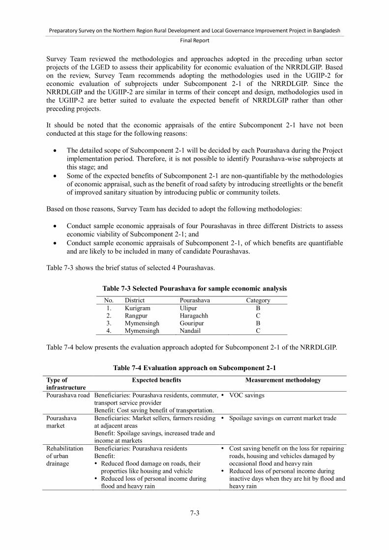
Preparatory Survey on the Northern Region Rural Development and Local Governance Improvement Project in Bangladesh
Final Report
7-3
Survey Team reviewed the methodologies and approaches adopted in the preceding urban sector projects of the LGED to assess their applicability for economic evaluation of the NRRDLGIP. Based on the review, Survey Team recommends adopting the methodologies used in the UGIIP-2 for economic evaluation of subprojects under Subcomponent 2-1 of the NRRDLGIP. Since the NRRDLGIP and the UGIIP-2 are similar in terms of their concept and design, methodologies used in the UGIIP-2 are better suited to evaluate the expected benefit of NRRDLGIP rather than other preceding projects. It should be noted that the economic appraisals of the entire Subcomponent 2-1 have not been conducted at this stage for the following reasons: The detailed scope of Subcomponent 2-1 will be decided by each Pourashava during the Project
implementation period. Therefore, it is not possible to identify Pourashava-wise subprojects at this stage; and
Some of the expected benefits of Subcomponent 2-1 are non-quantifiable by the methodologies of economic appraisal, such as the benefit of road safety by introducing streetlights or the benefit of improved sanitary situation by introducing public or community toilets.
Based on those reasons, Survey Team has decided to adopt the following methodologies: Conduct sample economic appraisals of four Pourashavas in three different Districts to assess
economic viability of Subcomponent 2-1; and Conduct sample economic appraisals of Subcomponent 2-1, of which benefits are quantifiable
and are likely to be included in many of candidate Pourashavas. Table 7-3 shows the brief status of selected 4 Pourashavas.
Table 7-3 Selected Pourashava for sample economic analysis No. District Pourashava Category 1. Kurigram Ulipur B 2. Rangpur Haragachh C 3. Mymensingh Gouripur B 4. Mymensingh Nandail C
Table 7-4 below presents the evaluation approach adopted for Subcomponent 2-1 of the NRRDLGIP.
Table 7-4 Evaluation approach on Subcomponent 2-1 Type of infrastructure
Expected benefits Measurement methodology
Pourashava road Beneficiaries: Pourashava residents, commuter, transport service provider Benefit: Cost saving benefit of transportation.
VOC savings
Pourashava market
Beneficiaries: Market sellers, farmers residing at adjacent areas Benefit: Spoilage savings, increased trade and income at markets
Spoilage savings on current market trade
Rehabilitation of urban drainage
Beneficiaries: Pourashava residents Benefit: Reduced flood damage on roads, their
properties like housing and vehicle Reduced loss of personal income during
flood and heavy rain
Cost saving benefit on the loss for repairing roads, housing and vehicles damaged by occasional flood and heavy rain
Reduced loss of personal income during inactive days when they are hit by flood and heavy rain

Preparatory Survey on the Northern Region Rural Development and Local Governance Improvement Project in Bangladesh
Final Report
7-4
7.2.4 Synergy effect between Components 1 and 2 As discussed above, the key concept of the Project is an integrated approach of rural and urban development, in which rural-urban linkages are strengthened to generate extra benefits or synergy effect for both rural and urban people. This approach aims to achieve the extra benefit or synergy effect by strategically coordinating the design and implementation of subprojects in Components 1 and Subcomponent 2-1. Table 7-5 shows the expected synergy effects between Component 1 and Subcomponent 2-1.
Table 7-5 Expected synergy effects between Component 1 and Subcomponent 2-1 Component Expected synergy effects Component 1: Rural infrastructure development
Increased traffic volume from/to adjacent Pourashava VOC saving on vehicles from/to adjacent Pourashava Improved rural livelihood by enhanced connectivity to urban areas Increased marketing of agricultural products in urban market
Subcomponent 2-1: Urban infrastructure and service delivery
Increased trade from rural areas which had not been able to reach urban market before the strategic coordination of subprojects in components 1 and 2
Increased income of migrant workers in urban areas Accelerated economic growth of Pourashava by increased flow of goods and
workforce The main objective of Component 1 is to enhance access to facilities that can provide socio-economic opportunities, such as trade, education, health, and social services. These benefits will be enhanced by improving adjacent urban infrastructure under Subcomponent 2-1. For example, improved rural roads will expand rural residents’ access to urban areas, and thereby provide employment opportunities in urban areas in their vicinity, where they can expect higher earnings. For rural farmers, they will be able to expand their reach to urban areas such as a new market to sell their products. From Pourashava development perspective, it can enhance the synergy effect by strategically coordinating the development of urban and rural infrastructure. By attracting inflow of goods and labor forces from surrounding rural areas, economic development of Pourashava will be accelerated. Its economic development will in turn benefit rural areas, by expanding their opportunities of trade, businesses and employment. This virtuous cycle of regional development will be achieved by an integrated approach of rural and urban development in which subprojects of the respective components are strategically coordinated. A concrete example of strategic coordination of subprojects in Component 1 and Subcomponent 2-1 is the improvement of an UZR and Pourashava roads that are directly connected each other. It was reported in the first field survey that there are a number of incidences in which, although an UZR has been improved by the LGED, some Pourashava roads connecting to the UZR remain in poor conditions, which undermines the impact of the development of the UZR. If those Pourashava roads are improved strategically in coordination with Pourashava under Subcomponent 2-1, synergy effect as highlighted in Table 7-5 could be created. Survey Team examined suitable methodology and data to quantify the synergy effect between Component 1 and Subcomponent 2-1. Based on the review, Survey Team confirmed that the existing methodology on economic appraisal of Pourashava market and rural road can be applicable to assess the extent to which the coordination of Component 1 and Subcomponent 2-1 would enhance their benefits. To assess the extra benefits, Survey Team conducted a sample survey in four Pourashavas to collect relevant data.

Preparatory Survey on the Northern Region Rural Development and Local Governance Improvement Project in Bangladesh
Final Report
7-5
The idea of appraisal methodology applied here is that the implementation of Component 1 and Subcomponent 2-1 in a strategically coordinated manner will enhance: 1) the efficiency and volume of transport from rural road to Pourashava roads and market; and thereby 2) market sales and VOC savings of those transporters. This impact will be enhanced further over time by stimulating economic activities between rural and urban areas. These extra benefits are added to the standard assessment of Pourashava market (see Annex 24 for details). 7.3 Summary results of economic appraisal The summary results of economic appraisal of UZRs and Growth Centers are presented below (see Annex 24 for the details on the methods and the assumptions applied and the results). 7.3.1 Component 1
EIRR on Upazila roads (development) 69 UZRs in total passed the selection and appraisal procedure. All 69 UZRs were economically viable, with having EIRR higher than the standard discount rate of 12%. The EIRR for these UZRs range from 12% to 57%, and the average is 25.58%. These results indicate moderately high economic viability. EIRR on Upazila roads (rehabilitation) 18 UZRs passed the preliminary selection and appraisal procedure. All 18 UZRs were economically viable, with having EIRR higher than the standard discount rate of 12%. The EIRR for these UZRs range from 14.5% to 53.4%, and the average EIRR is 31.4%. These results indicate high economic viability. EIRR on Union roads 47 Union roads in total passed the selection and appraisal procedure. The EIRR for these union roads range from 12% to 41%, and the average is 21.43 %. These results indicate moderately high economic viability. EIRR on Growth Center markets 70 Growth Center in total markets passed the selection and appraisal procedure. The EIRR ranges from 16% to 2,076 %, and the average EIRR is a robust 199%. This high EIRR can be attributed mainly to the relatively low cost investment which is substantially exceeded by the benefits in the form of reduced spoilage of produce. Two markets have even higher EIRR (over 2,000%) due to the large volume of the most perishable commodities such as fish that currently suffers from the greatest reduction in price over the course of the trading day. EIRR on rural markets 126 rural markets in total passed the selection and appraisal procedure. The EIRR ranges from 12% to 1,580%, and the average EIRR is a robust 115%. The reasons behind this high EIRR are the same as those pointed out on Growth Center markets. 7.3.2 Subcomponent 2-1 Pourashava road The EIRR of four sample Pourashava roads ranges from 68% to 150%, and the average EIRR is 107%. This indicates a high economic viability of the sample subprojects. Sensitivity analysis shows that a 20% increase in capital cost will reduce EIRR to 96%, whereas a 20% decrease in benefit will result in average EIRR 94%. Finally, the average EIRR is reduced to 85% in a combined case in which capital cost is increased by 20% and the benefit is decreased by 20%.

Preparatory Survey on the Northern Region Rural Development and Local Governance Improvement Project in Bangladesh
Final Report
7-6
Pourashava market The economic analysis of four sample Pourashava market generated an estimated EIRR at a robust 175%, and the EIRR lies between 75% and 254%. A sensitivity analysis shows that a 20% increase in capital cost will result in average EIRR at 146%, whereas a 20% decrease in benefit will push the EIRR down to 141%. Finally, a combined case of a 20% increase in capital cost and a 20% decrease in benefit resulted in the average EIRR at 117%. Urban drainage The economic analysis of the four sample Pourashava drains generated the average EIRR of 71.7% and the EIRR lies between 53% and 116%. A sensitivity analysis shows that a 20% increase in capital cost results in the average EIRR at 47%, whereas a 20 % decrease in benefit push the EIRR down to 43%. The combined case of a 20% increase in capital cost and a 20% decrease in benefit resulted in EIRR at 29%. This is still higher than the standard discount rate of 12%. 7.3.3 Synergy effect between Component 1 and Subcomponent 2-1 The economic appraisal of sample Pourashava markets showed additional 3% to 29% increases from the standard EIRR, indicating tangible impacts of synergy effect of Component 1 Subcomponent 2. The range of EIRR is generated by the type of commodities transported via the respective rural roads. The rate of improvement in EIRR is higher when the roads transport high-value, most perishable commodities such as fish, meat and vegetables. This indicates that strategic selection of roads and market, with consideration on each market and transport demand, are critical to achieving higher economic benefits.
Table 7-6 Example of economic appraisal on Pourashava markets Name of Pourashava: Ulipur Name of market: Ulilpur Kacha Bazar Items Commodities
transported EIRR NPV
(million BDT) 1.Standard EIRR/NPV 232.88% 131.65 2.EIRR/NPV when “Hatia to ulipur bazar road” is improved
Rice, paddy 244.84% 138.83
3.EIRR/NPV when “Kurigram to Ulipur por Kacha Bazar Road” is improved
Fish, meat, vegetables
270.21% 154.05
Name of Pourashava: Haragach Name of market: Haragach Pourashava Market Items Commodities
transported EIRR NPV
(million BDT) 1.Standard EIRR/NPV 75.07% 29.41 2.EIRR/NPV when “Rangpur to Haragach Por Road” is improved
Rice, wheat flour, fish, fruits, poultry, vegetables
93.97% 38.53
3.EIRR/NPV when “Sarai to Haragach Por Road” is improved
Paddy 75.99% 29.85
4. EIRR/NPV when “Khansama to Haragach Por Road” is improved
Meat 78.43% 31.03

Preparatory Survey on the Northern Region Rural Development and Local Governance Improvement Project in Bangladesh
Final Report
8-1
8 Environmental and social considerations 8.1 Institutional framework for environmental and social considerations 8.1.1 Legal and policy framework (1) Legal framework for environmental impact assessment a) Environment Conservation Act 1995 The Environment Conservation Act (ECA) 1995 is the main legal framework on environmental conservation in Bangladesh. The main objectives of the ECA are: 1) conservation and improvement of the environment; and 2) control and mitigation of pollution in the environment. To achieve these objectives, the ECA focuses on the following items: Declaration of Ecologically Critical Areas (Section 5) Regulations of emissions from vehicles (Section 6) Issuance of environmental clearances (Section 12) Formulation of environmental guidelines (Section 13) Regulation of development activities’ discharge permits (Section 20) Promulgation of standards for the quality of air, water, noise and soil (Section 20) Promulgation of standard limits for waste discharge (Section 20)
The ECA also stipulates the establishment of the Department of the Environment (DOE) and the power and functions of the Director General (DG) for carrying out the purposes of the ECA (Section 3 and 4). For instance, the DG who is appointed by the Government of Bangladesh (GOB) may issue directions of prohibition or regulations on an industry, undertaking or process when he or she considers it necessary for environmental conservation. In addition, according to Section 12 of the ECA, all development projects must obtain an Environmental Clearance Certificate (ECC) from the DG of the DOE. b) Environment Conservation Rules 1997 The Environment Conservation Rules (ECR) 1997, which was issued by the Ministry of the Environment and Forest (MOEF), spells out the detailed procedures and requirements for the enforcement of the ECA. The ECR was promulgated in exercise of the powers conferred by Section 20 of the ECA, stating that the government is empowered to make rules for carrying out the purposes of the ECA. The subjects relevant to environmental assessment are as follows: Considerations for the declaration of Ecologically Critical Areas (Rule 3) Classification of projects (Rule 7) Procedures to obtain ECCs (Rule 7) Requirements for Initial Environmental Examinations (IEE) and Environmental Impact
Assessments (EIA) (Rule 7) Determination of environmental quality standards for air, water, noise, odor and other
components of the environment (Rule 12) Determination of standards for waste discharge and gaseous emissions from industry or
development projects (Rule 13) Rule 3 defines the factors to be considered in declaration of Ecologically Critical Areas such as wetlands and forest areas as per Section 5 of the ECA. It also empowers the government to specify the
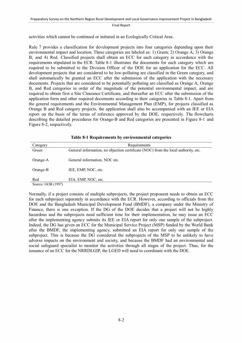
Preparatory Survey on the Northern Region Rural Development and Local Governance Improvement Project in Bangladesh
Final Report
8-2
activities which cannot be continued or initiated in an Ecologically Critical Area. Rule 7 provides a classification for development projects into four categories depending upon their environmental impact and location. These categories are labeled as: 1) Green; 2) Orange A; 3) Orange B; and 4) Red. Classified projects shall obtain an ECC for each category in accordance with the requirements stipulated in the ECR. Table 8-1 illustrates the documents for each category which are required to be submitted to the Division Officer of the DOE for an application for the ECC. All development projects that are considered to be low-polluting are classified in the Green category, and shall automatically be granted an ECC after the submission of the application with the necessary documents. Projects that are considered to be potentially polluting are classified as Orange A, Orange B, and Red categories in order of the magnitude of the potential environmental impact, and are required to obtain first a Site Clearance Certificate, and thereafter an ECC after the submission of the application form and other required documents according to their categories in Table 8-1. Apart from the general requirements and the Environmental Management Plan (EMP), for projects classified as Orange B and Red category projects, the application shall also be accompanied with an IEE or EIA report on the basis of the terms of reference approved by the DOE, respectively. The flowcharts describing the detailed procedures for Orange-B and Red categories are presented in Figure 8-1 and Figure 8-2, respectively.
Table 8-1 Requirements by environmental categories
Category Requirements Green General information, no objection certificate (NOC) from the local authority, etc.
Orange-A General information, NOC etc.
Orange-B IEE, EMP, NOC, etc.
Red EIA, EMP, NOC, etc. Source: GOB (1997)
Normally, if a project consists of multiple subprojects, the project proponent needs to obtain an ECC for each subproject separately in accordance with the ECR. However, according to officials from the DOE and the Bangladesh Municipal Development Fund (BMDF), a company under the Ministry of Finance, there is one exception. If the DG of the DOE decides that a project will not be highly hazardous and the subprojects need sufficient time for their implementation, he may issue an ECC after the implementing agency submits its IEE or EIA report for only one sample of the subproject. Indeed, the DG has given an ECC for the Municipal Service Project (MSP) funded by the World Bank after the BMDF, the implementing agency, submitted an EIA report for only one sample of the subproject. This is because the DG considered the subprojects of the MSP to be unlikely to have adverse impacts on the environment and society, and because the BMDF had an environmental and social safeguard specialist to monitor the activities through all stages of the project. Thus, for the issuance of an ECC for the NRRDLGIP, the LGED will need to coordinate with the DOE.

Preparatory Survey on the Northern Region Rural Development and Local Governance Improvement Project in Bangladesh
Final Report
8-3
Source: Adapted from LGED (2008e)
Figure 8-1 Procedures of Orange-B category projects
If the ECC is rejected, project proponent may appeal as per Clause 14 of Environmental
Conservation Act 1995
Renew the ECC every year 30 days before date of expiry
The application should include: A feasibility report; An IEE report; An EMP; An emergency plan An outline of a relocation and rehabilitation plan; and An NOC from the local authority
Project proponent may undertake activities for land development and infrastructure development
Issuance of Site Clearance
Applying for an Environmental Clearance Certificate (ECC) upon completion of the above activities
Issuance of ECC valid for one year
Within 60 working days from the date of application
Within 30 working days from the date of application
Project proponent can initiate the project
Application to the DOE

Preparatory Survey on the Northern Region Rural Development and Local Governance Improvement Project in Bangladesh
Final Report
8-4
Source: Adapted from LGED (2008e)
Figure 8-2 Procedures of Red category projects
(2) Legal and policy framework for land acquisition and resettlement The Acquisition and Requisition of the Immovable Property Ordinance (ARIPO) 1982 and the subsequent amendments made during 1993 and 1994 constitute the legal framework that governs all cases of land acquisition in Bangladesh. The Acquisition and Requisition of Immovable Property Rules 1982 were issued under Section 46 of the ARIPO stipulating that the government is empowered to make rules for carrying out the purposes of the ARIPO. The ARIPO presents the procedural details required for land acquisition as presented in Figure 8-3. Land acquisition below 50 bigha (about 6.7 hectare) is handled by the Division Commissioner, and that of over 50 bigha by the Ministry of Land. Regardless of the size of land to be acquired, it is the Deputy Commissioner (DC) who determines the market price of assets based on the approved procedure, and pays one hundred and fifty percent of the assessed value as compensation. Section 10A inserted by amendment in 1994 made provisions for payment of crop compensation to tenant cultivators. However, the ARIPO does not cover project-affected persons (PAPs) without titles of ownership record, for example informal settlers or
Within 60 working days from the date of application
Project proponent may undertake activities for land development and infrastructure development
Application to the DOE
The application should include: A feasibility report; An IEE report and TOR for EIA or EIA report An EMP An emergency plan An outline of a relocation and rehabilitation plan; and An NOC from the local authorities
Issuance of Site Clearance
Submission for approval of the EIA
Approval of EIA within 60 days of submission
Apply for an ECC
Issuance of ECC within the 30 days application
Project proponent can initiate the project
Renew ECC every 30 days before date of expiry

Preparatory Survey on the Northern Region Rural Development and Local Governance Improvement Project in Bangladesh
Final Report
8-5
squatters, occupiers, informal tenants and lease-holders (without documents), and does not ensure replacement value of the property acquired. In addition, the ARIPO has no provision related to resettlement or the restoration of livelihoods for PAPs. For example, provision of the expenses necessary for relocation and re-establishment of communities at resettlement sites are not prescribed in the ARIPO, although these are the requirements of international donor agencies including JICA. To supplement the gaps, the past projects similar to the NRRDLGIP prepared resettlement policy frameworks and Resettlement Action Plans (RAPs). For example, the Rural Transport Improvement Project (RTIP) of the LGED funded by the World Bank required acquisition of about 426 ha of private land and affected 11,470 people, for which RAPs were prepared and implemented. The total cost of resettlement programs arranged in accordance with the RAPs accounted for nearly 3% of the total cost of the RTIP. Under the Second Urban Governance and Infrastructure Improvement (Sector) Project (UGIIP-2) funded by the Asian Development Bank (ADB), as of May 2012, several land acquisitions have been proposed to the DC office. A total of 10.57 ha of private land plots are to be acquired for the construction of landfill sites in 13 Pourashavas, according to the mid-term review of the UGIIP-2. Thus, if the NRRDLGIP requires land acquisition, the LGED or Pourashava needs to coordinate with the DC and the Division Commissioner or the Ministry of Land to take necessary procedures for land acquisition. In addition, if resettlement is expected, the LGED or Pourashava needs to prepare a RAP in accordance with the JICA Guidelines.
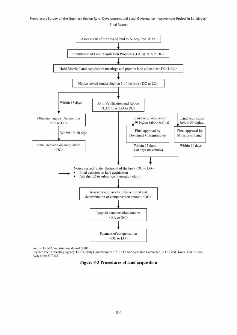
Preparatory Survey on the Northern Region Rural Development and Local Governance Improvement Project in Bangladesh
Final Report
8-6
Source: Land Administration Manual (2003) Legend: EA = Executing Agency, DC= Deputy Commissioner, LAC = Land Acquisition Committee, LO = Land Owner, LAO = Land Acquisition Official
Figure 8-3 Procedures of land acquisition
Final approval by Ministry of Land
Final approval by Divisional Commissioner
Within 15 days
Within 10–30 days
Land acquisition over 50 bighas (about 6.8 ha)
Within 90 days Within 15 days (30 days maximum)
Land acquisition below 50 bighas
Deposit compensation amount <EA to DC>
Notice served (under Section 3 of the law) <DC to LO>
Hold District Land Acquisition meetings and provide land allocation <DC+LAC>
Assessment of the area of land to be acquired <EA>
Joint Verification and Report <LAO+EA+LO to DC>
Notice served (under Section 6 of the law) <DC to LO> Final decision on land acquisition Ask the LO to submit compensation claim
Assessment of assets to be acquired and determination of compensation amount <DC>
Submission of Land Acquisition Proposals (LAPs) <EA to DC>
Payment of compensation <DC to LO>
Objection against Acquisition <LO to DC>
Final Decision on Acquisition <DC>

Preparatory Survey on the Northern Region Rural Development and Local Governance Improvement Project in Bangladesh
Final Report
8-7
(3) JICA Guidelines for Environmental and Social Considerations To ensure the environmental and social sustainability of its funded projects, JICA has formulated the Guidelines for Environmental and Social Considerations (hereafter “JICA Guidelines”) in April 2010. The objectives of the JICA Guidelines are to: 1) encourage the executing agency to have appropriate considerations for environmental and social impacts; and 2) ensure that JICA’s support for, and examination of, environmental and social considerations are conducted accordingly. The JICA Guidelines specify requirements that all executing agencies of JICA-funded projects must meet. The key requirements include, but are not limited to, the following: Assessment of potential environmental and social impacts and elaboration of mitigation
measures in the earliest possible planning stage, and incorporation of them into the project plan Examination of multiple alternatives to avoid or minimize adverse impacts, and to select better
project options Sufficient consultations with local stakeholders with disclosure of information at the earlier stage Compliance with laws, standards, and plans No significant adverse impacts on ecosystem and biota Avoidance and minimization of involuntary resettlement, where feasible, and preparation and
implementation of RAP, where involuntary resettlement is unavoidable Special considerations for indigenous people Sufficient monitoring to check the performance and effectiveness of mitigation measures
Thus, the LGED and Pourashavas, as the executing agencies of subprojects of the NRRDLGIP, shall satisfy the above requirements as well as the others described in the JICA Guidelines, even if the national laws and policies do not fully prescribe for these issues. (4) LGED Environmental Guidelines The LGED published the “Environmental Guidelines for the LGED Projects” (LGED Guidelines) in 2008, aiming to implement all of its development projects in an environmentally sound and sustainable manner. Following the LGED Guidelines would meet all the requirements of the GOB and its financing partners including JICA. They provide necessary procedures and formats for the IEE and EIA of rural infrastructure development and urban sector projects. For example, analysis of alternatives, public consultations and preparation of the EMP are included in the suggested outline of the EIA report. Thus it can be concluded that conducting an IEE and EIA in accordance with the LGED Guidelines generally satisfies the requirements of the JICA Guidelines. 8.1.2 Organizational framework for environmental and social considerations (1) Local Government Engineering Department The LGED under the Ministry of Local Government, Rural Development and Cooperatives (MLGRD&C) is the Executing Agency for the NRRDLGIP, and therefore responsible for, at the implementation phase: 1) obtaining ECCs from the DOE in accordance with the ECR; and 2) preparing and implementing land acquisition plans and RAPs in accordance with the ARIPO and the JICA Guidelines. In order to obtain ECCs, the LGED needs to prepare an IEE and EIA report. However, the LGED does not have any environmental units or posts for environmental specialists at any of its levels including the headquarters and the Regional, District, and Upazila levels. Thus the LGED usually commissions environmental consultants to conduct IEE and EIA. Regarding environmental monitoring, there is also no specific person who is responsible for it in the LGED. Normally, the LGED staff members at the

Preparatory Survey on the Northern Region Rural Development and Local Governance Improvement Project in Bangladesh
Final Report
8-8
District level are given the additional responsibility of assisting the environmental consultants in conducting the IEE or EIA and monitoring projects. According to an Assistant Engineer and a Laboratory Technician of the LGED at the District level, the LGED staff members has received general environmental trainings from different projects such as the Small-Scale Water Resources Development Sector Project (SSWRDSP) funded by the ADB, and assisted the IEE or EIA and environmental monitoring in those previous development projects. According to the Social Safeguard Specialists of the BMDF, the BMDF commissioned an environmental expert to monitor the environment in the project area. The LGED also employed the same scheme for the UGIIP-2. Thus, for the NRRDLGIP, environmental consultants need to be commissioned, and, with their assistance, the LGED shall conduct IEE and/or EIA, and environmental monitoring for rural infrastructure component (Component 1). Similarly in relation to involuntary resettlement and land acquisition, the LGED needs to prepare and implement land acquisition plans and RAPs for each subproject, if they are unavoidable. Since it has no social consideration unit, the LGED needs to commission resettlement and/or land acquisition consultants for the preparation and implementation of land acquisition plans and RAPs. The LGED is, in general, considered capable of performing environmental and social considerations in rural and urban projects, taking into account its experiences in similar projects in the past. However, the LGED needs to recruit consultants to properly conduct environmental and social assessment. The environmental and resettlement consultants, therefore, need to be assigned under the NRRDLGIP. (2) Pourashava Pourashavas are responsible for urban infrastructure development in their territories, and therefore are responsible for environmental and social considerations for subprojects under Subcomponent 2-2. If any subprojects fall under Orange-B or Red categories under the ECR, they are responsible for conducting IEE or EIA in accordance with the ECR. If any subprojects involve land acquisition or involuntary resettlement, concerned Pourashavas are required to prepare and implement land acquisition plans and involuntary resettlement in accordance with the ARIPO and the JICA Guidelines. Pourashavas are generally suffering from the lack of human resources. There is no section in charge of environmental and social assessment found in the organizational chart prescribed by the Local Government Division. No posts for environmental or social assessment specialist are assigned in Pourashavas. They normally lack the experiences in IEE and EIA, and land acquisition and involuntary resettlement. It is therefore necessary for the Project Management Office (PMO) to support Pourashavas in performing their environmental and social responsibilities. In this regard, environmental and resettlement specialists need to be assigned at the Regional level to assist Pourashavas. (3) Department of Environment The DOE within the MOEF is responsible for environmental laws and regulations, the activities of which are overseen by the DG. The DOE Headquarters is currently organized into nine main functional areas with six Division Offices that carry out the overall management of the environment supported by laboratory analysis (Figure 8-4). The DOE is also the regulatory body responsible for the enforcement of the ECA and ECR. Under the legal framework, the DOE issues ECCs required for the implementation of development projects. Therefore, if an IEE and EIA are required for the NRRDLGIP, the LGED needs to coordinate with the DOE.

Preparatory Survey on the Northern Region Rural Development and Local Governance Improvement Project in Bangladesh
Final Report
8-9
Source: Department of Environment
Figure 8-4 Organogram of the Department of Environment
8.1.3 Consistency with the “JICA Guidelines for Environmental and Social Considerations” The domestic laws and policies related to environmental and social considerations in Bangladesh are insufficient to meet the requirements of the JICA Guidelines. Survey Team identified the following gaps: 1) Although the ECR generally covers major requirements of JICA in environmental considerations, there are still partial insufficiencies; 2) The ARIPO does not cover the JICA requirements for social considerations related to the assistance for resettlement or restoration of livelihood of PAPs. More specific gaps in environmental and social considerations are listed in Table 8-2 and Table 8-3. For environmental considerations, there are three key insufficiencies of the ECR to satisfy the JICA requirements: 1) analysis of alternatives; 2) range of impacts to be assessed; and 3) public consultation and information disclosure. These issues are not addressed in any domestic laws or policies including the ECR, but only recommended in the LGED Guidelines. For social considerations, there are seven key insufficiencies of the ARIPO: 1) avoidance and minimization of involuntary resettlement; 2) restoration of livelihood of PAPs; 3) compensation based on replacement cost; 4) public consultation and information disclosure in preparing RAP; 5) grievance mechanism and participation of PAPs in
Director General
Director (Administration and Human
Resources Development)
Director (Planning)
Director (Law)
Director (Air quality Management)
Director (Climate Change &
International Convention)
Director (Information Technology)
Director (Environmental Clearance)
Director (Monitoring and Enforcement)
Director (Natural Resources
Management and Research)
Director (Dhaka Metropolitan)
Director (Laboratory)
Director (Sylhet Division)
Director (Rajshahi Metropolitan)
Director (Khulna Division)
Director (Barishal Division)
Director (Dhaka Region)
Director (Chittagong Metropolitan)
Director (Laboratory)
Director (Chittagong Region)

Preparatory Survey on the Northern Region Rural Development and Local Governance Improvement Project in Bangladesh
Final Report
8-10
planning, implementing and monitoring RAP; 6) eligibility of PAPs without legal rights to land; and 7) special assistance to vulnerable groups. These issues are not sufficiently addressed in the ARIPO. To bridge these gaps, the LGED and Pourashavas need to take appropriate measures in accordance with the JICA Guidelines. The LGED has already agreed to take such actions. Specific measures to be taken will be described in the Environmental Framework and Resettlement Policy Framework, which are being prepared and will be explained in the Final Report. These frameworks will guide the LGED and Pourashavas to take necessary actions.
Table 8-2 Comparison between relevant laws, regulations and guidelines of GOB and JICA (environment)
Requirements by JICA Guidelines
ECR, and other relevant policies
Gap Gap bridging measures to be taken in the Project
Analysis of alternatives and mitigation measures
The ECR provides for the submission of mitigation plans to cover the effects of pollution for the issuance of ECC (ECR §7). In addition, analysis of alternative measures is recommended in the LGED Guidelines.
Analysis of alternatives is not provided in legal instruments of Bangladesh, but recommended in the LGED guidelines.
Alternative options will be analyzed in the process of environmental assessment in accordance with the JICA Guidelines and LGED Guidelines.
Scope of impacts to be assessed
The ECR has no provision for the scope of impacts to be assessed for environmental assessment, but the LGED guidelines recommend using a checklist covering a broad range of environmental and social issues.
Scope of impacts to be assessed is not provided in legal instruments of Bangladesh, but recommended in the LGED guidelines.
Scope of impacts to be assessed will be determined in accordance with the JICA Guidelines and LGED Guidelines.
Information disclosure and consultation with stakeholders
The ECR has no provision for information disclosure or public consultation, but the LGED guidelines provide general recommendations for information disclosure and public consultation in environmental assessment.
Information disclosure and public consultation is not provided in legal instruments of Bangladesh, but recommended in the LGED guidelines.
Stakeholder meeting will be held, and findings of environmental analysis as well as the draft IEE/EIA reports will be explained in the local language.
Consideration for ecosystems and biota
The ECR provides for the consideration of ecosystems and biota by declaring Ecologically Critical Areas and limiting activities in those areas (ECR §3).
There is no significant gap. Ecologically Critical Areas declared under the ECR will be excluded from the Project site. Besides, all impacts on ecosystem and biota will be considered in accordance with the JICA Guidelines.
Monitoring The ECR provides for the submission of an EMP for the issuance of an ECC (ECR §7).
There is no significant gap. EMP which comprises environmental monitoring plan will be prepared to obtain ECC prior to the implementation of the Project. Monitoring will be conducted according to the EMP.
Source: Survey Team Note: “§” indicates provision of the ECR and ARIPO. (e.g., ECR §3 indicates Rule 3, and ARIPO §5 indicates Section 5.)

Preparatory Survey on the Northern Region Rural Development and Local Governance Improvement Project in Bangladesh
Final Report
8-11
Table 8-3 Comparison between relevant laws, regulations and guidelines of GOB and JICA (land acquisition and resettlement)
Requirements by JICA Guidelines
ARIPO and other relevant policies
Gap Gap bridging measures to be taken in the Project
Avoidance of involuntary resettlement and loss of means of livelihood (when feasible)
The ARIPO has no provisions regarding involuntary resettlement.
Avoidance of involuntary resettlement and loss of means of livelihood is not provided in legal instrument of Bangladesh or the LGED Guidelines.
Involuntary resettlement and loss of means of livelihood will be avoided as much as possible in accordance with the JICA Guidelines.
Minimization of impact (when population displacement is unavoidable)
The ARIPO has no provisions regarding involuntary resettlement.
Minimizing adverse impacts is not provided in legal instruments of Bangladesh or the LGED Guidelines.
Large-scale involuntary resettlement will be minimized in accordance with the JICA Guidelines, and excluded in the process of subproject selection.
Restoration of standards of living of the PAPs to pre-project level at least.
The ARIPO has no provisions regarding livelihood restoration.
Restoration of livelihoods and standards of living of the PAPs is not provided in legal instruments of Bangladesh or the LGED Guidelines.
Measures to restore livelihoods and standards of living of the PAPs will be taken based on their needs in accordance with the JICA Guidelines.
Compensation based on the full replacement cost (as much as possible)
The ARIPO provides that market value of the property at the date of public notice of acquisition is considered in determining compensation amount (ARIPO §8).
Compensation based on the full replacement cost is not provided in legal instruments of Bangladesh or the LGED Guidelines. Market value calculated under the ARIPO does not consider depreciation and deduction for taxes and/or costs of transaction.
Compensation amount will be determined based on full replacement cost in accordance with the JICA Guidelines.
Consultation with the PAPs and disclosure of information in preparing resettlement action plan
The ARIPO provides that the DC shall publish a notice at convenient places near the property proposed for acquisition (ARIPO §3).
Although the ARIPO provides indirect public consultation, it does not provide disclosure of detailed information such as the purpose of land acquisition and compensation as well as entitlements of and special assistance to PAPs.
Public consultation will be ensured through stakeholder meetings, and information will be made available during preparation and implementation of RAP in accordance with the JICA Guidelines.
Grievance mechanism and participation of PAPs in planning, implementation, and monitoring of RAPs
The ARIPO provides the occupant of the land to raise their objections to be filed to DC within 15 days after the public notice of acquisition (ARIPO §4).
The ARIPO provides a limited grievance mechanism where landowners can raise objections against acquisition. However, there is no provision of promoting participation of PAPs in planning, implementation and monitoring of resettlement plan.
Grievance Redress committees will be formed through participatory appraisal with all stakeholders. Besides, proper stakeholder consultations will be ensured in planning, implementation, and monitoring of RAPs in accordance with the JICA Guidelines.
Eligibility of benefits for PAPs with formal or informal legal rights to land
The ARIPO does not cover PAPs without titles of ownership record for compensation.
While JICA Guidelines provide eligibility of PAPs without titles of ownership record, the ARIPO does not.
The PAPs without titles of ownership record who indeed require assistance will be carefully screened out in social survey, and entitlement will be delivered to them in accordance with the JICA Guidelines.
Particular assistance to vulnerable groups
The ARIPO has no provision for particular assistance to vulnerable groups.
While JICA Guidelines provide particular assistance to vulnerable groups, the ARIPO does not.
Vulnerable groups will be identified in social survey, and provided with special assistance measures in accordance with the JICA Guidelines.
Source: Survey Team Note: “§” indicates provision of the ECR and ARIPO. (e.g., ECR §3 indicates Rule 3, and ARIPO §5 indicates Section 5.

Preparatory Survey on the Northern Region Rural Development and Local Governance Improvement Project in Bangladesh
Final Report
8-12
8.2 Policy for environmental and social considerations 8.2.1 Infrastructure and work type of the Project The NRRDLGIP covers eight Districts of the Rangpur Division and six Districts in the northern area of the Dhaka Division. The characteristics of the Project area are described in Chapter 3. The NRRDLGIP consists of three components. Component 1 will develop basic rural infrastructures. Component 2 will consist of two subcomponents. Subcomponent 2-1 will improve basic infrastructure and service delivery of Pourashavas, and Subcomponent 2-2 will enhance local governance and capacity development of Pourashavas. Component 1 and Subcomponent 2-1 will involve physical infrastructure work which may cause adverse impacts on environment and society in the Project area. Component 1 will include: 1) upgrading of Upazila roads (UZR) and Union roads (UNR) including bridges and culverts; 2) rehabilitation of UZR; 3) improvement of Growth Centers and rural markets; and 4) improvement of ghats. The upgrading and/or rehabilitation of UZR and UNR may involve bituminous pavement of unpaved sections, road widening as per the Road Design Standards of 2005 (RDS, 2005), minor realignments, construction of bridges, and the installation of culverts and other facilities. With regard to Growth Center markets and rural markets, major components may be access and internal road rehabilitation, improvement of drainage facilities, construction of modern sheds, installation of sanitary latrines and tubewells, and the construction of garbage pits. No subprojects in Subcomponent 2-1 are determined at present since they will be selected through participatory approaches in the implementation phase of the Project. The eligible types of infrastructure works under the subcomponent may include: 1) improvement and rehabilitation of Pourashava roads, bridges, and culverts; 2) repair, rehabilitation, and expansion of drains; 3) improvement of municipal markets; 4) construction of slaughter houses; 5) rehabilitation and expansion of water distribution network and tubewells; 6) construction of public and community toilets; 7) construction of solid waste management facilities; 8) construction of bus and truck terminals; 9) installation of streetlights; 10) establishment of parking areas; and 11) other basic infrastructures for the poor. Improvement of Pourashava roads and markets may include the rehabilitation, repair, and widening of existing roads in the Pourashavas. The repair, rehabilitation, and rehabilitation of drainage may involve: 1) the elimination of blockages on existing drainage paths; 2) the cleaning of existing drains; 3) the construction of new drains; and 4) construction of missing links. The construction of bus and truck terminals may involve: 1) the placement of fill material to bring the site to grade; 2) surfacing of parking areas; and 3) the construction of a terminal building and public toilet. 8.2.2 Environmental category (1) JICA Guidelines for Environmental and Social Considerations According to the JICA Guidelines, all to-be-funded subprojects are categorized into four groups based on the extent of the environmental and social impacts: Category A, B, C and FI. The NRRDLGIP is classified as category B. This is because all subprojects of Component 1, which will account for a large portion of the Project, will be specified by the funding approval of JICA, and the subprojects will not have significant adverse impacts on environment and society. Under Component 1, subprojects which will have the significant adverse impacts and thus will be classified as Category A will be excluded in the selection process of subprojects. Similarly for Component 2, subprojects which will have significant environmental and social impacts will be excluded by the selection criteria of subprojects of Component 2.

Preparatory Survey on the Northern Region Rural Development and Local Governance Improvement Project in Bangladesh
Final Report
8-13
(2) Environmental Conservation Rules 1997 In accordance with the ECR, some of the subprojects under the NRRDLGIP are classified as either Red or Orange-B categories depending on their work types. Table 8-4 demonstrates the categorization of subprojects by the ECR. In Component 1, construction of bridge over 100m is classified under Red category, and the upgrading and rehabilitation of UZR and UNR, and the construction of bridge below 100 m under Orange B category. Although there is no specific categorization for the improvement of Growth Center and rural markets, they may be categorized as Orange B if they involve the construction of public or community toilets. The construction of culverts and improvement of ghats are not classified under any category. The LGED needs to prepare EIA and IEE reports for the Red category subprojects, and IEE report for the Orange B category subprojects in consultation with the DOE. Regarding Subcomponent 2-1, the rehabilitation and expansion of water distribution networks and construction of solid waste management facilities are classified under Red category, and the improvement and rehabilitation of Pourashava roads, construction of bridges below 100 m, construction of public and community toilets under Orange B category. Although there is no specific categorization for the improvement of municipal markets, construction of bus and truck terminals, and establishment of parking areas, they may be categorized as Orange B if they involve the construction of public or community toilets. The construction of slaughterhouses and tubewells, installation of streetlights, and repair, rehabilitation and expansion of drains are not classified under any category. The concerned Pourashavas will bear the responsibility for conducting EIA and IEE for Red category subprojects, and IEE for Orange B category subprojects in consultation with the DOE. In addition, according to the ECR, subprojects may be categorized as Orange B if they involve engineering works up to 1 million BDT and as Red if they involve those above 1 million BDT. In those cases, the LGED and concerned Pourashavas will need to coordinate with the DOE to implement necessary procedures.

Preparatory Survey on the Northern Region Rural Development and Local Governance Improvement Project in Bangladesh
Final Report
8-14
Table 8-4 Categorization of subprojects under the Environmental Conservation Rules 1997 Type of work Category Action to
be taken Responsible
Agency Component 1 Upgrading and rehabilitation of UZR Orange B IEE LGED Upgrading and rehabilitation of UNR Orange B IEE Construction of bridges
(over 100 m) Red EIA, IEE
Construction of bridges (below 100 m)
Orange B IEE
Construction of culverts N/A - Improvement of Growth Centers and rural markets N/A, but may be
categorized as Orange B depending on the construction works
IEE if required
Improvement of ghats N/A - Subcomponent 2-1 Improvement and rehabilitation of Pourashava roads Orange B IEE Concerned
Pourashavas Construction of bridges (below 100 m) Orange B IEE Construction of slaughterhouses N/A - Rehabilitation and expansion of water distribution
networks Red EIA, IEE
Construction of tubewells N/A - Construction of public and community toilets Orange B IEE Construction of solid waste management facilities Red EIA, IEE Installation of streetlights N/A - Repair, rehabilitation, and expansion of drains N/A - Improvement of municipal markets N/A, but may be
categorized as Orange B depending on the construction works
IEE if required Construction of bus and truck terminals
Establishment of parking areas
Source: Environmental Conservation Rules of 1997 Note: N/A = Not applicable 8.2.3 Subprojects to be noticed Some subprojects of the NRRDLGIP are classified under Red category in accordance with the ECR. For these subprojects, due attention should be paid to ensure that IEE and EIA are conducted properly without any delay to obtain ECCs from the DOE. Red category subprojects of the NRRDLGIP are described below. (1) Component 1 Subprojects which involve the construction of bridges over 100 m are classified under Red Category under the ECR. The LGED inventory of UZR and UNR provides the information of bridges over 100 m. In addition, the bridges over 80 m should be also paid attention to ensure that the bridges over 100 m are identified in advance, considering the lessons learned from a similar project and a finding by Survey Team indicated in the following: After the start of the South-Western Bangladesh Rural Development Project (SWBRDP), it was
revealed that the lengths of some selected bridges were much longer than the spans of gaps recorded in the LGED road inventory.

Preparatory Survey on the Northern Region Rural Development and Local Governance Improvement Project in Bangladesh
Final Report
8-15
A field investigation by Survey Team revealed that the estimated spans between abutments on both sides of riverbank in sample roads were longer than the spans of gaps recorded in the LGED road inventory.
The locations and numbers of bridges over 100m are provided in Annex 19. (2) Component 2 The subprojects which contain the rehabilitation and expansion of water distribution networks and construction of solid waste management facilities are categorized as Red category under the ECR. However, since subprojects in Subcomponent 2-1 will be selected through participatory process at the implementation phase of the Project, the locations and numbers of these subprojects cannot be identified at the Preparatory Survey stage. 8.2.4 Policy for environmental and social considerations (1) Features of the Project Considering the types of each subproject and requirements of the relevant laws and policies, the features of the Project as a whole are summarized. a) Subproject selection Subprojects of Component 1 have been specified in the Survey. The LGED, in coordination with the DOE, needs to conduct EIA and IEE for the subprojects that include the construction of bridges over 100 m, and IEE for the subprojects that comprise the upgrading of UZR, upgrading and rehabilitation of UNR, and construction of bridges below 100m. As regards Component 2, subprojects cannot be specified during the Preparatory Survey because they will be selected through the participatory processes at the implementation stage of the Project. If any Red category subprojects are selected, the concerned Pourashavas will need to conduct EIA and/or IEE in coordination with the DOE. b) Measures as per detail designs Since detailed engineering designs have not been conducted at the Survey phase, the LGED or concerned Pourashavas will be required to take necessary actions at the implementation phase. If any subprojects, for instance, are found to involve involuntary resettlement during the detail designs phase, the LGED or concerned Pourashavas will need to prepare and implement ARAPs. They will also need to consider the adjustment of the detail designs to avoid or minimize resettlements. (2) Project policy and prepared documents Based on the analysis on the institutional framework and features of the Project, the policy of the Project for environmental and social considerations is to fulfill the requirements of national laws and policies, and the JICA Guidelines. To accomplish this, two actions will be implemented by the LGED: 1) procurement of consulting services regarding environmental and social considerations; and 2) performing its environmental and social requirements by referring to the drafts of key documents which have been prepared in the Preparatory Survey.

Preparatory Survey on the Northern Region Rural Development and Local Governance Improvement Project in Bangladesh
Final Report
8-16
a) Procurement of consulting services To ensure that necessary actions are implemented to fulfill all the requirements of national laws and the JICA guidelines, consultants with expertise in environmental and social considerations will be assigned to assist the LGED and Pourashavas. The consultants’ numbers and TORs are described in Section 8.4.2. b) Drafts of key documents prepared in the Survey Survey Team has conducted preliminary studies and prepared drafts of some key documents as a guiding and reference materials for the implementation phase. It is recommended that the LGED follows these documents to fulfill its environmental and social requirements. Those documents are described below. Draft Environmental Framework A draft Environmental Framework has been prepared to provide the basic concept of environmental assessment including IEE and EIA, and to describe study items, procedures, methodologies to meet the requirements of both national laws and policies, and the JICA Guidelines. This document has been prepared based on the findings of the IEE, EIA, and semi-IEE investigations conducted as a sample in the Survey, and on the literature survey of the past similar projects. The draft Environmental Framework is provided in Annex 25. Draft EIA and IEE reports for a sample bridge over 100 m In accordance with the draft Environmental Framework, a draft EIA and a draft IEE have been prepared for a sample subproject, i.e., the proposed 150-m bridge construction over the Gudaria River in the Haluaghat Upazila of Mymensingh area. It is expected that on the both banks of the river, abutments will be constructed with 150-m span, and approach roads will be developed. The detailed designs of the bridge will be determined during the implementation phase. A typical IEE needs to be conducted prior to an EIA. However, an IEE and an EIA have been conducted and documented simultaneously in this Survey, due to the limited time available for Survey Team. In the draft IEE, a broad range of items are assessed and potential impacts of the bridge construction and mitigation measures are identified, based on the literature review, secondary source surveys and field observations. In the EIA the potential impacts identified in the draft IEE are further elaborated, and an Environmental Management Plan (EMP) is being prepared. As a part of the EIA, the data on the present air, water, soil and sediment and noise were collected as benchmarks to see the possible changes or pollutions caused by the construction of the bridge. To ensure participation of local stakeholders, focus group discussions were hold in 15 villages within approximately 2.5 km from the bridge construction site. The draft EIA and the draft IEE are provided in Supplementary Annex 1 and 2, respectively. Draft Resettlement Policy Framework A draft Resettlement Policy Framework (RPF) has been prepared to provide the basic concept of social assessment including land acquisition and involuntary resettlement, and to describe study items, procedures, and methodologies to meet the requirements of both national laws and policies, and the JICA Guidelines. Survey Team prepared this document based on the findings of the field works conducted for two sample subprojects under the Survey, and on the literature survey of the past similar projects. The draft RPF is provided in Annex 26. Draft Abbreviated Resettlement Action Plan for 2 sample roads In accordance with the draft RPF, draft ARAPs have been prepared for two sample roads in Bhaluka Upazila in Mymensingh area and Birampur Upazila in Rangpur Division. The length of each road is approximately 10 km, and their crest widths do not satisfy the requirements of the RDS (i.e., 7.3 m).

Preparatory Survey on the Northern Region Rural Development and Local Governance Improvement Project in Bangladesh
Final Report
8-17
Therefore, both roads will be widened up to 7.3 m as per the RDS. The census for PAPs revealed that the two sample roads will likely affect 17 households (70 persons) for the road in Bhaluka, and 23 households (101 persons) for the road in Birampur. In addition to the PAP census, the following information is to be included in the draft ARAP: 1) inventory of assets; 2) socioeconomic survey for sampled PAPs; 3) eligibility for compensation and income restoration; 4) procedures for compensation at replacement cost; 5) income restoration program based on the survey on PAPs’ needs; 6) grievance redress mechanism; 7) institutional and implementation arrangements; 8) budget and financing. The draft ARAPs for UZRs in Bhaluka and Birampur Upazilas are provided in Supplementary Annex 3 and 4, respectively. Semi-IEE examinations Survey Team conducted a preliminary study at the semi-IEE level to describe potential impacts, mitigation measures, monitoring, and institutional assets in general based on the literature survey, and field investigations and interviews with stakeholders at sample sites. This preliminary study is aimed to serve as a reference for the LGED and Pourashavas to identify the site-specific impacts and mitigation measures at the implementation stage. The details are described in the Section 8.3. 8.2.5 Alternatives Taking into account the features of the Project, the possible viewpoints of the analysis on alternatives are listed below: Comparison among subprojects Detail design of each subproject Zero option
The basic approach of the three alternatives is presented below. (1) Comparison among subprojects The type and extent of impacts on environment and society caused by rural and urban infrastructure development greatly varies among the types of infrastructure and civil works. Since the Project consists of multiple subprojects involving many types of infrastructures, it is critical to consider alternatives among subprojects, i.e., to select subprojects with less adverse impacts. However, such alternatives among subprojects cannot be examined, since the Project is a sector-loan project in which a number of subprojects are involved, and thus it is impossible to compare one subproject to the others from environmental and social viewpoints during this Survey period. The Project, therefore, set selection criteria that will exclude or avoid subprojects with significant adverse impacts. For the road improvement subprojects in Component 1, two exclusion/inclusion criteria and one ranking criterion that are concerned with resettlement, environment and land acquisition are identified to screen the road subprojects with significant adverse impacts. The market upgrading subproject is also screened by one environmental exclusion/inclusion criterion. Regarding Subcomponent 2-1, all types of subprojects will be screened by four general criteria related to social and environmental safeguards as well as many other criteria on various items. As a result of the screening, subprojects that are expected to cause significant adverse environmental and social impacts will be excluded from the Project. (2) Engineering design of each subproject Although significant and irreversible impacts are excluded by the selection criteria of subprojects
Preparatory Survey on the Northern Region Rural Development and Local Governance Improvement Project in Bangladesh
Final Report
8-18
aforementioned, the extent of impacts will vary depending on the engineering designs of those subprojects, such as alignment of roads, and location and layout of the infrastructure. Thus, it is also essential to consider alternatives of detailed designs when conducting detained engineering designs of the subprojects. Since those detailed engineering designs will be conducted at the implementation stage of the Project, it is not possible to consider alternative designs at present. Therefore, the Environmental Framework and RPF will state that subprojects will need to be designed to avoid and minimize as much adverse impacts as possible. (3) Zero option A zero option to be examined in the Survey is the case without the activities of the Project, i.e., a case without any development of urban and rural infrastructures in the Project area. In examining the zero option, environmental and social impacts of the zero option case are compared with those resulting from the Project. In the case of the zero option, adverse environmental and social impacts are generally unexpected since any infrastructure development is not implemented. However, even in the zero option, rural and urban infrastructure development is more or less anticipated due to high demands for such infrastructure in the Project area. In such a case, there is an increased risk that the development works may not be conducted in an environmentally and socially sustainable manner. For instance, the risk of inappropriate land acquisition and resettlement may increase in the zero option case. On the other hand, if they are undertaken in the Project, requirements from the viewpoint of environmental and social considerations will be satisfied. This will bring more desirable situations to the Project area in the context of both socioeconomic development, and environmental and social sustainability. In addition, in the case of the zero option, socioeconomic development in the Project area will remain lagged behind. Since the Project aims to contribute to poverty reduction in the Project area, the zero option case may be one of the obstacles to achieve national targets of poverty reduction, i.e. reducing national poverty rate to 15% by 2021. Considering that the subprojects under the Project are not expected to have significant adverse impacts, the Project will have significantly positive socioeconomic impacts, and therefore the Project can be justified. 8.3 Potential environmental and social impacts and mitigation measures 8.3.1 Methodology of semi-IEE investigations for sample subprojects As mentioned in Section 8.2.4 (2), preliminary studies at the IEE level were carried out to describe potential impacts, mitigation measures, monitoring, institutional assets in general based on literature surveys, interviews with stakeholders, and field investigations at sample sites. Relevant documents prepared by the LGED and donors, including environmental and social assessment reports of past rural and urban infrastructure projects, were examined to draw implications for the Project. The field investigation was undertaken on sample rural roads, rural markets, and municipal roads, drainages, and a bus terminal in Pourashavas. The sample roads, markets, and urban basic infrastructures were selected based on the priority ranking of subprojects, natural characteristics of nearby areas, and consultations with the District Executive Engineers (XENs) and Pourashava Mayors. Those infrastructures improved under the past similar projects were also investigated to draw lessons from the past experiences and provide valuable insights for the Project. The sample subprojects surveyed are summarized in Table 8-5. The field survey on the sample subprojects was carried out by Survey Team and LGED engineers at the Upazila and District levels or Assistant Engineers of Pourashavas. During the field survey, a number of interviews with local stakeholders including LGED staff at the field level, road and market users,

Preparatory Survey on the Northern Region Rural Development and Local Governance Improvement Project in Bangladesh
Final Report
8-19
farmers, land owners, and other local residents, were conducted to hear their perceptions on rural and urban infrastructure projects.
Table 8-5 Number of sample subprojects for field investigation
Division District Upazila/ Pourashava
Number of sample subprojects Component 1 Component 2
UZR UNR GC RM Pourashava road
Drainage Bus/truck terminal
Mymensingh area
Tangail Haluaghat 1 - - - - - - Deldhure 2(1) - 1(1) 1 - - - Basail 1 1 2(1) - - - - Madhupur - - - - 2(2) 2(2) - Mirzapur - - - - 2 - -
Mymensingh Haluaghat 1 Rangpur Dinajpur Kaharol 2(1) 1 1(1) 1 - - -
Khanshama 1 - - - - - - Birampur 2 - 1 - - - - Fulbari 1 Hakimpur - - - - 3 1 -
Bogra Bogra - - - - - - 1(1) Total 11(2) 2 5(3) 2 7(2) 3(2) 1(1) Note: Figures in brackets indicate the number of subprojects improved under past similar projects out of the total number on the left side. 1) UZR: Upazila road, 2) UNR: Union road, 3) GC: Growth Center, 4) RM: Rural market 8.3.2 Potential impacts and mitigation measures of upgrading of Upazila and Union roads This section describes the overall impacts of key infrastructures, namely upgrading of Upazila and Union roads, market improvement, and urban infrastructures improvement. Impacts of rural road development, in particular, are described in detail since the major component of the Project is rural road development. Impacts of market improvement and urban infrastructure development are also briefly described. (1) Potential impacts a) Overall impact Table 8-6 presents the overall rating of potential impacts of road upgrading based on the results of the literature and field survey. Certain adverse impacts associated with road upgrading are anticipated, though the impacts are not expected to be significant. Major adverse impacts identified are soil erosion caused by construction works, and small-scale land acquisition and resettlement. However, NRRDLGIP will also bring positive effects such as improved drainage systems, increased accessibility to markets and public facilities, reduced soil erosion of road embankments, and creation of local employment. The potential impacts of road improvement are summarized in the following sections.

Preparatory Survey on the Northern Region Rural Development and Local Governance Improvement Project in Bangladesh
Final Report
8-20
Table 8-6 Overall rating of potential adverse impacts under the NRRDLGIP Impact Overall rating of impacts
Construction phase Operation phase Positive Negative Positive Negative
Pollution Air quality and dust Nil Low Nil Nil Water quality Nil Low Low Nil Noise and vibration Nil Low Nil Nil Bottom sediments Nil Low Nil Nil Wastes Nil Low Nil Nil Natural environment Protected areas Nil Nil Nil Nil Ecosystem Nil Low Nil Low Regional hydrology and drainage Nil Low Medium Nil Soil erosion Nil Medium Medium Nil Topography and geology Nil Low Nil Nil Social environment Living and livelihood Nil Low Medium Low Cultural heritage Nil Low Nil Low Landscape Nil Nil Nil Nil Ethnic minorities and indigenous peoples Nil Low Nil Nil Resettlement Nil Medium Nil Medium Land acquisition Nil Medium Nil Medium Safety and health Nil Low Nil Low Note: Medium, Low, and Nil indicate medium impacts, low impacts, and no or negligible impacts are expected, respectively. b) Air quality and dust During the construction phase, negligible amounts of air pollutants will be emitted from heavy machinery and construction vehicles. Local residents in the vicinity of the work sites will be temporarily disturbed by limited dust pollution. The overall adverse impacts are, however, expected to remain low as the works are unlikely to be large-scale. Regarding air pollution from motor vehicles at the operational phase, there is no risk of pollution, since the current traffic volume of motor vehicles on UZRs and UNRs is too small to cause air pollution. In the case of large bridge construction, it may be necessary to monitor the air quality periodically. This is because the volume of vehicles is expected to increase after the construction, and yet predicting the extent of the increase in pollution at this stage is a difficult and complicated task, compared with the case of upgrading of existing UZRs and UNRs. In addition, industrial areas, which may cause cumulative effects, are not identified in the vicinity of planned roads. It can therefore be concluded that road improvement will not cause air pollution. The air quality also will not exceed the Bangladesh ambient air quality standards provided in the ECR. c) Water quality Road rehabilitation works, such as earthmoving works associated with road surface grading and embankment rehabilitation, may cause soil runoff, which will eventually cause water quality degradation of roadside water bodies such as rivers and canals. Some negative impacts will be expected if the works are carried out during the rainy season. Construction materials such as bituminous materials and other petro-chemicals may also cause water pollution if the chemicals spill out.

Preparatory Survey on the Northern Region Rural Development and Local Governance Improvement Project in Bangladesh
Final Report
8-21
Furthermore, dredging activities and construction of the structures over water body will be included in bridge construction work, and thus may cause impact on the quality of surface water. d) Noise and vibration Noise and vibration caused by heavy machinery and construction vehicles may temporarily disturb nearby residents, though the impacts are limited. At the operation phase, no significant noise and vibration are anticipated, since the traffic volume of motor vehicles on the UZRs and UNRs are expected to be small. In the case of large bridge construction, a certain level of noise may be caused, since bridge construction may bring significant socioeconomic impacts on the surrounding areas of the construction site, and thus lead to traffic volume increase. However, the extent of the increase is difficult to predict at the survey stage. Therefore, it may be necessary to conduct periodical monitoring. e) Bottom sediments During construction works, there is a risk of contamination of bottom sediments by accidental spilling of construction materials such as bituminous materials and other petro-chemicals. This will be particularly significant if subprojects are implemented along or nearby water bodies. Bridge construction work will include dredging activities and the construction of main bridge over water body and approach roads along water bodies. Thus, there is more risk of spilling of construction materials into the water body. f) Wastes Road improvement works may generate a certain amount of wastes such as unused construction materials. The wastes may negatively affect the surrounding environment if they are left at the construction sites. g) Protected areas Protected areas in Bangladesh include 17 National Parks, 17 Wildlife Sanctuaries as of April 2012. The sites are designated by the Bangladesh Wildlife (Preservation) Order 1973 and managed by the Forest Department. In the Project area, there are six National Parks, i.e., the Shingra National Park, Birganj National Park, Ramsagar National Park, and Nababganj National Park in Dinajpur District, Madhupur National Park in Tangail District, and Kadigarh National Park in Mymensingh District. However, any subprojects passing through these National Parks will be excluded by one of the criteria for road selection. It is therefore concluded that NRRDLGIP will not negatively affect the protected areas. h) Ecosystem The removal of trees and other vegetation are inevitable in road widening and embankment rehabilitation works, since many existing trees and grasses are situated on the paths of planned road alignments. The scale of vegetation clearance, however, will be minor, as no new roads are planned to be constructed in NRRDLGIP. The possibility that primeval forests or valuable ecosystems are situated adjacent to the candidate roads is very low because all of them are existing alignments. With respect to ghat improvement in the haor area in Mymensingh area, it may disturb wetland ecosystem to some extent. However, No ecologically critical areas are designated based on the ECR in

Preparatory Survey on the Northern Region Rural Development and Local Governance Improvement Project in Bangladesh
Final Report
8-22
the haor area. There is an Important Bird Area,69 i.e., Madhupur National Park, in the haor area, but any subprojects will not be located within or in the vicinity of the National Park. The extent of the impacts of ghat improvement on wetland ecosystem is therefore considered low. i) Regional hydrology and drainage Temporary interruption of natural drainage and flood passage is anticipated during the construction phase. Storage of soils, sand, and construction materials may impede natural drainage. This typically occurs if the rehabilitation works are undertaken during the rainy season. An increase in embankment heights of currently submersible roads may also affect regional hydrology. The field survey confirmed that some drainage facilities of existing roads are not currently functioning well because they are inadequate in number and capacity. The drainage congestion problems also cause embankment erosion or soil runoff due to the increased pressure of flood water on the embankments. However, the planned civil works are expected to contribute to the improvement of the drainage problems by providing additional cross drainage capacities. The impacts on regional hydrology are, therefore, considered overall positive. In addition, bridge construction which involve dredging activities and the construction of main bridge over water body and approach roads along water bodies may have a temporary impact on the regional hydrology mainly during civil works. j) Soil erosion Rehabilitation works involving clearing, excavating and other earthmoving activities may cause soil erosion. The impacts are, in particular, expected to be significant if the works are carried out during the rainy season. The soil texture will also affect the stability of embankments. The field survey revealed that most unimproved roads are suffering from soil erosion and runoff. The erosion and runoff are particularly severe at the road sections along water bodies. However, the planned road rehabilitation works aim to address erosion and runoff problems by the compaction and protection of embankment soils, re-vegetation of embankments, and installation of proper drainage facilities. Regular maintenance of these measures is also important. Comparative investigations between roads improved under similar projects and the unimproved roads revealed that although soil erosion was mostly protected by palasidings established under the similar projects 70, some portions of them were already damaged due to the invasion of rainwater into soil below the palasiding panels. Thus, the overall impacts of the rehabilitation works on soil erosion are still considered positive if regular maintenance is ensured. In addition, bridge construction work will include dredging activities and the construction of main bridge over water body and approach roads along water bodies, and thus may cause soil erosion. k) Topography and geology Certain alterations to the topography of land in the target area of the Project are expected due to road realignments, embankment widening, development of borrow pits, and other rehabilitation works. However, the Project will not cause major alterations to the topography, as no large-scale civil works are planned.
69 The Important Bird Area is designated and published by the BirdLife International, an international NGO. 70 Palasiding is the board made of wood, concrete or other materials which will be installed on embankment to prevent soil erosion.

Preparatory Survey on the Northern Region Rural Development and Local Governance Improvement Project in Bangladesh
Final Report
8-23
l) Living and livelihoods Road improvement will not cause significant adverse impacts on local living and livelihoods. Furthermore, improved roads will increase the accessibility of local goods and people to the nearby markets and larger towns and cities. However, workers for ferry and boat transportation and other ferry-related workers, including shopkeepers at ghats, may be adversely affected where new bridge construction is planned. For instance, a 60 m bridge is planned to be constructed over a river which connects to a UZR in Basail, Tangail. Over the river, some manual boats are now operating for river crossing and transporting goods. Such workers will lose their income as a consequence of bridge construction. The improvement works will create temporary job opportunities for local people at the construction phase. Furthermore, improved roads will increase the accessibility of local goods and people to the nearby markets and bigger towns and cities. This will in turn provide long-term income-generating opportunities. m) Cultural heritage There are a number of heritages and cultural sites in the target area of the Project, but no such sites were found to be situated within any sampled subproject road alignments. However, religiously and culturally important sites such as mosques, Hindu temples, and graveyards may be affected by the road improvement works. n) Landscape Road improvement works will not have adverse impacts on landscape, since the works will not involve new road construction and will not be in large-scale. o) Ethnic minorities and indigenous peoples There are a few indigenous groups in the target area of the Project: the Rajbongshi and Santal in Dinajpur District, and the Mandi in Mymensingh District. Inhabitants belonging to these groups have not been identified in the vicinity of subproject sites in the current survey, but there remains possible that the Project might disturb their lives and cultures. p) Land acquisition and resettlement Road improvement will inevitably require some amount of land acquisition. In particular, widening and realignment of road and construction of bridge approach roads will require the acquisition of land. During field investigations, several portions of sample roads were found to require road widening or realignment, which would eventually involve acquisition of private land. Land acquisition may cause small-scale involuntary resettlement, though large-scale involuntary resettlement is excluded from the candidate list by one of the criteria for road selection. Although the scale of land acquisition and involuntary resettlement is expected to be small, impacts of loss of land, residence, and income generating business on vulnerable people, including the elderly-headed households, female-headed households, the rural poor and indigenous people, could be significant. q) Safety and health Road safety problems at work sites could be significant unless proper measures, such as signs, guards on the sites or speed breaker, are undertaken. The field survey revealed that there are one or more sharp

Preparatory Survey on the Northern Region Rural Development and Local Governance Improvement Project in Bangladesh
Final Report
8-24
curves in the respective sample roads, and some roads are used by children as school-commuting roads. Both situations may cause traffic accidents if no proper measure is taken. There is also the risk that infectious diseases such as HIV/AIDS could spread as a result of the inflow of construction workers. (2) Mitigation measures Necessary measures to mitigate the above potential impacts are described in Table 8-7.
Table 8-7 Mitigation measures for road upgrading
Impact Mitigation measures Air quality and dust
Water should be sprayed on the construction site to minimize the effects of dust. Implementation schedules of construction works should be notified in advance to nearby
residents. Air quality around the proposed subproject sites, e.g. large-scale bridge construction
sites, should be periodically monitored. Water quality Measures described in the soil erosion section should be taken properly.
Chemicals shall be treated carefully to prevent spilling. Surface water quality around the proposed subproject sites, e.g. large-scale bridge
construction sites, should be periodically monitored during the construction and post-construction phase.
Noise and vibration
Construction works shall be restricted to daytime hours so as to avoid and mitigate the disturbance of local lives.
Implementation schedules of construction works should be notified in advance to nearby residents.
Noise levels around the proposed subproject sites, e.g. large-scale bridge construction sites, should be periodically monitored.
Bottom sediments Construction materials such as bituminous materials and other petro-chemicals shall be treated carefully to prevent spilling
Bottom sediments around the proposed subproject sites, e.g. large-scale bridge construction sites, should be periodically monitored.
Wastes LGED should request and supervise contractors to clean up all construction wastes and unused materials after completion of construction works.
Protected areas No mitigation measure is necessary as protected areas will be excluded from subproject sites by one of the selection criteria of subprojects.
Ecosystem When determining detailed road designs and specifications, efforts should be made to conserve as many trees and other vegetation as possible.
Existence/nonexistence of valuable ecosystems shall be confirmed prior to the detailed design phase.
Re-vegetation and replanting will be necessary if rehabilitation works involve extensive vegetation clearance.
With respect to ghat improvement, it should be ensured that vegetation clearance should be minimized. Construction works should be strictly restricted to the dry season.
Regional hydrology and drainage
Earthworks shall be restricted to the dry season. Storage areas for soils and other construction materials should be carefully selected to
avoid disturbance of natural drainage. It is vital to install a sufficient number of functional culverts and other drainage facilities
at appropriate locations. Culverts, bridges and other structures should be carefully designed to ensure sufficient cross drainage capacity.
Alternative drainage should be ensured when dredging activities and foundation construction are implemented during large-scale bridge construction.

Preparatory Survey on the Northern Region Rural Development and Local Governance Improvement Project in Bangladesh
Final Report
8-25
Table 8-7 Mitigation measures for road upgrading (continued)
Impact Mitigation measures Soil erosion The implementation of earthworks shall be restricted to the dry season.
Vegetation clearance should be minimized at the construction phase. Soils for embankments should be properly tested and compacted to ensure stability. It is critical to ensure proper compaction of embankment soils along with grass turfing and
protective tree-planting on batter slopes. In particular, road embankments adjacent to water bodies such as rivers and canals need to be properly compacted and covered by grass and trees.
Appropriate protective measures including installation of palasiding and placement of sand-filled bag with regular maintenance should be taken for identified sites particularly vulnerable to erosion.
Topography and geology
Earthworks shall be restricted to the dry season. Embankment soils should be properly compacted and covered by vegetation.
Living and livelihood
If large-scale bridge construction is planned where ferry services operate, the plan of bridge construction should be explained well in advance to ferry-related workers so that they have sufficient time to find new income generating means.
Cultural heritage Important cultural sites shall be identified before the detailed design phase, and protection measures need to be incorporated into the detailed design. The measures should focus on avoiding disturbance of cultural and religious customs.
Hours for construction works shall be decided to avoid any disturbance. LGED shall obtain agreements from local residents prior to construction works.
Ethnic minorities and indigenous peoples
Existence/nonexistence of residences of indigenous peoples shall be confirmed before the detailed design phase.
If the residences of indigenous peoples are identified, agreements from them should be obtained prior to the commencement of civil works.
Land acquisition Prior to road improvement works, it is critical to gather information on the physical and social characteristics of the lands adjacent to target roads through field surveys and local consultations. Then, detailed designs and specifications need to be determined on the basis of the survey results. Priority should be given to the avoidance and minimization of land acquisition.
If land acquisition is unavoidable, LGED needs to hold consultations with affected persons, and obtain their respective agreements on land acquisition. The land acquisition process shall be conducted in line with the ARIPO.
Reasonable compensation shall be paid to the project affected persons (PAPs) in accordance with JICA Guidelines.
Resettlement Prior to road improvement works, it is critical to gather information on the physical and social characteristics of the lands adjacent to target roads through field surveys and local consultations. Then, detailed designs and specifications need to be determined on the basis of the survey results. Priority should be given to the avoidance and minimization of involuntary resettlement.
If the number of people to be resettled involuntarily is found to exceed 200 through field surveys and local consultations, then the subproject is unqualified and should be excluded from the candidate list.
If involuntary resettlement is unavoidable, the LGED or Pourashavas needs to prepare an ARAP in line with the draft Resettlement Policy Framework (RPF) prepared during the current Survey. The draft ARAPs to be prepared during the Survey shall be used as example.

Preparatory Survey on the Northern Region Rural Development and Local Governance Improvement Project in Bangladesh
Final Report
8-26
Table 8-7 Mitigation measures for road upgrading (continued)
Impact Mitigation measures Safety and health Prior to the commencement of upgrading and rehabilitation works, potential safety
hazards should be explained to construction workers. Warning signs, guards and speed breakers to prevent traffic accidents need to be placed
well in advance of construction sites. Warning signs, mirrors, and other safety facilities should be installed at sharp curves and
school commuting roads. Construction workers should be provided with basic information on infectious diseases
including HIV/AIDS. This is particularly important where construction workers are brought in from other areas.
8.3.3 Potential impacts and mitigation measures of market improvement a) Overall impacts Rehabilitation works of Growth Centers and rural markets will ameliorate current problems such as poor drainage, lack of proper sanitation, and mismanagement of solid waste. Thus, environmental and social impacts of market improvement are expected to be overall positive, and possible adverse impact pertains to land acquisition and livelihood. Key issues regarding market improvement are summarized below. b) Poor drainage condition The field survey revealed that there were no or few effective drainage systems in the sample Growth Centers that had not been upgraded yet. Even in the Growth Centers upgraded under RIIP-2, some drains did not function well because of congestion caused by dumped garbage. It is therefore crucial not only to construct or rehabilitate drainage facilities, but also to establish an effective maintenance system. In addition, installation of internal road-cum-drains, i.e., depressed internal roads that have a drainage function, should be considered. This type of drain would not induce garbage dumping, while deep roadside drains frequently become congested by dumped garbage. c) Lack of proper sanitation Lack of proper sanitation has the potential to cause ground and surface water pollution. Unimproved Growth Centers investigated during the field survey either lacked sanitary latrines or had a few latrines in poor condition. The installation of the required number of sanitary latrines with septic tanks and/or soak wells will be necessary to keep markets clean and sanitary, and to prevent offensive odor and degradation of nearby water bodies. Maintenance of sanitary latrines is also a critical issue. During the field survey, few latrines in Growth Centers upgraded under RIIP-2 were found to be in hygienic conditions due to the lack of proper maintenance. Market Management Committees (MMCs) should, therefore, ensure proper maintenance of the latrines. Besides, separate latrines for men and women shall be installed so that all users of the markets, men and women alike, can use them, which can also contribute to improving and maintaining sanitation of the markets. d) Mismanagement of solid waste Field survey revealed that few of the unimproved Growth Centers have garbage bins or waste disposal sites, and that the wastes are often dumped into nearby water bodies or internal drains, and thereby

Preparatory Survey on the Northern Region Rural Development and Local Governance Improvement Project in Bangladesh
Final Report
8-27
cause water quality degradation and congestion problems. It was also found that even in the Growth Centers improved under RIIP-2, installed garbage bins are not regularly cleaned. This common practice still remains the same as unimproved Growth Centers. It is therefore necessary to install garbage bins or waste disposal sites at suitable locations in Growth Centers and rural markets. Since most of solid wastes generated in the markets are organic wastes such as slaughter and vegetable wastes, recycling wastes by composting them in a large pit for use as organic fertilizers can be an effective option for solid waste management. Besides, MMC shall ensure proper maintenance such as transferring collected wastes to the large pit for composting. e) Living and livelihood The field survey found a number of closed sheds where people are running their business in unimproved Growth Centers. If open sheds will be constructed there, the closed sheds should be destroyed to provide sufficient space for open sheds. The shopkeepers of closed sheds may not be able to continue their present business, and need to change their business patterns. Therefore, if construction of open shed is planned where many people are running their business in close sheds, the plan of open shed construction should be explained well in advance to close shed shopkeepers so that they have enough time to change their business patterns for income generation. f) Safety of drinking water The lack of safe water supply facilities can have severe implications on human health. The field survey revealed that most Growth Centers had water supply facilities, but the numbers were inadequate, and some of them were inoperative. Thus, adequate numbers of tubewells and other water facilities should be installed in the markets. Water quality inspection of tubewells is also recommended. 8.3.4 Potential impacts and mitigation measures of urban infrastructures improvement Most of the issues on the improvement of urban basic infrastructures in Pourashavas are similar to those on the upgrading of rural roads and the improvement of rural markets. Thus, the issues which are only applicable for urban infrastructures are described below. a) Overall impacts The improvement of Pourashavas roads, markets, drainage systems, sanitation facilities, bus and truck terminals, solid waste management facilities, slaughterhouses, and streetlights will ameliorate current problems such as hygienic conditions in residential areas, poor drainage and risk of infectious diseases. Thus, environmental and social impacts of urban infrastructure improvement are expected to be overall positive, though small adverse impacts pertaining to degradation of water quality, increased amount of wastes, and land acquisition and resettlement may occur. Key issues regarding improvement of urban basic infrastructure are summarized below. b) Degradation of water quality Community and public toilets will ameliorate the surrounding environment and hygienic conditions in residential areas and public spaces such as markets and bus terminals. However, groundwater pollution may be caused if the disposals of excrements are not undertaken properly. Thus, the overall impact will be positive if appropriate measures are undertaken to avoid groundwater pollution. In addition, construction of landfills for waste disposal may also cause surface and groundwater pollution by

Preparatory Survey on the Northern Region Rural Development and Local Governance Improvement Project in Bangladesh
Final Report
8-28
leachate from wastes which contains hazardous substances and organic matters. It is therefore necessary that appropriate facilities are installed to avoid surface and groundwater pollution, and that regular maintenance of these facilities is ensured. c) Offensive odor The operation of slaughterhouses may cause offensive odors because carcasses and other waste are generated by slaughterhouses. However, overall impacts will be small or remain local because slaughterhouses to be constructed under the NRRDLGIP will not be large. Thus, the amount of carcasses and other waste is anticipated to be small. In addition, community and public toilets, and waste disposal sites will ameliorate hygienic conditions in the surrounding environment, and eventually contribute to the reduction of offensive odors. However, the risk of offensive odors is possible if proper maintenance of these facilities is not ensured. It is therefore necessary that proper treatment and disposal of carcasses and other waste is ensured for slaughter houses. With respect to community and public toilets, appropriate facilities, such as septic tanks and soak wells must be installed to prevent offensive odors. Regular maintenance of the toilets and waste disposal sites must be also ensured. d) Increased amount of wastes Construction or development of urban infrastructures, such as slaughter houses, public toilets, and bus and truck terminals, are expected to increase the amount of wastes. Thus, there is a risk of adverse impacts on the surrounding environment if the wastes are not disposed of properly and left at the infrastructure facilities. Thus, it is necessary that wastes generated by these facilities should be treated and disposed of properly in accordance with the national regulations. e) Drainage condition The rehabilitation and construction of urban drainage systems will improve the drainage condition. However, the field survey revealed that, even in the urban drainage systems upgraded under government-funded development projects, some drains did not function well because of congestion caused by dumped garbage and of insufficient slope to ensure water flow to outlets. It is, therefore, critical that engineering design of urban drainage system should consider topographic information in the target area to ensure a smooth water flow to the outlets, and that proper maintenance system should be developed. f) Possible source of infectious diseases The rehabilitation of urban drainage system will reduce the poor drainage causing risks of local residents such as pervasive odor and stench and transmission of diseases. However, the field survey revealed that the urban drainage upgraded under a government-funded project was blocked, and pervasive odor was emitted from stagnant water. The stagnant water may be a source for a swarm of mosquitoes, which transmit diseases such as malaria. Thus, regular maintenance shall be undertaken properly to prevent water from remaining stagnant. It is also recommended that residents shall be informed of the possibility in the nearby drainage of infectious diseases including malaria, so that they can reduce their risks by properly maintaining the drainages at the local level.
Preparatory Survey on the Northern Region Rural Development and Local Governance Improvement Project in Bangladesh
Final Report
8-29
g) Land acquisition and resettlement Upgrading of Pourashava roads, construction of bus and truck terminals, and construction of waste management facilities may require small-scale land acquisition, and subsequently cause involuntary resettlement. However, the scale of involuntary resettlement will be minor, since one of the selection criteria for subprojects under Subcomponent 2-1 disqualifies any subprojects that will cause resettlement of more than 200 persons or will affect more than 10% of their productive assets. If any subproject fails to satisfy these criteria through field surveys and local consultations, the subproject will not be selected. Although the scale of land acquisition and involuntary resettlement is expected to be small, impacts of the loss of land, residence, and income generating business on vulnerable people including the elderly-headed households, female-headed households, the poor, and indigenous people could be significant. It is thus critical to ensure that the mitigation measures discussed in rural road improvement section should be properly taken. 8.4 Environmental management system The Project needs to establish an environmental management system to ensure that necessary environmental and social measures are undertaken properly. The environmental management system shall include: 1) identification of key environmental and social impacts to be caused by the Project; 2) elaboration of mitigation measures against the impacts; 3) clarification of environmental and social monitoring system; and 4) description of institutional setup. Necessary actions and responsible entities are described in the draft Environmental Framework and draft Resettlement Policy Framework. Since the potential environmental and social impacts and mitigation measures are described in the previous sections, this section focuses on the monitoring for environmental and social issues and its institutional arrangements. Environmental and social monitoring is particularly important to check whether proposed mitigation measures are properly implemented, whether proposed mitigation measures are adequate, and whether unexpected impacts are caused. 8.4.1 Environmental and social monitoring Based on the key environmental and social impacts identified and mitigation measures recommended, a monitoring system shall be clarified for each subproject site. Environmental monitoring consists of the following five parts: Verify compliance with the mitigation measures proposed in the individual examinations of
subproject sites as well as IEE and/or EIA Verify compliance with compensation and resettlement measures proposed in ARAPs and the
RPF Check the effectiveness and adequacy of the proposed mitigation measures Take additional measures if the proposed measures are found to be inadequate Take necessary measures if unexpected problems emerge
Key environmental impacts to be monitored at subproject sites shall be identified based on the natural and socioeconomic characteristics of each project site. As reference information, possible items to be monitored for the individual subprojects under the NRRDLGIP are presented in Table 8-8. However, it should be kept in mind that there should be the other items which need to be monitored depending on the types and specific characteristics of

Preparatory Survey on the Northern Region Rural Development and Local Governance Improvement Project in Bangladesh
Final Report
8-30
subprojects. Similarly some of them will not be necessary to be monitored. The executing agency should identify subproject-specific monitoring according to the anticipated impacts before the commencement of civil works.
Table 8-8 Environmental and social monitoring items for the NRRDLGIP
Phase Key impact Monitoring item Pre- construction
Environmental clearance
Verify compliance with the conditions attached to the ECC by DOE
Land acquisition and resettlement
Check whether land acquisition and resettlement are required in accordance with the RPF
Check whether land acquisition procedure is properly undertaken in accordance with the RPF
Check whether compensations are completed in accordance with the ARAPs
Subproject selection
Check whether selected subprojects meet all the selection criteria (Subcomponent 2-1)
Construction Air quality and dust
Confirm whether measures to minimize dust such as spraying water are properly undertaken
Confirm the change in air quality in the vicinity of construction site of subprojects that may cause significant air pollution
Water quality Check whether earthworks are undertaken in the dry season Check whether bituminous materials and other construction materials
are treated properly Check whether wastes which may cause water pollution are properly
collected, stored, and disposed of Check whether maintenance system for toilets or other facilities which
may cause water pollution are properly established Confirm the change in water quality in the vicinity of construction site
of subprojects that may cause significant water pollution (e.g., large bridge construction)
Noise and vibration
Check whether construction works are conducted during daytime hours Check whether local residents are informed of the schedule of works Check whether bus and truck terminals are developed sufficiently far
from populated residential area Confirm the change in noise level in the vicinity of construction site of
subprojects that may cause significant noise Offensive odor Check whether wastes which may emit offensive odor are properly
collected, stored, and disposed of Check whether maintenance system for toilets or other facilities which
may emit offensive odor are properly established Bottom sediments
Check whether bituminous materials and other construction materials are treated properly
Confirm the change in substances contained in the bottom sediments in the vicinity of construction site for subprojects that may cause significant sediment contamination (e.g., large bridge construction)
Wastes Check whether construction sites are cleaned by contractors Check whether facilities such as garbage bins and waste disposal sites
are installed properly Check whether wastes are treated and disposed of properly by
responsible entities

Preparatory Survey on the Northern Region Rural Development and Local Governance Improvement Project in Bangladesh
Final Report
8-31
Table 8-8 Environmental and social monitoring items for the NRRDLGIP (continued)
Phase Key impact Monitoring item Construction Ecosystem Check whether subprojects cause large-scale vegetation clearance
Check whether conservation measures are properly undertaken Check whether construction works are undertaken in the dry season in
haor area Regional hydrology and Drainage
Check whether earthworks are undertaken in the dry season Check whether construction materials are properly stored to avoid
disturbance of local hydrology Check whether the capacity of drainage facilities is adequate Check whether alternative drainage is provided when dredging works
are implemented Check whether the improved drainage is maintained on a regular basis
Soil erosion Check whether earthworks are undertaken in the dry season Check whether soil protection measures, e.g., such as soil compaction
and minimization of vegetation clearance, are properly undertaken Check whether regular maintenance of the protection measures is
undertaken Land acquisition and involuntary resettlement
Check whether the ARAP is properly implemented, focusing on compensation, restoration and rehabilitation assistance, and special attention to vulnerable persons
Confirm the perceptions of PAPs on the NRRDLGIP, including grievances or any other request
Living and livelihoods
Check whether there are people who may lose income sources, such as workers on ferries near ghat and shopkeepers who need to change their business patterns in market
Check whether such people are informed well in advance Check whether consultations with such people are sufficiently held
Cultural heritage Check existence or nonexistence of cultural heritage in the vicinity of subproject sites
Check whether consultations with local stakeholders are sufficiently held
Check whether agreement of local stakeholders is obtained if any disturbance is inevitable.
Ethnic minorities and indigenous peoples
Check existence or nonexistence of residences of ethnic minorities and indigenous peoples
Check whether consultations with such peoples are sufficiently held Check whether agreement of such peoples is obtained if any disturbance
is inevitable. Safety and health Check whether potential safety hazards and health issues are explained to
construction workers Check adequate equipment to prevent accidents is provided to
construction workers Operation and maintenance
Environmental Monitoring
Undertake a periodic environmental monitoring on air quality, water quality, noise level, sediments, or other parameters for subprojects where required
If any of the monitoring results of the above parameters exceed environmental quality standards or baseline data, continue the monitoring on the parameter(s)
Regional hydrology and drainage
Check whether regional hydrology is disturbed by the subproject Check whether the capacity of drainage facilities is adequate
Soil erosion Check the conditions of embankment to evaluate adequacy of soil protection measures
Preparatory Survey on the Northern Region Rural Development and Local Governance Improvement Project in Bangladesh
Final Report
8-32
Table 8-8 Environmental and social monitoring items for the NRRDLGIP (continued)
Phase Key impact Monitoring item Operation and maintenance
Living and livelihoods
Confirm the perceptions of PAPs on the NRRDLGIP
Land acquisition and resettlement
Confirm the perceptions of PAPs on the NRRDLGIP Check whether PAPs have any complaints
Safety/health Check whether safety measures such as the installation of a sufficient number of warning signs are undertaken
Confirm the perceptions of local residents Operation and maintenance
Check whether improved or constructed facilities are properly maintained on a regular basis
Source: Survey Team 8.4.2 Institutional arrangement The LGED and Pourashavas, as the executing agencies, are responsible for the environmental and social considerations. However, few members within the LGED have sufficient capacity to handle environmental and social considerations. Furthermore, there is no section or posts in charge of environmental and social issues in Pourashavas. Therefore, the Project Management Office (PMO) shall establish an internal section for environmental and social considerations to ensure that proper environmental and social measures are undertaken. Consultants with expertise in environmental and social considerations, as members of DSM consultants, will be assigned to the internal section. At the central level, an Environmental Specialist (ES) and a Rehabilitation and Resettlement Specialist (RRS) will be assigned in the PMO. In addition, at the Regional level, a Regional Environmental Expert (RRE) and a Regional Rehabilitation and Resettlement Expert (RRRE) will be assigned in each Supervision and Monitoring Office (SMO) in Mymensingh, Rangpur, and Dinajpur. The draft Terms of Reference (TOR) of the above consultants are summarized below. a) Environmental Specialist The Environmental Specialist (ES) will assist the PMO, SMOs, Project Implementing Offices (PIOs), i.e. LGED District offices, and Project Implementing Units (PIUs) in Pourashavas in environment management of rural and urban infrastructure development. Specifically, she/he will:
1) Review the draft Environmental Framework and requirements of the Government of Bangladesh and the JICA Guidelines, and guide the implementation of future subprojects;
2) Provide technical support to the PMO, SMOs, PIOs and PIUs including review and update of the Environmental Framework, and assist them in preparing TOR for environmental assessment including IEE and EIA;
3) Assist and guide the REEs provide support to PIOs and PIUs in preparing IEEs and EIAs, and in environmental and social monitoring on the adverse impacts and implementation status of mitigation measures;
4) Provide support and guidance to SMOs, PIOs and PIUs in undertaking environmental monitoring;
5) Monitor overall environmental impacts and progress of mitigation measures, conduct field trips to monitor and advise PIOs and PIUs and the REEs, and report the results to the Project Director (PD); and
6) Prepare reports on the progress of the environmental management system, which will be submitted to JICA.

Preparatory Survey on the Northern Region Rural Development and Local Governance Improvement Project in Bangladesh
Final Report
8-33
b) Rehabilitation and Resettlement Specialist The Rehabilitation and Resettlement Specialist (RRS) will help the PMO, SMOs, PIOs and PIUs in resettlement and land acquisition issues in rural and urban infrastructure development under Component 1 and Subcomponent 2-1. Specifically, she/he will:
1) Assist and advise LGED staff in resettlement and land acquisition issues related to roads and other rural and urban infrastructure improvement under the Project;
2) Train and provide guidance to the PMO, SMOs, PIOs, PIUs and relevant LGED staff on the principles of resettlement and land acquisition issues, GOB policy, and its implications on the Project;
3) Provide technical support for the PMO, SMOs, PIOs and PIUs, and the RRREs including review and update the RPF;
4) Guide the RREs to provide support to PIOs and PIUs in carrying out resettlement and land acquisition activities.
5) Assist SMOs, PIOs and PIUs, and the RREs in preparing the ARAPs: 6) Assist SMOs, PIOs and PIUs, and the RREs in conducting sampling survey on livelihood
restoration of resettled people at pre- and post-project stages; 7) Monitor the overall progress of resettlement and land acquisition, conduct field trips to
monitor and advice PIOs and PIUs, and the RREs for the implementation of the ARAPs, and report the results to the PD; and
8) Prepare reports on the progress of resettlement and land acquisition implementation, which will be submitted to JICA.
c) Regional Environmental Expert The Regional Environmental Expert (REE) will work under the supervision and guidance of the Environmental Specialist (ES). Specifically, the Expert will:
1) Assist PIOs and PIUs in preparing IEEs and EIA, and assist in environmental and social monitoring on the impacts of subprojects and implementation status of mitigation measures;
2) Assist in the environmental review of subprojects; 3) Assist PIOs and PIUs in capacity building and training, preparation of guidelines and
procedure and subproject specific guidance; 4) Support environmental and social monitoring undertaken by PIOs and PIUs; 5) Undertake mitigation measures associated with opportunities and other specific measures in
construction contracts; 6) Follow the subproject selection guidelines to ensure compliance with the requirements of the
Government of Bangladesh and the JICA Guidelines; 7) Support ES by providing data, information and all other requested assistance to her/him at
the PMO; and 8) Any other responsibility assigned by the ES, Team Leader of DSM consultants and the PD.
d) Regional Rehabilitation & Resettlement Expert The Regional Rehabilitation and Resettlement Expert (RRRE) will work under the supervision and guidance of the RRS. Specifically, the Expert will: Work with the PIOs, PIUs to update the draft ARAPs at the detailed design stage, and prepare
new ARAPs for new subprojects, complying with the GOB's and JICA's policies; Assist PIOs and PIUs in screening and categorization of subprojects; Prepare Project Information Documents (PIDs) for disclosure to stakeholders and PAPs;

Preparatory Survey on the Northern Region Rural Development and Local Governance Improvement Project in Bangladesh
Final Report
8-34
Conduct a census of 100% PAPs and a socioeconomic survey; Screen out vulnerable PAPs and calculate compensation and entitlement; Hold consultation with PAPs on ARAPs, and finalize and submit ARAPs to PMO and JICA; Supervise the activities of implementing NGOs in performing the above tasks; and Any other responsibilities given by the RRS, Team Leader of DSM consultants, the PMOs and
PIUs. Due to the difference in institutional arrangements between Components 1 and 2, the entities to be involved and their responsibilities also differ, thus two sets of environmental and social sections are proposed to be established.
Preparatory Survey on the Northern Region Rural Development and Local Governance Improvement Project in Bangladesh
Final Report
8-35
Table 8-9 Responsibilities of relevant entities for Component 1
Responsibility Pre
Con
stru
c-
tion
Con
stru
c-
tion
Ope
ratio
n
LGED District Offices District Executive Engineers (XENs) Responsible for identification of potential impacts and elaboration of mitigation
measures X
Responsible for conducting environmental and social monitoring activities X X X Supervise and assist UE in supervising contractors X X Receive complaints transferred from UE and send it to PMO X X Project Management Office (PMO) Assistant engineer in charge of environmental and social monitoring Supervise overall activities for identification of potential impacts and elaboration
of mitigation measures X
Supervise overall activities for environmental and social monitoring X X X Supervise DSM consultants in elaborating an environmental and social
monitoring plan X
Supervise and assist DSM consultants in conducting activities for identification of impacts, elaboration of mitigation measures, and environmental and social monitoring
X X X
DSM consultants (Environmental Specialist, and Rehabilitation and Resettlement Specialist)
Assist the PMO in supervising overall activities for identification of impacts, elaboration of mitigation measures, and of environmental and social monitoring activities
X X X
Assist District XENs and Regional DSM consultants in conducting activities for identification of impacts, elaboration of mitigation measures, and monitoring
X X X
Elaborate an environmental and social monitoring plan X LGED Regional Offices Regional Deputy Project Director/Regional Executive Engineer (XEN) Supervise the monitoring activities of the District XENs X X X DSM consultants (Regional Environmental Experts and Regional Rehabilitation
& Resettlement Experts)
Assist District XENs in conducting activities for identification of impacts, elaboration of mitigation measures, and monitoring
X X X
LGED Upazila Offices Upazila Engineers (UEs) Supervise contractors to ensure compliance with IEE and/or EIA and ARAP X X Assist District XENs and DSM consultants in conducting activities for
identification of impacts, elaboration of mitigation measures, and monitoring, especially in conducting sample field survey
X X X
Receive complaints from local residents about environmental and social issues regarding the Project and send them to District XENs
X X
[Legend] DSM: Design, Supervision, and Monitoring, ES: Environmental Specialist, PMO: Project Management Unit, RRS: Rehabilitation and Resettlement Specialist, UE: Upazila Engineer, XEN: Executive Engineer
Table 8-9 presents the responsibilities of relevant entities at respective phases of subprojects in Component 1. District Executive Engineers (XENs) of LGED District Offices bear the responsibility for environmental and social issues. The DSM consultant team, especially, the Environmental Specialists (ES) and Rehabilitation and Resettlement Specialists (RRS) to be assigned in the PMO, will assist the District XENs. Regional Deputy Project Director (RDPD) or XEN at the LGED

Preparatory Survey on the Northern Region Rural Development and Local Governance Improvement Project in Bangladesh
Final Report
8-36
Regional Offices will supervise the activities of the District XENs such as identification of potential impacts, elaboration of mitigation measures, and monitoring. District level and Upazila level engineers will need to assist the Regional Environmental Expert (REE) and Rehabilitation and Resettlement Expert (RRRE) of DSM consultants to be assigned at the Regional level in conducting the field surveys. Upazila Engineers shall also be responsible for the supervision of contractors to ensure the compliance with the Environmental Framework, RPF, IEE and/or EIA, and ARAP. Complaints from local residents should also be received by Upazila Engineers and transferred to the PMO via District XENs. The PMO, under the assistance of an ES and a RRS shall be responsible for supervising overall activities related to environmental and social issues.
Table 8-10 Responsibilities of relevant entities for Component 2
Responsibility Pre
Con
stru
c-
tion
Con
stru
c-
tion
Ope
ratio
n
Project Implementation Units (PIUs) for Component 2 Pourashava Engineers Responsible for identification of potential impacts and elaboration of mitigation
measures X
Responsible for conducting environmental and social monitoring activities X X X Receive complaints from local residents about environmental and social issues
regarding the Project and send them to PMO X X
Project Management Office (PMO) Assistant engineer in charge of environmental and social monitoring Supervise overall activities for identification of potential impacts and elaboration of
mitigation measures X
Supervise overall activities for environmental and social monitoring X X X Supervise DSM consultants in elaborating an environmental and social monitoring
plan X
Supervise and assist DSM consultants in the identification of impacts, elaboration of mitigation measures, and environmental and social monitoring
X X X
DSM consultants (Environmental Specialist and Resettlement & Rehabilitation Specialist)
Assist the PMO in supervising overall environmental and social monitoring activities
X X X
Assist PIUs and Regional DSM consultants in conducting activities for identification of impacts, elaboration of mitigation measures, and monitoring
X X X
Elaborate an environmental and social monitoring plan X LGED Regional Offices DSM consultants (Regional Environmental Experts and Regional Rehabilitation
& Resettlement Experts)
Assist PIU-C2 in conducting activities for identification of impacts, elaboration of mitigation measures, and monitoring
X X X
[Legend] DSM: Design, Supervision, and Monitoring, PIU: Project Implementation Unit, PMO: Project Management Office Table 8-10 presents the responsibilities of relevant entities at respective phases in Component 2. The PIUs of Pourashavas bear the responsibility for environmental and social issues. The DSM consultants, i.e. REEs and RRREs will assist the PIUs in conducting the field surveys. The PMO, under the assistance of the ES and RRS in the PMO, shall also be responsible for supervising overall activities related to environmental and social issues. The PIUs of Pourashavas shall also be responsible for the supervision of contractors to ensure compliance with the Environmental Framework, RPF, IEE and/or EIA, and ARAP. Complaints from local residents should also be received by Engineers of PIUs and

Preparatory Survey on the Northern Region Rural Development and Local Governance Improvement Project in Bangladesh
Final Report
8-37
transferred to the PMO. In each quarter, the concerned District XENs and the PIUs of Pourashavas shall conduct monitoring and fill in the prescribed monitoring form. The District XENs will submit it to the Regional Deputy Project Directors, who will subsequently submit it to the PMO. The PIUs will directly submit it to the PMO. 8.5 Environmental checklist An environmental checklist for the Project was developed for the environmental review of the Project. It was formulated based largely on the checklists attached to the JICA Guidelines, but some modifications, such as the addition and deletion of check items, were made to adapt them to the characteristics of the Project. The findings gained through IEE, EIA, and ARAP preparation, literature reviews, and interviews with stakeholders at the central and field levels also provided important feedbacks for refining the checklist. The environmental checklist is presented in Annex 27. 8.6 Land acquisition and resettlement in the Project Land acquisition and involuntary resettlement are two of the major impacts associated with rural and urban infrastructure development. Thus it is essential to: 1) implement necessary procedures adequately in accordance with the ARIPO and the JICA Guidelines; and 2) estimate the scale and cost of land acquisition prior to the implementation. The former will be presented in the RPF to be included in the Final Report, and the latter will be discussed in this section. At the Preparatory Survey phase, it is not possible to precisely estimate the scale of land acquisition and involuntary resettlement due to the following reasons: It is impossible to conduct thorough surveys for all of the more than 100 target roads at the
preparatory survey phase, and therefore the precise proportion of public land and private land is still unknown.
Some private lands will be acquired through voluntary donations. The detailed designs of roads and other infrastructures have not been determined yet at the
Survey phase, and thus the area of land to be acquired and the number of PAPs to be relocated will not be determined as well.
Considering these, the Survey will make a preliminary estimate of the land area to be acquired, and the cost for its acquisition under the Project using the available data of past similar projects. The scale of land acquisition and the necessary cost are estimated through the following four steps: Calculation of acquired land per km of road using the actual figures in the past similar projects Extrapolation of the value calculated in 1) to the subprojects under the Project Calculation of cost per hectare using the actual figures in the past similar projects Extrapolation of the value calculated in 3) to the subprojects under the Project
8.6.1 Calculation of unit area and unit cost required for land acquisition The actual areas of the acquired land and actual cost of acquisition in the past similar projects are presented in Table 8-11. Some data were obtained through interviews with Project Implementation Office of RDP-24, 25 and the SWBRDP, and others were collected from the relevant documents.

Preparatory Survey on the Northern Region Rural Development and Local Governance Improvement Project in Bangladesh
Final Report
8-38
Table 8-11 Area and cost required for land acquisition of the past similar projects
Project Total length of upgraded road
(km)
Area of acquired land (ha)
Acquired land per kilometer
(ha)
Actual cost of acquisition
(million BDT)
Cost per hectare (million BDT)
RDP-24 638 14 0.022 10.25 0.73 RDP-25 1,226 22.75 0.019 35 1.54 RIIP 1,080 23 0.021 - - SWBRDP 814 8.71 0.011 39.92 4.58 RTIP 1,603 426.59 0.266 472.19 1.11 UGIIP-2 - 10.573 - - 28.814 Source: Survey Team Note: “-” indicates that the data is not available. 1) According to the Executive Engineer of the SWBRDP, as of August 2012, acquisition of 1.55 ha land occurred for one bridge, while those of 0.85 ha and 0.21 ha for other two bridges are expected. Other than these three bridges, it is expected that there will be seven more bridges requiring some amount of land acquisition. Survey Team first calculated the average area acquired and to be acquired for the three bridges for which actual figures are already available, and extrapolated the value to the total of ten bridges. 2) According to the Executive Engineer of the SWBRDP, BDT 7.1 million has been required for the acquisition of 1.55 ha of land acquisition. The unit cost per ha is extrapolated to the total of 10 bridges. 3) According to the Midterm Review of the UGIIP-2, as of May 2012, total 10.57 ha of land would be acquired for landfill sites for solid waste management. No other land had been acquired for other subprojects. 4) According to the DPD of the UGIIP-2, the estimate amount of compensation for 1.21 ha of acquired land and land-based properties is BDT 34.97 million. The cost per hectare was calculated based on these figures. The figures from RTIP were used as reference for calculating the area to be acquired and unit cost for upgrading of UZR, UNR, and Pourashava roads, as the Project is similar to RTIP in terms of the following two points: In the RTIP, rigorous procedures and measures for land acquisition and resettlement were
conducted in accordance with the ARIPO and the World Bank Safeguard policies. The Project also needs to conform adequately to the ARIPO and JICA Guidelines whose basic principles are common with the safeguard policies of the World Bank.
The target area of the RTIP covers 12 Districts in Dhaka Division, out of which six Districts in Mymensingh area are included under the Project.
However, it should be noted that the actual cost of acquisition and resettlement required in the RTIP included a number of roads where more than 200 persons were affected. Since the Project excludes those roads which cause the resettlement of over 200 persons, the values calculated from the RTIP should be considered as the maximum values. This is considered appropriate for the Project to avoid underestimation. The acquired land per km, thus calculated, is 0.266 ha. Regarding the cost per ha, the inflation rate (163.41%) is also considered to estimate the unit cost.71 The modified cost per hectare to be used for road upgrading is BDT 1.81 million. Regarding Component 2, considering the practices in the past and the results of field surveys, it is expected that Pourashava roads, waste management facilities, and bus and/or truck terminals will require land acquisition. The actual figures from the UGIIP-2 were used as reference for calculating the unit cost for the development of waste management facilities. The cost per hectare is calculated as BDT 28.81 million. Figures from the sample subprojects in the Survey are used for calculating the unit cost for the development of bus and/or truck terminals, since the population density of the possible
71 The acquisition of land was conducted in three phases of the RTIP. It is assumed that the first phase started from 2004, the second from 2006, and the third from 2007. The inflation rates from those starting years to 2012 were applied to the respective phase. The overall figure (i.e. BDT 771.62 million) calculated by summing up the phase-wise figures is 163.41% greater than the original one (BDT 472.19 million), The inflation rate is calculated based on the ‘Key Indicators for Asia and the Pacific 2012’ published by the Asian Development Bank in August 2012.

Preparatory Survey on the Northern Region Rural Development and Local Governance Improvement Project in Bangladesh
Final Report
8-39
locations for their constructions are expected to be as dense as that of the sample subprojects.72 On the assumption that 90% of the land is barren, 5% is agricultural and the remaining 5% is homestead, the cost per hectare is calculated as BDT 4.74 million. 8.6.2 Estimation of the scale of land acquisition and the required cost for the Project Using the unit rates calculated above, the area to be acquired and cost to be required under the Project is estimated as presented in Table 8-12. According to the calculation, a total of 269.4 ha land is estimated to be acquired, and the cost is to be BDT 503.31 million under the Project.
Table 8-12 Estimated scale and cost of land acquisition and resettlement under the Project Type of subprojects Scale of
subproject (km or ha)
Area to be acquired per
km (ha)
Total land to be acquired
(ha)
Cost per hectare
(million BDT)
Estimated Cost (million
BDT) Component 1 UZRs 620.68 km 0.266 165.10 1.81 298.83 (including bridge/culvert) UNRs 308.65 km 0.266 82.10 1.81 148.60 (including bridge/culvert) Component 2 Pourashava roads 53.5 km* 0.266 14.23 1.75 24.90 Waste management facility 7.3 ha* - 3.67** 28.81 10.6 Bus/truck terminal 8.6 ha* - 4.30** 4.74 20.38 Total 269.4 503.31 Note: *The scale of each subproject in Component 2 is estimated based on the general size and designs of each infrastructure. **It is assumed that 50% of the area will be acquired.
72 The prices of the four types of lands are calculated through the field surveys for two sample roads in Bhaluka Upazila in Mymensingh area, and Birampur Upazila in Rangpur Division. The average figures of the two sample roads are used to estimate the cost per hectare for bus and/or truck terminals. The prices for the four types of lands per hectare are as follows: 1) agricultural land: BDT 4.94 million, 2) homestead land: BDT 2.75 million, 3) commercial land: BDT 8.18 million, and 4) barren land: BDT 3.46 million.

Preparatory Survey on the Northern Region Rural Development and Local Governance Improvement Project in Bangladesh
Final Report
9-1
9 Institutional arrangements for implementation of the Project 9.1 Assessment of executing agency (1) Institutional arrangements of similar projects in LGED Survey Team reviewed and analyzed the implementation arrangements and lessons learned from the past and ongoing LGED projects with a view to formulating the appropriate institutional arrangements of the Project. Among them, the most similar ongoing projects are the South-Western Bangladesh Rural Development Project (SWBRDP) started in 2010 and the Second Urban Governance and Infrastructure Improvement Project (UGIIP-2) started in 2008. Table 9-1 presents a comparison of the SWBRDP and Component 1 of the Project. The SWBRDP is similar to Component 1 of the Project in their project objectives to improve rural infrastructure with JICA’s yen loan. In addition, they are also similar in: 1) the number of the target area; 2) LGED offices in the target area; and 3) target rural infrastructures.
Table 9-1 Comparison of SWBRDP and NRRDLGIP Component 1 Project name Major project
objective Financial scheme
Target area LGED offices in the target area
Civil works
SWBRDP Local economy development through Rural infrastructure improvement
JICA’s yen loan
14 Districts in 3 Regions
- HQ office - one Regional office - 14 District offices - 88 Upazila offices
- Upazila roads - bridges, Ghats - Growth Centers/
rural markets - Union complex
Component 1 of NRRDLGIP
Same as above Same as above
14 Districts in 3 Regions (different from the above)
- HQ office - 3 Regional offices - 14 District offices - 117 Upazila offices.
- Upazila/Union roads
- bridges/culverts, Growth Centers/ markets
- Ghats Source: JICA (2009), Survey Team The UGIIP-2 is similar to Component 2 of the Project in many aspects such as: 1) project objective to improve urban governance, service delivery and infrastructure; 2) combined assistance schemes with loan aid and technical assistance; and 3) composition of subcomponents (Table 9-2).
Table 9-2 Comparison of UGIIP-2 and NRRDLGIP Component 2 Project name Major project
objective Financial scheme
Target area Project offices in target area
Major subcomponents
UGIIP-2 Urban governance, service delivery and infrastructure improvement
- ADB and KfW loan
- GIZ Technical Assistance
35 Pourashavas in 6 Regions
- HQ office - 6 RMSU/RUMSU -35 Pourashavas
- Urban infrastructure improvement
- Governance and service delivery improvement program
Component 2 of NRRDLGIP
Same as above - JICA’s yen loan
- JICA’s Technical Assistance
18 Pourashavas in 3 Regions
- HQ office - 2 RMSU/RUMSU - 18 Pourashavas
Same as above
Source: LGED (2008a), Survey Team
Preparatory Survey on the Northern Region Rural Development and Local Governance Improvement Project in Bangladesh
Final Report
9-2
(2) LGED Municipal Support Unit/Urban Management Support unit The Municipal Support Unit (MSU) was established as a project unit when the LGED started its Municipal Services Project (MSP) in 2001 supported by the World Bank (WB). When the UGIIP-1 started in 2003 by ADB funding, another project unit, the Urban Management Support Unit (UMSU), was established. Since then, the MSU/UMSU has been providing capacity building support to Pourashavas and City Corporations with its municipal capacity building program, and gradually increased its coverage with funding by the WB and ADB as well as GOB counterpart fund. So far, the MSU/UMSU has supported total 177 Pourashavas and 6 City Corporations in ten Regions. It is aimed to further expand its support to the remaining Pourashavas that have not been supported yet.
Table 9-3 Coverage area of MSU and UMSU MSU Number of
Pourashavas UMSU Number of
Pourashavas Dhaka 18 Mymensingh 18 Chittagong 14 Comilla 18 Rajshahi 31 Faridpur 12 Khulna 22 Rangpur 16 Barisal 19 Sylhet 15 Sub-total 119 Sub-total 64
Total 119+64= 183, including 6 City Corporations by MSU Source: LGED Organizational Structure of MSU/UMSU As mentioned above, the MSU and UMSU were separately established for respective project, the MSP and the UGIIP-1 and 2, and then have been developed with mutual coordination in demarcating their coverage areas. Although they had been separate units, they currently share the staff and fund to support all the ten Divisions after completion of the MSP. The MSU/UMSU has been under the direct supervision of the MPRC. The MSU/UMSU have two levels of offices; namely one MSU/UMSU at the LGED headquarters and the ten RMSU/RUMSUs at ten Divisions respectively. Each unit consists of the LGED officials (engineers and supporting staff) and consultants. Roles of staff The main roles of the LGED officials and consultants in the MSU/UMSU and RMSU/RUMSU are shown in Table 9-4.
Table 9-4 Roles of Staff of MSU/UMSU and RMSU/RUMSU Name Location Roles
LGED officials Consultants MSU/UMSU Headquarter Supervising consultants, Monitor and
reporting to MPRC Develop/upgrade software
RMSU/RUMSU Region Supervising consultants, Monitor and reporting to UMSU
Training expansion/OJT/trouble-shooting
Source: LGED 9.2 Institutional arrangements for implementation An organization diagram of the actors to be involved in the implementation of the Project is shown in Figure 9-1.

9-3
Prep
aratory Su
rvey on th
e No
rthern
Region R
ural D
evelop
men
t and Lo
cal Go
vernan
ce Imp
rovem
ent P
roject in B
anglad
esh
Final Rep
ort
`
Municipal Performance ReviewCommittee(MPRC)
chaired by LGD
BMEConsultants
DPHE UpazilaOffices
LGED UpazilaOffice
59 Upazilas
RegionLevel
Upazila/Pourashava
Levels
GICDConsultants
GICD Consultants
Project Management Office(PMO)
CentralLevel
DSM Consultants
DSM Consultants
DSM Consultants GICD
Consultants
PIUı
8 Pourashavas
DistrictLevel
LGD
Chief EngineerLGED
Regional DeputyProject Director
(M)
Regional DeputyProject Director
(R)
Regional DeputyProject Director
(D)
Supervision and Monitoring Office (SMO)
NationalInstitute for
LocalGovernment
(NILG)
Department ofPublic HealthEngineering
(DPHE)
Deputy Project Directorfor Subcomponent 2-2
Deputy Director ofUMSU
Urban ManagementSupport Unit
(UMSU)
Regional DeputyDirector (M)
Regional DeputyDirector (R)
DirectorUMSU
for Subcomponent 2-2
Regional UMSU
LGED UpazilaOffice
29 Upazilas
LGED UpazilaOffice
29 Upazilas
PIU
10 Pourashavas
PIOLGED District
Office6 Districts
Source: Survey teamLegend: BME = Benefit Monitoring and Evaluation, D = Dinajpur Region, DPHE = Department of Public Health Engineering , DSM = Design, Supervision and Monitoring, EPS = Equipment Procurement Support, GICD = Governance Improvement andCapacity Development , M = Mymensingh Region, PAS = Project Accounting Support, PC = Publicity Campaign, PIO = Project Implementation Office, PIU = Project Implementation Unit, PME = Performance Monitoring and Evaluation, SA = StatisticalAnalysis , R = Rangpur Region, UMSU = Urban Management Support Unit
PIOLGED District
Office4 Districts
PIOLGED District
Office4 Districts
Deputy Project Directorfor Subcomponent 2-1
Component 1 Component 2
Project Director(PD)
Inter-Agency Working Group(IAWG)
Inter-Ministerial Steering Committee(IMSC)
chaired by LGD
PMRS, PAS ,EPS, PME,SA and PCAssistants
Deputy Project Directorfor Component 1
DSMConsultants
Figure 9-1 Project Institutional Arrangement

Preparatory Survey on the Northern Region Rural Development and Local Governance Improvement Project in Bangladesh
Final Report
9-4
(1) Coordination system at the inter-ministerial level a) Inter-ministerial Steering Committee Roles and responsibilities The Inter-ministerial Steering Committee (IMSC) for the Project will be responsible for guiding the implementation, reviewing the progress, and ensuring smooth inter-ministerial coordination of the Project. The IMSC will discuss the overall problems under the Project and play a role in coordination among the IMSC members to resolve them. The IMSC will also provide necessary instructions for the field offices and Pourashavas through the members based on reports and recommendation from the Inter-agency Working Group (IAWG). The first IMSC meeting will be held within three months of loan effectiveness. After the first meeting, the IMSC will convene a regular meeting every six months. In order to make sure necessary cooperation among the member organizations, IMSC members will sign Memorandums of Understanding (MOU) for cooperation based on mutual agreement before the second meeting. When cooperation issues arise during the Project implementation, Pourashavas may officially request technical support from any offices of member organizations. This will be implemented smoothly if the MOU has been already signed. In addition, the MOU will complement the institutional framework for inter-institutional coordination of TLCC that has already been established at the Pourashava, since local offices of District Administration, LGED, DPHE, Road and Highways Department, Public Works Department, Department of Social Services, Department of Cooperatives, and Bangladesh Telecommunications Company Limited are members of TLCC. IMSC is expected to play a role to increase participation of TLCC member from concerned agencies in TLCC. Composition of members The IMSC will be chaired by the Secretary of LGD and include a representative from LGD. Its members consist of representatives of the LGED, Planning Commission, Economic Relations Division of Ministry of Finance (MOF), Finance Division of MOF, Implementation Monitoring and Evaluation Division of Planning Ministry, National Institute for Local Government (NILG), Department of Public Health Engineering (DPHE), Department of Environment (DOE), Ministry of Women and Children Affairs, Ministry of Public Works, and three mayors representing target Pourashavas nominated by LGD as shown in Table 9-5.
Table 9-5 Composition of members of IMSC Organization Status in organization Title in IMSC
1 LGD Secretary Chairperson 2 LGD Representative Member 3 LGED Representative Member 4 Planning Commission Representative Member 5 Economic Relations Division of MOF Representative Member 6 Finance Division of the MOF Representative Member 7 Implementation Monitoring and Evaluation
Division of Planning Ministry
Representative Member
8 NILG Representative Member 9 DPHE Representative Member 10 DOE Representative Member 11 Ministry of Women and Children Affairs Representative Member 12 Ministry of Public Works Representative Member 13 Three mayors representing target Pourashavas
nominated by LGD. Representative Member
Source: Survey Team

Preparatory Survey on the Northern Region Rural Development and Local Governance Improvement Project in Bangladesh
Final Report
9-5
b) Inter-agency Working Group Roles and responsibilities The Inter-agency Working Group (IAWG) for the Project will be responsible for: 1) reviewing implementation of infrastructure development and governance improvement of Pourashava in Component 2; 2) providing necessary consultation for formulation of modules and materials for capacity development of Pourashava; 3) sharing good practices on governance improvement of Pourashava; and 4) collecting recommendations to provide supports for Pourashava and proposing them to the LGD through the IMSC annually. The IAWG will convene the first meeting within one month after the first IMSC meeting is held. A regular meeting will be organized every three months. The IAWG will call ad-hoc meetings when any issues arise. The minutes of meeting will be created and circulated among the IAWG members every time a meeting is held. The summary of main points discussed in the regular meeting of the IAWG will be submitted to the IMSC. The following are the areas to be discussed and coordinated within their mandates stipulated in legal framework of GOB under the IAWG: Technical advice to Pourashava by LGED local offices about surveying, designing, supervision
and inspection of construction works Operation and maintenance works with the LGED Road Maintenance and Road Safety Unit
(RMRSU) after completion of subprojects in Pourashavas under the Project Harmonization of training under the Project with routine training programs for mayors and
councilors by the NILG Collaboration in Horizontal Learning Program (HLP) with NILG Technical support to Pourashava by DPHE local offices about water quality and water vein for
construction of drinking water system and sanitation Technical trainings with the DPHE Any other issues necessary for planning, implementation, monitoring and evaluation, and
operation and maintenance in Component 2 of the Project Composition of members The IAWG will be chaired by the Project Director (PD) of the Project, and include Deputy Project Director (DPD) for Component 1, DPD for Subcomponent 2-1, DPD for Subcomponent 2-2 (Deputy Director (DD) of UMSU), representative of RMRSU, representatives at the Division head level from DPHE and NILG as permanent members. In addition, any additional members from the IMSC member organizations and LGED units should be assigned for specific issues.
Table 9-6 Composition of members of IAWG Organization Status in organization Title in IMSC 1 LGED PD Chairperson 2 LGED DPD for Component 1 Permanent member 3 LGED DPD for Subcomponent 2-1 Permanent member 4 LGED DPD for Subcomponent 2-2 (DD of UMSU) Permanent member 5 RMRSU, LGED Representative of the Unit Permanent member 6 DPHE Representative in Division head level Permanent member 7 NILG Representative in Division head level Permanent member 8 Other IMSC member
organizations and LGED units Representatives Additional members
Source: Survey Team

Preparatory Survey on the Northern Region Rural Development and Local Governance Improvement Project in Bangladesh
Final Report
9-6
c) Municipal Performance Review Committee Roles and responsibilities Transparent and fair assessment of performance will be critical for successful implementation of performance-based fund allocation. The Municipal Performance Review Committee (MPRC) has been established in the LGD of MLGRD&C to conduct regular review of performance of Pourashavas and City Corporations, and recommend remedial actions for improvement. It also provides policy support to UMSU which serves as the secretariat of MPRC. To support project activities in Component 2, an MPRC for the Project will be established and take responsibility of performance evaluation of UGIAP actions applying the criteria for performance-based fund allocation in order to enhance transparency and accountability of the Project. The regular MPRC meeting will be held to assess the performance of each Pourashava against the set criteria semiannually. The MPRC meeting will be mandatory at the end of UGIAP Phase 1 and 2, respectively. The PD can request the ad-hoc MPRC meeting when evaluation by the MPRC is needed to assess if a Pourashava will qualify for entry into Phase 2 before the end of UGIAP Phase 1. The MPRC needs to be planned and organized well in response to requests from the PD not to cause the Project to be delayed and the UMSU will work as a secretariat of the MPRC. Composition of members The MPRC should be independent from the PMO to ensure transparency in performance evaluation of Pourashavas. Moreover, its members should be ranked at par with Pourashava mayors. Therefore, the MPRC will be chaired by secretary of the LGD, and its members comprise: 1) Chief Engineer (CE) of the LGED; 2) Additional Chief Engineer in Urban Management of the LGED; 3) Director General of the LGD; 4) representative of Planning Commission; 5) Implementation, Monitoring and Evaluation Division of the MOF; 6) Economic Relations Division of the MOF; 7) Financial Division of the MOF; 8) Pourashavas; 9) urban governance professional nominated by the LGD; 10) representative of the JICA Bangladesh Office; 11) DPHE; and 12) Director of UMSU as Member Secretary as shown in Table 9-7.

Preparatory Survey on the Northern Region Rural Development and Local Governance Improvement Project in Bangladesh
Final Report
9-7
Table 9-7 Composition of members of proposed MPRC Organization Status in Organization Title in the IMSC
1 LGD Secretary Chairperson 2 LGED Chief Engineer Member 3 LGED Additional Chief Engineer in
Urban Management Member
4 LGD Director general Member 5 Planning Commission Representative Member 6 Implementation, Monitoring and
Evaluation Division of MOF Representative Member
7 Economic Relation Division of MOF
Representative Member
8 Financial Division of MOF Representative Member 9 Pourashavas Representatives Members
10 An urban governance professional nominated by LGD Member 11 JICA Bangladesh office Representative Observer 12 DPHE Representative Observer 13 UMSU of LGED Director Member Secretary
Source: Survey Team (2) Overall project management system at the headquarters a) Project Management Office at LGED headquarters Overall structure of PMO The executing agency of the Project will be the LGED headed by a CE, under the supervision of LGD of MLGRD&C. Under the CE, the PMO will be established at the LGED headquarters. The PMO will operate for the entire duration of the Project and will be headed by the PD who will work within the hierarchy of the LGED. Under the PD, three DPDs will be deployed for Component 1 and Subcomponent 2-1 and 2-2. The DPD for Subcomponent 2-2 will be assigned for the Deputy Director of UMSU as well. The output of Component 1 is developed rural infrastructure, including Upazila and Union roads, bridges and culverts, Growth Center markets and rural markets, and ghats. The output of Subcomponent 2-1 is developed Pourashava infrastructure including urban transport, market, drainage, water supply, sanitation, and municipal facility such as streetlights, slaughterhouse and solid waste management. Since Component 1 and Subcomponent 2-1 are aimed to develop infrastructure, the DPD for Component 1 and the DPD for Subcomponent 2-1 work together under the PD with LGED officials and Design, Supervision and Monitoring (DSM) consultants. The outputs of Subcomponent 2-2 are improved governance and developed capacity in Pourashavas. The Subcomponent 2-2 will be designed based on achievements and lesson learned from the MSP and the UGIIP. The cooperation between the PMO and UMSU is essential to realize the output of Subcomponent 2-2. Therefore, the DPD will work for both the PD and the Director of UMSU as DD of UMSU. For the same reason, the PD will need to maintain close communications with the Director of UMSU during the Project implementation period. Under the PMO, Supervision and Monitoring Offices (SMOs) at LGED Regional Offices and Project Implementation Offices (PIOs) at LGED District Offices will be established for Component 1. Project Implementation Units (PIUs) at the target Pourashavas will set up for Component 2.
Preparatory Survey on the Northern Region Rural Development and Local Governance Improvement Project in Bangladesh
Final Report
9-8
Roles and responsibilities of PMO The PMO will be responsible for overall management of all components to achieve the output efficiently. The PMO will perform the following roles and responsibilities for the implementation of the Project: Planning overall implementation of the Project Reviewing and conducting detailed engineering design work of Component 1 and
Subcomponent 2-1 Supervising activities and tasks delineated in the UGIAP of Subcomponent 2-2 Procuring, managing, and supervising PMRS, PAS, EPS, PME, SA, PC, DSM, GICD, and BME
consultants Providing oversight of the preparation and processing of tender documents Coordinating among implementation activities of Component1, 2 and 3 at the central, Regional
and Pourashava levels Providing guidance and support to PIOs and PIUs for day-to-day implementation and
supervision of subprojects in Component 1 and Subcomponent 2-1 Facilitating stakeholder participation and LCS management in Component 1 Monitoring the progress of implementation, managing implementation schedules, and executing
measures required to eliminate bottlenecks in Component 1 and 2 Ensuring compliance with assurances, including environmental and social safeguards Preparing and submitting reports to the PD, including progress reports and completion report of
Component 1, Subcomponent 2-1, and Subcomponent 2-2 prepared by the UMSU Coordinating with the PMO of the HILIP on planning and implementation of Subcomponent 1-5,
ghat improvement Composition of members The PMO will be headed by the PD supported by three DPDs. The LGED officials will consist of: 1) Executive Engineers; 2) Senior Assistant Engineers; 3) Sub-Assistant Engineers; 4) Socio-economist; 5) Environment Engineer; 6) Procurement Officer; 7) MIS officer; and 8) Supporting staff. The PMO will be supported by DSM consultants.

Preparatory Survey on the Northern Region Rural Development and Local Governance Improvement Project in Bangladesh
Final Report
9-9
Table 9-8 Composition of members of PMO
Post Status No. PM Component (C) or Subcomponent (SC) mainly in charge
1 Project Director GOB official 1 72 C1, 2 &3 2 Deputy Project Director GOB officials 1 72 C1 2 Deputy Project Director GOB officials 1 72 SC2-1 3
Deputy Project Director (Deputy director of UMSU) GOB official 1 72 SC2-2
4 Executive Engineer GOB officials 2 144 C1&SC2-1 5 Senior Assistant Engineer GOB officials 4 288 C1&SC2-1 6 Socio-economist GOB official 1 72 C1&SC2-1 7 Environment Engineer GOB official 1 72 C1&SC2-1 8 Procurement Officer GOB official 1 72 C1, 2 &3 9 MIS Officer GOB official 1 72 C1, 2 &3
10 Accounts & Audit Officer Project staff 1 72 C1, 2 &3 11 Administrative Officer Project staff 1 72 C1, 2 &3 12 Accountant Project staff 2 144 C1, 2 &3 13 Sub-Assistant Engineer Project staff 4 288 C1&SC2-1 14 CAD Operator Project staff 4 288 C1&SC2-1 15 Computer Operator Project staff 3 216 C1&SC2-1 16 Accountant Assistant Project staff 2 144 C1, 2 &3 17 Office Assistant Project staff 1 72 C1, 2 &3 18 Driver Project staff 7 504 C1, 2 &3 19 Messenger/MLSS Project staff 4 288 C1, 2 &3 20 Photocopier Operator Project staff 2 144 C1, 2 &3 21 Cleaner Project staff 1 72 C1, 2 &3 Total 46 3,312
Source: Survey Team Note: GOB officials and Project staff work full time for the Project.
Schedule for appointment of the GOB officials and Project staff The LGED will appoint key GOB officials and project staff of the PMO to prepare and smoothly start the Project as presented in Table 9-9. Other officials and project staff of the PMO, SMOs, PIOs, and PIUs will be nominated by May 30, 2013 to execute the Project.
Table 9-9 Schedule for appointment of key persons of the PMO for preparation of the Project
Post No. Date of appointment Project Director (PD) 1 March 15, 2013 Deputy Project Director (DPD) 1 March 15, 2013 Executive Engineer 1 March 15, 2013 Senior Assistant Engineer 2 March 15, 2013 Sub-Assistant Engineer 2 March 15, 2013 Procurement Officer 1 March 15, 2013 Administrative officer 1 March 15, 2013 Accountant 1 March 15, 2013 Computer Operator 2 March 15, 2013 Total 12

Preparatory Survey on the Northern Region Rural Development and Local Governance Improvement Project in Bangladesh
Final Report
9-10
Roles and responsibilities of PD The PD will be directly responsible for overall implementation, monitoring, and supervision of the Project. The main tasks of PD will be the following. Coordinate all of Project components Lead the PMO and UMSU to coordinate with related organizations and projects through heading
IAWG Convene the IAWG members and preside at the meeting Oversee expenditure and utilization of Project funds Provide oversight of accounts and timely submission of disbursement requests to JICA Liaise with concerned ministries and agencies, including MLGRD&C and JICA Report progress to the CE of LGED, IMSC, and JICA Conduct regular progress review meetings with Director of UMSU and three DPDs Implement public tenders for official procurement of consultants, contractors and the other
personnel and equipment Check and approve documents for tenders Check and approve outputs and products of the Project Perform functions as indicated in the DPP and guidelines of the Project Supervise and allocate tasks to officers and staff of the Project Supervise PMRS, PAS, PC, EPS, PME, SA, DSM, GICD, and BME consultants Appoint and transfer all non-gazette staffs under the Project Ensure that works are undertaken according to proper technical standards and are maintained during
the implementation of the Project Oversee coordination with the PMO of the HILIP on planning and implementation of
Subcomponent 1-5, ghat improvement The PD will have authority to approve the necessary plans for implementation of the Project in Component 1 and Subcomponent 2-1 on behalf of the PMO. For instance, the individual subproject implementation plan prepared by the PIO will be approved by the PD. Meanwhile, the PD and UMSU Director will jointly approve plans of Subcomponent 2-2 such as Pourashava Development Plan and UGIAP implementation plan of each Pourashava. Qualifications of PD The qualifications of the PD should be defined by the CE of the LGED under the comprehensive consideration for proper project management. The expected capacity of the PD will be the following: Relevant post in LGED to manage three DPDs, report directly to CE, and coordinate PMO,
UMSU and other related organizations and projects Educational background or equivalent experiences of engineering Relevant experience and knowledge in rural infrastructure development, urban infrastructure and
local governance to coordinate all Project components Capable of project management in planning, implementation, monitoring and evaluation Capable of coordination with other units in the LGED and external organizations Capable of financial management in ODA loan projects Excellent command of English to communicate and coordinate with development partners and
international consultants Roles and responsibilities of DPD for Component 1 The DPD for Component 1 will be directly responsible for overall design, supervision and monitoring of Component 1. Main tasks of DPD for Component 1 will the following:

Preparatory Survey on the Northern Region Rural Development and Local Governance Improvement Project in Bangladesh
Final Report
9-11
Supervise SMO, PIOs, and DSM consultants Lead SMO, PIOs, and DSM consultants to coordinate with three Regional Offices and 14 LGED
District Offices on project management Lead PMO to coordinate with related organizations and projects through IAWG Oversee expenditure and utilization of Component 1 Project fund Report the progress of Component 1 to the PD Participate in regular progress/review meetings with heads of SMO, PIOs, and DSM consultants Prepare documents for public tenders for official procurement of consultants, contractors and
other personnel and equipment for Component 1 Supervise activities related to environmental and social considerations of Component 1 Check and submit outputs and products of Component 1 to receive approval by the PD Perform functions as indicated in the DPP and guidelines of the Project Guide, coordinate, and supervise officers and staff of Component 1 Ensure that works are carried out according to proper technical standards, and are maintained during
the implementation of Component 1 Supervise and monitor the work of field level personnel involved in the implementation of
Component 1 Coordinate with the PMO of the HILIP on planning and implementation of Subcomponent 1-5,
ghat improvement Qualifications of DPD for Component 1 Qualifications of DPD for Component 1 should be defined by the CE of the LGED under the comprehensive consideration for proper project management. The expected capacity of the DPD will be as follows. Relevant post in LGED to manage SMO, PIOs, and DSM consultants, communicate with the PD,
and coordinate with UMSU, and other related organizations and projects Educational background of and/or equivalent experiences and expertise in rural infrastructure
development Sufficient experience and knowledge in urban infrastructure development and local governance
to coordinate with the other Project components Capable of project management of Component 1 in technical planning, designing,
implementation, supervision, monitoring and evaluation Capable of coordination with the other units in the LGED and external organizations at the
operational level Capable of financial management in ODA loan projects Excellent command of English to communicate and coordinate with development partners and
international consultants Roles and responsibilities of DPD for Subcomponent 2-1 The DPD will be directly responsible for overall implementation, monitoring, and supervision of Subcomponent 2-1. The main tasks of DPD for Subcomponent 2-1will be the following: Supervise DSM consultants Lead DSM consultants to coordinate with GICD consultants at the central, Regional and
Pourashava levels Lead PMO to coordinate with UMSU and other related organizations and projects through IAWG Provide technical advice and support to PIU for Subcomponent 2-1 Oversee expenditure and utilization of Subcomponent 2-1 Project fund Report progress of Subcomponent 2-1to the PD Participate regular progress/review meetings with Team Leader of DSM consultants
Preparatory Survey on the Northern Region Rural Development and Local Governance Improvement Project in Bangladesh
Final Report
9-12
Prepare documents for public tenders for official procurement of consultants, contractors and other personnel and equipment for Subcomponent 2-1
Supervise activities related to environmental and social considerations of Subcomponent 2-1 Check and submit outputs and products of Subcomponent 2-1 to receive approval by the PD Perform functions as indicated in the DPP and guidelines of the Project Guide, coordinate, and supervise officers and staff of Subcomponent 2-1 Ensure that works are carried out according to proper technical standards and are maintained during
the implementation of Subcomponent 2-1 Monitor and supervise the work of the personnel involved in the implementation of Subcomponent
2-1 at the central, Regional and Pourashava levels Qualifications of DPD for Subcomponent 2-1 The qualifications of DPD for Subcomponent 2-1 should be defined by the CE of the LGED under the comprehensive consideration for proper project management. The expected capacity of DPD for Subcomponent 2-1 will be as follows. Relevant post in the LGED to manage DSM consultants at the central and Pourashava levels,
communicate with the PD, and coordinate with UMSU and other related organizations and projects
Educational background of or equivalent experience and expertise in urban infrastructure development
Sufficient experience and knowledge in rural infrastructure and local governance to coordinate with the other Project components
Capable of project management of Subcomponent 2-1 in technical planning, designing, implementation, supervision, monitoring and evaluation
Capable of coordination with the other units in the LGED and external organizations at the operational level
Capable of financial management in ODA loan projects Excellent command of English to communicate and coordinate with development partners and
international consultants The roles, responsibilities, and qualifications of DPD for Subcomponent 2-2 will be described in the next part. b) UMSU for Subcomponent 2-2 Roles and responsibilities of UMSU The outputs of Subcomponent 2-2 are improved governance and developed capacity in Pourashavas. The UMSU will be responsible for overall management of Subcomponent 2-2 to achieve the outputs efficiently. The UMSU will perform the following roles and responsibilities for the implementation of Subcomponent 2-2: Planning overall implementation of Subcomponent 2-2 Reviewing modules and materials for capacity development of Subcomponent 2-2 Managing, and supervising GICD, PME, SA and PC consultants of Subcomponent 2-2 Provide oversight for the preparation and processing of tender documents of subprojects to be
contracted by Pourashava Coordinating implementation activities of Subcomponent 2-2 Coordinating activities with the other components at the Regional and Pourashava levels Monitoring the progress of implementation, managing implementation schedules, and executing
measures required to eliminate bottlenecks in Subcomponent 2-2

Preparatory Survey on the Northern Region Rural Development and Local Governance Improvement Project in Bangladesh
Final Report
9-13
Ensuring compliance with assurances, including environmental and social safeguards Preparing and submitting reports to the PD, including progress reports and completion report of
Subcomponent 2-2 In addition to the above roles and responsibilities, the UMSU will provide standard training modules to its target Pourashavas. Training includes the following four standard modules: 1) computerization of tax records; 2) computerization of accounting; 3) inventory and mapping of infrastructure assets; and 4) community mobilization. The UMSU will also function as the secretariat of the MPRC that will take responsibility for performance evaluation on UGIAP and criteria for performance-based fund allocation, and project performance monitoring and evaluation, in order to ensure transparency and accountability. Composition of members The UMSU will be headed by the Director of the UMSU with support from the DPD of the Project (DD of the UMSU). The members will be composed of: 1) Assistant Engineer; 2) Community Development Officer; 3) Social & Gender Development Officer; 4) Training Officers; 5) Urban Planner; 6) Account Officer; and 7) Supporting Staff.
Table 9-10 Composition of UMSU Post Status No. PM Director of UMSU GOB official 1 (72)* DPD (Deputy director of UMSU)** GOB official 1 72 Assistant Engineer GOB official 3 216 Community Development Officer GOB official 1 72 Social & Gender Development Officer GOB official 1 72 Training Officer GOB official 2 144 Urban Planner GOB official 1 72 Account Officer GOB official 1 72 Computer Operator Project staff 2 144 Accountant Project staff 1 72 U.D Assistant Project staff 1 72 Account Assistant Project staff 1 72 Driver Project staff 3 216 Photo Copy Operator Project staff 1 72 Messenger Project staff 1 72 MLSS Project staff 2 144 Cleaner Project staff 1 72 Total 24 1,656 Source: Survey Team Note: * The cost and PM of Director of UMSU are not estimated in the Project. GOB officials except the Director of UMSU and Project staff work full time for the Project. ** The DPD is the same official as listed in Table 9 8
Under the Director of the UMSU, GICD consultants will be allocated at the headquarters, in the LGED Regional offices of Mymensingh and Rangpur Regions, and each target Pourashava. As for the ordinary tasks of the UMSU, the current staff composition of UMSU and RUMSU are set to maintain the minimum level of technical support, and are not sufficient to implement the municipal capacity building program that expands its coverage of Pourashavas. Therefore, at the commencement of the Project, a group of consultants in each RUMSU at the Region level should be allocated, consisting of: 1) Regional Team Leader; 2) Municipal Finance Specialist; 3) Municipal Accounting Specialist; 4) Municipal Accounting Specialist; and 5) Urban Planning and Management Specialist. In addition, the UMSU at LGED headquarters will need to deploy a Computer Programmer who can upgrade and modify the software responding to the demand in the field.

Preparatory Survey on the Northern Region Rural Development and Local Governance Improvement Project in Bangladesh
Final Report
9-14
Roles and responsibilities of DPD for Subcomponent 2-2 (Deputy Director of UMSU) The DPD for Subcomponent 2-2 (Deputy Director of UMSU) will be directly responsible for overall implementation, monitoring, and supervision of Subcomponent 2-2. The main tasks of the Director will be the following. Supervise GICD, BME and other miscellaneous (OM) consultants Lead GICD, BME and OM consultants to coordinate with DSM consultants at the central and
local levels Lead the UMSU to coordinate with the PMO and other related organizations and projects through
IAWG Oversee expenditure and utilization of Subcomponent 2-2 Project fund Report progress of Subcomponent 2-2 to the PD and the Director of UMSU Participate regular progress/review meetings with the Team Leader of GICD and BME, and OMC Prepare documents for public tenders for official procurement of consultants, contractors and the
other personnel and equipment for Subcomponent 2-2 Check and submit outputs and products of Subcomponent 2-2 to receive approval by the PD Perform the functions as indicated in the DPP and guidelines of the Project Guide, coordinate, and supervise officers and staff of Subcomponent 2-2 Ensure that works are carried out according to proper technical standards and are maintained during
the implementation of Subcomponent 2-2 Monitor and supervise the work of the personnel involved in the implementation of Subcomponent
2-2 at the central, Regional, and Pourashava levels Qualifications of DPD for Subcomponent 2-2 (Deputy Director of UMSU) The qualifications of the DPD for Subcomponent 2-2 (Deputy Director of UMSU) should be defined by the CE of the LGED under consideration for proper project management. The expected capacity of the Director of the UMSU will be the following: Relevant post in the LGED to manage GICD consultants at the central, Regional and Pourashava
levels to communicate with the PD and coordinate with the other Project management units, and other related organizations and projects
Educational background of or equivalent experience and expertise in local governance improvement and capacity development
Sufficient experience and knowledge in urban and rural infrastructure development to coordinate with the other Project components
Capable of project management of Subcomponent 2-2 in planning, implementation, monitoring and evaluation
Capable of coordination with the other units in the LGED and external organizations at the operational level
Capable of financial management in ODA loan projects Excellent command of English to communicate and coordinate with development partners and
international consultants (3) Management system for Component 1 at Regional and District levels a) Supervision and Monitoring Office for Component 1 at LGED Regional Offices Roles and responsibilities The SMO will be under management of the PMO and will be located within the LGED Regional offices in Mymensingh, Rangpur, and Dinajpur Regions. The SMO will assist the LGED District and

Preparatory Survey on the Northern Region Rural Development and Local Governance Improvement Project in Bangladesh
Final Report
9-15
Upazila offices with matters related to implementation of the Project, preparation of subproject implementation plans and designs with stakeholders, and monitoring of subproject construction works. The SMO will also provide their comments on the progress reports and other relevant documents prepared by PIOs for the PD. In case that PIOs face any difficulties such as delay in implementation of physical works, the SMO will provide proper advices including actions to be taken to resolve problems for PIOs and the PMO. The officials and staff of the SMO need to visit PIOs and sites to identify the progress of implementation and problems to be addressed regularly and whenever necessary. Composition of members The SMO will be composed of LGED officials. The LGED officials will include: 1) Regional Deputy Project Director (Executive Engineer); 2) Senior Assistant Engineer (Quality Control); 3) Sociologist; and 4) Supporting Staff.
Table 9-11 Composition of SMO members Post Status No. PM Regional Deputy Project Director (RDPD) GOB official 1x3 216 Senior Assistant Engineer GOB official 1x3 216 Sociologist GOB official 1x3 216 Computer Operator Project staff 1x3 216 Sub-Assistant Engineer Project staff 1x3 216 Accounts Assistant Project staff 1x3 216 Surveyor/work assistant Project staff 2x3 432 Office assistant Project staff 1x3 216 Driver Project staff 2x3 432 Messenger/MLSS Project staff 1x3 216 Total 36 2,592 Note: GOB officials and Project staff work full time for the Project.
Roles and responsibilities of Regional Deputy Project Director The Regional Deputy Project Director (RDPD) will be directly responsible for overall supervision and monitoring of Component 1. Main tasks of RDPD will be the following: Assist PIOs and Upazila offices with matters related to the implementation of the Project and the
preparation of subproject implementation Examine progress reports and other relevant documents received from PIOs and send his /her
comments to the PD Supervise SMO, PIOs, and DSM consultants Lead SMO and DSM consultants to coordinate with PIOs on project management Oversee expenditure and utilization of Component 1 Project fund Participate in regular progress/review meetings with heads of PMO, PIOs, and DSM consultants Supervise activities related to environmental and social considerations of Component 1 Check and submit outputs and products of Component 1 to receive approval by the PD Perform functions as indicated in the DPP and guidelines of the Project Guide, coordinate, and supervise officers and staff of Component 1 Ensure that works are carried out according to proper technical standards, and are maintained during
the implementation of Component 1 Supervise and monitor the work of field level personnel involved in the implementation of
Component 1

Preparatory Survey on the Northern Region Rural Development and Local Governance Improvement Project in Bangladesh
Final Report
9-16
Qualifications of RDPD Qualifications of RDPD should be defined by the CE of the LGED under the comprehensive consideration for proper project management. The expected capacity of the RDPD will be as follows. Relevant post in the LGED to manage SMO, PIOs, and DSM consultants, communicate with the
PD, and coordinate with the UMSU, and other related organizations and projects Educational background of and/or equivalent experiences and expertise in rural infrastructure
development Capable of project management of Component 1 in technical planning, designing,
implementation, supervision, monitoring and evaluation Capable of financial management in ODA loan projects Excellent command of English to communicate and coordinate with development partners and
international consultants b) Project Implementation Office for Component 1 at LGED District Offices Roles and responsibilities On the implementation of Component 1, the PIO will be responsible for preparing individual subproject implementation plans in consultation with stakeholders, coordinating with NGOs, carrying out investigations and surveys, and creating designs with support from the PMO and SMO. The PIO will manage all tendering process including preparing bid documents and procuring. The PIO will also supervise construction activities and expenditures, ensure safeguard compliance and quality of construction works, and conduct monitoring activities with staff in charge of quality control in the PIO. It will provide information at the field level to the PMO on the detailed design of each subproject in close coordination with the SMO, Upazila offices, and stakeholders. The PIO will also submit the progress reports and other relevant documents to the PMO with copy to the SMO for their comments and observation. Composition of members The PIO staff will include: 1) Executive Engineer; 2) Assistant Engineers; 3) and 3) Sub-assistant Engineer; Sociologist; and 5) Support Staff employed by the LGED for each District. The DSM team will be comprised of Field Engineers assigned to work in each of PIOs.
Table 9-12 Composition of PIO officials Title Status No. PM Executive Engineer GOB official 1 x 14 (1,008) Assistant Engineer (Quality Assurance) GOB official 1 x 14 1,008 Sub-assistant Engineer GOB official 1 x 14 1,008 Sociologists GOB official 1 x 14 1,008 Accountant Project staff 1 x14 1,008 Accountant Assistant (Quality Assurance) Project staff 1 x 14 1,008 Computer Operator (Quality Assurance) Project staff 1 x 14 1,008 Work Assistant (Quality Assurance) Project staff 1 x 14 1,008 Lab Technician (Quality Assurance) Project staff 1 x 14 1,008 Lab Assistant Project staff 1 x 14 1,008 Operator/Driver (Quality Assurance) Project staff 1 x 14 1,008 Total 154 10,080 Note: 1) The cost and PM of Executive Engineer are not estimated in the Project. 2) GOB officials except Executive Engineers and Project staff work full time for the Project.

Preparatory Survey on the Northern Region Rural Development and Local Governance Improvement Project in Bangladesh
Final Report
9-17
c) LGED Upazila Offices Roles and responsibilities LGED Upazila offices will be responsible for the implementation of subprojects through the participation of local stakeholders. Upazila Engineer of each Upazila office will report to the Executive Engineer at the LGED District office with regard to subproject implementation. S/he will act as LGED representative to local stakeholders in all matters related to the implementation of subprojects, management of construction process, and supervision of construction works. Composition of members Two Sub-Assistant engineers, a drafter, a surveyor, and four work assistants will support Upazila Engineer. Community Organizer at LGED Upazila office will assist Upazila Engineer in coordinating with local NGOs and managing the work of NGO facilitators. (4) Management system for Component 2 at Pourashava and other agencies a) Project Implementation Unit at Pourashavas Roles and responsibilities A PIU will be established in each Pourashava to implement physical works in Subcomponent 2-1 and the UGIAP in Subcomponent 2-2. The PIU will be headed by Pourashava mayor who will be assisted by Secretary in actual implementation of Project activities. Each PIU includes three sections: 1) Infrastructure Improvement Section (IIS) headed by Assistant Engineer; 2) Urban Governance Improvement Section (UGIS) headed by Secretary; and 3) Environmental, Sanitation, and Slum Improvement Section (ESSIS) headed by Health Officer. The PIU will be responsible for: 1) implementing governance improvement activities defined in the UGIAP; 2) implementing construction works, including preparing bid documents, procuring and supervising contractors, and ensuring safeguard compliance; and 3) preparing detailed annual work plan and progress reports to the PMO. The PIU will prepare and plan subprojects with support from the DSM and GICD consultants, while the PMO will provide necessary advices on designing and management of subprojects and approve them. The UMSU and the RUMSU will provide technical support for the PIU on information and communication technology and the UGIAP implementation. Composition of members The PIU members will consist of Group 1 and Group 2 officials. The Group 1 will be nominated from Pourashava officials that are stipulated to be deployed by the Pourashava Act. 50% of their salary will be financed by the GOB during the first three years of the Project implementation in Pourashava. Within three years, the Pourashava will have to enhance their financial basis through UGIAP implementation so that they can sustainably allocate Group-I PIU members. The Pourashava will carry out interim assessment of holding tax in Phase 1 and continue it annually in Phase 2 of the Project. Tax collection is expected to be increased in Phase 2. These will be also performance criteria in the UGIAP. Group-II will be newly deployed staff whose salary will be fully financed by the LGED throughout the Project implementation period in Pourashava. Although they will be needed for smooth implementation of Project activities, they will be also essential manpower to sustain enhanced performance of Pourashava governance. Therefore, the Project will need to institutionalize their deployment.
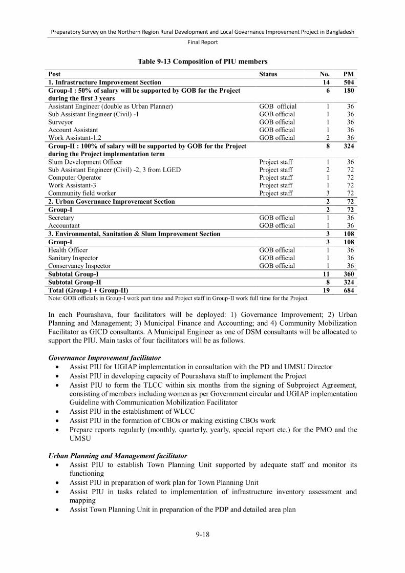
Preparatory Survey on the Northern Region Rural Development and Local Governance Improvement Project in Bangladesh
Final Report
9-18
Table 9-13 Composition of PIU members Post Status No. PM 1. Infrastructure Improvement Section 14 504 Group-I : 50% of salary will be supported by GOB for the Project during the first 3 years
6 180
Assistant Engineer (double as Urban Planner) GOB official 1 36 Sub Assistant Engineer (Civil) -1 GOB official 1 36 Surveyor GOB official 1 36 Account Assistant GOB official 1 36 Work Assistant-1,2 GOB official 2 36 Group-II : 100% of salary will be supported by GOB for the Project during the Project implementation term
8 324
Slum Development Officer Project staff 1 36 Sub Assistant Engineer (Civil) -2, 3 from LGED Project staff 2 72 Computer Operator Project staff 1 72 Work Assistant-3 Project staff 1 72 Community field worker Project staff 3 72 2. Urban Governance Improvement Section 2 72 Group-I 2 72 Secretary GOB official 1 36 Accountant GOB official 1 36 3. Environmental, Sanitation & Slum Improvement Section 3 108 Group-I 3 108 Health Officer GOB official 1 36 Sanitary Inspector GOB official 1 36 Conservancy Inspector GOB official 1 36 Subtotal Group-I 11 360 Subtotal Group-II 8 324 Total (Group-I + Group-II) 19 684 Note: GOB officials in Group-I work part time and Project staff in Group-II work full time for the Project. In each Pourashava, four facilitators will be deployed: 1) Governance Improvement; 2) Urban Planning and Management; 3) Municipal Finance and Accounting; and 4) Community Mobilization Facilitator as GICD consultants. A Municipal Engineer as one of DSM consultants will be allocated to support the PIU. Main tasks of four facilitators will be as follows. Governance Improvement facilitator Assist PIU for UGIAP implementation in consultation with the PD and UMSU Director Assist PIU in developing capacity of Pourashava staff to implement the Project Assist PIU to form the TLCC within six months from the signing of Subproject Agreement,
consisting of members including women as per Government circular and UGIAP implementation Guideline with Communication Mobilization Facilitator
Assist PIU in the establishment of WLCC Assist PIU in the formation of CBOs or making existing CBOs work Prepare reports regularly (monthly, quarterly, yearly, special report etc.) for the PMO and the
UMSU
Urban Planning and Management facilitator Assist PIU to establish Town Planning Unit supported by adequate staff and monitor its
functioning Assist PIU in preparation of work plan for Town Planning Unit Assist PIU in tasks related to implementation of infrastructure inventory assessment and
mapping Assist Town Planning Unit in preparation of the PDP and detailed area plan
Preparatory Survey on the Northern Region Rural Development and Local Governance Improvement Project in Bangladesh
Final Report
9-19
Assist PIU in implementing the process of consultation on and finalization of the PDP Assist PIU to prepare annual O&M work plan along with necessary budget in current fiscal year
Municipal Finance and Accounting facilitator Assist PIU in preparation, implementation and monitoring of tax collection plan including
activities related to increase in the holding tax collection efficiency Assist PIU in preparation, implementation and monitoring of plan to undertaking new
assessment of taxes as required involving tasks Assist PIU in implementing program for computerization and improved management of tax
records and/or water billing system Assist PIU in implementing program for computerization and improved reporting of accounting
records Examine the existing billing and collection efficiency of holding tax and make recommendations
for further improvement Community Mobilization Facilitator Assist PIU to formulate Citizen Charter through the approval of TLCC and display at the
Pourashava office Assist PIU to establish Mass Communication Cell to undertake mass communication and
information dissemination activities for the general public on UGIAP and Pourashava activities Assist PIU to form the TLCC within six months from the signing of Subproject Agreement,
consisting of members including women as per Government circular and UGIAP implementation Guideline with Governance Improvement Facilitator
Assist PIU to arrange regular meetings of the committee with set agenda, review Pourashava activities, monitoring UGIAP implementation, and ensure citizen's participation and transparency
Assist PIU in preparing and undertaking Gender Action Plan (GAP) as per the guidelines provided by the PMO
Assist PIU for establishment of WLCC headed by the respective Ward commissioners and facilitate effectiveness of all committees and citizens' participation including women following the government circular
Assist PIU to undertake poverty assessment in preparation of Poverty Reduction Action Plan, its processing for finalization, approval, and its implementation
b) DPHE Expected roles of DPHE in the Project The DPHE also has a mandate to support local government institutions. It has rich experience to implement some types of civil works that are also planned in the Project, namely public and community toilets, piped water supply system and tubewells in Subcomponent 2-1. Especially, the DPHE has accumulated knowledge in sanitary aspects of works and information of water vein on the tubewell construction. Therefore, it is expected that the DPHE will provide technical advice and information for Pourashavas through the DPHE Upazila offices on design, construction, operation, and maintenance of works. Through this collaboration, it is also expected to enhance coordination mechanism among local government institutions, as well as efficient implementation of the Project. Necessary arrangement for coordination The headquarters of the LGED and DPHE will need to exchange the Memorandum of the Understanding (MOU) for cooperation on the Project. Then, the representative of the LGED at each organizational level or Pourashavas will officially request support from DPHE local offices when any coordination need arises. IMSC, IAWG and TLCC will be the platforms of coordination, as the representative of DPHE at each level will be also members of those committees.

Preparatory Survey on the Northern Region Rural Development and Local Governance Improvement Project in Bangladesh
Final Report
9-20
c) NILG Expected roles of NILG in the Project It is essential that the LGED will coordinate with the NILG which is also mandated to support local government institutions in governance improvement. Through coordination in the IAWG meetings, the PMO and the UMSU needs to harmonize the training program of Component 2 with routine training courses conducted by the NILG and to closely collaborate with the NILG to introduce the HLP as a mutual learning system among Pourashavas for governance improvement into the Project. Necessary arrangement for coordination The same procedure as the coordination with the DPHE will need to be taken. However, the coordination between the LGED and the NILG will be limited since the NILG has no local office and its capacity is limited. Therefore, the IAWG will be the key coordination platform in the Project. d) NGOs Expected roles of NGOs in the Project Local Non-Governmental Organizations (NGOs) are suitable bodies to strengthen stakeholders’ participation and the LCS management in Component 1. They will work as representatives of the local stakeholders when receiving services from the LGED. They will also represent landless people and destitute women in forming the LCSs. The facilitators of NGOs are expected to fully understand the objectives and strategies of the Project. NGOs will take important roles in Component 2 and work as contractors to develop and spread an appropriately localized service delivery system such as a garbage collection system using rickshaws. NGOs are also key members of the TLCC who can speak on behalf of the people in local community. e) Labor contracting societies Expected roles of LCS in the Project The Labor Contracting Society (LCS) will play an important role as local contractor groups on off-pavement road maintenance works in Component 1. They will work for routine maintenance of off-pavement, including shoulders, slopes, and roadside tree plantations. The LCS approach started in the early 1980s, and has been refined under LGED projects. The Project will follow the approach already used by the LGED on the rural roads subprojects under Component 1. Destitute women who will form the LCS on a yearly contract basis will carry out day to day routine maintenance of off-pavement roads. (5) Freeze of staff transfer and deployment of staff a) Freeze of staff transfer during Project implementation. Frequent transfer or replacement of personnel in the LGED may hinder smooth implementation, and cause unnecessary delays and inconsistency in the quality of works. In order to ensure smooth implementation, it is vital to maintain core officers of the LGED. The LGED shall therefore ensure to freeze the transfer of core staff during the implementation of the Project, except for the case with unavoidable reasons that shall be consulted and agreed by JICA. Those core staff includes the PD, three DPDs, and two accountants in the PMO. b) Staff deployment of UMSU and RUMSU in the Project The UMSU and the RUMSU will be expected to play a key role in implementation of Subcomponent
Preparatory Survey on the Northern Region Rural Development and Local Governance Improvement Project in Bangladesh
Final Report
9-21
2-2. The following staffing will be necessary for continuous supports to Pourashavas. UMSU at the central level GOB funding for LGED officials in the UMSU after the UGIIP-2 ends in December 2014
RUMSU at the Regional level GOB funding for LGED officials in ten RUMSU after the UGIIP-2 ends in December 2014
9.3 Action plan for capacity development of concerned organizations (1) Actors of capacity development Major actors of capacity development on the Project will be composed of two groups: 1) hosts; and 2) supporters.73 The hosts are the groups who will improve their own capacity through spontaneous capacity development process with assistance by supporters. The supporters will assist the process to realize capacity development of the hosts. Members of the hosts in the Project will be: 1) LCS and local NGOs of target Upazila in Component 1; and 2) Pourashava citizens, Mayors, councilors and officials in Component 2. Members of the supporters will be LGED officials, consultants and experts under the technical cooperation schemes involved in the project implementation. (2) Outcome of capacity development The outcome of capacity development means any positive change of attitude or performance in the hosts. In the context of the Project, the outcomes include the following: LCSs become capable of implementing labor works with contract and earning their own
incomes. Local NGOs become capable of organizing LCS in Component 1. Community groups including social disadvantaged people become capable of managing market
infrastructures. Pourashava citizens and councilors become capable of undertaking participatory governance in
the Pourashava. Pourashava officials become capable of achieving their official mandates, and providing public
service delivery with transparency and accountability
The outcome will be achieved as consequence of the Project activities using Project inputs. The achievement levels of the outcome of the hosts by capacity development can be expressed at the following levels: Hosts obtain capacity to realize performance. Hosts establish institutional foundation to realize outcome. Hosts change their action and performance positively. Hosts and host groups achieve distinct results. Hosts and host groups can sustain the performance and results achieved.
The achievement levels will be measured by the established indicators and actual performance of the hosts. The indicators under the Project will be the UGIAP criteria, Benefit Monitoring Indicators, and Performance Evaluation Indicators that will be prepared in the Project.
73 “Facilitators” or “assistants” are often used in other publications on capacity development. However, we use “supporter” to avoid confusion by the former two words used in the other chapters in this report.

Preparatory Survey on the Northern Region Rural Development and Local Governance Improvement Project in Bangladesh
Final Report
9-22
Table 9-14 summarizes the achievement levels of capacity development outcomes of respective hosts and supporters under the Project.
Table 9-14 Achievement levels of capacity development outcome in the Project
Achievement level
1.Obtain capacity 2. Establish foundation
3. Change action and performance
4. Achieve results 5. Sustain performance and results
Qualitative aspect
Hosts obtain personal knowledge and skills to realize performance
Hosts establish institutional foundation to realize performance
Hosts change their action and performance positively
Host group or organization achieve distinct and measurable results
Host group sustain and upgrade performance and results
Means of measurement
Personal test, and questionnaires
Existence of established organizations/working systems, and allocated human/ financial/physical resources
Change of officials’ /LCS’s attitude at work, and participation of the community/committee members
Numbers of implemented subprojects/ services, and increased revenues/incomes
Sustained/increased amount of revenue, number of implemented subprojects, updated plans.
Indicators to measure
Level of understanding, and satisfaction of the CD contents
UGIAP criteria UGIAP criteria BMS indicators PE indicators
UGIAP criteria BMS indicators PE indicators
UGIAP criteria
Phase to be realized in Component 2
Phase 1, Phase 2 (continuous)
Phase 1 Phase 2 Phase 2 Phase 3
Source: Survey Team based on JICA (2005a) (3) Process of capacity development The outcome will be achieved through the following steps of capacity development process: 1) inputs; 2) implement activities; 3) achieve outputs; and 4) achieve outcome. Inputs will be consultants, materials, equipment and machinery, and financial resources for capacity development activities. The activities will consist of training courses, orientations, workshops, on-the-job-training (OJT) and routine follow-up activities, which should respect spontaneous process to stimulate the hosts’ own awareness. In addition, the process should be based on the learning cycle that consists of planning, implementation, monitoring, and evaluation, and adjustment. Thus capacity development will be realized through the process as if the hosts go up on a spiral staircase. In Component 2, Phase 1 will aim to achieve Level 1 and 2 outcomes; Phase 2 will be expected to achieve Level 3 and 4 outcomes; and Phase 3 will ensure Level 5 outcomes so that Pourashavas can sustain and upgrade improved performance after the Project end. Figure 9-2 presents the process of capacity development under the Project.

Preparatory Survey on the Northern Region Rural Development and Local Governance Improvement Project in Bangladesh
Final Report
9-23
Figure 9-2 Process of capacity development under the Project
(4) Actions to be taken by capacity development actors a) Actions by hosts In capacity development, sustainable resource allocation of hosts is an essential element. Those resources include financial resources to maintain performance, human resources developed by capacity development, equipment to support developed capacity, such as computers and software and heavy machinery for civil engineering. In addition, the institutional framework to secure those resources will be needed. Through the implementation of capacity development activities of the Project, the hosts should establish individual ability of staff, organizational systems, and institutional frameworks as well as financial performance to ensure their own sustainable resource allocation. b) Actions by supporters Component 2 aims to develop capacity of Pourashavas, and consultants will be allocated for capacity development. In this case, the consultants will not work as manpower under supervision or order of Pourashava staff, or civil society. Rather, they will support the spontaneous capacity development process on their duties as actors of urban governance. Therefore, it will be essential for the Project to explain the capacity development process to Pourashava mayors, staff and civil society to make the process work effectively. The LGED may be necessary to properly intervene in capacity development activities in the field when necessary. It is also critical to ensure that performance-based fund allocation should be independent and transparent to make capacity development effective. c) MSU/UMSU The key supporter to Pourashava capacity development under the Project is MSU/UMSU of the LGED. However, the current Survey revealed that the MSU/UMSU faces the following inherent challenges that need to be addressed.
Preparatory Survey on the Northern Region Rural Development and Local Governance Improvement Project in Bangladesh
Final Report
9-24
Establish institutional status The MSU/UMSU including its Regional offices is originally a project-based unit that does not have any institutional bases stipulated in any legal framework. Therefore, the MSU/UMSU has been developing and maintaining its activities by fixed-term project funds, not by revenue budget of the GOB. Such arrangements of MSU/UMSU have been facing inherent limit of sustainability since, when the projects that support MSU/UMSU terminate, capacity development activities of MSU/UMSU will also end. It is therefore essential for the LGED to institutionalize the MSU/UMSU to ensure continuous support to governance improvement in Pourashavas. Develop capacity to implement capacity development support The MSU/UMSU has been implementing its activities to support Pourashavas and City Corporations by several projects funded by the GOB budget and technical/financial cooperation of foreign donors. In these schemes, project consultants have been allocated in the MSU/UMSU to implement capacity development activities under supervision of officials in urban management wing of the LGED. This process has not developed sufficient capacity of LGED officials under the MSU/UMSU to implement capacity development activities in Pourashavas. Therefore, in accordance with the gradual progress of decentralization in Bangladesh, it is essential for the MSU/UMSU to strengthen their institutional, organizational and individual capacity to support Pourashavas. To realize the capacity development for the MSU/UMSU, it is worth implementing a technical assistance project to enhance its capacity. In this project, it will be essential to deploy proper LGED officials to host capacity development as counterpart officials who will be different from supervisor officials attached to the Project. (5) Theme of capacity development Table 9-15 and Table 9-16 summarize the main contents of capacity development activities. The capacity development of Component 1 will cover project orientation for LGED engineers, basic training on contract management, quality control, environmental and social considerations, and capacity development of NGOs and LCSs. It also includes overseas training. The capacity development of Component 2 will be spread over the six areas: 1) governance that is represented by six areas of the UGIAP; 2) engineering to implement urban and rural infrastructures and service delivery; 3) basic administration skills such as office management and IT operation; 4) project orientation to introduce the contents and principles of the Project activities; 5) project management such as progress review; and 6) capacity development facilitation such as training skill.
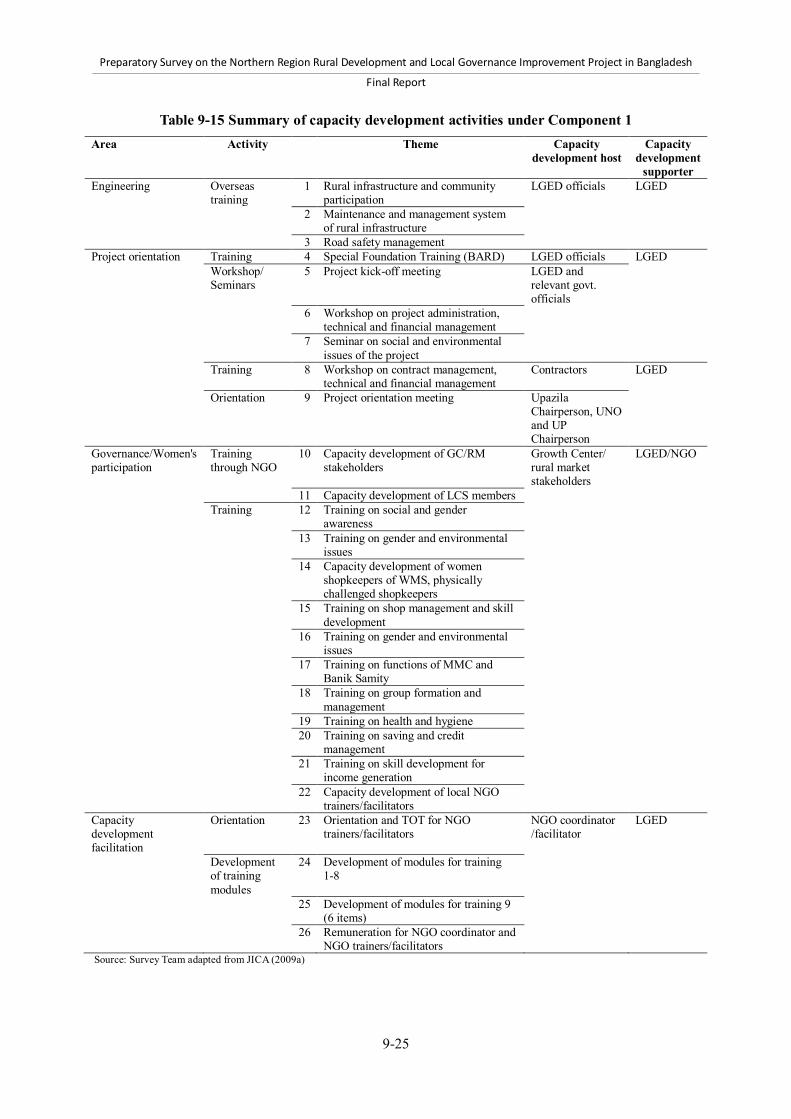
Preparatory Survey on the Northern Region Rural Development and Local Governance Improvement Project in Bangladesh
Final Report
9-25
Table 9-15 Summary of capacity development activities under Component 1 Area Activity Theme Capacity
development host Capacity
development supporter
Engineering Overseas training
1 Rural infrastructure and community participation
LGED officials LGED
2 Maintenance and management system of rural infrastructure
3 Road safety management Project orientation Training 4 Special Foundation Training (BARD) LGED officials LGED Workshop/
Seminars 5 Project kick-off meeting LGED and
relevant govt. officials
6 Workshop on project administration, technical and financial management
7 Seminar on social and environmental issues of the project
Training 8 Workshop on contract management, technical and financial management
Contractors LGED
Orientation 9 Project orientation meeting Upazila Chairperson, UNO and UP Chairperson
Governance/Women's participation
Training through NGO
10 Capacity development of GC/RM stakeholders
Growth Center/ rural market stakeholders
LGED/NGO
11 Capacity development of LCS members Training 12 Training on social and gender
awareness
13 Training on gender and environmental issues
14 Capacity development of women shopkeepers of WMS, physically challenged shopkeepers
15 Training on shop management and skill development
16 Training on gender and environmental issues
17 Training on functions of MMC and Banik Samity
18 Training on group formation and management
19 Training on health and hygiene 20 Training on saving and credit
management
21 Training on skill development for income generation
22 Capacity development of local NGO trainers/facilitators
Capacity development facilitation
Orientation 23 Orientation and TOT for NGO trainers/facilitators
NGO coordinator /facilitator
LGED
Development of training modules
24 Development of modules for training 1-8
25 Development of modules for training 9 (6 items)
26 Remuneration for NGO coordinator and NGO trainers/facilitators
Source: Survey Team adapted from JICA (2009a)

Preparatory Survey on the Northern Region Rural Development and Local Governance Improvement Project in Bangladesh
Final Report
9-26
Table 9-16 Summary of capacity development activities under Component 2 Area Sub-area Theme CD Host CD
Supporter Phase
Governance Good governance
1 Concept of good governance and its application
Mayors PMO 1, 3
Citizen awareness and participation
2 Organization and operation of TLCC/WLCCs
Secretary, TLCC member, WLCC member
UMSU 1, 2
3 Community mobilization and organization of CBOs
CBO president, secretary, casher, CBO members
UMSU 1, 2
4 Concept and tools for participation (CC, CRD, etc.)
Secretary, concerned Pourashava staff
UMSU 1
Urban planning 5 Preparation, implementation, and review of PDP
Town Planner, UPF UMSU 1, 2, 3
6 Preparation of base map and land-use plan
AE/SAE, Surveyor, Town Planner, UPF
UMSU 2
Women's participation
7 Preparation and implementation of GAP
Secretary, AE/SAE, GC member, officials in PMO
UMSU 1, 2
Integration of Urban Poor
8 Preparation and implementation of PRAP
Secretary, AE, SDO, CFW UMSU 1, 2
Financial accountability & sustainability
9 Assessment, reassessment and collection of holding tax
Account Officer/Accountant, Tax Assessor, Tax Collector
UMSU 1, 2, 3
10 Pourashava financial management, such as tax, accounts, and trade licenses
Account Officer, Tax Assessor, concerned Pourashava staff
UMSU 1, 2
11 Computerized financial and accounting system
Account Officer, Bill clerk, concerned Pourashava staff
UMSU 2
12 Pourashava budget preparation Account Officer/Accountant, Assistant Accountant
UMSU 2
Administrative capacity
13 E-governance Secretary, Administration Officer UMSU 2
Engineering1 Costing 14 Cost estimate for physical infrastructure
Cost Estimator, Work Assistant PMO 1, 2
Procurement 15 Public procurement rules & contract management
AE, SAE, Secretary PMO 1, 2
Quality control 16 Quality control and supervision of civil works
AE, SAE, Work Assistant PMO 1, 2, 3
O&M 17 O&M of infrastructure and facilities
AE, SAE, Secretary, Health Officer
PMO 1, 2, 3
Implementation 18 Infrastructure works (road, drain, sanitation, etc.)
AE, SAE, Work Assistant, concerned Pourashava staff
PMO 1, 2, 3
Basic administration
Office management
19 Administration and office management
Secretary, AE, concerned Pourashava staff
PMO 1
IT operation 20 Basic Computer Training AE, SAE, Accountant, concerned Pourashava staff
UMSU 2
Project management
Orientation 21 Contents, principles, procedures of the Project activities
Mayors, councilors, Secretary, AE, concerned Pourashava staff, consultants
PMO 1, 2, 3
22 Concept and contents of the UGIAP
Secretary, AE, SDO PMO 1, 2
Account management
23 Account management of NRRDLGIP fund
Accounts Officer and concerned Pourashava staff
PMO 2
Progress review 24 Progress review on UGIAP and infrastructure works
AE, AO, Secretary, Conservancy Inspector
PMO 2,3
Capacity development facilitation
Training skill 25 Trainers Training for Pourashava capacity development
AE, SAE, Accountant, concerned Pourashava staff, AD of UMSU
PMO/ UMSU
2
Source: Survey Team Note: 1. Learning from the lessons in UGIIP-2, the Survey Team proposes that the training programs for engineering capacity development should give more emphasis on the topics specific to infrastructure types and O&M, and include more concerned officials than training programs in UGIIP-2 in order to strengthen the capacity of officials of category-B and C Pourashavas. [Legend] AD: Assistant Director, AE: Assistant Engineer, CC: Citizen Charter, CD: Capacity Development, CFW: Community Field Worker,
CRC: Citizen Report Cards, GAP: Gender Action Plan, GC: Gender Committee, PRAP: Poverty Reduction Action Plan, SAE: Sub-assistant Engineer, SDO: Slum Development Officer, UPF: Urban Planning and Management Facilitator

Preparatory Survey on the Northern Region Rural Development and Local Governance Improvement Project in Bangladesh
Final Report
10-1
10 Operation and maintenance system and process The first part of this chapter presents an analysis of the current operation and maintenance (O&M) of the rural transport and trading infrastructure in Bangladesh. Following a brief overview, it then focuses on the maintenance of the “core” rural road network: Upazila Roads (UZRs) and Union Roads (UNRs). Sustaining the benefits from substantial investments in improving the standard of the core rural road network over a long period is a major issue now facing the LGED and the Government of Bangladesh (GOB). The second part of the chapter presents an outline of the proposed Rural Road Maintenance Action Plan. The final part of the chapter reviews O&M of Pourashava infrastructure. 10.1 Current operation and maintenance of the rural transport and trading
infrastructure 10.1.1 Overview of institutional responsibilities and financing This section presents a summary overview of the institutional responsibilities and financing arrangements for operation and maintenance of different categories of the rural transport and trading infrastructure in Bangladesh. A more detailed analysis is presented in Annex 28. (1) Core rural road network As set out in the Rural Roads Master Plan (LGED, 2005), the LGED assumes direct responsibility for the maintenance of what we have defined as the “core” rural road network, (i.e., UZRs and UNRs). To fulfill this responsibility, LGED utilizes the annual GOB revenue budget allocation for rural road maintenance, complemented by maintenance financing included in foreign-financed rural infrastructure projects. The core network comprises about 12,500 UZR and UNR covering a total distance of 82,571 km, with nearly 117,000 bridges and culverts spanning a total of 675,141 m. (2) Other rural roads The LGED is responsible for the development of village roads types A and B, but maintenance responsibility is delegated to Local Government Institutions (LGI). There are about 92,500 village roads covering a total distance of 215,774 km, with over 112,000 bridges and culverts spanning a total of 479,265 m. The maintenance of village roads and some earthen UNR is conducted by the Upazila Parishads (UZPs) and Union Parishads (UPs). These LGIs, however, receive technical assistance from LGED in design preparations and requesting estimates for maintenance projects. The LGED Upazila Engineers also provide overall supervision of the works. Various sources of funds are used to maintain the largely earthen village roads. The GOB Rural Employment Road Maintenance Program (RERMP) provides substantial resources for routine maintenance of earthen roads (including some earthen UNR), generating employment for the rural poor, particularly destitute women and landless workers. Additional government funds are provided to the UZP and Union Parishad (UP) through their Annual Development Program (ADP) allocations. Annual block grant allocations to UPs from 2011 to 2016 are supported by the World Bank and executed by the Local Government Division’s (LGD) Second Local Governance Support Project (LGSP-2). The UPs may use a portion of these block grant funds for village road maintenance. Maintenance of village roads remains problematic. Further support is needed to develop management
Preparatory Survey on the Northern Region Rural Development and Local Governance Improvement Project in Bangladesh
Final Report
10-2
and implementation capacity as well as increase local revenue generation, particularly at the UP level. (3) Growth Centers and rural markets There are many thousands of rural markets in Bangladesh, with estimates ranging from 16,476 to 17,121. Of these, 2,100 are designated by the Planning Commission as Growth Centers. Growth Center and rural market facilities’ improvements in providing an efficient and hygienic trading environment are the responsibility of the LGED through various foreign and GOB-financed rural infrastructure projects. However, responsibilities for the operation and maintenance of these markets are divided among the lessees, the Market Management Committees (MMC), and the Upazila Market Management Committees (UMMC) as stipulated in the guidelines issued by the Local Government Division (LGD, 2011). The relevant roles and responsibilities of the hat-bazaar lessee are as follows: The lessee shall maintain regular daily cleaning of the market. The lessee shall erect a signboard displaying the approved schedule of toll rates at a public place
in the market. If the lessee breaches any part of the lease conditions, his or her lease agreement will be
considered void. In such a case, the lease deposit shall be forfeited, while arrangements will be made to lease out the market again.
The relevant functions of the MMC are as follows: Prepare annual development plans for the overall development and maintenance of the market. Submit project proposals to the UMMC for improvement and maintenance of the market. Supervise toll collection and all other activities regarding tolls, as well as ensure that the toll rate
signboard is erected. Ensure that the market and its water supply and sanitation systems are kept clean.
The relevant functions of the UMMC are as follows: Oversee the proper management, operation, and maintenance of all markets within the Upazila. Review and approve the development and maintenance plans and proposals prepared by the
MMCs. Submit development and maintenance plans and proposals to the UZP for approval. Observe that the responsibilities assigned to the MMCs are properly performed, as well as ensure
that all MMCs hold regular meetings. Inform the Deputy Commissioner about the activities of the MMCs and the UMMC on a regular
basis, working in accordance with the directions provided from him or her. The UZP is responsible for the annual leases for all markets within its jurisdiction. Note that 15% of the lease value of each market shall be allocated to the maintenance of that market in accordance with the decisions made by the UMMC. For markets that have been improved by the LGED, the allocation to market maintenance may be increased from 15% to 25% of the annual lease value, as per the conditions of the agreements between the GOB and its development partner(s). In addition, 10% of the annual lease money from all markets shall be deposited into the Upazila Development Fund for maintenance and development of the markets within the Upazila.

Preparatory Survey on the Northern Region Rural Development and Local Governance Improvement Project in Bangladesh
Final Report
10-3
(4) Rural ghats Improved ghats are, in many cases, constructed adjacent to a Growth Center or rural market as part of the market improvement project. The operation and maintenance of such ghats then falls under the responsibility of the MMC and the market lessee. Other ghats improved by the LGED may be leased by the Upazila Nirbahi Officer (UNO) on the same basis as is stipulated for leasing markets. (5) Role of civil society In order to involve civil society in the operation and maintenance of the rural transport infrastructure, the circular/instruction letter issued by the Local Government Division (LGD) in 2000 established District Road Users Committees (DRUC) and the Upazila Road Users Committees (URUC). The objective of forming DRUCs and URUCs was to secure proper utilization and maintenance of all UZRs, UNRs, and village roads in the Districts and Upazilas concerned. The 2,000 circular requests that DRUCs hold meetings at least twice a year to discuss District-level issues related to road safety, traffic movement and management, and road development and maintenance. The LGED’s roles, as defined in the circular, are to consider the recommendations made by the DRUCs and to execute follow-up activities if the LGED deems the recommendations appropriate under its jurisdiction. The URUCs are also asked to hold meetings to share and discuss Upazila- and Union-level road-related issues in order for the LGED to consider follow-up activities. Road Operation and Maintenance Committees are sometimes voluntarily formed following the construction of a road and are composed of eight to ten beneficiaries, including the UP Chairperson. There is no official instruction regarding the formation of Road Operation and Management Committees. Because the maintenance of UZR and UNR is the responsibility of the LGED, the functions of these committees are limited to reporting on or complaining about the damage and repair of roads to the UP Chairman or the Upazila Engineer. 10.1.2 Maintenance of Upazila and Union roads (1) Introduction The GOB, with generous and longstanding support from its development partners, has invested substantial resources in rural infrastructure development. The major portion of these resources has been invested in developing the rural road network to meet reliable, all-weather standards for the purpose of providing cheaper and easier rural transport. Top priority has been given to the development of bitumen carpeted (or in some cases concrete paved) UZR and UNR, including the construction of all necessary bridges and culverts. During the last decade, significant expansion has occurred in the lengths of rural roads classified as UZR and UNR, combined with substantial improvements in the overall standard of the UZR and UNR network. There are currently 37,819 km of UZR and 44,752 km of UNR, with 479,265 m of cross-drainage structures. Most significantly, 72% of the total distance of UZR and 40% of the total distance of UNR has been improved to meet all-weather standards. With the rapid expansion of an improved network of UZR and UNR, the issue of establishing effective maintenance of these public assets has progressively emerged as an important issue for the LGED to sustain the improved level of transport service they provide and the socioeconomic benefits they generate. As the distance of improved roads has increased, the need for financial resources and management, along with implementation capacity for effective maintenance, has also increased. Unless adequate maintenance resources and capacity are in place, the structure of the improved roads will deteriorate owing to traffic and climate conditions; thus the benefits are not sustained.

Preparatory Survey on the Northern Region Rural Development and Local Governance Improvement Project in Bangladesh
Final Report
10-4
(2) Structure of rural road maintenance in Bangladesh International best practice for road maintenance is increasingly based on a strategy of sustainable rural road asset management. Under such a strategy, the effective maintenance that is required to keep improved roads in good condition and provide reliable service is conventionally classified into two categories: planned maintenance and emergency maintenance. In addition, if, over time, insufficient resources have been allocated to provide effective maintenance, causing some previously improved roads to deteriorate, rehabilitation also becomes part of the sustainable road asset management strategy. The LGED’s definition of the different types of rural road maintenance is largely consistent with best practices for sustainable road asset management. a) Planned maintenance There are two components of planned maintenance: routine maintenance and periodic maintenance. Routine maintenance Routine maintenance of roads comprises the regular and frequent daily activities that are conducted on a largely repetitive basis to keep a road in good operating condition throughout its design life. Routine maintenance is a continuing task that, under a sustainable road asset management strategy, is conducted every year on an improved road. Routine maintenance activities are further categorized as follows: Off-pavement: This deals primarily with earthen shoulders, side slopes, roadside tree
plantations, cleaning cross-drainage structures, and providing for surface water drainage, all of which require only a few basic hand-tools and limited technical expertise. The side slopes, all drains, and cross-drainage structures are kept in good condition, permitting the free but controlled water runoff away from the road and minimizing the risk of soil erosion.
On-pavement: This comprises road surface repairs, including filling potholes and cracks, as well as reinstating damaged pavement edges.
Periodic maintenance Periodic maintenance of roads is occasionally required, even with effective routine maintenance. This should be implemented at regular time intervals. Periodic maintenance of the pavement is divided into two categories: Resealing: This involves applying a thin film of bitumen surfacing, typically every three to five
years, to rejuvenate the road surface and restore smoothness. Any pavement damage is repaired before the new sealant is applied.
Overlaying: This amounts to applying an additional thicker surface layer over the existing pavement, typically every seven to eight years, to improve the road’s structural integrity and to restore smoothness and durability. Any pavement damage is repaired before the overlay is applied.
Periodic maintenance of the embankment and cross-drainage, typically conducted every three to five years, involves repairing any damage and deterioration that extends beyond the scope of routine maintenance, such as painting bridges and restoring traffic signage along with other safety measures. b) Emergency maintenance Even with effective planned maintenance, under special circumstances—for example, in Bangladesh, extreme climate situations such as excessive rainfall or flooding commonly occur—emergency maintenance is required. This involves the rapid repair or reconstruction of washouts, eroded

Preparatory Survey on the Northern Region Rural Development and Local Governance Improvement Project in Bangladesh
Final Report
10-5
embankments, and damaged bridges and culverts, as well as the removal of trees from the carriage way, all resulting from excessive water flow and landslides. Although specific needs for emergency maintenance cannot be predicted in advance, it is prudent to make budgetary provisions and to have implementation arrangements in place so that the road authority can respond rapidly to an emergency. c) Rehabilitation Rehabilitation, sometimes also called “backlog maintenance,” involves repairing previously improved roads whose condition has deteriorated because of inadequate planned maintenance. It does not involve any upgrading to the road’s standards; for instance, it does not include widening a road or constructing any new cross-drainage structures. Rather, rehabilitation restores the road to its previous “improved” condition, as seen immediately after construction, through repairs to damaged sections of pavement, embankments, bridges, culverts, and surface drainage together with the restoration of road safety measures. d) LGED rural road maintenance implementation arrangements The categories of road maintenance defined by the LGED and their procedures for implementation of maintenance works are shown in Figure 10-1.
Source: LGED Road Maintenance and Road Safety Unit (RMRSU)
Figure 10-1 Rural road maintenance in LGED
The LGED definitions of rural road maintenance categories are consistent with a sustainable asset management strategy, except that rehabilitation is defined as a subcategory of periodic maintenance rather than as a separate category. However, given the current state of the UZR and UNR network, in planning terms, this categorization is logical. The LGED already has well defined technologies for executing routine maintenance of roads and cross-drainage structures which are set out in its LCS and road maintenance manuals, reinforced by continuing programs of training for its field staff. The LGED road design standards and technical specifications provide a sound engineering basis for periodic maintenance and rehabilitation of the rural roads. The LGED uses three maintenance implementation methods: Routine off-pavement maintenance: by the Labor Contracting Society (LCS)
Maintenance
Emergency Periodic Routine
By Contractor
Overlaying Rehabilitation Structure Re-sealing
By Contractor
On-pavement Off-pavement
By Mobile Maintenance
Team (MMT)
By Labor Contracting
Society (LCS)
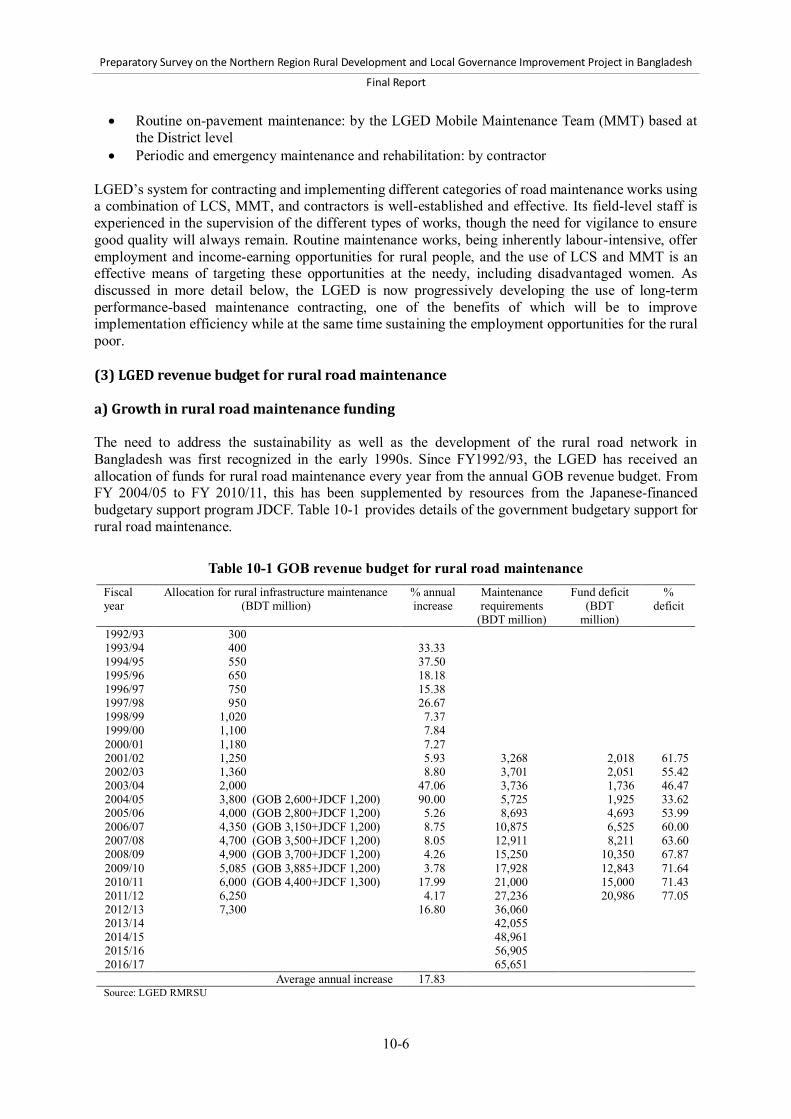
Preparatory Survey on the Northern Region Rural Development and Local Governance Improvement Project in Bangladesh
Final Report
10-6
Routine on-pavement maintenance: by the LGED Mobile Maintenance Team (MMT) based at the District level
Periodic and emergency maintenance and rehabilitation: by contractor LGED’s system for contracting and implementing different categories of road maintenance works using a combination of LCS, MMT, and contractors is well-established and effective. Its field-level staff is experienced in the supervision of the different types of works, though the need for vigilance to ensure good quality will always remain. Routine maintenance works, being inherently labour-intensive, offer employment and income-earning opportunities for rural people, and the use of LCS and MMT is an effective means of targeting these opportunities at the needy, including disadvantaged women. As discussed in more detail below, the LGED is now progressively developing the use of long-term performance-based maintenance contracting, one of the benefits of which will be to improve implementation efficiency while at the same time sustaining the employment opportunities for the rural poor. (3) LGED revenue budget for rural road maintenance a) Growth in rural road maintenance funding The need to address the sustainability as well as the development of the rural road network in Bangladesh was first recognized in the early 1990s. Since FY1992/93, the LGED has received an allocation of funds for rural road maintenance every year from the annual GOB revenue budget. From FY 2004/05 to FY 2010/11, this has been supplemented by resources from the Japanese-financed budgetary support program JDCF. Table 10-1 provides details of the government budgetary support for rural road maintenance.
Table 10-1 GOB revenue budget for rural road maintenance Fiscal year
Allocation for rural infrastructure maintenance (BDT million)
% annual increase
Maintenance requirements
(BDT million)
Fund deficit (BDT
million)
% deficit
1992/93 300 1993/94 400 33.33 1994/95 550 37.50 1995/96 650 18.18 1996/97 750 15.38 1997/98 950 26.67 1998/99 1,020 7.37 1999/00 1,100 7.84 2000/01 1,180 7.27 2001/02 1,250 5.93 3,268 2,018 61.75 2002/03 1,360 8.80 3,701 2,051 55.42 2003/04 2,000 47.06 3,736 1,736 46.47 2004/05 3,800 (GOB 2,600+JDCF 1,200) 90.00 5,725 1,925 33.62 2005/06 4,000 (GOB 2,800+JDCF 1,200) 5.26 8,693 4,693 53.99 2006/07 4,350 (GOB 3,150+JDCF 1,200) 8.75 10,875 6,525 60.00 2007/08 4,700 (GOB 3,500+JDCF 1,200) 8.05 12,911 8,211 63.60 2008/09 4,900 (GOB 3,700+JDCF 1,200) 4.26 15,250 10,350 67.87 2009/10 5,085 (GOB 3,885+JDCF 1,200) 3.78 17,928 12,843 71.64 2010/11 6,000 (GOB 4,400+JDCF 1,300) 17.99 21,000 15,000 71.43 2011/12 6,250 4.17 27,236 20,986 77.05 2012/13 7,300 16.80 36,060 2013/14 42,055 2014/15 48,961 2015/16 56,905 2016/17 65,651
Average annual increase 17.83 Source: LGED RMRSU

Preparatory Survey on the Northern Region Rural Development and Local Governance Improvement Project in Bangladesh
Final Report
10-7
The GOB has made very significant progress in financing rural road maintenance over the last twenty years since the first allocation of BDT 300 million from its general tax revenue in FY 1992/93. The average annual increase in the budget is 17.8%, indicating an important commitment by the government to effectively maintain its rural road assets. In addition, further rural road maintenance resources have been contributed by development partners under the maintenance components of different rural infrastructure projects, including food aid and local government institution-building. However, these resources were not consistently increased over the years, while project maintenance components tended to be limited to the project roads during the project period, with GOB taking responsibility for maintenance thereafter. b) Need for additional rural road maintenance funding Since FY 2001/02, the LGED has estimated rural road maintenance funding needs annually. This is based on the following information, which is updated annually: Roughness survey data Road surface condition data Traffic survey data Road attribute data, such as surface type, connectivity with the Growth Center, rural market, and
other socioeconomic features Bridge and culvert condition survey
For sealed roads, the LGED has up to now used roughness as the main indicator to determine the type, and hence estimate the cost, of maintenance needed on each road. However, in estimating future maintenance funding needs, this has been refined for those roads already in suitable condition for maintenance by assuming a 20-year life, routine maintenance every year, resealing every four years, and overlay every eight years. The LGED’s estimates of maintenance funding needs are presented in Table 10-1. This clearly shows: 1) the annual GOB revenue budget allocation has never been sufficient to meet the needs; and 2) the gap between the needs and the available funding is now increasing year by year, both in absolute and percentage terms. The practical reality is that there are very few road authorities anywhere in the world that receive a sufficient annual allocation of funds for maintenance from their governments. However, the current estimate of a 77% shortfall in the availability of funds is a real concern, highlighting the urgent need for serious attention to issues related to sustaining a reliable and efficient rural road network in Bangladesh. The fundamental issue that needs to be addressed is that the total cost of effective planned and emergency maintenance of rural roads and the rehabilitation of roads that have been neglected is increasing yearly. The latest revenue budget allocation by the GOB in FY 2011/12 is BDT 6,250 million compared with an estimated need of BDT 27,236 million, leaving a deficit of BDT 20,986 million, or 77% of the need. Maintenance needs have increased significantly from FY 2008/09 for three reasons: The total distance of UZR has increased owing to the transfer of 6,280 km of roads from the RHD
to the LGED. As a result of the recent exercise by the Planning Commission, 5,720 km of UNR have been
reclassified as UZR. The inflation rate in Bangladesh was recorded at 8% in July 2012. Historically, from 2001 until
2012, the Bangladesh inflation rate averaged 8.3%, reaching an all-time high of 12.0% in
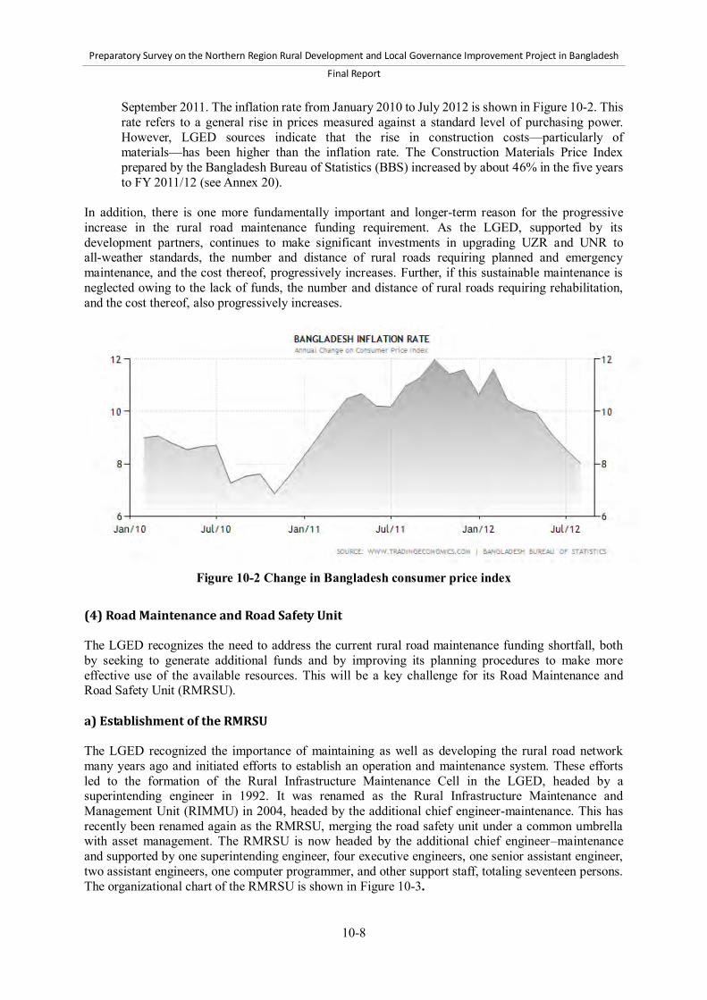
Preparatory Survey on the Northern Region Rural Development and Local Governance Improvement Project in Bangladesh
Final Report
10-8
September 2011. The inflation rate from January 2010 to July 2012 is shown in Figure 10-2. This rate refers to a general rise in prices measured against a standard level of purchasing power. However, LGED sources indicate that the rise in construction costs—particularly of materials—has been higher than the inflation rate. The Construction Materials Price Index prepared by the Bangladesh Bureau of Statistics (BBS) increased by about 46% in the five years to FY 2011/12 (see Annex 20).
In addition, there is one more fundamentally important and longer-term reason for the progressive increase in the rural road maintenance funding requirement. As the LGED, supported by its development partners, continues to make significant investments in upgrading UZR and UNR to all-weather standards, the number and distance of rural roads requiring planned and emergency maintenance, and the cost thereof, progressively increases. Further, if this sustainable maintenance is neglected owing to the lack of funds, the number and distance of rural roads requiring rehabilitation, and the cost thereof, also progressively increases.
Figure 10-2 Change in Bangladesh consumer price index
(4) Road Maintenance and Road Safety Unit The LGED recognizes the need to address the current rural road maintenance funding shortfall, both by seeking to generate additional funds and by improving its planning procedures to make more effective use of the available resources. This will be a key challenge for its Road Maintenance and Road Safety Unit (RMRSU). a) Establishment of the RMRSU The LGED recognized the importance of maintaining as well as developing the rural road network many years ago and initiated efforts to establish an operation and maintenance system. These efforts led to the formation of the Rural Infrastructure Maintenance Cell in the LGED, headed by a superintending engineer in 1992. It was renamed as the Rural Infrastructure Maintenance and Management Unit (RIMMU) in 2004, headed by the additional chief engineer-maintenance. This has recently been renamed again as the RMRSU, merging the road safety unit under a common umbrella with asset management. The RMRSU is now headed by the additional chief engineer–maintenance and supported by one superintending engineer, four executive engineers, one senior assistant engineer, two assistant engineers, one computer programmer, and other support staff, totaling seventeen persons. The organizational chart of the RMRSU is shown in Figure 10-3.
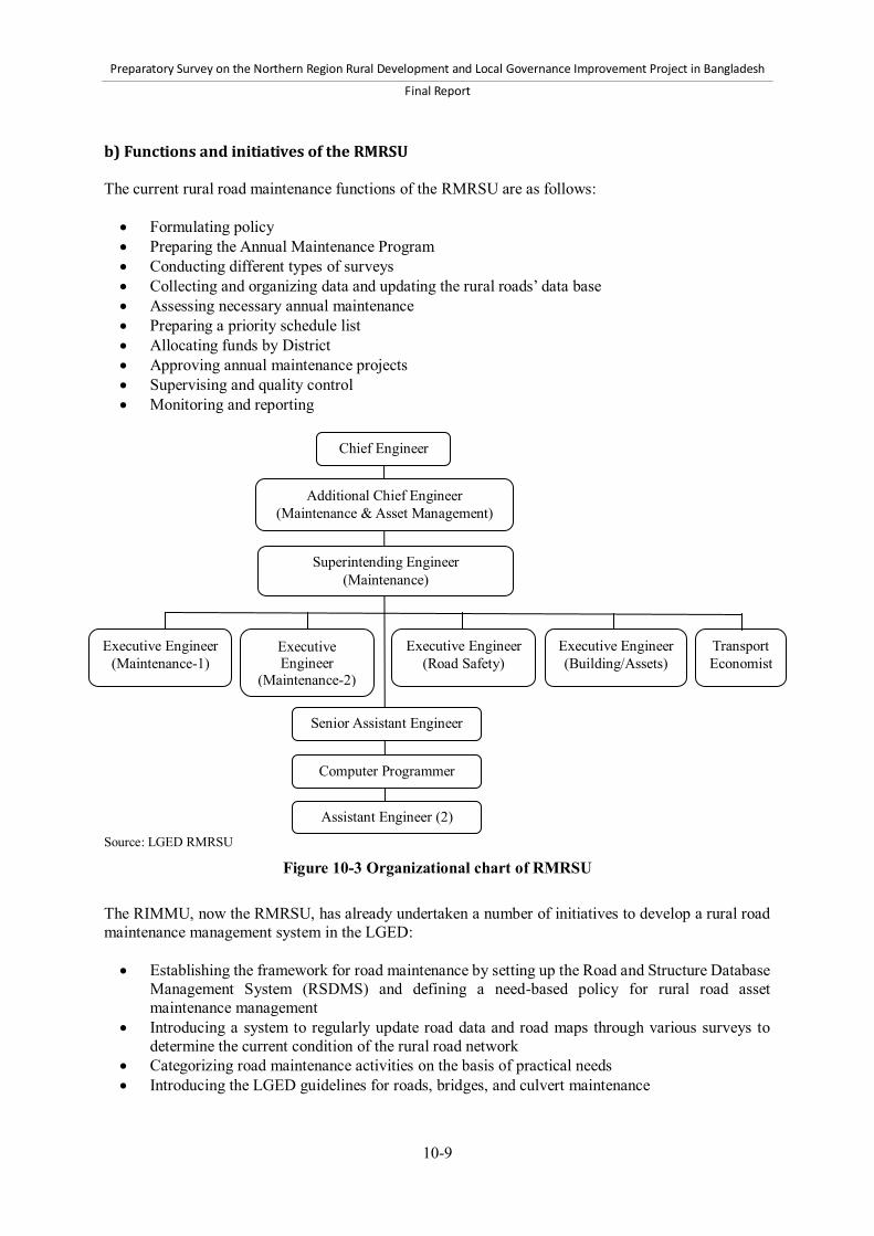
Preparatory Survey on the Northern Region Rural Development and Local Governance Improvement Project in Bangladesh
Final Report
10-9
b) Functions and initiatives of the RMRSU The current rural road maintenance functions of the RMRSU are as follows: Formulating policy Preparing the Annual Maintenance Program Conducting different types of surveys Collecting and organizing data and updating the rural roads’ data base Assessing necessary annual maintenance Preparing a priority schedule list Allocating funds by District Approving annual maintenance projects Supervising and quality control Monitoring and reporting
Source: LGED RMRSU
Figure 10-3 Organizational chart of RMRSU The RIMMU, now the RMRSU, has already undertaken a number of initiatives to develop a rural road maintenance management system in the LGED: Establishing the framework for road maintenance by setting up the Road and Structure Database
Management System (RSDMS) and defining a need-based policy for rural road asset maintenance management
Introducing a system to regularly update road data and road maps through various surveys to determine the current condition of the rural road network
Categorizing road maintenance activities on the basis of practical needs Introducing the LGED guidelines for roads, bridges, and culvert maintenance
Chief Engineer
Additional Chief Engineer (Maintenance & Asset Management)
Superintending Engineer (Maintenance)
Executive Engineer (Maintenance-1)
Executive Engineer
(Maintenance-2)
Executive Engineer (Road Safety)
Transport Economist
Executive Engineer (Building/Assets)
Senior Assistant Engineer
Computer Programmer
Assistant Engineer (2)
Preparatory Survey on the Northern Region Rural Development and Local Governance Improvement Project in Bangladesh
Final Report
10-10
Introducing methods for the systematic assessment of maintenance needs using modern techniques, based on roughness, deflection, and traffic, and surface conditions
Conducting regular training programs for LGED staff and maintenance workers at District and Upazila levels
The RIMMU/RMRSU human resource development initiatives are very important. In coordination with the central training unit of the LGED, it has been conducting continuous training programs to increase staff knowledge, to make them aware of and familiar with the latest technological changes, to improve their job-related skills, and to enhance their management capability. Target participants for different training courses are primarily assistant engineers, Upazila engineers and sub-assistant engineers who are directly involved in maintenance management activities at the field level. The training courses cover the following topics: Operation of customized software introduced by the RMRSU Maintenance planning and management Road conditions and roughness and deflection surveys, including the use of Dynamic Cone
Penetrometers Conducting traffic surveys Road maintenance engineering Use of appropriate tools and equipment for road maintenance tasks
(5) Planning of the Annual Maintenance Program The LGED has set up a road database inventory system that records the length of the road; surface type; surface condition assessment; number and span of cross-drainage structures and condition assessment; and the number and length of gaps for each UZR, UNR, and village road. The LGED has also created the “Guidelines for Maintenance of Rural Infrastructure,” which explain the objectives, priorities, and procedures for planning and executing road maintenance. The guidelines have been reviewed and revised annually, with the latest version being published in June 2010 (LGED, 2010c). Based on the guidelines, a training manual on maintenance has been created and a training course, prepared. The training courses for District- and Upazila-level staff are conducted at the LGED’s Regional and District Training Centers. The LGED’s planned rural road maintenance approach involves updating the road inventory each year, prioritizing links in the road network for maintenance (the guidelines give first priority to improved UZR), preparing rolling maintenance plans and realistic cost estimates, and monitoring to ensure timely completion and utilization of funds, with particular attention paid to quality control. The annual planning process involves each District in preparing its proposed road maintenance projects at the beginning of each year based on an indicative budget. These are submitted to headquarters for approval. The maintenance projects are first prepared at the Upazila level; they are then consolidated within the budget frame by the District level executive engineers in consultation with the Upazila engineers. Figure 10-4 presents a chart showing the planning and implementation procedures for the Annual Maintenance Program as set forth in the LGED guidelines.
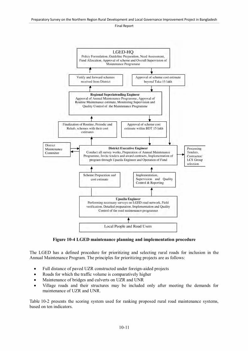
Preparatory Survey on the Northern Region Rural Development and Local Governance Improvement Project in Bangladesh
Final Report
10-11
Figure 10-4 LGED maintenance planning and implementation procedure
The LGED has a defined procedure for prioritizing and selecting rural roads for inclusion in the Annual Maintenance Program. The principles for prioritizing projects are as follows: Full distance of paved UZR constructed under foreign-aided projects Roads for which the traffic volume is comparatively higher Maintenance of bridges and culverts on UZR and UNR Village roads and their structures may be included only after meeting the demands for
maintenance of UZR and UNR. Table 10-2 presents the scoring system used for ranking proposed rural road maintenance systems, based on ten indicators.

Preparatory Survey on the Northern Region Rural Development and Local Governance Improvement Project in Bangladesh
Final Report
10-12
Table 10-2 Scoring system for ranking rural road maintenance schemes Indicator Description Rating Indicator Description Rating 1. Classification Upazila road 12 6. Market (point
per number) Growth Center 12
Union road 6 Rural market 6 Village road 3 7. Hospitals
(point per number) Upazila/Union Health complex
6
2. Surface type Fully BC 12 Private clinic/ community clinic/ Non govt. hospitals
3
BC+HBB/other pavement 10 8. Social center (point per number)
Union Parishad Office 9 Fully HBB/other pavement
6 Other public center 3
BC+HBB/other pavement+earthen
3 9. Educational institution (point per number)
College 9
3. Gaps Nil gaps 12 Secondary school 6 Minor gaps (up to 50m) 6 Primary school/ Madrasha 3 Major gaps 3 10. Industry Large 9
4. Traffic volume (CVD)
CVD 0-50 0 Medium 6 CVD 51-100 30 Small 3 CVD 101-200 40 CVD 201-300 50 CVD 301+ 100
5. Fund source Donor funded 12 Source: LGED RMRSU (6) Monitoring and reporting The RMRSU is responsible on behalf of the LGED for the overall monitoring and reporting of all maintenance activities and takes necessary actions based on the reports received from the Regional superintending engineers (RSE). The RSEs regularly monitor the maintenance works being implemented by the Districts within their Regions through field inspections, offer necessary advice, and report to the RMRSU. The executive engineers (EEs) are directly responsible for the proper execution of the Annual Maintenance Program in their Districts and make regular field visits. There is a District Maintenance Committee (DMC), chaired by the EE, with his senior assistant engineer acting as the member secretary. All Upazila engineers within the District are members of the DMC. The committee is expected to meet once a month to review the progress of implementation of the Annual Maintenance Program. Each DMC submits a monthly progress report containing information on all categories of works (routine, periodic, and emergency maintenance), along with the DMC meeting minutes, to the RMRSU and the concerned RSE. The Upazila engineer (UE) is directly responsible for implementing, supervising, and monitoring maintenance work at the Upazila level. He physically inspects the works on a regular basis. The UE presents the progress of implementation at meetings of the Upazila Development Coordination Committee and receives advice from the committee. The sub-assistant engineer-maintenance at the LGED Upazila office is responsible for the following tasks: Collects detailed information on the Upazila road network as per guidelines Updates road and structure inventory including road maps Conducts traffic surveys at least once a year Prepares cost estimates of maintenance projects Monitors and supervises off-pavement maintenance works, including tree plantation and
caretaking implemented by the LCS Monitors and supervises on-pavement maintenance works conducted by MMT Prepares physical and financial progress reports of all maintenance works at the Upazila level
Preparatory Survey on the Northern Region Rural Development and Local Governance Improvement Project in Bangladesh
Final Report
10-13
and submits them to the UE For reporting progress on routine maintenance, the forms and tables referred to in the guidelines are used. The monthly progress report of all approved projects is submitted to the LGED headquarters and to the RSE’s office from each District within the first week of each month in the prescribed Form 5.1 and Form 5.2, generated from the Road and Structure Database Management System-VI (RSDMS-VI) software. Soft copies of the reports can be uploaded to a LGED website or sent by email. Program summary status reports (using the form in Appendix 6 of the guidelines) covering all categories of works in the District are sent within fifteen days to the RMRSU. Progress reports that do not use the RSDMS-VI formats are not accepted. The reporting forms include the following information: Form 5.1(off-pavement) General information: Name of District, fund allocation, estimated cost, up-to-date expenditures,
reporting month, and reporting date Specific information: Name of project (road code), effective road length, gross estimated cost,
number of length-persons, name of supervisor, total number of trees planted, number of trees planted in reporting month, number of trees surviving, total employment (persons-days), employment (persons-days) in reporting month, financial progress (up to previous month and up to reporting month), and remarks
Form 5.2 (other than off-pavement) General information: Name of District, fund allocation, estimated cost, salvage value, contract
value, payable to contractor, up-to-date expenditures, reporting month, and reporting date Specific information: Name of project (road code), effective road length, structures (number and
span), gross estimated cost, salvage value, contract amount, amount payable to contractor, name of contractor, date of signing contract, date of completion of contract, actual date of completion, employment (persons-days), physical progress (up to previous month and up to reporting month), financial progress (up to previous month and up to reporting month), and remarks
Appendix 6: Summary status report Component (i.e., carried over, routine maintenance, periodic maintenance, and so on), number of
projects, approved estimated cost, approved contract amount, average physical progress (%), actual funds disbursed, remaining funds required, and remarks
The RMRSU reviews the progress information and produces reports for LGED: monthly, quarterly, and annual reports circulated to different ministries/organizations, IMED, ERD, Planning Commission, donor agencies, honorable members of Parliament, and honorable ministers. (7) Role of civil society In regard to maintenance of UZR and UNR, the LGED contracts with the LCS to carry out off-pavement maintenance works and enlists the services of NGOs and CBOs to provide social mobilization support to these LCS. However, the main civil society organizations that should be involved in rural road maintenance are the DRUCs and URUCs referred to earlier. The DRUCs and URUCs could potentially provide an important mechanism for participatory monitoring of the planning and implementation of the Annual Maintenance Program. The LGED is required to consider the recommendations made by them. However, in practice, these committees are not functioning as planned in respect to road maintenance. In most cases, the issues that should be considered by the DRUC and URUC are instead discussed in the Upazila Development Coordination

Preparatory Survey on the Northern Region Rural Development and Local Governance Improvement Project in Bangladesh
Final Report
10-14
Committee meetings, where UP chairpersons, the UNO, and line department officials are present. Neither the guidelines for rural road maintenance (LGED, 2010c) nor the draft rural road maintenance policy (LGED, 2012) refer to the role of DRUCs and URUCs. At the rural road maintenance project level, the voluntarily formed Road Operation and Maintenance Committees described earlier could play an important role in the community monitoring of the implementation of maintenance works. However, there is no official instruction to form these committees, and where they do exist, their main function appears to be to report or complain to the LGED about road damage. (8) Technical assistance to develop maintenance capacity in the LGED The LGED has received significant long-term technical capacity building support from JICA through the Rural Development Engineering Center (RDEC) Project Phase 1 (January 2003 to January 2006) and the follow-up RDEC Project Phase 2 from September 2007 to September 2011. This long-term assistance has made a major contribution to strengthening many different aspects of the LGED’s technical capacity. It included significant support to the RIMMU in developing a maintenance planning and management system using modern techniques, applying innovative methods for pavement repair, and preparing the maintenance guidelines (LGED, 2010c), together with related assistance in training and strengthening the GIS Unit’s capacity. At present, the RMRSU is not benefiting from any internationally supported technical cooperation. The forthcoming World Bank-assisted Second Rural Transport Improvement Project (RTIP-2) will include technical assistance to the RMRSU; however, this will focus primarily on the road safety component of the Unit’s work rather than on maintenance. (9) Recent maintenance initiatives by the LGED a) Performance-based maintenance contracting Reference has been made earlier in this report to development of the use of performance-based maintenance contracting (PBMC) by the LGED. Such contracts do not pay contractors based on the quantity of work performed but on outcomes in terms of the continuing level of service provided by the road or roads under maintenance. The contractor is charged with keeping a road (or group of roads) up to a specified standard and is paid a fee per month for doing so. Each road is inspected monthly, and, as long as the service level standards are being achieved, the contractor is paid, irrespective of the amount of work performed. This method of maintenance contracting is highly suited to low levels of continuing routine maintenance and regular periodic maintenance inputs on roads that are initially in good condition. In the long term, the widespread use of PBMC by the LGED would offer two benefits in terms of sustainable rural road asset management: 1) more efficient use of scarce maintenance funds, (i.e., a greater distance of road maintained in good condition for a given expenditure); and 2) improved overall road condition, in particular because the long-term PBMC contracts will ensure continued attention to routine maintenance of priority road links every year. The results from the pilot PBMC contracts implemented under a DANIDA-supported project in the LGED have been positive. The use of PBMC will now be expanded under the forthcoming RTIP-2. This project will maintain about 450 km of priority rural roads under five-year PBMC contracts, including roads in the target area of the NRDDLGIP. The effectiveness of these PBMC contracts will be carefully monitored. However, at this stage, the application of PBMC is still a learning process for the LGED and for rural road contractors; including it within the scope of the NRRDLGIP has not been proposed (see also the comments in Section 10.2 below).

Preparatory Survey on the Northern Region Rural Development and Local Governance Improvement Project in Bangladesh
Final Report
10-15
b) Rural Road Maintenance Policy As discussed earlier in this report, the LGED has prepared a draft Rural Road Maintenance Policy (LGED, 2012), benefitting from support from the World Bank during the formulation of the RTIP-2. The three most important features of the policy are that it proposes: a progressive increase in the GOB annual revenue budget for rural road maintenance, a 20%
increase per annum until the budget meets 75% of the need; provision for foreign-assisted rural infrastructure projects to finance planned maintenance and
rehabilitation works; and planning, implementation, and management measures to increase the efficiency with which
available maintenance resources are applied to sustain an improved level of service from the core rural road network
The World Bank has recommended that the policy be supplemented by a maintenance strategy for the next ten years, with different scenarios of backlog maintenance clearance and levels of service, including a business plan. The current status of the policy is that it was submitted to the MLGRD&C in February 2012. After examination, the Ministry has returned the policy to the LGED with an instruction to obtain “No Objection” clearance from the Ministry of Finance, the Planning Commission, the Ministry of Establishment, and the Ministry of Communication. Concurrence has already been received from the Planning Commission and the Ministry of Establishment, along with their comments. Concurrence is still being sought from the Ministry of Finance and the Ministry of Communication; the latter has already received comments from its Roads and Highways Department (RHD). After receiving “No Objection” from all concerned parties, the policy will be revised to incorporate the comments and will be submitted by the MLGRD&C to the Cabinet for adoption and publication as formal GOB policy. It is difficult to predict when the policy will receive Cabinet approval, but this is a very high priority for the LGED, and its senior management continues actively to pursue obtaining the necessary clearances. 10.2 Rural Road Maintenance Action Plan This section of the report responds to the requirement for the LGED and Survey Team to produce a “credible” Rural Road Maintenance Action Plan for the NRRDLGIP, consistent with the draft rural road maintenance policy and including institutional and financing arrangements. JICA has requested that this Action Plan be included in the NRRDLGIP alongside its agreement to finance rehabilitation of priority UZR under the Project. The requirement that the plan should be “credible” implies that it must be more than “fine words.” It should comprise a set of realistic commitments from the LGED, together with cost estimates and defined sources of financing, and should include institutional responsibilities for implementing the plan and achieving its outputs. The Action Plan will be reviewed during appraisal. The first step was to prepare a Concept Note which was reviewed with the LGED and JICA. Based on this, an outline of the proposed Action Plan, expanding upon the Concept Note, was included in the Draft Final Report. This has been reviewed and developed during the third field survey with the LGED and through further discussion with JICA. 10.2.1 Background (1) Sustainability Achieving sustainability has been an integral part of the approach to preparing all aspects of the design

Preparatory Survey on the Northern Region Rural Development and Local Governance Improvement Project in Bangladesh
Final Report
10-16
of the NRRDLGIP. It is important that the benefits to people, including the poor, which will result from improving the standards and conditions of rural and urban infrastructures, are sustained over the long term. The project design includes a number of measures to enhance sustainability: Under Component 1 (rural infrastructure development), JICA will finance the off-pavement
routine maintenance by the LCS of all project roads during the project period, as well as the rehabilitation of priority UZR which were previously improved but have deteriorated through the lack of adequate maintenance. The selection procedure for the Growth Center market improvement subprojects includes the requirement that they should generate sufficient lease revenue to cover their routine maintenance costs. This Rural Road Maintenance Action Plan provides the mechanism not only to sustain the project investments in upgrading UZR and UNR but also to increase the sustainability of the wider core rural road network in the Project area.
Under Subcomponent 2-1 (urban infrastructure development and service delivery), sustainable operation and maintenance (O&M) of the subproject investments will be addressed at the planning stage. It is a requirement that all subproject proposals selected from the Pourashava Development Plans (PDP) include an O&M plan that defines the budget, the sources of finance, and the institutional responsibilities. In addition, the NRRDLGIP will adopt a strategy of partial loan financing for some revenue-generating subprojects (e.g., bus and truck terminals and municipal markets).
(2) Emerging issue of sustaining an improved rural road network Effective sustainable asset management practice applies the principle that the first priority for use of resources should be to sustain the level of service provided by roads that have been upgraded to all-weather standard (bitumen-surfaced or concrete-paved, and with no gaps) by keeping them in good condition through a regime of planned routine and periodic maintenance, complemented by emergency maintenance to deal with damage caused by severe weather events. Sustaining the improved level of service provided by the rural road network, and particularly all-weather UZR and UNR, has emerged as an increasingly crucial issue. The importance of addressing this issue is recognized by the LGED, the GOB, and the financing partners. The overall standard of the UZR and UNR road networks has progressively improved with continuing, long-term investment in upgrading the roads and constructing cross-drainage structures. However, this continuing improvement of the rural road network results in an ever-increasing need for maintenance funding to sustain the level of service, as shown in Table 10-1. To date, the GOB has been unable to mobilize sufficient revenue resources to meet these needs. Its annual allocation of rural road maintenance funding has increased substantially over the last twenty years but currently meets only about 25% of the need. One important consequence is the urgent need for increased expenditures on the rehabilitation of rural roads that have previously been improved to meet all-weather standards but which have subsequently deteriorated in condition owing to the lack of adequate planned maintenance: “Rehabilitation” is defined as returning a road to its previously improved standard and condition. The LGED is already taking a number of actions to address the issue of sustainability: It has prepared a Rural Road Maintenance Policy that is currently being processed for formal
adoption by the GOB. This policy proposes: 1) increased funding for maintenance through a 20% annual rise in the revenue allocation until it meets 75% of the need, combined with greater support from donors; and 2) measures to increase the efficiency with which resources are applied

Preparatory Survey on the Northern Region Rural Development and Local Governance Improvement Project in Bangladesh
Final Report
10-17
to sustain the level of service of the rural road network. Increased emphasis, in both GOB- and foreign-financed rural infrastructure projects on
rehabilitation and periodic maintenance of UZR and UNR. Progressive adoption of the use of long-term PBMC, which potentially will result in maintenance
funds being applied more effectively to sustain levels of service. 10.2.2 Objective of the Rural Road Maintenance Action Plan The proposed objective of the NRRDLGIP Rural Road Maintenance Action Plan is “to contribute to improving sustainability of the all-weather core rural road network (UZR and UNR) in the Project area.” This objective is consistent with the Rural Road Maintenance Policy and addresses JICA’s concern regarding sustaining benefits from its investment in improved rural access. The definition of the objective recognizes that initiatives under one project cannot comprehensively resolve the issue of achieving full sustainability. It also emphasizes that the Action Plan should not be concerned solely with the project investments but rather with the core rural road network in the fourteen Project Districts. 10.2.3 Outputs of the Rural Road Maintenance Action Plan (1) Overview The Rural Road Maintenance Action Plan will have the four outputs shown in Table 10-3.
Table 10-3 Outputs of Rural Road Maintenance Action Plan
Output 1 Project investments in rural road upgrading and rehabilitation sustained Output 2 Sustainability of the core rural road network in the project area increased Output 3 Rural roads maintenance policy adopted and implemented Output 4 Rural road network performance monitoring system developed, tested, and applied The first output focuses on the project investments in improved rural roads. The second output is broader, addressing rural road maintenance at the Project area level. The third output has a national perspective. The final output is concerned with measuring LGED’s performance as a service provider in sustaining access on the rural road network. (2) Output 1: Project investments in rural road upgrading and rehabilitation sustained The LGED will ensure that, at the end of the Project, all UZR and UNR upgrading subprojects and all UZR rehabilitation subprojects have been sustained in good condition through continuing routine maintenance complemented where necessary by emergency maintenance – no periodic maintenance should be needed during the Project period. Achievement of this output will ensure that the Project roads continue to provide the improved level of service. Figure 1-5 presents the work plan and budget estimate for Output 1. Based on the implementation plan in Chapter 6, the need for maintenance of Project roads will expand during the Project period, starting from October 2015, as follows:
UZR upgrading, first phase: 212 km, from July 2016 onwards UZR upgrading, second phase: 213 km, from July 2017 onwards UZR upgrading, third phase: 212 km, from July 2018 onwards

Preparatory Survey on the Northern Region Rural Development and Local Governance Improvement Project in Bangladesh
Final Report
10-18
UNR upgrading, first phase: 111 km, from July 2016 onwards UNR upgrading, second phase: 110 km, from July 2017 onwards UNR upgrading, third phase: 111 km, from July 2018 onwards UZR rehabilitation, first phase: 152 km, from October 2015 onwards UZR rehabilitation, second phase: 154 km, from October 2016 onwards
Off-pavement routine maintenance by LCS will start on all roads as soon as the upgrading or rehabilitation works are completed, and continue to the end of the Project. The road upgrading and rehabilitation contracts will include a one-year Defects Liability Period during which the contractor is required to repair any pavement defects at his own expense. On-pavement routine maintenance will therefore commence 12 months after the completion of upgrading or rehabilitation works. By mid-2018 there will be 1,269 km of Project roads under planned maintenance. The unit costs of routine maintenance of Project roads have been estimated as follows: Off-pavement routine maintenance of UZR and UNR by LCS: A cost estimate is presented in
Annex 20: BDT 233,400 per km over a five-year period, i.e. BDT 46,680 per annum at mid-2012 prices.
On-pavement routine maintenance of UZR: Assume five pothole repairs per km per month, average size 0.5m x 0.5m x 0.4m deep. Material cost per pothole, based on LGED Unit Rates, is BDT 332 (tack coat BDT 13 plus grouting BDT 319). Assume materials are 75% of total cost. Cost per km per annum at mid-2012 prices = BDT 26,580.
On-pavement routine maintenance of UNR: Assume 82% of cost of UZR, since UNR pavement standard is 82% of width of UZR pavement. Cost per km per annum at mid-2012 prices = BDT 21,800.
An annual budgetary provision must also be made to meet the possible need for emergency maintenance of Project roads following severe climatic events. This provision has been estimated at 5% of the cost of routine maintenance (off- and on-pavement) of the UZR and UNR.

10-19
Prep
aratory Su
rvey on th
e No
rthern
Region R
ural D
evelop
men
t and Lo
cal Go
vernan
ce Imp
rovem
ent P
roject in B
anglad
esh
Final Rep
ort
Table 10-4 Work plan and budget for Output 1 A. Work Plan
Q1 Q2 Q3 Q4 Q1 Q2 Q3 Q4 Q1 Q2 Q3 Q4 Q1 Q2 Q3 Q4 Q1 Q2Upgraded UZR 212 212 212 212 425 425 425 425 637 637 637 637Upgraded UNR 111 111 111 111 221 221 221 221 332 332 332 332Rehabilitated UZR 152 152 152 152 300 300 300 300 300 300 300 300 300 300 300
Total 152 152 152 475 623 623 623 946 946 946 946 1,269 1,269 1,269 1,269
B. Budget
Q1 Q2 Q3 Q4 Q1 Q2 Q3 Q4 Q1 Q2 Q3 Q4 Q1 Q2 Q3 Q4 Q1 Q2Off-pavement routine 2,048 2,048 2,048 6,712 8,804 8,804 8,804 14,023 14,023 14,023 14,023 19,733 19,733 19,733 19,733 174,288 JICAOn-pavement routine UZR 1,223 1,223 1,223 3,072 4,322 4,322 4,322 6,419 6,419 6,419 6,419 45,383 LGEDOn-pavement routine UNR 768 768 768 768 1,605 1,605 1,605 1,605 9,493 LGEDEmergency Maintenance 161 161 161 519 683 683 683 1,084 1,084 1,084 1,084 1,522 1,522 1,522 1,522 13,472 LGED
Total 2,208 2,208 2,208 7,231 10,709 10,709 10,709 18,947 20,197 20,197 20,197 29,279 29,279 29,279 29,279 242,636
Unit costs per km per annum, mid-2012 prices (BDT '000)Off-pavement routine 46.68On-pavement routine UZR 26.58On-pavement routine UNR 21.80
Price Escalation: 4.9% per annum
Provision for Emergency Maintenance per km per annum, mid-2012 prices (BDT '000)Assume 5% of routine maintenance cost:
UZR 3.66UNR 3.42
Cost of Maintenance (BDT '000) Source ofFundingCategory of maintenance 2015 2016
2015
2017 2018 2019 Total
2019Category of investmentLength of project road (km) requiring maintenance
2016 2017 2018

Preparatory Survey on the Northern Region Rural Development and Local Governance Improvement Project in Bangladesh
Final Report
10-20
The total estimated cost of planned maintenance of Project roads up to the end of the Project period is BDT 242.64 million, to be financed as follows: JICA loan: BDT 174.29 million for off-pavement routine maintenance by LCS GOB from LGED annual revenue budget for maintenance: BDT 68.35 million
The planning of the maintenance of Project roads will be the responsibility of the RMRSU, under the supervision of the Project Management Office (PMO). The implementation of the maintenance works will follow standard LGED procedures – off-pavement routine maintenance under LCS contracts, on-pavement routine maintenance by MMTs, and emergency works by contractors. The RMRSU will be responsible for monitoring and evaluating the works on behalf of the Project. By mid-2015 the LGED will prepare and submit to JICA an updated work plan and budget for Output 1. The LGED will then report annually to JICA on the implementation of the maintenance works, including expenditures, and on the work plan and funding allocation for the coming year. The condition of the Project roads will be evaluated at the end of the Project based on data collected from site inspections, and applying the indicators developed under Output 4. The proposed key indicators of achievement are that, at project-end: All Project roads have an average IRI of 7 or less; and No Project roads have significant defects that interrupt the free flow of traffic.
Under the NRRDLGIP, PBMC works will be carried out in some Project Districts in the Mymensingh area. At the project midterm review, the LGED will report on the achievements of this initiative. If PBMC is proving effective, the LGED and JICA may jointly agree that selected Project roads be placed under long-term five-year PBMC contracts financed by the LGED from its annual revenue budget. This would contribute to sustaining the investments beyond the Project period. (3) Output 2: Sustainability of the core rural road network in the Project area increased This output reflects the fact that people and goods move on a network of roads in rural areas, not just on individual road links financed by a particular project. The LGED will therefore prepare and implement a realistic program to increase the sustainability of the all-weather UZR and UNR network in the fourteen Districts of the Project area during the Project period. This will set the level of service targets for the core rural road network in the Project area to be achieved by Project-end. This “sustainability program” will apply a sustainable road asset management strategy, and will:
cover all UZR and UNR in the Project area that already meet the all-weather access standard – bitumen sealed or concreted over the whole length, no gaps;
incorporate additional UZR and UNR that will be upgraded to all-weather access standard during the Project period under donor-financed projects or with GOB funding;
set realistic annual targets for rehabilitation, periodic maintenance, and routine maintenance on these roads, together with a provision for emergency maintenance, using all sources of funds available to the LGED; and
define the sources of those funds. The preparation of this sustainability program – comprising a maintenance work plan and budget for the Project period – for the core rural road networks in each of the 14 Project Districts is a quite complex exercise that will be carried out by the LGED and agreed with JICA by the end of Year 1 of the NRRDLGIP. The proposed methodology to prepare the program is presented here. It will comprise two stages:
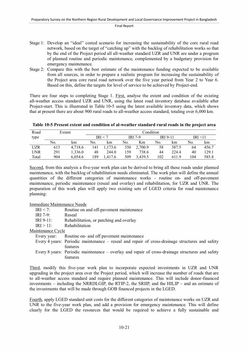
Preparatory Survey on the Northern Region Rural Development and Local Governance Improvement Project in Bangladesh
Final Report
10-21
Stage 1: Develop an “ideal” costed scenario for increasing the sustainability of the core rural road
network, based on the target of “catching up” with the backlog of rehabilitation works so that by the end of the Project period all all-weather standard UZR and UNR are under a program of planned routine and periodic maintenance, complemented by a budgetary provision for emergency maintenance.
Stage 2: Compare this with the best estimate of the maintenance funding expected to be available from all sources, in order to prepare a realistic program for increasing the sustainability of the Project area core rural road network over the five year period from Year 2 to Year 6. Based on this, define the targets for level of service to be achieved by Project-end.
There are four steps to completing Stage 1. First, analyse the extent and condition of the existing all-weather access standard UZR and UNR, using the latest road inventory database available after Project-start. This is illustrated in Table 10-5 using the latest available inventory data, which shows that at present there are about 900 rural roads to all-weather access standard, totaling over 6,000 km.
Table 10-5 Present extent and condition of al-weather standard rural roads in the project area Road type
Extent Condition IRI < 7 IRI 7-9 IRI 9-11 IRI >11
No. km No. km No. Km No. km No. km UZR 613 4,718.6 141 1,173.6 350 2,700.9 58 387.5 64 456.7 UNR 291 1,336.0 48 244.0 159 738.6 44 224.4 40 129.1 Total 904 6,054.6 189 1,417.6 509 3,439.5 102 611.9 104 585.8
Second, from this analysis a five-year work plan can be derived to bring all these roads under planned maintenance, with the backlog of rehabilitation needs eliminated. The work plan will define the annual quantities of the different categories of maintenance works - routine on- and off-pavement maintenance, periodic maintenance (reseal and overlay) and rehabilitation, for UZR and UNR. The preparation of this work plan will apply two existing sets of LGED criteria for road maintenance planning: Immediate Maintenance Needs
IRI < 7: Routine on and off-pavement maintenance IRI 7-9: Reseal IRI 9-11: Rehabilitation, or patching and overlay IRI > 11: Rehabilitation
Maintenance Cycle Every year: Routine on- and off pavement maintenance Every 4 years: Periodic maintenance – reseal and repair of cross-drainage structures and safety
features Every 8 years: Periodic maintenance – overlay and repair of cross-drainage structures and safety
features Third, modify this five-year work plan to incorporate expected investments in UZR and UNR upgrading in the project area over the Project period, which will increase the number of roads that are to all-weather access standard and require planned maintenance. This will include donor-financed investments – including the NRRDLGIP, the RTIP-2, the SRIIP, and the HILIP – and an estimate of the investments that will be made through GOB financed projects in the LGED. Fourth, apply LGED standard unit costs for the different categories of maintenance works on UZR and UNR to the five-year work plan, and add a provision for emergency maintenance. This will define clearly for the LGED the resources that would be required to achieve a fully sustainable and

Preparatory Survey on the Northern Region Rural Development and Local Governance Improvement Project in Bangladesh
Final Report
10-22
well-maintained core rural road network providing reliable and efficient access by Project-end. However, it is highly unlikely that sufficient resources will be available to implement this ideal scenario. Stage 2 of the preparation of the sustainability program will therefore involve making a detailed analysis of the maintenance funding resources expected to be available for the Project area over the five-year period. These resources will include: donor funds, e.g. NRRDLGIP funds for rehabilitation and for off-pavement maintenance by LCS,
and World Bank RTIP-2 funds for rehabilitation and PBMC; and GOB road maintenance funds from the annual revenue budget and other sources.
Applying this realistic assessment of resources, the ideal scenario will be reduced to a feasible work plan for increasing the sustainability of the core rural road network, together with annual expenditures and sources of funds, and annual targets for improvement in extent and condition. In developing this feasible sustainability program, two key criteria should be applied: 1) to sustain the condition of important rural roads which are already in good condition and providing efficient and reliable access; and 2) to reduce the backlog of rehabilitation and bring more core rural roads under planned maintenance. The sustainability program will be subject to formal approval by LGED senior management, and to agreement by JICA. The LGED will monitor and report to JICA on progress and achievement in implementing the sustainability program. The work plan will be updated annually and agreed with JICA. Based on the findings at the midterm review, it may be decided to incorporate PBMC into the sustainability program. The key indicators of progress will be expenditures on, and quantities of work carried out for, the different categories of maintenance works. The key indicators of achievement will be the improvement in extent and condition of the core rural road network in the Project area. As the performance monitoring system, Output 4, is developed, it will be applied to measure and report on the achievements of the program. The agreed five-year sustainability program will be implemented by the LGED, following its standard procedures, and in accordance with donor requirements when foreign funds are applied. The RMRSU will be responsible for preparing and monitoring the implementation of the sustainability program on behalf of the PMO. As discussed in Section 10.2.4 below, the DSM consultants will provide technical assistance support to the LGED and the RMRSU in preparing, and monitoring the implementation of, the sustainability program. (4) Output 3: Rural roads maintenance policy adopted and implemented The LGED is actively committed to achieving the adoption and implementation of the Rural Roads Maintenance Policy. This will significantly increase the sustainability of the core rural road network nationwide. The LGED is pursuing this objective with its existing staff resources under the direction of the Chief Engineer and with the active involvement of senior management and the RMRSU. Therefore no additional LGED or JICA resources are required for this output. From Project-start, the LGED will report quarterly to, and review annually with, JICA the progress of adoption and subsequently implementation of the Policy. Once the Policy has been formally adopted by the GOB, the RMRSU will support the PMO to prepare progress monitoring data for reporting to JICA. Two key indicators of progress in implementation are proposed. The first key indicator is the actual annual increase in the GOB revenue budget for maintenance. The target set is 20% per annum increase which implies future annual budgets as follows:
Preparatory Survey on the Northern Region Rural Development and Local Governance Improvement Project in Bangladesh
Final Report
10-23
FY 2013-2014: BDT 8,760 million FY 2014-2015: BDT 10,512 million
FY 2015-2016: BDT 12,614 million FY 2016-2017: BDT 15,137 million
FY 2017-2018: BDT 18,165 million FY 2018-2019: BDT 21,798 million
FY 2019-2020: BDT 26,157 million The second key indicator is the impact of the increased budget on the condition of the all-weather core rural road network. Initially, the LGED will use the following indicators to report to JICA: Extent (length) of bitumen-sealed and concrete UZR and UNR nationwide The average IRI of these roads
In the latter part of the Project period the monitoring methodology developed under Output 4 can be used to report on the condition of the network nationwide. The adoption of PBMC can potentially have a significant impact on the efficiency with which available maintenance funds are applied to sustain the rural road network. It is therefore proposed that the LGED should also report annually to JICA on its progress in the adoption of PBMC, and the lessons learnt on the benefits of using this long-term contracting method for planned and emergency maintenance of rural roads. (5) Output 4: Rural road network performance monitoring system developed, tested, and
applied The LGED already has procedures for monitoring and reporting on the implementation of rural road maintenance works. However, this is essentially monitoring the conduct of activities. One key to effective sustainable road asset management is to monitor and report on the performance of the rural road network, (i.e., the level of service it provides to rural people). The LGED, as an effective service provider, should be expected to deliver a progressively improving level of rural access service. The LGED will, therefore, develop, test, and apply a system of performance monitoring of the all-weather rural road network in the Project area. Performance will primarily be measured by the extent and condition of the all-weather rural road network. The monitoring procedure, its data needs, the indicators to be used, and the methodology for aggregating indicators to assess performance at District, Region, and national levels will be developed in detail during Project implementation. Consistent with the Rural Road Maintenance Policy, the key indicators of level of service provided should include the following: Lengths of UZR and UNR providing all-weather access – the indicator of “extent” IRI of these roads – the indicator of “condition” Rut depth, and extent of fatigue cracks – indicators of the “structural status” of the pavement Extent of potholes and edge cracking – “indicators of the effectiveness of routine maintenance”
The proposed schedule for developing this methodology is as follows:
Year 1: Develop the detailed methodology, and data collection and analysis procedure, collect baseline data for one Project District
Year 2: Test and evaluate the monitoring procedure in one District, and collect baseline data for all Project Districts

Preparatory Survey on the Northern Region Rural Development and Local Governance Improvement Project in Bangladesh
Final Report
10-24
Year 3: Apply the methodology in all Project Districts Year 4: Repeat Year 3, and develop manual and training materials on performance monitoring Year 5: Apply the methodology nationwide Year 6: Repeat Year 5
To complement this quantitative monitoring it is proposed that the LGED should take the initiative, initially in one Project District, to encourage community and user monitoring of maintenance performance by taking measures to active, and support the activities of, its DRUC and URUCs. The RMRSU will be responsible for the development and implementation of the performance monitoring system, under the supervision of the PMO. As discussed in Section 10.2.4 below, the DSM consultants will provide technical assistance support to the RMRSU in developing the monitoring system. The LGED will report quarterly to JICA on progress in developing and applying the system. It will report annually, and review with JICA, the results of performance monitoring. 10.2.4 Implementation of the Action Plan The descriptions of each of the outputs include definitions of LGED responsibilities. To summarize: The LGED Chief Engineer will direct the initiative for adoption of the Rural Road Maintenance
Policy by GOB, supported by LGED senior management. The Project Director will be responsible to the LGED for the implementation of the Action Plan
and for reporting to JICA. The RMRSU, managed by a Superintending Engineer and under the direction of the Additional
Chief Engineer (Maintenance), will carry out the planning, monitoring, and reporting tasks for the Action Plan, and will develop the performance monitoring methodology. The RMRSU will be supported by the concerned LGED District Engineers and Upazila Engineers in carrying out these tasks.
Implementation of all maintenance works under the Action Plan will follow standard LGED procedures, involving the concerned Regional Superintending Engineers, District Engineers, and Upazila Engineers.
Outputs 2, 3, and 4 will be implemented and reported throughout the Project period. Output 1 will come on stream in the fourth quarter of 2015 after the first phase UZR rehabilitation works are completed. Many of the Action Plan tasks will be carried out by existing LGED staff in the RMRSU and at Regional, District, and Upazila level as part of their normal duties, and by the PMO. The only JICA financing of maintenance works will be off-pavement routine maintenance of Project roads by LCS, which is already included in the Project budget. Other maintenance works will be financed from the GOB annual revenue budget. In addition, specific Project-financed resources are required for the implementation of the Action Plan as follows: JICA-financed technical assistance to develop capacity in the RMRSU and support the PMO for
the implementation of the Action Plan to be provided by the DSM Consultants: - International Road Maintenance Management Specialist, 6 person-months – 3 months in Year
1, 2 months in Year 2, 1 month in Year 3. To apply international experience and best practices, mainly for Outputs 2 and 4, on road maintenance planning and budgeting, and on maintenance performance monitoring, based on a sustainable road asset management strategy.
- National Road Maintenance Management Expert, 24 person-months – full-time in Year 1, 6

Preparatory Survey on the Northern Region Rural Development and Local Governance Improvement Project in Bangladesh
Final Report
10-25
months in each of Years 2 and 3. To support and provide continuity to the inputs from the International Specialist; advise RMRSU on improved data collection, management and analysis procedures for planning and monitoring; and assist RMRSU and PMO in reporting, including developing effective reporting formats.
Overseas study tours and short-term training, in order to give relevant LGED staff international exposure to, and practical experience of, the application of sustainable road asset management strategies and best practices in planning and performance monitoring.
The LGED has requested additional equipment to strengthen its road condition data collection and management capacity in the Project area, specifically:
- Six Roughness Measuring Meters (two per LGED Region in the Project area) to improve the efficiency of the conduct of the annual condition surveys of UZR and UNR. The current cost of these Meters is BDT 1.7 million per set.
- Three Digital Imaging Systems – GPS-linked Video Loggers – one per LGED Region in the Project area, to make and store visual records of road conditions to complement the existing database and data management system. These will facilitate more efficient maintenance planning, for example by providing visual information on road conditions to those making decisions on competing priorities for funds. The current cost of these Systems is BDT 7 million per set.
The implementation of the Action Plan will involve significant additional work for the RMRSU. Consideration should therefore be given to including in the GOB-financed project budget (i.e. not eligible for JICA financing), one incremental (or project-financed) staff position in the RMRSU for an engineer with computer skills.
10.3 Operation and maintenance of Pourashava infrastructure 10.3.1 Operation and maintenance in general Unlike for rural transport and trading infrastructure, there are no institutionalized arrangements or guidelines for O&M of urban infrastructure constructed and managed by Pourashavas. With the exception of markets, none of the Pourashava sources of funds are earmarked for infrastructure O&M. Similarly, there is no requirement for any part of the Annual Development Program (ADP) allocation from central government to Pourashavas to be allocated to O&M. The most recent instructions to Pourashavas are contained in the Local Government Division (LGD) fund release order for the first installment of the FY 2012/13 ADP allocation (memo no. 46.064.020.82.04.071.2011/1459, dated September 18, 2012). The only fund earmarking requirement in these instructions is that 20% of the ADP allocation should be used for sanitation subprojects. However, there is no bar to the use of the ADP for O&M since the funds are provided for overall development of the Pourashavas. In practice, Pourashavas typically allocate funds for O&M every year. Individual priority repair, maintenance, or rehabilitation subprojects are identified, costed, and budgeted. The implication of this approach is that the Pourashavas do not have any overall plan for the sustainable O&M of their inventory of different categories of infrastructure. Rather, O&M is carried out on an ad hoc basis to meet immediate priorities. The most recent LGD instructions (LGD memo no. 46.063.022.01.00.001.2011/258, dated March 9, 2011) on the functions of the Ward Level Coordination Committees (WLCC) and Town Level Coordination Committees (TLCC) do not set our any specific requirements relating to O&M. However, they define that the role of the Committees is to review the progress of overall development of Pourashavas, and this could certainly be interpreted to include reviewing the effectiveness of O&M of Pourashava infrastructure.
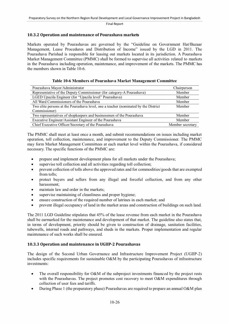
Preparatory Survey on the Northern Region Rural Development and Local Governance Improvement Project in Bangladesh
Final Report
10-26
10.3.2 Operation and maintenance of Pourashava markets
Markets operated by Pourashavas are governed by the “Guideline on Government Hat/Bazaar Management, Lease Procedures and Distribution of Income” issued by the LGD in 2011. The Pourashava Parishad is responsible for leasing out markets located in its jurisdiction. A Pourashava Market Management Committee (PMMC) shall be formed to supervise all activities related to markets in the Pourashava including operation, maintenance, and improvement of the markets. The PMMC has the members shown in Table 10-6.
Table 10-6 Members of Pourashava Market Management Committee Pourashava Mayor/Administrator Chairperson Representative of the Deputy Commissioner (for category-A Pourashava) Member LGED Upazila Engineer (for “Upazila level” Pourashava) Member All Ward Commissioners of the Pourashava Member Two elite persons at the Pourashava level, one a teacher (nominated by the District Commissioner)
Member
Two representatives of shopkeepers and businessmen of the Pourashava Member Executive Engineer/Assistant Engineer of the Pourashava Member Chief Executive Officer/Secretary of the Pourashava Member secretary
The PMMC shall meet at least once a month, and submit recommendations on issues including market operation, toll collection, maintenance, and improvement to the Deputy Commissioner. The PMMC may form Market Management Committees at each market level within the Pourashava, if considered necessary. The specific functions of the PMMC are: prepare and implement development plans for all markets under the Pourashava; supervise toll collection and all activities regarding toll collection; prevent collection of tolls above the approved rates and for commodities/goods that are exempted
from tolls; protect buyers and sellers from any illegal and forceful collection, and from any other
harassment; maintain law and order in the markets; supervise maintaining of cleanliness and proper hygiene; ensure construction of the required number of latrines in each market; and prevent illegal occupancy of land in the market areas and construction of buildings on such land.
The 2011 LGD Guideline stipulates that 45% of the lease revenue from each market in the Pourashava shall be earmarked for the maintenance and development of that market. The guideline also states that, in terms of development, priority should be given to construction of drainage, sanitation facilities, tubewells, internal roads and pathways, and sheds in the markets. Proper implementation and regular maintenance of such works shall be ensured. 10.3.3 Operation and maintenance in UGIIP-2 Pourashavas The design of the Second Urban Governance and Infrastructure Improvement Project (UGIIP-2) includes specific requirements for sustainable O&M by the participating Pourashavas of infrastructure investments: The overall responsibility for O&M of the subproject investments financed by the project rests
with the Pourashavas. The project promotes cost recovery to meet O&M expenditures through collection of user fees and tariffs.
During Phase 1 (the preparatory phase) Pourashavas are required to prepare an annual O&M plan

Preparatory Survey on the Northern Region Rural Development and Local Governance Improvement Project in Bangladesh
Final Report
10-27
for all infrastructure and services. This plan includes a listing and condition assessment of different assets, and an estimate of the required financial and manpower resources for operation and planned maintenance.
During Phases 2 and 3, it is mandatory for the Pourashavas to update the annual O&M plan and allocate sufficient budget, and deploy sufficient manpower, to implement the plan. The incremental costs of O&M during the implementation period are not included in the project cost
The project has operation and maintenance manuals revised from the UGIIP-1 for use by the Pourashava staff members. These describe the O&M procedures for different infrastructure and service delivery components. The project consultants provide specific O&M training to all relevant staff of the Pourashavas.
For the piped water supply component, the project aims to achieve full cost recovery for O&M through metering and rationalization of tariffs. For sewage waste disposal, O&M costs are met through service charges collected from the citizens.
The project provides hand deep tubewells in areas not reached by the piped system. For effective O&M and serviceability, these systems are managed by community-based organizations (CBOs), including the collection of contributions from beneficiaries when repairs are needed.
O&M aspects of community toilets are also managed by CBOs. The market and terminal associations manage public toilets (by outsourcing wherever possible) and school toilets are managed by the school administration.
The project encourages private sector engagement for better and more accountable O&M of some types of subprojects - treatment and disposal of solid waste, markets, and bus terminals.
The Urban Governance Improvement Action Program (UGIAP) defined for the UGIIP-2 expands on the requirement for sustainable O&M of Pourashava infrastructure: Participating Pourashavas should set aside at least 15-20% of the annual development budget for
O&M of infrastructure, and promote citizens’ involvement through social audit methods to ensure effective service delivery.
The Pourashava should prepare, by May-June, an annual O & M budget for the coming year, with an incremental increase of 5% per annum until the financing requirement for sustainable O&M is met. The O&M budget must be approved by the Pourashava Parishad.
The O&M subprojects will be executed by the Pourashava Engineer, who will submit monthly physical and financial progress reports to the Mayor. These reports will also be reviewed by the concerned LGED District Executive Engineer or Assistant Engineer.
10.3.4 Pourashava Infrastructure Operation and Maintenance Action Plan in the NRRDLGIP (1) Objective At the implementation stage of NRRDLGIP, each target Pourashava will formulate and implement a “Pourashava Infrastructure O&M Action Plan (PIOMAP)” in order to strengthen their O&M capacity and ensure sustainability of benefits from infrastructure investment. The proposed objective of the PIOMAP is “to enhance sustainability of Pourashava infrastructure by strengthening Pourashava’s capacity for O&M of the infrastructure.” (2) Contents The proposed PIOMAP will consist of the following items: Action: Action to be implemented to achieve the objective of the PIOMAP Output/indicator: Output aimed at by a respective action, or indicator of the output of PIOMAP Specific task: Detailed task to be taken to carry out a respective action

Preparatory Survey on the Northern Region Rural Development and Local Governance Improvement Project in Bangladesh
Final Report
10-28
Organization/person in charge of task Time schedule: Schedule of an action and respective tasks, e.g., when and by when to do them
The proposed PIOMAP should cover the following areas of actions: 1) institutional arrangements; 2) planning; 3) budgeting; 4) implementation; 5) citizens’ participation; and 6) technical capacity for O&M. The proposed format of the PIOMAP is presented in Table 10-7. Survey Team proposes that the PIOMAP should include the following actions in respective areas as discussed below: a) Institutional arrangements for O&M implementation A standing committee and councilors are assigned to the O&M. In this action, Pourashava will determine a standing committee and councilors that will oversee O&M of Pourashava infrastructure. This action will be undertaken in early Phase 1. A working group for O&M consisting of Pourashava officials is established. Each Pourashava will form a working group for O&M. The group will assume overall responsibility for the O&M at the working level, and the group members will be core persons for implementation of the PIOMAP. The group will consist of Pourashava officials including Executive Engineer, Assistant Engineer, Secretary, and Health Officer. This action will be undertaken in early Phase 1. b) Planning of O&M Inventories of Pourashava infrastructures are prepared and updated. The inventories of infrastructure to be maintained by Pourashava will be prepared in Phase 1 and updated periodically in Phases 2 and 3. The inventories should include information on type, location, construction year, and physical condition of each infrastructure. Subproject O&M plan is prepared. Each Pourashava will prepare an O&M plan for each subproject implemented under Component 2 of the NRRDLGIP.74 This plan is aimed at clarifying organizational structure, budget, financial sources, and procedures for O&M of each subproject. Pourashavas will prepare subproject O&M plans in the process of subproject planning. The plans will be discussed at TLCC and WLCCs. If the institutional arrangements for O&M implementation involve organizations or persons outside Pourashava Parishad, the Pourashava should obtain their commitment to O&M of the subprojects prior to the finalization of the plans. Annual O&M Plan is prepared. Each Pourashava will prepare an O&M Annual Plan. The O&M Annual Plan comprises the following items for each infrastructure in the inventory: 1) organizations and persons in charge; 2) necessary manpower to be contracted or hired; 3) schedule; and 4) O&M budget required. The O&M Annual Plan will be discussed at TLCC and WLCCs. The Pourashava should prepare the Annual O&M Plan by June each year, since Pourashava’s annual budget is prepared by June, and required budget for O&M shall be allocated in annual budget of Pourashava. The Annual O&M Plan will be prepared from the fiscal years from FY2015/16. Budget for O&M is allocated in annual budget. Based on an Annual O&M Plan, subproject O&M plans, each Pourashava will allocate budget for O&M in the process of annual budgeting that is usually undertaken from May to June. Since the preparation of the first Annual O&M Plan may be completed in late Phase 1, this action will start 74 Preparation of this plan is one of the criteria for subprojects to be approved and implemented.
Preparatory Survey on the Northern Region Rural Development and Local Governance Improvement Project in Bangladesh
Final Report
10-29
implementation from the annual budgeting for FY2015/16. c) Medium-term budgeting framework of O&M Five-year Budget Plan for O&M is prepared as part of Pourashava Development Plan. In order to enhance predictability of budget and sustainability of O&M activities, each Pourashava will prepare a Five-year Budget Plan for O&M as part of Pourashava Development Plan (PDP) by the end of Phase 1 of Component 2. The plan will include estimated cost of O&M, an available amount of budget earmarked for O&M, and a target amount of budget for O&M in each of the next five years from Phase 2. The cost, available amount, and target amounts will be identified for each type of infrastructure. TLCC and WLCCs will be involved in the process of this preparation. This Five-Year Plan is aimed to help Pourashava understand the gaps between estimated cost and available budget, and undertake systematic efforts to increase O&M budget in Pourashava. d) Implementation of O&M Annual O&M Plan is implemented. Each Pourashava will implement an Annual O&M Plan under the institutional arrangements in the PIOMAP. The working group for O&M in each Pourashava will monitor and supervise activities of the Annual O&M Plan to ensure the implementation of it. The working group will: 1) examine reports on O&M from organizations and persons in charge once every three months; 2) hold a regular meeting at least once in a month to discuss progress of the Annual O&M Plan and results of O&M; and 3) report on O&M to a standing committee and councilors in charge of O&M at least once in every three months. The standing committee and councilors will hold a meeting at least once in every three months. e) Citizens’ participation in O&M TLCC and WLCCs are involved in O&M. Each Pourashava will involve TLCC and WLCCs of each Pourashava in the preparation and implementation of O&M. The TLCC and WLCCs will hold discussions on inventories of infrastructure, subproject O&M plans, Annual O&M Plans, and Five-year O&M Budget Plan during their preparation. The TLCC and WLCCs will discuss the status of O&M and make suggestions and recommendations for Pourashava Parishad. A working group for O&M should report O&M issues to TLCC at least once in every three months. f) Technical capacity for O&M Technical skills of concerned persons for O&M are improved. Each Pourashava will implement activities to improve technical skills of concerned persons for O&M. Concerned officials of each Pourashava will participate in training courses on O&M provided by the Project, and disseminate learned knowledge and skills for relevant persons. It may be necessary for each Pourashava to provide training to citizens involved in O&M such as members of CBOs and SICs. Each Pourashava will also ensure that O&M manuals provided by the Project and other related documents will be properly stored at Pourashava office so that every concerned person is able to access them.

Preparatory Survey on the Northern Region Rural Development and Local Governance Improvement Project in Bangladesh
Final Report
10-30
Table 10-7 Proposed format of Pourashava Infrastructure O&M Action Plan (PIOMAP) Action Output/
indicator Specific task Organization
/person in charge
Time schedule
Institutional arrangements A standing committee and councilors are assigned to the O&M.*
A working group for O&M consisting of Pourashava officials is established.*
Planning of O&M Inventories of infrastructure under the responsibility of Pourashava are prepared and updated.*
Subproject O&M plan is prepared.*
Annual O&M Plan is prepared.*
Budget for O&M is allocated in annual budget.*
Medium-term budgeting framework of O&M Five-year Budget Plan for O&M is prepared as part of Pourashava Development Plan (PDP).*
Implementation Annual O&M Plan is implemented.* The working group receives reports on O&M
from organizations and persons in charge at least once in every three months.#
The working group holds a regular meeting at least once in a month to discuss progress of the Annual O&M Plan and results of O&M.#
The working group reports on O&M to a standing committee and councilors in charge of O&M at least once every three months.#
The standing committee and councilors have discussions on O&M at least once every three months.#
Citizens’ participation TLCC and WLCCs are involved in O&M.* TLCC and WLCCs have discussions on
inventories of infrastructure, Annual O&M Plan, subproject O&M plan, and Five-year Budget Plan during preparation of these inventories and plans.#
TLCC and WLCCs have discussions on the status of O&M and make suggestions and recommendations for Pourashava Parishad.#
A working group for O&M reports to TLCC at least once every three months.#
Technical capacity for O&M Technical skills of concerned persons for O&M are improved.*
Pourashava officials participate in training courses on O&M provided by the Project.#
The above officials disseminate what they learn in the training to relevant persons.#
Pourashava provides training to citizens involved in O&M such as members of CBOs and SICs.#
O&M manuals and other related documents are properly stored at Pourashava office.#
Note: Although Survey Team proposes this table as a format of the action plan, the contents of the action plan should be prepared and determined by Pourashava. However, the team proposes that actions marked with asterisk (*) in this table should be included in the action plan, while specific tasks with the mark “#” in this table are examples or recommendations.
Preparatory Survey on the Northern Region Rural Development and Local Governance Improvement Project in Bangladesh
Final Report
10-31
(3) Process for preparation and implementation of PIOMAP The PIOMAP will be prepared and implemented through the following process: 1) Preparation: Each Pourashava will prepare PIOMAP with support from the PMO and
consultants in Phase 1. In the process of this preparation, Pourashava should hold discussions at TLCC and consultation with concerned persons. The draft PIOMAP will be submitted to the PMO for approval. If it is difficult to prepare the whole of PIOMAP in early Phase 1, it may be acceptable to prepare PIOMAP for Phase 1, and for Phases 2 and 3 separately. In this case, the PIOMAP for Phase 1 is prepared in early Phase 1, while that for Phases 2 and 3 will be prepared by the end of Phase 1.
2) Implementation: Each Pourashava will implement respective actions in PIOMAP. First, it will assign a standing committee and councilors in charge of O&M and establish a working group for O&M. Then, this working group will take overall working-level responsibility for the implementation. The group may support responsible organizations and persons in performing their tasks written in PIOMAP, monitor the progress of PIOMAP, hold regular meetings among the group at least once in a month, and report on the implementation of PIOMAP to relevant organizations such as a standing committee and councilors in charge of O&M. Each Pourashava will submit quarterly reports on the implementation to the PMO.
The PMO will provide support for Pourashavas to facilitate the preparation and implementation of PIOMAP. The PMO with support from the DSM and GICD consultants will provide training courses for Pourashavas with regard to overall mechanism and procedures for PIOMAP, technical measures for O&M of each type of infrastructure, and so forth. The PMO will also develop training materials and O&M manuals for Pourashavas.

Preparatory Survey on the Northern Region Rural Development and Local Governance Improvement Project in Bangladesh
Final Report
11-1
11 Monitoring and evaluation 11.1 Operation and effect indicators Table 11-1 shows a logical framework proposed for the NRRDLGIP. The LGED employs the logical framework approach to monitor project progress and evaluate project effect and impacts. The objectively verifiable indicators at the output level are operation indicators, while the indicators at the Project Purpose level are effect indicators. The logical framework should be reviewed and finalized at the beginning of the Project. Whenever necessary, it should be modified with the concurrence of JICA. A list of risks and mitigation measures of the Project is attached in Annex 29.
Table 11-1 Logical Framework of NRRDLGIP Narrative summary Objectively verifiable indicators Means of
verification Important
assumptions Overall Goal
Economic growth is enhanced, and poverty is reduced in the 14 Districts in the northern region of Bangladesh.
Poverty headcount ratio is reduced by XX%. Household income in real term is increased by
XX%. Income gap between rural and urban areas is
reduced to XX%.
National statistics
Project Purpose
1. Access to rural infrastructures and services is expanded for all kinds of people including the poor and women.
Annual Average Daily Traffic (AADT) is increased by XX%.
Annual average travel time to access desired/preferred markets is reduced by XX%.
Total sales of Growth Centers supported by the Project are increased by XX%.
Total sales to nearby Pourashavas are increased by XX%.
Auxiliary indicators: XX million people have all-weather access to
markets and providers of social services, including health and education.
Average transport cost of farm produce to preferred market is reduced by XX%.
Ratio of the number of traffic accidents to AADT is reduced by XX%.
Permanent and temporary shops and hat-day sellers are increased by XX%.
Number of female shop owners of Growth Centers supported by the Project is increased by XX%.
Baseline survey report
Mid-term and terminal assessment reports
Project completion report
Private investment in agriculture, commerce, etc. increased
Social services provided well
Quality of developed infrastructures maintained
Macro-economic stability sustained
Political situation remains stable
No major natural calamities
2. Access to urban infrastructures and services is expanded for all kinds of people including the poor and women, and urban governance is improved in participating Pourashavas.
Number of establishments and business licenses is increased by XX%.
Incidence rate of water-borne disease is decreased by XX%.
Revenue income is increased by XX%. AADT from adjacent rural areas is increased by
XX%. Auxiliary indicators: Urban transport In all Pourashavas which implement subprojects of urban transport: Length of traffic congestion and time to pass
congestion at its peak hour are reduced by XX% and YY%, respectively.
Annual average travel time for households to have access to desired/preferred markets is reduced by XX%.
Citizen report cards
Baseline survey report
Mid-term and terminal assessment reports
Project completion report
National statistics
Private investment in agriculture, commerce, etc. increased
Macro-economic stability sustained
Political situation remains stable
No major natural calamities

Preparatory Survey on the Northern Region Rural Development and Local Governance Improvement Project in Bangladesh
Final Report
11-2
Table 11-1 Logical Framework of NRRDLGIP (continued) Narrative summary Objectively verifiable indicators Means of
verification Important
assumptions Annual Average Daily Traffic (AADT) is
increased by XX%. XX% of citizens are dissatisfied with condition of
roads. Drainage In all Pourashavas which implement subprojects of drainage: XX% of citizens are satisfied with conditions of
drains. Annual damage to houses, roads, and movable
assets and economic loss caused by waterlogging and inundation are reduced by XX%.
Solid waste management In all Pourashavas which implement subprojects of solid waste management: Volume of collected wastes is increased by XX%. Area coverage ratio of solid waste collection
services is increased by XX%. XX% of citizens are satisfied with solid waste
management. Water supply In all Pourashavas which implement subprojects of water supply: Number of people who have access to piped
water supply is increased significantly. A significant number of people have access to
safe water from tubewells installed in the Project. Toilets In all Pourashavas which implement subprojects of toilets: A significant number of people use public and
community toilets supported by the Project. Bus and truck terminals In all Pourashavas which implement subprojects of bus and truck terminals: A significant number of buses and trucks use
terminals supported by the Project. Number of buses arriving and departing is
increased by XX%. XX% of citizens are satisfied with bus terminals. Parking In all Pourashavas which implement subprojects of parking: A significant number of vehicles use parking
supported by the Project. Public markets In all Pourashavas which implement subprojects of public markets: Permanent and temporary shops and hat-day
sellers are increased by XX%. XX% of citizens are satisfied with conditions of
markets. Slaughterhouses In all Pourashavas which implement subprojects of slaughterhouses: Slaughterhouses developed in the Project are used
significant times a day. XX% of slaughtering persons are satisfied with
slaughterhouses.

Preparatory Survey on the Northern Region Rural Development and Local Governance Improvement Project in Bangladesh
Final Report
11-3
Table 11-1 Logical Framework of NRRDLGIP (continued) Narrative summary Objectively verifiable indicators Means of
verification Important
assumptions Streetlights In all Pourashavas which implement subprojects of streetlights: XX% of citizens are satisfied with streetlights. Basic services for the poor % of the poor who have access to basic
infrastructure (footpaths, drains, dustbins, tubewells, toilets, and streetlights) is increased by XX%.
XX% of the poor are satisfied with provided basic infrastructure.
Governance and capacity improvement XX% of citizens are satisfied with public service
provided by Pourashavas.
Output Component 1: Rural infrastructure development
1-1. Upazila Roads are improved.
XX km of UZRs are upgraded to bituminous surface standard.
XX km of UZRs are rehabilitated.
Progress monitoring reports
EIAs completed timely
Quality of developed infrastructures maintained
Management system for maintenance developed well
Sufficient fund for maintenance continuously allocated
Inflation within expected range
Timely procurement of consultants
Timely release of funds
Trained stakeholders apply learned knowledge and skills
Political situation remains stable
No major natural calamity
1-2. Union Roads are improved.
XX km of UNRs are upgraded to bituminous surface standard.
XX km of UNRs are rehabilitated.
Progress monitoring reports
1-3. Road structures are constructed.
XX m of bridges and culverts on UZRs and XX m of bridges and culverts on UNRs are constructed.
Progress monitoring reports
1-4. Growth Centers and Rural Markets are improved.
XX Growth Centers are improved. XX WMS’s are constructed. XX Rural Markets are improved.
Progress monitoring reports
1-5. Other basic rural infrastructures are developed.
XX ghats are constructed. XX m submersible roads are constructed. XX flood refuges are constructed.
Progress monitoring reports
1-6. Employment opportunities are created for rural poor through development and maintenance of rural infrastructures.
XX person-years of women’s employment are created in LCS road construction.
XX person-years of women’s employment are created in LCS road maintenance.
XX person-years of women’s employment are created in LCS tree-planting and caretaking.
Progress monitoring reports
1-7. Road safety is ensured.
XX Upazila/Union CBRS teams are created XX CBRS facilitators are assigned XX persons participate in road safety education
activities
Progress monitoring reports
1-8. Capacity of stakeholders are strengthened in planning, implementation, operation and management of rural infrastructure
XX trainee-day training is imparted to stakeholders.
Progress monitoring reports
Component 2: Urban infrastructure and governance improvement
Subcomponent 2-1: Urban infrastructure development and service
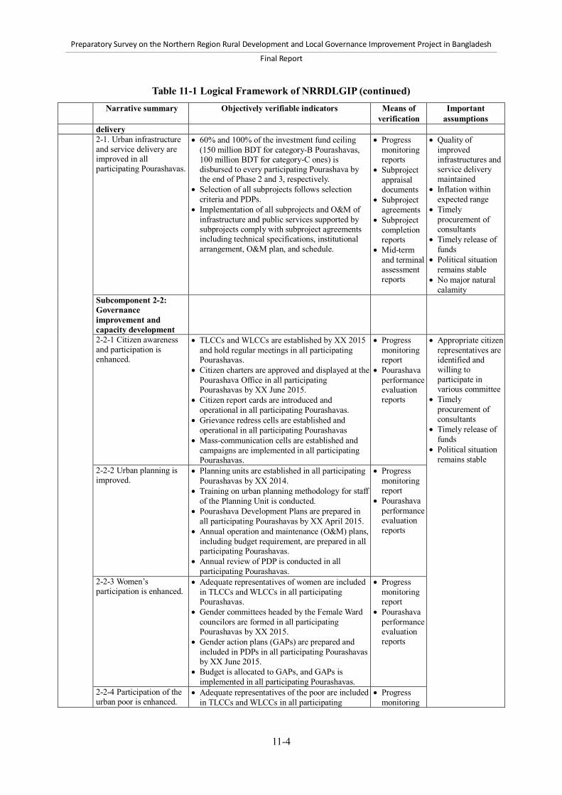
Preparatory Survey on the Northern Region Rural Development and Local Governance Improvement Project in Bangladesh
Final Report
11-4
Table 11-1 Logical Framework of NRRDLGIP (continued) Narrative summary Objectively verifiable indicators Means of
verification Important
assumptions delivery
2-1. Urban infrastructure and service delivery are improved in all participating Pourashavas.
60% and 100% of the investment fund ceiling (150 million BDT for category-B Pourashavas, 100 million BDT for category-C ones) is disbursed to every participating Pourashava by the end of Phase 2 and 3, respectively.
Selection of all subprojects follows selection criteria and PDPs.
Implementation of all subprojects and O&M of infrastructure and public services supported by subprojects comply with subproject agreements including technical specifications, institutional arrangement, O&M plan, and schedule.
Progress monitoring reports
Subproject appraisal documents
Subproject agreements
Subproject completion reports
Mid-term and terminal assessment reports
Quality of improved infrastructures and service delivery maintained
Inflation within expected range
Timely procurement of consultants
Timely release of funds
Political situation remains stable
No major natural calamity
Subcomponent 2-2: Governance improvement and capacity development
2-2-1 Citizen awareness and participation is enhanced.
TLCCs and WLCCs are established by XX 2015 and hold regular meetings in all participating Pourashavas.
Citizen charters are approved and displayed at the Pourashava Office in all participating Pourashavas by XX June 2015.
Citizen report cards are introduced and operational in all participating Pourashavas.
Grievance redress cells are established and operational in all participating Pourashavas
Mass-communication cells are established and campaigns are implemented in all participating Pourashavas.
Progress monitoring report
Pourashava performance evaluation reports
Appropriate citizen representatives are identified and willing to participate in various committee
Timely procurement of consultants
Timely release of funds
Political situation remains stable
2-2-2 Urban planning is improved.
Planning units are established in all participating Pourashavas by XX 2014.
Training on urban planning methodology for staff of the Planning Unit is conducted.
Pourashava Development Plans are prepared in all participating Pourashavas by XX April 2015.
Annual operation and maintenance (O&M) plans, including budget requirement, are prepared in all participating Pourashavas.
Annual review of PDP is conducted in all participating Pourashavas.
Progress monitoring report
Pourashava performance evaluation reports
2-2-3 Women’s participation is enhanced.
Adequate representatives of women are included in TLCCs and WLCCs in all participating Pourashavas.
Gender committees headed by the Female Ward councilors are formed in all participating Pourashavas by XX 2015.
Gender action plans (GAPs) are prepared and included in PDPs in all participating Pourashavas by XX June 2015.
Budget is allocated to GAPs, and GAPs is implemented in all participating Pourashavas.
Progress monitoring report
Pourashava performance evaluation reports
2-2-4 Participation of the urban poor is enhanced.
Adequate representatives of the poor are included in TLCCs and WLCCs in all participating
Progress monitoring

Preparatory Survey on the Northern Region Rural Development and Local Governance Improvement Project in Bangladesh
Final Report
11-5
Table 11-1 Logical Framework of NRRDLGIP (continued) Narrative summary Objectively verifiable indicators Means of
verification Important
assumptions Pourashavas.
Slum improvement committees (SICs) are formed in targeted slums in all participating Pourashavas.
Poverty Reduction Action Plans (PRAPs) are prepared by June 2015 in all participating Pourashavas.
Budget is allocated to PRAPs, and PRAPs are implemented in all participating Pourashavas.
report Pourashava
performance evaluation reports
2-2-5 Financial accountability and sustainability of Pourashavas are improved.
Annual budgets are displayed to the public at the all participating Pourashava offices.
Computerized accounting system is introduced and operated in all participating Pourashavas.
Computerized tax record system is introduced and operated in all participating Pourashavas.
Account and audit standing committees carry out audit of financial statements within 3 months after the closure of each fiscal year in all participating Pourashavas.
Interim tax assessment is carried out annually in all participating Pourashavas.
Tax collection rate is increased by at least 5% annually up to 80% in all participating Pourashavas.
Non-tax own revenue source is increased by at least inflation rate in all participating Pourashavas.
All outstanding overdue debt is fully paid in all participating Pourashavas.
All outstanding bills older than 3 months are fully paid in all participating Pourashavas.
Progress monitoring report
Pourashava performance evaluation reports
2-2-6 Administrative capacity of Pourashavas is improved.
Adequate staff structures are developed in all participating Pourashavas.
XX trainee-day training is imparted for elected representatives, and Pourashava officials.
Quarterly progress reports to PMO are prepared in time by PIUs in all participating Pourashavas.
Progress monitoring report
Pourashava performance evaluation reports
11.2 Monitoring arrangement 11.2.1 Progress monitoring The progress of the Project will be monitored according to GOB rules and the requirements of JICA. First, the Annual Development Program Review Format will be compiled on a monthly basis and submitted to the Local Government Division (LGD). Second, the Project Monitoring Form will be submitted to the Implementation, Monitoring, and Evaluation Division of the Ministry of Planning on a quarterly basis. Third, the Quarterly Report will be submitted to JICA. This report will include information on progress against the operation indicators of the following items: 1) physical works under Component 1; 2) soft activities such as training, poverty reduction program, and road safety enhancement under Component 1; 3) physical works and public service delivery under Subcomponent 2-1; and 4) governance improvement and capacity development under Subcomponent 2-2. Finally, the project completion report will be complied and submitted to JICA at project termination. The Project Management Office (PMO) will prepare those reports based on the reports from concerned organizations such as Supervision and Monitoring Offices, Project Implementation Offices, Project

Preparatory Survey on the Northern Region Rural Development and Local Governance Improvement Project in Bangladesh
Final Report
11-6
Implementation Units, and consultants; field investigations; and so forth. 11.2.2 Effect monitoring and evaluation Effect monitoring and evaluation will follow the LGED guidelines (LGED, 1999). In the first year of project implementation, the PMO with support from Benefit Monitoring and Evaluation (BME) consultants will conduct a baseline survey prior to the initiation of Component 1 in rural area and Component 2 in Pourashavas. The baseline survey should collect information on the indicators in the logical framework and other relevant socioeconomic conditions in the Project area. Based on the result of the baseline survey, the logical framework will be refined by the PMO with consent from JICA, and the effect monitoring and evaluation methodology will be finalized. Halfway through and towards the end of the project implementation period, the PMO with support from BME consultants will conduct a mid-term assessment and a terminal assessment, respectively. The assessment will follow the methodology of Benefit Monitoring and Evaluation and Socio-Economic Monitoring and Evaluation that the LGED has conducted for other similar projects in rural and urban areas. The survey items to be covered by the assessment should include at least the indicators in the logical framework.

Preparatory Survey on the Northern Region Rural Development and Local Governance Improvement Project in Bangladesh
Final Report
Reference-1
References Ahmed, M. F. and Rahman, M. M. (2010). Water Supply and Sanitation. Rural and Low Income Urban
Communities. Fourth edition. Dhaka: ITN-Bangladesh. Asian Development Bank (ADB). (2008a). Final Report Second Urban Governance and Infrastructure
Improvement Project (Project number: 40559, TA number: 4863-BAN). Manila: ADB. Asian Development Bank (ADB). (2008b). Report and Recommendation of the President to the Board
of Directors. People’s Republic of Bangladesh: Second Urban Governance and Infrastructure Improvement (Sector) Project. Philippines: Author.
Asian Development Bank (ADB). (2008c). “Review of the Approach and Principles of the World Bank-supported MSP and BMDF”. Final Report prepared for Second Urban Governance and Infrastructure Improvement (Sector) Project. Philippines: Author.
Asian Development Bank (ADB). (2012). Key Indicators for Asia and the Pacific 2012. Phillipines. As-Saber, S.N. & Rabbi, M.F. (2009). "Democratisation of the Upazila Parishad and Its Impact on
Responsiveness and Accountability: Myths versus Realities." Journal of Administration & Governance (JOAAG), Vol. 4, No. 2.
Association of Development Agencies in Bangladesh (ADAB) (2003). Directory of NGOs (Ready Reference) 2003-2004. Dhaka: Author.
Bangladesh Bureau of Statistics (BBS) and United Nations Children's Fund (UNICEF). (2008). Multiple Indicator Cluster Survey 2006. Volume II: District Tables. Dhaka: Authors.
Bangladesh Bureau of Statistics (BBS) and United Nations Children's Fund (UNICEF). (2010). Multiple Indicator Cluster Survey 2009. Volume I: Technical Report. Dhaka: Authors.
Bangladesh Bureau of Statistics (BBS). (2000). National Accounts Statistics of Bangladesh (Revised Estimates, 1989-90 to 1998-99). Dhaka: Author.
Bangladesh Bureau of Statistics (BBS). (2005). Population Census 2001. Zila Series: Dinajpur, Gaibandha, Kurigram, Lalmonirhat, Nilphamari, Panchagarh, Rangpur, Thakurgaon, Jamalpur, Kishoreganj, Mymensingh, Netrokona, Sherpur, Tangail. (14 separate books) Dhaka: Author.
Bangladesh Bureau of Statistics (BBS). (2007a). Economic Census 2001 & 2003. National Report. Dhaka: Author.
Bangladesh Bureau of Statistics (BBS). (2007b). Population Census 2001. National Series, Volume 1: Analytical Report. Dhaka: Author.
Bangladesh Bureau of Statistics (BBS). (2007c). Report of the Household Income & Expenditure Survey 2005. Dhaka: Author.
Bangladesh Bureau of Statistics (BBS). (2007d). Statistical Yearbook of Bangladesh 2006. Dhaka: Author.
Bangladesh Bureau of Statistics (BBS). (2007e). Report on Sample Vital Registration System, 2005-2006. Dhaka.
Bangladesh Bureau of Statistics (BBS). (2007f). 2005 Yearbook of Agriculture Statistics of Bangladesh. Dhaka.
Bangladesh Bureau of Statistics (BBS). (2008). Population Census 2001. National Series, Volume 4: Socio-Economic and Demographic Report. Dhaka: Author.
Bangladesh Bureau of Statistics (BBS). (2010a). Census of Agriculture 2008. Cropping Patterns. National Series Volume I. Dhaka: Author.
Bangladesh Bureau of Statistics (BBS). (2010b). Compendium of Environment Statistics of Bangladesh 2009. Dhaka: Author.

Preparatory Survey on the Northern Region Rural Development and Local Governance Improvement Project in Bangladesh
Final Report
Reference-2
Bangladesh Bureau of Statistics (BBS). (2010c). National Accounts Statistics (Provisional Estimates of GDP 2009-10 and Final Estimates of GDP, 2008-09). Dhaka: Author.
Bangladesh Bureau of Statistics (BBS). (2010d). Statistical Yearbook of Bangladesh, 2009. Dhaka: Author.
Bangladesh Bureau of Statistics (BBS). (2011a). 2010 Yearbook of Agricultural Statistics of Bangladesh. Dhaka: Author.
Bangladesh Bureau of Statistics (BBS). (2011b). Census of Agriculture 2008. Cropping Patterns. National Series Volume II. Dhaka: Author.
Bangladesh Bureau of Statistics (BBS). (2011c). Census of Agriculture 2008. Zila Series: Dinajpur, Gaibandha, Kurigram, Lalmonirhat, Nilphamari, Panchagarh, Rangpur, Thakurgaon, Jamalpur, Kishoreganj, Mymensingh, Netrokona, Sherpur, Tangail. (14 separate books) Dhaka: Author.
Bangladesh Bureau of Statistics (BBS). (2011d). National Accounts Statistics (Provisional Estimates of GDP 2010-11 and Final Estimates of GDP, 2009-10). Dhaka: Author.
Bangladesh Bureau of Statistics (BBS). (2011e). Population of Housing Census 2011. Preliminary Results. Dhaka: Author.
Bangladesh Bureau of Statistics (BBS). (2011f). Report on Labour Force Survey 2010. Dhaka: Author. Bangladesh Bureau of Statistics (BBS). (2011g). Report on Sample Vital Registration System 2009.
Dhaka: Author. Bangladesh Bureau of Statistics (BBS). (2011h). Report on Sample Vital Registration System 2010.
Dhaka: Author. Bangladesh Bureau of Statistics (BBS). (2011i). Statistical Yearbook of Bangladesh 2010. Dhaka:
Author. Bangladesh Bureau of Statistics (BBS). (2012). Report of the Household Income & Expenditure Survey
2010. Dhaka: Author. Bangladesh Road Transport Authority (BRTA). (2003a). Circular on reformation of
District/Metropolitan Road Safety Committee Reference No. SORE/BRTA/3M-8/96 (Bengali). Dhaka: Author.
Bangladesh Road Transport Authority (BRTA). (2003b). Circular on formation of Upazila Road Safety Committee Reference No. SP/BRTA/Road Safety24/2002 (part-1)-573 (Bengali). Dhaka: Author.
Bangladesh Road Transport Authority (BRTA). (2010). National Road Traffic Accident Report 2010. Dhaka: Author.
Bureau of Manpower Employment and Training (BMET). (2011). Bangladesh Expatriate Workers and their Contribution to National Development (Profile of migration, remittance and impact on economy). Dhaka: Author.
Bureau of Manpower Employment and Training (BMET). (unknown). Migration Scenario: Nature, Patterns and Trends. Dhaka: Author.
Economic Relations Division. (2011). Flow of External Resources to Bangladesh. Dhaka. Government of the People’s Republic of Bangladesh (GOB) and United Nations Development
Programme (UNDP) (2008). Project Document: Urban Partnership Poverty Reduction (UPPR) Project.
Government of the People’s Republic of Bangladesh (GOB). (1982). Acquisition and Requisition of Immovable Property Ordinance 1982. Dhaka: Author.
Government of the People’s Republic of Bangladesh (GOB). (1995). Environmental Conservation Act, 1995. Dhaka: Author.

Preparatory Survey on the Northern Region Rural Development and Local Governance Improvement Project in Bangladesh
Final Report
Reference-3
Government of the People’s Republic of Bangladesh (GOB). (1997). Environmental Conservation Rules, 1997. Dhaka: Author.
Government of the People’s Republic of Bangladesh (GOB). (2010). Outline Perspective Plan 2010-2021: Making Vision 2021 A Reality. Dhaka: Author.
Government of the People’s Republic of Bangladesh (GOB). (2011). Sixth Five Year Plan FY2011-FY2015 (Part 1, 2 and 3). Dhaka: Author.
International Monetary Fund (IMF). (2012). Bangladesh: Request for a Three-Year Arrangement under the Extended Credit Facility. IMF Country Report No.12/94. Washington, D.C.
Islam, K. M. N. (2006). Impacts of Flood in Urban Bangladesh: Micro & Macro Level Analysis. Dhaka: A H Development Publishing House.
Japan Bank for International Cooperation (JBIC). (2008). JBIC Pilot Study for Project Formation for the Small-Scale Infrastructure Project with the Integrated Approach to Rural Development in the People’s Republic of Bangladesh.
Japan Bank for International Cooperation (JBIC). (2009). Special Assistance for Project Formation for South-Western Bangladesh Rural Development Project, Final Report.
Japan International Cooperation Agency (JICA). (2007). Pourashava Governance: Final Report. Japan International Cooperation Agency (JICA). (2009). Final report of JICA Special Assistance for
Project Formulation (SAPROF) for South-Western Bangladesh Rural Development Project (SWBRDP). Japan: Author.
Japan International Cooperation Agency (JICA). (2010). Guidelines for Environmental and Social Considerations. Japan: Author.
Japan International Cooperation Agency (JICA). (2012a). Brochure on Commitment Procedure for Japanese ODA Loans. Japan: Author.
Japan International Cooperation Agency (JICA). (2012b). Brochure on Reimbursement Procedure for Japanese ODA Loans. Japan: Author.
Japan International Cooperation Agency (JICA). (2012c). Brochure on Special Account Procedure for Japanese ODA Loans. Japan: Author.
Japan International Cooperation Agency (JICA). (2012d). Brochure on Transfer Procedure for Japanese ODA Loans. Japan: Author.
Japan International Cooperation Agency (JICA). (2012e). General Terms and Conditions for Japanese ODA Loans. Japan: Author.
Local Government Division (LGD). (2000). Circular /Instruction letter on formation of District Road Users Committee and Upazila Road Users Committee Reference No. 2/n-7 / 2000 / 1457. (Bengali) Local Government Division, Ministry of Local Government, Rural Development and Cooperatives.
Local Government Division (LGD). (2001). Guidelines on shop allotment and women traders’ selection and guidelines on lease agreement and maintenance for existing or to-be-constructed WMS in government growth centers/rural markets (Bengali). Dhaka: Author.
Local Government Division (LGD). (2008). Principles for leasing Government Hat-bazar. Local Government Division (LGD). (2011a). Guideline on Government Hat/Bazaar Management,
Lease Procedures and Distribution of Income. Dhaka. Local Government Division (LGD). (2011b). Manual on Leasing Procedures, Management of
Government Owned Markets and Methods for Distribution of Incomes Amongst Union Parishad / Municipality / City Corporation. (Bengali) Dhaka: Author.
Local Government Division (LGD). (2012). Rural Road Maintenance Policy [Draft]. Dhaka.

Preparatory Survey on the Northern Region Rural Development and Local Governance Improvement Project in Bangladesh
Final Report
Reference-4
Local Government Engineering Department (LGED) and Japan International Cooperation Agency (JICA). (2005). Road Design Standards: Rural Roads. Dhaka: Author.
Local Government Engineering Department (LGED) and Rural Development and Infrastructure Wing, Planning Commission, in association with the World Bank. (1996). Bangladesh Rural Infrastructure Strategy Study. Dhaka.
Local Government Engineering Department (LGED). (1995). Manual for Growth Centre Planning. Dhaka.
Local Government Engineering Department (LGED). (1997). Guideline on Slum Improvement Activities: Secondary Towns Infrastructure Development Project-2 (written in Bengali). Dhaka: Author.
Local Government Engineering Department (LGED). (1998). Urban Drainage Manual. Volume 1: Design Manual. Dhaka: Author.
Local Government Engineering Department (LGED). (1999). Guidelines for Effect Monitoring and Evaluation (EME) of Road and Market Improvement. Dhaka: Author.
Local Government Engineering Department (LGED). (2004). Labor Contracting Society Management Guidelines. Dhaka: Local Government Division.
Local Government Engineering Department (LGED). (2005). Rural Roads Master Plan. Dhaka. Local Government Engineering Department (LGED). (2007). Socio-economic Monitoring and
Evaluation Report of Improved Upazila Roads & Growth Center Markets of Phase-I under Rural Transport Improvement Project (RDP-26). Dhaka
Local Government Engineering Department (LGED). (2008a). Development Project Proposal (DPP) for Second Urban Governance and Infrastructure Improvement (Sector) Project (UGIIP-2). Dhaka
Local Government Engineering Department (LGED). (2008b). Road Structures Manual for Double Lane Bridges, Part A: Design Criteria, Guidelines and Design Methods. Dhaka.
Local Government Engineering Department (LGED). (2008c). Road Structures Manual for Double Lane Bridges, Part B: Volume I Standard Drawings for Reinforced Concrete Bridges, Volume II Dhaka.
Local Government Engineering Department (LGED). (2008d). Road Structures Manual for Double Lane Bridges, Part C: Design Examples of Bridges, Culverts and Slope Protection Works. Dhaka.
Local Government Engineering Department (LGED). (2008e). Environmental Assessment Guidelines for LGED Projects. Dhaka: Author.
Local Government Engineering Department (LGED). (2010a). Development Project Proposal (DPP) for Sustainable Rural Infrastructure Improvement Project (SRIIP), December 2010
Local Government Engineering Department (LGED). (2010b). Development Project Proposal (DPP), Part-A for South- Western Bangladesh Rural Development Project, March 2010
Local Government Engineering Department (LGED). (2010c). Guideline for Implementation of Rural Roads and Culverts Maintenance Program. Dhaka.
Local Government Engineering Department (LGED). (2010d). Project Completion Report (PCR) for Municipal Services Project (MSP)
Local Government Engineering Department (LGED). (2011a). Consolidated Feasibility Study Report Documentation of RTIP-II.
Local Government Engineering Department (LGED). (2011b). Implementation Guideline of Slum Improvement Activities at the Pourashava Level (in Bengali). Dhaka: Author.

Preparatory Survey on the Northern Region Rural Development and Local Governance Improvement Project in Bangladesh
Final Report
Reference-5
Local Government Engineering Department (LGED). (2011c). MSU/UMSU Guidelines for the Implementation of Municipal Capacity Building Program (Bengali). Dhaka: Author
Local Government Engineering Department (LGED). (2011d). Project Monitoring Form of Second Rural Infrastructure Improvement Project (RIIP-II), November 2011.
Local Government Engineering Department (LGED). (2011e). Schedule of Rates July 2011 for each region of Mymensingh, Tangail, Rangpur and Dinajpur.
Local Government Engineering Department (LGED). (2012a). Basic Item’s Market Rate March/April 2012 for each region of Mymensingh, Tangail, Rangpur and Dinajpur.
Local Government Engineering Department (LGED). (2012b). Performance evaluation report of UGIIP-2(UGIAP phase-2). Dhaka: Author.
Local Government Engineering Department (LGED). (2012c). Rural Roads Maintenance Policy (Draft). Dhaka.
Local Government Engineering Department (LGED). (2012d). Rural Transport Improvement Project-II (RTIP-II) Preparation Study Report. Dhaka: Author.
Local Government Engineering Department (LGED). (2012e). Schedule of Rates July 2012 for each region of Mymensingh, Tangail, Rangpur and Dinajpur.
Ministry of Land. (2003). Land Administration Manual. Dhaka Ministry of Planning. (2003). The Public Procurement Regulation in 2003. Ministry of Planning. (2006). The Public Procurement Act 2006 (Act No.24 of 2006). Ministry of Planning. (2008a). Procedure for Implementation, processing, approval and revision of
Development Project in the Government Sector. Dhaka. Ministry of Planning. (2008b). The Public Procurement Rules in 2008 (Preliminary Draft). National Road Safety Council (NRSC). (2011). National Road Safety Strategic Action Plan 2011 –
2013. Dhaka. Planning Commission. (1984). Strategy for Rural Development Projects (A Sectoral Policy Paper).
Dhaka. Planning Commission. (2005). Unlocking the Potential: National Strategy for Accelerated Poverty
Reduction. Dhaka. Planning Commission. (2009). Steps Toward Change: National Strategy for Accelerate Poverty
Reduction II, FY 2009-2011. Dhaka. Raihan, S., Khondker, B. H., Sugiyarto, G., & Jha, S. (2009). Remittances and household welfare: A
case study of Bangladesh. ADB Economics Working Paper Series, 189. Philippines: Asian Development Bank.
Rashid, E. H. (1991). Geography of Bangladesh. (second edition). Dhaka: University Press. Rural Development and Cooperatives Division (RDCD). (2001). National Rural Development Policy
2001. Dhaka. Sharma, M. and Zaman, H. (2009). Who migrates overseas and is it worth their while? An assessment of
household survey data from Bangladesh. Policy Research Working Paper, 5018. Washington, D.C., USA: World Bank.
Van Schendel, W. (2009). A History of Bangladesh. Cambridge University Press. World Bank. (1999). Project Appraisal Document on the Municipal Services Project. Dhaka: South
Asia Region, World Bank. World Bank. (2010). Bangladesh Public Expenditure and Institutional Review: Volume I Main Report.

Preparatory Survey on the Northern Region Rural Development and Local Governance Improvement Project in Bangladesh
Final Report
Reference-6
World Bank. (2012). World Development Indicators 2012. Washington, D.C., USA: Author.