people around the houses with fire ... - yosothor › uploads › images › udaya ›...
TRANSCRIPT

63
PEOPLE AROUND THE HOUSES WITH FIRE: ARCHAEOLOGICAL INVESTIGATION OF SETTLEMENT AROUND THE
JAYAVARMAN VII ‘RESTHOUSE’ TEMPLES
Mitch HendricksonDepartment of Archaeology, University of Sydney
The ‘resthouse’ temples attributed to the reign of Jayavarman VII (1181-1220 CE) remain one ofthe most important yet enigmatic components of the Angkorian Khmer road system that spreads todayfrom Cambodia into northeast Thailand and southern Laos (Figure 1). Since Lunet de Lajonquière (1902:296) rediscovered the regularly-spaced temples along the Northwest and East roads a recurring issue in theliterature is whether these buildings served religious or practical purposes. This dichotomy is indicated bythe range of different names used by French and English scholars. French researchers variously use theterms Teap Chei (Lunet de Lajonquière 1902: 296), dharmaçala (Foucher 1903: 180; Finot 1925; Groslier1973: 117), maison du charité (Ibid.), gîte d’étape (Im 1998: 53; Dagens 2003: 70; see Cunin 2004), and maisonavec du feu/maison du feu (Cœdès 1940; Jacques and Lafond 2004: 387). English language publications similarlyemploy the term dharmasala (Freeman 1996: 14; Welch 1998: 213) but tend to refer to them as guest houses(Higham 1989: 337), rest-places (Snellgrove 2001: 108) or resthouses (Briggs 1951: 235; Chandler 1996: 61;Welch 1998: 213; Stark 2004: 109). Regardless of which name is used it is argued we need to consider thatthese structures simultaneously acted as both a home for the gods and part of resting places for travellersand officials moving along the road during the Angkorian period. Recent studies in the Greater Angkorarea (Greater Angkor Project 2003: 110-111) have demonstrated the dual or multiple roles of Angkorianinfrastructure (e.g., embankments as roads and canals) and that masonry buildings are part of largercomplexes comprising perishable or earthen features (e.g., moats, walls, secondary buildings).Archaeological investigation of occupation around the ‘resthouse’ temples is therefore required to documentthe presence and or extent of secondary features that would support their claim as resting places in theAngkorian past. Before discussing the appropriate term for these buildings they will be referred generically as“structures”.
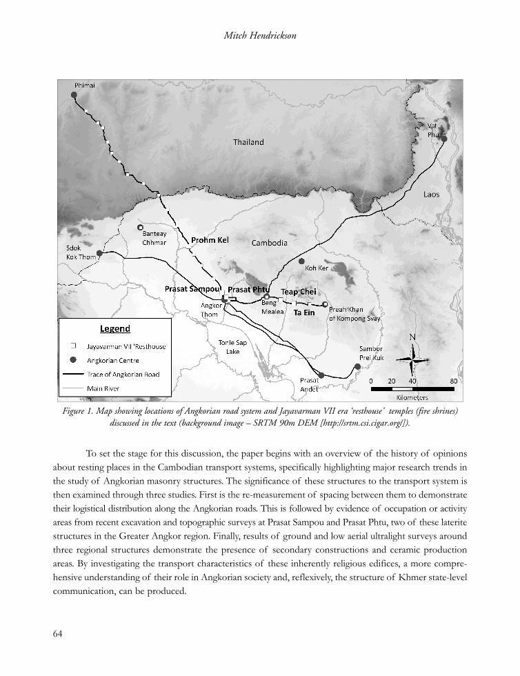
To set the stage for this discussion, the paper begins with an overview of the history of opinionsabout resting places in the Cambodian transport systems, specifically highlighting major research trends inthe study of Angkorian masonry structures. The significance of these structures to the transport system isthen examined through three studies. First is the re-measurement of spacing between them to demonstratetheir logistical distribution along the Angkorian roads. This is followed by evidence of occupation or activityareas from recent excavation and topographic surveys at Prasat Sampou and Prasat Phtu, two of these lateritestructures in the Greater Angkor region. Finally, results of ground and low aerial ultralight surveys aroundthree regional structures demonstrate the presence of secondary constructions and ceramic productionareas. By investigating the transport characteristics of these inherently religious edifices, a more compre-hensive understanding of their role in Angkorian society and, reflexively, the structure of Khmer state-levelcommunication, can be produced.
64
Mitch Hendrickson
Figure 1. Map showing locations of Angkorian road system and Jayavarman VII era ‘resthouse’ temples (fire shrines)discussed in the text (background image – SRTM 90m DEM [http://srtm.csi.cigar.org/]).

1. Salas and Fire Shrines: The History of Resting Places and Terminology.
Evidence of “resting places” associated with the Cambodian transport system is commonly foundfrom the Angkorian period to the modern day. During the dry season watering locations and shelter are anessential part of facilitating regional communication and are repeatedly mentioned in historic records. Thelate 13th century account of Zhou Daguan mentioned the presence of samnak (rest stops) (Zhou1902[1295-1296]: 173). While he does not actually describe the Jayavarman VII era structures, he comparesthem to Chinese post halts found along their main highways (Ibid.). Six centuries later, European explorersrepeatedly refer to rest stops or salas during their travels through Cambodia. Bastian, for instance, recordsstaying at wooden salas variably located beside ponds, rivers, monasteries or outside villages (2005[1864]:33; 45; 54; 101). Mouhot commented on the frequency of royal ‘stations’ spaced approximately 20 kmapart for the king on the route between Kampot and Udong (2000[1858-60] : 142). Albrecht’s survey alongone of the Southeast roads refers to a local tradition that the Southeast road from Angkor had a series ofétapes d’éléphant (elephant stops) marked by a monument (1905: 7). Unfortunately, no trace of these buildingsremains as locals informed Albrecht that the Thai destroyed these edifices during their control over theregion (Ibid.).
Resting places built of perishable materials no doubt played an important role in the Angkorianperiod but, like their more recent counterparts, have now faded from memory. Masonry structures* werefirst identified by Lunet de Lajonquière during his surveys along the Angkorian roads to Phimai(Northwest) and Preah Khan of Kompong Svay / Bakan (East) (1902 : 296). Initially referred to as teapchei, based on the similarities to a temple located 14 km east of Beng Mealea, these buildings are comprisedof a long hall, or mandapa, ending with a tower on the west end (Figure 2a-b). A total of seventeen such
65
People around the Houses with Fire
Figure 2. Examples of sandstone and laterite fire shrines. (Left) – Preah Khan at Angkor. (Right) – Prasat Sampou.
* Lunet de Lajonquière (1911 : xxix-xxx) identified a second set of structures along the East road opposite the ‘teap chei’ that areknown today as temples d’étapes (see Groslier 1973 : 118). Architectural style and configuration suggests these buildings date tothe early 12th century and therefore pre-date the Teap Chei buildings. For further discussion see Hendrickson 2007 : 149-157).

laterite structures are found along the Northwest road and three similar sandstone structures are presenton the East road between Beng Melea and Preah Khan of Kompong Svay. Attesting to the enigmatic roleof these buildings, a further five are found within temple enclosures – Ta Prohm (Angkor), Preah Khan(Angkor), Banteay Chhmar, Preah Khan of Kompong Svay, and Ta Prohm Bati – some of which are notconnected to the visible road system. A further and somewhat unique example, Prasat Phtu, is a considerabledistance from the trace of the Northwest road and is not within the confines of a temple enclosure, thenearest being the Preah Khan (Angkor).
Relatively little research has focussed specifically on the masonry structures since their initialdiscovery. The first and only publication specifically addressing the ‘teap chei’ temples was conducted byFinot (1925) who provided descriptions of the size, decoration, orientation, and spacing of the dharmaçalas,a term that suggests both a religious and secular role. Based on the sample of structures the average sizeof a dharmaçala was recorded as 14-15 m in length and 4-5 m in width. Current measurements (see Table 1)show the sandstone examples are slightly longer and wider on both the east and west ends of the building.A further cluster between the different masonry types is also visible in the length/width ratios. Both thelaterite and sandstone structures do share the Lokesvara motif depicted in the fronton. The sandstonebuildings, however, are more ornately decorated. Structurally both types commonly share features of threeto four open windows on the south side, while those on the north are filled in. It has been suggested thatthis is related to the position of the road as the dharmaçalas are normally found to the north of routes (Finot1925: 417-19). Building orientation, particularly along the Northwest road, follows the position of the roadrather than the typical east-west cardinal alignment of Angkorian architecture. This deviation has also beenused to suggest that practical rather than strict religious codes governed their construction (Lunet deLajonquière 1911: xxix ; see Mollerup 2008). Of all the characteristics, it is the regular spacing betweentemples that provides the justification for applying the specific term ‘resthouse’ that was initially presented byFinot (1925). Groslier (1997[1980]: 204) suggested that an average day’s travel in ancient Cambodia was 25km; this distance will act as a guide to determine whether the spacing between these structures would have
66
Mitch Hendrickson
Table 1. Comparison of size and ratios between laterite and sandstone fire shrines found along Angkorian roads andwithin temple enclosures.

been achievable during Angkorian times.
Both the sandstone and laterite ‘resthouse’ structures are attributed to the late 12th to early 13th
century and, most likely, to the reign of Jayavarman VII (1181-1220 CE). This chronological association isderived primarily from the Preah Khan stele dated to 1191 CE (see Cœdès 1941) and the decorative use ofthe Lokesvara motif. The stele describes a series of 121 vahni-griha found along three roads and in specificAngkorian temple enclosures; the correlation of the 17 vahni-griha listed to Vimaya (Phimai) corroboratesthe number found along the Phimai road (Ibid.). The Lokesvara motif, which represents the Buddha ofhealing, is associated with the switch to Buddhism as state religion for Jayavarman VII and his successorIndravarman II (1220-1270 CE).
Foucher (1903: 180) recognised that these structures served first and foremost religious purposesand were not simply ‘resthouses’, pointing out that stone is a material intended for the gods and not forhuman habitation. Translation of the Preah Khan stele also provided the first ‘true’ name of the resthouses– vahni-griha, or fire shrines – and potentially their direct association with religious/state-level practices.Jacques has recently supported the use of fire shrine as it more accurately represents the inscription andpossibly points to its role in housing a ‘sacred fire’, images of which are depicted being carried in processionson the walls of Angkor Wat, Banteay Chhmar and the Bayon (Jacques and Lafond 2004: 388). While heagrees that the fire shrines would have served as religious rest stops he rejects past assertions that theyfunctioned as gîtes d’étapes, or lodging stations, for travellers. He asserts that these mundane structures wouldhave been made of wood and thatch (Ibid.). To comply with the individual religious function of the stonestructures the term fire shrine is adopted for the rest of the paper.
2. The Practical Role of Fire Shrines
The ‘resthouse’ characteristic of the fire shrines is discussed from three different archaeologicaldata sets. The first section is the recalculation of the spacing between the temples and the implications thisdistance has on Angkorian travel times. The second presents the results of excavation and topographic surveycompleted by the Angkorian Dharmasala Project at the temples of Prasat Phtu and Prasat Sampou, thetwo closest fire shrines along the Northwest road. The final section discusses the results of landscape featuresidentified through ground and low level ultralight surveys around three remote fire shrines.
Spacing
The primary reason for including fire shrines in the transport system is that they are spaced at apractical distance for the modes of Angkorian transportation. Initial measurements between the 11 knownfire shrines on the Northwest and East roads were first recorded by Finot (1925) resulting in distancesbetween 1.6 and 108 km. Discovery of the remaining fire shrines along the Northwest road, including three
67
People around the Houses with Fire

recently identified by the Living Angkor Road Project (2008 : 249), results in an average distance of 16.11km. Distances along the East road between Beng Mealea and Preah Khan of Kompong Svay measuredfrom a new map of the Angkorian road system (see Hendrickson 2007) are slightly smaller with an aver-age of 14.8 km. Overall, the recalculated distances show that the fire shrines are indeed regularly spacedwith the laterite temples on the Northwest road being slightly further apart. An important feature of theEast road is the lack of fire shrines between Beng Mealea and Angkor. Given the distance to the capital(45.6 km) we should expect up to three more fire shrines. Either they have not been located, have not beenproperly identified, or were destroyed. A more intriguing hypothesis is that the temples were not meant tomonitor/facilitate transport all the way to Angkor.
The regular spacing between the fire shrines not only provides evidence that they served a practi-cal purpose but indicates how far people travelled in the Angkorian past. Groslier suggested that 25 kmwas an average distance per day; based on the data calculated here travel along the roads appears to beslightly longer at 30 km, with the fire shrines acting as midday and evening halts, or substantially shorter at15-16 km. If we assume the former distance is a better correlate the real-time trip between Beng Mealeaand Preah Khan of Kompong Svay would be approximately two to three days. Excluding the time requiredto travel up/down the Dangrek Range it would take four to five days to reach the escarpment from Angkorand a further four and a half to five and a half days to reach Phimai.
3. Prasat Sampou and Prasat Phtu
The religious importance and logistical positionof the fire shrines suggests we should find traces ofoccupation at or around the temples from one or twogroups. Based on the lists of people connected totemples from inscriptions, such as the Ta Prohm steleK.273, fire shrines should also have an attendant pop-ulation of monks living nearby and maintaining thetemples. The second type of archaeological signaturewould be from repeated visits by travellers, merchants,pilgrims and their animals. In both instances we shouldexpect to find evidence of housing structures, domesticactivities, and some trade goods. In January 2008, exca-vation and total station surveys were completedaround two laterite fire shrines, Prasat Sampou andPrasat Phtu in the Greater Angkor region (see Figure 3).
68
Mitch Hendrickson
Figure 3. Location of Prasat Sampou and Prasat Phtuin the Greater Angkor region (background data –
Pottier 1999 and Evans 2007).
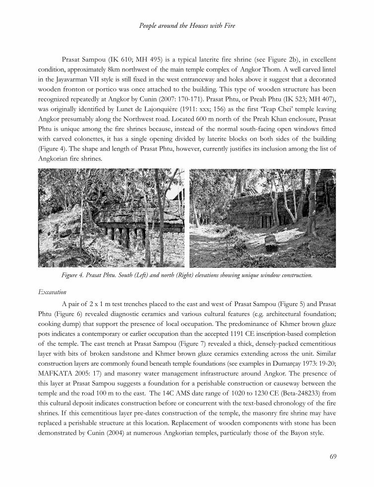
Prasat Sampou (IK 610; MH 495) is a typical laterite fire shrine (see Figure 2b), in excellentcondition, approximately 8km northwest of the main temple complex of Angkor Thom. A well carved lintelin the Jayavarman VII style is still fixed in the west entranceway and holes above it suggest that a decoratedwooden fronton or portico was once attached to the building. This type of wooden structure has beenrecognized repeatedly at Angkor by Cunin (2007: 170-171). Prasat Phtu, or Preah Phtu (IK 523; MH 407),was originally identified by Lunet de Lajonquière (1911: xxx; 156) as the first ‘Teap Chei’ temple leavingAngkor presumably along the Northwest road. Located 600 m north of the Preah Khan enclosure, PrasatPhtu is unique among the fire shrines because, instead of the normal south-facing open windows fittedwith carved colonettes, it has a single opening divided by laterite blocks on both sides of the building(Figure 4). The shape and length of Prasat Phtu, however, currently justifies its inclusion among the list ofAngkorian fire shrines.
Excavation
A pair of 2 x 1 m test trenches placed to the east and west of Prasat Sampou (Figure 5) and PrasatPhtu (Figure 6) revealed diagnostic ceramics and various cultural features (e.g. architectural foundation;cooking dump) that support the presence of local occupation. The predominance of Khmer brown glazepots indicates a contemporary or earlier occupation than the accepted 1191 CE inscription-based completionof the temple. The east trench at Prasat Sampou (Figure 7) revealed a thick, densely-packed cementitiouslayer with bits of broken sandstone and Khmer brown glaze ceramics extending across the unit. Similarconstruction layers are commonly found beneath temple foundations (see examples in Dumarçay 1973: 19-20;MAFKATA 2005: 17) and masonry water management infrastructure around Angkor. The presence ofthis layer at Prasat Sampou suggests a foundation for a perishable construction or causeway between thetemple and the road 100 m to the east. The 14C AMS date range of 1020 to 1230 CE (Beta-248233) fromthis cultural deposit indicates construction before or concurrent with the text-based chronology of the fireshrines. If this cementitious layer pre-dates construction of the temple, the masonry fire shrine may havereplaced a perishable structure at this location. Replacement of wooden components with stone has beendemonstrated by Cunin (2004) at numerous Angkorian temples, particularly those of the Bayon style.
69
People around the Houses with Fire
Figure 4. Prasat Phtu. South (Left) and north (Right) elevations showing unique window construction.
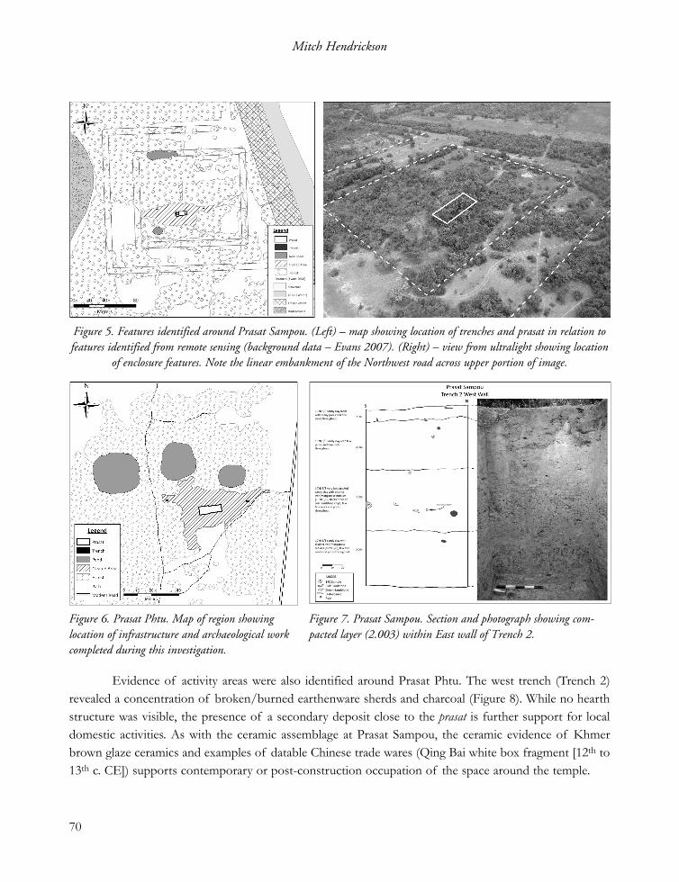
Evidence of activity areas were also identified around Prasat Phtu. The west trench (Trench 2)revealed a concentration of broken/burned earthenware sherds and charcoal (Figure 8). While no hearthstructure was visible, the presence of a secondary deposit close to the prasat is further support for localdomestic activities. As with the ceramic assemblage at Prasat Sampou, the ceramic evidence of Khmerbrown glaze ceramics and examples of datable Chinese trade wares (Qing Bai white box fragment [12th to13th c. CE]) supports contemporary or post-construction occupation of the space around the temple.
70
Mitch Hendrickson
Figure 6. Prasat Phtu. Map of region showinglocation of infrastructure and archaeological workcompleted during this investigation.
Figure 7. Prasat Sampou. Section and photograph showing com-pacted layer (2.003) within East wall of Trench 2.
Figure 5. Features identified around Prasat Sampou. (Left) – map showing location of trenches and prasat in relation tofeatures identified from remote sensing (background data – Evans 2007). (Right) – view from ultralight showing location
of enclosure features. Note the linear embankment of the Northwest road across upper portion of image.

Survey
Ground, ultralight and topo-graphic surveys were completedto document evidence ofinfrastructure and occupationaround Prasat Sampou andPrasat Phtu. Evans’ (2007)map of the greater Angkorregion indicates Prasat Sampouis surrounded by two rectilinearfeatures (see Figure 9). It isapparent now that the northpond documented in Figure 5is part of a moat. Low levelaerial surveys from an ultra-light identified also rectilinear
arrangement of vegetation around the site that may be the remnants of an enclosing wall or moat. On theground, a slight north-south rise between the two west features and at the northeast ‘corner’ both indicatethe presence of infrastructure around the fire shrine; whether this was a base of a wooden rampart surroundedby a moat is uncertain at this time. Presence of walls/moats is not direct evidence for settlement but doesindicate a separation of space for specific activities, be they ritual or secular.
71
People around the Houses with Fire
Figure 8. Prasat Phtu. Section and photograph showing location of ceramic con-centration (2.004-2.005) from West wall of Trench 2.
Figure 9. Examples of multi-component landscapes around fire shrines. Left – Prasat Sampou (background data – Evans2007). Right – Teap Chei (background image – Finnmap 1:25000 air photograph [February 1993 Roll 08 Strip 32w
1978]).

No clear evidence of settlement mounds was identified at either Prasat Sampou or Phtu. Thelandscape around both fire shrines, however, contained the remains of several small ponds. Unlike rectilineartrapeang commonly associated with larger Angkorian temples and temple enclosures, these small ponds arenot regularly placed and are amorphous in shape. The fact that regularly-spaced ponds are an importantpart of the Angkorian transport system (see Hendrickson 2007) further supports the idea that ponds wouldbe found around fire shrines for travellers and their beasts of burden. Combined with the excavationresults there is strong evidence to suggest that fire shrines are not isolated temples but were the centre ofa broader complex that supported different activity areas.
4. Regional Surveys: Teap Chei, Prohm Kel, Ta Ein
Surveys conducted around three fire shrines beyond Angkor (see Figure 1) similarly succeeded inidentifying remains of secondary infrastructure and activity areas. Ponds again are the most common featureat each temple though position, shape and number show considerable variation. Prohm Kel, situated 65km from Angkor along the Northwest road, is surrounded by up to five small ponds and the remains of alow laterite wall (Figure 10). Constructed of a single block on the edge of the laterite foundation, this wallrepresents the only division of space around a fire shrine using masonry. One pond was discovered at TeapChei and Ta Ein; the example at Ta Ein – whose fire shrine is largely destroyed – is unique among thosesurveyed as it is both rectilinear and lined with stone. Both of these characteristics show a greater affinityto ponds found in hospital chapel complexes than to the fire shrines.
72
Mitch Hendrickson
Figure 10. Prohm Kel. Left - aerial view of ponds and walls around fire shrine. Right – plan showing location of infra-structure recorded with GPS.

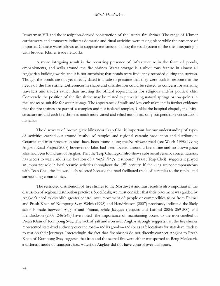
Clear evidence for intensive activity around fire shrines is the discovery of three Khmer brownglaze kilns near Teap Chei (see Hendrickson 2008). Located south of the fire shrine, the kilns are also closeto a seasonally flooded area thus providing a vital water resource for ceramic manufacture and kiln cooling. Inaddition to the ceramic production sites the surveys noted numerous ceramic concentrations and twoAngkorian masonry bridges (see Figure 9). The proximity of Prasat Teap Chei, one of the SuryavarmanII-era (1113-1150 CE) temples d’étapes along the East road, also highlights the significance of this area duringthe first half of the 12th century. The presence of multiple features highlights the dynamic nature of theTeap Chei locale and demonstrates the need to examine temples within their landscape instead of as isolatedbuildings. This strongly suggests that fire shrines, and likely their temple d’étape predecessors, may haveplayed an active role not only in supplying a safe place for travellers to stop but also as accessible andstate-regulated locations for the production and or distribution of valued commodities. Further detailedsurvey around the remaining fire shrines is required to clarify whether Teap Chei is an anomaly or rep-resentative of their role within Angkorian industries.
5. Discussion
The use of multiple descriptors for these unique buildings represents an unnecessary dichotomybetween the religious purpose(s) of the temple versus their collective role in the regional communicationsystem. It is accepted from the small internal dimensions and use of masonry that they were notaccommodation for people. Use of the term fire shrine, or maison avec du feu, is therefore appropriate as itrepresents one of the actual functions described in the Preah Khan stele. Adoption of this term shouldnot, however, detract from their role within the Angkorian transport system. Chapels, postal stations andinns commonly found in state-level transport systems are all referred to as forms of resthouses. For thisreason, it is also appropriate to refer to fire shrines and the temples d’étapes as two types of resthouseinfrastructure within the Angkorian system.
The data presented here demonstrates that fire shrines were an integral piece of Khmer transportinfrastructure. Written accounts from the 13th to 19th centuries show that resting places for travellers andthe ruling elite have a long history in Cambodia. Lunet de Lajonquière recognized the spacing and orientationof the fire shrines, characteristics that separate them from other Khmer temple types. Remeasuring thedistance between the fire shrines both corroborates this interpretation and additionally indicates that travellerswere able to move at an average of 30 km per day along Angkor’s main roads.
Completion of the first comprehensive excavation and surveys around the fire shrines demonstratesthat while they were ‘islands’ of Khmer state control, the area around them was far from isolated and/oruninhabited. Test trenches at Prasat Sampou and Prasat Phtu produced subsurface features (cookingremains, foundation) that, based on the ceramics and 14C AMS date, correspond with the era of
73
People around the Houses with Fire
Jayavarman VII and the inscription-derived construction of the laterite fire shrines. The range of Khmerearthenware and stoneware indicates domestic and ritual activities were taking place while the presence ofimported Chinese wares allows us to suppose transmission along the road system to the site, integrating itwith broader Khmer trade networks.
A more intriguing result is the recurring presence of infrastructure in the form of ponds,embankments, and walls around the fire shrines. Water storage is a ubiquitous feature in almost allAngkorian building works and it is not surprising that ponds were frequently recorded during the surveys.Though the ponds are not yet directly dated it is safe to presume that they were built in response to theneeds of the fire shrine. Differences in shape and distribution could be related to concern for assistingtravellers and traders rather than meeting the official requirements for religious and/or political elite.Conversely, the position of the fire shrine may be related to pre-existing natural springs or low-points inthe landscape suitable for water storage. The appearance of walls and low embankments is further evidencethat the fire shrines are part of a complex and not isolated temples. Unlike the hospital chapels, the infra-structure around each fire shrine is much more varied and relied not on masonry but perishable constructionmaterials.
The discovery of brown glaze kilns near Teap Chei is important for our understanding of typesof activities carried out around ‘resthouse’ temples and regional ceramic production and distribution.Ceramic and iron production sites have been found along the Northwest road (see Welch 1998; LivingAngkor Road Project 2008) however no kilns had been located around a fire shrine and no brown glazekilns had been found east of Angkor. That the Teap Chei region also shows substantial ceramic concentrations,has access to water and is the location of a temple d’étape ‘resthouse’ (Prasat Teap Chei) suggests it playedan important role in local ceramic activities throughout the 12th century. If the kilns are contemporaneouswith Teap Chei, the site was likely selected because the road facilitated trade of ceramics to the capital andsurrounding communities.
The restricted distribution of fire shrines to the Northwest and East roads is also important in thediscussion of regional distribution practices. Specifically, we must consider that their placement was guided byAngkor’s need to establish greater control over movement of people or commodities to or from Phimaiand Preah Khan of Kompong Svay. Welch (1998) and Hendrickson (2007) previously indicated the likelysalt-fish trade between Angkor and Phimai, while Jacques (Jacques and Lafond 2004: 259-300) andHendrickson (2007: 246-248) have noted the importance of maintaining access to the iron smelted atPreah Khan of Kompong Svay. The lack of salt and iron near Angkor strongly suggests that the fire shrinesrepresented state-level authority over the road – and its goods – and/or as safe locations for state-level tradersto rest on their journeys. Interestingly, the fact that fire shrines do not directly connect Angkor to PreahKhan of Kompong Svay suggests that iron and the sacred fire were either transported to Beng Mealea viaa different mode of transport (i.e., water) or Angkor did not have control over this route.
74
Mitch Hendrickson

A final issue that needs to be raised is construction dates of the laterite and sandstone fire shrines,and particularly the inclusion of Prasat Phtu within this group of resthouse temples. Fire shrines share thesame basic composition and spacing along roads but there are some subtle differences in length, decorationand ratio between those constructed of sandstone and those in laterite. The laterite fire shrines are almostcertainly those named in the 1191 CE Preah Khan stele. Jacques (2007: 40) argues that since the fire shrinesof Banteay Chhmar and Preah Khan of Kompong Svay (Prasat Kuk) are not mentioned in the Preah Khanstele that these sandstone structures post-date the laterite examples. Given the similarity in shape anddecoration of Teap Chei we can similarly presume that those on the East road were later constructions.Prasat Phtu, while sharing the correct dimensions is distinguished from its laterite counterparts by thepresence of north and south facing windows divided by laterite blocks and its location. Lunet deLajonquière suggested that Prasat Phtu was the first fire shrine along the Northwest road, positionedapproximately 1.6 km northeast of the north gate of Angkor Thom. Prasat Phtu is located close to theentrance of the Preah Khan temple – and the stele describing the fire shrines – however the road east ofPhtu does not link directly to the north gate and may be a modern construction. Others, including theauthor (see Hendrickson 2007; Living Angkor Project 2008) have previously suggested that Prasat Sampouis the first fire shrine on the Northwest road to Phimai, whose embankment is clearly visible 100m to itseast. Currently the network of canals and embankments south of Sampou prevent us from clearly followingthe Northwest road into the capital Angkor. Determining where the road begins – at Angkor Thom orPreah Khan – is a crucial task for assessing whether Prasat Phtu is an antecedent or descendent of the lateritefire shrine type. The fact that Preah Khan has a fire shrine and Angkor Thom does not is an importantpoint that needs to be considered in the perambulation of the supposed sacred fire.
Jacques, a strong proponent of the religious function of fire shrines, conceded the important pointthat we need to identify the function of these buildings in order to better understand the role of theAngkorian roads (see Jacques and Lafond 2004: 286). Since we are restricted to historic records of the‘sacred fire’ that was purported to have been stored at these temples, we are left to explore their concurrentpurpose as a resting place within the transportation system from archaeological evidence. Findings presentedhere from historic documents, excavation, and surveys have successfully identified their secular role as atype of ‘resthouse’ temple. Discovery of occupation, water storage and production centres demonstratesthat fire shrines are not isolated temples ignored by travellers and pilgrims on their travels to and fromAngkor. The fire shrines represent the most visible feature of a greater complex within the Angkorianlandscape. With clearance of land mines from around these sites, further work will no doubt shed morelight on the important religious, political, economic and social roles that these buildings played inAngkorian society.
75
People around the Houses with Fire

Acknowledgements
This research was aided by a Postdoctoral Fellowship for East Asian Archaeology and EarlyHistory from the American Council of Learned Societies, with funding from the Henry Luce Foundationheld at the University of Calgary, the Social Sciences Humanities Research Council of Canada DoctoralFellowship, and the Australian Research Council (Discovery Project 0558130). I would like to thank indi-vidually the Greater Angkor Project, An Sopheap, APSARA Authority, Christophe Pottier and the ÉcoleFrançaise d’Extrême Orient, Donald Cooney of Angkor Ultralight Services, Dougald O’Reilly andHeritageWatch, Lanh Udomrangsey, Andrew Wilson, Ngaire Richards, Caitlin Evans, Son Chanthoeun,Chan Sovichetra and Damian Evans who assisted in various ways in the field and out. I would also like tothank Roland Fletcher, Liz Holt and Eileen Lustig who read early drafts of this work. Any inconsistenciesor errors are solely my own.
References cited
Albrecht, M. 1905. « Reconnaissance de l’ancienne chaussée khmère ». Bulletin de la Societé des ÉtudesIndochinoises, Saigon: 3-17.
Bastian, A. 2005[1864]. A Journey in Cambodia and Cochin-China (1864). Bangkok: White Lotus Press.Briggs, L. P. 1951. The Ancient Khmer Empire. Philadelphia: The American Philosophical Society.Chandler, D. 1996. A History of Cambodia. Boulder: Westview Press.Cœdès, G. 1940. « Les gîtes d’étapes de la fin du XIIe siècle ». Bulletin de l’École Française d’Extrême-Orient
40: 347-349.Cœdès, G. 1941. « La Stèle du Práh Khan d’Angkor ». Bulletin de l’École Française d’Extrême-Orient 41: 255-302.Cunin, O. 2004. De Ta Prohm au Bayon. Analyse comparative de l’histoire architecturale des principaux monuments du
style du Bayon. Unpublished PhD Thesis. L’Institut National Polytechnique de Lorraine.Cunin, O. 2007. « The Bayon: an archaeological and architectural study », Bayon: New Perspectives, ed.
Clark, J., Bangkok, River Books: 136-229.Dagens, B. 2003. Les Khmers. Guide Belles Lettres des Civilisations. Paris: Les Belles Lettres.Dumarçary, J. 1973. Histoire Architecturale du Temple. Le Bayon, Paris, EFEO: 1-76.Evans, D. 2007. Putting Angkor on the Map: A New Survey of a Khmer ‘Hydraulic City’ in Historical and
Theoretical Context. Unpublished PhD thesis. Department of Archaeology, University of Sydney.Finot, L. 1925. « Dharmaçalas au Cambodge ». Bulletin de l’École Française d’Extrême Orient 25: 417-422.
76
Mitch Hendrickson

Foucher, A. 1903. « Nouvelles et Mélanges. Critique de E. Lunet de Lajonquière, 1902, Inventaire des-criptif des monuments du Cambodge ». Journal Asiatique, 10: 174-180.
Freeman, M. 1996. A Guide to Khmer temples in Thailand and Laos. New York: Weatherhill.Greater Angkor Project. 2003. « Redefining Angkor: Structure and environment in the largest, low densi-
ty urban complex of the pre-Industrial world ». UDAYA 4: 107-126.Groslier, B. P. 1973. Les Inscriptions du Bayon. Le Bayon, pp. 83-308. Paris: EFEO.Groslier, B. P. 1997 [1980]. « Prospection des sites Khmers du Siam », Mélanges sur l’archéologie du Cambodge
(1949-1986), Paris, Presses de l’EFEO: 189-220.Hendrickson, M. 2007. Arteries of Empire: An Operational Study of Transport and Communication in Angkorian
Southeast Asia (9th to 15th centuries CE). Unpublished PhD thesis. Department of Archaeology,University of Sydney.
Hendrickson, M. 2008. « New evidence of brown glaze stoneware kilns along the East road fromAngkor ». Bulletin of the Indo-Pacific Prehistory Association 28: 52-56.
Higham, C. 1989. The Archaeology of Mainland Southeast Asia. Cambridge: Cambridge University Press.Im, S. 1998. Réseaux routiers et moyen de transport à l’époque angkorienne du IXème au XIVème siècles. Unpublished
Master of Arts Thesis. École des Hautes Études en Sciences Sociales, Paris.Jacques, C. 2007. « The historical development of Khmer culture from the death of Suryavarman II to
the 16th century », Bayon: New Perspectives, ed. Clark, J., Bangkok, River Books: 28-49..Jacques, C. & Lafond, P. 2004. L’Empire Khmer. Cités et Sanctuaires Vème-XIIIème siècle. Paris: Fayard.Living Angkor Road Project 2008. Living Angkor Road Project Phase II. Nakon Nayok, Chulachomklao
Royal Military Academy. http://larp.crma.ac.th/larp/report/fullreport/RDG50O0003.PDF.Lunet de Lajonquière, É. 1902. Inventaire Descriptif des Monuments du Cambodge, t. I, Paris: Ernest Leroux.Lunet de Lajonquière, É. 1911. Inventaire Descriptif des Monuments du Cambodge, t. III, Paris: Ernest Leroux.Mission Archéologique Franco-Khmère sur l’Aménagement du Territoire Angkorien (MAFKATA) 2005.
Campagne 2005. Rapport. Siem Reap: EFEO.Mollerup, A. 2008. The Dharmasala Route from Angkor to Phimai - an ancient route in revival. http://www.sun-
dial.thai-isan-lao.com/dharmasalaroute.htmlMouhot, H. 2000 [1858-60]. Travels in Siam, Cambodia, Laos, and Annam. Bangkok: White Lotus. Snellgrove, D. L. 2001. Khmer Civilization and Angkor. Bangkok: Orchid Press.Stark, M. T. 2004. « Pre-Angkorian and Angkorian Cambodia », A Cultural History of Southeast Asia: From
Earliest Times to the Indic Civilizations, eds. Bellwood, P. and Glover, I., New York, RoutledgeCurzon Press: 89-119.
Welch, D. J. 1998. « Archaeology of Northeast Thailand in Relation to the Pre-Khmer and KhmerHistorical Record ». International Journal of Historical Archaeology 2: 205-233.
Zhou, D. 1902[1295-1296]. « Mémoires sur les coutumes du Cambodge. Traduits et annotés par P. Pelliot ».Bulletin de l’École Française d’Extrême Orient 2: 123-177.
77
People around the Houses with Fire

segçbPeople around the Houses with Fire: Archaeological investigation of settlement
around the Jayavarman VII ‘resthouse’ temples
eday Mitch Hendrickson
GtßbTenHBinitüeTAelImuxgarén {salasMNak;} sagkñúgraCüRBH)TC½yvr μ ½nTI7 tambeNþayfñl;
EdlecjBIGgÁreTAxagBayBünwgxagekIt. GñkRsavRCavBImunmkehAGaKarRbePTenHtameQ μaHepSg²Kña eFVI(
eyIgyl;faGaKarenHbeRmIsasna $mannaTIFm μtaenAkñúgbNþajpøÚvsm½yGgÁr. edaysarKeRmag {Angkorian
Dhamasala Project} enH mankareFVIkMNayCaelIkTImYy ehIyeFVIeLIgenATItaMgGaKarpg CuMvijenaHpg. eyIgehA
GaKarenH(RtwmRtUvfa {ehaePøIg} ehIydwgfaehaenHBuMEmnsageLIgeTalEtÉgeT KWRKan;EtCaEpñkmYyb:ueNÑaHén
TItaMgshKmn_mnusS EdlmandIFøIlMenAsßan/ kMEBg/ RtBaMg/ LeFVIPaCn_CaedIm. lT§plkMNay(eyIgyl;kan;Et
c,as;GMBInaTIénehaePøIg kñúgRkbx½NÐénkarRKb;RKgGaNacRkTaMgmUl. CaBiesseTAeTot KWCRmuj(eyIgKitfa
RtUveFVIkMNayrebobenHteTAeTot kñúgkarRsavRCavGMBIsMNg;EdleFVIBIvtßúFatuqab;BukpuynigsMNl;EdlemIl
BuMeXIjEsþgEdlenAsl;BIsm½yGgÁrmk.
AbstractPeople around the Houses with Fire: Archaeological investigation of settlement around the Jayavarman VII ‘resthouse’ templesMitch Hendrickson
This paper examines the function of the Jayavarman VII era ‘resthouse temples’ found along theNorthwest and East roads from Angkor. Over the past century, academic publications have used numerousterms for these buildings implying that they played a religious or pragmatic purpose within the Angkoriantransport system. The Angkorian Dharmasala Project represents the first direct archaeological investigationof these buildings, properly referred to as fire shrines, within their surrounding landscape. Through acombination of excavation and survey it is demonstrated that the fire shrines are not isolated religious edifices.Instead the fire shrine represents the best preserved component of a larger community structure, whichcan include subsurface settlement activity, walled complexes, reservoirs, and ceramic kilns. These resultsgreatly expand our understanding of the dual role of fire shrines within the territorial control mechanismsof the Khmer Empire and, more broadly, provide impetus for conducting similar archaeological researchfor perishable or ‘less-visible’ remains around Angkorian period temples.
78
Mitch Hendrickson

RésuméPeople around the Houses with Fire: Archaeological investigation of settlement around the Jayavarman VII ‘resthouse’ templesMitch Hendrickson
Cet article tente d’explorer la fonction des « chapelles de gîte » de l’époque de Jayavarman VIItrouvées le long des chaussées nord-ouest et est partant d’Angkor. On trouve dans les publications du siècledernier de nombreux termes utilisés pour désigner ces constructions, suggérant leur destination religieuseou pragmatique dans le système des transports angkorien. Le projet de recherche sur les dharmasalaangkoriens constitue la première recherche archéologique sur ces constructions, correctement désignéespar « chapelles du feu », considérées dans leurs ensembles respectifs. Fouilles et sondages montrent que leschapelles du feu n’étaient pas des édifices religieux isolés, mais qu’elles représentent seulement les élémentsles mieux préservés des structures communautaires comprenant aires d’occupation, complexes d’enceintes,réservoirs, fours de céramique. Dès lors nous percevons beaucoup mieux le double rôle des chapelles dufeu au sein des mécanismes de contrôle de l’Empire khmer, et nous sommes confortés dans l’idée qu’il fautappliquer le même procédé de recherche aux vestiges périssables ou moins visibles autour des templesangkoriens.
79
People around the Houses with Fire