paper 1.1 advanced geomorphology · lebon – human geography 5. ... mapping of physical and...
TRANSCRIPT
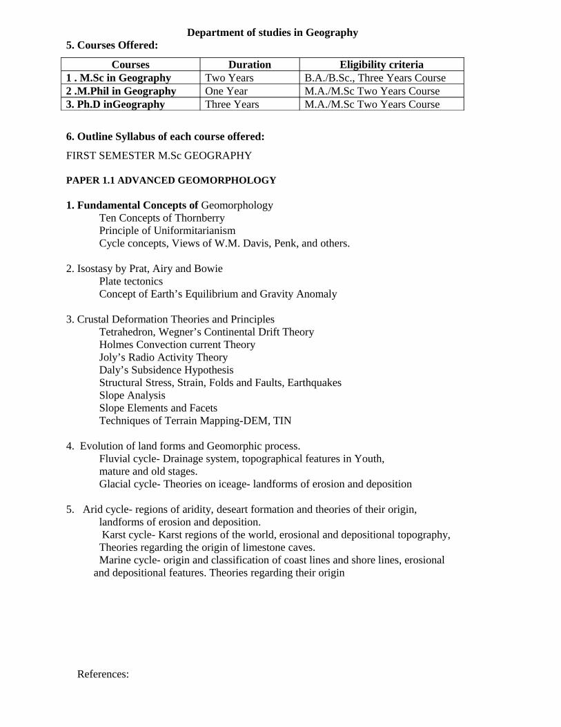
Department of studies in Geography5. Courses Offered:
Courses Duration Eligibility criteria1 . M.Sc in Geography Two Years B.A./B.Sc., Three Years Course2 .M.Phil in Geography One Year M.A./M.Sc Two Years Course3. Ph.D inGeography Three Years M.A./M.Sc Two Years Course
6. Outline Syllabus of each course offered:
FIRST SEMESTER M.Sc GEOGRAPHY PAPER 1.1 ADVANCED GEOMORPHOLOGY
1. Fundamental Concepts of GeomorphologyTen Concepts of Thornberry
Principle of UniformitarianismCycle concepts, Views of W.M. Davis, Penk, and others.
2. Isostasy by Prat, Airy and BowiePlate tectonicsConcept of Earth’s Equilibrium and Gravity Anomaly
3. Crustal Deformation Theories and PrinciplesTetrahedron, Wegner’s Continental Drift TheoryHolmes Convection current Theory
Joly’s Radio Activity TheoryDaly’s Subsidence HypothesisStructural Stress, Strain, Folds and Faults, EarthquakesSlope Analysis Slope Elements and FacetsTechniques of Terrain Mapping-DEM, TIN
4. Evolution of land forms and Geomorphic process. Fluvial cycle- Drainage system, topographical features in Youth, mature and old stages. Glacial cycle- Theories on iceage- landforms of erosion and deposition
5. Arid cycle- regions of aridity, deseart formation and theories of their origin, landforms of erosion and deposition.
Karst cycle- Karst regions of the world, erosional and depositional topography, Theories regarding the origin of limestone caves. Marine cycle- origin and classification of coast lines and shore lines, erosional and depositional features. Theories regarding their origin
References:
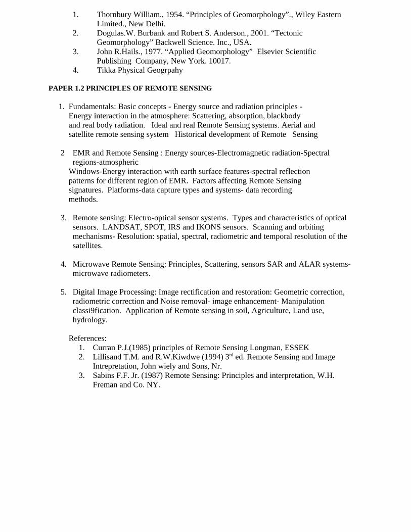
1. Thornbury William., 1954. “Principles of Geomorphology”., Wiley Eastern Limited., New Delhi.
2. Dogulas.W. Burbank and Robert S. Anderson., 2001. “Tectonic Geomorphology” Backwell Science. Inc., USA.
3. John R.Hails., 1977. “Applied Geomorphology” Elsevier Scientific Publishing Company, New York. 10017.
4. Tikka Physical Geogrpahy
PAPER 1.2 PRINCIPLES OF REMOTE SENSING
1. Fundamentals: Basic concepts - Energy source and radiation principles - Energy interaction in the atmosphere: Scattering, absorption, blackbody and real body radiation. Ideal and real Remote Sensing systems. Aerial and satellite remote sensing system Historical development of Remote Sensing
2 EMR and Remote Sensing : Energy sources-Electromagnetic radiation-Spectral regions-atmospheric
Windows-Energy interaction with earth surface features-spectral reflection patterns for different region of EMR. Factors affecting Remote Sensing signatures. Platforms-data capture types and systems- data recording methods.
3. Remote sensing: Electro-optical sensor systems. Types and characteristics of optical sensors. LANDSAT, SPOT, IRS and IKONS sensors. Scanning and orbiting mechanisms- Resolution: spatial, spectral, radiometric and temporal resolution of the satellites.
4. Microwave Remote Sensing: Principles, Scattering, sensors SAR and ALAR systems- microwave radiometers.
5. Digital Image Processing: Image rectification and restoration: Geometric correction, radiometric correction and Noise removal- image enhancement- Manipulation classi9fication. Application of Remote sensing in soil, Agriculture, Land use, hydrology.
References:1. Curran P.J.(1985) principles of Remote Sensing Longman, ESSEK2. Lillisand T.M. and R.W.Kiwdwe (1994) 3rd ed. Remote Sensing and Image
Intrepretation, John wiely and Sons, Nr.3. Sabins F.F. Jr. (1987) Remote Sensing: Principles and interpretation, W.H.
Freman and Co. NY.

PAPER 1.3 APPLIED ECONOMIC GEOGRAPHY
1. Nature, Scope and importance of Economic Geography, Evolution of Economic Geography, approaches to economic Geography, Concept of Economy, Simple model of economy, Spatial structure of the economy, Economy and economic Geography.
2. Decision making: Types and Mechanism of Decision making, Effects of time and Space and Price, Government Intervention in price Mechanism.
3. Consumer behavior and the economy, Analysis of Consumer behavior in Space, Location of Economic Activities, Production decisions, Choice of output, technique and location, Location and allocation model, Market centers- Origin and types, Retail and whole sale, periodic and daily market.
4. Interaction: Generalization of movement between areas, Spatial and Non-Spatial factors in movement generation, Distribution of Movement.:- A) Gravity model, B) Input-output Analysis C) Intervening opportunity model.
5. Economic Development: difference between growth and development, Definition, Content and meaning of development, Concept of sustainable development. Development models: Rostow’s Model, Core-periphery model, balanced growth model.
Reference:
1. J.W. Alexander and L.J Bibson- Economic Geography2. Hodder Lee- Economic Geography3. Thoms, Coakila and Yeater:- The Geography of economic4. Nithyananda Satpathy- Sustainable Development
PAPER 1.4 PRINCIPLES OF CULTURAL GEOGRAPHY
1. Scope & Content of Cultural Geography concept of culture , Culture & Geography, themes in cultural geography (5 themes).
2. Cultural Diversities:-Race, Religion, Language, Ideologies & Political order.
3. Cultural Realms of the world: Concept of Cultural realm, Classification & Problems of Classification.
A study of following realms with reference to (a) environment (b) economy (c) Demography (d) major socio-cultural factors.
West European, Soviet, Anglo-America, Latin America & North Africa & South- West Asia.
3. Cultural Realms :( continued) South – Asia, South – East Asia, East Asia, Africa, Australia New Zealand and Pacific
5. Major Tribes of the world & India Pygmies, Eskimos, Kirghiz, Bushmen & Aboriginal of Australia.
North – East India, Sub – Himalayan region, Central India & South India.
References:1. Carliev – Man & Land
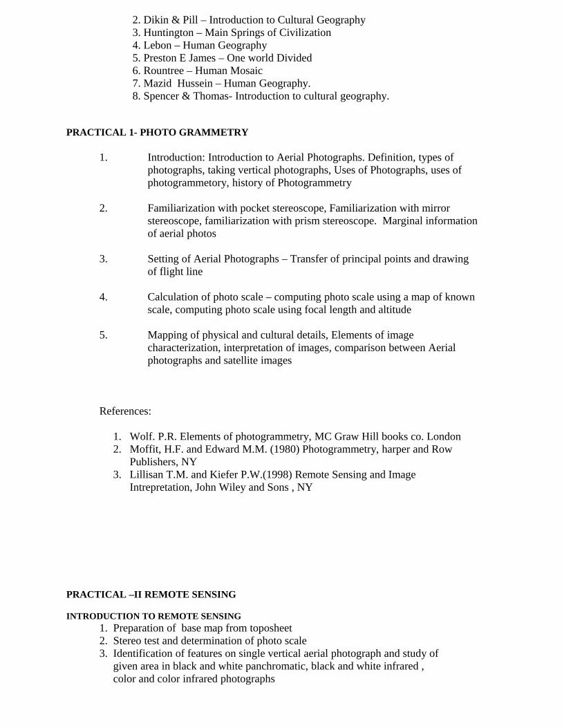
2. Dikin & Pill – Introduction to Cultural Geography3. Huntington – Main Springs of Civilization4. Lebon – Human Geography5. Preston E James – One world Divided6. Rountree – Human Mosaic7. Mazid Hussein – Human Geography.
8. Spencer & Thomas- Introduction to cultural geography.
PRACTICAL 1- PHOTO GRAMMETRY
1. Introduction: Introduction to Aerial Photographs. Definition, types of photographs, taking vertical photographs, Uses of Photographs, uses of photogrammetory, history of Photogrammetry
2. Familiarization with pocket stereoscope, Familiarization with mirror stereoscope, familiarization with prism stereoscope. Marginal information of aerial photos
3. Setting of Aerial Photographs – Transfer of principal points and drawing of flight line
4. Calculation of photo scale – computing photo scale using a map of known scale, computing photo scale using focal length and altitude
5. Mapping of physical and cultural details, Elements of image characterization, interpretation of images, comparison between Aerial photographs and satellite images
References:
1. Wolf. P.R. Elements of photogrammetry, MC Graw Hill books co. London2. Moffit, H.F. and Edward M.M. (1980) Photogrammetry, harper and Row
Publishers, NY3. Lillisan T.M. and Kiefer P.W.(1998) Remote Sensing and Image
Intrepretation, John Wiley and Sons , NY
PRACTICAL –II REMOTE SENSING
INTRODUCTION TO REMOTE SENSING1. Preparation of base map from toposheet2. Stereo test and determination of photo scale3. Identification of features on single vertical aerial photograph and study of given area in black and white panchromatic, black and white infrared , color and color infrared photographs
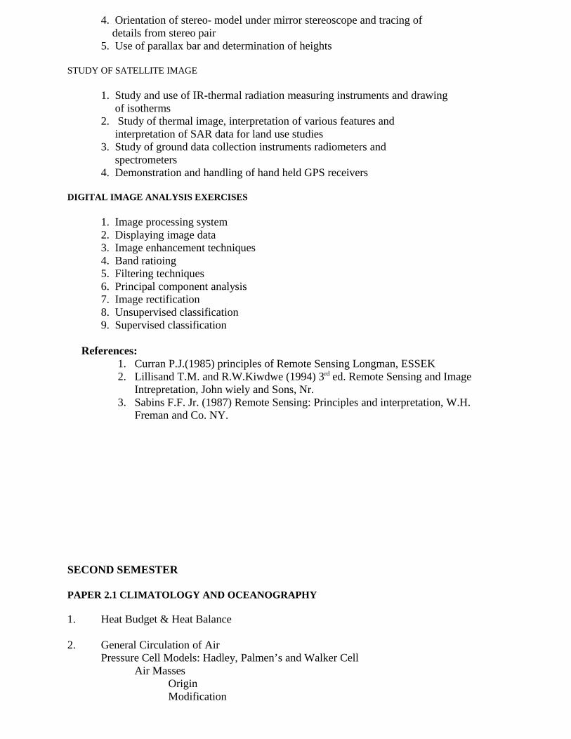
4. Orientation of stereo- model under mirror stereoscope and tracing of details from stereo pair5. Use of parallax bar and determination of heights
STUDY OF SATELLITE IMAGE
1. Study and use of IR-thermal radiation measuring instruments and drawing of isotherms2. Study of thermal image, interpretation of various features and interpretation of SAR data for land use studies3. Study of ground data collection instruments radiometers and spectrometers4. Demonstration and handling of hand held GPS receivers
DIGITAL IMAGE ANALYSIS EXERCISES
1. Image processing system 2. Displaying image data3. Image enhancement techniques4. Band ratioing5. Filtering techniques6. Principal component analysis7. Image rectification8. Unsupervised classification9. Supervised classification
References:1. Curran P.J.(1985) principles of Remote Sensing Longman, ESSEK2. Lillisand T.M. and R.W.Kiwdwe (1994) 3rd ed. Remote Sensing and Image
Intrepretation, John wiely and Sons, Nr.3. Sabins F.F. Jr. (1987) Remote Sensing: Principles and interpretation, W.H.
Freman and Co. NY.
SECOND SEMESTER
PAPER 2.1 CLIMATOLOGY AND OCEANOGRAPHY
1. Heat Budget & Heat Balance
2. General Circulation of AirPressure Cell Models: Hadley, Palmen’s and Walker Cell
Air MassesOrigin Modification
Classification Air mass Impact on World Climate
Fronts Cyclones and Anti CyclonesJet StreamsEl Nina and La Nina Impact (12)
3. Mechanism of MonsoonSouthern OscillationITCJet Stream Impact
Summer MonsoonWinter Monsoon
4. Classification of World ClimateKoppen’s Classification Thornthwaite’s Classification
Climatic Change’sMethods of Building Paleo Climate
Dendrochronolgy and DendroClimatologyPollen Grain Sedimentation and Lithology
5. Distribution of Surface and Sub Surface TemperatureLatitudinal Distribution of Temperature and Salinity,Closed and Open Sea Concept and its impact on ClimateOcean Currents Origin, Types of Ocean CurrentsPath of Ocean Currents-Indian,Pacific,AtlanticOceanic Conveyor Belt and its Impact on World Climate
Reference :1. Lal, D.S. (1996), “Climatology” Allahabad: Chaitanya Publishing House.2. Collings, V.K. (1987), Weather, Radar and Flood Forecasting, John Wiley & Sons,3. Critchfield, H.J. (1996), General Climatology, Prentice Hall, New Jersey.4. Menon, P.A. (1989), Our Weather, National Book Trust, New Delhi.5. Smith, K., (1975), Principles of Applied Climatology, McGraw Hill Book Co., London.
PAPER 2.2 TRENDS IN MODERN GEOGRAPHY
1. Foundation of Geography a. Modern geography: German, French, American, British schools.
b. Traditions in geography: Man-environment tradition, Spatial tradition, Regional Science tradition, Area Science tradition
2. Regional concepts and Regional methods in geography.a. Concept of a region b. Type of regions. c. Regional approach in geography. d. Regionalism

3. Dualism in geography:a. Historical vs. contemporaryb. Physical Vs. Humanc. General Vs Particular/ systematic vs. regionald. Determinism Vs possibilism
e. Ideographic vs nomothetic f. Quantitative vs qualitative g. Inductive vs deductive
4. Revolution in Geography: a. Quantitative revolution
b. Conceptual revolution: i) Space and distance ii) Spatial implications and distance decay iii). Spatial diffusion behavior and movements
c. Laws, theories, and Models in geography d. Paradigms in geography.
5. Modern themes in geographical thought: a. Pragmatism b. Functionalism.Recent approaches in geography: a. Systems approach b. Behavioural
approach d. Multi-disciplinary and inter disciplinary approach e. Ecological approach. f. Remote sensing and Geographic information system.
References:1. Mishall R. : Changing nature of geography.2. Majid Hussain : Evolution of geographical thought.3. Freeman T. : Hundred years of geography4. Chorley and Peter Haggett: Models in geogaphy.5. Hartshorne R. : Perspectives on the nature of geography.6. Wooldridge and East. W. G : The spirit and purpose of geography
PAPER 2.3 STATISTICAL GEOGRAPHY
I. Meaning and scope of statistics, importance of statistics in Geography; Nature and types of geographical data. Methods of collecting data, sample frame and procedures.
II. Frequency distribution and graphical representation of data: Cumulative frequency, Histogram, frequency polygon, ogive curves, Lorenz curve and Gini co-efficient
III. Measures and central tendencies: Mean, Median, Quartiles, deciles, percentiles and Mode. Merits and demerits of various measures.
IV. Measures of dispersion: Mean deviation and standard deviations. Co-efficient of variance. Kurtosis and skew ness, Time series analysis.
V. Measures of association and relationship: correlation, Rank correlation. Regression, testing of hypothesis: T-test, F-test, chi square test.
References:1. Alvi, Zamir (1995) “Statistical Geography” Methods and Applications, Rawat, pub, Jaypur.2. Aslam mahmood “Stastical Methods in Geographical Studies” Rajesh Pub, new Delhi
3. R Hammond and P. mccullagh “Quantitative techniques in Geography” Clarendon press, oxford.
PAPER 2.4 GEOGRAPHIC INFORMATION SYSTEM
1. Introduction: GIS Definitions and terminology, concepts, Geographical entities, Attributes, Topology.
2. GIS Architecture: components of GIS, GIS Workflow; Theoretical Framework; categories; levels/scales of Measurement
3. Spatial Data Modeling: Introduction: sources of spatial data, stages, graphical representation; Raster GIS: simple raster array, hierarchical raster structure, types and compact raster data models; Vector Models: spaghetti Model, Topological model, shape file, compact vector model; comparison of raster and vector model.
4. GIS Data Management system: Introduction: Functions and components of DBMS; GIS data file management: simple list, ordered sequential files, indexed files, Building GIS worlds.
5. Data base models: Hierarchical database models, network system, Relational database models, Standard Query Language; Storage of GIS Data: Hybrid data model, integrated data model; Object based data models: Entity Relationship –
Attribute Model; Spatio-Temporal Data: Entity – Relationship, Location-Based, Entity Based and Time-Based.
Books for Reference2. Burrough P.A. (1986) “Principles of Geographical Information Systems for Land Resources, Clarendon Press, Oxford.3. Chrisman N.R. (1997) “ Exploring Geographic Information Systems, Wiley, NY 4. Anji Reddy (2001) “Remote Sensing and Geographical Information Systems”
PRACTICAL- I GEOGRAPHIC INFORMATION SYSTEM
1. Introduction and Overview of Geographic Information Systems
Definition of GIS, features and functions; GIS as an Information System; GIS and cartography; historical development of GIS.
2. Map Projections and Coordinate Systems
3. Data Sources, Data Input and Data Quality and Database Concepts
Database concepts and components; relational database systems; entity relation model, spatial data modeling; databases and GIS.
4. Spatial Analysis
GIS analytical functions; vector analysis including topological overlay; (a)point data (b) Line data (c)Polygon data
5. Implementing a GIS using public domain low cost software
Map info and Arc info software
Books for Reference
2. Burrough P.A. (1986) “Principles of Geographical Information Systems for Land Resources, Clarendon Press, Oxford.3. Chrisman N.R. (1997) “ Exploring Geographic Information Systems, Wiley, NY 4. Anji Reddy (2001) “Remote Sensing and Geographical Information Systems”
PRACTICAL-II GLOBAL POSITIONING SYSTEM
Prismatic Compass SurveryingOpen and Closed Traverse
Theodolite SurveyDigital Theodolite SurveyMeasurement of Horizontal Angle and Vertical Angle
Measurement of Area
Global Positioning system (GPS): Introduction – Functions – space segment –control segment – user segment – Navigation – ranging – calculation ofdistance – surveying with GPS.
Total StationHorizontal angle and Vertical Angle
References:1. Misra, R.P., and Ramesh., (1989) Fundamentals of Cartography, Concept Publishing Co., New Delhi.2. Nag, P.ed., (1992) Cartography and Remote Sensing, Concept Publishing Co.,New Delhi.3. Robinson, A.H., Sale, A.H., Morrison, J.L., and Muerake (1985) Elements of
Cartography, John Wiley and Sons, New York.4. Burrough.P.A., 1986, Principles of GIS for land assessment, Clarendon Press, Oxford.5. Martin. D., 1996, Geographic Information: Economic applications, Routledge, London.
THIRD SEMESTER
STUDENTS HAVE TO SELECT FOUR OF THE FOLLOWING OPTIONALS.
PAPER 3.1 POPULATION GEOGRAPHY
I. Introduction to population geography, nature of population geography, evolution of population geography as a separate branch, approaches to population geography, population geography in India, source of population data and problems.
II. Trends of population growth in the world and in India. Theories of population growth, Malthusian theories, optimum theory, Demographic transition model.
III. Components of population change- Fertility: Measures, determinants and world pattern. Mortality- Measures, determinants and world pattern, Migration- Typology, Measures, determinants consequence and theories.
IV. Population, resource and development. Population and resource relationship, concept of over and under population, population pressure and its consequences, population resource regions of the world, population and economic development. Population and Environmental quality.
V. Demographic situations in the world. Population polices and projections- Demographic status in LDCs and MDCs, nature of population policies, population policies in MDCs and LDCs, population policy in India, Population projections,
Reference: 1. Asha bende & Tara Kanitkar (2000) “principles of population” Himalaya Publication, Delhi.2. Ashish bose, Ashok mitra, P.B. Deshi and J.N.Sharma (1974) “Population in India’s development 1947-2000”, Vikas publishing house, pvt ltd, Delhi. 3. Chandana R.C.(1999) “A Geography of Population”, Kalyani publishers, Delhi.4. Chari R.B.(1975) “Demographic Trends in India”, Sunlight Printers Fountain, Delhi.5. Clarke John I, (Ed), (1984) “Geography and Population: Approches and Applications”, Pergamon publishers, Oxford. 6. Gandatra M.M & Naryan Das (1984) “population policy in India” Blacki & Sons publishers pvt.ltd, Bangalore7. Goel N.P. (1994)“Readings in Population Geography”, Mohit Publications, Delhi.
8. Ghosh B.N. (1987) “Fundamentals of Population Geography”, Sterling publishers, Delhi. 9. Johan R. Weeks (1999) “Population- An Introduction to Concepts and issues”, Wardswarth Publishing Company, U.S.A.
PAPER 3.2 AGRICULTURAL GEOGRAPHY
1. Nature, Scope, & Significance of agricultural geography, Evolution of Agricultural geography & approaches to the study of agriculture geography.
2. Origin & Diffusion of agriculture -Elements of agriculture & world classification of agriculture bases for the witlessly Classification
3. Determinants of agriculture :-(a)Physical, (b)Economic (c) Social (d) Institutional (e)Technological Green Revolution, White & Blue Revolution.
4. Models in Agricultural Geography Significance & Limitations of agricultural models Classification of agricultural models – Input, output, Von Thune’s Jonas son’s model.
5. Methods of Delineating agricultural Regions concept & Techniques of regionalization Dois method, Least Square method, Maximum positive deviation method. Agriculture regions of India & their characteristics.
References:
1. Agriculture geography - Prof.M.Shafi.2. Agriculture geography - majid hussain.3. Agriculture geography - Noor Mohammed.
4. Agriculture geography - sing & Dhillin.5. Agriculture geography - Jasbir sing.6. Foundations of Indian Agricultura- Negi V.L7. Agricultural Problems of India – Manaria C.R.8. Applied Geography – L.D.Stamp.
PAPER 3.3 SETTLEMENT GEOGRAPHY
I. Nature, scope and contents of settlement geography, evolutions of settlement geography as a separate branch, approaches to settlement geography,
II. Origin and evolution of settlements, role of physical, historical, economic, cultural factors in the origin and development of settlements, diffusions of settlement, Diffusions modeling.
III. Classification of settlement on the basis of size, form, shape and functions, Pattern of rural settlement, density and spacing of rural settlements.
IV. Morphology, shape analysis and house types of rural settlements.

V. Rural service centers and strategy for the growth of rural service centers, hierarchy of rural settlements, central place theory, Loschian model, rural markets and periodical markets, planning rural settlement centers.
Reference:
1. Majid Husain “Human Geography” Rawat publications, Jaipur (2002)2. Majid Husain “Human and Economic Geography” NCERT, New deli3. R. Y. Singh, “Settlement Geography” Rawat pub, New Delhi4. R.B. Mondel “introduction to rural settlements” Concept pub, New Delhi.
PAPER 3.4 URBAN GEOGRAPHY
1. PRINCIPLES OF URBAN GEOGRAPHYa. Scope and Development of urban geography as a branch of geography.b. Approaches to the study of urban geography.c. Factors affecting origin and growth. Location, site and situation of the urban
areas. Size and spacing of settlement
2. . CLASSIFICATION OF URBAN CENTRES.a. Census classificationb. Functional classification of Harris, Ullman.c. Service classification of Nelson.
3.. THEORIES OF CITY SYSTEMS : Theories: Christaller theory of central places, central place Theory of Loach Concepts: fringe development, Green belt concept
4. THEORIES OF INTERNAL STRUCTURE OF CITIESa. Theories land use structure.(i)concentric, .(ii) sector and .(iii)multiple
nuclei.b. location of activities.(i) Residential. .(ii)Commercial (iii)Educational.
(iv)Recreational.c. Movement (i) intra urban movement work place home relationship. (ii) Inter
settlement flows- rural urban linkages and urban systems
5. METROPOLITAN CITIES OF INDIA AND SATELLITE TOWNS.a. Urbanization and; urban planning in India.b. Patterns of urban and rural settlements with special reference to India.c. Patterns, process and trends.d. Government policy and Urban planning in India.
References:
1. David Clark: Urban geography.2. Mayer and kohn Urban geography.3. Cadwallader Analytical urban geography.
4. Berry, Franjk and Horton Geographic perspectives on urban system5. Ramachandran R. Urban system and urbasnization in india6. Prakash Rao V.L.S. and Tiwari: Structure of an indian metropolis7. Robert Putnam A geography of urban policy8. Taylor.G. Urban geography9. Prakash Rao V.L. S. Urbanization in india
PAPER 3.5 ENVIRONMENTAL GEOGRAPHY
1. Nature and scope of Environmental Geography: - Factors of Environment, Location, Topography, Climate, Soil, Minerals, Vegetation. Environmental awareness and protection. Environment, ecology and Geography
2. Historical roots of our ecological crisis: Eco-System concept, Types, Structure and Features, nutrition transfer: Bio-Geo-Chemical cycle.
3. Bio-diversity and biomes, Concept of bio-diversity, Characteristics. Importance of Bio-diversity, Conservation Bio-diversity, Meaning and types of Biomes, Biomes of the world and India.
4. Environmental degradation and pollution, Meaning, Types, process and causes of environmental degradation, Natural hazards and its impact on environment, Earthquake, volcano and Cyclones. Deforestation and environmental degradation.
5. Industrial and agricultural development and Environmental degradation, Environmental pollution- Air, Water, Land and noise.
6. Environmental planning and management: concept of Environmental management approaches to Environmental management, resource and wildlife management, soled waste management. Environment Impact Assessment (EIA), elements of EIA, methodology and case study of EIA, Environmental planning in India.
Reference:
Sevendra Singh (2002) “Environmental Geography”Environmental Geography- SexenaEnvironmental Geography- Chandan Ecology - Mohan.P.AroraEcology and Environment- P.D. Sharma.
PAPER 3.6 RESEARCH METHODS IN GEOGRAPHY
1. Research : Meaning –Need for Scientific research Type of research- Approaches to geographical research: Traditional and scientific – Identification of the problem sub fields and themes
2. Logic in Research: Hypothesis, concdpts and facts, Principles Law, theory and their implications in Geographical research- the science of Geography- Role of models- Research trends in Geography
3. Resesrch design; Selection of the topic – statement of the problem- Formulation of hypothesis –Testing of hypothesis Parametirc and non parametric tests – T—test, F-
4. test, x2-test and Ztest. Literature survey and the role of internet, Preparation of bibliography
5. Data Acquisition and Analysis; collection of data- sources of data- primary and secondary- structuring the data- data transormation- Samplicng techniques SPSS package in data analysis.
6. Thesis writing: Organization of the thesis: the priliminaries, the text and the reference materials- Drafting of the thesis-First, Second and Final- Final evaluation Language and presentatio9n (form and style) Writing of abstracts, Research papers for seminar and conferences, Journal Publications.
References:
1> Anderson, J. Durston, B.H. and Poole, M,(1970) Thesis and Assignment Writing, Wiley Eastern Ltd, New Delhi
2> Cooray,P.G (1992) Guide to Scientific and Techmnical Writing, Handagala, Srilanka3> Davis J.C. (1986) Statistics and data Analysui, John Wiley and Sons NY.4> Fitz Gerald, B.P. ed (1974) Science in Geography, Series 1,2,3,4,5,6. Oxford
University press, London
5> Hang, L.L. and Lounsbury, J.F. (1971) Research Methods in Geography, Brown company Publishers, Iowa
6> Kothari, C.r. (1990) Research methodology : methods and Techniques, Vishwaprakashana, New Delhi
PAPER 3.7 TRANSPORTION GEOGRAPHY
I Introduction: 1. Nature of transport geography2. Scope of transport geography3. Development of transport geography as an independent branch of geography4. Recent trends in transport geography
II Causes of Movement and Accessibility 1. Major Forces Influencing Transportation :Globalization and Transportation 2.Type of movements (a). intra-urban (b). Inter urban (c) Rural – Urban (d) Inter regional (e) International. 3.Causes of movement: (a) Social and inter personal pattern (b) Economic and commerci(c) Recreation and tourism (d) Pilgrimage and others
III Urban Transportation
a.. Evolution of urban travel b.Transit in American Cities c. Transport and the Third World City d.The urban transport Problem and Potential Solutions e. Inter-city Passenger and Freight Movements in the U.S
IV. Modes of transportation1.Road network- hierarchy of roads (b) Road traffic congestion/overcrowding
2.Rail transport. (a) The Historical Pattern: (b) growth (c) Recent Trends (d) Railways in the Third World3.Air Transportation : (a) historical pattern (b) growth (c) Recent trend (d) Crisis in the Airline Industry: Causes, Impact and Solutions (e)The Budget Airline Phenomenon Across the Globe (f)The International Scene: route patterns, passenger demand and market (g)Air Cargo: Patterns, Issues 4.Recent trends and future growth in the demand for travel 5.The Impact of Transportation and transportation Costs
V. Transportation Planning - overall objective1. Integration of transportation and land use planning 2. Governmental policy: The Role of Institutions a. Deregulation b. Privatization, 3. Public transport - overall policy 4. Transportation impact assessments: (i)Environmental consequences of transport provision 5. Economic impact of transport/traffic conditions: Role of planning
References: 1. G. Gaile and C. Willmott (eds.). “Transportation geography” in Geography in America at the Dawn of the 21st Century. New York: Oxford University press, 2004., 2. Peter Dicken and Peter Lloyd. Location in Space, 1990,“Structure of Transport Costs.3. Susan Hanson, “The Context of Urban Travel," in Hanson and Giuliano (eds), The Geography of Urban Transportation, 2004 4. H. Dimitriou (ed) Transport Planning for Third World Cities. London: Routledge,1990
PAPER 3.8 POLITICAL GEOGRAPHY
1. Relevance of Political GeographyMeaning Nature and Scope Contemporary Geographical TraditionsScope of Political Geography Recent Trends in Political Geography
2. Concept of Organic State and GeopoliticsSpencer and SchaffleFreidrich Ratzel Rodolf Kjellan
Geopolitics ModelsModelski’s Long Cycle of Global PoliticsA Dynamic Model of Hegemony and Rivaly
Geopolitics : Present and FutureGlobal Change and Geo Politics: Different Version Diverse Relation and New Dimensions
3. Approaches to the study of Political Geography
Whittlesey’s Law of Landscape ApproachHartshrone’s Functional ApproachGottman’s Political Partitioning ModelJone’s Unifield Field TheoryPolitical System and ModelContemporary relevance to these appraoches.
4. Concept of Territoriality, State and Nation State Territoriality, State, The Nation State, Nationalism and Nation BuildingThe role of Spatial Factors in determining State
a) Shape b)Size and c)Shape
5. Global Strategic Models Mahan’s Sea Power Model, Geographical Pivot ModelHeart Land Model,The Mid Land ModelThe Rim Land Model,The relevance of Rim Land and Heart Land Model
in present context.
References:
1. Dickinson R.E. (1969) “Makers of Modern Geography”, London Rouledge and Kegan Paul.
2. Hert Shome, R. (1960) “Political Geography in the Modern World” Journal of Conflict Resolution., Vol 52., pp 67.
3. Sudeepta Adhikari., (1999) “Political Geography” Rawat publications, Jaipur, New Delhi.
4. Hagget P (1965) Locational Analysis in Human Geograph, London, Edward Arnold.5. Das Gupta B. and W.H. Morris Jones (1975) Patterns and Trends in Indain Politics,
New Delhi, Allied Publishers.
PRACTICAL I QUANTITATIVE TECHNIQUES
1. Meaning and significance of quantitative techniques in Geography 2. Measuring centrality of settlements- Index of centrality3. Centro graphic analysis- Mean and median centre4. Rank size and nearest neighbor analysis.5. Gravity potential models6. Network analysis- shortest path and shortest distance analysis.
7. Measures of dispersions- Kendal’s and Bhatia’s methods.8. Crop combinations and concentrations techniques. Weaver’s method and location
quotient method.
Reference: 1. R. P. Misra, Fundamental cartography, Concept pub, New Delhi. 2. Aurther.H Robinson “Elements of Cartography”, John wily and sons, inc., New york 3. G.R.P. Lawernce “Cortographic Methods” Methuen and Co. Ltd.1971.4. Aslam mahmood “Stastical Methods in Geographical Studies” Rajesh Pub, new Delhi5. R Hammond and P. mccullagh “Quantitative techniques in Geography” Clarendon press, oxford
PRACTICAL II MAP ANALYSIS
1. Introduction, Importance, Types, Scale of topographical maps.
2. Interpretation of topographical maps with reference to Geomorphology,
geological structure, soil, climate, transportation and settlement, drainage. Study
of interrelationship among these features.
3. Morphometric Analysis
4. Profile drawings: Simple, Super imposed profiles etc.
5. Slope Analysis; Wentworth’s Method, Dhurunder’s Method, Smith’s method,
Average slope analysis, Relative relief Method
Reference:
Gopal Singh- Practical geographyR.P. Misra- Fundamentals of cartography.R. Mammod and P. Mecullagh “ Quantitative Techniques in Geography”
FOURTH SEMESTER
STUDENTS HAVE TO SELECT FOUR OF THE FOLLOWING OPTIONALS PAPER 4.1 PRINCIPLES OF REGIONAL PLANNING
I. Concept of region and regional planning; meaning and types of regions, Planning region and its characteristics, hierarchy of regions, delineation of region and methods of delineation. Types of planning, Regional planning defined, Objectives and principles of regional planning, approach to regional planning.
II. Theories of regional growth: Sector, stage and export base theories, Economic base theory, convergence and divergence growth theory, Multiplier effects, intra and inter-regional input and output analysis.
III. Growth pole hypothesis and regional planningBasic concepts-Leading Industry, Polarization effects and Spread effectsInadequacies of growth pole hypothesis. Modified growth foci of R.P Misra,Growth poles in regional planning
IV. Regional imbalances in the levels of developmentRegional imbalance; causes and consequencesNeed for balanced regional developmentIndicators of measuring regional imbalance and extent of regional imbalance in India and in Karnataka Policies and programs- adapted to remove regional imbalance in India. and in Karnataka.
V. Issues in regional planning and approach to planning; social and environmental issues, Top down and bottom up approaches. District and block level planning in India, Backward and tribal area development programs.
Reference: 1. Mahesh Chand, Puri V.K (1997)“Regional Planning in India”, Allied Publishers Limited, New Delhi. 2. Rabindranath Dubey, (1992)“Population, Environment and Regional Planning”, Chugh Publications, Allahabad, India.3. S. Shekur “Regional planning in India “(Vol.1 and 2), Anmol pub, New Delhi. (2004)4. Jayasri Rai Choudhuri “Development and regional planning” Orient Longman, kolkata. (2001)
PAPER 4.2 TOURISM GEOGRAPHY
1. Importance of Tourism Industry in the Present WorldDefinition and Scope of TourismTypes of TouristObjective’s of Tourism
Heritage TourismCultural Tourism Recreational TourismPolitical TourismReligious Tourism Game Tourism
Tourist Behaviour on Space Path of Tourist and Flow Pattern
Domestic and InternationalHospitality and Stay pattern
Occupancy and Rate of OccupancyRural Tourism : Kerala Model
3. Geo Economic Implications of Tourism on Rural and Urban development.
Local level developmentEmployment opportunitiesPrinciple of Carrying Capacity and Sustainability Negative Impacts: Under Employment, Seasonal Employment, Under Utilization of Facilities and Infrastructure, Cultural dent, Landscape deformation, Pollution and Congestion, Shortage of Water and other facilities etc.
4. Tourism Research for Tourism Development and Promotion Role of Tour Operators
Advertisement and Campaign : Audio Video and Web Based PromotionConducted Tours and Tour PackagesQuestionnaire Survey and Sampling Techniques
5. Role of G.I.S. and Remote Sensing in Tourism PlanningIdentification of Geomorphological Sights as prospective tourist sights using Remote Sensing ImagesGIS and Tourism PlanningGIS based Conservation and Management of Tourist Sights.
Reference:1. Rana Pratap and Kamala Prasad (2003) “ Tourism Geography” Shree Publishers and Distributors, New Delhi.2. Gosami.V.K.(1987) “Tourism in India”, Gayan Publications, New Delhi.3. Batta.N. (2004) : “Touism and the Environment” Indus Book, New Delhi.4. Monohar Sajani (1998) “ Encyclopedia of Tourism Resource in India” 5. Bhardwaj, Kandan and Choudhary, (2004) “ Domestic Tourism in India” Indus
Books.
PAPER 4.3 MEDICAL GEOGRAPHY
1. Introduction to medical geography
a. Nature and scope of medical geography
b. Evolution and growth of medical geography as an independent branch of geography
c. Contribution of Geographers to medical Geography
d. Recent trends in medical geography
2. Environmental impact on human health a. Hazards of the natural environment b. Human induced hazards (i)air pollution (ii)water pollution
c. Health and Weather (i) meteorological and climatological influences on morbidity and mortality
3. Transition of diseases
a. Ecological considerations of transmission of diseases-physical and culturalb. Nature and modes of transmission of infectious diseasesc. Diffusion studies
4. The Geography of Health Care and Health Care Delivery a. The cultural role in health care
b. Nutritional disorders: Vitamin/mineral deficiencies
5. Changing Patterns of Health
a. Transitions 1. Demographic 2. Epidemiologic 3. Mobility b. Aging and health 1. Chronic/degenerative 2. Mental health c. Patterns of health 1. Regional 2. Health and development
References:
1. Andrew T.A. Learmonth, Patterns of Disease and Hunger (1978);
2. Gerald F. Pyle, Applied Medical Geography (1979);
3. L. Dudley Stamp, The Geography of Life and Death (1964).
4. Jacques M. May, The Ecology of Human Disease (1958);
5. Jacques M. May (ed.), Studies in Disease Ecology (1961).
6. John Eyles and Kevin J. Woods, The Social Geography of Medicine and Health (1983),
David R. Phillips, Contemporary Issues in the Geography of Health Care (1981)
PAPER 4.4 INDUSTRIAL GEOGRAPHY
1. Scope, Importance of industrial Geography, Approaches to industrial Geography, evolution of industrial Geography
2. Industries: classification of industries, basic and consumer, heavy and light industries and other classifications, Factors of industrial location- Geographical, Social, Economic, Environment, Historical and political factors. Changing role of these factors over time.
3. Theories of industrial location- least cost school, transport cost school, market area school, Marginal location school, and behavioral school.
4. Pattern and trends of industrialization in the world and in India, industrial regions of the world and industrial regions of India.
5. Industrialization: Significance, problems and prospects. Industrialization and economic development, Industrialization and environmental quality, Industrial policy in India since independence.
Reference:
1. D.M Smith- Industrial Location2. Alexander. J.N. – Economic Geography3. Kulkarni. M.R- Industrial Geography4. Majid Hussen- Industrial Geography.5. Johan Bale- The Location of manufacturing industry- conceptual frame work in Geography
PAPER 4.5 THEMATIC CARTOGRAPHY
1. Geography as Integrated Discipline: nature and scope of cartography-Meaning of maps- Maps and photographs- Types and uses- map scale. Cartography as a science of human communication. History of cartography in India.
2. Map Making Process: Collection of data- compilation ,Physical and cultural details. Elements of generalization, simplification, classification,,Induction-concepts and methods of map sympolization symbolizing qualitative, quantitative, continous and descrete data. Thematic and complex mapping- Tpes and problems.
3. map design and Layout: Principles-Theory of Visual Perception- constraints in map design – map format, Toponomy and map reproduction: planning and process related to duplicating, printing and latest methods.
4. GIS: Introduction – Historical development_ components; hardware andsoftware- Basic requirements- computer cartography- conceptual models for geographocal phenomena. Data type- raster and Vector.
5. GPS: introduction- Functions- space Segment control, Segment – User Segment – Navigation – renging – Calculation of distance and area Surveying with GPS – GPS mapping.
References:1. Misra R.P. and Ramesh.(1989) Fundamentals of Cartography, concept
publishing Co.New Delhi.2. Nag,P.ed.,(1992) Cartography and Remote Sensuing concept Publishing Co.
New Delhi3. Robinson, AH, Sale AH. Morrison JL and Muerake (1985) Elements of
Cartography, John wiles and sons NY.4. Burrough P.A. (1986) Principles of GIS for land assessment.
PAPER 4.6 RESOURCE CONSERVATION AND PLANNING
1. Concept of resource: DefinitionMeaning & classification – Resource Creating factors
– culture, technology, man.
2. Water Resources – Hydrological cycle recent trends in water use in the world & in India, Water Crises,- Causes & consequences water pollution, recycling of
Waste waters, methods of water conservation.
3. Forest resources – Types & uses depletion of forest resources & its impact on Environment, conservation of forest resources.
4. Atmospheric resources- Solar power; Atmospheric gases, wind power, Atmospheric pollution, Management of atmospheric resources.
5. Conservation & Management of Industrial & Power Resources. National Policy on development & utilization of natural resources in India.
References :1. Dasmann - Environmental Resources.2. Finch Trewartha & Sheares – The Earth & its Resources3. Herald G.V.V- Conservation of Natural Resources.4. Kommeyer – Population Studies5. Negi B.S. – Resource Geography.6. Olivers. Owen – Natural Resource Conservation.7. Renner G.G – Conservation of Resources.8. Zimmermann – World Resources.
PAPER 4.7 DISASTER MANAGEMENT
1. Natural Disasters: Basic Principles: Thermal and Physical state of the earth– Seismology and the earth’s interior – movement of earth’s crust –Earthquake – magnitude and intensity – volcanic eruption – Landslides –Avalanches – Geographical occurrence. Man-made disasters: Populationgrowth – rapid urbanization – poverty – Natural forces and life – phases ofdisasters.
2. Atmospheric Disturbances: Cyclones and Anticyclones – types, origin,development, distribution and their disastrous implications – Tropicaldisturbances – depressions, hurricanes – Thunder storms and Tornadoes –disastrous implications – geographical occurrences – Ozone depletion –Global warming – hot spot phenomenon.
3. Hydrological and Marine Disasters: Flood hazards – Flood plain – causesof flood – Problem of floods in India – Floods and Economic issues –management implications. Sea Level Changes: Measuring sea level changes– future changing tendencies – impact of South – Asian Region – Oceancirculation and SW monsoon – Coast Zone Management and sea level rise.
4. Wind and Biological Disasters: Desertification: Global distribution ofdesertification – types of desertification – human impact on desertification –land management practices that mitigate against desertification –desertification prediction – measure of reduction. Biodiversity Hazard: Lossof biological diversity – population diversity and extinction rate – Forest fireand loss of species – Biodiversity conservation – policy responses.
5. Satellite Data for Disaster Evaluation and Management: Application ofSatellite Data for Prediction – Assessment – Monitoring Disasters. DisasterAssessment and management through satellite data for Earthquake – floods– Tsunami – forest fire – land slide.
Ref: References:1. Korte, G. B., (2001) the GIS book: 5th edition, Onward Press, Australia.2. Anji Reddy, M., (2001) Remote Sensing and Geographical Information Systems., 2nd edition, BS.Publications, Hyderabad.3. Demers, Michael N., (2000) Fundamentals of Geographic Information Systems, John Willey and sons. Inc. New York.4. John A. Matthews (2002) Natural hazards and environmental change, Bill McGuire, Ian Mason. 5. Andrew Skeil (2002) Environmental Modeling with GIS and Remote sensing, John willey and sons, Inc New York.6. John. G. Lyon (2003) GIS for Water Resource and water Shed Management, Taylor and Francis.
PAPER 4.8 WATER RESOURCE MANAGEMENT
1. Meaning and scope of water resource management, Important of water as a resource, Hydro-meteorological relationship: Analysis of rainfall and temperature, evopo- transpiration, rainfall and runoff relationship, hydrological cycle.
2. Hydrological, hydro-morphological and hydro-pedagogical assessment. Morphological units and drainage classifications assessment of surface and sub surface (ground water) discharge and recharge condition and water table relationship. Measurement of soil moisture, soil classification and water quality; Water logging and salinization, floods and droughts.
3. Watershed management; concept of watershed; morphological units, morphogenetic classification, marphometric analysis, importance of watershed protection and approaches to watershed protection, watershed management.

4. Impact of modern development on water resource: - need of water for domestic and non-domestic use. Irrigation development and water resource management, Big and Small irrigation project and their impact on water resource, Tank and Well irrigation and their impact on water resource. Industrialization and its impact on water resource, Urbanization and its impact on water resource. Demand and supply position of water resource, contemporary water crisis.
5. Water resource policy, water resource development and conservation strategies. National water policy in India since independence and Inter state water disputes, River inter linking; Problem and prospects. Rain harvesting as strategies of water resource conservation, other strategies of water conservation; water recycling, sprinkler irrigation.
Reference:1. Bruce J.P. & R.H. Clerk, Introduction to hydrometeorology, pergamon press, oxford, 1996.2. David Keith todd, Ground water hydrology, John Willy and sons, New york,1959.3. Robert J. Reimold, watershed management, practice, policies and co- ordination, McGraw-Hill, New Delhi, 1998.
4. B.D.Dhawan,Indian water resource management for Irrigation : Issues critiques reiews, Commonwealh publishers, new Delhi,1993.5. Ravi Misra, Fresh water Environment, Anmol publication pvt.LTD, New Delhi, 2002.6. Ramaswamy R. Iyer, water perspective, Issues, concerns, SAGE publications, New Delhi,2003.
PRACTICAL-I DIGITAL CARTOGRAPHY
1. Introduction to Cartography-Cartograhy and GISCategories of MapsScanning operations and file formats
2. Introduction to GIS software-Mapinfo , ArcinfoGeoreferencing, coordinate systemDigitization-editing operationsRaster and vector data models
3. Creatinon of attribute data tablesExcel, Access and SPSS
4. Map design and layout

Map compilation, map scale, symbolization-point, line, and volumeColour and patterns, Map lettering
5. Mapping methods: Dot map, choropleth, isoline, flowline, cartograms,proportional point symbols, 3D mapping
Reference: 1. Menno-Jan karaak & Ferjan Ormeling “Cartography visualization of Geospatial data” pearson education ltd. UK (2003) 2. Anson, R.W and F.J. Ormeling (eds) ‘Basic Cartography for students and technicians Oxford;Butterworth-Heinemann, (2002) 3. Brewer, C.A (1994) Colour use guidelines for mapping and visualization “Visualization in Modern Cartography” oxford/NY 4. Hearnshaw, H.M. and D.J.Unwin (1994) “visualization in GIS, London, L. Wiley and sons
PRACTICAL II PROJECT WORK
UNIVERESITY OF MYSOREDEPARTMENT OF STUDIES IN GEOGRAPHY, MANASAGANGOTRI, MYSORE
M.Phil DEGREE IN GEOGRAPHY
PAPER I: RESEARCH METHODOLOGY
1. Research: Meaning – Need for scientific research Type of research – Approaches to geographical research: Traditional and Scientific – Identification of the problems sub fields and thems.
2. Logic in Research: Hypothesis, concepts and Facts, Principals Law, theory and their implications in Geographic research science of Geography – Role of Models, Research Trends in Geography.
3. Research design: Selection of the topic – Statement of the Problem – Formulation of hypothesis – Testing of hypothesis, parametric & non parametric tests – T – test, F-test, x2test & Z test. Literature survey and the role of internet preparation of bibliography.
4. Data Acquisition and Analysis: Collection of data – Surces of data – primary and secondary – Structuring the data – data transformation – sampling techniques SPSS package in data analysis.
5. Thesis writing : Organization of the thesis: the preliminaries of the text and the reference materials – Drafting of the thesis – First, Second and Final – Final evaluation, Language and presentation (form and style)writing of abstracts, Research Paper for seminar and conferences, journal publications.
References:
Anderson, J., Durston, B.H. and Pool, M,(1970)Thesis and Assignment writing, Wiley Eastern Ltd., New Delhi.Cooray, P.G.,(1992)Guide to Scientific and Technical Writing, Hendagala, SrilankaDavis J.C.(1986) statistics & data Analysis, John Wiley & sons NY Fitz Gerald, B.P.ed (1974) science in Geography Series 1,2,3,4,5, & 6. Oxford University Press, LondonHang,L.L., andLounsbury,J.F.,(1971)Research Methods in Geography Brown company Publishers, lowaKothari,C.R.,*(1990)Research Methodology: Methods & Techniques, Vishwaprakasha.
M.Phil DEGREE IN GEOGRAPHY
PAPER II: QUANTITATIVE TECHNIQUES IN GEOGRAPHY
1. Nature and Significance of Quantitative Techniques in Geography. Types of techniques and levels of measurement, types of spatial data.
2. Measures of point distribution-central location, dispersion and clustering.3. Measures of line distribution. Accessibility of nodes, route density, route sinnosity, traffic
flow; measures of connectivity- Beta index, gamma index, cyclomatic number, Alpha Index, Eta index.
4. Measures of Discrete and continuous Area distribution – Lorenz curve, Gini Co-efficient index of Concentration. Index of dissimilarity, Location quotient, Hypsometric curve.
5. Correlation and Regression Analysis – study of residuala from Regression.6. Spatial distribution and interactions – Nearest Neighbor Analysis, Rank size rule, Gravity and
potential model.7. Measures of disparities-Kendall’s method. Combinational Analysis-Weavers method,
Ternary diagram.8. Multivariate Analysis-Introduction to Factor Analysis.
Reference:
1. Quantitative Techniques in Geography; Hammont and Mecullch2. Statistical Methods in Geographical Study; AslamMahamed3. Quantitative Geography; J.P.Cole and C.A.M.king.
M.Phil Degree in Geography
Paper III Geoinformatics1. Aerial Remote Sensing history – photographic types – scales – stereo model – flight
planning and mosaics – photo interpretation elements – applications.
2. Satellite remote sensing : EMR – Atmospheric windows – energy interaction with atmosphere and earth surface features - spectral reflectance curve – platforms – types of satellites – resolutions – data products – application.

3. Digital image processing: Digital image formats – characteristic features - image rectification and restoration – spatial feature manipulation – vegetation components – classification methods – applications.
4. Global positioning system: history – segments – types of GPS – measurements – Accuracy – advantages and limitations – GPS based mapping.
5. Geographic information systems: components of GIS – data models and structures. Digital elevation models – layered and obhect oriented approaches- DBMS and RDMS – data input and editing – overlay methods – modeling in GIS.
Reference:Moffit, H.F., and Edward, M.M.,(1980)Photogrammertry, Harper and Row Publisheres, New York.Wolf.P.R.(1974)Elements of photogrammetry,McGraw Hill, London.Curran P.J.(1995)Principles of Remote sensing, Longman,Essek.Lillisand.T.M. and R.W.Kiefer.,(1994)Remote sensing and image interpretation. John willey & sons, New yark.Sabbins.F.F.,(1987).Remote sensing: Principles and interpretations, W.H.Freeman & Co., New York.Agarwal,N.K.(2004).Essentials of GPS,Spatial networks Pvt.Ltd, Hyderabad.Haywood.L,Comelius.S and S.Carver(1988)An introduction to Geographical Information System, Addision Willey, New york.
Annexture-1
SEM P.NOEXISTING TITLE OF THE PAPER
1PROPOSED TITLE OF THE PAPER
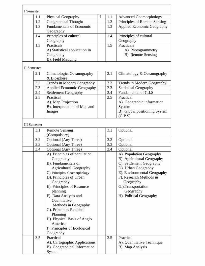
I Semester
1.1 Physical Geography I 1.1 Advanced Geomorphology1.2 Geographical Thought 1.2 Principles of Remote Sensing1.3 Fundamentals of Economic
Geography1.3 Applied Economic Geography
1.4 Principles of cultural Geography
1.4 Principles of cultural Geography
1.5 PracticalsA) Statistical application in GeographyB). Field Mapping
1.5 PracticalsA) PhotogrammetryB) Remote Sensing
II Semester
2.1 Climatologic, Oceanography & Biosphere
2.1 Climatology & Oceanography
2.2 Trends in Modern Geography 2.2 Trends in Modern Geography2.3 Applied Economic Geography 2.3 Statistical Geography2.4 Settlement Geography 2.4 Fundamental of G.I.S2.5 Practical
A). Map ProjectionB). Interpretation of Map and Images
2.5 PracticalA). Geographic information SystemB). Global positioning System (G.P.S)
III Semester
3.1 Remote Sensing (Compulsory)
3.1 Optional
3.2 Optional (Any Three) 3.2 Optional3.3 Optional (Any Three) 3.3 Optional3.4 Optional (Any Three) 3.4 Optional
A). Principles of population GeographyB). Fundamentals of Agricultural GeographyC). Principles GeomorphologyD). Principles of Urban GeographyE). Principles of Resource planningF). Data Analysis and Quantitative Methods in Geography G). Principles Regional Planning H). Physical Basis of Anglo AmericaI). Principles of Ecological Geography
A). Population GeographyB). Agricultural GeographyC). Settlement GeographyD). Urban GeographyE). Environmental Geography F). Research Methods in Geography G.).Transportation GeographyH). Political Geography
3.5 Practical A). Cartographic ApplicationsB). Geographical Information System
3.5 Practical A). Quantitative Technique B). Map Analysis
IV Semester
4.1 GIS data and Manipulation and Analysis (Compulsory)
4.1 Optional
4.2 Optional (Any Three) 4.2 Optional4.3 Optional (Any Three) 4.3 Optional4.4 Optional (Any Three) 4.4 Optional
A). Population and Recourse B). Rationalization and Agriculture and Agricultural. Land) useC). Advanced GeomorphologyD). Urban Analysis & PlanningE). Resource ManagementF). Research Design & Scientific technique in GeographyG). Methods and Application in GeographyH). Scocio-Economic Geography of Anglo AmericaI) Environmental Geography.
A). Principle of Regional PlanningB). Tourism GeographyC). Medical GeographyD). Industrial GeographyE). Thematic CartographyF). Resource Conservation and PlanningG) Disaster ManagementH). Water Resource Management.
4.5 Dissertation 4.5 PracticalA.) Digital cartographyB.) Project Work.
Scheme of examination will be similar to the existing PG semester scheme of the University of Mysore