(page 1) - pennsylvania · pdf filejaime kostelnik 412–442–5828 ... 22–522...
TRANSCRIPT

GEOLOGY
VOL. 36, NO. 2/3

CONTENTS
Simple, right?........................................................................................... 1Geology of Oz—aka the U.S. Route 22–522 Industrial Drive Interchange 2Meet the staff—Part 2 .............................................................................. 9Announcement—Survey Atlas reports on sale ......................................... 13New releases ........................................................................................... 14
Gettysburg field guidebook now an open-file report ............................. 14Open-file geologic maps for eastern Pennsylvania .............................. 15
Geofacts—The peculiar habits of geologists ............................................ 16
ON THE COVER
Slope failures at the U.S. Route 22–522 Industrial Drive Interchange (seearticle on page 2). Failures occurred after heavy rains associated withHurricane Ivan had passed through the area. Construction for the Lewis-town Bypass appears in the background of the photograph, and con-struction for the off-ramp to Industrial Drive appears in the foreground.The view is to the northeast from the southwest edge of the off-ramproadcut. Photograph by Thomas A. McElroy, 2004.
PENNSYLVANIA GEOLOGY
PENNSYLVANIA GEOLOGY is published quarterly by the Bureau of Topographic andGeologic Survey, Pennsylvania Department of Conservation and Natural Resources, 3240Schoolhouse Road, Middletown, PA 17057–3534.Editor: Caron E. O’Neil.Contributed articles are welcome. Guidelines for manuscript preparation may be obtainedat www.dcnr.state.pa.us/topogeo/pub/pageolmag/pageolguide.aspx or by contacting theeditors at the address listed above.
VOL. 36, NO. 2/3 SUMMER/FALL 2006
DEPARTMENT OF CONSERVATION AND NATURAL RESOURCESBUREAU OF TOPOGRAPHIC AND GEOLOGIC SURVEY
Main Headquarters3240 Schoolhouse RoadMiddletown, PA 17057–3534717–702–2017FAX: 717–702–2065
Pittsburgh Office500 Waterfront DrivePittsburgh, PA 15222–4745412–442–4235FAX: 412–442–4298
BUREAU STAFF AND TELEPHONE NUMBERS
COMMONWEALTH OF PENNSYLVANIAEdward G. Rendell, Governor
DEPARTMENT OF CONSERVATION AND NATURAL RESOURCESMichael DiBerardinis, Secretary
OFFICE OF CONSERVATION AND ENGINEERING SERVICESLarry G. Williamson, Deputy Secretary
BUREAU OF TOPOGRAPHIC AND GEOLOGIC SURVEYJay B. Parrish, Director
Bureau web site: www.dcnr.state.pa.us/topogeoDCNR web site: www.dcnr.state.pa.us
Pennsylvania home page: www.state.pa.usDirector and State GeologistJay B. Parrish, P.G. 717–702–2053
Assistant DirectorSamuel W. Berkheiser,
Jr., P.G. 717–702–2055
Administrative ServicesLynn M. Goodling 717–702–2054Elizabeth C. Lyon 717–702–2063
Library ServicesRichard C. Keen 717–702–2020Lewis L. Butts, Jr. 717–702–2018
Publication ServicesJody R. Zipperer
(General Inquiries) 717–702–2073Christine E. Miles, P.G. 717–702–2044Anne B. Lutz, P.G. 717–702–2043Caron E. O’Neil, P.G. 717–702–2042
Local Government Outreach ServicesHelen L. Delano, P.G. 717–702–2031George E. W. Love 717–702–2047
Computer ServicesSandipkumar P. Patel 717–702–4277
Database ServicesMitesh R. Patel 412–442–4234Janice Hayden 412–442–4287Joseph E. Kunz 412–442–4235Lynn J. Levino 412–442–4299
GIS ServicesMichael E. Moore, P.G. 717–702–2024John H. Barnes, P.G. 717–702–2025Victoria V. Neboga 717–702–2026Stuart O. Reese, P.G. 717–702–2028Thomas G. Whitfield, P.G. 717–702–2023
Water Well ServicesSharon E. Fesus 717–702–2074Jody R. Zipperer 717–702–2073
Groundwater ServicesThomas A. McElroy, P.G. 717–702–2046
Geologic Mapping ServicesWilliam A. Bragonier, P.G. 717–702–2034WESTERN MAPPING
Gary M. Fleeger, P.G. 717–702–2045Clifford H. Dodge, P.G. 717–702–2036Antonette K. Markowski,
P.G. 717–702–2038James R. Shaulis, P.G. 717–702–2037EASTERN MAPPING
Gale C. Blackmer, P.G. 717–702–2032Helen L. Delano, P.G. 717–702–2031William E. Kochanov, P.G. 717–702–2033Stephen G. Shank, P.G. 717–702–2021
Laboratory and Geochemical ServicesJohn H. Barnes, P.G. 717–702–2025Stephen G. Shank, P.G. 717–702–2021
Coal-Bed Methane ServicesAntonette K. Markowski,
P.G. 717–702–2038
Coal Quality and Availability ServicesRodger T. Faill, P.G. 717–702–2041Leonard J. Lentz, P.G. 717–702–2040John C. Neubaum 717–702–2039
Oil, Gas, and Subsurface GeologicalServicesJohn A. Harper, P.G. 412–442–4230Kristin M. Carter, P.G. 412–442–4233Jaime Kostelnik 412–442–5828Christopher D. Laughrey 412–442–4232Joseph R. Tedeski 412–442–4295
STATE GEOLOGIST’S EDITORIAL
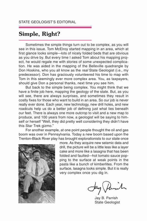
Simple, Right?
Sometimes the simple things turn out to be complex, as you willsee in this issue. Tom McElroy started mapping in an area, which atfirst glance looks simple—lots of nicely folded beds that are obviousas you drive by. But every time I asked Tom about his mapping proj-ect, he would regale me with stories of some unexpected complica-tion. He was aided in the mapping of the Belleville quadrangle byDon Hoskins, who you all know as the real State Geologist (i.e., mypredecessor). Don has graciously volunteered his time to map withTom in this seemingly ever more complex area. You, as taxpayers,should give Don a personal thanks, next time you see him.
But back to the simple being complex. You might think that wehave a finite job here, mapping the geology of the state. But, as youwill see, there are always surprises, and sometimes they result incostly fixes for those who want to build in an area. So our job is neverreally ever done. Each year, new technology, new drill holes, and newroadcuts help us do a better job of defining just what lies beneathour feet. There is always one more outcrop to visit and a new map toproduce, and 100 years from now, a geologist will be saying to him-self or herself “Well, they did pretty well considering they didn’t havethis Star Trek gizmo.”
For another example, at one point people thought the oil and gasboom was over in Pennsylvania. Today a new boom based upon theTrenton-Black River play has brought explorationists to our state once
more. As they acquire new seismic data anddrill, the picture will be a little less like a layercake and more like a lasagna that has beenfolded and faulted—hot tomato sauce pop-ping to the surface at weak points in thepasta like a bunch of kimberlites. From thesurface, lasagna looks simple. But it is reallyvery complex once you dig in.
Jay B. ParrishState Geologist

2
Geology of Ozaka the U.S. Route 22–522Industrial Drive Interchange1
by Thomas A. McElroyBureau of Topographic and Geologic Survey
INTRODUCTION. In July 2003, Tom McElroy and Assistant StateGeologist Sam Berkheiser first entered the portion of the U.S. Route22–522 Lewistown Bypass where it cuts deeply into Big Ridge inGranville Township, Mifflin County, Pa. (Figure 1). This area lies inthe Appalachian Mountain section of the Ridge and Valley physio-graphic province. At the time, excavation was underway for an exitramp to the Mifflin County Industrial Park, which is located to thesoutheast of the area, and Tom and Sam had come to investigatethe new exposure. They were surprised to see from a distance abroad band of black rock. It hadto be the black shale of the Mar-cellus Formation, but only forma-tions older than the Marcellus wereshown on the existing geologicmap for the area (Berg and oth-ers, 1980). The site was a jumbleof blasted rock that made contactand attitude determinations diffi-cult. As Tom and Sam scrambledup the steep slope, they foundmore surprises. In the Old PortFormation, they noted the follow-ing: (1) a pod of black, deeplyweathered rock that appeared tobe a consequence of a fuel spill;(2) Shriver Chert having anoma-lous purple and yellow bands;and (3) three distinct variations ofthe Ridgeley Sandstone. Thesestrange appearances caused Tomto remark “Are we in Oz?” As blast-
Studyarea
MC ALEVYSFORT
BELLEVILLE
BARRVILLE BURNHAM
LEWISTOWNALLENSVILLE
NEWTONHAMILTON
MC VEYTOWN MC COYSVILLE
77°37´30´77°45´00´
40°37´30´
40°30´00´
Figure 1. Location of the study areain the Belleville 7.5-minute quadrangle,Mifflin County, Pa.
1Modified from McElroy (2006).

ing and removal of rock continued, the geology became clear, butthe nickname stuck.
The construction project posed numerous geotechnical challenges,including, but not limited to, hillside failures in the clayey shales, oldmine workings in sandstones and shales, and acid drainage generatedby pyritic black shales. Perhaps the most costly of these challengeswere the hillside failures, which necessitated laying back the slopeabove the roadway from the original 1.5:1 to a 2.25:1 horizontal-to-vertical ratio.
STRATIGRAPHY. The stratigraphic relationship of rocks and theirthicknesses at the Industrial Drive Interchange and surrounding areaare shown and described in Figure 2. The oldest formation exposed atthe bottom of the roadcut is the Lower Devonian Old Port Formation,the underlying formations being covered by colluvium and constructionmaterials. The youngest unit exposed at the site is the Middle Devo-nian Marcellus Formation.
The Old Port Formation consists of the limestones, shales, cherts,and sandstones overlying the Keyser Formation and underlying theNeedmore Shale Member of the Onondaga Formation (Conlin andHoskins, 1962). The dominant lithology of the Old Port Formation occursin the lower part of the formation and consists of limestone with inter-beds of very fine grained sandstone, black chert, and shale. Almostall of the lower Old Port is covered by construction material at theexcavation site. Above the limestone are the Mandata Shale and theShriver Member. The Mandata is olive black, thin bedded, and non-calcareous. In this area, it is not continuous, and thickness rangesup to about 20 feet. The pod of black, deeply weathered rock men-tioned in the introduction is the Mandata Shale. The Shriver Memberis a fossiliferous, dark-gray to black chert that typically weathers tolight gray to white or yellow brown. At this location, the weatheredchert has striking thin purple and yellow bands. Typically, however,the Shriver Chert in this area has brown and yellow banding. TheShriver is continuous at the site, and its thickness varies from about30 to 50 feet in the surrounding area. The Ridgeley Member is at thetop of the Old Port Formation. It consists of white to very light gray,weathering to grayish-orange, quartz sandstone. It is about 70 feetthick. Robust brachiopods are common in this unit (Figure 3).
Cementation of the Ridgeley Member is highly variable at the site.Going up the slope of the excavation, the Ridgeley is exposed threetimes (Figure 2). The sandstone at the southeasternmost exposureis very friable and was deep mined as a source of glass sand some-
3

A
A
Dm
h
Do
n
Don
Don
Dm
Dm
Dor
Do
Do
Do
Dor
Do
rD
Sk S
to Sw
c
Dor
Dm
Do
r
Do
(
(
(
(
(
(
(
(
(
(
(
(
(
SC
ALE
0 0
2000
FT
600
M
AA
Lin
e of
geo
logi
ccr
oss
sect
ion
Show
n in
Fig
ure
4.
Sync
line
Ove
rtur
ned
plun
ging
syn
clin
e
Thr
ust f
ault
Saw
teet
hon
uppe
r pl
ate.
Geo
logi
c co
ntac
tIn
clud
esap
prox
imat
ely
loca
ted
cont
acts
.
Axi
al tr
ace
of f
olds
Lar
gear
row
show
sdi
rect
ion
ofpl
unge
;sh
ort a
rrow
s sh
ow d
irec
tion
of d
ips.
Ant
iclin
eSY
MB
OLS
GE
OLO
GIC
DE
SC
RIP
TIO
NS
Two
mem
bers
(not
delin
eate
don
map
)—N
eedm
ore
Shal
e(l
ower
).T
hick
ness
appr
oxim
atel
y13
5fe
et. S
ee te
xt f
or m
ore
deta
iled
desc
ript
ion.
Selin
sgro
veL
imes
tone
(upp
er)a
nd
Incl
udes
from
top
tobo
ttom
,R
idge
ley
Sand
ston
e(s
how
non
map
),lim
esto
new
ithin
terb
eds
ofsa
nd-
ston
e,bl
ack
cher
t,an
dsh
ale.
Thi
ckne
ssof
Old
Port
appr
oxim
atel
y27
0fe
et;t
hick
ness
ofR
idge
ley
appr
oxim
atel
y70
feet
.See
text
for
mor
e de
taile
d de
scri
ptio
n.
Shri
verC
hert
,Man
data
Shal
e,an
d
Dar
k-gr
ay,
foss
ilife
rous
,cr
ysta
lline
tono
dula
r,w
ell-
bedd
edlim
e-st
one;
mos
tbed
sfl
aggy
toth
ick,
som
em
assi
ve;t
hin
bedd
edat
top.
Thi
ckne
ss a
ppro
xim
atel
y 17
0 fe
et.
Med
ium
-gra
y,fi
nely
lam
inat
ed,
wel
l-be
dded
limes
tone
;fl
aggy
toth
ick
beds
.Thi
ckne
ss a
ppro
xim
atel
y 67
5 fe
et.
Gre
enis
h-gr
ay,
mod
erat
ely
wel
lbe
dded
shal
e;fi
ssile
toth
inbe
ds;
loca
llim
esto
nean
dsa
ndst
one
zone
s;re
dsh
ale
and
silts
tone
inlo
wer
part
.Thi
ckne
ss a
ppro
xim
atel
y 60
0 fe
et.
Hig
hly
fiss
ile,b
lack
,non
calc
areo
ussh
ale.
Thi
ckne
ssap
prox
imat
ely
70 f
eet.
See
text
for
mor
e de
taile
d de
scri
ptio
n.
Med
ium
-gra
y,w
eath
erin
gol
ive,
fine
-to
coar
se-g
rain
edsa
ndst
one;
num
erou
s,da
rk-g
ray
tobr
own
shal
e in
terb
eds.
Onl
ylo
wer
mos
t 100
fee
t pre
sent
.w
ell-
deve
lope
d,th
into
flag
gybe
ddin
g;
UN
ITS
MA
HA
NT
AN
GO
FOR
MA
TIO
ND
mh
MA
RC
EL
LU
SFO
RM
AT
ION
Dm
ON
ON
DA
GA
FOR
MA
TIO
ND
on
RID
GE
LE
YM
EM
BE
RD
or
OL
D P
OR
TFO
RM
AT
ION
Do
KE
YSE
RFO
RM
AT
ION
DS
k
TO
NO
LO
WA
YFO
RM
AT
ION
Sto
WIL
LS
CR
EE
KFO
RM
AT
ION
Sw
c
77°3
8´16
´77
°37´
30´
40°3
5´11
´
40°3
4´34
´Ba
sem
apm
odifi
edfro
mU
.S.G
eolo
gica
lSur
vey
Belle
-vi
lle7.
5-m
inut
equ
adra
ngle
(196
6,ph
otor
evis
ed19
73).
4
Figu
re 2
.B
edro
ck g
eolo
gy in
the
Ind
ustr
ial
Dri
ve I
nter
chan
ge a
rea
(the
stu
dy a
rea
show
n in
Fig
ure
1).
The
Lew
isto
wn
Byp
ass
run
s n
ort
hea
st-s
out
hw
est
thro
ugh
th
e ar
ea o
f ex
cava
tio
n.
Sta
rtin
g at
th
e n
ort
hea
st e
nd
of
the
exca
vate
d a
rea,
th
e o
ff-r
amp
swin
gs n
ort
hw
est
of
the
byp
ass,
cur
vin
g ar
oun
d t
o p
ass
und
er t
he
byp
ass
and
co
nn
ect
wit
h o
ld R
out
e 2
2–5
22
an
d I
nd
ustr
ial
Dri
ve i
n t
he
sout
hea
st c
orn
er o
f th
e m
ap.
Mo
dif
ied
fro
m M
cElr
oy
and
Ho
skin
s (2
00
5).

time in the nineteenth cen-tury. The mine’s existencewas not known to the con-tractors when they started ex-cavation—they discoveredthe mine when a bulldozer fellinto it! A fault-bounded, sili-ceous, and very hard sand-
stone of the Ridgeley Member is exposed 175 feet farther to the north-west. The northeastern extent of this sandstone is easily seen. Thesouthwestern end of the mapped unit is inferred from float. The thirdexposure of the Ridgeley Member, this one of well-indurated fossil-iferous sandstone, occurs higher on the ridge.
Overlying the Ridgeley Sandstone are the rocks of the OnondagaFormation. The Onondaga consists of two members, the NeedmoreShale (lower) and Selinsgrove Limestone (upper) (Willard, 1935). At theexcavation site, the Needmore Member is a medium-gray to medium-light-gray, fissile, generally calcareous shale. It commonly displayspencil cleavage and contains a few pyritized brachiopods. The Selins-grove Member is a dark- to medium-gray, dense, microcrystalline tovery finely crystalline, argillaceous limestone. Exposures of the Selins-grove in the study area are limited. Bedding ranges from thin tothick. The Onondaga Formation is about 135 feet thick in this area.
Above the Onondaga lies the Marcellus Formation, a highly fis-sile, black shale. It is sparsely fossiliferous, noncalcareous, slightlysilty, and pyritic. The formation contains several bentonite layers inits lowermost part. At the Mifflin County landfill, 7 miles to the north-east, the measured thickness of the Marcellus Formation is 70 feet.
STRUCTURE. The U.S. Route 22–522 Industrial Drive Interchangeis located in an area of northeast-southwest-striking, third-order folds.The third-order fold exposed at the excavation site is a structurallycomplex syncline (Figures 2 and 4). The northwest limb of the syn-cline is overturned, and the southeast limb is faulted. Both limbs havesteeply dipping beds. The syncline, which begins about a mile south-west of the excavation area, plunges to the northeast. The fault is in-
5
Figure 3. Sandstone boulder fromthe Ridgeley Member containingbrachiopods approximately 1 to1.5 inches in size.
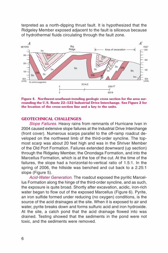
terpreted as a north-dipping thrust fault. It is hypothesized that theRidgeley Member exposed adjacent to the fault is siliceous becauseof hydrothermal fluids circulating through the fault zone.
GEOTECHNICAL CHALLENGESSlope Failures. Heavy rains from remnants of Hurricane Ivan in
2004 caused extensive slope failures at the Industrial Drive Interchange(front cover). Numerous scarps parallel to the off-ramp roadcut de-veloped on the northwest limb of the third-order syncline. The top-most scarp was about 20 feet high and was in the Shriver Memberof the Old Port Formation. Failures extended downward (up section)through the Ridgeley Member, the Onondaga Formation, and into theMarcellus Formation, which is at the toe of the cut. At the time of thefailures, the slope had a horizontal-to-vertical ratio of 1.5:1. In thespring of 2006, the hillside was benched and cut back to a 2.25:1slope (Figure 5).
Acid-Water Generation. The roadcut exposed the pyritic Marcel-lus Formation along the hinge of the third-order syncline, and as such,the exposure is quite broad. Shortly after excavation, acidic, iron-richwater began to flow out of the exposed Marcellus (Figure 6). Pyrite,an iron sulfide formed under reducing (no oxygen) conditions, is thesource of the acid drainages at the site. When it is exposed to air andwater, pyrite breaks down and forms sulfuric acid and iron hydroxide.At the site, a catch pond that the acid drainage flowed into wasdrained. Testing showed that the sediments in the pond were nottoxic, and the sediments were removed.
6
Don
Dmh
Don
Do
Do
Swc
Sto
DSkDo
Don
Dor
Dor
Dm
DSk
Sto
DSk
Sto
Dor
Dm
SCALE0
0
2000 FT
600 M
FEET
SEALEVEL
400
1200
800
METERS
SEALEVEL
100
200
300
AA
No vertical exaggeration
BigRidge Area of excavation
Figure 4. Northwest-southeast-trending geologic cross section for the area sur-rounding the U.S. Route 22–522 Industrial Drive Interchange. See Figure 2 forthe location of the cross-section line and a key to the units.

7
Figure 5. The U.S. Route 22–522 Industrial Drive Interchange after repair forslope failures (see front cover).
Figure 6. Acid drain-age flows out of anold iron mine in theMarcellus Formationat the excavation site.Photograph by FredWaldner, Site-BlauveltEngineers, Inc., 2003.

8
The cutting back of the slope removed a large volume of theMarcellus Formation, which may ameliorate the acid-water problemsat the site. Material removed from the hillside was mixed with lime-stone and sequestered. In addition, drains were installed above theremaining Marcellus Formation to decrease the volume of ground-water passing through it, and the outcrop was covered to reduce itsexposure to atmospheric oxygen.
Abandoned Mines. Two abandoned underground mines were duginto during excavation. The first was an iron mine underneath the mainroadway just east of the off-ramp (Figure 6). The ore was located inthe top part of the Marcellus Formation. When discovered, the supporttimbers were still in place. The mine was filled in as construction workcontinued.
The second mine was a sand mine in the Ridgeley Member (Fig-ure 7A). Collapses above the mine extend more than half a mile tothe southwest of the mine opening. One of these, a collapse adja-cent to the exposed opening, was repeatedly filling with water fromstorms. Several times, the pressure of this water blew out covers put
Figure 7. Opening to a Ridgeley sand mine encountered during excavation. A. Un-covered mine entrance. B. Mine opening blocked by a webbing of fabric andstone that was used to cover the entrance but blew out (see text).
A B

9
over the mine opening (Figure 7B). The Pennsylvania Department ofTransportation has since lined the collapse with clay and put a pipein to drain storm water away from the mine.
REFERENCES
Berg, T. M., Edmunds, W. E., Geyer, A. R., and others, compilers, 1980, Geologicmap of Pennsylvania (2nd ed.): Pennsylvania Geological Survey, 4th ser., Map 1,scale 1:250,000, 3 sheets.
Conlin, R. R., and Hoskins, D. M., 1962, Geology and mineral resources of the Mif-flintown quadrangle, Pennsylvania: Pennsylvania Geological Survey, 4th ser., Atlas126, 46 p.
McElroy, T. A., 2006, Stop 1—Geology at the Route 522 ramp road cut, Lewistown,in de Wet, A. P., ed., Four field trips in central Pennsylvania: Northeastern Sectionof the Geological Society of America, 41st Annual Meeting, Field Trip Guidebook,p. 106–110.
McElroy, T. A., and Hoskins, D. M., 2005, Bedrock geology of the Belleville quadran-gle, Mifflin County, Pennsylvania: Pennsylvania Geological Survey, 4th ser., Open-File Report OFBM 05–07.0, 16 p., Portable Document Format (PDF).
Willard, Bradford, 1935, Hamilton Group in central Pennsylvania: Geological Societyof America Bulletin, v. 46, p 195–224.
Meet the Staff—Part 2
In Part 1 of this article (Pennsylvania Geology, v. 36, no. 1, p. 14–18), we introduced you to the Director, Assistant Director, Adminis-trative Services, and Library Services areas of the Bureau. Now wewill meet the staff who work in the Computer Services and DatabaseServices areas.
COMPUTER SERVICES. The Computer Services area supports theday-to-day information-technology (IT) operations of the Bureau. Thisincludes help-desk support, applications development, networking,and database administration. The Computer Services staff memberalso maintains the Bureau’s networks and network-connected equip-ment and is responsible for computer and computer-related purchasesand security. He is a liaison for the Bureau with other state IT per-sonnel and outside consultants or contractors retained by the Bureaufor IT services.

10
Sandipkumar P. Patel. Sandipis a newcomer to the Bureau, havingbeen hired as an IT Generalist in ourMiddletown office in June 2005. Heearned a B.S. in Computer Sciencein 1998, and his prior credentials in-clude eight years of IT experience fromvarious industries. Immediately priorto joining the Bureau, Sandip was anindependent consultant responsiblefor designing, developing, and main-taining software applications and data-base solutions.
At the Survey, Sandip provideshelp-desk support for the Middletownoffice, maintains all the servers (fileservers, printer server, backup server, and database servers) and net-work routers and switches deployed at that location, and recommendshardware and software to be purchased by the Bureau. In addition,he coordinates with other staff and consultants on the developmentof software applications used in the Bureau’s databases and providesbackup support in the Middletown office for Database Services.
An ongoing project that Sandip has been heavily involved in isa stratigraphic database for the Bureau. The Survey maintains strati-graphic data in a number of forms and in a large number of disparatelocations. This application will coalesce the information into one cen-tralized database depository so that whenever someone needs data,he or she will not have to obtain it from more than one source or dataformat. The stratigraphic database will provide a series of utilities forusers to query, extract, and input data. To date, application require-ments and a database design have been completed, and an outcrop-data module is in operation. Modules for surficial, thin-section, drill-hole, and sinkhole data are to be developed in the second phase ofthe application.
DATABASE SERVICES. The Pennsylvania Geological Survey has threeinterrelated oil and gas applications maintained by the Database Ser-vices section in our Pittsburgh office. These applications are the WellsInformation System (WIS), Oil and Gas Base Maps, and the Penn-sylvania Internet Record Imaging System (PA*IRIS). The WIS and Oiland Gas Base Maps are internal applications residing in the Pittsburgh
Sandip Patel

11
office, and PA*IRIS is an external Internet application. A detailed de-scription of all three applications can be found in Pennsylvania Geology,v. 34, no. 2, p. 10–17. The staff of Database Services uses theseapplications to fulfill numerous IT contracts effectively and on timeand to provide high-quality document-management, database, GIS,and Internet products.
Mitesh Patel. Mitesh was hired as the new IT Generalist Admin-istrator of Database Services in January 2006. His prior experienceincluded IT work with the U.S. Army, the Pennsylvania SecuritiesCommission, and the Pennsylvania Department of Revenue. He re-ceived a B.S. in Computer Engineering in 1998 and an M.S. in Com-puter Information Systems in 2003.
Mitesh’s primary duty is to manage the Bureau’s oil and gas digi-tal services, including WIS, Oil and Gas Base Maps, and PA*IRIS.The users of these applications include state and federal agencies, aswell as 133 (as of October 27, 2006) oil and gas companies acrossthe United States and Canada—in all, more than 300 users!
Currently, Mitesh is the lead worker on a project that will incorpo-rate ESRI ArcIMS software to give users access to a “living” oil and gasbase map. This interactive map will connect to WIS and provide up-to-the-minute well locations as they are entered into the database. In ad-dition, users will have access to a number of geographic-information-system (GIS) layers that reside on the base-maps application, such aswell type, quadrangle, hydrology, field, and pool.
Our Bureau is a central repository for oil and gas documents filedwith the commonwealth. The Pittsburgh office processes on average5,000 location plats, 5,000 completion reports, and 2,000 pluggingcertificates per year. Prior to placing these documents in a central file,they are sent to up to 10 differentstaff members for processing.Under Mitesh’s direction, Data-base Services has been institut-ing OnBase Workflow software(a product of Hyland Software,Inc.) to fine-tune and expeditethe document-handling process.A Workflow application for loca-tion plats is already success-fully running, and applications forcompletion reports and pluggingcertificates are in the works. Mitesh Patel

12
Janice A. Hayden. Jan has been employed in our Bureau’s Pitts-burgh office as an IT Generalist since August 2001. She holds a B.S.in Computer Information Technology and came to the Survey withover eight years of experience in the computer field.
Jan provides IT support for the Pittsburghoffice of our Bureau, and she assists visitorsand PA*IRIS partners by giving training andsupport for the WIS and PA*IRIS applications.She is also responsible for hardware, software,and license maintenance contracts and pur-chases for PA*IRIS.
Jan is currently the project lead for an on-going geophysical-logs scanning project, work-ing with our West Virginia University contractor.The images from this project are made avail-
able on PA*IRIS. Jan is responsible for data entry, quality assurance,and indexing of the log images. The geophysical logs are kept on fileat the Survey’s Pittsburgh office, and the collection numbers in thetens of thousands. Scanning was completed on the entire collectionin April 2006 and is continuing on new logs, which are coming in atan average rate of 200 per month. As of October 26, 2006, a total of43,294 geophysical logs have been scanned and included in PA*IRIS.
Joseph E. Kunz, Jr. Joe started at the Survey on August 23,1984, coming to us after four years of service in the U.S. Navy.
Joe actually does multiple duties for the Survey. Inside the Data-base Services area, Joe operates an optical character recognition(OCR) program on scanned completion reports that will be importedinto WIS and PA*IRIS. He also processes new well records for thegeologists, sets up visitors on computersfor PA*IRIS, and answers questions fromclients or sends them information relatedto the PA*IRIS application.
In addition to his duties pertainingto oil and gas data, Joe greets visitorsto our Pittsburgh office and answers themain telephone line for the office. Hetakes care of our Pittsburgh library andorders publications as needed. He alsoorders all of the supplies for the officeand is in charge of the office credit cardand all the reports and audits that goalong with that responsibility. The two De-
Jan Hayden
Joe Kunz

13
partment vehicles for our Pittsburgh office are under Joe’s care; hemakes sure they are inspected and properly maintained. A specialjob Joe is currently working on is to reorganize the well-record filesin order to generate a lot more room for the incoming well records,location plats, and geophysical logs.
Lynn J. Levino. Lynn celebrated 14 years atthe Survey this October 2006, having been hiredas part of the “Gas Atlas” project team back inthe early 1990s. Before joining the Survey, Lynnwas the secretary for the Director of the Gover-nor’s Veterans Outreach and Assistance Centerin Greensburg, Pa.
Lynn is an integral part of the PA*IRIS part-nership, scanning and key entering all documentsand information for public Internet access. Thisincludes completion reports, location plats, andplugging certificates for all oil and gas wells in thecommonwealth. She handles all of the billing for PA*IRIS, includingthe billing for end-of-the-year subscription renewals, keeping accu-rate records of all monies received.
Lynn has become the key individual for introducing potential clientsto PA*IRIS. She trains visitors in the kiosk area in the use of our digitalproducts on a daily basis and sends companies interested in joiningthe partnership to Mitesh for the business side of the transaction.
Lynn Levino
ANNOUNCEMENT
Survey Atlas Reports on Sale
The Bureau of Topographic andGeologic Survey is putting 18 of itsAtlas Series reports on sale untilthe end of December 2006. Thesale publications are marked downmore than 50 percent from theiroriginal prices. These technicalreports include detailed, full-colorgeologic maps and descriptivetexts for selected 7.5- and 15-minute quadrangles. A list of ab-
breviated titles and sale prices isgiven on the next page. Specificbibliographic information can befound on our web site at www.dcnr.state.pa.us/topogeo/pub/sale.aspx.Also, if any of the reports go out ofprint during the sale, their titles willbe removed from the online list.
Atlas reports may be orderedfrom the State Bookstore, Com-monwealth Keystone Building, 400

14
North Street, Harrisburg, Pa. In-formation about purchase andpayment options, tax, and ship-ping and handling charges can befound on the Bureau’s web site.Announcements for future publi-cation sales will also be posted onour web site as each sale takesplace.
ATLAS REPORTS ON SALE(except where noted otherwise, names are7.5-minute quadrangles)
A 48. Donegal 15-Minute $1.60A 64. Hazen, Falls Creek,Reynoldsville, DuBois $10.00A 74cd. Luthersburg, Elliott Park $4.00A 85ab. Northern Half ofHoutzdale 15-Minute $3.20
A 85cd. Ramey, Houtzdale $8.80A 86. Blandburg, Tipton, Altoona,Bellwood $13.60A 95a. Philipsburg $4.80A 119ab. Chambersburg, part ofScotland $5.40A 129a. Caledonia Park $7.60A 133cd. Salladasburg, CoganStation $5.20A 134ab. Linden, Williamsport $6.20A 136. Millerstown 15-Minute $10.80A 143cd. Montoursville North,Huntersville $6.20A 144ab. Montoursville South,Muncy $6.80A 144cd. Allenwood, Milton $9.60A 154cd. Washingtonville,Millville $6.00A 177d. Sinking Spring $8.20A 187cd. Reading, Birdsboro $4.00
NEW RELEASES
Gettysburg Field GuidebookNow an Open-File Report
The Gettysburg, Pa., guidebookRifts, Diabase, and the Topographic“Fishhook”: Terrain and MilitaryGeology of the Battle of Gettys-burg—July 1–3, 1863, which wasused for a field trip at the 2006Annual Meeting of the GeologicalSociety of America, is now avail-able as Open-File Report 06–02on the Bureau’s web site at www.dcnr.state.pa.us/topogeo/pub/openfile/of06_02.aspx. It was writ-ten by Jon D. Inners, Pennsylva-nia Geological Survey; Roger J.Cuffey, Pennsylvania State Univer-sity; Robert C. Smith, II, John C.
Neubaum, Richard C. Keen,Gary M. Fleeger, Lewis Butts, andHelen L. Delano, PennsylvaniaGeological Survey; Victor A.Neubaum, Wellsville, Pa.; andRichard H. Howe, Camp Hill, Pa.
In the 105-page guidebook, theauthors review the topography, ge-ology, military actions, historicalconsequences, and monuments ofthe battlefield. Eight stops are in-cluded: McPherson Ridge, Lee’sHeadquarters and Seminary Ridge,Longstreet Tower, Little Round Top,Devils Den, the Peach Orchard,Culps Hill, and Cemetery Ridge.

15
Open-File Geologic Mapsfor Eastern Pennsylvania
The Bureau of Topographic andGeologic Survey recently releasednine online open-file reports forquadrangles in eastern Pennsyl-vania. The reports, which are inportable document format (PDF),include one 1:24,000-scale, full-color, surficial or bedrock geologicmap. Surficial geologic maps arepart of the five reports by Duane D.Braun of Bloomsburg University.These reports are for areas in thenortheastern part of the state. Thebedrock geologic maps are part of
the other four reports, which are byvarious authors and cover areas inthe southeastern part of the state.
In addition to its map, each re-port includes text and data tables.Relevant geographic-information-system (GIS) data in the forms ofESRI shapefiles and an ESRI 9.xpersonal geodatabase and ArcMapdocument are provided as sepa-rate downloads. These reports areavailable on the Bureau’s web site(www.dcnr.state.pa.us/topogeo/openfile/ofloc.aspx).
SURFICIAL GEOLOGY REPORTSby Duane D. Braun, Bloomsburg University
OFSM 06–07.0 Surficial Geology of the Scranton 7.5-Minute Quadrangle, LackawannaCounty, Pennsylvania.
OFSM 06–08.0 Surficial Geology of the Barbours 7.5-Minute Quadrangle, Lycomingand Sullivan Counties, Pennsylvania.
OFSM 06–09.0 Surficial Geology of the Bodines 7.5-Minute Quadrangle, LycomingCounty, Pennsylvania.
OFSM 06–12.0 Surficial Geology of the Lakeville 7.5-Minute Quadrangle, WayneCounty, Pennsylvania [supersedes report OF 99–02].
OFSM 06–13.0 Surficial Geology of the Hawley 7.5-Minute Quadrangle, Wayne Coun-ty, Pennsylvania.
BEDROCK GEOLOGY REPORTSOFBM 06–01.0 Bedrock Geologic Map of the Oxford and Pennsylvania Portion of
the Bay View Quadrangles, Chester and Lancaster Counties, Penn-sylvania, by Joseph C. Hill, Bloomsburg University.
OFBM 06–02.0 Bedrock Geologic Map of the Honey Brook Quadrangle, Chester andLancaster Counties, Pennsylvania, by Carolyn H. Brown, STATEMAPcooperator, Pennsylvania Geological Survey [supersedes report OFBM05–04.0].
OFBM 06–03.0 Bedrock Geologic Map of the Parkesburg Quadrangle, Chester andLancaster Counties, Pennsylvania, by Gale C. Blackmer, Penn-sylvania Geological Survey, and Carolyn H. Brown.
OFBM 06–04.0 Bedrock Geologic Map of the Chester Valley and Piedmont Portionof the Germantown, Malvern, Norristown, and Valley Forge Quad-rangles, Chester, Delaware, Montgomery, and Philadelphia Coun-ties, Pennsylvania, by Howell Bosbyshell, West Chester University.

16
GEOFACTS
The Peculiar Habits of Geologists
by James R. Shaulis and Gary M. FleegerBureau of Topographic and Geologic Survey
Geofact 8If properly trained, carbonivorouscanines can be used to locatecoal reserves.
Geofact 7Coffee and donuts can be used to lure ge-ologists into small confined areas where theycan be subjected to intense lecturing.
Geofact 9The arms of structural geologists involuntarily move into a position parallelto the S0 plane.

CONTENTS
Simple, right?........................................................................................... 1Geology of Oz—aka the U.S. Route 22–522 Industrial Drive Interchange 2Meet the staff—Part 2 .............................................................................. 9Announcement—Survey Atlas reports on sale ......................................... 13New releases ........................................................................................... 14
Gettysburg field guidebook now an open-file report ............................. 14Open-file geologic maps for eastern Pennsylvania .............................. 15
Geofacts—The peculiar habits of geologists ............................................ 16
ON THE COVER
Slope failures at the U.S. Route 22–522 Industrial Drive Interchange (seearticle on page 2). Failures occurred after heavy rains associated withHurricane Ivan had passed through the area. Construction for the Lewis-town Bypass appears in the background of the photograph, and con-struction for the off-ramp to Industrial Drive appears in the foreground.The view is to the northeast from the southwest edge of the off-ramproadcut. Photograph by Thomas A. McElroy, 2004.
PENNSYLVANIA GEOLOGY
PENNSYLVANIA GEOLOGY is published quarterly by the Bureau of Topographic andGeologic Survey, Pennsylvania Department of Conservation and Natural Resources, 3240Schoolhouse Road, Middletown, PA 17057–3534.Editor: Caron E. O’Neil.Contributed articles are welcome. Guidelines for manuscript preparation may be obtainedat www.dcnr.state.pa.us/topogeo/pub/pageolmag/pageolguide.aspx or by contacting theeditors at the address listed above.
VOL. 36, NO. 2/3 SUMMER/FALL 2006
DEPARTMENT OF CONSERVATION AND NATURAL RESOURCESBUREAU OF TOPOGRAPHIC AND GEOLOGIC SURVEY
Main Headquarters3240 Schoolhouse RoadMiddletown, PA 17057–3534717–702–2017FAX: 717–702–2065
Pittsburgh Office500 Waterfront DrivePittsburgh, PA 15222–4745412–442–4235FAX: 412–442–4298
BUREAU STAFF AND TELEPHONE NUMBERS
COMMONWEALTH OF PENNSYLVANIAEdward G. Rendell, Governor
DEPARTMENT OF CONSERVATION AND NATURAL RESOURCESMichael DiBerardinis, Secretary
OFFICE OF CONSERVATION AND ENGINEERING SERVICESLarry G. Williamson, Deputy Secretary
BUREAU OF TOPOGRAPHIC AND GEOLOGIC SURVEYJay B. Parrish, Director
Bureau web site: www.dcnr.state.pa.us/topogeoDCNR web site: www.dcnr.state.pa.us
Pennsylvania home page: www.state.pa.usDirector and State GeologistJay B. Parrish, P.G. 717–702–2053
Assistant DirectorSamuel W. Berkheiser,
Jr., P.G. 717–702–2055
Administrative ServicesLynn M. Goodling 717–702–2054Elizabeth C. Lyon 717–702–2063
Library ServicesRichard C. Keen 717–702–2020Lewis L. Butts, Jr. 717–702–2018
Publication ServicesJody R. Zipperer
(General Inquiries) 717–702–2073Christine E. Miles, P.G. 717–702–2044Anne B. Lutz, P.G. 717–702–2043Caron E. O’Neil, P.G. 717–702–2042
Local Government Outreach ServicesHelen L. Delano, P.G. 717–702–2031George E. W. Love 717–702–2047
Computer ServicesSandipkumar P. Patel 717–702–4277
Database ServicesMitesh R. Patel 412–442–4234Janice Hayden 412–442–4287Joseph E. Kunz 412–442–4235Lynn J. Levino 412–442–4299
GIS ServicesMichael E. Moore, P.G. 717–702–2024John H. Barnes, P.G. 717–702–2025Victoria V. Neboga 717–702–2026Stuart O. Reese, P.G. 717–702–2028Thomas G. Whitfield, P.G. 717–702–2023
Water Well ServicesSharon E. Fesus 717–702–2074Jody R. Zipperer 717–702–2073
Groundwater ServicesThomas A. McElroy, P.G. 717–702–2046
Geologic Mapping ServicesWilliam A. Bragonier, P.G. 717–702–2034WESTERN MAPPING
Gary M. Fleeger, P.G. 717–702–2045Clifford H. Dodge, P.G. 717–702–2036Antonette K. Markowski,
P.G. 717–702–2038James R. Shaulis, P.G. 717–702–2037EASTERN MAPPING
Gale C. Blackmer, P.G. 717–702–2032Helen L. Delano, P.G. 717–702–2031William E. Kochanov, P.G. 717–702–2033Stephen G. Shank, P.G. 717–702–2021
Laboratory and Geochemical ServicesJohn H. Barnes, P.G. 717–702–2025Stephen G. Shank, P.G. 717–702–2021
Coal-Bed Methane ServicesAntonette K. Markowski,
P.G. 717–702–2038
Coal Quality and Availability ServicesRodger T. Faill, P.G. 717–702–2041Leonard J. Lentz, P.G. 717–702–2040John C. Neubaum 717–702–2039
Oil, Gas, and Subsurface GeologicalServicesJohn A. Harper, P.G. 412–442–4230Kristin M. Carter, P.G. 412–442–4233Jaime Kostelnik 412–442–5828Christopher D. Laughrey 412–442–4232Joseph R. Tedeski 412–442–4295

Bureau of Topographic and Geologic SurveyDepartment of Conservation and Natural Resources3240 Schoolhouse RoadMiddletown, PA 17057–3534
Address Service Requested
An Equal Opportunity Employer 2200–BK–DCNR0103Recycled Paper
79° 77° 76°
75°
75°
78°
80°
79° 77°78° 76°
40°
80°
41°
42°
40°
75°
75°
42°
41°
SCALE
0 10 20 30 40 50 MI
0 20 40 60 80 KM
✶
LAKEERIE
DE
LA
WA
RE
RIV
ER
N. Y.
N.J.
N. Y.N. Y.
OH
IO
W. VA. MD. MD.
DEL.N. J.
W.
VA.
NORTHAMPTON
PHILADELP
HIA
ERIE
CRAWFORD
WARREN McKEAN POTTER TIOGA
VENANGO FOREST
MERCER
LAWRENCE
BUTLER
BEAVER
ALLEGHENY
ARMSTRONG
WESTMORE-LAND
WASHINGTON
GREENE
FAYETTE
CLARION
JEFFERSON
INDIANA
CLEARFIELD
CENTRE
ELKCAMERON
CLINTON
LYCOMING
UNION
SNYDER
CAMBRIA BLAIR
HUNTINGDON
SOMERSET
FULTON
BEDFORD
FRANKLIN
ADAMS
YORK
CUMBERLAND
PERRY
JUNIATA
MIFFLIN
DAUPHINLEBANON
NORTHUMBERLAND
MO
NTO
UR
LANCASTERCHESTER
DELAWARE
MONTGOMERY
BUCKS
BERKS
SCHUYLKILL
LEHIGH
CARBON
MONROE
COLUMBIA
LUZERNE
SULLIVAN
LACKA-WANNA
PIKE
WYOMING
WAYNE
BRADFORD SUSQUEHANNA
ATLASREPORT
SALE
ATLAS REPORTSALE
U.S.22–522INTERCHANGE
SURFICIALMAPS
BEDROCK
MAPS
ATLASREPORT
SALE
GETTYSBURGGUIDEBOOK
NEW
NEW
A 119ab
OFSM06–12.0
OFSM06–08.0 OFSM 06–07.0
OFBM06–01.0
OFBM 06–02.0OFBM
06–03.0
A 48
A 64A 74cd
A 85ab
A 85cd
A 86
A 95a
A 129a
A133cd
A134ab
A 136
A143cd
A144ab
A144cd A 154cd
A 177d
A187cd
OF 06–02
OFSM06–09.0
OFSM06–13.0
OFBM06–04.0
IN THIS ISSUE
Presorted StandardU.S. Postage
PaidHarrisburg, PAPermit No. 747