page 1 csiss center for spatial information science and systems 05/12/2006 geoinformatics 2006...
TRANSCRIPT

Page 1
CSISSCenter for Spatial Information Science and Systems
05/12/2006 Geoinformatics 2006
Center for Spatial Information Science and Systems (CSISS)
George Mason University (GMU)
Standard-compliant Grid Framework for Geoscience Virtual Products Modeling
Aijun Chen, Yuqi Bai, Yaxing Wei, Liping Di, Yang Liu
Dr. Aijun Chen
Page 2
CSISSCenter for Spatial Information Science and Systems
05/12/2006 Geoinformatics 2006
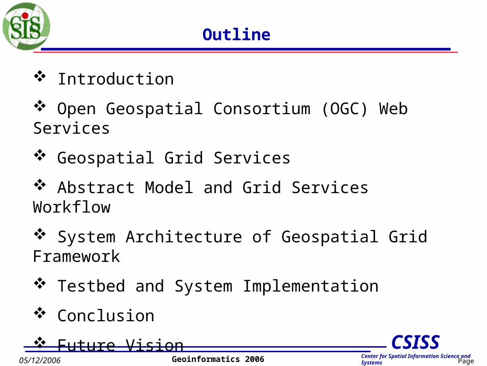
Outline
Introduction
Open Geospatial Consortium (OGC) Web Services
Geospatial Grid Services
Abstract Model and Grid Services Workflow
System Architecture of Geospatial Grid Framework
Testbed and System Implementation
Conclusion
Future Vision

Page 3
CSISSCenter for Spatial Information Science and Systems
05/12/2006 Geoinformatics 2006
Introduction
Grid computing has appeared as a new e-science information technology for addressing the formidable challenges of complete integration and utilization of heterogeneous computing systems and data resources.
The Open Geospatial Consortium (OGC) has been devoting to the interoperability of geospatial resources. It has produced a set of web-based data interoperability specifications such as WCS, WMS, CS/W.
CSISS at GMU has implemented several OGC-specification compliant Web Services, such as WMS, WCS and CS/W.
Try to establish a Grid service-oriented geospatial standard-compliant Grid framework for users to build up their application abstract processing model, execute it and get back users desired geospatial products through utilizing the OGC standard services and data and computing resources provided by Grid technologies.
Page 4
CSISSCenter for Spatial Information Science and Systems
05/12/2006 Geoinformatics 2006
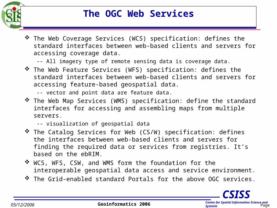
The OGC Web Services
The Web Coverage Services (WCS) specification: defines the standard interfaces between web-based clients and servers for accessing coverage data.
-- All imagery type of remote sensing data is coverage data.
The Web Feature Services (WFS) specification: defines the standard interfaces between web-based clients and servers for accessing feature-based geospatial data.
-- vector and point data are feature data. The Web Map Services (WMS) specification: define the standard
interfaces for accessing and assembling maps from multiple servers.
-- visualization of geospatial data
The Catalog Services for Web (CS/W) specification: defines the interfaces between web-based clients and servers for finding the required data or services from registries. It’s based on the ebRIM.
WCS, WFS, CSW, and WMS form the foundation for the interoperable geospatial data access and service environment.
The Grid-enabled standard Portals for the above OGC services.
Page 5
CSISSCenter for Spatial Information Science and Systems
05/12/2006 Geoinformatics 2006
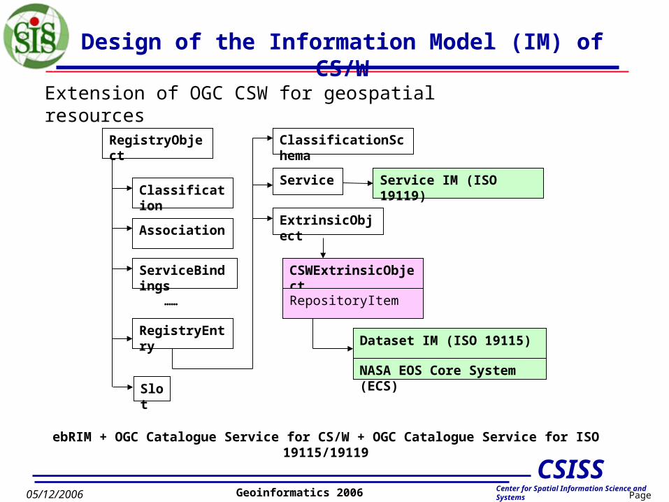
Design of the Information Model (IM) of CS/W
RegistryObject
Classification
ClassificationSchema
……
Association
ServiceBindings
RegistryEntry
Service
ExtrinsicObject
CSWExtrinsicObject
RepositoryItem
Service IM (ISO 19119)
Dataset IM (ISO 19115)
NASA EOS Core System (ECS)
ebRIM + OGC Catalogue Service for CS/W + OGC Catalogue Service for ISO 19115/19119
Extension of OGC CSW for geospatial resources
Slot
Page 6
CSISSCenter for Spatial Information Science and Systems
05/12/2006 Geoinformatics 2006
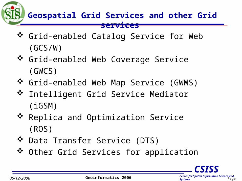
Geospatial Grid Services and other Grid services
Grid-enabled Catalog Service for Web (GCS/W) Grid-enabled Web Coverage Service (GWCS) Grid-enabled Web Map Service (GWMS) Intelligent Grid Service Mediator (iGSM) Replica and Optimization Service (ROS) Data Transfer Service (DTS) Other Grid Services for application

Page 7
CSISSCenter for Spatial Information Science and Systems
05/12/2006 Geoinformatics 2006
Globus MDS IM
HostnameMemoryCPU ……
Grid Enabled Catalogue Service for Web (GCS/W)
Integration of Information Model of CSW and Grid RLS/MDS
Extended CSW IM
repositoryItem
Dataset Metadata IM
UUID (logical ID)ProductNameProductDateTime……
Globus RLS IM
IDLogical File NamePhysical File Name
Client Requester
Send: Data requirementObtain:An optimal data service among the VO.
LegendIM – Information ModelCS/W – Catalogue Service – WebRLS – Replica Location ServiceMDS – Monitoring & Discovery ServiceVO – Virtual Organization
Page 8
CSISSCenter for Spatial Information Science and Systems
05/12/2006 Geoinformatics 2006
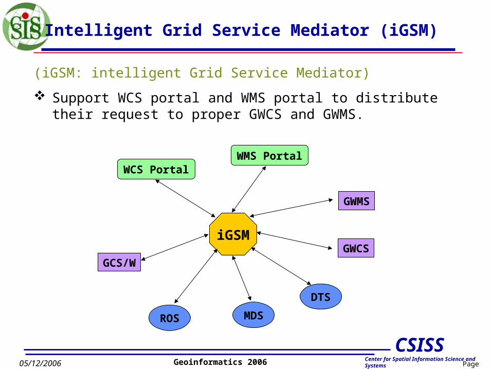
(iGSM: intelligent Grid Service Mediator)
Support WCS portal and WMS portal to distribute their request to proper GWCS and GWMS.
Intelligent Grid Service Mediator (iGSM)
WCS PortalWMS Portal
GCS/WGWCS
GWMS
iGSM
ROS MDS
DTS

Page 9
CSISSCenter for Spatial Information Science and Systems
05/12/2006 Geoinformatics 2006
Concept Models of Virtual Geospatial Products
Archived geo-object
User geo-object
Intermediate geo-object Automated data transformation service(WCS/WFS)
no service data servicemodeling and virtual data services
User Requested
User Obtained
Geospatial web/Grid services

Page 10
CSISSCenter for Spatial Information Science and Systems
05/12/2006 Geoinformatics 2006
Abstract Model for Modeling Virtual Products
Information Model of VDP• DTC: Data Type Catalogue. Data are classified into type based on their
scientific meaning. e.g. DEM, Slope, SlopeAspect, Landslide etc.• STC: Service Type Catalogue. Services are classified into service types
based on their scientific meanings. e.g. DEM2Slope, DEM2SlopeAspect,
SlopeAspect2Landslide, DEM2Landslide etc.
DataType
ServiceType
DataType
output
input
ServiceType
DataType
ServiceInstance
DataInstance
decides
associates to
associates to
associates to
GVWCSInstance
uses Real Data
Virtual Data
proce
ss

Page 11
CSISSCenter for Spatial Information Science and Systems
05/12/2006 Geoinformatics 2006
Design of Virtual Geospatial Products
System Architecture
User
GCS/W
GWCS
GVWCSRegister AM
Query
Geospatial
Data
GWCSGWICS
GWCTS
GSI (gt4.0.1)
Grid Workflow Engine Service
Grid Instantiation Service
Model Designer
Page 12
CSISSCenter for Spatial Information Science and Systems
05/12/2006 Geoinformatics 2006
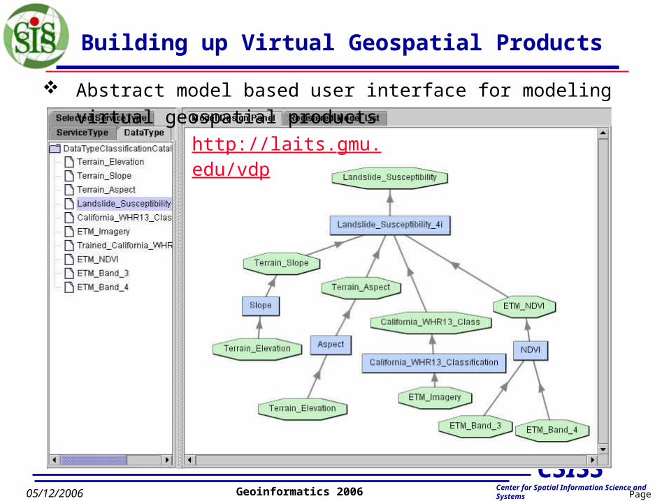
Building up Virtual Geospatial Products
Abstract model based user interface for modeling virtual geospatial products
http://laits.gmu.edu/vdp

Page 13
CSISSCenter for Spatial Information Science and Systems
05/12/2006 Geoinformatics 2006
Registry of Abstract Model of Virtual Products
Registration of Abstract Model to GridCS/W
Page 14
CSISSCenter for Spatial Information Science and Systems
05/12/2006 Geoinformatics 2006
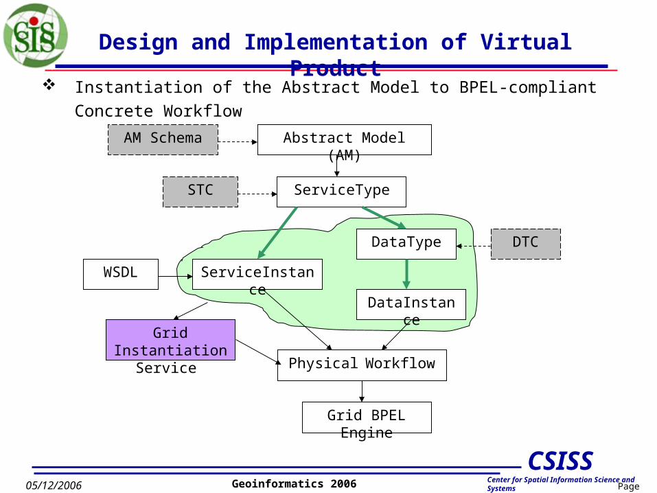
Design and Implementation of Virtual Product
Instantiation of the Abstract Model to BPEL-compliant Concrete Workflow
Abstract Model (AM)
ServiceType
ServiceInstanceWSDL
DataType
DataInstance
AM Schema
STC
DTC
Physical Workflow
Grid BPEL Engine
Grid Instantiation Service
Page 15
CSISSCenter for Spatial Information Science and Systems
05/12/2006 Geoinformatics 2006
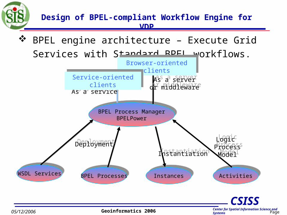
Design of BPEL-compliant Workflow Engine for VDP
BPEL engine architecture – Execute Grid Services with
Standard BPEL workflows.
ActivitiesActivitiesBPEL ProcessesBPEL Processes InstancesInstancesWSDL ServicesWSDL Services
BPEL Process ManagerBPELPower
BPEL Process ManagerBPELPower
InstantiationInstantiation
Logic ProcessModel
Logic ProcessModel
DeploymentDeployment
As a serveror middlewareAs a server
or middlewareAs a serviceAs a service
Browser-oriented clientsBrowser-oriented clients
Service-oriented clientsService-oriented clients
Page 16
CSISSCenter for Spatial Information Science and Systems
05/12/2006 Geoinformatics 2006
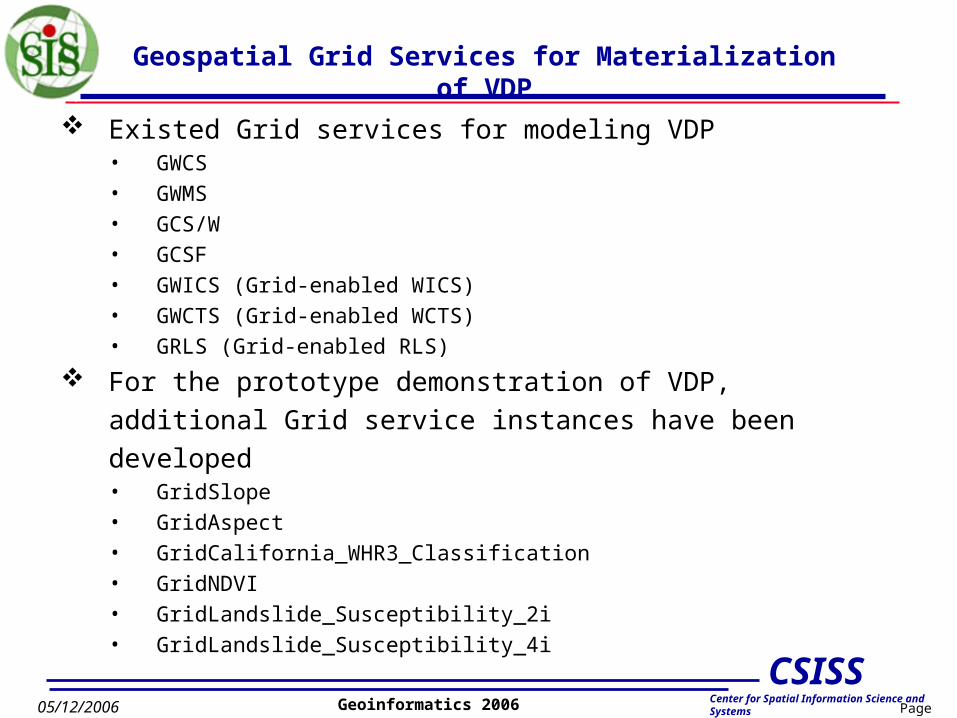
Geospatial Grid Services for Materialization of VDP
Existed Grid services for modeling VDP• GWCS• GWMS• GCS/W• GCSF• GWICS (Grid-enabled WICS)• GWCTS (Grid-enabled WCTS)• GRLS (Grid-enabled RLS)
For the prototype demonstration of VDP, additional Grid service
instances have been developed• GridSlope• GridAspect• GridCalifornia_WHR3_Classification• GridNDVI• GridLandslide_Susceptibility_2i• GridLandslide_Susceptibility_4i
Page 17
CSISSCenter for Spatial Information Science and Systems
05/12/2006 Geoinformatics 2006
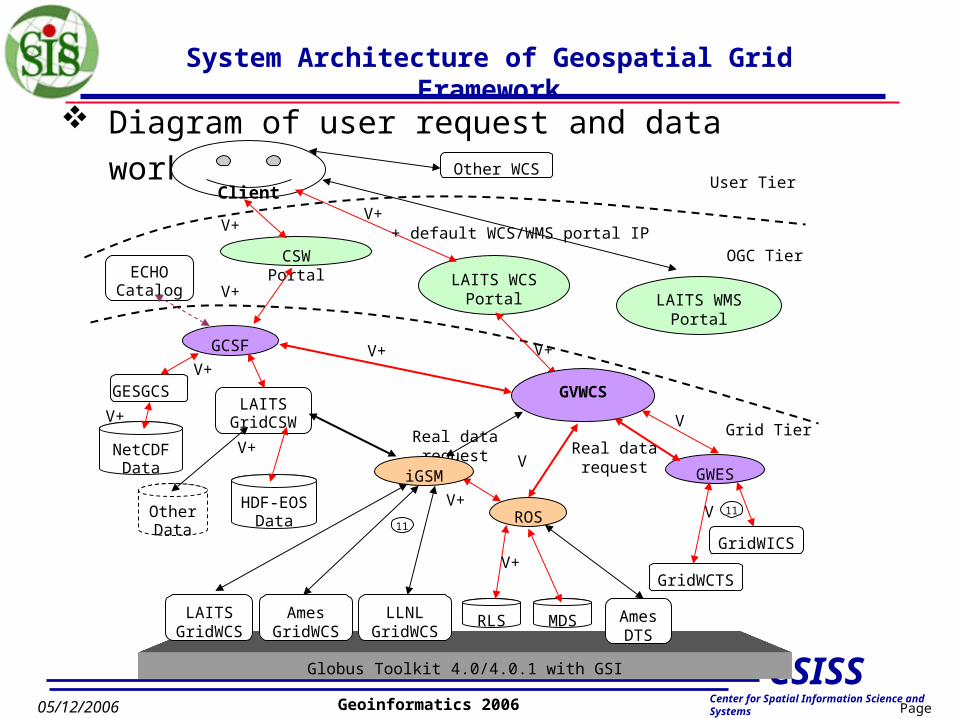
System Architecture of Geospatial Grid Framework
Diagram of user request and data workflow
Globus Toolkit 4.0/4.0.1 with GSI
HDF-EOS Data
Other Data
NetCDFData
LAITS WCS Portal
CSW Portal
Client
V+
V+
+ default WCS/WMS portal IP
V+
V+
Other WCS
LAITS GridCSW
GCSF
GESGCS
LAITS WMS Portal
ECHOCatalog
V+
V+
V+Real data request
AmesGridWCS
Ames DTS
RLS
ROS
MDS
iGSM
LLNLGridWCS
LAITSGridWCS
V+
V+
V+
11
VGVWCS
VGWES
GridWICS
GridWCTS
V
11V
Grid TierReal datarequest
OGC Tier
User Tier

Page 18
CSISSCenter for Spatial Information Science and Systems
05/12/2006 Geoinformatics 2006
Implementation: Testbed
GMU (Solaris) (laits.gmu.edu)Globus 4.0.1 with GMU Certs.
GMU (Mac)(geobrain.laits.gmu.edu)Globus 4.0.1 with GMU
Certs.
GMU CA center
Ames ipg05 (Linux)(ipg05.ipg.nasa.gov)Globus 4.0.1 with IPG
Certs.GMU LAITS VONASA IPG VO
GMU (Linux)(data.laits.gmu.edu)
Globus 4.0.1 with GMU Certs.
IPG CA center
NASA SGT (Linux)(arao2.sgt-inc.com)Globus 3.2 with CEOS
Certs.
NASA (Linux)(former.intl-interfaces.net)Globus 3.0 with CEOS Certs.
CEOS VO
Authentication among different VO
LLNL esg2 (Linux)(esg2.llnl.gov)
Globus 4.0.1 with ESG Certs.
LLNL ESG VO
ESG CA center
Grid Security (GSI) and VO Setup

Page 19
CSISSCenter for Spatial Information Science and Systems
05/12/2006 Geoinformatics 2006
Conclusion
The Grid service-oriented approach to serving geospatial data is a promising strategy for establishing an open, wide and secure system that securely provides access to huge volumes of distributed geospatial data/information through querying geospatial catalogs.
Devised a new geospatial abstract information model for building up geospatial application abstract model.
Applied the abstract model to Grid environment and concrete it to Grid-service workflow and execute it with Grid Workflow Engine.
Implements a prototype system that demos a landslide virtual data products.

Page 20
CSISSCenter for Spatial Information Science and Systems
05/12/2006 Geoinformatics 2006
Future Vision
GCSW and iGSM cooperate as Ganglia
GWCS, GWMS, GWICS, GWCTS as Nerve Cell
Grid and Web Services related technologies as basic infrastructure
Building up abstract model to produce virtual data products when user request it.
Using ontology-based semantic solution to provide automatically users application modeling
More Cell and more powerful Ganglia will be developed for more easily and completely Earth Science Data obtainments.
More specific Ganglia and Cell will be provided for special domain user requirements.
Page 21
CSISSCenter for Spatial Information Science and Systems
05/12/2006 Geoinformatics 2006
Thank You !
Any Questions [email protected]