oundle stone: its geology, occurrence and heritage …
TRANSCRIPT

OUNDLE STONE: ITS GEOLOGY, OCCURRENCE AND HERITAGE VALUE
Commissioned by: GP Planning for Churchfield Stone Ltd
Report authors: Dr Andy King and Tarnia McAlester Report date: 1 November 2012
Cobthorne House, West Street, Oundle, built in 1656 from Oundle Stone ashlar
with dressings and quoins of Weldon Stone.
Geckoella Ltd, Suite 323, 7 Bridge Street, Taunton, Somerset TA1 1TG Tel. 01392 762 334 [email protected] www.Geckoella.co.uk

CONTENTS
1. Introduction
2. The geology and characteristics of Oundle Stone
3. Building stone source quarries for Oundle Stone
4. The use and heritage value of Oundle Stone
5. Summary
6. References
Figures
1. The outcrop pattern of the Blisworth Limestone Formation in Northamptonshire
2. Comparison of different limestone varieties in the Blisworth Limestone Formation, Northamptonshire
3. Typical weathered surface of Oundle Stone ashlar, Oundle
4. Detail of Number 2A, Market Place, Oundle 5. Representative geological sections through the Blisworth Limestone Formation
(Oundle Stone) at Harley Way Quarry and the proposed Stonepits Quarry site 6 - Selected buildings in Oundle demonstrating the use of Oundle Stone 13.
Tables
1. Comparison of Oundle Stone with other Jurassic limestones traditionally used as building stones in north Northamptonshire
2. Status of former relic Oundle Stone building stone quarries in and around Oundle
3. Breakdown of limestone reserves and products at Harley Way Quarry and Stonepits Quarry
Back page: About the report authors

1. INTRODUCTION
This report, commissioned by GP Planning on behalf of Churchfield Stone Ltd in late September 2012, provides supporting information on the need for Oundle Stone as a building stone by:
a) Comparing and contrasting the differences between Oundle Stone and other varieties of Blisworth Limestone that occur in Northamptonshire;
b) Comparing and contrasting the differences between Oundle Stone and other varieties of Jurassic limestone traditionally used in buildings in northern Northamptonshire;
c) Explaining the rationale for the location of the proposed Stonepits Quarry near Benefield through an assessment of the status of former relic building stone quarries that worked Oundle Stone;
d) Comparing and contrasting the geological sequence of Oundle Stone and limestone products at Harley Way Quarry (due to commence in 2013) with the proposed application site Stonepits Quarry;
e) Demonstrating the heritage value of Oundle Stone in Northamptonshire, through its use in a selection of key buildings in the Oundle area.
Data within this report has drawn heavily on both authors experience gained from field work in Northamptonshire and undertaking the Strategic Stone Study for the county, combined with desk-based research using several key references listed in section 6.

2. THE GEOLOGY AND CHARACTERISTICS OF OUNDLE STONE
The geology of Northamptonshire is dominated by Jurassic rocks, predominantly limestones and sandstones which range from approximately 190 to 155 million years old. However, much of this Jurassic bedrock is obscured by younger ‘Ice Age’ boulder clays and river deposits so the outcrop pattern of limestones and sandstones appears highly irregular and complex, although in reality these rocks are typically nearly flat-bedded or only gently inclined.
One of these limestones, the Blisworth Limestone Formation occurs through much of southern and eastern Northamptonshire, extending from Aynho and Brackley in the south to beyond Oundle and King’s Cliffe in the north. Its distribution is shown in Figure 1.
The Blisworth Limestone Formation may reach up to 10 meters in thickness (Thompson, 1891), but at Blisworth the maximum is 7 metres and further north at Nassington, the formation is less than 5 metres thick (Thompson, 1927; Taylor, 1963; Torrens, 1967). Typically the Blisworth Limestone Formation is a pale creamy or greyish to pale yellowish limestone containing varying amounts of shelly fragments, and it often exhibits cross-bedding features. Although the formation was previously known as the ‘Great Oolite Formation’ in Northamptonshire, it is not always oolitic. Many of the constituent elongate shell fragments have been coated by layers of fine-grained carbonate which gives them a smooth, oval-shaped appearance, and they have been termed ‘superficial ooliths’ (Sutherland, 2003).
In Northamptonshire the Blisworth Limestone Formation has been extensively used as a building stone along its outcrop. Several different varieties are recognised but these are typically confined to very localised areas within the county:
Cosgrove Stone – a variety of Blisworth Limestone from southern Northamptonshire, which is often cross-bedded and has a ‘streaky’ yellowish/buffish or creamy appearance on weathered surfaces. In magnified sections the limestone is granular, containing a high proportion of roughly equidimensional shelly fragments and distinct micritic pellets.
Pury End Stone – a thinly-bedded, fawn coloured, fine-grained variety of Blisworth Limestone from southern Northamptonshire, which typically exhibits small-scale cross-bedded or laminated structures.
Raunds Limestone – a creamish to pale grey variety of Blisworth Limestone which occurs in eastern Northamptonshire. It is thinly cross-bedded in thin layers and contains flatter coated shell grains (superficial ooliths) in a crystalline spar matrix.
Oundle Stone – a pale grey, typically pale buff weathering variety of Blisworth Limestone confined to north-east Northamptonshire, which differs from all other varieties in its relatively coarse texture, full of closely-packed shell fragments set within a sparry matrix. Larger shell fragments are often conspicuous on weathered surfaces.
The differences between these limestone varieties is illustrated in Figures 2 and 3. Their differing chemical and lithological features gives each limestone type its different physical appearance and weathering properties when used in buildings.

Figure 1. The outcrop pattern of the Blisworth Limestone Formation in Northamptonshire (taken from Sutherland, 2003).

Oundle Stone – weathered surface with conspicuous closely packed shell fragments in sparry matrix
Oundle Stone – polished magnified view of coarse shelly, sparry limestone
Cosgrove Stone – polished magnified view showing micritic pellets in granular shelly limestone
Raunds Stone – weathered surface showing cross-bedding and aligned shelly fragments
Raunds Stone – polished magnified view of elongate shelly ‘ooliths’ in a crystalline sparry matrix
Pury End Stone – polished magnified view showing fine grain size and cross-bedding structures
Figure 2. Comparisons of different limestone varieties in the Blisworth Limestone Formation, Northamptonshire (partly taken from Sutherland, 2003).
Figure 3. Typical weathered surface of Oundle Stone ashlar showing conspicuous shelly fragments in a crystalline sparry matrix (Market Place, Oundle).

There are several other types of pale coloured Jurassic limestones that have traditionally been used as building stones in various parts of northern Northamptonshire. The most commonly used, and their characteristic geological differences with Oundle Stone, are listed in Table 1 below. The majority of these are variants of oolitic, shelly limestones from the Lincolnshire Limestone Formation which also includes famous building stones from Ketton, Stamford and Barnack, although these all lie within Leicestershire or Cambridgeshire.
Stone name
Geological unit name
Lithological description Typical use
Oundle Stone
Great Oolite Group: Blisworth Limestone Formation
Pale buff, to pale yellowish brown, coarsely-bioclastic limestone, typically full of closely-packed shells in a distinct sparry matrix. Some units commonly finely cross-bedded, with current winnowed and aligned fossil fragments
Used locally as building stone, mainly rubblestone in villages, but also some ashlar especially in prestigious buildings
King’s Cliffe Stone
Inferior Oolite Group: Lincolnshire Limestone Formation
Typically a warm, golden coloured limestone, porous and oolitic containing only small amounts of shell fragments, but varies from a fairly pale coloured, finer-grained porous oolite, to a very coarsely shelly, spar-cemented rock with small echinoid spines and gastropod shells. Alternating thin layers of fine and coarser ooliths with shell fragments give a characteristic banded texture
Used extensively in King's Cliffe, and other nearby villages, especially churches such as Apethorpe and Fotheringhay
Stanion Stone
Inferior Oolite Group: Lincolnshire Limestone Formation
Buff, spar-cemented oolitic limestone with fossil debris, the ooliths often being yellowish coloured. Typically less coarsely-textured than King's Cliffe Stone, but also lacks the distinctive oolite banding of the latter. Readily distinguished from Weldon Stone by its colour. Cross-bedded
Used within Stanion and nearby areas, partly as rubblestone, but mainly as ashlar especially for prestigious buildings
Weldon Stone (Weldon Oolite)
Inferior Oolite Group: Lincolnshire Limestone Formation
Pale white to pale cream, oolitic limestone (distinctly weathering pale grey) with some dispersed shell fragments, and characteristically no visible cement. Distinguished from King's Cliffe Stone and Stanion Stone by its colour. Often layered in diagonal cross-beds
One of Northants best known freestones, used extensively for ashlar and carving. Often used as quoins with other limestones being utilised for walls etc
Pendle limestones (various flaggy limestones)
Inferior Oolite Group: Northampton Sand Formation
Pale buff, golden yellow to pale brownish sandy limestones, often oolitic (sometimes sparsely), with limonitic veining, and containing fossil debris, typically crinoid ossicles. Almost invariably cross-bedded
Freestone varieties used as ashlar, others as rubblestone, sometimes roughly cut and laid in regular, flat blocks
Table 1. Comparison of Oundle Stone with other Jurassic limestones traditionally used as building stones in north Northamptonshire
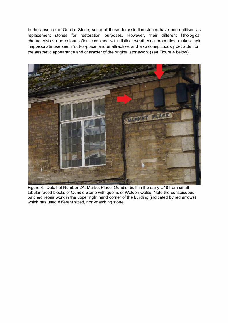
In the absence of Oundle Stone, some of these Jurassic limestones have been utilised as replacement stones for restoration purposes. However, their different lithological characteristics and colour, often combined with distinct weathering properties, makes their inappropriate use seem ‘out-of-place’ and unattractive, and also conspicuously detracts from the aesthetic appearance and character of the original stonework (see Figure 4 below).
Figure 4. Detail of Number 2A, Market Place, Oundle, built in the early C18 from small tabular faced blocks of Oundle Stone with quoins of Weldon Oolite. Note the conspicuous patched repair work in the upper right hand corner of the building (indicated by red arrows) which has used different sized, non-matching stone.

3. BUILDING STONE SOURCE QUARRIES FOR OUNDLE STONE
Historically there were many quarries in and around Oundle which were worked for building stone and these supplied both Oundle Stone ashlar and rubblestone for Oundle town and adjoining villages. Today however, none of these quarries are active. Many formerly marked as ‘old pits’ or ‘old limestone pits’ on C19th or early C20th maps have been completely infilled or sterilised beneath the present area of Oundle town. The complex of several building stone quarries that lay along the road to Benefield have become infilled or covered by the present day Golf Course where some of the present day hills and hollows likely represent traces of former old workings.
Until recently a quarry was worked at Churchfield, not far from the standing ruin of Lyvenden New Bield which is composed largely of local Oundle Stone type ashlar (Sutherland, 2003). However this site is also now disused.
A summary of the status of historic relic Oundle Stone quarries is provided in the following table.
Quarry name Location Grid reference Status Churchfield West of Oundle Golf
Course TL 0085 8805 Inactive
‘Oundle Quarries’
North Oundle TL 0309 8848 Inactive, heavily wooded North Oundle TL 0324 8853 Inactive, heavily wooded North Oundle TL 0214 8814 Sterilised by north Oundle
development ‘Benefield Road Quarries’
Immediately north of Benefield Road within arable fields
TL 0221 8823 Inactive, infilled TL 0241 8827 Inactive, infilled TL 0206 8821 Inactive, infilled TL 0199 8820 Inactive, infilled
South of Benefield Road, within Golf Course
TL 0223 8816 Sterilised by Golf Course development (Golf Course greens)
TL 0214 8814 TL 0195 8812 TL 0205 8813 TL 0188 8813
‘Benefield’ Southeast of Lammas Farm, Upper Benefield
SP 9804 8885 Inactive, largely infilled
Elmington East of Oundle TL 0547 8911 Inactive, heavily wooded Wadenhoe Wadenhoe TL 0086 8353 Inactive, infilled
Table 2. Status of former relic Oundle Stone building stone quarries in and around Oundle (data taken from various sources including historic maps (e.g. 19NW-13 for 1885), Taylor 1963, and the Survey Strategic Stone Study for Northamptonshire, 2011).
A recently permitted quarry (Harley Way Quarry) lies adjacent to the former Churchfield Quarry, and will extract up to 176,050 tonnes of Blisworth Limestone walling stone and crushed aggregates over a 17 year period (NCC, 2012). The quarry is not currently operational, however extraction is likely to commence in 2013.
The proposal for a new quarry (Stonepits Quarry) adjoins a relic quarry 0.5 km southeast of Lammas Farm (referred to in previous literature as ‘Benefield’ (Thompson, 1927, p.65)).
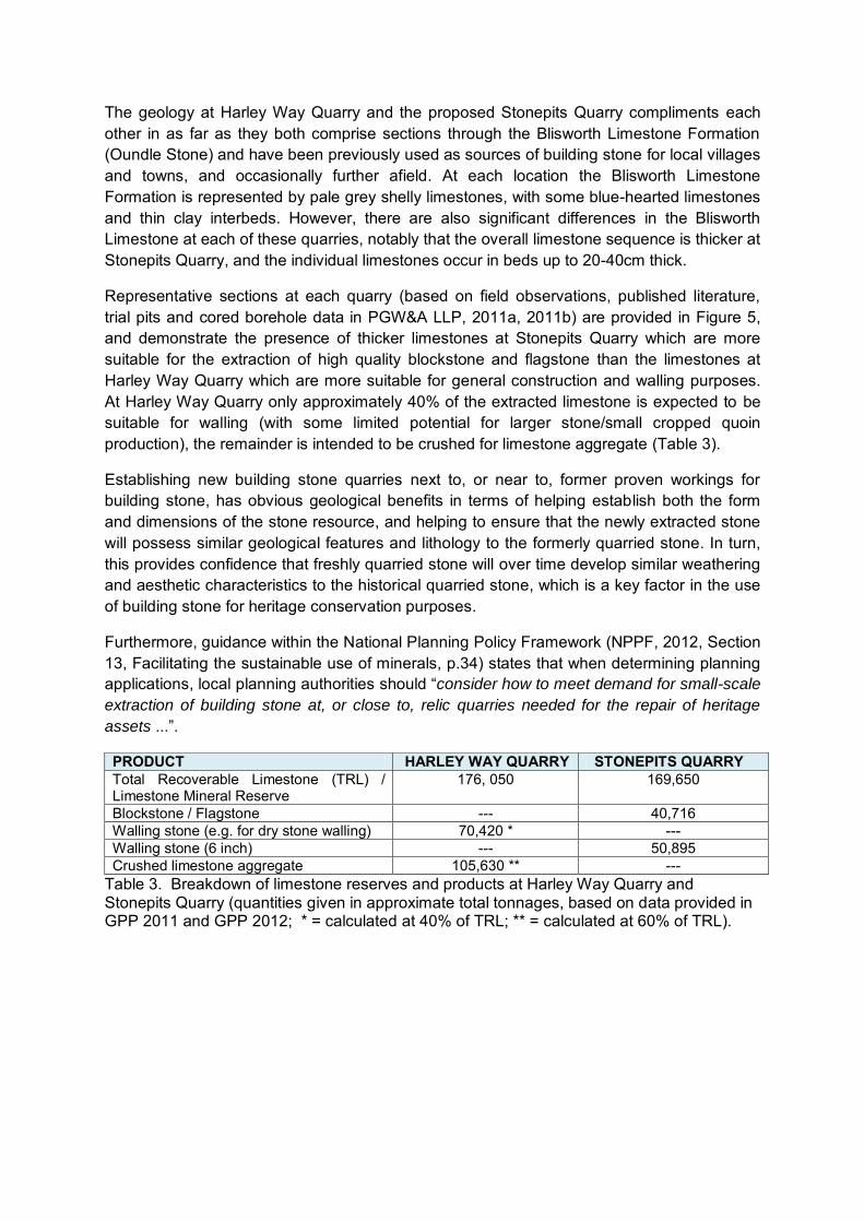
The geology at Harley Way Quarry and the proposed Stonepits Quarry compliments each other in as far as they both comprise sections through the Blisworth Limestone Formation (Oundle Stone) and have been previously used as sources of building stone for local villages and towns, and occasionally further afield. At each location the Blisworth Limestone Formation is represented by pale grey shelly limestones, with some blue-hearted limestones and thin clay interbeds. However, there are also significant differences in the Blisworth Limestone at each of these quarries, notably that the overall limestone sequence is thicker at Stonepits Quarry, and the individual limestones occur in beds up to 20-40cm thick.
Representative sections at each quarry (based on field observations, published literature, trial pits and cored borehole data in PGW&A LLP, 2011a, 2011b) are provided in Figure 5, and demonstrate the presence of thicker limestones at Stonepits Quarry which are more suitable for the extraction of high quality blockstone and flagstone than the limestones at Harley Way Quarry which are more suitable for general construction and walling purposes. At Harley Way Quarry only approximately 40% of the extracted limestone is expected to be suitable for walling (with some limited potential for larger stone/small cropped quoin production), the remainder is intended to be crushed for limestone aggregate (Table 3).
Establishing new building stone quarries next to, or near to, former proven workings for building stone, has obvious geological benefits in terms of helping establish both the form and dimensions of the stone resource, and helping to ensure that the newly extracted stone will possess similar geological features and lithology to the formerly quarried stone. In turn, this provides confidence that freshly quarried stone will over time develop similar weathering and aesthetic characteristics to the historical quarried stone, which is a key factor in the use of building stone for heritage conservation purposes.
Furthermore, guidance within the National Planning Policy Framework (NPPF, 2012, Section 13, Facilitating the sustainable use of minerals, p.34) states that when determining planning applications, local planning authorities should “consider how to meet demand for small-scale
extraction of building stone at, or close to, relic quarries needed for the repair of heritage
assets ...”.
PRODUCT HARLEY WAY QUARRY STONEPITS QUARRY Total Recoverable Limestone (TRL) / Limestone Mineral Reserve
176, 050 169,650
Blockstone / Flagstone --- 40,716 Walling stone (e.g. for dry stone walling) 70,420 * --- Walling stone (6 inch) --- 50,895 Crushed limestone aggregate 105,630 ** ---
Table 3. Breakdown of limestone reserves and products at Harley Way Quarry and Stonepits Quarry (quantities given in approximate total tonnages, based on data provided in GPP 2011 and GPP 2012; * = calculated at 40% of TRL; ** = calculated at 60% of TRL).

Figure 5. Representative geological sections, roughly to scale, through the Blisworth Limestone Formation (Oundle Stone) at Harley Way Quarry (left column) and the proposed Stonepits Quarry site (right column). The sequence at Harley Way Quarry is based on a trial pit (detailed in PGW&A LPP, 2011b); the sequence at Stonepits Quarry is based on a composite of a trial pit and borehole UB03/10 (detailed in PGW&A LPP, 2011a)

4. THE USE AND HERITAGE VALUE OF OUNDLE STONE
Oundle Stone has been used extensively as a local building stone in villages and small towns in north-east Northamptonshire, notably in Upper and Lower Benefield and Oundle where the stone plays a highly significant role in defining their character and charm, and is the main contributor to the built heritage. Oundle has been described as the ‘most attractive stone town in Northamptonshire’ (Sutherland, 2003) and in 1530 the traveller and commentator John Leland observed that the town had a fine central market and was ‘all buildid of stone’, much of which would have been the local variety of Blisworth Limestone (The Conservation Studio, 2009).
Oundle encompasses an extensive chronicle of growth. Development began during the C6th with the establishment of a Saxon settlement, and by the C8th Oundle had founded a monastery under the patronage of Peterborough Abbey. Burgage plots, with their characteristic long, thin layouts, possibly dating from the C13th still survive along West Street and the Market Place. These sections of the town, including New Street, and North Street, are set directly ‘road fronted’, with the omission of front gardens or enclosures, as historically, burgage plots would have had their most important building sitting close to the main street.
Oundle was a prosperous town, and the C17th to C19th saw the building of many handsome houses, such as Cobthorne House in West Street, their architecture relying upon the excellent local supply of Oundle Stone which provided both high quality ashlar and rubblestone. The near universal use of this local limestone is further exhibited in vernacular rubblestone construction, chunky chimney stacks and walling. The latter, mainly form part of the medieval burgage plot boundaries and were constructed between one metre and a half and three metres high in places. Dressings, lintels and quoins in many of the more prestigious buildings often employ paler Weldon Stone or oolitic Ketton Stone.
Oundle contains a high number of listed buildings, which run as continuous frontages along West Street, New Street, North Street and the Market Place. There are a large number of vernacular houses, cottages and outbuildings, most predominantly along Mill Road. These are built one and a half storeys high with timber lintels to the ground floor openings and doors. They are constructed of squared rubble, run to course and there is evidence of stone built chimneys. Oundle’s variety of style and construction is notable with many vernacular and modest cottages, and small dwellings sitting hand-in-hand with the high-status town houses, clearly designed to impress the local gentry.
Oundle contains a few buildings built of brick, the use of an often light yellow brick, blends in unobtrusively within this market town, which is defined by and dependent on its stone construction. Although there is a jumble of building types within Oundle, the clutter of differing gables, the steeply pitched stone flag roofing, varying in heights, with the buildings shifting from single storey cottages to the symmetrically designed four storey town houses, the town is highly dependent on the use of the local Oundle Stone.
Selected buildings in Oundle which demonstrate the above points are illustrated in Figures 6-13. Examples of the use of local Blisworth Limestone in Lower and Upper Benefield are provided in the reports by PGW&A LLP (2011a, 2011b).

Figure 6. Row of C17th cottages in Mill Road, Oundle, built of Oundle rubblestone.
Figure 7. Number 2/2A, Market Place, Oundle, built in the early C18 from small tabular faced blocks of Oundle Stone with quoins of Weldon Oolite. Note the conspicuous repair work in the upper right hand corner (by ‘Market place’ sign) which has used different sized, non-matching stone.

Figure 8. Cobthorne House, West Street, Oundle, built in 1656 from Oundle Stone ashlar with dressings and quoins of Weldon Stone (Weldon Oolite).
Figure 9. C17th Oundle Bookshop, West Street, with walling built from
Oundle Stone and colonnade of oolitic Ketton Stone.
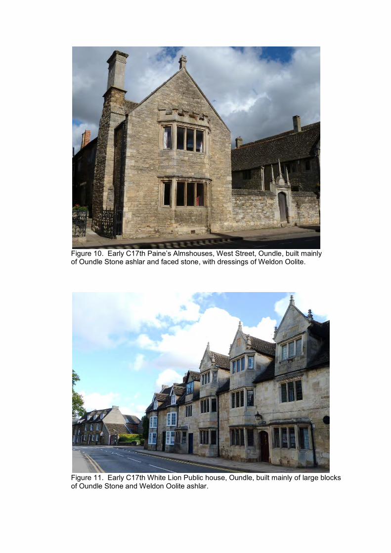
Figure 10. Early C17th Paine’s Almshouses, West Street, Oundle, built mainly of Oundle Stone ashlar and faced stone, with dressings of Weldon Oolite.
Figure 11. Early C17th White Lion Public house, Oundle, built mainly of large blocks of Oundle Stone and Weldon Oolite ashlar.

Figure 12. The Museum and Courthouse, corner of Stoke Hill, Oundle, built in 1877 from Oundle Stone with dressings and quoins of Weldon Oolite.
Figure 13. The ‘New’Schoolhouse, Stoke Hill, Oundle, built in 1799 and faced entirely in Oundle Stone aslar.

5. SUMMARY
Oundle Stone is a distinct variety of Blisworth Limestone which differs from other varieties of Blisworth Limestone in its geological and lithological characteristics (specifically in its pale buff colour, and relatively coarse texture, full of closely-packed shell fragments set within a sparry matrix.
In turn, these lithological characteristics mean that Oundle Stone will weather differently to other varieties of Blisworth Limestone and exhibit a different physical appearance when used in buildings. The larger shell fragments present in Oundle Stone are often conspicuous on weathered surfaces.
Oundle Stone has been used extensively as a local building stone in villages and small towns in north-east Northamptonshire, notably in Upper and Lower Benefield and Oundle where the stone plays a highly significant role in defining their character and charm, and is the main contributor to the built heritage. Oundle has been described as the ‘most attractive stone town in Northamptonshire’.
The occurrence of Oundle Stone is limited to north-east Northamptonshire. The main area from which it was formerly quarried as a building stone being confined to Oundle and closely adjoining areas (approximately within a 6 km radius).
There are presently no quarries actively working Oundle Stone. The vast majority of former quarries have either been infilled or become sterilised by development. The complex of well known building stone quarries that lay along the road to Benefield have largely become infilled or covered by the present day Golf Course. However, a recently permitted quarry (Harley Way Quarry) and a new application site (Stonepits Quarry) are both planned to extract Blisworth Limestone (Oundle Stone), with Harley Way Quarry becoming commencing in 2013.
At both Harley Way Quarry and the proposed Stonepits Quarry, the Blisworth Limestone Formation is represented by pale grey shelly limestones, with some blue-hearted limestones and thin clay interbeds. However, there are also significant differences in the Blisworth Limestone sequence at each of these quarries, notably that the overall limestone succession is thicker at Stonepits Quarry, and the individual limestones occur in beds up to 20-40cm thick.
The presence of thicker limestones at Stonepits Quarry are more suitable for the extraction of high quality blockstone and flagstone than the limestones at Harley Way Quarry which are more suitable for general construction and walling purposes.
6. REFERENCES
GPP, 2011: Environmental Statement, Application for a conservation stone quarry to extract Blisworth Limestone, Harley Way Quarry, Harley Way, Churchfield, Oundle PE8 5AU (December 2011). 49pp + 12 Appendices. GPP, 2012: Development Details, Establishment of a conservation stone quarry to extract Blisworth Limestone Blockstone and Flagstone product. 4pp. NCC, 2012: Planning Permission decision for Application 12/00001/MIN & EN/12/00135NCC for a conservation stone quarry at Harley Way, Churchfield, Oundle PE8 5AU. Northamptonshire County Council. 16pp. NPPF, 2012: National Planning Policy Framework, Department for Communities and Local Government. 59pp. PGW&A LLP, 2011a: Report on proposed building stone recovery at Upper Benefield (report produced for Churchfield Stone Ltd through GP Planning, March 2011). 14pp. PGW&A LLP, 2011b: Report on proposed building stone recovery at Churchfield Farm, Harley Way (report produced for Churchfield Stone Ltd through GP Planning, December 2011). 18pp. Strategic Stone Study, 2011: Northamptonshire – Atlas of Building Stones, Building Stones, Stone Buildings and Villages, Building Stone Quarries. (https://www.bgs.ac.uk/mineralsuk/mines/stones/EH_atlases.html, accessed 30 Oct. 2012). Sutherland, D. S. 2003: Northamptonshire Stone. Dovecote Press, Dorset. 128pp. Taylor, J. H. 1963: Geology of the area around Kettering, Corby and Oundle. Memoir of the Geological Survey (Explanation of Sheet 171). 149pp. The Conservation Studio, 2009: Oundle Conservation Area Character Appraisal. (http://www.docstoc.com/docs/28480605/Oundle-Conservation-Area-Character-Appraisal, acessed 30 Oct. 2012).
Thompson, B. 1891: The oolitic rocks at Stowe-Nine-Churches. Journal of the Northamptonshire Natural History Society, 6, 295-310. Thompson, B. 1927: Lime resources of Northamptonshire. Northamptonshire County Council. Torrens, H. S. 1967: The Great Oolite Limestone of the Midlands. Transactions of the Leicester Literary and Philosophical Society, 61, 65-90.

The Report authors:
Dr Andy King PhD BSc(Hons) MIEEM
Andy King is a Co-Director of Geckoella Ltd and geology specialist. He obtained his PhD (Geology) from the University of Wales in 1990. After oil exploration consultancy work at Cambridge University he joined English Nature working in the Southwest Region Science Team and Environmental Impacts Team as Senior Geologist. From 2001 to 2006 he was English Nature’s Area Manager for Somerset, Avon & Gloucestershire and formerly Chair of the Southwest Climate Change Impact Partnership (Biodiversity Group). He has written books and guides on the geology and fossils of the Somerset Coast and Quantock Hills AONB and the wildlife and history of the Somerset Levels and Moors. Recently Andy has worked as Consultant Geologist and Building Stone Specialist on the Strategic Stone Study (with English Heritage and the British Geological Survey) and with Somerset County Council on identifying building stone source quarries, defining Mineral Safeguarding Areas and developing minerals policy.
Tarnia McAlester MA BA(Hons) Tarnia McAlester is a specialist historic buildings and heritage consultant. She was national Project Manager for the Strategic Stone Study, commissioned by English Heritage for four years (from 2009 to 2012) and recently obtained an MA in Historic Environment Conservation. Tarnia has a broad knowledge of traditional construction techniques and materials with a strong understanding of conservation philosophy. Her surveying and investigative skills include Character Area Appraisals, Townscape Analysis, Conservation Management Plans, Statements of Signficance and historic building surveys.
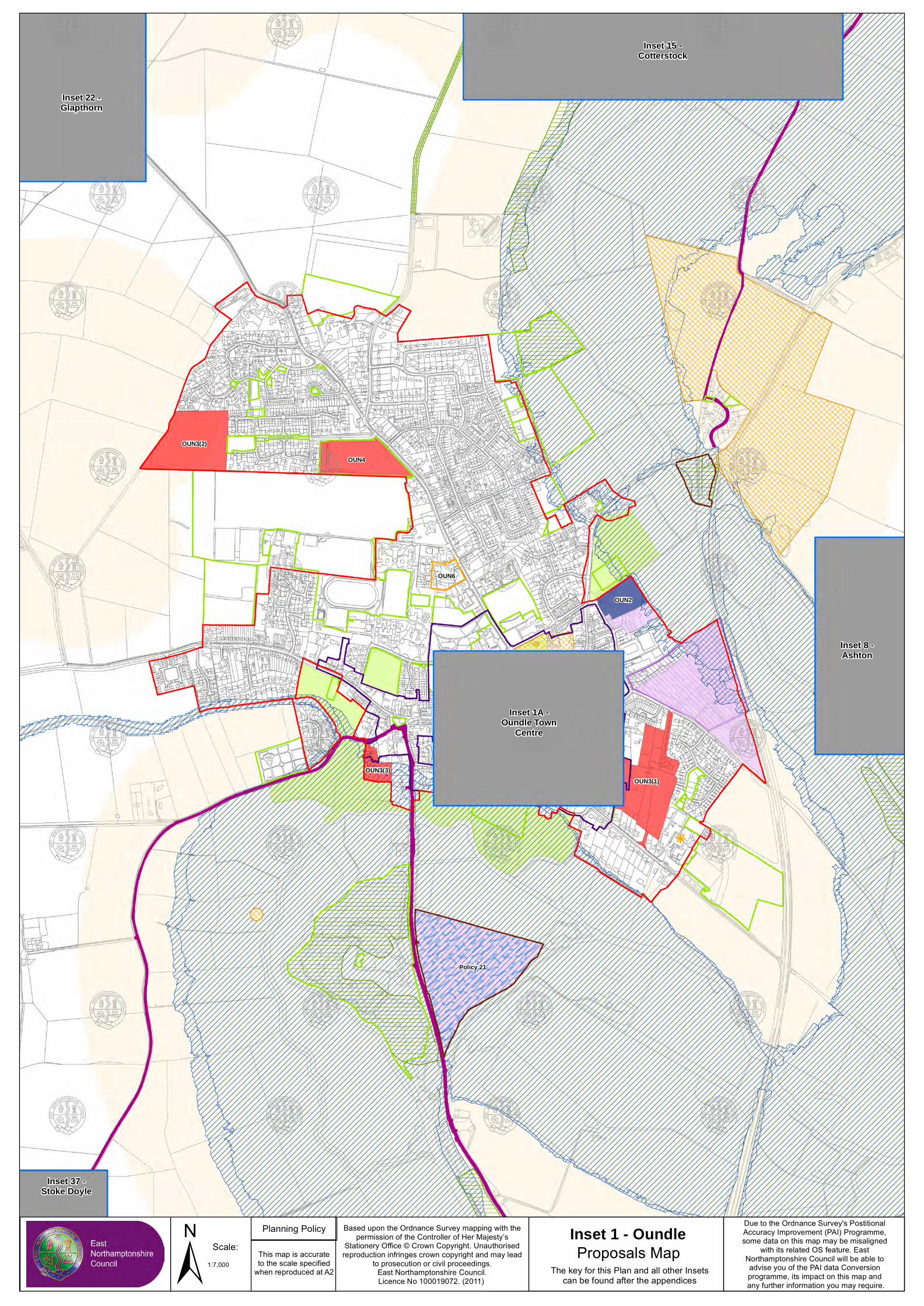
OUN2
OUN6
OUN3(1)
OUN3(2)
OUN4
OUN3(3)
Policy 21
± 1:7,000
Scale: This map is accurateto the scale specified
when reproduced at A2
Based upon the Ordnance Survey mapping with thepermission of the Controller of Her Majesty’s
Stationery Office © Crown Copyright. Unauthorisedreproduction infringes crown copyright and may lead
to prosecution or civil proceedings.East Northamptonshire Council.Licence No 100019072. (2011)
Planning Policy
Proposals MapThe key for this Plan and all other Insets
can be found after the appendices
Inset 1 - Oundle Due to the Ordnance Survey's Postitional Accuracy Improvement (PAI) Programme, some data on this map may be misaligned
with its related OS feature. East Northamptonshire Council will be able to advise you of the PAI data Conversion programme, its impact on this map and any further information you may require.
Inset 1A -Oundle Town
Centre
Inset 8 -Ashton
Inset 15 -Cotterstock
Inset 22 -Glapthorn
Inset 37 -Stoke Doyle


