(november 11th geo-scientific studies of the exclusive...
TRANSCRIPT
357ORV- Sagar Kanya
SK-343 Cruise Report (November 11th2017 to December 15th 2017)
Geo-scientific Studies of the
Exclusive Economic Zone
NATIONAL CENTRE FOR ANTARCTIC AND
OCEAN RESEARCH HEADLAND SADA, VASCO-DA-GAMA
(GOA)-403804
1.
Cruise
ii
CONTENTS
1. Introduction ................................................................................................... 1
2. Cruise Iternery .............................................................................................. 2
3. List Of Participants ...................................................................................... 3
4. Objectivearea Of Operation ....................................................................... 3
5. Methodology And Survey Equipments ....................................................... 4
6. Scientific Observation And Other Work During The Cruise .................. 7
7.Acknowledgement ............................................................................................ 8
ANNEXURE
1. Diary of Events
2. CTD/SVP Data Collection
3. Logsheet
4. Sediment Sampling
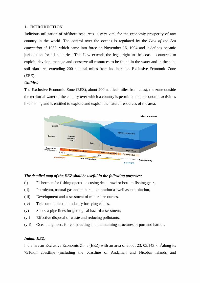
1. INTRODUCTION
Judicious utilization of offshore resources is very vital for the economic prosperity of any
country in the world. The control over the oceans is regulated by the Law of the Sea
convention of 1982, which came into force on November 16, 1994 and it defines oceanic
jurisdiction for all countries. This Law extends the legal right to the coastal countries to
exploit, develop, manage and conserve all resources to be found in the water and in the sub-
soil ofan area extending 200 nautical miles from its shore i.e. Exclusive Economic Zone
(EEZ).
Utilities:
The Exclusive Economic Zone (EEZ), about 200 nautical miles from coast, the zone outside
the territorial water of the country over which a country is permitted to do economic activities
like fishing and is entitled to explore and exploit the natural resources of the area.
The detailed map of the EEZ shall be useful in the following purposes:
(i) Fishermen for fishing operations using deep trawl or bottom fishing gear,
(ii) Petroleum, natural gas and mineral exploration as well as exploitation,
(iii) Development and assessment of mineral resources,
(iv) Telecommunication industry for lying cables,
(v) Sub-sea pipe lines for geological hazard assessment,
(vi) Effective disposal of waste and reducing pollutants,
(vii) Ocean engineers for constructing and maintaining structures of port and harbor.
Indian EEZ:
India has an Exclusive Economic Zone (EEZ) with an area of about 23, 05,143 km2along its
7516km coastline (including the coastline of Andaman and Nicobar Islands and
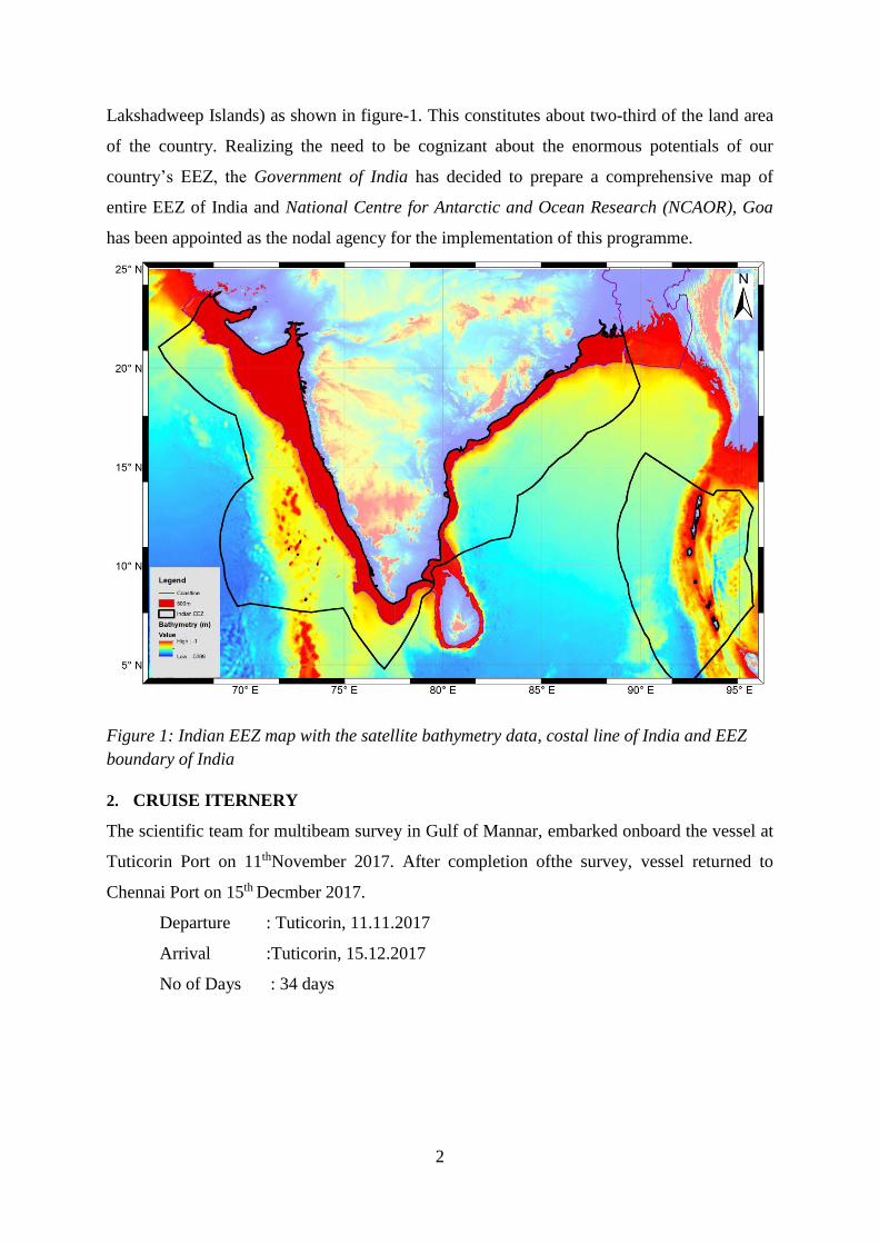
2
Lakshadweep Islands) as shown in figure-1. This constitutes about two-third of the land area
of the country. Realizing the need to be cognizant about the enormous potentials of our
country’s EEZ, the Government of India has decided to prepare a comprehensive map of
entire EEZ of India and National Centre for Antarctic and Ocean Research (NCAOR), Goa
has been appointed as the nodal agency for the implementation of this programme.
Figure 1: Indian EEZ map with the satellite bathymetry data, costal line of India and EEZ
boundary of India
2. CRUISE ITERNERY
The scientific team for multibeam survey in Gulf of Mannar, embarked onboard the vessel at
Tuticorin Port on 11thNovember 2017. After completion ofthe survey, vessel returned to
Chennai Port on 15th Decmber 2017.
Departure : Tuticorin, 11.11.2017
Arrival :Tuticorin, 15.12.2017
No of Days : 34 days
3
3. LIST OF PARTICIPANTS
1. Twinkle Damodharan NCAOR Ch. Scientist
2. MavungalArunlalSarunlal KCU Scientist
3. EdayiliamSreevidhya -do- -do-
4. NarathMeethalGayathri -do- -do-
5. Rahul Mavi NCAOR Shipboard Asst.
6. Mr. V.C Saratchandran NORINCO AMC-Service Engineer
7. Ramesh Raju -do- -do-
8. ElavarasanVasantharaja -do- -do-
9. Rajendran Prakash -do- -do-
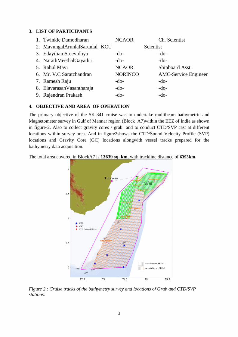
4. OBJECTIVE AND AREA OF OPERATION
The primary objective of the SK-341 cruise was to undertake multibeam bathymetric and
Magnetometer survey in Gulf of Mannar region (Block_A7)within the EEZ of India as shown
in figure-2. Also to collect gravity cores / grab and to conduct CTD/SVP cast at different
locations within survey area. And in figure2shows the CTD/Sound Velocity Profile (SVP)
locations and Gravity Core (GC) locations alongwith vessel tracks prepared for the
bathymetry data acquisition.
The total area covered in BlockA7 is 13639 sq. km, with trackline distance of 6393km.
Figure 2 : Cruise tracks of the bathymetry survey and locations of Grab and CTD/SVP
stations.

4
5. METHODOLOGY AND SURVEY EQUIPMENTS
5.1 Methodology :
The Multibeam survey was carried out using standard Survey practices. The tracklineswere
planned in order to obtain about 50% overlap at average speed of 5-7.5knots. Navigational
and attitude information is provided by C-NAV DGPS system. Ship track was maintained
within ±20 m.
Figure 3Trackline of SK-343
5.2 Equipment details:
5.2.1 SeaBeam-3012 MultibeamEchosounder System:
SeaBeam-3012 MultibeamEchosounderonboard ORV-SagarKanya was utilised to carry out
the surveys in Gulf of Mannar region. The SB-3012 is a 12 kHz, 201 beam sonar system, has
a beam width of 2° at nadir and is capable of measuring depths ranging from 200 m to 11000
m. Brief technical specification of the SB-3012 MBES system are as follows:
Manufacturer : L3-Communications Elac-Nautik GmbH, Germany
Number of Beams :189
Swath Coverage : 140°, 2° × 2° (5.5 × Depth),~20 dB backscatter
Depth :200 to 11, 000 m
Frequency of Operation : 12 kHz
Max. Source Level : 2° = 241 dB/mPa
5
Pulse Length : 2, 3, 5, 7, 10, 14, 20 ms
Side Lobe Suppression :> -30 dB
Technology : Full motion compensation (Sweptbeam technology)
Acquisition Software :Hydrostar
Data Processing Software :Carris HIPS & SIPS
The complete Multibeam system complex comprises of many sub systems:
a. Surface Sound velocity (SSV): The surface sound velocity profiler is an underway ocean
surface profiling system that collects the water sound speed continuously.
b. Gyro & Motion Sensor:Multibeam system uses IXSEA-Octans sensor for Gyro and
motion input. Octans is an IMO compliant survey grade gyrocompass with an integral motion
sensor.
c. Positioning System: The C-NAV DGPS subsystem is used for positioning accuracy. C-
NavGcGPS corrections are similar to other wide area DGPS system such as the Federal
Aviation Administration’s (FDA) wide area augmentation system (WAAS). The C-Nav GPS
receiver can accept two (2) different GcGPS correction service message formats. The C-Nav,
dual frequency, GPS equipment receives either of these corrections broadcast from the
communications satellite, applies them its own observed refraction corrected C/A code, dual
frequency observations, and performs a navigation solution. The resulting corrected GPS
position; velocity and time (PVT) are output from the C-Nav equipment to other subsystems
on the platform/vehicle/vessel to support the navigation positioning control requirements.
d. Network Time Server with GPS Synchronized Time Base: LANTIME (local area
network timeserver) provides a high precision time base to a TCP/IP network (stratum-1-
server). The NTP (network time protocol) is used to synchronize all NTP clients with the
reference. LANTIME/GPS is a set of equipment composed of a satellite controlled clock
GPS167, a single board computer with integrated network board and a power supply, all
installed in a metal 19” on the single-board computer flash disk. Four push buttons and a 2 x
40 character LC display can be used configure and monitor the time server. After the network
connection has been bestialized, the timeserver can also be configured and monitored
remotely from a work station via TEL/NET or FTP.
e. Network Time Protocol (NTP): NTP is a common method for synchronization of
hardware clocks in local and global networks. Timeservers synchronize themselves by a
reference time source, such as a radio controlled clock, GPS-receiver or modem time
distribution. Stratum-1-server distribute their time to several clients in the network which are
6
called stratum-2. A high precision synchronization is feasible because of the several time
references. Every computer synchronizes itself by up to three valued time sources. NTP
enable the comparison of the hardware times and the adjustment of the own clock, a time
precision of 128 ms, often better than 50 ms is possible.
5.2.2. Conductivity Temperature & Depth (CTD)
As the Sound Velocity Profiler (SVP) depth display was working, for this Sound Velocity
Profiler attached with the CTD cast. The vertical structure of sound velocity was
derivedusingSVP and CTD Cast. CTD is used to study various parameters like
temperature,conductivity, pressure etc. at various depths. The SBE-911pluswas utilized to
measure conductivity, temperature, and pressure in depths up to 6, 000 meters.The sketch
diagram of deployment of CTD as shown in figure 6.
Figure 4: the sketch shows the CTD cast with deployment unit.
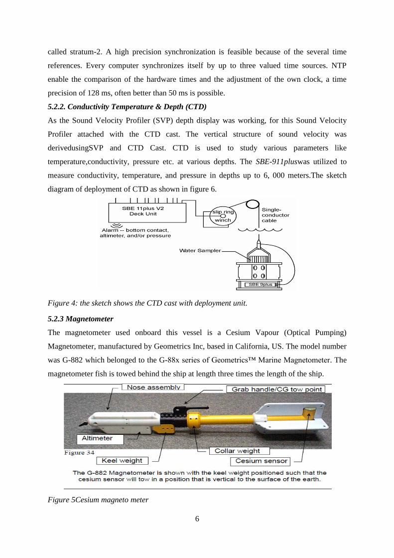
5.2.3 Magnetometer
The magnetometer used onboard this vessel is a Cesium Vapour (Optical Pumping)
Magnetometer, manufactured by Geometrics Inc, based in California, US. The model number
was G-882 which belonged to the G-88x series of Geometrics™ Marine Magnetometer. The
magnetometer fish is towed behind the ship at length three times the length of the ship.
Figure 5Cesium magneto meter
7
Technical Specifications of the G-882 Marine Magnetometer
Operating Principle Self-Oscillating split-beam CeisiumVapour
Operating Range 20, 000 to 100, 000 nT
CM-221Counter Sensitivity <0.004nT/Hz rms. Up to 10 samples per second.
Heading error 1nT (over entire 360E equatorial and polar spin)
Absolute accuracy <nT throughout Range
Output RS-232 at 1200 to 19200 Baud
Operating Temperature -30°F to +122°F (-35°C to +50°C)
Storage Temperature -48°F to +158°F (-45°C to +70°C)
Altitude Up to 30, 000 ft (9, 000 m)
Water tight Up to 9000 ft (2750m) depth operation
Power 24 to 32 VDC, 0.75 amp at turn-on and 0.5 amp thereafter.
The deck unit is connected to a winch cable via a deck cable. The deck unit is connected to
the computer along with a DGPS. The winch cable is connected to the magnetometer through
a sea cable (towing cable).
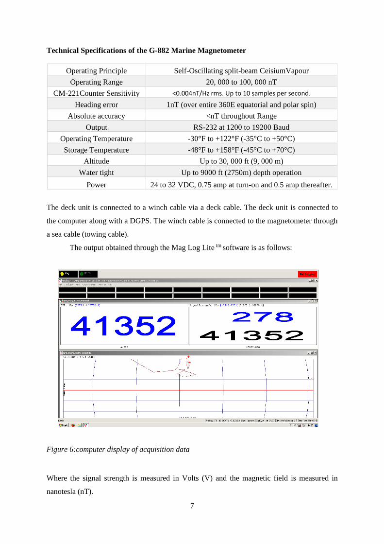
The output obtained through the Mag Log Lite tm software is as follows:
Figure 6:computer display of acquisition data
Where the signal strength is measured in Volts (V) and the magnetic field is measured in
nanotesla (nT).
8
5.2.4: Gravity Coring:
Gravity corer was used for sediment sample collection at one location. The corer consists of
an open-ended tube with lead weight (~700kgs).The corer is lowered into the seabed and
generally penetrates to a depth of up to 5-6 m. Gravity core lowering as shown in figure 5.
One core have been collected from Gulf of mannar and other one have been taken from off
Chennai( Cauvery-Palar Basin).
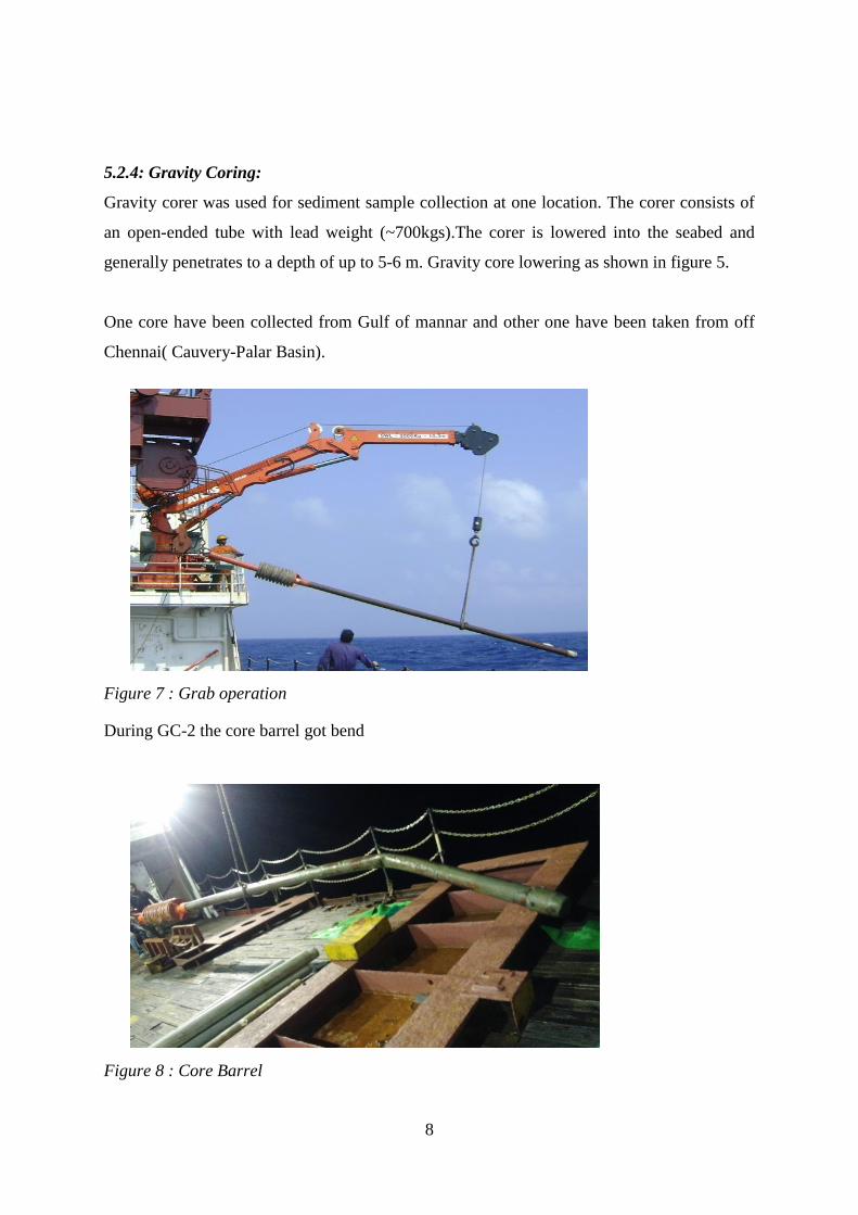
Figure 7 : Grab operation
During GC-2 the core barrel got bend
Figure 8 : Core Barrel
9
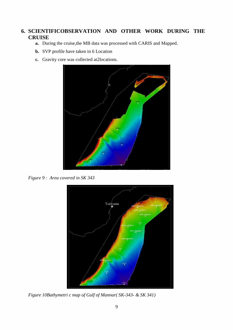
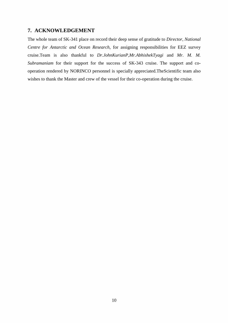
6. SCIENTIFICOBSERVATION AND OTHER WORK DURING THE
CRUISE a. During the cruise,the MB data was processed with CARIS and Mapped.
b. SVP profile have taken in 6 Location
c. Gravity core was collected at2locations.
Figure 9 : Area covered in SK 343
Figure 10Bathymetri c map of Gulf of Mannar( SK-343- & SK 341)
10
7. ACKNOWLEDGEMENT
The whole team of SK-341 place on record their deep sense of gratitude to Director, National
Centre for Antarctic and Ocean Research, for assigning responsibilities for EEZ survey
cruise.Team is also thankful to Dr.JohnKurianP,Mr.AbhishekTyagi and Mr. M. M.
Subramaniam for their support for the success of SK-343 cruise. The support and co-
operation rendered by NORINCO personnel is specially appreciated.TheScientific team also
wishes to thank the Master and crew of the vessel for their co-operation during the cruise.
11
ANNEXURE
1. Diary of Events
DIARY OF EVENTS SK-343
Date Time
(GMT)
Events(Lat/Long - ddmmss ; SOG- Speed Over Ground; COG- Course
Over Ground; D-Depth;WS- Wind Speed (knots); W- Weather)
11/11/2017 Vessel heading from Tuticorin to A7 block
Transit to A7 block. Vessel functioning and multibeamsettings checked. Vessel arrived at A7 block @
1728
BLOCK-A7
11/11/2017 1728 SOL SK341-PL01 , 08 51 17N , 78 47 17E
1900 EOL SK341-PL01 , 08 42 50N , 78 45 08E
1910 SOL SK341-PL02 , 08 42 44N , 78 44 59E
2131 EOL SK341-PL02 , 08 51 49N , 78 57 06E
2151 SOL SK341-PL03 , 08 51 54N , 78 56 20E
2151 EOL SK341-PL03 , 08.52.00N , 78.55.06E
2214 SOL SK341-PL04 , 08 52 06N , 78 52 24E
2334 EOL SK341-PL04 , 08 47 04N , 78 47 04E
2342 SOL SK341-PL05 , 08 46 44N , 78 47 04E
12/11/2017 @0230 08 48 14N , 78 47 54E , SOG 6.1 , COG 102 , D 484 , WS 6, W calm
0024 EOL SK341-PL05, 08 51 13N , 78 47 52E
0152 SOL SK341-PL06 , 08 50 59N, 78 48 39E
0219 EOL SK341-PL06, 08 48 59N, 78 47 49E
0457 EOL SK341-PL07, 08 56 21N, 79 01 57E
0500 SOL SK341-PL08, 08 56 21N, 79 02 07E
0751 EOL SK341-PL08, 08 55 27N, 79 22 51E
0810 SOL SK341-PL09, 08 56 16N, 79 22 27E
1127 EOL SK341-PL09, 08 57 10N, 79 01 35E
1139 SOL SK341-PL10, 08 58 01N, 79 01 35E
1411 EOL SK341-PL10, 08.57 16N, 79 20 39E
1420 SOL SK341-PL11, 08 57 10N, 79 21 39E
1600 EOL SK341-PL11, 08 50 02N, 79 27 30E
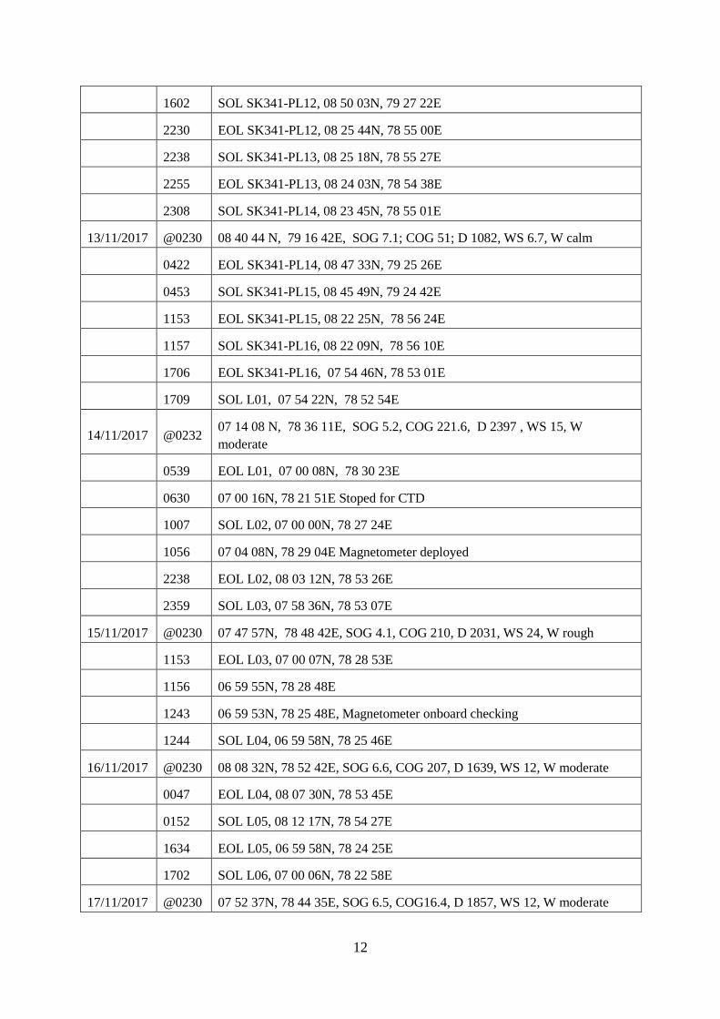
12
1602 SOL SK341-PL12, 08 50 03N, 79 27 22E
2230 EOL SK341-PL12, 08 25 44N, 78 55 00E
2238 SOL SK341-PL13, 08 25 18N, 78 55 27E
2255 EOL SK341-PL13, 08 24 03N, 78 54 38E
2308 SOL SK341-PL14, 08 23 45N, 78 55 01E
13/11/2017 @0230 08 40 44 N, 79 16 42E, SOG 7.1; COG 51; D 1082, WS 6.7, W calm
0422 EOL SK341-PL14, 08 47 33N, 79 25 26E
0453 SOL SK341-PL15, 08 45 49N, 79 24 42E
1153 EOL SK341-PL15, 08 22 25N, 78 56 24E
1157 SOL SK341-PL16, 08 22 09N, 78 56 10E
1706 EOL SK341-PL16, 07 54 46N, 78 53 01E
1709 SOL L01, 07 54 22N, 78 52 54E
14/11/2017 @0232 07 14 08 N, 78 36 11E, SOG 5.2, COG 221.6, D 2397 , WS 15, W
moderate
0539 EOL L01, 07 00 08N, 78 30 23E
0630 07 00 16N, 78 21 51E Stoped for CTD
1007 SOL L02, 07 00 00N, 78 27 24E
1056 07 04 08N, 78 29 04E Magnetometer deployed
2238 EOL L02, 08 03 12N, 78 53 26E
2359 SOL L03, 07 58 36N, 78 53 07E
15/11/2017 @0230 07 47 57N, 78 48 42E, SOG 4.1, COG 210, D 2031, WS 24, W rough
1153 EOL L03, 07 00 07N, 78 28 53E
1156 06 59 55N, 78 28 48E
1243 06 59 53N, 78 25 48E, Magnetometer onboard checking
1244 SOL L04, 06 59 58N, 78 25 46E
16/11/2017 @0230 08 08 32N, 78 52 42E, SOG 6.6, COG 207, D 1639, WS 12, W moderate
0047 EOL L04, 08 07 30N, 78 53 45E
0152 SOL L05, 08 12 17N, 78 54 27E
1634 EOL L05, 06 59 58N, 78 24 25E
1702 SOL L06, 07 00 06N, 78 22 58E
17/11/2017 @0230 07 52 37N, 78 44 35E, SOG 6.5, COG16.4, D 1857, WS 12, W moderate
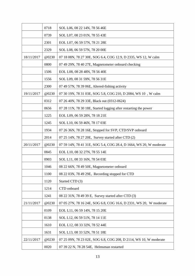
13
0718 SOL L06, 08 22 14N, 78 56 46E
0739 SOL L07, 08 23 01N, 78 55 43E
2301 EOL L07, 06 59 57N, 78 21 28E
2329 SOL L08, 06 59 57N, 78 20 00E
18/11/2017 @0230 07 18 08N, 78 27 30E, SOG 6.4, COG 12.9, D 2335, WS 12, W calm
0800 07 49 29N, 78 40 27E, Magnetometer onboard checking
1506 EOL L08, 08 28 48N, 78 56 40E
1556 SOL L09, 08 31 59N, 78 56 31E
2300 07 49 57N, 78 39 06E, Altered-fishing activity
19/11/2017 @0230 07 30 19N, 78 31 03E, SOG 5.8, COG 210, D 2084, WS 10 , W calm
0312 07 26 40N, 78 29 33E, Black out (0312-0624)
0656 07 28 11N, 78 30 18E, Started logging after restarting the power
1225 EOL L09, 06 59 28N, 78 18 21E
1245 SOL L10, 06 59 46N, 78 17 03E
1934 07 26 36N, 78 28 16E, Stopped for SVP, CTD/SVP onboard
2014 07 25 14N, 78 27 20E, Survey started after CTD (2)
20/11/2017 @0230 07 59 14N, 78 41 31E, SOG 5.4, COG 28.4, D 1664, WS 20, W moderate
0845 EOL L10, 08 32 27N, 78 55 14E
0903 SOL L11, 08 33 16N, 78 54 03E
1046 08 22 66N, 78 49 50E, Magnetometer onboard
1100 08 22 03N, 78 49 29E, Recording stopped for CTD
1120 Started CTD (3)
1214 CTD onboard
1241 08 22 31N, 78 49 39 E, Survey started after CTD (3)
21/11/2017 @0230 07 05 27N, 78 16 24E, SOG 6.8, COG 16.6, D 2331, WS 20, W moderate
0109 EOL L11, 06 59 14N, 78 15 20E
0138 SOL L12, 06 59 51N, 78 14 11E
1610 EOL L12, 08 33 32N, 78 52 44E
1631 SOL L13, 08 33 52N, 78 51 18E
22/11/2017 @0230 07 25 09N, 78 23 02E, SOG 6.8, COG 208, D 2114, WS 10, W moderate
0020 07 39 22 N, 78 28 54E, Helmsman restarted
14
0627 EOL L13, 06 59 32N, 78 12 30E
0645 SOL L14, 06 59 35N, 78 11 10E
23/11/2017 @0230 08 31 17N, 78 47 23E, SOG 7.4, COG 196, D 1201, WS 15, W moderate
0139 EOL L14, 08 34 42N, 78 50 02E
0155 SOL L15, 08 35 05N, 78 48 46E
1658 EOL L15, 07 59 31N, 78 09 34E
1720 SOL L16, 06 59 35N, 78 08 09E
1928 07 10 16N, 78 12 51E, Hydrostar crashed,
2016 joined on line L16, recording started
2040 07 10 01N, 78 12 25E, Magnetometer retrieved
2055 Magnetometer deployed
24/11/2017 @0230 07 40 25N, 78 24 56E, SOG 5.7, COG 23.4, D 1525, WS 18, W moderate
1401 EOL L16, 08 35 35N, 78 47 41E
1447 SOL L17, 08 37 33N, 78 44 04E
1603 EOL L17, 08 29 01N, 78 40 23E
1636 SOL L18, 08 27 20N, 78 41 16E
1830 EOL L18, 08 36 38N, 78 45 10E
1852 SOL L19, 08 35 53N, 78 46 20E
2127 07 55 19N, 78 32 59E, Magnetometer retrieved due to high traffic fishing
trollers
25/11/2017 @0230 07 46 01N, 78 25 53E, SOG 6.8, COG 200, D 1475, WS 15, W moderate
0400 07 35 48N, 78 21 43E, Helmsman’s display restarted
0250 Multibeam stopped fot CTD
0310 CTD deployed and retrieved due to winch problem
0406 CTD-4 deployed again upto 1250m
0511 CTD-4 onboard
0548 GC-1 Operation Started
0741 GC-1 onboard with sample
1021 EOL L19, 06 58 44N, 78 05 37E
1033 SOL L20, 06 59 24N, 78 05 07E
26/11/2017 @0230 07 456 33N, 78 22 49E, SOG 2.7, COG 256, D 1343, WS 20, W moderate

15
0013 EOL L20, 08 0151N, 78 28 02E
0015 SOL L21, 08 01 40N, 78 28 03E
0837 07 47 20N, 78 23 13E, After coring Magnetometer deployed
1425 07 10 37N, 78 08 09E, Helmsman’s display restarted
1600 EOL L21, 06 58 52N, 78 03 20E
1637 SOL L22, 06 59 03N, 78 02 17E
27/11/2017 @0230 07 56 28N, 78 25 56E, SOG 5.7, COG 22, D 1188, WS 25, W moderate
0310 EOL L22, 08 00 07N, 78 27 26E
0311 SOL J22, 08 00 16N, 78 27 28E
0330 SOL L23, 08 00 62N, 78 21 06E
1302 EOL L23, 06 58 47N, 78 00 52E
1317 SOL L24, 06 59 15N, 78 60 01E
2100 07 46 31N, 78 19 17E, Magnetometer onboard, track diversion
2355 EOL L24, 07 59 56N, 78 24 59E
28/11/2017 @0230 07 47 15N, 78 18 32E, SOG 7.1, COG 190, D 1154, WS 25, W moderate
0020 SOL L25, 08 00 47N, 78 24 07E
0132 07 53 07N, 78 21 00E, Magnetometer lowered & survey resumed
1004 EOL L25, 06 59 03N, 77 58 43E
1030 SOL L26, 06 58 41N, 77 57 27E
1318 07 13 35 N, 78 03 32E, Magnetometer onboard
1338 07 14 59N, 78 04 07E, Stopped for CTD/SVP operation
1358 CTD lowered
1545 CTD on deck
1618 07 14 17N, 78 03 49E, Survey started after CTD
29/11/2017 @0230 07 55 29N, 78 20 49E, SOG 3.9, COG 22.9, D 1023m , WS 35, W very
rough
0348 EOL L26, 08 00 05N, 78 22 43E
0410 SOL L27, 08 00 31N, 78 21 29E
1357 EOL L27, 06 59 29N, 77 56 33E
1424 SOL L28, 06 59 06N, 77 55 16E, magnetometer retrieved, MBES recording
stopped
30/11/2017 @0230 Survey suspended due to cyclone, SOG 2.5, COG 180, WS 45, W very rough
16
01/12/2017 @0230 Survey suspended due to cyclone, SOG 3.8, COG 335, WS 25, W vey rough
1337 06 55 28N, 77 56 49E, started MBES
1431 07 00 14N, 77 55 41E, Magnetometer deployed
02/12/2017 @0230 07 53 13N, 78 16 22E, SOG 5.7, COG 218, D 857, WS 15, W moderate
0107 EOL L28, 08 00 01N, 78 20 18E
0123 SOL L29, 07 59 54N, 78 19 07E
1135 EOL L29, 06 59 10N, 77 54 04E
1155 SOL L30, 06 59 02N, 77 52 56E
2253 EOL L30, 07 59 54N, 78 17 56E
2324 SOL L31, 07 58 12N, 78 15 44E
03/12/2017 @0230 07 38 55N, 78 08 06E, SOG 6.5, COG 193.3, D 1281, WS 20, W moderate
0904 EOL L31, 06 58 55N, 77 51 38E
0923 SOL L32, 06 58 27N, 77 50 18E
1710 07 46 10N, 78 69 55E, Helmsman’s display system crashed
1852 EOL L32, 07 56 16N, 78 14 03E
1929 SOL L33, 07 54 15N, 78 12 39E
04/12/2017 @0230 07 10 19N, 77 54 00E, SOG 6.8, COG 200.4, D 1698, WS 20, W moderate
0419 EOL L33, 06 58 00N, 77 49 00E
0443 SOL L34, 06 58 51N, 77 48 00E
1215 Helmsman’s system display stopped
1225 Helmsman’s system display restarted
1237 EOL L34, 07 47 45N, 78 08 14E
1245 SOL L35, 07 46 46N, 78 07 42E
2029 EOL L35, 06 58 26N, 77 46 45E
2046 SOL L36, 06 58 41N, 77 46 00E
05/12/2017 @0230 07 34 29N, 78 00 41E, SOG 6.9, COG 21.3, D 1111, WS 15, W calm
0300 EOL L36, 07 37 38N, 78 02 00E
. 0312 SOL L37, 07 38 07N, 78 01 23E
0925 EOL L37, 06 58 44N, 77 45 06E
0945 SOL L38, 06 58 38N, 77 44 13E
1047 07 04 41N, 77 46 41E, Vessel stopped for CTD, CTD on deck
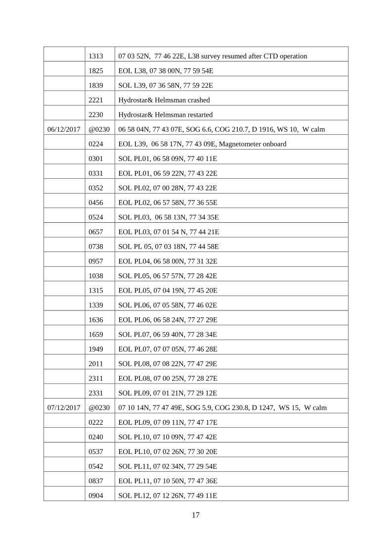
17
1313 07 03 52N, 77 46 22E, L38 survey resumed after CTD operation
1825 EOL L38, 07 38 00N, 77 59 54E
1839 SOL L39, 07 36 58N, 77 59 22E
2221 Hydrostar& Helmsman crashed
2230 Hydrostar& Helmsman restarted
06/12/2017 @0230 06 58 04N, 77 43 07E, SOG 6.6, COG 210.7, D 1916, WS 10, W calm
0224 EOL L39, 06 58 17N, 77 43 09E, Magnetometer onboard
0301 SOL PL01, 06 58 09N, 77 40 11E
0331 EOL PL01, 06 59 22N, 77 43 22E
0352 SOL PL02, 07 00 28N, 77 43 22E
0456 EOL PL02, 06 57 58N, 77 36 55E
0524 SOL PL03, 06 58 13N, 77 34 35E
0657 EOL PL03, 07 01 54 N, 77 44 21E
0738 SOL PL 05, 07 03 18N, 77 44 58E
0957 EOL PL04, 06 58 00N, 77 31 32E
1038 SOL PL05, 06 57 57N, 77 28 42E
1315 EOL PL05, 07 04 19N, 77 45 20E
1339 SOL PL06, 07 05 58N, 77 46 02E
1636 EOL PL06, 06 58 24N, 77 27 29E
1659 SOL PL07, 06 59 40N, 77 28 34E
1949 EOL PL07, 07 07 05N, 77 46 28E
2011 SOL PL08, 07 08 22N, 77 47 29E
2311 EOL PL08, 07 00 25N, 77 28 27E
2331 SOL PL09, 07 01 21N, 77 29 12E
07/12/2017 @0230 07 10 14N, 77 47 49E, SOG 5.9, COG 230.8, D 1247, WS 15, W calm
0222 EOL PL09, 07 09 11N, 77 47 17E
0240 SOL PL10, 07 10 09N, 77 47 42E
0537 EOL PL10, 07 02 26N, 77 30 20E
0542 SOL PL11, 07 02 34N, 77 29 54E
0837 EOL PL11, 07 10 50N, 77 47 36E
0904 SOL PL12, 07 12 26N, 77 49 11E
18
1120 EOL PL12, 07 05 47N, 77 34 26E
1126 SOL PL13, 07 06 11N, 77 35 36E
1150 Helmsman’s display restarted
1344 EOL PL13, 07 13 29N, 77 49 25E
1354 SOL PL14, 07 14 12N, 77 49 10E
1442 EOL PL14, 07 11 22N.77 44 18E
1447 SOL PL15, 07 11 07N, 77 43 43E
1614 EOL PL15, 07 16 16N, 77 50 44E
1615 SOL PL16, 07 16 23N, 77 50 49E
2000 EOL PL16, 07 33 32N, 77 57 11E
2029 SOL CL01, 07 35 08N, 77 55 59E, Magnetometer deployed
08/12/2017 @0230 07 43 52N, 78 07 09E, SOG 6.6, COG 36.5, D 741.5, WS 10, W calm
0122 EOL CL01, 07 37 37N, 78 03 09E
0123 SOL PL17, 07 37 44N, 78 03 14E
0430 07 54 46N, 78 13 49E, Magnetometer deployed
0740 EOL PL17, 08 01 47N, 78 29 57E, Helmsman’s display hanged & restarted
the system
0750 SOL PL18, 08 01 30N, 78 30 16E
0905 EOL PL18, 07 54 08N, 78 26 40E
0907 SOL PL19, 07 54 06N, 78 26 27E
1056 EOL PL19, 07 59 47N, 78 15 28E
1100 SOL CL03, 07 59 31N, 78 15 35E
1706 EOL CL03, 07 39 33N, 78 48 09E
1708 SOL PL20, 07 39 29N, 78 48 05E
2254 EOL PL20, 07 06 51N, 78 35 45E
2255 SOL CL01a, 07 06 53N, 78 35 38E
09/12/2017 @0230 07 20 59N, 78 15 50E, SOG 6.8, COG 306.4, D 2209, WS 10, W calm
0545 EOL CL01a, 07 34 41N, 77 57 32E
0546 SOL PL21, 07 34 47N, 77 57 30E
0747 EOL PL21, 07 43 43N, 78 05 52E
0754 SOL CL02, 07 43 51N, 78 06 19E
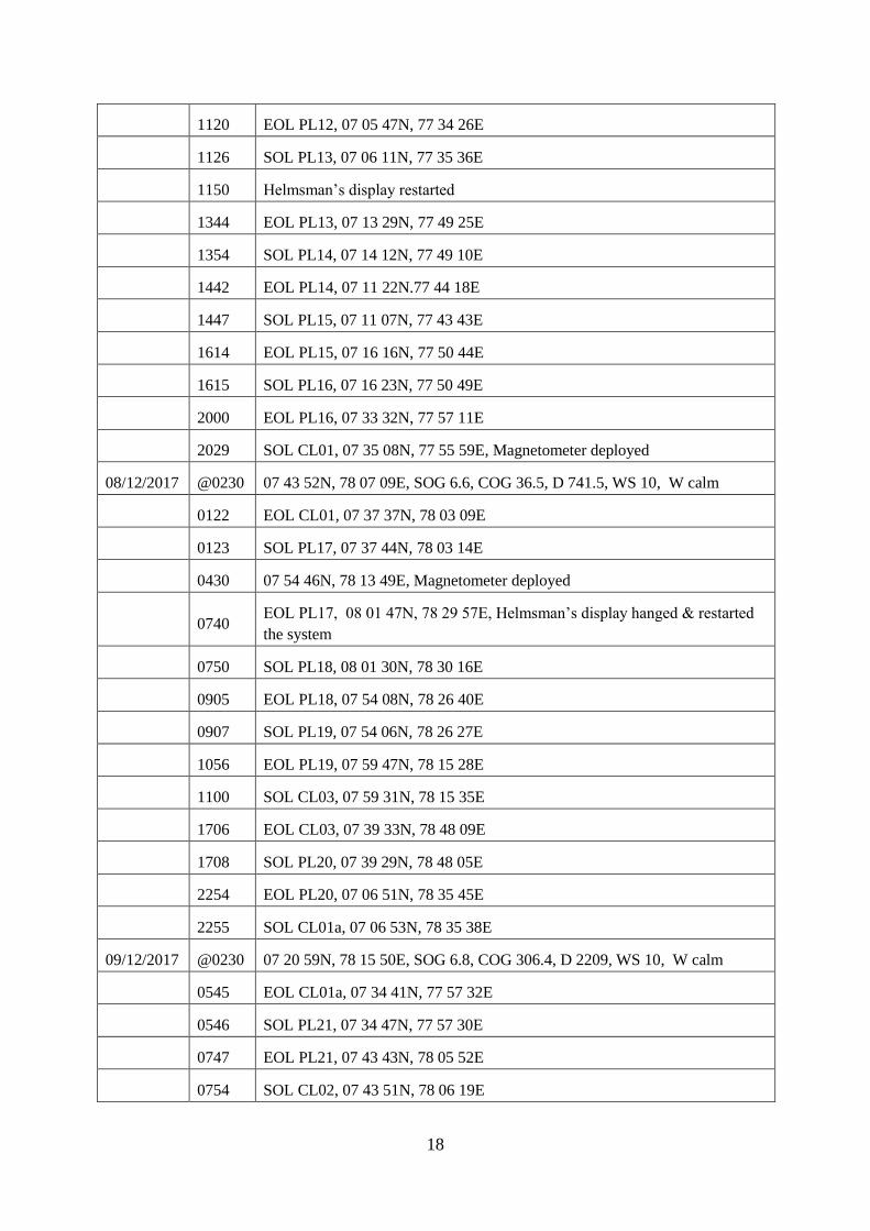
19
1524 EOL CL02, 07 01 02N, 78 30 54E
1540 SOL PL22, 07 00 34N, 78 30 05E
1830 Magnetometer onboard
1927 MB recording Stopped, EOL PL22, 06 58 42E, 78 07 48N
1927 Vessel Changed heading towards GC-2 location
10/12/2017 @0230 06 2900N, 78 4953E, SOG 7.8, COG 124, WS 15, W calm
11/12/2017 @0230 054131N, 805022E, SOG 4.7, COG 90, WS 10, W calm
12/12/2017 @0230 064550N, 820223E, SOG 5.0, COG 90, WS 10, W calm
13/12/2017 @0230 0848 54N, 8144 54E, SOG 5.8, COG 343, WS 10, W calm
14/12/2017 @0230 1112 50N, 810100E, SOG 6.2, COG 343, WS 10, W calm
0342 GC-2 deployed, 12 28 17N, 80 36 52E
0525 GC-2 onboard, Core barrel got bend
15/12/2017 @0230 13 06 09N, 80 20 45E, SOG 1, COG 343, WS 10, W calm
@0800 Ship berthed at Chennai port
End of the Cruise SK-343
2. CTD/SVP Data Collection
SVP/CTD Sl
No Date
Time
UTC Depth(m) Latitude Longitude
Filename/Folder
name
1 14.11.2017 06:56:27 2035 7°00'14" 78°27'49" SVP 01-
14112017
2 19.11.2017 17:59:27 1835 7°26'39" 78°28'16" SVP 02-
19112017
3 20.11.2017 11:21:51 1325 8°21'53" 78°49'12" SVP 03-
20112017
4 26.11.2017 04:08:05 1270 7°46'42" 78°22'21" SVP 04-
26112017
5 28.11.2017 14:02:06 1885 7°14'59" 78°04'00" SVP 05-
28112017
6 05.12.2017 11:06:51 1575 7°04'41" 77°46'41" SVP 06-
05122017
3. Gravity Core
Gravity Core
Sl No Date Time UTC Depth(m) Latitude Longitude Length of Core
(m)
GC-1 26.11.2017 0741 1340m 7°46'42" 78°22'21" 3.55
GC-2 14.12.2017 0525 947m 12°28'19" 80°36'52" 1.30
4. Logsheet
Line No
Start of Line End of Line
Date
Time
(UTC)
Depth
(m)
Latitude Longitude Filename Date
Time
(UTC)
Depth
(m)
Latitude Longitude Filename
SK341-
PL-01 11112017 1728 338 08 51 17 78 47 17
SK341-PL-01-
201711Nov173834 11112017 1900 881 08 42 50 78 45 08
SK341-PL-01-
201711Nov185353
SK341-
PL-02 11112017 1910 871 0842 04 7844 59
SK341-PL-02-
201711NOV191003 11112017 2131 523 084943 785706
SK341-PL-02-
201711NOV1212630
SK341-
PL-03 11112017 2151 469 085154 785620
SK341-PL-03-
201711NOV214658 11112017 2151 411 085200 785506
SK341-PL-03-
201711NOV215020
SK341-
PL-04 11112017 2214 432 085200 785224
SK341-PL-04-
201711NOV221406 11112017 2334 583 084704 784704
SK341-PL-04-
201711NOV232827
SK341-
PL-05 11112017 2342 608 084644 784704
SK341-PL-05-
201711NOV234214 11112017 0024 355 085113 784752
SK341-PL-05-
201711NOV002218
SK341-
PL-06 11112017 0152 416 085059 784839
SK341-PL-06-
201711NOV015128 11112017 0219 507 084859 784749
SK341-PL-06-
201711NOV021832
SK341-
PL-07 11112017 0233 484 084814 784755
SK341-PL-07-
201711NOV023307 11112017 0457 587 085621 790157
SK341-PL-07-
201711NOV045614
SK341-
PL-08 11112017 0500 599 085621 790209
SK341-PL-08-
201711NOV050023 12112017 0751 429 085527 792251
SK341-PL-08-
201712NOV074931
SK341-
PL-09 12112017 0810 386 085616 792227
SK341-PL-09-
201712NOV081018 12112017 1127 460 085710 790135
SK341-PL-09-
201712NOV111957
SK341-
PL-10 12112017 1139 366 085801 790186
SK341-PL-10-
201712NOV113930 12112017 1411 338 085716 792039
SK341-PL-10-
201712NOV141101
SK341-
PL-11 12112017 1420 252 085710 792139
SK341-PL-11-
201712NOV142043 12112017 1600 612 085002 792730
SK341-PL-11-
201712NOV155202

2
Line No
Start of Line End of Line
Date
Time
(UTC)
Depth
(m)
Latitude Longitude Filename Date
Time
(UTC)
Depth
(m)
Latitude Longitude Filename
SK341-
PL-12 12112017 1602 618 085003 792722
SK341-PL-12-
201712NOV160200 12112017 2230 1407 082730 790030
SK341-PL-12-
201712NOV221852
SK341-
PL-13 12112017 2238 1425 082518 785527
SK341-PL-13-
201712NOV223836 12112017 2255 1438 082403 785438
SK341-PL-13-
201712NOV225452
SK341-
PL-14 12112017 2308 1444 082345 785501
SK341-PL-14-
201712NOV230840 13112017 0422 799 084733 792526
SK341-PL-14-
201713NOV041926
SK341-
PL-15 13112017 0453 854 084549 792442
SK341-PL-15-
201713NOV045327 13112017 1153 1448 082225 785624
SK341-PL-15-
201713NOV114413
SK341-
PL-16 13112017 1157 1455 082209 785610
SK341-PL-16-
201713NOV115741 13112017 1706 1975 075446 785301
SK341-PL-16-
201713NOV170214
L01 13112017 1709 1975 075422 785254 SK343-L01-
201713NOV170853 14112017 0539 2528 070008 783023
SK343-L01-
201714NOV053416
L02 14112017 1007 2461 070000 782724 SK343-L02-
201714NOV 14112017 2238 1760 080313 785326
SK343-L02-
201714NOV223546
L03 14112017 2359 1885 075836 785307 SK343-L03-
201714NOV235957 15112017 1153 2500 070000 782853
SK343-L03-
201715NOV115355
L04 15112017 1244 2438 065958 782546 SK343-L04-
201715NOV124413 16112017 0047 1669 080730 785745
SK343-L04-
201716NOV004252
L05 16112017 0152 1633 081217 785427 SK343-L05-
201715NOV015211 16112017 1634 2424 065958 782425
SK343-L05-
201716NOV162733
L06 16112017 1702 2417 070006 782258 SK343-L06-
201716NOV170226 17112017 0718 1428 082214 785646
SK343-L06-
201717NOV071343
L07 17112017 0739 1450 082301 785543 SK343-L07-
201717NOV073903 17112017 2301 2412 065957 782128
SK343-L07-
201717NOV224821
L08 17112017 2329 2403 065957 782000 SK343-L08-
201717NOV232902 18112017 1506 1347 082848 785640
SK343-L08-
201718NOV145322

3
Line No
Start of Line End of Line
Date
Time
(UTC)
Depth
(m)
Latitude Longitude Filename Date
Time
(UTC)
Depth
(m)
Latitude Longitude Filename
L09 18112017 1556 1270 083159 785631 SK343-L09-
201718NOV155605 19112017 1225 2398 065928 781821
SK343-L09-
201719NOV121134
L10 19112017 1245 2390 065946 781703 SK343-L10-
201719NOV124516 20112017 0845 1267 083227 785514
SK343-L10-
201720NOV084404
L11 20112017 0903 1246 083316 785409 SK343-L11-
201720NOV090257 21112017 0109 2387 065914 781520
SK343-L11-
201721NOV005133
L12 21112017 0138 2374 065951 781411 SK343-L12-
201721NOV013835 21112017 1610 1243 083332 785244
SK343-L12-
201721NOV161112
L13 21112017 1631 1234 083352 785118 SK343-L13-
201721NOV163055 22112017 0627 2368 065932 781230
SK343-L13-
201722NOV060500
L14 22112017 0645 2357 065935 781110 SK343-L14-
201722NOV064547 23112017 0139 1220 083442 785002
SK343-L14-
201723NOV013139
L15 23112107 0155 1191 083505 784846 SK343-L15-
201723NOV015503 23112017 1658 2334 065931 780934
SK343-L15-
201723NOV164811
L16 23112017 1720 2315 065935 780809 SK343-L16-
201723NOV172002 24112017 1401 1162 083535 784741
SK343-L16-
201724NOV134916
L17 24112017 1447 1015 083733 784404 SK343-L17-
201724NOV144711 24112017 1603 1137 082901 784023
SK343-L17-
201724NOV154553
L18 24112017 1634 1206 082720 784116 SK343-L18-
201724NOV163609 24112017 1830 1047 083638 784510
SK343-L18-
201724NOV182030
L19 24112017 1852 1083 083553 784620 SK343-L19-
201724NOV185157 25112017 1021 2301 065844 780537
SK343-L19-
201725NOV101021
L20 25112017 1033 2275 065924 780507 SK343-L20-
201725NOV103411 26112017 0013 1214 080151 782802
SK343-L20-
201726NOV000331
L21 26112017 0015 1218 080140 782803 SK343-L21-
201726NOV001510 26112017 1600 2254 065852 780320
SK343-L21-
201726NOV160302

4
Line No
Start of Line End of Line
Date
Time
(UTC)
Depth
(m)
Latitude Longitude Filename Date
Time
(UTC)
Depth
(m)
Latitude Longitude Filename
L22 26112017 1637 2250 065903 780217 SK343-L22-
201726NOV163713 27112017 0310 1192 080007 782726
SK343-L22-
201727NOV030207
L23 27112017 0330 1141 080062 782106 SK343-L23-
201727NOV033030 27112017 1302 2227 065847 780052
SK343-L23-
201727NOV124638
L24 27112017 1317 2213 065915 780001 SK343-L24-
201727NOV131620 27112017 2355 1095 075956 782459
SK343-L24-
201727NOV235422
L25 28112017 0020 1041 080047 782407 SK343-L25-
201728NOV002010 28112017 1004 2176 065903 775843
SK343-L25-
201728NOV100415
L26 28112017 1030 2175 065841 775727 SK343-L26-
201728NOV102956 29112017 0348 998 080005 782243
SK343-L26-
201729NOV034449
L27 29112017 0410 929 080031 782129 SK343-L27-
201729NOV041012 29112017 1357 2118 065939 775633
SK343-L27-
201729NOV135247
L28 29112017 1424 2114 065906 775516 SK343-L28-
201729NOV142437 02122017 0107 830 080001 782018
SK343-L28-
201702DEC010341
L29 02122017 0123 752 075954 781907 SK343-L29-
201702DEC012255 02122017 1135 2077 065910 775404
SK343-L29-
201702DEC112457
L30 02122017 1155 2057 065902 775256 SK343-L30-
201702DEC115522 02122017 2253 658 075954 781756
SK343-L30-
201702DEC224843
L31 02122017 2324 472 075812 781544 SK343-L31-
201702DEC232443 03122017 0904 2043 065855 775138
SK343-L31-
201703DEC085629
L32 03122017 0923 2023 065827 775018 SK343-L32-
201703DEC092347 03122017 1852 289 075616 781403
SK343-L32-
201703DEC185158
L33 03122017 1929 255 075415 781239 SK343-L33-
201703DEC192948 04122017 0419 1934 065800 774900
SK343-L33-
201704DEC041924
L34 04122017 0443 1959 065851 774800 SK343-L34-
201704DEC044252 04122017 1237 155 074745 780814
SK34L34-
201704DEC123050
5
Line No
Start of Line End of Line
Date
Time
(UTC)
Depth
(m)
Latitude Longitude Filename Date
Time
(UTC)
Depth
(m)
Latitude Longitude Filename
L35 04122017 1245 182 074646 780742 SK343-L35-
201704DEC124507 04122017 2029 1937 065826 774645
SK343-L35-
201704DEC203007
L36 04122017 2046 1909 065841 774600 SK343-L36-
201704DEC204608 05122017 0300 245 073738 770200
SK343-L36-
201705DEC025606
L37 05122017 0312 158 073807 780123 SK343-L37-
201704DEC031248 05122017 0925 1903 065844 774506
SK343-L37-
201705DEC092006
L38 05122017 0945 1884 065838 774413 SK343-L38-
201705DEC054533 05122017 1825 132 073600 775959
SK343-L38-
201705DEC182150
L39 05122017 1839 265 073658 775922 Sk343-l39-
201705DEC183907 06122017 0224 1902 065817 774309
SK343-L39-
201706DEC021805
PL01 06122017 0301 1823 065809 774011 SK343-PL01-
201706DEC030057 06122017 0331 1835 065922 774322
SK343-PL01-
201706DEC031827
PL02 06122017 0352 1751 070028 774322 SK343-PL02-
201706DEC035121 06122017 0456 1655 065758 773655
SK343-PL02-
201706DEC044226
PL03 06122017 0524 1526 065813 773435 SK343-PL03-
201706DEC052420 06122017 0657 1684 070154 774421
SK343-PL03-
201706DEC061531
PL04 06122017 0738 1612 070318 774458 SK343-PL04-
201706DEC074020 06122017 0957 1417 065800 773132
SK343-PL04-
201706DEC095531
PL05 06122017 1033 1211 065757 772842 SK343-PL05-
201706DEC103409 06122017 1315 1556 070419 774520
SK343-PL05-
201706DEC130259
PL06 06122017 1339 1497 070558 774602 SK343-PL06-
201706DEC133918 06122017 1636 1040 065824 772729
SK343-PL06-
201706DEC162026
PL07 06122017 1659 843 065940 772834 SK343-PL06-
201706DEC165849 06122017 1949 1488 070705 774628
SK343-PL06-
201706DEC193519
PL08 06122017 2011 1493 070822 774729 SK343-PL08-
201706DEC201104 06122017 2311 576 070025 772827
SK343-PL08-
201706DEC230957
6
Line No
Start of Line End of Line
Date
Time
(UTC)
Depth
(m)
Latitude Longitude Filename Date
Time
(UTC)
Depth
(m)
Latitude Longitude Filename
PL09 06122017 2331 393 070121 772912 SK343-PL09-
201706DEC233043 07122017 0222 1292 070911 774717
SK343-PL09-
201707DEC021254
PL10 07122017 0247 1252 071009 774742 SK343-PL10-
201707DEC024033 07122017 0534 299 070226 773020
SK343-PL10-
201707DEC052938
PL11 07122017 0542 285 070234 772954 SK343-PL11-
201707DEC054228 07122017 0837 1260 071050 774736
SK343-PL11-
201707DEC082337
PL12 07122017 0904 1046 071226 774911 SK343-PL12-
201707DEC090421 07122017 1120 330 070547 773426
SK343-PL12-
201707DEC111622
PL13 07122017 1126 308 070611 773536 SK343-PL13-
201707DEC112729 07122017 1344 967 071329 774925
SK343-PL13-
201707DEC133538
PL14 07122017 1354 616 071412 774910 SK343-PL14-
201707DEC135428 07122017 1442 359 071122 774418
SK343-PL14-
201707DEC142845
PL15 07122017 1447 358 071107 774343 SK343-PL15-
201707DEC144718 07122017 1614 714 071616 775044
SK343-PL15-
201707DEC166823
PL16 07122017 1615 756 071623 775049 SK343-PL16-
201707DEC161652 07122017 2000 243 073332 775711
SK343-PL016-
201707DEC200429
PL17 08122017 0123 483 073744 780314 SK343-PL17-
201708DEC012336 08122017 0740 1284 080147 782957
SK343-PL17-
201708DEC073041
PL18 08122017 0750 1300 080130 783016 SK343-PL18-
201708DEC075006 08122017 0905 1286 075408 782640
SK343-PL18-
201708DEC085130
PL19 08122017 0907 1281 075406 782627 SK343-PL19-
201708DEC090715 08122017 1056 175 075947 781528
SK343-PL17-
201708DEC105340
CL03 08 12 2017 11 00 255 07 54 31 78 15 35 SK343-CL03-
201708DEC105749 08 12 2017 17 06 2119 07 39 33 78 48 09
SK343-CL03-
201708DEC165925
PL20 08 12 2017 17 08 2169 07 39 29 78 48 05 SK343-PL20-
201708DEC170814 08 12 2017 22 54 2439 07 06 51 78 35 45
SK343-PL20-
201708DEC225054

7
Line No
Start of Line End of Line
Date
Time
(UTC)
Depth
(m)
Latitude Longitude Filename Date
Time
(UTC)
Depth
(m)
Latitude Longitude Filename
CL01a 08 12 2017 22 55 2436 07 06 53 78 35 38 SK343-CL01a-
201708DEC225553 09 12 2017 05 45 294 07 3441 77 57 32
SK343-CL01a-
201709DEC054459
PL21 09 12 2017 05 46 256 07 34 47 77 57 32 SK343-PL21-
201709DEC054631 09 12 2017 07 47 403 07 43 43 78 05 52
SK343-PL21-
201709DEC074037
CL02 09 12 2017 07 54 277 07 43 51 78 06 19 SK343-PL21-
201709DEC075401 09 12 2017 15 24 2541 07 01 02 78 30 54
SK343-CL02-
201709DEC150757
PL22 09 12 2017 15 40 2531 07 00 34 78 30 05 SK343-PL22-
201709DEC154004 09 12 2017 19 27 2337 06 58 42 78 07 48
SK343-PL21-
201709DEC190836
