north london business park,planning brief,april 2006
TRANSCRIPT

-
PLANNING BRIEF
NORTH LONDON BUSINESS PARK AND LAND ADJACENT TO COPPIES GROVE
251

CONTENTS 1.0 INTRODUCTION 1.1 North London Business Park and Coppies Grove / Oakleigh Road South 1.2 Overview 1.3 History of the sites 1.4 Reasons for Redevelopment Bringing Vacant Land Back into Use Providing High Quality Mixed Use Development E-enabling Residential Development Delivering Sustainable Communities 1.5 Key Design Issues Nature of the surrounding sites
Existing topography of the sites Mixed Use Sustainable Development (Design and Construction)
1.6 The Existing Sites Former STC Sports Ground Emerald Suite Social Club Local Highway Network Pedestrian and Cycle Routes Marketing Existing Occupiers 1.7 Policy Designations Strategic Employment Location Industrial Business Park 2.0 DEVELOPMENT VISION 2.1 Corporate Vision 2.2 Three strands 2.3 The stakeholders within the site boundary 3.0 THE DEVELOPMENT FRAMEWORK 3.1 Dwelling Mix : Affordable Housing and Lifetime Homes Provision 3.2 Telecommunications 3.3 Employment Enhancement 3.4 Employment Protection 3.5 Transport 3.6 Health and Community Facilities Provision 3.7 Existing Landscaping, Trees and Biodiversity 3.8 Unstable Land 3.9 Contamination 3.10 Pedestrian Permeability 3.11 Infrastructure and Utilities 3.12 Noise and Air Quality 3.13 Drainage and Land Issues
252

4.0 KEY DESIGN PRINCIPLES AND SUSTAINABILITY 4.1 Good Building Design 4.2 Design Quality 4.3 Density and Building Height 4.4 Landscape 4.5 Private Amenity Space 4.6 Addressing the Street 4.7 Design of Car Parking 4.8 Addressing Neighbour Impacts 4.9 Key Views 4.10 Sustainable Development and Construction 5.0 DEVELOPMENT AREA AND OPTIONS 5.1 NLBP 5.2 Oakleigh Road South / Coppies Grove 6.0 PROCESS, TIMETABLE AND PHASING 6.1 Pre-Application Advice APPENDICES
1 NLBP Schedule of Areas 2 Relevant National, Regional and Local Planning policies 3 Zoning Plan: NLBP & Oakleigh Road South/Coppies Grove
253

1.0 INTRODUCTION 1.1 The Sites: SITE A: North London Business Park North London Business Park (NLBP) occupies an area of 16.5 hectares. The site has a history as a major centre for employment and this is reflected in its designation as an Industrial Business Park in Barnet’s Revised Deposit Draft UDP and as a Strategic Employment Location in the London Plan. NLBP is located approx 500 metres from the Coppies Grove / Oakleigh Road South site. SITE B: Coppies Grove / Oakleigh Road South Coppies Grove / Oakleigh Road South occupies an area of approximately 4 hectares. It forms the southern portion of a larger area of employment land between Oakleigh Road South and the East Coast Main Line. The site provides premises for a mixture of uses, some existing warehouse, distribution and salvage uses that are important to protect. The site at Coppies Grove / Oakleigh Road South has no UDP designation but is recognised as land that is providing important local services and employment. 1.2 Overview The brief covers the two sites in close proximity and part joint ownership in the Brunswick Park Ward of Barnet. Status: This Planning Brief will form the framework for any future development of North London Business Park and land at Coppies Grove / Oakleigh Road South. The brief provides for a strategic and local opportunity to enhance sustainable development of the two sites, consolidate and protect important employment activities and provide for viable mixed uses including new housing. The main buildings at NLBP range in height from two to four storeys taking advantage of the change of levels across the site. There are a large number of trees on the site, some of which are covered by a Tree Preservation Order, which provide significant screening on the southern and eastern boundaries of the site. To the south of the existing commercial buildings is a multi storey car park accommodating 645 spaces. There are a large number of other parking areas located around the site, most notably a large stepped parking area between the commercial building and the former playing fields. The eastern part of the site around the lake comprises an area of open landscape. The largest single land holding at Oakleigh Road South / Coppies Grove is the Comer Group, the owners of NLBP. Access to the site is taken from Oakleigh Road South to the north of the site, opposite New Southgate Recreation Ground. 1.3 The History of NLBP and Oakleigh Road South Standard Telephone and Cable developed the NLBP site as the New Southgate Works in the 1920s. The site has had a long association with telecommunications. As a strategic industrial centre during the Second World War it was subject to bombing including V1 bombs that hit the site in August 1944. Northern Telecom (Nortel) took over the site in 1989. In 2000 Nortel started construction on an Optical Centre for Excellence (Building 3), which would provide a European base for internet optical and wireless development. By 2002 Nortel had vacated the site and ended 80 years of manufacturing and the association of the site with a single occupier. Oakleigh Road South has a slightly less illustrious history, although Abbott’s Packaging were a high profile local company in their heyday.
254

For both sites it is expected that some reference through new street names or possibly sculptures/works of art be made to the historical legacy of employment at these sites. 1.4 Purposes for drawing up a Planning Brief NLBP is characterised by office based B1 accommodation while Oakleigh Road South provides opportunities for general industrial and warehouse/storage type (Class B2/B8) uses. It is important that the redevelopment of the two sites be taken forward in a co-ordinated and orderly way, to ensure the proper planning of the area and to deliver a high quality sustainable mixed-use scheme whilst retaining important existing employment uses. It is also important that the Council articulate its vision for the site within the context of: existing UDP policies, the London Plan, the Three Strands Approach, community aspirations for the sites, and what can realistically be negotiated with development partners. It is important that redevelopment of the two employment sites either in part or full take advantage of their locations while respecting the surrounding suburban character. This Brief specifies development outcomes that are fully integrated with the local community and that relate to the traditional Barnet suburb. The two sites are the subject of this Planning Brief because they meet the following objectives: 1.4.1 Bringing Vacant Land Back into Use The Brief provides an opportunity to tackle high levels of vacancy associated with the two sites. Despite the advantages of modern office accommodation in high quality landscaped grounds with generous car parking the owners of NLBP have struggled to attract new tenants. Since the departure of Nortel Networks in 2002 about 6,100 sq.m of floorspace (17.8 % of total NLBP) has remained vacant. In view of this Barnet Council has permitted some temporary non-B1 uses including D1 further education uses (Barnet College and Middlesex University). The London Plan recognises that the suburban stock is losing its attraction as a location for strategically important office based activity. Any rejuvenation of this market can only come about by consolidating its current strengths and potential attraction. The London Plan also prioritises opportunity areas of intensification or regeneration for such office-based employment growth in the future. In North London and particularly Barnet this will be primarily concentrated in town centres, Cricklewood/Brent Cross and areas of high public transport accessibility. The Mayor further recognises in his draft SPG on Industrial Capacity that genuinely surplus industrial land can be put into more active uses to meet the wider objectives of the London Plan. At Oakleigh Road South a warehouse of approximately 4000 sq.m (including ancillary office space) forms the centre of the site and has been vacant for 5 years and serves no employment or planning benefit. The Brief acknowledges that the future health of North London’s economy is inextricably linked to the performance of small and medium sized enterprises. The Brief aims to achieve sustainable economic development. Job and wealth creation opportunities must be generated close to local communities. The Brief seeks to make existing employment land more attractive to business by encouraging at the NLBP site a mixed suite of supporting services, such as local convenience retail, health, education (higher, further and crèche) day-care and small-scale leisure. These services will provide opportunities for the day-time, as well as the evening and weekend economies created by new residential communities that emerge from the development of land not zoned for commercial or community use. At Coppies Grove / Oakleigh Road South the Brief seeks to protect existing (operating) employment uses, deliver environmental improvements as part of a mixed use scheme which will provide a safe and pleasant environment for small to medium sized enterprises and a small new residential community.
255

1.4.2 Providing High Quality Mixed Use Development The Brief provides an opportunity to generate high quality mixed-use development underlined by sustainable design and construction. Even with the downturn in employment prospects NLBP still has the potential to become a Centre for Excellence for high technology that reflects its SEL status. The London Plan encourages new foci for innovation and research excellence with boroughs ensuring an adequate supply of environmentally attractive, high quality and affordable premises that will foster an opportunity for synergy with the capital’s 40 universities, higher education institutions and research bodies. The mix of uses at both sites will enable the creation of a more attractive and sustainable environment for business, generating locations capable of attracting long term occupiers willing to work, rest and stay in Barnet. It is considered that the high quality environment created, along with the new mixed uses, will encourage high technology and knowledge-based industry to locate at NLBP. The location of Middlesex University and Barnet College, albeit temporary at this stage, at NLBP is already offering up some synergy between employment and research/education uses. 1.4.3 E-enabling Residential Development The new communities that emerge at NLBP will complement the telecommunications legacy of Nortel / Standard Telephone and Cables (STC). The provision of Information Communication Technology (ICT) infrastructure will enable people to work from home. The Brief expects that opportunities for broadband access will be enhanced at both sites with the provision of e-infrastructure such as ducting and wireless equipment. Opportunities for the expanding teleworkforce will be increased by new homes that are e-enabled. 1.4.4 Delivering Sustainable Communities By bringing previously developed land back into use proposals will achieve the highest possible intensity of use compatible with local context, the design principles in this Brief and with public transport capacity. Residential development built to Lifetime Homes standards, will deliver balanced communities, a mixture of houses and flats capable of providing private and affordable accommodation particularly for families. There will be an emphasis on houses with gardens and larger unit sizes/mix at NLBP site given the shortage of such new provision in recent Barnet residential schemes. Accompanied by community infrastructure such as health and day-care provision the development should be capable of creating an inclusive environment. There is real potential to enhance the NLBP’s existing high quality landscaping with innovative pocket parks that provide sustainable environmental management with a strong community focus. 1.5 The Key design issues Recognising and addressing the following aspects of the site: - 1.5.1 Nature of the surrounding sites The East Coast Main Line forms the edge to both sites. Site A: NLBP is largely bounded by low density residential to the north, south and east. It looks onto New Southgate Cemetery. Site B: Coppies Grove / Oakleigh Road South At Oakleigh Road South an extensive tree and vegetation screen along an embankment forms the eastern boundary, screening the existing buildings on the site from view from adjoining roads and houses. The northern part of the Brief site looks onto New Southgate Recreation Ground and is bounded by industrial activities including waste transfer and builders merchants that occupy the northern section of employment land at Oakleigh Road South. The properties along Oakleigh Road South are predominantly two storey family houses, whereas Coppies Grove comprises a high-density mix of flats, maisonettes and some houses. The site includes the Curtis Family Centre in Coppies Grove, but excludes the Thames Water Pumping House at the corner of Coppies Grove and Oakleigh Road South.
256

1.5.2 Existing topography of the sites As there have been substantial earth movements from past activities at both sites there are considerable variations in levels. These variations could be exploited to maximise potential views and generate benefits in terms of quality of light and microclimate.
Utilities: A public sewer crosses NLBP. The Thames Water Pumping House may indicate the presence of utilities infrastructure at Oakleigh Road South. Further site investigations are required.
Underground Shelters: An Emergency Support Centre at NLBP indicates access below ground. The site at NLBP has a number of underground shelters dating from Second World War. Further site investigations are required.
Trees: Both sites are rich with trees, which create an abundant ‘green screen’. Site A: NLBP site is home to a variety of trees including Lombardy Poplar, Austrian Pine, Norway Maple, Beech and Oak. The 1989 Planning Brief identified a large number of trees worthy of retention. The area around the lake was subject to planting in the 1980s. TPO Group polygons cover the northern and southern portions of the site. Site B: Coppies Grove / Oakleigh Road South Oakleigh Road South site is also home to a variety of trees that form an attractive natural screen with the road and mark its boundary with Coppies Grove. A detailed tree survey will be required to accompany any application. Lake – Water Feature and Functional Water Storage Facility: The lake with island forms a prominent feature of the NLBP site. It performs a surface water storage function as well as an ornamental one and provides a habitat for a colony of Canada Geese. Because of the lake’s intrinsic amenity value and its important functional role, the Brief requires its retention. The Brief expects the lake’s future setting and surrounding for new development and landscaping to be of the highest quality. The contribution of the lake to NLBP’s landscape quality will be enhanced by the proposals for development.
(Photograph of the lake and Building 7 in Foreground –NLBP)
257

Telecommunications: A mobile phone telecommunications mast (approx 25 metres in height) behind Building 4 forms a prominent utilitarian feature at NLBP. Due to the changing nature and proposed uses on the site, including residential and community uses opportunities for alternate provision for service providers should be investigated by the mast operators and future developers. 1.5.3 Mixed Use Sustainable Development A high quality mixed use development is expected and guided by the brief that supports the commercial activities of each site and is underlined by the highest standards of sustainable design and construction. The NLBP site offers imaginative opportunities for the re-use of existing sports facilities. 1.6 The Existing Sites 1.6.1 Former STC Sport’s Ground The NLBP site has benefited from 80 years of ownership by a major manufacturing employer. The northern section of NLBP consists of an area of open disused land containing former private playing fields and hard surface tennis courts. A rifle range also formed part of the recreational provision. These facilities were used by employees of STC, Nortel and by private agreement occasionally Southgate Rugby Club. No sporting or recreational uses have taken place since Nortel vacated the site 3-4 years ago. The Council accepted the loss of the playing field in June 1990 when permission was granted to develop the playing fields for business use subject to appropriate alternative provision (ref: N00429CJ ). The previous 1989 planning brief comments that making the playing fields available for public use in their current form is unlikely to be viable. This was some years before the publication of the revised PPG 17 – Sport, Recreation and Open Space. Whilst the playing field has fallen into a poor condition the tennis courts appear in good condition and there may be an argument for their reuse. Floodlighting is still in place for the tennis courts and former rugby pitch. The former playing surface of the rugby pitch has been targeted for flytipping and its re-use or redevelopment is becoming an increasing imperative. The possibility of retaining and enhancing the tennis courts and some adjoining land should be explored. If retention is not feasible then reprovision of, at a minimum, equal quality elsewhere on the site or nearby area will be expected. 1.6.2 Emerald Suite Social Club The Emerald Suite Social Club is a single storey building located in the north east corner of the NLBP site. The Clubhouse was built in 1985 and consists of meeting rooms, hall and a bar that forms a support facility at the NLBP site. It is in relatively good condition but its location is isolated. It can also be hired for social and community events. The retention or re-provision of this facility of equal quality elsewhere on the site will be expected in order to support business and residential communities. 1.6.3 Local Highway Network An assessment of the capacity of the surrounding highway network will be required to ensure the local road network and individual access points can cope with the additional volume of traffic, especially during the peak periods. There is a large volume of existing traffic relating to the business use on the NLBP site, which is at present is not fully utilised. Both sites are about 1.25 miles from the North Circular Road and 6 miles from the M25. At NLBP there are two accesses to NLBP linked by an internal road system. The main access is at the south-western corner from Oakleigh Road South. The second vehicular access, is from Brunswick Park Road on the eastern side of the site.
1.6.4 Public Transport Site A: NLBP the nearest overland rail stations are New Southgate approximately 15 minutes walk away and Oakleigh Park about 25 minutes walk. These stations access services to London Kings Cross and Moorgate. In a scenario of the Weirdale Avenue
258

pedestrian access being reopened the walking time to Oakleigh Park would be reduced to 15 minutes. The nearest underground station is Arnos Grove on the Piccadilly Line just over 20 minutes walk. Bus routes 34 and 251 serve the Oakleigh Road South entrance as well as Arnos Grove station. The journey time to Arnos Grove tube is 5-7 minutes and a similar distance to Totteridge and Whetstone tube station on the Northern Line (High Barnet Branch). The 382 serves the Brunswick Park Road entrance and connects with New Southgate station. The PTAL score for the NLBP site is currently 1, which is low. Yet the bus services are relatively frequent and connect well to rail and tube networks. Site B: Oakleigh Road South / Coppies Grove has access to the 34, 251 and 382 bus services as well as the 221 which serves North Finchley town centre. New Southgate station is within 10 minutes walk of the site. The PTAL score for this site is 2. A bus stop adjoins the site in Oakleigh Road South providing frequent good connections to tube stations and town centres. 1.6.5 Pedestrian and Cycle Routes The pedestrian access to NLBP from Weirdale Avenue to the north is not currently used. This will be subject to a review as part of the transport evaluation. A footpath runs from the boundary with Weirdale Avenue alongside the perimeter of the playing field and tennis courts allowing a through route to Oakleigh Road South. A network of footpaths connects office buildings at NLBP. At Oakleigh Road South there is a pedestrian entrance from Coppies Grove. The purpose of this entrance may solely be for the inspections of overhead power lines. A Scheduled Footpath runs alongside the northern boundary of the site via a subway under the East Coast Main Line connecting Oakleigh Road South with Beaconsfield Road and beyond to open spaces at Bethune Recreation Ground and Friary Park. The footpath forms a pleasant green link with one of Barnet’s Premier Parks – Friary Park but the section between Oakleigh Road South and Beaconsfield Road is unappealing as it has been subject to fly tipping and graffiti. 1.6.6 Marketing – Business/Office uses The Council expects that a strategic site such as NLBP should be the subject of high profile active marketing, to attract new tenants. The Council acknowledges that factors influencing the long-term take-up of floorspace include poor public transport accessibility, the lack of supporting facilities both on site and local, a depressed office market and competition from sites beyond the borough. Given competition from sites within the Lea Valley, which enjoy Assisted Area Status, and the low level of public transport accessibility, it is considered that the remainder of the site has no reasonable prospect of productive employment use in isolation. It should be noted that most of the site is underdeveloped for B1 business use buildings. The Brief seeks to consolidate the office functions and retain core business floorspace at Building 2, 3, 4 and 7, all of which are partially or fully occupied at present. The only building proposed to be removed and B1 floorspace reduced is Building 5 (single storey) that is currently leased to Barnet Council primarily as a training and development facility, some reprovision of this facility for the existing office occupiers and future business trends is requested by the Brief. The attractiveness of both the NLBP and Oakleigh Road South sites as employment locations can be enhanced by new mixed-use development. New supporting facilities will help to sustain the existing employment floorspace. New mixed-use development will partly compensate for the loss of the playing fields together with re-configured open space and leisure/sports provision plus off-site re-provision and investment in local parks. There is real potential for continuing the NLBP site’s long association with sport, making provision for new leisure facilities (or enhancing existing such as tennis courts) that can be utilised by employees based at NLBP together with new residents, ensuring long-term viability.
259

1.6.7 Existing Occupiers Comer Group purchased the NLBP site in 2002. The site is now occupied by several organisations, including Barnet Council, Middlesex University and Avent Naturally, who use the premises for office use within Class B1 (a) of the 1987 Use Classes Order. Barnet College occupy Building Three (5658 sq.m) for educational (D3 use) on a temporary basis until July 2009. Middlesex University have recently been allowed temporary D1 education use in Building 2. Avent Naturally form part of the Cannon Avent multinational and have an international reputation as designers and manufacturers of baby feeding accessories. Avent have occupied Building 7 of NLBP as their Head Office since 2003. Barnet Council have temporarily leased Building 4 as office space since 2003. Council services including Environment and Education and the core back office functions are based at Building 4, which also serves as the base for the Corporate Management Team. The Council is currently reviewing its leases at NLBP in the next few years, with options to extend. Middlesex University has part of their administrative HQ at NLBP. As part of a strategy of concentrating teaching activity on fewer campuses in North London the University relocated its Corporate Services to NLBP. A new temporary learning facility has recently been approved planning consent on the ground floor of Building 2. Barnet College moved into NLBP in January 2005. Building 3 provides flexible space that can be subdivided to meet the specific requirements of the College. They have benefited from an improved learning environment with the business park location expected to help attract more adult learners to the College. Brogan Scaffolding is a contract scaffolding company with a European reputation. The firm is amongst the largest scaffolding contractors in London. Its HQ is at Oakleigh Road South. Winters Haulage has an established reputation for waste transfer in North London. They operate a licensed waste transfer station at their HQ at Oakleigh Road South. The site also serves as a base for their fleet of wheel tippers and skip hire. Debden Buildbase form part of the Grafton Group PLC. They have a network of branches throughout England specialising in the supply of building products. The branch at Oakleigh Road South specialises in heavy side building materials. It also provides a tool hire service. Curtis Family Centre is part of Barnet Council that undertakes work with families in order to assess their parenting strengths and identify areas that they may need support with. 1.7 Policy Designations 1.7.1 Strategic Employment Location Historically the London Planning Advisory Committee (LPAC) identified NLBP/Northern Telecom site in 1994 as a Strategic Employment Location – Industrial Business Park (IBP). These sites are especially geared to activities associated with research and development (B1 (b)) and light industry (B1(c)) and some high value added general industrial uses (B2). The Strategic Employment Location Framework does not identify locations for large scale B1 (a) office development, as these should be located on sites with good public transport access. This classification has been taken forward into the Mayor’s London Plan (February 2004) where the site is included as a Strategic Employment Location (SEL). The strategic designation of NLBP largely reflects its historical occupation by STC, rather than its potential to fulfil future long-term strategic employment objectives. STC and subsequently Nortel were major employers within the Borough. They have since departed (in part due to the dot.com and hi-tech stock market crash in 2000-2001). They have been replaced by a variety of employment, government and education organisations, including Middlesex University, Barnet Council and Barnet College. IBP’s are “intended to meet the needs of activities which require a higher quality environment, have significantly less heavy goods access and can relate more harmoniously with neighbouring uses than those in PIL’s. They are especially geared to those activities associated with B1 (b) and B1(c) and some high value added B2 uses. IBP’s are not intended for primarily B1 (a) office development.”
260

The London Plan states in para 3.129 that “The Mayor will promote the Strategic Employment Locations framework in association with the LDA, boroughs and other strategic partners”. The same paragraph also advises that “Surplus employment land should help meet strategic and local requirements for other uses such as education and community activities and, in particular, housing.” This is designed to reconcile demand and supply and to take account of industry’s needs in terms of clustering, capacity, environment, accessibility and cost requirements. Such policy designation requires that strategic bodies, including the Greater London Authority (GLA) and London Development Agency (LDA), will have to be satisfied, in the event of a planning application being submitted, that the applicant has provided the necessary justification for any loss of employment land. Any major application will be referable to the Mayor of London. The brief in itself will be a material consideration but these external bodies will require supporting material with an application covering issues such as site marketing and surveys of local office and industrial capacity. The GLA has also produced supplementary planning guidance (SPG) on industrial land capacity. Whilst draft SPG it will also be a material consideration in respect of the Mayor’s London Plan alongside strategic policies on employment sites and strategic employment locations (SEL’s). 1.7.2 Industrial Business Park The NLBP site is designated in the UDP as the only Industrial Business Park in Barnet. UDP policies are positive towards this site recognising its development potential for proposals which cater for business, including offices, light industry, and high-tech activities. The UDP therefore includes a wider range of uses than those envisaged by the London Plan for IBP’s by including reference to offices {B1(a)}. The adopted UDP 1991 is proposed to be replaced by the modified UDP in early 2006, which confirms the IBP use zone. However the emerging Barnet LDF that will replace the UDP (modification) by 2008/2009 will take into account the Planning Brief and mixed-use proposals in future site allocation designations.
(Photograph of Building 2 – NLBP) Note: Recently approved temporary planning permission for D1-education use and occupation by Middlesex University.
261

2.0 DEVELOPMENT VISION The priority planning objective of the brief is to consolidate and improve the viability of the existing business and strategic employment functions. Protection of existing business uses and jobs with some redevelopment at NLBP and on land adjoining Coppies Grove, provides a real opportunity to create well-designed mixed-use development. Development that is of a high quality capable of attracting high technology/knowledge based employment uses. Site A: NLBP Development should maximise the potential of this Strategic Employment Location respecting its legacy as a centre for telecommunications advancement and high quality/high value business employment. The introduction of some non-business uses, including residential and community uses, will enhance the business uses and increase the beneficial development opportunities of the largely undeveloped employment sites. Both sites should deliver sustainable residential neighbourhoods with good community and service provision where people choose to live. This should be achieved through high quality urban design principles that draw upon the character and attributes of the surrounding area. Future planning applications should deliver a mix of, commercial, housing and community facilities that support the development of a cohesive community. This Planning Brief will form the basis of a formal planning framework to ensure proper policy status. This Brief aims to ensure an integrated approach to the redevelopment of the site, in order to protect strategic employment and business uses, deliver on housing need, and maximise townscape, amenity and community benefits. 2.1 Corporate Vision This Planning Brief will assist in the delivery of the Council’s Corporate Plan and its five key priorities, in particular:
• Supporting the vulnerable in our community will be achieved by delivering good homes in balanced communities as the development will make a major contribution to affordable housing
• A First Class Education Service will be supported by contributions from development
to life-long learning, particular schools provision in the local area, giving people learning and leisure opportunities throughout life
• A Cleaner Greener Barnet will be achieved through sustainable design that helps to
enhance the biodiversity of both sites. Protection of existing ecological features, new landscaping proposals and contributions to recreation and open spaces will improve the standards of greenspaces in Barnet
• Tackling Crime will benefit from the ‘Secure by Design’ principles that will be
incorporated into development proposals. The high quality of design will open up NLBP and improve the connectivity of the surrounding area
• Repairing Roads and Pavements by enhancing the site highway and pedestrian
networks and investing in the surrounding highways and key junctions through Section 106 Legal agreement planning obligation contributions.
2.2 The Three Strands Strategy The Three Strands Approach sets out a strategy for protecting and enhancing the best of Barnet’s quality suburbs and delivering growth through high quality sustainable
262

development. The Three Strand principles of Protection, Enhancement and Growth underpins this Planning Brief. As a Strategic Employment Location the NLBP site presents an area for a co-ordinated development approach most suitable to Strand Two – Enhancement. Likewise the contribution of businesses at Oakleigh Road South to the local economy is recognised. Both sites provide an unusual context for Strand 2, an objective of which is to retain activities that create opportunities for local people and prevent parts of the borough becoming dormitory suburbs. There is a variation in density between the two locations, land surrounding NLBP is low density development typical of the Barnet suburb while land at Coppies Grove has a density that is more characteristic of an urban location. Site characteristics of both sites require that the principles of Strands One (Protection) and Three (Growth) also apply particularly in relation to the biodiversity and the surrounding suburban / urban development characterised by both sites. 2.3 Local Stakeholders Stakeholders include the companies, people and groups with direct legitimate interest in the redevelopment of the two sites. These are primarily the landowners, commercial occupiers, adjoining occupiers and members of the local community and Barnet Council. In addition to recognised residents associations there will be other more informal groups such as disabled access groups and voluntary associations/church groups that might wish to comment on development proposals. The list of stakeholders may therefore increase during consultation. In addition to consultation undertaken on the planning brief, developers will be expected to undertake consultation with the local community prior to submitting development proposals. Key Stakeholders: Landowners/ Business Occupiers:
• Comer Group • Middlesex University • Barnet College • Barnet Council • Avent Naturally • Brogan Scaffolding • Winters Haulage • Debden Buildbase • Telecommunications Providers (existing/extant permissions at NLBP) • Fitzgerald & Burke (Builders Merchants) 87 Oakleigh Road South • Network Rail • Curtis Family Centre (managed by LB Barnet - Supporting Families)
External and Statutory Stakeholder Consultees
• Mayor for London and the Greater London Authority • Transport for London • Government Office for London • London Development Agency • Barnet Primary Care Trust • Metropolitan Police • London Fire Brigade • Environment Agency • Sport England • North London Strategic Alliance • North London Chamber of Commerce • Thames Water • Three Valleys Water • CABE • RSPB
263

• LB Enfield • Electricity and Gas Undertakers
Residents and Elected Representatives
• Residents surrounding the sites • Local Resident Associations • Voluntary Groups • Teresa Villiers MP • Leader of the Council and Members of Cabinet • Cllr Andreas Tambourides (Mayor of Barnet & Brunswick Park Ward Councillor) • Cllr Lynn Hillan (Brunswick Park Ward Councillor) • Cllr Daniel Hope (Brunswick Park Ward Councillor) • Adjoining Ward Councillors
264

3.0 THE DEVELOPMENT PRIORITIES The Development Priorities provide guidance as to the main planning objectives for both sites covered by the brief. Screening for Environmental Impact Assessment (under Environmental Impact Assessments (England and Wales) Regulations 1999) will be required for any proposals that have a significant effect on the environment. The potential for significant environmental impacts shall be fully assessed and worked up with the Councils planning service before any submission programme of a scoping opinion or formal planning application. 3.1 Dwelling Mix: Affordable Housing & Lifetime Homes Provision There should be a mixture of dwelling size and type within the residential areas to meet the requirements of UDP policy. Provision of affordable housing will be required as part of any residential proposals in accordance with the policies within the Council’s UDP or future LDF policies in place at the time of the submission of the planning application. It is important that affordable housing (especially on larger sites such as those covered by this brief) is designed to meet the needs of the full range of those persons and families in need of affordable accommodation as identified by the Borough’s Housing Needs survey. This means that affordable units should be a range of sizes (not just flats) and at both sites should include a significant proportion of family units and larger houses. In order to create mixed communities affordable housing should be integrated where possible with private housing rather than segregated into defined areas. The high proportion of social housing already in Coppies Grove and on the eastern side of Brunswick Park Road will be a factor in determining the form of affordable housing that is appropriate. Consideration could be given to how affordable housing could address first time buyer problems in Brunswick Park Ward or supply of key worker housing. Early discussions will be required with the Local Planning Authority All new dwellings should be designed to Lifetime Home standards, but not less than 20%, and 10% should be designed to wheelchair standards, as required by policies H13 and H14 of the UDP. 3.2 Telecommunications At NLBP, adjacent to the vacant tennis courts is a 25m high telecommunications mast that is shared by 3 different telecommunication operators. The removal of the mast in this location where new housing, education and community/health facilities are proposed is of paramount importance. This will ensure an appropriate environment for the new mixed-use development and will benefit visual amenity. Consent exists for siting of antennas on freestanding poles adjacent to the railway line on the western site boundary abutting Network Rail Land and on the roof of Building 4. It will be expected that rationalisation and re-siting of antenna’s will occur within the site and the use of existing employment buildings maybe be preferable to both operators and occupiers of proposed residential property rather than pole mounted or mast based antenna’s. The design of new buildings or refurbishment of existing buildings should not preclude provision of telecommunication equipment and Government objectives of ‘planned’ provision of telecommunications equipment as outlined in Planning Policy Guidance Note 8 (Telecommunications). New telecommunication facilities will be determined with reference to policy D16 of the Revised Deposit Draft Unitary Development Plan. 3.3 Employment Enhancement The strategic and local policy protection of the site and attractiveness of the site as an employment location needs to be addressed if the existing employment floorspace is to be sustained to provide increased job opportunities. An example of inefficient use of surrounding land is the expansive land-take of a limited number of car parking spaces for Avent Naturally at Building 6 NLBP and the terraced parking adjoining Building 3. The Brief envisages a more flexible approach to employment generation on both sites. It is considered that employment enhancement will occur through the following means:
265
(1) Improvements to the built environment around the development: • Landscaping Improvements. • Highways Improvements (including better bus links preferably servicing the site
and entering directly to its centre). • Integration with uses that have synergy with employment generation such as
small-scale retail/leisure & childcare facilities. (2) Improvements to employment land and buildings:
• The subdivision of land and buildings into a range of premises of different types, sizes and costs to meet the needs of different sectors of the economy and firms of different types and sizes needs to be explored (including small and medium sized businesses).
• The creation of high quality buildings that have flexibility to adapt to changes in employment supply and demand (this has already occurred with respect to Buildings 2, 3 & 5 at NLBP).
• Buildings that have the latest e-enabled technology.
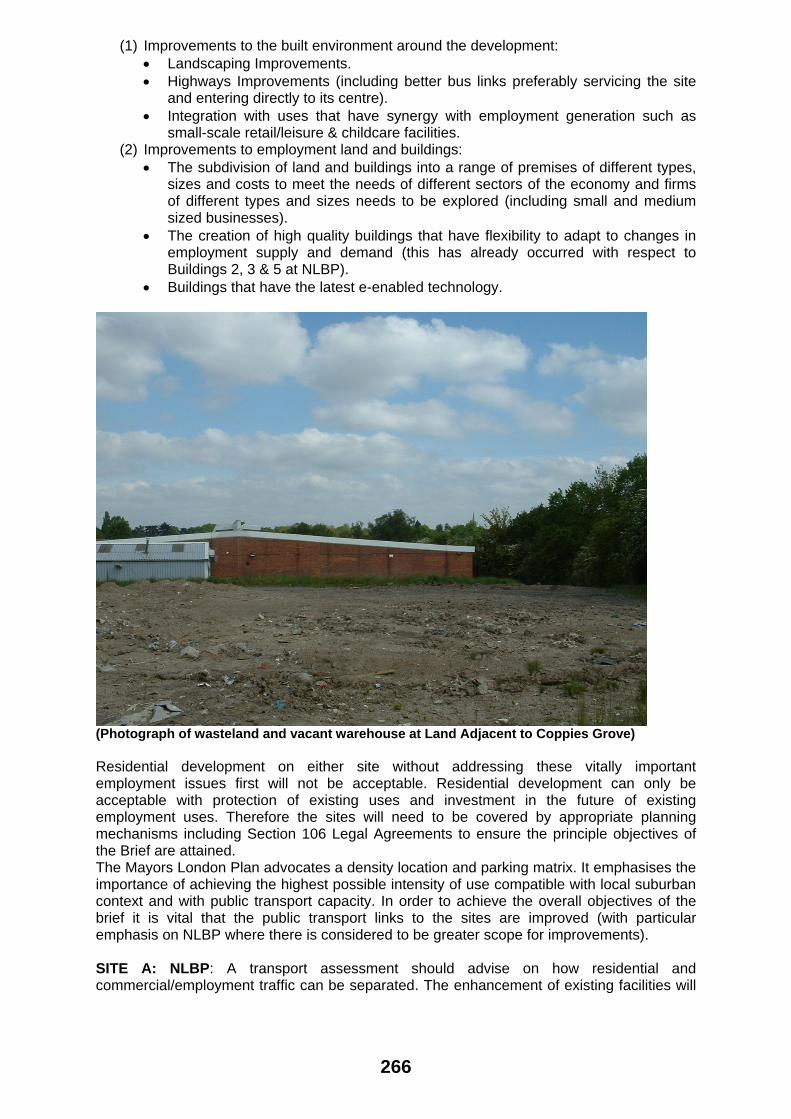
(Photograph of wasteland and vacant warehouse at Land Adjacent to Coppies Grove) Residential development on either site without addressing these vitally important employment issues first will not be acceptable. Residential development can only be acceptable with protection of existing uses and investment in the future of existing employment uses. Therefore the sites will need to be covered by appropriate planning mechanisms including Section 106 Legal Agreements to ensure the principle objectives of the Brief are attained. The Mayors London Plan advocates a density location and parking matrix. It emphasises the importance of achieving the highest possible intensity of use compatible with local suburban context and with public transport capacity. In order to achieve the overall objectives of the brief it is vital that the public transport links to the sites are improved (with particular emphasis on NLBP where there is considered to be greater scope for improvements). SITE A: NLBP: A transport assessment should advise on how residential and commercial/employment traffic can be separated. The enhancement of existing facilities will
266

need to be accompanied by exploring how different potential tenants could occupy the existing/expanded premises. Technical reports addressing the above points would be expected to accompany any planning application. New service provision such as retail/leisure should be local in scale, largely meeting need arising from employees and new residents. Local services should therefore not be trip- generating destinations. SITE B: Land Adjacent to Coppies Grove: The existing vehicular access should be restricted to employment traffic only. A new access (the location of which is dictated by existing site levels and landscaping) will be located close to the existing Curtis Family Centre that should be for residential traffic only. Appendix 2 indicates proposed zoning for the two respective sites. 3.4 Employment Protection SITE A: NLBP The site is classified as a Strategic Employment Location. This means there is a requirement for the applicant to satisfy the Local Planning Authority that all new uses bring additional benefits to employment creation and will not adversely impact on existing employment sites. The introduction of housing can place pressure on the Council to curtail un-neighbourly activity (particularly with respect to noise and traffic/delivery disturbance). A key issue for both sites will be to ensure that employment uses are not subject to pressure to alter working practices from new residents. This can be achieved by identifying appropriate locations for new housing, through the use of noise mitigation measures, through careful consideration of road layouts for each site and through the use of transitional areas where employment uses that have less impact on neighbours are located. Location of delivery areas needs to be carefully considered. With respect to transitional zones the location of appropriate adjoining housing will be important. This may take the form of flats where there is more flexibility over the location of amenity space. Nonetheless the location of high quality communal gardens at appropriate locations will be necessary. Opportunities for the provision of pocket parks, particularly where existing open space is developed should be explored. The housing should also utilise the benefits of a location adjacent to employment buildings such as fibre optic cable links. The Brief will seek to ensure the retention of employment uses through the employment zoning shown for the two sites in Appendices 3 and 4. In determining future planning applications the Local Planning Authority will normally refuse proposals for change of use or new buildings that prejudice the retention of employment uses on either site. SITE B: Land Adjacent to Coppies Grove: In consultation with the Council’s Environmental Health (Scientific Services) section a detailed noise assessment is required to determine mitigation measures to ensure housing is not adversely affected by employment uses. This could involve reducing the proposed residential footprint if it is considered that proposed housing will either: (i) Provide a poor standard of amenity for future occupiers. (ii) Fail to address potential conflicts between residential occupiers and neighbouring employment uses. Although the site is not a strategic employment site it does include businesses on adjoining land that would have difficulty finding suitable alternative locations. It is therefore paramount that the long-term retention of these businesses is not jeopardised. The Mayor of London has identified that existing businesses involved in waste re-processing should be not prohibited from future expansion by new housing. The zoning plan includes capacity for Winters Haulage to expand if such a proposal was considered acceptable through the normal planning process. The brief also contains a buffer zone where significant
267

environmental improvements to existing businesses would be required if alternative uses were to be considered. 3.5 Transport The Barnet UDP contains the Borough’s car parking standards. Any future proposals will be required to meet the prevailing standards. Careful consideration will be given to variation from these standards and the potential for detrimental impacts arising on the surrounding highways. Where there is a demonstrable planning and transport benefit. Car parking provision should be safe, secure and convenient for the development it serves. A safe pedestrian environment will be essential. The opportunity to improve pedestrian permeability will require consideration of likely desire lines, the constraints of the surrounding built environment, and the need to ensure routes are planned with respect to creating a safe and secure pedestrian environment. Movement by pedestrians and cyclists should be an integral part of the design process and it is important that the whole site should be integrated with the surrounding area. Appraisal of the existing footway network and current pedestrian and cycle activity should inform future layout and proposed improvements. As part of the transport assessment the impact of opening up Weirdale Avenue to limited residential only access (non-through traffic and pedestrians) should be explored. This should be considered in liaison with the Councils Highways Group. As part of such a study the impact on nearby road junctions should be considered. The traffic impact upon the surrounding highway network may constrain the extent of development that the site can accommodate. Existing conditions on the surrounding road network result in significant queuing at peak times, particularly at the following junctions:
• Betstyle Roundabout where Brunswick Park Road and Oakleigh Road South converge
• Oakleigh Road North/Russell Lane • The site entrance to NLBP where it meets Oakleigh Road North Brunswick
Crescent/Brunswick Park Road • The double mini-roundabout at the junction of Brunswick Park Road/Osidge
Lane/Russell Lane • Myddelton Park and Oakleigh Road North
The area of traffic impact will need to be analysed and defined. New residential units will cause increased volumes of traffic to be generated onto an already congested network. Junction improvements through S106 contributions will be required, as part of a package of mitigation measures necessary to deal with the potential for increased traffic generation. In respect of public transport, bus service’s 34, 251 and 382 currently provide direct bus access to the sites. Redevelopment should incorporate enhanced bus provision where possible and be appropriately designed into the highway and built form. The demand for all public transport services will need to be carefully considered in terms of the adequacy of services available and the ease of access to those services. The internal layout of both sites will need to be carefully considered and should strive to meet the highest highway and design standards, whilst recognising the context of Barnet and its adopted policies. It will be important to consider all of the following issues:
• Internal Highway Design • Bus Routes • Emergency access • Refuse/recycling collection points and access and turning of refuse vehicles • Pedestrian and cycle permeability
Planning applications will require the analysis of and submission of a comprehensive and robust Transport Assessment that considers existing conditions in detail future demands the
268

development will place upon existing infrastructure and an appraisal of improvements to public transport, pedestrian and cycle conditions, as well as improvements to the highway network. SITE A: NLBP: The site is currently accessed via Oakleigh Road South and Brunswick Park Road. It is known that the Oakleigh Road South access point has various technical constraints that mean the access cannot be improved. Any new access points would be a sensitive issue that would need to be determined at technical feasibility stages in conjunction with members, Highways officers and other necessary consultation. The issue of access off Weirdale Avenue/Ashbourne to new housing was the subject of extensive public objection during consultation on the draft brief (there was more references to this issue than any other). It is recognized that the existing road layout does not lend itself to large additional numbers of additional vehicles. It is also recognized that security of nearby property will be an issue if the access is opened up. The use of Weirdale Avenue and Ashbourne Avenue for vehicular traffic is considered to raise concern over the narrow width of the existing highway, making the road unsuitable for large volumes of additional traffic. Any form of vehicular or pedestrian link would require examination through a Transport Assessment. It is considered that it would not be appropriate for the access to serve a large number of residential properties. Nonetheless it may be the case that access for emergency service vehicles becomes an issue with potential housing layouts. The appropriate mechanism for determining whether any form of vehicular/pedestrian link is advisable is through a transport assessment. The views of the Metropolitan Police should be obtained on proposals aswell.
(Photograph showing playing field and existing gate to Weirdale Avenue -NLBP)
269

SITE B: Land Adjacent to Coppies Grove: The provision of a new site access solely for residential units will need to be carefully planned to take into account existing site levels. The gradient of the new site access should not be steeper than 1:20 or 5%. 3.6 Health and other Community Facilities Provision: This is a key part of the brief as to create a successful mixed community it is necessary to ensure that the developer makes appropriate investment in local health/community facilities and that appropriate areas of land are set aside for such facilities. Brunswick Park Ward has acute health provision deficiencies. It also has the highest proportion of elderly persons of any Ward in the Borough. It is considered that a high priority is the improvement of health facilities in Brunswick Park Ward; to serve not just the new residential development created by the brief but also the wider community. The intention is that new uses will integrate with enhanced existing and new employment uses. There are a variety of community facilities that will require provision. Financial contributions covering a range of issues can give rise to a need to prioritise the area of contribution. It is not possible in a planning brief to exactly specify the level of contribution/size of community facility required as this can only be based on an exact picture of the size and number of new buildings proposed. This will need to be absolutely clear in any planning application. The priority will be to retain and enhance existing employment facilities and provide appropriate health and community provision as residential development moves forward.
• Sport, Recreation, Nursery and Meeting Space: SITE A: NLBP: The 1989 planning brief established the principle of loss of existing sporting facilities for employment use of the land. This was considered acceptable subject to a Section 106 Agreement providing investment in nearby alternative facilities. This principle similarly applies. Whilst the 1989 brief was prior to PPG 17 being adopted and there is now a stronger policy presumption against loss of playing fields, the loss of the playing fields will still be considered to be acceptable provided the issue is appropriately addressed in a combination of on-site and off-site sporting facilities through a substantial planning obligations S106 package. The quality and quantity of reprovision will need to be of a high standard to satisfy Local and National Planning Policies in addition to Sport England (who should be consulted at an early stage prior to submission of any planning application). It is considered that community uses and sport and recreation should be addressed through a combination of on-site provision and off-site improvement of existing facilities covered through a section 106 Agreement. When a planning brief introduces new housing to a site there is a commensurate potential rise in demand for facilities on site by occupiers of new residential units. For this reason there needs to be an accurate assessment made of which existing facilities can be retained and what new facilities should be provided within the NLBP site. Part of the western side of the site is identified in the UDP as being within an Area of Deficiency at Local Park Level. Policy H20 in the UDP is therefore relevant and any residential development will need to provide proportionate amounts of public recreational space and facilities as required by the policy. Parks are popular spaces in Barnet, 82% of residents use them. The Council’s recently approved Premier Parks Strategy has selected 16 green spaces to become Premier Parks that are accessible by the majority of homes in Barnet. Residents should not be more than a mile away from a Premier Park, each of which is subject to a 5 year improvement plan which will ensure they are attractive, accessible, well maintained and offer a wide range of
270

services. Oak Hill Park is a Premier Park within walking distance of the NLBP site whilst Friary Park is the Premier Park closest to the Oakleigh Road South site. Pocket parks are promoted by CABE and an environmental initiative pioneered successfully by Northamptonshire County Council. The lake and surrounding landscaping at NLBP could provide a suitable location for Barnet’s first pocket park. The park basically is a green space owned and managed by local people in order to provide cultural, social and environmental benefits. The parks can ensure sustainable and environmental management of green space. As well as making a valuable contribution to landscape and wildlife conservation a pocket park would provide an excellent opportunity to bring the new residential and commercial communities together at NLBP. Further guidance is available at www.pocketparks.com. Opportunities for Pocket Park’s and funding avenues at NLBP should be explored. The management of Pocket Parks would be part of a Section 106 Agreement accompanying submission of any new housing scheme at the NLBP site. The creation of a mixed use community brings with it demand for community facilities such as meeting space, nursery use and indoor/outdoor sport and children’s play areas. To encourage efficient use of land it is considered that all of these uses could be catered for on the same site. The funding for such facilities would form part of a Section 106 Agreement. This would require that the primary use of the land be for sport and recreation. The management of such land and that of landscaped areas around the site would normally be undertaken by a management company. If a Pocket Park were set up it would probably have responsibility for the landscaped areas. Many Pocket Parks have management committees with representatives from adjoining residential property and commercial business. Such a site should have carefully designed pedestrian links and integrate with the overall landscape strategy. Areas have been set-aside on the constraints map to accommodate recreational facilities. The areas shown on Appendix 2 should not be taken as precise geographical areas for provision/reprovision as a detailed assessment of the recreational needs of new residents and of existing facilities in the local area is required. That an appropriate level of investment is required to satisfy National Planning Guidance, Mayor’s of London Plan Guidance and UDP policy constraints as well as demand from occupiers of new residential development proposed on the NLBP site. SITE B: Land Adjacent to Coppies Grove A contribution towards increased demand for local parks, and recreation facilities will be required commensurate with the level of any residential development and new demand generated. It is envisaged that young families may be attracted to this site and the provision of play equipment on this site will be explored. Again the size and scale of such a facility will be based on an assessment of the accommodation proposed and existing provision.
• Healthcare: Early discussions with the PCT are imperative. The Brunswick Park Ward has a limited number of healthcare professionals and it is known that doctor waiting lists have closed to new patients in the surrounding area. The scale of the overall housing provision across both sites is likely to be significant enough to justify partnership financing of a primary healthcare facility. As part of such considerations aswell as General Practitioners, deficiencies in dentists and other key healthcare practitioners should be considered. SITE A: NLBP The provision of a primary healthcare facility on the site is an appropriate use that will be required as part of negotiations for any major developments for new housing. The Council will require construction of the agreed facility (subject to agreement with the PCT) to be undertaken in the early phases of development on site. It is considered that a D1 clinic would be an appropriate use within Zone 5 NLBP as shown on the zoning plan attached as Appendix 2. It is also considered that such a use could integrate with other uses such as residential, retail and B1 office –although the catchment of such a facility and its parking implications will have to be carefully considered. Whether a new building could include other uses could also be explored. It is considered that such a facility could be provided through a partnership scheme.
271

The implementation will be achieved initially through the following mechanisms: (i) Ensuring that appropriate land is safeguarded within Zone 5. (ii) Ensuring early negotiations occur with the Primary Healthcare Trust. SITE B: Land Adjacent to Coppies Grove Development will also be expected to contribute towards such facilities on a pro-rata basis.
• Education: Whilst there is a need for new education (in particular primary school provision) in the Brunswick Park area the priority will be for S106 contributions for off-site nursery, primary and secondary provision, particularly for nearby Brunswick Park School. Brunswick Park Primary School is subject to tranche 1 of the Schools Capital programme and will therefore be at the forefront of the Councils schools expansion programme. Full consultation will be required with both primary and secondary schools to assess the implications of proposals on schools provision in the Borough. Local crèche facilities should also be a priority consideration for direct provision on SITE A: NLBP given the high number of people employed on the site.
There will be a requirement for an educational contribution to cover the educational costs arising as a result of development.
The educational contribution will be an important component of the overall S106 package and discussion with the Councils planning and education departments will be required at an early stage.
• Retail/Leisure:
Large-scale retail units would be inappropriate as neither site is within a town centre or classified as edge of centre. National Planning Policy Statement PPS 6 (Planning For Town Centres) covers a wide variety of uses including leisure uses. Small-scale community facilities including health centres, pharmacies, post offices, libraries and job centres are excluded from town centre uses and together with non-destination shopping may be appropriate at NLBP. SITE A: NLBP It is considered that to create a mixed community that retail A1 use should be a minimum of 65% of retail floor area (the priority will be to encourage a range of services, although any concentration of A5 units will be strongly discouraged). An existing healthy and fitness gym is located adjacent to the site entrance to NLBP off Oakleigh Road South but appears to have closed. A gym could be viewed favourably although the size and scale of such a facility will be carefully considered in line with PPS 6 and UDP priorities, such a facility should cater for residential occupiers and employees within the NLBP site, such a unit would be subject to planning controls to ensure this occurs. Appropriate uses can act as a catalyst to attract both employees and residents. These uses have to be carefully considered and controlled. They would be integrated with the employment buildings and would be intended to serve primarily businesses and residents within walking distance of the unit, a fact that should be re-enforced by site entrance location and pedestrian priority access. These units should also follow principles of designing out crime and should provide appropriate disabled access. 3.7 Existing landscaping, trees and ecology It is important that there is an understanding of both sites biodiversity. Accurate surveys should be undertaken of both the existing trees and ecology for both sites. The overall landscaping strategies will need to take account of arboricultural and ecological issues and provisions should be made for their long-term management.
272

• Trees: There are a number of Tree Preservation Orders that include individual trees and groups of trees on the NLBP site. The tree survey should be undertaken in accordance with the guidance in BS5837: 2005 (as amended) ‘Trees with relation to construction’. The retention of Green Buffers at both sites is considered important for the amenity of existing neighbouring occupiers, and a strategy of retention and enhancement (rather than removal and replacement) is considered important with regard to the ensuring a pleasant environment for existing neighbour’s and the occupiers of proposed residential housing.
• Biodiversity The ecological survey report and assessment should identify whether any protected species exist, whether there are any wildlife corridors or linkages to surrounding land (e.g. New Southgate Cemetery at NLBP and railway land for both sites) and their locations. NLBP is home to a large colony of Canadian Geese. These non-native birds have successfully spread around the UK. The RSPB recognise that the geese form noisy flocks and can be a nuisance where large numbers inhabit amenity grassland. Applicants should liaise with the RSPB in controlling the impact of the birds on residential amenity. 3.8 Unstable Land The site on land adjacent to Coppies Grove was the subject of a landslip on part of the wooded bank in the 1960's (above the location of the bus stop on Oakleigh Road South and covering a 25m wide area approximately). The problem was overcome by the use of sheet steel piling and limited regrading. The Brief does not envisage the removal of trees or regrading of the bank in any way except for the location of a new access for residential housing. The location of the new access road as indicated on Appendix 4 would be a considerable distance from the area of the 1960's landslip. The access location involves the part of woodland with the smallest quantity of built up land/level changes and the smallest trees. Both these factors will be key considerations in directing the access location. Land instability can occur for a number of factors and can be localised to a specific part of a development site. Land instability is a material consideration in the determination of planning applications. PPG 14 (Unstable Land) advises local Planning Authorities how to deal with land instability, in particular the content of paragraph 34 that states, 'When there are good reasons to believe that instability could make the ground unsuitable for the proposed development, or could adversely affect it or neighbouring land, a specialist investigation and assessment by the developer to determine the stability for the ground and to identify any remedial measures required to deal with any instability may be required before the application can be decided.' The Local Planning Authority will not expect to receive planning applications without appropriate specialist technical reports addressing land instability. 3.9 Contamination There will need to be detailed assessment of ground contamination and the implications of building on land identified for housing by the planning brief. Soil sampling methodology should be agreed with Council Environmental Health officers prior to instigation at either of the brief sites. Close liaison should also occur with the Environment Agency. Outline planning applications should include the completion of full ground investigations to establish if remedial works are required as part of the design and construction programme in full consultation with the Environment Agency and Water Utilities Company. SITE A: NLBP The NLBP site was a major industrial works operated by STC. The site falls within 250m of a former landfill site and hence liaison will be required with the Environment Agency with regard to site contamination. It is understood that there are extensive air raid shelters beneath the playing fields to the north of the site. The playing fields were extended further eastward pursuant to the planning permission granted in 1983. This work involved tipping in the area.
273

SITE B: Land Adjacent to Coppies Grove: contamination suspected from its former usage as railway sidings and existing waste transfer use. 3.10 Pedestrian permeability Internally, the pedestrian circulation should allow links between the employment/ community uses and both new housing and the wider community. Any design proposals should be consistent with the Borough’s policies relating to Designing out Crime and maximizing access for all groups of society. 3.11 Infrastructure and Utilities The site planning must establish the likely constraints to redevelopment in relation to existing service locations. This should involve the development of a strategy for the construction and installation of services required as part of any new proposal. In particular, in relation to proposed below ground works, including: foundations, basements and underground car parking. A comprehensive flow survey of the existing foul sewers in the area will have to be carried out by any developer at their expense to determine existing flows in the network. Depending on the results, the developer may have to pay for improvements that may be necessary to provide the required capacity. 3.12 Noise and Air Quality The proposed development should not result in noise nuisance either to neighbouring residents or existing or future occupiers. Care should therefore be taken to minimise noise from any plant and machinery, such as air conditioning, and in the siting of parking areas, access roads and servicing areas. An assessment of the impact of the development on air quality will also be required. The western part of both sites adjoins the railway cuttings on the East Coast main line and any work in this area will require consultation with Network Rail. 3.13 Drainage and Land Issues To address existing drainage issues, a full assessment of the current drainage infrastructure will be required. Sustainable drainage should underpin the drainage strategy for the sites. SITE A: NLBP There will need to be an assessment of the role of the existing lake. The lake on the eastern side of the site performs a surface water storage function as well as an ornamental one. The discharge to this lake will have to be restricted to that presently being discharged from the properly drained areas within the site. Any additional run off will have to be stored by approved means within the site, or the lake enlarged, and its discharge to the public sewer network restricted by a suitable flow control device. Any modifications to the water storage and drainage facilities should achieve sustainability objectives.
274

4.0 KEY DESIGN PRINCIPLES AND SUSTAINABILITY 4.1 Good Building Design The building design needs to relate positively to the site constraints. The different uses of buildings should integrate with their surroundings so that a truly sustainable mixed community is created. It is important that the new housing is not viewed in isolation but integrates with surrounding suburban housing. The development also needs to be cohesive with a clear strategy to the layout and siting of new buildings. Care should be taken in the design and siting of all buildings to design out crime and avoid overlooking, overshadowing and conflicts due to inappropriate relationships with surrounding buildings. 4.2 Design quality There will be a requirement of the outline planning process that a design statement be produced as part of an overall design framework. This must set out the ambitions for the design quality of the proposed development. The Borough will only accept proposals to the highest design quality and standards, which relate to the specific characteristics of the site’s location. Good urban design principles, in addition to sustainable development best practice, should be fully adopted, including reference to ‘DETR - ‘By Design’ and CABE advice’. 4.3 Density and Building Height SITE A: NLBP Under the Council’s new Three Strands Strategy the site falls under Strand Two - Enhancement. Whilst the two sites can be considered ‘brownfield opportunity areas’ in part, they do not fall within the Strand 3 Strategic type ‘growth’ areas. The suburban scale and form of development is therefore the required approach to development. The density and heights of buildings will need to be underpinned by two key constraints:
i. The importance of strengthening the existing employment uses and creating a mixed community with a transitional area between the larger employment and residential buildings.
ii. The importance of creating links with the surrounding suburban development and respecting the scale and form of this existing development which involves housing of low to medium density with relatively low building heights.
It is considered that on no part of the land indicated as ‘Lower Density Family Housing’ in Zone 1 (Appendix 3: Zoning Plan) should building heights exceed 3 storeys. Housing in Zone 2 should be designed with consideration to levels and surrounding building heights, the predominant unit type should be housing rather than maisonettes or flats. In most of Zone 2 four storeys will be the maximum appropriate building height. Housing in Zone 5 will be acceptable above ground floor uses but should not exceed 4 storeys in height. In all cases full consideration should be given to how residential uses will interact with ground floor uses and to the provision of appropriate levels of private amenity space. It is envisaged that the existing multi-storey carpark will be significantly altered and increased in height. It is considered that the heights of new or extended buildings should be based on consideration of the site surroundings and the impact on local views. A height and visual impact views assessment will be required to support an environmental assessment and proposals. Density will be calculated only on the basis of land zoned for housing.
275

Housing density at NLBP should not exceed 50 Units a Hectare
This is based on the site falling within a Strand 2 location and having a low PTAL rating. This is based on the existing public transport accessibility. The Mayors London Plan advises that density ranges for development sites should not be fixed but reflect improvements in public transport accessibility. It will need to be demonstrated that public transport improvements justify any increase in the specified housing density. The expansion of employment floorspace and mixed uses will be restricted by transport statements exploring traffic capacity. The capacity of the surrounding road system will be restricted even with junction improvements and public transport improvements. There should be an overall strategy for the site that reinforces and enhances links with the surrounding streetscape and creates a clear hierarchy of street types within the site. This strategy will be based on an understanding of key issues such as: • Highest quality of design, sustainability and construction –that has longevity • Provision of top quality new or improved open spaces and public realm • Improved infrastructure provision; both physical (public transport links) and
social/community facilities. The strategy will be underpinned by ensuring that building design should be of appropriate scale for its location. This will mean that outside of the transitional zones the majority of the site will be devoted to a variety of types of houses rather than flats. The transitional areas will need a mixture of building types to integrate with the larger employment buildings and also new suburban style housing. It is important that from an urban design perspective that appropriate spaces are kept between buildings. In particular the layout of buildings around the lake should not only be influenced by integration with employment areas but also the special character of this part of the site. NLBP is identified in the UDP as having a low level of accessibility and its current public transport accessibility (Public Transport Accessibility Rating rating of 1/2) index classifies the site as remote in terms of the density matrix. The range for such sites is 30-50 units per hectare. Such figures include internal roads and ancillary open spaces. SITE B: Land Adjacent to Coppies Grove The retention of employment uses on adjoining land is considered paramount. The design of residential accommodation that does not place pressure on employment uses and that provides a high standard of amenity for potential occupiers will limit the design, size and location of new housing. The storey height should in general not dominate over the tree buffer. The density will be dictated by the site constraints. The site has a slightly higher PTAL rating than the NLBP site due to better proximity to public transport and is therefore suitable to higher density development subject to the constraints outlined in the brief. Suburban density range of 50-80 units hectare would apply. Again public transport improvements could influence the density range. 4.4 Landscape Landscape strategies for both sites will require not just detailed proposal plans but strategies for the protection of existing trees during construction works and strategies for the planned maintenance of new planted areas. SITE A: NLBP The existing site has areas of successful landscaping, including the lake, and areas of unsuccessful landscaping such as the spaces around buildings 2&3. There is no cohesive strategy to the site landscaping at present. It is considered that the overall vision for the site should be underpinned with a strong landscaping strategy. This should allow all
276

the different existing and proposed land uses to link together to create a strong sense of local identity and character. The landscape proposals must relate positively to the site’s physical attributes and particular emphasis must be placed on protected trees as part of the strategy. The protected trees in many parts of the site are significant boundary features that are of both visual and residential amenity significance in softening the impact of new housing as viewed from neighbouring property. Overall the landscape design should be informed by the existing topography, hydrology, soils and vegetation to create positive opportunities for a rich diversity of sustainable landscape space, which works in harmony with the architectural design for new housing, existing employment buildings and new community facilities. The existing lake is considered a key landscape feature. Any child safety proposals related to the lake should be extremely sensitively undertaken given the focus the lake should provide. The landscaping should also assist linkages of the new housing with the wider community. SITE B: Land Adjacent to Coppies Grove Retention of the trees around the site will be the core element of the landscape strategy for this site. 4.5 Private Amenity Space Considerable benefits can be achieved by providing residents with appropriate space for activity and passive recreation. For houses this should be provided in the form of individual rear gardens whilst for flats it should take the form of private communal open space or individual terraces. The UDP sets standards for amenity areas and the proposed housing will be expected to address these standards, although flexibility in size will apply where overall design and housing benefits are realised. The lake at NLBP will not be appropriate to be included as usable amenity space with reference to policy H3.2 of the Adopted Barnet Unitary Development Plan and policy H18 of the Revised Deposit Draft Unitary Development Plan. 4.6 Addressing the Street The streetscape proposals must relate positively to the site’s physical attributes and the surrounding urban context that is Strand Two - Suburban (Enhancement). It should be informed by an overall urban strategy for the site, which reinforces and enhances links with the surrounding streetscape and creates a clear hierarchy of street types within the site. This should produce a layout where the front of houses and buildings positively engage with the public streets and provide natural surveillance, while the rear of buildings is private and secure. The scale and positioning of buildings should reflect the hierarchy of street types and work with the site topography. Entrances to buildings should be appropriately sited to minimise the need for ramps and stairs. All entrances are to be fully accessible, clear and easily read by those living in and visiting the dwellings. The overall proposed streetscape must be human in scale and provide a fully accessible, pedestrian friendly environment. 4.7 Design of Car Parking If underground car parking is to be considered this should take into account existing levels. Minimum access gradients will apply and accessibility will be important. Venting can have impacts on the streetscape and should be natural venting where possible. Existing service mains will need to be taken account of and drainage implications of the parking layouts. SITE A: NLBP At present the site is dominated by large areas of hardstanding for car parking. With the creation of a mixed use site and opportunities to create a high quality development addressing the visual impact of providing appropriate levels of parking will be a key issue. Innovative solutions for car parking will be encouraged where these do not adversely affect the appearance of the streetscene.
277

4.8 Addressing Neighbour Impacts In assessing and addressing the impact on neighbouring development, consideration should be given to: site topography, location of existing trees, overlooking, overshadowing and the appropriate siting of different building types. It is important that site location plans accompanying a planning application identify new development such as Meadhurst off Brunswick Crescent and the new flats at Haynes Close (both adjoining NLBP). SITE A: NLBP The new building proposals must recognise and address the impact of the development on the neighbouring area including: (i) The need to avoid overlooking of gardens in Weirdale Avenue, Linden Road, Pine
Road and Brunswick Park Gardens and to avoid loss of important boundary trees. (ii) The need to particularly respect property that borders the site where there are small
south facing gardens, such as Howard Close. 4.9 Key Views SITE A: NLBP The existing site frontage to Brunswick Park Road is an attractive tree lined feature. It has deciduous trees and is narrow in width, hence allows views into the site. This band of trees should be maintained. The new building layout where close to these existing trees should provide visual interest and blank end elevations facing the highway should be avoided. The higher level area on the former playing field will require careful consideration in terms of longer views and immediate views, in particular impact with surrounding residential neighbourhoods. 4.10 Sustainable Development and Construction All planning applications for major development are expected to demonstrate how proposals address sustainable design and construction standards in the Draft SPG. Major strategic developments that are referable to the Mayor are expected to meet the essential standards on sustainable development as set out below:
• Re-use land and buildings • Maximize use of natural systems • Conserve energy water and other resources • Reduce noise, pollution, flooding and microclimatic effects • Ensure developments are comfortable and secure for users • Conserve and enhance the natural environment and biodiversity • Promoting sustainable waste behaviour
Major strategic developments should also meet the following essential standards on sustainable construction:
• Waste treatment • Pre-fabrication and modular construction • Logistics • Materials and resources • Air quality • Equipment • Construction noise • Building green • Biodiversity • Considerate contracting
Proposals should also set out how they have met the Mayor’s preferred standards. SITE A: NLBP The existing car-parking sandwiched between buildings 2&3 has a south facing aspect and is on a slope, hence offers excellent opportunities for energy reduction.
278

5.0 DEVELOPMENT AREAS AND OPTIONS To be read in conjunction with zoning map in Appendix 2 It is considered that the site can be divided into various zones to guide appropriate future development options. It is considered that the zones should not be rigidly applied, but that they should be flexible to adapt to the site constraints outlined in the rest of the planning brief (except for primary protection of local employment functions and landscape features –i.e. The Lake). Existing trees and wildlife areas should be seen with regard to all zones as assets to enhance the setting of proposals. 5.1 SITE A: NLBP It is considered that the site can be divided into five approximate zones as a guide to appropriate future development options. Zone 1 comprises the existing commercial and B1 Business Use (employment generating) development at the south-western end of the site as accessed off Oakleigh Road South. The approach to be followed here is one of primary business use preference and consolidation of suitable modern accommodation to ensure future viability and synergy within a more sustainable mixed-use complex. The protection of strategic employment uses is a primary requirement. The existing B1 Business use commercial buildings must be retained or replaced/enlarged dependent on the employment needs of the area. Appropriate parking is required within this part of the site, parking levels and highway capacity will limit the level of building expansion. Secondary to consolidation of the strategic employment uses is the provision of other commercial mixed uses. Community uses, such as medical facilities (Primary Healthcare Centre) and a nursery/crèche, would help address the needs of the site and surrounding area. Small-scale non-‘destination’ local retail and leisure uses could benefit the occupiers of the employment floorspace who are remote from such facilities and the occupiers of future residential properties. The principle of further employment development on the site should be in accordance with policy EMP4 of the Revised UDP. It is considered that some additional employment floorspace as part of a mixed-use scheme would be acceptable providing that it is supported by public transport improvements. Educational uses are supported dependent on their scale, impact and whether they are temporary or permanent. Future educational provision should not be at the expense or displacement of primary employment B1 business uses. All alternative uses to B1 employment will have to be considered and justified in the context of the sites strategic employment function. Zone 2 is proposed for Housing. It is the sloping land between the existing buildings 2&3 and the playing field, including the areas of parking and landscaping. This transitional zone between the employment and lower density housing will need to be carefully planned to take account of the changing levels. Housing should integrate with the lower density family housing and large blocks of flats will not be appropriate. Zone 3 involves the re-use of the obsolete playing field and areas around the lake at the lower levels. These areas abut nearby housing and are only appropriate for lower density housing centred on the former playing field at the northern end of the site and the edges of the site. Housing on these parts of the site should be designed to respect the size and scale of surrounding property and to reflect its siting in a Strand 2 part of the Borough. Larger houses with gardens and pocket parks would be required in this zone. On the playing fields it is expected that a very high quality development of large house types would be created for family provision and local need. Zone 4 is intended to cover the existing tennis courts, former rifle range and Social Club buildings. The siting over the tennis court and Social Club reflects the fact that consideration
279

of whether these areas’s can be retained in leisure use (given capability for re-use) must be addressed as part of a recreation and leisure strategy for the site. The zoning plan should not be considered as restricting leisure and recreation uses to the footprints highlighted in the zoning plan shown in Appendix 3; as additional recreational land may be required, dependent on the exact development proposals put forward. All existing leisure or community uses must be replaced or retained in any new development. Zone 5 is intended to be a mixed-use area that could include housing, community uses, retail uses and a mixture of employment uses. Residential units above community, employment and retail uses will be acceptable, however masterplanning of this part of the site must be based on the understanding of the importance of creating a genuine mixed-use sustainable community. 5.2 SITE B: Land adjacent to Coppies Grove It is considered that the site can be divided into six approximate zones as a guide to appropriate future development options, acknowledging that the principle uses of employment and industry remain and existing occupiers businesses unaffected. Zone 6 – The intention is for land in this zone to be retained and where possible enhanced with new tree planting. The issue of pedestrian access through the woodland area fronting Oakleigh Road South needs to be explored. It is important that an accurate tree and ecology survey is undertaken to identify what flora and fauna exists within the site. Zone 7 – This area shall be retained in employment use (Primarily B2 use with ancillary B8) and new planning applications which assist the retention of existing businesses will be viewed favourably subject to improvements in the general environment. Land is availalable under the zoning plan for the possible expansion of Winters Haulage, which is recognised for its contribution towards waste re-processing in the North London sub-region. Zone 8 – This land currently includes the offices and carparking to Brogan scaffolding. A use that has less environmental impact with respect to noise, dust and odour disturbance than uses in Zone 7. Where storage uses occur these will be encouraged in closed environments that reduce environmental and amenity benefits. Zone 9 - Transitional area to be carefully developed for uses that are compatible with adjoining proposed residential land to south. Brogan scaffolding will have to reconfigure their storage area, this should be taken into account as part of masterplanning for the whole Coppies Grove site. Loss of existing employment space currently in use without appropriate re-provision will not be acceptable. All types of B1 uses will be considered suitable for this zone and ancillary B8 uses. B1 office or community uses would be encouraged here. The siting of buildings to act as acoustic screening for the residential uses will also be encouraged. It is also considered that new landscaping can both act as a noise and visual buffer to employment land. Zone 2 - Housing: The surrounding noise environment and the need to retain tree screening will influence the siting of units. Whilst houses will be strongly encouraged where practical, higher density mixed apartment accommodation with a range of unit sizes would be acceptable also. The Curtis Family Centre is currently sited in part of this area. The provision of housing on this site is subject to the agreed reprovision of the facility either within land designated for community use as part of the brief or elsewhere within the Borough. The brief includes large areas of land that are designated for community use at both sites. It is considered that the brief contains the flexibility to accommodate new premises on the existing footprint or alternative locations zoned for community use, or indeed at a totally new location.
280

6.0 PROCESS, TIMETABLE AND PHASING The planning brief is intended to guide and manage the delivery of sustainable development over the two sites of NLBP and Oakleigh Road South, prior to the review of the London Plan and production of the LDF. Consideration of the Environmental Impact Assessment Regulations will be required to ascertain whether an Environmental Assessment is necessary. The brief contains interconnected elements such as the provision of private housing assisting the finance of new healthcare, affordable housing and leisure facilities. There are also links between the two sites, not least the fact that all the NLBP site and large parts of the Oakleigh Road South site are in single ownership. A planning application covering the entire NLBP site, probably initially in outline form is required, to ensure a comprehensive and sustainable approach to the proper planning of the area and provision of infrastructure. A separate planning application is appropriate on Site B. Planning applications will need to be accompanied by a phasing plan and timetable that shows the relationship between the key infrastructure provision and the component parts of the development. Consultation with the Local Community will be encouraged at all stages of the planning process. The Local Planning Authority will discuss with applicants the appropriate time for an emerging scheme to be the subject of a Planning and Development Forum (which will be prior to the submission of an application). 6.1 Pre-Application Advice Service Barnet Council offers a new innovative pre-application advice and planning brief service to advise (in particular with major and complex developments) customers through the complexities of the development control planning system. Charges apply and a multi-disciplinary team of dedicated technical and environmental officers is on hand to assist. For further information contact the Councils Major Projects Unit or use the link provided for pre-application meetings on the planning pages of the Council website: - www.barnet.gov.uk
281

APPENDIX 1 - NLBP Schedule of Areas BUILDING SQ.FEET SQ.M BUILDING 2 Lower Ground 3450 320.5 Ground 21,038 1954.5 1st Floor 18,659 1733.5 2nd Floor 18,645 1732.2 TOTAL 65,837 6116.5 BUILDING 3 Ground 22,206 2063.0 1st Floor 19,349 1797.6 2nd Floor 19348 1797.5 TOTAL 60,903 5658.1 BUILDING 4 Ground Storage 6,731 625.3 Ground Office 75,546 7010.1 1st Floor 54,849 5095.6 2nd Floor 55,540 5159.8 TOTAL 192,576 17,890.8 BUILDING 5 Ground Floor 5872 545.5 1st Floor 5472 508.4 TOTAL 11,344 1053.9 BUILDING 7 Ground (2/3 Canteen)
30,763 2,858.0
1st Floor 9190 853.7 TOTAL 39,953 3711.7 TOTAL ALL NLBP BUILDINGS
370,613 34,431.0
Footnotes:
1301 Parking Spaces as of February 2003.
Does not include changes to site made by Barnet College or Middlesex University.
282

APPENDIX 2
Relevant National, Regional and Local Planning policies NATIONAL PLANNING POLICIES 1.1 PPS 1 Delivering Sustainable Development 1.2 PPG 3 Housing 1.3 PPG 4 Industrial and Commercial Development and Small Firms 1.4 PPS 6 Planning for Town Centres 1.5 PPG 13 Transport 1.6 PPG 17 Sport Recreation and Open Space REGIONAL PLANNING FRAMEWORK 2.1 The London Plan LOCAL PLANNING FRAMEWORK 3.1 LB Barnet Revised Deposit Draft (Post Inquiry Modifications) June 2005
283

1.0 NATIONAL PLANNING POLICY The following statements of national guidance are considered those most relevant to both sites. Reference should also be made to PPG 8 – Telecommunications, PPS 9 – Biodiversity and Geological Conservation, PPS 10 – Planning for Sustainable Waste Management, PPG 14 – Development on Unstable Land, PPS 22 – Planning for Renewable Energy, PPG 24 - Noise and Planning, PPG 25 Development and Flood Risk 1.1 Planning Policy Statement 1 – Delivering Sustainable Development Outlines Government’s objectives for the planning system and sets out a series of key principles that should be applied to decisions taken on planning applications to contribute to the delivery of sustainable development. Key principles include the requirement to address causes and potential impacts of climate change by, among other things, encouraging patterns of development that reduce the need to travel by private car. A further principle is that high quality design should be promoted in the layout of new developments and individual buildings in terms of function and impact PPS 1 stresses that high quality and inclusive design should be the aim of all those involved in the development process. Good design should:
• Address connections between people and places by considering peoples needs to access jobs and key services
• Be integrated into existing urban form and natural and built environments • Be integral part of process for ensuring successful, safe and inclusive villages, towns
and cities • Create an environment where everyone can access and benefit from full range of
opportunities available to society • Consider direct and indirect impacts on the environment.
PPS 1 extols the virtue of high quality and inclusive design but without stifling innovation, originality or initiative through unsubstantiated requirements to conform to certain development forms or styles. PPS 1 highlights the following good practice:
• DETR / CABE – By Design – Urban Design in the planning system, 2000 • DTLR – By Design – Better places to live, 2001 • ODPM / Home Office - Safer Places – the planning system and crime prevention,
2003 • ODPM – Planning and Access for Disabled People – a Good Practice Guide, 2003
PPS 1 emphasises the need to involve communities in drawing up specific plans, policies or proposals for development. Effective community involvement should ensure that consultation takes place in locations that are widely accessible. Involvement should provide feedback. 1.2 Planning Policy Guidance Note 3:Housing (to be superseded in 2006 by PPS 3) Guidance states that local authorities should:
• Plan to meet housing requirements of the whole community; including those in need of affordable and special needs housing.
• Provide wider housing opportunity and choice and a better mix in size, type and location of housing than currently available, and seek to create mixed communities;
• Create more sustainable patterns of development by building in ways which exploit and deliver accessibility by public transport to jobs, education and health facilities, shopping, leisure and local services;
• Make more efficient use of land by reviewing planning policies and standards; • Place the needs of the people before ease of traffic movements in designing the
layout of residential developments.
284

• Seek to reduce car dependence by facilitating more walking and cycling, by improving linkages by public transport between housing, jobs, local services and local amenity, and by planning for mixed use; and
• Promote good design in new housing developments in order to create attractive, high-quality living environments in which people will choose to live.
Para 22 states “The Government is committed to maximising the re-use of previously developed land….in order both to promote regeneration and minimise the amount of Greenfield land being taken for development”. Para 54 states that local planning authorities and developers should think imaginatively about designs and layouts that make more efficient use of land without compromising the quality of the environment. Para 57 states that local planning authorities should avoid the inefficient use of land and continues “Policies which place unduly restrictive ceilings on the amount of housing that can be accommodated on a site, irrespective of its location and the type of housing envisaged or the types of households likely to occupy the housing, should be avoided.” Para 58 declares that local authorities should avoid developments that make inefficient use of land i.e. those of less than 30 dwellings per hectare, and encourage housing development that makes more efficient use of land i.e. between 30 and 50 dwellings per hectare. In January 2005, the Government issued an update to PPG3 “Supporting the Delivery of New Housing”. It inserts a new paragraph (42 (a)) into PPG 3 which states “Local Planning Authorities should consider favourably planning applications for housing or mixed use developments which concern land allocated for industrial or commercial use in saved policies and development plan documents or redundant land or buildings in industrial or commercial use, but which is no longer needed for such use…” The requirement to consider such applications favourably is subject to three conditions, firstly that the proposal should accord with other policies within PPG 3, secondly that it should not undermine the regional or local housing strategy and thirdly unless “it can be demonstrated, preferably through an up-to-date review of employment land….that there is a realistic prospect of the allocation being taken up for its stated use in the plan period or that its development for housing would undermine regional and local strategies for economic development and regeneration.” 1.3 Planning Policy Guidance Note 4: Industrial and Commercial Development and Small Firms Guidance encourages continued economic development compatible with the Government’s stated environmental objectives. Para 2 states “Development Plans provide the policy framework, weighing the importance of industrial and commercial development with that of maintaining and improving environmental quality.” At paragraph 10 it encourages new development in locations that minimise the length and number of trips especially by the motor car and encourages new development in locations that can be served by more energy efficient modes of transport. PPG 4 recognises at paragraph 15 that it may not be appropriate to separate industry and commerce from the residential communities for whom they are a source of employment and services. Para 18 further recognises that the juxtaposition of incompatible uses can cause problems for the occupiers of the new and the existing development especially where residential development is proposed in the vicinity of industrial uses. Para 21 acknowledges that there are large areas of land, once used for industrial purposes, but now under used or vacant. In order to get this land back into beneficial uses PPG 4 states that ‘optimum use should be made of potential sites and existing premises in urban areas taking into account public transport accessibility. 1.4 Planning Policy Statement 6: Planning for Town Centres The Statement was published in 2005. PPS 6 sets out the Government’s key objective to promote the vitality and viability of town centres by planning for growth and development; promoting and enhancing existing centres by focusing development and encouraging a wide range of services, including shopping and leisure, that is accessible to all. Office developments will be subject to the “need” and “sequential” tests. Office developments and facilities such as health and fitness centres, restaurants, pubs and bars are regarded in Para
285

1.8 as town centre uses along with retail, leisure, entertainment and facilities for arts, culture and tourism. Small-scale community facilities including health centres, pharmacies, post offices, libraries and job centres are excluded from town centre uses. Para 2.21 states that ‘the inclusion of housing in out-of centre mixed use developments should not in itself, justify additional floorspace for main town centre uses in such locations. Para 2.37 recognises that additional benefits in respect of regeneration and employment may be material considerations in the site selection process. These considerations are set out in paragraph 2.51:
• physical regeneration – the benefits of using previously developed land which may require remediation
• employment – the net additional employment opportunities that would arise in a locality
• economic growth – increased investment in an area • social inclusion – increasing accessibility of a range of services and facilities to all
groups. Para 2.39 requires an assessment of need for new office floorspace as part of the development plan preparation process. The physical capacity of town centres to accommodate new office development and the town centre’s role in the hierarchy will be relevant to planning new offices. Para 2.44 sets out the sequential approach to site selection. Locations should be considered in the following order:
• locations in existing centres • edge of centre locations • out of centre locations with preference given to sites, which are or will be well served
by a choice of means of transport and are close to the centre and have a high likelihood of forming links with the centre.
Para 3.23 requires an impact assessment for all retail and leisure developments over 2,500 metres square gross floorspace, but they may be necessary for smaller developments, such as those likely to have an impact on smaller centres. Para 3.30 covers uses such as shops that may be an ancillary element to other forms of development. In deciding whether a shop is ancillary factors such as the scale of the development, the range of goods sold, proportion of turnover from goods sold which are not directly related to the main use. PPS 6 will apply where retail element is not considered to be ancillary. The Government will produce the following daughter documents for PPS6:
• Assessing Need and Impact of New Retail and Leisure Development; • Applying the Sequential Approach; • Strategies for Smaller Centres.
1.6 Planning Policy Guidance Note 13: Transport The objectives of this guidance are to integrate planning and transport at the national, regional, strategic and local level to:
• Promote more sustainable transport choices for both people and for moving freight; • Promote accessibility to jobs, shopping, leisure facilities and services by public
transport, walking and cycling, and • Reduce the need to travel, especially by car
Para 23 sets out where developments with significant transport implications require Transport Assessments. The coverage and detail of the Transport Assessment should reflect the scale of development and the extent of the transport implications of the proposal. For small schemes, the Transport Assessment should simply outline the transport aspects of the application. For major proposals, the assessment should illustrate accessibility to the site by all modes and the likely modal split of journeys to and from the site. It should also give details of proposed measures to improve access by public transport, walking and cycling, to reduce the need for parking associated with the proposal and to mitigate transport impacts.
286

Para 30 highlights the benefits of mixed-use development, in terms of promoting vitality and diversity and in promoting walking as a primary mode of travel. Para 33 acknowledges the impact of ICT on size, specification and location of development, particularly in the service sector and the knowledge based economy with consequent implications for planning policy. ICT is creating opportunities to reduce the need to travel. ICT is facilitating increased flexibility in working patterns, including more home working, which has the potential to reduce daily commuting to work and enable some journeys to take place outside the peak periods. Para 50 encourages the shared use of parking, particularly in town centres and as part of major proposals: for example offices and leisure uses might share parking because the peak levels of use do not coincide, provided adequate attention is given at the design stage. Para 90 states that measurable outputs from Green Travel Plans might relate to targets in the local transport plan, and should set out the arrangements for monitoring the progress of the plan, as well as the arrangements for enforcement, in the event that agreed objectives are not met. 1.7 Planning Policy Guidance Note 17: Planning for Open Space, Sport and Recreation PPG 17 requires local authorities to undertake a robust assessment of the existing and future needs of their communities for open space, sports and recreational facilities. Para 15 advises that where an assessment of need has not been undertaken, planning permission for development on playing fields should not be allowed unless, among other things, the playing fields that would be lost as a result of the proposed development would be replaced by a playing field or fields of equivalent or better quantity or quality and in a suitable location. Another factor is that the proposed development is for an outdoor or indoor sports facility of sufficient benefit to the development of sport to outweigh the loss of the playing field. With regard to open space, paragraph 16 advises local authorities that, when considering planning applications, they should weigh any benefits being offered to the community against the loss of any open space that will occur. Para 18 refers to circumstance where recreational land and facilities are of poor quality or under-used local authorities should seek opportunities to improve the value of existing facilities. Usage might be improved by better management or by capital investment to secure improvements. Planning obligations may be used where improvements are required to meet identified needs. Para 24 encourages local authorities to seek opportunities to improve the local open space network, to create public open space from vacant land, and to incorporate open space within new development on previously-used land. They should also consider whether use can be made of land which is otherwise unsuitable for development, or procure public use of privately owned areas of land or sports facilities. The Annex to PPG 17 contains a rigorous definition of open space to mean all open space of public value including outdoor sports facilities whether private or public. It also advises local authorities to take account of the various functions of open space when applying the policies in the document, including its function as a visual amenity.
287

2.0 REGIONAL PLANNING FRAMEWORK 2.1 The London Plan (LP)– published February 2004 The following are considered the most relevant policies from the LP. Policy 3B.5 Strategic Employment Locations The NLBP site is identified in the LP as an Industrial Business Park within the Strategic Employment framework. Policy 3B.5 states “With Strategic Partners the Mayor will promote and manage the varied industrial offer of the Strategic Employment locations….as London’s strategic reservoir of industrial capacity.” Para 3.123 of the LP states that “with only a few exceptions, the suburban office stock is losing its attraction as a location for strategically important office-based activity.” The Mayor acknowledges at paragraph 3.128 the important role of high value added and design led manufacturing in London’s knowledge driven economy. Opportunities may lie in engineering, biotechnology, medical devices and pharmaceutical spin-off activities from London’s universities and others. The Mayor encourages the development and clustering of such sectors. Policy 3B.6 Supporting Innovation The Mayor acknowledges that innovation is an important factor underpinning London’s economy. Policy 3B.6 encourages new foci for innovation and research excellence with boroughs ensuring an adequate supply of environmentally attractive, high quality and affordable premises that will foster an opportunity for synergy with the capital’s 40 universities, higher education institutions and research bodies. Policy 3B.7 Improving London’s ICT Infrastructure The Mayor wants boroughs to ensure that new residential and commercial developments are e-enabled in terms of ducts to existing or proposed fibre cables, multiple duct nests for individual buildings or appropriate alternative provision. The Mayor supports development measures that will enhance access to broadband. Policy 4B.6 Sustainable Design and Construction The highest standards of sustainable design and construction will include measures, to re-use land and buildings, to conserve energy, materials, water and other resources, to ensure building designs make the most of natural systems, to reduce the impacts of noise, pollution, flooding and micro-climatic effects, to conserve and enhance the natural environment, particularly in relation to biodiversity and to promote sustainable waste behaviour. Applications for strategic development should include a statement showing how sustainability principles will be met in terms of demolition, construction and long-term management. The Mayor has produced Draft SPG on Sustainable Design and Construction as additional information to support the implementation of the LP. North London Sub Region Barnet with Enfield, Haringey and Waltham Forest forms the North London sub-region. The LP proposes that the sub-region should accommodate 47,000 additional homes and around 26,000 new jobs by 2016. The Plan also identifies Opportunity Areas and Areas of Intensification for each sub region. Development is focused upon Opportunity Areas such as Cricklewood / Brent Cross which are capable of accommodating substantial new jobs and homes. Areas for Intensification such as Colindale and Mill Hill East have good public transport accessibility and potential for higher residential densities and more mixed and intensive uses. The minimum targets for these areas are to provide 22,500 of the 26,000 new jobs and 10,900 of the 47,000 additional homes to be provided in the sub region. Policy 5E.1 Strategic Priorities for North London Strategic priorities for the North London sub-region include: “Identify capacity to accommodate new job and housing opportunities and appropriate mixed use development. This is especially important in relation to the Upper Lee Valley and other Opportunity Areas….
• Improve the variety, quality and access to available employment sites, especially within Strategic Employment Locations, to meet the identifiable demands for employment land.
• Ensure that social and community infrastructure is retained, enhanced and expanded where needed.”
288

Para 5.118 advises that the “Sub Regional Framework should reflect and review the availability of land for industry and should take into account the attractiveness of the sub region’s relatively good access to the M25 and other major links.” Para 5.134 of the Plan refers to the Strategic Employment Locations in the Sub Region. It recognises that SELs are subject to development pressures and advises that the Sub Regional Development Framework (SRDF) should ensure that their capacity to meet future industrial need is sustained in accordance with policy 3B.5. The draft North London SRDF was published for 3 months of public consultation in June 2005. Policy 3A.2 Borough Housing Targets The target for additional homes for Barnet from 1997-2016 is 17,780, with an annual target of 890. The Mayor requires the boroughs to include these targets within revisions to UDPs as minima but also to include policies to exceed the total target figure. The Plan acknowledges that, in order to achieve these targets, new sources of capacity will need to be identified. It considers that the main types of opportunities in London would include the change of use of unneeded industrial/employment land to residential or mixed use development, and the intensification of housing provision through development at higher densities particularly where there is good access to public transport. In July 2005 the Mayor published the 2004 London Housing Capacity Study. The Study assesses the future potential for new housing in London within the policy framework established in the London Plan and is the product of a collaborative exercise with all local planning authorities in the capital. The Study sets a total housing capacity of 19,637 net additional dwellings between 2007 and 2017 for Barnet. This breaks down as 1,965 units per year that compares with the current annual target of 890 units (which underpins the Revised Deposit Draft UDP) and represents an increase of 121%. The figures in the 2004 Study will be carried forward in an alteration to the London Plan subject to consultation and examination. It is envisaged that the final figures will be published in February 2007. Policy 3A.7 Affordable Housing Targets LP has set a strategic target that 50% of all additional housing should be affordable. This target includes affordable housing from all sources and not just that secured through planning obligations. The LP requires UDP policies to set an overall target for the amount of affordable housing provision over the Plan period in their area based on an assessment of all housing need and a realistic assessment of supply. Policy 3A.8 Negotiating Affordable Housing in Individual Private Residential and Mixed Use Schemes LP requires Boroughs to seek the maximum reasonable amount of affordable housing when negotiating on individual private residential and mixed-use schemes, having regard to their affordable housing targets. Targets should be applied flexibly taking account of individual site costs, availability of public subsidy and other scheme requirements. Policy 3C.1 Integrating Transport & Development Mayor seeks to integrate transport and development and he will only support high trip generating development at locations with high levels of public transport accessibility and capacity, sufficient to meet the transport requirements of the proposed development. Policy 3C.2 Matching Development to Transport Capacity LP requires that applications with significant transport implications should include a Transport Assessment and Travel Plan. Policy 3D.11 Open Space Strategies LP seeks to protect and promote London’s network of open space, which includes playing fields, both public and private. It requires Boroughs to produce open space strategies to protect, create and enhance all types of open space in their area and states “Development of local open spaces will not be acceptable where there is a demonstrable need for that open space, unless that need can be met elsewhere within the local catchment area, or a new or replacement open space can be created within the local catchment area..” Policy 4A.11 Water Supplies Mayor seeks to protect and conserve water supplies. Measures include minimising use of treated water, maximising rainwater harvesting and using grey water recycling systems.
289

Policy 4A.13 Water and Sewerage Infrastructure LP expects developers and local planning authorities to work together with water supply and sewerage companies to enable inspection, repair or replacement of infrastructure during construction. Policy 4A.14 Reducing Noise Mayor seeks to reduce noise by minimising existing and potential adverse impacts of noise from development proposals, separating new noise sensitive development from major noise sources when practicable. Policy 4B.3 Maximising the Potential of Sites LP seeks to ensure that sites potential is maximised by ensuring that development proposals achieve the highest possible intensity of use compatible with local context….and with public transport capacity. The policy also recommends that Boroughs should adopt the residential density ranges set out in the accompanying “Density Location and Parking Matrix” (this is shown in a table on page 177 of the Mayor’s London Plan) which sets appropriate density ranges in relation to the location of a site and its accessibility by public transport. The Mayor will refuse permission for strategic referrals that under use the potential of the site. Policy 4C.8 Sustainable Drainage LP promotes the use of sustainable urban drainage systems. When not practicable the developer should seek to manage as much run-off as possible on site and explore sustainable methods of managing the remainder as close as possible to the site. Draft SPG on Industrial Capacity In September 2003, the Mayor published for public consultation draft Supplementary Planning Guidance relating to Industrial Capacity. The objectives of the draft SPG are to supplement and provide detailed guidance as to how the broad policies of the London Plan should manage industrial development capacity. In particular, it seeks to:-
• Ensure that sufficient land is available to meet future industrial needs, including those of existing firms, and
• Bring genuinely surplus industrial land back into more active uses to meet the wider objectives of the DLP, especially those to meet housing and other needs.”
The draft SPG aims to ensure that sufficient land is available to meet future industrial needs including those of existing firms. Genuinely surplus industrial land can be put into more active uses to meet the wider objectives of the London Plan. It refers to the need to retain capacity in West, Central and South London while carefully managing the release of surplus capacity elsewhere in London. The draft SPG encourages mixed use, higher density re-development of some Strategic Employment Locations close to town centres and public transport nodes, providing it does not compromise London Plan policy on SEL’s and capacity to meet London’s future industrial needs. The draft SPG states that in preparing a Sub Regional Framework there will be opportunities for identifying SELs or parts of SELs, which could be consolidated through the first review of the London Plan. A draft North London Sub Regional Framework was issued for consultation in June 2005.
290

3.0 LOCAL PLANNING FRAMEWORK 3.1 Revised Deposit Draft UDP - Post Direction Modifications (February 2006) The Barnet Unitary Development Plan was adopted in 1991. Although it remains the relevant development plan for the purposes of Section 54A of the Town and Country Planning Act 1990 (as amended), other material considerations, such as subsequent national planning policy guidance, now supersede many of its policies. The Revised Deposit Draft of the UDP was produced in March 2001. An inquiry into the Local Plan was held in March 2004 and the Inspector submitted his report to the Council in October 2004. The Council has considered the Inspector’s recommendations and proposed its response to them in Post Inquiry Modifications that was subject to a 6-week period of consultation from mid-July 2005. On the 31 January 2006 the Council adopted the Revised Deposit Draft UDP- Post Direction Modifications (February 2006). The following UDP policies (Policy text in italics) are considered to be particularly relevant and are therefore set out in full. The Council adopted the ‘Three Strands Approach’ (November 2004) to protect the Green Belt and suburbs whilst addressing the demands for additional housing accommodation within the Borough. This Council policy aligns with the UDP. GSD – Sustainable Development The Council will seek to ensure that development and growth within the Borough is sustainable. GH1- New Households The Council will seek the minimum provision of 17,780 additional homes to contribute to local and regional housing provision between 1997 and 2016…. GMixed Use – Mixed Use Mixed-use developments can contribute to the aims of sustainable development through reducing the need to travel, encouraging the use of public transport, maximising the efficiency of land, adding to the vitality of areas, offering opportunities for energy saving and creating a safer environment for communities. The Council will encourage development proposals which incorporate a mix of uses within buildings or areas in town centres and other appropriate locations. GEMP 1 – Protecting Employment Sites and GEMP 4 – Protection of Employment Land The economic prosperity of the borough depends on land being available to accommodate a wide range of employment developments. The Council will seek to consolidate and promote employment uses (B1, B2, or B8) on the Borough’s primary industrial sites and business parks and safeguard them against redevelopment for non-business/industrial uses. GEMP4 The Council will seek to retain land that meets strategic requirements for small, medium and large-scale industrial users. If there is no realistic prospect of re-use purely for employment purposes, mixed use development for employment and housing will be a priority. GL3 – Outdoor Recreation The council will aim to ensure that there are adequate sports and recreation facilities to meet the needs of residents by protecting existing facilities and encouraging new ones where the need arises. Informal recreation is also important and therefore the council will protect existing open space and create new ones in areas of deficiency The council will seek to protect and promote the creation of public open spaces for formal and informal outdoor leisure and recreation in the borough. EMP1 – Protection of Primary Industrial Sites The NLBP site is acknowledged in the UDP for its high quality environment. General industry and storage and distribution activities are considered less suitable at NLBP because of the potential detrimental impact they would have on residential amenity and highway conditions.
291

For these reasons, and to support the continued development of a high quality Industrial Business Park, the Council considers it necessary that preference should be given to applications for B1 development of high environmental quality. Industrial Business Parks are suitable for research and development and light industry (use Classes B1 (b) and B1(c)). This designation can also allow high technology office development”. UDP states that a firm and concise policy framework resisting redevelopment of industrial sites and business parks for non-industrial/business use is required in Barnet. This will convey a clear message to landowners and developers that redevelopment of the borough’s Business Parks and other sites that have reasonable prospect of productive industrial use will not be permitted. Within the borough’s primary industrial sites and business parks…..planning permission will not be granted to redevelop or change the use of industrial or business (use classes B1, B2 or B8 or similar uses) sites or premises for other uses. EMP 3 – Consolidation of Employment Land UDP acknowledges the important contribution of sites such as NLBP to the competitiveness of the local and regional economy. The consolidation and promotion of business and industry on these sites (Industrial and business sites) will contribute towards the continued development of a healthy and stable economy in Barnet. The expansion, conversion or redevelopment of premises for uses falling within Classes B1, B2, B8 or similar uses will be permitted in the borough’s primary industrial sites and business parks and at other premises falling within those use classes provided that: i) the development would not adversely affect residential amenity or highway and traffic
conditions; ii) would not lead to a significant reduction in employment provided on the site, and iii) the resultant trip generation is catered for by the most sustainable means. EMP 4 – Industrial Business Park UDP states that to support the continued development of a high quality Industrial Business Park, the council considers it necessary that preference should be given to applications for use class B1 development of high environmental quality on the site. Given the present low accessibility of this site by public transport it is important that any significant development proposals include measures aimed at minimising the volume of traffic likely to be generated. UDP Policies M2, M3 to M7, and Policy 3C.2 of the London Plan, are of particular relevance. On the Northern Telecom site….preference will be given to proposals which cater for business, including offices, light industry, and high tech activities. EMP 6 - Offices Para 10.3.16 acknowledges that demand for office accommodation shifts over time. Where it is foreseen that there will be no realistic productive re-use of office floorspace and it has been actively marketed for 18 months, (including as serviced offices with retailing below in town centres) the priority re-use will be a mixed-use development. This can bring regeneration benefits to the site and the area, and help to meet projected housing needs. The development of offices for non-employment uses will be granted planning permission only where there is no realistic prospect of re-use or redevelopment for office purposes. Where this is the case, the priority for re-use would be a mixed-use development. EMP 9 – Housing Developments Adjacent to Industry UDP recognises the potential for tensions between new housing development and adjacent industrial areas. The housing developer will be required to incorporate elements i.e. screening and noise attenuation, to mitigate this. Residential development will only be permitted adjacent to industrial areas provided the development does not unduly inhibit the continuing operation of the employment use. The council may impose conditions on the residential development to safeguard this. EMP 10 – Home/Working Development Advancements in communication, information technology and the Internet is enabling people to work from home. Demand for such accommodation is projected to increase particularly in Barnet because of the high number of self-employed residents. Where appropriate, the council will support proposals, which would provide offices or studios within homes to enable residents to work from home. D9 – Designing Out Crime
292

It is the shared objective of the Council, the police and our community safety partners to reduce both crime, and fear of crime in line with the advice in Circular 5/94 ‘Planning out Crime’. Further design guidance is contained in the Council’s SPG ‘Designing to Reduce Crime’ which details the need for the crime profile of an area, highlighting the pattern of crime and specific risks to be considered at the start of any new development proposal. This is the main source of information when assessing the community impact of a development. In addition the police ‘Secured by Design’ initiative encourages crime prevention measures and provides best practice advice on security and design. The council will require all new development to be designed to provide safety and security in the environment and reduce opportunities for crime and the fear of crime. Particular regard will be given to : i. ensuring that public areas are overlooked by buildings ii. increasing natural surveillance in public areas at different times by promoting a mix of
land uses in an area iii. ensuring that main entrances are visible from the street or other public places iv. ensuring that streets and paths are well and appropriately lit v. ensuring that buildings, landscaping and planting do not create dark or secluded
areas vi. creating clear boundaries between public and private space. D16 Telecommunications Proposals for the installation of telecommunications equipment will only be permitted where it can be demonstrated that: i. there are no adverse visual effects on the skyline; and ii. there is no significant adverse effect on the external appearance of the building on
which they are located; …… iii. the possibility of sharing facilities, such as masts and satellite dishes, and erecting
antennae on existing buildings or other structures has been fully explored; and iv. technologies to miniaturise and camouflage telecommunications apparatus have
been fully explored; and v. they are appropriately designed, coloured, and landscaped to take account of their
setting. D18 High Buildings – Acceptable Locations Development proposals for high buildings will only be permitted where they i. are carefully related to their surroundings, ii. have a well designed setting with hard & soft landscaping iii. are of design and architectural quality iii. do not mar the skyline nor intrude to the detriment of important views and sightlines
(see policy D19) iv. contribute positively to any relevent point of civic or visual significance v. have taken account of the impact on wind turbulence, overshadowing, light/noise
reflection, telecommunication channels and other functional considerations. vi. are accompanied by a design statement including analysis of the urban design
context. L17/18 – Sports Grounds and Playing Fields Any development of playing fields proposals must be referred to Sport England who will oppose applications that lead to the loss of, or prejudice the loss of all or part of a playing field. Exceptions will be made where…replacement facilities of at least an equivalent quality and quantity are provided at an alternative site at least as accessible to users may be acceptable Policy L17: The Council will resist the loss of sports grounds or playing fields (including school playing fields) to other uses other than in the circumstances set out in Policy L18. Policy L18: The Council will consider proposals for the development of playing fields identified as surplus by the council taking into account considerations set out in government guidance, and where an overriding community benefit in terms of sport and recreation can be shown. ENV 2 – Energy Efficient Design
293

The council will encourage energy efficient development through: Seeking forms of layout, design, landscaping and materials used in developments, refurbishments and conversions that conserve energy; Expecting new developments to meet high standards of energy efficiency and achieve an energy rating of national home energy rating (NHER)8; and Encouraging the integration and mixture of land uses where appropriate ENV 8 – Water Quality The council will not permit development that is likely to adversely affect ground or surface water quality or quantity. In addition the council will encourage all new development to incorporate water conservation measures ENV 9 – Flood Risk Areas In areas at risk from flooding new development or intensification of existing development will only be permitted where applicants have formerly assessed the flood risk and made arrangements to implement flood prevention measures. The council will seek to ensure this through the use of planning conditions or obligations. ENV 10 – Increased Flood Risk Development that will generate significant surface water run off likely to result in increased flood risk or changes to natural habitats will not be permitted unless appropriate prevention measures are taken as part of the development ENV 11 – Drainage Infrastructure The council will require new developments to include adequate foul and surface water drainage infrastructure and will seek to ensure this through the use of planning conditions or obligations ENV 13 – Minimising Noisy Disturbance Where development is proposed to be located close to a permanent source of noise generation the council will require applicants to minimise the effect of noise through design, layout, landscaping and insulation and will seek to ensure this through the use of planning conditions or legal agreements H2 – Other Housing Sites. The preferred locations for new residential development are on previously developed land, more specifically….. • Redundant or derelict sites • Productive use of vacant sites within the urban area which are not allocated or
required for another use.” Proposals for residential development in town centre locations or as part of mixed use developments will be encouraged because they provide the opportunity to live and work in one area, thus reducing the need to travel.” Proposals for residential development on sites not allocated for housing under Policy H1 will be assessed in terms of: • whether the site is appropriate having regard to a sequential test • the impact of the proposal on its surroundings • the availability of access by a choice of means of transport; • access to educational and community facilities; and • whether land is required for another use, as identified in this Plan and associated
planning briefs H4 – Dwelling Mix In housing developments of 15 dwellings or more, there should be a mix of dwelling type and size in order to meet the range of housing needs required in the borough. H5 – Affordable Housing Based on the council’s own assessment of need and a review of the size of housing sites developed in Barnet to date, the council considers that having regard to the London Plan’s overall 50% target, it will seek to negotiate the maximum reasonable amount of affordable housing on sites of 15 dwellings or more gross or on sites of 0.5 hectares or more minimum. Having regard to the council’s target that half the housing provision over the plan period should be affordable, the council will seek to negotiate the maximum reasonable amount of affordable housing on sites of 15 or more units gross or 0.5 hectares or more and to ensure that these units will continue to be affordable for successive occupiers..
294

H20 – Provision of Public Space and Play Areas New residential development will be expected to ensure that a sufficient quantity and quality of public recreational space and facilities are available for future residents. Planning permission will only be granted for housing developments if they provide proportionate amounts of public recreational space and facilities and commensurate improvements in children’s play, sports ground and general use areas where a deficiency in open space exists as indicated on map 6.2 and to the standard of 2.43 hectares per 1000 population. H21 – Density of Residential Development There is pressure to accommodate more housing and one way to achieve this is to increase the density of new residential development. To ensure an adequate supply of housing previously developed land must be maximised whilst respecting the character and environmental quality of the borough. This can be achieved by providing high quality design whilst increasing densities. Areas outside but nearby the boundary (of accessible centres) or along transport corridors with bus routes should not be developed below 200 HRH. Other areas should be above 150 HRH. The Council will favourably consider proposals for higher density residential development within Barnet’s major and district town centres, together with West Hendon local centre, Cricklewood / Brent Cross, Mill Hill East and Colindale provided such proposals comply with Policy D1 and relate satisfactorily to their surroundings. M1 – Transport Accessibility Mixed use developments, especially where residential development is included, can reduce the need to travel and increase the proportion of trips, which can be made on foot. Large-scale developments….will not be encouraged in areas of low accessibility unless measures to encourage access by a range of transport modes are put forward. The council will expect that major development proposals with the potential for significant trip generation should be in locations which are, or will be made, highly accessible by a range of modes of transport, in particular public transport, walking and cycling. In assessing such proposals, the council will use a measure of accessibility. In assessing the suitability of such proposals, the council will make reference to established accessibility models and further refinements in consultation with strategic authorities. M3 – Green Travel Plan Sites that potentially generate the largest traffic flows are considered to be the first priority for implementing Green Travel Plans. The Council will use S106 agreements in order to require occupiers of new developments to adopt and maintain Green Travel Plans. For significant trip generating developments, the council will require the occupier to develop, implement and maintain a satisfactory travel plan to minimise any increase in road traffic, and encourage the use of transport modes other than the car. The council will lead by example with policies which help its employees. M4 – Widening Opportunities for Pedestrians and Cyclists The council will expect developers to provide convenient, safe and secure facilities for those people wishing to travel by cycle and, enable and encourage access to new developments by pedestrians and cyclists, maximising the pedestrian and cycle catchment and the opportunities to travel on foot and by cycle. The council will require that the needs of pedestrians and cyclists are taken into account in the location and design of new development. M5 – Facilities for Pedestrians and Cyclists The council will require new development to provide or fund adequate facilities for the safety and convenience of cyclist and pedestrians both on and off-site M6 – Use of Public Transport Developments should be located and designed to make the use of public transport more attractive by providing improved access to existing facilities and if necessary the development of new routes and services. M7 – Improvements to Public Transport Where appropriate the council will expect development to contribute to achieving improvements to public transport services, including better links, interchange facilities and
295

waiting areas, and will give particular attention to the needs of people with disabilities, the elderly, women and people with young children. M14 – Parking Standards Para 7.3.50 states “The council’s approach to parking provision is to accept the need for restraint, but to apply it with sensitivity to local circumstances.” The car parking standards that apply to the borough are to be found in the London Plan, Annex 4 ‘Parking Standards’, and will be subject to review during the lifetime of this plan. However, an exception is made in the case of office (B1) development where the London Plan standard of 1:100m² may not be appropriate for an outer London borough. In assessing parking provision, the council will have regard to the likelihood of parking occurring on-street and any detrimental effect on highway conditions and road safety. The public transport accessibility levels (PTALs) for individual locations can be obtained from Transport for London (see Policy C8 of the Cricklewood chapter for car parking in that regeneration area). The council will expect development to provide parking in accordance with the London Plan’s parking standards, except
(i) in the case of residential development the standards will be 2 to 1.5 spaces per unit for detached and semi-detached house, 1.5 to 1 space per unit of terraced houses and flats, and 1 to less than 1 space per unit for development consisting mainly of flats
(ii) in the case of office (B1) development where a maximum standard of 1:50 square metres will apply.
CS 10 – Health Care Facilities UDP refers to ‘healthy living centres’ that are intended to address the whole issue of healthy lifestyles and could include health care facilities and social care facilities such as day centres and early years centres. Development proposals for medical and dental surgeries and other primary health care facilities…….will be permitted where they : Are easily accessible by public transport, walking and cycling; Would not have a demonstrably harmful impact on the character of the surrounding area, or the amenities of nearby residential properties and other uses… CS 11 – Multiple Use of Health Care Facilities The council will encourage new health care facilities to be designed to be capable of multiple use, for both health care and social care purposes CS 12 – Social Day Care Facilities These facilities are an important community resource and it will be necessary to ensure that there are appropriate facilities available to meet the needs of Barnet residents. Development proposals for social day care facilities will be permitted where they :
1. meet an identified community need; 2. are easily accessible by public transport, walking and cycling; 3. would not have a demonstrably harmful impact on the character of the surrounding
area or the amenities of nearby residential properties and other uses; and 4. are designed to be accessible to people with disabilities
IMP1- Priorities for Planning Obligations The Council’s key priorities for planning obligations will be for the provision of:
• improvements to public transport infrastructure and services • education provision in areas of existing shortages of school spaces or where
developments will create such shortages • affordable or special needs housing • small business accommodation and training programmes to promote local
employment and economic development • highway improvements – including benefits for pedestrians and cyclists • environmental improvements • the provision of open space and other community facilities
O15 – Nature Conservation When considering development proposals the council will where appropriate seek the retention and enhancement, or the creation of habitats and facilities for nature conservation, particularly in areas lacking ecological interest.
296

APPENDIX 3: - Proposed Zoning Plan: Land at North London Business Park and Land Adjacent to Coppies Grove ZONE 1 – Primarily strategic employment B1, other appropriate uses: Health/Education/Community & Minor retail or leisure and recreation uses ZONE 2 – Predominantly Housing ZONE 3 – Lower Density Family housing ZONE 4 – Area’s of recreational land/community space to be retained in such use or
reprovided at sites to be agreed outside of Zone 1. ZONE 5 – Mixed use transitional area with employment, residential, community uses
and new landscaping ZONE 6 – Retained woodland / Boundary landscaping ZONE 7 – B2 / Ancillary B8 ZONE 8 – B1 / Ancillary B8 ZONE 9 – Buffer zone B1/B8 - Other uses if environmental improvements undertaken
to existing employment uses.
297
