national weather service situation report · severe weather outlook click for a description of this...
TRANSCRIPT

Click for a description of this product Click to evaluate this product
Headline
Headline
Headline
Headline
Graphics Depot Situation Report Thursday, June 28, 2018 1:12 PM
National Weather Service Aberdeen, SD
Summarize the threat in
one or two bullets
This page is required
Use banner color that
matches risk level
Summary Graphic – In one glance, this
graphic should summarize your Weather
Message of the Day. This is the graphic
portion of the thumbnail that will appear
on the homepage. In most cases, this
graphic should not be the same as the
weather story.
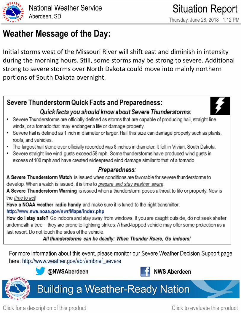
Initial storms west of the Missouri River will shift east and diminish in intensity during the morning hours. Still, some storms may be strong to severe. Additional strong to severe storms over North Dakota could move into mainly northern portions of South Dakota overnight.
Initial issuance
Weather Message of the Day:
Important Forecast Changes
Storm Threat this morning & again Overnight

Hazards:
Severe Weather…Mainly strong damaging winds. Large hail or a tornado will
also be possible.
Heat…Heat Index values may reach near 100 degrees this afternoon and Friday
afternoon
Areas Impacted:
Severe Weather…Northern portions of South Dakota, especially north central
South Dakota.
Heat…South central South Dakota this afternoon, and eastern South Dakota
Friday afternoon.
Timing & Duration:
Severe Weather…Overnight.
Heat…This afternoon, and again Friday afternoon.
Click for a description of this product Click to evaluate this product
Headline
Headline
[Insert Weather Message] Headline
Graphics Depot Situation Report Thursday, June 28, 2018 1:12 PM
National Weather Service Aberdeen, SD
Address the key points of
the event by providing
valued added detail
This page should feature
at LEAST one image.
Use banner color that
matches risk level
Key Points
This page is required in order to address
these critical elements:
1. Hazards
2. Areas Impacted
3. Timing & Duration
4. Impacts
5. Forecast Certainty and Considerations
6. Historical Perspective (how rare is this
event?) is recommended to include
especially in larger events.
However, this format may be modified
and offices may use graphics/other text
(encompassing other slides if needed) as
they see fit or as requested by local
partner feedback to address these
critical elements.
Storm Threat this morning & again Overnight
Severe Weather Outlook
Click for a description of this product Click to evaluate this product
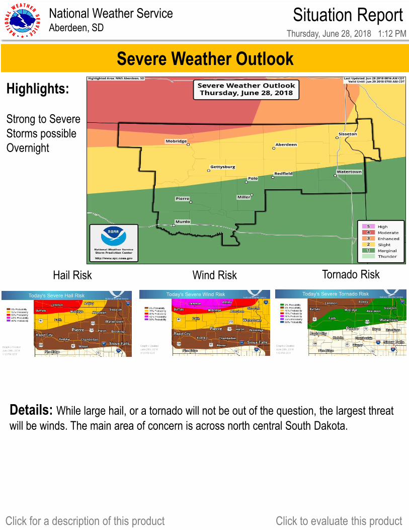
Highlights:
Strong to Severe
Storms possible
Overnight
Graphics Depot
Day 2 Day 3
WWA
Day 4 Day 5
Day 1
Situation Report Thursday, June 28, 2018 1:12 PM
Highlight the hazards
including the magnitude
Provide overall outlook
Hail Risk Wind Risk Tornado Risk
Details: While large hail, or a tornado will not be out of the question, the largest threat
will be winds. The main area of concern is across north central South Dakota.
National Weather Service Aberdeen, SD
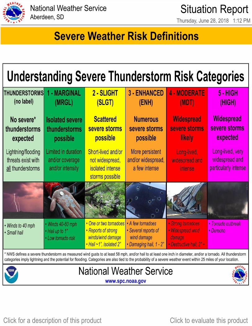
Severe Weather Risk Definitions
Click for a description of this product Click to evaluate this product
Graphics Depot
Day 2 Day 3
WWA
Day 4 Day 5
Day 1
Situation Report Thursday, June 28, 2018 1:12 PM
Highlight the hazards
including the magnitude
Provide overall outlook
National Weather Service Aberdeen, SD

Heat Index Values Reaching near 100 degrees today and Friday
Additional Weather Concern: Heat
Graphics Depot
Click for a description of this product Click to evaluate this product
Situation Report Thursday, June 28, 2018 1:12 PM
Enter event impacts including
storm reports and overall
summary of the event
National Weather Service Aberdeen, SD
Click for a description of this product Click to evaluate this product
Select Appropriate Info Box from:
Info Box Repository or from images
to the right. Note: if you use the images
from the margins of this document, there
is a slight decrease in resolution.
Add links to relevant top news
stories from your homepage or to a
DSS page you have set up below
the info box.
Enter event messaging themes &
resources. Inform core partners of
the message of the day and the
safety message of the day
Weather Message of the Day: Initial storms west of the Missouri River will shift east and diminish in intensity during the morning hours. Still, some storms may be strong to severe. Additional strong to severe storms over North Dakota could move into mainly northern portions of South Dakota overnight.
@NWSAberdeen NWS Aberdeen
Situation Report Thursday, June 28, 2018 1:12 PM
This page is required National Weather Service Aberdeen, SD
For more information about this event, please monitor our Severe Weather Decision Support page
here: http://www.weather.gov/abr/embrief_severe
Info Boxes:
Basic SVR
Lg Hail
Flash Flood
Strong Wind