national spatial data infrastructure strategic plan … draft nsdi strategic plan v2 7/31/2013 –...
TRANSCRIPT

National Spatial Data Infrastructure Strategic Plan 2014—2016
Federal Geographic Data Committee
Public Comment Draft (Version 2) July 31, 2013
NOTE: This revised draft of the NSDI Strategic Plan (Version 2) has been prepared for public review and comment. Instructions on submitting comments are posted at www.fgdc.gov/nsdi-plan. Comments are due by August 21, 2013. For additional information on the NSDI strategic planning process, please visit: www.fgdc.gov/nsdi-plan.
1 DRAFT NSDI Strategic Plan v2 7/31/2013 – Public Comment Version
CONTENTS
Executive Summary ..................................................................................................................................... 2
The National Spatial Data Infrastructure ..................................................................................................... 3
Vision .................................................................................................................................................... 3
Guiding Principles ................................................................................................................................. 3
Strategic Plan Overview ............................................................................................................................... 4
Background .......................................................................................................................................... 4
A Shared Vision for the NSDI ................................................................................................................ 6
Roles and Responsibilities of the Federal Sector ................................................................................. 7
External Factors .................................................................................................................................... 8
Challenges and Opportunities ............................................................................................................ 11
Strategic Goals ........................................................................................................................................... 12
Goal 1 – Develop National Shared Services Capabilities..................................................................... 12
Goal 2 – Ensure Accountability and Effective Development and Management of
Federal Geospatial Resources ............................................................................................................. 14
Goal 3 – Convene Leadership of the National Geospatial Community .............................................. 15
Implementing the NSDI Strategic Plan ....................................................................................................... 17
Implementation Strategies and Performance Measurement Approach ........................................... 17
Additional Information ............................................................................................................................... 18
List of Authorities ............................................................................................................................... 18
Member Agencies .............................................................................................................................. 19

2 DRAFT NSDI Strategic Plan v2 7/31/2013 – Public Comment Version
EXECUTIVE SUMMARY The tremendous growth and evolution of geospatial technologies, industries, and applications in recent years has highlighted the need to update and modernize the strategic direction of Federal geospatial programs to align with and leverage these advancements. The Federal Geographic Data Committee’s (FGDC) 2014–2016 Strategic Plan for the National Spatial Data Infrastructure (NSDI) sets priorities and describes the actions the FGDC community will take, in collaboration with partners, to develop and maintain the Nation’s critical geospatial infrastructure.
This Strategic Plan was developed during 2013 through extensive consultation with Federal agencies, the National Geospatial Advisory Committee (NGAC), and with partners and stakeholders across the geospatial community. This external input was instrumental in shaping the Plan and in reflecting the perspectives of the broader geospatial community. This Plan describes a shared national vision of the NSDI and includes a set of goals and objectives for the Federal government’s role in achieving this vision:
“The NSDI leverages investments in people, technology, data, and procedures to create and provide the geospatial knowledge required to understand, protect, and promote our national and global interests.”
The goals and objectives in the Plan define areas of critical importance to the continued development of the NSDI and provide a framework for the Federal geospatial community’s responsibilities over the next three years. Goal 1– Develop National Shared Services Capabilities
Objective 1.1. Develop geospatial interoperability reference architecture
Objective 1.2. Establish the Geospatial Platform as the Federal geospatial data, services, and applications Web-based service environment
Objective 1.3. Expand the use of cloud computing
Objective 1.4. Promote the use of geospatial multiagency acquisition vehicles for interagency and intergovernmental purchases
Goal 2 – Ensure Accountability and Effective Development and Management of Federal Geospatial Resources
Objective 2.1. Advance the portfolio management process for National Geospatial Data Assets (NGDA)
Objective 2.2. Identify potentially duplicative investments and opportunities for collaborative investments
Goal 3 – Convene Leadership of the National Geospatial Community
Objective 3.1. Lead and participate in the development and coordination of national and international standards applicable to the geospatial community
Objective 3.2. Convene the leadership of the geospatial and nongeospatial communities to develop shared approaches to critical national issues
Objective 3.3. Raise awareness of the NSDI and its impact on critical national issues
The Plan also describes the steps the FGDC community will take to implement the goals, objectives, and actions, including development of project plans and performance measures in collaboration with partners and stakeholders. For more information visit: www.fgdc.gov/nsdi-plan.

3 DRAFT NSDI Strategic Plan v2 7/31/2013 – Public Comment Version
THE NATIONAL SPATIAL DATA INFRASTRUCTURE Executive Order 12906, “Coordinating Geographic Data Acquisition and Access,” describes the National Spatial Data Infrastructure (NSDI) as “the technology, policies, standards, and human resources necessary to acquire, process, store, distribute, and improve utilization of geospatial data.”
Vision
The NSDI leverages investments in people, technology, data, and procedures to create and provide the geospatial knowledge required to understand, protect, and promote our national and global interests.
Guiding Principles Federal agencies that produce, collect, maintain, or use spatial data either directly or indirectly will (1) recognize and manage their data as capital assets, (2) facilitate non-Federal participation in the development of the NSDI, and (3) work together through the FGDC to provide for effective and economical use and management of geospatial data in the digital environment for the benefit of the Nation. Our Guiding Principles
Ensure that spatial data from multiple sources (Federal, State, local, regional, and Tribal governments; academia; and the private sector) are available and easily integrated to enhance understanding of our physical, natural, and cultural world.
Facilitate the development of authoritative National Geospatial Data Assets that are complete, accurate, current, standards-compliant, and at the scale needed for shared uses by Federal, State, local, regional, and Tribal governments, academia, and the private sector.
Protect the privacy and security of citizens’ personal data and ensure the accuracy of statistical information about people, both in raw form and in derived information products.
Enable access for all citizens to spatial data, information, and derivative and interpretive products, in accordance with Office of Management and Budget Circulars A–130 and A–16.
Protect proprietary interests related to licensed information and data.
Enable interoperability of information systems through the use of open and machine readable formats to enable access to resources from multiple agencies and partners.
Ensure that investment and policy decisions consider the expected return on investment and effective use of resources.

4 DRAFT NSDI Strategic Plan v2 7/31/2013 – Public Comment Version
STRATEGIC PLAN OVERVIEW
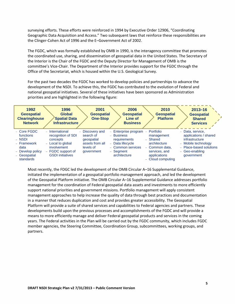
Background The Changing Geospatial Landscape The technology landscape has seen tremendous change since the NSDI was initially conceptualized in the early 1990s. In the years leading up to the 1990s, advances in mapping and geospatial technology were largely driven by the public sector—with the Federal government playing a major role in the development and coordination of data, products, and services. The origins for many of the current geospatial innovations and operational successes have their roots in past government investment in research and implementation of computing and communication technology, geospatial data standards, NSDI framework data development, the Internet, remote sensors, and the Global Positioning System (GPS). In the years since the inception of the NSDI, remarkable advances in computing power, the emergence of open standards and open systems, and the Internet have reshaped the technology landscape. In recent years, the availability and usage of geospatial information and products have dramatically expanded as software has matured and high-quality data became available through newly implemented State and Federal clearinghouses and private sector offerings. The Growing Role and Value of Geospatial Technology and Information The geospatial technology and services industry is a growing and important factor in the United States and world economies, driving significant benefits and providing high-wage jobs. A 2012 study by the Boston Consulting Group (BCG) estimated that the U.S. geospatial industry generated approximately $73 billion in revenues in 2011 and comprises at least 500,000 high-wage jobs. In addition, BCG found that geospatial services deliver efficiency gains in the rest of the economy that are valued at many times the size of the sector itself—with geospatial services driving $1.6 trillion in revenue and $1.4 trillion in cost savings. These benefits, representing 15 to 20 times the size of the geospatial services sector itself, create an important competitive advantage for the U.S. economy. The Geospatial Information and Technology Association (GITA) recently reported that the geospatial information technology (IT) sector has recently been growing by 35% per year, with the commercial side growing at an incredible rate of 100% annually. In addition, the U.S. Department of Labor recently identified the geospatial technology sector as one of the three technology areas that would create the greatest number of new jobs over the next decade. Worldwide, a 2012 study by Oxera commissioned by Google estimated that the global geospatial services sector generates $150 to $270 billion annually. By comparison, this is greater than the $25 billion generated by the video games industry, roughly equivalent to the $140 billion in revenue from the global security services industry, and about one-third of the global airline industry’s annual revenues of $594 billion. The Role of the FGDC The Office of Management and Budget (OMB) has specific oversight responsibilities for Federal information technology systems and acquisition activities, including geographic information systems, to help ensure their efficient and effective use. Since 1953, OMB has released several iterations of Circular A–16 that, among other requirements, encourages avoidance of duplicative mapping and
5 DRAFT NSDI Strategic Plan v2 7/31/2013 – Public Comment Version
surveying efforts. These efforts were reinforced in 1994 by Executive Order 12906, “Coordinating Geographic Data Acquisition and Access.” Two subsequent laws that reinforce these responsibilities are the Clinger-Cohen Act of 1996 and the E–Government Act of 2002. The FGDC, which was formally established by OMB in 1990, is the interagency committee that promotes the coordinated use, sharing, and dissemination of geospatial data in the United States. The Secretary of the Interior is the Chair of the FGDC and the Deputy Director for Management of OMB is the committee’s Vice-Chair. The Department of the Interior provides support for the FGDC through the Office of the Secretariat, which is housed within the U.S. Geological Survey. For the past two decades the FGDC has worked to develop policies and partnerships to advance the development of the NSDI. To achieve this, the FGDC has contributed to the evolution of Federal and national geospatial initiatives. Several of these initiatives have been sponsored as Administration priorities and are highlighted in the following figure: Most recently, the FDGC led the development of the OMB Circular A–16 Supplemental Guidance, initiated the implementation of a geospatial portfolio management approach, and led the development of the Geospatial Platform initiative. The OMB Circular A–16 Supplemental Guidance addresses portfolio management for the coordination of Federal geospatial data assets and investments to more efficiently support national priorities and government missions. Portfolio management will apply consistent management approaches to help increase the quality of data through best practices and documentation in a manner that reduces duplication and cost and provides greater accessibility. The Geospatial Platform will provide a suite of shared services and capabilities to Federal agencies and partners. These developments build upon the previous processes and accomplishments of the FGDC and will provide a means to more efficiently manage and deliver Federal geospatial products and services in the coming years. The Federal activities in the Plan will be carried out by the FGDC community, which includes FGDC member agencies, the Steering Committee, Coordination Group, subcommittees, working groups, and partners.
1996
Global Spatial Data
Infrastructure
2001 Geospatial One-Stop
2010 Geospatial Platform
2013–16 Geospatial
Shared Services
International recognition of SDI concepts
Local to global involvement
FGDC support of GSDI initiatives
Discovery and search of geospatial assets from all levels of government
Enterprise program
Business requirements
Data lifecycle
Common services
Segment architecture
Portfolio management
Shared architecture
Common data, services, and applications
Cloud computing
Data, service, applications / shared infrastructure
Mobile technology
Place-based solutions
Geo-enabling government
1992 Geospatial
Clearinghouse Network
Core FGDC functions
NSDI Framework
data
Develop policy
Geospatial standards
2006 Geospatial
Line of Business
6 DRAFT NSDI Strategic Plan v2 7/31/2013 – Public Comment Version
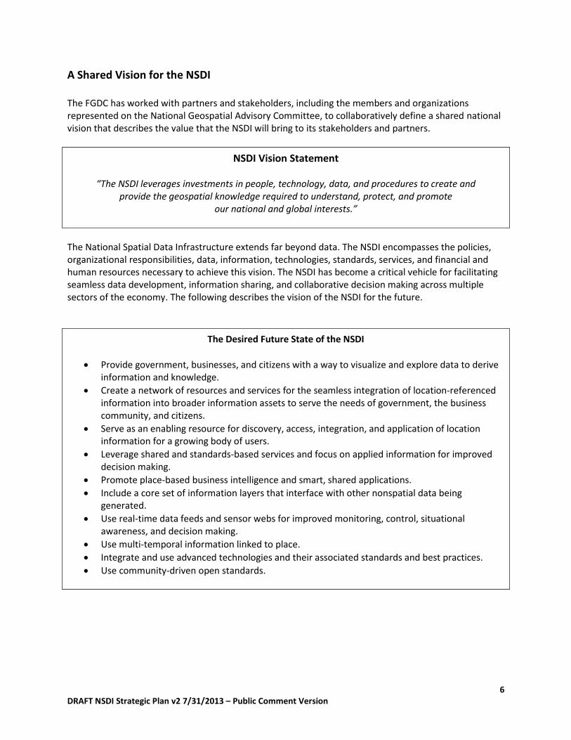
A Shared Vision for the NSDI
The FGDC has worked with partners and stakeholders, including the members and organizations represented on the National Geospatial Advisory Committee, to collaboratively define a shared national vision that describes the value that the NSDI will bring to its stakeholders and partners.
NSDI Vision Statement
“The NSDI leverages investments in people, technology, data, and procedures to create and provide the geospatial knowledge required to understand, protect, and promote
our national and global interests.”
The National Spatial Data Infrastructure extends far beyond data. The NSDI encompasses the policies, organizational responsibilities, data, information, technologies, standards, services, and financial and human resources necessary to achieve this vision. The NSDI has become a critical vehicle for facilitating seamless data development, information sharing, and collaborative decision making across multiple sectors of the economy. The following describes the vision of the NSDI for the future.
The Desired Future State of the NSDI
Provide government, businesses, and citizens with a way to visualize and explore data to derive information and knowledge.
Create a network of resources and services for the seamless integration of location-referenced information into broader information assets to serve the needs of government, the business community, and citizens.
Serve as an enabling resource for discovery, access, integration, and application of location information for a growing body of users.
Leverage shared and standards-based services and focus on applied information for improved decision making.
Promote place-based business intelligence and smart, shared applications.
Include a core set of information layers that interface with other nonspatial data being generated.
Use real-time data feeds and sensor webs for improved monitoring, control, situational awareness, and decision making.
Use multi-temporal information linked to place.
Integrate and use advanced technologies and their associated standards and best practices.
Use community-driven open standards.
7 DRAFT NSDI Strategic Plan v2 7/31/2013 – Public Comment Version
Roles and Responsibilities of the Federal Sector
The FGDC, in collaboration with partners and with input from the National Geospatial Advisory Committee (NGAC), has examined the current and future roles of the Federal government as they relate to the continued development of the NSDI. The following is a summary of the key geospatial roles for the Federal government and relationships with other sectors of the geospatial community. Leadership The Federal government will play a critical role in providing institutional leadership for the development and coordination of national and international geospatial policies, the integration of geospatial technology into IT management processes, and in coordinating the resolution of legal and policy issues. The Federal government is in a unique position to convene multiple stakeholders, through mechanisms such as the NGAC, to develop joint approaches to issues affecting multiple sectors. In addition, the Federal community can provide leadership to establish joint acquisitions of geospatial data and services (for example, Smartbuy) with buy-up options for partners. Partner Federal agencies will continue to work together and with State, local, Tribal, regional, academic, and private sector partners to jointly fund and share geospatial data, services, and tools. Emphasis will be placed on improved efficiency, improved effectiveness, and open access as directed by the Administration’s Open Data Policy. Facilitator The FGDC will facilitate collaboration between and across all levels of government, academia, nonprofits, the private sector, and individuals for research and to create data and information services. To accomplish this role, the Federal community can convene key experts, decision makers, and stakeholders to address common concerns and solve problems. The Federal role will be to work with other levels of government and stakeholders to share data, approaches, and services; to develop best practices to meet common needs; and to clearly delineate responsibilities for agency theme leads under OMB Circular A–16. Provider Federal agencies will focus on providing geospatial services and tools for the use of critical data assets. This focus encompasses the agency mapping activities, framework data, the A–16 categories, metadata and catalogs, and interagency communications. The Federal government should focus on the implementation of the Geospatial Platform as a primary mechanism for collaborative development and distribution of data content via standards-based services. Curator The Federal community will provide and maintain geospatial content, where appropriate, and focus on delivering services that provide data in standardized, accessible, open formats. The Federal community should take the lead in building and maintaining an online catalog for transparent discovery and access to Federal and other data through the Geospatial Platform and other resources. Enabler The Federal government will play an enabler role to make geospatial data and services more accessible to an expanded audience and to work with partners to develop more timely, accurate, and useful data

8 DRAFT NSDI Strategic Plan v2 7/31/2013 – Public Comment Version
and services. In this way the Federal government can make State and local information play an enhanced role in national government and business operations. Standards and Research The Federal government will promote the continued development of consensus-based standards for interoperability as new technologies and capabilities evolve in order to achieve and maintain an interoperable NSDI network. In addition, the Federal government will effectively coordinate among programs that conduct and (or) sponsor geospatial research to ensure that highest priority needs are addressed; the Federal government will work with partners to better share research results and translate new findings and capabilities into operational activities across appropriate sectors.
External Factors
The National Geospatial Advisory Committee has identified the following key factors, including technology, economic, political, and organizational trends, that should be considered for geospatial strategy at the national level. Evolutions in Information Management Innovations in data collection, management, processing, dissemination, and application are becoming available largely through private sector advancement of sensors, crowd-sourcing, big data storage/analytics and information distribution technologies, and through academic and government funded research. In light of these changes, the role of government is transitioning from building framework spatial infrastructure to ensuring that specific programmatic goals and the greater public good are served by trusted, documented information resources. This information has new requirements for transparency, currency, accuracy, and accessibility. The next generation of geospatial resources will be information sourced and served from a combination of the private sector, the public sector, individuals, nongovernment groups, and public-private partnerships. Geospatial information is now viewed as one component of the overall information management fabric. Geospatial infrastructure provides value via connected services to a diverse set of devices operated by end users comprising a full range of roles and skills. It balances the same demands as other information resources (accessibility, security, persistence, reliability, confidentiality, and cost efficiency), while providing the spatial capabilities that are its core strength: visualization, analytics, and the ability to bring together disparate information resources using location as a unifying principle. Important Trends Other trends impacting the strategy for a national geospatial infrastructure can be characterized by four themes: technology, communications, workforce, and legal/policy issues. Technology
The “Internet of Things” will connect billions of stationary and mobile sensors with human users.
The value of integrated geospatial information (3D, 4D, indoor, unstructured, linked, archived) will be magnified by high-powered processing and analytics capabilities, and by the ability to provide succinct intelligence to decision makers.
Static ad hoc data will yield to big data transactional models based on Cloud-based service models for infrastructure, software, and information content.
9 DRAFT NSDI Strategic Plan v2 7/31/2013 – Public Comment Version
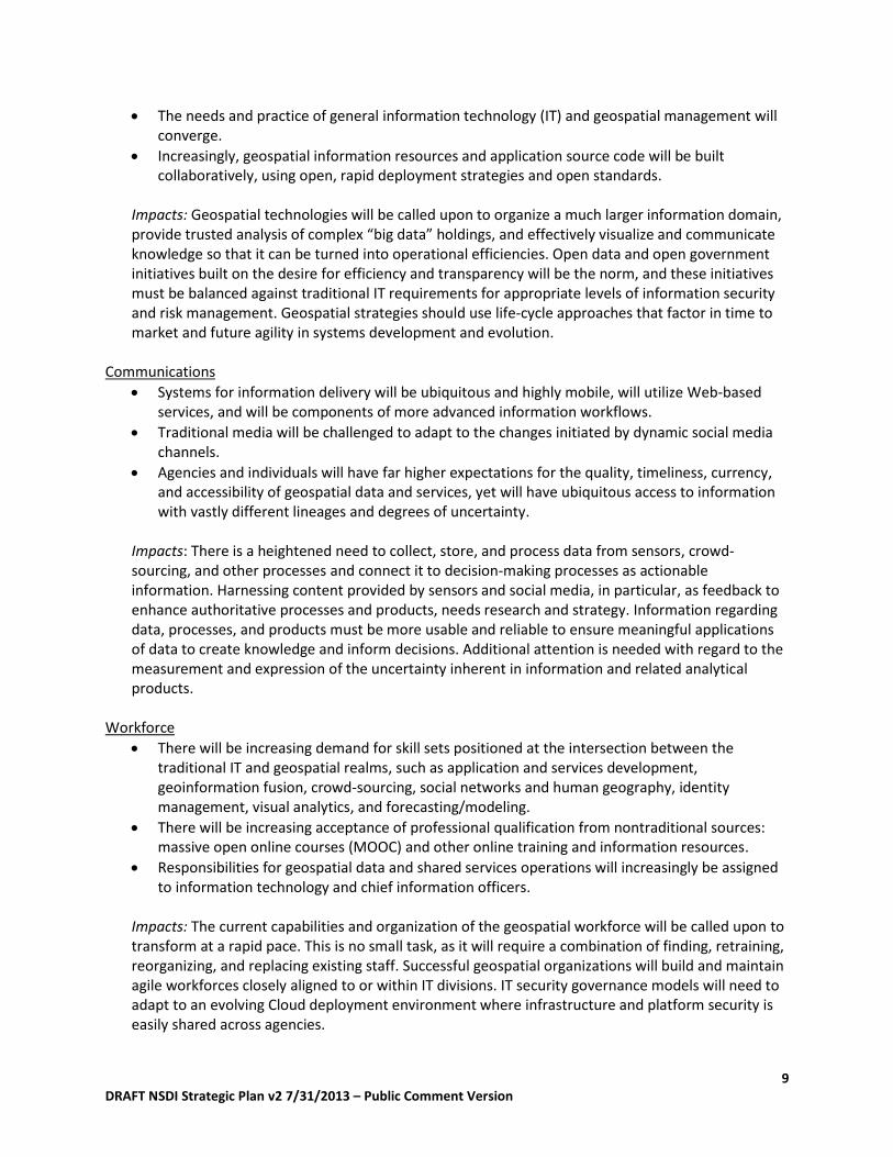
The needs and practice of general information technology (IT) and geospatial management will converge.
Increasingly, geospatial information resources and application source code will be built collaboratively, using open, rapid deployment strategies and open standards.
Impacts: Geospatial technologies will be called upon to organize a much larger information domain, provide trusted analysis of complex “big data” holdings, and effectively visualize and communicate knowledge so that it can be turned into operational efficiencies. Open data and open government initiatives built on the desire for efficiency and transparency will be the norm, and these initiatives must be balanced against traditional IT requirements for appropriate levels of information security and risk management. Geospatial strategies should use life-cycle approaches that factor in time to market and future agility in systems development and evolution.
Communications
Systems for information delivery will be ubiquitous and highly mobile, will utilize Web-based services, and will be components of more advanced information workflows.
Traditional media will be challenged to adapt to the changes initiated by dynamic social media channels.
Agencies and individuals will have far higher expectations for the quality, timeliness, currency, and accessibility of geospatial data and services, yet will have ubiquitous access to information with vastly different lineages and degrees of uncertainty.
Impacts: There is a heightened need to collect, store, and process data from sensors, crowd-sourcing, and other processes and connect it to decision-making processes as actionable information. Harnessing content provided by sensors and social media, in particular, as feedback to enhance authoritative processes and products, needs research and strategy. Information regarding data, processes, and products must be more usable and reliable to ensure meaningful applications of data to create knowledge and inform decisions. Additional attention is needed with regard to the measurement and expression of the uncertainty inherent in information and related analytical products.
Workforce
There will be increasing demand for skill sets positioned at the intersection between the traditional IT and geospatial realms, such as application and services development, geoinformation fusion, crowd-sourcing, social networks and human geography, identity management, visual analytics, and forecasting/modeling.
There will be increasing acceptance of professional qualification from nontraditional sources: massive open online courses (MOOC) and other online training and information resources.
Responsibilities for geospatial data and shared services operations will increasingly be assigned to information technology and chief information officers.
Impacts: The current capabilities and organization of the geospatial workforce will be called upon to transform at a rapid pace. This is no small task, as it will require a combination of finding, retraining, reorganizing, and replacing existing staff. Successful geospatial organizations will build and maintain agile workforces closely aligned to or within IT divisions. IT security governance models will need to adapt to an evolving Cloud deployment environment where infrastructure and platform security is easily shared across agencies.

10 DRAFT NSDI Strategic Plan v2 7/31/2013 – Public Comment Version
Legal/Policy Issues
Views and approaches to geospatial privacy will continue to evolve. Geolocation privacy is a complex and multifaceted issue that will engage a variety of interests, including both geospatial and nongeospatial entities. Potential statutory or regulatory changes to locational privacy issues have the potential to significantly impact the geospatial community. It is likely that legislation will lag behind the changes in technology and behavior.
Capabilities of local, Tribal, regional, and State geospatial resources continue to improve and, in many areas, will provide the best sources for ongoing current and accurate information.
Government policy and private practices will increasingly demand information transparency. Data will be considered an integral and accountable part of decision making, including its use in models and forecasts.
Impacts: Proactive approaches are needed to develop consensus terminology, develop policy, and educate citizens and decision makers with regard to geospatial data gathering, dissemination, licensing, and usage practices. Privacy, confidentiality, and security issues must be addressed for sensitive geospatial information, especially when directly linked to personally identifiable information, to protect the interests of both individuals and commerce. A priority for privacy policy efforts should be developing consensus on acceptable practices with immediate use. Issues at the margins of privacy acceptability should not delay important work to aggregate and utilize geospatial data and services from local to national levels in a timely manner.
Summary: What External Factors will Influence the Future of the NSDI? A number of critical external factors are driving trends in technology, communications, workforce, and legal/policy issues of importance to a future NSDI. These factors signal a strong need to align national geospatial strategy with both mainstream and emerging information technology practices and with related trends. Geospatial technologies provide attractive integrative approaches for meeting current requirements to “do more with less.” New approaches are demanded, supported, and must be implemented quickly for technology, collaboration, workforce development, funding, and other resources. Geospatial technology should be aligned with and integrated into the broader, ever-evolving technology ecosystem.
11 DRAFT NSDI Strategic Plan v2 7/31/2013 – Public Comment Version
Challenges and Opportunities
The revolutionary changes in geospatial technology and applications and the growing visibility of geospatial technology across all sectors of the global economy are leading public sector agencies to realign their geospatial strategies and investments to meet the needs of newly geospatial-savvy information consumers. More and more, citizens expect government to provide geospatial data and services to them in their specific areas of interest. As the public sector faces the challenge of doing more with less, the smart, strategic use of shared, enterprise geospatial technologies provides significant opportunities for efficiencies. Key challenges and opportunities for the geospatial community include the following:
The Federal government plays an important role in providing leadership, policy development, and facilitation of the broad range of organizations and interests involved in the geospatial community. This leadership role has been identified by stakeholders as a critical responsibility.
The geospatial community holds a shared value in the importance of standards, data sharing, partnerships, and collaboration to solve real issues. The diverse geospatial community relies on the FGDC’s leadership for metadata guidance and the coordination of standards.
Execution and enforcement of OMB Circular A–16 responsibilities have been identified as challenges for the Federal community. The task of building the NSDI and the accomplishment of A–16 responsibilities has not always been aligned with agency missions. In difficult budgetary times, ensuring agency accountability for A–16 responsibilities is a significant challenge.
It is difficult to quantify the entire magnitude of geospatial investment across the NSDI partner community because these investments are typically integrated into other programs and services. Moreover, geospatial data management is not fully integrated into Federal IT management processes, and many programs that have geospatial components are not visible through existing IT management processes.
With the expanded use of geospatial data and services, new challenges are arising for the Federal geospatial community. It has been difficult to express the value and benefit of Federal investments in providing geospatial data and services when the public can readily access a great deal of geospatial information managed by both the public and private sectors through Web-based applications and hand-held devices. In addition, technology adoption and policy development by the Federal government often cannot keep up with the speed of the innovative changing technology. The role of the Federal sector is evolving and the Federal geospatial community will have to be agile and flexible to accommodate and adapt to these changing roles.
The geospatial technology field is at a remarkable point in its evolution, presenting an opportunity to rethink the deployment and use of these resources across the Federal government, and to enhance our ability to solve problems using geographic information while ultimately saving time and money. This Plan provides a new set of goals, objectives, and actions to advance Federal geospatial programs in light of the changing state of geospatial technology and capabilities.

12 DRAFT NSDI Strategic Plan v2 7/31/2013 – Public Comment Version
STRATEGIC GOALS
Goal 1 – Develop National Shared Services Capabilities Developing shared services is a vital strategy for delivering geospatial solutions faster, for less money, and with fewer resources. These enterprise approaches take advantage of evolving technologies and methodologies to reduce potential duplication, create innovative tools and technology, and leverage agency budgets and expertise to accomplish agency mission and support functions more efficiently, while also improving quality. The Geospatial Platform initiative is a critical component for the continued development of the NSDI. The Platform is a Web-based first generation service environment that provides access to a suite of well-managed, highly available, and trusted geospatial data, services, applications, and tools for use by Federal agencies and their State, local, Tribal, and regional partners. In addition, the FGDC community and its partners will utilize common cloud computing and enterprise acquisition approaches as mechanisms to leverage technology, close productivity gaps, and combine buying power across agencies for similar needs. This strategic goal describes how the Federal geospatial community will work with partners to develop shared service approaches and leverage the Administration’s Federal Information Technology Shared Services Strategy.
Objective 1.1. Develop geospatial interoperability reference architecture
Anticipated Outcomes. More current, complete data available to all through improving capabilities for NSDI partners to develop, maintain, share, and use geospatial information. Cost savings through better leveraging of shared technology infrastructure across the Federal government and among our partners.
Action 1.1.1. Establish reference architecture to assure interoperability utilizing published, open service standards to share data among unclassified; controlled, unclassified information (CUI); and classified domains and missions.
Action 1.1.2. Define the role of the Geospatial Platform as a technology and collaboration environment for unclassified geospatial information sharing.
Action 1.1.3. Identify Federal Chief Information Officers (CIO) Council requirements, shared services, and other infrastructure that can be reused and leveraged by the NSDI, including access control, search, and discovery.
13 DRAFT NSDI Strategic Plan v2 7/31/2013 – Public Comment Version
Objective 1.2. Establish the Geospatial Platform as the Federal geospatial data, services, and applications Web-based service environment
Anticipated Outcomes. Efficient, effective use of shared technology infrastructure to encourage and support better information sharing. Cost savings through shared geospatial investment planning.
Action 1.2.1. Establish Service Level or Interagency Agreements between and among government agencies and the Geospatial Platform Managing Partner.
Action 1.2.2. Establish the Geospatial Platform Oversight Body and develop its operating procedures, scope, and roles of Federal and non-Federal members.
Action 1.2.3. Implement the primary contracting mechanism to continue Platform development and operations and maintenance for FY 2014 and beyond.
Action 1.2.4. Implement communities of interest on the Geospatial Platform for collaboration, including a shared investment planning “Marketplace” and data theme communities, as outlined in Circular A–16
Action 1.2.5. Develop guidance for Federal agencies and their partners that describes how to use the Geospatial Platform to store and publish data and metadata and how to use services in the Platform’s common hosting infrastructure.
Action 1.2.6. Solicit advice and recommendations from the NGAC and community partners on ways to expand and enhance the Geospatial Platform for broader use and value by the non-Federal community.
Action 1.2.7. Define the concept and develop an implementation plan for a “Data as a Service” offering within the Geospatial Platform Marketplace.
Objective 1.3. Expand the use of cloud computing
Anticipated Outcomes. Cost savings through expanded use of commodity cloud hosting capabilities for the benefit of all NSDI partners.
Action 1.3.1. Define the mechanism and workflow for Geospatial Platform leveraging of a DOI Foundational Cloud Services offering that will benefit the Platform user community.
Action 1.3.2. Provide guidance, best practices, and case studies for agencies considering migration of agency-stored content and services to commodity cloud providers.
Action 1.3.3. Develop an options paper for expanding the currently defined common hosting environment to look at other capabilities available in the commercial market.

14 DRAFT NSDI Strategic Plan v2 7/31/2013 – Public Comment Version
Objective 1.4. Promote the use of geospatial multiagency acquisition vehicles for interagency and intergovernmental purchases
Anticipated Outcomes. Cost savings through better leveraging of the government’s purchasing power when buying goods and services for the benefit of multiple partners.
Action 1.4.1. Inventory available and planned geospatial acquisition vehicles open to
Federal agencies and non-Federal partners.
Action 1.4.2. Create a mechanism for sharing information on the availability and use of consolidated acquisition vehicles.
Goal 2 – Ensure Accountability and Effective Development and Management of
Federal Geospatial Resources
Effective management of geospatial investments will enable the Federal government and its partners to control costs, streamline services, make decisions on eliminating duplication, save taxpayer dollars, and drive efficiency across the Federal government. The OMB Circular A–16 Supplemental Guidance provides guidelines for implementing a portfolio management approach to Federal geospatial investments and managing National Geospatial Data Assets (NGDA) government-wide. This approach will allow identification of datasets that are most critical for meeting the needs of government and stakeholders. This strategic goal describes the actions the Federal geospatial community will take to implement portfolio management to more effectively plan geospatial data collection efforts, assess the status of NGDAs, and minimize duplicative investments.
Objective 2.1. Advance the portfolio management process for National Geospatial Data Assets (NGDA)
Anticipated Outcomes. Increased access to high-priority, documented, and standards-based national geospatial datasets and services. Enhanced level of transparency into Federal activities and resources required to manage and provide access to geospatial resources.
Action 2.1.1. Identify foundational NGDAs and high-priority datasets to be included in NSDI portfolio management.
Action 2.1.2. Define Federal roles and responsibilities in national data management, including metadata and data delivery, taking into account Circular A–16 Supplemental Guidance portfolio management requirements, Open Data policy, Geospatial Platform, Data.gov, and other relevant requirements.
Action 2.1.3. Finalize and implement the Circular A–16 Portfolio Management Plan to include reporting investments and defining investment requirements.
Action 2.1.4. Develop a process for monitoring and reporting on the progress of Circular A–16 Data Theme and Geospatial Platform Community management responsibilities, including the use and proliferation of content and technology standards.

15 DRAFT NSDI Strategic Plan v2 7/31/2013 – Public Comment Version
Objective 2.2. Identify potentially duplicative investments and opportunities for collaborative investments
Anticipated Outcomes. Additional information is publicly available on geospatial acquisition plans resulting in cost efficiencies and decreased duplication of effort. Enhanced return on geospatial investments through partnerships across Federal and non-Federal sectors.
Action 2.2.1. Provide guidance and instructions to Federal agencies on use of the Geospatial Platform Marketplace.
Action 2.2.2. Develop process and technology implementation to track use of the Geospatial Platform Marketplace and cost savings/avoidance through its application.
Action 2.2.3. Solicit feedback from the Geospatial Platform user community on future requirements for Marketplace functionality.
Goal 3 – Convene Leadership of the National Geospatial Community
The Federal government is in a unique position to provide a leadership and facilitation role in the national geospatial community. This role includes providing institutional leadership for the development and coordination of national and international geospatial standards and policies, integrating geospatial technology into IT management processes, coordinating the resolution of legal and policy issues, and fostering collaboration across sectors. The Federal geospatial community can play an important role in communicating the value of geospatial information and tools to enable informed analysis and decision making. Stakeholders have identified this strategic goal as a critical responsibility that can be accomplished most effectively by the Federal government.
Objective 3.1. Lead and participate in the development and coordination of national and international standards applicable to the geospatial community
Anticipated Outcomes. Greater adoption and utilization of geospatial standards resulting in enhanced interoperability of geospatial data, services, and systems. Decreased barriers to exchanging geospatial content effectively and efficiently by reducing technical impediments to sharing geospatial data and services.
Action 3.1.1. Consult and collaborate with nontraditional geospatial communities to advance common standards and approaches.
Action 3.1.2. Develop strategic partnerships with existing standards development organizations.
Action 3.1.3. Engage the standards community through workshops or online information sharing tools such as Web meetings or social media.

16 DRAFT NSDI Strategic Plan v2 7/31/2013 – Public Comment Version
Objective 3.2. Convene the leadership of the geospatial and nongeospatial communities to develop shared approaches to critical national issues
Anticipated Outcomes. More effective collaboration in the development and oversight of critical geospatial activities required for the effective management of the NSDI.
Action 3.2.1. Engage with the NGAC, key geospatial organizations, and other stakeholders to inform policy decisions and collaboratively identify and address issues of common concern.
Objective 3.3. Raise awareness of the NSDI and its impact on critical national issues
Anticipated Outcomes. Enhanced level of understanding, engagement, and investment by all affected communities in the development and maintenance of the national spatial data infrastructure.
Action 3.3.1. Develop and implement a communication strategy and outreach plan to promote the benefits of NSDI data and the goals of the NSDI strategic plan.

17 DRAFT NSDI Strategic Plan v2 7/31/2013 – Public Comment Version
IMPLEMENTING THE NSDI STRATEGIC PLAN
Implementation Strategies and Performance Measurement Approach The FGDC community will work collaboratively to implement and monitor the implementation of the NSDI Strategic Plan. The FGDC Executive Committee will have the lead responsibility for monitoring the implementation of the Plan. A designated Federal official, appointed from the FGDC Executive Committee, will serve as the champion for each strategic goal. The champions will report to the FGDC Executive Committee and Steering Committee. The champions will be responsible for overseeing team leaders and action teams, addressing each objective and its supporting actions. Each action team leader will develop a project plan following adoption of the NSDI Strategic Plan outlining how the goals and objectives will be achieved. The project plans will include detailed tasks and milestones, responsible parties, and performance indicators/measures for each of the objectives. The project plans will also identify the resources available to achieve the objectives and scale the plan to what can be achieved with that level of resource. FGDC leadership will assist in identifying and committing resources as well as tracking progress. The performance measurement approach is critical to the successful implementation of the goals and objectives described in this Plan. Performance measures will be based on data (numeric description and results) and will describe whether the identified action is achieving its expected result and if progress is being made toward attaining the goal or objective. With the completion of each project plan, performance measures will be reviewed and evaluated by the champions and Executive Committee as to whether the measure or metric will demonstrate progress toward achieving the objective. The champions, in collaboration with the Executive Committee, will monitor performance based on review of performance measures and milestones. Brief quarterly progress reports will be required for each objective. Progress will be reported to the FGDC Steering Committee and Executive Committee at each meeting. Updates and adjustments to the plans will be completed as needed. The implementation of the NSDI Strategic Plan will be aligned with the implementation of the geospatial portfolio management approach described in the Supplemental Guidance to OMB Circular A–16. These initiatives will lead to a more efficient and systematic approach to the development and management of National Geospatial Data Assets.
18 DRAFT NSDI Strategic Plan v2 7/31/2013 – Public Comment Version
ADDITIONAL INFORMATION
List of Authorities
Office of Management and Budget. (2000, November 28). Circular A–130 Revised. Retrieved July 17, 2013, from: http://www.whitehouse.gov/omb/circulars_a130_a130trans4/
Office of Management and Budget. (2002, August 19). Circular A–16 Revised. Retrieved July 17, 2013, from: http://www.whitehouse.gov/omb/circulars_a016_rev/
Office of Management and Budget. (2010, November 10). Circular A–16 Supplemental Guidance. Retrieved July 17, 2013, from: http://www.whitehouse.gov/sites/default/files/omb/memoranda/2011/m11-03.pdf
Office of Management and Budget. (2006, March 3). Memorandum M–06–07: Designation of a Senior Agency Official for Geospatial Information. Retrieved July 17, 2013, from: https://www.fgdc.gov/participation/steering-committee/memos/EOP-3-3-06-Designation-of-SAOGIs_m06-07.pdf
Office of Management and Budget. (2013, May 9). Open Data Policy—Managing Information as an Asset. Retrieved July 17, 2013, from: http://www.whitehouse.gov/sites/default/files/omb/memoranda/2013/m-13-13.pdf
Public Law 104–106. (1996, February 10). National Defense Authorization Act for Fiscal Year 1996 (includes Clinger-Cohen Act). Retrieved July 17, 2013, from: http://www.gpo.gov/fdsys/pkg/PLAW-104publ106/pdf/PLAW-104publ106.pdf Public Law 107–347. (2002, December 17). E-Government Act of 2002. Retrieved July 17, 2013, from: http://www.gpo.gov/fdsys/pkg/PLAW-107publ347/content-detail.html The White House. (1994, April 11). Executive Order 12906: Coordinating Geographic Data Acquisition and Access: The National Spatial Data Infrastructure. Retrieved July 17, 2013, from: http://www.archives.gov/federal-register/executive-orders/pdf/12906.pdf

19 DRAFT NSDI Strategic Plan v2 7/31/2013 – Public Comment Version
Member Agencies About the FGDC The Federal Geographic Data Committee is organized under the authority of OMB Circular A–16 (revised 2002) and Executive Order 12906. The FGDC provides leadership for the National Spatial Data Infrastructure and coordinates the development, use, sharing, and dissemination of the Nation’s geospatial data. In accordance with Circular A–16, the FGDC is chaired by the Secretary of the Interior (or designee), and the OMB Deputy Director for Management (or designee) serves as Vice Chair. The FGDC includes the following member agencies:
Federal Communications Commission* General Services Administration Library of Congress National Aeronautics and Space Administration National Archives and Records Administration National Capital Planning Commission* National Science Foundation Office of Management and Budget Office of Personnel Management Small Business Administration Smithsonian Institution Social Security Administration Tennessee Valley Authority U.S. Agency for International Development U.S. Army Corps of Engineers* U.S. Department of Agriculture U.S. Department of Commerce U.S. Department of Defense U.S. Department of Education U.S. Department of Energy U.S. Department of Health and Human Services U.S. Department of Homeland Security U.S. Department of Housing and Urban Development U.S. Department of the Interior U.S. Department of Justice U.S. Department of Labor U.S. Department of State U.S. Department of Transportation U.S. Department of the Treasury U.S. Department of Veterans Affairs U.S. Environmental Protection Agency U.S. Nuclear Regulatory Commission *Non-voting members