national parks and wildlife service · 2018-04-05 · national parks and wildlife service ... this...
TRANSCRIPT

Conservation Objectives
National Parks and Wildlife Service
River Barrow and River Nore SAC 002162
19 July 2011 Page 1 of 39Version 1.0

European and national legislation places a collective obligation on Ireland and its citizens to maintain habitats and species in the Natura 2000 network at favourable conservation condition. The Government and its agencies are responsible for the implementation and enforcement of regulations that will ensure the ecological integrity of these sites.
A site‐specific conservation objective aims to define favourable conservation condition for a particular habitat or species at that site.
Favourable conservation status of a habitat is achieved when: • its natural range, and area it covers within that range, are stable or increasing, and • the specific structure and functions which are necessary for its long‐term maintenance exist and are likely to continue to exist for the foreseeable future, and • the conservation status of its typical species is favourable.
The favourable conservation status of a species is achieved when: • population dynamics data on the species concerned indicate that it is maintaining itself on a long‐term basis as a viable component of its natural habitats, and • the natural range of the species is neither being reduced nor is likely to be reduced for the foreseeable future, and • there is, and will probably continue to be, a sufficiently large habitat to maintain its populations on a long‐term basis.
The overall aim of the Habitats Directive is to maintain or restore the favourable conservation status of habitats and species of community interest. These habitats and species are listed in the Habitats and Birds Directives and Special Areas of Conservation and Special Protection Areas are designated to afford protection to the most vulnerable of them. These two designations are collectively known as the Natura 2000 network.
The maintenance of habitats and species within Natura 2000 sites at favourable conservation condition will contribute to the overall maintenance of favourable conservation status of those habitats and species at a national level.
1. The targets given in these conservation objectives are based on best available information at the time of writing. As more information becomes available, targets for attributes may change. These will be updated periodically, as necessary.2. An appropriate assessment based on these conservation objectives will remain valid even if the targets are subsequently updated, providing they were the most recent objectives available when the assessment was carried out. It is essential that the date and version are included when objectives are cited.3. Assessments cannot consider an attribute in isolation from the others listed for that habitat or species, or for other habitats and species listed for that site. A plan or project with an apparently small impact on one attribute may have a significant impact on another.4. Please note that the maps included in this document do not necessarily show the entire extent of the habitats and species for which the site is listed. This should be borne in mind when appropriate assessments are being carried out.5. When using these objectives, it is essential that the relevant backing/supporting documents are consulted, particularly where instructed in the targets or notes for a particular attribute.
Notes/Guidelines:
Introduction
19 July 2011 Page 2 of 39Version 1.0
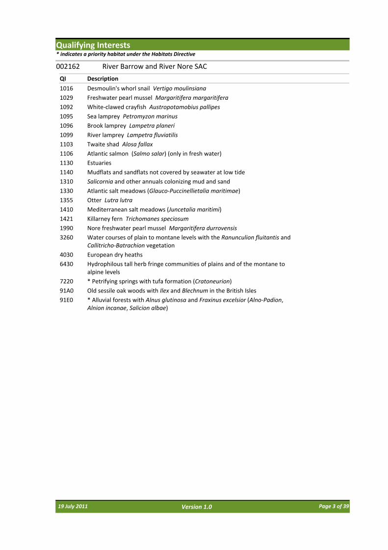
Qualifying Interests* indicates a priority habitat under the Habitats Directive
QI Description
River Barrow and River Nore SAC002162
1016 Desmoulin's whorl snail Vertigo moulinsiana
1029 Freshwater pearl mussel Margaritifera margaritifera
1092 White‐clawed crayfish Austropotamobius pallipes
1095 Sea lamprey Petromyzon marinus
1096 Brook lamprey Lampetra planeri
1099 River lamprey Lampetra fluviatilis
1103 Twaite shad Alosa fallax
1106 Atlantic salmon (Salmo salar) (only in fresh water)
1130 Estuaries
1140 Mudflats and sandflats not covered by seawater at low tide
1310 Salicornia and other annuals colonizing mud and sand
1330 Atlantic salt meadows (Glauco‐Puccinellietalia maritimae)
1355 Otter Lutra lutra
1410 Mediterranean salt meadows (Juncetalia maritimi)
1421 Killarney fern Trichomanes speciosum
1990 Nore freshwater pearl mussel Margaritifera durrovensis
3260 Water courses of plain to montane levels with the Ranunculion fluitantis and Callitricho‐Batrachion vegetation
4030 European dry heaths
6430 Hydrophilous tall herb fringe communities of plains and of the montane to alpine levels
7220 * Petrifying springs with tufa formation (Cratoneurion)
91A0 Old sessile oak woods with Ilex and Blechnum in the British Isles
91E0 * Alluvial forests with Alnus glutinosa and Fraxinus excelsior (Alno‐Padion, Alnion incanae, Salicion albae)
19 July 2011 Page 3 of 39Version 1.0

Supporting documents, relevant reports & publications (listed by date)Supporting documents, NPWS reports and publications are available for download from: www.npws.ie/Publications
Author: Moorkens, E. ; Killeen, I.
Title: Desmoulin’s whorl snail (Vertigo moulinsiana ‐ 1016) Conservation Status Assessment Report
Year: 2011
Series: Unpublished Report to NPWS
Author: NPWS
Title: River Barrow and River Nore SAC (002162): Conservation objectives supporting document ‐woodland habitats [Version 1]
Year: 2011
Series: Unpublished Report to NPWS
Author: NPWS
Title: River Barrow and River Nore SAC (002162): Conservation objectives supporting document ‐ coastal habitats [Version 1]
Year: 2011
Series: Unpublished Report to NPWS
Author: NPWS
Title: River Barrow and River Nore SAC (002162): Conservation objectives supporting document ‐marine habitats [Version 1]
Year: 2011
Series: Unpublished Report to NPWS
Author: DEHLG
Title: Second Draft Nore Freshwater Pearl Mussel Sub‐basin Management Plan (2009‐2015)
Year: 2010
Series: Unpublished Report to NPWS
Author: NPWS
Title: Site investigations for Sabellaria alveolata (Honey‐comb worm) biogenic reefs in Ireland
Year: 2010
Series: Unpublished Report to NPWS
Author: O’Neill, F.H.; Martin, J.R.; Devaney, F.M.; McNutt, K.E.; Perrin, P.M. ; Delaney, A.
Title: Irish Semi‐natural Grasslands Survey. Annual report no. 3: Counties Donegal, Dublin, Kildare & Sligo
Year: 2010
Series: Unpublished Report to NPWS
Author: Perrin, P.M.; Daly, O.H.
Title: A provisional inventory of ancient and long‐established woodland in Ireland
Year: 2010
Series: Irish Wildlife Manuals No. 46
Author: Perrin, P.M.; Barron, S.J.; Roche, J.R.; O'Hanrahan, B.
Title: Guidelines for a national survey and conservation assessment of upland vegetation and habitats in Ireland [Version 1.0]
Year: 2010
Series: Irish Wildlife Manuals No. 48
19 July 2011 Page 4 of 39Version 1.0

Author: Reynolds, J.D.; O’Connor, W.; O’Keeffe, C.; Lynn, D.
Title: A technical manual for monitoring white‐clawed crayfish Austropotamobius pallipes in Irish lakes
Year: 2010
Series: Irish Wildlife Manuals No. 45
Author: SSC
Title: Report of the standing scientific committee to the DCENR. The status of Irish salmon stocks in 2010 and precautionary catch advice for 2011
Year: 2010
Series: Unpublished Report to DCENR
Author: Government of Ireland
Title: The European Communities Environmental Objectives (Freshwater Pearl Mussel) Regulations 2009. [S.I. 296 of 2009]
Year: 2009
Series: Irish Statute Book
Author: Government of Ireland
Title: The European Communities Environmental Objectives (Surface Water) Regulations 2009. [S.I. 272 of 2009]
Year: 2009
Series: Irish Statute Book
Author: McCorry, M.; Ryle, T.
Title: Saltmarsh Monitoring Report 2007‐2008
Year: 2009
Series: Unpublished Report to NPWS
Author: Moorkens, E. A.
Title: Margaritifera durrovensis Survey of Nore River. June – July 2009. NS 2 project
Year: 2009
Series: Unpublished Report to NPWS
Author: ARMS
Title: Benthic Biotope classification of subtidal sedimentary habitats in the Lower River Suir candidate Special Area of Conservation and the River Nore and River Barrow candidate Special Area of Conservation
Year: 2008
Series: Unpublished Report to NPWS
Author: ASU
Title: A survey of mudflats and sandflats in Ireland. An intertidal soft sediment survey of Waterford Estuary
Year: 2008
Series: Unpublished Report to NPWS
Author: CFB; Compass Informatics
Title: Assessment of the Risk of Barriers to Fish Migration in the Nore Catchment, Southern Regional Fisheries Board
Year: 2008
Series: Unpublished Report to CFB
19 July 2011 Page 5 of 39Version 1.0

Author: Maas, J.; Stevens, M. ; Breine, J.
Title: Poor water quality constrains the distribution and movements of Twaite shad Alosa fallax fallax(Lacepede, 1803) in the watershed of river Scheldt
Year: 2008
Series: Hydrobiologia 602, 129 ‐ 143
Author: NPWS ; EHS‐NI
Title: All Ireland Species Action Plan ‐ Killarney fern
Year: 2008
Series: Unpublished Report to NPWS & EHS‐NI
Author: Perrin, P.; Martin, J.; Barron, S.; O’Neill, F.; McNutt, K.; Delaney, A.
Title: National Survey of Native Woodlands 2003‐2008
Year: 2008
Series: Unpublished Report to NPWS
Author: McCorry, M.
Title: Saltmarsh Monitoring Report 2006
Year: 2007
Series: Unpublished Report to NPWS
Author: NPWS
Title: Supporting documentation for the Habitats Directive Conservation Status Assessment ‐ backing documents, Article 17 forms and supporting maps
Year: 2007
Series: Unpublished Report to NPWS
Author: O'Connor, W.
Title: A Survey of Juvenile Lamprey Populations in the Corrib and Suir Catchments
Year: 2007
Series: Irish Wildlife Manuals No. 26
Author: Sullivan, A.
Title: Assessment of fish passage and the ecological impact of migration barriers on the River Nore catchment
Year: 2007
Series: Nore Suir Rivers Trust & OPW
Author: Bailey, M.; Rochford, J.
Title: Otter Survey of Ireland 2004/2005
Year: 2006
Series: Irish Wildlife Manuals No. 23
Author: Geist, J.; Porkka, M.; Kuehn, R.
Title: The status of host fish populations and fish species richness in European freshwater pearl mussel (Margaritifera margaritifera) streams
Year: 2006
Series: Aquatic Conservation: Marine and Freshwater Ecosystems 16, 251–266
Author: King, J.J.
Title: The distribution of Lamprey in the River Barrow SAC
Year: 2006
Series: Irish Wildlife Manuals No. 21
19 July 2011 Page 6 of 39Version 1.0

Author: Kruuk, H.
Title: Otters ‐ ecology, behaviour and conservation
Year: 2006
Series: Oxford University Press
Author: Kingston, N. ; Hayes, C.
Title: The ecology and conservation of the gametophyte generation of the Killarney Fern (Trichomanes speciosumWilld.) in Ireland
Year: 2005
Series: Biology and Environment: Proceedings of the Royal Irish Academy 105B(2): 71‐79
Author: Moorkens, E. A.
Title: Pilot Project for Monitoring Populations of the Freshwater Pearl Mussel. Baseline survey of the Nore River SAC, Counties Laois and Kilkenny
Year: 2004
Series: Unpublished Report to NPWS
Author: Harvey, J.; Cowx, I.
Title: Monitoring the river, sea and brook lamprey, Lampetra fluviatilis, L. planeri and Petromyzon marinus
Year: 2003
Series: Conserving Natura 2000 Rivers Monitoring Series No. 5, English Nature, Peterborough
Author: Hatton‐Ellis, T.W.; Grieve, N.
Title: Ecology of Watercourses Characterised by Ranunculion fluitantis and Callitricho‐Batrachion Vegetation
Year: 2003
Series: Conserving Natura 2000 Rivers Ecology Series No. 11. English Nature, Peterborough.
Author: Maitland, P.S.; Hatton‐Ellis, T.W.
Title: Ecology of the Allis and Twaite shad
Year: 2003
Series: Conserving Natura 2000 Rivers Ecology Series No. 3. English Nature, Peterborough
Author: Demers, A.; Reynolds, J. D.
Title: A survey of the white‐clawed crayfish, Austropotamobius pallipes (Lereboullet) and of water quality in two catchments of Eastern Ireland
Year: 2002
Series: Bulletin Français de la Pêche et de la Pisciculture, 367: 729‐740
Author: Peterken, G.
Title: Reversing the habitat fragmentation of British woodlands
Year: 2002
Series: WWF‐UK, London
Author: Browne, A.; Dunne, F.; Roche, N.
Title: A survey of broadleaf woodlands in 3 SACs: Barrow‐Nore, River Unshin & Lough Forbes
Year: 2000
Series: Unpublished Report to NPWS
Author: Kingston, S.; O'Connell, M.; Fairley, J.S.
Title: Diet of Otters Lutra lutra on Inishmore, Aran Islands, west coast of Ireland
Year: 1999
Series: Biol & Environ Proc R Ir Acad B 99B:173–182
19 July 2011 Page 7 of 39Version 1.0

Author: Reynolds, J.D.
Title: Conservation Management of the White‐clawed Crayfish, Austropotamobius pallipes
Year: 1998
Series: Irish Wildlife Manuals No. 1
Author: Moorkens, E.A.
Title: Studies on the biology and ecology of Margaritifera in Ireland
Year: 1996
Series: Unpublished PhD thesis, University of Dublin, Trinity College.
Author: Moorkens, E.A. ; Costello, M.J.
Title: Imminent extinction of the Nore freshwater pearl mussel Margaritifera durrovensis Phillips: a species unique to Ireland
Year: 1994
Series: Aquatic Conservation: Marine and Freshwater Ecosystems 4,363‐365
Author: Kruuk, H.; Moorhouse, A.
Title: The spatial organization of otters (Lutra lutra) in Shetland
Year: 1991
Series: J. Zool, 224: 41‐57
Author: Heuff, H.
Title: The vegetation of Irish rivers
Year: 1987
Series: Unpublished Report
Author: Chapman, P.J.; Chapman, L.L.
Title: Otter survey of Ireland
Year: 1982
Series: Unpublished Report to Vincent Wildlife Trust
19 July 2011 Page 8 of 39Version 1.0
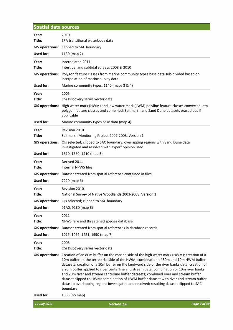
Spatial data sources
Title: EPA transitional waterbody data
Year: 2010
GIS operations: Clipped to SAC boundary
Used for: 1130 (map 2)
Title: Intertidal and subtidal surveys 2008 & 2010
Year: Interpolated 2011
GIS operations: Polygon feature classes from marine community types base data sub‐divided based on interpolation of marine survey data
Used for: Marine community types, 1140 (maps 3 & 4)
Title: OSi Discovery series vector data
Year: 2005
GIS operations: High water mark (HWM) and low water mark (LWM) polyline feature classes converted into polygon feature classes and combined; Saltmarsh and Sand Dune datasets erased out if applicable
Used for: Marine community types base data (map 4)
Title: Saltmarsh Monitoring Project 2007‐2008. Version 1
Year: Revision 2010
GIS operations: QIs selected; clipped to SAC boundary; overlapping regions with Sand Dune data investigated and resolved with expert opinion used
Used for: 1310, 1330, 1410 (map 5)
Title: Internal NPWS files
Year: Derived 2011
GIS operations: Dataset created from spatial reference contained in files
Used for: 7220 (map 6)
Title: National Survey of Native Woodlands 2003‐2008. Version 1
Year: Revision 2010
GIS operations: QIs selected; clipped to SAC boundary
Used for: 91A0, 91E0 (map 6)
Title: NPWS rare and threatened species database
Year: 2011
GIS operations: Dataset created from spatial references in database records
Used for: 1016, 1092, 1421, 1990 (map 7)
Title: OSi Discovery series vector data
Year: 2005
GIS operations: Creation of an 80m buffer on the marine side of the high water mark (HWM); creation of a 10m buffer on the terrestrial side of the HWM; combination of 80m and 10m HWM buffer datasets; creation of a 10m buffer on the landward side of the river banks data; creation of a 20m buffer applied to river centerline and stream data; combination of 10m river banks and 20m river and stream centerline buffer datasets; combined river and stream buffer dataset clipped to HWM; combination of HWM buffer dataset with river and stream buffer dataset; overlapping regions investigated and resolved; resulting dataset clipped to SAC boundary
Used for: 1355 (no map)
19 July 2011 Page 9 of 39Version 1.0

Conservation objectives for: River Barrow and River Nore SAC [002162]
1016 Desmoulin's whorl snail Vertigo moulinsiana
Attribute Measure Target
To maintain the favourable conservation condition of Desmoulin’s whorl snail in the River Barrow and River Nore SAC, which is defined by the following list of attributes and targets:
Notes
Distribution: occupied sites
Number No decline. Two known sites: Borris Bridge, Co. Carlow S711503; Boston Bridge, Kilnaseer S338774, Co. Laois. See map 7
Data from NPWS rare and threatened species database
Population size: adults
Number per positive sample
At least 5 adults snails in at least 50% of samples
Attribute and target from Moorkens and Killeen (2011)
Population density Percentage positive samples
Adult snails present in at least 60% of samples per site
Attribute and target from Moorkens and Killeen (2011)
Area of occupancy Hectares Minimum of 1ha of suitable habitat per site
Attribute and target from Moorkens and Killeen (2011)
Habitat quality: vegetation
Percentage of samples with suitable vegetation
90% of samples in habitat classes I and II as defined in Moorkens & Killeen (2011)
Attribute and target from Moorkens and Killeen (2011)
Habitat quality: soil moisture levels
Percentage of samples with appropriate soil moisture levels
90% of samples in moisture class 3‐4 as defined in Moorkens & Killeen (2011)
Attribute and target from Moorkens and Killeen (2011)
19 July 2011 Page 10 of 39Version 1.0

Conservation objectives for: River Barrow and River Nore SAC [002162]
1029 Freshwater pearl mussel Margaritifera margaritifera
The status of the freshwater pearl mussel (Margaritifera margaritifera) as a qualifying Annex II species for the River Barrow and River Nore SAC is currently under review. The outcome of this review will determine whether a site‐specific conservation objective is set for this species. Please note that the Nore freshwater pearl mussel (Margaritifera durrovensis) remains a qualifying species for this SAC. This document contains a conservation objective for the latter species.
19 July 2011 Page 11 of 39Version 1.0
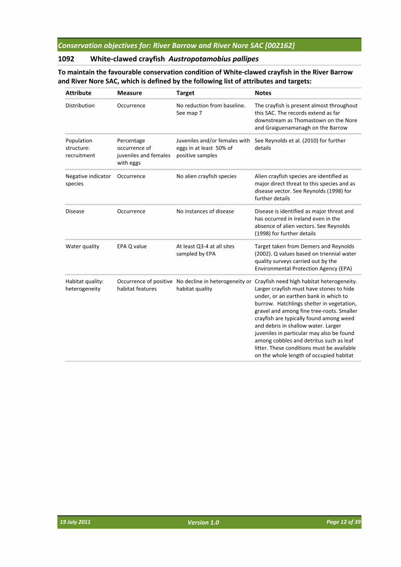
Conservation objectives for: River Barrow and River Nore SAC [002162]
1092 White‐clawed crayfish Austropotamobius pallipes
Attribute Measure Target
To maintain the favourable conservation condition of White‐clawed crayfish in the River Barrow and River Nore SAC, which is defined by the following list of attributes and targets:
Notes
Distribution Occurrence No reduction from baseline. See map 7
The crayfish is present almost throughout this SAC. The records extend as far downstream as Thomastown on the Nore and Graiguenamanagh on the Barrow
Population structure: recruitment
Percentage occurrence of juveniles and females with eggs
Juveniles and/or females with eggs in at least 50% of positive samples
See Reynolds et al. (2010) for further details
Negative indicator species
Occurrence No alien crayfish species Alien crayfish species are identified as major direct threat to this species and as disease vector. See Reynolds (1998) for further details
Disease Occurrence No instances of disease Disease is identified as major threat and has occurred in Ireland even in the absence of alien vectors. See Reynolds (1998) for further details
Water quality EPA Q value At least Q3‐4 at all sites sampled by EPA
Target taken from Demers and Reynolds (2002). Q values based on triennial water quality surveys carried out by the Environmental Protection Agency (EPA)
Habitat quality: heterogeneity
Occurrence of positive habitat features
No decline in heterogeneity or habitat quality
Crayfish need high habitat heterogeneity. Larger crayfish must have stones to hide under, or an earthen bank in which to burrow. Hatchlings shelter in vegetation, gravel and among fine tree‐roots. Smaller crayfish are typically found among weed and debris in shallow water. Larger juveniles in particular may also be found among cobbles and detritus such as leaf litter. These conditions must be available on the whole length of occupied habitat
19 July 2011 Page 12 of 39Version 1.0
Conservation objectives for: River Barrow and River Nore SAC [002162]
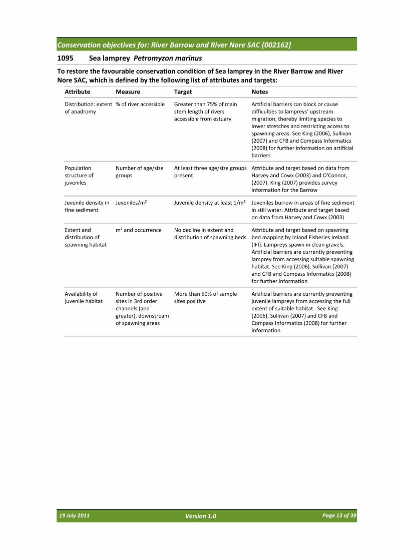
1095 Sea lamprey Petromyzon marinus
Attribute Measure Target
To restore the favourable conservation condition of Sea lamprey in the River Barrow and River Nore SAC, which is defined by the following list of attributes and targets:
Notes
Distribution: extent of anadromy
% of river accessible Greater than 75% of main stem length of rivers accessible from estuary
Artificial barriers can block or cause difficulties to lampreys’ upstream migration, thereby limiting species to lower stretches and restricting access to spawning areas. See King (2006), Sullivan (2007) and CFB and Compass Informatics (2008) for further information on artificial barriers
Population structure of juveniles
Number of age/size groups
At least three age/size groups present
Attribute and target based on data from Harvey and Cowx (2003) and O'Connor, (2007). King (2007) provides survey information for the Barrow
Juvenile density in fine sediment
Juveniles/m² Juvenile density at least 1/m² Juveniles burrow in areas of fine sediment in still water. Attribute and target based on data from Harvey and Cowx (2003)
Extent and distribution of spawning habitat
m² and occurrence No decline in extent and distribution of spawning beds
Attribute and target based on spawning bed mapping by Inland Fisheries Ireland (IFI). Lampreys spawn in clean gravels. Artificial barriers are currently preventing lamprey from accessing suitable spawning habitat. See King (2006), Sullivan (2007) and CFB and Compass Informatics (2008) for further information
Availability of juvenile habitat
Number of positive sites in 3rd order channels (and greater), downstream of spawning areas
More than 50% of sample sites positive
Artificial barriers are currently preventing juvenile lampreys from accessing the full extent of suitable habitat. See King (2006), Sullivan (2007) and CFB and Compass Informatics (2008) for further information
19 July 2011 Page 13 of 39Version 1.0

Conservation objectives for: River Barrow and River Nore SAC [002162]
1096 Brook lamprey Lampetra planeri
Attribute Measure Target
To restore the favourable conservation condition of Brook lamprey in the River Barrow and River Nore SAC, which is defined by the following list of attributes and targets:
Notes
Distribution % of river accessible Access to all watercourses down to first order streams
Artificial barriers can block lampreys’ upstream migration, thereby limiting species to lower stretches and restricting access to spawning areas. See King (2006), Sullivan (2007) and CFB and Compass Informatics (2008) for further information on artifical barriers
Population structure of juveniles
Number of age/size groups
At least three age/size groups of brook/river lamprey present
Attribute and target based on data from Harvey and Cowx (2003). King (2007) provides survey information for the Barrow. It is impossible to distinguish between brook and river lamprey juveniles in the field, hence they are considered together in this target
Juvenile density in fine sediment
Juveniles/m² Mean catchment juvenile density of brook/river lamprey at least 2/m²
Juveniles burrow in areas of fine sediment in still water. Attribute and target based on data from Harvey and Cowx (2003) who state 10/m² in optimal conditions and more than 2/m² on a catchment basis
Extent and distribution of spawning habitat
m² and occurrence No decline in extent and distribution of spawning beds
Attribute and target based on spawning bed mapping by Inland Fisheries Ireland (IFI). Lampreys spawn in clean gravels. Artificial barriers are currently preventing lamprey from accessing suitable spawning habitat. See King (2006), Sullivan (2007) and CFB and Compass Informatics (2008) for further information
Availability of juvenile habitat
Number of positive sites in 2nd order channels (and greater), downstream of spawning areas
More than 50% of sample sites positive
Artificial barriers are currently preventing juvenile lampreys from accessing the full extent of suitable habitat. See King (2006), Sullivan (2007) and CFB and Compass Informatics (2008) for further information
19 July 2011 Page 14 of 39Version 1.0

Conservation objectives for: River Barrow and River Nore SAC [002162]
1099 River lamprey Lampetra fluviatilis
Attribute Measure Target
To restore the favourable conservation condition of River lamprey in the River Barrow and River Nore SAC, which is defined by the following list of attributes and targets:
Notes
Distribution: extent of anadromy
% of river accessible Greater than 75% of main stem and major tributaries down to second order accessible from estuary
Artificial barriers can block lampreys’ upstream migration, thereby limiting species to lower stretches and restricting access to spawning areas. See King (2006), Sullivan (2007) and CFB and Compass Informatics (2008) for further information on artificial barriers
Population structure of juveniles
Number of age/size groups
At least three age/size groups of river/brook lamprey present
Attribute and target based on data from Harvey and Cowx (2003). King (2007) provides survey information for the Barrow. It is impossible to distinguish between brook and river lamprey juveniles in the field, hence they are considered together in this target
Juvenile density in fine sediment
Juveniles/m² Mean catchment juvenile density of brook/river lamprey at least 2/m²
Juveniles burrow in areas of fine sediment in still water. Attribute and target based on data from Harvey and Cowx (2003) who state 10/m² in optimal conditions and more than 2/m² on a catchment basis
Extent and distribution of spawning habitat
m² and occurrence No decline in extent and distribution of spawning beds
Attribute and target based on spawning bed mapping by Inland Fisheries Ireland (IFI). Lampreys spawn in clean gravels. Artificial barriers are currently preventing lamprey from accessing suitable spawning habitat. See King (2006), Sullivan (2007) and CFB and Compass Informatics (2008) for further information
Availability of juvenile habitat
Number of positive sites in 2nd order channels (and greater), downstream of spawning areas
More than 50% of sample sites positive
Artificial barriers are currently preventing juvenile lampreys from accessing the full extent of suitable habitat. See King (2006), Sullivan (2007) and CFB and Compass Informatics (2008) for further information
19 July 2011 Page 15 of 39Version 1.0

Conservation objectives for: River Barrow and River Nore SAC [002162]
1103 Twaite shad Alosa fallax
Attribute Measure Target
To restore the favourable conservation condition of Twaite shad in the River Barrow and River Nore SAC, which is defined by the following list of attributes and targets:
Notes
Distribution: extent of anadromy
% of river accessible Greater than 75% of main stem length of rivers accessible from estuary
In some catchments, artificial barriers block twaite shads’ upstream migration, thereby limiting species to lower stretches and restricting access to spawning areas
Population structure: age classes
Number of age classes More than one age class present
Regular breeding has been confirmed in the River Barrow in recent years, but not in the Nore
Extent and distribution of spawning habitat
m² and occurrence No decline in extent and distribution of spawning habitats
Water quality: oxygen levels
Milligrammes per litre No lower than 5mg/l Attribute and target based on Maas, Stevens and Briene (2008)
Spawning habitat quality: Filamentous algae; macrophytes; sediment
Occurrence Maintain stable gravel substrate with very little fine material, free of filamentous algal (macroalgae) growth and macrophyte (rooted higher plants) growth
See Maitland and Hatton‐Ellis (2003) for further information
19 July 2011 Page 16 of 39Version 1.0
Conservation objectives for: River Barrow and River Nore SAC [002162]
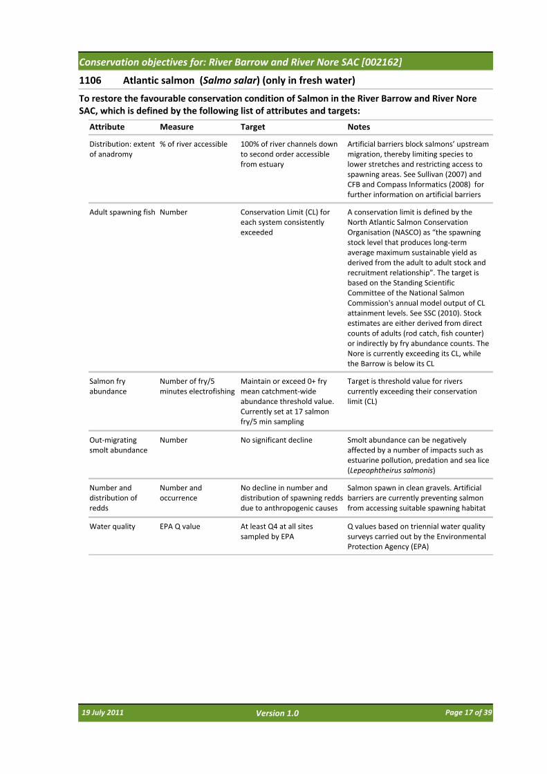
1106 Atlantic salmon (Salmo salar) (only in fresh water)
Attribute Measure Target
To restore the favourable conservation condition of Salmon in the River Barrow and River Nore SAC, which is defined by the following list of attributes and targets:
Notes
Distribution: extent of anadromy
% of river accessible 100% of river channels down to second order accessible from estuary
Artificial barriers block salmons’ upstream migration, thereby limiting species to lower stretches and restricting access to spawning areas. See Sullivan (2007) and CFB and Compass Informatics (2008) for further information on artificial barriers
Adult spawning fish Number Conservation Limit (CL) for each system consistently exceeded
A conservation limit is defined by the North Atlantic Salmon Conservation Organisation (NASCO) as “the spawning stock level that produces long‐term average maximum sustainable yield as derived from the adult to adult stock and recruitment relationship”. The target is based on the Standing Scientific Committee of the National Salmon Commission's annual model output of CL attainment levels. See SSC (2010). Stock estimates are either derived from direct counts of adults (rod catch, fish counter) or indirectly by fry abundance counts. The Nore is currently exceeding its CL, while the Barrow is below its CL
Salmon fry abundance
Number of fry/5 minutes electrofishing
Maintain or exceed 0+ fry mean catchment‐wide abundance threshold value. Currently set at 17 salmon fry/5 min sampling
Target is threshold value for rivers currently exceeding their conservation limit (CL)
Out‐migrating smolt abundance
Number No significant decline Smolt abundance can be negatively affected by a number of impacts such as estuarine pollution, predation and sea lice (Lepeophtheirus salmonis)
Number and distribution of redds
Number and occurrence
No decline in number and distribution of spawning redds due to anthropogenic causes
Salmon spawn in clean gravels. Artificial barriers are currently preventing salmon from accessing suitable spawning habitat
Water quality EPA Q value At least Q4 at all sites sampled by EPA
Q values based on triennial water quality surveys carried out by the Environmental Protection Agency (EPA)
19 July 2011 Page 17 of 39Version 1.0

Conservation objectives for: River Barrow and River Nore SAC [002162]
1130 Estuaries
Attribute Measure Target
To maintain the favourable conservation condition of Estuaries in the River Barrow and River Nore SAC, which is defined by the following list of attributes and targets:
Notes
Habitat area Hectares The permanent habitat area is stable or increasing, subject to natural processes. See map 2
Habitat area was estimated using OSI data and the defined Transitional Water Body area under the Water Framework Directive as 3856ha. See marine supporting document for further details
Community distribution
Hectares The following sediment communities should be maintained in a natural condition: Muddy estuarine community complex; Sand to muddy fine sand community complex; Fine sand with Fabulina fabula community. See map 4
The likely area of sediment communities was derived from a combination of intertidal and subtidal surveys undertaken in 2008 (ARMS, 2008; ASU, 2008). See marine supporting document for further details
Community extent Hectares Maintain the natural extent of the Sabellaria alveolata reef, subject to natural process. See map 4
The likely area of this community is derived from a survey undertaken in 2010 (NPWS, 2010). See marine supporting document for further details
19 July 2011 Page 18 of 39Version 1.0
Conservation objectives for: River Barrow and River Nore SAC [002162]
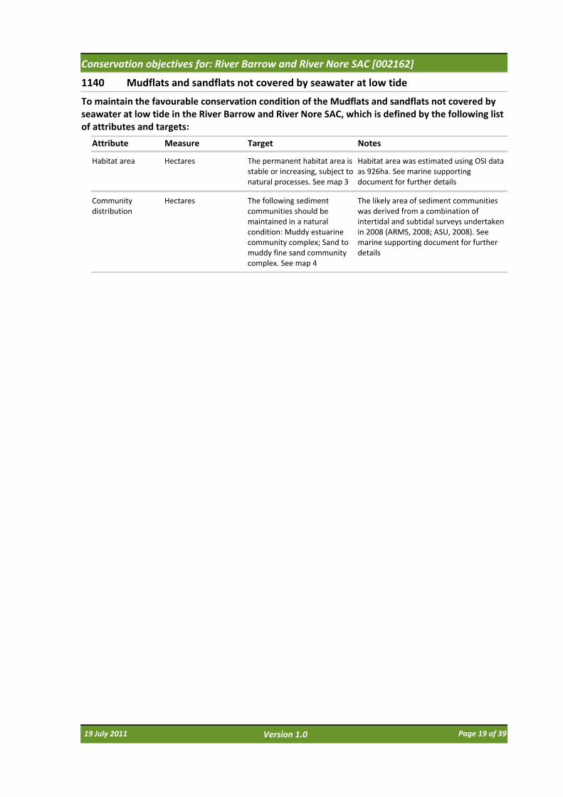
1140 Mudflats and sandflats not covered by seawater at low tide
Attribute Measure Target
To maintain the favourable conservation condition of the Mudflats and sandflats not covered by seawater at low tide in the River Barrow and River Nore SAC, which is defined by the following list of attributes and targets:
Notes
Habitat area Hectares The permanent habitat area is stable or increasing, subject to natural processes. See map 3
Habitat area was estimated using OSI data as 926ha. See marine supporting document for further details
Community distribution
Hectares The following sediment communities should be maintained in a natural condition: Muddy estuarine community complex; Sand to muddy fine sand community complex. See map 4
The likely area of sediment communities was derived from a combination of intertidal and subtidal surveys undertaken in 2008 (ARMS, 2008; ASU, 2008). See marine supporting document for further details
19 July 2011 Page 19 of 39Version 1.0

Conservation objectives for: River Barrow and River Nore SAC [002162]
1310 Salicornia and other annuals colonizing mud and sand
Attribute Measure Target
To maintain the favourable conservation condition of Salicornia and other annuals colonizing mud and sand in the River Barrow and River Nore SAC, which is defined by the following list of attributes and targets:
Notes
Habitat area Hectares Area stable or increasing, subject to natural processes, including erosion and succession. For the one sub‐site mapped: Ringville ‐0.03ha. See map 5
Based on data from the Saltmarsh Monitoring Project (McCorry and Ryle, 2009). The Ringville sub‐site was mapped and no additional areas of potential Salicornia mudflat were identified from an examination of aerial photographs, giving a total estimated area of 0.03ha. NB futher unsurveyed areas maybe present within the site. See coastal habitats supporting document for further details
Habitat distribution Occurrence No decline, subject to natural processes. See map 5
See coastal habitats supporting document for further details
Physical structure: sediment supply
Presence/absence of physical barriers
Maintain or where necessary restore natural circulation of sediments and organic matter, without any physical obstructions
See coastal habitats supporting document for further details
Physical structure: flooding regime
Hectares flooded; frequency
Maintain natural tidal regime See coastal habitats supporting document for further details
Physical structure: creeks and pans
Occurrence Maintain/restore creek and pan structure, subject to natural processes, including erosion and succession
Based on McCorry and Ryle (2009). See coastal habitats supporting document for further details
Vegetation structure: zonation
Occurrence Maintain range of saltmarsh habitat zonations including transitional zones, subject to natural processes including erosion and succession. See map 5
Based on McCorry and Ryle (2009). See coastal habitats supporting document for further details
Vegetation structure: vegetation height
Centimetres Maintain structural variation within sward
Based on McCorry and Ryle (2009). See coastal habitats supporting document for further details
Vegetation structure: vegetation cover
Percentage cover at a representative sample of monitoring stops
Maintain more than 90% of area outside creeks vegetated.
Based on McCorry and Ryle (2009). See coastal habitats supporting document for further details
Vegetation composition: typical species and sub‐communities
Percentage cover at a representative sample of monitoring stops
Maintain range of sub‐communities with typical species listed in Saltmarsh Monitoring Project (McCorry & Ryle, 2009).
See coastal habitats supporting document for further details
Vegetation structure: negative indicator species: Spartina anglica
Hectares No significant expansion of Spartina. No new sites for this species and an annual spread of less than 1% where it is already known to occur
Based on McCorry and Ryle (2009). See coastal habitats supporting document for further details
19 July 2011 Page 20 of 39Version 1.0
Conservation objectives for: River Barrow and River Nore SAC [002162]
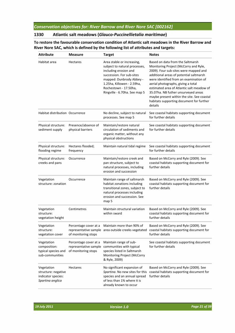
1330 Atlantic salt meadows (Glauco‐Puccinellietalia maritimae)
Attribute Measure Target
To restore the favourable conservation condition of Atlantic salt meadows in the River Barrow and River Nore SAC, which is defined by the following list of attributes and targets:
Notes
Habitat area Hectares Area stable or increasing, subject to natural processes, including erosion and succession. For sub‐sites mapped: Dunbrody Abbey ‐1.25ha, Killowen ‐ 2.59ha, Rochestown ‐ 17.50ha, Ringville ‐ 6.70ha. See map 5
Based on data from the Saltmarsh Monitoring Project (McCorry and Ryle, 2009). Four sub‐sites were mapped and additional areas of potential saltmarsh were identified from an examination of aerial photographs, giving a total estimated area of Atlantic salt meadow of 35.07ha. NB futher unsurveyed areas maybe present within the site. See coastal habitats supporting document for further details
Habitat distribution Occurrence No decline, subject to natural processes. See map 5
See coastal habitats supporting document for further details
Physical structure: sediment supply
Presence/absence of physical barriers
Maintain/restore natural circulation of sediments and organic matter, without any physical obstructions
See coastal habitats supporting document for further details
Physical structure: flooding regime
Hectares flooded; frequency
Maintain natural tidal regime See coastal habitats supporting document for further details
Physical structure: creeks and pans
Occurrence Maintain/restore creek and pan structure, subject to natural processes, including erosion and succession
Based on McCorry and Ryle (2009). See coastal habitats supporting document for further details
Vegetation structure: zonation
Occurrence Maintain range of saltmarsh habitat zonations including transitional zones, subject to natural processes including erosion and succession. See map 5
Based on McCorry and Ryle (2009). See coastal habitats supporting document for further details
Vegetation structure: vegetation height
Centimetres Maintain structural variation within sward
Based on McCorry and Ryle (2009). See coastal habitats supporting document for further details
Vegetation structure: vegetation cover
Percentage cover at a representative sample of monitoring stops
Maintain more than 90% of area outside creeks vegetated
Based on McCorry and Ryle (2009). See coastal habitats supporting document for further details
Vegetation composition: typical species and sub‐communities
Percentage cover at a representative sample of monitoring stops
Maintain range of sub‐communities with typical species listed in Saltmarsh Monitoring Project (McCorry & Ryle, 2009)
See coastal habitats supporting document for further details
Vegetation structure: negative indicator species: Spartina anglica
Hectares No significant expansion of Spartina. No new sites for this species and an annual spread of less than 1% where it is already known to occur
Based on McCorry and Ryle (2009). See coastal habitats supporting document for further details
19 July 2011 Page 21 of 39Version 1.0
Conservation objectives for: River Barrow and River Nore SAC [002162]
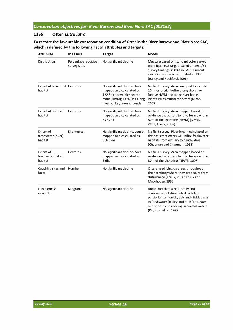
1355 Otter Lutra lutra
Attribute Measure Target
To restore the favourable conservation condition of Otter in the River Barrow and River Nore SAC, which is defined by the following list of attributes and targets:
Notes
Distribution Percentage positive survey sites
No significant decline Measure based on standard otter survey technique. FCS target, based on 1980/81 survey findings, is 88% in SACs. Current range in south‐east estimated at 73% (Bailey and Rochford, 2006)
Extent of terrestrial habitat
Hectares No significant decline. Area mapped and calculated as 122.8ha above high water mark (HWM); 1136.0ha along river banks / around ponds
No field survey. Areas mapped to include 10m terrestrial buffer along shoreline (above HWM and along river banks) identified as critical for otters (NPWS, 2007)
Extent of marine habitat
Hectares No significant decline. Area mapped and calculated as 857.7ha
No field survey. Area mapped based on evidence that otters tend to forage within 80m of the shoreline (HWM) (NPWS, 2007; Kruuk, 2006)
Extent of freshwater (river) habitat
Kilometres No significant decline. Length mapped and calculated as 616.6km
No field survey. River length calculated on the basis that otters will utilise freshwater habitats from estuary to headwaters (Chapman and Chapman, 1982)
Extent of freshwater (lake) habitat
Hectares No significant decline. Area mapped and calculated as 2.6ha
No field survey. Area mapped based on evidence that otters tend to forage within 80m of the shoreline (NPWS, 2007)
Couching sites and holts
Number No significant decline Otters need lying up areas throughout their territory where they are secure from disturbance (Kruuk, 2006; Kruuk and Moorhouse, 1991)
Fish biomass available
Kilograms No significant decline Broad diet that varies locally and seasonally, but dominated by fish, in particular salmonids, eels and sticklebacks in freshwater (Bailey and Rochford, 2006) and wrasse and rockling in coastal waters (Kingston et al., 1999)
19 July 2011 Page 22 of 39Version 1.0
Conservation objectives for: River Barrow and River Nore SAC [002162]
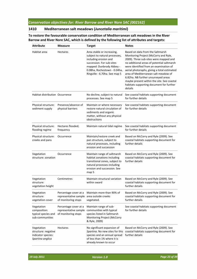
1410 Mediterranean salt meadows (Juncetalia maritimi)
Attribute Measure Target
To restore the favourable conservation condition of Mediterranean salt meadows in the River Barrow and River Nore SAC, which is defined by the following list of attributes and targets:
Notes
Habitat area Hectares Area stable or increasing, subject to natural processes, including erosion and succession. For sub‐sites mapped: Dunbrody Abbey ‐0.08ha, Rochestown ‐ 0.04ha, Ringville ‐ 6.70ha. See map 5
Based on data from the Saltmarsh Monitoring Project (McCorry and Ryle, 2009). Three sub‐sites were mapped and no additional areas of potential saltmarsh were identified from an examination of aerial photoraphs, giving a total estimated area of Mediterranean salt meadow of 6.82ha. NB further unsurveyed areas maybe present within the site. See coastal habitats supporting document for further details
Habitat distribution Occurrence No decline, subject to natural processes. See map 5
See coastal habitats supporting document for further details
Physical structure: sediment supply
Presence/absence of physical barriers
Maintain or where necessary restore natural circulation of sediments and organic matter, without any physical obstructions
See coastal habitats supporting document for further details
Physical structure: flooding regime
Hectares flooded; frequency
Maintain natural tidal regime See coastal habitats supporting document for further details
Physical structure: creeks and pans
Occurrence Maintain/restore creek and pan structure, subject to natural processes, including erosion and succession
Based on McCorry and Ryle (2009). See coastal habitats supporting document for further details
Vegetation structure: zonation
Occurrence Maintain range of saltmarsh habitat zonations including transitional zones, subject to natural processes including erosion and succession. See map 5
Based on McCorry and Ryle (2009). See coastal habitats supporting document for further details
Vegetation structure: vegetation height
Centimetres Maintain structural variation within sward
Based on McCorry and Ryle (2009). See coastal habitats supporting document for further details
Vegetation structure: vegetation cover
Percentage cover at a representative sample of monitoring stops
Maintain more than 90% of area outside creeks vegetated.
Based on McCorry and Ryle (2009). See coastal habitats supporting document for further details
Vegetation composition: typical species and sub‐communities
Percentage cover at a representative sample of monitoring stops
Maintain range of sub‐communities with typical species listed in Saltmarsh Monitoring Project (McCorry & Ryle, 2009)
See coastal habitats supporting document for further details
Vegetation structure: negative indicator species: Spartina anglica
Hectares No significant expansion of Spartina. No new sites for this species and an annual spread of less than 1% where it is already known to occur
Based on McCorry and Ryle (2009). See coastal habitats supporting document for further details
19 July 2011 Page 23 of 39Version 1.0
Conservation objectives for: River Barrow and River Nore SAC [002162]
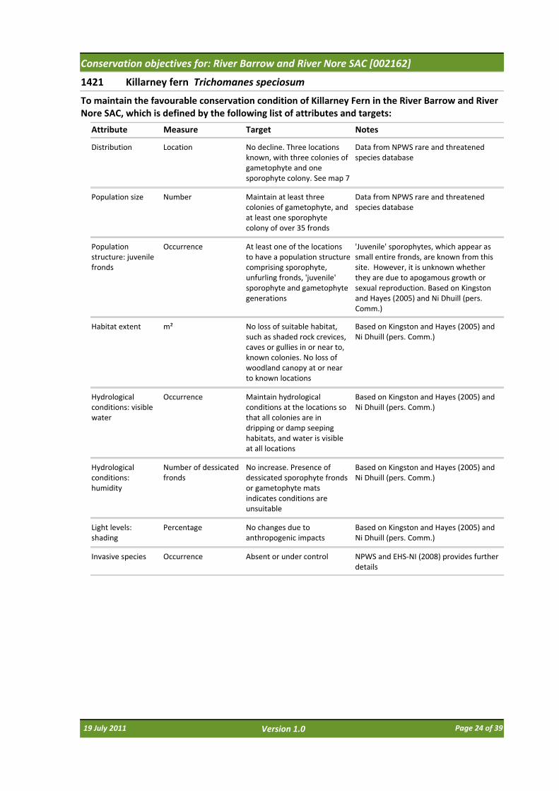
1421 Killarney fern Trichomanes speciosum
Attribute Measure Target
To maintain the favourable conservation condition of Killarney Fern in the River Barrow and River Nore SAC, which is defined by the following list of attributes and targets:
Notes
Distribution Location No decline. Three locations known, with three colonies of gametophyte and one sporophyte colony. See map 7
Data from NPWS rare and threatened species database
Population size Number Maintain at least three colonies of gametophyte, and at least one sporophyte colony of over 35 fronds
Data from NPWS rare and threatened species database
Population structure: juvenile fronds
Occurrence At least one of the locations to have a population structure comprising sporophyte, unfurling fronds, 'juvenile' sporophyte and gametophyte generations
'Juvenile' sporophytes, which appear as small entire fronds, are known from this site. However, it is unknown whether they are due to apogamous growth or sexual reproduction. Based on Kingston and Hayes (2005) and Ni Dhuill (pers. Comm.)
Habitat extent m² No loss of suitable habitat, such as shaded rock crevices, caves or gullies in or near to, known colonies. No loss of woodland canopy at or near to known locations
Based on Kingston and Hayes (2005) and Ni Dhuill (pers. Comm.)
Hydrological conditions: visible water
Occurrence Maintain hydrological conditions at the locations so that all colonies are in dripping or damp seeping habitats, and water is visible at all locations
Based on Kingston and Hayes (2005) and Ni Dhuill (pers. Comm.)
Hydrological conditions: humidity
Number of dessicated fronds
No increase. Presence of dessicated sporophyte fronds or gametophyte mats indicates conditions are unsuitable
Based on Kingston and Hayes (2005) and Ni Dhuill (pers. Comm.)
Light levels: shading
Percentage No changes due to anthropogenic impacts
Based on Kingston and Hayes (2005) and Ni Dhuill (pers. Comm.)
Invasive species Occurrence Absent or under control NPWS and EHS‐NI (2008) provides further details
19 July 2011 Page 24 of 39Version 1.0

Conservation objectives for: River Barrow and River Nore SAC [002162]
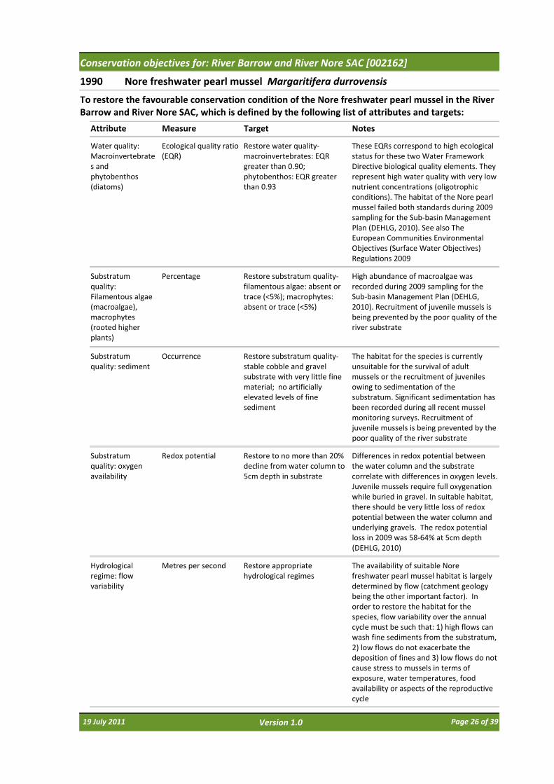
1990 Nore freshwater pearl mussel Margaritifera durrovensis
Attribute Measure Target
To restore the favourable conservation condition of the Nore freshwater pearl mussel in the River Barrow and River Nore SAC, which is defined by the following list of attributes and targets:
Notes
Distribution Kilometres Maintain at 15.5km. See map 7
The population stretches from Poorman’s Bridge (S407859) to Lismaine Bridge (S442660), with most of the population found between Poorman’s Bridge and the Avonmore Creamery above Ballyragget (S 440 722) (Moorkens, 1996)
Population size: adult mussels
Number Restore to 5,000 adult mussels
The extant wild population of Nore freshwater pearl mussel is estimated as 300 adult individuals (Moorkens, 2009)
Population structure: recruitment
Percentage per size class
Restore to at least 20% of population no more than 65mm in length; and at least 5% of population no more than 30mm in length
Mussels of no more than 65mm are considered 'young mussels' and may be found buried in the substratum and/or beneath adult mussels. Mussels of no more than 30mm are 'juvenile mussels' and are always buried in the substratum. This species is known not to have reproduced successfully in the River Nore since 1970 (Moorkens and Costello, 1994; Moorkens, 2004; Government of Ireland, 2009 [S.I. 272 of 2009])
Population structure: adult mortality
Percentage No more than 5% decline from previous number of live adults counted; dead shells less than 1% of the adult population and scattered in distribution
5% is considered the cut‐off between the combined errors associated with natural fluctuations and sampling methods and evidence of true population decline. 1% of dead shells is considered to be indicative of natural losses
Habitat extent Kilometres Restore suitable habitat in length of river corresponding to distribution target (15.5km; see map 7) and any additional stretches necessary for salmonid spawning
The species habitat is a stretch of large lowland river and is a combination of 1) the area of habitat adult and juvenile mussels can occupy and 2) the area of spawning and nursery habitats the host fish can occupy. Fish nursery habitat typically overlaps with mussel habitat. Fish spawning habitat is generally adjacent mussel habitat, but may lie upstream of the generalised mussel distribution. Only those salmonid spawning areas that could regularly contribute juvenile fish to the areas occupied by adult mussels should be considered. The availability of mussel habitat and fish spawning and nursery habitats are determined by flow and substratum conditions. The habitat for the species is currently unsuitable for the survival of adult mussels or the recruitment of juveniles
19 July 2011 Page 25 of 39Version 1.0
Conservation objectives for: River Barrow and River Nore SAC [002162]
1990 Nore freshwater pearl mussel Margaritifera durrovensis
Attribute Measure Target
To restore the favourable conservation condition of the Nore freshwater pearl mussel in the River Barrow and River Nore SAC, which is defined by the following list of attributes and targets:
Notes
Water quality: Macroinvertebrates and phytobenthos (diatoms)
Ecological quality ratio (EQR)
Restore water quality‐macroinvertebrates: EQR greater than 0.90; phytobenthos: EQR greater than 0.93
These EQRs correspond to high ecological status for these two Water Framework Directive biological quality elements. They represent high water quality with very low nutrient concentrations (oligotrophic conditions). The habitat of the Nore pearl mussel failed both standards during 2009 sampling for the Sub‐basin Management Plan (DEHLG, 2010). See also The European Communities Environmental Objectives (Surface Water Objectives) Regulations 2009
Substratum quality: Filamentous algae (macroalgae), macrophytes (rooted higher plants)
Percentage Restore substratum quality‐filamentous algae: absent or trace (<5%); macrophytes: absent or trace (<5%)
High abundance of macroalgae was recorded during 2009 sampling for the Sub‐basin Management Plan (DEHLG, 2010). Recruitment of juvenile mussels is being prevented by the poor quality of the river substrate
Substratum quality: sediment
Occurrence Restore substratum quality‐stable cobble and gravel substrate with very little fine material; no artificially elevated levels of fine sediment
The habitat for the species is currently unsuitable for the survival of adult mussels or the recruitment of juveniles owing to sedimentation of the substratum. Significant sedimentation has been recorded during all recent mussel monitoring surveys. Recruitment of juvenile mussels is being prevented by the poor quality of the river substrate
Substratum quality: oxygen availability
Redox potential Restore to no more than 20% decline from water column to 5cm depth in substrate
Differences in redox potential between the water column and the substrate correlate with differences in oxygen levels. Juvenile mussels require full oxygenation while buried in gravel. In suitable habitat, there should be very little loss of redox potential between the water column and underlying gravels. The redox potential loss in 2009 was 58‐64% at 5cm depth (DEHLG, 2010)
Hydrological regime: flow variability
Metres per second Restore appropriate hydrological regimes
The availability of suitable Nore freshwater pearl mussel habitat is largely determined by flow (catchment geology being the other important factor). In order to restore the habitat for the species, flow variability over the annual cycle must be such that: 1) high flows can wash fine sediments from the substratum, 2) low flows do not exacerbate the deposition of fines and 3) low flows do not cause stress to mussels in terms of exposure, water temperatures, food availability or aspects of the reproductive cycle
19 July 2011 Page 26 of 39Version 1.0
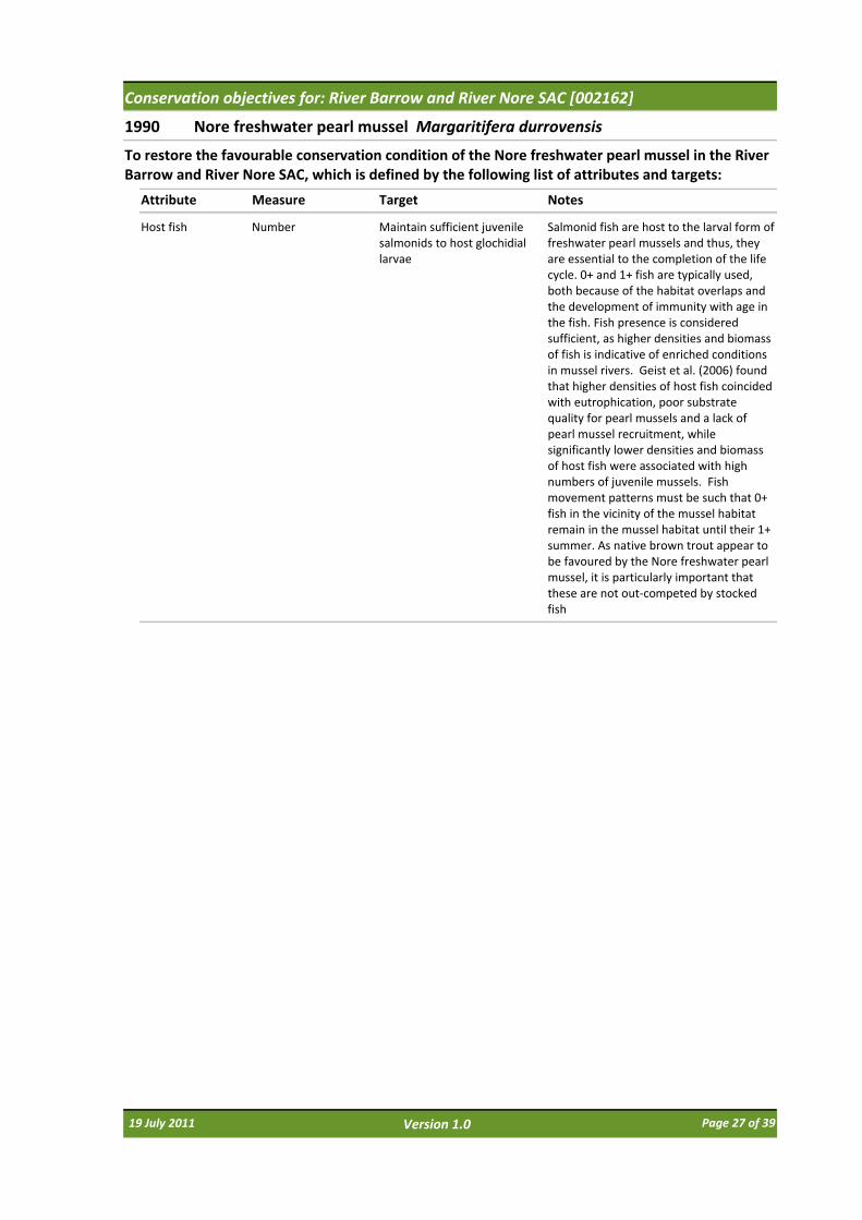
Conservation objectives for: River Barrow and River Nore SAC [002162]
1990 Nore freshwater pearl mussel Margaritifera durrovensis
Attribute Measure Target
To restore the favourable conservation condition of the Nore freshwater pearl mussel in the River Barrow and River Nore SAC, which is defined by the following list of attributes and targets:
Notes
Host fish Number Maintain sufficient juvenile salmonids to host glochidial larvae
Salmonid fish are host to the larval form of freshwater pearl mussels and thus, they are essential to the completion of the life cycle. 0+ and 1+ fish are typically used, both because of the habitat overlaps and the development of immunity with age in the fish. Fish presence is considered sufficient, as higher densities and biomass of fish is indicative of enriched conditions in mussel rivers. Geist et al. (2006) found that higher densities of host fish coincided with eutrophication, poor substrate quality for pearl mussels and a lack of pearl mussel recruitment, while significantly lower densities and biomass of host fish were associated with high numbers of juvenile mussels. Fish movement patterns must be such that 0+ fish in the vicinity of the mussel habitat remain in the mussel habitat until their 1+ summer. As native brown trout appear to be favoured by the Nore freshwater pearl mussel, it is particularly important that these are not out‐competed by stocked fish
19 July 2011 Page 27 of 39Version 1.0
Conservation objectives for: River Barrow and River Nore SAC [002162]
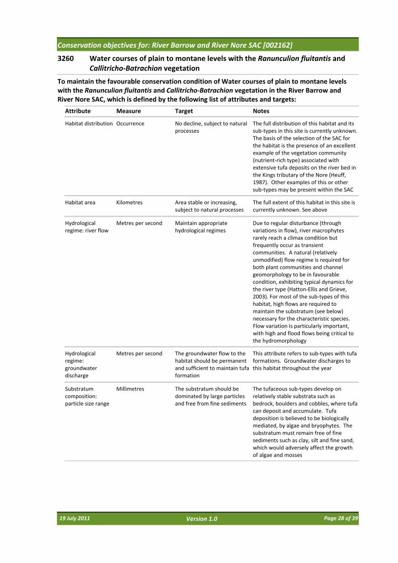
3260 Water courses of plain to montane levels with the Ranunculion fluitantis and Callitricho‐Batrachion vegetation
Attribute Measure Target
To maintain the favourable conservation condition of Water courses of plain to montane levels with the Ranunculion fluitantis and Callitricho‐Batrachion vegetation in the River Barrow and River Nore SAC, which is defined by the following list of attributes and targets:
Notes
Habitat distribution Occurrence No decline, subject to natural processes
The full distribution of this habitat and its sub‐types in this site is currently unknown. The basis of the selection of the SAC for the habitat is the presence of an excellent example of the vegetation community (nutrient‐rich type) associated with extensive tufa deposits on the river bed in the Kings tributary of the Nore (Heuff, 1987). Other examples of this or other sub‐types may be present within the SAC
Habitat area Kilometres Area stable or increasing, subject to natural processes
The full extent of this habitat in this site is currently unknown. See above
Hydrological regime: river flow
Metres per second Maintain appropriate hydrological regimes
Due to regular disturbance (through variations in flow), river macrophytes rarely reach a climax condition but frequently occur as transient communities. A natural (relatively unmodified) flow regime is required for both plant communities and channel geomorphology to be in favourable condition, exhibiting typical dynamics for the river type (Hatton‐Ellis and Grieve, 2003). For most of the sub‐types of this habitat, high flows are required to maintain the substratum (see below) necessary for the characteristic species. Flow variation is particularly important, with high and flood flows being critical to the hydromorphology
Hydrological regime: groundwater discharge
Metres per second The groundwater flow to the habitat should be permanent and sufficient to maintain tufa formation
This attribute refers to sub‐types with tufa formations. Groundwater discharges to this habitat throughout the year
Substratum composition: particle size range
Millimetres The substratum should be dominated by large particles and free from fine sediments
The tufaceous sub‐types develop on relatively stable substrata such as bedrock, boulders and cobbles, where tufa can deposit and accumulate. Tufa deposition is believed to be biologically mediated, by algae and bryophytes. The substratum must remain free of fine sediments such as clay, silt and fine sand, which would adversely affect the growth of algae and mosses
19 July 2011 Page 28 of 39Version 1.0

Conservation objectives for: River Barrow and River Nore SAC [002162]
3260 Water courses of plain to montane levels with the Ranunculion fluitantis and Callitricho‐Batrachion vegetation
Attribute Measure Target
To maintain the favourable conservation condition of Water courses of plain to montane levels with the Ranunculion fluitantis and Callitricho‐Batrachion vegetation in the River Barrow and River Nore SAC, which is defined by the following list of attributes and targets:
Notes
Water chemistry: minerals
Milligrammes per litre The groundwater and surface water should have sufficient concentrations of minerals to allow deposition and persistence of tufa deposits
The tufaceous sub‐types require mineral‐(typically calcium‐) rich groundwaters to allow deposition of tufa. Surface water must also be sufficiently base‐rich to prevent chemical erosion. Alkalinity and/or total hardness data may also be relevant
Water quality: suspended sediment
Milligrammes per litre The concentration of suspended solids in the water column should be sufficiently low to prevent excessive deposition of fine sediments
See substratum composition above. Turbidity data may also be relevant
Water quality: nutrients
Milligrammes per litre The concentration of nutrients in the water column should be sufficiently low to prevent changes in species composition or habitat condition
Phosphorus (MRP) is typically the limiting nutrient, however increased nitrogen (NO3‐) negatively impacts upon the N‐fixing blue‐green algal communities that frequently contribute to tufa deposition. Nutrient enrichment of the habitat typically leads to increased filamentous‐green‐algal biomass, and consequent changes in other algae, bryophyte and macrophyte species composition and abundance. Water quality should reach a minimum of Water Framework Directive good status, in terms of nutrient standards, and macroinvertebrate and phytobenthos quality elements
Vegetation composition: typical species
Occurrence Typical species of the relevant habitat sub‐type should be present and in good condition
The sub‐types of this habitat are poorly understood and their typical species have not yet been defined. Typical species and appropriate targets may emerge to be site‐specific. The typical species of the tufaceous sub‐type in the Kings tributary of the Nore are identified in Heuff (1987). The typical species may include higher plants, bryophytes, macroalgae and microalgae
Floodplain connectivity
Area The area of active floodplain at and upstream of the habitat should be maintained
River connectivity with the floodplain is essential for the functioning of this habitat. The site of the tufaceous sub‐type in the King's River is within an area of floodplain, with further large floodplains upstream. Floodplains regulatefine sediment deposition within the channel. See substratum composition above
19 July 2011 Page 29 of 39Version 1.0

Conservation objectives for: River Barrow and River Nore SAC [002162]
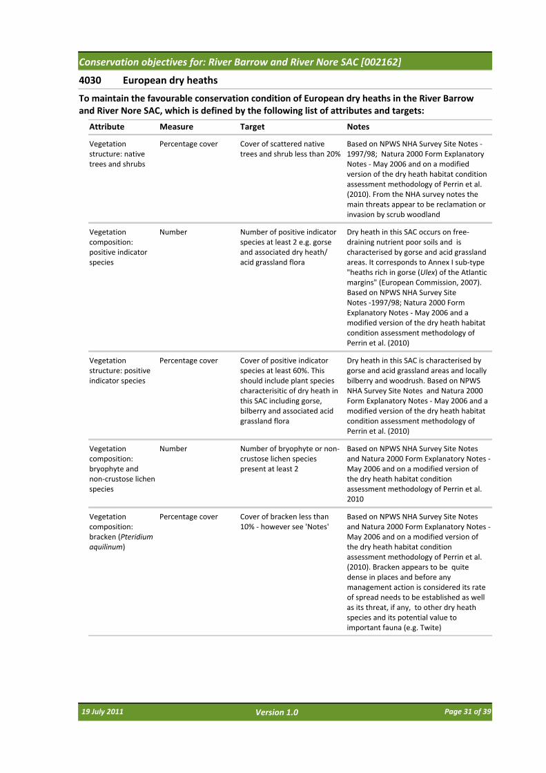
4030 European dry heaths
Attribute Measure Target
To maintain the favourable conservation condition of European dry heaths in the River Barrow and River Nore SAC, which is defined by the following list of attributes and targets:
Notes
Habitat distribution Occurrence No decline from current habitat distribution, subject to natural processes
Spatial extent currently unmapped but indicated as occurring on the steep, free‐draining, river valley sides especially the Barrow and tributaries in the foothills of the Blackstairs Mountains (based on NPWS NHA Survey ‐ 1997/98 Site Notes; Natura 2000 Form Explanatory Notes ‐May 2006; The above NHA survey was prior to the extensions to the SAC that included river habitat and estuary at Ballyhack which may have incorporated additional dry heath habitat)
Habitat area Hectares Area stable or increasing, subject to natural processes. Habitat area is not known but estimated as less than 400ha of the area of the SAC, occurring in dispersed locations
Based on NPWS NHA Survey Site Notes (1997/98); Natura 2000 Form Explanatory Notes ‐May 2006
Physical structure: free‐draining, acid, low nutrient soil; rock outcrops
Occurrence No significant change in soil nutrient status, subject to natural processes. No increase or decrease in area of natural rock outcrop
Based on NPWS NHA Survey Site Notes ‐1997/98; Natura 2000 Form Explanatory Notes ‐May 2006
Vegetation structure: sub‐shrub indicator species
Percentage cover Cover of characteristic sub‐shrub indicator species at least 25%: gorse (Ulex europaeus) and where rocky outcrops occur bilberry (Vaccinium myrtillus) and woodrush (Luzula sylvatica). Some rock outcrops support English stonecrop (Sedum anglicum), sheep's bit (Jasione montana) and wild madder (Rubia peregrina) as well as important moss and lichen assemblages
Dry heath in this SAC occurs on free‐draining nutrient poor soils and is often characterised by gorse and open acid grassland areas. A characteristic coastal dry heath of the southeast also occurs. Several rare plants occur including two species listed in the Red Data Book (Curtis and McGough, 1988). The species occurring on the site are listed in NPWS NHA Survey Site Notes ‐ 1997/98. A brief overview of the principal characteristics of the dry heath habitat of this SAC is given in the Natura 2000 Explanatory Notes ‐May 2006
Vegetation structure: senescent gorse
Percentage cover Cover of senescent gorse less than 50%
Based on NPWS NHA Survey Site Notes and Natura 2000 Form Explanatory Notes ‐May 2006 and on a modified version of the dry heath condition assessment methodology of Perrin et al. (2010)
Vegetation structure: browsing
Percentage cover Long shoots of bilberry with signs of browsing collectively less than 33%
Based on NPWS NHA Survey Site Notes and Natura 2000 Form Explanatory Notes ‐May 2006 and on a modified version of the dry heath condition assessment methodology of Perrin et al. (2010)
19 July 2011 Page 30 of 39Version 1.0
Conservation objectives for: River Barrow and River Nore SAC [002162]
4030 European dry heaths
Attribute Measure Target
To maintain the favourable conservation condition of European dry heaths in the River Barrow and River Nore SAC, which is defined by the following list of attributes and targets:
Notes
Vegetation structure: native trees and shrubs
Percentage cover Cover of scattered native trees and shrub less than 20%
Based on NPWS NHA Survey Site Notes ‐1997/98; Natura 2000 Form Explanatory Notes ‐May 2006 and on a modified version of the dry heath habitat condition assessment methodology of Perrin et al. (2010). From the NHA survey notes the main threats appear to be reclamation or invasion by scrub woodland
Vegetation composition: positive indicator species
Number Number of positive indicator species at least 2 e.g. gorse and associated dry heath/ acid grassland flora
Dry heath in this SAC occurs on free‐draining nutrient poor soils and is characterised by gorse and acid grassland areas. It corresponds to Annex I sub‐type "heaths rich in gorse (Ulex) of the Atlantic margins" (European Commission, 2007). Based on NPWS NHA Survey Site Notes ‐1997/98; Natura 2000 Form Explanatory Notes ‐May 2006 and a modified version of the dry heath habitat condition assessment methodology of Perrin et al. (2010)
Vegetation structure: positive indicator species
Percentage cover Cover of positive indicator species at least 60%. This should include plant species characterisitic of dry heath in this SAC including gorse, bilberry and associated acid grassland flora
Dry heath in this SAC is characterised by gorse and acid grassland areas and locally bilberry and woodrush. Based on NPWS NHA Survey Site Notes and Natura 2000 Form Explanatory Notes ‐May 2006 and a modified version of the dry heath habitat condition assessment methodology of Perrin et al. (2010)
Vegetation composition: bryophyte and non‐crustose lichen species
Number Number of bryophyte or non‐crustose lichen species present at least 2
Based on NPWS NHA Survey Site Notes and Natura 2000 Form Explanatory Notes ‐May 2006 and on a modified version of the dry heath habitat condition assessment methodology of Perrin et al. 2010
Vegetation composition: bracken (Pteridium aquilinum)
Percentage cover Cover of bracken less than 10% ‐ however see 'Notes'
Based on NPWS NHA Survey Site Notes and Natura 2000 Form Explanatory Notes ‐May 2006 and on a modified version of the dry heath habitat condition assessment methodology of Perrin et al. (2010). Bracken appears to be quite dense in places and before any management action is considered its rate of spread needs to be established as well as its threat, if any, to other dry heath species and its potential value to important fauna (e.g. Twite)
19 July 2011 Page 31 of 39Version 1.0
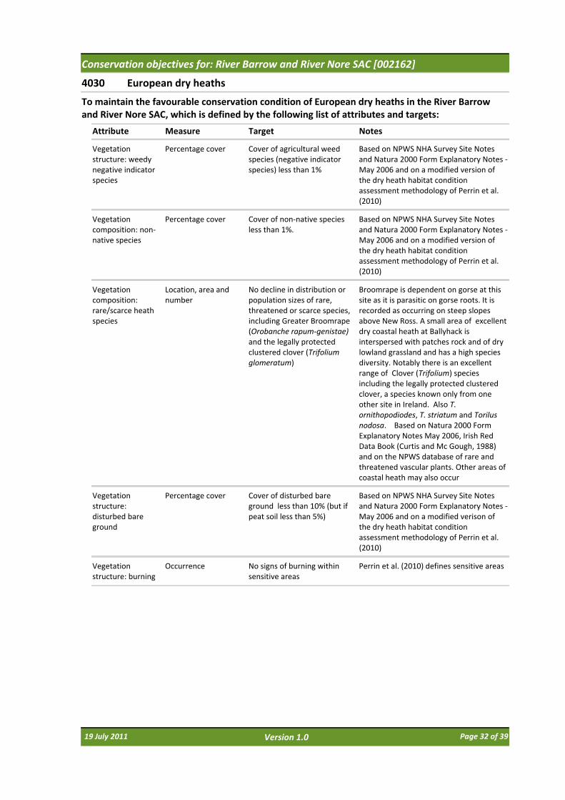
Conservation objectives for: River Barrow and River Nore SAC [002162]
4030 European dry heaths
Attribute Measure Target
To maintain the favourable conservation condition of European dry heaths in the River Barrow and River Nore SAC, which is defined by the following list of attributes and targets:
Notes
Vegetation structure: weedy negative indicator species
Percentage cover Cover of agricultural weed species (negative indicator species) less than 1%
Based on NPWS NHA Survey Site Notes and Natura 2000 Form Explanatory Notes ‐May 2006 and on a modified version of the dry heath habitat condition assessment methodology of Perrin et al. (2010)
Vegetation composition: non‐native species
Percentage cover Cover of non‐native species less than 1%.
Based on NPWS NHA Survey Site Notes and Natura 2000 Form Explanatory Notes ‐May 2006 and on a modified version of the dry heath habitat condition assessment methodology of Perrin et al. (2010)
Vegetation composition: rare/scarce heath species
Location, area and number
No decline in distribution or population sizes of rare, threatened or scarce species, including Greater Broomrape (Orobanche rapum‐genistae)and the legally protected clustered clover (Trifolium glomeratum)
Broomrape is dependent on gorse at this site as it is parasitic on gorse roots. It is recorded as occurring on steep slopes above New Ross. A small area of excellent dry coastal heath at Ballyhack is interspersed with patches rock and of dry lowland grassland and has a high species diversity. Notably there is an excellent range of Clover (Trifolium) species including the legally protected clustered clover, a species known only from one other site in Ireland. Also T. ornithopodiodes, T. striatum and Torilus nodosa. Based on Natura 2000 Form Explanatory Notes May 2006, Irish Red Data Book (Curtis and Mc Gough, 1988) and on the NPWS database of rare and threatened vascular plants. Other areas of coastal heath may also occur
Vegetation structure: disturbed bare ground
Percentage cover Cover of disturbed bare ground less than 10% (but if peat soil less than 5%)
Based on NPWS NHA Survey Site Notes and Natura 2000 Form Explanatory Notes ‐May 2006 and on a modified verison of the dry heath habitat condition assessment methodology of Perrin et al. (2010)
Vegetation structure: burning
Occurrence No signs of burning within sensitive areas
Perrin et al. (2010) defines sensitive areas
19 July 2011 Page 32 of 39Version 1.0
Conservation objectives for: River Barrow and River Nore SAC [002162]
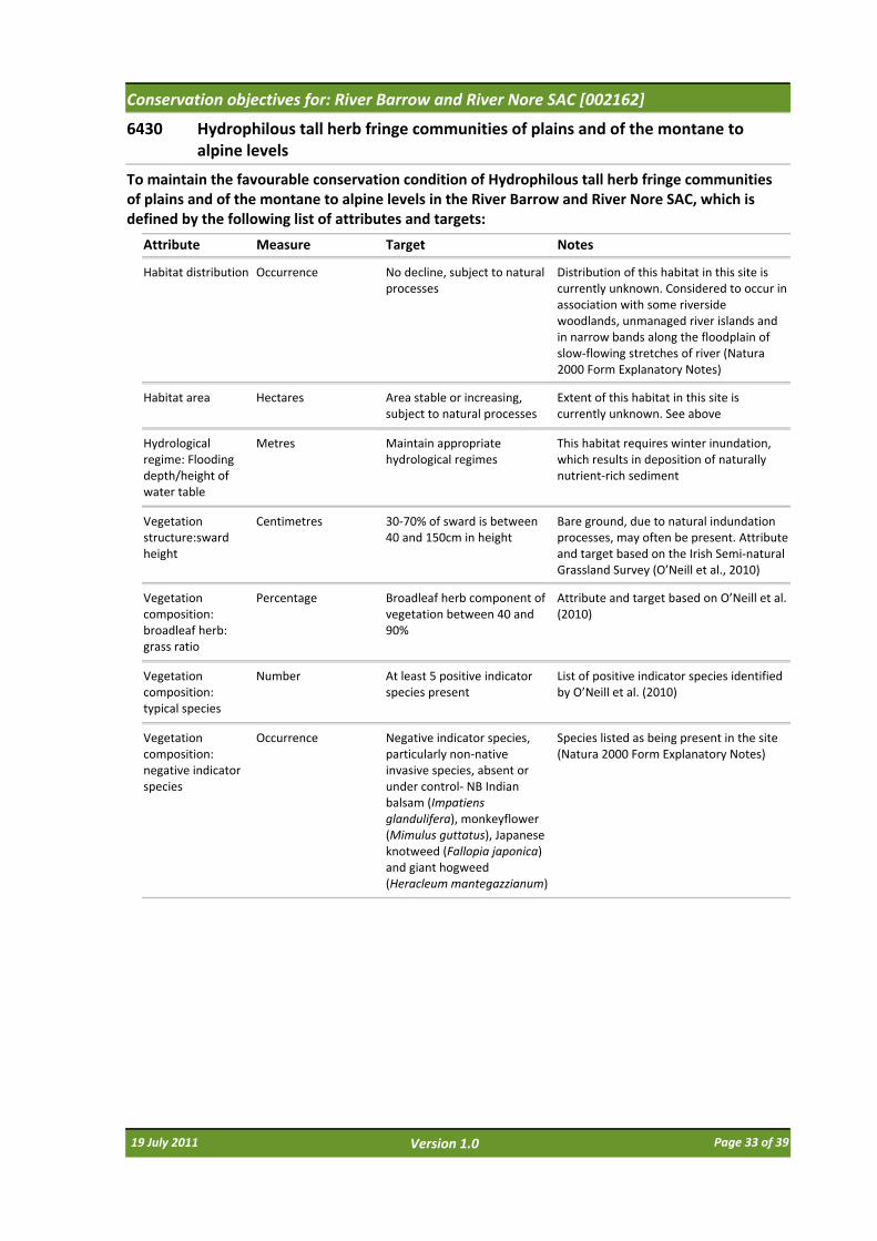
6430 Hydrophilous tall herb fringe communities of plains and of the montane to alpine levels
Attribute Measure Target
To maintain the favourable conservation condition of Hydrophilous tall herb fringe communities of plains and of the montane to alpine levels in the River Barrow and River Nore SAC, which is defined by the following list of attributes and targets:
Notes
Habitat distribution Occurrence No decline, subject to natural processes
Distribution of this habitat in this site is currently unknown. Considered to occur in association with some riverside woodlands, unmanaged river islands and in narrow bands along the floodplain of slow‐flowing stretches of river (Natura 2000 Form Explanatory Notes)
Habitat area Hectares Area stable or increasing, subject to natural processes
Extent of this habitat in this site is currently unknown. See above
Hydrological regime: Flooding depth/height of water table
Metres Maintain appropriate hydrological regimes
This habitat requires winter inundation, which results in deposition of naturally nutrient‐rich sediment
Vegetation structure:sward height
Centimetres 30‐70% of sward is between 40 and 150cm in height
Bare ground, due to natural indundation processes, may often be present. Attribute and target based on the Irish Semi‐natural Grassland Survey (O’Neill et al., 2010)
Vegetation composition: broadleaf herb: grass ratio
Percentage Broadleaf herb component of vegetation between 40 and 90%
Attribute and target based on O’Neill et al. (2010)
Vegetation composition: typical species
Number At least 5 positive indicator species present
List of positive indicator species identified by O’Neill et al. (2010)
Vegetation composition: negative indicator species
Occurrence Negative indicator species, particularly non‐native invasive species, absent or under control‐ NB Indian balsam (Impatiens glandulifera), monkeyflower (Mimulus guttatus), Japanese knotweed (Fallopia japonica) and giant hogweed (Heracleum mantegazzianum)
Species listed as being present in the site (Natura 2000 Form Explanatory Notes)
19 July 2011 Page 33 of 39Version 1.0

Conservation objectives for: River Barrow and River Nore SAC [002162]
7220 * Petrifying springs with tufa formation (Cratoneurion)
Attribute Measure Target
To maintain the favourable conservation condition of Petrifying springs with tufa formation (Cratoneurion) in the River Barrow and River Nore SAC, which is defined by the following list of attributes and targets:
Notes
Habitat area Square metres Area stable or increasing, subject to natural processes
Extent of this habitat in this site is currently unknown. An area ("Tens of square metres") has been described at one location (Natura 2000 Form Explanatory Notes; internal NPWS files), see below
Habitat distribution Occurrence No decline. See map 6 for recorded location
Full distribution of this habitat in this site is currently unknown. It has been described in woodlands at Dysart, between Thomastown and Inistioge (Natura 2000 Form Explanatory Notes; internal NPWS files). NB futher areas are likely to occur within the site
Hydrological regime: height of water table; water flow
Metres; metres per second
Maintain appropriate hydrological regimes
Current hydrological regimes are unknown. Petrifying springs rely on permanent irrigation, usually from upwelling groundwater sources or seepage sources
Water quality Water chemistry measures
Maintain oligotrophic and calcareous conditions
Water chemistry is currently unknown. Water supply to petrifying springs is characteristically oligotrophic and calcareous
Vegetation composition: typical species
Occurrence Maintain typical species The bryophytes Cratoneuron commutatumand Eucladium verticillatum are diagnostic of this habitat. Both are found at the location described above. Natura 2000 Form Explanatory Notes and internal NPWS files also list other typical species
19 July 2011 Page 34 of 39Version 1.0
Conservation objectives for: River Barrow and River Nore SAC [002162]
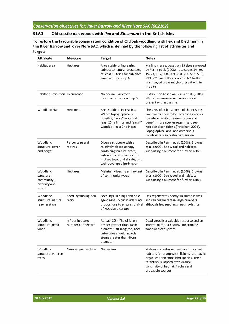
91A0 Old sessile oak woods with Ilex and Blechnum in the British Isles
Attribute Measure Target
To restore the favourable conservation condition of Old oak woodland with Ilex and Blechnum in the River Barrow and River Nore SAC, which is defined by the following list of attributes and targets:
Notes
Habitat area Hectares Area stable or increasing, subject to natural processes, at least 85.08ha for sub‐sites surveyed: see map 6
Minimum area, based on 13 sites surveyed by Perrin et al. (2008) ‐ site codes 14, 20, 49, 73, 125, 508, 509, 510, 514, 515, 518, 519, 521, and other sources. NB further unsurveyed areas maybe present within the site
Habitat distribution Occurrence No decline. Surveyed locations shown on map 6
Distribution based on Perrin et al. (2008). NB further unsurveyed areas maybe present within the site
Woodland size Hectares Area stable of increasing. Where topographically possible, "large" woods at least 25ha in size and “small” woods at least 3ha in size
The sizes of at least some of the existing woodlands need to be increased in order to reduce habitat fragmentation and benefit those species requiring ‘deep’ woodland conditions (Peterken, 2002). Topographical and land ownership constraints may restrict expansion
Woodland structure: cover and height
Percentage and metres
Diverse structure with a relatively closed canopy containing mature trees; subcanopy layer with semi‐mature trees and shrubs; and well‐developed herb layer
Described in Perrin et al. (2008); Browne et al. (2000). See woodland habitats supporting document for further details
Woodland structure: community diversity and extent
Hectares Maintain diversity and extent of community types
Described in Perrin et al. (2008); Browne et al. (2000). See woodland habitats supporting document for further details
Woodland structure: natural regeneration
Seedling:sapling:pole ratio
Seedlings, saplings and pole age‐classes occur in adequate proportions to ensure survival of woodland canopy
Oak regenerates poorly. In suitable sites ash can regenerate in large numbers although few seedlings reach pole size
Woodland structure: dead wood
m³ per hectare; number per hectare
At least 30m³/ha of fallen timber greater than 10cm diameter; 30 snags/ha; both categories should include stems greater than 40cm diameter
Dead wood is a valuable resource and an integral part of a healthy, functioning woodland ecosystem.
Woodland structure: veteran trees
Number per hectare No decline Mature and veteran trees are important habitats for bryophytes, lichens, saproxylic organisms and some bird species. Their retention is important to ensure continuity of habitats/niches and propagule sources
19 July 2011 Page 35 of 39Version 1.0

Conservation objectives for: River Barrow and River Nore SAC [002162]
91A0 Old sessile oak woods with Ilex and Blechnum in the British Isles
Attribute Measure Target
To restore the favourable conservation condition of Old oak woodland with Ilex and Blechnum in the River Barrow and River Nore SAC, which is defined by the following list of attributes and targets:
Notes
Woodland structure: indicators of local disctinctiveness
Occurrence No decline Includes ancient or long‐established woodlands, archaeological and geological features as well as red‐listed and other rare or localised species. Perrin and Daly (2010) list sites 14, 20, 73, 125, 508, 509, 510, 514, 515, 518, 521 as potential ancient/long established woodlands
Vegetation composition: native tree cover
Percentage No decline. Native tree cover not less than 95%
Species reported in Perrin et al. (2008); Browne et al. (2000)
Vegetation composition: typical species
Occurrence A variety of typical native species present, depending on woodland type, including oak (Quercus petraea) and birch (Betula pubescens)
Species reported in Perrin et al. (2008); Browne et al. (2000)
Vegetation composition: negative indicator species
Occurrence Negative indicator species, particularly non‐native invasive species, absent or under control
The following are the most common invasive species in this woodland type: beech (Fagus sylvatica), rhododendron (Rhododendron ponticum), cherry laurel (Prunus laurocerasus)
19 July 2011 Page 36 of 39Version 1.0
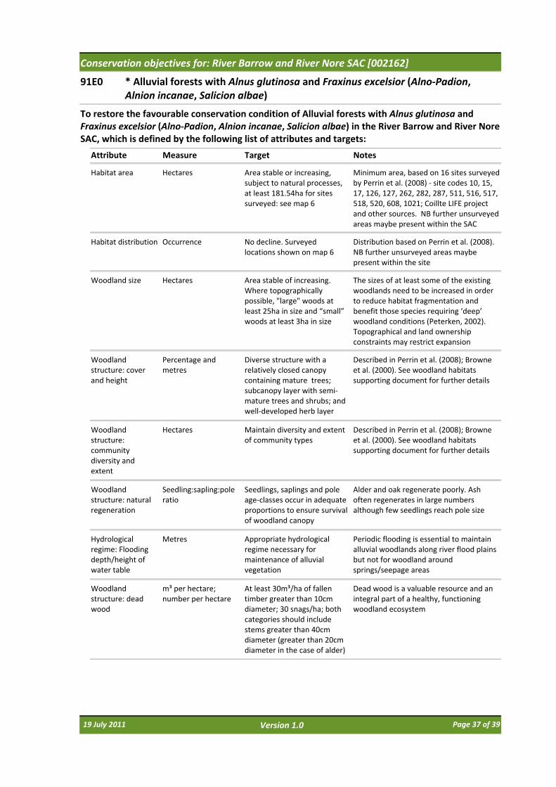
Conservation objectives for: River Barrow and River Nore SAC [002162]
91E0 * Alluvial forests with Alnus glutinosa and Fraxinus excelsior (Alno‐Padion, Alnion incanae, Salicion albae)
Attribute Measure Target
To restore the favourable conservation condition of Alluvial forests with Alnus glutinosa and Fraxinus excelsior (Alno‐Padion, Alnion incanae, Salicion albae) in the River Barrow and River Nore SAC, which is defined by the following list of attributes and targets:
Notes
Habitat area Hectares Area stable or increasing, subject to natural processes, at least 181.54ha for sites surveyed: see map 6
Minimum area, based on 16 sites surveyed by Perrin et al. (2008) ‐ site codes 10, 15, 17, 126, 127, 262, 282, 287, 511, 516, 517, 518, 520, 608, 1021; Coillte LIFE project and other sources. NB further unsurveyed areas maybe present within the SAC
Habitat distribution Occurrence No decline. Surveyed locations shown on map 6
Distribution based on Perrin et al. (2008). NB further unsurveyed areas maybe present within the site
Woodland size Hectares Area stable of increasing. Where topographically possible, "large" woods at least 25ha in size and “small” woods at least 3ha in size
The sizes of at least some of the existing woodlands need to be increased in order to reduce habitat fragmentation and benefit those species requiring ‘deep’ woodland conditions (Peterken, 2002). Topographical and land ownership constraints may restrict expansion
Woodland structure: cover and height
Percentage and metres
Diverse structure with a relatively closed canopy containing mature trees; subcanopy layer with semi‐mature trees and shrubs; and well‐developed herb layer
Described in Perrin et al. (2008); Browne et al. (2000). See woodland habitats supporting document for further details
Woodland structure: community diversity and extent
Hectares Maintain diversity and extent of community types
Described in Perrin et al. (2008); Browne et al. (2000). See woodland habitats supporting document for further details
Woodland structure: natural regeneration
Seedling:sapling:pole ratio
Seedlings, saplings and pole age‐classes occur in adequate proportions to ensure survival of woodland canopy
Alder and oak regenerate poorly. Ash often regenerates in large numbers although few seedlings reach pole size
Hydrological regime: Flooding depth/height of water table
Metres Appropriate hydrological regime necessary for maintenance of alluvial vegetation
Periodic flooding is essential to maintain alluvial woodlands along river flood plains but not for woodland around springs/seepage areas
Woodland structure: dead wood
m³ per hectare; number per hectare
At least 30m³/ha of fallen timber greater than 10cm diameter; 30 snags/ha; both categories should include stems greater than 40cm diameter (greater than 20cm diameter in the case of alder)
Dead wood is a valuable resource and an integral part of a healthy, functioning woodland ecosystem
19 July 2011 Page 37 of 39Version 1.0
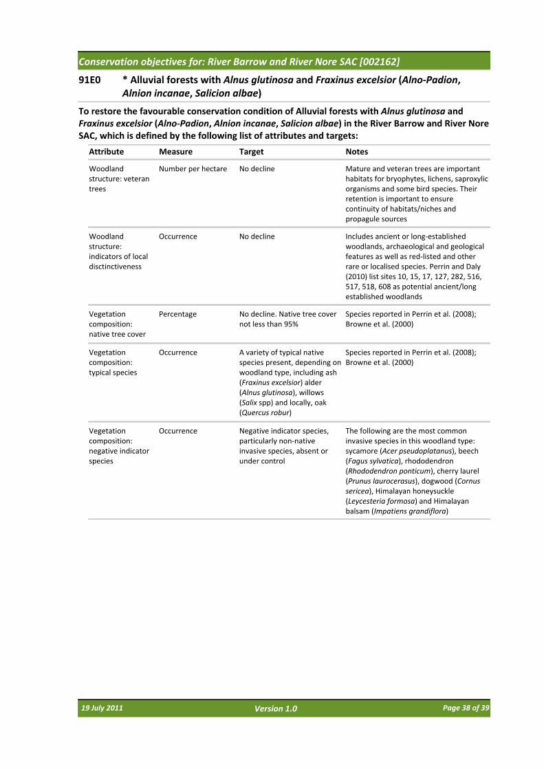
Conservation objectives for: River Barrow and River Nore SAC [002162]
91E0 * Alluvial forests with Alnus glutinosa and Fraxinus excelsior (Alno‐Padion, Alnion incanae, Salicion albae)
Attribute Measure Target
To restore the favourable conservation condition of Alluvial forests with Alnus glutinosa and Fraxinus excelsior (Alno‐Padion, Alnion incanae, Salicion albae) in the River Barrow and River Nore SAC, which is defined by the following list of attributes and targets:
Notes
Woodland structure: veteran trees
Number per hectare No decline Mature and veteran trees are important habitats for bryophytes, lichens, saproxylic organisms and some bird species. Their retention is important to ensure continuity of habitats/niches and propagule sources
Woodland structure: indicators of local disctinctiveness
Occurrence No decline Includes ancient or long‐established woodlands, archaeological and geological features as well as red‐listed and other rare or localised species. Perrin and Daly (2010) list sites 10, 15, 17, 127, 282, 516, 517, 518, 608 as potential ancient/long established woodlands
Vegetation composition: native tree cover
Percentage No decline. Native tree cover not less than 95%
Species reported in Perrin et al. (2008); Browne et al. (2000)
Vegetation composition: typical species
Occurrence A variety of typical native species present, depending on woodland type, including ash (Fraxinus excelsior) alder (Alnus glutinosa), willows (Salix spp) and locally, oak (Quercus robur)
Species reported in Perrin et al. (2008); Browne et al. (2000)
Vegetation composition: negative indicator species
Occurrence Negative indicator species, particularly non‐native invasive species, absent or under control
The following are the most common invasive species in this woodland type: sycamore (Acer pseudoplatanus), beech (Fagus sylvatica), rhododendron (Rhododendron ponticum), cherry laurel (Prunus laurocerasus), dogwood (Cornus sericea), Himalayan honeysuckle (Leycesteria formosa) and Himalayan balsam (Impatiens grandiflora)
19 July 2011 Page 38 of 39Version 1.0
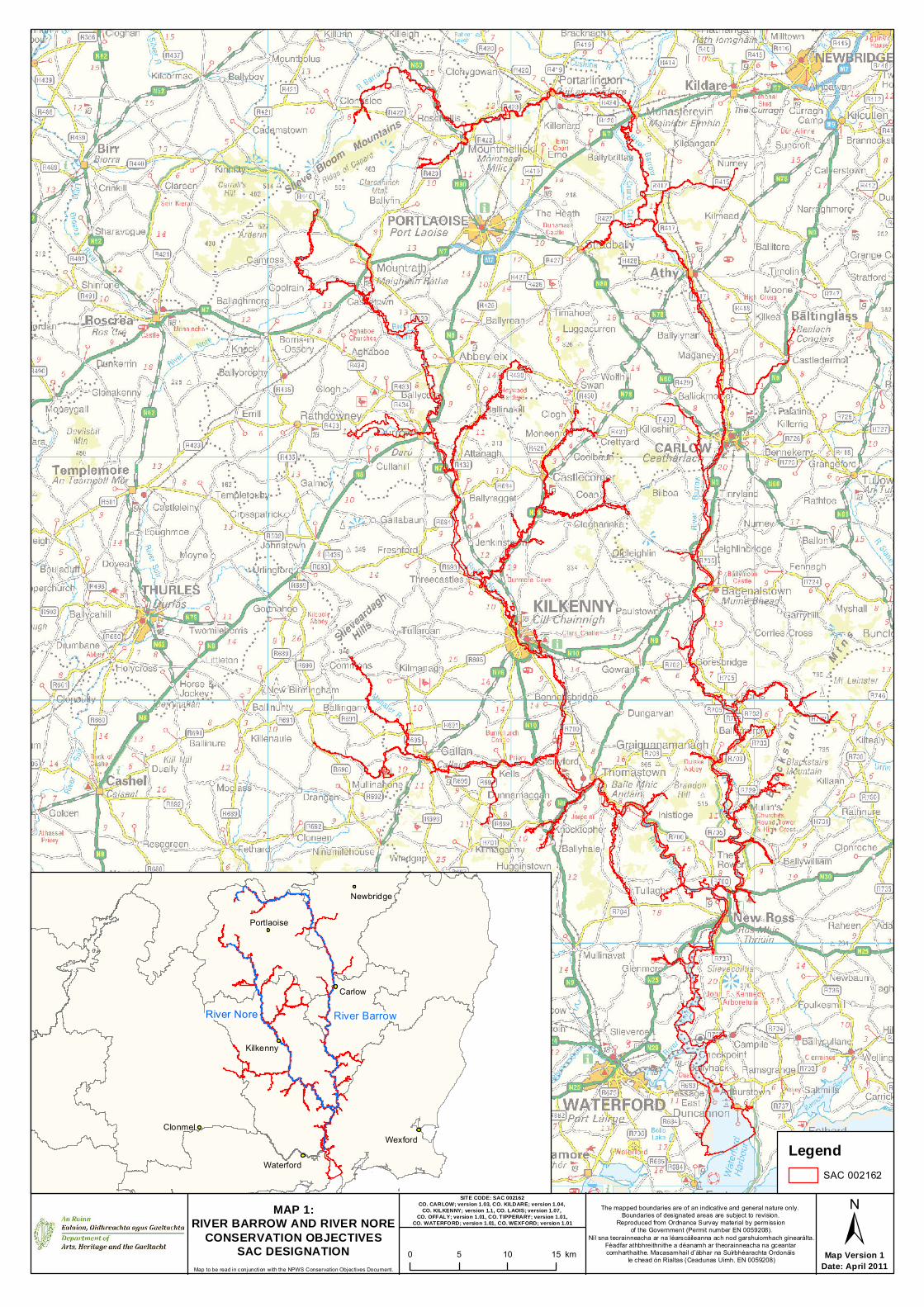
Map Version 1Date: April 2011
MAP 1:RIVER BARROW AND RIVER NORE
CONSERVATION OBJECTIVESSAC DESIGNATION
Map to be read in conjunction with the NPWS Conservation Objectives Document.
SITE CODE: SAC 002162CO. CARLOW; version 1.03, CO. KILDARE; version 1.04,
CO. KILKENNY; version 1.1, CO. LAOIS; version 1.07, CO. OFFALY; version 1.01, CO. TIPPERARY; version 1.01,
CO. WATERFORD; version 1.01, CO. WEXFORD; version 1.01
The mapped boundaries are of an indicative and general nature only. Boundaries of designated areas are subject to revision.
Reproduced from Ordnance Survey material by permission of the Government (Permit number EN 0059208).
Níl sna teorainneacha ar na léarscáileanna ach nod garshuiomhach ginearálta.Féadfar athbhreithnithe a déanamh ar theorainneacha na gceantar comharthaithe. Macasamhail d’ábhar na Suirbhéarachta Ordonáis
le chead ón Rialtas (Ceadunas Uimh. EN 0059208)
LegendSAC 002162
0 5 10 15 km
Clonmel
Waterford
Wexford
Carlow
Newbridge
Portlaoise
Kilkenny
±
River Nore River Barrow
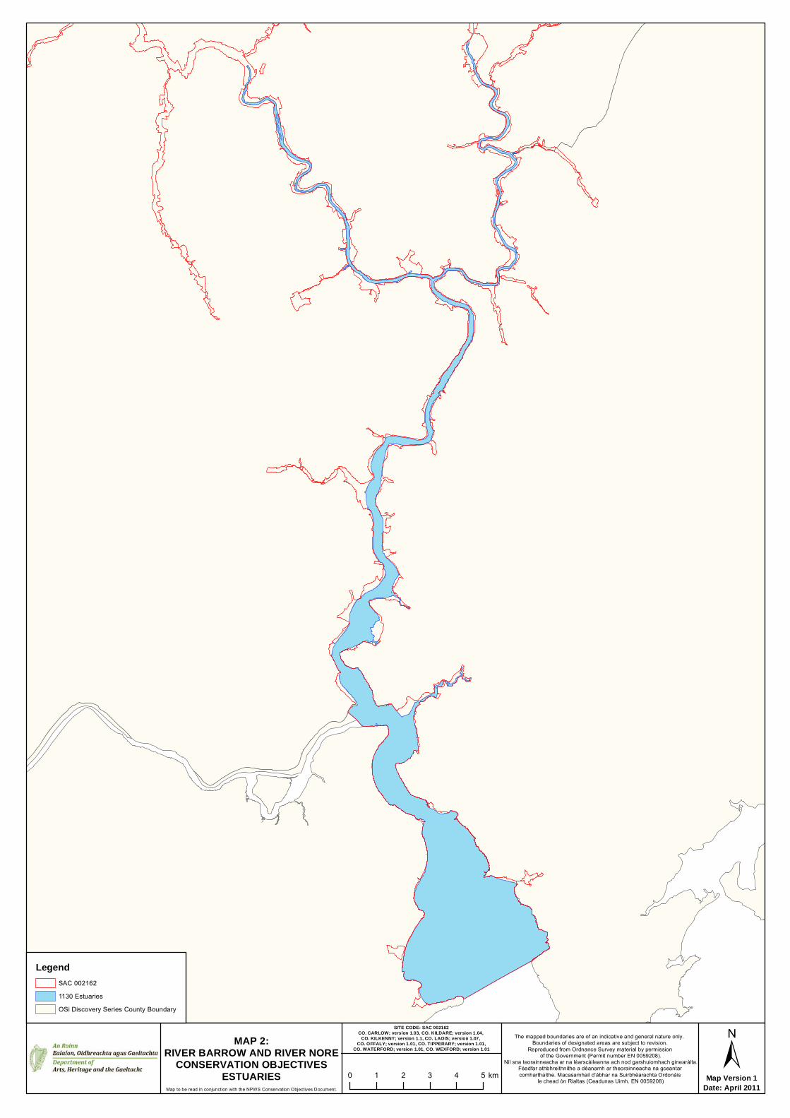
Map Version 1Date: April 2011Map to be read in conjunction with the NPWS Conservation Objectives Document.
The mapped boundaries are of an indicative and general nature only. Boundaries of designated areas are subject to revision.
Reproduced from Ordnance Survey material by permission of the Government (Permit number EN 0059208).
Níl sna teorainneacha ar na léarscáileanna ach nod garshuiomhach ginearálta.Féadfar athbhreithnithe a déanamh ar theorainneacha na gceantar comharthaithe. Macasamhail d’ábhar na Suirbhéarachta Ordonáis
le chead ón Rialtas (Ceadunas Uimh. EN 0059208)
±0 1 2 3 4 5 km
LegendSAC 0021621130 EstuariesOSi Discovery Series County Boundary
SITE CODE: SAC 002162CO. CARLOW; version 1.03, CO. KILDARE; version 1.04,
CO. KILKENNY; version 1.1, CO. LAOIS; version 1.07, CO. OFFALY; version 1.01, CO. TIPPERARY; version 1.01,
CO. WATERFORD; version 1.01, CO. WEXFORD; version 1.01MAP 2:
RIVER BARROW AND RIVER NORECONSERVATION OBJECTIVES
ESTUARIES

Map Version 1Date: April 2011Map to be read in conjunction with the NPWS Conservation Objectives Document.
The mapped boundaries are of an indicative and general nature only. Boundaries of designated areas are subject to revision.
Reproduced from Ordnance Survey material by permission of the Government (Permit number EN 0059208).
Níl sna teorainneacha ar na léarscáileanna ach nod garshuiomhach ginearálta.Féadfar athbhreithnithe a déanamh ar theorainneacha na gceantar comharthaithe. Macasamhail d’ábhar na Suirbhéarachta Ordonáis
le chead ón Rialtas (Ceadunas Uimh. EN 0059208)
±0 1 2 3 km
LegendSAC 0021621140 Mudflats and sandflats not covered by sea water at low tideOSi Discovery Series County Boundary
SITE CODE: SAC 002162CO. CARLOW; version 1.03, CO. KILDARE; version 1.04,
CO. KILKENNY; version 1.1, CO. LAOIS; version 1.07, CO. OFFALY; version 1.01, CO. TIPPERARY; version 1.01,
CO. WATERFORD; version 1.01, CO. WEXFORD; version 1.01MAP 3:
RIVER BARROW AND RIVER NORECONSERVATION OBJECTIVES
TIDAL MUDFLATS AND SANDFLATS
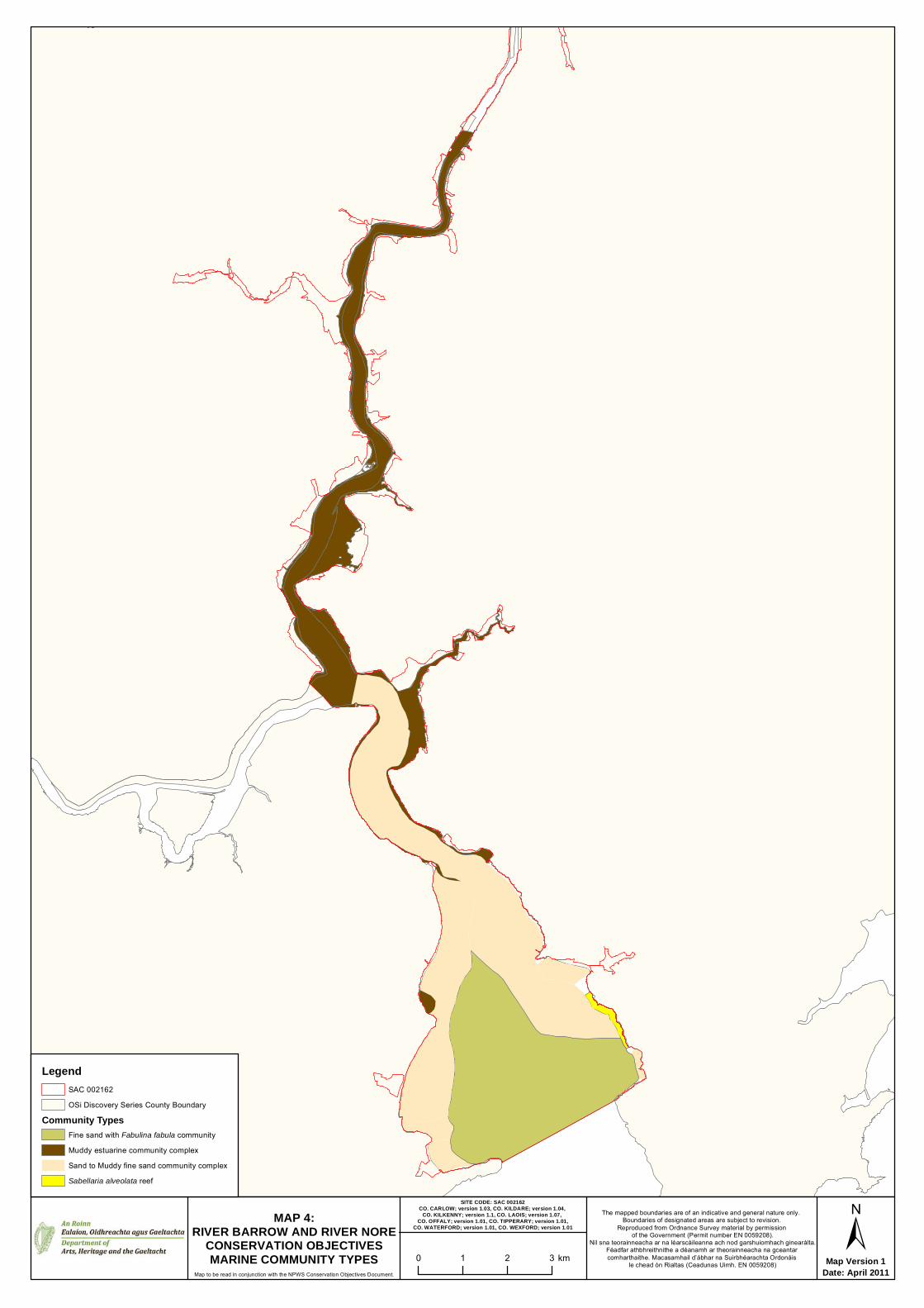
Map Version 1Date: April 2011Map to be read in conjunction with the NPWS Conservation Objectives Document.
The mapped boundaries are of an indicative and general nature only. Boundaries of designated areas are subject to revision.
Reproduced from Ordnance Survey material by permission of the Government (Permit number EN 0059208).
Níl sna teorainneacha ar na léarscáileanna ach nod garshuiomhach ginearálta.Féadfar athbhreithnithe a déanamh ar theorainneacha na gceantar comharthaithe. Macasamhail d’ábhar na Suirbhéarachta Ordonáis
le chead ón Rialtas (Ceadunas Uimh. EN 0059208)
±0 1 2 3 km
LegendSAC 002162OSi Discovery Series County Boundary
Community TypesFine sand with Fabulina fabula communityMuddy estuarine community complexSand to Muddy fine sand community complexSabellaria alveolata reef
SITE CODE: SAC 002162CO. CARLOW; version 1.03, CO. KILDARE; version 1.04,
CO. KILKENNY; version 1.1, CO. LAOIS; version 1.07, CO. OFFALY; version 1.01, CO. TIPPERARY; version 1.01,
CO. WATERFORD; version 1.01, CO. WEXFORD; version 1.01MAP 4:
RIVER BARROW AND RIVER NORECONSERVATION OBJECTIVESMARINE COMMUNITY TYPES

Map Version 1Date: April 2011Map to be read in conjunction with the NPWS Conservation Objectives Document.
The mapped boundaries are of an indicative and general nature only. Boundaries of designated areas are subject to revision.
Reproduced from Ordnance Survey material by permission of the Government (Permit number EN 0059208).
Níl sna teorainneacha ar na léarscáileanna ach nod garshuiomhach ginearálta.Féadfar athbhreithnithe a déanamh ar theorainneacha na gceantar comharthaithe. Macasamhail d’ábhar na Suirbhéarachta Ordonáis
le chead ón Rialtas (Ceadunas Uimh. EN 0059208)
±0 0.25 0.5 0.75 1 km
SMP0048Legend
SAC 002162OSi Discovery Series County Boundary
Saltmarsh Habitats1310 Salicornia and other annuals colonising mud and sand1330 Atlantic salt meadows (Glauco-Puccinellietalia maritimae)1330 / 1410 Atlantic salt meadows (Glauco-Puccinellietalia maritimae) / Mediterranean salt meadows (Juncetalia maritimi)1410 Mediterranean salt meadows (Juncetalia maritimi)Potential 1330 Atlantic salt meadows (Glauco-Puccinellietalia maritimae)
SMP0049
SMP0050
SMP0051
Kilkenny
NewbridgePortlaoise
Carlow
Waterford
SITE CODE: SAC 002162CO. CARLOW; version 1.03, CO. KILDARE; version 1.04,
CO. KILKENNY; version 1.1, CO. LAOIS; version 1.07, CO. OFFALY; version 1.01, CO. TIPPERARY; version 1.01,
CO. WATERFORD; version 1.01, CO. WEXFORD; version 1.01MAP 5:
RIVER BARROW AND RIVER NORECONSERVATION OBJECTIVES
SALTMARSH HABITATS
WexfordClonmel
Area of Interest
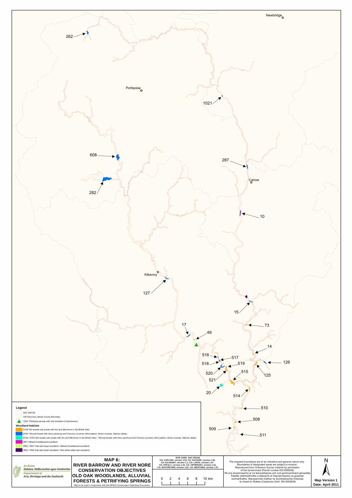
#7
Carlow
Clonmel
Kilkenny
Newbridge
Portlaoise
Map Version 1Date: April 2011Map to be read in conjunction with the NPWS Conservation Objectives Document.
The mapped boundaries are of an indicative and general nature only. Boundaries of designated areas are subject to revision.
Reproduced from Ordnance Survey material by permission of the Government (Permit number EN 0059208).
Níl sna teorainneacha ar na léarscáileanna ach nod garshuiomhach ginearálta.Féadfar athbhreithnithe a déanamh ar theorainneacha na gceantar comharthaithe. Macasamhail d’ábhar na Suirbhéarachta Ordonáis
le chead ón Rialtas (Ceadunas Uimh. EN 0059208)
±0 2 4 6 8 10 km
LegendSAC 002162OSi Discovery Series County Boundary
#7 7220 *Petrifying springs with tufa formation (Cratoneurion)Woodland Habitats
91A0 Old sessile oak woods with Ilex and Blechnum in the British Isles91E0 *Alluvial forests with Alnus glutinosa and Fraxinus excelsior (Alno-padion, Alnion incanae, Salicion albae)91A0 / 91E0 Old sessile oak woods with Ilex and Blechnum in the British Isles / *Alluvial forests with Alnus glutinosa and Fraxinus excelsior (Alno-padion, Alnion incanae, Salicion albae)WD1 (Mixed) broadleaved woodlandWN2 / WD1 Oak-ash-hazel woodland / (Mixed) broadleaved woodlandWN2 / WN6 Oak-ash-hazel woodland / Wet willow-alder-ash woodland
SITE CODE: SAC 002162CO. CARLOW; version 1.03, CO. KILDARE; version 1.04,
CO. KILKENNY; version 1.1, CO. LAOIS; version 1.07, CO. OFFALY; version 1.01, CO. TIPPERARY; version 1.01,
CO. WATERFORD; version 1.01, CO. WEXFORD; version 1.01
MAP 6:RIVER BARROW AND RIVER NORE
CONSERVATION OBJECTIVESOLD OAK WOODLANDS, ALLUVIAL FORESTS & PETRIFYING SPRINGS
10
519518517516
514
511
510
282
287
262
127
125
7349
20
17
15
14
1021
608
521520
508509
126515

Map Version 1Date: April 2011Map to be read in conjunction with the NPWS Conservation Objectives Document.
The mapped boundaries are of an indicative and general nature only. Boundaries of designated areas are subject to revision.
Reproduced from Ordnance Survey material by permission of the Government (Permit number EN 0059208).
Níl sna teorainneacha ar na léarscáileanna ach nod garshuiomhach ginearálta.Féadfar athbhreithnithe a déanamh ar theorainneacha na gceantar comharthaithe. Macasamhail d’ábhar na Suirbhéarachta Ordonáis
le chead ón Rialtas (Ceadunas Uimh. EN 0059208)
±0 2 4 6 8 10 km
LegendSAC 002162OSi Discovery Series County Boundary1016 Desmoulin's Whorl Snail - Vertigo moulinsiana1092 White-Clawed Crayfish - Austropotamobius pallipes1421 Killarney Fern - Trichomanes speciosum1990 Nore Freshwater Pearl Mussel - Margaritifera durrovensis
SITE CODE: SAC 002162CO. CARLOW; version 1.03, CO. KILDARE; version 1.04,
CO. KILKENNY; version 1.1, CO. LAOIS; version 1.07, CO. OFFALY; version 1.01, CO. TIPPERARY; version 1.01,
CO. WATERFORD; version 1.01, CO. WEXFORD; version 1.01
MAP 7:RIVER BARROW AND RIVER NORE
CONSERVATION OBJECTIVESDESMOULIN'S WHORL SNAIL, WHITE-
CLAWED CRAYFISH, NORE FRESHWATER PEARL MUSSEL & KILLARNEY FERN
Produced by: National Parks and Wildlife Service,Department of Arts, Heritage and the Gaeltacht, 7 Ely Place, Dublin 2, Ireland.Web: www.npws.ieE‐mail: [email protected]
NPWS (2011) Conservation Objectives: River Barrow and River Nore SAC 002162. Version 1.0. National Parks and Wildlife Service, Department of Arts, Heritage and the Gaeltacht.
Citation:
ISSN 2009‐4086
Series Editors: Rebecca Jeffrey & Naomi Kingston
19 July 2011 Page 39 of 39Version 1.0