name jl* russellville historic district
TRANSCRIPT
Form No. 10-300 (Rev. 10-74)
UNITED STATES DHPARTMENT OF THE INTERIOR NATIONAL PARK SERVICE
NATIONAL REGISTER OF HISTORIC PLACES INVENTORY -- NOMINATION FORM
SEE INSTRUCTIONS IN HOWTO COMPLETE NATIONAL REGISTER FORMS TYPE ALL ENTRIES -- COMPLETE APPLICABLE SECTIONS
NAME
HISTORICmu *JL* Russellville Historic DistrictAND/OR COMMON
Same
LOCATION.. '...<.' - . i ,. I *-.,('• ' -.;
STREETS NUMBER " ( vSee annexed U.S.G.S. map for boundaries _NOT FOR PUBLICATIONCITY, TOWNRussellvilleSTATEKentucky
.VICINITY OFCODE021
CONGRESSIONAL DISTRICT
1COUNTY CODE
Logan 141
UCLA SSIFI c ATI ONCATEGORY
XLDISTRICT
_BUILDING(S)
—STRUCTURE
_SITE
_OBJECT
OWNERSHIP—PUBLIC
—PRIVATE
XBOTH PUBLIC ACQUISITION
_ IN PROCESS
—BEING CONSIDERED
STATUSXoCCUPIED
—UNOCCUPIED
—WORK IN PROGRESS
ACCESSIBLE XvES: RESTRICTED
_YES: UNRESTRICTED
_ NO
PRESENT USE—AGRICULTURE XlVIUSEUM XCOMMERCIAL XPARK XEDUCATIONAL XPRIVATE RESIDENCE XENTERTAINMENT XRELIGIOUS XGOVERNMENT —SCIENTIFIC—INDUSTRIAL —TRANSPORTATION
—MILITARY —OTHER:
Multiple private and public ownersSTREET & NUMBER
CITY, TOWN
__ VICINITY OF
STATE
LOCATION OF LEGAL DESCRIPTION
Logan County CourthouseCOURTHOUSE, REGISTRY OF DEEDS, ETC
STREET& NUMBER
CITY, TOWN
RussellvilleSTATE
KentuckyREPRESENTATION IN EXISTING SURVEYSTITLE
Survey of Historic Sites in Kentucky (Supplement)DATE
1975 -FEDERAL —STATE XcOUNTY _LOCAL
DEPOSITORY FOR SURVEY RECORDS Kentucky Heritage CommissionCITY, TOWN
FrankfortSTATE
Kentucky
DESCRIPTION
ccX.EXCELLENT
X-GOOD
X.FAIR
)NDITION CHECK ONE CHECK ONE
XDETERIORATED XUNALTERED XORIGINALSITE XRIHNS XALTERED Xiuim/Fn HATFXUNEXPOSED
DESCRIBETHE PRESENT AND ORIGINAL (IF KNOWN) PHYSICAL APPEARANCE
INTRODUCTION
The Russellville Historic District includes a large portion of the late 18th-century and the 19th-century sections of the town. The boundaries have been chosen to include as wide a range of structures, functions, and types as possible. The boundaries exclude modern subdivisions on the west and south; deteriorated housing of little antiquity or significance on the east and some on the north. The area along the railroad line north of the courthouse retains little or no historic character and much of an intrusive nature: modern highways with concomitant strip development enter the town center at the north west corner of the grid system.
Although internally diversified, the area within the boundaries proposed has a more or less continuous identity and remarkably few intrusions. Most modern construction has been at least compatible in scale, material, and style. There have been a few out standing restorations and a great deal of preservation through survival and adaptation.
Unusually for a Kentucky county seat, the core of the town is not the present courthouse which lies along the north side of the main east-west thoroughfare, Fourth Street but the commercial square that spans Fourth Street a block east of the courthouse forming a long north-south rectangle with Main Street along its east side. This attractive square, the site of the original courthouse, with its fountain and memorials, forms the main inter section of the town and fulfills the usual role of the courthouse square. Mostly Victorian commercial buildings line Main Street north of the square and a block south to the old Long Bank Building, a combination residence-bank that formed an apprqpriate transition from the commercial center to the residential area beyond. Other commercial structures surround the square*,,extending west past the courthouse and some distance along Second and Third streets flanking North Main.
The original settlement of Russellville tended to be in the northeast quadrant of the present city, because of early industries along Muddy Creek below Maulding's Hill. The oldest surviving part of the town is in the area several blocks east of Main Street near the meandering Town Branch. This area has been subject to flooding, and has historically had a small scale of construction. Much of the brick and frame housing stock is physically deteriorated, but the earlier dwellings have a remarkable rate of survival in this area, which is traditionally divided into sections known locally as White Bottom and Black Bottom (south of Fourth Street). The Town Branch itself has considerable charm, being at some places lined with old stone walls. The old town cemetery forms the northeast terminus of this quadrant.
(continued)
01 SIGNIFICANCE
PERIOD
—PREHISTORIC
— 1400-1499
— 1500-1599
_1600-1699
— 1700-1799
Xl 800-1899
Xl900-
AREAS OF SIGNIFICANCE -- CHECK AND JUSTIFY BELOW_ARCHEOLOGY-PREHISTORIC
—ARCHEOLOGY-HISTORIC
_AGRICULTURE
^ARCHITECTURE
—ART
^COMMERCE
—COMMUNICATIONS
—COMMUNITY PLANNING
—CONSERVATION
—ECONOMICS
_EDUCATION
—ENGINEERING
—EXPLORATION/SETTLEMENT
—INDUSTRY
_INVENTION
—LANDSCAPE ARCHITECTURE XLAW—LITERATURE—MILITARY—MUSIC
_PHILOSOPHY
XPOLITICS/GOVERNMENT
—RELIGION
—SCIENCE
—SCULPTURE
XsOCIAL/HUMANITARIAN
—THEATER
—TRANSPORTATION
—OTHER (SPECIFY)
SPECIFIC DATES BUILDER/ARCHITECT
STATEMENT OF SIGNIFICANCE
SUMMARY
Russellville is the county seat of Logan County, which is located in the southern tier of Kentucky counties along the Tennessee border. Although identified with Western Kentucky most of which was formed from the original Logan County the town has many connections with central Kentucky (the Bluegrass region) and metropolitan Louis ville, as well as with Nashville, Tennessee, and other cities across the border. His torically, however, the "southern" character predominates: most of the early settlers in the late 18th century came up the Cumberland and Red rivers from central Tennessee into Kentucky; Jefferson Davis' birthplace is located in adjacent Todd County and his memory is revered throughout the area;*and the regional economy, still based on agriculture (although about half of the present county's population works in industry) resembles that of the corresponding parts of Tennessee, where some of the flavor of the old plantation system still remains. Yet,since the early 19th century, when the town began to redeem its initial reputation as a "rogue's harbor" (talented and individualistic as several of those rogues seem to have been), Russellville has been a banking center for much of surrounding Western Kentucky, thus, t'he town has had a distinct cultural identity, perhaps best symbolized by the building that housed the Southern Bank of Kentucky and the Nimrod Long Bank in the period just before and after the Civil War. Within a structure of remarkable architectural sophistication were institutions whose personnel included members of some of the most eminent (and philanthropic) families in Kentucky's history, yet this landmark is best known for its robbery by the notorious gangster, Jesse James.
A certain conservatism has been responsible for the physical preservation of such a large portion of the 19th-century town and its ambience while a quiet progressivism has allowed the economic base to be frequently stimulated, social problems confronted, and the community kept viable as a unique and desirable place to live. Outstanding as are a number of the historical events and figures associated with the structures and sites described here particularly the extraordinary incidence of men born and educated in Russellville in the first half of the 19th century who became governors of Kentucky (four of them) and other states (at least five), as well as other prominent legal and political figures at the state and national levels it is the overall identity and integrity of Russellville that
___is being recognized in the proposed historic district._________________________ -*Moreover, the Kentucky Confederate Convention was held in Russellville in 1861.
(continued)
MAJOR BIBLIOGRAPHICAL REFERENCES (continued)
The nomination form was prepared by Mary Cronan, Historian, and Walter E Langsam Architectural Historian, of the Kentucky Heritage Commission, based on materials supplied by Al Smith; Mr. Langsam also visited the town and helped determine the boundaries of the district.Much information was derived from individual citizens of Russellville, particularly J . Granville
DGEOGRAPHICAL DATAACREAGE OF NOMINATED PROPERTY _
UTM REFERENCES
J5iliQl6i8tQlZONE EASTING
c|l|6| |5|0,9|6|4,0|
Clark and
approximately 210
NORTHING14.017,618.1 01
Bll.fil I5ll.0i9.3.0|ZONE EASTING
|5|Oi9l6iO.Q|
l4.0l7i7Jli9.Q|NORTHING
|4iO|7,7l7.4i OJVERBAL BOUNDARY DESCRIPTION
Starting at North Main and Third streets, proceed west along Third past the rear of the court house to Bakey Street; south along Bakey to the midpoint between West Fifth and Sixth streets; then west to Nashville Street (along the rear of the properties on the north side of Sixth Street); south on Nashville to West Seventh; west on Seventh to the rear of the properties on the westside of Nashville Street (which is not aligned with the portion of Nashville Street north of Sev- enth Street; the latter is also known as Bethel Street after the Bethel Academy that (continued!
LIST ALL STATES AND COUNTIES FOR PROPERTIES OVERLAPPING STATE OR COUNTY BOUNDARIES
STATE CODE COUNTY CODE
STATE CODE COUNTY CODE
FORM PREPARED BYNAME/TITLE
Mary Cronan, Historian; Walter E. Langsam, Architectural HistorianORGANIZATION
Kentucky Heritage CommissionDATE
June 4, 1976STREET& NUMBER
104 Bridge StreetTELEPHONE
(502)564-3741CITY OR TOWN
FrankfortSTATE
Kentucky
STATE HISTORIC PRESERVATION OFFICER CERTIFICATIONTHE EVALUATED SIGNIFICANCE OF THIS PROPERTY WITHIN THE STATE IS:
NATIONAL__ STATE IT LOCAL___
As the designated State Historic Preservation Officer for the National Historic Preservation Act of 1966 (Public Law 89-665), I hereby nominate this property for inclusion in the National Register and certify that it has been evaluated according to the criteria and procedures set forth by the National Park Service.
SIGNATURE
TITLE State Historic Preservation Officer
Form No. 1£)-300a (Rev. 10-74)
UNITED STATES DEPARTMENT OF THE INTERIOR NATIONAL PARK SERVICE
NATIONAL REGISTER OF HISTORIC PLACES INVENTORY - NOMINATION FORM
Russellville Historic DistrictCOIMTI NUATION SHEET _____ ITEM NUMBER 7_____PAGE 2
INTRODUCTION continued
East Second and to some extent Third streets are of mixed socio-economic range and architectural scale. Although not all have survived, there are a number of ample 19th-century residential properties, especially along the north side of Second Street.
The main upper- and middle-class residential area of Russellville has been since the early 19th century the southwest quadrant, especially along South Main Street and the cross streets from Sixth to Ninth. There is a concentration of houses outstanding both historically and architecturally, with a sprinkling of older churches. Some of the properties on the south side of Ninth Street still extend back into open farmland, but subdivisions (many of superior character) are rapidly encroaching in this direction, The "new" town cemetery, known as Maple Grove, forms the southwest terminus of the quadrant. Northwest of the cemetery, particularly along Nashville Street, was a residential area once primarily inhabited by Irish families associated with the railway to the north. (Some of this neighborhood farther west has been excluded from the district because of intervening intrusions.)
The eastern terminus of the fashionable southwestern residential area is the present Logan Elementary School, located on or near the site of the historic Logan Female College. East of it, however, survives the attractively landscaped Roberts-Edwards House, set at the base of the hills (or knobs) that rise steeply above Ninth Street to the south and east.
A total of approximately 50 city blocks of varying size is included in the district. The number of structures has not yet been determined. Intrusions in the proposed district include several abandoned gas stations, including one at the major intersection of the Public Square and West Fourth Street (adjacent to the restored newspaper building); several drive-in quick-food operations, including one at East Fourth and Breathitt streets; a number of refacings of Victorian commercial structures (see photographs of the Old Courthouse Square and adjacent streets); and a few incompatible recent resi dences or commercial/professional additions to residences.
Russellville has had zoning since the 1960s. As the present-day pictures indicate, there are a few new buildings downtown, but the majority of commercial structures
(continued)
Form No. 1£)-300a (Hev. 10-74)
UNITED STATES DEPARTMENT OF THE INTERIOR NATIONAL PARK SERVICE
NATIONAL REGISTER OF HISTORIC PLACES INVENTORY - NOMINATION FORM
Russellville Historic District
RECEIVEDi: 11
14 1976
CONTINUATION SHEET _____________ITEM NUMBER 7_____PAGE 3_____________
INTRODUCTION continuedin the Public Square area are old buildings. A few have "fronts" that were tacked on without regard to the historic nature of the site, but several of them have already been restored to their late Victorian style. Moreover, the Southern Deposit Bank building (see photo 17) erected on the Public Square in the 1960s was planned to blend in with Russellville's earlier architecture, as was the Kirkpatrick office complex behind it on West Fourth (see photo 18) in a joint project (the Kirkpatrick family con trolled the office area and the bank).
A thorough survey of existing structures in Russellville has not yet been undertaken. As a result, the photographs and descriptions tend to emphasize the traditionally admired and documented buildings, particularly the residences. An attempt has been made, however, to supplement these with representative examples of somewhat more modest structures. In some cases, therefore, oral history has been relied upon.
For the sake of convenience, the physical descriptions (#7) and histories (#8) of indi vidual structures have been combined. Please note that the numbers of the photographs do not correspond with the numbers applied to sites. The latter are used on the rough sketch-map of the area. Also of interest are the 1798 plat and approximately century- old map of the town with its indication of the "Original Town" and various "Additions," former street names, and a few significant institutions and estates.
Form No 1fl-300a (Rev. 10-74)
UNITED STATES DhPARTMtNT OF THE INTERIOR NATIONAL PARK SERVICE
NATIONAL REGISTER OF HISTORIC PLACES INVENTORY -- NOMINATION FORM
FOR NFS USE ONLY
JIM 14
JUL 14 1976
Russellville Historic DistrictCONTINUATION SHEET _____ ITEM NUMBER 8_____PAGE 2___________________
HISTORIC CONTEXT
The 13th county formed when Kentucky became a state in 1792, Logan was named for the Indian fighter and contemporary of Daniel Boone, General Benjamin Logan. The original Logan County ran from the little Barren River (near Bowling Green) on the east to the Mississippi on the west and from the Ohio and Green rivers on the north to the Tennessee line on the south, embracing most of what is now known as Western Kentucky. Twenty-eight counties were formed wholly or in part from its original territory.
Andrew Jackson fought a duel here. Jesse James robbed a bank here. The evil Harpe brothers, William and Wiley, once murdered a whole family in Logan County. Jim Bowie was a Logan countian and so, in his civilian life, was the early Marine Corps hero, Lt. Presley O'Bannon, who fought the Barbary pirates near Tripoli in 1805.
Eighteenth-century Russellville was a "rogue's harbor" according to the Reverend Peter Cartwright, but preachers and lawyers were soon riding in with the settlers, many of whom were officers from the Revolutionary War in claim of land grants. By 1800 the Great Revival was underway at camp meetings on the banks of the Red, Gasper, and Muddy rirers in Logan County (see the National Register forms for the Red River Meeting House and Cemetery Site, approved at the state level on October 21, 1975). The Shakers came in 1807 and maintained a Logan County colony for 115 years (see the National Register form for Shakertown at South Union, entered on April 3, 1975). In the 1950s the Catholic Benedictines founded an interracial monastery at the site of the Shaker colony. A few years later, Amish farm families from Virginia settled near Shakertown, drawn by the good land and by a tradition of tolerance which has almost wiped out the memory of a darker era at the turn of the century when Night Riders burned tobacco barns and vigilantes hung four Negroes on a cedar tree in Russellville.
There is no coal in Logan County, no Appalachian range of great mountains, nor any towering forests. The bear, the buffalo, the elk, and the Indians have gone. But nearly everything else that is evocative of Kentucky either flourishes or has left a trail in the Russellville area. Border state ambivalence shimmers across the pages of Logan's history. In the Civil War, a thousand Logan men fought in the Confederate Army, but another five hundred were with the Union forces. A landmark in Russellville
(continued)
Form No. 10-300a (Aev. 10-74)
UNITED STATES DEPARTMENT OK THE INTERIOR NATIONAL PARK SERVICE
NATIONAL REGISTER OF HISTORIC PLACES INVENTORY -- NOMINATION FORM
Russellville Historic District
FOR NFS USE ONLY
DATE ENTERED
JUN 14 1976
JUL 141976
CONTINUATION SHEET__________________ITEM NUMBER 8 PAGE 3__________________
HISTORIC CONTEXT continuedis the house in which the Kentucky Confederate convention was held in 1861 (see the
V nomination form for the Forst House, entered on the Register on June 19, 1973; and below). Across the street is the courthouse, citadel of the Democratic machine which smashed the Ku Klux Klan in a countywide election confrontation in 1922.
In the old courthouse square in Russellville, historical markers honor three Revolu tionary War generals, soldiers of other wars, and a Methodist minister, the Reverend John Littlejohn, who protected the Declaration of Independence and other treasured national documents during the War of 1812 when he was sheriff of Loudon County, Vir ginia. The saving of the square itself, with its shrubs, flowers, and fountains, was one of several memorable modern-day battles waged by a coalition of women's clubs and the county historical society. While blocking various plans for a street through the park, for a filling station at the corner of the cemetery, and for demolition of the 1903 courthouse (the county's third), the preservationists have educated a new genera tion of Logan countians to the richness of their past as well as taught the politicians to respect the political clout of an indignant Daughter of the American Revolution. From these civic controversies, there has sprung a wider interest in the 19th-century archi tectural heritage. Several old commercial buildings have been renovated and a number of new ones are sympathetic to the traditional Georgian and Federal styles.
Logan was first explored by white men about 1770 as Kasper Mansker and other 'long hunters" ranged northward from middle Tennessee. The town site was called Big Boiling Spring, then successively Gasper Butcher's Spring, Cook's Spring, Logan Courthouse, and from 1798, Russellville, in honor of General William Russell who had received a land grant there.
The first permanent house, built in 1790, is gone, but silver and pewter spoons, hunt ing horns, and jewelry crafted by one of the men who helped put up the log-pole house, Major William Stewart, may be seen in Russellville.
As was typical of the 18th-century frontier, many of Logan's settlers were fleeing the law or looking for a fresh start. Major Stewart had killed a man in Georgia. The first merchant, Philip Ralston, was a dealer in salt and hides in Logan County, but in Natchez he had been a counterfeiter. The first physician, Beverly Anthony Alien, was a former Methodist minister who abandoned the pulpit as well as the state of Virginia after killing
(continued)
Form No. 1{)-300a (Rev 10-74)
UNITED STATHS DEPARTMENT OF THt INTERIOR NATIONAL PARK SERVICE
NATIONAL REGISTER OF HISTORIC PLACES INVENTORY -- NOMINATION FORM
Russellville Historic District
1976
CONTINUATION SHEET __________ITEM NUMBER 3 PAGE 4_________________
HISTORIC CONTEXT continueda Major Forsythe who had arrested him in a church dispute. "Murderers, horse thieves, highway robbers, and counterfeiters fled here until they combined and actu ally formed a majority," the Reverend Peter Cartwright, whose family moved here in 1792, wrote in his autobiography.
Logan was neither lawless nor godless for long. Young Andrew Jackson was practicing at the Logan Courthouse in 1793. A carpenter, William Henry, arrived in 1795 and was in demand for house raisings. A potter came in 1798, followed by another carpenter, a joiner, a turner, and in 1800, by Millard Lee, a shoemaker.
By 1800 Russellville had been laid out (see the 1798 plat enclosed). There were nearly a thousand people in the county, and the sermons of the Reverend James McGready, a Presbyterian who preached a personal witness of the spirit, "charismatic" we would say, kindled the Great Revival (see the National Register nomination form for the Rev erend James McGready House, near Russellville, approved April 21, 1976). From an historical point of view, one of the most important duels ever fought in Kentucky was between two Tennesseans and occurred in Logan County. This was on May 30, 1806, on the banks of the Red River, not far from McGready's meeting house, when Major Andrew Jackson, then 40, killed the young Nashville attorney, Charles Dickinson.
Russellville's most historic houses were built between 1800 and 1830 when the town was the home of four men who became governors of Kentucky* John Breathitt, James T. Morehead, John J. Crittenden, and Charles S. Morehead; and of five who became gov ernors in other states. Residences of the four Kentucky governors are still standing. Five men who started in Russellville in this period were elected United States senators. Several of these notables owed their proficiency at law to the training of George M. Bibb, once justice of the Kentucky Court of Appeals, twice Chief Justice, once United States senator, and Secretary of the Navy under President Tyler. Three residences preserved from the early 19th century were owned by the Bibb family whose patriarch, Major Richard M. Bibb, is remembered for freeing a hundred slaves before the Civil War. The 1805 Marine hero,O'Bannon, lived in one of the Bibb residences. Another Bibb house became the birthplace of Thomas Pritchett DeGraffenried, later a New York attorney who posthumously became a Russellville hero in 1961 when it was disclosed that he had left the town a million dollars for educational purposes.
(continued)
Form No. 1fl-300a (Aev. 10-74)
UNITED STATES DEPARTMENT OF THE INTERIORNATIONAL PARK SERV,CE JUNUB76
ncv^ci vc.u
NATIONAL REGISTER OF HISTORIC PLACES INVENTORY -- NOMINATION FORM
FOR NFS USE ONLY
Russellville Historic DistrictCONTINUATION SHEET_________________ITEM NUMBER 8 PAGE 5_________________
HISTORIC CONTEXT continued
One of the oldest buildings in Russellville, now a residence, was a saddle and leather factory built by the brothers, Andrew and David Caldwell. By 1810 there were three brick kilns and two limestone kilns, mills of all sorts, and Russellville had become a manufacturing center. In 1812 Thomas Grubbs arrived. It is significant that Grubbs had studied bricklaying in Charlottesville, Albemarle County, Virginia, in 1803 with the Jordans (John, Sam, and Hezekiah) and thought it important enough to mention to a Russellville historian, Alex Finley, in 1876 when Grubbs was 92. A founder of the First Baptist Church, Grubbs was one of the early contractors whose work survives. The town was also an early banking center, boasting the first branch of the Bank of Kentucky set up in the aftermath of the War of 1812's boycott of European commerce.
With all its colorful history, the most talked-about event in Russellville is still the 1868 robbery of the Nimrod Long Banking Company by the Jesse James gang. After wounding the cashier and exchanging shots with a posse, the bandits escaped with $9,000. The bank is now a private museum. During the annual fall tobacco festival, a re-enactment of the robbery features a raid by men on horseback whose leader is a descendant of a Logan County uncle of Frank and Jesse James.
Philip Ralston, the pioneer merchant and counterfeiter, was a more versatile crimi nal than the James brothers. The Harpes, "Big Harpe" and "Little Harpe," were certainly meaner. But no outlaws, or for that matter, no soldiers, statesmen, or preachers have gripped the imagination of Logan countians like the Jameses. A huge mural depicting the robbery dominates the lobby of a Russellville bank, surely one of the few financial institutions in the world that could find such a theme appropriate without seeming ludicrous.
ARCHITECTURE
The history of Russellville has been embodied in numerous surviving structures: a few of them of outstanding architectural significance, a considerable number of intrin sic interest, and many with character. Of the earliest log structures, few are known to survive, although fragments are said to be embedded in several later buildings (see #24 and #43, Photos 30, 30A and 56; and photo 26A). The Reverend James McGready House referred to above, now on the outskirts of town but once fairly remote, is a superb example of stone construction from before 1800, but none is known to survive
(continued)
Form No. 1p-300a (Aev. 10-74)
UNIThD STATES DEPARTMENT OF THE INTERIOR NATIONAL PARK SERVICE
NATIONAL REGISTER OF HISTORIC PLACES INVENTORY -- NOMINATION FORM
JUL 141976
Russellville Historic DistrictCONTINUATION SHEET ITEM NUMBER 8 PAGE 6
ARCHITECTURE continued within the district.
Of brick construction from the first quarter of the 19th century, however, there are several important examples and no doubt (like the log structures) others to be dis covered by means of thorough scrutiny of more modest dwellings in the oldest (but no longer fashionable or well-maintained) central and eastern part of the district. The oldest surviving brick house in town is alleged to be a small brick building near the intersection of Morgan and East Sixth streets (not illustrated). According to one of the oldest and best-informed inhabitants of Russellville, this house was the birth place of the first of a series of Marmaduke Beckwith Mortons prominent in local history; one was cashier of the Southern Bank of Kentucky during the Civil War, another became editor of The Nashville Banner and recorded and preserwd much local history. Another outstanding early brick structure, on a much larger scale, is the Caldwell Saddle Factory building (#11, photo 15), an extremely important example of specialization of a standard style for a specific function: the very wide windows are said to have been intended to provide light for pairs of workmen.
Outstanding among early brick dwellings are those associated with the Bibb family. Two of these, the O'Bannon-Bibb House (#27, photo 34) and the Major Richard Bibb House (#36, photos 47 and 48) share an interesting feature: the unusual semi- octagonal entrance bay. The latter house has a two-story central portion flanked by one-story wings and subtly recessed arches over single and triple windows sug gestive of the work of Charles Bulfinch in New England. Other early Federal- period buildings are plainer but no less well-constructed. These include a one- and-a-half-story Federal house (#28, photo 35) occupied by the first postmaster in Logan County, Armistead Morehead, and the three-bay townhouse lived in by Gov ernor Morehead (#12, photo 16). The latter was built for John Breathitt, later governor of Kentucky, for his sister. He also built for himself a larger Federal house (#52, photo 68). These are among several groups of houses in Russellville built for and occupied by members of families prominent in early Kentucky and later.
A number of early houses have impressive doorways. The house later the site of the Kentucky Confederate Convention (#13, photo 19) seems to have been used by the builder, an English cabinetmaker named First (later corrupted to Forst), as a
(continued)
Form No. 1fl-300a (Hev. 10-74)
UNITED STATES DEPARTMENT OF THE INTERIORNATIONAL PARK SERVICE
RECEIVED JUN 1 4 197&
NATIONAL REGISTER OF HISTORIC PLACES INVENTORY -- NOMINATION FORM
FOR NFS US& ONLY
DATE ENTERED >>ljl '•'- $76
Russellville Historic DistrictCONTINUATION SHEET ITEM NUMBER 8 PAGE 7
ARCHITECTURE continuedshowcase for his virtuoso millwork and mantels. At least one large frame house of the early 19th century survives (#41, photo 54); curiously, it has an added handsome Greek Revival double portico very similar to that of the John J. Crittenden House (#23, photo 29), which consists of early asymmetrical brick and frame portions united, and at first glance disguised, by the impressive central feature.
The date of a colossal portico on another earlier house (#29, photos 36 and 37) is in question, but its impressive double side-gallery with an ingenious spiral staircase seems more likely to date from the Grecian vogue. At the southeast end of town is a handsome fully Greek Revival mansion (#25, photos 31 and 32), its bold cubic mass weakened only by a 20th-century staircase and ironwork. And there is at least one 19th-century vernacular adaptation of the style (#43, photo 56), with applied pilasters.
Other modest structures, such as #38, photo 51 early 19th-century in type, if not possibly in date abound in Russellville, particularly in the eastern part of the district, There are also some representative outbuildings, such as the apparent smokehouse later used as a school (#37, photo 50).
Russellville is particularly rich in Victorian architecture of the Civil War era, much of it in the Italianate vein. The Public Square and adjacent streets are lined with commercial fronts that feature lavish hoodmolds (usually cast iron) and cornices (see #s 1-10, photos 1-14). The unusual, for Kentucky, frequency of partial mansard roofs suggests a post-War date for several of these. The outstanding Renaissance Revival structure in the town and,indeed, one of the finest in the state is the combined residence and bank building remodelled from an early house in 1857, and the site of the famous James robbery (#34,photos 43-45). Here design, functional expression, and craftsmanship in brick, stone, wood, and ironwork unite at a very high level. All these downtown structures reflect both the affluence and the taste of the merchants in the sec ond half of the 19th century.
Mansards, some with concave roofs, also appear on Itailianate houses just after the Civil War. Fancy porches, bay windows, extra gables, and plastic cornices also con tribute to the Victorians' love of richness and bariety, whether executed in brick or frame (#15, photo 21; #16, photo 22; #17, photo 23). Some of these features encrust earlier structures (#24, photo 30; #31, photo 39; #43, photo 56). A localized device
(continued)
Form No 1fl-300a (Aev. 10-74)
UNITED STATHS DEPARTMENT OF THH INTERIORNATIONAL PARK SERVICE 7R
RECEIVED JU
NATIONAL REGISTER OF HISTORIC PLACES INVENTORY -- NOMINATION FORM
FOR NFS USE ONLY
Russellville Historic DistrictCONTINUATION SHEET_________________ITEM NUMBER g PAGE 8_____________
ARCHITECTURE continuedis the use of wooden quoins, even on houses of relatively modest scale (#17, photo 23; #15, photos 66 and 67). The Maple Grove Cemetery Sexton's Cottage is an especially picturesque compilation of Victorian preferences (#19, photo 25). The First Presby terian Church of 1878 is a still bolder concoction with its preposterous finials and octagonal mansard tower (#44, photo 57). In contrast, the old jailer's residence (#14A, photo 20A) shows an appropriate restraint.
The Gothic Revival was not altogether skimped in Russellville. Trinity Episcopal Church (#41, photos 41 and 42) is a fine example of an irregular brick "parish church" (in fact, it has retained missionary status for over a century!). Of ambitious Gothic or Tudor "cottages," there are few examples (see photo 26A), but many brick or frame structures whose multiple acute gables evoke that mode (#20, photo 26).
Of late 19th-century styles there may be fewer examples. A curious facade on the east side of the Public Square (photos 5 and 13) evokes "Moorish" horeshoe arches, or may be an inventive variation on the Richardsonian Romanesque embodied in the 1891 Baptist "auditorium" (#36, photo 46). Residences became increasingly extra vagant in composition and detail, reaching a climax in the enormous Courts House, which more than holds its own against the historic early houses on the three other corners of the prominent intersection of Ninth Street at the south end of Main Street. The Courts House (#26, photos 33 and 33A), which has recently been restored by one of the community's best-known citizens, has not only an impressive exterior with its chateauesque turrets and varied room-shapes, but also a spectacular interior with superb intact stained glass, mantels, millwork, functioning period plumbing, and fourteen-foot high ceilings. The hand of an architect, perhaps from Nashville, Tennes see, is apparent here. This is the last and grandest of a series of residences that
belonged to the Rheas (#22, photo 28; #52, photo 68), who also patronized Trinity Episcopal Church (see above). Another group of such houses also reflects the changing tastes of another local family: residences of members of the Evans family (#18, photo 24; #17, photo 23; and #46, photo 59), the last of which seems almost like a frame ver sion of the Courts house, including the latter's original porch (compare photo 33A).
In the early 20th century such exuberance became frowned upon. Architects of public buildings sought quieter models in classical antiquity, although the 1903 courthouse still had a picturesque tower, domes, and pavilion roofs until a recent colonialization
(continued)
Form No. 10-300a (Hev. 10-74)
UNITHDSTATtS DEPARTMENT OF THE INTERIORNATIONAL PARK SERVICE
RECEIVED JUN 14 1376 NATIONAL REGISTER OF HISTORIC PLACES
FOR NFS USE ONLY
INVENTORY -- NOMINATION FORM
Russellville Historic DistrictCONTINUATION SHEET_________________ITEM NUMBER 8_____PAGE 9
ARCHITECTURE continued
JUL 14 1976
(#14, photo 20; see also the Opera House #7, photo 8). Churches were remodelled into Roman basilicas (#30, photo 38; #40, photo 53) and banks acquired similar im perial dignity. Compare the Southern Deposit Bank quarters at the southeast corner of Main and Fourth streets before and after about 1910 (photos 3 and 4). The bank's most recent edifice represents the easy transition from the Neo-imperial to the Neo- colonial with its vaguely "Southern Colonial" portico and bland but substantial pro portions (photo 17). Other attempts at harmonization of new structures with the conceptualization of early Kentucky architecture in terms of colonial Williamsburg, Virginia, have been more or less successful (photos 18, 20, and 58).
In the last few years, however, the actual heritage of Victorian commercial structures has become recognized, most conspicuously in the restoration-cum -functional adaptative renovation of a century-old hardware store as the offices and printing plant of The News- Democrat and Logan Leader (#6, photo 7). This prize-winning design has sparked other efforts to capitalize on surviving downtown facades, in spite of the wholesale stripping of street-level shopfronts.
The majority of 20th-century residential construction within the district has been of an inoffensive "traditional" sort, although there has been the usual removal of Victorian porches (see #18, photo 23; #22, photo 28) and addition of oversized (but hardly colossal) porticos (probably #29, photo 36; #36, photo 47; photo 69).
Nevertheless, and in spite of the inevitable minor intrusions throughout the district, there has been an overall maintenance of scale, material, and density. This has been abetted by the tree-lined streets, often spacious lots, natural features such as the not-so-distant knobs (tree-covered hills) on the horizon, the meandering Town Branch within the eastern half of the district, and elements of the streetscape, including cast- and wrought-iron fences and porches (photos 42-45, 47, and 63-67) and herringbone brick sidewalks (photo 45). Above all, the presence in the center of town of the memorial-filled old courthouse square (photos 1-4, and 12-14), and on a lesser scale, the new courthouse yard (photo 20), with their lawns and trees, unite the public and the private, the pretentious and the modest aspects of the town.
(continued)
Form No. 1£)-300a (Aev. 10-74)
UNITED STATES DEPARTMENT OE THE INTERIOR NATIONAL PARK SERVICE
NATIONAL REGISTER OF HISTORIC PLACES INVENTORY -- NOMINATION FORM
Russellville Historic District
RECEIVED
JUL 14
CONTINUATION SHEET __________ITEM NUMBER 8 PAGE 10__________________
DESCRIPTION
#1 The City or Public Park (Old Courthouse Square) (photos 1, 2, and 3; compare old views, photos 12-14), located at the intersection of Fourth and Main streets, is the site of the original Logan County Courthouse. The original structure was constructed of brick in 1822 and served as the courthouse until 1904, when the present courthouse was constructed on another site a block west. The present park contains many monuments and markers commemorating events and persons prominent in the history of the town, including the Confederate Soldier Monument; the Site of the Sovereignty Convention memorial stone; the Armed Forces Monument; the marker to John Littlejohn, resident of Logan County and prominent Methodist minister, who during the War of 1812 preserved the Declaration of Independence, the National Archives, and other important state papers from destruc tion; the sundial commemorating installation of electric lights around the Park in 1932 (unfortunately these lights have been removed); the Confederate State Convention marker; and the marker honoring Revolutionary War Generals Benjamin Logan, William Russell, and John Adair, for whom Logan County, Russellville, and Adairville, respectively, were named.
#2 Situated southeast of the courthouse square on the east side of South Main Street opposite the site of the old market house on the south side of the square are eight commercial buildings (photos 4 and 5), most of them dating back to 1900 or before. The buildings are constructed of brick and have varied roof lines and facades, but are related in scale. First-story shopfronts have been modernized, but most of the upper stories preserve their original character. A structure of particular interest in this block houses a studio and jewelry store. The second story has two large horseshoe arches enclosing triple windows with smaller horseshoe frames and bullseye windows. The present Logan County Furniture Company building south of it is a more restrained but elegant composition of pilasters within rectangles. Farther south is a prominent mansard roof and several post-Civil War facades with typical Victorian arched hoodmolds. To the left is the former Southern Deposit Bank building built after the turn of the century, with stone trim featuring paired columns of the Tuscan order (compare photos 4 and 14).
#3 The Harris on Building (photo 6), located on the southeast corner of Fourth and Main streets, is a four-bay, two-story structure. Two bays on the northeast corner of the building are open so that vehicles may drive through. Here the second story of the
( continued)
Form No. 1{)-300a (Hev. 10-74)
UNITED STATES DEPARTMENT OE THE INTERIOR NATIONAL PARK SERVICE
NATIONAL REGISTER OF HISTORIC PLACESINVENTORY - NOMINATION FORM DATE ENTE-D
Russellville Historic DistrictCOIMTi NUATION SHEET _____________ITEM NUMBER 8_____PAGE 11_________________
DESCRIPTION continuedstructure is supported by large square brick piers. The second story is broken by three brick smokestacks that project forward the width of a header between the windows which are arched and have narrow stone sills. A dentillated cornice of brick is sur mounted by a large wooden bracketed cornice and a false mansard roof. A wide door for vehicles is located on the west end of the north side.
The Harrison building, built circa 1870, was first used as a livery stable. Since that time it has been used as a grocery, a casket shop, and as the first service station in Logan County. West of the Harrison building is the Russellville Hall (#4) (photo 6). It is three-bay, two-story brick building, constructed circa 1880. (The lower part of the facade has been altered since the photograph was taken.) Adjacent to the City Hall is the City Police and Fire Station (#5) (photo 6), which is of more recent construction.
#6 The News-Democrat and Logan Leader Newspaper Plant (photo 7) is located southwest of the courthouse square. The plant is a six-bay, two-story brick structure with a plainer three-bay, one-story brick addition on the south side. The first floor has been altered and has large plate glass windows recessed between the original slim fluted columns in three bays, with original millwork doors in the remaining three openings. The narrow arched windows of the second story have four-over-four-pane sash with cast-iron hoodmolds. The original half-mansard roof is sheathed in scalloped slates with a polychrome pattern. The newspaper office was built circa 1873. Fire successive hardware stores occupied it until 1973, when it was purchased by the newspaper. The imaginative and functional adaption of the structure by the architectural firm of Bailey Ryan Associates has received several awards.
#7 The Opera House (photo 8), which is situated on the west side of South Main Street south of the courthouse square, is a five-bay, two-story brick structure with stone trim. The pedimented center bay projects forward. The main entrance is a large arched opening with a fanlight. The structure was built in 1903 as an opera house. In later years it has been used as a General Motors car agency. Now a furniture store, it is owned by the city of Russellville.
#8 The A. P. Perry Building (photo 9) is located on the southeast corner of Fifth and South Main streets. The Perry building is a two-bay, two-story brick structure. The first floor has been altered and has large windows at the corners, but the second-story windows
(continued)
Form No. 10-300a (Rev. 10-74)
UNITED STATES DEPARTMENT OF THE INTERIOR NATIONAL PARK SERVICE
NATIONAL REGISTER OF HISTORIC PLACES INVENTORY -- NOMINATION FORM
Russellville Historic District
Hi!!!!
liliiillill
CONTI NU ATION SHEET_________________ITEM NUMBER 8 PAGE 12
DESCRIPTION continuedare long and narrow arched openings with four-over-four-pane sash. The building was the circuit court clerk's office. It now serves as Democratic Headquarters.
#9 The block of North Main Street (photo 10) north of the courthouse square is a mixture of old and new buildings. On the east side of the street, four Victorian brick commer cial buildings (with remains of lavish hoodmolds and cornices) survive. The facades of the other structures have been altered.
#10 The J.M. Perry Building (photo 11), located on the east side of North Main Street east of the old courthouse square, is a two-bay, two-story brick building with a false mansard roof. The ground floor has been altered, but the second story retains the long narrow arched windows with hoodmolds and four-over-four-pane sash. A deli cate wooden cornice with dentils below and paired brackets above remains. The name of the building and construction date is inscribed on a segmentally arched pediment with volutes. The building was constructed in 1873 by J.M. Perry and used as a drug store. It is one of the oldest continually operating businesses in Logan County.
#11 The Caldwell Saddle Factory (photo 15), on the northeast corner of Fourth and Breathitt streets, is a seven-bay, two-and-a-half-story brick structure built on a stone foundation, A one-story wing extends off the back of the main block on the west end. Interior chim neys are located at each end of the main block. The brick is laid in Flemish bond on the front and sides. The main entrance, centered in the facade, is slightly recessed and has a five-light transom and three-pane sidelights. A long stone lintel rests above the door. The windows have fifteen-over-ten-pane sash with narrow stone sills and wide stone lintels. Lookout windows are placed high in the end walls on each side of the chimneys.
The imposing brick structure was built circa 1810 by Andrew and David Caldwell as a saddle and leather factory, with living quarters in the rear wing. The wide windows were designed so that two men could sit and work at each opening. The third floor was used as sleeping quarters for apprentices; still written on a wall in charcoal are the words, "Two years from today I will be free." One of the oldest commercial buildings standing in Logan County, it is now a private residence.
#12 The Breathitt-Morehead House (photo 16) is not only important historically, but repre sents the earliest type of brick residence east of the center of Russellville, although on
(continued)
GPO 892 455
Form No. 10-300a (Rev. 10-74}
UNITED STATES DEPARTMENT OF THE INTERIORNATIONAL PARK SERVICE
NATIONAL REGISTER OF HISTORIC PLACESINVENTORY ~ NOMINATION FORM
Russellville Historic DistrictCONTINUATION SHEET_________________ITEM NUMBER 8_____PAGE 13_______________
DESCRIPTION continueda grander scale than most. It is located on the west side of Summer Street between Fifth and Fourth streets. It is an asymmetrical three-bay, two-story brick structure. Located at each end of the main block are chimneys which project outward slightly. The windows, which have been lengthened, now have four-over-four-pane sash. The front entrance, situated toward the north end of the south wall, has been altered and has a transom and sidelights.
The house was built between 1818 and 1828 by John Breathitt, later governor of Kentucky (1832-1834) (see #52), for his sister, Jane Breathitt Sappington. Evidently his sister and her husband, Dr. Sappington, never lived in the house. During this period, the Sappingtons moved to Missouri along the Mississippi River where Dr. Sappington suc cessfully experimented with quinine as a cure for malaria. Governor Charles S. Morehead (1855-1859; see the National Register form for his house in South Frankfort, listed December 30, 1974) spent several of his boyhood years at the house. In the mid- 1800s it became a private boys' school.
#13 The First-dark House (photo 19) (listed on the National Register on June 19, 1973) islocated on the southeast corner of Fourth and Winter streets. It is a five-bay, two-story brick structure with interior end chimneys with corbelled tops. Two-story brick wings were added on each side of the main block in 1964 to allow use of the structure as both residence and office for members of the prominent Clark family. The main entrance is slightly recessed and has a transom and sidelights. Although the interior has been some what modified at several periods, a good deal remains of exceptionally interesting wood work, probably the display pieces of the man for whom the house was built circa 1820, a Mr. First, a cabinetmaker from England whose name was later corrupted to Forst and given to a famous hotel located nearby (see photo 12).
The house was the site of the Kentucky Confederate Convention on November 18-19, 1861. When the Civil War broke out in 1861, Kentucky struggled to retain its neutrality. Imme diately the state was filled with both Union and Confederate troops. As soon as Confederate troops from Tennessee invaded Kentucky, their goal was to establish a Confederate govern ment in the state, which would immediately declare the secession of Kentucky. Realizing that the legislature in Frankfort was Unionist, Confederates in the southern part of the state, such as George W. Johnson (see George W. Johnson Slavequarters and Smokehouse, Scott County, listed on the National Register November 19, 1974) and General John C.
(continued)
GPO 892 455
Form No. 10-300a (Rev. 10-74)
UNITED STATES DEPARTMENT OF THE INTERIOR NATIONAL PARK SERVICE
NATIONAL REGISTER OF HISTORIC PLACES INVENTORY -- NOMINATION FORM
CONTINUATION SHEET ITEM NUMBER 8 PAGE 14
DESCRIPTION continuedBreckinridge, decided to establish a Confederate government. A preliminary meeting held in Russellville on October 29-30, 1861, condemned the Frankfort legislature for their actions and declared that the citizens of the state had a right to "alter, reform, or abolish their government in such a manner so they think proper" (Harrison 1975:20).
The formal convention was called on November 18-19, 1861, at the First House in Russellville. One hundred and fifteen delegates representing 68 counties assembled. Henry C. Burnett of Trigg County presided over the convention. As a result of the con ference, a provisional Confederate state government was established in nearby Bowling Green, Kentucky.
#14 The present Logan County Courthouse (photo 20) is located diagonally opposite theClark building on the northwest corner of Fourth and Winter streets. The courthouse is a nine-bay, two-story yellow brick structure. The center three bays project for ward as do the bays on each end. There is a stone water table as well as a brick belt course. A wooden cornice with paired brackets extends around the courthouse. The courthouse was constructed in 1904 to replace an earlier brick courthouse built in 1822 on the old courthouse square. Bather than demolish and replace the present building, the citizens decided to have it remodelled in 1973-74. Curious onion domes, pyramidal pavilion roofs, and a massive tower were replaced by a hipped roof and a smaller Williamsburg-inspired tower, and the interior was thoroughly renovated for contempory use. In the yard are a number of monuments and markers.
#14A The Logan County Jail (photo 20A), located west of the courthouse on Fourth Street, is a three-bay, two-story brick structure built on a stone foundation. Interior brick chimneys are located at each end. A one-story shed porch spans the facade. The windows are paired long narrow arched openings. A massive stone cell block is lo cated at the rear of the residence.
The jail and residence are believed to have been built in 1869. They are now no longer used as a jail, but plans are being considered for adaptive use.
#15 The Married Students' Quarters of Bethel College (photo 21) is located at the south east corner of Nashville and West Seventh streets. It is a two-story brick structure with long narrow segmentally arched windows. The building is constructed on the side
(continued)
GPO 892 455
Form No. 10-300a (Rev. 10-74)
UNITED STATES DEPARTMENT OF THE INTERIOR NATIONAL PARK SERVICE
NATIONAL REGISTER OF HISTORIC PLACES INVENTORY -- NOMINATION FORM
lif
iiliiillili
Russellville Historic DistrictCONTINUATION SHEET_________________ITEM NUMBER 8 PAGE 15____________________
DESCRIPTION continuedof a hill so that the front section has one story and the back, two stories. The lower portion of the front porch was added in 1900. The building was erected before or after the Civil War by Nimrod Long, a Russellville banker and philanthropist (see #34). Long built the residence for the married students who attended Bethel College, which was founded in 1856. This prominent local institution was located north of Sixth Street west of Nashville (Bethel) Street. The college was closed in the 1930s.
#16 The Baptist Parsonage (photo 22) is located across the street from the Married Students' Quarters on the southwest corner of Nashville and West Seventh streets. The parsonage is a two-story brick structure with a one-story wing extending off the back (south). On the west end of the main block is a semi-octagonal wing which projects forward. A small gable is located above the center face. A one-story porch spans the two bays of the center portion. The windows have two -over -two-pane sash with a row of arched headers above and narrow stone lintels below.
The house was built prior to 1888 and was at one time the residence of Nimrod Long. In 1888 the structure was left by Long to the trustees of the Baptist Church for use as a parsonage.
#17 The Dudley Evans Residence (photo 23) is located on the northwest corner of Nash ville and West Eighth streets. Constructed circa 1880, the house is a large one-and- a-half-story frame "cottage." The front entrance is recessed in a two-story square tower. Small gables are centered above the face of each side. A bay window is located to the left of the front entrance and a two-story turret on the corner to the right. Al though the front porch has recently been removed, much of the elaborate wooden trim remains. The house was built by Thomas Evans, a prominent Russellville businessman, for his son, Dudley Evans.
#18 The Thomas Evans House (photo 24) is located directly south of the Dudley Evans resi dence (#17) on Nashville Street. The house is a five-bay, two-story frame structure built on a stone foundation. Interior brick chimneys with corbelled tops are located at each end of the main block. The front entrance is framed by a one-story porch with a balcony. The entrance has a fanlight and sidelights. Above the door is a narrow double window centered under a gable. Small wooden dentils form the cornice of the gable while a bracketed cornice extends on either side of it. The windows have two-over-two-pane
GPO 892 455
Form No. 10-300a (Rev. 10-74)
UNITED STATES DEPARTMENT OF THE INTERIOR NATIONAL PARK SERVICE
NATIONAL REGISTER OF HISTORIC PLACES INVENTORY -- NOMINATION FORM
Russellville Historic District
liiiliilili
CONTINUATION SHEET_________________ITEM NUMBER g PAGE IQ
DESCRIPTION continuedsash. A more recent porch has been added to the south side of the porch. The house is believed to have been built soon after the Civil War, but has apparently undergone alterations that give it an earlier character. In 1877 it was sold to Thomas Evans, a respected businessman who lived thereuntil 1913.
#19 The Sexton's House (photo 25) for the Maple Grove Cemetery is located on the south west corner of Nashville and Ninth streets and forms the southwest corner of the district (the cemetery itself is not included). The house is a one-story brick structure. Cen tered in the facade is a square one-and-a-half-story tower with the front entrance lo cated in this section. To the left of the tower is a bay window and to the right is a re cessed porch which spans two bays. The latter has wooden trim of a type localized in this area, with rows of applied knobs. With its exaggerated proportions and details, the building has a picturesque flavor once thought suitable for cemeteries.
The house was built circa 1870 by Owen Mosely as a sexton's house for the Maple Grove Cemetery. The cemetery was created soon after the end of the Civil War and replaced earlier burial grounds at the northeast end of town. Many notable persons have been buried here.
#20 The Lee House (photo 26), situated on the north side of West Ninth Street, is a two-bay, two-story frame cottage with double gables in front The second-floor windows have round arches and five-over-six-pane sash. A later one-story porch frames the front entrance. The house was built prior to 1882. It has been stripped of original trim, re sided, and otherwise altered, but its outline is typical of many such 'Gothic cottages" on the periphery of the downtown area.
#21 The Clark House (photo 27) is located on the southeast corner of West Ninth Street and / Rhea Boulevard. It is a five-bay, two-story frame structure with interior brick chim-
# neys at each end. A one-story porch frames the front door. The original nucleus of the house is a one-story brick building that was constructed circa 1876, but its original character is no longer observable.
#22 The Rhea House (photo 28), adjacent to the Clark House on West Ninth Street, is a two- story frame house with a one-room, one-story ell on the north. The central bay of the house projects forward. The front entrance has sidelights and a transom. The reduction
(continued)
GPO 892 455
Form No. 10-300a (Rev. 10-74)
UNITED STATES DEPARTMENT OF THE INTERIOR NATIONAL PARK SERVICE
NATIONAL REGISTER OF HISTORIC PLACES INVENTORY -- NOMINATION FORM
Russellville Historic DistrictCONTINUATION SHEET_________________ITEM NUMBER 8_____PAGE 17________________
DESCRIPTION continuedof the front porch to a single bay has left a curiously syncopated pattern of double win dows below and single windows under low gables above.
Members of the Rhea family were leaders in the Logan County Democratic party for years. Thomas S. Rhea, Sr., lived in this house when he ran for governor of Kentucky against Albert B. Chandler in a celebrated Democratic primary in 1935.
#23 The John J. Crittenden House (photo 29) is located on the southwest corner of West Ninth and Main streets. The Crittenden House is a seven-bay, two-story structure. The east section of the house is frame while the west side is brick; both appear to be of quite early date. A handsome two-story Greek Revival portico spans the center two bays and ties the two elements together. Interior brick chimneys are located at each end of the frame section. The house has two adjacent front entrances, one in the frame part and one in the brick section. Above the entrance in the brick part is another door which opens onto the second-floor balcony. The first-floor fenestration in the frame half consists of twelve-over-twelve-pane sash while the second floor has eight-over- twelve. The windows in the brick part have twelve-over-twelve-pane sash with wide stone lintels above. This structure important historically and interesting architec turally deserves preservation and restoration.
John J. Crittenden (1786-1863) was born in Woodford County, Kentucky. (See the Na tional Register nomination form for the Crittenden Birthplace Cabin, listed on Octo ber 18, 1972.) He was the son of John Crittenden, a Revolutionary War officer who came to Kentucky after the end of the war. John J. Crittenden received a high-quality education, attending Washington Academy and William and Mary College in Williams - burg, Virginia. Crittenden returned to Kentucky in 1807 and lived in Russellville in this house, studying law under Judge George M. Bibb. (See #27 and the nomination form for the Corner in Celebrities Historic District, Frankfort, Franklin County, listed on the Register on March 11, 1971.)
Upon completion of his studies, Crittenden remained in Russellville and established a fine reputation and a successful'law practice. In 1811 he was elected to the Kentucky legislature from Logan County and served six consecutive terms. While holding this position, he was elected Speaker of the House of Representatives in 1817. That same year, Crittenden was elected to the United States Senate. Although the youngest member
(continued)
GPO 892 455
Form No. 10-300a (Rev. 10-74)
iililiillilll
UNITED STATES DEPARTMENT OF THE INTERIOR NATIONAL PARK SERVICE
NATIONAL REGISTER OF HISTORIC PLACES INVENTORY - NOMINATION FORM
Russellville Historic DistrictCOIMTI NUATION SHEET_________________ITEM NUMBER 8_____PAGE 18
DESCRIPTION continuedin that body, Crittenden soon established a reputation as one of the finest orators. In order to devote more time to his private practice, he withdrew from the Senate and moved to Frankfort in 1819. In 1820 Crittenden was once again elected to the State legislature from Franklin County and served three terms. He again returned to private life for a short period before being elected again in 1835 to the United States Senate, where he served two terms. Crittenden was appointed United States Attorney General by President William H. Harrison in 1841. At the sudden death of Harrison that same year, Crittenden resigned his post. In 1843 he was selected to fill the vacancy created by the resignation of Henry Clay in the State legislature and held the office until 1848. At this time, he resigned to accept the Whig nomi nation to run successfully for State Governor (see the National Register nomination form for Edgewood (Dupuy-Dield House) near Versailles, Woodford County, approved at the state level on June 10, 1975).
In 1850 Crittenden was appointed Attorney General under President Fillmore. He was once again elected to the United States Senate in 1853 and served a full term which ended in 1861, when he was elected to the United States House of Representatives where he served until his death 1863.
During his term in the Senate in 1860, Crittenden proposed the famous 'Crittenden Compromise" in one last attempt to save the Union. The Compromise proposed that the old 36° 30' line between free and slave territories be extended to California, that Congress would never interfere with slavery in states where it already existed or in the District of Columbia, and that owners of fugitive slaves be compensated. These proposals were presented as an amendment to the Constitution, but were voted down after two months of discussion. In 1861 Crittenden served as president of the "Bor der States Convention" held in Frankfort, Kentucky, in an attempt to mediate between the hostile sides. John J. Crittenden died in Louisville, Kentucky, in July 1863. Although much of his life was spent away from Russellville, his distinguished political career stemmed in part from his early training there.
#24 The Wallace-Byrne House (photo 30), which forms an integral part of the intersection of South Ninth and Main streets on which so many significant structures are located (#5, #24, #26, and #27), is a remarkably unspoiled example of a mid-19th-century frame house, in this case, developed from a two-room log structure erected at this
(continued)
GPO 892 455
Form No. 10-300a (Rev. 10-74)
UNITED STATES DEPARTMENT OF THE INTERIOR NATIONAL PARK SERVICE
NATIONAL REGISTER OF HISTORIC PLACES INVENTORY -- NOMINATION FORM
Russellville Historic District<H)NTINUATIONSHEET_________________ITEM NUMBER 8_____PAGE 19_______________
DESCRIPTION continuedlocation in 1811. The two-story front block has five bays with a central gable. The first story is treated asymmetrically, probably both in expression of interior needs and in response to the sloping site. The ornamented entrance porch extends o\er the two east bays, but there is a half-octagonal bay window at the west end instead. The upper central window has a charming bracketted hood, and there are paired brackets in the panelled cornice and wooden quoins.
In 1791 Judge William Wallace moved to Logan County and became the first jurist and the second judge of the Logan County Circuit Court. In 1811 he built the log house which was later used as a tavern. Augustine Byrne, a successful merchant and son- in-law of Doctor Walter Jones who was Russellville's first physician, bought the prop erty in 1822. He incorporated the log structure and finished the home as it is seen today. Augustine Byrne was the father of Doctor Walter Byrne the first of four successive Walter Byrnes who have been physicians in Russellville; Doctor Walter R. Byrne, the fourth of the series, is in practice at the present time. The Byrne family owned this home for 140 years to 1951.
#25 The Roberts-Edwards House (photos 31 and 32), known originally as "The Oaks" or "Oakhill" and now as "Mockingbird Hill," is located on a hillside at the end of Box wood Drive in the southeast corner of the district. The five-bay, two-and-a-half-story brick mass rests on a high stone foundation and has the cubic quality characteristic of the Greek Revival style. A wide cornice extends above the flat roofline and around the facade to the east and west sides. In the front (north) the stone foundation walls extend about five feet above the ground creating an "English basement." Two modern semi circular stairways lead up to the front entrance which has a transom and sidelights. Above the front entrance is an identical door which opens onto a one-bay wrought-iron balcony. The windows on the ground floor and the first and second floors have six- over-six-pane sash with narrow stone sills and wide stone lintels.
Construction of the house was begun in 1837 and completed in 1850 for Ormund Roberts. During the Civil War it was used as a hospital and headquarters by Federal troops dur ing their occupation of Russellville. After the Civil War it was sold to the Methodist Conference to be used for a college. It is now a private residence, with extensive grounds remaining.
(continued)
Form No. 10-300a (Rev. 10-74)
UNITED STATES DEPARTMENT OF THE INTERIOR ililiiillililliNATIONAL PA RKSERVICE ...... wm,,,,,,,,
NATIONAL REGISTER OF HISTORIC PLACESINVENTORY - NOMINATION FORM
Russellville Historic District
iiiiiiiiiil
CONTIIMU ATION SHEET ______________ITEM NUMBER 8 PAGE 20
DESCRIPTION continued
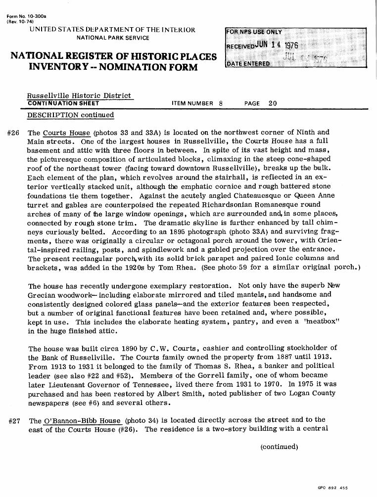
#26 The Courts House (photos 33 and 33A) is located on the northwest corner of Ninth and Main streets. One of the largest houses in Russellville, the Courts House has a full basement and attic with three floors in between. In spite of its vast height and mass, the picturesque composition of articulated blocks, climaxing in the steep cone-shaped roof of the northeast tower (facing toward downtown Russellville), breaks up the bulk. Each element of the plan, which revolves around the stairhall, is reflected in an ex terior vertically stacked unit, although the emphatic cornice and rough battered stone foundations tie them together. Against the acutely angled Chateauesque or Queen Anne turret and gables are counterpoised the repeated Richardsonian Romanesque round arches of many of Ihe large window openings, which are surrounded and,in some places, connected by rough stone trim. The dramatic skyline is further enhanced by tall chim neys curiously belted. According to an 1895 photograph (photo 33A) and surviving frag ments, there was originally a circular or octagonal porch around the tower, with Orien tal-inspired railing, posts, and spindlework and a gabled projection over the entrance. The present rectangular porch,with its solid brick parapet and paired Ionic columns and brackets, was added in the 1920s by Tom Rhea. (See photo 59 for a similar original porch.)
The house has recently undergone exemplary restoration. Not only have the superb New Grecian woodwork including elaborate mirrored and tiled mantels, and handsome and consistently designed colored glass panels and the exterior features been respected, but a number of original functional features have been retained and, where possible, kept in use. This includes the elaborate heating system, pantry, and even a 'meatbox" in the huge finished attic.
The house was built circa 1890 by C.W. Courts, cashier and controlling stockholder of the Bank of Russellville. The Courts family owned the property from 1887 until 1913. From 1913 to 1931 it belonged to the family of Thomas S. Rhea, a banker and political leader (see also #22 and #52). Members of the Gorrell family, one of whom became later Lieutenant Governor of Tennessee, lived there from 1931 to 1970. In 1975 it was purchased and has been restored by Albert Smith, noted publisher of two Logan County newspapers (see #6) and several others.
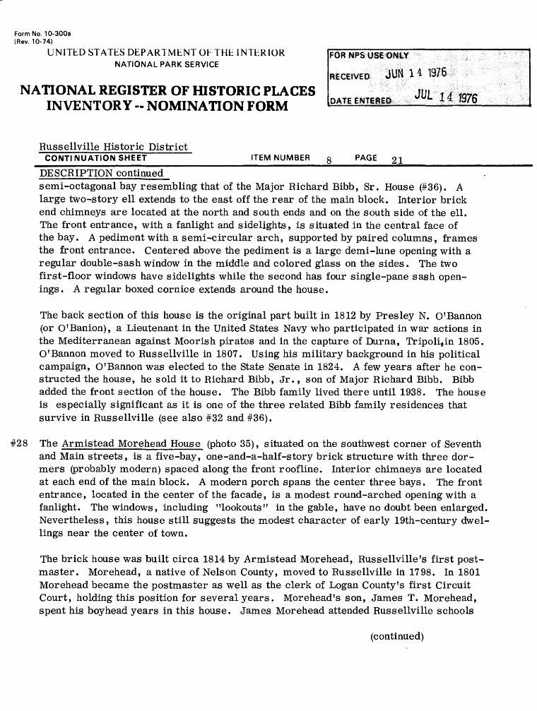
#27 The OCannon-Bibb House (photo 34) is located directly across the street and to the east of the Courts House (#26). The residence is a two-story building with a central
(continued)
GPO 892 455
Form No. 10-300a (Rev. 10-74)
UNITED STATES DEPARTMENT OF THE INTERIOR NATIONAL PARK SERVICE
NATIONAL REGISTER OF HISTORIC PLACES INVENTORY -- NOMINATION FORM
Russellville Historic DistrictCONTI1MUATION SHEET_______________ITEM NUMBER g PAGE 2 1
DESCRIPTION continuedsemi-octagonal bay resembling that of the Major Richard Bibb, Sr. House (#36). A large two-story ell extends to the east off the rear of the main block. Interior brick end chimneys are located at the north and south ends and on the south side of the ell. The front entrance, with a fanlight and sidelights, is situated in the central face of the bay. A pediment with a semi-circular arch, supported by paired columns, frames the front entrance. Centered above the pediment is a large demi-lune opening with a regular double-sash window in the middle and colored glass on the sides. The two first-floor windows have sidelights while the second has four single-pane sash open ings. A regular boxed cornice extends around the house.
The back section of this house is the original part built in 1812 by Presley N. O'Bannon (or O'Banion), a Lieutenant in the United States Navy who participated in war actions in the Mediterranean against Moorish pirates and in the capture of Duma, Tripoli^in 1805. O'Bannon moved to Russellville in 1807. Using his military background in his political campaign, O'Bannon was elected to the State Senate in 1824. A few years after he con structed the house, he sold it to Richard Bibb, Jr., son of Major Richard Bibb. Bibb added the front section of the house. The Bibb family lived there until 1938. The house is especially significant as it is one of the three related Bibb family residences that survive in Russellville (see also #32 and #36).
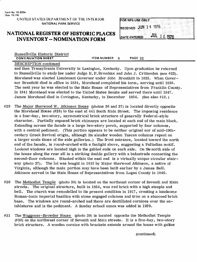
#28 The Armistead Morehead House (photo 35), situated on the southwest corner of Seventh and Main streets, is a five-bay, one-and-a-half-story brick structure with three dor mers (probably modern) spaced along the front roofline. Interior chimneys are located at each end of the main block. A modern porch spans the center three bays. The front entrance, located in the center of the facade, is a modest round-arched opening with a fanlight. The windows, including "lookouts" in the gable, have no doubt been enlarged. Nevertheless, this house still suggests the modest character of early 19th-century dwel lings near the center of town.
The brick house was built circa 1814 by Armistead Morehead, Russellville f s first post master. Morehead, a native of Nelson County, moved to Russellville in 1798. In 1801 Morehead became the postmaster as well as the clerk of Logan County's first Circuit Court, holding this position for several years. Morehead's son, James T. Morehead, spent his boyhead years in this house. James Morehead attended Russellville schools
(continued)
Form No. 10-300a (Rev. 10-74)
UNITED STATES DEPARTMENT OF THE INTERIOR NATIONAL PARK SERVICE
NATIONAL REGISTER OF HISTORIC PLACES INVENTORY -- NOMINATION FORM
Russellville Historic DistrictCONTI NUATION SHEET__________________ITEM NUMBER 8_____PAGE 22_________________
DESCRIPTION continuedand then Transylvania University in Lexington, Kentucky. Upon graduation he returned to Russellville to study law under Judge H.P.Broadnax and John J. Crittenden (see #23). Morehead was elected Lieutenant Governor under John Breathitt in 1832. When Gover nor Breathitt died in office in 1834, Morehead completed his term, serving until 1836. The next year he was elected to the State House of Representatives from Franklin County, In 1841 Morehead was elected to the United States Senate and served there until 1847. James Morehead died in Covington, Kentucky, in December 1854. (See also #12.)
#29 The Major Sherwood W. Atkins on House (photos 36 and 37) is located directly opposite the Morehead House (#28) to the east at 441 South Main Street. The imposing residence is a four-bay, two-story, asymmetrical brick structure of generally Federal-style character. Partially exposed brick chimneys are located at each end of the main block. Extending across the facade is a large two-story porch, supported by four columns, with a central pediment. (This portico appears to be neither original nor of mid-19th- century Greek Revival origin, although its slender wooden Tuscan columns repeat on a larger scale those of the side galleries.) The front entrance, located toward the north end of the facade, is round-arched with a fanlight above, suggesting a Palladian motif. Lookout windows are located high in the gabled ends on each side. On the north side of the house along the rear ell is a striking double gallery with a balustrade connecting the second-floor columns. Situated within the east end is a virtually unique circular stair way (photo 37). The lot was bought in 1815 by Major Sherwood Atkinson, a native of Virginia, although the main portion may have been built earlier by a James Bell. Atkinson served in the State House of Representatives from Logan County in 1840.
#30 The Methodist Temple (photo 38) is located on the northeast corner of Seventh and Main streets. The original structure, built in 1854, was red brick with a high steeple and bell. The church was remodelled to its present condition in 1917, creating a handsome Roman-Ionic imperial basilica with stone engaged columns and trim on a stuccoed brick base. The windows are round-arched and there are dentillated cornices over the en tablatures and in the pediment. A Sunday school annex was added in 1929.
#31 The Waggoner-Browder House (photo 39) is located opposite the Methodist Temple (#30) on the northwest corner of Seventh and Main streets. It is a five-bay, two-story brick structure. A wooden cornice with brackets extends around the house with gaUes
(continued)
Form No. 10-300a (Rev. 10-74)
UNITED STATES DEPARTMENT OF THE INTERIOR NATIONAL PARK SERVICE
NATIONAL REGISTER OF HISTORIC PLACES INVENTORY -- NOMINATION FORM
Russellville Historic DistrictCONTINUATION SHEET________________ITEM NUMBER 8_____PAGE 23_____________
DESCRIPTION continued
above. The fenestration consists of two-over-two-pane sash with hoodmolds supported by small brackets. There is an elaborate spindled side porch.
According to Coffman, the house was "built new" for Les Waggoner, president of Bethel College (see #15 and #16). Waggoner moved to Texas in 1883. Partly because of its location directly on the street and the quality of the brickwork, it appears that the core of this structure may have been an early townhouse with later Italianate and Queen Anne additions.
#32 The Jesse Bibb House (photo 40), built prior to 1900, is located on the southeast cor ner of Sixth and Main streets. It is a one -story brick cottage with cornice and gable trim similar to that of the Waggoner-Browder Ho use (#31), although much of it is hid den by the more recent massive brick and stone corner porch.
#33 The Trinity Episcopal Church (photos 41 and 42), built circa 1875, is situated across the street to the east of the Jesse Bibb House (#32). It is a modest but fine example of a post-Civil War Gothic Revival Episcopal church with an asymmetrical composition allowing an entrance at the base of the corner tower. Stepped buttresses emphasize the corners and brickwork frames thelancet windows and bell stage of the tower. The ample lot is surrounded by a handsome cast-iron fence. The interior features a bold timberwork ceiling and a series of stained-glass windows, many of them contributed by members of the influential and active Rhea family (see #28).
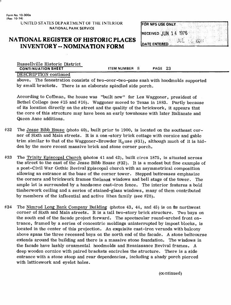
#34 The Nimrod Long Bank Company Building (photos 43, 44, and 45) is on tte northwest corner of Sixth and Main streets. It is a tall two-story brick structure. Two bays on the south end of the facade project forward. The spectacular round-arched front en trance, framed by a series of concentric moldings uninterrupted by impost blocks, is located in the center of this projection. An exquisite cast-iron veranda with balcony above spans the three recessed bays on the north end of the facade. A stone beltcourse extends around the building and there is a massive stone foundation. The windows in the facade have lushly ornamental hoodmolds and Renaissance Revival frames. A deep wooden cornice with paired brackets encircles the structure. There is a side entrance with a stone stoop and rear dependencies, including a shady porch pierced with latticework and eyelet holes.
(co ntinued)
Form No 10-300a (Rev. 10-74)
UNITED STATES DEPARTMENT OF THE INTERIOR NATIONAL PARK SERVICE
NATIONAL REGISTER OF HISTORIC PLACES INVENTORY -- NOMINATION FORM
Russellville Historic DistrictCONTINUATION SHEET ________________ ITEM NUMBER 8 PAGE 24 _____________
DESCRIPTION continued
The structure is exceptionally important architecturally, as well as historically. In its present form, dating from 1857, it is a unique example of a combined bank and residence, with both functions expressed on the Main Street facade, which includes a marble plaque set on a bare wall-space over the boldly treated commercial entrance. The contrast between this portion of the facade and the delicate veranda is most effec tive. Throughout, the details are both richly plastic and refined in both conception and execution. A sophisticated architectural hand, perhaps inspired by such a hand book as Calvert Vaux', seems to have been responsible for the design. Although considerably deteriorated, the structure is remarkably unaltered, preserving a num ber of features, both inside and outside, that have rarely survived modernization.
The original structure on this site was built in 1810 by William Harrison. In 1837 it was purchased by the Norton family. About 1857 the residence was remodelled and became the Southern Bank of Kentucky. The bank was first organized in 1850 and had five branches throughout the state, with the initial capital of $1,500,000. During the early days of the War Between the States, David Norton, the president of the bank, and Marmaduke B. Morton, cashier, removed $1,000,000 from the vault and hid it in the surrounding hills until danger of confiscation by Union or Confederate forces had passed. The Southern Bank continued in operation until 1863 when the National bank laws were established.
Soon after the bank closed, Nimrod Long (see #15) bought the property and organized the Nimrod Long Banking Company. This bank was robbed in 1868 by the Jesse James Gang. Ironically, Jesse James' father, Robert James, a Baptist minister, was born in Logan County in 1820 and received his early education there. Nimrod Long and a member of the Norton family financially assisted him in his education at the George town College in Scott County, Kentucky, where he was trained as a minister. At the age of twenty he moved to Missouri where his son Jesse was born and raised. During the Civil War Jesse and his brother joined Confederate guerilla bands. After the war they formed a gang and traveled through the mid-South robbing small -town banks. On March 20, 1868, they robbed the Nimrod Long Bank in Russellville and took $9,000. They were never caught. The owner, Nimrod Long, was wounded during the holdup.
(continued)
Form No. 10-300a (Rev. 10-74)
UNITED STATES DEPARTMENT OF THE INTERIOR NATIONAL PARK SERVICE
NATIONAL REGISTER OF HISTORIC PLACES INVENTORY -- NOMINATION FORM
Russellville Historic DistrictCONTl NUATION SHEET__________________ITEM NUMBER 8_____PAGE 25
DESCRIPTION continued
At the death of Long in 1887, the bank was moved to another location. It was bought by a Judge Hardy in 1906. The building now serves as the Marcellite Hardy Memorial Museum.
#35 The First Baptist Church (photo 46), located on the east side of South Main at Sixth Street, is a late example of a Romanesque Revival design, probably inspired ultimately by the influence of architect H.H. Richardson. The complex massing was no doubt intended to build up to the corner tower, which unfortunately appears to be truncated. A triple- arched entrance porch is flanked by the asymmetrical corner blocks. Large round- arched windows dominate the gables on both street facades, one of which has a picturesque tourelle. Narrow recessed openings define the upper story of the corner tower. Openings are linked by brick or stone bands and there is a roughly cut stone foundation.
The First Baptist Church was organized in 1818. The original church on this site, built in 1844, was in use until 1898 when the present structure was constructed. The church has the largest congregation in Logan County.
#36 The Major Richard Bibb House (photos 47 and 48) is located on the south side of WestEighth and Winter streets. The basic mass of the house is a one-and-a-half-story brick structure. A two-story, semi-octagonal bay projects forward from the center of the facade (see the similar feature on the O'Bannon-Bibb House (#27)). The main entrance,
located in the center face of the bay, has a sweeping fanlight and sidelights. Centered above the door is a palladian window. The projecting bay is framed by a large Greek portico supported by two columns, which appears to be a later addition. The wings flanking the semi-octagonal, bay have triple windows set within shallow recessed ellip tical arches, similar to those on the bay. There have been several large additions at the rear. A Victorian iron fence surrounds the extensive property. Although its origi nal appearance is a subject of controversy, the house seems to have been a rare and fine example of a pavilioned Federal house in Kentucky, with unusually subtle treatment of massing and surfaces.
The house was built prior to 1822 by Major Richard Bibb, a Revolutionary War officer. Bibb moved to Russellville in 1799. Sometime prior to 1822 he built the present house
(continued)
Form No. 10-300a (Rev. 10-74)
U NITED STATES DEPARTMENT OF THE 1NTER1OR NATIONAL PARK SERVICE
NATIONAL REGISTER OF HISTORIC PLACES INVENTORY -- NOMINATION FORM
Russellville Historic DistrictCONTI NU ATION SHEET_________________ITEM NUMBER 8_____PAGE 26
DESCRIPTION continuedfor his second wife. Although Bibb was educated as an Episcopal minister, he served as a Methodist minister in Russellville. Bibb was an abolitionist and freed 29 of his slaves, sending thSm to Liberia in 1829. In his will he provided for the freedom of the remainder of his slaves, who numbered about 70. He also provided that these freed slaves be given farmland. In accordance with his father's wishes, John Bibb distributed 1,200 acres of land west of Russellville and 300 acres to the north. Both areas were formerly known as Bibbtown and there is still a Bibbtown Road northwest of Russellville. John Bibb, by the way, was the developer of Bibb lettuce, still a favorite with millions around the world. Richard Bibb's sons, Richard, George, and John, were all highly successful in their fields.
#37 The Slaughter-DeGraffenried House (photo 49), 510 South Winter Street, is located di agonally opposite the Major Bibb House (#36) at the end of Eighth Street. The residence is a three-bay, two-story brick structure with a low mansard roof. A one-story porch with balcony, supported by four fluted columns, spans the facade. On the north side of the house is a one-story bay window. The fenestration consists of two-over-two-pane sash. It is said that some portion of the house was built circa 1820 by Thomas Slaughter, although there is no visible evidence for such an early date. Slaughter was a son-in-law of Major Richard Bibb (see #36). He served in the state senate from 1818 to 1822 and again in 1826 until 1829.
The house was also the boyhood home of Thomas P. DeGraffenried. DeGraffenried, a prominent New York attorney and a director of the Cunard Steamship Line, was born in Russellville in 1881. He attended the local schools, being graduated from Bethel College in Russellville before attending Columbia Law School. At his death in 1961 he left approximately $1,000,000 to the city of Russellville for the education of its citizens. The bequest has been applied to a high school auditorium, the Logan County Library, and a number of scholarships for college education.
Situated to the rear of the house (west) is a small, one-and-a-half-story brick building laid in common bond. This structure was used as a school between 1887 and 1908. The school, one of the earliest in the area, was operated by the Rodefer family. The Reverend C.P. Rodefer, an Episcopal minister, came to Russellville in 1887. (See photo 50.)
(continued)
Form No. 10-300a (Rev. 10-74)
UNITED STATES DEPARTMENT OF THE INTERIOR NATIONAL PARK SERVICE
NATIONAL REGISTER OF HISTORIC PLACES INVENTORY -- NOMINATION FORM
Russellville Historic DistrictCONTI NUATION SHEET__________________ITEM NUMBER 8 PAGE 27
DESCRIPTION continued
#38 The A. P. Lyon House (photo 51), located on the northwest corner of Seventh and Spring streets, is a three-bay, two-story frame structure with exterior brick chimneys. The main entrance is located in the center with a smaller door on the right. Hoods are lo cated above the first-floor openings. The second-floor windows have four-over-four - pane sash. In its present form the structure has little stylistic character, but is similar to a number of more modest dwellings in the eastern part of the district. The house is now vacant. Little is known about the history of the house, which is named for a presi dent of Logan College who owned the property in the 1920s.
#39 The Curd-Coffman House (photo 52) is located on the north side of Seventh Street between Main and Winter streets. The house is a four-bay, two-story asymmetrical brick struc ture with a one-story frame wing extending off the rear to the north. An exterior brick chimney is located on the east end. The recessed front entrance with transom and side lights is in the west end of the facade. An identical door flanked by shutters is centered above, seeming to form a unit not integral with the rest of the front. A one-bay, one-story Victorian porch covers the front door. The facade has a stone belt course. The windows consist of nine-over-nine-pane sash with stone lintels above the second. Part of the house was built in 1824 by Richard Curd, husband of Eliza Morehead who was a cousin of Gover nor Morehead. After the Curds sold the house in 1823, it changed hands several times until it was purchased in 1886 by Selby K. Evans. Evans' grandson, Edward F. Coffman, was born here in 1890. He is one of the leading historians of Logan County.
#40 The First Christian Church of Russellville (photo 53) is located on the southeast corner of Seventh and Winter streets. The original box-like structure was built in 1872. It was remodelled to its present condition with a Roman-Ionic recessed portico in 1913.
#41 The Morton-Loving House (photo 54) at 34 West Seventh Street is located at the inter section of Seventh and Rhea streets. It is a five-bay, two-story frame structure with a two-story ell extending off the back (south) of the main block. The front entrance, situ ated in the center of the facade, has a long transom and sidelights. An identical door is located directly above. A one-bay, two-story Greek Revival portico, very similar to that of the Crittenden House (#23), frames the front entrance. A returned, dentilated wooden cornice spans the facade, sustaining the Grecian effect. The windows have nine- over-six-pane sash. The main body of the house was built circa 1816 by William J. Morton and Dr. H.T. Loving.
(continued)
Form No. 10-300a (Rev. 10-74)
UNITED STATES DEPARTMENT OF THE INTERIOR NATIONAL PARK SERVICE
NATIONAL REGISTER OF HISTORIC PLACES INVENTORY -- NOMINATION FORM
Russellville Historic District CONTINUATION SHEET________________ITEM NUMBER 8_____PAGE 28
DESCRIPTION continued
#42 The Samuel Caldwell House (photo 55), located on the north side of Sixth Street between Main and Summer streets, is a six-bay, two-story asymmetrical brick structure on a stone foundation. The brick is laid in common bond in the front and on the sides. The front entrance is located right of center and has sidelights. A modern one-story porch and balcony with an iron railing spans the front doors. The fenestration consists of two-over-two-pane sash with later lintels, but the windows retain their early squarish proportions.
The residence was built circa 1805 by Samuel Caldwell, one of Russellville's earliest settlers. Caldwell was one of the first merchants in the town and served as the first clerk of the Logan County Court. About 1805 he was appointed county clerk. The house was sold to Judge Hunter prior to 1819. At this time, Finis Ewing, an Evange list and member of a prominent Logan County family, held a revival of considerable importance in this house. The house is now used as a funeral home.
#43 The Andrews House (photo 56) is situated directly opposite the Caldwell House (#42). It is a five-bay, two-story frame structure with exterior brick end chimneys. Super imposed between the openings at the corners and sides of the main block are wooden pilasters. The front entrance and the similar door located directly above have Italia- nate hoodmolds, although a small modern porch frames the entrance.
The house is built on the site of a log school. It is believed that the log structure was incorporated into the present house. The residence was built in the late 1800s and has been owned for many years by the C.W. Andrews family. Clarence W. Andrews, the original owner, was city clerk for many years.
#44 The First (originally Cumberland) Presbyterian Church (photo 57), located on the south side of Sixth Street between Winter and Main streets, was built in 1878. It is a brick structure with a bell tower which projects from the center of the facade. The round- arched front entrance is located in the center face of the tower. The tower has a con cave mansard roof which terminates in the form of an octagon. Pilasters, which are located at the corners of the facade, are crowned by tremendous finials, and there is much corbelled brick trim.
(continued)
Form No. 10-300a (Rev. 10-74)
UNITED STATES DEPARTMENT OF THE INTERIOR NATIONAL PARK SERVICE
NATIONAL REGISTER OF HISTORIC PLACES INVENTORY -- NOMINATION FORM
Russellville Historic DistrictCONTINUATION SHEET_______________ITEM NUMBER 8 PAGE 29_____________
DESCRIPTION continued
#45 The Logan County Public Library (photo 58), 201 West Sixth Street, is a new building constructed in the 1960s to harmonize with its mostly residential surroundings.
#46 The Sandidge House (photo 59) is located on the north side of West Sixth Street. The residence is a two-story frame structure. The front entrance is located in the center of the facade in an ell, which projects forward from the main block. To the left of the door on the corner is a three-story tower with a conical roof. A one-story porch, which curves around the facade, ties the elements together. In some ways, this elab orate turn-of-the-century residence resembles a frame version of the brick and stone Courts House (#26). The house was built for Judge W.P. Sandidge, who bought the lot in 1894. A deed book description of the transaction includes the notation, 'Sandidge's lot upon which he expects to build." Judge Sandidge's wife, May Evans, was one of four children of Thomas Y. Evans, who acquired and built houses of similar size in Russellville (see #17 and #18; others no longer exist).
#47 The Caldwell-Fuqua Besidence (photo 60) is located directly across the street to the south of the Sandidge House (#46). The house is a two-story brick structure with a mansard roof. To the left of the front entrance is a bay window, to the right at the corner is a two-story, semi-octagonal bay with an octagonal roof. The arched win dows have brick hoodmolds. The house was built by the Caldwell family. J. Taylor Fuqua, former mayor of Russellville, lived here for many years.
#48 The Seward Residence (photo 61), located on the south side of West Sixth Street, is a two-bay, two-story asymmetrical frame house. A gabled wing projects forward to the right of the front entrance, which has a transom and sidelights. A one-story porch spans the front two bays. The windows in the wing and west side are divided in two by a central vertical sash. The house was built circa 1870 by the Seward family.
#49 The Perry-Thompson House (photo 62) is located on the east side of Breathitt Street between Fourth and Fifth streets. The house is a three-bay, two-story common-bond brick house. Double interior chimneys are located in the center of the main block. On the south side a one-and-a-half-story, one-room wing extends forward from the main block. Small sharp gables are centered above the three second-floor windows. In
(continued)
Form No. 10-300a (Rev. 10-74)
UNITED STATES DEPARTMENT OK THE INTERIOR NATIONAL PARK SERVICE
NATIONAL REGISTER OF HISTORIC PLACES INVENTORY -- NOMINATION FORM
Russellville Historic District
FOR NFS USe ONLY
CONTINUATION SHEET ________________ ITEM NUMBER 8 PAGE 30 _____________
DESCRIPTION continuedrecent years an enclosed one-story porch has been added to the facade. Otherwise, the house, built prior to 1880, somewhat resembles a brick version of the Seward residence (#48). In the 1890s it belonged to a Dr. M.R. Perry.
#50 The Harrison House (photos 63, 64, and 65) is located on the north side of East Fifth Street between Breathitt and Summer streets. The house, set close to the street, is a three-bay, two-story asymmetrical brick structure with a one-story wing extending north off the rear of the main block. Interior brick chimneys are located at the ends of the main block and in the center of the ell. The front entrance is located on the west side of the facade. Above the arched opening is a wooden shelf supported by brackets. A one-story porch, supported by fluted columns, extends around the west side binding the main block to the wing. The arched windows have two-over-two-pane sash and flanking shutters. An iron fence, with an interesting gate, encircles the property. The original portion of the house was built circa 1820, probably for the Emmett family. Later it was a Knowles family home. Thomas Harrison was a Logan County judge from 1887-1897. Thomas Harrison's son, John, operated a grocery in the Harrison building (#3). The house has been occupied by members of the Harrison family for over 80 years and has undergone many alterations .
#51 The Perry House (photos 66 and 67) is located on the south side of East Fifth Street. The house is a one-story frame cottage. A wing with a bay window projects forward from the main block. Wood quoins are located at the corners of the house, which re tain an Italianate feeling in spite of incised detail over the windows of the bay and cut shingles in the gables.
The house was the residence of James R. Perry, sheriff of Logan County form 1886 to 1891, and represents some of the buildings of fairly modest scale but individual treat ment in the area. Much local pride is indicated by the bold, rough-stone and wrought - iron fence (see photo 67).
#52 The Governor Breathitt House (photo 68) is located on the north side of Fifth Street between Summer and Main streets, directly on the front property line. It is a five- bay, two-story brick structure with a frame two-story wing extending off the rear to the north. The brick in the front is laid in Flemish bond while the sides are laid
(continued)
Form No. 10-300a (Rev. 10-74)
UNITED STATES DEPARTMENT OF THE INTERIOR NATIONAL PARK SERVICE
NATIONAL REGISTER OF HISTORIC PLACES INVENTORY -- NOMINATION FORM
Russellville Historic DistrictCONTINUATION SHEET_________________ITEM NUMBER 8 PAGE 31____________
DESCRIPTION continuedin common. The brick chimneys at the east and west ends project the width of a header. Lookout windows are located high in the gabled ends on each side of the chimneys. The front entrance, which is located in the center of the facade, is arched and has a narrow demicircular fanlight. A shelf supported by brackets is above. The sash has been simplified but the stone lintels have elegant keystones.
The house was built circa 1812 by John Breathitt, Governor of Kentucky 1832-34. Breathitt, born in Virginia in 1786, was the son of William Breathitt who moved to Logan County, Kentucky, with his family in 1800. John Breathitt attended the local schools and became a surveyor of public lands. He also spent several years teaching school. After he had saved enough funds, he studied law under Judge Wallace (see #24). By 1812 Breathitt had completed his studies, passed the bar, and established a law practice. That same year he was elected to the State House of Representatives, and was re-elected for several terms. In 1828 Breathitt was appointed Lieutenant Governor by Governor Thomas Metcalfe (1828-1832). Breathitt himself was elected governor in 1832. He served until his death in 1834.
The house, which for many years was inhabited by members of the Rhea family, now serves as the Russellville Woman's Club.
Form No. 10-300a (Rev. 10-74)
UNITED STATES DEPARTMENT OF THE INTERIOR NATIONAL PARK SERVICE
NATIONAL REGISTER OF HISTORIC PLACES INVENTORY -- NOMINATION FORM
Russellville Historic DistrictCONTI NU ATION SHEET________________ITEM NUMBER 9 PAGE 2_________________
his mother, Mrs. Wis Clark; Miss May Belle Morton and her sister, Mrs. Carrie McKenzie; Mrs. Louise Harrison Gary; Mrs. Wells Vick; and Colonel Byrne A. Evans. The editors of the special Kentucky issues of the magazine Antiques, Wendell Garrett, Miss Lois Olcott, and Keith Morgan also contributed to the architectural selection.
The extensive bibliography enclosed was mainly gathered by the Reverend Edward Coffman, Russellville historian.
(continued)
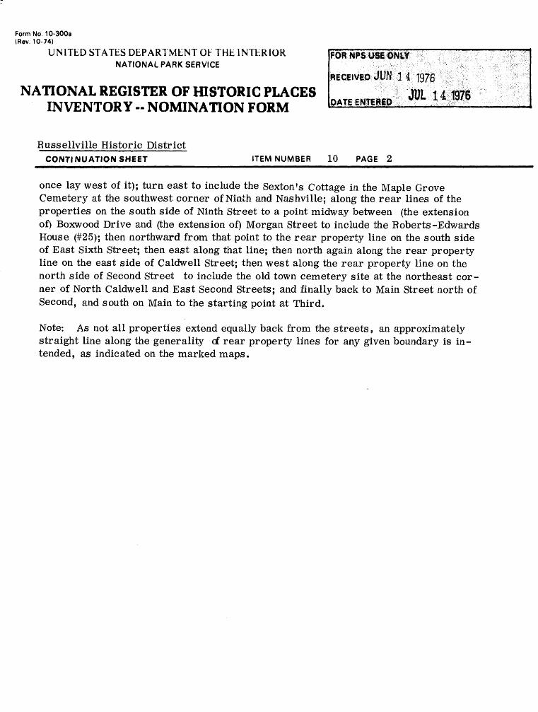
Form No. 10-300a (Rev. 10-74)
UNITED STATES DEPARTMENT OF THE INTERIOR NATIONAL PARK SERVICE
NATIONAL REGISTER OF HISTORIC PLACES INVENTORY -- NOMINATION FORM
Russellville Historic DistrictCONTINUATION SHEET_________________ITEM NUMBER 10 PAGE 2______________
once lay west of it); turn east to include the Sexton's Cottage in the Maple Grove Cemetery at the southwest corner of Ninth and Nashville; along the rear lines of the properties on the south side of Ninth Street to a point midway between (the extension of) Boxwood Drive and (the extension of) Morgan Street to include the Roberts-Edwards House (#25); then northward from that point to the rear property line on the south side of East Sixth Street; then east along that line; then north again along the rear property line on the east side of Caldwell Street; then west along the rear property line on the north side of Second Street to include the old town cemetery site at the northeast cor ner of North Caldwell and East Second Streets; and finally back to Main Street north of Second, and south on Main to the starting point at Third.
Note: As not all properties extend equally back from the streets, an approximately straight line along the generality of rear property lines for any given boundary is in tended, as indicated on the marked maps.
Russellville Historic District Russellville, Kentucky
#9 BIBLIOGRAPHY '(Cbntinued)
George D., MEN WHOM I REMEMBER, 52 articles printed in ^--tfHE HERALD. July 24, 1877-June 7, 1879. Russellville, Ky.
printed articles in scrapbook. George D. Blakey, II. Long Island, N. Y.
Finley, Alex C., History of Russellville and Logan County, Ky. (5 bks.) Bk. 1, 0. C. Rhea. 1878. Bks. 2 and 3, THE HERALD.
Bks. 4 and 5, THE HERALD-ENTERPRISE. 1890. Russellville,
PRIMARY
Canon, C. T. , THE HISTORY OF EDUCATION IN LOGAN COUNTY, KENTUCKY.Thesis. Univ. of Ky. 1929.
Cartwright, Peter, AUTOBIOGRAPHY. 1859. Coleman, J. Winston, BEAUCHAMP-SHARP TRAGEDY. Roberts printing
Co. Frankfort, Ky. 1950. ________, FAMOUS KENTUCKY DUELS. Roberts Printing Co., Frankfort,
Ky. Collins, Lewis, HISTORY OF KENTUCKY. Revised 1874. (2 vols.)
John P. Morton & Co. Louisville, Ky. 1924. Oe\r/sham, John M. Co. Pub., KENTUCKY BIOGRAPHIES-BIOGRAPHICAL
CYCLOPEDIA OF THE COMMONWEALTH OF KENTUCKY. Chicago. 1896. Grant, Helen Hardie, PETER CARTWRIGHT, PIONEER. The Abingdon
Press, New York. 1931. Hoss, E. E., DAVID MORTON. Logan County Order Book A-l. 1792. Logan County Marriage Records. Kerr, Judge Charles, HISTORY OF KENTUCKY. American Historical
Society. Chicago. 1922. McGready, James, POSTHUMOUS WORKS OF THE REVEREND AND PIOUS JAMES
McGREADY. Vol 1. Louisville, Ky. 1831. Morton, David, THE NQRTONS. J. B. Lippincott Co., Philadelphia.
1891. Morton, M. B., KENTUCKIANS ARE DIFFERENT. Standard Printing Co.
Louisville. 1938. Nordham, John, BIOGRAPHICAL ENCYCLOPEDIA OF KENTUCKY. Armstrong
& Co. 1878. Neal, Julia, BY THEIR FRUITS. Univ. N. C. Press. Chapel Hill,
N. C. 1947.Redford, A. H., THE HISTORY OF METHODISM IN KENTUCKY. 1868. Rothert, Otto, OUTLAWS OF CAVE-IN ROCK. 1924. Schoenman-Jones, SOIL SURVEY OF LOGAN COUNTY, KENTUCKY. Gov't.
Ptg. Office, Washington, D. C. 1922. Smith, T. Marshall, LEGENDS OF THE WAR OF INDEPENDENCE AND EARLY
SETTLEMENTS. 1855. Shrum, Mr s . Austin, HISTORY OF LEWISBURG. (Unpublished) 1949.
Mimeogr aphed.
JUL ;. •'•-. 197R

Rutherford, J. W. , "Andrew Jackson". (Copy of newspaper article)Rutherford, THE SOUTH IN HISTORY AND LITERATURE.Trout, Allan, "George W. Johnson". Article, THE COURIER-JOURNAL.
Louisville, Ky.Ware, C. C., BARTON W. STONE.Whitaker, Matilda, DIARY. 1862-1865. Published NEWS-DEMOCRAT. 1962 Smith, Albert, HISSJOHy IN TOWNS, RUSSELLVILLE, KY. , an article.
Antiques magazine, April, 1974, pages 894-900. Stevenson, Edward, DD., BIOGRAPHICAL SKETCH OF THE REV. VALENTINE
COOK. Nashville, 1858, 204 pages, J. B. McFerrin, agent, inpossession Miss May Belle Morton, Granville Clark, Russellville,Ky., and others.
VISITOR'S GUIDE SELECTED HOMES AND OTHER SITES IN HISTORICRUSSELLVILLE, compiled by Byrne A. Evans, Colonel, USA., RET.for Russellville Chamber of Commerce, 1973.
ATLAS OF LOGAN COUNTY, KENTUCKY, Wight and Son, Dayton, Ohio, 1877.In possession of May Belle Morton, Granville Clark, MorganCardwell, others, all of Russellville.
FAMILY RECORDS
Blakey Family (Mr s . George T. Blakey).Curd Family (Mr s . H. 0. Price)Morton Family (Maybelle Morton)Morton Genealogy by Mrs. J. Wells Vick.Orndorff Family by J. V. Orndorff. 1931.Procter Family (Mr s . V. K. Hopson)Riley Family (Mr s . Ernest Riley).Russell, Family of Col. WilliamWashington Family Records by Mrs. J. Wells Vick.
INTERVIEWS
Childress, Miss Nell. Auburn, Ky. May, 1962.Logan County Extension Service, Russellville, Ky. May, 1962.McCuddy, Overton. Oakville, Ky. May, 1962.Ryan, D. A., Lewisburg, Ky. May, 1962.Sneed, Miss Catherine, Diamond Springs. May, 1962.Vick, Mr s .J. Wells. Russellville, Ky.
COURIER-JOURNAL, Louisville, Ky.DEMOCRAT, THE, Russellville, Ky.KENTUCKY PROGRESS MAGAZINE, Frankfort, Ky. Fall 1935.L & N MAGAZINE. Louisville. April, 1939.NEWS-DEMOCRAT, THE, Russellville, Ky.SCRIPTORIUM, THE, December, 1954.TOBACCO FESTIVAL MAGAZINE, Russellville, Ky. 1959, 1960, 1961.
Tobacco Festival magazines, published for Russellville Chamberof Commerce annually, 1959-1974.
The Logan Leader, Russellville, Ky. (After May 1, 1968)
tJUL 1 4 1976
MEMORIES AND MILESTONES, 175th anniversary celebration of Russell- ville, Sept. 16-22, 1973, Jim Turner, editor, privately printed for Russellville Chamber of Commerce, unpaged.
KENTUCKY HISTORICAL CHRONICLE, historical highlights of Logan County, Ky., published by Ed Waggener d/b/a Kentucky Historical Chronicle, Statesman-Adair County News, Columbia, Ky., July 16, 1973. 24 pages.
JUL 14 1976
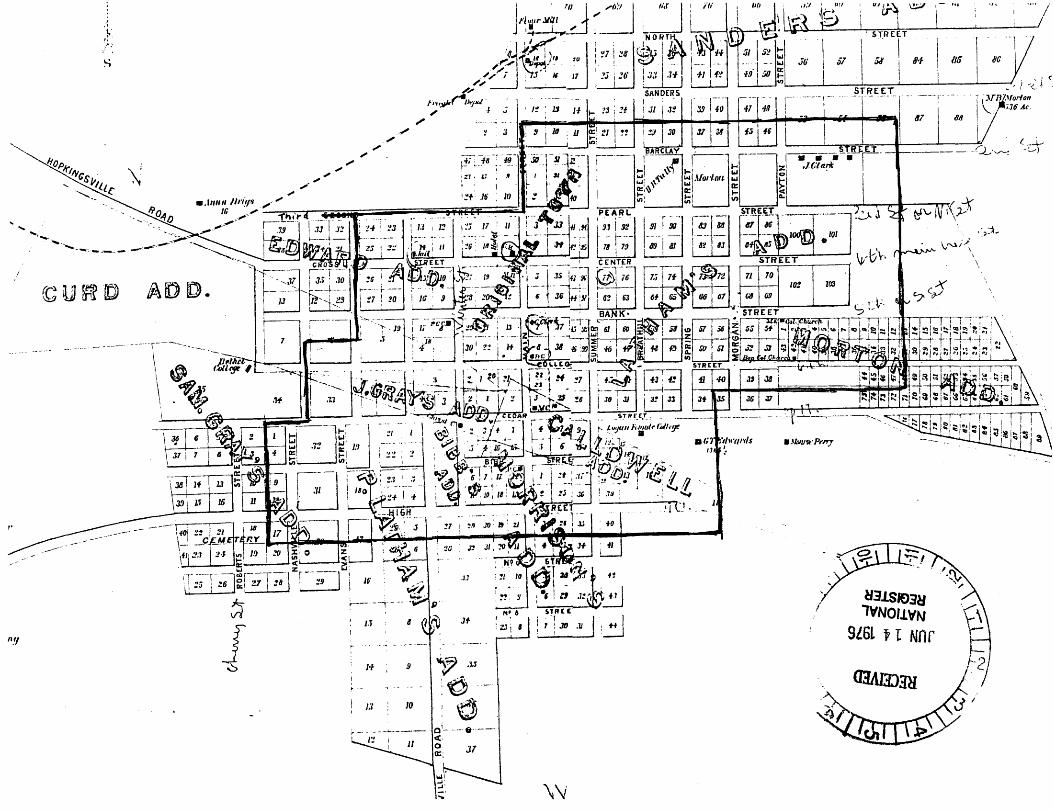
C*4
-~0\
A-c
/i
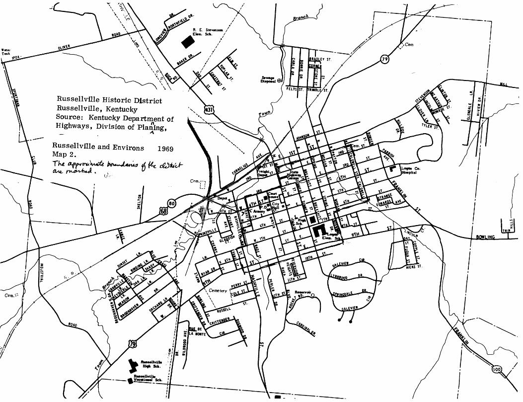
R. E. Stevenson Elem. Sch. /
Russellville Historic District Russellville, Kentucky Source: Kentucky Department of Highways, Division of Planing,
•A
Russellville and Environs 1969 Map 2.
ai {t±
Di^oiol
I///
Cemefery
BOWLING
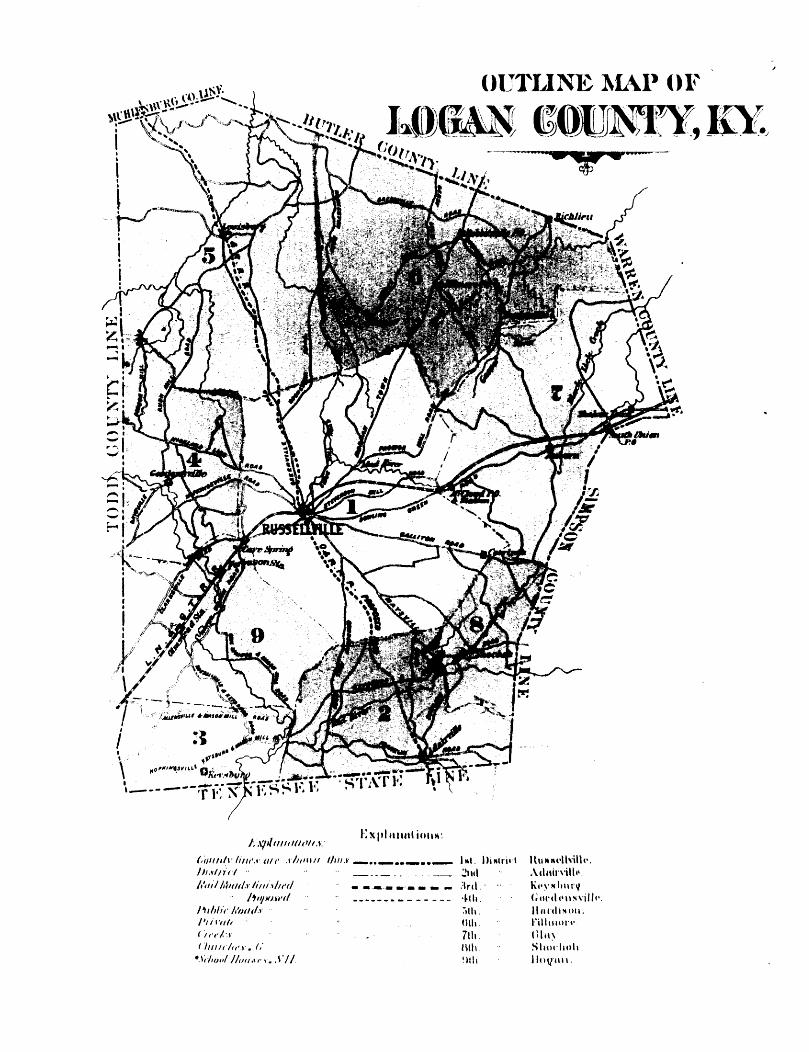
Russellville Historic District Russellville, Kentucky Source: Atlas Date: 1877 JUN j 4 ^
Map 5.Outline map of Logan County showing road, railroad lines, and relationship of Russellville to other communities in the late 19th Century,
14
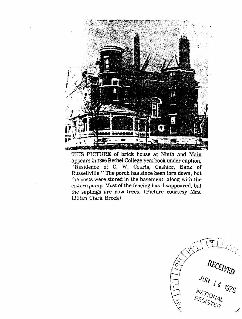
THIS PICTURE of brick house at Ninth and Main appears in 1895 Bethel College yearbook under caption, "Residence of C. W, Courts, Cashier, Bank of Russellville." The porch has since been torn down, but the posts were stored in the basement, along with the cistern pump. Most of the fencing has disappeared, but the saplings are now trees. (Picture courtesy Mrs. Lillian Ciark Brock)
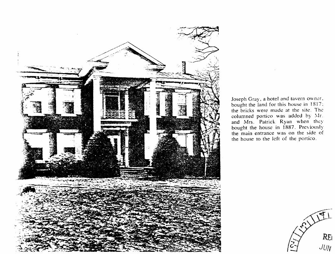
Joseph Gray, a hotel and tavern owner, bought the land for this house in 1817; the bricks were made at the site. The columned portico was added by Mr. and Mrs. Patrick Ryan when they bought the house in 1887. Previously the main entrance was on the side of the house to the left of the portico.
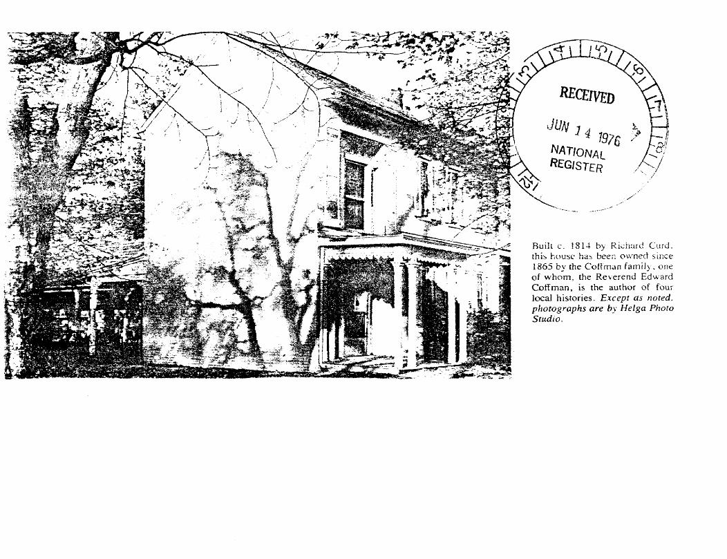
Built c. 1814 by Richard Curd, this house has been owned since 1865 by the CofTman family, one of whom, the Reverend Edward Coffman, is the author of four local histories. Except as noted, photographs are by Helga Photo Studio.
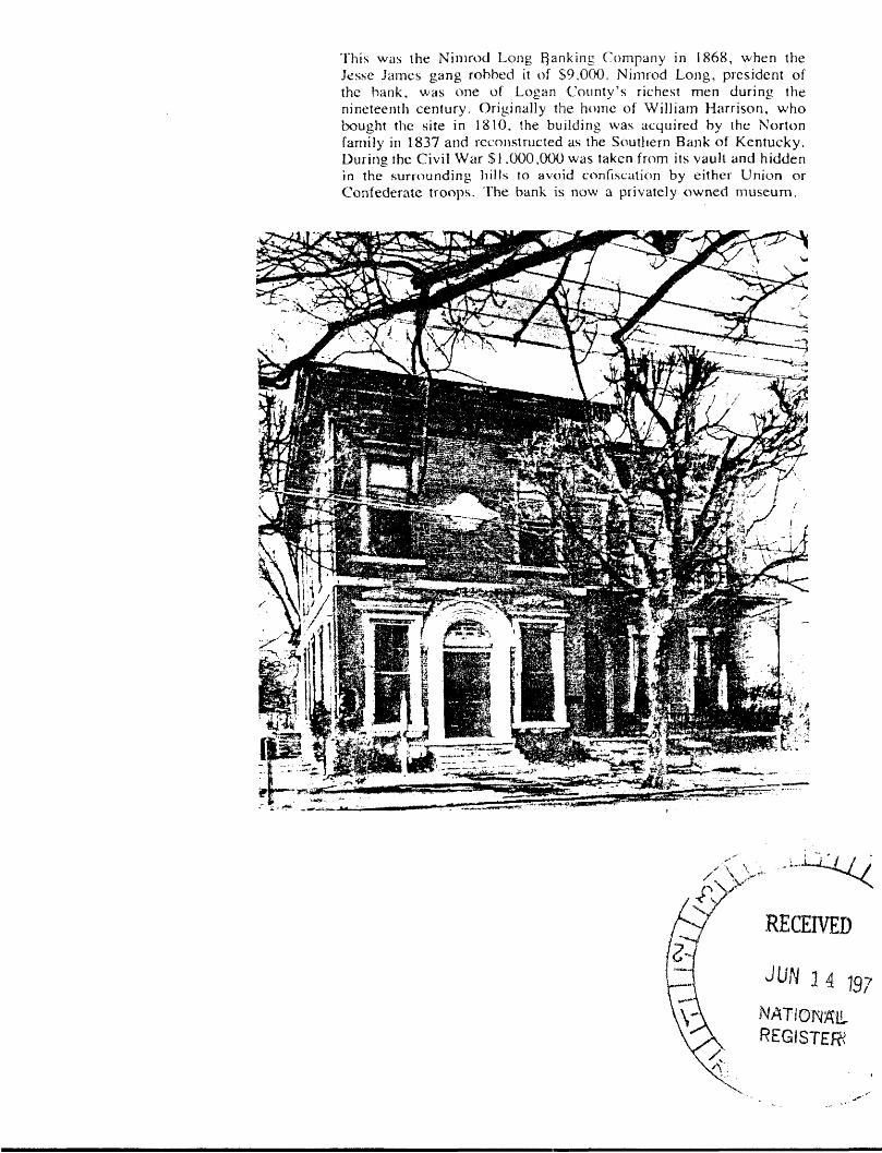
This was the Nimrod Long {Ranking Company in 1868, when the Jesse James gang robbed it of $9,000. Nimrod Long, president of the bank, was one of Logan County's richest men during the nineteenth century. Originally the home of William Harrison, who bought the site in 1810, the building was acquired by the Norton family in 1837 and reconstructed as the Southern Bank of Kentucky. During the Civil War $1.000,000 was taken from its vault and hidden in the surrounding hills to avoid confiscation by either Union or Confederate troops. The bank is now a privately owned museum.