montgomery metropolitan planning organization (mpo ...montgomerympo.org/docs/2016/september... ·...
TRANSCRIPT
Page | 1
Montgomery Metropolitan Planning Organization (MPO)
Transportation Alternatives Program (TAP):
FY-2016 Transportation Alternatives
Program (TAP) Round #2 Applications
TABLE OF CONTENTS
Table of Contents......................................................................................................................... 1
Montgomery Metropolitan Planning Organization (MPO) Bicycle and Pedestrian
Subcommittee (BPS) Membership.................................................................................. 2
Transportation Alternatives Program (TAP) Eligible and Ineligible Project Sponsors………... 3
Transportation Alternatives Program (TAP) Eligible and Ineligible Activities.......................... 4
Project Application Analysis and Selection................................................................................. 5
Regulations and Guidelines......................................................................................................... 6
Eligible Items............................................................................................................................... 8
Ineligible Items............................................................................................................................ 9
Town of Pike Road FY 2016 Transportation Alternatives Program (TAP) Project Ranking
Results....................................................................................................................................10
Town of Pike Road FY 2016 Transportation Alternatives Program (TAP) Project Ranking
Criteria Information…………............................................................................................... 12
Appendix A: Town of Pike Road FY 2016 Transportation Alternatives Program (TAP)
Application………………………………………………………………………..…..... 13
Page | 2
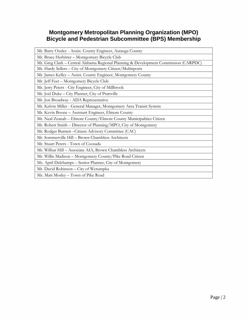
Montgomery Metropolitan Planning Organization (MPO) Bicycle and Pedestrian Subcommittee (BPS) Membership
Mr. Barry Ousley - Assist. County Engineer, Autauga County
Mr. Bruce Herbitter – Montgomery Bicycle Club
Mr. Greg Clark – Central Alabama Regional Planning & Development Commission (CARPDC)
Mr. Hardy Sellers – City of Montgomery Citizen/Multisports
Mr. James Kelley – Assist. County Engineer, Montgomery County
Mr. Jeff Feet – Montgomery Bicycle Club
Mr. Jerry Peters - City Engineer, City of Millbrook
Mr. Joel Duke – City Planner, City of Prattville
Mr. Jon Broadway - ADA Representative
Mr. Kelvin Miller - General Manager, Montgomery Area Transit System
Mr. Kevin Boone – Assistant Engineer, Elmore County
Mr. Neal Zeanah – Elmore County/Elmore County Municipalities Citizen
Mr. Robert Smith – Director of Planning/MPO, City of Montgomery
Mr. Rodger Burnett –Citizen Advisory Committee (CAC)
Mr. Sommerville Hill – Brown Chambless Architects
Mr. Stuart Peters - Town of Coosada
Mr. Wilbur Hill – Associate AIA, Brown Chambless Architects
Mr. Willie Madison – Montgomery County/Pike Road Citizen
Ms. April Delchamps – Senior Planner, City of Montgomery
Mr. David Robinson – City of Wetumpka
Ms. Matt Mosley – Town of Pike Road

Page | 3
TRANSPORTATION ALTERNATIVES PROGRAM (TAP)
ELIGIBLE AND INELIGIBLE PROJECT SPONSORS
Eligible Entities: the eligible entities to receive TAP funds are:
A. Local Governments;
B. Any other local or regional Government entity with responsibility for oversight of transportation
(other than a Metropolitan Planning Organization or State Agency) that is determined to be
eligible.
Ineligible Entities: In addition, the State of Alabama, at its discretion, declared the following entities
not eligible to receive TAP funds:
A. Nonprofits are not eligible as direct grant recipients of TAP funds. Nonprofits are eligible to
partner with any eligible entity;
B. Regional Transportation Authorities;
C. Transit Agencies;
D. Natural Resource or Public Land Agencies;
E. School District, Local education Agencies, or Schools;
F. Universities and Colleges;
G. Tribal Governments.
Page | 4
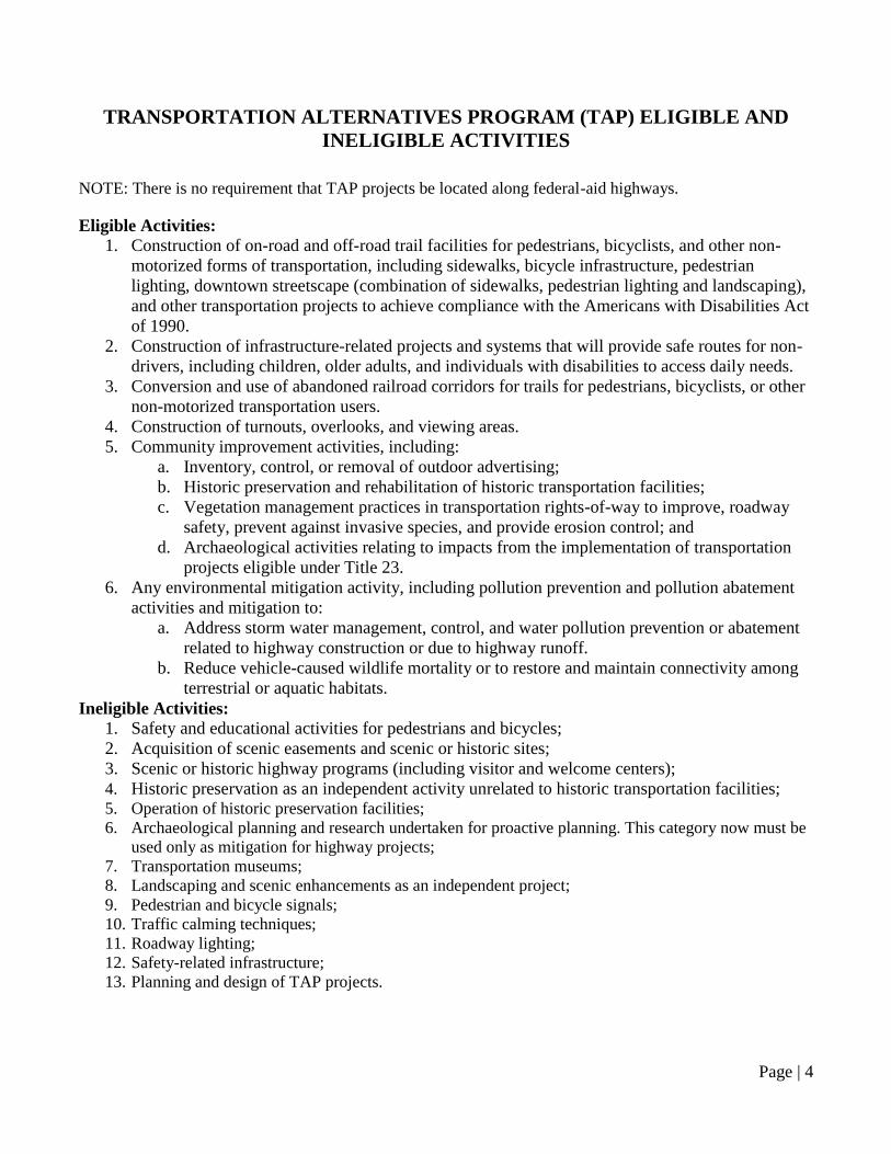
TRANSPORTATION ALTERNATIVES PROGRAM (TAP) ELIGIBLE AND
INELIGIBLE ACTIVITIES
NOTE: There is no requirement that TAP projects be located along federal-aid highways.
Eligible Activities:
1. Construction of on-road and off-road trail facilities for pedestrians, bicyclists, and other non-
motorized forms of transportation, including sidewalks, bicycle infrastructure, pedestrian
lighting, downtown streetscape (combination of sidewalks, pedestrian lighting and landscaping),
and other transportation projects to achieve compliance with the Americans with Disabilities Act
of 1990.
2. Construction of infrastructure-related projects and systems that will provide safe routes for non-
drivers, including children, older adults, and individuals with disabilities to access daily needs.
3. Conversion and use of abandoned railroad corridors for trails for pedestrians, bicyclists, or other
non-motorized transportation users.
4. Construction of turnouts, overlooks, and viewing areas.
5. Community improvement activities, including:
a. Inventory, control, or removal of outdoor advertising;
b. Historic preservation and rehabilitation of historic transportation facilities;
c. Vegetation management practices in transportation rights-of-way to improve, roadway
safety, prevent against invasive species, and provide erosion control; and
d. Archaeological activities relating to impacts from the implementation of transportation
projects eligible under Title 23.
6. Any environmental mitigation activity, including pollution prevention and pollution abatement
activities and mitigation to:
a. Address storm water management, control, and water pollution prevention or abatement
related to highway construction or due to highway runoff.
b. Reduce vehicle-caused wildlife mortality or to restore and maintain connectivity among
terrestrial or aquatic habitats.
Ineligible Activities: 1. Safety and educational activities for pedestrians and bicycles;
2. Acquisition of scenic easements and scenic or historic sites;
3. Scenic or historic highway programs (including visitor and welcome centers);
4. Historic preservation as an independent activity unrelated to historic transportation facilities; 5. Operation of historic preservation facilities;
6. Archaeological planning and research undertaken for proactive planning. This category now must be
used only as mitigation for highway projects;
7. Transportation museums;
8. Landscaping and scenic enhancements as an independent project;
9. Pedestrian and bicycle signals;
10. Traffic calming techniques;
11. Roadway lighting;
12. Safety-related infrastructure;
13. Planning and design of TAP projects.
Page | 5
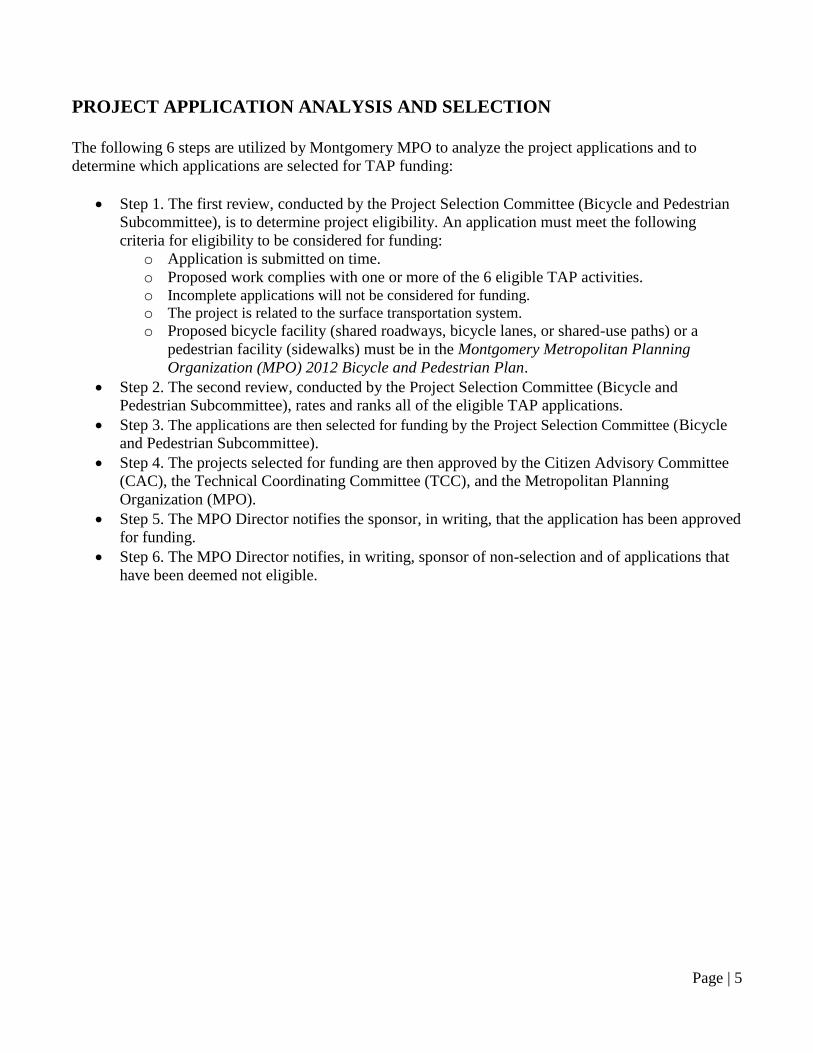
PROJECT APPLICATION ANALYSIS AND SELECTION
The following 6 steps are utilized by Montgomery MPO to analyze the project applications and to
determine which applications are selected for TAP funding:
Step 1. The first review, conducted by the Project Selection Committee (Bicycle and Pedestrian
Subcommittee), is to determine project eligibility. An application must meet the following
criteria for eligibility to be considered for funding:
o Application is submitted on time.
o Proposed work complies with one or more of the 6 eligible TAP activities. o Incomplete applications will not be considered for funding. o The project is related to the surface transportation system. o Proposed bicycle facility (shared roadways, bicycle lanes, or shared-use paths) or a
pedestrian facility (sidewalks) must be in the Montgomery Metropolitan Planning
Organization (MPO) 2012 Bicycle and Pedestrian Plan.
Step 2. The second review, conducted by the Project Selection Committee (Bicycle and
Pedestrian Subcommittee), rates and ranks all of the eligible TAP applications.
Step 3. The applications are then selected for funding by the Project Selection Committee (Bicycle
and Pedestrian Subcommittee).
Step 4. The projects selected for funding are then approved by the Citizen Advisory Committee
(CAC), the Technical Coordinating Committee (TCC), and the Metropolitan Planning
Organization (MPO).
Step 5. The MPO Director notifies the sponsor, in writing, that the application has been approved
for funding.
Step 6. The MPO Director notifies, in writing, sponsor of non-selection and of applications that
have been deemed not eligible.
Page | 6
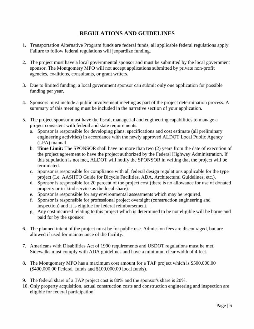
REGULATIONS AND GUIDELINES
1. Transportation Alternative Program funds are federal funds, all applicable federal regulations apply.
Failure to follow federal regulations will jeopardize funding.
2. The project must have a local governmental sponsor and must be submitted by the local government
sponsor. The Montgomery MPO will not accept applications submitted by private non-profit
agencies, coalitions, consultants, or grant writers.
3. Due to limited funding, a local government sponsor can submit only one application for possible
funding per year.
4. Sponsors must include a public involvement meeting as part of the project determination process. A
summary of this meeting must be included in the narrative section of your application.
5. The project sponsor must have the fiscal, managerial and engineering capabilities to manage a
project consistent with federal and state requirements.
a. Sponsor is responsible for developing plans, specifications and cost estimate (all preliminary
engineering activities) in accordance with the newly approved ALDOT Local Public Agency
(LPA) manual.
b. Time Limit: The SPONSOR shall have no more than two (2) years from the date of execution of
the project agreement to have the project authorized by the Federal Highway Administration. If
this stipulation is not met, ALDOT will notify the SPONSOR in writing that the project will be
terminated.
c. Sponsor is responsible for compliance with all federal design regulations applicable for the type
project (Le. AASHTO Guide for Bicycle Facilities, ADA, Architectural Guidelines, etc.).
d. Sponsor is responsible for 20 percent of the project cost (there is no allowance for use of donated
property or in-kind service as the local share).
e. Sponsor is responsible for any environmental assessments which may be required.
f. Sponsor is responsible for professional project oversight (construction engineering and
inspection) and it is eligible for federal reimbursement.
g. Any cost incurred relating to this project which is determined to be not eligible will be borne and
paid for by the sponsor.
6. The planned intent of the project must be for public use. Admission fees are discouraged, but are
allowed if used for maintenance of the facility.
7. Americans with Disabilities Act of 1990 requirements and USDOT regulations must be met.
Sidewalks must comply with ADA guidelines and have a minimum clear width of 4 feet.
8. The Montgomery MPO has a maximum cost amount for a TAP project which is $500,000.00
($400,000.00 Federal funds and $100,000.00 local funds).
9. The federal share of a TAP project cost is 80% and the sponsor's share is 20%.
10. Only property acquisition, actual construction costs and construction engineering and inspection are
eligible for federal participation.
Page | 7
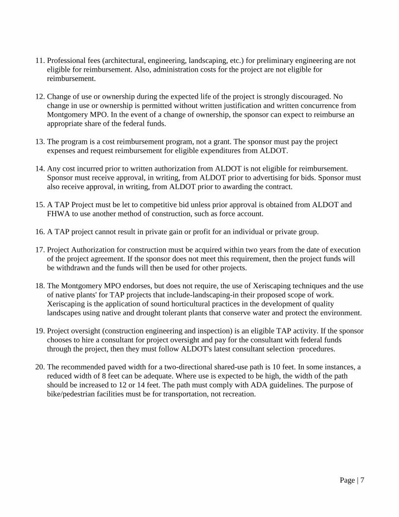
11. Professional fees (architectural, engineering, landscaping, etc.) for preliminary engineering are not
eligible for reimbursement. Also, administration costs for the project are not eligible for
reimbursement.
12. Change of use or ownership during the expected life of the project is strongly discouraged. No
change in use or ownership is permitted without written justification and written concurrence from
Montgomery MPO. In the event of a change of ownership, the sponsor can expect to reimburse an
appropriate share of the federal funds.
13. The program is a cost reimbursement program, not a grant. The sponsor must pay the project
expenses and request reimbursement for eligible expenditures from ALDOT.
14. Any cost incurred prior to written authorization from ALDOT is not eligible for reimbursement.
Sponsor must receive approval, in writing, from ALDOT prior to advertising for bids. Sponsor must
also receive approval, in writing, from ALDOT prior to awarding the contract.
15. A TAP Project must be let to competitive bid unless prior approval is obtained from ALDOT and
FHWA to use another method of construction, such as force account.
16. A TAP project cannot result in private gain or profit for an individual or private group.
17. Project Authorization for construction must be acquired within two years from the date of execution
of the project agreement. If the sponsor does not meet this requirement, then the project funds will
be withdrawn and the funds will then be used for other projects.
18. The Montgomery MPO endorses, but does not require, the use of Xeriscaping techniques and the use
of native plants' for TAP projects that include-landscaping-in their proposed scope of work.
Xeriscaping is the application of sound horticultural practices in the development of quality
landscapes using native and drought tolerant plants that conserve water and protect the environment.
19. Project oversight (construction engineering and inspection) is an eligible TAP activity. If the sponsor
chooses to hire a consultant for project oversight and pay for the consultant with federal funds
through the project, then they must follow ALDOT's latest consultant selection ·procedures.
20. The recommended paved width for a two-directional shared-use path is 10 feet. In some instances, a
reduced width of 8 feet can be adequate. Where use is expected to be high, the width of the path
should be increased to 12 or 14 feet. The path must comply with ADA guidelines. The purpose of
bike/pedestrian facilities must be for transportation, not recreation.

Page | 8
ELIGIBLE ITEMS
Parking Facilities in conjunction with a trail head where the trail is several miles long.
Lighting is eligible only when it is decorative landscape or pedestrian lighting. Lighting is
limited to 30% of the project cost.
If there is a direct relationship to the project, signs are allowed. Examples include historic
interpretation or destination/distance/direction signs.
Fencing is only eligible for safety purposes.
Paving is approved on a case-by-case basis for repair of a street that may have been unavoidably
damaged in the course of the TAP project.
Drainage is approved on a case-by-case basis where it is required for construction of the project.
Drainage is limited to a small percentage of the overall project.
Project Oversight - Construction engineering and inspection. Examples include: certified
concrete, architectural, landscaping, and construction inspection, etc. Oversight is limited to 15%
of the project cost. If the sponsor chooses to hire a consultant for project oversight, they must
follow ALDOT's latest consultant selection procedures.
Streetscape Improvements are eligible and can include items such as sidewalk replacement,
landscaping, pedestrian lighting, etc. These enhancements must be located in the downtown area
(central business district in front of store fronts). This is the only instance where replacement of
deteriorated sidewalks is an eligible item.
Page | 9
INELIGIBLE ITEMS
Hardscapes (e.g. signs at entrances to cities and educational institutions, fencing, waterfalls,
towers, flag poles, statues. etc.)
Landscaping and scenic enhancement as an independent project.
Landscaping along minor roads/streets (residential areas)
Street lighting, traffic signals, flashers
Parking lots (stand alone)
Amphitheaters
Pavilions
Recreational trails, walking tracks, circular paths
Enhancements to parks. playgrounds and installation of exercise equipment
Curb and gutter (unless absolutely necessary for sidewalk construction or as an integral part of a
streetscape)
Preliminary engineering design (consulting engineering fees, architectural & professional
landscaping fees)
Curb & gutter islands
Sidewalks along dirt roads
Sidewalks in residential areas (unless the sidewalks lead to businesses, schools, public use
facilities, etc.)
Sidewalk rehabilitation (repair of damaged sidewalks)
Replication of historic structures
Legal fees, realtor fees
Architectural & professional landscaping fees
Utility relocation
Operations or maintenance activities
Annual plants
Highway & bridge construction (resurfacing, milling, concrete islands. etc.)
Utilized as matching funds for other federal projects
Enhancements on proposed projects, streets, roads, etc.
In-Kind Services cannot be used for local match
Profit, overhead and taxes
Workmanship warranties
Safety and educational activities for pedestrians and bicycles
Acquisition of scenic easements and scenic or historic sites
Scenic or historic highway programs
Archaeological planning and research
Transportation museums
Safety related infrastructure

Page | 10
FINAL
PIKE ROAD FY 2016 TRANSPORTATION ALTERNATIVES PROGRAM (TAP)
APPLICATION:
TAP PROJECT RANKING RESULTS
1. For projects on functionally classified roadways, is in the Montgomery Metropolitan Planning
Organization (MPO) 2012 Bicycle and Pedestrian Plan or the State Bicycle and Pedestrian Plan?
For projects on local roadways, does the project increase connectivity of existing facilities?
Yes - 10 points
No - 0 points Score: 10
2. Project provides pedestrian or bicyclist access to a school, park, YMCA or community center
Within 0.1 miles - 10 points
Within 0.25 miles - 8 points
Within 0.5 miles - 6 points
Within 1 mile - 4 points
Between 1 mile and 2 miles – 2 points
Beyond 2 miles – 0 points Score: 0
3. Project demonstrates an improvement to “livability.” The Interagency Partnership for Sustainable
Communities (U.S. Secretary of Transportation, U.S. Secretary of Housing and Urban
Development, and U.S. EPA) outlined 6 livability principles to act as a foundation for interagency
coordination (1) Provide more transportation choices, (2) Promote equitable, affordable housing,
(3) Enhance economic competitiveness, (4) Support existing communities, (5) Coordinate policies
and leverage investment, and (6) Value communities and neighborhoods.
Excellent - 10 points
Good - 7 points
Average - 5 points
Poor - 2 points Score: 10
4. Adequacy of the Budget (Sufficient details, Itemized, Numbers reflect current project costs)
Excellent - 10 points
Good - 7 points
Average - 5 points
Poor - 2 points Score: 10
5. Project provides a safe route for non-drivers to access daily needs and multimodal transportation
Excellent - 10 points
Good - 7 points
Average - 5 points
Poor - 2 points Score: 10
Page | 11
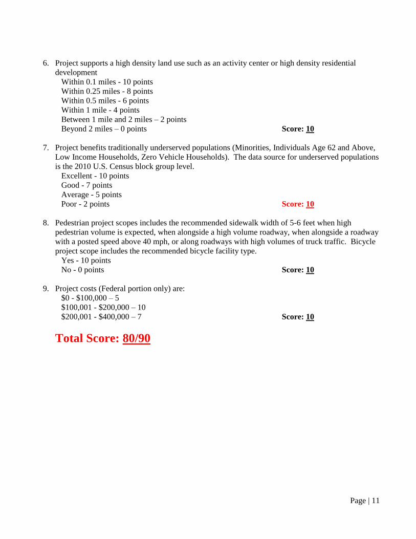
6. Project supports a high density land use such as an activity center or high density residential
development
Within 0.1 miles - 10 points
Within 0.25 miles - 8 points
Within 0.5 miles - 6 points
Within 1 mile - 4 points
Between 1 mile and 2 miles – 2 points
Beyond 2 miles – 0 points Score: 10
7. Project benefits traditionally underserved populations (Minorities, Individuals Age 62 and Above,
Low Income Households, Zero Vehicle Households). The data source for underserved populations
is the 2010 U.S. Census block group level.
Excellent - 10 points
Good - 7 points
Average - 5 points
Poor - 2 points Score: 10
8. Pedestrian project scopes includes the recommended sidewalk width of 5-6 feet when high
pedestrian volume is expected, when alongside a high volume roadway, when alongside a roadway
with a posted speed above 40 mph, or along roadways with high volumes of truck traffic. Bicycle
project scope includes the recommended bicycle facility type.
Yes - 10 points
No - 0 points Score: 10
9. Project costs (Federal portion only) are:
$0 - $100,000 – 5
$100,001 - $200,000 – 10
$200,001 - $400,000 – 7 Score: 10
Total Score: 80/90
Page | 12
Project Ranking Criteria Information
1. The Pike Road TAP Project submitted is along a roadway in the Montgomery Metropolitan Planning
Organization (MPO) 2012 Bicycle and Pedestrian Plan. The project follows proposed facilities
outlined in the Montgomery Metropolitan Planning Organization (MPO) 2012 Bicycle and
Pedestrian Plan. Pike Road is eligible to be awarded 10 points for this criterion.
2. The Pike Road TAP Project submitted is over 2 miles from a school, park, YMCA or community
center; therefore, Pike Road is ineligible for points for this criterion.
3. The Pike Road TAP Project submitted demonstrates an improvement to “livability.” By fulfilling
three of six livability principles outlined by the Interagency Partnership for Sustainable Communities
(U.S. Secretary of Transportation, U.S. Secretary of Housing and Urban Development, and U.S.
EPA). The supported principles are as follows: (1) Provide more transportation choices, (3) Enhance
economic competitiveness and (6) Value communities and neighborhoods. The number of points
awarded is at the discretion of the BPS; however, relevant literature suggests that meeting three of
six principles warrants a minimum of a “Good” ranking. In the opinion of the MPO staff, the project
warrants a ranking “Excellent” because the project facilitates traffic reduction during peak hours by
providing multi-modal options for children to reach school as well as providing transportation to
typically underserved populations.
4. At the state level, ALDOT reviews the submitted budget to ensure that no ineligible items are
included. If no ineligible items are included, full points are given for the criterion.
5. The Pike Road TAP Project submitted connects with p[previously funded segments of the Pike Road
Master Trails Plan. The project will provide residents a safe alternative means of carrying out every
day travel activities and greater connectivity with MANE and proposed residential development
along Wallahatchie Road. With this is mind, the recommendation of the MPO staff is a ranking of
“Excellent;” however, the final determination is at the discretion of the BPS.
6. The project supports a proposed residential development. The exact location of the proposed
residential development is unknown; however, the assumption is that the proposed development is
directly adjacent to the proposed trail. Because the proposed residential development is with 0.1
miles of the proposed project, the total points allocated for the criterion is ten points.
7. According to the 2010 U.S. Census, the proposed Pike Road project is located in a 2010 U.S. Census
Block Group (Tract 56, Block Group 4) with the following demographic statistics: 36.1% Minority
Population and 13.2% of Individuals are Age 62 and Above. According to the 2010-2014 American
Community Survey, the proposed Pike Road project is located in a U.S. Census Block Group with
the following demographic statistics: the median income is $96,625 (Margin of Error of +/-$41,442),
approximately 9 (+/-14) of 318 (+/-78) owner occupied households are Zero Vehicle Households,
and approximately 0 (+/-11) of 21 (+/-20) renter occupied households are Zero Vehicle Households.
The statistics indicate a significant elderly population. With this is mind, the recommendation of the
MPO staff is a ranking of “Excellent;” however, the final determination is at the discretion of the
BPS.
8. The scope of the proposed Pike Road TAP project includes the recommended width of 5-6 feet;
therefore, a total of ten points are allocated for the eighth criterion.
9. The federal portion of the cost of the proposed project is $187,850; therefore, ten points are allocated
from the project cost criterion.
Page | 13
Appendix A: Town of Pike Road FY 2016 Transportation Alternatives Program
(TAP) Application
July 1, 2016
Transportation Alternatives Program
(TAP)
Pike Road Multi-Purpose Nature Trail,
Wallahatchie Road Phase 3
Submitted to:
Montgomery Metropolitan Planning
Organization (MPO)
Submitted by:
Town of Pike Road
Gordon Stone – Mayor Chris Dunn – Council
Betsy Atkins – Council Rob Steindorff – Council
Angie Bradsher – Council Lee Tolliver – Council
Town of Pike Road - 9575 Vaughn Road - Pike Road, AL 36064
[email protected] 334-272-9883 phone 334-272-9884 fax
"The Town of Pike Road has a vision to develop the community in a manner that will maintain and improve the quality of life of
its citizens and bring greater economic, recreational, educational and cultural value.”
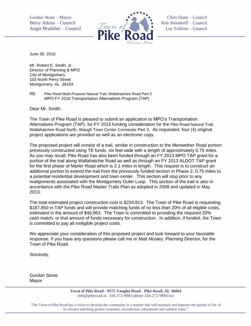
June 30, 2016
Mr. Robert E. Smith, Jr. Director of Planning & MPO City of Montgomery 103 North Perry Street Montgomery, AL 36104 RE: Pike Road Multi-Purpose Natural Trail, Wallahatchee Road Part 3
MPO FY 2016 Transportation Alternatives Program (TAP)
Dear Mr. Smith: The Town of Pike Road is pleased to submit an application to MPO’s Transportation Alternatives Program (TAP), for FY 2015 funding consideration for the Pike Road Natural Trail,
Wallahatchee Road North, Waugh Town Center Connector Part 3. As requested, four (4) original project applications are provided as well as an electronic copy. The proposed project will consist of a trail, similar in construction to the Meriwether Road portion previously constructed using TE funds, six feet wide with a length of approximately 0.75 miles. As you may recall, Pike Road has also been funded through an FY 2013 MPO TAP grant for a portion of the trail along Wallahatchie Road as well as through an FY 2013 ALDOT TAP grant for the first phase of Marler Road which is 2.1 miles in length. This request is to construct an additional portion to extend the trail from the previously funded section in Phase 2, 0.75 miles to a potential residential development and town center. This section will stop prior to any realignments associated with the Montgomery Outer Loop. This section of the trail is also in accordance with the Pike Road Master Trails Plan as adopted in 2008 and updated in May 2013. The total estimated project construction cost is $234,813. The Town of Pike Road is requesting $187,850 in TAP funds and will provide matching funds of no less than 20% of all eligible costs, estimated in the amount of $46,963. The Town is committed to providing the required 20% cash match, or that amount of funds necessary for construction. In addition, if funded, the Town is committed to pay all ineligible project costs. We appreciate your consideration of this proposed project and look forward to your favorable response. If you have any questions please call me or Matt Mosley, Planning Director, for the Town of Pike Road. Sincerely, Gordon Stone Mayor
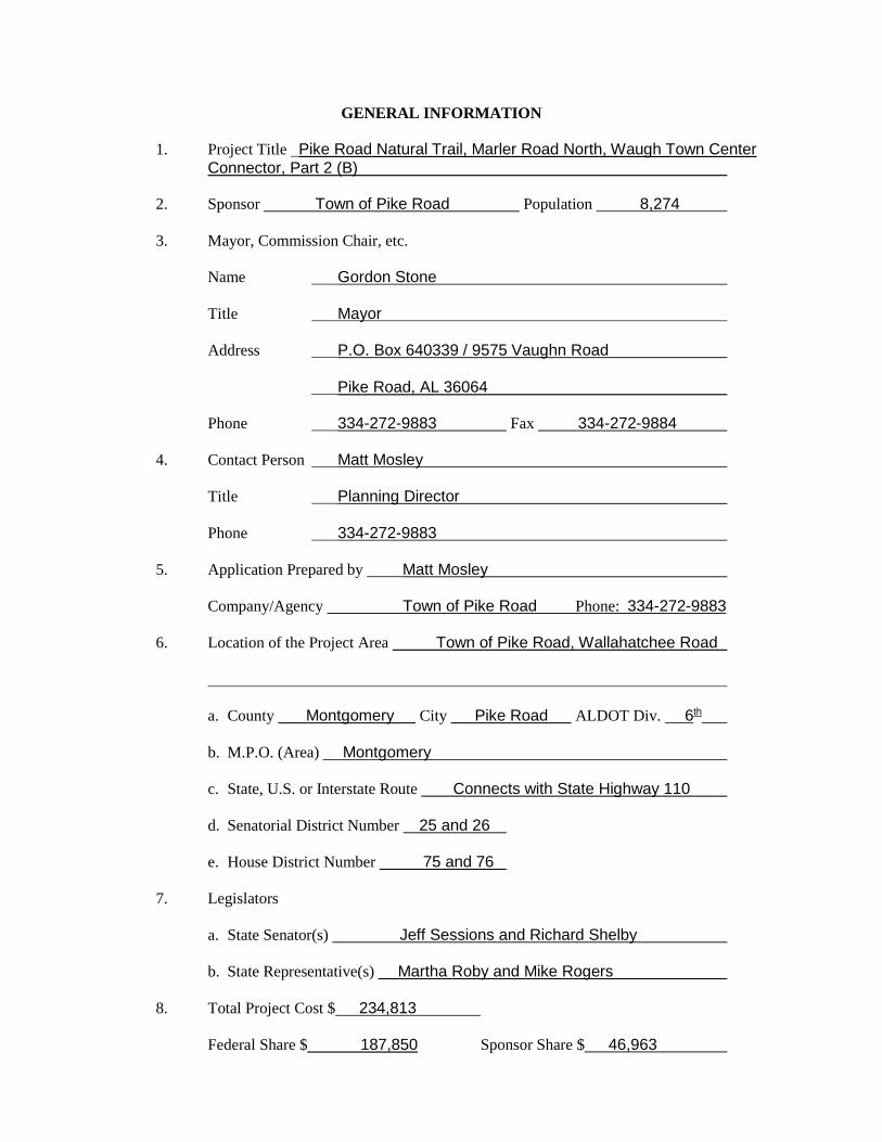
GENERAL INFORMATION
1. Project Title Pike Road Natural Trail, Marler Road North, Waugh Town Center
Connector, Part 2 (B) 2. Sponsor Town of Pike Road Population 8,274 3. Mayor, Commission Chair, etc. Name Gordon Stone Title Mayor Address P.O. Box 640339 / 9575 Vaughn Road Pike Road, AL 36064 Phone 334-272-9883 Fax 334-272-9884 4. Contact Person Matt Mosley Title Planning Director Phone 334-272-9883 5. Application Prepared by Matt Mosley Company/Agency Town of Pike Road Phone: 334-272-9883 6. Location of the Project Area Town of Pike Road, Wallahatchee Road
a. County Montgomery City Pike Road ALDOT Div. 6th b. M.P.O. (Area) Montgomery c. State, U.S. or Interstate Route Connects with State Highway 110 d. Senatorial District Number 25 and 26 e. House District Number 75 and 76
7. Legislators
a. State Senator(s) Jeff Sessions and Richard Shelby b. State Representative(s) Martha Roby and Mike Rogers
8. Total Project Cost $ 234,813 Federal Share $ 187,850 Sponsor Share $ 46,963
PROJECT DESCRIPTION
Transportation Alternatives Eligibility
The project proposed herein meets the eligible activity of item number 1 from page 2 of the FY 2016 Transportation Alternatives Program (TAP) project application. The proposed trail facility will allow for pedestrians and other non-motorized forms of transportation. The trail is ideally suited for walking, jogging, running, or hiking, will follow the terrain of the land, and be constructed with natural materials. To date the Town of Pike Road has fully implemented a Transportation Enhancement (TE) grant that developed the first segment of the trail system which consists of two trail heads, one near the intersection of Meriwether Road and US 231 funded by the Town, and one near the intersection of Meriwether Road and Pike Road, funded through an ADECA RTP grant. The Town is in the final stage awaiting sign-off of the 1st phase of the Marler Road portion of the trail system which is approximately 2.1 miles in length. Currently the Town is implementing an FY 2013 MPO TAP grant for construction of 0.8 of a mile of trail along Wallahatchie Road from the corner of Vaughn and Wallahatchie Roads to the drive entrance to MANE and Wallahatchie Road phase 2 from MANE 1.2 miles to the proposed beginning of this section of trail. This project, along with completion of the first segment of the trail and the two currently underway, is a part of the Town's overall Master Trails Plan. As Pike Road continues to grow, this Plan will guide and direct development that will bring an easier flow to overall transportation and connectivity. The Plan continues to encourage involvement by residents and developers alike and was recently updated in May 2013.
History
The Town of Pike Road was established in 1997 by a group of individuals living in the historically significant community located in the eastern part of Montgomery County. The people of the Pike Road area had watched with interest the growth that was surrounding them and, while not opposed to progress, they were concerned about the lack of consistent planning for the growth. As a result, the people living in Pike Road decided to seek incorporation and form their own municipality. Their goal was to guarantee that local people would make decisions about important growth issues like schools, recreation, business development, etc. The incorporators set in motion a process to build a town that would maintain a high quality of life and increase overall value to its citizens. Further, they developed a town model that would welcome all of the people in the Pike Road area. Each of the crossroad communities located in the Pike Road area have historical significance. Whether it is Merry, McDade, Cecil, Waugh, Mathews, Carters Hill, or some other location, these communities each have an important story to tell. For example, the crossroads positioned at the historical center of Pike Road received its name because it was located on a toll road that allowed for travel between Montgomery and Union Springs. As a frequently used connector, the toll road had economic importance and began to draw growth that eventually helped strengthen each of the crossroad locations. The toll road helped bring people together. The Pike Road area therefore shares historical bonds that transition from strong ties to agriculture, to the common schoolhouse, the common mail route, and ultimately the common way of life.
Today, the Town of Pike Road, which ties all of the crossroads communities together, continues to be positioned along important economic and transportation corridors. Retail, professional, and agricultural opportunities are fast approaching and must be appropriately blended with residential development and recreation to paint the landscape for tomorrow’s Pike Road. It is these facts that encouraged the people, who initiated incorporation of the Town of Pike Road, to understand the lessons of the past and plan for the future. To achieve a greater depth of understanding, Pike Road leaders have studied numerous towns in similar locations and hired the national firm, PlaceMakers, LLC, to assist in planning for growth. As a result, Pike Road has learned that properly planned growth will be a compliment to economic, social, and cultural advancement of the area. Proper planning will benefit the people of the Town and this includes planning for the overall trail system throughout Pike Road. Eighteen short years since incorporation, Pike Road continues to move ahead of schedule. The Town has grown from 360 to over 5,406 citizens (according to 2010 Census figures) and expects this growth to continue in a steady manner.
Scenic Significance
The proposed multi-purpose trail will run through lightly developed areas of Pike Road with large lot residential development to pasture and farmland. The route is scenic in nature with rolling pastures and limited development. At the same time, the route will continue to run through the heart of the community and one of the fastest growing areas of the Town. The trails, along with associated tree planting and landscaping, will provide a true definition to Pike Road's town center and provide visual beauty for pedestrian, rider, and vehicular travelers. In particular, the proposed location of this continued segment of the trail along Wallahatchie Road will also provide greater accessibility to the Montgomery Area Non-Traditional Equestrians (MANE), a non-profit organization formed in 1994 that provides safe and effective therapeutic horseback riding opportunities to Montgomery and tri-county area children and adults with emotional, physical, cognitive, and developmental disabilities.
Impact
The development of the multi-purpose trail will have a positive impact on the area in a variety of ways. It will augment the existing surface transportation system by providing pedestrians a safe and enjoyable route. In addition, the project will provide residents a safer alternative means of carrying out everyday travel activities and greater connectivity with MANE and proposed residential development along Wallahatchie Road. The presence of MANE within Pike Road is one of which the Town is most proud and the use by Woodland Methodist Church, its staff and members, is also anticipated to be a great benefit of this particular segment of the trail. It should be recognized that the entire portion of the trail system along Wallahatchie Road is four miles in length, all of which has been designated as a "scenic right of way" by the Town of Pike Road and Montgomery County using the guidelines outlined by the State Legislature. However, for this application, the Town seeks funding for construction of 0.8 miles of the
Wallahatchie Road portion of the trail -to directly extend from the 2.0 miles currently funded. This application is to continue from the end of Phase 2 an additional 0.75 miles, to connect with proposed residential development to occur on Wallahatchie Road. If this section is funded, that will secure funding for a total of 2.75miles of the trail system along Wallahatchie Road. The trail will end prior to any realignment associated with the Future Montgomery Outer Loop. The overall trail network in the Town of Pike Road encompasses over 30 miles of trails that will ultimately connect residents throughout the community and provide a safe and healthy alternative form of transportation. This trail system will be connected by various trail heads along the path which provide areas for parking, restroom and water access facilities, and general gathering spots. There are two trail head facilities currently in place and for this portion of the trail, Woodland Methodist Church is agreeable to their parking facilities being used as a trail head. There are also plans to offer educational spots along the trail paths to highlight various natural and historical markers. The educational trail stops is a current project of the Recreation Service Corps. others are under development. Plans and regulations are already in place to encourage developers to construct a trail or paths within the sub-divisions and connect them to the natural trail as planned and intended in the Town's Master Trails Plan. This will enhance the trial as well as new sub-division development. The Town of Pike Road's Master Trail System helps focus on increasing pedestrian walking and jogging activities, which was rated during development of the 2008-2012 SCORP (the most recent plan available) as one of the greatest needs Statewide. Additionally, responders in Region 9, which contains Montgomery County, also document walking/jogging trails in the top two needs for this area. With such a high demand for safe places to walk and/or jog, funding of this segment of the trail will also help the State in increasing walking/jogging trail supply. For the segment of the trail identified herein, all proposed installation will be in areas located along existing rights-of-way; therefore any negative impacts of installation will be negligible. Care will be taken not to adversely impact plant or animal life, habitats, wetlands, archaeological, or historic resources. Additional activities may involve clearing of any existing undergrowth, possible landscaping, reseeding or sodding of disturbed turf, and/or mulching.
Proposed Construction
Pike Road proposes the continuation of construction of a multi-purpose trail from compacted crushed stone on the west side of Wallahatchie Road. The trail will run approximately 1.2 miles with an average width of 6 feet and will be compliant with ADA standards. As previously stated, the trail will be designed for multi-purpose use and is a portion of an additional segment included in the Town's overall Master Trails Plan. A design sketch and typical cross-section for the proposed improvements is provided at Attachment 6. Like the first portion of the trail constructed along Meriwether Road, and the second to be constructed along Marler Road, and the section that this application section will directly connect to, the trail will be constructed of compacted crushed stone over a fabric base. Construction activities are estimated to include the obtaining of temporary construction access easements, selected clearing and earthwork, trail development, shoulder work,
removal and construction of a new head wall, and seeding and mulching of disturbed areas. In preparation for future trail development the Town has made and continues to make all property owners and potential developers aware of requirements to provide necessary easements. easements.
Ownership The project will be constructed 100% on Town of Pike Road Right of Way with some temporary easements required. These will be identified during formal plan development and are anticipated and planned for in the budget.
Intended Use The Pike Road natural trail provides an alternative form of transportation for residents. This new, proposed section will continue to do the same. It provides an important and safe link between a number of destination points throughout the area. In addition, this trail represents overall connectivity throughout Pike Road that is highly desirable and necessary in growth of a community.
Life Expectancy The expected life of the project is approximately 50 years. With proper care and maintenance the access should last far into the future, providing a route to and from residential and commercial areas of the Town for present and future citizens of Pike Road. Based on average wear and tear it is realized that some portions may have to be repaired during interim years.
Maintenance Plan
As with the previously constructed segment of the trail, the Town of Pike Road will provide maintenance and be responsible for all elements of this project. Maintenance expenses will be paid from the Town’s General Fund. Local officials anticipate monthly maintenance costs to average $500 per month for an annual total of $6,000. Such funds will be and are made available through general fund budget allocations which are routinely reviewed for accuracy.
Public Involvement
The need for a trail system in Pike Road originated through citizen input provided by local residents of Pike Road and recognized by Town leadership. This project proposal as well as previous trail improvements that resulted from the overall Master Trails Plan contains numerous items that document the high level of community involvement and participation from citizens of Pike Road. The PRICE (Pike Road Investment in Community and Education) Foundation was developed to help the Town maintain its community-minded focus and to foster partnerships that will create a safer, better living environment for the residents of Pike Road. Since that foundation's inception the Town has further increased public involvement by encouraging and assisting with formation of multiple other committees and partnerships that allow residents to voice their vision for
the Town. In 2011, the Town began to focus on what would become the ENHANCE Initiative - which is a community program designed to maximize community involvement in several key areas focusing on Exercise, Nutrition, Health, Agriculture, Nature, Community, and Education. There are a total of nine community organizations that have formed as a result of this initiative and are actively engaging the community in numerous events and activities. One of the organizations is the Recreation Service Corps. mentioned previously in the "Impact" section. Pike Road has a resident community leader who resides in the Rolling Hills area that has taken on leadership of the Recreation Service Corps. Mr. Willie Madison has over 20 years of experience working for the National Parks Service and is a 17-year resident of the Rolling Hills community. His leadership and knowledge is a true asset to the community and this group. Pike Road continues to be forward-thinking and progressive in their approach to community involvement and residents like Mr. Madison fully support completion of the overall trail plan. Private sector commitments of labor, money, or materials to support the proposed project are not specific to this project request, however, the support and endorsement by citizens and community leaders is well documented. The development, plan, and community input for the Master Trails Plan and the improvements proposed herein are unmistakable and the Town will continue to seek funding for completion of its trail system in order to validate the community's efforts and determination for seeing it become a reality. In addition, the Town has tremendous support from local Pike Road businesses such as The Home Depot. They have proven their commitment to Pike Road by providing materials and employee labor to assist with identified projects pursued by the Town including providing man power and necessary materials to construct the Pike Road Veterans Memorial located at the Old Town Hall trail head site. Home Depot also provided manpower and materials to construct the community baseball field on this site. Finally, individual citizens continue to discuss with local officials and other Town personnel, their appreciation for the commitment and support the trail system is receiving. Growth in Pike Road remains consistent and the Town is working hard to keep pace with the needs of all residents. The continuation of the development of the trails system is discussed at all council meetings. All council members have expressed their support of this proposal as well as relayed the many positive comments they've received from numerous Pike Road residents regarding trail use. As documented, there has been substantial public involvement in the Master Trails Plan and with each segment of construction considered.
LINE
NO.
ITEM
NO.DESCRIPTION UNIT PRICE AMOUNT BID
1 201A-002 CLEARING & GRUBBING (MAXIMUM ALLOWABE BID $ ) 1 LUMP SUM $ 2,500.00 $ 2,500.00
2 206E-000 REMOVING HEADWALLS 2 EACH $ 400.00 $ 800.00
3 STREET SIGN REMOVAL AND RESET 2 EACH $ 500.00 $ 1,000.00
4 210A-000 UNCLASSIFIED EXCAVATION 879 CU YD $ 8.50 $ 7,471.50
5 210D-021 BORROW EXCAVATION (LOSE TRUCK BED MEASUREMENT) (A4 OR BETTER) 2,360 CU YD $ 12.00 $ 28,320.00
6 214A-000 STRUCTURE EXCAVATION 16 CU YD $ 38.00 $ 608.00
7 214B-001 FOUNDATION BACKFILL, COMMERCIAL 10 CU YD $ 70.00 $ 700.00
8 243C-001 FILTER FABRIC (WOVEN) 3,560 SQ YD $ 2.00 $ 7,120.00
9 301A-004CRUSHED AGGREGATE BASE COURSE, TYPE B, PLANT MIXED, 4"
COMPACTED THICKNESS2,670 SQ YD $ 9.00 $ 24,030.00
10 430B-051 AGGREGATE SURFACING (ALDOT #8910) (2" COMPACTED THICKNESS) 2,670 SQ YD $ 7.00 $ 18,690.00
11 530A-101 18" SIDE DRAIN PIPE (CLASS 3 R.C.) (EXTENSION) 32 EACH $ 80.00 $ 2,560.00
12 530B-064 35" SPAN, 24" RISE ROADWAY PIPE (14 GAUGE C.C.S.P.I.) 16 LIN FT $ 75.00 $ 1,200.00
13 6'x5' BOX CULVERT 8 LIN FT $ 800.00 $ 6,400.00
14 WING WALLS AND PARAPET WALL 1 LUMP SUM $ 6,000.00 $ 6,000.00
15 600A-000 MOBILIZATION 1 LUMP SUM $ 22,000.00 $ 22,000.00
16 610A-003 LOOSE RIPRAP, CLASS 2, 18" THICK 70 SQ YD $ 50.00 $ 3,500.00
17 610D-003 FILTER BLANKET, GEOTEXTILE 70 SQ YD $ 3.00 $ 210.00
18 619A-002 18" SIDE DRAIN PIPE END TREATMENT, CLASS 1 2 EACH $ 1,800.00 $ 3,600.00
19 619B-068 36" SPAN, 24" RISE ROADWAY PIPE END TREATMENT, CLASS 2 1 EACH $ 2,500.00 $ 2,500.00
20 620A-000 MINOR STRUCTURE CONCRETE 29 CU YD $ 600.00 $ 17,400.00
21 650B-000 TOPSOIL FROM STOCKPILES 538 CU YD $ 10.00 $ 5,380.00
22 652A-100 SEEDING 2 ACRE $ 800.00 $ 1,600.00
23 652C-000 MOWING 2 ACRE $ 200.00 $ 400.00
24 654A-000 SOLID SODDING 1,956 SQ YD $ 5.00 $ 9,780.00
25 656A-010 MUCHING 2 ACRE $ 1,000.00 $ 2,000.00
26 665F-000 HAY BALES 156 EACH $ 7.00 $ 1,092.00
27 665J-002 SILT FENCE 300 LIN FT $ 3.50 $ 1,050.00
28 665O-001 SILT FENCE REMOVAL 300 LIN FT $ 1.00 $ 300.00
29 665Q-002 WATTLE 400 LIN FT $ 6.00 $ 2,400.00
30 666A-001 PEST CONTROL TREATMENT 2 ACRE $ 200.00 $ 400.00
31 680A-000 ENGINEERING CONTROLS 1 LUMP SUM $ 4,500.00 $ 4,500.00
32 740B-000 CONSTRUCTION SIGNS 250 SQ FT $ 10.00 $ 2,500.00
33 740D-000 CHANNELIZING DRUMS 15 EACH $ 70.00 $ 1,050.00
34 740E-000 CONES (36" HIGH) 30 EACH $ 50.00 $ 1,500.00
35 740M-001 BALLAST FOR CONE 30 EACH $ 20.00 $ 600.00
PIKE ROAD NATURE TRAIL - WALLAHATCHIE ROAD PORTION - PHASE 3
ENGINEER'S ESTIMATE
PREPARED BY FLOWERS & WHITE ENGINEERING ON JULY 1, 2016
QUANTITY & UNIT

36 902A-000 FENCE 60 LIN FT $ 35.00 $ 2,100.00
193,261.50$
37 Plan Set - Engineering 1 Lump Sum $ 12,562.00 $ 12,562.00
38 CE&I (15% of construction) 1 Lump Sum $ 28,989.23 $ 28,989.23
234,812.72$ TOTAL PROJECT COST ESTIMATE
TOTAL CONSTRUCTION ESTIMATE
Federal Share $ 187,850Local Share $ 46,963

Attachment 1 .........................Documentation of Sponsor's Willingness to Pursue Project to Completion and be Responsible for Required Expenses – Provided in Cover Letter and Resolution Attachment 2 .........................Letter from Metropolitan Planning Organization (MPO) to Allow Project to be Included in the Transportation Improvement Plan (TIP) Attachment 3 .........................Resolution from the Town Council Stating Approval of the Proposed Transportation Alternatives Attachment 4 .........................Letters from Property Owners (Governmental Agency) Where Work is to be Constructed on Property Not Already Owned by the Town – NOT APPLICABLE Attachment 5 .........................7.5 USGS Minute Map Indicating Exact Project Location Attachment 6 .........................Map of Project Area Clearly Depicted by Highlighting and Labeling Attachment 7 .........................Design Sketch and Typical Cross-Section Attachment 8 .........................Color Photographs Keyed to Sketch Map Clearly Depicting Project Area and Proposed Improvements
ATTACHMENTS
ATTACHMENTS:
ATTACHMENT 1
Documentation of Sponsor’s willingness to pursue project to completion and be responsible for required expenses – provided in cover letter and resolution
ATTACHMENT 2
Letter from MPO to allow project area to be included in the TIP
ATTACHMENT 3
Resolution from the Town Council stating approval of Trail Master Plan and individual segments
ATTACHMENT 4
Letters from property owners (governmental agency) where work is to be constructed on property not already owned by the town – NOT APPLICABLE
ATTACHMENT 5
7.5 USGS minute map indicating exact project location
ATTACHMENT 6
Map of project area clearly depicted by highlighting and labeling
ATTACHMENT 7
Design sketch and typical cross section
ATTACHMENT 8
Color photographs keyed to sketch map clearly depicting project area and proposed improvements
Provided in Cover Letter and Resolution at Attachment 3
Documentation of Sponsor's Willingness to Pursue Project to Completion and be
Responsible for Required Expenses
Attachment 1

Letter from Metropolitan Planning Organization (MPO) to Allow Project to be Included in the Transportation
Improvement Plan (TIP)
Attachment 2

Resolution from Town Council Stating Approval of the Proposed Transportation Alternatives
Attachment 3
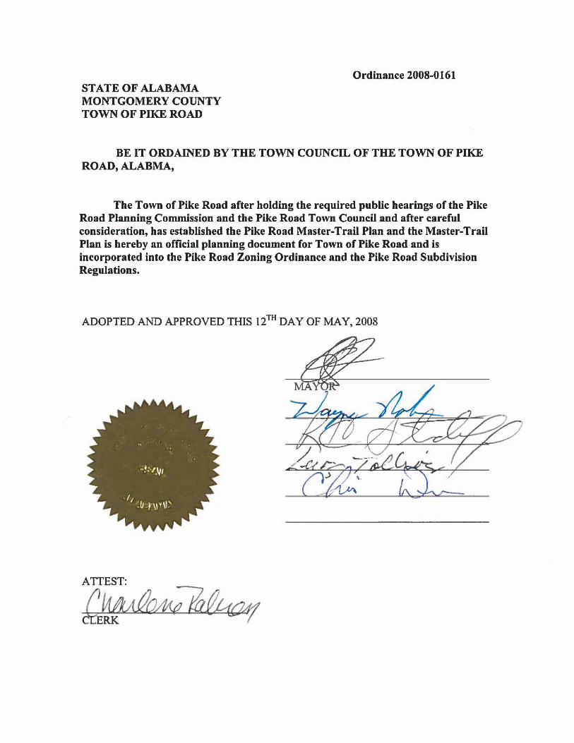
STATE OF ALABAMA MONTGOMERY COUNTY TOWN OF PIKE ROAD
Ordinance 2008-0161
BE IT ORDAINED BY THE TOWN COUNCIL OF THE TOWN OF PIKE ROAD, ALABMA,
The Town of Pike Road after holding the required public hearings of the Pike Road Planning Commission and the Pike Road Town Council and after careful consideration, has established the Pike Road Master-Trail Plan and the Master-Trail Plan is hereby an official planning document for Town of Pike Road and is incorporated into the Pike Road Zoning Ordinance and the Pike Road Subdivision Regulations.
ADOPTED AND APPROVED THIS 12TH DAY OF MAY, 2008
ATTEST:
'~AVJ.~
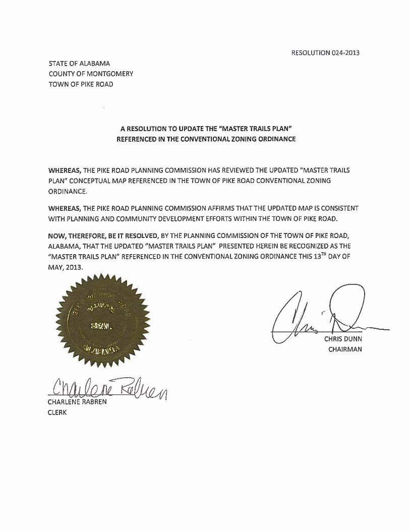
RESOLUTION 024-2013
STATE OF ALABAMA
COUNTY OF MONTGOMERY
TOWN OF PIKE ROAD
A RESOLUTION TO UPDATE THE "MASTER TRAILS PLAN"
REFERENCED IN THE CONVENTIONAL ZONING ORDINANCE
WHEREAS, THE PIKE ROAD PLANNING COMMISSION HAS REVIEWED THE UPDATED "MASTER TRAILS
PLAN" CONCEPTUAL MAP REFERENCED IN THE TOWN OF PIKE ROAD CONVENTIONAL ZONING
ORDINANCE.
WHEREAS, THE PIKE ROAD PLANNING COMMISSION AFFIRMS THATTHE UPDATED MAP IS CONSISTENT
WITH PLANNING AND COMMUNITY DEVELOPMENT EFFORTS WITHIN THE TOWN OF PIKE ROAD.
NOW, THEREFORE, BE IT RESOLVED, BY THE PLANNING COMMISSION OF THE TOWN OF PIKE ROAD,
ALABAMA, THAT THE UPDATED "MASTER TRAILS PLAN" PRESENTED HEREIN BE RECOGNIZED AS THE
"MASTER TRAILS PLAN" REFERENCED IN THE CONVENTIONAL ZONING ORDINANCE THIS 13TH DAY OF
MAY, 2013.
CHAIRMAN
Ch{tLfu~ CHARLENE RABREN
CLERK

--.
..
"' .,
Gi ~
u '" u
'E Q
. ..
"' '"
'0 .E
.!l c.
"> 'tJ
,., ~
'" .l!l
'tJ 0
0 ~
'" a:
a: ....
., .. iii
., :§.
iii .. ""
l-e::
'tJ .!l
'tJ
'" ~
... .,
0 G
l 0
:I: a:
"' c
0
3: E
.~
c. 0
0 ..
l-I-
I-D
-
o • t I
aNana,
-/ " I --
I .. >
HI
,/'
\ .~-
j \
\ ,
i •
I \
J "
c '\'.
~
'" m
I "
m
C')
) \ ..
0 ....
-0
! .~
'-Il::
a.. N
I, .~ .
rn >
.
. ., I Q
)
' .... .:&:::
-I'll
.-:E
I ~ .-
.-e
-. a..
~
• I
~~
" ,
~
I-iii
0 L..
:::I
,-i
I ,
.... ,
'. /
.s Q
.
• C
CIl
.. )
Ii I
-, ;:
rn u
-'
m
c:
r=. 0
• I'
:E
u
l~ ......
j . /
J -
Ilfl --,
/ /I
• I
\ --)
,-' .. J
....... / ..
•
\ •
• /
• ,
Ito. \
. ,
\
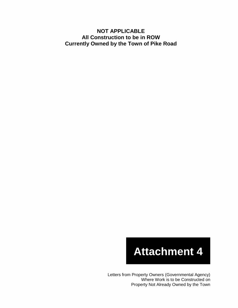
NOT APPLICABLE All Construction to be in ROW
Currently Owned by the Town of Pike Road
Letters from Property Owners (Governmental Agency) Where Work is to be Constructed on
Property Not Already Owned by the Town
Attachment 4

7.5 USGS Minute Map Indicating Exact Project Location
Attachment 5
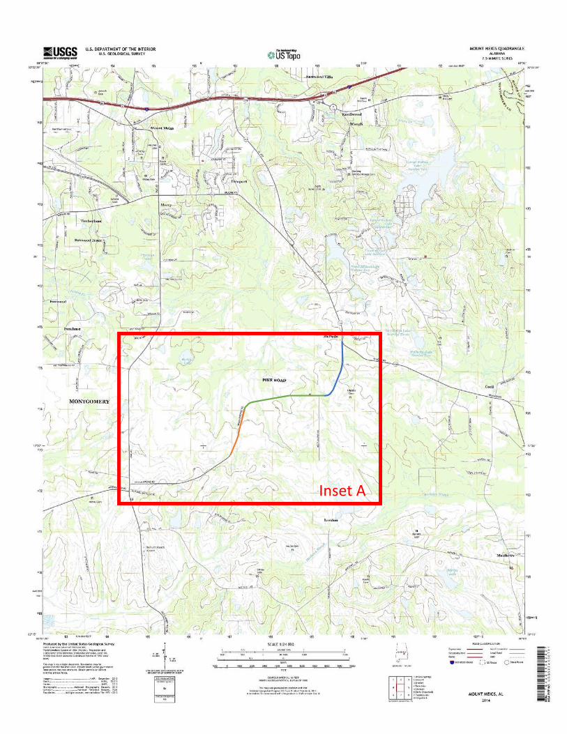
Inset A
Phase 10.8 miles
Phase 21.2 miles
Phase 3(proposed)0.75 miles
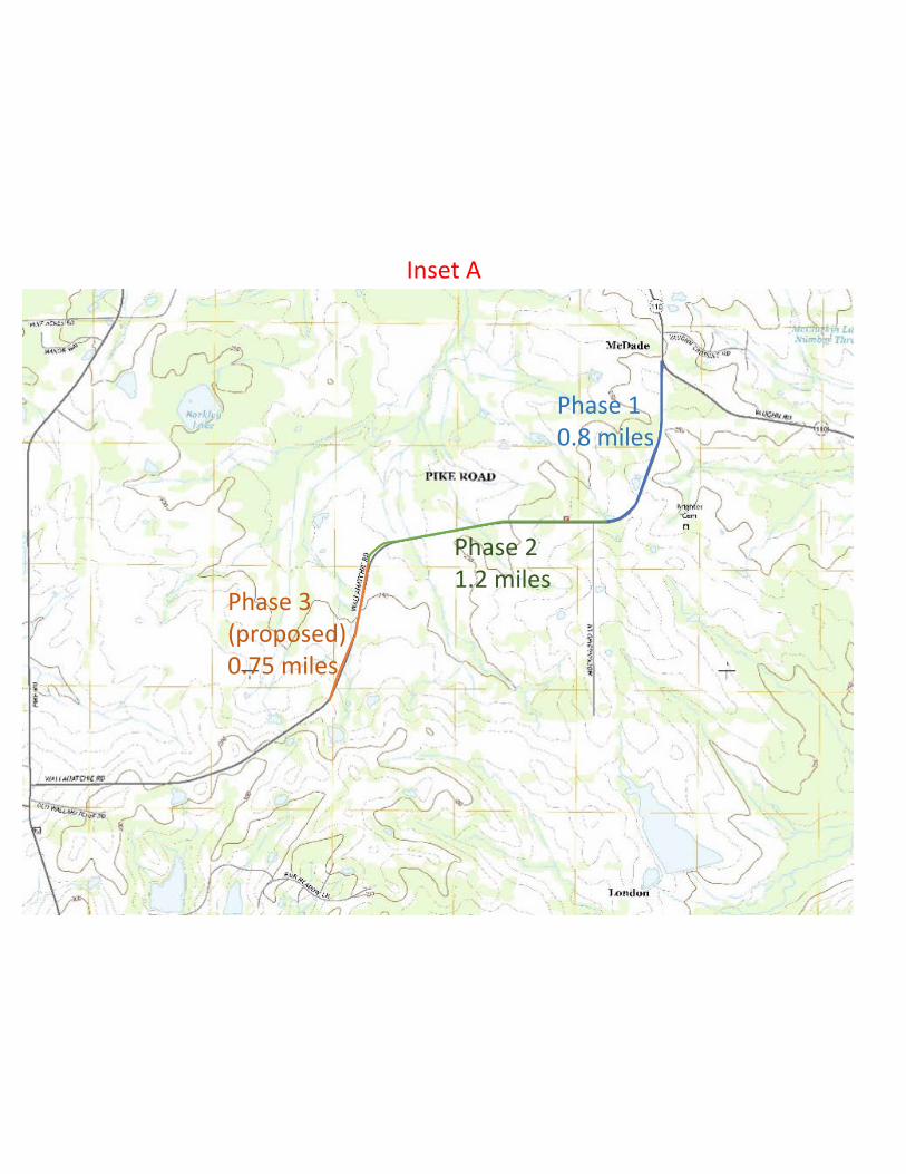
Inset A

Map of Project Area Clearly Depicted by Highlighting and Labeling
Attachment 6
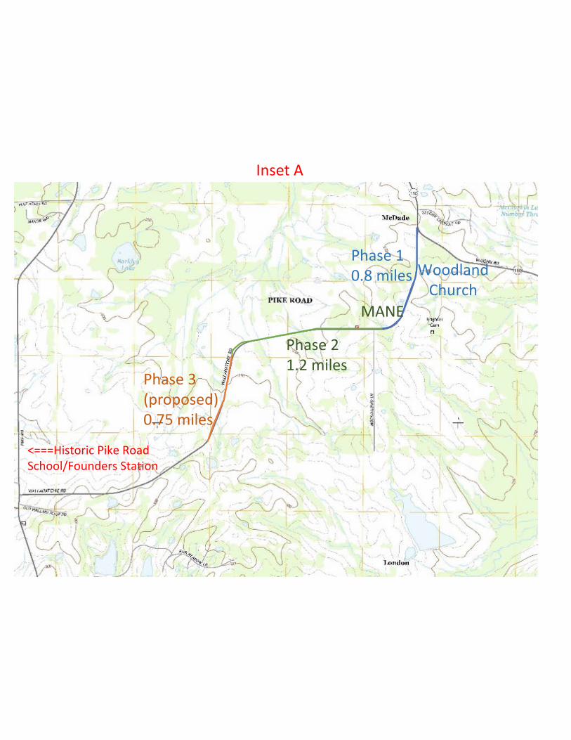
Phase 10.8 miles
Phase 21.2 miles
Phase 3(proposed)0.75 miles
Inset A
MANE
WoodlandChurch
<===Historic Pike Road School/Founders Station

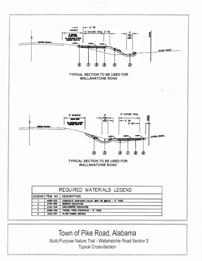
Design Sketch and Typical Cross-Section
Attachment 7
L. ..
I
TYPICAL SECTION TO BE USED FOR
WALLAHATCHIE ROAD
I 8' MINIMUM
==:::::::+(£ ==========� __ ,. �--.,-,
LEGEND
1
3
4
s
ITEM NO.
"'308-022 2100-000
210.t.-OOD
8�000
2430-001
TYPICAL SECTION TO BE USED FOR
WALLAHATCHIE ROAD
REQUIRED MATERIALS LEGEND
DESCRIPTION
AGGREGATE SURFAaNG {Al.DOT .IB'IO OR 11191D) - 4" lHIO< BORROW EXCAVATION
UNClASSIFIED EXCAVATION
TOPSOIL FROM STOCl<PII..ES - 8° ntO(
FILTER FABRIC (WIMN)
Town of Pike Road, Alabama
Typical Cross-Section
Multi-Purpose Nature Trail - Wallahatchie
Road Section 3

Color Photographs Keyed to Sketch Map Clearly Depicting Project Area and Proposed Improvements
Attachment 8
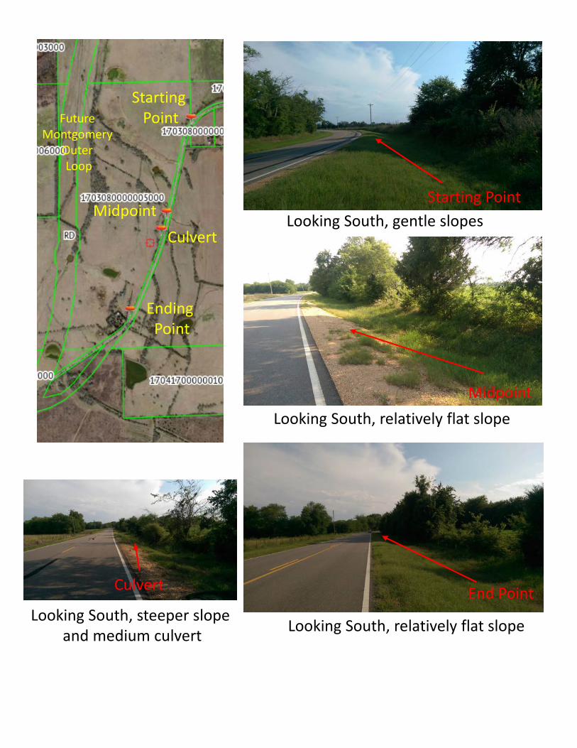
Starting Point
MidpointCulvert
Ending Point
Future Montgomery
Outer Loop
Starting Point
Midpoint
End Point
Looking South, gentle slopes
Looking South, relatively flat slope
Looking South, relatively flat slopeLooking South, steeper slopeand medium culvert
Culvert