table of contents transportation...
TRANSCRIPT

Palm Beach County Page i - TE 1989 Comprehensive Plan Revised 10/30/17 Ordinance 2017-34
TABLE OF CONTENTS
TRANSPORTATION ELEMENT
I. INTRODUCTION ............................................................................................................. 1-TE A. Purpose ...................................................................................................................... 2-TE B. Assessment and Conclusions .................................................................................... 2-TE
II. GOAL, OBJECTIVES, AND POLICIES .......................................................................... 5-TE
GOAL 1: TRANSPORTATION ELEMENT ......................................................................... 5-TE
A. LEVEL OF SERVICE ................................................................................................. 5-TE Objective 1.1 Level of Service Standards ................................................................. 5-TE Objective 1.2 Level of Service Exceptions .............................................................. 12-TE
B. FUTURE TRANSPORTATION SYSTEM EXPANSIONS ........................................ 47-TE Objective 1.3 Management of Transportation System ............................................ 47-TE Objective 1.4 Roadway System .............................................................................. 48-TE Objective 1.5 Transit System .................................................................................. 55-TE Objective 1.6 Paratransit Services for the Transportation Disadvantaged (Non-ADA-Qualifying Individuals) ...................................................... 56-TE Objective 1.7 Future Airport Expansion .................................................................. 57-TE Objective 1.8 Port of Palm Beach ........................................................................... 58-TE Objective 1.9 Bicycle, Pedestrian, and Linked Open Space Facilities .................... 58-TE
C. TRANSPORTATION MARKETING ......................................................................... 60-TE Objective 1.10 Transportation Marketing Program .................................................. 60-TE
D. ENVIRONMENTAL CONSIDERATIONS ................................................................ 61-TE Objective 1.11 Air, Water, and Other Environmental Concerns .............................. 61-TE
E. TRANSPORTATION FUNDING .............................................................................. 62-TE Objective 1.12 Transportation Funding ................................................................... 62-TE
F. TRANSPORTATION SYSTEM COORDINATION ................................................... 64-TE Objective 1.13 General Plan Coordination ............................................................. 64-TE
G. PUBLIC INVOLVEMENT ......................................................................................... 66-TE Objective 1.14 Citizen Participation ........................................................................ 66-TE
H. ADDITIONAL AIRPORT FACILITY CONSIDERATIONS ........................................ 66-TE Objective 1.15 Additional Airport Land Use and Environmental Issues .................. 66-TE Objective 1.16 Additional Airport Intergovernmental Coordination ......................... 68-TE

Palm Beach County Page ii - TE 1989 Comprehensive Plan Revised 10/30/17 Ordinance 2017-34
Transportation Element History: Adopted: 11/17/97, Ord. No. 97-50, Effective 10/28/98 Revised: 11/17/97, Ord. No. 97-52, Effective 01/14/98 Revised: 11/17/97, Ord. No. 97-48, Effective 01/14/98 Revised: 09/16/98, Ord. No. 98-35, Effective 11/12/98 Revised: 08/17/99, Ord. No. 99-22, 23, 24, & 29, Effective 10/14/99 Revised: 12/13/99, Ord. No. 99-57, 58, 59, 60, 61, 62, & 63, Effective 01/19/00 Revised: 12/21/99, Ord. No. 99-76, Effective 01/19/00 Not Revised: 09/18/00, Ord. No. 2000-24, Found Not in Compliance, see 2001-19 Revised: 09/18/00, Ord. No. 2000-25, 26, 27, 28, Effective 11/14/00 Revised: 12/06/00, Ord. No. 2000-45 to 49 & 52, Effective 01/31/01 Revised: 12/06/00, Ord. No. 2000-61, Effective 01/14/02 Revised: 04/26/01, Ord. No.2001-19, Effective 06/05/01 (Ord. 2000-24 formerly NIC) Revised: 08/27/01, Ord. No. 2001-41, 48, 49, 51, 52, Effective 10/22/01 Not Revised: 08/27/01, Ord. No. 2001-50, Challenged – Never in effect Revised: 12/05/01, Ord. No. 2001-69, Effective 01/14/02 (Ord. 2000-61 formerly NIC) Revised: 12/05/01, Ord. No. 2001-72, 79 to 82, Effective 01/28/02 Revised: 08/28/02, Ord. No. 2002 - 41-45, Effective 10/25/02 Revised: 08/28/02, Ord. No. 2002 - 47, 48, Effective 10/25/02 Revised: 12/18/02, Ord. No. 2002 - 72-76, 78, 90 02/19/03, Effective 02/19/03 Revised: 08/13/03, Ord. No. 2003 – 33-35, 37, Effective 10/27/03 Revised: 11/24/03, Ord. No. 2003 – 57-60, Effective 01/26/04 Revised: 08/24/04, Ord. No. 2004 – 23, 24, 27 Effective 10/29/04 Revised: 12/13/04, Ord. No. 2004-70, Effective 02/02/05 Revised: 05/10/05, Ord No. 2004-38, Effective 05/10/05 Revised: 08/25/05, Ord. No. 2005-23, 26 & 31, Effective 11/01/05 Revised: 11/28/05, Ord No. 2005-49-52 & 57, Effective 01/24/06 Revised: 08/21/06, Ord. No. 2006-20 & 22-27, Effective 10/23/06 Revised: 11/13/06, Ord. No. 2006-45 &46, Effective 02/23/07 Not Revised: 11/27/06, Ord. No. 2006-57, Challenged – Settled with Ord. 2007-44 Revised: 11/27/06, Ord. No. 2006-58, Effective 1/23/07 Revised: 08/27/07, Ord. No. 2007-08, Found Not in Compliance - not within this element Revised: 08/27/07, Ord. No. 2007-09, 10 & 11, Effective 10/26/07 Revised: 11/26/07, Ord. No. 2007-25 & 27, Effective 01/28/08 Revised: 11/26/07, Ord. No. 2007-36 & 37, Effective 01/03/08 Revised: 12/18/07, Ord. No. 2007-44, Effective 05/05/08 Revised: 08/21/08, Ord. No. 2008-19, 26-30, Effective 10/17/08
Revised: 12/03/08, Ord. No. 2008-54, Effective 02/11/09 Revised: 05/19/09, Ord. No. 2009-10, Effective 7/29/09 Revised: 08/25/09, Ord. No. 2009-30, 33, 35, Effective 10/23/09 Revised: 11/19/09, Ord. No. 2009-46, Effective 1/11/10
Revised: 08/30/10, Ord. No. 2010-33, 35, Effective11/4/10 Revised: 10/25/10, Ord. No. 2010-47, Effective 11/22/10 Revised: 10/11/11, Ord. No. 2011-24 to 27, Effective 11/24/11 Revised: 07/23/12, Ord. No. 2012-23 to 26, Effective 08/31/12 Revised: 10/29/12, Ord. No. 2012-35 to 37, Effective 12/09/12 Revised: 04/25/13, Ord. No. 2013-12 & 13, Effective 06/08/13 Revised: 10/28/13, Ord. No. 2013-29, Effective 12/08/13 Revised: 10/30/14, Ord. No. 2014-35 & 37, Effective 12/07/14 Revised: 10/30/14, Ord. No. 2014-35 & 37, Effective 12/07/14 Revised: 10/29/14, Ord. No. 2014-30, Effective 07/07/15 (initially challenged) Revised: 04/29/15, Ord. No. 2015-19, 20, 21, Effective 06/12/15 Revised: 10/26/15, Ord. No. 2015-41, Effective 12/04/2015 Revised: 04/27/16, Ord. No. 2016-24, Effective 06/09/16 Revised: 09/22/16, Ord. No. 2016-41, Effective 10/29/16

Palm Beach County Page iii - TE 1989 Comprehensive Plan Revised 10/30/17 Ordinance 2017-34
Revised: 10/26/16, Ord. No. 2016-47, Effective 12/09/16 Revised: 07/26/17, Ord. No. 2017-23, Effective 09/08/17 Revised: 10/30/17, Ord. No. 2017-34, Effective 12/07/17
Traffic Circulation Element History:
Adopted: 08/31/89, Ord. No. 89-17, Effective 09/11/89 Revised: 09/18/90, Ord. No. 90-32, Effective 10/04/90 Revised: 12/31/90, Ord. No. 90-54, Effective 01/14/91 Revised: 08/22/91, Ord. No. 91-31, Effective 09/15/91 Revised: 12/16/91, Ord. No. 91-48, Effective 12/27/91 Revised: 04/20/92, Ord. No. 92-06, Effective 05/01/92 Revised: 10/20/92, Ord. No. 92-28, Effective 11/03/92 Revised: 10/26/92, Ord. No. 92-31, Effective 11/09/92 Revised: 06/14/93, Ord. No. 93-09, Effective 06/28/93 Revised: 12/20/93, Ord. No. 93-32, Effective 02/21/94 Revised: 12/21/93, Ord. No. 93-33, Effective 02/21/94 Revised: 03/15/94, Ord. No. 94-03, Effective 04/20/94
Revised: 07/21/94, Ord. No. 94-16, 94-17, Effective 09/28/94 Revised: 12/20/94, Ord. No. 94-33, 94-34, Effective 02/24/95 Revised: 11/07/95, Ord. No. 95-44, 95-46, Effective 01/11/96 Revised: 12/06/95, Ord. No. 95-58, 95-59, Effective 02/06/96 Revised: 10/04/96, Ord. No. 96-32, 96-34, 96-35, Effective 11/22/96 Revised: 12/20/96, Ord. No. 96-51, 96-54, 96-55, 96-56, Effective 01/29/97 Revised: 09/22/97, Ord. No. 97-27, 97-36, Effective 12/03/97 Revised: 09/22/97, Ord. No. 97-28, Effective 05/20/98 Mass Transit Element History: Adopted: 08/31/89, Ord. No. 89-17, Effective 09/11/89 Revised: 09/18/90, Ord. No. 90-32, Effective 10/04/90 Revised: 06/14/93, Ord. No. 93-09, Effective 06/28/93 Revised: 07/21/94, Ord. No. 94-16, Effective 09/28/94 Revised: 12/06/95, Ord. No. 95-58, Effective 02/06/96 Revised: 09/22/97, Ord. No. 97-36, Effective 12/03/97 Aviation Element History: Adopted: 08/31/89, Ord. No. 89-17, Effective 09/11/89 Revised: 12/16/91, Ord. No. 91-48, Effective 12/27/91 Revised: 09/22/97, Ord. No. 97-37, Effective 12/03/97 Coastal Management Element Port Section History: Adopted: 08/31/89, Ord. No. 89-17, Effective 09/11/89 Revised: 09/18/90, Ord. No. 90-32, Effective 10/04/90 Revised: 12/16/91, Ord. No. 91-48, Effective 12/27/91 Revised: 10/26/92: Ord. No. 92-31, Effective 11/09/92 Revised: 09/22/97, Ord. No. 97-35, Effective 12/03/97 Revised: 12/02/98, Ord. No. 98-60, Effective 01/22/99 Revised: 12/02/98, Ord. No. 98-61, Effective 01/22/99
T:\Planning\CompPlan\Elements Ineffect\Transportation-17-D.docx

Palm Beach County Page 1 - TE 1989 Comprehensive Plan Revised 10/30/17 Ordinance 2017-34
TRANSPORTATION ELEMENT
I. INTRODUCTION As per 163.3177(6)(a)11.b F.S., Florida Administrative Code, the purpose of the Transportation Element is to coordinate local transportation planning with the long range transportation plan of the Metropolitan Planning Organization of Palm Beach County and to plan for a multimodal and intermodal transportation system that places an emphasis on the public transportation system. The Transportation Element establishes policies to guide the delivery of transportation services, including performance standards, future expansions, marketing, environmental considerations, financial feasibility, plan coordination, and public involvement. The transportation network is identified to maintain adequate service levels to the public based on estimates of future development and population growth. Chapter 163.3177(6)(a)11.b F.S. requires that a local government which has all or part of its jurisdiction included within the urbanized area of the Metropolitan Planning Organization (MPO), prepare and adopt a transportation element consistent with the provisions of this rule and Chapter 163, Part III of the Florida Statutes. The Transportation Element plays a vital role in the development and implementation of the other Comprehensive Plan elements. While each element of the Comprehensive Plan attempts to integrate the various physical, social and economic needs of the County within a dynamic planning process, the Future Land Use and Transportation Elements are the fundamental units from which the other elements are developed. The inherent relationship between the use of land and the need for access makes the transportation system one of the primary determinants of future growth and development in Palm Beach County. The need to coordinate local decisions on the appropriate use of land with the infrastructure necessary for access and development requires a unified approach and commonality of basic goals and objectives. Recognition of the relationship between plan elements is critical for the eventual coordination and implementation of the Comprehensive Plan. The main focus of the Transportation Element document is to provide the guidelines to be adhered to by the County in serving the transportation community. This document is divided into three sections. This section, Section I, provides an introduction and general description of the Palm Beach County Comprehensive Plan Transportation Element. Section II presents the Goals, Objectives, and Policies, which constitute the basis for all transportation planning within Palm Beach County. Section II is separated into the eight categories of Level of Service, Future Transportation System Expansions, Transportation Marketing, Environmental Considerations, Transportation Funding, Transportation System Coordination, Public Involvement, and Additional Airport Facility Considerations. Finally, Section III provides a reference to the amendment history of the Transportation Element and cross-references to other Elements within the Comprehensive Plan. Additionally, a separate document titled the Transportation Element Support Document provides the existing and future conditions analysis and assessment of the Palm Beach County transportation system, along with other supportive information.

Palm Beach County Page 2 - TE 1989 Comprehensive Plan Revised 10/30/17 Ordinance 2017-34
A. Purpose The purpose of the Transportation Element is to:
1. Address the specific transportation system requirements of the local area; 2. Provide for an interconnected system of roadways, transit, paratransit services,
port and airport facilities, and bicycle, sidewalk, and linked open space facilities options that offer alternative mobility modes of travel and which meet the County's level of service standards;
3. Promote the use of the transportation system, especially non-automobile modes of travel, through effective marketing;
4. Provide for a financially feasible system; 5. Address the coordination of land use and transportation planning in Palm Beach
County; 6. Ensure that all transportation impacts on the environment are addressed; and, 7. Ensure that public involvement is included in the transportation planning process.
B. Assessment and Conclusions Realistic and accurate objectives and policies are essential if Palm Beach County is to achieve a viable transportation system that serves all sectors of the community. The mechanisms described in this element are designed to govern the overall framework for planning and implementation of the transportation system. The following provides the assessment along with conclusions for the Palm Beach County transportation system: 1. Management of Transportation System - The County's on-going effort to maintain and
implement a safe and efficient transportation system is a key foundation for all transportation planning within the County. Policies exist for implementing Transportation System Management (TSM), Transportation Demand Management (TDM), and land use/transportation coordination strategies. Policies also exist for alleviating high accident locations and for controlling access connections. Further, a new policy is in place for developing a County Task Force to assess the County's current transportation planning principles.
2. Roadway System - Level of service standards are defined for the Palm Beach County
roadway system. Exceptions to the level of service standards exist for identified cases which meet specific Transportation Element criteria, such as very low and low income housing developments, Constrained Roadway at Lower Level of Service (CRALLS) and other select facilities, select geographic areas, Transportation Concurrency Management Areas (TCMAs), and Transportation Concurrency Exception Areas (TCEAs).
The Palm Beach County's adopted Thoroughfare Right-Of-Way Identification Map is the
basis for the preservation of roadway right-of-ways within the County. This map is a long-range planning tool, which identifies the network of roadways required to meet future traffic demands. The map depicts roadways maintained by the State and County, as well as select roadways maintained by municipalities. Roadways are identified by name, width, and termination points. The Thoroughfare Right-Of-Way Identification Map should serve as the premise for future roadway system expansions as depicted in the MPO's 2035 Cost Feasible Plan-Highway Component map. The MPO's Year 2035 Cost Feasible Plan-Highway Component map utilizes the best available data and methodologies for the purpose of determining traffic circulation system needs and
Palm Beach County Page 3 - TE 1989 Comprehensive Plan Revised 10/30/17 Ordinance 2017-34
provides for reasonable level of service operations for the year 2035, based on projected available financial resources.
3. Transit System - With the increase in revenue devoted to mass transit, Palm Beach
County has instituted a complete upgrading of infrastructure. This has resulted in significant increases in the number of buses and the number and extent of bus routes. Palm Tran is increasing ridership as a result of these improvements.
Nevertheless, the County has a transit modal split of less than one percent. Therefore,
this element provides policies that promote additional mobility alternatives to automobile use. These include Palm Tran and Palm Tran Connection services, Tri-Rail, ridesharing coordination programs which result in car and van-pooling, High Occupancy Vehicle (HOV) lanes designed for car pooling, park-and-ride lots, and designated bikeways.
It is recognized that public transit provides additional benefits, such as decreased traffic
congestion and reduced impacts to the environment, beyond solely being able to recoup its costs.
4. Paratransit Services - A major reorganization is occurring in Palm Beach County in
regard to how both ADA and transportation disadvantaged paratransit services are delivered. For individuals who qualify for ‘Americans with Disabilities Act’ paratransit services, Palm Tran Connection provides specialized transportation for both services.
5. Airport Facilities – Palm Beach County has incorporated into its Comprehensive Plan
the existing Airport Master Plans of the four County-operated airports: Palm Beach International Airport, Palm Beach County Park Airport, Palm Beach County Glades Airport, and North Palm Beach County General Aviation Airport, and shall seek to achieve consistency and coordination between the Master Plans and this Comprehensive Plan. Future expansions of the four County-operated airports are to be performed relative to the Master Plans and include an analysis of the compatibility of future land uses around airports. Impacts of the non-County operated airports of Belle Glade State and Boca Raton airports on the County operated airports are also to be monitored.
6. Port of Palm Beach - Palm Beach County has incorporated the Port of Palm Beach
Master Plan into its Comprehensive Plan and shall seek to achieve consistency and coordination between the Master Plan and this Comprehensive Plan. However, by its adoption of the Port Master Plan, the County does not necessarily subscribe to all its findings and recommendations.
7. Bicycle, Pedestrian, and Linked Open Space Facilities - The County recognizes
these modes as integral components of the overall transportation system and establishes standards for increased use of the facilities. A Master Comprehensive Bicycle Transportation Plan was adopted by the MPO in March 2011. Design standards for pedestrian crossings are also to be identified. Generally, Linked Open Space facilities are to be incorporated into the County's overall planning.
8. Other Issues - Intermodal facilities such as major parking facilities, intermodal terminals,
intermodal connectors, and park 'n ride facilities are considered important components of the overall intermodal transportation system. The County recognizes the need to
Palm Beach County Page 4 - TE 1989 Comprehensive Plan Revised 10/30/17 Ordinance 2017-34
incorporate these facilities in the general planning for the County's transportation system.
Existing revenue sources are in place for maintaining and expanding the Palm Beach
County transportation system. The County has implemented various measures, including the dedication of a "six-cent" optional gasoline tax, to ensure that reasonable resources are available for funding applicable transportation system expansions.
Palm Beach County, as part of the Southeast Florida airshed, was originally designated
as a moderate nonattainment area for ozone and its precursors, volatile organic compounds and nitrogen oxides. The airshed was subsequently redesignated to attainment effective April 25, 1995. Air quality within Palm Beach County will continue to be monitored to ensure that the Clean Air Act Amendments of 1990 air quality conformity determination requirements are met.

Palm Beach County Page 5 - TE 1989 Comprehensive Plan Revised 10/30/17 Ordinance 2017-34
II. GOAL, OBJECTIVES, AND POLICIES GOAL 1: TRANSPORTATION ELEMENT It is the GOAL of Palm Beach County to provide an interconnected multimodal transportation system which moves people, goods, and services in a safe, efficient, convenient and economical manner with minimal adverse impact to the environment. A. LEVEL OF SERVICE Palm Beach County has established Level of Service standards for the operations of the roadway and public transit components of its transportation system. Objective 1.1 addresses the Level of Service standards adopted by the County. Exceptions to the standards are identified under Objective 1.2. OBJECTIVE 1.1 Level of Service Standards By 2035, the Countywide transportation system shall operate at the adopted Level of Service standard (as defined below):
Policy 1.1-a: Development Orders issued by the County and municipalities shall be consistent with the level of service standards of this Element and the Countywide Traffic Performance Standard Ordinance. Roadway capacity shall be provided to accommodate development-related impacts at the adopted Level of Service (LOS) standard, except where otherwise indicated in Objective 1.2 of this Element or in other Goals, Objectives, and Policies of the Palm Beach County Comprehensive Plan. The implementing ordinance may effect a partial exercise in municipalities by the authority established by Section 1.3(4) of the Palm Beach County Charter.
Policy 1.1-b: No development order shall be issued by the County or a municipality for any project that adds traffic to a thoroughfare network street or intersection as defined herein and in the Unified Land Development Code (ULDC) Traffic Performance Standard that causes a LOS in Test One or Test Two to deteriorate below adopted standards. Traffic shall be measured by application of Test One and Test Two as described below and set forth with greater specificity in the ULDC. Exceptions are limited to those Specific Exceptions as provided for in this Element.
1. Test One shall analyze the projected levels of service on the intersections and
links of the Thoroughfare network as defined in the ULDC. The analysis shall consist of two components; Test One Part One – Intersection Analysis and Test One Part Two – Link Analysis.
a. Test One Part One shall utilize the peak season, peak hour turning
movement volumes at Major Intersections as defined in the ULDC. The intersections must satisfy the LOS D thresholds using the 1985 Highway Capacity Manual-Planning Methodology (also known as the Critical Movement Analysis, CMA). In addition to performing this analysis, subsequent analysis may be performed to show compliance using the most current Highway Capacity Manual Intersection Operational Analysis.

Palm Beach County Page 6 - TE 1989 Comprehensive Plan Revised 10/30/17 Ordinance 2017-34
b. Test One Part Two shall utilize the peak season, peak hour, peak direction traffic volumes on links within or beyond the Radius of Development Influence (RDI) where the project has a significant impact as defined in the ULDC.
1) The total project traffic volumes on links shall not exceed the
applicable LOS D peak hour, peak direction service volumes as identified in Table TE 1a of this Element. The applicable facility class for each link shall be determined on the basis of the number of traffic signals per mile anticipated by the County Engineer to be in place by the buildout time frame of the proposed project being evaluated. Additionally, for all links where the total traffic peak hour directional volumes exceed the applicable service volume in Table TE 1a and for all links where the uninterrupted flow service volume has been utilized, the Major Intersections on each end of the link shall meet LOS D Intersection Thresholds as identified in Table TE 1b.
2) If the link fails the analysis under 1), then a more detailed analysis
using the HCM Arterial Analysis Operational methodology can be done provided the following conditions are met: a) the Major Intersections at each end of the link meet the
LOS D Intersection Thresholds in Table TE 1b, and b) the buildout period is five years or fewer, and c) the traffic signals projected to be in place on the link during
the Buildout period of the Traffic Impact Study are less than or equal to 2 miles apart
If the more detailed analysis is done and the link meets the LOS D Speed Thresholds in Table TE 1c, then the project passes Part Two of Test One. If the conditions to permit the more detailed analysis are not met or the link does not meet the LOS Speed Thresholds in Table TE 1c, then the project fails Part Two of Test One.
2. Test 2-Five Year Analysis: No project shall be approved for development by the
County or a municipality unless it can be shown that the traffic impact of the proposed development meets the requirements of Test 2 as described in greater detail in the ULDC. A Test 2 analysis will address all traffic anticipated to be in place at the end of the fifth year of the Florida Department of Transportation Five-Year Transportation Improvement program in effect at the time of traffic analysis submittal. LOS E, provided for in Tables 2a through 2c shall be employed in application of Test 2 as set forth in greater detail in the ULDC.
3. The level of Service D thresholds for Test One, Parts One and Two are shown in Tables TE-1a through TE-1c.
4. The Level of Service E thresholds for Test Two are shown in Tables TE-2a
through TE-2c.

Palm Beach County Page 7 - TE 1989 Comprehensive Plan Revised 10/30/17 Ordinance 2017-34
Policy 1.1-c: The County hereby establishes the Functional Classification system for roadways based on FDOT's FHWA Urban Boundary and Federal Functional Classification Procedure 525-020-311-a, and FHWA Urban Boundary and Federal Functional Classification Handbook. The County Engineering and Public Works Department shall establish, considering the methodology utilized by FDOT, classifications for roadways labeled as “Undefined” on Functional Classification of Roads (Map TE 3.1). Policy 1.1-d: The County shall continue to use FDOT's Generalized Level of Service Tables that address capacity standards
Policy 1.1-e: The County shall utilize the best available data and methodologies for the purpose of determining traffic circulation system needs. Policy 1.1-f: Deleted in Amendment Round 02-1.

Palm Beach County Page 8 - TE 1989 Comprehensive Plan Revised 10/30/17 Ordinance 2017-34
TABLE TE 1a Level of Service D Link Service Volumes
FACILITY TYPE
ADT
PK HOUR (Two-way)
Peak Season, Peak Hour, Peak Direction
Service Volume
CLASS I CLASS II UNINTERRUPTED
FLOW** 2 lanes undivided*
2L
15,200 1,480 880 810 1,140
2 lanes one-way
2LO
19,900 2,350 2,120
3 lanes two-way
3L
15,200 1,480 880 810
3 lanes one-way
3LO
30,200 3,530 3,220
4 lanes undivided*
4L
31,500 3,060 1,860 1,680 3,150
4 lanes divided
4LD
33,200 3,220 1,960 1,770 3,320
5 lanes two-way
5L
33,200 3,220 1,960 1,770
6 lanes divided
6LD
50,300 4,880 2,940 2,680 4,980
8 lanes divided
8LD
67,300 6,530 3,940 3,590
4 lanes expressway
4LX
73,600 6,770
3,720
6 lanes expressway
6LX
110,300 10,150
5,580
8 lanes expressway
8LX
146,500 13,480
7,420
10 lanes expressway
10LX
184,000 16,930
9,320 Based on the 2009 FDOTQuality/ LOS Handbook. *Service volumes for “undivided” roadways assume no left turn lanes are available provided at signalized intersections. If there are no left turn lanes, reduce these values by 20 percent.
Table TE 1b:
Level of Service D Intersection Thresholds
Level of Service Critical Movement HCM Operational Analysis
D 1400 Greater than 35.0 to 55.0
Seconds of Delay
Table TE 1c:
Level of Service D Speed Threshold
Urban Street Class I II III
Range of Free Flow Speeds (FFS)
55 to 45 miles per hour 45 to 35 miles per hour 35 to 30 miles per hour
Typical FFS 50 miles per hour 40 miles per hour 35 miles per hour
LOS D Average Travel Speed (Miles per Hour)
Greater than 21 to 27
Greater than 17 to 22
Greater than 14 to 18

Palm Beach County Page 9 - TE 1989 Comprehensive Plan Revised 10/30/17 Ordinance 2017-34
TABLE TE 2a Level of Service E Link Service Volumes
FACILITY TYPE
ADT
PK HOUR (Two-way)
Peak Season, Peak Hour, Peak Direction
Service Volume
CLASS I
CLASS II
UNINTERRUPTED FLOW
2 lanes undivided*
2L
16,200 1,570 880 860 1,440
2 lanes one-way
2LO
21,100 2,350 2,240
3 lanes two-way
3L
16,200 1,570 880 860
3 lanes one-way
3LO
31,900 3,530 3,400
4 lanes undivided*
4L
33,300 3,230 1,860 1,780 3,570
4 lanes divided
4LD
35,100 3,400 1,960 1,870 3,760
5 lanes two-way
5L
35,100 3,400 1,960 1,870
6 lanes divided
6LD
53,100 5,150 2,940 2,830 5,650
8 lanes divided
8LD
70,900 6,880 3,940 3,780
4 lanes expressway
4LX
79,400 7,300
4,020
6 lanes expressway
6LX
122,700 11,290
6,200
8 lanes expressway
8LX
166,000 15,270
8,400
10 lanes expressway
10LX
209,200 19,250
10,580 Based on the 2009 FDOTQuality/ LOS Handbook *Service volumes for “undivided” roadways assume no left turn lanes are provided at signalized intersections. If there are no left turn lanes, reduce these values by 20 percent.
Table TE 2b:
Level of Service E Intersection Thresholds
Level of Service Critical Movement HCM Operational Analysis
E 1500 Greater than 55.0 to 80.0
seconds of delay
Table TE 2c:
Level of Service E Intersection Thresholds
Urban Street Class I II III
Range of Free Flow Speeds (FFS)
55 to 45 miles per hour 45 to 35 miles per hour 35 to 30 miles per hour
Typical FFS 50 miles per hour 40 miles per hour 35 miles per hour
LOS E Average Travel Speed (Miles per Hour)
Greater than 16 to 21 Greater than 13 to 17 Greater than 10 to 14
Palm Beach County Page 10 - TE 1989 Comprehensive Plan Revised 10/30/17 Ordinance 2017-34
Policy 1.1-g: For purposes of Test One, an applicant may receive a development order based upon assured construction, provided the issuance of building permits is phased to roadway construction either by a condition of the approval or a developer's agreement. Building permits will not be issued until the construction of the roadway project begins. Assured construction is defined as road construction improvements scheduled to be made to the Major Thoroughfare system by one or more of the following means: 1. Inclusion in the adopted Five-Year County Road Program for commencement of
construction; provided any anticipated non-public funds are secured by performance security;
2. Inclusion in the adopted Five-Year State Department of Transportation Work
Program for commencement of construction; 3. A major intersection or link improvement for which a contract for construction,
which is secured by performance security has been executed and which, by its terms, requires that construction be completed within five (5) years;
4. A major intersection or link improvement, which will be constructed pursuant to a
road agreement; and which, by its terms, requires that construction be completed within five (5) years;
5. Major intersection or link improvements which are required to be constructed
pursuant to a condition of a development order which by its terms requires that it be completed within five (5) years and which has been secured by performance security;
6. Specific inclusion in the capital improvements element of a municipal
comprehensive plan for commencement of construction within five (5) years provided: (1) the improvements are financially feasible, based on currently available public revenue sources adequate to complete the improvement; and (2) a comprehensive plan amendment would be required to eliminate, defer, or delay construction; or
7. For purposes of a concurrency certificate for a development order only, a major
intersection or link that the applicant agrees to construct and guarantee through a condition of approval, or agreement; said construction to be: (1) completed prior to issuance of the certificate(s) of occupancy which are phased to the improvement(s); and (2) secured by performance security within six (6) months of issuance of the development order.
Development orders for Developments of Regional Impact (D.R.I.s) with a project build out of more than five years may meet Test One based on development order conditions that phase building permits to assured construction, for the first five years of the project, and to the construction of identified links in the MPO adopted 2035 Cost Feasible – Highway Component map beyond the first five years of the project. No building permits within the D.R.I. may be issued until the roadways that the building permits are phased to are under construction.

Palm Beach County Page 11 - TE 1989 Comprehensive Plan Revised 10/30/17 Ordinance 2017-34
Notwithstanding any other provisions of this Element, any project which is a D.R.I., located east of I-95 which requires any single roadway project costing in excess of $15 million to meet concurrency, may treat that roadway project as assured construction if the roadway project is in the first three years of an adopted work program. The D.R.I. development order must include a condition that the road project must be under actual construction no more than three years after the issuance of the certificate of occupancy (or functional equivalent) that precipitates the need for the road project. A development project may consider intersection improvements to be in place if there is a scheduled road construction project, which would incorporate all or a portion of such intersection improvements, and payment is made for the cost of such intersection improvements. Upon receipt of payment, building permits may be granted for a portion of the project, which is phased to such intersection improvements. For any roadway project which is being relied upon as assured construction as outlined above, the Capital Improvements Element must be amended to include:
a. The estimated fiscal year of commencement of actual construction and
the estimated fiscal year of project completion; and b. A provision that a plan amendment is required to eliminate, defer, or
delay construction of the road. For purposes of Test Two, a development order shall not be issued unless the development meets the established L.O.S. standard. Policy 1.1-h: The County shall maintain a level of service, for the purpose of concurrency management, that requires mass transit services be available to accommodate a minimum of 1/2% of the total trip demands. Policy 1.1-i: The County (through the MPO) shall maintain a level of service (LOS) performance standard to regularly monitor and evaluate each mass transit bus route by assessing peak hour headways. For each individual route, a minimum LOS shall be established which would dictate that no individual route shall exceed 1.5 hour peak hour headway. Policy 1.1-j: For roadway facilities on the Strategic Intermodal System, the Florida Intrastate Highway System & roadway facilities funded in accordance with s. 339.2819, F.S., the level of service standard shall be consistent with rule 14-94.003, F.A.C. & be calculated based on the methodology contained in Article 12 of ULDC, unless a variance has been granted by the Florida Department of Transportation. Policy 1.1-k: Relocated under Policy 1.4-v in Amendment Round 02-1.
Policy 1.1-l: Relocated under Policy 1.4-w in Amendment Round 02-1.
Policy 1.1-m: Relocated under Policy 1.4-x in Amendment Round 02-1.
Policy 1.1-n: Deleted in Amendment Round 09-1

Palm Beach County Page 12 - TE 1989 Comprehensive Plan Revised 10/30/17 Ordinance 2017-34
Policy 1.1-o: Palm Beach County shall consider establishing Multimodal transportation districts. [163.3177(6)(a)10.b(III)]
Policy 1.1-p: [deleted in Round 17-C]
Policy 1.1-q: Palm Beach County shall fund capital and operating costs for the provision of county bus service along SR 7 Transit Oriented Corridor, at a level commensurate with, or exceeding, the County-wide ridership level standards adopted by Palm Tran for the Palm Beach County bus system on a system-wide basis. The County shall fund additional county bus service to the SR 7 Transit Oriented Corridor at such time that the demand for bus service along the corridor warrants the additional service. Calculation of demand warranting additional service shall be made on at least an annual basis. Additional service shall be considered warranted when actual service demand exceeds seated capacity and the number of standees is more than 25% of the seats on a standard 40 foot bus for at least 3 hours during an average weekday. (Note industry standard is 50% on standees). However, the calculation of demand may result in service reductions, if average route ridership falls below the above-mentioned standard for average Palm Tran system ridership per route for a prolonged period of time.
OBJECTIVE 1.2 Level of Service Exceptions The County shall provide for exceptions to the County's Level of Service standards in select cases where facilities or areas meet the County's specified criteria for those defined exceptions.
Policy 1.2-a: To further other important State, regional, and local goals, policies, and objectives relating to: (1) urban infill, providing 24 hour livable cities and deterring urban sprawl; (2) development of residential land uses in eastern Palm Beach County; (3) annexation; and (4) community redevelopment, the authority given the County by Section 1.3 of the Palm Beach County Charter shall not be implemented for residential land uses within the incorporated areas: 1. east of I-95, north of the Broward County line, west of the Atlantic Ocean
(excluding the barrier island and coastal high-hazard areas), and south and east of a boundary from I-95 along PGA Boulevard to Prosperity Farms Road, then north along Prosperity Farms Road to the western prolongation of the northern boundary of Juno Isles, then east to a point six hundred feet (600') west of U.S. 1, then north to the northern boundary of Juno Beach, then east to the Atlantic Ocean; and
2. the incorporated areas bounded on the south by the north boundary of the Jupiter Hospital, and its eastern and western prolongation between the Atlantic Ocean and Military Trail; bounded on the west by Military Trail and its northern prolongation to the North Fork of the Loxahatchee River, then meandering northwest along the northeast shore of the North Fork of the Loxahatchee River to the Martin County Line; bounded on the north by the Martin County Line; and bounded on the east by the Atlantic Ocean, excluding the barrier island and coastal high-hazard areas.
This non-implementation area shall allow residential development in incorporated areas to receive a development order notwithstanding the Level of Service Standards of this Element. This non-implementation area shall not obviate the municipal traffic circulation

Palm Beach County Page 13 - TE 1989 Comprehensive Plan Revised 10/30/17 Ordinance 2017-34
level of service standards or concurrency requirements. A residential development within this area must meet all concurrency requirements of the municipality, including traffic.
Policy 1.2-b: Deleted in Amendment Round 10-1 Policy 1.2-c: Portions deleted and portions modified and relocated under Policy 1.2-f in Amendment Round 00-2.
Policy 1.2-d: The Board of County Commissioners finds that under certain limited circumstances dealing with transportation facilities, countervailing planning and public policy goals may come into conflict with the requirement that adequate public facilities be available concurrent with the impacts of such development. The Board of County Commissioners further finds that under certain circumstances, lower level of service standards for specific roadway segments and intersections are appropriate. Consequently, this policy provides for lower transportation facilities level of service standard for certain purposes on roadway segments and intersections: 1. For the public purpose of allowing public and private schools (whose primary
purpose is to provide kindergarten, elementary, or high school education) to be constructed, the level of service standard permitted on affected segments and intersections shall be up to 30% above the LOS D volume on those segments and intersections.
2. There is a public purpose to allowing hospital (as defined in Article 1 of the
Unified Land Development Code) and hospital-related uses to be constructed or expanded on the original campus or on parcels contiguous to the campus which shall provide interconnectivity. In these cases, the level of service standard permitted on affected segments and intersections shall be up to 30% above the LOS D volume on those segments and intersections. Any project utilizing this exception and significantly impacting Strategic Intermodal System (SIS) facilities shall be required to address its impacts on SIS facilities pursuant to ULDC.
3. For the public purpose of allowing Transit Oriented Development to be
constructed, the level of service standard permitted on affected segments and intersections shall be up to 30% above the LOS D volume on those segments and intersections. Transit Oriented Development shall be those areas planned according to a Station Area Master Plan as this term is outlined in FLUE Policy 4.4.9-a.
4. For the public purpose of allowing developments that include Workforce and
Affordable Housing units (as defined in Housing Element Policies 1.5-g and 1.5-i) to be constructed, the level of service standard permitted for all housing units beyond the standard density (as defined in Future Land Use Element Table III.C.1) on affected segments and intersections shall be up to 30% above the LOS D volume on those segments and intersections.
Any project seeking to utilize this Workforce and Affordable Housing exception which significantly impacts Strategic Intermodal System (SIS) facilities shall be required to address its impacts on SIS facilities as may be required by applicable state law in effect at the time of development order application.

Palm Beach County Page 14 - TE 1989 Comprehensive Plan Revised 10/30/17 Ordinance 2017-34
Policy 1.2-e: The Board of County Commissioners finds that under certain limited circumstances dealing with transportation facilities, countervailing planning and public policy goals may come into conflict with the requirement that adequate public facilities be available concurrent with the impacts of such development. Often, the unintended consequence of the transportation facilities concurrency requirement is the redirection of growth and development from the urban area to the suburban, exurban and rural areas, thereby discouraging urban infill development, and urban revitalization and redevelopment. Consequently, this policy provides for exceptions from the transportation facilities concurrency requirements of the Comprehensive Plan and Unified Land Development Code. However, the proposed project must, at a minimum be: 1. Internally consistent with the County’s Comprehensive Plan, and if the project is located within a municipality, consistent with the County’s and with the Municipality’s Comprehensive Plans; and, 2. Integrally related to the provision of public transportation. The specific guidelines and standards for granting an exception from the transportation facilities concurrency requirements, pursuant to this policy, are detailed in the Transportation Element Support Document. Policy 1.2-f: The Palm Beach County Board of County Commissioners finds the following facilities are constrained facilities and development orders shall be evaluated using the specific level of service standards identified herein instead of the Policy 1.1-b general level of service standards. A County amendment to consider a CRALLS designation will rely upon, as appropriate, the data and analysis provided by the local government requesting the CRALLS designation. Mitigation measures shall be required for any new CRALLS designation adopted after 2001, pursuant to Policy 1.2-q.
1. Center Street, from Indiantown Road to Loxahatchee River Road, is hereby
designated as a Constrained Roadway at a Lower Level of Service (CRALLS) facility and its level of service shall be 15,500 trips on an ADT basis and 989 trips on a peak hour peak direction basis.
2. Center Street, from Loxahatchee River Road to Alternate A-1-A, is hereby
designated as a CRALLS facility and its level of service shall be 20,700 trips on an ADT basis, and 1,180 trips on a peak hour peak direction basis.
3. Northlake Boulevard, from Military Trail to Prosperity Farms Road, is designated
as a CRALLS facility. The facility’s level of service shall be 3,890 on a peak hour peak direction basis and an intersection critical volume of 1,500.
4. Northlake Boulevard, from I-95 to Congress Avenue, is hereby designated as a
CRALLS facility. The facility’s level of service shall be 60,000 trips on an ADT basis, 3,890 on a peak hour peak direction basis and an intersection critical volume of 1,500. If the level of service threshold volumes for LOS D or LOS E are increased above the proposed volumes shown above, the new level of service threshold volumes shall be used.
5. Deleted in Amendment Round 11-2

Palm Beach County Page 15 - TE 1989 Comprehensive Plan Revised 10/30/17 Ordinance 2017-34
6. The following roadway segments and intersections are hereby designated as a CRALLS facility:
Peak Hour
a. Palm Beach Lakes Boulevard from Village Boulevard to I-95 Daily level of service standard: 54,990 vehicles per day Peak hour, peak direction standard: 2,969 vehicles per hour
b. Palm Beach Lakes Boulevard from I-95 to Executive Center Drive
Daily level of service standard: 58,040 vehicles per day Peak hour, peak direction standard: 2,816 vehicles per hour
c. Australian Avenue from 25th Street to Palm Beach Lakes Boulevard
Daily level of service standard: 34,839 vehicles per day d. Intersection of Palm Beach Lakes Boulevard & Village Boulevard
Critical Sum: 1,820 vehicles per hour e. Intersection of Palm Beach Lakes Boulevard & I-95 ramps
Critical Sum: 1,593 vehicles per hour f. Intersection of Palm Beach Lakes Boulevard & Congress Avenue
Critical Sum: 1,513 vehicles per hour g. Intersection of Palm Beach Lakes Boulevard & Australian Avenue Critical Sum: 1,431 vehicles per hour
This CRALLS facility reflects the commitment of the City of West Palm Beach that the residential portion of the auditorium site in the City shall be limited to 600 units.
7. Deleted in Amendment Round 03-1
8. Deleted in Amendment Round 11-2 9. Deleted in Amendment Round 11-2 10. Deleted in Amendment Round 01-2
11. Deleted in Amendment Round 01-1 12. through 16. Deleted in Amendment Round 01-2 17. The following roadway segments are hereby designated as CRALLS facilities
exclusively for redevelopment of the Jai Ala Fronton site, located in the Town of Mangonia Park, by the 45th Street Arena project:
a. 45th Street from I-95 to Congress Avenue
Peak Hour, Peak Direction Standard: 3,601 vph b. 45th Street from Congress Avenue to Australian Avenue
Peak Hour, Peak Direction Standard: 2,863 vph

Palm Beach County Page 16 - TE 1989 Comprehensive Plan Revised 10/30/17 Ordinance 2017-34
18. Prosperity Farms Road from Donald Ross Road to Gardens Parkway is hereby
designated as a Constrained Roadway at a Lower Level of Service (CRALLS) facility. Its level of service shall be: 19,460 trips on a daily basis and 1,043 on a peak hour, peak direction basis. The County shall require that all applicants seeking to utilize this CRALLS ensure the construction of appropriate portions of this segment as determined by the County Engineer as a three lane section with landscaping.
19. Prosperity Farms Road between Burns Road and Northlake Boulevard is hereby
designated as a Constrained Roadway at a Lower Level of Service (CRALLS) facility. Its level of service shall be: 20,950 trips on a daily basis and 1,102 on a peak hour, peak direction basis.
20. PGA Boulevard, from the Ronald Reagan Turnpike to Prosperity Farms Road,
and the intersection of PGA Boulevard and Military Trail are hereby designated as Constrained Roadways at Lower Level of Service (CRALLS) facilities exclusively for the purpose of concurrency for properties which were the subject of a forbearance agreement with the City of Palm Beach Gardens dated April 15, 1999 and are developing at densities and/or intensities no greater than those provided for in that forbearance agreement. All concurrency certificates issued by Palm Beach County utilizing this CRALLS shall be conditioned to require that: 1) prior to any development order for any project seeking to utilize this CRALLS, the funds for design, acquisition, and construction of all roads in the City Center Linkages Plan associated with the project, shall irrevocably be pledged to ensure construction is commenced as required by the County Engineer; 2) the City of Palm Beach Gardens development order approvals ensure that all those elements of the City Center Linkages Plan, as approved by the City of Palm Beach Gardens, which are associated with a particular project, are constructed prior to issuance of any certificate of occupancy within that project; and 3) for projects utilizing the CRALLS on the segments between Military Trail and Alternate A1A: a) the issuance of building permits shall be phased to the issuance of a final order by the Florida Department of Transportation relating to the Kyoto Gardens Drive railroad crossing for which no timely appeal is filed by FEC; b) once the condition set forth in subsection (a) has been satisfied, projects may be issued building permits without limitation within eighteen (18) months from the issuance of the final order by FDOT, provided, however, that the County Engineer may grant one six (6) month extension; and c) upon expiration of the eighteen (18) month period set forth in subsection (b), or any extension thereof, additional building permits beyond the phased level set forth in subsection (a) may not be issued until the commencement of construction of Kyoto Gardens Drive and the associated railroad crossing.
a. PGA Boulevard from Ronald Reagan Turnpike to Central Boulevard
Peak Hour, Peak Direction Level of Service Standard: 2,747 vehicles per hour
b. PGA Boulevard from Central Boulevard to Military Trail
Peak Hour, Peak Direction Level of Service Standard: 2,900 vehicles per hour

Palm Beach County Page 17 - TE 1989 Comprehensive Plan Revised 10/30/17 Ordinance 2017-34
c. PGA Boulevard from Military Trail to I-95 Peak Hour, Peak Direction Level of Service Standard: 3,720 vehicles per
hour
d. PGA Boulevard from I-95 to RCA Boulevard Peak Hour, Peak Direction Level of Service Standard: 4,811 vehicles per
hour e. PGA Boulevard from RCA Boulevard to Alternate A1A Peak Hour, Peak Direction Level of Service Standard: 4,835 vehicles per
hour
f. PGA Boulevard from Alternate A1A to Fairchild Gardens Avenue Peak Hour, Peak Direction Level of Service Standard: 4,016 vehicles per hour
g. PGA Boulevard from Fairchild Gardens Avenue to Prosperity Farms Road Peak Hour, Peak Direction Level of Service Standard: 3,406 vehicles per
hour
h. Intersection of PGA Boulevard and Military Trail Critical Volume of 1,800
The CRALLS designation on the above will be revisited if the City of Palm Beach Gardens: 1) fails to adopt the City Center Linkages Plan dated November 1999
into the City’s Comprehensive Plan by April 30, 2001 or 2) fails to provide the County’s Planning Director a report by March
1st of each year beginning in year 2002 showing that concurrent with the development approvals, the City: a) is requiring the construction of the City Center Linkages
Plan dated November 1999; b) has completed an evaluation of the feasibility of a fixed-
route bus transit service to circulate within the City Center; c) has completed the construction of the Hood Road
extension from Alternate A1A to Prosperity Farms Road by the year 2003; and
d) has commenced construction to widen Burns Road to four lanes from Military Trail to Prosperity Farms Road.
i. The level of service standards for PGA Boulevard between Prosperity Farms Road and United States Highway 1 will be:
1) 2,990 trips on a peak hour peak direction basis, and an
intersection critical volume of 1,500;
21. Deleted in Amendment Round 11-2 22. Community Drive, from Military Trail to Village Boulevard, is hereby designated
as a Constrained Roadway at a Lower Level of Service (CRALLS) facility and its

Palm Beach County Page 18 - TE 1989 Comprehensive Plan Revised 10/30/17 Ordinance 2017-34
level of service shall be 18,615 trips on an ADT basis and 1,129 on a Peak Hour, Peak Direction basis.
23. Deleted in Amendment Round 11-2 24. The following roadways are hereby designated as a CRALLS facility, subject to
mitigation criteria, consistent with Transportation Policy 1.2-q:
a. Okeechobee Boulevard from Jog Road to the Florida Turnpike: Peak Hour, Peak Direction Standard: 5,651 vehicles per hour
b. Okeechobee Boulevard from the Florida Turnpike to Haverhill Road:
Peak Hour, Peak Direction Standard: 4,164 vehicles per hour Total trips for new projects: 606 vehicles per hour
c. Okeechobee Boulevard from Haverhill Road to Military Trail:
Peak Hour, Peak Direction Standard: 5,081 vehicles per hour Total trips for new projects: 439 vehicles per hour
No development order or permit dependent on this CRALLS shall be issued until adoption of the ULDC revisions to implement the associated point system.
25. Deleted in Amendment Round 11-2
26. Deleted in Amendment Round 15-1
27. through 32. Deleted in Amendment Round 11-2 33. Deleted on 11/26/07 34. The following intersections are hereby designated as CRALLS facilities
exclusively for the purposes of concurrency for the High Point on Congress project and the Realtors Association of Palm Beach project:
a. Congress Avenue and Forest Hill Boulevard A.M. Peak Hour Critical Sum: 1688 Critical Sum P.M. Peak Hour Critical Sum: 1923 Critical Sum b. Congress Avenue and Summit Boulevard A.M. Peak Hour Critical Sum: 1481 Critical Sum P.M. Peak Hour Critical Sum: 1600 Critical Sum
CRALLS Mitigation Measures are to be implemented in conjunction with the Congress Avenue at Forest Hill Boulevard and Congress Avenue at Summit Boulevard Intersection CRALLS by the High Point on Congress project including the following:
1) The proposed project must develop at a reduction of 68% or greater from
its approved Comprehensive Plan intensity (not to exceed 100,000 square feet).
Palm Beach County Page 19 - TE 1989 Comprehensive Plan Revised 10/30/17 Ordinance 2017-34
2) The proposed project must prepay Traffic Impact Fees within 6 months of the approval of the Development Order or prior to the issuance of the first building permit, whichever shall first occur.
3) The proposed project will provide a contribution to help cover some of the funding shortfall for the various transportation related improvements, at a minimum of 100% the applicable impact fee to be used towards off-site roadway improvements.
4) The proposed project must provide access from Holly Road. 5) The proposed project must provide easements on Congress Avenue for
the future construction of transit facilities.
CRALLS Mitigation Measures to be implemented in conjunction with the Congress Avenue at Summit Boulevard Intersection CRALLS by the Florida Board of Realtors project include the following:
1) The proposed project shall develop at a reduction of 34% or greater from
its approved Comprehensive Plan intensity (not to exceed 50,000 square feet).
2) The proposed project shall prepay Traffic Impact Fees within 6 months of the approval of the Development Order or prior to the issuance of the first building permit, whichever shall first occur.
3) The proposed project shall provide one driveway to Congress Avenue on its northern property line to share access with the property to the north.
4) The proposed project shall provide on-going ride-sharing information service to persons employed at the site.
35. [deleted in Round 17-C]
36. The following roadway segment and intersections are hereby designated as a CRALLS facility:
a. Old Boynton Road from spine road to Boynton Beach Boulevard Peak Hour, Peak Direction Standard: 1,084 b. Intersection of Congress Avenue and Gateway Boulevard Critical Sum: 1,498 c. Intersection of Congress Avenue and Old Boynton Road Critical Sum: 1,744
Commencing in June, 2007 the City shall prepare and submit an annual report that monitors traffic volumes on the affected roadway link and intersections, and provides a status report on compliance with all of the mitigation measures identified in this policy. Should any of the mitigation measures for the Congress/Old Boynton CRALLS not be satisfactorily completed, it shall be deemed that the City is in violation of the provisions of the CRALLS and no further building permits requiring the CRALLS for concurrency shall be issued. Mitigation Measures to be implemented in conjunction with this CRALLS include the following:

Palm Beach County Page 20 - TE 1989 Comprehensive Plan Revised 10/30/17 Ordinance 2017-34
1) Within three (3) years of adoption of this CRALLS, a Palm Tran Route and/or City Trolley route serving the Boynton Town Center and Boynton Village (Winchester Property) Developments with connections to the Congress/Old Boynton area (connects to Mall, Downtown and Tri-Rail station) shall be initiated. Should a Palm Tran route not be in place, the City must operate a trolley service for a minimum of 2 years after issuance of certificates of occupancy for 95% of the gross square footage on the Boynton Town Center and Boynton Village (Winchester Property); but after said 2-year period, if the trolley service operates with low ridership or excessive costs, the City may petition the County Engineer to eliminate said obligation.
2) CRALLS Mitigation Measures to be implemented by all developments
utilizing this CRALLS (including Boynton Town Center and Boynton Village - Winchester Property), and to be included in all new concurrency approvals and Development Order (D.O.) conditions for those developments proposing more than 10 dwelling units and utilizing this CRALLS to set aside at least 10% of their development for occupancy by very low income (less than or equal to 50% of the County’s median annual adjusted gross income) households and low income (more than 50% but less than or equal to 80% percent of the County’s median annual adjusted gross income) households, and 10% for moderate income (more than 80% but less than or equal to 120% percent of the County’s median annual adjusted gross income) households. Units meeting this requirement shall include no more than 40% renter occupied units for low income and very low income households and no more than 30% renter occupied units for moderate income households. The remaining units must be owner occupied. The renter occupied units must continue to be attainable for a period of at least 20 years, and the owner occupied units must continue to be attainable for a period of at least 10 years. Attainability shall be assured through deed restrictions on these properties.
However, as an alternative to the above requirement, the Boynton Town Center and Boynton Village (Winchester Property) may choose to contribute a fee in-lieu amounting to $750,000. Any other development with a residential component may also choose to contribute a fee in-lieu of units. The sum amount of this fee shall be established by the City Commission and Board of County Commissioners, and it shall be paid to the City of Boynton Beach’s affordable housing program(s) to finance land acquisition, homeowner assistance, or other actions to further the City’s affordable housing objectives as specified in the City of Boynton Beach Comprehensive Plan.
3) All developments (including Boynton Town Center and Boynton Village -
Winchester Property) will provide an additional contribution above the established road impact fee to help cover some of the funding shortfall for the various transportation related improvements, at 0.5 times the applicable impact fee to be used towards off-site roadway improvements. This contribution shall be payable upon issuance of each building permit. Impact fee credits may be applied to this contribution.

Palm Beach County Page 21 - TE 1989 Comprehensive Plan Revised 10/30/17 Ordinance 2017-34
4) Other CRALLS Mitigation Measures to be implemented by the Boynton
Town Center and Boynton Village (Winchester Property), in order to utilize this CRALLS, include the following:
a) Prior to issuance of building permits that generate more than 733
new external PM peak hour trips per County Engineer’s determination for the Property, contracts shall be let for: 1. Construction of spine road from Gateway Boulevard to Old
Boynton Road. 2. Construction of pathway within Greenway along C-16 and
E-4 canals. b) A letter of credit shall be posted with the City for 110% of an
engineer’s cost estimate for the widening projects prior to the first building permit for the Boynton Town Center and Boynton Village (Winchester Property), and prior to issuance of building permits that generate more than 963 new external PM peak hour trips per County Engineer’s determination for the Boynton Town Center and Boynton Village (Winchester Property), contracts shall be let for: 1. Construction of 5-lane Old Boynton Road from Congress
Avenue to spine road, with appropriate transition to 3-lane section east of spine road.
2. Construction of 3-lane Old Boynton Road from spine road to Boynton Beach Boulevard. As part of this construction, the Boynton Town Center and Boynton Village (Winchester Property) at its own cost must offer all homeowners, where geometrically feasible, to install circular driveways or “T” turn arounds.
c) A letter of credit shall be posted with the City for 110% of an
engineer’s cost estimate for the widening project prior to issuance of the first building permit, and within twelve months of the first building permit a contract shall be let for this widening of Gateway Blvd to 6 lanes from Congress Ave to High Ridge Rd including the required intersection improvements at the intersection of Gateway and Congress Avenue (with the exception of southbound right turn lane). The Boynton Town Center and Boynton Village (Winchester Property) Developments shall be entitled to County road impact fee credits for this improvement.
d) The Property must: 1. Provide Multiple Uses and Mixed Use Structures. 2. Unify residential and non-residential land uses through
driveway locations and pathways. 3. Allow Home Businesses and Live-Work Units. 4. Provide a minimum of 30% density/intensity reduction from
the approved comprehensive Plan. 5. Introduce Non-Vehicular Corridor (bike lane/path) Along
spine road.

Palm Beach County Page 22 - TE 1989 Comprehensive Plan Revised 10/30/17 Ordinance 2017-34
6. Dedicate a local City Park within the property. e) At time of project platting:
1. Provide easement (as required by PalmTran) for bus stop/shelter on the Property.
f) A letter of credit shall be posted with the City prior to the first
building permit for the Property, and prior to issuance of building permits that generate more than 733 new external PM peak hour trips per County Engineer’s determination for the Property, contracts shall be let for the following Intersection improvements: 1. Raised median divider on West approach of Old Boynton
Rd and Congress Avenue intersection, if geometrically feasible as determined by the County Engineer.
2. Extended storage length of northbound left turn at Boynton Beach Blvd and Congress Avenue, if geometrically feasible as determined by the County Engineer.
g) A letter of credit shall be posted with the County for 110% of an
engineer’s cost estimate for the improvement prior to the first building permit for the Property for traffic signal installation at spine road/Old Boynton Road, said traffic signal shall be installed if warranted by the County Engineer.
37. Deleted in Amendment Round 11-2
38. Deleted in Amendment Round 11-2
39. The following roadways and intersections are hereby designated as a CRALLS facility exclusively for the purpose of concurrency for the Airport Center project.
a. Australian Avenue from Belvedere Road to Southern Boulevard
Peak Hour Directional Standard: 3,716 vehicles per hour b. Australian Avenue and Belvedere Road
Critical Sum: 1,868 vehicles per hour
CRALLS Mitigation Measures to be implemented in conjunction with this CRALLS include the following:
1) The project shall develop at a minimum of 44 % reduction from its
approved Comprehensive Plan intensity. 2) The project shall coordinate with Palm Tran to provide an enhanced bus
stop and shelter within the site. 3) The project shall provide a bicycle rack to accommodate commuters
using alternative modes of transportation. 4) The project shall coordinate with South Florida Commuter Services to
promote and provide information on ride-sharing services to persons employed by the project.
5) The project shall designate preferential parking spaces for commuters utilizing carpooling.
Palm Beach County Page 23 - TE 1989 Comprehensive Plan Revised 10/30/17 Ordinance 2017-34
6) The project shall provide shower facilities for employees utilizing alternative modes of transportation.
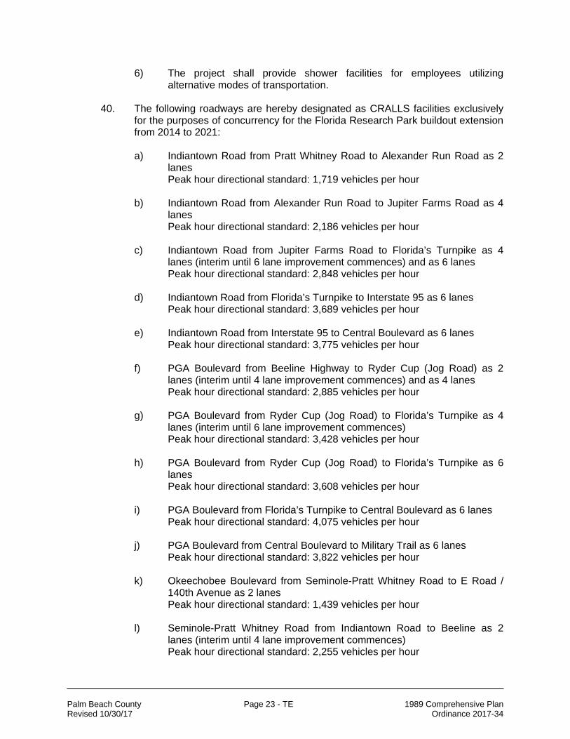
40. The following roadways are hereby designated as CRALLS facilities exclusively
for the purposes of concurrency for the Florida Research Park buildout extension from 2014 to 2021: a) Indiantown Road from Pratt Whitney Road to Alexander Run Road as 2
lanes Peak hour directional standard: 1,719 vehicles per hour
b) Indiantown Road from Alexander Run Road to Jupiter Farms Road as 4
lanes Peak hour directional standard: 2,186 vehicles per hour
c) Indiantown Road from Jupiter Farms Road to Florida’s Turnpike as 4
lanes (interim until 6 lane improvement commences) and as 6 lanes Peak hour directional standard: 2,848 vehicles per hour
d) Indiantown Road from Florida’s Turnpike to Interstate 95 as 6 lanes
Peak hour directional standard: 3,689 vehicles per hour e) Indiantown Road from Interstate 95 to Central Boulevard as 6 lanes
Peak hour directional standard: 3,775 vehicles per hour
f) PGA Boulevard from Beeline Highway to Ryder Cup (Jog Road) as 2 lanes (interim until 4 lane improvement commences) and as 4 lanes Peak hour directional standard: 2,885 vehicles per hour
g) PGA Boulevard from Ryder Cup (Jog Road) to Florida’s Turnpike as 4
lanes (interim until 6 lane improvement commences) Peak hour directional standard: 3,428 vehicles per hour
h) PGA Boulevard from Ryder Cup (Jog Road) to Florida’s Turnpike as 6
lanes Peak hour directional standard: 3,608 vehicles per hour
i) PGA Boulevard from Florida’s Turnpike to Central Boulevard as 6 lanes
Peak hour directional standard: 4,075 vehicles per hour j) PGA Boulevard from Central Boulevard to Military Trail as 6 lanes
Peak hour directional standard: 3,822 vehicles per hour k) Okeechobee Boulevard from Seminole-Pratt Whitney Road to E Road /
140th Avenue as 2 lanes Peak hour directional standard: 1,439 vehicles per hour
l) Seminole-Pratt Whitney Road from Indiantown Road to Beeline as 2
lanes (interim until 4 lane improvement commences) Peak hour directional standard: 2,255 vehicles per hour
Palm Beach County Page 24 - TE 1989 Comprehensive Plan Revised 10/30/17 Ordinance 2017-34
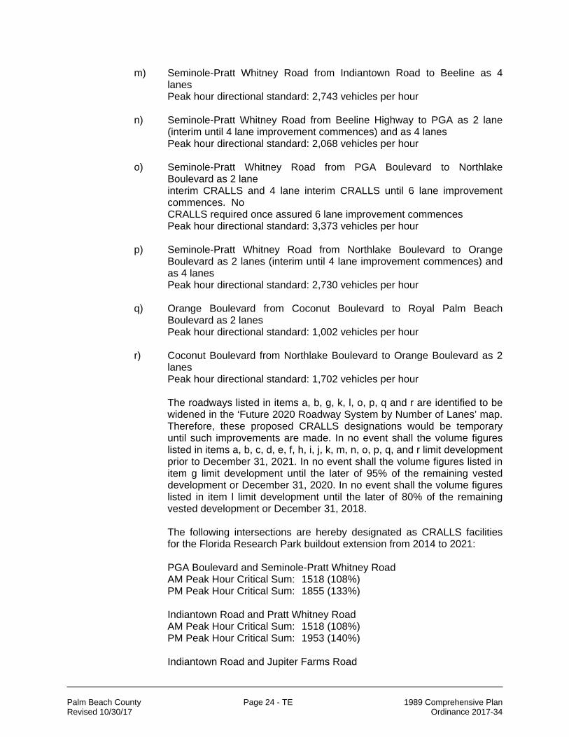
m) Seminole-Pratt Whitney Road from Indiantown Road to Beeline as 4 lanes Peak hour directional standard: 2,743 vehicles per hour
n) Seminole-Pratt Whitney Road from Beeline Highway to PGA as 2 lane (interim until 4 lane improvement commences) and as 4 lanes Peak hour directional standard: 2,068 vehicles per hour
o) Seminole-Pratt Whitney Road from PGA Boulevard to Northlake
Boulevard as 2 lane interim CRALLS and 4 lane interim CRALLS until 6 lane improvement commences. No CRALLS required once assured 6 lane improvement commences Peak hour directional standard: 3,373 vehicles per hour
p) Seminole-Pratt Whitney Road from Northlake Boulevard to Orange
Boulevard as 2 lanes (interim until 4 lane improvement commences) and as 4 lanes Peak hour directional standard: 2,730 vehicles per hour
q) Orange Boulevard from Coconut Boulevard to Royal Palm Beach
Boulevard as 2 lanes Peak hour directional standard: 1,002 vehicles per hour
r) Coconut Boulevard from Northlake Boulevard to Orange Boulevard as 2
lanes Peak hour directional standard: 1,702 vehicles per hour
The roadways listed in items a, b, g, k, l, o, p, q and r are identified to be widened in the ‘Future 2020 Roadway System by Number of Lanes’ map. Therefore, these proposed CRALLS designations would be temporary until such improvements are made. In no event shall the volume figures listed in items a, b, c, d, e, f, h, i, j, k, m, n, o, p, q, and r limit development prior to December 31, 2021. In no event shall the volume figures listed in item g limit development until the later of 95% of the remaining vested development or December 31, 2020. In no event shall the volume figures listed in item l limit development until the later of 80% of the remaining vested development or December 31, 2018.
The following intersections are hereby designated as CRALLS facilities for the Florida Research Park buildout extension from 2014 to 2021: PGA Boulevard and Seminole-Pratt Whitney Road AM Peak Hour Critical Sum: 1518 (108%) PM Peak Hour Critical Sum: 1855 (133%) Indiantown Road and Pratt Whitney Road AM Peak Hour Critical Sum: 1518 (108%) PM Peak Hour Critical Sum: 1953 (140%) Indiantown Road and Jupiter Farms Road

Palm Beach County Page 25 - TE 1989 Comprehensive Plan Revised 10/30/17 Ordinance 2017-34
AM Peak Hour Critical Sum: 1576 (113%) PM Peak Hour Critical Sum: 1558 (111%) Indiantown Road and Central Boulevard AM Peak Hour Critical Sum: 2430 (174%) PM Peak Hour Critical Sum: 2266 (162%) PGA Boulevard and Florida’s Turnpike AM Peak Hour Critical Sum: 2509 (179%) PM Peak Hour Critical Sum: 2167 (155%) PGA Boulevard and Central Boulevard AM Peak Hour Critical Sum: 1967 (141%) PM Peak Hour Critical Sum: 1840 (131%) PGA Boulevard and Military Trail AM Peak Hour Critical Sum: 2143 (153%) PM Peak Hour Critical Sum: 2207 (158%) Northlake Boulevard and Seminole-Pratt Whitney Road AM Peak Hour Critical Sum: 2248 (161%) PM Peak Hour Critical Sum: 1974 (141%) Northlake Boulevard and Coconut Boulevard PM Peak Hour Critical Sum: 1654 (118%) Okeechobee Boulevard and Seminole-Pratt Whitney Road AM Peak Hour Critical Sum: 1985 (142%) PM Peak Hour Critical Sum: 2182 (156%) Orange Boulevard and Seminole-Pratt Whitney Road AM Peak Hour Critical Sum: 2144 (153%) PM Peak Hour Critical Sum: 2135 (153%) Orange Boulevard and Coconut Boulevard AM Peak Hour Critical Sum: 1606 (115%) PM Peak Hour Critical Sum: 1565 (112%) Orange Boulevard and Royal Palm Beach Boulevard AM Peak Hour Critical Sum: 1564 (112%) PM Peak Hour Critical Sum: 1897 (136%) Northlake Boulevard and Military Trail AM Peak Hour Critical Sum: 1397 (100%) PM Peak Hour Critical Sum: 1658 (118%)
In no event shall the intersectional data listed above limit development prior to December 31, 2021. CRALLS Mitigation Measures to be implemented and to be included in the concurrency approval and Development Order (D.O.) conditions for

Palm Beach County Page 26 - TE 1989 Comprehensive Plan Revised 10/30/17 Ordinance 2017-34
Florida Research Park DRI, in conjunction with these CRALLS include the following: 1) Land Use / Site Planning Measure – Provide mixed/multiple land
uses based upon the Florida Research Park Master Development Plan.
2) Land Use / Site Planning Measure – Concurrent with obtaining
each certificate of occupancy, for a non-residential building located on a parcel 50 acres or greater, implement parking strategies that provide preferred parking for alternative vehicles and car pool vehicles.
3) Land Use / Site Planning Measure – Apply access management
techniques along all roadways along project frontage. 4) Connectivity Measure – Provide access to more than one road
including Beeline Highway and Seminole Pratt-Whitney Road. 5) Transit Measure – Coordinate with Palm Tran to provide a bus
route(s) to/from the site by January 1, 2015 or 3 million square feet, whichever comes first.
6) Transit Measure – Provide onsite bus stop facilities (intermodal
facility), within one year of provision of a bus service. 7) Transportation Demand Management (TDM) Measure – Provide
an on-going ride-sharing information service to persons employed at the project site.
8) Transportation Demand Management (TDM) Measure –
Proportionately and annually fund an Employee Transportation Coordinator position that will coordinate the individual businesses in Florida Research Park.
9) Transportation Demand Management (TDM) Measure – The
Florida Research Park Transportation Coordinator shall encourage businesses of 500 employees or more to accommodate alternate work hours and telecommuting standards.
Beginning January 1, 2008, Florida Research Park shall submit an annual report to the County’s Planning Director and the County Engineer to demonstrate compliance with the mitigation measures required by this policy. In the event that any of the mitigation measures above are not fulfilled, the annual report will be submitted to the Board of County Commissioners (BCC) for consideration. The BCC may then amend or rescind any or all provisions of this policy. This CRALLS will be revisited one year after the effective date of this amendment. Conditions may be required in order to meet the concurrency requirements of Palm Beach County. These shall be determined at the time of issuing the concurrency reservation. In addition, these CRALLS mitigation measures shall be

Palm Beach County Page 27 - TE 1989 Comprehensive Plan Revised 10/30/17 Ordinance 2017-34
detailed and included in the concurrency reservation and the Florida Research Park DRI D.O.
41. [deleted in Round 17-C] 42. The following intersection is hereby designated as a CRALLS facility exclusively
for the purposes of concurrency for W & W V LLC project, and shall become effective upon the project’s obtaining of a variance (if required) from FDOT’s adopted LOS standard for the SIS.
State Road 7and Southern Boulevard (SR-80) P.M. Peak Hour: HCM Average Control Delay = 210.3 secs HCM Level of Service = F
In addition, the maximum queue length (95th percentile) projected by the HCM signalized intersection analysis shall not exceed the available storage on the east and west ramps from SR 80 to their at grade intersections with SR 7 so as not to interfere with the movement of east-west through traffic on SR 80.
To the satisfaction of the County Engineer, the following CRALLS Mitigation Measures are to be implemented in conjunction with this CRALLS: 1) The project must prepay Traffic Impact Fees within 6 months of the
approval of the Development Order or prior to the issuance of the first building permit, whichever shall first occur.
2) The project shall provide a contribution to help cover some of the funding shortfall for the various transportation related improvements, at a minimum of 1.5 times the applicable impact fee to be used towards off-site roadway improvements.
3) The project shall require an ADA accessible connection to pedestrian parkways that allow direct access to the Mall at Wellington Green & the bus transfer station there.
4) The project shall provide an on-going ride-sharing information service to persons employed by the project.
5) The project shall provide an integrated pedestrian system that connects the buildings to public sidewalks & the enhanced Palm Tran bus stops\shelters.
6) The project shall provide inter-connectivity between complementary neighboring land uses for both vehicular & pedestrian cross-access.
7) The project shall provide a bicycle rack to accommodate commuters using alternative modes of transportation.
8) The project shall provide transit passes to employees using mass transit. 43. [deleted in Round 17-C]

Palm Beach County Page 28 - TE 1989 Comprehensive Plan Revised 10/30/17 Ordinance 2017-34
Policy 1.2-g: As specified in the Unified Land Development Code (ULDC) for the purposes of issuing a development order or permit, a proposed urban redevelopment project located within the County's existing Urban Service Area shall not be subject to the transportation concurrency requirements of the County's Comprehensive Plan for up to 110 percent of the transportation impact generated by the previously existing development. The following issues, at a minimum, shall be addressed: 1. The Policy's Scope: Consideration shall be given to further limiting the
geographic areas (such as coastal high hazard areas) where this provision shall apply and the buildings, structures or resources that may be impacted; and
2. Other Implementation Issues: For purposes of this Policy, a previously existing development is the actual previous use, which was occupied and active within the preceding five years. Consideration shall be given to:
a. Reassessment of the five-year time period;
b. The documentation needed to establish the actual previous uses was "occupied" and "active"; and
c. The guidelines to be used for determining the transportation impact generated by the previous existing development when there was more than one actual previous uses within the identified time period; and
d. Any other relevant and appropriate issues.
Policy 1.2-h: Notwithstanding any other provisions of this Comprehensive Plan, a local government may issue a development order or permit provided that: 1. Transportation facilities needed to serve new development are in place no more
than three (3) years from the date of development order approval; and, 2. The transportation facilities and services needed to serve the development are
identified in the local government's Capital Improvement Element or the first three-years of the adopted Florida Department of Transportation's Work Program; and,
3. The Capital Improvement Element includes the following information for each affected roadway:
a. The estimated date of commencement of actual construction and the
estimated date of project completion; and b. A provision that a plan amendment is required to eliminate, defer, or
delay the programmed construction of the road which is needed to maintain the adopted level of service standard; and,
4. The development is located within one of the following geographic areas: a. The residential exception area per Transportation Element Policy 1.2-a;
b. the Glades communities, delineated as the areas in the Urban/Suburban Tier immediately east of Lake Okeechobee, and the areas with urban densities in the rural towns of Lake Harbor and Canal Point;
c. the County’s Redevelopment and Revitalization Overlay; or
5. The facilities are wholly owned and operated by State, local, and County entities, or public and private schools (as defined in the Introduction and Administration Element).
Palm Beach County Page 29 - TE 1989 Comprehensive Plan Revised 10/30/17 Ordinance 2017-34
Policy 1.2-i: The Palm Beach County Board of County Commissioners shall allow for the designation of Transportation Concurrency Management Areas (TCMAs) within Palm Beach County as specified in the Unified Land Development Code (ULDC). [163.3177(6)(a)10.b(II)]
Policy 1.2-j: Each local government within an effective TCMA shall provide an Annual Report demonstrating that the areawide level of service standard is being maintained, as required in the ULDC. The Annual Report shall be submitted to the Planning Division no later than March 31. If the Annual Report shows the local government cannot maintain the areawide level of service standard, the BCC shall have the authority to repeal the ULDC TCMA provisions for the affected TCMA.
Policy 1.2-k: The Palm Beach County Board of County Commissioners shall allow for the designation of Transportation Concurrency Exception Areas (TCEAs) within Palm Beach County as specified in the Unified Land Development Code (ULDC). TCEAs allow an exception from the concurrency requirements for transportation facilities if the proposed development is consistent with the adopted local government comprehensive plan and is located within an area designated in a comprehensive plan for urban infill development, urban redevelopment, or downtown revitalization. [163.3177(6)(a)10.b(II)] Policy 1.2-l: The City of Delray Beach Transportation Concurrency Exception Area (TCEA) is hereby established and designated as shown on TE Map 15.1 and TE Map 15.4 in the Map Series (Additional maps of the TCEA can be found in Figures TE-S 6.1 and TE-S 7.1 in the support documents).
Policy 1.2-m: The City of West Palm Beach Transportation Concurrency Exception Area (TCEA) is hereby established and designated as shown on TE Map 15.1 and TE Map 15.2 in the Map Series (additional maps of the TCEA can be found in the Support Document Figures TE-S 6.1 and TE-S 7.1), subject to: 1) the City maintenance of a residential/non-residential ratio minimum, 2) City participation/ support of motor vehicle capacity increases as indicated in the City’s TCEA and the applicable portions of Section II.A.6.d.6 of the Support Document, and 3) the following sub-policies:
1. Palm Beach County shall evaluate the annual reports of the City of West Palm
Beach’s Traffic Management System (TMS) and the Buildable Areas Monitoring Table and other appropriate materials as provided by the TCEA policies identified in the various elements of the City’s Comprehensive Plan, and determine conformance with the TCEA policies of the City’s and the County’s Comprehensive Plans and Section II.A.6.d.6 of the County’s Support Document.
By May 2000, the City shall develop a Traffic Management System (TMS) for the purpose of monitoring motor vehicle operations within the Downtown. The City shall prepare an annual report to determine the necessary measures to effectively manage vehicular traffic operations and evaluate the Traffic Management System. The City shall distribute the report to the Florida Department of Community Affairs, Palm Beach County, and other interested agencies, within three months of the anniversary of the effective date of the TCEA. Based on the results of the traffic monitoring report, the City will pursue strategies including, but not limited to, the following:
a. change motor vehicle signalization devices;

Palm Beach County Page 30 - TE 1989 Comprehensive Plan Revised 10/30/17 Ordinance 2017-34
b. promote public transit services; c. encourage transportation mode options
d. implement an employer-based Transportation Demand Management (TDM) activities;
e. develop a centrally-managed system of strategically located parking facilities; and
f. facilitate capital projects and street modifications in keeping with the Transportation Vision
2. Five years from the effective date of the City's TCEA, the City shall achieve a
built ratio of residential to non residential development of no less than the 1995 ratio of .33 (the baseline ratio). If the built ratio is lower than .33 at that time, no building permits shall be issued for new development (not including renovation) in downtown which represent a ratio lower than the next baseline, until such time that a recalculation of built units and floor space yields at least a built ratio of .33.
Every two years ("reporting period") following the fifth year from the effective date of the City's TCEA, the City shall increase its baseline ratio by .03 until the baseline ratio is .46 by the year 2010. Thereafter, .46 will be the baseline ratio, If the baseline ratio is not met by the end of each reporting period, then no building permits shall be issued for new development in downtown which represent a ratio lower than the next baseline ratio, until such time that a recalculation of built units and floor space yields at least the baseline ratio. This annual report shall be based on total built units as of one month prior to the end of the reporting period.
3. In the event Palm Beach County determines that the City has not complied with
the TCEA policies of the City’s and the County’s Comprehensive Plans and Section II.A.6.d.6 of the County’s Transportation Element Support Document, the County’s Comprehensive Plan policies creating the TCEA will be re-evaluated.
4. In the event the City seeks to reduce the number of lanes on Okeechobee
Boulevard from Tamarind Avenue to Dixie Highway, a CRALLS designation will be required.
5. The City and County have determined the specific limits where Dixie Highway
and Olive Avenue shall be two way and where they shall be one way, shall be as follows:
Roadway Segment Operation
Dixie Hwy South of Lakeview Ave. Between Lakeview Ave. and Banyan Blvd. North of Banyan Blvd.
Two-way One-way Two-way
Olive Ave. South of Lakeview Ave. Between Lakeview Ave. and Quadrille Blvd. North of Quadrille Blvd.
Two-way One-way Two-way
Those segments that have one-way operations shall contain two vehicular travel lanes as reviewed and approved by the City and County, while increasing sidewalk width as deemed appropriate by the City.

Palm Beach County Page 31 - TE 1989 Comprehensive Plan Revised 10/30/17 Ordinance 2017-34
6. The Transportation Concurrency Exception Area (TCEA) for the West Palm Beach Downtown Master Plan (DMP) shall become effective upon the finding of compliance by the Florida Department of Community Affairs (DCA) for both the County’s and the City’s amendments to their respective comprehensive plans for the TCEA. It is the County’s position that development orders issued within the DMP area shall be consistent with the policies in the County’s TCEA.
7. The TCEA is limited to the square footage set forth in the Downtown Master Plan
and as indicated below in Table TE 3 titled “Buildable Areas Monitoring Table”.
Table TE 3 BUILDING AREAS MONITORING TABLE
DOWNTOWN MASTER
PLAN
NONRESIDENTIAL
(Square Feet)
RESIDENTIAL [1] (Dwelling Units)
HOTEL [2] (Rooms)
1995 EXISTING 8,126,945 2,689
349
DEVELOPMENT GAP
6,947,025 4,454
2,100
TOTAL PROJECTION
15,073,970 7,143
2,449
1. Residential info is provided only to show how the ratio of residential units to each 1,000 square
feet of non-residential development (referenced in condition 2) was calculated. There is no upper limit to the amount of residential development within the TCEA area.
2. Hotel is a permitted land use category within the TCEA and the number of rooms projected to be built is shown for informational purposes only. There is no upper limit to the number of Hotel rooms within the TCEA area.
Policy 1.2-n: The BCC finds that a de minimis impact to transportation facilities within the Urban/Suburban Tier is consistent with the County’s goal of operating the Countywide transportation system at the adopted level of service. Consequently, the ULDC shall provide for an exemption for projects which generate de minimis impacts to the transportation network. A de minimis impact may generate up to 1 percent of the maximum volume at the adopted level of service of the affected transportation facility. No impact will be de minimis if the sum of existing roadway volumes and the projected volumes from approved projects on a transportation facility would exceed 110 percent of the maximum volume at the adopted level of service of the affected transportation facility. However, no project may utilize this provision if its impact would exceed the adopted level-of-service standard of any affected designated hurricane evacuation routes. Furthermore, impacts from single-family homes and development at entitlement densities and lot intensities will constitute a de minimis impact on all roadways regardless of the level of the deficiency of the roadway.

Palm Beach County Page 32 - TE 1989 Comprehensive Plan Revised 10/30/17 Ordinance 2017-34
Policy 1.2-o: The Unified Land Development Code (ULDC) shall contain provisions to exempt developments located within urban infill, urban redevelopment, existing urban service, or downtown revitalization areas which pose only special part-time demands on the transportation system from the transportation concurrency requirements.
Policy 1.2-p: The County shall include provisions in the ULDC which may allow a
project to be exempted from transportation concurrency requirements provided that the project otherwise is consistent with the adopted Comprehensive Plan and demonstrates that it will promote public transportation. The following criteria shall be used to determine compliance with the statute for this exception:
1. All projects must be located within the County’s Urban/Suburban Tier and be
adjacent to (i.e., abutting or separated only by other public or governmental rights-of-way) the Tri-County Commuter Rail Authority line, or be adjacent to a street which is served by Palm Tran; and
2. All projects shall provide a site to Tri-Rail at the project site adjacent to the Tri-
Rail tracks for a station platform, ticket booth, parking for at least 400 automobiles. When a project is not adjacent to Tri-Rail, it shall provide a bus stop facility capable of handling two or more Palm Tran buses at a time with a covered waiting area of sufficient size to accommodate at least 10% of its employees; and
3. The project shall provide a financial incentive in the form of a subsidy of at least
50% of the annual ticket cost to at least 15% of the persons employed at the project site for riding Tri-Rail and/or Palm Tran to and from the project site a minimum of 200 working days per year. As an alternative, the development may provide equivalent funds directly to Palm Tran to subsidize this service; and
4. The project shall provide a ride-sharing information service to persons employed
at the project site; and 5. The project shall provide emergency transportation to those employees using
mass transit, ride sharing, or other alternative modes of transportation (ie. bicycles or pedestrian); and
6. The project shall apply access management techniques along all roadways
fronting the project; and
7. The project shall provide external pedestrian access to the project, as well as an internal pedestrian system, accommodating persons with disabilities, as well as persons using alternative modes of transportation to the automobile; and
8. a. Projects which promote economic development through job creation shall,
at a minimum, be of 200 acres in size, and create, at project build-out, an estimated 5,000 jobs at the project site; or,
b. Projects developed by a not-for-profit agency in order to provide essential
public services shall, at a minimum, be of 20 acres in size, and create, at build-out, an estimated 2,000 jobs at the project site; and

Palm Beach County Page 33 - TE 1989 Comprehensive Plan Revised 10/30/17 Ordinance 2017-34
9. The project may be a mixed use project, incorporating residential and/or
commercial components. However, in no event shall residential and/or commercial retail uses combine to comprise more than 45% of the gross floor area; and
10. The project shall not be located within the Coastal High Hazard Area.
Projects utilizing this exemption may be required to provide roadway, intersection, and/or signalization improvements to minimize their impact on the road network. They shall also provide a transportation analysis that illustrates their impact on the Florida Intrastate Highway System & the Strategic Intermodal System to ensure that those impacts are considered in the approval process. [163.3164(37)] Policy 1.2-q: Beginning in the first amendment round of year 2002, mitigation measures shall be required for any new CRALLS designation. These measures are intended to improve the mobility in the corridor by increasing the options available to vehicular and non-vehicular travel. Measures to be required may include, but are not limited to, the following, where appropriate:
1. Connectivity measures that will more effectively distribute traffic
a. Build/ expand alternate roads 1) Thoroughfare roads 2) Non-Thoroughfare roads
b. Use existing Right-of-Way (i.e. canals) where possible, to provide connections for alternative travel modes
c. Provide access to more than one road d. Provide connections between/within developments e. Provide frontage/access roads
2. Land use/site planning measures
a. Provide mixed/multiple uses on site b. Provide land use balance regionally c. Unify residential and non-residential portions of the project through the
master plan to accomplish mixed-use projects d. Allow home businesses e. Allow accessory units f. Create traffic sensitive uses for use in constrained areas g. Implement parking strategies (locational) h. Incorporate design features oriented towards alternative modes i. Introduce or enhance landscaped non-vehicular corridors
3. Transit measures
a. Provide lump sum payment for capital improvements b. Provide lump sum payment for operational costs c. Provide on-going funding d. Dedicate Land
4. Transportation Systems Management (TSM) measures a. Improve intersections b. Dedicate transit/HOV lanes

Palm Beach County Page 34 - TE 1989 Comprehensive Plan Revised 10/30/17 Ordinance 2017-34
c. Provide reversible lanes d. Improve signal coordination
5. Transportation Demand Management (TDM) measures a. Provide incentives for transit, carpool and other modes b. Accommodate alternate work hours c. Accommodate telecommuting d. Implement parking strategies (supply related)
All future CRALLS, where appropriate, shall: 1) identify specific mitigation measures; 2) evaluate measures to encourage the use of alternatives to the Florida Intrastate Highway System & the Strategic Intermodal System; 3) determine timing and responsibility of the implementation of mitigation measures; 4) identify methodology to relate the anticipated impacts of development to the mitigation measures; and 5) demonstrate coordination with appropriate agencies. The County shall develop and include in the ULDC a series of transportation, land use, and development strategies that can be implemented by individual developers in order to reduce the traffic impacts of future CRALLS designations, where appropriate. Indicators that assess the effectiveness of each strategy for mitigating the traffic impacts of developments will be identified for this system.
Policy 1.2-r: The Westgate-Belvedere Homes Community Redevelopment Area (Westgate CRA) Transportation Concurrency Exception Area (TCEA) is hereby established and designated. Contiguous with the boundaries of the CRA, the TCEA is bounded by Okeechobee Boulevard on the north side, Florida Mango Road on the east side, Belvedere Road on the South side, and Military Trail on the West side. The TCEA shall be limited to the maximum allowable total daily trips, and total pm peak hour trips identified in the Table TE-6 of this policy. A proposed project must be recommended for approval by the Community Redevelopment Agency to be eligible to benefit from this pool. Any project utilizing this TCEA and significantly impacting Interstate 95 shall be required to address its impacts pursuant to ULDC. By August 2020, the TCEA may be modified by the BCC if the CRA achieves the developments shown in Table TE-6. The CRA shall submit an annual report to the County’s Planning Director to demonstrate compliance with the conditions set forth in this policy as well as provide data on the Existing Land Use Intensities by number of units, square footage of uses as well as the status of the total daily trips and total peak pm hour trips. Upon review by the Planning Director and the County Engineer, the annual report will be submitted to the Board of County Commissioners (BCC) for consideration. In the event that any of the conditions below is not met, the BCC may amend or rescind any or all of this policy. The conditions are: 1. Development approvals utilizing the TCEA shall remain at or below the maximum
allowable total daily trips and total p.m. peak hour trips set by Table TE-6. No building permits shall be issued for new development when the applicable maximum allowable limit for that development is reached.
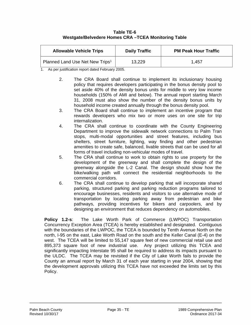
Palm Beach County Page 35 - TE 1989 Comprehensive Plan Revised 10/30/17 Ordinance 2017-34
Table TE-6 Westgate/Belvedere Homes CRA –TCEA Monitoring Table
Allowable Vehicle Trips Daily Traffic PM Peak Hour Traffic
Planned Land Use Net New Trips1 13,229 1,457
1. As per justification report dated February 2005. 2. The CRA Board shall continue to implement its inclusionary housing
policy that requires developers participating in the bonus density pool to set aside 40% of the density bonus units for middle to very low income households (150% of AMI and below). The annual report starting March 31, 2008 must also show the number of the density bonus units by household income created annually through the bonus density pool.
3. The CRA Board shall continue to implement an incentive program that rewards developers who mix two or more uses on one site for trip internalization.
4. The CRA shall continue to coordinate with the County Engineering Department to improve the sidewalk network connections to Palm Tran stops, multi-modal opportunities and street features, including bus shelters, street furniture, lighting, way finding and other pedestrian amenities to create safe, balanced, livable streets that can be used for all forms of travel including non-vehicular modes of travel.
5. The CRA shall continue to work to obtain rights to use property for the development of the greenway and shall complete the design of the greenway alongside the L-2 Canal. The design should show how the bike/walking path will connect the residential neighborhoods to the commercial corridors.
6. The CRA shall continue to develop parking that will incorporate shared parking, structured parking and parking reduction programs tailored to encourage businesses, residents and visitors to use alternative mode of transportation by locating parking away from pedestrian and bike pathways, providing incentives for bikers and carpoolers, and by designing an environment that reduces dependency on automobiles.
Policy 1.2-s: The Lake Worth Park of Commerce (LWPOC) Transportation Concurrency Exception Area (TCEA) is hereby established and designated. Contiguous with the boundaries of the LWPOC, the TCEA is bounded by Tenth Avenue North on the north, I-95 on the east, Lake Worth Road on the south and the Keller Canal (E-4) on the west. The TCEA will be limited to 55,147 square feet of new commercial retail use and 895,373 square foot of new industrial use. Any project utilizing this TCEA and significantly impacting Interstate 95 shall be required to address its impacts pursuant to the ULDC. The TCEA may be revisited if the City of Lake Worth fails to provide the County an annual report by March 31 of each year starting in year 2004, showing that the development approvals utilizing this TCEA have not exceeded the limits set by this Policy.

Palm Beach County Page 36 - TE 1989 Comprehensive Plan Revised 10/30/17 Ordinance 2017-34
Policy 1.2-t: The City of Riviera Beach Community Redevelopment Area (CRA) - Transportation Concurrency Exception Area (TCEA) is hereby established and designated. The boundaries of the TCEA are shown on TE Map 15.1 and TE Map 15.3 in the Map Series. The TCEA shall be to limited to the maximum allowable number of units, square footage, total daily trips, and total pm peak season, peak hour trips identified in the Table TE-4.A of this policy. Any project utilizing this TCEA and significantly impacting the Florida Intrastate Highway System (FIHS) shall be required to address its impacts on FIHS facilities pursuant to the ULDC.
The TCEA shall not take effect unless and until the City of Riviera Beach demonstrates to the satisfaction of the County Engineer in his sole discretion that peak hour peak season traffic on North Ocean Drive (SR A1A) does not exceed level of service D at build-out, based on maximum density/ intensity/zoning established by the City of Riviera Beach Comprehensive Plan and land development regulations for properties on the Singer Island outside the boundaries of the TCEA. Any Development Order (DO) application for any project set forth in Table TE 4.B shall not be approved if the County Engineer determines that such project will cause peak season pm peak hour traffic on North Ocean Drive to exceed LOS D at project build-out or anticipated Singer Island build-out in year 2025 except for a project utilizing its vested traffic pursuant to County’s ULDC. Projected traffic at the anticipated Singer Island build-out shall be calculated by using: the traffic count on North Ocean Drive (SR A1A) 100 feet south of Harbor Drive South; a background traffic annual growth rate of 0.5%; and include the allowable approved but unbuilt traffic for the TCEA and for Singer Island outside the TCEA. On or before December 1, 2011, the County staff shall submit a written report to the Board of County Commissioners which recommends whether or not the TCEA and its associated policy restrictions should remain in effect on Singer Island.
Prior to issuance of any Development Order for a project within the TCEA on Singer Island, the project must submit a traffic generation study for approval to the County Engineer. This traffic study shall show external project traffic and all other existing and committed development traffic within the TCEA on Singer Island, to demonstrate that the proposed project is within the limits for allowable land uses and trips set forth in Table TE-4.A.
Beginning March 1, 2005, the City shall submit an annual report to the County’s Planning Director to demonstrate compliance with the conditions set forth in this policy. Upon review by the Planning Director and the County Engineer, the annual report will be submitted to the Board of County Commissioners (BCC) for consideration. In the event that any of the conditions below is not met, the BCC may amend or rescind any or all of this policy. The conditions are: 1. The development approvals within this TCEA shall remain at or below the
maximum allowable limits for units, square footage, total daily trips, and total pm peak hour trips set by Table TE-4.A of this policy. No building permits shall be issued for new development when the applicable maximum allowable limit for that development is reached.
2. Beginning with the March 1, 2006 annual report, and at the end of each reporting period thereafter, the cumulative ratio of approved residential units to 1,000 square foot approved office space shall remain between the maximum and minimum allowable ratios identified in Table TE-4.A.
3. Beginning with the March 1, 2006 annual report, and at the end of each reporting period thereafter, the cumulative ratio of approved residential units to 1,000

Palm Beach County Page 37 - TE 1989 Comprehensive Plan Revised 10/30/17 Ordinance 2017-34
square foot approved other non-residential space shall remain between the maximum and minimum allowable ratios identified in Table TE-4.A.
4. By January 2005, the City shall amend its land development regulations to require developments within the TCEA to contribute toward the cost of public transit infrastructure as one means to offset the impact of the concurrency exception on the arterial roadway network and the FIHS.
5. The City, in coordination with the Riviera Beach CRA, shall maintain and annually update a master phasing plan and infrastructure budget and schedule that targets needed improvements within the TCEA boundaries and sets priority for funding and construction in the City’s Five Year Capital Improvements Program.
6. By January 2005, the City shall revise its street design standards for all City streets within the TCEA to install street design features so that construction of new streets and repair of existing streets create safe, balanced, livable streets that can be used for all forms of travel including non-vehicular modes of travel.
7. By January 2006, the City shall undertake a detailed transit study to develop a local transit circulator plan (complementing the County’s public transit service) for the TCEA including specific route alignments, infrastructure needs, headways, hours of operation and other service characteristics. The City shall act on the conclusions and recommendations contained within the transit circulator plan and move forward with efforts to implement improvements according to the phasing and schedule provided in the plan.
8. Prior to issuance of building permits for TCEA development generating more than 30% of the total Planned Land Use Net New PM Peak Hour Trips (as identified in Table T-1), the City shall provide local transit circulator service within a ¼ mile of fifty percent (50%) of all mixed use and medium high density residential areas identified on the Future Land Use Map (FLUM) of the City’s Comprehensive Plan and within the TCEA boundaries, provided they are within the Palm Tran service areas. The City may also focus this service to areas where transit service-supportive densities and intensities have developed. If, however, equivalent service within the area described above is already being provided by regular Palm Tran bus routes, then the City is not required to provide additional service.
9. If the Palm Beach MPO adopts the South Florida East Coast Corridor (SFECC) Study final recommendations and a station site is required in the City of Riviera Beach for a fixed-guideway transit system, then the City shall acquire the necessary property and transfer it to the transit system operating authority at a cost no greater than City’s acquisition cost. The property shall be transferred at such time as requested by the transit system operating authority, but no sooner than the fiscal year in which funds are budgeted by the MPO’s Transportation Improvement Program (TIP) for property acquisition on this segment of the Corridor. Concurrent with the opening of this new FEC Corridor station, the City with its own funding source shall provide a new circulator service and/or expand an existing circulator service to connect to this new station, unless equivalent service is provided by some other public transit agency.
10. Concurrent with the development, the City shall provide hurricane shelter space for at least 20% of the population increase associated with hotel/motel developments, residential developments, mobile home and trailer park developments, and recreational vehicle developments within the hurricane vulnerability zone. A long-term comprehensive shelter program shall be coordinated in conjunction with public, private and non-profit organizations to ensure that adequate shelter space is located in an area outside of the hurricane evacuation zone and meets current American Red Cross standards.
Palm Beach County Page 38 - TE 1989 Comprehensive Plan Revised 10/30/17 Ordinance 2017-34
11. Deleted in Amendment Round 12-1 12. The City shall annually monitor the intersection of Blue Heron Boulevard and Old
Dixie Highway, and coordinate with FDOT and the County to improve this intersection when necessary, and if feasible.
13. Consistent with the intent of the City’s Redevelopment Plan dated 2001, Section 3.2.10.3, Methods of Assuring Availability of Housing, the City shall ensure that the development (with any residential component) within each phase (as contemplated by the Phasing Plan in the TCEA Justification Report dated July 9, 2003) of the CRA, be required to provide no less than 5% of the total residential units for occupancy by very low income (less than or equal to 50% of the County’s median annual adjusted gross income) households, and low income (more than 50% but less than or equal to 80% percent of the County’s median annual adjusted gross income) households. The City shall also ensure that these affordable units remain affordable for no less than 10 years for ownership units and no less than 20 years for rental units.
14. By March 1, 2005, the City shall submit to County’s Emergency Management Division a site-specific study determining evacuation times from Singer Island in case of mandatory evacuation. The Transportation Concurrency Exception Area (TCEA) for the Riviera Beach CRA shall become effective upon the finding of compliance by the Florida Department of Community Affairs (DCA) for both the County’s and the City’s amendments to their respective comprehensive plans for the TCEA. It is the County’s position that development orders issued within the CRA area shall be consistent with the policies in the County’s TCEA.

Palm Beach County Page 39 - TE 1989 Comprehensive Plan Revised 10/30/17 Ordinance 2017-34
Table TE-4.A Riviera Beach CRA - TCEA
Monitoring Table
MAINLAND DEVELOPMENT
Allowable Land Use Intensities
Residential/ Rental Units
Hotel Units
Conference Area (SF)
Office/ Technical
Area
Other Non- residential
Planned Land Use Totals 3,945 300 33,000 1,145,855 1,636,506
Allowable variance +/- (%) 15% 25% 25% 10% 10%
Maximum Allowable Development 4,537 375 41,250 1,260,441 1,800,157
Minimum Allowable Development 3,353 225 24,750 1,031,270 1,472,855
Daily Traffic PM Peak Hour Traffic
Planned Land Use Net New Trips 49,703 5,226
Allowable Land Use Ratios Residential/ Office Residential/ Other Non-Residential
Maximum Allowable Ratios 4.50 3.10
Minimum Allowable Ratios 2.10 1.30
SINGER ISLAND DEVELOPMENT
Allowable Land Use Intensities Residential/ Rental Units
Hotel Units
Conference Area (SF)
Office/ Technical
Area
Other Non- residential
Planned Land Use Totals 426 535 50,000 0 134,010
Allowable variance +/- (%) 15% 25% 25% 0% 10%
Maximum Allowable Development 490 669 62,500 147,411
Minimum Allowable Development 362 401 37,500 120,609
Maximum Allowable Vehicle Trips Daily Traffic PM Peak Hour Traffic
Planned Land Use Net New Trips 4,213 337
Allowable Land Use Ratios Residential/ Office Residential/ Other Non-Residential
Maximum Allowable Ratios - 4.10
Minimum Allowable Ratios - 2.40

Palm Beach County Page 40 - TE 1989 Comprehensive Plan Revised 10/30/17 Ordinance 2017-34
Table TE-4.B Singer Island Development (Outside TCEA)
Land Use Existing/Approved
Intensity
* Phoenix Towers 192 MF du Tiara 320 MF du Amrit (Island Beach Resort) 258 rooms Amrit (Island Beach Resort) 28 MF du * Crowne Plaza/Flaglers Grill 193 rooms * Ocean Tree 152 MF du * Villas on the Ocean 54 MF du * Villa Towers 51 MF du * Hilton/Coconuts on the Beach 223 rooms Mirasol (Rutledge Inn) 58 MF du Island Spa (Canopy Palms) 306 rooms * Oasis 38 MF du Beachfront 60 MF du Ocean’s Edge 40 MF du One Singer Island 15 MF du * Harbor Point 37 MF du * current development reflected in existing base traffic counts
Policy 1.2-u: The City of Boynton Beach Community Redevelopment Area (CRA) - Transportation Concurrency Exception Area (TCEA) is hereby established and designated. The boundaries of the TCEA are shown on TE Map 15.1 and TE Map 15.2 in the Map Series. The TCEA shall be limited to the maximum allowable number of units, square footage, total daily trips, and total pm peak hour trips identified in the Table TE-5 of this policy. Any project utilizing this TCEA and significantly impacting the Florida Intrastate Highway System (FIHS) shall be required to address its impacts on FIHS facilities pursuant to the ULDC. Beginning March 1, 2006, the City shall submit an annual report to the County’s Planning Director to demonstrate compliance with the conditions set forth in this policy. Upon review by the Planning Director and the County Engineer, the annual report will be submitted to the Board of County Commissioners (BCC) for consideration. In the event that any of the conditions below is not met, the BCC may amend or rescind any or all of this policy. The conditions are: 1. The development approvals utilizing this TCEA shall remain at or below the
maximum allowable limits for units, square footage, total daily trips, and total pm peak hour trips set by Table TE-5 of this policy. No building permits shall be issued for new development when the applicable maximum allowable limit for that development is reached.
2. Beginning with the March 1, 2007, annual reports shall include the cumulative ratio of approved residential units to 1,000 square foot approved office space.
3. Beginning with the March 1, 2007, annual reports shall include the cumulative ratio of approved residential units to 1,000 square foot approved other non-residential space.
4. The City, in coordination with the Boynton Beach CRA, shall maintain and annually update a master phasing plan and infrastructure budget and schedule

Palm Beach County Page 41 - TE 1989 Comprehensive Plan Revised 10/30/17 Ordinance 2017-34
that targets needed improvements within the TCEA boundaries and sets priority for funding and construction in the City’s Five Year Capital Improvements Program.
5. The City shall demonstrate that it has been complying with the Policy 2.4.12 of the TCEA Justification Report dated March 5, 2003, supporting various street design features.
6. The City acknowledges that in order to provide traffic circulation and transportation infrastructure consistent with the requirements of the TCEA, it may be necessary to augment the existing public transit circulator system. Therefore, prior to issuance of building permits for development within the TCEA that would represent 25% or more of the total Planned Land Use New PM Peak Hour Traffic (as identified in Table TE-5), the City and the Boynton Beach CRA shall undertake an update of the November 2007 Transit Circulator Study to determine what additional, if any, public transit routes need to be implemented to provide at least 50% of all mixed use and residential areas within the City east of Interstate 95 with no greater than 30-minute transit service to the Boynton Beach TCEA during weekday peak hours. In making this determination, existing service available to the general public provided by PalmTran and other public agencies shall be considered so long as it is within ¼ mile walking distance of residential units. If the update indicates a need for additional service, the City and the Boynton Beach CRA shall be responsible for funding and implementing the transit circulator plan recommended by the updated study prior to issuance of building permits for more than 30% of the total Planned Land Use New PM Peak Hour Traffic. The County must review and approve the update of the November 2007 Transit Circulator Study.
7. The City shall annually demonstrate hurricane shelter space availability for at least 20% of the population increase within the TCEA associated with hotel/motel and residential developments within the hurricane vulnerability zone. In the event the City is unable to satisfactorily demonstrate hurricane shelter space availability, the City shall coordinate with Palm Beach County Emergency Management and the Red Cross to provide adequate hurricane shelter space within a timely manner. The City shall also participate in a long-term, Countywide, comprehensive shelter program coordinated with public, private, non-profit organizations to ensure adequate shelter space is available for the long-term needs of the TCEA and the County.
8. The City shall annually monitor the intersection of Boynton Beach Boulevard and US-1, and coordinate with FDOT and the County to improve this intersection when necessary, and if feasible.
9. By January 2005, the City, through the CRA's Direct Incentive Program and its Affordable Access component, shall implement a program to make affordable housing available to low-to moderate income households (with incomes of 80% to 100% of median household income in Palm Beach County) in the TCEA area. The affordable units in this program must remain affordable for a minimum period of 10 years. The City shall continue implementation of the policies under Objectives 6.1, 6.3, and 6.6 of The Housing Element of the City’s Comprehensive Plan to provide other programs benefiting very low, low and moderate income households. The City will also insure that 5% of new or rehabilitated housing within the TCEA area is available for occupancy by these households, with pricing consistent with SHIP guidelines, and rent levels consistent with affordable effort ratios. The City will begin the annual monitoring of the affordability of housing within the TCEA by January 2006.

Palm Beach County Page 42 - TE 1989 Comprehensive Plan Revised 10/30/17 Ordinance 2017-34
The Transportation Concurrency Exception Area (TCEA) for the Boynton Beach CRA shall become effective upon the finding of compliance by the Florida Department of Community Affairs (DCA) for both the County’s and the City’s amendments to their respective comprehensive plans for the TCEA. Development orders issued within the TCEA area shall be consistent with this policy.
Table TE-5
Boynton Beach CRA - TCEA Monitoring Table
Allowable Land Use Intensities Residential/ Rental Units
Hotel Units
Industrial Office Other Non- residential
Planned Land Use Totals 7,000 450 235,000 2,400,000 1,450,000 Allowable variance +/- (%) 15% 25% 10% 10% 10% Maximum Allowable 8,050 563 258,500 2,760,000 1,595,000
Minimum Allowable 5,950 338 211,500 2,040,000 1,305,000
Allowable Vehicle Trips Daily Traffic PM Peak Hour Traffic
Planned Land Use Net New Trips 45,976 4,510 Allowable Land Use Ratios at Buildout Residential/ Office Residential/ Other Non-Residential
Minimum Allowable Ratios 2.2 3.7
Policy 1.2-v: Urban Redevelopment Area (URA) - Transportation Concurrency Exception Area (TCEA) is hereby established and designated. Only projects that are consistent with the Urban Redevelopment Area Master Plan as adopted by the BCC shall utilize the provisions of this TCEA. The boundaries of the TCEA are shown in TE Maps 15.1, 15.3, 15.5, and 15.6 in the Map Series. Projects within municipalities may utilize this TCEA provided that municipalities adopt regulations consistent with this policy, adopt affordable housing policy consistent with the County’s workforce housing regulations if proposing residential development, be consistent with the URA Master Plan and the County’s land development regulations adopted to implement this plan. The residential and non-residential developments and projects described above may be able to utilize this TCEA, at any time, provided Palm Beach County determines that these projects are generally consistent with the goals and objectives of the URA Master Plan and Regulating Plan. The TCEA shall be limited to the maximum allowable number of units, square footage, total daily trips, and total pm peak hour trips identified in Tables TE-7A through TE-7E of this policy. Any project utilizing this TCEA and significantly impacting the Strategic Intermodal System (SIS) shall be required to address its impacts on SIS facilities pursuant to the ULDC. Prior to issuance of any Development Order for a project within the TCEA, the project must submit a traffic generation study for approval to the County Engineer. This traffic study shall show external project traffic and all other existing and committed development traffic in the area to demonstrate that the proposed project is within the limits for allowable land uses and trips set forth in Tables TE-7A through TE-7E.

Palm Beach County Page 43 - TE 1989 Comprehensive Plan Revised 10/30/17 Ordinance 2017-34
Beginning March 1, 2011, the County’s Planning Division in coordination with the Traffic Division shall prepare a biennial report to demonstrate compliance with the conditions set forth in this policy. Upon review by the Planning Director and the County Engineer, the biennial report will be submitted to the Board of County Commissioners (BCC) for consideration. In the event that any of the conditions below is not met, the BCC may amend or rescind any or all of this policy. The conditions are: 1. By July 2010, the County’s Zoning Division in coordination with the Planning
Division shall develop land development regulations designed to implement the objectives of the URA master plan. No developments shall be allowed to utilize this TCEA until the new regulations are adopted and are in effect.
2. The development approvals utilizing this TCEA shall remain at or below the maximum allowable limits for units, square footage, total daily trips, and total pm peak hour trips set in TE-7A through TE-7E of this policy. No building permits shall be issued for new development when the applicable maximum allowable limit for that land use is reached.
3. Beginning with the March 1, 2015 biennial report, and at the end of each reporting period thereafter, the cumulative ratio of approved residential units to 1,000 square-foot approved office space shall remain above the minimum allowable ratios identified in Tables TE-7A through TE-7E.
4. Beginning with the March 1, 2015 biennial report, and at the end of each reporting period thereafter, the cumulative ratio of approved residential units to 1,000 square-foot approved other non-residential space shall remain above the minimum allowable ratios identified in Tables TE-7A through TE-7E.
Table TE-7A
Urban Redevelopment Area–TCEA for Military Trail Corridor Monitoring Table
Allowable Land Use Intensities Residential/ Rental Units
Retail2 Industrial/
Warehouse Office
Other Non- residential
Existing Land Use Totals 677 1,368,176 150,313 89,315 247,426
Planned Land Use Totals 1 Allowable variance +/- (%)
2766 15%
1,432,12725%
300,669 10%
153,266 10%
247,426 10%
Maximum Allowable Minimum Allowable
3181 2351
1,790,1591,074,095
330,736 270,602
168,593 137,939
272,169 222,683
Allowable Vehicle Trips Daily Traffic PM Peak Hour Traffic
Planned Land Use Net New Trips 21,210 2,207
Allowable Land Use Ratios Residential/ Office Residential/ Other Non-Residential
(Inc. Industrial)
Minimum Allowable Ratios3 14.0 3.9 1 Includes existing development 2 The unit for Non-residential developments is in square feet (sft).
3 Residential units divided by 1000 sft of Office or Other Non-Residential uses (Incl. Industrial).
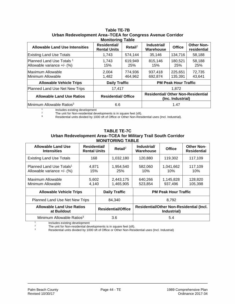
Palm Beach County Page 44 - TE 1989 Comprehensive Plan Revised 10/30/17 Ordinance 2017-34
Table TE-7B Urban Redevelopment Area–TCEA for Congress Avenue Corridor
Monitoring Table
Allowable Land Use Intensities Residential/ Rental Units
Retail2 Industrial/
Warehouse Office
Other Non- residential
Existing Land Use Totals 1,743 574,144 35,146 134,716 58,188
Planned Land Use Totals 1 Allowable variance +/- (%)
1,743 15%
619,949 25%
815,146 15%
180,521 25%
58,188 25%
Maximum Allowable Minimum Allowable
2,004 1,482
774,936 464,962
937,418 692,874
225,651 135,391
72,735 43,641
Allowable Vehicle Trips Daily Traffic PM Peak Hour Traffic
Planned Land Use Net New Trips 17,417 1,872
Allowable Land Use Ratios Residential/ Office Residential/ Other Non-Residential
(Inc. Industrial)
Minimum Allowable Ratios3 6.6 1.47 1 Includes existing development 2 The unit for Non-residential developments is in square feet (sft). 3 Residential units divided by 1000 sft of Office or Other Non-Residential uses (Incl. Industrial).
TABLE TE-7C Urban Redevelopment Area–TCEA for Military Trail South Corridor
MONITORING TABLE Allowable Land Use
Intensities Residential/ Rental Units
Retail2 Industrial/
Warehouse Office
Other Non-Residential
Existing Land Use Totals 168 1,032,180 120,880 119,302 117,109
Planned Land Use Totals1 Allowable variance +/- (%)
4,871 15%
1,954,540 25%
582,060 10%
1,041,662 10%
117,109 10%
Maximum Allowable Minimum Allowable
5,602 4,140
2,443,175 1,465,905
640,266 523,854
1,145,828 937,496
128,820 105,398
Allowable Vehicle Trips Daily Traffic PM Peak Hour Traffic
Planned Land Use Net New Trips 84,340 8,792
Allowable Land Use Ratios at Buildout
Residential/Office Residential/Other Non-Residential (Incl.
Industrial)
Minimum Allowable Ratios3 3.6 5.4 1 Includes existing development 2 The unit for Non-residential developments is in square feet (sft). 3 Residential units divided by 1000 sft of Office or Other Non-Residential uses (Incl. Industrial)

Palm Beach County Page 45 - TE 1989 Comprehensive Plan Revised 10/30/17 Ordinance 2017-34
TABLE TE-7D Urban Redevelopment Area–TCEA for Lake Worth Rd/Congress Ave South Corridor
MONITORING TABLE Allowable Land Use Intensities
Residential/ Rental Units
Retail2 Industrial/
Warehouse Office
Other Non-Residential
Existing Land Use Totals 266 403,369 240,275 222,571 86,967
Planned Land Use Totals1 Allowable variance +/- (%)
1,152 15%
914,009 25%
495,595 10%
733,211 10%
86,967 10%
Maximum Allowable Minimum Allowable
1,325 979
1,142,511 685,507
545,151 446,039
806,532 659,890
95,664 78,270
Allowable Vehicle Trips Daily Traffic PM Peak Hour Traffic
Planned Land Use Net New Trips 34,390 3,773
Allowable Land Use Ratios at Buildout
Residential/Office Residential/Other Non-Residential (Incl.
Industrial)
Minimum Allowable Ratios3 1.2 1.5
1 Includes existing development 2 The unit for Non-residential developments is in square feet (sft). 3 Residential units divided by 1000 sft of Office or Other Non-Residential uses (Incl. Industrial)
TABLE TE-7E Urban Redevelopment Area–TCEA for Florida Mango & 10th Avenue Node
MONITORING TABLE Allowable Land Use
Intensities Residential/ Rental Units
Retail2 Industrial/
Warehouse Office
Other Non-Residential
Existing Land Use Totals 13 90,095 NA 95,705 NA
Planned Land Use Totals1 Allowable variance +/- (%)
107 15%
223,715 25%
66,810 10%
229,325 10%
NA
Maximum Allowable Minimum Allowable
123 91
279,644 167,786
73,491 60,129
252,258 206,393
NA
Allowable Vehicle Trips Daily Traffic PM Peak Hour Traffic
Planned Land Use Net New Trips 7,644 859
Allowable Land Use Ratios at Buildout
Residential/Office Residential/Other Non-Residential (Incl.
Industrial)
Minimum Allowable Ratios3 0.36 1.24
1 Includes existing development 2 The unit for Non-residential developments is in square feet (sft). 3 Residential units divided by 1000 sft of Office or Other Non-Residential uses (Incl. Industrial)

Palm Beach County Page 46 - TE 1989 Comprehensive Plan Revised 10/30/17 Ordinance 2017-34
5. Mixed use urban centers should be strategically spaced, preferably located at
major corridor intersections and should have frontage roads with parallel on-street parking.
6. By January 2011, the County’s Planning Division in coordination with the County’s Engineering Department, Palm Tran and the Metropolitan Planning Organization (MPO) shall undertake a detailed transit study to augment the existing Palm Tran bus services (Route 2 connects Congress Avenue to the Tri-Rail stations in West Palm Beach, Delray Beach and Boca Raton and Route 40 connects the junction of Southern Boulevard and Military Trail to the Tri-Rail station in West Palm Beach) and to explore shuttle bus services from the major employment centers in the URA TCEA corridors to the two closest Tri-Rail stations in West Palm Beach and Lake Worth.
7. Transit stations for the four corridors and one node should be built at locations identified in the URA master plan.
8. Projects utilizing this TCEA must meet at least three mitigation strategies out of the fourteen strategies available in the Okeechobee Boulevard Point System outlined in detail in Chapter P, Section 4 of the Traffic Performance Standards in the Unified Land Development Code.
9. Military Trail, Lake Worth Road and Congress Avenue corridors shall maintain its current roadway sections accommodating a maximum of six lanes of traffic; three through lanes in each direction. The node at Florida Mango and 10th Avenue shall also maintain its current roadway sections as of 2009.
10. Consistent with the URA Master Plan, projects should increase connectivity through the development or redevelopment of small and large parcels by requiring continuous frontage roads, connection of commercial parcels, consolidation of driveways through elimination of curb cuts, provision of access in the front and rear of existing and future developments and utilization of parking lot driveways to connect existing streets or frontage streets.
11. Consistent with the URA Master Plan projects should increase corridor capacity through neighborhood connectivity by requiring connectivity to all existing right-of-ways from all new developments or redevelopments, elimination of street closures, avoidance of right-of-way abandonment and by connecting missing links.

Palm Beach County Page 47 - TE 1989 Comprehensive Plan Revised 10/30/17 Ordinance 2017-34
B. FUTURE TRANSPORTATION SYSTEM EXPANSIONS Future expansions to the Palm Beach County transportation system need to be performed in a manner consistent with the Objectives and Policies defined for each of the modes within the system and serve to compliment and integrate the individual modes. Objective 1.3 provides management policies to be followed in the implementation of future expansions of the transportation system. Objective 1.4 specifies the policies related to the expanding the roadway system. Objectives 1.5 and 1.6. address transit expansions. Future airport facilities and Port of Palm Beach improvements are identified under Objectives 1.7 and 1.8, respectively. Bicycle, pedestrian, and linked open space facilities policies are listed under Objective 1.9. OBJECTIVE 1.3 Management of Transportation System The County shall emphasize the safe and efficient management of the transportation system.
Policy 1.3-a: [deleted in Round 17-C]
Policy 1.3-b: Transportation Systems Management (TSM) strategies that include optimization of traffic signal systems, turning lanes, ridesharing and other innovative transportation system management activities shall continue to be implemented by the appropriate agencies within Palm Beach County. Policy 1.3-c: The County shall coordinate transportation demand management strategies with land use strategies. Examples include density and intensity of land uses, parking supply and increasing transit attractiveness. Policy 1.3-d: The County shall promote programs which reduce per capita vehicle miles traveled (VMT) and discourage single occupant vehicle trips, recognizing that these programs assist in reducing the overall air quality emissions. This can be accomplished through supporting Tri-Rail, bicycling, alternative fuels, ridesharing, alternative work hour programs, public transit, parking management and other transportation control measures. Policy 1.3-e: High-traffic accident locations shall continue to be monitored by Palm Beach County in order to identify and implement, when economically feasible, design improvements that will alleviate existing high-accident frequency. Policy 1.3-f: The County shall continue to update its existing access control standards to be consistent with adopted State and County standards that ensure the protection of the arterial and collector network capacity and increase safety margins and traffic flow. Policy 1.3-g: New access along existing arterials and collectors shall be controlled and limited in order to increase safety margins, traffic capacity, and traffic flow; shall be consistent with existing State and County standards; shall allow for the integration of multimodal considerations, where applicable; and shall consider impacts on adjacent neighborhoods. Policy 1.3-h: Palm Beach County shall consider intermodal terminals and access to intermodal facilities, where applicable, in its assessment of future transportation needs within Palm Beach County.

Palm Beach County Page 48 - TE 1989 Comprehensive Plan Revised 10/30/17 Ordinance 2017-34
Policy 1.3-i: The County will maintain policies and programs which ensure that the overall transportation system meets the County’s level of service criteria in order to provide viable alternatives to the Florida Intrastate Highway System & the Strategic Intermodal System, and to protect their interregional and intrastate functions.
OBJECTIVE 1.4 Roadway System The County shall provide for identification and acquisition of existing and future roadway rights-of-way consistent with the adopted Thoroughfare Right-Of-Way Identification Map and shall address certain specific corridors in the transportation planning process in Palm Beach County.
Policy 1.4-a: The County shall continue to construct the traffic circulation network and shall identify transportation corridors consistent with the County's adopted Thoroughfare Right-Of-Way Identification Map (TE 14.1) in the Map Series. Policy 1.4-b: Pursuant to Ch. 163.3177(6)(a)11.b F.S., the Transportation Element shall be coordinated with the plans and programs of the Metropolitan Planning Organization (MPO). The County hereby incorporates by reference the MPO 2035 Cost Feasible Plan-Highway Component map and the MPO 2035 Cost Feasible Plan-Transit Component map (adopted on October 15, 2009 by the MPO) into the Comprehensive Plan. Policy 1.4-c: The Capital Improvements Element (CIE) shall include a provision for funds specifically earmarked for use in an advanced corridor right-of-way acquisition program consistent with the Thoroughfare Right-of-Way Identification Map. Policy 1.4-d: Development Orders issued by the County shall require conveyance of roadway, intersection and interchange rights-of-way consistent with the adopted Thoroughfare Right-Of-Way Identification Map when there is a rational nexus between the required dedication of land, the needs of the community, and the impacts of the transportation network due to the development.
Policy 1.4-e: Right-of-way for all at-grade thoroughfare intersections shall provide for expanded intersection capacity, including special lane provisions, such as bicycle lanes, and provisions for pedestrian movement. The County Engineer, after notification of the Board of County Commissioners and in the case of State highways, coordination with FDOT, shall be allowed to waive the expanded intersection requirement where it is determined that the effect of right-of-way dedication from existing development makes it economically impracticable to implement this requirement or where it is shown by traffic impact studies that future traffic volumes will not require a full expanded intersection. The County Engineer shall evaluate these studies prior to granting a waiver of Thoroughfare Plan requirements, and in the case of State highways, provide such to FDOT District IV.
The typical number of lanes for an approach of an expanded intersection shall be as follows:

Palm Beach County Page 49 - TE 1989 Comprehensive Plan Revised 10/30/17 Ordinance 2017-34
Roadway Left Turn Lanes Through Lanes Right Turn Lanes Approach-total
4-Lane 2 2 1 5
6-Lane 2 3 1 6
8-Lane 2 4 1 7
Policy 1.4-f(1): At an intersection where an urban interchange is identified on the adopted MPO 2035 Cost Feasible Plan-Highway Component map and/or the Thoroughfare Right-of-Way Identification Map, an urban interchange will be considered when any approach of the intersection requires more than the approach-total for an expanded intersection. The consideration will include an analysis of the costs and benefits associated with the construction of an urban interchange. The urban interchange shall be required when the intersection as a whole needs three or more lanes than the sum of the approach-totals of an expanded intersection, unless it is determined by the County Engineer that there will be adverse financial or environmental impacts, or adverse effects on neighborhood character. Due to the adverse financial or environmental impacts or adverse effects on existing businesses or neighborhoods, all identified but not constructed roadway improvements that reduce the demand at the proposed Urban Interchange shall be pursued prior to the Urban Interchange option.
Policy 1.4-f(2): The County, through the MPO, shall give priority to capacity increases required to complete the Interstate Highway System and to other projects in urban areas that integrate and improve access to multiple modes of transportation. Policy 1.4-g: The County shall reduce the need for widening major and minor thoroughfares by encouraging the placement of a well inter-connected system of streets. Where an interconnected system becomes possible, care should be given to a community's quality of life, the amount of through-traffic, the impacts on safety, and overall security.
Policy 1.4-h: The County shall discourage the use of dead-end streets, loop streets, and oversized blocks in favor of through-streets and shorter blocks; provide cut-throughs for pedestrian access to transit; and promote landscaping of rights-of-way. Policy 1.4-i: The County shall encourage new developments to include: 1) an interconnected system of streets in their development plans which consider appropriate adjacent parcels with potential for future compatible developments; 2) stub streets that connect to adjacent undeveloped parcels with a potential for future developments; and 3) stub streets that tie into existing adjacent stub streets. Policy 1.4-j: [deleted in Round 17-C] Policy 1.4-k: [deleted in Round 17-C]
Policy 1.4-l: [deleted in Round 12-1]

Palm Beach County Page 50 - TE 1989 Comprehensive Plan Revised 10/30/17 Ordinance 2017-34
Policy 1.4-m: The County shall support the Florida Department of Transportation’s lead on preparing a current alignment, corridor and environmental study of the extension of State Road 7 northward from its terminus at Okeechobee Boulevard if permits can be obtained. The County shall encourage special consideration to protecting wetlands and their surroundings with environmental concerns. The County shall encourage that median openings and connections should be restricted consistent with a high speed rural arterial, however, consideration shall be given to existing connections and platted lots. Upon completion of the study, Palm Beach County shall amend its Thoroughfare Right-of-Way Identification Map. Policy 1.4-n: Central Boulevard from Indiantown Road to Church Street shall not be widened beyond its existing 3-lane cross-section until after the Western Corridor is constructed from north of the entrance to the Jupiter Community Park to Indiantown Road as a 4 lane cross-section. Constraining the widening of this section of Central Boulevard is intended to protect the Limestone Creek neighborhood from the intrusion of traffic from large projects located north and west of the Limestone Creek neighborhood. Policy 1.4-o: The Traffic Division shall evaluate and consider studies which provide information for the consideration of alternative methods to determine trip generation and internal capture rates within a specified area where there is a functional relationship for proposed development within existing urbanized areas characterized by a need for restoration, infill and adaptive reuse. Policy 1.4-p: Traffic Division shall consider and implement traffic calming measures, where feasible and appropriate, to reduce vehicular speed and encourage safety. Policy 1.4-q: The Rural Parkway concept is established to protect the rural character of roadways outside of the Urban/Suburban Tier, and those roadways identified on the Conceptual Plan of an Agricultural Enclave designated pursuant to FLUE Policies 2.2.5-d and 2.2.5-e. Rural Parkways shall accommodate future transportation planning needs to ensure that the cross-section and alignment of the roads preserves the rural residential lifestyle, sense of place and quality of life of the adjacent areas. For properties fronting on rural parkways, a portion of the designated Right-of-Way may be retained in private ownership provided that the property owner dedicates a parkway easement to Palm Beach County for non-vehicular pathways. Such dedications shall only be required when consistent with the criteria contained in Transportation Policy 1.4-d. The following roadway segments are hereby designated as Rural Parkways: 1. Northlake Boulevard, from Seminole Pratt-Whitney Road to the western edge of
the Palm Beach Gardens Municipal Golf Course, with a 50 foot easement on each side of the road being dedicated exclusively for multipurpose paths.
2. Lyons Road, from Atlantic Avenue to Boynton Beach Boulevard, with a 100 foot
easement on each side in order to accommodate multipurpose pathways. Undulating berms, no taller than five feet and landscaped with native vegetation, shall be required. No walls shall be allowed within the parkway easements.
Within a designated Agricultural Enclave: 3. Persimmon Boulevard, from 140th Avenue North to approximately 3,700 feet
east of Seminole Pratt Whitney Road (as measured along the centerline, and not

Palm Beach County Page 51 - TE 1989 Comprehensive Plan Revised 10/30/17 Ordinance 2017-34
located within an Urban or Sub-urban Transect), a 50 foot easement on each side in order to accommodate multipurpose pathways landscaped with at least 70% native vegetation, shall be required. No walls or signs shall be allowed within the parkway easements. However, a pair of context-sensitive community identification monuments may be permitted provided they are more than 400 feet from the terminus of the parkway easement, subject to approval by the Planning Director.
4. 140th Avenue North from the municipal boundary of Loxahatchee Groves to 60th
Street North, a 50 foot easement on the west side in order to accommodate a multipurpose pathways landscaped with at least 70% native vegetation, shall be required. No walls or signs shall be allowed within the parkway easements.
5. The future "Town Center Parkway" within the Agricultural Enclave, from 60th
Street North to approximately 2,500 feet east of Seminole Pratt Whitney Road (as measured along the centerline, and not located within an Urban or Sub-urban Transect), a 50 foot easement on each side in order to accommodate multipurpose pathways landscaped with at least 70% native vegetation, shall be required. No walls or signs shall be allowed within parkway easements. However, a pair of context-sensitive community identification monuments may be permitted provided they are more than 400 feet from the terminus of the parkway easement, subject to approval by the Planning Director.
6. Seminole Pratt Whitney Road from Sycamore Drive to Persimmon Boulevard,
and from 1,400 feet south of 60th Street North to 60th Street North, an 80 foot easement on each side in order to accommodate multipurpose pathways landscaped with at least 70% native vegetation, shall be required. No walls or signs shall be allowed within the parkway easements. However, for each segment, a pair of context-sensitive community identification monuments may be permitted provided they are more than 400 feet from the terminus of the parkway easement, subject to approval by the Planning Director. "Entrance signs" for a District Park located adjacent to the rural parkway easement may also be allowed within the rural parkway easement, subject to the approval by the Planning Director.
7. 60th Street North from 140th Avenue North to the M-canal crossing at 59th Lane
North, a 50 foot easement on the south side in order to accommodate a multipurpose pathway landscaped with at least 70% native vegetation, shall be required. No walls or signs shall be allowed within the parkway easements.
Palm Beach County Page 52 - TE 1989 Comprehensive Plan Revised 10/30/17 Ordinance 2017-34
Within the designated Western Communities Residential Overlay: 8. 180th Ave. North from the north property line of the Indian Trails Grove PUD to
Orange Blvd., a minimum 80 foot easement on the west side in order to accommodate a multipurpose paved pedestrian pathway and equestrian trail landscaped with at least 70% native vegetation shall be required. No walls shall be allowed within the parkway easement. However, a pair of context-sensitive community identification monuments may be permitted provided they are more than 400 feet from the terminus of the parkway easement, subject to approval by the Planning Director.
9. 190th Street North adjacent to the Indian Trails Grove PUD, a minimum of 50
feet wide easement on the east and west side in order to accommodate a multipurpose paved pedestrian pathway and equestrian trail landscaped with at least 70% native vegetation, shall be required. No walls shall be allowed within the parkway easements. However, a pair of context-sensitive community identification monuments may be permitted provided they are more than 400 feet from the terminus of the parkway easement, subject to approval by the Planning Director.
10. Orange Blvd. from 180th Ave. North to 190th Street North, a minimum of 50 feet
wide easement on the north in order to accommodate a multipurpose pathway and equestrian trail and a 50 feet wide easement on the south side to accommodate a multipurpose pathway, both landscaped with at least 70% native vegetation, shall be required. No walls shall be allowed within the parkway easements. However, a pair of context-sensitive community identification monuments may be permitted provided they are more than 400 feet from the terminus of the parkway easement, subject to approval by the Planning Director.
11. 60th Street North from the western limits of the M-1 canal to 190th Street North,
a minimum of 50 feet wide easement on the south side of 60th Street North, in order to accommodate a multipurpose paved pedestrian pathway (from the eastern limits of the Indian Trails Grove PUD to the westernmost PUD entrance) and equestrian trail (from the eastern limits of the PUD to the westernmost PUD entrance) with at least 70% native vegetation, shall be required. No walls shall be allowed within the parkway easements. However, a context-sensitive community identification monument may be permitted provided they are more than 400 feet from the terminus of the parkway easement, subject to approval by the Planning Director.
Policy 1.4-r: To further protect the Rural Tier communities from the impacts of surrounding development and to prevent encroachment of incompatible uses, proposed roads which are intended to serve as arterials or collectors and which pass through existing rural communities shall be aligned, where feasible, along the periphery of the existing community and not sited so that they bisect rural communities.
Palm Beach County Page 53 - TE 1989 Comprehensive Plan Revised 10/30/17 Ordinance 2017-34
Policy 1.4-s: The County shall continue to implement provisions in the Unified Land Development Code (ULDC) which provide for: 1. distinct design sections for the various classification of a roadway that reflect the
character and are compatible with the Tier through which it passes; and 2. specific design criteria for roadways designated as a Traditional Marketplace
corridors. Policy 1.4-t: Pursuant to s. 336.02, Florida Statutes, Palm Beach County reserves the authority to provide needed transportation corridors as depicted on its Thoroughfare Right-of-Way Identification Map to ensure the efficient functioning of the County road transportation network. Recognizing that conflict can arise among local governments regarding roadway issues, Palm Beach County commits to coordinating with affected local governments in an effort to ensure that the roadway network planning processes result in appropriate input from affected local governments. Policy 1.4-u: The following notes reflect conditions associated with roadway segments in the County’s Thoroughfare Right of Way Identification Map (TIM): 1. The extension of Jog Road (Ryder Cup Boulevard) is shown as a public way:
from Northlake Boulevard to Thorton Drive, Jog Road is a 120 foot right-of-way with four lanes; from Thorton Drive to Carrick Road, Jog Road is a 60 foot right-of way with two lanes, with the remaining 60 feet of right-of-way owned by the Northern Palm Beach County Water Control District restricted to such uses as public utilities, open space, drainage, pathways and landscaping; and from Carrick Road to PGA Boulevard, Jog Road is a 120 foot right-of-way with four lanes.
2. SR A1A, from the Broward County/Palm Beach County line to Indiantown Road
and from U.S. 1 to the Palm Beach County/Martin County line is restricted to a two-lane roadway.
3. Lyons Road, from Southern Boulevard to Lake Worth Road, is a 100 foot section
that shall be restricted to two through lanes with the remaining right-of-way to be used for drainage, landscaping, pathways, turning lanes, and bicycle paths.
4. Hood Road, from Alternate A1A to Prosperity Farms Road, is a 60 foot section
that shall be restricted to two through lanes with an additional 50 feet to be used for landscaping and buffering.
5. Jog Road, from Hood Road to approximately 3500 feet north of Hood Road (up
to the northern edge of Old Marsh Property), is a 60 foot section and the remaining portion of Jog Road up to Donald Ross Road is a 100 foot section that shall be restricted to two through lanes with the excess right-of-way to be used for drainage, landscaping, pathways, turning lanes, and bicycle paths. This 60- foot restriction does not apply to locations where roundabouts are needed or where the County Engineer requires additional right-of-way.

Palm Beach County Page 54 - TE 1989 Comprehensive Plan Revised 10/30/17 Ordinance 2017-34
Policy 1.4-v: Before the Frederick Small Road crossing may be constructed: 1) the crossings at Donald Ross Road and Indiantown Road must exceed Level of Service D, or; 2) one of the crossings must exceed the Level of Service E. Policy 1.4-w: Before individual segments (between major thoroughfare intersections) of Lyons Road between Southern Boulevard and Lantana Road may be connected, the parallel segment of State Road 7 must be an 8-lane facility. The parallel segment must also operate at or below Level of Service E. The segment immediately south of Forest Hill Boulevard may be constructed and connected to Forest Hill Boulevard at any time. However, connection to allow access to Lake Worth Road must meet State Road 7 8-lane and Level of Service criteria. For the segment of Lyons Road between Southern Boulevard and Forest Hill Boulevard, the Board of County Commissioners may waive the State Road 7 Level of Service and 8-lane requirement if it is determined that local roads between Southern Boulevard and Dillman Road can be relieved by the construction of Lyons Road. If the waiver occurs, this segment may be constructed and connected. Policy 1.4-x: Before Prosperity Farms Road between Burns Road and Northlake Boulevard may be constructed as a 4/5-lane facility: 1. the CRALLS volumes on this segment must be reached; and
2. the parallel segment of Alternate A1A must be a 6-lane facility and must operate
below its adopted Level of Service; or 3. the parallel segment of US-1 must operate below its adopted Level of Service. Before Prosperity Farms Road between Donald Ross Road and Gardens Parkway may be constructed as a 4/5-lane facility: 4. the CRALLS volumes on this segment must be reached; and
5. the parallel segment of Alternate A1A must be a 6-lane facility and must operate
below its adopted Level of Service; or 6. the parallel segment of US-1 must operate below its adopted Level of Service. Policy 1.4-y: [deleted in Round 17-C] Policy 1.4-z: [deleted in Round 17-C] Policy 1.4-aa: [deleted in Round 17-C]

Palm Beach County Page 55 - TE 1989 Comprehensive Plan Revised 10/30/17 Ordinance 2017-34
OBJECTIVE 1.5 Transit System The County shall encourage the use of transit within Palm Beach County. The measurement of the success of this Objective shall be through increased usage of transit services within Palm Beach County.
Policy 1.5-a: Palm Beach County, through Palm Tran (the Palm Beach County Surface Transportation Department), shall attempt, when practical and cost feasible, to increase the transit presence in the County to maintain at least 3/4 of one percent modal split through modification of the existing route system, or increasing service in areas with high propensity for transit use.
Policy 1.5-b: Palm Beach County shall continue to provide the West Palm Beach multi-modal transit transfer station with loop shuttle service connecting the major downtown employment centers and which provides intermodal connections to such destinations as the Palm Beach International Airport and the Port of Palm Beach, as applicable. Policy 1.5-c: Palm Tran shall continue to provide and plan for bus service to Tri-Rail stations and to major traffic generators and attractors in the County. Policy 1.5-d: The County (through Palm Tran) shall consider increasing the number of park-and-ride facilities and increasing the number of buses connecting to Tri-Rail as means to encourage greater use of mass transit. Policy 1.5-e: Palm Tran shall continue the existing program of maintaining signage to mark transit stops. Policy 1.5-f: The County (through Palm Tran) shall maintain guidelines to improve the design and functionality of transit stations/stops. Particular attention shall be devoted to how they relate to the surrounding area and how they promote a pedestrian friendly environment and a sense of place. The County shall also require site design evaluation of transit stops that include such features as passenger loading areas, transit user amenities and sidewalks that link to other nodes within a well-connected system. Policy 1.5-g: Palm Tran shall oversee the maintenance of existing bus shelters and install new bus shelters, where appropriate, at selected locations. Policy 1.5-h: The MPO shall investigate the use of transit services to promote more efficient urban development through increased services in the coastal communities. Policy 1.5-i: The County (through Palm Tran) shall encourage the future coordination of bus routes and the location of new major residential and non-residential developments. Future coordination means that: 1) transit routes and adjacent land uses are concurrently planned and fixed to promote additional complementary development; and 2) western transit route extensions should occur as development is built. Policy 1.5-j: The County (through Tri-Rail and its coordination with the MPO) shall continue to design and implement a program of incentives to encourage the use of rail modes of transportation. The measurement of the success would be through increased usage of the rail modes of transportation.

Palm Beach County Page 56 - TE 1989 Comprehensive Plan Revised 10/30/17 Ordinance 2017-34
Policy 1.5-k: Tri-Rail and Palm Beach County (through participation on Tri-Rail’s governing board) shall regularly coordinate and analyze all reviews of ridership, revenues and costs, and user characteristics relative to the operations of Tri-Rail to determine the feasibility of expanding service. Policy 1.5-l: [deleted in Round 17-C]
Policy 1.5-m: The County, (through the MPO), understanding the importance of commuter rail services as a vital transportation mode, shall support and assist FDOT and Tri-Rail, to the extent possible, in securing Federal, State, and County funds for the continued expansion of the South Florida Rail Corridor. Policy 1.5-n: [deleted in Round 17-C] Policy 1.5-o: [deleted in Round 17-C]
Policy 1.5-p: The County will promote the designation of land uses and densities which are supportive of mass transit in areas around roadways which have been designated as public transportation corridors in the Comprehensive Plan. Policy 1.5-q: Palm Tran shall continue to program to shorten headways during peak hours. Policy 1.5-r: Palm Tran shall explore providing altered routes to address home-to-work commutes between neighborhoods and employment centers. Policy 1.5-s: The County shall utilize the MPO 2035 Cost Feasible Plan – Transit Component map, incorporated by reference in TE Policy 1.4-b, to plan for existing and projected intermodal deficiencies and needs.
OBJECTIVE 1.6 Paratransit Services for the Transportation Disadvantaged (Non-
ADA-Qualifying Individuals) In order to fulfill the MPO’s coordinating responsibilities regarding transportation services for the transportation disadvantaged, Palm Tran shall coordinate public paratransit transportation for eligible individuals who qualify under the Federal ‘Americans with Disabilities Act’ (ADA). Palm Beach County, through Palm Tran, shall provide public paratransit transportation services. These services are to be carried out as part of Palm Tran’s obligation to implement the ADA civil rights legislation.
Policy 1.6-a: Palm Tran, or through third party contract, shall maintain an adequate fleet of sedans, vans, and mini-buses for individuals who qualify for ADA paratransit. Policy 1.6-b: Palm Tran (through Spectran or a third party contract) shall maintain services available for eligible riders with disabilities, who are unable to transport themselves, by providing paratransit services. Policy 1.6-c: The MPO shall make services available for individuals qualifying under Chapter 427 of the Florida Statutes by managing and monitoring a system of transportation operators and by coordinating provider organizations.

Palm Beach County Page 57 - TE 1989 Comprehensive Plan Revised 10/30/17 Ordinance 2017-34
OBJECTIVE 1.7 Future Airport Expansion Palm Beach County has incorporated the four County-operated Airport Master Plans into its Comprehensive Plan. The dates of the Airport Master Plans incorporated into this Comprehensive Plan are shown below: [163.3177(6)(b)4]
Palm Beach International Airport – October 2006 Palm Beach County Glades Airport – October 2006 Palm Beach County Park Airport – October 2006 North Palm Beach County General Aviation Airport – October 2006
Policy 1.7-a: The County shall monitor the expansion and safety needs at the four County-operated airports, Palm Beach County Park Airport, Palm Beach County Glades Airport, North Palm Beach County General Aviation Airport and Palm Beach International Airport (PBIA). These needs will be monitored both at five-year intervals, using guidelines set forth in the airport master plans (which must meet all Federal, State and local requirements), and on a continuing basis through implementation of the Continuing Florida Aviation System Planning Process, administered by the Florida Department of Transportation and coordinated through the County's Department of Airports.
Policy 1.7-b: All adopted airport master plans for new airports or the expansion of existing airport facilities shall coordinate surface transportation access with the Metropolitan Planning Organization, and the Palm Beach County Traffic Engineering Department, and shall comply with FAA standards for ground transportation access to the airport facilities. The Department of Airports shall ensure that the ground transportation evaluations and recommendations are consistent with other Policies of the Transportation Element.
Policy 1.7-c: The County shall continue to provide improvements to navigation aids and other safety related items as mandated by FAA and/or measured by present or updated airport master plan standards in response to increased facility demands, safety considerations and operational efficiencies at all County-operated airports. Policy 1.7-d: Any updates to the PBIA master plan shall evaluate intermodal transportation efficiencies to and from PBIA. Such planning evaluation shall include, at a minimum, the establishment of light rail passenger service to PBIA, improved interstate and ground transportation access to PBIA, improved connections to Port of Palm Beach, and Foreign Trade Zone facilities, and refinement of mass transit alternatives in cooperation with the MPO. Policy 1.7-e: Airport Master Plans and related development activities shall be consistent with local, State, Regional and Federal agencies plans and programs.

Palm Beach County Page 58 - TE 1989 Comprehensive Plan Revised 10/30/17 Ordinance 2017-34
OBJECTIVE 1.8 Port of Palm Beach Palm Beach County has incorporated Section A, Goals, Objectives and Policies, 2017-2022 Future Improvements Map, and 2017-2022 Capital Improvement Program of the Port of Palm Beach Master Plan adopted April 20, 2017 into the Coastal Management Element of its Comprehensive Plan. The County shall continuously seek to achieve consistency and coordination between the Goals, Objectives and Policies of the Port Master Plan and this Comprehensive Plan. (See Goal 4 and related objectives and Policies in the Coastal Management Element)
OBJECTIVE 1.9 Bicycle, Pedestrian, and Linked Open Space Facilities The County shall promote the increased use of the bicycle, pedestrian, and linked open space facilities as viable alternate means of transportation.
Policy 1.9-a: Bikeways shall be given full consideration in the planning and development of state, regional, and local transportation facilities and programs. Policy 1.9-b: The County shall provide for bicycle, pedestrian, and bus transit facilities in the plans for all major roadway construction and reconstruction projects consistent with adopted standards developed by the County and State, especially when connecting to GLOSS components, unless cost prohibitive or deemed impractical by the County Engineer based upon generally accepted engineering principles. Policy 1.9-c: Deleted in Amendment Round 12-1 Policy 1.9-d: The County shall support and encourage the implementation of the MPO Master Comprehensive Bicycle Transportation Plan, which provides for and promotes the use of the bicycle as an alternate means of transportation.
Policy 1.9-e: The County shall, through the Unified Land Development Code, require all new development or redevelopment to provide bicycle facilities to promote bicycling unless the establishment of bicycle facilities is contrary to public safety, the cost of doing so is excessively disproportionate to the need or probable use, or other factors indicate an absence of any need for such facilities. Policy 1.9-f: The County shall continue to implement appropriate highway design standards which shall include the use of wildlife/pedestrian crossing structures where adjacent land designations and uses indicate that such structures are appropriate. Policy 1.9-g: The County shall encourage the use of expanded road rights-of-way corridor cross-sections which allow for multi-use bicycle and pedestrian and equestrian trails cross sections where appropriate, especially when connecting to GLOSS components. Policy 1.9-h: Roadway design for areas identified as urban residential shall continue to address pedestrian transportation design at a priority level equal to that of the automobile and public transit; all public roadway projects in urban residential areas shall include sidewalks on both sides of any roadway above the classification of a minor collector, and pedestrian needs shall continue to be considered at the outset of design,

Palm Beach County Page 59 - TE 1989 Comprehensive Plan Revised 10/30/17 Ordinance 2017-34
to avoid conflicts with retrofitted stormwater drainage facilities, new utility placement, new development and the like.
Policy 1.9-i: As a part of the County's Pathway Program, areas designated as urban residential shall receive high priority in funding pathway construction projects in the County’s Pathway Program.
Policy 1.9-j: As development occurs, the County shall improve pedestrian linkages between residential and non-residential developments as well as connections within neighborhoods by: 1) increasing the number and quality of pedestrian paths or sidewalks; 2) eliminating physical barriers; and 3) locating transit stops within easy walking distance to all residences. Policy 1.9-k: The County shall encourage the design of mixed use and multi-use developments and planned developments to be of a pedestrian scale and design by incorporating transit stops and sidewalk connections that follow the accepted general threshold for pedestrian access: 1) approximately five minutes walking time or 2) one quarter mile of distance walked. Policy 1.9-l: For new residential developments, the County shall encourage cut-through linkages for pedestrian and bicycle access to transit. The County shall also encourage developers of new master plans to include specific circulation planning for pedestrian and bicycle access.
Policy 1.9-m: The County shall encourage pedestrian and bicycle linkages between existing residential and non-residential land uses, especially for commercial and open space. Policy 1.9-n: The County shall incorporate the principle of linking open space into ongoing planning efforts such as the Bicycle/Pedestrian plan efforts of the Metropolitan Planning Organization (MPO). The use of publicly owned road right-of-way and abandoned publicly owned road rights-of-way shall be annually examined during the Bicycle/Pedestrian planning process to determine which rights-of-way can be safely used to achieve the following: increasing alternative access to beach parks; facilitating bicycle/pedestrian connections between County and municipal parks as well as parks and conservation areas; facilitating connections between residential areas, parks and conservation areas; supporting connections to the bikeway/hiking/equestrian path around Lake Okeechobee; and facilitating bicycle, hiking and equestrian access to County parks. Policy 1.9-o: To increase access to linked open space corridors through the use of mass transit public facilities, the County shall use the Pathways Program to ensure that: 1) wheelchair accessible sidewalks are provided in both directions at all Palm Tran bus stop shelters; and 2) appropriate wheelchair street-crossing facilities are located adjacent to bus stop shelters. Appropriate crossings shall be defined on a case-by-case basis and may include mid-block crossings where they are determined to be safer for pedestrians.
Policy 1.9-p: Deleted in Amendment Round 12-1 Policy 1.9-q: The County shall require, where feasible, pedestrian and bicycle linkages between non-residential land uses.

Palm Beach County Page 60 - TE 1989 Comprehensive Plan Revised 10/30/17 Ordinance 2017-34
C. TRANSPORTATION MARKETING The marketing of the overall Palm Beach County transportation system and the alternative modes available to its users is the key to the success of an integrated multimodal system. OBJECTIVE 1.10 Transportation Marketing Program Palm Beach County shall continue to implement a comprehensive marketing strategy to orient and familiarize County residents and visitors about alternative transportation modes. The success of this program shall be measured by continued increased usage and the need for system expansion.
Policy 1.10-a: The County (through the MPO, Tri-Rail, and Palm Tran) shall provide publicly-distributed information on the use of alternative means of travel. These alternatives include: Palm Tran buses, Palm Tran Connection, Tri-Rail, ridesharing coordination programs which result in car and van-pooling, High Occupancy Vehicle (HOV) lanes designed for car pooling, park-and-ride lots, bicycle and pedestrian facilities. Policy 1.10-b: To reduce overall roadway demand and improve air quality, the County (through the MPO and Palm Tran) shall provide incentives for those who use alternative travel means, and disincentives for single-occupancy automobile users. Alternative modes include, but are not limited to, Palm Tran and Palm Tran Connection services, Tri-Rail, ridesharing coordination programs which result in car and van-pooling, High Occupancy Vehicle (HOV) lanes designed for car pooling, park-and-ride lots, bicycle and pedestrian facilities. Policy 1.10-c: Deleted in Amendment Round 12-1 Policy 1.10-d: Palm Tran shall continue to advertise the routes of the County’s public bus service through radio, television, and newspaper. Palm Tran shall continue to provide bus information brochures to the public by placing them at public buildings and other designated locations throughout the County. Policy 1.10-e: Palm Tran shall continue to maintain an automated telephone information system to provide route schedules and fares. Policy 1.10-f: Palm Tran shall implement, as resources allow, the marketing of transportation services for eligible low-income persons, elderly, disabled children, and children-at-risk, who are unable to transport themselves or afford transportation. This program is to be carried out through pamphlets distributed to: senior citizen centers, organizations providing services for the disabled, low-income neighborhoods, and Palm Tran buses. Policy 1.10-g: Palm Tran shall continue to market accessible fixed route services and paratransit services which are mandated by the Americans with Disabilities Act (ADA), to individuals with disabilities, and organizations and agencies, which serve the disabled.

Palm Beach County Page 61 - TE 1989 Comprehensive Plan Revised 10/30/17 Ordinance 2017-34
Policy 1.10-h: The County (through Palm Tran) shall institute and maintain a training program to teach individuals who are disabled or transportation disadvantaged how to use the fixed route bus system. The purpose of this program is to: 1) teach the public how to access the transit system; 2) educate the public about their rights to accessible public transportation; 3) foster greater independence for individuals with disabilities; and 4) decrease operating and administrative transit system costs associated with paratransit services. Policy 1.10-i: Tri-Rail and Palm Beach County (through Palm Tran) shall develop a coordinated inter-agency program of incentives to increase ridership on the Tri-County Commuter Rail and other public transportation systems through the use of promotional material, special events and parking and price incentives.
D. ENVIRONMENTAL CONSIDERATIONS The impact of proposed transportation system expansions on the environment will be considered for all planned improvements. OBJECTIVE 1.11 Air, Water, and Other Environmental Concerns Palm Beach County shall adhere to all applicable environmental guidelines in the maintenance and expansion of its transportation system.
Policy 1.11-a: Development of new transportation facilities or expansion of existing facilities shall address environmental impacts consistent with the appropriate goals, objectives, and policies contained in other elements of the County's Comprehensive Plan and consistent with the appropriate permitting agencies, including applicable Federal, State, and local regulations. Policy 1.11-b: The County shall follow the appropriate standards for erosion control for application to County roadways and other transportation systems. Policy 1.11-c: Deleted in Amendment Round 02-1
Policy 1.11-d: The County shall consider air quality impacts from roadway capacity increases by conducting an Air Quality Conformity Determination on the County's Five Year Transportation Improvement Program (TIP). This process will be the joint responsibility of the Metropolitan Planning Organization (MPO) of Palm Beach County working closely with the Air Pollution Control Section of the Palm Beach County Health Department, and the State of Florida Department of Health.
Policy 1.11-e: Airport, port, and related surface transportation access facilities shall be sited in an environmentally sound manner, consistent with the objectives and policies of the Conservation and Coastal Management Elements of the County's Comprehensive Plan, FAA, and State of Florida DOT standards and regulations for environmental protection. Policy 1.11-f: As stated in FAA Advisory Circular number 150/5070-6a for the development of airport master plans, all master plans for the development of new airports or the expansion of existing airport facilities must meet FAA standards for
Palm Beach County Page 62 - TE 1989 Comprehensive Plan Revised 10/30/17 Ordinance 2017-34
compliance with both Federal statutory and regulatory requirements for environmental and natural resource protection.
E. TRANSPORTATION FUNDING Transportation funding is the mechanism used to implement proposed transportation system expansions. OBJECTIVE 1.12 Transportation Funding The transportation system required by the 2035 MPO Cost Feasible Plan – Highway and Transit Component maps to maintain the adopted Level of Service Standards and provide the necessary alternative mode system expansions shall be financially feasible and shall be funded using designated funding sources. New funding sources shall also be considered for the funding of transportation system expansions.
Policy 1.12-a: The County shall consider all available funding sources, including those at the County, State, and Federal levels, including but not limited to, automobile registration fees, optional sales tax, ad valorem taxes, State and Federal public transit assistance, user fees, gasoline taxes, public/private initiatives, public transportation corporations, and annual millage to fund future transportation-related needs. Policy 1.12-b: New development shall be assessed an appropriate impact fee to help provide funding for roadway improvements to serve the development. Policy 1.12-c: The County shall develop, adopt and annually update a Five-Year Road Improvement Program that shall include roads that are currently “over capacity” and facilities that are required to accommodate projected traffic increases so as to maintain acceptable level of service. This program shall be based on the following criteria: 1. Whether the volume-to-capacity (V/C) ratio of the roadway is greater than 1.0; 2. Whether the roadway is planned as a reliever for roads with a V/C ratio greater
than 1.0; 3. Whether the link provides system continuity; 4. Correction of a public hazard; or, 5. The feasibility of relying on alternative modes of transportation to address any
identified V/C ratio capacity problems.
When determining road improvements to be included in the Five Year Road Program and companion 6 Year Road Improvement Schedule, projects outside the Urban Service Area shall receive lower priority than similar projects in the Urban Service Area. This prioritization shall be applied only when projects have similar volume to capacity ratios. Policy 1.12-d: The Five Year Road Improvement Program shall be consistent with the 1990 Countywide Traffic Performance Standards Ordinance and serve as input to the Capital Improvement Element's Five Year Road Improvement Schedule. Policy 1.12-e: The County shall set aside a portion of the gas tax revenues for Palm Tran’s capital budget.
Palm Beach County Page 63 - TE 1989 Comprehensive Plan Revised 10/30/17 Ordinance 2017-34
Policy 1.12-f: To increase ridership and overall revenues, Palm Tran shall maintain a farebox recovery rate of 20 to 25 percent based on a strategy of: 1. reducing or eliminating bus routes with very low ridership, where appropriate; 2. adjust fares on remaining routes, where appropriate; and 3. extending new service to transit-attractive areas.
Policy 1.12-g: To promote alternative modes of transportation, Palm Beach County should through the Development Review Officer (DRO) process encourage site specific mass transit capital improvements (ex.: bus turn-off lanes adjacent to major thoroughfares, bus shelters and stops, installing signs, and bus turn-arounds) by developers of large, significant planned residential, retail, or employment-based projects, when those developments: 1. are served, or will be served by a transit fixed route; or 2. degrade the traffic levels of service of any adjacent thoroughfare beyond LOS C. When developer provided mass transit capital improvements are not feasible on-site, the County should consider a second method, which transfers those improvements to more appropriate geographic areas. Policy 1.12-h: The needs and resources of Palm Tran shall be reviewed on a regular basis. This analysis would evaluate costs, general ridership, and the needs of the transportation disadvantaged and would suggest shifts in resources accordingly. Any change in needs and resources must be reviewed for consistency with the policies of the Comprehensive Plan. Policy 1.12-i: When reviewing the effectiveness of mass transit programs, Palm Beach County shall recognize that a mass transit system provides indirect benefits in addition to serving the non-driving public. These include reduced impacts on the environment, decreased traffic congestion on roads, and reduced dependence on the automobile as a dominant mode of transport. The success of any mass transit program should not be evaluated solely on its ability to recoup its cost. Policy 1.12-j: Palm Tran shall monitor its paratransit services to ensure that the ADA program is cost effective and complies with Federal requirements. Policy 1.12-k: The Community Transportation Committee (CTC) shall monitor its ability to subsidize user fares and administer financial assistance to organizations that provide services to the transportation disadvantaged (Non-ADA-Qualifying). The CTC shall also monitor its services to ensure that they are cost effective and comply with State and local requirements. Policy 1.12-l: The County shall implement capital improvements at county operated airports as specified by current airport master plans and/or supplemental studies until such plans are modified or updated. General priority shall be given to those improvements required to conform to FAA and FDOT regulations.

Palm Beach County Page 64 - TE 1989 Comprehensive Plan Revised 10/30/17 Ordinance 2017-34
Policy 1.12-m: Palm Tran shall continue to seek grant funding from the U.S. Department of Transportation to provide transportation to assist in welfare-to-work initiatives. Sources of funding may include grants, such as the Transit Capital Improvement Grants and Federal Transit Operating Assistance Formula Grants. Policy 1.12-n: In order to preserve the sense of place and function that unpaved local roads provide in the Exurban and Rural Tiers, the County shall limit funding of paving and maintaining of roads to those classified as, or higher than, a Rural Major Collector as depicted on Functional Classification of Roads (Map TE 3.1), unless otherwise deemed appropriate by the Board of County Commissioners to protect the safety and welfare of the residents.
F. TRANSPORTATION SYSTEM COORDINATION The transportation system within Palm Beach County is coordinated with the Palm Beach County Comprehensive Plan Elements; Federal, State, and local guidelines; and the various Master Plans. OBJECTIVE 1.13 General Plan Coordination The County shall provide for the coordination of transportation plans and programs among the appropriate land use and transportation planning and implementing organizations on a continuing basis.
Policy 1.13-a: The County shall utilize intergovernmental programs identified in the Intergovernmental Coordination Element, such as the Intergovernmental Plan Amendment Review Committee (IPARC), to implement the Goal, Objectives, and Policies of the County's Transportation Element. Policy 1.13-b: The County shall continue to use the Metropolitan Planning Organization's transportation planning process as the County's main mechanism for long range transportation planning and coordination with the MPO’s TIP and the FDOT District IV Adopted Work Program. Policy 1.13-c: Recognizing international commerce and tourism as key components of the intermodal transportation system, the County shall coordinate with the MPO to ensure that these issues are considered in the development of future Long Range Plan updates and other future transportation efforts. Policy 1.13-d: To ensure the availability of adequate transportation facilities, the County's transportation system shall be coordinated with local comprehensive plans to reflect the demand created by anticipated development. Policy 1.13-e: The Palm Beach County Planning Division and Engineering Department shall establish a coordinated review process that will ensure that the Palm Beach County Six Year Road Improvement Schedule is consistent with Goals, Objectives, and Policies of the Comprehensive Plan.

Palm Beach County Page 65 - TE 1989 Comprehensive Plan Revised 10/30/17 Ordinance 2017-34
Policy 1.13-f: The County shall continue to work with jurisdictions in adjacent counties and municipalities within Palm Beach County to coordinate transportation related issues, such as 1) the locations and dimensions of thoroughfare rights-of-way and to address multi-jurisdictional traffic impacts to assure maintenance of acceptable Level of Service on the traffic circulation network, 2) the future transit needs and delivery services, and 3) the provisions and operations of non-vehicular modes as they relate to intercounty travel. Policy 1.13-g: The County shall continue to coordinate with FDOT, MPO, DEO, Treasure Coast Regional Planning Council, the Governor's Commission for a Sustainable South Florida, and local municipalities to promote sustainable transportation principles within Palm Beach County. Policy 1.13-h: The County shall work with the State through the MPO to optimize the use of State and Federal funds by advance preparation of right-of-way acquisition documents and construction plans for roadway improvements. Policy 1.13-i: The County (through the MPO) shall coordinate the effort to master plan the I-95 transportation corridor with all affected and appropriate State, Regional and County-level agencies. The master planning would include considerations for alternative modes of transportation including Tri-Rail, High-Occupancy Vehicle (HOV) lanes for car and van pooling, and park-and-ride lots. Policy 1.13-j: All aviation and port master plans and related development activities shall be consistent with local, State, Regional and Federal agencies plans and programs. Policy 1.13-k: All public airports in the County shall be operated in conformance with applicable State and Federal regulations. Policy 1.13-l: Palm Beach County shall encourage measures that advance effective coordination of its goals and activities with those of the Port of Palm Beach, and shall investigate such opportunities as present themselves, for increased cooperation between the two entities. Policy 1.13-m: Deleted in Amendment Round 06-1

Palm Beach County Page 66 - TE 1989 Comprehensive Plan Revised 10/30/17 Ordinance 2017-34
G. PUBLIC INVOLVEMENT Public involvement is an important component of transportation planning since the transportation system serves the public at large. OBJECTIVE 1.14 Citizen Participation The County shall continue programs to increase citizen participation in the transportation planning process.
Policy 1.14-a: The County shall provide the opportunity for the public to furnish comments on the transportation planning process through participation at public meetings, public workshops, public hearings, and similar type forums open to the public. These type public forums shall be scheduled as needed in accordance with applicable Federal, State, and local guidelines. Policy 1.14-b: Input from the public and the private sectors, through attendance at committees that have jurisdictions to coordinate transportation issues within Palm Beach County, shall be considered in the review of transportation planning issues. The various committees which are open to the public include the following: Local Planning Agency (LPA)/Planning Commission (PLC), the Citizens’ Advisory Committee (CAC) and the Technical Advisory Committee (TAC) under the MPO, Port of Palm Beach Commission, and the Independent Five-Year Road Program Oversight and Advisory Council. Policy 1.14-c: Palm Beach County shall work with representatives of directly affected neighborhoods early in the planning process of transportation related projects. The County shall encourage FDOT to coordinate with neighborhood representatives in the early stages of its planning, as well.
H. ADDITIONAL AIRPORT FACILITY CONSIDERATIONS
Given the special provisions which exist relating to airport planning, separate Objectives have been derived to ensure that the applicable Federal, State, and local guidelines are adhered to as they relate to airport land use, environmental, and governmental coordination considerations.
OBJECTIVE 1.15 Additional Airport Land Use and Environmental Issues Palm Beach County shall ensure that aviation facilities are located in appropriate areas consistent with the adopted County Future Land Use, Coastal Management and Conservation Elements; are operated in a safe manner as mandated by applicable FAA, FDOT, CFASPP and county guidelines; shall provide for coordination of transportation plans among the appropriate land use and transportation planning and implementing organizations on an ongoing basis; and be financially feasible.
Policy 1.15-a: The Future Land Use Plan Map shall delineate airport locations as depicted in adopted airport master plans, and ensure that adjacent areas are restricted to compatible land uses such as industrial, commercial, recreation, and open space. The County shall use the mechanisms established in Goal 1, Objectives 1 to 4 of the

Palm Beach County Page 67 - TE 1989 Comprehensive Plan Revised 10/30/17 Ordinance 2017-34
Intergovernmental Coordination Element and its policies to coordinate compatible land use designations with municipalities. Policy 1.15-b: The siting of airport facilities shall be consistent with provisions in the airport master plans, the County’s Comprehensive Plan, the Unified Land Development Code, and required Federal and State land development regulation standards. Policy 1.15-c: Surface transportation providing access to airports shall be planned and developed in an environmentally sound manner in compliance with the Coastal Management, Conservation, and Transportation Elements of the Comprehensive Plan, and shall be coordinated with municipalities by the Metropolitan Planning Organization. Policy 1.15-d: The County shall utilize existing and projected noise levels as determined by the FAR Part 150 study completed for PBIA in considering requests for zoning changes and building permits for new construction or major modifications to airport facilities and land uses adjacent to airport facilities. Policy 1.15-e: Palm Beach County shall continue to implement noise abatement measures as required in Ordinances 84-14, 85-20, 85-21, 85-34 and 85-35 and the County's Comprehensive Airport Zoning and Land Use Compatibility Ordinance (ULDC Article 16). Policy 1.15-f: The County's Department of Airports shall continue to implement its noise abatement program to reduce existing noise and sound levels. Based on noise-compatibility standards established in the FAA FAR Part 150 Study, this program includes measures for insulating homes, acquiring land and residences, and recommending compatible land uses in high-noise areas. Implementation of these noise abatement and containment measures is underway and projected to reduce noise levels such that those of 75 LDN and greater (the level at which the FAA has determined noise exposure to be unacceptable for individuals in their communities and residences) will be restricted to areas with non-residential land uses. Policy 1.15-g: The County shall ensure that applications for all structures (temporary or permanent) that exceed FAA guidelines and might negatively affect County Airports (existing or planned) will be processed in accordance with Federal Aviation Regulations Part 77, Chapter 333 Florida Statutes. Policy 1.15-h: The County shall conduct land use analyses and studies to evaluate options for including industrial land uses in the development plans for airport property, based on recommendations and standards for land use designation set forth in the FAA FAR Part 150 study on aviation noise effects. Policy 1.15-i: The FAA FAR Part 150 study sets guidelines for land use compatibility in areas affected by aviation noise. New structures proposed for construction in areas identified by the FAA study as incompatible for that structure's proposed use shall be insulated in compliance with the County's noise abatement requirements prior to certificate of occupancy issuance. Policy 1.15-j: Palm Beach County shall enforce the Comprehensive Airport Zoning and Land Use Compatibility Ordinance (ULDC Article 16) that, at a minimum, complies with Chapter 333, Florida Statutes, making necessary revisions and incorporating Ordinances 78-2, 84-14, 85-20, 85-21, 85-34 and 85-35 regarding airport vicinity height

Palm Beach County Page 68 - TE 1989 Comprehensive Plan Revised 10/30/17 Ordinance 2017-34
and noise compatibility and addresses public safety and acceptable land uses in the areas affected by county operated airports. Policy 1.15-k: Upon achieving at least a 30% Foreign Trade Zone (FTZ) occupancy and a dedicated cargo carrier, the Department of Airports should evaluate the FTZ at county-operated airport facilities. Policy 1.15-l: The County shall review future amendments to the four County-operated Airport Master Plans for consistency with the County’s Comprehensive Plan, and will consider incorporation by reference in the Comprehensive Plan the County-approved Master Plan revisions.
OBJECTIVE 1.16 Additional Airport Intergovernmental Coordination
All affected municipal governments including, but not limited to, Palm Beach Gardens, Pahokee, Atlantis, Lake Worth, Lantana, Cloud Lake, Glenridge, Greenacres, Haverhill, Lake Clarke Shores, Palm Beach and West Palm Beach shall be encouraged to develop or to revise their airport height ordinances to reflect consistency with the County's Comprehensive Airport Zoning and Land Use Compatibility Ordinance (ULDC Article 16) addressing, at a minimum, airport height restrictions, airport noise, public safety and future coordination of activities in areas affected by county airport facilities. This ordinance will largely strengthen height and noise restrictions imposed by ordinances 78-2, 84-14, 85-20, 85-21, 85-34 and 85-35.
Policy 1.16-a: All municipal governments containing "high hazard areas" as defined in State airport zoning legislation, Chapter 333, F.S., are required to adopt airport height ordinances. By using mechanisms established in Goal 1, Objectives 1 to 4 of the Intergovernmental Coordination Element and its policies, the County shall coordinate with these governments toward their adoption of municipal ordinances consistent with the Comprehensive Airport Zoning and Land Use Compatibility Ordinance (ULDC Article 16). Policy 1.16-b: All land development and transportation strategies coordinated between the County and municipalities shall be in compliance with the Intergovernmental Coordination, Land Use, Coastal Management, and Conservation Elements of the County's Comprehensive Plan. Policy 1.16-c: Because of its proximity to PBIA, the PBIA Overlay Area is subject to noise levels, which may be unacceptable for residential and community development, according to FAA noise compatibility guidelines for land use. Policy 1.1-d of the Land Use Element addresses the intergovernmental and land use regulation procedures for conversion of land uses in this area. Policy 1.16-d: The Department of Airports shall ensure coordination with surrounding neighborhoods, neighborhood organizations such as the PBIA-Overlay Committee and municipal governments when addressing issues that affect their communities. Such issues include, but are not limited to: the Hillcrest Acquisition, the Golfview Buyout initiatives, and the I-95 direct connect to the Airport.
T:\Planning\CompPlan\Elements Ineffect\Transportation-17-D.docx

Transportation Element Amendment History
AdoptionRound Description OrdNum Effective Note*
8/31/1989Adopted as individual Elements: Traffic Circulation, Mass Transit, Aviation, and the Port of Palm Beach section of the Coastal Management Element.
1989‐17 9/11/198989‐1
12/31/1990Round solely of Traffic Cir. amendments. Amendments NIC included LOS Policy 4‐b; LOS for constrained and backlogged facilities Policy 4‐h; coastal residential Pol 4‐I; affordable housing Pol 4‐j; gov. facilities Pol 4‐k; pub. Fac. 4‐l; road imp. 4‐h.
1990‐54 Settled by 1992‐28
90‐2
8/22/1991TC: To revise the TIM, text and maps. 1991‐31 9/15/1991 Settled by 1992‐28
91‐1
12/16/1991TC, Aviation: To revise the 5 year road program; affordable housing LOS; air quality; modify existing conditions; Airport Zoning Ordinance; TIM Map.
1991‐48 12/27/1991 Settled by 1992‐28
91‐2
4/20/1992TC: To extend deadline for Corridor studies; delete Future Revenue Sources section; Address TIM legalities; date limit on University Parkway; TIM Map revisions; 2010 Interim Transportation Plan Map changes.
1992‐06 5/1/199292‐1
10/26/1992TC: Thoroughfare Protection Map changed to Identification (TIM); Establish Interim TCMA areas; TIM Changes; 2010 Map changes; Add Westgate/Belvedere Homes CRA Interim TCMA to FLUA and as new Map, Figure 46.
1992‐31 11/9/1992 W/corrections to 91‐
31
92‐2
6/14/1993MT,TC: To add Tri‐Rail to Mass Transit Element; TIM Changes.
1993‐09 6/28/199393‐1
12/20/1993TC: To revise affordable housing sectors; PGA Blvd lower LOS.
1993‐32 2/21/199493‐2
12/20/1993TC: To update FDOT standards. 1993‐33 2/21/199493‐2
3/15/1994TC: Settlement Agreement to demarcate Jog Rd extension (Ryder Cup Blvd) from Northlake Blvd to Carrick Rd in text and on TIM.
1994‐03 4/21/1994 Settlement for
93‐2
7/21/1994MT: To revise concurrency exception; bus inventory and existing conditions. TC: concurrency exception; gas tax; public transportation projects; TIM alignment of Folsom Rd.
1994‐16 9/28/199494‐1
Page 1 of 19Transportation Element Amendment History
* NIE means not in effect ‐ not within element

AdoptionRound Description OrdNum Effective Note*
7/21/1994TC: To establish a 2010 Interim Plan for WPBUSA; lower LOS on Jog Rd for school; A1A constrained roadway; add Woolbright to TIM.
1994‐17 9/28/199494‐1
12/20/1994TC: To revise for Abacoa DRI, including Center Street CRALLS and TIM.
1994‐33 2/24/199594‐2
12/20/1994TC: To revise TIM and 2010 Map for Davis Road and Cedar Bluff Blvd.
1994‐34 2/24/199594‐2
11/7/1995TC: To revise the time period for assurance that very‐low and low‐income housing remains affordable; Urban infill and special part‐time demand; 110 Percent Exception for Urban Redevelopment; TCMAs; Three Year Grace.
1995‐44 1/11/199695‐1
11/7/1995TC: To establish the Traffic Concurrency Exception Area concept.
1995‐46 1/11/199695‐1
11/7/1995TC: To revise the TIM and 2010 Maps for Central Blvd and Donald Ross.
1995‐47 1/11/199695‐1
12/6/1995TC,MT: To establish the City of Delray Beach TCEA; Linked Open Space Program.
1995‐58 2/6/199695‐2
12/6/1995TC: SR7 Extension Alignment revised. 1995‐59 2/6/199695‐2
9/26/1996TC: TIM and 2010 Map to reduce ROW to 80 ft on: Haverhill Rd from Community Dr to Beeline Hwy; 10th Ave N. from Federal Hwy to Jog Rd; Melaleuca Lane from Congress Ave to Jog Rd; and RPB Blvd and Coconut Blvd from 60th St N to Northlake Blvd.
1996‐32 11/22/199696‐1
9/26/1996TC: To revise the TIM and 2010 Map to delete Frederick Small Rd from west of Central Blvd to reflect Abacoa DO.
1996‐32 11/22/199696‐1
9/26/1996TC: To identify Southern Blvd. from the Hendry County Line to I‐95 as a "transportation corridor".
1996‐32 11/22/199696‐1
9/26/1996TC: To revise LOS Thresholds. 1996‐33 11/22/199696‐1
9/26/1996TC: To convert from the 2010 to 2015 Roadway Network. 1996‐35 11/22/199696‐1
9/26/1996TC: To revise the TIM and 2015 Map to delete Lake Worth Rd from South Shore Blvd to Southern Blvd and to delete Flying Cow Rd from Lake Worth Road to Greenbriar Blvd.
1996‐36 11/22/199696‐1
12/16/1996To revise the Aviation Element. 1996‐51 1/26/199796‐2
Page 2 of 19Transportation Element Amendment History
* NIE means not in effect ‐ not within element

AdoptionRound Description OrdNum Effective Note*
12/16/1996TC: To adopt the Federal Functional Classification (FFC) system.
1996‐51 1/26/199796‐2
12/16/1996TC: To establish the Northlake CRALLS on Northlake Blvd from Military Trail to Prosperity Farms Rd and Northlake Blvd from I‐95 to Congress Ave by Policy 1.2‐f(3) and (4).
1996‐54 1/26/199796‐2
12/16/1996TC: To establish the PBG Military Temporary CRALLS from Northlake Blvd to I‐95. (sunsets 12/21/99), TC Policy 4‐n(5) Military Trail.
1996‐55 1/26/199796‐2
12/16/1996TC: To establish the 45th St Temporary CRALLS from Village Blvd to Australian Ave (effective until 12/31/97) TC Policy 4‐n(6).
1996‐56 1/26/199796‐2
9/22/1997TC: To establish the West Palm Beach TCEA by Policy 1.2‐m(1‐7).
1997‐27 12/3/199797‐1
9/22/1997TC: To establish the Clint Moore Road CRALLS on Clint Moore Rd from Lyons to Jog Roads by Policy 1.2‐f(5).
1997‐28 5/20/199897‐1
9/22/1997CM: To revise Port of Palm Beach Master Plan provisions in the Coastal Management Element.
1997‐35 12/3/199797‐1
9/22/1997To make revisions per the EAR to the entire Traffic Circulation, Mass Transit, Aviation Elements.
1997‐36 12/3/199797‐1
9/22/1997AV: To add to the Map Series Lantana Airport and Pahokee Airport Aviation Maps.
1997‐36 12/3/199797‐1
11/17/1997TC: To revise the TIM to delete Sansbury Way from Okeechobee Blvd north to Roebuck Rd.
1997‐48 1/14/199897‐2
11/17/1997To create the Transportation Element by combining the Traffic Circulation, Mass Transit, Aviation, and the Port of Palm Beach section of the Coastal Management Element, and making revisions based on the EAR.
1997‐50 1/14/199897‐2
11/17/1997TC: To delete the TIM for Western Corridor Church St to add right‐of‐way.
1997‐52 1/14/199897‐2
9/16/1998Stipulated Settlement Amendments 1998‐35 11/12/1998 Settlement97‐2
12/2/1998To revise the TIM to add Okeechobee turning south 5 miles east of the future intersection of Okeechobee Blvd. and SR80 and intersecting at the old SR80. ROW width of 200 ft is unchanged.
1998‐60 1/22/199998‐2
12/2/1998To revise the West Palm Beach TCEA Map for corrections. 1998‐60 1/22/199998‐2
Page 3 of 19Transportation Element Amendment History
* NIE means not in effect ‐ not within element

AdoptionRound Description OrdNum Effective Note*
12/2/1998To revise the TIM and 2015 Map for Boutwell Rd to extend Boutwell Rd from 2nd Ave No. to Lake Worth Rd as an 80 ft ROW and to add Boutwell Rd from 10th Ave No. to Lake Worth Rd.
1998‐60 1/22/199998‐2
12/2/1998To establish the Palm Beach Lakes CRALLS by Policy 1.2‐f(6)(a‐h).
1998‐61 1/22/199998‐2
8/17/1999To revise the TIM and 2015 Map for Lyons Rd to revise right of way and add Policy 1.1‐l.
1999‐22 10/14/199999‐1
8/17/1999To establish the 10th Avenue North CRALLS from Congress Ave to I‐95 in Policy 1.2‐f(9).
1999‐23 10/14/199999‐1
8/17/1999To revise the Palm Beach Lakes CRALLS in Policy 1.2‐f(6)(h).
1999‐24 10/14/199999‐1
8/17/1999Country Club Dr TIM‐ Reduce right of way from Tequesta Dr. to Martin County line from 80 ft to 50 ft
1999‐25 10/14/199999‐1
8/17/1999TIM for Jog Rd/Roebuck Rd to combine from W of the Turnpike to 3 mi east of SR7; reduce Jog Rd from 1 mi north of Okeechobee to Turnpike from 240 to 120 ft; reduce Roebuck W of TP from 160 to 80ft; reduce Roebuck from TP to Haverhill from 110 to 80ft.
1999‐25 10/14/199999‐1
8/17/1999To revise the TIM to reduce right of way for Coconut Lane (Flavor Pict Rd.) from Barwick Rd to Military Trail from 80 ft to 60 ft.
1999‐25 10/14/199999‐1
8/17/1999To revise the 2015 Map to increase the segment of SR7 from Southern Blvd to Lake Worth Rd from 6 to 8 lanes.
1999‐25 10/14/199999‐1
8/17/1999To revise and add policies for consistency with the Managed Growth Tier System.
1999‐29 10/14/199999‐1
12/13/1999To establish the Forest Hill Blvd CRALLS on Forest Hill Blvd from Wellington Trace (north) to South Shore Blvd by Policy 1.2‐f(8)(a), and South Shore Blvd to SR7 by Policy 1.2‐f(8)(b).
1999‐57 1/19/200099‐2
12/13/1999To establish the SR7 CRALLS on SR7 from Forest Hill Blvd. to Lake Worth Rd by Policy 1.2‐f(9).
1999‐58 1/19/200099‐2
12/13/1999To establish the SR7 CRALLS on SR7 from Lake Worth Rd to Boynton Beach Blvd by Policy 1.2‐f(10)(a)(b) (Deleted 01‐2).
1999‐59 1/19/200099‐2
12/13/1999To establish the Central Blvd CRALLS on Central Blvd from Indiantown Rd to Roebuck Rd by Policy 1.2‐f(11) (Deleted 01‐1).
1999‐60 1/19/200099‐2
Page 4 of 19Transportation Element Amendment History
* NIE means not in effect ‐ not within element
AdoptionRound Description OrdNum Effective Note*
12/13/1999Winston Trails Jog Road CRALLS established on Jog Rd from Melaleuca Lane to Lantana Rd. Policy 1.2f(12)(a); and on Jog Rd, from Lantana Rd to Hypoluxo Rd. Policy 1.2(12)(b) (Deleted 01‐2)
1999‐61 1/19/200099‐2
12/13/1999De Minimis Impact Provision established (Policy 1.2‐n). 1999‐62 1/19/200099‐2
12/13/1999To establish the Woolbright Road Lower LOS (Policy 1.2‐d).
1999‐62 1/19/200099‐2
12/13/1999To revise and update the Aviation, Mass Transit, Traffic Circulation sections.
1999‐62 1/19/200099‐2
12/13/1999TIM to delete Donald Ross Rd 120 ft ROW west of Jog Rd; reduce Northlake Blvd ROW from SR7 to the western edge of the PBG Municipal Golf Club from 180 ft/240 ft to 120 ft; to add 13th St from Alt A1A/Old Dixie Hwy to Port of Palm Beach as 108 ft ROW.
1999‐63 1/19/200099‐2
12/21/1999To add Winston Trails CRALLS by Policy 1.2‐f(13‐16) on Boynton Beach Blvd from Hagen Ranch Rd to Jog Rd; Lantana Rd from Lyons Rd to Hagen Ranch Rd; Lawrence Rd from Hypoluxo to Gateway Blvd; Congress Ave from Lake Worth Rd to Melaleuca Ln (deleted 01‐2)
1999‐76 1/19/200099‐2
9/18/2000To establish the 45th Street CRALLS. (no revisions, NIC ‐ see 2001‐19)
2000‐24 NIE ‐ See 2001‐19
00‐1
9/18/2000To establish a Project Specific Concurrency Exception in new Policy 1.2‐p.
2000‐25 11/14/200000‐1
9/18/2000To revise the TIM for Northlake Blvd and Rural Parkways in Policy 1.4‐q.
2000‐26 11/14/200000‐1
9/18/2000To add a Public Facilities Traffic Concurrency Grace Period to Policy 1.2‐h.
2000‐27 11/14/200000‐1
9/18/2000TIM to delete Clint Moore Rd from 2nd Ave to Dixie Hwy; add Mizner Blvd from S Federal Hwy to N Federal as 80 ft; add Winchester Park Blvd from Boynton B. Blvd to Old Boynton Rd as 100 ft; add Le Chalet from Hagen to Haverhill 106ft and Hav to Mil as 100.
2000‐28 11/14/200000‐1
12/6/2000To convert from the 2015 Roadway Network Map to 2020, revising text and maps.
2000‐45 1/31/200100‐2
Page 5 of 19Transportation Element Amendment History
* NIE means not in effect ‐ not within element

AdoptionRound Description OrdNum Effective Note*
12/6/2000TIM Notes and Map, to add Policy 1.4‐u to list notes: add Quadrille Blvd from Okeechobee Blvd to Dixie as a 100 ft; add Urban Interchange at So. Blvd/Jog Rd; add Urban Int. at So. Blvd/ Haverhill; add West Park Ave from Old Dixie to Congress as 60 ft.
2000‐46 1/31/200100‐2
12/6/2000TIM and Text‐add Pol. 1.4‐t for TIM purpose: reduce Hood Rd from Alt A1A to Prosperity Farms from 110 to 60ft 2‐ln; revise Jog Rd from Northlake to PGA; University Dr from Broward to Palmetto as a 120 ft; A1A and US1 as 2‐lane; Lyons Rd as 2 lane 100ft.
2000‐47 1/31/200100‐2
12/6/2000To revise the TIM to add 13th St from Australian Ave to Old Dixie Hwy as a 108 ft ROW.
2000‐48 1/31/200100‐2
12/6/2000To revise the TIM in West Boca to delete Palmetto Park Rd from Coral Ridge Drive Extension to University Ave, to add a Coral Ridge Drive/University Dr. Connector and to add Kimberly Blvd from SR7 to Lyons Rd.
2000‐49 1/31/200100‐2
12/6/2000To revise Inter‐connectivity language to apply to all new developments, not just residential in Policy 1.4‐i.
2000‐52 1/31/200100‐2
12/6/2000To revise the PGA Blvd CRALLS. Revised with a Stipulated Settlement Agreement and Remedial Plan Agreement. See Ord. 2001‐069
2000‐61 1/14/200200‐2
4/26/200145th Street CRALLS Stipulated Settlement Agreement (was in 00‐1, but found NIC)
2001‐19 6/5/2001 Settlement00‐2
12/5/2001PGA Blvd. CRALLS Stipulated Settlement Agreement (was in 00‐2 originally)
2001‐69 1/14/2002 Settlement00‐2
8/27/2001To revise the TIM and 2020 Map in the Ag Reserve to delete Linton Blvd from SR7 to west of Jog Rd.
2001‐41 10/22/200101‐1
8/27/2001To establish the Prosperity Farms Rd. CRALLS on Prosperity Farms Rd from Donald Ross Rd to Gardens Parkway Policy 1.2‐f(18).
2001‐48 10/22/200101‐1
8/27/2001To revise CRALLS LOS on Northlake Blvd from Military Trail to Prosperity Farms Rd to increase trips by 200 Policy1.2‐f(3), and to delete Central Blvd from Indiantown Rd. to Roebuck Rd Policy 1.2‐f(11).
2001‐49 10/22/200101‐1
8/27/2001To establish the Greenacres/Wellington School Traffic LOS to establish a lower LOS on SR7 from Southern Blvd. to Forest Hill Blvd for a public high school.
2001‐50 10/22/200101‐1
Page 6 of 19Transportation Element Amendment History
* NIE means not in effect ‐ not within element

AdoptionRound Description OrdNum Effective Note*
8/27/2001TIM and 2020 Map: Haverhill Rd from Melaleuca Ln to Le Chalet Blvd from 80 to 10 ft; SR7 from So. Blvd. to Belvedere Rd. from 6 to 8 lns; SR7 from So. Blvd. to Belvedere Rd from 160 to 200ft; Yamato from I‐95 to Military from 6 to 8 lns and 120 to 160ft.
2001‐51 10/22/200101‐1
8/27/2001To establish the Ag Reserve Rural Parkway to identify Lyons Rd from Atlantic Ave. to Boynton Beach Blvd as a Rural Parkway in 1.4‐q and on the TIM.
2001‐52 10/22/200101‐1
12/5/2001To add dispute resolution measures used to reconcile inconsistencies between the Port of Palm Beach Master Plan and the County Comprehensive Plan.
2001‐72 1/28/200201‐2
12/5/2001Update assured construction in Pol. 1.1‐g; add expanded intersection Policy 1.4‐e and f w/ urban interchange; delete 6 CRALLS expiring in 2001 on SR7, Jog Rd, Boynton Bch Blvd, Lantana Rd, Lawrence Rd, Congress Ave.
2001‐79 1/28/200201‐2
12/5/2001To add segments to the SR7 CRALLS exclusively for Wellington Medical Phase I Project consisting of SR7 from Southern Blvd to Forest Hill Blvd Policy 1.2‐f(b)(1), and SR7 from Forest Hill Blvd to Lake Worth Rd. Policy 1.2‐f(b)(2).
2001‐80 1/28/200201‐2
12/5/2001To establish Military Trail CRALLS for Military Trail from 45th St to Community Dr. Policy 1.2‐f(21)(a), Military Trail from Community Drive to Okeechobee Blvd. Policy 1.2‐f(21)(b), and Community Drive from Military Trail to Village Blvd. Policy 1.2‐f(22)
2001‐81 1/28/200201‐2
12/5/2001To establish the Prosperity Farms Rd. CRALLS for Prosperity Farms Rd. from Burns Rd. to Northlake Blvd Policy 1.2‐f(19) and establish specific policies pertaining to Prosperity Farms Rd. CRALLS Policy 1.1‐m(a‐f).
2001‐82 1/28/200201‐2
8/28/2002To revise the TIM and 2020 Map to delete the segment of Elmhurst/Westgate from Haverhill Rd to Jog Rd.
2002‐39 10/25/200202‐1
8/28/2002To establish CRALLS Mitigation Measures consistent with the PGA Blvd CRALLS settlement in Policy 1.2‐g(1‐5).
2002‐41 10/25/200202‐1
8/28/2002To establish the Westgate‐Belvedere Homes CRA TCEA in Policy 1.2‐r.
2002‐42 10/25/200202‐1
8/28/2002To establish the Okeechobee Blvd CRALLS East for Okeechobee Blvd roadway segments from Jog Rd to the Turnpike, the Turnpike to Haverhill Rd., Haverhill Rd. to Military Tr. in Policy 1.2‐f(24).
2002‐43 10/25/200202‐1
Page 7 of 19Transportation Element Amendment History
* NIE means not in effect ‐ not within element
AdoptionRound Description OrdNum Effective Note*
8/28/2002To establish an Okeechobee Blvd CRALLS for Arrigo Dodge on Okeechobee roadway segments from Benoist Farms Rd to Skees Rd, from Skees Rd to Jog Rd, from Jog Rd to the Turnpike, and from the Turnpike to Haverhill Rd in Policy 1.2‐f(25).
2002‐44 10/25/200202‐1
8/28/2002To establish the Okeechobee Blvd CRALLS West efor Okeechobee roadway segments from Benoist Farms to Skees Rd and from Skees Rd to Jog Road Policy 1.2‐f(23).
2002‐45 10/25/200202‐1
8/28/2002TIM and 2020 map ‐ Roosevelt Ave and US98 (aka Western Corridor) from Church Street to the Martin County from a 60 to 100 ft and 4 lanes to 2 lanes; Island Way as 60ft; add US98/SR 700 from a 220ft to 120ft.
2002‐46 10/25/200202‐1
8/28/2002Revise /relocate policies, revise Northlake Blvd CRALLS from Military Trail to Prosperity Farms Rd; revise thresholds in Policy 1.2‐p; delete Policy 1.11‐c automobile inspection program.
2002‐47 10/25/200202‐1
8/28/2002To revise the Delray Beach TCEA in Policy 1.2‐l to accurately depict the boundaries.
2002‐48 10/25/200202‐1
8/28/2002To establish a Lower Traffic LOS for Schools in Policy 1.2‐d.
2002‐49 10/25/200202‐1
12/18/2002To establish the Lake Worth Park of Commerce TCEA and revise the 10th Avenue North CRALLS to clarify that it is only available for projects outside the LWPC.
2002‐72 2/19/200302‐2
12/18/2002To revise Traffic Performance Standards (TPS) in Policy 1.1‐b(2)
2002‐73 2/19/200302‐2
12/18/2002To establish the Belvedere/Haverhill CRALLS on Belvedere Road from Jog Road to Military Trail.
2002‐74 2/19/200302‐2
12/18/2002To establish the Okeechobee Blvd CRALLS on Okeechobee Blvd from SR7 to Benoist Farms exclusively for purposes of concurrency for Parkwood Estates PUD.
2002‐75 2/19/200302‐2
12/18/2002To revise the TIM to reduce Wabasso Drive right of way from Okeechobee Blvd to Belvedere Road from 120 ft to 80 ft.
2002‐76 2/19/200302‐2
12/18/2002To revise the TIM and 2020 Map to add a partial interchange at Jog Road and the Turnpike.
2002‐77 2/19/200302‐2
12/18/2002To revise CRALLS in Policy 1.2‐f for PGA Blvd CRALLS project so phase Kyoto Gardens Dr Ext from Military to Alt A1A; add statement that CRALLS shall rely upon data from local gov. requesting CRALLS.
2002‐78 2/19/200302‐2
Page 8 of 19Transportation Element Amendment History
* NIE means not in effect ‐ not within element

AdoptionRound Description OrdNum Effective Note*
12/18/2002To establish the Lyons Road CRALLs on Lyons Road from Southern Blvd to Lantana Road the purpose of Test 2 analysis (future conditions).
2002‐90 2/19/200302‐2
8/21/2003To establish the Atlantic Ave CRALLS on Atlantic Avenue from the Turnpike to Lyons Road for purposes of the Mizner Country Club project.
2003‐33 10/27/200303‐1
8/21/2003To establish the Haverhill Road CRALLS established on Haverhill Road from Purdy Lane to 10th Avenue North for purposes of the proposed Abbey Park MUPD.
2003‐34 10/27/200303‐1
8/21/2003To delete the 10th Avenue North CRALLS on 10th Avenue North from I‐95 to Congress Avenue.
2003‐35 10/27/200303‐1
8/21/2003To establish Commercial Interconnectivity policies to require shared entrances and vehicular and non‐vehicular access between and within commercial uses; and revise policies 1.4‐g, 1.4‐h, and 1.4‐i to clarify intent.
2003‐36 10/27/200303‐1
8/21/2003To incorporate by reference the four County airports master plans into the Comprehensive Plan and update the Map Series, TE 8.1 and TE 9.1 Future 2020 Airport Clear Zones.
2003‐37 10/27/200303‐1
11/24/2003To establish the Riviera Beach Community Redevelopment Area Transportation Concurrency Exception Area to facilitate development and redevelopment in the CRA.
2003‐57 1/26/200403‐2
11/24/2003To revise the 2020 Roadway Map for Greenview Shores Blvd from South Shore Blvd to Wellington Trace to increase the lanes from 2 to 4.
2003‐58 1/26/200403‐2
11/24/2003To revise the Okeechobee Blvd CRALLS to remove a time constraint on Okeechobee Blvd from SR7 to Benoist Farms Road.
2003‐58 1/26/200403‐2
11/24/2003To update the Tables TE 1a and TE 2a per the latest FDOT Generalized LOS Tables.
2003‐59 1/26/200403‐2
11/24/2003To add corridors to the Corridor Master Plans Build‐out Analysis listed in Policy 1.1‐n.
2003‐59 1/26/200403‐2
11/24/2003TIM and 2020 Roadway Map for Jog Rd to: reduce Jog Road from Hood Road to Donald Ross Road from 4 to 2 lanes; and add a condition to Policy TE 1.4‐u limiting this section of Jog Road to 2 lanes on the TIM.
2003‐60 1/26/200403‐2
Page 9 of 19Transportation Element Amendment History
* NIE means not in effect ‐ not within element
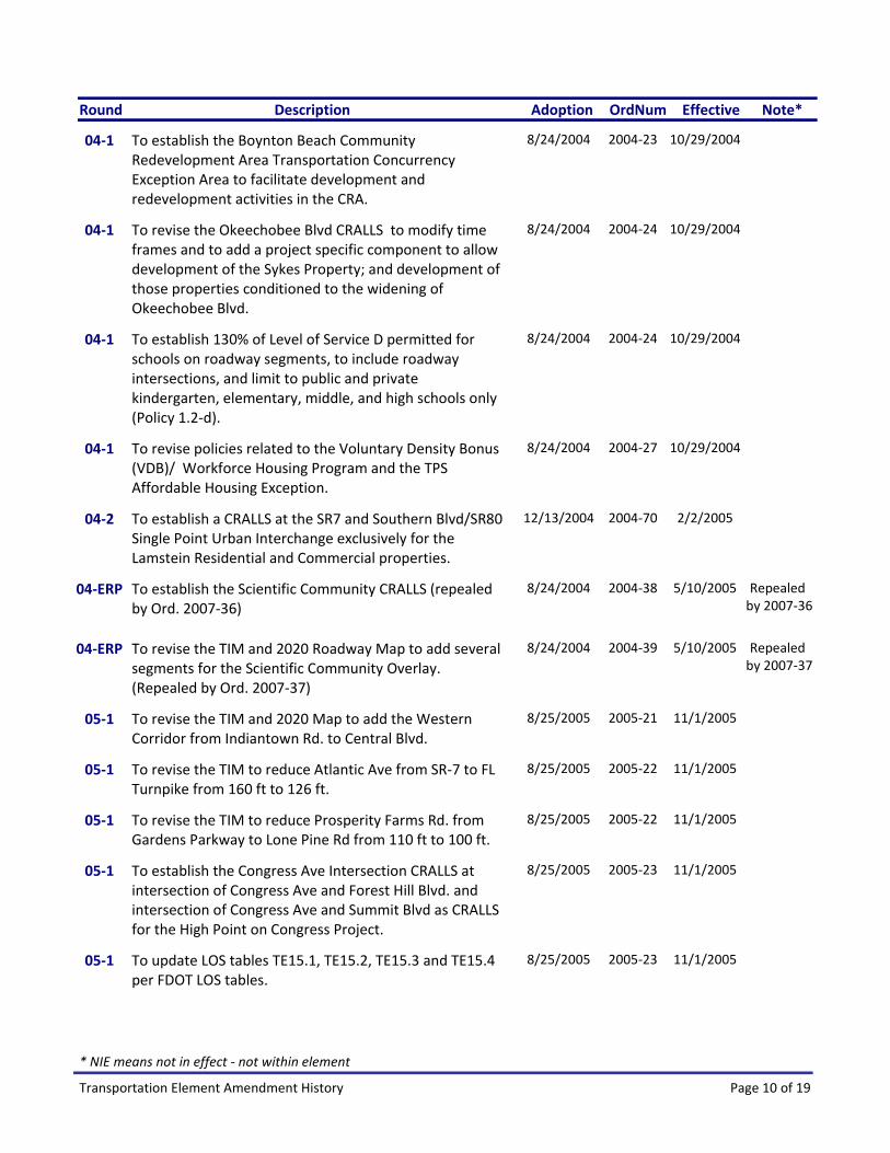
AdoptionRound Description OrdNum Effective Note*
8/24/2004To establish the Boynton Beach Community Redevelopment Area Transportation Concurrency Exception Area to facilitate development and redevelopment activities in the CRA.
2004‐23 10/29/200404‐1
8/24/2004To revise the Okeechobee Blvd CRALLS to modify time frames and to add a project specific component to allow development of the Sykes Property; and development of those properties conditioned to the widening of Okeechobee Blvd.
2004‐24 10/29/200404‐1
8/24/2004To establish 130% of Level of Service D permitted for schools on roadway segments, to include roadway intersections, and limit to public and private kindergarten, elementary, middle, and high schools only (Policy 1.2‐d).
2004‐24 10/29/200404‐1
8/24/2004To revise policies related to the Voluntary Density Bonus (VDB)/ Workforce Housing Program and the TPS Affordable Housing Exception.
2004‐27 10/29/200404‐1
12/13/2004To establish a CRALLS at the SR7 and Southern Blvd/SR80 Single Point Urban Interchange exclusively for the Lamstein Residential and Commercial properties.
2004‐70 2/2/200504‐2
8/24/2004To establish the Scientific Community CRALLS (repealed by Ord. 2007‐36)
2004‐38 5/10/2005 Repealed by 2007‐36
04‐ERP
8/24/2004To revise the TIM and 2020 Roadway Map to add several segments for the Scientific Community Overlay. (Repealed by Ord. 2007‐37)
2004‐39 5/10/2005 Repealed by 2007‐37
04‐ERP
8/25/2005To revise the TIM and 2020 Map to add the Western Corridor from Indiantown Rd. to Central Blvd.
2005‐21 11/1/200505‐1
8/25/2005To revise the TIM to reduce Atlantic Ave from SR‐7 to FL Turnpike from 160 ft to 126 ft.
2005‐22 11/1/200505‐1
8/25/2005To revise the TIM to reduce Prosperity Farms Rd. from Gardens Parkway to Lone Pine Rd from 110 ft to 100 ft.
2005‐22 11/1/200505‐1
8/25/2005To establish the Congress Ave Intersection CRALLS at intersection of Congress Ave and Forest Hill Blvd. and intersection of Congress Ave and Summit Blvd as CRALLS for the High Point on Congress Project.
2005‐23 11/1/200505‐1
8/25/2005To update LOS tables TE15.1, TE15.2, TE15.3 and TE15.4 per FDOT LOS tables.
2005‐23 11/1/200505‐1
Page 10 of 19Transportation Element Amendment History
* NIE means not in effect ‐ not within element

AdoptionRound Description OrdNum Effective Note*
8/25/2005To establish a map to depict TCEAs and CRALLS; to remove imbedded TCEA graphics from the Element and relocate to a map; to revise the Residential Concurrency Exception Area to omit parcels in the Coastal High Hazard Area (CHHA).
2005‐23 11/1/200505‐1
8/25/2005To revise the TIM to increase the right of way for State roads projected to be widened to 6 lanes from 120 ft to 126 ft.
2005‐24 11/1/200505‐1
8/25/2005To update ULDC references within Policies 1.1‐c, 1.15‐e, 1.15‐j, 1.16‐a, and Objective 1.16.
2005‐26 11/1/200505‐1
8/25/2005To revise the Westgate Community Redevelopment Area Overlay Transportation Concurrency Exception Area in order to facilitate the CRA plan.
2005‐31 11/1/200505‐1
11/28/2005To revise Corridor Master Plan Time Frames in Policy 1.1‐n.
2005‐49 1/24/200505‐2
11/28/2005To establish the Congress/ Old Boynton CRALLS in the vicinity of the Boynton Beach Mall for Old Boynton Rd from Spine Rd. to Boynton Beach Blvd., Intersection of Congress Ave. / Gateway Blvd., Intersection of Congress Ave / Old Boynton Rd.
2005‐50 1/24/200505‐2
11/28/2005To establish the Atlantic Avenue CRALLS on Atlantic Avenue from SR7 to Lyons Rd., from Lyons Rd. to Starkey Rd., from the Turnpike to Hagen Ranch Rd., from Hagen Ranch Rd to Jog Rd.
2005‐51 1/24/200505‐2
11/28/2005To revise Okeechobee Blvd CRALLS on Okeechobee Blvd from RPB Blvd to RPB High School, from SR7 to Sansbury Way, from Sansbury Wto Benoist Farms Rd, from Benoist Farms to Skees Rd, from Skees to Jog Rd, from Turnpike to Haverhill, and Haverhill to Military
2005‐52 1/24/200505‐2
11/28/2005To reflect the Port of Palm Beach Master Plan update in Objective 1.8 and relocate policies to the Coastal Management Element.
2005‐57 1/24/200505‐2
8/21/2006To revise the Congress Ave. Intersection CRALLS for the High Point Realtors Association project at the Congress Ave / Forest Hill Blvd intersection and the Congress Ave / Summit Blvd intersection and mitigation measures.
2006‐20 10/23/200606‐1
8/21/2006To revise the TIM to reduce right of way on Lyons Rd from Southern Blvd to Okeechobee Blvd from 120 ft to 100 ft, and Congress Ave. from North of Northlake Blvd to Alternate A1A from 110 ft to 80 ft.
2006‐20 10/23/200606‐1
Page 11 of 19Transportation Element Amendment History
* NIE means not in effect ‐ not within element

AdoptionRound Description OrdNum Effective Note*
8/21/2006To revise the TIM and 2020 Roadway Map to remove Coral Ridge Dr. from Lox Rd. to Glades Rd and move connection from Coral Ridge Dr. to Glades Rd. to a point west of Riverside Dr.
2006‐20 10/23/200606‐1
8/21/2006To revise the 2020 Map to widen SR7 from Clint Moore Rd to Broward County Line from 6 to 8 lanes.
2006‐20 10/23/200606‐1
8/21/2006To revise to reflect the Workforce Housing (Inclusionary Zoning) mandatory workforce housing programs (Policy 1.2‐6).
2006‐22 10/23/200606‐1
8/21/2006To add language per the EAR to consider establishing Multimodal transportation districts by 2010 as related to Transit Oriented Development (TOD) Policy 1.1‐o.
2006‐23 10/23/200606‐1
8/21/2006To establish a lower LOS to allow 130% LOS‐D for hospitals on roadway segments and intersections in Policy 1.2‐d.
2006‐24 10/23/200606‐1
8/21/2006To establish Congress Ave So. CRALLS (37) from Lantana Rd to Melaleuca Ln as 4 ln; and Lantana Airport CRALLS (38) for Congress from Lantana Rd to Melaleuca as 6 ln, plus intersections, mitigation measures, and on TCEA and CRALLS Map TE 15.1.
2006‐25 10/23/200606‐1
8/21/2006To revise the TIM to reduce right of way for Jog Rd. from Hood Rd to 3500 ft north of Hood Rd. from 100 ft to 60 ft and change width of section from 100 ft to 60 ft in Policy TE1.4‐u(6).
2006‐26 10/23/200606‐1
8/21/2006To revise the TIM and 2020 Map to add Orange Grove Blvd from Royal Palm Beach Blvd to SR7 as a 60 ft ROW to the TIM and to add 2 lanes to 2020.
2006‐27 10/23/200606‐1
11/13/2006To establish the Australian Ave. CRALLS for the Airport Center project on Australian Ave. from Belvedere Rd. to Southern Blvd., Australian Ave. / Belvedere Rd. intersection, mitigation measures, and to reflect on the TCEA and CRALLS TE15.1 Map.
2006‐45 2/23/200706‐2
11/13/2006To revise the TIM and 2020 Map for Lyons Road to widen Lyons Rd. from Lake Worth Rd. to Lantana Rd. from 2 lanes to 4 lanes, to remove two lane maximum limitation from TIM and Policy 1.4‐a(4).
2006‐46 2/23/200706‐2
11/27/2006To revise the Riviera Beach TCEA (not added to this Element ‐ listed here for reference only).
2006‐57 NIE ‐ Settled by 2007‐44
06‐2
Page 12 of 19Transportation Element Amendment History
* NIE means not in effect ‐ not within element

AdoptionRound Description OrdNum Effective Note*
12/18/2007Stipulated Settlement Agreement Ord. 2007‐44 for Riviera Beach TCEA. Prior Ord. 2006‐57 was never in effect due to a challenge.
2007‐44 5/5/2008 Settlement for 2006‐57
06‐2
11/27/2006To establish the Florida Research Park CRALLS on 19 roadway segments and 14 intersections and to add mitigation measures, and to reflect on TCEA and CRALLS TE15.1 Map.
2006‐58 1/23/200706‐D2
8/27/2007TIM and 2020 Map to remove University Dr. and Riverside Dr. from Lox Road to Palmetto Park Rd, to revise Policy 1.1‐n to add 3 roadways to corridor master plan list. (not added NIE/NIC)
2007‐08 Repealed by 2009‐10
07‐1
8/27/2007To establish the Urban Redevelopment Area TCEA for parcels fronting two corridors (Military Trail and Congress Avenue from Southern Blvd to Forest Hill Blvd) by Policy 1.2‐v and reflect on the TCEA and CRALLS Map TE15.1.
2007‐09 10/29/200707‐1
8/27/2007To revise references from a CIE six year capital improvement schedule to a five year schedule in Policy 1.12‐d.
2007‐10 10/29/200707‐1
8/27/2007To establish a lower level of service standard (up to 30% above the LOS D volume) on roadways and intersections for Transit Oriented Development (TOD) in Policy 1.2‐d.
2007‐10 10/29/200707‐1
8/27/2007To revise the TIM and 2020 Map to add an interchange at Hood Road and the Turnpike.
2007‐11 10/29/200707‐1
8/27/2007To add Strategic Intermodal System (SIS) Policies 1.1‐j, 1.2‐p, 1.2‐q and 1.3‐i.
2007‐11 10/29/200707‐1
8/27/2007To revise De Minimis Impact language in Policy 1.2‐n for consistency with Florida Statutes.
2007‐11 10/29/200707‐1
8/27/2007To revise the TIM and 2020 Map to widen Okeechobee Blvd from 6 to 8 lanes from SR7 to the future La Mancha Ave extension and increase right of way from 120 ft to 200 ft.
2007‐11 10/29/200707‐1
8/27/2007To establish 26 temporary CRALLS for roadway segments which are projected to exceed 110% of the adopted level of service standard exclusively for projects with insignificant (less than 1%) impact and reflect on the TCEA and CRALLS Map 15.1.
2007‐11 10/29/200707‐1
Page 13 of 19Transportation Element Amendment History
* NIE means not in effect ‐ not within element

AdoptionRound Description OrdNum Effective Note*
5/19/2009University Drive Settlement Agreement – designate SR 7 from Broward line to Glades Rd as a Transit Oriented Corridor, w/ mass transit, add SR7 CRALLS, remove University Dr Policy 1.4‐u.2, and Turnpike PDE, Glades Rd PDE, SR 7 PDE and Boca Raton MMTD.
2009‐10 7/29/2009 Settlement07‐1
5/19/2009University Dr Settlement– 2020 add transit note SR 7 from Broward to Glades Rd Policy 1.1‐p; Palmetto Park Rd from Lyons Rd to Powerline Rd from 6 to 8 lns; remove University and Riverside Dr from Lox Road to Palmetto Park, remove note Policy 1.4‐u.2.
2009‐10 7/29/2009 Settlement07‐1
11/26/2007To revise the Boynton Beach CRA Modification to remove the maximum ratios required in Policy TE1.2‐u.
2007‐25 1/28/200807‐2
11/26/2007To revise Westgate CRA TCEA to match ULDC, extend date 1 year for inclusionary housing policy, and revise the mix of affordable housing household income ranges for projects using CRA density bonus pool in Policy 1.2r(4)and(5).
2007‐25 1/28/200807‐2
11/26/2007To revise Greenways and Linked Open Space provisions to reflect current conditions in Policies 1.9‐b, 1.9‐d, 1.9‐g and 1.9‐p.
2007‐27 1/28/200807‐2
11/26/2007To revise Board of Adjustment References and to replace Development Review Committee (DRC) with Development Review Officer (DRO) in Policy 1.12‐g.
2007‐27 1/28/200807‐2
11/26/2007Repeal of the Central Western Communities Sector Plan. 2007‐31 Repealed by 2005‐34
07‐2
11/26/2007Mecca Repeal ‐ to delete Scientific Community Overlay CRALLS
2007‐36 1/3/2008 See Ord. 2004‐38
07‐M
11/26/2007Mecca Repeal TIM and 2020 2007‐37 1/3/2008 See Ord. 2004‐39
07‐M
8/21/2008TIM 2020 Map for Callery Ag Enclave: add Persimmon Blvd from 140th Ave N. to Seminole Pratt W Blvd from 2 to 4 lns and 140th Ave N from Persimmon to 60th St as rural parkways Pol 1.4‐q; So. Blvd from Big Blue Trace to Forest Hill 6 to 8 lns, add TIM notes
2008‐19 10/17/200808‐1
8/21/2008To revise the TIM and 2020 Map to remove E Rd./140th Ave N. from Northlake Blvd to Southern Blvd and 40th St North from RPB Blvd to E Rd/140th Ave N.
2008‐26 10/17/200808‐1
Page 14 of 19Transportation Element Amendment History
* NIE means not in effect ‐ not within element

AdoptionRound Description OrdNum Effective Note*
8/21/2008To establish the Belvedere CRALLS exclusively for Planet Kids, Duke Realty, McCraney Property, and Boys and Girls Club / PBC WFH project with mitigation measures, and reflect on the TCEA and CRALLS Map.
2008‐27 10/17/200808‐1
8/21/2008To establish the SR7/Southern Blvd CRALLS exclusively for WW V LLC project with mitigation measures, and reflect on the TCEA and CRALLS Map.
2008‐28 10/17/200808‐1
8/21/2008To update the Functional Classification Map TE 3.1 and reflect in Policy 1.1‐c and 1.12‐n.
2008‐29 10/17/200808‐1
8/21/2008To revise URA TCEA Policy 1.2‐v and Tables TE‐7a and TE‐7B to allow industrial development and to expand the boundaries of the TCEA on the TCEA and CRALLs Map TE 15.1 and 15.5, and URA Regulating Map LU 9.1
2008‐30 10/17/200808‐1
8/21/2008To revise LOS Tables TE‐1a and TE‐2a and clarify concurrency policies 1.1‐b(1)(a)(b) and 1.1‐b(3)and(4)
2008‐30 10/17/200808‐1
8/21/2008To revise Westgate CRA TCEA Policy 1.2‐r and Table TE‐6 to indicate existing land use totals, clarify allowable daily traffic and the PM peak hour traffic trips, increase the variance for hotel rooms, and eliminate allowable land use ratios.
2008‐30 10/17/200808‐1
12/3/2008To incorporate the four County airports revised master plans into the of the Comprehensive Plan in Objective 1.7 and to update the Airport Clear Zones Map TE 8.1 for consistency.
2008‐54 2/11/200908‐2
8/25/2009To delete Policy 1.1‐n requiring the completion of Corridor Master Plans.
2009‐30 10/23/200909‐1
8/25/2009To add provisions for an Affordable Housing Program to Policy 1.2‐b.
2009‐33 10/23/200909‐1
8/25/2009To reflect the latest date of the Port of Palm Beach Master Plan in Objective 1.8 as incorporated into the Coastal Management Element.
2009‐35 10/23/200909‐1
11/19/2009To revise the TIM and 2020 Map to remove the Haverhill Road roadway segment from Le Chalet Blvd to Military Tr.
2009‐43 1/11/201009‐2
11/19/2009To revise the TIM and 2020 Map to add a connector roadway from Lake Worth Rd to Lyons Rd through LW Polo Properties across Blanchette Trail as 2 lane roadway and with 80 ft of right of way.
2009‐43 1/11/201009‐2
Page 15 of 19Transportation Element Amendment History
* NIE means not in effect ‐ not within element

AdoptionRound Description OrdNum Effective Note*
11/19/2009To revise the URA TCEA to include the expanded PRA Corridors along Military Trail, Lake Worth Road/ Congress Ave and the node at Florida Mango and 10th Ave No in Policy 1.2v and Tables TE‐7A, 7B, 7C, 7D and 7E, and revise Maps TE 15.4, TE 15.5, TE 15.6.
2009‐46 1/11/201009‐2
8/30/2010To revise the TCEA and CRALLS Map TE 15.1 to depict a CRALLS for SR7 from the Broward County line to Glades Rd previously adopted in 2009.
2010‐32 11/4/201010‐1
8/30/2010To revise the TPS Exemption for Affordable Housing and Workforce Programs provisions for consistency with other existing TPS Exception methodologies (delete TE Policy 1.2‐b, revise TE Policy 1.2‐d)
2010‐33 11/4/201010‐1
8/30/2010To revise the TIM to remove the right of way for the Wabasso Drive segment from Westgate Ave to Belvedere Rd and to reduce the right of way for the segment from Okeechobee Blvd. to Westgate Ave from 80 ft to 60 ft.
2010‐34 11/4/201010‐1
8/30/2010To revise Level of Service Tables TE 1a and TE 1b and Policy 1.1b to require directional analysis for purposes of traffic concurrency, and to revise Policy 1.1‐f to provide peak hour / peak direction CRALLS Standards.
2010‐35 11/4/201010‐1
8/30/2010To revise the TIM and 2020 Map to remove Haverhill Rd segment from Le Chalet Blvd. to Hypoluxo Blvd from 4 lanes to 2 lanes, and to reduce the right of way from Hypoluxo Rd to Le Chalet Blvd. from 100 ft. to 80 ft.
2010‐36 11/4/201010‐1
8/30/2010TIM and 2020, and FFC Maps for Pike Road as urban collector from Belvedere Rd to So. Blvd; add Pike Rd. from Belvedere Rd to Turnpike as 2 lane; and from the Turnpike to So. Blvd as 4 lane; add Pike Rd from Belvedere Rd to So. Blvd as an 80 ft.
2010‐37 11/4/201010‐1
10/25/2010Est. Wellington Medical Arts District CRALLS for Okeechobee Blvd,, Southern Blvd./SR7, US441/SR7 and Lyons Rd as CRALLS facilities exclusively for the Wellington MAD and to reflect on the TCEA and CRALLS Map TE 15.1.
2010‐48 11/22/201010‐2
10/11/2011To revise alternate facilities ‐ the provision of bicycle, pedestrian, and bus transit facilities in the plans for all major roadway construction and reconstruction projects.
2011‐24 11/24/201111‐2
10/11/2011To modify the Boynton Beach CRA TCEA to reflect transit needs.
2011‐25 11/24/201111‐2
Page 16 of 19Transportation Element Amendment History
* NIE means not in effect ‐ not within element

AdoptionRound Description OrdNum Effective Note*
10/11/2011To revise the West Palm Beach Traffic Concurrency Exception Area to reconcile inconsistencies in the County and City Comprehensive Plans regarding allowable development building areas.
2011‐26 11/24/201111‐2
10/11/2011To modify the methodology for converting CRALLS to peak hour, peak direction numbers and to revise or delete CRALLS facilities on several intersections and roadway segments.
2011‐27 11/24/201111‐2
10/11/2011To add the I‐95/Spanish River interchange to the TIM and 2020 Map.
2011‐28 11/24/201111‐2
10/11/2011To revise the TIM to remove the right of way for the Australian Ave. Extension from Blue Heron Blvd to Dixie Highway.
2011‐28 11/24/201111‐2
10/11/2011To revise the 2020 Map to reduce lanes on Old Dixie Highway from Yamato Road to Lindell Blvd from 4 to 2 lanes.
2011‐28 11/24/201111‐2
10/11/2011To revise the 2020 Map to increase lanes on West Atlantic Avenue from Hagen Ranch Road to Jog Road from 4 to 6 lanes.
2011‐28 11/24/201111‐2
10/11/2011To revise the TIM and 2020 Map to add Stribling Way from Forest Hill Blvd to Lyons Road as a 2‐lane segment and as an 80 foot right of way.
2011‐28 11/24/201111‐2
7/23/2012To clarify the description of the boundaries of the Coastal Residential Exception Area and extend this exception to unincorporated areas within those boundaries.
2012‐24 8/31/201212‐1
7/23/2012To revise a Riviera Beach CRA TCEA provision for that requires a Transit Circulator Service by 2007.
2012‐25 8/31/201212‐1
7/23/2012To revise a Westgate‐Belvedere Homes CRA TCEA provision that requires a Transit Circulator Service by 2010.
2012‐26 8/31/201212‐1
10/29/2012To reduce the segment of Congress Ave Extension from Park Lake to the Richard Rd/Alt A1A intersection from 80 ft to 66 ft and from 4 to 2 lanes.
2012‐35 12/9/201212‐2
10/29/2012To revise maps TE 7.1, TE 8.1, 9.1 to change names to remove 2020 and add seaport to TE 7.1 , and to delete TE 2.1, TE 4.1, TE 5.1, TE 10.1, TE 11.1, and TE 12.1 that are no longer required by statute.
2012‐36 12/9/201212‐2
Page 17 of 19Transportation Element Amendment History
* NIE means not in effect ‐ not within element
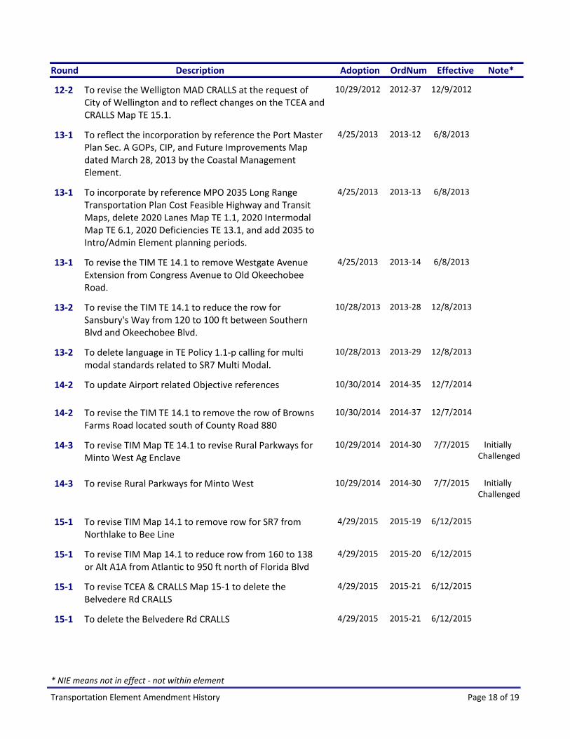
AdoptionRound Description OrdNum Effective Note*
10/29/2012To revise the Welligton MAD CRALLS at the request of City of Wellington and to reflect changes on the TCEA and CRALLS Map TE 15.1.
2012‐37 12/9/201212‐2
4/25/2013To reflect the incorporation by reference the Port Master Plan Sec. A GOPs, CIP, and Future Improvements Map dated March 28, 2013 by the Coastal Management Element.
2013‐12 6/8/201313‐1
4/25/2013To incorporate by reference MPO 2035 Long Range Transportation Plan Cost Feasible Highway and Transit Maps, delete 2020 Lanes Map TE 1.1, 2020 Intermodal Map TE 6.1, 2020 Deficiencies TE 13.1, and add 2035 to Intro/Admin Element planning periods.
2013‐13 6/8/201313‐1
4/25/2013 To revise the TIM TE 14.1 to remove Westgate Avenue Extension from Congress Avenue to Old Okeechobee Road.
2013‐14 6/8/201313‐1
10/28/2013To revise the TIM TE 14.1 to reduce the row for Sansbury's Way from 120 to 100 ft between Southern Blvd and Okeechobee Blvd.
2013‐28 12/8/201313‐2
10/28/2013To delete language in TE Policy 1.1‐p calling for multi modal standards related to SR7 Multi Modal.
2013‐29 12/8/201313‐2
10/30/2014To update Airport related Objective references 2014‐35 12/7/201414‐2
10/30/2014To revise the TIM TE 14.1 to remove the row of Browns Farms Road located south of County Road 880
2014‐37 12/7/201414‐2
10/29/2014To revise TIM Map TE 14.1 to revise Rural Parkways for Minto West Ag Enclave
2014‐30 7/7/2015 Initially Challenged
14‐3
10/29/2014To revise Rural Parkways for Minto West 2014‐30 7/7/2015 Initially Challenged
14‐3
4/29/2015To revise TIM Map 14.1 to remove row for SR7 from Northlake to Bee Line
2015‐19 6/12/201515‐1
4/29/2015To revise TIM Map 14.1 to reduce row from 160 to 138 or Alt A1A from Atlantic to 950 ft north of Florida Blvd
2015‐20 6/12/201515‐1
4/29/2015To revise TCEA & CRALLS Map 15‐1 to delete the Belvedere Rd CRALLS
2015‐21 6/12/201515‐1
4/29/2015To delete the Belvedere Rd CRALLS 2015‐21 6/12/201515‐1
Page 18 of 19Transportation Element Amendment History
* NIE means not in effect ‐ not within element

AdoptionRound Description OrdNum Effective Note*
10/26/2015To delete the Wellington Medical Arts District CRALLS from the Element and from the TCEA & CRALLS Map TE 15.1
2015‐41 12/4/201515‐2
10/26/2015To revise TIM Map 14.1 to delete Folsom Road from Okeechobee Blvd to Crestwood Blvd
2015‐42 12/4/201515‐2
4/27/2016To revise the Westgate Belvedere Homes CRA TCEA 2016‐24 6/9/201616‐B
9/22/2016To add Rural Parkways for the and to revise the TIM for the Western Communities Residential Indian Trails Grove
2016‐41 10/29/201616‐ITG
10/26/2016To revise TIM TE 14.1 to narrow the with of Palmwood Road.
2016‐47 12/9/201616‐D
7/26/2017To revise outdated language, to delete the SR 7 Transit Oriented Corridor, and to delete expired Constrained Roadways at Lower Level of Service (CRALLS).
2017‐23 9/8/201717‐C
10/30/2017To update references to the revised Port of Palm Beach Master Plan
2017‐34 12/7/201717‐D
Page 19 of 19Transportation Element Amendment History
* NIE means not in effect ‐ not within element