monroe county, new york addendum no. 1 … addendums/bp050612... · addendum no. 1 specifications...
TRANSCRIPT
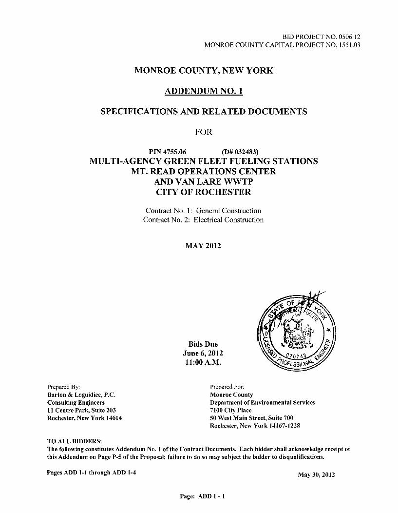
BID PROJECT NO. 0506.12 MONROE COUNTY CAPITAL PROJECT NO. 1551.03
MONROE COUNTY, NEW YORK
ADDENDUM NO. 1
SPECIFICATIONS AND RELATED DOCUMENTS
FOR
PIN 4755.06 (D# 032483)
MULTI-AGENCY GREEN FLEET FUELING STATIONS MT. READ OPERATIONS CENTER
AND VAN LARE WWTP CITY OF ROCHESTER
Contract No. 1: General Construction Contract No. 2: Electrical Construction
MAY 2012
Bids Due June 6,2012 11:00 A.M.
Prepared By: Barton & Loguidice, P.C. Consulting Engineers 11 Centre Park, Suite 203 Rochester, New York 14614
Prepared For: Monroe County Department of Environmental Services 7100 City Place 50 West Main Street, Suite 700 Rochester, New York 14167-1228
TO ALL BIDDERS: The following constitutes Addendum No. 1 of the Contract Documents. Each bidder shall acknowledge receipt of this Addendum on Page P-5 of the Proposal; failure to do so may subject the bidder to disqualifications.
Pages ADD 1-1 through ADD 1-4 May 30, 2012
Page: ADD 1 -1
Page: ADD 1 - 2
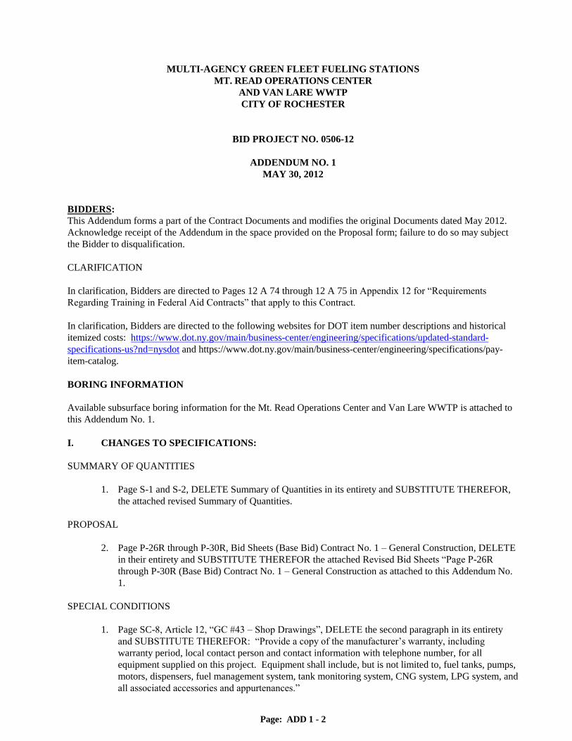
MULTI-AGENCY GREEN FLEET FUELING STATIONS
MT. READ OPERATIONS CENTER
AND VAN LARE WWTP
CITY OF ROCHESTER
BID PROJECT NO. 0506-12
ADDENDUM NO. 1
MAY 30, 2012
BIDDERS:
This Addendum forms a part of the Contract Documents and modifies the original Documents dated May 2012.
Acknowledge receipt of the Addendum in the space provided on the Proposal form; failure to do so may subject
the Bidder to disqualification.
CLARIFICATION
In clarification, Bidders are directed to Pages 12 A 74 through 12 A 75 in Appendix 12 for “Requirements
Regarding Training in Federal Aid Contracts” that apply to this Contract.
In clarification, Bidders are directed to the following websites for DOT item number descriptions and historical
itemized costs: https://www.dot.ny.gov/main/business-center/engineering/specifications/updated-standard-
specifications-us?nd=nysdot and https://www.dot.ny.gov/main/business-center/engineering/specifications/pay-
item-catalog.
BORING INFORMATION
Available subsurface boring information for the Mt. Read Operations Center and Van Lare WWTP is attached to
this Addendum No. 1.
I. CHANGES TO SPECIFICATIONS:
SUMMARY OF QUANTITIES
1. Page S-1 and S-2, DELETE Summary of Quantities in its entirety and SUBSTITUTE THEREFOR,
the attached revised Summary of Quantities.
PROPOSAL
2. Page P-26R through P-30R, Bid Sheets (Base Bid) Contract No. 1 – General Construction, DELETE
in their entirety and SUBSTITUTE THEREFOR the attached Revised Bid Sheets “Page P-26R
through P-30R (Base Bid) Contract No. 1 – General Construction as attached to this Addendum No.
1.
SPECIAL CONDITIONS
1. Page SC-8, Article 12, “GC #43 – Shop Drawings”, DELETE the second paragraph in its entirety
and SUBSTITUTE THEREFOR: “Provide a copy of the manufacturer‟s warranty, including
warranty period, local contact person and contact information with telephone number, for all
equipment supplied on this project. Equipment shall include, but is not limited to, fuel tanks, pumps,
motors, dispensers, fuel management system, tank monitoring system, CNG system, LPG system, and
all associated accessories and appurtenances.”

Page: ADD 1 - 3
II. CHANGES TO DRAWINGS:
DRAWING E-3 – VAN LARE ELECTRICAL SITE PLAN
2. Under KEYED NOTES, ELECTRICAL - SITE PLAN, NOTE 5, ADD “TRANSFORMER TO BE
PLACED MINIMUM OF 10‟ FROM CNG FUELING AREA.” To clarify, transformer „TR2‟ shall
be at least 10‟ away from areas where compressed natural gas (CNG) is stored, handled, or
dispensed.
3. Under KEYED NOTES, ELECTRICAL - SITE PLAN, NOTE 6, ADD “ELECTRICAL
BACKBOARD TO BE PLACED MINIMUM OF 10‟ FROM CNG FUELING AREA.” To clarify,
electrical backboard shall be at least 10‟ away from areas where compressed natural gas (CNG) is
stored, handled, or dispensed.
DRAWING E-4 – MT. READ ELECTRICAL DEMOLITION PLANS
4. DELETE “FUEL ISLAND – ELECTRICAL ROOM ENLARGED DEMOLITION PLAN” in its
entirety, and SUBSTITUTE THEREFOR Figure SK-1 “FUEL ISLAND ELECTRICAL ROOM
ENLARGED PLAN” as attached to this Addendum No. 1.
5. DELETE “GENERAL NOTES, FUEL ISLAND – ELECTRICAL ROOM ENLARGED
DEMOLITION PLAN” and DELETE “KEYED NOTES, FUEL ISLAND – ELECTRICAL ROOM
ENLARGED DEMOLITION PLAN” in their entirety, and SUBSTITUTE THEREFOR Figure SK-2
“GENERAL NOTES, FUEL ISLAND ELECTRICAL ROOM ENLARGED PLAN” and “KEYED
NOTES, FUEL ISLAND ELECTRICAL ROOM ENLARGED PLAN” as attached to this
Addendum No. 1.
DRAWING G-4 MT. READ OPERATIONS CENTER FUELING SYSTEM SITE PLAN
6. ADD the following sentence to General Note No. 2, “REFINISH ALL SURFACES AROUND AND
BELOW THE EXISTING CANOPY, INCLUDING STRUCTURAL STEEL FRAMING,
SUPPORTS AND COLUMNS.”
DRAWING G-5 MT. READ OPERATIONS CENTER SITE PLAN
7. ADD Note 5 to the GENERAL NOTES, “APPROXIMATE BEDROCK ELEVATION IS 8 FEET
BELOW GROUND SURFACE. IT IS ASSUMED APPROXIMATELY 50 CUBIC YARDS OF
BEDROCK WILL NEED TO BE REMOVED FOR THE INSTALLATION OF THE
UNDERGROUND HOLDING TANK. THE COST OF ANY ROCK EXCAVATION SHALL BE
INCLUDED IN THE PRICE BID FOR ITEM 203.02.”
DRAWING G-6 VAN LARE DEMOLITION SITE PLAN
8. ADD Note 5 to the UNDERGROUND TANK CLOSURE AND REMOVAL NOTES, “All
DEMOLITION WORK FOR UST REMOVALS INCLUDING ELECTRICAL DEMOLITION
WORK IS TO BE COMPLETED BY GENERAL CONTRACTOR. CONTRACTOR TO
PROTECT AND RESTORE FENCING FOLLOWING DEMOLITION AND REMOVAL OF
TANK. ALL SECURITY CAMERAS TO BE SALVAGED AND TURNED OVER TO THE
OWNER.”
DRAWING G-7 VANLARE WWTP FUELING SYSTEM SITE PLAN
9. DELETE the “OVERALL SITE PLAN” in its entirety and SUBSTITUTE THEREFOR, the
“OVERALL SITE PLAN” with approximately 1,200 feet over underground 3-inch natural gas piping
as shown on Figure SK-3 as attached to this Addendum No. 1.

Page: ADD 1 - 4
10. ADD the following General Note, “6. EXTEND THE NEW 3-INCH NATURAL GAS LINE FROM
THE EXISTING 8-INCH SERVICE TO THE CNG SYSTEM AS SHOWN ON THE OVERALL
SITE PLAN. NATURAL GAS LINE SHALL BE INSTALLED A MINIMUM 24-INCHES
BELOW GRADE USING ASTM D2513 POLYETHYLENE PIPING, 100 PSIG WORKING
PRESSURE, MINIMUM SDR 11.5, ASTM D2683 SOCKET FITTINGS, AND ASTM D2513
MOLDED BUTT-FUSION FITTINGS. CONTRACTOR SHALL ALSO PROVIDE ALL
TRENCHING, BACKFILL AND COMPACTION, REMOVAL AND REPLACEMENT OF
ASPHALT PAVEMENT, CONCRETE, AND/OR TOPSOIL AND SEEDING NECESSARY TO
INSTALL NEW GAS LINE. ALL WORK ASSOCIATED WITH GAS LINE INSTALLATION
SHALL BE INCLUDED IN ITEM 990.07.”
DRAWING G-8 VAN LARE WWTP SITE PLAN
11. Under SITE PLAN, CONCRETE EQUIPMENT PAD note with arrow, DELETE the words “ITEM
555.01015” and SUBSTITUTE THEREFOR, “ITEM 555.0105”.
12. Under SITE PLAN, TANK PAD PILE note with arrow, DELETE the words “ITEM 551.012053”
and SUBSTITUTE THEREFOR, “ITEM 551.010042”.
DRAWING G-14 SITE DETAILS
13. Under TYPICAL VAN LARE CONCRETE TANK SLAB SECTION, DELETE the note “STEEL
H-PILE (HP 12X53) ITEM 551.012053 (TYP.)” in its entirety and SUBSTITUTE THEREFOR,
“STEEL H-PILE (HP 10X42) ITEM 551.010042 (TYP.)”.
14. Under TYPICAL VAN LARE CONCRETE TANK SLAB SECTION, DELETE Note No. 1 in its
entirety and SUBSTITUTE THEREFOR, “1. THE PILES ARE DESIGNED TO SUPPORT
MAXIMUM ALLOWABLE LOAD OF 154 KIPS AND A REQUIRED ULTIMATE TEST
CAPACITY OF 308 KIPS. HOWEVER ALL PILES SHALL BE DRIVEN TO PRACTICAL
REFUSAL.”
DRAWING G-15 SITE DETAILS
15. ADD Note to the SECTION 3, “CONCRETE BALLAST PAD REINFORCING TO MATCH
TYPICAL UNDERGROUND TANK SECTION 2 (SEE SHEET G-12). BALLAST PAD
DIMENSIONS TO EXTEND 2‟-0” MINIMUM BEYOND ENDS AND SIDES OF TANK, LEVEL
IN ALL DIRECTIONS.”
DRAWING G-16 SITE DETAILS
16. Under CANOPY PILE AND FOUNDATION DETAIL, DELETE the note “STEEL H-PILE (HP
12X53) ITEM 551.012053 (TYP.)” in its entirety and SUBSTITUTE THEREFOR, “STEEL H-PILE
(HP 10X42) ITEM 551.010042 (TYP.)”.
17. Under CANOPY PILE AND FOUNDATION DETAIL, DELETE Note No. 1 in its entirety and
SUBSTITUTE THEREFOR, “1. THE PILES ARE DESIGNED TO SUPPORT MAXIMUM
ALLOWABLE LOAD OF 154 KIPS AND A REQUIRED ULTIMATE TEST CAPACITY OF 308
KIPS. HOWEVER, ALL PILES SHALL BE DRIVEN TO PRACTICAL REFUSAL.”
Attachments
END OF ADDENDUM NO. 1
Addendum No. 1 May 30, 2012

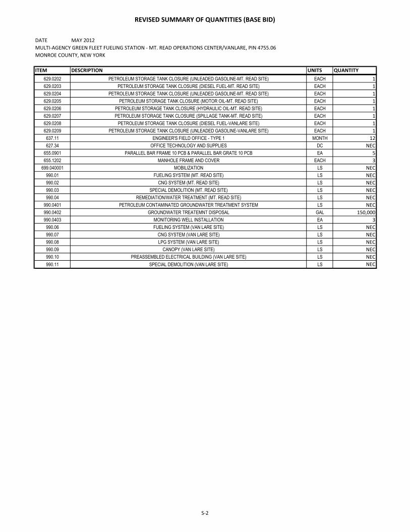
REVISED SUMMARY OF QUANTITIES (BASE BID)
DATE MAY 2012
MULTI-AGENCY GREEN FLEET FUELING STATION - MT. READ OPERATIONS CENTER/VANLARE, PIN 4755.06
MONROE COUNTY, NEW YORK
ITEM DESCRIPTION UNITS QUANTITY
201.06 CLEARING AND GRUBBING LS NEC
202.010001 DISPOSAL OF BUILDINGS LS NEC
202.19 REMOVAL OF SUBSTRUCTURES CY 350
203.02 UNCLASSIFIED EXCAVATION AND DISPOSAL CY 1,167
203.03 EMBANKMENT IN PLACE CY 400
203.07 SELECT GRANULAR FILL CY 480
203.21 SELECT STRUCTURE FILL CY 210
205.0201 SEGREGATION AND STORAGE OF CONTAMINATED SOIL LS NEC
205.0401 PETROLEUM CONTAMINATION PARAMETER ANALYSIS EACH 11
205.0402 LABORATORY ANALYSIS FOR HAZARDOUS WASTE RCRA TOXICITY CHARACTERISTICS EACH 11
205.0403 LABORATORY ANALYSIS FOR IGNITABILITY EACH 11
205.0404 LABORATORY ANALYSIS FOR pH EACH 11
205.0405 LABORATORY ANALYSIS FOR POLYCHLORINATED BIPHENYLS (PCBs) EACH 11
205.0406 LABORATORY ANALYSIS FOR TOTAL PETROLEUM HYDROCARBONS - GASOLINE RANGE ORGANICS EACH 11
205.0407 LABORATORY ANALYSIS FOR TOTAL PETROLEUM HYDROCARBONS -DIESEL RANGE ORGANICS EACH 11
205.050201 DISPOSAL OF CONTAMINATED NON-HAZARDOUS WASTE SOIL TON 1,890
206.01 STRUCTURE EXCAVATION CY 250
206.02 TRENCH AND CULVERT EXCAVATION CY 460
207.20 GEOTEXTILE BEDDING SY 440
207.21 GEOTEXTILE SEPARATION SY 395
209.1106 CHECK DAM, STONE-PERMANENT EA 5
209.13 SILT FENCE - TEMPORARY LF 600
209.22 CONSTRUCTION ENTRANCE SY 70
304.15 SUBBASE COURSE, OPTIONAL TYPE CY 1,020
402.128202 12.52 F2 TOP COURSE HMA, 80 SERIES COMPACTION TON 270
402.198902 19 F9 BINDER COURSE HMA, 80 SERIES COMPACTION TON 350
402.378902 37.5 F9 BASE COURSE HAM, 80 SERIES COMPACTION TON 1,030
407.0101 TACK COAT GAL 130
520.5014008SAWCUTTING, ASPHALT PAVEMENT, ASPHALT SURFACE COURSE, CONCRETE PAVEMENT OR ASPHALT OVERLAY
ON CONCRETE PAVEMENTLF 750
551.010042 STEEL H-PILES LF 1,000
551.13 FURNISHING EQUIPMENT FOR DRIVING PILES LS NEC
551.14 DYNAMIC PILE TESTING EACH 2
555.0105 CONCRETE FOR STRUCTURES, CLASS A CY 555
556.0201 UNCOATED BAR REINFORCEMENT LB 44,150
556.0202 UNCOATED BAR REINFORCEMENT LB 49,950
603.16500002 INTERNALL SLOPPING SLOTTED DRAIN (TRENCH DRAIN) LF 20
603.6002 REINFORCED CONCRETE PIPE CLASS III, 12 INCH LF 260
603.9804 SMOOTH INTERIOR CORRUGATED POLYETHYLENE STORM DRAIN 4 INCH LF 60
603.9812 SMOOTH INTERIOR CORRUGATED POLYETHYLENE STORM DRAIN 12 INCH LF 35
604.070401 ALTERING DRAINAGE STRUCTURES, LEACHING BASINS AND MANHOLES EACH 1
604.301990 RECTANGULAR DRAINAGE STRUCTURE TYPE S EACH 5
605.1001 UNDERDRAIN FILTER, TYPE II CY 130
608.0101 CONCRETE SIDEWALKS AND DRIVEWAYS CY 13
609.0204 STONE CURB GRANITE TYPE D LF 970
609.04 CAST IN PLACE CONCRETE CURB LF 200
610.0203 ESTABLISHING TURF ACRE 0.35
611.01010010 PLANTING-MAJOR DECIDUOUS TREES EACH 2
611.03010010 PLANTING-MAJOR CONIFEROUS TREES EACH 14
613.02 PLACING TOPSOIL-TYPE A CY 110
615.88020004 BOLLARD, FIXED (GALVANIZED) EACH 69
615.88040004 BOLLARD, MOVABLE (GALVANIZED) EACH 32
619.01 BASIC WORK ZONE TRAFFIC CONTROL LS NEC
620.02 STONE FILLING (FINE) CY 30
625.01 SURVEY OPERATIONS LS NEC
629.01 REMOVAL/DISPOSAL OF LIQUIDS FROM PETROLEUM TANKS GAL 6,200
629.0201 PETROLEUM STORAGE TANK CLOSURE (DIESEL FUEL-MT. READ SITE) EACH 1
S-1
REVISED SUMMARY OF QUANTITIES (BASE BID)
DATE MAY 2012
MULTI-AGENCY GREEN FLEET FUELING STATION - MT. READ OPERATIONS CENTER/VANLARE, PIN 4755.06
MONROE COUNTY, NEW YORK
ITEM DESCRIPTION UNITS QUANTITY
629.0202 PETROLEUM STORAGE TANK CLOSURE (UNLEADED GASOLINE-MT. READ SITE) EACH 1
629.0203 PETROLEUM STORAGE TANK CLOSURE (DIESEL FUEL-MT. READ SITE) EACH 1
629.0204 PETROLEUM STORAGE TANK CLOSURE (UNLEADED GASOLINE-MT. READ SITE) EACH 1
629.0205 PETROLEUM STORAGE TANK CLOSURE (MOTOR OIL-MT. READ SITE) EACH 1
629.0206 PETROLEUM STORAGE TANK CLOSURE (HYDRAULIC OIL-MT. READ SITE) EACH 1
629.0207 PETROLEUM STORAGE TANK CLOSURE (SPILLAGE TANK-MT. READ SITE) EACH 1
629.0208 PETROLEUM STORAGE TANK CLOSURE (DIESEL FUEL-VANLARE SITE) EACH 1
629.0209 PETROLEUM STORAGE TANK CLOSURE (UNLEADED GASOLINE-VANLARE SITE) EACH 1
637.11 ENGINEER'S FIELD OFFICE - TYPE 1 MONTH 12
627.34 OFFICE TECHNOLOGY AND SUPPLIES DC NEC
655.0901 PARALLEL BAR FRAME 10 PCB & PARALLEL BAR GRATE 10 PCB EA 5
655.1202 MANHOLE FRAME AND COVER EACH 3
699.040001 MOBILIZATION LS NEC
990.01 FUELING SYSTEM (MT. READ SITE) LS NEC
990.02 CNG SYSTEM (MT. READ SITE) LS NEC
990.03 SPECIAL DEMOLITION (MT. READ SITE) LS NEC
990.04 REMEDIATION/WATER TREATMENT (MT. READ SITE) LS NEC
990.0401 PETROLEUM CONTAMINATED GROUNDWATER TREATMENT SYSTEM LS NEC
990.0402 GROUNDWATER TREATEMNT DISPOSAL GAL 150,000
990.0403 MONITORING WELL INSTALLATION EA 3
990.06 FUELING SYSTEM (VAN LARE SITE) LS NEC
990.07 CNG SYSTEM (VAN LARE SITE) LS NEC
990.08 LPG SYSTEM (VAN LARE SITE) LS NEC
990.09 CANOPY (VAN LARE SITE) LS NEC
990.10 PREASSEMBLED ELECTRICAL BUILDING (VAN LARE SITE) LS NEC
990.11 SPECIAL DEMOLITION (VAN LARE SITE) LS NEC
S-2

BID SHEETS (BASE BID)
Contract No. 1 - General Construction
ITEMIZED PROPOSAL
MULTI-AGENCY GREEN FLEET FUELING STATION CIP No. 0506.12
MT. READ OPERATIONS CENTER AND VANLARE SITE
P-22R CARRY FORWARD
ITEM DESCRIPTION EST.
QUANT.
UNIT UNIT BID PRICE
(NUMERALS)
UNIT PRICE
(WORDS - PRINTED LEGIBLY)
AMOUNT
BID
201.06 CLEARING AND GRUBBING NEC LS
$
DOLLARS and CENTS
$
202.010001 DISPOSAL OF BUILDINGS NEC LS
$
DOLLARS and CENTS
$
202.19 REMOVAL OF SUBSTRUCTURES 350 CY
$
DOLLARS and CENTS
$
203.02 UNCLASSIFIED EXCAVATION AND DISPOSAL 1,167 CY
$
DOLLARS and CENTS
$
203.03 EMBANKMENT IN PLACE 400 CY
$
DOLLARS and CENTS
$
203.07 SELECT GRANULAR FILL 480 CY
$
DOLLARS and CENTS
$
203.21 SELECT STRUCTURE FILL 210 CY
$
DOLLARS and CENTS
$
205.0201 SEGREGATION AND STORAGE OF
CONTAMINATED SOIL
NEC LS
$
DOLLARS and CENTS
$
205.0401 PETROLEUM CONTAMINATION PARAMETER
ANALYSIS
11 EA
$
DOLLARS and CENTS
$

BID SHEETS (BASE BID)
Contract No. 1 - General Construction
ITEMIZED PROPOSAL
MULTI-AGENCY GREEN FLEET FUELING STATION CIP No. 0506.12
MT. READ OPERATIONS CENTER AND VANLARE SITE
P-23R CARRY FORWARD
205.0402 LABORATORY ANALYSIS FOR HAZARDOUS
WASTE RCRA TOXICITY CHARACTERISTIC
11 EA
$
DOLLARS and CENTS
$
205.0403 LABORATORY ANALYSIS FOR IGNITABILITY 11 EA
$
DOLLARS and CENTS
$
205.0404 LABORATORY ANALYSIS FOR pH 11 EA
$
DOLLARS and CENTS
$
205.0405 LABORATORY ANALYSIS FOR
POLYCHLORINATED BIPHENYLS (PCBs)
11 EA
$
DOLLARS and CENTS
$
205.0406 LABORATORY ANALYSIS FOR TOTAL
PETROLEUM HYDROCARBONS-GASOLINE
RANGE ORGANICS
11 EA
$
DOLLARS and CENTS
$
205.0407 LABORATORY ANALYSIS FOR TOTAL
PETROLEUM HYDROCARBONS-DIESEL RANGE
ORGANICS
11 EA
$
DOLLARS and CENTS
$
205.050201 DISPOSAL OF CONTAMINATED NON-
HAZARDOUS WASTE SOIL
1,890 TON
$
DOLLARS and CENTS
$
206.01 STRUCTURE EXCAVATION 250 CY
$
DOLLARS and CENTS
$
206.02 TRENCH AND CULVERT EXCAVATION 460 CY
$
DOLLARS and CENTS
$
207.20 GEOTEXTILE BEDDING 440 SY
$
DOLLARS and CENTS
$

BID SHEETS (BASE BID)
Contract No. 1 - General Construction
ITEMIZED PROPOSAL
MULTI-AGENCY GREEN FLEET FUELING STATION CIP No. 0506.12
MT. READ OPERATIONS CENTER AND VANLARE SITE
P-24R CARRY FORWARD
207.21 GEOTEXTILE SEPARATION 395 SY
$
DOLLARS and CENTS
$
209.1106 CHECK DAM, STONE-PERMANENT 5 EA
$
DOLLARS and CENTS
$
209.13 SILT FENCE - TEMPORARY 600 LF
$
DOLLARS and CENTS
$
209.22 CONSTRUCTION ENTRANCE 70 SY
$
DOLLARS and CENTS
$
304.15 SUBBASE COURSE, OPTIONAL TYPE 1,020 CY
$
DOLLARS and CENTS
$
402.128202 12.52 F2 TOP COURSE HMA, 80 SERIES
COMPACTION
270 TON
$
DOLLARS and CENTS
$
402.198902 19 F9 BINDER COURSE HMA, 80 SERIES
COMPACTION
350 TON
$
DOLLARS and CENTS
$
402.378902 37.5 F9 BASE COURSE HMA, 80 SERIES
COMPACTION
1,030 TON
$
DOLLARS and CENTS
$
407.0101 TACK COAT 130 GAL.
$
DOLLARS and CENTS
$
520.5014008 SAWCUTTING, ASPHALT PAVEMENT,
ASPHALT SURFACE COURSE, CONCRETE
PAVEMENT OR ASPHALT OVERLAY ON
CONCRETE PAVEMENT
750 LF
$
DOLLARS and CENTS
$

BID SHEETS (BASE BID)
Contract No. 1 - General Construction
ITEMIZED PROPOSAL
MULTI-AGENCY GREEN FLEET FUELING STATION CIP No. 0506.12
MT. READ OPERATIONS CENTER AND VANLARE SITE
P-25R CARRY FORWARD
551.010042 STEEL H-PILES 1,000 LF
$
DOLLARS and CENTS
$
551.13 FURNISHING EQUIPMENT FOR DRIVING PILES NEC LS
$
DOLLARS and CENTS
$
551.14 DYNAMIC PILE TESTING 2 EA
$
DOLLARS and CENTS
$
555.0105 CONCRETE FOR STRUCTURES, CLASS A 555 CY
$
DOLLARS and CENTS
$
556.0201 UNCOATED BAR ENFORCEMENT 44,150 LB
$
DOLLARS and CENTS
$
556.0202 EPOXY COATED BAR ENFORCEMENT 49,950 LB
$
DOLLARS and CENTS
$
603.16500002 INTERNALLY SLOPPING SLOTTED DRAIN
(TRENCH DRAIN)
20 LF
$
DOLLARS and CENTS
$
603.6002 REINFORCED CONCRETE PIPE CLASS III, 12
INCH
260 LF
$
DOLLARS and CENTS
$
603.9804 SMOOTH INTERIOR CORRUGATED
POLYETHYLENE STORM DRAIN 4 INCH
60 LF
$
DOLLARS and CENTS
$
603.9812 SMOOTH INTERIOR CORRUGATED
POLYETHYLENE STORM DRAIN 12 INCH
35 LF
$
DOLLARS and CENTS
$

BID SHEETS (BASE BID)
Contract No. 1 - General Construction
ITEMIZED PROPOSAL
MULTI-AGENCY GREEN FLEET FUELING STATION CIP No. 0506.12
MT. READ OPERATIONS CENTER AND VANLARE SITE
P-26R CARRY FORWARD
604.070401 ALTERING DRAINAGE STRUCTURES,
LEACHING BASINS AND MANHOLES
1 EA
$
DOLLARS and CENTS
$
604.301990 RECTANGULAR DRAINAGE STRUCTURE
TYPE S
5 EA
$
DOLLARS and CENTS
$
605.1001 UNDERDRAIN FILTER, TYPE II 130 CY
$
DOLLARS and CENTS $
608.0101 CONCRETE SIDEWALKS AND DRIVEWAYS 13 CY
$
DOLLARS and CENTS
$
609.0204 STONE CURB GRANITE TYPE D 970 LF
$
DOLLARS and CENTS
$
609.04 CAST-IN-PLACE CONCRETE CURB 200 LF
$
DOLLARS and CENTS
$
610.0203 ESTABLISHING TURF 0.35 ACRE
$
DOLLARS and CENTS
$
611.01010010 PLANTING-MAJOR DECIDUOUS TREES 2 EA
$
DOLLARS and CENTS
$
611.03010010 PLANTING-MAJOR CONIFEROUS TREES 14 EA
$
DOLLARS and CENTS
$
613.02 PLACING TOPSOIL –TYPE A 110 CY
$
DOLLARS and CENTS
$
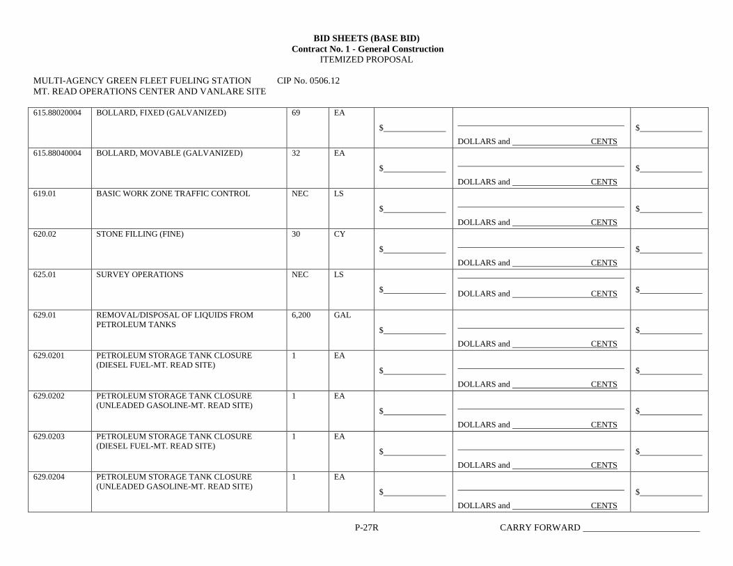
BID SHEETS (BASE BID)
Contract No. 1 - General Construction
ITEMIZED PROPOSAL
MULTI-AGENCY GREEN FLEET FUELING STATION CIP No. 0506.12
MT. READ OPERATIONS CENTER AND VANLARE SITE
P-27R CARRY FORWARD
615.88020004 BOLLARD, FIXED (GALVANIZED) 69 EA
$
DOLLARS and CENTS
$
615.88040004 BOLLARD, MOVABLE (GALVANIZED) 32 EA
$
DOLLARS and CENTS
$
619.01 BASIC WORK ZONE TRAFFIC CONTROL NEC LS
$
DOLLARS and CENTS
$
620.02 STONE FILLING (FINE) 30 CY
$
DOLLARS and CENTS
$
625.01 SURVEY OPERATIONS NEC LS
$
DOLLARS and CENTS $
629.01 REMOVAL/DISPOSAL OF LIQUIDS FROM
PETROLEUM TANKS
6,200 GAL
$
DOLLARS and CENTS
$
629.0201 PETROLEUM STORAGE TANK CLOSURE
(DIESEL FUEL-MT. READ SITE)
1 EA
$
DOLLARS and CENTS
$
629.0202 PETROLEUM STORAGE TANK CLOSURE
(UNLEADED GASOLINE-MT. READ SITE)
1 EA
$
DOLLARS and CENTS
$
629.0203 PETROLEUM STORAGE TANK CLOSURE
(DIESEL FUEL-MT. READ SITE)
1 EA
$
DOLLARS and CENTS
$
629.0204 PETROLEUM STORAGE TANK CLOSURE
(UNLEADED GASOLINE-MT. READ SITE)
1 EA
$
DOLLARS and CENTS
$

BID SHEETS (BASE BID)
Contract No. 1 - General Construction
ITEMIZED PROPOSAL
MULTI-AGENCY GREEN FLEET FUELING STATION CIP No. 0506.12
MT. READ OPERATIONS CENTER AND VANLARE SITE
P-28R CARRY FORWARD
629.0205 PETROLEUM STORAGE TANK CLOSURE
(MOTOR OIL-MT. READ SITE)
1 EA
$
DOLLARS and CENTS
$
629.0206 PETROLEUM STORAGE TANK CLOSURE
(HYDRAULIC OIL-MT. READ SITE)
1 EA
$
DOLLARS and CENTS
$
629.0207 PETROLEUM STORAGE TANK CLOSURE
(SPILLAGE TANK-MT. READ SITE)
1 EA
$
DOLLARS and CENTS
$
629.0208 PETROLEUM STORAGE TANK CLOSURE
(DIESEL FUEL-VAN LARE SITE)
1 EA
$
DOLLARS and CENTS
$
629.0209 PETROLEUM STORAGE TANK CLOSURE
(UNLEADED GASOLINE-VAN LARE SITE)
1 EA
$
DOLLARS and CENTS
$
637.11 ENGINEER’S FIELD OFFICE-TYPE I 12 MONTHS
$
DOLLARS and CENTS
$
637.34 OFFICE TECHNOLOGY AND SUPPLIES NEC DC
$
DOLLARS and CENTS
$
655.0901 PARALLEL BAR FRAME 10 PCB & PARALLEL
BAR GRATE 10 PCB
5 EA
$
DOLLARS and CENTS
$
655.1202 MANHOLE FRAME AND COVER 3 EA
$
DOLLARS and CENTS
$
699.040001 MOBILIZATION NEC LS
$
DOLLARS and CENTS
$

BID SHEETS (BASE BID)
Contract No. 1 - General Construction
ITEMIZED PROPOSAL
MULTI-AGENCY GREEN FLEET FUELING STATION CIP No. 0506.12
MT. READ OPERATIONS CENTER AND VANLARE SITE
P-29R CARRY FORWARD
990.01 FUELING SYSTEM (MT. READ SITE) NEC LS
$
DOLLARS and CENTS
$
990.02 CNG SYSTEM (MT. READ SITE) NEC LS
$
DOLLARS and CENTS
$
990.03 SPECIAL DEMOLITION (MT. READ SITE) NEC LS
$
DOLLARS and CENTS
$
990.04 REMEDIATION/WATER TREATMENT (MT.
READ SITE)
NEC LS
$
DOLLARS and CENTS
$
990.0401 PETROLEUM CONTAMINATED
GROUNDWATER TREATMENT SYSTEM
NEC LS
$
DOLLARS and CENTS
$
990.0402 GROUNDWATER TREATMENT DISPOSAL 150,000 GAL
$
DOLLARS and CENTS
$
990.0403 MONITORING WELL INSTALLATION 3 EA
$
DOLLARS and CENTS
$
990.06 FUELING SYSTEM (VAN LARE SITE) NEC LS
$
DOLLARS and CENTS
$
990.07 CNG SYSTEM (VAN LARE SITE) NEC LS
$
DOLLARS and CENTS
$
990.08 LPG SYSTEM (VAN LARE SITE) NEC LS
$
DOLLARS and CENTS
$

BID SHEETS (BASE BID)
Contract No. 1 - General Construction
ITEMIZED PROPOSAL
MULTI-AGENCY GREEN FLEET FUELING STATION CIP No. 0506.12
MT. READ OPERATIONS CENTER AND VANLARE SITE
P-30R CARRY FORWARD
990.09 CNOPY (VAN LARE SITE) NEC LS
$
DOLLARS and CENTS
$
990.10 PREASSEMBLED ELECTRICAL BUILDING (VAN
LARE SITE)
NEC LS
$
DOLLARS and CENTS
$
990.11 SPECIAL DEMOLITION (VANLARE SITE) NEC LS
$
DOLLARS and CENTS
$
TOTAL $
DOLLARS and CENTS


KE
YE
D N
OT
ES
, FU
EL IS
LA
ND
ELE
CTR
ICA
L R
OO
M E
NLA
RG
ED
PLA
N:
GE
NE
RA
L N
OT
ES
, FU
EL IS
LA
ND
ELE
CT
RIC
AL R
OO
M E
NLA
RG
ED
PLA
N:


GENERAL NOTES


tr coRPoRATE/BUFFATO OFFICE
5'l67 South Pork AvenueHomburg, NY
.14075
Phone: (7'l6) 649-81 l0Fox: (7.l6) 649-805,l
N ALBANV OFFICEPO Box 2'l99
Bollston Spo, NY 12020
5 Knobner RoodMechonicville, NY l2l lB
Phone: (5lB) 899-7491Fox: (5lB) 899-7496
X CORTLAND OFFICE60 Miiler Street
Cortlcrnd NY .l3045
Phone; (607) 758-7182Fox: (607) 758-7188
lxl RocHESTER OFFICE535 Summit Point Drive
Henrietto, NY 14467
Phone: (585) 359-2730
Fox: (585) 359-9668
GontractDrillinq iand v
Testing
SUBSURFACE INVESTIGATION REPORTPROPOSED MULTI-AGENCY FLEET FUELING FACILITY
VAN LARE WASTEWATER TREATMENT FACILITYMONROE COUNTY, NEW YORK
Prepared For:
Barton & Loguidice, P.C.290 Elwood Davis Road, Box 3107
Syracuse, New York 13220
sJB # RD-10-024Fetrruary 7,2011

SUBSURFACE INVESTIGATION REPORT PROPOSED MULTI-AGENCY FLEET FUELING FACILITY
VANLARE WASTEWATER TREATMENT FACILITY MONROE COUNTY, NEW YORK
SJB # RD-10-024
February 7, 2011
SJB Services, Inc. (SJB) is pleased to present this summary of our subsurface investigation for the Proposed
Multi-Agency Fleet Fueling Facility planned for the VanLare Wastewater Treatment Plant in Monroe County,
New York.
The test borings were requested and authorized by Barton and Loguidice (B&L) in Syracuse, New York. A total
of two (2) test borings (B-1 and B-2) were advanced to depths of 50.0 feet and 53.1 feet, respectively, along the
east side of the main entrance road to VanLare WWTP. The test borings were located in the field by a
representative of B&L. Refer to the attached test boring plan (aerial) prepared by SJB included in Appendix A, for
the approximate location of each test boring.
SJB utilized a Central Mine Equipment 550x all terrain mounted drill rig to advance the hollow stem augers and
to perform split spoon sampling at B-1 and B-2 soil test borings. As each of the borings were advanced, soil
samples were obtained in the materials below the augers using the Standard Penetration Test (SPT), in general
accordance with the procedures set forth in ASTM D1586. A Geologist visually classified all recovered soil
samples in our office.
In general, the subsurface conditions encountered at the test borings consisted topsoil, fill soils or reworked soils
overlying indigenous sands, silts, clayey silts/silty clays underlain by reddish-brown glacial till and shale bedrock.
Detailed descriptions of the subsurface conditions encountered at each test borehole location are presented on the
individual subsurface logs included in Appendix B. Subsurface conditions between exploration locations will
vary. The stratification lines shown on the boring logs are approximate, where as in-situ, the changes between the
strata may be more gradual.
Free standing water was observed in the test borings upon completion of overburden sampling. Freestanding
water was first encountered at a depth of about 6 feet during overburden sampling of boring B-1 and at a

{
depth of about 12 feet atB-Z with a post-drilling borehole measurement of 28.I feet atB-Z. An accurate post-
drilling measurement at B-1 could not be made due to the augers being filled with "running sands/si1ts". It
should be noted that post drilling free water observations may not accurately represent groundwater levels as
a result of the short time allowed for stabilization of the water levels. Groundwater levels will be influenced
by seasonal and construction related flucfuations.
We appreciate the opporlunity to be of service to you on this project. If you have any questions regarding this
report, please contact our office. All recovered samples will be retained for a ma.ximum of sixty (60) days, at
which time they will be destroyed unless otherwise noted.
Respectfu lly submitted,
SJB f,en'ices,Inc.
r! / ' ,+/ / / {--"'i ',. ;L"{,
An/-{'L.'6rruct< Gtzzett//
Project Manager
APPENDIX A
DRAWING

i
ffiosrts"aetffiHnilfl[n'ngamctlTestung
17s- &za ba*zz*"t 2'*

APPENDIX B
SUBSURFACE LOGS

DATE
STARTED
FINISHED
sntrE t LJF
SJB SERVICES, INC.SUBSURFACE LOG
PROJ. No.
HOLE No.
SURF. ELEV.
G.W. DEPTH
SOIL OR ROCKCLASSIFICATION
3 " T O P S O I L
B r o w n S I L T , s o m e S a n d , t r a c e c l a y , M L( M o i s t - L o o s e )
FLu
0
Gray SHALE. med ium hard , r , rea thered,th in bedded, some f rac tu res
I/4 -\!.) (numbered feotures
exploined on reverce)
Groundwa te r a t 101upon comPle t i on , and5 ' 2 4 h r s . a f t e rn n m n l o f i n n
III
R u n # 1 , 2 . 5 ' - 5 . O '
f h 95 t Recove ry \v sor neo @
TABLE i l l
TABLE V
Varved Horizontal uniform layers or seams ofsoi l(s).
Layer Soil deposit more than 6" thick.
Seam Soil deposit less than 6'thick.
Part ing Soil deposit less than 1/g,,thick.
Laminated lnegular, horizontal and angled seamsand partings of soil(s).
TABLE I
l-/ sptit spoon[/ I Sample
[ ::iil**ffi ceonroue/\ Macro-Core
l-fl Auger or Testl l l e i t s a m p t e
I noct core
TABLE IIldentification of soil type is made on basis of an estimareof particle sizes, and in the case of fine grained soils alsoon basis of plasticig.
Soi l Type Soil Part icle Size
Boulder
CobbleGravel- Coarse
- FineSand - Coarse
- Medium- Fine
>12"3 - 1 2 '3 - 3t4'314" -#4#4 - #10
#10 - #40#40 -#200
Coarse Grained(Granular)
Sift - Non Plastic (Granular) <#2OOClay - Plastic (Cohesive) Fine Grained
The following terms are used in classifoing soilsconsisting of mixtures of two or more soil types.The estimate is based on weight of total sample.
Term Percent of Total Sample
'and" 35 - S0
"some' 20 - 35"l i t t le" 10 - 20"trace" less than 10
(When sampling gravelly soils with a standard splitspoon, the true percentage of gravel is often notrecovered due to the relatively small samplerdiameter.)
TABLE IV
The relative compactness or consistency is described in accordance with thefollowing terms:
Granu lar So i l s Cohes ive So i lsTerm Blows per Foot, N Term Blows per Foot, N
VeryLoose 0 -4Loose 4 - 10Firm 10 - 30Compact 30 - S0VeryCompact >50
VerySof t 0 -2So f t 2 -4Medium 4 - Istiff I - 15Very Stiff 15 - 30Hard >30
(Large particles in the soils will often significanfly influence the blows per footrecorded during the penetration test)
TABLE VI
Rock Classif icat ion Term
Hardness - Soft- Medium Hard- Hard- Very Hard
Weathering - Very Weathered- Weathered- Sound
Mean ing
Scratched by fingemailScratched easily by penknifeScratched with difficulty by penknifeCannot be scratched by penknife
Judged from the relative amounts ofdisintegration, iron staining, corerecovery, clay seams, etc.
Rock Classif icat ion Term Meaning
Bedding - Laminated- Thin Bedded
( '1")(1" - 4")
- Bedded (4" - 12"\ Natural breaks- Thick Bedded (12" - 36"i in Rock Layers
- Massive ( '36")(Fracturing refers to naiural breaks in the rock oriented at someangle to the rock layers)

GENERAL INFORMATION & KEY TO SI]BSURFACE LOGS
The Subsr:rface Logs attached ts rhis lepsrt presetrt the observations and mechanical data collected by the driller at the site,
supplemented by classification of the matirial iemoved from the borings as determined througb visual idcqhfication by tecbnicians
in tie iaboratori,. t, ir cautioned that the materials removed from the borings reprl1ent only a fraction of the total volume of the
deposits at the site and may not necessarily be represenrative of the subsurface conditions between adjacen_tborings or between the
sarrpled intervals. The daa presented on tbe Subsnrface Logs together with the recovered saryles p:ovide "_bTit
for evaluating
the iharacter of the subsurfice conditions relative to the projecl The evaluation ml$t consider all the recorded details and their
significance relative to each other. Often analyses of standard boring data indicate the need for additional testing or samplingpr-ocedr:res to more accurately evaluate the subsurface conditions. Aay_ evaluatiol 9f the couterrls 9f thic 1gpe6 and recovered
iarrples sn:st be performcd by qualified professionals. The following information defines some of the procedures and terms used
on the Subsr.rrfacJ Logs to describe the couditions encountered, consistent with the uumbered identifiers shown on the Key opposite
this page.
1. The fig:res in the Depth column define the scale of the Subsurface Log.
Z- The Saryles colurno shows, graphically, the depth range from which a sample was recovered- See Table I for descriptions
of the symbols used to represent the various tlpes of samples-
3. The Sarryle No. is used for identification on sample containers and/or Laboratory Test Reports.
4. Blowson Sampler- shows the resulE of the "Peueration Test", recording the numberofblows required to drive a split spoon
sampler into tic soil- The ngmber of blows required for each six inches is recorded- The first 6 inches of penetration is
considered a seating drive. The uumber of blorvs required for the second and third 6 inches of penetration is termed the
penetration rcsistance, N.
5- Blows on Casing - Shows the nr:rnber of blows required to advance the casing a distance of 12 inches. The casing size,
harnmer weigbg and-length of drop are uoted at the bottom of the Subsurface Log. If the casing is advanced by me'nc other
than driving, thc methoJof advancement will be irtdicated in the Notes colurnn or under the Method of lnvestigation at the
bottom of the Subsurface Log. Alternatively, sample recovery may be shown in this column, or other data consistent with the
column heading.
6. All recovered soil sarnples are reviewed in the laboratory by aaengineering techniciaq geologls] or_geotech'ucal engiueer,
unless noted otherwise. Visuat descriptions are mrde on tle basis of a combination of the driller's field descriptions and noted
observations together with the s"mpi" as received in the laboratory. The method of visr:al classffication is based prinarily
on the Unified Soil Classification System (ASTM D 2487) with regard to the particle size and plasticity (See Table No. II),
and the Unifred Soil Classification System group symbols for the soil lypes are sometimes included with the soil classification.
Additioually, the relative portion, by weighg of t*o or more sbil types is described for granular soils in accordance with
"suggested Methods of Test for Identification of Soils" by DM. Burmister, ASTM Special Tech"ical Publication 479, June
teZ6llSee Table No. iII). Description of the relative soil density or consistency is based upon $9 penehation records as
defrned in Table No. IV- The descriptiou of the soil moishrre is based upon the relative webess of the soil as recovered and
is descnAed as dry, mois! wet and iatr:rated. Water introduced i.nto the boring either natr:rally or during dtilli"g rray have
affected the moisirue condition of the recovered sarnple. Special terns are used as required to describe soil deposition in
greater detail; several such terms are listed in Table V- When saryling gravelly soils with a standard two inch diameter split
ipooo" the tue'percentage of gravel is often not recovered due to the relatively small sampler diamcter- The_presence of
boulders and large gr"ue1 is sometimes, but uot necessarily, detected by an evaluation of the casing and sasPler blows or
through the "action" ofthe drill rig as reported by the driller.
7 . Rock description is based on reyiew of the recovered rock core and the &iller's notes. Frequently used rock classification
terms are included in Table VI.
8. The stratification liaes ,.nr"r"o, the approxirrate bomdary between soil types and the transition nny be gradual- Solid
shatificatioa lines delineaG appareut changes in soil type, based upon review ofrecovered soil saryles and the driller's notes.
Dashed lines couvey a lesser hlgree of certainty with respect to either a qhenge in soil type or where 5us! shange Inay occur.
9. Miscellaneous observatioDs and procedures noted by the driller are shown in this ssltrtnn, includiug watcr level obsewations-
It is iryorbnt to realize the reliability of the watei level obserrations depends upon the soil type (water do-cs_not readily'
stabilizl in a holc tbrough fiae grained sofu), and tbat any drill watcr used to advance thc boring may bare inlluenced the
obsewations. 1Ae ground water lcvcl will fluctrate seasonally, typically. One or more perched or tapped water levels may
exist in the grouud-seasonally. All the availablc lssdings should be evaluated- [f dsfini16 conclusions c:nnot be made, it is
often pmdeit to examine thiconditions more thoroughly tbrough test pit excavations or groundwater observation wells-
i0. The length ofcorc run is defined as the length ofpenehatiou ofthe core barrel- Core recovery is the leugth ofcore recovered
dividedly the core run- The ReD @ock Q".tiry Designation) is the total length of pieces of NX core exceeding 4 inches
divided by the core ruL Thc size core barreiusedis also noted in the Method of luvestigation at the bottomof the Subswface
Log.

DATESTART SJB SERVICES, INC. HOLE NO. B-1FINISH SUBSURFACE LOG SURF. ELEV
SHEET 1 OF 2 G.W. DEPTH See Notes
LOCATION:
DEPTH SMPL BLOWS ON SAMPLER SOIL OR ROCK NOTESFT. NO. 0/6 6/12 12/18 N CLASSIFICATION
1 1 45 8 9
2 7 99 10 18
5 3 4 5 5 8 10
4 5 129 9 21
5 2 410 5 5 9
6 3 53 4 8
7 3 46 8 10
15 8 4 54 6 9
9 3 55 9 10
10 WOR 220 3 3 5
11 1 11 2 2
12 1 12 1 3
25 13 1 11 1 2
14 1 21 3 3
15 WOR WOR
30 WOR 2 116 WOH 1
2 1 317 1 2
2 1 435 18 WOH WOH
2 2 2 19 2 2
2 2 420 WOH 2
40 2 2 4
N = NO. BLOWS TO DRIVE 2-INCH SPOON 12-INCHES WITH A 140 LB. PIN WT. FALLING 30-INCHES PER BLOW CLASSIFIED BY: GeologistDRILLER: DRILL RIG TYPE :
METHOD OF INVESTIGATION ASTM D-1586 USING HOLLOW STEM AUGERS
Brown-Gray SILT, occasional Silty Clay partings, occasional
(moist-wet, medium, CL)Gray Silty CLAY, tr. sand, occasional silt partings
fine Sand lenses, tr. roots (moist, loose, ML)Brown fine SAND and Silt, occasional Silt partings
Contains numerous clay partings
(wet, loose, ML)
Becomes Gray (moist-wet, loose)
Gray Silty CLAY, tr. sand (moist-wet, soft, CL)
1/17/20111/17/2011
(very soft)
(moist, firm, SM)
(firm)
Brown SILT, occasional fine Sand and clay partings
K. Fuller CME - 550X
Gray SILT, tr. sand, tr. clay (wet, very loose, ML)
Gray Silty CLAY, tr. sand (moist-wet, soft, CL)
Gray SILT, tr.-little Clay, tr. sand (wet, very loose, ML)
PROJECT:PROJ. NO.:
Proposed Green Fleet Fueling Facility Van Lare WWTPRochester, New YorkRD-10-025
(soft)
Gray SILT, numerous clay lenses and partings, tr. sand
Gray Clayey SILT, tr. sand (wet, very soft, ML-CL)
(moist-wet, very loose, ML)

DATESTART SJB SERVICES, INC. HOLE NO. B-1FINISH SUBSURFACE LOG SURF. ELEV
SHEET 2 OF 2 G.W. DEPTH See Notes
LOCATION:
DEPTH SMPL BLOWS ON SAMPLER SOIL OR ROCK NOTESFT. NO. 0/6 6/12 12/18 N CLASSIFICATION
213 WOH
22 3 22 2 4
45 23 WOH 2 2 2 4
24 5 48 8 12
25 8 650 18 13 24
55
60
65
70
75
80
N = NO. BLOWS TO DRIVE 2-INCH SPOON 12-INCHES WITH A 140 LB. PIN WT. FALLING 30-INCHES PER BLOW CLASSIFIED BY: GeologistDRILLER: DRILL RIG TYPE :
METHOD OF INVESTIGATION ASTM D-1586 USING HOLLOW STEM AUGERS
PROJECT:PROJ. NO.:
Proposed Green Fleet Fueling Facility Van Lare WWTPRochester, New YorkRD-10-025
K. Fuller CME - 550X
1/17/20111/17/2011
Boring Complete at 50.0'
Contains "and" Clayey Silt, little f-c Gravel (firm, SM-SC)
Gray Silty CLAY (moist-wet, CL)
Gray SILT, tr. clay, tr. sand (wet, loose, ML)
(moist-wet, loose, SM)Red-Brown fine SAND and Silt, tr. clay, tr. fine gravel
encountered at 6.0'Freestanding water first
during overburdensampling
(very soft)WOH / 1.5

DATESTART SJB SERVICES, INC. HOLE NO. B-2FINISH SUBSURFACE LOG SURF. ELEV
SHEET 1 OF 2 G.W. DEPTH See Notes
LOCATION:
DEPTH SMPL BLOWS ON SAMPLER SOIL OR ROCK NOTESFT. NO. 0/6 6/12 12/18 N CLASSIFICATION
1 1 47 8 11
2 5 45 8 9
5 3 7 7 8 8 15
4 8 98 9 17
5 2 510 5 6 10
6 2 58 5 13
7 3 55 5 10
15 8 2 37 8 10
9 3 38 7 11
10 2 520 7 10 12
11 3 33 2 6
12 2 21 1 3
25 132 WOH
30
141 WOH
35
15 WOH 1 2 1 3
40
N = NO. BLOWS TO DRIVE 2-INCH SPOON 12-INCHES WITH A 140 LB. PIN WT. FALLING 30-INCHES PER BLOW CLASSIFIED BY: GeologistDRILLER: DRILL RIG TYPE :
METHOD OF INVESTIGATION ASTM D-1586 USING HOLLOW STEM AUGERS
Gray Silty CLAY, tr. sand (wet, medium, CL)
Gray SILT, tr. sand, tr. clay (wet, very loose, ML)
(soft)
PROJECT:PROJ. NO.:
Proposed Green Fleet Fueling Facility Van Lare WWTPRochester, New YorkRD-10-025
K. Fuller CME - 550X
Gray Silty CLAY, tr. sand (wet, very soft, CL)
Gray SILT, tr. sand, tr. clay (wet, very loose, ML)
1/18/20111/18/2011
(moist, firm, ML)
Brown fine SAND and Silt (moist, firm, SM)
Gray-Brown Clayey SILT, tr. sand, tr. organics (moist, FILL)
Becomes Mottled, Contains tr.-little Clay
# 2
Brown SILT, numerous fine sand lenses, tr. clay
Possible buried "native"Topsoil horizon encountered in sample
Brown f-c SAND, little f-c Gravel, tr. silt (moist, FILL)
(wet)
Contains slight / trace organics
Becomes GrayGray fine SAND and Silt (wet, loose, SM)
Gray SILT, little-some fine Sand, tr. clay (moist-wet, firm, ML)
WOH / 1.5
WOH / 1.5

DATESTART SJB SERVICES, INC. HOLE NO. B-2FINISH SUBSURFACE LOG SURF. ELEV
SHEET 2 OF 2 G.W. DEPTH See Notes
LOCATION:
DEPTH SMPL BLOWS ON SAMPLER SOIL OR ROCK NOTESFT. NO. 0/6 6/12 12/18 N CLASSIFICATION
16 WOH 12 1 3
45
17 WOH 55 5 10
18 8 650 18 13 24
19 8 4145 50/0.4 86
55
60
65
70
75
80
N = NO. BLOWS TO DRIVE 2-INCH SPOON 12-INCHES WITH A 140 LB. PIN WT. FALLING 30-INCHES PER BLOW CLASSIFIED BY: GeologistDRILLER: DRILL RIG TYPE :
METHOD OF INVESTIGATION ASTM D-1586 USING HOLLOW STEM AUGERS
boring completion
PROJECT:PROJ. NO.:
Proposed Green Fleet Fueling Facility Van Lare WWTPRochester, New YorkRD-10-025
K. Fuller CME - 550X
1/18/20111/18/2011
Gray Rock Fragments and Red-Brown fine sand, some Silt
Gravel (wet, stiff, ML)
(moist, firm, SM)
Red-Brown Clayey SILT, little-some fine Sand, little fine
Red-Brown fine SAND, some Silt, tr.-little f-c Gravel, tr. clay
recorded at 28.1' atFreestanding water
(wet, very compact)
Boring Complete with Sample Spoon encountered at 51.9' and Auger Refusal encountered at 53.1'